Defining HCV Thresholds in Gabon: Year #1 report
37
Defining HCV Thresholds in Gabon: Year #1 report An Interim report on activities & initial results WCS, MBG and WWF Author: Tim Rayden 1 October, 2012 1 Technical Advisor—Forestry, Wildlife Conservation Society
Transcript of Defining HCV Thresholds in Gabon: Year #1 report

Defining HCV Thresholds in Gabon: Year #1 report An Interim report on activities & initial results WCS, MBG and WWF Author: Tim Rayden1
October, 2012
1 Technical Advisor—Forestry, Wildlife Conservation Society


Defining HCV Thresholds in Gabon: An Interim report on activities & initial results WCS, MBG and WWF I
October, 2012
Defining HCV Thresholds in Gabon: Year #1 report
An Interim report on activities & initial results
WCS, MBG and WWF
Author: Tim Rayden

WCS—WWF—ABCG II
Cover Photo: Carlos Reis /Flickr
This report was made possible by the generous support of the American people through the United States Agency for International Development (USAID) under the terms of Cooperative Agreement No. RLA-A-00-07-00043-00. The contents are the responsibility of the Africa Biodiversity Collaborative Group (ABCG). Any opinions, findings, conclusions, or recommendations expressed in this publication are those of the authors and do not necessarily reflect the views of USAID or the United States Government. This publication was produced by Wildlife Conservation Society and World Wildlife Fund on behalf of ABCG.

Defining HCV Thresholds in Gabon: An Interim report on activities & initial results WCS, MBG and WWF III
Table of contents
Introduction 1 The aim of the project 2 Integration of findings into HCV standard setting processes 2
The Themes Addressed in 2012 3
Description of Planned WCS Activities 4 Forest type map: a means to identify HCV 3 4 Hot spots of plant endemism: a means to identify HCV 1.3 4 Concentrations of rare threatened or endangered mammals (HVC 1.2) 5
Description of Planned WWF Activities 5
Detailed Methods and Initial Results 6 Elephant population analysis 6 Endemic plant hotpots 15
Further and ongoing work 21
Appendixes 22 Appendix 1: List of participants in June workshop on RSPO criteria 22 Appendix 2 -A: Terms of reference for identification of important river catchments 25 Appendix 2 -B: Terms of reference for identification of important river catchments—Translation 28

WCS—WWF—ABCG IV
List of Tables & Figures
Tables
1 Thematic Areas 3
2 Population Targets by Landscape 13
3 Codes Details the Locations of the Samples 17
Figures
1 Elephant density prediction shown in density classes 7
2 National parks and their buffer zones (A) and FSC certified forestry concessions (B) 8
3 Elephant population blocks used for this study 10
4 Map of estimated elephant population by population block 11
5 Map of low access areas in Gabon 11
6 Human population density (A) and accessibility (B) 12
7 The initial outputs from ZONATION 14
8 Phytogeographic zones of Gabon with an approximate definition of the coastal forest zone 16
9 Example map showing predicted distributions for 6 species of plants 19
10 Initial results map showing the overlap of the predicted presence of 53 plant species 20

Defining HCV Thresholds in Gabon: An Interim report on activities & initial results WCS, MBG and WWF 1
Introduction
The government of Gabon is engaged in a process of land use planning. As part of this process, they will define the likely destination of future plantation development, notably palm oil, rubber and eucalyptus. There is growing scientific consensus that the effective conservation of biodiversity in agricultural landscapes depends more on ‘land sparing’ than on management actions within individual concessions1,2. This means future land development should be guided by information on priorities for conservation. Specifically, strategic land use decisions should aim to avoid fragmentation of large areas of natural habitat and ensure the retention of sufficient forest areas to support viable populations of wide ranging ‘umbrella’ species.
Gabon’s 13 existing national parks protect around 11% of the country. There is still scope to increase this area, and indeed, the government is committed to doing so. However, given the regional importance of Gabon for the conservation of large mammals, it is important that managed lands surrounding the parks continue to support biodiversity conservation.
Emerging industry standards for good environmental practice in the agricultural and plantation sectors (e.g. Roundtable on Sustainable Palm Oil (RSPO)) require that areas deemed important for biodiversity conservation are not converted to agricultural use. These certification schemes use the criteria for High Conservation Value, originally developed by the FSC (Forest Stewardship Council) to orientate companies towards good practice. In instances where land suitable for plantation uses conflicts with biodiversity conservation priorities, industry stakeholders require this information before land is allocated for forest conversion. Wildlife Conservation Society (WCS), Missouri Botanical Gardens (MBG) and World Wildlife Fund (WWF) are keen to ensure that future industrial developments also take into consideration areas of important biodiversity.
So government, NGOs and private sector have an interest to ensure HCV areas are correctly identified during land use planning. However experience is limited in the use of the HCV criteria to define and map high conservation value areas. The criteria themselves need to be interpreted through the development of parameters and thresholds that are appropriate in the national context.
High Conservation Values are attributes considered by national stakeholders to be globally, regionally or nationally important for the following reasons:
1. Biodiversity: e.g. Concentrations of threatened species
2. Large landscape units containing most species in natural patterns
3. Rare or threatened Ecosystems
4. Areas providing critical environmental services
1 Streubig (2010) Renewable and Sustainable Energy Reviews 14 (2010) 2443–2444, 2 Edwards et al (2010) Conservation Letters 3 (2010) 236–242

WCS—WWF—ABCG 2
5. Areas providing products critical to local people’s livelihoods
6. Areas critical to local people’s cultural integrity
THE AIM OF THE PROJECT
HCV criteria established by the certification schemes are generic. For example,
• HCV 1 ‘Concentrations of biological diversity including endemic species, and rare, threatened or endangered species, that are significant at global, regional or national levels.
• HCV 3 ‘Rare, threatened, or endangered ecosystems, habitats or refugia’
In order for these attributes to be mapped, limits and thresholds for these HCVs need to be defined and agreed at the national level. For each HCV criteria, it is necessary for stakeholders to agree when a given value will be considered an HCV. Key to the process is setting the limits and thresholds in a way that is scientifically robust, based on a transparent process and repeatable.
The aim of this project is to establish a model approach to setting these thresholds for certain HCV attributes. The HCV attributes considered for this project are those for which a reasonable amount of data exists, and those which will contribute added value to the process of land use planning currently underway in Gabon.
INTEGRATION OF FINDINGS INTO HCV STANDARD SETTING PROCESSES
It is hoped that the HCV definitions derived from this project can be directly incorporated into a National Interpretation of HCV criteria. A draft of such criteria was produced for Gabon in 2008, at a time when no plantation development was taking place. The definitions proposed in the earlier draft now need to be reviewed in the context of significant habitat loss through plantation development.
In parallel to this project, WWF is facilitating a process of National Interpretation of the RSPO Principles and Criteria for use in Gabon. The two companies producing or planning to produce palm oil in Gabon, Siat and Olam have committed to adhere to the RSPO Principles and Criteria (P&Cs). WWF has been working with the two companies in Gabon to kick-start this process.
In June 2012 WWF organised a 2 day workshop for all relevant stakeholders (including industry NGO and government officials) to raise awareness of the criteria development process and the need to define HCVs. During the workshop it was agreed that 4 thematic working groups would be formed to carry the process forward. Participant at the RSPO workshop were invited to sign up to one or more of the working groups.
Each of these working groups will concentrate on one thematic area of the RSPO as follows:
1. Land rights and traditional use rights (including issue of Free, Prior and Informed Consent)

Defining HCV Thresholds in Gabon: An Interim report on activities & initial results WCS, MBG and WWF 3
2. Pesticides and best practice use for growers
3. Rights of workers
4. Biodiversity and HCV
A coordination group of RSPO members has been formed to supervise the work of these 4 working groups and develop Terms of References. The members of this Pilot Group are Siat Gabon, Olam, ZSL and WWF (as members of the RSPO) and the Ministry of Agriculture and the Ministry of Environment.
It was agreed that the 4th working group, on HCV and Biodiversity, will use the work of WCS and WWF derived from the ABCG project as the basis for criteria development. The parameters and thresholds under test by WCS and others (described in this report) will be reviewed by the thematic working group on Biodiversity (see annex 1 a list of all participants to the RSPO workshop in 6-7 June). Therefore, in the second year, the work done in the RSPO working group on Biodiversity will be an important component of the project, as it will lead towards a final workshop around March 2013, where thresholds will be set and adopted by stakeholders (see also ABCG work plan for Year 2)
The Themes Addressed in 2012
The outputs of this project are intended to add value to the national land use process, by focussing on areas where data has not yet been collected or a method has not yet been proposed. We have identified five thematic areas, shown in Table 1, to complement the work already underway by the government of Gabon.
Table 1. Thematic Areas
Theme Objective Organisation
1. Review existing approaches to threshold setting for conservation planning in data-poor contexts and their potential applicability to a stakeholder-led HCV decision making process.
CI
2. Development of methods for the identification of forest types and land units, to facilitate the planning process
WCS & MBG
3. Identification and modeling of endemic plant hotspots WCS & MBG
4. Refining the work done so far on population mapping of great apes and elephants to have: • A method for identifying priority areas (size, intactness, population viability etc) • Coarse scale maps of priority areas • Interpolation maps that facilitate the testing of thresholds within these zones
WCS
5. Using a biotic index of fresh water systems to identify important river catchments WWF

WCS—WWF—ABCG 4
Description of Planned WCS Activities
FOREST TYPE MAP: A MEANS TO IDENTIFY HCV 3
There is no accurate classification of forest types in Gabon. It is currently impossible to estimate the rarity of the different forest types or to carry out representational analyses. We have created a method to classify forest types, based on forest inventory data that is available from the private sector. This method allows the identification of forest types that are widespread and those that are rare. This method was successfully tested during two projects funded by USAID and GEF, and the results were applied at the scale of forestry concessions. The aim is to use this approach at the national scale, combining data from the forest inventories of several different companies.
WCS and MBG have obtained a large amount of inventory data through collaborative agreements with different forestry companies. The first phase of the work is to complete this data set through the acquisition of additional data from certain strategic locations. Agreements with the relevant companies have been secured. Forest inventory data (usually in excel format) is entered into a dedicated Access data base. Each individual inventory plot (100s by concession) and each species with the plot has a unique geographical reference location.
The second phase of the work is statistical analysis of inventory plot data. It allows different forest types to be defined by mapping the alpha and the beta diversity from logging inventories. Different statistical approaches are used that correct for uneven sampling, and give more weight to abundant species. In order to identify forest vegetation types, tree species turnover is analyzed using Non-Symmetric Correspondence Analysis (NSCA).
The final stage is the mapping of the different forest types. In order to interpret the variation in tree species composition spatially, the scores along the NSCA axes are mapped. Vegetation types can then be identified using a similarity matrix and the Ward clustering method. Results from NSCA are used to check the clustering approach and to document the different vegetation types identified.
HOT SPOTS OF PLANT ENDEMISM: A MEANS TO IDENTIFY HCV 1.3
In a parallel programme of work, existing herbarium records of endemic species collections were collated. The known locations of a set of endemics was mapped using species modelling. These maps were then overlaid to identify areas that appear to represent concentrations of endemic species. These maps can be combined with forest type maps to seek correlations between forest type and endemicity, and to orientate land use decisions.
Defining HCV Thresholds in Gabon: An Interim report on activities & initial results WCS, MBG and WWF 5
CONCENTRATIONS OF RARE THREATENED OR ENDANGERED MAMMALS (HVC 1.2)
Elephants
The modelling and mapping of elephant population concentrations at the regional level has recently been completed by WCS (Maisels et al in review). The model, based on survey data from several national parks and park peripheral areas, represent the current best estimate of elephant distribution and abundance at the national level.
The outputs from the modelling exercise can be displayed as a density grid, where each point corresponds to a predicted elephant density. This facilitates the identification of areas that are expected to support concentrations (or higher densities) of elephants. However, the decision about when a concentration becomes nationally significant requires the definition of a threshold value.
This part of the project used the model data to consider different ways to visualise the results and enable a threshold value to be agreed upon by stakeholders. Various approaches were considered and tested.
For example, Key Biodiversity Area selection methodologies (IUCN) describe applying thresholds to select areas with a large proportion of the national population of the species. Endemic bird areas are selected on the basis that they contain a threshold of 5% of the global population of the species.
Great apes
WCS is undertaking a similar population modelling exercise for great apes, based on the same survey data. This modelling work is a prediction of great ape population abundance across the whole sub-region, based on habitat parameters, human population, and the history of ebola outbreaks.
The same approach will be applied to this data in Gabon to that which is described for elephants (above). This would involve the definition of major habitat units, and the testing of different high conservation value threshold setting approaches.
Description of Planned WWF Activities
In order to collect data on watershed systems, WWF is working together with a specialist consultant on aquatic ecosystems, Yves Fermon, who has started to collect data on all the geo-referenced scientific fish capture to elaborate a map on watershed fish biodiversity and endemism. A first list of 5 000 point-capture is available. (see Annex 2: ToR for this consultancy).

WCS—WWF—ABCG 6
Detailed Methods and Initial Results
ELEPHANT POPULATION ANALYSIS
This project describes a process of priority setting involved with the interpretation of the term High Conservation Value (HCV) when applied to biodiversity parameters in Central Africa. The aim of the approach is to develop a method to define the areas of elephant habitat that should be maintained to ensure long term maintenance of the species. It is hoped that this method can be used to define HCV areas for elephants and great apes in collaboration with national stakeholders
Threshold setting for conservation priority status is always a challenge, even when data is abundant, as it involves value judgements that draw a line somewhere along the gradient between “important” and “very important”.
In Central Africa, where data is sparse, it involves modelling and projections about expected population sizes, how much land is required for a given population, and what minimum viable populations are, which themselves contain uncertainty. In this example, we look at threshold setting for elephants in Gabon.
The approach uses a population distribution and density model under development (Maisels et al. in review) that takes account of the species’ wide ranging behaviour and lack of particular habitat specificity. Threshold setting approaches using the model data allow us to investigate the spatial implications of establishing different priority levels for conservation. It also permits analysis of the conservation impacts of different spatial choices on Gabon’s elephant populations.
Setting thresholds for HCV is also potentially controversial when the alternative to conservation status is conversion to plantation agriculture.
Results of population surveys throughout Africa show elevated densities in protected areas relative to surrounding land uses.
Known data points from the surveys in Central Africa have been used to model elephant density across the region (Maisels et al. in review) The most important factors determining elephant population density are:
• Whether there is hunting or not in the area (direct measure)
• Distance from human settlements and human infrastructure
• Management status of the land (protected areas, forestry concessions, no particular management...)
• Presence of active protection, i.e. guards
The model provides a continuous surface (in a map grid) that gives an estimated density for any point on the map. The data can be displayed in different density classes, to display the high density areas e.g.
Defining HCV Thresholds in Gabon: An Interim report on activities & initial results WCS, MBG and WWF 7
the 8 classes shown in figure 1 below. The model predictions of population density make it possible to predict the population of elephants in a given area.
Figure 1. Elephant density prediction (individuals per km sq) shown in density classes. The model predicts much higher population densities in protected areas and well managed forest concessions.
The elephant population of Gabon estimated at around 46,000 individuals.
The model estimates that Gabon’s national parks and 5 km buffer zones currently protect around 19,000 elephants (approx 41% of the total population of Gabon).
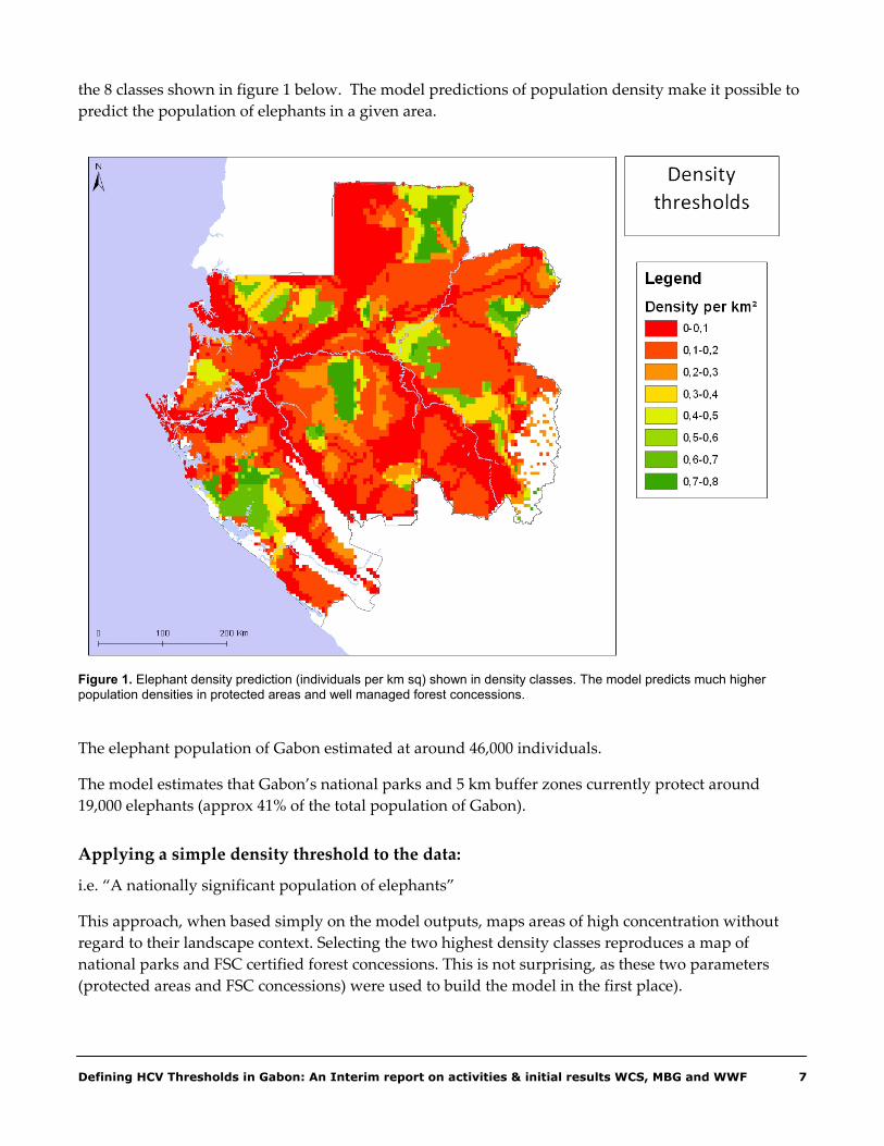
Applying a simple density threshold to the data:
i.e. “A nationally significant population of elephants”
This approach, when based simply on the model outputs, maps areas of high concentration without regard to their landscape context. Selecting the two highest density classes reproduces a map of national parks and FSC certified forest concessions. This is not surprising, as these two parameters (protected areas and FSC concessions) were used to build the model in the first place).
WCS—WWF—ABCG 8
Figure 2. National parks and their buffer zones (A) and FSC certified forestry concessions (B) are predicted to have higher elephant populations, as a result of both lower human populations and increased efforts on wildlife protection. These assumptions are borne out by field data from Gabon and Congo.
A
B

Defining HCV Thresholds in Gabon: An Interim report on activities & initial results WCS, MBG and WWF 9
Outside protected areas, FSC certified concessions have been shown to hold higher densities of elephants than non certified concessions. This is due to additional wildlife protection in FSC certified forests.
Nevertheless, while the model predicts higher elephant densities in FSC concessions, their locations may not present the best long term conservation opportunity. The approach does not take account of connectivity, landscape issues, or change in management in the future.
Even non-certified forest concessions that are remote from human populations, and near protected areas are likely to have a much more important role in elephant conservation than isolated FSC-certified management units.
Efforts should be made to define stable population units that can be conserved as continuous habitat blocks and provide for viable populations.
Defining elephant population units
This stage involved the development of a map of current and potential barriers to elephant movement that could be used as a basis for defining elephant population conservation units. For this we used the assumption that elephant movement is greatly restricted by human infrastructure development and natural barriers such as major rivers. We defined a map of major barriers to movement based on major roads and rivers, and assumed that elephant populations are now, or will soon be separated by these barriers.
For this we used
• Natural barriers e.g. Major rivers
• Human infrastructure, especially roads, including those currently under development
Simple calculation of the estimated elephant population in each population block
One possible approach to identifying elephant concentrations is a simple prioritisation by population block. This approach selects the blocks that have the largest/most intact populations. For example, blocks could be prioritised for conservation on the basis of overall population size. Using a threshold of X% of the global or national population, blocks could be assigned to ‘elephant conservation’ or ‘agriculture’
E.g. Use a threshold of 3000 individuals to define High Conservation Vale
However, this approach raises a number of problems, notably:
• Are the blocks with less than 3000 individuals really less important?
• Does not consider suitable habitat within each block

WCS—WWF—ABCG 10
Figure 3. Elephant population blocks used for this study. These were based on existing and planned human infrastructure developments in Gabon and the African Elephant Conservation Units (AfECUs) previously defined by WCS. It is assumed that elephant populations within each of these blocks are today, or will soon be isolated from one another by human infrastructure development.
Designed elephant conservation units
Given the limits of the simple thresholds for priority setting, a more comprehensive approach is required to defining the areas should be considered HCV for elephants in Gabon.
This approach should seek to delineate contiguous blocks of habitat that:
• provide for viable populations,
• are contiguous with a protected area boundary where possible, and
• that avoid areas of high human impact, especially unprotected roads.
Here we propose a mapping approach that seeks to maximise population size in each population block, while maximising connectivity to existing protected areas and minimises overall boundary length, while avoiding areas of high human impact.
The first layer necessary for the population unit modelling approach is the human influence layer. This layer effectively identifies the areas that should be avoided when building elephant conservation zones. In this case, an accessibility layer was created by combining human population density and ease of access, using roads, navigable rivers and topography to measure the ‘ease of travel’ to any given point.

Defining HCV Thresholds in Gabon: An Interim report on activities & initial results WCS, MBG and WWF 11
Figure 4. Map of estimated elephant population by population block. Population blocks with more than 3000 individuals are shown in green.
Figure 5. Map of low access areas in Gabon where maintaining forest habitat will have maximum value for wildlife conservation.

WCS—WWF—ABCG 12
Figure 6. Human population density (A) and accessibility (B).
A
B

Defining HCV Thresholds in Gabon: An Interim report on activities & initial results WCS, MBG and WWF 13
Making the cost layer
To this was included information on land use status, including land under long term forest management (i.e. forest concessions with valid management plans) and land in the domaine rural (non permanent forest). Further detail on the methodology are available in the training module on the use of the ZONATION modelling approach.
Setting targets (threshold values)
To create these population units, the modelling approach uses target levels of conservation. Targets can be set for the overall population that should be conserved, of overall population size and the population conserved within each separate block. In this example, we use two targets in a hierarchy:
• An overall target of 70% of the total elephant population of Gabon,
• A variable target (e.g. 500, 1000, 3000, and 5000) by population block depending on the predicted total population size in the block and the perceived importance of the block for long term conservation).
Note: population blocks with a predicted population of less than 500 individuals are not prioritised.
Table 2. Population Targets by Landscape
BLOCK AREA (ha)
Total estd. Elephant
population 70% target population
80% target population
90% target population
Weighted target
% of population under weighted
target 1 585000 1219 853 975 1097 500.0 41 2 1507500 2128 1490 1702 1915 2000.0 94 3 1237500 1591 1114 1273 1432 1000.0 63 4 2042500 6238 4366 4990 5614 5000.0 80 5 690000 875 613 700 788 500.0 57 6 295000 104 73 84 94 0.0 0 7 1615000 3553 2487 2843 3198 2000.0 56 8 362500 363 254 290 327 0.0 0 9 3612500 7004 4903 5603 6304 5000.0 71
10 1452500 1780 1246 1424 1602 1000.0 56 11 3442500 8049 5634 6439 7244 6000.0 75 12 577500 754 528 603 679 500.0 66 13 1162500 2800 1960 2240 2520 2000.0 71 14 2212500 5373 3761 4299 4836 5000.0 93 15 605000 617 432 493 555 0.0 0 16 2370000 4053 2837 3242 3648 2000.0 49
Total 23770000 46502 Total 32500.0 Overall % 69.9

WCS—WWF—ABCG 14
The model approach uses ZONATION software
The ZONATION model assigns grid cells to ‘elephant conservation’ or ‘agricultural use’ according to the cost parameters defined for the cell. Cells with high cost are removed until the predicted population of elephants falls to the target value set for that block
The resulting map shows the areas where forest (elephant habitat) must be retained to ensure the target population is conserved within each population block. These areas (in green on the map Fig 7 below) would be required to be retained under natural forest cover and would not be converted to agricultural use.
Figure 7. The initial outputs from ZONATION showing the areas required to meet the weighted targets shown in table 2 above. Note, these results are for demonstration purposes only.
Refinements to the method
These initial map outputs are imperfect, and should not be regarded as de-facto HCV areas for elephants. The purpose of this work was to show the use of the ZONATION tool to derive a map output from stakeholder decisions about targets and thresholds. The map in figure 7 uses only the experimental targets shown in table 2 (above) and should not be regarded as a definitive definition. There remain some un-resolved problems with the map outputs, such as the consideration of
Potential areas for elephant conservation

Defining HCV Thresholds in Gabon: An Interim report on activities & initial results WCS, MBG and WWF 15
connectivity between habitats selected as elephant conservation zones. Further work is still required to resolve these concerns before the tool can be used in a stakeholder workshop to derive a valid HCV map.
Using this approach to define HCV areas
Generic HCV criteria state that a significant concentration of a rare species will be considered an HCV. In Gabon (estimated to hold 50% of the worlds remaining forest elephants, F. Maisels pers comm..) any large population can be considered nationally and regionally, even globally significant
In this example, we have used a population target to define a ‘significant concentration’ of elephants at the national scale. In this way areas required to meet the pre-defined target for ‘significant’ are considered HCV areas. Changing the targets changes the ‘HCV area’ output from the model. In this way the model provides a process to map the HCV threshold decisions made by stakeholders
Nevertheless, all the tests carried out on this data to date highlight the importance of the same large blocks of relatively intact forest around Minkebe, Ivindo and Lope national parks and the Gamba complex of protected areas and logging concessions on the west coast. This should be taken as a strong indication of their HCV status for elephants.
Next steps
These initial outputs should be regarded as a test phase for the approach. The next step forward, after refining the use of the tool, will be to present the approach and these initial outputs to relevant national stakeholders in Gabon. A stakeholder workshop is planned with WWF to develop consensus on:
• Acceptable conservation target populations and HCV area boundaries
• Management practices in HCV areas
• Management practices in zones adjacent to HCV areas
Integration of elephant HCV area maps with other analyses (e.g. Great apes) to move towards an integrated definition of HCV areas for large mammals.
ENDEMIC PLANT HOTPOTS
Introduction
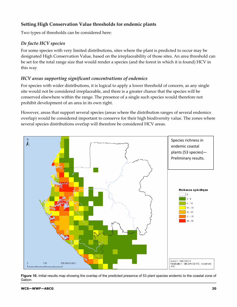
This project considered the mapping of the probable distributions of endemic plant species in Gabon’s coastal forest, using existing herbarium data. The objective was to enable the identification of forest areas where the probable distributions of several endemic species overlap, i.e. areas that support concentrations of several endemic species, which corresponds to criteria HCV 1.3
A large amount of herbarium data exists for Gabon, which can be exploited to determine trends of variation, diversity and endemism in Gabon. This herbarium data is insufficient to operate at finer

WCS—WWF—ABCG 16
scales, for example to determine the habitat preferences and likely distributions of individual endemic species. Nevertheless, herbarium records can be used as the basis for further analysis, to determine these parameters more precisely as is required for activities related to the determination of concentrations of endemic species, where the distribution ranges of several endemic species overlap. This project verified and geo-referenced herbarium records to determine the likely species ranges for a set of endemic plants found in the coastal forest area of Gabon. These geo-referenced records were then used in a distribution modelling approach that predicts the suitability of habitat for each species, and creates a distribution probability map. The distribution probabilities were used to identify likely hot-spots of endemism in the coastal zone.
Figure 8. Phytogeographic zones of Gabon (Caballe 1978) with an approximate definition of the coastal forest zone used for this project.
Step 1 -Creation of the database
A database was created for this project containing more than 5000 endemic or subendemic herbarium plants from Gabon. The database was created from an extract of the NCB Naturalis-Wageningen database of Gabonese plants (http://dps.plants.ox.ac.uk/bol/Gabon/Home/Index).
This database includes most herbarium data collected in Gabon and is based on information from TROPICOS, the National Herbarium of Gabon, Free University of Brussels, the Herbarium of the Belgian Botanical Garden and the National Museum of Natural History in Paris.

Defining HCV Thresholds in Gabon: An Interim report on activities & initial results WCS, MBG and WWF 17
Step 2 - Making of maps in a GIS to verify locations
To check or add geographical coordinates of samples, GIS maps of Gabon and Equatorial Guinea was created. For each sample, a resolution code was given using a modified code according Droissart (2009). This code also corresponds to the field in the database LLRES NCB Naturalis-Wageningen (Table 3).
Table 3. Codes Details the Locations of the Samples
Project code
WAG code (LLRES) Precision
1 7 Precision less than 100 meters, represents generally recently collected herbaria and whose position was measured using a GPS
2 6 Precision less than 1 kilometers, which represents generally the reference herbaria indicated a locality, often with an altitude
3 3-5 Precision less than 10 kilometers, generally represents points to a location without altitude found in a gazetteer
3a 2 3a = Precision less than 30 kilometers
4 0-1 Precision greater than 30 kilometers, represents points with a not very precise locality. These points were used solely to measure the diversity and large-scale sampling (mesh size of 1 degree).
Step 3- Data verification
The coastal endemic database was developed for the project objectives, that is to say, the verification and improvement of the data for a selection of species confirmed to be endemic to the coastal region of Gabon. Indeed, the work done consisted of the following steps:
• Check that the species were endemic or subendémique to the coastal zone of Gabon,
• Check the spatial accuracy of the record identified as endemic or subendémiques
• Check that identifications were correct, in consultation with specialists in these taxonomic groups.
3-1 Correct identification If the species has been identified by an expert (eg a specialist of gabonse Flora like Frans Breteler), identification was accepted. Otherwise, the identification has been verified. If there was any doubt about the identification, for example if the species were identified with a cf., these specimens were tested, and were excluded from the database if there was doubt.
3-2 Error location If the distribution of a species appeared abnormal, for example, if a coastal species showed a specimen in the mainland of Gabon, the specimen in question was checked, even if it had been previously identified by a specialist
WCS—WWF—ABCG 18
3-3 Error taxonomy If a species has not been revised taxonomically, but when there was a specialist in the family available, consultation was undertaken to determine whether the species would still valid in the event of future revision. For example, many species of Eugenia (Myrtaceae) endemic to Gabon were treated in the Flora of Gabon in 1960. In this treatment, the author of the Flora indicates that different species are known only from the type specimen. This is the case of Eugenia librevillensis which is highly similar to a known species from Cameroon and may be conspecific, and therefore not of use to this particular analysis. In these cases the species in question were removed from the data set.
Step 4- Species selection
A final set of 51 species endemic to coastal area of Gabon was selected for the realization of potential distribution maps
Species selection was made on the basis of an extract from the database Brahms Plant Gabon as mentioned above. At first, all endemic plants of Gabon were extracted from the database. Then sorting was performed to isolate endemic species whose records show a potential distribution more than 80% in the littoral area. All those who had less than 50% of records in the coastal zone have been set aside.
Of the 604 species known to be endemic to Gabon, 146 were selected as endemic to the coastal zone. Another group of 55 species known from more recent collections to be endemic to the coastal zone but not yet entered into the Brahms database were added to the initial list of 146 species. Thus a final sample of 201 species were selected for the analysis.
Initial distribution maps eliminated 75 species in the list because they showed samples taken at points not only outside of the coastal zone, but largely out of Gabon
After this first analysis, we had 126 species therefore to deepen our investigations to determine which species were ‘true’ endemic/subendemic to the coastal region.
This new short list of 126 species has been the subject of further analysis, this is to say that for each of these species, we re-checked additional specimens held at the herbarium of Wageningen to see if the samples actually corresponded to the right species and secondly to re-check all the geographical coordinates of collection sites.
After these last two verifications, we obtained 70 endemic species to the coastal zone; 19 sudendémiques and 31 were rejected because for taxonomic reasons or erroneous geographical distributions. Finally we were unable to use 6 species because they were under systematic review, or did not have enough information to determine their phytogeographical status.
The 89 confirmed species (70 endemic and 19 subendémiques) were georeferenced and a shapefile was created for each of them. Distribution maps were realized. These distribution maps then underwent a re-sorting to select the ones that met the prerequisites for reliability of the geographic range information (at least 2 different sites of collection, accuracy of points ...) to create potential distributions maps of the different species.

Defining HCV Thresholds in Gabon: An Interim report on activities & initial results WCS, MBG and WWF 19
In this group of 89 species, those that were represented by only one point of collection and those we had no information on the accuracy of the point of collection were set aside. Ultimately, these are 51 species (Annexe 1) who met the minimum requirements for the production of maps of potential distributions
Step 5- Potential distribution of endemic species of coastal area in Gabon
This part of the project was conducted in collaboration with IRD and using the method of maximum entropy (ME) developed within the MaxEnt software and is explained below.
MaxEnt uses a statistical approach called maximum entropy to make predictions from incomplete data. MaxEnt estimates the most uniform distribution / range (maximum entropy) of the points of occurrence inside the study area, taking into account the constraint that the expected value of each environmental variable predictor under this estimated distribution matches its average empirical (average values for the data set of occurrence).
Figure 9. Example map showing predicted distributions for 6 species of plants endemic to the coastal forest of Gabon
WCS—WWF—ABCG 20
Setting High Conservation Value thresholds for endemic plants
Two types of thresholds can be considered here:
De facto HCV species For some species with very limited distributions, sites where the plant is predicted to occur may be designated High Conservation Value, based on the irreplaceability of those sites. An area threshold can be set for the total range size that would render a species (and the forest in which it is found) HCV in this way
HCV areas supporting significant concentrations of endemics For species with wider distributions, it is logical to apply a lower threshold of concern, as any single site would not be considered irreplaceable, and there is a greater chance that the species will be conserved elsewhere within the range. The presence of a single such species would therefore not prohibit development of an area in its own right.
However, areas that support several species (areas where the distribution ranges of several endemics overlap) would be considered important to conserve for their high biodiversity value. The zones where several species distributions overlap will therefore be considered HCV areas.
Figure 10. Initial results map showing the overlap of the predicted presence of 53 plant species endemic to the coastal zone of Gabon.
Species richness in endemic coastal plants (53 species)—Preliminary results.

Defining HCV Thresholds in Gabon: An Interim report on activities & initial results WCS, MBG and WWF 21
A threshold value for concentrations can be developed based on this approach. Areas supporting the presence, or potential presence of several endemics should be regarded as HCV. To maintain the important biological diversity of these areas, the likely management recommendation would be conservation under permanent forest, with certain restrictions on activities such as selective logging.
Using the method
Here we present example maps of the overlapping distributions of several species to show how decisions about this High Conservation Value threshold can be made through stakeholder consensus, supported by the data. Thresholds of significance can be proposed on this basis. As with the results from the elephant and great ape population analysis, the decisions on the appropriate threshold of significance should be made by a stakeholder forum, on the basis of this analysis.
Further and ongoing work
A stakeholder workshop to present these initial results and discuss appropriate thresholds is planned to complete this phase. Due to delays in the implementation of some parts of this project, this workshop will now be held under the Yr II workplan for this project. Work is ongoing on the two other modules in this project (Great apes and Forest habitat types), however, initial results are not yet available. It is hoped that these will be available for presentation at the stakeholder workshop. The year II report for this project will show refinement and revisions to the methods discussed here, the thresholds agreed upon during the stakeholder workshop. It will also preset initial results from these further two modules. (See Yr II workplan).

WCS—WWF—ABCG 22
Appendixes
APPENDIX 1: LIST OF PARTICIPANTS IN JUNE WORKSHOP ON RSPO CRITERIA
N° Participants Institutions Contacts Mail 1 Dr Jean Louis Moubamba Expert, BAD 07 41 64 33 [email protected]
2 Ella Frédéric Communicateur social, OLAM 07 34 40 81 [email protected]
3 Sydney Ivembi Journaliste, Gabon Actu.com 07 36 26 10 [email protected]
4 Alexandre Garron Ondimba Journaliste, Gabon Infos 07 62 97 42/06 46 53 40 [email protected]
5 Pierre Martian Obiang C.E, DGEPN, Ministère de l'Economie 06 24 86 33 /72 27 00 [email protected]
6 Gérards W. Obangoue Corespondant International, Vox Africa 07 17 91 53/02 03 69 69 [email protected]
7 Aimérich Nloma Chef de service commeercil, BGFI 04 13 96 64 [email protected]
8 Paule Operha BGFI 03 24 01 93 [email protected]
9 Gerly Ekoty Bureau d'Etude Ecosphère 07 10 36 03 [email protected]
10 Alban Danny Koumba N. Bureau d'Etude Ecosphère 07 17 65 15 [email protected]
11 Olivier Desmet Directeur Aménagement, OLAM 04 55 70 94 [email protected]
12 Alain Ngadjvi Directeur Financier, OLAM 07 59 74 24 [email protected]
13 Dr Hubert Binga Directeur Général Adjoint, CNAP 07 90 06 08 [email protected]
14 Ludovic Ngoh Chercheur, CENAREST 07 88 93 22 [email protected]
15 Protet Essono Ondo Coordonnateur de Programme, Brainforest 07 41 99 22 [email protected]
16 Léonard Melangoung OLAM 05 91 87 05
17 Franck Charly Mandoukou Agence France Presse 07 96 73 23 [email protected]

Defining HCV Thresholds in Gabon: An Interim report on activities & initial results WCS, MBG and WWF 23
N° Participants Institutions Contacts Mail 18 Ludovic- Serge Tonjokoue C.E, Agriculture 04 74 36 11 [email protected]
19 Lionel B. Mezui-Mezui Direction Générale de l'Environnement 07 08 26 56 [email protected]
20 Aimé Jordan Pango Directeur Général Adjoint, T.V Canal Océan 07 50 26 48 [email protected]
21 Hugues Ndjali Mairie de Port-Gentil 07 89 17 20
22 Thierry Pandeou Directeur EGMS 06 41 81 79/04 70 87 04
23 Jean Nestor Pama Pama Président Exécutif Nyanga Tour 07 29 75 68 [email protected]
24 François Duc Mackwanguy Journaliste, Africa n° 1 07 94 50 76 [email protected]
25 Arnaud Iwango Nzamba Journaliste, Africa n° 1 03 28 33 86/06 58 52 28 [email protected]
26 Laetitia Manuela Kombila Stagiaire, SIAT Gabon 07 90 59 64 [email protected]
27 Sophie Dirou TEREA Gabon 04 29 93 14 [email protected]
28 Sandra Ratiarison Chef de Proget, ZSL 07 50 79 99 [email protected]
29 Michal Zrust Chef de Projet michal. [email protected]
30 Romain Calaque Représentant WCS, Gabon 07 15 06 90 [email protected]
31 Ludovic Serge Tonjokoue CE , Agriculture 04 74 36 11 [email protected]
32 Luc Mathot Président, Conservation Justice 04 23 38 65 [email protected]
33 Broll Santelli Otchika Juriste de l'Environnement, Conservation Justice 07 06 17 66 [email protected]
34 Ida Navratilova Oye Obame Assistante de Projet , Brainforest 07 03 72 33 [email protected]
35 Pamphile Makanga Secrétaire Général de Préfecture de Lambaréné 07 83 63 68
36 Serge Nguema Etudiant Stagiaire, WWF 07 50 61 97 [email protected]
37 Louis Edgar Redombina Etudiant Stagiaire, WWF 07 33 22 90 [email protected]
38 Martin Nguema Ndong Nkoghe Etudiant Stagiaire 04 51 10 71 [email protected]
39 Cyriaque Assoumoub Ndong Conseiller Juridique, Ministère de l'Agriculture 06 26 28 31
41 Moukanimambou Bipakila Responsable Social, SIAT Gabon 04 38 17 97 [email protected]

WCS—WWF—ABCG 24
N° Participants Institutions Contacts Mail 42 Cédric Missang HSE, SIAT Gabon 04 20 82 60 [email protected]
43 Lionel Nzogo-Abessolo HSE stagiaire, SIAT Gabon-Makouké 07 67 22 69 [email protected]
44 Cisse Ahmadou Chef de Service Agronomique SIAT Gabon-Makouké
04 56 82 68 [email protected]/ [email protected]
45 Hervé Nguembe-Diyembou Prefet de Mouila 07 71 95 95
46 Michel Pré Conseiller Régional, Ambassade de France 79 70 40/04 15 90 57 [email protected]
47 Idriss Deffry Expert Developpement de Projets, WWF-Gabon 07 27 62 14 [email protected]
48 Zouera Youssoufou Représentante Régional, Banque Mondiale 07 41 00 41 [email protected]
49 Véronique Bovee WWF-Gabon 07 10 30 66 [email protected]
50 Emmanuel Bayani CE-MEEDD/Direction Générale de l'Environnement 04 13 07 39 [email protected]
51 Hervé Omva Ovono Coordinateur des Programmes, ONG IDRC Africa 07 54 64 46 [email protected]
52 Charles Ebane Zeng Inspecteur Principal du Travail/ Directeur du Travail/ Réglémentation
07 99 69 77/ 06 21 87 00 [email protected]
53 Bertrand Patrick Ngabou Représentant DGF 06 25 79 04
54 Philippe Ongouli Chef de Service Départemental des Eaux et Forêts de Kango
07 84 35 35 [email protected]
55 Raphael Aouba Manager Suivi PGES et Certification RSPO/OLAM 07 38 40 57 [email protected]
56 Wilfried Dissaki Agent , DVPFABO 07 68 69 84 [email protected]
57 Nina Kouba Hangoue Assistante Manager, EPIC OLAM/Mouila 05 35 91 92 [email protected]
58 Gyslaine Milebe Assistante Manager, EPIC OLAM/Kango 07 49 85 67 [email protected]
59 Aristide Ekomi N'na Ingénieur Géographe, Environnement 07 37 10 28
60 Maximilienne Ebang Consultante MAKIBER 04 33 58 54 [email protected]
61 Ghislain Ndong Assembe SG 07 41 64 03
62 Alexandre Moukambi Moukambi Gouvernoraét Estuaire 07 46 64 77

Defining HCV Thresholds in Gabon: An Interim report on activities & initial results WCS, MBG and WWF 25
APPENDIX 2 -A: TERMS OF REFERENCE FOR IDENTIFICATION OF IMPORTANT RIVER CATCHMENTS
Expertise pour la caractérisation ichtyologique des bassins versants gabonais
Contexte Le territoire du Gabon s’étend sur près de 270 000 km2 et possède des ressources naturelles uniques au monde. L’économie du pays est principalement basée sur l’exploitation de ces ressources naturelles renouvelables et non renouvelables (foresterie, exploitation minière et pétrolière). Le pays détient aussi une biodiversité exceptionnelle qu’il est nécessaire de préserver.
Le territoire public gabonais est sollicité pour diverses utilisations, il est déjà utilisé à de nombreuses fins notamment protection de la nature (parcs nationaux, réserves…), exploitation forestière, agriculture, exploitation minière et pétrolière. Dans le cadre d’une volonté du gouvernement gabonais de diversification de l’économie, le territoire public fait constamment l’objet de nouvelles demandes d’utilisation des ressources et d’occupation du territoire.
Le Gabon s’est engagé dans un processus de planification de l’utilisation des terres piloté par le Conseil Climat qui rassemble l’ensemble des ministères et institutions gouvernementales impliquées. Il vient d’annoncer lors de la conférence des parties de la convention cadre des Nations Unies sur les changements climatiques de Durban (COP 17) un plan climat qui comprend plusieurs axes3 dont l’élaboration d’ici la fin de l’année 2012 d’un plan d’affectation des terres pour une meilleure gestion de l’ensemble de son territoire. Le Gabon a l’ambition que ce plan lui permette de déterminer avec précision les zones d’implantation pour les activités économiques (agriculture, exploitation minière, infrastructures, habitat) tout en atténuant les facteurs de vulnérabilité aux conséquences des changements climatiques.
Dans ce contexte, le WWF Gabon a développé un projet pour (i) accompagner les différents départements ministériels dans le processus de planification de l’utilisation des terres à travers l’identification des zones à hautes valeur de conservation (ii) suivre et accompagner le développement des plantations de palmiers à huile sur les impacts environnemental.
Le WWF Gabon avec d’autres ONG ont identifiés 4 thèmes et types de données stratégiques et représentatifs à compiler et traiter pour l’identification de zones de hautes valeurs de conservation :
1. Types de forêts, zonage biogéographique ;
2. Plantes endémiques ;
3. Habitats et populations de grands singes et d’éléphants ;
4. Bassins versants sensibles au Gabon.
3 Plan d’affectation des terres, un plan national de réduction des gaz torchés, le développement d’énergie propre, la production systématique de bilan carbone dans les secteurs public et privé, la publication systématique de sa communication nationale tous les deux ans.

WCS—WWF—ABCG 26
Plusieurs travaux et inventaires ayant été réalisés en ce qui concerne les communautés ichtyologiques, la compilation et le traitement adéquat de ces données peuvent constituer un outil d’aide à la décision stratégique en ce qui concerne la planification de l’utilisation des terres et le suivi de l’impact du développement des plantations de palmiers à huile au Gabon, foresteries, mise en place d’aménagement des cours d’eau (barrages) et activités minières.
Objectif de la consultation L’objectif principal de la consultation est la caractérisation ichtyologique des différents bassins versants du Gabon à travers la compilation et le traitement de l’ensemble des données disponibles (publications, travaux scientifique disponible et littérature grise) pour réaliser un outils d’aide à la décision dans le processus de planification de l’utilisation des terres et une ligne de base pour développer des protocoles de suivi de la ‘’santé’’ des bassins versants.
Les objectifs spécifiques sont :
• Compilation de l’ensemble des données valables et disponibles (publications, travaux scientifique disponible et littérature grise) sur les communautés ichtyologiques au Gabon avec si possible géoréférencement des données ;
• Caractérisation des bassins versant en fonction du traitement des données compilées ;
• Réalisation d’une typologie des bassins versant en fonction des caractéristiques ichtyologiques et leur possible vulnérabilité.
• Apporter des éléments pour le développement d’un outil de suivi écologique des hydrosystèmes fluviaux.
Activités à réaliser Les activités réalisées par l’Association AIMARA en collaboration avec l’IRAF (Gabon) pour atteindre ces objectifs sont :
• Dans le cadre de la compilation de l’ensemble des données valables et disponibles sur les communautés ichtyologiques au Gabon :
o Réaliser une revue bibliographique complète des travaux réalisés dans le domaine ichtyologique au Gabon (publications, travaux scientifique disponible et littérature grise) ;
o Traiter la littérature grise existante pour la transformer en données utilisables ;
o Compiler l’ensemble des données ichtyologique existantes avec géoréférencement ;
o Compiler des données physico-chimiques existantes sur les cours d’eau.
• Dans le cadre de la caractérisation des bassins versant et de la réalisation d’une typologie en fonction de leur vulnérabilité :
o En fonction des données disponibles, analyser et traiter les données des communautés ichtyologiques (nombre d’espèces, endémisme, structure des peuplements) ;

Defining HCV Thresholds in Gabon: An Interim report on activities & initial results WCS, MBG and WWF 27
o Caractériser les bassins versant en fonction de leur connectivité et tout autres paramètres pertinents (biodiversité, endémisme, vulnérabilité) ;
o Établir s’il existe des corrélations entre les paramètres physico-chimiques et les communautés ichtyologiques ;
o Établir le plus précisément possible les besoins complémentaires en données de base pour une caractérisation adéquate de l’ensemble des bassins versant et proposer l’ensemble des outils nécessaires (plan de travail, budget estimatif, mobilisation d’expertise) nécessaire pour combler ce manque.
o Accompagner l’expert en SIG du WWF dans la réalisation de cartes thématiques avec les taux d'endémismes et la biodiversité afin de définir une carte globale de sensibilité des bassins versants.
• Dans le cadre du développement d’un outil de suivi écologique des hydrosystèmes fluviaux
o Proposer une notice méthodologique détaillée, en vue d’une seconde phase du partenariat pour le développement d’un outil permettant une évaluation pertinente de la qualité écologique des hydrosystèmes fluviaux selon l’Indice Poisson sur 5 sites (à définir en fonction : Lagune, zone d’extraction etc.) ainsi qu’un suivi permettant de détecter rapidement tout dysfonctionnement / menace sur les sites choisis ;
Résultats attendus • Dans le cadre de la compilation de l’ensemble des données valables et disponibles sur les
communautés ichtyologiques au Gabon :
o Un rapport sur la revue bibliographique dans le domaine ichtyologique au Gabon est disponible ;
o Une base de donnée compilant l’ensemble des données géoréférencées sur les communautés ichtyologiques au Gabon est disponible ;
• Dans le cadre de la caractérisation des bassins versant :
o Une liste de l’ensemble des bassins versant gabonais avec caractérisation (taux d’endémisme, biodiversité, validité statistique des données, etc.) est disponible ;
o Un rapport sur la caractérisation des bassins versant est disponible compilant les différentes analyses écologiques et statistiques réalisées ;
o Un protocole pour la récolte de données complémentaires pour caractériser l’ensemble des bassins versant est élaboré.
• Dans le cadre de la caractérisation des bassins versant et de la réalisation d’une typologie en fonction de leur vulnérabilité :
o une typologie des différents bassins versant gabonais est réalisée en fonction de leur ‘’vulnérabilité’’ ;
o des cartes thématiques sur les taux d’endémismes, la biodiversité, la vulnérabilité, etc. sont disponibles.
WCS—WWF—ABCG 28
o une notice méthodologique détaillée pour le développement d’un outil permettant une évaluation pertinente de la qualité écologique des hydrosystèmes fluviaux selon l’Indice Poisson sur 5 sites (à définir en fonction : Lagune, zone d’extraction etc.) ainsi qu’un suivi permettant de détecter rapidement tout dysfonctionnement / menace sur les sites choisis ;
Organisation et mise en œuvre
L’association AIMARA mobilisera toute l’expertise nécessaire à la bonne mise en œuvre des activités prévues dans le cadre de ce contrat. L’expertise mobilisée comprendra entre-autres :
Des compétences en ichtyologie ;
Des compétences en hydrologie ;
Des compétences en traitement statistique des données ;
L’Association AIMARA pourra, si besoin, passer des sous contrats et/ou accords de collaboration pour la bonne réalisation des présentes prestations, elle devra transmettre ces accords de partenariat au WWF.
Le WWF mettra à disposition de l’association un expert en SIG pour la réalisation des traitements cartographiques.
Un agent du WWF sera désigné comme étant le point focal pour l’association AIMARA, il sera chargé du suivi du contrat.
Tous les résultats attendus, ainsi que les données brutes seront mis à la disposition du WWF en version numérique à la fin de la prestation.
7. Durée La durée du contrat est de 6 mois. Le début des prestations est prévu le 1er avril 2012.
APPENDIX 2 -B: TERMS OF REFERENCE FOR IDENTIFICATION OF IMPORTANT RIVER CATCHMENTS—TRANSLATION
Expertise for watershed characterization ichthyological Gabon Context Gabon's territory covers approximately 270 000 km2 and has unique natural resources in the world. The country's economy is mainly based on the exploitation of these natural resources and non-renewable (forestry, mining and oil). The country also has a unique biodiversity that is necessary to preserve. Gabonese public land is sought for a variety of uses, it is already used for many purposes including protection of nature (national parks, ...), forestry, agriculture, mining and oil. As part of a commitment by the Gabonese government to diversify the economy, public land is constantly being further requests for use of resources and land use.

Defining HCV Thresholds in Gabon: An Interim report on activities & initial results WCS, MBG and WWF 29
Gabon has embarked on a process of planning land use controlled by the Climate Council, which brings together all government ministries and institutions involved. He announced at the Conference of the Parties of the United Nations Framework Convention on Climate Change in Durban (COP 17) climate plan that includes several areas including the development by the end of the year 2012 a plan of land for better management of its entire territory. Gabon has the ambition that the plan allows it to accurately determine the settlement areas for economic activities (agriculture, mining, infrastructure, housing) while reducing vulnerabilities to climate change impacts. In this context, WWF Gabon has developed a project to (i) assist the various departments in the planning of land use through the identification of areas of high conservation value (ii) monitor and support the development of oil palm plantations on environmental impacts. WWF Gabon with other NGOs have identified four themes and types of strategic and representative data to compile and process for identifying areas of high conservation value: 1. Forest types, zoning biogeographical 2. Endemic plants; 3. Habitats and populations of great apes and elephants; 4. Sensitive watersheds in Gabon. Several studies and surveys have been conducted regarding fish communities, compilation and adequate treatment of these data can be a tool for strategic decision regarding the planning of land use and monitoring the impact of the development of oil palm plantations in Gabon, forestries, implementation planning of rivers (dams) and mining activities. Objective of the consultation The main objective of the consultation is Ichthyological characterization of different watersheds Gabon through the compilation and processing of all available data (publications, work available scientific and gray literature) to create a tool to help decision in the process of planning land use and a baseline to develop protocols for monitoring the'' health'' watershed. The specific objectives are: • Compilation of all available and valid data (publications, work available scientific and gray literature) on fish communities in Gabon with georeferencing data if possible; • Characterization of watersheds according to data compiled treatment; • Completion of a typology of watersheds according to the characteristics and their possible vulnerability fishery. • Provide input for the development of a tool for ecological monitoring of river hydro. Activities to be carried Activities carried out by the Aymara Association in collaboration with the IRAF (Gabon) to achieve these goals are: • As part of the compilation of all data valid and available on fish communities in Gabon: o Conduct a comprehensive literature review of the work done in the field ichthyological Gabon (publications, work available scientific and gray literature); o Treat the existing gray literature to transform it into usable data; o Compile all existing ichthyological data with georeferencing; o Compile physicochemical existing watercourses.

WCS—WWF—ABCG 30
• As part of the characterization of the watershed and the creation of a typology based on their vulnerability: o Based on the available data, analyze and process data from fish communities (number of species endemism, stand structure); o Characterize the watershed based on their connectivity and all other relevant parameters (biodiversity, endemism, vulnerability); o Determine whether there are correlations between physicochemical parameters and fish communities; o Establish as accurately as possible additional needs in data for an adequate characterization of all watersheds and offer all the necessary tools (work plan, estimated budget, mobilization of expertise) needed to fill the gap . o Supporting the GIS expert WWF in achieving thematic maps with rates of endemism and biodiversity in order to define a global map of the sensitivity of watersheds. • In the development of a tool for ecological monitoring of river hydro o Propose a detailed methodological note, for a second phase of the partnership for the development of a tool for a meaningful assessment of the ecological quality of river hydro according to Poisson Index 5 sites (defined according: Lagoon, extraction area etc..) as well as monitoring to quickly detect any malfunction / threat to the selected sites; Outcomes • As part of the compilation of all data valid and available on fish communities in Gabon: o A report on the literature review in the ichthyological Gabon is available; o A database compiling all georeferenced data on fish communities in Gabon is available; • As part of the characterization of the watershed: o A list of all watersheds with Gabonese characterization (endemism, biodiversity, statistical validity, etc..) is available; o A report on the characterization of the watershed is available compiling different ecological and statistical analyzes performed; o A protocol for the collection of additional data to characterize the whole watershed is developed. • As part of the characterization of the watershed and the creation of a typology based on their vulnerability: o a typology of different watersheds Gabon is made on the basis of'' vulnerability''; o thematic maps on rates of endemism, biodiversity, vulnerability, etc.. are available. o A detailed methodological note for the development of a tool for a meaningful assessment of the ecological quality of river hydro according to Poisson index of 5 sites (defined according to: Lagoon, mining area etc..) and a monitoring to quickly detect any malfunction / threat to the selected sites; Organization and implementation The association Aymara mobilize all the expertise necessary for the successful implementation of planned activities under this contract. Mobilized expertise include among others: ♣ Skills in Ichthyology; ♣ Skills in hydrology; ♣ Skills in statistical treatment of data; The Aymara Association may, if necessary, pass under contracts and / or cooperative agreements for the performance of these services, it will transmit these partnership agreements with WWF.

Defining HCV Thresholds in Gabon: An Interim report on activities & initial results WCS, MBG and WWF 31
WWF will provide the association an expert in GIS for mapping realization treatments. WWF agent will be designated as the focal point for the Aymara Association, will be responsible for monitoring the contract. All deliverables, as well as the raw data will be made available to the WWF digital at the end of the service. 7. Duration The contract period is 6 months. The benefits start is scheduled for 1 April 2012.