
Defacing the map: Cartographic vandalism in the digital commons · 2018-09-28 · Defacing the map:...
24
Defacing the map: Cartographic vandalism in the digital commons Andrea Ballatore Department of Computer Science National University of Ireland, Maynooth [email protected] Author copy. Cartographic Journal, 2014. Abstract This article addresses the emergent phenomenon of carto-vandalism, the intentional defacement of collaborative cartographic digital artefacts in the context of volunteered geographic information. Through a qualita- tive analysis of reported incidents in WikiMapia and OpenStreetMap, a typology of this kind of vandalism is outlined, including play, ideological, fantasy, artistic, and industrial carto-vandalism, as well as carto-spam. Two families of counter-strategies deployed in amateur mapping commu- nities are discussed. First, the contributors organise forms of policing, based on volunteered community involvement, patrolling the maps and reporting incidents. Second, the detection of carto-vandalism can be sup- ported by automated tools, based either on explicit rules or on machine learning. Keywords Carto-vandalism, Online vandalism, Crowdsourced cartography, Vol- unteered Geographic Information, OpenStreetMap, WikiMapia, Commons-based peer production, Digital commons 1 arXiv:1404.3341v1 [cs.CY] 13 Apr 2014
Transcript of Defacing the map: Cartographic vandalism in the digital commons · 2018-09-28 · Defacing the map:...
Defacing the map: Cartographic vandalism in the
digital commons
Andrea BallatoreDepartment of Computer Science
National University of Ireland, [email protected]
Author copy. Cartographic Journal, 2014.
Abstract
This article addresses the emergent phenomenon of carto-vandalism, theintentional defacement of collaborative cartographic digital artefacts inthe context of volunteered geographic information. Through a qualita-tive analysis of reported incidents in WikiMapia and OpenStreetMap, atypology of this kind of vandalism is outlined, including play, ideological,fantasy, artistic, and industrial carto-vandalism, as well as carto-spam.Two families of counter-strategies deployed in amateur mapping commu-nities are discussed. First, the contributors organise forms of policing,based on volunteered community involvement, patrolling the maps andreporting incidents. Second, the detection of carto-vandalism can be sup-ported by automated tools, based either on explicit rules or on machinelearning.
Keywords Carto-vandalism, Online vandalism, Crowdsourced cartography, Vol-unteered Geographic Information, OpenStreetMap, WikiMapia, Commons-basedpeer production, Digital commons
1
arX
iv:1
404.
3341
v1 [
cs.C
Y]
13
Apr
201
4
1 Introduction
Maps are widely recognised as powerful and versatile representations of geo-graphic realities, loaded with cultural, aesthetic, and practical meanings. Thanksto ubiquitous and inexpensive personal computers, smartphones, and locationtechnologies, mapping practices are currently experiencing a reconfiguration,driven by online modes of production, delivery, and consumption, generat-ing informational commons of reusable geographic information. These formsof crowdsourced cartography inherit well-established mapping conventions andtraditions, but also present novel aspects that deserve attention (Dodge andKitchin, 2013). Collaborative online mapping relies on commons-based peerproduction, almost entirely mediated by digital communication tools. As Ben-kler and Nissenbaum (2006) put it, commons-based peer production is a socio-technical system that relies on “collaboration among large groups of individu-als . . . who cooperate effectively to provide information, knowledge, or culturalgoods without relying on either market pricing or managerial hierarchies tocoordinate their common enterprise” (p. 394).
In the geographic domain, commons-based peer production has transformedthe traditional expert-driven models that had dominated the field. Goodchild(2007) used the term volunteered geographic information to describe the com-plex constellation of amateur mapping projects, while Graham (2010) identifiedin these phenomena a common drive to create virtual versions of places andgeographic realities. In such projects, contributors form self-regulating commu-nities to create, maintain, and promote the usage of digital geospatial artefacts.Wikified maps, free gazetteers, mash-ups, and open geo-knowledge bases createan inter-linked ecosystem of geospatial commons (Ballatore et al., 2013). In ad-dition, these large collaborations form a communal space in which individualscan engage with their geographic surroundings in novel ways (Elwood, 2008).
Among others, a major difference exists between traditional and commons-based peer cartography. Traditional cartographic production is conducted byexperts in a private environment, which limits the possibility of malicious actionson the data. This is manifestly not the case in commons-based peer productionprojects such as WikiMapia and OpenStreetMap. This article investigates carto-vandalism, an emergent form of deviant behaviour in collaborative productionenvironments directed at geographic information. Unlike online open datasets,physical geospatial artefacts can be vandalised only when exposed in publicspaces, such as in the case of tourist maps and cartographic monuments. Anotable instance of such vandalism can be found in the history of modern Italy,when in 1943 one of Mussolini’s ‘imperial maps’ in Rome was defaced withred paint, symbolically attacking Fascism’s geographic expansionism (Minor,1999).1
1In 1934, Benito Mussolini commissioned and supervised the construction of a monumentconsisting of five ‘imperial maps,’ overlooking the Via dei Fori Imperiali in Rome. The firstfour tablets represented distinct phases of the expansion of the Roman Empire, while the fifthshowed the borders of Fascist Italy, inviting a comparison between the Roman Empire andhis own regime.
2
Mutatis mutandis, the digital maps that are generated today through com-mons-based peer production suffer from a variety of forms of vandalism. Be-cause crowdsourced cartography is intrinsically open to anonymous contribu-tions, the core geospatial artefacts are highly vulnerable to malicious contri-butions. Commons-based peer production relies heavily on implicit trust incontributors, and on the goodwill of participants to construct value rather thandestroy it. For example, anybody can create an account and edit the vectormap in OpenStreetMap, the most prominent peer production cartographic ini-tiative, and see their changes immediately visible online. Whilst malicious editson Wikipedia have been the object of much research, carto-vandalism, i.e. van-dalism aimed at geographic artefacts, is a little-understood phenomenon. Inthe recent debate on the quality of crowdsourced geographic information, thiskind of vandalism is often mentioned, but has not been analysed organically(Flanagin and Metzger, 2008; Mooney et al., 2010; Goodchild and Li, 2012).
The perception of carto-vandalism plays a crucial role in the credibility –or lack thereof – of crowdsourced cartography (Flanagin and Metzger, 2008).Therefore the stakes surrounding it are high. Unsurprisingly, crowdsourcedcartography advocates tend to minimise the severity and importance of carto-vandalism. OpenStreetMap’s founder Steve Coast (2010b) argued that “mali-cious edits are probably the least significant and will always exist” (para. 43).By contrast, commercial providers of geographic information cite vandalism asa serious flaw of crowdsourced cartography. In a promotional newsletter, thecompany TomTom (2012) claims that user-generated maps are “wide open toattack” and therefore unfit for critical applications such as routing, generatingparticular anxiety by evoking the possibility that anybody can change the direc-tion of one-way streets, with potentially dire consequences for drivers. Althoughboth claims bear some degree of truth, they are influenced by vested interests,and a deeper understanding of the reasons behind carto-vandalism is necessary.
The phenomenon of carto-vandalism can be observed from several, com-plementary perspectives. Volunteered geographic information is generated byonline communities, through forms of network sociality (Wittel, 2001), and theweak social bonds that dominate online communities can indeed favour deviantbehaviour.2 Definitional problems surround the emotionally-loaded term ‘van-dalism,’ used to label a variety of behaviours whose boundaries are notoriouslydifficult to define and whose targets include buildings, vehicles, as well as dig-ital artefacts such as websites (Goldstein, 1996; Williams, 2007). From a legalviewpoint, unlike other types of ‘serious’ cybercrime, such as the trade of childpornography or credit card cloning, the vandalisation of digital commons con-stitutes an uncharted gray area.
This does not imply that carto-vandalism has no tangible consequences forprojects and contributors. When vandalised, digital artefacts see their use valuebeing diminished, and their appeal reduced. As a result, communities have todevote part of their scarce resources to policing and other anti-vandalism activ-
2For a discussion of the problematic notion of ‘online community’ see Williams (2006), pp.14-17.
3
ities that are often dull and unrewarding for contributors. The possible causesand consequences of carto-vandalism need be discussed in the framework of theunique properties of crowdsourced cartography, emphasising the peculiaritiesthat distinguish geospatial artefacts from other forms of digital commons.
The remainder of this article sheds light on these issues as follows. Sec-tion 2 discusses the continuities of digital carto-vandalism with physical vanda-lism, which has been studied from sociological and psychological standpoints.Based on a qualitative analysis of incidents reported in OpenStreetMap andWikiMapia, two prominent volunteered geographic information projects, Sec-tion 3 proposes a classification of the multiple facets of carto-vandalism. Am-ateur mapping communities need strategies to defend themselves from carto-vandalism, and Section 4 surveys currently adopted counter-strategies. Finally,Section 5 draws conclusions, pointing out directions for future research aboutcarto-vandalism.
2 Vandalism, physical and digital
The term ‘vandalism’ refers to a variety of socially constructed phenomena, andno clear academic consensus has been established about its scope. Reviewingits many definitions, Moser (1992) suggested that vandalism is “a hodgepodgeconcept that covers behavior for which motivations are extremely different” (p.51). The definitions of vandalism differ as they take into account the causeddamage, the motivation of the human actor, and/or the context of the incident.Vandalism is a ubiquitous and visible social phenomenon, in which intentionaldamage was performed on a variety of objects, including buildings, public toilets,vehicles, furniture, infrastructures, and works of art such as paintings, monu-ments, and sculptures. Most vandalism incidents are far from being random,senseless acts, and several competing theories to explain its reasons have beenproposed. A consensus exists around the general meaningfulness of vandalismas a form of social communication between the offender and an imagined orreal audience. The next sections review theories of vandalism directed towardsphysical and digital objects, and discuss the issue of deviance in volunteeredgeographic information communities.
2.1 Physical vandalism
Studies on vandalism against physical objects have been conducted mostly inthe broad framework of criminology, harnessing theoretical tools from socialpsychology and sociology, particularly in the 1970s and 1980s. The key pre-occupation of these social science researchers is the reduction of such deviantbehaviours, and their societal and economic negative consequences (Goldstein,1996). South African criminologist Stanley Cohen (1973) outlined a broad andinfluential classification of types of vandalism, based on the offender’s purpose.His classification includes the following categories: acquisitive vandalism (theftor looting); tactical/ideological vandalism (to attract attention around a polit-
4
ical or social issue); vindictive vandalism (for revenge against somebody); playvandalism (unintentional damage resulting from children’s games); and mali-cious vandalism (violent outpouring of rage).
In the same decade, Allen and Greenberger (1978) proposed an aesthetictheory of vandalism, focusing on its pleasure-arousing potential, which dependson the specific traits of the target objects. By defacing objects, offenders tendto alter their structure towards simpler configurations, and therefore objects ofcomplex design are more likely to be vandalised than simple ones. Fisher andBaron (1982) have argued that perceived social inequality is a key cause of van-dalism, which is perpetrated as an iniquity resolution mechanism. Their modelaccounts in particular for vandalism directed at public property, conceptualisedby offenders as a symbol of an unfair status quo. Furthermore, Sutton (1987)expanded Cohen’s classification, identifying a new type of vandalism, i.e. peerstatus motivated vandalism. Mostly conducted by groups rather than individ-uals, this type of vandalism is perpetrated to gain or maintain peer status, forexample damaging a vehicle on a dare.
From a more conservative standpoint, Kelling and Wilson (1982) outlinedtheir widely discussed ‘broken window theory,’ claiming that minor crime suchas vandalism affects the environment, and the resulting physical disorder tendsto generate more serious crime. The linkage between low and high intensitydeviance has been also stressed by Goldstein (1996) as a key motivation tocounter vandalism. However, these theories do not seem to capture the afore-mentioned essential drives behind physical vandalism, and have been challengedas inadequate to explain the socio-structural conditions that cause crime (Gauand Pratt, 2010). Over the last two decades, attempts to counter physicalvandalism have been predominantly conducted in the framework of ‘crime pre-vention through environmental design,’ applying architectural design patternsto discourage deviant behaviour (Cozens, 2008).
2.2 Digital vandalism
With the emergence of online spaces in the 1990s, vandalism found new avenuesof expression, as happened with other types of crime that soon appeared onthe Web. The most common form of cybercrime is the defacement of websites,often for satirical or playful purposes (Furnell, 2002). Williams (2004) definedthe term ‘online vandalism’ to refer to deviant behaviour in online communities,particularly the defacement of digital artifacts built collaboratively, often aspart of cyber-bullying. The environmental structure of online spaces determinesspecific, peculiar aspects of online vandalism. The so-called ‘online disinhibitioneffect’ consists of a reduction in social inhibitions and constraints, fostered bythe perceived anonymity, invisibility, asynchronicity, dissociative imagination,and lack of authority in online spaces (Suler, 2004).
However, the many continuities between online digital vandalism and offlinephysical vandalism should not be understated, it is important to avoid the trapof what Jurgenson (2012) named ‘digital dualism,’ i.e. the tendency of over-looking the substantial intermesh between the online and offline. Similarly to
5
physical vandalism, ‘digital vandalism’ generates a large number of low-impactincidents, is rarely reported, prosecuted and punished, and is – quite reason-ably – perceived as a less serious threat than phishing, identity theft, and otherobviously harmful activities. The inherent openness of commons-based peerproduction projects makes them ideal targets for online vandalism.
Because of its global success and visibility, vandalism against Wikipedia isthe subject of an active research area, thoroughly surveyed by Nielsen (2012).The open infrastructure of Wikipedia is subject to structural vandalism, i.e.damage that is regularly inflicted on the digital artefact at the core of thecommunity efforts. The surprising success of Wikipedia relies on its abilitykeep such structural vandalism at bay, rapidly reverting suspicious edits. Usersdeliberately delete valid information or enter incorrect facts in Wikipedia witha variety of playful or malicious purposes.
Because Wikipedia, as a form of digital commons, does not host informationof high economic value, such as credit card numbers, authorities tend not todevote resources to counter online vandalism. As a result, offenders have highrewards in terms of visibility and pleasure-arousing effects, and virtually no risk,a highly criminogenic combination. Predictably, articles about controversialtopics (e.g. abortion, divisive politicians, sexuality, contested borders) tend tobe vandalised more often than others, and correct but damaging informationis often removed directly by affected individuals and organisations. Notablecases of Wikipedia vandalism include obituaries of living celebrities, humorouslyincongruous facts, obscenities, and political propaganda.
2.3 Deviance in cartographic communities
Crowdsourced cartography is sustained by complex social networks, in which in-dividuals deploy an inter-dependent combination of physical objects (personalcomputers, servers, cloud computing facilities, GPS sensors, and smartphones)and digital artefacts (datasets, websites, documentation, and software tools).The purpose of such ad hoc communities is the development and the main-tenance digital artefacts, such as datasets, websites, and databases. Commu-nity members co-operate through a variety of social media, including mailinglists, forums, private e-mails, wikis, Web conferences and, to a limited extent,through face-to-face interaction such as mapping parties. These communitiesare formed around an explicit and shared purpose, coordinating and sustaininginter-personal bonds through a combination of online and offline communication.As in any human community, behavioural norms are established, and deviancefrom these norms is discouraged and sanctioned with a variety of incentives andpunishments (Williams, 2006).
While the vast majority of literature analyses volunteered geographic infor-mation data – particularly OpenStreetMap (e.g. Haklay, 2010a; Mooney andCorcoran, 2012) – fewer studies directly observe the underlying communities.Amateur mapping communities are characterised by social, technological andgeographic divides. Human geographers study volunteered geographic informa-tion as a social practice, focusing particularly on the inequalities between people
6
and places involved in the generation of knowledge (Elwood et al., 2012). An-other dimension of study is that of the scope, motivations, and conditions ofcommons-based peer production of maps.
In these communities, social ties are less stable than in local communities,and the emotional attachment to the digital artefacts plays a crucial role inpreserving the community from disaggregation. Digital cartographic artefacts,such as the OpenStreetMap world map, constitute the barycentre of the com-munity, whose boundaries can shift considerably over short periods of time,with many new members joining and current members leaving. Coleman et al.(2009) have investigated the motivation of contributors, classifying them on aspectrum ranging from neophyte to expert authority. In their view, volunteeredgeographic information contributors act on some combination of eight positivemotivations: (1) altruism; (2) professional or personal interest; (3) intellectualstimulation; (4) protection or enhancement of a personal investment; (5) socialreward; (6) enhanced personal reputation; (7) self-expression; (8) pride of place.
However, motivations of contributors are not exclusively positive. As Williams(2004) noted for virtual spaces, volunteered geographic information communitiestend be made up of “turbulent and shifting populations” (p. 15). Uncoopera-tive and disruptive behaviour drains resources from volunteers, and generatestensions within projects (Wall and Williams, 2007). Amateur mapping com-munities are no exception, and suffer from trolling and cyber-bullying. Forexample, OpenStreetMap has been often disrupted by the deviant behaviourof a minority of individuals. Project founder Steve Coast (2010a) has directlyintervened against deviance that plagues the community, advocating the ‘disin-fection’ of the project from ‘poisonous people’ who “drain, paralyse, slow, causeneedless infighting and destroy the attention and focus of a community . . . arewrecking the time, focus and goodwill of the majority of contributors, creatingdissent out of nothing and even purposefully breaking our data” (para. 8).
In the context of crowdsourced cartography, Coleman et al. (2009) have iden-tified three negative motivations for contribution: mischief (general destructivebehaviour); agenda (conscious purpose); and malice and criminal intent (per-sonal gain). According to them, such motivations lead to a number of deviantbehaviours, including: mass or partial deletes; nonsense (incomprehensible in-formation); spam; offensive content; and misinformation. Although this clas-sification is a useful starting point, it fails to discriminate between the diverseand deep motivations of deviant expressions of carto-vandalism. To date, nosystematic analysis of vandalism occurring in the context of digital cartographyhas been conducted. The next section fills this gap by investigating differenttypes of carto-vandalism.
3 A typology of carto-vandalism
Carto-vandalism is an emergent phenomenon, and its boundaries are difficultto delineate precisely. Unlike general digital vandalism, carto-vandalism has astrong geographic component, and bears an intimate relationship with places.
7
The target of carto-vandalism is primarily a digital artefact containing geo-graphic information, such as a vector dataset, a spatial database, or a gazet-teer. The classic economic notion of the utility of geographic information canfunction as the guiding principle to include or exclude a given action withincarto-vandalism.
As utility is context-sensitive and subjective, some acts can increase theutility of an artefact for one group of actors, while reducing it for another, andin such cases conflicts arise between groups with divergent views. Hence, an actof carto-vandalism intentionally reduces the utility of a geospatial artefact forthe majority of the users. The definitional difficulties encountered when dealingwith vandalism are particularly visible in crowdsourced cartography. Althoughthe actor’s intentionality is crucial to define carto-vandalism, it is often difficultto assess it in practice, resulting in a wide gray area of acts that might be dueto incompetence rather than maliciousness, or a combination of the two. Forthis reason, it is very common for contributors flagged as vandals to claim thatwhat they did was not vandalism, and controversies ensue.
In order to uncover the motivations of this phenomenon, a new qualitativeanalysis of real amateur mapping incidents was conducted. This analysis fo-cused on the carto-vandalism incidents reported and discussed on the forumsand mailing lists of WikiMapia and OpenStreetMap, two highly representa-tive collaborative cartographic projects. These incidents provided the empiricalground for the typology of carto-vandalism outlined in this section, and sum-marised in Table 1. The types of carto-vandalism identified in this classification,framed in the tradition of Cohen (1973), are not mutually exclusive, but can co-exist in the same incidents. For example, incidents of political carto-vandalismoften have a playful component. This typology also emphasises the aspects thatdistinguish carto-vandalism from other types of vandalism.
WikiMapia is a commercial collaborative mapping project founded in 2006,“aimed at marking all geographical objects in the world and providing a usefuldescription of them.”3 On WikiMapia, vandalism is defined as “any deliberateaction intended to corrupt information.” WikiMapia’s license agreement statesthat “you will not post advertisements or solicitations of business; you willnot submit false information intentionally; you will not vandalize or corruptinformation on WikiMapia.”4 The project’s contributors can report suspiciousbehaviour on a dedicated forum, which currently contains 983 threads aboutvandalism.5
OpenStreetMap is a non-profit volunteered geographic information projectstarted in 2004, focused on the construction and maintenance of a vector mapof the entire planet. In this context, “vandalism is intentionally ignoring theconsensus norms of the OpenStreetMap community,” and includes copyrightinfringement, graffiti, use of bots, disruptive behaviour, and spamming.6 Con-tributors can report suspect cases of vandalism on the project’s mailing lists,
3http://wikimapia.org/docs/About_Wikimapia4http://wikimapia.org/terms_reference.html5http://wikimapia.org/forum6http://wiki.openstreetmap.org/wiki/Vandalism
8
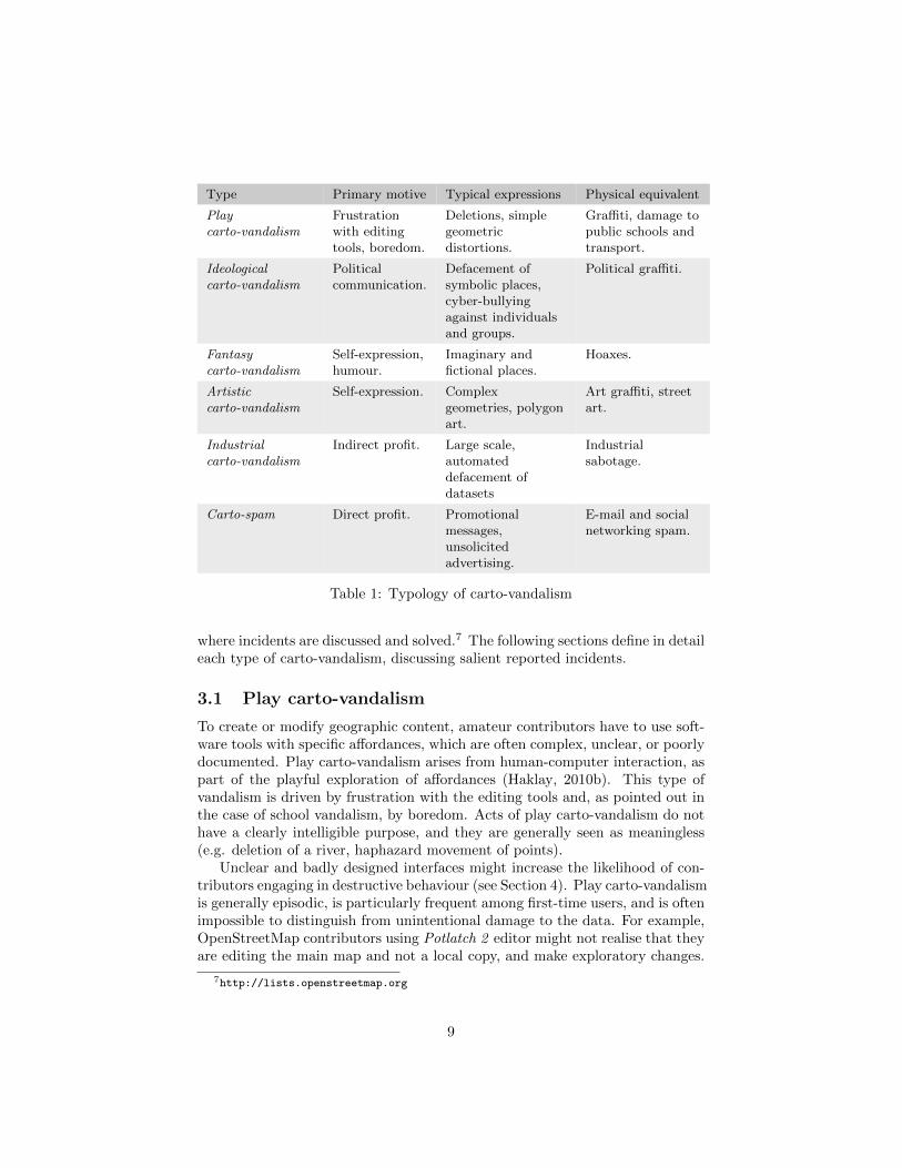
Type Primary motive Typical expressions Physical equivalent
Playcarto-vandalism
Frustrationwith editingtools, boredom.
Deletions, simplegeometricdistortions.
Graffiti, damage topublic schools andtransport.
Ideologicalcarto-vandalism
Politicalcommunication.
Defacement ofsymbolic places,cyber-bullyingagainst individualsand groups.
Political graffiti.
Fantasycarto-vandalism
Self-expression,humour.
Imaginary andfictional places.
Hoaxes.
Artisticcarto-vandalism
Self-expression. Complexgeometries, polygonart.
Art graffiti, streetart.
Industrialcarto-vandalism
Indirect profit. Large scale,automateddefacement ofdatasets
Industrialsabotage.
Carto-spam Direct profit. Promotionalmessages,unsolicitedadvertising.
E-mail and socialnetworking spam.
Table 1: Typology of carto-vandalism
where incidents are discussed and solved.7 The following sections define in detaileach type of carto-vandalism, discussing salient reported incidents.
3.1 Play carto-vandalism
To create or modify geographic content, amateur contributors have to use soft-ware tools with specific affordances, which are often complex, unclear, or poorlydocumented. Play carto-vandalism arises from human-computer interaction, aspart of the playful exploration of affordances (Haklay, 2010b). This type ofvandalism is driven by frustration with the editing tools and, as pointed out inthe case of school vandalism, by boredom. Acts of play carto-vandalism do nothave a clearly intelligible purpose, and they are generally seen as meaningless(e.g. deletion of a river, haphazard movement of points).
Unclear and badly designed interfaces might increase the likelihood of con-tributors engaging in destructive behaviour (see Section 4). Play carto-vandalismis generally episodic, is particularly frequent among first-time users, and is oftenimpossible to distinguish from unintentional damage to the data. For example,OpenStreetMap contributors using Potlatch 2 editor might not realise that theyare editing the main map and not a local copy, and make exploratory changes.
7http://lists.openstreetmap.org
9
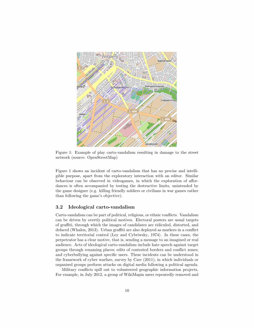
Figure 1: Example of play carto-vandalism resulting in damage to the streetnetwork (source: OpenStreetMap)
Figure 1 shows an incident of carto-vandalism that has no precise and intelli-gible purpose, apart from the exploratory interaction with an editor. Similarbehaviour can be observed in videogames, in which the exploration of affor-dances is often accompanied by testing the destructive limits, unintended bythe game designer (e.g. killing friendly soldiers or civilians in war games ratherthan following the game’s objective).
3.2 Ideological carto-vandalism
Carto-vandalism can be part of political, religious, or ethnic conflicts. Vandalismcan be driven by overtly political motives. Electoral posters are usual targetsof graffiti, through which the images of candidates are ridiculed, distorted, anddefaced (Whalen, 2013). Urban graffiti are also deployed as markers in a conflictto indicate territorial control (Ley and Cybriwsky, 1974). In these cases, theperpetrator has a clear motive, that is, sending a message to an imagined or realaudience. Acts of ideological carto-vandalism include hate speech against targetgroups through renaming places; edits of contested borders and conflict zones;and cyberbullying against specific users. These incidents can be understood inthe framework of cyber warfare, survey by Carr (2011), in which individuals ororganised groups perform attacks on digital media following a political agenda.
Military conflicts spill out to volunteered geographic information projects.For example, in July 2012, a group of WikiMapia users repeatedly removed and
10
obfuscated military sites in Syria, acting within the current armed conflict be-tween the Syrian government and the armed opposition (Carpenter, 2013). Analleged member of the Syrian opposition added obscenity to the map, targetingthe Alawites, the religious minority to which the Assad family belongs. Anothercontributor edited the military academy in Aleppo, calling the Alawites ‘ani-mals’ in the cartographic meta-data. The village Qardaha, home of the Assadfamily, was renamed as ‘home to monkeys.’
Similarly, during the Arab Spring, a user posted pro-government propagandain Bahrain, while an incident of vandalism was reported in Turkey near theSyrian border. In OpenStreetMap, political carto-vandalism expresses itself inthe context of ‘tag wars,’ in which different groups of contributors keep editingthe same objects without reaching an agreement (Mooney and Corcoran, 2012).The Israeli-Palestinian conflict manifested itself in disputes over the naming ofJerusalem in the meta-data, and topoynms in the Crimea peninsula in Ukrainecreated controversy between Ukrainian and Russian-speaking contributors.
3.3 Fantasy carto-vandalism
Imaginary places play a key role in grounding fictional worlds in literature, art,and film (Joliveau, 2009). More specifically, Piatti and Hurni (2011) pointedout that “fictional plots are set along a scale of localisations that range from therealistically rendered, highly recognisable to the completely imaginary” (p. 218).It should therefore not come as a surprise that the imaginations of contributorsoften find an outlet in creating non-existent places in crowdsourced cartography,resulting in fantasy carto-vandalism.
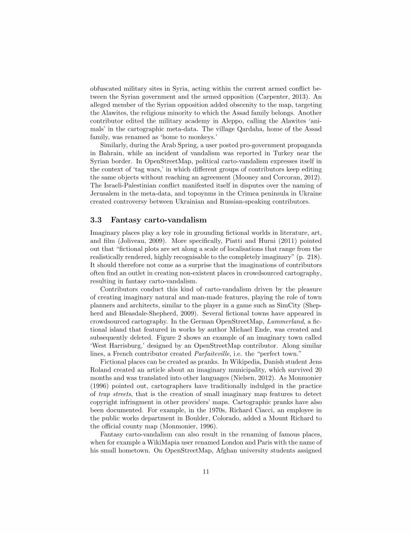
Contributors conduct this kind of carto-vandalism driven by the pleasureof creating imaginary natural and man-made features, playing the role of townplanners and architects, similar to the player in a game such as SimCity (Shep-herd and Bleasdale-Shepherd, 2009). Several fictional towns have appeared incrowdsourced cartography. In the German OpenStreetMap, Lummerland, a fic-tional island that featured in works by author Michael Ende, was created andsubsequently deleted. Figure 2 shows an example of an imaginary town called‘West Harrisburg,’ designed by an OpenStreetMap contributor. Along similarlines, a French contributor created Parfaiteville, i.e. the “perfect town.”
Fictional places can be created as pranks. In Wikipedia, Danish student JensRoland created an article about an imaginary municipality, which survived 20months and was translated into other languages (Nielsen, 2012). As Monmonier(1996) pointed out, cartographers have traditionally indulged in the practiceof trap streets, that is the creation of small imaginary map features to detectcopyright infringment in other providers’ maps. Cartographic pranks have alsobeen documented. For example, in the 1970s, Richard Ciacci, an employee inthe public works department in Boulder, Colorado, added a Mount Richard tothe official county map (Monmonier, 1996).
Fantasy carto-vandalism can also result in the renaming of famous places,when for example a WikiMapia user renamed London and Paris with the name ofhis small hometown. On OpenStreetMap, Afghan university students assigned
11
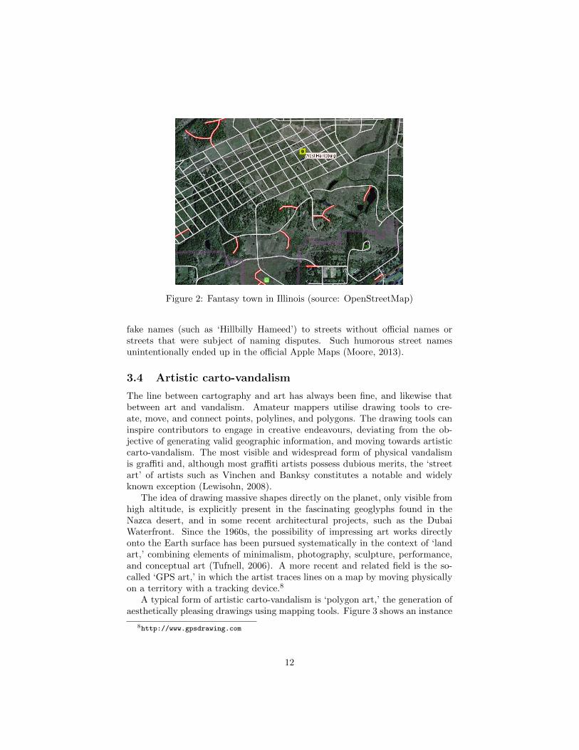
Figure 2: Fantasy town in Illinois (source: OpenStreetMap)
fake names (such as ‘Hillbilly Hameed’) to streets without official names orstreets that were subject of naming disputes. Such humorous street namesunintentionally ended up in the official Apple Maps (Moore, 2013).
3.4 Artistic carto-vandalism
The line between cartography and art has always been fine, and likewise thatbetween art and vandalism. Amateur mappers utilise drawing tools to cre-ate, move, and connect points, polylines, and polygons. The drawing tools caninspire contributors to engage in creative endeavours, deviating from the ob-jective of generating valid geographic information, and moving towards artisticcarto-vandalism. The most visible and widespread form of physical vandalismis graffiti and, although most graffiti artists possess dubious merits, the ‘streetart’ of artists such as Vinchen and Banksy constitutes a notable and widelyknown exception (Lewisohn, 2008).
The idea of drawing massive shapes directly on the planet, only visible fromhigh altitude, is explicitly present in the fascinating geoglyphs found in theNazca desert, and in some recent architectural projects, such as the DubaiWaterfront. Since the 1960s, the possibility of impressing art works directlyonto the Earth surface has been pursued systematically in the context of ‘landart,’ combining elements of minimalism, photography, sculpture, performance,and conceptual art (Tufnell, 2006). A more recent and related field is the so-called ‘GPS art,’ in which the artist traces lines on a map by moving physicallyon a territory with a tracking device.8
A typical form of artistic carto-vandalism is ‘polygon art,’ the generation ofaesthetically pleasing drawings using mapping tools. Figure 3 shows an instance
8http://www.gpsdrawing.com
12
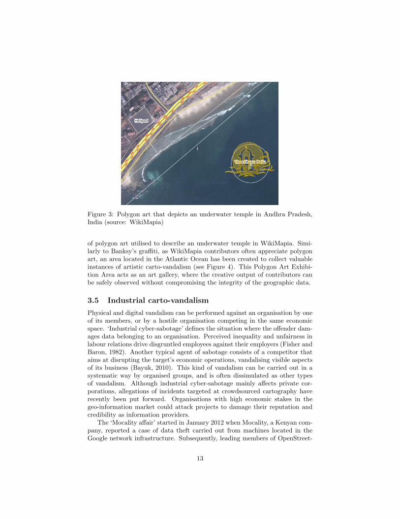
Figure 3: Polygon art that depicts an underwater temple in Andhra Pradesh,India (source: WikiMapia)
of polygon art utilised to describe an underwater temple in WikiMapia. Simi-larly to Banksy’s graffiti, as WikiMapia contributors often appreciate polygonart, an area located in the Atlantic Ocean has been created to collect valuableinstances of artistic carto-vandalism (see Figure 4). This Polygon Art Exhibi-tion Area acts as an art gallery, where the creative output of contributors canbe safely observed without compromising the integrity of the geographic data.
3.5 Industrial carto-vandalism
Physical and digital vandalism can be performed against an organisation by oneof its members, or by a hostile organisation competing in the same economicspace. ‘Industrial cyber-sabotage’ defines the situation where the offender dam-ages data belonging to an organisation. Perceived inequality and unfairness inlabour relations drive disgruntled employees against their employers (Fisher andBaron, 1982). Another typical agent of sabotage consists of a competitor thataims at disrupting the target’s economic operations, vandalising visible aspectsof its business (Bayuk, 2010). This kind of vandalism can be carried out in asystematic way by organised groups, and is often dissimulated as other typesof vandalism. Although industrial cyber-sabotage mainly affects private cor-porations, allegations of incidents targeted at crowdsourced cartography haverecently been put forward. Organisations with high economic stakes in thegeo-information market could attack projects to damage their reputation andcredibility as information providers.
The ‘Mocality affair’ started in January 2012 when Mocality, a Kenyan com-pany, reported a case of data theft carried out from machines located in theGoogle network infrastructure. Subsequently, leading members of OpenStreet-
13
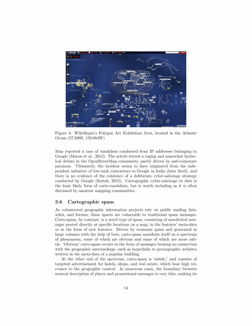
Figure 4: WikiMapia’s Polygon Art Exhibition Area, located in the AtlanticOcean (57.899S, 159.084W)
Map reported a case of vandalism conducted from IP addresses belonging toGoogle (Maron et al., 2012). The article stirred a raging and somewhat hyster-ical debate in the OpenStreetMap community, partly driven by anti-corporateparanoia. Ultimately, the incident seems to have originated from the inde-pendent initiative of low-rank contractors to Google in India (later fired), andthere is no evidence of the existence of a deliberate cyber-sabotage strategyconducted by Google (Sottek, 2012). Cartographic cyber-sabotage to date isthe least likely form of carto-vandalism, but is worth including as it is oftendiscussed by amateur mapping communities.
3.6 Cartographic spam
As volunteered geographic information projects rely on public mailing lists,wikis, and forums, these spaces are vulnerable to traditional spam messages.Carto-spam, by contrast, is a novel type of spam, consisting of unsolicited mes-sages posted directly at specific locations on a map, in the features’ meta-dataor in the form of new features. Driven by economic gains and generated inlarge volumes with the help of bots, carto-spam manifests itself on a spectrumof phenomena, some of which are obvious and some of which are more sub-tle. ‘Obvious’ carto-spam occurs in the form of messages bearing no connectionwith the geographic surroundings, such as hyperlinks to pornographic websiteswritten in the meta-data of a popular building.
At the other end of the spectrum, carto-spam is ‘subtle,’ and consists oftargeted advertisement for hotels, shops, and real estate, which bear high rel-evance to the geographic context. In numerous cases, the boundary betweenneutral description of places and promotional messages is very thin, making its
14
detection challenging, if not impossible. The same issue arises in review web-sites, such as TripAdvisor,9 where promotional reviews are generated by thebusinesses’ owners and skew the user ratings, in what has been called ‘opinionspam’ by Jindal and Liu (2008).
In OpenStreetMap, carto-spammers add specific tags to increase the visi-bility of businesses, for example by adding the tag tourism=attraction to nightclubs. The emergence of carto-spam occasionally triggers debates about thescope of acceptable information, e.g. WikiMapia contributors discussed whether“Joe’s shoe repair shop - www.joeshoefix.com” should be considered spam orvalid meta-data. In OpenStreetMap, a contributor systematically removed shopnames because he did not want the project to become business-oriented. In suchcases, divergent views on the utility of geographic information determine differ-ent boundaries for carto-vandalism. What is useful for one user, can be anotheruser’s vandalism.
4 Countering carto-vandalism
The success of crowdsourced cartography lies in its ability to harness and co-ordinate individual contributors towards the production of re-usable digitalmaps. In this sense, containing and responding in a timely manner to carto-vandalism is crucial to ensuring the integrity of digital artefacts, and to keepingcontributors motivated. As in other commons-based peer production contexts,crowdsourced cartography faces a participation/quality dilemma, a tension be-tween the need for non-expert involvement and that of high-quality contribu-tions. In order to reduce the societal harm caused by physical vandalism, twoapproaches are adopted: repairing artefacts and prosecuting offenders in inci-dents that have occurred (ex-post), and preventing vandalism from occurring(ex-ante). In the case of carto-vandalism, legal prosecution is usually not fea-sible neither desirable, therefore anti-vandalism strategies focus on detectingand reverting incidents. The only concrete way that a community can punishoffenders is by banning them, which does not constitute a strong deterrent.
The issue of geo-information quality is tightly coupled with carto-vandalism.Goodchild and Li (2012) propose three families of approaches to ensure quality.First, crowdsourcing approaches are based on the assumption that the moreusers inspect an area, the higher the quality of the data. Second, social ap-proaches rely on collaborative policing, adopting forms of hierarchical control,typically granting special powers to a group of selected users (e.g. moderators,administrators, etc.). Finally, geographic approaches aim at data validationthrough geographic scientific knowledge, and are to date only a theoretical pos-sibility. Currently, volunteered geographic information communities countercarto-vandalism primarily through a combination of crowdsourcing and socialapproaches, setting up semi-formal mechanisms to police the vast open spacesvulnerable to malicious users, as described in the next section.
9http://www.tripadvisor.com
15
4.1 Volunteered community involvement and policing
To contain and manage carto-vandalism, amateur mapping communities aimat identifying incidents, in what is essentially a classification problem betweenvalid and damaging changes to an artefact. The manual inspection of changesperformed by competent contributors remains the ultimate technique to assesswhether a change should be accepted or reverted. Hence, the social mobilisationand co-ordination of human users is key to identifying and reverting incidents.In order to control and inhibit carto-vandalism, the communities usually banusers, detecting ‘sockpuppets,’ i.e. banned users who create new accounts tokeep disrupting the project’s activities.
Policing is an essential activity in the digital commons. Williams (2007)observed the emergence of two policing strategies in online 3D platform Cy-berworlds. Initially, a ‘community involvement’ model arose, in which anti-vandalism policing is performed on a non-structured basis by common users.After a wave of highly damaging vandalism, a ‘volunteered community polic-ing’ model was adopted, establishing a structured response through a group ofvigilantes with special powers. This pattern occurs across commons-based peerproduction environments.
In Wikipedia, any user is encouraged to revert vandalous changes throughcommunity involvement, using watch lists to monitor articles of interest. Volun-teered community policing was initiated through the Counter-Vandalism Unit,which aims to detect, fight, and to gather first-hand knowledge about vandalismin Wikipedia, with the slogan “Civility, Maturity, Responsibility.”10 Membersof the unit engage in patrolling, and are rewarded with medals of honour andbadges for their efforts. In this context, Kittur et al. (2009) pointed out that be-longing to a clearly defined group within the community increases the likelihoodof participation in anti-vandalism and other ‘good citizenship’ behaviours.
To counter carto-vandalism, leading cartographic projects rely on volun-teered community policing, coordinated through forums, wikis, and mailinglists. In OpenStreetMap, the Data Working Group deals with accusations ofcopyright infringement, disputes, and major cases of vandalism, indicating that“minor incidents of vandalism should be dealt with by the local community.”11
Its members have the possibility of banning users only temporarily, while arestricted group of administrators have the power to ban users permanently.The pride in one’s local environment functions as an important motivational as-pect, encouraging users to patrol familiar areas, tapping their local knowledgeto promptly identify and revert incidents.
Being a commercial project, WikiMapia is more centralised than OpenStreet-Map. However, policing is largely self-organised, and relies on gamificationto motivate and reward users. The system automatically assigns ‘experiencepoints’ to editors for types of actions, ranking them in different groups. High-ranking groups, called ‘moderators’ and ‘power users,’ gain access to advancedmap monitoring tools, fewer restrictions, and increased powers to ban deviant
10http://en.wikipedia.org/wiki/Wikipedia:CVU11http://wiki.openstreetmap.org/wiki/Data_working_group
16
users.Given their reliance on social mechanisms, such forms of policing are bound
to suffer from the divides that affect volunteered geographic information ingeneral. As Elwood (2010) points out, geo-information about high-incomeneighbourhoods and tourist destinations tends to be overrepresented, express-ing existing divides between urban and rural, high-income and low-income socialgroups and areas. Analogous coverage biases have been observed in Wikipedia(George, 2007). Another salient divide relates to the technical skills and accessto digital technologies that are needed to engage with volunteered geographic in-formation in the first place. In this sense, strategies to counter carto-vandalismare likely to be strongly influenced by such divides, which should explicitly betaken into account.
Furthermore, policing causes social tension within the communities, espe-cially because of the difficulties in classifying carto-vandalism, and the hazyboundary between intentional and unintentional damage to the map. Just as inany legal system, anti-vandalism patrols can abuse their banning powers, andcan wrongly identify and ban a user as a vandal. For example, a WikiMapiauser stated: “HELP! I have been falsely banned as a clone.” The moderatorreplied “apparently you edited a few tags that were touched by a known van-dal . . . Your account name resembled a choice pattern of names the vandal hadbeen using lately.” To overcome these limitations, the automatic detection ofcarto-vandalism has emerged as a complementary approach.
4.2 Automatic detection of carto-vandalism
Although human judgement is necessary in most cases to identify incidents ofcarto-vandalism, automated procedures can provide valuable support. Becauseof the prominence of the issue and the massive size of its datasets, Wikipedia hasattracted research on automatic detection of vandalism, resulting in a number ofsoftware tools and classifiers (Adler et al., 2011). After initial efforts with rule-based techniques, machine learning approaches have emerged as being moreeffective (e.g. Potthast et al., 2008). Indicators of Wikipedia vandalism arefound in character distribution, presence of vulgar words, uppercase/lowercaseratio, semantic relatedness with the edit’s context, and contributor’s reputation.Since 2010, academic competitions have been held to enhance and compareautomatic vandalism detection techniques in Wikipedia, using an annotatedcorpus of changes as the ground truth (Potthast and Holfeld, 2011).
In the context of OpenStreetMap, automatic detection is taking its firststeps. Notably, Neis et al. (2012) have developed OSMPatrol, a rule-based sys-tem to detect carto-vandalism in OpenStreetMap. Starting from criteria pro-posed by the OpenStreetMap community,12 the system classifies users’ actionsbased primarily on the contributor’s reputation. However, possibly because ofan excessively inclusive definition of rules, the system seems to detect a highnumber of false positives, indicating edits of experienced users as potential van-
12http://wiki.openstreetmap.org/wiki/Detect_Vandalism
17
dalism. OSMPatrol confirms the difficulties of clearly discriminating betweensub-optimal contributions and genuine carto-vandalism.
Automatic techniques are particularly important to counter carto-spam,which is one of the most threatening forms of carto-vandalism because of itsfor-profit motive. In recent years, anti-spam techniques have experienced hugeadvances in the context of e-mails and social networking sites (Heymann et al.,2007). However, spammers respond to new filters by re-engineering their tech-niques to circumvent automated barriers, resulting in a perverse feedback loopbetween spam and anti-spam forces. While obvious carto-spam pushing illegaldrugs and fake diplomas is easily detectable using traditional anti-spam tools,subtle carto-spam about restaurants, real estate, and tourist resorts, presentsmore complex challenges. To automatically detect opinion spam, the sophisti-cated techniques of natural-language processing, sentiment analysis, and socialnetwork analysis discussed by Jindal and Liu (2008) need to be combined andtailored to the cartographic domain.
5 Conclusions
Carto-vandalism is an emergent area ripe for multi-disciplinary research. Thisarticle has provided a discussion of the phenomenon’s salient features, motiva-tions, and the current approaches adopted to keep it at bay with social and tech-nological detection and control mechanisms. Many open questions and future re-search directions lie ahead for cartographers, geographic information scientists,social scientists, human-computer interaction experts, and human geographersalike.
The typology outlined in this article was based on a direct observation offorums and mailing lists in WikiMapia and OpenStreetMap. To assess the im-pact and study the processes revolving around the generation and repression ofcarto-vandalism, more empirical research is needed. Social network analysis andethnographic observations can be conducted on volunteered geographic infor-mation communities, further clarifying the reasons behind carto-vandalism andhow communities defend the integrity of the geospatial artefacts. Such researchshould also be conducted beyond the most studied crowdsourced cartographyprojects, including smaller projects that might provide original solutions to theproblem of carto-vandalism.
To enable the development of machine learning approaches and the empiricalcomparison between automatic techniques of carto-vandalism, a more extensivecorpus of real incidents should be collected, involving the affected communities.To collect instances of carto-spam, the idea of ‘honeypots,’ i.e. spaces designedto be particularly attractive to spammers, could be adapted from the context ofsocial networking websites and applied to volunteered geographic information.Existing counter-carto-vandalism techniques are ex-post, aiming at identifyingincidents that have already occurred. By contrast, ex-ante approaches of pre-vention have been ignored. Human-computer interaction principles to designvolunteered geographic information online spaces can draw on the architectural
18
ideas developed in crime prevention through environmental design, which aimat designing criminogenic factors out of the built environment (Cozens, 2008).
Furthermore, as much play carto-vandalism is caused by the interactionwith complex editing tools, research in geospatial human-computer interactionis needed to identify design principles to facilitate volunteered geographic infor-mation production and monitoring, preventing, and not only repairing carto-vandalism incidents. Relevant ideas can also be sought in the area of videogamedesign. As Shepherd and Bleasdale-Shepherd (2009) point out, many modernvideogames have interfaces to interact with complex geographic information,and provide useful ideas to improve the often unsophisticated mapping toolsused by amateur mappers.
The study of carto-vandalism can help understand the issue of the long-termsustainability of crowdsourced cartography, often mentioned as one of its crit-ical weak points (Dodge and Kitchin, 2013). The geospatial digital commonsare threatened by a peculiar form of the so-called ‘tragedy of the commons.’The tragedy of the physical commons occurs when the behaviour of individ-uals, driven by their self interest, ultimately leads to the depletion of a finiteresource, such as the atmosphere, the rainforest, and the reserves of fossil fuels.As Jayaraman (2012) has suggested, the digital commons are affected not by theoverexploitation that plagues the physical commons, but by underexploitation:the tragedy arises precisely when commons-based peer production projects loseparticipants and their labour, and the digital artefacts see their utility decreas-ing, ultimately leading to their disappearance. In his discussion of Wikipedia,George (2007) argued that, to avoid the tragedy in the long run, complex gov-ernance is needed, carefully managing vandalism and incentivising high-qualitycontributions.
This issue is of particular relevance for cartographic artefacts, which suffersfrom rapid obsolescence. Every map is by definition a historical map that re-flects a past state of affairs and needs updating. To keep a map alive, constantand systematic efforts are necessary, keeping the gap between the map and theterritory constant. It is possible to imagine that once a commons-based projecthas lost its initial thrust and popular appeal, carto-vandalism can damage adataset’s value irreparably, leading to the project’s eventual demise.13 To date,no survey exists of the life expectancy of commons-based peer production pro-jects. Such research directions around carto-vandalism might offer insights onthe issue of maintainability, and help identify important factors in the survivalof volunteered geographic information projects amidst turbulent and unstableflows of contributions.
References
Adler, B. T., De Alfaro, L., Mola-Velasco, S. M., Rosso, P., and West, A. G.(2011). Wikipedia vandalism detection: Combining natural language, meta-
13In this sense, the British Library-funded UK Web Archive acts as a graveyard for deadwebsites. http://www.webarchive.org.uk/ukwa
19
data, and reputation features. In Gelbukh, A., editor, Computational Lin-guistics and Intelligent Text Processing, LNCS, pages 277–288. Springer.
Allen, V. and Greenberger, D. (1978). An aesthetic theory of vandalism. Crime& Delinquency, 24(3):309–321.
Ballatore, A., Wilson, D., and Bertolotto, M. (2013). A Survey of VolunteeredOpen Geo-Knowledge Bases in the Semantic Web. In Pasi, G., Bordogna, G.,and Jain, L., editors, Quality Issues in the Management of Web Information,volume 50 of Intelligent Systems Reference Library, pages 93–120. Springer.
Bayuk, J. (2010). CyberForensics: Understanding Information Security Inves-tigations. Humana Press, New York.
Benkler, Y. and Nissenbaum, H. (2006). Commons-based Peer Production andVirtue. Journal of Political Philosophy, 14(4):394–419.
Carpenter, T. G. (2013). Tangled Web: The Syrian Civil War and Its Implica-tions. Mediterranean Quarterly, 24(1):1–11.
Carr, J. (2011). Inside cyber warfare: Mapping the cyber underworld. O’ReillyMedia, Sebastopol, CA.
Coast, S. (2010a). Enough is enough: disinfecting OSM from poisonous people(August 10, 2010). OpenGeoData. Available from: http://opengeodata.
org/enough-is-enough-disinfecting-osm-from-poison.
Coast, S. (2010b). OpenStreetMap - The Best Map (February 19,2010). OpenGeoData. Available from: http://opengeodata.org/
openstreetmap-the-best-map.
Cohen, S. (1973). Property destruction: Motives and meanings. In Ward, C.,editor, Vandalism, pages 23–53. Architectural Press, London.
Coleman, D., Georgiadou, Y., and Labonte, J. (2009). Volunteered GeographicInformation: the nature and motivation of produsers. International Journalof Spatial Data Infrastructures Research, 4(2009):332–358.
Cozens, P. (2008). Crime prevention through environmental design. In Wortley,R. and Mazerolle, L., editors, Environmental criminology and crime analysis,pages 153–194. Willan, Devon, UK.
Dodge, M. and Kitchin, R. (2013). Mapping experience: Crowdsourced cartog-raphy. Environment and Planning A, 45(1):19–36.
Elwood, S. (2008). Volunteered geographic information: Key questions, conceptsand methods to guide emerging research and practice. GeoJournal, 72(3):133–135.
20

Elwood, S. (2010). Geographic information science: emerging research on thesocietal implications of the geospatial web. Progress in Human Geography,34(3):349–357.
Elwood, S., Goodchild, M., and Sui, D. (2012). Researching Volunteered Ge-ographic Information: Spatial Data, Geographic Research, and New SocialPractice. Annals of the Association of American Geographers, 102(3):571–590.
Fisher, J. and Baron, R. (1982). An equity-based model of vandalism. Popula-tion & Environment, 5(3):182–200.
Flanagin, A. and Metzger, M. (2008). The credibility of volunteered geographicinformation. GeoJournal, 72(3):137–148.
Furnell, S. (2002). Cybercrime: Vandalizing the Information Society. InCueva Lovelle, J., Gonzalez Rodrguez, B., Joyanes Aguilar, L., Labra Gayo,J., and del Puerto Paule de Ruiz, M., editors, Web Engineering, volume 2722of LNCS, pages 8–16. Springer.
Gau, J. M. and Pratt, T. C. (2010). Revisiting Broken Windows Theory: Ex-amining the Sources of the Discriminant Validity of Perceived Disorder andCrime. Journal of Criminal Justice, 38(4):758–766.
George, A. (2007). Avoiding Tragedy in the Wiki-Commons. Virginia Journalof Law and Technology, 12(8):1–42.
Goldstein, A. (1996). The Psychology of Vandalism. Plenum Press, New York,NY.
Goodchild, M. (2007). Citizens as Sensors: The World of Volunteered Geogra-phy. GeoJournal, 69(4):211–221.
Goodchild, M. and Li, L. (2012). Assuring the Quality of Volunteered Geo-graphic Information. Spatial Statistics, 1:110–120.
Graham, M. (2010). Neogeography and the Palimpsests of Place: Web 2.0 andthe Construction of a Virtual Earth. Tijdschrift voor economische en socialegeografie, 101(4):422–436.
Haklay, M. (2010a). How good is volunteered geographical information? Acomparative study of OpenStreetMap and Ordnance Survey datasets. Envi-ronment and Planning B: Planning and Design, 37(4):682–703.
Haklay, M., editor (2010b). Interacting with Geospatial Technologies. JohnWiley & Sons, Chichester, UK.
Heymann, P., Koutrika, G., and Garcia-Molina, H. (2007). Fighting Spam onSocial Web Sites: A Survey of Approaches and Future Challenges. IEEEInternet Computing, 11(6):36–45.
21
Jayaraman, K. (2012). Tragedy of the Commons in the Production of DigitalArtifacts. International Journal of Innovation, Management and Technology,3(5):625–627.
Jindal, N. and Liu, B. (2008). Opinion spam and analysis. In Proceedings ofthe International Conference on Web Search and Web Data Mining, WSDM2008, pages 219–230, New York. ACM.
Joliveau, T. (2009). Connecting real and imaginary places through geospatialtechnologies: Examples from set-jetting and art-oriented tourism. Carto-graphic Journal, The, 46(1):36–45.
Jurgenson, N. (2012). When atoms meet bits: Social media, the mobile weband augmented revolution. Future Internet, 4(1):83–91.
Kelling, G. and Wilson, J. (1982). Broken windows: The police and neighbor-hood safety. Atlantic Monthly, 249(3):29–38.
Kittur, A., Pendleton, B., and Kraut, R. (2009). Herding the cats: The in-fluence of groups in coordinating peer production. In Proceedings of the 5thInternational Symposium on Wikis and Open Collaboration, pages 1–7. ACM.
Lewisohn, C. (2008). Street art: The graffiti revolution. Abrams, New York.
Ley, D. and Cybriwsky, R. (1974). Urban Graffiti as Territorial Markers. Annalsof the Association of American Geographers, 64(4):491–505.
Maron, M., Slater, G., and Coast, S. (2012). Google IP Vandalizing Open-StreetMap (January 16, 2012). OpenGeoData. Available from: http:
//opengeodata.org/google-ip-vandalizing-openstreetmap.
Minor, H. (1999). Mapping Mussolini: Ritual and Cartography in Public Artduring the Second Roman Empire. Imago Mundi, 51(1):147–162.
Monmonier, M. (1996). How to Lie With Maps. University of Chicago Press,Chicago, IL.
Mooney, P. and Corcoran, P. (2012). Characteristics of heavily edited objectsin OpenStreetMap. Future Internet, 4(1):285–305.
Mooney, P., Corcoran, P., and Winstanley, A. (2010). Towards quality metricsfor OpenStreetMap. In Proceedings of the 18th SIGSPATIAL InternationalConference on Advances in Geographic Information Systems, pages 514–517,New York. ACM.
Moore, U. (2013). How Afghan Amateur Mappers Unintentionally PunkedApple (January 14, 2013). UN Dispatch. Available from: http://www.
undispatch.com/how-afghan-mappers-punked-apple.
22
Moser, G. (1992). What is Vandalism? Towards a Psycho-Social Definitionand Its Implications. In Christensen, H. H., Johnson, D. R., and Brookes,M. H., editors, Vandalism: Research, Prevention, and Social Policy, pages51–59. U.S. Dept. of Agriculture, Forest Service, Pacific Northwest ResearchStation.
Neis, P., Goetz, M., and Zipf, A. (2012). Towards Automatic Vandalism De-tection in OpenStreetMap. ISPRS International Journal of Geo-Information,1(3):315–332.
Nielsen, F. (2012). Wikipedia Research and Tools: Review and Comments.Social Science Research Network, pages 1–52. Available from: http://ssrn.com/abstract=2129874.
Piatti, B. and Hurni, L. (2011). Cartographies of Fictional Worlds. CartographicJournal, The, 48(4):218–223.
Potthast, M. and Holfeld, T. (2011). Overview of the 2nd international compe-tition on wikipedia vandalism detection. In CLEF 2011 Labs and Workshop,Notebook Papers, 19-22 September 2011, Amsterdam, The Netherlands.
Potthast, M., Stein, B., and Gerling, R. (2008). Automatic Vandalism Detectionin Wikipedia. In Advances in Information Retrieval, volume 4956 of LNCS,pages 663–668. Springer.
Shepherd, I. D. and Bleasdale-Shepherd, I. D. (2009). Videogames: the newGIS? In Lin, H. and Batty, M., editors, Virtual Geographic Environments,pages 311–344. Science Press, Beijing, China.
Sottek, T. (2012). Sources: Google contractors fired after vandalizing Open-StreetMap, ‘no connection’ with Mocality incident (January 1, 2012). TheVerge. Available from: http://www.theverge.com/2012/1/17/2714044/
google-contractors-sacked-vandalism-openstreetmap.
Suler, J. (2004). The Online Disinhibition Effect. Cyberpsychology & Behavior,7(3):321–326.
Sutton, M. (1987). Differential rates of vandalism in a new town: Towards atheory of relative place. PhD thesis, Lancashire Polytechnic.
TomTom (2012). Open source maps and their alternatives. TomTom newsletter.Available from: http://www.tomtom.com/en_gb/licensing/newsletter/
201205/didyouknow.
Tufnell, B. (2006). Land art. Tate Publishing, London.
Wall, D. and Williams, M. (2007). Policing diversity in the digital age: Maintain-ing order in virtual communities. Criminology and Criminal Justice, 7(4):391–415.
23
Whalen, K. (2013). Defacing Kabul: An iconography of political campaignposters. Cultural Geographies, 20(4):541–549.
Williams, M. (2004). Understanding King Punisher and His Order: Van-dalism in an Online Community - Motives, Meanings and Possible Solu-tions. Internet Journal of Criminology. Available from: http://www.
internetjournalofcriminology.com.
Williams, M. (2006). Virtually Criminal: Crime, Deviance, and RegulationOnline. Taylor & Francis, Abington, UK.
Williams, M. (2007). Policing and Cybersociety: The maturation of regulationwithin an online community. Policing & Society, 17(1):59–82.
Wittel, A. (2001). Toward a network sociality. Theory, culture & society,18(6):51–76.
24