Davis County Authors Keller and DeVecchio of Natural Hazards suggest some possible ways of educating...
13
A look into the Wasatch Front Pre- Disaster Mitigation Plan -Sara Warr
-
Upload
ethan-boyd -
Category
Documents
-
view
215 -
download
1
Transcript of Davis County Authors Keller and DeVecchio of Natural Hazards suggest some possible ways of educating...

A look into the Wasatch Front Pre-Disaster Mitigation Plan
-Sara Warr

Davis County
Authors Keller and DeVecchio of Natural Hazards suggest some possible ways of educating the community. “This educational effort could include the public distribution of pamphlets and videos” (pg 93, Keller, Devecchio). Although Davis County has a great start in bringing the community to the awareness of earthquake education, thus furthering mitigation plans, the scheduled meetings will only alert a small sample of the community. This sample mostly includes those who actually attend community meetings. Some are unable to attend such as: the elderly, those who are busy during scheduled times, or those who do not attend community meetings. These people will not be educated or prepared should an earthquake arise. A better solution to the distribution of pamphlets, though time consuming or costly, would be to deliver pamphlets to homes, attempting to educate everyone in the community.
Page 25 of Mitigation Plan

Davis County
The picture to the left is an example of Tectonic
Creep, defined in the book Natural Hazards as, “Slow, more or less
continuous, movement along a fault; also called fault creep” (Keller and
Devecchio, 538). Though Davis County claims there
has not been enough evidence to update fault zone maps since 2003, constant movement has
occurred over the last 12 years. Shouldn't this be
enough information as is? Why do we need another
Earthquake to make better decisions? Doesn’t that defeat the purpose of
decision making?
Picture of San Andreas Fault. Picture found on Pg. 61 of Textbook.
Page 25 of Mitigation Plan

Davis County
“Fire is another major hazard linked to earthquakes. Shaking of the ground and surface displacements can break electrical power and natural gas lines, thus starting fires. The threat from fire is even greater because firefighting equipment may be damaged; streets, roads, and bridges may be blocked; and essential water mains broken” (Keller and DeVecchio, 77). Davis County’s measures have taken beneficial measures due to earthquake’s accompanying hazard of fire. As explained by Keller and DeVecchio, risk is higher due to damage of firefighting equipment. By updating fire department structures, proper aid may be received should an earthquake occur.
Page 25-26 of mitigation Plan.

Morgan County “Insurance and relief measures are vital to help a community, state, or country recover from an earthquake” (Keller and DeVecchio, 93). Although even the book claims that insurance is important, it does not reduce the loss of life and damage to property as the Morgan County Plan claims. As discussed in Jon Allred’s class, insurance only replaces our belongings. Still, even this goal is unaccomplished.
Page 30 in Mitigation Plan

Salt Lake County
“Technically it is feasible to develop an earthquake warning system that would provide up to about 1 minute of warning to the Los Angeles area prior to the arrival of damaging earthquake waves from an event several hundred kilometers away. Such a system would be based on the principle that radio waves travel much faster than seismic waves” (Keller and DeVecchio, 89). As shown above, Salt Lake County is updating radio systems to improve emergency communications. This is exciting news for the county!
Page 33 in Mitigation Plan

Salt Lake County
Refer to the next slide.
Page 33 in Mitigation Plan

Salt Lake
County
The above image is cropped from the original Utah Geological Survey GIS map. Encircled is the city which I live. As indicated in the Key below the map, Cottonwood Heights’ ground is made of mostly sand and gravel deposits. According to page 66 of the text, as shown in the image to the left, shaking of ground made of silt and mud (sand included) shakes more severely than alluvium, sedimentary rock, and hard igneous rock. With the information included, builders can plan accordingly.
Murray
Cottonwood Heights
Mouth of Big
Cottonwood Canyon
Key
GIS Map Data - Utah Geological Survey, 2013.
(Keller and DeVecchio, 66)

Tooele
Yet another example that could represent a lack of urgency.
Page 38 in Mitigation Plan

Tooele
We haven’t seen activity yet, therefore maybe we should spend time on other pressing matters, right? WRONG! Utah’s fault zones are classic examples of a seismic gaps, “Area along an active fault zone that is capable of producing a large earthquake but has not produced one recently” (Keller and Devecchio, 537). As described in the text, tension (or strain) builds within the Earth” (Keller and DeVecchio, 66). When released, an earthquake occurs. The more strain that is built, the larger the earthquake. “Frequent small earthquakes may help prevent larger ones in the same area. If we assume that small earthquakes release pent-up energy, then the reduction in elastic strain may lower the chance of a devastating earthquake along a particular fault” (Keller and DeVecchio, 79). However when an earthquake does not occur for a long period of time, the increasing future damage can be overlooked. In reality strain is building higher and higher until BAM! A quake occurs. The unattended classes intended for planners and policy officials could very well represent this lack of urgency. Currently, as discussed in class, we are expected to have a 7.5 quake. As strain builds, that number will increase. We need to be prepared.
Page 38 in Mitigation Plan
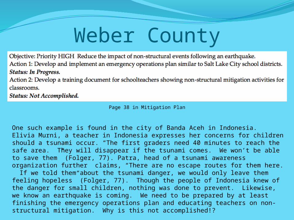
Weber County
One such example is found in the city of Banda Aceh in Indonesia. Elivia Murni, a teacher in Indonesia expresses her concerns for children should a tsunami occur. “The first graders need 40 minutes to reach the safe area. They will disappear if the tsunami comes. We won’t be able to save them” (Folger, 77). Patra, head of a tsunami awareness organization further claims, “There are no escape routes for them here. If we told them about the tsunami danger, we would only leave them feeling hopeless” (Folger, 77). Though the people of Indonesia knew of the danger for small children, nothing was done to prevent. Likewise, we know an earthquake is coming. We need to be prepared by at least finishing the emergency operations plan and educating teachers on non-structural mitigation. Why is this not accomplished!?
Page 38 in Mitigation Plan

Weber County
Page 38 in Mitigation Plan
Retrofitting these buildings will accomplish two things. As the textbook says, “Earthquakes don’t kill people, buildings kill people” (Keller and DeVecchio, 92). By retrofitting these buildings, deaths and injuries may be reduced. The book further states, “Although we may never be able to prevent injury and death from earthquakes, we can reduce the number of casualties through the safe location of critical facilities.” Should an earthquake occur, these critical buildings will help the community receive aid as soon as possible.

CitationsFolger, Tim. "The Calm Before the Wave: Where and When Will
the Tsunami Hit?" National Geographic 1 Feb. 2012: 77. Print."GIS Map Data - Utah Geological Survey." GIS Map Data - Utah
Geological Survey. State of Utah, 1 Jan. 2013. Web. 4 Mar. 2015. <http://geology.utah.gov/maps/gis/>.
Keller, Edward A., and Duane E. DeVecchio. Natural Hazards: Earth's Processes as Hazards, Disasters, and Catastrophes. Third ed. Upper Saddle River, NJ: Pearson/Prentice Hall, 2012. Print.
"Wasatch Front Region Natural Hazard Pre - Disaster Mitigation Plan." The Official Website of Davis County, Utah | Sheriff. Davis County Government Information Systems, 1 June 2009. Web. 4 Mar. 2015. <http://www.co.davis.ut.us/sheriff/divisions/emergency_services/emergency_management/lepc.cfm>.