Date: Meeting time: Date: Bus stops: BERG WANDER · loaned hiking boots and backpack available...
4
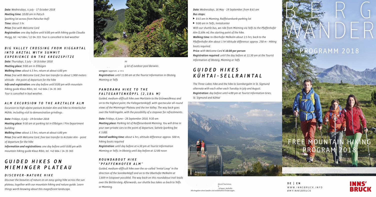
unlimited IMPRESSUM: Herausgeber / Konzept u. Grafik: Innsbruck Tourismus Druck: Alpina Druck GmbH, Innsbruck Bilder: Innsbruck Tourismus / Moser, Schwarz, Vorhofer Alle Angaben ohne Gewähr und vorbehaltlich Änderungen. BERG WANDER PROGRAMM 2018 FREE MOUNTAIN HIKING PROGRAM 2018 Date: Wednesdays, 4 July - 17 October 2018 Meeting time: 10:00 am in Patsch (parking lot across from Patscher Hof) Time: about 5 hr. Price: free with Welcome Card Registration: one day before until 6:00 pm with hiking guide Claudia Muigg, tel. +43 664 / 12 04 333. Tour is cancelled in bad weather BIG VALLEY CROSSING FROM VIGGARTAL INTO ARZTAL WITH SUMMIT EXPERIENCE ON THE KREUZSPITZE Date: Thursdays, 5 July - 18 October 2018 Meeting place: 9:00 am in Ellbögen Walking time: about 4.5 hrs, return at about 4:00 pm Price: free with Welcome Card, free taxi transfer to about 1,900 meters altitude - the point of departure for the hike Info and registration: one day before until 8:00 pm with mountain hiking guide Klaus Ribis, tel. +43 664 / 24 35 365 Tour is cancelled in bad weather. ALM EXCURSION TO THE ARZTALER ALM Excursion to high alpine pasture Arztaler Alm and hike to Hinterlocher Mühle, including visit to demonstration grindings. Date: Fridays, 6 July - 19 October 2018 Meeting place: 9:30 am at parking lot in Ellbögen / Fire Department building Walking time: about 1.5 hrs, return at about 4:00 pm Price: free with Welcome Card, free taxi transfer to Arztaler Alm - point of departure for the hike Information and registrations: one day before until 8:00 pm with mountain hiking guide Klaus Ribis, tel. +43 664 / 24 35 365 GUIDED HIKES ON MIEMINGER PLATEAU DISCOVER-NATURE HIKE Discover the beauties of nature on an easy-going hike across the sun plateau, together with our mountain hiking and nature guide. Learn things worth knowing about this magnificent landscape. Date: Mondays, 2:00 pm Meeting place: Parking lot of outdoor pool Barwies Length: approx. 2 hrs Registration: until 11:00 am at the Tourist Information in Obsteig, Mieming or Telfs PANORAMA HIKE TO THE FALTEGARTENKÖPFL (2,184 M) Guided, medium-difficult hike over Marlstein to the Grünwaslkreuz and on to the highest point, the Faltegartenköpfl, with spectacular all-round views of the Mieminger Plateau and the Inn Valley. The way back goes over the Feldringalm, with the possibility of a stopover for refreshments. Date: Fridays, 6 June - 28 September 2018, 9:30 am Meeting place: Parking lot of Raiffeisenbank Mieming. You will drive in your own private cars to the point of departure, Sattele (parking fee € 3.00). Overall walking time: about 4 hrs, altitude difference: approx. 500 m, hiking boots required Registration: until day before at 4:30 pm at Tourist Information Mieming or Telfs; in Obsteig until day before at 12:00 noon ROUNDABOUT HIKE “PFAFFENHOFER ALM” Guided, medium-difficult hike over the so-called “Inntal Loop” in the direction of the Sonnkarköpfl and on to the Oberhofer Melkalm at 1,669 m (stopover possible). The way back on this roundabout trail leads over the Bettlersteig. Afterwards, our shuttle bus takes us back to Telfs or Mieming. DE | EN WWW.INNSBRUCK.INFO #MYINNSBRUCK Date: Wednesdays, 16 May - 19 September, from 8:45 am Bus stops: 8:45 am in Mieming, Raiffeisenbank parking lot 9:00 am in Telfs, Inntalcenter With our shuttle bus, we ride from Mieming via Telfs to the Pfaffenhofer Alm (1,694 m), the starting point of the hike. Walking time: to Oberhofer Melkalm about 2.5 hrs; back to the Pfaffenhofer Alm about 1 hr! Altitude difference: approx. 250 m - Hiking boots required. Price: with Welcome Card € 10.00 per person Registration required: until the day before at 11:30 am at the Tourist Information of Obsteig, Mieming or Telfs GUIDED HIKES KÜHTAI-SELLRAINTAL The Three-Lakes hike and the hike to Sonnbergalm in St. Sigmund alternate with each other each Tuesday in July and August. Registration: day before until 4:00 pm at Tourist Information Gries, St. Sigmund and Kühtai Mieming Viggartal
Transcript of Date: Meeting time: Date: Bus stops: BERG WANDER · loaned hiking boots and backpack available...
u n l i m i t e du n l i m i t e d
IMPRESSUM:Herausgeber / Konzept u. Grafi k: Innsbruck TourismusDruck: Alpina Druck GmbH, InnsbruckBilder: Innsbruck Tourismus / Moser, Schwarz, VorhoferAlle Angaben ohne Gewähr und vorbehaltlich Änderungen.
B E R GWANDERWANDER
PROGRAMM 2018
u n l i m i t e d
FREE MOUNTAIN HIK ING PROGRAM 2018
As a guest in the Innsbruck region, a wide ranging hiking programme is
available to you which can be enjoyed free of charge with the Welcome
Card. From the end of May until about end-October, tours with mountain
guides are offered by ASI Reisen and other providers. Thematic hikes
and discovery tours to the Nordkette are on the programme, along with
valley crossings and fun excursions for the whole family. The free hiking
bus takes you from the villages to select points of departure for a total
1,200 kilometers of hikes in the region. Registration until day before
at your Tourist Information.
G U I D E D T O U R S I N T H E C I T Y R E G I O NCombined Hikes: daily from 28 May until 28 September, minimum
6 persons, two hikes on offer. You can select from between a simple,
gentle hike and a medium-difficult, somewhat longer hike. The bus
ride of the groups is together. From 1 October to 26 October 2018,
only one hike is on offer.
Note: meeting points for the holiday villages not listed on the hiking
bus schedule (Ampass / Grinzens / Ranggen / Rinn / Sistrans / Unterper-
fuss / Völs / Zirl) or not listed on that particular day are at the nearest
village or point of departure for the hike. More information at the local
Tourist Information.
Date: Mon - Fri, 28 May to 26 October 2018
Meeting point / Departure time: 9:00 am.
Meeting points (see hiking bus schedule)
hikes with mountain guide by ASI Reisen
hiking bus
tour book
loaned hiking boots and backpack available (limited number)
Hiking Badge:
Bronze: 1 hike, Silver: 3 hikes,
Gold: 10 hikes, Gold with crystal: 20 hikes
Hiking Badge for seniors (over 60):
Bronze: 1 hike, Silver: 3 hikes, Gold: 8 hikes
Gold with crystal: 12 hikes
Participation:
free with Welcome Card
meeting time is always 15 minutes before departure time
hikes take place in any and all weather
hikes with walking times of 3-4 hours
suitable for children 8 years and older, and for seniors
good physical condition is a prerequisite
weatherproof clothing (hiking boots, anorak, rainwear)
of considerateness towards other hikers, dogs are not permitted
sun protection, food and enough to drink
registration required for groups of more than 15 persons
registration at the local Tourist Information
N O R D K E T T E D I S C O V E R Y T O U RA highly varied rather difficult hike for all those interested in nature, from
the Hafelekar on the Goetheweg to the superb site of the Pfeishütte hut.
Our expert nature guide knows everything worth knowing about flora
and fauna, has lots of tales to tell and has binoculars for observations.
Dates: July: 22 / 28 | August: 4 / 15 / 19 / 25 | September: 1 / 9 / 15 / 23
Meeting: 9:00 am, Hungerburg ticket window
Walking time: about 6 hrs, incl. stopover
Price: free for everyone. For the funicular/lift, regular prices apply
Infomation and registration: max. 20 persons, at Naturpark Karwendel,
Anton Heufelder, tel. +43 664 / 88 44 62 25.
D I S C O V E R T H E C H A R M S O F T H E P R I M E V A L V I G G A R T A LHike through an untouched and primordial high altitude valley.
Very near to the city. Maximum 16 persons.
Date: Wednesdays, 4 July - 17 October 2018
Meeting time: 10:00 am in Patsch
(parking lot across from Patscher Hof)
Time: about 5 hr.
Price: free with Welcome Card
Registration: one day before until 6:00 pm with hiking guide Claudia
Muigg, tel. +43 664 / 12 04 333. Tour is cancelled in bad weather
B I G V A L L E Y C R O S S I N G F R O M V I G G A R T A L I N T O A R Z T A L W I T H S U M M I T E X P E R I E N C E O N T H E K R E U Z S P I T Z E Date: Thursdays, 5 July - 18 October 2018
Meeting place: 9:00 am in Ellbögen
Walking time: about 4.5 hrs, return at about 4:00 pm
Price: free with Welcome Card, free taxi transfer to about 1,900 meters
altitude - the point of departure for the hike
Info and registration: one day before until 8:00 pm with mountain
hiking guide Klaus Ribis, tel. +43 664 / 24 35 365
Tour is cancelled in bad weather.
A L M E X C U R S I O N T O T H E A R Z T A L E R A L MExcursion to high alpine pasture Arztaler Alm and hike to Hinterlocher
Mühle, including visit to demonstration grindings.
Date: Fridays, 6 July - 19 October 2018
Meeting place: 9:30 am at parking lot in Ellbögen / Fire Department
building
Walking time: about 1.5 hrs, return at about 4:00 pm
Price: free with Welcome Card, free taxi transfer to Arztaler Alm - point
of departure for the hike
Information and registrations: one day before until 8:00 pm with
mountain hiking guide Klaus Ribis, tel. +43 664 / 24 35 365
G U I D E D H I K E S O N M I E M I N G E R P L A T E A UD I S C O V E R - N A T U R E H I K EDiscover the beauties of nature on an easy-going hike across the sun
plateau, together with our mountain hiking and nature guide. Learn
things worth knowing about this magnificent landscape.
Date: Mondays, 2:00 pm
Meeting place: Parking lot of outdoor pool Barwies
Length: approx. 2 hrs
Registration: until 11:00 am at the Tourist Information in Obsteig,
Mieming or Telfs
P A N O R A M A H I K E T O T H E F A L T E G A R T E N K Ö P F L ( 2 , 1 8 4 M )Guided, medium-difficult hike over Marlstein to the Grünwaslkreuz and
on to the highest point, the Faltegartenköpfl, with spectacular all-round
views of the Mieminger Plateau and the Inn Valley. The way back goes
over the Feldringalm, with the possibility of a stopover for refreshments.
Date: Fridays, 6 June - 28 September 2018, 9:30 am
Meeting place: Parking lot of Raiffeisenbank Mieming. You will drive in
your own private cars to the point of departure, Sattele (parking fee
€ 3.00).
Overall walking time: about 4 hrs, altitude difference: approx. 500 m,
hiking boots required
Registration: until day before at 4:30 pm at Tourist Information
Mieming or Telfs; in Obsteig until day before at 12:00 noon
R O U N D A B O U T H I K E “ P F A F F E N H O F E R A L M ” Guided, medium-difficult hike over the so-called “Inntal Loop” in the
direction of the Sonnkarköpfl and on to the Oberhofer Melkalm at
1,669 m (stopover possible). The way back on this roundabout trail leads
over the Bettlersteig. Afterwards, our shuttle bus takes us back to Telfs
or Mieming.D E | E NW W W . I N N S B R U C K . I N F O# M Y I N N S B R U C K
Burggraben 3 • 6020 Innsbruck, Austria Tel. +43 512 / 59 850 • [email protected] W W W . I N N S B R U C K . I N F O
Date: Wednesdays, 16 May - 19 September, from 8:45 am
Bus stops:
8:45 am in Mieming, Raiffeisenbank parking lot
9:00 am in Telfs, Inntalcenter
With our shuttle bus, we ride from Mieming via Telfs to the Pfaffenhofer
Alm (1,694 m), the starting point of the hike.
Walking time: to Oberhofer Melkalm about 2.5 hrs; back to the
Pfaffenhofer Alm about 1 hr! Altitude difference: approx. 250 m - Hiking
boots required.
Price: with Welcome Card € 10.00 per person
Registration required: until the day before at 11:30 am at the Tourist
Information of Obsteig, Mieming or Telfs
G U I D E D H I K E S K Ü H T A I - S E L L R A I N T A LThe Three-Lakes hike and the hike to Sonnbergalm in St. Sigmund
alternate with each other each Tuesday in July and August.
Registration: day before until 4:00 pm at Tourist Information Gries,
St. Sigmund and Kühtai
IMPRESSUM:Herausgeber / Konzept u. Grafi k: Innsbruck TourismusDruck: Alpina Druck GmbH, InnsbruckBilder: Innsbruck Tourismus / Moser, Schwarz, Vorhofer
1,669 m (stopover possible). The way back on this roundabout trail leads
Mieming
Date: Mondays, 2:00 pm
Meeting place: Parking lot of outdoor pool Barwies
Length: approx. 2 hrs
Viggar tal
Participation:
free with Welcome Card
Adolf P ichler Hüt te
Weg zur Adolf P ichler Hüt te , Senderstal
Dem Gast in der Region Innsbruck steht ein umfangreiches Wander
programm zur Verfügung, das mit der Welcome Card kostenlos genützt
werden kann. Von Ende Mai bis Ende Oktober werden Touren ange
boten. Dabei stehen Themenwanderungen oder Entdeckertouren auf
die Nordkette genauso auf dem Programm wie Tälerüberschreitungen
oder Erlebnis ausflüge für die ganze Familie. Von Innsbruck und den
umliegenden Dörfern steuert der kostenlose Wanderbus verschiedene
Ausgangs punkte des insgesamt 1.200 km langen Wanderwegnetzes
an. Anmeldungen jeweils bis zum Vortag in den jeweiligen
Tourismus Informationen.
G E F Ü H R T E T O U R E N S T A D T R E G I O NKombiwandern: Die Tageswanderungen werden im Zeitraum
28.Mai–28.September 2018 ab sechs Personen als Kombiwandern an
geboten. Dabei gibt es die Wahlmöglichkeit zwischen einer einfachen,
sanften Wanderung und einer mittelschweren, etwas längeren Wande
rung. Die Busfahrt der Gruppen erfolgt gemeinsam. Im Zeitraum
1.Oktober–26.Oktober 2018 wird nur eine Wanderung angeboten.
Hinweis: Die Treffpunkte für die nicht in der WanderbusTabelle ange
führten Ferien dörfer (Ampass / Grinzens / Ranggen / Rinn / Sistrans /
Unterperfuss / Völs / Zirl) bzw. an Tagen ohne Eintrag sind im nächst
gelegenen Feriendorf bzw. am Ausgangspunkt der Wande rungen.
Mehr Informationen zu dem Thema in den örtlichen Tourismus
Informationen.
Termin: Mo–Fr, 28.5.–26.10.2018
Treffpunkt / Abfahrt: 9:00 Uhr, Treffpunkte siehe Wanderbustabelle
Wanderungen mit Bergwanderführern von ASI Reisen
Wanderbus
Tourenbuch
LeihWanderschuhe und Rucksäcke verfügbar (limitierte Anzahl)
Wanderabzeichen:
Bronze: 1 Wanderung, Silber: 3 Wanderungen,
Gold: 10 Wanderungen, Gold mit Kristall: 20 Wanderungen
Wanderabzeichen für Senioren (über 60 Jahre):
Bronze: 1 Wanderung, Silber: 3 Wanderungen,
Gold: 8 Wanderungen, Gold mit Kristall: 12 Wanderungen
Teilnahme:
kostenlos mit der Welcome Card
Treffpunkt ist jeweils 15 Minuten vor Abfahrt
Durchführung bei jedem Wetter
Wandertouren mit Gehzeiten zwischen drei und vier Stunden
geeignet auch für Kinder ab acht Jahren und Senioren
gute Kondition erforderlich
wetterfeste Kleidung (Wanderschuhe, Anorak, Regenschutz)
Sonnenschutz, Proviant und ausreichend Getränke
aus Rücksicht auf andere Mitwanderer können keine Hunde
akzeptieren werden
Anmeldung ab einer Gruppengröße von 15 Personen erforderlich
Anmeldungen in der örtlichen Tourismus Information
N O R D K E T T E - E N T D E C K E R T O U R Eine abwechslungsreiche eher schwierige Bergwanderung für alle
Natur interessierten vom Hafelekar über den Goetheweg zur herrlich
gelegenen Pfeishütte. Die fachkundigen Naturparkführer wissen
allerhand über Flora und Fauna zu erzählen und haben Spektive für
besondere Beobachtungen dabei.
Termine: Juli: 22.+28.7. | August: 4.+15.+19.+25.8.
September: 1.+9.+15.+23.9.
Treffpunkt: 9:00 Uhr Kassa Hungerburg
Gehzeit: ca. 6 h, inkl. Einkehr
Preis: kostenlos für jeden, für die Bahnfahrt gelten reguläre
Preise, das Freizeitticket ist gültig
Info und Anmeldung: max. 20 Personen, bei Naturpark Karwendel,
Anton Heufelder, Tel. +43 664 / 88 44 62 25,
D E N C H A R M E D E S U R S P R Ü N G L I C H E N V I G G A R T A L S K E N N E N L E R N E NWanderung durch ein unberührtes und uriges Hochtal, in
unmittelbarer Stadtnähe gelegen.
Maximal 16 Personen
Termin: mittwochs, 4. Juli–17. Oktober 2018
Treffpunkt: 10:00 Uhr in Patsch
(Parkplatz gegenüber Patscher Hof)
Dauer: ca. 5 h
Preis: kostenlos mit der Welcome Card
Anmeldung: am Vortag bis 18:00 Uhr, bei Bergwanderführerin Claudia
Muigg, Tel. +43 664 / 12 04 333, Absage bei Schlechtwetter
G R O S S E T Ä L E R Ü B E R S C H R E I T U N G V O M V I G G A R T A L I N S A R Z T A L M I T G I P F E L E R L E B N I S A U F D E R K R E U Z S P I T Z E Termin: donnerstags, 5. Juli–18. Oktober 2018
Treffpunkt: 9:00 Uhr in Ellbögen
Gehzeit: ca. 4,5 h, retour ca. 16:00 Uhr
Preis: kostenlos mit der Welcome Card, gratis Taxitransfer bis
ca. 1.900 m Seehöhe – Ausgangspunkt der Wanderung
Info und Anmeldung: am Vortag bis 20:00 Uhr bei Bergwanderführer
Klaus Ribis, Tel. +43 664 / 24 35 365, Absage bei Schlechtwetter
A L M E N A U S F L U G Z U R A R Z T A L E R A L MAlmenausflug zur Arztaler Alm und Wanderung zur Hinterlocher Mühle
mit Besichtigung der Schaumahlungen.
Termin: freitags, 6. Juli–19. Oktober 2018
Treffpunkt: 9:30 Uhr beim Parkplatz in Ellbögen/Feuerwehrhalle
Gehzeit: ca. 1,5 h, retour ca. 16:00 Uhr
Preis: kostenlos mit Welcome Card, gratis Taxitransfer zur
Arztaler Alm – Ausgangspunkt der Wanderung
Info und Anmeldung: am Vortag bis 20:00 Uhr bei Bergwanderführer
Klaus Ribis, Tel. +43 664 / 24 35 365
G E F Ü H R T E T O U R E N M I E M I N G E R P L A T E A UN A T U R - E R L E B N I S W A N D E R U N G Gemütliche Wanderung über das Mieminger Plateau, gemeinsam mit ei
nem Bergwander und Naturführer die Schönheit der Natur entdecken
und dabei Wissenswertes über die wunderbare Landschaft erfahren.
Termin: montags, 14:00 Uhr Treffpunkt: Waldschwimmbad Barwies
Dauer: ca. 2 Stunden
Anmeldung: bis 11:00 Uhr, in den Tourismus Informationen
Obsteig, Mieming oder Telfs
P A N O R A M A W A N D E R U N G Z U M F A L T E G A R T E N K Ö P F L ( 2 . 1 8 4 M )Geführte mittelschwere Wanderung über Marlstein zum Grünwaslkreuz
und weiter zum höchsten Punkt, dem Faltegartenköpfl, mit wunder
schönem Panoramablick auf das Mieminger Plateau und das Inntal.
Zurück geht es über die Feldringalm mit Einkehrmöglichkeit.
Termin: freitags, 6. Juni–28. September 2018, 9:30 Uhr
Treffpunkt: Parkplatz Raiffeisenbank Mieming. Man fährt gemeinsam
mit den PrivatPKWs zum Ausgangspunkt Sattele (Parkgebühr € 3,00).
Gesamtgehzeit: ca. 4 Stunden; Höhenunterschied ca. 500 m,
Bergschuhe erforderlich
Anmeldung: bis zum Vortag, 16:30 Uhr in den Tourismus
Informationen Mieming oder Telfs, in Obsteig bis zum Vortag,
12:00 Uhr
R U N D W A N D E R U N G P F A F F E N H O F E R A L M Geführte, mittelschwere Wanderung über die sogenannte Inntal
schlaufe Richtung Sonnkarköpfl und weiter zur Oberhofer Melkalm auf
1.669 m (Einkehrmöglichkeit). Retour führt diese Rundwanderung über
den Bettlersteig. Anschließend fährt ein Busshuttle wieder zurück
nach Telfs bzw. Mieming.
Termin: mittwochs, 16. Mai–19. September, ab 8:45 Uhr
Zustiegsmöglichkeiten:
8:45 Uhr Mieming, Parkplatz Raiffeisenbank
9:00 Uhr Telfs, Inntalcenter
Mit dem Busshuttle fahren Sie von Mieming über Telfs auf die
Pfaffenhofer Alm (1.694 m), dem Startpunkt der Wanderung.
Gehzeit: zur Oberhofer Melkalm ca. 2,5 Stunden, zurück zur
Pfaffenhofer Alm ca. 1 Stunde. Höhendifferenz: ca. 250 Höhenmeter
Bergschuhe erforderlich!
Preis: mit Welcome Card € 10,00 pro Person
Verpflichtende Anmeldung: bis zum Vortag, 11:30 Uhr in den
Tourismus Informationen Obsteig, Mieming oder Telfs
G E F Ü H R T E T O U R E N K Ü H T A I - S E L L R A I N T A LDie DreiSeen Wanderung & die Wanderung zur Sonnbergalm in St.Sig
mund finden abwechselnd immer dienstags von Juni–August statt.
Info und Anmeldung: am Vortag bis 16:00 Uhr, in den Tourismus
Informationen Gries, St. Sigmund und Kühtai
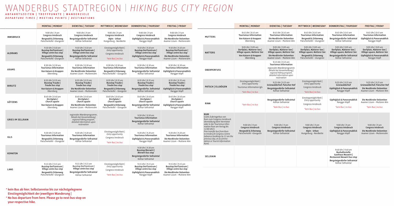
MONTAG | MONDAY DIENSTAG | TUESDAY MITTWOCH | WEDNESDAY DONNERSTAG | THURSDAY FREITAG | FRIDAY
INNSBRUCK
9:00 Uhr | 9 am Congress Innsbruck
Bergwald & Zirbenweg Patscherkofel Glungezer
9:00 Uhr | 9 amCongress Innsbruck
Bergsteigerdörfer SellraintalKühtaiSellraintal
9:00 Uhr | 9 amCongress Innsbruck
Alpin - UrbanHungerburg Nordkette
9:00 Uhr | 9 amCongress Innsbruck
Gipfelglück & Panoramablick Rangger Köpfl
9:00 Uhr | 9 amCongress Innsbruck
Die Nordtiroler DolomitenAxamer Lizum Muttereralm
ALDRANS
9:10 Uhr | 9.10 am Busstop Dorfzentrum | Village centre bus stopBergwald & Zirbenweg
Patscherkofel Glungezer
9:10 Uhr | 9.10 amBusstop Dorfzentrum | Village centre bus stop
Bergsteigerdörfer SellraintalKühtaiSellraintal
Einstiegsmöglichkeit | Entry opportunity
Congress Innsbruck
*kein Bus | no bus
9:10 Uhr | 9.10 amBusstop Dorfzentrum | Village centre bus stop
Gipfelglück & Panoramablick Rangger Köpfl
9:10 Uhr | 9.10 amBusstop Dorfzentrum | Village centre bus stop
Die Nordtiroler DolomitenAxamer Lizum – Muttereralm
AXAMS
8:30 Uhr | 8.30 amTourismus InformationVon Kaisern & Knappen
Obernberg
8:30 Uhr | 8.30 amTourismus Information
Die Nordtiroler DolomitenAxamer Lizum – Muttereralm
8:30 Uhr | 8.30 amTourismus InformationBergwald & Zirbenweg
Patscherkofel – Glungezer
8:30 Uhr | 8.30 amTourismus Information
Bergsteigerdörfer SellraintalKühtaiSellraintal
8:30 Uhr | 8.30 amTourismus Information
Gipfelglück & Panoramablick Rangger Köpfl
BIRGITZ
8:35 Uhr | 8.35 amBusstop Traube | Traube bus stop
Von Kaisern & KnappenObernberg
8:35 Uhr | 8.35 amBusstop Traube | Traube bus stop
Die Nordtiroler DolomitenAxamer Lizum – Muttereralm
8:35 Uhr | 8.35 amBusstop Traube | Traube bus stop
Bergwald & ZirbenwegPatscherkofel – Glungezer
8:35 Uhr | 8.35 amBusstop Traube | Traube bus stop
Bergsteigerdörfer, SellraintalKühtaiSellraintal
8:35 Uhr | 8.35 amBusstop Traube | Traube bus stop
Gipfelglück & Panoramablick Rangger Köpfl
GÖTZENS
8:40 Uhr | 8.40 amKirchplatz |
Church squareVon Kaisern & Knappen
Obernberg
8:40 Uhr | 8.40 amKirchplatz |
Church squareDie Nordtiroler Dolomiten
Axamer Lizum – Muttereralm
8:40 Uhr | 8.40 amKirchplatz |
Church squareBergwald & Zirbenweg
Patscherkofel – Glungezer
8:40 Uhr | 8.40 amKirchplatz |
Church squareBergsteigerdörfer Sellraintal
KühtaiSellraintal
8:40 Uhr | 8.40 amKirchplatz |
Church squareGipfelglück & Panoramablick
Rangger Köpfl
GRIES IM SELLRAIN
regionales Wanderprogramm, Details bei Voranmeldung |
regional hiking program, detailed information upon
reservation
9:50 Uhr | 9.50 amTourismus Information
Bergsteigerdörfer SellraintalKühtaiSellraintal
IGLS
9:20 Uhr | 9.20 amTourismus InformationBergwald & Zirbenweg
Patscherkofel – Glungezer
9:20 Uhr | 9.20 amTourismus Information
Bergsteigerdörfer SellraintalKühtaiSellraintal
Einstiegsmöglichkeit | Entry opportunity
Congress Innsbruck
*kein Bus | no bus
9:20 Uhr | 9.20 amTourismus Information
Gipfelglück & Panoramablick Rangger Köpfl
9:20 Uhr | 9.20 am Tourismus Information
Die Nordtiroler DolomitenAxamer Lizum – Mutterer Alm
KEMATEN
9:30 Uhr | 9.30 amBusstop Bierwirt | Bierwirt bus stop
Bergsteigerdörfer SellraintalKühtaiSellraintal
LANS
9:15 Uhr | 9.15 am Busstop Dorfzentrum | Village centre bus stopBergwald & Zirbenweg
Patscherkofel Glungezer
9:15 Uhr | 9.15 amBusstop Dorfzentrum | Village centre bus stop
Bergsteigerdörfer SellraintalKühtaiSellraintal
Einstiegsmöglichkeit | Entry opportunity
Congress Innsbruck
*kein Bus | no bus
9:15 Uhr | 9.15 amBusstop Dorfzentrum | Village centre bus stop
Gipfelglück & Panoramablick Rangger Köpfl
9:15 Uhr | 9.15 amBusstop Dorfzentrum | Village centre bus stop
Die Nordtiroler DolomitenAxamer Lizum – Mutterer Alm
WANDERBUS STADTREGION | HIKING BUS CIT Y REGION A B F A H R T S Z E I T E N | T R E F F P U N K T E | W A N D E R Z I E L E D E P A R T U R E T I M E S | M E E T I N G P O I N T S | D E S T I N A T I O N S
MONTAG | MONDAY DIENSTAG | TUESDAY MITTWOCH | WEDNESDAY DONNERSTAG | THURSDAY FREITAG | FRIDAY
MUTTERS
8:45 Uhr | 8.45 amTourismus InformationVon Kaisern & Knappen
Obernberg
8:45 Uhr | 8.45 amTourismus Information
Die Nordtiroler DolomitenAxamer Lizum – Mutterer Alm
8:45 Uhr | 8.45 amTourismus InformationBergwald & Zirbenweg
Patscherkofel – Glungezer
8:45 Uhr | 8.45 amTourismus Information
Bergsteigerdörfer SellraintalKühtaiSellraintal
8:45 Uhr | 8.45 amTourismus Information
Gipfelglück & Panoramablick Rangger Köpfl
NATTERS
9:05 Uhr | 9.05 amDorfplatz, Natterer See |
Village square, Natterer SeeVon Kaisern & Knappen
Obernberg
9:05 Uhr | 9.05 amDorfplatz, Natterer See |
Village square, Natterer SeeDie Nordtiroler Dolomiten
Axamer Lizum – Mutterer Alm
9:05 Uhr | 9.05 amDorfplatz, Natterer See |
Village square, Natterer SeeBergwald & Zirbenweg
Patscherkofel – Glungezer
9:05 Uhr | 9.05 amDorfplatz, Natterer See |
Village square, Natterer SeeBergsteigerdörfer Sellraintal
KühtaiSellraintal
9:05 Uhr | 9.05 amDorfplatz, Natterer See |
Village square, Natterer SeeGipfelglück & Panoramablick
Rangger Köpfl
OBER PERFUSS
9:15 Uhr | 9.15 amTourismus Information
regionales Wanderprogramm Details bei Voranmeldung |
regional hiking program, detailed information upon
reservation
PATSCH | ELLBÖGEN
Einstiegsmöglichkeit | Entry opportunity
Tourismus Information Igls
*kein Bus | no bus
9:25 Uhr | 9.25 amGrünwalderhof, Patscher Hof Bergsteigerdörfer Sellraintal
KühtaiSellraintal
Einstiegsmöglichkeit | Entry opportunity
Congress Innsbruck
*kein Bus | no bus
9:25 Uhr | 9.25 amGrünwalderhof
Gipfelglück & Panoramablick Rangger Köpfl
9:25 Uhr | 9.25 amGrünwalderhof, Patscher Hof
Die Nordtiroler DolomitenAxamer Lizum – Mutterer Alm
RINN *kein Bus | no bus
Bergsteigerdörfer SellraintalKühtaiSellraintal
*kein Bus | no bus
Einstiegsmöglichkeit | Entry opportunity
Congress Innsbruck
*kein Bus | no bus
Gipfelglück & Panoramablick Rangger Köpfl
*kein Bus | no bus
Die Nordtiroler DolomitenAxamer Lizum – Mutterer Alm
*kein Bus | no bus
RUM Gratis Zubringerbus von Rum zum Congress Innsbruck (Anmeldung beim Vermieter oder in der Tourismus Information Rum am Vortag bis 12:00 Uhr) | Free transfer bus from Rum to Innsbruck Congress Centre (advance bookings by 12 am the previous day, at accommo-dation or Tourist Information Rum).
9:00 Uhr | 9 am Congress Innsbruck
Bergwald & Zirbenweg Patscherkofel Glungezer
9:00 Uhr | 9 amCongress Innsbruck
Bergsteigerdörfer SellraintalKühtaiSellraintal
9:00 Uhr | 9 amCongress Innsbruck
Alpin - UrbanHungerburg Nordkette
9:00 Uhr | 9 amCongress Innsbruck
Gipfelglück & Panoramablick Rangger Köpfl
9:00 Uhr | 9 amCongress Innsbruck
Die Nordtiroler DolomitenAxamer Lizum Muttereralm
SELLRAIN
9:40 Uhr | 9.40 amBushaltestelle
Gasthaus Neuwirt | Restaurant Neuwirt bus stopBergsteigerdörfer Sellraintal
KühtaiSellraintal
* kein Bus ab hier; Selbstanreise bis zur nächstgelegnene Einstiegmöglichkeit der jeweiligen Wanderung |
* No bus departure from here. Please go to next bus stop on your respective hike.

Dem Gast in der Region Innsbruck steht ein umfangreiches Wander
programm zur Verfügung, das mit der Welcome Card kostenlos genützt
werden kann. Von Ende Mai bis Ende Oktober werden Touren ange
boten. Dabei stehen Themenwanderungen oder Entdeckertouren auf
die Nordkette genauso auf dem Programm wie Tälerüberschreitungen
oder Erlebnis ausflüge für die ganze Familie. Von Innsbruck und den
umliegenden Dörfern steuert der kostenlose Wanderbus verschiedene
Ausgangs punkte des insgesamt 1.200 km langen Wanderwegnetzes
an. Anmeldungen jeweils bis zum Vortag in den jeweiligen
Tourismus Informationen.
G E F Ü H R T E T O U R E N S T A D T R E G I O NKombiwandern: Die Tageswanderungen werden im Zeitraum
28.Mai–28.September 2018 ab sechs Personen als Kombiwandern an
geboten. Dabei gibt es die Wahlmöglichkeit zwischen einer einfachen,
sanften Wanderung und einer mittelschweren, etwas längeren Wande
rung. Die Busfahrt der Gruppen erfolgt gemeinsam. Im Zeitraum
1.Oktober–26.Oktober 2018 wird nur eine Wanderung angeboten.
Hinweis: Die Treffpunkte für die nicht in der WanderbusTabelle ange
führten Ferien dörfer (Ampass / Grinzens / Ranggen / Rinn / Sistrans /
Unterperfuss / Völs / Zirl) bzw. an Tagen ohne Eintrag sind im nächst
gelegenen Feriendorf bzw. am Ausgangspunkt der Wande rungen.
Mehr Informationen zu dem Thema in den örtlichen Tourismus
Informationen.
Termin: Mo–Fr, 28.5.–26.10.2018
Treffpunkt / Abfahrt: 9:00 Uhr, Treffpunkte siehe Wanderbustabelle
Wanderungen mit Bergwanderführern von ASI Reisen
Wanderbus
Tourenbuch
LeihWanderschuhe und Rucksäcke verfügbar (limitierte Anzahl)
Wanderabzeichen:
Bronze: 1 Wanderung, Silber: 3 Wanderungen,
Gold: 10 Wanderungen, Gold mit Kristall: 20 Wanderungen
Wanderabzeichen für Senioren (über 60 Jahre):
Bronze: 1 Wanderung, Silber: 3 Wanderungen,
Gold: 8 Wanderungen, Gold mit Kristall: 12 Wanderungen
Teilnahme:
kostenlos mit der Welcome Card
Treffpunkt ist jeweils 15 Minuten vor Abfahrt
Durchführung bei jedem Wetter
Wandertouren mit Gehzeiten zwischen drei und vier Stunden
geeignet auch für Kinder ab acht Jahren und Senioren
gute Kondition erforderlich
wetterfeste Kleidung (Wanderschuhe, Anorak, Regenschutz)
Sonnenschutz, Proviant und ausreichend Getränke
aus Rücksicht auf andere Mitwanderer können keine Hunde
akzeptieren werden
Anmeldung ab einer Gruppengröße von 15 Personen erforderlich
Anmeldungen in der örtlichen Tourismus Information
N O R D K E T T E - E N T D E C K E R T O U R Eine abwechslungsreiche eher schwierige Bergwanderung für alle
Natur interessierten vom Hafelekar über den Goetheweg zur herrlich
gelegenen Pfeishütte. Die fachkundigen Naturparkführer wissen
allerhand über Flora und Fauna zu erzählen und haben Spektive für
besondere Beobachtungen dabei.
Termine: Juli: 22.+28.7. | August: 4.+15.+19.+25.8.
September: 1.+9.+15.+23.9.
Treffpunkt: 9:00 Uhr Kassa Hungerburg
Gehzeit: ca. 6 h, inkl. Einkehr
Preis: kostenlos für jeden, für die Bahnfahrt gelten reguläre
Preise, das Freizeitticket ist gültig
Info und Anmeldung: max. 20 Personen, bei Naturpark Karwendel,
Anton Heufelder, Tel. +43 664 / 88 44 62 25,
D E N C H A R M E D E S U R S P R Ü N G L I C H E N V I G G A R T A L S K E N N E N L E R N E NWanderung durch ein unberührtes und uriges Hochtal, in
unmittelbarer Stadtnähe gelegen.
Maximal 16 Personen
Termin: mittwochs, 4. Juli–17. Oktober 2018
Treffpunkt: 10:00 Uhr in Patsch
(Parkplatz gegenüber Patscher Hof)
Dauer: ca. 5 h
Preis: kostenlos mit der Welcome Card
Anmeldung: am Vortag bis 18:00 Uhr, bei Bergwanderführerin Claudia
Muigg, Tel. +43 664 / 12 04 333, Absage bei Schlechtwetter
G R O S S E T Ä L E R Ü B E R S C H R E I T U N G V O M V I G G A R T A L I N S A R Z T A L M I T G I P F E L E R L E B N I S A U F D E R K R E U Z S P I T Z E Termin: donnerstags, 5. Juli–18. Oktober 2018
Treffpunkt: 9:00 Uhr in Ellbögen
Gehzeit: ca. 4,5 h, retour ca. 16:00 Uhr
Preis: kostenlos mit der Welcome Card, gratis Taxitransfer bis
ca. 1.900 m Seehöhe – Ausgangspunkt der Wanderung
Info und Anmeldung: am Vortag bis 20:00 Uhr bei Bergwanderführer
Klaus Ribis, Tel. +43 664 / 24 35 365, Absage bei Schlechtwetter
A L M E N A U S F L U G Z U R A R Z T A L E R A L MAlmenausflug zur Arztaler Alm und Wanderung zur Hinterlocher Mühle
mit Besichtigung der Schaumahlungen.
Termin: freitags, 6. Juli–19. Oktober 2018
Treffpunkt: 9:30 Uhr beim Parkplatz in Ellbögen/Feuerwehrhalle
Gehzeit: ca. 1,5 h, retour ca. 16:00 Uhr
Preis: kostenlos mit Welcome Card, gratis Taxitransfer zur
Arztaler Alm – Ausgangspunkt der Wanderung
Info und Anmeldung: am Vortag bis 20:00 Uhr bei Bergwanderführer
Klaus Ribis, Tel. +43 664 / 24 35 365
G E F Ü H R T E T O U R E N M I E M I N G E R P L A T E A UN A T U R - E R L E B N I S W A N D E R U N G Gemütliche Wanderung über das Mieminger Plateau, gemeinsam mit ei
nem Bergwander und Naturführer die Schönheit der Natur entdecken
und dabei Wissenswertes über die wunderbare Landschaft erfahren.
Termin: montags, 14:00 Uhr Treffpunkt: Waldschwimmbad Barwies
Dauer: ca. 2 Stunden
Anmeldung: bis 11:00 Uhr, in den Tourismus Informationen
Obsteig, Mieming oder Telfs
P A N O R A M A W A N D E R U N G Z U M F A L T E G A R T E N K Ö P F L ( 2 . 1 8 4 M )Geführte mittelschwere Wanderung über Marlstein zum Grünwaslkreuz
und weiter zum höchsten Punkt, dem Faltegartenköpfl, mit wunder
schönem Panoramablick auf das Mieminger Plateau und das Inntal.
Zurück geht es über die Feldringalm mit Einkehrmöglichkeit.
Termin: freitags, 6. Juni–28. September 2018, 9:30 Uhr
Treffpunkt: Parkplatz Raiffeisenbank Mieming. Man fährt gemeinsam
mit den PrivatPKWs zum Ausgangspunkt Sattele (Parkgebühr € 3,00).
Gesamtgehzeit: ca. 4 Stunden; Höhenunterschied ca. 500 m,
Bergschuhe erforderlich
Anmeldung: bis zum Vortag, 16:30 Uhr in den Tourismus
Informationen Mieming oder Telfs, in Obsteig bis zum Vortag,
12:00 Uhr
R U N D W A N D E R U N G P F A F F E N H O F E R A L M Geführte, mittelschwere Wanderung über die sogenannte Inntal
schlaufe Richtung Sonnkarköpfl und weiter zur Oberhofer Melkalm auf
1.669 m (Einkehrmöglichkeit). Retour führt diese Rundwanderung über
den Bettlersteig. Anschließend fährt ein Busshuttle wieder zurück
nach Telfs bzw. Mieming.
Termin: mittwochs, 16. Mai–19. September, ab 8:45 Uhr
Zustiegsmöglichkeiten:
8:45 Uhr Mieming, Parkplatz Raiffeisenbank
9:00 Uhr Telfs, Inntalcenter
Mit dem Busshuttle fahren Sie von Mieming über Telfs auf die
Pfaffenhofer Alm (1.694 m), dem Startpunkt der Wanderung.
Gehzeit: zur Oberhofer Melkalm ca. 2,5 Stunden, zurück zur
Pfaffenhofer Alm ca. 1 Stunde. Höhendifferenz: ca. 250 Höhenmeter
Bergschuhe erforderlich!
Preis: mit Welcome Card € 10,00 pro Person
Verpflichtende Anmeldung: bis zum Vortag, 11:30 Uhr in den
Tourismus Informationen Obsteig, Mieming oder Telfs
G E F Ü H R T E T O U R E N K Ü H T A I - S E L L R A I N T A LDie DreiSeen Wanderung & die Wanderung zur Sonnbergalm in St.Sig
mund finden abwechselnd immer dienstags von Juni–August statt.
Info und Anmeldung: am Vortag bis 16:00 Uhr, in den Tourismus
Informationen Gries, St. Sigmund und Kühtai
MONTAG | MONDAY DIENSTAG | TUESDAY MITTWOCH | WEDNESDAY DONNERSTAG | THURSDAY FREITAG | FRIDAY
INNSBRUCK
9:00 Uhr | 9 am Congress Innsbruck
Bergwald & Zirbenweg Patscherkofel Glungezer
9:00 Uhr | 9 amCongress Innsbruck
Bergsteigerdörfer SellraintalKühtaiSellraintal
9:00 Uhr | 9 amCongress Innsbruck
Alpin - UrbanHungerburg Nordkette
9:00 Uhr | 9 amCongress Innsbruck
Gipfelglück & Panoramablick Rangger Köpfl
9:00 Uhr | 9 amCongress Innsbruck
Die Nordtiroler DolomitenAxamer Lizum Muttereralm
ALDRANS
9:10 Uhr | 9.10 am Busstop Dorfzentrum | Village centre bus stopBergwald & Zirbenweg
Patscherkofel Glungezer
9:10 Uhr | 9.10 amBusstop Dorfzentrum | Village centre bus stop
Bergsteigerdörfer SellraintalKühtaiSellraintal
Einstiegsmöglichkeit | Entry opportunity
Congress Innsbruck
*kein Bus | no bus
9:10 Uhr | 9.10 amBusstop Dorfzentrum | Village centre bus stop
Gipfelglück & Panoramablick Rangger Köpfl
9:10 Uhr | 9.10 amBusstop Dorfzentrum | Village centre bus stop
Die Nordtiroler DolomitenAxamer Lizum – Muttereralm
AXAMS
8:30 Uhr | 8.30 amTourismus InformationVon Kaisern & Knappen
Obernberg
8:30 Uhr | 8.30 amTourismus Information
Die Nordtiroler DolomitenAxamer Lizum – Muttereralm
8:30 Uhr | 8.30 amTourismus InformationBergwald & Zirbenweg
Patscherkofel – Glungezer
8:30 Uhr | 8.30 amTourismus Information
Bergsteigerdörfer SellraintalKühtaiSellraintal
8:30 Uhr | 8.30 amTourismus Information
Gipfelglück & Panoramablick Rangger Köpfl
BIRGITZ
8:35 Uhr | 8.35 amBusstop Traube | Traube bus stop
Von Kaisern & KnappenObernberg
8:35 Uhr | 8.35 amBusstop Traube | Traube bus stop
Die Nordtiroler DolomitenAxamer Lizum – Muttereralm
8:35 Uhr | 8.35 amBusstop Traube | Traube bus stop
Bergwald & ZirbenwegPatscherkofel – Glungezer
8:35 Uhr | 8.35 amBusstop Traube | Traube bus stop
Bergsteigerdörfer, SellraintalKühtaiSellraintal
8:35 Uhr | 8.35 amBusstop Traube | Traube bus stop
Gipfelglück & Panoramablick Rangger Köpfl
GÖTZENS
8:40 Uhr | 8.40 amKirchplatz |
Church squareVon Kaisern & Knappen
Obernberg
8:40 Uhr | 8.40 amKirchplatz |
Church squareDie Nordtiroler Dolomiten
Axamer Lizum – Muttereralm
8:40 Uhr | 8.40 amKirchplatz |
Church squareBergwald & Zirbenweg
Patscherkofel – Glungezer
8:40 Uhr | 8.40 amKirchplatz |
Church squareBergsteigerdörfer Sellraintal
KühtaiSellraintal
8:40 Uhr | 8.40 amKirchplatz |
Church squareGipfelglück & Panoramablick
Rangger Köpfl
GRIES IM SELLRAIN
regionales Wanderprogramm, Details bei Voranmeldung |
regional hiking program, detailed information upon
reservation
9:50 Uhr | 9.50 amTourismus Information
Bergsteigerdörfer SellraintalKühtaiSellraintal
IGLS
9:20 Uhr | 9.20 amTourismus InformationBergwald & Zirbenweg
Patscherkofel – Glungezer
9:20 Uhr | 9.20 amTourismus Information
Bergsteigerdörfer SellraintalKühtaiSellraintal
Einstiegsmöglichkeit | Entry opportunity
Congress Innsbruck
*kein Bus | no bus
9:20 Uhr | 9.20 amTourismus Information
Gipfelglück & Panoramablick Rangger Köpfl
9:20 Uhr | 9.20 am Tourismus Information
Die Nordtiroler DolomitenAxamer Lizum – Mutterer Alm
KEMATEN
9:30 Uhr | 9.30 amBusstop Bierwirt | Bierwirt bus stop
Bergsteigerdörfer SellraintalKühtaiSellraintal
LANS
9:15 Uhr | 9.15 am Busstop Dorfzentrum | Village centre bus stopBergwald & Zirbenweg
Patscherkofel Glungezer
9:15 Uhr | 9.15 amBusstop Dorfzentrum | Village centre bus stop
Bergsteigerdörfer SellraintalKühtaiSellraintal
Einstiegsmöglichkeit | Entry opportunity
Congress Innsbruck
*kein Bus | no bus
9:15 Uhr | 9.15 amBusstop Dorfzentrum | Village centre bus stop
Gipfelglück & Panoramablick Rangger Köpfl
9:15 Uhr | 9.15 amBusstop Dorfzentrum | Village centre bus stop
Die Nordtiroler DolomitenAxamer Lizum – Mutterer Alm
WANDERBUS STADTREGION | HIKING BUS CIT Y REGION A B F A H R T S Z E I T E N | T R E F F P U N K T E | W A N D E R Z I E L E D E P A R T U R E T I M E S | M E E T I N G P O I N T S | D E S T I N A T I O N S
MONTAG | MONDAY DIENSTAG | TUESDAY MITTWOCH | WEDNESDAY DONNERSTAG | THURSDAY FREITAG | FRIDAY
MUTTERS
8:45 Uhr | 8.45 amTourismus InformationVon Kaisern & Knappen
Obernberg
8:45 Uhr | 8.45 amTourismus Information
Die Nordtiroler DolomitenAxamer Lizum – Mutterer Alm
8:45 Uhr | 8.45 amTourismus InformationBergwald & Zirbenweg
Patscherkofel – Glungezer
8:45 Uhr | 8.45 amTourismus Information
Bergsteigerdörfer SellraintalKühtaiSellraintal
8:45 Uhr | 8.45 amTourismus Information
Gipfelglück & Panoramablick Rangger Köpfl
NATTERS
9:05 Uhr | 9.05 amDorfplatz, Natterer See |
Village square, Natterer SeeVon Kaisern & Knappen
Obernberg
9:05 Uhr | 9.05 amDorfplatz, Natterer See |
Village square, Natterer SeeDie Nordtiroler Dolomiten
Axamer Lizum – Mutterer Alm
9:05 Uhr | 9.05 amDorfplatz, Natterer See |
Village square, Natterer SeeBergwald & Zirbenweg
Patscherkofel – Glungezer
9:05 Uhr | 9.05 amDorfplatz, Natterer See |
Village square, Natterer SeeBergsteigerdörfer Sellraintal
KühtaiSellraintal
9:05 Uhr | 9.05 amDorfplatz, Natterer See |
Village square, Natterer SeeGipfelglück & Panoramablick
Rangger Köpfl
OBER PERFUSS
9:15 Uhr | 9.15 amTourismus Information
regionales Wanderprogramm Details bei Voranmeldung |
regional hiking program, detailed information upon
reservation
PATSCH | ELLBÖGEN
Einstiegsmöglichkeit | Entry opportunity
Tourismus Information Igls
*kein Bus | no bus
9:25 Uhr | 9.25 amGrünwalderhof, Patscher Hof Bergsteigerdörfer Sellraintal
KühtaiSellraintal
Einstiegsmöglichkeit | Entry opportunity
Congress Innsbruck
*kein Bus | no bus
9:25 Uhr | 9.25 amGrünwalderhof
Gipfelglück & Panoramablick Rangger Köpfl
9:25 Uhr | 9.25 amGrünwalderhof, Patscher Hof
Die Nordtiroler DolomitenAxamer Lizum – Mutterer Alm
RINN *kein Bus | no bus
Bergsteigerdörfer SellraintalKühtaiSellraintal
*kein Bus | no bus
Einstiegsmöglichkeit | Entry opportunity
Congress Innsbruck
*kein Bus | no bus
Gipfelglück & Panoramablick Rangger Köpfl
*kein Bus | no bus
Die Nordtiroler DolomitenAxamer Lizum – Mutterer Alm
*kein Bus | no bus
RUM Gratis Zubringerbus von Rum zum Congress Innsbruck (Anmeldung beim Vermieter oder in der Tourismus Information Rum am Vortag bis 12:00 Uhr) | Free transfer bus from Rum to Innsbruck Congress Centre (advance bookings by 12 am the previous day, at accommo-dation or Tourist Information Rum).
9:00 Uhr | 9 am Congress Innsbruck
Bergwald & Zirbenweg Patscherkofel Glungezer
9:00 Uhr | 9 amCongress Innsbruck
Bergsteigerdörfer SellraintalKühtaiSellraintal
9:00 Uhr | 9 amCongress Innsbruck
Alpin - UrbanHungerburg Nordkette
9:00 Uhr | 9 amCongress Innsbruck
Gipfelglück & Panoramablick Rangger Köpfl
9:00 Uhr | 9 amCongress Innsbruck
Die Nordtiroler DolomitenAxamer Lizum Muttereralm
SELLRAIN
9:40 Uhr | 9.40 amBushaltestelle
Gasthaus Neuwirt | Restaurant Neuwirt bus stopBergsteigerdörfer Sellraintal
KühtaiSellraintal
* kein Bus ab hier; Selbstanreise bis zur nächstgelegnene Einstiegmöglichkeit der jeweiligen Wanderung |
* No bus departure from here. Please go to next bus stop on your respective hike.