
Date: 5 July 2017 · 1. Notes the paper and presentation 2. Advises the Heritage Division to...
26
State Heritage Register Committee Agenda item: 3.3 Date: 5 July 2017 Type of issue: State Heritage Register – Notice of Intention to Consider Revising Heritage Curtilage and Update of Assessment of Significance (heritage data form) Item: Varroville Homestead and Estate 152, 166-176, 196 St Andrews Road, Varroville; 205 Campbelltown Road, Denham Court (see location in Annexure A) Recommended curtilage: Lot B of Deposited Plan 370979, Lot 21 of Deposited Plan 564065, Lot 22 of Deposited Plan 564065, Lot 1 of Deposited Plan 218016 and Lot 4 of Deposited Plan 239557 and Lot 1 of Deposited Plan 541916, Parish of Minto, County of Cumberland as shown in Annexure B and Annexure C. Item description: Varroville is a ‘celebrated early farm estate dating from 1810 with early structures, the 1850s homestead, layout, agricultural (vineyard) terracing and evidence of early access road’. The recommended extended curtilage proposes to include the setting of the Varroville homestead along with the outbuildings, extant vineyard trenching (possibly 1810s to 1830s) to the west of the homestead, dams from c1830s and the extant trace of Bunbury-Curran creek. Existing listing (SHR No. 00737): Varroville Homestead was listed under the Heritage Act 1977 as a Permanent Conservation Order in 1993. This order was converted to a listing on the State Heritage Register upon its establishment in 1999. The existing assessment of significance is included at Annexure D. Criteria satisfied: 6 of the 7 Heritage Council criteria of state heritage significance (a, b, c, e, f, g), as outlined in Annexure E. Owner/s: Jacqui Kirkby & Peter Gibbs (Existing Varroville Homestead battle axe block – SHR listing 00737). Catholic Metropolitan Cemeteries Trust. Scenic NSW Pty Ltd. Minister for NSW Parliament administering Environmental Planning and Assessment Act 1979 Occupants or Lessee/s: Jacqui Kirkby & Peter Gibbs (Varroville Homestead) Campbelltown City Council Local Govt Area/s: Campbelltown Nominator/s: Jacqui Kirkby & Peter Gibbs Existing Listings: Statutory i. SHR 00737 – State Heritage Register (Varroville) ii. SHR item listed as a LEP heritage item on the Campbelltown LEP 2015 iii. I105 – Varroville extended curtilage listed on the Campbelltown LEP (2017 amendment)
Transcript of Date: 5 July 2017 · 1. Notes the paper and presentation 2. Advises the Heritage Division to...

State Heritage Register Committee Agenda item: 3.3 Date: 5 July 2017
Type of issue: State Heritage Register – Notice of Intention to Consider Revising Heritage Curtilage and Update of Assessment of Significance (heritage data form)
Item: Varroville Homestead and Estate 152, 166-176, 196 St Andrews Road, Varroville; 205 Campbelltown Road, Denham Court (see location in Annexure A)
Recommended curtilage:
Lot B of Deposited Plan 370979, Lot 21 of Deposited Plan 564065, Lot 22 of Deposited Plan 564065, Lot 1 of Deposited Plan 218016 and Lot 4 of Deposited Plan 239557 and Lot 1 of Deposited Plan 541916, Parish of Minto, County of Cumberland as shown in Annexure B and Annexure C.
Item description: Varroville is a ‘celebrated early farm estate dating from 1810 with early structures, the 1850s homestead, layout, agricultural (vineyard) terracing and evidence of early access road’. The recommended extended curtilage proposes to include the setting of the Varroville homestead along with the outbuildings, extant vineyard trenching (possibly 1810s to 1830s) to the west of the homestead, dams from c1830s and the extant trace of Bunbury-Curran creek.
Existing listing (SHR No. 00737):
Varroville Homestead was listed under the Heritage Act 1977 as a Permanent Conservation Order in 1993. This order was converted to a listing on the State Heritage Register upon its establishment in 1999. The existing assessment of significance is included at Annexure D.
Criteria satisfied: 6 of the 7 Heritage Council criteria of state heritage significance (a, b, c, e, f, g), as outlined in Annexure E.
Owner/s: Jacqui Kirkby & Peter Gibbs (Existing Varroville Homestead battle axe block – SHR listing 00737). Catholic Metropolitan Cemeteries Trust. Scenic NSW Pty Ltd. Minister for NSW Parliament administering Environmental Planning and Assessment Act 1979
Occupants or Lessee/s:
Jacqui Kirkby & Peter Gibbs (Varroville Homestead) Campbelltown City Council
Local Govt Area/s: Campbelltown
Nominator/s: Jacqui Kirkby & Peter Gibbs
Existing Listings: Statutory i. SHR 00737 – State Heritage Register (Varroville)ii. SHR item listed as a LEP heritage item on the
Campbelltown LEP 2015iii. I105 – Varroville extended curtilage listed on the
Campbelltown LEP (2017 amendment)

Non statutory (Community) iv. National Trust Register.
Threat to Item/Contentious Issues:
Land surrounding Varroville homestead (the area not currently included on the SHR) is subject to the proposed cemetery development of the Macarthur Memorial Park by the Catholic Metropolitan Cemeteries Trust (CMCT).
Site specific exemptions requested or recommended:
Will be developed during the notifications period.
Information for consideration:
Annexure A: Location map Annexure B: Recommended curtilage for extension (option 1) Annexure C: Recommended curtilage for extension (option 2) Annexure D: Existing assessment of significance (Varroville, SHR No. 00737) Annexure E: Assessment of significance for the extended curtilage (Varroville Homestead and Estate) Annexure F: Campbelltown Local Environmental Plan 2015 (Amendment No 1)
Previous HC determinations:
27 August 1993: Varroville listed as a Permanent Conservation Order (PCO) under the Heritage Act 1977. 2 April 1999: PCO converted to SHR listing upon establishment of State Heritage Register. 20 June 2000: Heritage Council considered a request to extend the curtilage of Varroville but deferred making a determination on the matter. 2 October 2013: Heritage Council briefed about the proposed rezoning of land surrounding Varroville and the potential impact future development on the site may have on the heritage significance of Varroville. The Heritage Council resolved to:
1. Write to Campbelltown City Council requesting: a. An opportunity to provide comment on the
Planning Proposal to rezone the land surrounding Varroville homestead;
b. That Campbelltown City Council consider the heritage status of the outbuildings in relation to their Local Environment Plan;
c. That the existing zoning controls around Varroville homestead remain in place;
2. Pursue a curtilage extension of Varroville to include the outbuildings.
6 August 2014: Heritage Council considered Interim Heritage Order (IHO) request for land and outbuildings surrounding Varroville homestead. The Heritage Council resolved to:
1. Request the Heritage Division to confirm the boundary of the original 1810 land grant to Dr Robert Townson;
2. Considers the land and outbuildings associated with and surrounding the SHR listed Varroville homestead are potentially of state heritage significance; and
3. Advise the Minister for Heritage to make an Interim Heritage Order (IHO) over the land and outbuildings surrounding the SHR listed Varroville Homestead at 196 St Andrew’s Road, Varroville defined in accordance with the curtilage shown by the blue line

at Figure 1, Attachment B of the prepared report for a period of 12 months.
8 September 2014: Minister for Heritage determined not to make IHO. Instead, the Minister asked that the Heritage Council work with the landowners towards managing the heritage values as part of development (including potentially a heritage listing nomination).
2015–2016: The owners of Varroville homestead, Jacqui Kirkby and Peter Gibbs, were granted Heritage Council funding of $10,000 to undertake curtilage study (‘Curtilage Study: Varro Ville’ project)
7 September 2016: A draft report was presented to the State Heritage Register Committee to present the findings of the ‘Curtilage Study’ The State Heritage Register Committee resolved to:
1. Notes the paper and presentation 2. Advises the Heritage Division to progress the
nomination to extend the curtilage of Varroville (SHR 00737)
3. Advises the Heritage Division to pursue further investigations of an appropriate curtilage for Varroville (SHR 00737)
4. Requests the Heritage Division to investigate potential curtilage at Annexure E of the paper
5. Requests the Heritage Division to report back on the impact of the proposed cemetery use.
7 September 2016: (IHO request) The Heritage Council State Heritage Register Committee:
1. Advises the Heritage Division not to progress the request for an Interim Heritage Order to the Minister for Heritage at that time.
Consultation overview:
Owner consultation prior to notifications:
4 May 2017: Heritage Division met with owners Jacqui Kirkby and Peter Gibbs (196 St Andrews Road) to discuss the extension of curtilage. 29 May 2017: Heritage Division met with the owners of (166–176 St Andrews Road)—CMCT (Catholic Metropolitan Cemeteries Trust) to discuss the proposed curtilage options. CMCT are keen to work with the Heritage Division to protect areas of signifcance 07 June 2017: Heritage Division has written to the owner of 152 St Andrew’s Road (Minister administering the Environmental Planning and Assessment Act 1979 – Lot 4 DP 239557) regarding the proposed extension to Varroville’s curtilage. 05 June 2017: Heritage Division has written to the owner of 205 Campbelltown Road, Denham Court (Scenic NSW Equine Centre – Lot 1 DP 541916) regarding the proposed extension to Varroville’s curtilage.
Council consultation prior to notifications:
Nil


ISSUES: Heritage Significance Varroville is a celebrated early farm estate dating from 1810 with early structures, 1850s homestead, layout, agricultural (vineyard) terracing/trenching and evidence of early access road. The remnant estate with its landscape and integral estate core, rare and innovative features, early establishment, substantial intactness as a cultural landscape and important colonial associations; may be of significant state heritage value. Varroville house dating from 1858-9 is a significant example of the work of William Weaver, former Government Architect 1854-56. The house appears to occupy the site of a previous (1810s) house and the kitchen of the northern wing incorporates the sandstone chimneypiece of a previous service wing. With the exception of generously scaled rooms and plate glass windows (allowing maximum light and views), the symmetrical Italianate villa is architecturally conservative. This, and the large underground water tank at the end of the wings may reflect Weaver's engineering (rather than architectural) training. Varroville is significant for the relationship between the house and its group of farm buildings, sited in relation to each other on the ridge. The location of the outbuildings along the entrance drive reflect William Lawson's Veteran Hall, Prospect and Mrs Charles Meredith's description of Homebush in the 1840s, both of which have since been demolished. The garden immediately surrounding the house is a substantially intact mid-19th century plan with a gravelled carriage drive (with post-1950 concrete edgings), lawn tennis court site c. 1870(?) remains of a glasshouse and a trellis. Perimeter fence lines and gates have been relocated post 1950 but the original locations are well documented in photographs of c. 1935. The garden contains staples of Cumberland Plain gardening: Moreton Bay figs, hoop pines, funeral cypresses, white cedars, pepper trees, a Norfolk Island hibiscus, Bauhinia, agaves (bordering the original drive), yuccas, aloes and hedges of cape honeysuckle (Tecomaria capensis) and common olive. The Queensland rain forest tree, Barklya syringifolia, may possibly survive from the c. 1890s-1910 period. Varroville's remnant vineyard trenching, directly linked to original grantee Dr Robert Townson, is rare in Australia on account of its unusually extensive area, its very early period, its unusual trenching patterns relative to the topography and its dual function as a means of intercepting rainfall and runoff for water conservation (it is also possibly unique in an Australian context as a vineyard apparently inspired directly from ancient Roman writers on agriculture). Through its documentary and largely intact physical evidence, the Varroville cultural landscape also demonstrates one of the earliest systematic attempts at water conservation in Australia. Varroville, through the Sturt dams and modified watercourses from the Sturt period as well as the large underground water tank c1858 that extends westwards from the ends of the wings of the house illustrates early recognition of the importance of water conservation to colonists in NSW. The Varroville estate landscape setting holds exceptional aesthetic value for its ability to demonstrate a rare surviving example in NSW of an English landscape park approach to estate planning indicating an awareness of the highly influential work of landscape pioneers Capability Brown and Humphry Repton. The Varroville homestead also demonstrates former Colonial Architect William Weaver's awareness of classic country villa siting, formal planning and design principles espoused by ancient European writers such as Pliny the Younger and Renaissance architects such as Leon Battista Alberti and Andrea Palladio. An essential component of Varroville's ability to demonstrate notions of classic villa planning and Reptonian landscape typologies is that its impressive picturesque views (to and from the homestead core) are an integral part of its significance-the homestead cannot be

seen in isolation from its visually cohesive landscape setting. Governor Macquarie remarked that the farms of Townson and Thompson (St. Andrews, opposite Varroville) were the best pasturage he had seen in the colony. The gently rolling hills of the two properties appealed to English Picturesque sensibilities reflected in the locality name-Scenic Hills. Varroville, a 'house in the landscape', is sited to take advantage of the sweeping, wrap-around views of the scenic hills from Raby Road in the west to Bunbury Curran Hill in the north and to an extending ridgeline of the range to the east. The important western view dominates the entry through the front door and across the rear courtyard. The direct view line (still evident) from the homestead to the landmark Araucarias of both nearby Denham Court and Macquarie Fields house appears to be a deliberate siting intention. The totality of the Varroville cultural landscape holds exceptional cultural value as it retains many elements-including its vineyard, dam network, progression of important buildings spanning between the early 19th century and 1858, pre-1850 lines of access and fence alignments, plantings that are likely contemporary with the homestead, a considerable archaeological resource having exceptional research potential and historic views-that testify to its establishment and consolidation as a farming estate and country villa over a period of more than 200 years. Varroville is rare as one of the few larger estate landscapes remaining in the Campbelltown area where the form of the original grant and the former agricultural use of the estate and its rural landscape character may be appreciated. Varroville was significant to the horticultural development, agriculture and food production in early New South Wales through the laying out of a productive kitchen garden in 1809 noted for its extensive fruit varieties by the early 1820s and the establishment of a vineyard, said to be second only to that of Gregory Blaxland of Brush Farm, Eastwood. Accounts relating to Charles Sturt's ownership (1837-39) indicate the property's continued role in the acclimatisation of plants sourced from as far afield as Calcutta. The grants of land at Minto were made by Colonel Paterson in response to the Hawkesbury floods of 1806 and later, aiming to safeguard the colony's food supplies. A significant portion of Varroville was used for growing crops in the c. 1810s-1830s period. Townson supplied meat to the Sydney, Liverpool and Parramatta commissariat stores. The remnant Varro Ville estate holds considerable associational value for its direct and important connexions with a large number of prominent and elite figures in early Australian society-including Dr Robert Townson, Governor Lachlan and Mrs Elizabeth Macquarie, explorer Captain Charles Sturt, NSW's first Postmaster-General James Raymond, Justice Alfred Cheeke and Colonial Architect and engineer William Weaver. More recently, its notable associations include ACM Jackaman (Cambridge engineer; pilot; owner and instigator of Gatwick Airport, UK including its famous Beehive building) and Cherry Jackaman (first female President of the National Trust of Australia (NSW)). The proposed item is likely to meet six of the seven Heritage Council criteria for listing on the State Heritage Register in terms of criteria a (historical values), b (associations with people or groups of people), c (aesthetic values), d (community esteem), e (research potential), f (rarity), g (representative values).
• a (historical values) The former Varroville estate landscape contains a considerable number of important elements that testify to its settlement and agricultural development over a period of 200 years. Of particular interest are those elements that demonstrate the formative years from about 1809 through to the 1870s that cover the periods of ownership of the grant by Dr Robert Townson, Thomas

Wills, Captain Charles Sturt, James Raymond, George Rowe and Justice Alfred Cheeke. Important site evidence remains for this formative period including 1810s/1820s vineyard trenching; a progression of important buildings spanning between the early 19th century and 1858; a network of 1830s dams (tanks) installed by Thomas Wills and Charles Sturt (and to which Sturt later referred as an example when exhorting landowners throughout Australia to conserve water); pre-1850 lines of access and fence alignments; and fig tree plantings that are likely contemporary with the homestead. Beyond these individual components, combinations of them can be shown to demonstrate an early and unusual strategy of water conservation in Australia using the dam network and the vine trenching as a system to capture rainfall and runoff; the extensive vine trenching represents one of the earliest vineyards in NSW with a focus on adapting the viticultural techniques of ancient Roman writers; the retained clumps of old woodland trees near the dams (and especially in combination with the surviving section of carriage drive en route to the homestead) and various spectacular vistas within the western and eastern valleys are consistent with the features of an 18th and 19th century English landscape park; and the location, orientation, formal planning and architectural design of the homestead (especially in the way it embraces estate and distant views) show it be a classic example of a villa design in NSW consistent with those from Europe centuries and millennia earlier. The basic outlines of the original 1000 acres land grant, including features mentioned by James Meehan in his 1809 survey notes (such as woodland vegetation, pre-settlement streams, Bunbury Curran Hill and Bunbury Curran Creek) largely remain intact. The original grant area is also an enduring reminder of the measured and methodical process of colonial land administration over the first few decades of European settlement of NSW. Several early buildings survive on the former estate that testify to early phases of use of the site, including outbuilding structures (two of which are dated to the early 19th century, one - possibly Robert Townson's first house on the site - being among the earliest surviving cottages in the State) and a substantial archaeological resource associated with them. It is also likely that an important archaeological resource remains from the former Townson villa which was probably in the vicinity of the present tennis court as well as, potentially, some components of Townson’s former kitchen garden/orchard which was an early (from about 1809) and substantial example of its kind at that time in NSW. The site is also distinguished by its potential ability to demonstrate successive residences likely used by various owners of the former Townson villa (used by successive owners from Townson to Cheeke) to the present homestead. It is also remarkable being so close to Campbelltown that much of the original Varroville land grant area still retains the character of a rural and pastoral landscape, representing several phases of varying agricultural emphasis, and is still used for agricultural purposes continuing a basic land use for over 200 years. The former Varroville estate, and particularly the area in the western half of the grant between Bunbury Curran Hill and Bunbury Curran Creek, may be of exceptional historical significance at a State level.

• b (associations with people or groups of people) During its initial establishment in 1809 and subsequent formative development into the 1870s, Varroville had direct and important associations with a number of prominent figures in early Australian society. These included Dr Robert Townson, Governor Lachlan and Mrs Elizabeth Macquarie, Captain Charles Sturt, Postmaster-General James Raymond, Justice Alfred Cheeke (NSW Supreme Court) and former NSW Colonial Architect William Weaver (architect/ engineer). The second owner of Varroville, Thomas Wills (brother-in-law of Dr William Redfern and the instigator of Varroville's first dam system) is now known (from Charles Sturt's account) to have been an important contributor to the site's water conservation strategy. More recently, its notable associations include ACM Jackaman (Cambridge engineer; pilot; owner and instigator of Gatwick Airport, UK including its famous Beehive building) and Cherry Jackaman (first female President of the National Trust of Australia (NSW)). The Jackaman period of ownership of Varroville represents the longest single ownership (over 40 years) to date. For a brief time, the National Trust of Australia (NSW) was also the owner of Varroville. The following owners made various contributions in their lifetimes to the advancement of Australia: Townson (as Australia's first eminent scholar and experimental agriculturist); Sturt (as an advocate of National agricultural development inclusive of appropriate water conservation measures as well as his role in exploring Australia for its development potential); and Raymond as Australia's first Postmaster-General and for introducing, purportedly, the world's first system of pre-paid postage leading to postage stamps (and of whom there is a romanticised account in architect Hardy Wilson's The Cow Pasture Road, 1920). The former Varroville estate, in its entirety, may be of exceptional associational significance at a State level.
• c (aesthetic values) The enduring and outstanding characteristic of the former Varroville grant area is that, to a substantial extent, since 1809 it remains as a traditional rural and pastoral landscape where it is still possible to appreciate the estate core within a largely intact landscape setting. Such an attribute for an early settled property within the Cumberland Plain is now rare. The nature of this setting is especially important as it represents a rare surviving example in NSW of an English landscape park approach to estate planning indicating an awareness of the highly influential work of landscape pioneers Capability Brown and Humphry Repton. This is demonstrated in the arrival sequence along the former main carriage drive within the eastern valley and the exquisite views to and from the homestead within the western valley along with numerous other view prospects across its various pastures, distant prospects, its irregular, naturalistic edges, clumps and belts of mature trees and water bodies along with the finely articulated valleys and swales as glades and dells. The intact estate landscape, with its continuing farming potential and impressive picturesqueness, compellingly illustrates Repton's planning objective of 'beauty and utility' combined. The landscape park became the British aesthetic mantra for a gentleman's country estate and the essential symbol of gentility both in Britain and beyond. Here it can be readily appreciated within the Antipodean landscape of Varroville. Significantly, Varroville's homestead can also demonstrate an awareness of classic country villa siting, formal planning and design principles as espoused by ancient European writers such as Pliny the Younger and Renaissance

luminaries such as Leon Battista Alberti and Andrea Palladio. In relation to the Varroville landscape, these principles are particularly demonstrated in the ways that the homestead has been organised to engage with its landscape setting on a quadripartite basis. Its orientation reflects a concern to exploit scenic vistas - both front and back - along its main axis as well as perpendicularly by way of a picturesque vista to the old coach house. Its extended northern wing projects over falling ground to exploit broadside views of the western valley with its signature dams. The reverse views - along the valley and over the dams to the homestead within its mantle of gardens and landmark plantings - is one of the most magnificent prospects of the Varroville landscape. An appreciation of these important aesthetic values only remains possible because of the landscape's enduring intactness as picturesque rural scenery. The homestead itself is a fine example of the rural domestic work of noted architects Weaver and Kemp, combining ingenious planning and siting with finishes of high quality. The former Varroville estate, and particularly the area in the western half of the grant between Bunbury Curran Hill and Bunbury Curran Creek, may be of exceptional aesthetic significance at a State level.
• e (research potential) The Varroville estate landscape remains an extensive repository of potentially rich archaeological information of possible State value. Its resources range from the extensive areas of 1810s/1820s vineyard trenching (extending into the adjacent former St Andrews estate), the 1810s kitchen garden/orchard site, the 1830s dam network, the pre-1850 lines of access and fence alignments (indicating early paddock divisions and hence estate organisation and early farm management), to its list of building sites. Another potential 19th century vineyard site is located across the northern quadrant of the original grant area that may be related to the Raymond period of ownership. Beyond the group of surviving buildings and structures, the entire estate core (homestead and outbuilding surrounds) potentially holds evidence of a range of demolished structures dating from 1809 or 1810 through to the 1850s indicating a collective zone of exceptional research interest of relevance to NSW. The Lot 4 area is also of interest archaeologically as this is likely to be an area where Townson conducted farming activities and the likeliest location for the 1827 race meeting as well as Justice Alfred Cheeke's racecourse. As both Cheeke (1860s to 1876) and James Raymond (1840s and 1850s) were avid horse breeders and trainers, Lot 4 - as Varroville's only relatively flat expanse - would have been the most logical place to exercise and train expensive racehorses. The possibility of indigenous archaeology within the former Varroville estate - especially in the light of significant discoveries on the adjacent East Leppington site in recent years - should not be discounted though zones of potentially high sensitivity would be more limited through the extent and nature of disturbance from vineyard and dam construction. The former Varroville estate, in its entirety, may be of exceptional research significance at a State level.
• f (rarity). Within the Varroville estate landscape are numerous elements that are individually rare and, as a collective, are particularly so. They are also vital to an

understanding, and the interpretation, of Varroville as a major colonial farm estate in NSW. Varroville's rare features include its vineyard trenching because of its unusually extensive area, its very early period, its unusual trenching patterns relative to the topography and its apparent dual function as a means of intercepting rainfall and runoff for water conservation (it is also potentially unique in an Australian context for the vineyard's apparent inspiration directly from ancient Roman writers); its evidence of a planned network of dams from the 1830s in an effort to maintain stock levels (and hence agricultural economic viability) in the face of unpredictable rainfall; its evidence of a desirable landscape park concept as part of the broader estate planning and betraying a familiarity with leading exponents (or, at least, populist versions) of such highly influential estate design from England; and its evidence of a thorough knowledge of classic European country villa planning and design on the part of William Weaver whose surviving scheme for Varroville represents an important example of a domestic rural design within his oeuvre and an important surviving Early Victorian country house in NSW. The former Varro Ville estate, in its entirety, may be of exceptional rarity value at a State level.
• g (representative values) Many of the features of the Varroville estate landscape identified in the previous significance criteria provide a basis for seeing the place as an excellent representative example of an early colonial estate within NSW; an estate where over 200 years of agricultural history can be interpreted through its intact landscape and buildings; an estate where the integral relationship of an early Victorian-era country villa and its encompassing pastoral landscape can still be substantially appreciated through its planning and design; a place where substantial evidence remains of an English landscape park adapted to Australia; an extensive example of an early colonial vineyard; and an example of early estate 'future proofing' through the implementation of water conservation strategies. The former Varroville estate, in its entirety, may be of exceptional representative value at a State level.
The full assessment of heritage significance for the SHR listed Varroville Homestead (00737) in Annexure D and the proposed extension of Varroville’s curtilage is included in Annexure E.

Comparative analysis The following homestead properties in the Cumberland Plains have been considered for a brief comparative analysis: Denham Court SHR No. 00212 Denham Court is one of the most interesting and historically significant early country houses in NSW. The site was granted to Judge-Advocate Richard Atkins and was later acquired by Captain Richard Brooks, a trader operating in the Indicant and Pacific Oceans. He applied to become a free settler and arrived in NSW with his family in 1814. The family came to Denham Court in 1820. The rear buildings at Denham Court are thought to have been built before 1820. The main part of the house, the two-storey front section was designed by John Verge in 1832. The garden contains some remnant colonial and Victorian era plantings, including an informal avenue planting east of the house and a palo alto (Picconia excelsa) tree, which is a rare species nationally. Denham Court has some views to and from the homestead, which have been recorded as significant. Epping Forest SHR No. 01298 Epping Forest is significant as a surviving example of an early colonial farm complex on the Cumberland Plain that retains the layout and fabric of a main house and associated outbuildings sited upon a small hill dating from the 1820s. The integrity of the place has been maintained by the survival of the Old Colonial Georgian style brick house, the slab and log outbuildings, and the survival of a sufficient curtilage of open country around the complex to enable its strategic siting and historical rural uses to still be appreciated and understood. The main house and outbuildings demonstrate in their layers of additional fabric and changing technology the ongoing functioning of the place as both a farm and residence. The overall layout of the complex, including its curtilage, allow for the continuance of a colonial built form within an increasingly late 20th century urbanised location. (Heritage Office 1999). Denfield SHR No. 00540 Denfield's homestead is assessed as having state and regional heritage significance primarily regarding its architectural quality, social and historic associations particularly at a regional level and in its setting, garden and collective of buildings. The complex is one of the earliest surviving and intact collective of buildings of their kind in the Campbelltown and Appin areas. Denfield is associated with early farming identities John Farley, who was also infamous in that he was the first person to encounter Fisher's Ghost in Campbelltown and John Bray who along with his family owner and farmed it from 1840 until well into the 1900's. It played an important part in the early settlement of Campbelltown/Appin through increasing importance and popularity of the district.

The early buildings form part of a highly significant group of surviving colonial farmhouse buildings in the Campbelltown/ Appin areas with the visually intact garden and bush setting. The early buildings are a very fine and rare example of the colonial farmhouse style of architecture, even though altered a number of times, and is of very high aesthetic value not only here but also in the broader context of NSW. The surviving early fabric demonstrates the basic principles of colonial design, detailing and finishes. The buildings are significant for the use of early colonial materials and methods of construction and building forms and their adaptation over their life with a variety of materials. The buildings demonstrate colonial design principles in best practice. The examples provided here give an overview of some homestead properties in the regional context, a region that was historically significant in the colonial period expansion and development of pastoral and agricultural development of the state. While they do not offer direct comparison to Varroville Estate, they are comparable as the last remaining pastoral landscapes in an increasingly developing Western Sydney Region. In comparison to these estates, Varroville and its landscape setting as captured by the proposed extended SHR curtilage is distinguished by including several rare and unusual elements. One of these rare features is he Sturt dams and modified watercourse system which demonstrates early colonial efforts to control and conserve water in the Australian environment. The second feature is the vineyard terracing, based on an ancient Roman model, which was intended to enhance water management. The inclusion of these important features as well as the maintenance of a landscape setting with important views to and from the homestead warrant the extension of the SHR curtilage for the item. Listing Curtilage In accordance with the SHRC recommendation of 7 September 2016 The Heritage Division has pursued further investigations of an appropriate curtilage for Varroville. There are multiple curtilage options which have been investigated and the two options that were considered most suitable have been discussed with the major stakeholders including the Owners of Varroville Homestead (Kirkby/Gibbs) and the Catholic Cemeteries Trust (land owner of land surrounding Varroville Homestead). Most of these options have been discounted due to lack of land owner support or for not representing the significant aspects of Varroville’s heritage. The various curtilage options are discussed below.
• Option 1 is the curtilage that was recommended by the ‘Curtilage Study – Varro Ville’. This was presented to the SHRC meeting in September 2016. This option was not recommended to be investigated because it was very large and it included areas of significance that are also part of the St. Andrews Estate to the south-west of St Andrews Road.
• Option 2 was the minimum curtilage recommended by the study, which includes all areas of significance considered in the ‘Curtilage Study – Varro Ville’. This option was not pursued as it is large, non-contiguous and includes areas of significance that are also part of the St Andrews Estate to the south-west of St Andrews Road. This is the minimum curtilage deemed acceptable by the nominators.
• Option 3 includes most of Townson’s original grant. The residential subdivision to the north-west and the creek boundary to the south of M5 motorway have been excluded. This option has not been pursued as it is a larger curtilage.
• Option 4 was recommended for investigation by SHRC in September 2016.

Curtilage Extension Option 1: Recommended by 'Curtilage Study - Varro Ville', Orwell & Peter Phillips, May 2016 considered by nominators as preferred curtilage option
Curtilage Extension Option 2: Minimum curtilage recommended by 'Curtilage Study - Varro Ville', Orwell & Peter Phillips, May 2016—also considered acceptable by nominators
Curtilage Extension Option 3: This option includes most of Townson’s original Land Grant. The residential subdivision to the north-west and the creek boundary to the south of M5 motorway have been excluded.
Curtilage Extension Option 4: SHRC directed the Heritage Division to investigate this option following the presentation of a draft report at the September 2016 SHRC meeting.
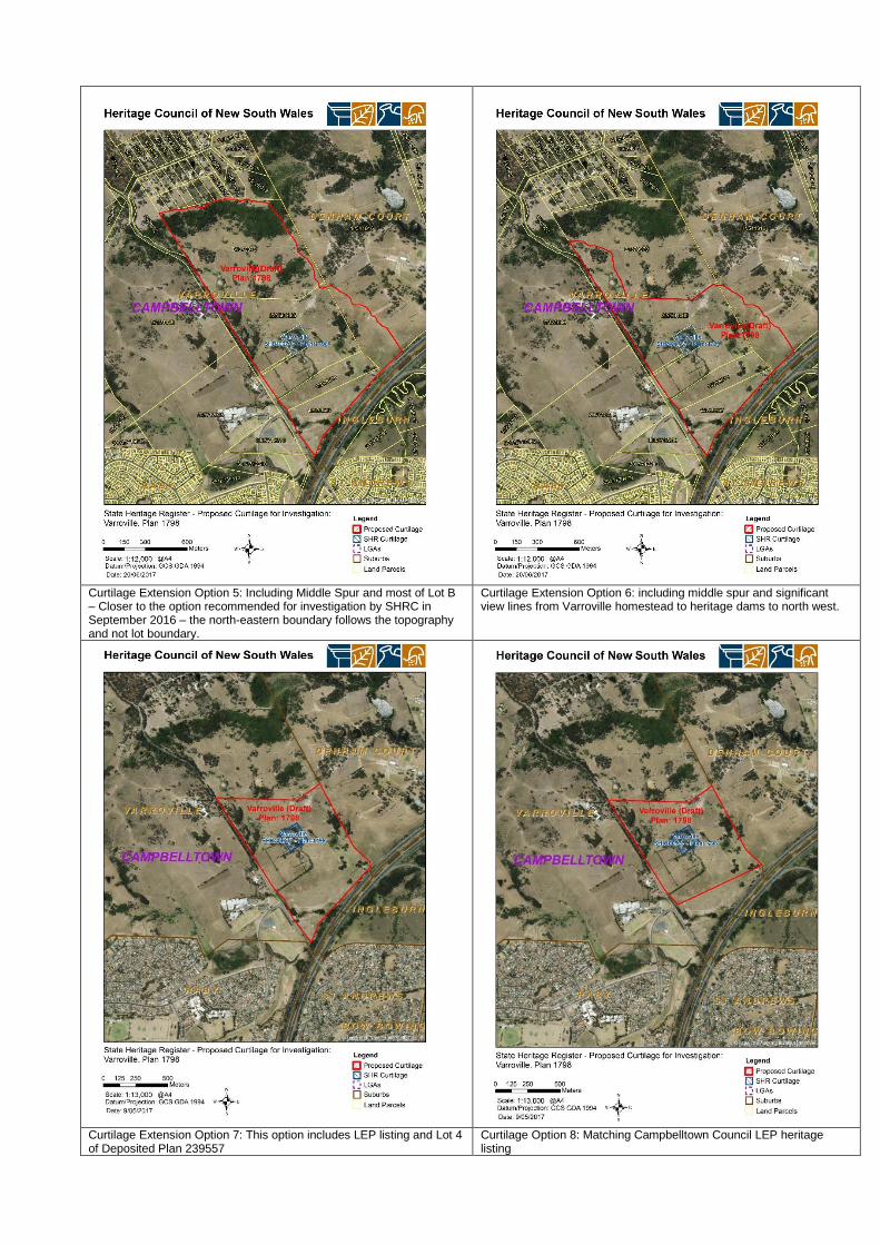
Curtilage Extension Option 5: Including Middle Spur and most of Lot B – Closer to the option recommended for investigation by SHRC in September 2016 – the north-eastern boundary follows the topography and not lot boundary.
Curtilage Extension Option 6: including middle spur and significant view lines from Varroville homestead to heritage dams to north west.
Curtilage Extension Option 7: This option includes LEP listing and Lot 4 of Deposited Plan 239557
Curtilage Option 8: Matching Campbelltown Council LEP heritage listing

• Option 5 (Annexure B) is a variation of Option 4 that was presented to the SHRC in September 2016. The north-eastern boundary of ‘option 5’ does not follow the lot boundary alignment; rather it follows the topography of the landscape (ridge line of middle spur). Option 5 seeks to capture the Vineyard trenching, Sturt period dams, outbuildings of the Varroville homestead, southern extent of Townson’s original grant to the north of the M5 Motorway and some important views from and to Varroville homestead. The views captured include the views from Varroville house to the dams closer to St Andrews Road and the views towards the middle spur to the north-east of the homestead. This curtilage option would also help retain the view from Bunbury Curran Hill towards Varroville homestead. Option 5 is largely in keeping with the curtilage recommended (unsuccessfully) by the Heritage Council for an Interim Heritage Order in 2014.
• Option 6 (Annexure C) is a smaller curtilage that includes some of the significant aspects of Varroville’s cultural landscape. The features included are Varroville’s outbuildings, vineyard trenching, some of the Sturt period dams, southern extent of Townson’s original grant to the north of the highway and some important views from and to the Varroville homestead. The views captured include the views to the dams closer to St Andrews Road (from Varroville homestead) and the views towards the middle spur to the north-east of the homestead.
• Options 7 and 8 are curtilage options that were based on the Campbelltown’s LEP (2017 Amendment) but were discounted as not capturing enough of the significant values of Varroville’s wider landscape.
The Heritage Division is proposing Curtilage ‘Option 6’ to the SHRC for progression to NOI. Option 6 has been based on consultation with the site owners and captures a highly significant view line identified by the owners of Varroville from the living room of the homestead to the dams. The owner of Lot B, the CMCT, has indicated ‘in-principle support’ for the Option 6 curtilage with site specific exemptions for the proposed cemetery. They are also willing to consider modification of their proposed development application (DA is still in planning phase) to preserve the significant views from Varroville house to the dams to the north-west. This is further discussed in the Consultation section of this report. The Owners of Varroville do not support Option 6. They support Option 1 or 2. Option 6 captures some highly significant landscape features and views of the Varroville estate. It allows the majority landholder to proceed with their proposed development, with some modifications. It allows the land surrounding Varroville to be opened for use which will benefit the wider regional community. If the SHRC does not support Option 6, the Heritage Division would then recommend Option 5, although it is noted that it is unlikely the CMT would support a curtilage that encompassed their entire landholding without very detailed site specific exemptions. It should be noted that despite the lack of a current DA (expected to be submitted in August 2017 to Campbelltown Council), the CMCT has outlined that it is dedicated to meeting the requirements of the LEP land rezoning. The Heritage Division considers that the lawn cemetery will proceed in the future, regardless of any extension of curtilage of Varroville. If it proceeds without a curtilage expansion the Heritage Council will have no say in how the cemetery development proceeds in relation to its impacts of Varroville homestead. From a pragmatic standpoint, the Heritage Division considers if the chosen curtilage does not have the support of the major landowner, regardless of the SHRC/HC recommendations, it will not progress to listing on the SHR and the current curtilage of Varroville will remain the same.

Contentious issues

The land surrounding the Varroville homestead has been rezoned (Attachment F) in 2016 and the Campbelltown Council’s LEP has been amended. The land at 166-176 St Andrews Road, Varroville (lots B/370979, 22/564065 and 1/218016) is the subject to the proposed cemetery development of the Macarthur Memorial Park by the Catholic Metropolitan Cemeteries Trust (CMCT). A rezoning application was submitted to the Joint Regional Planning Panel (JRPP) to allow for the inclusion of ‘cemetery’ in the CMCT land, which was approved in September 2016. In accordance with the JRPP ruling, the Campbelltown LEP 2015 has been amended. (Amendment No 1). The approval has been passed with Conditions. The rezoning allows for development for the purposes of a cemetery, permitted with development consent. The heritage map of the Campbelltown Council’s LEP has been amended to include this decision and was published online on the 20 February 2017. Item I105 is listed as Varroville Estate on the LEP
Image 10. Campbelltown LEP 2015 – Heritage map showing Varroville House (SHR Item 00737) surrounded by heritage item I105—Varroville Estate (Amendment No 1).
The CMCT has publicly released plans and image renders of the proposed Macarthur Memorial Park surrounding Varroville Homestead and publicly committed to “restore the site’s dilapidated and partly collapsed buildings, as well as the former vineyards, landscape and lakes to their former condition” (http://mmpark.com.au/macarthur-memorial-park-to-restore-historic-buildings-at-varroville/).
Background:
• Upon the listing of Varroville, under the Heritage Act 1977, in 1993, the extent of the curtilage was given due consideration, but it was determined by the Heritage Council that only the homestead would be listed and its associated landscape would be excluded from the listing.
• The Heritage Council has previously resolved to investigate extending the curtilage around Varroville homestead to incorporate the homestead’s outbuildings and its former estate. In August 2014, the Heritage Council recommended the Minister for Heritage make an Interim Heritage Order (IHO) for an area of the landscape surrounding the homestead, comprising Lot B DP 370979, Lot 22 DP 564065 and Lot 1 DP 218016.
• The then Minister for Heritage declined to make an Interim Heritage Order over the land. Instead the Minister ‘asked that the Heritage Council work with the landowners towards managing the Heritage Values as part of development (including potentially a heritage listing nomination)’.
• The owners of Varroville homestead commissioned the recent curtilage study by Orwell & Peter Phillips (part-funded by the NSW Heritage grants program) and formally requested investigation of an expanded SHR curtilage for Varroville in May 2016.
• Scenic Hills Association, a local community group has been lobbying for the protection of Scenic Hills since 2010 owing to a number of development pressures.
Consultation:
• 4 May 2017: Heritage Division met with owners Jacqui Kirkby and Peter Gibbs (196 St Andrews Road) to discuss the extension of curtilage. The owners elaborated on the significant features of the landscape and identified these features on the site. The vineyard trenches, the network of dams and watercourses, siting of the Homestead in the landscape Significant views to and from the Varroville Homestead, are some of the features that are intact and visible in the landscape. They are very concerned with regards to the proposed Cemetery Development as they believe this would destroy the setting of Varroville as a ‘house in the landscape’ and impact on the views from and to the homestead. Jacqui Kirkby has clearly expressed her support for the curtilage options proposed in the ‘Curtilage Study – Varro Ville, prepared by Orwell and Peter Philips. They have expressed their strong views against the curtilage options presented in this report as they believe these options do not capture all the values of Varroville estate as elaborated in the ‘Curtilage Study’.
• 29 May 2017: Heritage Division met with the owners of (166–176 St Andrews Road)—CMCT (Catholic Metropolitan Cemeteries Trust) to discuss the proposed curtilage options. CMCT are keen to work with the Heritage Division to protect areas of significance in their land. The CMCT have not expressed support for ‘option 1’ at Annexure D, as this includes all of the CMCT-owned land. The ‘option 2’ presented at Annexure E received support from CMCT and they have expressed a willingness to modify their development in accordance with this curtilage.
• 07 June 2017: Heritage Division has written to the owner of 152 St Andrew’s Road (Minister administering the Environmental Planning and Assessment Act 1979 – Lot 4 DP 239557) regarding the proposed extension to Varroville’s curtilage. The officer in charge has responded stating that the information has been forwarded to Campbelltown Council and they would get in touch with Heritage Division to relay Council’s response.
• 05 June 2017: Heritage Division has written to the owner of 205 Campbelltown Road, Denham Court (Scenic NSW Equine Centre – Lot 1 DP 541916) regarding the proposed extension to Varroville’s curtilage.

• 15 June 2017: The nominators/Owners of Varroville emailed stating their specific opposition to Curtilage option 6 which is recommended in this report, stating that the “proposed draft curtilage of the 31 May 2017 has been reduced, not with regard to significance, but to accommodate the proposed use of the land as a cemetery by the Catholic Metropolitan Cemeteries Trust (CMCT)”.
• They have also included feedback from their curtilage consultant, Geoffrey Britton in the same email, who states “There are two salient issues here: one is that the view from the homestead/estate core area looking west does actually encompass important parts of this western valley (see the attached panorama from a few years back, proposed to be excised from our considered minimum curtilage area) and therefore indicates that the valley is an essential part of the rural landscape experience of Varro Ville. It impinges on the siting rationale for the homestead by Weaver. The second issue is that views from within the western parts of the former estate area (including St Andrews Road) also constitute an important part of the experience of this landscape – in other words it's not just views from the remnant core that are important. The western areas (including all the way up to the high ridge beyond) are not only important as excellent vantage points from which to view the homestead (it's main broadside elevation) but views of this extant rural landscape contain part of the valuable experience of pastoral scenery that is the key setting for the homestead and remnant estate core. It is my considered opinion (and ...that of Peter Phillips also) that Lots B, 21, 22, 1 and 4 constitute the minimum curtilage area that makes sense of the exceptional significance that we've identified for the Varro Ville lands...[T]he remnant rural landscape around VV is an extraordinarily rare and valuable traditional setting for the VV core. Every time a part of it is excised for transformation to other land uses, it directly affects the whole”.
• Due to the strong views expressed by the nominator of this item and the owner’s plans for the future development of Lot B, Heritage Division believes that both parties should be invited to present to the full Heritage Council at the meeting where any Recommendation to List the extended curtilage is considered.
• Consultation for Lot 4/239557 – Land owned by the Minister administering EP&A act. The Office of Strategic Lands (OSL) has been contacted regarding a proposed curtilage extension and the Heritage Division has received a response from them stating that the Campbelltown City Council has been informed regarding this as this land is under the care, control and management (CCM) of the Campbelltown City Council. OSL stated that they would inform the Heritage Division when they have a response from the Campbelltown City Council.
• Lot 1/541916 – Scenic NSW Equine Centre. The owner of this lot has been contacted with regards to the proposed curtilage extension. Their consultant has contact Heritage Division requesting the Curtilage Report, which cannot be sent out, and the Heritage Division consulting with them regarding the NOI.
RECOMMENDATION: That the State Heritage Register Committee: 1. Advise the Heritage Division on the preferred curtilage option from among
the two options presented at Annexure B and Annexure C; 2. consider the item known as “Varroville Homestead and Estate” at 152,
166-176, 196 St Andrews Road, Varroville; 205 Campbelltown Road, Denham Court, defined in accordance with the preferred curtilage may be of state heritage significance;
3. in accordance with section 33(1)(a) of the Heritage Act 1977, will give each person that it considers to be an affected owner or occupier written notice that it is going to consider whether or not to recommend the listing of the item concerned (a Notice of Intention to Consider Listing);
4. in accordance with section 33(1)(b) and section 33(1)(c) of the Heritage Act
1977, within 14 days after notice of intention to consider listing is given, will cause a notice of intention to consider listing to be published in a newspaper circulating in the area in which the item is situated, inviting submissions on the listing, specifying a date as the closing date for the receipt of submissions of 35 days after the publication of the newspaper notice and the manner in which submissions may be made.
5. Invite both the nominator of the curtilage extension and the owner of Lot B to present to the Heritage Council when it meets to consider a Recommendation to extend the curtilage and amend the listing information for Varroville Homestead and Estate
Prepared by: Dr Senthil Kasiannan
Heritage Officer – Listings
15 June 2017
Reviewed by: Ms Katrina Stankowski, A/Manager, Listings
dd Month 2017
<signature>
Approved by: Mr Nigel Routh, A/Executive Director, Heritage Division
27 June 2017 <signature>

Annexure A Heritage Council of NSW
State Heritage Register Committee Agenda item: 3.3 Date: 5 July 2017
File: EF14/4535
Location map
196 St Andrew’s Road, Varroville (Varroville homestead) in its existing setting

Annexure B Heritage Council of NSW
State Heritage Register Committee Agenda item: 3.3 Date: 5 July 2017
File: EF14/4535
Listing boundary recommended (Option 5)

Annexure C Heritage Council of NSW
State Heritage Register Committee Agenda item: 3.3 Date: 5 July 2017
File: EF14/4535
Listing boundary recommended (Option 6)

Annexure D
Heritage Council of NSW State Heritage Register Committee
Agenda item: 3.3 Date: 5 July 2017
File:
Assessment of significance – existing (SHR 00737) (heritage data form)

Annexure E Heritage Council of NSW
State Heritage Register Committee Agenda item: 3.3 Date: 5 July 2017
File: EF14/4535
Assessment of significance – Varroville Curtilage Extension homestead and estate (heritage data form)

Annexure F Heritage Council of NSW
State Heritage Register Committee Agenda item: 3.3 Date: 5 July 2017
File: EF14/4535
Campbelltown Local Environmental Plan 2015 (Amendment No 1)


