Data Structure Report: Navan Fort, Co. Armagh
65
Transcript of Data Structure Report: Navan Fort, Co. Armagh
Data Structure Report: Navan Fort, Co. Armagh
Chris Lynn, Cormac McSparron and Peter Moore
CAF DSR 013
SMR No: ARM 012:012
Grid Reference: H 8470 4515
Excavation Licence: AE/02/68
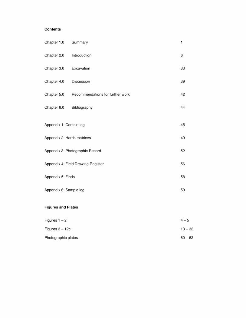
Contents Chapter 1.0 Summary 1 Chapter 2.0 Introduction 6 Chapter 3.0 Excavation 33 Chapter 4.0 Discussion 39 Chapter 5.0 Recommendations for further work 42 Chapter 6.0 Bibliography 44 Appendix 1: Context log 45 Appendix 2: Harris matrices 49 Appendix 3: Photographic Record 52 Appendix 4: Field Drawing Register 56 Appendix 5: Finds 58 Appendix 6: Sample log 59 Figures and Plates Figures 1 – 2 4 – 5 Figures 3 – 12c 13 – 32 Photographic plates 60 – 62

Navan Fort, Co. Armagh 2002 (Licence No. AE/02/68) CAF DSR 013
1
1. Summary
1.1. An excavation was carried out at Navan Fort, Co. Armagh (Figure 1), from 5Th
August to 6th September 2002, directed by Dr Chris Lynn, Environment and Heritage
Service: Built Heritage, with a crew from the Centre for Archaeological Fieldwork.
The assistant directors were Cormac McSparron and Peter Moore.
1.2. Navan Fort is a scheduled monument (SMR: ARM 012:012) consisting of a massive
circular bank and ditch, 236m in diameter, which encloses a drumlin. The size of the
embankments varies. At its most impressive, in the south west of the monument the
ditch is 16m wide and 3m deep and the bank is 9m wide and 2.5m tall. On the flat
summit of the drumlin is a ringwork (Site A) circa 37m in diameter and a mound
(Site B) circa 50m in diameter and 5 m in height.
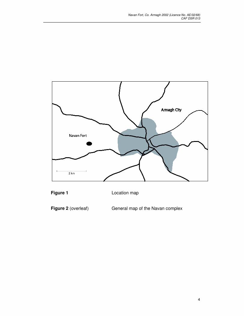
1.3. Navan Fort (Emain Macha) is a monument within the ‘Navan Complex (Figure 2)’, an
area that contains a concentration of late prehistoric archaeological sites that
stretches for approximately 1 kilometre around the fort itself. More recent human
activity has damaged many of the sites but the importance of the landscape within a
prehistoric context remains unquestionable. Within the complex over forty sites have
been identified ranging from substantial earthworks to crop marks.
1.4. There have been a number of previous archaeological investigations at Navan Fort.
Excavations were carried out by Dudley Waterman at Site A and Site B from 1961 to
1971 (Waterman & Lynn, 1997) (Figure 4- 5). In 1998 Jim Mallory of the School of
Archaeology and Palaeoecology, Queens University Belfast, excavated a portion of
the ditch surrounding Navan Fort (Mallory & Lynn, 2002) . Further excavations were
carried out at Site C from 1999 to 2001 (Figure 6) by Dr Chris Lynn of the
Environment and Heritage Service: Built Heritage, to investigate a series of
geophysical survey results obtained in 1994 and 1995 by the Department of
Archaeology, University of Boston, and the Department of Geological Sciences,
California State University. This work revealed a series of three concentric ring-slots
with a diameter of 30 metres between Site A and Site B on the summit of the
drumlin. This series of features was named Site C. The results obtained during
Lynn’s programme of excavations have been published in interim form. Reports on
the 1999 and 2000 excavations have appeared in Emania and the interim report on
the 2001 excavation was published in Antiquity (Mallory & Lynn, 2002, 532-41)
1.5. Dr Lynn’s programme of excavations continued in 2002 when a total of six trenches
were opened (Figure 3). One of the aims for the excavation in 2002 was to complete
previous archaeological investigations that took place towards the top of the site in

Navan Fort, Co. Armagh 2002 (Licence No. AE/02/68) CAF DSR 013
2
2001 at the junction of Rings Ci and A3. The excavations had concentrated on Site
C, which has been shown to comprise three concentric ring-slots, the inner and outer
of which contained burnt material. The feature joins figure-of-eight style with the
smaller triple ring-slot feature underneath ‘Site A’ found by Waterman in 1961. It
post-dates a palisade slot emanating from the area excavated under ‘Site B’. This
and a series of four radiocarbon dates indicates that the ‘Site A/C’ feature was
probably built around the same time as the ‘Site B’ mound (around 95 BC). It was
clearly intended for ceremonial purposes and may even have been used as part of
the commissioning rites of the monument.
1.6. The 2002 excavation involved the opening of a 2 x 2.5 metre trench (Trench 6) to the
north of Trench 1 (first dug in 1999) to find the ends of the converging ring-slots at
Site C. The deposits were very disturbed by animal (probably rabbit) activity which
exploits the softer archaeological deposits. It appeared, however, that the ends of
the slots A3 and Ci were complete and undisturbed. The slots ended by shelving
steeply upwards and the last post was approximately the same size as the others
within the slots. The terminals of A3 and Ci were 80 centimetres apart, centre to
centre, and the packing merged along the zone of contact to form a single deposit.
This confirmed that the wooden structures in the separate (inner) rings of the figure-
of-eight were contemporary. The trench yielded finds, mainly from the disturbed
deposits, but probably still of Iron Age date and included a fragment of copper alloy
binding, an iron pin shank or awl, and a tapering fragment of lignite rod.
1.7. An important issue raised by the investigation of Site C was the location of an
entrance to Navan Fort (assuming that there was a formal entrance to the
sanctuary). The present large entrance west of Site B is probably relatively recent,
created to allow access to a nearby farm. Speculation about the location of a
possible entrance has focussed on the downhill, eastern section of the enclosure
where there are several possible candidates. Excavation in 2001 of an apparent gap
in the east side of Site C revealed that this was a genuine opening, an ‘entrance’
which was flanked on the north by a slot running off to the east. It is possible that this
northern element of the palisade slot runs down the eastern side of the drumlin
towards an entrance, which is the case at similar sites such as Knockaulin and Tara
(Ráith na Rí). Therefore, the orientation of the Iron Age structures on the summit, the
layout of the earthwork in relation to the natural topography, comparisons with similar
arrangements at Knockaulin and Tara together with the findings of a geophysical
survey all suggested that the location of any possible entrance would be towards the
east side of the monument, investigated in Trenches 1, 3 and 4. The eastern section
of the monument, where any possible entrance may lie, is much levelled and the site
of the bank is in scrub ground outside the area maintained for visitor access.

Navan Fort, Co. Armagh 2002 (Licence No. AE/02/68) CAF DSR 013
3
1.8. A trench 2 x 6 metres (Trench 2) was opened on the eastern slope of the drumlin,
some 20 metres from the inner edge of the ditch. The trench was laid out to
determine whether a local hollow on the hill side was a sunken access perhaps
flanked by an artificial feature. The trench located several parallel slots running west
– east down the slope. Some may have been drains but one was larger, c.60
centimetres deep. There was no evidence of post-holes; however its fill contained
several large limestone boulders. Trench 5 was opened across the second
(northern) ridge of the hollow; similar features to those uncovered in Trench 2 were
recorded.
1.9. Trench 1 was excavated on the site of the bank at the point at which one of the
possible entrances was located. The excavation revealed a metalled or cobbled
surface running west into the earthwork. Across a flat base the path was 2 metres
wide rising at each edge to rougher cobbling giving an overall width of 6 metres. The
deepest part of the surface was covered with a deposit of fine clay 50 centimetres
deep. The only diagnostic evidence recovered was a clay pipe stem which came
from this superincumbent material. However, this may have been intrusive, given the
amount of recent material recovered from the base of the topsoil layer. This surface
is therefore not securely dated and no stratigraphic relationship could be established
between the surface and the bank or pre-bank surface. On balance it is unlikely that
this surface represents an original access.
1.10. Trenches 3 and 4 were located on the inside of the monument perimeter,
directly to the west of Trench 1 as described above. The trenches were designed to
investigate the possibility that the surface (see 1.10.) continued into the monument
and across the ditch. The ditch cut, however, was located and core samples taken of
the fill. Significantly it appears that at this section the ditch is somewhat narrower
than at any other point and that the outside edge is some 5 metres inside the
perimeter marked by the hedgerow.
Navan Fort, Co. Armagh 2002 (Licence No. AE/02/68) CAF DSR 013
4
Figure 1 Location map
Figure 2 (overleaf) General map of the Navan complex

Navan Fort, Co. Armagh 2002 (Licence No. AE/02/68) CAF DSR 013
5

Navan Fort, Co. Armagh 2002 (Licence No. AE/02/68) CAF DSR 013
6
2. Introduction
2.1. The following report details the preliminary results of the excavations undertaken
from 5th August to 6th September 2002, at Navan Fort, Navan Td., Co. Armagh, by
Dr Chris Lynn, Environment and Heritage Service: Built Heritage, with a crew from
the Centre for Archaeological Fieldwork, School of Archaeology and Palaeoecology,
Queens University Belfast.
2.2. Reason for excavation and research aims
The excavations at Navan Fort 2002 were designed to answer a number of questions
about the monument.
There have been a number of previous archaeological excavations at Navan Fort.
Excavations were carried out by Dudley Waterman at Site A and Site B from 1961 to
1971. In 1998 Professor Jim Mallory of the School of Archaeology and
Palaeoecology, Queen’s University Belfast, excavated a portion of the ditch
surrounding Navan Fort. Further excavations took place at Site C, located by
geophysical survey undertaken in 1994 and 1995. This programme of work was
directed by Dr Chris Lynn of the Environment and Heritage Service: Built Heritage,
and took place between 1999 and 2001. The 2002 season of work represented a
continuation of this programme.
The aims of the excavation were to:
• Ascertain if a potential entrance way at the eastern sector of the monument
was an ancient entrance way to the monument or a later agricultural feature.
• Investigate a hollow on the eastern slope of the drumlin which was believed
might have been part of a sunken access or processional avenue leading to
the top of the mound.
• Locate and identify a geophysical anomaly on the east of the drumlin which
was believed may have been a palisade trench.
• Complete the excavation of a small area of Site C, which had previously
received extensive excavation during the 1999 and 2000 seasons of work.

Navan Fort, Co. Armagh 2002 (Licence No. AE/02/68) CAF DSR 013
7
2.3. Location
Navan Fort, Navan Td., Co. Armagh (SMR: ARM 12:12), is located on a drumlin
2.6km west of the city of Armagh (H8470 4515) (Figure 1). Navan Fort is just one of a
number of related monuments in the immediate area known collectively as the Navan
Complex (Warner 1994) (Figure 2).
2.4. Description
Navan Fort is a circular enclosure with an internal diameter of 236 m. It is defined by
a deep ditch and external bank which is most apparent on the west side of the
monument. At the south west of the monument the ditch is 16m wide and 3m deep
and the bank is 9m wide and 2.5m tall. The internal area of the monument is 4.23
hectares and the approximate complete area of the monument, including the bank
and external ditch, is approximately 6.3 hectares. The drumlin on which the
monument is located has a maximum elevation of 75.66 m OD. The countryside
surrounding Navan Fort is rolling drumlin countryside, although the elevation of the
site gives it excellent views in all directions. On the flat summit of the drumlin is a
ringwork (Site A), circa 37m in diameter, and a mound (Site B), circa 50m in diameter
and 5m in height. Site C, a series of three concentric ring-slots, with a diameter of 30
m, was discovered during geophysical surveying of the monument in 1994 and 1995
by the Department of Archaeology, University of Boston, and the Department of
Geological Sciences, California State University.
2.5. Early accounts of Navan Fort.
Navan Fort is one of the most important archaeological monuments in Europe. It is
important not just because of the complex prehistoric activity uncovered there in
successive excavations but in the significant role which Navan plays in early Irish
myths, pseudo-history and history. It is unique in that, as Emain Macha, it is central to
the Ulster Cycle of tales, being both the backdrop to many individual events and the
capital of Ulaid. There are also numerous annalistic and genealogical references to
Navan Fort / Emain Macha and it is possible that the site is mentioned by the 2nd
century AD geographer Ptolemy.
The identification of Navan Fort with Emain Macha is well established and rests on
two main bodies of evidence. First, there are a number of references to Emain Macha
relating its position to that of Armagh. In the tale Bricriu’s feast, for example, Cú
Chulainn is described as setting out in a south-easterly direction from Emain Macha
“until he came to where Ard Marchach or Ard Macha is, because at that time it was a

Navan Fort, Co. Armagh 2002 (Licence No. AE/02/68) CAF DSR 013
8
forest”. (Flanagan 1997, 7). There are a number of other similar passages in other
tales. Second, linguistic evidence points strongly to an association of Navan Fort and
Emain Macha. The change in anglicised versions of Emain Macha, from variants very
close to Emain, to the modern English Navan, can be traced in 17th century
documents (Ibid, 8).
It is outside the scope of this report to detail all the references to Emain Macha in the
Ulster Cycle except to say they are many, varied and not all consistent with one
another. Some tales use Emain Macha as a backdrop to various activities such as the
games of the macrad in the cluichemag, or playing field (Mallory 1997, 203). Other
tales give detailed, but formulaic, descriptions to buildings at Emain Macha, such as
the descriptions of Conchobar’s palaces (Ibid, 205-6) However, it has been noted
that there are interesting correlations between one description of Conchobar’s great
hall, from the Tochmarc Emire, and the Phase 4 structure at Site B (Ibid: Lynn 1992,
51). Also the date of the burning of Emain Macha by Fergus in the late first century
BC as recorded in the story of Deirdre correlates well with the date of the felling of the
central post of the Phase 4 structure at Site B in 95 BC (Mallory 1997, 206)
Annalistic references to Emain Macha are common. The foundation of Emain Macha
is variously dated in the Irish annals from 668 BC, in the Annals of the Four Masters,
to 307 BC, in the Annals of Tigernach and Inisfallen (Ibid, 199). The period of activity
at Emain Macha is stated as being between 630 years in the Annals of Clonmacnoise
to about 1000 years according to the Annals of Ulster (ibid). The Tain and death of
Cú Chulainn are dated to 19 BC in the Annals of Tigernach and the fall of the last
king of Emain Macha is recorded at the battle of Achad Lethderg as occurring
between 324 and 332 AD in various sources (Ibid, 200). A few sources raise the
possibility of some royal association with Navan up to about 450 AD (Ibid).
The earliest reference to Navan Fort may come from Ptolemy’s Geographia of the 2nd
century AD. There are two places mentioned in the Geographia, Isamnion and
Regia, which may refer to Navan. Isamnion is located in the territory of the Volunti,
which is considered to be a corruption of Uluti the tribe occupying the Navan area in
the Iron Age (Mallory 1997, 197-198) However, Ptolemy identified Isamnion as a
promontory, not a town. The linguistic similarity of the name Isamnion with Emain
Macha and the confusion between Ptolemy and the geographer Marcianus on the
number of promontories and towns in Ireland, have led some academics, however, to
identify Navan with Isamnion (Ibid). Ptolemy’s Regia has also been attributed to
Navan. The name means ‘royal centre’ and it is located within inland Ulster. However,
it is equally possible that this reference pertains to Clogher, Co. Tyrone (Ibid).

Navan Fort, Co. Armagh 2002 (Licence No. AE/02/68) CAF DSR 013
9
2.6. Previous archaeological investigations at Navan Fort.
Extensive excavations were carried out at Navan Fort by Dudley Waterman, Ancient
Monuments, Ministry of Finance, between 1961 and 1971. He excavated in two areas
on the top of the drumlin; Site A appeared to be a ploughed out earthwork 37 m in
diameter, and at Site B a large mound 50 m in diameter and 5 m high. At Site A two
phases of circular construction trenches, Phase A and Phase B, were discovered.
Phase A was composed of three concentric construction trenches, the outermost
having a diameter of 19.5m. The innermost construction trench had traces of post
and plank walling. This phase was cut by Phase B which was composed of two
concentric construction slots which had an entrance gap on the east side. Flanking
the entrance into the Phase B structure were two inhumation burials. Portions of the
ring ditch surrounding the Phase A and B structures were also excavated (Figure 4).
At Site B a complex series of structures was identified. Phase 1 consisted of a few
subsoil cutting features filled by Neolithic material and Phase 2 was an episode of
cultivation shown by traces of plough marks in the subsoil. Phase 3 (Figure 5a) was
complex and was subdivided into three parts: 3(i), 3(ii) and 3(iii). Phase 3(i) was
composed of a ditch, 46m in diameter, surrounding Site B. The ditch was up to 5.5m
wide and 1.2m deep and had an entrance causeway on its east side. Concentric with
this ditch were a series of elongated pits set back from the inner ditch edge. Phase
3(ii) was composed of three sets of ring-slot enclosures to the south of Site B and four
sets to the north. Two of the sets to the south and north joined to form figure-of-eight
structures. All of the ring slot enclosures have entrances pointing approximately to the
east. Four lines of palisade trenches running up to the ring-slot enclosures in the
north of Site B are the probable remains of an avenue leading to the entrances of
these ring-slots. Phase 3(iii) was composed of three concentric ring-slots, the largest
13.6 m in diameter, cutting through both the northern and southern parts of phase
3(ii). These ring-slots had two entrances at the north-east and south-west
diametrically opposed to each other.
Phase 4 at Site B (Figure 5b) marked a complete architectural departure with the
construction of a large multi-ring timber structure, approximately 37m in diameter.
This structure was composed of four concentric lines of posts, around a larger central
post, which were surrounded by a series of large post-pits linked by horizontal split
timbers in a shallow construction trench. The four concentric circles of internal posts
were interrupted by a double line of posts running in parallel from the central post to
the perimeter of the structure. There is no indication that this was ever inhabited as
no attempt was made to create a level floor for the structure which was built directly
on top of the Phase 3 structures. It is uncertain if Phase 4 was actually roofed

Navan Fort, Co. Armagh 2002 (Licence No. AE/02/68) CAF DSR 013
10
although there was considerable evidence for pressure exerted on structural posts at
the perimeter of the structure, suggesting that some sort of superstructure was
supported by the timber circles.
A short time after the construction of Phase 4 the timber structure was encased in a
composite mound, Phase 5 (Figure 5c), consisting of a limestone cairn and an
earthen mound above it. The limestone cairn was built around and upon the Phase 4
building while it was still standing, voids of the posts of the Phase 4 building having
been visible in the cairn during excavation. The limestone boulders varied in size up
to 60 cm in diameter, with the largest stones at the bottom of the cairn. Few of the
stones looked freshly quarried. The upper surface of the cairn was deliberately laid
out in radial divisions caused by kerbs, depressions and raised areas.
Close to or after the completion of the limestone cairn the wooden wall of the Phase 4
building, and presumably any superstructure, was burned. The evidence for burning
was greatest where a portion of the cairn collapsed, sealing a portion of the burning
wall of the Phase 4 structure. In other areas the evidence of burning was scant but
combustion may have been very complete leaving only the burnt clays which were
found around the edge of the building and tiny charcoal fragments. After the burning
an earthen mound was erected over the limestone cairn. It was composed of 21
different types of soil which probably implies that soils were imported from
surrounding areas. The mound appears to have been constructed in a single
continuous operation (Waterman & Lynn, 1997).
An excavation of a portion of the ditch at Navan Fort was undertaken by Professor
Jim Mallory of the School of Archaeology and Palaeoecology, Queens University
Belfast, in 1998. It showed the ditch to be 4.5m deep. An oak timber found at the
base of the ditch was dated by dendrochronolgy to 95 BC, contemporary with the
central timber from the 40 m timber structure, Phase 4, at Site B. A fragment of a
wooden bowl was also found (Mallory 2000).
In 1994 and 1995 geophysical surveys were undertaken by the Department of
Archaeology, Boston University, and the Department of Geological Sciences at
California State University, Long Beach. The work was undertaken under the
sponsorship of the Navan Research Group, The Environment and Heritage Service,
the Department of Archaeology, Queens University Belfast, and the Navan Centre.
These surveys revealed a circular feature composed of two lines of magnetic
anomaly with an exterior diameter of circa 30 m. A further linear anomaly heading
approximately south was also shown. The circular anomaly was subsequently named
Site C (Kvamme 1996: Ambos, Larson. Kvamme, Conway and Cibbarelli 1996).

Navan Fort, Co. Armagh 2002 (Licence No. AE/02/68) CAF DSR 013
11
In 1999 an excavation was directed by Dr. Chris Lynn, Environment and Heritage
Service: Built Heritage, to investigate the 30 m diameter, circular anomaly (Site C)
discovered during the geophysical surveys. The excavation revealed two concentric
slots, 0.5 m wide, 0.6 m deep and spaced 1.0 m apart. The upper fill of the slots
consisted of burnt soil, ash and charcoal and - where fully excavated - the remains of
closely set posts were found in the bases of the slots. Traces of an intermediate slot
with a much cleaner fill were found between the two slots. The area of intersection of
Site A and Site C was also investigated. However, considerable animal disturbance
made it impossible to establish the exact relationship between Site A and Site C,
although it was possible to ascertain that Site C predated the bank of Site A. An
additional trench investigated the area of intersection of one of the palisades ,Z,
running from the Phase 3ii: Northern Ring-Slot Enclosures to the east. It showed that
Site A cut through the palisade. Radiocarbon dates from the excavation provided a
calibrated date range of 400 BC to 26 AD (Lynn 2001).
Further excavations by Dr. Chris Lynn in 2000 confirmed the existence of the third
intermediate slot at Site A. It also showed that the outer slot of Site A was
contemporary with the outer slot of Site C, forming a single figure-of-eight building.
The inner slot was shown to have held a post and plank wall, which had burned
down, and had deposits of burnt animal bones of cattle, pig and sheep at its inner
edge (ibid).
A series of trenches were opened at Site C during Lynn’s 2001 excavation season
(Figure 6). The north side of the east gap with the possible palisade slot running
towards the east was investigated, as was the western junction of Sites A and C
which included palisade/slots A2, A1,A3, Ci. Cm and Co (Figure 1). The excavations
showed that the features that comprise the triple ring-slot enclosure at Site C and Site
A join to form what would have been a contemporary figure-of-eight structure. A
series of ‘V’ shaped terminals are present where the ring-slots from the Site A and C
enclosures meet to form the bend in the ‘8’ but do not converge into a single feature,
and they maintain a degree of separation. The 2001 excavations investigated these
‘V’ shaped curves in the slot trenches, together with a narrow trench that contained
post-sockets running at right angles from the end of the outer slot ‘Co’ towards the
east (ibid).

Navan Fort, Co. Armagh 2002 (Licence No. AE/02/68) CAF DSR 013
12
2.7. Archiving
A copy of this report has been deposited with the Environment and Heritage Service:
Built Heritage, DOE NI. All site records, finds and samples are temporarily archived
with the Centre for Archaeological Fieldwork, within the School of Archaeology and
Palaeoecology, Queens University Belfast.
2.8. Credits and Acknowledgements
The excavation was directed by Dr. Chris Lynn of the Environment and Heritage
Service: Built Heritage. Cormac McSparron and Peter Moore were the assistant
directors.
Assistance during the course of the excavation and the preparation of this report was
kindly provided by: Dr. Colm Donnelly, Janet Bell, Catherine Boner, Lucy Chapman,
James McKee, (Centre for Archaeological Fieldwork), Billy Dunlop, Ken Pullin, Harry
Welsh and John Moore.
The illustrations in this report were prepared by Bronagh Murray and Ruth Logue of
the Centre for Archaeological Fieldwork, Queens University Belfast.

Navan Fort, Co. Armagh 2002 (Licence No. AE/02/68) CAF DSR 013
13

Navan Fort, Co. Armagh 2002 (Licence No. AE/02/68) CAF DSR 013
14

Navan Fort, Co. Armagh 2002 (Licence No. AE/02/68) CAF DSR 013
15

Navan Fort, Co. Armagh 2002 (Licence No. AE/02/68) CAF DSR 013
16

Navan Fort, Co. Armagh 2002 (Licence No. AE/02/68) CAF DSR 013
17

Navan Fort, Co. Armagh 2002 (Licence No. AE/02/68) CAF DSR 013
18
Navan Fort, Co. Armagh 2002 (Licence No. AE/02/68) CAF DSR 013
19

Navan Fort, Co. Armagh 2002 (Licence No. AE/02/68) CAF DSR 013
20

Navan Fort, Co. Armagh 2002 (Licence No. AE/02/68) CAF DSR 013
21

Navan Fort, Co. Armagh 2002 (Licence No. AE/02/68) CAF DSR 013
22
Navan Fort, Co. Armagh 2002 (Licence No. AE/02/68) CAF DSR 013
23

Navan Fort, Co. Armagh 2002 (Licence No. AE/02/68) CAF DSR 013
24

Navan Fort, Co. Armagh 2002 (Licence No. AE/02/68) CAF DSR 013
25
Navan Fort, Co. Armagh 2002 (Licence No. AE/02/68) CAF DSR 013
26

Navan Fort, Co. Armagh 2002 (Licence No. AE/02/68) CAF DSR 013
27

Navan Fort, Co. Armagh 2002 (Licence No. AE/02/68) CAF DSR 013
28

Navan Fort, Co. Armagh 2002 (Licence No. AE/02/68) CAF DSR 013
29
Navan Fort, Co. Armagh 2002 (Licence No. AE/02/68) CAF DSR 013
30

Navan Fort, Co. Armagh 2002 (Licence No. AE/02/68) CAF DSR 013
31
Navan Fort, Co. Armagh 2002 (Licence No. AE/02/68) CAF DSR 013
32

Navan Fort, Co. Armagh 2002 (Licence No. AE/02/68) CAF DSR 013
33
3. Excavation
3.1. Methodology Navan Fort is a scheduled monument. Prior to the commencement of the 2002
season of excavation, Scheduled Monument Consent was sought and approved. The
programme of work involved the archaeological investigations of (i) a possible
entrance to Navan Fort, hypothesised to be located towards the eastern extremity of
the site, (ii) a hollow located on the east slope of the drumlin, speculated to be a
sunken access to the hilltop, and (iii) a set of triple ring-slots associated with a figure-
of-eight structure at ‘Site C’.
The excavations were undertaken by hand and the context record for the site was
created using the standard context recording method. Individual features and
deposits were photographed prior to and after excavation. Overall plans of each
trench, and the features they contained, and sections were drawn using either 1:10 or
1:20 scales. For details of the photographic record see Appendix Three; for details of
field illustrations see Appendix Four. In addition to the records noted above, the site
records also consisted of a small finds register (Appendix Five) and a soil sample log
(Appendix Six). Following the completion of the archaeological investigations each
trench was backfilled and the turf layer replaced.
A full assessment of the health and safety aspects of the work was undertaken, with
no conceivable hazards to personal safety identified.
3.2. Account Of The Excavations
For ease of reading a trench-by-trench account is given below for the excavations
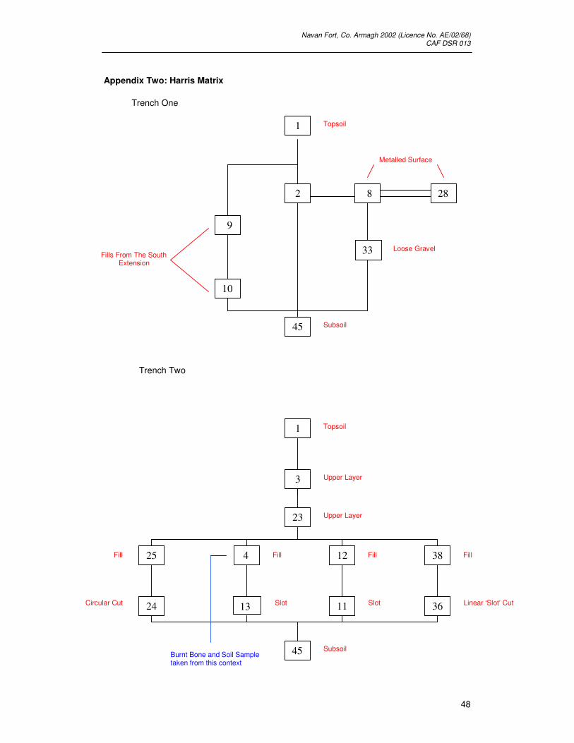
that took place at Navan Fort in 2002. It is recommended that the Harris Matrix
(Appendix Two) for each trench is referred to when reading the excavation account.
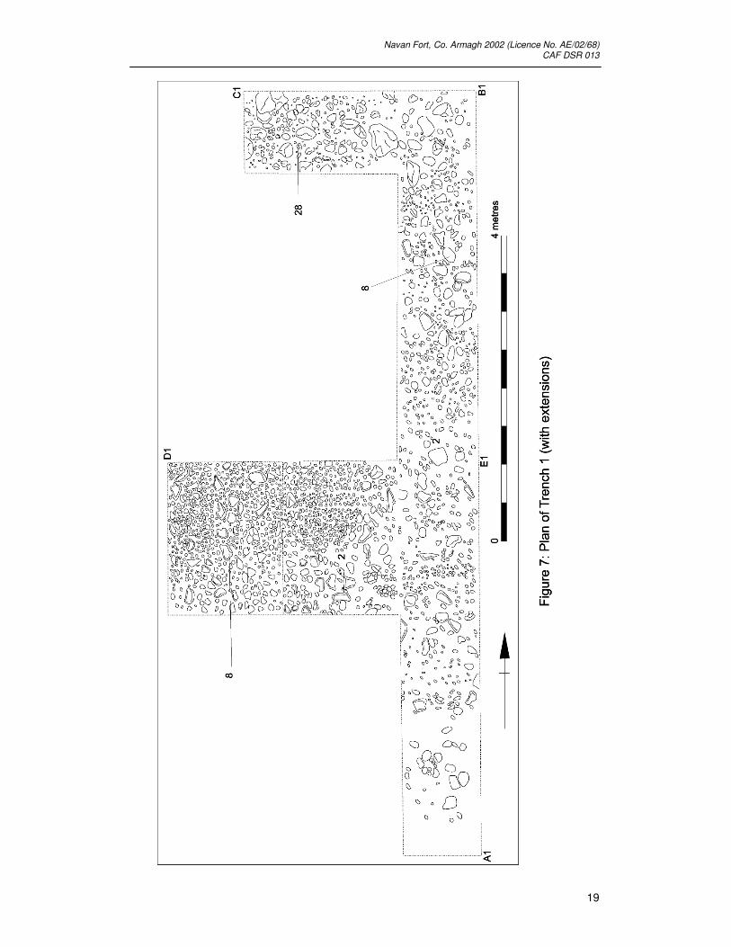
3.3. Trench One (Figure 7, 7b & 7c)
Speculation about the possible location of an original entrance has focused on the
downhill, eastern sector of the enclosure where several likely candidates have been
identified by Lynn.
Trench 1 was located towards the eastern extremity of the site, outside and to the
east of the perimeter hedgerow. Initially, a trench 10 metres (north – south) by 1
metre (east – west) was opened. After the removal of the turf layer topsoil was
encountered (Context 1), a brown/black friable loam containing marine shell fragments

Navan Fort, Co. Armagh 2002 (Licence No. AE/02/68) CAF DSR 013
34
together with modern ceramic and agricultural artefacts (see Appendix Five). Located
beneath the topsoil layer was Context 2, a yellow/red friable loam with frequent
stone inclusions. It was within this context that an extensive layer of closely packed
stones was uncovered (Context 8: Figure 7). Within the south section a layer
underlying Context 8 was visible, a very loose slightly loamy gravel (Context 33).
Trench 1 was located where the earthwork had undergone much levelling. It was
unfortunate that a stratigraphic relationship between the stone surface and the bank
and/or pre-bank surface could not be established.
Two extensions were added to Trench 1 running towards the west to investigate
whether this stone layer continued towards the perimeter hedgerow. These
extensions were placed at the north and south ends of the trench, each measuring 1
metre (north – south) by 2 metres (east – west). Within the northern extension, after
the removal of topsoil, a similar stone layer to Context 8 was encountered,
renumbered Context 28. However, this layer contained more loose gravel and the
stones were not as densely packed as had been previously recorded for Context 8.
Within the southern extension, after the removal of topsoil, an orange/brown friable
sandy loam was uncovered that contained infrequent small stone inclusions (Context
9). Located beneath this was Context 10, a brown/orange compact sandy clay with
infrequent small stone inclusions. A further extension to Trench 1 was added, 4.6
metres from the north and running towards the perimeter hedgerow (west). This
extension measured 2 metres (north – south) by 3 metres (east – west). Although
initially a separate box trench, the baulk was subsequently removed to join Trench 1
with this extension. The stratigraphic sequence within this extension was identical to
the initial trench, with the continuation of Context 8 observed. A single clay-pipe stem
was recovered from Context 8 (Appendix Five).
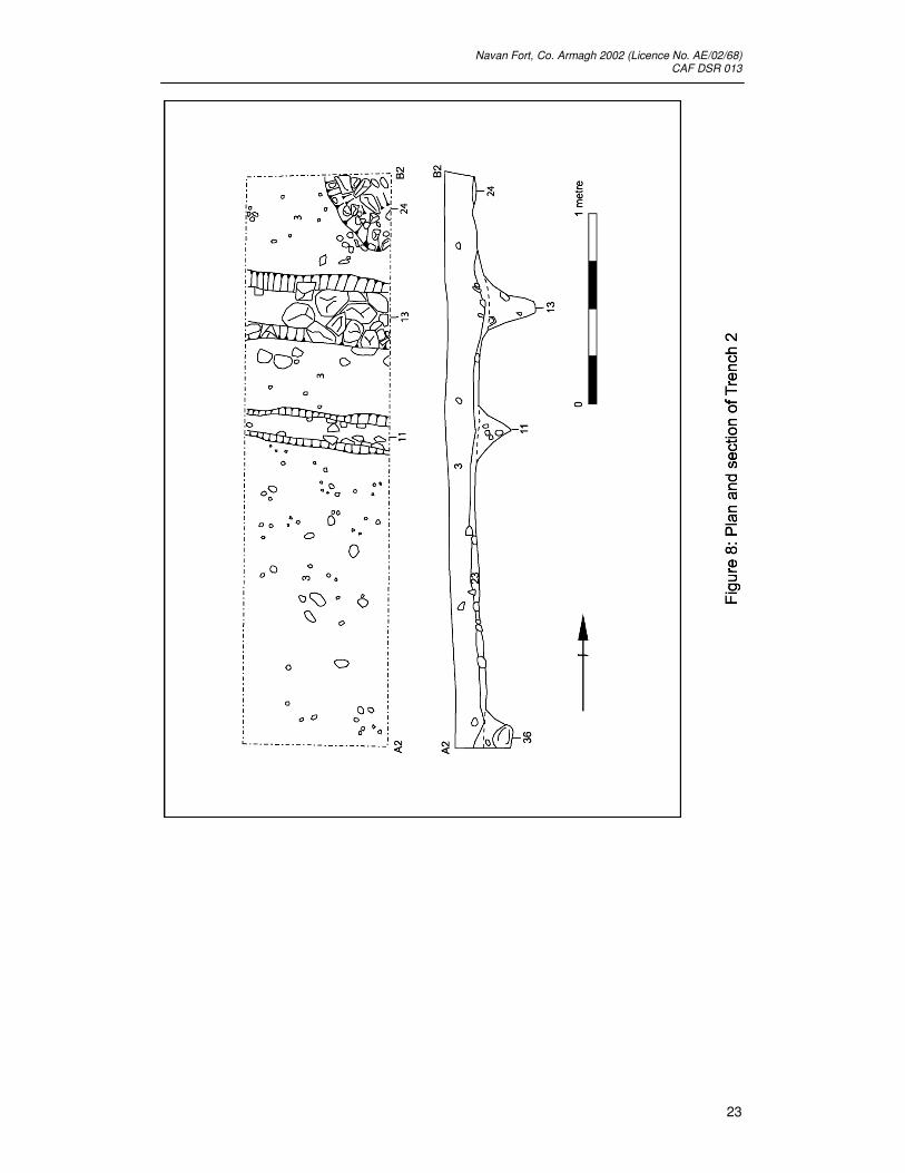
3.4. Trench Two (Figure 8)
Trench 2 was positioned on the eastern slope of the drumlin and was designed to
investigate the hollow (aligned east – west on the hillside) that could possibly have
been a sunken access or processional avenue leading to the top of the drumlin. A
series of slot-like features had been detected by geophysics (GeoQuest, 2000). In
addition, an apparent gap in the east side of ‘Ring C’
revealed that this was a true entrance and that it was flanked on the north by a
slot running to the east. The possibility existed that these slots could continue to
run down the east side of the drumlin. New trenches (Trench 2; and later Trench 5)
were therefore opened to investigate this possibility.

Navan Fort, Co. Armagh 2002 (Licence No. AE/02/68) CAF DSR 013
35
After the removal of the turf layer, a topsoil of brown/black friable loam with
occasional small stone inclusions (Context 1) was uncovered. Situated beneath this
was Context 3, a fairly compact orange slightly sandy loam. Context 23 a browny
orange, slightly loamy clay, was situated beneath Context 3 and its removal revealed
several cut features. Context 11 was a linear feature running in an east – west
alignment that was 37cm in width (north – south) and, at its greatest extent, 42cm in
depth. This feature was filled by Context 12, a dark brown friable, slightly sandy loam,
with occasional charcoal flecking and small stone inclusions. This ‘slot’ was similar to
Context 13, also aligned east – west, which was filled by Context 4, a dark brown
loose sandy loam with occasional charcoal and small stone inclusions. Several other
archaeological features were also observed within the trench. Context 24 was a
circular cut located in the north-east corner of the trench, 56cm in diameter and at its
greatest extent 30cm in depth. This was filled by Context 25, a dark brown, soft loamy
clay with charcoal flecking. A third linear feature in an east – west alignment was also
observed (Context 36), 28cm in width and 36cm in depth. This was filled by Context
38, a brown/grey fairly compact clay, that appeared to be mixed in places with a fine
gravel which formed the base of the cut. The trench was then excavated down to
Context 45 (subsoil).
Artefacts were frequently recovered during the excavation of Trench 2. For example,
clay pipe stems were found at the interface between Context 1 and Context 3.
However, samples of burnt bone were the only artefacts recovered from any of the
base contexts, such as Context 4.
3.5. Trench Three (Figure 9 & 9b)
Trench 3 was situated to the immediate west of the perimeter hedgerow and in
alignment with Trench 1. It was located in this position to ascertain whether the
compact layer of stones (Context 8) recorded in Trench 1 continued on the inside of
the site. The trench was the same width ( 2 metres north – south) as the extension
to Trench 1 and ran in an east – west alignment for 4 metres.
After the removal of the turf layer, a black/brown friable loam with occasional stone
inclusions (Context 1: topsoil) was uncovered. Located immediately beneath this was
Context 19, a layer of loosely packed stones (c.10 – 13cm) in a sandy loam. These
stones were not as densely packed as Context 8 and are unlikely to represent a
continuation of this context to the monument’s interior. Located against the western
baulk of the trench were the edges of a cut (Context 46). Although not fully
excavated, the edge was investigated to ascertain whether it was the main ditch of
the monument or some other archaeological feature. It appeared that the feature was

Navan Fort, Co. Armagh 2002 (Licence No. AE/02/68) CAF DSR 013
36
cut into subsoil, and was filled by Context 27, a grey soft silty sand. Significantly, this
cut appears to be narrower than the ditch at any other point, with the outside edge
some 5 metres inside the perimeter hedge rather than butting against it.
A bronze or copper spherical object with a pin on one side c.2.5 cm in diameter was
recovered from the interface between Contexts 1 and 19, together with modern
ceramic material. Several pieces of flint (possibly with retouched edges) were
recovered from Context 19.
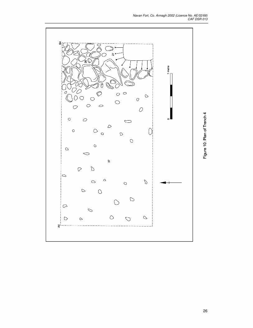
3.6. Trench Four (Figure 10 & 10b)
Trench 4 was located on the same alignment as Trenches 1 and 3 but two metres
further to the west within the monument’s interior. Trench 4 was designed to
investigate whether the stone surface (Contexts 8 and 19) continued further into the
monument interior, and also to investigate the possibility that the cut feature (Context
46) recorded in Trench 3 was part of the ditch surrounding Navan Fort.
After the removal of the turf layer and topsoil (Context 1), Context 26 was observed,
which represented a series of large stones towards the east end of the trench in a
north – south alignment. Excavation revealed that these stones formed part of a large
drain feature that was cut into Context 27, a grey soft silty sand with occasional small
stone inclusions, hypothesised to be the ditch fill. A small box section was
excavated in the north–west corner of Trench 4 to further verify that Context 27 was
ditch fill. Several core samples were taken for laboratory analysis from this box
section. Wood and burnt bone fragments were also recovered. The box section was
excavated down to Context 37, a brown/orange slightly sandy clay with occasional
small stone inclusions. Significantly, this layer would indicate that the ditch cut is
somewhat shallower at this point in the east perimeter than elsewhere surrounding
the site.
3.7. Trench Five (Figure 11 & 11b)
Trench 5 was located two metres north of trench 2 on the east side of the drumlin and
placed on top of the sunken hollow’s second ridge. Its purpose was to locate the
second palisade or slot trench indicated by the geophysics running down the side of
the drumlin in an east – west alignment.
After the turf and topsoil (Context 1) was removed, a loose brown/orange loamy clay
with occasional small stone inclusions (Context 29) was recorded, together with an
orange fairly compact sandy loam (Context 3) that had been recorded in Trench 2.

Navan Fort, Co. Armagh 2002 (Licence No. AE/02/68) CAF DSR 013
37
Within this were several cut features similar to the ones uncovered during the
excavation of Trench 2. Context 30 was a linear cut in an east – west alignment
situated in the south – west corner of Trench 5 measuring 42cm (north – south) and
at its greatest extent 24cm in depth. This was filled by Context 39 a brown/yellow
compact clay together with frequent large stones. Context 31 was a linear cut, also in
an east-west alignment, filled by a brown loose gravel (Context 40), together with
large stones. This feature was cut by Context 32; a layer of stones comprising a field
drain running east – west. All of the archaeological features contained a similar base
fill (Context 44) a reddish brown loose gravel. After the investigation and recording of
the features the trench was excavated to Context 45 and 23 (subsoil).
Artefact material was recovered from Trench 5 including several clay pipe stems and
modern ceramics from the topsoil layer, a single piece of flint and black pottery
together with fragments of burnt bone were recovered from the interface of Context 3
and 29. A dark blue barrel shaped bead was recovered from Context 3 probably
dating to the Early Christian period.
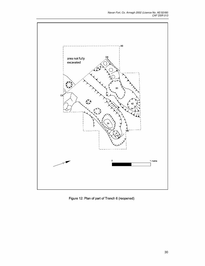
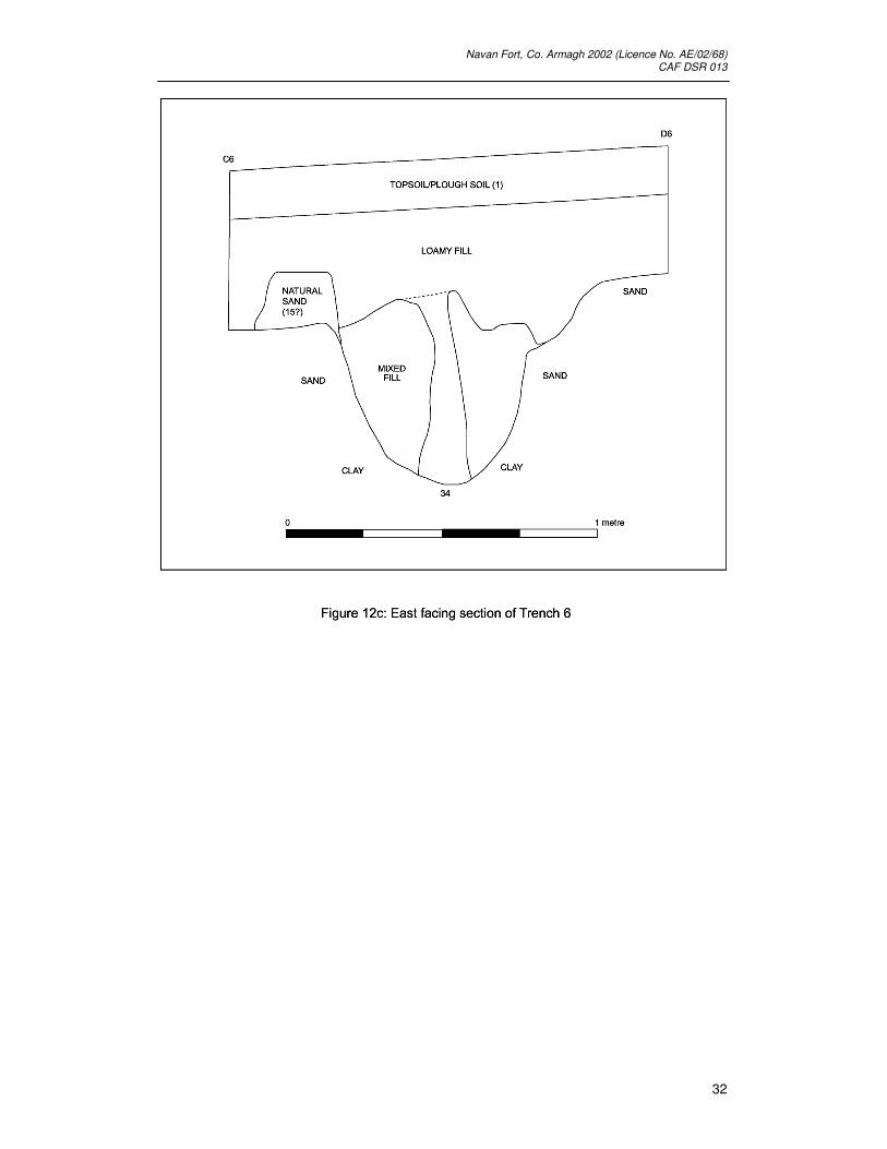
3.8. Trench 6 (Figure 12, 12b & 12c)
This trench was opened to continue the investigation first undertaken in 1999 towards
the top of the drumlin at the site of the figure-of-eight structures, first noted by the
geophysical survey undertaken in 1994 and 1995. The trench was designed to locate
the converging ring-slots of Sites A and C.
After the removal of the turf and topsoil (Context 1), a yellowish sandy loam fill
(Context 5) was recorded. It appeared that all archaeological features were below
and within this context. Two lenses of dark loam with charcoal inclusions (Contexts 6
and 7) together with a circular ring of dark loam (Context 17), were observed. Context
18, a sandy clay material was situated in a slight depression seemingly enclosed
within Context 17. A fossil soil (Context 16), was located towards the north–west of
the trench, which was in part buried under the bank of Site A. Further excavation
revealed - as had been anticipated - two slot trenches (A1 and Ci) were uncovered,
each containing post-holes. Slot trench A1 contained four post-holes (Contexts 34,
35, 41 and 43 and their respective fills: Appendix Two). Slot trench Ci also contained
four post-holes (Contexts 20, 21, 22 and 42 and their respective fills). Lining the edge
of trench Ci was Context 14, a red/black clay consistent with burning or fire
hardening. These slot trenches ended by shelving steeply upwards. The terminals of
the slots were 80cm apart, centre to centre, with the packing of the slots merging
along the zone of contact to form a single deposit. The lower archaeological features
Navan Fort, Co. Armagh 2002 (Licence No. AE/02/68) CAF DSR 013
38
appeared to be situated on top of a clean yellow sand (Context 15). It was
unfortunate that, in some instances, rabbit burrows had been dug into this soft
archaeological deposit.
Finds recovered form this trench included bone fragments derived from many of the
contexts (see Appendix Five). Perhaps of most significance was a single pot sherd
from the fill of A1, and a cylindrical piece of lignite from the upper fill of Ci. Other finds
included a fragment of copper alloy binding and an iron pin shank or awl. Although
these latter finds were from contexts that had been disturbed by animal burrowing,
they are probably of Iron-Age date.

Navan Fort, Co. Armagh 2002 (Licence No. AE/02/68) CAF DSR 013
39
4. Discussion
4.1. Background
The location of the 2002 trenches was designed to uncover a possible formal
entrance to Navan Fort, which is thought to be situated towards the eastern side of
the monument. Comparisons between Navan, Knockaulin and Tara (Ráith na Rí),
suggest that any formal entrance would have been located towards this side; indeed
these monuments share many similarities. However, it is important to note that at
these two other sites there is no ‘grand’ entrance, instead there is a rather plain break
in the bank and ditch; the focus for attention must have been the monuments/mounds
themselves rather than the entrance and access route to them. Previous excavation
at Site C combined with geophysical survey results also suggested that had Navan
had a formal entrance, it would be located towards the east side. The palisade found
at Site C appeared to continue down the drumlin side, running in an east – west
alignment and the geophysical results confirmed the presence of several anomalous
features that required investigation.
4.2. Trench One (Figure 7, 7b & 7c)
Trench 1 was located outside the current perimeter hedge (which marks the area kept
for visitor access, as well as the position of the bank in many places). Initially a 10 x 1
metre trench was opened, however three extensions were added, two of which were
positioned at the northern and southern ends of the initial trench, measuring 1 x 2
metres and the third measuring 2 x 3 metres, (each of these extensions ran
westwards towards the perimeter hedgerow). Situated in the layer beneath the topsoil
(Context 2) was a layer of densely packed stones that formed a cobbled or metalled
surface. Within the northern extension this layer was also recorded, but the stones
were less densely packed and they were situated in a gravely subsoil layer. This
rougher cobbling rose with the topography to give the surface a flat base
approximately 2 metres wide with sloped sides to give an overall width of 6 metres.
The only dating evidence came from a clay pipe stem which was found lying directly
on Context 8 (the cobbled surface). However, given the finds recovered from the base
of topsoil, which included modern glass and ceramics, it is not unreasonable to
suggest that this stem could have been intrusive; therefore this surface cannot be
said to be securely dated, (unfortunately no stratigraphic relationship could be
established between the cobbling and the bank or pre-bank surface). On balance it is
unlikely that this cobbled surface represents anything related to an original
entranceway and probably dates to the 17th or 18th centuries with an agricultural
function the most plausible explanation.
Navan Fort, Co. Armagh 2002 (Licence No. AE/02/68) CAF DSR 013
40
4.3. Trench Two (Figure 8)
Trench 2 was positioned over a ridge on the eastern slope of the drumlin that
appeared to relate to a hollow on the drumlin side. It was here that a series of slot-like
features were detected by geophysics. Several linear features were recorded running
in an east – west alignment, (they ran with the direction of the downward slope). Two
linear features (Contexts 11 and 13) were filled by slightly sandy loams with charcoal
flecking. The third linear feature (Context 36) was filled with a brown/grey clay.
Unfortunately these slots contained no diagnostic finds, and ascribing a date to them
would be purely speculative. They did not contain post-holes of voids either within
their fills or at their base, there was also no sign of any burning activity. It is feasible
that they could represent a gully-like feature that could have flanked a route towards
the drumlin or mound top, it is also possible that they would have contained some
form of kerbing (now robbed out) for the same purpose. However, it is also possible
that these linear gullies simply represent a drain.
The only find[s] recovered from Trench 2 was a burnt bone sample, obtained from the
fill (Context 4), of the east – west aligned linear cut (Context 13).
4.4. Trench Three (Figure 9 & 9b)
Trench 3 was positioned to the immediate west of Trench 1, within the perimeter
hedgerow. It was intended that the trench would uncover a continuation of the
cobbled surface recorded in Trench 1 that it was thought could run into the
monument’s interior. Located immediately beneath a thin layer of topsoil was a layer
of very loosely packed stones, this Context (19), was not as densely packed as
Context 8 in Trench 1 and is unlikely to represent a continuation of the metalled
surface, rather the possibility that the stones gathered here as a result of hill-wash or
some other natural process has to be considered as the more plausible explanation
for their presence. A cut located against the west baulk was recorded, and the
possibility that it was the Navan ditch had to be investigated. Although not fully
excavated the feature was cut into subsoil and filled by a soft grey silty sand,
characteristic of the ditch fill at Navan. It was concluded that this cut feature did
indeed represent the Navan ditch, however, significantly the cut appears to be
narrower than at any other point surrounding the monument, with the outside edge
some 5 metres within the perimeter hedgerow rather than butting against it.

Navan Fort, Co. Armagh 2002 (Licence No. AE/02/68) CAF DSR 013
41
4.5. Trench Four (Figure 10 & 10b)
Trench 4 was designed to further verify that the cut located in Trench 3 was the
Navan ditch. Beneath the topsoil layer a stone field drain was encountered,
constructed using stones of substantial size, this drain was cut into what appeared to
be upper ditch fill deposits. A small box section was excavated in the north-west
corner of the trench, with several core samples taken of what appeared to be ditch fill
positioned under a harder sandy material, probably hill wash.
4.6. Trench Five (Figure 11 & 11b)
Trench 5 was located two metres north of Trench Two and over the sunken hollow’s
second ridge and was designed to locate a possible second palisade slot indicated by
geophysical survey. Beneath the topsoil layer two loam layers were encountered
Context 3 and Context 29. Cut into these contexts several linear cut features, similar
to those recorded in Trench Two, were uncovered. As with the linear features in
Trench Two, none of the archaeological cuts recorded in Trench Five exhibited any
signs of burning or post-holes / voiding within their fills, therefore a similar
interpretation as either original gully’s to the side of any avenue to the top of the
monument, or some sort of drain system must be placed upon them. However,
although modern ceramics and glass was found with several clay pipe stems, a blue
barrel shaped bead was recovered from Context 3, and probably dates to the Early
Christian period. The presence of this bead could indicate that, some of the linear
features at least, could date to the Early Christian period. If this is the case then it is
not unreasonable to assume that the similar features within Trench Two could also
date to this period. However this still indicates that they are not contemporary with the
monument’s construction.
4.7. Trench Six (Figure 12, 12b & 12c)
In 1999, 2000 and 2001 a trench 5m by 4m (In the nomenclature of the 1999-2001
excavations Trench 1) was excavated in the area where the Site A construction slots
A1, A2 & A3 appeared to join with the construction slots Co, Cm and Ci. The remains
excavated in Trench 6 in 2002 give further confirmation to the fact that the
construction slots A1, A2 and A3 from Site A and Slots Ci, Cm, and Co from Site C
are contemporary. The termination of A3 and probable termination of Ci implies that
there was a door or entrance way linking both parts of the structure. The finds found
during the excavation of this trench are broadly compatible with an Iron Age date for
the site and in agreement with C14 dates from the previous seasons excavations.
Navan Fort, Co. Armagh 2002 (Licence No. AE/02/68) CAF DSR 013
42
5.0 Recommendations for Further Work
Introduction: There are seven areas of recommendation for further work on the post-
excavation programme for the Navan Fort excavations in 2002.
• It is suggested that the soil samples collected during the excavation be processed by
wet sieving and flotation.
• It is proposed that a single C14 date be obtained for the east-west linear cut (Context
13) in Trench 2. Provision should be made for a possible further date if required.
• It is proposed that all burnt bone remains be examined by a specialist.
• It is proposed that all macro-flora from soil sample processing be examined and
identified by a specialist.
• It is proposed that macro-faunal remains, such as shell recovered, during soil sample
analysis be examined by a specialist.
• Formal identification of metal objects
• Provision should be made for examination of any unsuspected finds from soil sample
processing.
Soil sample processing: It is suggested that all the soil samples taken at Navan Fort
2002 be sieved and floated. It is possible that much environmental, agricultural and
dietary information will be obtained from soil sample processing and subsequent
processing of the material recovered.
Radiocarbon dating programme: It is suggested that a C14 date be obtained for a
sample of burnt bone in Context 4, the fill of the linear gully (Context 13) in Trench 2.
This is one of a series of similar features running east-west in both Trench 2 and Trench
5. It is also suggested that provision be made for a second date if good datable material,
i.e. not susceptible to the problems of old wood effects etc, is recovered from soil sample
processing.

Navan Fort, Co. Armagh 2002 (Licence No. AE/02/68) CAF DSR 013
43
Burnt bone analysis: Fragments of burnt bone have already been collected during the
excavation and soil sample processing will produce more. It may be possible to identify
the species of some of these fragments of bone and it is suggested that analysis of the
burnt bone is carried out by a specialist.
Macro-floral remains: It is possible that macro-floral remains will be found during soil
sample processing. If these remains are found they will provide an excellent chance to
obtain information about the environment and possibly agriculture of the immediate area
in the Iron Age. It is proposed that, if found, the seeds and grains etc be analysed and
identified by a specialist.
Macro-faunal remains: It is possible that macro-faunal remains will be found during soil
sample processing, possible oyster shell has already been noticed in some samples. It is
proposed that any faunal remains found during soil sample processing be examined by a
specialist.
Copper Objects: The two fragments of copper found from good archaeological contexts
should be identified by an expert in Iron Age metalwork.
Unsuspected finds: It is possible that other material not envisioned above will be
recovered from soil sample processing. It is suggested that provision be made for
analysis of such material should it be found.
Navan Fort, Co. Armagh 2002 (Licence No. AE/02/68) CAF DSR 013
44
6.0 Bibliography
Ambos, E.L, Larson,
D.O., Kvamme, K., Conway,
M. and Cibbarelli, S. 1996 Remote sensing surveys of Navan Fort, Emania 15,
15 - 32.
Flanagan, D., 1997 The identification of Emain Macha with Navan Fort
in: Waterman D.W. 1997, Excavations at Navan Fort
1961 – 7, 7 - 8.
Geoquest 2000 Geophysics Report, Navan Fort, Co. Armagh
Kvamme, K.L., 1996. A proton magnetometer survey at Navan Fort
Lynn, C.J., 1992 The Iron Age mound in Navan Fort, Emania 10: 33 –
57
Mallory, J.P., 1997 Emain Macha and Navan Fort, in: Waterman
D.W. 1997, Excavations at Navan Fort 1961 – 71,
197 - 207.
Mallory, J.P., 2000 Excavations of the Navan Ditch, Emania 18: 23 - 35
Mallory, J.P. & Lynn, C.J., 2001 Recent excavations and speculations on the Navan
complex, Antiquity 73, 2001
Warner, R., 1994 The Navan Complex, a new schedule of sites and
finds, Emania 18: 39 -44
Waterman D.W., 1997 Excavations at Navan Fort 1961 – 71. Completed
and edited by C.J. Lynn. Belfast : The Stationery
Office.

Navan Fort, Co. Armagh 2002 (Licence No. AE/02/68) CAF DSR 013
45
Appendix One: Context Log Context 1 Friable brown/black loam (Topsoil) visible in
all trenches Context 2 Friable dark brown/red loam (Contains C. 8)
Trench 1 Context 3 Compact orange sandy loam/clay. Trench 2 Context 4 Loose dark brown sandy loam with charcoal
flecking (fill of C.13). Context 5 Firm light yellow/orange sandy loam. Trench
6 Context 6 Dark loam with charcoal inclusions and bone
fragments. Trench 6 Context 7 Dark charcoal rich loam (contained copper
alloy pin). Trench 6 Context 8 Layer of closely packed stones within C. 2.
Trench 1 Context 9 Friable orange/brown sandy loam. Trench 1 Context 10 Brown/orange compact clay with small stone
inclusions. Trench 1 Context 11 Cut feature running east-west. Trench 2 Context 12 Friable dark brown sandy loam with charcoal
inclusions, fill of C.11. Trench 2 Context 13 Cut feature running east-west (filled by C. 4)
Trench 2 Context 14 Red/black burnt or fire-hardened clay lining
palisade cut. Trench 6 Context 15 Yellow sand. Trench 6 Context 16 Fossil soil to the north-east of cut Ci. Trench
6 Context 17 Soft dark loam first observed as a circular
soil variation. Trench 6 Context 18 Sandy clay seemingly enclosed by C. 17.
Trench 6 Context 19 Stone layer. Trench 3 Context 20 Post-hole cut within palisade Ci. Trench 6 Context 20b Fill of post-hole C. 20. Trench 6 Context 21 Post-hole cut within palisade Ci. Trench 6

Navan Fort, Co. Armagh 2002 (Licence No. AE/02/68) CAF DSR 013
46
Context 21b Fill of post-hole C. 21. Trench 6 Context 22 Post-hole cut within palisade Ci. Trench 6 Context 22b Fill of post-hole C.22. Trench 6 Context 23 Orange/brown loamy clay. Trench 5 Context 24 Circular cut in the north-west corner of
Trench 2 Context 25 Fill of C. 24, soft dark brown loamy clay with
charcoal inclusions and frequent stone inclusions. Trench 2
Context 26 Stone drain feature in Trench 4 Context 27 Soft grey silty sand (probable ditch fill).
Trench 4 Context 28 Stone layer similar to C. 8. Trench 1 Context 29 Brown/orange loamy sand. Trench 5 Context 30 Linear cut running east-west. Trench 5 Context 31 Circular cut against the east baulk. Trench 5 Context 32 Stone field drain running roughly east-west.
Trench 5 Context 33 Very loose gravel beneath C. 8. Trench 1 Context 34 Post-hole in palisade slot Ai. Trench 6 Context 34b Fill of post-hole C. 34. Trench 6 Context 35 Post-hole in palisade slot Ai. Trench 6 Context 35b Fill of post-hole C. 35. Trench 6 Context 36 Cut feature. Trench 3 Context 37 Subsoil layer in Trench 4 Context 38 Brown/grey fairly compact clay, fill of C. 36.
Trench 2 Context 39 Fill of cut feature C. 30. Trench 5 Context 40 Brown loose gravel. Trench 5 Context 41 Post-hole in palisade slot Ai. Trench 6 Context 41b Fill of post-hole C. 41. Trench 6 Context 42 Post-hole in palisade slot Ci. Trench 6 Context 42b Fill of post-hole C. 42. Trench 6

Navan Fort, Co. Armagh 2002 (Licence No. AE/02/68) CAF DSR 013
47
Context 43 Post-hole in palisade slot Ai. Trench 6 Context 43b Fill of post-hole C. 43. Trench 6 Context 44 Gravel layer beneath stones and at the base
of many of the features. Trenches 2 and 5 Context 45 Subsoil layer Context 46 Ditch cut situated in Trench 4 and against
the west baulk in Trench 3
Navan Fort, Co. Armagh 2002 (Licence No. AE/02/68) CAF DSR 013
48
Appendix Two: Harris Matrix
Trench One
1
2 8 28
9
10
Trench Two
1
3
4 12 38 25
24 11 36
23
45
Topsoil
Upper Layer
Upper Layer
Circular Cut Slot Slot Linear ‘Slot’ Cut
Subsoil
Topsoil
Metalled Surface
Fills From The South Extension
Loose Gravel
Burnt Bone and Soil Sample taken from this context
45 Subsoil
Fill Fill Fill Fill
33
13
Navan Fort, Co. Armagh 2002 (Licence No. AE/02/68) CAF DSR 013
49
Appendix Two: Harris Matrix Trench Three 1
19
Trench Four
45
27
Topsoil
Stone Layer
Subsoil
Ditch Cut
Topsoil
Series of Large Stones (running north – south) Probable drain
Silty Ditch Fill
Orange Sandy Clay
46
Ditch Fill
Ditch Cut
1
26
27 37
46

Navan Fort, Co. Armagh 2002 (Licence No. AE/02/68) CAF DSR 013
50
Trench Five
1
3 29
39
32
40
30 31
44
45
Topsoil
Loose Loamy Clay Compact Sandy Loam
Stone Field Drain
Slot Trench
Fill of Circular Cut 31 Fill of Slot Trench 30
Loose Gravel at the base of all the features in Trench Five
Subsoils 23
Linear Cut

Navan Fort, Co. Armagh 2002 (Licence No. AE/02/68) CAF DSR 013
51
Trench six 1
5
6 7 17 16
18
Ai Ci
42 20 21 22
14
34 35 41 43
15
45
Post-holes at base of Ai Post-holes at base of Ci
Burnt lining to Edge of Ci
Clean ‘natural’ sand
Subsoil
Topsoil
Yellowish Sandy Loam Fill
Dark Charcoal rich Lens with stone inclusions
Fossil Soil
34b 35b 41b 43b 42b 20b 21b 22b
Palisade Slot Palisade Slot
Post-hole Fills Post-hole Fills
Dark Soil
Clay/ Sand

Navan Fort, Co. Armagh 2002 (Licence No. AE/02/68) CAF DSR 013
52
Appendix Three: Photographic Record Digital Archive Fuji Finepix A201 Photograph Description No.
1 Trench One (main trench) looking North 2 Trench One (main trench) looking North
3 Trench One (main trench) looking South
4 Trench One (main trench) looking South
5 Trench One (main trench) looking North
6 Trench One (main trench) looking North
7 Trench One [extension] towards the West, showing
the continuation of Context 8
8 Trench One, close-up detail of Context 8 in extension, before the baulk was removed
9 Detail of Context 8 in extension running West
10 Trench Five, large boulder fill of linear cut Context 30
11 As Above
12 Trench Five, circular cut against the East baulk
(Context 31)
13 Trench Four looking east
14 Trench Four taken from the North (looking East)
15 Trench Four looking North

Navan Fort, Co. Armagh 2002 (Licence No. AE/02/68) CAF DSR 013
53
Slide Film Fuji Chrome ASA 200 Photograph Description No.
1 Trench One showing Context 8 looking north 2 Trench One extension, showing Context 8 and
position of clay-pipe stem (Small Find No. 2)
3 As Above (looking North)
4 Extension to trench One showing Context 8 looking South
5 Trench Four looking West
6 Southern most extension to Trench One looking East
7 Trench One (North extension) looking West
8 As Above
9 Trench One (main trench) looking North
10 As Above
11 Trench One (main trench) looking South
12 As Above
13 Northern extension of Trench One showing Context
28
14 Trench Five showing position of large [limestone?] boulder
15 Trench Two, South facing section
16 Trench Two slot trench with large boulder fill
17 Trench Two East facing section with labelled
contexts
18 Trench Two showing section [shown in photograph No. 17] and the slot trench [shown in photograph No. 16] in the same shot
19 As Above looking South
20 Trench Five, South facing baulk
21 Trench Two [plastic covering] before the trench was
backfilled
22 View to the East (looking towards the excavation area) from the top of the mound [Site B]

Navan Fort, Co. Armagh 2002 (Licence No. AE/02/68) CAF DSR 013
54
23 Trench Five, linear stone arrangement towards the South facing baulk
24 As Above, taken from the South
25 Stone filled slot trench within trench Five (Context
30)
26 As Above, taken looking South
27 Trench One showing Context 8 28 Trench One main extension showing the continuation
of Context 8 29 Close-up of metalled surface (Context 8) in main Extension of Trench One 30 Trench One (North extension) showing Context 28 31 Trench Five showing Context 30 and 31 32 Trench One (North Extension) looking West 33 Trench One (main extension) box section taken down
to subsoil layer 34 Trench One (main extension) showing Context 8 `
and position of clay-pipe stem (Small Find No. 2) 35 Trench Two looking West 36 As Above 37 Trench Three (looking West) fully excavated 38 Trench One (main extension) before removal of baulk 39 Trench Three looking east

Navan Fort, Co. Armagh 2002 (Licence No. AE/02/68) CAF DSR 013
55
Slide Film No. 2 Photograph Description No.
2 Beginning of excavation of Trench Six 4 Trench Four North facing section
5 Detail of linear stone feature (Trench Five)
5 As Above
6 Deleted
7 Trench Five linear stone feature
8 Trench Three looking East
9 Box Section in Trench Four being excavated
10 As Above 11 Coring in Trench Four [working shot] 12 As Above 13 Section Face of Trench Four showing ditch fill 14 As Above 15 Trench Four (B. Dunlop) excavating ditch fill [working
shot]

Navan Fort, Co. Armagh 2002 (Licence No. AE/02/68) CAF DSR 013
56
Appendix Four: Field Drawing Register Drawing No.Scale Plan/Section Description
1 1:20 Plan Trench One showing contexts 2 and 8
2 1:20 Plan Trench Six showing Contexts 5 / 6/ 7
3 1:20 Plan Trench Six showing Contexts 6 / 7 / 14 / 15 16
and 17
4 1:10 Section Trench Six (xx – yy)
5 1:10 Plan
Trench Six after preliminary excavation
6
1:20 Plan Trench Six showing Contexts 5 / 14 / 20 / 21 and 22
7
1:20 Plan Trench Six showing palisade slots A1 and Ci with post-holes/voiding at their base
8
1:20 Section Trench Six showing Contexts 5 / 22 and animal activity
9
1:20 Plan Trench Three showing possible metalled surface (Context 19)
10
1:20 Plan Trench One showing Context 8 and the trench extensions
11
1:20 Plan Trench Two showing Contexts 11 / 13 / 3 and 24
12
1:10 Section Trench Two east facing section showing Context 13
13
1:10 Section Trench Two west facing section showing Context 13
14 1:10 Section Trench Two east facing section showing Context 11
15 1:10 Section Trench Two south facing section showing Context 24
16 1:20 Plan Trench Four plan of probable stone field drain
17 1:20 Plan Trench One plan of box section through west extension
18 1:20 Section Trench Five east facing section of west baulk showing Context 30
19 1:20 Section Trench One south facing section
20 1:20 Plan Trench One northern extension with the continuation of Context 8 / 28
21 1:20 Section Trench Two east facing section of west baulk
22 1:20 Section Trench Four south facing section showing test pit

Navan Fort, Co. Armagh 2002 (Licence No. AE/02/68) CAF DSR 013
57
an drain feature
23 1:20 Plan Trench Three showing ditch cut (Context 46) and Context 19
24 1:20 Section Trench Three south facing section
25 1:20 Section Trench One west facing section and the extension to the north
26 1:20 Plan Trench One subsoil beneath Context 8
27 1:20 Section Trench One south facing section
28 1:20 Plan Trench Five also showing Context 31
29 1:20 Section Trench Five east facing section showing Context 31
30 1:20 Section Trench Five west facing section also showing Context 31

Navan Fort, Co. Armagh 2002 (Licence No. AE/02/68) CAF DSR 013
58
Appendix Five ‘B’: Small Finds of Archaeological Significance Small Find Description No.
1 A blue bead recovered from Trench 5 in the mottled Context 3 / 29. Approximately 1 cm in width and 1 cm in height the artifact is barrel shaped and would probably date to the 8th Century and the Early Christian Period (Lynn, pers comm).
2 A fragment of clay pipe stem, at its greatest
extent approximately 2.5 cm in length and 0.7 cm in width. Recovered from Trench 1 and situated on top of the cobbled/metalled surface (Context 8).
3 A small piece of orange/red flint. Originally
thought in the field to have retouched edges, this now appears unlikely; rather small ‘chips’ have been taken off the sides by either glacial movement or agricultural practices.
4 A sherd of pottery recovered from Context
16 (Trench 6). One side is black in colour, with the reverse largely red-orange. The sherd measures approximately 3 cm in length and c.1.1 cm at its widest point.
5 A small fragment of lignite rod, tapering from
1cm in width to 0.6 cm. The round sides are smooth and appear to be polished. It is possible that the rod was tapering towards a point, however with such a small fragment this suggestion is purely speculative.
6 Bronze/Copper alloy disc with a bent hook
that was probably at one time a straight pin on the reverse side. Probably a button or clothing pin.
Navan Fort, Co. Armagh 2002 (Licence No. AE/02/68) CAF DSR 013
59
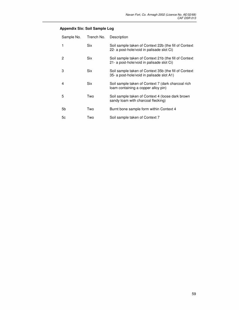
Appendix Six: Soil Sample Log Sample No. Trench No. Description
1 Six Soil sample taken of Context 22b (the fill of Context
22- a post-hole/void in palisade slot Ci)
2 Six Soil sample taken of Context 21b (the fill of Context 21- a post-hole/void in palisade slot Ci)
3 Six Soil sample taken of Context 35b (the fill of Context 35- a post-hole/void in palisade slot A1)
4 Six Soil sample taken of Context 7 (dark charcoal rich loam containing a copper alloy pin)
5 Two Soil sample taken of Context 4 (loose dark brown sandy loam with charcoal flecking)
5b Two Burnt bone sample form within Context 4
5c Two Soil sample taken of Context 7

Navan Fort, Co. Armagh 2002 (Licence No. AE/02/68) CAF DSR 013
60
Plate 1: View of Tr. 1 from south

Navan Fort, Co. Armagh 2002 (Licence No. AE/02/68) CAF DSR 013
61
Plate 2: View of Tr. 3 from the west

Navan Fort, Co. Armagh 2002 (Licence No. AE/02/68) CAF DSR 013
62
Plate 3: View to the west from Navan Summit