Data Gathering - California
25
Guidance for Preparers of Indirect and Cumulative Impacts Assessments Data Gathering Issue Paper Introduction Data gathering for cumulative and indirect impacts assessments does not have to be a major challenge; much of the data is available in existing documents. The following discussion presents ways to identify existing data and steps to take when no data is available. It also includes information about which agencies to contact and the types of data they maintain. Three attachments are also provided for reference: Exhibit A lists specific agencies and how the data they generate can be used in a cumulative impacts analysis; Exhibit B presents various types of data that may be available for a specific resource and the source of such data; and Exhibit C presents sample questions that can be posed to planning agency staff when requesting data for a cumulative impacts analysis. Why Data is Important Data, which is often used synonymously in this issue paper with information, is the foundation of a cumulative/indirect impacts analysis. To complete a cumulative/indirect impacts analysis, you will require data to: Determine the health of the resources included in the analysis; Identify projects to include in your projects list; and Conduct the impact assessment. Key Points to Consider Before you begin, there are several key points to keep in mind. Review information gathered previously for the project. In the interest of efficiency, start your data gathering efforts by reviewing Data Gathering Issue Paper 1 June 30, 2005
Transcript of Data Gathering - California

Guidance for Preparers of Indirect and Cumulative Impacts Assessments
Data Gathering Issue Paper
Introduction Data gathering for cumulative and indirect impacts assessments does not have to be a major challenge; much of the data is available in existing documents. The following discussion presents ways to identify existing data and steps to take when no data is available. It also includes information about which agencies to contact and the types of data they maintain. Three attachments are also provided for reference:
Exhibit A lists specific agencies and how the data they generate can be used in a cumulative impacts analysis;
Exhibit B presents various types of data that may be available for a specific resource and the source of such data; and
Exhibit C presents sample questions that can be posed to planning agency staff when requesting data for a cumulative impacts analysis.
Why Data is Important Data, which is often used synonymously in this issue paper with information, is the foundation of a cumulative/indirect impacts analysis. To complete a cumulative/indirect impacts analysis, you will require data to:
Determine the health of the resources included in the analysis;
Identify projects to include in your projects list; and
Conduct the impact assessment.
Key Points to Consider Before you begin, there are several key points to keep in mind.
Review information gathered previously for the project. In the interest of efficiency, start your data gathering efforts by reviewing
Data Gathering Issue Paper
1 June 30, 2005

Guidance for Preparers of Cumulative Impact Assessments
information from previous work on the project. If available and sufficiently applicable to the presently defined project, a Project Study Report (PSR) or other Project Initiation Document (PID) can provide background and setting information, a starting point for sources of information applicable to the project study area, and a scan-level estimate of probable effects. The value of this “head start” must be tempered with the recognition that the scan-type methodology and cost estimation purpose of preliminary environmental analysis is less rigorous than the environmental analysis needed for the decisions made at the project-approval stage. You should also consider the amount of time that has elapsed since the Preliminary Environmental Analysis Report (PEAR) was prepared to account for changing conditions in your present analysis of cumulative/indirect impacts.
Collect most data before you start the analysis. By doing so, you will be saved from unnecessary interruptions. Of course, if you determine that you need additional data that is critical to your analysis later in the process, you will have to stop and collect it.
Include both transportation projects and non-transportation projects in the analysis. A conscientious approach requires that you identify both transportation projects and relevant non-transportation projects, including projects that are outside of the control of Caltrans. There are two factors to consider when determining the list of related projects:
The nature of each environmental resource being examined and the extent that it is affected by other projects, and
The location, type, and size of other projects. For example, location may be important when water quality impacts are at issue, since projects outside of the watershed would probably not contribute to a cumulative effect. Project type may be important, for example, when the impact is specialized, such as a particular air pollutant or mode of traffic.
Determine whether future transportation and non-transportation projects within the Resource Study Area are reasonably foreseeable. To be considered reasonably foreseeable, an action, while uncertain, must be probable or likely to occur. The confident prediction of reasonably foreseeable impacts requires judgment based on information obtained from reliable resources such as local and regional planning officials, adopted general plans, regional transportation plans (RTPs) or environmental documents. For example, environmental documents prepared for redevelopment of the Hunters Point Naval Station in San Francisco assume that reuse of the closed military base will promote economic development in the district. The description of San Francisco's constrained real estate market and current high demand for all forms of housing redevelopment, presented in the environmental documents, would provide ample support to conclude that
Data Gathering Issue Paper
2 June 30, 2005

Guidance for Preparers of Cumulative Impact Assessments
redevelopment of the district is reasonably foreseeable in the near-term. Your discussion of cumulative impacts upon a resource should include all reasonably foreseeable actions within that particular resource study area.
Evaluate how the actions will affect the resource. Once you have determined the list of reasonably foreseeable actions within each resource-specific study area, you will need to evaluate how these actions will impact the resource. Focus on gathering information that will enable you to determine the health or sustainability of each affected resource, since these characteristics are primary factors in a resource’s susceptibility to cumulative impacts. Use reliable sources of information about the proposed project and reasonably foreseeable actions to forecast cumulative impacts. If specific details about the proposed project or other actions are not known, the analysis of impacts may be more general and qualitative than specific and quantitative. The essential outcome is the meaningful disclosure of reasonably foreseeable cumulative impacts, including consideration of the appropriate methods, assumptions, and limitations of these determinations.
Prevent data overload. Avoid getting so caught up in data gathering that you have to rush to complete the analysis. Generally, if you find the same information repeatedly, it is time to cease data gathering.
Gather useable data. Be mindful that agencies may package data in various formats, and request the data you need in a format that is easy for you to manipulate and interpret. For example, if you are using GIS to compile and analyze data on the location of different species or habitats, ask whether the agency can provide data that can be used by your version of ArcGIS, ArcInfo, or ArcViewer (or other GIS software platform that you are using). Be sure to obtain metadata for the datasets for correct georeferencing, information on research methodology, and bibliographic information. If you are evaluating land development activity proximate to your project, ask if the local land use agency can aggregate the data to the geographic level that would be most useful for your purposes and request the data in that form. Otherwise, you may be provided with raw permitting data that you will have to spend precious time aggregating. Also, inquire whether data is formatted in a way that will allow you to access and manipulate it. For example, if you use Excel software to manipulate data, request that the data be provided to you in an Excel spreadsheet, if it is available in that format.
Review new and old data. Don’t limit your review of maps and plans to current documents (i.e., those in progress or completed in the last 5 years). Depending on the timeframe they cover, older documents can help you to identify historic trends relative to the health of a resource.
Data Gathering Issue Paper
3 June 30, 2005

Guidance for Preparers of Cumulative Impact Assessments
Verify the data. Data from a source that could be biased, such as a privately sponsored website presenting public statistics, should always be verified independently. Where practical, data that conflicts with your knowledge of a situation or that seems intuitively inconsistent with your understanding of the subject matter should be verified. For example, if planning department information does not call out wetlands impacts for proposed development areas that you know contain wetlands, you might conduct a windshield survey to verify your hunch.
Consult knowledgeable staff. Interviews with knowledgeable resource agency and planning staff can be a reliable source of data regarding the health of a resource. Likewise, interviews with large developers can yield valuable information pertaining to projects.
Document references. By documenting your references you can demonstrate the breadth of your data gathering effort. It is best to keep track of data as you go along, because trying to reproduce references later on can be difficult and time consuming. Develop a system for documenting data sources at the outset and document data as you obtain it. Include the name of the source and the date that the data was published or generated.
Use credible data. When quantitative (numeric) data from a resource that is widely acknowledged as a source of accurate data, such as the U.S. Census Bureau, the Environmental Protection Agency, or a regional Council of Government, is available, take advantage of it. Reliance on this type of data lends credibility to your document and saves time and effort that might be spent generating data. (See “Generate Data” below.)
Obtaining Useful Data Identify Your Data Needs Start by identifying the issues you need to address. As mentioned earlier, the PSR is a good initial resource for identifying the issues that are relevant to your analysis, as is the NEPA scoping process. You should also confer with your environmental colleagues at Caltrans who are working locally or experienced with local issues. For example, environmental specialists in your regional or district environmental branch can share their knowledge of resources they are identifying in the field or other research applicable to local projects. Senior specialists at the Headquarters Division of Environmental Analysis can also provide guidance on data needed for analysis, as well as important perspectives on professional practices and resource agency expectations.
In addition, focusing your data gathering on the Resource Study Areas (RSAs) that you have established can help you determine what data you
Data Gathering Issue Paper
4 June 30, 2005

Guidance for Preparers of Cumulative Impact Assessments
will need to conduct an assessment of impacts on resources within those RSAs.
Prepare a Checklist A checklist is an effective tool for data gathering. If you choose to use this approach, divide your checklist into the three categories of data needs:
Data for determining the health of resources included in the analysis,
Data for compiling the projects list, and
Data for assessing impacts.
List the agencies and organizations from which you are likely to obtain the data needed in each category, along with a contact person. (See Exhibit A for an example of a checklist.) The Resource Guide (Exhibit B) contains information that can assist you in preparing a checklist. It also lists agencies and the data they maintain.
Once you have prepared your checklist, check across categories for duplicate entries so that you can avoid multiple trips to the same agency. For example, if a planning agency is listed as a source for data that you will need at more than one stage in the analysis, make a note of that and try to get all of the data that you will need on your first trip to the agency. However, multiple trips to the same agency are not always avoidable. As your analysis unfolds, you may need to return to an agency for new data or to ask questions about the data you already have.
The Intergovernmental Review Group The Intergovernmental Review Group within Caltrans’ Transportation Planning Division consists of program managers and coordinators who review environmental documents prepared by CEQA lead agencies on actions that might affect the state transportation system. Types of actions include land use plans, capital improvement programs, and local development projects. Contact the program administrator in your district for information regarding projects that should be included in your cumulative effects analysis.
Gather Data
Tap Internal Data Sources Internal resources for helping you build your projects list are numerous and accessible. Start by contacting your district’s Intergovernmental Review (IGR) designee. Obtaining information regarding projects that have been the subject of this review can expedite the assembly of your project list and provide data on setting and impact analyses for those projects.
Other Caltrans units that have data that can help you build your projects list include:
Encroachment Permits Branch. This Caltrans unit tracks requests for access that have been made in a project corridor. You can request a list and then sort through it to eliminate simple driveways and identify potential access points for development.
Data Gathering Issue Paper
5 June 30, 2005

Guidance for Preparers of Cumulative Impact Assessments
Scoping Units. Scoping units are responsible for project initiation documents. Obtain a list of projects and conduct a review to determine whether any are relevant to your analysis.
Caltrans Transportation Planning. Transportation Planning maintains future estimate data that can be useful for quantitative travel behavior models. Advanced planning units, which are typically within Transportation Planning, maintain information regarding future projects (e.g., travel demand, transport mode choice distribution, trip generation from planned land uses, travel network plans, etc.). Get a list from them and select projects that are relevant to your analysis.
System Planning. System planning, which is also typically within Transportation Planning, has Route Concept Reports and Transportation Concept Reports. They are good sources of information on transportation resources and planning in the project vicinity. Concept reports can help you understand the demand for future improvements in your RSAs, along with general issues that affect route design and selection.
GIS Data. Caltrans maintains a GIS Data Library, which includes an abundance of data organized at the state, district, and county levels. Available data includes data related to transportation and other infrastructure, the physical environment (air quality, soil and vegetation, elevation, hydrography, and shoreline), and political/administrative and cultural resources.
Programming Documents. The State Transportation Improvement Program (STIP) , State Highway Operations and Protection Program (SHOPP), and the Caltrans expenditure programs contain lists of currently programmed projects. Contact Transportation Planning for current SHOPP and STIP documents.
Digital Highway Inventory Photography Program (DHIPP). DHIPP is the Department’s first full-featured web-based enterprise geospatial data system, which enables all employees with access to the CT Intranet to use digital high-resolution color aerial imagery in their work. DHIPP imagery is available for the entire 15,000-mile state highway system. Caltrans staff can simply click on the link provided on the Caltrans Onramp.
Standard Environmental Reference (SER). The SER is an online resource to help state and local agency staff plan, prepare, submit, and evaluate environmental documents for transportation projects. The SER contains information appropriate to all transportation projects developed under the auspices of Caltrans, and to all local agency highway or local streets and roads projects with funding or approvals by the Federal Highway Administration (FHWA).
Utilities Relocation Branch. The Utilities Relocation Branch ensures that the right of way for highway projects is clear of utility facilities that would be in conflict with the proposed construction or
Data Gathering Issue Paper
6 June 30, 2005

Guidance for Preparers of Cumulative Impact Assessments
subsequent operation of the highway facility. Contact the Utilities Relocation Branch for utility plans and related documents.
Right of Way. Right of Way administers the statewide program for right of way acquisition and real property management in support of Caltrans projects. The first of two key responsibilities is to appraise and purchase property required for transportation purposes, to implement orderly relocation of affected families, businesses and utility facilities: and to clear properties prior to construction. The second responsibility is to comprehensively manage Caltrans’ Real Property Program, reducing the costs of operations, and disposing of property no longer needed for transportation purposes. Contact the Right of Way division for information regarding right of way acquisition and real property.
Review Regional Transportation Plans Regional Transportation Plans (RTPs) are an important source of data for your project list. RTPs are the long-range plans for transportation improvement projects within a defined regional area. The plans include alternative project lists that accommodate a range of funding opportunities. Transportation improvement projects that are funded for construction within the “fiscally constrained” plan alternative are reasonably foreseeable projects for cumulative or indirect impact analysis. To identify the reasonably foreseeable projects within your resource study areas, you can obtain RTPs from Metropolitan Planning Organizations (MPOs), which are sometimes located in regional Councils of Government (COGs). (Refer to the discussion that follows entitled “Regional Councils of Government” for a description of other data available from COGs). The RTP for a county that is outside of a MPO must be prepared by that county’s Regional Transportation Planning Agency (RTPA). RTPAs are sometimes referred to as Local Transportation Commissions, or LTCs.
The Caltrans GIS Data Library contains information regarding boundaries of MPOs, LTCs, and RTPAs.
Search Databases Databases are readily accessible sources that provide of a variety of useful information. Environmental databases, such as NEPANet, CEQAnet, CERES, and LUPIN are particularly useful resources. The State CEQA Clearinghouse in the Governor’s Office of Planning and Research maintains a statewide, online database of CEQA documents, called CEQAnet. This database can be searched by jurisdiction, document type, year, and Clearinghouse document number. In the future, the document information may be linked to a geo-database that will enable you to search for documents associated with specified geographic coordinates. There are databases that contain other environmental documents (e.g., UC Davis Information Center for the
Data Gathering Issue Paper
7 June 30, 2005

Guidance for Preparers of Cumulative Impact Assessments
Environment, copies of plans developed by planning and resource agencies, and statistical data (e.g., the U.S. Census Bureau website)
Several databases have been compiled for Northern California, including one maintained by the University of California at Berkeley. The UC Berkeley Digital Library Project provides modern research technology, and is developing extensive collections of environmental reports and plans, natural science databases, and geographic data. In addition, the Bay Area Automated Mapping Association maintains an inventory of Northern California geo-databases and provides a convenient access clearinghouse to GIS data, models, and user groups. The Southern California Association of Governments and San Diego Association of Governments maintain inventories of spatial data for the southern portion of the state.
The California Legacy Project The California Legacy Project, which is available at (http://legacy.ca.gov/) is a state initiative to provide natural resources information to the public and agencies, among other objectives. The centerpiece of the information is the California Digital Conservation Atlas, a web-based tool for reviewing geo-spatial data on natural resources and working landscapes. The project is intended to support a clearinghouse of digital information, as well as research on the health and condition of resources. It could be an excellent source of data for impact analysis.
Other useful databases include those maintained by newspapers, business journals, and technical journals. You can check newspaper databases for information on real estate development projects and development trends that may be relevant to the proposed action. Media databases also contain names of community organizations and resource advocacy organizations that can be contacted for data regarding future projects and potential impacts.
Review Environmental Documents Environmental documents that have been produced for proximate or related projects within the RSA(s) associated with the proposed action are likely to contain valuable information about issues of concern for cumulative impact analysis. For example, an environmental document for another project might identify impacts to sensitive species, wetlands, and historic properties. If an impact is located in one of your RSAs, information in the document would help you determine the need to consider cumulative impacts that are likely to result from the proposed action. (You can obtain environmental documents using CEQAnet . Currently, they are available from the agencies that prepared them and sometimes you can find them in public, university, and planning agency libraries.
Contact Agencies with Relevant Data Many of your data needs, especially those related to land use and development, can be met by visiting city and county planning agencies, regional Councils of Government (COGs), and Local Agency Formation Commissions (LAFCOs).
City and County Planning Agencies
City and county planning agencies maintain data that can help you determine the health of a resource, develop the projects list, and assess
Data Gathering Issue Paper
8 June 30, 2005

Guidance for Preparers of Cumulative Impact Assessments
impacts. (Exhibit A depicts ways to use data obtained from planning agencies.)
At these agencies you can typically obtain the following:
General plans. A general plan is a source of data pertaining to a locality’s plans for future land use, land development, and related issues (e.g., infrastructure development, development of housing allocated within the region, provision of public facilities and services, etc.). These documents contain elements that pertain to the environment, describe locations for public facilities, and identify floodplains and timberlines. Reviewing relevant general plans is a way to define context and identify reasonably foreseeable actions.
Limitations of General Plans
Be aware that where impact analysis is concerned, general plans have limitations. First, they are predictive as opposed to prescriptive, so it is not safe to rely upon them as the sole source of information regarding foreseeable actions. Secondly, they are not always updated in a timely manner, so information contained in them could be obsolete. Due to these limitations, it is a good idea to validate the information and data contained in general plans by interviewing knowledgeable individuals and reviewing current data.
General plan EIRs. Environmental documents prepared for general plans describe the impacts caused by implementation of the general plans. Thus, the general plan EIRs identify programs and projects, as well as the impacts of these programs and projects that may be relevant to your analysis.
Neighborhood and community plans. These plans are miniature general plans. If an RSA contains an area for which a neighborhood or community plan has been completed, the neighborhood plan may contain useful data on programs and attendant environmental effects within the plan area. While these types of plans consider a subset of the area within a jurisdiction’s general plan, the limited geographic scope does not necessarily lead to a greater level of detail in the plan or environmental assessment. These are programmatic tools that can help you identify the possible universe of actions for cumulative or indirect impact analysis.
Subdivision maps and development agreements. Through planning agencies, municipalities grant developers the right to subdivide land through a subdivision map approval process. Subdivision maps, which are often available online, are sometimes the subject of development agreements that signal intent to build a project. As entitlements, subdivisions are examples of foreseeable projects, particularly when the approved project is a vesting tentative map. Subdivision maps and their accompanying environmental documents are useful resources.
Building permits. Building permits represent a grant by a local authority to construct projects, so they are a good source of data pertaining to reasonably foreseeable projects. Reviewing building permit data to identify large projects can help you assemble a comprehensive project list. As is true of subdivision maps, building permit data is frequently available online.
Data Gathering Issue Paper
9 June 30, 2005

Guidance for Preparers of Cumulative Impact Assessments
Census data and other statistical data. Although census data is available from the U.S. Census Bureau’s website, local planning agencies can usually provide access to census data and other statistical data aggregated to the neighborhood or other sub-area level. If one or more RSAs coincides with a neighborhood or other small area boundary, the planning agency will already have done the work of aggregating the data to that level, which can save you the time and effort. You can use this information, which may include population, housing, and employment data, to identify existing conditions.
Census data and other statistical data (e.g., housing condition data) can also help you to identify trends that affect the health of a resource. For example, in an assessment of community impacts, a substantial decrease in population and a substantial increase in unemployment might signal decline.
Zoning maps. Zoning ordinances support general plans by placing restrictions on the use of land in a community. Zoning maps are a
Use Several Types of Data It is advisable to use data from several of these sources to ensure accuracy and comprehensiveness in your analysis. For example, you may need to review subdivision plats, capital improvement plans, and building permits to construct a complete and accurate scenario related to upcoming development. Use your best judgment to determine which data types best complement each other in your particular situation.
graphic depiction of these restrictions. Identifying how land within RSAs is zoned can help you assess potential impacts on resources. Keep in mind, however, that municipalities have the power to grant zoning variances. Before relying on this data, however, you should interview agency personnel to find out about a locality’s precedent for granting zoning variances.
Land use maps. Maps of current and planned future land use show where residential, commercial, industrial, undeveloped land and open space uses once existed or remain in a community. Comparing these maps can help you identify growth trends. In addition, overlaying resource maps over future land use maps can help you identify resource conflicts and potential impacts.
Specific plans. Specific plans contain development standards applicable to a specified geographic area and establish zoning standards specific to a site and project. Reviewing these documents and their accompanying environmental impact documents can help you assess potential impacts on the area covered by the specific plan.
GIS data. Most planning agencies in major metropolitan areas have typically invested in Geographic Information Systems (GIS). These systems are capable of presenting data in map format, which can aid in your analysis. For example, a planning agency might be able to supply GIS maps that depict population growth trends; this information can help you identify potential cumulative/indirect impacts.
Capital improvements plans. Development is more likely to occur where infrastructure is in place or will be in place in the foreseeable future. Capital improvements plans identify upcoming infrastructure projects, often sequenced by opportunity or funding capacity. Thus, these plans can serve a two-fold purpose: they may contain projects that fall into the reasonably foreseeable category, and one or more of
Data Gathering Issue Paper
10 June 30, 2005

Guidance for Preparers of Cumulative Impact Assessments
these projects may stimulate or support development, triggering impacts.
Natural Community Conservation Plans and Habitat Conservation Plans. Set forth in an initiative of the California Department of Fish and Game, Natural Community Conservation Plans (NCCPs) are being conducted coincidentally with general plans. NCCPs provide comprehensive habitat planning programs in response to development activities in an effort to preserve networks of sustainable habitat and open space, and to protect biodiversity. NCCPs are the state equivalent of federal Habitat Conservation Plans (HCPs) that contain peer-reviewed evaluations of sensitive resources within the planning areas, general descriptions of planned growth and associated covered activities, and general descriptions of areas or criteria for habitat banking or conservation.
NCCPs and HCPs can provide useful information regarding the health of resources. In addition, these plans address the kinds of development projects and effects that the resource agencies have identified as contributing to decline in species population and distribution, and habitat losses.
Anecdotal data. Employees of city and county planning agencies can provide anecdotal data about past and proposed actions—especially development activity—that have affected or have the potential to affect the health of a resource.
Regional Councils of Government
Regional Councils of Government (COGs), such as the Southern California Association of Governments (SCAG), Association of Bay Area Governments (ABAG), or Sacramento Area Council of Governments (SAGOG), also perform planning functions. In this capacity, their role as data providers is similar to that of city and county planning agencies.
COGs often maintain GIS systems that can generate county-level maps depicting patterns and trends in regional growth and development, travel demand, and transportation levels of service. Also, COGs can provide 5-year projections of needs prepared by the demographic unit of the Department of Finance. The department allocates these numbers to the COG level and COGs, in turn, allocate the numbers to the county level. These projections include numbers for housing obligations and numbers for transportation modeling.
COGs maintain census and other statistical data, and they often aggregate population, housing, economic and employment data to the county or other sub-area level. If the COG has data depicting projected population, employment, housing, and economic growth in an RSA, be sure to request this data. You can input this data to models that help you assess impacts.
Data Gathering Issue Paper
11 June 30, 2005

Guidance for Preparers of Cumulative Impact Assessments
As is true of city and county planners, employees of COGs are frequently a good source of anecdotal historical data. For example, an employee of a rural COG might have information regarding the status of a wetland.
Local Agency Formation Commissions
Local Agency Formation Commissions (LAFCOs) are empowered by California state law to rule on incorporations of new cities and designate “spheres of influence” of localities. In performing this function, LAFCOs have to forecast what is reasonably foreseeable. Thus, LAFCOs are a good source of data regarding areas that are primed for development. Data from LAFCOs can also be used to validate the accuracy of general plans completed in the last several years.
Resource Agencies
There are numerous agencies that maintain natural resources data that can aid in your analysis. Useful data from these agencies includes permits, resource recovery plans, conservation plans, and air and water quality data. Types of data available from selected resource agencies are in Exhibit A. Exhibit B presents more resource agencies and their associated data.
Environmental Protection Agency (EPA) EPA’s primary functions include developing and enforcing environmental regulations and conducting environmental research. EPA also collects and maintains air and water quality data, among other activities.
U.S. Army Corps of Engineers (Corps) Under authority of Section 404 of the Clean Water Act, the Corps regulates the discharge of dredged or fill material into Waters of the United States. The Corps also provides review and permitting under Section 10 of the Rivers and Harbors Act, in coordination with the U.S. Coast Guard.
U.S. Fish and Wildlife Service (USFWS) USFWS can provide access to incidental take permits and Habitat Conservation Plans required for development activities that might result in harm to a species listed as endangered or threatened. These permits and plans can be a good source of information about local presence and health of resources. USFWS can also provide special-status species lists, information on critical habitat resource recovery plans, and guidance information on impact assessment and resource health.
National Oceanographic and Atmospheric Administration - Fisheries (NOAA-Fisheries) NOAA-Fisheries maintains information on special-status marine and anadromous species throughout California. In addition to providing
Data Gathering Issue Paper
12 June 30, 2005

Guidance for Preparers of Cumulative Impact Assessments
species lists and information on critical habitat, the agency can provide information on resource management and recovery planning, resource health and impact assessment, and aquatic contaminant problems. Analogous to the USFWS regulation of terrestrial resources, NOAA-Fisheries is responsible for permitting development activities that might result in an incidental take of an endangered or threatened species. Permit documentation can be another good source of information on resource presence and health.
California Department of Fish and Game (CDFG) The CDFG maintains extensive information on species that are listed under the California Endangered Species Act. The information is developed through the state’s incidental take permitting process, habitat-related permitting (e.g., streambed alteration agreements), resource management activities, and research. CDFG can be a good source of information on resource presence and health, sensitive habitat, and related development activities. Analogous to the federal HCP process, CDFG regulates the development of Natural Community Conservation Plans that provide a comprehensive context for resource management in response to direct or incidental take and loss of habitat due to land development. NCCPs can provide information on the location and health of special status species, as well as the kinds of impacting actions anticipated by local jurisdictions. CDFG maintains a comprehensive listing and status of NCCPs and HCPs in the state at: http://www.dfg.ca.gov/nccp/status.htm.
Regional Water Quality Control Boards (RWQCBs) Nine RWQCBs operate under the authority of the State Water Resources Control Board. RWQCBs gather and maintain extensive data on climate, topography, geology, hydrology, water quality, and ownership/rights to state waters as part of their regulatory duty to develop and enforce water quality objectives and implementation plans.
California Department of Parks and Recreation – State Historic Preservation Officer (SHPO) The SHPO administers both federal and state mandated historic preservation programs in California. In addition to maintaining the California Register of Historical Resources and Historical Landmarks register, the SHPO is directly involved in heritage resource management through Section 106 of the NHPA and Section 4(f) of the NDOTA. The SHPO can, under specified circumstances designed to protect the integrity of sensitive resources, provide information on the location and health of cultural resources. The SHPO also coordinates an extensive, statewide system of cultural resource data through regional information centers affiliated with California State University campuses.
Federal and State Land or Resource Management Agencies Federal and State land or resource management agencies, such as U.S. Forest Service (USFS), Bureau of Land Management (BLM), California Department of Forestry (CDF), California Department of Fish and Game,
Data Gathering Issue Paper
13 June 30, 2005

Guidance for Preparers of Cumulative Impact Assessments
and California Department of Water Resources (CDWR), among others, collect, manage, and maintain extensive data on lands and/or resources within their jurisdiction. The data are developed through direct research, resource management, and use permitting. These agencies can be a good source of information on resource location and health, as well as the land uses occurring within your resource study areas.
Several regional or special purpose entities in California monitor and/or regulate resources within specific geographic areas. The following agencies should be contacted for data if your project is in an area within their jurisdiction:
Tahoe Regional Planning Agency
Delta Protection Commission (Sacramento-San Joaquin Delta)
San Francisco Bay Conservation and Development Commission
California Coastal Commission
Data maintained by agencies mentioned in this section, as well as other local, state, and federal resource agencies can help you develop your projects list, determine the health of a resource, and identify potential impacts.
Private and Non-Profit Organizations
Advocacy Organizations
If a resource is of special value to the community or is perceived as threatened, there is probably an advocacy group or task force that directs its attention to that resource. Data available from these groups can be useful for assessing resource health, identifying projects, and identifying potential impacts. To identify these groups, contact planning agencies, COGs, and resource agencies, or conduct an Internet search using keywords.
Development Organizations
Redevelopment agencies, public housing agencies, and non-profit developers, such as Community Development Corporations (CDCs) and rural development corporations, often sponsor development projects and are usually willing to share information about them.
Private for-profit developers are sometimes willing to share limited information regarding planned or proposed real estate developments. You may find that information about private development projects is usually more readily available for projects that have already been initiated.
Data Gathering Issue Paper
14 June 30, 2005

Guidance for Preparers of Cumulative Impact Assessments
Media Outlets
Newspaper, radio, and television journalists and researchers can provide information pertaining to advocacy organizations and information regarding projects.
Generate Data Under some circumstances, it may be a good idea to generate data, using individual and group consultation techniques and direct observation techniques. Typically, you would limit the generation of data to circumstances when there is no reliable data available from another source or when you have an instinct that data that you have obtained from a secondary source is not accurate. Table DG-1 (below) depicts the types of data-generation techniques that are available and outlines instances in which you might use each technique.
Table DG-1. Data-Generation Techniques and When to Use Them
Data-Generation Technique Description When Technique Might be Useful
Interviews Informal or structured dialogue that follows a script prepared by the interviewer.
Determine past health of resource. Identify potential impacts. Validate data that is dubious or outdated.
Questionnaires Structured survey instruments that contain questions directed at extracting relevant information.
Validate data (e.g., survey members of a cultural resources organization to validate data contained in outdated directory).
Expert panels Groups of experts assembled to address one or more specific issues.
Determine health of resource. Assess development trends. Identify potential cumulative or indirect impacts. Validate data.
Delphi technique Highly structured data gathering technique that involves the use of questionnaires administered to knowledgeable individuals. This technique can be used to identify issues and generate feedback regarding alternatives and impacts. This can be an expensive approach, so it is not likely that it will be practical for use on small projects or projects with minor impacts.
Identify potential indirect impacts. Assess development trends.
Brainstorming sessions
Informal sessions involving the free-flowing exchange of ideas and information from knowledgeable individuals.
Determine health of resource. Identify potential impacts.
Field and windshield surveys
Field surveys involve traveling to a site and walking around to observe conditions. Windshield surveys involve driving around and observing conditions from a vehicle.
Validate data. Identify potential impacts.
Data Gathering Issue Paper
15 June 30, 2005

Guidance for Preparers of Cumulative Impact Assessments
If Little or No Data Is Available You will encounter situations when data is unavailable or incomplete, and generating data is not feasible. Cumulative and indirect impacts assessments are not intended to require extensive data gathering efforts to develop information that is not available. The Council on Environmental Quality (CEQ) recognizes that this situation might arise and has adopted regulations that address this issue. Regulations at CEQ 1502.22 allow for the preparer to:
Include a statement that information is incomplete or unavailable,
Include a statement of the relevance of the incomplete or unavailable information to evaluating significant adverse impacts,
Provide a summary of existing relevant credible scientific evidence, and
Include the agency’s evaluation of reasonably foreseeable impacts based on theoretical approaches or research methods generally accepted in the scientific community.
However, some amount of data is almost always available. CEQ regulations at 40 CFR 1502.22 provide ample flexibility for sensible adaptation of analysis to the information you can obtain through the reasonable and practical means illustrated in this paper.
Sources Bay Area Automated Mapping Association.
California Department of Fish and Game. Natural Community Conservation Planning. Available:
California Department of Transportation. 2003. Standard environmental reference, forms, and templates: Annotated IS/EA Outline.
California EPA. State Water Resource Control Board website.
The California Legacy Project: A Resource Conservation Strategy. State of California website.
City of San Diego. Multiple Species Conservation Plan Summary.
Council on Environmental Quality. 1977. Considering Cumulative Effects under the National Environmental Policy Act. Council on Environmental Quality.
Data Gathering Issue Paper
16 June 30, 2005

Guidance for Preparers of Cumulative Impact Assessments
______. Regulations for Implementing the National Environmental Quality Act. Title 40 Code of Federal Regulations, Part 1502.
Environmental Protection Agency website.
Fulton, William. 1999. Guide to California Planning. Solano Press Books. Point Arena, California.
Habitat Conservation Plans. U.S. Fish and Wildlife Services website.
Michigan State University Extension website.
Southern California Association of Governments website.
Special Area Management Plans. U.S. Army Corps of Engineers website.
State of California. 2003. State Water Resource Control Board Mission Statement.
University of California, Berkeley. Digital Library Project.
Data Gathering Issue Paper
17 June 30, 2005

Guidance for Preparers of Cumulative Impact Assessments
Exhibit A How to Use Data from Planning Agencies
Data Determine
Health of Resource Develop
Project List Assess Impacts
City and County Planning Agencies
General plans
General plan EIR
Sub-area (or community plan)
Building permits
Subdivision plats and development agreements
Zoning maps
Land use maps
Specific plans
Census data and other statistical data
GIS data
Capital Improvements Plans
Natural Community Conservation Plans
Anecdotal data
Regional Councils of Government
Census and other statistical data
GIS data
5-year projections
Anecdotal data
Local Area Formation Commissions
Annexation Data
Data Gathering Issue Paper Exhibit A: Resource Guide
A-1
January 19, 2005

Guidance for Preparers of Cumulative Impact Assessments
Exhibit B Resource Guide
Resource Data Type Source
Biological Environment
Natural Communities Information regarding habitat loss and fragmentation and protection of wildlife corridors
U.S. Fish and Wildlife Service National Oceanographic and Atmospheric Administration (fisheries and marine mammals) California Department of Fish and Game County and local planning agencies California Legacy Project U.S. Geological Survey Local and regional conservation entities Public and nonprofit organizations, such as open space districts, Audubon Society, etc.
Habitat Conservation Plans and Multiple-Species Conservation Plans
U.S. Fish and Wildlife Service Local and county planning agencies
Natural Communities Conservation Plans
Local and county planning agencies California Department of Fish and Game
Conservation plans Conservation non-profits, local and state wide public open space entities
Special Area Management Plans (SAMPs)
U.S. Army Corps of Engineers
Plant and Animal Species Data pertaining to plant and animal species
U.S. Fish and Wildlife Service National Oceanographic and Atmospheric Administration (fisheries and marine mammals) California Department of Fish and Game California Native Plant Society U.S. Geological Survey
Threatened and Endangered Species
Data pertaining to threatened and endangered species
U.S. Fish and Wildlife Service National Oceanic and Atmospheric Administration (fisheries and marine mammals) California Department of Fish and Game U.S. Geological Survey
Recovery plans U.S. Fish and Wildlife Service
Data Gathering Issue Paper Exhibit B: Resource Guide
B-1
January 19, 2005

Guidance for Preparers of Cumulative Impact Assessments
Resource Data Type Source
Physical Environment
Hydrology and Floodplain Hydraulic data Local general plans U.S. Geological Survey
Floodplain encroachment information
Federal Emergency Management Agency Flood control and reclamation districts California Department of Water Resources – Board of Reclamation
Permit data U.S. Army Corps of Engineers (CWA Section 404 Fill Permits) California Department of Fish and Game (Section 1600 Streambed Alteration Agreements) California Water Resources Board San Francisco Bay Conservation and Development Commission (Use or development permits) California Coastal Commission (Use or development permits)
Water Quality and Storm Water Runoff
Receiving water bodies and their beneficial uses, water quality, project-related storm water discharges and quality and potential storm water impacts
State Water Resources Control Board (CWA Section 402 and NPDES permit Storm Water Pollution Prevention Plan, CWA Section 303d Impaired Water Bodies) Regional Water Quality Control Boards (CWA Section 401 Water Quality Certification, TMDLs) Local and county governments County water agency U.S. Geological Survey
Geology/Soils/Paleontology/ Topography
Geology and soils data Office of Land Conservation, Department of Conservation U.S. Geological Survey
Data pertaining to impacts to fossil plants and animals
U.S. Fish and Wildlife Service U.S. Geological Survey
Topography U.S. Geological Survey
Air Quality Air quality data Environmental Protection Agency Air Quality Management District
Noise and Vibration Noise and vibration data Traffic noise analyses, noise and vibration studies (technical documents)
Data Gathering Issue Paper Exhibit B: Resource Guide
B-2
January 19, 2005
Guidance for Preparers of Cumulative Impact Assessments
Resource Data Type Source
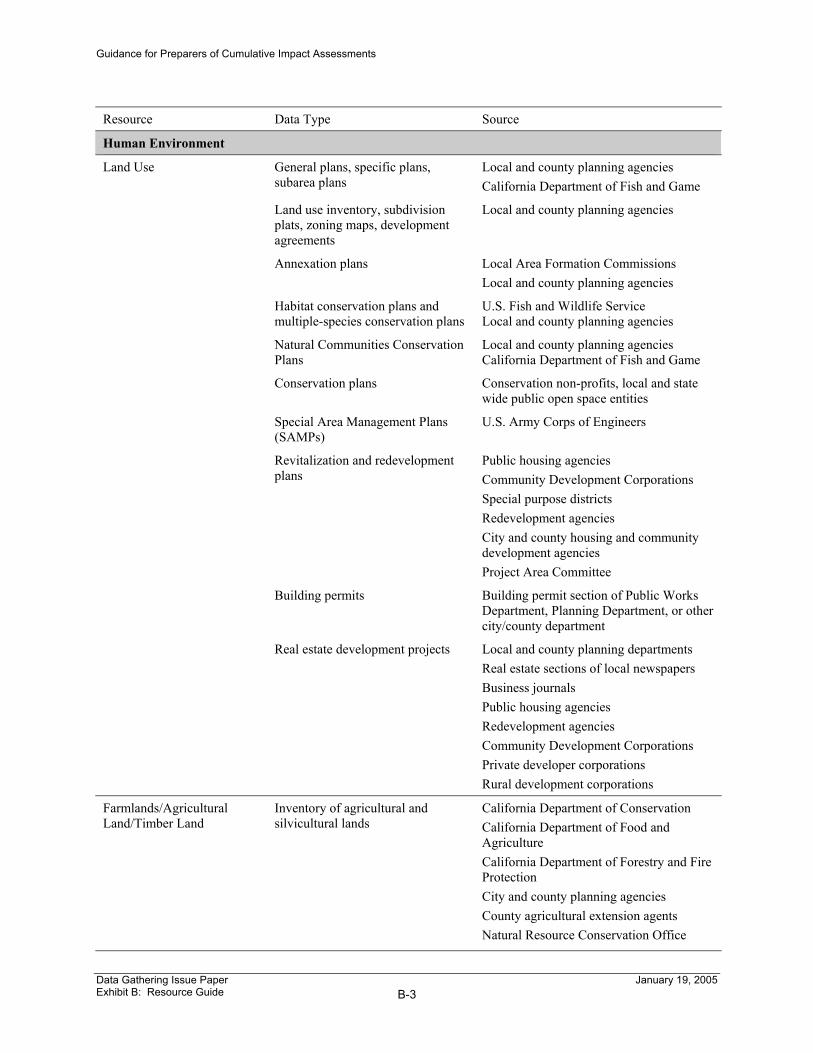
Human Environment
Land Use General plans, specific plans, subarea plans
Local and county planning agencies California Department of Fish and Game
Land use inventory, subdivision plats, zoning maps, development agreements
Local and county planning agencies
Annexation plans Local Area Formation Commissions Local and county planning agencies
Habitat conservation plans and multiple-species conservation plans
U.S. Fish and Wildlife Service Local and county planning agencies
Natural Communities Conservation Plans
Local and county planning agencies California Department of Fish and Game
Conservation plans Conservation non-profits, local and state wide public open space entities
Special Area Management Plans (SAMPs)
U.S. Army Corps of Engineers
Revitalization and redevelopment plans
Public housing agencies Community Development Corporations Special purpose districts Redevelopment agencies City and county housing and community development agencies Project Area Committee
Building permits Building permit section of Public Works Department, Planning Department, or other city/county department
Real estate development projects Local and county planning departments Real estate sections of local newspapers Business journals Public housing agencies Redevelopment agencies Community Development Corporations Private developer corporations Rural development corporations
Farmlands/Agricultural Land/Timber Land
Inventory of agricultural and silvicultural lands
California Department of Conservation California Department of Food and Agriculture California Department of Forestry and Fire Protection City and county planning agencies County agricultural extension agents Natural Resource Conservation Office
Data Gathering Issue Paper Exhibit B: Resource Guide
B-3
January 19, 2005

Guidance for Preparers of Cumulative Impact Assessments
Resource Data Type Source Williamson Act Maps
U.S. Census Bureau Forest Practices Act guidance City and county planning agencies
Community Impacts Data pertaining to potential community impacts including population and housing data
Local, county government, and tribal government. Public housing agencies Community Development Corporations Civic groups Rural development corporations Project Area Committee Redevelopment agencies Department of Finance U.S. Census Bureau
Utilities/Emergency Service Data regarding water, sewer, electric power, and telecommunications systems
Caltrans Right-of-Way Division
Traffic and Transportation/Pedestrian and Bicycle Facilities
Information about projects COGs (Regional Transportation Plans) Caltrans (State Transportation Improvement Programs) Caltrans (State Highway Operation and Protection Program) Caltrans Scoping Units Caltrans Transportation Planning Local traffic and transportation departments Regional transit authorities
Information about bicycle facilities COGs (Regional Transportation Plans) Counties and municipalities (Bicycle Master Plans)
List of requests for access Caltrans Encroachment Permits Branch
Cultural Resources Inventory of cultural resources Regional Information Centers at California State University campuses Tribal historic preservation officer California Native American Heritage Commission State Office of Historic Preservation Local historic commissions and historical societies Local arts councils
Data Gathering Issue Paper Exhibit B: Resource Guide
B-4
January 19, 2005

Guidance for Preparers of Cumulative Impact Assessments
Exhibit C Sample Questions
Questions for Planning Agencies 1. Is the general plan current, or are updates or amendments planned for
the near future?
2. Are there any growth management plans in existence for this jurisdiction? What are the growth management issues, if any? Have any growth control ballot measures been approved by the local jurisdiction?
3. Has an urban growth boundary been established for this jurisdiction?
4. Are you aware of any substantial proposed land developments in the vicinity of the proposed project? If so, where are they located and what is the proposed level of development (e.g. number of dwelling units, square feet of commercial space, public buildings, etc.)? Will the development require a zoning change? How advanced are the development plans? Are you aware of any conservation requirements associated with the development? Has an EIR for the development been completed?
5. Are you aware of any recently completed land development projects that might result in environmental impacts?
6. What are the development trends that may affect the proposed project; are there any pressures for land development in the vicinity of the proposed project? What is the rate of conversion of raw land to urban uses?
7. Are there other capital projects planned, such as water and sewer, which might affect growth trends in the affected area?
8. Have there been any recent Williamson Act opt-outs?
9. Are you aware of any recent or proposed environmental documents that are relevant to the proposed action?
10. Do you maintain building permit data? If so, is there a compilation report that you can provide? If not, which agency does?
11. Do you maintain inventories of historic, archaeological, and/or cultural resources?
12. Can you provide the names of individuals, groups, or agencies that are involved in documentation and/or resource conservation activities that are relevant to study area for the proposed project?
Data Gathering Issue Paper Exhibit C: Sample Questions
C-1
January 19, 2005

Guidance for Preparers of Cumulative Impact Assessments
Questions for Councils of Government 1. Can you provide projections related to housing, population, and
employment?
2. Do you have historical trends data related to housing, population, and employment?
3. Can you provide Department of Finance projections for population and housing needs and employment?
Questions for Resource Specialists 1. Are you aware of any valuable and/or protected environmental
resources in the Resource Study Area?
2. Are you aware of any threats to these resources?
3. If so, what efforts are underway, if any, to protect these resources?
4. Do you have data on the current health/trends for resources of concern?
5. Are you aware of any planned or proposed projects that, in combination with the proposed project, may threaten existing resources of concern?
6. Are you aware of any pressure on species, pending listing of species, or Habitat Conservation Plans or Natural Community Conservation Plans in process or under discussion?
7. Are you aware of any mitigation sites in the vicinity of the proposed project?
8. Are you aware of any pending permits in the vicinity of the proposed project?
9. Can you provide names of individuals, organizations, or agencies that might have information related to resources that might be affected by the proposed action?
10. Can you share environmental documents, newspaper articles or other written material related to the potential impact that the proposed action might have on resources that may be affected by the proposed action?
11. Are you aware of any conservation easements on large parcels of land within or nearby the project area that have been established for the purposes of habitat protection and/or species conservation?
Data Gathering Issue Paper Exhibit C: Sample Questions
C-2
January 19, 2005

Guidance for Preparers of Cumulative Impact Assessments
Questions for Advocacy Organizations 1. Can you identify resources that you believe would be affected by the
proposed action?
2. If so, what are your thoughts, opinions, or concerns about the affect that the proposed action may have on the resource(s)?
3. Do you maintain a database related to the resource(s) to which your organization directs its attention?
4. Can you share newspaper articles or other written material related to the potential impact that the proposed action might have on resources that may be affected by the proposed action?
5. Can you provide names of individuals, organizations, or agencies that might have information related to resources that might be affected by the proposed action?
Data Gathering Issue Paper Exhibit C: Sample Questions
C-3
January 19, 2005