dalrev vol33 iss4 - dalspace.library.dal.ca
20
CABOT'S LANDFALL By C. B. FERGUSSON W HILE the profound importance and the far-reaching consequences of the discovery of N ortb America by John Cabot in 1497 have long been realized, and in some measure recognized, his landfall in the New World still remains unmarked. T hat is actually so. But it in- dicates neither a lack of interest in doing honour to a distin- guished navigator for his outstanding services, nor a paucity of those who have urged the marking of his landfall or advanced claims with respect to its site. His name and his fame are per- petuated by Cabot Strait, which separates Cape Breton Island :.. ... r- from Newfoundland, by the Cabot Trail, with its unsurt>assed :., , scenic splendour, in Cape Br eton Island, and by Cabot 'l'ower on Signal Hill, at St. John's in Newfoundland. It is very fitting that Cabot's a.ctivities should be so com- memorated in both Cape Breton Island and Newfoundland, for his voyages had great significance for each. Yet these me- morials, through their different locations, may also indicate the crux of the Cabotian controversy: there is still a lack of un- animity with respect to the site of Cabot's landfall in 1497. There are some who would claim it for Cape Breton Island, as well as others who would attribute it to Newfoundland or Labra- dor. And now that Newfoundland is a part of the Canadian nation, these rival claims have been revived, the evidence has been re-considered and re-sifted, and, if it is now possible, a decision should be reached on this ma tter. · This is, of course, not the first investigation of this problem. Near the end of the nineteenth century, a committee of the Royal Society of Canada, which had been appointed by that society to make preparations for the Cabot Celebration which was to be held in 1897, declared that they were of opinion that the greatly preponderating weight of evidence pointed to the e::i.stern- most cape of Cape Breton as the Iandiall of John Cabot in 1497. But, at the same time, they observed that the commemor ation then proposed, which will be described more fully below, would not commit the Royal Society of Canada, as a whole, to the definite a.-0ceptance of that theory. Furthermore, in commenting upon the suggestion of the council of the Royal Society that a permanent memento of the great achievement of Cabot should be erected upon some point of the K ova Scotia coast, they re- marked that no place on the whole Atlantic coast seemed so su itable as Sydney: that community was about twenty miles
Transcript of dalrev vol33 iss4 - dalspace.library.dal.ca

_J_
CABOT'S LANDFALL By C. B. FERGUSSON
WHILE the profound importance and the far-reaching consequences of the discovery of N ortb America by John Cabot in 1497 have long been realized, and in some measure recognized, his landfall in the New
World still remains unmarked. T hat is actually so. But it indicates neither a lack of interest in doing honour to a distinguished navigator for his outstanding services, nor a paucity of those who have urged the marking of his landfall or advanced claims with respect to its site. His name and his fame are perpetuated by Cabot Strait, which separates Cape Breton I sland
:.. ... r- from Newfoundland, by the Cabot Trail, with its unsurt>assed :., , scenic splendour, in Cape Breton Island, and by Cabot 'l'ower
on Signal Hill, at St. John's in Newfoundland. It is very fitting that Cabot's a.ctivities should be so com
memorated in both Cape Breton Island and Newfoundland, for his voyages had great significance for each. Yet these memorials, through their different locations, may also indicate the crux of the Cabotian controversy: there is still a lack of unanimity with respect to the site of Cabot's landfall in 1497. There are some who would claim it for Cape Breton Island, as well as others who would attribute it to Newfoundland or Labrador. And now that Newfoundland is a part of the Canadian nation, these rival claims have been revived, the evidence has been re-considered and re-sifted, and, if it is now possib le, a decision should be reached on this matter.
· This is, of course, not the first investigation of this problem. Near the end of the nineteenth century, a committee of the Royal Society of Canada, which had been appointed by that society to make preparations for the Cabot Celebration which was to be held in 1897, declared that they were of opinion that the greatly preponderating weight of evidence pointed to the e::i.sternmost cape of Cape Breton as the Iandiall of John Cabot in 1497. But, at the same time, they observed that the commemoration then proposed, which will be described more fully below, would not commit the Royal Society of Canada, as a whole, to the definite a.-0ceptance of that theory. Furthermore, in commenting upon the suggestion of the council of the Royal Society that a permanent memento of the great achievement of Cabot should be erected upon some point of the K ova Scotia coast, they remarked that no place on the whole Atlantic coast seemed so suitable as Sydney: that community was about twenty miles

258 THE DALHOUSIE REVIEW
in a direct line from th~ eastern.most point of land in the province· and while it was believed that the landfa11 was at the easternmost point of Cape Br~ton. it was impossible to locate with certainty, witrun a few md~s, the precise spot upon which the banner of St. George was first planted.
As it turned out, however, the Royal Society of Canada chose the city of Halifax fo~ the Cabot celebration in 1897. In view of the controversy with respect to the landfall of 1497 Halifax was considered as a neutral ground on which all th~ disputants could happily i:neet ":1thout giving up their respective theories. The Royal Socrnty did not identify itself with any of those theories but called upon all the disputants to meet on a common "'round of action and join in paying a just tribute to a great n:v igator, whose claims t_o fame were tersely set forth in the inscription on the tablet which was placed in the entrance hall of Province House in Halifax:. On this piece of brass work, decorated with the arms of England, Bristol and Venice, and other appropriate emblems, the following words may be read:
This Tablet is in Honour of the Famous Navigator JOH N CABOT
Who under authority of letters-patent of Henry VII directing him "to conquer .occupy and possess" for England all lands he might fin~ ' ' J.Jl ~hatever part of the "'.Orld they be", sailed in a. Bristol ship T_he Matthew. and first planted the flags of England and Venice on the 24th.of June 1497 on the north east.ND sea.board of N or~b A mer1ca, and by his discoveries in this and _the follo.wmg yen.r gave to England a. claim upon the Contment wh1ch the colonizing spirit of her
sons made good in later times. This tablet was placed in this hal~ .by the Royal Society of Canada in June 189? when the Br1tISh Empire was celebrating the Sixtieth An~iversary of th~ Accession of Her Maj esty Queen Victoria during whose benefwent reign the Dominion of Canada has extended from the shores, first seen by Cabot and English sailors four hundred years before, to the far Pacific coast.
So it was that in 1897 the R oyal Society of Canada refrained from officially adopting any one of the theories with respect to Cabot's landfall in 1497, al~houg~ .a committee of the Society emphatically expressed .their op1ruon that "the greatly proponderating weight of evidence" indicated the easternmost cape of Cape Breton Island as the landfall.
'l'hat attitude of the R?yal Society of Canada in 1897 is sufficient to turn our attentwn to the voyage of 1497. At the outset one is struck by the fact that in the past there has been
J_
.. f
i·
1-

_J_
I·. ..
"f:. . .
CABOT'S LANDFALL 259
much confusion of thought about the early voyages to North America by John Cabot and his son Sebastian. That confusion arose from the meagre character of the official record, whfoh has had to be supplemented by information from secondary sources, · much of it conflicting. Unsettled problems may still plague the historian, but the recent work of James A. William.son (The Voyages of the Cabots and the English Discovery of North America under Henry VII and Henry VI II; London: Argonaut Press, 1929) presents convincing proof of two voyages by John Cabot, one in 1497, the other in 1498, and one by his son Sebastian in 1509. The disentangling of these voyages is, of course, of immense value to an understanding of the Cabotian controversy, as well as to a clarification of the evidence rela.ting to it:
Cabot's voyage of 1497 was, at least in part, a continuation of the English search for the Western Islands . Western Islands, some real and others imaginary, appeared on maps in the late ::\fiddle Ages. The real islands wero the Madeira and Azores, and the imaginary ones included Antilia or Island of the Seven Cities, St. Branda.n's Island and Brazil. Antilla was usually representP.d as a very large island far to the wost of Africa, and was sometimes associated with the legendary island of the Seven Cities, which was supposed to have been colonized in the eighth century by seven bishops and their followers, who had fled from Spain and Portugal on account of the Moslem invasion, each bishop founding a separate city. St. Brandan, abbot of a Benedictine monastery in Ireland, was supposed to have made an extended voyage out into the Atlantic in the sixth century in search of an ideal island, revealed to him in a dream, where the trees wero laden with fruit and the climate was always mild. The island of Brazil, whose name means red dyewood, was also supposed to lie in the Atlantic ocean, and was placed by popular tradition about seventy leagues west of Ireland. It was to find the island of Brazil, "beyond the western part of Ireland," that in 1480 Thomas Lloyd, in a ship of 80 tons belonging to John Jay the younger, sailed from Bristol. That search for the legendary island of Brazil and the Seven Cities was continued by Bristol mn.riners in ensuing years, according to a letter of Pedro de Ayala, temporary Spanish ambassador to England in 1498, and the same goal seems also to have been the object of Cabot's voyage in 1497, according to the same authority. Furthermore, John Cabot, native of Genoa and citizen of Venice, who sailed from England in 1497,

260 THE DALHOUSIE REVIEW
seems to have believed that he had found one of the Wes tern Islands, as well as the mainland of Asia, on his voyage of that year.
It was in 1496 that J olm Cabot obtained, in England, royal sanction for his voyage to the west. He sought and received from Henry VII of England, for himself and his sons Lewis, Sebastian and Santius, authority to sail to "all parts, countries, and seas of the east, of the west, and of the north,. .. , to seeke out, discover, and finde whatsoever isles, countries, regions or provinces of the heathen and infidels whatsoever they be and in what part of the world soever they be, which before this time have been unknowen to all Christians." The king also gave them "licence to set up our banners and ensignes in every village, towne, castle, isle, or maine land of them newly found. And that the aforesaid John and his sonnes, . or their heires and assignes may subdue, occupy and possesse, as our vassals, and lieutenants, getting unto us the rule, title, and jurisdiction of the same villages, townes, castles, and firme land so found ... "
John Cabot made his first trans-Atlantic voyage in 1497. He apparently sailed in the ship Matthew from Bristol early in May and returned to England early in August of that year.
Although Cabot's journal or log-book for this voyage is not available, evidence of it is found in certain contemporary documents. 'l'bese include lettP-rs written by Lorenzo Pasqualio, one of the Venetian colony living in London, and by Raimondo di Soncino, ambassador in London for Ludovico Sforza, the usurping Duke of Milan. L In a letter to his brothers, dated 23 August 1497, Pasqualio announces the return of the expedition and gives news of its discoveries:
The Venetian, our countryman, who went with a ship from Bristol in quest of new islands, is returned, and says that 700 leagues hence he discovered land, the territory of the Grand Cham (Gram Cam). He coasted for 300 leagues and landed; saw no human beings, but he had brought hither to the king cer tain snares which had been set to catch game, and a needle for making nets; he also found some felled trees, wherefore he supposed there were inhabitants, and returned to his ship in perplexity .
R e was three months on the voyage, and on his return he saw two islands to starboard, but would not land, time being precious, as he was short of provisions. He says that the
1. These. the chief contem por:ineous accounts of the voy1\ge, <lre tnkcn from John Boyd Thacher's article, ''T he Co.botian Discovery'', in the Transactfons of the Ro,yal Society of Canoda. They are repro· duced at length for theconvcntence of those who rnithL otherwise have diHiculty in seeing th em.
J_
.-.
,,. •"
1-
_l_
·l
CABOT'S LANDFALL
tides are slack and do not flow as they do here1• The King of England is much pleased with this intelligence.
The king has promised that in the spring our countryman shall have ten ships, armed to his order, and at his request has conceded him all the prisoners, except such as are confined for high treason, to man his fleet. 'rhe king has also given him money wherewith to amuse himself till then, and he is now at Bristol with his wife, who is also a Venetian, aod with his sons; his name is Juan Cabot, and he is styled the great admiral. Vast honour is paid him; he dresses in silk, and these English run after him like mad people, so that be can enlist as many 01' them as he pleases, and a number of our own rogues besides.
The discoverer of these places planted oo his new found land a. large cross, with one flag of England and another of St. Mark, by reason of his being a Venetian, so that our banner has floated very far afield.
261
A day later, on 24 August 1497, Raimondo wrote a letter containing information about Cabot's voyage. It reads in part as follows:
Also some months ago his majesty sent out a Venetian, who is a very good mariner, and has good skill in discovering new islands, and he has returned safe, and has found two very largo and fertile islands; having likewise discovered the seven cities, 400 leagues from England, on the western passage. This next spring his majesty means to send him with fifter. n or twenty ships.
Later in thA year, on 14 December 1497, Raimondo wrote another letter which contains a fuller Mcount of the voyage. I t is as follows:
Most Illustrious ao.d Excellent Lord: Perhaps among your excellency's many occupations, it
may not displease you to learn how his majesty here has won a part of Asia without a stroke of the sword. 'fhere is in this kingdom a Venetian fe!Jow, Master John Ca.boto by name, of fine mind, greatly skilled in navigation, who, seeing that those most serene kings, first he of Portugal, a.nd then the one of Spa.in, have occupied unknown islands, determined to make a like acquisition for his majesty aforesaid. And having obtained royal grants that he should have the usufruct of ail that ho should discover, provided that the ownership of the same is r eserved to the crown, with a. small ship and eighteen persons he committed bimselI to fortune; and
I. Tides on both sidu of Call" Breton Island. as well :u In many other parts ol the northeaatem se~boa.rd of North Americn. are very noticeably less Lhan those near Brlstol. One writer. however. taking this statement about the tide, the •igns or fndians and other evidence. has tried-but failed-to convince others that Cabot"s londlall was near Mount S<;uirrel on the wtstem side"' Cape Breton Island. The slacltness of Lhe tides Is a weak reed in th ls cn.!c ror there 11 no difference in the tides n~-ar Mount Squirrel and those on tbe eastern side of Cape Bre<on Island.

262 THE DALHOUSIE REVIEW
having set out from Bristol, a western port of this kingdom, and passed the western limits of Hibernia, and then standing to the northward, keeping (after a few days) the north star on his r ight hand; and having wandered about considerably, at last he fell in with terra firma, where, having planted the royal banner and taken possession on behall' of this king, and taken certain tokens, he has retw-ned thence. T he said Master John, as being foreign born and poor, would not be believed if his comrades, who are almost all Englishmen from Bristol, did not testify that what he says is true. 'rhis Master John has the description of the world in a chart, and also in a solid globe, which he has made, and it shows where he landed, and that going toward the east he passed considerably beyond the country of the T anais. And they say that it is a very good and temperate country, and they th.ink that brazil wood and silks grow there; and they affirm that that sea is covered with fishes, which are caught not only with the net, but with baskets, a stone being tied to them in order that the baskets may sink in the water. And this I heard the said Master John relate, and the aforesaid Englishmen, his comrades, say that they will bring so many fishes that this kingdom will no longer have need of Iceland, from which country there comes a very great store of fish which are called stock-fish. But Master J ohn has set his mind on something greater; for he expects to go farther on toward the east (Levant) from that place already occupied, constantly hugging the shore, until he shall be over against an island, by him called Cipango, situated in the equinoctial region, where he thinks all the spices of the world, and also the precious stones, originate; and he says that in former times he was at Mecca, whither spices are brought by caravans from distant countries, and that those who brought them, on being asked where the said spices grow, answered that they do not know, but that other caravans come to their homes with this merchandise from distant countries, and these again say that they are brought to them from other remote regions. And he argues thus, that if the orientals affirmed to the southerners that these things come from a distance from them, and so from hand to hand , presupposing the rotundity of the earth, it must be that the last ones get them at the north toward the west ; and he said it in such a way, that, having nothing to gain or lose by it, I , too, believe it; and what is more, the king here, who is wise and not lavish, likewise puts some faith in him; for (ever) since his return he has made good provision for him, as the same Master John tells me. And it is said tha.t in the spring, his majesty aforenamed will fit out some ships, and will, besides, give him all the convicts, and they will go to that country to make a colony, by means of which they hope to establish in London a greater storehouse of spices than there is in Alexandria; and the chief men of the enterprise are men of Bristol, great sailors, who, now that they know where to go, say that it is not i:i voyage of more than fifteen days, nor do
J_
. ..,
· > )
~·.·
1-

_J_
..
'f
i '
CABOT'S LANDFALL
they ever have storms after they get away from Hibernia. I ha,·e also talked with a Burgundian, a comrade of Master John's, who confirms everything, and wishes to return thither because Lhe admiral (for so Master John already enLitles himself) has given him an island; and he has given another one to a barber of his from Castiglione-of-Genoa, and both of them regard themselves as counts; nor does my lord tho admiral esteem himself anything less than a prince. I think that with this expedition there will go several poor Italian monks, who have all been promised bishoprics. And, as I have become a friend of the admiral's, if I wished to go thither I should get an archbishopric. But I have thought that the benefices which your excellency has in store for me are a. surer thing; and, therefore, I beg that if these should fall vacant in my absence, you will cause possession to be given to me, taking measures to do this rather (especially) where. it is needed, in order that they may not be taken from me by others, who, because they are present, can be more diligent than I, who, in this country, have been brought to the pass of eating ten or twelve dishes at every meal, and sitting at table three hours at a time twice a day, for the sake of your excellency, to whom I humbly commend myself.
263
In certain English documents, too, mention is made of Cabot's voyage of 1497, and official recognition is given for .his achievement. For example, on 10 August 1497, a royal grant of ten pounds was made "to hym that founde the new isle"; and on 3 February 1498 supplementary letters patent were granted, n.utborizing John Cabot to requisition six shipR for another voyage, to "convey and lede to the londe and isles of late founde by the said John."
Besides these contemporaneous materials, as well as certain maps wh.ich will be described below, some later documents having to do with the voyages of the Cabots have also received considerable attention. One of these is an account of Sebastian Cabot, which was written in 1515 by Peter Martyr, when Se-
.~\ bastia.n Cabot was his familiar friend. Another is Ramusio's ~:. recollection in 1553 of what Sebastian Cabot is supposed to
have written to him "many years past." And a third is Rarmusio's record of what Sebastian is supposed to have told to a gentleman from .Mantua. But these accounts or recollections, written years after the expedition of 1497, seem to confuse that voyage with the later Cabot voyag-es.
.....
Two maps which have speciu.l importance for an investigartion of the Cabot voyage of 14:97 are the Cosa map of 1500 and the Sebastian Cabot map of 1544.
The celebrated map of Juan de La Cosa, associate of Co-

J_
-""''
:t : ,\-:_
264 THE DALHOUSIE REVIEW ~:i· ~ ·~: '·
~ lumbus and Ojeda, famous pilot and well-known map-maker, 1,
has been described as "the most interesting Geographical Draw- t ing that we have inherited from the Middle Ages." It is of f,!:.·
particular interest here because the outline of the northeastern part of America in it seems to have been based upon John ~ Cabot's chart of his first voyage. At any rate in July 1498 f' Pedro de Ayala, joint Spanish ambassador at London informed fr his sovereigns that he had procured and would forward Cabot's chart; and in his map of 1500 La Cosa marked a portion of the ~ northeastern coast of America with English flags and the legend, l "Mar descubierto por ingleses" (Sea discovered by the English). f No English but the Cabots and their associates had been there. • If Cava de Ynglaterra on this map be Cape Race, as some au- ~-.. fl<
thorities claim, then of necessity the named coa-stline is the south .~' coast (as seems clear from the world map of La Cosa itself), not the eastern coast, of Newfoundland, and Cavo descubierto : . i is west of Cape Race. In that case, notwithstanding the efforts ,<- t of some to rotate a section of La Cosa.'s map ninety degrees, ~ ... ~ i Cape Bonavista, on the eastern coast of Newfoundland, could -r ! not be Cavo descubier to, and Cape Breton Island may be in- ~. t dicated as. th~ discovered c~pe and Cabo~'s landfall. . ·;::~~~ f
The likelihood that this map contams the testimony of ?', i John Cabot that his bndfall of 1497 was at Cape Breton Island ·~r ~ receives additional support from the Sebastian Cabot m~~P of .{j: i 1544. On tha.t. lllap, which he made or assisted in making, .;.,"" ,~ Sebastian Cabot indicated that the landfall was at Cape Breton. ,~ · Moreover, Hakluyt has preserved the inscription on a map at- ·-~"'t: • tributed t? Sebastian Ca?ot, wbic~ he sa:w in the queen's gallery .~. ; at vVestmmster, but which has smce disappeared. It appears ·"-· from this inscription that there was an island opposite the fast ~~ ' land seen, and that Cabot named this island St. John. Ftu·tber- ·'~~· moro, on Michael Lok's map, published in 1582, the name J. ·::·. Cabot appears near Cape Breton in Cape Breton Island, with St. John (8. Joha) for the island nearby (Scatari) . Thus, while ,. the contemporaneous verbal accounts of John Cabot's first voyage may differ in detail, the independent testimony of J ohn and Sebastian Cabot, as seen in the Cosa and Sebastian Cabot maps, points to Cape Breton I sland as Cabot's landfall.
Nevertheless, the fact that Cabot's journal is not available, together with the vagueness of at least the verbal evidence regarding the landfall, provided room for speculation. The result has been that various theories have been advanced; some writers contend that the landfall wa-s at Labrador; others that

_J_
CABOT'S LAND!l'ALL 265
it was at Newfoundland; and still others that it was at Cape Breton Island.
Little attention will be given here to the view that Cabot ~eached Labrador first. That theory now receives less support tban formerly, because of tbe disentangling of the Cabot voyages, as well as of the inability to reconcile land, ocean and fishery conditions with the evidence relating to Cabot's first voyage.
So far as the other claims are concerned, apparently place of birth and local patriotism have on occasion obtruded themselves, but even Newfoundlanders have not always advocated the Cape Bonavista theory. Bishop Howley, for example, adhered to the view that Cabot made his landfall at Ca,Pe St. John in Newfoundland; J. P. Howley, formerly the Director of the Geological Survey at Newfoundland, supported the theory that the landfall was at Labrador; and the Rev. Dr. Harvey, who wrote on the History and Physical Geography of Newfoundland, held the opinion that Cabot made his landfall at Cape Breton Island.
Some have argued that the name 'Newfoundland' is an indication that Newfoundland was the site of Cabot's landfall. But that argument is apparently neither sound nor irrefutable. Cabot had claimed his reward for finding the empire of the Grand Khan; in 1501 Henry VII issued a patent to a group of Bristol merchants and Azorea.n navigators, conferring upon them the monopoly of trade with any new lands they might discover; in 1501and1502 these men undertook voyages of discovery; and later on Henry VII granted them rewa.rds or pensions for exploring in "the New Found Land." That pbra,se wa,s significant; for in 1502 there was no suggestion of Asia, "the empire of the Grand Khan", and henceforward '"rhe New Found Land" is the designation for all the western coasts rather than merely for that part now called Newfoundland.
Others have stated that tradition tells that the first land sighted was the east coast of Ne,vfoundland. But that "ancient immemorial tradition" in Newfoundland seems to be allegation rather tban proof. It could not have originated at the time of Cabot's first voyage; in 1583, according to a contemporary account, Sir Humphrey Gilbert was "the first of our nation that carried people to erect an habitation and government in these countries of America;" and, no matter how early the flying fishery began, no continuous tradition could have existed in Newfoundland. Moreover, whenever this so-called tradition originated, it seems

J_
266 THE DALHOUSIE REVIEW
to speak with a very uncertain sound: the Prowses, D .f.W. and G. R. F ., father and son, of Newfoundland, apply it to Bonavista, while Bishop Howley accords it to Cape St. John and says that Bonavista was probably Cortereal's landfall. In addition, Dr. W. F . Ganong says that it seems likely that the local tradition with respect to Bonavista originated in a confusion, supported by a certain resemblance between the names Cartier ·i and Cabot, whereby the real but later landfall of Cartier became attributed to Newfoundland's favorite hero, John Cabot. ~ Furthermore, it must be remembered that La Cosa's map has the southern, not the eastern, coast of Newfoundland flagged.
Another claim for Newfoundland is one that is attached to the word 'Bonavista.' D . W . Prowse, the author of A H istory of Newfoundland, argues that it is distinctly Italian, that "Bonavista! Oh! good sight! is the natural exclamation the old I talian might make, as after his long and dangerous voyage he first caught sight of land." But that argument is obviously unsubstantial. In Italian the name would be Buonavista; in Spanish it would be Buena Vista; in Portuguese Boavista; and actually it is Boa vista on the first map where the name is foundViegas' map of 1534. G. R. F. Prowse seems to have realized that his father's attractive argument had very little foundation; but his subsequent declaration that Bonavista is medieval Latin does not detract from the validity of the r efutation of his father's contention. Still less does the statement of Bishop Howley that "We have as early as 1527, on Niajollo's map, the beautiful name Buonavista . . . ", for while Buonavista or Bonavista may appear on what purport to be reproductions of certain portions of Majollo's map, the Majollo map, from Harrisse, as copied by Dawson in the Transactions of the Royal Society of Canada, has no such name but rather ben posta. Thus it appears that Bonavista is a Portuguese word: the nasal sound in Boav ista, though omitted in spelling, is sounded in pronunciation, and phonetically the word is Bonavista. Moreover , the name is the designation of the easternmost island of the Cape Verde group, belonging to Portugal, and another of the same group is called Fogo. So, in Newfoundland, there are two headlands-Bonavista and Fogo-names apparently given by the Portuguese after their own home islands. Evidently the tradition in Newfoundland, as mentioned by some writers, has been given an
1. H . P. Biggar. in hls Precursors of Jacq•us C'tr!ier. '.'ICvH, says that Cape Bonavista still retains the name given to lt by Cortereal of caho de801J Vista, or F:.1.irview c::i.pe.
1-
_J_
•• , ~.
CABOT'S Lfu~DFALL 267
erroneous foundation; for it should probably be Portuguese rather than English, having reference to the voyage of a Po1·tuguese not to that of Cabot.
It is also alleged that in a number of early references to John Cabot's voyage of 1497 his landfall was reported to be in latitude 481. For instance, G. R. F. Prowse says that Ramusio stated in 1565 that the northern part of Baccalaos was in 48t de
, ... grees north latitude and was called Cape Bonavista, that Sanata 7. Cruz placed Cabot's Baccalaos north of Cape Spear, and that in
"' 1530 Peter Martyr drew attention to the fact that as early as 1513 two distinct cod-fish countries were recognized: "The Bacalhaos discovered by Cabot; the Baccalais ; these lands I
· ... -: suppose are contiguous." For half a century, as he said himself, G. R. F. Prowse deliberately and consistently suspended judgment on the question of the sire of Cabot's landfall; but then, either in the heat of controversy, or under pressure from Newfoundland, his judgment apparently became coloured and he abandoned his former position. Now he seems to have convinced himself-and strove to convince others-that Cabot had maide land at Bonavista in 1497. But, while it is patent that Prowse devoted a great deal of tjme to this topic, as well as to the study of early maps of the New World, it is much less clear that the "ne\v evidence" in his articles, has yet convinced, or ever will convince, historians that it is adequate proof for his rather belated conc1usion. If they should be unconvinced of the validity of the Cape Bonavista theory before reading his latest articles, it seems unlikely that they would change their minds alter reading them .
Of special significance is the fact that some of those who contend that the landfall was at Newfoundland find their most conclusive evidence in support of this contention in the Mason map of about 1617. But this map of Captain John Mason, London merchant, one-time governor of Newfoundland, and later known as the proprietor of New Hampshire, itself invalidates this claim. On the legend of it, as shown in Winsor, Narrative and Critical History of America, volume VIII, page 189, the following words may be seen: I nsula olim appellata Nova Ten-a a Cabota Veneto primu reperta Anno Dmi 1499 ...
Mention must also be made that some contend that Sebastian Cabot did not accompany his father on the voyage of 1497, that he never visited "the newe found land," and that he lied. It is true that Sebastian was still only a boy in 1497 but that fact can hardly be taken as precluding him from crossing

. ~
268 THE DALHOUSIE REVIEW
the Atlantic in that year; and Boies Penrose, a Fellow of the Royal Geographical Society, states in Travel and Discovery in the Renaissance J 420-ll)20 (Harvard University Press, 1952) that John Cabot sailed in the small bark 1vI atthew in .May 1497 with a crew of Bristol mariners, and probably with his subsequently famous son Sebastian, who was then a young boy of twelve or thirteen. It is to be noted, moreover, that in 1496 J ohn Cabot had received royal sanction for the western voyage for himself and his sons Lewis, Sebastian and Santius : if Sebastian was old enough to be expressly mentioned in the royal authority, perhaps he may bo considered as old enough to go a.long on the voyage of 1497. The assertion that Sebastian never visited "the new found land", which is based on the 1521 statement of the Drapers Company, at a time when Henry VII was proposing not only that Sebastian should lead an expedition but also that twelve companies should contribute toward the ex"})ense, seems hardly tenable in the light of Williamson's account of Sebastian Cabot's voyage of 1509, apart from his probably accompanying his father in 1497. To say that Sebastian lled no doubt makes it easier to advance claims for other nations in the new world or to override evidence that does not fit in with other views. Yet the Cosa and Sebastian Cabot maps, if authentic, are two of the most positive pieces of evidence relating to Cabot's landfall, and pointing to Cape Breton Island rather than Newfoundland.
Here it must also be said that some have either cast doubt upon the authenticity of these maps or offered other interpretartions of them. And it must be admitted that the history of the Cosa map has been such as to make it not impossible to offer room for doubt : this celebrated map was completed in October 1500; from the hands of the Spanish sovereigns it passed into the Archives of the Trading Department of Seville; from there it wa.s transferred to the Archives of the Indies; then it probably found its way into some monastery, and it might have been the Gosa chart seen in 1514 by Pedro Martir Angleria in the chamber of the Bishop of Burgos; it disappeared and was later discovered and purchased in France by the woll known geographer Baron Walckenaer, then iVIinister for Holland at Paris; after Baron Walckenaer's death in 1853 it was purcho,sed by the Spanish Government and placed in the Na val Museum at Madrid. Although many authorities concede that the outline of the northern part of America on the Cosa map is based on J ohn Cabot's map of his voyage of 1497, G. R. F. Prowse at-
J_
' ,, j ' '
1-

_J_
·.-\-:
... ~:
CABOT'S LANDFALL 269
tributes the flagged part of the Cosa map to Thorne and Elyot rather tha.n to Cabot, and says that some of the flags mark points ·in the Gulf of St. Lawrence. There is, as Professor Brebner says in The Explorers of North America, a remote possibility that Robert Thorne and Hugh Elyot reached Newfoundla.nd in 1494. But whether they did or not , there is little to indicate that the flagged part of the Cosa map has any connexion with their voyage, whereas the Spanish ambassador in London had procured a copy of Cabot's chart by 1498, and practically all other authorities are unwilling to accept Prowse's view that the Cosa. map has to do with the circumnavigation of the Gulf of St. Lawrence: Ganong declares that there were many maps of the Atlantic coast before Cartier but that not one of them laid down indubitably any part of the Gulf of St. Lawrence except its bare entrances. So far as the Sebastian Cabot map is concerned, Harrisse has an elaborate theory to attempt to prove that Sebastian Cabot lied when he placed the landfall at Cape Breton , and G. R. F. Prowse apparently agrees with that theory and tries to prove that Sebastian transferred "the legend (of the landfall) from Newfoundland to Cape Breton." On this point, however, S. E. Dawson says that even if Sebastian were a liar, which he does not believe, and even if Sebastian never existed, tho evidence of the Cosa map is sufficient. "It is strangely assumed," Dawson writes, "that, because Sebastian Cabot in 1544 said the landfall was at Cape Breton, therefore it was somewhere else-at Labrador, Bonavista, Cape St. John, Mount Squirrel- anywhere, in fact, but where he said it was."
It is easier for many of the authorities to agree that Cabot first made land in 1497 at Cape Breton Island than for them to be unanimous as to the precise site of the landfall. I t .is therefore hardly sw·pris.ing that three different though perhaps. not equally well-founded theories have been advanced to attempt to explain the mattor.
First of all, there is the Mount Squirrel theory. Mount Squirrel is a high point on the western side of Cape Breton Island. about 35 miles from Cape St. Lawrence, the northwestern tip of the island. One man argues that Cabot made bis landfall there. From the letters of Pasqualio and di Soncino, which are quoted in this paper, he sets forth certain premises: that the landfall was 700 leagues from Bristol, and that Cape Breton Island is approximately that distance from that city; that it was west of that city; and that it was considerably beyond or sou th of Tana.is, later ca.'led the River Don, which was looked upon

270 THE DALHOUSIE REVIEW
as the dividing line between Europe and Asia, and which lay between the 50th and 48th degree. .He asserts, in short, that the landfall was 700 leagues from Bristol, west of that city and somewhat south of the 48th degree. He declares that the conclusion therefrom emphatically and jnexorably excludes Labrador, Cape St. John aod Bonavista, and says that the only place which fulfils all the conditions is a point on Cape Breton Island, either on the Atlantic coast or within the gulf to the southwest of Cape North. From the statements in di Soncino's letters that the islands were very large and fertile, that the land made was a very good and temperate country and that they thought that Brazil wood and silk grew there, as well as the references to tides and signs of Indians, he jumps to the conclusion that the landfall could not have been on the Atlantic seaboard of Cape Breton, and that it must therefore be sought within the gulf. His version now is that Cabot, having wandered into the gulf, saw early in the morning land, probably Mount Squirrel, 1220 feet high, about 35 miles from the northwest corner of Cape Breton Island; that Cabot and his men made a shor t landing there and then resumed their western course in the gulf, until six o'clock the same evening they were abreast of a large island lying parallel with the mainland (Prince Edward Island); that they sailed round this island, went north of Anticosti for some distance, then turned and passed through the Strait of Belle I sle; and that the two large islands on his right were Anticosti and Newfoundland. In comment on this view it must be said that some of the authorities wonder at a theory which opens up the Gulf of St. Lawrence and still leaves it to be discovered by Cartier 35 years later, which suppresses the whole south side formed by the peninsula of Gaspe and the provinces of Nova Scotia and New Brunswick, and which puts the north shore of the estuary of the St. Lawrence vis a vis Cuba across an open ocean. Moreover, there is very little difference in the conditions of a landfall )n the Atlantic at the foot of Cape Smoky, 950 feet high, or at the foot of Mount Squirrel, in the gulf, 1220 feet high. The former is exactly on the far side of the same tableland. Furthermore, as S. E. Dawson has pointed out, that it should have occurred to any one to suggest a discovery of America from the inside of a laud-locked gulf is one of the strangest things in this rem.arkabl~ controversy. Not only is this gulf landlocked, but at Cabot Strait, and for a great distance, as the shores of Cape Breton and Newfoundland are approached, the land on both sides is high and bold. Between Cape Dauphin,
J_
1-

_l_
CABOT'S LANDFALL 271
where the northern promontory of Cape Breton begins, and Cape North, a distance of 45 miles, there are Cape. Dauphin itself, over 1000 feet high, St. Anne's mountain, of about the same elevation, Cape Smoky, nearly as high, Sugar Loaf, 200 feet higher, and Cape North, about 1000 feet high. Turning westward through the strait, Cape St. Lawrence, 8 milos off and 1000 feet high, may be seen. 'i'he coastline then turns southwMd, and a succession of capes follow, ranging in height from. 950
· to 1130 feet, until, at 35 miles distance from Cape St. Lawrence, Mount Squirrel, 1220 feet high, is reached. In other words, the plain fact is that all this northern part of Cape Breton Island is a tableland, of which the outer edge is from 800 to 1200 feet above sea-level in the Atlantic or in the gulf. It is everywhere visible from the sea at a distance of 40 miles. In addition, the south coast of Newfoundland is bold also. Table Mountain, three miles behind Cape Ray, at the southwestern point of Newfoundland, is 1700 feet high, a remarkable headland, visible at a distance of 50 miles. Furthermore, while tbe strait is nearly 60 miles wide, St. Paul's Island divides the distance. I t is 14 miles from Cape North to St. Paul's Island, and 42 miles from St. Paul's Island to Cape Ray on the coast of Newfoundl11nd. On the one hand, there is the northern part of Cape Breton Island visible from 40 miles at sea; then there is St. Paul's Island, 500 feet high, and visible for 30 miles at sea; and oo the other hand there is Cape Ray visible all the way across to St. Paul's Island. ThA time of Cabot's voyage was a seasou when the weather is good and the nigh ts a.re short and, while the fog sweeps up from the south and frequently hides St. Pierre and Cape Race, the pilot charts for June show no probability of fog in Cabot Strait at the western end of Newfoundland, and, in fact, there is very little fog in that region. Land may be seen on both sides from tho deck of a passing vessel.
Let us take another look at this Mount Squirrel theory. John Cabot set out to sail due west-and tbat course would bring him to Labrador. But due to magnetic variation, the force of the Arctic current and perhaps winds or ice-fields he dropped south of Cape Race. He then sailed west, and naturally one
·would expect him to strike Cape Breton, but, according to this theory, ho did not. He is supposed to have turned instinctively to the northwest, just at the point to strike the middle of Cabot Strait. The inward current off Cape Ray then carried him through and, although to be in the current he could not have been farther from the Cape than 10 or 15 miles, he did not see

;;I· ·'.~·
272 TH E DALHOUSIE REVIEW :'.~£ )!i.
Table Mountain, 1700 feet high, three miles in rear of the poi~~ of land. Then he changed his course, and again sailed west, and the Magdalen Islands lay in front of him, but the other current running out through Cabot Strait caught him and turned his course southwest until he saw Mount Squirrel, 35 miles to the south, on the Cape Breton Island coast. Here, as Dawson says, is another difficulty. Entry Island, in the Magdalens, was straight ahead, 580 feet high, and visible at a distance of 32 miles. There are only 45 marine miles between Entry Island and the nearest point of Cape Breton Island, but Cabot and his men saw neither, and thus having passed within 20 miles of land, 1700 feet high, which they did not see, they saw land to the south far behind them, 500 feet less in elevation. It is understating the case, Dawson concludes, to say that such a course is impossible in any arrangement of winds, tides, curr ents or fogs, which can be imagined.
T hat, it may be said, disposes of the Mount Squirrel theory, and leaves two others-the Cape North theory and the Cape Breton theory.
The Cape North theory puts the landfall near Sugar Loaf and identifies Cabot's St. John island as St. Paul's island. This theory is based in great measure upon a certain interpretation of the Sebastian Cabot map of 1544-on the understanding that Cabot meant that the land made was at the most northerly point rather than the most easterly part of Cape Breton Island.
On this point, however, there is disagreement, and so strong a case has been made for the vicinity of Cape Breton, just east of Baleine, with Louisbourg near at hand on the one side of the cape and Scatari island near at hand on the other , that the committee of the Royal Society of Canada which arranged for the Cabot celebration of 1897 emphatically declared that "the greatly preponderating weight of evidence" pointed to the easternmost cape of Cape Breton Island as the landfall. This theory is supported by the very fact that Cape Breton is a natural landfall. If a vessel continue past Cape Race on a westerly course she will make Scatari as her landfall. Halibmton, in his H istory, which was published in 1829, confirmed this by these ' words: "T his island being usually the first land made by vessels from Europe, to any of the Colonies eastward of the Bay of Fundy; and from the common occurrence of vessels being ahead of their reckoning, when steering to the westward, the first news of its propinquity being often given by the roar of its· breakers, or the concussion of its rocks; shipwrecks are of fre-
J_
· ... ~
1-

_J_
. f
' I.
CABO'l"S LANDFALL 273
quent occurrence, and few places on the coast of North America more obviously call for the precaution of a light-house."(!) Tbat this region was a natural landfall may also be illustrated by Hore's expedition of 1536, which never sighted land until the point of Cape Breton was approached, by the Bonaventure which saiHng in 1591 did not see Cape Race, by the Marigold
";--') .r>,'~
r;, (~ 't ~ r....._ -----~ ' ~ _d_ J ~'l
:f r~ CJ .L .)
~
~~ ~/~~,------~ -~,4-----~:s:: ~, . ~ .. "!'
~~Pr .. ~ ~ti~ta. Vif rF-::a~.-
·,~t~ I ~~ 6 oc c ""J {/ ot:t ~ ~c 0 ~ C~
{
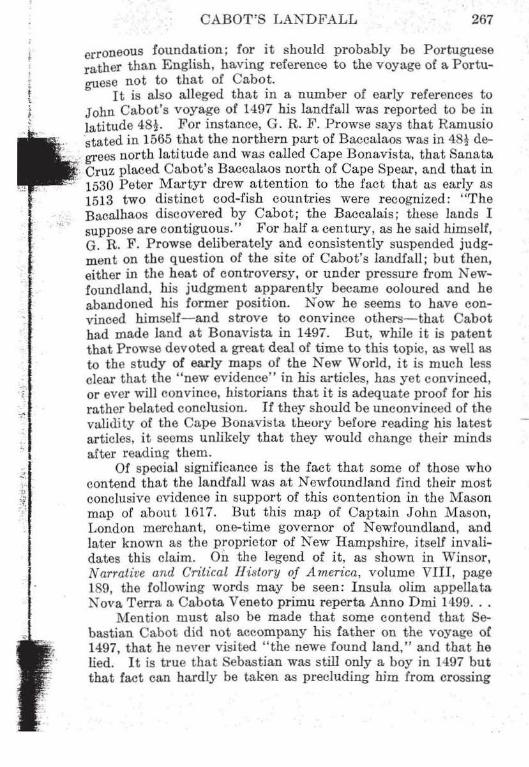
A tracing of photographic enlargomont of Ca.pa Breton coast from the Sebastian Cabot map of 1544 showing prima terra v·ista.
which in 1593 sailed for the Magdalens but fell in with Cape ~· Breton, by Humphrey Gilbert's sailing directions :" .. .if we shall ~~-not happen to meet at Cape Rase, then the plaee of rendezvous
·-~ to be at Cape Briton, or the nearest harbour to the westward of '~~ Cape Briton." Chabert, a French naval officer who sailed on a
--~~ ----'if I. T. C. Ho.llburton, An llistorical and Stalisli<al A"ount of NOfJa Scolla, 11, 213.
j ~
~-

274 THE DALHOUSIE H.EVIEW
scientific expecli ti on in 17 50 may also be called as a witness, for of Scatari he said: "The island is the usual landfall for all vessels sailing to Louisbourg." .A part from the fact that this region was a natural landfall, there is strong documentary evidence in favour of Cape Breton. First of all, the Cosa map locates Cavo descubierto on a course west by compass from Cape Race. Then the Cabot map of 1544 definitely fixes the landfall on Cape Breton Island, and an enlarged photographic copy of this ma.p seems to indicate that the land made was not Cape North but Cape Breton. Moreover, Harrisse, in his first book, appears to have read the meaning of the map and located the landfall at Cape Percy, only 16 miles from Cape Breton, although Cape Breton and not Cape Percy is the easternmost point, and Scatari island is first made from sea for it stretches farther east. Attempts have been made to support other theories by saying that no signs of Indians would be found on the Atlantic coast of Cape Breton Island and that the land there would hardly fit the contemporaneous accounts. But these attempts have been unsuccessful because the distinct evidence of the crew of the Marigold is that Indians were there, as seen in artificial ponds and weirs, and that the fertility of the soil and the richness of vegetation made a most favourable impression. Finally, Scatari makes an excellent choice for Cabot's island of St. John-an is land lying near the land, according to the legend on the Sebastian Cabot map, discovered on the same day the landfall was made and so named by Cabot; and Pedro Reinel drew it on his map in 1505 with that name.
If there are some who would try to show a connexion between the first voyage of Cabot and the names of Newfoundland and Bonavista, there are others who relate that voyage with certain place-names in Cape Breton Island. By means of this relationship the name Cape Breton itself may have an English origin. A comparison of Cosa's Mar descubierto por -ingleses with the 1514-1520 Portuguese Terra Q Foy Descuberta por Berlomes applied in the same geographical position shows that the two differ essentially only in the substitution of "land" for "sea", and especially of Bertomes for ingleses. And the close connexion between Portuguese and Spanish cartogrnphy increases the strength of this simila.rity, and suggests that by Berlomes the Portuguese map of 1514-1520 means precisely the same thing as does Cosa by ingleses. Furthermore, at that time, the English were called, at lea.st among themselves, Bretons,
J_
r - .
, • •'
" t
,, •;£\.
1-

_l_
• . CABOT'S LANDFALL 275
· Brytons or Bretones, with the familiar form Briton becoming prevalent later, and in 1508 Beneventanus refers to the Bretons whom we now call English (atque 8rittanorum quos Anglos nunc dicimus ). It therefore appears that while our name Cape Breton goes directly back to the Berlomes of the early Portuguese maps that word meant at the time the English and not the French Bretons, and referred to the region which Cabot and his Bristol searoa.n discovered on the voyage of 1497. Next, the old name
•1'· .·~···· \•~""" r.?£; :~:.
-h~' .. : :
of English Harbour (now Louisbourg) may also derive from that Cabot voyage. The Leigh narrative of 1597 has "the English port" and, while some ascribe the origin of English Harbour, by guess, to the early resort there of English fishermen, it is possible
. -~· that the name originated in a visit of Cabot's expedition, and ~>. that there was his landfall, a. spot marked by a flag on Cosa's -~~--'.·} map. Similarly, Gabarouse, or Gaba.rus, the bay next west
.· of Louisbourg, a bay whose name is variously explained, may " be, as Ganong points out, a gallicized corruption of "Cabot's
-f_ .; Cross." (On the Jean Guerard map of 1631 the word has the ,~· form "Gabor"; on the Jumeau of 1685 "Gabari"; on tho Bellin ";;~· of 1744 "Gabori" and on the Franquet of 1751 "Gabarus.")
'-i~ In conclusion, it appears that while a few writers, the Prow-f · ses of Newfoundland in particular, favour Newfoundland as the "'\J site of Cabot's landfall, most of the authorities, includfag the -;.~· Committee of the Royal Society which made preparaLiuns for the ~--
1
Cabot celebration of 1897, as well as H. P. Biggar, S. E. Dawson t!'~ and W. F. Ganong, a.re couvinced that Cape Breton Islruid was
the actual site. That Cabot's landfall was probably at Cape -i Breton Island rather than at Newfoundland is also the view of I
~ the English historian James A. Williamson, who has written a ;~ great deal on maritime enterprise. He spent three years in re""? search for his book, The Voyages of lhe Cabots, which was pub
lished in Loudon in 1929, and since that time he has written 1'he Age of Drake, Hawkins of Plymouth, T he Evolution of England, and other historical works. In his book, The Ocean in English History, which was published by the Clarendon Press, Oxford, in 1941, Williamson says that the evidence of Cabot's landfaU is so vague that there can be no certainty on the matter, but that the indications seem to point rather to Nova Scotia than to Newfoundland. It is probable therefore that Cabot's landfall in 1497 was at Cape Breton Island and, while the Sebastian Cabot map of 1544 may leave some room for specular tioo. as to whether the lao.dfall was near Cape Breton or Cape North, a number of the authorities, including the committee of

THE DALHOUSIE REVIEW
the Royal Society of Canada for the Cabot celebration of 1897, assert that it was near Cape Breton in Cape Breton I sland. This view is undoubtedly strengthened by evidence supplied by Hakluyt and Michael Lok. The former bas preserved the inscription on a map attributed to Sebastian Cabot, which he saw in the queen's gallery at ·westminster, but which has since disappeared. It appears from this inscription that there was an island opposite the first land seen, and that Cabot named this island St. J ohn1• On Lok's map, published in 1582, the name J. Cabot appears near Cape Breton on Cape Breton Island, with St. John (S. Joha) for the island nearby (Scatari) . In addition, it is a fact, impossible to explain away, that from about 1505 for one hundred years, the east point of Cape Breton Island is indicated on maps with an attendant island, which when named is always St. John. Furthermore, according to one account, Cabot on his return voyage passed two islands to the right which the short supply of his provisions prevented him from examining. Those islands have been thought by some authorities to be St. Pierre and Miquelon. While credence is given to the views of the P r owses and others, who contend that Cabot's landfall was at Newfoundland, and while conflicting views are held with respect to the Cosa and Sebastian Cabot maps, unanimity will be lacking but probability will favour Cape Breton, unless new information should be disclosed or the supposed validity of the theories of the Prowses should be held to be without foundation. For the time being, however, one can at least say that which Boies P enrose says (in Travel and Discovery in the Renaissance 1420-1620): perhaps the least controversial theory is that Cabot had his landfall at Cape Breton Island, and that he doubled northeast and coasted the southern shores of Newfoundland. Indeed, perhaps even now the evidence warrants more than that.
I. Perhapg this map was very similar to. ii not identical with, the Sebastian Cabot map of JSH, wh.ich is found in the Bibliothf!Que Nationale in Paris.
J_
~·.
t ,.
:i .
. ,.i~ ~
. . .. ., 1•·· ···;rt ·~ ·:i
... -~ ,, ~.
1-