DALE W. ASKEW
14
MANAGER'S INFORMATION REPUKI SFUND RECORDS CTR 2095935 OFFICE OF THE COUNTY MANAGER CLARK COUNTY. NEVADA DALE W. ASKEW County M«n*8«r MICHAEL R. ALASTUEY Assistant County Min*g«r BONNIE RINALDI Assistant County Mirugcr Date: 11/20/98 MIR No.: ABBS RECEIVED Originating Department: Public Works NO'V 2 4 1998 C.C.RW. DIRECTORS OFFICE Contact/Ext: Martin J. Manning/6020 Issue: SUNRISE LANDFILL Subject/Issue Statement: Progress report on the Sunrise Landfill Site Strategic Goal Addressed by this Issue: Goal A: Create partnerships with common interest groups and the people within our community. Goat C: Maximize service delivery and human resources utilization. Summary: The Sunrise Landfill Site has been a focus for media attention over the last few months. As a result, County staff has compiled the attached report to summarize the results of its investigations into these issues to date. At this point, there are few indications of unmanageable issues, but not all of the results of monitoring, sampling, and analysis are available. The most significant issue would appear to be groundwater quality monitoring. The information accumulated to date originated in studies undertaken by the Bureau of Land Management (BLM) and Republic Silver State. Republic Silver State has a continuing obligation to perform maintenance on the Site for five years after acceptance of the closure in 1995 by the County Health District, BLM, and the County. On September 11, 1998, a rainfall event in the Frenchman's Mountain area resulted in damage to the Site and also to a 200-acre area of solid waste deposits north of the Site on BLM owned and controlled property. Downstream deposits of solid wastes originated from both locations in the area above the Las Vegas Wash. As a result, orders were received from County Health and the Nevada Division of Environmental Protection. Cleanup and repair have been underway since the rainfall event. These orders were specific to the Sunrise Landfill Site but no similar orders were entered for the 200 acres of additional deposits on the upstream BLM property. A report of the Republic Silver State actions to cleanup and to analyze corrections as to on-site drainage and flood control facilities was submitted to the regulatory councils on November 9, 1998. These corrections will lead to future drainage facility construction upon approval by the County.
Transcript of DALE W. ASKEW

MANAGER'S INFORMATION REPUKISFUND RECORDS CTR
2095935OFFICE OF THE COUNTY MANAGERCLARK COUNTY. NEVADA
DALE W. ASKEWCounty M«n*8«r
MICHAEL R. ALASTUEYAssistant County Min*g«r
BONNIE RINALDIAssistant County Mirugcr
Date: 11/20/98
MIR No.: ABBS
RECEIVED
OriginatingDepartment: Public Works
NO'V 2 4 1998C.C.RW.
DIRECTORS OFFICE
Contact/Ext: Martin J. Manning/6020
Issue: SUNRISE LANDFILL
Subject/Issue Statement:
Progress report on the Sunrise Landfill Site
Strategic Goal Addressed by this Issue:
Goal A: Create partnerships with common interest groups and the people within ourcommunity.
Goat C: Maximize service delivery and human resources utilization.
Summary:
The Sunrise Landfill Site has been a focus for media attention over the last few months. Asa result, County staff has compiled the attached report to summarize the results of itsinvestigations into these issues to date. At this point, there are few indications ofunmanageable issues, but not all of the results of monitoring, sampling, and analysis areavailable. The most significant issue would appear to be groundwater quality monitoring.
The information accumulated to date originated in studies undertaken by the Bureau of LandManagement (BLM) and Republic Silver State. Republic Silver State has a continuing obligationto perform maintenance on the Site for five years after acceptance of the closure in 1995 bythe County Health District, BLM, and the County.
On September 11, 1998, a rainfall event in the Frenchman's Mountain area resulted in damageto the Site and also to a 200-acre area of solid waste deposits north of the Site on BLM ownedand controlled property. Downstream deposits of solid wastes originated from both locationsin the area above the Las Vegas Wash. As a result, orders were received from County Healthand the Nevada Division of Environmental Protection. Cleanup and repair have been underwaysince the rainfall event. These orders were specific to the Sunrise Landfill Site but no similarorders were entered for the 200 acres of additional deposits on the upstream BLM property.A report of the Republic Silver State actions to cleanup and to analyze corrections as to on-sitedrainage and flood control facilities was submitted to the regulatory councils onNovember 9, 1998. These corrections will lead to future drainage facility construction uponapproval by the County.

MIR No. 4883November 20, 1998Page Two
A final concern on the part of the Republic Silver State addresses the obligation of bettergroundwater monitoring. This will require installation of monitoring wells and the collectionand analysis of samples. Silver State proposes to amend their existing contracts with theCounty to allow them to recover groundwater monitoring costs. However, their existingcontracts allow Silver State to recover Sunrise closure and post-closure costs from Apextipping fee revenues over an eight-year amortization period that is still in effect. We arepresently awaiting proposals from Republic Silver State for contract amendments.
We will be sure to provide additional information and periodic progress reports as this projectproceeds.
DALE W. ASKEWCounty Manager
/MJM:iam:mvAttachments

11/10/98PROGRESS REPORT: SUNRISE SITE
Introduction:
The County staff has performed some research to determine the nature and extent of anyenvironmental issues concerning the Sunrise Site. There are a number of studies thathave been performed by consultants working for the Bureau of Land Management andDUMPCO (Republic Silver State) on the Sunrise Site. The impetus behind the federalstudies would appear to be a desire to cause the County to accept full ownership of theSite. This may be a worthwhile venture for the County provided that current conditions onthe Site are understood, Site-related issues are defined, remedies for any Site-relatedconcerns can be uncovered, and solutions, if needed, can be implemented at reasonablecost. Finally, if the County is to contemplate taking the Sunrise Site, it should be donewithout strings attached and an assurance of no continuing federal intervention that wouldlimit the County's future use oUhe Site. This report summarizes our findings to date.
Background:
The County received solid waste at the Sunrise Site until 1993 and them closed the Siteusing the then existing federal, state, and local regulations. Agreement as to the closureplan was obtained from the Bureau of Land Management (BLM), the Clark County HealthDistrict, Clark County, and DUMPCO. The final closure of the Site upon completion of theconstruction identified in the closure plan was approved by the same agencies.
Thereafter, new U.S. EPA regulations requiring methane gas emission monitoring,collection, and disposal refocused BLM interest on the Sunrise Site. BLM is concernedthat they may have to pay for methane collection and disposal in the future. An additionalissue has been raised by the Nevada Division of Environmental Protection regardingground and surface water quality downstream of the Sunrise Site. Continuingmaintenance on the Site is being performed by DUMPCO through its contract with theCounty. A closure plan obligation provided that DUMPCO would maintain the Site for fiveyears after its closure.
The Sunrise Site covers 720 acres on the front slope of Frenchman Mountain facing west(Exhibit A is a map locating the site). Access to the Site is Vegas Valley Drive, an all-weather road on an 80-ft. wide right-of-way. The Sunrise Site varies in elevation between1850 ft. and 2505 ft. MSL (Exhibit B is an aerial view of the 720-acre site, circa 1996).
The Site is owned by BLM. Although formerly operated as a sanitary landfill for wastesgenerated in the Las Vegas Valley, the Site has not been used for this purpose sinceAugust 1993. During these operations, the County held a Recreation and Public PurposesLease with BLM.

Landfilling operations and natural processes have disturbed the original topography of thesite (Exhibit C shows the extent of disturbance on the site between 1952 and 1996). Themaximum extent of any waste deposits should not exceed the topographic fill area shownin Exhibit C but actually may occupy less area than the area shown. Actual deposits onsite include natural detrital soils (wind and water borne soil depositions), domestic solidwastes, wastewater treatment and septic tank sludges, remediated petro-chemicalcontaminated soils, medical wastes, asbestos, and construction debris. The volume of allof these deposits including soil cover materials are estimated at 23 million cubic yards(Exhibit D shows an oblique view of the Site and some cross sections of the most deepdeposits on the Site. The depth of these deposits are approximately 140 ft.)
Regulatory Issues:
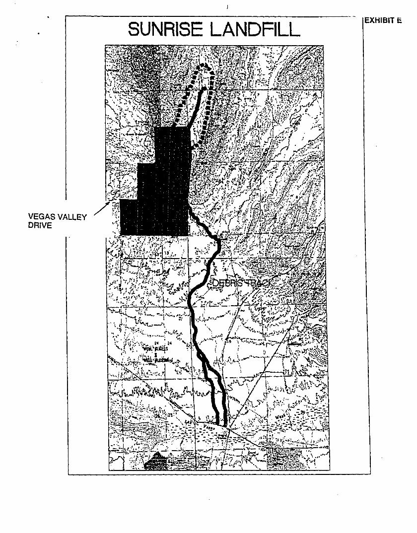
The extent of solid waste deposits: Considerable investigative effort and mediaexposure have been focused on the County's former 720-acre recreation and publicpurpose lease site. However, recent events have uncovered an additional 200 acres ofsolid waste deposits located north of the County site on BLM property outside of the 720-acre former lease site (Exhibit E shows the Sunrise Site as well as the additional 200-acresite within the dash lines).
These deposits were disturbed during the September 11,1998, rainfall event and materialsfrom this location were washed down to locations below the Sunrise Site and above theLas Vegas Wash. Documents found in the wastes located in the additional 200-acre sitewere found dated in the 1960's and 1970's. These materials were apparently carrieddownstream in storm water runoff along the drainage path identified as the "debris track*on Exhibit E.
Repair and clean-up activities due to the September 11, 1998, rainfall were startedimmediately and are still underway at the Sunrise Site. In addition, certain improvementsto on-site drainage are also to be built. Unfortunately, similar activities are not underwayon the 200-acre BLM area at present.
On October 5 and 6, 1998, findings of violation and orders to repair conditions at theformer lease site were received from the Nevada Division of Environmental Protection andthe Clark County Health District. We are unaware of any action being taken to seekcorrective action on the adjacent 200-acre site. Corrective action should have includedthe 200-acre area as well as the Sunrise Site.
Groundwater: Three major groundwater issues exist concerning the County's former site.A recap of each is provided below.
A. Monitoring Wells: The Nevada Division of Environmental Protection has requestedthat a monitoring well plan be provided by November 10,1998. Initial groundwaterinvestigations were performed by the Silver State's consulting engineer, CH2M Hill.Their sampling and laboratory analysis results of water from three existing

groundwater wells and a natural spring down-gradient or cross-gradient from theSite showed that there were no concentrations of any of the organic constituentsidentified in the U.S. EPA drinking water standards in excess of these standards,although concentrations of 2-Bufanone were identified at one water well site (LG224) by Converse Consultants, as a constituent in the glue they used to fabricatetheir sampling equipment. Similarly, traces of inorganic compounds appeared insamples from each site at concentrations less than the U.S. EPA drinking waterstandards with the exception of lead at one water well (LG 223). The location oftwo of the three wells and the spring are also located on Exhibit EE.
Republic Silver State has taken the position that this information should besufficient to satisfy the State's interest in seeking the construction of additionalmonitoring wells. The County staff does not agree. The State's reaction has beento initiate an order specifically requesting the installation of monitoring wells by theCounty and Silver State. The County, Silver State, and representatives of theDivision of Environmental Protection met to address these issues. A program toconstruct additional monitoring wells in closer proximity to the Sunrise Site will beunderway in the near future. The addition of this extra groundwater monitoring willassure that all of the conjecture about groundwater quality will be put to rest in favorof real data.
B. Groundwater Seep: Recent news reports indicated that a groundwater dischargeseep in close proximity to the Sunrise Site after the September 11,1998, rainfallevent was found. Considerable concern was expressed in the news media as to thequality of the water discharging from the seep. Single samples of the dischargewere analyzed by BLM and Silver State at separate testing laboratories. Theresults of the analysis confirm one another in that no organic chemical compoundsassociated with solid wastes were detected. Some inorganic chemicals weredetected including manganese and nutrients that would require some watertreatment to bring this water into compliance with National Drinking WaterStandards. However, we are not recommending that this spring water be treatedto provide drinking water. The water samples were collected on September 22,1998, eleven days after the rainfall event. Although taken in close proximity to theSunrise Site, neither demonstrated any characteristics similar to what might beexpected of a discharge of seepage from a sanitary landfill.
It is apparent from the foregoing that the preliminary investigatory efforts ofsampling existing wells, springs, and seeps down-gradient and cross-gradient fromthe Sunrise Site have not shown pollutant concentrations attributable to the Site.However, we will be installing additional monitoring wells to provide moreinformation on the Sunrise Site and its effect on groundwater.
C. Airborne Emissions: Two major points of discussion have been raised regardingairborne emissions. These are summarized as follows:

a. Hydrogen Sulfide: Concerns by local residents regarding hydrogen sulfideemissions were raised and also communicated in the local media. As aresult of these concerns, the Clark County Health District installed amonitoring station to measure hydrogen sulfide concentrations in the area.The results of their measurements disclosed that the emissions in the areamay be a product of the waste water treatment plants immediately below theSunrise Site and the site itself. All of the measurements taken to date havevaried to some degree. All have been measured at the part per billion levelsof accuracy. Sampling concentrations have remained below any health-related concern as indicated by the OSHA standards for hydrogen sulfideemissions. The measurements continue and summary reports have beenprovided by the Health District periodically.
b. Methane and Other Volatile Organics: The production of methane gas onthe Sunrise Site has also had a lot of local media attention and a number ofsamples have been collected and analyzed on the Site to date. The BLMinvestigated the covered solid wastes under the closure cap installed as partof the Site's closure plan by probing these waste materials and taking gassamples and soil samples. The extent of the sampling effort is shown onExhibit F. It indicated the presence of volatile organic chemicals under theclosure cap as well as a few locations that were venting gas from thecomposting of solid waste under the cap.
Another survey of the entire site was recently completed by Republic Silver Stateto measure methane surface emissions as shown in Exhibit G. The pathwaystraversed by the sampling party in collecting measurements on the site are the redlines, while the forty-one individual discharge locations found as a result of thesurvey are shown as red points surrounded by closed red boundaries. Ourestimate of vent areas covers 48 acres of the 720-acre site, but each of the pointsrepresent discrete locations where methane exceeded 250 parts per million.
Samples collected from two of the vents indicated that the makeup of the gas atthose locations was as follows:
Site 12 Site 39Compound A B A B
OxygenNitrogenMethaneCarbon Dioxide
Non-methaneOrganic Compounds * 0.027%
13.00%65.00%12.00%10.00%100.00%
12.00%55.00%18.00%15.00%100.00%
19.00%80.00%0.67%0.77%
100.44%
18.00%81.00%
0.67%0.76%
100.43%

• = Below detection limits
Further sampling of emission locations would appear to be warranted as well asmeasurements of site emission rates. However, very preliminary measurementssuggest that the quality of emissions may not be an economic source of methanefor commercial purposes.
Conclusions:
Preliminary measurements at the Sunrise Site indicate that most of the concernsexpressed to date appear to be manageable but with a few obvious exceptions. Theadditional 200 acres of solid waste deposits on BLM land located upstream of the 720-acresite is a continuing concern. Unless this property is stabilized and additional drainagefacilities constructed, the 200-acre site will continue to compromise the Sunrise Site whenfuture rain events occur uphill on Frenchman's Mountain. The additional 200 acres shouldbe an equivalent or greater community concern than the Sunrise Site.
The second major concern involves surface and groundwater quality. Although preliminaryfindings have not uncovered any meaningful problems to date, a continuing groundwatermonitoring program needs to be implemented to provide assurances that any concerns canbe eliminated or proper remediation undertaken. Further, drainage facilities need to beprovided to better separate runoff from any waste deposits. Studies of additional drainagerequirements are now underway.
As to the remaining issues, preliminary investigations suggest that they may bemanageable. However, additional information about groundwater quality is needed beforefinal conclusions are made. The future use of the site could be designed to handle gasemissions using technologies similar to those required to assure a separation between on-site deposits and irrigation water, if grass and landscaping are to be installed as part of afuture use. This could be accomplished by installation of an impervious layer ormembrane. Similarly, any future site usage would require that flood control and drainagefor the site be addressed as well. Construction of structures on-site would likely be limitedto areas free of deposits.
At this point, meetings have been held with the Nevada Division of EnvironmentalProtection regarding groundwater quality. A tentative schedule for the review of the planfor the site as a result of the rainfall event of September 11,1998, and for submission ofa groundwater monitoring plan is planned on November 6,1998. Discussions with BLMregarding the 200-acre site and its stabilization and drainage issues are also beingplanned.
We will continue to advise as to our continuing progress in addressing Sunrise Site issuesand the opportunity to redevelop the site to a compatible future use.

EXHIBIT ASUNRISE SITE VICINITY MAP
-t
OWENS AVE
IWASHINCTC M AVE
BONANZA
STEWART AVE
CHEYENNE V
u
RD
NELUSAIR FORCE
BASE
SUNRISE SITE
PLAMINOCARD
TROP1CANA
HACIENDA

EXHIBIT B

EXHIBM U
FILL CUT

SUNRISE SITE OBLIQUE VIEW WITH SECTIONS IN AMCM ur
VEGAS VALLEY DRIVE
TOTAL VOLUME OF DEPOSITS = 23 MILLION CYMAXIMUM DEPOSIT DEPTH = 104ft. +/-
SUNRISE LANDFILL
VEGAS VALLEYDRIVE
il" V^ '̂̂ ^^-SE^^<4g£&$£2
EXHIBIT E

VEGAS VALLEY DRIVE
SURVEY OF VOLATILE ORGANICS,HYDROGEN SULFIDE AND METHANEPRODUCTION UNDER THE CLOSURE CAP

SUNRISE SITE
SURFACE METHANE EMISSION SURVEY
EXHIBIT G
K&igSlSglg'VEGAS VALLEY DRIVE


![[XLS]KDCB Music Library - Home | SESD Music Department · Web viewZoot Suit Riot Perry, Steve Kennard-Dale Kennard-Dale Kennard-Dale Kennard-Dale Kennard-Dale Kennard-Dale Kennard-Dale](https://static.fdocuments.net/doc/165x107/5b1a7c437f8b9a28258d8e9a/xlskdcb-music-library-home-sesd-music-web-viewzoot-suit-riot-perry-steve.jpg)