d5 - Preparation of a Layout Plan
32
PREPARATION OF A LAYOUT PLAN FOR THE DEVELOPMENT OF THE PROPOSED PANORAMA BUSINESS PARK ON A PORTION OF THE REMAINDER OF ERF 783 PANORAMA GARDENS, BEING OFF BIRMINGHAM ROAD AND NAVAN BOULEVARDE : PANORAMA GARDENS DECEMBER 2011 APPLICANT : PREPARED BY : DEVROG FAMILY TRUST MARK PUTTICK & ASSOCIATES 7 CAITHNESS TERRACE URBAN AND REGIONAL PLANNERS SCOTTSVILLE P.O. BOX 100718 3201 SCOTTSVILLE 3209
Transcript of d5 - Preparation of a Layout Plan
8/13/2019 d5 - Preparation of a Layout Plan
http://slidepdf.com/reader/full/d5-preparation-of-a-layout-plan 1/32
PREPARATION OF A LAYOUT PLAN FOR THE DEVELOPMENT
OF THE PROPOSED PANORAMA BUSINESS PARK ON A PORTIONOF THE REMAINDER OF ERF 783 PANORAMA GARDENS, BEING OFF
BIRMINGHAM ROAD AND NAVAN BOULEVARDE : PANORAMA GARDENS
DECEMBER 2011
APPLICANT : PREPARED BY :
DEVROG FAMILY TRUST MARK PUTTICK & ASSOCIATES7 CAITHNESS TERRACE URBAN AND REGIONAL PLANNERSSCOTTSVILLE P.O. BOX 1007183201 SCOTTSVILLE
3209
8/13/2019 d5 - Preparation of a Layout Plan
http://slidepdf.com/reader/full/d5-preparation-of-a-layout-plan 2/32
PREPARATION OF A LAYOUT PLAN FOR THE DEVELOPMENTOF THE PROPOSED PANORAMA BUSINESS PARK ON A PORTION
OF THE REMAINDER OF ERF 783 PANORAMA GARDENS, BEING OFF
BIRMINGHAM ROAD AND NAVAN BOULEVARDE : PANORAMA GARDENS
CONTENTS
1 PURPOSE OF REPORT .........................................................................................................1
2 BACKGROUND.......................................................................................................................1
3 SITE EVALUATION...............................................................................................................2
3.1 Locality......................................................................................................................................2 3.2 Topography...............................................................................................................................43.3 Hydrology..................................................................................................................................63.4 Geology and Soils .....................................................................................................................93.5 Land Use Management Controls ............................................................................................9 3.6 Land Use..................................................................................................................................133.7 Infrastructure .........................................................................................................................14
4 NEED AND DESIRABILITY...............................................................................................16
5 IMPACT ON AMENITY ......................................................................................................23
6 LAYOUT DESIGN ................................................................................................................24

8/13/2019 d5 - Preparation of a Layout Plan
http://slidepdf.com/reader/full/d5-preparation-of-a-layout-plan 3/32
MARK PUTTICK & ASSOCIATES URBAN AND REGIONAL PLANNERSPM164-032-11.REP
1
PREPARATION OF A LAYOUT PLAN FOR THE DEVELOPMENTOF THE PROPOSED PANORAMA BUSINESS PARK ON A PORTION
OF THE REMAINDER OF ERF 783 PANORAMA GARDENS, BEING OFFBIRMINGHAM ROAD AND NAVAN BOULEVARDE : PANORAMA GARDENS
1 PURPOSE OF REPORT
The purpose of this report is to document the factors that have provided the context for thepreparation of the two alternative layout plans for the proposed Panorama Business Park.These are referenced Alternatives A and B and attached as Appendices ‘C1 ’ and ‘ C2 ’ of theBAR.
2 BACKGROUND
Panorama Gardens is a private township development that commenced construction during thelate1980s.
In terms of the provisions of the structure plan for the north eastern sector of the city that wasformally adopted into the town planning scheme, the eastern two thirds of Panorama Gardenswas set aside for residential development, the western portion was reserved for industrialpurposes as a proposed extension of the Willowton Industrial Estate whilst the area formingthe southern interface between these two components was identified as an activity nodecontaining commercial and educational uses and social facilities.
The development of the residential component occurred gradually in phases with the lastphase, situated in the north eastern corner adjacent to Chief Mhlabunzima Road (Baynes DriftRoad/Main Road 25), being currently under construction.
The Panorama Primary School located off Navan Boulevarde is the only element of theproposed activity node that has been developed to date.
The proposed industrial component, which was formerly partially occupied by the JesmondDene Plant Nursery, has remained undeveloped apart from being subject to a number of landinvasions which saw the demolition of the former nursery buildings and associated structures.The squatter settlement located within the floodplain of the Baynes Spruit in the north westernportion of the parent property is a remnant of these land invasions.
In order to facilitate the development of the proposed industrial component the applicantengaged Terratest (Pty) Ltd to undertake an environmental assessment in accordance with theregulations under the National Environmental Management Act (NEMA) (Act 107 of 1998)who in turn appointed eThembeni Cultural Heritage to undertake a heritage assessment.
The applicant subsequently appointed a professional team, comprising Alletson Ecologicals(wetland and vegetation assessment), GeoZone GeoServices (geotechnical investigation),Sukuma Consulting Engineers (Pty) Ltd (civil engineering), DMA (traffic impact assessment),Dereck James (land survey) and Mark Puttick and Associates (town planning), in order to
prepare a layout via an integrated town and engineering planning exercise and provide theinformation required for the preparation of a Basic Information Document (BAR) to supportthe application for environmental authorisation.
8/13/2019 d5 - Preparation of a Layout Plan
http://slidepdf.com/reader/full/d5-preparation-of-a-layout-plan 4/32
MARK PUTTICK & ASSOCIATES URBAN AND REGIONAL PLANNERSPM164-032-11.REP
2
Discussions with the applicant determined that he wished to respond to the apparent demandfor a mixed use development which would enable proprietors of commercial, office and lightindustrial uses to develop their own premises or become tenants in a mixed use commercialcentre.
In this regard, it had been noted that an increasing number of non industrial uses are beingestablished in the city’s industrial estates, mostly without authorisation, due to the reduceddemand for premises for large scale manufacturing and other industrial purposes.
Under these circumstances, and having regard to the fact that the market had shown very littleinterest in the development of the industrial component of Panorama Gardens for generalindustrial purposes, it was decided to investigate the potential of developing the undevelopedportion of Panorama Gardens in the form of a mixed use business park, referred to as thePanorama Business Park, which would be similar to the Ballito Business Park located in thewestern portion of Ballito on the north coast.
In evaluating the undeveloped portion of Panorama Gardens, which now constitutes theRemainder of Erf 783 Panorama Gardens, it was noted that the access way that bisects thewestern portion of the property, and provides a link between the Afrisam Quarry and a railsiding located off Birmingham Road, runs within a 9.14 registered public road servitude.
As this road servitude is required to remain open, it effectively divides the property into twoportions. As the portion located to the north west of the servitude is considered to be largelyunsuitable for development, due to it being mostly located within the floodplain of the BaynesSpruit, and the municipal transportation officials were opposed to any upgrading of theservitude to become a formal access point for any further development on the grounds of roadsafety concerns, it was decided that the servitude would constitute the western boundary of theproposed Panorama Business Park.
As a result, the proposed Panorama Business Park will be situated on a portion of theRemainder of Erf 783 Panorama Gardens, approximately 13.4 ha in extent, which shallhereafter be referred to as the ‘ application site ’.
The application site ’ is bounded by the aforementioned road servitude providing access to theAfrisam Quarry to the north west, Birmingham Road to the west, Navan Boulevarde to thesouth, the Panorama Primary School and residential component of Panorama Gardens to theeast and industrial uses located on the Afrisam Quarry property to the north.
3 SITE EVALUATION
3.1 Locality (Figure 1)
The application site , situated approximately 3.5 km north east of the Central Area with acentral co-ordinate of S 29° 34’.22.41” and E 30° 25’.16.14”, forms an interface between theWillowton Industrial Estate, which contains a range of large scale manufacturing industrialuses, and the residential uses and school forming part of the Panorama Gardens residentialestate.

8/13/2019 d5 - Preparation of a Layout Plan
http://slidepdf.com/reader/full/d5-preparation-of-a-layout-plan 5/32
8/13/2019 d5 - Preparation of a Layout Plan
http://slidepdf.com/reader/full/d5-preparation-of-a-layout-plan 6/32
MARK PUTTICK & ASSOCIATES URBAN AND REGIONAL PLANNERSPM164-032-11.REP
3
The application site has an extensive frontage along Birmingham Road which forms animportant cross link between Bhambatha Road (New Greytown Road/R33) and ChiefMhlabunzima Road and connects directly into Allandale Drive which in turn provides afurther cross linkage between Bhambatha Road and Chota Motala Road (Old GreytownRoad). Bhambatha, Chief Mhlabunzima and Chota Motala Roads are the three main arterialroads serving the north eastern sector of the city and also provide short direct linkages to theN3 Freeway.
The application site also fronts onto Navan Boulevarde which is the primary access collectorroad serving the Panorama Gardens residential development and also provides an alternativelink between Birmingham and Chief Mhlabunzima Roads.
Influence on development
The application site is very well located in that the existing road network makes it easilyaccessible from the surrounding residential suburbs of Northdale, Allandale, Raisethorpe,Copesville, Haniville, Beacon Hill, Panorama Gardens, Eastwood and Cinderella Park andfrom the north eastern rural portions of The Msunduzi Municipality as well as to peopletravelling between the city and the adjoining uMshwathi and uMvoti Municipal areas.
The short direct links between the application site and the N3 Freeway also makes theproperty easily accessible from other parts of the city.
The combined attributes of good accessibility, high visibility and a relatively prominenteccentric location on the inboard side of the residential component of the north eastern sectorof the city, places the application site in an interceptory position in relation to residentstravelling to and from Panorama Gardens, Beacon Hill, Copesville and Haniville.
In addition to these areas, the southern portions of Northdale and Raisethorpe and the suburbsof Eastwood and Cinderella Park could also be considered as potentially constituting theprimary residential catchment for any commercial uses developed on the property.
Within this context, the proposed development of the Panorama Business Park, which wouldpermit a range of commercial, light industrial and office type uses, is viewed as being anappropriate means of realising the development potential afforded by the locationalopportunities of the application site whilst providing a more appropriate land use transitionbetween the Willowton Industrial Estate and the residential portion of Panorama Gardens thanafforded by the current General Industrial zoning of the property.
With regard to the latter, the establishment of large scale industrial uses is expresslypermissible within the current General Industrial zoning whilst noxious industrial uses arepermitted by the Council’s Special Consent. In contrast, it is proposed that only industrialuses that would be expressly permissible within the proposed Panorama Business Park arelight industrial uses such as workshops, warehouses and small scale manufacturing uses.
The locational attributes of the application site also suggested the inclusion of a focused orspeciality retail centre as an anchor component of the business park. This centre could have awholesaler, discount department store, hardware store or home improvement store as maintenants along with line shops and possibly a supermarket.

8/13/2019 d5 - Preparation of a Layout Plan
http://slidepdf.com/reader/full/d5-preparation-of-a-layout-plan 7/32
MARK PUTTICK & ASSOCIATES URBAN AND REGIONAL PLANNERSPM164-032-11.REP
4
3.2 Topography
A slope and land form analysis was undertaken using contours at 0.5 metre intervals, whichwas obtained from the detailed contour survey that was undertaken by Dereck James landsurveyors.
The application site can essentially be divided into two distinct zones on the basis of itstopographical features, with the dividing line between these two zones being mostlycoincidental with the alignment of a small east west aligned drainage line that bisects theapplication site .
This drainage line flows in a shallow channel which appears to have been excavated ratherthan naturally eroded and becomes almost imperceptible in the vicinity of the road servitudewhere it flows over gently sloping land.
The northern half of the application site, situated adjacent to the Afrisam Quarry property andresidential component of Panorama Gardens, forms part of the western face of a ridge thatextends from Darjeeling Heights through Panorama Gardens and Eastwood into Bishopstowe.The gradient of the landform in this portion of the application site ranges between 1 : 2 to 1 :10 with the average being about 1 : 8.
The steeper portions of this zone occur along the boundary with the adjoining residential usesin Panorama Gardens and appear to have been largely created by spoil material being pushedonto the application site during the development of the housing estate.
The southern half of the application site, situated adjacent to Birmingham Road and NavanBoulevarde, is more gently sloping with gradients ranging between 1 : 10 to 1 : 40 with theflat portion located adjacent to the road servitude having a gradient of about 1 : 50.
An open channel has been excavated parallel to Birmingham Road along the south westernboundary of this portion of the application site and appears to carry stormwater runoff fromthe north eastern portion of the Willowton Industrial Estate and parts of the residentialcomponent of Panorama Gardens. The sides of the channel are defined by earth berms, thetops of which are about 1 metre above the level of Birmingham Road.
The lowest and highest portions of the application site are located within the stream channeladjacent to the road servitude along the south western boundary and in the north easterncorner of the property adjacent to the Afrisam Quarry property respectively.
These portions have an elevation of 663 metres and 685 metres above sea level giving avertical height difference of about 22 metres over a distance of about 365 metres on thesteeper sloping northern portion of the application site which equates to an overall gradient ofabout 1 : 16 between the highest and lowest points.
In contrast, the more gently sloping southern portion has a height difference of 15 metresbetween the eastern boundary adjacent to the school and the lowest point over a distance ofabout 450 metres which equates to an overall gradient of about 1 : 30 between these points.This clearly illustrates the differing topographical characteristics of the north and southern
halves of the application site .

8/13/2019 d5 - Preparation of a Layout Plan
http://slidepdf.com/reader/full/d5-preparation-of-a-layout-plan 8/32
MARK PUTTICK & ASSOCIATES URBAN AND REGIONAL PLANNERSPM164-032-11.REP
5
The application site has a west to south west aspect.
Influence on development
The flatter sloping topography in the southern half of the application site facilitates the
economic development of service infrastructure and large scale buildings with limitedassociated earthworks. This portion of the property was evaluated more closely in order todetermine the most suitable site for the proposed commercial centre accordingly.
In this regard, the south eastern portion of the application site adjacent to the school playingfields was eventually selected as being the optimum location for the proposed commercialcentre as it would facilitate the alignment of the centre buildings along contour which,combined with the gentle cross fall, would minimise the requirement for earthworks andavoid a substantial height difference between the parking areas and the buildings.
This locality also had the advantage of being easily accessible from Birmingham Road andfacilitating the establishment of gently sloping vehicular access points into the centre from theproposed road network.
Steeper sloping topography, which characterises the northern portion of the application site ,usually imposes constraints on urban development in that it can impact on the alignment ofthe road network, particularly higher order roads, and necessitates large volumes ofearthworks to facilitate road and building construction. This can in turn result in a disjointedurban form, higher development costs and difficult vehicular access to properties.
However, the gradient of most of the steeper sloping northern portion of the application siteis not severe and the layout has been able to be designed in a manner that will mitigate thepotential constraints often imposed by steep sloping land.
In this regard, the proposed roads serving the northern portion of the application site havebeen aligned to mostly achieve a minimum 1 : 10 cross fall which will reduce the height ofcut and fill banks and ease access to individual erven. The size and frontages of erven locatedin areas where higher cut and fill banks are anticipated have also been increased in order tocompensate for any topographically related constraints accordingly.
Topographical features are an important element of landscapes that may be regarded as havingscenic beauty or visual amenity. Elevated topography is also regarded as being potentiallysensitive in that it can be visually prominent and frames or forms a backdrop to views andvistas.
Although the north eastern portion of the application site forms part of the slopes of anelevated ridge, it is not visually prominent as it tends to be overshadowed by surroundingmore elevated topographical features, including the Pietermaritzburg ‘step’, which have agreater elevation and define the city =s, northern and north eastern skyline in respect of mostviews and vistas.
In addition, as the application site slopes down from the adjoining residential component ofPanorama Gardens, development within the proposed business park will be set below the levelof both the existing residences and the school which will ensure that current views and vistas
enjoyed by occupants of these areas will not be unduly compromised.
8/13/2019 d5 - Preparation of a Layout Plan
http://slidepdf.com/reader/full/d5-preparation-of-a-layout-plan 9/32
MARK PUTTICK & ASSOCIATES URBAN AND REGIONAL PLANNERSPM164-032-11.REP
6
However, as it is accepted that the proposed development will result in the extension of urbandevelopment into an area that is currently undeveloped, it is recommended that considerationbe given to the formulation of a landscaping plan for the business park, with specificproposals for the landscaping of the road reserves and open spaces and boundary screenplanting where this is deemed to be necessary.
3.3 Hydrology
The application site drains into the Baynes Spruit which in turn forms part of the dendriticdrainage system of the uMsunduzi River. This drainage pattern is usually indicative ofrelatively high surface runoff rates, caused by the impervious nature of the underlying bedrockand the generally low permeability of soils with a high clay content.
A wetland delimitation exercise was undertaken by Alletson Ecologicals and the two reportsprepared, ‘Delineation of wetlands at a development site in Panorama Gardens,Pietermaritzburg’ and ‘Assessment of a small drainage line near Panorama Gardens in relationto proposed industrial development in the area’, are attached as Appendices ‘D3’ and ‘ D1’ ofthe BAR document.
The wetland assessment noted that the application site is bisected by a small east westaligned drainage line that is not indicated on the 1:50,000 map sheet and appears to originatefrom the flow emanating from a number of drains serving the adjoining Panorama Gardensresidential area which is impounded in a small dam located adjacent to the eastern boundary ofthe property. This dam was constructed in order to store water pumped from the BaynesSpruit as part of the plant irrigation system operated by former nursery.
It was noted that flow along this drainage line, which is defined by an excavated rather thaneroded channel that is very shallow in places, is obstructed by the road servitude providingaccess to the Afrisam Quarry before draining into the Baynes Spruit via a more substantialchannel that appeared to have been deepened and straightened. The assessment noted thatwater diffuses over a wide area adjacent to the road servitude providing access to the AfrisamQuarry due to the combined effect of the physical obstruction created by the access way andthe underlying plinthite layer which impedes percolation.
The wetland assessment concluded that the drainage line was “ probably dry throughout muchof the winter season or at other times when there is no rainfall ”, and noted that flow in the
channel “ appeared to be derived primarily from a broken sewer in the residential area to theeast ” at the time of the site visit.
It was noted that the channel had been degraded through the invasion of alien plant speciesand the accumulation of litter, domestic refuse and other deposited materials in places whilstthe water flowing in the channel was significantly polluted being “a dirty grey colour ” and“contained dense growths of fungi and bacteria ”. Subsequent tests of water samples indicated “an extremely high bacterial count in the main source of the stream ” with a coliform count of3000 colonies per 100 ml which reduces to 1 030 colonies per 100 ml lower down thedrainage line. Both counts indicated a severe health risk.
8/13/2019 d5 - Preparation of a Layout Plan
http://slidepdf.com/reader/full/d5-preparation-of-a-layout-plan 10/32
MARK PUTTICK & ASSOCIATES URBAN AND REGIONAL PLANNERSPM164-032-11.REP
7
The application site also contains an open drain that has been excavated parallel toBirmingham Road along the south western boundary in order to carry stormwater runoff fromthe north eastern portion of the Willowton Industrial Estate and parts of the residentialcomponent of Panorama Gardens.
The confluence of this drain and the central drainage line occurs in the north western portionof the application site adjacent to the road servitude providing access to the Afrisam Quarry.This open drain currently carries very little run off from the application site as its sides aredefined by berms which are generally higher than the level of the adjoining land.
It has been acknowledged that this drain would need to be piped as part of any development ofthe application site .
Notwithstanding the presence of the two drains, the soil surveys undertaken as part of thewetland assessment indicated that there “ is very little evidence of wetland development at thesite. At a few points some very poor mottling was evident but it since there is an underlying
plinthite layer it is possible that some of the colour was derived from there ”.
Influence on development
The wetland assessment noted that development of the application site for industrial purposeswill transform the character of the property and, having regard to experience with streamsflowing through the city’s industrial areas, this is likely to an increase “ the abundance ofgarbage and litter …over current levels ” and become used “ as dump sites for soil or wastes ”.
Within this context, the assessment concluded that it was likely that the banks of the centraldrainage channel would “ tend to lose their indigenous flora to invasions of hardy pioneeralien species and ultimately the stream may become little more than an open drain ”.
In addition, the assessment noted that although the central drainage channel has “ someindigenous ecosystem function in place at present .. it must be regarded as being of very lowconservation value ”.
The wetland assessment considered the following three options for the central drainagechannel and its use as part of the stormwater management system:
(i) An open stream flowing in an unhardened channel which could be bordered on eitherside by vegetation and stabilized by plant roots.
(ii) An open stream flowing in a hardened concrete channel.(iii) An enclosed stream flowing through underground pipes.
Although the assessment acknowledged that the third option would “ totally destroy theaquatic ecosystem, it does have a number of advantages. Apart from those associated withthe lack of obstruction to roads or other conduits through the area, the opportunity forgarbage and/or pollution to enter the system will be very significantly reduced ”.
In addition, the assessment concluded that “ the deliberate loss of the ecosystem due todiversion of the water via pipes is not a significant issue since there will be degradation in anyevent. On this basis the use of an underground pipe system is not a threat to the environmentand it is not opposed here .”
8/13/2019 d5 - Preparation of a Layout Plan
http://slidepdf.com/reader/full/d5-preparation-of-a-layout-plan 11/32
MARK PUTTICK & ASSOCIATES URBAN AND REGIONAL PLANNERSPM164-032-11.REP
8
Within this context, and with reference to Figure 3 of the report attached as Appendix ‘D3’ ofthe BAR, the wetland assessment recommended the implementation of the following watermanagement measures:
(i) Retention, cleaning out and repair of the existing dam, termed ‘Water collectionpond’ in Figure 3, adjacent to the eastern boundary of the application site in order toenhance its function as; a wetland; attenuation pond for stormwater flowing from theadjacent residential component of Panorama Gardens; and an initial biological filter.
(ii) Piping the channel below the dam to discharge into a new pond, termed ‘Intermediatestormwater management pond’ in Figure 3, constructed to the east of the roadservitude providing access to the Afrisam Quarry which would also serve as a furtherstormwater attenuation pond. The planting of reeds and sedges in this pond wasrecommended in order to provide a further biological filter for water discharging intothe Baynes Spruit.
(iii) Accommodating the overflow from the new pond under the road servitude via pipingor the installation of a culvert and discharging this into a second larger pond, termed‘Final pond’ in Figure 3, to the west of the road servitude providing access to theAfrisam Quarry which could be developed as a water feature. The flow from thispond would discharge into the Baynes Spruit via the existing channel.
At a meeting held between the applicant and representatives of the Environmental Division ofThe Msunduzi Municipality, WESSA, Alletson Ecologicals and Terratest, it was concludedthat two alternative layouts should be prepared based on either piping most of length of thecentral drainage line in accordance with the recommendations of the wetland assessment or
allowing it to continue flowing in an open unhardened channel.
With regard to the alternative with the open drainage channel, Alletson Ecologicalsrecommended a 15 metre wide buffer zone which is planted to “ either lawns or to indigenousveld vegetation and trees ” with the sides being planted “ with indigenous grasses and sedgeswith the occasional tree ” and for stones to be possibly introduced in order to “ create poolsand riffles ” along the channel. It was also recommended that the retention ponds should havea 15 metre buffer and not be deeper than 1.5 metres with a “ flat or gently sloping substratewith an average depth of about 0,5 to 0,7 m ” and planted with “a quatic plants such as reeds,rushes and sedges ” in order to “ perform the water purification process ”.
The alternative layout plans, A and B which are attached as Appendices ‘C1 ’ and ‘ C2 ’ of theBAR, have been prepared in accordance with the outcome of the meeting with representativesof environmental bodies and the recommendations of Alletson Ecologicals.
The design of the layouts have also ensured that all the proposed erven that will be zoned forGeneral and Religious purposes are situated well above the 1 : 50 year floodlevel.

8/13/2019 d5 - Preparation of a Layout Plan
http://slidepdf.com/reader/full/d5-preparation-of-a-layout-plan 12/32
MARK PUTTICK & ASSOCIATESURBAN AND REGIONAL PLANNERSPm164-032-11.REP
9
3.4 Geology & Soils
The geology and soils have been assessed by GeoZone GeoServices by excavating andprofiling 14 test pits and undertaking 13 dynamic cone penetrometer tests adjacent to the testpits. A copy of the geotechnical assessment is attached as Appendix ‘D6’ of the BAR.
The geotechnical assessment found the application site to be underlain by a “ mantle of fill, pedogenic, colluvial and residual soils which overlie weathered dolerite of Post Karoo age ”.
The fill material encountered in 6 test pits extended to an average depth of 0.7 metres andcomprises gravel road base, potting bags emanating from the operation of the former nurseryand garden refuse.
The colluvial soils comprise slightly moist, dark greyish brown soft silty clay which isencountered at depths ranging between 0.2 to 1.1 metres below ground level whilst thepedogenic material encountered in two test pits in the south central portion of the applicationsite comprised ferricrete gravel and hardpan horizons.
Alluvium, in the form of very moist to wet greyish brown/yellowish soft very silty clay wasencountered in the test pits excavated adjacent to the central drainage line and extended todepths in excess of 3 metres in places whilst residual soils which extended to a similar depthcomprised reddish brown, soft to firm, silty clay with variable amounts of ferricrete gravelscattered throughout the horizon.
No bedrock was encountered in the test pits excavated.
Influence on development
The geotechnical investigation concluded that the application site was stable and suitable forthe proposed development provided that both surface and groundwater is appropriatelycontrolled and appropriate foundations are constructed within the boundaries of the 3 areasthat have been determined in accordance with the NHBRC criteria.
In this regard, the investigation recommends that “ a stiffened or cellular raft foundationsolution be adopted for founding the structures, with the necessary site drainage and serviceand plumbing precautions ” in most part of the application site and that “ no foundationsshould be placed in fill unless it has been specifically engineered to support structural
foundations ”.
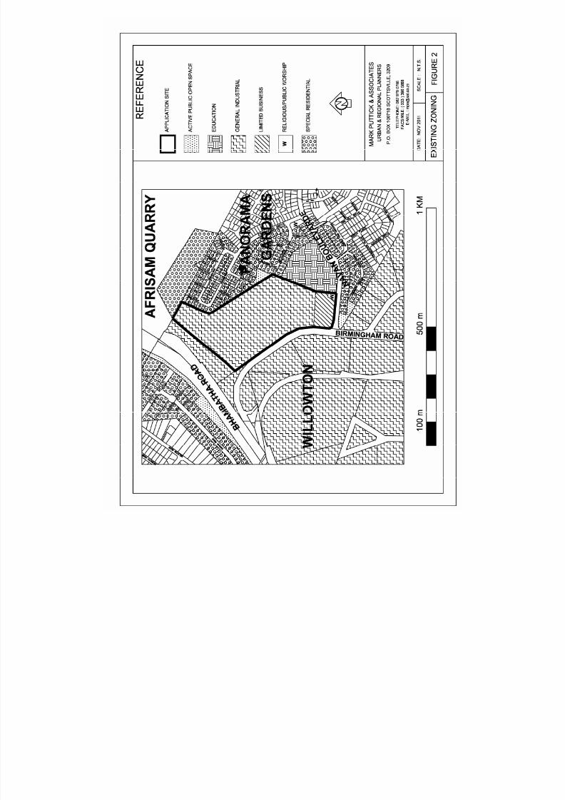
3.5 Land Use Management Controls (Figure 2)
The application site is subject to the provisions of the Pietermaritzburg Draft Town PlanningScheme.
Most of the application site is currently zoned for “General Industrial” purposes in terms ofthe adopted structure plan with an 11 200 m² site, located at the corner of Birmingham Roadand Navan Boulevarde, being zoned for “Limited Business” purposes together with an 850 m²site located adjacent to Panorama Primary school which is zoned for “Religious Purposes”
The boundaries and areas of these land use components have a degree of flexibility and areable to be finally determined as part of the preparation of a layout as in the case of theresidential component of Panorama Gardens.
8/13/2019 d5 - Preparation of a Layout Plan
http://slidepdf.com/reader/full/d5-preparation-of-a-layout-plan 13/32

8/13/2019 d5 - Preparation of a Layout Plan
http://slidepdf.com/reader/full/d5-preparation-of-a-layout-plan 14/32
MARK PUTTICK & ASSOCIATESURBAN AND REGIONAL PLANNERSPm164-032-11.REP
10
Uses including an “Industrial Building”, a “Light” and “Service Industrial Building”, “MotorSalesroom” and “Workshop” and “Service Workshop” are currently expressly permissiblewithin the “General Industrial” component with various uses including a “Business Premises”,“Flat”, “Institution”, “Noxious Industrial Building”, “Parking Garage” and “Lot”, “PetroleumFilling Station”, “Place of Public Entertainment”, “Place of Instruction”, “Place of Worship”,“Restaurant”, “Shop”, and “Special Building” being permitted with Council’s SpecialConsent.
“Business Premises”, “Dwelling”, “Flat”, “Public Office”, “Residential Building”,“Restaurant”, “Shop” and “Specialised Office” are currently expressly permissible within the“Limited Business” component with various uses including a “Agricultural Building”,“Boarding House”, “Institution”, “Parking Garage”, “Parking Lot”, “Petrol Filling Station”,“Place of Instruction”, “Place of Public Entertainment”, “Place of Worship”, “Public Garage”,“Social Hall” and “Special Building” being permitted with Council’s Special Consent.
The zoning and reservation of the surrounding properties is:
(a) Above the application site (to the north)
Unzoned Afrisam Quarry property and “Special Residential”
(b) To the right (east) of the application site
“Special Residential”, “Active Public Open Space” and “Education”
(c) Below (to the south) the application site (across Navan Boulevarde)
“Special Residential” and “General industrial”
(d) To the left (west) of the application site (across Birmingham Road)
“General industrial”
There is no control of “Bulk” in respect of industrial uses within the “General Industrial” zonewhilst the “Coverage” and “Height” of buildings is limited to 90 % and a 60° Light anglerespectively and parking is required to be provided on the basis of the greater of 10 % of thesite area or 15 % of the floor area of a building.
The current controls associated with the development of a non industrial use within the“General Industrial” zone are a “Bulk”, “Coverage” and “Height” of 1.5, 75 % and 3“Storeys” respectively, and associated on-site parking is required to be supplied in accordancewith the Scheme requirements for uses as provided for in the controls for other relevant landuse zones.
The current controls associated with the development of non residential uses within the“Limited Business” zone are a “Bulk”, “Coverage” and “Height” of 1, 50 % and 3 “Storeys”respectively and associated on-site parking is required to be supplied 1.2 m² of gross parkingper 1 m² of gross floor area.
The application site is also subject to conditions which are contained in the Deed of Transfer,T 058407/07.
8/13/2019 d5 - Preparation of a Layout Plan
http://slidepdf.com/reader/full/d5-preparation-of-a-layout-plan 15/32
MARK PUTTICK & ASSOCIATESURBAN AND REGIONAL PLANNERSPm164-032-11.REP
11
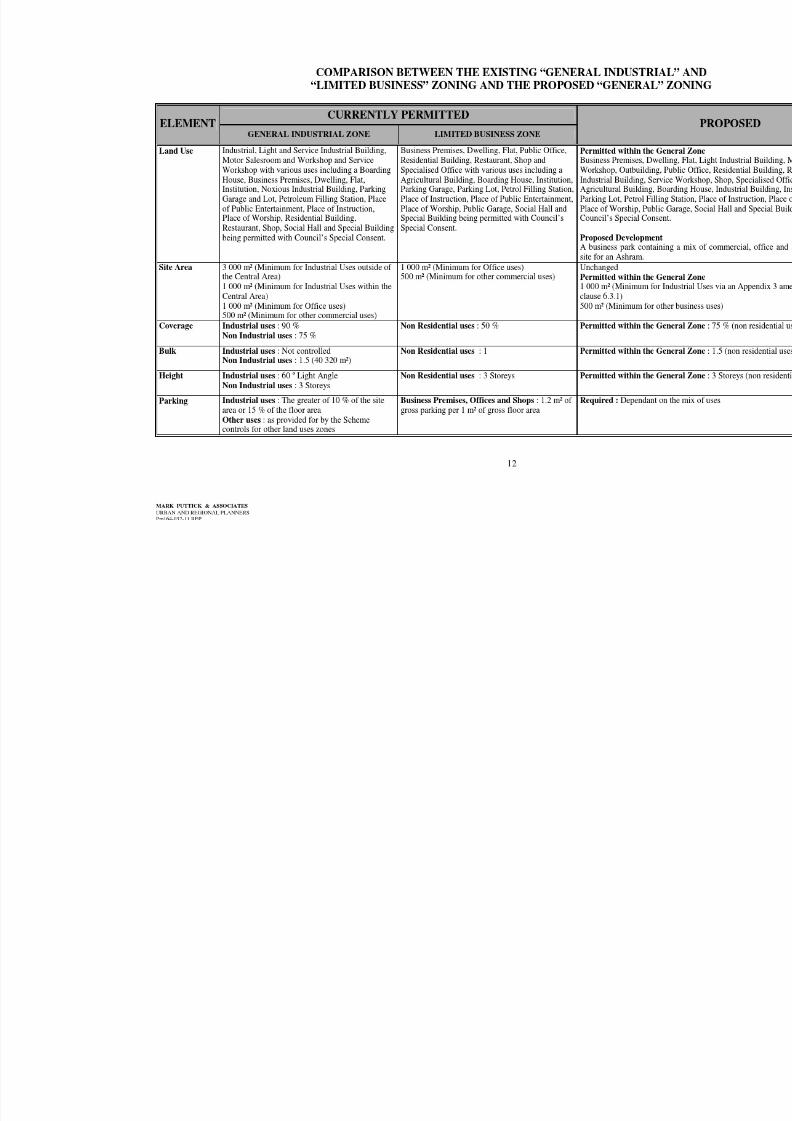
It is noted that the Spatial Development Framework Plan (SDF) component of the IDPdesignates the future use of the application site for residential purposes contrary to the currentzoning. The consultants who prepared the SDF have provided no rationale for thisdesignation or consulted the applicant regarding the proposed change of use. Officials of theMsunduzi Municipality Development Services section have indicated that the residentialdesignation in the SDF is an error that would be corrected when the SDF is reviewed and alsoindicated that they would support an application for the development of the proposedPanorama Business Park.
Influence on development
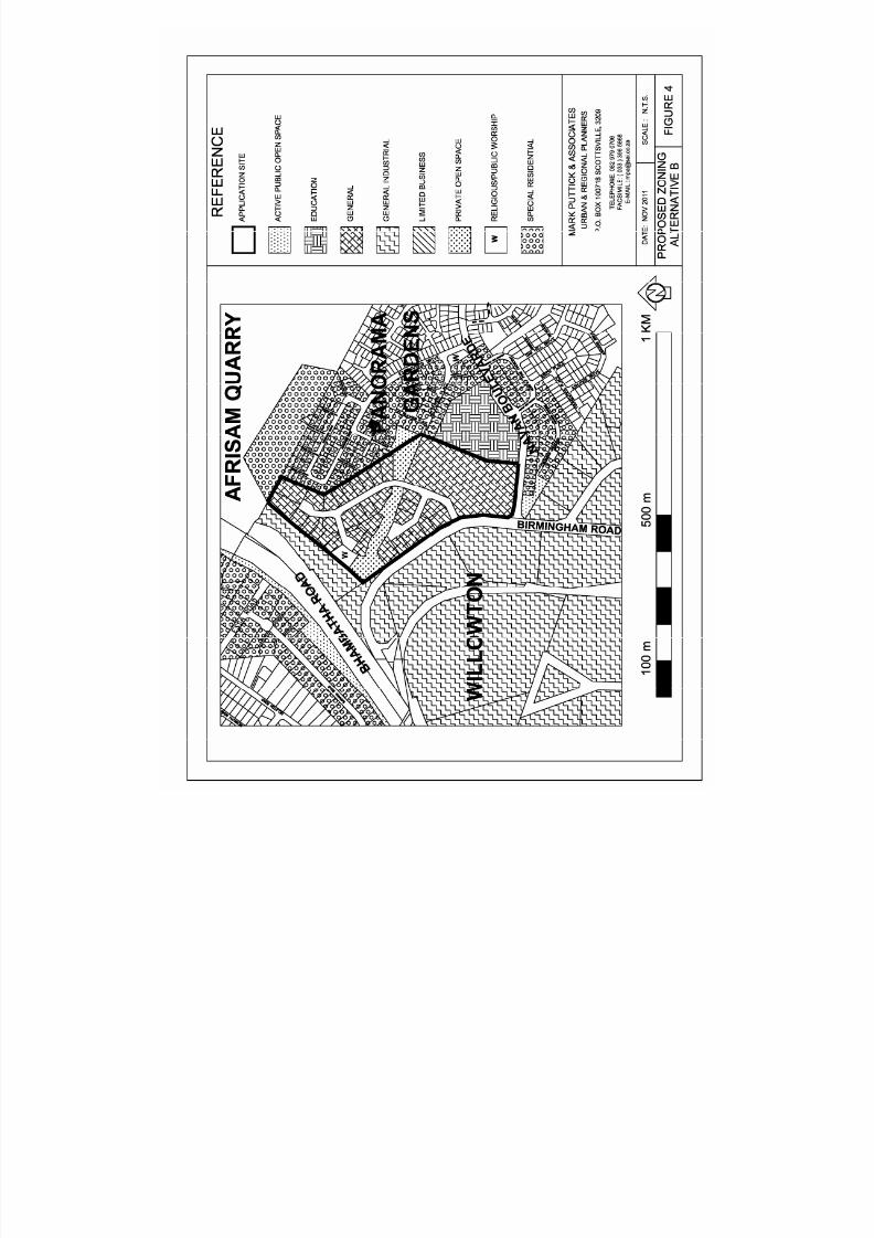
In order to enable the applicant to secure purchasers and tenants for the proposed PanoramaBusiness Park, it is essential that potential components such as a “Business Premises”, “Shop”and office uses become ‘expressly permissible’. With reference to Figures 3 and 4 overleaf,this will be achieved by rezoning the proposed erven for “General” purposes together witheither an Appendix 3 amendment to permit industrial uses on erven with a minimum area of 1000 m² or a written undertaking from the municipality that industrial uses would be permitted
on such erven in accordance with the discretionary provisions of clause 6.3.1 of the townplanning scheme.
A comparison between the development potential permitted by the current and proposedzoning is given in the table overleaf..
The significant changes resulting from the adoption of the proposed rezoning to “General”purposes will be that a “Noxious Industrial Building” will become a prohibited use; usesclassified as being an “Industrial Building” (heavy industrial type uses) will require Council’sSpecial Consent; whilst uses such as a “Business Premises”, “Dwelling”, “Flat”, “ResidentialBuilding”, “Restaurant”, “Shop” and “Specialised Office” would become expresslypermissible on the application site rather than being permitted by Council’s Special Consent
in terms of current “General Industrial” zoning.
The exclusion of potential noxious industrial uses and the requirement for heavy types ofindustrial uses to be subject to Council’s Special Consent is regarded as being moreappropriate than the situation under the current zoning as this will facilitate a development onthe application site that will create a more compatible interface with the adjoining residentialcomponent of Panorama Gardens and have less potential impact on the amenity of thesurrounding residents. The reduction in the permissible height of buildings from a 60° lightangle to a maximum of 3 storeys via the proposed rezoning to “General” purposes is alsoregarded as being more appropriate with respect to adjoining residential component ofPanorama Gardens.
None of the conditions contained in the Deed of Transfer place any restrictions of theproposed development of a business park on the application site .
Having regard to the above, the proposed rezoning of the proposed erven for “General”purposes is regarded as being the most appropriate means of facilitating the development ofthe application site in a manner that will optimise its locality; meet the need for small scaleindividually owed commercial and light industrial premises; and create an appropriatetransition between the large scale industrial manufacturing uses off Birmingham Road and theresidential component of Panorama Gardens.
8/13/2019 d5 - Preparation of a Layout Plan
http://slidepdf.com/reader/full/d5-preparation-of-a-layout-plan 16/32

8/13/2019 d5 - Preparation of a Layout Plan
http://slidepdf.com/reader/full/d5-preparation-of-a-layout-plan 17/32
8/13/2019 d5 - Preparation of a Layout Plan
http://slidepdf.com/reader/full/d5-preparation-of-a-layout-plan 18/32
8/13/2019 d5 - Preparation of a Layout Plan
http://slidepdf.com/reader/full/d5-preparation-of-a-layout-plan 19/32
MARK PUTTICK & ASSOCIATES URBAN AND REGIONAL PLANNERSPM164-032-11.REP 13
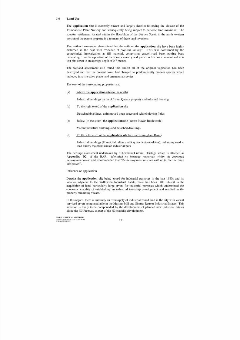
3.6 Land Use
The application site is currently vacant and largely derelict following the closure of theJesmondene Plant Nursery and subsequently being subject to periodic land invasions. Thesquatter settlement located within the floodplain of the Baynes Spruit in the north westernportion of the parent property is a remnant of these land invasions.
The wetland assessment determined that the soils on the application site have been highlydisturbed in the past with evidence of “ topsoil mining ”. This was confirmed by thegeotechnical investigation as fill material, comprising gravel road base, potting bagsemanating from the operation of the former nursery and garden refuse was encountered in 6test pits down to an average depth of 0.7 metres.
The wetland assessment also found that almost all of the original vegetation had beendestroyed and that the present cover had changed to predominantly pioneer species whichincluded invasive alien plants and ornamental species.
The uses of the surrounding properties are:
(a) Above the application site (to the north)
Industrial buildings on the Afrisam Quarry property and informal housing
(b) To the right (east) of the application site
Detached dwellings, unimproved open space and school playing fields
(c) Below (to the south) the application site (across Navan Boulevarde)
Vacant industrial buildings and detached dwellings
(d) To the left (west) of the application site (across Birmingham Road)
Industrial buildings (Fram/Gud Filters and Kaymac Rotomoulders), rail siding used toload quarry materials and an industrial park
The heritage assessment undertaken by eThembeni Cultural Heritage which is attached asAppendix ‘D2’ of the BAR, “identified no heritage resources within the proposeddevelopment area ” and recommended that “ the development proceed with no further heritagemitigation ”.
Influence on application
Despite the application site being zoned for industrial purposes in the late 1980s and itslocation adjacent to the Willowton Industrial Estate, there has been little interest in theacquisition of land, particularly large erven, for industrial purposes which undermined theeconomic viability of establishing an industrial township development and resulted in theproperty remaining vacant.
In this regard, there is currently an oversupply of industrial zoned land in the city with vacantserviced erven being available in the Masons Mill and Shortts Retreat Industrial Estates. Thissituation is likely to be compounded by the development of planned new industrial estatesalong the N3 Freeway as part of the N3 corridor development.
8/13/2019 d5 - Preparation of a Layout Plan
http://slidepdf.com/reader/full/d5-preparation-of-a-layout-plan 20/32
MARK PUTTICK & ASSOCIATES URBAN AND REGIONAL PLANNERSPM164-032-11.REP 14
However, based on the recent interest that has been shown in the acquisition of smallerpremises to accommodate a mix of light industrial, commercial and office uses, the proposeddevelopment of the Panorama Business Park is viewed as being an appropriate means of;accommodating demand for such premises; maximising the locational advantages of theapplication site and achieving a more desirable mix of land uses that will establish a morecompatible and complementary interface between the existing adjoining housing in PanoramaGardens and the large scale industrial development within the Willowton Industrial Estate.
Having regard to the previous land invasions, it is contended that it would be undesirable toleave the application site undeveloped.
Although the heritage assessment identified no heritage resources, it is acknowledged that theprovisions of the Heritage Resources Act (25 of 1999) requires all work to cease in the eventthat any heritage resources are discovered during construction and that Amafa aKwaZulu-Natali be notified accordingly.
3.7 Infrastructure
3.7.1 Roads
The application site is well served by the existing higher order road networkcomprising Bhambatha Road (New Greytown Road/R33) and Chief MhlabunzimaRoad (Baynes Drift Road/Main Road 25), which are the primary arterial roadsserving the city’s north eastern suburbs and the main road links to the uMshwathi andUmvoti Municipal Areas.
The application site has an extensive frontage along Birmingham Road which formsan important cross link between Bhambatha and Chief Mhlabunzima Roads andconnects directly into Allandale Drive which in turn provides a further cross linkagebetween Bhambatha Road and Chota Motala Road (Old Greytown Road) which is
the primary arterial road serving the city’s northern suburbs.
These three arterial roads provide short direct linkages between the application siteand the N3 Freeway.
The application site also fronts onto Navan Boulevarde which is the primary accesscollector road serving the Panorama Gardens residential development and alsoprovides an alternative link between Birmingham and Chief Mhlabunzima Roads.
3.7.2 Potable Water
The proposed development will be serviced by an extension of the existing municipalreticulated water supply and each erf will be separately metered.
The water mains serving the layout will ensure an appropriate level of supply to firehydrants that will be located throughout the development in accordance with themunicipal requirements.
3.7.3 Sewerage
The proposed development will be serviced by an extension of the existing municipalreticulated sewer system and each erf will have a separate connection.
8/13/2019 d5 - Preparation of a Layout Plan
http://slidepdf.com/reader/full/d5-preparation-of-a-layout-plan 21/32
MARK PUTTICK & ASSOCIATES URBAN AND REGIONAL PLANNERSPM164-032-11.REP 15
3.7.4 Electricity
The proposed development will be serviced by an extension of the existing municipalelectricity supply via new mini sub stations and each erf will be separately metered.
3.7.5 Stormwater Management
As detailed in Appendix ‘D4’ of the BAR, stormwater runoff will be directed intoretention areas on each erf in accordance with the municipality’s requirements as wellas into the two retention ponds located along the alignment of the central drainagechannel. The proposed reticulated stormwater system serving the layout willcomprise a system of catchpits, kerb and channels, side inlets, discharge pipes, headwalls and reno mattresses.
3.7.6 Solid Waste Removal
Refuse generated by occupants of the proposed erven will be collected by themunicipal refuse service on the scheduled refuse collection days for commercial andindustrial properties.
Influence on application
A traffic impact assessment was undertaken by transportation specialists, DMA, inorder to determine the potential impact that the proposed development could have onthe existing road network and to identify the need for any improvements. A copy ofthe report documenting this investigation is included as Appendix ‘D7’ of the BAR.
This report recommends that the following measures be implemented in order toaccommodate the projected traffic generated by the proposed Panorama BusinessPark:
(i) Intersection of Bhambatha/Birmingham Roads
The introduction of a south to west turning lane and a right turn green arrowsignal phase for right turning movements from Bhambatha Road intoBirmingham Road.
(ii) Intersection of Birmingham Road and Panorama Business Park accessroad
The proposed access to be ‘stop’ controlled with a right turn refuge lane
provided on Birmingham Road within the existing road width and for theaccess road to have the potential to accommodate local widening in places upto at least the first main intersection within the development in order toaccommodate dedicated turning lanes if required.
A traffic impact assessment also found the location of the proposed entrance to thePanorama Business Park to be acceptable in terms of criteria related to trafficmanagement and road safety and, with reference to the letter included as Appendix ‘E2 ’ of the BAR, this has been supported by the Transportation Planning unit of TheMsunduzi Municipality.
Although Sukuma are of the view that the proposed development will not exceed the
capacity of the existing infrastructural services this has not been formally confirmedby municipal officials to date.
8/13/2019 d5 - Preparation of a Layout Plan
http://slidepdf.com/reader/full/d5-preparation-of-a-layout-plan 22/32
MARK PUTTICK & ASSOCIATES URBAN AND REGIONAL PLANNERSPM164-032-11.REP 16
The proposed stormwater management measures incorporated throughout theproposed development have been designed to ensure that stormwater runoff isappropriately managed in accordance with the municipality’s requirements and toobserve the 15 metre buffer requirement for retention ponds and any open sections ofthe central drainage channel which has been recommended by Alletson Ecologicals.
4NEED AND DESIRABILITY
Whilst the need for the proposed development of the Panorama Business Park has beenprecipitated by the applicant’s desire to respond to market forces and develop the applicationsite in a manner that realises an appropriate economic return on an investment, it is alsoconcerned with a number of broader town planning issues.
(i) Appropriateness of the provisions of the Pietermaritzburg Town PlanningScheme in respect of the application site
The current “General Industrial” zoning of most of the application site is notconsidered to be appropriate within the context of;
• the lack of interest that has been shown in utilising the application site toaccommodate large scale industrial activities;
• the compatibility of some of the uses currently permitted within this zonewith respect to the nature and scale of the adjoining residential uses inPanorama Gardens;
• the availability of vacant serviced land in the city’s main industrial estates,which are considered to be a preferable location for major industrial activities,and the development of planned new large scale industrial estates off the N3in the Mkhambathini and Ethekwini Municipalities;
• the acceptance that the portions of the city’s industrial zones should, where
appropriate, facilitate the establishment of mixed use developments whichaccommodate business premises, light industrial, office and retail uses;• the interest that has been shown in respect of acquiring land in the proposed
Panorama Business Park to accommodate commercial and small scale lightindustrial uses; and
• the need to facilitate the economically viable and sustainable use of theapplication site .
Under these circumstances, identifying a more appropriate zoning of the applicationsite that takes account of the factors listed above and the locational attributes of itsenvirons is regarded as being both ‘necessary’ and ‘desirable’ in the public interest.
(ii) Alternative development scenarios for the application site
It is contended that there are essentially four substantive alternative developmentscenarios that are relevant to the application site . These are evaluated as follows:
(a) Leaving the property undeveloped
This scenario, which equates to the ‘do nothing scenario’, is not considered tobe practical or desirable as it would not enable the applicant to realise anappropriate return from a land investment and it is highly likely that theproperty would become subject to further land invasions and unauthoriseddumping.
8/13/2019 d5 - Preparation of a Layout Plan
http://slidepdf.com/reader/full/d5-preparation-of-a-layout-plan 23/32
MARK PUTTICK & ASSOCIATES URBAN AND REGIONAL PLANNERSPM164-032-11.REP 17
(b) Developing the property in terms of the current General Industrial andLimited Business zoning.
This scenario is not regarded as being desirable with the context of the issuesexamined in section 4 (i) above and, due to the lack of interest in theindustrial component, it is likely that only the “Limited Business” componentwould be developed with the balance of the application site remainingundeveloped with similar consequences to the ‘do nothing scenario’.
(c) Rezoning the property to facilitate its development for predominantlyresidential purposes
This scenario is not regarded as being viable in either the short to mediumterm within the context of the abundance of vacant serviced residential landin the surrounding area. In this regard, vacant land is still available within thefinal phase of Panorama Gardens, Beacon Hill Estate has seen littledevelopment over the last 5 years and Darjeeling Heights and Bakervillelocated in Raisethorpe and Northdale respectively remain largelyundeveloped. There are also plans to develop Surrey Farm located adjacent
to Panorama Gardens and opposite the Beacon Hill Estate for residentialpurposes.
In addition to these developments which cater for the middle income sector ofthe market, which would be the market for any private sector residentialdevelopment on the application site , three phases of Copesville, whichwould be aimed at catering for the lower income sector, still have to bedeveloped.
Consequently, if this scenario were pursued, only the “Limited Business”component is likely to be developed, assuming that the zoning of thiscomponent is retained, within the medium term with the balance of the
application site remaining undeveloped. This would have similarconsequences to the ‘do nothing scenario’.
This scenario or a predominant residential development is also not regardedas being an optimum use of land that is currently zoned to accommodateeconomic activities within the context of the urgent need to stimulate jobcreation in the city and contribute to the economic sustainability of the futureresidents of the planned residential developments in the surrounding area.
In this regard, the development of the application site to accommodateeconomic activities with the associated creation of new job opportunities isviewed as contributing to achieving a more desirable mix of land uses in thearea and assisting in reducing the commuting distances for some of the futureresidents in the surrounding area.
(d) Rezoning the property to facilitate the proposed Panorama Business Park
The interest that has been shown in acquiring premises for a range ofbusiness and office related uses rather than large scale industrial activitiesand the applicant’s concomitant desire to accommodate this demandindicates that the application site potentially satisfies the requirements ofinvestors, developers and tenants. These requirements include; goodvisibility and accessibility from the major road network; a good qualityenvironment, close proximity to a range of commercial and businessactivities and affordable premises.

8/13/2019 d5 - Preparation of a Layout Plan
http://slidepdf.com/reader/full/d5-preparation-of-a-layout-plan 24/32
MARK PUTTICK & ASSOCIATES URBAN AND REGIONAL PLANNERSPM164-032-11.REP 18
The proposed Panorama Business Park is viewed as having the ability toenhance rather than interfere with the current amenity of the surrounding areawhen compared with a development under the current zoning and isanticipated to have the following benefits for the city:
! providing opportunities to accommodate the demand for additionalaccommodation for “Business Premises”, “Light IndustrialBuildings” and “Offices” which has the potential to relieve thepressure that is currently being exerted on residential precincts in thecity’s northern suburbs via the infiltration of unauthorised uses;
! securing a sustainable use for the currently vacant property withoutrequiring any unplanned expenditure by the Municipality;
! enhancing the economic and investment climate of Pietermaritzburgthrough sustained local investment;
! contributing to increasing the rates base of the Municipality;! facilitating the creation of additional job opportunities in the northern
sector of the city; and!
contributing to the attainment of the goals of the IDP with respect tomaking more efficient use of the existing infrastructure; encouraginga greater mix of land use activities and building the local economy.
(iii) Determining the most appropriate zoning for the application site
In terms of the provisions of the scheme, the use of a property within the “GeneralIndustrial” zone for certain commercial purposes may be permitted with the Council =sSpecial Consent. This requirement was introduced at a time when the use ofindustrial land was highly regulated at a national level in order to ensure that thelimited amount of land that had been permitted to be set aside to accommodateindustrial activities was not inundated by commercial uses to the detriment of such
industrial activities.
However, as an application for Council’s Special Consent is considered on thegrounds of interference with the amenity of the surrounding neighbourhood, a numberof appeals against Council’s refusal of applications to establish commercial uses inindustrial areas on the grounds of excluding non-industrial uses were upheld by theTown Planning Appeals Board. In response, the then Town and Regional PlanningCommission formally requested Council during 1984 to review the provisions of theScheme regarding the retention of “Shops” as a Special Consent use within industrialzones in view of its policy regarding the use of industrial zoned land.
In submitting this request, the Commission noted that Council did not refuse aparticular application on the grounds of “ amenity interference or increased trafficgeneration considerations, as, presumably, such factors were irrelevant, given thelevels of amenity and traffic generation which the Scheme would acknowledge in such
Industrial zones” and that this was contrary to the provisions of the Town PlanningOrdinance.
However, Council decided against amending the Scheme within the context of anincreasing acceptance of the desirability of establishing mixed land use areas.Consequently, the establishment of non-industrial uses within industrial zones becameviewed as being ‘necessary and desirable’ provided that it could be demonstrated thatsuch uses did not interfere with the amenity of the surrounding area.
8/13/2019 d5 - Preparation of a Layout Plan
http://slidepdf.com/reader/full/d5-preparation-of-a-layout-plan 25/32
MARK PUTTICK & ASSOCIATES URBAN AND REGIONAL PLANNERSPM164-032-11.REP 19
In addition, changing circumstances saw a reduction in the demand for industrial landin the city as a result of the termination of the benefits granted under the formerRegional Industrial Development Plan (RIDP) and the closure of a number ofindustrial concerns in the city. The latter was also precipitated by the removal ofsome tariff protections since 1994 as a consequence of South Africa =s openparticipation in the world economy and the requirements of the World TradeOrganisation.
The last 15 to 20 years has also seen the introduction of the concept of ‘factory shops’within industrial areas and many wholesalers have effectively become retailenterprises. This has lead to a blurring between the nature of uses currently foundwithin business and industrial zones in the city. However, records indicate that themajority of the commercial uses currently operating within the industrial zones havenever been authorized.
As it would be both impossible and undesirable to try and reverse this situation, theGeneral zone was introduced into the scheme wherein light industrial business andoffice uses are expressly permissible and portions of the Central Area industrial zoneswere rezoned by Council accordingly. Although it was intended that the “General”zoning would be extended to other parts of the city’s industrial zones, such as theapplication site , this was never initiated by Council.
Having regard to;
! the applicant’s desire not to preclude the possible future use of the propertyfor some of the uses that are expressly permitted in terms of the currentzoning, particularly “Light and Service Industrial Buildings” and “ServiceWorkshops”, whilst enabling appropriate additional uses such as “BusinessPremises” and offices to become expressly permissible;
! the nature and character of the existing surrounding development, particularly
the mix of residential and industrial uses to the east and west of theapplication site! the locational attributes of the application site which facilitates a mixed
industrial, commercial and office development; and! the process that has seen the industrial areas of Allandale and Failsworth
Road become more mixed use zones,
the current “General Industrial” zoning of the application site is no longer consideredto be suitable and the most appropriate alternative zoning is considered to be General”purposes.
The significant changes resulting from the adoption of the proposed rezoning to
“General” purposes will be that a “Noxious Industrial Building” will become aprohibited use; uses classified as being an “Industrial Building” (heavy industrial typeuses) will require Council’s Special Consent; whilst uses such as a “BusinessPremises”, “Dwelling”, “Flat”, “Residential Building”, “Restaurant”, “Shop” and“Specialised Office” would become expressly permissible on the application siterather than being permitted by Council’s Special Consent in terms of current “GeneralIndustrial” zoning.
The changes relating to a “Noxious Industrial Building” and “Industrial Building” areconsidered to be beneficial with respect to maintaining the amenity of the occupantsof the adjacent residential uses in Panorama Gardens.
8/13/2019 d5 - Preparation of a Layout Plan
http://slidepdf.com/reader/full/d5-preparation-of-a-layout-plan 26/32
MARK PUTTICK & ASSOCIATES URBAN AND REGIONAL PLANNERSPM164-032-11.REP 20
(iv) Desirability of developing a commercial centre on the application site
The proposed commercial centre should be viewed within the overall context of aretail system which is " never static, in a state of equilibrium, or even tending to anultimate stage of development, but is rather constantly adjusting to more efficient andeffective methods of operation " (Metropolitan Pietermaritzburg Retail Study – Khan ,
Mark Puttick & Associates, Integrated Planning Services : 1993).
The changes in the retail system are viewed as being the result of a normal process ofevolution that responds to variations of; the population, the distribution of consumers,shopping habits and tastes and the requirements of business operations.
It was recognised that this process leads to totally new centres being built in new andoften better locations. The combination of new centres, expanded centres andrevitalised older centres and enterprises leads to a rich mix of complementary retailactivities being continually available to consumers.
In this regard, the proposed commercial centre is intended to be a focused orspeciality centre which will potentially include tenants such as a hypermarket,furniture store, discount department store, and hardware/building supplies in additionto line shops. This would be complimentary to other retail centres serving thenorthern suburbs.
The Metropolitan Pietermaritzburg Retail Study, which was adopted by Council as apolicy document, recommends that the need and desirability of developing retailcentres and uses be specifically evaluated in terms of four sets of criteria pertaining toCustomer, Agency (investors and developers) and Planning or Local Authority needs.
The following evaluation of the proposed commercial centre has been undertaken in
terms of the four sets of criteria which are listed in Annexure 6 of the Retail Study.
Customer Needs
(i) Location of the centre in relation to target market
The primary catchment or target trading area is seen as being the residents ofportions of Panorama Gardens, Beacon Hill, Eastwood, Glenwood,Tembalihle, Copesville, Haniville, Raisethorpe and Northdale as well asemployees of industrial and commercial uses located in the adjoiningWillowton and Allandale Industrial Estates.
As the proposed centre is situated adjacent to existing and proposedresidential uses it will be within a 1.5 km walking distance of a significantportion of the primary catchment.
(ii) Accessibility from major roads serving the target market
The location of the proposed commercial centre on an erf that will be definedby Birmingham Road, Navan Boulevarde and the proposed access road intothe Panorama Business Park off Birmingham Road will ensure that it iseasily accessible.
8/13/2019 d5 - Preparation of a Layout Plan
http://slidepdf.com/reader/full/d5-preparation-of-a-layout-plan 27/32
MARK PUTTICK & ASSOCIATES URBAN AND REGIONAL PLANNERSPM164-032-11.REP 21
In this regard, Birmingham Road forms an important cross link betweenBhambatha Road (New Greytown Road/R33) and Chief Mhlabunzima Roadand connects directly into Allandale Drive which in turn provides a furthercross linkage between Bhambatha Road and Chota Motala Road (OldGreytown Road). Bhambatha, Chief Mhlabunzima and Chota Motala Roadsare the three main arterial roads serving the north eastern sector of the cityand also provide short direct linkages to the N3 Freeway.
Navan Boulevarde is also the primary access collector road serving thePanorama Gardens residential development and provides an alternative linkbetween Birmingham and Chief Mhlabunzima Roads.
(iii) Potential of the site to facilitate the development of a range of commercialand related uses
The proposed 4 hectare site for the commercial centre is regarded as beingappropriate to accommodate the proposed commercial centre as well as other
potential related uses and allow for some expansion should this be required toserve a growing population in the future.
(iv) Potential of the site to facilitate the adequate provision of parking
The potential area required for parking has been calculated on the basis of aratio of 1,2 m 5 of gross parking per 1 m 5 of gross floor space in accordancewith the town planning scheme requirements for suburban retail centres andprovision could also be made to accommodate a taxi parking area if required.
(v) Quality of the environment of the site
Whilst the site of the proposed commercial centre is not currently consideredto have a high degree of environmental quality or amenity, it is contendedthat the amenity of both the proposed erf and the parent application site willbe substantially improved by the development of the proposed commercialcentre and the Panorama Business Park with associated landscaping.
The environment of the proposed centre is also intended to offer patrons theopportunity to shop in pleasant and safe surroundings which will becomparable to that of other similar types of retail centres located within theMunicipality.
Agency Needs
The site of the proposed commercial centre is regarded as meeting the followingagency requirements;
• location in an area which is relatively safe and secure;• potentially available in the short term, subject to the granting of
environmental authorisation for the proposed business park and the approvalof an application to subdivide the property and amend the town planningscheme;
• large enough to enable an appropriately sized centre to be developed;• space which allows for some potential expansion to cater for the growth of the
trade area;• good accessibility from the potential trading area;
8/13/2019 d5 - Preparation of a Layout Plan
http://slidepdf.com/reader/full/d5-preparation-of-a-layout-plan 28/32
MARK PUTTICK & ASSOCIATES URBAN AND REGIONAL PLANNERSPM164-032-11.REP 22
• good accessibility for service and delivery vehicles;• good visibility from the surrounding major road network;• complementary to other existing local shopping facilities serving the area;• few constraints on construction and the availability of infrastructural services;
and• a site which could be developed with minimal environmental complications.
These attributes have already led to potential tenants canvassed by the applicantexpressing an interest in leasing space in the centre.
Local Authority Needs
(i) Impact on existing infrastructural services
Sukuma are of the view that the existing infrastructural services have thecapacity to accommodate the proposed commercial centre and the balance ofthe proposed Panorama Business Park.
(ii) Whilst the development will alter traffic movements around the site, thetransportation study has concluded that the traffic can be accommodated bythe existing road network provided that the measures detailed in section 3.7.6above are implemented at the intersection of Bhambatha/Birmingham Roadsand the new intersection between Birmingham Road and the proposedPanorama Business Park access road.
(iii) Requirements for the public sector to upgrade infrastructural services
The Municipality will not be required to undertake any unplanned upgradingof the infrastructural services.
(iv) Impact on environment and surrounding land use activitiesIt is contended that the proposed development of a commercial centre willlead to an improvement of the environmental quality of the parentapplication site and have a positive impact on its environs.
Planning Needs
The proposed development of a commercial centre on the application site is viewedas having the potential to:
• Improve the investment climate in an area which is currently under-
utilised.• Contribute to the attainment of the development principles identified
in the IDP relating to:
Compaction - by making more efficient use of an urban infillsite and existing infrastructure;
Integration - by facilitating the development of a greater mixof land use activities;

8/13/2019 d5 - Preparation of a Layout Plan
http://slidepdf.com/reader/full/d5-preparation-of-a-layout-plan 29/32
MARK PUTTICK & ASSOCIATES URBAN AND REGIONAL PLANNERSPM164-032-11.REP 23
Restructuring the city - by providing residents of the city’snorthern suburbs with a wider range of easily accessible usesand services;
• Providing an upgraded entrance into Panorama Gardens which willhelp to provide this portion of the city with a greater sense of place.
5 IMPACT ON AMENITY
The term ‘amenity’ is regarded as being the quality or condition of an area which contributesto its pleasantness and enjoyment.
The criteria that have been established by the former Town Planning Appeals Board throughthe hearing of appeals are generally used to assist in evaluating the potential interference that aproposed use could have on the current level of amenity of the surrounding neighbourhood.These include the introduction of ‘foreign’ uses or activities, increase in vehicular traffic,noise generated and any nuisance of a substantial nature.
The existing amenity of the application site and its immediate environs is characterised by amix of business and industrial activities and residential uses. The environment associated withthese activities is currently dominated by the industrial buildings located off BirminghamRoad with associated surfaced parking and service areas which contains limited landscaping.
It is contended that the proposed development of the proposed Panorama Business Park on theapplication site will not interfere with the amenity of the surrounding neighbourhood for thefollowing reasons:
(a) it will not introduce any ‘foreign uses’ into the area and will be fully compatible withthe industrial uses located off Birmingham Road;
(b) it will have considerably less impact on the residential amenity of the propertieslocated in Panorama Gardens to the east of the application site than a large scaleindustrial use that is currently expressly permissible in terms of the “GeneralIndustrial” zoning;
(c) the traffic assessment has confirmed that the associated traffic movements can beaccommodated by the existing road network provided minor improvements areeffected;
(d) very little of the additional traffic generated by the proposed development isanticipated to route through Panorama Gardens residential area;
(e) the noise associated with the operation of the proposed development is unlikely toexceed the current ambient level;
(f) the wetland study found that the application site has a low in situ biodiversity withrespect to flora and fauna; and
(g) the buildings in the portion of the proposed Panorama Business Park that forms theinterface between the application site and the residences in Panorama Gardens willbe set on platforms that are significantly lower than these dwellings, thereby notunduly impacting on any views and vistas currently enjoyed by residents, whilst anyother visual impacts can be further mitigated by employing measures such asappropriate screening where necessary.
In addition, it is contended that the proposed development will assist in upgrading the amenityand improve the environmental quality of the interface zone between the Willowton IndustrialEstate and Panorama Gardens.
8/13/2019 d5 - Preparation of a Layout Plan
http://slidepdf.com/reader/full/d5-preparation-of-a-layout-plan 30/32
MARK PUTTICK & ASSOCIATES URBAN AND REGIONAL PLANNERSPM164-032-11.REP 24
6 LAYOUT DESIGN
The design of the layout was informed by biophysical factors and engineering andenvironmental considerations. The primary determinants of the design of the layout were theland form, the limitation of having a single access point off Birmingham Road, the roadservitude providing access to the Afrisam Quarry and the central watercourse which would
require a 15 metre buffer and be limited to being traversed by a single road crossing if leftrunning within an open channel.
A number of alternative layout designs were prepared and incrementally evaluated bymembers of the applicant’s professional team. The sequence of the evaluation process was tofirstly optimise the overall structure and the location and shape of the proposed commercialcentre in relation to the land form and the existing road system.
This was followed by the integration of potential open spaces, which were defined on the basisof; having the central drainage channel piped in accordance with the recommendation ofAlletson Ecologicals or left running in an open channel; the incorporation of stormwaterretention ponds; and observing a 15 metre buffer around the open channel and retentionponds.
The boundaries of the individual erven were then determined on the basis of providing a rangeof site sizes, minimising the earthworks that would be required to establish future buildingplatforms and facilitating an appropriate development that would be able to observe the townplanning scheme requirements for spaces around buildings and on-site parking.
Two preferred layouts were generated through the evaluation process, termed Alternatives Aand B, which are attached as Appendices ‘C1 ’ and ‘ C2 ’ of the BAR. Alternative A isstructured around the piping of the central drainage channel between the two proposedstormwater retention ponds whilst Alternative B leaves the channel open between these twoponds. Although Alletson Ecologicals had proposed a potential third pond, located to the westof the road servitude serving the Afrisam Quarry, the subsequent calculation of stormwaterflow by Sukuma has indicated that this would not be necessary.
Both alternatives make provision for a 4 hectare site, framed by Birmingham Road, NavanBoulevarde and the proposed access into the Panorama Business Park, in order toaccommodate the proposed commercial centre. The reserve of the proposed access roadadjacent to the proposed centre has been widened to 20 metres in accordance with therecommendations of the traffic assessment.
The location of the proposed centre at the entrance to the proposed Panorama Business Parkhas been determined on the grounds of; ensuring that it is easily accessible from the
surrounding road system; avoiding the routing of extraneous traffic through the balance of thebusiness park; and, being located on gently sloping topography, minimising the potentialearthworks required for the construction of large volume commercial buildings and associatedparking areas.
The location of the proposed commercial centre is also regarded as contributing to theestablishment of an acceptable interface between the proposed development and the residentialuses in Panorama Gardens. In this regard, the Panorama Primary School fields are seen asaffording an appropriate buffer between the proposed commercial centre and the schoolclassrooms.
No provision is made for access to be taken off the existing road servitude serving the Afrisam
Quarry in either alternative as the location of the intersection of this servitude withBirmingham Road has been deemed by the Municipal Transportation section to be unsafe withrespect to road safety requirements.

8/13/2019 d5 - Preparation of a Layout Plan
http://slidepdf.com/reader/full/d5-preparation-of-a-layout-plan 31/32
MARK PUTTICK & ASSOCIATES URBAN AND REGIONAL PLANNERSPM164-032-11.REP 25
Both alternatives make provision for a religious site to be located adjacent to the westernstormwater retention pond in order to accommodate an Ashram in accordance with theapplicant’s requirements. The retention pond is viewed as being a potential environmentalamenity that can be enjoyed by members of the Ashram.
The main features and components of the two layouts are as follows:
6.1 Alternative A
6.1.1 General Erven
The layout makes provision for a total of 37 erven to be zoned for “General” purposes whichincludes the 4 hectare site for the commercial centre. The balance of the 36 erven have acombined site area of about 64 130 m² with individual sizes ranging between 4 128 m² and 1367 m². The larger sites are generally located on steeper sloping topography in order toensure that the associated additional site and earthworks that will be required to form access
ways and building platforms can be easily accommodated.
6.1.2 Movement System
Good accessibility and mobility for private, commercial and emergency vehicles is providedby a looped private road system that is linked to Birmingham Road. The road reserves,including the cul-de-sac, are generally 18 metres in width except for the access road along thefrontage of the commercial centre which is 20 metres in order to accommodate dedicatedturning lanes in places in accordance with the recommendations of the traffic assessment.The cul-de-sac has a 30 metre wide turning head in accordance with the requirements toaccommodate the turning movements of large industrial vehicles.
6.1.3 Community Facilities
In addition to the commercial centre which has the potential to accommodate a range ofcommunity facilities, the layout makes provision for a 2 473 m² erf zoned for “ReligiousPurposes” in order to accommodate the proposed Ashram.
6.1.4 Open Space
The layout makes provision for two erven, with a combined area of about 9 960 m² to bereserved for “Private Open Space Purposes”. These erven are intended to accommodate theproposed two retention ponds that form part of the stormwater management system and willbe landscaped accordingly and managed and maintained by an owners’ association.
6.1.5 Maintenance and Management
An owners’ association, with membership being restricted to, and compulsory for, all ownersof erven in the Panorama Business Park will be formed to manage and maintain the openspaces and the road system together with any other reticulated services that are not taken overby the Municipality.
The owners’ association could also be given powers to require the owners of erven to observea building design code, landscaping requirements and use and conduct requirements via thearticles of association. This could assist in facilitating the practical implementation ofmeasures recommended as part of any required Environmental Management Plan.
8/13/2019 d5 - Preparation of a Layout Plan
http://slidepdf.com/reader/full/d5-preparation-of-a-layout-plan 32/32
6.2 Alternative B
6.2.1 General Erven
The layout makes provision for a total of 34 erven to be zoned for “General” purposes whichincludes the 4 hectare site for the commercial centre. The balance of the 33 erven have acombined site area of about 58 900 m² which is about 5 230 m² less than Alternative A due tothe increased area of open space and different road layout. Individual erven have areasranging between 4 128 m² and 1 334 m². As in the case of Alternative A, the larger sites aregenerally located on steeper sloping topography in order to ensure that the associatedadditional site and earthworks that will be required to form access ways and buildingplatforms can be easily accommodated.
6.2.2 Movement System
Due to the limitation of having a single road crossing over the open central drainage channel,the private road movement system has had to include three culs-de-sac which does not offer
the same level of accessibility and mobility for private, commercial and emergency vehiclesas provided for in Alternative A.
As in the case of Alternative A, the road reserves are generally 18 metres in width except forthe access road along the frontage of the commercial centre which is 20 metres in order toaccommodate dedicated turning lanes in places in accordance with the recommendations ofthe traffic assessment. The three culs-de-sac have a minimum 30 metre wide turning head inaccordance with the requirements to accommodate the turning movements of large industrialvehicles.
6.2.3 Community Facilities
In addition to the commercial centre which has the potential to accommodate a range ofcommunity facilities, the layout makes provision for a 2 405 m² erf zoned for “ReligiousPurposes” in order to accommodate the proposed Ashram. This is slightly smaller than thereligious site provided for in Alternative A.
6.2.4 Open Space
The layout makes provision for a central open space system that accommodates the centraldrainage channel and an associated 15 metre wide buffer. This open space system is split intotwo erven, with a combined area of 15 725 m² and will be reserved for “Private Open SpacePurposes”. The open space system is intended to form part of the stormwater managementsystem and accommodate the two proposed retention ponds as in the case of Alternative A.The open space system will be appropriately landscaped and managed and maintained by anowners’ association.
6.2.5 Maintenance and Management
As in the case of Alternative A, an owners’ association, with membership being restricted to,and compulsory for, all owners of erven in the Panorama Business Park will be formed tomanage and maintain the open spaces and the road system together with any other reticulatedservices that are not taken over by the Municipality.
The owners’ association could also be given powers to require the owners of erven to observea building design code, landscaping requirements and use and conduct requirements via thearticles of association. This could assist in facilitating the practical implementation ofmeas res recommended as part of an req ired En ironmental Management Plan