D23 – Report of technical workshop - MSP MED
30
D23 – Report of technical workshop 2 nd Technical workshop “LSI analysis for MSP”
Transcript of D23 – Report of technical workshop - MSP MED

D23 – Report of technical workshop
2nd Technical workshop “LSI analysis for MSP”

4
ACKNOWLEDGEMENT The work described in this report was supported by the European Maritime and Fisheries Fund of the European Union- through the Grant Agreement number 887390 - MSPMED - EMFF-MSP-2019, corresponding to the Call for proposal Call EMFF-MSP-2019 (Maritime Spatial Planning) Topic: EMFF-MSP-2019 Type of action: EMFF-AG for Projects on Maritime Spatial Planning (MSP). DISCLAIMER The content of this report represents the views of the author only and is his/her sole responsibility; it cannot be considered to reflect the views of the European Commission and/or the Executive Agency for Small and Medium-sized Enterprises (EASME) or any other body of the European Union. The European Commission and the Agency do not accept any responsibility for use that may be made of the information it contains.

5
Project Full Title Towards the operational implementation of MSP in our
common Mediterranean Sea
Project Acronym MSP-MED
Gant Agreement Nr. 887390
Project Website www.mspmed.eu
Deliverable Nr. D23
Status (Final/Draft/Revised) Final
Work Package WP2 – Setting-up Maritime Spatial Plans
Task Number 2.7 – Sharing experiences among countries
Responsible Institute CORILA
Author/s
Niccolò Bassan, Martina Bocci, Neil Alloncle, Francesco Musco
Infographics Folco Soffietti
Recommended Citation
Dissemination Level (Public/Partnership) Public
Document History
Version Date Modification Introduced Modification Reason Modified by
1 30/11/2020 Typos & Corrections
Cristina Cervera Nuñez, Laura Cotte, Martina Bocci, Efi Stefani, Niccolò Bassan

6
INDEX 1 Introduction ...................................................................................................................... 72 Programme ....................................................................................................................... 93 Participants .................................................................................................................... 104 Main topics identified .................................................................................................... 115 The Workshop ................................................................................................................ 136 Parallel Sessions ........................................................................................................... 207 Discussion & conclusion .............................................................................................. 288 References ..................................................................................................................... 31
7
1 Introduction What is meant by “Land-Sea Interactions”? The term “Land-Sea Interactions” (LSI) is usually used in the context of planning and management of marine and coastal areas. Despite its high relevance, a unique definition and conceptualization of LSI has not yet been established or formalized in literature. LSI is generally interpreted as the set of processes linking terrestrial and marine areas. Such processes may include, for example, nutrients and contaminants runoff from agriculture in rivers, and their consequent load in coastal waters, as well as the laying of a submarine pipe in the intertidal area to connect an offshore O&G platform to the terrestrial pipeline network. Almost all maritime uses need support installations on land (such as the ports for shipping, marinas for yachting or grid connections for offshore wind farms). On the other hand, there are uses, mostly exerted on the ground (for example, beach tourism, water-front, ports), that extend their domain also at sea. Some common categorizations are generally adopted in LSI analysis: i) LSI have double direction: from land toward sea and from sea toward land; ii) LSI can have natural or anthropogenic components. LSI analysis should also consider the interactions of planning processes and plans for land and sea domains. It is important to ensure that legal, administrative, consultation and technical processes are coordinated (and hopefully linked) to avoid unnecessary duplications, incoherence, conflicts, waste of resources and/or excessive demand of stakeholders’ efforts. Why is important to tackle this topic? LSI analysis shall be understood as an important component in the preparation of a marine plan. When carrying out maritime spatial planning (MSP), it is important to consider the continuity between land and sea, and to ensure that spatial planning is conducted in an integrated manner across maritime and terrestrial areas. This is of interests for both the environmental protection of coastal areas and the effective development of maritime and coastal economies. It is a requirement of the EU Directive 2014/89/EU on Maritime Spatial Planning (MSPD, EC, 2014) to take land-sea interactions into account when preparing maritime spatial plans. In fact, the MSPD specifies that the planning process should consider land-sea interactions and promote the collaboration between Member States. The MSPD makes several references to the concept of LSI in:
• Art. 1, referring to the subject of the Directive; • Art. 4, which refers to the development and implementation of maritime spatial planning.
Paragraph 2 provides that, during the entire MSP process, the Member States shall take account of land-sea interactions; Paragraph 5 states that, when drawing up the maritime spatial planning, Member States shall take into account the peculiarities of the marine regions, the related activities and present and future uses and their effects on the environment, as well as natural resources, and land-sea interactions.
• Art. 6, Paragraph 2 (a), states that one of the minimum requirements for the maritime spatial planning is that Member States take into account land-sea interactions;

8
• Art. 7, Paragraph 1 (“Land-sea interactions”), describing the nature of the LSI and the relationships with the other formal or informal processes, such as integrated coastal zone management.
• LSI is also referred to in recitals 9, 16 and 18 of the MSP Directive.
The aim of LSI analysis is to inform the planning process through the identification of the key elements about processes linking the land and marine areas that need to be considered when planning the sea space, i.e. LSI problems to be addressed and opportunities to be exploited. Which are the objectives of this second technical workshop? There are a number of possible ways of addressing land-sea interaction (LSI) in MSP. These include building on the experience of integrated coastal management (ICM), harmonising terrestrial and maritime spatial plans, and carrying out spatial planning at a scale that crosses the land-sea border. Mediterranean countries could benefit from understanding the options that are available and considering how to develop their practice further. The main goal of the second workshop is to exchange information on the different approaches undertaken for LSI analysis in the national marine planning processes. This would help capitalizing from other experiences and setting the ground for cross-border consultation encompassing LSI components. What should be addressed during this second technical workshop? Giving the complexity of the topic and the number of its different implications the workshop will be organized in two steps: (a) a round-table aimed at sharing snapshots from the countries with basic information on the state-of-art of LSI analysis in MSP and the adopted approach; (b) 3 parallel sessions aimed at sharing and discussing more in detail the approaches, the methods and the issues regarding some key LSI-related topics; (c) sharing of conclusions from the parallel sessions. a) Round-table on LSI snap-shots Each MSP-MED partner is invited to briefly (5 minutes) share some essential information on the approach adopted for LSI analysis. The following questions are provided as guidance.
− Is LSI analysis considered in your MSP Plan? − Do you include it in the MSP Plan or present it as a separate document? − Do you consider one unique LSI analysis at national level or do you work by sub-areas? − Do you identify key LSI issues (related to specific driver/s1) to be considered in the MSP
Plan? 1 In this document we refer to the DPSIR model terminology (see EEA DPSIR definition). Here, drivers are intended as driving forces (see EEA Glossary for a definition) of LSI processes that need to be considered and managed within MSP, such as, for instance, socio-economic development and related human activities, whose

9
− Do you undertake stakeholder consultation on LSI analysis?
b) Parallel sessions on key topics Three key LSI-related topics (see chapter 3) have been identified through a survey circulated to all MSP-MED partners. Parallel sessions are aimed to discuss these topics in detail. The questions provided below are meant to facilitate the interventions of each participant and focus the discussion. Each MSP-MED partner is invited to briefly (5 minutes) share the country approach.
2 Programme
Programme 09:30 Introduction, greetings and warm-up
09:45 Roundtable on LSI snap-shots (5 min each) Moderator: Pierpaolo Campostrini - European Commission – Celine Frank - MSP Platform – Yves Henocque - UNESCO-IOC – Alejandro Iglesias Campos - PAP-RAC – Marina Markovic - Italy – Francesco Musco - France – Olivier Laroussinie - Spain – Aurora Mesa Fraile - Greece – Foteini Stefani - Malta – Michelle Borg - Slovenia – TBC
11:00 Virtual Coffee Break
11:15 Parallel session on key topics a. LSI analysis methodology and scale
Moderator: Martina Bocci Rapporteur: Agnese Cosulich Spain: Miriam Garcia Oliva France: Patricia Sala Italy: Martina Bocci
induced changes can exert pressures (see EEA Glossary for a definition) on the environment (EEA, 1999). In the context of double-direction processes embedded in LSI, drivers can come both from land and sea.

10
Malta: Alexia Vella b. LSI key natural and anthropogenic drivers and pressures: identification
and management Moderator: Neil Alloncle Rapporteur: Federico Fabbri Italy: Giulio Farella France: Neil Alloncle Greece: Tonia Koutsopoulou Spain: Carla Murciano Virto
c. Interaction and integration of LSI analysis for MSP with other planning and management instruments (WFD, ICZM, Coastal risk management, Urban and land planning, etc) Moderator: Francesco Musco Rapporteur: Fabio Carella Italy: Niccolò Bassan France: Olivier Laroussinie Malta: Michelle Borg Greece: Haris Coccossis Spain: Ana Lloret
12:00 Debriefing and conclusions
- What is/was the most challenging aspect of LSI analysis in MSP in your country?
- What is the most important outcome from the LSI analysis undertaken under your national MSP process?
- What would you recommend to other countries in order to facilitate / optimize / improve their LSI analysis? (approach, tools, activities)
3 Participants MSP-MED Partners CORILA Pierpaolo Campostrini, Barbara Giuponi, Andrea Barbanti,
Giulio Farella, Agnese Cosulich, Francesco Musco, Niccolò Bassan, Alberto Innocenti, Daniele Brigolin, Elena Gissi, Martina Bocci, Fabio Carella, Folco Soffietti, Amedeo Fadini, Federico Fabbri

11
PA Michelle Borg, Alexia Vella, Ivan Fava Shom Dominique Carval, Corine Lochet, Laura Ceyrac, Florent Le
Courtois OFB Neil Alloncle, Camille Assali, Olivier Monnier RRC Koper Slavko Mezek UTH Haris Coccossis, Evangelos Asprogerakas, Tonia
Koutsopoulou, Claire Lappa YPEN Foteini Stefani, Elena Lalou, Evgenia Lagiou IEO Cristina Cervera Nuñez MSP Competent Authorities Ministry of the Sea (France) Olivier Laroussinie Ministry of Environment and Energy (Greece)
Foteini Stefani, Elena Lalou, Evgenia Lagiou
Ministry for the Ecological Transition and the Demographic Challenge – DG for the coasts and the sea (Spain)
Sagrario Arrieta Algarra, Aurora Mesa Fraile
MSP Technical Committee (Malta)
Joe Bianco, Mark Chapelle, Charles Galea, Stephen Brincat
Other Institutions European Commission – DG MARE
Cèline Frank, Juan Ronco
MSP Platform Yves Henocque, Thanos Smanis Pap-Rac Marina Markovic Unesco-Ioc Alejandro Iglesias Campos CEDEX Miriam Garcia Oliva, Ana Lloret Capote, Jose Francisco
Sanchez, Carla Murciano Virto, Isabel Moreno Aranda, Jose Maria Medina Villaverde, Ana Molina Marin
CEREMA Patricia Sala
4 Main topics identified The following main topics were identified through a short survey circulated to all MSP-MED partners, in order to identify the priorities and needs concerning LSI analysis and management. Some questions were also provided in order to drive and facilitate the interventions of each participant and focus the discussion. The speakers (one per country) introduced the topics with respect to the approach undertaken within their national MSP process. LSI analysis methodology and scale

12
1. How did you structure LSI analysis? Did you prioritize interactions based on their relevance? If yes, what criteria did you use?
2. Did you support LSI analysis with maps? What kind of maps? 3. At what scale did you develop LSI analysis (national, marine region, other)? Have
you identified LSI hot-spots, intended as areas with numerous and/or very intense LSIs? If yes, how?
LSI key natural and anthropogenic drivers and pressures: identification and management
1. What kind of LSI drivers are the most at stake in your Mediterranean coasts (see LSI drivers examples in annex) in the context of MSP? What was the approach for their identification and prioritisation?
2. Did you have any issue with lack/inadequacy of knowledge/data? 3. How do you plan to consider and manage LSI drivers through the MSP process?
How the results of LSI analysis should be reflected in the planning phase?
Interaction and integration of LSI analysis for MSP with other planning and management instruments (WFD, ICZM, Coastal risk management, Urban and land planning, etc)
1. For LSI analysis could you rely on results from other planning processes? 2. Did you undertake an analysis of planning and management instruments in place
as part of your LSI analysis (e.g. identification of gaps, conflicts, synergies)? 3. How do you think integration of results of LSI analysis with other planning and
management instruments should be achieved? Has stakeholder engagement a role in this?

13
5 The Workshop
More than 50 participants attended the workshop showing the general interest in the topic among Mediterranean countries and institutes. The first part of the event was dedicated to a round table with snap-shots on LSI experiences, presented by invited institutions and representatives from the participant countries. DG-MARE raised attention on the strategic role Offshore Renewable Energy (ORE) is having in the European Union with the publication of a new EU strategy on offshore renewable energy being announced for the 16th of November 2020. This sector has enormous implications for MSP in the EU seas in general and also in the Mediterranean where ORE is not developed yet but where potential has been recognized especially for Offshore Wind Energy and Wave Energy. This sector has also important implications in terms of LSI, both in the construction and operational phases: issues have to be considered particularly in relationship with some coastal uses such as tourism, and also with environmental protection. Interventions from the EU MSP Platform and UNESCO-IOC highlighted the importance (and complexity) to deal with diverse scales and the need to define criteria for geographic boundaries

14
(both on land and at sea). Different approaches and criteria (e.g. clusters of municipalities to be considered for LSI analysis) have been tested (e.g. in SUPREME and SIMWESTMED) and might be capitalized in the national MSP processes. The need for a local approach to LSI, in order to take local specificities into considerations, was also stressed. UNEP/MAP PAP/RAC provided an update about on-going activities, building on the proposed methodology for LSI analysis developed in SUPREME and SIMWESTMED projects, and aiming at testing and refining it in some local cases (Montenegro and Malta are on-going tests). It was also announced that a module to support LSI analysis will be included within a Toolbox to support MSP which is in preparation by PAP/RAC.
After the invited external institutions, participant countries shared their approach to LSI analysis and management. Italy has developed and applied an LSI methodology specifically for MSP plan, starting from available experiences and considering the other available planning framework on land and at sea. The LSI analysis is integrated in the national MSP process and follows specific phases of analysis. They are considering LSI analysis at a larger scale (marine areas) and at more local scale (LSI hotspots) for more in-depth research.

15
In France LSI is being considered within the strategy for land and sea. The analysis is done at national level, in agreement with the marine planning approach (vocational maps) but the local level is taken into consideration by local authorities through territorial planning.

16
In Spain, a specific annex to each marine plan is being prepared for LSI, and it will also include several factsheets where specific LSIs will be analysed. The scale of analysis considers the marine subdivisions of the Spanish waters. Participatory approach will be considered: once all factsheets are developed, consultation with other national and regional authorities will be undertaken. Information about LSI progress will be included in the participation process, in order to gather the opinion and suggestions of different sectors and other stakeholders.

17
In Greece LSI is considered already in the spatial Planning system and the main issues considered as specific spatial drivers for MSP are given through the provisions of national and regional planning. LSI are already considered in the Spatial Framework for Aquaculture and in the Spatial Framework for Renewable Energy Sources.

18
In Malta LSI analysis is considered in the framework of the revision of the current Plan, considering sea and land planning. MSP Technical Committee is engaged in testing LSI analysis methodology developed by PAP-RAC in SUPREME project. The expected outcome of this activity is to identify LSI issues that can inform plan review. The reality of Malta, as a small island state, where small terrestrial size is heavily used by one of the highest population densities makes it more practical to streamline terrestrial and marine planning. Identification of complementarities between LSI analysis and ICZM process is also of great interest for the country.

19
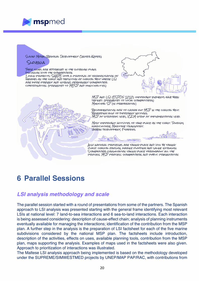
Slovenia can count on relevant previous experiences on LSI analysis and management namely within SHAPE project where harmonization of regimes in 100-meter coastal belt has been considered (requirements of article 8 of the ICZM protocol); within the ESPON 2020 Cooperation Programme; and within the Municipal Spatial Plans (preparation in course). LSI is integrated in the MSP plan, when considering the coastal strip, as guideline and recommendations for the spatial planning units. Key LSI issues in Slovenia are both linked to human activities: coastal tourism, mariculture, maritime transport, fisheries, urban development, as well as to natural processes: coastal erosion, marine flooding and saline intrusion.
20
6 Parallel Sessions LSI analysis methodology and scale The parallel session started with a round of presentations from some of the partners. The Spanish approach to LSI analysis was presented starting with the general frame identifying most relevant LSIs at national level: 7 land-to-sea interactions and 6 sea-to-land interactions. Each interaction is being assessed considering: description of cause-effect chain; analysis of planning instruments eventually available for managing the interactions; identification of the contribution from the MSP plan. A further step in the analysis is the preparation of LSI factsheet for each of the five marine subdivisions considered by the national MSP plan. The factsheets include introduction, description of the activities, effects on uses, available planning tools, contribution from the MSP plan, maps supporting the analysis. Examples of maps used in the factsheets were also given. Approach to prioritization of interactions was illustrated. The Maltese LSI analysis approach being implemented is based on the methodology developed under the SUPREME/SIMWESTMED projects by UNEP/MAP PAP/RAC, with contributions from

21
all partners. The process is still in the early stages with main LSIs being identified based on analysis of uses and activities and supported by thematic maps. In Italy the LSI analysis approach has been based on existing guidelines and experiences at EU level (DG Mare Factsheet, ESPON study), at Mediterranean level (SUPREME/SIMWESTMED) and at national level (CAMP Italy). The methodology is articulated in four steps: (1) Identification of main territorial elements (done); (2) Identification and mapping of factors determining LSI (anthropogenic activities and natural processes generating interactions) (done); (3) Identification and prioritization of interactions (LSI and SLI, natural and anthropogenic, present and future) and identification of hotspots areas for LSI (Done); (4) In-depth analysis of hot-spot areas and identification of measures to be included in MSP plan. Regarding the scale considered for LSI analysis, a nested-approach has been adopted, with a first, general analysis at marine area scale (Italy is preparing 3 marine plans for the three marine areas under national sovereignty). The result of the first stage analysis brings to the identification of hot-spot areas, which are then analysed in a greater detail. The analysis has been supported by the use of maps, illustrating natural and anthropogenic factors determining LSIs. Finally, LSI prioritization approach was illustrated, based on expert judgement and scoring the relevance of the interactions for each of the main uses of the area (including natural and cultural heritage protection). During the discussion several questions, were addressed on diverse topics, like for example the way the other existing EU directives have been taken into consideration, the time horizon used for the analysis, the eventual interactions with stakeholders. The discussion highlighted how LSI methodologies, in order to be practically applicable to MSP processes, have to be tailored on national specificities such as the overall structure of MSP plans, the planning process organization, data availability, time constraints, etc. Capitalization of existing approaches is recommended to save effort and time, but original approaches also work well. In general, expert judgment is a commonly used assessment tool in LSI analysis. One main challenge is represented by the scale of analysis: in principle, different scales should be considered and coherence of analysis (and measures identification) should be ensured between different scales. Local scale is very important for LSI: most of the interactions are evident at local scale and, very importantly, engagement of local stakeholders and communities is crucial to guarantee the feeling of “ownership of the territory” is considered and respected. Across the Mediterranean much experience is available on LSI management in the framework of ICZM: this experience should be capitalized as much as possible in LSI for MSP. Finally, it was recommended that any LSI analysis should capitalize on knowledge and data, measures identified and implementation experience available from other legislation / planning contexts: River Basin Management Plans (Water Framework Directive), Program of Measures (Marine Strategy Framework Directive), Flood Risk Management Plans (Floods Directive) and other national, regional (sub-national) and local planning instruments.

22
LSI key natural and anthropogenic drivers and pressures: identification and management Objectives of this parallel session were to emphasise key LSI drivers identified in each country of the project and to a certain extent, to discuss approaches to manage them appropriately. Participants agreed on the importance of the local level when analysing interactions between land and sea. It was widely recognised that local scale was the most appropriated to assess LSI, both considering uses conflicts or interactions between uses and environment. Therefore, LSI can vary significantly depending on the location of the region and the type of coastal area considered: urban or natural coast, type of coast (islands, estuaries, lagoon), areas subject to erosion or flooding. These specificities have to be taken into account in the LSI management. It appeared that the main drivers identified through the different MSP implementation experiences are mostly the same between different Mediterranean countries represented at the workshop:
- Coastal artificialisation, either due to urban development or coastal protection, is raised by all partners as a major LSI driver in their Mediterranean coasts. It leads to biodiversity loss, landscape deterioration, alteration of coastal dynamics creating erosion phenomenon and can reinforce land-based pollutants and litters inputs by the increase of watershed runoffs.

23
- Coastal tourism is also an important driver shared by all countries. It amplifies facilities needs leading to coastal artificialisation and the growing population induced during summer period raise the level of pollution and litters inputs. Moreover, coastal leisure activities are sources of environmental impacts on coastal habitats and species.
- Aquaculture is an important sector in coastal blue economy development for several countries (Greece, France). This activity requires fixed space allocation, the most often close to the shore, and coastal facilities and therefore is an important LSI driver.
- Maritime transport is also an activity linking sea with land, particularly with harbour development and connexion with the hinterland going far from the coasts. Slovenia raised this driver with the port of Koper (one of the main port of the Adriatic) which has a dedicated spatial plan to fulfil its needs that have to be integrated into the MSP framework.
- Marine Renewable Energy production, mostly windfarms, was pointed out by France and Greece as a significant LSI driver when considering cables to connect with land and related harbour activity. It could also raise landscape issues with coastal populations.
Conversely, some drivers were emphasised by few partners. Agriculture, obvious LSI drivers due to pollutants and nutrients runoff, doesn’t seem to be of the main interaction factors in the Mediterranean and eutrophication doesn’t appear as an issue. Fisheries were little pointed out as a driver of LSI. Greece stressed it out as a source of pressure for marine biodiversity and France pointed out the need to manage fishing of euryhaline fishes, species that move between sea and rivers along their lifecycle. A major challenge that emerges when addressing LSI key drivers and related issues in a concerted integrated approach such as MSP is that legal and management frameworks take place at different scales, they are often disjoint between land and sea and are sector based. To overcome these challenges, it is fundamental to push for integration when analysing and sharing issues with stakeholders. Then, specific issues can be tackled through sectorial approaches and measures at different scales. It has also been raised that LSI are constantly evolving, particularly in the context of climate change and coastal population densification. Monitoring and access to adequate data are crucial aspects of LSI management.

24

25
Interaction and integration of LSI analysis for MSP with other planning and management instruments (WFD, ICZM, Coastal risk management, Urban and land planning, etc) During the parallel session some of the partners involved presented how each country is managing and integrating LSI analysis for MSP with their existing spatial plans (also on land/coastal areas) and instruments. The existing spatial planning in the Italian approach is addressed in the fourth phase of LSI analysis defined as “Planning: vocations, specific objectives, measures” and it has been divided into two main contexts: national planning and regional-local planning. The plans identified at the national scale mainly include management, regulative and strategic plans concerning hydrographic district, energy, climate, tourism, aquaculture, national interest sites, and logistic issues. Meanwhile, at the regional-local scale more specific items such as transports, landscape plans, regional interest sites, operational plans for ports, MPAs management and ICZM have been considered. All have been spatialized and mapped to understand the possible interactions between them and to identify the role MSP will play.

26
A matrix has also been set up in which the most relevant hot-spot area interactions have been listed and analysed according to legislative criteria, identifying the specific goals that these interactions are intended to achieve. In France the importance of the scale was stressed and, in particular, the small scale for local planning. To enhance the effectiveness and integration of LSI for MSP, a local development project should be considered which allows to identify local stakeholders that should be involved during the process. In Greece the main challenge underlined, was the reconstruction of spatial planning considering to establish relationships between normative regulation and strategic guidance linking planning and management, particularly important for maritime and coastal areas which require adapting decision making. It is important to focus on the specificities and peculiarities of certain areas.In Spain, starting from the general frame of Land-Sea interactions, the main issue behind the impact of maritime activities in the surroundings of coastal cultural and historical heritage was highlighted. The instruments available for cultural heritage at the National level are based on Spanish law which establishes: the guiding principles for designation and protection, the special value sites designed as “BIC” and defining the Regional Authorities as competent for establishing the inventories of BIC and Protection Plan. Between National and Regional levels, a gap has been identified: Regional Authorities have no power to protect cultural heritage beyond the terrestrial domain which establishes limitations for maritime activities. MSP proposal may provide, in the surrounding of certain BICs, protection measures against maritime activities, and stresses that new activities with negative impact in the landscape must be outside the zone of visual influence. Finally, the choice of these areas should be based on an agreement between the regional government and local stakeholders. The Maltese MSP process experience underlined the lack of integration between plans. The role of MSP, indeed, “shouldn’t be a stand-alone plan, rather the key able to connect and interact with all the different plans operating in the marine area.” Sharing the approaches of different countries has brought out key aspects for integration and roles of MSP within existing planning processes. The reference scale on which to carry out the analysis and intervene is certainly the first aspect to address. The local scale is a dimension that allows not only to identify the real needs and problems, but to create above all a functional network of local stakeholders as well as those directly interested in the process. As expressed previously, the number of plans and programs in place often present a lack of integration between them. This gap could be filled through the decisive role of MSP.

27

28
7 Discussion & conclusion The general aim of an LSI analysis is to inform the planning process through the identification of the key elements about processes linking the land and marine areas that need to be considered when planning the sea space. The MSP Directive requires that LSI are taken into account to promote sustainable and integrated development and management of human activities at sea. For this reasons alignment between maritime and terrestrial spatial planning should be achieved through consistency of policies, plans and decisions. The main goal of this second workshop was to exchange information on the different approaches undertaken for LSI analysis in the national marine planning processes. Ultimately this could help capitalizing from other experiences and setting the ground for cross-border consultation encompassing also LSI components.

29
During the discussion and conclusion of the workshop, three main LSI components were considered as fundamental for a coherent and correct analysis and for the integration in national MSP process and could be summarized as follows:
- Quantity and quality of information and data - Scale of analysis - Involvement of stakeholders
Data and information on LSI was underlined as fundamental especially during the first phases of analysis. Having enough information from both land and sea areas useful for a concrete LSI analysis was expressed as challenging. Also economic and environmental information needs to be compared with other planning or management indicators (such as water quality, WFD). It was also evidenced how difficult it is to know how many sectors and industries at land are linked to the sea in general. There is the need to gather more focused information and data and facilitate communication between planning and management instruments (even if integration is complex). The reference scale of analysis was also a highly debated topic and is certainly one of the first aspects to be addressed. The local scale was underlined as a dimension that allows not only to identify the real needs and problems, but to create above all a functional network of local stakeholders, as well as those directly interested in the process. On the other hand, the MSP process gives the opportunity to adopt an integrated national and, above that, regional approach to LSI that should harmonize different local decisions and management instruments. Many LSI issues cannot be addressed just at local scale but from overarching planning instruments such as MSP. To this respect, the role of regional administrations in this process is fundamental. Moreover, in many cases maritime activities have significant landward footprints and impacts that extend beyond the local level, and have regional, national and international reach. Things that happen very far from the coast can have huge impacts. Involvement of stakeholders was also much discussed. It was underlined how the ownership of local stakeholders is fundamental for achieving a real integration of LSI in an MSP process. Also regional and national stakeholders need to be included in an LSI analysis to achieve coherence between the different scales. The scale of governance and sectorial planning needs to be addressed properly in order to involve all relevant actors in the process, especially when considering sectors that have no direct relation with the maritime space (in-land agriculture). In the end the result is a very complex landscape with diverse stakeholders with different competences to be involved. The role of local governments which held all the competences of land and urban planning and how to transfer the needs of the sea to these stakeholders were also discussed. Ocean literacy could be a tool to educate the civil society in understanding the overall interconnections that all human activities have with the sea. There are numerous factors and sectorial policies that shape development on both land and sea, all of which should ideally be considered in an integrated planning process. Land and sea are basically connected via complex interactions and these interactions often influence people’s livelihoods, economies and wellbeing. Any strict division between land and sea domains, planning frameworks, and binaries is essentially an “artificial” construct that follows political-administrative

30
demarcations and priorities. But planning at land and sea is often divided between different government departments and agencies, reflecting the characteristics of particular country contexts. This results in complex governance settings that are further complicated by the need for cross-border coordination. In the end LSI analysis does not have a single answer and should be highly context based, involving all relevant stakeholders in a multi-scalar approach.

31
8 References DG-ENVIRONMENT 2018. Land-Sea Interaction in Maritime Spatial Planning.
EU MSP PLATFORM 2017. Maritime Spatial Planning: Addressing Land-Sea Interaction. A briefing paper (MSP Conference, Malta 15- 16 June 2017).
ESPON 2019. MSP-LSI - Maritime spatial planning and land-sea interactionsSIMWESTMED PROJECT 2018. Relationship between LSI and ICZM. Deliverable C 1.3.1.4.
SUPREME PROJECT 2018. How to perform analysis of land-sea interactions, combining MSP and ICZM in the considered project area. Deliverable 1.3.7
European Environmental Agency (EEA), 1999. Environmental indicators: Typology and overview, Technical report No 25/1999, pp. 19, available at https://www.eea.europa.eu/publications/TEC25 (accessed at 16/10/20)
Co-Evolve Project: Threats to co-evolution in touristic areas - Mediterranean scale: Land-Sea uses and land-sea interactions

32
Annex:LSIdriversaccordingtotheconceptualisationproposedbytheCAMPItalyProject