D C MINERALOGÍA Y - antoniojordan.weebly.com · xiii COLABORACIONES De forma paralela a la...
182
-
Upload
vuongkhanh -
Category
Documents
-
view
214 -
download
0
Transcript of D C MINERALOGÍA Y - antoniojordan.weebly.com · xiii COLABORACIONES De forma paralela a la...

DEPARTAMENTO DE CRISTALOGRAFÍA,
MINERALOGÍA Y QUÍMICA AGRÍCOLA
STUDY ON THE IMPACT OF WILDFIRES IN
WATER REPELLENCY FROM MEDITERRANEAN
SOILS (SOUTH-WESTERN ANDALUSIA)

DEPARTAMENTO DE CRISTALOGRAFÍA,
MINERALOGÍA Y QUÍMICA AGRÍCOLA
STUDY ON THE IMPACT OF WILDFIRES IN
WATER REPELLENCY FROM MEDITERRANEAN
SOILS (SOUTH-WESTERN ANDALUSIA)
Memoria que presenta D. Ángel J. Gordillo Rivero para optar al Grado de Doctor por la Universidad de Sevilla


DEPARTAMENTO DE CRISTALOGRAFÍA,
MINERALOGÍA Y QUÍMICA AGRÍCOLA
STUDY ON THE IMPACT OF WILDFIRES IN WATER REPELLENCY FROM
MEDITERRANEAN SOILS (SOUTH-WESTERN ANDALUSIA)
El autor
Ángel J. Gordillo Rivero
Los directores
Antonio Jordán López Lorena Martínez Zavala
Sevilla, 2014


DISTINCIONES OBTENIDAS DURANTE LA REALIZACIÓN DE LA TESIS DOCTORAL:
2013. Young Scientist’s Travel Award. European Geosciences Union. Viena, Austria. 2013. Grant for applicant FESP IV. 4th International Meeting of Fire Effects on Soil
Properties. Vilnius, Lituania.
PUBLICACIONES
Parte de los resultados obtenidos durante la realización de la presente tesis doctoral han sido publicados en los siguientes trabajos:
ARTÍCULOS
García-Moreno J, Gordillo-Rivero AJ, Gil J, Jiménez-Morillo NT, Mataix-Solera J, González-Peñaloza FA, Granged AJP, Bárcenas-Moreno G, Jiménez-Pinilla P, Lozano E, Jordán A, Zavala LM. 2013. Do stones modify the spatial distribution of fire-induced soil water repellency? Preliminary data. Flamma 4, 76-78.
Gordillo-Rivero AJ, García-Moreno J, Jordán A, Zavala LM. 2013. Monitoring fire impacts in soil water repellency and structure stability during 6 years. Flamma 4, 71-75.
Gordillo-Rivero AJ, García-Moreno J, Jordán A, Zavala LM, Granja-Martins FM. 2013. Fire severity and surface rock fragments cause patchy distribution of soil water repellency and infiltration rates after burning. Hydrological Processes. DOI: 10.1002/hyp.10072.
Gordillo-Rivero AJ, García-Moreno J, Jiménez-Morillo NT, Jordán A, Zavala LM, Pereira P, Mataix-Solera J, Granja-Martins FM, Neto-Paixão HM. 2014. Stones resting on the top soil cause heterogeneous patterns of fire-induced water repellency. Flamma 5, 66-70.
Gordillo-Rivero AJ, García-Moreno J, Zavala LM, Jordán A, Granged AJP, Gil J. 2014. Postfire evolution of water repellency and aggregate stability in Mediterranean calcareous soils: a 6-year study. Catena 118, 115-123.
TRABAJOS EN CONGRESOS
García-Moreno J, Gordillo-Rivero AJ, Gil J, Jiménez-Morillo NT, Mataix-Solera J, González-Peñaloza FA, Granged AJP, Bárcenas-Moreno G, Jiménez-Pinilla P, Lozano E, Jordán A, Zavala LM. 2012. Do stones modify the spatial distribution of fire-induced soil water repellency? Preliminary data In: IV Reunión Internacional de FUEGORED (FUEGORED2012). Puerto de la Cruz, Tenerife.

xii
García-Moreno J, Gordillo-Rivero AJ, Zavala LM, Jordán A, Pereira P. 2013. How much mulch? No tillage and mulching practices contribute to enhanced soil water repellency. EGU2013 (Viena, Austria). Geophysical Research Abstracts 15, EGU2013-916.
García-Moreno J, Gordillo-Rivero AJ, De Celis R, Granged AJP, Jordán A, Zavala LM. 2014. Impacto de la cobertura de cenizas sobre la erosión por salpicadura tras un incendio experimental. V Reunión Internacional de FUEGORED (FUEGORED2014). Barcelona-Solsona.
García-Moreno J, Gordillo-Rivero AJ, Zavala LM, Jordán A. 2014. Intra-aggregate distribution of soil water repellency in Mediterranean forest soils. EGU2014 (Viena, Austria). Geophysical Research Abstracts 16, EGU2014-978.
Gordillo-Rivero AJ, García-Moreno J, Jordán A, Zavala LM. 2012. Monitorización del impacto del fuego en la repelencia al agua y la estructura del suelo durante 6 años In: IV Reunión Internacional de FUEGORED (FUEGORED2012). Puerto de la Cruz, Tenerife.
Gordillo-Rivero AJ, García-Moreno J, Bárcenas-Moreno G, Jiménez-Morillo NT, Mataix-Solera J, Jordán A, Zavala LM. 2013. Rock fragments induce patchy distribution of soil water repellency in burned soils. EGU2013 (Viena, Austria). Geophysical Research Abstracts 15, EGU2013-938.
Gordillo-Rivero AJ, García-Moreno J, Jiménez-Morillo NT, Jordán A, Zavala LM, Pereira P, Mataix-Solera J. 2013. Stones resting on the top soil cause heterogeneous patterns of fire-induced water repellency. Fire Effects on Soil Properties (FESP4) (Vilnius, Lituania).
Gordillo-Rivero AJ, García-Moreno J, Zavala LM, Jordán A, Granged AJP, Gil J. 2013. Medium-term evolution of water repellency and aggregate stability in Mediterranean calcareous soils after wildfire. EGU2013 (Viena, Austria). Geophysical Research Abstracts 15, EGU2013-899.
Gordillo-Rivero AJ, García-Moreno J, De Celis R, Granged AJP, Jordán A, Zavala LM. 2014. Monitorización de la erosión por salpicadura tras un incendio experimental en un suelo bajo matorral mediterráneo. V Reunión Internacional de FUEGORED (FUEGORED2014). Barcelona-Solsona.
Gordillo-Rivero AJ, García-Moreno J, Jordán A, Zavala LM. 2014. Effects of rock fragments on water dynamics in a fire-affected soil. EGU2014 (Viena, Austria). Geophysical Research Abstracts 16, EGU2014-973.
Jordán A, Zavala LM, García-Moreno J, Gordillo-Rivero AJ, Granged AJP, Gil J. 2014. Impacto de la retirada de madera quemada sobre las propiedades físicas, químicas e hidrológicas de suelos calcáreos afectados por el fuego. V Reunión Internacional de FUEGORED (FUEGORED2014). Barcelona-Solsona.

xiii
COLABORACIONES
De forma paralela a la realización de la tesis doctoral, se han realizado las siguientes colaboraciones:
ARTÍCULOS
García-Moreno J, Gordillo-Rivero AJ, Zavala LM, Jordán A, Pereira P. 2013. Mulch application in fruit orchards increases the persistence of soil water repellency during a 15-years period. Soil & Tillage Research 130, 62-68.
Jordán A, García-Moreno J, Gordillo-Rivero AJ, Zavala LM, Cerdà A. 2014. Organic carbon, water repellency and soil stability to slaking under different crops and managements: a case study at aggregate and intra-aggregate scales. SOIL Discussions 1, 295-325.
Zavala LM, García-Moreno J, Gordillo-Rivero AJ, Jordán A, Mataix-Solera J. 2014. Natural soil water repellency in different types of Mediterranean woodlands. Geoderma 226-227, 170-178.
PARTICIPACIONES EN CONGRESOS
García-Moreno J, Gordillo-Rivero AJ, Aguirre I, Pajuelo P, Carmona I, Zavala LM, Jordán A. 2011. Mineralization of two organic fertilizers in organic cotton sustainable cropping systems V Simposio Nacional sobre Control de la Degradación y Uso Sostenible del Suelo. Sociedad Española de la Ciencia del Suelo. Murcia.
García-Moreno J, Gordillo-Rivero AJ, Zavala LM, Jordán A, Pereira P. 2013. How much mulch? No tillage and mulching practices contribute to enhanced soil water repellency. EGU2013 (Viena, Austria). Geophysical Research Abstracts 16, EGU2013-916.
García-Moreno J, Gordillo-Rivero AJ, Zavala LM, Jordán A. 2014. Intra-aggregate distribution of soil water repellency in Mediterranean forest soils. EGU2014 (Viena, Austria). Geophysical Research Abstracts 16, EGU2014-978.
Mataix-Solera J, Zavala LM, Arcenegui V, Jordán A, Lozano E, Gordillo-Rivero AJ, Jiménez-Pinilla P, García-Moreno J. 2013. La repelencia al agua en el suelo: una propiedad más común de lo que pensábamos. 29 Reunión de la Sociedad Española de las Ciencias del Suelo. SECS 2013. Mallorca.

xiv
xv
AGRADECIMIENTOS
Estas líneas, que ya con la tesis a punto de llegar a su fin comienzo a escribir, son las que más noches han dado vueltas en mi cabeza. Y es que, afortunadamente, es mucha la gente que ha pasado por mi camino, y mucha la que sigue estando. Y son parte de lo que ha hecho que este aquí ahora.
Desde los primeros amigos, esos de “toda la vida” que, aunque el destino nos haya alejado, siguen ahí. Tras estos, en el instituto, llegaron otros, que formaron una segunda familia, y que lo siguen siendo: José, Nacho, Bea, Espe, Odil, Belén, Andrés… y alguno que me dejo detrás. Pero no a Javi, que vivió tan deprisa que tuvo que marcharse, aunque sigue siendo alma de esta “familia trianera”.
Siguiendo el orden “cronológico”, la universidad trajo nuevas experiencias, y nuevos amigos. Y ahí siguen en mi día a día: Pedro, Meme, Juan, Felipe, Loli, José, Rafa, Ignacio, Miriam, Dani, Mode, Marisol, Virginia, mis amigos de “Los Estudiantes” y “El Cachorro”… estos y otros que me vuelvo a dejar atrás.
A uno de “estos amigos” no sé en que grupo meterlo, si universidad o familia. Por eso lo pongo aquí, en medio. Y cualquiera que nos conozca ya sabe de quién hablo. Jorge es una especie de hermano con sus cosas buenas y malas. Con él empecé la carrera, y la terminé, empezamos los masters y los terminamos, y aunque parezca mentira, comenzamos la tesis y ahora la terminamos. Vamos, que a los curriculums se les cambia la foto y casi nos valen. Los zipi-zape.
Al terminar la carrera y comenzar en este mundo de la ciencia, se abría una nueva etapa que traería nueva gente. Todo empezó con Itziar, Puri, Antonio y Lorena (Universidad de Sevilla). Y con los dos últimos, Antonio y Lorena, continúa hasta el día de hoy. Quién lo iba a decir. Sin ellos nada de esto habría sido posible. La verdad es, que me quedo un poco atascado, ya que todo lo que diga de ellos es poco. Directores-amigos, compañeros-directores, no me queda claro. Solo Gracias.
Cómo no, el Cerdocarpa Team. A Miriam (University of Western Australia) la conocí en el primer congreso al que fui a presentar un trabajo, y hubo una gran conexión, que sigue manteniéndose a día de hoy, a pesar de la lejanía. Al poco tiempo fue apareciendo más gente, como Nicolás Bellinfante (Universidad de Sevilla), que aunque él se iba cuando nosotros llegábamos, aprendimos a respetarlo y a admirarlo por boca de Antonio y Lorena. Arturo J.P. Granged (Universidad de Sevilla), quién iba a decir que de ser el profesor de Física pasaríamos a estar codo con codo “liándola” en el laboratorio y en el campo. Gema Bárcenas (Universidad de Sevilla), y nuestras aficiones en común. Félix y Esperanza, que, aunque cambiaron su camino, hicieron amenos los primeros años de campo y laboratorio. Poco después llegó Nica, con su colección de pañuelos a juego con

xvi
sus camisas. Reyes y Eli, con su alegría y sus ganas de aprender y de trabajar. Marco, acaparando la mesa del despacho. Y Sameh, dando el toque exótico al heterogéneo grupo.
Los congresos fueron haciendo que conociera a gente de la que estaba harto de leer artículos, como Artemi Cerdà (Universitat de València), Jorge Mataix y Vicky Arcenegui (Universidad Miguel Hernández), Jesús Notario (Universidad de La Laguna), Juan F. Murillo (Universidad de Málaga) y Paulo Pereira (Mykolas Romeris University). Y jóvenes con trayectorias paralelas a la mía pero de otros puntos geográficos, como las prusianas Pat Jiménez, Elena Lozano y Jorge Moltó (Universidad Miguel Hernández), Meritxell Alcañiz y Marcos Francos (Universitat de Barcelona), Jonay Neris (Swansea University), Paloma Hueso (Universidad de Málaga) y todos los miembros de FUEGORED.
En el ámbito familiar, quién le iba a decir a mi abuela que si hubiera aguantado hasta los ciento y poco habría podido verme defender mi tesis. Seguro que estaría feliz, y me repetiría eso que tan bien se me quedó de: “la cabeza es el único cortijo que nadie te puede quitar”. Que verdad esa.
Mis tíos y primos, unos más cerca que otros pero siempre ahí.
Carmen, que apareció en el peor momento de mi vida en el que podía hacerlo, y que ahora, comparte estos momentos de satisfacción.
Por último, en el día de hoy hay unas personas que están tan felices como yo, o más. Esas personas son: mi padre, mi hermana y Daniel. La Nena y Fátima son muy pequeñas para ser conscientes aun de esto. Pero por mucha felicidad y alegría que pueda tener en momentos como este, esta nunca será plena, ya que sin mi madre, parte de mí tampoco está. Ella estaría contenta y orgullosa como si me hubieran dado el premio Nobel.
Gracias a mis padres por esas frases de: “bueno, has suspendido este, pero en el próximo sacas mejor nota”, o “tú no te preocupes, tu trabajo es estudiar”. No me dejarán en herencia pisos y millones, pero sí una educación, una preparación y una cabeza, que, como decía mi abuela, es lo único realmente de uno mismo.
Finalmente agradecer a toda la gente que ha colaborado en este trabajo de una u otra forma: Antonio Jordán, Lorena M Zavala, Jorge García-Moreno, Artemi Cerdá, Nicasio Tomas Jiménez-Morillo, Jorge Mataix-Solera, Felix Ángel González-Peñaloza, Arturo J.P. Granged, Gema Bárcenas-Moreno, Patricia Jiménez-Pinilla, Elena Lozano, Juan Gil, Helena M. Neto-Paixão, Fernando M. Granja-Martins, Paulo Pereira, Nicolás Bellinfante, Antonio Roldán y Reyes de Celis (a esta última, especialmente). Eva Pérez, por tener el laboratorio siempre a punto y, Marisa Gago, por agilizar todos los trámites burocráticos siempre con una sonrisa.
El trabajo de la Red Temática Efectos de los Incendios Forestales en los Suelos (FUEGORED) ha facilitado enormemente la realización de esta tesis. En cuanto a la

xvii
financiación, los trabajos llevados a cabo para la realización de esta tesis doctoral han sido sufragados parcialmente por el Plan Nacional de Investigación del Ministerio de Ciencia e Innovación a través de los proyectos HYDFIRE (CGL2010-21670-C02-01) y GEOFIRE (CGL2012-38655-C04-01) y por las Ayudas a Consolidación de Grupos de la Junta de Andalucía (2011/RNM-364 y 2012/RNM-364).
Y por supuesto, una vez más, mis agradecimientos a Antonio y Lorena, que son mucho más que mis directores, y si no fuera por ellos, nada de esto habría sido posible.

xviii

xix
SUMMARY 1
RESUMEN 7
1 INTRODUCCIÓN 13
1.1 Efectos generales del fuego en los ecosistemas 19 1.1.1 Efectos sobre la vegetación 19 1.1.2 Efectos sobre los microorganismos 21 1.1.3 La ceniza 22 1.1.4 Efectos sobre las propiedades químicas del suelo 26 1.1.5 Efectos sobre las propiedades físicas del suelo 33 1.1.6 Efectos sobre los procesos hidrológicos y erosivos 36
1.2 Repelencia al agua del suelo inducida por el fuego 38 1.2.1 Antecedentes 38 1.2.2 Origen de la repelencia al agua 39 1.2.3 Principales consecuencias de la repelencia al agua 40 1.2.4 El impacto del fuego 41
2 OBJETIVOS 43
3 POST-FIRE EVOLUTION OF WATER REPELLENCY AND AGGREGATE STABILITY IN MEDITERRANEAN CALCAREOUS SOILS: A 6-YEAR STUDY. 47
3.1 Introduction 49
3.2 Methods 51 3.2.1 Study area and fire characteristics 51 3.2.2 Soil sampling and analysis 54 3.2.3 Data analysis 56
3.3 Results 56 3.3.1 Soil characteristics 56 3.3.2 Effect of fire on soil water repellency of sieve fractions 56 3.3.3 Effect of fire on aggregate stability of sieve fractions 60 3.3.4 Relation between aggregate stability and water repellency 63
3.4 Discussion 64 3.4.1 Immediate changes in soil water repellency 64 3.4.2 Evolution of soil water repellency in the postfire period 65

xx
3.4.3 Effects of pre-fire vegetation and lithology in soil water repellency and aggregate stability 66
4 DO STONES MODIFY THE SPATIAL DISTRIBUTION OF FIRE-INDUCED SOIL WATER REPELLENCY? AN EXPERIMENTAL APPROACH 69
4.1 Introduction 71
4.2 Methodology 71
4.3 Results and discussion 72
5 FIRE SEVERITY AND SURFACE ROCK FRAGMENTS CAUSE PATCHY DISTRIBUTION OF SOIL WATER REPELLENCY AND INFILTRATION RATES AFTER A FOREST FIRE 77
5.1 Introduction 79
5.2 Methods 81 5.2.1 Study area 81 5.2.2 Experimental design 82 5.2.3 Soil water repellency 85 5.2.4 Infiltration capacity 85 5.2.5 Data analysis 85
5.3 Results 86 5.3.1 Soil characteristics 86 5.3.2 Effects of fire severity on soil water repellency 86 5.3.3 Effect of rock fragments on soil water repellency 89 5.3.4 Effect of fire severity and rock fragments on infiltration rates 90
5.4 Discussion 93 5.4.1 Soil water repellency and fire severity 93 5.4.2 Effects of rock fragments on soil water repellency and infiltration after fire 93
6 WETTABILITY OF ASH CONDITIONS SPLASH EROSION AND RUNOFF RATES IN THE POSTFIRE 97
6.1 Introduction 99
6.2 Objectives 100

xxi
6.3 Material and methods 100 6.3.1 Experimental design 100 6.3.2 Soil analysis 103 6.3.3 Ash water repellency 104 6.3.4 Erosion splash 104 6.3.5 Rainfall simulation 106 6.3.6 Data analysis 107
6.4 Results and discussion 108 6.4.1 General description of soil 108 6.4.2 Ash water repellency 108 6.4.3 Splash erosion 110 6.4.4 Rainfall simulations 111
CONCLUSIONS 117
CONCLUSIONES 123
REFERENCIAS 129
ÍNDICE DE TABLAS Y FIGURAS - INDEX OF TABLES AND FIGURES 155

xxii

SUMMARY

SUMMARY
2
SUMMARY
3
Soil water repellency is a property of soils that has been deeply studied during the last two decades. Soil water repellency occurs as a consequence of hydrophobic organic substances in soils. These substances are released by plants, soil microbes and fungi, and, frequently, are the result of in situ transformations. It has been found that wildfires are a major cause of soil water repellency. Depending on fire severity, burning can induce water repellency in previously wettable soils, increase its intensity in previously water repellent soils or destroy it. Also, in some times, not appreciable effects are found, especially after low-severity fire.
The main effect of soil water repellency is a reduction of infiltration rates and the accumulation of ponded water on the soil surface. This has important hydrological and geomorphological consequences, as increased runoff rates and erosion risk, the development of preferential flow paths, nutrient leaching, impacts on soil aggregation and others that are discussed in the following sections.
Currently, we have a deep knowledge about these effects. A brief review of the current knowledge is carried out in chapter 1. OK, but… are there research gaps? There are some areas that need light to be shed on.
Most studies only consider short-term fire impacts, but very few research has been carried out about medium- or long-term impacts and evolution of fire-induces soil water repellency. In chapter 3, the post-fire evolution of fire-induced water repellency and some associated properties in calcareous Mediterranean soils is discussed during a 6-years period. Water repellency and aggregate stability are two soil properties generally modified after burning which show several hydrological and soil functioning consequences and that may be used as indices for assessing burn severity. Both properties are strongly related and have major impacts on soil functioning and post-fire hydrologic and geomorphological processes. In many cases, the impact of fire on these properties has been analyzed in the short term. However, it is also necessary to investigate the magnitude of these changes and their implications for longer periods under specific conditions. In this work, we have investigated [1] the fire-induced changes on soil water repellency and aggregate stability in the medium term (6-years period after burning) and its distribution within aggregate size fractions (1-2, 0.5-1 and 0.25-0.5 mm), [2] the relations between post-fire aggregate stability and water repellency, and [3] the interactions between aggregate stability, water repellency and different factors (site, time since burning, lithology and vegetation type) in Mediterranean calcareous soils. Five areas burned during summer 2006 in southern Spain were selected for this study. The study sites were characterized by wettable or slightly water-repellent calcareous soils with loam to clayey texture under herbaceous vegetation and

SUMMARY
4
shrubs. Soils were characterized chemically and physically, while the water repellency and aggregate stability of the fine earth and aggregate sieve fractions were determined annually between 2006 and 2011. Results show that soil water repellency was induced in previously wettable or enhanced in slightly or moderately water-repellent calcareous soils after moderate severity burning. Severity of water repellency from finer aggregates (0.5-1 and 0.25-0.5 mm) varied or remained stable but did not contribute to general soil water repellency assessed in the fine earth fraction. aggregate stability was slightly increased in some cases, and both properties returned progressively to pre-fire conditions during the study period. Soil resilience to low-moderate severity burning in the study area was very high.
The relation between soil water repellency and surface elements (as ash of rock fragments) has been rarely considered in scientific literature. In the case of rock fragments, only some papers have been published, but not considering the impact of stones on the development of water repellency during fire. These aspects are discussed in chapters 4 and 5. In chapter 4, the occurrence and spatial distribution of soil water repellency and its consequences on soil structure after experimental burning in a previously wettable soil under different stone covers (0, 15, 30, 45 and 60%) is carried out. In our experiment, burning induced critical or subcritical soil water repellency in the upper millimetres of previously wettable soil. Fire-induced soil water repellency did not vary with stone cover, but critical soil water repellency was reached in inter-stone soil areas. At stone-covered soil areas, soil water repellency was increased, but WDPTs remained mostly below the 5 s threshold.
In chapter 5, the study of the impacts of fire severity and rock fragments is carried out. In this research, we have studied the effect of rock fragments on the strength and spatial distribution of fire-induced soil water repellency at different fire severities. A fire-affected area was selected for this experiment and classified into different zones according to fire severity (unburned, low, moderate and high) and rock fragment cover (low, <20%, and high, >60%). During 7 days after fire, soil water repellency and infiltration rates were assessed in the soil surface covered by individual rock fragments and in the midpoint between two adjacent rock fragments (with maximum spacing of 20 cm). Soil water repellency increased with fire severity. Rock fragments resting on the soil surface increased the heterogeneity of the spatial distribution of fire-induced soil water repellency. Soil water repellency increased significantly with rock fragment cover in bare areas under moderate and high fire severity, but quantitatively important changes were only observed under high fire severity. In areas with a low rock fragment cover, water repellency from soil surfaces covered by rock fragments increased relative to bare soil surfaces, with

SUMMARY
5
increasing soil water repellency. In areas with a high rock fragment cover, soil water repellency increased significantly from non-covered to covered soil surfaces only after low-severity burning. Rock fragment cover did not affect infiltration rates, although it decreased significantly in soil surfaces after high-severity burning in areas under low and high rock fragment cover.
Only very recently, the study of the impacts associated to ash have been studied in depth. An ash layer may act ephemerally as a physical protection for rainfall-induced soil erosion processes. Its influence on runoff and infiltration dynamics have been largely discussed. But little or very scarce information is available about its effects on raindrop splash erosion risk. The effect of wettable and water repellent ash layers after an experimental fire on splash erosion are discussed in chapter 6.

SUMMARY
6

RESUMEN

RESUMEN
8
RESUMEN
9
La repelencia al agua del suelo es una propiedad que se ha estudiado profundamente durante las últimas dos décadas. La repelencia al agua del suelo se produce como consecuencia de las sustancias orgánicas hidrófóbicas en los suelos. Estas sustancias son liberados por las plantas, la fauna microbiana y los hongos del suelo, y, con frecuencia, son el resultado de transformaciones in situ. Se ha observado que los incendios forestales son una causa importante de repelencia al agua del suelo. Dependiendo de la severidad del fuego, la combustión puede inducir repelencia al agua en los suelos previamente humectables, aumentar su intensidad en los suelos previamente repelentes al agua o destruirla. También, en ciertos casos, no se encuentran efectos apreciables, especialmente después de un fuego de baja severidad.
El principal efecto de la repelencia al agua del suelo es una reducción de las tasas de infiltración y la acumulación de agua en la superficie del suelo. Esto tiene importantes consecuencias hidrológicas y geomorfológicas, como el aumento de las tasas de escorrentía y el riesgo de erosión, el desarrollo de vías de flujo preferencial, el lavado acelerado de nutrientes, así como impactos sobre la agregación del suelo y otras propiedades que se discuten en las siguientes secciones.
En la actualidad, tenemos un conocimiento profundo acerca de estos efectos. Una breve revisión de los conocimientos actuales se lleva a cabo en el capítulo 1. Bien, pero... ¿qué lagunas hay en la investigación? Hay algunas áreas que presentan aún interrogantes.
La mayoría de los estudios sólo consideran los impactos del fuego a corto plazo, pero muy pocas investigaciones se han llevado a cabo sobre los impactos y evolución de la repelencia al agua inducida por el fuego a medio o largo plazo. En el capítulo 3, se discute la evolución de la repelencia al agua inducida por el fuego y algunas propiedades asociadas en suelos mediterráneos calcáreos durante un período de 6 años. La repelencia al agua y la estabilidad de los agregados son dos propiedades del suelo generalmente modificadas después del fuego, que muestran varias consecuencias sobre los procesos hidrológicos y geomorfológicos y que, por tanto, pueden ser utilizadas como índices para evaluar la severidad del incendio. Ambas propiedades están fuertemente relacionadas entre sí y tienen un gran impacto. En muchos casos, el impacto del fuego en estas propiedades ha sido analizado a corto plazo. Sin embargo, también es necesario investigar la magnitud de estos cambios y sus implicaciones para períodos más largos en condiciones específicas. En este trabajo se han investigado [1] los cambios inducidos por el fuego en la repelencia al agua del suelo y la estabilidad de los agregados en el medio

RESUMEN
10
plazo (período de 6 años después de la quema) y su distribución dentro de fracciones de tamaño de agregado (1-2, 0.5-1 y 0,25-0,5 mm), [2] las relaciones entre la estabilidad de agregados y la repelencia al agua en el postincendio, y [3] las interacciones entre la estabilidad de agregados, repelencia al agua y diferentes factores (lugar, tiempo transcurrido, litología y tipo de vegetación) en suelos calcáreos mediterráneos. Para ello, se seleccionaron cinco áreas quemadas durante el verano de 2006 en el sur de España. Los sitios de estudio se caracterizan por la presencia de suelos calcáreos, humectables o ligeramente hidrofóbicos, con textura franca a francoarcillosa y con vegetación predominantemente herbácea y arbustiva. Los suelos se caracterizaron química y físicamente, mientras que la repelencia al agua y estabilidad de los agregados de la fracción de tierra fina y diferentes fracciones de tamaño agregados se determinaron anualmente entre 2006 y 2011. Los resultados muestran que fuego de severidad moderada indujo o intensificó ligeramente la repelencia al agua del suelo. La severidad de la repelencia al agua en agregados finos (0.5-1 y 0.25-0.5 mm) se mantuvo estable en el postincendio, pero en general no contribuyó a la repelencia al agua del suelo determinada en la fracción de tierra fina. La estabilidad de los agregados se incrementó ligeramente en algunos casos, y ambas propiedades regresaron progresivamente a las condiciones pre-fuego durante el período de estudio. La capacidad de recuperación del suelo tras fuegos de severidad baja o moderada en el área de estudio fue muy alta.
La relación entre la repelencia al agua del suelo y de los elementos de superficie (como cenizas de fragmentos de roca) ha sido raramente considerada en la literatura científica. En el caso de las piedras, sólo se han publicado algunos trabajos, pero no han tenido en cuenta el impacto de las piedras en el desarrollo de la repelencia al agua durante un incendio. Estos aspectos se discuten en los capítulos 4 y 5 En el capítulo 4 se estudia la aparición y la distribución espacial de la repelencia al agua del suelo y sus consecuencias sobre la estructura del suelo después de un incendio experimental en un suelo previamente humectable bajo diferentes coberturas de piedra (0, 15, 30, 45 y 60%). El fuego indujo repelencia crítica o subcrítica al agua en los primeros milímetros de profundidad. La repelencia al agua no varió con la cobertura de piedras, pero sí se observó la aparición de repelencia subcrítica en la superficie de suelo no cubierta por piedras.
En el capítulo 5 se lleva a cabo el estudio de los impactos de la severidad del fuego y las piedras tras un incendio forestal, así como el efecto de la severidad del fuego. Para ello se establecieron diferentes zonas experimentales en función de la severidad del fuego (no quemado, baja, moderada y alta severidad) y la cobertura de piedras (baja, <20%, y la alta,> 60%). Durante 7 días después del incendio se
RESUMEN
11
evaluaron la repelencia al agua del suelo y las tasas de infiltración en áreas cubiertas por piedras y en el punto medio entre dos piedras adyacentes con separación máxima de 20 cm. Se observó que la repelencia al agua del suelo aumenta con la severidad del fuego. Los fragmentos de roca que descansan sobre la superficie del suelo contribuyeron a aumentar la heterogeneidad de la distribución espacial de la repelencia al agua inducida por el fuego. Se observó también que la repelencia al agua del suelo aumentó de forma significativa con la cobertura de piedras en áreas desnudas (entre piedras adyacentes) bajo fuego de severidad moderada y alta, aunque cambios cuantitativamente importantes únicamente se observaron tras fuego de alta severidad. En las zonas cubiertas por piedras, la repelencia al agua aumentó en función de la cobertura. En las zonas bajo alta cobertura de piedras, la repelencia al agua del suelo aumentó considerablemente en las zonas cubiertas respecto a las no cubiertas por piedras sólo bajo fuego de baja severidad. La cobertura de piedras no afectó las tasas de infiltración, a pesar de que disminuyó significativamente en la superficie del suelo después de fuego de alta severidad en las áreas bajo cobertura baja o alta de piedras.
Sólo muy recientemente se han realizado estudios en profundidad sobre el impacto asociado a la presencia de ceniza. Una capa de ceniza puede actuar como una protección física efímera frente a procesos de erosión hídrica. Su influencia sobre la dinámica de la escorrentía e infiltración se ha discutido ampliamente, pero existe poca o muy escasa información disponible sobre sus efectos sobre la erosión por salpicadura. En el capítulo 6 se discute el efecto de la presencia de ceniza humectable o repelente al agua después de un incendio experimental sobre la intensidad de la erosión por salpicadura.

RESUMEN
12

1 INTRODUCCIÓN

CAPÍTULO 1
14
INTRODUCCIÓN
15
Los incendios forestales producen algunos de los impactos más profundos en los ecosistemas (Pausas et al., 2008), afectando la vegetación, los suelos, la fauna y los recursos de las cuencas hidrográficas. En la zona Mediterránea, el fuego es un factor que influye en la formación y dinamismo de los paisajes, los ecosistemas y la vegetación de los mismos (Saura-Mas y Lloret 2010; De la Rosa et al., 2008), produciendo problemas socio-económicos en todo el mundo (Barreiro et al., 2010). El fuego está considerado como uno de los mayores factores de transformación medioambiental de los ecosistemas (FAO, 2007). Por esta razón, se debe ser consciente de que su aparición no supone una catástrofe, sino que constituye un factor más que contribuye a modelar el paisaje y la vegetación a lo largo de los años (Pausas et al., 2008).
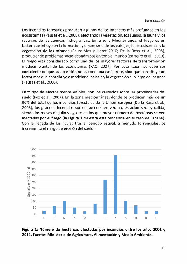
Otro tipo de efectos menos visibles, son los causados sobre las propiedades del suelo (Fox et al., 2007). En la zona mediterránea, donde se producen más de un 90% del total de los incendios forestales de la Unión Europea (De la Rosa et al., 2008), los grandes incendios suelen suceder en verano, estación seca y cálida, siendo los meses de julio y agosto en los que mayor número de hectáreas se ven afectadas por el fuego (la Figura 1 muestra esta tendencia en el caso de España). Con la llegada de las lluvias tras el periodo estival, a menudo torrenciales, se incrementa el riesgo de erosión del suelo.
Figura 1: Número de hectáreas afectadas por incendios entre los años 2001 y 2011. Fuente: Ministerio de Agricultura, Alimentación y Medio Ambiente.

CAPÍTULO 1
16
La intensa actividad humana desde el Neolítico y especialmente tras la Edad de Bronce, cuando el hombre se convierte en agricultor y comienza a utilizar el fuego como herramienta para crear amplias zonas de cultivo, ha contribuido a cambios notables en la cobertura vegetal, teniendo como resultado la deforestación y la erosión del suelo (De Celis et al., 2014; García-Ruiz 2010; Pausas et al., 2008, 2009), este tipo de utilización del fuego como herramienta se ha mantenido históricamente, haciendo de los incendios, tanto naturales como provocados, una situación recurrente, lo cual ha creado ecosistemas bien adaptados a los mismos, desarrollándose procesos de adaptación de resistencia o reproductivos de las especies (Chuvieco et al., 2010; De Celis et al., 2014; Pausas y Verdú, 2005; Pausas et al., 2008).
Los efectos de los incendios forestales en el suelo son muy numerosos y diversos en función del tipo de suelo, y la estabilidad de las propiedades inherentes del mismo, así como del comportamiento del fuego y la temperatura alcanzada durante el incendio (DeBano et al., 2005; Mataix-Solera y Guerrero, 2007). El grado en el que el suelo es afectado por un incendio puede influir en varios aspectos, tanto físicos (textura, estructura, repelencia al agua, porosidad, capacidad de retención de agua o estabilidad de agregados), como químicos (acidez, conductividad eléctrica, capacidad de intercambio catiónico, carbono orgánico, fósforo y nitrógeno) (De Celis et al., 2013; DeBano et al., 2005; Zavala et al., 2014)
En zonas donde se produce un aprovechamiento económico de la naturaleza, bien sea zonas agrícolas, zonas de industria basada en recursos forestales, e incluso zonas de recreo, el fuego puede producir una serie de efectos socio-económicos negativos. Este tipo de usos se intensifican en la segunda mitad del siglo XX (Andreu et al., 2010), aumentando la degradación potencial de suelo y vegetación debido a la explotación de los recursos (Chuvieco et al., 2010). Esta intensificación del espacio forestal supone un abandono de los usos tradicionales, que permitían la compartimentación del paisaje mediterráneo, favoreciendo un bajo riesgo de incendio y una mayor facilidad de extinción en caso de producirse (Bodí et al., 2012a). Los cambios de uso de los espacios forestales, influenciados también, por las migraciones de las poblaciones de las zonas rurales a núcleos urbanos, son factores clave en el cambio del régimen de incendios (Andreu et al., 2010; Margaris et al., 1996). Ciertas labores culturales como el pastoreo o la retirada de leña, que contribuían a eliminar parte del combustible en las zonas próximas a las poblaciones rurales, se han visto reducidas, y en muchos casos, desaparecidas.
Los efectos producidos por el fuego en las propiedades físicas, químicas y bioquímicas del suelo dependen del régimen de incendios, es decir, duración, recurrencia y magnitud de los mismos (Barreiro et al., 2010; De la Rosa et al., 2008).

INTRODUCCIÓN
17
Tabla 1: Tabla de severidad según los cambios en la vegetación y la severidad del fuego. A partir de Keeley (2009).
Severidad del fuego Descripción de efectos sobre la vegetación
No quemado Vegetación inalterada. No hay efectos por fuego. Chamuscado Plantas no quemadas, pero con pérdida de hojas debido al calor por
radiación. Suave Copas de árboles sin alterar, pero tallos chamuscados. Hojarasca,
musgo y hierba carbonizados o consumidos. Horizontes orgánicos de los suelos intactos o afectados levemente en los primeros milímetros de profundidad.
Fuego de superficie moderado o severo
Arboles con parte de las copas muertas pero no consumidas. Matorral carbonizado o consumido. Ramas finas en superficie del suelo muertas y troncos carbonizados. Horizontes orgánicos del suelo consumidos en gran parte.
Combustión intensa o fuego de copas
Copas de árboles muertas y hojas consumidas. Hojarasca y horizontes orgánicos del suelo totalmente consumidos. Aparición de capa de cenizas blancas y materia orgánica carbonizada a varios centímetros de profundidad.
Esta magnitud varía según la intensidad y la severidad del fuego. Estos conceptos han sido debatidos por diversos autores (Keeley, 2009; Pausas, 2012), ya que, aunque hasta hace unos años se utilizaban indistintamente, su significado es diferente, creándose un problema de terminología (Hartford y Frandsen, 1992; Keeley, 2009). Keeley (2009) describe la intensidad del fuego como la tasa de liberación de energía del mismo, es decir, la velocidad a la que se consume una cantidad de combustible durante el proceso físico de combustión. La severidad, en cambio, estaría relacionada con el impacto causado por el fuego, y la respuesta del ecosistema (Keeley, 2009). La Tabla 1, por ejemplo, muestra un resumen de los tipos de severidad del fuego según el impacto en la vegetación.
Según esto, un incendio de una cierta intensidad puede ser más o menos severo en función de las condiciones en las que se genere, como las condiciones meteorológicas, tipo de combustible y humedad del mismo, relieve, características de la vegetación o del suelo. Los incendios en las zonas mediterráneas suelen ser de alta intensidad, dependiendo de la velocidad del viento, la temperatura, el contenido de humedad del combustible y la topografía del terreno (De la Rosa et al., 2008; Rincón, 2010), produciéndose principalmente en verano.

CAPÍTULO 1
18
Los efectos producidos por el fuego en el suelo provienen de la combustión de la vegetación y la materia orgánica del suelo. Durante este proceso se liberan grandes cantidades de energía en forma de calor. Este calor liberado se transmite al suelo mediante tres procesos: radiación (transferencia de calor mediante ondas electromagnéticas), conducción (transferencia de calor entre objetos en contacto sin movimiento másico), y convección (el calor se transfiere por el movimiento y la mezcla de un fluido con otro a diferentes temperaturas) (Chandler et al. 1991; Countryman, 1976a, 1976b). Durante un incendio, la temperatura en la superficie del suelo puede llegar a 900 oC, mientras que los cambios pueden ser inapreciables a pocos milímetros de profundidad debido a la baja conductividad térmica del suelo (Úbeda, 2009). La principal transferencia de calor al suelo durante un incendio se produce por convección y por procesos de evaporación y condensación que se producen en los centímetros superficiales del suelo.
Figura 2: Comportamiento del fuego dependiendo de las características de la zona incendiada. Elaborada a partir de Moya et al., 2013.

INTRODUCCIÓN
19
1.1 EFECTOS GENERALES DEL FUEGO EN LOS ECOSISTEMAS
El fuego produce efectos sobre diferentes parámetros físicos, químicos, mineralógicos biológicos, (Certini, 2005, De la Rosa et al., 2008), hidrológicos y en la degradación de la cubierta vegetal (Fox et al., 2007; Pardini et al., 2004; Rubio et al., 1997), produciéndose una modificación en los ecosistemas pasando de un estado estable y menos erosionable, a un estado inestable y erosionable (Cerdà, 1998). Estando todos estos aspectos implicados el sistema suelo, y siendo algunos de ellos provocados directamente por la temperatura alcanzada durante el incendio. Temperatura que se transmite al suelo durante el incendio dependiendo, principalmente del combustible y de la duración del mismo (Moody et al., 2009). Pero no solo depende de las características del fuego, sino también de las características de la zona: morfológicas, topográficas, climatológicas, edafológicas… (Andreu et al., 2010) (Figura 2).
1.1.1 EFECTOS SOBRE LA VEGETACIÓN
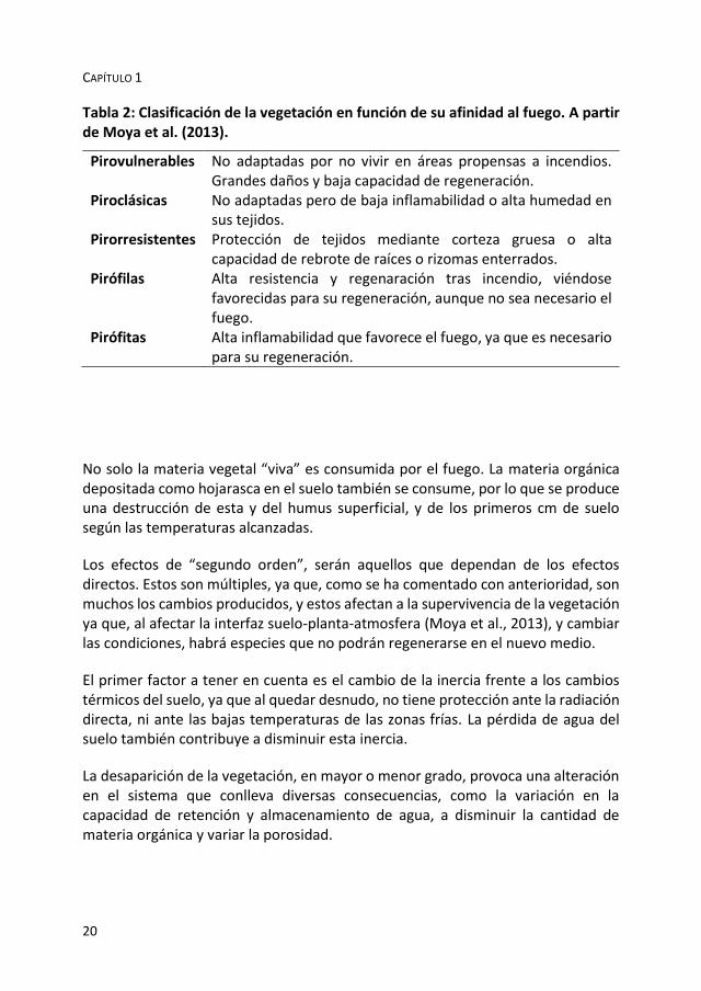
Dentro de los efectos sobre las comunidades vegetales se pueden diferenciar entre efectos de “primer orden” y de “segundo orden”. Los efectos de “primer orden” son efectos inmediatos y directos. El más evidente es la mortalidad de las plantas, y pérdida de vegetación (Badía y Martí, 2008), consumida por el fuego como combustible. Esta destrucción de la materia vegetal será de mayor o menor grado dependiendo de la intensidad y severidad del incendio, del tipo de vegetación que haya en la zona y del contenido en agua de la misma. Al destruirse la cubierta vegetal, se produce una destrucción de la cubierta protectora del suelo (Johansen et al., 2001; Pierson et al., 2008a). El tipo de vegetación es determinante, ya que unas especies combustionan más rápidamente que otras, que al tener mayor protección térmica por su estructura, como corteza o escamas (Moya et al., 2013), pudiendo clasificarse según la Tabla 2.
La repercusión del incendio sobre la vegetación, dependerá de las características propias del incendio, y de las adaptaciones de la flora de la zona afectada, incluyéndose la capacidad de resistencia, rebrote, potencial del banco de semillas, etc… pudiendo considerarse el fuego como un factor evolutivo de las plantas. El aumento de la temperatura durante el incendio, tanto en superficie, como en los primeros centímetros de suelo, afecta potencialmente al banco de semillas por combustión total o parcial (Vega, 2008).
CAPÍTULO 1
20
Tabla 2: Clasificación de la vegetación en función de su afinidad al fuego. A partir de Moya et al. (2013).
Pirovulnerables No adaptadas por no vivir en áreas propensas a incendios. Grandes daños y baja capacidad de regeneración.
Piroclásicas No adaptadas pero de baja inflamabilidad o alta humedad en sus tejidos.
Pirorresistentes Protección de tejidos mediante corteza gruesa o alta capacidad de rebrote de raíces o rizomas enterrados.
Pirófilas Alta resistencia y regenaración tras incendio, viéndose favorecidas para su regeneración, aunque no sea necesario el fuego.
Pirófitas Alta inflamabilidad que favorece el fuego, ya que es necesario para su regeneración.
No solo la materia vegetal “viva” es consumida por el fuego. La materia orgánica depositada como hojarasca en el suelo también se consume, por lo que se produce una destrucción de esta y del humus superficial, y de los primeros cm de suelo según las temperaturas alcanzadas.
Los efectos de “segundo orden”, serán aquellos que dependan de los efectos directos. Estos son múltiples, ya que, como se ha comentado con anterioridad, son muchos los cambios producidos, y estos afectan a la supervivencia de la vegetación ya que, al afectar la interfaz suelo-planta-atmosfera (Moya et al., 2013), y cambiar las condiciones, habrá especies que no podrán regenerarse en el nuevo medio.
El primer factor a tener en cuenta es el cambio de la inercia frente a los cambios térmicos del suelo, ya que al quedar desnudo, no tiene protección ante la radiación directa, ni ante las bajas temperaturas de las zonas frías. La pérdida de agua del suelo también contribuye a disminuir esta inercia.
La desaparición de la vegetación, en mayor o menor grado, provoca una alteración en el sistema que conlleva diversas consecuencias, como la variación en la capacidad de retención y almacenamiento de agua, a disminuir la cantidad de materia orgánica y variar la porosidad.

INTRODUCCIÓN
21
La vegetación supone una gran protección para el suelo contra la erosión tanto eólica como hídrica por escorrentía, especialmente en zonas de pendiente elevada. Al desaparecer esta protección vegetal, se producen grandes pérdidas de suelo, sobre todo cuando se dan lluvias postincendio, encontrándose el suelo desprotegido y vulnerable.
En las zonas mediterráneas, el fuego ha sido considerado un factor mas en la formación de los ecosistemas y biodiversidad, por lo que hay que tener en cuenta el régimen de incendios y la tasa de renovación vegetal. Ante esto, esta el problema de la variación del régimen de incendios por la antropización de la naturaleza, variándose la capacidad de respuesta y recuperación natural de los ecosistemas. El aumento de la frecuencia de fuegos forestales en las últimas décadas por todo el mundo, y especialmente en áreas bajo clima Mediterráneo, ha sido y es una de las claves de la degradación medioambiental (Notario del Pino et al., 2008).
Esta recurrencia de incendio ha hecho que en todas las regiones mediterráneas existan comunidades vegetales adaptadas al fuego (Kaye et al., 2010), principalmente mediante dos mecanismos: plantas rebrotadoras y germinación inducida por fuego (Ojeda et al., 2010). Con órganos protegidos contra las altas temperaturas, que minimizan las perdidas tras el fuego (Saura-Mas y Lloret, 2010).
La combinación de zonas agrícolas abandonadas y la frecuencia de fuegos, dan como fruto grandes áreas dominadas por matorral denso, siendo un combustible altamente peligroso (Valdecantos et al., 2009), pero que a su vez, muchas de las especies vegetales mediterráneas tienen mecanismos de adaptación al fuego, unas mediante resistencias, por rebrotación y otras por germinar tras los incendios.
1.1.2 EFECTOS SOBRE LOS MICROORGANISMOS
La importancia de los microorganismos en el sistema suelo, radica en que son los encargados de que este sea un sistema vivo y dinámico, mediando entre el 80 o 90% de las reacciones y procesos del suelo. Siendo responsables de la fertilidad, calidad y estabilidad (Oades, 1993) del suelo. De igual manera, son fundamentales para la biodegradación de compuestos químicos, como la atracina, herbicida agrícola que se presenta con frecuencia en diferentes tipos de suelo (Porrúa, 2009).
La biótica de un suelo depende directamente de las características del suelo, como: humedad, temperatura, aireación, pH, disponibilidad de nutrientes, etc… (Bárcenas-Moreno et al., 2011) viéndose afectada ante cualquier modificación de

CAPÍTULO 1
22
las mismas. Tras un incendio, todas estas características se ven afectadas, en mayor o menor medida.
Los efectos producidos por los incendios sobre los microorganismos están ligados a los cambios que se dan en el suelo y en sus propiedades, la actividad microbiana se ve afectada por esta variación de la temperatura, asi como por la desaparición de materia orgánica, pudiendo distinguir tres fases con en la evolución de la biótica del suelo postincendio.
Efecto inmediato: Justo tras el fuego, se produce una esterilización parcial del mismo, especialmente en la parte superficial del suelo (0-2.5 cm de profundidad). Esta se debe a las altas temperaturas alcanzadas durante el incendio, variando con la intensidad del mismo. Disminuyendo la actividad microbiana pudiendo llegar, incluso, a desaparecer, mediante una esterilización parcial del mismo (Acea y Carballas, 1996; Bárcenas-Moreno et al., 2011).
Efecto a corto plazo: Algunos microorganismos son mas resistentes a los cambios de temperatura, o se encuentran en zonas, en los que los cambios han sido de menos brusquedad, por lo que sobreviven al incendio. Estas colonias se encuentran sin competencia, y con gran cantidad de nutrientes disponibles, por lo que proliferan de forma rápida (Bárcenas-Moreno y Bååth, 2009; Bárcenas-Moreno et al., 2011) y ocupan nuevos nichos.
Efectos a medio y largo plazo: Tras este boom de crecimiento microbiano, la cantidad de nutrientes y de C comienza a disminuir, por lo que la actividad biótica comienza a disminuir y a estabilizarse, fijándose la población. El efecto a largo plazo es limitado, ya que tras 1 o 2 años puede llegar a desaparecer.
Cambios bruscos en la actividad de los microorganismos del suelo, tanto cuantitativos, como cualitativos, pueden alterar el sistema suelo-planta y participar en la degradación del mismo (Barreiro et al., 2010).
Tras un incendio, los microorganismos del suelo juegan un papel muy importante, ya que tienen la capacidad de mejorar las mermadas condiciones postincendio.
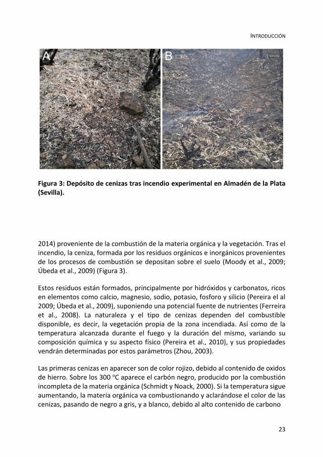
1.1.3 LA CENIZA
El efecto más inmediato y obvio que se produce tras un incendio es la aparición de una capa de cenizas (Badía y Martí, 2008; Jiménez-Pinilla et al., 2012; Pereira et al.,
INTRODUCCIÓN
23
Figura 3: Depósito de cenizas tras incendio experimental en Almadén de la Plata (Sevilla).
2014) proveniente de la combustión de la materia orgánica y la vegetación. Tras el incendio, la ceniza, formada por los residuos orgánicos e inorgánicos provenientes de los procesos de combustión se depositan sobre el suelo (Moody et al., 2009; Úbeda et al., 2009) (Figura 3).
Estos residuos están formados, principalmente por hidróxidos y carbonatos, ricos en elementos como calcio, magnesio, sodio, potasio, fosforo y silicio (Pereira el al 2009; Úbeda et al., 2009), suponiendo una potencial fuente de nutrientes (Ferreira et al., 2008). La naturaleza y el tipo de cenizas dependen del combustible disponible, es decir, la vegetación propia de la zona incendiada. Así como de la temperatura alcanzada durante el fuego y la duración del mismo, variando su composición química y su aspecto físico (Pereira et al., 2010), y sus propiedades vendrán determinadas por estos parámetros (Zhou, 2003).
Las primeras cenizas en aparecer son de color rojizo, debido al contenido de oxidos de hierro. Sobre los 300 oC aparece el carbón negro, producido por la combustión incompleta de la materia orgánica (Schmidt y Noack, 2000). Si la temperatura sigue aumentando, la materia orgánica va combustionando y aclarándose el color de las cenizas, pasando de negro a gris, y a blanco, debido al alto contenido de carbono

CAPÍTULO 1
24
Tabla 3: Formación de distintos tipos de cenizas según la temperatura alcanzada.
Temperatura (oC)
≤ 300 300-500 ≥ 500
Tipo de ceniza Ceniza rojiza (óxido de hierro)
Ceniza negra (carbón negro) y ceniza gris
Carbono inorgánico (blanca) Carbonato de calcio
inorgánico, especialmente carbonato cálcico, desapareciendo el carbono orgánico (Tabla 3). Este material carbonizado procedente de la biomasa vegeta, supone un aporte sustancial para el suelo (Hernández el al., 2013). Otros autores afirman, que las cenizas oscuras aparecen entre 100 y 250 oC siendo necesarias temperaturas superiores a los 500ºC durante un largo periodo de tiempo para que aparezcan cenizas rojizas (Ketterings et al., 2000).
El color, y por tanto, el tipo de cenizas, no solo dependen de la temperatura alcanzada en el incendio (Ketterings et al., 2000). También depende del tipo de combustible, así para las mismas temperaturas, se obtendrán distintos colores de cenizas según el combustible. En la Figura 4, se muestran los colores de cenizas obtenido para diferentes temperaturas de combustión para hojas de Quercus suber, Pinus pinea y Pinus pinaster (Pereira y Bodí, 2013).
La hidrofobicidad aumenta para mayores contenidos de carbono orgánico, por lo que puede ser afectada directamente por el tipo de cenizas. C y N comienzan a volatilizar a 200 oC, y desaparecen a partir de los 500 oC. A partir de los 800 oC volatilizan Ca, Mg, Na, K y otros elementos. Esto indica que en incendios de alta intensidad, las cenizas producidas serán pobres en esos elementos (Neary et al., 2005, Pereira et al., 2010).
La capa de cenizas que se deposita sobre el suelo tiene una importante labor, ya que proporciona una protección post-fire ante la erosión del suelo (Bodí et al., 2012b), que queda desprotegido tras desaparecer la capa vegetal. Esta capa suele desaparecer en menos de un año, considerándose las mismas muy móviles. Parte por erosión, y parte se incorpora al suelo, produciendo un efecto fertilizante debido al contenido de nutrientes como Ca, Mg, K, Si y P, y alguno micronutrientes como Al, Mn, Fe o Zn, (Khanna et al., 1994) que estarán presentes o no, según el tipo de combustible y la temperatura alcanzada durante el incendio, teniendo en cuenta,

INTRODUCCIÓN
25
Figura 4: Cambio de color de las cenizas según la temperatura de exposición para hojas de Quercus suber, Pinus pinea y Pinus pinaster (Pereira y Bodí, 2013).
Figura 5: Arrastre de cenizas por lluvias postincendio. Fotografías: J. Jacob Keizer (Universidad de Aveiro, Portugal).

CAPÍTULO 1
26
que para la volatilización completa de estos elementos, a excepción de C y N, hacen falta temperaturas muy elevadas (Pereira et al., 2010).
Otro efecto protector de la capa de cenizas es el retraso de la escorrentía, ya que tienen gran capacidad de retención, debido a su elevada porosidad, exceptuando los casos en los que las mismas sean hidrofobicas (Pereira y Bodí, 2013, Bodí et al., 2012b), en cuyo caso, aumentara el riesgo de encharcamiento y de escorrentía. La aparición de esta capa de cenizas proporciona al suelo una protección contra la erosión, especialmente durante el período inmediatamente posterior al fuego (Cerdá y Doerr, 2008; Pereira et al., 2010; Zavala et al., 2009a), pero por otro lado, en zonas con pendiente, pueden favorecer el arrastre de sedimentos en masa (Cannon et al., 2001; Pereira et al., 2010) (Figura 5).
1.1.4 EFECTOS SOBRE LAS PROPIEDADES QUÍMICAS DEL SUELO
Cuando las llamas consumen la cubierta vegetal y la hojarasca acumulada en el suelo, se produce una liberación de energía calorífica que altera las propiedades químicas del suelo (Neary et al., 1999; Notario del Pino, 2013) y una translocación de las sustancias orgánicas. Esto se debe a que parte de los componentes volatilizan y se pierden a la atmosfera. Otra parte se incorpora al sistema suelo, en contra de gradiente de temperatura (Doerr et al., 2000), a través de los poros y microporos. Estos compuestos químicos volatilizados productos de la combustión, al penetrar en el suelo, y descender la temperatura, condensan, dando, generalmente, compuestos hidrofobicos, que pueden provocar un aumento de la WR del suelo (Moody et al., 2009).
De forma paralela, la combustión de la materia orgánica libera gran cantidad de cationes: Ca2+, Mg2+, K+ y otros (Úbeda et al., 2009), lo que provoca un aumento de la salinidad y del pH, ya que se acumulan en el mismo como óxidos y carbonatos (Ulery et al., 1993).
Parte de los nutrientes de las cenizas pueden perderse del sistema por volatilización, mineralización, escorrentía, o erosión. Otra parte se pierde vaporizados a la atmosfera (Úbeda, 2009), estas pérdidas dependen de la temperatura que se alcance.
Otro efecto a nivel microscópico es el de la modificación estructural de ciertos minerales, especialmente las arcillas, aunque esta solo se da a temperaturas muy elevadas, superiores a 500ºC (Notario del Pino, 2013). Esto sumado a la destrucción de la materia orgánica hace que el suelo sufra una disminución de su capacidad de

INTRODUCCIÓN
27
retención, ya que tanto las arcillas como la materia orgánica son retenedores de agua.
El fuego es considerado un componente del ciclo del carbono (Kaye et al., 2010), ya que produce la movilización del mismo. Considerándose el carbono del suelo, como clave dentro del ciclo bioquímico global, ya que moviliza una parte significativa del carbono total y supone el mayor sumidero del mismo (Almendros y Gonzalez-Vila 2012; Hernández et al., 2013; Muñoz-Rojas et al., 2012, 2013). El mismo proceso se produce con el N total del suelo, que puede verse incrementado por la incorporación de materia tras el incendio, o verse disminuido por volatilización (Hernández el al., 2013; Lezberg et al., 2008).
Podría considerarse un factor químico indirecto, la diferencia entre las especies vegetales según su inflamabilidad, ya que esta varía según la composición química de las mismas, asi como de su estructura arquitectónica y su contenido en humedad (Úbeda et al., 2009).
1.1.4.1 EFECTOS SOBRE LA MATERIA ORGÁNICA
En los apartados anteriores se han mencionado los efectos producidos por el fuego sobre la materia orgánica efectos que se deben a la destrucción y alteración (De la Rosa et al., 2013; González-Pérez et al., 2004; Santín et al., 2008) de la misma, ya que esta se concentra, normalmente, en los primeros centímetros de suelo, que son los mas afectados por el fuego. Estos cambios pueden llegar a afectar su productividad, ya que la materia orgánica afecta tanto las propiedades físico-químicas y estructurales del suelo, como su contenido en nutrientes (De la Rosa et al., 2008).
Desde el punto de vista químico, se producen cambios en los contenidos de N y C. La materia orgánica es la mayor reserva de C que posee el suelo (Batjes, 1996), por lo que una variación de esta, conlleva una variación en el ciclo del C. Al disminuir el C orgánico se produce una disminución en la relación C/N en muestras de suelo quemados (Chandler et al., 1991). Está perdida de C orgánico comienza a temperaturas de 100-200 oC (De la Rosa et al., 2008). En cambio, en incendios de alta intensidad, donde la materia orgánica se llega a estabilizar, pueden darse aumentos en la cantidad de C orgánico.
La combustión de la materia orgánica suele ser incompleta (De la Rosa et al., 2013), dependiendo esto, en gran medida, del contenido de humedad del suelo. Lo que hace que las cenizas tengan mayor o menor contenido en materia orgánica Cuando

CAPÍTULO 1
28
no hay combustión completa, se produce una variación en sus propiedades químicas, dando una materia orgánica con menor solubilidad y menos biodegradable (De la Rosa et al., 2013), ya que se incrementa su complejidad molecular generándose macromoléculas que no existían antes del fuego (González-Pérez et al., 2004). Estos cambios estructurales se dan para temperaturas superiores a los 300 oC (Knicker et al., 2005).
La naturaleza del incendio también produce una diferencia en los efectos sobre la materia orgánica, ya que cuando el incendio es de alta intensidad, se produce una mayor combustión total de la materia orgánica por lo que disminuye el contenido de la misma, pudiendo desaparecer totalmente. Cuando el incendio es de baja intensidad, la cantidad de materia orgánica en suelo puede llegar a aumentar, ya que se produce una movilización de la misma y una incorporación al suelo de necromasa, con alto contenido en materia orgánica que antes no estaba disponible para el suelo. Esto indica que la alteración de la materia orgánica viene determinada, tanto por el régimen de incendios y la recurrencia, como por la intensidad y severidad del mismo, así como por las características de la zona (Andreu et al., 2010; Certini, 2005; De la Rosa et al., 2013; Santín et al., 2008).
Figura 6: Disminución del contenido de materia orgánica en suelo tras un incendio según las fracciones del suelo. A partir de Fox et al. (2007).

INTRODUCCIÓN
29
Figura 7: Detalle de la combustión subterránea producida durante el incendio de Montellano, Sevilla (2012).
Tras el incendio, hay una pérdida importante en el contenido de materia orgánica (Figura 6) que se va con el humo, pero otra parte, se mueve hacia los primeros centímetros del suelo siguiendo un gradiente de temperatura, y condensa en los poros del suelo, creando una capa hidrofobica bajo superficie (Fox et al., 2007; Jordán et al., 2011).
Este efecto de destrucción de materia orgánica incorporada al suelo, es especialmente notable en los llamados “incendios subterráneos”, que se propagan bajo la superficie de terreno, afectando a raíces y a la materia orgánica acumulada

CAPÍTULO 1
30
Figura 8: Histograma de frecuencias de valores de pH en suelos control (azul) y afectados por el fuego (rojo) tras el incendio de Aldeaquemada (2004). A partir de Gil et al. (2010).
(Sánchez y Gándara, 2011).Se dan en zonas de suelos esponjosos con altos contenidos de materia orgánica y porosidad. También pueden producirse puntualmente en suelos sin estas características al combustionar raíces de árboles que hacen que el fuego se propague bajo tierra (Figura 7).
El contenido en materia orgánica es un factor que determina la aparición de hidrofobicidad de forma directa (Cuevas, 2006), así como afecta al incremento de los procesos erosivos post-incendio (Shakesby y Doerr, 2006)
1.1.4.2 EFECTOS SOBRE LA ACIDEZ
Tras un incendio, suele producirse una disminución en la acidez del suelo, debido a la desnaturalización de los ácidos orgánicos (Certini, 2005) y a la exposición a las altas temperaturas, sobre todo superados los 450-500 oC. Otros autores, han observado aumentos tanto del pH como de la conductividad eléctrica, debido a la

INTRODUCCIÓN
31
liberación de cationes básicos tras la quema del combustible (Figura 8)(Granged et al., 2011a; Hernández el al., 2013; Notario et al., 2007), estos aumentos pueden llegar a las 5 unidades (Ulery et al. 1995), pudiendo deberse a la perdidas de grupos OH de los minerales de arcilla, la formación de óxidos (Giovannini et al., 1990) y carbonatos, y a la liberación de cationes solubles tras la combustión de la materia orgánica (Úbeda et al., 2009, Ulery et al., 1993).
La duración de estos cambios de pH, que no suele superar los tres años (Úbeda et al., 2005), depende del nivel de acidez previo en suelo, de la humedad y de la cantidad y composición química de las cenizas producidas durante la combustión de la cubierta vegetal (Gil et al., 2010). Si el cambio de pH se debe, principalmente, a la presencia de cenizas en suelo, el tiempo de recuperación del pH inicial será corto, ya que la duración de las cenizas en el mismo no es larga, pudiendo desaparecer por erosión en poco tiempo (Mataix-Solera, 1999).
Estos aumentos en el pH, pueden producir problemas de fertilidad, y por tanto, de recuperación de la cubierta vegetal postincendio.
1.1.4.3 EFECTOS SOBRE EL COMPLEJO DE CAMBIO CATIÓNICO
La capacidad de intercambio catiónico en suelo puede verse afectada por la acción del fuego, estos efectos, suelen ser una disminución de la misma, debido, en la mayoría de los casos, por la pérdida de coloides orgánicos del suelo (Oswald et al., 1999). Para incendios de alta intensidad, y temperaturas en suelo superiores a 500oC, comienza a observarse disminución debido a la alteración mineralógica de las arcillas, siendo estos procesos de menor importancia (Arocena y Opio, 2003; Ketterings et al., 2000; Tan et al., 1986; Ulery et al., 1995).
Los procesos de escorrentía y lavado pueden producir perdidas en los cationes de cambio liberados (Gil et al., 2010). Tras el lavado post-incendio disminuye la saturación de bases (Soto y Díaz-Fierros, 1997), esta variación en la saturación del complejo de cambio será de mayor o menor intensidad dependiendo de la intensidad de las precipitaciones (Hatten et al., 2005). Estos procesos producen una mayor desaturación del complejo de cambio, y por lo tanto una reducción de la capacidad tampón del suelo. Especialmente si son de alta intensidad, se produce un empobrecimiento del suelo, debido a la disminución drástica de materia orgánica (Ibáñez et al., 1983).

CAPÍTULO 1
32
Figura 9
: Esqu
ema d
e lo
s efecto
s de
l fue
go e
n las p
rop
ied
ade
s de
l suelo
. A p
artir de M
ataix-Solera et al.
(20
11
).

INTRODUCCIÓN
33
No siempre se producen perdidas en el complejo de cambio. Molina et al. (2007) observan un enriquecimiento en Ca2+ y k+ en la capacidad de retención de Andosoles en los cinco centímetros superficiales de suelo. Estos cationes proceden de las cenizas de la combustión.
Según esto, el suelo puede sufrir un doble proceso, por un lado un descenso en las bases de cambio justo tras el fuego por volatilización y dispersión de las cenizas (Grier, 1975), y por otro un incremento de las mismas, como observaron Kraemer y Hermanann (1979) 25 años tras un incendio.
1.1.5 EFECTOS SOBRE LAS PROPIEDADES FÍSICAS DEL SUELO
Dentro de las propiedades físicas afectadas por un incendio forestal, la más evidente y visible, es la eliminación de la vegetación y cubierta del suelo, ya que es consumida como combustible por el fuego (Arcenegui et al., 2013; Fox et al., 2007). Esta eliminación será mayor o menor según la severidad del incendio.
Simultáneamente a la eliminación de la vegetación, se crea una capa de cenizas, que se depositan en el suelo. Esta capa tendrá unas características determinadas según haya habido mayor o menor combustión de la materia orgánica, dando origen a cenizas que a simple vista se pueden diferenciar ciertas características físicas, como el color de las mismas. Pasando del negro, al rojizo, gris o blanco. Estos cambios afectan a ciertas propiedades físicas del suelo, como: la textura, el contenido en arcillas, la estructura, la porosidad y la densidad aparente (como se veía en el apartado 1.1.3, pág. 22). Según Mataix-Solera et al. (2011), estas propiedades se ven afectadas unas a otras, estando interrelacionadas durante el postincendio según la Figura 9.
Un efecto indirecto es la alteración del contenido en agua del suelo. Esta no se debe solo a la disminución de arcillas y el aumento de limos y arenas (Ulery y Graham, 1993) y destrucción de materia orgánica, sino que también es afectada, indirectamente, por un aumento de la radiación que recibe el suelo, lo que conlleva un aumento de temperatura, y un aumento en la evapotranspiración (ETc) del mismo. Especialmente en los primeros centímetros del suelo, debido a su escasa conductividad (Úbeda et al., 2009).
Estos efectos dependen del grado de estabilidad previo del suelo, y de la temperatura alcanzada durante el incendio, pudiendo afectar a la estructura unas temperaturas relativamente bajas, necesitando temperaturas extremas para que se vean afectado suelos arenosos, ya que se ha observado que tras el incendio, se

CAPÍTULO 1
34
produce una modificación estructural, disminuyendo las fracción arcilla y aumentando limos y arenas (Ulery y Graham, 1993). Este cambio estructural afecta, indirectamente, los procesos físicos del suelo (Arcenegui et al., 2013).
1.1.5.1 EFECTOS SOBRE LA TEXTURA Y MINERALOGÍA
Otro cambio físico que se observa tras las elevadas temperaturas alcanzadas en un incendio, es la variación textural del suelo. La estructura de las arcillas se ve modificada, disminuyendo la proporción de las mismas, a favor de las fracciones limo y arena, que se incrementan (Ulery y Graham, 1993). Esto hace que haya una tendencia a pasar de suelos arcillosos a limo-arenosos, en mayor o menor grado dependiendo de las características del incendio y la naturaleza previa del suelo. Esta alteración entre las fracciones texturales del suelo (arenas, limos y arcillas), solo se produce a elevadas temperaturas, comenzando a darse a partir de los 400 oC, debido a la disminución de la hidratación de las arcillas, y el colapso de su estructura cristalina. Destruyéndose por completo entre los 700 y 800 oC. La temperatura de fusión de arenas y limos está en torno a los 1400 oC (Lide, 2001).
Esta diferencia en las temperaturas de fusión de las distintas fracciones, hace que en un incendio de intensidad moderada o baja, no se alcancen temperaturas que alteren las fracciones gruesas, pero si que destruyan parte de las arcillas, produciéndose una alteración en la textura del suelo, hacia fracciones más gruesas.
A pesar de esto, ese efecto suele darse en los primeros centímetros del suelo, en el horizonte superficial, ya que a mas profundidad, rara vez se alcanzas temperaturas tan elevadas. Por lo que, aunque la textura del suelo no se vea significativamente alterada, pueden producirse perdidas superficiales de la fracción fina debido a la erosión postincendio (Mermut et al. 1997). Esta tendencia de disminución de la fracción arcillas en el suelo, conlleva cambios en los procesos erosivos, hídricos, biológicos, etc… del suelo.
1.1.5.2 EFECTOS SOBRE LA ESTRUCTURA
La estructura es una propiedad edáfica del suelo, consistente en la asociación de las partículas, formando un espacio de poros intercomunicados, que posibilita la aireación y la vida del suelo.
Este ordenamiento se basa en el ordenamiento de particulares individuales en partículas secundarias o agregados (Arcenegui et al., 2013), que se diferencian de los agregados de alrededor por superficies de enlace débil y los espacios porosos

INTRODUCCIÓN
35
asociados. Estas uniones se deben a las interacciones físico-químicas entre las arcillas y la materia orgánica y depende de la composición granulométrica del suelo, la actividad biológica, y una serie de condicionantes físico-químicos. Esto hace que suelos con textura semejante, sean muy diferentes entre sí, ya que según sea la acción de los coloides, arcilla y materia orgánica, y las sustancias cementantes del suelo (Campo et al., 2008) se formaran dichos agregados o permanecerán las partículas dispersas.
Figura 10: Proceso de rotura de agregados por impacto de gotas de lluvia y aumento de erosión por escorrentía. Fuente: Badía y Úbeda (2013).

CAPÍTULO 1
36
La estabilidad de los agregados puede ser afectada por diversos factores, entre otros, la combustión de materia orgánica y sustancias humefactantes (Badía y Martí, 2003) que sirven de cementantes para los agregados (Arcenegui et al., 2013), ya que la M.O, junto a carbonato cálcico, componentes órgano-metálicos y componentes mucilaginosos microbianos, están relacionados con la formación de agregados (Campo et al., 2008), por lo que se produce una destrucción de agregados. Esta depende de la temperatura alcanzada por el suelo. Para temperaturas entre los 220ºC y los 460ºC se produce la combustión de algunos agentes cementantes y parte de la materia orgánica Temperaturas por encima de los 460ºC durante un tiempo prolongado, pueden llegar a descomponer la combustión total de la materia orgánica y la descomposición de los carbonatos (Campo et al., 2008).
Dicha propiedad también sufre alteraciones postincendio. Por un lado se produce una obstrucción de los poros, tanto macroporos como microporos (Fernandez et al., 2008), por la incorporación de cenizas al suelo, lo que produce una reducción de la aireación del mismo. Y diversas propiedades, relacionadas con la estructura sufren cambios en mayor o menor media, siendo la relación de estos cambios con la acción de fuego muy ambigua y compleja (Fox et al., 2007).
Tras la eliminación de la protección del suelo tras un incendio, la estabilidad estructural, es un importante factor de control de la erosión y comportamiento hídrico del suelo (Fox et al., 2007; Mataix-Solera et al. 2011), ya que el impacto de las gotas de lluvia en el suelo desnudo tras el incendio puede romper los agregados (Arcenegui et al., 2013), aumentando la erosionabilidad del mismo, especialmente en zonas con pendiente (Figura 10).
Según las características del incendio, y la naturaleza de los compuestos cementantes, se dan casos en los que la estabilidad estructural aumente tras un incendio, debido a cambios en las arcillas y a la destrucción de ciertas fracciones de la materia orgánica En estos casos puede darse una mayor estabilidad de los agregados que permanecen, frente a los que había con anterioridad, ya que se seleccionarían los compuestos mas resistentes (Arcenegui et al., 2008; Guerrero et al., 2001; Mataix-Solera et al., 2011) al combustionar unos compuestos y crearse otros.
1.1.6 EFECTOS SOBRE LOS PROCESOS HIDROLÓGICOS Y EROSIVOS
Se conoce “cuenca hidrográfica” a la unidad de estudio hidrológico (Badía y Úbeda, 2013) que posee un balance de entradas y salidas de agua, conformando un sistema

INTRODUCCIÓN
37
cerrado, incluyendo: corrientes, barrancos, acuíferos, fuentes, usos del agua, ETc, y por supuesto, suelo. Cuando se produce un incendio, este afecta al paisaje en mayor o menor grado dependiendo de la intensidad y severidad del mismo, por lo tanto, provoca modificaciones en la Cuenca hidrológica, teniendo efecto potencial sobre los recursos de agua (Fernández et al., 2010).
Otro efecto relacionado con la hidrología, es la erosión y perdida de suelo, considerada por la Unión Europea como una de las amenazas ambientales mas importantes (Andreu et al., 2010) que se puede producir tras el incendio, ya que la cubierta vegetal que lo protege desaparece, considerándose, esta pérdida de cubierta vegetal como uno de los principales factores del incremento de pérdida de suelo (Andreu et al., 2010; Fernández et al., 2010; Fox et al., 2007). Ya que, aunque la capa de cenizas que se deposita sobre el mismo, le proporciona cierta protección postincendio (Ferreira et al., 2008), esta desaparece en poco tiempo, por incorporación o por acción del viento o lluvia.
Cuando el suelo queda desnudo y viéndose afectada su estabilidad estructural, ya que la estabilidad de agregados en una de las claves de la resistencia a la erosión postincendio (Campo et al., 2008), aumenta el riesgo de erosión (Andreu et al., 2001; Shakesby y Doerr, 2006), especialmente en zonas con fuertes vientos, o de pendientes pronunciadas. Cuando tras quedar el suelo desnudo, se producen lluvias de consideración, las perdidas aumentan notablemente por el efecto del impacto de las gotas (Andreu et al., 2010; Ferreira et al., 2008). El suelo y las cenizas arrastradas por el agua pueden favorecer la creación de cárcavas y barrancos. El fuego suele inducir WR en suelos. Como consecuencia, se reduce la infiltración, y se incrementan la escorrentía y la erosión (Mataix-Solera et al., 2008).
Si el suelo es hidrófobo, a lo dicho anteriormente, se suma la posible aparición de canales de flujo de preferencia (Robichaud y Hungerford, 2000) tanto a pequeña escala mediante los poros, como a gran escala, creándose zonas parcheadas de suelo seco y mojado, y zonas de encharcamiento allí donde la hidrofobicidad es mayor. En estas zonas, al no drenar el agua al suelo, habrá aún mas riesgo de pérdida de suelo. El volumen y tiempo de encharcamiento depende de la capacidad de infiltración, que a su vez depende de las propiedades hídricas del suelo y del contenido de humedad inicial del mismo, pudiendo diferenciarse entre respuesta a corto y largo plazo (Moody et al., 2009), siendo, teóricamente, la velocidad de infiltración mayor en un suelo seco (Vogelmann et al., 2013), pudiendo ser extremadamente lento en suelos con WR (Vogelmann et al., 2013).
Otros efectos se producen con la perdida de la hojarasca y materia orgánica superficial, como son la perdida de la capacidad de retención de agua de esta capa,
CAPÍTULO 1
38
y por tanto, un factor del control de infiltración a capas mas profundas (Badía y Úbeda, 2013).
1.2 REPELENCIA AL AGUA DEL SUELO INDUCIDA POR EL FUEGO
1.2.1 ANTECEDENTES
La repelencia al agua es un fenómeno por el que se reduce la afinidad del suelo por el agua, aumentando la resistencia a la humectación, y se debe, en gran medida, a la acumulación de ciertos tipos de compuestos orgánicos hidrofóbicos en el suelo (DeBano, 2000a; Doerr et al., 2000). Aunque este fenómeno se da de forma natural en muchos suelos (Fox et al., 2007), los estudios realizados muestran una fuerte relación entre la repelencia al agua del suelo y el fuego. La repelencia al agua reduce la infiltración y la disponibilidad de agua para las plantas (Moral et al., 2002); incrementa la escorrentía y la susceptibilidad a la erosión (Zavala et al., 2009a), generando grandes pérdidas en la producción agropecuaria y forestal (Hallet et al., 2001). También puede dar lugar a vías de flujo preferencial, que facilitan la formación de frentes de humedecimiento irregulares, provocando la diferenciación en el contenido de humedad de unas zonas y otras (Moral et al., 2002). La repelencia al agua tiene una alta variabilidad temporal, debido a que algunos factores que afectan en la misma son potenciales, como el contenido en humedad, y se puede expresar con mayor intensidad tras reducirse el contenido en humedad del suelo (Dekker y Ritsema, 1994; Moral et al., 2002).
La repelencia al agua del suelo ha sido objeto de creciente interés de la comunidad científica en las últimas décadas (DeBano, 2000a; Dekker et al., 2005; Doerr et al., 2000), a pesar de ser un fenómeno conocido desde principios de siglo, siendo mencionado por Schreiner y Shorey (1910). Hasta la fecha, la investigación ha demostrado que la repelencia al agua del suelo es una propiedad mucho más extendida de lo que inicialmente se sospechaba. Se ha encontrado en diferentes tipos de suelo (DeBano, 2000a; Doerr et al., 2000; Jaramillo et al., 2000; Jordán et al., 2011; Wallis et al., 1991), suelos con diferente concentración de materia orgánica o textura (Dekker et al., 2005; DeBano, 2000a; Doerr et al., 2000; Doerr et al., 2006) y origen mineralógico (Mataix-Solera et al., 2007; Mataix-Solera et al., 2008); bajo un rango de climas desde tropical a sub-ártico, en todos los continentes excepto la Antártida, y bajo una amplia variedad de tipos de vegetación (Buczko et al., 2002; Cerdà y Doerr, 2007; Dekker y Ritsema, 1996a; Doerr et al., 1998; Granged et al., 2011; Jordán et al., 2008; Jordán et al., 2009; Mataix-Solera et al., 2007; Zavala et al., 2009b) y diferentes tipos de uso y manejo agrícola (Abadi, 2000;

INTRODUCCIÓN
39
Blanco-Canqui, 2011; Blanco-Canqui y Lal, 2009; García-Moreno et al., 2013; González-Peñaloza et al., 2012; McKissock et al., 1998).
En los últimos años se han producido importantes avances por parte de la comunidad científica en la comprensión de los factores que afectan a la repelencia al agua del suelo (Jordán et al., 2010b). Aunque los incendios forestales son conocidos por ser una causa importante de repelencia al agua, se ha observado que también se produce en los suelos no afectados por el fuego (Fox et al., 2007). Su presencia se ve afectada por las propiedades del suelo, como la textura (Giovannini y Lucchesi, 1983; Roberts y Carbon, 1972), la irregularidad de la superficie (Shirtcliffe et al., 2006), el contenido de materia orgánica y la composición química (Atanassova y Doerr, 2010), la acidez (Diehl et al., 2010), el tipo de suelo y la mineralogía de la fracción arcilla (Dlapa et al., 2004; Mataix-Solera et al., 2008; Zavala et al., 2009b), la microbiología (Jex ey al, 1985; Savage et al., 1969), el contenido de agua (De Jonge et al., 2007; Dekker et al., 2001; Poulenard et al., 2004; Regalado y Ritter, 2005), así como variaciones estacionales de la temperatura y humedad del suelo (Czachor y Lichner, 2013; De Jonge et al., 1999; Doerr y Thomas, 2006; Leelamanie y Karube, 2007; Zavala et al., 2009b).
1.2.2 ORIGEN DE LA REPELENCIA AL AGUA
El origen y la naturaleza de las sustancias hidrofóbicas del suelo no se conoce por completo, aunque es sabido que el grado de afinidad o repelencia al agua depende de las propiedades de la capa externa de las partículas, bastando una capa molecular polar externa, para que se produzca la hidrofobicidad (Langmuir, 1920).
La repelencia al agua en el suelo se origina por la acumulación de compuestos orgánicos hidrofóbicos (Hudson et al., 2001; Ma’shum et al., 1988). Según Moral et al. (2002), se ha observado cómo la repelencia al agua se origina debido a la presencia de recubrimientos de origen orgánico sobre los granos de arena. El origen de estas sustancias orgánicas es muy variado, como microorganismos, plantas en diferentes estados, e incluso las ceras de algunas especies vegetales (Neinhuis y Barthlott, 1997).
Las sustancias orgánicas responsables de la hidrofobicidad en los suelos son principalmente de dos tipos: hidrocarburos alifáticos, formados por cadenas hidrocarbonadas largas no polares e insolubles al agua y sustancias polares con estructura anfifílica, con cadenas hidrocarbonadas polares, con un extremo hidrofóbico, y otro extremo hidrofílico. Estas sustancias, a pesar de ser solubles en agua, son susceptibles de producir cubiertas hidrofóbicas (McIntosh y Horne,

CAPÍTULO 1
40
1994). La repelencia al agua del suelo es una propiedad muy variable, ya que depende, no solo de las sustancias presentes en el suelo, sino también de las condiciones ambientales.
Algunas especies vegetales también se asocian a suelos repelentes al agua, debido al aporte de ciertos exudados de las raíces, o que poseen altos contenidos en ceras, resinas o aceites aromáticos, que son incorporados al suelo, como en el caso de eucaliptos, pinos y otras especies (Conde et al., 1998; Ito et al., 2002; Mallik y Rahman, 1985; Salminen et al., 2004). Desde la primera mitad del siglo XX se conocen los efectos de la actividad de hongos y de ciertos microorganismos sobre la repelencia al agua (Molliard, 1910). Un ejemplo significativo es el fenómeno observado por Shantz y Piemeisel (1917), conocido como “anillo de hadas”. Los anillos de hadas están formados por la actividad de micelios de basidiomicetos, que pueden llegar a producir la inhibición de la presencia de vegetación en zonas circulares por repelencia al agua.
1.2.3 PRINCIPALES CONSECUENCIAS DE LA REPELENCIA AL AGUA
Como se ha mencionado previamente (pág. 38), la repelencia al agua es una propiedad de algunos suelos que reduce su afinidad por el agua. Por consiguiente, la superficie de un suelo repelente al agua puede ofrecer una fuerte resistencia a la humectación, disminuyendo así la tasa de infiltración (Jordán et al., 2011) durante períodos de tiempo que pueden oscilar entre unos pocos segundos a horas, días o semanas. La repelencia al agua del suelo tiene varias implicaciones hidrológicas y geomorfológicas, además de las consecuencias para la disponibilidad de agua y la nutrición de las plantas, ya que cambia las propiedades hídricas de los suelos (Robichaud y Hungerford 2000). Mediante la reducción de la tasa de infiltración, la repelencia al agua puede reducir el tiempo de generación de escorrentía y aumentar el flujo de agua superficial, que a su vez tiene otras consecuencias importantes, tales como el aumento de las tasas de erosión (Doerr et al., 2000; Shakesby et al., 2000), la irregularidad del frente de mojado, el desarrollo de vías de flujo preferenciales, la lixiviación de nutrientes y el aumento del riesgo de contaminación (Leighton-Boyce et al., 2005; Ritsema y Dekker, 1994), e incluso la reducción de la fertilidad del suelo (Blackwell, 2000 ). Sin embargo, la repelencia al agua del suelo no sólo tiene consecuencias negativas. Algunos autores han señalado relaciones positivas con, por ejemplo, la estabilidad de los agregados, existiendo una relación entre la estabilidad de agregados y la capacidad de humectación (Cuevas, 2006; Jordán et al., 2011; Mataix-Solera y Doerr, 2004; Vogelmann et al., 2013) o las tasas de secuestro de carbono (Piccolo y Mbagwu, 1999). En suelos repelentes al agua, el tiempo de infiltración aumenta, pudiendo

INTRODUCCIÓN
41
permanecer los agregados secos por periodos largos (Mataix-Solera et al., 2011; Vogelmann et al., 2013).
Figura 11: A: aparición de repelencia al agua en la superficie del suelo tras un incendio forestal en Montellano, Sevilla (2012). B: repelencia al agua tras un incendio experimental en Almadén de la Plata, Sevilla (2013).
1.2.4 EL IMPACTO DEL FUEGO
Los efectos de los incendios sobre la repelencia al agua del suelo se deben a las alteraciones de distinta naturaleza que sufre el suelo, ya que ésta depende, en gran medida, del contenido y tipo de materia orgánica presente en el suelo y su textura (Cuevas, 2006; Scott y Van Wyk, 1990). Se ha observado un aumento considerable de la repelencia al agua en suelos sometidos a elevadas temperaturas o a prolongados periodos de sequía (Contreras y Solé-Benet 2003), pudiendo considerarse en algunos climas, como una propiedad estacional, que aumenta en los periodos de sequía estival y desaparece o se reduce durante la estación húmeda (Cuevas, 2006; Fabres, 2001), apareciendo en diferentes regiones y bajo variedad de climas (Jordán et al., 2011).
Diferentes factores controlan los cambios en la repelencia al agua en suelos afectados por fuego (Arcenegui et al., 2007; Mataix-Solera et al., 2013). Entre los factores que se relacionan con la presencia de repelencia al agua pueden

CAPÍTULO 1
42
considerarse los factores bióticos (como la vegetación, la actividad fúngica y microbiana y el contenido y propiedades de la materia orgánica del suelo) y abióticos (textura, temperatura y humedad del suelo) (Doerr et al., 2000), estando todos estos factores relacionados entre sí (Lozano et al., 2013). La disponibilidad de oxígeno y el tipo de combustible consumido durante la combustión también afectan directamente a los cambios en la repelencia al agua del suelo tras el fuego (Fernandez et al., 2009; Letey 2001). La Figura 11 muestra algunos ejemplos de inducción de repelencia al agua del suelo tras la acción del fuego.
Cuando el incendio es de baja intensidad, la repelencia al agua puede aumentar, debido a la combustión de la materia orgánica y la hojarasca (Lewis et al., 2006). Durante la combustión, parte de las sustancias orgánicas se volatilizan (Moody et al., 2009) y se pierden a la atmósfera, y parte se incorporan y condensan en los espacios porosos del suelo, pudiendo originarse una capa hidrofóbica bajo la superficie (Ferreira et al., 2008). En diversos estudios se ha observado la aparición de repelencia al agua en suelos previamente hidrofílicos, mientras que en otros se ha observado su reducción o desaparición en suelos previamente hidrofóbicos (Arcenegui et al., 2008; Hubbert et al., 2006; Jordán et al., 2011).

2 OBJETIVOS

CAPÍTULO 2
44

OBJETIVOS
45
El principal objetivo de este trabajo es el estudio del impacto del fuego en la repelencia al agua del suelo bajo condiciones mediterráneas. Con la finalidad de arrojar luz sobre algunos aspectos aún poco estudiados actualmente, en este trabajo se ha investigado el efecto del fuego sobre las propiedades de suelos calcáreos arcillosos. Por otra parte, se presentan y discuten resultados sobre el impacto en los procesos hidrológicos y geomorfológicos de elementos superficiales ya sea inducidos por el fuego (como la ceniza) o habituales en suelos mediterráneos áridos (como la presencia de piedras con alto grado de cobertura), que no han sido estudiados en trabajos previos. Por lo tanto, se proponen las siguientes líneas de investigación:
a) En el capítulo 3 se lleva a cabo el estudio de la evolución de la repelencia al
agua y la estabilidad estructural del suelo durante un período de 6 años
después de un incendio forestal en suelos mediterráneos de textura arcillosa y
carácter calcáreo en la provincia de Cádiz y Málaga (sur de España). Los
objetivos de esta investigación son:
i) Estudiar los cambios en la repelencia al agua y en la estabilidad estructural
producidos inmediatamente después de un incendio y a medio plazo (6
años después del fuego), así como su distribución dentro de las diferentes
fracciones de tamaño de agregados.
ii) Evaluar la relación entre la repelencia al agua y la estabilidad de los
agregados durante el período post-incendio a medio plazo (6 años).
iii) Investigar la interacción entre la repelencia al agua y la estabilidad de los
agregados y diferentes factores (características locales, tiempo desde el
fuego, litología y el tipo de vegetación) en suelos mediterráneos calcáreos.
b) En el capítulo 4 se lleva a cabo el estudio del impacto de la cobertura de piedras
sobre la repelencia al agua inducida por el fuego en un suelo previamente
hidrofílico tras un incendio experimental.
c) En el capítulo 5 se presentan los resultados de un experimento de campo en un
área recientemente quemada en el suroeste de España, explorando el impacto
de los diferentes rangos de cobertura de piedras en:
i) el desarrollo, la severidad y el patrón espacial de la repelencia al agua,
ii) la tasa de infiltración en la superficie del suelo cubierta por piedras y en
áreas desnudas (entre piedras) de un suelo afectado por el fuego
previamente hidrofílico y
iii) el impacto de diferentes grados de severidad del fuego (no afectado, baja,
moderada y alta severidad).

CAPÍTULO 2
46
iv) Finalmente, se discuten los procesos implicados en el desarrollo y la
distribución espacial de la repelencia al agua inducida por el fuego y de las
tasas de infiltración durante el periodo post-incendio.
d) En el capítulo 6 se lleva a cabo el estudio del impacto de la ceniza sobre la
erosión por salpicadura después de un incendio experimental. Para ello, se ha
llevado a cabo el estudio de la dispersión de sedimentos por el impacto de las
gotas de lluvia y sobre la tasa de escorrentía mediante experimentos de
simulación de lluvia en superficies afectadas por diferente severidad de fuego
(zonas cubiertas por ceniza repelente al agua o por ceniza hidrofóbica).
3 POST-FIRE EVOLUTION OF WATER REPELLENCY
AND AGGREGATE STABILITY IN MEDITERRANEAN
CALCAREOUS SOILS: A 6-YEAR STUDY

CHAPTER 3
48
POST-FIRE EVOLUTION OF WATER REPELLENCY AND AGGREGATE STABILITY
49
3.1 INTRODUCTION
Water repellency (WR) is a characteristic of some soils that reduces the affinity of soil for water (Doerr et al., 2000; Jordán et al., 2013). According to Doerr and Moody (2004), soil WR has more than one temporal scale, and infiltration is inhibited in water-repellent soils during periods of time ranging from a few seconds to hours or months (Doerr and Moody, 2004; Doerr et al., 2000). When the infiltration rate is inhibited or reduced, time for runoff generation is shortened and overland flow is enhanced, thus increasing soil erosion rates (Doerr et al., 2000; García-Moreno et al., 2013; Jordán et al., 2008; Shakesby et al., 2000; Sheridan et al., 2007; Varela et al., 2010). Soil WR also contributes to the development of preferential flow paths (De Rooij, 2000; Dekker and Ritsema, 1996a; Dekker and Ritsema, 1996b; Jordán et al., 2009; Granged et al., 2011a; Zavala et al., 2009c) and macropore flow (Burch et al., 1989; Doerr et al., 2006; Nyman et al., 2010). Some important consequences of these irregular wetting patterns are accelerated leaching of nutrients and increased contamination risk (Leighton-Boyce et al., 2005; Ritsema and Dekker, 1994), reduced soil fertility (Blackwell, 2000) or alterations of the runoff-runon patterns between vegetated and bare soil patches due to the existence of biological crusts (Contreras et al., 2008; Lichner et al., 2012).
Soil WR has been reported from a variety of soils under different vegetation types and climates (Doerr et al., 2009a; Jordán et al., 2009; Martínez-Zavala and Jordán-López, 2009; Mirbabaei et al., 2013; Neris et al., 2013), but sometimes fire is considered as a triggering factor (Bodí et al., 2013; Mataix-Solera et al., 2013). Depending on factors such as soil temperatures during burning (DeBano et al., 1976), time of heating (Doerr et al., 2004), soil properties (texture, structure or organic matter content, among other), and quantity and type of fuel, soil WR may be induced, enhanced, destroyed (Arcenegui et al.,. 2007; Arcenegui et al., 2008; Doerr et al., 2004; Jordán et al., 2011; Granged et al., 2011a; Tessler et al., 2008) or stay unaffected in the short- (Cerdà and Doerr, 2005; Fernández et al., 2008; Granged et al., 2011b; Jordán et al., 2010a) or in the long-term (Doerr et al., 2009a). Besides other soil properties (such as texture or AS), spatial distribution, intensity and persistence of soil WR are key factors controlling runoff/infiltration patterns and water availability in burned soils.
Soil structure is an important factor controlling hydrological processes, water availability and soil erosion risk. Soil structure results from the arrangement of soil pores and aggregates, which are formed as a consequence of the interaction of soil mineral and organic solid particles (Amézketa, 1999). Aggregate stability (AS) may

CHAPTER 3
50
vary as a result of changes in the concentration of cementing agents (clay, organic matter, calcium carbonates, Ca, Fe and Al oxides) or external forces resulting from wetting/drying, raindrop impacts, dispersion/ swelling of clay or mechanical pressure (Mataix-Solera et al., 2011). Destruction or degradation of aggregates by burning has been reported as a cause of increased post-fire soil erosion, but a complex response of soil aggregation to fire has been reported by many authors (Imeson, 1992; Mataix-Solera et al., 2011; Shakesby, 2011). In the short-term, some authors have reported decreased AS after intense wildfire or severe laboratory heating (Giovannini et al., 1988; Sanroque et al., 1985; Úbeda et al., 1990) or increased AS (Díaz-Fierros et al., 1987; Giovannini and Sequi, 1976; Ibáñez et al., 1983). Other studies have not found significant changes in AS after fire (for example: Arcenegui et al., 2008; Llovet et al., 2008; Jordán et al., 2011; Mataix-Solera et al., 2002). According to Mataix-Solera et al. (2011), AS from soils with a high clay content, calcium carbonate, Fe and Al oxides as principal cementing substances increase with fire severity, while AS from highly water-repellent sandy soils with organic matter as main cementing agent usually decrease with fire severity. As a third pattern, AS from wettable or slightly water-repellent soils, with organic matter as the main binding agent, increases after medium severity fires and sharply decreases after high severity fires.
Although fire-induced soil WR dynamics in the post-fire have been rarely studied, it is well established that the severity of fire-induced soil WR depends on burning temperature (DeBano, 1981; Jordán et al., 2011; Robichaud and Hungerford, 2000), vegetation type and land use (Arcenegui et al., 2007; Doerr et al., 2002; Doerr et al., 2006; Granged et al., 2011a; Reeder and Jurgensen, 1979; Zavala et al., 2009b) and soil properties (Mataix-Solera et al., 2013). Malkinson and Wittenberg (2011), suggested that, in the short-term, fire-induced WR dynamics are controlled by pre-fire vegetation. Bodí et al. (2013) reported increased soil WR immediately after burning and a rapid decrease in the following period, with variations strongly related with soil moisture. In contrast, little is known about the long-term variability of fire-induced soil WR at a decadal time scale (Doerr and Moody, 2004; Malkinson and Wittenberg, 2011). Long-term patterns have been reported, with soil WR decreasing slowly (Dyrness, 1976; Hubbert and Oriol; 2005; Reeder and Jurgensen, 1979; Tessler et al., 2008), or increasing, which has been attributed to microbial activity, plant species or erosion of the surface wettable layer after deep environmental changes induced by burning (Hallett, 2008; Jordán et al., 2010a; Zavala et al., 2009c).
Independently of fire, both properties, AS and soil WR are related, since hydrophobic organic coatings may retard water entry in aggregates and reduce air
POST-FIRE EVOLUTION OF WATER REPELLENCY AND AGGREGATE STABILITY
51
entrapment, inhibiting aggregate slaking. This results in increased AS, as it has been reported by many authors (Shakesby, 2011; Mataix-Solera et al., 2011). Soil WR has been reported to occur preferably in coarsely-textured soils with low aggregation (DeBano, 1981; McGuie and Posner, 1980; Roberts and Carbon, 1972), since coarse particles are more likely to develop water repellency for a certain amount of hydrophobic substances because of its lower specific surface (Blackwell, 1993; Giovannini and Luchesi, 1983; González-Peñaloza et al., 2013) and super-hydrophobicity (González-Peñaloza et al., 2013). However, soils with 25-40% clay have been reported to be extremely water-repellent (Crockford et al., 1991; Dekker and Ritsema, 1996a). It has been suggested that aggregation in clayey soils reduces the area that need be coated with hydrophobic substances to produce water repellency (Wallis et al. 1991; Bisdom et al., 1993). It may also happen that the size of the particles of hydrophobic organic material is small enough to enhance the severity of repellency fine fractions compared to the coarse ones (De Jonge et al., 1999). In other cases, it has been shown that a certain amount of hydrophobic substances may be sufficient to coat fine particles, plus the mineral particles and coarse aggregates (Doerr et al., 1996). If this happens, a fine-textured soil might also show a high severity of water repellency. Some authors have suggested to include the combined assessment of soil WR and AS in studies of fire-affected soils because of the interaction between both properties, their implications and the complexity of post-fire soil processes (Shakesby, 2011; Shakesby and Doerr, 2006; Mataix-Solera et al., 2011).
In this paper, we study the evolution of soil WR and AS during a 6-years period after a wildfire in Mediterranean calcareous loamy to clayey soils from SW Spain. The objectives of this research are: [1] to study the changes in SWR and AS immediately after fire and in the medium-term (6 years after burning) and its distribution within aggregate size fractions, [2] to assess the relationships between postfire AS and WR, and [3] to investigate interactions between AS and WR and different factors (site, time since burning, lithology and vegetation type) in calcareous Mediterranean soils.
3.2 METHODS
3.2.1 STUDY AREA AND FIRE CHARACTERISTICS
Five areas affected by wildfires between July and September 2006 were selected in the municipalities of Cortes de la Frontera (CF), Jimena de la Frontera (JF), Los Barrios (LB) and Tarifa (T1 and T2), in the provinces of Cádiz and Málaga (southwestern Spain; Figure 1).

CHAPTER 3
52
Figure 1: Study area. Red zones indicate burned areas.
The climate is Mediterranean, with cool, humid winters and warm, dry summers. Mean annual rainfall ranges between 971 (Tarifa) and 1922 mm (Cortes de la Frontera). The annual number of days with precipitation over 1 mm is 60. Mean air temperature is mild, 16-18 °C, with maximum monthly mean air temperature 22 °C (August) and minimum monthly mean 13 °C (January-February).

POST-FIRE EVOLUTION OF WATER REPELLENCY AND AGGREGATE STABILITY
53
Table 1: Location, coordinates, lithology and vegetation type for each study site; date of fire, burned area (ha) and mean annual rainfall (mm). (*) Data from the same weather station.
Code Location N W Lithology Vegetation Date of fire Total burned area
Mean annual rainfall
CF Cortes de la Frontera
36.58 5.34 Limestone and marls
Shrubland and grassland with sparse holm oak
22/07/2006 600.4 1922
JF Jimena de la Frontera
36.41 5.35 Marls Grassland 31/08/2006 63.7 1230
LB Los Barrios
36.25 5.50 Calcareous and siliceous sandstone
Shrubland and sparse olive tree
09/09/2006 115.1 1162
T1 Tarifa 36.10 5.55 Calcareous sandstone
Shrubland 17/07/2006 141.0 971*
T2 Tarifa 36.05 5.59 Marls Shrubland 22/07/2006 133.5 971*
Table 1 shows the location and characteristics of each site, date of fire, burned area and mean annual rainfall. Fire severity was estimated according to the degree of vegetation and ground fuel destruction (Chandler et al., 1983; Moreno and Oechel, 1992). According to terminology proposed by Keeley (2009), fire severity at each study area varied between low (burned herbs; shrubs below 2 m were partly charred but not consumed; scarce deposition of ash; most soil organic layer unaffected) and high (scorched trees; stems thinner than 15 mm were completely consumed; white ash covering part of the soil surface; organic layer completely burned). Only areas affected by moderate fire severity were selected for this study. These areas showed complete consumption of herbs and most shrubs, and soil organic layer largely consumed. When present, sparse trees and larger shrubs were scorched but biomass was not completely burned or consumed, and stems thicker than 8-10 mm were not completely consumed and some of them even survived.
Main vegetation types in unburned areas adjacent to studied burned plots are grassland (dominated by Poaceae and Fabaceae); shrublands dominated by mastic (Pistacia lentiscus) and Mediterranean dwarf palms (Chamaerops humilis)
CHAPTER 3
54
associated with brooms (Genista linifolia and Calicotome villosa), and Kermes oak (Quercus coccifera). Also sparse olive trees (Olea europaea) and holm oak (Quercus rotundifolia) were present in some cases (LB and CF sites, respectively).
3.2.2 SOIL SAMPLING AND ANALYSIS
Ten soil samples (0-15 mm) were collected for soil characterization in unburned areas adjacent to each burned areas during the first week after burning. Sampling sites were selected using randomly generated coordinates and between 5 and 10 m from moderate severity burned areas. At each site, soil profiles were described and classified according to ISSS-ISRIC-FAO (1998). Soil samples were transported in plastic bags to laboratory, air dried on paper boxes at room temperature in an air-forced chamber until constant weight. When dry, samples were gently homogenized and sub-divided for the different analyses. All samples were sieved (2 mm) and coarse material was discarded.
Part of soil samples was sieved (2 mm) and reserved for standard soil analyses. Triplicate samples were analysed and mean values were accepted as representative. Soil acidity (pH) and electrical conductivity (EC) were measured in aqueous soil extracted in de-ionised water (1,2.5 soil: water). The CaCO3 content was calculated by the method of the Bernard calcimeter. Soil organic carbon was determined by the Walkley-Black method (Walkley and Black, 1934). Total nitrogen was measured by the Regular Macro-Kjeldahl method and the C/N ratio was calculated. For texture analysis, air-dried soil subsamples were pretreated with H2O2 (6%) to remove organic matter and soluble salts, dried in the oven to obtain the initial weight, dispersed with a sodium hexametaphosphate solution, and mechanically shaken. The sand fraction (0.05-2 mm) was removed from the suspension by wet sieving. The clay fraction (<0.002 mm) was determined by the pipet method (USDA, 2004), and the silt fracion (0.002-0.05 mm) was calculated as the difference between 100% and the sum of the sand and clay percentages. Bulk density was measured by triplicate using the core method (Blake and Hartge, 1986), using cores (4.8 cm in diameter) inserted 25 mm in soil inside a radius of 15 cm from each soil sampling plot.
Soil samples (0-15 mm) were collected from south-facing slopes at each of the experimental burned areas immediately after wildfires in 2006, and then in August every year between 2007 and 2011. Soil samples were carefully dry-sieved and separated in aggregate sieve fractions (<0.25, 0.25-0.5, 0.5-1 and 1-2 mm), avoiding the destruction of aggregates. For soil WR analysis, subsamples (approximately 20 g) were placed on separated Petri dishes levelled and allowed to equilibrate to the laboratory atmospheric conditions (25 oC, 1 atm, 50% relative humidity) in a climate

POST-FIRE EVOLUTION OF WATER REPELLENCY AND AGGREGATE STABILITY
55
chamber during a 1-week period in order to eliminate any potential effects of variations in preceding atmospheric humidity on soil WR (Doerr et al., 2002). The proportion of wettable samples was assessed using the water drop penetration time (WDPT) test (Jordán et al., 2010b; Letey, 1969) in fine earth (<2 mm) and aggregate sieve fractions. Five drops of distilled water (0.05 mL) were applied on the surface of each sample using a micro-pipette. Samples were classified as wettable if infiltration of all drops occurred during the first 5 seconds after application. According to Bisdom et al. (1993), WDPT classes were classified as wettable (WDPT ≤ 5 s), slightly water repellent (5-60 s), strongly water repellent (60-600 s), severely water repellent (600-3600 s) and extremely water repellent (> 3600 s).
Aggregate stability was analyzed following the method proposed by Mataix-Solera et al. (2010). This method examines the proportion of aggregates that remain intact after a soil sample was subjected to artificial rainfall of a specific energy. Four grams of soil material (>0.25 mm) were placed into a 0.25-mm sieve and exposed to an energy of 270 J m-2 applied by an artificial rainfall of 30 mm in one minute from a height of one meter. After treatment, the material remaining within the sieve was dried and weighed. The material remaining in the sieve, consisting of remaining aggregates, mineral particles and organic debris was then washed until only mineral particles and organic debris remained. The dry weight of the remaining aggregate-free material allowed for the difference in aggregate weight (%) within a sample before and after artificial rainfall to be calculated. Results are based on the mean value of three replicate experiments. The use of a 0.25-mm mesh sieve did not allow the finest particle size fraction examined in this study to be included in this analysis.
The percentage of stable aggregates was used as an index of AS, and calculated as:
AS% = 100 × (WA- WC) / (WSA - WC + W)
where AS% is the percentage of aggregates remaining stable under simulated rainfall; W is the weight of the recipient; WA is the weight of the recipient + stable aggregates after simulated rainfall; WC is the weight of the recipient + coarse material (sand, gravels and plant residues) separately of stable aggregates; and WSA is the weight of soil aggregates used (4 g). Each sample was analysed by triplicate and mean values were chosen as representative.
In order to study the coevolution in time of WR and AS, the ratio between the proportions of wettable samples (WDPT ≤ 5 s) and stable agregates from sieve

CHAPTER 3
56
fractions (1-2 mm, 0.5-1 mm and 0.25-0.5 mm) between 2006 and 2011 at each study site was calculated (WASR).
3.2.3 DATA ANALYSIS
Assumptions of normality and homogeneity of variances were tested using the Shapiro-Wilk and Brown-Forsyth tests, respectively, for AS and the percentage of wettable samples (WDTP ≤ 5 s). AS data were normally distributed (Shapiro-Wilk p < 0.00001). AS from each size fraction of burned and unburned sites was analyzed by one-way ANOVA, with factors of site and year. In contrast, the percentage of wettable samples showed a non-parametric distribution (Shapiro-Wilk p = 0.12414). The Kruskal-Wallis test was applied to the percentage of wettable samples from each size fraction from burned and unburned sites for testing whether samples from different sites and year originate from the same distribution. When ANOVA or Kruskal-Wallis null hypotheses were rejected, pos-hoc comparisons were performed to investigate differences between means (Bonferroni test). All computations were made using STATGRAPHICS Centurion version 16.1.17 (Statpoint Technologies, Inc., 1982-2011).
3.3 RESULTS
3.3.1 SOIL CHARACTERISTICS
Soil characteristics in the upper 15 mm are shown in Table 2 and Table 3. Soil pH ranged from neutral to basic (7.5 - 8.1). Soil salinity was low, with values between 0.15 and 0.49 dS m-1. Mean organic carbon content was moderate (5.88 ± 1.53%). Calcium carbonate content ranged between 6.5 (JF) and 18.3% (CF), 12.4 ± 4.2% on average. Soil nitrogen ranged between 0.13 (JF) and 0.53% (CF). Soil texture was clay (JF), clay loam (T1) and loam (CF, LB and T1), with average sand content 38.2 ± 9.9% and clay 30.1 ± 13.5%. Coarse elements (rock fragments coarser than 2 mm) were low at T2 and JF (2.8 and 3.2%, respectively), and moderately high at CF, T1 and LB (15.9, 26.8 and 27.3%, respectively). Bulk density varied between 1.17 (CF) and 1.68 g cm-3 (T1), and mean value 1.49 ± 0.21 g cm-3.
3.3.2 EFFECT OF FIRE ON SOIL WATER REPELLENCY OF SIEVE FRACTIONS
The number of observations per WDPT class in composite (fine earth, <2 mm) and sieve fractions (1-2 mm, 0.5-1 mm, 0.25-0.5 mm and <0.25 mm) from burned and unburned control soils from the different study areas between 2006 and 2011 is shown in Figure 10.

POST-FIRE EVOLUTION OF WATER REPELLENCY AND AGGREGATE STABILITY
57
Table 2: Soil chemical characterization (0-15 mm depth) in the studied unburned areas. Site codes as in Table 1. Soil classification according to ISSS-ISRIC-FAO (1998). EC: electrical conductivity; OC: organic carbon. N = 10 for each case.
Code Soil classification pH EC (dS m-1) OC (%) CaCO3 (%) N (%) C/N
CF Lithic Leptosols 8.1 ± 0.1 0.49 ± 0.03 7.7 ± 0.3 18.3 ± 1.0 0.53 ± 0.00 4.12 ± 0.2
JF Haplic Calcisols 7.5 ± 0.3 0.35 ± 0.03 3.7 ± 0.2 6.5 ± 0.0 0.13 ± 0.00 0.61 ± 0.0
LB Haplic Luvisols 7.7 ± 0.4 0.44 ± 0.03 6.8 ± 0.6 12.2 ± 0.6 0.28 ± 0.00 3.51 ± 0.1
T1 Haplic Luvisols 7.5 ± 0.1 0.15 ± 0.00 6.2 ± 0.6 11.5 ± 0.7 0.16 ± 0.00 3.01 ± 0.3
T2 Eutric Regosols 7.8 ± 0.2 0.15 ± 0.00 5.0 ± 0.1 13.4 ± 0.7 0.16 ± 0.00 1.87 ± 0.1
Mean 7.7 ± 0.2 0.32 ± 0.16 5.9 ± 1.5 12.4 ± 4.2 0.25 ± 0.17 2.60 ± 1.4
Table 3: Soil physical characterization (0-15 mm depth) in the studied unburned areas. Site codes as in Table 1. BD: bulk density. N = 10 for each case.
Code Sand (%) Silt (%) Clay (%) Texture (USDA) Coarse elements (%) BD (g cm-3)
CF 37.0 ± 0.4 39.7 ± 3.1 23.3 ± 1.5 Loam 15.9 ± 1.5 1.17 ± 0.14
JF 21.6 ± 1.6 27.1 ± 1.8 51.4 ± 2.7 Clay 3.2 ± 0.3 1.54 ± 0.13
LB 46.5 ± 3.8 32.2 ± 0.9 21.3 ± 1.0 Loam 27.3 ± 0.3 1.66 ± 0.01
T1 42.5 ± 1.2 38.7 ± 1.1 18.8 ± 0.4 Loam 26.8 ± 0.8 1.68 ± 0.12
T2 43.5 ± 1.6 20.9 ± 1.9 35.6 ± 0.6 Clay Loam 2.8 ± 0.1 1.42 ± 0.13
Mean 38.2 ± 9.9 31.7 ± 7.9 30.1 ± 13.5 15.2 ± 12 1.49 ± 0.21
Regarding only composite samples (< 2 mm), soil WR was induced in soils which were completely wettable (99-100% wettable samples) before burning in CF, JF and LB sites. In CF and LB, the proportion of wettable samples decreased from 100 to 63% and 64%, respectively, with 37 and 36% slightly to extremely water-repellent soil samples immediately after burning. In JF site, the proportion of wettable samples decreased from 99 to 82%. In this case, only slight water repellency was observed in after burn (18% samples). Soil WR was observed previously to burning in T1 (12% slightly and 2% strongly water-repellent samples) and T2 (11% slightly water-repellent samples). In these cases, the proportion of water-repellent samples increased to 40 and 47% slightly and extremely water-repellent samples, respectively.

CHAPTER 3
58
Figure 2: Proportion of observations per WDPT class (N=100 at each case) in composite (<2 mm) and sieve fractions (1-2 mm, 0.5-1 mm, 0.25-0.5 mm and <0.25 mm) from burned and unburned soils for studied burned and unburned sites between 2006 and 2011.
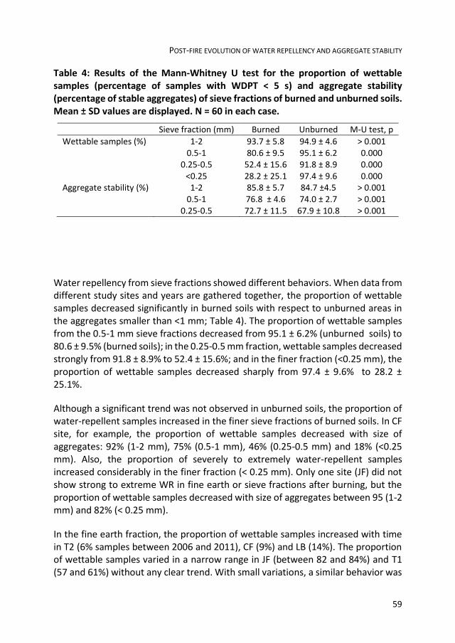
POST-FIRE EVOLUTION OF WATER REPELLENCY AND AGGREGATE STABILITY
59
Table 4: Results of the Mann-Whitney U test for the proportion of wettable samples (percentage of samples with WDPT < 5 s) and aggregate stability (percentage of stable aggregates) of sieve fractions of burned and unburned soils. Mean ± SD values are displayed. N = 60 in each case.
Sieve fraction (mm) Burned Unburned M-U test, p
Wettable samples (%) 1-2 93.7 ± 5.8 94.9 ± 4.6 > 0.001 0.5-1 80.6 ± 9.5 95.1 ± 6.2 0.000 0.25-0.5 52.4 ± 15.6 91.8 ± 8.9 0.000 <0.25 28.2 ± 25.1 97.4 ± 9.6 0.000 Aggregate stability (%) 1-2 85.8 ± 5.7 84.7 ±4.5 > 0.001 0.5-1 76.8 ± 4.6 74.0 ± 2.7 > 0.001 0.25-0.5 72.7 ± 11.5 67.9 ± 10.8 > 0.001
Water repellency from sieve fractions showed different behaviors. When data from different study sites and years are gathered together, the proportion of wettable samples decreased significantly in burned soils with respect to unburned areas in the aggregates smaller than <1 mm; Table 4). The proportion of wettable samples from the 0.5-1 mm sieve fractions decreased from 95.1 ± 6.2% (unburned soils) to 80.6 ± 9.5% (burned soils); in the 0.25-0.5 mm fraction, wettable samples decreased strongly from 91.8 ± 8.9% to 52.4 ± 15.6%; and in the finer fraction (<0.25 mm), the proportion of wettable samples decreased sharply from 97.4 ± 9.6% to 28.2 ± 25.1%.
Although a significant trend was not observed in unburned soils, the proportion of water-repellent samples increased in the finer sieve fractions of burned soils. In CF site, for example, the proportion of wettable samples decreased with size of aggregates: 92% (1-2 mm), 75% (0.5-1 mm), 46% (0.25-0.5 mm) and 18% (<0.25 mm). Also, the proportion of severely to extremely water-repellent samples increased considerably in the finer fraction (< 0.25 mm). Only one site (JF) did not show strong to extreme WR in fine earth or sieve fractions after burning, but the proportion of wettable samples decreased with size of aggregates between 95 (1-2 mm) and 82% (< 0.25 mm).
In the fine earth fraction, the proportion of wettable samples increased with time in T2 (6% samples between 2006 and 2011), CF (9%) and LB (14%). The proportion of wettable samples varied in a narrow range in JF (between 82 and 84%) and T1 (57 and 61%) without any clear trend. With small variations, a similar behavior was

CHAPTER 3
60
observed in the coarser sieve fractions (2-0.25 mm). In contrast, no important changes were observed in the proportion of WR classes of the finer fraction (< 0.25 mm) from all studied soils after water repellency was induced or enhanced by fire.
In burned soils, WR varied according to vegetation type (Table 5). Significant differences were found among unburned soil samples under different vegetation types in sieve fractions 1-2. 0.5-1 and 0.25-0.5 mm. Generally, the proportion of wettable samples was lower under shrubs without trees, and increased when oaks or olive trees were present or under grassland. No significant differences were found in the finer fraction (< 0.25 mm) under different vegetation types. In contrast, burned soils showed a different behaviour. Differences among samples under vegetation types were found only for sieve fractions below 1 mm. In this case, the proportion of wettable samples was always greater in burned grasslands, while it strongly decreased in shrublands (with or without trees).
Significant differences were also found among soil samples with different lithological origin in sieve fractions below 1 mm (unburned soils) and 0.25-1 mm (burned soils). Generally, more severe WR was found in the finer fractions (<0.5 mm) of burned soils developed from marls.
3.3.3 EFFECT OF FIRE ON AGGREGATE STABILITY OF SIEVE FRACTIONS
Stability of aggregates did not vary significantly between sieve fractions from burned and unburned soils (Table 3). In burned soils, the proportion of wettable samples varied significantly between years only in the 0.5-1 mm sieve fraction, where AS decreased 11.7% between 2006 and 2011 (Table 6). Significant differences were found for AS of sieve fractions from burned and unburned soils under different vegetation types except for the 0.5-1 mm sieve fractions (Table 5). No significant differences were found for AS of the 0.5-1 and 0.25-0.5 mm sieve fractions from burned and the 0.25-0.5 mm sieve fraction from unburned soils with different lithology type.

POST-FIRE EVOLUTION OF WATER REPELLENCY AND AGGREGATE STABILITY
61
Tab
le 5
: R
esu
lts
of
the
Kru
skal
-Wal
lis a
nal
ysis
(K
W,
p)
of
we
ttab
ility
(p
erc
en
tage
of
wet
tab
le s
amp
les)
fo
r d
iffe
ren
t ve
geta
tio
n t
ype
and
lith
olo
gy f
rom
sie
ve f
ract
ion
s (0
-25
-2 m
m)
in b
urn
ed
an
d u
nb
urn
ed s
oil
sam
ple
s (m
ean
± S
D).
Dif
fere
nt
lett
ers
in t
he
sam
e c
olu
mn
in
dic
ate
sig
nif
ican
t d
iffe
ren
ces
be
twe
en g
rou
ps
(p ≤
0.0
5)
for
eac
h f
acto
r.

CHAPTER 3
62
Table 6
: Re
sults o
f the
on
e-w
ay AN
OV
A o
f aggregate
stability fo
r factors ye
ar, vegetation
type an
d lith
olo
gy from
each sieve fractio
n in
bu
rne
d an
d b
urn
ed
soil sam
ples (m
ean
± SD). D
ifferen
t letters in
the sam
e co
lum
n in
dicate
significan
t differen
ces b
etwe
en
grou
ps (p
≤ 0.0
5) fo
r each
factor.

POST-FIRE EVOLUTION OF WATER REPELLENCY AND AGGREGATE STABILITY
63
3.3.4 RELATION BETWEEN AGGREGATE STABILITY AND WATER REPELLENCY
The ratio between the proportions of wettable samples and stable aggregates (WASR) did not vary in unburned samples with time, although some small differences were observed occasionally (Figure 3). In most cases, WASR of sieve fractions and years after fire are related by a squared rooted inverse function (regression equations are shown in Table 7).
For most sites and sieve fractions, WASR showed an asymptotic increase between 2006 and 2011. In the 1-2 mm and 0.5-1 mm, WASR increased up to values similar to those from unburned soils. On the contrary, WASR from the finer fraction (0.25-0.5 mm) reached approx. 50% of unburned sites in CF, LB, T1, and T2. In JF, WASR from the 0.25-0.5 mm fraction increased from 1.23 (2006) to 1.27 (2011), but did not reach the mean WASR for the same fraction (1.62).
Table 7: Regression results for WASR (dependent variable) and year (independent variable) for each burned site and sieve fraction (WASR = (a - b/year)1/2, a, intercept; b, slope; R, Pearson correlation coefficient; R2, coefficient of determination; p-value, statistical significance of the F-test statistic. Site codes as in Table 1.
Site Sieve fraction (mm)
a b R R2 p-value
CF 0.25-0.5 134.204 -268,405.660 0.930 0.865 0.0071 0.5-1.0 305.281 -610,939.498 0.969 0.939 0.0014 1.0-2.0 215.294 -429,936.055 0.971 0.943 0.0013 JF 0.25-0.5 15.609 -28,403.179 0.138 0.019 ≥ 0.05 0.5-1.0 190.946 -380,101.246 0.907 0.822 0.0127 1.0-2.0 62.213 -122,405.463 0.728 0.531 0.1006 LB 0.25-0.5 33.781 -66,928.863 0.769 0.591 ≥ 0.05 0.5-1.0 215.956 -431,553.345 0.987 0.974 0.0003 1.0-2.0 193.195 -384,995.453 0.849 0.720 0.0326 T1 0.25-0.5 48.726 -97,282.865 0.981 0.963 0.0005 0.5-1.0 133.300 -266,211.727 0.964 0.930 0.0019 1.0-2.0 277.236 -554,744.912 0.972 0.944 0.0012 T2 0.25-0.5 77.807 -155,702.906 0.944 0.892 0.0045 0.5-1.0 301.045 -602,471.392 0.976 0.954 0.0008 1.0-2.0 272.819 -545,828.220 0.989 0.978 0.0002

CHAPTER 3
64
Figure 3: Ratio (WASR) between the proportion of wettable samples from sieve fractions (1-2 mm, 0.5-1 mm and 0.25-0.5 mm) and aggregate stability between 2006 and 2011 in the study areas. Codes: CF (Cortes de la Frontera), JF (Jimena de la Frontera), LB (Los Barrios), T1 (Tarifa 1 T2 (Tarifa 2); U (unburned), B (burned).
3.4 DISCUSSION
3.4.1 IMMEDIATE CHANGES IN SOIL WATER REPELLENCY
Fire induced WR in previously wettable soils (CF, JF and LB sites) and enhanced it in soils were a relative proportion of water repellent samples existed before burning (T1 and T2). This is in agreement with results reported by Arcenegui et al. (2008), Tessler et al. (2008) and Granged et al. (2011b). Also, many authors have described enhanced WR in soils with slight or moderate pre-existent repellency, as in studied soils from T1 and T2 sites (Arcenegui et al., 2008; DeBano et al., 1979; MacDonald and Huffmann, 2004; Mataix-Solera and Doerr, 2004; Reeder and Jurgensen, 1979; Savage, 1974; Sevink et al., 1989). In calcareous Mediterranean soils, Bodí et al. (2013) observed that WR immediately after burning was similar to that of long-unburned sites (29 years), but greater at 1 cm depth, as a result of migration of hydrophobic substances during burning. In this case, WR decreased after 1-year period, due to deposition of wettable sediments (ash) transported by runoff. Differences in the severity of post-fire soil water repellency may be attributed to

POST-FIRE EVOLUTION OF WATER REPELLENCY AND AGGREGATE STABILITY
65
soil temperature peaks during burning, as shown by Jordán et al. (2011), who observed that low fire severity did not induce changes in soil WR, but high fire severity produced different responses depending on temperature peaks and time of residence of high temperatures. It has been observed that temperatures of 150-250 oC can induce soil WR (Doerr et al., 2009a; Zavala et al., 2010a), but destruction has been reported after temperatures of 370 (Robichaud and Hungerford, 2000), 280-400 (DeBano and Krammes, 1966) and 270-300 oC (DeBano et al., 1976; Savage, 1974). According to this, it is it reasonable to assume that soil temperature in the first 15 mm of burned studied soils was in a range (100-250 oC) sufficient to induce WR but insufficient to break it down. Temperature peaks above that threshold were not reached or were reached during a short time, so that soil WR was not destroyed.
3.4.2 EVOLUTION OF SOIL WATER REPELLENCY IN THE POSTFIRE PERIOD
Fire-induced WR depends on the size of aggregates. The proportion of wettable fine-earth samples (<2 mm) increased with time in most cases (CF, LB, T2), remained stable (JF) or decreased very slightly (T1). In acid soils from the study area, soil WR occurs naturally (Jordán et al., 2008; Zavala et al., 2009b) and it easily re-established in a relatively short time after destruction by burning (Jordán et al., 2010a; Granged et al., 2011c). In contrast, calcareous soils are not susceptible to the development of WR (Mataix-Solera and Doerr, 2004; Mataix-Solera et al., 2007), and fire-induced hydrophobicity is expected to decrease with time under natural conditions. Our results are in agreement with previous studies which have reported a decrease in fire-induced soil WR in periods ranging between some months and a few years when fire is not highly recurrent. In the short term, soil WR may decrease due to wetting (Hubbert and Oriol, 2005; Huffman et al., 2001; Tessler et al., 2008). In the long term, this decrease may be due to the erosion of water-repellent soil particles and unearthing of wettable soil layers (Hubbert and Oriol, 2005) and biological activity associated with vegetative regrowth (Doerr et al., 2009b).
In contrast to fine-earth samples, aggregate sieve fractions show different patterns in the postfire period, suggesting that fire-induced WR depends on the size of aggregates. The proportion of wettable samples from the 1-2 mm sieve fraction decreased immediately after burning in all cases, but it increased progressively with time until values between 96 and 100% in 2011. Hydrophobicity persisted in the rest of sieve fractions, especially in aggregates <0.25 mm (where the proportion of wettable samples was ≤ 17% in CF LB, T1 and T2).
CHAPTER 3
66
In our study, the post-fire behaviour of the 1-2 and the 0.5-1 mm sieve fractions conditioned the general soil response, while fire-induced WR from finer fractions remained stable through the experimental period and did not caused great effects in hydrophobicity. This is not in agreement with previous results from several authors, who have highlighted the role played by the finer sieve fractions in the occurrence of soil WR. Bisdom et al. (1993) studied soils showing a range of WR and
found that the most severe WR was always found in the finer aggregates (<53 m), which showed longer WDPTs even in composite samples from wettable soils. Similar results have been reported for burned and unburned soils by Doerr et al. (1996) for the <0.125 mm fraction, Jordán et al. (2011) and Mataix-Solera and Doerr (2004) for the <0.25 mm fraction. Some hypotheses for this behaviour are that pores between coarse particles are filled with fine hydrophobic materials as plant residues, faecal particles, hydrophobic organic residues or amorphous substances (Bisdom et al., 1993; Doerr et al., 2000). Progressive destruction of hydrophobicity in the coarser sieve fractions (1-2 mm) and in the mid-fraction (0.5-1 mm, except in site JB) may be a consequence of microbial degradation of hydrophobic organic substances (Hallett, 2008). After a wildfire, as vegetation and microfauna populations recover and microbial activity in the soil increases (Malkinson and Wittenberg, 2011) and the progressive increase of wettability in the coarser fraction may be explained by microbial degradation of hydrophobic coatings, which may be much more efficient in coarse particles, associated to macropores, than in finer particles included in the soil matrix. The role played by coarse particles in the overall WR of soil is unclear. Doerr et al. (1996) suggested that the degree of WR of the coarse particles is not significant in determining the overall WR in acid soils (derived from schists) with 50-75% sand. In contrast, our results show that WR of calcareous soils with 21.56-46.49% sand may be conditioned mostly by the coarser sieve fractions (0.5-2 mm). These differences may be due to the presence of calcium carbonate (12.4±4.2%, on average; Table 2) forming concretions or coating fine particles, which contributes to an increased wettability in the coarse fraction.
3.4.3 EFFECTS OF PRE-FIRE VEGETATION AND LITHOLOGY IN SOIL WATER
REPELLENCY AND AGGREGATE STABILITY
Our results suggest that combustion of shrubs contributed to enhanced soil WR after burning, at least in the 0.5-1 and 0.25-0.5 mm sieve fractions. Similarly, lithology caused significant differences only in the finer sieve fraction of burned soils. Water repellency in the finer fraction of soils developed from calcareous and/or siliceous sandstone was greater (on average, 40.5% of wettable samples) than in soils developed on limestone and marls. The limited strength of fire-induced WR found in the studied soils contrasts with that observed in acid soils after burning

POST-FIRE EVOLUTION OF WATER REPELLENCY AND AGGREGATE STABILITY
67
in nearby areas (Granged et al., 2011a; Zavala et al., 2009b) or re-established WR after high-severity burning (Granged et al., 2011c; Jordán et al., 2010a). Fungal activity under alkaline conditions (as proposed by Cerdà and Doerr, 2005), the low potential of vegetation type for the development of a water-repellent layer (Zavala et al., 2009b) and general soil conditions in the study area do not promote the long-term persistence of fire-induced soil WR.
Vegetation type and lithology did not affect AS from the 0.5-1 mm sieve fraction, but induced differences in the coarser and finer fractions. Although the influence of vegetation type does not show a clear pattern, AS of burned soils developed from calcareous and siliceous sandstone, limestone and/or marls was stronger. On average, AS from sieve fractions did not show significant differences between burned and unburned soils. This is in agreement with results reported by Mataix-Solera et al. (2002). In a recent review by Mataix-Solera et al. (2011), concluded that low severity fire does not have great effects in AS of calcareous clayey soils. In our research, a homogenous pattern was not observed for AS of sieve fractions from burned soils with different substrate. Although the coarser fraction from burned soils showed significant differences between substrates, average values varied in a short interval (79.0 - 91.0%).

CHAPTER 3
68

4 DO STONES MODIFY THE SPATIAL DISTRIBUTION
OF FIRE-INDUCED SOIL WATER REPELLENCY? AN
EXPERIMENTAL APPROACH

CHAPTER 4
70

DO STONES MODIFY THE SPATIAL DISTRIBUTION OF FIRE-INDUCED SWR?
71
4.1 INTRODUCTION
Increased or induced soil water repellency (SWR) has been reported in many fire-affected soils (DeBano, 2000b; Doerr et al., 2000). Although wildfires are considered one of the main causes of SWR, they are not the only origin. But fire can be considered as a water repellency-triggering factor in soils where plant species, microorganisms, or organic matter act as sources of hydrophobic substances (Doerr et al., 2000). SWR is a property of many soils that is getting more and more interesting for the scientific community, because of its consequences on soil erosion risk, runoff or infiltration rates and even plant ecology. Although the occurrence and consequences of fire-induced SWR have been deeply studied, some gaps still exist, as the influence of stone cover. Stones on the soil surface may affect the distribution of heat during burning, and, consequently, may change the expected spatial distribution of SWR. In this research, we study the effect of the stone
cover on the occurrence of fire-induced SWR in a previously hydrophilic soil after experimental burning.
The objective of this research is to study occurrence and spatial distribution of SWR after experimental burning in a previously hydrophilic soil under different stone covers (0, 15, 30, 45 and 60%).
4.2 METHODOLOGY
Experiments were carried out in the Blanco White experimental farm (Sevilla). Soil at the experimental area is clay-sandy loam (sand 64.1%, silt 15.3% and clay 19.6%), pH is 7.5 and CO3Ca content is 18.3%. Soil plots (1.0 × 1.5 m2) were marked with vertical metal bars and stones (8-10 cm in diameter) were regularly arranged at each plot in order to get 0, 15, 30, 45 and 60% stone cover, as shown in Figure 1-a. Stones were kept on the soil surface during three months before experimental burning. A series of thermopar probes were inserted 1 cm below the soil surface and soil temperature was recorded every 60 seconds under stones and under no stones.
Fuel was added to soil plots in order to simulate natural shrubs (Figure 1-b). Fuel density was 6.5-7.5 kg m-2. Fuel structure was 50% fine branches (<5 mm) and 50% thick branches (>15 mm). Experimental burning was carried out on February 14th 2012 until fire extinguished spontaneously (Figure 1-c), after full consumption of fuel after 15 minutes.
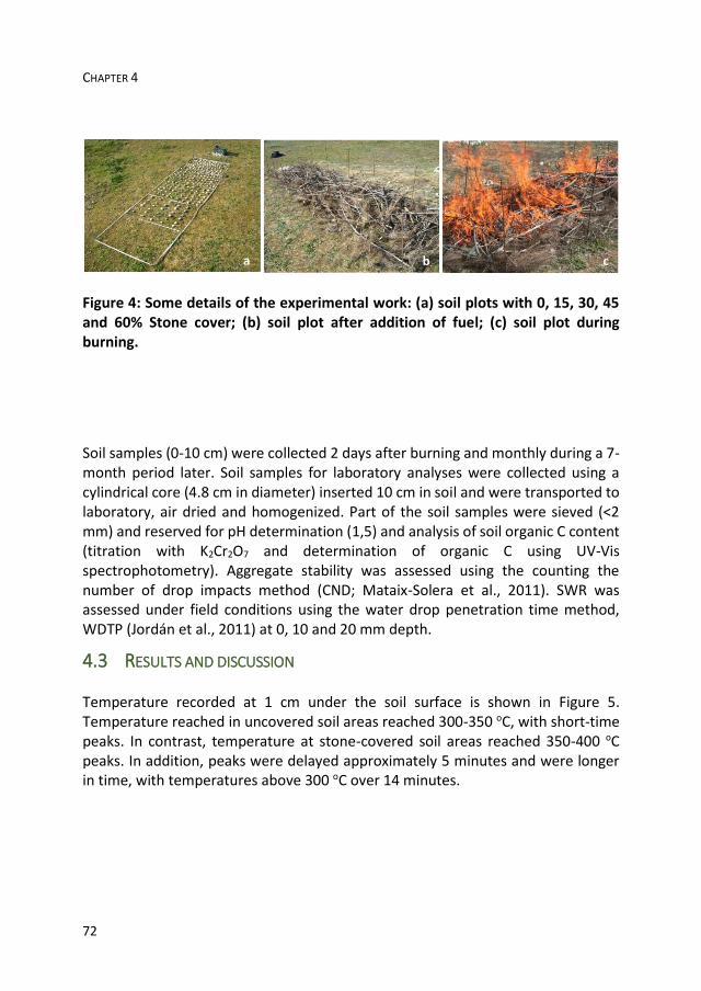
CHAPTER 4
72
Figure 4: Some details of the experimental work: (a) soil plots with 0, 15, 30, 45 and 60% Stone cover; (b) soil plot after addition of fuel; (c) soil plot during burning.
Soil samples (0-10 cm) were collected 2 days after burning and monthly during a 7-month period later. Soil samples for laboratory analyses were collected using a cylindrical core (4.8 cm in diameter) inserted 10 cm in soil and were transported to laboratory, air dried and homogenized. Part of the soil samples were sieved (<2 mm) and reserved for pH determination (1,5) and analysis of soil organic C content (titration with K2Cr2O7 and determination of organic C using UV-Vis spectrophotometry). Aggregate stability was assessed using the counting the number of drop impacts method (CND; Mataix-Solera et al., 2011). SWR was assessed under field conditions using the water drop penetration time method, WDTP (Jordán et al., 2011) at 0, 10 and 20 mm depth.
4.3 RESULTS AND DISCUSSION
Temperature recorded at 1 cm under the soil surface is shown in Figure 5. Temperature reached in uncovered soil areas reached 300-350 oC, with short-time peaks. In contrast, temperature at stone-covered soil areas reached 350-400 oC peaks. In addition, peaks were delayed approximately 5 minutes and were longer in time, with temperatures above 300 oC over 14 minutes.

DO STONES MODIFY THE SPATIAL DISTRIBUTION OF FIRE-INDUCED SWR?
73
Figure 5: Temperature recorded 1 cm under the soil in áreas uncovered and covered by stones by two selected termopar probes.
Wettable character was stable below 10 mm, with SWR remaining unaffected by burning. In contrast, soil areas under stones and no stones showed different behaviours. SWR was triggered at 0-10 mm depth in plots under 0% stone cover immediately after burning, and decreased progressively until soil material became wettable two monts after burning. Slight SWR (average WDTP between 5 and 10 s) was observed by sampling dates 1 and 3 at exposed inter-stone areas from soil plots under 15, 30 and 45% stone cover. Stone-covered areas remained wettable or slightly water repellent (average WDPT ranging between 1 and 6 s) character. SWR was not observed at 60% stone cover soil plots. (Figures 3, 4, 5).

CHAPTER 4
74
Figure 6: Soil water repellency (WDPT) for different stone cover classes, soil depth and dates (month after burning).
Figure 7: Soil acidity (pH) for different stone cover classes, soil depth and dates (month after burning).

DO STONES MODIFY THE SPATIAL DISTRIBUTION OF FIRE-INDUCED SWR?
75
Figure 8: Aggregate stability (AS) for different stone cover classes, soil depth and dates (month after burning).

CHAPTER 4
76

5 FIRE SEVERITY AND SURFACE ROCK FRAGMENTS
CAUSE PATCHY DISTRIBUTION OF SOIL WATER
REPELLENCY AND INFILTRATION RATES AFTER A
FOREST FIRE

CHAPTER 5
78

IMPACT OF FIRE SEVERITY AND SURFACE ROCK FRAGMENTS ON WATER REPELLENCY AND HYDROLOGY
79
5.1 INTRODUCTION
Especially in recent years, much attention has been paid to the study of soil water repellency (SWR) and, in particular, to fire-induced SWR. This property has been reported in unburned soils from different regions, climates, soil types and land uses by many researchers (DeBano, 2000a; Doerr et al., 2000; Jordán et al., 2013).
Wildfires are considered an important geomorphological agent in Mediterranean ecosystems (Cerdà et al., 1995; Shakesby et al., 1993) and a major cause of water repellency. Fire-induced or enhanced water repellency in burned areas has been reported by many authors (e.g. DeBano et al., 1970; DeBano, 2000a; Doerr et al., 2000; Jordán et al., 2013). Recent research has been carried out in burned soils from Israel (Mataix-Solera et al., 2013), Portugal (Malvar et al., 2013), Spain (Bodí et al., 2013; Mataix-Solera et al., 2013). The role played by the chemical composition of ash has been also recently discussed by Dlapa et al. (2013). But SWR is also present in unburned soils. Recent studies have discussed the origin and characteristics of SWR in unburned forest soils from Iran (Mirbabaei et al., 2013), NE Spain (Badía et al., 2013), volcanic soils from the Canary Islands (Spain) (Neris et al., 2013) and Mexico (Jordán et al., 2009; Jordán et al., 2011), cropped solis (García-Moreno et al., 2013a; González-Peñaloza et al., 2012) and biological soil crusts in Slovakia (Lichner et al., 2013) and Israel (Kidron et al.1999).
In recent years, noteworthy progresses have been done in understanding factors affecting SWR. Water repellency is conditioned by soil properties such as organic matter content and quality (Atanassova and Doerr, 2010; Leelamanie and Karube, 2007), texture (Giovannini and Lucchesi, 1983; Mataix-Solera et al., 2013; Roberts and Carbon, 1972), aggregates (Jordán et al., 2011; Mataix-Solera et al., 2011; Zavala et al., 2010a), acidity and mineralogy of the clay fraction (Dlapa et al., 2004; Mataix-Solera et al., 2008; Mirbabaei et al., 2013; Zavala et al., 2009b), microbial activity (Jex et al., 1985; Savage et al., 1969), water content (De Jonge et al., 2007; Dekker et al., 2001; Lichner et al., 2006; Poulenard et al., 2004; Regalado and Ritter, 2005) as well as seasonal variations (Czachor and Lichner, 2013; De Jonge et al., 1999; Doerr and Thomas, 2000; Leelamanie and Karube, 2007; Zavala et al., 2009b).
According to DeBano (2000b), a significant amount of soil organic matter is lost as part of the smoke during combustion, but a small quantity is transferred downwards following the temperature gradient in the first centimetres of soil and condenses on the surfaces of soil aggregates and particles as hydrophobic coatings. The strength of fire-induced SWR depends mostly on temperatures reached during burning, the amount and type of litter consumed and pre-fire soil moisture level,

CHAPTER 5
80
the length of time these temperatures occur in the soil and soil properties (Arcenegui et al., 2007; DeBano and Krammes, 1966; DeBano et al., 1970; Rubio et al., 2012; Savage, 1974). When SWR occurs naturally, it may be re-established after a period of time (Jordán et al., 2010). Doerr et al. (2000) proposed some possible causes for re-establishment of SWR after burning, as concentration of waxes onto mineral surfaces aided by warm temperatures or microbiological mechanisms (Franco et al., 2000); the input of new hydrophobic substances into the soil due to decaying plant litter (Reeder and Jurgensen, 1979; McGhie and Posner, 1981); root activity (Dekker and Ritsema, 1996a; Doerr et al., 1998); or activity of fungi and other soil microorganisms (Doerr and Thomas, 2000; Doerr et al. ,2000; Jex et al., 1985; Rillig, 2005).
Water repellent soils can be difficult to model because of their extreme spatial and temporal variability (DeBano, 2000a; Pierson et al., 2008b; Shakesby and Doerr, 2006; Woods et al., 2007). One factor not usually considered when studying the spatial distribution of SWR is the presence of rock fragments (mineral particles 2 mm or larger in diameter) resting on the soil surface or partly embedded in the soil body. Rock fragments at the soil surface or in the top layer of soil directly affect the physical properties of the fine earth (porosity, organic matter content), physical degradation (surface sealing, compaction) of the soil top layer, hydrological processes affecting run-off generation and discharge (infiltration, percolation) and hydraulics of run-off (Poesen and Lavee, 1994; Poesen et al., 1997).
It is known that rock fragments resting on the soil surface can affect the thermal properties of soils. It has been demonstrated that, for dry soils, thermal conductivity and heat storage capacity increase with increasing rock fragment content (Poesen and Lavee, 1994). Also, water percolation through water-repellent stony soils and implications for preferential flow have been studied by Urbanek and Shakesby (2009). They found that water infiltration is enhanced even through extremely water-repellent sand at large rock fragment contents. They observed that infiltration rates vary in a wide range at rock fragment contents between 45 and 55%, for wettable rock fragments, and 55 and 65%, for water-repellent rock fragments, suggesting that the distribution and arrangement of rock fragments in the soil body are critical for water flow. A high concentration of rock fragments allowed water movement along the pores between adjacent rock fragments. With rock fragment concentration below 45 (wettable rock fragments) or 55% (water-repellent rock fragments), water percolation through water-repellent sand is reduced. However, very little attention has been paid to the effect of rock fragments resting on the soil surface in the development of water repellency during burning. Stony soils are frequent in Mediterranean soils. According to Poesen and

IMPACT OF FIRE SEVERITY AND SURFACE ROCK FRAGMENTS ON WATER REPELLENCY AND HYDROLOGY
81
Lavee (1994), abundant rock fragments characterize more than 60% of soils from the Mediterranean area. Just in the Iberian Peninsula, for example, very large rock fragment contents between 41 and 90% have been reported for both wettable and water-repellent soils (Leighton-Boyce et al., 2005; Martínez-Zavala and Jordán, 2008; Poesen et al., 1997; Schoorl et al., 2004; Van Wesemael et al., 2006; Zavala et al., 2010b). Rock fragments on the soil surface may affect the distribution of heat during burning, and, consequently, may change the expected spatial distribution of SWR. During combustion of litter and above-ground biomass, the soil surface under rock fragments is heated, reaching temperature peaks after a certain delay respect to areas not covered by rock fragments (García-Moreno et al., 2013b). In contrast, temperature peaks beneath rock fragments are longer, increasing the time of residence of high temperatures (García-Moreno et al., 2013b). As a consequence, rock fragments can change the expected spatial distribution of SWR. To date, very little research has concerned the effect of rock fragments at the soil surface on the fire-induced pattern of SWR.
After fire, litter and aerial plant parts are partly or completely consumed, and the mineral soil surface is partly exposed or covered with varying amount of ash, charred litter and plant residues (Bodí et al., 2011; Bodí et al., 2012b; Cerdà and Doerr, 2008; Moreno and Oechel, 1992; Marion, et al., 1991) and surface rock fragments (García-Moreno et al., 2013b). Only in recent years, however, have some authors highlighted the role played by materials resting on the soil surface (such as ash and charred litter) in the immediate post-fire period. The aim of this paper is to present the results of field experiments in a recently burned area in south-western Spain, exploring the impact of different rock fragment covers (low, 20%; high, >60%) in [i] the development, severity and spatial pattern of water repellency and [ii] infiltration rate in areas [iii] below rock fragments and bare surfaces (between rock fragments) of previously wettable soils [iv] under different fire severities (unburned, low, moderate, and high fire severity). The probable processes involved in the development and spatial distribution of post-fire SWR and infiltration rates are discussed.
5.2 METHODS
5.2.1 STUDY AREA
In July 6th 2011, a wildfire caused by negligence affected a forested area near Calañas (province of Huelva, southwestern Spain). About 9,000 m2 were burned, affecting shrubland and woodlands (mainly Pinus pinea and Eucalyptus globulus), approximately at coordinates 37o 39’ N/ 6o 51’ W (285 m a.s.l.). The climate is Mediterranean, with cool, humid winters and warm, dry summers. According to the

CHAPTER 5
82
nearby weather station “Alosno Tharsis-Minas” (Alosno, located at coordinates 37o 35’ N/ 7o 7’ W; 286 m a.s.l.), the average annual precipitation is 616.4 mm, with a maximum monthly value of 104.8 mm (December) and a minimum of 2.6 mm (August). The mean annual temperature is mild, 6.9 °C, with a maximum monthly mean temperature of 25.4 °C (August) and a minimum monthly mean of 9.9 °C (January).
The main vegetation types in unburned areas adjacent to the studied burned plots are herbs (dominated by Poaceae, Fabaceae); shrubs are dominated by heaths (Erica australis), rockrose (Cistus ladanifer and C. monspeliensis) and brooms (Genista hirsuta, G. triacanthos, Ulex parviflorus and Calicotome villosa). Where present, tree species prior to the fire include Pinus pinea and Eucalyptus globulus.
5.2.2 EXPERIMENTAL DESIGN
To determine soil characteristics, four points were selected in unburned soils 20 m to the north, east, south and west of the fire-affected area. Four soil profiles were described and sampled for laboratory analysis and classification in plots 5 m from each point at coordinates randomly generated by an electronic calculator. Soil samples were transported in plastic bags to the laboratory. Samples were dried at laboratory room temperature (25 oC) until a constant weight and sieved to eliminate coarse soil particles (> 2 mm). Soil Samples were dried at laboratory room temperature acidity (pH) was measured in an aqueous soil extract in de-ionized water (1,2.5 soil:water).
Soil organic carbon content was determined by the Walkley-Black method (Walkley and Black, 1934). Soil organic matter content was determined using the conversion factor 2 (Prybil, 2010). Prior to textural analysis, samples were treated with H2O2 (6 %) to remove organic matter. The proportion of particles > 2 mm was determined by wet sieving and the particle-size analysis of the fine earth fraction (particles < 2 mm) was carried out according to USDA (2004). Soil particles < 2 mm were classified as sand (0.05 - 2.0 mm), silt (0.002 - 0.05 mm) and clay (< 2 µm). Soils were classified according to IUSS Working Group WRB (2006).
Fire severity was assessed according to the criteria used by Keeley (2009). The burned area was divided into different zones according to fire severity: unburned (control areas not affected by fire), low, moderate and high fire severity. The description of fire severity classes is shown in Table 8. Areas showing homogeneous fire severity were divided into subareas with low rock fragment (<20%) and high
rock fragment covers (>60%), as shown in Figure 6. The minimum size of the selected subareas was 10 m2 and the minimum distance between adjacent

IMPACT OF FIRE SEVERITY AND SURFACE ROCK FRAGMENTS ON WATER REPELLENCY AND HYDROLOGY
83
areas was 4 m. SWR and infiltration rates from selected subareas were studied during the first 7 days immediately following burning. On each subarea, experimental points were selected using coordinates randomly generated by an electronic calculator.
At each point, SWR and infiltration rates were assessed in the soil area covered by the nearest rock fragment (minimum diameter of 10 cm) and in the bare soil at the midpoint between this and the second nearest rock fragment with maximum spacing of 20 cm. Prior to these assessments, ash and litter were gently brushed away where present.
Table 8: Description of fire severity classes in the study area.
Fire severity
Description
Unburned Unaffected by fire Low Burned herbs; shrubs partly charred but not consumed
and most branches intact after fire; < 50% canopy burned; occasional deposition of black ash; most soil organic layer unaffected
Moderate Herbs completely consumed; stems thinner than 10 mm were not completely consumed; 50-80% canopy consumed; black and white ash covering soil; organic layer deeply charred; white ash covering part of the soil
High Shrubs consumed and scorched trees; stems thinner than 10 mm were completely consumed (many shrubs were consumed completely except the base); white ash covering most of the soil surface; organic layer showing severe damages and litter consumed; mineral soil colour shows evidence of alteration

CHAPTER 5
84
Figure 9: Field sampling scheme. The number of determinations varied with the size of each sampling area, minimum distance between determinations was 1 m. In burned areas, minimum distance to unburned soil was 5 m.
Table 9. Classification of WDPT used in this study. Classification of WDPT follows Bisdom et al. (1993) and WDPT categories follows Doerr (1998).
Classification WDPT categories WDPT (s)
Wettable I > 5 Slightly water repellent II 5 - 10 III 10 - 30 IV 30 - 60 Strongly water repellent V 60 - 180 VI 180 - 300 VII 300 - 600
IMPACT OF FIRE SEVERITY AND SURFACE ROCK FRAGMENTS ON WATER REPELLENCY AND HYDROLOGY
85
5.2.3 SOIL WATER REPELLENCY
SWR was determined by the water drop penetration time (WDPT) test, following the method suggested by Doerr (1998). At each point, three drops of distilled water (0.05 mL) were applied to the soil surface using an automatic pipette from a height of approximately 10 mm to avoid excess kinetic energy affecting soil-droplet interaction (Doerr, 1998). The time required for each droplet to infiltrate was recorded and the average penetration time was considered as representative of the WDPT for each sample. WDPT was classified according to Table 9, following the criteria suggested by Bisdom et al. (1993). In agreement with Doerr (1998), in order to allow a comparatively detailed discrimination of a wide range of degrees of SWR classes, 7 subcategories have been used.
5.2.4 INFILTRATION CAPACITY
Infiltration capacity was determined using a Mini-disc Infiltrometer device (MDI; Decagon Devices, Inc. Pullman, WA; Robichaud et al. 2008). The MDI allows rapid assessment of soil infiltration capacity. The MDI device is a 32.7 cm long, 3 cm diameter hard tube divided into two chambers (bubble chamber and water reservoir) by a barrier (approximately 5 cm below the top of the tube). A steel tube communicates with both chambers passing from above the barrier to the bottom of the tube, above a sintered stainless-steel porous disc (4.5 cm in diameter, 3 mm thick). A second steel tube allows adjustment of the suction rate (in this experiment, a 2 cm suction rate was considered adequate). When placed on the soil surface, water is drawn through the sintered steel disk by capillary action.
Prior to MDI placement, litter, small branches, residues and coarse mineral particles were carefully removed from the soil surface. When the measuring area was irregular, a thin layer of fine silica was applied to the soil surface. The water volume was recorded at regular time intervals (30 s) and hydraulic conductivity was calculated after infiltration of at least 30 mL of water.
5.2.5 DATA ANALYSIS
Data analysis included correlations, regression and ANOVA. Assumptions of normality for WDPT and MDI data were tested using the Shapiro-Wilk test. MDI data were found to fit a normal distribution. In this case, the ANOVA test was used for analysis of variance between groups (unburned, low, moderate and high fire severity), and the t-test was used for comparison of means. The WDPT distribution of data did not satisfy the assumption of normality, and alternative non-parametric tests were used: Kruskal-Wallis ANOVA and Wilcoxon rank-sum test. This follows
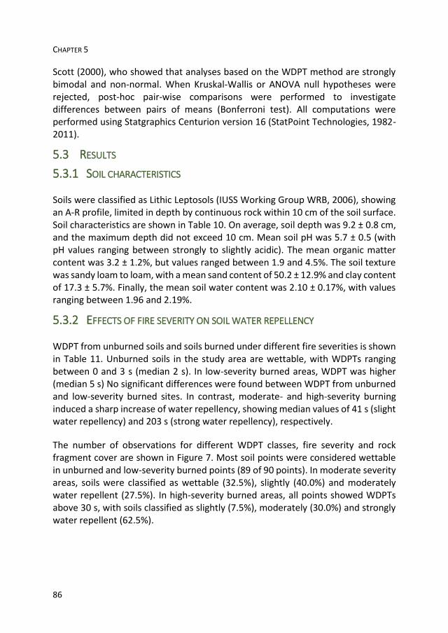
CHAPTER 5
86
Scott (2000), who showed that analyses based on the WDPT method are strongly bimodal and non-normal. When Kruskal-Wallis or ANOVA null hypotheses were rejected, post-hoc pair-wise comparisons were performed to investigate differences between pairs of means (Bonferroni test). All computations were performed using Statgraphics Centurion version 16 (StatPoint Technologies, 1982-2011).
5.3 RESULTS
5.3.1 SOIL CHARACTERISTICS
Soils were classified as Lithic Leptosols (IUSS Working Group WRB, 2006), showing an A-R profile, limited in depth by continuous rock within 10 cm of the soil surface. Soil characteristics are shown in Table 10. On average, soil depth was 9.2 ± 0.8 cm, and the maximum depth did not exceed 10 cm. Mean soil pH was 5.7 ± 0.5 (with pH values ranging between strongly to slightly acidic). The mean organic matter content was 3.2 ± 1.2%, but values ranged between 1.9 and 4.5%. The soil texture was sandy loam to loam, with a mean sand content of 50.2 ± 12.9% and clay content of 17.3 ± 5.7%. Finally, the mean soil water content was 2.10 ± 0.17%, with values ranging between 1.96 and 2.19%.
5.3.2 EFFECTS OF FIRE SEVERITY ON SOIL WATER REPELLENCY
WDPT from unburned soils and soils burned under different fire severities is shown in Table 11. Unburned soils in the study area are wettable, with WDPTs ranging between 0 and 3 s (median 2 s). In low-severity burned areas, WDPT was higher (median 5 s) No significant differences were found between WDPT from unburned and low-severity burned sites. In contrast, moderate- and high-severity burning induced a sharp increase of water repellency, showing median values of 41 s (slight water repellency) and 203 s (strong water repellency), respectively.
The number of observations for different WDPT classes, fire severity and rock fragment cover are shown in Figure 7. Most soil points were considered wettable in unburned and low-severity burned points (89 of 90 points). In moderate severity areas, soils were classified as wettable (32.5%), slightly (40.0%) and moderately water repellent (27.5%). In high-severity burned areas, all points showed WDPTs above 30 s, with soils classified as slightly (7.5%), moderately (30.0%) and strongly water repellent (62.5%).
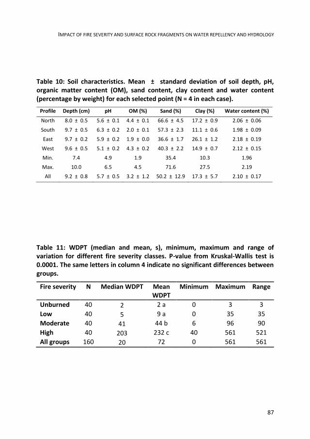
IMPACT OF FIRE SEVERITY AND SURFACE ROCK FRAGMENTS ON WATER REPELLENCY AND HYDROLOGY
87
Table 10: Soil characteristics. Mean ± standard deviation of soil depth, pH, organic matter content (OM), sand content, clay content and water content (percentage by weight) for each selected point (N = 4 in each case).
Profile Depth (cm) pH OM (%) Sand (%) Clay (%) Water content (%)
North 8.0 ± 0.5 5.6 ± 0.1 4.4 ± 0.1 66.6 ± 4.5 17.2 ± 0.9 2.06 ± 0.06
South 9.7 ± 0.5 6.3 ± 0.2 2.0 ± 0.1 57.3 ± 2.3 11.1 ± 0.6 1.98 ± 0.09
East 9.7 ± 0.2 5.9 ± 0.2 1.9 ± 0.0 36.6 ± 1.7 26.1 ± 1.2 2.18 ± 0.19
West 9.6 ± 0.5 5.1 ± 0.2 4.3 ± 0.2 40.3 ± 2.2 14.9 ± 0.7 2.12 ± 0.15
Min. 7.4 4.9 1.9 35.4 10.3 1.96
Max. 10.0 6.5 4.5 71.6 27.5 2.19
All 9.2 ± 0.8 5.7 ± 0.5 3.2 ± 1.2 50.2 ± 12.9 17.3 ± 5.7 2.10 ± 0.17
Table 11: WDPT (median and mean, s), minimum, maximum and range of variation for different fire severity classes. P-value from Kruskal-Wallis test is 0.0001. The same letters in column 4 indicate no significant differences between groups.
Fire severity N Median WDPT Mean WDPT
Minimum Maximum Range
Unburned 40 2 2 a 0 3 3
Low 40 5 9 a 0 35 35
Moderate 40 41 44 b 6 96 90
High 40 203 232 c 40 561 521
All groups 160 20 72 0 561 561

CHAPTER 5
88
Figure 10: Number of WDPT data for different classes (<5, 5-10, 10-30, 30-60, 60-180, 180-300 and 300- 600 s), fire severity and rock fragment cover class (low, <20%; high, >60%).
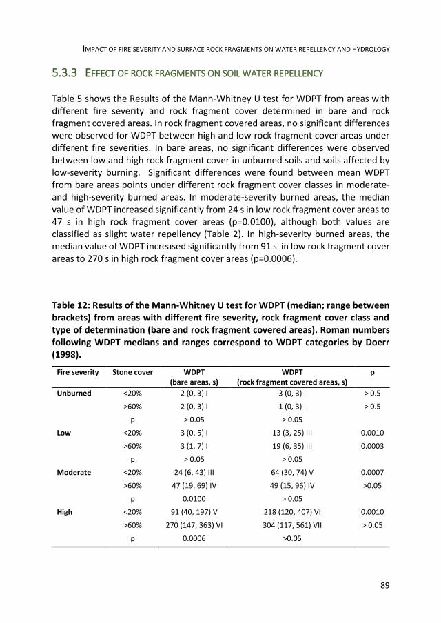
IMPACT OF FIRE SEVERITY AND SURFACE ROCK FRAGMENTS ON WATER REPELLENCY AND HYDROLOGY
89
5.3.3 EFFECT OF ROCK FRAGMENTS ON SOIL WATER REPELLENCY
Table 5 shows the Results of the Mann-Whitney U test for WDPT from areas with different fire severity and rock fragment cover determined in bare and rock fragment covered areas. In rock fragment covered areas, no significant differences were observed for WDPT between high and low rock fragment cover areas under different fire severities. In bare areas, no significant differences were observed between low and high rock fragment cover in unburned soils and soils affected by low-severity burning. Significant differences were found between mean WDPT from bare areas points under different rock fragment cover classes in moderate- and high-severity burned areas. In moderate-severity burned areas, the median value of WDPT increased significantly from 24 s in low rock fragment cover areas to 47 s in high rock fragment cover areas (p=0.0100), although both values are classified as slight water repellency (Table 2). In high-severity burned areas, the median value of WDPT increased significantly from 91 s in low rock fragment cover areas to 270 s in high rock fragment cover areas (p=0.0006).
Table 12: Results of the Mann-Whitney U test for WDPT (median; range between brackets) from areas with different fire severity, rock fragment cover class and type of determination (bare and rock fragment covered areas). Roman numbers following WDPT medians and ranges correspond to WDPT categories by Doerr (1998).
Fire severity Stone cover WDPT (bare areas, s)
WDPT (rock fragment covered areas, s)
p
Unburned <20% 2 (0, 3) I 3 (0, 3) I > 0.5
>60% 2 (0, 3) I 1 (0, 3) I > 0.5
p > 0.05 > 0.05
Low <20% 3 (0, 5) I 13 (3, 25) III 0.0010
>60% 3 (1, 7) I 19 (6, 35) III 0.0003
p > 0.05 > 0.05
Moderate <20% 24 (6, 43) III 64 (30, 74) V 0.0007
>60% 47 (19, 69) IV 49 (15, 96) IV >0.05
p 0.0100 > 0.05
High <20% 91 (40, 197) V 218 (120, 407) VI 0.0010
>60% 270 (147, 363) VI 304 (117, 561) VII > 0.05
p 0.0006 >0.05
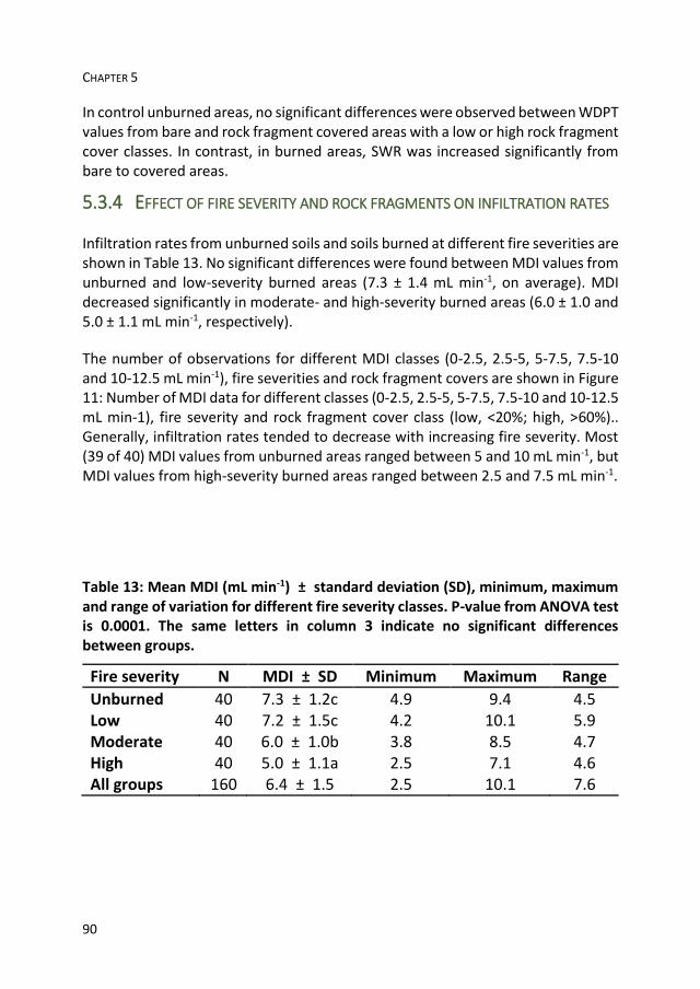
CHAPTER 5
90
In control unburned areas, no significant differences were observed between WDPT values from bare and rock fragment covered areas with a low or high rock fragment cover classes. In contrast, in burned areas, SWR was increased significantly from bare to covered areas.
5.3.4 EFFECT OF FIRE SEVERITY AND ROCK FRAGMENTS ON INFILTRATION RATES
Infiltration rates from unburned soils and soils burned at different fire severities are shown in Table 13. No significant differences were found between MDI values from unburned and low-severity burned areas (7.3 ± 1.4 mL min-1, on average). MDI decreased significantly in moderate- and high-severity burned areas (6.0 ± 1.0 and 5.0 ± 1.1 mL min-1, respectively).
The number of observations for different MDI classes (0-2.5, 2.5-5, 5-7.5, 7.5-10 and 10-12.5 mL min-1), fire severities and rock fragment covers are shown in Figure 11: Number of MDI data for different classes (0-2.5, 2.5-5, 5-7.5, 7.5-10 and 10-12.5 mL min-1), fire severity and rock fragment cover class (low, <20%; high, >60%).. Generally, infiltration rates tended to decrease with increasing fire severity. Most (39 of 40) MDI values from unburned areas ranged between 5 and 10 mL min-1, but MDI values from high-severity burned areas ranged between 2.5 and 7.5 mL min-1.
Table 13: Mean MDI (mL min-1) ± standard deviation (SD), minimum, maximum and range of variation for different fire severity classes. P-value from ANOVA test is 0.0001. The same letters in column 3 indicate no significant differences between groups.
Fire severity N MDI ± SD Minimum Maximum Range
Unburned 40 7.3 ± 1.2c 4.9 9.4 4.5 Low 40 7.2 ± 1.5c 4.2 10.1 5.9 Moderate 40 6.0 ± 1.0b 3.8 8.5 4.7 High 40 5.0 ± 1.1a 2.5 7.1 4.6 All groups 160 6.4 ± 1.5 2.5 10.1 7.6

IMPACT OF FIRE SEVERITY AND SURFACE ROCK FRAGMENTS ON WATER REPELLENCY AND HYDROLOGY
91
Figure 11: Number of MDI data for different classes (0-2.5, 2.5-5, 5-7.5, 7.5-10 and 10-12.5 mL min-1), fire severity and rock fragment cover class (low, <20%; high, >60%).

CHAPTER 5
92
Table 14: Results of the t-test for comparison of MDI values (mean ± standard deviation, mL min-1) from areas with different fire severity, rock fragment cover class and type of determination (bare and rock fragment covered areas).
Fire severity Stone cover MDI (bare areas) MDI (rock fragment covered areas) p
Unburned <20% 7.6 ± 1.3 7.5 ± 1.2 > 0.05
>60% 7.0 ± 1.2 7.1 ± 1.2 > 0.05
p > 0.05 > 0.05
Low <20% 8.0 ± 1.4 7.0 ± 1.4 > 0.05
>60% 7.5 ± 1.5 6.5 ± 1.4 > 0.05
p > 0.05 > 0.05
Moderate <20% 7.5 ± 1.5 6.5 ± 1.4 > 0.05
>60% 6.6 ± 1.2 5.6 ± 1.0 > 0.05
p > 0.05 > 0.05
High <20% 5.6 ± 0.9 4.5 ± 1.1 0.0264
>60% 5.3 ± 0.9 4.4 ± 1.0 0.0413
p > 0.05 > 0.05
Table 14 shows the comparison of mean MDI values from soils that underwent different burn severities under low (<20%) and high (>60%) rock fragment cover. In areas with homogeneous fire severity, no significant differences were observed between infiltration rates for different rock fragment cover classes. On average, differences between MDI values from low (<20%) and high (>60%) rock fragment covers ranged between 0.1 (bare areas after high fire severity burning) and 1.1 mL min-1 (covered areas after high fire severity burning).
When mean MDI values from bare and rock fragment covered areas were compared, no significant differences were observed, except in soils affected by high fire severity. In low rock fragment cover areas after high fire severity, MDI increased significantly from 4.5 ± 1.1 (covered areas) to 5.6 ± 0.9 mL min-1 (bare areas; p=0.02640). In high rock fragment cover areas after high fire severity, MDI increased significantly from 4.4 ± 1.0 (covered areas) to 5.3 ± 0.9 mL min-1 (bare areas; p=0.04128).
IMPACT OF FIRE SEVERITY AND SURFACE ROCK FRAGMENTS ON WATER REPELLENCY AND HYDROLOGY
93
5.4 DISCUSSION
5.4.1 SOIL WATER REPELLENCY AND FIRE SEVERITY
SWR increased with fire severity. Independently of rock fragment cover, the soil surface changed from wettable (low fire severity) to strongly water-repellent (high fire severity) in bare areas, and from slightly (low fire severity) to strongly water-repellent (high fire severity) in rock fragment covered areas. This agrees with
DeBano et al. (2005), who reported that SWR increases with burn severity (although it is expected that water repellency would disappear after extreme severity burning). Severity of fire effects on soils is conditioned by temperature peaks and heating duration in soil. According to DeBano and Krammes (1966), the intensity of fire-induced SWR depends for the most part on temperatures reached
during burning. Fire-induced SWR appears when temperatures of 175 - 200 oC are reached (Doerr et al., 2000), while some authors have observed destruction of SWR
at 270-300 oC (DeBano et al., 1976; Savage, 1974), 350-400 oC (Chandler et al.,
1983; Doerr et al., 2000), 270-400 oC (Robichaud and Hungerford, 2000; Zavala et
al., 2010a), 480-540 oC (DeBano and Krammes, 1966) or 500-600 oC (Bryant et al., 2005). These variations in temperature ranges are due to different conditions, oxygen availability and times of heating during laboratory experiments. According to some authors, the temperature at which complete destruction of hydrophobicity occurs is a function of time of heating (Bryant et al., 2005; Doerr et al., 2004).
High WDPTs observed in our research may be explained by temperature peaks surpassing the threshold for water repellency development. This is in agreement with Jordán et al. (2011), who found that moderate-severity burning increased SWR, but high-severity burning either enhanced or destroyed hydrophobicity, as different temperature peaks or heating periods were reached at the soil surface. Also, Glenn and Finley (2010) observed that infiltration rates significantly increased between moderate- and high-severity burned areas.
5.4.2 EFFECTS OF ROCK FRAGMENTS ON SOIL WATER REPELLENCY AND
INFILTRATION AFTER FIRE
In the absence of a dense vegetation cover, as in fire-affected soils, rock fragments resting on a wettable soil surface or partly incorporated into the soil body contribute significantly to the interception of rainfall, reducing the number of direct drop impacts, and affect the surface runoff flow. Martínez-Zavala and Jordán (2008) and Zavala et al. (2010b) observed that rock fragments enhance roughness of the soil surface, favouring ponding and channelling water between them, generating a

CHAPTER 5
94
deeper and more hydraulically-efficient flow. In addition porosity and aggregation of soil below are enhanced, facilitating water infiltration and, in consequence, reducing soil erosion risk.
According to our results, fire severity and rock fragments resting on the soil surface are responsible for a patchy distribution of SWR and infiltration after burning, so that processes can change significantly. Even after low-severity burning with a low rock fragment cover (<20%), SWR was enhanced at the soil surface directly beneath rock fragments. This effect may be explained by the heat flow dynamics between fire, rock fragments and the soil surface. After a controlled burn experiment, García-Moreno et al. (2013b) have observed that temperature peaks in the soil surface covered by rock fragments were reached some minutes later than in exposed soil surface. In their experiment, a controlled burn was carried out during 15 minutes, and temperature in bare soil reached 300-350 oC. Under rock fragments, temperature peaks were delayed, but reached 350-400 oC, and heating lasted longer. At these points where rock fragments are resting on the soil surface,
thermal energy is transferred to the rock fragments and stored for longer than in the exposed areas. Even after burning, rock fragments continue transmitting heat to the soil surface. In their experiment, García-Moreno et al. (2013b) have found that water repellency was induced in the upper soil layer (0-10 mm) where there was no rock fragment cover, and that wettability increased with rock fragment cover. Water repellency in soil plots beneath rock fragments (0-10 mm) was higher, but remained mostly at subcritical levels (WDPT<5 s). This is not in agreement with the present results, which show a strong difference in water repellency between bare and rock fragments covered soil after moderate- and high-severity burning. Differences between both results may be due to different fire severities observed. The prescribed fire by García-Moreno et al. (2013b) was carried out during the cool wet season and temperature peaks above 300 oC were recorded during 14 minutes. In the present work, great changes were not observed in SWR after low fire severity, but slight and strong water repellency were observed after moderate- and high-fire severity.
It is suggested that prolonged heat transfer from rock fragments to soil contributed to lengthened period of residence for temperatures above the threshold for water repellency induced at the soil surface, hence increasing WDPT. In bare areas, weaker water repellency was induced. In these cases, temperatures during the fire at the soil surface may have been even higher, but more short-timed peaks were probably reached during low-severity burning.

IMPACT OF FIRE SEVERITY AND SURFACE ROCK FRAGMENTS ON WATER REPELLENCY AND HYDROLOGY
95
After moderate- and high-severity burning, no significant differences were observed between WDPTs from bare and covered sites under a high rock fragment cover, probably as a consequence of the proximity between rock fragment-covered areas and high fire temperatures: rock fragments can induce a lateral heat flow (Poesen and Lavee, 1994), which may have reduced the intensity of the temperature gradient between the bare area between nearby rock fragments and covered sites. Also, authors have observed occasional amounts of ashes between neighbouring rock fragments, as a result of prolonged combustion of litter and plant residues with low oxygen availability. Flameless smouldering may have contributed to enhanced water repellency in bare sites with a high rock fragment cover.
Fire-induced SWR caused different infiltration rates, which decreased when burning severity increased. Consequently, a patchy pattern of runoff generation must be expected. Decreased infiltration rates after burning have been reported by González-Pelayo et al. (2010) in Mediterranean shrubland soils from Spain, Imeson et al. (1992) in northeastern Spain, Robichaud (2000) in forest soils from the Northern Rocky Mountain, USA, and Rulli et al. (2006) in northwestern Italy. Although different processes are involved (as pore clogging by ash and soil fine particles), the development of a fire-induced water-repellent layer has been suggested as the main cause for decreased soil infiltration rates (Doerr et al., 2000). According to our results, runoff rates are expected to increase with fire severity. So, when a range of fire severities are found after burning, the runoff response may be complex, and studies at broader scale are necessary to fully understand this process.
MDI and WDPT were significantly correlated (Spearman’s rank correlation coefficient -0.6837, p = 0.0000). Although the mean MDI from rock fragment covered areas was higher than that for bare areas in all cases, significant differences (p<0.05) were observed only after high-severity burning. In these cases, mean infiltration rates changed significantly when median WDPT values increased between bare and covered sites.

CHAPTER 5
96

6 WETTABILITY OF ASH CONDITIONS SPLASH
EROSION AND RUNOFF RATES IN THE POSTFIRE

CHAPTER 6
98

WETTABILITY OF ASH AND SOIL EROSION
99
6.1 INTRODUCTION
Soil is a basic component of ecosystems. Sustainability and recovery after fire depend both on physical, chemical and biological processes and fire severity (Neary et al., 1999; Mataix-Solera and Guerrero, 2007). Fire effects on soils are divided in two types: direct effects, as a consequence of combustion and temperature reached and indirect effects (Neary et al., 1999) as consequence of changes in other ecosystem components, such as decrease in vegetal coverage or ash and partially burned litter contribution incluiding changes in flora (Pausas and Verdú, 2005; Trabaud, 2000).
Low intensity fires, during which high temperatures are not reached, affect vegetal coverage but will not cause major impacts on soil. Impacts in soil will only be restricted to the first millimeters of depth. In contrast, prolonged, recurrent, or high-intensity fires can cause important impacts on the soil system functioning (De Celis et al., 2013; DeBano, 1991; Mataix-Solera et al., 2009), aggregation (Mataix-Solera et al., 2011), organic matter content and quality (Sevink et al., 1989), water repellency (DeBano, 2000a; Doerr et al., 2000), soil nutrients (DeBano et al., 1979; Stark, 1977), soil erosion (Larsen et al., 2009) and others. In these cases, the restoration period of the initial conditions can be very long and changes become permanent (DeBano, 1991; DeBano et al., 1979).
During combustion, fuel (biomass, necromass and soil organic matter) is transformed in materials with new physical and chemical properties. After fire, the soil surface is covered by a layer of ash and organic residues, more or less charred depending on fire severity. Ash has important ecological, hydrological and geomorphological effects, even after being rearranged or mobilized by runoff or wind (Bodí et al., 2014).
The characteristics of ash will depend on the burnt species, the amount of affected biomass, fuel flammability and structure, temperature and the residence time of thermal peaks (Ulery et al., 1993; Pereira et al., 2009). Some studies have emphasized the role of ash on soil protection during the after fire period, in which the vegetable coverage could be drastically decreased (Cerdà and Doerr, 2008; Woods and Balfour, 2008; Zavala et al., 2009a).
Soil protection by the ash coverage is critical during the time when the vegetal coverage is low (Zavala et al., 2009a). However, the ash coverage can be transient or last for some time, until it disappears or decreases due to erosion (water and wind), animals or crossing vehicles. The effect may be variable, since an intense combustion favors the appearance of white ash is predominantly of a mineral
CHAPTER 6
100
nature, and hydrophilic. Conversely, incomplete combustion promotes the appeareance of dark ashes often hydrophobic and capable of increasing the rate of run-off, and therefore the risk of erosion (Zavala et al., 2009a).
Diverse authors have observed that the capacity of ash coverage to protect soil depends on properties as the topography, the meteorological conditions and the thickness of ash coverage (Cerdà and Doerr, 2008; Gabet and Sternberg, 2008; Larsen et al., 2009; Leighton-Boyce et al., 2007; Pereira et al., 2013; Woods and Balfour, 2010; Zavala et al., 2009a).
6.2 OBJECTIVES
The aim of this work is to study the impact of the ash produced after a fire in water erosion risk. More specifically it has been carried out the study of [i] sediment dispersion by splash erosion and [ii] impact on runoff rate trough rain simulations experiments, in soils affected by fire and covered by hydrophobic or hydrophilic ash after a prescribed fire.
6.3 MATERIAL AND METHODS
6.3.1 EXPERIMENTAL DESIGN
In 20 November 2012, a prescribed fire was carried out in an area located in the public mount "Las Navas", near Almaden de la Plata, Sevilla. The coordinates are approximately 37o 50’ 44.44’’ N / 6o 3’ 7.44’’W and 428 masl. Soils are shallow, developed from acidic metamorphic rocks (schists, slates and pyrophyllites). Vegetation is dominated by shrub legumes (Calicotome villosa and several species of Ulex and Genista).
The experimental area was framed and plowed to eliminate the risk of fire spreading during the experiment. Before starting the fire, sticks for determining flame height (Figure 12) were installed. The temperature reached in the soil was monitored during the fire by a set of six thermocouples which were buried in soil (2 cm depth) and connected to a data-logger for monitoring the topsoil temperature every 60 s. The environmental conditions were also monitored during the experiment by a mobile weather station (Figure 13). At the moment of the ignition, the temperature was around 20 oC and the wind speed was near 0.0 km.

WETTABILITY OF ASH AND SOIL EROSION
101
Figure 12: Installation of bars for determining flame height.
Previously to burn, soil samples (0-5 cm depth) were collected inside the experimental area at points selected by randomly generated coordinates for soil characterization. Soil samples were transported in plastic bags to the laboratory, spread in paper trays and left drying during 7 days under standard laboratory conditions. When dry, soil samples were homogenized and sieved (2 mm) to remove coarse materials.
The experimental area was allowed to burn during 2.5 h. During the experimental fire, flames reached 200 cm height, although thermal peaks recorded 2 cm depth were relatively low (not surpassing 80 oC). After burning, the soil surface was covered by a pattern of white and black ash, indicating varying degrees of fire severity (Figure 14). For security, water was sprayed to ensure complete extinguishment.
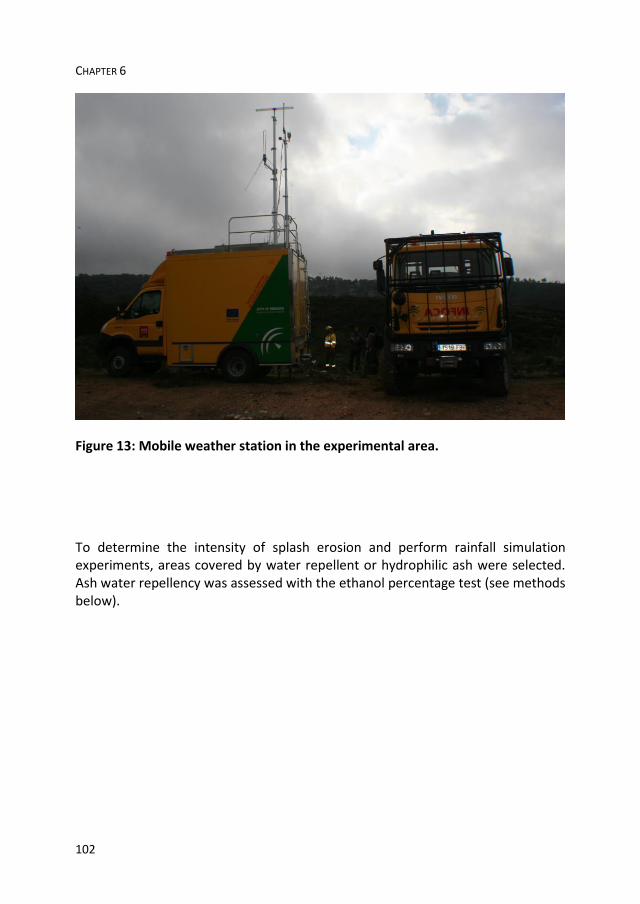
CHAPTER 6
102
Figure 13: Mobile weather station in the experimental area.
To determine the intensity of splash erosion and perform rainfall simulation experiments, areas covered by water repellent or hydrophilic ash were selected. Ash water repellency was assessed with the ethanol percentage test (see methods below).
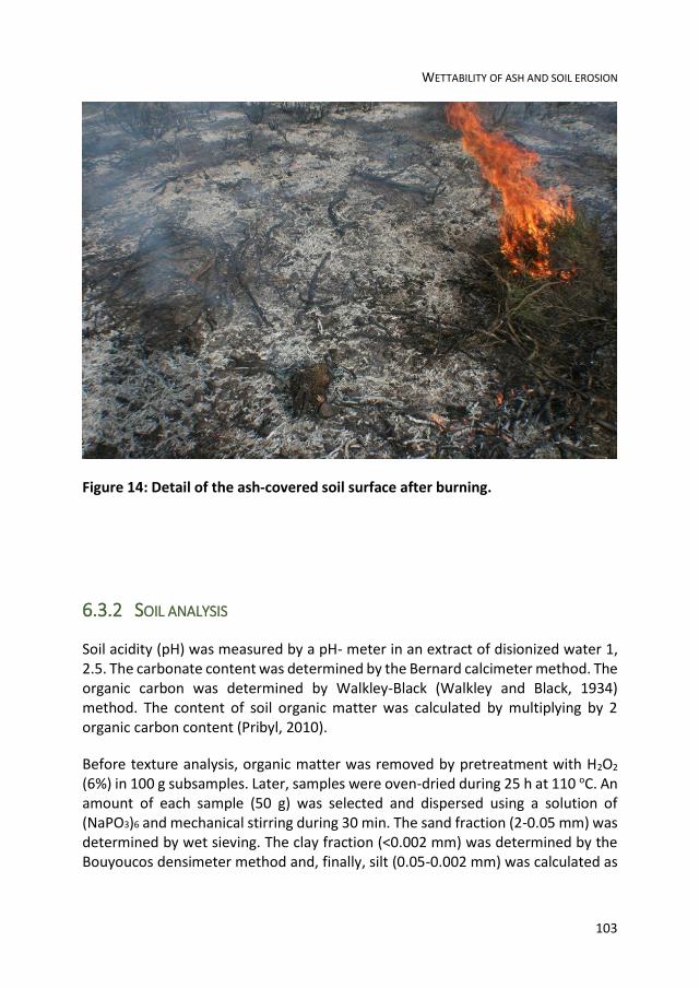
WETTABILITY OF ASH AND SOIL EROSION
103
Figure 14: Detail of the ash-covered soil surface after burning.
6.3.2 SOIL ANALYSIS
Soil acidity (pH) was measured by a pH- meter in an extract of disionized water 1, 2.5. The carbonate content was determined by the Bernard calcimeter method. The organic carbon was determined by Walkley-Black (Walkley and Black, 1934) method. The content of soil organic matter was calculated by multiplying by 2 organic carbon content (Pribyl, 2010).
Before texture analysis, organic matter was removed by pretreatment with H2O2 (6%) in 100 g subsamples. Later, samples were oven-dried during 25 h at 110 oC. An amount of each sample (50 g) was selected and dispersed using a solution of (NaPO3)6 and mechanical stirring during 30 min. The sand fraction (2-0.05 mm) was determined by wet sieving. The clay fraction (<0.002 mm) was determined by the Bouyoucos densimeter method and, finally, silt (0.05-0.002 mm) was calculated as
CHAPTER 6
104
the difference between 100% and the sum of the percentages of sand and clay which were previously determined.
For the determination of the structural stability, 20-25 (size between 4 and 4.8 mm) soil aggregates per sample were selected and the CND method (Counting the Number of Drop-Impacts, Mataix-Sill et al, 2010) was used. The aggregates of each sample were wetted by capillarity upto pF1. Aggregates were arranged on a sieve (2.88 mm) and subjected to the successive impact of drops of water (0.1 g) from 1 m height, falling through a PVC pipe 10 cm in diameter to avoid the effect of air current until the aggregate is destroyed, counting the number of drops required (CND) to a maximum of 200.
6.3.3 ASH WATER REPELLENCY
The intensity of the water repellency of the ash was determined by the ethanol percentage test (EPT). The EPT provides an indirect measurement of the surface tension of the ground and, therefore, indicates the intensity of soil water repellency and is based on the different surface tension of a number of standardized solutions of ethanol in water.
The procedure consists in applying drops (0.05 mL) of different ethanol solutions with different concentrations onto the surface of the ash layer observing if infiltration occurs in a period that not exceed 5 s (Jordán et al., 2010) . Every drop is allowed to fall from a distance not bigger than 15 mm to avoid the excess of kinetic energy that can affect infiltration. Applying drops with decreasing surface tension (that is, with concentrations of increasing ethanol; Table 15) until a drop resists the infiltration allows the classification of the ground in a particular class of surface tension between two concentrations of ethanol: that in which infiltration occurs immediately (in less than 5 s) and the above solution of weaker concentration. Thus, it is assumed that solution whose drop is infiltrated within the first 5 s after application has a lower surface tension than soil surface (Letey et al., 2000).
6.3.4 EROSION SPLASH
In each of the areas covered by hydrophilic and water repellent ash 15 representative points were selected. Each of these points was surrounded by white / hydrophilic or dark / water repellent to a minimum distance of 0.5 m ash. In each of the points a splash sediment collection system was installed. This system consist
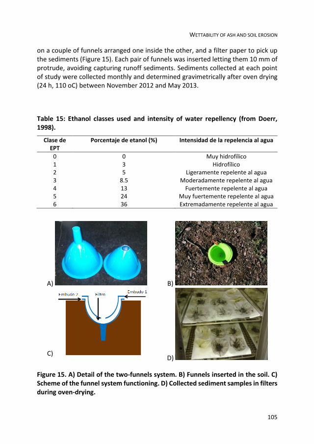
WETTABILITY OF ASH AND SOIL EROSION
105
on a couple of funnels arranged one inside the other, and a filter paper to pick up the sediments (Figure 15). Each pair of funnels was inserted letting them 10 mm of protrude, avoiding capturing runoff sediments. Sediments collected at each point of study were collected monthly and determined gravimetrically after oven drying (24 h, 110 oC) between November 2012 and May 2013.
Table 15: Ethanol classes used and intensity of water repellency (from Doerr, 1998).
Clase de EPT
Porcentaje de etanol (%) Intensidad de la repelencia al agua
0 0 Muy hidrofílico 1 3 Hidrofílico 2 5 Ligeramente repelente al agua 3 8.5 Moderadamente repelente al agua 4 13 Fuertemente repelente al agua 5 24 Muy fuertemente repelente al agua 6 36 Extremadamente repelente al agua
A) B)
C) D)
Figure 15. A) Detail of the two-funnels system. B) Funnels inserted in the soil. C) Scheme of the funnel system functioning. D) Collected sediment samples in filters during oven-drying.

CHAPTER 6
106
6.3.5 RAINFALL SIMULATION
In order to perform rain simulation experiments, 30 representative points of water repellent ash and as many of hydrophilic ash were chosen. These points were located below the slope used for the analysis of splash erosion. The rainfall simulation experiments were carried using a Kamphorst portable simulator (Figure 16; Kamphorst, 1987). Raindrops (5.9 mm, 0.106 g) were dropped from a height of 33-54 cm with a constant intensity of 350 mm h-1 for 10 minutes over an area of 0.625 cm2 which was enclosed by an aluminum frame inserted into the soil.
Distilled water was used at all simulations, because the response of the soil or ash can vary depending on the chemical composition of the liquid used (Agassi et al., 1994). A metal collector inserted into the soil down slope was used to direct runoff to a plastic container buried in the ground. Runoff water was collected periodically, calculating the total volume. The runoff rate was calculated as a percentage of the total water collected in relation to the total used in each test (about 350 mm × 0.16 h-1 h). Prior to rain simulation, five measurements of the thickness of the ash layer were taken by a metal rod evenly distributed on a diagonal from the experimental area. The average of the measurements was taken as representative of each point.

WETTABILITY OF ASH AND SOIL EROSION
107
Figure 16: Description of the Kamphorst mobile rainfall simulator.
6.3.6 DATA ANALYSIS
Analysis of normality and homogeneity of all variables was performed using the Shapiro-Wilk and Brown-Forsyth test, respectively. In cases where the variable fulfilled both requirements, tests and statistical parametric (ANOVA, rank correlation analysis-LSD-t test for comparison of averages, Pearson correlations, average, standard deviation and regressions) were used. If a variable did not satisfy both conditions, non-parametric statistics (Spearman correlation, mode, average and range) were used. For data analysis STATGRAPHICS (Centurion version 16 StatPoint Technologies, 1982-2011) software was used.

CHAPTER 6
108
6.4 RESULTS AND DISCUSSION
6.4.1 GENERAL DESCRIPTION OF SOIL
Table 16 shows the physicochemical characterization of the study area. The pH fluctuated between 5.9 and 7.1, with an average value of 6.5 ± 0.4. The organic matter content is moderate (3.1 ± 0.4%). Because the soil is slightly acidic, the calcium carbonate content determined was very low (0.14 ± 0.29% on average, with a maximum of 0.9%). The structural stability of the soil was moderately high, with a CND value of 189 ± 5. Soil texture swings between sandy-clay-loam and loam, with averages of sand, silt and clay 45.0 ± 2.5, 31.01 ± 3.5 and 24.9 ± 2.7 %, respectively.
After the fire, the soil was covered with a layer of ash with a thickness between 1 and 60 mm, as a result of the combustion.
6.4.2 ASH WATER REPELLENCY
Depending on the intensity of the water repellency, the ash layer fluctuated between hydrophilic (EPT 1) and very strongly water repellent (EPT 5). Figure 17shows the distribution of the values of EPT (2-5) in the water repellant ash areas. The ash has a high permeability and water storage. However, its hydrophilic character has been emphasized rarely (Cerdà and Doerr, 2008). Different authors have described hydrophobic behaviors depending on the burned vegetation such as chaparral (Gabet and Sternberg, 2008) or coniferous forest (Stark, 1977) in the United States, the eucalyptus forest in Australia (Khanna et al., 1996 ) or Mediterranean tree and shrub species in Spain (Bodí et al., 2011). In the latter case, Bodí et al. (2011) observed that ash has different properties depending on the combustion conditions, organic carbon content and color. This variability of behavior agrees with the results obtained in the present work.

WETTABILITY OF ASH AND SOIL EROSION
109
Table 16: Physical and chemical characteristics of soils in the study área.
Mean SD Minimum Maximum
pH (1,2.5 H2O) 6.5 0.4 5.9 7.1 Organic matter (%) 3.1 0.4 1.9 3.5 CO3Ca (%) 0.14 0.29 0.0 0.9 Stability of structure 189 5 184 198 Sand (%) 45.0 2.5 42.3 50.5 Silt (%) 30.1 3.5 24.6 34.8 Clay (%) 24.9 2.7 22.2 31.3
Figure 17: Distribution of water repellency classes in the water-repellent ash area. N = 30.

CHAPTER 6
110
6.4.3 SPLASH EROSION
Table 17 shows the results of analysis of variance splash displaced sediment according to the sampling in areas covered by water repellent and hydrophilic ash. In both cases significant differences between groups (ANOVA p-value = 0.0000) were observed.
For the ash-covered water repellent area, the results of all samples showed significant differences between them. On average, the number of displaced sediment was 13.23 ± 6.70 g. During the first four months after the fire, the amount of sediment displaced by splash increased rapidly up to 264.10% (from 3.90 ± 0.44 to 14.20 ± 1.75 g). By contrast, during the last three months, the number of displaced sediments remained high, but growth was lower, only 28.11% (from 16.97 ± 1.66 to 21.74 ± 3.27 g).
In the case of the area covered with hydrophilic ash, the amount of sediment was much smaller, as well we consider all samples together (t = -13 to 7017, p-value = 0.000), as individually (average values fluctuated from 1.29 and 6.14 g). During the first two sampling after the fire, the values did not differ from each other (1.38 ± 0.18 g on average). Subsequently, the amount of sediment collected grew slowly until the last two samples (6.12 ± 0.63 g on average).
Several authors have suggested that ash acts protecting soil from the direct impact of raindrops and thus reduce splash sediment dispersion (Cerdà and Doerr, 2008, Larsen et al, 2009; Woods and Balfour, 2008, Zavala et al, 2009a). However, there is very little information about the effect of hydrophobicity on splash erosion. In a rainfall simulation experiment under laboratory conditions, Bodí et al. (2012b) observed that splash erosion was at least two times higher in samples of water repellent soil than in hydrophilic soil, but no differences in ash loss or thickness of ash layer were observed.

WETTABILITY OF ASH AND SOIL EROSION
111
Table 17: Results of the ANOVA test for sediment displaced by raindrop splash (mean ± standard deviation, SD) in wettable and water repellent ash areas. Mean values followed by different letters within the same column show significant differentes (p ≤ 0.05). N = 15 in all cases.
Sampling date Water repellent ash Mean ± SD
Wettable ash Mean ± SD
10/11/2012 3.90 ± 0.44 a 1.29 ± 0.12 a 20/12/2012 5.28 ± 0.69 b 1.48 ± 0.17 a 20/01/2013 10.61 ± 1.34 c 3.06 ± 0.39 b 20/02/2013 14.20 ± 1.75 d 4.32 ± 0.47 c 20/03/2013 16.97 ± 1.66 e 4.96 ± 0.52 d 20/04/2013 19.91 ± 2.16 f 6.10 ± 0.58 e 20/05/2013 21.74 ± 3.27 g 6.14 ± 0.69 e
Mean 13.23 ± 6.70 3.91 ± 1.94 ANOVA, p-value 0.0000 0.0000
6.4.4 RAINFALL SIMULATIONS
Table 18 shows a descriptive analysis of runoff coefficient and the thickness of the layer of ash in the water repellent and hydrophilic ash zones. In neither of cases significant differences between the ash layer thickness (Table 19), which together with, showed an average of 18.59 ± 13.85. However, significant differences in the case of runoff coefficient were recorded after the rain simulation experiments (p = 0.0000, Table 19). While in the water repellent ash, the runoff coefficient showed an average value of 49.9 ± 10.08% in the hydrophilic ash this value decreased to 10.28 ± 4.86%.
Figure 18 shows the runoff coefficient, determined depending on the thickness of the ash layer in the areas of hydrophilic and water repellent ash. In the first case, it is observed that runoff coefficient is independent of the thickness of the ash layer. Low runoff coefficient here observed, suggests that despite the saturation of the ash layer with water precipitation, a general process of infiltration was favored (higher to 80%). Similar behavior has been described by Bodí et al. (2012b) under laboratory conditions and by Kinner and Moody (2010) in field conditions.
In the second case (water repellent ash), clearly shows how the runoff rate decreases with the ash layer thickness. The relation between the two variables can
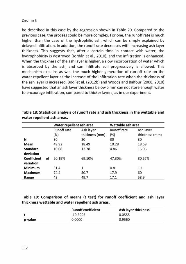
CHAPTER 6
112
be described in this case by the regression shown in Table 20. Compared to the previous case, the process could be more complex. For one, the runoff rate is much higher than the case of the hydrophilic ash, which can be simply explained by delayed infiltration. In addition, the runoff rate decreases with increasing ash layer thickness. This suggests that, after a certain time in contact with water, the hydrophobicity is destroyed (Jordán et al., 2010), and the infiltration is enhanced. When the thickness of the ash layer is higher, a slow incorporation of water which is absorbed by the ash, and can infiltrate soil progressively is allowed. This mechanism explains as well the much higher generation of run-off rate on the water repellent layer as the increase of the infiltration rate when the thickness of the ash layer is increased. Bodí et al. (2012b) and Woods and Balfour (2008, 2010) have suggested that an ash layer thickness below 5 mm can not store enough water to encourage infiltration, compared to thicker layers, as in our experiment.
Table 18: Statistical analysis of runoff rate and ash thickness in the wettable and water repellent ash areas.
Water repellent ash area Wettable ash area
Runoff rate (%)
Ash layer thickness (mm)
Runoff rate (%)
Ash layer thickness (mm)
N 30 30 30 30 Mean 49.92 18.49 10.28 18.69 Standard deviation
10.08 12.78 4.86 15.06
Coefficient of variation
20.19% 69.10% 47.30% 80.57%
Minimum 31.4 1 0.8 1.1 Maximum 74.4 50.7 17.9 60 Range 43 49.7 17.1 58.9
Table 19: Comparison of means (t test) for runoff coefficient and ash layer thickness wettable and water repellent ash areas.
Runoff coefficient Ash layer thickness
t -19.3995 0.0555 p-value 0.0000 0.9560

WETTABILITY OF ASH AND SOIL EROSION
113
Figure 18: Runoff rate in function of the ash-layer thickness in the wettable- and water repellent-ash areas.
Table 20: Results of the regression analysis between runoff coefficient and ash layer thickness in the water repellent ash área.
Runoff regression
Parameter Minimum squared Standard error T-value P-value
Interception 63.1261 1.41256 44.6891 0.0000 Slope -0.714283 0.0631815 -11.3053
ANOVA
Source Sum of squared Degrees of freedom Mean squared F-ratio P-value
Model 2415.91 1 2415.91 127.81 0.0000 Residues 529.271 28 18.9026 Total 2945.18 29
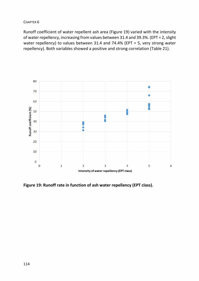
CHAPTER 6
114
Runoff coefficient of water repellent ash area (Figure 19) varied with the intensity of water repellency, increasing from values between 31.4 and 39.3%. (EPT = 2, slight water repellency) to values between 31.4 and 74.4% (EPT = 5, very strong water repellency). Both variables showed a positive and strong correlation (Table 21).
Figure 19: Runoff rate in function of ash water repellency (EPT class).

WETTABILITY OF ASH AND SOIL EROSION
115
Table 21: Correlation coefficients between runoff rate, ash layer thickness and intensity of ash water repellency (EPT class) in wettable and water repellent ash areas.
Zone Variable R p-value
Wettable area Runoff rate/ash layer thickness (R-Pearson)
0.2226 0.2370
Water repellent ash area Runoff rate /ash layer thickness (R-Pearson)
-0.9057 0.0000
Runoff rate /EPT (R-Spearman)
0.9533 0.0000
Ash ayer thicknes /EPT (R-Spearman)
-0.9400 0.0000
A working scale, these results agree with previous works in which it has been found that the ash is a key factor in the study of soil erosion affected by fire at pedon scale (1 m2). However, it is not clear what is the influence of the ash layer on slope or basin scale (León et al, 2013; Woods and Balfour, 2010). Due to the particle size of the ash, it is often suggested that it may contribute to the occlusion of the soil pores, forming a sealing surface that facilitate runoff generation (Gabet and Sternberg, 2008; Mallik et al., 1984) However, in this work it has been assumed that the effect occurs as well in the hydrophilic ash as in the water repellent ashes, so that differences in runoff generation should be conditioned only by the ash layer capacity to absorb and store water (conditioned by its thickness) and their degree of hydrophobicity. Owing to ash layer high heterogeneity after combustion (Granged et al., 2011c), Bodí et al. (2014) proposed the study of connectivity of ash cover to improve the knowledge about the ash influence on erosion, along with other elements such as leaves debris and other wastes partially burned.

CHAPTER 6
116

CONCLUSIONS

CONCLUSIONS
118

CONCLUSIONS
119
The research carried out in this thesis constitutes an approach to the study of the impacts of wildfires in soils under Mediterranean conditions, with special reference to medium- and long-term evolution of fire-affected soil properties and the influence of surface elements (rock fragments and ash layers) that have not been largely considered in the scientific literature. The results previously discussed allow obtaining the following conclusions:
Post-fire evolution of water repellency and aggregate stability in Mediterranean calcareous soils
Soil WR was induced in previously wettable calcareous soils after moderate severity burning. In calcareous soils where pre-fire WR was observed, the proportion of wettable samples generally decreased after burning.
Small changes were observed in soil WR in the fine earth fraction (<2 mm) from soil samples (0-15 mm deep) over a six year recovery period. Generally, severity of soil WR was stable or decreased slightly, in agreement with previous results. In contrast, sieve-fractions showed different behaviour patterns. The proportion of wettable samples in coarser aggregates (1-2 mm) decreased immediately after burning, but increased to values close to 100% in the last year of the experiment. Severity of WR from finer aggregates (0.5-1 and 0.25-0.5 mm) varied or remained stable but did not contribute to general soil WR assessed in the fine earth fraction. Vegetation type and lithology conditioned the severity of WR in the finer fractions, although this did not affect soil WR.
Vegetation type and lithology did not affect clearly AS. AS increased slightly after fire and decreased progressively through the experimental period. AS varied with WR suggesting a relation between both variables. However, AS was not affected severely by moderate-severity burning in the studied soils, which show a high clay content and calcium carbonate as main cementing substances.
It can be concluded that soil resilience to low-moderate fire disturbance seems to be very high in the studied areas.
Do stones modify the spatial distribution of fire-induced soil water repellency?
Both pH and AS at different depths did not show significant differences between soil plots with different soil cover. Burning temperature induced critical or subcritical SWR in the upper layer (0-10 mm) of previously wettable soil.

CONCLUSIONS
120
Fire-induced SWR did not vary with stone cover, but critical SWR was reached in inter-stone soil areas. At stone-covered soil areas, SWR was increased, but WDPTs remained mostly below the 5 s threshold.
Research is being carried out in order to study further evolution of properties, wettability at the surface and the effect and dynamics of ashes.
Fire severity and surface rock fragments cause patchy distribution of soil water repellency and infiltration rates after a forest fire
The effect of fire severity and rock fragments resting on the soil surface on the development of water repellency in burned soils has been studied in this experiment. After a wildfire, it was observed that burning induced water repellency in previously wettable soils. The degree of repellency increased with burning severity. The soil surface changed from wettable (bare areas) or slightly water repellent (rock fragment covered areas) after low fire severity to strongly water repellent after high fire severity.
Rock fragments resting on the soil surface may cause heterogeneity in the spatial distribution of water repellency after burning. In areas with a low rock fragment cover (<20%), water repellency from soil surfaces covered by rock fragments increased at least in 2 categories relative to soil surfaces not covered by rock fragments.
In areas with a high rock fragment cover (>60%), SWR was significantly lower for bare soil surfaces (wettable) compared with rock fragment covered areas after low-severity burning (slight water repellency). In moderate- and high-severity burned soils with a high rock fragment cover, no significant differences were observed between bare areas and areas covered by rock fragments. It is suggested that the proximity of rock fragments during severe burning may have contributed to reducing the intensity of the temperature gradient between bare and covered sites. Smouldering processes after the passage of fire are also suggested as a factor implied in water repellency development.
Rock fragment cover did not affect the infiltration rate. Also, the rate decreased significantly in rock fragment-covered soil surfaces after high-severity burning where there was a low or high rock fragment cover.
Together with fire severity, rock fragments resting on the soil surface should be considered as a factor potentially affecting the distribution of fire-induced soil water repellency in burned soils. Especially in stony soils, which are frequent in

CONCLUSIONS
121
areas as the Mediterranean basin, the effect of rock fragments must be taken into account to avoid errors in evaluating the hydrological response of burned soils.
Wettability of ash conditions splash erosion and runoff rates in the postfire
Ash plays an important role to protect soil in the post-fire. In this work has also been shown that the intensity of water repellency of the ash, as a result of the biomass and soil organic matter combustio degree, conditions very significantly the hydrological response after fire.
Results of this research show that ash protects soil from splash erosion, particularly in the case of hydrophilic ash. The presence of a water-repellent ash layer, however, in contrast to hydrophilic ash, increases the mobilization and sediment loss.
Water-repellent ash layer presence, increases runoff rate generation. The runoff rate is directly proportional to the intensity of the water repellency. However, during the rain test simulation it has been observed that even with strongly hydrophobic ash, the increase in the thickness of the ash layer contributes to the storage of water, which infiltrates slowly in the soil, thereby decreasing the run-off generation and the erosion risk.
During the post-fire precipitation, a hydrophilic ash layer acts absorbing large amounts of water and maintaining the runoff rate generation reduced at 20%, even as high intensity of precipitation as was used in this assay (350 mm h-1 for 10 minutes).
Although fire can increase the soil erosion risk, results suggest that, at plot scale, ash may acts protecting soil from erosion risk.

CONCLUSIONS
122
CONCLUSIONES

CONCLUSIONES
124
CONCLUSIONES
125
La investigación llevada a cabo en esta tesis doctoral constituye una aproximación al estudio de los impactos de los incendios forestales en suelos bajo condiciones mediterráneas, con especial referencia a la evolución a medio y largo plazo de las propiedades de los suelos afectados por los incendios, así como a la influencia de los elementos de superficie (piedras y capas de ceniza) que no han sido considerados con profundidad en la literatura científica. Los resultados discutidos anteriormente permiten obtener las siguientes conclusiones:
Evolución post-fuego de repelencia al agua y estabilidad de agregados en suelos calcáreos mediterráneos
El fuego de severidad moderada es capaz de inducir repelencia al agua en suelos calcáreos previamente humectables. En suelos calcáreos donde se observó la existencia de repelencia al agua antes del incendio, la proporción de muestras humectables disminuyó generalmente después del fuego.
Se observaron pequeños cambios en la repelencia al agua del suelo en la fracción de tierra fina (<2 mm) de muestras de suelo superficiales (0-15 mm de profundidad) durante un período de recuperación de seis años. En general, la severidad de la repelencia al agua del suelo se mantuvo estable o disminuyó ligeramente, de acuerdo con los resultados anteriores. Por el contrario, las diferentes clases de tamaño de agregados mostraron diferentes patrones de comportamiento. La proporción de muestras humectables en los agregados gruesos (1-2 mm) disminuyó inmediatamente después del fuego, pero aumentó a valores cercanos al 100% en el último año del experimento. El grado de repelencia al agua de los agregados finos (0.5-1 y 0.25-0.5 mm) varió o permanecido estable, pero en general no contribuyó a la repelencia al agua de la fracción de tierra fina del suelo. El tipo de vegetación y la litología condicionaron la severidad de repelencia al agua en los agregados más finos, si bien esto no se reflejó en la repelencia del suelo.
El tipo de vegetación y la litología no mostraron una clara relación con la estabilidad de agregados. La estabilidad de agregados aumentó ligeramente después de los incendios disminuyó progresivamente durante el período experimental. La estabilidad de agregados sí varió en función del grado de repelencia al agua, sugiriendo una relación entre ambas variables.
Se puede concluir que los suelos del área de estudio presentan una alta resiliencia a las perturbaciones del suelo bajo fuego de severidad moderada.
CONCLUSIONES
126
Relación entre la distribución espacial de la repelencia al agua del suelo inducida por el fuego y la cobertura de piedras
Tanto el pH como la estabilidad de agregados a diferentes profundidades no mostraron diferencias significativas entre parcelas de suelo con diferente cobertura de piedras. Tras el fuego, se observó la presencia de repelencia al agua crítica o subcrítica en la capa superior (0-10 mm) de suelo previamente humectable.
La repelencia al agua inducida por el fuego-no varió con la cobertura de piedras, pero sí se alcanzaron niveles críticos (tiempos de infiltración de gota cercanos a 5 s) en áreas de suelo entre piedras adyacentes. En las áreas de suelo inmediatamente cubierto por piedras, la persistencia de la repelencia al agua se incrementó, aunque generalmente se mantuvo por debajo del umbral de 5 s.
Efectos de la severidad del fuego y la cobertura de piedras sobre la distribución de la intensidad de la repelencia al agua y las tasas de infiltración después de un incendio forestal
En este experimento se describen los efectos de la severidad del fuego y las piedras que descansan sobre la superficie del suelo en el desarrollo de la repelencia al agua. Después de un incendio forestal, se observó que el fuego indujo repelencia al agua en suelos previamente humectables. El grado de repelencia incrementó con la severidad del fuego. La repelencia al agua del suelo se modificó significativamente entre las áreas desnudas (entre piedras adyacentes) y las zonas cubiertas por piedras después de la exposición a fuego de alta severidad.
Las piedras situadas sobre la superficie del suelo pueden causar heterogeneidad en la distribución espacial de la repelencia al agua después del fuego. Así, en las zonas con una baja cobertura de piedras (<20%), la intensidad de la repelencia al agua en zonas cubiertas por piedras aumentó al menos en 2 categorías en relación con la superficie del suelo no cubierta.
En las zonas con una cobertura alta de piedras (> 60%), la intensidad de la repelencia al agua fue menor en las superficies de suelo desnudo (humectable) en comparación con las áreas cubiertas por piedras tras fuego de baja severidad (que mostraron sólo ligera repelencia al agua). Tras fuego de moderada y alta severidad, no se observaron diferencias significativas entre las zonas desnudas y áreas cubiertas por piedras. Esto sugiere que la
CONCLUSIONES
127
proximidad de las piedras durante el fuego puede haber contribuido a la reducción de la intensidad del gradiente de temperatura entre zonas desnudas y cubiertas. Los procesos de combustión lenta de hojarasca y materia orgánica después del paso del frente del fuego también pueden estar implicados en el desarrollo de la repelencia al agua.
La cobertura de piedras no afectó la tasa de infiltración. Asimismo, la tasa disminuyó significativamente en las zonas cubiertas después de fuego de alta severidad, tanto bajo alta como baja cobertura de piedras.
Junto con la severidad del fuego, la presencia de piedras sobre la superficie del suelo se debe considerar como un factor que afecta potencialmente a la distribución de la hidrofobicidad inducida por el fuego en los suelos quemados. Sobre todo en el caso de suelos pedregosos, frecuentes en las zonas mediterráneas. Este efecto debe tenerse en cuenta para evitar errores en la evaluación de la respuesta hidrológica de los suelos quemados.
Efecto de la presencia de ceniza sobre la erosión por salpicadura y la generación de escorrentía
La ceniza juega un papel importante en la protección del suelo en el post-incendio. En este trabajo también se ha demostrado que los diferentes grados de repelencia al agua de la ceniza, como resultado de la diferente intensidad de la combustión de la biomasa y la materia orgánica del suelo condiciona muy significativamente la respuesta hidrológica después de un incendio.
Los resultados de esta investigación muestran que la ceniza protege el suelo de la erosión por salpicadura, en particular en el caso de la ceniza hidrofílica. La presencia de una capa de ceniza repelente al agua, sin embargo, contribuye a aumentar el riesgo de pérdida y movilización de sedimentos, en claro contraste con la ceniza de carácter hidrofóbico.
La presencia de una capa de ceniza repelente al agua aumenta la tasa de generación de escorrentía. Sin embargo, los resultados obtenidos tras los experimentos de simulación de lluvia permiten afirmar que incluso sobre una capa de ceniza fuertemente repelente al agua, el incremento del espesor de la capa de ceniza contribuye a aumentar la capacidad de almacenamiento de agua, que se infiltra lentamente en el suelo y así

CONCLUSIONES
128
disminuye la tasa de generación de escorrentía y, por tanto, el riesgo de erosión.
Durante la precipitación en el período postincendio, una capa de ceniza humectable actúa absorbiendo grandes cantidades de agua, lo que mantiene la tasa de escorrentía en niveles bajos (en nuestro experimento, por debajo del 20%), incluso bajo una intensidad de lluvia tan elevada como la empleada en este ensayo (350 mm h-1 durante 10 minutos).
Aunque el fuego puede aumentar el riesgo de erosión del suelo, los
resultados sugieren que, a escala de parcela, la ceniza puede actuar como
una protección efectiva del suelo ante el riesgo de erosión.

REFERENCIAS

REFERENCIAS
130

REFERENCES
131
Abadi AK. 2000. Water repellency: a whole-farm bio-economic perspective. Journal of Hydrology 231-232, 396-405.
Acea MJ, Carballas T. 1996. Changes in physiological groups of microorganisms in soil following wildfire. FEMS Microbiology Ecology 20, 33-39.
Adam NK. 1963. Principles of water-repellency. En: Moillet JL (Ed.), Water Proofing and Water-Repellency. Elsevier. Londres.
Agassi M, Shainberg I, Van der Merwe D. 1994. Effect of water salinity on inter-rill erosion and infiltration: laboratory study. Australian Journal of Soil Research 32, 595-601.
Almendros G, González-Vila FJ. 2012. Wildfires, soil carbon balance and resilient organic matter in Mediterranean ecosystems. A review. Spanish Journal of Soil Science 2, 8-33.
Amézketa, E. 1999. Soil aggregate stability: a review. Journal of Sustainable Agriculture 14, 83-151.
Andreu V, Gimeno-García E, González-Pelayo O, Campo J, Rubio JL. 2010. Respuesta hidrológica y erosiva de un suelo forestal mediterráneo en recuperación de diferentes impactos. Pirineos 165, 29-53.
Andreu V, Imeson AC, Rubio JL. 2001. Temporal changes in soil aggregates and water erosion after a wildfire in a Mediterranean pine forest. Catena 44, 69-84.
Arcenegui A, Mataix-Solera J, Guerrero C, Zornoza R, Mayoral AM, Morales J. 2007. Factors controlling the water repellency induced by fire in calcareous Mediterranean forest soils. European Journal of Soil Science 58, 1254-1259.
Arcenegui V, Mataix-Solera J, Guerrero C, Zornoza R, Mataix-Beneyto J, García-Orenes F. 2008 Immediate effects of wildfires on water repellency and aggregate stability in Mediterranean calcareous soils. Catena 74, 219-226.
Arcenegui V, Lozano E, Jiménez-Pinilla P. 2013. Efectos del fuego en las propiedades físicas del suelo. Red Temática Nacional Efectos de los Incendios Forestales sobre los Suelos (FUEGORED). Ficha técnica FGR2013/04.
Arocena JM, Opio C. 2003. Prescribed fire-induced changes in properties of subboreal forest soils. Geoderma 113, 1-16.
Atanassova A, Doerr SH. 2010. Organic compounds of different extractability in total solvent extracts from soils of contrasting water repellency. European Journal of Soil Science 61, 298-313.
Badía D, Martí C. 2003. Plant ash and heat intensity effects on chemical and physical properties of two contrasting soils. Arid Land Research and Management 17, 23-41.
Badía D, Martí C. 2008. Fire and Rainfall Energy Effects on Soil Erosion and Runoff Generation in Semi-Arid Forested Lands. Arid Land Research and Management 22, 93-108.
REFERENCIAS
132
Badía D, Úbeda X. 2013. Consecuencias hidrológicas y erosivas de un incendio forestal. Red Temática Nacional Efectos de los Incendios Forestales sobre los Suelos (FUEGORED). Ficha técnica FGR2013/07.
Badía D, Aguirre JA, Martí C, Márquez MA. 2013. Sieving effect on the intensity and persistence of water repellency at different soil depths and soil types from NE-Spain. Catena 108, 44-49.
Bárcenas-Moreno G, Bååth E. 2009. Bacterial and fungal growth in soil heated at different temperatures to simulate a range of fire intensities. Soil Biology & Biochemistry 41, 2517-2526.
Bárcenas-Moreno G, García-Orenes F, Mataix-Solera J, Mataix-Beneyto J, Bååth E. 2011. Soil microbial recolonisation after a fire in a Mediterranean forest. Biology and Fertility of Soils 47, 261-272.
Barreiro A, Martín A, Carballas T, Díaz-Raviña M. 2010. Response of soil microbial communities to fire and fire-fighting chemicals. Sciences of the Total Environment 408, 6172-6178.
Batjes NH. 1996. Total carbon and nitrogen in the soils of the world. European Journal of Soil Science 47, 151-163.
Bisdom EBA, Dekker LW, Schoute JFT. 1993. Water repellency of sieve fractions from sandy soils and relationships with organic material and soil structure. Geoderma 56, 105-118.
Blackwell, P.S. 1993. Improving sustainable production from water repellent sands. Western Australia Journal of Agriculture 34, 160-167.
Blackwell, P.S. 2000. Management of water repellency in Australia, and risks associated with preferential flow, pesticide concentration and leaching. Journal of Hydrology 231-232, 384-395.
Blake, G.R., Hartge, K.H. 1986. Bulk density. En: Klute, A. (Ed.), Methods of Soil Analysis: Part 1, Physical and Mineralogical Methods. Monograph Number 9 (2nd ed.). American Society of Agronomy, Soil Science Society of America. Madison, WI.
Blanco-Canqui H. 2011. Does no-till farming induce water repellency to soils? Soil Use and Management 27, 2-9.
Blanco-Canqui H, Lal R. 2009. Extent of soil water repellency under long-term no-till soils. Geoderma 149, 171-180.
Bodí MB, Mataix-Solera J, Doerr SH, Cerdà A. 2011. The wettability of ash from burned vegetation and its relationship to Mediterranan plant species type, burn severity and total organic carbon content. Geoderma 160, 599-607.
Bodí MB, Cerdà A, Mataix-Solera J, Doerr SH. 2012a. Efectos de los incendios forestales en la vegetación y el suelo en la cuenca mediterránea: revisión bibliográfica. Boletín de la Asociación de Geógrafos Españoles 58, 33-55.

REFERENCES
133
Bodí MB, Doerr SH, Cerdà A, Mataix-Solera J. 2012b. Hydrological effects of a layer of vegetation ash on underlying wettable and water repellent soil. Geoderma 191, 14-23.
Bodí, M.B., Muñoz-Santa, I., Armero, C., Doerr, S.H., Mataix-Solera, J., Cerdà, A. 2013. Spatial and temporal variations of water repellency and probability of its occurrence in calcareous Mediterranean rangeland soils affected by fires. Catena 108, 14-25.
Bodí MB, Martin DA, Balfour VN, Santín C, Doerr SJ, Pereira P, Cerdà A. Mataix-Solera J. 2014. Wildland fire ash: Production, composition and eco-hydro-geomorphic effects. Earth-Sciece Reviews 130, 103-127.
Bryant R, Doerr SH, Helbig M. 2005. Effect of oxygen deprivation on soil hydrophobicity during heating. International Journal of Wildland Fire 14, 449-455.
Buczko U, Bens O, Fischer H, Hüttl RF. 2002. Water repellency in sandy luvisols under different forest transformation stages in northeast Germany. Geoderma 109, 1-18.
Burch, G.J., Moore, I.D., Burns, J. 1989. Soil hydrophobic effects on infiltration and catchment runoff. Hydrological Processes 3, 211-222.
Campo J, Gimeno-García E, Andreu V, González-Pelayo O, Rubio JL. 2008. Aggregation of under canopy and bare soils in a Mediterranean environment affected by different fire intensities. Catena 74, 212-218.
Cannon SH, Bigio ER, Mine E. 2001. A process for fire related debris flow iniciation, Cerro Grande fire, New Mexico. Hydrological Processes 15, 3011-3023.
Cerdà A. 1998. Changes in overland flow and infiltration after a rangeland fire in a Mediterranean scrubland. Hydrological Processes 12, 1031-1042.
Cerdà A, Doerr SH. 2005. Influence of vegetation recovery on soil hydrology and erodibility following fire: an 11-year investigation. International Journal of Wildland Fire 14, 423-437.
Cerdà A, Doerr SH. 2007. Soil wettability, runoff and erodibility of major dry-Mediterranean land use types on calcareous soils. Hydrological Processes 21, 2325-2336.
Cerdà A, Doerr, SH. 2008. The effect of ash and needle cover on surface runoff and erosion in the immediate post-fire period. Catena 74, 256-263.
Cerdà A, Imeson AC, Calvo A. 1995. Fire and aspect induced differences on the erodibility and hydrology of soils at La Costera, Valencia, southeast Spain. Catena 24, 289-304. Czacor H, Lichner L. 2013. Temperature influences water sorptivity of soil aggregates. Journal of Hydrology and Hydromechanics 61, 84-87.
Certini G. 2005. Effects of fire on properties of forest soils: a review. Oecologia 143, 1-10.
REFERENCIAS
134
Chandler C, Cheney P, Thomas P, Trabaud L, Williams D. 1983. Fire effects on soil, water and air. In Fire in forestry. I. Forest fire behavior and effects. Wiley, Chichester.
Chandler CP, Cheney P, Thomas P, Trabaund L, Williams D. 1991. Fire in forestry- Volume 1, Forest fire behavior and effects. John Wiley & Sons. New York, NY.
Chuvieco E, Aguado I, Yebra M, Nieto H, Martín MP, Vilar L, Martínez J, Martín S, Salas J, Ibarra P, De la Riva J, Baeza J, Rodríguez F, Molina JR, Herrera MA, Zamora R. 2010. Development of a framework for fire risk assessment using remote sensing and geographic information system technologies. Ecological Modelling 221, 46-58.
Conde E, Cadahía E, García-Vallejo M.C, Fernández de Simón B. 1998. Polyphenolic composition of Quercus suber cork from different Spanish provenances. Journal of Agricultural and Food Chemistry 46, 3166-3171.
Contreras S, Solé-Benet A. 2003. Hidrofobia en suelos mediterráneos semiáridos: implicaciones hidrológicas para una pequeña cuenca experimental en el SE Ibérico. Cuaternario y Geomorfologia 17, 29-45.
Contreras, S., Cantón, Y., Solé-Benet, A. 2008. Sieving crusts and macrofaunal activity control soil water repellency in semiarid environments: Evidences from SE Spain. Geoderma 145, 252-258.
Countryman CM. 1976a. The Nature of heat-Its role in wildland fire-Part 1. United States Departament of Agriculture, Forest Service, Pacific Southwest Forest and Range Experiment Station. Berkeley, CA.
Countryman CM. 1976b. Radiation heat-Its role in wildland fire-Part 4. United States Departament of Agriculture, Forest Service, Pacific Southwest Forest and Range Experiment Station. Berkeley, CA.
Crockford, S., Topalidis, S., Richardson, D.P. 1991. Water repellency in a dry sclerophyll forest-measurements and processes. Hydrological Processes 5, 405-420.
Cuevas J. 2006. Efecto de la materia orgánica y el manejo sobre la hidrofobicidad de suelos volcánicos. Revista de la ciencia del suelo y nutrición vegetal 13-27.
Czachor H, Lichner L. 2013. Temperature influences water sorptivity of soil aggregates. Journal of Hydrology and Hydromechanics 61, 84-87.
De Celis R, Jordán A, Zavala LM. 2013. Efectos del fuego en las propiedades biológicas, físicas y químicas del suelo. En: Bento-Gonçalves A, Vieira A (Eds.), Grandes incêndios florestais, erosão, degradação e medidas de recuperação dos solos. Núcleo de Investigação en Geografia e Planeamento (NIGP), Universidade do Minho. Guimaraes. Pp.: 145-160.
REFERENCES
135
De Celis R, Jordán A, Zavala LM. 2014. Efectos Del Fuego En Las Propiedades Biológicas, Físicas Y Químicas Del Suelo. En: Bento A, Vieira A. (Eds.). Grandes Incêndios Florestais, Erosão, Degradação E Medidas De Recuperação Dos Solos. Parte II, 146-160.
De Jonge LW, Jacobsen OH, Moldrup P. 1999. Soil water repellency: effects of water content, temperature and particle size. Soil Science Society of America Journal 63, 437-442.
De Jonge LW, Moldrup P, Jacobsen OH. 2007. Soil-water content dependency of water repellency in soils: effect of crop type, soil management, and physical-chemical parameters. Soil Science 172, 577-588.
De la Rosa JM, González-Pérez JA, González-Vázquez R, Knicker H, López-Capel, E, Manning DAC, González-Vila FJ. 2008. Use of pyrolysis/GC-MS combined with thermal analysis to monitor C and N changes in soil organic matter from a Mediterranean fire affected forest. Catena 74, 296-303.
De la Rosa JM, Almendros G, Knicker H, Hernández Z, Arias E, González-Vila. 2013. Investigaciones recientes sobre el impacto del fuego enla materia orgánica del suelo. Red Temática Nacional Efectos de los Incendios Forestales sobre los Suelos (FUEGORED). Ficha técnica FGR2013/09.
De Rooij, G. 2000. Modeling fingered flow of water in soils owing to wetting front instability: a review. Journal of Hydrology 231-232, 277-294.
DeBano LF. 1981. Water repellent soils: a state-of-the-art. General Technical Report, PSW-46. United States Department of Agriculture, Forest Service. Berkeley, CA.
DeBano LF. 1991. The effect of fire on soil. En: Harvey AE; Neuenschwander LF.(Eds.), Management and productivity of western-montane forest soils. General Technical Report INT-280. Intermountain Forest and Range Experimental Station, United States Department of Agriculture, Forest Service. Ogden, UT.
DeBano LF. 2000a. Water repellency in soils: a historical overview. Journal of Hydrology 231-232, 4-32.
DeBano LF. 2000b. The role of fire and soil heating on water repellency in wildland environments: a review. Journal of Hydrology 231-232, 195-206.
DeBano LF, Krammes JS. 1966. Water repellent soils and their relation to wildfire temperatures. Bulletin of the International Association of Scientific Hydrology 2, 14-19.
DeBano LF, Mann LD, Hamilton DA. 1970. Translocation of hydrophobic substances into soil by burning organic litter. Soil Science Society of America Journal 34, 130-133.
REFERENCIAS
136
DeBano, L.F., Savage, S.M., Hamilton, D.A. 1976. The transfer of heat and hydrophobic substances during burning. Soil Science Society of America Journal 40, 779-782.
DeBano, L.F., Rice, R.M., Conrad, C.E. 1979. Soil heating in chaparral fires: effects on soil properties, plant nutrients, erosion and runoff. Research Paper PSW-145. United States Department of Agriculture, Forest Service, Pacific Southwest Forest and Range Experiment Station. Berkeley, CA.
DeBano LF, Neary D, Ffolliott P. 2005. Soil physical properties. En: Neary D, Ryan KC, DeBano LF (Eds.), Wildland fire in ecosystems. Effects of fire on soil and water. General Technical Report 42-4. Rocky Mountain Research Station. United States Department of Agriculture, Forest Service. Washington, DC.
Dekker LW, Ritsema CJ. 1994. How water moves in a water repellent sandy soil. I. Potential and actual water repellency. Water Resources Research 30, 2507-2517.
Dekker LW, Ritsema CJ. 1996a. Variation in water content and wetting patterns in Dutch water repellent peaty clay and clayey peat soils. Catena 28, 89-105.
Dekker LW, Ritsema CJ. 1996b. Preferential flow paths in a water repellent clay soil with grass cover. Water Resources Research 32, 1239-1294.
Dekker LW, Doerr SH, Oostindie K, Ziogas AK, Ritsema CJ. 2001. Water repellency and critical soil water content in a dune sand. Soil Science Society of America Journal 65, 1667-1674.
Dekker LW, Oostindie K, Ritsema CJ. 2005. Exponential increase of publications related to soil water repellency. Australian Journal of Soil Research 43, 403-441.
Díaz-Fierros, F., Benito, E., Pérez, R. 1987. Evaluation of the USLE for prediction of erosion in burnt foresta reas in Galicia (NW Spain). Catena 14, 189-199.
Diehl D, Bayer JV, Woche SK, Bryant R, Doerr SH, Schaumann GE. 2010. Reaction of soil water repellency to artificially induced changes in soil pH. Geoderma 158, 375-384.
Dlapa P, Doerr SH, Lichner L, Sir M, Tesar M. 2004. Effect of kaolinite and Ca-montmorillonite on the alleviation of soil water repellency. Plant, Soil and Environment 50, 358-363.
Dlapa P, Bodí MB, Mataix-Solera J, Cerdà A, Doerr SH. 2013. FT-IR spectroscopy reveals that ash water repellency is highly dependent on ash chemical composition. Catena 108, 35-43.
Doerr SH. 1998. On standardizing the ‘water drop penetration time’ and the ‘molarity of an ethanol droplet’ techniques to classify soil hydrophobicity: a case study using medium textured soils. Earth Surface Processes and Landforms 23, 663-668.

REFERENCES
137
Doerr SH, Moody JA. 2004. Hydrological effects of soil water repellency: on spatial and temporal uncertainties. Hydrological Processes 18, 829-832.
Doerr SH, Thomas AD. 2000. The role of soil moisture in control patterns and moisture variability in water repellent Dutch soils. Journal of Hydrology 231-232, 134-147.
Doerr SH, Thomas AD. 2006. The role of soil moisture in control patterns and moisture variability in water repellent Dutch soils. Journal of Hydrology 231-232, 148-164.
Doerr, S.H., Shakesby, R.A., Walsh, R.P.D. 1996. Soil hydrophobicity variations with depth and particle size fraction in burned and unburned Eucalyptus globulus and Pinus pinaster forest terrain in the Águeda Basin, Portugal. Catena 27, 25-47.
Doerr SH, Shakesby RA, Walsh RPD. 1998. Spatial variability of soil hydrophobicity in fire-prone eucalyptus and pine forests, Portugal. Soil Science 163, 313-324.
Doerr SH, Shakesby RA, Walsh RPD. 2000. Soil water repellency: its causes, characteristics and hydro-geomorphological significance. Earth-Science Reviews 51, 33-65.
Doerr SH, Dekker LW, Ritsema CJ, Shakesby RA, Bryant R. 2002. Water repellency of soils: the influence of ambient relative humidity. Soil Science Society of America Journal 66, 401-405.
Doerr SH, Blake WH, Shakesby RA, Stagnitti F, Vuurens SH, Humphreys GS, Wallbrink P. 2004. Heating effects on water repellency in Australian eucalypt forest soils and their value in estimating wildfire soil temperatures. International Journal of Wildland Fire 13, 157-163. .
Doerr SH, Shakesby RA, Dekker LW, Ritsema CJ. 2006. Occurrence, prediction and hydrological effects of water repellency amongst major soil and land-use types in a humid temperate climate. European Journal of Soil Science 57, 741-754.
Doerr SH, Woods SM, Martin MD, Casimiro M. 2009a. 'Natural background' soil water repellency in conifer forests of the north-western USA: its prediction and relationship to wildfire occurrence. Journal of Hydrology, 371, 12-21.
Doerr SH, Shakesby RA, MacDonald LH. 2009b. Soil water repellency: A key factor in post-fire erosion. In: Cerdà, A., Robichaud, P.R. (Eds.), Fire effects on soils and restoration strategies. Science Publishers. Enfield, NH, Jersey, Plymouth, pp. 197-223.
Dyrness CT. 1976. Effect of wildfire on soil wettability in the High Cascade of Oregon. United States Department of Agriculture Forest Service Research Paper PNW-202, Pacific Northwest Forest and Range Experimental Station, Portland, OR.

REFERENCIAS
138
Fabres T. 2001 Variación de la humectación de los suelos según intensidad de uso y propiedades de la materia orgánica. Tesis Lic. Agr. Valdivia. Universidad Austral de Chile. Facultad de Ciencias Agrarias. 66 p.
FAO. 2007. Fire Management-Global Assessment 2006. A Thematic Study Prepared in the Framework of the Global Forest Resources Assessment 2005. FAO, Rome.
Fernández C, Vega JA, Vieira DCS. 2010. Assessing soil erosion after fire and rehabilitation treatments in NW Spain: Performance of rusle and revised Morgan-Morgan-Finney models. Land Degradation Developement 21, 58-67.
Fernández C, Vega JA, Fonturbel T, Jiménez E, Pérez JR. 2008. Immediate effects of prescribed burning, chopping and clearing on runoff, infiltration and erosion in a shrubland area in Galicia (NW Spain). Land Degradation and Development 19, 502-515.
Ferreira AJD, Coelho COA, Ritsema CJ, Boulet AK, Keizer JJ. 2008. Soil and water degradation processes in burned areas: Lessons learned from a nested approach. Catena 74, 273-285.
Fox DM, Darboux F, Carrega P. 2007. Effects of fire-induced water repellency on soil aggregate stability, splash erosion, and saturated hydraulic conductivity for different size fractions. Hydrological Processes 21, 2377-2384.
Franco CMM, Clarke PJ, Tate ME, Oades JM. 2000. Hydrophobic properties and chemical characterisation of natural water repellent materials in Australian sands. Journal of Hydrology 231-232, 47-58.
Gabet EJ, Sternberg P. 2008. The effects of vegetative ash on infiltration capacity, sediment transport, and the generation of progressively bulked debris flows. Geomorphology 101, 666-673.
García Moreno J, Gordillo-Rivero AJ, Zavala LM, Jordán A, Pereira P. 2013a. Mulch application in fruit orchards increases the persistence of soil water repellency during a 15-years period. Soil and Tillage Research 130, 62.68.
García-Moreno J, Gordillo-Rivero AJ, Gil J, Jiménez-Morillo NT, Mataix-Solera J, González-Peñaloza FA, Granged AJP, Bárcenas-Moreno G, Jiménez-Pinilla P, Lozano E, Jordán A, Zavala LM. 2013b. Do stones modify the spatial distribution of fire-induced soil water repellency? Preliminary data. Flamma 4, 76-80.
García-Ruiz JM, Lana-Renault N, Beguería S, Lasanta T, Regués-Muñoz D, Nadal-Romero E, Serrano MP, López-Moreno JI, Alvera B, Martí CE, Alatorre LC. 2010. From plot to regional scales: Interactions of slope and catchment hydrological and geomorphic processes in the Spanish Pyrenees. Geomorphology 120, 248-257.
REFERENCES
139
Gil J, Zavala LM, Bellinfante N, Jordán A. 2010. Acidez y capacidad de intercambio catiónico en los suelos afectados por incendios. Métodos de determinación e interpretación de resultados. En: Cerdà A, Jordán A (Eds.), Actualización en métodos y técnicas para el estudio de los suelos afectados por incendios forestales. Cátedra de Divulgació de la Ciència, Universitat de València, FUEGORED. Valencia. Pp.: 327-348.
Giovannini, G., Sequi, P. 1976. Iron and aluminium as cementing substances of soil aggregates. II. Changes in stability of soil aggregates following extraction of iron and aluminium by acetylacetone in a no polar solvent. Journal of Soil Science 27, 148-153.
Giovannini G, Lucchesi S. 1983. Effect of fire on hydrophobic and cementing substances of soil aggregates. Soil Science 136, 231-236.
Giovannini, G., Lucchesi, S., Giachetti, M. 1988. Effect of heating on some physical and chemical parameters related to soil aggregation and erodibility. Soil Science 146, 255-262.
Giovannini G, Lucchesi S, Giachetti M. 1990. Effects of heating on some chemical parameters related to soil fertility and plant growth. Soil Science 149, 344-350.
Glenn ND, Finley CD. 2010. Fire and vegetation type effects on soil hydrophobicity and infiltration in the sagebrush-steppe: I. Field analysis. Journal of Arid Environments 74, 653-659.
González-Pelayo O, Andreu V, Gimeno-García E, Campo J, Rubio JL. 2010. Effects of fire and vegetation cover on hydrological characteristics of a Mediterranean shrubland soil. Hydrological Processes 24, 1504-1513.
González-Peñaloza FA, Cerdà A, Zavala LM, Jordán A, Giménez-Morera A, Arcenegui A, Ruiz-Gallardo JR. 2012. Do conservative agriculture practices increase soil water repellency? A case study in citrus-cropped soils. Soil & Tillage Research 124, 233-239.
González-Peñaloza, F.A., Zavala, L.M., Jordán, A., Bellinfante, N., Bárcenas-Moreno, G., Mataix-Solera, J., Granged, A.J.P., Granja-Martins, F.M., Neto-Paixão, H.M. 2013. Water repellency as conditioned by particle size and drying in hydrophobized sand Geoderma 209-210, 31-40.
González-Pérez, JA, González-Vila FJ, Almendros G, Knicker H. 2004. The effect of fire on soil organic matter. A review. Environment International 30, 855-870.
Granged, A.J.P., Jordán, A., Zavala, L.M., Bárcenas, G. 2011a. Fire-induced changes in soil water repellency increased fingered flow and runoff rates following the 2004 Huelva wildfire. Hydrological Processes 25, 1614-1629.
REFERENCIAS
140
Granged, A.J.P., Zavala, L.M., Jordán, A., Muñoz-Rojas, M., Mataix-Solera, J. 2011b. Short-term effects of experimental fire for a soil under eucalyptus forest (SE Australia). Geoderma 167-168, 125-134.
Granged AJP, Zavala LM, Jordán A, Bárcenas-Moreno G. 2011c. Post-fire evolution of soil properties and vegetation cover in a Mediterranean heathland after experimental burning: a 3-year study. Geoderma 164, 85-94.
Grier CC. 1975. Wildfire effects on nutrient distribution and leaching in a coniferous ecosystem. Canadian Journal of Forest Research 5, 599-607.
Guerrero C, Mataix-Solera J, Navarro-Pedreño J, García-Orenes F, Gómez I. 2001 Different patterns of aggregate stability in burned and restored soils. Arid Land Research and Management 15, 163-171.
Hallett, P.D. 2008. A brief overview of the causes, impacts and amelioration of soil water repellency—a review. Soil and Water Research 3, 521-528.
Hallett PD, Baumgartl T, Young IM. 2001. Subcritical water repellency of aggregates from a range of soil management practices. Soil Science Society of America Journal 65, 184-190.
Hartford RA, Frandsen WH. 1992. When it’s hot, it’s hot... or maybe it’s not! (Surface flaming may not portend extensive soil heating). International Journal of Wildland Fire 2, 139-144.
Hatten J, Zabowski D, Scherer G, Dolan E. 2005. A comparison of soil properties after contemporary wildfire and fire suppression. Forest Ecology and Management 220, 227-241.
Hernández A, Arbelo CD, Rodríguez N, Notario J, del Arco M, Rodríguez-Rodríguez A. 2013. Efectos de un incendio forestal (Tenerife, Islas Canarias, verano de 2007) bajo bosques de pinar sobre algunas propiedades del suelo y su relación con la repelencia al agua a corto y medio plazo. Spanish Journal of Soil Science 3, 1.
Hubbert KR, Oriol V. 2005. Temporal fluctuation in soil water repellency following wildfire in chaparral steeplands, southern California. International Journal of Wildland Fire 14, 439-447.
Hubbert KR, Preisler HK, Wohlgemuth PM, Graham RC, Narog MG. 2006. Prescribed burning effects on soil physical properties and soil water repellency in a steep chaparral watershed, southern California, USA. Geoderma 130, 284-298
Hudson RA, Traina SJ, Shane WW. 1994. Organic matter comparison of wettable and non-wettable soils from bentgrass sand greens. Journal of the Soil Science Society of America 58, 361-367.
Huffman EL, MacDonald LH, Stednick JD. 2001. Strength and persistence of fire-induced soil hydrophobicity under ponderosa and lodgepole pine, Colorado Front Range. Hydrological Processes 15, 2877-2892.

REFERENCES
141
Ibáñez JJ, Lobo M, Almendros G, Polo A. 1983. Impacto del fuego sobre algunos ecosistemas edáficos de clima mediterráneo continental en la zona centro de España. Boletín de la Estación Central de Ecología 24, 755-777.
Imeson AC, Vestraten JM, Van Mulligen EJ, Sevink J. 1992. The effects of fire and water repellency on infiltration and runoff under mediterranean type forest. Catena, 19, 345-361.
Ito H, Yamaguchi K, Kim T-H, Khennouf S, Gharzouli K, Yoshida T. 2002. Dimeric and trimeric hydrolizable tannins from Quercus coccifera and Quercus suber. Journal of Natural Products 65, 339-345.
IUSS Working Group WRB. 2006. World reference base for soil resources 2006. World Soil Resources Reports No. 103. FAO. Rome.
Jaramillo DF, Dekker LW, Ritsema CJ, Hendrickx JMH. 2000. Ocurrence of soil water repellency in arid and humid climates. Journal of Hydrology 231-232, 105-111.
Jex GW, Bleakley BH, Hubbell DH, Munro LL. 1985. High humidity-induced increase in water repellency in some sandy soils. Soil Science Society of America Journal 49, 1177-1182.
Jiménez-Pinilla P, Lozano E, Mataix-Solera J, Arcenegui V, Zavala LM, Jordán A, Morugán A, Pérez-Bejarano A, Bárcenas-Moreno G. 2012. The role of ash on soil water repellency changes in a Mediterranean area affected by a forest fire: a field conditions study. Geophysical Research Abstracts 14, EGU2012-1274.
Johansen MP, Hakonson TE, Breshears DD. 2001. Post-fire runoff and erosion from rainfall simulation: contrasting forest with shrublands and grasslands. Hydrological processes 15, 2953-2965.
Jordán A, Martínez-Zavala L, Bellinfante N. 2008. Heterogeneity in soil hydrological response from different land cover types in southern Spain. Catena 74, 137-143.
Jordán A, Zavala LM, Nava AL, Alanís N. 2009. Occurrence and hydrological effects of water repellency in different soil and land use types in Mexican volcanic highlands. Catena 79, 60-71.
Jordán A, González FA, Zavala, LM. 2010a. Re-establishment of soil water repellency after destruction by intense burning in a Mediterranean heathland (SW Spain). Hydrological Processes 24, 108-117.
Jordán A, Zavala LM, González FA, Bárcenas-Moreno G, Mataix-Solera J. 2010b. Repelencia al agua en suelos afectados por incendios: métodos sencillos de determinación e interpretación. En: Cerdà A, Jordán A (Eds.), Actualización en métodos y técnicas para el estudio de los suelos afectados por incendios forestales. Cátedra de Divulgació de la Ciència, Universitst de València. Valencia. Pp.: 145-184.
REFERENCIAS
142
Jordán A, Zavala LM, Mataix-Solera J, Nava AL, Alanís N. 2011. Effect of fire severity on water repellency and aggregate stability on Mexican volcanic soils. Catena 84, 136-147.
Jordán A, Zavala LM, Mataix-Solera J, Doerr SH. 2013. Soil water repellency: Origin, assessment and geomorphological consequences. Catena 108, 1-5.
Kamphorst A. 1987. A small rainfall simulator for determination of soil erodibility. Netherlands Journal of Agricultural Soil Science 35, 407-415.
Kaye JP, Romanyà J, Vallejo VR. 2010. Plant and soil carbon accumulation following fire in Mediterranean woodlands in Spain. Oecologia 164, 533-43.
Keeley JE. 2009. Fire intensity, fire severity and burn severity: a brief review and suggested usage. International Journal of Wildland Fire 18, 116-126.
Ketterings QM, Bigham JM, Laperche V. 2000. Changes in soil mineralogy and texture caused by slash-and-burn fires in Sumatra, Indonesia. Soil Science Society of American Journal 64, 1108-1117.
Khanna PK, Raison RJ, Falkiner RA. 1994. Chemical properties of ash derived from Eucalyptus litter and its effects on forest soils. Forest Ecology and Management 66, 107-12.
Khanna PK, Ludwin B, Raison RJ. 1996. Comparing modelled and observed effects of ash additions on chemistry of a highly acid soil. Australian Journal of Soil Research 34, 999-1013
Kidron Gj, Yaalon DH, VOnshak A. 1999. Two causes for runoff initiation on microbiotic crusts: Hydrophobicity andpore clogging. Soil Science 164, 18-27.
Kinner DA, Moody JA. 2010. Spatial variability of steady state infiltration into a two-layer soil system on burned hillslopes. Journal of Hydrology 381, 322-332.
Knicker H, González-Vila FJ, Polvillo O, González-Pérez JA, Almendros G. 2005. Fire-induced transformation of C- and N- forms in different organic soil fractions from a Dystric Cambisol under a Mediterranean pine forest (Pinus pinaster). Soil Biology & Biochemistry 37, 701-718.
Kraemer JF, Hermann RK. 1979. Broadcast burning: 25-year effects on forest soils in the western flanks of the Cascade Mountains. Forest Science 25, 427-439.
Langmuir I. 1920. The mechanism of the surface phenomena of flotation. Transactions of the Faraday Society 15, 62-74.
Larsen I, MacDonald LH, Brown E, Rough D, Welsh MJ, Pietraszek JH, Libohava Z, Benavides-Solorio JD, Schaffrath K. 2009. Causes of post-fire runoff and erosion: water repellency, cover or soil heating?. Soil Science Society of America Journal 73, 1393-1407.

REFERENCES
143
Leelamanie DAL, Karube J. 2007. Effects of organic compounds, water content and clay on water repellency of a model sandy soil. Soil Science and Plant Nutrition 53, 711-719.
Leighton-Boyce G, Doerr SH, Shakesby RA, Walsh RPD, Ferreira AJD, Boulet AK, Coelho COA. 2005. Temporal dynamics of water repellency and soil moisture in eucalypt plantations, Portugal. Australian Journal of Soil Research 43, 269-280.
Leighton-Boyce G, Doerr SH, Shakesby RA, Walsh RPD. 2007. Quantifying the impact of soil water repellency on overland flow generation and erosion: a new approach using rainfall simulation and wetting agent on in situ soil. Hydrological Processes 21, 2337-2345.
León J, Bodí MB, Cerdà A, Badía D. 2013. Effects of ash type and thickness on the temporal variation of runoff from a calcareous soil from SE Spain. Geoderma 209-210, 143-152.
Letey, J. 1969. Measurement of contact angle, water drop penetration time, and critical surface tension. En: DeBano, L.F., Letey, J. (Eds.), Water Repellent Soils. Proc. Symp. on Water Repellent Soils. University of California, Riverside, CA, pp. 43-47.
Letey J. 2001. Causes and consequences of fire induced soil water repellency. Hydrological Processes 15, 2867-2875.
Letey J, Carrillo MLK, Pang XP. 2000. Approaches to characterize the degree of water repellency. Journal of Hydrology 231-232, 61-65.
Lewis SA, Wu JQ, Robichaud PR. 2006. Assessing burn severity and comparing soil water repellency, Hayman Fire, Colorado. Hydrological Processes 20, 1-16.
Lezberg AL, Battaglia MA, Shepperd WD, Schoettle AW. 2008. Decades-old silvicultural tratments influence surface wildfire severity and post-fire nitrogen availability in a ponderosa pine forest. Forest Ecology Management 255, 49-61.
Lichner, L., Holko, L., Zhukova, N., Schacht, K., Rajkai, K., Fodor, N., Sándor, R. 2012. Plants and biological soil crust influence the hydrophysical parameters and water flow in an aeolian sandy soil. Journal of Hydrology and Hydromechanics 60, 309-318.
Lichner L, Hallett PD, Drongová Z, Czachor H, Kovacik L, Mataix-Solera J, Homolák M. 2013. Algae influence the hydrophysical parameters of a sandy soil. Catena 108, 58-68.
Lide DR. 2001. Handbook of Chemistry and Physics. CRC Press. Boca Raton, FL. Llovet J, Josa R, Vallejo VR. 2008. Thermal shock and rain effects on soil surface
characteristics: a laboratory approach. Catena 74, 227-234. Lozano E, Jiménez-Pinilla P, Mataix-Solera J, Arcenegui V, Bárcenas-Moreno G,
González-Pérez JA, García-Orenes F, Torres MP, Mataix-Beneyto J. 2013.

REFERENCIAS
144
Biological and chemical factors controlling the patchy distribution of soil water repellency among plant species in a Mediterranean semiarid forest. Geoderma 207-208, 121-220.
Ma’shum M, Tate ME, Jones GP, Oades JM. 1988. Extraction and characterisation of water-repellent material from Australian soils. Soil Science 39, 99-110.
MacDonald LH, Huffmann EL. 2004. Post-fire soil water repellency: persistence and soil moisture thresholds. Soil Science Society of America Journal 68, 1729-1734.
Malkinson D, Wittenberg L. 2011. Post fire induced soil water repellency-Modeling short and long-term processes. Geomorphology 125, 186-192.
Mallik AU, Gimingham CH, Rahman AA. 1984. Ecological effects of heater burning. I. Water infiltration, moisture retention and porosity of surface soil. Journal of Ecology 72, 767-776.
Mallik AU, Rahman AA. 1985. Soil water repellency in regularly burned Calluna heathlands: comparison of three measuring techniques. Environmental Management 20, 207-218.
Malvar MC, Martins MAS, Nunes JP, Robichaud PR, Keizer JJ. 2013. Assessing the role of pre-fire ground preparation operations and soil water repellency in post-fire runoff and inter-rill erosion by repeated rainfall simulation experiments in Portuguese eucalypt plantations. Catena 108, 69-83.
Margaris NS, Koutsidou E, Giourga C. 1996. Changes In Traditional Mediterranean Landuse Systems. En: Brandt CJ, Thornes JB. (Eds.). Mediterranean desertification and land use. Chichester. Wiley 29-42.
Martínez-Zavala L, Jordán A. 2008. Effect of rock fragment cover on interrill soil erosion from bare soils in Western Andalusia, Spain. Soil Use and Management 24, 108-117.
Martínez-Zavala L, Jordán-López A. 2009. Influence of different plant species on water repellency in Mediterranean heathland soils. Catena 76, 215-223.
Mataix-Solera J. 1999. Alteraciones físicas, químicas y biológicas en suelos afectados por incendios forestales. Contribución a su conservación y regeneración. Tesis Doctoral. Facultad de Ciencias. Universidad de Alicante. Alicante.
Mataix-Solera J, Doerr SH. 2004. Hydrophobicity and aggregate stability in calcareous topsoils from fire-affected pine forests in south-eastern Spain. Geoderma 118, 77-88.
Mataix-Solera J, Guerrero C. 2007. Efecto de los incendios forestales sobre las propiedades edáficas. En: J. Mataix-Solera (Ed.) Incendios Forestales, Suelos y Erosión Hídrica. Caja Mediterráneo CENACAM Font Roja-Alcoi. Alicante. Pp.: 5-40.

REFERENCES
145
Mataix-Solera J, Gómez I, Navarro-Pedreño J, Guerrero C, Moral R. 2002. Soil organic matter and aggregates affected by wildfire in a Pinus halepensis forest in a Mediterranean environment. International Journal of Wildland Fire 11, 107-114.
Mataix-Solera J, Arcenegui V, Guerrero C, Mayoral AM, Morales J, González J, García-Orenes F, Gómez I. 2007. Water repellency under different plant species in a calcareous forest soil in a semiarid Mediterranean environment. Hydrological Processes 21, 2300-2309.
Mataix-Solera J, Arcenegui V, Guerrero C, Jordán M, Dlapa P, Tessler N, Wittenberg L. 2008. Can terra rossa become water repellent by burning? A laboratory approach. Geoderma 147, 178-184.
Mataix-Solera J, Guerrero C, Arcenegui V, Bárcenas G, Zornoza R, Pérez-Bejarano A, Bodí MB, Mataix-Beneyto J, Gómez I, García-Orenes F, Navarro-Pedreño J, Jordán MM, Cerdà A, Doerr SH, Úbeda X, Outeiro L, Jordán A, Zavala LM. 2009. Los incendios forestales y el suelo: un resumen de la investigación realizada por el Grupo de Edafología Ambiental de la UMH en colaboración con otros grupos. En: Cerdà A, Mataix-Solera J. (Eds.). El efecto de los incendios forestales sobre los suelos en España. El estado de la cuestión visto por los científicos españoles. Universitat de Valencia. Valencia. Pp.: 185-218.
Mataix-Solera J, Benito E, Andreu V, Cerdà A, Llovet, J, Úbeda X, Martí C, Varela E, Gimeno E, Arcenegui V, Rubio JL, Campo J, García-Orenes F, Badía D. 2010. ¿Cómo estudiar la estabilidad de agregados en suelos afectados por incendios? En: Cerdà A, Jordán A (Eds.), Actualización en métodos y técnicas para el estudio de los suelos afectados por incendios forestales. FUEGORED, Cátedra de Divulgació de la Ciència, Universitat de València. Valencia. Pp.: 109-144.
Mataix-Solera J, Cerdà A, Arcenegui V, Jordán A, Zavala LM. 2011. Fire efects on soil aggregation: a review. Earth-Science Reviews 109, 44-60
Mataix-Solera J, Arcenegui, V, Tessler N, Zornoza R, Wittenberg L, Martínez C, Caselles P, Pérez-Bejarano A, Malkinson D, Jordán MM. 2013. Soil properties as key factors controlling water repellency in fire-affected areas: Evidences from burned sites in Spain and Israel. Catena 108, 6-13.
McGhie DA, Posner AM. 1981. The effect of plant top material on the water repellence of fired sands and water repellent soils. Australian Journal of Agricultural Research 32, 609-620.
McIntosh JC, Horne DJ. 1994. Causes of repellency: I. The nature of the hydrophobic compounds found in a New Zealand development sequence of yellow-brown sands. Proceedings of the 2nd National Water Repellency Workshop, 1-5 August. Perth, WA.
REFERENCIAS
146
McKissock I, Gilkes RJ, Harper RJ, Carter DJ. 1998. Relationships of water repellency to soil properties for different spatial scales of study. Australian Journal of Soil Research 36, 495-507.
Mermut AR, Luk SH, Romkens MJ, Poesen JWA. 1997. Soil loss by splash and wash during rainfall from two loess soils. Geoderma 75, 203-214
Mirbababei, S.M., Shahrestani, M.S., Zolfachari, A., Abkenar, K.T. 2013. Relationship between soil water repellency and some of soil properties in northern Iran. Catena 108, 26-34.
Mirbabaei SM, Shahrestani MS, Zolfaghari A, Abkenar KT. 2013. Relationship between soil water repellency and some of soil properties in northern Iran. Catena 108, 26-34.
Molina M, Fuentes R, Calderon R, Escudey M, Avedaño K, Gutierrez M, Chang AC. 2007. Impact of forest fire ash on surface charge characteristics of Andisols. Soil Science 172, 820-834.
Molliard M. 1910. De l’action du Marasmius oreades Fr. sur la vegetation. Bulletin of the Society of Botany t.57 s.4, t.1 (1): 62-69.
Moody JA, Kinner, DA, Úbeda, X. 2009. Linking hydraulic properties of fire-affected soils to infiltration and water repellency. Journal of Hydrology 379, 291-303.
Moral FJ, Giraldez J, Laguna AM. 2002. La hidrofobia en los suelos arenosos del parque natural de Doñana: Caracterización y distribución. Ingeniería del Agua. Vol 9, Nº1.
Moreno J, Oechel W. 1992. Factors controlling postfire seedling establishement in southern California chaparral. Oecology 90, 50-60
Moya D, Ferrandis P, de las Heras J. 2013. Efectos del fuego sobre las comunidades vegetales. Red Temática Nacional Efectos de los Incendios Forestales sobre los Suelos (FUEGORED). Ficha técnica FGR2013/06.
Muñoz-Rojas M, Jordán A, Zavala LM, De la Rosa D, Abd-Elmabod SK, Anaya-Romero M. 2012. Organic carbon stocks in Mediterranean soil types under different land uses (Southern Spain). Solid Earth 3, 375-386.
Muñoz-Rojas M, Jordán A, Zavala LM, Gonzalez-Peñaloza FA, De la Rosa D, Pino-Mejías, R Anaya-Romero M. 2013. Modelling soil organic carbón stocks in global change scenarios: a CarboSOIL application. Biogeosciences 10, 8253-8268.
Neary DG, Klopatek CC, DeBano LF, Ffolliott PF. 1999. Fire effects on belowground sustainability: a review and synthesis. Forest Ecology and Management 122, 51-71.
Neary DG, Ryan KC, DeBano LF. 2005. Wildland fire in ecosystems: effects of fire on soils and water. General Technical Report RMRS-GTR-42-vol. 4, U.S.

REFERENCES
147
Department of Agriculture, Forest Service, Rocky Mountain Research Station, Ogden, UT.
Neinhus C, Barthlott W. 1997. Characterisation and distribution of water repellent, self-cleaning plant surfaces. Annals os Botany 79, 667-677.
Neris J, Tejedor M, Rodríguez M, Fuentes J, Jiménez C. 2013. Effect of forest floor characteristics on water repellency, infiltration, runoff and soil loss in Andisols of Tenerife (Canary Islands, Spain). Catena 108, 50-57.
Notario del Pino J. 2013. Efectos de los incendios sobre las propiedades químicas de los suelos. Red Temática Nacional Incendios Forestales sobre los Suelos (FUEGORED). Ficha técnica FGR2013/03.
Notario J, Dorta I, Navarro FJ, Rodríguez A, Arbelo CD, Armas CM, Guerra JA, Mora JL. 2007. Temporal evolution of organic carbon and nitrogen forms in volcanic soils under broom scrub affected by a wildfire. Sci Total Environ. 378, 245-252.
Notario J, Dorta I, Rodríguez A, Arbelo C, Navarro FJ, Mora JL, Armas CM, Guerra JA. 2008. Analysis of the 1,5 soil: water extract in burnt soils to evaluate fire severity. Catena 74, 246-255.
Nyman P, Sheridan G, Lane PNJ. 2010. Synergistic effects of water repellency and macropore flow on the hydraulic conductivity of a burned forest soil, south-east Australia. Hydrological Processes 24, 2871-2887.
Oades JM. 1993. The role of biology in the formation, stabilization and degradation of soil structure. Geoderma 56, 377-400.
Ojeda F, Pausas JG, Verdú M. 2010. Soil shapes community structure through fire. Oecología 163, 729-735.
Oswald BP, Davenport D, Neuenschwander LF. 1999. Effects of slash pile burning on the physical and chemical soil properties of Vassar soils. Journal of Sustainable Forestry 8, 75-86.
Pardini G, Gispert M, Dunjo G. 2004. Relative influence of wildfire on soil properties and erosion processes in different Mediterranean environments in NE Spain. Science of the Total Environmen 328, 237-246.
Pausas JG. 2012. Incendios Forestales. Editorial Catarata .CSIC. Madrid. Pausas JG, Verdú M. 2005. Plant persistence traits in fire-prone ecosystems of the
Mediterranean Basin: a phylogenetic approach. Oikos 109, 196-202. Pausas JG, Llovet J, Rodrigo A, Vallejo R. 2008. Are Wildfires A Disaster In The
Mediterranean Basin?-A Review. International Journal Of Wildland Fire 2008, 173-723.
Pereira P, Bodí MB. 2013. Las cenizas y su impacto en el suelo. Red Temática Nacional Efectos de los Incendios Forestales sobre los Suelos (FUEGORED). Ficha Técnica GR2013/02.

REFERENCIAS
148
Pereira P, Úbeda X, Outeiro L, Martin D. 2009. Factor analysis applied to fire temperature effects on water quality. En: Gómez E, Álvarez K (Eds.), Forest Fires: Detection, Suppression and Prevention. Series Natural Disaster Research, Prediction and Mitigation, Nova Science Publishers, New York, NY. Pp.: 273-285
Pereira P, Bodi MB, Úbeda X, Cerdà A, Mataix-Solera J, Balfour V, Woods S. 2010. Las cenizas y el ecosistema suelo. En: Cerdà A, Jordán A. (Eds), Actualización en métodos y técnicas para el estudio de los suelos afectados por incendios forestales, Càtedra de Divulgació de la Ciència. Universitat de Valencia. Valencia. Pp. 345-398.
Pereira P, Cerdà A, Úbeda X, Mataix-Solera J, Martin D, Jordán A, Burguet M. 2013. Spatial models for monitoring the spatio-temporal evolution of ashes after fire - a case study of a burnt grassland in Lithuania. Solid Earth 4, 153-165.
Pereira P, Cerdà A, Úbeda X, Mataix-Solera J, Jordán A, Martin D, Mierauskas P, Arcenegui V, Zavala LM. 2014. Do fire severity effects on soil change in space and time in the short-term? What ash tells us. Flamma 5, 23-27.
Piccolo A, Mbagwu JSC. 1999. Role of hydrophobic components of soil organic matter in soil aggregate stability. Soil Science Society of America Journal 63, 1801-1810.
Pierson FB, Robichaud PR, Moffet CA, Spaeth KE, Hardegree SP, Clark PE, Williams, CJ. 2008a. Fire effects on rangeland hydrology and erosion in a steep sagebrush-dominated landscape. Hydrological processes 22, 2916-2929.
Pierson FB, Robichaud PR, Moffet CA, Spaeth KE, Williams CJ, Hardegree SP, Clarck PE. 2008b. Soil water repellency and infiltration in coarse-textured soils of burned and unburned sagebrush ecosystems. Catena 74, 98-108.
Poesen J, Lavee H. 1994. Rock fragments in top soils: significance and processes. Catena 23, 1-28.
Poesen J, van Wesemael B, Govers G, Martinez-Fernandez J, Desmet P, Karel Vandaele K Quine T, Degraer G. 1997. Patterns of rock fragment cover generated by tillage erosion. Geomorphology 18, 183-197.
Porrúa O. 2009. Characterization of the regulatory mechanisms of atzR and atzDEF expression by the LysR-type regulator AtzR. Tesis Doctoral. Departamento de biología molecular e ingeniería bioquímica. Universidad Pablo de Olavide. Sevilla.
Poulenard J, Michel J, Bartoli F, Portal J, Podwojewski P. 2004. Water repellency of volcanic ash soils from Ecuadorian paramo: effect of water content and characteristics of hydrophobic organic matter. European Journal of Soil Science 55, 487-496.
Pribyl DW. 2010. A critical review of the conventional SOC to SOM conversion factor. Geoderma 156, 75-83.
REFERENCES
149
Reeder CJ, Jurgensen MF. 1979. Fire-induced water repellency in forest soils of upper Michigan. Canadian Journal of Forest Research 9, 369-373.
Regalado CM, Ritter A. 2005. Characterizing water dependent soil repellency with minimal parameter requirement. Soil Science Society of America Journal 69, 1955-1966.
Rillig MC. 2005. A connection between fungal hydrophobins and soil water repellency? Pedobiologia 49, 395-399.
Rincón A, Pueyo, JJ. 2010. Effect of fire severity and site slope on diversity and structure of the ectomycorrhizal fungal community associated with post-fire regenerated Pinus pinaster Ait. Seedlings. Forest Ecology and Management 260, 361-369.
Ritsema CJ, Dekker, LW. 1994. How water moves in a water repellent sandy soil. 2. Dynamics of fingered flow. Water Resources Research 30, 2519-2531.
Roberts FJ, Carbon BA. 1972. Water repellence in sandy soils of south-western Australia: 2. Some chemical characteristics of the hydrophobic skins. Australian Journal of Soil Research 10, 35-42.
Robichaud PR. 2000. Fire effects on infiltration rates after prescribed fire in Northern Rocky Mountain forests, USA. Journal of Hydrology 231-232, 220-229.
Robichaud PR, Hungerford RD. 2000. Water repellency by laboratory burning of four Rocky Mountain forest soils. Journal of Hydrology 231-232,207-219.
Robichaud PR, Lewis SA, Ashmun LE. 2008. New procedure for sampling infiltration to assess post-fire soil water repellency. USDA, Forest Service, Rocky Mountain Research Station Research Note 33, Fort Collins, CO.
Rubio Jl, Forteza J, Andreu V, Cerni R. 1997. Soil profile characteristics influencing runoff and soil erosion after forest fire: a case study (Valencia, Spain). Soil Technology 11, 67-78.
Rubio CM, Úbeda X, Ferrer F. 2012. Response of the thermal conductivity as a function of water content of a burnt Mediterranean loam soil. Open Journal of Soil Science 2, 1-6.
Rulli MC, Bozzi S, Spada M, Bocchiola D, Rosso R. 2006. Rainfall simulations on a fire disturbed Mediterranean area. Journal of Hydrology 327, 323-338.
Salminen JP. Roslin T. Karonen M. Sinkkonen J. Pihlaja K. Pulkkinen P. 2004. Seasonal variation in the content of hydrolyzable tannins, flavonoid glycosides and proanthocyanidins in oak leaves. Journal of Chemical Ecology 30, 1693-1711.
Sánchez y Gándara A. 2011. Conceptos básicos de gestión ambiental y desarrollo sustentable. (Eds) S y G. Secretaría de Medio Ambiente y Recursos Naturales. Instituto Nacional de Ecologia. Asociación para el Desarrollo Integral de la región de Misantla, A.C.

REFERENCIAS
150
Sanroque, P., Rubio, J.L., Mansanet, J. 1985. Efectos de los incendios forestales en las propiedades del suelo, la composición florística y en la erosión hídrica de las zonas forestales de valencia (España). Revue d'Ecologie et de Biologie du Sol 22, 131-147.
Santín C, Knicker H, Fernandez S, Mendez-Duarte R, Alvarez M A. 2008. Wildfire influence on soil organic matter in an Atlantic mountainous region (NW of Spain). Catena 74, 286-295.
Saura-Mas S, Lloret F. 2010. Foliar stable carbon and nitrogen isotopes among woody mediterranean species with different life-form and post-fire regeneration. Plant Biology 12, 125-133.
Savage SM. 1974. Mechanism of fire-induced water repellency in soils. Soil Science Society of America Journal 38, 652-657.
Savage SM, Martin JP, Letey J. 1969. Contribution of some soil fungi to natural and heat-induced water repellency in sand. Soil Science Society of America Proceedings 33, 405-409.
Schmidt MWI, Noack AG. 2000. Black carbon in soils and sediments: Analysis, distribution, implications, and current challenges. Global Biogeochemical Cycles 14, 777-793.
Schoorl JM, Boix-Fayos C, de Meijer RJ, van der Graaf ER, Veldkamp A. 2004. The 137Cs technique applied to steep Mediterranean slopes (Part I): the effects of lithology, slope morphology and land use. Catena 57, 15-34.
Schreiner O & Shorey EC. 1910. Chemical nature of soil organic matter. USDA Bur. Soils Bull 74, 2-48.
Scott DF. 2000. Soil wettability in forested catchments in South Africa; as measured by different methods and as affected by vegetation cover and soil characteristics. Journal of Hydrology, 231-232, 87-104.
Scott DF, Van Wyk DB. 1990. The effects of wildfire on soil wettability and hydrological behavior of an afforested catchment. Journal of Hydrology 121, 239-256.
Sevink J, Imeson AC, Verstraten JM. 1989. Humus form development and hillslope runoff, and the effects of fire and management, under Mediterranean forest in N.E. Spain. Catena 16, 461-475.
Shakesby RA. 2011. Post-wildfire soil erosion in the Mediterranean: review and future research directions. Earth-Science Reviews 105, 71-100.
Shakesby RA, Doerr SH. 2006. Wildfire as a hydrological and geomorphological agent. Earth-science reviews 74, 269-307.
Shakesby RA, Coelho COA, Ferreira AD, Terry JP, Walsh RPD. 1993. Wildfire impacts on soil erosion and hydrology in wet Mediterranean forest, Portugal. International Journal of Wildland Fire 3, 95-110.
REFERENCES
151
Shakesby RA, Doerr SH, Walsh RPD. 2000. The erosional impact of soil hydrophobicity: current problems and future research directions. Journal of Hydrology 231-232, 178-191.
Shantz HL, Piemeisel RL. 1917. Fungus fairy rings in eastern Colorado and their effect on vegetation. Journal of Agricultural Research 11, 191-245.
Sheridan, G.J., Lane, P.N.J., Noske, P.J. 2007. Quantification of hillslope runoff and erosion processes before and after wildfire in a wet Eucalyptus forest. Journal of Hydrology 343, 12-28.
Shirtcliffe NJ, McHale G, Pyatt FB, Newton MI, Doerr SH. 2006. Critical conditions for the wetting of soils. Applied Physics Letters, 89, Art. No. 094101.
Soto B, Díaz-Fierros F. 1997. Soil water balance as affected by throughfall in gorse (Ulex europaeus, L.) shrubland after burning. Journal of Hidrology 195, 218-231.
Stark NM, 1977. Fire and nutrient cycling in a Douglas-fir/larch forest. Ecology, 58, 16-30.
StatPoint Technologies. 1982-2011. Statgraphics Centurion XVI. StatPoint Technologies, Inc. Warrenton, VA.
Tan KH, Hajek BF, Barshad I. 1986. Thermal analysis techniques. En: Methods of soil analysis. 1. Physical and mineralogical methods (Klute A., editor). American Society of Agronomy and Soil Science Society of America. Madison, WI.
Tessler, N., Wittenberg, L., Malkinson, D., Greenbaum, N. 2008. Fire effects and short-term changes in soil water repellency - Mt. Carmel, Israel. Catena 74, 185-191.
Trabaud L. 2000. Post-fire regeneration of Pinus halepensis forest in the west Mediterranean. En: Ne’eman G, Trabaud L (Eds.), Ecology, biogeography and management of Pinus halepensis and P. brutia forest ecosystems in the Mediterranean basin. Backhuys Publishers. Leiden. Pp.: 257-268.
Úbeda, X., Sala, M., Imeson, A. 1990. Variaciones en la estabilidad y consistencia de un suelo forestal antes y después de ser sometido a un incendio. In: I Reunión Nacional de Geomorfología, Teruel, pp. 677-685.
Úbeda X, Lorca M, Outeiro LR, Bernia S, Castellnou M. 2005. The effects of prescribed fire on soil quality (Prades Mountains, North East Spain). International Journal of Wildland Fire 14, 379-384.
Úbeda X, Pereira P, Outeiro L, Martin D A. 2009. Effects of fire temperature on the physical and chemical characteristics of the ash from two plots of cork oak (Quercus suber). Land Degradation and Development 20, 589-608.
Ulery AL, Graham RC. 1993. Forest fire effects on soil color and texture. Soil Science Society of America Journal 57, 135-140.
Ulery AL, Graham RC, Amrhein C. 1993. Wood-ash composition and soil pH following intense burning. Soil Science 156, 358-364.

REFERENCIAS
152
Ulery AL, Graham RC, Chadwick OA, Wood HB. 1995. Decade scale changes of soil carbon, nitrogen and exchangeable cations under chaparral and pine. Geoderma, 65, 121-134.
Urbanek E, Shakesby RA. 2009. Impact of stone content on water movement in water-repellent sand. European Journal of Soil Science 60, 412-419.
USDA. 2004. Soil survey laboratory methods manual. Soil Survey Investigation Report, No. 42. Version 4.0. United States Department of Agriculture-NCRS, Lincoln, NE.
Valdecantos A, Baeza MJ, Vallejo VR. 2009. Vegetation Management for Promoting Ecosystem Resilience in Fire-Prone Mediterranean Shrublands. Restoration Ecology 17, 414-421.
Van Wesemael B, Rambaud X, Poesen J, Muligan M, Cammeraat E, Stevens A. 2006. Spatial patterns of land degradation and their impacts on the water balance of rainfed treecrops: a case study in South East Spain. Geoderma 133, 43-56.
Varela, M.E., Benito, E., Keizer, J.J., 2010. Wildfire effects on soil erodibility of woodlands in NW Spain. Land Degradation and Development 21, 78-82.
Vega JA, Fernandez, C Perez-Gorostiaga P, Fonturbel T. 2008. The influence of fire severity, serotiny, and post-fire management on Pinus pinaster Ait. recruitment in three burnt areas in Galicia (NW Spain). Forest Ecology And Management 9, 1596-1603.
Vogelmann ES, Reichert JM, Prevedello J, Awe GO, Mataix-Solera J. 2013. Can occurrence of soil hydrophobicity promote the increase of aggregates stability? Catena 110, 24-31.
Walkley A, Black IA. 1934. An examination of the Degtjareff method for determining soil organic matter and a proposed modification of the chromic acid titration method. Soil Science 37, 29-38.
Wallis MG, Scotter DR, Horne DJ. 1991. An evaluation of intrinsic sorptivity water repellency index on a range of New Zealand soils. Australian Journal of Soil Research 29, 353-362.
Woods SW, Balfour VN. 2008. Vegetative ash: an important factor in the short term response to rainfall in the post-fire environment. Geophysical Research Abstracts 10, EGU2008-A-00556.
Woods SW, Balfour VN. 2010. The effects of soil texture and ash thickness on the post-fire hydrological response from ash-covered soils. Journal of Hydrology 393, 274-286.
Zavala LM, Jordán A, Gil J, Bellinfante N, Pain C. 2009a. Intact ash and charred litter reduces susceptibility to rain splash erosion post-wildfire Earth Surface Processes and Landforms, 34, 1522-1532.
REFERENCES
153
Zavala LM, González FA, Jordán A. 2009b. Intensity and persistence of water repellency in relation to vegetation types and soil parameters in Mediterranean SW Spain. Geoderma 152, 361-374.
Zavala LM, González FA, Jordán, A. 2009c. Fire-induced soil water repellency under different vegetation types along the Atlantic dune coast-line in SW Spain. Catena 79, 153-162.
Zavala LM, Granged AJP, Jordán A, Bárcenas-Moreno G. 2010a. Effect of burning temperature on water repellency and aggregate stability in forest soils under laboratory conditions. Geoderma 158, 366-374.
Zavala LM, Jordán A, Bellinfante N, Gil J. 2010b. Relationships between rock fragment cover and soil hydrological response in a Mediterranean environment. Soil Science and Plant Nutrition 56, 95-104.
Zavala LM, De Celis R, Jordán A. 2014. How wildfires affect soil properties. A brief review Cuadernos de Investigación Geográfica 40, 311-331.
Zhou H. 2003. Reducing, reusing and recycling solid wasted from wood fibre processing. En: Burton PJ (Ed.), Towards Sustainable Management of the Boreal Forest. NRC Research Press, 758-798.

REFERENCIAS
154

ÍNDICE DE TABLAS Y FIGURAS - INDEX OF TABLES
AND FIGURES

TABLAS Y FIGURAS
156
TABLES AND FIGURES
157
TABLAS / TABLES Tabla 1: Tabla de severidad según los cambios en la vegetación y la severidad del fuego.
A partir de Keeley (2009). 17 Tabla 2: Clasificación de la vegetación en función de su afinidad al fuego. A partir de
Moya et al. (2013). 20 Tabla 3: Formación de distintos tipos de cenizas según la temperatura alcanzada. 24 Table 1: Location, coordinates, lithology and vegetation type for each study site; date of
fire, burned area (ha) and mean annual rainfall (mm). (*) Data from the same weather station. 53
Table 2: Soil chemical characterization (0-15 mm depth) in the studied unburned areas. Site codes as in Table 1. Soil classification according to ISSS-ISRIC-FAO (1998). EC: electrical conductivity; OC: organic carbon. N = 10 for each case. 57
Table 3: Soil physical characterization (0-15 mm depth) in the studied unburned areas. Site codes as in Table 1. BD: bulk density. N = 10 for each case. 57
Table 4: Results of the Mann-Whitney U test for the proportion of wettable samples (percentage of samples with WDPT < 5 s) and aggregate stability (percentage of stable aggregates) of sieve fractions of burned and unburned soils. Mean ± SD values are displayed. N = 60 in each case. 59
Table 5: Results of the Kruskal-Wallis analysis (KW, p) of wettability (percentage of wettable samples) for different vegetation type and lithology from sieve fractions (0-25-2 mm) in burned and unburned soil samples (mean ± SD). Different letters in the same column indicate significant differences between groups (p ≤ 0.05) for each factor. 61
Table 6: Results of the one-way ANOVA of aggregate stability for factors year, vegetation type and lithology from each sieve fraction in burned and burned soil samples (mean ± SD). Different letters in the same column indicate significant differences between groups (p ≤ 0.05) for each factor. 62
Table 7: Regression results for WASR (dependent variable) and year (independent variable) for each burned site and sieve fraction (WASR = (a - b/year)1/2, a, intercept; b, slope; R, Pearson correlation coefficient; R2, coefficient of determination; p-value, statistical significance of the F-test statistic. Site codes as in Table 1. 63
Table 8: Description of fire severity classes in the study area. 83 Table 9. Classification of WDPT used in this study. Classification of WDPT follows Bisdom
et al. (1993) and WDPT categories follows Doerr (1998). 84 Table 10: Soil characteristics. Mean ± standard deviation of soil depth, pH, organic
matter content (OM), sand content, clay content and water content (percentage by weight) for each selected point (N = 4 in each case). 87
Table 11: WDPT (median and mean, s), minimum, maximum and range of variation for different fire severity classes. P-value from Kruskal-Wallis test is 0.0001. The same letters in column 4 indicate no significant differences between groups. 87

TABLAS Y FIGURAS
158
Table 12: Results of the Mann-Whitney U test for WDPT (median; range between brackets) from areas with different fire severity, rock fragment cover class and type of determination (bare and rock fragment covered areas). Roman numbers following WDPT medians and ranges correspond to WDPT categories by Doerr (1998). 89
Table 13: Mean MDI (mL min-1) ± standard deviation (SD), minimum, maximum and range of variation for different fire severity classes. P-value from ANOVA test is 0.0001. The same letters in column 3 indicate no significant differences between groups. 90
Table 14: Results of the t-test for comparison of MDI values (mean ± standard deviation, mL min-1) from areas with different fire severity, rock fragment cover class and type of determination (bare and rock fragment covered areas). 92
Table 15: Ethanol classes used and intensity of water repellency (from Doerr, 1998). 105 Table 16: Physical and chemical characteristics of soils in the study área. 109 Table 17: Results of the ANOVA test for sediment displaced by raindrop splash (mean ±
standard deviation, SD) in wettable and water repellent ash areas. Mean values followed by different letters within the same column show significant differentes (p ≤ 0.05). N = 15 in all cases. 111
Table 18: Statistical analysis of runoff rate and ash thickness in the wettable and water repellent ash areas. 112
Table 19: Comparison of means (t test) for runoff coefficient and ash layer thickness wettable and water repellent ash areas. 112
Table 20: Results of the regression analysis between runoff coefficient and ash layer thickness in the water repellent ash área. 113
Table 21: Correlation coefficients between runoff rate, ash layer thickness and intensity of ash water repellency (EPT class) in wettable and water repellent ash areas. 115

TABLES AND FIGURES
159
FIGURAS / FIGURES Figura 1: Número de hectáreas afectadas por incendios entre los años 2001 y 2011.
Fuente: Ministerio de Agricultura, Alimentación y Medio Ambiente. 15 Figura 2: Comportamiento del fuego dependiendo de las características de la zona
incendiada. Elaborada a partir de Moya et al., 2013. 18 Figura 3: Depósito de cenizas tras incendio experimental en Almadén de la Plata
(Sevilla). 23 Figura 4: Cambio de color de las cenizas según la temperatura de exposición para hojas
de Quercus suber, Pinus pinea y Pinus pinaster (Pereira y Bodí, 2013). 25 Figura 5: Arrastre de cenizas por lluvias postincendio. Fotografías: J. Jacob Keizer
(Universidad de Aveiro, Portugal). 25 Figura 6: Disminución del contenido de materia orgánica en suelo tras un incendio según
las fracciones del suelo. A partir de Fox et al. (2007). 28 Figura 7: Detalle de la combustión subterránea producida durante el incendio de
Montellano, Sevilla (2012). 29 Figura 8: Histograma de frecuencias de valores de pH en suelos control (azul) y afectados
por el fuego (rojo) tras el incendio de Aldeaquemada (2004). A partir de Gil et al. (2010). 30
Figura 9: Esquema de los efectos del fuego en las propiedades del suelo. A partir de Mataix-Solera et al. (2011). 32
Figura 10: Proceso de rotura de agregados por impacto de gotas de lluvia y aumento de erosión por escorrentía. Fuente: Badía y Úbeda (2013). 35
Figura 11: A: aparición de repelencia al agua en la superficie del suelo tras un incendio forestal en Montellano, Sevilla (2012). B: repelencia al agua tras un incendio experimental en Almadén de la Plata, Sevilla (2013). 41
Figure 1: Study area. Red zones indicate burned areas. 52 Figure 2: Proportion of observations per WDPT class (N=100 at each case) in composite
(<2 mm) and sieve fractions (1-2 mm, 0.5-1 mm, 0.25-0.5 mm and <0.25 mm) from burned and unburned soils for studied burned and unburned sites between 2006 and 2011. 58
Figure 3: Ratio (WASR) between the proportion of wettable samples from sieve fractions (1-2 mm, 0.5-1 mm and 0.25-0.5 mm) and aggregate stability between 2006 and 2011 in the study areas. Codes: CF (Cortes de la Frontera), JF (Jimena de la Frontera), LB (Los Barrios), T1 (Tarifa 1 T2 (Tarifa 2); U (unburned), B (burned). 64
Figure 4: Some details of the experimental work: (a) soil plots with 0, 15, 30, 45 and 60% Stone cover; (b) soil plot after addition of fuel; (c) soil plot during burning. 72
Figure 5: Temperature recorded 1 cm under the soil in áreas uncovered and covered by stones by two selected termopar probes. 73
Figure 6: Soil water repellency (WDPT) for different stone cover classes, soil depth and dates (month after burning). 74

TABLAS Y FIGURAS
160
Figure 7: Soil acidity (pH) for different stone cover classes, soil depth and dates (month after burning). 74
Figure 8: Aggregate stability (AS) for different stone cover classes, soil depth and dates (month after burning). 75
Figure 9: Field sampling scheme. The number of determinations varied with the size of each sampling area, minimum distance between determinations was 1 m. In burned areas, minimum distance to unburned soil was 5 m. 84
Figure 10: Number of WDPT data for different classes (<5, 5-10, 10-30, 30-60, 60-180, 180-300 and 300- 600 s), fire severity and rock fragment cover class (low, <20%; high, >60%). 88
Figure 11: Number of MDI data for different classes (0-2.5, 2.5-5, 5-7.5, 7.5-10 and 10-12.5 mL min-1), fire severity and rock fragment cover class (low, <20%; high, >60%). 91
Figure 12: Installation of bars for determining flame height. 101 Figure 13: Mobile weather station in the experimental area. 102 Figure 14: Detail of the ash-covered soil surface after burning. 103 Figure 15. A) Detail of the two-funnels system. B) Funnels inserted in the soil. C) Scheme
of the funnel system functioning. D) Collected sediment samples in filters during oven-drying. 105
Figure 16: Description of the Kamphorst mobile rainfall simulator. 107 Figure 17: Distribution of water repellency classes in the water-repellent ash area. N =
30. 109 Figure 18: Runoff rate in function of the ash-layer thickness in the wettable- and water
repellent-ash areas. 113 Figure 19: Runoff rate in function of ash water repellency (EPT class). 114