
CURRENT ACTIVITIES OF THE INTERNATIONAL PRECIPITATION
24
CURRENT ACTIVITIES OF THE INTERNATIONAL PRECIPITATION WORKING GROUP (IPWG) Joe Turk 1 and Peter Bauer 2 (IPWG Co-Chairpersons) 1 Naval Research Laboratory, Marine Meteorology Division, Monterey, CA 93943 USA Tel: (831)-656-4888; FAX (831)-656-5025; Email: [email protected] 2 European Centre for Medium Range Weather Forecasts, Shinfield Park, Reading RG29AX UK http://www.isac.cnr.it/~ipwg
Transcript of CURRENT ACTIVITIES OF THE INTERNATIONAL PRECIPITATION

CURRENT ACTIVITIES OF THE INTERNATIONALPRECIPITATION WORKING GROUP (IPWG)
Joe Turk1 and Peter Bauer2 (IPWG Co-Chairpersons)
1Naval Research Laboratory, Marine Meteorology Division, Monterey, CA 93943 USATel: (831)-656-4888; FAX (831)-656-5025; Email: [email protected]
2European Centre for Medium Range Weather Forecasts, Shinfield Park, Reading RG29AX UK
http://www.isac.cnr.it/~ipwg

Endorsed during the 52nd session of the WMO Executive Council (June 2000)WMO encouraged the Coordination Group for Meteorological Satellites (CGMS) to participate in the formation of the IPWG with active participation by WMO and GPCP
Endorsed by the CGMS 29th session (July 2001)
Precipitation “equivalent” of the longstanding ITWG (TOVS Working Group)
First Co-Chairs were Vincenzo Levizzani (CNR) and Arnold Gruber (NESDIS)IPWG-1: September 2002, INM, Madrid, Spain
Development of better measurements, and improvement of their utilization
Improvement of scientific understanding
Development of international partnerships
IPWG Objectives

IPWG-2004: 25-28 October 2004, Monterey, California
1-Robert Kuligowski 2-Thomas Nauss 3-Christian Klepp 4-George Huffman 5-Chris Kidd 6-Ralf Bennartz 7-Kyle Hilburn 8-Alessandro Battaglia 9-Joerg Schulz 10-Shannon Brown 11-Tomoo Ushio 12-John Janowiak 13-Ralph Ferraro 14-Daniel Vila 15-Francisco Tapiador 16-Toshio Inoue 17-Deborah Smith 18-Cristian Mitrescu 19-Vincenzo Levizzani 20-Anke Thoss 21-Jason Nachamkin 22-João Teixeira 23-Amy Doherty 24-Thomas Smith 25-Peter Bauer 26-Ben Jong-Dao Jou27-Geoff Pegram 28-Una O’Keeffe 29-Michael Goodman 30-Joe Turk 31-Clara Oria Rojas 32-Rosario Alfaro 33-Bizzarro Bizzarri 34-Elizabeth Ebert 35-Arthur Hou 36-Chris Kummerow 37-Yang Hong 38-Donald Hinsman 39-Carlos FredericoAngelis 40-Thomas Nauss 41-Robert Joyce 42-Arnold Gruber 43-Philip Arkin 44-James Purdom 45-Bruno Rudolf 46-Eric Smith
19 countries represented
2 ½ days presentations1 day working groups
Productive!
Workshop proceedings in press (email me for a copy)[email protected]

How far have we come?How far have we come?•• 25 Years Ago:25 Years Ago:
–– Oceanic climatologies; gaugeOceanic climatologies; gauge--based analyses over landbased analyses over land–– Qualitative indices of tropical convectionQualitative indices of tropical convection
•• Now:Now:–– Time series of global gridded monthly, pentad Time series of global gridded monthly, pentad
precipitation (precipitation (GPCPGPCP, , CMAPCMAP))–– Powerful new observations (TRMM, SSM/I, AMSRPowerful new observations (TRMM, SSM/I, AMSR--E, E,
AMSUAMSU--B, SSMI/S, high resolution geostationary)B, SSMI/S, high resolution geostationary)–– New algorithms for high resolution products (CMORPH, New algorithms for high resolution products (CMORPH,
PERSIANN, TRMMPERSIANN, TRMM--RT, NRL, numerous others)RT, NRL, numerous others)–– Improved gaugeImproved gauge--based analyses over land; oceanic based analyses over land; oceanic
reconstructionreconstruction–– See Climate Research Data Center (See Climate Research Data Center (CRDCCRDC) at CSU) at CSU
(slide courtesy of Phil Arkin)

IPWG Research: Increasing Refresh and Coverage with Multi-Dataset Techniques
∑ ∑ ∑
Multiple LEO (Microwave) Satellite Merging
+ + + .......
DMSP orbits Aqua (AMSR) TRMM (TMI+PR)
Characteristics
Only a few obs per point per dayIntermittently spaced in timeInter-sensor differences
(resolution, calibration, algorithm)Open issues: high latitudes, snow,
cold/variable surfaces, drizzle
3-hour
6-hour
12-hour
24-houretc….

SNOW AT MIDSNOW AT MID--TOTO--HIGH LATITUDES HIGH LATITUDES (Figures from P. (Figures from P. YoeYoe, J. , J. KoistinenKoistinen))
At midAt mid--toto--high latitudes, high latitudes, snowfall represents a substantial snowfall represents a substantial portion of the precipitation.portion of the precipitation.
Snow to Total Precipitation RatioSnowfall Accumulation
From higher latitudes at least 90% of the precipitation occurs at rates less than 3 mm/hr and 60 % at less than 1 mm/h(Slide courtesy of Ralf Bennartz)


IPWG Research: Increasing Refresh and Coverage with Multi-Dataset Techniques
LEO + GEO (High Refresh VIS/SW/LW) Satellite Merging
GOES-10/12: 30-min ENH, 3-hr diskGOES-9 (MTSAT-1R) 1-hr diskMSG-1: 15-min disk (9 thermal bands)Meteo-5: 30-min disk
Operational Geostationary Constellationtime
TRMM (TMI+PR)
Aqua (AMSR) F-14 SSMI
time gap
time gap
Characteristics
Quantitative use of GEOSequential use of GEO“In Microwave We Trust”TMI+PR only non-sun-
synch PMW observation

Other IPWG Research: Data Assimilation
Presentations and Articles from IPWG-2004
NASA GEOS-3/TRMM Re-Analysis: Capturing Observed Tropical Rainfall Variability in Global Analysis for Climate Research (Arthur Hou, NASA)
Evaluation of RTTOVSCATT at AMSU Frequencies by Comparison to Observation and ARTS (Una O’Keeffe, UKMO)
Radiometer Channel Optimization for Precipitation Remote Sensing(Peter Bauer, Sabatino DiMichele, ECMWF)

IPWG Validation: Satellite Precipitation Algorithm Validation and Intercomparison Project
• Conducted by The International Precipitation Working Group (IPWG)• Co-sponsored by the Global Precipitation Climatology Project (GPCP)
• Routine daily validation of several satellite precipitation algorithms against daily rain gauge analyses was begun in February 2003 at the Australian Bureau of Meteorology
• The NOAA Climate Prediction Center (CPC) began a similar validation of algorithms over the United States starting in May 2003, followed by a European validation in mid 2004
• Most of the algorithms currently being validated are "operational" or "semi-operational", meaning that they are run routinely in near-real time and their estimates are available to the public via the web or FTP
• Short-term rain forecasts from a small number of numerical weather prediction (NWP) models are also verified for comparison
http://www.bom.gov.au/bmrc/SatRainVal/validation-intercomparison.html

Example Validation Product from the USA Validation

Example Validation Product from the EUROPEAN Validation

Example Validation Product from the AUSTRALIAN Validation

The IPWG Satellite Precipitation Archive
Updated daily with 24-hour rainfall estimates from 16 operational and semi operational algorithms, as well as some NWP model forecasts, gauge and radar analyses
Encourage the validation and intercomparison of satellite precipitation estimates in additional regions of the globe using high quality and/or national rainfall reference data
IPWG is interested in the evaluation of these satellite precipitation estimates as input to weather, climate, hydrological, and agricultural models and other applications
Located at the Cooperative Institute for Climate Studies (CICS) at the University of Maryland (updated daily): ftp://cics.umd.edu/pub/DATA/Validation
See also the IPWG Satellite Precipitation Archive web site: http://www.bom.gov.au/bmrc/SatRainVal/IPWG_precip_archive.html

Continental Australia including TasmaniaAll Latitude Regimes Jan 2003-Sept 2004
Daily Correlation between Gauge Analysis and Estimates15 Satellite Algorithms
(blended PMW-IR, PMW-only,Multi-Precip, IR-only)
4 NWP Models(AVN, ECMWF, NOGAPS, mesoLAPS)
Wide variety in performance of satellite techniquesNWP model performance is superior for winter seasonSimilar performance in summer season
summer winter summer winter summer winter summer winter

Continental Australia including TasmaniaAll Latitude Regimes Jan 2003-Sept 2004
Bias Score* between Gauge Analysis and Estimates15 Satellite Algorithms
(blended PMW-IR, PMW-only,Multi-Precip, IR-only)
4 NWP Models(AVN, ECMWF, NOGAPS, mesoLAPS)
summer winter summer winter summer winter summer winter
*Bias Score = (hits + false alarms)/(hits + misses) Range= 0 to infinityIndicates whether the system has a tendency to underforecast (bias < 1) or
overforecast (bias > 1)

IPWG Validation Results So Far (Still Ongoing….)
No Ocean Validation Microwave algorithms are expected to have better performance over
ocean because emission signal is used
Therefore microwave+IR algorithms should also perform better over ocean
NWP QPFs perform better over land than over ocean since more observations used in model initialization
Upcoming Snowfall Workshop !IPWG/GPM/GRP Workshop on global microwave modeling and retrieval of
snowfall 11-13 October 2005, UW-Madison (Organized by Ralf Bennartz)

Program for the Evaluation of High Resolution Program for the Evaluation of High Resolution Precipitation Products (PEHRPP)Precipitation Products (PEHRPP)
•• Recommended by IPWG (Working Group of CGMS)Recommended by IPWG (Working Group of CGMS)•• Process:Process:
–– Recruit participants; identify/collect necessary dataRecruit participants; identify/collect necessary data–– Compare with dense gauge networks via Ebert, Janowiak, Kidd effoCompare with dense gauge networks via Ebert, Janowiak, Kidd effortsrts–– Use CEOP time series to extend spatial coverageUse CEOP time series to extend spatial coverage–– Apply coordinated diagnoses with other datasets, circulation datApply coordinated diagnoses with other datasets, circulation dataa
•• Outcomes:Outcomes:–– Reach consensus on necessary development stepsReach consensus on necessary development steps–– Recommend algorithm(s) to be used for IGWCP IPPRecommend algorithm(s) to be used for IGWCP IPP–– Recommend actions by space agencies to provide data sets necessaRecommend actions by space agencies to provide data sets necessary to ry to
extend products back to early 1990sextend products back to early 1990s
•• Timeline:Timeline:–– Initial discussions ongoing; side meeting during GEWEX ConferencInitial discussions ongoing; side meeting during GEWEX Conference e
possible (25 June 2005 planning meeting at UCpossible (25 June 2005 planning meeting at UC--Irvine)Irvine)–– Data collection and analysis efforts: Jan 2005 Data collection and analysis efforts: Jan 2005 –– June 2006 June 2006 –– Concluding workshop: June or July 2006 during IPWGConcluding workshop: June or July 2006 during IPWG--20062006

IPWG Validation Results So Far (Still Ongoing….)
1. Merging PMW & IR estimates (i.e., GEO and LEO satellites) provides more accurate estimates of precipitation than the separate components can
2. Two major systematic biases are apparent in the satellite estimates:a. OVER-estimation over snow-covered regionsb. OVER-estimation in semi-arid regions during the warm season
3. When merging PMW & IR data, more accurate results obtained when using IR to transport & morph precipitation than to use IR toestimate precipitation directly
4. NWP forecasts generally outperform satellite estimates and radarduring the winter season over the U.S.
5. Satellite estimates compare better with radar than gauge: point estimates vs. less-direct / spatially complete
gauges radar

Current(10-Satellite)LEO Satellite Constellation
Revisit TimeColor Codes:SSMIDMSP F-13/14/15AMSR-EAquaAMSU-BNOAA-15/16/17TMITRMMCoriolisWindsatSSMISF-16
Revisit Scale: White= 0 hours Black= 6+ hours (shaded boxes represent 15-minute coverage)
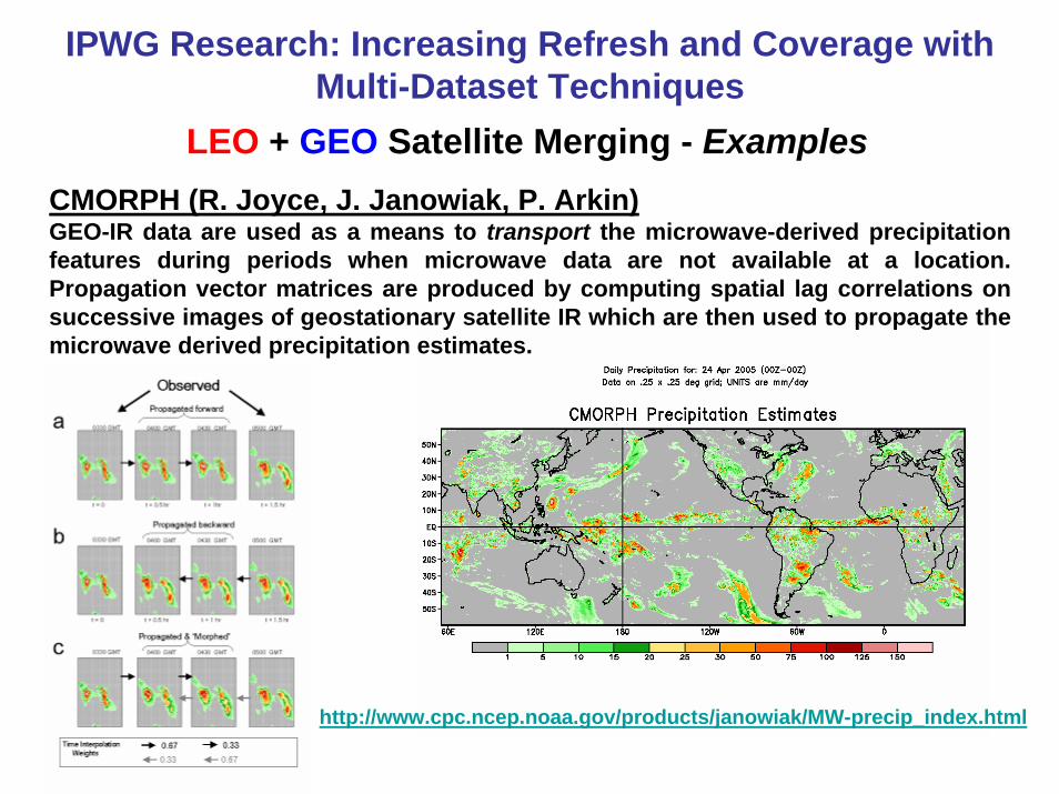
LEO + GEO Satellite Merging - Examples
IPWG Research: Increasing Refresh and Coverage with Multi-Dataset Techniques
CMORPH (R. Joyce, J. Janowiak, P. Arkin)GEO-IR data are used as a means to transport the microwave-derived precipitation features during periods when microwave data are not available at a location. Propagation vector matrices are produced by computing spatial lag correlations on successive images of geostationary satellite IR which are then used to propagate the microwave derived precipitation estimates.
http://www.cpc.ncep.noaa.gov/products/janowiak/MW-precip_index.html

LEO + GEO Satellite Merging - Examples
IPWG Research: Increasing Refresh and Coverage with Multi-Dataset Techniques
NASA 3B42RT or MPA (George Huffman, Robert Adler)This algorithm provides a combination of the TRMM real-time merged passive microwave (HQ; 3B40RT) and microwave-calibrated IR (VAR; 3B41RT). The current scheme is simple replacement - for each gridbox the HQ value is used if available, and otherwise the VAR value is used.
http://trmm.gsfc.nasa.gov ( images and animations)ftp://aeolus.nascom.nasa.gov/pub/merged/mergeIRMicro (data)

LEO + GEO Satellite Merging - Examples
IPWG Research: Increasing Refresh and Coverage with Multi-Dataset Techniques
PERSIANN (Precipitation Estimation from Remotely Sensed Information using Artificial Neural Networks) (Kuo-Lin Hsu)This system uses neural network function classification/approximation procedures to compute an estimate of rainfall rate at each 0.25° x 0.25° pixel of the infrared brightness temperature image provided by geostationary satellites. An adaptive training feature facilitates updating of the network parameters whenever independent estimates of rainfall are available.
http://hydis8.eng.uci.edu/persiann

LEO + GEO Satellite Merging - Examples
identify moist low-level flow+
adjust upslope and downslope rain
Global NWPFinal Blended Analysis
Orographic Adjustments and No-Rain Screening
IPWG Research: Increasing Refresh and Coverage with Multi-Dataset Techniques
NRL-Blend (Joe Turk)The NRL blended satellite technique is based upon area-dependent statistical relationships derived from a precise, near realtime ensemble of colocated passive microwave (PMW) and infrared (IR) pixels from any or all low Earth-orbiting (LEO) and geostationary satellites, respectively, as their individual orbits and sensor scan patterns continuously intersect in space and observation time.
http://www.nrlmry.navy.mil/sat-bin/rain.cgi (images)ftp://ftp.nrlmry.navy.mil/pub/receive/turk/global_rain (data)


