CSIRO LAND and WATER Estimation of Spatial Actual Evapotranspiration to Close Water Balance in...
20
CSIRO LAND and WATER Estimation of Spatial Actual Estimation of Spatial Actual Evapotranspiration to Close Evapotranspiration to Close Water Balance in Irrigation Water Balance in Irrigation Systems Systems 1- Key Research Issues 2- Evapotranspiration through Remote Sensing 3- SEBAL Applications 4- Data Requirements and Way Forward Mohsin Hafeez and Shahbaz Khan CSIRO Land and Water, Wagga Wagga
-
Upload
lambert-walters -
Category
Documents
-
view
221 -
download
3
Transcript of CSIRO LAND and WATER Estimation of Spatial Actual Evapotranspiration to Close Water Balance in...

CSIRO LAND and WATER
Estimation of Spatial Actual Estimation of Spatial Actual Evapotranspiration to Close Water Evapotranspiration to Close Water
Balance in Irrigation SystemsBalance in Irrigation Systems
1- Key Research Issues2- Evapotranspiration through Remote Sensing3- SEBAL Applications4- Data Requirements and Way Forward
Mohsin Hafeez and Shahbaz Khan
CSIRO Land and Water, Wagga Wagga

CSIRO LAND and WATER
Water losses and gains are part of Water losses and gains are part of the water cyclethe water cycle
gain
loss
ET is important at all scales

CSIRO LAND and WATER
5125
14
17
3924
15
1096
7
1217
2536
22
194
1181
21
466
2038
-99590
164282386
#
Wagga Wagga
#
Narrandera
#
Darlington Pt
#
D/S Hay W eir
#
D/S Balranald Weir
Inflow / Outflow (GL)
Diversions (Gl)
Evaporation (GL)
Net Change (GL)
1880
1945
1830
2216
#
Burrinjuck Dam
#
Blowering Dam
Murrumbidgee System Water Account Murrumbidgee System Water Account (1991)(1991)

CSIRO LAND and WATER
Key Research IssuesKey Research Issues
ET is coupled mass/energy process, linking the energy and water cycles
Estimation of ET is critical for on-farm and regional models in irrigation systems
ET is the largest water balance component after rainfall and irrigation input
Water quantification (i.e. productive and non-productive use) is important for irrigated agriculture.

CSIRO LAND and WATER
Why determine spatial ET?Why determine spatial ET?
Classical methods will measure ET at the field scale.– Penman - Monteith (PM) method
Need to have accurate estimates of spatially distributed ET at multi-scales.
• Remote sensing provide spatially distributed actual evapotranspiration– Accurate and cheap for large landscape systems
– Many RS algorithms developed in last decades

CSIRO LAND and WATER
In-situ measurement (Bowen ratio tower, Lysimeters, etc.)
Air-borne measurement (fluxes)
Satellite measurement
– High Spatial Resolution (ASTER and Landsat)
– High Temporal Resolution (MODIS and NOAA-AVHRR)
Modelling Approaches (plant to catchment)
Current state-of-the-art Approaches for Current state-of-the-art Approaches for measuring ETmeasuring ET

CSIRO LAND and WATER
1. Empirical direct methods
- Characterizing crop water status through the cumulative temperature difference (Ts-Ta)
2. Residual methods of the energy budget
– Combination of empirical relationship and physical modules (SEBAL, & SEBS)
3. Deterministic methods
– Soil-Vegetation-Atmosphere Transfer models (SVAT)
4. Vegetation Index methods
Methods for Quantification of ET Methods for Quantification of ET through RSthrough RS

CSIRO LAND and WATER
Methods Advantage DisadvantageSimplified Relationship
Operational from local to regional scale
Spatial variation of coefficients
Inference models (Kc f(NDVI))
Operational if combined with ground measurements
Requires calibration for each crop type; Kc varies according to water stress
Empirical-physical (SEBAL,….)
Operational, low cost, need no additional climatic data.
Requires presence of wet and dry pixels. Some empirical relationship
Deterministic (SVAT,….)
Estimation of intermediate variables (LAI), links with climate, hydrological models, assimilation to find some parameters
Requires more parameters ± easy to estimate. Requires accurate remote sensing data
models (PBL, …)
Estimation of climatic data, lateral exchange accounted, possible to stimulate landuse modification
Complex and high cost for CPU, only short simulation for high spatial resolution

CSIRO LAND and WATER
Surface Energy Balance Algorithm for Land (SEBAL); thermodynamically based model, which partitions between sensible heat flux and latent heat of vaporization flux.
The core of SEBAL is based on the assumption that at hot/dry pixels, all energy flux into the atmosphere is sensible heat and at cool/wet pixels all is latent heat.
SEBAL robustly interpolates values at intermediate pixels but is very sensitive to the right choice and flux values at the extremes.
SEBAL
CSIRO LAND and WATER
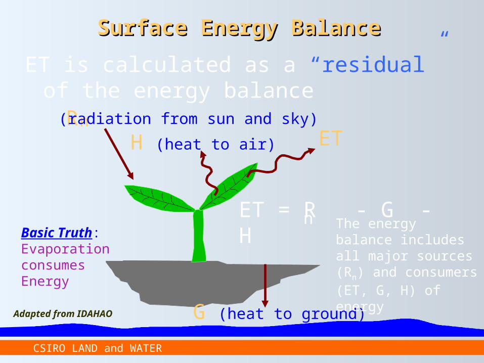
Surface Energy BalanceSurface Energy Balance
ET is calculated as a “residual” of the energy balance
ET = R - G - Hn
Rn
G (heat to ground)
H (heat to air) ET
The energy balance includes all major sources (Rn) and consumers (ET, G, H) of energy
Basic Truth: Evaporation consumes Energy
(radiation from sun and sky)
Adapted from IDAHAO

CSIRO LAND and WATER
The energy balance components
Energy Balance Equation
Rn = Go + H+ λE
Evaporative Fraction
Daily ETa
Seasonal ETa
SEBAL Derived Actual Evapotranspiration

CSIRO LAND and WATER
ALBEDO NDVI
Surface Temperature
Emissivity
Albedo
Pre-processing of satellite image

CSIRO LAND and WATER
Study Area (Lower Murrumbidgee)Study Area (Lower Murrumbidgee)

CSIRO LAND and WATER
24 October 1990
Land use Classification for Lower Land use Classification for Lower MurrumbidgeeMurrumbidgee

CSIRO LAND and WATER
Actual ET Distribution for Lower Murrumbidgee
24 October 1990

CSIRO LAND and WATER
0
10000
20000
30000
40000
50000
60000
Water Bodies RedgumForest
Wetland AgricultureCrops
Lignum Fallow Land Soil Others
Land Use Classes
Are
a (H
a)
0
100
200
300
400
500
600
ET (M
L/d)
Area ET24 October 1990
ET from different land use classes ET from different land use classes using Landsat 5 TM sensorusing Landsat 5 TM sensor

CSIRO LAND and WATER
Ground based – temporal variation:– Micro-meteorology and fluxes
– Calibration data (soil temperature, LAI, NDVI, LST, albedo, and net radiation)
– Vegetation description and surface roughness
Airborne based – spatial variation:– Surface conditions - soil moisture, LST, NDVI, LAI, albedo,
– Surface fluxes
– Low flying over irrigation supply channels
Satellite based - model requirements:– NDVI, LAI, LST, albedo, emissivity, net radiation, surface roughness
– Other data (rainfall, soil moisture, fluxes….)
Data RequirementsData Requirements

CSIRO LAND and WATER
Uncertainty analysis of different input parameters for remote sensing based ET models
Validation of remote sensing derived ET by ground and airborne fluxes.
Customization of remote sensing based algorithms for ET estimation for Australian landscape.
Integration of spatial estimation of seasonal ET for water balance studies using system level approach
Flexible for any irrigation system
Way ForwardWay Forward
CSIRO LAND and WATER
Working across different scales with universities and other partners as
one CSIRO

CSIRO LAND and WATER
Seasonal Evapotranspiration (ETSeasonal Evapotranspiration (ETseasonalseasonal))
Step 1: Decide the length of the season Step 2: Determine period represented by each satellite image Step 3: Compute the cumulative ETr for period represented by
image. Step 4: Compute the cumulative ET for each period
(n = length of period in days) Step 5: Compute the seasonal ET.
ETseasonal = ETperiod
n
irperiodrperiod i
ETFETET1
24