Croxton and Brettenham & Kilverstone Character...
75
Croxton, Brettenham & Kilverstone Character Appraisal August 2017 1 Croxton and Brettenham & Kilverstone Character Appraisal Water Tower, Kilverstone Estate, Grade II Listed August 2017
Transcript of Croxton and Brettenham & Kilverstone Character...

Croxton, Brettenham & Kilverstone Character Appraisal August 2017
1
Croxton and Brettenham
& Kilverstone
Character Appraisal
Water Tower, Kilverstone Estate, Grade II Listed
August 2017

Croxton, Brettenham & Kilverstone Character Appraisal August 2017
2
CONTENTS
1 Introduction 3
2 What is a Character Appraisal? 4
3 Purposes and Benefits of Character Appraisal 5
4 Character Appraisal Context 6
5 Importance of the Brecks 8
6 Croxton Character Appraisal 11
7 Brettenham Character Appraisal 30
8 Kilverstone Character Appraisal 52
9 Appendices A and B - Maps: 66
Appendix A - Character Area Maps 67
Appendix B – Strategic Gaps Maps 70

Croxton, Brettenham & Kilverstone Character Appraisal August 2017
3
1.0 Introduction
1.1 This document is the Character Appraisal for parishes of Croxton and Brettenham &
Kilverstone. A first draft of the document was the subject of a 6 week informal
public consultation period between 29th October 2016 and 30th November 2016.
All comments received as a consequence of that consultation have been assessed
and changes made to the document as appropriate.
1.2 A table summarising these consultation responses can be found on the Joint
Neighbourhood Plan website.
http://c-bandkjointplan.norfolkparishes.gov.uk/
1.3 It is intended that this Character Appraisal will be a piece of evidence used to
support the policies in the emerging Joint Neighbourhood Plan (JNP) which
covers both parishes.
1.4 The Appraisal was initially informed by the Survey work undertaken in July, August
and September 2016 by Parish Councillors and local residents. Other sources of
information include Parishioners’ own recollections and photographs, data from
Norfolk Heritage Explorer, Norfolk Historic Environment Record, parish archives
and information from Natural England and Historic England data sets.
1.5 The Survey work was undertaken using a modified version of the Planning Aid in England, Character Assessment Document Template.
THIS DOCUMENT IS A SUPPORTING DOCUMENT TO THE JOINT NEIGHBOURHOOD
PLAN (JNP) FOR CROXTON, BRETTENHAM & KILVERSTONE AND WILL BE PUBLISHED
FOR PUBLIC CONSULTATION AT THE SAME TIME AS THE JNP
THIS DOCUMENT WILL BE FURTHER REFINED AND IMPROVED THROUGH CHANGES
MADE AS A RESULT OF PUBLIC CONSULTATION FROM 11th AUGUST 2017 to 29th
SEPTEMBER 2017.

Croxton, Brettenham & Kilverstone Character Appraisal August 2017
4
2.0 What is a Character Appraisal?
2.1 A character appraisal is a document that describes the distinct appearance and feel of
an area or settlement. It identifies the key physical features and characteristics that
give a particular settlement its unique identity and local distinctiveness. It sets out
what makes that particular settlement special and indicates what is valued by its local
community.
2.2 Many of the country’s statutorily designated Historic Conservation Areas are
underpinned by Character Appraisals for the following reasons:
• As a tool to demonstrate the area’s special interest
• As explanation to owners, businesses and inhabitants of the reasons for designation
• As educational and informative documents created with the local community, expressing what the community particularly values about the place they live and work in
• Provide greater understanding and articulation of its character which can be used to develop a robust policy framework for planning decisions
• Informing those considering investment in the area in guiding the scale, form and content of new development
2.3 Character Appraisals traditionally take the form of an appraisal of the historic character of the Conservation Area which describes in detail the delineation of the Conservation Area and sets out the rationale for its designation; these are commonly known as Conservation Area Appraisals (CAAs).
2.4 There is a statutory responsibility placed on Local Planning Authorities (LPAs) under
the Planning (Listed Buildings and Conservation Areas) Act 1990, to review their
Conservation Areas “from time to time” and to produce up to date appraisal
documents and management plans.

Croxton, Brettenham & Kilverstone Character Appraisal August 2017
5
3.0 Purpose and benefits of a Character Appraisal
3.1 The purpose of a Character Appraisal is to describe in some detail the existing
character of an area, commenting on its current condition and value to its community, but also identifying positive action including areas for potential enhancement and even mechanisms for achieving those enhancements.
3.2 The Character Appraisals can be used to develop local planning policies at all levels including Neighbourhood Plans. Using the Character Appraisals, policies can be developed that result in good design which is both visually attractive and not only respects the existing character but also enhances its form, character and setting. In order to achieve this, there needs to be a good understanding of the character of the area and its value to its community.
3.3 It is often a lack of understanding of this that can lead developers or individuals to
propose development which fails to consider or enhance the existing unique qualities
of an area and may result in erosion or harm of that existing character.
3.4 The benefit of preparing a character assessment is that a local community will feel it
has the ability to shape and influence future development in its area.
3.5 By using the opportunity to clearly document and describe the important
characteristics of an area, the community can begin to influence developers and their
architects to help them understand the local character and the value that is attached
to it. In turn this should aid the production of sensitively designed proposals which
respect and complement the existing local character. The result of this should enable
greater integration of the development within the existing community and potentially
greater acceptance of it.

Croxton, Brettenham & Kilverstone Character Appraisal August 2017
6
4.0 Character Appraisal Context
4.1 When the principle of a Joint Neighbourhood Plan was first being considered, it
became clear, that the 5000 new dwellings proposed on the outskirts of Thetford, in
the Breckland Joint Core Strategy 2009, would have a profound impact upon the rural
parishes within which they sat.
4.2 It was also apparent at an early stage, that the key concern to local residents was how
this large development would integrate with the existing communities. There were
very deep felt concerns about the potential to effectively create two new completely
different communities - the new development inside what is now known as the SUE
(Sustainable Urban Extension) and the existing communities of Croxton, and
Brettenham and Kilverstone.
4.3 This concern gained momentum through the evolution of the Breckland Core Strategy
in 2007-2009, the development of the Thetford Area Action Plan (TAAP) in 2008-2010
and during the planning application process for the SUE in 2011-2013. It can also be
evidenced in the responses received to the Parish Questionnaire undertaken by the
two Parish Councils at the beginning of the Joint Neighbourhood Plan (JNP) process in
2015.
4.4 The Parish Councils were therefore keen to ensure that the key objective of the JNP
should be to attempt to integrate the new development with the existing community
but at the same time ensure that the important rural and historic character, and
tranquillity of the villages, which is valued so much, is retained.
4.5 There is an existing Conservation Area in Croxton which was designated in 1974,
however it does not have an up to date Conservation Area Appraisal attached to it nor
does it have a Management Plan.
4.6 There is no conservation area designated within Brettenham and Kilverstone although
there is a considerable wealth of built heritage.
4.7 Initially it was thought that through the JNP process the Parish Council would produce
their own Conservation Area Appraisal for Croxton and that a similar Conservation
Area Appraisal style appraisal would be undertaken for Brettenham and Kilverstone.
However because so much new development was proposed in the SUE together with

Croxton, Brettenham & Kilverstone Character Appraisal August 2017
7
Breckland Council advice that the JNP timing would enable it to be in a position where
it could influence the design of that new development, it was decided to broaden the
Appraisal work away from concentrating only on the historic aspect but to undertake a
wider character appraisal of the whole village and try to establish some new design
policies in the JNP that would positively influence new development in the SUE.
Therefore the approach that has been taken is a blend of historic Conservation Area
Appraisal work with Character Appraisal work in order to have maximum effect.
4.8 The Character Appraisal for Croxton was carried out using one survey focussed
mainly on Croxton Village and includes the Conservation Area designated in 1974 as
well as looking slightly wider.
4.9 The Brettenham and Kilverstone Character Appraisal, has been split into 4 distinct
survey areas which were each surveyed by a specific team, and this reflects the
distinct settlement area and makeup of those Parishes.
4.10 Therefore there are 4 separate Character Appraisals that cover the following:
Brettenham Village
Brettenham West (including Arlington Way)
Rushford
Kilverstone

Croxton, Brettenham & Kilverstone Character Appraisal August 2017
8
5.0 Importance of the “Brecks”
5.1 Both parishes sit within a national and regionally recognised landscape known as the “The Brecks”. The Brecks has one of the most distinctive landscapes in the UK and boasts the best overall climate with low rainfall and hot summers.
5.2 The word “Breck“ is medieval, meaning an area of sandy heathland and gorse that
was broken up for farmland and then allowed to revert to wilderness once the soil was exhausted. The area comprises vast forests of native coniferous softwood, lines of Scots pines called 'Deal rows' some of which are still maintained as true hedges, also patches of classic historic heathland that were formed thousands of years ago by the felling and burning of forests for grazing land, and wide arable fields. Also unique to the Brecks are the prehistoric Pingos.
'Deal rows' are unique to the Brecks.
5.3 Thetford Forest, planted just after the First World War by the Forestry Commission,
covers an area of 20,000 hectares. From at least the fourteenth century, large areas were used for warrens, and the intensive grazing of the rabbits could lead to the formation of mobile sand dunes: In the 1760s the area was described as 'sand, and scattered gravel, without the least vegetation; a mere African desert'. Dickens mentioned how barren it was in David Copperfield.

Croxton, Brettenham & Kilverstone Character Appraisal August 2017
9
5.4 The Brecks also contains Peddar’s Way, which runs for 63 miles from just outside Thetford at Knettishall Heath to the north Norfolk coast via Swaffham.
5.5 A significant proportion of the Brecks is designated as a European protected site, forming the largest terrestrial protected area in Norfolk. The heathland serves as an important habitat designated for its suitability to support internationally important bird species, particularly Stone Curlew, Woodlark and Nightjar.
5.6 The site is also designated as a Special Protection Area (SPA) under the European Council’s Directive on the Conservation of Wild Birds. The East of England supports 65% of the UK’s breeding pairs of stone curlew where most breeding is located within the Brecks. The rich biodiversity of the Brecks is also recognised by many other statutory conservation designations which include four Special Areas of Conservation (SACs), numerous Sites of Special Scientific Interest (SSSI) and National Nature Reserves (NNR), where the latter (NNRs and SSSIs) make up 40% of the total area.
5.7 Evidence to support the adoption of the Breckland Core Strategy in 2009 resulted in research which examined the effects of housing and roads on the distribution of stone curlew in the Brecks. The research was required to inform the Habitats Regulations Assessment (HRA) of the Core Strategy which, subject to the imposition of suitable policy mitigation, enabled the Core Strategy to be progressed through to adoption.
5.8 The adopted mitigation policy required that any new development which may impact on the SPA must be subject to Appropriate Assessment. New development was not permitted within 1,500m of the edge of the SPA unless it could be demonstrated by an Appropriate Assessment that the development would not adversely affect the integrity of the SPA. There was also provision for the re-use of existing buildings and development where it was completely masked from the SPA by existing development.
5.9 Beyond the SPA boundary, stone curlews occur outside the SPA and those birds are clearly part of the SPA population and functionally linked. These areas are identified as areas where there are concentrations of stone curlew, 5 or more nests recorded, over the period 1995 – 2006, and indicated on the current policy maps as a secondary buffer. Within these areas development could be brought forward, providing alternative land outside the SPA can be secured to mitigate the potential effects.
5.10 Further recent work undertaken on behalf of Breckland Council in 2013, provides strong support for the continuation of a 1500m zone around the areas capable of supporting stone curlews. Within this zone it would seem that additional development would have a likely significant effect on the SPA. The 2013 research also suggests that the planting of woodland/screening as a mitigation measure is

Croxton, Brettenham & Kilverstone Character Appraisal August 2017
10
unlikely to be effective and that the effect on nest density is strongest as a result of the amount of buildings rather than type. One of the key aims of the research was to differentiate the effects of nest density due to different building classes. The research indicates that there was no evidence of a negative impact of agricultural or commercial buildings. As such, the analysis suggests an element of flexibility could be applied for non-residential development in the SPA buffer zones.

Croxton, Brettenham & Kilverstone Character Appraisal August 2017
11
6.0 Croxton Character Appraisal
6.1 Introduction and Historical Context
6.1.1. The parish of Croxton is situated in the south of Norfolk, just northeast of Thetford. The area is mainly forested heathland plus farmed agricultural land, set within the traditional Brecks Landscape, with the built settlement form being largely located in the south of the parish.
6.1.2 The origin of the name comes from the Old Norse for ‘Krokr’s Enclosure’, and the
parish was already an established settlement by the time of the Norman
Conquest. Productive capacity, population and land ownership are all detailed in
the Doomsday Book of 1086.
6.1.3 The earliest indication of human activity in the parish as evidenced in the Norfolk
Heritage Explorer comes in the form of prehistoric flint tools, plus evidence of
their manufacture. The first flint finds in the Parish that can be dated, have been
dated to the Mesolithic era and include flint axes.
6.1.4 Further flint finds from the Neolithic age and tools found in the parish from this
period include chipped axes, polished axes, arrowheads, scrapers and a laurel leaf
point.
6.1.5 The parish is unusual in that evidence of early activity is not confined to flint tools.
There are fragmentary remains of two possible prehistoric track ways:
• The Icknield Way, which was part of a probable track way running north
through the parish on its way to the north Norfolk coast.
• East Harling Drove, a similar track way, but running east to west.
6.1.6 Both these track ways continued in use up to the medieval period and possibly
later. Harling Drove was so called because it was used by drovers to take their
sheep to the East Harling Sheep Sales – boys from the village were paid a penny
to watch the sheep whilst the drovers came into the village to have a drink.
6.1.7 The oldest monument to survive in the parish is thought to be from either the
bronze or Saxon ages. It is a relatively undisturbed round barrow on Mickle Hill on Croxton Heath.

Croxton, Brettenham & Kilverstone Character Appraisal August 2017
12
6.1.8 Bronze Age flint arrowheads have also been found in the parish on the
Hadlers Hole fields behind Harefield and Melville Roads, plus Iron Age
pottery fragments.
6.1.9 There is no evidence of buildings left from the Roman occupation although coins
have been found together with pottery fragments and brooches. Saxon finds are
likewise confined to small objects such as tweezers and a brooch. The medieval
period has left the parish with its oldest surviving building, All Saints’ Church
All Saints Church, Grade I Listed
6.1.10. The church has a round tower and priest’s door that date back to the late 12th
century. The tower is topped by a 14th century octagonal belfry with a small
Victorian spire. The rest of the building is 14th century and later, restored in the
19th century. Inside can be found a 15th century font, a fine hammer beam roof
and a remarkable World War One memorial. No other medieval buildings survive
although the Norfolk Historic Environment Record indicates that there was a
hospital in the parish, founded in 1250. No trace of it remains today. There is
also a medieval well. Other medieval material found in the parish consists of

Croxton, Brettenham & Kilverstone Character Appraisal August 2017
13
coins, pottery fragments and buckles. A strong spring from which villagers took
water for centuries is located by the roadside just below the church. Fresh spring
water wells up strongly on the north valley side so much that the village
produced its own fresh water until 1970! There are still natural springs in
outlying fields on the west side of The Street.
6.1.11. Some medieval stone has been found reused in post medieval buildings which
may have come from Thetford Priory after the Dissolution of the monasteries,
or possibly from the demolished aisle of All Saints’ Church.
Chapel Farm a Grade II Listed, 17th century house, contains reused medieval stone
6.1.12. The only evidence of post medieval industrial activity is a tile kiln (which is
marked on 19th century maps). However, this was demolished in 1940, and
nothing remains today. More recently, two World War II pillboxes survive, part
of the anti-invasion defences of the time.
6.1.13. The comparative scarcity of buildings on the archaeological record is no doubt
due to the mainly heathland landscape, but the extensive nature of finds show
there has been human activity here through every period since the Mesolithic.
Croxton, Brettenham & Kilverstone Character Appraisal August 2017
14
6.1.14 In 1870-72, John Marius Wilson's Imperial Gazetteer of England and Wales described Croxton like this:
“CROXTON, a parish in Thetford district, Norfolk; 2 miles N of Thetford town and
r. station. It has a post office under Thetford. Acres, 4, 609. Real property, £3,
157. Pop., 428. Houses, 85. The property is divided among a few. Croxton Hall is a
chief residence. Croxton High Trees are seen at a great distance. There is a large
manufactory of coarse earthenware. The living is a vicarage in the diocese of
Norwich. Value, £98.* Patron, Christ's College, Cambridge. The church is ancient;
and has a curious flint tower and a Norman font. There are a Wesleyan chapel,
and charities £5.”
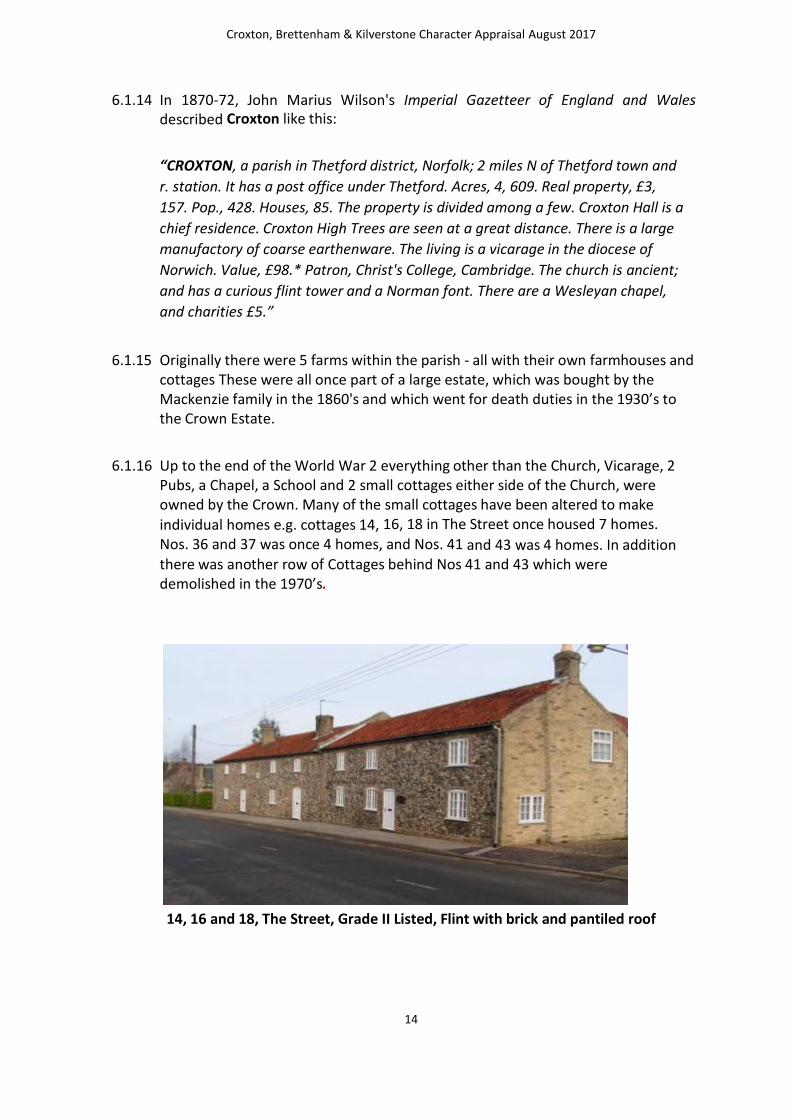
6.1.15 Originally there were 5 farms within the parish - all with their own farmhouses and cottages These were all once part of a large estate, which was bought by the Mackenzie family in the 1860's and which went for death duties in the 1930’s to the Crown Estate.
6.1.16 Up to the end of the World War 2 everything other than the Church, Vicarage, 2 Pubs, a Chapel, a School and 2 small cottages either side of the Church, were owned by the Crown. Many of the small cottages have been altered to make
individual homes e.g. cottages 14, 16, 18 in The Street once housed 7 homes.
Nos. 36 and 37 was once 4 homes, and Nos. 41 and 43 was 4 homes. In addition there was another row of Cottages behind Nos 41 and 43 which were demolished in the 1970’s.
14, 16 and 18, The Street, Grade II Listed, Flint with brick and pantiled roof

Croxton, Brettenham & Kilverstone Character Appraisal August 2017
15
6.1.17 Properties still remain in the village today which at one time accommodated the
Policeman, the Mackenzie's Agent, the Estate Office, the School, the School
Mistress, and there was also a ‘Bothy’, where unmarried men who worked on the
land lodged. Field names reflect craftsmen who lived in the village - Carmichaels
(the blacksmith) Ben Whites (smallholder) Bell field named after the Bell Inn. Ten
acres was once the village cricket ground and Wick's patch was where village
Bowls were played.
6.1.18 Croxton Hill was where the famous Burrell Steam Engines (Thetford) were given
their final testing. Ada Cole (founder of International League for Protection of
Horses - now housed at Snetterton) was born and lived with her family at Hall
Farm.
Hall Farm, Grade II Listed
6.2 Brief over view of character areas
6.2.1 The linear nature of Croxton Village and its compactness has lent itself to one distinct character area based on the historic core of The Street with some later additions at Harefield Road, Church Avenue, Earl Warren, All Saints Court, and
High Tree Close.
Croxton, Brettenham & Kilverstone Character Appraisal August 2017
16
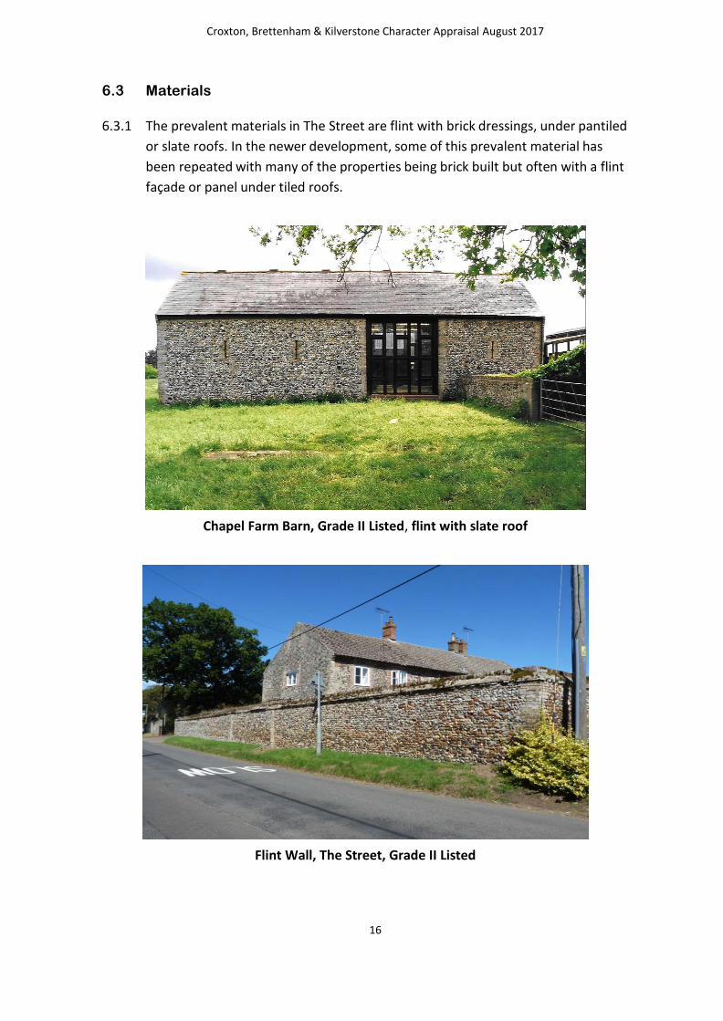
6.3 Materials
6.3.1 The prevalent materials in The Street are flint with brick dressings, under pantiled
or slate roofs. In the newer development, some of this prevalent material has
been repeated with many of the properties being brick built but often with a flint
façade or panel under tiled roofs.
Chapel Farm Barn, Grade II Listed, flint with slate roof
Flint Wall, The Street, Grade II Listed

Croxton, Brettenham & Kilverstone Character Appraisal August 2017
17
6.4 Scale, Form and Orientation
6.4.1 Development in the central historic core of the village is compact, with dwellings
on small plots. Many of the original buildings which may have been larger
farmhouses have been subdivided into smaller cottages. These tend to sit closer
to the road and have road frontages.
6.4.2 As you travel out from the centre of the village the plots sizes and houses get
bigger moving through medium plots to large plots which are set further back
from the road, the remaining farmhouses also sit back from the road in relatively
mature plots.
Croxton Lodge, Grade II Listed
6.4.3 During many changes of ownership some properties have had or are having
extensions added to enlarge and improve the properties. Some plots have
also been subdivided to accommodate additional infill development.

Croxton, Brettenham & Kilverstone Character Appraisal August 2017
18
6.5 Condition and Use
6.5.1 The majority of the buildings are in private residential use and the vast majority
are also in good condition. Chapel Farmhouse is in business use rather than just
residential and it is only the Vicarage at the southern end of the village that has
been identified as being in poor condition. It occupies a prominent position at the
southern gateway to the village and it has not been lived in for some time.
The Vicarage, unlisted
6.6 Important buildings
6.6.1 The value and importance of the core village is recognised through the designation of a Conservation Area in 1974. Unfortunately, there is no Conservation Area appraisal or surviving designation document that sheds light on the rationale for the Conservation Area boundary. There are also a number

Croxton, Brettenham & Kilverstone Character Appraisal August 2017
19
of buildings that are of special, architectural or historic interest and they are included on the statutory list as approved by the secretary of state.
These include:
Chapel Farm Barn Grade II Chapel Farmhouse Grade II Wall south from Chapel Farmhouse Grade II Croxton Lodge Grade II No’s 14, 16, & 18 The Street, Grade II Hill Farm House Grade II Hall Farm House Grade II Church Cottage Grade II Church of All Saints Grade I
Church Cottage, Grade II Listed
Croxton, Brettenham & Kilverstone Character Appraisal August 2017
20
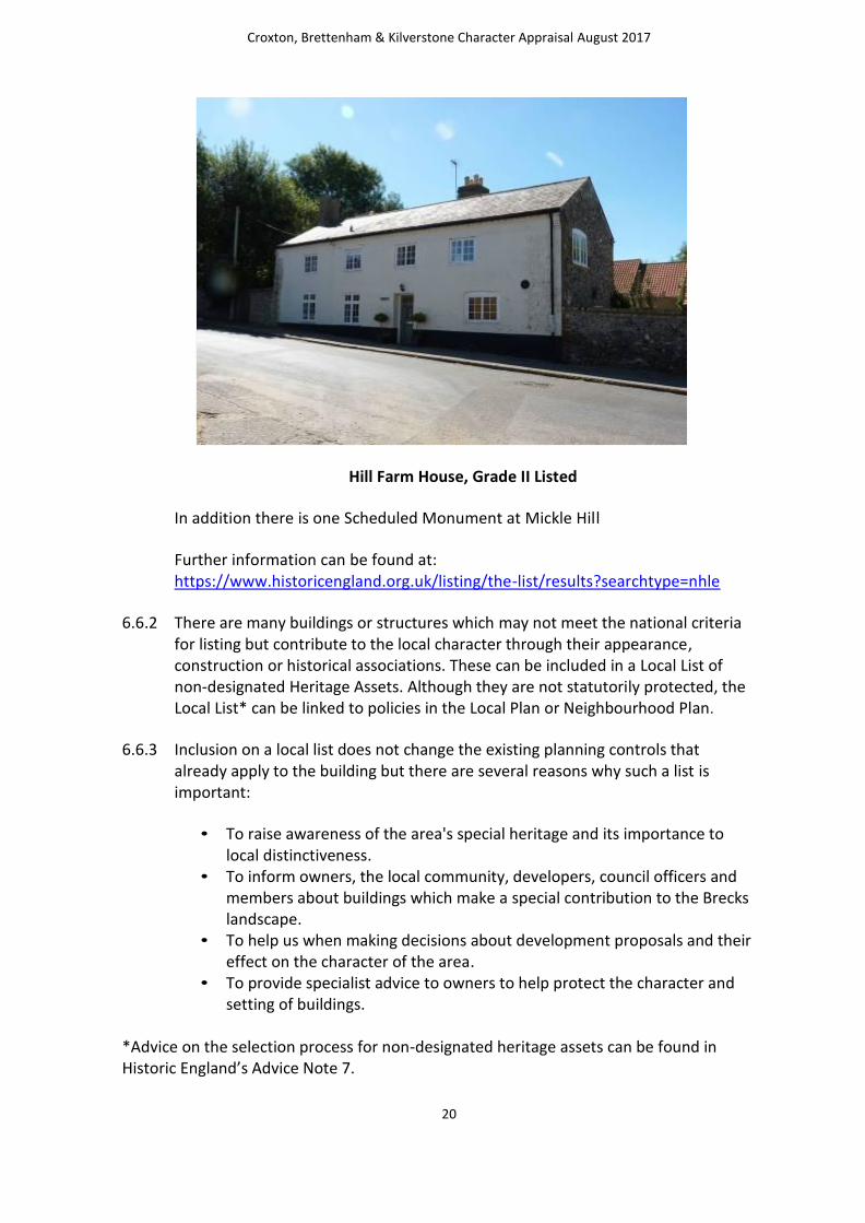
Hill Farm House, Grade II Listed
In addition there is one Scheduled Monument at Mickle Hill
Further information can be found at: https://www.historicengland.org.uk/listing/the-list/results?searchtype=nhle
6.6.2 There are many buildings or structures which may not meet the national criteria for listing but contribute to the local character through their appearance, construction or historical associations. These can be included in a Local List of non-designated Heritage Assets. Although they are not statutorily protected, the Local List* can be linked to policies in the Local Plan or Neighbourhood Plan.
6.6.3 Inclusion on a local list does not change the existing planning controls that already apply to the building but there are several reasons why such a list is important:
• To raise awareness of the area's special heritage and its importance to local distinctiveness.
• To inform owners, the local community, developers, council officers and members about buildings which make a special contribution to the Brecks landscape.
• To help us when making decisions about development proposals and their effect on the character of the area.
• To provide specialist advice to owners to help protect the character and setting of buildings.
*Advice on the selection process for non-designated heritage assets can be found in Historic England’s Advice Note 7.

Croxton, Brettenham & Kilverstone Character Appraisal August 2017
21
6.6.4 The Croxton survey work has identified a number of buildings that are not listed but have been identified by the local community as having some architectural, cultural or historic value. Whilst they currently do not enjoy the protection offered by formal listing, there may be benefit to them being identified as non-designated heritage assets, the significance of which should be taken into account when determining planning applications. There is also merit in pressing Breckland
Council as Local Planning Authority to consider the compilation of a Local List and
for them to formally assess the suitability of the buildings identified in this survey with a view to being included on the Local List.
6.6.5 These buildings include:
The Vicarage
The Vicarage, built on the brow of the hill at south end of village on the east side, sits in a very large plot. It was built in 1843, during the residency of the Rev. H. S.M. Hubert at a cost of £700, and was considerably enlarged by the following vicar Rev. H.
Williams (1852-1897) at his own expense. The building has been unoccupied for some
years and currently in rather poor condition. (See earlier photograph, in paragraph 6.5.1)
Primitive Methodist Chapel, flint and pantiles
Primitive Methodist Chapel
The Primitive Methodists Chapel was built, on the west of The Street in 1865, constructed of flint under a pantiled roof. The building is privately owned and currently used for storage.
Croxton, Brettenham & Kilverstone Character Appraisal August 2017
22
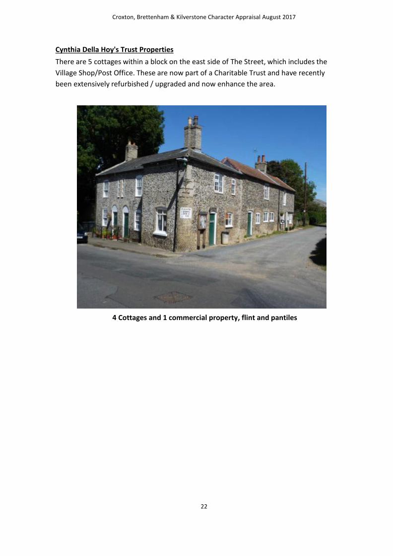
Cynthia Della Hoy's Trust Properties
There are 5 cottages within a block on the east side of The Street, which includes the
Village Shop/Post Office. These are now part of a Charitable Trust and have recently
been extensively refurbished / upgraded and now enhance the area.
4 Cottages and 1 commercial property, flint and pantiles

Croxton, Brettenham & Kilverstone Character Appraisal August 2017
23
The School House
The School House is built of brick under slate tile roof built C19-20 but not listed. It was one of two schools supported by subscription, later reduced to one National School,
enlarged in 1875 to accommodate 60 scholars, and served as the village school for many years before becoming a residential property
The School House, slate and flint
The Old Bell House
The Old Bell House, on the east side of The Street is a flint built house with pantile roof and shares a wall with Croxton Lodge. Set well back from The Street, situated on a large plot with front and rear gardens, it was at one time one of two public houses in the village
The Old Bell House
Croxton, Brettenham & Kilverstone Character Appraisal August 2017
24
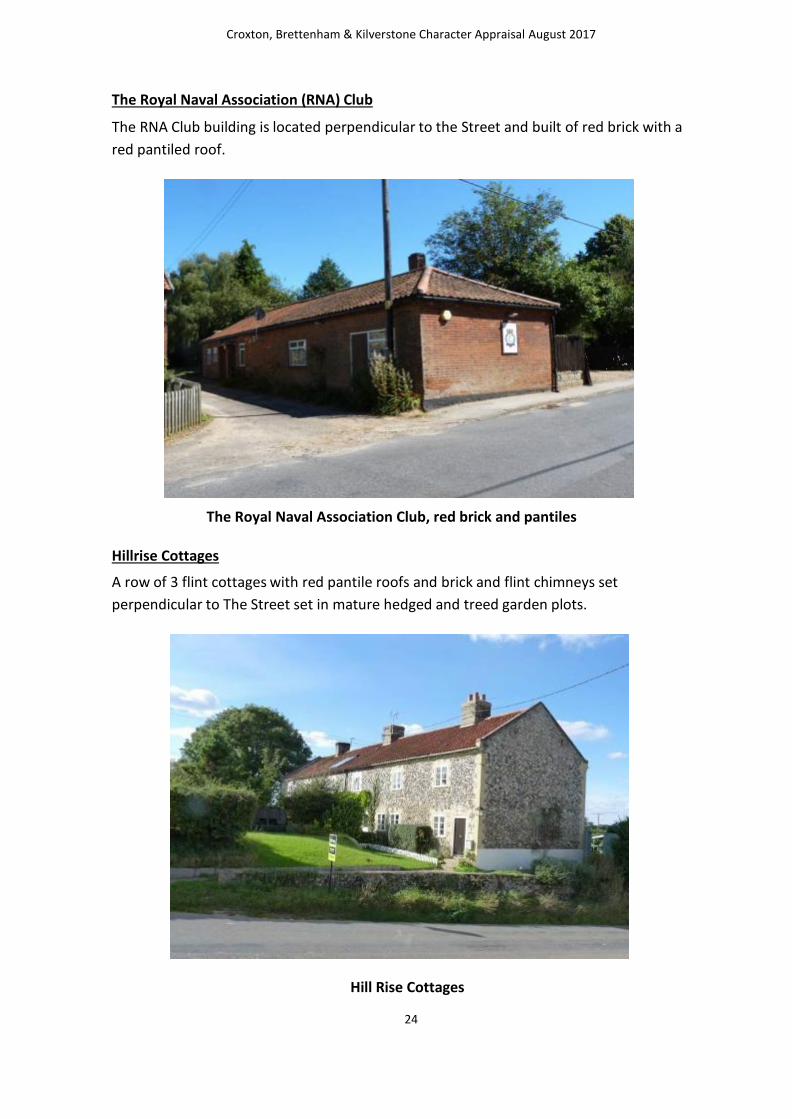
The Royal Naval Association (RNA) Club
The RNA Club building is located perpendicular to the Street and built of red brick with a
red pantiled roof.
The Royal Naval Association Club, red brick and pantiles
Hillrise Cottages
A row of 3 flint cottages with red pantile roofs and brick and flint chimneys set
perpendicular to The Street set in mature hedged and treed garden plots.
Hill Rise Cottages
Croxton, Brettenham & Kilverstone Character Appraisal June 2017
25
6.7 Important spaces for Landscape and Nature Conservation
6.7.1 Green and open spaces play an important role in shaping the character of many areas. Character Assessments/Appraisals can be used to inform decisions about designated new local green space or to identify existing open spaces that can be protected and enhanced.
6.7.2 Due to the compact nature of the village there are very few undeveloped or open spaces within the built up area of the village. However the village is surrounded by the traditional Brecks landscape and this is identified as an Area of Special Protection (Policy ENV.1 of the Breckland District Local Plan) – Area of Important Landscape Quality. The current consultation on the Local Plan Preferred Directions being undertaken by Breckland Council indicates that this level of protection afforded to the Brecks landscape will continue and high protection will be given to the Brecks landscape, reflecting its role as a regionally significant green infrastructure asset. Proposals within the Brecks Landscape Character Areas will not be permitted where these would result in harm to key visual features of the landscape type, other valued components of the landscape, or where proposals would result in a change in the landscape character.
6.7.3 There are three identified green spaces within the village; the first is a formally set out children’s play area adjacent to the village hall which has received funding for new play equipment in recent years and extends to the field to the rear of the village hall; the second is the churchyard which provides an important setting for the church; and the third is a small area at the entrance to the new development at High Tree Close.
6.7.4 Any other open spaces are prominent farmland being part of the existing farm estates and outside of the settlement boundary.
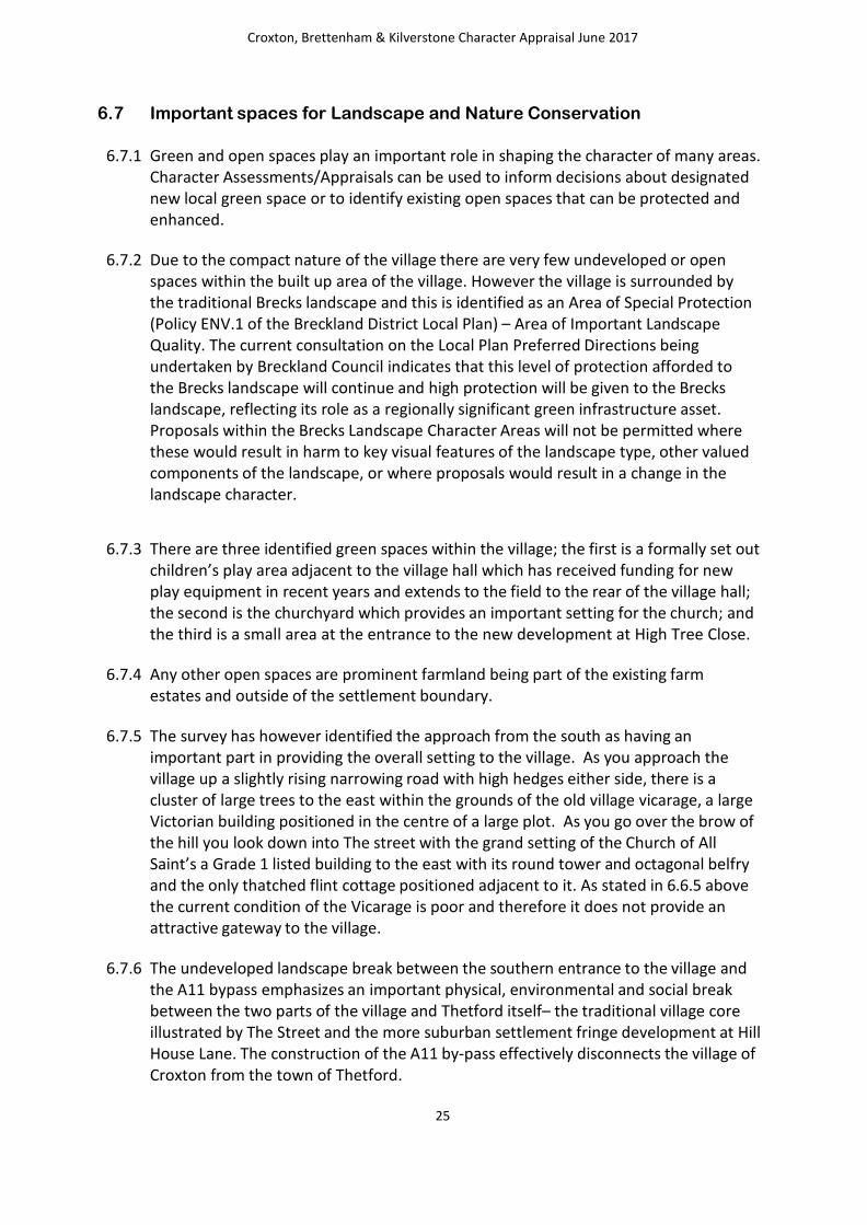
6.7.5 The survey has however identified the approach from the south as having an important part in providing the overall setting to the village. As you approach the village up a slightly rising narrowing road with high hedges either side, there is a cluster of large trees to the east within the grounds of the old village vicarage, a large Victorian building positioned in the centre of a large plot. As you go over the brow of the hill you look down into The street with the grand setting of the Church of All Saint’s a Grade 1 listed building to the east with its round tower and octagonal belfry and the only thatched flint cottage positioned adjacent to it. As stated in 6.6.5 above the current condition of the Vicarage is poor and therefore it does not provide an attractive gateway to the village.
6.7.6 The undeveloped landscape break between the southern entrance to the village and the A11 bypass emphasizes an important physical, environmental and social break between the two parts of the village and Thetford itself– the traditional village core illustrated by The Street and the more suburban settlement fringe development at Hill House Lane. The construction of the A11 by-pass effectively disconnects the village of Croxton from the town of Thetford.

Croxton, Brettenham & Kilverstone Character Appraisal June 2017
26
6.7.7 As well as being identified as important for landscape quality, the Brecks is also
identified as being important for it nature conservation value and the wealth and
diversity of protected habitats and species that it supports.
6.7.8 Much of this area is within Croxton parish, which also contains a feature known as
Devils’ Punchbowl. The Ministry of Defence has the Stanford Training Area here
(known as STANTA). There is limited public access to STANTA which makes it an
important wildlife haven. The Devil’s Punchbowl is a doline – a circular depression
formed by ground subsidence or ground collapse in an area with limestone bedrock. It
is one of numerous dolines in the Brecklands of Norfolk, where the bedrock consists of
chalk beneath a cover of unconsolidated sandy sediment, called glacial till, deposited
during the Ice Age. Chalk is composed mainly of calcium carbonate, which is easily
attacked by acidic groundwater, causing fissures and caverns to form. This in turn
leads to subsidence or collapse of the underlying sediment, forming dolines in the
landscape. The Devil’s Punchbowl is an excellent example of a “subsidence” doline.
Devil’s Punch bowl
Croxton, Brettenham & Kilverstone Character Appraisal June 2017
27
6.7.9 The Devil’s Punchbowl fills and empties with water from below due to changing water
table level in the chalk. The water level changes produce rings of different vegetation
around the edges. The Punchbowl is one of a handful of fluctuating meres in Breckland
which support pondweeds and rare aquatic life, including beetles and tiny shrimps!
6.8 Access to the countryside – footpaths and cycle ways
6.8.1 National Cycle Route 30 passes north – south through the parish on its way to Thetford and beyond. The principle public rights of way are Thetford FP3, FP4 and FP5 which all transect the parish and make up short sections of longer distance trails. FP3 and FP4 form part of East Harling Drove and are east-west routes from the direction of the Fibrothet power station in the extreme west of the Parish, crossing open fields and ending up just north of the village at the north end of The Street. FP5 is a north –south route passing Croxton Park forming part of the Icknield Way and crosses FP3 and FP4 just west of the village.
6.9 Trees
6.9.1 In earlier Vicarage surveys, a number of trees were specifically identified as being of importance and the trees in the garden of the vicarage, particularly at the southern gateway to the village are notable.
6.9.2 With much of the main built up core of the village falling within the Conservation Area the trees within it are afforded a degree of protection. According to Breckland Council there are upwards of approximately 20 trees protected by Tree Preservation Orders (TPOS) within the Parish.
6.10 Areas for enhancement or specific protection
6.10.1 The Character Appraisal Survey work has identified the following areas as in need of some form of positive enhancement to increase the visual contribution they make to the overall character of the village. The survey work has also identified that some areas would benefit from complete preservation because of the contribution their current form makes to the overall character of the village
6.10.2 The Vicarage has been identified as being in a poor state of repair and in need of
improvement to its visual appearance. Opportunities for enhancing this important
gateway site are likely to be supported.
6.10.3 The preferred option would be for the Vicarage to be suitably renovated and repaired
without the need for any form of additional curtilage development.
6.10.4 The children’s play area adjacent to the village hall is already protected from
development by policies in the Breckland District Local Plan as is the churchyard.
Croxton, Brettenham & Kilverstone Character Appraisal June 2017
28
6.10.5 Whilst the important landscape break to the south of the village up to the A11
bypass is protected by the landscape policies in the Local Plan that relates to the
wider Brecks landscape, it is felt that the desirability of keeping this area
undeveloped is such that it should be specifically identified for this reason and be
protected from any form of development that may erode the function it
currently performs.
6.11 Conclusion for Croxton – Value to Residents
6.11.1 In conclusion, the survey has highlighted the following issues specific to Croxton
for the draft JNP policies to address:
Design policy to reflect prevalent materials of flint with brick dressings
under pantiled or slate roofs
Local List policy to include the following buildings as “potential candidates”:
The Vicarage
Methodist Chapel
Village Shop and Post Office
The School House
The Old Bell House
The Royal Naval Association (RNA) Club
Hill Rise Cottages
Specific policy to address the need for visual enhancement of the Vicarage Site at the southern gateway to the village
Specific policy to protect the following important undeveloped landscape area:
o “Strategic Gap” between A11 by-pass and Croxton village.

Croxton, Brettenham & Kilverstone Character Appraisal June 2017
29
6.11.2 The Character Appraisal Survey concludes with the following reflections from the local community:
“The parish is well served by its Parish Council which strives to ensure that the
community is well served in every way from the condition of the roads, footpaths and
infrastructure in general, to supporting the village hall and other providers of services
and amenities.
In conclusion, Croxton is generally considered to be what residents conceive is their
requirement, a relatively quiet rural village set in well maintained countryside with the
added advantage of having the nearby forest to use.”

Croxton, Brettenham & Kilverstone Character Appraisal June 2017
30
7.0 Brettenham and Kilverstone Character Appraisal The Parish Council area covers the parishes of Brettenham and Kilverstone. The parish character
area has been sub divided into 3; Brettenham Village, Brettenham West (including Arlington Way) and Rushford.
7.1 Introduction and Historical Context
7.1.1 Brettenham is a large parish in Breckland, close to the town of Thetford, in the south
of the county. Settlement in the parish is sparse, and focused on the hamlets of
Brettenham, Rushford, Shadwell and Snarehill. Rushford is situated on the north bank
of the River Little Ouse. The river forms the boundary between Norfolk and Suffolk
and until 1894, Rushford was in both counties. Rushford Hall is south of the river and
thus in Suffolk. Within the parish is the further hamlet of Shadwell which derives its
name from St Chad’s Well.
7.1.2 Due to the later landscape history of Breckland, which had not been ploughed as
intensively as other areas of Norfolk, prehistoric artefacts and sites tend to survive in
greater numbers. Palaeolithic hand axes, Mesolithic axe heads, a Mesolithic mace and
part of a wooden bow or axe have been found in the parish, as well as Neolithic flint
implements including knives and arrowheads.
7.1.3 A small Bronze Age settlement was excavated by Norwich Castle Museum in 1959 on
the banks of the Little Ouse, and the remains of buildings, pits and enclosures were
discovered, as well as a substantial amount of Bronze Age pottery. In Rushford, the
Norfolk Archaeological Unit has excavated various Late Saxon settlement features
including a boundary ditch.
7.1.4 Close to the settlement is a linear barrow cemetery known as the ‘Seven Hills’, which
was constructed on a ridge of high land above the Little Ouse. The settlement
continued to develop in Brettenham during the Iron Age, pottery and coins have
been found scattered throughout the parish, as well as a small hoard of silver coins.
The Peddar’s Way forms part of the parish boundary of Brettenham, and Roman
settlement in the parish seems to have been drawn to the edges of the road,
including the site of a possible Roman villa and a Roman town which straddles the
road.

Croxton, Brettenham & Kilverstone Character Appraisal June 2017
31
7.1.5 Buildings and other features are visible as crop marks on aerial photographs, and
excavation revealed various Roman buildings, and large amounts of pottery and
building materials, as well as two Roman coin hoards. Roman inhumations have also
been found on the site, which was reused as a cemetery in the Early Saxon period.
Another area of Roman and Early Saxon settlement is located on the other side of the
parish, close to the outskirts of Thetford. The remains of domestic and agricultural
buildings dating to both the Roman and the Early Saxon periods have been found, as
well as a Late Roman cemetery.
7.1.6 During the Saxon period nucleated settlements developed around the present
hamlets of Brettenham, Rushford and Great and Little Snarehill. An Early Saxon
cremation cemetery was discovered close to the village of Brettenham in the late
17th century, with over 100 burials.
7.1.7 All four settlements are recorded in the Doomsday Book, but it does not mention the
presence of a church at Great Snarehill. The remains of the Late Saxon parish church
at Great Snarehill have been incorporated into the 18th century outbuildings of
Snarehill Hall.
7.1.8 The Doomsday Book records the presence of large numbers of sheep in the
settlements within the parish, and pastoral farming was the most important element
of the agricultural exploitation of Breckland into the post medieval period. The
hamlets of Great and Little Snarehill gradually became deserted over the course of
the medieval and post medieval periods, and a map of 1740 shows a warrener’s
lodge on the site of the hamlet of Little Snarehill.
7.1.9 The post medieval landscape of the parish is dominated by Shadwell Court and Park. The house dates from the 18th century, but was extensively remodelled in the 19th Century, in Gothic Revival style, as was the medieval parish church of St Andrew.

Croxton, Brettenham & Kilverstone Character Appraisal June 2017
32
St Andrew’s Church, Grade I
7.1.10 The original parish Church was destroyed by fire in 1693, leaving a ruin as noted in
Ladbrookes’ 1829 drawing. Dowager Lady Buxton engaged the well-respected
architect SS Teulon to rebuild the Church in 1852/53. Additions and modifications
were carried out in 1903 on the Grade l building with further restoration work taking
place over the last twenty or so years. Historic England (formerly English Heritage)
have supported all latter works to restore the fine tower, roof and drainage systems
together with present work which has enabled the church to have a complete new
floor and other works following an infestation by death watch beetle etc. which when
completed will offer the community a building of fine importance which can be used
regularly.
7.1.11 The earlier church which was here before AD970 was given to the Abbey of Ely
together with the original Manor. It is believed pilgrims visited when stopping off at St
Chads Well, which is situated in Shadwell Park before continuing their journey.
Following reorganisation of religious areas, both the Churches are now part of the
Diocese of Norwich and are included in the Harling United Benefice with the
incumbent residing in East Harling.
7.1.12 The landscaped park was laid out in the 18th century, with perimeter belts and extensive
plantations to provide privacy for the house, as well as game cover. The large lake and the
formal gardens were created in the 19th century, when the house was altered. The
creation of large parks and estates was typical in Breckland in the late 18th and 19th
centuries, when improving landowners revolutionised the agricultural landscape of the
area. SS Teulon was the architect responsible for the majority of the work.

Croxton, Brettenham & Kilverstone Character Appraisal June 2017
33
7.1.13 Many other listed properties, which in the past were various estate lodges and
employees cottages are in the vicinity. These all form part of the Shadwell Estate
previously owned by the late Sir John Musker who was married to the late Lady
Rosemary Musker. Lady Rosemary is well remembered in the area for her
community involvement and various other charitable commitments and there are
many references in the built heritage of Thetford today which bear her name
including one of the two former High Schools.
7.1.14 Snarehill Airfield was built during World War One, and continued to be used as a
decoy during World War Two. The airfield is close to the Bronze Age settlement and
barrow cemetery a reminder of the rich variety of archaeology from all periods that is
juxtaposed in the Breckland landscape.
Trees
7.1.15 Brettenham is surrounded by various native hedges and include in some areas
the unmistakable Douglas Fir Trees, which are characteristic to this area. Large
areas of heathland are prevalent with light sandy soil and arable land where
native deer roam.
Fir trees in Brecks Landscape, Brettenham
Croxton, Brettenham & Kilverstone Character Appraisal June 2017
34
7.2 Brief over view of individual character areas
7.2.1 Brettenham was split into three distinct character areas. The first was based around
the core historic settlement of Brettenham, the second (also Brettenham) focussed
largely on the new development in the west of the parish immediately adjacent to the
built up area of Thetford at Arlington Way and Aleutia Gardens and the third was
based around the hamlet of Rushford. All three whilst having complimentary features
are nevertheless quite distinct from each other in character.
7.3 Brettenham Village Character Area
7.3.1 The hamlet of Brettenham, known in the Doomsday Book (1086) as “Bretham” is
situated close to the town of Thetford with the River Thet running through. Peddar’s
Way forms part of the boundary to the East of the settlement. An Early Saxon
cremation cemetery was discovered in the late 17thcentury with over 100 burials
found. The area is believed to have been a settlement in Roman times with large
numbers of sheep grazing the natural heathland being part of the renowned
Breckland sandy soil region.
Important Buildings
7.3.2 The built heritage within Brettenham is extremely rich and varied and much of it
nationally listed, ranging from the Grade I Gothic Mansion at Shadwell Court, with a
number of its ancillary or outbuildings listed Grade II in their own right e.g. the Game
Larder, Clock tower and Brewery, Shadwell Park which is itself recognised as Grade II
Historic Park and Garden Grade by Historic England, the Grade II Hall at Snarehill , the
Parish Church of St Andrews, the remains of a former moat opposite the church and
even a listed phone box.
The full record of nationally Listed Buildings is as follows:
K6 telephone Kiosk Grade II
Brewery to North of Shadwell Court Grade II
Fountain in Court, North of Shadwell Court Grade II
Two Stable Ranges to North/ North West of Shadwell Court Grade II
Snarehill Hall Grade II
Church of St Andrew Grade I
Manor House Grade II
Manor Farm Barn Grade II
Shadwell Court Grade I
Snarehill Barn Grade II

Croxton, Brettenham & Kilverstone Character Appraisal June 2017
35
Dairy North East of Dairy Cottage Grade II
1-3 Kilverstone Road Grade II
Forest Lodge Grade II
Game Larder to North of Shadwell Court Grade II
Wall to Garden 250 yds South East of Shadwell Court Grade II
Shadwell Estate Houses Grade II
Garage and tack room East of Snarehill Barn Grade II
Gardeners Cottage 350 m south east of Shadwell Park Grade II
In addition, Scheduled Monuments include :
Seven Hills Tumuli
Tutt Hill Barrow
Historic England also lists one Historic Park and Garden at Shadwell Court as Grade II.
Further information can be found at: https://www.historicengland.org.uk/listing/the-
list/results?q=brettenham&searchtype=nhlesearch&page=6
7.3.3 However the survey work has identified a number of buildings that are not listed but
have been identified by the local community as having some architectural, cultural or
historic value. Whilst they currently do not enjoy the protection offered by formal
listing, there may be some benefit of them being identified as non-designated heritage
assets, the significance of which should be taken into account when determining
planning applications. There is also merit in pressing Breckland Council as Local
Planning Authority to consider the compilation of a Local List and for them to formally
assess the suitability of the buildings identified in this survey to be included on it. The
most notable of these being a building believed to be the Stallion box from the original
stud. A horse’s head currently resides over the entrance.

Croxton, Brettenham & Kilverstone Character Appraisal June 2017
36
Stallion Box, Brettenham, unlisted
Materials
7.3.4 Brettenham is characterised by buildings of brick or rendered construction with the
Manor Farm house having a slate roof. One or two houses and lodges are thatched and
generally the other buildings and cottages are tiled. The 2 Churches in the parish
(Brettenham and Rushford) and various walls in the area are of flint construction.
Scale, Form and Orientation
7.3.5 In Brettenham, most of the houses are in close proximity to the roads which pass
through the village either towards Thetford- C149 & A1066 or East Harling C148.
7.3.6 The A1066 passes close to the village with the turning to Shadwell signposted off the
main road. Most of the equestrian accommodation is situated close to the main
road.
Condition and Use
7.3.7 In Brettenham the survey findings concluded that generally most of the buildings
which were visible are in fairly sound condition although not all are accessible or
visible from public view points. The majority of the properties are in good
condition, in residential use and in private ownership.

Croxton, Brettenham & Kilverstone Character Appraisal June 2017
37
Important Spaces for landscape and nature conservation
7.3.8 Green and open spaces play an important role in shaping the character of many areas. Character assessments can be used to inform decisions about designated new local green space or to identify existing open spaces that can be protected and enhanced.
7.3.9 In Brettenham, the survey identified “The Green, Playing field” as an important
undeveloped open space. It does not currently enjoy specific protection from
development in the Breckland Local Plan, although policies within that Plan would
largely dissuade its redevelopment for another use or for a form of development that
might erode its open space value. However there is merit in the JNP identifying it as an
area that should be specifically protected from development.
7.3.10 The survey also identifies in detail the value that residents place on the surrounding
Brecks landscape including traditional views of pine trees and woodland belts
Access to the countryside – footpaths and cycle ways
7.3.11 The Peddar’s Way long distance trail forms part of the boundary of the parish.
Peddar’s Way
Croxton, Brettenham & Kilverstone Character Appraisal June 2017
38
7.4 Brettenham West (including Arlington Way) Character Area
7.4.1 The area is surrounded by mature woodland and the River Ouse to the west, the
Shadwell Estate with open fields, farmland and woodland to the east, and the BTO
Nunnery Lakes nature reserve to the south. Arlington Way lies to the west of the area
with its surroundings entirely rural in nature. Arlington Way borders the Shadwell
estate to the east which land is within the buffer zone of the SPA for stone curlew.
There have been stone curlews recently nesting on the Shadwell site and adjoining
land.
7.4.2 Arlington Way is a cul-de-sac off of Castle Street between the Melford Bridge and the
A1066/A1088 roundabout. It is a relatively new development (c.20 years old) of four
and five bedroomed detached houses and two detached bungalows. At the start of
Arlington Way on the left hand (eastern) side is an old Railway Station site which is
currently derelict. Further down Arlington Way, also on the left hand side, is Aleutia
Gardens which is a gated and fenced development of five detached bungalows.
South of Aleutia Gardens on the left hand side there is an open space owned and
maintained by the Parish Council with a bench seat for public use. At the southern
end of Arlington Way are 4 cottages which pre-date Arlington Way.
Important Buildings
7.4.3 There are no nationally Listed Buildings within this Character Area however Melford
Bridge which crosses the River Thet, is a Scheduled Monument. (See para 7.4.10).
Materials
7.4.4 More modern development can be found at Arlington Way built from 1995 to 1997
and at Aleutia Gardens and its bungalows which were built over several years later
with the house and 2 bungalows of Arlington Place completed in 2009. These
developments have tended to reflect their surroundings and have integrated well and
are all brick built with tiled roofs and some have flint facades.
Scale, Form and Orientation
7.4.5 Arlington Way is generally north east to south west orientation and consists of a
winding cul-de-sac street with a single loop and 3 cul-de-sacs off the main street.

Croxton, Brettenham & Kilverstone Character Appraisal June 2017
39
Condition and Use
7.4.6 Unsurprisingly, given the age of the development, the properties in Arlington Way
are well maintained and in their primary residential use. Gardens and other private
spaces are also well kept.
Important Open Spaces for Landscape or Nature Conservation
7.4.7 The Character Survey of Arlington Way has identified a number of small formal and
informal spaces that have been set out as part of the wider development. These spaces
are not specifically identified for protection in the Breckland Local Plan although there
are policies that would protect their open space value and prevent it loss or erosion.
Further along on the left hand side, and beyond Aleutia Gardens, is an open space
owned and maintained by the Parish Council with a seat for public use.
Open space at Arlington Way
7.4.8 Opposite the open space is an area of land owned by Abbey Homes, which is of scrub,
woodland and mature trees, bordering the 10m strip of land beside the river Thet
which is owned by the British Trust for Ornithology (BTO). On the right hand side
there is a balancing pond for flood prevention which backs onto the woodland area.
South of the balancing pond, the land to the west of the development is wholly owned
by the BTO.

Croxton, Brettenham & Kilverstone Character Appraisal June 2017
40
Access to the countryside – footpaths and cycle ways
7.4.9 A recently constructed permissive footpath (a joint venture between the Parish
Council, Thetford Town Council and the BTO) crosses the open space and follows
the River Thet, within BTO Land, and across the Parish boundary with Thetford, to
Nuns’ Bridges, where it links with Spring Walk into Thetford town.
Wheel Chair Friendly Entrance to Riverside Path
Step Entrance and Riverside Path
7.4.10 Arlington Way is also signposted as a cycle route to Nuns Bridges from where it
links with cycle routes to Thetford town. At the end of Arlington Way there is a
foot/cycle path that leads to the BTO Nunnery Lakes Nature reserve and the Rivers
Thet and Little Ouse. The land adjoining the nature reserve is open space and
grazing land.
Croxton, Brettenham & Kilverstone Character Appraisal June 2017
41
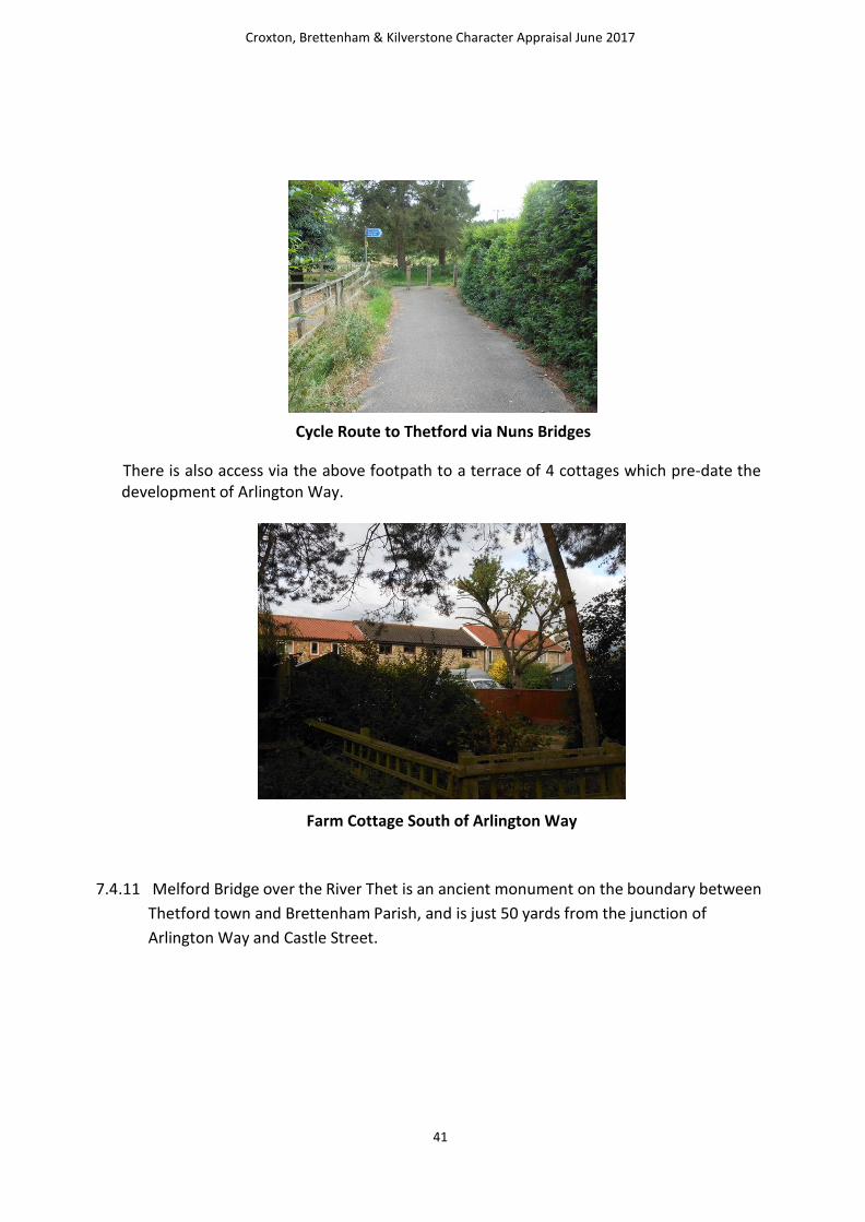
Cycle Route to Thetford via Nuns Bridges
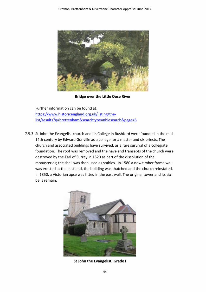
There is also access via the above footpath to a terrace of 4 cottages which pre-date the development of Arlington Way.
Farm Cottage South of Arlington Way
7.4.11 Melford Bridge over the River Thet is an ancient monument on the boundary between
Thetford town and Brettenham Parish, and is just 50 yards from the junction of
Arlington Way and Castle Street.

Croxton, Brettenham & Kilverstone Character Appraisal June 2017
42
Melford Bridge
Areas for enhancement or specific protection
7.4.12 The Character Survey work has specifically identified the Old Railway Station Site at
the corner of Arlington Way as having a detrimental impact upon the character of
the village and is specifically identified as being in need of some form of visual
enhancement.
Old Railway Station site at Arlington Way
7.4.12. The site is currently derelict and underused and is very close to the busy
A1066/A1088/Castle Street junction. The site has been used as a temporary stopping
place by the travelling community and also problems have been encountered in the
past with antisocial behaviour. It is considered by the community to be an eyesore.
The site lies within the Settlement boundary for Thetford as shown in the Thetford

Croxton, Brettenham & Kilverstone Character Appraisal June 2017
43
Area Action Plan adopted in 2012, however in Breckland District Council’s Local Plan
Interim Consultation (September/October 2016) it is shown as being outside of the
settlement boundary. The site could be the subject of future redevelopment
potentially for housing. The site is believed to be in private ownership. However, if
redevelopment for residential use was not considered to be a realistic option then
proposals for the visual enhancement of the site in terms of planting, screening and
strengthening of boundary treatments would be supported.
7.5 Rushford Character Area
7.5.1 Rushford is characterised by two country lanes converging, in the centre of the
village, the C147 Rushford Road running north to south and Nursery Lane from the northeast as a fork in the road. Church Lane is a very narrow residential street an d also adjoins here, providing access to the church.
Important Buildings
7.5.2 The built heritage of Rushford is of significant quality in national terms and
Historic England’s National List includes the following entries for Rushford:
St John Evangelist, Rushford Grade I
The College, Rushford Grade II*
College Gates, Rushford Grade II
Old School House Grade II
Lych Gate, St John Evangelist
In addition, Rushford Bridge is identified as a Scheduled Ancient Monument.
Croxton, Brettenham & Kilverstone Character Appraisal June 2017
44
Bridge over the Little Ouse River
Further information can be found at:
https://www.historicengland.org.uk/listing/the-
list/results?q=brettenham&searchtype=nhlesearch&page=6
7.5.3 St John the Evangelist church and its College in Rushford were founded in the mid-
14th century by Edward Gonville as a college for a master and six priests. The
church and associated buildings have survived, as a rare survival of a collegiate
foundation. The roof was removed and the nave and transepts of the church were
destroyed by the Earl of Surrey in 1520 as part of the dissolution of the
monasteries; the shell was then used as stables. In 1580 a new timber frame wall
was erected at the east end, the building was thatched and the church reinstated.
In 1850, a Victorian apse was fitted in the east wall. The original tower and its six
bells remain.
St John the Evangelist, Grade I

Croxton, Brettenham & Kilverstone Character Appraisal June 2017
45
Materials
7.5.4 Within Rushford the pre-19th Century dwellings are mainly of flint with decorative
chimneys, arched oak doors and traditional 2-bar windows. The moated college has
numerous gothic features and the adjacent church is thatched. Modern development
largely occurred in the 1970s and has consisted of brick built houses in large plots with
sympathetic later extensions, cart lodges and garages.
College Gates, Rushford, recently refurbished

Croxton, Brettenham & Kilverstone Character Appraisal June 2017
46
The College, Rushford
Scale, Form and Orientation
7.5.5 In Rushford, buildings are sparsely distributed around the village. Many residents
enjoy large back gardens with well-maintained hedges and verges. The buildings either
cluster around School Green or are adjacent to the Church and are set back from
the roads, with hedging and generous gardens and inconsistent building lines.
Condition and Use
7.5.6 In Rushford, the majority of properties are residential with large gardens, a
Church with graveyard, a working Stud, farm and forestry, otherwise no other
commercial enterprises, all of which are in good condition and in individual private
ownership except for the Church and the College.

Croxton, Brettenham & Kilverstone Character Appraisal June 2017
47
The Rushford Village Sign on the Green
Important Open Spaces for landscape or nature conservation
7.5.7 The setting of the village and the limited development gives a general open and
undeveloped feel to the village. Rushford enjoys a traditional village layout, a school
green, a church, a bridge and a river surrounded by mature woodlands, fields,
hedgerows, paddocks and meadows and has remained on the same footprint for
many years. The residents enjoy large back gardens, with well-maintained hedges
and verges and pride themselves on a green culture. The Green, known as School
Green, is the most striking undeveloped feature within the village and does not
currently enjoy specific protection from development, therefore the JNP policies could
address this and specifically identify the area for protection.
The School House and Estate Workers Cottages on the Green

Croxton, Brettenham & Kilverstone Character Appraisal June 2017
48
7.5.8 Rushford is characterised by narrow country lanes, no footpaths or cycle routes, a
permissive walking trail, (kindly provided and maintained by Shadwell), allows safe
and secure dog walking and exercise. There is a bridleway owned by the Diocese of
Norwich, newly designated PROW on the old highway, to the north of the church
linking C147 to the adopted Church Lane.
Private Bridleway (Public Right of Way) from the Church to
C147 road through Rushford)
7.5.9 The Little Ouse River is crossed by a bridge which is a Scheduled An cien t
Monument. Residents attach significant value to the area alongside the river and the
landscape it provides, they have identified it as being in need of enhancement
possibly through maintenance and clearing of scrub (not through development) and it
is therefore worthy of being specifically identified as an important landscape feature
in a JNP policy.
Croxton, Brettenham & Kilverstone Character Appraisal June 2017
49
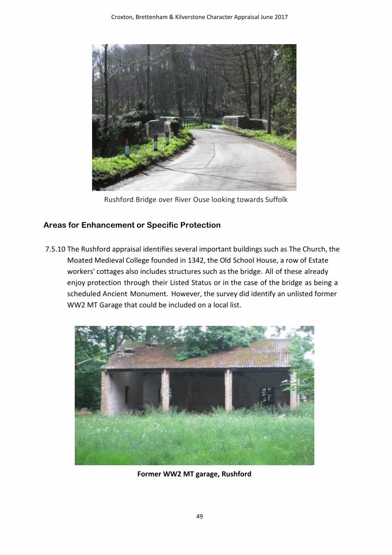
Rushford Bridge over River Ouse looking towards Suffolk
Areas for Enhancement or Specific Protection
7.5.10 The Rushford appraisal identifies several important buildings such as The Church, the
Moated Medieval College founded in 1342, the Old School House, a row of Estate
workers' cottages also includes structures such as the bridge. All of these already
enjoy protection through their Listed Status or in the case of the bridge as being a
scheduled Ancient Monument. However, the survey did identify an unlisted former
WW2 MT Garage that could be included on a local list.
Former WW2 MT garage, Rushford

Croxton, Brettenham & Kilverstone Character Appraisal June 2017
50
7.6 Conclusion for Brettenham Character Areas – Value to Residents
7.6.1 In terms of specific areas identified for protection, the JNP policies should consider
some specific protection for the following areas to ensure their continued
landscape and undeveloped value is maintained:
a) Strategic Gap between Kilverstone and Brettenham (C148)
b) The Green. Playing Field, Brettenham
c) School Green, Rushford
d) Little Ouse River, Brettenham/Rushford
7.6.2 In conclusion the survey has highlighted the following issues for the draft JNP policies
to address:
1. Design policy to reflect prevalent material of a mix of brick with flint panels,
some render and tiles roofs.
2. Local List policy to include the “Stallion Box”, Brettenham and former WW2 MT garage, Rushford, as a potential candidates
3. Specific policy to address the need for visual enhancement of the Old Railway Station Site at the corner of Arlington Way
4. Specific policy to protect the following green spaces:
a) Strategic Gap between Kilverstone and Brettenham, (C148) b) The Green Playing Feld, Brettenham
c) School Green, Rushford
d) Little Ouse River, Brettenham/Rushford
7.6.3 The Character Survey work highlighted a number of important factors which are
important to understanding the characteristics of the local community.
7.6.4 In Brettenham, there is a dependency of the local population on two main employers
– the Shadwell Estate Company Limited and Wrights of Brettenham – both of which
have employees living in close proximity is a key attribute. Estate and agricultural
workers’ accommodation is a key physical characteristic of the parish.
7.6.5 In Arlington Way and Aleutia Gardens it is clear that residents are very proud of their
rural position, bordered by woodland in spite of being immediately adjacent to the
built up area of Thetford. The area whilst being the most modern element of

Croxton, Brettenham & Kilverstone Character Appraisal June 2017
51
Brettenham is well spaced and well maintained. It is a development of large, well-
spaced, residential homes with sizeable gardens; however the rural setting is a haven
for wildlife.
7.6.7 The Rushford appraisal work included some very detailed reflections and observations
from local residents who were asked about how they felt about the village. The
overwhelming impression given from that work is that the local population attribute
great value and weight to the tranquillity and rural feel of the village, the views over
open countryside and appreciation of the diverse wildlife in the area. However a
number of residents also cite one of the attractions of Rushford as being its
accessibility – it is easy to get to other places e.g. Thetford, Diss, Norwich, Bury St
Edmunds and therefore it has been possible for a number of residents to live and
bring up children in a rural setting whilst still maintaining easy access to work.
7.6.8 There are however, underlying concerns over the spectre of new development and
what that might mean for the existing communities, the landscape, the heritage and
the wildlife.
7.6.9 The residents of Rushford have a deep emotional attachment to their village, they
are very proud of the green, the village layout, the river and the historic buildings and
what they describe on more than one occasion as a “quintessential” English village.

Croxton, Brettenham & Kilverstone Character Appraisal June 2017
52
8.0 Kilverstone Parish
8.1 Introduction to the Village and Historical Context
8.1.1 Kilverstone is a small parish in Breckland on the edge of the town of Thetford. The
River Thet forms the southern boundary of the parish, and to the north the parish is
bisected by the A11 and the railway. Kilverstone comes from the Old English
meaning ‘Kilvert’s enclosure or settlement’.
8.1.2 An excavation carried out on Norwich Road in 2000 revealed a nationally important
Early Neolithic site made up of over two hundred pits, some of which were grouped
into distinct clusters. According to the Norfolk Historic Environment Record, the pits
are probably the remains of an Early Neolithic settlement. A small group of Beaker pits
and a Late Neolithic to Early Bronze Age 'buried soil' deposit, both containing pottery
and flints were also discovered. Other prehistoric finds from the parish include Early
Neolithic pottery and Neolithic flints including arrowheads, a knife and axe heads
8.1.3 Two ring ditches probably the remains of Bronze Age round barrows, are
visible as cropmarks on aerial photographs to the north of Kilverstone Hall.
8.1.4 The excavation also revealed an Iron Age to Roman settlement. A series of Late Iron
Age ditches and a post-built structure was replaced in the Early Roman period by a
more extensive system of ditches, and by the end of the 2nd century AD the
settlement included a timber aisled barn and other post-built structures. The
excavation uncovered three circular late Roman structures that were associated with
metalworking. One structure contained a wooden pump, one of only two examples to
be excavated in Britain. A blacksmith's hoard, including an anvil, tongs, and several
pewter plates, was found in a pit on the site. An Iron Age or Roman escutcheon from a
bucket has been found by a metal detector, as well as Roman pottery, coins, brooches
and other metal finds. The excavation also revealed a small Early Saxon settlement
with ten sunken-featured buildings and four post-built halls. The settlement is
associated with a nearby Early Saxon cemetery. The cemetery contained six
inhumations and a cremation. An Early Saxon wrist clasp, fragments of Early Saxon
pottery and a coin from the reign of Cnut have been found during fieldwalking and
metal detecting.
8.1.5 In 1086 Kilverstone was held by the King and by Robert Malet, and the Doomsday
Book records mills, a fishpond and flocks of sheep. Medieval and post medieval

Croxton, Brettenham & Kilverstone Character Appraisal June 2017
53
documents show that sheep were of enduring importance in the local economy, and
the cause of many legal disputes!
8.1.6 Kilverstone was the property of The Crown from William I to Henry I who gave it to
William d’Albani, who gave it to the Cluniac Prior of Thetford. It remained theirs until
the Dissolution when it was given to Thomas Duke of Norfolk. In 1568 Sir Thomas
Cornwall had its use following the Duke of Norfolk’s beheading in 1571 was sold to the
Lovell Family then to Charles Corwallis then to Thomas Wright. His son, also Thomas,
built the old hall and is buried at Kilverstone. The Wright Family owned Kilverstone
until 1899 when Josiah Vavasseur purchased it and he in turn bequeathed it the
present Fisher Family.
8.1.7 St Andrew’s Church, listed as Grade II, has a 12th century round tower, and parts of
the nave and chancel also date to the 12th century. The church was altered in the 14th
century and was restored by Boardman in 1906. Inside the grounds of the church is
the grave of Jackie, 1st Baron Fisher, Admiral of the Fleet, and there are also three
Listed Table Tombs to the Wright Family.
St Andrew’s Church, Grade II
8.1.8 The medieval village of Kilverstone was virtually deserted when a small landscape
park was laid out around Kilverstone Hall in the late 18th century.
8.1.9 The earthworks of medieval hollow ways, tofts and house platforms are visible on
aerial photographs taken in 1946, but the earthworks have since been destroyed by
ploughing. Field-walking on the site has recovered Roman, medieval and post

Croxton, Brettenham & Kilverstone Character Appraisal June 2017
54
medieval pottery. There were two manorial sites in the villages, Coxford’s and Monk’s
Hall. Both manors were in ecclesiastical hands until the Dissolution, and by the end of
the 16th century both manors were held by Thomas Wright. Medieval pottery, coins,
a brooch and other metal finds) have been found, including a 14th century seal made
from a Roman coin that belonged to John Cornwallis, whose descendants were Lords
of the Manor of Coxford in the 16th century.
8.1.10 The House at Kilverstone was originally Monks Hall with a village further over to the
east, south of the church, and in this area is “the lost village of Kilverstone” which
incorporated an old mill pond, forge, and footings of ancient buildings.
Kilverstone Hall, Grade II Listed
8.1.11 The Estate was put together following the Civil War by the Wright Family of whom
Thomas rebuilt the Hall in 1620, further enlargement made in 1725. Further changes
undertaken from the 1900’s to the 1930’s by Lord Cecil Fisher. Through the centuries
buildings have come and gone and in 1896 purchased by Josiah Vavasseur who
developed the courtyard from 1901 to 1908.
8.1.12 Kilverstone Hall is an early 17th century house that was extensively rebuilt in the
Jacobean style in 1913. The drawing room and dining room have been virtually
unaltered since the early 18th century, and both rooms contain ornate fireplaces.
8.1.13 The last major refit was undertaken by Josiah Vavasseur between 1901 and 1908 when
most of the courtyard from the water tower in the south west corner to the Annexe,
completed in 1910 at the North West. These buildings included a laundry, a garage,
stabling and engine and gun rooms with game larders and storage. The majority have
been converted to modernised residences, all having a distinctive individual character.

Croxton, Brettenham & Kilverstone Character Appraisal June 2017
55
Grade II Listed Stable Block, Kilverstone Estate
8.1.14 The stables were designed by Boardman in 1901, with an open loggia and a clock
tower. Boardman also designed the entrance lodge and the water tower, which
has decorative brickwork and a timber tank.
8.1.15 During the 1840s a large number of huts were erected on Kilverstone Heath to house
people working on the construction of the railway. A World War Two pillbox guards a
level crossing on the railway.
8.1.16 Kilverstone Parish is a Landed Estate, and the current Seat of Baron Fisher of
Kilverstone.
8.2 Brief over view of character area
8.2.1 Kilverstone has largely lent itself to one character area delineated by the A1075
for its western boundary with the River little Ouse as the southern boundary and
with Harling Drove/Kilverstone Belt forming the eastern boundary.
8.2.3 The focus of the character area is the Kilverstone Estate just north of the River Ouse.
The estate is characterised by Kilverstone Hall and its various outbuildings and
stables including courtyard and water tower. The majority of the buildings in the
village are owned by the Kilverstone Estate.

Croxton, Brettenham & Kilverstone Character Appraisal June 2017
56
8.3 Materials
8.3.1 The prevalent materials within Kilverstone are again traditional Norfolk flint with
brick and tiled roofs and these are features that have been reflected in the
construction of the new housing developments adjacent to the Tescos food
superstore many of which have flint facades or features as well tiled or slate roofs.
8.4 Scale, Form and Orientation
8.4.1 The Estate is located around a central court yard which includes stable block, a water
tower to the north aspect and a clock tower to the south aspect. There are also various
walled gardens and a deer park to the south bounded by the river Thet. Kilverstone
Hall itself is the dominant building which sites well amongst its more subservient
curtilage buildings.
8.4.2 The remainder of the built form of the village consists of dwellings located close to the
road these include Fountain Cottages 1-4, the Almshouses and Lodge Gatehouse.
8.5 Condition and Use
8.5.1 The majority of the buildings in Kilverstone are in very good condition with the
possible exception of the Almshouses which the Parish Council has identified as being
in poor condition and being in need of some significant updating ad renovation
particularly internally. Some redundant agricultural buildings are in a fragile state
awaiting development.
8.5.2 The use of buildings, primarily rented housing, with agricultural and small
businesses, and some awaiting modernisation, with the open parkland used for
charity functions such as jamborees, fetes and fun days.
8.5.3 Field Barn Farm set further into the estate and its associated buildings are used for
an equestrian centre, temporary accommodation for migrant workers and extensive
modern barns for agricultural business.
8.5.4 Lodge Farmhouse at present is a community church club and two residences.
8.6 Important buildings
8.6.1 As identified earlier a number of the buildings in the village are in good condition and
their contribution to the character of the area is recognised through their listed
status.

Croxton, Brettenham & Kilverstone Character Appraisal June 2017
57
Water Trough, Grade II
8.6.2 The National List includes the following entries for Kilverstone:
Church of St Andrew Grade II*
Kilverstone Hall Grade II
Kilverstone Club in the grounds of Kilverstone Hall Grade II
Entrance Lodge to Kilverstone Hall Grade II
Stable block to Kilverstone Hall Grade II
Water Tower, Kilverstone Hall Grade II
Mediaeval Cross Base, Kilverstone Hall Grade II
Three Table Tombs to the Wright Family Grade II
Water Trough and War Memorial Grade II
Further information can be found at The List Search Results for kilverstone | Historic
England

Croxton, Brettenham & Kilverstone Character Appraisal June 2017
58
Ex-prisoner of war huts now used as shoot huts
8.6.3 However the survey work has identified a number of buildings that are not listed but have been identified by the local community as having some architectural, cultural or historic value. Whilst they currently do not enjoy the protection offered by formal listing, there may be some benefit of them being identified as non-designated heritage assets, the significance of which should be taken into account when determining planning applications. There is also merit in pressing Breckland Council as Local
Planning Authority to consider the compilation of a Local List and for them to formally
assess the suitability of the buildings identified in this survey to be included on it.
Lodge Farmhouse – flint construction with a slate roof and currently
partial residential use and partial community use
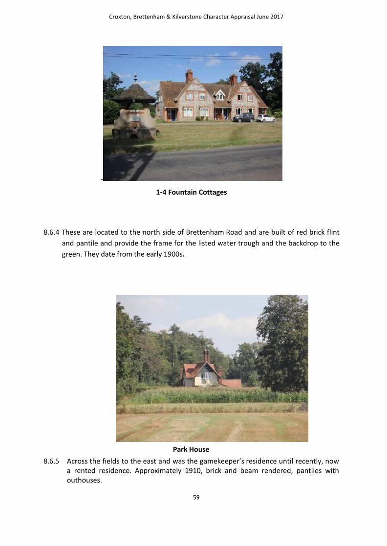
Croxton, Brettenham & Kilverstone Character Appraisal June 2017
59
-
1-4 Fountain Cottages
8.6.4 These are located to the north side of Brettenham Road and are built of red brick flint
and pantile and provide the frame for the listed water trough and the backdrop to the
green. They date from the early 1900s.
Park House
8.6.5 Across the fields to the east and was the gamekeeper’s residence until recently, now a rented residence. Approximately 1910, brick and beam rendered, pantiles with outhouses.

Croxton, Brettenham & Kilverstone Character Appraisal June 2017
60
.
1 and 2 Farm Gate circa 1904
8.6.6 To the north of Brettenham Road are cottages associated with the farm, I & 2 Farm gate, brick base rendered first elevation, Maidens Walk.
1 & 2 Shepherds Cottages, grey brick, flint and slate,
8.6.6 However, the survey work concluded that these were unlisted buildings make an important contribute to the overall character of this part of the village and could be worthy of some recognition as non-designated heritage assets. This is an issue that should be addressed by the inclusion of an appropriate policy within the draft JNP.

Croxton, Brettenham & Kilverstone Character Appraisal June 2017
61
8.7 Important spaces for landscape and nature conservation, including trees
8.7.1 Green and open spaces play an important role in shaping the character of many areas. Character assessments can be used to inform decisions about designated new local green space or to identify existing open spaces that can be protected and enhanced.
8.7.2 The survey identified some areas that are considered to contribute to the
character of the parish because of their landscape or nature conservation value.
These include:
• The Lakes – south of Kilverstone Hall, created in the 1980’s by the 3rd Baron Fisher,
adjoining the dykes which drain the land into the River Thet. This is an ideal
habitat for water loving animals.
• Maidens Walk - an important Landscape Features created in the Parish, a beech
tree lined avenue with abundant snowdrops and aconites
• Fishers Fan, a planting scheme of woods interspersed with open ground
specifically for shooting, as is the arrangement of all the woodlands which were
significantly planted and laid out in Edwardian days for shooting.
8.7.3 Whilst none of these are specifically identified as being in need of protection or
considered to be under threat from any development that would erode their
character, they are largely located within the open countryside they are largely
protected under existing policies of the Breckland District Local Plan.
The Lakes, south of Kilverstone Hall

Croxton, Brettenham & Kilverstone Character Appraisal June 2017
62
Maiden’s Walk, South Aspect
Maiden’s Walk, South West Aspect
8.7.4 In addition the survey highlighted the value attributed by residents to the
undeveloped nature of The Green which hosts the water trough and provides its
setting; thus protected through the listing of the water trough and also the small
green at the entrance to the estate which hosts the new wooden village sign.

Croxton, Brettenham & Kilverstone Character Appraisal June 2017
63
Village Sign on green at entrance to Kilverstone Estate
8.8 Access to the countryside – footpaths and cycle ways
8.1 The survey does not identify any formal Public Rights of Way within Kilverstone Parish nor does Norfolk County Council’s definitive map identify any. There are informal paths across the Kilverstone Estate including Maiden’s Walk as identified above. There are no formal off road cycle paths either and much of the parish does not even benefit from formal pavements.
8.9 Areas for enhancement or specific protection
8.9.1 The Parish Council, a Trustee to the Kilverstone Almshouse Trust, has identified the
Almshouses at the end of church lane as being in need of some form of updating and
renovation, particularly internally, further they would benefit from visual
enhancement although the character survey work doesn’t specifically identify them
as visually detracting from the overall character. However their built fabric is not of
the quality and condition which the survey work has identified as being prevalent
elsewhere in the village.
8.9.2 Therefore there is some benefit to including a specific policy within the draft JNP
to promote the need for enhancement. Opportunities for enhancing this
important site are likely to be supported.
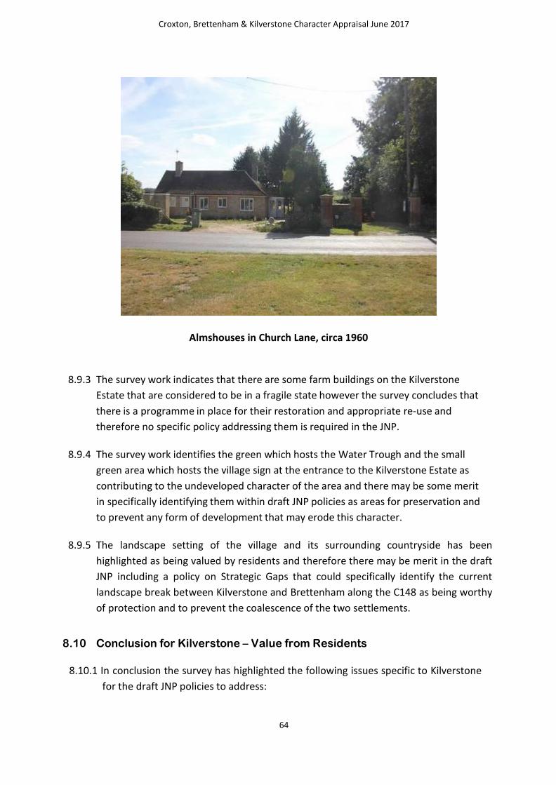
Croxton, Brettenham & Kilverstone Character Appraisal June 2017
64
Almshouses in Church Lane, circa 1960
8.9.3 The survey work indicates that there are some farm buildings on the Kilverstone
Estate that are considered to be in a fragile state however the survey concludes that
there is a programme in place for their restoration and appropriate re-use and
therefore no specific policy addressing them is required in the JNP.
8.9.4 The survey work identifies the green which hosts the Water Trough and the small
green area which hosts the village sign at the entrance to the Kilverstone Estate as
contributing to the undeveloped character of the area and there may be some merit
in specifically identifying them within draft JNP policies as areas for preservation and
to prevent any form of development that may erode this character.
8.9.5 The landscape setting of the village and its surrounding countryside has been
highlighted as being valued by residents and therefore there may be merit in the draft
JNP including a policy on Strategic Gaps that could specifically identify the current
landscape break between Kilverstone and Brettenham along the C148 as being worthy
of protection and to prevent the coalescence of the two settlements.
8.10 Conclusion for Kilverstone – Value from Residents
8.10.1 In conclusion the survey has highlighted the following issues specific to Kilverstone
for the draft JNP policies to address:
Croxton, Brettenham & Kilverstone Character Appraisal June 2017
65
1. Design policy to reflect prevalent material of flint, brick with red pantiled roofs.
2. Local List policy to include the following buildings as potential candidates:
a) Ex prisoner of War Huts (now shoot huts)
b) Lodge Farmhouse
c) 1-4 Fountain Cottages
d) Park House
e) 1&2 Farm Gate
f) 1&2 Shepherd’s Cottages
3. Specific policy to explore the options for enhancing the Alms Houses
4. Specific policy to protect the following green spaces:
a. Green hosting Listed Water Trough
b. Green hosting Village sign at entrance to Kilverstone Estate
c. Strategic Gap between Kilverstone and Brettenham (C148)
8.10.2 In terms of an overall conclusion, the survey identifies the following as
capturing the essence of the village:
“although, abutting Thetford, Kilverstone is a world away from the town, and has a very
tranquil feeling. If you like it here you tend to stay for as long as possible, however to be a local
you need to have been here at least 40 years until then you are a very welcome guest.”

Croxton, Brettenham & Kilverstone Character Appraisal June 2017
66
9.0 Appendices
Appendix A : – Character Area Maps
1 Croxton Character Area 67
2 Brettenham Parish Character Area (Village) 68
3 Brettenham Parish Character Area (Arlington Way) 69
Appendix B : – Strategic Gaps Maps
1 Croxton, Brettenham & Kilverstone Strategic Gaps 70
2 Croxton Parish Strategic Gap 71
3 Croxton Strategic Gap (Village) 72
4 Brettenham Parish (West) 73
5 Brettenham Parish (East) 74
6 Kilverstone Parish Strategic Gap 75

Croxton, Brettenham & Kilverstone Character Appraisal June 2017
67
A1 - Croxton Character Area

Croxton, Brettenham & Kilverstone Character Appraisal June 2017
68
A2 - Brettenham Parish Character Area (Village)

Croxton, Brettenham & Kilverstone Character Appraisal June 2017
69
A3 - Brettenham Parish Character Area (Arlington Way)

Croxton, Brettenham & Kilverstone Character Appraisal June 2017
70
B1 - Croxton, Brettenham & Kilverstone Strategic Gaps

Croxton, Brettenham & Kilverstone Character Appraisal June 2017
71
B2 = Croxton Parish Strategic Gap

Croxton, Brettenham & Kilverstone Character Appraisal June 2017
72
B3 - Croxton Strategic Gap (Village)

Croxton, Brettenham & Kilverstone Character Appraisal June 2017
73
B4 - Brettenham Parish (West)

Croxton, Brettenham & Kilverstone Character Appraisal June 2017
74
B5 - Brettenham Parish (East)
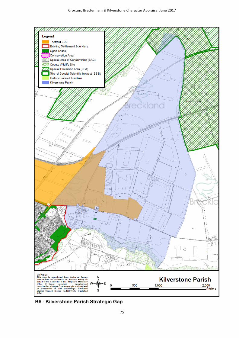
Croxton, Brettenham & Kilverstone Character Appraisal June 2017
75
B6 - Kilverstone Parish Strategic Gap