Cropland vs Forests: Landscape Composition and Land-use ... · Cropland vs Forests: Landscape...
12
Cropland vs Forests: Landscape Composition and Land-use Changes in Peri-urban Rome (1949-2008) LUCA SALVATI 1 , ILARIA TOMBOLINI 2 1 Consiglio per la Ricerca e la sperimentazione in Agricoltura, Centro per lo Studio delle Relazioni tra Pianta e Suolo (CRA-RPS), Via della Navicella 2-4, I-00184 Rome 2 c/o Consiglio per la Ricerca e la sperimentazione in Agricoltura, Unità di ricerca per la Climatologia e la Meteorologia applicate all'Agricoltura (CRA-CMA), Via del Caravita 7a, I-00186 Rome ITALY [email protected] Abstract: - This paper investigates long-term land-use changes in peri-urban Rome (1500 km 2 ) over sixty years (1949-2008) as a contribution to the study of landscape form and composition. The investigated region is a paradigmatic example of an originally compact urban landscape progressively transformed into a more dispersed urban form, with high-quality agricultural areas and pristine forests (including the Castelporziano presidential estate) still preserved along the urban fringe but endangered by forest fires, urban sprawl and increasing human pressure. Changes in the distribution of nine land-use categories have been determined and diachronic relationships among them deeply explored in the investigated area. Results illustrated in this study indicate a substantial similarity in the processes of land-use changes observed in the peri-urban area of Rome during the last sixty years. The main trends include (i) agricultural land abandonment (arable land, pasture and, partly, vineyards) followed by urbanization (either in compact and dispersed forms of settlements), (ii) deforestation in the first time period followed by woodland re-colonization and overall increase during the most recent years and, finally (iii) crop intensification and rural landscape simplification. Conversion probability to impervious land was found high only for defined cover classes over the whole period, including arable lands, pastures, annual cultivations, and vineyards. Notably, these classes were found strictly associated to the urban- rural interface in the Mediterranean landscape. The implications of land-use changes for policies aimed at protecting the fragile woodland ecosystem around large Mediterranean are discussed in the light of planning strategies for the containment of urban diffusion. Key-Words: - Urban expansion; land-use changes; Settlement density; Rome; Mediterranean basin. 1 Introduction Population grew rapidly in southern Europe consolidating the gap between urban and rural regions (1). Economic growth, urban development, and massive population increased during the 1960s and 1970s, and contributed to the subsequent process of deconcentration observed since the early 1980s in several Mediterranean cities (2; 3; 4; 5; 6). However, long-term land-use changes have been poorly documented in large peri-urban regions of southern Europe (7; 8; 5; 9; 10). Recent studies have illustrated, usually over a restricted observation period, the rate of land consumption, especially of the agricultural land surfaces, and the loss of semi-natural vegetation and woodlands (11; 12; 13; 14; 15; 16). Although land- use trajectories are mainly determined by the underlying dynamics of urban expansion, other landscape transitions can be investigated. Just to provide an example, the loss of surface areas originally devoted to arable lands, pastures and vineyards is probably the most visible landscape transition in Mediterranean peri-urban regions. However, a subtle phenomenon of simplification of the rural landscape is also active and should be monitored in depth (17) since peri-urban regions are progressively losing their traditional landscapes rich in biodiversity and culture (18; 19; 20; 21; 22). This paper investigates long-term land-use changes in peri-urban Rome (1500 km 2 ) over sixty years WSEAS TRANSACTIONS on ENVIRONMENT and DEVELOPMENT Luca Salvati, Ilaria Tombolini E-ISSN: 2224-3496 278 Issue 4, Volume 9, October 2013
Transcript of Cropland vs Forests: Landscape Composition and Land-use ... · Cropland vs Forests: Landscape...
Cropland vs Forests: Landscape Composition and Land-use Changes in Peri-urban Rome (1949-2008)
LUCA SALVATI1, ILARIA TOMBOLINI2
1 Consiglio per la Ricerca e la sperimentazione in Agricoltura, Centro per lo Studio delle Relazioni
tra Pianta e Suolo (CRA-RPS), Via della Navicella 2-4, I-00184 Rome
2 c/o Consiglio per la Ricerca e la sperimentazione in Agricoltura, Unità di ricerca per la
Climatologia e la Meteorologia applicate all'Agricoltura (CRA-CMA), Via del Caravita 7a, I-00186
Rome
ITALY [email protected] Abstract: - This paper investigates long-term land-use changes in peri-urban Rome (1500 km2) over sixty years (1949-2008) as a contribution to the study of landscape form and composition. The investigated region is a paradigmatic example of an originally compact urban landscape progressively transformed into a more dispersed urban form, with high-quality agricultural areas and pristine forests (including the Castelporziano presidential estate) still preserved along the urban fringe but endangered by forest fires, urban sprawl and increasing human pressure. Changes in the distribution of nine land-use categories have been determined and diachronic relationships among them deeply explored in the investigated area. Results illustrated in this study indicate a substantial similarity in the processes of land-use changes observed in the peri-urban area of Rome during the last sixty years. The main trends include (i) agricultural land abandonment (arable land, pasture and, partly, vineyards) followed by urbanization (either in compact and dispersed forms of settlements), (ii) deforestation in the first time period followed by woodland re-colonization and overall increase during the most recent years and, finally (iii) crop intensification and rural landscape simplification. Conversion probability to impervious land was found high only for defined cover classes over the whole period, including arable lands, pastures, annual cultivations, and vineyards. Notably, these classes were found strictly associated to the urban-rural interface in the Mediterranean landscape. The implications of land-use changes for policies aimed at protecting the fragile woodland ecosystem around large Mediterranean are discussed in the light of planning strategies for the containment of urban diffusion. Key-Words: - Urban expansion; land-use changes; Settlement density; Rome; Mediterranean basin. 1 Introduction Population grew rapidly in southern Europe consolidating the gap between urban and rural regions (1). Economic growth, urban development, and massive population increased during the 1960s and 1970s, and contributed to the subsequent process of deconcentration observed since the early 1980s in several Mediterranean cities (2; 3; 4; 5; 6). However, long-term land-use changes have been poorly documented in large peri-urban regions of southern Europe (7; 8; 5; 9; 10). Recent studies have illustrated, usually over a restricted observation period, the rate of land consumption, especially of the agricultural land surfaces, and the loss of semi-natural vegetation and
woodlands (11; 12; 13; 14; 15; 16). Although land-use trajectories are mainly determined by the underlying dynamics of urban expansion, other landscape transitions can be investigated. Just to provide an example, the loss of surface areas originally devoted to arable lands, pastures and vineyards is probably the most visible landscape transition in Mediterranean peri-urban regions. However, a subtle phenomenon of simplification of the rural landscape is also active and should be monitored in depth (17) since peri-urban regions are progressively losing their traditional landscapes rich in biodiversity and culture (18; 19; 20; 21; 22). This paper investigates long-term land-use changes in peri-urban Rome (1500 km2) over sixty years
WSEAS TRANSACTIONS on ENVIRONMENT and DEVELOPMENT Luca Salvati, Ilaria Tombolini
E-ISSN: 2224-3496 278 Issue 4, Volume 9, October 2013
(1949-2008) as a contribution to the study of landscape form and composition. The investigated region is a paradigmatic example of an originally compact urban landscape progressively transformed into a more dispersed urban form, with high-quality agricultural areas and pristine forests (namely the Castelporziano estate) still preserved along the urban fringe but endangered by forest fires, urban sprawl and increasing human pressure (11; 23). Changes in the distribution of nine land-use categories have been determined and diachronic relationships among them deeply explored in the investigated area. The implications of land-use changes for policies aimed at protecting the fragile woodland ecosystem around large Mediterranean are discussed in the light of planning strategies for the containment of urban diffusion. 2 Methods 2.1 Study area Rome, one of the largest urban regions in the northern Mediterranean basin, has been considered in this paper as the study site. The investigated area encompasses the boundaries of the municipalities of Rome and Fiumicino (1500 km2) and is characterized by a complex topography consisting of nearly 70% lowlands and 30% uplands. Although urban areas occupy an important (and increasing) part of the region, the majority of the prefecture’s area still consists of forests, pastures, and cropland. Despite degraded by summer fires and the exceptional human pressure caused by the closeness to Rome, the original forest vegetation is still preserved in some strands of Castelporziano coastal flat oakwood. Industrial areas were traditionally located in the eastern part of the ‘Agro Romano’ lowland close to the city of Rome while traditional rural areas are more abundant in the western part of the prefecture. The climate is typically Mediterranean, with rainfall concentrated in autumn and spring and mild temperature in winter. The average long-term annual rainfall and mean daily temperature in Rome were 700 mm and 16°C respectively. However, an important decrease in rainfall coupled with growing temperature was recorded in the last years (24). 2.2 Cartographic data Land-use data were obtained from the elaboration of four compatible digital maps referring to the Corine Land Cover (CLC) classification system: (i) the IGM topographic map scaled 1:25000 and produced in 1949, (ii) the ‘Agricultural and forest map of
Rome region’ scaled 1: 50000 and produced by the prefecture authority of Rome in 1974 (LCM74), and two maps scaled 1: 25000 and respectively dated 1999 (LCM99), and 2008 (LCM08). LCM99 is a land cover map produced by the Regional Authority of Latium region with a minimum mapping unit of 1 hectare and a coverage of 17203 km2. The map was derived from digital ortho-photo interpretation (Terraitaly - IT2000, 1998-1999, 1 meter pixel) and projected in UTM 33 ED50. LCM08 is an original land cover map acquired by photo-interpretation of digital ortho-images released from the Italian National Geoportal (Italian Ministry for Environment, Land and Sea) with a 0.5 meters pixel related to 2008 and projected in UTM33 WGS84. The land cover classification system is based on twelve classes with a minimum mapping unit of 1 hectare. Since the land cover classification system used in the three maps is comparable, land-use categories were reclassified (sensu 25) into nine classes (see Table 2). The surface area of each land-use class was calculated and assigned to each spatial domain on the basis of the ‘intersect’ tool provided by the ArcGIS software (24). The soundness of these figures has been checked by comparison with independent statistical and cartographic data derived from (i) the National Censuses of Agriculture, Population, and Buildings, (ii) the CORINE-like land cover map produced on the behalf of the LACOAST project which covers the coastal area of Rome province and refers to 1975 (26) and finally, (iii) the land-use maps of Italy respectively prepared by the Milizia Forestale Italiana in 1938 and Touring Club Italiano in 1960. As far as settlement density is concerned, since the early 1990s, the National Institute of Statistics of Italy (ISTAT) has developed Geographic Information Systems (GIS) which comprise digital databases supporting census operations. These databases consist of digital cartographical data which have been produced through aerial photograph processing. The digital data have been converted to the corresponding analogical diagrams at 1:25000 scale in urban areas and 1:50000 scale in rural areas. The information available in these databases include a vector map covering the whole investigated area with the geometry of thousands enumeration districts corresponding to 3-5 building blocks in urban areas (27). The surface area of each enumeration district polygon was calculated by way of the relevant ArcGIS ‘Spatial analyst’ tool (ESRI Inc., Redwoods, USA). 2.3 Statistical analysis
WSEAS TRANSACTIONS on ENVIRONMENT and DEVELOPMENT Luca Salvati, Ilaria Tombolini
E-ISSN: 2224-3496 279 Issue 4, Volume 9, October 2013
The land-use composition observed in Rome by selected years (1949, 1974, 1999, 2008) at each spatial domain was calculated as the percentage of the surface area of each class on the total surface area. Selected relationships between different land-use classes was checked by pair-wise non parametric correlations (Spearman rank test) carried out between the percent surface cover of the twelve classes observed at each investigated time. After Bonferroni correction for multiple comparisons, significance was tested at p < 0.001. The density of buildings was calculated in 1945, 1961, 1971, 1981, 1991, and 2001 using the data collected in the framework of the Censuses of Population and Buildings, carried out by the national statistical authority. The building density was, then, calculated over time at each enumeration district. Eight building density classes have been considered here: (i) no buildings, (ii) 0 – 0.5 buildings per hectare, (iii) 0.5 – 1 buildings per hectare, (iv) 1 – 2 buildings per hectare, (v) 2 – 5 buildings per hectare, (vi) 5 – 10 buildings per hectare, (vii) 10 – 50 buildings per hectare, and (viii) > 50 buildings per hectare. The total surface area corresponding to each density class was calculated by summing the surface area of each enumeration district classified within that class. 3 Results Rome's urban expansion have shifted from settlement compactness to dispersion in the last thirty years (Figure 1). The compact form of the city was evident in 1949 while settlement dispersion increased rapidly from 1974 with exurban development invading the peri-urban fringe around Rome. Covering more than 69% of the investigated area, arable land decreased by 17.7% between 1949 and 1974 (Table 2) and the rate of decrease maintained relatively stable in the following time periods (Figure 2) leading to only 44.1% of the study area in 2008. Conversely there has been a progressive increase of the impervious land (amounting to the 6.6% and 27.5% of the investigated land in 1949 and 2008, respectively) as a result of urban expansion. Reflecting a change in economic activities and, in particular, the abandonment of forestry and agro-pastoral activities, pastures increased by 8.2% between 1949-1974 while showing a decrease in the subsequent years. The vineyards decreased slightly over time (composing 2.4% and 1.3% of landscape in 1949 and 2008, respectively), while olive groves increased lightly. The abandonment of forestry and agro-pastoral activities favoured the natural vegetation growth allowing the woodland class to
remain stable over time and offsetting the effects of the impervious land increase. This increase reflects the rise in the building density whose spatial distribution is shown in Figure 3 for the period between 1945 and 2001. The first two density classes are those prevailing throughout the period (Table 3), but the first one (no buildings) decreased over time (from 39.6% in 1945 to 22.2% in 2001) possibly indicating a progressive fragmentation of natural landscape due to settlement and infrastructure expansion. Classes representing higher building density increased quite homogeneously: just to provide paradigmatic examples, the second class by density rose from 36% in 1945 to 55% in 2001, the fifth class rose from 0.9% in 1945 to 7.3% in 2001 and the sixth class rose from 0.5% in 1945 to 4.4% in 2001. The resulting urban footprint observed in 2010 reflects a very fragmented and dispersed urban form (Figure 4) with implications on landscape quality and fragmentation at the fringe. 4 Discussion While land-use changes in peri-urban regions are becoming a crucial issue in the European policy agenda, efforts aimed at assessing sprawl at different spatial levels should be intensified (28) through the integrated use of different data sources capable to provide spatio-temporal trends in urban expansion (29; 2; 30; 6; 31). The present study contributes to the analysis of the urban expansion of a large Mediterranean urban region shifting from a compact and mono-centric form to a more dispersed and polycentric spatial organization. Results illustrated in this study indicate a substantial similarity in the processes of land-use changes observed in the peri-urban area of Rome during the last sixty years. The main trends include (i) agricultural land abandonment (arable land, pasture and, partly, vineyards) followed by urbanization (either in compact and dispersed forms of settlements), (ii) deforestation in the first time period followed by woodland re-colonization and overall increase during the most recent years and, finally (iii) crop intensification and rural landscape simplification. Conversion probability to impervious land was found high only for defined cover classes over the whole period, including arable lands, pastures, annual cultivations, and vineyards. Notably, these classes were found strictly associated to the urban-rural interface in the Mediterranean landscape (32; 33; 34). Overall, the traditional land-use segregation observed in peri-urban regions (urban areas, cropland, forests) and depending on the distance
WSEAS TRANSACTIONS on ENVIRONMENT and DEVELOPMENT Luca Salvati, Ilaria Tombolini
E-ISSN: 2224-3496 280 Issue 4, Volume 9, October 2013
from the main urban pole (35) has been altered in Rome producing a 'disordered' landscape, with no evident spatial hierarchies and structures, mainly depending on socioeconomic factors rather than on bio-physical factors like climate and soil quality (36). Especially during the last decade, the demand for land conversion to urban uses moved progressively far from the city centre and impacted different land-use classes (e.g. 37). This process may alter irreversibly the traditional landscape pattern of the 'Agro Romano' lowland and reduces the surface area of high-quality cover classes. Contrasting the recent changes in the ‘landscape gradient’ described earlier, high-naturality areas like Castelporziano woodlands situated in the southern part of Rome's municipality may act as a buffer zone containing dispersed urban expansion and mitigating landscape conversion to low-quality uses. In order to be really effective, urban and regional planning should recognize the role of relict habitats (forests, pastures and 'mosaic' agricultural land) around Castelporziano as a key buffer zone maintaining the environmental quality of 'Agro Romano' lowland and protecting the relict forest of Castelporziano from land degradation. References: [1] Antrop, M., Landscape change and the
urbanization process in Europe, Landscape and Urban Planning, Vol.67, No.1-4, 2004, pp. 9-26.
[2] Kasanko, M., Barredo, J.I., Lavalle, C., McCormick, N., Demicheli, L., Sagris, V., Brezger, A., Are European Cities Becoming Dispersed? A Comparative Analysis of Fifteen European Urban Areas, International Landscape and Urban Planning, Vol.77, No.1-2, 2006, pp. 111-130.
[3] Longhi, C., Musolesi, A., European cities in the process of economic integration: towards structural convergence, Annals of Regional Science, Vol.41, 2007, pp. 333-351.
[4] Turok, I., Mykhnenko, V., The trajectories of European cities, 1960-2005, Cities, Vol.24, No.3, 2007, pp. 165-182.
[5] Catalán, B., Saurí, D., Serra, P., Urban sprawl in the Mediterranean?: Patterns of growth and change in the Barcelona Metropolitan Region 1993-2000, Landscape and Urban Planning, Vol. 85, No.3-4, 2008, pp. 174-184.
[6] Schneider, A., Woodcock, C.E., Compact, dispersed, fragmented, extensive? A comparison of urban growth in twenty-five global cities using remotely sensed data, pattern
metrics and census information, Urban Studies, Vol.45, No.3, 2008, pp. 659-692.
[7] Alphan, H., Land use change and urbanisation of Adana, Turkey, Land Degradation and Development, Vol. 14, 2003, pp. 575-586.
[8] Weber, C., Puissant, A., Urbanisation pressure and modeling of urban growth: example of the Tunis Metropolitan Area, Remote Sensing of Environment, Vol.86, 2003, pp. 341 – 352.
[9] Weber, C., Petropoulou, C., Hirsch, J., Urban development in the Athens metropolitan area using remote sensing data with supervised analysis and GIS, International Journal of Remote Sensing, Vol.26, No.4, 2005, pp. 785-796.
[10] Ioannidis, C., Psaltis, C., Potsiou, C., Towards a strategy for control of suburban informal buildings through automatic change detection, Computers, Environment and Urban Systems, Vol.33, 2009, pp. 64-74.
[11] Attorre, F., Rossetti, A., Sbrega, B., Bruno, F., Landscape changes in Rome, Italy, Coenosis, Vol. 13, 1998, pp. 578-564.
[12] Garcia Latorre, J., Garcia-Latorre, J., Sanchez-Picon, A., Dealing with aridity: socio-economic structures and environmental changes in an arid Mediterranean region, Land Use Policy, Vol. 18, 2001, pp. 53-64.
[13] Tanrivermis, H., Agricultural land use change and sustainable use of land resources in the Mediterranean region of Turkey, Journal of Arid Environment, Vol.54, 2003, pp. 553-564.
[14] Marull, J., Mallarach, J.M., A GIS methodology for assessing ecological connectivity: application to Barcelona Metropolitan Area, Landscape and Urban Planning, Vol.71, No.2-4, 2005, pp. 243-262.
[15] Terzi, F., Bolen, F., Urban sprawl measurement of Istanbul, European Planning Studies, Vol.17, No.10, 2009, pp. 1559-1570.
[16] Frondoni, R., Mollo, B., Capotorti, G., A landscape analysis of land cover change in the Municipality of Rome (Italy): spatio-temporal characteristics and ecological implications of land cover transitions from 1954 to 2001, Landscape and Urban planning, Vol.100, No.1-2, 2011, pp. 117-128.
[17] Salvati, L., Munafò, M., Morelli, V.G., Sabbi, A., Low density settlements and land use changes in a Mediterranean urban region, Landscape and Urban Planning, Vol.105, No.1-2, 2012, pp. 43-52.
[18] Beriatos, E., Gospodini, A., “Glocalising” urban landscapes: Athens and the 2004 olympics, Cities, Vol. 21, 2004, pp. 187-202.
WSEAS TRANSACTIONS on ENVIRONMENT and DEVELOPMENT Luca Salvati, Ilaria Tombolini
E-ISSN: 2224-3496 281 Issue 4, Volume 9, October 2013
[19] Soliman, A.M., Regional planning scenarios in South Lebanon: the challenge of rural-urban interactions in the era of liberation and globalization, Habitat International, Vol.28, 2004, pp. 385-408.
[20] Polyzos, S., Christopoulou, O., Minetos, D., Leal Filho, W., An overview of urban-rural land use interactions in Greece, International Journal of Agricultural Resources, Governance and Ecology, Vol.7, 2008, pp. 276-296.
[21] Kucukmehmetoglu, M., Geymen, A., Urban sprawl factors in the surface water resource basins of Istanbul, Land Use Policy, Vol.26, 2009, pp. 569-579.
[22] Marull, J., Pino, J., Tello, E., Cordobilla, M.J., Social metabolism, landscape change and land-use planning in the Barcelona Metropolitan Region, Land Use Policy, Vol.27, No.2, 2009, pp. 497-510.
[23] Attorre, F., Bruno, M., Francesconi, F., Valenti, R., Bruno, F., Landscape changes of Rome through tree-lined roads, Landscape and Urban Planning, Vol. 49, 2000, pp. 115-128.
[24] Salvati, L., Zitti, M., Territorial disparities, natural resource distribution, and land degradation: a case study in southern Europe, Geojournal, Vol.70, 2007, pp. 185-194.
[25] Petit, C.C., Lambin, E.F., Impact of data integration techniques on historical land-use/land-cover change: comparing historical maps with remote sensing data in the Belgian Ardennes, Landscape Ecology, Vol.17, 2002, pp. 117-132.
[26] Perdigao, V., Christensen, S. (eds), The Lacoast atlas: Land cover changes in European coastal zones. Milano: Joint Research Centre Ispra, 2000
[27] Salvati, L., ‘A chronicle of a death foretold’: Urban shrinkage and land consumption in Rome, Italy, European Planning Studies, 2013, in press.
[28] European Environmental Agency, Urban sprawl in Europe – The ignored challenge. Copenhagen: EEA Report no. 10, 2006.
[29] Hasse, J.E., Lathrop, R.G., Land resource impact indicators of urban sprawl, Applied Geography, Vol.23, 2003, pp. 159-175.
[30] Christopoulou, O., Polyzos, S., Minetos, D., Peri-urban and urban forests in Greece: obstacle or advantage to urban development?, Journal of Environmental Management, Vol.18, 2007, pp. 382-395.
[31] Doygun, H., Effects of urban sprawl on agricultural land: a case study of Kahramanmaraş, Turkey, Environmental
monitoring and assessment, 158, No.1-4, 2009, pp. 471-478.
[32] Jomaa, I., Auda, Y., Abi Saleh, B., Hamzé, M., Safi, S., Landscape spatial dynamics over 38 years under natural and anthropogenic pressures in Mount Lebanon, Landscape and Urban Planning, Vol. 87, 2008, pp. 67-75.
[33] Geri, F., Amici, V., Rocchini, D., Human activity impact on the heterogeneity of a Mediterranean landscape, Applied Geography, Vol.30, No.3, 2009, pp. 370-379.
[34] Chorianopoulos, I., Pagonis, T., Koukoulas, S., Drymoniti, S., Planning, competitiveness and sprawl in the Mediterranean city: The case of Athens, Cities, Vol.27, 2010, pp. 249-259.
[35] Brouwer, F.B., Thomas, A.J., Chadwick, M.J., Land use changes in Europe. Processes of change, environmental transformations and future patterns. Dordrecht: Kluwer Academic Publishers, 1991.
[36] Falcucci, A., Maiorano, L., Land use and misure: landscape changes in Italy since 1950, pp. 176-187. In: Teofili C, Clarino R (eds) Riconquistare il paesaggio. Roma: WWF Italia and Ministry for Education, University and Research., 2008.
[37] Paul, V., Tonts, M., Containing urban sprawl: trends in land use and spatial planning in the Metropolitan Region of Barcelona, Journal of Environmental Planning and Management, Vol.48, No.1, 2005, pp. 7-35.
WSEAS TRANSACTIONS on ENVIRONMENT and DEVELOPMENT Luca Salvati, Ilaria Tombolini
E-ISSN: 2224-3496 282 Issue 4, Volume 9, October 2013
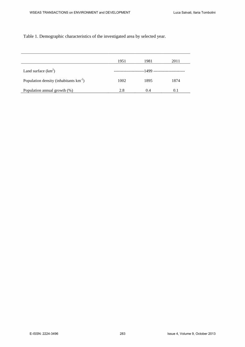
Table 1. Demographic characteristics of the investigated area by selected year.
1951 1981 2011
Land surface (km2) ----------------------1499 -----------------------
Population density (inhabitants km-2) 1002 1895 1874
Population annual growth (%) 2.8 0.4 0.1
WSEAS TRANSACTIONS on ENVIRONMENT and DEVELOPMENT Luca Salvati, Ilaria Tombolini
E-ISSN: 2224-3496 283 Issue 4, Volume 9, October 2013
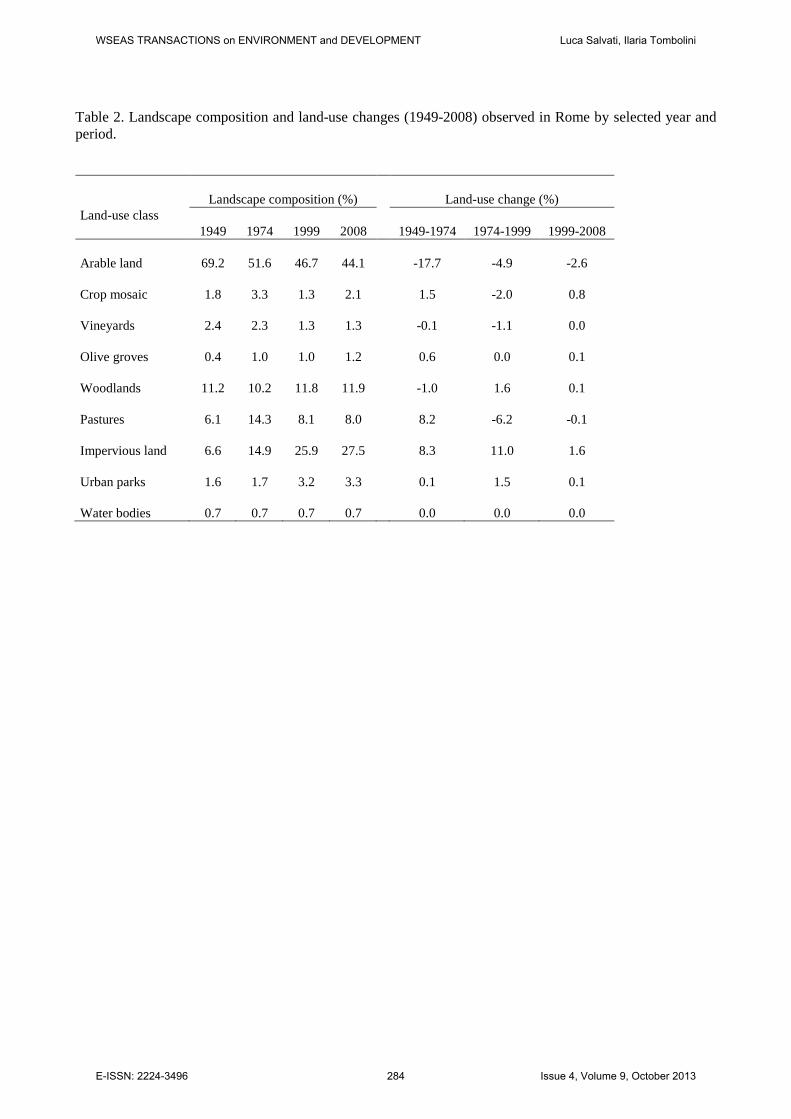
Table 2. Landscape composition and land-use changes (1949-2008) observed in Rome by selected year and period.
Land-use class Landscape composition (%)
Land-use change (%)
1949 1974 1999 2008 1949-1974 1974-1999 1999-2008
Arable land 69.2 51.6 46.7 44.1
-17.7 -4.9 -2.6
Crop mosaic 1.8 3.3 1.3 2.1
1.5 -2.0 0.8
Vineyards 2.4 2.3 1.3 1.3
-0.1 -1.1 0.0
Olive groves 0.4 1.0 1.0 1.2
0.6 0.0 0.1
Woodlands 11.2 10.2 11.8 11.9
-1.0 1.6 0.1
Pastures 6.1 14.3 8.1 8.0
8.2 -6.2 -0.1
Impervious land 6.6 14.9 25.9 27.5
8.3 11.0 1.6
Urban parks 1.6 1.7 3.2 3.3
0.1 1.5 0.1
Water bodies 0.7 0.7 0.7 0.7 0.0 0.0 0.0
WSEAS TRANSACTIONS on ENVIRONMENT and DEVELOPMENT Luca Salvati, Ilaria Tombolini
E-ISSN: 2224-3496 284 Issue 4, Volume 9, October 2013
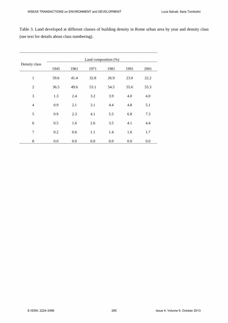
Table 3. Land developed at different classes of building density in Rome urban area by year and density class
(see text for details about class numbering).
Density class Land composition (%)
1945 1961 1971 1981 1991 2001
1 59.6 41.4 32.8 26.9 23.0 22.2
2 36.5 49.6 53.1 54.5 55.6 55.3
3 1.3 2.4 3.2 3.9 4.0 4.0
4 0.9 2.1 3.1 4.4 4.8 5.1
5 0.9 2.3 4.1 5.5 6.8 7.3
6 0.5 1.6 2.6 3.5 4.1 4.4
7 0.2 0.6 1.1 1.4 1.6 1.7
8 0.0 0.0 0.0 0.0 0.0 0.0
WSEAS TRANSACTIONS on ENVIRONMENT and DEVELOPMENT Luca Salvati, Ilaria Tombolini
E-ISSN: 2224-3496 285 Issue 4, Volume 9, October 2013
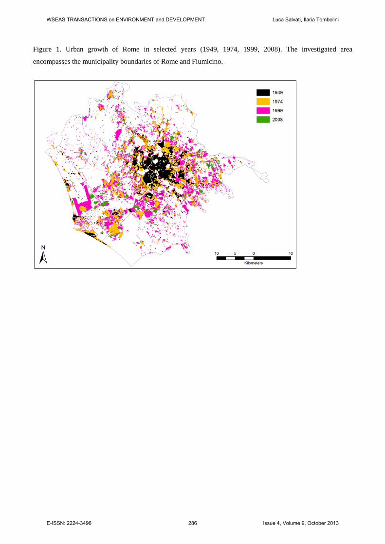
Figure 1. Urban growth of Rome in selected years (1949, 1974, 1999, 2008). The investigated area
encompasses the municipality boundaries of Rome and Fiumicino.
WSEAS TRANSACTIONS on ENVIRONMENT and DEVELOPMENT Luca Salvati, Ilaria Tombolini
E-ISSN: 2224-3496 286 Issue 4, Volume 9, October 2013
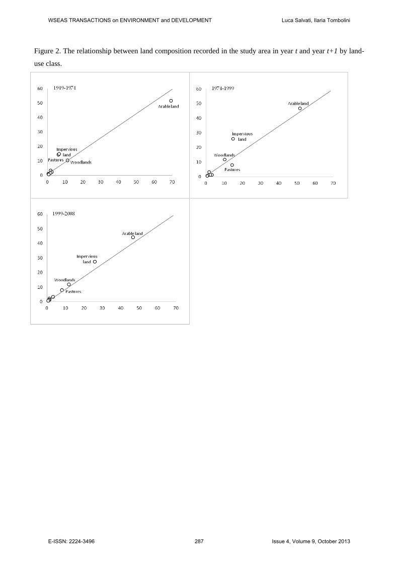
Figure 2. The relationship between land composition recorded in the study area in year t and year t+1 by land-
use class.
WSEAS TRANSACTIONS on ENVIRONMENT and DEVELOPMENT Luca Salvati, Ilaria Tombolini
E-ISSN: 2224-3496 287 Issue 4, Volume 9, October 2013
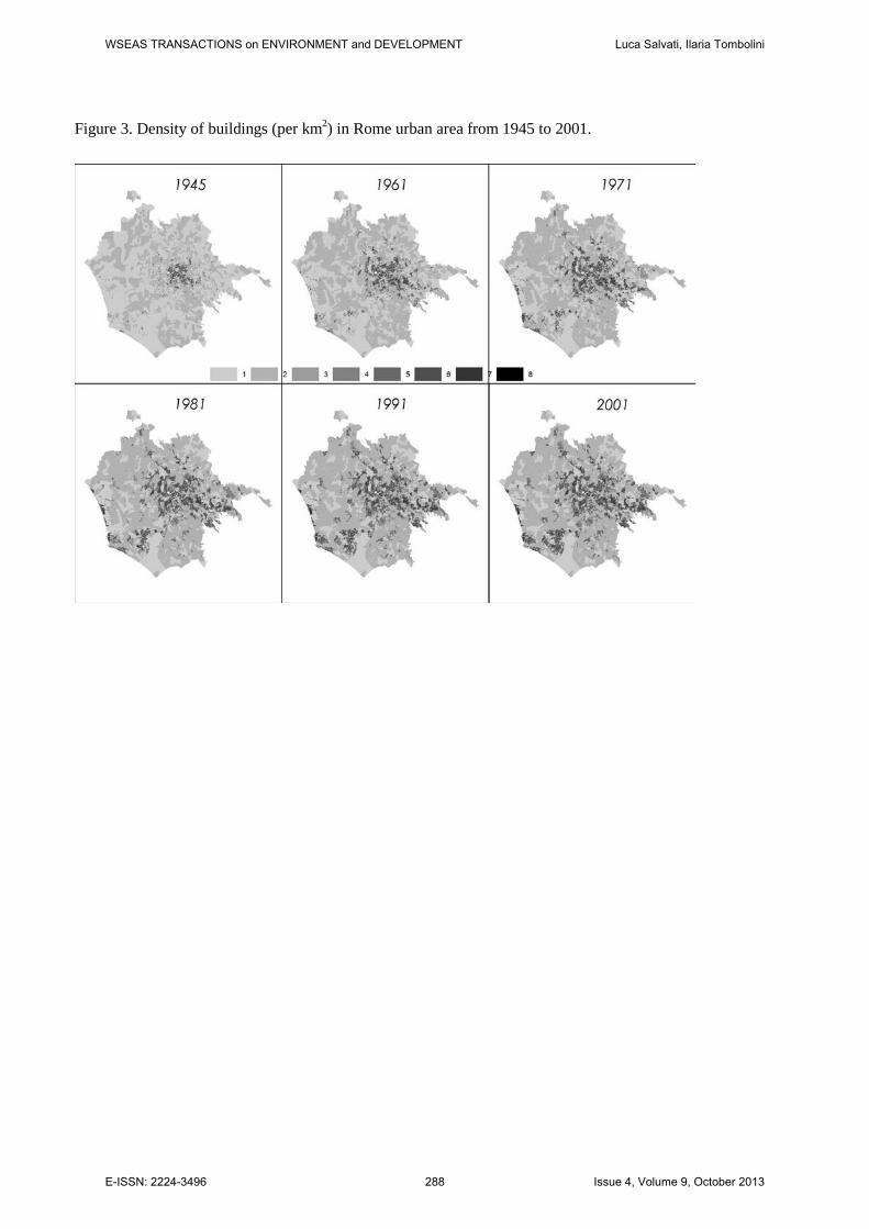
Figure 3. Density of buildings (per km2) in Rome urban area from 1945 to 2001.
WSEAS TRANSACTIONS on ENVIRONMENT and DEVELOPMENT Luca Salvati, Ilaria Tombolini
E-ISSN: 2224-3496 288 Issue 4, Volume 9, October 2013
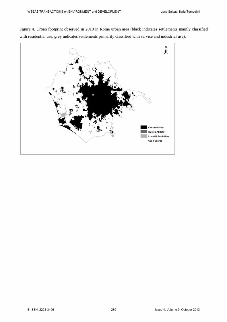
Figure 4. Urban footprint observed in 2010 in Rome urban area (black indicates settlements mainly classified
with residential use, grey indicates settlements primarily classified with service and industrial use).
WSEAS TRANSACTIONS on ENVIRONMENT and DEVELOPMENT Luca Salvati, Ilaria Tombolini
E-ISSN: 2224-3496 289 Issue 4, Volume 9, October 2013