Crook County Oregon - CCNR- · PDF fileCrook County Oregon ... Creek, although mining is...
64
Crook County Oregon Natural Resources Plan Crook County Natural Resources Political Action Committee CCNR-PAC NATURAL RESOURCES PLAN REVISION 011D.1 1
-
Upload
hoangtuyen -
Category
Documents
-
view
215 -
download
0
Transcript of Crook County Oregon - CCNR- · PDF fileCrook County Oregon ... Creek, although mining is...

Crook County Oregon Natural Resources Plan
Crook County Natural Resources Political Action Committee
CCNR-PAC NATURAL RESOURCES PLAN REVISION 011D.1 �1

IntroductionPurpose & Need 4Revision 5Severability 6
Land UseLand Management 7
Crook County OverviewHistory and Culture 10Location 11Demographics 12Climate 14
Principles for Federal and State Land Management Within Crook County
Recognition of County Status, Responsibilities, and Authority 15Statutory and Regulatory Authority 16County Involvement in Federal Land Management 16Coordination 16Statutory Authority—Coordination with the BLM 17Statutory and Regulatory Authority—Coordination with the US Forest Service 18NEPA Consistency Review 19BLM Dispute Resolution 19Further Opportunities for County Involvement with Federal Agency Decision-making 19Private Property Rights and Property Interests 20Data Quality Policy 20Natural Resources Mitigation Policy: 21Coordinated Management and Conservation 22
Access & Travel ManagementTravel Management Policies 23
Agriculture - Livestock and Crop ProductionProduction Agriculture 25Crop Production 25Crop Production Agriculture Policy 25Livestock Production and Grazing 26Public Lands Livestock and Grazing Policy 26
Economy
CCNR-PAC NATURAL RESOURCES PLAN REVISION 011D.1 �2
Economic Policies 29Energy
Energy Source Development Policies 32Environment
Environmental Policies 33Forest Resources
Forest Management Policies 34Invasive Species
Definition and impact of Invasive species: 37Noxious Weed Policy 38
MiningMining Policies 40
Recreation & TourismSpecial Designations
Special Designation Policies 44Threatened & Endangered Species
Threatened and Endangered Species Policies 46Watersheds
Watershed Policies 48Wildfire
Wildfire policies 50Wildlife
Wildlife Policies 52Wild Horses
Wildlife Horses Policies 54GlossaryRevision HistoryContributors
CCNR-PAC NATURAL RESOURCES PLAN REVISION 011D.1 �3

Introduction
Purpose & NeedIt is the Purpose of the Crook County Natural Resources Plan (hereinafter “CCNRP”) to set forth the policies of Crook County in regard to the use and access to, natural resources located on public land. It is a Crook County Court (hereinafter “Court”)priority to engage in coordination with federal and state agencies, to provide for the health, safety, and welfare of its citizens through the appropriate management of all natural resources within Crook County. The Court will exercise its legal right to full participation in the planning processes utilized by state and federal agencies for developing and implementing land use plans and actions within the County. The Court’s interests extend to land use plans or action formulation, development and implementation, including monitoring and evaluation. Crook County directs that all decisions be based on current, relevant, peer reviewed science and data, which take into account multiple land uses within all plans or actions.The use of public land is critical to the health, safety,welfare and economic stability of Crook County citizens. The Court recognizes the inherent natural beauty and the quality of life afforded to the citizens and visitors to Crook County. The Court knows and values the importance of private property rights, water rights, open roads systems and RS 2477 right-of-ways, the multiple uses for all public lands within Crook County and the quality and quantity of the natural resources.The Court accepts that it is its duty and obligation to enter into coordination for official resource planning activities and that federal and state agencies must fulfill their requirement to coordinate with the County’s plan to seek to ensure consistency between plans as required by federal and state laws.The Court commits to the following principles to guide decision making governing natural resources within the County:
(1) Expansion, revitalization and continuation of multiple uses on all public lands in Crook County.
(2) Multiple use shall be inclusive rather than exclusive, thereby avoiding pitting one use against the other.
(3) All plans shall mitigate based on multiple use rather than by a resource by resource issue.
(4) Maintain flexibility in all plans to allow for extraction of natural resources from public lands and to continue to use existing resources in accordance with all laws.
(5) Protect and preserve the following rights of all County citizens, including: 1. Private property interests, such as water and grazing rights and access to lands,
which have ties to public lands,
CCNR-PAC NATURAL RESOURCES PLAN REVISION 011D.1 �4

2. Traditional economic structures in the county that form the base for economic stability,
3. Historic custom, culture and values of the local people, and 4. Enjoyment of the natural resources of the County.
In accordance with federal and state laws regarding public land use planning and protection of private property interests, the Court seeks to expand, continue, and to revitalize the various multiple uses of federally managed lands. To that end, the Court has adopted this plan, which includes policies regarding the various multiple uses on publicly managed lands in Crook County. This plan serves to assure the County’s elected officials have meaningful public involvement in the development of land use programs, land use regulations, and land use decisions for public lands in recognition of the significant impact these actions can have on private lands and the health, safety and welfare of its citizens.This plan has been prepared by the Crook County Natural Resources Political Action Committee with input from the citizens of Crook County, and subsequently reviewed and adopted by the Court. It is intended to be a base line plan and designed to be supplemented and amended as better information becomes available, unforeseen problems arise or issues become apparent which need to be addressed.
RevisionAs natural resource issues develop and change over time, it is to be expected that Crook County policies will evolve to meet the needs of the citizens. It is, therefore, to be expected that the CCNRP and all implementing ordinances and supporting documents, will be amended as necessary, and further, will undergo routine and periodic review on a regular basis, or as directed by the Court.The CCNRP and supporting items, shall be evaluated in relation to changing public policies and Natural Resource circumstances; including community, social, economic and environmental needs. The Natural Resources Committee, having developed this plan through significant team investment amounting to hundreds of person-hours of effort, will therefore continue to provide the ongoing maintenance and support in perpetuity. Opportunities shall be provided for comment by all citizens and affected governmental units to insure internal county, and external (with outside agencies) coordination in formulation and implementation of policies.In addition to periodic scheduled major update of the CCNRP and the Ordinances (review to take place every other year in the winter months), minor revisions shall occur when public needs and desires change, and when further Natural Resource related management opportunity occurs at a different rate than contemplated by the plan. Minor revisions shall occur once per year under usual circumstances. At the time of major Natural Resource Plan change, and/or Ordinance revision, a public statement shall be issued concerning the need
CCNR-PAC NATURAL RESOURCES PLAN REVISION 011D.1 �5

for major revision and shall be based upon examination of data and problems. Public need and justification for minor changes shall also be established prior to minor plan changes.It is the policy of Court to maximize the citizens of Crook County as related to their general health, safety and welfare; through effective and persistent stewardship of the county’s extensive and valuable natural resources.
SeverabilityShould a court declare any part of these policies void, unenforceable, or invalid, the remaining provisions shall remain in full force and effect.
CCNR-PAC NATURAL RESOURCES PLAN REVISION 011D.1 �6
Land Use
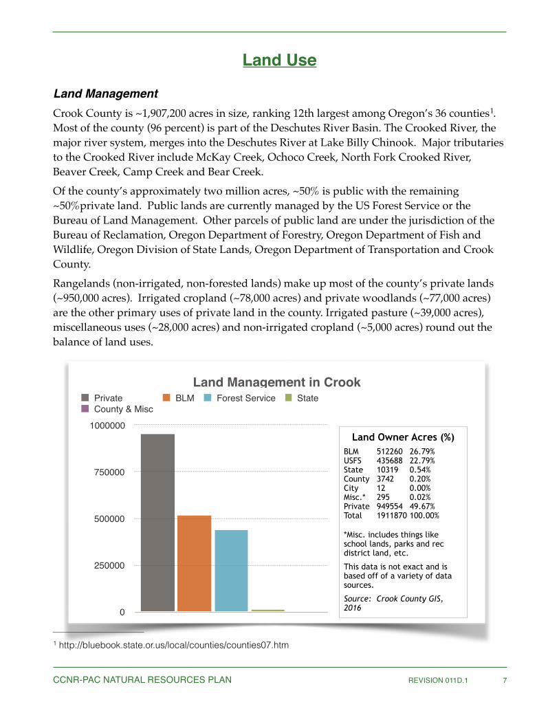
Land ManagementCrook County is ~1,907,200 acres in size, ranking 12th largest among Oregon’s 36 counties . 1
Most of the county (96 percent) is part of the Deschutes River Basin. The Crooked River, the major river system, merges into the Deschutes River at Lake Billy Chinook. Major tributaries to the Crooked River include McKay Creek, Ochoco Creek, North Fork Crooked River, Beaver Creek, Camp Creek and Bear Creek.Of the county’s approximately two million acres, ~50% is public with the remaining ~50%private land. Public lands are currently managed by the US Forest Service or the Bureau of Land Management. Other parcels of public land are under the jurisdiction of the Bureau of Reclamation, Oregon Department of Forestry, Oregon Department of Fish and Wildlife, Oregon Division of State Lands, Oregon Department of Transportation and Crook County.Rangelands (non-irrigated, non-forested lands) make up most of the county’s private lands (~950,000 acres). Irrigated cropland (~78,000 acres) and private woodlands (~77,000 acres) are the other primary uses of private land in the county. Irrigated pasture (~39,000 acres), miscellaneous uses (~28,000 acres) and non-irrigated cropland (~5,000 acres) round out the balance of land uses.
http://bluebook.state.or.us/local/counties/counties07.htm1
CCNR-PAC NATURAL RESOURCES PLAN REVISION 011D.1 �7
0
250000
500000
750000
1000000
Private BLM Forest Service StateCounty & Misc
Land Management in Crook
Land Owner Acres (%) BLM 512260 26.79% USFS 435688 22.79% State 10319 0.54% County 3742 0.20% City 12 0.00% Misc.* 295 0.02% Private 949554 49.67% Total 1911870 100.00%
*Misc. includes things like school lands, parks and rec district land, etc.
This data is not exact and is based off of a variety of data sources.
Source: Crook County GIS, 2016

Agriculture & TimberFrom the start cattle ranching has been one of the primary industries of the county, with huge herds grazing the countryside from the 1880s. Farming was also developed in certain valley regions friendly to agriculture .2
Logging in the Ochoco Mountains and the timber mills that accompanied them, also greatly contributed to the economic and population growth of the county. The first recorded mention of a sawmill was made by George Barnes, speaking about the Swartz sawmill on Mill Creek, circa 1867 . At one time, as many as 5 sawmills were operating in the county and they have 3
historically contributed to the cultural and economical well being of county residents.
Mining4
Mining has long been a tradition in Crook County. The mines lie primarily in the Howard mineral district, which is 26 miles east of Prineville in the timbered hills bordering Ochoco Creek, although mining is scattered throughout Crook County. Although not intended to be all inclusive by definition, other mining also includes: limb casts, Thunder Eggs, Vista-ite, Bentonite, Plume Agate and Moss agate, which are all semi-precious and have value in mining claims.The area is underlain by Tertiary Andesite. Mineralization has taken place along rather broad fracture zones in which the andesite is intensely altered and cut by carbonate-quartz-sulfide veins. These veins are commonly less than an inch thick, but locally enlarge into ore shoots especially at the junctions or intersections.All of the mines in the Howard district are cinnabar mines with the exception of the Mayflower gold mine. At present all of the underground workings are caved and inaccessible. During the past few years, some mining and prospecting has been done on the surface, particularly in the Johnson Creek area.Available records show that the district produced $79,885 in gold up to 1923, from intermittent operations. Of this, $17,560 is based on estimates prior to 1902, while $62,325 is based on records since 1902. The greatest yearly output was $26,623 in 1918, of which $24,092 was in gold.The Howard district is divided into the following three areas: The Ochoco Creek area, the Johnson Creek area and the Marks Creek area.
Hubert Howe Bancroft, The Works of Hubert Howe Bancroft: Volume XXX: History of Oregon: Volume II, 2
1848-1888. San Francisco, CA: The History Company, 1888; pg. 710. Shaver, F. A., Arthur P. Rose, R. F. Steele, and A. E. Adams, compilers. An Illustrated History of Central 3
Oregon: Embracing Wasco, Sherman, Gilliam, Wheeler, Crook, Lake, & Klamath Counties. Spokane, WA: Western Historical Publishing Co., 1905 Crook County Chamber of Commerce, 20164
CCNR-PAC NATURAL RESOURCES PLAN REVISION 011D.1 �8

Recreation & TourismRecreation and Tourism contribute significantly to the economy and culture of Crook County. Activities range from hunting and OHV use, to photography, hiking, camping, rockhounding, cross-country skiing, dog mushing, snowshoeing, snowmobiling, and wildlife viewing, among many others. The Wild Horses of the Big Summit Horse Management Area (HMA) in the Ochoco National Forest, make an extraordinary contribution to the uniqueness of the County. Two reservoirs and their associated campgrounds; Ochoco and Prineville, are a major draw for both local and out of area visitors. The estimated economic benefits from Prineville Reservoir alone (fuel, supplies, recreational related purchases, etc) totaled $24,426,000 in a 2009 study . In short, recreational opportunities in the 5
county are plentiful and varied. They are a vital part of the Natural Resources in the county.
Wilderness and Areas of Critical Environmental ConcernOnly two wilderness areas are currently within Crook County; Mill Creek is the largest and most heavily used and Oregon Badlands straddles the border between Crook and Deschutes counties.Mill Creek Wilderness is a wilderness area located in the Ochoco National Forest of central 6
Oregon. It was established in 1984 and comprises 17,400 acres (7,040 ha).The Oregon Badlands Wilderness is a 29,301-acre (11,858 ha) wilderness area located east of 7
Bend in Deschutes and Crook counties in the U.S. state of Oregon. The wilderness is managed by the Bureau of Land Management as part of the National Landscape Conservation System and was created by the Omnibus Public Land Management Act of 2009, which was signed into law by President Barack Obama on 30 March 2009.
Prineville Reservoir, Recreational Impacts, City of Prineville, 20095 https://en.wikipedia.org/wiki/Mill_Creek_Wilderness6
https://en.wikipedia.org/wiki/Oregon_Badlands_Wilderness7
CCNR-PAC NATURAL RESOURCES PLAN REVISION 011D.1 �9

Crook County Overview
History and Culture8
Crook County was established in 1882. It was created from the southern part of Wasco County and named after US Army Major General George Crook, a hero of the Snake Indian Wars. Originally 8,600 square miles in size, Crook County was reduced to 2,986 square miles with the formation of Jefferson County in 1914 and Deschutes County in 1916.At first referred to as the Ochoco Country, fur trappers from the Hudson’s Bay Company are believed to be the first Europeans to visit the region. Peter Skene Ogden led an expedition of trappers and others through the area several times from 1825 through 1827. A range of mountains, a national forest, a reservoir, a creek and several other geographic features in the county are consequently named Ochoco.Native Americans were the first to travel and live in the area. European settlers began to establish permanent residence in the mid-1800s.Prineville, founded in 1868, is Central Oregon’s oldest city and Crook County’s only incorporated town. Prineville is the county seat and named in honor of Barney Prine, the town’s first merchant. The picturesque stone courthouse, located in the middle of Prineville, was completed in 1909 and still serves as the Crook County Courthouse. Prineville’s colorful past was the scene of tribal raids, range wars between sheep and cattle ranchers and vigilante justice .9
Other communities established in the county include Paulina, Post, Powell Butte and Lone Pine. Paulina, 56 miles east of Prineville, was named for a Paiute Indian chief and is home to some of the best cattle country in Oregon. Post, a general store and post office, is known as the “center of the state.” The official geologic marker noting this spot is located near the store. Powell Butte was established in 1909 when a post office was built. The butte was named for John and Emily Powell, settlers who came from Linn County to raise livestock in the 1880s.Cattle, sheep and horse ranching were the region’s first industries. In the mid-1890s logging and wood products became important. Small mills dotted the forest, producing lumber mostly for local needs. The citizens of Prineville voted to build their own railroad in 1918. Larger mills were built in the late 1930s and Prineville became known as “the largest ponderosa pine shipping center in the world.” Prineville was primarily built upon the timber industry.
http://extension.oregonstate.edu/crook/sites/default/files/rlh_for_web.pdf8 http://bluebook.state.or.us/local/counties/counties07.htm9
CCNR-PAC NATURAL RESOURCES PLAN REVISION 011D.1 �10

Water has been and will continue to be a critical resource for life and industry in the high-desert. Homesteaders diverted water from the region’s streams in the mid-1800s to produce hay for livestock.Ochoco Irrigation District and Central Oregon Irrigation District organized landowners in the early 1900s to complete projects resulting in reservoirs for water use with canals and ditches to distribute the water over thousands of acres. Ochoco Irrigation District built Ochoco Reservoir in 1918. Prineville Reservoir was authorized as a Bureau of Reclamation project in 1958 and construction was completed in 1961. Today these projects store water for the region’s agricultural fields, provide flood control, boating and fishing recreation, mitigation credits for aquifer usage, and in the future, perhaps hydro-power. Forest products, agriculture, livestock raising, recreation/tourism services and a growing high-technology industry constitute most of Crook County’s economy now. Thousands of hunters, fishers, boaters, sightseers and rockhounds are annual visitors to its streams, reservoirs and the Ochoco Mountains. Rockhounds can dig for agates, limb casts, jasper and thunder-eggs on more than 1,000 acres of mining claims provided by the Prineville Chamber of Commerce . State, city, county government and schools still account for the largest 10
number of family wage jobs . Crook County’s natural resources have been enjoyed by many 11
generations. These natural resources help provide jobs and a good place to raise kids, unique habitats for a myriad of flora, and an abundance of fish and wildlife species.
Location12
Geographically, Crook County is located in the center of Oregon. It is bordered by Jefferson and Wheeler counties to the North, Grant and Harney counties to the East and Deschutes County to the South and west. It sits on the northern edge of the Great Basin, a large geographic area covering parts of Oregon, Idaho, Utah, Nevada, Colorado, Arizona and New Mexico. It sits on the southwestern edge of the Blue Mountains and the northeastern edge of the volcanic influence of Mt. Mazama (Crater Lake) and Newberry Volcano. This unique geographic position supports diverse forests, deserts, sagebrush plant communities and broad valley bottoms.
http://bluebook.state.or.us/local/counties/counties07.htm10 http://extension.oregonstate.edu/crook/sites/default/files/rlh_for_web.pdf11 http://extension.oregonstate.edu/crook/sites/default/files/rlh_for_web.pdf12
CCNR-PAC NATURAL RESOURCES PLAN REVISION 011D.1 �11

Demographics13
Crook County is home to approximately 21,000 people, distributed at~7 persons per square mile and primarily white (~95%). There is nearly an even split between males and females. The 65+ demographic comprises ~25% and is growing, while the persons under 18 is shrinking down from ~22% to ~19% between 2010-2014. A significant number of veterans, (~2700) live in the county. About 54% of the population is in the labor force and another ~18% live in poverty, which is higher than the norm for Oregon. Most residents are high school graduates with only about 15% holding an advanced degree. Almost 20% of those under 65 have no health insurance.
People Crook County
PopulationPopulation estimates, July 1, 2014, (V2014) 20998
Population estimates base, April 1, 2010, (V2014) 20978Population, percent change - April 1, 2010 (estimates base) to July 1, 2014, (V2014) 0.1
Population, Census, April 1, 2010 20978
Age and SexPersons under 5 years, percent, July 1, 2014, (V2014) 4.3Persons under 5 years, percent, April 1, 2010 5.4
Persons under 18 years, percent, July 1, 2014, (V2014) 19.4
Persons under 18 years, percent, April 1, 2010 21.9
Persons 65 years and over, percent, July 1, 2014, (V2014) 24.2Persons 65 years and over, percent, April 1, 2010 20.0
Female persons, percent, July 1, 2014, (V2014) 50.6
Female persons, percent, April 1, 2010 50.4
Race and Hispanic OriginWhite alone, percent, July 1, 2014, (V2014) (a) 95.2
White alone, percent, April 1, 2010 (a) 92.7
Black or African American alone, percent, July 1, 2014, (V2014) (a) 0.3
Black or African American alone, percent, April 1, 2010 (a) 0.2American Indian and Alaska Native alone, percent, July 1, 2014, (V2014)(a) 1.6
American Indian and Alaska Native alone, percent, April 1, 2010 (a) 1.4
Asian alone, percent, July 1, 2014, (V2014) (a) 0.7
Native Hawaiian and Other Pacific Islander alone, percent, July 1, 2014, (V2014) (a) 0.1Two or More Races, percent, July 1, 2014, (V2014) 2.1
Two or More Races, percent, April 1, 2010 2.0
People
http://www.census.gov/quickfacts/table/PST045215/4101313
CCNR-PAC NATURAL RESOURCES PLAN REVISION 011D.1 �12

Hispanic or Latino, percent, July 1, 2014, (V2014) (b) 7.4
Hispanic or Latino, percent, April 1, 2010 (b) 7.0White alone, not Hispanic or Latino, percent, July 1, 2014, (V2014) 88.6
Population CharacteristicsVeterans, 2010-2014 2674
Foreign born persons, percent, 2010-2014 2.3Families and Living ArrangementsHouseholds, 2010-2014 8977
Persons per household, 2010-2014 2.30
Living in same house 1 year ago, percent of persons age 1 year+, 2010-2014 81.1Language other than English spoken at home, percent of persons age 5 years+, 2010-2014 4.2
Education
High school graduate or higher, percent of persons age 25 years+, 2010-2014 84.8
Bachelor's degree or higher, percent of persons age 25 years+, 2010-2014 14.7HealthWith a disability, under age 65 years, percent, 2010-2014 16.3
Persons without health insurance, under age 65 years, percent 18.0
Economy
In civilian labor force, total, percent of population age 16 years+, 2010-2014 53.8
In civilian labor force, female, percent of population age 16 years+, 2010-2014 49.1
Total accommodation and food services sales, 2007 ($1,000) (c) 22704
Total health care and social assistance receipts/revenue, 2007 ($1,000) (c) 47309Total manufacturers shipments, 2007 ($1,000) (c) 209877
Total merchant wholesaler sales, 2007 ($1,000) (c) 100505
Total retail sales, 2007 ($1,000) (c) 139916
Total retail sales per capita, 2007 (c) 6147TransportationMean travel time to work (minutes), workers age 16 years+, 2010-2014 19.8
Income and PovertyMedian household income (in 2014 dollars), 2010-2014 36158Per capita income in past 12 months (in 2014 dollars), 2010-2014 20533
Persons in poverty, percent 18.3
Businesses Crook County, Oregon
Total employer establishments, 2013 479Total employment, 2013 3780
Crook CountyPeople
CCNR-PAC NATURAL RESOURCES PLAN REVISION 011D.1 �13

ClimatePrineville’s elevation is 2,868 feet and it averages 10.5 inches of precipitation per year. Annual variation in precipitation ranges from less than eight inches per year in the Southwest corner of the county to more than 30 inches in the higher elevations of the Ochoco Mountains. Average temperatures range from 31.5° F in January to 64.5° F in July and August. Temperature extremes range from minus 35° F to +119° F. Nights are generally cool with moderate daytime temperatures. Typically, the growing season will last 90 to 110 days but a review of historical temperature data shows that killing frosts (29° F) can occur any time during the summer months.Crook County is semi-arid with 60 to 80 percent of the annual precipitation occurring during the winter and early spring months (October – April). Most precipitation comes as snow with spring precipitation occurring as rain. Sporadic summer/fall thunderstorms and associated lightning, can cause considerable damage to property and natural resources. Wildfire is a serious consideration for this region of Oregon.
Total annual payroll, 2013 123799
Total employment, percent change, 2012-2013 -6.8Total nonemployer establishments, 2013 1387
All firms, 2007 2236
Men-owned firms, 2007 1014
Women-owned firms, 2007 652Minority-owned firms, 2007 S
Nonminority-owned firms, 2007 2073
Veteran-owned firms, 2007 79
Nonveteran-owned firms, 2007 1943Geography Crook County, Oregon
Population per square mile, 2010 7.0
Land area in square miles, 2010 2979.09
This geographic level of poverty and health estimates are not comparable to other geographic levels of these estimates
Crook CountyPeople
CCNR-PAC NATURAL RESOURCES PLAN REVISION 011D.1 �14

Principles for Federal and State Land Management Within Crook County
Public lands dominate the landscape in Crook County, with approximately 50% of the land in the County managed by a public agency. Therefore, decisions made by the agencies managing our public lands and resources directly affect Crook County’s residents, custom and culture, economy, and valued way of life. The following policies codify Crook County’s requirements, needs, and expectations of federal and state agencies with land-use planning and decision making powers within the boundaries of Crook County.
Recognition of County Status, Responsibilities, and AuthorityCrook County represents a local government as defined by ORS 174.116 (1)(a) . In order to 14
discharge its statutory obligations and duties as a County within the State of Oregon,“Crook County has the primary responsibility for securing and promoting the public peace, general welfare, health, and safety of the citizens of the County through preservation of their customs, culture, and economic stability, protection and use of their environment, and protection of their private property rights.”Crook County Ordinance No. tbdFurthermore, Oregon State law empowers Crook County to pass ordinances in the interest of fulfilling these responsibilities to its citizens, and to exercise its authority over such matters insofar as doing so does not conflict with State or Federal law:
“...[T]he governing body or the electors of a county may by ordinance exercise authority within the county over matters of county concern, to the fullest extent allowed by Constitutions and laws of the United States and of this state... The power granted by this section is in addition to other grants of power to counties, shall not be construed to limit or qualify any such grant and shall be liberally construed, to the end that counties have all powers over matters of county concern that it is possible for them to have under the Constitutions and laws of the United States and of this state.”ORS 203.035
Crook County expects federal and state land management agencies to respect and understand the County’s responsibilities to its citizens, and to work through coordination with the County in order to ensure that these responsibilities are satisfied with regard to issues pertaining to public lands and natural resource management within the County’s boundaries.
“...as used in the statutes of this state “local government” means all cities, counties and local service 14districts located in this state, and all administrative subdivisions of those cities, counties and local service districts”. ORS 174.116 (1)(a)
CCNR-PAC NATURAL RESOURCES PLAN REVISION 011D.1 �15

Statutory and Regulatory AuthorityManagement of the Federal and State lands is dictated by a system of federal and state statutes, regulations, and policies. Crook County expects that all applicable statutes, regulations, and policies will be followed by federal and state land management agencies, and that federal and state agencies shall fulfill their affirmative responsibility to be apprised of all pertinent laws and policies.
County Involvement in Federal Land ManagementCertain federal statues, regulations, and policies discussed below offer special opportunities to state, tribal, and local government agencies to participate in federal agency planning and decision-making when such actions take place within the purview of the state, tribal, or local government’s responsibilities to the people it represents. Importantly, many such opportunities are only offered to government agencies; they are not available to private individuals, special interest groups, or NGOs.As a local government within the State of Oregon, Crook County is therefore entitled to avail itself of these special opportunities for government involvement in federal decision-making. In accordance with federal statute and regulations, federal agencies shall recognize that certain opportunities, such as coordination as defined by FLPMA and NFMA is exclusive to government agencies, and therefore not fulfilled merely through soliciting “public input” or engaging in “stake holder consultation” or “collaboration”—opportunities that are available to the broader interested public.
CoordinationCoordination is a federally mandated process that requires all state and federal agencies including the BLM and Forest Service to work with local governments to seek consistency between state and federal land use planning and management and local land use plans and policies. Coordination, by its plain meaning, requires state and federal agencies do more than just inform local governments of their future management plans and decisions and it requires that they do more than merely solicit comments from local government entities. Coordination calls for something beyond that: a negotiation on a government-to-government basis that seeks to ensure officially approved local plans and policies are included in the public lands planning and management decisions of state and federal agencies.Crook County expects the state and federal agencies to engage in coordination with the County, upon the County’s request, for land use planning efforts and on an ongoing basis—as mandated by applicable statute, regulations, policy, and case law. Coordination as envisaged by Congress involves use of a local government plan or policy to determine whether proposed Federal agency plans, policies and management decisions are consistent with the needs and requirements of the local community. Crook County expects that all agency planning efforts and subsequent management actions shall be reviewed, in
CCNR-PAC NATURAL RESOURCES PLAN REVISION 011D.1 �16
coordination with the County, with an aim of achieving maximum consistency with the CCNRP. Agency decisions and plans are expected to be consistent with this Plan wherever practicable and/or wherever mandated by applicable federal statute or regulations.
Statutory Authority—Coordination with the BLM
CCNR-PAC NATURAL RESOURCES PLAN REVISION 011D.1 �17
“In the development and revision of land use plans, the Secretary shall [...] to the extent consistent with the laws governing the administration of the public lands, coordinate the land use inventory, planning, and management activities [...] with the land use planning and management programs [...] of local governments... Land use plans of the Secretary under this section shall be consistent with State and local plans to the maximum extent he finds consistent with federal law and the purposes of this Act.”
43 U.S.C § 1712(c)(9), emphasis added (FLPMA)
“Consistent means that the Bureau of Land Management plans will adhere to the terms, conditions, and decisions of officially approved and adopted resource related plans, or in their absence, with policies and programs, subject to the qualifications in § 1615.2 of this title.”
43 CFR § 1601.0-5(c)

Statutory and Regulatory Authority—Coordination with the US Forest Service
CCNR-PAC NATURAL RESOURCES PLAN REVISION 011D.1 �18
“[T]he Secretary of Agriculture shall develop, maintain, and, as appropriate, revise land and resource management plans for units of the National Forest System, coordinated with the land and resource management planning processes of State and local governments and other Federal agencies.”
16 U.S.C. § 1604(a)
(b) Coordination with other public planning efforts. (1) The responsible official shall coordinate land management planning with the equivalent and related planning efforts of federally recognized Indian Tribes, Alaska Native Corporations, other Federal agencies, and State and local governments.(2) For plan development or revision, the responsible official shall review the planning and land use policies of federally recognized Indian Tribes (43 U.S.C. 1712(b)), Alaska Native Corporations, other Federal agencies, and State and local governments, where relevant to the plan area. The results of this review shall be displayed in the environmental impact statement (EIS) for the plan (40 CFR 1502.16(c), 1506.2). The review shall include consideration of:(i) The objectives of federally recognized Indian Tribes, Alaska Native Corporations, other Federal agencies, and State and local governments, as expressed in their plans and policies; (ii) The compatibility and interrelated impacts of these plans and policies; (iii) Opportunities for the plan to address the impacts identified or contribute to joint objectives; and (iv) Opportunities to resolve or reduce conflicts, within the context of developing the plan’s desired conditions or objectives...
36 CFR § 219.4
“The responsible official shall coordinate with appropriate Federal, State, county, and other local governmental entities and tribal governments when designating National Forest System roads, National Forest System trails, and areas on National Forest System Lands pursuant to this subpart.”
36 CFR § 212.53

NEPA Consistency ReviewNEPA requires that a federal agency prepare a consistency review for any federal agency action calling for an environmental impact statement (EIS). Specifically, CEQ regulations require that EISs “shall discuss any inconsistency of a proposed action with any approved state or local plan and laws (whether or not federally sanctioned). Where an inconsistency exists, the [EIS] should describe the extent to which the agency would reconcile its proposed action with the plan or law.” 40 CFR § 1506.2(d). Crook County fully expects that all EISs prepared by the BLM, Forest Service, or other federal agencies on lands within the County’s boundaries—in whole or in part—feature such a consistency review with the CCNRP, and that all practicable efforts are made to reconcile inconsistencies of proposed actions and/or alternatives with the Plan. If consistency is not achieved, the federal agency shall justify its decision on the record. Further, in the event that consistency is not achieved, Crook County expects that the federal agency shall engage with the County in conflict resolution and work with the County to mitigate any residual impacts to the County and its citizens.
BLM Dispute ResolutionWhile it is inevitable that there will be occasional disagreements between the BLM and Crook County over natural resource issues, Crook County requires that such conflicts be resolved to the maximum extent possible. For this reason, Crook County expects that unresolved conflicts and inconsistencies between BLM plans and/or actions and the CCNRP, and conflicts between permittees, lessees, and other public land users and the BLM, be addressed through the Rule that provides if consistency cannot be resolved, there is an appeal to the National Director of BLM.
Further Opportunities for County Involvement with Federal Agency Decision-makingIn addition to the coordination mandate in FLPMA and NFMA a number of other federal and state statutes and corresponding regulations require state and federal agencies to offer other opportunities for coordination with local governments in making land and resource management decisions. Relevant statutes featuring such opportunities include the Clean Water Act, the Clean Air Act, the Endangered Species Act, the Wild and Scenic Rivers Act, and the National Preservation Act. Many of these opportunities for additional County involvement will be covered in the resource-specific sections below.It is the policy of Crook County to engage in all such opportunities, and to work through coordination with federal and state agencies on all projects and decisions that could affect County interests. Further, it is the express expectation of the County that federal and state agencies will give the County early notification of forthcoming decision-making and extend an early invitation to the County to participate in joint planning and consultation.
CCNR-PAC NATURAL RESOURCES PLAN REVISION 011D.1 �19

Private Property Rights and Property InterestsMany private individuals hold either private property rights or property interests on public lands within Crook County. These may include water rights, mining claims, rights of way, as well as preference to grazing permits. Such property rights and interests constitute valuable holdings, increase the County tax base, and are vital for the stability of small businesses essential to the economic make-up and culture of free enterprise of Crook County. Crook County is dedicated to preserving these rights and interests, and expects that federal agencies shall not attempt to terminate, or otherwise demand the transfer or relinquishment of, such holdings in whole or in part from private individuals.
Data Quality PolicyCrook County requires that all data—environmental, economic, and social—used to develop federal and state land and natural resource use decisions be impartial, collected and analyzed using tested and local peer reviewed methods, and current. Environmental data used to justify changes in land or natural resource use must be firmly anchored in local, on-the-ground, site specific monitoring and trend data (as opposed to computer modeling and other remotely collected data). Where remotely collected data are used to supplement monitoring or other on-the-ground data, federal and state agencies shall clearly state the mapping error, or similar margin of error, of the methodology used and ensure that the methodology is applied at the appropriate scale. If data relevant to decision making is extrapolated from scientific journals, papers or studies, that data will be accompanied by the articles in their entirety and made available to Crook County for review. Further, federal and state agencies shall routinely solicit input and data from regional sources including Crook County, Oregon State University (OSU) Extension Service and OSU/USDA Eastern Oregon Agriculture Research Center (EOARC). Crook County has many workers who have extensive and intimate knowledge of the Ochoco Forest and the rangelands of Crook County. An attempt shall be made to gather some of the historical information on land management practices during the past 50 years from these people. Many land practices have been tried, and the historical information may allow us to avoid repeating past failures. This information, as it is gathered, will be made available to the local, state and federal agencies, for inclusion in the decision making process. It is understood that historical information and information gathered from local informants may not adhere to Data Quality Act standards, but may nonetheless be extremely useful, due to its specificity to local sites and conditions.Data used in land management decisions by federal agencies must meet the minimal requirements outlined in the Data Quality Act and guidelines pursuant to this Act: Data 15
gathered and used by the BLM shall meet the standards established by the DOI Information
“...for ensuring and maximizing the quality, objectivity, utility, and integrity of information, including statistical 15information, disseminated by Federal agencies…” Sec. 515 of Public L. No. 106-554.
CCNR-PAC NATURAL RESOURCES PLAN REVISION 011D.1 �20

Quality Guidelines and Policies and the BLM Information Quality Guidelines; information gathered and used by the Forest Service shall meet the General Requirements for Information Quality established by the USDA and be site specific.
Natural Resources Mitigation Policy:Crook County recognizes sometimes significant negative effects of a proposed action cannot be avoided, and that mitigation is often preferred to no action. Further, small and seemingly insignificant effects may accumulate over time into a larger, negative consequence of projects. These generally unforeseen and unintended consequences can give rise to disruptions in the ways the land and natural resources are used and enjoyed for long periods of time. To the extent possible, potential disruptions shall be identified during the planning phase, and appropriate mitigations analyzed. If negative consequences are identified during or after project completion, there should be a system by which mitigations can be determined, created and funded.A mitigation plan shall provide detailed and realistic alternatives. The mitigation plan shall: (1) Identify each impact that the mitigation measure is intended to address. (2) Identify the party or agency responsible for the implementation and monitoring of the
proposed mitigation measure. (3) Specify the following for each mitigation alternative:
(a) How impacts may be avoided through non-action, or alternatives to the proposed actions.
(b) How impacts may be minimized by limiting the degree or magnitude of the proposed actions.
(c) How impacts may be rectified through repair, rehabilitation, or restoration of the affected environment.
(d) How impacts may be reduced or eliminated over time through preservation and maintenance action during the life of the action.
(e) How the agency could compensate for the impact by providing substitute resources of equal economic or social value.
(4) Specify, for each mitigation measure, its: (a) Legal authority (b) Technical feasibility (c) Fiscal and economic feasibility (d) Social, cultural and political feasibility(e) Initiation and completion dates(f) Funding sources (g) Performing entity
CCNR-PAC NATURAL RESOURCES PLAN REVISION 011D.1 �21
(5) Provide a mitigation monitoring plan, which is based on specific objectives and performance standards, to ensure implementation of mitigation measures during the life of the project. Provide options if the mitigation does not achieve its purpose.
(6) Provide all pertinent information to the Court, or its designee, from the mitigation monitoring process.
(7) If a proposed action would reduce or eliminate any specific historical type of travel with in the project boundaries, or if the proposed action would reduce or eliminate any specific historical recreational or economic activity, mitigation offered should be an in-kind substitution or rotation of use within the project boundaries.
Coordinated Management and ConservationCrook County believes that a coordinated, interdisciplinary approach to the management of public lands will best promote the conservation of our natural resources while developing sustainable methods for their use. Crook County also holds that locally based, on-the-ground management, monitoring, and information gathering is preferable to out-sourcing data collection and/or analysis to remote providers. Therefore, Crook County expects that federal and state agencies will work with the County, the local Soil and Water Conservation Districts, Rural Fire Protection Agencies, Oregon State University Department of Range Science, Oregon State University Extension Service, USDA range scientists at the Eastern Oregon Agriculture Research Center, as well as permittees and lessees on public lands on an ongoing basis to monitor, manage, share information, problem solve, apply adaptive management strategies, and promote the health of public lands to ensure that natural resource use is both ongoing and sustainable.
CCNR-PAC NATURAL RESOURCES PLAN REVISION 011D.1 �22

Access & Travel ManagementAccess to private and public lands in Crook County is an integral piece of the CCNRP. The intent of Crook County’s travel management policies is to provide year round access for multiple land uses while respecting private property rights as well as utilizing the resources on public lands.Historic access to what are now public lands is important for the sustainability of the citizens’ customs and culture and promotes a positive outdoor experiences for visitors as well as providing access in the case of needed medical attention. Therefore, Revised Statute (RS) 2477 rights-of-way, will be received in perpetuity. RS 2477 rights-of-way is a simple and straightforward law. This is the entire text of RS 2477 rights-of-way:
"The rights-of-way for the construction of highways across public lands not reserved for public purposes is hereby granted.”
Congress granted a ‘rights-of-way,’ not a road. In fact, RS 2477 rights-of-way can host a number of things besides roads. The legal definition of "highway" in the law means not only the frequently-traveled, periodically-maintained roads commonly associated with it, but also other kinds of public ways, including carriage-ways, bridle-ways, footways, trails, bridges, and even railroads, canals, ferries and navigable rivers. The essential element in defining "highway" is that whatever the means of transport, the public has the right to come and go at will for the economic viability of the County.It is recognized that if access is limited, the adverse effect of human uses on the environment is magnified in those locations where the human usage is most dense. Short roads are more dusty and rutted; heavily used campgrounds a problem with reuse, litter and soil compaction. Keeping multiple access points and travel routes disperses the activity of humans across the landscape and allows for less impact upon wildlife and the environment.The CCNRP is intended to sustain the management of road systems to deal with the changing uses of lands within Crook County. The use and enjoyment of the natural resources of Crook County dictate that we have a transportation system which is efficient, available and balances the various resource values. Access and travel issues are critical to all resource uses encompassed in the CCNRP.
Travel Management PoliciesIt is the policy of Crook County that roads providing access for the use and enjoyment of public lands shall remain open year round and be accessible. Specifically, there will be no net loss to access. It is the policy of Crook County that roads created and/or established for timber harvesting and other forest projects will remain open as unimproved multi-use trails for recreational use.
CCNR-PAC NATURAL RESOURCES PLAN REVISION 011D.1 �23

Proposed road closures affecting access to or on public lands in Crook County shall be discussed on a case-by-case basis, and shall be individually justified. Where there is no clear and overriding reason to close a particular road, it shall remain open. Further, proposed road closures require an appropriate County and public review process; noticing, appeal periods, and a genuine good faith effort to incorporate the suggestions and concerns put forth by the public. Proposed road closures shall also be discussed in coordination with Crook County, and shall be consistent with the Crook County Natural Resources Plan to the maximum extent practicable and allowable by law.Road inventories shall be carried out in coordination with Crook County and with the input of Crook County citizens. Unless prohibited by law, roads accessing grazing allotments, water developments, mining claims, foraging sites and other authorized land uses shall remain open.It is the policy of Crook County to keep all roads open and passable. Disruptions to the travel surface of roads (e.g. tank traps, boulders, berms, or other road surface impediments) are a hazard to road travel in the case of fire fighting, fire evacuation or rescue vehicles, and are an endangerment to the health and well being of road users.Crook County supports the partnering of public and private entities for the ongoing access of roads on public lands. Crook County encourages voluntary activity from users as well as partnering with private and public groups in maintaining trails and roads such as rock removal, filling holes, branch trimming, and clearing downed trees. Trails and roads maintained by private groups are meant to benefit all user and types, and maintenance does not confer special privilege. Crook County supports the improvement of signage and maps for navigation on public lands to enhance the enjoyment and safety of visitors. Maps must reflect the valid federal land use plan.It is the policy of Crook County that all RS 2477 rights-of-way roads historically and currently used for any natural resource to market must remain open for public access. These include, but are not limited to, forest-to-market, mine-to-market, livestock trail ways, wagon and stage coach roads, access trails to reservoirs, streams, springs and rivers, historic sites of towns, post offices and schools, and other places of historic land uses. All RS 2477 rights-of-ways and historical site roads will be open to the public at all times to support the recreation and tourism industries. Where appropriate, installation of informational signage shall be installed to explain the significance of the site.It is the policy of Crook County that recreational access shall not discriminate in favor of one mode of recreation to the exclusion of others.It is the policy of Crook County that any proposed action that includes, or considers including, any reduction of access of any specific kind to public lands, assesses and mitigates the cumulative loss of access.
CCNR-PAC NATURAL RESOURCES PLAN REVISION 011D.1 �24

Agriculture - Livestock and Crop Production
Production Agriculture Production Agriculture, which includes crops and livestock, is an important part of the Crook County economy. Many of the farms and ranches of the county are three or more generations of the same family operating and caring for the land. Agriculture is an integral part of the economy, custom and culture of Crook County, as well as a way of life to the farming and ranching families since the town of Prineville was established in 1868Livestock and Crops contributed $47,741,000.00 to the Crook County economy .16
The state of Oregon has a right to farm law , which describes actions and responses to 17
farming and other natural resources including forest. These Right To Farm laws shall be taken into account and used with consistency during federal and state land use decisions.
Crop ProductionThe comparatively short growing season of the county dictates the rather narrow variety of cash crops that can be grown here. Examples of crops include, but are not limited to grass and alfalfa hay, grain, potatoes, garlic and carrot seed. Crops are grown along the Crooked River, Ochoco Creek, Mill Creek, McKay Creek, the Ochoco Valley and in the higher elevations around Powell Butte. The majority of the water for irrigation comes from, McKay Creek and it’s tributaries, Ochoco Creek and it's tributaries, Crooked River and its tributaries, and the Deschutes River and its tributaries. These water sources are vital to our Agricultural community and the citizens of Crook County.
Crop Production Agriculture PolicyIt is the policy of Crook County to support production agriculture and the conscientious use of natural resources necessary for sustaining agricultural enterprise. There are 822,688 acres in farm land in Crook County . Crop production contributes 49% of agricultural sales in 18
Crook County .19
Wildlife and Forestry Managers, including but not limited to, the BLM, USFS and ODF&W, shall work with private property owners to keep private property damage to land and livestock to a minimum. Any private property damage caused by Wildlife, an uncontrolled prescribed burn, other fire suppression efforts, or damage caused by any other government agency action in Crook County shall be considered justification for compensation by said agency, to the private property owner at current market value.
http://oain.oregonstate.edu/charts/12%20CROOK.pdf16 www.oregonlaws.org/ors/30.93017 http://oain.oregonstate.edu/charts/12%20CROOK.pdf18 http://oain.oregonstate.edu/charts/12%20CROOK.pdf19
CCNR-PAC NATURAL RESOURCES PLAN REVISION 011D.1 �25

Livestock Production and GrazingLivestock production has customarily been, and continues to be, a significant contributor to the economic stability of Crook County. Livestock production contributes 51% of all agricultural sales in Crook County . The total reported value of livestock sales produced in 20
Crook County was $24,426,000.00 in 2012, (OSU extension service).Livestock producers who graze on public land have been issued grazing permits by the federal land management agencies based on the ownership of base property to which a grazing allotment is tied. Currently the base property does not need to be adjacent to a livestock grazing allotment. For range lands managed by the BLM, this right was defined by the Taylor Grazing Act of 1934 and the Federal Land Policy and Management Act of 1976. Grazing administration on the National Forest System lands are administered under the Granger-Thye Act of 1950, the Multiple-Use Sustained-Yield Act of 1960 and the Forest and Range land Renewable Resources Planning Act of 1974, among others.In Crook County, many livestock producers rely on grazing allotments administered by the BLM and the US Forest service. The seasons of use vary by permit on these allotments. The preservation of these permits and the continuation of historic stocking rates is crucial to sustainable livestock production in Crook County.
Public Lands Livestock and Grazing PolicyThe continued viability of livestock operations and the livestock industry shall be supported on federal and state lands within Crook County through:(1) Proactive and coordinated management of land and forage resources;(2) Proper optimization of livestock animal unit months (AUMs);(3) The use of unbiased, current site-specific methods, analysis and data, and (4) Upholding the multiple use provisions of federal and state law. Crook County expects
that the current pricing structure formula for AUMs will remain consistent with historical practices.
Federal and state grazing allotments and leases shall be managed through working partnerships with allotment holders and lessees, which will include joint monitoring and data collection, joint problem solving, developing adaptive management strategies, development of grazing plans and NEPA alternatives for permit renewal.In general, grazing on federal and state allotments and leases shall continue at historical stocking rates. In the event that range health standards on a permit or lease are not being met, stocking rates will be reduced only in the event that; 1) failure to meet range health standards is established on the basis of current, on the ground site specific monitoring data; 2) failure to meet range health standards is shown to be caused by current, as opposed to historic,
http://oain.oregonstate.edu/charts/12%20CROOK.pdf20
CCNR-PAC NATURAL RESOURCES PLAN REVISION 011D.1 �26

livestock management practices; and 3) all adaptive management approaches have been exhausted.Federal and state agencies shall not encourage the relinquishment of, nor allow the retirement of, grazing allotments on designated grazing lands for uses that exclude substantive livestock grazing. Voluntary relinquishment of permits shall be made available to other livestock operators to address the economic needs of Crook County citizens and to support the County's tax base.When range health standards return to acceptable levels, suspended AUMs shall be returned to active use by the next grazing season.In the event that grazing is temporarily suspended due to fire or drought, grazing shall recommence on the basis of case-by-case monitoring and site specific range land health determinations, as opposed to fixed and/or predetermined time lines.Where range health standards are being met, or if failure to meet range land health standards is not due to current livestock management, stocking rates shall not be diminished and season of use will not be curtailed. Additional forage on federal public lands to be used as mitigation County wide.Range health on allotments shall be managed on a case-by-case basis, based on current and site specific analysis and data collection. Allotments that have had a history of reduced AUMs shall be reevaluated as to present condition compared to condition prior to reduction. If no improvement in range condition is determined and other factors have remained relatively stable, we must assume higher stocking rates were not the problem and the lower stocking rates possibly created the degraded range condition due to reduced disturbance, compaction, and grazing pressure. This also may have allowed invasive species such as Juniper and Medusa head to thrive and increase. Agencies shall take interdisciplinary approach to range management, including allotment holders and lease holders soliciting allotment input from OSU Extension Service, the Eastern Oregon Agriculture Research Center, and Crook County in determining best approaches to maintaining sustainable use of range land resources.In light of amendments to NEPA included in the National Defense Authorization Act for FY 2015, §3023 (3), Crook County expects that:
Categorical exclusions shall be used in the renewal of grazing permits where current management is continued and range land health standards are being met (or failure to meet range land health standards is not due to existing livestock grazing).
CCNR-PAC NATURAL RESOURCES PLAN REVISION 011D.1 �27
Livestock trailing and crossing on public lands shall be categorically excluded from environmental assessments and impact statements under NEPA . Roads historically 21
used for trailing or vehicle transport of livestock across public lands shall remain open.
Federal allotment renewals (such as grazing permits) or authorization of federal allotments for the development or improvement of water rights on federal lands shall not be contingent upon the transfer of privately held water rights, in whole or in part, to the US Government.Federal agencies shall work with permit holders and other land managers on riparian management, to insure that site specific analysis and monitoring are current, and potential issues regarding stream bank erosion, channel depth, etc., are addressed early through adaptive management approaches. Reduction or elimination of grazing on riparian areas shall occur only;(1) If current grazing livestock methods, as opposed to historic livestock grazing or wildlife,
are demonstrably the cause of riparian degradation, and (2) If adaptive management approaches are exhausted.Grazing on designated Wilderness areas and Wilderness Study Area's shall be ongoing and unimpeded, in accordance with the Congressional Grazing Guidelines set forth in H.R. 101-405, Appendix A. The benefits of managed livestock grazing for fire control, weed control, and wildlife habitat enhancement shall be recognized and incorporated into planning NEPA documents .22
see also: “whenever any grazing district is established pursuant to this sub chapter, the Secretary shall 21grant to owners of land adjacent to such district, upon application of any such owner, such rights-of-way over the lands included in such district for stock driving purposes as may be necessary for the convenient access by any such owner to marketing facilities or to lands not within such district owned by such person or upon which such person has stock-grazing rights.” 43 USC §315 (TGA) http://www.blm.gov/wy/st/en/field_offices/Casper/range/taylor.1.html 22http://www.blm.gov/flpma/FLPMA.pdf https://en.wikipedia.org/wiki/Granger-Thye_Act_of_1950 https://en.wikipedia.org/wiki/Multiple-Use_Sustained-Yield_Act_of_1960 http://uscode.house.gov/view.xhtml?req=granuleid%3AUSC-prelim-title43-chapter35-subchapter5&edition=prelimhttp://www.wilderness.net/toolboxes/documents/grazing/House%20Report%20101-405A.pdf
CCNR-PAC NATURAL RESOURCES PLAN REVISION 011D.1 �28

EconomyCrook County, again like many non-metro counties nationally, is a natural resource-based economy, which the county is trying to diversify so that it can more effectively adjust to the variations of a globalized marketplace. Its population is growing and diversifying, like many areas with significant natural capital and lifestyle opportunities. People are moving to and visiting Crook County to enjoy the environmental amenities .23
The historic roots of Crook County—timber harvest, ranching, farming, and mining,—are still the lifeblood of Crook County’s economy. The County’s customs and culture are based on a land stewardship ethic stemming from the people’s dependence on the land to provide a livelihood-for those who directly work on the land, and those whose businesses serve the natural resource industries and people. Crook County believes that humans are entitled to an equal opportunity to use public and private lands for both recreation and economic growth. To that end, it is Crook County’s intent to protect those values through coordination with those who implement policy on both private and public lands.
Economic PoliciesCrook County supports efforts to maintain or improve the overall economic base of the county through the judicious use and enjoyment of federal and state lands in the county.It is Crook County’s policy that economic diversity and long-term stability are beneficial to the welfare of county residents and the environment.Crook County will not support federal and state agencies on land management decisions when the economic impact is not carefully considered in the decision. In such cases, Crook County may be forced to appeal or seek other relief.Any proposed change in land use must evaluate, mitigate, and minimize impacts to the customs, culture, and the economic stability of the county. In the event proposed land use changes, or litigation regarding public lands use cause reduced, restricted, or financial loss to the economy of the citizens of Crook County, the entity proposing land use change must also replace lost income and jobs at an equal rate through new, sustainable business or industry for a period not less than 20 years. Crook County recommends federal and state agencies entertain and evaluate opportunities for free trade and enterprise based on their merits and impacts to federal and state lands. While economics should not always be the driving factor in decision making, it should be part of the balance of interests considered.Federal and state land management agencies must work in coordination with Crook County to accurately provide socioeconomic impact analysis and provide socioeconomic impact mitigation recommendations to both the agencies overseeing the development as well as
http://agsci.oregonstate.edu/sites/agsci.oregonstate.edu/files/ruralstudies/pub/pdf/crookcounty.pdf23
CCNR-PAC NATURAL RESOURCES PLAN REVISION 011D.1 �29

county government officials. Agencies overseeing the development should make every reasonable attempt to implement the socioeconomic impact mitigation recommendations while working with local government officials.Crook County expects that socioeconomic monitoring and analysis be performed by experts familiar with the area’s unique history, culture, economy and resources. It is Crook County’s policy that such monitoring and analysis be selected by the Court, and paid for by the entity creating the impact, and that this requirement be duly outlined in the Crook County Code and understood by all involved, early in the process.Federal land management agencies shall notify Crook County of any actions or regulations that affect the economic base of the county at the earliest opportunity; and Crook County will review and comment on proposed actions significant to the economic base of the county.When a negative impact of a proposed action is unavoidable, provisions shall be made for mitigation or compensation for those impacts.It is Crook County’s policy that analysis of proposed federal actions must include consideration of the following socioeconomic factors:• An evaluation of the social and economic conditions in the area of site influence. The
social and economic conditions shall be inventoried and evaluated as they currently exist, projected as they would exist in the future without the proposed industrial facility and as they will exist with the facility.
• A study of the area economy including a description of methodology used. The study may include, but is not limited to, the following factors:• Employment projections by major sector• Economic bases and economic trends of the local economy• Family and per capita income• Purchasing power of earnings within the area of site influence• Short and long term fluctuations in resource consumption and resource availability• Employment dislocation and skill obsolescence• Diversity of economy• Estimates of basic versus non-basic employment• Unemployment rates• Population, optionally including demographics and projections• Housing, including quantitative evaluations of the number of units in the area and
discussion of vacancy rates, costs, and rental rates of the units• Transportation• Governmental facilities• Sewer and water distribution and treatment facilities• Solid waste collection and disposal services
CCNR-PAC NATURAL RESOURCES PLAN REVISION 011D.1 �30

• Health and medical care facilities and services• Human Service facilities• Recreational facilities• Schools• Mental Health services• Problems due to the transition from temporary, construction employees to operating
workforces• Fiscal analysis over the projection period for all local governments, including revenue
structure, expenditure levels, mill levies, services provided through public financing, and the problems in providing public services
• Estimate of sales and use taxes and ad valorem taxes generated by the proposed activity
• Impact controls and mitigating measures proposed by the applicant to alleviate adverse social and economic impacts associated with construction and operation of the proposed industrial facility.
• Any MOU, or offers for replacement industry designed to mitigate loss of economy due to proposed changes.
CCNR-PAC NATURAL RESOURCES PLAN REVISION 011D.1 �31

EnergyIt is the intent of the CCNRP to direct the development of alternative energy sources. These policies are believed to be realistic and achievable in current circumstances but adaptable to meet changing circumstances and local public attitudes to environmental issues. The CCNRP will thus provide policies which are transparent to the community and federal land managers.
Energy Source Development PoliciesIt is the policy of Crook County that there will be no development of any energy sources that do not directly benefit residents of the County. Further, proposed energy developments require an appropriate County and public review process; noticing, appeal periods, and a good faith effort to incorporate the suggestions and concerns put forth by the public. Any and all alternative energy proposals will be considered in the totality of their cost, long term viability, impact/benefit to the County and other applicable measures. Proposed energy developments shall also be discussed in coordination with Crook County, and shall be consistent with the CCNRP to the maximum extent practicable and allowable by law.
CCNR-PAC NATURAL RESOURCES PLAN REVISION 011D.1 �32

EnvironmentCrook County will pay particular attention to determining the source of any environmentally toxic material that has the potential for negative impact on the health, safety, welfare or culture of Crook County.
Environmental PoliciesIn order to limit stress or damage to the environment, Crook County will work to identify toxic materials that have a potential for negative impact on the environment of Crook County, or on the people within the County, whether resident or visitor.Periodic analysis of air, water and soil shall be conducted to test for heavy metals, radioactive materials or any other substance of concern. Analysis, by certified testing facilities, shall conform to current, quantifiable monitoring methods. Currently accepted, Best Known Methods (BKM’s) and standards of toxicity parameters will be used to determine if test results show safe of unsafe levels of potentially toxic substances.In the event agricultural practices threaten healthy bio-systems (e.g. beneficial insect populations) within Crook County, these practices may be considered toxic to the environment of Crook County. The level of environmental threat and the appropriate resolution of said threat will be determined.In the event toxic materials are determined to exist in excess of safe levels of determined safety standards, Crook County requires a recovery plan to include:(1) Location, origin, and identification of toxic deposits.(2) Causality and root cause analysis. (3) Identification of those responsible for said toxic materials/levels with the intent to hold
the source financially responsible for remedy.(4) Identification of potential health risks so that anyone experiencing health complications
resulting from said toxin(s) is able to hold the source financially responsible.Crook County declares wood burning a “necessity of life” for the Heath, Safety and Welfare of its citizens. Wood smoke produced from heating shall be treated as an exception.It is the policy of Crook County that any government agency involved in any environmental issue will work with Crook County through coordination to resolve these issues.
CCNR-PAC NATURAL RESOURCES PLAN REVISION 011D.1 �33

Forest ResourcesThe beneficial use of forest natural resources has always been a large part of the County’s economy, custom, and culture. The County’s forest resources must be governed in the best interest of local citizens while promoting the health of the forests. Approximately sixty percent (60%) of the acres of forestland in Crook County are held in public trust under the authority of the United States Forest Service (USFS), Bureau of Land Management (BLM) and State of Oregon. Federal and State planning decisions have the potential to transfer a disproportionate amount of fiscal and social costs and responsibilities to the County. In order for the County to provide and maintain roads, schools and other services, the forest industry and the forest products commerce within the county must be encouraged and strengthened.
Forest Management PoliciesSound, peer reviewed science and common sense support the premise of active forest management on the public forested lands in Crook County. Forest management practices on public land within Crook County shall include a stable timber-harvesting program, which is essential to maintain healthy forest ecosystems and to provide employment and economic security to individuals and businesses in Crook County.Forest management shall follow the mandates of the 1897 Organic Act and adhere to the Multiple-Use/Sustained Yield Act of 1960 as well as the later acts: National Forest Management Act; National Environmental Policy Act, and the Endangered Species Act. The Crook County portions of the National Forest and State Forest systems, as well as any forestland managed by the BLM within the County shall be managed and administered for outdoor recreation, livestock grazing, timber harvesting, watershed protection, public access, fire risk management, for timber health and wildlife in the best interests of Crook County citizens and the American people generally. These resources shall be managed for sustained multiple use in perpetuity so that future generations will have the opportunity to benefit from, use and enjoy them. Forest management on National Forest, BLM, and State lands within Crook County shall foster a permanent roads system and trails open to the public. It is Crook County’s policy that roads on State and National Forests and on forests managed by the BLM shall remain open to provide for the economic benefit, enjoyment, and safety of the public. Where State and Federal agencies propose to close roads on forestlands, specific justification for the proposal shall be given on a case-by-case basis, and the proposal shall be discussed in coordination with the Court.Crook County’s road policy as it pertains to the Forest Service, is consistent with the Multiple Use Sustained Yield Act, which states:
The Congress hereby finds and declares that the construction and maintenance of adequate system of roads and trails within and near the national forests and other
CCNR-PAC NATURAL RESOURCES PLAN REVISION 011D.1 �34

lands administered by the Forest Service is essential if increasing demands for timber, recreation, and other uses of such lands are to be met; that the existence of such a system would have the effect, among other things, of increasing the value of timber and other resources tributary to such roads; and that such a system is essential to enable the Secretary of Agriculture (hereinafter called the Secretary) to provide for intensive use, protection, development, and management of these lands under principles of multiple use and sustained yield of products and services.16 USC §532
A forest management policy of no action or arms-length management is unacceptable, irresponsible, and potentially disastrous. Crook County policy supports a coordinated, hands-on, proactive approach to forest management that uses timber harvesting as a tool to accomplish overall forest health and to ensure a healthy and vibrant forest for current and future generations.It is critical that an active management approach to forests within Crook County be applied immediately and continuously for the health, safety, and welfare of Crook County residents. Over-mature; overstocked and stagnant conifer forests cover much of the public land in the County. These stressed trees are subject to insects, disease, and fire and have a negative impact on carbon sequestration. Varying tree stands may have a different rotation age, stocking density, species diversity, access availability, or environmental and economic viability. However, all public lands provide products that may be suitable for harvest, and should therefore be considered for logging and thinning projects.Timber harvesting shall be used to promote forest health, reduce disease and insect infestation, and prevent waste of forest products while supporting the economic stability of Crook County.It is the policy of Crook County to seek to ensure early detection and management of forest fires, and to maximize fire control potential through full coordination and communication between state and federal agencies and local fire-fighting associations.It is a policy of Crook County to use managed livestock grazing and fuels management programs to promote forest healthOn public lands, all tree mortality caused by forest fire, disease, pests, or other natural events, shall be harvested, once a snag component has been met, before additional loss of economic value occurs.It is the policy of Crook County to promote the prompt reseeding and rehabilitation of harvested areas and areas affected by wildfire.It is the policy of Crook County that the customary permitted extraction of forest products by private citizens for fuel, building materials, and Christmas trees shall be ongoing. Access to these sites shall be through an open roads and cross-country travel system.
CCNR-PAC NATURAL RESOURCES PLAN REVISION 011D.1 �35

Crook County supports the timber industry, and this industry’s ability to provide economic support to the citizens of Crook County.Crook County supports and encourages active and economic viable timber industries. Therefore, until the timber industries can supply the needed revenue to support Crook County services, the Crook County Court supports federal payments in lieu of taxes (PILT) to Crook County, comparable to property tax payments from private forest property owners in Crook County.
CCNR-PAC NATURAL RESOURCES PLAN REVISION 011D.1 �36

Invasive SpeciesCrook County recognizes it is the nature of land and climate to vary, and for native species of plants, animals, fish, birds, and insect populations to fluctuate in response to local climate, food, shelter and predation issues. This is a natural fluctuation of ecosystems, however, when invasive species, either native or non-native, spread aggressively in their environmental niche and cause disruptions in the local ecosystem, there shall be actions taken to control or eradicate the problems.
Definition and impact of Invasive species:Invasive species include noxious weeds, non-native and native species of a wide variety of flora and fauna, and pests. By competing for limited resources such as water, soil, space and nutrients, they can negatively impact existing native plant and animal communities; carry and transmit disease, alter the watershed, or increase fuel load and wildfire risk. Ill effects from invasive species cause harm to humans and the ecological health, safety, and welfare of Crook County. Invasive species to be considered for control include: Species that are poisonous or predatory to livestock, humans, or wildlife; whose effects increase risk of wild fire; whose effects increase the desertification of the watershed; that transmit disease; that are detrimental to waterways, fish, and aquatic life; noxious weeds, pests, and species that over-utilize soil, space, water and nutrients, leading to a reduction in local biodiversity.It is imperative that state and federal agencies coordinate invasive control efforts directly with the Court. It is the policy of Crook County to limit the introduction of potentially harmful invasive species into the county that may adversely affect the area economically or environmentally. Non-native and invasive species whose species dwindle in Crook County to an “Endangered” standard shall neither be conserved nor preserved. They shall be allowed to die out.Care should be taken to avoid introducing future negative invasive species by choosing native, non-engineered trees and plants for remediation and reforestation projects on public lands. We also recognize that non-native Genetically Engineered (GE) trees are being introduced in Oregon for fiber purposes. Crook County will reject efforts by any agency to introduce a non-native or GE tree, (or any other non-native or GE species), into our public lands; they will be treated as an invasive species.It is considered that crops under active management are being controlled by the farmer and are not treated as invasive species. If plants jump the agricultural boundaries and create a negative impact, they will be treated as invasive species and eradicated.
CCNR-PAC NATURAL RESOURCES PLAN REVISION 011D.1 �37

Crook County has a large pool of experienced and knowledgeable workers who care deeply about the lands of Crook County. Wherever possible, use local citizens, to implement eradication, treatment and remediation efforts.
Noxious Weed PolicyInvasive noxious weed species include terrestrial and aquatic weeds not native and harmful to this area. Often they are unintentionally introduced by vehicles, watercraft, people, animals, and wildlife. Public land managers at the federal, state and county level shall work in close coordination with private land owners and the Court to ensure effective weed control in Crook County. CCNRP states that noxious weed populations on public lands shall be promptly treated to prevent their spreading. The various state and federal agencies shall coordinate with Crook County Weed Department and the Crook County Weed Master. There is a noxious weed list on Crook County web site with noxious weeds listed by level of priority and recommended control methods. It is the policy of Crook County to be active in education of the public on the proper use of various treatment methods for invasive species. Crook County encourages the planting of native forage and the use of animals to improve the lands and control invasive species.
Western Juniper defined as a native invasive tree:The Western Juniper is common throughout central and eastern Oregon. It has a historical record of existence in non-productive rocky ground, and in fire-protected areas. Its range has greatly expanded in the last 130 years since European settlement, mainly due to the suppression of fires and recent insufficient grazing of the range. The juniper tree is very invasive by nature and uses a vast amount of water, reducing native grasses and plants where it grows. Removing the junipers around springs and other water sources has proven to increase the water table and water flow, allowing the return of native grasses and sage. There is a general consensus that western juniper needs to be removed from non-rocky land to improve grazing, water supply, and to restore available habitat for sensitive species such as upland game birds and other fowl. It is the policy of the Crook County, in coordination with other government agencies, to encourage control of the western juniper by allowing thinning, logging, firewood cutting, and removal on a wide spread or a case by case basis on both public and private lands. Crook County recognizes the need for more timber harvest to improve the overall health of the forest, and support our citizens and local economy. The removal of the juniper has the potential to create needed local jobs by hiring citizens of Crook County, and to provide economic opportunity in the timber and forest product industry in Crook County.
CCNR-PAC NATURAL RESOURCES PLAN REVISION 011D.1 �38

Pests and Other Invasive Species Pests are destructive insects or other animals that may carry disease or attack humans, crops, livestock and wildlife. Insect, animal, and other pest control on federal, state, and county lands in Crook County shall be conducted in order to reduce the risk of transmission of disease and pests. Examples include but are not limited to the treatment for mosquitoes as a vector for the West Nile Virus, the treatment of grasshoppers responsible for the defoliation of forages and the utilization and or reduction of mistletoe or insect infected timber stands to address extensive wildfire fuel loads.Oregon Department of Fish and Wildlife in conjunction with the Oregon Marine Board, is responsible for control and eradication of invasive aquatic species. They maintain vessel inspection stations at ports of entry, and when needed at inland rest stops. Crook County urges all watercraft owners to be vigilant about inspecting and cleaning of watercraft to avoid importing or transporting mussels and other invasive aquatic species.
SummaryEarly detection, rapid response, and follow-up monitoring of all invasive species is essential to effectively control and eradicate their infestations. Discovery of any invasive species, disease, or large areas of plant or animal die offs shall be reported to the Court to insure its investigation and control, by coordinating with Crook County Weed Department, the Oregon State University Extension Service and the various state and federal agencies. This allows for increased health, safety and welfare of the people, livestock, crops, and wildlife of Crook County, and for the economy of Crook County to flourish.
CCNR-PAC NATURAL RESOURCES PLAN REVISION 011D.1 �39

MiningMining is one of the historical uses of public land within Crook County, with mining predating the establishment of the Forest Service and the Bureau of Land Management. Maintenance of such use is statutorily compatible with multiple use principles.Federal management agencies shall comply with laws, beginning with the Congressional Act of July 26, 1866, and the General Mining Law of 1872, which granted all American Citizens the right to go into the public domain to prospect for, and develop, locatable minerals resources. Every mining law or act enacted since then has contained a “savings clause” that guarantees that the originally granted rights have never been rescinded.
Mining PoliciesIt is the policy of Crook County that all exploration, development and mining on lands in the county with locatable mineral potential, shall be governed by scrupulous adherence to all laws which pertain to mining and production by the state and federal agencies.Federal management agencies shall facilitate the orderly exploration, development and production of minerals resources within all federal lands in Crook County open to these activities, consistent with valid existing rights and in accordance with the National Mineral Policy Act of 1970 and the Organic Act. Federal management must recognize the adverse economic effects to Crook County’s economy when federal agencies unnecessarily restrict or eliminate mining.Federal lands historically open for mineral access in Crook County shall remain open and all proposed road closures shall be coordinated with Crook County.The economic importance of exploration, development and production of locatable mineral resources shall be incorporated into all federal management agencies land and resource management plans.It is the policy of Crook County that federal management agencies must address the need for maintaining mineral related access during the planning process for all activities in mineralized areas.The analysis of Plans of Operation by federal management agencies for locatable minerals projects shall take precedence over, or take place simultaneously with, analysis of non-discretionary proposals.The approval of locatable minerals Plans of Operation by federal land management agencies must occur within one year from the submittal of a complete Plan. Crook County and the mine operator shall be notified if this timeframe cannot be met, the reasons for the delay and what it will take to get the Plan finalized.
CCNR-PAC NATURAL RESOURCES PLAN REVISION 011D.1 �40

It is the policy of Crook County that mineral development and production are not subject to unreasonable stipulations, Best Management Practices, mitigation measures or reclamation bonds.Federal land management agencies must not restrict or in any way interfere with legitimate water rights. All mining water use is subject to the statutes and administrative rules of the Oregon Water Resources Department and it is the duty of the Water Master, not the federal agencies, to assure legal and appropriate use of the waters.Recommendations by federal management agencies for withdrawals of federal land from mineral exploration and development shall only occur in coordination with Crook County.Prior to initiating the administrative withdrawal of public lands from mineral entry, the agency shall carefully take into account and document for the record:
1) the impacts to rural communities affected by the withdrawal;2) the economic value of the mineral resources foregone; 3) the economic value of the resources being protected, and;4) An evaluation of the risk that the renewable resources within the minerals surface use
regulations.
CCNR-PAC NATURAL RESOURCES PLAN REVISION 011D.1 �41

Recreation & TourismCrook County’s landscape is a recreational haven for residents and visitors alike. A pioneer history embedded in the social backdrop of the county runs as deep as the hardships endured on the Meek’s Cutoff of 1845, a branch of the Old Oregon Trail. Amenities such as a bounty of wildlife, beautiful Ponderosa Pines, grass prairies and wild flowers offer year-round outdoor recreational possibilities, which is an essential part of the lives of the residents. Recreation, both motorized and non-motorized, is a critical economic drawing point for Crook County. It attracts visitors who come to view wildlife, fish, hunt, cross country ski, snowmobile, hike, camp and generally enjoy the opportunities that an open access motorized forest and range system provides.Historically, recreation has been an essential part in the social framework of the County. Families who live in Crook County have the right to enjoy its resources that surround our home communities. One of the longest standing traditions for residents and visitors alike is having open motorized and non-motorized access to our recreational resources including open forests.The management of federal lands for multiple use will positively impact recreational values, and the use of, and access to, public lands encourages economic development that sustains businesses and provides jobs.
Recreation and Tourism PoliciesCrook County policy supports a year round multiple use management approach on public lands as a means of continuing and enhancing recreation opportunities within the County.Crook County shall not support unsubstantiated land use fees and/or fee increases, or the creation of new and/or unnecessary fees for the use of public lands within the County. Any entity considering fee increases with the potential to impact recreation in the County must coordinate with Crook County on the decision.It is the policy of Crook County that roads providing access for the use and enjoyment of public lands shall remain open year round and be maintained as needed. It is the policy of Crook County that roads created and/or established for timber harvesting and other forest projects will remain open as unimproved multi-use trails for recreational use.Proposed road closures affecting access on public lands in Crook County shall be discussed on a case-by-case basis, and shall be individually justified. Where there is no clear and overriding reason to close a particular road, it shall remain open. Further, proposed road closures require an appropriate County and public review process; noticing, appeal periods, and a genuine good faith effort to incorporate the suggestions and concerns put forth by the public. Proposed road closures shall also be discussed in coordination with Crook County and shall be consistent with the Crook County Natural Resources Plan to the maximum extent practicable and allowable by law.
CCNR-PAC NATURAL RESOURCES PLAN REVISION 011D.1 �42

Crook County supports the accessibility, improvement, maintenance and development of motorized and non-motorized trails to facilitate recreation and access to natural resources for residents and visitors. This policy reflects the no net loss of our open roads system.It is the policy of Crook County that recreational access shall not discriminate in favor of one mode of recreation to the exclusion of others.It is the policy of Crook County that any proposed action that includes, or considers including, any reduction of access of any kind to public lands, assesses and mitigates the cumulative County impact.Crook County supports the promotion of tourism through signage that explains historical significance of areas, sites and roads.It is the policy of Crook County to continue the open road systems for off-road (cross country) access for snowmobiling, game retrieval, visitations of cultural sites, other recreational or tourism interests and other lawful motorized OHV uses.
CCNR-PAC NATURAL RESOURCES PLAN REVISION 011D.1 �43

Special DesignationsFederal agencies, Congress, and the President of the United States are variously authorized to create special designations on the public lands that have the potential to restrict customary use, limit economic opportunity, and erode the multiple use character of lands within Crook County. Such designations include, but are not limited to: Areas of Critical Environmental Concern (ACECs), Wild and Scenic Rivers, National Monuments, Wilderness and Wilderness Study Areas (WSAs), and National Conservation Areas (NCAs).Special Designations remove the ability of the County to tax natural resource based businesses thereby reducing the tax base for local government needs.
Special Designation PoliciesWilderness and Wilderness Study AreasIt is Crook County’s Policy that no Special Designation be introduced in Crook County unless it is firmly endorsed by the local community, and the proposal has been fully coordinated with the County Court, to ensure maximal consistency with the CCNRP. Should such designations be created, the planning and management shall also be coordinated with Crook County to the maximum extent allowable by law.Federal agencies responsible for making wilderness recommendations to Congress shall coordinate with Crook County in making wilderness determinations and developing wilderness inventories. It is Crook County’s position that no additional lands are suitable for Wilderness designation within the County. Crook County therefore opposes any further Wilderness designations.Grazing on designated Wilderness areas shall not be encumbered with unreasonable requirements, in accordance with the Congressional Grazing Guidelines (H.R. 101-405, Appendix A).Land determined to have “wilderness characteristics” will not necessarily be managed to preserve wilderness characteristics, as other resources may prove more valuable. Management of lands with wilderness characteristics shall be coordinated with Crook County (see glossary: Wilderness).24
Crook County expects the expedient processing of Wilderness Study Areas by Congress, to achieve a decision within 2-years from when the designation is first proposed. Crook County supports a prompt return of Wilderness Study Areas not designated by Congress as wilderness, into multiple-use status.
http://www.wilderness.net/NWPS/documents//publiclaws/PDF/16_USC_1131-1136.pdf24
CCNR-PAC NATURAL RESOURCES PLAN REVISION 011D.1 �44

Wild and Scenic RiversCrook County opposes any further designations of Wild and Scenic Rivers within the County. Any proposed designation of a Wild and Scenic River within the geographic boundaries of Crook County shall be coordinated with Crook County.Any existing or established Wild and Scenic River occurring within Crook County shall be managed by the designating federal agency in coordination with Crook County.
National MonumentsCrook County oppose the use of the Antiquities Act for designation of National Monuments.Crook County opposes the designation of any National Monument within its borders unless the proposal is coordinated with the County and is strongly supported by the local community.It is the policy of Crook County to support the multiple-use character of public lands for the economic welfare and enjoyment of Crook County citizens and visitors. Crook County therefore opposes the restriction or elimination of customary uses on proposed or existing national monuments.
Areas of Critical Environmental Concerns (ACEC)The proposal of any ACEC on land managed by the BLM shall be fully coordinated with Crook County in accordance with FLPMA. Proposals for ACEC designations shall strictly adhere to the relevance and importance criteria, and the BLM must demonstrate the need for an ACEC designation to protect the area in question and prevent irreparable damage to resources or natural systems. A proposed ACEC designation must be consistent with the BCNRP, provided that such consistency is not in conflict with federal law. 43 U.S.C § 1712(c)(9). Further, it shall be recognized that ACECs are administrative designations, and as such, are only valid for the term of a resource planning document. An ACEC designation may be revisited through subsequent land use planning, revision, or amendment.
Other Areas of ConcernCrook County opposes any other Special Designations including those in the Congressional Designated National Landscape Conservation System as of September 2002. These include, but are not limited to, National Conservation Areas, National Research Areas, National Recreation Areas, Outstanding Forest Areas, Outstanding Natural Areas, Cooperative Management and Protection Areas, Headwaters Forest Reserves, National Historic Trails and National Scenic Trails.11 Sec. 515 of Public L. No. 106-554.
CCNR-PAC NATURAL RESOURCES PLAN REVISION 011D.1 �45
Threatened & Endangered SpeciesThe federal designation of a species as threatened or endangered, or the control of lands as designated study areas for threatened and endangered species can have a profound negative impact on the health, safety, and welfare of Crook County residents. In view of this, Crook County will pay particular attention to any species designated in any category or classification for protection or consideration of protection under the Endangered Species Act (ESA) and will act to require the agencies to comply with full procedural provisions of federal statutes.
Threatened and Endangered Species PoliciesThe listing of any species shall be based on current, quantifiable monitoring data and peer reviewed studies and determinations that meet the standards of the Data Quality Act.25
Consideration of any species for federal listing shall take into careful account all State, regional, and local conservation efforts.All recovery planning efforts for sensitive, threatened, or endangered species shall be made in coordination with Crook County, and shall take into account the custom and culture of Crook County while minimizing and mitigating any economic impacts to the County’s economy. All recovery planning shall be consistent with the CCNRP wherever practicable.In accordance with statute, federal agencies shall coordinate with Crook County in the use of water resources as they pertain to the conservation of endangered species:
“It is further declared to be the policy of Congress that Federal agencies shall cooperate with State and local agencies to resolve water resource issues in concert with conservation of endangered species.”16 USC 1531 (c)(2)
In the event that a species within Crook County is listed under the ESA, Crook County requires the Recovery Plan to include:(1) A site specific management plan for any proposed conservation plan of an ESA listed
species; (2) Assurances that the listed species are native to Crook County or have migrated to Crook
County from their native lands without human assistance, and have not migrated to fill a niche that is man made such as, but not limited to, reservoirs, irrigation canals and other created wetlands.
(3) Efforts to make sure that critical habitat designation not be in substantial conflict with customary use of natural resources or negatively impact the economy;
(4) Establishment of on-the-ground baseline data and population goals for the species;
Sec. 515 of Public L. No. 106-554.25
CCNR-PAC NATURAL RESOURCES PLAN REVISION 011D.1 �46

(5) Clear identification of target populations that will qualify the species for delisting, and prompt delisting when such targets are reached.
In the event that a listing under the ESA and/or critical habitat designation has an economic impact on Crook County, the County expects the US Fish and Wildlife Service or any other agency involved, to coordinate with the County to develop viable mitigation measures. Further, Crook County endorses the establishment of a federal funded and managed compensation program for property owners who suffer losses as a result of an ESA listed species.
CCNR-PAC NATURAL RESOURCES PLAN REVISION 011D.1 �47

WatershedsWatersheds are the over-arching, all-encompassing lands to which all natural resources belong. Healthy watersheds contain forests that are in good health, have minimal weed infestations, functioning riparian areas, range lands with a variety of vegetation and valleys that support farming and urban developments. These watersheds provide recreation opportunities for residents and visitors, serve cultural needs, and provide habitat for native plants, wildlife, and fisheries. The health of Crook County’s watersheds directly affects the current and future availability and quality of the water resources and water-dependent natural resources in Crook County, and the ability of watersheds to adapt to climate variability (i.e., periods of drought, periods of high rainfall, rain-on-snow events).Crook County’s watersheds are diverse and dynamic. They consist of forestlands, shrub-lands and grasslands, mountains, canyons and valleys, uplands, floodplains, wetlands, channels, streams, springs, lakes, reservoirs, and groundwater. They continue to evolve under the influence of climate, plants, animals, geology, floods, landslides, faults, uplift, volcanoes, erosion and sedimentation, and human land use. A successful management strategy for Crook County’s watersheds must consider how the various watershed components and uses interrelate and influence each other from ridge line to stream and across adjacent watersheds. Crook County lies within the Deschutes River basin and is contained primarily within the Crooked River watershed and it's tributaries, however, part of Crook County is also included in the Deschutes watershed.Crook County has two large reservoirs that were created for flood control and water storage for agriculture. Other reservoirs exist on tributaries and are used primarily for irrigation purposes. USGS Hydrological Unit Code for watersheds: A watershed is the area of land where all of the water that is under it or drains off of it goes into the same place. Watersheds come in all shapes and sizes. They cross county, state, and national boundaries.
Watershed PoliciesIt is the County’s policy to encourage wise management and use of the County’s surface and groundwater resources to sustain economic development and to maintain and improve stream, floodplain, wetland, and groundwater functions. Also to encourage, and allow, consumptive water right owners to improve water quality and water-use efficiency to provide additional water for economic development and agriculture.It is the policy of Crook County to maintain the primary use of all reservoirs within our county for the purpose they were originally intended.
CCNR-PAC NATURAL RESOURCES PLAN REVISION 011D.1 �48

It is Crook County’s policy to encourage good management of watersheds, including stream channels, floodplains, wetlands and uplands to retain and slowly release water for desired plant, animal and human uses, and to reduce the risk of flash floods. Crook County shall direct the US Forest Service, Bureau of Land Management, Environmental Protection Agency, Department of Environmental Quality, and other relevant public agencies to manage the watershed, including the municipal watersheds, to meet the multiple needs of residents and promote healthy forests. In conjunction with invasive species policy, as part of maintaining a healthy forest and to enhance water flow from the watersheds, Crook County encourages clear cutting juniper trees where reasonable, and harvesting pine, fir, and other forest trees on a sustainable basis.Construction and management of roads, bridges, culverts, cutslopes, fillslopes, and artificial surfaces to minimize water concentration, erosion, and delivery of water and sediment to streams is critical.Land managers shall properly manage water under, around and above mapped landslides to prevent/minimize new movement, especially where landslides could disrupt public transportation or threaten public safety.The County supports reclamation activities on mined-land that improve soil productivity and water quality and the function of streams channels, floodplains and wetlands.By Oregon law, all surface and ground water belong to the public. The Oregon Water Resources Department (OWRD) is responsible for management of these waters and protect existing water rights and this resource. Oregon water laws and statutes are governed by Title 45 of the 2013 Revised statutes Volume I and II . It is the policy of Crook County to adhere 26
to these statutes. It is the policy of Crook County that water districts and senior water right holders allocations shall not be reduced below historic levels. It is the policy of Crook County that NO junior water right filed after 2014 shall have any standing that adversely effects either, water district storage and delivery, or senior and adjudicated water right holders.
http:// www.oregonlaws.org/ors/volume/1326
CCNR-PAC NATURAL RESOURCES PLAN REVISION 011D.1 �49

WildfireWildfire is defined as an unplanned, unwanted fire that spreads rapidly and is difficult to extinguish. This includes unauthorized human caused fires, escaped wildfires used as a management tool, escaped prescribed burns and naturally occurring fires due to nature.Wildfires have had catastrophic effects in Crook County, including the Maury’s and Ochoco National Forest. Previous wildfire events have severely damaged the county watershed, timber, grazing lands, wildlife habitat and recreational activities that rely on healthy forests and rangelands. In addition, the loss of resource has directly affected the revenue stream and fiscal stability of the counties residents.Proactive planning for a response to a wild-land fire event is critical to the protection of Crook County, citizen’s health, safety, welfare, and private property, as well as forest and rangeland health.
Wildfire policiesA high degree of coordination between federal, state, and local agencies is necessary for maximal prevention and suppression of wildfire. Federal agencies shall incorporate local fire association plans into their fire suppression and control plans. Federal agencies shall enter into coordination (as required by FLPMA and NFMA) with local fire agencies (such as RFPAs) at the local agencies’ request.The Forest Service and State agencies shall adhere to all requirements set forth in the Cooperative Forestry Assistance Act, including:The effective cooperative relationships between the Secretary (of Agriculture) and the states regarding fire prevention and control on rural lands and in rural communities should be retained and improved;
(1) Efforts in fire prevention and control in rural areas should be coordinated among Federal, State and local agencies.
(2) In addition to providing assistance to State and local rural fire prevention and control programs, the Secretary should provide prompt and adequate assistance whenever a rural fire emergency overwhelms, or threatens to overwhelm the firefighting capability of the affected State and rural area.16 USC §2106(a) (parentheses added)
Crook County supports the Department of Interior’s Secretarial Order 3336—Rangeland Fire Prevention, Management, and Restoration. Crook County expects the BLM to comply with SO 3336 and all subsequent reports and guidance.Coordination between the BLM, Crook County local fire associations and local stakeholders shall be informed by the BLM document Earning Bridges: Strategies for Effective Community Relations Before, During and After Fire.
CCNR-PAC NATURAL RESOURCES PLAN REVISION 011D.1 �50

In the event that grazing on public lands is temporarily suspended due to fire, grazing shall recommence on the basis of case-by-case monitoring and site-specific rangeland health determinations, versus fixed timelines.It is the policy of Crook County to expect to work through coordination to implement managed livestock grazing, biomass fuel removal, slash pile burning, and limited prescribed burning as fire control tools.Crook County supports and encourages temporary fire restrictions based on fire hazard designations to minimize the potential for human caused wildfires. Restrictions will be removed as soon when it is safe for work and recreation on Public lands.Wildfire damage and rangeland shall be rehabilitated as soon as possible for habitat and wildlife, this reduces the potential for erosion and introduction of invasive and noxious grasses.
CCNR-PAC NATURAL RESOURCES PLAN REVISION 011D.1 �51

WildlifeCrook County has long held a reputation amongst wildlife enthusiasts as a premier destination for many of the various activities associated with the native wildlife species available. From the Elk herds to Pronghorn Antelope and Mule Deer herds, birds of all types and a host of other species, Crook County presents opportunities for human beings to witness the grandeur of the infinite variety of wildlife found in Central Oregon.Working with appropriate agencies to promote and secure proper BKM management practices for the various species available in Crook County, is a priority. In doing so, Crook County will help to preserve the culture and the traditions of the past, present, and for many more generations to follow.
Wildlife PoliciesIt is Crook County’s policy to coordinate with the Oregon Department of Fish and Wildlife (ODFW) to utilize BKM management plans for all managed wildlife, in cooperation with local stakeholders. Such management plans shall maintain adequate hunting and fishing opportunities and encourage the maintenance and improvement of wildlife habitat. Further, Crook County will seek to encourage the development of public/private partnerships to improve hunting, fishing, and viewing opportunities, and to encourage the development of peer-reviewed studies documenting the relationship between humans, predators, and other wildlife species.It is Crook County’s policy to ensure mitigation of damage caused by wildlife on private ground. To advance this policy, Crook County encourages the stewardship of habitat on public lands. Further, Crook County supports emergency hunts to control wildlife populations, and winter feeding programs as a means of mitigating damage to private property. Where private property is destroyed, damaged, or depleted as a result of wildlife impacts, Crook County policy supports just compensation to private property owners.State (and where applicable, Federal) agencies shall develop comprehensive BKM management plans in coordination with Crook County for all predatory species.. Such plans shall include a determination of appropriate predator numbers in light of desired game populations. Predator control, including re-introduction is to be determined by the County. State (and where applicable, Federal) agencies shall employ all recognized methods of predator control on state and federal lands within the County.State (and where applicable, Federal) agencies shall rely on the USDA APHIS Wildlife Services to provide expertise and conduct predator control on public lands, determine livestock losses, and to determine methodology for animal damage management.
CCNR-PAC NATURAL RESOURCES PLAN REVISION 011D.1 �52

Federal and State agencies shall consider the impacts of wildlife to rangelands when making range-land health assessments and when conducting monitoring on grazing allotments and shall consider the impact of grazing on wildlife forage.Crook County supports the coordinated management and conservation of game species in the County within a framework that protects property rights and the State’s management authority over wildlife resources.It is the policy of Crook County that land not be removed from existing authorized use for the purpose of establishing wildlife corridors.
CCNR-PAC NATURAL RESOURCES PLAN REVISION 011D.1 �53

Wild HorsesThe Ochoco Wild Horse is of great value economically, aesthetically, and recreationally in Crook County. Very few Counties or National Forests can claim wild horse herds. The Ochoco National Forest has sustained human populations materially and spiritually for centuries, but the list of resident wildlife species includes a very unique herd of wild horses. Visitors come from all over the world to see and photograph them. Horseback riders, campers, and families select the Ochoco’s as a destination, hoping to get a peek at a band of wild horses. The Ochoco Wild Horse has been on the National Geographic website and in Trail Rider Magazine, as well as appearing at children's learning fairs. Adopted Ochoco Wild Horses have excelled as kids' horses, pack horses, and therapy horses. Crook County recognizes that wild horses are indeed a resource; unique and treasured by the community.The wild horses are protected under The Wild Free-Roaming Horses and Burro Act of 1971. 27
In doing so this declared wild horses as "living symbols of the historic and pioneer spirit of the West " and protected them as an integral part of the natural system of the public lands. 28
In accordance with the Act, there is a designated Big Summit Wild Horse Territory which consists of approximately 27,300 acres in the general area of Round and Lookout Mountains. History, as well as specific DNA testing, shows that the horses of the Big Summit Wild Horse Territory are descended from the tenacious, resilient, original horses of very early America. The cultural, historical and economic value to Crook County, is evident by the many visitors who seek to catch a glimpse of these icons of the American Landscape.
Wildlife Horses PoliciesIt is Crook County’s policy that the Wild Horse herd will be maintained as a valuable County resource. At a minimum, the degree of protection and consideration set forth in the original language of the Wild Free-Roaming Horses and Burros Act must be maintained in any Herd 29
Management Area (HMA), plan, or any other considerations, or decisions regarding the wild horses. This will be achieved through, (but not limited to) the following;(1) Review formal HMA territory boundaries to address areas where horses were known to
reside in 1971, and to correct as appropriate past administrative errors when the Act was implemented.
(2) Maintain total herd numbers to genetically viable levels in consideration of actual headcount, rather than basing Animal Management Level’s (AML) on perceived "resource damage" increased public interference, or any other subjective impacts. Optimal herd numbers can be achieved through fertility control, naturalistic band management, or strategic captures.
The Wild Free- Roaming Horses and Burros Act of 1971. Public Law 92-195 pg 649-651.27 27
Wild Horses on the Ochoco National Forest - USDA Forest Service. https//fs.usda.gov>fsbdev3_035796 pg 228
The Wild Free- Roaming Horses and Burros Act of 1971. Public Law 92-195 pg 649-65129
CCNR-PAC NATURAL RESOURCES PLAN REVISION 011D.1 �54

(3) Development of an innovative and responsive adoption program, to include value-added training.
(4) Consider wild horses thoroughly and scientifically in every proposed action that could impact, or be impacted, by the wild horses. Consideration must extend to public events and commercial venues, which are planned within or may impact the Wild Horse Territory.
(5) Roads within the Big Summit HMA will be managed in accordance with the CCNRP and in the best interests of the Wild Horses.
(6) As so specified in the Wild Horse Act, create and maintain appropriate habitat.(7) Crook County expects the establishment of local protocols which emphasize humane,
consistent responses for both short and long term incidents and trends. Emergencies are to be addressed promptly, and resolved humanely. Examples would include but are not limited to: what to do with abandoned foal/injured horses, harsh winter supplemental feeding, fire plan.
(8) Improve monitoring of permitted livestock use within Wild Horse Territory.(9) Improved monitoring and tracking of the horses.(10)Judicious use of funding so as to promote horse habitat; including forage, cattle guards,
or other factors affecting the well being of he herd.(11) Public education as a means of improving herd acceptance and sustainability.The County will utilize existing BKM’s, knowledge experts, managing agencies, advocacy groups, partnerships, or other applicable means appropriate to achieve the best welfare for the Wild Horse herd. All management of the Wild Horse herd will be in coordination with Crook County.
CCNR-PAC NATURAL RESOURCES PLAN REVISION 011D.1 �55

GlossaryAndesite, is an extrusive igneous, volcanic rock, of intermediate composition, with aphanitic to porphyritic texture. In a general sense, it is the intermediate type between basalt and dacite, and ranges from 57 to 63% silicon dioxide (SiO2). The average composition of the continental crust is andesitic. The name andesite is derived from the Andes Mountain range.Biodiversity, a contraction of "biological diversity," generally refers to the variety and variability of life on Earth. One of the most widely used definitions defines it in terms of the variability within species, between species, and between ecosystems. It is a measure of the variety of organisms present in different ecosystems. This can refer to genetic variation, ecosystem variation, or species variation (number of species) within an area, biome, or planet.The number and variety of plants, animals and other organisms that exist is known as biodiversity. It is an essential component of nature and it ensures the survival of human species by providing food, fuel, shelter, medicines and other resources to mankind. The richness of biodiversity depends on the climatic conditions and area of the region.biosystemBKM, Best Known Method, or “best practice”. A best practice is a method or technique that has consistently shown results superior to those achieved with other means, and that is used as a benchmark. In addition, a "best" practice can evolve to become better as improvements are discovered.Crook County Court, County Court, Court, Crook County’s elected governing body, consisting of three persons; Judge (head Commissioner), and two part-time Commissioners.CCNRP, Crook County Natural Resources PlanCausality (also referred to as ‘causation', or 'cause and effect') is the agency or efficacy that connects one process (the cause) with another (the effect), where the first is understood to be partly responsible for the second. In general, a process has many causes, which are said to be causal factors for it, and all lie in its past. An effect can in turn be a cause of many other effects, which all lie in its future.30
Ecosystem, the complex of a community of organisms and its environment functioning as an ecological unit.Root cause is an initiating cause of either a condition or a causal chain that leads to an outcome or effect of interest. Commonly, root cause is used to describe the depth in the causal chain where an intervention could reasonably be implemented to improve performance or prevent an undesirable outcome.Tertiary is the former term for the geologic period from 66 million to 2.58 million years ago, a time span that lies between the superseded Secondary period and the Quaternary. The
30
CCNR-PAC NATURAL RESOURCES PLAN REVISION 011D.1 �56

Tertiary is no longer recognized as a formal unit by the International Commission on Stratigraphy, but the word is still widely used. The traditional span of the Tertiary has been divided between the Paleogene and Neogene Periods and extends to the first stage of the Pleistocene Epoch, the Gelasian age.Wilderness (c) A wilderness, in contrast with those areas where man and his own works 31
dominate the landscape, is hereby recognized as an area where the earth and its community of life are untrammeled by man, where man himself is a visitor who does not remain. An area of wilderness is further defined to mean in this Act an area of undeveloped Federal land retaining its primeval character and influence, without permanent improvements or human habitation, which is protected and managed so as to preserve its natural conditions and which (1) generally appears to have been affected primarily by the forces of nature, with the imprint of man's work substantially unnoticeable; (2) has outstanding opportunities for solitude or a primitive and unconfined type of recreation; (3) has at least five thousand acres of land or is of sufficient size as to make practicable its preservation and use in an unimpaired condition; and (4) may also contain ecological, geological, or other features of scientific, educational, scenic, or historical value.Wilderness Act ; Public Law 88-577 (16 U.S. C. 1131-1136) 88th Congress, Second Session 32
September 3, 1964: AN ACT To establish a National Wilderness Preservation System for the permanent good of the whole people, and for other purposes.
http://www.wilderness.net/NWPS/documents//publiclaws/PDF/16_USC_1131-1136.pdf31
http://www.wilderness.net/NWPS/documents//publiclaws/PDF/16_USC_1131-1136.pdf32
CCNR-PAC NATURAL RESOURCES PLAN REVISION 011D.1 �57

Revision History
Crook County Natural Resources Plan Amendments
Item # Date Ordinance # Action Placed in Text
1 07/15/2016 Revision to Watershed Per Chair F. Porfily
Page 48 added "Agriculture" & deletionsPage 49 deletions
2
3
4
5
6
7
8
9
10
11
12
13
14
15
16
17
18
19
CCNR-PAC NATURAL RESOURCES PLAN REVISION 011D.1 �58

ContributorsCCNRPAC - document owners
# First Last Signature Departments Date
1Cindy Dehler Agriculture
2
Olaf Aalop
Co-Chair- Endangered Species, Environmental
3Ayla Aalop Endangered Species
4Jane Aggers Secretary
5Jason Ahlman
Access, Recreation & Tourism, Review
6Terry Avery
Access, Recreation & Tourism
7Charles Banks Public Relations
8Daniel Barker Recreation & Tourism
9Don Bartlett Wildfire
10Donald Bernard Wildfire, Review
11Ellis Bonnier WaterSheds
12Monty Bowen Wildlife
13Mario Bradley Public Relations
14Jennifer Bradley Public Relations
15Craig Brookhart
CCNR-PAC Chair, Consolidaton
16James Burns Finance
17Julie Burns
Access, Recreation & Tourism
18Robert Cain Agriculture
19Frances Carter Consolidaton, Review
20Thomas Case Chair-Finance
#
CCNR-PAC NATURAL RESOURCES PLAN REVISION 011D.1 �59

21Ron Cholin Economy
22David Clark Recreation & Tourism
23Sharon Clark Recreation & Tourism
24Wade Clark Recreation & Tourism
25Oliver Cross,
Agriculture, Timber, Review
26Michael DeHaan
Access, Recreation & Tourism
27Teresa Ervin
Access, Recreation & Tourism
28Mike Ervin
Access, Recreation & Tourism
29Jorie Ewards Finance
30Jared Fleck Set-up
31
Jodie Fleck
CCNR-PAC-Vice Chair, IT, Organization, Review
32Jordan Fleck Wildlife, Set-up
33Jake Hale Wildlife
34Dan Hammond Mining, Review
35Donna Hammond Legal
36Cynthia Harper Review
37George Heinz
Co-Chair-Wildfire, Review
38Joe Hince Agriculture, Review
39Helen Hisaw
Invasive Species, Review
40John Hite Chair-Economy
41Joe Hudspeth
Chair-Wildlife, Wild Horse
42Shelley Hudspeth Legal
First Last Signature Departments Date#
CCNR-PAC NATURAL RESOURCES PLAN REVISION 011D.1 �60

43Tom Jay Forests
44Scott Johnson Agriculture, Review
45Cathy Jones Public Relations
46Jeff Jones IT
47Kurt Jones Recreation & Tourism
48Jeanne Keith Public Relations
49Melinda Kestler Chair-Wild Horses
50Cliff Kiser
Chair-Agriculture, Wildlife, Review
51Alzada Magdalena
Chair-Invasive Species, Public Relations
52Dale McCallister Forests
53Steve McGuire Chair-Forests
54Earl Meeker Finance
55Terry Moore Agriculture, Review
56Jozee Moss Agriculture
57Renee Moss
Invasive Species, Endangered Species
58Brett Nelson Chair-Public Relations
59John Novak Agriculture, Review
60Emily Olson Wildlife
61Necole Ontko Co-Chair-Wildfire
62Lori Ontko Wildlife
63Steve Ontko Wildlife
64Bud Petrusse Mining, Review
65Daniel Piske WaterSheds, Review
First Last Signature Departments Date#
CCNR-PAC NATURAL RESOURCES PLAN REVISION 011D.1 �61

66Shellie Piske Wildfire, Review
67Annie Poitras Wild Horses, Review
68Steven Poplin
Access, Recreation & Tourism
69Frank Porfily WaterSheds, Review
70Keith Reynolds Agriculture
71
Teresa Rodriguez
Chair-Recreation & Tourism, Access, Review
72Pete Sharp
Co-Chair-Forests, Agriculture, Review
73Carl Shaver Co-ChairWildlife
74Brooke Smith
Agriculture, Recreation & Tourism
75Tim Smith Recreation & Tourism
76Gail Staniford Forests
77Donna Stuart
Chair-WaterSheds, Review
78George Stuart WaterSheds
79Ty Sumner Wildlife
80Rob Tandy Chair-Mining, Review
81Amy Tandy Mining, Review
82Ken Taylor Public Relations
83Stephanie Templeton
Access, Recreation & Tourism
84Allen Van Leuven
Access, Recreation & Tourism
85David Vieu Finance, Review
86Barbara Vieu
Invasive Species, Review
87
SusanneWalters Moore
Co-Chair-Endangered Species, Agriculture, Review
First Last Signature Departments Date#
CCNR-PAC NATURAL RESOURCES PLAN REVISION 011D.1 �62

88Dar Whitney
Chair-Access, Recreation & Tourism
89Steve Whitrock Economy
90Craig Woodward
Forest, Agriculture, Review, Wild Horses
91Ty Yazzie Mining, Review
92
93
94
95
96
97
98
99
100
101
102
103
104
105
106
107
108
109
110
First Last Signature Departments Date#
CCNR-PAC NATURAL RESOURCES PLAN REVISION 011D.1 �63

CCNR-PAC NATURAL RESOURCES PLAN REVISION 011D.1 �64