
Critical Area Management Program Manual
73
City of Baltimore Critical Area Management Program Manual 2020 Edition
Transcript of Critical Area Management Program Manual
City of Baltimore
Critical Area Management Program Manual
2020 Edition

Baltimore City Critical Area Management Program Manual | i
TABLE OF CONTENTS
1 GENERAL INFORMATION .............................................................................................. 1
Introduction to the Critical Area Management Program _____________________________ 1
Overview of CAMP Requirements ________________________________________________________ 1
This Manual __________________________________________________________________________________ 2
Actions Requiring Critical Area Project Review ________________________________________ 2
Prohibited and Conditional Uses in the Critical Area _________________________________ 3
Grandfathered Uses _________________________________________________________________________ 5
Critical Area Commission Approval Process of Significant Projects ________________ 5
Compliance with Other City Ordinances ________________________________________________ 5
Overview of CAMP Manual _________________________________________________________________ 6
2 INTENSELY DEVELOPED AREAS ............................................................................... 10
Waterfront Revitalization Area __________________________________________________________ 10
Waterfront Industrial Area _______________________________________________________________ 13
3 RESOURCE CONSERVATION AREAS ........................................................................ 15
Development within the RCA _____________________________________________________________ 15
Critical Area Requirements in the RCA _________________________________________________ 16
4 THE CRITICAL AREA BUFFER .................................................................................... 17
Measurement and Expansion of the Buffer ____________________________________________ 17
Prohibited Uses in the Buffer ____________________________________________________________ 17
Sites with 15% or More Total Land Area in the Buffer _______________________________ 18
Buffer Mitigation Requirements _________________________________________________________ 18
Buffer Management Plans ________________________________________________________________ 18
Shoreline Erosion Control ________________________________________________________________ 21
Piers, Barges, Vessels, and Docks ________________________________________________________ 21
The Promenade ____________________________________________________________________________ 22
5 HABITAT PROTECTION AREAS AND DESIGNATED HABITAT PROTECTION
AREAS ......................................................................................................................................... 23
Habitat Protection Areas__________________________________________________________________ 23
Designated Habitat Protection Area ____________________________________________________ 26
Habitat Protection Requirements for Undeveloped HPAs and DHPAs ____________ 26
Habitat Assessment and Forest Stand Delineation ___________________________________ 27
Mitigation Plan _____________________________________________________________________________ 27
Baltimore City Critical Area Management Program Manual | ii
6 MITIGATION STANDARDS & PLANTING GUIDE ................................................... 29
Afforestation Requirements ______________________________________________________________ 29
Mitigation Requirements for Forest and Vegetation Clearing ______________________ 30
Removal of Vegetation Planted as Mitigation for a Previous Critical Area Project or Funded by Critical Area Offset-fees ______________________________________________________________ 32
Planting Credits ____________________________________________________________________________ 32
Planting Standards for Afforestation and Mitigation _________________________________ 33
Process for Deferment of Mitigation Requirements __________________________________ 34
7 STORMWATER POLLUTANT REDUCTION IN THE INTENSELLY
DEVELOPED AREA ................................................................................................................. 36
The 10% Rule _______________________________________________________________________________ 36
Green Roofs _________________________________________________________________________________ 36
8 OFFSET PROGRAMS ....................................................................................................... 37
Background _________________________________________________________________________________ 37
Critical Area Buffer and Afforestation Offset Program _______________________________ 37
Receiving Areas for Buffer Offset Projects _____________________________________________ 37
Stormwater Offset Program ____________________________________________________________ 38
Assessing the Fee for a Stormwater Offset _____________________________________________ 38
9 DESIGNATED HABITAT PROTECTION AREAS ...................................................... 39
Upper Middle Branch ______________________________________________________________________ 40
Gywnns Falls ________________________________________________________________________________ 41
Lower Middle Branch ______________________________________________________________________ 42
Reedbird _____________________________________________________________________________________ 43
Masonville Cove ____________________________________________________________________________ 44
Stonehouse Cove ___________________________________________________________________________ 45
Cabin Branch ________________________________________________________________________________ 45
Hawkins Point ______________________________________________________________________________ 46
Quarantine Road ___________________________________________________________________________ 46
Thomas Cove ________________________________________________________________________________ 46
Fort Armistead _____________________________________________________________________________ 47
Colgate Creek _______________________________________________________________________________ 48
10 ADDITIONAL INFORMATION ABOUT THE CAMP ................................................ 49
Stormwater Offset Program Criteria for Small Sites and Derelict Buildings _____ 49
Mitigation for Public Uses ________________________________________________________________ 49

Baltimore City Critical Area Management Program Manual | iii
Growth Allocation __________________________________________________________________________ 49
Marina Requirements _____________________________________________________________________ 49
Maritime Master Plan Compliance ______________________________________________________ 50
Lot Consolidation and Reconfiguration ________________________________________________ 50
Local Agency Actions within the Critical Area _________________________________________ 50
Criteria for Grandfathering and Non-Conforming Uses ______________________________ 50
Criteria for Brownfield Sites _____________________________________________________________ 51
11 IMPLEMENTATION OF THE CAMP ........................................................................... 53
Local Adoption of the CAMP ______________________________________________________________ 53
Critical Area Review Process _____________________________________________________________ 53
Inter-Agency Coordination _______________________________________________________________ 54
Building and Occupancy Permits and Inspections ____________________________________ 55
Variances ____________________________________________________________________________________ 55
Enforcement ________________________________________________________________________________ 58
Restoration__________________________________________________________________________________ 59
Local Program Administration___________________________________________________________ 59
12 FORMS & ADDITIONAL RESOURCES ....................................................................... 61
Forms ________________________________________________________________________________________ 61
Related Regulations and Resources _____________________________________________________ 63
13 DEFINITIONS AND ACRONYMS .................................................................................. 64
Definitions __________________________________________________________________________________ 64
Acronyms ____________________________________________________________________________________ 69
LIST OF TABLES
Table 1: Summary of notification requirements ........................................................................ 2 Table 2: Mitigation requirements for vegetation removal in non-Buffer areas.................... 30
Table 3: Buffer mitigation for forest and vegetation clearing ................................................ 31
Table 4: Mitigation for Buffer disturbance .............................................................................. 32 Table 5: Planting credits for Buffer and non-Buffer mitigation ............................................ 32
Baltimore City Critical Area Management Program Manual | 1
1 GENERAL INFORMATION
Introduction to the Critical Area Management Program
Declines in the Chesapeake Bay’s once bountiful populations of fish, crustaceans, waterfowl and
other wildlife can be directly linked to a parallel decline in water quality and destruction of
natural habitat, both consequences of increasing human activity within the Bay’s watershed.
Population growth within the watershed, as well as changing farming and land use practices,
have increased nutrient and sediment loads into the Bay, contributing to its decline. The
residents and the lands immediately surrounding the Bay and its tidal tributaries have the greatest
impact on water quality and natural habitat, and therefore, those who benefit the most from the
beauty of the Bay also bear the greatest responsibility for its future. The Baltimore City’s
Critical Area Management Program (CAMP) addresses this connection by regulating the Critical
Area - all land and all development within 1,000 feet of the Bay and its tidal tributaries. The
Department of Planning has authority over the CAMP and makes decisions regarding
development projects that take place within the Baltimore City’s Critical Area.
The Chesapeake Bay Critical Area Act prescribed within State Natural Resources Article, §8-
108.1 et. Seq., Annotated Code of Maryland establishes the State of Maryland Chesapeake Bay
Critical Area Commission (CAC) and requires that Baltimore City prepare and adopt a Critical
Area Management Program to protect and improve the shoreline habitat and tidal waters of the
Chesapeake Bay and its tributaries. All land within 1,000 feet of the shore fall within the Critical
Area and must be regulated to meet the program’s goals and requirements.
CAMP Goals
The goals of the CAMP are as follows:
● Improve water quality by reducing the adverse impacts of human activity;
● Conserve and restore fish, plant and wildlife habitat while accommodating growth and
revitalization; and,
● Promote a more attractive and sustainable environment for Baltimore’s residents.
Overview of CAMP Requirements
The Code of Maryland Regulation, Title 27: Critical Area Commission for the Chesapeake and
Atlantic Coastal Bays (COMAR 27) establishes criteria which the City’s CAMP must meet. By
these regulations, development within the Critical Area must:
● Meet “The 10% rule” by reducing pollutants running off the land by at least 10% above
existing conditions, as measured by phosphorus;
● Preserve, enhance and restore trees, vegetation and habitat throughout the Critical Area;
● Plan for and manage the Critical Area Buffer to preserve, enhance and restore trees,
vegetation and habitat;
● Preserve and restore shoreline; and,
● Follow CAMP regulations on use, zoning, subdivision, lot consolidation and
reconfiguration.
Baltimore City Critical Area Management Program Manual | 2
This Manual
The Baltimore City Critical Area Management Program Manual (Manual) has been developed to
help property owners and developers better understand the requirements that apply to their land
or project. Once the classification of the land is determined, the owner or developer can refer to
the appropriate section of this manual for a detailed description of not only the development area
designation, but also a complete description of the types of projects allowed, prohibited uses, and
the Critical Area regulations. Based upon a site’s location, it may be subject to multiple
categories of regulations, which may include Intensely Developed Areas (IDA) or Resource
Conservation Areas (RCA), Habitat Protection Areas (HPA) and Designated Habitat Protection
Areas (DHPA) requirements; and other requirements, conditions, or limitations.
Furthermore, this Manual and all development projects located within the Critical Area are
required to comply with COMAR 27; and the Baltimore City Zoning Code, §7-401 et. Seq.. The
three documents are required to be used concomitantly.
Actions Requiring Critical Area Project Review
Development in the Critical Area is subject to Critical Area review and requirements each time
one or more of the following actions occur:
● Building/grading permit
● Zoning variance
● Conditional use or special exception
● Subdivision or lot consolidation
● Rezoning
● Other City, State and Federal project requirements
The above actions may include construction, reconstruction, modification, expansion of
structures, placement of fill, dredging, drilling, mining, grading, paving, land excavation,
vegetation clearing, land improvement, or storage of materials.
Once one of the above actions triggers the Critical Area review process, the project is evaluated
by the Department of Planning to determine whether the proposed development is “significant
development.”
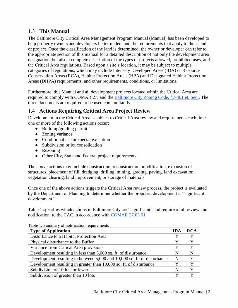
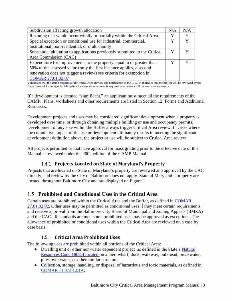
Table 1 specifies which actions in Baltimore City are “significant” and require a full review and
notification to the CAC in accordance with COMAR 27.03.01.
Table 1: Summary of notification requirements
Type of Application IDA RCA
Disturbance to a Habitat Protection Area Y Y
Physical disturbance to the Buffer Y Y
Variance from Critical Area provisions Y Y
Development resulting in less than 5,000 sq. ft. of disturbance N N
Development resulting in between 5,000 and 10,000 sq. ft. of disturbance N Y
Development resulting in greater than 10,000 sq. ft. of disturbance Y Y
Subdivision of 10 lots or fewer N Y
Subdivision of greater than 10 lots Y Y
Baltimore City Critical Area Management Program Manual | 3
Subdivision affecting growth allocation N/A N/A
Rezoning that would occur wholly or partially within the Critical Area Y Y
Special exception or conditional use for industrial, commercial,
institutional, non-residential, or multi-family
Y Y
Substantial alteration to applications previously submitted to the Critical
Area Commission (CAC)
Y Y
Expenditure for improvements to the property equal to or greater than
50% of the assessed value (only the first instance applies, a second
renovation does not trigger a review) see criteria for exemption in
COMAR 27.01.02.07
Y Y
Y indicates that the action requires a full Critical Area Review and notification to the CAC. N indicates that the project will be reviewed by the Department of Planning only. Mitigation for vegetation removal is required even when a full review is not necessary.
If a development is deemed “significant,” an applicant must meet all the requirements of the
CAMP. Plans, worksheets and other requirements are listed in Section 12: Forms and Additional
Resources.
Development projects and uses may be considered significant development when a property is
developed over time, or through obtaining multiple building or use and occupancy permits.
Development of any size within the Buffer always trigger Critical Area review. In cases where
the cumulative impact of the use or development ultimately results in meeting the significant
development definition above, the project or use will be subject to Critical Area review.
All projects permitted or that have approval for mass grading prior to the effective date of this
Manual is reviewed under the 2002 edition of the CAMP Manual.
Projects Located on State of Maryland’s Property
Projects that are located on State of Maryland’s property are reviewed and approved by the CAC
directly, and review by the City of Baltimore does not apply. State of Maryland’s property are
located throughout Baltimore City and are displayed on Figure 1.
Prohibited and Conditional Uses in the Critical Area
Certain uses are prohibited within the Critical Area and the Buffer, as defined in COMAR
27.01.02.02. Other uses may be permitted as conditional uses if they meet certain requirements
and receive approval from the Baltimore City Board of Municipal and Zoning Appeals (BMZA)
and the CAC. If standards are met, some prohibited uses may be approved as exceptions. The
allowance of prohibited or conditional uses within the Critical Area are reviewed on a case by
case basis.
Critical Area Prohibited Uses
The following uses are prohibited within all portions of the Critical Area:
● Dwelling unit or other non-water dependent project as defined in the State’s Natural
Resources Code 1808.4 located on a pier, wharf, dock, walkway, bulkhead, breakwater,
piles over water, or other similar structure;
● Collection, storage, handling, or disposal of hazardous and toxic materials, as defined in
COMAR 11.07.01.01A;

Baltimore City Critical Area Management Program Manual | 4
● Commercial or municipal incinerators;
● Junk or scrap storage and yards, including storage on barges and belt conveyor systems
used for the transfer of materials – this prohibition does not apply to the continuous
process of loading or unloading processed metal for and during its transfer to or from a
docked barge or vessel awaiting shipment;
● Landfills;
● Liquefied natural gas and petroleum gas terminals;
● Non-water dependent uses on barges in tidal waters, except maritime museums;
● Non-water dependent uses on permanently moored vessels in the Inner Harbor Basin,
except maritime museums;
● Storage and handling of radioactive waste;
● Recycling collection stations;
● Solid waste acceptance facilities as defined in Baltimore City Code Article 23
(Sanitation) § 11-1(i), except for facilities approved as a conditional use by the BMZA;
● Automobile dismantling and recycling; including operations that perform maintenance,
dismantling or storage of abandoned, unlicensed, junked, or derelict vehicles.
Prohibited Uses within the Buffer
The following uses are prohibited within the Buffer:
● Storage facilities for nutrients (elements or compounds essential as raw material for
organic growth; for example, carbon, nitrogen, and phosphorus);
● Sand or gravel extraction operations;
● Cement plants;
● Chemical plants.
Exceptions to Prohibited Uses
The prohibitions listed above do not apply if the following standards are met:
● On recommendation of the Department of Planning, the BMZA finds that both:
o There is no environmentally acceptable alternative outside the Critical Area;
o The use is needed to improve water quality or address a wastewater management
problem.
● For any new use that constitutes a significant development or for any expansion of a
nonconforming use, a best management practices plan that achieves a net improvement in
water quality and habitat is submitted and implemented as a requirement of the Critical
Area review process.
Conditional Uses outside the Buffer
Solid waste acceptance facilities as defined in Baltimore City Code Article 23 (Sanitation) § 11-
1(i) are prohibited in the Critical Area. The following exceptions are conditional uses allowed
outside the Buffer, which require BMZA approval upon the recommendation of the Department
of Planning:
● Waste-to-energy facilities;
● Indoor operated transfer facilities;
● Indoor operated composting facilities.

Baltimore City Critical Area Management Program Manual | 5
Grandfathered Uses
Any use that lawfully existed or was approved by the Board of Municipal and Zoning Appeals as
of the date of the enactment of this ordinance, January 4, 1988, is considered grandfathered. Any
expansion of these grandfathered uses must meet the standards of the Baltimore City Zoning
Code for non-conforming uses and for uses prohibited in the Critical Area.
Critical Area Commission Approval Process of Significant Projects
After the project documents are reviewed by the Baltimore City Department of Planning, CAMP
staff sends an application package to the CAC for final review. On average, the CAC provides
feedback on complete permit applications within five (5) weeks from receipt. CAC feedback
may include requests for additional information and recommendations. Baltimore City CAMP
staff then informs the applicant of CAC comments and coordinates the submittal of additional
information and issues the approval or denial of permits within the Baltimore City’s permitting
system.
For more detailed information on the Critical Area Review process, please see Section 11 -
Implementation of the CAMP.
Compliance with Other City Ordinances
All development within the Critical Area must comply with all the applicable provisions of the
Baltimore City Code. This includes, but is not limited to:
• Baltimore City Natural Resources Code: Division II: Stormwater Management
• Baltimore City Natural Resources Code: Floodplain District, § 2-1 et. Seq.
• Baltimore City Zoning Code: Critical Overlay District, § 7-401 et. Seq.
• Baltimore City Building Code
Compliance with the City of Baltimore Stormwater Management Regulations
In addition to the Critical Area 10% phosphorus reduction requirement, projects in the Critical
Area are required to comply with all existing City of Baltimore stormwater management
regulations mandated by Baltimore City Department of Public Works (Baltimore City DPW).
Procedures for permits, inspection, performance bonding, maintenance, appeals, and penalties
are explained in the Maryland Stormwater Management Design Manual and the Baltimore City
Natural Resources Code, Division 2.
The Maryland Stormwater Management Design Manual (Appendix D-4) provides guidelines for
run-off pollution reduction in the Critical Area. The Manual also includes an assessment
methodology for evaluating pollutant removal effectiveness of stormwater management
facilities, and instructions for review and approval of runoff pollution reduction plans. Baltimore
City DPW administers the review and approval process.
Stormwater Management Plans must be approved by the Baltimore City DPW prior to the
submission of a project application to the CAC for review.

Baltimore City Critical Area Management Program Manual | 6
Compliance with the City of Baltimore Landscape Manual
The Baltimore City Landscape Manual applies to any development or redevelopment project
involving 5,000 square feet or more of site disturbance and requiring Site Plan Review
Committee approval. Plantings provided to meet Critical Area mitigation requirements may be
credited towards the requirements of the Landscape Manual if the plantings also meet the
conditions and standards of the Landscape Manual.
Conflicts with other Codes, Ordinances and Regulations
In the event that the exercise of the CAMP creates conflicts with other Baltimore City Codes,
Ordinances or Regulations, the stricter provisions shall apply.
Overview of CAMP Manual
Designation of Development Areas
The City is required by the State Critical Area Act to differentiate districts, sub-districts and sub-
subdistricts within its Critical Area according to land use types and densities that existed at the
time of program development. These areas are subject to different guidelines and restrictions
that govern development and use. The Critical Area Regulations (COMAR 27.01.02) establish
three land use classifications designed to accommodate growth in such a manner as to conserve
habitat and protect water quality. The three development areas are:
1. Intensely Developed Areas (IDA)
2. Limited Development Areas (LDA)
3. Resource Conservation Areas (RCA)
The land within Baltimore City’s Critical Area falls into two of the three categories outlined in
the Critical Area Act: IDA and RCA, as Baltimore has no LDA.
The vast majority of Baltimore City’s Critical Area is designated as IDA, for which the
guidelines and restrictions are further detailed in Section 2 – Intensely Developed Areas. The
diversity of existing land uses in the IDA requires that Baltimore City further differentiates this
district of its Critical Area into Waterfront Industrial Areas (WIA) and Waterfront Revitalization
Areas (WRA). The WRA retains a sub-subdistrict, the Shoreline Conservation Area (SCA),
which intends to preserve soft shorelines and prevent the construction of additional bulkheads
along Baltimore City’s coastline. The total land area encompassed by the Critical Area in
Baltimore City is 5,521.3 acres.
The expansion of the WRA and reduction of the WIA in the 2020 CAMP, when compared to the
2002 CAMP, was implemented to better align the Critical Area districts with the zoning map
adopted by Baltimore City in 2017. The 2017 zoning map was enacted to reflect the changes in
land use observed across Baltimore City, where areas previously zoned as industrial are
converting into commercial uses.
The remainder of the City’s Critical Area is designated as RCA. Guidelines and restrictions for
RCA are provided in Section 3 – Resource Conservation Areas.

Baltimore City Critical Area Management Program Manual | 7
The Critical Area Buffer
The Critical Area Act requires the establishment of a protective buffer around aquatic resources
within the Critical Area. The Buffer is measured 100-feet landward from the mean high water
line of tidal waters, the landward edge of tidal wetlands, and both banks of tributary streams. In
some instances, the Buffer is expanded beyond 100 feet to include contiguous steep slopes,
hydric soils, highly erodible soils, or non-tidal wetlands. When a development project
encroaches upon the Buffer, the submission and approval of a Buffer Management Plan is
required. Guidelines, restrictions, and submission requirements for development projects
containing land within the Buffer are detailed in Section 4 – The Critical Area Buffer.
Habitat Protection Areas and Designated Habitat Areas
The Critical Area Act also requires the City to identify existing natural resources in and around
the Critical Area and establish provisions for protecting and enhancing these resources. In
Section 5 – Habitat Protection Areas and Designated Habitat Protection Areas, specific resources
and environmental concerns are described, including resource and wildlife habitat protection,
water quality and shore erosion control. Maps and descriptions of Baltimore’s DHPAs are
included in Section 9 – Designated Habitat Protection Areas.
Mitigation Standards & Planting Guide for the Critical Area
To protect wildlife habitat, water quality, and forest cover; development and redevelopment
projects are required to meet mitigation planting requirements. Detailed information on
mitigation requirements and planting guidelines can be found in Section 6 – Mitigation
Standards and Planting Guide for the Critical Area.
Stormwater Pollutant Reduction in the IDA
The 10% Rule requires development and redevelopment projects to reduce stormwater runoff
pollutant levels by at least 10% compared to the existing land use through the use of best
management practices (BMP) for projects with disturbance over 250 square feet. Further
guidance for meeting the 10% Rule can be found in Section 7 – Stormwater Pollutant Reduction
in the IDA.
Offset Programs
Alternative methods of compliance may be allowed if the applicant can prove that the Critical
Area Requirements cannot be met onsite, or if the CAMP goals are better met by alternative
compliance methods. Alternate compliance methods are most often achieved through offsite
mitigation or offset fee programs. These topics are detailed further in Section 8 – Offset
Programs.
Implementation of the CAMP and Materials Needed for Compliance
The Critical Area Act (State Natural Resources Article, § 8-108.1 et. Seq., Annotated Code of
Maryland) requires that each jurisdiction establish administrative procedures for implementing a
local development review process. These procedures must include provisions for interagency
coordination, enforcement and appeals; such provisions are listed in Section 11 –
Implementation of the CAMP.
Forms and Additional Resources
The materials needed for compliance with Baltimore’s CAMP, and other resources helpful to
preparing required submissions are provided in Section 12 – Forms and Additional Resources.

Baltimore City Critical Area Management Program Manual | 8
Definitions and Acronyms
Definitions of terms used throughout the manual are provided in Section 13 – Definitions and
Acronyms.
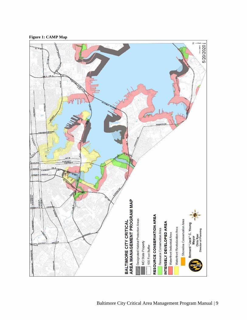
Baltimore City Critical Area Management Program Manual | 9
Figure 1: CAMP Map

Baltimore City Critical Area Management Program Manual | 10
2 INTENSELY DEVELOPED AREAS
Most of the City’s Critical Area is designated as IDA. The diversity of existing land uses in the
IDA necessitates further differentiation of the IDA into Waterfront Revitalization Areas and
Waterfront Industrial Areas. The CAMP Map (Figure 1) displays where Waterfront
Revitalization Areas (WRA) and Waterfront Industrial Areas (WIA) are located within the IDA.
Waterfront Revitalization Area
The WRA is one of two sub-districts within the IDA and has been undergoing redevelopment
since the 1990’s. In the 2020 Manual update, the WRA expanded by 48 percent, going from
approximately 617 acres to 1,282.8 acres, or 34 percent of the land area of the City’s Critical
Area. The area starts approximately 4,800 feet (0.9 miles) southeast of the intersection of Key
Highway and Stevenson Street and proceeds clockwise around the harbor to roughly 1,200 feet
south of the intersection of Boston Street and Clinton Street in Canton. The intensity of use,
extensive storm drain system and bulkheaded shores often preclude the habitat and stormwater
filtering benefits of the Buffer. In addition, a hard-edged urban public promenade is almost
complete along the full length of the area. However, areas that retain soft and pervious shoreline
are also still present in the WRA. For that reason, the 2020 CAMP enacted the Shoreline
Conservation Area (SCA) as a sub-subdistrict of the WRA, that encompasses 595.9 acres, or
46.5 percent of the total WRA. The intent of the SCA is to restrict the development of new
bulkheads within soft shoreline areas of the WRA.
Critical Area Requirements in the WRA
2.1.1.1 Buffer Requirements in the WRA
Buffer Management Plans are required for any project that encroaches upon and disturbs land
and /or vegetation within the Buffer, to mitigate or establish vegetated areas to protect aquatic,
wetland, and shoreline environments from man-made disturbances. The mitigation requirements
are detailed in Section 4 – The Critical Area Buffer.
2.1.1.1.1 Buffer Requirements for Water and Non-Water Dependent Uses in the WRA
Critical Area requirements for development in the Buffer of the WRA vary, depending on
whether the development is a water dependent or non-water dependent. To the extent possible,
non-water dependent structures or operations associated with water-dependent projects or
activities must be located outside the Buffer, in accordance with COMAR 27.01.03.03-(a)(4).
Any proposals for new or expanded water-dependent facilities shall be considered in relation to
the criteria set forth in COMAR 27.01.03.04 - Local Plan Requirements for Water-Dependent
Facilities.
All development that happens in the Buffer of the WRA requires that the applicant offset for any
additional/new impervious areas. The applicant is also required to mitigate for any vegetation
disturbed by development and meet the requirements for any new lot coverage. Shore erosion
problems also must be corrected. A Buffer Management Plan that meets the requirements of this
manual and COMAR 27.01.09.01-3 must be submitted to the Department of Planning for
approval. The Buffer must be vegetated, or mitigated for by other means, according to the

Baltimore City Critical Area Management Program Manual | 11
approved Buffer Management Plan prior to the approval of any use and occupancy permits for
the project.
Any development or redevelopment within the Buffer is limited to 60 percent of the entire Buffer
area, and mitigation must be provided for an area equal to additional/new impervious areas
within the Buffer. Any deviation of this directive requires a variance. Table 5 provides guidance
for the calculation of mitigation requirements. Please note that the developer must strive to meet
the required mitigation on site, but a fee-in-lieu may be accepted if mitigation may not be fully
met on site. The applicant is also required to mitigate for any vegetation disturbed by
development.
2.1.1.2 Afforestation Requirement in the WRA
Projects within the WRA must meet the 15% afforestation requirement for the entire site,
including the Buffer. Projects with LOD lesser than 20 percent of the total site area calculate the
15% afforestation based on the LOD. Afforestation requirements for projects in the WRA can be
found in Section 6 – Mitigation Standards & Planting Guide for the Critical Area.
2.1.1.3 Mitigation Requirements for Vegetation Removal in the WRA
The removal of trees or woody vegetation within the WRA requires advanced approval of the
Director of Planning and must be mitigated in accordance with this manual. Mitigation
requirements for projects in the WRA can be found in Section 6 – Mitigation Standards &
Planting Guide for the Critical Area.
2.1.1.4 Runoff Pollution Reduction in the WRA
Development and redevelopment projects are required to reduce stormwater runoff pollutant
levels by at least 10% below that of existing land use, through the use of best management
practices. This is known as the 10% Rule. Total phosphorus is used as the basis for computing
pre-development and post-development pollutant loads to determine compliance with the 10%
Rule. Further guidance for meeting the 10% Rule can be found in Section 7 – Stormwater
Pollutant Reduction in the IDA.
Baltimore City Critical Area Management Program Manual | 12
Shoreline Conservation Area
The SCA is a sub-subdistrict of the WRA created with the 2020 Manual update. The SCA
encompasses areas that transitioned from industrial to other types of uses overtime, and that
retain soft, green or natural shoreline features. The intention of the SCA is to limit the
construction of additional bulkheads along Baltimore’s coastline, and sponsor the natural habitat
as aesthetic value provided by soft shorelines. Additional benefits provided by soft shorelines
include the maintenance of natural shoreline dynamics, attenuation of storm surge and flood
waters, filtration of nutrients and other pollutants, and creation and protection of carbon sinks
through the maintenance of wetlands.
The SCA occupies approximately 595.8 acres, or 10.8 percent of the land areas of Baltimore
City’s Critical Area. The sub-subdistrict covers a portion of Masonville Cove, the MedStar
Hospital site, portions of Westport, the shoreline area from the Horseshoe Casino until the BGE
Spring Garden site, Port Covington and Fort McHenry National Monument and Historic Shrine.
For the purpose of the SCA, shoreline is defined as the area within 30 feet of the mean high
water line as displayed in the Critical Area map.
2.1.2.1 Critical Area Requirements in the SCA
2.1.2.1.1 Buffer Requirements for Water and Non-Water Dependent Uses in the SCA
The Buffer requirements included in Section 2.1.1.1.1 apply to the Buffer of the SCA. In
addition to those, no new -bulkheads are allowed in the SCA’s shoreline area (30 feet from the
mean high water line), and the removal of vegetation, even if necessary for the re-establishment
of the Buffer, must be approved by the Baltimore City Department of Planning and the CAC.
The SCA requirements apply to areas that have soft shorelines as of the date of adoption of this
Manual. Variances may be pursued for projects that propose water-dependent uses that deviate
from the above described criteria. Variance information can be found on section 11.5 - Variances
of this document.
Buffer Management Plans are required for any project that encroaches upon the Buffer in order
to mitigate or establish vegetated areas that serve to protect aquatic, wetland, and shoreline
environments from human-made disturbances. The mitigation requirements are detailed in
Section 4 – The Critical Area Buffer.
2.1.2.1.2 Afforestation Requirement in the SCA
Projects within the SCA must meet the 15% afforestation requirement for the total site area,
including the Buffer. Projects with LOD lesser than 20 percent of the total site area calculate the
15% afforestation based on the LOD. Afforestation requirements for projects in the SCA can be
found in Section 6 – Mitigation Standards & Planting Guide for the Critical Area.
2.1.2.1.3 Mitigation Requirements for Vegetation Removal in the SCA
The removal of trees or woody plants within the SCA requires advance approval by the
Baltimore City Department of Planning and must be mitigated in accordance with this manual.

Baltimore City Critical Area Management Program Manual | 13
Mitigation requirements for projects in the SCA can be found in Section 6 – Mitigation
Standards & Planting Guide for the Critical Area.
2.1.2.1.4 Runoff Pollution Reduction in the SCA
Development and redevelopment projects are required to reduce stormwater runoff pollutant
levels by at least 10% below that of existing land use by using best management practices. This
is known as the 10% Rule. Total phosphorus is used as the basis for computing pre-development
and post-development pollutant loads to determine compliance with the 10% Rule. Further
guidance for meeting the 10% Rule can be found in Section 7 – Stormwater Pollutant Reduction
in the IDA.
Waterfront Industrial Area
The WIA is the second sub-district in the Intensely Developed Area and generally has fewer
structures and less lot coverage than the Waterfront Revitalization Area. This portion of the
City’s IDA is 3,169.3 acres, or 57.4 percent of the City’s Critical Area.
A large amount of the City’s industrially zoned land lies within the WIA, which has long been
developed for port-related purposes. The City encourages the redevelopment of this area as part
of its effort to retain and create jobs and industry. The City seeks the development of port-
related facilities within its Critical Area but cannot reserve it exclusively for this purpose. The
development of marinas is primarily regulated by the Baltimore City Zoning Code, § 14-323 and
guided by the Maritime Master Plan. Portions of the City’s WIA are protected and reserved for
industrial uses by the Baltimore City Zoning Code, § 11-206 (Maritime Industrial Zoning
District).
Critical Area Requirements in the WIA
2.2.1.1 Buffer Requirements in the WIA
Critical Area requirements for development in the Buffer vary, depending on whether the
development is a water-dependent or non-water dependent use. To the extent possible, non-
water-dependent structures or operations associated with water-dependent projects or activities
must be located outside the Buffer, in accordance with COMAR 27.01.03.03-(a)(4). Any
proposals for new or expanded water-dependent facilities shall be considered in relation to the
criteria set forth in COMAR 27.01.03.04 - Local Plan Requirements for Water-Dependent
Facilities. Buffer Management Plans are required for any project that encroaches upon the
Buffer in order to mitigate or establish vegetated areas that serve to protect aquatic, wetland, and
shoreline environments from human-made disturbances. The Buffer mitigation requirements are
detailed in Section 4 – The Critical Area Buffer.
2.2.1.1.1 Buffer Requirements for a Water-Dependent Use in WIA
Water-dependent development within the Buffer of the Waterfront Industrial Area requires the
applicant to offset for any additional/new impervious areas. Table 5 provides guidance to
calculate the mitigation required from the project. The applicant is also required to mitigate for
any vegetation disturbed by development and meet Buffer disturbance requirements for any new
lot coverage. In addition, shore erosion problems must be corrected.

Baltimore City Critical Area Management Program Manual | 14
A Buffer Management Plan that meets the requirements of this manual and COMAR
27.01.09.01-3 must be submitted to the Department of Planning for approval. The Buffer must
be vegetated, or mitigated for by other means, according to the approved Buffer Management
Plan prior to the approval of any use and occupancy permits for the project.
2.2.1.1.2 Buffer Requirements for Non-Water Dependent Use in WIA
Non-water dependent development within the Buffer of the WIA is limited to 50 percent of the
total undeveloped Buffer area, and mitigation must be provided for new impervious areas within
the Buffer. A variance is required of projects that wish to exceed the 50 percent limit. The
applicant must follow Table 5 to calculate the mitigation required from the project. The applicant
is also required to mitigate for any vegetation disturbed by development. Table 3 provides
guidance for the calculation of the required mitigation. In addition, shore erosion problems must
be corrected.
A Buffer Management Plan that meets the requirements of this manual and COMAR
27.01.09.01-3 must be submitted to the Department of Planning for approval. The Buffer must
be vegetated, or mitigated for by other means, according to the approved Buffer Management
Plan prior to the approval of any use and occupancy permits for the project.
2.2.1.2 Afforestation Requirement in the WIA
Projects within the WIA must meet the 15% afforestation requirement for the total site area,
including the Buffer. Projects with LOD lesser than 20 percent of the total site area calculate the
15% afforestation based on the LOD. Afforestation requirements for projects in the WIA can be
found in Section 6 – Mitigation Standards & Planting Guide for the Critical Area.
2.2.1.3 Mitigation Requirements for Vegetation Removal in the WIA
The removal of trees or woody plants within the WIA requires advance approval of the Director
of Planning and must be mitigated in accordance with this manual. Mitigation requirements for
projects in the WIA can be found in Section 6 – Mitigation Standards & Planting Guide for the
Critical Area.
2.2.1.4 Runoff Pollution Reduction in the WIA
Development and redevelopment projects are required to reduce stormwater runoff pollutant
levels by at least 10% below that of existing land use using best management practices. This is
known as the 10% Rule. Total phosphorus is used as the basis for computing pre-development
and post-development pollutant loads to determine compliance with the 10% Rule. Further
guidance for meeting the 10% Rule can be found in Section 7 – Stormwater Pollutant Reduction
in the IDA.

Baltimore City Critical Area Management Program Manual | 15
3 RESOURCE CONSERVATION AREAS The portion of the City’s Critical Area not designated as IDA is classified as Resource
Conservation Area (RCA). This sub-area encompasses 371.8 acres and represents 6.7 percent of
the land area of the City’s Critical Area. The Resource Conservation Area is almost exclusively
floodplain areas and shoreline parks. Resource Conservation Areas are regulated by COMAR
27.01.02.05.
Development within the RCA
Permitted, Conditional, and Prohibited Uses outside the Buffer
In addition to the uses identified as prohibited and conditional uses in the Critical Area in Section
1.5 of this manual, there are additional limitations on development within the RCA.
Development outside the Buffer within the RCA will be limited to recreational, cultural, and
educational facilities. Permitted and accessory uses include open space, public recreation,
natural parks, pedestrian easements, bike paths, and cultural and historical sites. Sites owned by
the City of Baltimore that are used for active recreation by the City of Baltimore have their uses
grandfathered. The grandfathering provision only applies to exiting sites that have active uses as
of, or prior to, the enactment of the Critical Area law in the City of Baltimore. Public facilities
are conditional uses outside the Buffer, and non-public water-dependent facilities are prohibited
in the RCA.
Permitted, Conditional, and Prohibited Uses within the Buffer
In addition to the uses identified as prohibited uses in the Buffer in Section 1.5 - Prohibited and
Conditional Uses in the Critical Area of this manual, there are additional limitations on
development within the Buffer of the RCA. Permitted and accessory uses permitted within the
Buffer of the RCA include areas for passive recreation, such as nature study and education.
Service facilities for these uses must be located outside of the Buffer. Public water-dependent
facilities are conditional uses within the Buffer in the RCA.
Lot Coverage Limitations in the RCA
Within the RCA, lot coverage is limited as follows:
a) Lot coverage is limited to 15 percent of a parcel or lot except as otherwise outlined
below;
b) If a parcel or lot one-half acre or less in size existed on or before December 1, 1985,
then lot coverage is limited to 25 percent of the parcel or lot;
c) If a parcel or lot greater than one half acre and less than one acre in size existed on or
before December 1, 1985, then lot coverage is limited to 15 percent of the parcel or
lot;
d) If an individual lot one-acre or less in size is part of a subdivision approved after
December 1, 1985, then lot coverage may not exceed 25 percent of the lot. However,
the total lot coverage over the entire subdivision may not exceed 15 percent;
e) Lot coverage limits provided in sub-sections (a) and (c) above may be exceeded, upon
findings by the Director of Planning or their designee that the following conditions
exist:
1) Lot coverage associated with new development activities on the property have
been minimized;

Baltimore City Critical Area Management Program Manual | 16
2) For a lot or parcel one-half acre or less in size, total lot coverage does not
exceed the lot coverage limitations described above by more than 25 percent
or 500 square feet, whichever is greater;
3) For a lot or parcel greater than one-half acre in size and less than one acre in
size, total lot coverage does not exceed 15 percent lot coverage by more than
5,445 square feet;
4) Water quality impacts associated with runoff from new lot coverage have
been minimized through the use of best management practices (BMP)
approved by the City of Baltimore – Department of Public Works (DPW);
5) The property owner performs on-site mitigation to offset potential adverse
water quality impacts from the new development activities that contribute to
lot coverage; or the property owner pays a fee in lieu of performing the on-site
mitigation. The new lot coverage on the property must be mitigated, and
Table 5 can be used to calculate the mitigation required.
Critical Area Requirements in the RCA
Buffer Requirements in the RCA
Buffer Management Plans are required for any project that encroaches upon the Buffer in order
to mitigate or establish vegetated areas that serve to protect aquatic, wetland, and shoreline
environments from human-made disturbances. The Buffer mitigation requirements are detailed
in Section 4 – The Critical Area Buffer.
Mitigation Requirements for Vegetation Removal in the RCA
The removal of trees or woody vegetation within the RCA requires advance approval of the
Director of Planning and must be mitigated in accordance with this manual. Mitigation
requirements for projects in the RCA can be found in Section 6 – Mitigation Standards &
Planting Guide for the Critical Area.
Runoff Pollution Reduction in the RCA
Local and state stormwater management requirements apply to projects in the RCA. If a project
receives a variance or conditional approval to exceed lot coverage in the RCA, the 10% Rule for
phosphorus reduction applies.
Baltimore City Critical Area Management Program Manual | 17
4 THE CRITICAL AREA BUFFER
The Buffer is the area immediately adjacent to the mean high water line of tidal waters, the edge
of each bank of tributary streams and the landward edge of tidal wetlands. It includes areas that
are naturally vegetated or not naturally vegetated and may include undeveloped land or land that
has been previously developed or disturbed. The Buffer requirements described in this section
are intended to protect aquatic, wetland, shoreline, and terrestrial environments from human-
made disturbances. The Buffer is expanded to include steep slopes, erodible soils and other
sensitive areas.
The Buffer regulations in this chapter include comprehensive standards and procedures for the
management of the Critical Area Buffer.
Measurement and Expansion of the Buffer
The Buffer is measured 100-feet landward from:
● The mean high water line of tidal waters;
● The landward edge of tidal wetlands;
● The edge of each bank of tributary streams;
● The landward edge of rip-rap, bulkhead or revetment when the shoreline of the site is
developed and/or impervious.
The Buffer is expanded when one or more of the following conditions exist, contiguous to the
Buffer (see COMAR 27.01.09.01):
a) Steep slopes, with the Buffer expanded at a rate of four feet for every one percent of
slope or to the top of the slope, whichever is greater;
b) Non-tidal Wetlands of Special State Concern, including both the wetland and its
regulated 100-foot buffer;
c) Non-tidal wetlands to the upland boundary of the non-tidal wetland; and,
d) Highly erodible soils and hydric soils, with the Buffer expanded to the landward edge
of the soil or 300-feet (which includes the minimum 100-foot Buffer), whichever is
less.
In accordance with provisions enacted by the Maryland General Assembly in 2008, a 200-foot
Buffer from tidal waters and tidal wetlands is required for new subdivisions and site plan
approvals in the RCA.
Before final recordation of a subdivision, the applicant must mark the Buffer in the field with a
permanent sign that prohibits clearing or disturbance. There must be at least one sign per lot or
for each 200 linear feet of shoreline. Concurrent with the recordation of the subdivision, the
applicant must record a protective measure, such as deed restrictions or an equivalent, within the
Buffer Management Plan.
Prohibited Uses in the Buffer
The following uses are prohibited within the Buffer in all portions of the Critical Area:
● Storage facilities for nutrients, including elements or compounds essential as raw
materials for organic growth and development;
● Sand or gravel extraction operations;
Baltimore City Critical Area Management Program Manual | 18
● Cement plants;
● Chemical plants.
See Section 3 - Resource Conservation Areas for additional use restrictions applicable to
development in the RCA, and Section 1.5 - Prohibited and Conditional Uses in the Critical Area
for general use restrictions in the Critical Area.
Sites with 15% or More Total Land Area in the Buffer
When the Buffer comprises 15 percent or more of a site, the applicant may be approved to
develop within the Buffer up to the point where 85 percent of the total site area is developed,
provided that the portion of the Buffer disturbed by such development complies with mitigation
requirements. This provision does not apply to projects located within the WRA, RCA or DHPA.
Additional information about the Buffer Offset Fee Program is provided in Section 8 – Offset
Programs.
Buffer Mitigation Requirements Mitigation for Buffer disturbance is required from projects located within the Buffer of the IDA
and is calculated based on new impervious areas and vegetation removal. Calculations and
plantings for mitigation are required as part of the submission of Buffer Management Plans.
Regarding fulfilment, if the mitigation requirement cannot be met on site, it may be met off-site
or through payment of a fee-in-lieu. Table 5 offers guidance for the calculation of Buffer
mitigation, and additional information about the fee-in-lieu program is provided in Section 8 –
Offset Programs.
Mitigation for Buffer disturbance must be provided for an area equal to all newly proposed
impervious areas within the Buffer. The mitigation ratio depends on whether the project is water
dependent or non-water dependent (Table 4). The mitigation requirement does not apply to a
project that limits its Buffer disturbance to areas that are currently impervious. Specific
mitigation requirements and calculations for Buffer mitigation can be found in Section 6 -
Mitigation Standards & Planting Guide for the Critical Area.
Mitigation for vegetation removal is based on the caliper inch and the condition of the trees
removed from the Buffer area. Specific planting requirements and calculations for Buffer
mitigation can be found in Section 6 - Mitigation Standards & Planting Guide for the Critical
Area.
Buffer Management Plans
The submittal of a Buffer Management Plan is required for any project that involves disturbance
of the Buffer. An applicant must submit a Buffer Management Plan to the Department of
Planning for review and approval when Buffer mitigation is required in accordance with
COMAR 27.01.09.01-3 or when disturbance to the Buffer will result from issuance of a variance,
permit, or other project approval. As set forth in COMAR 27.01.09.01-3, Baltimore City may
not authorize a variance to Buffer planting and mitigation requirements or issue a final use and
occupancy permit until the applicant completes the implementation of a Buffer Management

Baltimore City Critical Area Management Program Manual | 19
Plan, or provides financial assurance to cover the costs for materials, installation and long-term
survivability of plant materials.
Projects requiring submission of a Buffer Management Plan include:
● The creation of a new subdivision or a new lot;
● The conversion from one land use to another land use on a lot or a parcel; or
● Development or disturbance on a lot or a parcel created before March 8, 2010.
Buffer Management Plan requirements vary depending on the intensity of the proposed
development activity. The project types and submission requirements for each type of Buffer
Management Plan are described further in this section.
The three types of Buffer Management Plans are:
● Simplified Buffer Management Plan
● Minor Buffer Management Plan
● Major Buffer Management Plan
4.5.1.1 Simplified Buffer Management Plan
A Simplified Buffer Management Plan is required for a Buffer impact that is associated with:
● Providing access to a private pier or shoreline that is no greater than 3 feet wide;
● Manually removing invasive or noxious vegetation;
● Filling to maintain an existing grass lawn; or,
● Cutting a tree that is in imminent danger of falling, except when actions are necessary in
emergency situations. In such instances, a Simplified Buffer Management Plan shall be
submitted at the earliest possible time.
A Simplified Buffer Management Plan must include:
● A brief narrative describing the proposed activity, including the anticipated start date and
method to be used;
● The proposed mitigation;
● The proposed planting date; and
● The signature of the party responsible for the proposed activity and for ensuring the
survival of the planting.
4.5.1.2 Minor Buffer Management Plan
A Minor Buffer Management Plan is required for a Buffer impact that is associated with:
● Proposed Buffer disturbance that requires less than 5,000 square feet of mitigation.
A Minor Buffer Management Plan must include:
● A plan that shows the proposed Limit of Disturbance (LOD), the total number and size of
trees to be removed, if applicable, and the arrangement of the planting to be done;
● Calculations to determine the required Buffer mitigation;
● A landscape schedule that shows the proposed species type, the quantity of plants, the
size of plants to be installed, and the planting date;
● A maintenance plan for the control of invasive species, pests, and predation that shows
invasive species and pest control practices, the provision of at least two years of

Baltimore City Critical Area Management Program Manual | 20
monitoring, and a reinforcement planting provision if survival rates fall below the
standards set in this manual and COMAR 29.01.09.01-2.
● An inspection agreement that grants permission to Baltimore City to inspect the plantings
at appropriate times;
● The signature of the party responsible for the proposed activity and for ensuring the
survival of the planting.
4.5.1.3 Major Buffer Management Plan
A Major Buffer Management Plan is required for a Buffer impact that is associated with:
● Proposed Buffer disturbance requiring mitigation of 5,000 square feet or greater.
A Major Buffer Management Plan must include:
● A plan that shows the proposed LOD, the total number and size of trees to be removed, if
applicable, and the arrangement of the planting to be done;
● Calculations to determine the required Buffer mitigation;
● A landscape schedule that shows the proposed species type, the quantity of plants, the
size of plants to be installed, and the planting date;
● A maintenance plan for the control of invasive species, pests and predation that shows
invasive species and pest control practices, the provisions for at least two years of
monitoring, and a reinforcement planting provision if survival rates fall below the
requirements;
● A long-term protection plan that includes evidence of financial assurance that adequately
covers the planting and survivability requirement, a provision for at least two years of
monitoring, and if planting, an anticipated planting date before construction or the sale of
the lot;
● An inspection agreement that grants permission to the local government to inspect the
plantings at appropriate times;
● The signature of the party responsible for the proposed activity and for the survival of the
planting.
In a Major Buffer Management Plan, a single species may not exceed 20 percent of the total
planting requirement, and shrubs may not exceed 20 percent of the total planting requirement
without special permission from the Department of Planning.
Buffer Credit for Plantings Outside the Buffer
New vegetation planted outside the Buffer may be credited toward Buffer requirements provided
that:
● It is contiguous to existing or planned vegetation within the Buffer; and,
● Vegetation planted outside the Buffer is at least 25 feet in width or as wide as site constraints
will allow; and,
● Existing or planned vegetation within the Buffer is the entire depth of the Buffer and includes
at least 50 linear feet along the shoreline or as wide as site constraints will allow; and,
● The buffer plan has prior approval from the Department of Planning’s Director.

Baltimore City Critical Area Management Program Manual | 21
Shoreline Erosion Control
To protect shoreline against erosion while retaining natural shoreline form, habitat, and
ecological function, the State of Maryland has established regulations to promote the use of
nonstructural shoreline stabilization measures. Nonstructural shoreline stabilization measures
are required where shoreline erosion control is necessary, except in areas mapped by the
Maryland Department of the Environment (MDE) as appropriate for structural shoreline
stabilization measures. In areas designated for nonstructural shoreline stabilization measures,
structural measures may be allowed where the applicant is able to demonstrate to the satisfaction
of MDE that nonstructural measures are not feasible. Additional information can be found on
COMAR 26.24.04.04-1. These may involve areas of excessive erosion, areas subject to heavy
tides, and areas too narrow for effective use of nonstructural shoreline stabilization measures.
The construction of structural shoreline stabilization measures is a development activity
requiring Buffer mitigation planting. Additional information regarding shoreline stabilization is
provided on COMAR 26.24.04. Calculations and guidelines for mitigation planting are provided
in Section 6 - Mitigation Standards & Planting Guide for the Critical Area.
Piers, Barges, Vessels, and Docks
Piers, barges, permanently moored vessels, and docks are subject to Critical Area regulations,
requirements and offsets. All piers, barges, vessels and docks must also comply with all
applicable State and Federal rules and regulations.
Piers and Fill Piers
Pursuant to the State Natural Resources Article, § 8-1808.4, Annotated Code of Maryland, and
the Baltimore City Zoning Code, § 7-406, no building permit shall be issued for any project
involving the construction of a dwelling unit or other non-water dependent structure on a pier
waterward of the mean high waterline of tidal streams, waters, or wetlands within the Critical
Area. Non-water-dependent projects include, but are not limited to: dwelling units, restaurants,
shops, other commercial buildings and recreational areas; swimming pools; sheds or storage
buildings; parking lots; and sanitary facilities.
The following piers have been approved by MDE for non-water dependent uses, and have been
grandfathered:
● Belt’s Wharf – 960 Fell Street,
● North Shore – 2327 Boston Street,
● Harborview, two piers – 1101 Key Highway and 100 Harborview Drive
● Power Plant, 601 East Pratt Street, three dining areas on piers.
The construction of a water dependent pier or any other structure creates a new area of the
Critical Area Buffer, and all Critical Area Buffer regulations are applicable. Buffer requirements
and the 10% Rule apply to work done in existing piers (replacement, rehabilitation) if the
structure is considered impervious. Reconfiguration of existing piers are reviewed based on the
net footprint of the structure. Only the 10% Rule applies to expansions of water dependent piers
if the structure’s surface is considered impervious.
Baltimore City Critical Area Management Program Manual | 22
Barges
Non-water dependent uses in tidal waters are not permitted on barges located in the City of
Baltimore. A barge is defined as non-self-propelled watercraft, as opposed to a vessel which is
defined as self-propelled and is licensed by the U.S. Coast Guard. Uses on barges approved as of
the original date of the enactment of this legislation are grandfathered, which includes the barges
themselves and original locations. Barges that are relocated without the prior notification and
approval by the Planning Department lose their grandfathered status under the CAMP.
Barges that have been approved by the City for non-water dependent uses and are grandfathered
include:
● Lighthouse Point Boat Sales Barge (2701 Boston Street)
● Harborview Swimming Pool Barge (500 Harborview Drive)
Permanently Moored Barges and Vessels
Non-water dependent uses are not allowed on permanently moored barges and vessels in the
Inner Harbor Basin with the exception of permanently moored vessels used as maritime
museums. Permanently moored barges and vessels become part of the Critical Area and are
subject to all regulations, requirements and offsets.
Floating Piers and Docks
Concrete, wood or other materials used for floating piers and docks are considered impervious
for the calculation of lot coverage, unless the dock is constructed of slats with spaces between
that are wide enough to allow water to freely pass through. Buffer requirements apply to floating
piers and docks located over the surface of the water, unless the structure is considered pervious
surface as described in this paragraph; and is open to the public.
Mitigation Requirement
The development of existing piers, barges, permanently moored vessels, and docks trigger all
Buffer mitigation requirements, as the structures as considered extensions of the Buffer. The
development of new structures over water (ex.: concrete pier expansions) trigger the 10% Rule
only.
The Promenade
Privately owned land or piers within the Critical Area for which the applicant grants a public
pedestrian and bicycle access easement, approved by the Board of Estimates, is excluded from
Buffer requirements. The portion of the site which has been dedicated as public promenade, trail
or for access to the promenade or trail may be excluded in the calculation of the net Buffer area.
The right of way areas should also be excluded from the total lot coverage used to calculate
Buffer mitigation requirements.

Baltimore City Critical Area Management Program Manual | 23
5 HABITAT PROTECTION AREAS AND
DESIGNATED HABITAT PROTECTION AREAS
The Critical Area regulations require local jurisdictions to identify important natural and
community resources within the Critical Area and to devise strategies for protecting and
enhancing those resources.
The Critical Area regulations identify ten types of Habitat Protection Areas (HPA) that must be
included in local habitat protection programs. In addition, twelve important natural areas within
Baltimore have been identified as Designated Habitat Protection Areas (DHPA).
Habitat Protection Areas HPAs are designated areas that receive special protection within the Critical Area because they
provide habitat for fish, wildlife, and plant species that are significant to the local ecosystem.
The ten types of HPAs identified in the Critical Area regulations include:
1. The Critical Area Buffer;
2. Areas containing threatened and endangered species and species in need of conservation;
3. Colonial water bird nesting sites;
4. Historic waterfowl staging and concentration areas;
5. Riparian forests;
6. Forest interior dwelling bird habitat (forests of 100 acres or more);
7. Designated Natural Heritage Areas;
8. Anadromous fish propagation waters;
9. Habitats of local significance including non-tidal wetlands; and,
10. Areas which may in the future be identified by State and Federal agencies as important
plant or wildlife habitats.
The Critical Area Buffer
The Buffer is one of the designated HPAs. The majority of Baltimore’s Buffer has been
previously altered by development, including filling and structural stabilization or alteration of
the shoreline, leaving little remaining natural habitat. The remaining undeveloped Buffer areas
primarily consist of beaches, vegetated slopes and banks, eroding banks, vegetated tidal
wetlands, and tributary streams.
Species Threatened, Endangered, or in Need of Conservation
The Maryland Department of Natural Resources (DNR) identifies Significant Habitats within
Baltimore. Maryland DNR also maintains lists of rare, threatened, and endangered plant and
animal species for each Maryland jurisdiction, including Baltimore City.
Colonial Water Bird Nesting Sites
Chesapeake Bay Foundation staff and Baltimore Department of Parks and Recreation staff have
documented rookeries of black crowned night heron at the mouth of Curtis Creek and at the
northern end of the Middle Branch of the Patapsco River. The State of Maryland cannot

Baltimore City Critical Area Management Program Manual | 24
officially designate these sites until documented by the Maryland Department of Natural
Resources through site surveys.
Historic Waterfowl Staging and Concentration Areas
The Chesapeake Bay is located within the Atlantic Flyway and plays a role in migratory bird
patterns. The Baltimore Harbor provides habitat for wintering waterfowl in its tidal wetlands
and open water areas. The Patapsco River mainstem, from the Hanover Street Bridge eastward
to the Dundalk Marine Terminal, supports various wintering waterfowl. According to DNR,
documented areas of special importance to wintering waterfowl include the west cove adjoining
the Masonville dredge disposal site, the upper Middle Branch, and Stonehouse Cove on Curtis
Creek.
Riparian Forests
Riparian forests are crucial to the protection and enhancement of the water resources of the
Chesapeake Bay. They are complex ecosystems that help provide food and habitat for wildlife,
as well as being an asset in mitigating and controlling stormwater runoff and pollution.
Forest Interior Dwelling Bird Habitat
The impact of the loss of forests impacts all species of birds and wildlife. Although small forests
are less optimal breeding habitat for most forest-interior birds, these forests can be an important
migratory stopover. Maximizing forest cover, improving forest interconnectivity, and increasing
forest widths are strongly encouraged to increase habitat in the Critical Area.
Designated Natural Heritage Areas
The Maryland Natural Heritage program has no designated Natural Heritage Areas in Baltimore
City.
Anadromous Fish Propagation Waters
Anadromous fish propagation waters are those streams that are a tributary to the Chesapeake Bay
where the spawning of anadromous species, including rockfish, striped bass, yellow perch, white
perch, shad, and river herring occurs or has occurred. The Upper Middle Branch of the Patapsco
River and the Lower Gwynns Falls are classified as anadromous fish propagation waters.
It is the policy of the City of Baltimore to require protection of the in-stream and stream bank
habitat of anadromous fish propagation waters. The City promotes land use policies and
practices in the watershed of spawning streams within the Critical Area that minimize the
adverse impacts of development on the water quality of the streams and provide for the
unobstructed movement of spawning and larval forms of anadromous fish in streams.
The following standards apply within anadromous fish propagation watersheds:
● The installation or introduction of concrete riprap or other artificial surfaces onto the
bottom of natural streams shall be prohibited unless it can be demonstrated that water
quality and fisheries habitat can be improved;
● Channelization or other physical alterations, which may change the course of circulation
of a stream and thereby interfere with the movement of fish, shall be prohibited;
Baltimore City Critical Area Management Program Manual | 25
● The City shall require each development activity that occurs within a watershed draining
to anadromous fish propagation waters to fulfill the following objectives:
o Minimize development activities or land disturbances within the watershed;
o Maintain, or if practicable, improve water quality in affected streams or other
water bodies;
o Minimize to the extent possible the discharge of sediments into affected streams
or other water bodies;
o Maintain, or if practicable, increase the natural or native vegetation of the
watershed and tree canopy over the streams.
The City shall ensure coordination and compliance with complimentary State laws and
regulations. This includes prohibiting the construction or placement of dams or other structures
that would interfere with or prevent the movement of spawning fish or larval forms in streams or
other designated water bodies. If practical, existing structures that block streams or other water
bodies shall be removed. The City shall ensure that the construction, repair or maintenance
activities associated with bridges, or other stream crossing, or with utilities and roads, which
involve disturbance within the Buffer or which occur in-stream as described in COMAR
08.05.03.11B(5), shall be prohibited between March 1 and May 15 of each year. These activities
must also meet State and Federal tidal wetlands license requirements.
Habitats of Local Significance Including Non-Tidal Wetlands
Habitats of local significance in the City of Baltimore are different in quality from significant
habitat areas in less disturbed or non-urbanized environments. Herbaceous, scrub-shrub, and
woodland communities include native plants and often-exotic volunteer species. Common
resident birds, wintering species, migrants and an assortment of urban-tolerant small mammals
are supported by these habitats, each of which is considered desirable in our urban context.
Naturalized areas of any reasonable size, especially when located near water, are valuable to the
wildlife populations of City of Baltimore and therefore are protected within the Critical Area as
HPAs.
Woodlots are valuable habitats to a diversity of species as well as providing many benefits to a
city, including reducing water and air pollution and moderating temperatures. COMAR
27.01.05-2 requires protection of “developed woodlands.” These areas, whether or not they lie
within an HPA, are protected within CAMP.
The National Wetland Inventory Maps indicate, and our site investigations have confirmed, that
the City of Baltimore has fewer than 10 acres of palustrine wetlands within its Critical Area.
These wetlands are scattered in isolated pockets and include small stands of both palustrine
forested and palustrine emergent wetlands.
The CAC does not regulate non-tidal wetlands. All permits for construction will be contingent
on the applicant receiving all proper approvals from MDE. An applicant is required to obtain a
permit from MDE for any activity that alters a non-tidal wetland or its 25-foot Buffer. The 25-
foot Buffer is expanded to 100 feet for Wetlands of Special State Concern as defined in COMAR
26 Subtitles 23 and 24.

Baltimore City Critical Area Management Program Manual | 26
To begin the permit process, the applicant is required to complete a ‘Joint Federal/State
Application for the Alteration of any Floodplain, Waterway, Tidal or Non-Tidal Wetland in
Maryland’, which may be obtained from the U.S. Army Corps of Engineers. Applicants are
required to demonstrate that those proposed impacts to non-tidal wetlands are necessary. The
application review process first eliminates and then reduces impacts through avoidance and
minimization of impacts. An alternative analysis may be required as part of this process.
Mitigation is required for all authorized impacts, and wetland mitigation monitoring is required
and will extend beyond construction of an approved mitigation project.
Future Areas Identified as Important Plant or Wildlife Habitat
Since the date of original adoption of the CAMP program (January 1988), no State or federal
agency has designated such an area within Baltimore’s Critical Area. If such an area is
designated in the future, it will be incorporated into the Program as provided in COMAR 27.
Designated Habitat Protection Area
The City of Baltimore has identified twelve important natural areas as DHPAs:
1. Upper Middle Branch
2. Gwynns Falls
3. Lower Middle Branch
4. Reedbird
5. Masonville
6. Stonehouse Cove
7. Cabin Branch
8. Hawkins Point
9. Quarantine Road
10. Thoms Cove
11. Fort Armistead
12. Colgate Creek
Locations, maps, and types of habitats existing for each of the DHPAs listed above are provided
in Section 9 – Designated Habitat Protection Areas (DHPAs).
Habitat Protection Requirements for Undeveloped HPAs and DHPAs
In order to protect undeveloped HPAs and DHPAs, encroachment by development or
redevelopment will be permitted only on portions of DHPAs that are already developed.
Development within undeveloped HPAs follow criteria specific to the sub-district where the
project site is located. Projects located within those areas are subject to the habitat protection and
mitigation requirements outlined in this section.
In portions of DHPAs where the Director of Planning determines that the area is not developed,
no disturbance or encroachment by development, redevelopment, destruction of vegetation or
certain uses will be allowed. Provisions for appeals of determinations and requests for variances
are presented in Section 10 - Implementation of the CAMP.

Baltimore City Critical Area Management Program Manual | 27
Determination by the Director of Planning
When development is proposed for any portion of an HPA or DHPA, the Director of Planning
will determine the extent of existing development on the project site. The Director will base
determinations regarding the extent of existing development on a review of the following:
● Habitat Assessment;
● Field investigations and other verification methods deemed appropriate and necessary by
the Director;
● Consultation with experts including MDE and DNR.
Previously Developed HPAs and DHPAs
The applicant may encroach upon developed portions of the HPA or DHPA upon fulfillment of
the following conditions that may be required by the Director of Planning:
● The applicant must submit a habitat assessment for the development site as described in
the subsection below;
● The applicant must demonstrate that the proposed development cannot be located
elsewhere on the property and the disturbance is limited to the absolute minimum
required, as determined by the Director of Planning;
● The applicant must submit a mitigation plan for the development site as described below.
The Director of Planning will certify that the above conditions have been met and that the
proposed development will not adversely affect the HPA or DHPA. In determining whether the
proposed development will adversely affect the HPA or DHPA, the Director of Planning may
seek review and/or technical expertise from DNR, when appropriate.
Habitat Assessment and Forest Stand Delineation
Where a development project is proposed to encroach upon an HPA or DHPA, the applicant may
be required to perform a habitat assessment of the site to determine the impact of the proposed
development on the protected habitat located on or adjacent to the development site. Any such
assessment is subject to field investigations and other verification methods deemed appropriate
and necessary by the Director of Planning.
The Baltimore City Department of Planning determines, based on site conditions, whether a
separate Forest Stand Delineation is required. When required, the applicant should use the State
of Maryland Forest Conservation Manual to determine whether an Intermediate or Full Forest
Stand Delineation is needed.
Mitigation Plan
If the Director of Planning reviews the habitat assessment, concurs with its findings, and
determines that the proposed development or use has minimal adverse impact on the habitat
designated for protection, the applicant must then propose appropriate environmental mitigation.
The proposed mitigation plan must include sufficient elements so as to render the larger HPA or
DHPA substantially unaltered with respect to the habitat designated for protection as required in
COMAR 27.01.09. The proposed mitigation plan shall include all tree replacements required to
mitigate the removal of existing trees to accommodate the proposed development within the
Baltimore City Critical Area Management Program Manual | 28
HPA or DHPA. Mitigation requirements for tree removal can be found in Section 6 - Mitigation
Standards & Planting Guide for the Critical Area.
No building, use, or occupancy permits shall be issued, partially or otherwise, in any HPA or
DHPA until or unless the Director of Planning has certified that the mitigation plan proposed by
the property owner is consistent with the requirements of the CAMP. Likewise, no use or
occupancy permit, whether it is permanent, temporary or partial will be issued for any
development or use until or unless the Director of Planning has certified that the mitigation
measures proposed in the approved mitigation plan have been satisfactorily installed, protected,
and maintained.
In the event that a property owner has been issued a valid building, use, or occupancy permit on
the basis of an approved mitigation plan, but subsequent to the issuance of such permits the
owner fails to install, protect, or maintain the approved on-site mitigation specified in the
mitigation plan, all such permits shall be subject to immediate suspension or revocation.

Baltimore City Critical Area Management Program Manual | 29
6 MITIGATION STANDARDS & PLANTING GUIDE
The Critical Area regulations task local jurisdictions with conserving, maintaining, and
increasing the forest and woodland vegetation within the Critical Area. This includes ensuring
that tree and woody vegetation clearing to accommodate development activities is minimized
and appropriately mitigated. Projects proposed by private entities on privately owned land must
follow this Manual to calculate the required mitigation.
In accordance with the Critical Area regulations, various development activities and conditions
within the Critical Area and the Buffer require mitigation through planting. These requirements
include:
● Afforestation of sites within the entire Critical Area (Buffer included).
● Mitigation of forest or vegetation clearing within the Critical Area outside the Buffer.
● Buffer disturbance for development or redevelopment sites containing land within the
Critical Area Buffer not forested or partially established in woody or wetland vegetation.
● Buffer mitigation for the clearing of forest or woody vegetation and disturbance within
the Critical Area Buffer.
This section details how the various mitigation requirements are calculated and provides
guidelines on how they can be met.
Afforestation Requirements
Many development and redevelopment sites in the City of Baltimore have limited or no existing
forest cover. The portions of sites located within the Critical Area shall be planted to provide a
vegetative cover of at least 15 percent of the project site area.
Existing vegetation on the site may be credited towards the required 15 percent if:
● The vegetated area is greater than 4,000 sq. ft. as described in the Baltimore City Natural
Resources Code;
● The forested area or vegetation is over 70 percent native species;
● Any areas of non-native species will be subtracted from the above 70 percent;
● The area will be protected from disturbance during development;
● A Forest Stand Delineation is prepared for the vegetated area.
The required area for afforestation shall be calculated as follows:
(Total Site Area in the Critical Area) x 0.15 =
Required Forest or Developed Woodland Cover (Acres)
Required Forest or Developed Woodland Cover – Existing Vegetation Credit =
Afforestation Requirement (Acres)
Planting credits for afforestation on sites or portions of sites within Buffer and non-Buffer areas
of the Critical Area are based on COMAR 27.01.09.01-2. The following formula should be used
to determine the number of plantings needed to satisfy the afforestation requirement:
Afforestation requirement for the Buffer areas (acres) * 217.8 = number of 2-inch caliper trees required

Baltimore City Critical Area Management Program Manual | 30
Afforestation requirement for non-Buffer areas (acres) * 100 = number of 2-inch caliper trees required
A conservation easement, or a similar legal instrument, is required from projects that plant
woodlands greater than 10,000 square feet to fulfill its mitigation requirement, located within or
outside of the Critical Area.
Mitigation Requirements for Forest and Vegetation Clearing
Within Baltimore’s Critical Area and Buffer, no tree or woody plant may be cut, removed, or
destroyed unless approved in advance by the Director of Planning. Any clearing of forest or
woody vegetation must be replaced and maintained by the property owner. Mitigation
requirements vary depending on the purpose of the clearing activity and the portion of the
Critical Area where the clearing is to occur.
Mitigation for Clearing outside the Buffer
For densely vegetated sites, a Forest Stand Delineation may be required as described in the State
Forest Conservation Manual and the Baltimore City Supplement to the State Forest Conservation
Manual. For such sites, the Forest Stand Delineation shall be used to determine mitigation
requirements.
The Department of Planning will make the final determination of how to estimate the mitigation.
One of the following methods will be used to calculate required mitigation:
● Calculation of the square footage of the vegetation removed; or,
● Count or estimate of the total number of caliper inches of trees or woody plants removed.
Any vegetation disturbed outside the Buffer within the Critical Area must be mitigated according
to the ratios listed in Table 2. Where ratios are used to express mitigation requirements, they
indicate either the number of caliper inches of replacement required per caliper inch (unless
otherwise specified) of vegetation removed, or the number of square feet of planting required per
square foot of vegetation removed.
Table 2: Mitigation requirements for vegetation removal in non-Buffer areas
Development Area Type &
Activity Outside of Buffer1 Outside of Buffer Violation1
All IDA – dead or dying, hazardous
and/or invasive species removal (1) 2-inch caliper tree:1 tree (2) 2-inch caliper tree:1 tree
IDA 1:1 2:1
RCA 3:1 4:1
DHPAs 3:1 4:1 Ratios are displayed in inches unless otherwise specified.
Clearing violations require mitigation at a higher ratio than vegetation removal that is approved
in advance by the Director of Planning. The higher ratio also applies for vegetation planted as
mitigation for a previous development project located within the Critical Area, or vegetation
planted using Critical Area offset-fee funds. Because RCAs and DHPAs are intended to provide
a higher level of resource and habitat protection, the mitigation ratios for these areas are more
stringent than that for IDAs.

Baltimore City Critical Area Management Program Manual | 31
Planting credits for mitigation of vegetation removal on sites or portions of sites outside the
Buffer and within the Critical Area are based upon the State Forest Conservation Manual and the
Baltimore City Supplement to the State Conservation Manual.
Mitigation for Clearing within the Buffer
Any tree or vegetation clearing must have the prior written approval of the Director of Planning
and must be mitigated according to the ratios in Table 3. For projects involving both disturbance
in the Buffer and tree removal, mitigation is calculated as the sum of both.
Where ratios are used to express mitigation requirements, they indicate either the number of
caliper inches of replacement required per caliper inch of vegetation removed, or the number of
square feet of planting required per square foot of vegetation removed. Each caliper inch equals
100 square feet of planting requirement.
Table 3: Buffer mitigation for forest and vegetation clearing
Development Area Type & Activity Buffer1
All IDA – dead or dying, hazardous and/or
invasive species removal (1) 2-inch caliper tree:1 tree
IDA – Shore erosion control 1:1
IDA – Riparian water access 2:1
IDA – Development/redevelopment of
water-dependent facilities 2:1
IDA (non-water dependent use) 3:1
DHPAs – any tree removal 3:1
RCAs – any tree removal 3:1
All areas and types2 – Buffer violation 4:1 1 Ratios are displayed in inches unless otherwise specified. 2 Mitigation for Buffer violation is two (2) 2-inch caliper tree for the removal of one (1) dead or dying, hazardous and invasive species in the IDA
only.
As shown on Table 3, the removal of dead or dying trees must be mitigated with 3-caliper inches
of replacement per caliper inch removed only within the RCA and DHPA. Clearing violations
require mitigation at a higher ratio than vegetation removal that is approved in advance by the
Director of Planning. The higher ratio also applies for vegetation planted as mitigation for a
previous development project located within the Critical Area, or vegetation planted using
Critical Area offset-fee funds. In case vegetation planted with Critical Area funds is removed
without a permit, the mitigation ratio is what would be required from clearing violation plus one
(1) additional inch of mitigation.
Regardless of the size and type of vegetation selected for Buffer mitigation, the areas of the
Buffer required to be planted must be covered with mulch, groundcover, or a combination of the
two until understory vegetation is established.
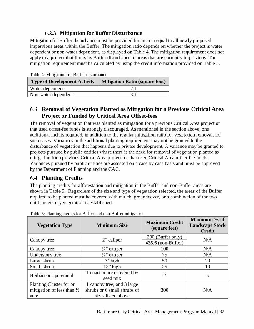
Baltimore City Critical Area Management Program Manual | 32
Mitigation for Buffer Disturbance
Mitigation for Buffer disturbance must be provided for an area equal to all newly proposed
impervious areas within the Buffer. The mitigation ratio depends on whether the project is water
dependent or non-water dependent, as displayed on Table 4. The mitigation requirement does not
apply to a project that limits its Buffer disturbance to areas that are currently impervious. The
mitigation requirement must be calculated by using the credit information provided on Table 5.
Table 4: Mitigation for Buffer disturbance
Type of Development Activity Mitigation Ratio (square foot)
Water dependent 2:1
Non-water dependent 3:1
Removal of Vegetation Planted as Mitigation for a Previous Critical Area
Project or Funded by Critical Area Offset-fees
The removal of vegetation that was planted as mitigation for a previous Critical Area project or
that used offset-fee funds is strongly discouraged. As mentioned in the section above, one
additional inch is required, in addition to the regular mitigation ratio for vegetation removal, for
such cases. Variances to the additional planting requirement may not be granted to the
disturbance of vegetation that happens due to private development. A variance may be granted to
projects pursued by public entities where there is the need for removal of vegetation planted as
mitigation for a previous Critical Area project, or that used Critical Area offset-fee funds.
Variances pursued by public entities are assessed on a case by case basis and must be approved
by the Department of Planning and the CAC.
Planting Credits
The planting credits for afforestation and mitigation in the Buffer and non-Buffer areas are
shown in Table 5. Regardless of the size and type of vegetation selected, the areas of the Buffer
required to be planted must be covered with mulch, groundcover, or a combination of the two
until understory vegetation is established.
Table 5: Planting credits for Buffer and non-Buffer mitigation
Vegetation Type Minimum Size Maximum Credit
(square feet)
Maximum % of
Landscape Stock
Credit
Canopy tree 2” caliper 200 (Buffer only)
N/A 435.6 (non-Buffer)
Canopy tree ¾” caliper 100 N/A
Understory tree ¾” caliper 75 N/A
Large shrub 3’ high 50 20
Small shrub 18” high 25 10
Herbaceous perennial 1 quart or area covered by
seed mix 2 5
Planting Cluster for or
mitigation of less than ½
acre
1 canopy tree; and 3 large
shrubs or 6 small shrubs of
sizes listed above
300 N/A

Baltimore City Critical Area Management Program Manual | 33
Planting Cluster for
mitigation of less than ½
acre
2 understory trees; and 3
large shrubs or 6 small
shrubs of sizes listed above
350 N/A
All stock shall be subject to a 2-year replacement warranty
Because of the harsh urban environment and lack of native seed sources, natural regeneration and smaller planting stock are not accepted in Baltimore City.
Planting Standards for Afforestation and Mitigation
Planting Approach
The composition and arrangement of required Buffer and Critical Area planting may depend on
the constraints and opportunities of the site and the proposed development project. Planting
requirements for the Buffer are greater than the planting standards to satisfy required
afforestation or mitigation of vegetation cleared outside the Buffer. Buffer planting requirements
are intended to improve the functions of the Buffer, including protecting water quality and
conserving and enhancing habitat.
In highly developed urban sites, the afforestation and mitigation requirements may be met
through traditional site landscaping rather than reforestation. Plantings provided to meet
mitigation requirements may also be used to satisfy the requirements of the Baltimore City
Landscape Manual, if the plantings proposed meet the conditions and standards required by the
Landscape Manual.
Preferred Species
To receive credit towards afforestation and mitigation planting requirements, species native to
the Maryland Coastal Plain region must be used.
The City of Baltimore Department of Planning maintains a list of native species acceptable for
meeting Critical Area planting requirements. The criteria for selection of this list are as follows:
● Predominately Coastal Plain native species;
● Ability to perform the desired dynamic function in the community as planted;
● Commercial availability;
● Anticipated survival and hardiness.
Only species listed in the Critical Area Native Plant List or those included in the U.S Fish &
Wildlife Service publication “Native Plants for Wildlife Habitat and Conservation Landscaping,
Chesapeake Bay Watershed” are acceptable for credit without special approval. Native species
not included in the above sources may receive credit with approval from the Department of
Planning and the CAC. The Department of Planning must approve and may choose to prescribe
the size and composition of any planting list.
Questions about species selection may be directed to the Critical Area Planner at the City of
Baltimore Department of Planning by calling (410) 396-PLAN.
Invasive Species
Invasive plant species may not be planted in the Critical Area, and where they exist the City
encourages removal of the species and replanting with native species. A list of invasive species

Baltimore City Critical Area Management Program Manual | 34
may be found in the guide “Plant Invaders of the Mid-Atlantic Natural Areas (2002 - National
Park Service and U.S. Fish and Wildlife Service). An additional helpful resource is the Maryland
Native Plant Society “Control of Invasive Non-Native Plants - A Guide for Gardeners and
Homeowners in the Mid-Atlantic Region”.
Native Grasses and Woody Shrub Seed Mixes
Sites that are to be reforested or otherwise not to be mown or disturbed shall be seeded with an
appropriate wildlife habitat mix, herbaceous mix, woody shrub mix, reclamation mix, or other
mix as approved by the Department of Planning. In locations where the Buffer is not
programmed with dedicated uses or activities, this planting regime can create a low maintenance
natural area.
For any native seed mix in the Critical Area, the criteria used for species selection will be:
● High germination rate;
● High wildlife value;
● Native species of the Coastal Plain;
● Ability to survive in dry, hot conditions and poor soils.
Field observations will be performed to determine the establishment success rate.
Traditional Grasses and Lawns
Traditionally maintained lawn or turf grass areas provide little to no habitat and may not be
credited towards mitigation requirements. New lawn areas are not permitted within the Buffer.
Afforestation and Mitigation Offset Fees
The Department of Planning may approve the payment of offset fees if the requirements cannot
be met onsite and no offsite mitigation opportunities are available. Further information on the
use and calculation of offset fees can be found under Section 8 – Offset Programs.
Process for Deferment of Mitigation Requirements
Under special circumstances, the Department of Planning in consultation with the CAC may
allow the deferment of the fulfilment of mitigation requirements; that being the afforestation,
vegetation removal or stormwater 10% Rule requirements. The applicant is required to submit a
written request to the Department of Planning that describes the special circumstance that could
qualify for mitigation deferment. Please note that monetary reasons are not a valid argument for
mitigation deferment and will not be entertained by the Department of Planning. The granting of
mitigation deferment is at the full discretion of the Department of Planning.
No occupancy permit shall be issued until the required afforestation or mitigation requirement
has been completed or until an Escrow Account, Non-revocable Letter of Credit, Performance
Bond or similar financial instrument has been established in the name of the Mayor and City
Council of Baltimore. Such account shall be for an amount equal to the total estimated cost of the
required planting, plus an additional forty percent for contingencies and project management fees
in the event the applicant fails to implement the plan.

Baltimore City Critical Area Management Program Manual | 35
Regarding timelines, the mitigation required from a project may be deferred up to 24 (twenty-
four) months after project completion. The deferment deadline for requirements that arise from
violations is 24 (twenty-four) months from project review by the Department of Planning, or the
review of actions performed without a permit within the Critical Area. The specific deadline for
mitigation fulfilment must be approved by the Department of Planning and must be listed along
additional terms and conditions for the action in a Memorandum of Understanding (MOU) that is
prepared by the Department of Planning. The MOU must be reviewed and approved by the
Baltimore City Department of Law, the Baltimore City Board of Estimates and the CAC.
Additionally, the applicant is required to provide a financial assurance in the form of a Letter of
Credit, Escrow Account, Performance Bond or similar instrument approved by the Department
of Planning and the Baltimore City Department of Law prior to the approval of the MOU. At a
minimum, the MOU must:
• Briefly describe the project or action,
• List the reason for the mitigation deferment,
• List the terms and conditions of the mitigation deferment,
• Contain an original copy of the financial assurance document,
• Establish when and how the financial instrument may be executed by the City of
Baltimore.

Baltimore City Critical Area Management Program Manual | 36
7 STORMWATER POLLUTANT REDUCTION IN THE
INTENSELLY DEVELOPED AREA
The 10% Rule
The criteria set forth in conjunction with the Critical Area Act require that any development
within the IDA be accompanied by practices to reduce water quality impacts associated with
stormwater runoff. The Criteria further specify that these practices must be capable of reducing
stormwater pollutant loads from a development site to a level at least 10% below the load
generated by the same site prior to development. This requirement is commonly referred to as the
“10% Rule.”
The concentration of phosphorus in stormwater runoff is the element used to characterize the
requirement for meeting the 10% Rule. Phosphorus reduction requirements shall be calculated
using the formulas provided by the Critical Area Commission. The pollution reduction
requirement should be met on-site. However, if onsite compliance is not feasible, the applicant
may mitigate offsite, and if an offsite project is not available, the applicant may be allowed to
pay an offset fee. See Section 8.4 - Stormwater Offset Program for more information about the
stormwater offset program.
Stormwater management plans shall comply with the Maryland Chesapeake and Atlantic Coastal
Bays Critical Area 10% Rule Guidance- Fall 2003 (the 10% Rule Guidance), and as
subsequently amended.
1. Redevelopment and new development proposals in the IDA shall demonstrate use of best
management practices for stormwater management that assure a 10% reduction of
predevelopment pollutant loadings. This demonstration shall be based on methodologies
agreed on by the County and the Critical Area Commission.
2. Plans that cannot demonstrate the required on-site reductions in predevelopment pollutant
loadings may be approved only if the plan demonstrates that mitigation measures,
including fees-in-lieu, or offsets will be provided to achieve equivalent water quality
benefits elsewhere in the same watershed. All such mitigation measures or offset plans
shall be consistent with methodologies agreed on by the City and the Critical Area
Commission.
Green Roofs
Green roofs qualify as stormwater best management practices in accordance with the Maryland
Stormwater Design Manual and may be counted as pervious surface in the determination of
stormwater management requirements. However, if a green roof is located on a new or expanded
structure within the Buffer, Buffer mitigation requirements will still apply for Buffer impacts
associated with the structure.
Additionally, vegetation planted on a roof may not be used to meet the afforestation or
vegetation removal mitigation requirements within the Critical Area.

Baltimore City Critical Area Management Program Manual | 37
8 OFFSET PROGRAMS
Background
Baltimore City’s Critical Area review process may be triggered by projects whose location and
circumstances do not allow for on-site mitigation and fulfillment of Critical Area requirements.
The second preferred option is to perform the mitigation at an off-site location. To allow
necessary development and redevelopment to proceed while meeting the Critical Area
requirements when no off-site mitigation options are available, the City of Baltimore has
established two fee-in-lieu offset programs:
● The Buffer Mitigation and Afforestation Offset Program, and
● The Stormwater Pollution Reduction Offset Program.
Before an applicant is permitted to pay an offset fee, the City requires the applicant to review the
many methodologies available for reducing environmental impacts. Alternative strategies for
water quality and habitat enhancement must be incorporated into the applicant’s project to
comply with the current Maryland Stormwater Design Manual and the 10% Rule.
A project may qualify for an offset if the Director of Planning determines that it is infeasible for
the applicant to meet all or part of the Critical Area Buffer, afforestation, and/or stormwater
pollution reduction requirement on the development site or through an offsite mitigation project.
Critical Area Buffer and Afforestation Offset Program
Applicants who are unable to comply with the Buffer mitigation and afforestation requirements
are obligated to contribute a fee to the Critical Area Buffer and Afforestation Offset-fee Fund.
These options are a last resort and fees are only accepted if the applicant can prove compliance is
not feasible onsite, and no suitable offsite projects are available. The fee amount will be based
on costs associated with installing and maintaining the quantity and type of landscaping required
to satisfy the project’s afforestation and/or Buffer mitigation requirements. Buffer disturbance
costs are determined based on planting credits, where 200 square feet of credit is attributed to
one 2-inch caliper tree. Each 2-inch caliper tree is valued according to the Baltimore City
Landscape Manual, which reflects the current cost to install and maintain landscaping equivalent
to the afforestation requirement not able to be met on site. The cost per 2-inch caliper tree may
be amended periodically with approval from both the Baltimore City Planning Commission and
the CAC. This cost is set in the Baltimore City Landscape Manual, and may be revised and
readjusted at any time.
Alternative offset projects may be considered, provided that the applicant is able to demonstrate
to the City that the proposed alternative will result in an environmental benefit to the City’s
Critical Area equivalent to the installation of the prescribed vegetation on the development site.
The project owner is required to maintain the plantings installed on an offsite location for a
minimum of two (2) years. The City may seek comments and recommendations from the CAC.
Receiving Areas for Buffer Offset Projects
The City can designate sites throughout its Critical Area as receiving areas for the Buffer offsets
described above. In selecting sites for receiving areas, the City will give priority to lands

Baltimore City Critical Area Management Program Manual | 38
covered with impervious surface or lots containing compacted soils. The City encourages
landowners within its Critical Area to allow Buffer offset projects to be installed on private
property in exchange for the granting of conservation easements. Participating landowners may
be granted a credit toward Buffer mitigation requirements in the event that future development
takes place in portions of the Buffer that remain without vegetation. The City may also explore
additional incentives, and will assess the recommendations and requests on a case by case
manner, to encourage the use of private lands as receiving areas for Buffer offsets
If suitable private land is not available, City-owned land within the Resource Conservation Area
may be used for this purpose. The focus in these areas will be to enhance existing vegetation and
habitat.
Minimum requirements for qualifications as potential receiving areas include the following:
● The site is determined by the City as being unlikely to be redeveloped for a water-
dependent use; and,
● The planting plan includes at least 50 linear feet along the shoreline for the entire width
of the Buffer. Planting may extend outside the Buffer provided it is contiguous to the
vegetated portion of the Buffer and is no less than 25 feet in width and depth.
Stormwater Offset Program
Projects that are unable to comply with the runoff pollution reduction requirements as described
in Section 7 are required to contribute a fee to the Stormwater Offset Fund before building, use,
and occupancy permits may be issued for the property. A project may qualify for an offset when
it is determined that it is infeasible for the project to meet all or part of the 10% pollution
reduction requirement on site or through offsite mitigation.
Any subsequent redevelopment of a site already assessed an offset fee for either the 10% Rule
requirement or the Buffer disturbance requirement triggers additional Critical Area review. This
applies if the further redevelopment is determined to be significant or would result in any change
to on-site mitigation required for prior development or use. Such additional redevelopment may
require modification of the permit or denial of the permit application. In some cases, additional
mitigation may be required if the redevelopment increases impervious surfaces or displaces
vegetation originally approved as part of a Critical Area determination.
Assessing the Fee for a Stormwater Offset
The amount of the fee is based on the costs that a project would incur for installation and
maintenance of a stormwater pollution reduction facility on-site. Methodologies for computing
existing and proposed pollutant loading and the effectiveness of stormwater management
facilities in fulfilling the pollution removal goals are specified in the Maryland Stormwater
Management Design Manual. The fee is $45,000 per pound of phosphorous per year, or as
amended.

Baltimore City Critical Area Management Program Manual | 39
9 DESIGNATED HABITAT PROTECTION AREAS
The Critical Area regulations require local jurisdictions to identify important natural and
community resources within the Critical Area and to devise strategies for protecting and
enhancing those resources. Twelve important natural areas within Baltimore have been
identified as DHPA. Locations, maps, and types of habitats existing for each of the DHPAs are
provided in this section.
Legend for Habitat Protection Area Maps
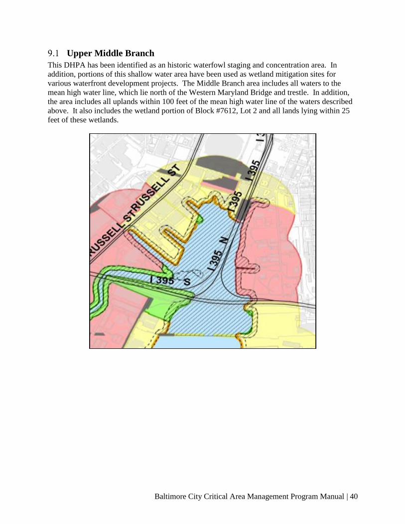
Baltimore City Critical Area Management Program Manual | 40
Upper Middle Branch
This DHPA has been identified as an historic waterfowl staging and concentration area. In
addition, portions of this shallow water area have been used as wetland mitigation sites for
various waterfront development projects. The Middle Branch area includes all waters to the
mean high water line, which lie north of the Western Maryland Bridge and trestle. In addition,
the area includes all uplands within 100 feet of the mean high water line of the waters described
above. It also includes the wetland portion of Block #7612, Lot 2 and all lands lying within 25
feet of these wetlands.

Baltimore City Critical Area Management Program Manual | 41
Gywnns Falls
This DHPA has been identified as a major greenway, needing protection as a wildlife corridor.
This corridor connects the upland forests of the upper Gwynns Falls Watershed with the
wetlands and tidal waters of the upper Middle Branch. The area includes the waters of the
Gwynns Falls from the upper Middle Branch continuing upstream to a point 1000 feet north and
west of the southeast side of the Washington Boulevard Bridge. In addition, the area includes all
lands within 100-feet of waters of the Gwynns Falls on the south side of the stream from the
upper Middle Branch to the boundary of the Critical Area. On the north side of the stream, the
area includes all lands within 100-feet of the waters of the Gwynns Falls extending from the
upper Middle Branch to the point of intersection with the Russell Street bridge and then expands
to various widths to be bounded on the north by the B & O Railroad right-of-way and continues
along the I-95 right-of-way to the point where the I-95 right-of-way intersects Washington
Boulevard. From this point, the area includes all lands within 100-feet from the waters of the
Gwynns Falls on the north side of the stream continuing upstream to the boundary of the Critical
Area. This area also includes the streambeds and all lands lying within 100-feet of the
streambeds of the two tributary streams which intersect the Gwynns Falls on its south side. The
first is located between Bremen and Berlin Streets and continues from the main stem of the
Gwynns Falls southward to the Critical Area boundary and the second is located along the B &
O Railroad right-of-way and also continues approximately 580 feet from the main stem of the
Gwynns Falls.
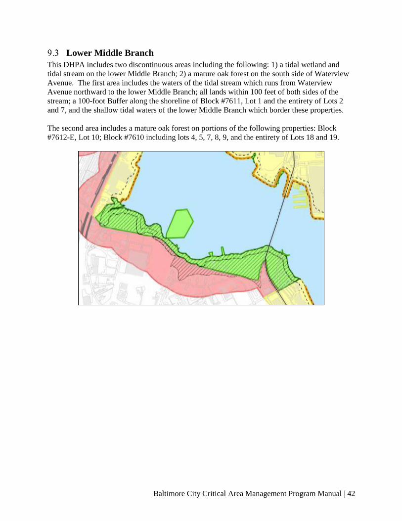
Baltimore City Critical Area Management Program Manual | 42
Lower Middle Branch
This DHPA includes two discontinuous areas including the following: 1) a tidal wetland and
tidal stream on the lower Middle Branch; 2) a mature oak forest on the south side of Waterview
Avenue. The first area includes the waters of the tidal stream which runs from Waterview
Avenue northward to the lower Middle Branch; all lands within 100 feet of both sides of the
stream; a 100-foot Buffer along the shoreline of Block #7611, Lot 1 and the entirety of Lots 2
and 7, and the shallow tidal waters of the lower Middle Branch which border these properties.
The second area includes a mature oak forest on portions of the following properties: Block
#7612-E, Lot 10; Block #7610 including lots 4, 5, 7, 8, 9, and the entirety of Lots 18 and 19.

Baltimore City Critical Area Management Program Manual | 43
Reedbird
This DHPA includes three discontinuous areas including the following: 1) tidal wetlands and
City-owned open spaces along both banks of the Patapsco River; 2) a streambed flowing under
the 500 block of West Patapsco Avenue; and 3) a streambed west of the intersection of Garrett
and Potee Streets. The first area encompasses the following: the waters of the Patapsco river;
tidal wetlands, Critical Area Buffer and portions of the publicly-owned vegetated open space in
Block #7612-L including Lots 1 and that portion of Lot 2 which lies south of an imaginary line
that would be created where Cherryland Road extended at its present alignment through Lot 2 to
the Patapsco River; those portions of Block #7612-N, Lots 7, 8, and 10 which lie in the 100 foot
Buffer; all lands extending from the south bank of the Patapsco River to the right-of-way of the
Baltimore Harbor Tunnel Thruway and continuing from the City line to the point where the
Harbor Tunnel Thruway intersects Potee Street; the entirety of Block #7612-M; and that portion
of Block #7027, Lot 20 that is bounded by S. Hanover Street, Potee Street, and Frankfurst
Avenue. The second area includes 100 feet on either side of a stream flowing towards Baltimore
County, located in Block #7612-G, Lots 1 and 4. The third area includes 100 feet on either side
of a stream flowing northwesterly towards the Patapsco River starting from a point located 475
feet from the intersection of Potee and Garrett Streets, and 100 feet on either side of a small inlet
tributary on the western side of the same stream, both of which are located in Block #7027-C,
portions of Lots 3 and 4.

Baltimore City Critical Area Management Program Manual | 44
Masonville Cove
This DHPA has been identified as a historic waterfowl staging and concentration area with an
extensive vegetated Buffer. The area includes all waters to the mean high water line which lie
within the cove formed by the irregular shoreline of Block #7043, Lot 1 and all lands within 100
feet of the mean high water line. In addition, the area includes a 100-foot Buffer on both sides of
the tributary stream that empties into this cove at the south end of the property. This 100-foot
Buffer extends from the Critical Area line northward to the point where it intersects the Critical
Area Buffer formed by the tidal waters of the Patapsco River.
It is important to note that the Maryland Port Administration (MPA) maintains and operates a
dredge disposal site on the upland area immediately east of these waters. In addition, the MPA
has for at least a decade now, identified this area for development as a major terminal similar to
their Dundalk and Seagirt facilities. Part of the site has been developed by Mercedes Benz as an
automobile Roll On / Roll Off. As mitigation for the dredge disposal site and the port
development, the MPA is developing the Masonville Cove as wildlife habitat area with an
environmental education center, a fishing pier and small boat launch.
In response to the complex balance that must be achieved between economic development for
the benefit of the State and protection of habitat, the Maryland Department of Transportation
(MDOT) in cooperation with the Department of Natural Resources (DNR) has developed a
comprehensive plan to address future expansion areas for the Port. An important part of this
master plan is an environmental element for the improvement in quality and/or quantity of
habitat areas in a manner consistent with the policies established in COMAR 27.01.09.04(B).
The plan is part of MPA’s plans for marine terminal facilities and dredged disposal.
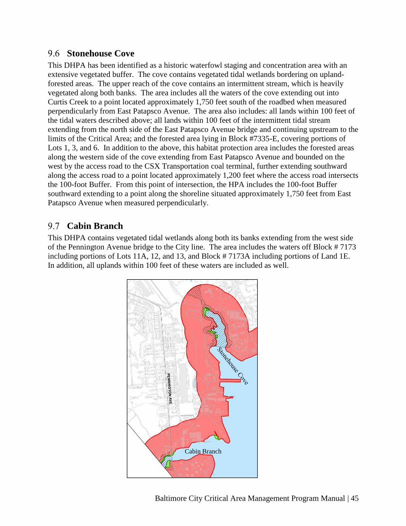
Baltimore City Critical Area Management Program Manual | 45
Stonehouse Cove
This DHPA has been identified as a historic waterfowl staging and concentration area with an
extensive vegetated buffer. The cove contains vegetated tidal wetlands bordering on upland-
forested areas. The upper reach of the cove contains an intermittent stream, which is heavily
vegetated along both banks. The area includes all the waters of the cove extending out into
Curtis Creek to a point located approximately 1,750 feet south of the roadbed when measured
perpendicularly from East Patapsco Avenue. The area also includes: all lands within 100 feet of
the tidal waters described above; all lands within 100 feet of the intermittent tidal stream
extending from the north side of the East Patapsco Avenue bridge and continuing upstream to the
limits of the Critical Area; and the forested area lying in Block #7335-E, covering portions of
Lots 1, 3, and 6. In addition to the above, this habitat protection area includes the forested areas
along the western side of the cove extending from East Patapsco Avenue and bounded on the
west by the access road to the CSX Transportation coal terminal, further extending southward
along the access road to a point located approximately 1,200 feet where the access road intersects
the 100-foot Buffer. From this point of intersection, the HPA includes the 100-foot Buffer
southward extending to a point along the shoreline situated approximately 1,750 feet from East
Patapsco Avenue when measured perpendicularly.
Cabin Branch
This DHPA contains vegetated tidal wetlands along both its banks extending from the west side
of the Pennington Avenue bridge to the City line. The area includes the waters off Block # 7173
including portions of Lots 11A, 12, and 13, and Block # 7173A including portions of Land 1E.
In addition, all uplands within 100 feet of these waters are included as well.
Cabin Branch

Baltimore City Critical Area Management Program Manual | 46
Hawkins Point
This area on the Hawkins Point peninsula contains a historic waterfowl staging and
concentration area and a densely vegetated Buffer. The DHPA includes the tidal waters off
Block #7000, Lots 1, 7, 8, and 9, including I-695 right-of-way. The area also includes a 100-foot
Buffer along the shoreline of these properties. In addition, the area includes the protection of
woodlands adjoining the drainage areas located on Block #7000, Lots 7, 8, and 9.
Quarantine Road
This designated area contains a historic waterfowl staging and concentration area. The DHPA
includes the waters off the vegetated portion of the shoreline of Block #7003, Lot 4 and a 100-
foot Buffer along this same section of shoreline. The area also includes the wooded drainage
area along the eastern side of the property and the forested portions of Block #7005, Lots 30 and
31 and Block #7002, Lot 3 which fall within the Critical Area.
Thomas Cove
The third designated area on the Hawkins Point Peninsula is Thomas Cove, also known as
Thoms Cove. The cove has been identified as a historic waterfowl staging and concentration
area. This DHPA includes the waters off the shoreline of Block #7005 Lot 35 as well as the 100-
foot Buffer along the shoreline.
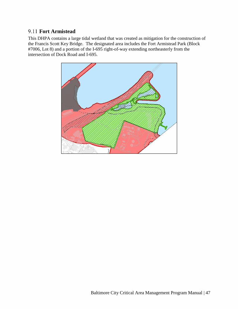
Baltimore City Critical Area Management Program Manual | 47
Fort Armistead
This DHPA contains a large tidal wetland that was created as mitigation for the construction of
the Francis Scott Key Bridge. The designated area includes the Fort Armistead Park (Block
#7006, Lot 8) and a portion of the I-695 right-of-way extending northeasterly from the
intersection of Dock Road and I-695.
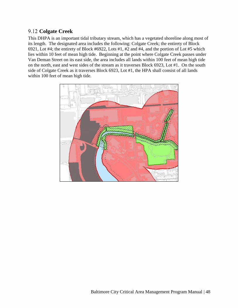
Baltimore City Critical Area Management Program Manual | 48
Colgate Creek
This DHPA is an important tidal tributary stream, which has a vegetated shoreline along most of
its length. The designated area includes the following: Colgate Creek; the entirety of Block
6921, Lot #4; the entirety of Block #6922, Lots #1, #2 and #4, and the portion of Lot #5 which
lies within 10 feet of mean high tide. Beginning at the point where Colgate Creek passes under
Van Deman Street on its east side, the area includes all lands within 100 feet of mean high tide
on the north, east and west sides of the stream as it traverses Block 6923, Lot #1. On the south
side of Colgate Creek as it traverses Block 6923, Lot #1, the HPA shall consist of all lands
within 100 feet of mean high tide.

Baltimore City Critical Area Management Program Manual | 49
10 ADDITIONAL INFORMATION ABOUT THE CAMP
Stormwater Offset Program Criteria for Small Sites and Derelict
Buildings
Critical Area compliance costs for reducing the stormwater pollution by 10% on small lots can
be significant and out of proportion to the cost of the overall development and construction
process. Construction on existing structures on residential lots less than 1,500 square feet and
commercial lots less than 2,000 square feet can activate Critical Area requirements based upon
the 50 percent assessment criteria used to define “significant” development. In these cases, the
engineering fees can cost more than the mitigation or the offset fees, therefore, the following
special provision will apply to these projects:
Small Residential Projects
Development activities on existing structures for residential use outside the 100-foot Buffer on
sites less than 1,500 square feet are not required to pay offset fees, even if the project activates
the 50 percent assessment criteria. This does not apply to new subdivisions or new construction.
Small Non-Residential Projects
Development activities on existing structures in Residential, Office-Residential and Business
zoning districts for commercial use outside of the 100-foot Buffer on sites less than 2,000 square
feet are not subject to Critical Area requirements, even if the project meets or exceeds the 50
percent assessment criteria. This does not apply to new subdivisions or new construction.
Mitigation for Public Uses
The City of Baltimore maintains a policy of requiring development projects in the Waterfront
Revitalization Area to include the construction and maintenance of a public pedestrian
promenade or hiking biking facilities along the Inner Harbor, the Middle Branch and other
waterfront areas. Cultural and educational facilities may also require paved areas to
accommodate public traffic. The portions of these public areas dedicated to public access
easements, approved by the Board of Estimates, may be excluded from Buffer disturbance and
afforestation requirements. However, they are not exempt from the 10% Rule requirements.
Growth Allocation
The use of growth allocation in the City is prohibited.
Marina Requirements
Water Quality Best Management Practices
For the development of new marinas and the expansion or alteration of existing marinas,
developers and operators are required to comply with environmental best management practices
or provide offsets to prevent adverse effects on water quality.
Marina developers and operators are required to meet sanitary requirements by installing,
maintaining, and operating year-round, sanitary pump-out facilities, or through payment into an
offset fund. Such facilities must be constructed in conformity with the provisions of COMAR
26.22.01.01.

Baltimore City Critical Area Management Program Manual | 50
For marinas with boatlift facilities, marina developers and operators are required to install,
maintain, and operate devices for the interception of boat-bottom wash-waters whenever a
marina offers pullout, lifts, or bottom-cleaning facilities or services. The discharge of any boat-
bottom wash-waters into the harbor will be allowed only in the event that the operator has
obtained a valid National Pollution Discharge Elimination System (NPDES) permit, if one is
required, and provided that all such waters are properly treated prior to discharge.
Maritime Master Plan Compliance
All marinas must comply with the City of Baltimore's Maritime Master Plan.
Lot Consolidation and Reconfiguration
The provisions of this regulation shall apply to the consolidation or reconfiguration of lots that
are non-conforming to Critical Area requirements, and are further detailed under COMAR
27.01.02.08.
Any legal parcel of land, not being part of a recorded or approved subdivision, that was recorded
as of December 1, 1985;
Land that was subdivided into recorded, legally buildable lots, if the subdivision received the
local jurisdiction's final approval before June 1, 1984; and,
Land that was subdivided into recorded, legally buildable lots, if the subdivision received the
local jurisdiction's final approval after December 1, 1985, but not later than the date of the
jurisdiction's program approval.
Local Agency Actions within the Critical Area
Development in the Critical Area resulting from actions of local agencies shall be in accordance
with the provisions COMAR 27.02. Projects proposed by local agencies require Consistency
Reports that are prepared by the Department of Planning and submitted to the CAC; however,
exceptions apply. Full review by the CAC may be required.
Criteria for Grandfathering and Non-Conforming Uses
Grandfathering
The City shall permit the continuation, but not necessarily the intensification or expansion, of
any use in existence on January 4, 1988, unless the use has been abandoned for more than one
year, or is otherwise restricted by existing local ordinances. If any existing use does not conform
to the provisions of the program, its intensification or expansion may be permitted only in
accordance with the variance procedures outlined in the Baltimore City Zoning Code and
COMAR 27.01.02.07.
In addition, all buildings and development existing in the Buffer prior to January 4, 1988 are not
subject to Buffer mitigation requirements, as long as the development activity is within the
existing building or footprint and does not involve ground disturbance. This holds true if the
development activity meets or exceeds 50 percent of the assessed full base cash value of the
Baltimore City Critical Area Management Program Manual | 51
property. Expansion beyond the existing building or footprint must be addressed with the
regulations listed in this Manual, and Buffer mitigation requirements apply to the entire
developed footprint, existing and proposed.
The City shall permit a single-lot or parcel of land that was legally on record at the date of
program approval to be developed with a single-family dwelling, if a dwelling is not already in
place, provided that:
● It is on land where development activity has progressed to the point of the pouring of the
foundation footings or the installation of structural members;
● It is a legal parcel of land, not being part of a recorded or approved subdivision, that was
recorded as of December 1, 1985, and land that was subdivided into recorded, legally
buildable lots, where the subdivision received the City’s final approval prior to June 1,
1984, if:
o At the time of development, the land is brought into conformance with the Critical
Area program insofar as possible, including the consolidation or configuration of
lots not individually owned or the procedures are approved by the CAC; or
o The land has received a building permit subsequent to December 1, 1985, but
prior to the local program approval.
● It is on land that was subdivided into recorded, legally, buildable lots, where the
subdivision received the City’s final approval between June 1, 1984 and December 1,
1985; and,
● It is on land that was subdivided into recorded, legally buildable lots, where the
subdivision received the final approval after December 1, 1985, and provided that either
development of any such land conforms to the IDA or RCA requirements in this CAMP
or the area of the land is counted by the City against the growth allocation permitted
through the City’s CAMP.
No portion of this this section may be interpreted as altering any requirements for development
activities set out in the water-dependent facilities section or the habitat protection section of this
manual.
Criteria for Brownfield Sites
The US Environmental Protection Agency (EPA) defines Brownfields as, “A brownfield is a
property, the expansion, redevelopment, or reuse of which may be complicated by the presence
or potential presence of a hazardous substance, pollutant, or contaminant.”
There are many Brownfields located within Baltimore’s Critical Area, and because the City
wishes to encourage clean-up actions. As explained below, special provisions apply to these
sites.
To be considered a Brownfield, a site must be eligible for and participating in the MDE
Brownfield Voluntary Cleanup Program (BVCP). Listed below are criteria for development of
these sites:
● If a paved/capped area is required as part of the Brownfields mitigation, that
paving/capping is temporarily exempt from Critical Area fees;
● The Brownfields property will remain exempt and payments deferred until a portion of
the site is re-used, requiring a new occupancy permit or building permit. The property
Baltimore City Critical Area Management Program Manual | 52
owner will be required to provide a letter to the Planning Department explaining that they
understand this deferment and will convey this requirement to prospective buyers or
tenants of the property;
● When the building or occupancy permit application process is started, the entire site will
have to comply with Critical Area regulations;
● At the time the use and occupancy permit is requested the stormwater quality standards
must have been met.
Baltimore City Critical Area Management Program Manual | 53
11 IMPLEMENTATION OF THE CAMP
Local Adoption of the CAMP
The City’s CAMP was originally enacted into law by City Council Resolution Number 107 and
companion Ordinances Numbers 1130, 1131, and 1132, effective January 4, 1988. As of that
date, all development activity, which requires any public action and constitutes significant
development as defined herein is subject to any and all applicable CAMP requirements specified
in the Baltimore City Code and this CAMP document. Subsequent to its adoption, the City’s
CAMP was amended by Ordinance Number 356, effective June 22, 1994, and approved by the
Chesapeake Bay CAC on November 2, 1994. This CAMP document was further modified by
Ordinance Number 517, effective March 21, 1995, and approved by the Chesapeake Bay CAC
on May 3, 1995. Development projects for which Critical Area findings were made prior to
January 4, 1988, are also subject to CAMP requirements in the event that such projects require
additional public actions after the effective date of the City’s CAMP.
Baltimore’s CAMP was reviewed in 2002, and was repealed and re-ordained by Ordinance 02-
350, effective June 13, 2002 and approved by the Chesapeake Bay CAC on November 13, 2002.
The terms and conditions contained herein reflect the most current amendments to the CAMP.
Critical Area Review Process
Submissions & Reviews
All development and redevelopment projects located within the Critical Area must comply with
CAMP manual requirements. Review of all site plans and proposals within the City’s Critical
Area is the responsibility of Baltimore City Department of Planning. The Baltimore City
Department of Planning determines if a development proposal meets local Critical Area
requirements for “significant” development and has the authority to approve or deny permit
applications. If a project is deemed significant, the following is the minimum that will be
requested:
● Existing conditions plan.
● Proposed site plan.
● Mitigation/landscaping plan with planting details, spacing, and species.
● The stormwater management plan approved by Baltimore DPW.
● CAMP Program Certification and Landscape Maintenance Agreement signed and
included as part of the mitigation plan or landscape plan package, if required.
● Buffer Management Plan, if one is required.
● Forest Stand Delineation (FSD), if one is required.
● ESD 10% Rule spreadsheet (found on the Critical Area Commission’s website).
● Habitat Assessment if any encroachment in a Designated Habitat Protection Area is
proposed.
● Critical Area Project Information Form (available at the Baltimore Office of
Sustainability website).
● Any additional information deemed necessary by the Director of Planning.

Baltimore City Critical Area Management Program Manual | 54
The appropriate documents are sent electronically to the CAC by the Department of Planning for
further review and for verification that the proposed development is compliant with Baltimore
City’s CAMP, as required by the Critical Area Act.
For projects requiring technical water quality review, Planning staff may request the applicant to
submit the ESD 10% Rule calculations to DPW for a technical water quality review. Please note
that DPW charges a fee for such reviews, and the applicant is fully responsible for its payment.
As part of the review, DPW assesses the applicant’s runoff pollution reduction requirements and
the proposed BMPs for the project.
It is important to note that when a project is required by DPW to develop a Stormwater
Management Plan, the plan must have, at a minimum, environmental site design (ESD) approval
by the Agency prior to its submission to the CAC. The requirement is necessary because in the
event that DPW requests any modifications to the BMPs utilized to achieve stormwater
management compliance, after the permit application has been submitted to the CAC, the ESD
10% Rule information submitted as part of the Critical Area package must also be modified, and
post-submittal changes are strongly discouraged.
Such approval helps streamline processes whenever the ESD 10% Rule information, submitted
as part of the Critical Area Package, must be modified in the following conditions:
• DPW requests any modifications to the BMPs utilized to achieve stormwater
management compliance, and
• DPW does so after the permit application has been submitted to the CAC.
The requirement is necessary to diminish the chances of post-submittal changes, which the CAC
strongly discourages.
Additionally, all applicants are required to meet all applicable Building Codes and other Code
requirements before a building permit may be issued.
Inter-Agency Coordination
The Department of Planning has established notification and review procedures to insure timely
and maximum communication among City agencies involved in permit approval processes. To
the extent possible, these procedures utilize existing plans and permits review mechanisms.
Inter-agency coordination is currently built into these review processes, which allows Federal,
State and Local agencies the opportunity to review Critical Area compliance as well.
Key agencies reviewing all significant development projects in the Critical Area include the:
• Department of Planning
• Department of Public Works
• Department of Housing and Community Development.
The City Health and Fire Departments review development projects that involve the generation,
storage or use of hazardous, toxic or nutrient materials. The City Law Department is consulted
as necessary.
Baltimore City Critical Area Management Program Manual | 55
Building and Occupancy Permits and Inspections
An applicant may not be issued an occupancy permit or certificate of completion unless or until
the City has certified that the on-site vegetation and/or runoff pollution reduction BMPs have
been installed in a satisfactory manner. Once the applicant has demonstrated that all on-site
requirements have been completed, the Department of Planning may inspect the property to
certify that Critical Area requirements have been satisfied.
In cases where the Director of Planning determines that Critical Area requirements may be
satisfied off-site through one or both of the offset programs, an occupancy permit or certificate of
completion for the property may not be issued until and unless the applicant has fully complied
with offset agreements. The Department of Planning determines compliance with offset
agreements.
Variances
Applicability
The City of Baltimore has established provisions where, owing to special features of a site or
other circumstances, implementation of this Manual or a literal enforcement of provisions within
this Manual would result in unwarranted hardship to an applicant; a Critical Area variance may
be obtained.
1) In considering an application for a variance, the City of Baltimore shall presume that the
specific development activity in the Critical Area, that is subject to the application and
for which a variance is required, does not conform with the general purpose and intent of
Natural Resources Article, Title 8 Subtitle 18, COMAR Title 27, and the requirements of
this Manual.
2) Unwarranted hardship means that without a variance, an applicant would be denied
reasonable and significant use of the entire parcel or lot for which the variance is
requested.
Standards for Granting a Variance
Standards for the variance are per the Zoning Code Article 32 Title 5-308.
Standing
The provisions for granting such a variance shall include evidence submitted by the applicant
that the following standards are met:
1) Due to special features of the site or special conditions or circumstances peculiar to the
land or structure involved, a literal enforcement of provisions and requirements of this
Critical Area Manual would result in unwarranted hardship;
2) A literal interpretation of the provisions of this Manual will deprive the applicant the use
of land or a structure permitted to others in accordance with the provisions of this Critical
Area Manual;
Baltimore City Critical Area Management Program Manual | 56
3) The granting of a variance will not confer upon an applicant any special privilege that
would be denied by this Critical Area Manual to other lands or structures within the
Critical Area;
4) The variance request is not based upon conditions or circumstances which are the result
of actions by the applicant, including the commencement of development activity before
an application for a variance has been filed;
5) The request does not arise from any condition relating to land or building use, either
permitted or non-conforming on any neighboring property; and
6) The granting of a variance shall not adversely affect water quality or adversely impact
fish, wildlife or plant habitat within the Critical Area; and
7) The granting of the variance will be in harmony with the general spirit and intent of the
State Critical Area Law and this Critical Area Manual.
Process
Applications for a variance will be made in writing to the BMZA with a copy provided to the
Department of Planning and the Critical Area Commission. The City of Baltimore shall follow
its established procedures for advertising and notification of affected landowners. Variance
guidelines are per the Zoning Code Article 32 Subtitle 3 – Variances.
1) After hearing an application for a Critical Area Program variance, the BMZA shall make
written findings reflecting analysis of each standard. With due regard for the person’s
technical competence, and specialized knowledge, the written findings may be based on
evidence introduced and testimony presented by:
a. The applicant;
b. The City of Baltimore or any other government agency; or
c. Any other person deemed appropriate by the City of Baltimore.
2) If the variance request is based on conditions or circumstances that are the result of
actions by the applicant, the City of Baltimore shall consider that fact, and whether the
application has met the requirements of Part E below.
3) The applicant has the burden of proof and the burden of persuasion to overcome the
presumption of nonconformance established in paragraph (A) above.
4) Within 10 working days after issuance of a written variance decision, the City of
Baltimore shall notify the Critical Area Commission of its findings and decision to grant
or deny the variance request.
After-the-Fact Requests

Baltimore City Critical Area Management Program Manual | 57
1) A local jurisdiction may not accept an application of a variance to legalize a violation of
this subtitle, including an unpermitted structure or other development activity until the
local jurisdiction:
a. Issues a notice of violation; and
b. Assesses an administrative or civil penalty for the violation.
2) The City of Baltimore may not approve an after-the-fact variance unless an applicant has:
a. Fully paid all administrative, civil and criminal penalties imposed under Natural
Resources Article, §8-1808(c)(l)(iii)14-15 and (2)(i), Annotated Code of
Maryland;
b. Prepared a restoration or mitigation plan, approved by the local jurisdiction, to
abate impacts to water quality or natural resources as a result of the violation; and
c. Performed the abatement measures in the approved plan in accordance with the
local Critical Area Program.
3) If the Board denies the requested after-the-fact variance, then the City of Baltimore shall:
a. Order removal or relocation of any structure; and
b. Order restoration of the affected resources.
Appeals
Appeals from decision concerning the granting or denial of a variance under these regulations
shall be taken in accordance with all applicable laws and procedures of the City of Baltimore for
variances. Variance decisions by the BMZA may be appealed to the Circuit Court in accordance
with the Maryland Rules of Procedure. Appeals may be taken by any person, firm, corporation or
governmental agency aggrieved or adversely affected by any decision made under this Manual.
Such appeals will be made as follows:
1) Zoning appeals shall be filed with the Baltimore Zoning Administrator and forwarded to
the BMZA for a hearing, in accordance with Baltimore City Zoning Code;
2) Stormwater Management appeals shall be filed with the Director of the DPW,
3) Building Permit and Occupancy Permit appeals shall be filed with the Commissioner of
the Department of Housing and Community Development, in accordance with the
Baltimore City Building Code.
4) Baltimore City Charter (2018), Department of Planning, § 70-80: Other appeals from
determinations by the Director of the Department of Planning regarding the CAMP
provisions shall be made to the Planning Commission pursuant to Baltimore City
Building Code Article 00.
Additional Appeals
Further appeals from any decision rendered by the hearing officers or bodies specified above
may be taken to the Circuit Court for the City of Baltimore, as follows:
Baltimore City Critical Area Management Program Manual | 58
1) BMZA: Judicial Review proceeds in accordance with City Charter Article VII and
Baltimore City Zoning Code Article 32.
2) Planning Commission proceeds in accordance with Article VII, Section 79 (City Charter,
1995).
Conditions and Mitigation
The BMZA shall impose conditions on the use or development of a property which is granted a
variance as it may find reasonable to ensure that the spirit and intent of this Manual is maintained
including, but not limited to the following:
1) Adverse impacts resulting from the granting of the variance shall be mitigated as
recommended by the Department of Planning, but not less than by planting on the site per
square foot of the variance granted at no less than a 3:1 basis.
2) New or expanded structures or lot coverage shall be located the greatest possible distance
from mean high water, the landward edge of tidal wetlands, tributary streams, nontidal
wetlands, or steep slopes.
Commission Notification
Within 10 working days after a written decision regarding a variance application is issued, a
copy of the decision will be sent to the Critical Area Commission. The City of Baltimore may
not issue a permit for the activity that was the subject of the application until the applicable 30-
day appeal period has elapsed.
Enforcement
Violation of the provisions of this CAMP document shall be dealt with in the manner provided
for in the applicable Critical Area provisions of the Baltimore City Code. Penalty citations are as
follows:
● Stormwater management violations: Baltimore City Natural Resources Code Article 7,
Division II;
● Zoning violations: Baltimore City Zoning Code Article 32, Title 19;
● Building Code violations: Baltimore City Building Code, Article 00.
Civil and Criminal Penalties
In addition to other penalties applicable under State or City law, including the ones required by
any other City agencies, each person who violates a provision of Baltimore City Natural
Resources Code , or the City’s CAMP ordinance or related regulations; including a contractor,
property owner, or any other person who committed, assisted, authorized, or participated in the
violation; is subject to a fine not to exceed $25,000. A “property owner” includes two or more
persons holding title to the property under any form of joint ownership. Due process principles
apply and shall include proper notice to the violator, and an opportunity of justification of
actions. The following apply to civil and criminal penalties:

Baltimore City Critical Area Management Program Manual | 59
● Each violation of a regulation, rule, order, program, or other requirement constitutes a
separate offense;
● Each calendar day that a violation continues constitutes a separate offense;
● For each offense, a person shall be subject to separate fines, orders, sanctions, and other
penalties;
● Civil penalties for continuing violations will accrue without a requirement for an
additional assessment, notice, or opportunity for hearing for each separate offense; and,
● On consideration of all the factors included under the Natural Resources Code and any
other factors within Baltimore’s CAMP, the City will impose the amount of the penalty.
Satisfaction of all requirements represents a pre-condition to the issuance of any permit,
approval, variance, or special exception for the affected property. Unless an extension of
time is appropriate due to adverse planting conditions, any additional mitigation required
as a condition of approval for the permit, approval, variance, or special exception shall be
completed within 90 days of the issuance of a permit, approval, variance, or special
exception for the affected property
In determining the amount of the penalty to be assessed, the City may consider the following:
● The gravity of the violation;
● Any willfulness or negligence involved in the violation;
● The environmental impact of the violation; and,
● The cost of restoration of the resource affected by the violation and mitigation for
damage to that resource, including the cost to the State and Baltimore City for
performing, supervising, or rendering assistance to the restoration and mitigation.
Baltimore City shall not issue a permit, approval, variance, or special exception unless the person
seeking the permit approval, variance, or special exception has:
● Fully paid all administrative, civil, and criminal penalties imposed under paragraph of
this subsection;
● Prepared a restoration or mitigation plan, approved by the Baltimore City Director of
Planning to abate impacts to water quality or natural resources as a result of the violation;
and,
● Performed the abatement measures in the approved plan in accordance with Baltimore’s
CAMP.
Restoration
Any development, redevelopment, construction or excavation undertaken in violation of any
provision of this CAMP document must promptly be corrected after written notice from the
Director of Planning and/or the DHCD. The property owner will have thirty days (30) from the
receipt of such written notice in order to correct any violations.
Local Program Administration
Program Amendments and Refinements
The Planning Commission and the City Council may from time to time amend or refine the
Baltimore CAMP. A program amendment is any change or proposed change to an adopted
program that is not determined by the chairman of the CAC to be a program refinement.
Program refinement is any change or proposed change to an adopted Manual that does not
Baltimore City Critical Area Management Program Manual | 60
significantly impact the use of land or water in the Critical Area. Program refinements may
include:
● A change to an adopted program that results from a State law;
● A change to an adopted program that affects local processes and procedures;
● A change to a local ordinance or code that clarifies an existing provision: and,
● A minor change to an element of an adopted program that is clearly consistent with the
provisions of State Critical Area law and all the criteria of the Commission.
All such amendments and refinements shall be approved by the CAC as established in State
Natural Resources Article, § 8-1809.
http://mgaleg.maryland.gov/webmga/frmStatutesText.aspx?article=gnr§ion=8-
1809&ext=html&session=2019RS&tab=subject5. No such amendments shall be implemented
without approval of the CAC. Standards and procedures for the CAC approval of proposed
amendments or refinements are as set forth in the State Natural Resources Article, § 8-1809 (I)
and § 8-1809 (d),
http://mgaleg.maryland.gov/webmga/frmStatutesText.aspx?article=gnr§ion=8-
1809&ext=html&session=2019RS&tab=subject5, respectively. In addition, the Department of
Planning and the City Council shall review the entire program and propose any necessary
amendments or refinements at least every six (6) years.
When an amendment or refinement is requested, the applicant shall submit the amendment or
refinement request to the Planning Commission for review. Upon completing Findings of Fact,
these documents shall be forwarded to City Council. The City Council shall hold at least one
public hearing at which parties of interest and citizens shall have an opportunity to be heard. The
public comment period must be at least fifteen (15) days. The City Council shall forward the
approved amendment or refinement request to the CAC for final approval.
Except for program amendment or program refinements developed during a six (6)-year
comprehensive review, a zoning map amendment may only be granted by the City upon proof of
a mistake in the existing zoning. This requirement does not apply to proposed changes to a
zoning map that meets the following criteria:
● Are wholly consistent with the land classifications in the adopted program; or,
● Propose the use of growth allocation in accordance with the adopted program.
Revisions to this Manual
Between the required six (6)-year program review, revisions to this manual shall be submitted to
the Baltimore City Planning Commission for review and approval and are subject to a public
hearing by the Planning Commission. In the event that the revision is approved by the Planning
Commission, it shall be forwarded to the CAC for approval.
The Director of Planning and the CAC are authorized to correct any typographical errors,
eliminate redundant or extraneous material or rearrange portions of Baltimore's CAMP document
from time to time, provided that the Baltimore Law Department concurs that any such
corrections do not constitute changes in the City's adopted CAMP within the intent of COMAR
27 and other applicable State or City laws.

Baltimore City Critical Area Management Program Manual | 61
12 FORMS & ADDITIONAL RESOURCES The materials in this section are intended to assist applicants in the preparation of their
submissions by providing various forms, worksheets, and other information that may be required
for the review and approval of projects in the Critical Area.
Forms
CITY OF BALTIMORE CHESAPEAKE BAY CRITICAL AREA
MANAGEMENT PROGRAM
City of Baltimore, Maryland
Department of Planning
I am aware of the requirements of the City of Baltimore Critical Area Management Program and
I agree to comply with these regulations and all applicable policy, guidelines and ordinances. I
further agree to:
1. Certify installation of the approved Best Management Practice(s), to maintain such practices
and have signed, if appropriate, a Declaration of Covenants-Inspection/Maintenance
Agreement for Stormwater Management Facility and filed it with the Department of Public
Works.
2. Certify installation of the Landscaping/Planting Plan no later than one (1) year from the date
of occupancy to the Baltimore City Planning Department, 417 E. Fayette Street, 8th Floor,
Baltimore, MD 21202.
3. Certify implementation of the landscape maintenance agreement listed in items A-F below. I
shall be responsible for this maintenance and tree care for a period of two years. Services
shall include, but not be limited to the following:
A. WATERING
● Watering shall be provided during the growing season as required.
● First Growing Season: Once per week.
● Second and Subsequent Growing Seasons: As needed, but not less than once per month
during July and August. This includes trees planted in the sidewalk and the public right-
of-way.
B. REINFORCEMENT OF PLANTING REQUIREMENTS
● A minimum of 100 percent of the total number of trees is required to survive at the end of
the two-year maintenance period.
C. MOWING AND FERTILIZER USE
● Mowing: Areas requiring mowing should be kept to a minimum. If mowing is
necessary, raise the lawn mower blade to at least 5 inches. This will reduce soil erosion,

Baltimore City Critical Area Management Program Manual | 62
increase water absorption, and increase turf drought tolerance. On areas that are lawn
that do not require close mowing, allow the grass to attain a height of at least 10 inches.
Mowing in these areas is permitted once per year in the fall after September.
● Fertilizer, Pesticides and Herbicides: Avoid the use of any fertilizer, especially those
containing phosphorous or nitrogen, chemical pesticides and herbicides. If pest (rat)
control is necessary, use integrated pest management, which limits pesticide applications
to times when a problem is actually present. Remove all human and pet waste sources:
garbage, spoiled food, pet excrement, etc.-these are all rodent food sources.
D. STORMWATER FACILITIES
● Plantings in stormwater facilities/BMPs are to be left to grow in their natural form in
order to provide habitat for birds and other species. Do not mow grass or other plants in
these areas, but keep trash cleaned out.
E. CONTROL OF INVASIVE PLANT SPECIES
● Phragmites, ailanthus, and other non-native plant removal should be undertaken in any
areas on-site in perpetuity. Invasive, non-native plants will overtake the newly planted,
native landscaping plants and create a monoculture unless controlled. Non-native,
invasive plants should be spot-controlled using a combination of "Rodeo" herbicide,
hand-cutting and weeding. Care should be taken not to spray any newly planted, native
plants.
F. PROTECTION FROM DISEASE AND INJURY
● Periodic inspection shall be made for any evidence of disease or damage.
_________________________________________________________________________
Applicant/Developer’s Name
_________________________________________________________________________
Applicant/Developer’s Signature
_________________________________________________________________________
Owner’s Name
_________________________________________________________________________
Owner’s Signature
Baltimore City Critical Area Management Program Manual | 63
Related Regulations and Resources
The following regulations and documents may be helpful in better understanding the
requirements of the CAMP and other related regulations.
Critical Area Regulation & Critical Area Commission Publications
• Code of Maryland Regulations, Title 27: Critical Area Commission for the Chesapeake
and Atlantic Coastal Bays (COMAR 27)
• State Natural Resources Article, § 8-1808 et. Seq., Annotated Code of Maryland
• Critical Area 10% Rule Guidance Manual
• Other Critical Area Commission Publications
o Including planting guidance publications:
▪ “Native Trees and Shrubs in Maryland”
▪ “Forest Mitigation Guidance”
▪ “Living Shorelines – A Guide for Waterfront Property Owners”
Related Regulations
• Baltimore City Codes
• Baltimore City Development Guidebook
• Baltimore City Forest Conservation Program
• Baltimore City Landscape Manual
• Baltimore City Maritime Master Plan
• Baltimore City Site Plan Review Guidelines
• Maryland Stormwater Design Manual
Critical Area Planting Resources
• Invasive Species of Concern in Maryland
• U.S. Fish & Wildlife Service – Native Plants for Wildlife Habitat and Conservation
Landscaping for the Chesapeake Bay Watershed
Baltimore City Critical Area Management Program Manual | 64
13 DEFINITIONS AND ACRONYMS
Definitions
The following terms have been incorporated into the Baltimore City Critical Area Management
Program. Each of these terms has the meaning indicated below.
“Afforestation” means the establishment of forest cover on an area from which it has always or
very long been absent, or the planting of open areas which are not presently in forest cover
(source: Baltimore City Code, Article 7, Division iv, Subtitle 41, forest and tree conservation).
"Anadromous Fish" means fish that travel upstream (from their primary habitat in the ocean) to
freshwaters in order to spawn.
"Anadromous Fish Propagation Waters" means those streams that are tributary to the
Chesapeake Bay where spawning of anadromous species of fish (e.g., rockfish, yellow perch,
white perch, shad, and river herring) occurs or has occurred. The streams are designated by the
tidewater administration. For the purpose of this program, "streams" refers to designated
anadromous fish propagation waters within the critical area.
“Barge” means a non-self-propelled vessel.
"Best Management Practices (BMPs)" means conservation practices or systems of practices and
management measures that control soil loss and reduce water quality degradation caused by
nutrients, animal waste, toxics, and sediment.
"Brownfield” “A brownfield is a property, the expansion, redevelopment, or reuse of which may
be complicated by the presence or potential presence of a hazardous substance, pollutant, or
contaminant.” (U.S. Environmental Protection Agency).
“Buffer”, means area that based on conditions at the time of development, is immediately
landward from mean high water of tidal waterways, the edge of bank of a tributary stream, or the
edge of a tidal wetland; and the area exists, or may be established in, natural vegetation to protect
a stream, tidal wetland, tidal waters or terrestrial environments from human disturbance. The
Buffer includes an area of at least 100-feet, even if that area was previously disturbed by human
activity, and also includes any expansion for contiguous areas, including a steep slope, hydric
soil, highly erodible soil, nontidal wetland, or a Nontidal Wetland of Special State Concern as
defined in COMAR 26.23.01.01.
“COMAR” means Code of Maryland Regulations. The Critical Area regulations are COMAR
Title 27, or COMAR 27.
“Commission” means the Chesapeake Bay Critical Area Commission.
"Community Piers" means boat docking facilities associated with subdivisions and similar
residential areas, and with condominium, apartment, and other multiple-family dwelling units.
Private piers are excluded from this definition.
"Conservation Easement" means a non-possessory interest in land, which restricts the manner in
which the land may be developed in an effort to reserve natural resources for future use.
"Cover Crop" means the establishment of a vegetative cover to protect soils from erosion and to
restrict pollutants from entering the waterways. Cover crops can be dense, planted crops of
grasses or legumes, or crop residues such as corn, wheat, or soybean stubble which maximize
infiltration and prevent runoff from reaching erosive velocities.

Baltimore City Critical Area Management Program Manual | 65
"Critical Area" means all lands and waters defined in §8-1807 of the Natural Resources Article,
Annotated Code of Maryland. Critical Area includes:
a) All waters of and lands under the Chesapeake Bay and Atlantic Coastal Bays and their
tributaries to the head of tide;
b) All State and private wetlands designated under Title 16 of the Environment Article,
Annotated Code of Maryland;
c) All land and water areas within 1,000 feet beyond the landward boundaries of State or private
wetlands and the heads of tides designated under Title 16 of the Environment Article, Annotated
Code of Maryland; and
d) Modification to these areas through inclusions or exclusions proposed by local jurisdictions
and approved by the Commission as specified in §8-1807 of the Natural Resources Article,
Annotated Code of Maryland.
"Developed Woodlands" means those areas of 1 acre or more in size which predominantly
contain trees and natural vegetation and which also include residential, commercial, or industrial
structures and uses.
"Developer" means a person who undertakes development activity as defined in this ordinance;
or a person who undertakes development as defined in the criteria of the commission.
"Development activities" or “Development” means the construction or substantial alteration of
residential, commercial, industrial, institutional, or transportation facilities or structures and
includes construction, reconstruction, modification, demolition or expansion of structures;
placement of fill; dredging; drilling; mining; grading; paving; land excavation; land clearing;
land improvement; storage of materials.
“Disturbance” means any alteration or change to the land and includes any amount of clearing,
grading, or construction activity (COMAR Title 27).
“Dwelling Unit” means a single unit providing complete, independent living facilities for at least
one person, including permanent provisions for sanitation, cooking, eating, sleeping, and other
activities routinely associated with daily life. Dwelling unit includes a living quarters for a
domestic or other employee or tenant, an in-law or accessory apartment, a guest house, or a
caretaker residence.
"Ecosystem" a biological community of interacting organisms and their physical environment.
"Forest" means a biological community dominated by trees and other woody plants covering a
land area of 1 acre or more. This also includes forests that have been cut, but not cleared.
“Forested Area” means a biological community dominated by trees and other woody plants.
“Highly Erodible Soils” means those soils with a slope greater than 15 percent; or those soils
with a k value greater than 0.35 and with slopes greater than 5 percent.
"Historic Waterfowl Staging and Concentration Area" means an area of open water and adjacent
marshes where waterfowl gather during migration and throughout the winter season.
"Hydric Soils" means soils that are wet frequently enough to periodically produce anaerobic
conditions, thereby influencing the species composition or growth, or both, of plants on those
soils.
"Hydrophytic Vegetation" means those plants cited in "Vascular Plant Species Occurring in
Maryland Wetlands" (Dawson, F. et al., 1985) which are described as growing in water or on a
substrate that is at least periodically deficient in oxygen as a result of excessive water content
(plants typically found in water habitats).
“Improvements” means all physical improvements to the land or structures. Does not include
consultant fees, portable equipment (restaurant ranges, moveable brewery equipment, etc.)

Baltimore City Critical Area Management Program Manual | 66
"Includes" means includes or including by way of illustration and not by way of limitation.
“Intensely Developed Area” means an area of at least 20 acres or the entire upland portion of the
Critical Area within a municipal corporation, whichever is less, where:
● Residential commercial, institutional, or industrial developed land uses predominate; and
● A relatively small amount of natural habitat occurs.
The district includes:
● An area with a housing density of at least 4 dwelling units per acre;
● An area with public water and sewer systems with a housing density of more than 3
dwelling units per acre; or
● A commercial marina re-designated by a local jurisdiction from a resource conservation
area or limited development area to an intensely developed area through a mapping
correction that occurred before January 1, 2006.
"K Value" means the soil erodibility factor in the universal soil loss equation. It is a quantitative
value that is experimentally determined.
"Land Clearing" means any activity that removes the vegetative ground cover.
"Landforms" means features of the earth's surface created by natural causes.
“Lot Coverage” means the percentage of a total lot or parcel that is:
● Occupied by a structure, accessory structure, parking area, driveway, walkway, or
roadway; or
● Covered with gravel, stone, shell, impermeable decking, a paver, permeable pavement, or
any human-made material.
Lot coverage includes the ground area covered or occupied by a stairway or impermeable
deck.
Lot coverage does not include:
● A fence or wall that is less than 1 foot in width that has not been constructed with a
footer;
● A walkway in the Buffer or expanded Buffer, including stairway, that provides direct
access to a community or private pier;
● A wood mulch pathway; or
● A deck with gaps that allow water to pass freely.
"Marina" means any facility for the mooring, berthing, storing, or securing of watercraft, but not
including community piers and other non-commercial boat docking and storage facilities.
"Master Plan" means a compilation of policy statements, goals, standards, maps, and pertinnt
data relative to the past, present, and future trends of the Baltimore City including, but not
limited to, its population, housing, economics, social patterns, land use, water resources and their
use, transportation facilities, and public facilities, prepared by or for the Department of Planning.
"Mean High Tide" means the average height of all the daily high tides recorded over a specified
period at a given location.
“Mitigation” means an action taken to compensate for an adverse impact to the environment
resulting from a development activity or a change in land use or intensity.
"Natural Heritage Area" means any communities of plants or animals which are considered to be
among the best statewide examples of their kind, and are designated by regulation by the
Secretary of the Department of Natural Resources.
"Natural Vegetation" means those plant communities that develop in the absence of human
activities.

Baltimore City Critical Area Management Program Manual | 67
"Natural Parks" means areas of natural habitat that provide opportunities for those recreational
activities that are compatible with the maintenance of natural conditions.
"Non-Point Source Pollution" means pollution generated by diffuse land use activities rather than
from an identifiable or discrete facility. It is conveyed to waterways through natural processes,
such as rainfall, storm runoff, or groundwater seepage rather than by deliberate discharge. Non-
point source pollution is not generally corrected by "end-of-pipe" treatment, but rather, by
changes in land management practices.
"Non-Renewable Resources" means resources that are not naturally regenerated or renewed.
"Non-Tidal Wetlands" means those lands in the critical area, excluding tidal wetlands regulation
under Title 9 of the Natural Resources Article, Annotated Code of Maryland, where the water
table is usually at or near the surface, or lands where the soil or substrate is covered by shallow
water at some time during the growing season. These regulations apply to the palustrine class of
non-tidal wetlands as defined in "Classification of Wetlands and Deepwater Habitats of the
United States" (publication FWS/OBS-79/31, December 1979) and as identified on the national
wetlands inventory maps, or which may be identified by site survey at the time of application for
a development activity. These lands are usually characterized by one or both of the following:
● At least periodically, the lands support predominantly hydrophytic vegetation;
● The substrate is predominantly undrained hydric soils.
“Offsets" means structures or actions that compensate for undesirable impacts.
"Open Space" means land and water areas retained in an essentially undeveloped state.
"Palustrine" means all non-tidal wetlands dominated by trees, shrubs, persistent emergent plants,
or emergent mosses or lichens and all such wetlands that occur in tidal areas where the salinity
due to ocean-derived salts is below one-half part per 1,000 parts of water.
"Port" means any one or more or combination of:
● Lands, piers, docks, wharves, warehouses, sheds, transit sheds, elevators, compressors,
refrigeration storage plants, buildings, elevators, compressors, refrigeration storage
plants, buildings, structures, and other facilities, appurtenances, and equipment useful or
designed for use in connection with the operation of a port;
● Every kind of terminal or storage structure or facility useful or designed for use in
handling, storing, loading, or unloading freight or passengers at marine terminals;
● Every kind of transportation facility useful or designed for use in connection with any of
these.
“Program Amendment” means any change or proposed change to an adopted program that is not
determined by the chairman of the Critical Area Commission to be a program refinement.
“Program Refinement” means any change or proposed change to an adopted program that the
chairman of the Critical Area Commission determines will result in a use of land or water in the
Chesapeake Bay Critical Area or Atlantic Coastal Bays Critical Area in a manner consistent with
the adopted program, or that will not significantly affect the use of land or water in the critical
area. Program refinement may include:
● A change to an adopted program that results from state law;
● A change to an adopted program that affects local processes and procedures:
● A change to a local ordinance or code that clarifies an existing provision: and
● A minor change to an element of an adopted program that is clearly consistent with the
provisions of state critical area law and all the criteria of the commission
"Redevelopment" means the process of developing land which is or has been developed.

Baltimore City Critical Area Management Program Manual | 68
"Reforestation" means the establishment of a forest through artificial reproduction or natural
regeneration.
“Resource Conservation Area” means an area that is characterized by:
● Nature dominated environments, such as wetlands, surface water, forests, and open
space; and
● Resource-based activities, such as agriculture, forestry, fisheries, or aquaculture.
● An area with a housing density of less than one dwelling per five acres.
"Runoff Pollution" means those contaminants which are carried by precipitation that flows over
land.
"Selection" means the removal of single, scattered trees or other vegetation from uneven-aged
stands by frequent and periodic cutting operations.
"Significant Development" means development which: disturbs land in the Buffer; disturbs
10,000 or more square feet of land in the Critical Area; results in any disturbance, caused by use,
development, or destruction of vegetation, to land in an area designated under the Critical Area
Management Program as a habitat protection area; or involves an expenditure for improvements
to the property equal to or greater than 50 percent of the assessed value of the property, as
certified by the Department of Planning.
"Species in Need of Conservation" means those fish and wildlife whose continued existence as
part of the state's resources are in question and which may be designated by regulation by the
Secretary of Natural Resources as in need of conservation pursuant to the requirements of
COMAR Natural Resources Article.
"Steep slopes" means slopes of 15 percent or greater incline.
“Stormwater Runoff” means all increases in storm water resulting from:
● an increase in the imperviousness and/or lot coverage of the site, including all additions
to buildings, roads and parking lots;
● changes in permeability caused by compaction during construction or modifications in
contours, including the filling or drainage of small depression areas;
● alteration of drainage ways, or regrading of slopes;
● destruction of forest; or
● installation of collection systems to intercept street flows or to replace swales or other
drainage ways.
"Transportation Facilities" means anything that is built, installed, or established to provide a
means of transport from one place to another.
"Tributary Streams" means a perennial stream or an intermittent stream within the critical area
that has been identified by site inspection or in accordance with local program procedures
approved by the commission. “Unwarranted Hardship” means that without a variance, an
applicant would be denied reasonable and significant use of the entire parcel or lot for which the
variance is requested. (Natural Resources Article 8-1808 (d) (1)).
“"Waterfowl" means birds which frequent and often swim in water, nest and raise their young
near water, and derive at least part of their food from aquatic plants and animals.
"Wildlife Corridor" means a strip of land having vegetation.
"Wildlife Habitat" means those plant communities and physiographic features that provide food,
water and cover, nesting, and foraging or feeding conditions necessary to maintain populations
of animals in the critical area.

Baltimore City Critical Area Management Program Manual | 69
Acronyms
BMP Best Management Practices
BMZA Baltimore City Board of Municipal and Zoning Appeals
BVCP Brownfield Voluntary Cleanup Program
CAC Critical Area Commission
CAMP Critical Area Management Program
COMAR Code of Maryland Regulations
DHPA Designed Habitat Protection Areas
DNR Maryland Department of Natural Resources
DPW Baltimore City Department of Public Works
EPA Environmental Protection Agency
ESD Environmental Site Design
FSD Forest Stand Delineation
HPA Habitat Protection Area
IDA Intensely Developed Areas
LDA Limited Development Areas
MDE Maryland Department of the Environment
MDOT Maryland Department of Transportation
MPA Maryland Port Administration
NPDES National Pollution Discharge Elimination System
RCA Resource Conservation Areas
SCA Shoreline Conservation Area
WIA Waterfront Industrial Areas
WRA Waterfront Revitalization Areas