Creek West and Lethbridge Bay West Sands Mining Project · Andranangoo Creek West and Lethbridge...
83
ASSESSMENT REPORT 53 Andranangoo Creek West and Lethbridge Bay West Mineral Sands Mining Project ‐ Matilda Minerals Ltd.‐ ENVIRONMENTAL ASSESSMENT REPORT AND RECOMMENDATIONS ENVIRONMENT PROTECTION AGENCY PROGRAM NORTHERN TERRITORY GOVERNMENT May 2006
Transcript of Creek West and Lethbridge Bay West Sands Mining Project · Andranangoo Creek West and Lethbridge...
ASSESSMENT REPORT 53
Andranangoo Creek West and Lethbridge Bay West Mineral Sands Mining Project
‐ Matilda Minerals Ltd.‐
ENVIRONMENTAL ASSESSMENT REPORT
AND
RECOMMENDATIONS
ENVIRONMENT PROTECTION AGENCY PROGRAM
NORTHERN TERRITORY GOVERNMENT
May 2006

TABLE OF CONTENTS
Andranangoo Creek West and Lethbridge Bay West Mineral Sands Mining Project........1
TABLE OF CONTENTS................................................................................................................2
ABBREVIATIONS.........................................................................................................................4
1 EXECUTIVE SUMMARY...................................................................................................6
1.1 MAJOR ISSUES ......................................................................................................................7
1.2 CONCLUSIONS.....................................................................................................................7
2 LIST OF RECOMMENDATIONS....................................................................................8
3 INTRODUCTION AND BACKGROUND....................................................................15
3.1 ENVIRONMENTAL IMPACT ASSESSMENT PROCESS .............................................15
3.2 ENVIRONMENTAL IMPACT ASSESSMENT HISTORY .............................................16
3.3 REGULATORY FRAMEWORK.........................................................................................17
4 THE PROPOSAL..............................................................................................................18 4.1.1 Areas of Disturbance .......................................................................................20 4.1.2 Mining Methods ...............................................................................................21 4.1.3 Camp and Plant Facilities ...............................................................................22
4.2 WATER MANAGEMENT ..................................................................................................23 4.2.1 Potable Water....................................................................................................23 4.2.2 Untreated Water...............................................................................................23
4.3 REHABILITATION AND MINE CLOSURE ...................................................................26
4.4 ISSUES NOT INCLUDED IN THIS ENVIRONMENTAL IMPACT ASSESSMENT .26 4.4.1 Future and Expanded Mining Activities ......................................................26
5 REGIONAL SETTING .....................................................................................................26
5.1 LAND TENURE ...................................................................................................................27
5.2 CLIMATE ..............................................................................................................................27
5.3 LANDFORMS.......................................................................................................................27
Matilda Minerals Ltd Assessment Report 53
May 2006
2

5.3.1 Flora ...................................................................................................................28 5.3.2 Fauna..................................................................................................................28
5.4 SOCIO‐ECONOMIC ENVIRONMENT............................................................................28
6 ENVIRONMENTAL IMPACT ASSESSMENT .............................................................29
6.1 INTRODUCTION ................................................................................................................29
6.2 FLORA...................................................................................................................................31 6.2.1 Endangered Flora Species...............................................................................31 6.2.2 Land Clearing ...................................................................................................33 6.2.3 Rehabilitation and Revegetation....................................................................34 6.2.4 Natural Catastrophic Events ..........................................................................37 6.2.5 Weeds.................................................................................................................38 6.2.6 Fire......................................................................................................................39
6.3 FAUNA..................................................................................................................................40 6.3.1 Endangered Fauna Species .............................................................................40 6.3.2 Animal Rescue and Relocation ......................................................................43 6.3.3 Biting Insects .....................................................................................................45
6.4 BUFFER ZONES...................................................................................................................46 6.4.1 Sensitive Vegetation Buffers...........................................................................46 6.4.2 Drainage Lines, Streams and Wetlands ........................................................48 6.4.3 Freshwater Swamp ..........................................................................................49 6.4.4 Sea Turtles .........................................................................................................51
6.5 ROADS ..................................................................................................................................52
6.6 ACID SULFATE SOILS .......................................................................................................53
6.7 SURFACE WATER AND LANDFORM IMPACTS ........................................................54 6.7.2 Water Quality (Surface Water).......................................................................57
6.8 GROUNDWATER MANAGEMENT................................................................................58 6.8.1 Andranangoo....................................................................................................59 6.8.2 Lethbridge .........................................................................................................62 6.8.3 Groundwater Quality ......................................................................................62 6.8.4 Seawater Intrusion ...........................................................................................64
6.9 RADIATION.........................................................................................................................64
6.10 MINE CLOSURE..................................................................................................................65
6.11 GREENHOUSE GAS EMISSIONS.....................................................................................65
6.12 PORT MELVILLE.................................................................................................................66
6.13 HERITAGE VALUES...........................................................................................................66
Matilda Minerals Ltd Assessment Report 53
May 2006
3

6.14 SOCIO‐ECONOMIC IMPACTS.........................................................................................67 6.14.1 Increased Access...............................................................................................68
6.15 MANAGEMENT PLANS AND AUDITS.........................................................................68 6.15.1 Management Plans and Monitoring..............................................................68 6.15.2 Audits ................................................................................................................70
7 REFERENCES....................................................................................................................72
8 APPENDIX A ...................................................................................................................74
ABBREVIATIONS AQIS Australian Quarantine and Inspection Service ARI Average Recurrence Interval ASS Acid Sulfate Soil Bonn Convention Convention on the Conservation of Migratory Species of Wild Animals.
(Agreement took place at Bonn, Germany) CAMBA Agreement between the Government of Australia and the Government of the
Peopleʹs Republic of China for the Protection of Migratory Birds and their Environment
CDEP The National Community Development Employment Program DPIFM Department of Primary Industry, Fisheries and Mines (formerly part of the
Department of Business, Industry and Resource Development) DEH Department of the Environment and Heritage (Australian Government) DHCS Northern Territory Department of Health and Community Services EA Act Environmental Assessment Act 1982 (Northern Territory Government) ECNT Environment Centre of the Northern Territory EIS Environmental Impact Statement for the Andranangoo Creek West and
Lethbridge Bay West Mineral Sands Mining Project. Generic term taken to include both the draft EIS and the Supplement documents.
EMP Environmental Management Plan EPA Program
Environment Protection Agency Program (Northern Territory Government) EMP Environmental Management Plan EPBC Environment Protection and Biodiversity Conservation Act 1999 (Australian
Government) ha Hectares
Matilda Minerals Ltd Assessment Report 53
May 2006
4

HM Heavy Mineral HMC Heavy Mineral Concentrate hPa Hectopascal (atmospheric pressure).
1 hectopascal (hPa) = 100 Pa = 1 mbar = 100 kg∙m–1∙s–2JAMBA Agreement between the Government of Australia and the Government of
Japan for the Protection of Migratory Birds and Birds in Danger of Extinction and their Environment
kL Kilolitres LFA Landscape Function Analysis km Kilometres km2 Square Kilometres kW Kilowatts m Metres MAGNT Museum and Art Gallery of the Northern Territory Matilda Matilda Minerals Limited ML/y Megalitres per year MMP Mining Management Plan MSL Mean Sea Level mSv/a milliSievert per annum, Gamma radiation exposure. ML Megalitres (Million litres) Mt Million tonnes NOI Notice of Intent NRETA The Department of Natural Resources, Environment and the Arts (Northern
Territory Government) NT Northern Territory PASS Potential Acid Sulfate Soils RMCP Rehabilitation and Mine Closure Plan s Section Supplement The Supplement to the Draft Environmental Impact statement for the
Andranangoo Creek West and Lethbridge Bay West Mineral Sands Mining Project.
t Tonnes TILG Tiwi Islands Local Government TLC Tiwi Land Council T/O Traditional Owners TPWC Act Territory Parks and Wildlife Conservation Act (2000) TSF Tailings Storage Facility TITEB Tiwi Island Training and Employment Board URS Environmental Management Consultants subcontracted by Matilda Mineral
Ltd.
Matilda Minerals Ltd Assessment Report 53
May 2006
5

1 EXECUTIVE SUMMARY
This report assesses the environmental impacts of the proposal by Matilda Minerals Limited to mine heavy mineral sands from Andranangoo Creek West and Lethbridge Bay West, Melville Island, Tiwi Islands in the Northern Territory. The proposed operation would extract high‐grade heavy minerals, specifically zircon and rutile, for export to China. It is estimated that a total of 107,000t of zircon and rutile would be exported over approximately four years. This zircon and rutile would be shipped directly from Port Melville on Melville Island, to China. The heavy mineral deposits both occur within areas of narrow coastal sand plains flanked on one side by the sea and the other by large brackish swamps and upland laterite plateaus, covered by eucalypt open forest. The deposit areas are dominated by Melaleuca woodlands, indicating seasonal inundation. Surveys in the proposed areas identified 165 plant species, including a listed (threatened) cycad and two exotic species (one naturalised). Fauna species identified 132 species, including 22 listed species were recorded. Introduced fauna species recorded were horses and water buffalo, both regarded as common on the Tiwi Islands. Turtles nest on the adjacent beaches. The locations represent unspoilt wilderness areas. The heavy mineral deposits both consist of multiple narrow strands 20‐250m wide up to 3 ½ km long and are associated with coastal dune crests. Mine camps would be located inland on the escarpments within Eucalyptus woodland. The mineral sands would be mined by an open cut slot method with an excavator progressively removing the mineralized sand along the strand line. Processing would be limited to slurrying with water and gravity separation, and is to occur on site. Concentrated Mineral Sand product would be stockpiled for later trucking to the port terminal. This would require upgrades to existing roads and increase access into this area of the Tiwi Islands. Progressive rehabilitation would occur close behind the mining face as tailings separated from the heavy mineral fraction are pumped back to the mining slot. Overlying topsoil would be stockpiled for use in the rehabilitation of the backfilled slot. The total footprint of the proposed operations, including roads, would be approximately 1.37 km2 (137 ha). Extensive consultation has occurred with Traditional Owners and the Tiwi Land Council from the beginning. Benefits to the local population would include a new haul road across to northern Melville Island, local employment and training, and financial contributions for the approximate four year life of the mine.
Matilda Minerals Ltd Assessment Report 53
May 2006
6
This Assessment Report reviews the draft Environmental Impact Statement (draft EIS), Government Agency and public comments, Matilda’s Supplement to the draft EIS (Supplement) and additional information requested by the Environment Protection Agency Program (EPA Program) during the assessment process. Information, comments and advice provided by Northern Territory Government agencies and previous studies undertaken in the region and interstate, have also been used in the preparation of this report. Environmental assessment is the process of defining those elements of the environment which may be affected by a development proposal and of determining the significance, risk and consequences of the potential impacts of the proposal. Recommendations arising from the assessment address methods to mitigate these impacts.
1.1 MAJOR ISSUES
The principal environmental issues associated with the proposal are: • Loss of biodiversity from land clearing and weed introductions; • Uncertainties regarding the success of site rehabilitation / revegetation operations,
and vulnerability of rehabilitated areas to cyclonic storm surge damage; • Adequacy of buffer zones from inundated areas, water courses and sensitive
habitats; • Potential for acid sulfate soil generation; • Erosion and sedimentation from alteration of surface water flows; • Potential groundwater drawdown impacts on nearby groundwater dependent
ecosystems; and • Opening up haul‐road access to remote wilderness areas of Melville Island, as well
as installing bore water supplies and clearing land, thus encouraging human settlement into new areas.
1.2 CONCLUSIONS
The EPA Program considers that the environmental issues associated with the proposed project have been adequately identified. Appropriate environmental management of a number of these issues has been resolved through the assessment process, while the remainder would be addressed through monitoring and management actions detailed in Environmental Management Plans proposed to be developed for the project.
The final environmental management plans for the proposal would be subject to review to the satisfaction of the relevant Northern Territory Government agencies prior to their incorporation into a Mining Management Plan. The Management Plans would be working
Matilda Minerals Ltd Assessment Report 53
May 2006
7

documents for the life of the project and would require continual review in the light of operational experience and changed circumstances.
Based on its review of the draft EIS, the Supplement and Matilda’s response to submissions from relevant Northern Territory Government agencies, affected stakeholders and the public, the EPA Program considers that the project can be managed without unacceptable environmental impacts. This is provided that the environmental commitments and recommendations detailed in the draft EIS, the Supplement, this Assessment Report and in the final management plans are implemented and managed under the environmental management system for the project and are subject to regular reporting and compliance auditing.
2 LIST OF RECOMMENDATIONS
Recommendations are not stand‐alone statements, and this summary should be interpreted in the context of the associated sections in the main body of this assessment report, and with reference to information and commitments already presented in the draft EIS and the Supplement. Existing commitments are summarised in Appendix A of this assessment report.
1. Recommendation
Matilda Minerals Limited shall ensure that the proposal is implemented in accordance with the environmental commitments and safeguards: • Identified in the Andranangoo Creek West and Lethbridge Bay West Mineral
Sands Mining Project Draft Environmental Impact Statement, and Supplement ; and
• Recommended in this Assessment Report (No. 53)
All safeguards and mitigation measures outlined in the Draft Environmental Impact Statement, and Supplement are considered to be commitments by Matilda Minerals Limited and are included in Appendix A of this report.
2. Recommendation
In accordance with clause 14A of the Administrative Procedures of the Environmental Assessment Act 1982 Matilda shall advise the Minister of any changes to the proposal for determination of whether or not further environmental impact assessment is required.
In the event that mining does not commence within 5 years, the project should be reconsidered as to whether a new assessment should be required.
Matilda Minerals Ltd Assessment Report 53
May 2006
8

3. Recommendation
Management measures are to be incorporated into the Flora Environmental Management Plan to conserve any threatened species identified during pre‐disturbance flora surveys. Conservation measures are to be stated explicitly. The Department of Natural Resources, Environment and the Arts must be consulted regarding appropriate management of any further discoveries of threatened / listed species.
4. Recommendation
Close‐out criteria, contained in the Rehabilitation and Mine Closure Plan are to contain provision for sufficient resources to be made available to maintain mine‐site rehabilitation and monitoring works in the longer term, for up to 20 years, to allow for setbacks (eg. cyclones) and slower than expected progress in the rehabilitation.
5. Recommendation
The Rehabilitation and Mine Closure Plan, including mine close‐out criteria, is to be made available for public comment and government agencies before finalization, and readily accessible to the public once finalised.
6. Recommendation
Existing commitments with regard to weed management on the mine and camp sites are to:
• Be closely adhered to, for the life of the mine and post‐mining revegetation effort;
• Undergo periodic expert review in light of weed monitoring results, with the aim of continual improvement of weed prevention outcomes; and
• Be undertaken also in conjunction with all road construction and maintenance activities, in consultation the Department of Natural Resources, Environment and the Arts.
7. Recommendation
Lethbridge haul road alignment be contingent on further surveys for Butler’s Dunnarts occurring before‐hand, and any discovered populations being avoided by the road alignment.
8. Recommendation
Expert surveys are to be carried out to identify any active nests of masked owls before any clearing of vegetation is to occur. If active nests are discovered, temporary 100m
Matilda Minerals Ltd Assessment Report 53
May 2006
9

vegetation buffers should be provided from mine activities until the nest is no longer active.
9. Recommendation
Intensive trapping and relocation programs are to be carried out in areas planned for clearing, followed by intensive surveys of the site for occupied tree hollows, nests or burrows in the day(s) immediately preceding such actions. Any further detected fauna should be removed and relocated, if possible before clearing occurs. If removal from hollows, etc is not possible, then the occupation sites should be marked and further managed during the clearing operation to minimise fauna injury.
10. Recommendation
Amendments to Matilda’s revised Fauna Environmental Management Plan (Supplement s 8.2 (Table 3)), are to include an obligation on drivers of haul vehicles to: • Assist wildlife injured or orphaned by transportation activities; • Remove dead animals from the road, to help prevent follow‐on injuries to
scavenging wildlife or further traffic incidents from the carcass; • Check for surviving young in pouches or at the scene if parents are killed; and• Contact wildlife authorities where fauna are injured, especially if there is a
likely a need for specialist care.
11. Recommendation
Matilda is to avoid creating mosquito breeding habitat in the form of fresh‐water‐filled open containers around camp areas, to lessen the risk of introduction of Aedes aegypti (and potentially dengue fever) onto Melville Island.
12. Recommendation
The following measures are to be employed to protect coastal vine thicket habitat: • Sediment and runoff control measures around mining and revegetated areas,
as per Matilda’s existing commitments; • Fire breaks and fire management practices; • Weed management practices; and • A vegetation buffer of at least 20m be retained.
13. Recommendation
The 50m buffer to mining around the brackish swamp at Lethbridge Bay be accepted, on condition the buffer is combined with protective mechanisms to increase buffer functionality, in containing mining impacts. Ongoing monitoring is to be carried out to determine the extent of any mining impacts extending into the buffer zones.
Matilda Minerals Ltd Assessment Report 53
May 2006
10

14. Recommendation
If Matilda can demonstrate world‐best environmental practice in containing mining impacts within widths that can be unequivocally proved to be significantly less than are currently being imposed, then the buffer width requirements to appropriate distances can be reviewed.
15. Recommendation
Matilda commit to 50m vegetation buffers to mining around the freshwater swamp immediately north of the Andranangoo prospect, combined with protective mechanisms to contain mining impacts. Ongoing monitoring is to be carried out to determine the extent of any mining impacts extending into the buffer zones.
16. Recommendation
In relation to buffers to the drainage line from the spring in the mid Andranangoo prospect: • Matilda fulfill its commitments to use engineering measures to control mining
impacts on the drainage line, in the mid Andranangoo prospect; • Matilda wait until the dry season, and until flows in the drainage line have
ceased, before mining the adjacent mineralized zone; • Matilda commit to maintaining a minimum 20m untouched vegetation buffer
from any mining near the drainage line. Fire breaks, tracks and engineering controls should be additional to the 20m, not within it; and
• Matilda commit to restoring the original landforms, water‐flow contours and soil stability of the area surrounding the drainage line, well before onset of the wet season.
17. Recommendation
Matilda is to develop a strategy for ongoing monitoring of potential acid generating soils, commensurate with the risk as part of their mine planning process. The strategy is to be incorporated into the Ground Water Quality Protection Environmental Management Plan as part of any Mining Management Plan. The management plan is to also incorporate management mechanisms and contingencies to manage any detection of Potential Acid Sulfate Soils.
18. Recommendation
Vegetation monitoring assessing species composition in the Melaleuca woodland must be conducted to confirm groundwater drawdown is not significantly impacting the vegetation and must be included as part of the Flora Environmental Management Plan.
Matilda Minerals Ltd Assessment Report 53
May 2006
11
19. Recommendation
As part of the Mining Management Plan, Matilda is to provide additional mitigation measures to reduce vegetation impacts in the event groundwater drawdown impacts on sensitive vegetation.
20. Recommendation
The recommendations made in the draft EIS, Appendix B (s8.2) to manage groundwater impacts, and the groundwater and environmental monitoring requirements made in draft EIS (s8.4), are to be incorporated into the Groundwater Quality Environmental Management Plan as part of the Mining Management Plan.
21. Recommendation
Groundwater extractions are to be managed so that the ecological processes and biodiversity of the groundwater dependent ecosystems are maintained. As part of the Mining Management Plan, Matilda is to consider threshold levels critical for ecosystem health and monitoring of the groundwater dependent ecosystems. Matilda is to commit to further studies to improve understanding of this ecosystem, essential to its management prior to mining operation.
22. Recommendation
As part of closure criteria, Matilda is to demonstrate that groundwater flow regimes at Andranangoo return to pre mining activity following the wet season after completion of mining activity.
23. Recommendation
As part of the Mining Management Plan, more detailed groundwater modelling at Lethbridge and appropriate mitigation measures are required prior to mining for assessment by the Departments of Primary Industry, Fisheries and Mining, and Natural Resources, Environment and the Arts.
24. Recommendation
The results of the groundwater monitoring program would be required as part of the Mining Management Plan to assess the effectiveness and appropriateness of the groundwater monitoring program.
Matilda Minerals Ltd Assessment Report 53
May 2006
12

25. Recommendation
Compliance with the NT Code of Practice for small on‐site sewage and septic systems and the disposal or reuse of sewage effluent is to be monitored as part of the Mining Management Plan.
26. Recommendation
Matilda is to seek advice from a Hydraulic Consultant regarding the design of the wastewater system. Consultation should also be made with the Tiwi Island Environmental Health Officer regarding this issue.
27. Recommendation
The results of the groundwater modelling at Lethbridge are to provide information on the extent of seawater intrusion and appropriate mitigation measures to manage predicted drawdown impacts.
28. Recommendation
As part of closure criteria, Matilda is to demonstrate that groundwater flow regimes at Lethbridge return to pre‐mining activity following the wet season after completion of mining activity.
29. Recommendation
That the proposal’s operational greenhouse gas emission estimates are to be adopted as initial emission targets and be reflected in the Mining Management Plan.
30. Recommendation
Matilda is to join the Australian Government’s Greenhouse Challenge Plus program as a framework for reporting greenhouse emissions and achieving ongoing improvement in emissions management.
31. Recommendation
Matilda create a management plan for the ongoing use of the lease areas after mine closure, on behalf of the Tiwi Land Council, to control impacts on the landscape from fire, weeds, feral animals and erosion with regard to future uses of the mine or camp areas after mine closure.
Matilda Minerals Ltd Assessment Report 53
May 2006
13

32. Recommendation
Revised environmental management plans covering construction and operation of the Andranangoo Creek West and Lethbridge Bay West Mineral Sands Mining Project are to be submitted to Department of Primary Industry, Fisheries and Mines and the Environment Protection Agency Program for approval prior to commencement of construction and operation. The management plans would be included as an appendix within the Mining Management Plan. In preparing each environmental management plan, Matilda is to include any additional measures for environmental protection and monitoring contained in this Assessment Report and recommendations made by the Northern Territory Government or the Commonwealth Department of Environment and Heritage with respect to the proposal. The plans shall be referred to relevant NT Government Agencies and the Department of Environment and Heritage for review prior to finalization. The plans would form the basis for approvals and licenses issued under relevant NT legislation.
33. Recommendation
An audit is to be performed toward the end of Matilda’s mining at Andranangoo, to determine whether environmental outcomes of mining activities have been met to that point. Operations at Lethbridge is to be contingent on Government approval of the outcomes of that audit.
Matilda Minerals Ltd Assessment Report 53
May 2006
14

3 INTRODUCTION AND BACKGROUND This report assesses the environmental impacts of the proposal by Matilda Minerals Limited (the Proponent) to mine heavy mineral (HM) sands from Andranangoo Creek West and Lethbridge Bay West, Melville Island, of the Tiwi Islands in the Northern Territory (NT). The proposed operation would extract high‐grade heavy minerals, specifically zircon and rutile, for export to China. It is estimated that a total of 107,000t of zircon and rutile could be exported over approximately four years. The zircon and rutile would be shipped directly from Port Melville on Melville Island, to China. Tailings would be re‐deposited into the rear of the mine pit and the areas progressively rehabilitated.
3.1 ENVIRONMENTAL IMPACT ASSESSMENT PROCESS
Environmental impact assessment is based on adequately defining those elements of the environment that may be affected by a proposed development, and on evaluating the significance, risks and consequences of the potential impacts of the proposal at both local and regional levels. This Assessment Report describes the adequacy of the draft Environmental Impact Statement (draft EIS) and Supplement to the draft EIS (Supplement) submitted by Matilda Minerals Limited (Matilda) in achieving these objectives. The report also evaluates the adequacy of the commitments and environmental safeguards proposed by Matilda in order to avoid or mitigate potential impacts associated with the proposed Andranangoo Creek West and Lethbridge Bay West Mineral Sands Mining Project. Where it is determined through the environmental assessment process that the potential impacts associated with aspects of the proposal can be adequately managed through the strategies presented by Matilda in the draft EIS and Supplement, these strategies are supported in the Assessment Report (and are presented as commitments by Matilda, included in Appendix A). Where it is determined that the potential impacts cannot be adequately managed through the safeguards presented by Matilda, additional safeguards are recommended to ensure that should the proposal be approved, it can proceed in an environmentally acceptable manner. A list of commitments made by Matilda in the draft EIS and Supplement, in response to submissions from the public, NT Government and the Australian Government, is provided in Appendix A. These commitments, along with the recommendations made in this report form the basis of advice to the NT Minister for Natural Resources, Environment and Heritage on the environmental issues associated with the project and would inform a decision as to whether or not the project should proceed.
Matilda Minerals Ltd Assessment Report 53
May 2006
15

Matilda’s consultations with government have been conducted through URS Environmental Consultants (Darwin Office).
3.2 ENVIRONMENTAL IMPACT ASSESSMENT HISTORY
In April 2005 Matilda notified the Northern Territory Minister for Mines and Energy of the proposed project, who subsequently referred the project to the Minister for Natural Resources, Environment and Heritage. On 19 July 2005 the Minister for Natural Resources, Environment and Heritage determined that the assessment for the proposed mineral sands mining project would be at the level of an EIS. In addition, in May 2005 the proposal was referred to the Commonwealth Department of Environment and Heritage (DEH) under the Environment Protection and Biodiversity Conservation (EPBC) Act 1999. The Commonwealth Government determined that the proposal constituted a Controlled Action under sections 18 and 18A (listed threatened species and communities), and sections 20 and 20A (listed migratory species) of the EPBC Act. The Commonwealth and NT Governments agreed that the project would be assessed through accreditation of the NT assessment process under the terms of the Bilateral Agreement between the two Governments. Matilda was instructed to prepare one EIS document to fulfill both the Commonwealth and NT Government environmental assessment requirements. Draft Guidelines covering issues to be addressed in the EIS were developed by the NT Environment Protection Agency (EPA) Program and Commonwealth Department of Environment and Heritage. The Draft Guidelines were subject to a statutory 14 day public review period from 1 August 2005. Guidelines for the EIS were finalised in September 2005, taking into account submissions and comments from various members of the public, non‐government groups and NT Government agencies. The NT Minister for Natural Resources, Environment and Heritage directed Matilda to prepare the EIS addressing matters set out in the final guidelines. The draft EIS was prepared, submitted on 7 February 2006 and released for public comment until 6 March 2006. The Supplement addressing comments made on the draft EIS was prepared and submitted on 18 April 2006 and was circulated to the NT Government agencies and the DEH for review and comment. Following the review of the Supplement, this Assessment Report was prepared to report on the outcomes of the environmental assessment process. It contains recommendations on the environmental issues associated with the proposal for consideration by the Minister for Natural Resources, Environment and Heritage. Once the Minister for Natural Resources, Environment and Heritage has considered and agreed to the findings of this Assessment Report, it will be forwarded to the
Matilda Minerals Ltd Assessment Report 53
May 2006
16

Commonwealth Government Minister for the Environment and Heritage. The Minister, or his delegate, then considers the findings presented in this Assessment Report when determining whether to issue an approval under the EPBC Act. The Commonwealth Government has 30 business days in which to issue an approval once it has received this Assessment Report and a notice issued by the Northern Territory as required under Section 130 (1B) (b) of the EPBC Act.
3.3 REGULATORY FRAMEWORK
The proposed Matilda Mineral Sands Mining Project is located wholly within the land borders of the NT. The NT Government has jurisdiction over environmental and other legislation relating to the siting, construction and operation of the proposal. The Commonwealth Government administers the EPBC Act, which applies to the proposed project as it was deemed to have the potential to have a significant impact on threatened species and migratory species listed under that Act. Therefore, environmental assessment is being undertaken in accordance with the requirements of both the NT Environmental Assessment Act (1982) and the Commonwealth Environment Protection and Biodiversity Conservation Act (1999). As the proposal is deemed a controlled action under the EPBC Act, approval is required from the Commonwealth Government Minister for the Environment and Heritage (or his delegate). Approval for Matilda Mineral Sands mining project is also required under the NT Mining Management Act (2001). Under the provisions of the NT Environmental Assessment Act (1982), the Minister for Natural Resources, Environment and Heritage informs the Minister for Mines and Energy of the findings of the review and assessment of the environmental aspects of the proposed action. The Minister for Mines and Energy then makes a determination as to whether or not an ‘Authorisation to Operate’ is issued to Matilda under the Mining Management Act.
Matilda Minerals Ltd Assessment Report 53
May 2006
17
4 THE PROPOSAL
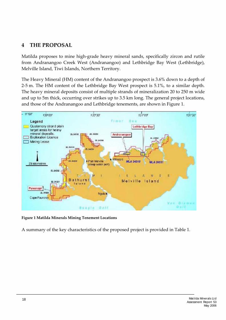
Matilda proposes to mine high‐grade heavy mineral sands, specifically zircon and rutile from Andranangoo Creek West (Andranangoo) and Lethbridge Bay West (Lethbridge), Melville Island, Tiwi Islands, Northern Territory.
The Heavy Mineral (HM) content of the Andranangoo prospect is 3.6% down to a depth of 2‐5 m. The HM content of the Lethbridge Bay West prospect is 5.1%, to a similar depth. The heavy mineral deposits consist of multiple strands of mineralization 20 to 250 m wide and up to 5m thick, occurring over strikes up to 3.5 km long. The general project locations, and those of the Andranangoo and Lethbridge tenements, are shown in Figure 1.
Figure 1 Matilda Minerals Mining Tenement Locations A summary of the key characteristics of the proposed project is provided in Table 1.
Matilda Minerals Ltd Assessment Report 53
May 2006
18

Table 1: Summary of the Proposed Project
Component Proposed Project
Resource 107,000t of Heavy Minerals (HM)
Mine Life 3 ½ to 4 years
Mining method Open‐cut slot mining using excavator and trucks
Mine Production Rate 26,000‐30,000 t/y
Depth of mine pit Average 2.5m at both sites. Max. depth ~3m.
Extent of mine pit 43ha (Andranangoo) & 20 ha (Lethbridge)
Processing Screening, slurrying and HM separation in a spiral centrifuge
Product zircon and rutile
Waste Sand Management Approximately 2.7Mt of sand would be extracted and processed from Andranangoo Creek and 0.4Mt from Lethbridge. Sand tailings from the concentrator would be pumped back to the pit area via dewatering cyclones and stockpiled at the rear of the mining area prior to re‐shaping into the natural landform for later rehabilitation.
Transport HM concentrate transported by double road train 153km to Port Melville, for up to 20,000t storage. Concentrate shipped (exported) directly from Port Melville, 4,000 t ‐ 8,000 t at a time, approx. every two months.
Power source Diesel powered generators (5, total 820kW) and vehicles
Fuel requirement Estimated total diesel usage 3,099 kL/annum
Concentrate Storage Facility Port Melville – 20,000t, Processing plant HM storage shed ~6,000t
Water Supply Groundwater bores, and recycled water from tailings slurry and concentrate processing.
Raw water requirement 840kL/day, 307 ML/year
Groundwater level 0.4 (Wet Season) to 3.3m (dry season) below surface level.
Groundwater Groundwater used in HM separation process, irrigation for revegetation works, road dust suppression and camp potable water supplies
Workforce 12 personnel (two weeks on one week off roster); 18 in construction phase
Air emission sources Diesel engine exhausts; dust generation from: construction of camp and processing plant; upgrade of haul roads; on‐going clearance and rehabilitation activities for mining operations; excavation, loading and transportation of sand via truck along the mineralised zone to the feeder, and return; haulage by road trains of the mineral sands concentrate to the port facilities; storage and loading activities at Port Melville; and other vehicle usage.
Facilities associated with the mining operations would include those listed below:
• Mineralised mining zone;
• Topsoil stockpile areas;
• Tailings sand stockpile inside mining pit;
• Recycled water sump inside mining pit;
Matilda Minerals Ltd Assessment Report 53
May 2006
19

• Mineralised sand stockpile and screen / slurry feeder area;
• Slurry transport pipelines and pumps;
• HM concentrate separator;
• HM concentrate temporary stockpile;
• HM concentrate storage shed (at mine site, 5‐6,000t);
• HM concentrate stockpile for export (at Port Melville, 20,000t);
• Workers camp;
• Fuel storage shed;
• Office;
• Workshop;
• Power house;
• Groundwater bores;
• Haul Road; and
• Access Road.
Facilities associated with the mining operations are represented in Figure 2 and Figure 3
4.1.1 Areas of Disturbance
The total footprint of the proposal is estimated at approximately 1.37 km2 (137Ha). Although mineralised deposits may occur to 5m depth, mining will occur down to maximum depths of ~3m to prevent the need for dewatering.
It is estimated that the area of disturbance at Andranagoo would be 0.45 km2 (45 Ha). The habitats to be disturbed are predominantly Melaleuca woodland, with approximately 2ha in Eucalyptus open woodland for the camp. At Andranangoo the estimated life‐of‐mine is approximately three to three and a half years.
It is estimated that the area of disturbance at Lethbridge would be approximately 10ha. The habitats to be disturbed at Lethbridge are predominantly Melaleuca (paperbark) woodland. Minor areas of coastal vine thicket and strand (beach edge) communities will also be cleared associated with camp access roads. An additional 2 ha of Eucalyptus open woodland would be disturbed for the processing plant and camp. The estimated life‐of‐mine at Lethbridge is approximately six months.
The mining footprints of the proposed project are shown in Figure 4 and Figure 5.
The widening of the existing 4WD tracks from the main road across Melville Island to the mine sites is an additional disturbance, primarily to Eucalyptus woodland. The total area
Matilda Minerals Ltd Assessment Report 53
May 2006
20

of disturbance involved, in increasing the track width from 2 to 6 m, (10m width cleared, including verges and drains) is about 0.78 km2 (78 Ha), comprising 38 Ha for the Andranangoo access and 40 Ha for the 50km Lethbridge access. Road alignments have been selected to avoid areas recognised as being environmentally sensitive, such as black‐soil regions, to minimise environmental disturbance.
4.1.2 Mining Methods
Figure 2 Diagram of Mining Method
At the Andranangoo Creek West Deposit, it is estimated that approximately 2,700,000 t of sand would be extracted and processed, which would contain approximately 88,000 t of HM. Approximately 410,000 t of sand would be extracted and processed at the Lethbridge Deposit, which would contain 19,000 t of HM.
The mineral sands mining method to be used at both Andranangoo and Lethbridge is a form of slot mining. Mining would be undertaken by use of 45 t excavator, which would load into 35 t articulated six‐wheel drive trucks. The excavator would dig to the base of mineralisation, or as deep as practicably possible, without the need for dewatering. The mining face would progress at a typical rate of about 8 to 10 m per day, followed behind by progressive rehabilitation and revegetation 2‐3 months later. Processing would be limited to slurrying and spiral gravity separation and would occur on site. Tailings sand
Matilda Minerals Ltd Assessment Report 53
May 2006
21
separated from the heavy mineral fraction would be pumped back to the mining slot. Overlying topsoil previously stockpiled would be used in the rehabilitation of the backfilled slot. Concentrate product would be stockpiled on site, then trucked to the port terminal. This would require upgrades to existing roads and increased access into this area of Northern Melville Island. Mineral sands mining would commence at Andranangoo, and then follow at Lethbridge when complete.
Areas of particular environmental sensitivity would be protected by vegetation buffers, edged by protective barriers. Buffer widths would vary, including those from: coastal vine thicket and natural springs ‐ 20m buffers; turtle beach nesting sites ‐ 200 m inland from Spring High Water mark; wetlands / damp plains ‐ 50 m; and mangroves ‐ 100m buffer (see Figure 4 and Figure 5).
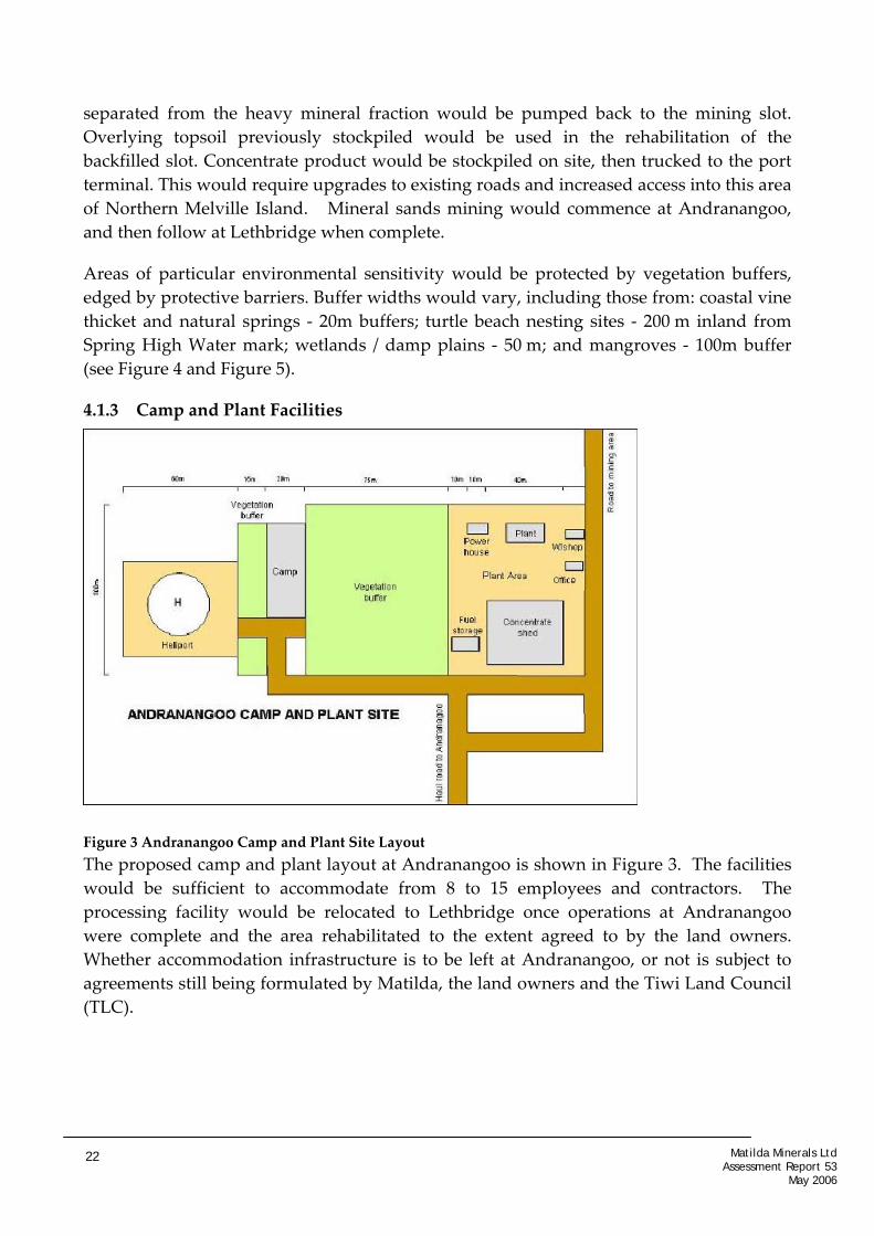
4.1.3 Camp and Plant Facilities
Figure 3 Andranangoo Camp and Plant Site Layout The proposed camp and plant layout at Andranangoo is shown in Figure 3. The facilities would be sufficient to accommodate from 8 to 15 employees and contractors. The processing facility would be relocated to Lethbridge once operations at Andranangoo were complete and the area rehabilitated to the extent agreed to by the land owners. Whether accommodation infrastructure is to be left at Andranangoo, or not is subject to agreements still being formulated by Matilda, the land owners and the Tiwi Land Council (TLC).
Matilda Minerals Ltd Assessment Report 53
May 2006
22

4.2 WATER MANAGEMENT
4.2.1 Potable Water
The potable water used in the mining camp for human consumption and sanitary purposes would be sourced from a groundwater bore separate to the production bores, in close proximity to the camps. Potable water would be pumped to a 5,000 kL poly‐tank. The total consumption rate of water at the camp is anticipated to be approximately 1.1 ML per year. Water quality has been found to meet the Australian Drinking Water Health Guidelines, and would undergo ongoing monitored to ensure drinking water standards are maintained.
Camp water from the camp kitchen and ablution areas would be piped to a septic tank system with associated soakage trench.
4.2.2 Untreated Water
Untreated groundwater from production bores would be used for non‐potable purposes such as processing (slurrying of excavated sands), irrigation, fire fighting and dust suppression. It is proposed that two or three production bores would be used at each of the Andranangoo and Lethbridge sites, located away from the mining areas, and in areas of minimal impact to environmentally sensitive areas.
The main use of production water would be as make up in the spiral separation and slurrying processes, and also for irrigation of rehabilitation areas. The water used in the separation process would be recycled as much as possible (estimated 90%). It is anticipated that approximately 307 ML per year (equivalent to ~150 Olympic swimming pools) would be required for processing and mining activities.
Water would also be utilised for dust suppression along the haul road, by use of a water tanker truck, as necessary. It is estimated that dust suppression would consume approximately 7.3 ML of water per year (equivalent to ~3.6 Olympic swimming pools).
No discharge is anticipated from the mining pit, because no dewatering will occur. The process as a whole will not discharge water, due to the constant recycling of sump water, Based on a 90% return of water from the dewatering cyclone, and a net loss of 360 kL/day from the tailings return water through seepage, the required bore groundwater supply is 840 kL/day.
Matilda Minerals Ltd Assessment Report 53
May 2006
23

Figure 4 Andranangoo Site Layout including buffer zones and infrastructure
Matilda Minerals Ltd Assessment Report 53
May 2006
24

Figure 5 Lethbridge Site Layout including buffer zones and infrastructure
Matilda Minerals Ltd Assessment Report 53
May 2006
25

4.3 REHABILITATION AND MINE CLOSURE
A Rehabilitation and Mine Closure Plan (RMCP) would be developed in consultation with the Landowners, TLC and Department of Primary Industry, Fisheries and Mines (DPIFM), to be incorporated into the Mining Management Plan (MMP) prior to commencement of mining activities. The plan would incorporate rehabilitation objectives, completion criteria, procedures, monitoring, maintenance and contingency requirements in the event of rehabilitation failure. The MMP would be submitted to DPIFM. Final site relinquishment would require sign‐off from the Traditional Owners, NT Government and the Tiwi Land Council.
4.4 ISSUES NOT INCLUDED IN THIS ENVIRONMENTAL IMPACT ASSESSMENT
4.4.1 Future and Expanded Mining Activities
Future and expanded mining activities on the Tiwi Island by Matilda Minerals Limited are not within the scope of the current environmental assessment process, and would require further assessment under a new application.
Matilda has been granted or applied for Exploration tenements covering all prospective areas for mineral sands mining on the Tiwi Islands (see Figure 1). Matilda proposes to only mine prospects sequentially on Melville Island, although potentially on both islands if current exploration is successful on Bathurst Island. The current proposal has not described any future mining Matilda plans for the Tiwi Islands. Matilda’s website (www.matildaminerals.com) does describe future mining plans on the island in more detail. This assessment does not include an assessment of possible future mining implied by the extensive exploration tenements held, or any expansion of areas or depths at the current sites beyond those mapped /described in the Supplement. Any future mining proposal would be subject to a separate assessment process under the Environmental Assessment Act.
5 REGIONAL SETTING
The Matilda Mineral Sands mines of this proposal are located approximately 25 km (Andranangoo Ck) and 35km (Lethbridge Bay) north east of Milikapiti, both on the central north coastline of Melville Island, of the Tiwi Islands, ~110km north of Darwin.
The current population of the Tiwi Islands is concentrated in the three main communities of Nguiu (Bathurst Island), Pirlangimpi (Melville Island) and Milikapiti (Melville Island).
Matilda Minerals Ltd Assessment Report 53
May 2006
26

Land and resource uses in and surrounding the proposed mineral sands mining operations include tourism, forestry, fishing/aquaculture and hunting.
5.1 LAND TENURE
The Tiwi Islands Mineral Sands Project comprises ten granted Exploration Licences registered in the name of Matilda (Figure 1). The Licences and Applications collectively cover an aggregate area of some 790 km2. The Draft EIS relates to mining lease applications at Lethbridge Bay West (9.11 km2) (MLA 24511) and Andranangoo Creek West (11.63 km2) (MLA 24510).
The Traditional Owners of the land in which the mineral leases occur are the Yimpinari Traditional Owners. This is one of eight Traditional Owner groups located on the Tiwi Islands. The Yimpinari Traditional Owners hold the largest area of land on both the islands (TLC 2004).
5.2 CLIMATE
The proposed mineral sands mining operations are located in the wet/dry tropics of northern Australia, which is influenced by the north‐west monsoon and has two distinct seasons, a wet and a dry season. Annual average rainfall is approximately 1,600 mm. Approximately 90% of the annual rain falls between November through April, when monsoonal activity is prevalent and cyclonic activity is experienced. In the dry season, from May to October, rainfall is minimal.
The strongest and heaviest rains are associated with the passage of tropical cyclones, which can occur at any time during the monsoonal period from November to April. The average frequency of occurrence for the thirty year period 1969/70 to 1998/99, for the study area, is approximately 0.4 cyclones per year. The main impacts of a cyclone are wind damage to vegetation and infrastructure, storm surge, and flooding as a result of heavy rain. Storm surge events are of particular concern to coastal communities, and management of this risk has been incorporated into Matilda’s operational planning.
5.3 LANDFORMS
The proposed mining areas are located on the low‐lying coastal dune system of northern Melville Island, which rises to only a few metres above sea level. The coastal dune systems within and surrounding the proposed sand mining areas comprise a sequence of shore‐parallel beach ridges and shore‐parallel sand spits (cheniers), locally modified by tidal creeks and drainage channels that drain the hinterland plateau.
The beach ridge and chenier land unit, comprises predominantly silicious sands with some calcareous sands (draft EIS, s5). Drainage is described as moderate, but wet season flooding is common, with the water table normally raised by ~2.5 m seasonally.
Matilda Minerals Ltd Assessment Report 53
May 2006
27

5.3.1 Flora
Open forests, especially those co‐dominated by Eucalyptus species, dominate the vegetation of the Tiwi Islands. These forests comprise about 76% of the total land area. Partly reflecting the high rainfall, these eucalypt forests are the tallest and have the greatest basal area of any eucalypt forests in the Northern Territory. Tall grasses, with variable shrub cover and stature depending in part on prevailing fire regimes, dominate the understorey. These regimes vary across the Islands: large areas of western Melville Island and central Bathurst Island are burnt almost every year. In contrast, the far less reachable eastern half of Melville Island is burnt noticeably less frequently (averaging about one year in five). The Tiwi Islands also include unusually large and many patches of monsoon rainforest (comprising about 2% of the land area), along with extensive tracts of mangroves (10%), and smaller areas of swamps (4%), and open shrublands (3%).
The Tiwi Islands are home to approximately 1068 native plant species, of which 11 taxa are endemic to the Islands. The Islands’ flora also contains an unusually high number and proportion of listed threatened plant species, including 20 species that are listed as endangered or vulnerable, and a further 44 species regarded as data deficient.
5.3.2 Fauna
A total of 132 fauna species were recorded during surveys of both prospects and both haul roads, comprising 12 mammals, 98 birds, 19 reptiles and three frog species. Of the 132 species recorded during the survey, 22 are considered to be of conservation significance and are listed under government legislation.
Introduced fauna species on the Islands have been identified as mammals (black rat, water buffalo, cattle, pig, horse, cat, dog), reptiles (gecko, flowerpot blind snake) (Woinarski et al. 2003b) and nine species of ants. Of these, pigs, cats, cane toads and big‐headed ants are considered as significant potential threats to natural resource values. Pigs have been introduced to Bathurst Island, and water buffalo to Melville Island, although there is more recent evidence of pigs on Melville.
In order to minimise the spread of weeds onto the Islands, improved quarantine infrastructure has been put in place at the Tiwi Barge Service, which has an inspection and wash‐down facility at the Darwin Port, to prevent such introduction on to the Islands. The service also guards against introduction of potentially significant feral pest species such as cane toads and big‐headed ants.
5.4 SOCIO‐ECONOMIC ENVIRONMENT
The 2003 Census counted 2,454 people on the Tiwi Islands of which the majority live in Nguiu (59%) and are Tiwi Islanders (91%). The population of the Tiwi Islands accounts
Matilda Minerals Ltd Assessment Report 53
May 2006
28

for approximately 1% of the total Northern Territory population and 4% of the Territory’s Indigenous population.
In March 2005 the unemployment rate on the Tiwi Islands was 19% (150 persons), although the national Community Development Employment Program (CDEP) ‘employs’ 68% of employed Indigenous persons and 18% of employed non‐Indigenous persons on the Tiwi Islands. The original intent of CDEP was to provide training and skills to facilitate a smooth transition to full‐time employment, however it has become a long‐term employment option for many. The majority (70%) of the population have not completed schooling past Year 10.
Business enterprises on the Tiwi Islands include aquaculture, forestry, tourism, barge operations, and arts and crafts. In 1999, the TLC assessed the Tiwi economy as generating $25 million/year. This was made up of $11.5 m commercial fishing generated by non‐Tiwi interests, $9.5m ‘welfare economy’ generated by Tiwi, and $4 m enterprise and non‐welfare payments accruing to the Island’s organizations and business sector.
The health status on the Tiwi Islands is poor and in the 1990s the Tiwi Islands had the worst overall health statistics for any population group in Australia. The last decade has seen measurable improvements with initiatives introduced by governments. There are police based at both Pirlangimpi and Nguiu, although Nguiu is now the main station of the region with the officer‐in‐charge based there. There is an Aboriginal Community Police Officer stationed at Milikapiti.
6 ENVIRONMENTAL IMPACT ASSESSMENT
6.1 INTRODUCTION
The purpose of this Environmental Assessment Report is to evaluate the environmental protection measures of the project proposal and to determine whether the proposal can proceed without unacceptable environmental impacts. This is done by identifying all potential environmental impacts and evaluating the corresponding safeguards or prevention measures suggested by Matilda. Where the proposed safeguards are considered insufficient, or where a safeguard is significantly important, recommendations are made in this Report to complete or emphasise those commitments made by Matilda.
The environmental acceptability of this project is based on consideration of the following from the draft EIS and Supplement:
adequacy of information outlining the proposal (particularly which activities are likely to impact the environment);
•
Matilda Minerals Ltd Assessment Report 53
May 2006
29

adequacy of information on the existing environment (particularly environmental sensitivities);
•
•
•
adequacy of information on the range and extent of potential impacts; and
adequacy of the proposed safeguards to avoid or mitigate potential impacts. The EPA Program considers that the environmental issues associated with the project have been adequately identified. Appropriate environmental management of some of these issues have been resolved through the assessment process, while the remainder can be addressed through monitoring and management actions detailed in environmental management plans, included as part of the Mining Management Plan. It is recognized that some of Matilda’s management measures would be refined after approval has been obtained and the design phase of the project completed. The EPA Program considers that the project can be managed in a manner that avoids unacceptable environmental impacts, provided that the environmental commitments and recommendations made in this Assessment Report and in the final environmental management plans are implemented, with regular reporting and compliance auditing. Subject to decisions that permit the project to proceed, the primary recommendations of this assessment are:
1. Recommendation
Matilda Minerals Limited shall ensure that the proposal is implemented in accordance with the environmental commitments and safeguards: • Identified in the Andranangoo Creek West and Lethbridge Bay West Mineral Sands Mining Project Draft Environmental Impact Statement, and Supplement ; and
• Recommended in this Assessment Report (No. 53)
All safeguards and mitigation measures outlined in the Draft Environmental Impact Statement, and Supplement are considered to be commitments by Matilda Minerals Limited and are included in Appendix A of this report.
Any future mining on the Tiwi Islands, or expansion to the current mining activities beyond those presented in the draft EIS and mapped in the Supplement would require further assessment under the Environmental Assessment Act.
2. Recommendation
In accordance with clause 14A of the Administrative Procedures of the Environmental Assessment Act 1982 Matilda shall advise the Minister of any changes to the proposal
Matilda Minerals Ltd Assessment Report 53
May 2006
30

for determination of whether or not further environmental impact assessment is required. In the event that mining does not commence within 5 years, the project should be reconsidered as to whether a new assessment should be required.
The principal environmental issues associated with the proposal are: • Loss of biodiversity from land clearing and weed introductions; • Uncertainties regarding the success of site rehabilitation / revegetation operations, and
vulnerability of rehabilitated areas to cyclonic storm surge damage; • Adequacy of buffer zones from inundated areas, water courses and sensitive habitats; • Potential for acid sulfate soil generation; • Erosion and sedimentation from alteration of surface water flows; • Potential groundwater drawdown impacts on nearby groundwater dependent
ecosystems; and • Opening up haul‐road access to remote wilderness areas of Melville Island, as well as
installing bore water supplies and clearing land, thus encouraging settlement into new areas.
The remainder of Section 6 deals with issues raised in the government and public submissions to the draft EIS and Supplement and Matilda’s commitments to environmental management provided within the draft EIS and Supplement. In addition, recommendations to strengthen environmental management strategies and safeguards are presented. Some issues were adequately addressed in the Supplement and require no further discussion. The outstanding environmental issues that remain are addressed below.
6.2 FLORA
6.2.1 Endangered Flora Species
Of the 1068 native plant species recorded on the Tiwi Islands, a total of 165 plant species were recorded during the field surveys of the Lethbridge and Andranangoo sites. One listed threatened species, Cycas armstrongii, was recorded at Andranangoo. Only two exotic species (one naturalised) were recorded during the surveys at each of the mining prospects.
The wet season when Matilda had carried out their ‘wet‐season’ flora survey was unusually dry, and the areas were also still affected by the preceding Cyclone Ingrid. Comments were made in and on the draft EIS that species may have been missed. Twenty‐five rare and threatened plant species listed under NT conservation legislation were identified as having potential to occur in environments affected by the mining proposal.
Matilda Minerals Ltd Assessment Report 53
May 2006
31

However, during this survey only Cycas armstrongii was recorded, at the Andranangoo site.
The issue was subsequently discussed with the NT Herbarium, following the review of the submissions on the draft EIS. The discussion covered the list of significant species identified in the draft EIS Guidelines and other listed annual species that might be likely to occur within the habitats proposed to be disturbed by mining activities. These discussions indicated that further studies would be unlikely to provide any additional information. However, Matilda has still committed to undertake pre‐disturbance surveys to inform rehabilitation programs. Commitments to pre‐mining flora surveys are not backed up by any conservation measures if any further threatened flora species are found. The EPA Program considers that conservation measures need to be incorporated explicitly into the Flora Environmental Management Plan (EMP) to protect any threatened species discovered by the pre‐disturbance flora surveys. Present wording infers only a commitment to record the list of species present, but not to protect species other than Cycas armstrongii from destruction. The Biodiversity Conservation unit of the Department of Natural Resources, Environment and the Arts (NRETA) should be consulted regarding appropriate management of any further discoveries of listed threatened plant species (beyond c. armstrongii). The EPA Program supports Matilda’s commitments to a pre‐ and post‐mining flora monitoring program which would encompass surveys to determine the species present and to establish the success of rehabilitation. Pre‐mining surveys would incorporate a range of vegetation survey methods (eg. diversity indices, importance values) as well as identification of annuals in the proposed areas of disturbance, in order to establish whether any further listed threatened species are present on the proposed mine sites.
3. Recommendation
Management measures are to be incorporated into the Flora Environmental Management Plan to conserve any threatened species identified during pre‐disturbance flora surveys. Conservation measures are to be stated explicitly. The Department of Natural Resources, Environment and the Arts must be consulted regarding appropriate management of any further discoveries of threatened / listed species.
Matilda committed in the Supplement to report, recover and transplant Cycas armstrongii when encountered, where possible, in conjunction with appropriate assistance from specialists. Information related to the permitting requirements for ‘interference’ with
Matilda Minerals Ltd Assessment Report 53
May 2006
32

cycads is contained in the document: A Trial Management Program for Cycads in the Northern Territory of Australia, which can be found at: http://www.nt.gov.au/nreta/wildlife/animals/management.
Recovery and transplanting of Cycas armstrongii is supported.
6.2.2 Land Clearing
The habitats to be disturbed in the mining areas at Andranagoo and Lethbridge are predominately Melaleuca woodland. The camps and haul roads are mostly sited in open Eucalyptus woodland. It is estimated that approximately 1.47km2 (147Ha) of vegetation would be cleared in the course of the project, including the two mine‐sites, camps, processing plant sites and the two access/haul roads. Of the 147Ha, at least the two mine‐sites (~65Ha) would undergo revegetation, leaving a net loss of vegetated habitat of up to 0.82km2 (82Ha), represented by the haul roads and camps, if requested by the TLC that these be kept open. The habitats to be cleared are predominantly Melaleuca woodland or Eucalyptus open woodland. Clearing these habitats represents removal of approximately 0.81% of the 60.8km2 of Melaleuca vegetation communities currently present on the Tiwi Islands, and 0.0085% of the total existing 5725.1 km2 of Eucalyptus communities. Temporary removal of these areas of habitat is unlikely to significantly or permanently impact on any Melville Island fauna or ecosystems reliant on these habitat types. A Permit application has been made by Matilda under the Territory Parks and Wildlife Conservation (TPWC) Act (2000 ) to remove or transplant Cycas Armstrongii plants from the mine sites. Similar application would need to be made if further listed threatened species are found. Land clearing permits are administered under the NT Planning Act (2005). A permit for land clearing is not required for this proposal. In the draft EIS, patches of Coastal Vine Thicket were also proposed to be cleared for mining at Lethbridge Bay. Comments received questioned the cost‐benefits of clearing and replacing those patches. Coastal vine thicket has been recognised by Matilda as a vegetation community of conservation significance. The flora survey in the drafts EIS included the comment: the vine‐thicket vegetation tends to be quite species‐rich and the community is relatively restricted in distribution throughout the region, containing a high proportion of fire sensitive species. It was further identified as the habitat for diverse invertebrate species including the endangered land snails Amphidromus cognatus and Trochomorpha melvillensis. In response to comments Matilda revised its mining plan to avoid areas of coastal vine thicket areas.
Matilda Minerals Ltd Assessment Report 53
May 2006
33

6.2.3 Rehabilitation and Revegetation
Due to the nature of the mine operation, rehabilitation and revegetation would be undertaken progressively behind the mine front, with sand tailings being returned directly to the mine pit. The draft EIS (s21) and the Supplement (s14) summarize the rehabilitation objectives and methodology.
The objectives for Matilda’s rehabilitation are: • To minimise the area of land disturbed and cleared at time, and to progressively
rehabilitate mined areas as soon as practicably possible; • To ensure that the post‐mining landform is consistent with the pre‐mining
landform and the surrounding undisturbed area wherever possible; • To stabilise disturbed areas as soon as practically possible to prevent wind and
water erosion; and • To revegetate the stabilised post‐mining landform to provide for the long‐term
stability of the system, and for the return of native flora and fauna communities that are similar to pre‐mining conditions and surrounding undisturbed areas.
Rehabilitation of landforms is expected to occur progressively within 2‐3 months of mining. Landforms are to be reconstructed to be in keeping with their original profiles and to those of surrounding areas. Original drainage patterns will be restored. After topsoil is re‐spread, revegetation would occur progressively, utilizing seed already present in the topsoil, supplemented by seed of local provenance and nursery‐grown seedlings also from local seed/cuttings, where necessary. It is assumed untouched vegetation surrounding Matilda’s mining strips would provide a continuous supply of local seeds and fauna back to the revegetation sites, supplementing the seed banks remaining in the returned topsoil. Surrounding trees would also provide a degree of shelter from eroding sea breezes and shade to edge areas. This would aid recovery of the mined areas. Concern was raised on the rehabilitation components of the project, more in response to the chequered history1 of the mineral sand mine failures than particularly with Matilda’s proposal. Reasons for failures varied but included: volatile market prices; heavy mineral concentrations found to be too low; extended periods before recouping investments; and failures of financial backing. Although relevant, these factors are outside the range of expert advice available the EPA Program in its assessment. Protection for the environment against market failure etc, is provided from the Proponent in the form of a rehabilitation bond, lodged prior to operations.
1 McManus (2002)
Matilda Minerals Ltd Assessment Report 53
May 2006
34

No mineral sand mining has occurred before in the Northern Territory on which to base environmental or rehabilitation decisions. The paucity of studies on rehabilitation in this environment type led Matilda to base rehabilitation plans on URS2 reviews of rehabilitation case studies undertaken in Western Australia and Queensland, and on studies of means to measure rehabilitation success3. In a southern Queensland sand mining rehabilitation study key issues were identified for rehabilitation success: • Collection of vegetation litter prior to mining. The litter provides valuable ecosystems
for fauna and flora as well as providing nutrient resources; and • Development of an effective nursery to establish seedlings prior to re‐planting. The EPA Program consulted Greening Australia (GA) in Darwin regarding the likely success of Matilda’s proposed revegetation methods. GA advice suggested the likelihood of success will be conditional upon proper management of weeds, fires, pests and watering regimes. Matilda has expressed plans to implement a range of methods of rehabilitation to establish optimal techniques for restoring Melville Island coastal habitats to optimize rehabilitation success, and to inform future rehabilitation efforts. These are discussed in detail in the draft EIS (s21), and the Supplement (s14). Potential strategies include: • Timing of progressive rehabilitation to minimise the amount of time that soils are
exposed; • Use of (sterile) cover crops; • Fertiliser application to replace lost nutrients, and to assist in establishing ground
cover, if low nutrient status is found to be a constraint to rehabilitation. • Respreading of cleared vegetation; • Refining seeding mixture; • Seed treatment; • Construction of windbreaks; • Soil moisture testing, combined with alternative soil reconstruction methods; • Herbivore‐proof fencing; • Dominant species control; and • Additional seeding or planting of seedlings.
The potential for storm surge impacts upon rehabilitated areas is discussed in section 6.2.4
2 Environmental consultants subcontracted by Matilda for the assessment process.
3 Tongway and Hinley 2004
Matilda Minerals Ltd Assessment Report 53
May 2006
35
Matilda noted that rehabilitation services were to be subcontracted to the TLC Ranger program, who would also establish a nursery at Milikapiti, for the project. Although concerns arise regarding sufficient expertise and commitment being available from the local workforce, the training and employment opportunity is viewed as a valuable input into the local community. Matilda has committed to: • Supporting the TLC Ranger program; • Training locals in rehabilitation care; • Provide specialist expertise as required, to assist TLC Rangers address specific issues;
and • Working with the TLC Ranger program to ensure the ongoing monitoring of disturbed
areas continues until completion criteria are met. Ongoing monitoring would be undertaken by Matilda of rehabilitation progress. Annual reporting would occur to DPIFM, for auditing of progress and potential evolution of environmental management plans. Annual inspections would also be carried out of the mine sites by DPIFM. Recovery of the mined areas may take a number of years to reach a stable state and similar to untouched areas nearby. Rehabilitation works will be required to continue after mining is complete, until pre‐determined mine‐closure completion criteria are fulfilled to the satisfaction of the NT government, Land Owners and the TLC. How long Matilda’s commitment to rehabilitation works and monitoring will be required to continue is thus open ended, and will depend on the speed of recovery of the mined landscape, and the effectiveness of restoration methods. The EPA Program is satisfied that Matilda possesses the commitment and has drawn on sufficient expertise to successfully rehabilitate and revegetate landforms and ecosystems on the project areas, to states similar to their original conditions. Unknowns still exist as to the time required to fully reinstate vegetation and fauna communities. Also unknown is the level of commitment and human resources available from local labour pools to fulfil Matilda’s environmental commitments in the revegetation effort. Financial incentives exist for Matilda with the annual calculation of a rehabilitation bond, to avoid an expanding rehabilitation liability. Post mining, bonds are held until all completion criteria4 are fulfilled. The EPA Program supports Matilda’s support and training of the local Tiwi Island workforce in the revegetation effort, as well as Matilda’s commitments to provide specialist expertise to plan, supervise and monitor as required, to assist the TLC Rangers.
4 As set out in the Rehabilitation and Mine Closure Plan (RMCP)
Matilda Minerals Ltd Assessment Report 53
May 2006
36
6.2.4 Natural Catastrophic Events
Concern was raised regarding the potential for storm surge flooding of the mine site, leading to broadscale erosion and setbacks to the revegetation effort. Between 1969 and 1999 the average frequency of tropical cyclones affecting the Tiwi Islands was found to be 0.4/year, extrapolating to an ‘expected’ 1‐2 cyclones affecting the area in the life of active mining, or 4 within 10 years. Tropical cyclones are highly variable and unpredictable, and to be flooded by a storm surge a series of factors would need to occur simultaneously. Although it is probable that the site would be affected by a cyclone within the mine’s life, it is increasingly less probable that the following would also occur simultaneously5: • Wind speeds would be at their maximum at the mine site, which occurs when the
cyclone eye passes within 10‐20 km. Within this zone, storm surge may raise water levels by ~1m for each cyclone category;
• The winds would be onshore at the mine‐site, to push the water up onto shore, instead of away from shore. This occurs only to the left of the eye of the cyclone, in the case of north facing NT beaches;
• The daily tidal cycle is at its high tide point; and • The lunar tidal cycle is on a spring tidal cycle.
The mine sites sit ~3‐6m above Mean Sea Level (MSL). Mean Spring High Tide levels, based on Port Melville data6, are around 1.7m above MSL (2.3m) (Mean Neap High tides are around 0.7 m above MSL). At the mine sites, a category one cyclone or greater could begin to flood the mine sites if some of the factors listed above coincided. Nevertheless, being situated as they are in a low‐lying coastal drainage zone, in an area of high tropical cyclone frequency, the sites are vulnerable to a storm surge impact, and the impacts could be significant. Even if the site were not flooded by a storm surge in a cyclone, vegetation would be defoliated and damaged by a direct cyclone hit, and associated heavy rains would erode exposed and unstable soils in restored areas. Fire could have similarly catastrophic effects.
If such an event were to occur, Matilda has stated it would undertake the necessary rehabilitation works in these areas in accordance with the approved Rehabilitation and Mine‐Closure Plan (RMCP), to be submitted to DPIFM. Matilda has expressed an expectation that comittment may be required for up to five years post mine closure to assist with the rehabilitation works. If the revegetation effort suffers setbacks, or fails to advance as quickly as Matilda is expecting, then a longer commitment is required. Of the
5 Information provided in personal communications from the Bureau of Meteorology, Darwin.
6 Information supplied by Marine Manager, Perkins Shipping, Darwin.
Matilda Minerals Ltd Assessment Report 53
May 2006
37

benchmark studies offered by Matilda as evidence of the likely success of the revegetation effort, 9 of the 10 longer term examples required 5‐15 years to reach a level of vegetation cover comparable to control (non‐mined) areas.
The EPA Program recognises closure criteria may not be met after 5 years, and Matilda must ensure sufficient funds would be available in the event of rehabilitation setbacks requiring works continue for a longer term.
The EPA Program is satisfied that as long as there is sufficient provision of resources including expertise, funding and ongoing site management continuing over the longer term, then the rehabilitation efforts are likely to succeed. Most catastrophic damage to the revegetation effort could in theory be rectified by sufficient input of effort and resources over a sufficient period.
Sufficient bond or security is to be lodged with the NT Government to guarantee sufficient funding would be available for a comprehensive revegetation effort for as long as is required to fully fulfill the close‐out criteria, contained in the Rehabilitation and Mine Closure Plan.
4. Recommendation
Close‐out criteria, contained in the Rehabilitation and Mine Closure Plan are to contain provision for sufficient resources to be made available to maintain mine‐site rehabilitation and monitoring works in the longer term, for up to 20 years, to allow for setbacks (eg. cyclones) and slower than expected progress in the rehabilitation.
5. Recommendation
The Rehabilitation and Mine Closure Plan, including mine close‐out criteria, is to be made available for public comment and government agencies before finalization, and readily accessible to the public once finalised.
6.2.5 Weeds
An outstanding feature of the flora surveys of the mine‐sites and new haul roads was the low levels of introduced weed species recorded. The road verges beside the settlement of Pickertaramoor were an exception, but commitments have been made for the (4x) daily road train trips transporting product to Port Melville to avoid this area. As long as existing management commitments are enforced, weed management at the mine‐sites would operate under the significant advantage of not having large weed populations ‘at the front gate’. On the other hand, the relative significance of any new weed introductions
Matilda Minerals Ltd Assessment Report 53
May 2006
38

to the area may be greater, considering the relative pristine wilderness nature of the areas being disturbed. Unchecked weed infestations have the potential to neutralise revegetation efforts, reduce biodiversity in surrounding areas, and create a lasting scar on the landscape after the mine.
The EPA Program supports Matilda’s range of commitments to weed control, including: • Avoiding areas considered more susceptible to environmental degradation from weed
introduction; • Maintaining a weed monitoring and weed management plan to control the
establishment and spread of weeds; and • Abiding by the existing Tiwi Islands quarantine procedures, including wash‐down of
all vehicles and machinery before entering Melville Island, and applying their own management programs to control and prevent the establishment of weeds.
It is very unlikely that Port Melville, as a population centre, is weed free and Matilda’s trucks would visit there on average 4 times a day. No wash‐down or quarantine measures are planned on entry of vehicles to the mine‐sites, but these should be kept as a potential management tool, if current weed management plans are found to be inadequate to keep the mine‐sites weed free. Additionally, regular weed surveys and implementation of the weed management plan for the site to prevent weed introductions would be more cost‐effective than attempting to control weed outbreaks.
6. Recommendation
Existing commitments with regard to weed management on the mine and camp sites are to: • Be closely adhered to, for the life of the mine and post‐mining revegetation effort; • Undergo periodic expert review in light of weed monitoring results, with the aim of continual improvement of weed prevention outcomes; and
• Be undertaken also in conjunction with all road construction and maintenance activities, in consultation the Department of Natural Resources, Environment and the Arts.
6.2.6 Fire Fire has the potential to impact heavily upon revegetated areas, and to create significant setbacks toward mine closure. Fire also has the potential to seriously damage Coastal Vine Thicket habitats and their high biodiversity values. If fire frequency increases to be more often than occurred pre‐mining, then alteration of vegetation community structures can occur, also affecting biodiversity values. Weed infestations can also alter the fire regime of the mine site, by encouraging hotter, more damaging fires to occur on site, leading to greater mortality or loss of vegetation types with fire‐sensitivity. Operation of the mine
Matilda Minerals Ltd Assessment Report 53
May 2006
39

lease areas and increasing road access to the area increases the risk of these environmental impacts occurring through fires outbreaks. Commitments had been made by Matilda to a comprehensive fire management program.
6.3 FAUNA
6.3.1 Endangered Fauna Species
A total of 132 Fauna species were recorded during surveys of both prospects and both haul roads, comprising 12 mammals, 98 birds, 19 reptiles and three frog species. Of the 132 species recorded during the survey, 22 are considered to be of conservation significance and are listed under government legislation.
The species that were recorded during the survey that are listed under the Commonwealth Environment Protection and Biodiversity Conservation (EPBC Act 1999), the TPWC Act 2000 as well as the CAMBA, JAMBA and BONN conventions include the: • Butler’s dunnart; • Brush‐tailed rabbit‐rat; • Brush‐tailed phascogale; • Masked owl; • Partridge pigeon; • Black‐footed tree‐rat; • Pale field‐rat; • Ornate burrowing frog; • Northern bandy bandy; • Caspian tern; • Great egret; • Eastern reef egret;; • Black‐tailed godwit; • Common greenshank; • White‐bellied sea‐eagle;; • Osprey; • Rufous fantail; • Rainbow bee‐eater; • Leaden flycatcher; • Restless flycatcher; • Flatback turtle; • Olive ridley turtle; and • Saltwater crocodile.
Matilda Minerals Ltd Assessment Report 53
May 2006
40

Of the 22 listed species of conservation significance recorded in Matilda’s fauna surveys, the predominant issues of concern remaining are the recording of the Butler’s dunnart and the masked owl.
Two Butler’s dunnarts were trapped along the Lethbridge haul road. Prior to mining at Lethbridge, Matilda has committed to further survey the area where the Butler’s dunnarts were found and investigate options for realigning the haul road.
Commitment has also been made to avoid disturbing areas that have been found to contain protected species, where possible. Matilda has committed to record fauna species of conservation significance, and their abundance and the location of sightings. If such species are found within the camp and mine area, Matilda has committed that they would be trapped and relocated to suitable habitats.
Matilda has committed to work with the appropriate authorities and the Tiwi Barge Service to ensure that exotic and feral fauna species are not accidentally transported onto the Island. In particular, this would focus on prevention of entry of feral ants and the cane toad. The EPA Program supports Matilda’s commitments in the revised Fauna Management Program in the Supplement (s8.2), to: • Further survey for Butler’s dunnarts and realign road to avoid populations; • Regularly monitor the occurrence of masked owls over the life of operations; • Avoid disturbing areas that have been found to contain protected species; • Record fauna species of conservation significance, and their abundance and the
location of sightings; and if found within the camp and mine area, to trap and relocate individual animals to suitable habitats; and
• Work with the appropriate authorities and the Tiwi Barge Service to ensure that exotic and feral fauna species are not accidentally transported onto the Island.
7. Recommendation
Lethbridge haul road alignment be contingent on further surveys for Butler’s Dunnarts occurring before‐hand, and any discovered populations being avoided by the road alignment. Masked Owl (Tiwi Islands) Tyto novaehollandiae
The masked owl was recorded in vegetation over both mineral deposits and along the Lethbridge haul road. Commitment has been made by Matilda to ongoing monitoring of the occurrence of masked owls over the life of operations as part of the fauna monitoring program, and to avoid disturbing areas where they are found.
Matilda Minerals Ltd Assessment Report 53
May 2006
41

The Commonwealth Department of Environment and Heritage (DEH) currently has a masked owl recovery plan in place for the conservation of the Tiwi Island subspecies7. Based on population densities recorded elsewhere in Australia, and from estimated home ranges of 5–10 km2, the total population of the Tiwi sub‐species has been estimated in the draft EIS at about 1,000 mature birds. Their conservation status is classed as Vulnerable under the EPBC Act and Endangered under the TPWC Act.
Tiwi Island Masked Owls are described as occurring primarily in tall open eucalypt woodland, and probably nesting in eucalypts that grow into large trees with numerous hollows. They feed primarily on rats. Masked owls are threatened by extensive clearing of nesting trees as has occurred for forestry, and reductions in rat populations. The owls may also be adversely affected by changes in vegetation structure, as a result of a trend away from traditional burning practices, and weed invasion. The EPA Program recommends prior expert surveys for any active nests of masked owls or other species of conservation significance, before any clearing of vegetation is to occur. If active nests are discovered, temporary 100m vegetation buffers should provided from mine activities until the nest is no longer active. Little is known about this bird or its response to disturbance, so the buffer would be taking a precautionary approach. The EPA program also recommends the retention of nest trees (and their surrounds) after breeding, if possible.
Matilda has made commitments to: • Avoid disturbing areas that have been found to contain Masked Owls; • Ongoing monitoring of the occurrence of masked owls over the life of operations; and • Managing in the parameters of the conservation plan.
8. Recommendation
Expert surveys are to be carried out to identify any active nests of masked owls before any clearing of vegetation is to occur. If active nests are discovered, temporary 100m vegetation buffers should be provided from mine activities until the nest is no longer active.
7 The masked owl recovery plan can be viewed at: http://www.deh.gov.au/biodiversity/threatened/action/birds2000/pubs/masked‐owl‐tiwi.pdf
Matilda Minerals Ltd Assessment Report 53
May 2006
42

6.3.2 Animal Rescue and Relocation
Comments on the draft EIS requested Matilda to incorporate animal rescue and relocation measures into the Fauna EMP for tree felling operations and haul road injuries/fatalities. In response, Matilda included a revised Fauna EMP in the Supplement, and committed to (only) consider relocation for species that are not considered to be ‘common’ to the area, due to the complex and expensive nature of the exercise.
Matilda’s commitment to trap and relocate any species of conservation significance if they are found within the camp and mine area appears to be referring to incidental sightings. The Matilda Final Fauna Report (s10 draft EIS), recognises that some of the listed threatened species already recorded in the mine areas and haul roads may be destroyed by the operation, including the brush‐tailed rabbit‐rat, brush‐tailed phascogale, black‐footed tree‐rat and pale field‐rat, Butler’s Dunnart, ornate burrowing frog and the northern bandy bandy snake. However Matilda states that the numbers lost in each case would not significantly affect the Melville Island populations.
To minimise any unnecessary destruction of native fauna in the areas planned for clearing, the EPA program recommends an intensive trapping and relocation program to be carried out in the day(s) immediately preceding mining actions, followed by intensive surveys of the site for occupied tree hollows, nests or burrows. Any further detected fauna should be removed and relocated, if possible before clearing occurs. If removal from hollows, etc is not possible, then the occupation sites should be marked and further managed during the clearing operation to minimise fauna injury. The trapping and relocation program by necessity would need to be ongoing in a staggered fashion, and overseen by a trained wildlife expert. It is possible that with training, this task could be subcontracted to local Tiwi Island workers.
All native vertebrate fauna are protected. Prior approval is required to interfere with native vertebrate wildlife under the Territory Parks and Wildlife Conservation Act (TPWC Act). Relocation of native wildlife is classed as interfering, accordingly, relocation permits8 will need to be obtained by Matilda.
9. Recommendation
Intensive trapping and relocation programs are to be carried out in areas planned for clearing, followed by intensive surveys of the site for occupied tree hollows, nests or burrows in the day(s) immediately preceding such actions. Any further detected fauna should be removed and relocated, if possible before clearing occurs. If removal from
8 Details can be found at: http://www.nt.gov.au/nreta/wildlife/permits/takefromwild.html
Matilda Minerals Ltd Assessment Report 53
May 2006
43

hollows, etc is not possible, then the occupation sites should be marked and further managed during the clearing operation to minimise fauna injury.
The Revised Fauna EMP in the Supplement (Supplement s8.2 ,Table 3) included the following additions: • Objectives and Targets
o To minimise fauna road injuries and death during road haulage activities; and o To rescue or relocate listed fauna that may be impacted by site activities.
• Actions o Train truck drivers in safe driving techniques and reporting requirements in the
event of hitting fauna during transportation activities; and o Staff to be trained in fauna identification and procedures for rescue and
relocation. • Monitoring
o Record any incidents of fauna injury or death during transportation activities; and
o Record any incidents involving fauna rescue and relocation.
The above amendments to the Fauna EMP fail to include any obligation on drivers to: • Offer assistance to wildlife injured or orphaned by transportation activities; • Remove dead animals from the road, to help prevent follow‐on injuries to scavenging
wildlife or further traffic incidents from the carcass; • Check for surviving young in pouches or at the scene if parents are killed; or • Contact wildlife authorities where fauna are injured, especially if there is likely a need
for specialist care. The EPA program recommends the inclusion of such commitments into the Fauna EMP.
10. Recommendation
Amendments to Matilda’s revised Fauna Environmental Management Plan (Supplement s 8.2 (Table 3)), are to include an obligation on drivers of haul vehicles to: • Assist wildlife injured or orphaned by transportation activities; • Remove dead animals from the road, to help prevent follow‐on injuries to scavenging wildlife or further traffic incidents from the carcass;
• Check for surviving young in pouches or at the scene if parents are killed; and • Contact wildlife authorities where fauna are injured, especially if there is a likely a need for specialist care.
Matilda Minerals Ltd Assessment Report 53
May 2006
44

6.3.3 Biting Insects
DPIFM commented on the draft EIS that the dengue vector mosquito (Aedes aegypti) has been recorded in the Tiwi Islands, albeit rarely, and that marine transport from Timor or north‐eastern Australia is a potential carrier of the mosquito. In the Supplement, Matilda noted these comments. The Australian Quarantine Inspection Service (AQIS) and the Australian Customs Service is responsible for quarantine controls of Australia’s borders to minimise the risk of exotic pests such Aedes aegypti entering Australia. This species is a serious threat to the NT, which is currently free of A. aegypti and dengue fever. This species is occasionally found breeding in water containers on incoming vessels such as barges and fishing vessels from neighbouring countries. Outbreaks of dengue fever associated with this species are currently occurring as close as Timor, and have recently occurred on Thursday Island (Qld). Considering the remote northern location of the mine sites, a possibility exists for untracked marine vessels to land in the area while harbouring dengue mosquito larvae. It would be pertinent for Matilda to avoid creating mosquito breeding habitat in the form of fresh‐water‐filled open containers around camp areas. Any enquiries should be directed to the Medical Entomology Branch (MEB) of the NT Department of Health and Community Services (HCS).
Comments on the draft EIS called for adequate exploration of the proposed use of active control measures for biting insects. Options related to relocation of facilities, improved personnel management and other aspects should be considered prior to chemical controls. In the Supplement, Matilda replied that alternative options to chemical methods would be explored, and that the effectiveness of methods chosen would be assessed in future mine planning submissions. Matilda presented a Biting Insects Environmental Control Plan in the Supplement. This will be incorporated into the final Mining Management Plan.
11. Recommendation
Matilda is to avoid creating mosquito breeding habitat in the form of fresh‐water‐filled open containers around camp areas, to lessen the risk of introduction of Aedes aegypti (and potentially dengue fever) onto Melville Island.
Matilda Minerals Ltd Assessment Report 53
May 2006
45

6.4 BUFFER ZONES Matilda has committed to the following buffers: Sensitive feature Buffer width Turtle nesting areas 200m from high tide mark Mangroves 100 m (increased from 50 m) Damp plain or swamp areas 50m Coastal Vine Thicket no direct mining drainage line from a spring mid Andranangoo Ck prospect
no direct mining and an effective buffer of 20m
Comments received on the draft EIS questioned the adequacy of Matilda’s buffer widths around wetlands in which suggestions were also made for exclusion and buffers from vine thicket habitats and the drainage line from the spring in the Andranangoo prospect. Matilda offered exclusion, but no buffers, from coastal vine thicket habitats and the drainage line. Buffer widths recommended as appropriate vary amongst authors. Appropriateness of widths depends on the intended purpose of the buffer in each case. Recommendations are commonly made in government documents based upon the Land Clearing Guidelines (2002) (LCG). The LCG prescribe general principles applicable to permanently clearing land beside sensitive environmental features, such as streams, for land uses such as agriculture, pasture, residential developments, industry, etc.. In Matilda’s case, the mine involves complete removal of all vegetation, but to be followed within a few months by a revegetation process that will probably have most of the biodiversity and natural features fully reinstated within 20 years, or less. Buffers will be required to protect sensitive natural features firstly from any direct mining impacts for ~3 months, then from any impacts from the adjacent areas undergoing rehabilitation / revegetation, for the next ~20 years.
6.4.1 Sensitive Vegetation Buffers
Vine‐thicket vegetation tends to be quite species‐rich. It is relatively restricted in distribution throughout the region, possibly due to containing a high proportion of fire sensitive species. On the Tiwi Islands there are ~132 km2 of coastal vine thicket vegetation communities. Matilda originally planned to disturb 1.8 ha (or 0.014% of the 132km2) of coastal vine thicket.
Matilda Minerals Ltd Assessment Report 53
May 2006
46
Comments on the draft EIS questioned the cost‐benefits of clearing Coastal Vine Thicket habitat. NRETA comments requested 100m buffers to sensitive vegetation types, but also indicated that if these functions could be met in ways other than with a 100m buffer zone, then reduction of the buffer width could be justified. Dry Vine Thickets were mentioned in the draft EIS as important to conservation on the Tiwi Islands in the Matilda Final Fauna Report (draft EIS, Appendix D), with reference to Woinarski et al. 2000 & 2003. In the Supplement, Matilda committed to excluding mining from Coastal Vine Thicket, and later agreed to a 20m buffer from the habitat edge, functionally enhanced with engineering mechanisms such as sediment fences and fire breaks. Comments on the draft EIS noted the fire vulnerability of vine thicket and the need to prevent any ‘fire penetration points’. In response to the Supplement, DPIFM observed that commitments had been made by Matilda to a comprehensive fire management program, which will be reviewed by NRETA when received. The functions of buffer zones around sensitive vegetation could be described as preventing habitat degradation by: • Preventing flow of sediment, runoff and airborne dust from the adjacent development
into the sensitive habitat; • Presenting a barrier to fire intrusion into fire‐sensitive habitat; • Protecting and preventing loss of biodiversity within the habitat, by preventing the
entrance of weeds, exposure to excess understorey sunlight, wind, weather, dust etc.; and
• Preventing the loss from the habitat of soil, moisture, leaf litter, nutrients, fauna, seeds, pollinating fauna, etc.
Other mechanisms available to replace buffer functions could include: • Sediment protection with screen fencing around mining and revegetated areas; • Runoff control with appropriate drains and bunds; • Fire breaks and preventative management against accidental ignitions; • Weed management practices; and • Maintenance of some level of high vegetation buffer, even if reduced in width from the
recommended 100m. This can still provide shade and moisture retention, and protect the edges of the sensitive habitat and resident fauna from direct sunlight (heat), dust, wind, and salt spray, etc.
12. Recommendation
The following measures are to be employed to protect coastal vine thicket habitat: • Sediment and runoff control measures around mining and revegetated areas, as per Matilda’s existing commitments;
• Fire breaks and fire management practices;
Matilda Minerals Ltd Assessment Report 53
May 2006
47

• Weed management practices; and • A vegetation buffer of at least 20m be retained.
6.4.2 Drainage Lines, Streams and Wetlands
The functions of buffers around drainage lines, streams and wetlands could be described similarly to those around sensitive vegetation, as well as: • Preventing alteration of flow regimes, by preserving landscape contours; • Preventing sedimentation of the drainage line or wetland from excavated material
being pushed or washed into the waterway; • Protecting aquatic ecosystems; • Protecting habitat and transport corridors for fauna utilising the water source; and • Protecting biodiversity values of water dependent ecosystems adjacent to the wetlands
or drainage lines. The required functions of each buffer may differ by degree, depending on the character of water (flows) and existing adjacent ecosystems. Many of the physical functions of a buffer around wetlands or drainage lines can be aided by temporary protective mechanisms, such as drains, bunds and sediment fences, as mentioned above in association with sensitive habitat buffers. Buffers also have the function in some cases of protecting biodiversity values in water dependent ecosystems (WDE) lying beside wetlands, streams and drainage lines. WDE are not as readily replaced by revegetation works, and could be classed as sensitive habitats in their own right, due to their higher biodiversity values and lower resilience to impacts such as fire and desiccation. WDE are apparent at Andranangoo around the freshwater spring, and around the wetlands to the east (draft EIS, Appendix C‐1, s3.3). Sensitive WDE should be considered as a limitation in any consideration of reductions to buffer widths around water bodies. In comments on the draft EIS, NRETA recommended a 50m buffer from rivers creeks and wetland areas. The Environment Centre of the Northern Territory (ECNT) requested 100m buffers around wetlands. Matilda responded in the Supplement by committing to 100m buffers around mangroves, and 50m buffers around the brackish swamp at Lethbridge. West Australian Water and Rivers Corporation guidelines for wetland buffers around the Swan Coastal Plain9 recommended buffers of 20‐50m wide to protect ecological processes and major food webs. A 100m buffer zone around the Lethbridge brackish swamp would exclude ~90% of the Lethbridge mineral prospect.
9 Waters and Rivers Commission (2000).
Matilda Minerals Ltd Assessment Report 53
May 2006
48

If the 50m buffers around the brackish swamp at Lethbridge are combined with protective mechanisms to contain mining impacts, then the function of the buffer zones would be increased. In further discussions, NRETA has indicated that this combination of measures would be sufficient to protect the brackish swamp and adjacent biodiversity values.
13. Recommendation
The 50m buffer to mining around the brackish swamp at Lethbridge Bay be accepted, on condition the buffer is combined with protective mechanisms to increase buffer functionality, in containing mining impacts. Ongoing monitoring is to be carried out to determine the extent of any mining impacts extending into the buffer zones.
Matilda has requested that the buffer requirements be reduced if the company can demonstrate that sensitive natural features would be protected from impact through other means. Monitoring and auditing would need to occur early in the project’s life to inform a judgement on whether buffers can be reduced, to be of benefit to the latter stages of the mining.
14. Recommendation
If Matilda can demonstrate world‐best environmental practice in containing mining impacts within widths that can be unequivocally proved to be significantly less than are currently being imposed, then the buffer width requirements to appropriate distances can be reviewed.
6.4.3 Freshwater Swamp The western resource area at the Andranangoo prospect is quite extensive (approximately 3.5 km long) and although largely flat and well drained, a spring fed freshwater swamp is situated beside the escarpment, with a small seasonal overflow drainage line leading to a low lying area within the site. This area appears to pond and discharge north through the existing sand dunes to the Timor Sea and also east to existing wetlands/damplands and mangroves that discharge to the Andranangoo Creek. The swamp and surrounds is home to flora typically associated with perennial water, including water lilies and ferns. Plant species including Melastoma malabathricum, Lycopoiella cernua and Dicranopteris linearis were only recorded from this location. It is also likely to represent an important fresh‐water source to local fauna. In keeping with advice and commitments made with regard to buffers around the brackish swamp at Lethbridge Bay, the EPA considers that identical buffers and controls should be placed around this freshwater swamp, immediately north of the Andranangoo prospect area.
Matilda Minerals Ltd Assessment Report 53
May 2006
49
15. Recommendation
Matilda commit to 50m vegetation buffers to mining around the freshwater swamp immediately north of the Andranangoo prospect, combined with protective mechanisms to contain mining impacts. Ongoing monitoring is to be carried out to determine the extent of any mining impacts extending into the buffer zones.
6.4.3.1 Spring Overflow Drainage Line
In comments on the draft EIS, NRETA also recommended a minimum 50m riparian buffer zone beside first order (unbranched) drainage lines. Matilda’s maps issued with the Supplement show an intention to mine to approximately 20m from this drainage line. Matilda has commented in the Supplement that:
no mining would be undertaken in the drainage line from the escarpment spring in central Andranangoo Creek Project Area. Matilda noted that a 50 m buffer is not feasible in this area. Surface drainage management methodologies10 (described in Section 7 of the Draft EIS) were planned to be implemented to minimise impacts in this area.
Further communications stated: …wouldn’t describe it as a water way. It is noticeable on the photo as the vegetation stays green as the clays stay damp but it hardly noticeable on the ground except at the height of the wet season. The mining would get within 20 metres of the drainage but is not proposed to interfere with the flow and would be conducted during the dry part of the season. We would be mining in the area less than a month and the final rehabilitated landform would preserve the drainage.
In consideration of the proposed buffers around the drainage line, NRETA is of the view that adequate protective measures are being proposed by Matilda around the drainage line, given: • The low, seasonal flow characteristics;
10 Surface drainage management methodologies from Section 7 of the draft EIS include: buffer zones with silt fencing and a small bund around the existing spring near the Andranangoo deposit to prevent soil deposition into the existing spring and stream, and to prevent potential flooding of the mining area from the spring or break‐out from the mining slot into the stream.
Matilda Minerals Ltd Assessment Report 53
May 2006
50

• The lack of significant flora changes associated with the drainage line, compared to the surrounding Melaleuca woodlands11;
• The engineering measures proposed by Matilda to contain impacts from mining; • The follow up rehabilitation /revegetation plans proposed to restore flow
characteristics and biodiversity values ; and • A 20m vegetation buffer offered, on condition that fire breaks, tracks and engineering
controls are additional to the 20m, not within it.
16. Recommendation
In relation to buffers to the drainage line from the spring in the mid Andranangoo prospect: • Matilda fulfill its commitments to use engineering measures to control mining impacts on the drainage line, in the mid Andranangoo prospect;
• Matilda wait until the dry season, and until flows in the drainage line have ceased, before mining the adjacent mineralized zone;
• Matilda commit to maintaining a minimum 20m untouched vegetation buffer from any mining near the drainage line. Fire breaks, tracks and engineering controls should be additional to the 20m, not within it; and
• Matilda commit to restoring the original landforms, water‐flow contours and soil stability of the area surrounding the drainage line, well before onset of the wet season.
6.4.4 Sea Turtles
Surveys found that flatback and olive ridley sea turtles nest in low to medium densities on the beaches of Andranangoo Creek West and Lethbridge Bay West on Melville Island. These species are listed as vulnerable and endangered respectively under the EPBC Act 1999. Details are provided in the draft EIS, s11.
Matilda has committed to enforcing a 200 m buffer zone, to provide a physical and light barrier between the proposed mining operations and the sea turtle nesting beach. Additional controls to be employed by Matilda include: • Limiting excavating operations to day shift only; • Restricting access to turtle nesting beaches to sea turtle monitoring activities only; • Designing lighting systems so as to minimise the potential for lighting impacts; and • On‐going monitoring of sea turtle nesting activities.
11 draft EIS, Appendix C‐1, Flora survey – Lethbridge & Andranangoo prospects, p19
Matilda Minerals Ltd Assessment Report 53
May 2006
51

Matilda’s management and monitoring of potential impacts on Flatback and Olive‐Ridley turtles during nesting, including a 200m buffer to the beaches on which turtles regularly nest, and light‐reduction measures, are supported. Prior to commitment to 200m buffers, Matilda had targeted 189Ha for mining at Andranangoo. Upon agreeing to the buffer to turtle nesting, Matilda’s available resource area dropped to ~45Ha at Andranangoo Ck.
On the Andranangoo Ck map supplied by Matilda with the Supplement, it is noted that the 200m buffer from the Spring High Tide mark has not been applied in the NE corner of the prospect. Target mining areas are mapped to within 100m or less from the beach. Vegetation immediately inland of this area appears to be Melaleuca woodland (paperbarks), in contrast to the dune vegetation behind the more exposed beaches. The beaches in this area appear narrower and possibly steeper. The area is sheltered from ocean swell by a sandy spit and cluster of islands 200‐300m offshore.
Further consultation with Dr Michael Guinea, who conducted Matilda’s turtle surveys, advised:
There was no evidence of sea turtle nesting in either the February or the August surveys of the Andranangoo site beyond the paperbark trees at the mouth of the creek. Sea turtles both Flatback and olive Ridley nest almost exclusively where there is surf break. The dynamics of river mouths usually prevent surf breaking and the beach narrows to only a few metres in width to become a river bank. (If turtles do lay eggs under paperbark trees, the roots tend) to remove the liquid from sea turtle nests when freshwater is in short supply – usually during the dry season.
The 200m coastal buffers serve the additional functions of protecting the coastline against storm surge and protecting sensitive dune vegetation from mining. Neither of these functions nor the turtle nesting site protection are required in this corner of the prospect. The offshore islands shelter the area from surf, and the Melaleuca woodland adjacent to the coast is more typical of inland areas. The closer proximity of mining to the coastline in this NE corner of the Andranangoo prospect, beside Aliu creek is thus accepted.
6.5 ROADS
The draft EIS highlighted potential erosion and deposition impacts associated with road alignments through areas with unstable substrates (draft EIS, Appendix C‐1 & C‐3). Erosion control measures are likely to be required. Locations and associated issues of concern included: • Access road – Lethbridge west prospect
o Potential impacts of clearing of a linear tract of vegetation; o Erosion of the track could occur in the side slopes leading to the camp area;
Matilda Minerals Ltd Assessment Report 53
May 2006
52

o The access road crosses a small drainage line at the base of the low escarpment; and
o Erosion of the access track in the beach dune area may lead to localised habitat degradation.
• Access road to the mining camp at Andranangoo o Intersects some high sand dunes behind the beach. Relatively steep slopes
occur where the access road drops down into the Melaleuca woodland and also where it grades up into the eucalypt woodland habitat.
Details of measures already proposed by Matilda’s to manage erosion and sedimentation are summarised in their Surface Water Quality Environmental Management Plan (SWQMP), in the draft EIS (s25.5).
Land Clearing Guidelines (2002) include the following principles to minimise environmental impact. They are offered for inclusion in the SWQMP by Matilda: • Work along contours, to minimise the risk of water channelling and concentrating
down‐slope. This is particularly important during wet conditions. It is suggested to drive vehicles or heavy machinery along the contour to prevent the concentration of runoff along wheel ruts;
• Maintain drainage and erosion and sediment control works; • Avoid the use of open unlined drains wherever possible, as they tend to be highly
erodible; • Stabilise and revegetate construction access tracks and hardstand areas as soon as
development is complete; and • For linear alignments wherever possible always locate:
o On high ground; o On stable, “hard” country (such as gravely soils or spinifex plains); o Along the crest of broad gentle rises, ridge lines and/or catchment
boundaries; or o Along the contour, where it is not possible to follow crests.
6.6 ACID SULFATE SOILS
Concern was raised in various comments on the draft EIS regarding the potential for Acid Sulfate Soil (ASS) generation by the mine, despite inferences in the draft EIS that the potential is low. The question was raised whether reduced organic humus could exist in more recently accumulated sediments that may be disturbed by the mining activities, and generate acid upon exposure. The ECNT recommended that all Acid Sulfate issues be identified and resolved before commencement of operations.
Matilda Minerals Ltd Assessment Report 53
May 2006
53

The EIS identifies sediments proximal to wetlands and mangroves as having higher probability to oxidise to acid conditions. The depth of extraction relative to the groundwater table has also been discussed with regard to ASS risk. In the Supplement Matilda gave firm commitments to ensure no mining would occur within 50m of rivers creeks, wetlands and damp plain areas and within 100m of mangroves.
Matilda described in the Supplement encountering humic layers at both sites at depths generally less than 1m below ground level. They suggested that the depths in question would be above the water table, and that the humic material would be already oxidised.
It was recommended by DPIFM that Matilda develop a strategy for ongoing monitoring of potential ASS commensurate with the risk (low due to being above the water table), as part of their mine planning process. The EPA Program considers DPIFM’s suggestion is appropriate considering Matilda’s intention to occasionally mine below the water table, as well as in the vicinity of wetlands at Lethbridge Bay, Andranangoo Ck east, and near the drainage line and spring at Andranangoo, areas which may be more likely to create ASS.
17. Recommendation
Matilda is to develop a strategy for ongoing monitoring of potential acid generating soils, commensurate with the risk as part of their mine planning process. The strategy is to be incorporated into the Ground Water Quality Protection Environmental Management Plan as part of any Mining Management Plan. The management plan is to also incorporate management mechanisms and contingencies to manage any detection of Potential Acid Sulfate Soils.
6.7 SURFACE WATER AND LANDFORM IMPACTS
6.7.1.1 Flood and Erosion Management
NRETA commented on the draft EIS that the water issues expected from the mining operation are: • Potential flooding and drainage of the mining area, and more frequent flooding due to
lowering the landform in the mining area by approximately 150 mm; • Increase in the volume of runoff due to removal of vegetation; and • Increase in the amount of erosion caused by removal of vegetation, which could
impact on nearby receiving environments.
Matilda Minerals Ltd Assessment Report 53
May 2006
54

6.7.1.2 Potential flooding
The strands to be mined are located on sand dune crests, between 3 and 6 m above sea level. The dunes are between 1 ‐ 3 m high, relative to their adjacent channels (swales). Mining would reduce the elevation of crests by an average of 0.15 m, after rehabilitation of the landforms. A post‐mining 0.15m lowering of the dune crests would not be sufficient to affect flood regimes, because the final crest heights would still be at least 0.85 m above the water table.
Figure 6. Cross section of Strandline12
During mining, the mine pit would potentially encounter limited flooding. The deepest depths likely to be mined by Matilda would be to around 3m. This is despite mineralised depths reaching to ~5m in some areas. Matilda has committed to staying above the water table to the extent that dewatering would not be required from the pit. Mining may still occur at limited depths13 (up to 50cm) below the water table where shallow water tables exist, but not to the extent that pit dewatering would need to be implemented. Matilda would minimise this occurrence by a schedule to mine areas of the deposit where the water table is lowest during the wet season, and areas of the deposit where the water table is closest to the surface during the dry season.
12 Figure 1 –typical section, supplied by Matilda after the Supplement.
13 Bruce Maluish, Matilda, personal communication.
Matilda Minerals Ltd Assessment Report 53
May 2006
55

6.7.1.3 Increased Runoff
Matilda estimates potential increases in surface water runoff due to the removal of vegetation to be in the order of 0.12% at both sites. These increases are not considered significant, in the context of annual variation.
6.7.1.4 Erosion and Sedimentation
Sediments could potentially be eroded from the site, and deposited via surface water flows into adjacent tidal dunes, wetlands/damplands, mangroves or creeks. Measures would be taken by Matilda to minimise erosion arising from drainage of the mine sites, stockpiles, haul roads and camps. These are described in the draft EIS (s7) and in the Supplement (s5.2). The feeder stockpile is expected to move with the mining area. The stockpile has significant potential for erosion and downstream sediment deposition. Management of the potential impacts would include the constructing of small spoon drains to divert surface water flows around feeder stockpiles and maintaining low silt berms around the perimeter of the feeder stockpile to minimise the transport of sediment. The heavy mineral concentrate stockpile on site and at Port Melville would be roofed and concrete bunded, neutralizing potential erosion/runoff issues. Measures proposed by Matilda to minimise erosion to downstream waterways include: • Establishing a buffer zone with silt fencing and a small bund to prevent soil deposition
into the existing spring and stream, and to prevent potential flooding of the mining area from the spring or break‐out from the mining slot into the stream;
• Construction of drainage channels and low‐lying areas with similar geometry (depth and width) to the existing areas in the Andranangoo deposit downstream of the spring;
• Maintaining buffer zones of 200 m from mining activities adjoining the Timor Sea, to prevent additional inundation during tidal surges to the sites; and
• Maintaining buffer zones of 100m from mining activities adjoining mangrove areas, to prevent potential break‐out from mining activities and deposition of sediments into either Andranangoo Creek or Aliu Creek.
Soil erosion monitoring is proposed at both sites to identify if and where erosion and deposition is occurring and to assess the effectiveness of the management measures. Areas to be mined would be surveyed prior to clearing, to provide data on which to assess the effectiveness of landform reconstruction and rehabilitation programs. Matilda’s commitments to minimise erosion arising from drainage of the mine sites and stockpiles are acceptable.
Matilda Minerals Ltd Assessment Report 53
May 2006
56

6.7.1.5 Flooding Events
Comment was made that Matilda should consider development of water budget for process water and waste water for a worst case scenario, i.e. for a 1 in 3 year 72 hour rainfall event in saturated conditions. This would assist Matilda to quantify potential excess water generated by the extraction and dewatering of sands in such conditions. Subsequently the feasibility and requirements to implement the control strategy to irrigate excess water would be better anticipated for extreme events. In response Matilda highlighted their commitment to no dewatering requirements (Supplement s2.7), hence had no excess water issues. Matilda identified strategies to such occurrences to include wet season mining of low water table areas and cessation of mining during worst case scenarios. NRETA stated that …the design criteria for flooding and drainage of the mining area is based on a 5 year Average Recurrence Interval (ARI), and no indication has been made of any flood management measures in the mining area during a major flood (50 and 100 year ARI). Matilda response in the Supplement was:
Modelling for a five year ARI scenario only was completed, which reflects in part the short‐term nature of the project (mining would occur at Andranangoo and Lethbridge for only a four to five year period). It is accepted that a larger rainfall event could however occur. In the event of larger events (which are most likely to occur in the wet season during a cyclone event) the site would be closed, secured and staff evacuated. Once the event was over, staff would return to conduct any necessary re‐construction works.
6.7.2 Water Quality (Surface Water)
Various comments on the draft EIS referred to potential water quality impacts, mainly from sedimentation, impacting on water courses or wetlands. If sedimentation / runoff issues and all potential acid sulfate soils issues have been adequately addressed, then water quality impacts would not occur. The processing of the mineral sands is chemical free, and the heavy mineral concentrate is an inert sand, non‐toxic to the environment14.
14 Material Safety Data Sheets for Ilmenite, Rutile, and Zircon
Matilda Minerals Ltd Assessment Report 53
May 2006
57

Matilda has committed to monitoring of the surface water quality prior to, during and following mining activities to assess and report on the impact on surface water quality. The EPA Program supports Matilda’s commitments to surface water and erosion management and hydrocarbon management. These are considered to be adequate to maintain water quality and surface water impacts to within acceptable levels, if adhered to.
6.7.2.1 Hydrocarbons
There is a potential for contamination of surface waters with hydrocarbons or chemicals from spills, particularly in the fuel storage area at the camp. Around refuelling areas, systemic small spillages have a high probability of occurring. Comments in response to the draft EIS asked whether any hydrocarbon monitoring was proposed as part of the water monitoring program, given the sandy nature of the soils in the area. Matilda responded with a commitment to undertaking hydrocarbon monitoring of surface and groundwater should hydrocarbon spillage occur.
In the draft EIS, Matilda presented their Hydrocarbons and Hazardous Substances Environmental Management Plan. It outlined their operating guidelines for hydrocarbon and chemical storage, operations and spill/emergency procedures. All relevant Australian Standards were incorporated as well as reference to Matilda Minerals’ own Hydrocarbon and Chemical Management Procedure manual, which included further spill response procedures. This was presented in the Supplement. If a significant spill were to occur this should also be reported immediately to the POLLUTION HOTLINE on 1800 064 567. The EPA Program is satisfied that appropriate hydrocarbon management mechanisms are in place to minimise any potential hydrocarbon or chemical spill impacts to acceptable levels. The EPA Program supports the commitments to hydrocarbon monitoring of surface and ground water in the event of a significant spill (Supplement 6.2).
6.8 GROUNDWATER MANAGEMENT
The main impacts associated with groundwater use at the deposits include: • Impacts of regional groundwater drawdown on Melaleuca woodland vegetation; • Potential impacts of drawdown to groundwater dependent ecosystems; and • Groundwater quality.
The main impacts associated with groundwater use at the Lethbridge deposit include: • Magnitude of regional drawdown; and
Matilda Minerals Ltd Assessment Report 53
May 2006
58

• Seawater intrusion
6.8.1 Andranangoo
6.8.1.1 Groundwater drawdown vegetation impacts
Field investigations and numerical groundwater modelling of the Andranangoo site was conducted as part of the EIS. Comments were received regarding the drawdown impacts on vegetation types including vine thickets, wetlands and mangroves. The majority of the mining lease areas are located in Melaleuca woodland. From the groundwater modelling conducted, the groundwater drawdown expected to occur in Melaleuca woodland was 0.4m up to 100m distance from the production bores. Therefore, the groundwater drawdown may temporarily affect the water availability to the Melaleuca woodland in the immediate vicinity of the three production water bores. The EPA acknowledges that one water supply bore at Andranangoo would be located on the escarpment where groundwater levels are approximately 15m below the surface indicating vegetation is not likely to be dependent on groundwater (section 9.3, EIS). However, the location of the remaining production bores may be in areas where groundwater was noted at a depth of 3.1m. The impacts to vegetation in these areas would need to be closely monitored to ensure groundwater levels towards the end of the dry season, do not result in significant or long term impacts to the woodland. Recent groundwater monitoring at Andranangoo Creek West indicated that the magnitude of seasonal variation in groundwater levels ranges from 2 – 3 metres. Matilda expects that the anticipated drawdown of 0.4m would not result in significant impacts to the woodland and expects any impacts to be short term due to Melaleuca species being adapted to surviving a distinct wet and dry season. Matilda anticipates that there would be a rapid recovery following cessation of mining. Vegetation monitoring that assesses any change in vegetation structure or composition (eg monitoring parameters could include calculating similarity indices, age (size), class distribution, vigour and recruitment), would be required to confirm this expected recovery post mining.
18. Recommendation
Vegetation monitoring assessing species composition in the Melaleuca woodland must be conducted to confirm groundwater drawdown is not significantly impacting the vegetation and must be included as part of the Flora Environmental Management Plan.
As a mitigation measure to manage vegetation impact from changes in groundwater flow regimes, Matilda has committed to establishing buffer zones between the mining areas
Matilda Minerals Ltd Assessment Report 53
May 2006
59

and the wetlands of 50m and within 100m of mangroves, and that mining would not occur in vine thicket areas. The EPA Program considers that the establishment of buffer zones are not the only mitigation measures that should be considered by Matilda and additional measures would be required as part of the MMP. The modelled drawdown has estimated the majority of the drawdown would occur up to 100m from the production bores, and groundwater monitoring needs to demonstrate that the drawdown from the production bores would not extend significantly beyond the proposed buffer zones.
19. Recommendation
As part of the Mining Management Plan, Matilda is to provide additional mitigation measures to reduce vegetation impacts in the event groundwater drawdown impacts on sensitive vegetation. The management measure indicated by Matilda to manage groundwater impacts included monitoring groundwater levels and quality prior to, during and following mining activities to assess the extent of groundwater drawdown and the impact on groundwater quality. The recommendations made in the draft EIS, Appendix B (s8.2) also need to be incorporated into the MMP and include: • Preparation of the monitoring programs outlined in draft EIS, Appendix B (7.1.1), (or
section 8.4, EIS); • Groundwater monitoring at Andranangoo Creek West occurring before and during
mining in order to quantify: o seasonal groundwater levels and fluctuations throughout the mine area; and o drawdown associated with borefield and mining operations.
• Groundwater salinity profiles in monitoring bores being undertaken at regular intervals before and during mining to monitor groundwater quality and any changes in groundwater quality (especially near the coast) related to groundwater abstraction;
• During mining, the quality and quantity of the process water should be monitored regularly to determine any variations that may impact processing or indicate an environmental impact; and
• As additional groundwater data become available, the groundwater model being refined and re‐calibrated and additional predictive scenarios completed.
The EPA Program supports the above recommendations and the groundwater and environmental monitoring requirements that were made in the draft EIS (s8.4), which include: • Monitoring fluctuations in groundwater levels; • Monitoring of bore‐field abstraction;
Matilda Minerals Ltd Assessment Report 53
May 2006
60

• Monitoring of process water recovery rates; and • Monitoring of groundwater salinity variations between the coast and bore‐fields.
20. Recommendation
The recommendations made in the draft EIS, Appendix B (s8.2) to manage groundwater impacts, and the groundwater and environmental monitoring requirements made in draft EIS (s8.4), are to be incorporated into the Groundwater Quality Environmental Management Plan as part of the Mining Management Plan.
6.8.1.2 Groundwater drawdown impacts to Groundwater Dependent Ecosystems
Groundwater dependent ecosystems (GDE’s) are communities of plants, animals and other organisms whose life processes are dependent on groundwater resources. As part of the EIS, a waterhole and perennial spring located near monitoring bore MM2 (figure 2.4, draftEIS) were identified as GDEs as they depend on groundwater to maintain water levels. Groundwater modelling results indicated that drawdown is expected to lower groundwater levels in the waterhole and an existing perennial spring by 0.1m (draft EIS (s8.3.2) & Supplement (s6.3)). The reduction in groundwater levels can be expected to result in a decrease in the depth and extent of the spring at an earlier time in the dry season, prior to it being replenished in the following wet season. While the drawdown expected to lower groundwater levels in the existing water hole and spring is a minimal amount (0.1m), monitoring would be required to ensure the ecological process and biodiversity of the GDEs are maintained. This would involve consideration of threshold levels that are critical for ecosystem health. The precautionary principle should be applied to protect this GDE and Matilda needs to commit to further studies to improve understanding of this ecosystem, essential to its management prior to mining operation.
21. Recommendation
Groundwater extractions are to be managed so that the ecological processes and biodiversity of the groundwater dependent ecosystems are maintained. As part of the Mining Management Plan, Matilda is to consider threshold levels critical for ecosystem health and monitoring of the groundwater dependent ecosystems. Matilda is to commit to further studies to improve understanding of this ecosystem, essential to its management prior to mining operation. It is noted also that the impact to the groundwater flow regime is expected to be minor and temporary during the estimated three and a half years of mining activities at
Matilda Minerals Ltd Assessment Report 53
May 2006
61
Andranangoo. Matilda expects these impacts would cease the following wet season after the completion of mining activity and closure criteria should reflect this expectation.
22. Recommendation
As part of closure criteria, Matilda is to demonstrate that groundwater flow regimes at Andranangoo return to pre mining activity following the wet season after completion of mining activity.
6.8.2 Lethbridge
6.8.2.1 Groundwater drawdown impacts
Seven groundwater monitoring bores were drilled to determine the hydrogeology at Lethbridge and allow for determination of potential impacts of mining on groundwater resources in the area. A conceptual model based on calibrated model results at Andranangoo Creek West, was constructed to determine the likely drawdown associated with borefield operation. The model predicted groundwater level drawdown to be about 1m at a distance 50 metres from the borefield with the extent of drawdown of 0.1m to be 1.5 – 2km from the borefield. Due to the absence of more detailed groundwater modelling, drawdown impacts remain uncertain although Matilda expects impacts to be minor and temporary during the short estimated mining period (6 months). Matilda has committed to undertake more detailed groundwater modelling to assess the impacts in more detail prior to mining and determine the optimum location of a bore field. The EPA Program expects appropriate mitigation measures based on further modelling outcomes, would be provided prior to mining commencement at Lethbridge.
23. Recommendation
As part of the Mining Management Plan, more detailed groundwater modelling at Lethbridge and appropriate mitigation measures are required prior to mining for assessment by the Departments of Primary Industry, Fisheries and Mining, and Natural Resources, Environment and the Arts.
6.8.3 Groundwater Quality Groundwater samples were collected from the three test production bores (Site 1(P), Site 4 (P) and Site 7 (P) and the camp bore (Table 8.2, EIS). Concern was raised on the results from Site 1(P) which indicated that the mildly acidic water with elevated Total Dissolved
Matilda Minerals Ltd Assessment Report 53
May 2006
62

Solids may be due to oxidation of acid sulfate soil sediments. In the Supplement, it was clarified that laboratory testing of soil near Site 1(P) showed the sulfur trail was below the limits of recording and therefore the presence of sulfur near Site 1(P) would be limited. Matilda has committed to monitoring groundwater quality to determine the likelihood of the elevated TDS from production bore Site 1(P).
24. Recommendation
The results of the groundwater monitoring program would be required as part of the Mining Management Plan to assess the effectiveness and appropriateness of the groundwater monitoring program.
6.8.3.1 Septic tanks
Concern was raised regarding the potential for surface and groundwater contamination by flooding of the proposed septic systems for the mine camps. In the Supplement, it was clarified that the elevated location of the camps and presence of the sand strata, would provide adequate drainage for surface water and little risk of flooding. The septic tanks would be above the groundwater and would minimise the potential for groundwater impacts. Matilda has committed to ensure the design of the septic tank system would be in accordance with the NT Code of Practice for small on‐site sewage and sullage treatment systems and the disposal or reuse of sewage effluent (1998).
25. Recommendation
Compliance with the NT Code of Practice for small on‐site sewage and septic systems and the disposal or reuse of sewage effluent is to be monitored as part of the Mining Management Plan. It is noted in the draft EIS that a bore would be installed near the septic system for potable camp water supply, raising the question of pollution of groundwater potable water supplies by the Septic Tank. The position of the septic tank at either of the camps is not indicated in the EIS, in relation to the freshwater bore. Comment from the Department of Health and Community Services (DHCS) was made on the Supplement with respect to the proposed camp on‐site wastewater system, that Matilda should seek advice from a Hydraulic Consultant regarding the design of the system, and its compliance with relevant codes. DHCS mentioned that correct location of the system is
Matilda Minerals Ltd Assessment Report 53
May 2006
63

a critical factor and siting an effluent disposal system in sandy soil may pose a significant pollution risk to groundwater.
26. Recommendation
Matilda is to seek advice from a Hydraulic Consultant regarding the design of the wastewater system. Consultation should also be made with the Tiwi Island Environmental Health Officer regarding this issue.
6.8.4 Seawater Intrusion
A query was raised regarding whether seawater intrusion into the groundwater during storm surges or high tides would be exacerbated as a result of mining operations. Groundwater monitoring conducted at Lethbridge indicates seawater intrusion already exists on the coastal plain. The EPA program recommends that further detailed groundwater modelling should determine the extent and potential extent of seawater intrusion under various pumping and recharge conditions and contingency measures to manage seawater intrusion impacts would need to be provided as part of the MMP.
27. Recommendation
The results of the groundwater modelling at Lethbridge are to provide information on the extent of seawater intrusion and appropriate mitigation measures to manage predicted drawdown impacts.
28. Recommendation
As part of closure criteria, Matilda is to demonstrate that groundwater flow regimes at Lethbridge return to pre‐mining activity following the wet season after completion of mining activity.
6.9 RADIATION
Thorium and uranium are a source of ionizing radiation in low concentrations in the mineral sands at Andranangoo Ck and Lethbridge Bay. Their presence, although shown from baseline studies to be in low concentrations, triggers requirements under the: • Radiation (Safety Control) Act; • Radiation Protection Act;
Matilda Minerals Ltd Assessment Report 53
May 2006
64

• Code of Practice for Radiation Protection and Radioactive Waste Management in Mining and Milling Processing; and the
• Code of Practice on Radiation Protection in the Mining and Milling of Radioactive Ores (1987). Matilda is required to submit a Radiation Management Plan and appoint a Radiation Safety Officer. Further monitoring would be undertaken by Matilda once operations commence, as part of the Radiation Management Plan, to determine any potential radiation exposure pathways to workers or the environment. Operations would also be in accordance with the above codes of practice. The radiation exposure dose to workers is expected to be low (less than 1 mSv/a above background), no greater than would be received by the public in Darwin or Adelaide.
6.10 MINE CLOSURE
A restoration bond, reviewed annually would be submitted by Matilda to DPIFM. The bond, as a bank guarantee, is based on the current liabilities. If the ongoing restoration process proves successful, then Matilda avoids annual increases in the required bond, calculated partly on the amount of area still requiring rehabilitation. The annual recalculation of the bond provides incentive toward successful, efficient, landscape restoration. Support is given to Matilda’s commitments and DPIFM’s management of Post Mine Closure, as well as the suitability of the Post Mine Closure Completion Criteria (draft EIS, Table 21.1), and refinements mentioned in the Supplement (s.14).
6.11 GREENHOUSE GAS EMISSIONS
The EPA Program supports Matilda in working to minimize greenhouse emissions by committing to: • Decreasing greenhouse gas emissions through the efficient use of resources; • Minimising the area of land cleared to reduce the amount of CO2 released to the
atmosphere; and • Including an assessment of Greenhouse Gas emissions as part of its MMP annual
reporting.
Recommendation is also made that Matilda outline actions that would be undertaken to minimise greenhouse gas emissions. This might include monitoring energy consumption and calculating greenhouse emissions to compare against target emissions, and establishing targets that reflect ongoing improvement. It is recommended that these actions be included as commitments in the Mining Management Plan for the proposal. It is
Matilda Minerals Ltd Assessment Report 53
May 2006
65

recommended that the proposal’s operational greenhouse gas emission estimates be adopted as initial emission targets and that these targets be reflected in Matilda’s Mine Management Plan. It is also recommended that Matilda join the Australian Government’s Greenhouse Challenge Plus program as a framework for reporting greenhouse emissions and achieving ongoing improvement in emissions management.
29. Recommendation
That the proposal’s operational greenhouse gas emission estimates are to be adopted as initial emission targets and be reflected in the Mining Management Plan.
30. Recommendation
Matilda is to join the Australian Government’s Greenhouse Challenge Plus program as a framework for reporting greenhouse emissions and achieving ongoing improvement in emissions management.
6.12 PORT MELVILLE
The loading and unloading of goods and ore at Port Melville would be controlled by PenSyl Pty Ltd, and would be conducted under PenSyl’s Management Procedures and Guidelines. It is proposed that concentrate would be loaded into bins on trucks using a front‐end loader. The concentrate would then be emptied directly from the bins into the ship by the ships gantry. Guidelines issued for the project did not require any specific assessment of impacts or their management associated with port operations, although a brief outline of operations were provided. The lack of analysis was commented on after the draft EIS. Matilda responded by including a draft Port Operations Concentrate Handling Environment Management Program in the Supplement (s2.2). Matilda also expressed a willingness to undertake any further dialogue required by Government in this respect.
6.13 HERITAGE VALUES
Matilda has had searches carried out of: • the Archaeological Site Register held with the NT Heritage Conservation Services; • the registers held by the Commonwealth Government; • the vicinity of both prospect sites for the existence of any European cultural sites; and
Matilda Minerals Ltd Assessment Report 53
May 2006
66

• the Andranangoo Ck area for a reported aboriginal grave site;
The searches failed to reveal any previously recorded Aboriginal or European archaeological sites from the databases. Site searches found no European archaeological sites. One small background scatter of shells was discovered at eastern Lethbridge Bay and was assessed as having being deposited by humans as a food resource in the past and of low archaeological significance. A permit to disturb will be applied for. The TLC has undertaken consultations with Traditional Owners on behalf of the Aborignial Areas Protection Authority. These consultations indicated that an old grave site is known within the vicinity of Andranangoo Creek although the exact location was not known. A search for a grave site by the TLC and Traditional Owners was unsuccessful however, the consensus was that the grave site is on high ground, and not in the area that Matilda plans to mine. No significant sites were known in the vicinity of Lethbridge.
Suggestion was made in the draft EIS that a Cultural Heritage Management Plan is to be prepared outlining the processes and procedures for managing any Aboriginal archaeological and ethnographic sites identified, as well as chance finds. This should be done in accordance with the Heritage Conservation Act and the Sacred Sites Act.
Matilda has committed to put into place procedures for managing discoveries of grave sites or subsurface archaeological material during operations. In the event that such material or sites are found, work would immediately cease in the area and the TLC and Traditional Owners should be informed. Advice would also be obtained from Heritage Conservation Services to ensure the conditions of the Heritage Conservation Act are not contravened.
6.14 SOCIO‐ECONOMIC IMPACTS
Matilda has undertaken extensive consultation with Traditional Owners and the Tiwi Land Council from the beginning of proposed explorations on the Tiwi Islands. Benefits to the local population from the proposed mines would include a new haul road across to northern Melville Island, some local employment and training, and financial contributions for the ~4 year life of the mine. Matilda’s commitments to the Tiwi population are summarized in the Socio‐Economic section of Appendix A.
The TLC has negotiated financial compensation from Matilda for the right to mine the land on which the leases lie. Plans have been raised at stakeholder meetings to use the post‐mine accommodation and bores for a fishing camp for paying tourists. Other plans proposed by the TLC have included using the mine proceeds in the building of a new police station at Milikapiti, to be leased back to the NT government. These plans have
Matilda Minerals Ltd Assessment Report 53
May 2006
67

aimed to create an ongoing income stream for the community from the ~4‐year financial input from the Mine. Currently the nearest police station to Milikapiti is at Pirlangimpi, ~70km away by road, although Milikapiti does have an Aboriginal Community Police Officer.
6.14.1 Increased Access
Comments were raised regarding the potential impacts (and benefits) of increasing access to remote wilderness areas of the island in which the mining activities would occur, with the new haul roads.
Matilda responded in the Supplement that the improved access was an important benefit to the Tiwi Islanders, and is considered by the TLC to be a positive impact. The area’s previous, and likely intended future use by the traditional owners includes fishing and hunting of magpie geese, buffalo and dugongs. The new haul roads would provide access to fresh exploitable resources and recreational opportunities for Tiwi Islanders.
Opening new access into a wilderness area has the potential to introduce a range of insidious impacts on the environment, including increased rates of land clearing and pollution, weed and feral animal introductions, and alterations to fire regimes leading to changes in vegetation community structures and loss of biodiversity.
Recommendation is made that Matilda create a management plan for the post‐mine ongoing use of the lease areas, on behalf of the TLC, to control impacts on the landscape from fire, weeds, feral animals and erosion.
31. Recommendation
Matilda create a management plan for the ongoing use of the lease areas after mine closure, on behalf of the Tiwi Land Council, to control impacts on the landscape from fire, weeds, feral animals and erosion with regard to future uses of the mine or camp areas after mine closure.
6.15 MANAGEMENT PLANS AND AUDITS
6.15.1 Management Plans and Monitoring
The environmental management plans outlined in the draft EIS and Supplement included the following issues applicable to the project:
Matilda Minerals Ltd Assessment Report 53
May 2006
68
• Flora; • Fauna; • Sea Turtles management; • Ground water quality protection; • Surface water quality protection; • Hydrocarbon and hazardous substances management; • Waste management and disposal; • Dust and noise; • Fire management; • Pest, weeds and diseases; • Radiation management plan; • Biting insects; and • Port Operations Concentrate Handling Environment Management Program.
These management plans would need to be revised to incorporate the additional measures for environmental protection and monitoring that are contained in this Assessment Report.
A Rehabilitation and Mine Closure Plan would also be produced after the assessment process is complete under the Environmental Assessment Act.
The environmental management plans, as part of the Mining Management Plan, would be used for implementing management and monitoring commitments made by Matilda in the draft EIS and Supplement and the recommendations detailed in this Assessment Report. As such, it would be a working document for the life of the mine and would require continual review in light of operational experience, monitoring results and changed circumstances.
32. Recommendation
Revised environmental management plans covering construction and operation of the Andranangoo Creek West and Lethbridge Bay West Mineral Sands Mining Project are to be submitted to Department of Primary Industry, Fisheries and Mines and the Environment Protection Agency Program for approval prior to commencement of construction and operation. The management plans would be included as an appendix within the Mining Management Plan. In preparing each environmental management plan, Matilda is to include any additional measures for environmental protection and monitoring contained in this Assessment Report and recommendations made by the Northern Territory Government or the Commonwealth Department of Environment and Heritage with respect to the proposal. The plans shall be referred to relevant NT Government Agencies and the Department of Environment and Heritage for review
Matilda Minerals Ltd Assessment Report 53
May 2006
69
prior to finalization. The plans would form the basis for approvals and licenses issued under relevant NT legislation. Ongoing monitoring of sensitive natural features in the mine’s vicinity would be undertaken by Matilda to determine the effectiveness of environmental protective measures put in place. Results would be reported annually to DPIFM. Any environmental ‘incidents’ are also required to be reported within 24 hrs. The Department of Primary Industry, Fisheries and Mines would undertake annual inspections and auditing of monitoring results of the mine sites to inform any required evolution of environmental management plans.
6.15.2 Audits
Matilda proposes mining at Andranangoo Ck, followed by mining at Lethbridge Bay. The life‐of‐mine at Andranangoo is expected to be approximately three and a half years, and at Lethbridge approximately six months.
Comments on the draft EIS and Supplement requested regular audits be carried out of Matilda’s environmental performance, and that these be tied to management responses including penalties where significant impacts had occurred. Full, open and transparent auditing of Matilda’s environmental performance at Andranangoo were requested before any mining be allowed at Lethbridge (or at any further Tiwi Island locations in future). Comments requested mining to be stopped if it became clear that significant impacts were occurring.
Various uncertainties exist with the project, some of which include: • The initial and ongoing success of rehabilitation efforts; • The accuracy of predictions made from water groundwater drawdown models,
especially those only partially carried out at Lethbridge; • The effects upon vegetation and groundwater dependent ecosystems both in the short
and long–term from groundwater drawdown, for the period of the mine; and • Impacts over the life‐of‐mine from cyclones, fires, pests, weeds and market forces.
Auditing is already scheduled to be carried out by DPIFM annually and at the end of operations to achieve mine closure, as normal process.
33. Recommendation
An audit is to be performed toward the end of Matilda’s mining at Andranangoo, to determine whether environmental outcomes of mining activities have been met to that
Matilda Minerals Ltd Assessment Report 53
May 2006
70

point. Operations at Lethbridge is to be contingent on Government approval of the outcomes of that audit.
Matilda Minerals Ltd Assessment Report 53
May 2006
71

7 REFERENCES ANZMEC / MCA Framework for Mine Closure (2000) Commonwealth of Australia 2000 ARPANSA (2005). Radiation Protection and Radioactive Waste Management in Mining and Mineral Processing Radiation Series No.9. ARPANSA (2005). National Directory for Radiation Protection Edition 1.0 Radiation Protection Series No.6. On Site Technology Pty Ltd (2005). Radiological Survey of Matilda Minerals Ltd Andranangoo Lease Melville Island NT (November 2005). Prepared for Matilda Minerals Ltd. Darwin Department of Infrastructure Planning and the Environment (2002, 2006) Land Clearing Guidelines ‐Broadacre Developments, Linear Developments Subdivisions. Department of Natural Resources, Education and the Arts (formerly the Department of Infrastructure Planning and the Environment).
Department of Business, Industry and Resource Development (2001) Close Out Criteria – Life of Mine Planning Objectives Mines Division, Department of Primary Industry, Fisheries and Mines. (formerly Northern Territory Department of Business, Industry and Resource Development). Northern Territory Government
McManus, P.,(2002) Mineral Sands Industry In Australia, Past And Future by Patrick McManus‐ General Manager – Group Development, RZM Cable Sands Group; Mildura Mineral Sands Conference April 2002 Radiation Safety Control Act and Regulations, Northern Territory (1999) Territory Health Services (1996), Code of Practice for Small On‐Site Sewage and Sullage Treatment Systems and the Disposal or Reuse of Sewage Effluent, Department of Health and Community Services (formerly Territory Health Services), Darwin. URS (2005) Andranangoo Creek West and Lethbridge Bay West Mineral Sand Mining Project Draft Environmental Impact Statement (November 2005). Prepared for Matilda Minerals Ltd. Darwin URS (2006) Andranangoo Creek West and Lethbridge Bay West Mineral Sand Mining Project Draft Environmental Impact Statement Supplement (April 2006). Prepared for Matilda Minerals Ltd. Darwin
Matilda Minerals Ltd Assessment Report 53
May 2006
72
WA Government (2000) Water Notes –Advisory Notes for Land Mangers on River and Wetland Restoration. Fact Sheet. WN$ January 2000. Woinarski, J., Brennan, K., Hempel, C., Firth, R., and Watt. F. (2000). Biodiversity Conservation On The Tiwi Islands: plants, vegetation types and terrestrial vertebrates on Melville Island. A report to the Tiwi Land Council. Parks and Wildlife Commission of the Northern Territory. Woinarski, J., Brennan, K., Cowie, I., Kerrigan, R. and Hempel, C. (2003a). Biodiversity conservation on the Tiwi Islands, Northern Territory: Part 1. Environments and plants. A report to the Tiwi Land Council. Parks and Wildlife Commission of the Northern Territory. Woinarski, John, Kym Brennan, Craig Hempel, Martin Armstrong, Damian Milne and Ray Chatto. (2003b). Biodiversity Conservation On The Tiwi Islands: Part 2 fauna. A report to the Tiwi Land Council. Parks And Wildlife Commission of the Northern Territory.
Matilda Minerals Ltd Assessment Report 53
May 2006
73

8 APPENDIX A
The following table summarizes the key commitments and statements of proposed preventative and management measures made by Matilda Mineral Sands Mining Project in the draft EIS, Supplement to the draft EIS, and subsequent correspondence and consultations. While not all preventative and management measures proposed by Matilda have been detailed in this table, all commitments and measures proposed, along with the recommendations in this Assessment Report must be fulfilled by Matilda for the project to be implemented in an acceptable manner. These commitments and management measures are to be managed under the project’s environmental Management Plans and Mining Management Plan.
Source Section
Commitment/Safeguard draft EIS
draft EIS Chapter
Summary
Supplement
Assessment Report
Landform Matilda commits to restoring disturbed areas back to the original landform contours, where possible. Where this is not possible, the reshaped contours would be compatible with the surrounding landform.
5.2 5.5 6.7, 6.4.3
Matilda commits to investigating the possible presence of ASS at Lethbridge as part of more detailed site work prior to mining being undertaken. In addition, further analysis for the presence of ASS soils would be undertaken near any wetlands, when access to these areas is available, prior to mining in these areas.
5.1.3 5.5 6.6
Storm Surge
Matilda commits to implementing evacuation procedures in the event of a cyclone to ensure employee safety.
6.3 6.5 6.2.4
Matilda commits to maintaining a 200‐m buffer zone from mining activities to the Spring High Water Mark, to mitigate impacts on sea turtle nesting behaviours on adjacent beaches. This would also reduce the risk of inundation of mining areas if a storm surge is experienced.
6.4 6.5 6.4.4
Matilda Minerals Ltd Assessment Report 53
May 2006
74

Source Section
Commitment/Safeguard
draft EIS
draft EIS Chapter
Summary
Supplement
Assessment Report
Matilda commits to minimising the area of land disturbed and to minimise the area of land that is cleared at any one time.
6.4 6.5
Matilda commits to progressively rehabilitating mined areas as soon as practically possible.
6.4 6.5
Surface Water
Matilda commits to implement measures to minimise potential erosion arising from drainage of the mine sites, haul roads and camps.
7.3 7.5 6.7
Matilda commits to managing earthworks so as to minimise disturbance to drainage channels and erosion.
7.4 7.5 6.4.2, 6.7
Matilda commits to continual rehabilitation of the disturbed areas and to minimising the total area of disturbance at any one time to reduce the amount of erosion from surface water flow and to monitor soil erosion.
7.2 7.5
Matilda commits to maintaining a 100m buffer zone around mangroves.
1.5, 7.5 6.4
Matilda commits to maintaining a 50m buffer zone around the wetlands/damplands and mangroves to prevent erosion and to reduce deposition of sediment.
7.2 7.5 1.5, 7.5 6.4, 6.4.2
Matilda commits that no mining would be undertaken in the drainage line from the escarpment spring in central Andranangoo Ck Project Area although it is noted that a 50m buffer is not feasible in this area.
1.5, 7.5 6.4.3
Matilda commits to monitoring surface water quality prior to commencement, during and following the completion of mining activities.
7.4 7.5 6.7.2
Ground Water
Matilda commits to monitoring of groundwater quality prior to commencement, during and following the completion of mining activities.
8.5 6.8.3
Matilda commits to monitoring of groundwater levels fluctuations to assess any impacts of the borefield, especially in areas where a lowered water table could occur.
8.4.1 8.5 6.8.2.1
Matilda Minerals Ltd Assessment Report 53
May 2006
75

Source Section
Commitment/Safeguard
draft EIS
draft EIS Chapter
Summary
Supplement
Assessment Report
Matilda commits to undertake more detailed modelling at Lethbridge to assess the impacts in more detail prior to mining, to determine the optimum location of the borefield.
8.5 6.8.2, 6.8.4
Flora
Matilda commits, where possible, to avoiding areas that have been found to contain species protected under the EPBC Act 1999 and TPWC Act 2000 and avoid vegetation communities considered as having conservation significance.
9.2 9.5 6.2.1
Matilda commits, where possible, to avoiding areas that are considered to be more susceptible to environmental degradation from erosion, changes in drainage, pollution and weed introduction.
9.2 9.5 6.4
Matilda commits to minimising the area of land disturbed and to minimise the area of land that is cleared at any point in time, and to progressively rehabilitate mined areas as soon as practicably possible.
9.2 9.5
Matilda commits to a pre‐ and post‐mining flora monitoring program which would encompass surveys to determine the species present and to establish the success of rehabilitation. Pre‐mining surveys would include the identification of annuals in the proposed areas of disturbance.
9.2 9.5 6.2.2
Matilda commits to a weed monitoring and weed management plan to control the establishment and spread of weeds.
9.2 9.5 6.2.5
Matilda commits to abiding by the existing Tiwi Islands quarantine procedures and applying their own management programs to control and prevent the establishment weeds.
9.2 9.5
Matilda commits that no mining would be undertaken in coastal Vine Thicket areas.
1.6, 7.6
Matilda Minerals Ltd Assessment Report 53
May 2006
76

Source Section
Commitment/Safeguard
draft EIS
draft EIS Chapter
Summary
Supplement
Assessment Report
Matilda commits that a 20m vegetation buffer zone around Coastal Vine Thicket areas would be protected from mining, and engineering controls would be used to further protect this habitat type from all environmental impacts from mining activities.
(Agreement made after
the Supplement)
Matilda commits that individual Cycas Anstrongii plants would be recovered and transplanted where possible.
1.5, 7.6 6.2.1
Fauna
Matilda commits, where possible, to avoiding areas that have been found to contain species protected under the EPBC Act 1999 and TPWC Act 2000, CAMBA, JAMBA and Bonn Convention.
10.2 10.5 6.3.1 6.3.2
Matilda commits to further surveys of the Lethbridge Haul Road before the upgrade takes place to confirm the population sizes and extent of the Butler’s dunnart which were recorded during the initial survey.
10.4 10.5 6.3.1
Matilda commits to relocating any fauna species of conservation significance if found within the mine camp and mining areas.
10.4 10.5 6.3.2
Matilda commits, where possible, to avoiding vegetation communities considered as important habitats to these protected species.
10.2 10.5 6.3.1
Matilda commits to minimising the area of land disturbed and to minimise the area of land that is cleared at any point in time, and to progressively rehabilitate mined areas as soon as practicably possible.
10.2 10.5
Matilda commits to a pre and post mining fauna monitoring program which would encompass surveys to determine the species present and to establish the success of rehabilitation.
10.2 10.5
Matilda commits to abiding by the existing Tiwi Islands quarantine procedures and applying their own management programs to prevent the introduction or establishment of feral animals onto the Islands, including feral ants.
10.4 10.5 6.2.5
Sea Turtles
Matilda Minerals Ltd Assessment Report 53
May 2006
77

Source Section
Commitment/Safeguard
draft EIS
draft EIS Chapter
Summary
Supplement
Assessment Report
Matilda commits to providing a 200 m vegetative buffer zone from the spring high water mark specifically for protecting nesting sea turtles from potential effects of light spill and noise generation.
11.4 11.5 6.4.4
Matilda commits to conducting pit excavations in daylight hours to reduce the potential effect of light spill on nesting turtling populations.
11.4 11.5 6.4.4
Matilda is currently monitoring nesting sea turtle populations and commits to an on‐going monitoring of sea turtle nesting activities during mining operations.
11.4 11.5 6.4.4
Matilda commits to restricting access by personnel to the nesting beaches except for sea turtle monitoring activities only.
11.4 11.5
Air Quality
Matilda commits to progressive rehabilitation to stabilise the soils and to promote re‐vegetation to minimise the effects of wind erosion and dust generation.
12.2 12.5
Matilda commits to decreasing greenhouse gas emissions through the efficient use of resources.
12.2 12.5 6.11
Matilda commits to minimising the area of land cleared at any point in time to reduce the amount of CO2 released into the atmosphere.
12.2 12.5
Matilda commits to watering down roads to reduce the amount of dust emissions.
12.2 12.5
Matilda commits to further suppression measures if dust becomes an issue.
12.4 12.5
Noise
Matilda commits to providing a 200 m vegetative buffer zone from the beach areas to further reduce the effect of noise on nesting turtles.
13.2 13.5 6.4.4
Matilda commits to reducing the noise emissions where possible.
13.4 13.5
Radiation
Matilda Minerals Ltd Assessment Report 53
May 2006
78

Source Section
Commitment/Safeguard
draft EIS
draft EIS Chapter
Summary
Supplement
Assessment Report
Matilda would develop a Radiation Management Plan that meets the requirements of the Radiation (Safety Control Act) 1999 and appoint a Radiation Safety Officer.
14.5 6.9
Matilda commits to train staff to undertake a long term gamma and radon monitoring program in order to ensure that doses are kept below harmful limits and to ascertain baseline data.
12.4 14.5 6.9
Fire
Matilda commits to working with the TLC and the local land owners to adopt a local fire management plan to prevent the spread of wild fires into or out of the camp and processing area.
15.2 15.5
Matilda commits to a ‘no unauthorised fire’ policy within the mine and camp areas.
15.2 15.5
Matilda commits to maintaining firebreaks on a half yearly basis.
15.4 15.5
Matilda commits to avoiding areas infected with weeds to prevent weed spread that would alter fire regimes.
15.4 15.5 6.2.5
Hydrocarbon & Hazardous Substances
Matilda commits to storing and handling flammable and combustible liquids, and corrosive substances as per the relevant Australian Standards (AS 1940 – 1993 and AS 3780 – 1994).
16.2 16.6 6.7.2
Matilda commits to maintaining an inventory of all receivables and dispatches of hydrocarbon and chemical products, including supplier, quantities, types and storage location of hydrocarbons, chemical products and associated products.
16.2 16.6
Matilda commits to storing hydrocarbons and hazardous substances in appropriate bunded storage areas.
16.4 16.6
Matilda commits to storing and transporting hydrocarbons and hazardous substances as per the recommendations made on the material safety data sheets.
16.4 16.6
Waste Management
Matilda commits to reducing waste production through the efficient utilisation of resources.
17.2 17.5
Matilda Minerals Ltd Assessment Report 53
May 2006
79

Source Section
Commitment/Safeguard
draft EIS
draft EIS Chapter
Summary
Supplement
Assessment Report
Matilda commits to disposing of appropriate wastes on‐site through appropriate maintenance of waste disposal areas and disposing of other wastes off‐site through the utilisation of environmentally responsible waste disposal companies.
16.2 17.5
Biting Insects
Matilda commits to working with DH&CS to continue biting insect trapping to gather baseline data.
18.1 18.6
Matilda commits to reducing the possible biting insect breeding locations by employing a continuous rehabilitation program and ensuring watered areas are inspected regularly.
18.3 18.6
Matilda commits to preventing the introduction of malaria onto the island by ensuring employees undergo malaria tests annually or when they return from overseas.
18.3 18.6
Socio‐economic
Matilda commits to ensuring that adverse impacts are minimised and mitigated, and the short and long‐term social enhancement opportunities on the island are maximised through the development of a consultation strategy.
19.4 19.5
Matilda commits to working with the TLC and the community to assess demand for employment and desired working conditions for future employment of locals through the development of an employment strategy.
19.4 19.5
Matilda commits to developing a road transport strategy reduce the level of disturbance and ensure safety is the number one priority.
19.4 19.5
Matilda commits to implementing cultural awareness programs for employees and sub‐contractors.
19.4 19.5
Matilda commits to consultations with the TLC and the local community to establish agreed end land use of areas and infrastructure requirements.
19.5 19.5
Matilda commits to developing a monitoring and evaluation program for reporting to government and non‐government stakeholders on the social impacts of this
19.4 19.5
Matilda Minerals Ltd Assessment Report 53
May 2006
80
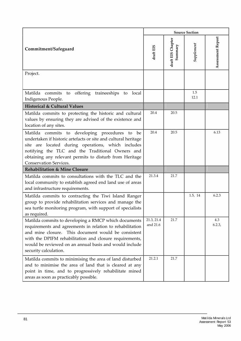
Source Section
Commitment/Safeguard
draft EIS
draft EIS Chapter
Summary
Supplement
Assessment Report
Project.
Matilda commits to offering traineeships to local Indigenous People.
1.5 12.1
Historical & Cultural Values
Matilda commits to protecting the historic and cultural values by ensuring they are advised of the existence and location of any sites.
20.4 20.5
Matilda commits to developing procedures to be undertaken if historic artefacts or site and cultural heritage site are located during operations, which includes notifying the TLC and the Traditional Owners and obtaining any relevant permits to disturb from Heritage Conservation Services.
20.4 20.5 6.13
Rehabilitation & Mine Closure
Matilda commits to consultations with the TLC and the local community to establish agreed end land use of areas and infrastructure requirements.
21.3.4 21.7
Matilda commits to contracting the Tiwi Island Ranger group to provide rehabilitation services and manage the sea turtle monitoring program, with support of specialists as required.
1.5, 14 6.2.3
Matilda commits to developing a RMCP which documents requirements and agreements in relation to rehabilitation and mine closure. This document would be consistent with the DPIFM rehabilitation and closure requirements, would be reviewed on an annual basis and would include security calculation.
21.3, 21.4 and 21.6
21.7 4.3 6.2.3,
Matilda commits to minimising the area of land disturbed and to minimise the area of land that is cleared at any point in time, and to progressively rehabilitate mined areas as soon as practicably possible.
21.2.1 21.7
Matilda Minerals Ltd Assessment Report 53
May 2006
81

Source Section
Commitment/Safeguard
draft EIS
draft EIS Chapter
Summary
Supplement
Assessment Report
Matilda commits, where possible to restoring disturbed areas back to the original landform contours. Where this is not possible reshaped contours would be compatible with the surrounding landform.
21.2 and 21.3
21.7
Matilda commits to stabilising disturbed areas as soon as practically possible to prevent wind and water erosion.
21.2 and 21.3
21.7
Matilda commits to revegetating the disturbed land to provide for the long‐term stability of the system, and for the return of native flora and fauna communities that are similar to pre‐mining conditions and surrounding undisturbed areas.
21.2 and 21.3
21.7
Matilda commits to a developing a rehabilitation monitoring program that includes assessments of landform stability, flora and fauna in the rehabilitated areas.
21.2.5 21.7
Matilda commits to ensuring that closure requirements are progressed and achieved, as required after mining operations have ceased and to implement contingency plans if required.
21.2.6 21.7 6.2.4, 6.2.3
Matilda commits to allocating money to a nominated account every six months, as to budget for operating expenditure for site rehabilitation and mine closure purposes.
21.5 21.7 6.10
Consultations
Matilda commits to maintaining its existing stakeholder consultation by continuing its extensive consultation programme during the public review period and throughout the construction, operation and decommissioning phases of the mining operations, and developing a consultation strategy in collaboration with the TLC and the Traditional Owners.
22.4 22.5
Environmental Management System & Environmental Management Plan
Matilda Minerals Ltd Assessment Report 53
May 2006
82

Source Section
Commitment/Safeguard
draft EIS
draft EIS Chapter
Summary
Supplement
Assessment Report
Matilda commits to developing an EMS to assist them in managing their environmental responsibilities and to allow for continuous improvement of their EMS. This EMS would include specific EMP’s to address key or significant environmental identified during environmental risk assessments.
24.1 and 24.2
24.5 6.15
Matilda commits to ensuring that the required resources are available to establish, implement, maintain and improve the EMS.
24.3 24.5
Matilda commits to creating a monitoring, inspection and audit program to ensure the effectiveness of the EMS and EMPs.
24.4 24.5
Matilda Minerals Ltd Assessment Report 53
May 2006
83