COVER PHOTO: Tornadic storm from top to bottom captured … · COVER PHOTO: Tornadic storm from top...
15
Transcript of COVER PHOTO: Tornadic storm from top to bottom captured … · COVER PHOTO: Tornadic storm from top...
COVER PHOTO: Tornadic storm from top to bottom captured on May 2, 1988 nearRegan, Oklahoma.
STORM TRACKStormtrack is a non-profit publication intended for the scientist and amateur alike whoshare an avid interest in the acquisition and advancement of knowledge concerningsevere or unusual weather phenomena.
Stormtrack is printed on a bi-monthly basis by Lokke Printing
PUBLICATION STAFF
Timothy P. MarshallEditor-in-Chief
Philip E. ShermanAssistant Editor
Gene D. RhodenDesign Editor
Special thanks to Donald H. Lokke Jr., Stormtrack printer
DAVID HOADLEY, FOUNDER, 1977
SUBSCRIPTION INFORMATION:
Subscription price is $8.00 per year. Persons wishing to subscribe should make checks payable to:
Tim Marshall1336 Brazos Blvd.Lewisville, Texas 75067
JULY 31, 1988TIM MARSHALL, EDITORPHIL SHERMAN, ASST. ED.1336 BRAZOS BLVD.LEWISVILLE, TEXAS 75067
STORM TRACKSUBSCRIPTION RATE: $8.00/YEAR
VOL. 11, NO. 5BI-MONTHLY
CHECKS PAYABLE TOTHE EDITOR ONLY
CIRCLES IN ENGLAND: ARE THEY REALLY WHIRLWINDS?
I. COMMENTARY
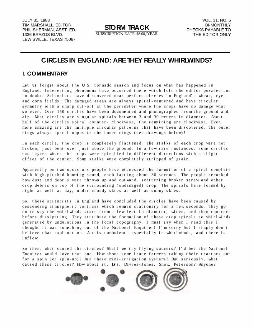
Let us forget about the U.S. tornado season and focus on what has happened inEngland. Interesting phenomena have occurred there which left the editor puzzled andin doubt. Scientists have discovered near perfect circles in England's wheat, rye,and corn fields. The damaged areas are always spiral-centered and have circularsymmetry with a sharp cut-off at the perimeter where the crops have no damage whatso ever. Over 150 circles have been documented and photographed from the ground andair. Most circles are singular spirals between 3 and 30 meters in diameter. Abouthalf of the circles spiral counter- clockwise, the remaining are clockwise. Evenmore amazing are the multiple circular patterns that have been discovered. The outerrings always spiral opposite the inner rings (see drawings below)!
In each circle, the crop is completely flattened. The stalks of each crop were notbroken, just bent over just above the ground. In a few rare instances, some circleshad layers where the crops were spiralled in different directions with a slightoffset of the center. Some stalks were completely stripped of grain.
Apparently on two occasions people have witnessed the formation of a spiral completewith high-pitched humming sound, each lasting about 30 seconds. The people remarkedhow dust and debris were thrown up and outward, scattering broken straw and othercrop debris on top of the surrounding (undamaged) crop. The spirals have formed bynight as well as day, under cloudy skies as well as sunny skies.
So, these scientists in England have concluded the circles have been caused bydescending atmospheric vortices which remain stationary for a few seconds. They goon to say the whirlwinds start from a few feet in diameter, widen, and then contractbefore dissipating. They attribute the formation of these crop spirals to whirlwindsgenerated by undulations in the local topography. I must say when I read this Ithought it was something out of the National Enquirer! I'm sorry but I simply don'tbelieve that explanation. Air is turbulent' especially in whirlwinds, and there isinflow.
So then, what caused the circles? Shall we try flying saucers? I'd bet the NationalEnquirer would love that one. How about some irate farmers taking their tractors outfor a spin (or spin-up)? Are these mini-irrigation systems? But seriously, whatcaused these circles? How about it, Drs. Davies-Jones, Snow, Peterson? Anyone?
II. CHASER NEWS
Where is a good place to buy film in bulk? Try Liberty Supply Co., 6450 Santa MonicaBlvd., Los Angeles, CA 90038. Ask for a price list. You can save $3-$4 per roll. ph:1-800-634-2057.
III. LETTERS TO THE EDITOR
Gene Rhoden is impressed with the new Kodak VRG 200 film. "If you've experimentedwith this film and find it comparable to the 100 film, you're right! When Kodakimproved the 100 ISO to 200, it ended up with a grain structure as good as the oldfilm. So for a little more money, you get an extra F-stop with the 200 film and thesame quality results."
Tom Fava sent in his favorite list of recent articles on tornadoes. "Please, let mesuggest the following:
1) "Tornados" by Peter Miller, National Geographic, June 1987, pp. 690-715.
2) "Year of the Tornado" by Steve Olson, Science 84, Nov. 1984, pp. 174-183.
3) "Tornado" by Civia Tamarkin, People, July 9, 1984, pp. 25-31.
4) "The Killer Winds of Spring" by Bruce Schechter, Discover, May 1981, pp. 18-24.
5) "Looking into Tornadoes" by Peter Gwynne, Audubon, March 1982, pp. 44-55.
6) "How Tornado Labs Tame Giant Twisters" by Franklynn Peterson and Judi Kesselman,Popular Mechanics, Aug. 1980, pp. 64-67.
Other favorites are listed in Weatherwise Magazine which publishes at least onetornado article per year. I do feel that these articles are the creme de la creme ofthe tornado literature I have encountered over the years. All of them are basicallynon-technical, heavily illustrated (many in color), and are an integral part of mytornado information collection. I hope STORM TRACK subscribers will check them out;they won't be disappointed!"
Roger Edwards summarizes his 1988 storm chase activities: "There were a few decentstorms in Oklahoma, even into July (if you like big hail). I can only hope to shareDr. Gray's optimism about the upcoming tropical season. Although I saw no twistersthis year, there were many interesting cloud features and lightning strikes tophotograph. I went out on several 'cumulus photography excursions' and 'WestOklahoma tumbleweed tours'. Maybe next year!"
March 24: Richard Thompson and I got directly under the first storm, south ofBartlesville, OK. We saw some minor straight-line wind damage in Nowata, and punchedsix cores from Vinita to Muskogee as the storms built southwest and lined out. Ineach core, small hail was encountered, with 3/4 inch diameter hail in Muskogee.
March 28: Mike Eilts, Paul Eisenmenger, and myself photographed what wouldeventually be the Oklahoma City tornado producer. The storm developed near Anadarko.We followed it toward Mustang, plunging into sheets of rain and small hail that weremoving rapidly southward. As we exited the precipitation, the movement of it was tothe north. (Not something I wish to do again). We stopped in Newcastle, watching themesocyclone occlude in heavy rain. Of course, we couldn't see the tornado throughthe green wall of hail and rain.
April 16: Richard Thompson, my wife Tanja and I caught an isolated storm northwestof Abilene, Texas between Jayton and Clairmont. We photographed a well defined wallcloud and very brief funnel to our west. After wall cloud dissipated, we moved underits previous location and found no damage. However, there was marble to golfball-size hail on the ground. We continued west and saw a rain-obscured wall cloud inTahoka at sunset.
May 7: We spent two hours sitting in Apache, OK throwing rocks at a dumpster. A BigBust! There was a stout inversion, we called a "nuclear cap". That is, it would oftaken a nuclear warhead to break it. (Editors note: Many chasers, including myself,were also fooled on this one.)
May 15: Tanja and I got under the first storm north of Stillwater, OK andphotographed a short-lived, weakly rotating wall cloud. More storms formed quickly,and we drove through marble, then golfball-size hail west of Cleveland. We hit andcollected half dollar to tennis ball hail east of Cushing."
Greg Story writes about the storms in Iowa on May 8th: "We had one great MothersDay. I've seen pictures of tornadoes and talked to several people who saw them. Onetornado was followed for 17 miles continuously on the ground in Iowa County, IA!"
John Mecikalski made his first serious storm chasing trip from Wisconsin to Kansasand Oklahoma. "Although the trips were unsuccessful for the most part, they provedto be fantastic experiences for both forecasting on the mesoscale and forunderstanding the connection between the upper atmosphere and severe weatherdevelopment. The trip also turned out to be a heck of a lot of fun."
C.L. Vlcek left the east coast and headed to the plains this year. We le t Friday,May 13th' (Missed the great FO outbreak on May 8th.) Steve Flood and myself leftWashington D.C. in the morning and drove all night to NSSFC in Kansas City, MO bynoon the next day. We continued to Emporia, KS to stay near a cold front. The nextmorning, May 15th, we drove southwest as a line of storms developed near Wichita,KS. The outflow boundary was marked by a small flat roll cloud. We stayed with theline all day and filmed a small wall cloud under a flanking line about 4 pm. Nearthe Cimmaron Turnpike on Rt. 18, we encountered strong winds and hail to 1-1/4inches in diameter. It was over in five minutes. Car damage included partial loss ofa side view mirror, and cracks in the tail light casing. For that price, I got somepretty decent video. We stayed at the OU Motel in Norman and spent the next few daystouring West Texas, seeing Palo Duro Canyon. We encountered a strong storm nearDalhart, TX on May 19th, with rain and hail. On May 20th,
we saw heavy thunder near Lubbock, TX. Finally, we settled for an isolated outflowstorm near Benjamin, TX on May, 21st and continued home the next two days."
Jim Ladue tells about his May 30, 1988 chase. "Five students doing research from theOklahoma University School of Meteorology were Herbert Stein, Steve Kruckenberg,Mark Shafer, Mike Kuetemeyer, and myself. We left Norman, OK at 9:45 am and headedwest toward Amarillo ending up on the northern extension of an intense line ofstorms. What we found was supercell imbedded in heavy precipitation near Boise City,OK. We were positioned east of the storm which was perfect for the NNE moving cell.A tornado touched down at 8:09:30 pm about 8 miles WSW of Boise City and lasted alittle over 2 minutes. A visible condensation funnel extended about 60% downwardfrom a relatively flat rain free base. The inflow into the squall-line was animpressive 40- 50 knots with blowing dust and east winds. After the first tornado, 2successive funnels were produced several miles north of the tornado. We were unableto pursue the storm further due to darkness and no road options. We were informedfrom the NWS that there was a 13 mile intermittent damage path which consisted ofdamaged barns and irrigation equipment. Amazing! A tornado in Oklahoma!
We observed another tornado near Ardmore, OK on May 2nd. We were in a good positionto see the tornado about 3 miles west of Regan, OK. We were ahead of the wall cloudwhen the funnel touched down about 2 miles to our southwest. There was a short-liveddebris cloud. We watched the tornado approach us, then lift about a half mile away.All in all, two tornadoes in a dried up season, I shouldn't complain."
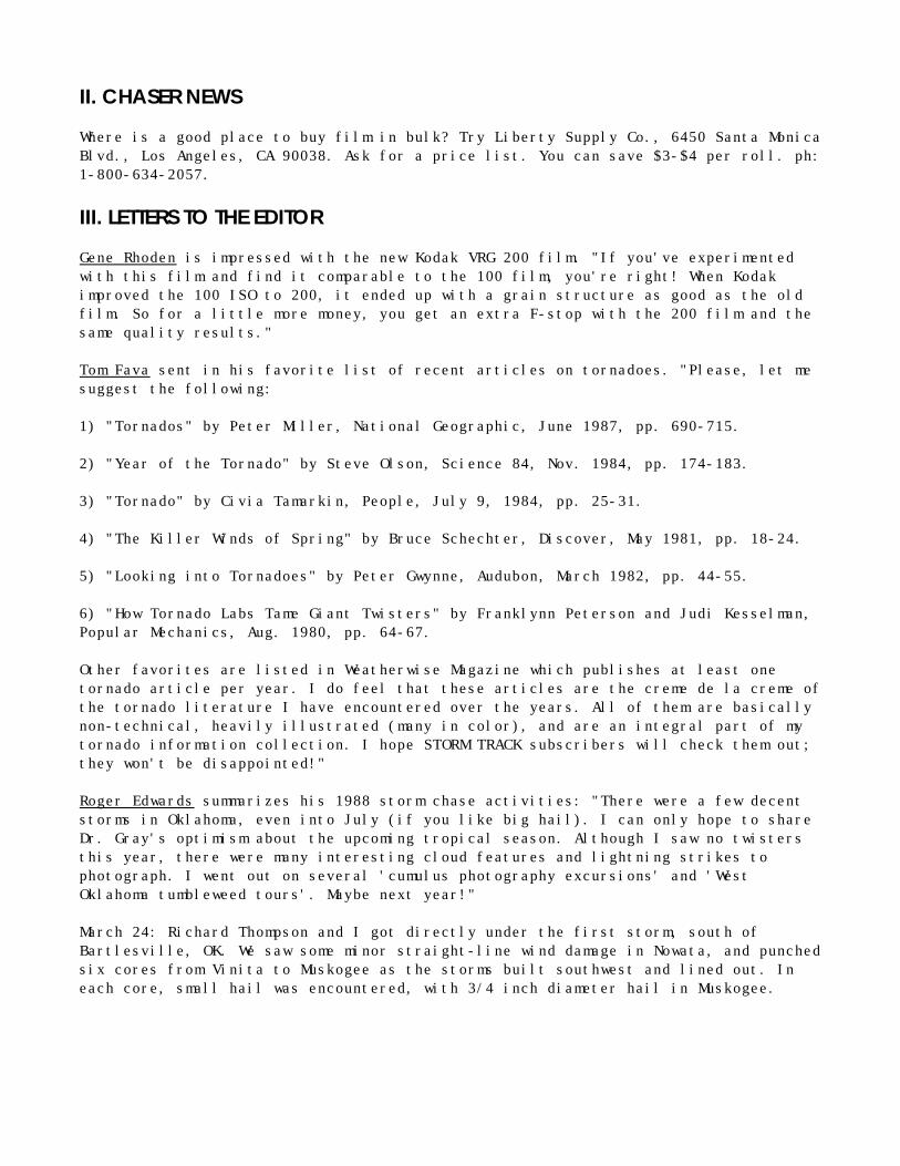
Jeff Piotrowski had a successful chase season this year: "On March 28, I observed atornado south of Lawton, OK, about 25 miles north of the Red River. On April 1, Ifollowed a tornado through northeast Texas. On April 16, I left Tulsa, OK about 4 amand drove to Abilene, TX as severe weather conditions were coming together over WestTexas. One storm developed near Big Spring, TX but it moved northeastward into drierair. It did produce some hail northeast of Big Spring about 3 pm. I continued westto storms firing along the dryline and filmed two tornadoes. Our closest encounterwas a tornado near Ardmore, OK on May 2. I was north of Troy which was the lastplace to report damage. I took video of the tornado as the sun streamed through thevortex."
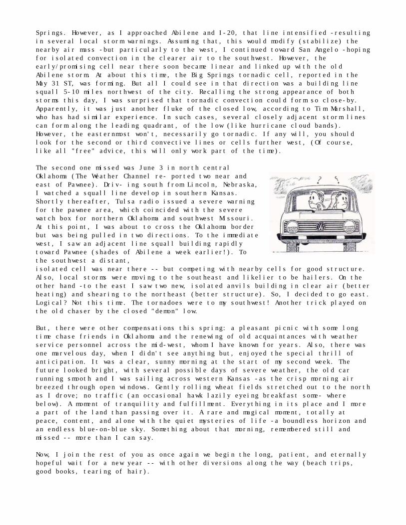
Wall cloud inGaines County,Texas on April 16,1988. Photographby Jeff Piotrowski
DENVER AREA TORNADOES: JUNE 15, 1988by Richard Slonaker
June has proven to be a plentiful storm month in Colorado. I was fortunate to catchthe storms that produced multiple tornadoes in the Denver area on June 15th of thisyear. There were a total of six tornadoes which caused extensive ground damage inthe Denver area. Another tornado reportedly occurred around Fort Collins, CO at thesame time, about 60 miles north of Denver.
On June 14th, a cold front moved through the Denver area producing thunderstorms. Iescaped from work two hours early and gave chase almost to the Kansas border. Thesestorms were fast moving and produced only some rain and lightning. However, theweather pattern set the stage for an explosion the following day.
The post-frontal conditions on June 15th were perfect for storm development. Therewas upper-level instability, plenty of low-level moisture, and clear skies formaximum surface heating. The National Weather Service had predicted a strongpossibility of severe weather. As storms began exploding off the Front Range of theRocky Mountains, I once again slipped away from work early.
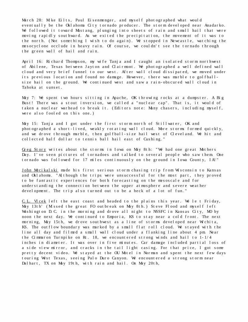
At about 4:05 pm, the radio broadcast was interrupted with the announcement of atornado at the Rocky Mountain Arsenal, just north of the Denver Stapleton Airport.My pulse quickened as I mapped out a plan to drive east, then north to catch thestorm. It was reported that the control tower at the Airport was evacuated for 25minutes.
At approximately 4:28 pm, I noticed this cloud that kept lowering to the ground. Itook a road north and reached the ridge of a hill. There it was, a tornado. It wasunbelievable! I stopped on the side of the road, set up my camera, and scribblednotes while trying to keep my eyes on the tornado. The tornado was to my northwest,about 13 miles away. I was just southeast of Aurora, a suburb east of Denver, at thetime the tornado was near 16th and Monaco in central Denver. After squeezing off ahalf dozen frames in my camera, I proceeded down the road in search of a betterview.
As I changed film, another funnel dipped out of the sky touching down at Broadwayand Evans (southwest of the previous tornado). It was a much thinner funnel than thefirst (which was still going strong). However, it was still powerful enough tooverturn several cars. The thin funnel dissipated before I had a chance to captureit on film. The first tornado dissipated about 4:44 pm. After the tornadoes haddissipated, I noticed a lot of lateral cloud-to-cloud lightning bolts with thisstorm. I have never noticed this type of lightning in other storms.
The Denver tornadoes were listed as F2 intensity on the Fujita tornado damageintensity scale. I think that was a bit optimistic. Damage to me seemed to beconsistent with the Fl variety. Considering both tornadoes occurred in the heart ofcrowded Denver during rush hour, it was a miracle that no one was killed and fewwere injured."
According to the Denver Post, Carol Reynolds watched the tornado from her backyard."We could see the tree limbs and debris being drawn toward it as it moved downColfax St. My husband's a weather nut. I couldn't get him inside." Sounds like an STsubscriber to me....
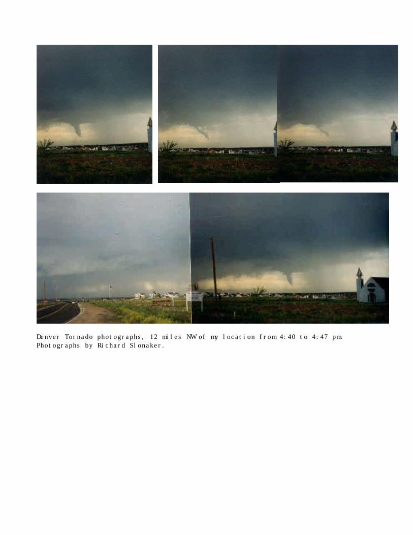
Denver Tornado photographs, 12 miles NW of my location from 4:40 to 4:47 pm.Photographs by Richard Slonaker.
WACO to WILLISTONby David Hoadley
-which otherwise might be titled "Diary of a Lean Chase," After 10,957 miles and16.1 days -one "landspout' and four weak funnels! That was my two week record thisyear. Lucky to have seen even one mini-tornado, I reluctantly gave up June 3rd andreturned home. A few tornadoes were missed on two other days from closed upper lows-- each of which presented a confused air mass, misleading visual indicators anddifficult choices -- when logic didn't seem to apply (more later).
My '88 chase spanned nine states from May 14-22 and May 27-June 3 (The week betweenI flew home and returned, naively hoping for better upper air support). This springwas dominated by strong troughs that initially looked great but then dug well southand became cut off from the jet stream as closed lows -producing widely scattered,marginally severe storms. Literally "driven" by Kansas City's Severe Storms ForecastCenter, I chased widely scattered Slight Risk areas (ergo one round trip from RapidCity to Williston, North Dakota and back -the next day south to Colorado). Itoccurred to me more than once that I was hostage to the quiet electronic confusionof some computer chip in a large remote build- ing, that was malevolently playingwith my fate. Most of the time, "Thar warn't nuthin' thar" but scattered weak towersand non-sustaining showers.
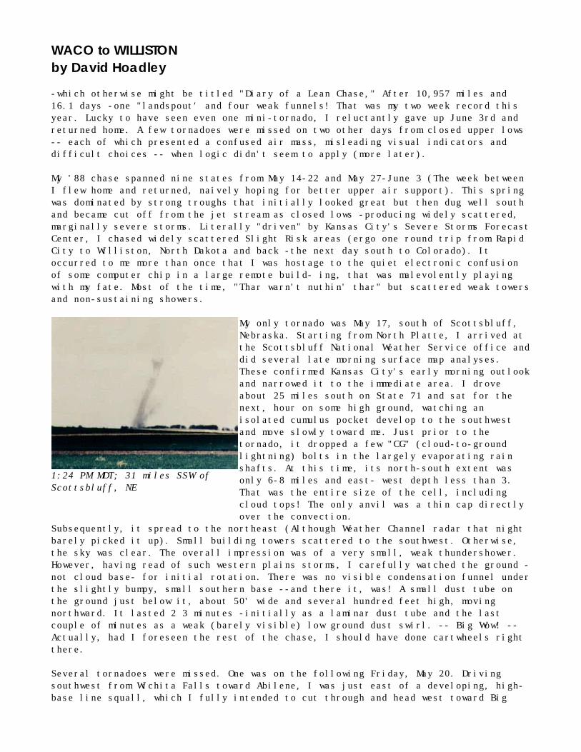
1:24 PM MDT; 31 miles SSW ofScottsbluff, NE
My only tornado was May 17, south of Scottsbluff,Nebraska. Starting from North Platte, I arrived atthe Scottsbluff National Weather Service office anddid several late morning surface map analyses.These confirmed Kansas City's early morning outlookand narrowed it to the immediate area. I droveabout 25 miles south on State 71 and sat for thenext, hour on some high ground, watching anisolated cumulus pocket develop to the southwestand move slowly toward me. Just prior to thetornado, it dropped a few "CG" (cloud-to-groundlightning) bolts in the largely evaporating rainshafts. At this time, its north-south extent wasonly 6-8 miles and east- west depth less than 3.That was the entire size of the cell, includingcloud tops! The only anvil was a thin cap directlyover the convection.
Subsequently, it spread to the northeast (Although Weather Channel radar that nightbarely picked it up). Small building towers scattered to the southwest. Otherwise,the sky was clear. The overall impression was of a very small, weak thundershower.However, having read of such western plains storms, I carefully watched the ground -not cloud base- for initial rotation. There was no visible condensation funnel underthe slightly bumpy, small southern base --and there it, was! A small dust tube onthe ground just below it, about 50' wide and several hundred feet high, movingnorthward. It lasted 2 3 minutes -initially as a laminar dust tube and the lastcouple of minutes as a weak (barely visible) low ground dust swirl. -- Big Wow! --Actually, had I foreseen the rest of the chase, I should have done cartwheels rightthere.
Several tornadoes were missed. One was on the following Friday, May 20. Drivingsouthwest from Wichita Falls toward Abilene, I was just east of a developing, high-base line squall, which I fully intended to cut through and head west toward Big
Springs. However, as I approached Abilene and I-20, that line intensified -resultingin several local storm warnings. Assuming that, this would modify (stabilize) thenearby air mass -but particularly to the west, I continued toward San Angelo -hopingfor isolated convection in the clearer air to the southwest. However, theearly/promising cell near there soon became linear and linked up with the oldAbilene storm. At about this time, the Big Springs tornadic cell, reported in theMay 31 ST, was forming. But all I could see in that direction was a building linesquall 5-10 miles northwest of the city. Recalling the strong appearance of bothstorms this day, I was surprised that tornadic convection could form so close-by.Apparently, it was just another fluke of the closed low, according to Tim Marshall,who has had similar experience. In such cases, several closely adjacent storm linescan form along the leading quadrant, of the low (like hurricane cloud bands).However, the easternmost won't, necessarily go tornadic. If any will, you shouldlook for the second or third convective lines or cells further west, (Of course,like all "free" advice, this will only work part of the time).
The second one missed was June 3 in north centralOklahoma (The Weather Channel re- ported two near andeast of Pawnee). Driv- ing south from Lincoln, Nebraska,I watched a squall line develop in southern Kansas.Shortly thereafter, Tulsa radio issued a severe warningfor the pawnee area, which coincided with the severewatch box for northern Oklahoma and southwest Missouri.At this point, I was about to cross the Oklahoma borderbut was being pulled in two directions. To the immediatewest, I saw an adjacent line squall building rapidlytoward Pawnee (shades of Abilene a week earlier!). Tothe southwest a distant,isolated cell was near there -- but competing with nearby cells for good structure.Also, local storms were moving to the southeast and likelier to be hailers. On theother hand -to the east I saw two new, isolated anvils building in clear air (betterheating) and shearing to the northeast (better structure). So, I decided to go east.Logical? Not this time. The tornadoes were to my southwest! Another trick played onthe old chaser by the closed "demon" low.
But, there were other compensations this spring: a pleasant picnic with some longtime chase friends in Oklahoma and the renewing of old acquaintances with weatherservice personnel across the mid-west, whom I have known for years. Also, there wasone marvelous day, when I didn't see anything but, enjoyed the special thrill ofanticipation. It was a clear, sunny morning at the start of my second week. Thefuture looked bright, with several possible days of severe weather, the old carrunning smooth and I was sailing across western Kansas -as the crisp morning airbreezed through open windows. Gently rolling wheat fields stretched out to the northas I drove; no traffic (an occasional hawk lazily eyeing breakfast some- wherebelow). A moment of tranquility and fulfillment. Everything in its place and I morea part of the land than passing over it. A rare and magical moment, totally atpeace, content, and alone with the quiet mysteries of life -a boundless horizon andan endless blue-on-blue sky. Something about that morning, remembered still andmissed -- more than I can say.
Now, I join the rest of you as once again we begin the long, patient, and eternallyhopeful wait for a new year -- with other diversions along the way (beach trips,good books, tearing of hair).
ARDMORE, OK TORNADOESMAY 2, 1988
PART I: The Forecast
"Strong Dynamics, Weak Thermodynamics"
Had it been another chase year, the weather situation on May 2nd would havewarranted a definite "let's go" chase strategy, but 1988 was different--yet again, aday in which I thought "if it's not one thing, it's another thing...". Many of theingredients were present, for sure: a powerful storm system was winding up in theTexas Panhandle, poised to move onto the plains; the vertical wind structure andupper cold pool associated with it were favorable for severe weather; and arespectable dryline was beginning to advance eastward off of the Caprock Escarpmentin Texas.
These strong dynamic parameters were offset by limited air-mass instability.Although the low-level winds were now blowing briskly from the south and southeast,a persistent surface high pressure area along the gulf coast had pre- vented thedeep moisture from pouring more rapidly inland. Thus, the 60 degree Fahrenheitdewpoint line, which signified the northernmost extent of the better moisture field,was still south of Austin, TX at 7 a.m. A narrower channel of low-to-mid 50'sdewpoints extended in an area 150 miles wide ahead of the dry- line from Hill City,KS to San Angelo, TX. Lifted indices were from 0 to -4 in the moist air, marginalfor severe thunderstorm production.
Given the mixed scenario, I forecasted two possible areas for later severe weatherduring the day: (1) part of North Central Texas, along the leading edge of deepermoisture moving north, and (2) the area of Central Oklahoma that was ahead of aneastward bulging arc in the dryline. The SELS forecast of SLIGHT RISK mentioned thatthe low- and mid-level dry punch would continue to drive towards Southern Oklahomaand enhance the severity of any storms that did develop. Another favorable factorwas an axis of difluence at 500 MB that ex- tended across North Texas and SouthernOklahoma. With the situation offering at least some promise, and relatively close tohome, I decided to leave for work and prepare the car for a possible afternoonchase. Just before leaving, I ob- tained the 8 a.m. observations, noticing that a"line of CB's" had been reported near Abilene. "Looks like an 'early boom' in myforecast area", I thought.
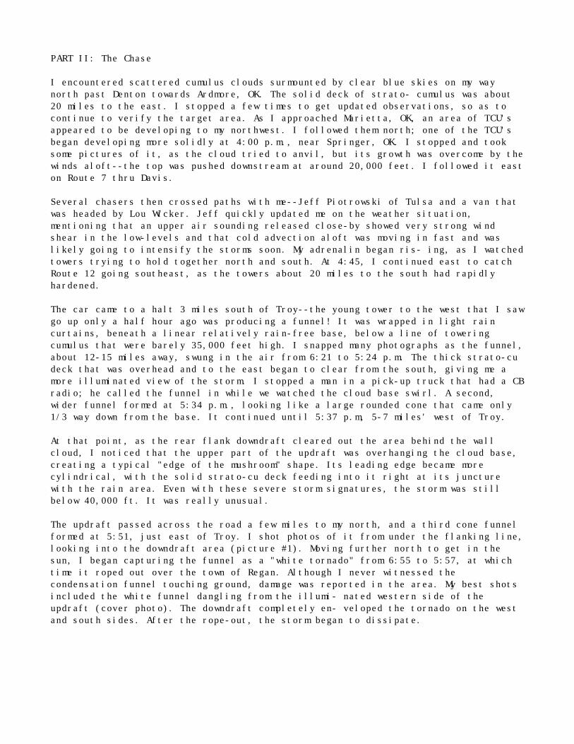
By phone, I monitored the hourly observations for the target areas through noon, andfound that dewpoints were rising steadily across the entire region, reaching 60degrees at Dallas and 57 degrees at Ardmore. In addition, the skies outside IBM hadrapidly become overcast with thick stratocumulus clouds surging northward. Thedryline advanced to a Fort Sill, Wichita Falls, Brownwood line; the earlier line ofCB's had apparently dissipated along it. Having skipped lunch and becomingincreasingly committed to chasing, I decided that the 1 p.m. obser- vations wouldprovide my "now or never" choice. As a result of the following key changes, I chose"now": (a) surface convergence had increased significantly over South-CentralOklahoma, as Ardmore's winds had abruptly backed from 190 degrees to 120 degreesahead of the dryline; (b) the thermodynamic pattern had also become favorable, witha strong warm/cool, dry/moist boundary well estab- lished (see 4 p.m. surface map);and, (c) a line of TCU had been reported east of Wichita Falls.
PART II: The Chase
I encountered scattered cumulus clouds surmounted by clear blue skies on my waynorth past Denton towards Ardmore, OK. The solid deck of strato- cumulus was about20 miles to the east. I stopped a few times to get updated observations, so as tocontinue to verify the target area. As I approached Marietta, OK, an area of TCU'sappeared to be developing to my northwest. I followed them north; one of the TCU'sbegan developing more solidly at 4:00 p.m., near Springer, OK. I stopped and tooksome pictures of it, as the cloud tried to anvil, but its growth was overcome by thewinds aloft--the top was pushed downstream at around 20,000 feet. I followed it easton Route 7 thru Davis.
Several chasers then crossed paths with me--Jeff Piotrowski of Tulsa and a van thatwas headed by Lou Wicker. Jeff quickly updated me on the weather situation,mentioning that an upper air sounding released close-by showed very strong windshear in the low-levels and that cold advection aloft was moving in fast and waslikely going to intensify the storms soon. My adrenalin began ris- ing, as I watchedtowers trying to hold together north and south. At 4:45, I continued east to catchRoute 12 going southeast, as the towers about 20 miles to the south had rapidlyhardened.
The car came to a halt 3 miles south of Troy--the young tower to the west that I sawgo up only a half hour ago was producing a funnel! It was wrapped in light raincurtains, beneath a linear relatively rain-free base, below a line of toweringcumulus that were barely 35,000 feet high. I snapped many photographs as the funnel,about 12-15 miles away, swung in the air from 6:21 to 5:24 p.m. The thick strato-cudeck that was overhead and to the east began to clear from the south, giving me amore illuminated view of the storm. I stopped a man in a pick-up truck that had a CBradio; he called the funnel in while we watched the cloud base swirl. A second,wider funnel formed at 5:34 p.m., looking like a large rounded cone that came only1/3 way down from the base. It continued until 5:37 p.m, 5-7 miles' west of Troy.
At that point, as the rear flank downdraft cleared out the area behind the wallcloud, I noticed that the upper part of the updraft was overhanging the cloud base,creating a typical "edge of the mushroom" shape. Its leading edge became morecylindrical, with the solid strato-cu deck feeding into it right at its juncturewith the rain area. Even with these severe storm signatures, the storm was stillbelow 40,000 ft. It was really unusual.
The updraft passed across the road a few miles to my north, and a third cone funnelformed at 5:51, just east of Troy. I shot photos of it from under the flanking line,looking into the downdraft area (picture #1). Moving further north to get in thesun, I began capturing the funnel as a "white tornado" from 6:55 to 5:57, at whichtime it roped out over the town of Regan. Although I never witnessed thecondensation funnel touching ground, damage was reported in the area. My best shotsincluded the white funnel dangling from the illumi- nated western side of theupdraft (cover photo). The downdraft completely en- veloped the tornado on the westand south sides. After the rope-out, the storm began to dissipate.
Fig 1. Photograph looking east towardRegan, OK of dissipating tornado at5:58 pm. Photograph by Phil Sherman.
Area map around Ardmore, OK.
Computer generated surface map for 7 amon May 2, 1988.
Computer generated surface map for 4 pmon May 2, 1988.
FUNNEL FUNNIES: Nothing Can Phase the Storm-aholics (Fact)Nothing can phase the storm-aholics as they constantly live, breath, and eat storms.
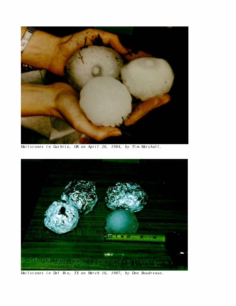
Hailstones in Guthrie, OK on April 26, 1984, by Tim Marshall.
Hailstones in Del Rio, TX on March 16, 1987, by Don Boudreaux.