“Courting Nuclear Disaster in Maharashtra: Why the Jaitapur Project Must Be Scrapped”

Courting Disaster: How the Supreme Court Has Broken the Clean Water Act and Why Congress Must Fix It

APRIL 2009
Courting Disaster: How the Supreme Court Has Broken the Clean Water Act and Why Congress Must Fix It
Courting Disaster is a publication of Earthjustice, Environment America, Clean Water Action, National Wildlife Federation, Natural Resources Defense Council, Sierra Club, and Southern Environmental Law Center.
These organizations recognize the following individuals for their valuable work in researching, drafting, editing and/or compiling information and photographs for this report and thank them for making its publication possible: Dalal Aboulhosn, Tanja Bos, Josh Davis , Jon Devine, Jessica Ennis , Ed Hopkins, Joan Mulhern, Jim Murphy, Bill Sapp.
© 2009 Earthjustice, Environment America, Clean Water Action, National Wildlife Federation, Natural Resources Defense Council, Sierra Club, and Southern Environmental Law Center. All rights reserved.
Cover Photos: (top) Cypress swamp, Bill Lea; (bottom) Pollution discharge, Earthjustice
This report is printed on 100% postconsumer waste recycled paper with soy inks by union labor .
1
In 1972, Congress passed an expansive Clean Water Act
to protect all “waters of the United States.” For almost 30
years, both the courts and the agencies responsible for
administering the Act interpreted it to broadly protect
our Nation’s waters. However, in two recent decisions,
Solid Waste Agency of Northern Cook County v. U.S. Army
Corps of Engineers (SWANCC) in 2001 and Rapanos v.
United States in 2006, the Supreme Court misinterpreted
the law and placed pollution limitations for many vital
water bodies in doubt. After the decisions, the Bush
administration’s Environmental Protection Agency (EPA)
and Army Corps of Engineers (Corps) excluded numerous
waters from protection and placed unnecessarily high
hurdles to protecting others.
Executive Summary
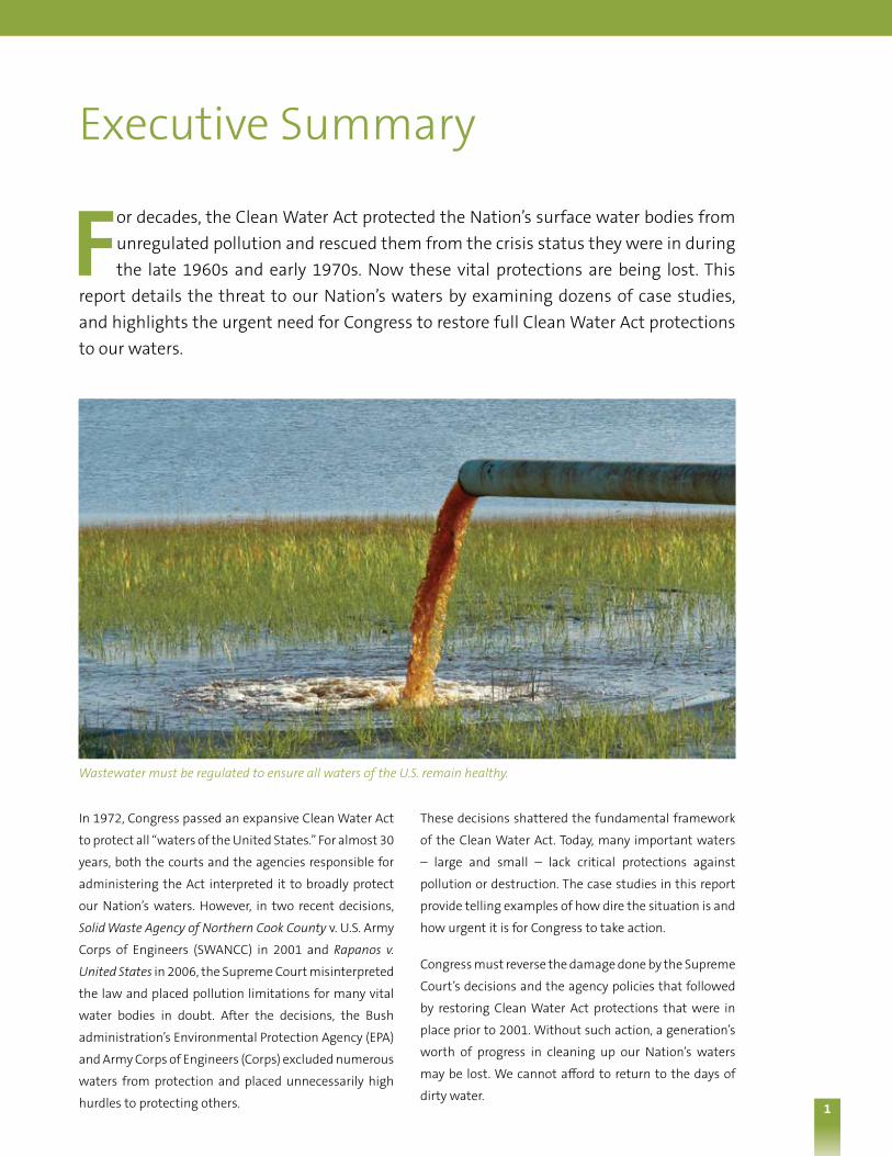
For decades, the Clean Water Act protected the Nation’s surface water bodies from unregulated pollution and rescued them from the crisis status they were in during the late 1960s and early 1970s. Now these vital protections are being lost. This
report details the threat to our Nation’s waters by examining dozens of case studies, and highlights the urgent need for Congress to restore full Clean Water Act protections to our waters.
These decisions shattered the fundamental framework
of the Clean Water Act. Today, many important waters
– large and small – lack critical protections against
pollution or destruction. The case studies in this report
provide telling examples of how dire the situation is and
how urgent it is for Congress to take action.
Congress must reverse the damage done by the Supreme
Court’s decisions and the agency policies that followed
by restoring Clean Water Act protections that were in
place prior to 2001. Without such action, a generation’s
worth of progress in cleaning up our Nation’s waters
may be lost. We cannot afford to return to the days of
dirty water.
Wastewater must be regulated to ensure all waters of the U.S. remain healthy.

2
Clean water depends on the health of all water bodies,
from small streams, to woodland vernal pools, to
our greatest rivers, lakes, and coastal waters. Science
overwhelmingly shows that headwater streams and
wetlands are vital parts of the aquatic system. Indeed,
small streams and wetlands in the upper reaches of
our watersheds often account for the vast majority of
the chemical, physical, and biological activity that takes
place throughout the water cycle. These waters provide
the foundation of the food chain upon which aquatic
life depends. They filter pollutants, store flood waters,
and recharge flow in our greatest waterways. Just as
our circulatory system can not function without its
capillaries, the water cycle cannot function without its
smaller waters.
When Congress passed the Clean Water Act in 1972,
our waters were in dire shape. The Cuyahoga River had
caught fire several times, Lake Erie was all but devoid
of life, oil spills commonly occurred on our coasts,
and industrial polluters treated rivers and lakes as
open sewers.
Background
Although work remains, the Clean Water Act is primarily
responsible for the remarkable clean up of our waters
and the dramatic slowing of wetland loss. Part of the
law’s success comes from its broad scope; many of the
law’s pollution control programs apply to every “water
of the United States.” This is true of the requirement
that industrial facilities and sewage treatment plants
use advanced pollution controls on their discharges. It
is true of the Act’s provisions requiring certain facilities
to prepare oil spill prevention plans. It is true of the
program to identify waterways that do not meet state
water quality standards and develop a pollution budget
to help clean them up. And it is true of the requirement
to get a permit before discharging dredged or fill material
into waters.
Sadly, progress under the law has been undermined
by attacks on what kinds of water bodies qualify as
protected “waters of the United States.”
Making a Mess: SWANCC and RapanosIn 2001 and 2006, the U.S. Supreme Court dealt a one-two
punch to water quality. The first blow came when it
decided SWANCC, a 5-4 ruling that certain isolated,
intrastate ponds were not protected by the Clean Water
Act, even though the Justice Department argued that the
Act covers water bodies used as migratory bird habitat.
The Supreme Court suggested that Congress’s use of the
term “navigable waters” in the Act indicated an intent
to restrict protections to waterways somehow related
to navigable ones. The court fundamentally ignored the
fact that Congress defined “navigable waters” broadly to
mean the “waters of the United States,” and the Court
similarly brushed aside its own prior decision saying
that the word “navigable” was of “limited import.”
We cannot survive without clean water. We need it to drink, to grow our crops, and supply our food. Many of us rely on it for the things we enjoy most: swimming, boating, duck hunting, paddling, and fishing.
The next generation deserves clean water.

3
The second blow came five years later in Rapanos,
when the court revisited the issue of which waters are
covered by the law. Rapanos involved wetlands near to
tributaries of traditionally navigable waters. Rather than
providing clarity, the Supreme Court created further
confusion, failing to reach any majority decision, in
several opinions with fundamentally contrary rationales.
A four-member plurality would protect only “relatively
permanent waters” connected to traditionally navigable
water bodies, as well as wetlands with a “continuous
surface connection” to other protected waters. In a solo
concurring opinion, Justice Anthony Kennedy would
require that certain wetlands have a “significant nexus”
to traditional navigable waters in order to be protected
and gave little guidance as to what such a “nexus”
requires, leaving the courts and the agencies to figure
that out on a cumbersome case-by-case basis.
Insult to Injury: Agency “Guidance”To make matters worse, following both SWANCC and
Rapanos, the Bush administration issued new policies
instructing field staff how to apply the Supreme Court
decisions. These documents made it significantly harder
to protect various water bodies, including tributary
streams, rivers, and wetlands. In 2003, following SWANCC,
the administration essentially removed protection for
non-navigable “isolated” water bodies, including prairie
pothole wetlands, playa lakes, and vernal pools that are
invaluable for wildlife habitat, groundwater recharge,
and flood control. The U.S. House of Representatives
specifically voted to reject the use of the agencies’
post-SWANCC policy in 2006, but it remains in effect to
this day.
In 2007, the EPA and Corps released a second guidance
document purporting to instruct agency officials on
how to implement Rapanos. The Rapanos guidance is
even more confusing and less protective than Rapanos
itself. In addition to the isolated waters written off
by the SWANCC guidance, the Rapanos guidance
puts intermittent and ephemeral streams and many
adjacent wetlands in danger of losing protections,
a result not required by either court decision. In
particular, the Rapanos guidance strips categorical
protections for tributaries of larger waters; presumes
certain types of ephemeral streams and waters are no
longer protected; creates a binding, unpredictable, and
time and resource intensive case-by-case process for
determining what is protected; and ignores science to
interpret important and relatively protective aspects
of Justice Kennedy’s approach in a manner that makes
them nearly meaningless. The agencies revised the
Rapanos guidance in December 2008 and made it even
less protective, wrongly interpreting long standing case
law to make it more difficult to determine whether a
water is “traditionally navigable,” a determination that
impacts protection of both specific waters and waters in
the upper reaches of watersheds.
These confusing and unworkable directives put
countless water resources at risk. They can be rescinded
by the new administration — and should be. However,
because Rapanos and SWANCC are interpretations of
the Clean Water Act itself, the agencies responsible
for administering the Clean Water Act cannot fix the
problems created by these damaging decisions. Only
Congress can do that.
The Threat to Our WatersThe impact SWANCC, Rapanos, and the agency directives
have had on our water resources is alarming. The
Environmental Protection Agency estimated that
approximately 20 percent of the over 100 million acres
of wetlands in the continental U.S. are geographically
“isolated,” a troubling statistic when one considers that
the agencies stopped protecting isolated, non-navigable
intrastate water ways after SWANCC. 1 Additionally, about
60 percent of the stream miles in the continental U.S.
do not flow year-round; post-Rapanos interpretations
directly threaten those kinds of streams. These waters
not only serve as valuable wildlife habitat, store flood
water, return water to aquifers, and filter pollutants, but
they also provide some or all of the supply for drinking
water systems serving roughly 111 million Americans.
The legal chaos spawned by SWANCC and Rapanos and
the misguided EPA and Corps interpretations of them
have also had devastating effects on law enforcement.
In December 2008, Congressman Henry Waxman and
Congressman James Oberstar wrote a memorandum
1 Eric Pianin, Administration Establishes New Wetlands Guidelines; 20 Million Acres Could Lose Protected Status, Groups Say, Washington Post, at A.5 (Jan. 11, 2003)

4
to then-President-Elect Obama detailing hundreds
of Clean Water Act enforcement cases that the EPA
shelved or downgraded, and dozens more where the
legal mess forced the government to spend resources
arguing about whether a particular waterbody was
protected. Some of these cases included significant oil
spills. The memorandum also explains how, as a result
of the legal confusion, agency regulators are suffering
from increased workloads, record backlogs, heightened
frustration, and plummeting morale.
The Nation’s waters, and in turn our public health, cannot
withstand the current legal situation. After eight years of
litigation, the lower courts have failed in their attempts
to make sense of the Supreme Court’s handiwork.
Fixing the Fractures: The Clean Water Restoration ActThe current untenable situation facing our waters
simply cannot be mended by the Judicial and Executive
branches. It is time for Congress to step up and remedy
this problem. Environmental groups are not alone in
calling for this congressional action. State governors,
hunting and fishing groups, respected scientists, federal
regulators, and members of the public from all across
the Nation are behind this call.
In order to return to the original intent of the Clean
Water Act, Congress must:
n Pass a bill that removes the confusing term
“navigable” from the Act;
n Make clear that “waters of the United States” means
the waters protected prior to SWANCC; and
n Explain the facts supporting Congress’s
Constitutional authority to protect such waterways.
In previous years, leaders in Congress introduced a bill
entitled the Clean Water Restoration Act to achieve
these ends. The Restoration Act had broad bi-partisan
support in past Congresses, but it is up to this Congress
to secure passage of such legislation.
About this reportIn the pages that follow we provide more than 30 case
studies from around the U.S. of how the Clean Water
Act has been misapplied since 2001. The case studies
include several kinds of examples:
n An administrative agency (EPA or the Corps) limited
legal protection for a given waterbody, ruling that it
is no longer protected by the Clean Water Act;
n A court made a determination undercutting Clean
Water Act protections for a waterbody;
n As a defense in an enforcement action, an alleged
polluter raised the issue of whether the water it
discharged into is a protected water;
n District officials at the Corps of Engineers originally
determined a water not be protected, forcing
headquarters officials at EPA and/or the Corps to
step in to overrule the initial decision and protect the
waterbody; and
n A discharger with a permit argued it may pollute
waters without federal safeguards in the future.
Although hard to document, we also believe many
polluters across the country have simply determined
that specific waterways lack protection and acted to
destroy, degrade or pollute that water without informing
federal officials. Further, these are only case studies; we
estimate that federal agencies declared over 15,000
water bodies unprotected in the past eight years. Thus,
the case studies in this report represent a small fraction
of the thousands of waters that have lost federal
protections, officially or unofficially, since the Supreme
Court’s 2001 decision.
Wetlands like this one in the Upper Mississippi NationalWildlife Refuge in Iowa filter pollutants, store flood waters, and recharge waterways.
U.S. Fish and W
ildlife Services

5 5
S o ut h Ca ro l i n a
Coastal Wetlands Isolated from Ocean?
Coastal and riparian wetlands are vital pieces of South Carolina’s ecosystems. According to the South Carolina Department of Health and Environmental Control (DHEC), the state’s coastal zones provide habitat for a variety of wildlife,
including the American Alligator, Bobcat, Red Fox, River Otter, Mink, Black Bear and Southern Bald Eagle. Such resources include a 32 acre wetland on a site owned by the company Spectre, LLC. Spectre wants to destroy this coastal wetland in order to develop the site for commercial and retail purposes. Despite historic and current hydrological connections between the wetland and navigable waters, the Corps gave the green light to Spectre by issuing a determination that the wetlands are “isolated” and not protected by the Clean Water Act.
South Carolina Departm
ent of N
atural Resources
A large coastal wetland associated with the Murrells Inlet in South Carolina is being left vulnerable to federally unregulated pollution and destruction.
Coastal zones provided critical habitat to River Otters and other wildlife.
Historic maps indicate a stream directly connected the
wetland in question to nearby Murrells Inlet before
road construction activities disrupted that connection.
Today, the wetland drains through a series of channels
before emptying into Collins Creek, which flows a short
distance before flowing into the navigable Waccamaw
River, which flows into the ocean. The entire area is wet
and contains many coastal and riparian wetlands.
Not all agencies agreed that this vital wetland is
isolated. As part of the state permitting process, the U.S.
Fish and Wildlife Service (USFWS) wrote a letter stating
that the, “[p]roject plans illustrate that the wetland
proposed for filling is a portion of a much larger wetland
system. The illustrations do show a waterway exiting
the wetland at the southeast corner and connecting
to a stream.” It requested the wetland be treated as
jurisdictional because of “the rarity and importance
of such large ‘isolated’ wetlands in South Carolina.”
USFWS also followed with a recommendation “that the
filling of any portion of this unique wetland should be

6 6 2 South Carolina Department of Health and Environmental Control appealed this decision.
U.S. N
ational Oceanic and Atm
ospheric Administration
South Carolina coastal wetlands like the ones pictured here, create habitat for wildlife and buffer communities from storms.
S o ut h Ca ro l i n a
completely avoided, and furthermore, the wetland in its
entirety should be buffered and preserved in perpetuity.”
Similarly, the South Carolina DHEC denied Spectre’s
application for a state land disturbance or storm water
permit in July of 2006 after its staff concluded the
project’s impact on the wetlands violated the state’s
Coastal Management Program.
On February 19, 2008, an administrative law court
in South Carolina overturned South Carolina DHEC’s
denial on the basis that “[t]he terms of the [Coastal
Management Program] policies do not permit review
of isolated wetlands over which the Army Corps does
not have jurisdiction” and therefore DHEC “has no
authority to use the policies to make decisions on storm
water permit applications involving impacts to isolated
wetlands over which the Army Corps does not exercise
jurisdiction.” In other words, because state law tracks
the Corps’ Clean Water Act authority, the federal loss of
protection undercut state-level safeguards as well.2

7 7
What’s In a Name? Water Skiing on a Lake Doesn’t Prove It Is Navigable
Outdoor activities are plentiful around Greeley, Colorado. Located about 45 miles north of Denver and about 30 miles south of Rocky Mountain National Park, Greeley is a scenic tree-lined town in the shadows of the Rockies. While Colorado
is known for its world famous snow sports, waterskiing and boating are also popular recreational pastimes in the state. Greeley fully embraces outdoor recreation, and was even selected by Sports Illustrated magazine as a town with one of the best park and recreation programs in the nation.
Ski Lake, the northern lake in this picture, in Greeley, Colorado.
Kids as well as adults around the Nation depend on clean lakes and ponds for sports like waterskiing.
Google Earth
3 U.S. Army Corps of Engineers, Omaha District, Approved Jurisdictional Determination, Terra Ceia Estates, NWO-2007-2810-DEN (Nov. 2, 2007), available at https://www.nwo.usace.army.mil/html/od-tl/jur/NWO20072810DEN%20Jackson%20Inlet%20Ditch%20and%20ski%20lake.doc
Co lo ra d o
In November 2007, the Corps concluded that a 15 acre
lake used for waterskiing was not protected by the Clean
Water Act, because the lake was hydrologically “isolated”
from other water bodies. The Corps said that “[t]here is
no information available to show that this Ski Lake 1) is
or could be used by interstate or foreign travelers [sic]
for recreational or other purposes, 2) produces fish or
shellfish which are or could be taken and sold in inter-
state or foreign commerce, or 3) is or could be used
for industrial purposes by industries in the interstae
[sic] commerce.”3
Whether or not this is true, the Corps missed an obvious
fact, one that should have made this lake obviously
protected – it is actually navigable. Its name is Ski Lake,
after all! Boats – power boats, in fact – are pulling the
water skiers, and even the remarkably lax guidance
documents that EPA and the Corps produced make it
clear that if a waterbody is susceptible to commercial
recreation (like boat rentals and water ski events), the
water is protected by the Clean Water Act.

8 8
n o rt h da kota
The End of Prairie Potholes?
Prairie potholes in the upper Great Plains are incredibly productive wetlands. Labeled America’s “duck factory,” about half of the ducks hatched in North America every year come from the prairie pothole region. In addition, these often seasonal
wetlands provide tremendous amounts of flood storage and pollutant filtration. Studies demonstrate that restoring wetlands in the pothole region that have been lost since European settlement could have significantly reduced recent major flooding in waters such as the Mississippi Basin and Devils Lake in North Dakota. Notwithstanding the obvious importance of these water bodies, government information shows that since the SWANCC and Rapanos decisions, neither EPA nor the Corps have continued to afford Clean Water Act protection to these valuable prairie potholes.
Prairie potholes, America’s “Duck Factory,” are no longer being federally protected under the Clean Water Act.
U.S. Fish and W
ildlife ServicesU
.S. Fish and Wildlife Services
4 Letter from Michael G. McKenna, Chief, Conservation and Communication Division, North Dakota Game and Fish Department to Steve Thompson, Project Manager, Interstate Engineering, Inc. (August 13, 2007).
5 Approved Jurisdictional Determination, File No. NWO-2007-2606-BIS.
6 Approved Jurisdictional Determination, File No. NWO-2007-2376-BIS.
In one case, the North Dakota Department of Fish and
Game wrote a letter expressing that wetland impacts
of a highway upgrade project should be avoided to the
extent possible and compensated for otherwise.4 Even
with this letter, in September 2007, the Corps deter-
mined that an approximately 400 acre wetland called
Runner Slough in the prairie pothole region of North
Dakota was not federally protected.5 The Corps stated
that prior to the 2001 SWANCC decision, the wetland
would have been regulated based on the fact that it
provides habitat for migratory birds.
Similarly, in September 2007, the Corps declared an
approximately 100 acre wetland in the pothole area of
the state unprotected. This wetland, which the Corps
also conceded would have been protected prior to
SWANCC, will be impacted by a road project as well.6
The Corps has left countless smaller wetlands unpro-
tected by the Clean Water Act over the last several years.
For example, in yet another instance involving a highway
project, the Corps sanctioned the partial destruction of
over 15 small pothole wetlands by finding them not to

9
7 Information Sheet, File Number 200660429, Omaha District Office (July 24, 2006).
8 Letter from Jeffrey K. Towner, U.S. Fish and Wildlife Service, Field Supervisor, North Dakota Field Office, to Mr. Paul Seeley, Environmental Specialist, U.S. Department of Homeland Security (June 30, 2006).
9 U.S. Fish And Wildlife Service, Habitat and Population Evaluation Team Office Report, Bismarck, ND, 2001.
10 http://www.climatescience.gov/Library/sap/sap4-2/public-review-draft/sap4-2-prd-ch3.pdf site visited January 19, 2009 (detailing loss and shift of pothole habitat under various scenarios accounting for global warming).
Draining and destroying depressional wetlands, like potholes, have contributed to devastating flooding in Devils Lake, North Dakota and throughout the Upper Great Plains and Mississippi basin.
Protecting even small pothole wetlands is critical to duck habitat.
U.S. G
eological SurveyU
.S. Fish and Wildlife Services
n o rt h da kota
be subject to the Clean Water Act.7 Even the concerns
of the U.S. Fish and Wildlife Service, which expressed
worries regarding possible impacts to the wetlands
if protective measures were not taken and noted the
wetlands’ proximity to the Silver Lake National Wildlife
Refuge in North Dakota, could not give them federal
protection under the Act.8
Protecting small pothole wetlands is as important as
protecting larger water bodies. U.S. Fish and Wildlife
Service analysis suggests duck production in the prairie
pothole region would decline by 70 percent if all wetlands
less than an acre in size were lost.9 To make matters
worse, global warming could cause a dramatic loss of
pothole habitat,10 making it even more crucial that all
potholes be protected so that a sufficient number have
a chance to remain.

10
Un-Savory Ruling for Savery Creek: Wildlife Habitat Placed at Risk
11 Letter from Carol Rushin, Chief, Assistant Regional Administrator, Office of Ecosystems Protection and Remediation, US EPA, Region 8, to Cheryl Goldsberry, US Army Corps of Engineers, Omaha District (July 31, 2007).
12 Approved Jurisdictional Determination Form, NWO-2007-1550 (Jan. 3, 2008).
After the Corps determined that Coal Gulch in Wyoming, a non-permanently flowing tributary of Savery Creek (which in turn flows to the Little Snake River and on to the Green River) did not warrant Clean Water Act protection, the case
was elevated to EPA for review. EPA found serious deficiencies with the Corps’ analysis. In a letter EPA wrote that:
Western trout streams, like Savery Creek in Wyoming, depend on ephemeral and intermittent headwaters for their health. Many of these vital headwater streams in the West are no longer being protected against pollution and destruction.
Wyom
ing Wildlife and N
atural Resource Trust (w
ww
.nrt.state.wy.us/projects funded/D
istrict2.htm)
W yom i n g Ca l i F o r n i a
[W]e disagree with the Corps’ Traditional Navigable
Waters (TNW) determination as there are stream
segments between Coal Gulch and Green River which
are navigable in fact. … EPA also disagrees with the
Corps’ determination that because the Coal Creek
watershed is small the possibility of flow contribution
from that watershed is “essentially non-existent.”
Clearly a significant rain even on a watershed of 7.6
miles will result in a significant discharge to Savery
Creek. And EPA disagrees with the Corps’ conclusion
that the 3.6 acres of wetland which abut Coal Creek
have “no meaningful habitat for aquatic or terrestrial
species.” The Corps does point out that the soils in the
Coal Gulch watershed are easily eroded which produces
poor water quality due to sediment accumulation. This
recognition of erodible soils is inconsistent with the
determination that a contribution from the watershed
would be “essentially non-existent.”11
The EPA letter goes on to mention the fact that Savery
Creek is listed as “threatened” by the Little Snake River
Conservation District, that sediment control efforts
in the creek are underway, that the Wyoming Fish and
Game Department is trying to establish a trout fishery
below Savery Reservoir and that “[a]dditional sediment
loads from Coal Gulch will frustrate such efforts.”
Notwithstanding these serious concerns, the Corps still
decided not to protect Coal Gulch.12

11
Un-Savory Ruling for Savery Creek: Wildlife Habitat Placed at Risk
Protected Yesterday, Not Today: Up a Creek in California
Caliente Creek is a 20 mile ephemeral stream. Water from the creek flows through a series of waterways and into a wetland. The wetland is “highly likely” to have subsurface flow to the Eastside Canal, a diversion off the Kern River. Apparently
because the direction of flow in the canal is away from the Kern River, the Army Corps concluded that flow from Caliente Creek would not substantially affect the health of the river.
13 See 33 C.F.R. §§ 328.3(a)(4) (identifying “impoundments” of certain waters, including navigable ones like the Kern River, as protected) and (a)(5) (protecting tributaries to various protected waters, including impoundments under (a)(4)).
14 Kern Delta Water District, Welcome, available at http://kerndelta.org/index.cfm. 15 Indeed, the regulations provide that the “use, degradation, or destruction” criterion is satisfied if the waters in question “are used or could be used for industrial
purpose by industries in interstate commerce,” and the government explained in 1986 that waters “[u]sed to irrigate crops in interstate commerce” are protected. 51 Fed. Reg. 41,206, 41,217 (Nov. 13, 1986).
Protecting small streams and creeks helps protect our communities’ water quality.
Ca l i F o r n i a
Previously, the Clean Water Act would have protected
Caliente Creek, either because it could be considered a
tributary to an impoundment of a navigable water,13 or
because it is a water in which “the use, degradation or
destruction of which could affect interstate or foreign
commerce” under the agencies’ regulations.
The Eastside Canal is part of the Kern Delta Water
District’s network of supply canals, which supplies
customers in Kern County; in particular, the District
explains, “[s]ince its formal organization in 1965, Kern
Delta Water has primarily been involved with the distri-
bution of irrigation water to local farmers in specific
areas of Kern County.”14 In other words, the water from
the Eastside Canal, some of which is supplied by Caliente
Creek, is used to irrigate crops, which means the water’s
use, degradation or destruction surely could affect inter-
state commerce.15
This is a classic example of a stream that the Clean
Water Act plainly protected prior to the Supreme Court’s
decisions and the agencies’ guidance, and one that
desperately needs protection restored today.
11

12
Wetlands Under Attack in Connecticut
The Farmington River is a traditionally navigable interstate river, one of New England’s most prized trout fisheries, a favorite destination of canoers and kayakers, and a major tributary of the Connecticut River. The Farmington River
watershed also provides drinking water for the greater Hartford, Connecticut area. Yet a federal district judge ruled that wetlands neighboring the Farmington River are not protected by the Clean Water Act.
16 SAPS, 472 F. Supp. 2d at 228.17 Id. at 229. 18 The case has been appealed to the federal appeals court seated in New York.
The Farmington River is a favorite destination of paddlers, anglers, and other outdoor enthusiasts from New England and beyond. A federal court ruled that polluted wetlands next to this river are not protected by the Clean Water Act.
Farmington River W
atershed Association
Farmington River W
atershed Association
Co n n e C t i C ut
A citizens’ group alleged that the wetlands along the
river were being polluted by discharges of lead from
a shooting range berm on property that borders the
wetlands and has been accumulating lead shot over
several decades. Wetlands on the approximately 137
acre site are separated from the river on one side by
a minor road called Nod Road and directly connect, at
least during wet periods, to the river in another direction
through a tributary called Horseshoe Cove. The wetlands
are within an aquifer area that is also a major source of
drinking water.
The wetlands are also within the Farmington River’s
floodplain. The area can flood several times per year,
particularly during times of increased precipitation.
The record in the case showed that sometimes water
overtops Nod Road, allowing the wetlands to flow
directly into the river.
The court concluded that “[i]t is undisputed that the
Farmington River at least ‘neighbors’ the claimed
wetlands on Metacon property,” and cited evidence
that “the area is conducive to flooding, particularly
during the spring” or “with an average rainstorm.”16 The
court noted photographs submitted by the neighbors
“depict[ed] what occurs after heavy rains and thawing of
snow and ice …. [and shows] a surface water connection
between the Metacon Gun Club and [H]orseshoe Cove,
which flows into the Farmington River.” The court
further found that “in the light most favorable to the
plaintiffs, [there exists] at least a periodic physical nexus
between the site and the navigable waters of the
Farmington River.”17
Alarmingly, despite these facts, the court relied upon
Rapanos to conclude that a rational trier of fact could
not find that the wetlands at issue are protected by the
Clean Water Act because the record did not demonstrate
a continuous surface connection between the wetlands
and the river and because the pollutant of concern
– lead – was not conclusively shown to be polluting
the river.18

13
Coastal Plain Plainly at Risk: Near-Miss Nearly Leads to Destruction of Huge Wetlands Area
The Georgia Coastal Plain is covered by tens of thousands of freshwater wetlands that collectively create aquatic ecosystems that are vital to the health of the region. Many of these wetlands are intertwined with one another, through surface and
subsurface connections.
g e o rg i a
Just twenty miles from the Okefenokee Swamp, the
largest freshwater wetland in North America, lies a
6,100 acre site in the Satilla River basin that nearly lost
hundreds of acres of wetlands to mining.
After the Supreme Court decided SWANCC, a subsidiary
of an Australian mining company decided to mine
titanium and zircon on this site. The mining company
applied for permits from the Corps to destroy many of
these wetlands but claimed that it would not need a
permit to destroy over 300 acres of wetlands because
they were “isolated” from other wetlands by a dirt road.
The Corps obligingly determined that the wetlands had
“no surface water connection to any other water of the
United States,” and therefore, was not protected by the
Clean Water Act.
The environmental groups investigated the Corps’
determination and demonstrated that many of the
wetlands at issue drained into a working culvert that
Okefenokee Swamp at sunset.
U.S. Fish and W
ildlife Services
Just twenty miles from the Okefenokee Swamp, the
largest freshwater wetland in North America, lies a
6,100 acre site in the Satilla River basin that nearly lost
hundreds of acres of wetlands to mining.
After the Supreme Court decided SWANCC, a subsidiary
of an Australian mining company decided to mine
titanium and zircon on this site. The mining company
applied for permits from the Corps to destroy many of
these wetlands but claimed that it would not need a
permit to destroy over 300 acres of wetlands because
they were “isolated” from other wetlands by a dirt road.
The Corps obligingly determined that the wetlands had
“no surface water connection to any other water of the
United States,” and therefore, was not protected by the
Clean Water Act.
The environmental groups investigated the Corps’
determination and demonstrated that many of the
wetlands at issue drained into a working culvert that
went under a dirt road and clearly linked the 300 acres
of wetlands to other waterways downstream. After
months of communications with the mining company,
the Corps, and EPA and, after the threat of litigation, the
Corps finally reversed its jurisdictional determination
over about 120 acres, bringing those areas under
Clean Water Act protection.

14
Co lo ra d o
Reservoir Dogged: Critical Tributary Losing Protection in Thirsty Colorado
Headwater streams are an integral part of watersheds, including intermittent and ephemeral streams. These waters help ensure the quality and integrity of the waters below. In Colorado, 68 percent of streams do not flow year-round.
Because these small streams are so integrated into landscapes, they are most at risk of degradation or destruction.19
19 See “Protecting Headwaters: The Scientific Basis for Safeguarding Stream and River Ecosystems,” Stroud Water Research Center (2008.). 20 U.S. Army Corps of Engineers, Omaha District, Approved Jurisdictional Determination, Channel Work in the North Tributary of Newlin Gulch at Lagae Ranch,
NWO-2007-2195-DEN (Nov. 1, 2007), available at https://www.nwo.usace.army.mil/html/od-tl/jur/NWO20072195DEN.doc. 21 See Rueter-Hess Reservoir, available at http://www.reuterhess.com. 22 U.S. Army Corps of Engineers, Final Supplemental Environmental Impact Statement: Rueter-Hess Reservoir Expansion, Omaha District at Figure 2-10:
Conceptual Recreation Master Plan (Nov. 2007), available at https://www.nwo.usace.army.mil/html/od-tl/eis/rueter-hess.fseis.vol1.nov2007.pdf. 23 Id. at ES-2.
14
Marina at Cherry Creek Reservoir.
Colorado State Parks
In November 2007, the Corps declared an ephemeral
stream located between Castle Pines and Parker,
Colorado, not to be a protected waterbody. The stream,
known as the North Tributary, flows for roughly 2.6 miles
before joining with the main stem of Newlin Gulch and
its South Tributary, which then flows into the Rueter-
Hess Reservoir.20 If the stream flows were not caught by
the reservoir, Newlin Gulch would connect with Cherry
Creek and then the Cherry Creek Reservoir, a traditionally
navigable waterbody.
Historically, the Clean Water Act would have prohibited
unregulated pollution into Newlin Gulch, because it is a
tributary to a traditionally navigable water, even though
its flows are intercepted by an intervening dam. But in
this case, the Corps ruled the tributary was no longer a
water of the U.S. – apparently ignoring the effect this
could have on the health and safety of the local drinking
water supply.
The Rueter-Hess Reservoir, into which the North Tributary
flows, currently holds up to 16,200 acre-feet of water
that is “piped to municipal water treatment plants” or
re-injected into local bedrock aquifers – in other words,
it is used to replenish water supplies. In fact, work is
underway to expand the reservoir to 72,000 acre-feet.21
The plans call for the expanded reservoir to host a beach,
fishing opportunities, and a boat launch.22 More impor-
tantly, the reservoir will be an even larger water supplier
in the future. The larger reservoir will store Denver Basin
groundwater and water after its initial use, and it will
supply regional aquifers. Consequently, “[t]he expansion
would allow the reservoir to serve as a regional water
management facility for multiple water providers in
northern Douglas County…”23
Notwithstanding the fact that the North Tributary to
Newlin Gulch provides water to a regional water supply
reservoir, the Corps concluded that the stream has an
“insubstantial nexus” to the traditionally navigable
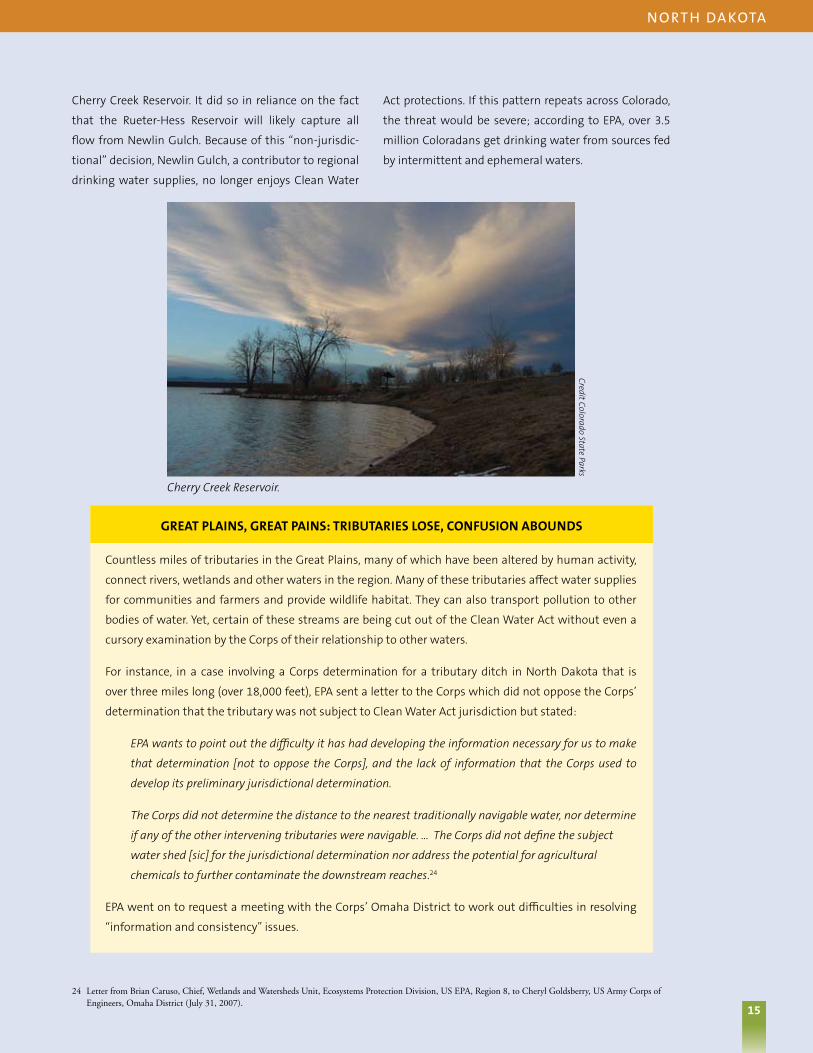
15
Countless miles of tributaries in the Great Plains, many of which have been altered by human activity,
connect rivers, wetlands and other waters in the region. Many of these tributaries affect water supplies
for communities and farmers and provide wildlife habitat. They can also transport pollution to other
bodies of water. Yet, certain of these streams are being cut out of the Clean Water Act without even a
cursory examination by the Corps of their relationship to other waters.
For instance, in a case involving a Corps determination for a tributary ditch in North Dakota that is
over three miles long (over 18,000 feet), EPA sent a letter to the Corps which did not oppose the Corps’
determination that the tributary was not subject to Clean Water Act jurisdiction but stated:
EPA wants to point out the difficulty it has had developing the information necessary for us to make
that determination [not to oppose the Corps], and the lack of information that the Corps used to
develop its preliminary jurisdictional determination.
The Corps did not determine the distance to the nearest traditionally navigable water, nor determine
if any of the other intervening tributaries were navigable. … The Corps did not define the subject
water shed [sic] for the jurisdictional determination nor address the potential for agricultural
chemicals to further contaminate the downstream reaches.24
EPA went on to request a meeting with the Corps’ Omaha District to work out difficulties in resolving
“information and consistency” issues.
24 Letter from Brian Caruso, Chief, Wetlands and Watersheds Unit, Ecosystems Protection Division, US EPA, Region 8, to Cheryl Goldsberry, US Army Corps of Engineers, Omaha District (July 31, 2007).
n o rt h da kota
15
GReAT PLAInS, GReAT PAInS: TRIBuTARIeS LOSe, COnFuSIOn ABOunDS
Cherry Creek Reservoir.
Credit Colorado State Parks
Cherry Creek Reservoir. It did so in reliance on the fact
that the Rueter-Hess Reservoir will likely capture all
flow from Newlin Gulch. Because of this “non-jurisdic-
tional” decision, Newlin Gulch, a contributor to regional
drinking water supplies, no longer enjoys Clean Water
Act protections. If this pattern repeats across Colorado,
the threat would be severe; according to EPA, over 3.5
million Coloradans get drinking water from sources fed
by intermittent and ephemeral waters.

16
Last Resort for Ten Mile Long Creek
Parowan Creek begins at Brian Head, Utah, at an elevation of 9,700 feet in the red-rock mountains, where it is fed by more than 35 inches of rain and snowmelt each year. The creek runs for about ten miles, supporting a population of Rainbow
Trout and Brown Trout before a hydroelectric dam blocks the natural flow at about 6,000 feet elevation near Parowan. Wetlands adjacent to the creek provide habitat for migratory birds.
25 Approved Jurisdictional Determination Form, SPK, St.George Office, Parowan Creek 2007-01171-SG (Oct. 4, 2007).
Trout are present four miles downstream.
Beginning of Parowan Creek watershed looking downstream.
U.S. Arm
y Corps of EngineersU
.S. Army Corps of Engineers
uta h
The creek also supports substantial economic activity,
according to the Utah office of the Corps. Brian Head
Resort — which provides skiing, mountain biking, off
highway vehicle rentals, hiking, and other recreational
activities — draws visitors from Las Vegas and other
southwestern cities. The resort completed a major
expansion in late 2007, linking two ski mountains,
expanding snowmaking, and incorporating a new
planned community with more than 400 condominiums
and town homes.
In addition to supplying water for summer homes, recre-
ation, and ski lodge sanitation, the creek provides water
for more than 6,500 head of cattle and irrigation for
13,273 acres of alfalfa production. A hydroelectric plant
also uses water diverted from the creek.
Based on these and other water uses, the Utah field
offices of the Corps and EPA Region 8 determined that
Parowan Creek qualifies as a “water of the United
States” because it is used, has been used, and may be
susceptible to use in interstate commerce. The Utah
Corps office established this interstate use based on the
resort’s proximity to Arizona and Nevada and substantial
out-of-state tourism.25
The headquarters offices of the EPA and the Corps
disagreed, stating that there was insufficient evidence to
demonstrate that the creek’s waters are used or could be
used in interstate commerce.
Neither the Corps nor the
EPA made information
available in response to
a public records request
explaining the rationale for
the headquarters reversal.
Now, Parowan Creek and
about 25 acres of associated
wetlands are unprotected
by the federal Clean
Water Act due to these
poor decisions.

17
Sue RichConnected Ponds Not Considered Waters of the U.S.
In the Upper Midwest, the Corps excluded several ponds from the Clean Water Act, ironically because local officials were attempting to protect their water quality or improve public open space. This section discusses three examples.
When suburbs in Minnesota requested dredge and fill permits for improvement projects, they triggered non-jurisdictional determinations by the Army Corps.
W i S Co n S i n
26 City of South St. Paul, 13 November 2007. Accessed at http://www.southstpaul.org/index.asp?Type=B_BASIC&SEC=%7B344AB625-20E2-488C-94A1-5542F2800157%7D.
27 U.S. Army Corps of Engineers, St. Paul District, Approved Jurisdictional Determination, MVP-2008-00678-BAJ Anderson Pond Improvements (4 June 2008), downloaded 30 July 2008 from http://www.mvp.usace.army.mil/regulatory/default.asp?pageid=924.
28 Stoughton Courier Hub, 21 May 2008. Accessed at http://connectstoughton.com/main.asp?SectionID=2&SubSectionID=2&ArticleID=400.29 U.S. Army Corps of Engineers, St. Paul District, Approved Jurisdictional Determination, Waukesha, Paradise Pond Delineation, 2008-03084-SLM (31 October
2008), downloaded 11 November 2008 from http://www.mvp.usace.army.mil/regulatory/default.asp?pageid=925.30 U.S. Army Corps of Engineers, St. Paul District, Determinations of no Jurisdiction for Isolated, Non-Navigable, Intra-State Waters Resulting From U.S. Supreme
Court Decision In Solid Waste Agency of Northern Cook County V. U.S. Army Corps of Engineers, MVP-2006-1251-BAJ (4 June 2006), downloaded 12 may 2006 from http://www.mvp.usace.army.mil/regulatory/default.asp?pageid=924.
Anderson Pond, a historic wetland in South St. Paul,
Minnesota, leads into a suburban fishing lake called
Seidl Lake. These water bodies are connected, so any
pollution in Anderson Pond will flow into Seidl Lake. But
when the city crafted a plan to reduce flooding and algal
blooms in Anderson Pond, the Corps denied the pond
Clean Water Act protection, saying it lacked a surface
water connection to other water bodies.26
Even though the pre-existing connection was simply
put into storm sewers during the development of the
neighborhood, the Corps said nothing more than,
“Anderson Pond is a storm water pond, surrounded by
non-hydric soils and is not used for interstate or foreign
commerce. Outflow from Anderson Pond drains via
storm sewer to Seidl Lake, a naturally occurring land
locked lake.”27
Likewise, Paradise Pond in Stoughton, Wisconsin is a
wetland that has turned into a large pond because of
development and drainage. It is a flood-prone area
that the city would like to clean up, as well as improve
its recreation installments. The Corps ruled the pond
to be outside the Clean Water Act’s scope, saying the
wetlands are “not associated with any river or lake or
other waterbody,” and concluding that they do not
have a link to interstate or foreign commerce because
they were not known to be used by interstate or foreign
travelers for recreation or other purposes.28,29
Both Paradise and Anderson ponds almost certainly had
surface water connections to other waterbodies before
urban development, but as happened in most cities,
those connections have been buried in culverts. Polluted
water still flows through the culverts to larger lakes,
rivers, and drinking water sources.
Finally, the 135th Street Pond in Rosemount, Minnesota
is surrounded by wetlands that were bisected by a
road decades ago, but still provides habitat and open
space in this growing community. The Corps found
that the Clean Water Act did not protect it because
the pond is in a closed basin and does not support
interstate commerce.30
All three of these ponds lost protections as a result
of municipalities trying to improve their recreational
open space or prevent water pollution. Ironically, as a
result of their projects, their waters were removed from
federal protection under the Clean Water Act.

18
Longing for Protection: Lake Used to Store Water Not a Water?
Long Lake is a seasonal lake that stretches more than three miles long and covers approximately 1,500 acres in Oregon. The valley area surrounding the lake provides recreational as well as commercial value. In a July 2007 memo, EPA wrote that Long
Lake sits in the “heart” of the Pacific Flyway that “attracts birders from all over the world.” The memo notes that “[t]he size and location of Long Lake would provide optimal birding habitat” for visitors to the area. EPA also noted the use of the lake and its wetlands as irrigation sources for crops and cattle sold in interstate commerce.
View of Long Lake.
Oregon W
ild
o r e g o n
Despite these facts, on November 15, 2007, the Corps
and EPA Headquarters – with little explanation other
than a bald statement that such information is “not
sufficient” – issued a joint memorandum declining to
protect the lake under the Clean Water Act. This failure
to assert Clean Water Act protections is noteworthy not
only for the size of the lake, but also because the project
proposed to impact the lake will, according to the
Corps, be used for water storage and directly connect
it to Upper Klamath Lake. In other words, the Corps is
saying Long Lake is not a waterbody when it knows there
are plans to fill it with water and directly connect it to
navigable waters.
The Corps’ determination came about because of a
request from the Bureau of Reclamation to use Long Lake
as water storage for the controversial Klamath Project,
a massive federal works project designed to provide
irrigation to the wildlife-rich Klamath River basin. The
Bureau’s project would create up to 350,000 acre-feet
of deep water storage by pumping water from Upper
Klamath Lake, which is less than three miles away, to
Long Lake during wet periods. Stored water would be
pumped back to Upper Klamath Lake in drier months.
While it is unclear from the records how exactly the project
will impact the lake, it appears given the amount of water
to be stored, that the project will likely turn wetlands
bordering the lake into open water, destroying or altering
habitat, and directly connecting to Long Lake to Upper
Klamath Lake. The determination document even writes
that the project “will create a direct chemical, physical,
biological and hydrological connection [from Long Lake]
to Klamath Lake a [traditionally navigable water].”
This conclusion presents a troubling question as to
whether pollutants that might be dumped into Long
Lake and then get pumped directly into Upper Klamath
Lake and the Klamath Basin will face any regulation
under the Clean Water Act. Given that Long Lake is no
longer considered to be protected, the answer could very
well be that such pollution dumped into Long Lake will
not be federally regulated.
18

19
Land O’ Fewer Lakes: Minnesota’s Water Resources Placed in Jeopardy?
Minnesota is known as “The Land of 10,000 Lakes.” But the state nearly lost the Clean Water Act as a safeguard against polluting two big Minnesota lakes because of the Supreme Court’s decisions. At risk were Boyer Lake, a 310 acre
lake in Becker County, and 70 acre Bah Lakes in Douglas County.
Even though Boyer Lake, in the above two pictures, is enjoyed by sportsmen and boaters, protecting this water has come into doubt.
m i n n e S ota
According to the Minnesota Department of Natural
Resources, Boyer Lake has several small islands, bays
and peninsulas, and boasts a public boat ramp as
well as boat access from the highway. Anglers catch
northern pike, Largemouth Bass, Walleye, and Panfish
in Boyer Lake. The state even stocks the lake with
Walleye and other fish.
Bah Lakes is popular for canoeing, as well as bird-
watching, cross-country skiing, hiking, hunting, and
snow shoeing. Ducks Unlimited is working to implement
a conservation easement to preserve habitat around the
lakes, and several hotels, resorts, and campgrounds exist
nearby, hosting tourists who enjoy the lakes area.
Despite the use of these waters by boaters, the local
office of the Corps ruled that each of these lakes is an
“isolated, non jurisdictional water with no substantial
connection to interstate (or foreign) commerce.” This
determination would have meant that the Clean Water
Act would no longer constrain polluters from discharging
into, or even destroying, nearly 400 acres of Minnesota’s
fresh waters.
Thankfully, the government ultimately reversed these
misguided determinations. Officials in EPA and Corps
headquarters overturned the determination for Boyer
Lake. EPA headquarters ruled that Bah Lakes was still
protected by the Clean Water Act, a decision the Corps
refused to join.
Although the initial decisions to drop Clean Water Act
protections were overturned, these near-misses under-
score the threat to the health and safety of Minnesota’s
waters and waters nationwide as polluters and devel-
opers try to shrink the scope of the federal law.

20
It’s Not Just Inland Waterways – A Near Miss on the Georgia Coast
The Georgia tidelands are a mosaic of barrier islands, island hammocks, and upland peninsulas. Knit together by wide expanses of saltwater marsh and swaths of freshwater wetlands, these coastal features embody what is unique about the
Georgia coast.
31 U.S. EPA & U.S. Army Corps of Engineers, Memorandum to Assert Jurisdiction for SAS-2007-670, 5 (Feb. 12, 2008).
Julienton Plantation (Southeast Corner).
U.S. Arm
y Corps of Engineers
g e o rg i a
Like saltwater marshes, freshwater wetlands serve
critical functions in the tidelands ecosystem. In a region
dominated by saltwater, the wetlands provide a source
of freshwater that would be otherwise unavailable. For
migratory birds winging up and down the east coast
each year, these watering holes prove invaluable.
The “Julienton Plantation” development is a 1,270 acre
site located on Harris Neck in McIntosh County, Georgia.
This relic barrier island is also home to the Harris Neck
National Wildlife Refuge and borders thousands of acres
of state protected shellfish waters. Because the marsh,
upland, and wetland interface is so interrelated in these
coastal areas, harm to one resource invariably impacts
the other two as well.
Nonetheless, when a developer sought to fill 28 fresh-
water wetlands covering at least 155 acres on a coastal
peninsula, the Savannah District of the Corps of
Engineers wrote off these wetlands. The Corps deter-
mined that the wetlands were trapped behind ridges of
sand dunes and therefore had no significant nexus with
other nearby traditional navigable waters. As a result the
Corps found that the wetlands were not protected and
the developer did not have to secure any type of permit
before filling and destroying them.
If the developer were allowed to fill the freshwater
wetlands and develop the uplands, the salt marsh,
which includes the state-protected shellfish beds, could
suffer irreparable damage from stormwater runoff.
Fortunately, the EPA regional office covering Georgia
elevated the Corps’ determination to the EPA and Corps
headquarters offices. The two agencies reversed the
District decision, noting that the wetlands “are part of
an interdunal system that is in close proximity to and
has a direct and/or indirect hydrologic connection to the
Julienton River and Little Mud River, and are part of the
interdunal landscape that makes up Harris Neck.”31 Both
of these rivers are traditional navigable waters because
they are tidally influenced.
What is most alarming about this case is that some of
wetlands abutted the Julienton and Little Mud Rivers,
yet the Corps staff initially did not find them to be
covered by the law. Had the EPA been less rigorous in its
review, the Corps’ determination would have stood and
another 155 acres of Georgia’s coastal wetlands would
have been lost forever.

21
L.A. River Revitalization: City’s New “Front Door” Slammed By the Corps
Over 50 miles long, the Los Angeles River flows from the suburbs of the San Fernando Valley to the ocean in Long Beach. Along the way, the river passes through 14 cities and numerous and diverse neighborhoods. Originally,
the Los Angeles River meandered through wetlands, marshes, willow, alder, and sycamore, providing desperately needed water for the region.
The Los Angeles River is undergoing revitalization to protect people and promote a healthy river and economy.
George W
olfe
Ca l i F o r n i a
In the late 1930s the Army Corps of Engineers initiated
flood control projects and lined 80 percent of the river
with concrete, essentially turning it into a large storm
water conduit. The L.A. River became a no-man’s land,
with fences and signs discouraging its use. But today,
people see the L.A. River differently and have hatched
major plans to revitalize the river to protect people and
wildlife, promote a healthy river, and leverage economic
development – making the L.A. River a new “front door”
to the city.
Unfortunately, just as these plans are underway, the
Corps issued a ruling that would have undermined
federal Clean Water Act protections for the headwaters
and wetlands in the L.A. River Basin, threatening the
health of those waters and the quality of the L.A. River
itself. The June 2008 ruling determined that only two
small stretches of the river – totaling a meager four
miles – qualified as “traditionally navigable waters.”
Ironically, the Corps argued that because the river is
primarily a flood control channel, people should not be
boating on or otherwise using the river for recreation.
This flies in the face of reality – people do, in fact, use
the river, and many community groups throughout the
river basin encourage that use and work to keep the L.A.
River clean. Also, treating the river like a storm drain is
contrary to the revitalization plans and inconsistent
with the law.
Shrinking the size of what is considered the “traditionally
navigable” part of the L.A. River – leaving more than 90
percent of the river without that designation – makes it
more difficult to protect the watershed’s tributaries and
wetlands. Losing these resources would have meant
more pollution throughout the river basin. Fortunately,
in August 2008 the EPA stepped in and designated the
L.A. River a “special case,” essentially taking the authority
to determine the river’s status away from the Corps. As
of the time of this report, EPA had not yet acted.

22 The Santa Cruz River and its tributaries are important resources in the arid Southwest.
No More Cruising on the Santa Cruz?
The Santa Cruz River is a significant natural resource for the communities along its banks, and an important cultural and historic resource. It begins in the high grasslands of the San Rafael Valley, between the Canelo Hills to the east and
the Patagonia Mountains to the west, just north of the U.S.-Mexican border. It flows southward into Mexico and turns westward, and reenters the U.S. just to the east of Nogales. It then continues northward from the international border at Nogales past the Tumacacori National Historical Park, Tubac, Green Valley, Sahuarita, San Xavier del Bac, and Tucson to the Santa Cruz Flats just to the south of Casa Grande and the Gila River. According to Friends of the Santa Cruz River, more than 22 threatened or endangered species, including the Rose-throated Becard, Gray Hawk and Yellow-bellied Cuckoo, depend on the Santa Cruz and its tributaries.
a r i Zo n a
Matt Skroch, Sky Island Alliance
22

23
Developers are now in court fighting the EPA’s decision to protect the Santa Cruz and its tributaries.
32 E-mail from Mark Cohen to Chip Smith (June 13,2008; 5:55 p.m.).
a r i Zo n a
Matt Skroch, Sky Island Alliance
In May 2008, after the Corps’ L.A. District staff conducted
an extensive study and prepared a detailed report, the
District formally ruled that two long reaches of the Santa
Cruz River in southern Arizona are “traditional navigable
waters” (TNWs). Soon thereafter, the Corps withdrew
the findings from the agency’s website suddenly and
without explanation – apparently repudiating or at least
reconsidering their initial ruling.
A joint investigation by the chairmen of the House
Committee on Oversight and Government Reform and
the Committee on Transportation and Infrastructure
concluded that the Assistant Secretary of the Army
(ASA) for Civil Works, John Paul Woodley, urged his staff
to pull the initial determination after corporate lobbyists
and other special interests complained about the staff’s
legal and scientific findings. His action endangered
important resources; as the Corps’ Regulatory Division’s
Deputy Chief explained:
If these reaches are not TNWs, there would be a
profound effect on our ability to regulate tributaries of
the Santa Cruz river. . . . An inability to find a significant
nexus for these tributaries would lead to a wide loss of
jurisdiction and ultimately pose serious water quality
concerns for the area.32
After additional urging by special interests, Assistant
Secretary Woodley began the process to formally
override the determination that certain portions of
the Santa Cruz were traditional navigable waters. In
doing so, he ignored his staff’s own well-researched
and 70-plus page report containing hydrological data,
historical information about uses of the river, maps,
photographs, and other data documenting the river’s
abundant qualification for this designation.
The Corps’ action could have undercut Clean Water
Act safeguards for the headwaters and wetlands in
the Santa Cruz watershed. The EPA made the Santa
Cruz determination a “special case” (as it did with the
L.A. River) to take the decision away from the Corps.
In December 2008, EPA reinstated the Corps District’s
initial determination that the two reaches are “TNWs”
and stated that the agency will continue to evaluate
other reaches of the river for that designation as well.
On March 23, 2009, the National Association of Home
Builders and its local counterparts filed suit in federal
court challenging EPA’s ruling. The industry complaint
indicates that the Association is trying to make it more
difficult to protect the Santa Cruz’s many headwater
streams and tributaries.
23

24
Seasonal Streams Under Assault in the “Heart of America”
After the Rapanos decision, correspondence and EPA actions indicate that the Kansas City District of the Corps created a presumption that first order ephemeral streams were no longer protected by the Clean Water Act. The Kansas City
District is responsible for the protection of waters in all or parts of Kansas, Missouri, Nebraska, Iowa, and Colorado. EPA had to intervene and reverse the District’s policy, but such streams are still at risk.
33 Memorandum Craig Hooks, Director, Office of Wetlands, Oceans, and Watersheds, US EPA, to John B. Askew, Regional Administrator, US EPA Region VII (Jul. 10, 2008).
34 Memorandum from Craig Hooks, Director, Office of Wetlands, Oceans, and Watersheds, US EPA, to John B. Askew, Regional Administrator, US EPA Region VII (Feb. 27, 2008).
Co lo ra d o, ka n Sa S, n e b ra S ka , a n d m i S S o u r i
In February 2008, EPA took “special case” action targeting
the Kansas City District, meaning that EPA stepped in
to take responsibility for determining the Clean Water
Act status of water bodies in the area. EPA expressed
concern with the presumption that such streams are
too small to have a “significant nexus” to traditionally
navigable waters.
EPA exercised its special case authority for three
individual sites, and also declared “a policy special case
for first-order ephemeral streams in Kansas City District,
as well as for those waters in Kansas City District that are
currently used for commercial recreational navigation
and as a result may potentially be a traditional navigable
water (TNW).” EPA stated it would be “responsible for
determining the jurisdictional status of such waters
(first order ephemeral streams in Kansas City District,
and waters in Kansas City District that currently have
commercial recreational navigation)” until the policy
special cases were resolved.
In July 2008, EPA issued a memorandum repudiating
the Kansas City District’s illegal policy. EPA concluded
that “such a presumption [that first-order ephemeral
streams, as a class, are not waters of the United States]
is not consistent with the Supreme Court’s decision in
Rapanos or with interagency guidance interpreting that
decision.”33 Unfortunately, even this memo — which
was an improvement over the prior, utterly unpro-
tective, policy – merely reiterates the EPA/Corps policy
of subjecting such streams to the ambiguous signif-
icant nexus test. Rapanos does not require that result;
the policy fails to protect tributaries to the full extent of
the law.
Finally, EPA also noted concerns with specific draft
jurisdictional determinations (JDs), stating its concerns
included:
[D]ata on the JD form that underestimated the length
of the stream reaches, failure of the draft JDs to
consider or address available data from site visits, and
mischaracterizations of [the] ability of streams and
associated wetlands to filter pollutants and otherwise
affect the integrity of downstream [traditionally
navigable waters].34

25
Jack KellyParadise Lost? Stream Loses, then Regains, Federal Safeguards
Pu‘uhonua O Hōnaunau National Historical Park is a 180 acre park located on the big island of Hawaii. The park lies within the watershed of the Ki‘ilae Watercourse, which begins at the crest of Mauna Loa and runs through the southern area of the
park before emptying into Ki‘ilae Bay. In Hawaii, this land is considered sacred because it was a royal residence and contains many historic structures such as a temple and mausoleum that housed the bones of Hawaiian royalty. Despite the area’s rich history, the Ki‘ilae Stream was deemed unprotected by the Corps, primarily because it flows only during periods of rainfall. Ki‘ilae Stream is “approximately five miles in length, draining more than 325 square miles through a channel that averages approximately 30 feet wide and five feet deep . . .”35
Aerial photo of Ki’ilae Stream, which flows into Ki’ilae Bay.
35 Memorandum Craig Hooks, Director, Office of Wetlands, Oceans, and Watersheds, US EPA, to Wayne Nastri, Regional Administrator, US EPA Region IX (Jun. 11, 2008).
36 Id.
h aWa i i
The Honolulu District of the Corps looked only “to the
specific project area” rather than “the entire relevant
reach” in determining whether the stream could be
protected. The Corps’ limited analysis resulted in a
determination that there was no significant nexus
between the stream and the bay. This is particularly
troubling given EPA’s analysis showing that:
Average rainfall at the nearest monitoring station,
historic USGS gauging and flow data for Ki‘ilae
Stream, proximity to the nearest traditional navigable
water, and an analysis of soil permeability in the
watershed indicate that likely existence of a significant
nexus to Ki‘ilae Bay and the Pacific Ocean. For example,
discharges from Ki‘ilae Stream of sediments and other
pollutants appear to have the potential to exceed the
stringent water quality standards set for Ki‘ilae Bay as
protection for its high-quality coral reef habitat.36
In light of these findings, EPA used its “special case”
authority to overrule the Corps and reinstate protections
for Ki’ilae Stream. This represents another waterbody
barely spared, which is very lucky given that tourism
is Hawaii’s leading employer, revenue producer, and
growth sector. People from all over the world come to
see Hawaii’s natural beauty and historical sites.
Protecting Hawaii’s water resources can help assure
that not only Hawaii’s beauty is protected, but also
its culture.

26
Massive Coal Industry Violations in West Virginia and Kentucky
Appalachian Mountain Streams – even those that are seasonal – provide drinking water, recreation such as fishing and wading, and flood control. These tributaries are important to the entire watershed and ecosystem of Appalachia.
Unfortunately, according to a government enforcement action, Massey Energy Co., the fourth-largest U.S. coal mining company, polluted many of these waters with coal mining waste in excess of legal limits (or in some cases, without even obtaining a pollution control permit).
The government’s 2007 enforcement
action did not cover all of Massey’s prior
water pollution problems. For instance, one
alarming incident occurred Oct. 11, 2000,
when a coal waste holding area at Massey’s
Martin County Coal subsidiary ruptured,
spilling more than 250 million gallons of coal
slurry into tributaries of the Big Sandy River,
killing all aquatic life for 75 miles.
W e St V i rg i n i a a n d k e n tu C ky
George’s Branch, Laurel Creek.
Patty Sebok
26
In May 2007, the U.S. Department of Justice filed a
massive civil lawsuit against Massey and its subsidiaries
seeking more than $1.6 billion in fines and alleging
thousands of illegal discharges of wastewater and other
water pollution caused by the company’s mines since
2001. The government’s complaint alleged 60,534 days
of violations – some 165 years, if added together – of
Massey’s Clean Water Act permits. The Department
of Justice’s 2007 complaint covered more than one
hundred Massey permits, and involved several hundred
pollution discharge outfalls into waterways in West
Virginia and Kentucky. Massey and its subsidiaries
“have an extensive history of violating the Clean Water
Act” the government said in its complaint, citing two
criminal plea agreements and civil enforcement actions
previously brought by state officials.
Massey’s first line of defense to the government’s
enforcement case was that, based on Rapanos, the
government had not alleged sufficient facts to show that
the Clean Water Act applied to the receiving streams in
question. Massey’s defense was dubious, as the coal
mines previously applied for, received, and were operating
under, Clean Water Act permits, but it argued that “[t]he
existence of federal [Clean Water Act] jurisdiction over
each of the alleged violations is critical to distinguishing

27
Salamanders and newts need Appalachian streams.
U.S. G
eological Survey
U.S. D
epartment of Agriculture
W e St V i rg i n i a a n d k e n tu C ky
37 Decision & Order, Pine Tree Homeowners’ Association, Inc. v. Ashmar Development Co., LLC, No. 04-Civ-10006, at 15 (S.D.N.Y. Jan 29, 2008).
COMMunITy LAke nOT COnSIDeReD A PROTeCTeD WATeR
Houses dot the shoreline of Pine Tree Lake, a roughly nine-acre body of water in Monroe, New York. In a
case brought by a local homeowners’ association against a development company for allegedly discharging
pollutants into the lake in violation of an applicable permit, there was evidence that there are boats on the
lake. In fact, a boat was used to conduct a study of the lake.
Nevertheless, a federal jury found that the neighbors had not established that Pine Tree Lake was protected
by the Clean Water Act, and the judge refused to reinstate the association’s case. The judge ruled: “I
conclude that ‘navigable waters’ under the CWA [Clean Water Act] cannot be interpreted to include an
intrastate lake with no interstate or foreign commerce connection simply because it may be navigable-in-
fact.”37 The judge found that his conclusion was supported by the recent decisions in SWANCC and Rapanos.
27
between lawful and potentially unlawful conduct”
even when permits exist. Consequently, Massey argued,
dozens of tributaries in West Virginia had not been
proven to be protected Clean Water Act, including:
n Pigeon Creek – a tributary of the Tug Fork that
joins the main stem of the Tug near the town of
Naugatuck, West Virginia
n Trace Fork and elk Creek – tributaries of Pigeon Creek
that join Pigeon Creek along Highway 65 between
Delbarton and Belo, West Virginia
n Whitman Creek and Island Creek – tributaries to the
Guyandotte River near Logan, West Virginia
n The headwaters of Clear Fork and Clear Fork, and
Marsh Fork and Little Marsh Fork – all of which
discharge into the Big Coal River
n Buffalo Creek – a tributary of the Elk River and site
of a massive coal slurry impoundment failure in
February 1972 that killed over 100 people and left
thousands homeless
In the end, Massey’s claims were not ruled on by the
court. Instead, Massey settled with the government for
$20 million and other penalties to resolve the case. But
this case illustrates the ways in which industries can use
Rapanos to impede Clean Water Act enforcement.

28
Oil, Lead, Zinc, and Grease, Oh My! Midnight Dumpers Escape Accountability
Avondale Creek is a continuously flowing stream in north Birmingham, Alabama, that feeds into Village Creek. After 28 miles, Village Creek flows into Bayview Lake, which was created by a dam. On the other side of the lake, Locust Fork flows
for 20 miles before it reaches the Black Warrior River, which is traditionally navigable.
a l a bam a
Avondale Creek.
Nelson Brooke, Black W
arrior Riverkeeper
t ex a S
In June 2005, a jury in Birmingham found pipe
manufacturer McWane, Inc. and company managers
guilty of knowingly discharging oil, lead, zinc, and grease
into Avondale Creek in violation of the Clean Water Act.
The district court sentenced McWane to 60 months
probation and a fine of $5 million. The individuals were
sentenced to fines ranging from $35,000 to $90,000 and
to varying lengths of probation.
On October 24, 2007, the U.S. Court of Appeals for the
Eleventh Circuit overturned these convictions. The
McWane defendants challenged their sentences by
claiming that the government had not shown that
Avondale Creek was protected by the Clean Water Act.
The court held that Rapanos requires the government to
show a “significant nexus” between a given waterbody
and a navigable one, and found that the prosecution
had not done so at trial.
The government did not present any evidence…about
the possible chemical, physical, or biological effect that
Avondale Creek may have on the Black Warrior River,
and there was also no evidence presented of any actual
harm suffered by the Black Warrior River.
Consequently, the Court of Appeals reversed the
convictions and sent the case back to the district court
for a new trial.
In response, the judge who presided over the trial of the
McWane defendants went so far as to take himself off
the case, saying, “I am so perplexed by the way the law
applicable to this case has developed that it would be
inappropriate for me to try it again.”
Yet, unless the required “nexus” can be established in
a new trial, or the government can show that pollution
reaches some other protected water, industrial waste
can be dumped into the creek with no Clean Water Act
oversight or limits.

29 29
Oil Polluter in Texas Let Off the Hook for Spill
Across much of the Western United States, oil wells dot the landscape. After crude is pumped, it travels to refineries through networks of pipelines. Unfortunately, pipelines are not fail-proof. On August 24, 2000, a pipeline operated by the
Chevron Pipe Line Company failed, spilling 126,000 gallons of oil into a west Texas creek.
t ex a S
These pictures show the tributary to Ennis Creek where the oil spill occurred when it is dry and when it is wet.
A March 2008 internal ePA enforcement memo
documented that over 200 oil spill enforcement
actions across the country have been dropped or
de-prioritized over just an 18 month period. This
is likely just the tip of the iceberg, as an official in
ePA’s Denver office warned in January 2008, “we
literally have hundreds of OPA [Oil Pollution Act]
cases in our “no further action” file due to the
Rapanos decision. . . .”
The creek was dry at the time – just as almost 60 percent
of the nation’s streams are dry for a portion of the year.
But even often dry creeks need Clean Water Act
protections from oil spills because they are home to
wildlife, they are part of a larger watershed, and when
water flows, they carry pollutants to downstream
waters. In this case, 500 feet from where the oil spill
occurred, the unnamed creek runs into Ennis Creek
(another intermittent stream), which flows for 17 miles
before reaching Rough Creek, which is also intermittent.
Almost 30 miles downstream, Rough Creek discharges
into Double Mountain Fork of the Brazos River.
Eighty-two miles downstream, it meets the Brazos River,
the eleventh longest river in the U.S., called the Rio de los
Brazos de Dios (“The River of the Arms of God”) by early
Spanish explorers.
The Texas headwater creeks that Chevron polluted are
not dry all the time. “During times of water flow, there
is an unbroken surface water tributary connection
from the unnamed tributary [where the oil spill
occurred]…into the Brazos River,” according to the U.S.
Justice Department.
Yet when the U.S. sued Chevron Pipe Line for violating
the Clean Water Act, a federal trial court in Texas
ruled that because no water was flowing in the
unnamed tributary at the time of the spill and the
government had not demonstrated that the oil had
reached a traditionally navigable water, the law did
not apply. This decision was issued just days after
Rapanos, and the Texas judge concluded that denying
protections to these streams was consistent with
that case.
If this rationale were followed elsewhere, companies
that discharge oil or other pollutants may not be held
liable under the Clean Water Act unless the pollution
reached a traditionally navigable water or a waterbody
adjacent to such a water. Such a demonstration will be
time and resource intensive and has never before been
required under the Clean Water Act.

30
All Bogged Down in Buzzards Bay
Buzzards Bay is an estuary 28 miles long and eight miles wide that connects to Cape Cod Bay in Massachusetts through the Cape Cod Canal. The bay supports abundant flora and fauna, including many species of shellfish such as lobsters,
quahogs, and blue crabs, as well as several species of finfish, including striped bass, herring, bluefish, and American eels.
ma S SaC h u S e t tS
Wetlands at the headwaters of the storied Buzzards Bay in Massachusetts were converted to cranberry bogs without a Clean Water Act permit. Cranberry bogs contribute harmful pollutants to the already impaired Bay. EPA has been trying to clean this pollution up, but efforts have been stalled by court wrangling.
U.S. Environm
ental Protection Agency
Increased pollution harms the natural communities
of Buzzards Bay, particularly from activities that load
pesticides and nutrients into the bay. Cranberry bogs
are among sources that contribute to the bay’s water
quality problems because they replace nutrient-filtering
wetlands with cranberry farms that release water
loaded with nutrients and pesticides. Nitrogen is a
particular concern in the bay because it stimulates algal
growth, which blocks sunlight that is needed to nourish
grass beds. Shellfish and finfish species are crucially
dependant upon the eel grass and other submerged
aquatic vegetation at different stages of their life cycles.
Charles Johnson, Genelda Johnson, and Francis Vaner
Johnson operate a cranberry farm at three sites in Carver,
Massachusetts. Between 1979 and 2001, the Johnsons’
operation dredged and filled 50 acres of freshwater
wetlands to convert them to commercial cranberry bogs.
The tracts of wetlands lay among several wetlands and
small surface ponds in the low elevation headwaters of
the Weweantic River, a major navigable tributary river of
Buzzards Bay.
At the first site, which originally consisted of a stream
known as Beaver Dam Brook, an unnamed tributary to
30

31
ma S SaC h u S e t tS
38 United States v. Johnson, 437 F.3d 157 (1st Cir. 2006), opinion withdrawn and vacated by, 467 F.3d 56 (2006).39 United States v. Johnson, 467 F.3d 56 (1st Cir. 2006), reh’g and reh’g en banc denied (Feb. 21, 2007), cert. denied 128 S. Ct. 375 (2007).
Aerial view of Buzzards Bay.
Cape Cod Bay Inlet.
U.S. N
ational Aeronautics and Space Administration
it, as well as forested, grassy, marsh, and scrub-shrub
wetlands, the Johnsons removed the trees, leveled the
area with fill material, completely filled the tributary,
straightened and widened the Beaver Dam Brook, and
obstructed flow with a dike. At the second site, which
once had a shallow reservoir formed by damming two
small streams and which contained both forested and
scrub-shrub wetlands, the Johnsons installed dikes in
the reservoir with fill materials that flooded some of
the adjacent wetlands, and they removed trees before
leveling out another bog. At the third site, which
originally contained forested, and scrub-shrub wetlands
as well as open water, the Johnsons installed a dike in
the open water and added fill material to convert much
of the wetlands to cranberry bogs.
All three sites are hydrologically connected via surface
waters to the upper reaches of the Weweantic River. The
Johnsons never obtained permits for the activities at the
three sites that polluted and destroyed these wetlands
and streams.
EPA sued the Johnsons under the Clean Water Act in
1999. The district court ultimately found the Johnsons
liable of violating the law, imposed a $75,000 fine and
ordered a $1.1 million restoration and mitigation plan
for the impacted wetlands. The Johnsons appealed the
decision after SWANCC on the grounds that the wetlands
were no longer protected by the Clean Water Act. The
government originally won in a 2-1 decision issued
shortly prior to the Rapanos decision.38 After Rapanos,
the court reconsidered and vacated its earlier ruling,
deciding to send the case back to the district court for
further fact finding.39 Now, ten years after the initial
enforcement action, the case is again before a trial court,
and it remains uncertain whether the Johnsons will ever
have to restore the destroyed wetlands.
31

32 32
n at i o n W i d e
Dumpers’ Bill of Rights: Oil Industry Gets Off “Clean”
Apparently seeking loopholes that would allow them to avoid liability for spilling oil into our Nation’s waters, the American Petroleum Institute (API) and Marathon Oil Company sued the EPA over a 2002 agency regulation defining which waters
are protected by the Clean Water Act’s program that helps guard against oil spills into waters of the U.S. 40
40 American Petroleum Institute v. Leavitt, DDC 02cv2247 PLF.41 The case was put on hold when the U.S. Supreme Court took up the case of Rapanos v. U.S.
Oil spills into our Nation’s waters can have disastrous effects on critical habitat and water supplies.
On March 31, 2008, a federal district court in Washington,
D.C., concluded that the EPA did not give a sufficiently
detailed “reasoned explanation” for applying the oil
spill prevention regulations to the same water bodies
protected by other Clean Water Act programs when it
rewrote the oil spill prevention regulations after the
SWANCC decision.41
As troubling as this decision was, it could have been
much worse; the oil industry argued that the scope
of the Act should be dramatically shrunk to leave the
vast majority of rivers, streams, and wetlands without
protections. According to one API argument, only
so-called “traditional navigable waters,” shorelines
adjacent to those waters, and certain ocean waters
are covered by the Act’s oil spill program because that
section uses a slightly different jurisdictional term than
the rest of the Act. This view would leave out over 90
percent of U.S. waters, including tributaries that flow
directly into – and can pollute – traditional navigable

33 33
42 Declaration of Marvin Blakesley, Advanced Health, Environment, and Safety Professional at Marathon Oil Company (June 2, 2004), at ¶ 4 (emphasis added). 43 Id. at ¶¶ 4-5.
Loch Katrine has been a sanctuary for Trumpeter Swans for over 100 years.
U.S. Fish and W
ildlife Services
W yom i n g
waters, and many other kinds of water bodies, such
as ecologically valuable streams, wetlands and lakes
in arid areas that may not have surface links to larger
water bodies. An experienced attorney at the Corps,
Lance Wood, described a similar argument as “the Holy
Grail of polluters, the proverbial Dumpers Bill of Rights,
rendering the [Clean Water Act] a toothless nullity.”
API and Marathon also claimed that, at most, Justice
Kennedy’s “significant nexus” test from Rapanos is
controlling, and that test should be viewed strictly to
eliminate protections for many tributaries, lakes, and
wetlands across the country.
The implications of the oil industry’s sweeping
arguments are staggering. In briefs in this case,
Marathon identified a number of water bodies that it
argued should not be subject to the Clean Water Act,
meaning that EPA would no longer be able to require the
company to take measures to prevent oil spills. Below
are a few examples.
Loch katrineTeddy Roosevelt established Loch Katrine, located in
Wyoming, as a Federal Bird Reservation on October 26,
1908. Loch Katrine is a relic of a much larger Pleistocene
lake bed, which today provides habitat for a wide variety
of waterfowl and shorebirds including Trumpeter Swan,
Tundra Swan, Canada Geese, Snow Geese, and various
species of ducks, also shorebirds such as American
Avocets, Black-necked Stilts, and White-faced Ibis.
About one mile from the Loch is Marathon Oil’s Battery 1
North facility, which has an aggregate storage capacity
“of approximately 889,320 gallons” – “enough oil storage
capacity that a spill could reach” Loch Katrine.42
Despite the importance of this aquatic site, Marathon
apparently believes it should not be subject to
regulations that would guard against spilling oil into
Loch Katrine unless it could spill so much that the spill
would flow out of the federally protected refuge and
further on into the Big Horn River. The company’s expert
stated:
Because the natural depression that Loch Katrine and
Battery 1 North lie in is 100 feet deep and Loch Katrine
itself is only four to six feet deep, a spill would have to
raise Loch Katrine’s water level over 94 feet to cause it
to overflow the natural basin. It would be impossible
for a spill to raise the water level to such a point. Even
if the entire fluid capacity from the Battery 1 North
facility spilled into Loch Katrine, the spill would only
raise the water level of Loch Katrine by approximately
0.0013 feet.43
In other words, Marathon claimed that the Clean Water
Act should not apply to this plant unless the facility
was capable of producing an oil spill 94 feet deep. Of
course, if a spill causes the level of the Loch to rise even
a fraction of an inch, it would be severely polluted.
Other Water BodiesIn addition to Loch Katrine, other examples of water-
bodies claimed to no longer have federal protections
include:
n The Dolores Arroyo, which is a tributary of the
Rio Grande River
n Trail Creek, which flows 90 percent of the time and
which is a tributary to the Red River, a navigable-
in-fact waterway
n Patrick Draw and Bitter Creek, which flow through
federal land and which are tributaries of the Green
River, a navigable-in-fact waterway

34
Green River Turning Orange? Wetlands and Creek Polluted with Acid Mine Drainage
Pond and Caney Creeks are both tributaries of the Green River in Kentucky; adjacent to these creeks are two areas of wetlands, which filter and retain water. Water flowing into these wetlands was contaminated with acid mine
drainage from a nearby abandoned mine. In a Clean Water Act enforcement case, the government alleged that George Rudy Cundiff and Christopher Seth Cundiff, who owned the lots, drained and destroyed the wetlands, sending their contents – including the acid mine drainage – downstream. The Cundiffs’ defense? That the wetlands are no longer protected by the Clean Water Act.
k e n tu C ky
Orange water polluted by acid mine drainage flowed from this site into tributaries of the Green River in Kentucky.
Plaintiff’s Exhibit, U
.S. v. Cundiff, Federal District Court Case
The southern lot contained approximately 85 acres
of wetlands, portions of which contained orange-
colored water caused by drainage from nearby mining
activity. The Cundiffs dug ditches to drain the water,
“sidecasting” the dredged material into the wetlands
without obtaining a permit. The Corps inspected the
site and issued a cease and desist order prohibiting
further discharges of excavated or fill material into
the wetlands. Though the Corps and EPA repeatedly
ordered the Cundiffs to stop the pollution and restore
the wetlands, the Cundiffs continued converting the
wetlands into dry land.

35
k e n tu C ky
44 Proof Brief of Appellants, Jan. 30, 2006 at 6-7. 45 480 F. Supp. 2d at 944.46 U.S. v. Cundiff, 555 F.3d 200 (6th Cir. 2009)
After years of time-consuming legal wrangling, a court decision has finally ensured the destruction of these wetlands will be remedied.
Plaintiff’s Exhibit, U
.S. v. Cundiff, Federal District Court Case
The northern lot contained approximately 103 acres
of wetlands, which were similarly excavated and filled.
Specifically, the Cundiffs excavated a 200 foot ditch by
sidecasting the dredged material into the wetland that
extended from the property and into Caney Creek.
The Cundiffs claimed that they wanted to be rid of
this water from their property because it “kill[s] the
vegetation and make[s] the Cundiff land uninhabitable
for wildlife and all but mosquitoes.”44 They further
complained that if they were prohibited from draining
the wetlands into the creeks, they would be “forced to
use their land only for the purpose of filtering out the
acid from the water so it would be purified when it
flowed into the adjacent creeks.”
In January of 2005, the trial court agreed with the U.S.
that the Clean Water Act protected the sites’ wetlands.
The judge fined the defendants and permanently
enjoined them from discharging dredged or fill material
into waters of the U.S. unless they were in compliance
with the Clean Water Act.
That did not end the saga. After the defendants appealed
their trial court loss to and the Supreme Court issued
Rapanos, the parties jointly moved for a limited remand
back to the district court so that the judge could address
whether the wetlands were covered by the law in light
of the new opinions.
On remand, the district court found that the Clean
Water Act protected the wetlands under either of the
tests outlined in Rapanos.45 In applying the significant
nexus test, the court looked to expert witness
testimony that demonstrated that the wetlands store
water, filter pollutants, and support habitat for the
navigable Green River. Expert testimony also showed
that filling the wetlands diminished capacity for storing
water, leading to flooding downstream that affected
navigation and crop production, stream bank erosion,
and sedimentation. Similarly, the evidence indicated
that destruction of the wetlands allowed the acid mine
drainage to move quickly into the neighboring creeks
and downstream river without being first filtered out by
the wetlands.
The court also found that the Act covered the wetlands
because the wetlands flow into “relatively permanent”
waters that flowed into navigable waters and because
there was a continuous surface connection making it
“difficult to determine where the water ends and the
wetland begins.” The court further noted evidence that
“confirm[ed] that the wetlands at the site physically
abut the South Channel, Pond Creek, and Caney Creek.”
The Cundiffs appealed again, and the appeals court
upheld the trial court decision early in 2009.46 The
decision came down over seventeen years after the
Cundiffs’ activity first triggered government action,
illustrating the time and resource burden that alleged
polluters can impose on the government and citizen
plaintiffs by making arguments based on these Supreme
Court decisions.
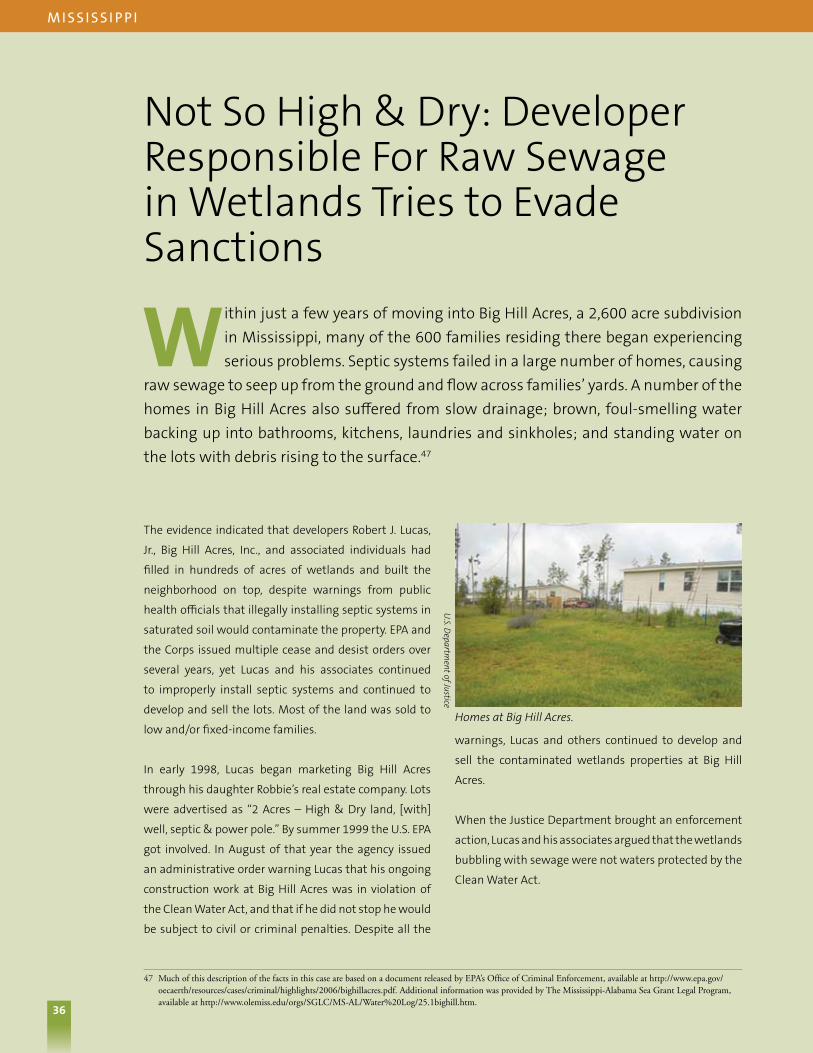
36
Not So High & Dry: Developer Responsible For Raw Sewage in Wetlands Tries to Evade Sanctions
Within just a few years of moving into Big Hill Acres, a 2,600 acre subdivision in Mississippi, many of the 600 families residing there began experiencing serious problems. Septic systems failed in a large number of homes, causing
raw sewage to seep up from the ground and flow across families’ yards. A number of the homes in Big Hill Acres also suffered from slow drainage; brown, foul-smelling water backing up into bathrooms, kitchens, laundries and sinkholes; and standing water on the lots with debris rising to the surface.47
m i S S i S S i p p i
47 Much of this description of the facts in this case are based on a document released by EPA’s Office of Criminal Enforcement, available at http://www.epa.gov/oecaerth/resources/cases/criminal/highlights/2006/bighillacres.pdf. Additional information was provided by The Mississippi-Alabama Sea Grant Legal Program, available at http://www.olemiss.edu/orgs/SGLC/MS-AL/Water%20Log/25.1bighill.htm.
Homes at Big Hill Acres.
U.S. D
epartment of Justice
36
The evidence indicated that developers Robert J. Lucas,
Jr., Big Hill Acres, Inc., and associated individuals had
filled in hundreds of acres of wetlands and built the
neighborhood on top, despite warnings from public
health officials that illegally installing septic systems in
saturated soil would contaminate the property. EPA and
the Corps issued multiple cease and desist orders over
several years, yet Lucas and his associates continued
to improperly install septic systems and continued to
develop and sell the lots. Most of the land was sold to
low and/or fixed-income families.
In early 1998, Lucas began marketing Big Hill Acres
through his daughter Robbie’s real estate company. Lots
were advertised as “2 Acres – High & Dry land, [with]
well, septic & power pole.” By summer 1999 the U.S. EPA
got involved. In August of that year the agency issued
an administrative order warning Lucas that his ongoing
construction work at Big Hill Acres was in violation of
the Clean Water Act, and that if he did not stop he would
be subject to civil or criminal penalties. Despite all the
warnings, Lucas and others continued to develop and
sell the contaminated wetlands properties at Big Hill
Acres.
When the Justice Department brought an enforcement
action, Lucas and his associates argued that the wetlands
bubbling with sewage were not waters protected by the
Clean Water Act.

37
Sewage seeping from the ground.
Unnamed Tributary by Big Hill Acres.
U.S. D
epartment of Justice
U.S. D
epartment of Justice
m i S S i S S i p p i
48 U.S. v. Lucas, 516 F.3d 316 (5th Cir. 2008)37
The federal indictment filed against Lucas and his
associates in June 2004 included twelve counts of
discharging pollutants (sewage and other wastewater)
into wetlands without a permit, ten counts of putting
material (including dirt, pipes, culverts, gravel, garbage,
debris, cement, and asphalt) and septic systems in
wetlands without a permit, and eighteen counts of
mail fraud. The grand jury made additional findings of
fact that were included in the indictment; among these
were that at least 250 individuals were victimized by
the defendants’ fraud, at a cost to the victims of over
$2.5 million.48
Attorneys for the defendants argued that the Clean
Water Act did not protect the Big Hill Acres’ wetlands
because they were not adjacent to navigable waterways.
This argument was ultimately unsuccessful, and the
defendants were convicted on all counts in January
2005. But the fact that defendants in such an egregious
case of water pollution directly in the Gulf of Mississippi
watershed could even make a colorable argument that
the Clean Water Act no longer prohibits the discharge
of raw sewage into the water bodies in this case is cause
for great concern.

38
In a Clear Lake, You Can See Forever
Prior to 2003, Cedar Lake was home to fish, turtles, and other wildlife, and enjoyed by residents for water recreation. The water was clear enough that in 1998, Aquatic Sports, Ltd., a scuba diving instruction and equipment business, moved to
the lake.
49 Complaint, Fitzgibbons v. Cook & Thorburn & Hancock County Drainage Districts, No 1:08-cv-165 (W.D. Mich., Feb. 19, 2008).50 Brief in Support of Motion to Dismiss, v. Cook & Thorburn & Hancock County Drainage Districts, No 1:08-cv-165, at 19-21 (W.D. Mich., Apr. 4, 2008).51 Opinion, v. Cook & Thorburn & Hancock County Drainage Districts, No 1:08-cv-165 (W.D. Mich., Dec. 8, 2008) (concluding that plaintiffs had provided
insufficient notice of claims against defendants).
m i C h i ga n
Citizens claimed that stormwater polluted Cedar Lake, harming a community resource.
Sheila Fitzgibbons & Richard Ellison
Sheila Fitzgibbons & Richard Ellison
Sheila Fitzgibbons & Richard Ellison
Sheila Fitzgibbons & Richard Ellison
This roughly 40 acre lake, located in the southern part
of Michigan, is about 1.4 miles long, averages 275 feet
wide, and reaches a maximum depth of 33 feet. Scuba
diving might not be the type of recreation that comes to
mind when thinking about Michigan, but the state has
the longest freshwater shoreline in the world, bounded
by four of the five Great Lakes, plus Lake Saint Clair.
Groundwater supplies most of the water in the lake,
which is linked via a series of other water bodies to the
Sycamore River.49 But in recent years, the proprietors
of Aquatic Sports claimed that the county storm sewer
system made alterations so that it directly discharged
into Cedar Lake. Thereafter, they allege, the water became
much less clear, so much so that they often could no
longer use it for scuba training. In addition, they report
that aquatic life in and around the lake diminished.
When Aquatic Sports and its operators sued nearby
drainage districts, claiming they were responsible
for increased pollution of the lake, the defendants
responded by arguing, among other things, that the lake
is not a “water of the United States” under the federal
Clean Water Act.50 The case was dismissed in 2008 on
other grounds, so the court did not rule on whether this
lake was in fact protected by the Act, leaving this lake’s
future status uncertain.51

39
Waste Treatment Plants Without Permits?
Congress passed the original Clean Water Act to eliminate the use of the Nation’s waters as open sewers for untreated (or under-treated) sewage and other wastewater. Now, nearly 37 years later, some wastewater treatment facilities are
using uncertainty about the Clean Water Act to argue that they do not need to comply with federal pollution control permit limits on sewage discharges.
a r i Zo n a , Ca l i F o r n i a , a n d n eW m ex i Co
In June 2007, the Pima County, Arizona County
Commissioner’s office wrote to EPA suggesting that
a number of wastewater treatment plants in the
Southwest are no longer required to comply with the
Clean Water Act, despite previously obtaining pollution
discharge permits. These facilities include:
n The Aura Valley Wastewater Treatment Facility,
which discharges to the Black Wash Spray Fields, and
irrigates native mesquite trees. The spray fields drain
into the Black Wash, a tributary to Brawley Wash,
which is dry much of the year, but eventually drains
into the lower Santa Cruz River and ultimately into
the Colorado River near Yuma. The flow path moves
through six different watersheds, covering almost
300 miles of arid desert.
n The Mt. Lemmon facility, which discharges into a
ditch that links to a series of unnamed washes along
Alder Canyon. After 18 miles, the washes flow into
Alder Wash, which intersects with the San Pedro
River six miles downstream. The San Pedro, which
has run dry in 2005 and 2006, eventually drains into
the Gila River and eventually intersects with the
Colorado River.
Similarly, in New Mexico, Cannon Air Force Base in Curry
County discharges up to 750,000 gallons a day from its
wastewater treatment plant, but might soon avoid Clean
Water Act limits on its pollution. For more than a decade,
the facility operated under a Clean Water Act permit to
treat its waste, which is then used to irrigate a nearby
golf course and is discharged into a nearby playa lake.
The Clean Water Act’s pollution control requirements
historically applied to playa lakes, but, in 2005, the base
hired a consultant to study whether the Act covered the
lake. The report noted that “the limited water resources
in the area are extremely important for wildlife and the
surrounding vegetation,” but nonetheless concluded
that the playa lake lacked Clean Water Act protection.
Without a Clean Water Act permit, Cannon could
discharge wastewater into the playa lake without
regard to that law’s requirement to limit releases to
comply with state water quality standards. Wastewater
at the base contains selenium, oils and greases, chloride,
sulfate, nitrogen, and phosphorus. If left unchecked,
these chemicals could pose a threat to human health
and local ecosystems. The four thousand active-duty
military members and civilians who currently work on
the base deserve better.
Finally, in California, the city of Taft asked the Corps
to conclude that Sandy Creek, an ephemeral stream,
lacked Clean Water Act protections, so that the prison it
operates would not have to comply with stricter pollution
controls at its sewage treatment plant. Initially, the Corps
complied, but had to withdraw its determination when
EPA pointed out to the Corps that the Corps does not
have authority over discharges from wastewater plants.
But in the end, EPA Region 9 ruled that the creek is no
longer a “water of the U.S.” so the wastewater plant will
no longer be subject to federal pollution limits.
39

40
Conclusion
The more then 30 case studies described in this report illustrate the unprecedented risk our waterways now face. These examples demonstrate how recent Supreme Court decisions and agency policies have removed or jeopardized safeguards for
many of America’s important waters. Currently, countless small streams, rivers, lakes, and wetlands across the country are being polluted, ditched, piped, and filled because they are not afforded the protections they deserve under the Clean Water Act.
These case studies reveal merely the tip of the iceberg.
What makes the current state of affairs particularly
pernicious is that much of the destruction to our waters
occurs well below the radar of public scrutiny. Unless
a neighboring property owner alerts a local watchdog
organization about a polluting activity or a concerned
citizen questions regulatory officials directly, many
waters are likely degraded or destroyed without the
general public’s knowledge. To capture the case studies
we have included in this document, we dug deep into
the agencies’ files, because when a regulator decides
that a water is not protected by the Clean Water Act,
oftentimes the only individuals to even know are that
regulator, the property owner, and an overworked EPA
case reviewer. Corps decisions declaring water bodies
unprotected are posted only on difficult-to-navigate
websites, and sometimes for only a short time; these
decisions are not subject to public notice and comment.
The stakes are enormous – inaction jeopardizes safe
and sufficient water. We cannot afford to let the current
rollbacks and legal confusion erase three decades of
progress and return us to the days of widespread dirty
water. Currently the law cannot work, as demonstrated
by questionable decisions in the field endangering
streams, rivers, lakes, and wetlands across this country.
Congress must enact the Clean Water Restoration Act
now to stop the bleeding and restore basic Clean Water
Act protections to our waters. This legislation restores
protections by:
nRemoving the confusing term “navigable” from the
Act;
nMaking clear that “waters of the United States”
means the water bodies protected prior to 2001; and
nArticulating the Congress’s broad constitutional
authority to protect such waters.
Until Congress restores the Clean Water Act, the waters
of this country are going to suffer irretrievable harm, the
regulated community is going to experience unnecessary
delays, and regulatory resources will be stretched to the
breaking point.
By enacting legislation to restore pre-2001 Clean
Water Act protections, Congress would fix all of these
problems and re-establish the Clean Water Act as the
comprehensive water quality protection statute that
Congress passed over a generation ago.
Congress must act now to restore the Clean Water Act.

Clean Water Action1010 Vermont Avenue NWSuite 1100Washington, DC 20005(202) 895-0420 www.cleanwateraction.org
earthjusticeWashington, DC Office1625 Massachusetts Avenue NWWashington, DC 20036(202) 667-4500www.earthjustice.org
environment America218 D Street SE 2nd FloorWashington, DC 20003(202) 683-1250 www.environmentamerica.org
national Wildlife Federation11100 Wildlife Center DriveReston, VA 20190(800) 822-9919www.nwf.org
natural Resources Defense Council40 West 20th StreetNew York, NY 10011(212) 727-2700www.nrdc.org
Sierra ClubLegislative Office408 C Street NEWashington DC 20002(202) 547-1141www.sierraclub.org
Southern environmental Law Center 122 C Street NWSuite 240Washington, DC 20002(202) 828-8382 www.southernenvironment.org