Country Report Myanmar - JICAopen_jicareport.jica.go.jp/pdf/1000023395.pdf · Country Report ....
100
Country Report Myanmar Natural Disaster Risk Assessment and Area Business Continuity Plan Formulation for Industrial Agglomerated Areas in the ASEAN Region March 2015 AHA CENTRE Japan International Cooperation Agency OYO International Corporation Mitsubishi Research Institute, Inc. CTI Engineering International Co., Ltd.
Transcript of Country Report Myanmar - JICAopen_jicareport.jica.go.jp/pdf/1000023395.pdf · Country Report ....

C o u n t r y R e p o r t
M y a n m a r
Natural Disaster Risk Assessment and
Area Business Continuity Plan Formulation for
Industrial Agglomerated Areas in the ASEAN Region
March 2015
AHA CENTRE
Japan International Cooperation Agency
OYO International Corporation Mitsubishi Research Institute, Inc.
CTI Engineering International Co., Ltd.

Overview of the Country Basic Information of Myanmar 1), 2), 3)
Country Name Long form: Republic of the
Union of Myanmar Short form: Myanmar
Capital Naypidaw Area (km2) Total :
Land: Inland Water:
676,590 653,290 23,300
Population 53,259,018 Population density (people/km2 of land area)
82
Population growth (annual %)
0.9
Urban population (% of total)
33
Languages Myanmar Ethnic Groups Burmese (about 70%),many
other ethnic groups Religions
Buddhism (90%), Christianity, Islam, others
GDP (current US$) (billion) 55(Estimate) GNI per capita, PPP (current international $)
-
GDP growth (annual %) 6.4(Estimate) Agriculture, value added (% of GDP)
48
Industry, value added (% of GDP)
16
Services, etc., value added (% of GDP)
35
Brief Description
Myanmar covers the western part of Indochina Peninsula, and the land area is about 1.8 times the size of Japan. Myanmar has a long territory stretching north to south, with the Irrawaddy River running through the heart of the country. While Burmese is the largest ethnic group in the country, the country has many ethnic minorities. Myanmar joined ASEAN on July 23, 1997, together with Laos. Due to the isolationist policy adopted by the military government led by Ne Win which continued until 1988, the economic development of Myanmar fell far behind other ASEAN countries. Today, Myanmar is a republic, and President Thein Sein is the head of state. Myanmar was a socialist country until 1988, but after the coup d’état, the military took control of the government. The current political system has been in place since 2011. Myanmar is expected to accelerate its economic development through democratization, which is being promoted under the current administration. Natural Hazards
50% of the total number of disasters in Myanmar was related to floods followed by storm (23%), earthquake (15%), and mass movement-wet (12%), whereas 73% of the total affected people by disasters were due to storm followed by floods in 1980-2011. Similarly, storm is a major cause of disaster-related death and biggest estimated damage cost (86%). Earthquake (11%) and flood (3%)
National Flag
i
are next on the estimated damage cost. This pattern of disasters is due to Cyclone Nargis in 2008 t affected 2,400,000 people, left 138,000 fatalities and estimated damage cost of US$4,000,000 to Myanmar.
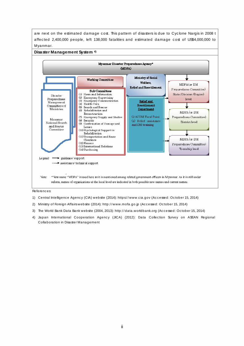
Disaster Management System 4)
References:
1) Central Intelligence Agency (CIA) website (2014): https://www.cia.gov (Accessed: October 15, 2014)
2) Ministry of Foreign Affairs website (2014): http://www.mofa.go.jp (Accessed: October 15, 2014)
3) The World Bank Data Bank website (2004, 2013): http://data.worldbank.org (Accessed: October 15, 2014)
4) Japan International Cooperation Agency (JICA) (2012): Data Collection Survey on ASEAN Regional Collaboration in Disaster Management
ii
Contents
Overview of the Country Page
1. Introduction ............................................................................................................. 1
2. Natural Disaster Risks ............................................................................................ 2
2.1 Predominant Hazards ....................................................................................... 2
2.2 Flood ................................................................................................................. 4
2.3 Earthquake ...................................................................................................... 10
2.4 Tsunami ........................................................................................................... 20
2.5 Volcanoes ....................................................................................................... 24
2.6 Cyclone and Meteorological Hazards.............................................................. 27
2.7 Landslides ....................................................................................................... 35
3. Industrial Parks ..................................................................................................... 38
3.1 Distribution of Industrial Parks in Myanmar ..................................................... 38
3.2 Historical Evolution of Industrial Parks ............................................................ 40
3.3 Recent Trends and Japanese Investment ....................................................... 41
3.4 Risks of Natural Hazards ................................................................................ 42
4. Transport Infrastructure and Lifeline Utilities ......................................................... 45
4.1 Overview of Transport Infrastructure ............................................................... 45
4.2 Overview of Lifeline Utilities ............................................................................ 49
4.3 Natural Disasters and Infrastructure................................................................ 53
5. Legislative Systems .............................................................................................. 56
5.1 Legislative Systems for Disaster Management ............................................... 56
5.2 Regulations and Standards for Business Continuity Management ................. 57
5.3 Legislative Systems for the Environment and Pollution Control ...................... 57
5.4 Legislative Systems for Development including Land Use, Rivers, and Building Code in Myanmar .............................................................................. 58
6. Implementaion of BCP .......................................................................................... 59
6.1 Major Natural Disasters and Awareness Disaster Management ..................... 59
6.2 Current State of BCP Implementation ............................................................. 59
6.3 Efforts on Promoting BCP Implementation ...................................................... 59
6.4 Problems Facing for Implementation of BCP .................................................. 60
iii

Appendix 1: Method for Evaluating Predominant Hazards ....................................... 61
Appendix 2: Data Sheets Outline of Existing Investigations and Studies ............... 63
Appendix 3: List of Industrial Parks in Myanmar ....................................................... 85
Appendix 4: General Investment Risk of Myanmar ................................................... 87
iv
Introduction
1. Introduction This report is the first version of the Country Report for Myanmar, which gives
information on natural disaster risks of the country, industrial parks, major traffic
infrastructure and lifeline utilities, and legislative systems relating to disaster
management and business continuity.
The country report is prepared as a reference document for individuals and
organizations who are wishing to integrate disaster risk information for their decisions:
such as investment to Myanmar, preparation of a business continuity plan (BCP) or
disaster management plan of their organization, preparation of an Area Business
Continuity Plan (Area BCP) of their area, and simply knowing natural disaster risks of
their area.
Information contained in this report is macroscopic covering the entire country at the
same level. When detailed risk information is necessary, hazard and risk assessments
for an area of interest are required.
Since the country report was prepared with limited data and information as one of
the components of the project1 of ASEAN Coordinating Centre for Humanitarian
Assistance on Disaster Management (AHA Centre) and Japan International
Cooperation Agency (JICA) with a limited data and information, a revision by
national experts is required for further refinement.
The following are reference documents prepared by the project of AHA Centre and
JICA.
1. AHA Centre and JICA (2015): Planning Guide for Area Business Continuity, Area
BCM Took Kits, Version 2.
2. AHA Centre and JICA (2015): The Country Reports; Brunei, Cambodia, Laos,
Malaysia, Myanmar, the Philippines, Thailand, Singapore and Vietnam.
3. AHA Centre and JICA (2015): The Risk Profile Reports; Karawang and Bekasi of
Indonesia, Cavite, Laguna and the Southern Part of Metropolitan Manila of the
Philippines, and Haiphong of Vietnam.
1 Natural Disaster Risk Assessment and Area Business Continuity Plan Formulation for Industrial Agglomerated Areas in the ASEAN Region, AHA Centre and JICA, 2013 to 2015.
1
Country Report
2. Natural Disaster Risks 2.1 Predominant Hazards Major natural hazards, namely floods, earthquakes, tsunamis, cyclones and landslides
have been recorded in Myanmar. Among those cyclones, floods, tsunamis and
earthquakes have pronounced impacts to Myanmar.
The impact of Cyclone Nargis that occurred in 2008 far exceeds other disasters in
terms of the number of deaths (about 140 thousand). Additionally, another 3
cyclones caused more than 1000 deaths during the 20th century. The numbers of
deaths caused by floods are less than that of cyclones but they are more frequent.
The amount of damage caused by the 2004 Indian Ocean Tsunami was large;
however no tsunamis and earthquakes have been recorded that caused more than
1000 deaths.
2
Natural Disaster Risks
Note: GDP-PPP, Gross domestic product based on purchasing-power-parity
(PPP) valuation of country GDP, International Monetary Fund, World Economic Outlook Database, October 2012
Source of data and information:
EM-DAT, The OFDA/CRED International Disaster Database, Université catholique de Louvain, Brussels, Belgium: http://www.emdat.be.
Pacific Rim Coordination Center Disaster Data: http://data.pacificrimnetwork.org/. Global Unique Disaster Identification Number:
http://www.glidenumber.net/glide/public/search/search.jsp. National Geophysical Data Center (NGDC), National Oceanic and Atmospheric Administration
(NOAA): http://ngdc.noaa.gov/hazard/hazards.shtml Dartmouth Flood Observatory, University of Colorado: http://floodobservatory.colorado.edu/
Figure 2.1 Impact of Natural Hazards in Myanmar 3
Country Report
2.2 Flood
Risks
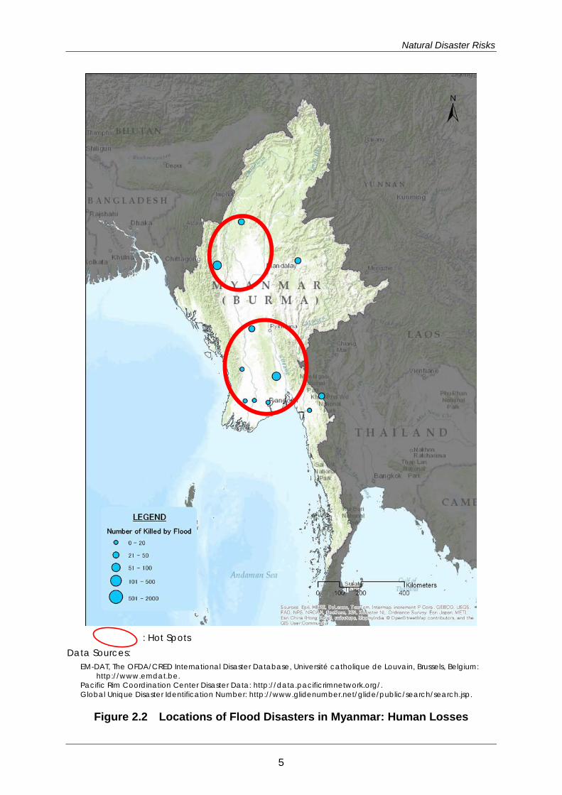
Locations of flood disasters in Myanmar are shown in Figure 2.2. Size of circles
represents the scale of the disasters in terms of human losses.
Many floods are caused by storm rainfalls from the southwest monsoons in July to
October. The topography of the country is characterized by the central plain (delta),
which is surrounded by steep mountains on the west side and highlands on the east
side. Rainfall in the mountains and highlands causes flood damage in the central
plain and coastal areas. Flooding spanned over the long term at the delta near the
river mouth.
Notable examples of flood event include:
The flood of October 2006, triggered by a large scale monsoon which hit Thailand
and Myanmar, caused damage, including human losses and property losses in
Mandalay, the eastern areas, and the central areas.
The flood of June 15, 2010 was caused by storm rainfall, which was recorded at
340 mm/day in Rakhine in the western region.
The flood of October 2011, which was triggered by a Cyclone, caused damages
in Magway and Mandalay in the central areas and Sagain in the northern region.
Flash floods hit Pakokku and collapsed a bridge.
Hot spots are of flood disasters include:
Central regions: Mandalay and its surroundings
Ayeyarwadi River delta
4
Natural Disaster Risks
: Hot Spots Data Sources:
EM-DAT, The OFDA/CRED International Disaster Database, Université catholique de Louvain, Brussels, Belgium: http://www.emdat.be.
Pacific Rim Coordination Center Disaster Data: http://data.pacificrimnetwork.org/. Global Unique Disaster Identification Number: http://www.glidenumber.net/glide/public/search/search.jsp.
Figure 2.2 Locations of Flood Disasters in Myanmar: Human Losses
5
Country Report
Sources of Hazard and Risk Information
Table 2.1 Sources of Hazard and Risk Information: Flood
Central Committee on National Disaster Prevention (CCNDP)
Relief and Resettlement Department (RRD)
http://www.clearcut-team.com/rrd/index.php?name=menu&m=1&id=3
Department of Meteorology and Hydrology Myanmar (DMH)
http://www.dmh.gov.mm/
Yangon University (YU)
Yangon Technological University (YTU)
http://www.most.gov.mm/ytu/
Table 2.2 List of Reference Reports for Risk Analysis
Organization Post Title/ Web Address Form
Asia Development Bank
Asian Water Development Outlook
Asian Water Development Outlook 2013: Asia-Pacific Water Forum
Report http://www.adb.org/publications/asian-water-development-outlook-2013
World Bank ASEAN Disaster Risk Management Initiative
Synthesis Report on Ten Asian Countries Disaster Risks Assessment: December 2012 Report http://www.unisdr.org/files/18872_asean.pdf
The Nature Conservancy
ASEAN Disaster Risk Management Initiative
World Risk Report 2012: October 2012 Report http://www.ehs.unu.edu/article/read/worldri
skreport-2012
World Bank Framework and Options for Implementation
Advancing Disaster Risk Financing and Insurance in ASEAN Countries: April 2012
Report https://openknowledge.worldbank.org/bitstream/handle/10986/12628/714530v20ESW0W0AN0appendices0June12.pdf?sequence=1
International Development Research Centre
Economy and Environment Program for Southeast Asia (EEPSA)
Climate Change Vulnerability Mapping for Southeast Asia: January 2009
Report http://web.idrc.ca/uploads/user-S/12324196651Mapping_Report.pdf
UNEP, GRID, UNISDR
Global Risk Data Platform Web Map http://preview.grid.unep.ch/index.php?prev
iew=map&lang=eng
6
Natural Disaster Risks
Studies on Hazard and/or Risk Assessment
Some useful studies on flood hazard, risk, and vulnerability are publicly available
presenting assessment results, case studies of countermeasures, as well as different
methodological approaches. There are a few types of methodologies to assess risks
and vulnerability including, for example, risks involving exposure to flooding events
and population density. Vulnerability can be defined as a function of exposure,
adaptive or coping capacity, and land-use etc. There are slightly different
combinations of these factors with different studies for use. Therefore, these concepts
must be defined in advance to plan a methodology for an assessment, in terms of
which definitions are to be used in a certain analysis.
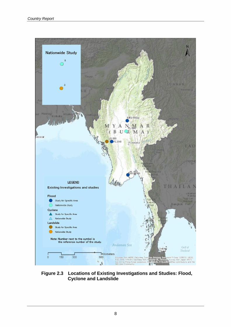
Locations of existing investigations and studies on flood are shown in Figure 2.3.
Outline of those investigations and studies are attached in Appendix 2 and their
summary is given in Table 2.3.
Table 2.3 Summary of Existing Investigations and Studies: Flood
Country/Region Summary of Existing Studies and Reports
ASEAN
There are a few reports that study natural disasters for ASEAN and the Pacific regions at large in recent years. Disaster risks are assessed by scenario, exposure, vulnerability, damage, and loss. An assessment framework is also sought to give an overview of risks, hazard and vulnerability.
Myanmar
Flood hazard maps are prepared for 50-year and 100-year return period scenarios by a project conducted by UNDP/ADPC for Rakhine State. 5 river basins are selected for analysis. Flood forecasting efforts are also implemented by the Department of Meteorology and Hydrology. Flood forecasting stations are installed at major rivers in Myanmar.
References for Data and Further Reading
1) ADRC: “Countries; Myanmar”, Information on Disaster Risk Reduction of the
Member
2) ADRC: “Myanmar, Flood,2006/10/11”
3) ADRC: “Myanmar, Flood, 2010/06/16”
4) ADRC: “Myanmar, Flood, 2011/10/20”
7
Country Report
Figure 2.3 Locations of Existing Investigations and Studies: Flood, Cyclone and Landslide
8
Natural Disaster Risks
5) Department of Meteorology and Hydrology (2010). Flood Forecasting and
Mitigation in Myanmar, Department of Meteorology and Hydrology
6) Japan-Myanmar Interchange Association HP(2010/06):“the dead: 63 persons by
flood at Kayin State in Japanese”
7) Ministry of Foreign Affairs of Japan (2013): “Information on Myanmar in Japanese”,
06 2013.
8) Relief Web; OCHA (2010):“Myanmar, Floods Situation Report # 5 - 28 June
2010”,Report from UN Office for the Coordination of Humanitarian Affairs,28 Jun
2010
9) Relief Web; OCHA (2011): “Magway Floods DREF operation n° MDRMM005”,
Report from IFRC, 03 Nov 2011.
10) Shigenobu Tanaka et al (2010). Progress Report on Flood Hazard Mapping in
Asian Countries. PWRI.
11) UNDP/ADPC (2011). Multi Hazard Risk Assessment in the Rakhine State of
Myanmar.
12) Velasquez, Jerry et al (ed.) (2012). Reducing vulnerability and exposure to
disasters: Asia-Pacific disaster report 2012, ESCAP/UNISDR AP
13) World Bank (2011). Advancing Disaster Risk Financing and Insurance in ASEAN
Countries: Framework and Options for Implementation, Washington: Global
Facility for Disaster Reduction and Recovery
14) World Bank, UNISDR (2010). Synthesis Report on Ten ASEAN Countries Disaster Risks
Assessment.
9
Country Report
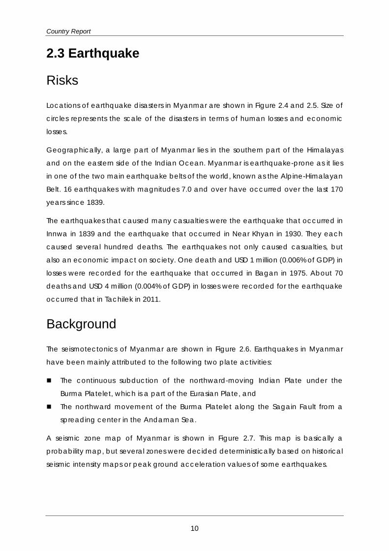
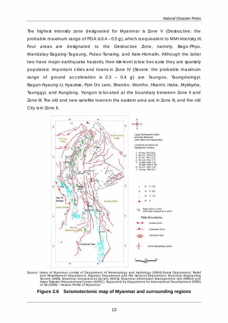
2.3 Earthquake
Risks
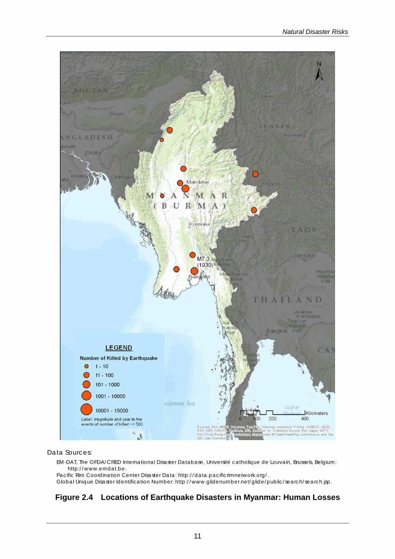
Locations of earthquake disasters in Myanmar are shown in Figure 2.4 and 2.5. Size of
circles represents the scale of the disasters in terms of human losses and economic
losses.
Geographically, a large part of Myanmar lies in the southern part of the Himalayas
and on the eastern side of the Indian Ocean. Myanmar is earthquake-prone as it lies
in one of the two main earthquake belts of the world, known as the Alpine-Himalayan
Belt. 16 earthquakes with magnitudes 7.0 and over have occurred over the last 170
years since 1839.
The earthquakes that caused many casualties were the earthquake that occurred in
Innwa in 1839 and the earthquake that occurred in Near Khyan in 1930. They each
caused several hundred deaths. The earthquakes not only caused casualties, but
also an economic impact on society. One death and USD 1 million (0.006% of GDP) in
losses were recorded for the earthquake that occurred in Bagan in 1975. About 70
deaths and USD 4 million (0.004% of GDP) in losses were recorded for the earthquake
occurred that in Tachilek in 2011.
Background
The seismotectonics of Myanmar are shown in Figure 2.6. Earthquakes in Myanmar
have been mainly attributed to the following two plate activities:
The continuous subduction of the northward-moving Indian Plate under the
Burma Platelet, which is a part of the Eurasian Plate, and
The northward movement of the Burma Platelet along the Sagain Fault from a
spreading center in the Andaman Sea.
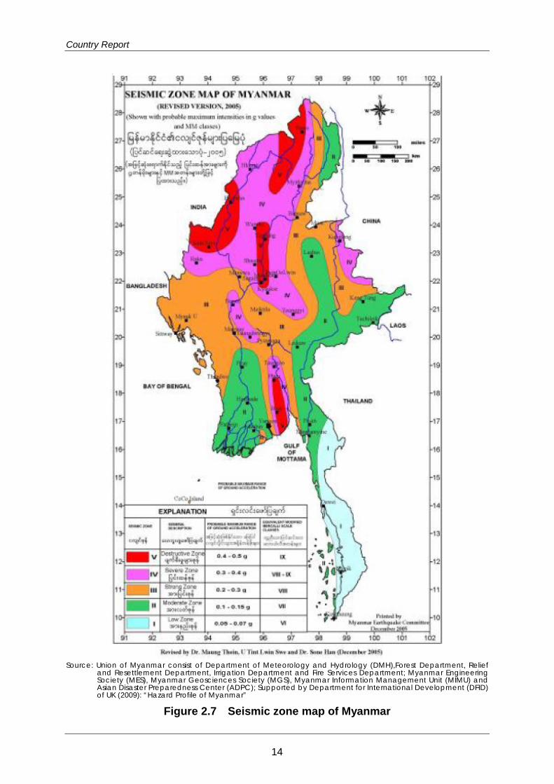
A seismic zone map of Myanmar is shown in Figure 2.7. This map is basically a
probability map, but several zones were decided deterministically based on historical
seismic intensity maps or peak ground acceleration values of some earthquakes.
10
Natural Disaster Risks
Data Sources: EM-DAT, The OFDA/CRED International Disaster Database, Université catholique de Louvain, Brussels, Belgium:
http://www.emdat.be. Pacific Rim Coordination Center Disaster Data: http://data.pacificrimnetwork.org/. Global Unique Disaster Identification Number: http://www.glidenumber.net/glide/public/search/search.jsp.
Figure 2.4 Locations of Earthquake Disasters in Myanmar: Human Losses
11

Country Report
Data Sources: EM-DAT, The OFDA/CRED International Disaster Database, Université catholique de Louvain, Brussels, Belgium:
http://www.emdat.be. Pacific Rim Coordination Center Disaster Data: http://data.pacificrimnetwork.org/. Global Unique Disaster Identification Number: http://www.glidenumber.net/glide/public/search/search.jsp.
Figure 2.5 Locations of Earthquake Disasters in Myanmar: Economic Losses
12
Natural Disaster Risks
The highest intensity zone designated for Myanmar is Zone V (Destructive: the
probable maximum range of PGA is 0.4 – 0.5 g), which is equivalent to MMI Intensity IX.
Four areas are designated to the Destructive Zone, namely, Bago-Phyu,
Mandalay-Sagaing-Tagaung, Putao-Tanaing, and Kale-Homalin. Although the latter
two have major earthquake hazards, their risk-level is low because they are sparsely
populated. Important cities and towns in Zone IV (Severe: the probable maximum
range of ground acceleration is 0.3 – 0.4 g) are Taungoo, Taungdwingyi,
Bagan-Nyaung-U, Kyaukse, Pyin Oo Lwin, Shwebo, Wuntho, Hkamti, Haka, Myitkyina,
Taunggyi, and Kunglong. Yangon is located at the boundary between Zone II and
Zone III. The old and new satellite towns in the eastern area are in Zone III, and the old
City is in Zone II.
Source: Union of Myanmar consist of Department of Meteorology and Hydrology (DMH),Forest Department, Relief
and Resettlement Department, Irrigation Department and Fire Services Department; Myanmar Engineering Society (MES), Myanmar Geosciences Society (MGS), Myanmar Information Management Unit (MIMU) and Asian Disaster Preparedness Center (ADPC); Supported by Department for International Development (DFID) of UK (2009): “Hazard Profile of Myanmar”
Figure 2.6 Seismotectonic map of Myanmar and surrounding regions
13
Country Report
Source: Union of Myanmar consist of Department of Meteorology and Hydrology (DMH),Forest Department, Relief
and Resettlement Department, Irrigation Department and Fire Services Department; Myanmar Engineering Society (MES), Myanmar Geosciences Society (MGS), Myanmar Information Management Unit (MIMU) and Asian Disaster Preparedness Center (ADPC); Supported by Department for International Development (DFID) of UK (2009): “Hazard Profile of Myanmar”
Figure 2.7 Seismic zone map of Myanmar
14
Natural Disaster Risks
Responses by Myanmar
Disaster Management Information
A small-scale nationwide seismotectonic map and seismic zone map were
developed by the Myanmar Earthquake Committee (MEC) in 2004 and by the
Myanmar Geosciences Society (MGS) in 2012. However, earthquake hazard maps
available at community level have not been developed yet. On the other hand, the
MEC developed seismic zoning maps for Mandalay-Amarapura, Bago-Oaktha, and
Taunggyi until 2006. The earthquake hazard map of Mandalay was developed in
collaboration with the Norwegian government. All other cities plan to develop their
hazard maps.
Tokyo University and Kyoto University in Japan have studied historical seismic activity
and conducted a trench survey along the Sagain Fault in collaboration with the MES.
Early Warning and Information Transmission
Eight broadband seismographs have been installed by the Myanmar government,
China Earthquake Administration (CEA), Yunnan Seismic Bureau (YSB), and Regional
Integrated Multi-Hazard Early Warning System for Africa and Asia (RIMES). However,
only two digital broadband seismographs installed by DMH and three analog
seismographs installed by JICA are currently operating for seismic observation. The
others are not in operation because of mechanical trouble.
Preparedness and Education
Reading material that contains information on eight types of disasters is available as a
self-study booklet for Grade 5, 6, and 7 students. Reading cards on earthquakes,
storms, and tsunami, and story books on how to be prepared are available for
non-formal education. These materials cover what to do before, during, and after a
disaster.
The Disaster Preparedness and Response Education (DPRE) Working Group,
comprised of representatives from DEPT, MOE, UN Agencies, International NGOs, and
NGOs was formed in August 2008. The DPRE Working Group collects relevant DRR
education materials from various agencies and distributes them as resource packs to
schools and teachers for their training.
15
Country Report
The Department of Educational Planning and Training (DEPT) has developed Disaster
Risk Reduction (DRR) training modules in accordance with the five priority areas of
HFA, with the support of the DPRE Working Group. DEPT conducts training for township
education officers, school principals, teachers in cyclone-affected areas, and
teacher trainers at education colleges. The DRR training covers risk assessment, the
formation of school disaster management committees and school disaster
preparedness plans, mock drills, and psychological/social support.
In higher education, the Ministry of Science and Technology has initiated seminars
and technical training on the topics of ‘Utilization of Space-based Technologies for
Disaster Risk Management’ and ‘Quality Control Assessment for Cyclone Shelter
Construction.’
Sources of Hazard and Risk Information
Table 2.4 Sources of Hazard and Risk Information: Earthquake
Myanmar Earthquake Committee (MEC)
http://eqmyanmar.org/?page_id=9
Department of Meteorology and Hydrology (DMH)
http://www.dmh.gov.mm/
Myanmar Engineering Society (MES)
http://www.mes.org.mm/
Myanmar Geosciences Society (MGS)
http://www.myanmargeosciences.org/
Myanmar Information Management Unit (MIMU)
http://www.themimu.info/
Reports on Hazard and/or Risk Assessment
Useful information and studies on earthquake hazard, risk, and vulnerability were
collected from resources available in the public domain including websites. The
information and studies include methodologies with analysis and assessment.
16
Natural Disaster Risks
There is no standardized or authorized methodology for risk and vulnerability
assessment. Therefore, the methodology should be selected or updated in
accordance with the purpose when risk and vulnerability assessments are required.
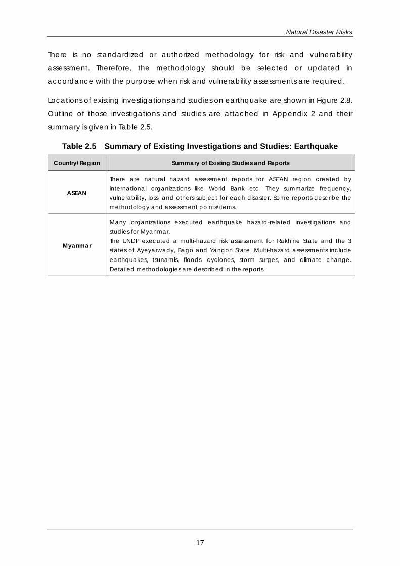
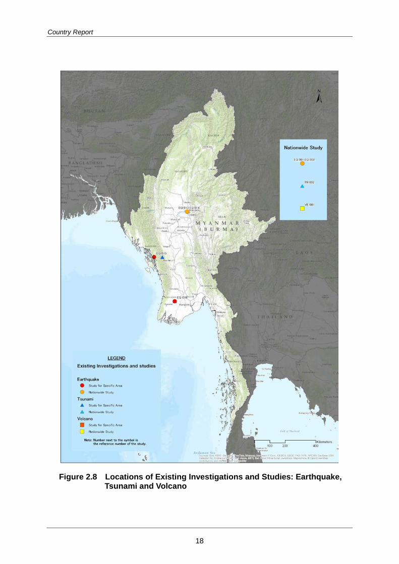
Locations of existing investigations and studies on earthquake are shown in Figure 2.8.
Outline of those investigations and studies are attached in Appendix 2 and their
summary is given in Table 2.5.
Table 2.5 Summary of Existing Investigations and Studies: Earthquake
Country/Region Summary of Existing Studies and Reports
ASEAN
There are natural hazard assessment reports for ASEAN region created by international organizations like World Bank etc. They summarize frequency, vulnerability, loss, and others subject for each disaster. Some reports describe the methodology and assessment points/items.
Myanmar
Many organizations executed earthquake hazard-related investigations and studies for Myanmar. The UNDP executed a multi-hazard risk assessment for Rakhine State and the 3 states of Ayeyarwady, Bago and Yangon State. Multi-hazard assessments include earthquakes, tsunamis, floods, cyclones, storm surges, and climate change. Detailed methodologies are described in the reports.
17
Country Report
Figure 2.8 Locations of Existing Investigations and Studies: Earthquake, Tsunami and Volcano
18
Natural Disaster Risks
References for Data and Further Reading
1) EM-DAT: The OFDA/CRED International Disaster Database – www.emdat.be –
Université Catholique de Louvain – Brussels – Belgium
2) Japan International Cooperation Agency (JICA) (2012): “Data Collection Survey
on ASEAN Regional Collaboration in Disaster Management”
3) OCHA-ROAP (2011). MYANMAR: Natural Hazard Risks
4) Union of Myanmar consist of Department of Meteorology and Hydrology (DMH),
Forest Department, Relief and Resettlement Department, Irrigation Department
and Fire Services Department; Myanmar Engineering Society (MES), Myanmar
Geosciences Society (MGS), Myanmar Information Management Unit (MIMU)
and Asian Disaster Preparedness Center (ADPC); Supported by Department for
International Development (DFID) of UK (2009): “Hazard Profile of Myanmar”
5) UNDP (2011). Multi-hazard Risk Assessment in the Rakhine State of Myanmar
6) UNDP (2012). Multi-hazard Risk Assessment in Nargis Affected Areas, Myanmar
7) UNISDR (2009). Global assessment report on disaster risk reduction, Risk and
poverty in a changing climate
8) USGS (2012). Poster of the Burma Earthquake of 11 November 2012 - Magnitude
6.8
19
Country Report
2.4 Tsunami
Risks
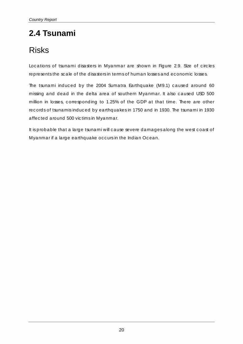
Locations of tsunami disasters in Myanmar are shown in Figure 2.9. Size of circles
represents the scale of the disasters in terms of human losses and economic losses.
The tsunami induced by the 2004 Sumatra Earthquake (M9.1) caused around 60
missing and dead in the delta area of southern Myanmar. It also caused USD 500
million in losses, corresponding to 1.25% of the GDP at that time. There are other
records of tsunamis induced by earthquakes in 1750 and in 1930. The tsunami in 1930
affected around 500 victims in Myanmar.
It is probable that a large tsunami will cause severe damages along the west coast of
Myanmar if a large earthquake occurs in the Indian Ocean.
20

Natural Disaster Risks
Data Sources: EM-DAT, The OFDA/CRED International Disaster Database, Université catholique de Louvain, Brussels, Belgium:
http://www.emdat.be. Pacific Rim Coordination Center Disaster Data: http://data.pacificrimnetwork.org/. Global Unique Disaster Identification Number: http://www.glidenumber.net/glide/public/search/search.jsp.
Figure 2.9 Locations of Tsunami Disaster in Myanmar
21
Country Report
Responses by Myanmar
In the delta area where the tsunami in 2004 caused damage and the area along the
Bay of Bengal, evacuation routes have been planned and tsunami evacuation drills
have been conducted using such routes. Preparedness for tsunami disaster
prevention has been cooperatively addressed by the national and local
governments.
There are two tide gauges installed in Myanmar by the Hawaii Sea Level Center.
However, the Department of Meteorology and Hydrology (DMH) needs to access
Hawaii University website to acquire data for tsunami observation. Under these
circumstances, tsunami warnings are disseminated based on information from foreign
observation agencies and international organizations through GTS, even though local
tsunami occurs near the coast. Therefore, there are concerns that warning
information will not be issued early enough for the public to evacuate.
In the delta area where the tsunami in 2004 and Cyclone Nargis caused damage,
tsunami evacuation shelters were built using funds donated from citizens and private
companies. However, such tsunami shelters have not been built in coastal cities
including Sittwe along the west coast; instead, a pagoda (temple) on a hill has been
utilized as the evacuation facility. However, it is necessary to install evacuation sign
boards showing evacuation routes and sites, and warning facilities such as sirens and
loud speakers are required.
In the areas mentioned above, a tsunami evacuation drill in which many citizens
participate was conducted by DMH and local government in October 2011.
The Myanmar government has promoted mangrove plantations as a measure to
reduce tsunami damage along the front coast of the delta area.
Sources of Hazard and Risk Information
Table 2.6 Sources of Hazard and Risk Information: Tsunami Department of Meteorology and Hydrology (DMH)
http://www.dmh.gov.mm/
22
Natural Disaster Risks
Reports on Hazard and/or Risk Assessment
Useful information and studies on tsunami hazard, risk, and vulnerability were
collected from resources available in the public domain including websites. The
information and studies include methodologies with analysis and assessment.
There is no standardized or authorized methodology for risk and vulnerability
assessment. Therefore, methodology should be selected or updated in accordance
with the purpose when risk and vulnerability assessment are required.
Locations of existing investigations and studies on tsunami are shown in Figure 2.8.
Outline of those investigations and studies are attached in Appendix 2 and their
summary is given in Table 2.7.
Table 2.7 Summary of Existing Investigations and Studies: Tsunami
Country/Region Summary of Existing Studies and Reports
ASEAN Tsunami induced by the Sumatra earthquake on December 26, 2004 caused major damage to ASEAN countries. The disaster is summarized by organizations like ADB.
Myanmar
There are a few recorded tsunami disasters in Myanmar, and it is recognized as a damaging hazard in the country. UNDP executed a multi-hazard risk assessment for Rakhine State and the 3 states of Ayeyarwady, Bago, and Yangon State. The multi-hazard assessment includes earthquakes, tsunamis, floods, cyclones, storm surges, and climate change. Detailed methodologies are described in the reports.
References for Data and Further Reading
1) ADB (2005). From Disaster to Reconstruction: A Report on ADB's Response to the
Asian Tsunami
2) EM-DAT: The OFDA/CRED International Disaster Database – www.emdat.be –
Université Catholique de Louvain – Brussels – Belgium.
3) Japan International Cooperation Agency (JICA) (2012): “Data Collection Survey
on ASEAN Regional Collaboration in Disaster Management”
4) UNDP (2011). Multi-hazard Risk Assessment in the Rakhine State of Myanmar
5) UNDP (2012). Multi-hazard Risk Assessment in Nargis Affected Areas, Myanmar
23

Country Report
2.5 Volcanoes
Risks
Popa, Lower Chindwin, and the Singu Plateau are the known volcanoes in Myanmar.
However, there is no record of significant disaster caused by volcanic eruption in its
history.
Background
Major hazards caused by volcanic eruption are lava flow, pyroclastic flow, “Lahar”
(volcanic mud flow), and volcanic ash fall. Lava flow is a flow of melted rock along
the slope. Pyroclastic flow is the flow of a mixture of hot dry masses of fragmented
volcanic materials and volcanic gas along the slope. “Lahar” is originally an
Indonesian term and is also called volcanic mud flow. It is the flow of a mixture of
volcanic materials and water along the slope. These cause enormous damage to the
side and foot of the volcano but generally do not have an extended reach. However,
volcanic ash fall often spreads widely via the trade winds or the westerlies, causing
damage over an extensive area. Therefore, there is a possibility that a volcanic
eruption in the neighboring countries might wreak a volcanic ash fall in Myanmar.
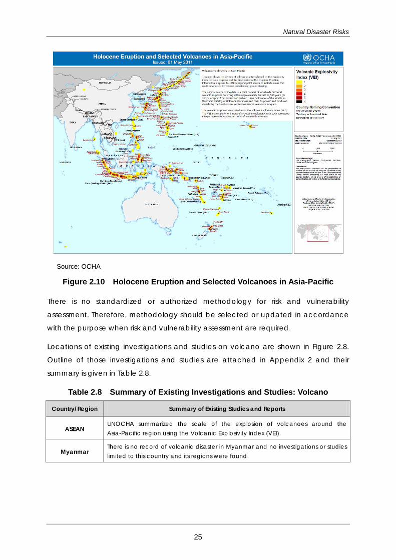
Figure 2.10 shows the volcanoes in the Asia-Pacific region which erupted during the
Holocene. The Holocene is a geological epoch from 10,000 years ago to the present.
The map indicates that many volcanic eruptions have occurred in Indonesia,
Philippines and other neighboring countries.
Responses by Myanmar
There are no special measures focusing on volcanic disaster.
Reports on Hazard and/or Risk Assessment
Useful information and studies on volcanic hazard, risk, and vulnerability were
collected from resources available in the public domain including websites. The
information and studies include methodologies for analysis and assessment.
24
Natural Disaster Risks
Source: OCHA
Figure 2.10 Holocene Eruption and Selected Volcanoes in Asia-Pacific
There is no standardized or authorized methodology for risk and vulnerability
assessment. Therefore, methodology should be selected or updated in accordance
with the purpose when risk and vulnerability assessment are required.
Locations of existing investigations and studies on volcano are shown in Figure 2.8.
Outline of those investigations and studies are attached in Appendix 2 and their
summary is given in Table 2.8.
Table 2.8 Summary of Existing Investigations and Studies: Volcano
Country/Region Summary of Existing Studies and Reports
ASEAN UNOCHA summarized the scale of the explosion of volcanoes around the Asia-Pacific region using the Volcanic Explosivity Index (VEI).
Myanmar There is no record of volcanic disaster in Myanmar and no investigations or studies limited to this country and its regions were found.
25
Country Report
References for Data and Further Reading
1) EM-DAT: The OFDA/CRED International Disaster Database – www.emdat.be –
Université Catholique de Louvain – Brussels – Belgium.
2) Japan International Cooperation Agency (JICA) (2012): “Data Collection Survey
on ASEAN Regional Collaboration in Disaster Management”
3) Lee Siebert, Tom Simkin, and Paul Kimberly (2011): “Volcanoes of the World - Third
Edition”, Smithsonian Institute/University of California Press
4) OCHA -ROAP (2011). Holocene Eruption and Selected Volcanoes in Asia-Pacific
5) United Nations Office for the Coordination of Humanitarian Affairs (OCHA),
Regional Office for Asia Pacific (ROAP) (2011): “Holocene Eruption and Selected
Volcanoes in Asia-Pacific”, Downloaded from
http://reliefweb.int/sites/reliefweb.int/files/resources/map_619.pdf
26
Natural Disaster Risks
2.6 Cyclone and Meteorological Hazards
Risks
Myanmar is located on the western edge of the Indochina Peninsula between
latitudes 10° and 28° to the north and longitudes 92° and 101° to the east. The central
part of the country is covered predominantly by the Ayeyarwady River, which runs
into the Bay of Bengal while the mouth lies in the Ayeyarwady Delta. Myanmar
stretches for 1,930km from the north to the south. The climate of the country is mostly
tropical. The southern coastal area is characterized by the tropical monsoon; the
central part is a savanna, while the mountainous terrain in the north is a temperate
zone. The country has three seasons, a hot season (from late February to early May),
a rainy season (mid-May to mid-October), and a season (late October to
mid-February).
Heavy rains with thunder usually occur in the coastal region during the afternoons
and late nights of April and May. On the other hand, instead of rain, furious dust
storms and occasionally, tornadoes occur inland. The monthly rainfall of July exceeds
1,000 mm while the annual rainfall is more than 5,000 mm on the slopes of the
mountains and coastal areas in the western region. Myanmar is exposed to
meteorological hazards which include cyclones, storm surges, floods, landslides,
droughts, and forest fires.
The average annual frequency of tropical cyclones (cyclonic disturbances) in the
Bay of Bengal is from five to nine. Normally, only two to four cyclones are formed. The
monthly frequency of tropical cyclones in the Bay of Bengal peaks in November (the
transition month between the southwest monsoon and the northeast monsoon).
Tropical cyclones developing during the monsoon months (July to September) are
generally not so intense. Cyclones which make land fall in Myanmar are most
prevalent in two peaks periods: April to May and October to November.
In the last five decades, seven major cyclones have hit Myanmar.
27
Country Report
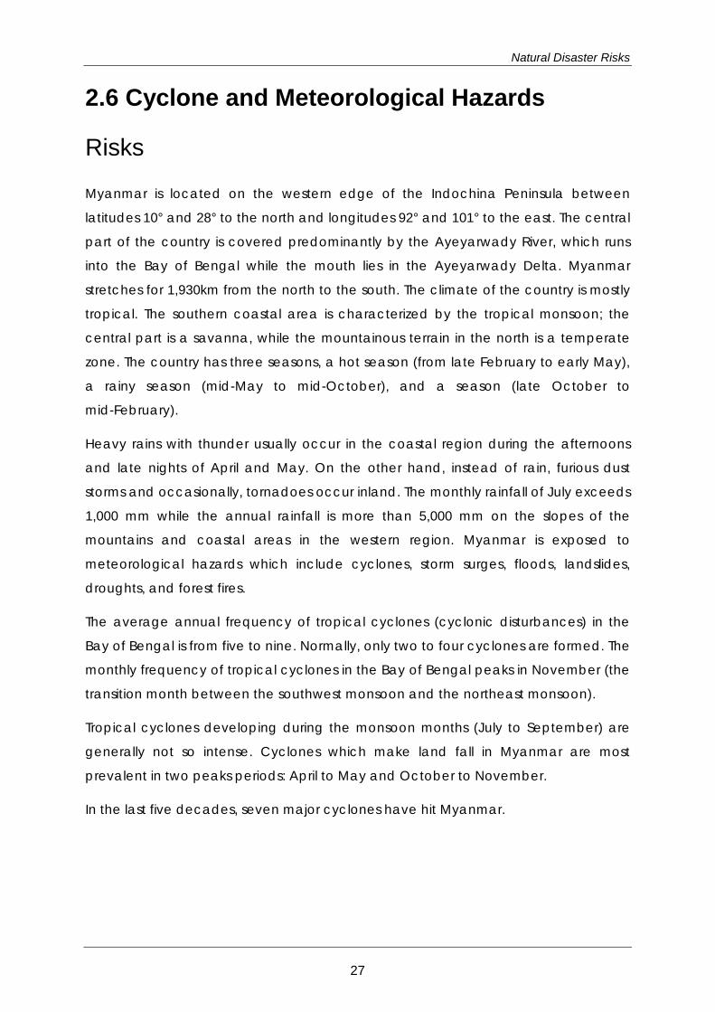
Table 2.9 Cyclones which Caused Significant Damage in Myanmar
Years Location Cyclone Name Dead Victims
Amount of Damage
(million US$)
October,2010 Kyaukpyu, Minbya, Munaug Gili 45 260,049 57
May, 2008 Ngapadudaw, Labutta, Mawl Nargis 138,373 2,420,000 4,000
April, 2006 Irrawaddy, Rakhine, Araka Mara 37 60,106 -
May, 1994 Maungdaw, Buthidaung Mandoryu 17 64,970 10
May, 1982 South West Gaoua 11 36,000 -
May, 1975 - Pathein 304 - -
May, 1968 - Shittawa 1,037 90,000 2.5
Cyclone Nargis, back in 2008, brought about unprecedented damage killing 138,371
people, affecting over 2.4 million people and dealing a total amount of damage
estimated to be worth around 4 billion dollars. Typically, most of the cyclones are
generated in the Bay of Bengal land in Bangladesh or on the east coast of India.
However, Cyclone Nargis continued to move eastward on the Bay of Bengal and hit
Myanmar directly.
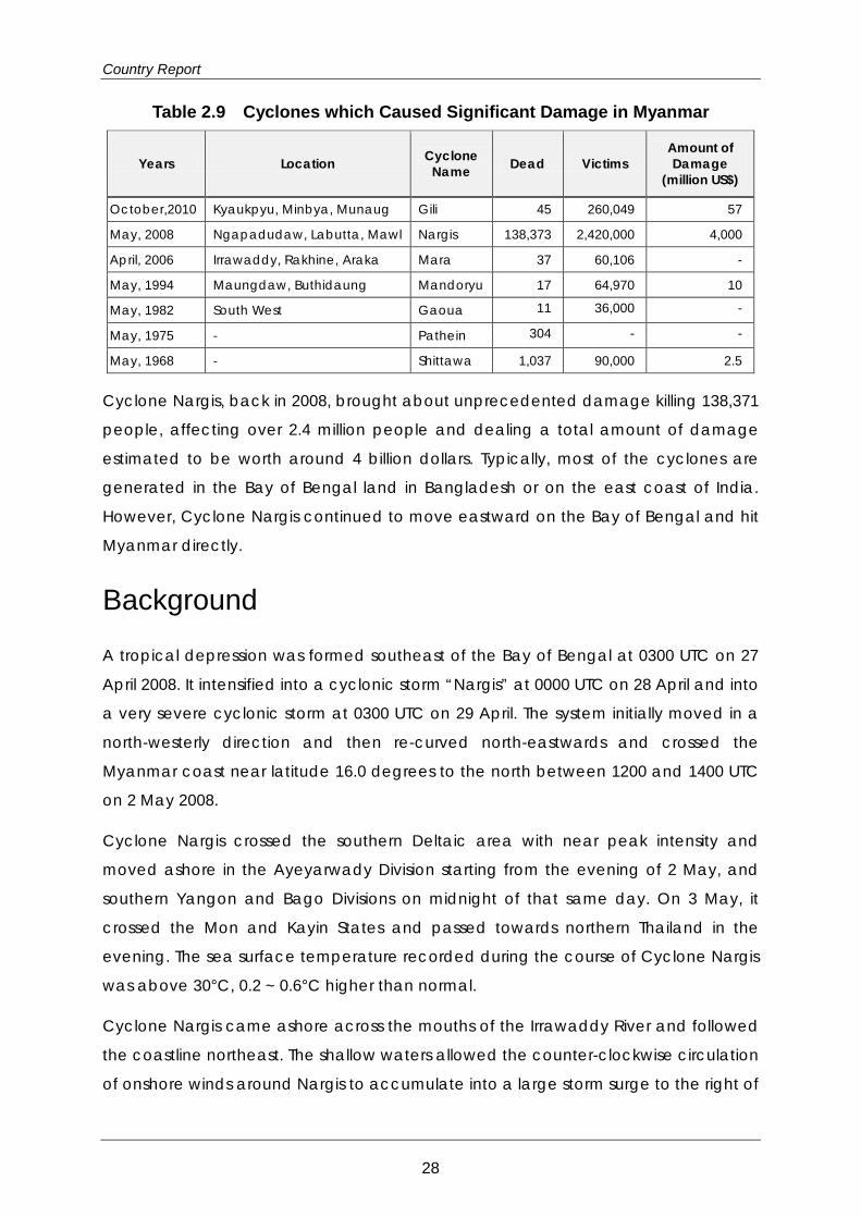
Background
A tropical depression was formed southeast of the Bay of Bengal at 0300 UTC on 27
April 2008. It intensified into a cyclonic storm “Nargis” at 0000 UTC on 28 April and into
a very severe cyclonic storm at 0300 UTC on 29 April. The system initially moved in a
north-westerly direction and then re-curved north-eastwards and crossed the
Myanmar coast near latitude 16.0 degrees to the north between 1200 and 1400 UTC
on 2 May 2008.
Cyclone Nargis crossed the southern Deltaic area with near peak intensity and
moved ashore in the Ayeyarwady Division starting from the evening of 2 May, and
southern Yangon and Bago Divisions on midnight of that same day. On 3 May, it
crossed the Mon and Kayin States and passed towards northern Thailand in the
evening. The sea surface temperature recorded during the course of Cyclone Nargis
was above 30°C, 0.2 ~ 0.6°C higher than normal.
Cyclone Nargis came ashore across the mouths of the Irrawaddy River and followed
the coastline northeast. The shallow waters allowed the counter-clockwise circulation
of onshore winds around Nargis to accumulate into a large storm surge to the right of
28
Natural Disaster Risks
the storm's track. The major cause of damage and loss of lives during Cyclone Nargis
was from storm surges (up to 90% of losses).
Source: India Meteorological Department (2002). Best track data of tropical cyclonic disturbances over
the north Indian Ocean, RSMC- Tropical Cyclones, New Delhi,
Figure 2.11 Path of Cyclone Nargis
The causes of storm surge damage are as follows (WMO Report).
At its severe stage while crossing the southern Ayeyarwady;
Moving straight eastwards along the coastline;
During landfall, Nargis was almost stationary for about four hours;
The system is phenomenal in the sense that the intensity and track of the Cyclone
has never been experienced before in the Deltaic area.
Very low-lying area;
Most populous area of the country;
Many tributaries in the Deltaic areas (seven river mouths);
Absence of storm shelters and high ground;
Hazard maps and risk assessment had not yet been made;
No past experience and difficulties in convincing the local people to evacuate;
Risk knowledge on the disaster and especially on storm surges is very low;
29

Country Report
Poor mobility as area is filled mostly with waterways to be navigated by boats;
The non-linear interactions between the wind induced waves, and the
topography and high tides of the area are extremely high;
The cutting of mangrove trees.
Meteorological disasters in Myanmar are mainly due to floods during the rainy season
from mid-May to October. Riverine floods are common in the river delta while flash
floods and landslides are frequent in upper reaches of the river systems which are
normally the mountainous areas. In cities and towns, localized floods occur from time
to time. The dry zone of Myanmar is located in the central part of the country in
Magway, Mandalay, and Sagaing Regions (lower part) across 54 townships in 13
districts and covers approximately 10 percent of the total area of the country.
Thunderstorms may occur during the inter-monsoon period (from April to May and
from October to November). Downbursts are particularly strong downdrafts from
thunderstorms. Downbursts are exceedingly dangerous to aircrafts which are taking
off or landing due to the strong vertical wind shear caused by these events.
Downbursts are also dangerous in the sea as they can cause extreme, sudden winds
which can capsize ferry boats. Fatal accidents related to this have already been
reported.
Climate change vulnerability and impact in Myanmar are as follows.
According to the IPCC 2007, the probable temperature rise in Myanmar by 2100
could range between 1.8-4.0 °C, whereas, possible temperature rise by 2100 is
predicted to be around 1.1-6.4°C.
The IPCC 2007 also projected a probable rise in sea levels of 18-59 cm. Countries
like Myanmar with a long coastline and densely settled low-lying land are
particularly vulnerable to rising sea levels. Even diminutive vertical rises in sea
levels can lead to enormous horizontal erosion in the country.
Responses by Myanmar
The Myanmar National Disaster Preparedness Agency (MDPA) was created in 2011
under the Chairmanship of the Union Minister of Social Welfare, Relief and
Resettlement. The MDPA is the national focal point for planning, executing,
facilitating, and coordinating disaster preparedness activities.
30
Natural Disaster Risks
Meteorological service is under the responsibility of the DMH (Department of
Meteorology and Hydrology) under the Ministry of Transport.
The DMH is responsible for the following:
To exchange information with other centers on weather, water and earthquakes;
To safeguard the people from losing their lives and property by issuing early
warnings and bulletins for all weather, water and geological-related hazards;
To expand public awareness and education programs on natural disasters,
natural hazards and environmental issues;
To monitor climate change, underground water resources, air and water quality
of Myanmar;
To assist all authorities from Transport, Health, Agriculture, Construction and
Tourism by providing meteorological, hydrological and seismological information;
and,
To assist with all national projects.
The DMH issues the following products:
Daily Weather Forecast
10-day and Monthly Weather Forecast
Sea Route Forecast
Aviation Forecast
Special Weather Forecast
Water-level Forecast
Lowest Water-level Forecast
Water-level Bulletin
General Forecast for Southwest Monsoon
Pre-, Mid- and Post-monsoon Weather Forecast
In accordance with meteorological law, the above forecasts and warnings are
disseminated by the DMH to Government authorities, local authorities, UN Offices,
NGOs and other relevant organizations, national media, and the general public
through telephone, fax, mobile phone, Internet (website and e-mail), VHF, wireless
port, AFTN (aviation), and Radio/TV and print media.
On the other hand, it is the responsibility of the RRD to transmit the information to the
community.
31
Country Report
Sources of Hazard and Risk Information
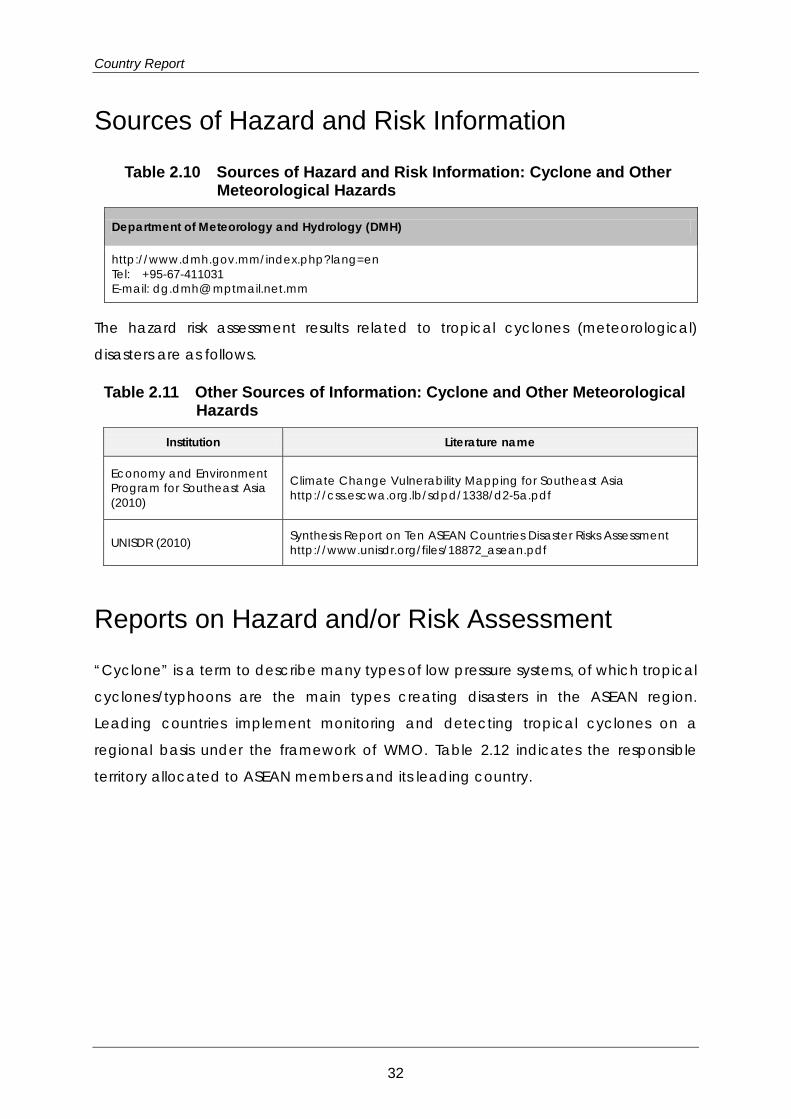
Table 2.10 Sources of Hazard and Risk Information: Cyclone and Other Meteorological Hazards
Department of Meteorology and Hydrology (DMH)
http://www.dmh.gov.mm/index.php?lang=en Tel: +95-67-411031 E-mail: dg.dmh@ mptmail.net.mm
The hazard risk assessment results related to tropical cyclones (meteorological)
disasters are as follows.
Table 2.11 Other Sources of Information: Cyclone and Other Meteorological Hazards
Institution Literature name
Economy and Environment Program for Southeast Asia (2010)
Climate Change Vulnerability Mapping for Southeast Asia http://css.escwa.org.lb/sdpd/1338/d2-5a.pdf
UNISDR (2010) Synthesis Report on Ten ASEAN Countries Disaster Risks Assessment http://www.unisdr.org/files/18872_asean.pdf
Reports on Hazard and/or Risk Assessment
“Cyclone” is a term to describe many types of low pressure systems, of which tropical
cyclones/typhoons are the main types creating disasters in the ASEAN region.
Leading countries implement monitoring and detecting tropical cyclones on a
regional basis under the framework of WMO. Table 2.12 indicates the responsible
territory allocated to ASEAN members and its leading country.
32
Natural Disaster Risks
Table 2.12 Members of WMO Tropical Cyclone Committee
Warning Zones Members(ASEAN) Leading Country
Western North Pacific Ocean and South China
Sea
0° - 60°(N) 0° - 100°(E)
Cambodia, Lao PDR, Malaysia, Philippines, Singapore, Thailand, Vietnam Japan
Bay of Bengal and the Arabian Sea
5°S - 45°(N) 30°E - 90°(E) Myanmar, Thailand India
South Pacific and South-East Indian Ocean
0°-50°(S) 90° - 170°(E) Indonesia Fiji
The dates and information utilized in this report have been acquired from various
reports on the studies and research conducted on tropical cyclones and
meteorological hazards published on the internet. Collected documents include
evaluation results of hazards/risks, as well as their evaluation methods. With regard to
tropical cyclones/typhoons, a meteorological organization of each country compiles
a summary on the damage situation, including the number of casualties or loss of
human lives, and the estimated amount of damage, etc.
Locations of existing investigations and studies on cyclone and other meteorological
hazard are shown in Figure 2.3. Outline of those investigations and studies are
attached in Appendix 2 and their summary is given in Table 2.13.
Table 2.13 Summary of Existing Investigations and Studies: Cyclone and Other Meteorological Hazards
Country/Region Summary of Existing Studies and Reports
ASEAN Study reports on natural disasters in the whole ASEAN region are available.
Myanmar The enormous Cyclone Nargis brought about unprecedented damage that was more than had occurred in several decades.
References for Data and Further Reading
1) DMH (Website): http://www.dmh.gov.mm/index.php?lang=en
2) ESCAP/WMO Typhoon Committee. (http://www.typhooncommittee.org/)
3) JMA/WMO Workshop on Quality Management in Surface, Climate and Upper-air
Observations in RA II (Asia) 2011
33
Country Report
4) Ministry of Social Welfare, Relief and Resettlement, Relief and Resettlement
Department (2012): “Myanmar Action Plan on Disaster Risk Reduction (MAPDRR)”
http://reliefweb.int/sites/reliefweb.int/files/resources/RRD_FILE_1340609699_MAPD
RR_English_June% 202012.pdf
5) WMO National Meteorological or Hydrometeorological Services of Members
(http://www.wmo.int/pages/members/members_en.html)
6) WMO (2009): WMO Fact-Finding Mission to Myanmar, Mission Report, pp.4-5
7) WMO (2010). First Meeting of the Task Team on “Meteorological, Hydrological
and Climate Services for Improved Humanitarian Planning and Response”, WMO
Headquarters, Geneva, Switzerland (31 August - 2 September, 2010)
34
Natural Disaster Risks
2.7 Landslides
Risks
Locations of landslide disasters in Myanmar are shown in Figure 2.12. Circle size
represents the scale of the disaster in terms of human losses.
According to the EM-DAT database (http://www.emdat.be/), six (6) landslides have
occurred since 2005, but there are no records before that. As the reported landslides
occurred in combination with slope collapse and flash floods, the exact mechanism
of landslide still remains unsolved.
In Myanmar most of landslides are distributed along the borders with India,
Bangladesh, and Thailand as shown in the Figure 2.12.
Landslides occurred at several slopes in Maungdaw-Buthidaung, Arakan province on
June 2010, causing 68 fatalities. This occurred during heavy rain and there was
simultaneous flooding. The highway was blocked for a long time due to those
disasters.
The occurrence of landslides seems to be limited to steep slope areas consisting of
soft rocks, such as in the areas bordering India and Bangladesh.
The areas of exposure related to climate change are also distributed in the areas
bordering India and Bangladesh.
Sources of Hazard and Risk Information
A small scale provincial hazard map of the landslide was created by Myanmar
Geosciences Society (MGS) based on the geology and topography.
Reports on Hazard and/or Risk Assessment
Locations of existing investigations and studies on landslide are shown in Figure 2.3.
Outline of those investigations and studies are shown in Appendix 2 and their
summary is given in Table 2.14.
35

Country Report
Data Sources: EM-DAT, The OFDA/CRED International Disaster Database, Université catholique de Louvain, Brussels, Belgium:
http://www.emdat.be. Pacific Rim Coordination Center Disaster Data: http://data.pacificrimnetwork.org/.
Global Unique Disaster Identification Number: http://www.glidenumber.net/glide/public/search/search.jsp.
Figure 2.12 Location of Landslide Disasters in Myanmar: Human Losses
36
Natural Disaster Risks
Table 2.14 Summary of Existing Studies and Reports by Country: Landslide
Country/Region Summary of Existing Studies and Reports
ASEAN
There have been a few reports that study landslides for ASEAN and the Pacific region at large in recent years. Disaster risks are assessed by scenario, exposure, vulnerability, damage, and loss. An assessment framework is also sought to give an overview of risks, hazard, and vulnerability.
Myanmar
High levels of hazard are distributed in the border area with India and some hazard is distributed in the Andaman Sea coastal area. According to the LS-001 risk assessment of Rakhine state, a hazard map of landslide caused by rainfall and earthquake was analyzed and there is no hazard around townships. The number of landslide per year is at a high level, but the deaths per year and average annual economic losses are low. Exposure is distributed along the border with India at a high level and also along the border with Thailand. The vulnerability of buildings, households, and livelihoods in Rakhine state were studied. There are few laws and organizations regarding disaster. MGS prepared hazard maps. Experience and technical education are lacking because of poor organization.
References for Data and Further Reading
1) Economy and Environment Program for Southeast Asia (EEPSEA) (2009): “Climate
Change Vulnerability Mapping for Southeast Asia”, p. 19
2) World Bank, UNISDR (2010). Synthesis Report on Ten ASEAN Countries Disaster Risks
Assessment
37
Country Report
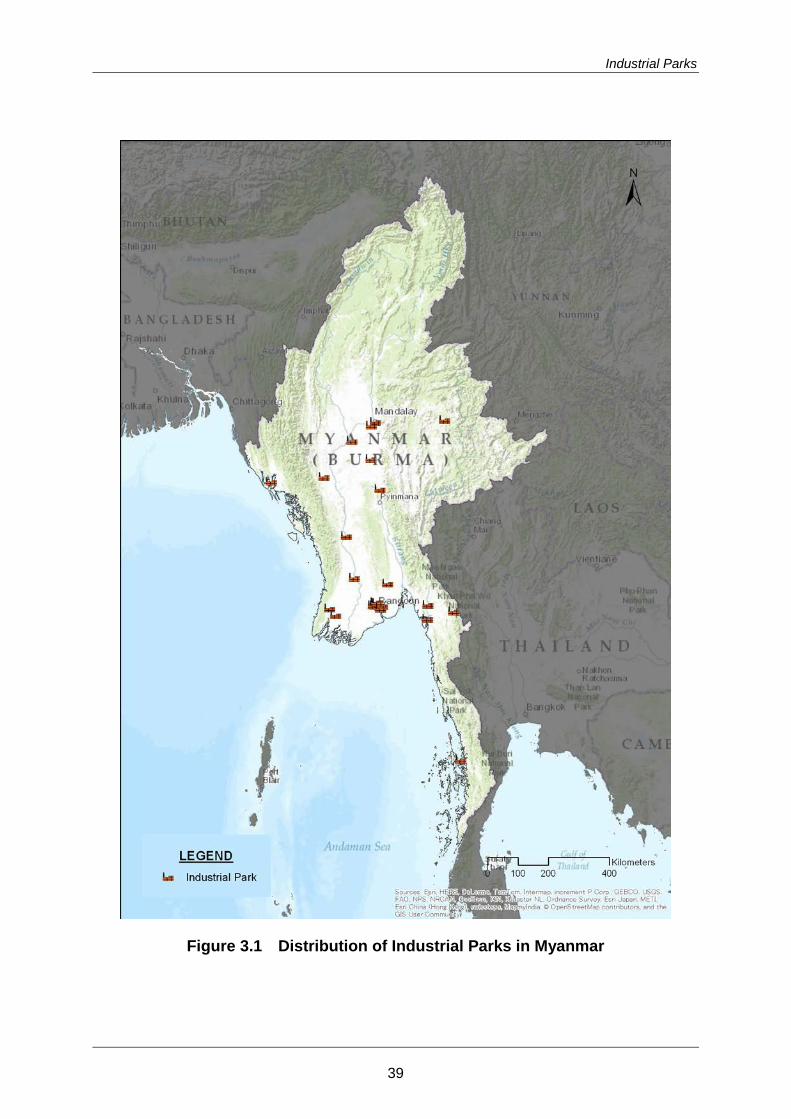
3. Industrial Parks 3.1 Distribution of Industrial Parks in Myanmar
51 industrial parks (or industrial zones) were identified by the study, and as shown in
Figure 3.1, most of them are located in Yangon Division and Mandalay Division.
A list of the industrial parks in Myanmar is given in Appendix 3, and a brief description
of the selected industrial parks is given in reference2.
Publicly available information on Myanmar’s industrial zones is extremely hard to
come by. Only Mingaladon, by far the country’s best-run industrial zone, has any sort
of online presence. The Directorate of Investment and Company Administration, a
government agency tasked with aiding foreigners with investment questions, was
unable to provide industrial park information for this project. Multiple government
agencies told us that no official, comprehensive list of industrial parks in the country
exists. The closest document that we were able to identify is an outdated list of parks
in and around Yangon held by the Union of Myanmar Federation of Chambers of
Commerce and Industry (UMFCCI). Contact information for some industrial zones was
provided by the Myanmar Industries Association (MIA), but it consisted of phone
numbers only, most of which were disconnected. The MIA was unable to provide
contact information for a number of industrial zones outside of Yangon. With the
exception of Mingaladon, which is already fully occupied, and Thilawa SEZ, which is
under construction, industrial parks in Myanmar appear to be wholly unprepared to
engage with foreign investors.
Information on industrial zone ownership and capital contributions remains shrouded
in secrecy. A Japanese company, FORVAL, has collected some data on the physical
features of industrial parks in the Yangon area, however this information is proprietary
and for internal company use only. FORVAL apparently attempted to obtain financial
information for various industrial zones around Yangon, only to have their requests
universally denied. A representative from FORVAL explained that local businesses
intentionally obfuscate their investments in order to avoid taxation. This means that
accurate figures for capital contributions and investment levels are, in general,
2 AHA Centre and JICA (2014), Risk Assessment Reports for ASEAN and its Countries, Natural Disaster Risk Assessment and Area Business Continuity Plan Formulation for Industrial Areas in the ASEAN Region.
38
Industrial Parks
Figure 3.1 Distribution of Industrial Parks in Myanmar
39
Country Report
impossible to procure. Corruption is likely to be another motivation for this lack of
transparency – commercial real estate ownership is often used to launder money.
3.2 Historical Evolution of Industrial Parks Myanmar first saw the development of industrial parks in the 1950s, primarily around
Yangon, as part of foreign-financed reconstruction efforts following World War II. The
development of these sites was fairly limited, and they were closed following the rise
of Ne Win’s socialist government through a coup in 1962. The development of
industrial parks did not restart until the 1990s. The State Law and Order Restoration
Council, the successor military junta to Ne Win’s government, established industrial
zones in the early 1990s under the auspices of the Department of Human Settlement
and Housing Development (DHSHD), part of the Ministry of Construction.
These industrial zones were not initially intended to function as SEZs and promote
export-oriented manufacturing; businesses operating in them were not granted relief
from prevailing tax or labor laws. Rather, the zones were intended to serve as an
example of urban land-use planning and to warehouse cottage industries. The
establishment of industrial zones, along with the junta’s attempts at opening the
economy to the outside world, led to a garment-manufacturing boom by the
mid-1990s. This boom was fueled by relatively low labor costs and the underutilized
import quotas for Burmese goods in place in the EU and US. It saw the number of
parks in the country rise to around 50, and saw the establishment of the first private
parks. Most industrial parks catered only to domestic investors, focused on the
garment industry and had fairly basic infrastructure and facilities. A couple of parks,
especially the few private and joint-venture ones around Yangon, attracted foreign
investment and offered somewhat better infrastructure, though this was generally still
below regional standards.
Throughout the 1990s, garments accounted for the majority of Myanmar’s
manufactured exports. As the US had become the single largest market for
Myanmar-produced garments by the late 1990s, the imposition of trade sanctions in
2003 resulted in a massive contraction of the garment industry. By 2005, output had
contracted to 38% of what it had been in 1999. As a result, most foreign investors left,
40
Industrial Parks
and many industrial parks closed or stagnated, with little invested in park
development or infrastructure.
In the wake of political reforms since 2011 and the easing of international sanctions,
foreign interest in Myanmar’s industrial parks has returned. However, ongoing
infrastructure and governance problems have to date limited new foreign
manufacturing investment. Modern, heavy-industrial production is essentially
impossible, given Myanmar’s unreliable power grid, poor roads, and underdeveloped
ports. Yangon is also experiencing a property bubble; rampant speculation has
driven up the price of commercial real estate to a level that offset Myanmar’s
low-wage advantages. A 2012 investigation found that one acre of land in Yangon’s
Hlaing Thar Yar industrial zone cost roughly USD 500,000 – about ten times what an
equivalent plot would cost in Orlando, Florida. Land confiscation has also been an
issue associated with industrial zone development in the past, which may lead to
tenure issues for investors to contend with in the future.
In an attempt to jumpstart export production, the government has announced plans
to develop three SEZs, in which foreign manufacturers will enjoy special tax benefits.
The one that has attracted the most interest from foreign manufacturers to date is the
Thilawa SEZ, located next to the closest deep-water port to Yangon. Japan’s ODA
agency has issued the Myanmar government with a USD 205 million loan to assist with
infrastructure development in the Thilawa SEZ.
3.3 Recent Trends and Japanese Investment Japan, which has never imposed trade sanctions on Myanmar, became the
country’s largest garment export market after the imposition of US sanctions in 2003.
Japanese companies and organizations have subsequently done more to further
Myanmar’s industrial development than any other country. In 1998, a consortium
spearheaded by Mitsui & Co. broke ground on what is to date the only
international-standard industrial zone in the country - Mingaladon, located near
Yangon International Airport. One of only a handful of joint-venture or private
industrial parks in the country, it is also among the smallest at 184 acres. Of its nine
tenants, five are Japanese: Ajinomoto (foodstuffs), Htet Pyae Phyo (electronics), and
three garment manufacturers.
41
Country Report
Aside from Mingaladon, Japanese foreign direct investment in the manufacturing
sector has been limited. In 2012, a Japanese garment producer, Honey, set up a
wholly Japanese financed factory in the Yangon Industrial Zone near Mingaladon,
which is the first new investment of its type in Myanmar since 2002. Suzuki resumed
production of small cars at its facility in Yangon’s South Dagon industrial zone in May
2013, but the plant, which has never built more than 100 cars per month, is hampered
by a lack of infrastructure.
Suzuki is set to build a much larger and more modern factory at Thilawa, the first firm
commitment from a foreign company to develop a modern automobile plant in
Myanmar. Other Japanese heavy industry firms have recently expressed interest in
manufacturing construction equipment at Thilawa. It is likely that the vast majority of
future manufacturers at Thilawa will be Japanese due to Tokyo’s support for and
promotion of the project.
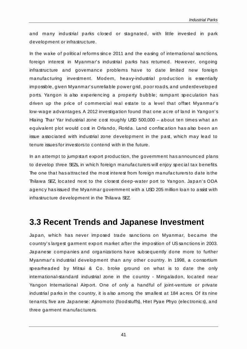
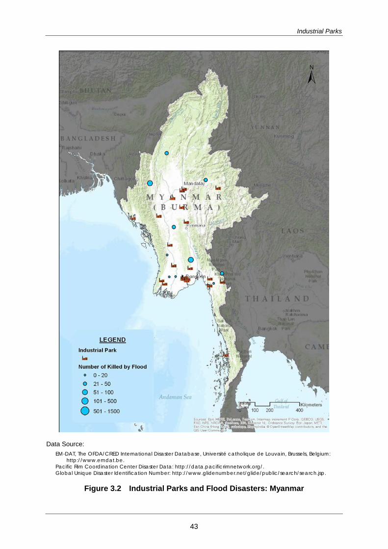
3.4 Risks of Natural Hazards For the first glance of risks of natural hazards to industrial parks and individual
enterprises, it is useful superimpose your location on the distribution maps of natural
disasters given in Chapter 2. Figures 3.2 and 3.3 are showing relationships of locations
of industrial parks, and flood and earthquake disasters, respectively. For the detailed
assessment of the risks of natural disasters to industrial parks and individual enterprises,
hazard and risk assessment are required for an area of interest.
A description of general investment risks of Myanmar is attached in Appendix 4.
42
Industrial Parks
Data Source: EM-DAT, The OFDA/CRED International Disaster Database, Université catholique de Louvain, Brussels, Belgium:
http://www.emdat.be. Pacific Rim Coordination Center Disaster Data: http://data.pacificrimnetwork.org/. Global Unique Disaster Identification Number: http://www.glidenumber.net/glide/public/search/search.jsp.
Figure 3.2 Industrial Parks and Flood Disasters: Myanmar
43

Country Report
Data Sources: EM-DAT, The OFDA/CRED International Disaster Database, Université catholique de Louvain, Brussels, Belgium:
http://www.emdat.be. Pacific Rim Coordination Center Disaster Data: http://data.pacificrimnetwork.org/. Global Unique Disaster Identification Number: http://www.glidenumber.net/glide/public/search/search.jsp.
Figure 3.3 Industrial Parks and Earthquake Disasters: Myanmar
44
Transport Infrastructure and Lifeline Utilities
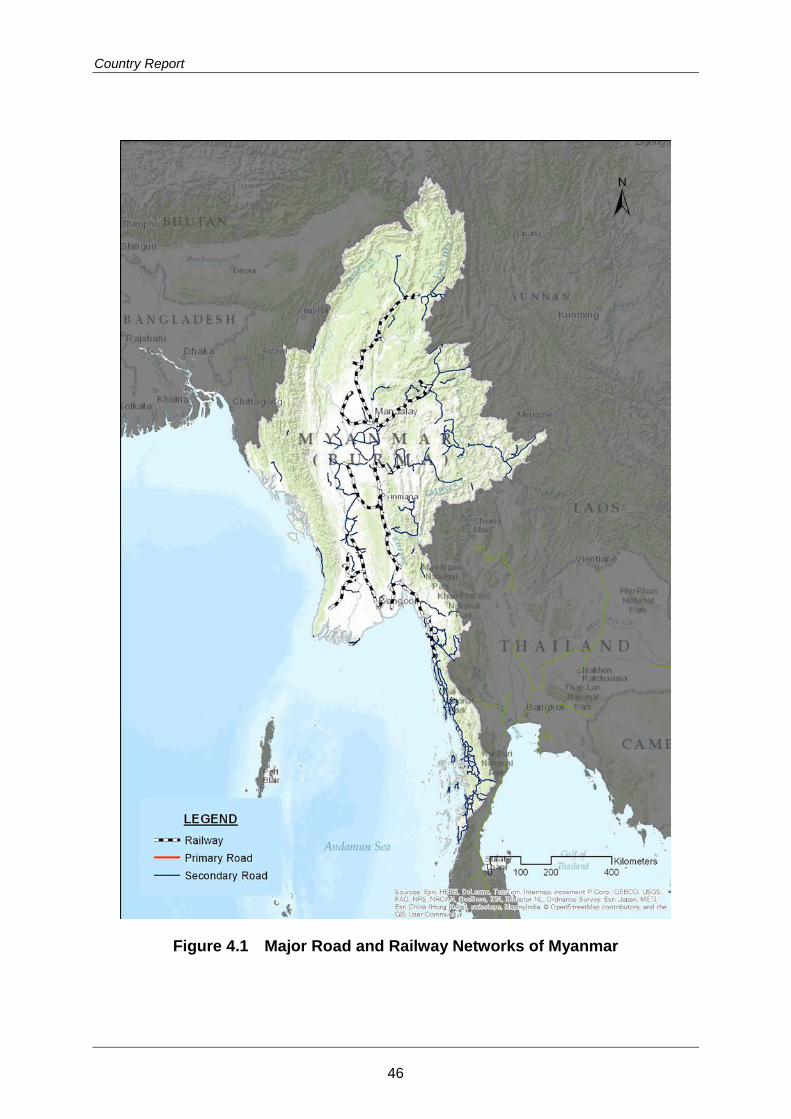
4. Transport Infrastructure and Lifeline Utilities
4.1 Overview of Transport Infrastructure
Road
The domestic transportation network in Myanmar is based on a road system which
flows in the direction of north to south, while the east to west route tends to be
divided by rivers. No means of transportation have been developed in either the
northern mountain area or border regions because of political restrictions.
In 2005, the capital was relocated from Yangon to Ney Pyi Taw. Improvement work for
the road and railway networks has been furthered in order to improve access
between the two areas. A highway between the two areas was opened for traffic in
2009.
Regarding the number of registered cars, most are passenger cars, followed by trucks.
However, it is expected that the number of trucks will increase in the future.
Major road networks of Myanmar are shown in Figure 4.1.
Railway
In 1877, the 298 km of railway between Yangon- Pyay was built by the Irrawaddy
State Railway. In 1886, the 623 km between Yangon-Mandalay was completed.
These became the foundation of the railway of Myanmar. After that, construction of
railway progressed slowly. However, in recent years, railway construction has been
conducted more rapidly.
The present railway is 5,031 km in length, and there are 806 railway stations (2007). The
railway company is under governmental jurisdiction, with no entry of private
enterprise into railway operations. 1,000 mm gauge and 37 kg/m rail are used for the
railway structure with wooden railway sleepers. However, these wooden sleepers are
currently being replaced with concrete sleepers. The speed limits are 70 km/h for
main lines and 35 km/h for branch lines. Major railway networks are shown in Figure
4.1.
45
Country Report
Figure 4.1 Major Road and Railway Networks of Myanmar
46
Transport Infrastructure and Lifeline Utilities
Port
In Myanmar, the ports are classified according to their roles into three types.
Table 4.1 Classification of Ports
Classification Ports
International port for export and import Yangon Port
International Export port Sittwe Port, Pathein Port, Mawlamyine Port, Myeik Port
Domestic coastal transportation port Chaopyu Harbor, Sandoue Port, Dawei Port, Harbor Kotaun
Source: Ministry of Land, Infrastructure, Transport and Tourism, Transportation, Japan, Situation of Myanmar 2009.11
The Yangon Thilawa Port and the Kyaukphyu Port are listed in the 47 harbors
designated by ASEAN.
The Yangon Port has 26 berths, of which 13 can accommodate containers. There are
four (4) container terminals: Bo Aung Gyaw Terminal: MPA Management, Myanmar
International Terminal Thilawa: MITT, Asia World Port Terminal (AWP), and Myanmar
Industrial Port (MIP). At the Yangon Port, the cargo throughput was 12,003,103 tons
and the container throughput was 189,690 TEUs in 2008. Although there is some yearly
fluctuation, there is a general upward trend.
In May 2008, Cyclone Nargis hit the Ayeyarwaddy District and the Yangon District,
causing serious damage to Yangon Port. Because of the sinking of vessels, the
throughput capability of Yangon Port fell to about 1/3, and among the 37 piers used
for domestic distribution, 24 piers became unusable. As a result, the distribution of
goods was greatly disrupted.
Locations of major ports are shown in Figure 4.2.
47
Country Report
Figure 4.2 Major Ports and Airports of Myanmar
48
Transport Infrastructure and Lifeline Utilities
Airport
Myanmar has 69 airports. They are classified as of Table 4.2. There are two (2)
international airports: Yangon International Airport and Mandalay International
Airport. They are managed by the Ministry of Transport and Department of Civil
Aviation. The Myanmar government will also build the Hanthawaddy International
Airport at Bago. Table 4.2 Classification of Airports
Classification of Airports Number
Class 1(International Airport) 2
Class 2(Domestic airport adjusted to a jet aircraft) 24
Class 3(Domestic airport not adjusted to a jet aircraft) 6
Class 4(Local safety airport) 30
Class 5(Military airport) 7
Total 69
Source: Ministry of Land, Infrastructure, Transport and Tourism, Transportation Situation of Myanmar 2009.11
4.2 Overview of Lifeline Utilities
Electricity
In Myanmar, power failures occur frequently, even in big cities such as Yangon and
Mandalay. Unless personal electricity generators are used, it is difficult to establish a
satisfactory electric power environment. The shortage of electric power is a major
issue in Myanmar.
Electricity in Myanmar is generated by hydro power (70%) and thermal power (24%).
There is also a difference in electricity generation capacity of electricity between the
rainy season (May to October) and the dry season (November to March). (almost
half.)
Myanmar transmits electricity at 66, 33, 11 and 6.6 kV, and supplies electricity at 230V
and 132V. The electric power supply at peak hours is 1,500 MW, of which about half is
consumed in Yangon. However, even if the nominal voltage is stated as 230V, it may
49
Country Report
be distributed in voltages that are higher or lower, which home electrical appliances
to malfunction.
Dam construction is difficult due to large problems involving location, time, distance,
and the environment. Therefore, the construction of a natural gas power plant is
planned. Additionally, Chubu Electric Power of Japan received an order to conduct
a survey on improving the electric power supply networks of Myanmar in June this
year. Various types of plans are expected to be formulated.
Locations of major power stations and dams are shown in Figure 4.3.
Water Supply
The tap water service coverage rate is only 60% in Yangon city. The shortage is
supplemented by using groundwater and low-speed filtrated water. Chemical
disinfection and water-purification is not conducted. The total water volume supplied
to Yangon is 524,000 m³/day; coming from the four (4) water-purification plants.
About 40% of the water supply comes from the water supply pump station of the 1st
phase water purification plant in Naunghnapin. Although there are four (4) sets of
pumps installed, only two (2) sets of them are working because of malfunctions.
As for the water quality, two thirds (2/3) of the water supply is without
water-purification and it has also suffered flood damage. The leakage rate is about
50% in Yangon City, and also 40% in some parts of Nay Pyi Taw City. Water supply
pipes are deteriorated.
Sewerage
In some parts of the city center in Yangon, the sewer facilities installed during British
possession 120 years ago are still partly in use, but have become remarkably
deteriorated. Although there is an area using septic tanks, supernatant fluid is
discharged without treatment and contaminates groundwater. Moreover, domestic
wastewater is discharged without any treatment into the Yangon River and
contaminates the river. Among the 28 industrial estates in Myanmar, only the
Mingaladon Industrial Park (MIP) of Yangon, which was partly developed by
Japanese companies, treat their industrial wastewater.
50

Transport Infrastructure and Lifeline Utilities
Figure 4.3 Major Power Stations and Dams of Myanmar
51

Country Report
Communications
Internet and Broadband
Only two companies (Myanmar Posts and Telecommunications (MPT) and
Yadanaporn Teleport (YT)) provide ISP services. Several companies borrow these lines
and are performing communications services using optical fiber, radio broadband,
Asymmetric Digital Subscriber Line (ADSL), Dialup, WiMAX, and an iPSTAR satellite.
Mobile Phone
MPT provides mobile communication services with many systems, such as CDMA and
GSM. Interconnection between the systems is not performed. In August, 2012,
Telecom Square (the Japanese mobile communication facility rental service
company) started mobile phone rental services.
Fixed-line Phone
Although MPT offers fixed-line telephone services, infrastructure improvement of
fixed-line phones is insufficient because of a shortage of funds. Diffusion rates are also
low.
Terrestrial Broadcasting
Myanmar Radio and Television (MRTV) is a state-run television station that broadcasts
news and dramas. There are 218 relay stations, which cover about 98% of the
population.
Waste
In order to maintain Yangon city as a garden city, the Pollution Control and Cleansing
Department (PCCD) was established. In 1999, the urban waste generated was 3,000
tons/day, and the basic unit of solid waste generation was 0.52 kg/person/day. The
sources of solid waste are households (61.4%) and markets (14.8%).
Although there were disposal sites located in Yangon, they were closed because
they caused various environmental problems. Currently, the new Htein Pin disposal
site located at 26 km west of the city is used.
52
Transport Infrastructure and Lifeline Utilities
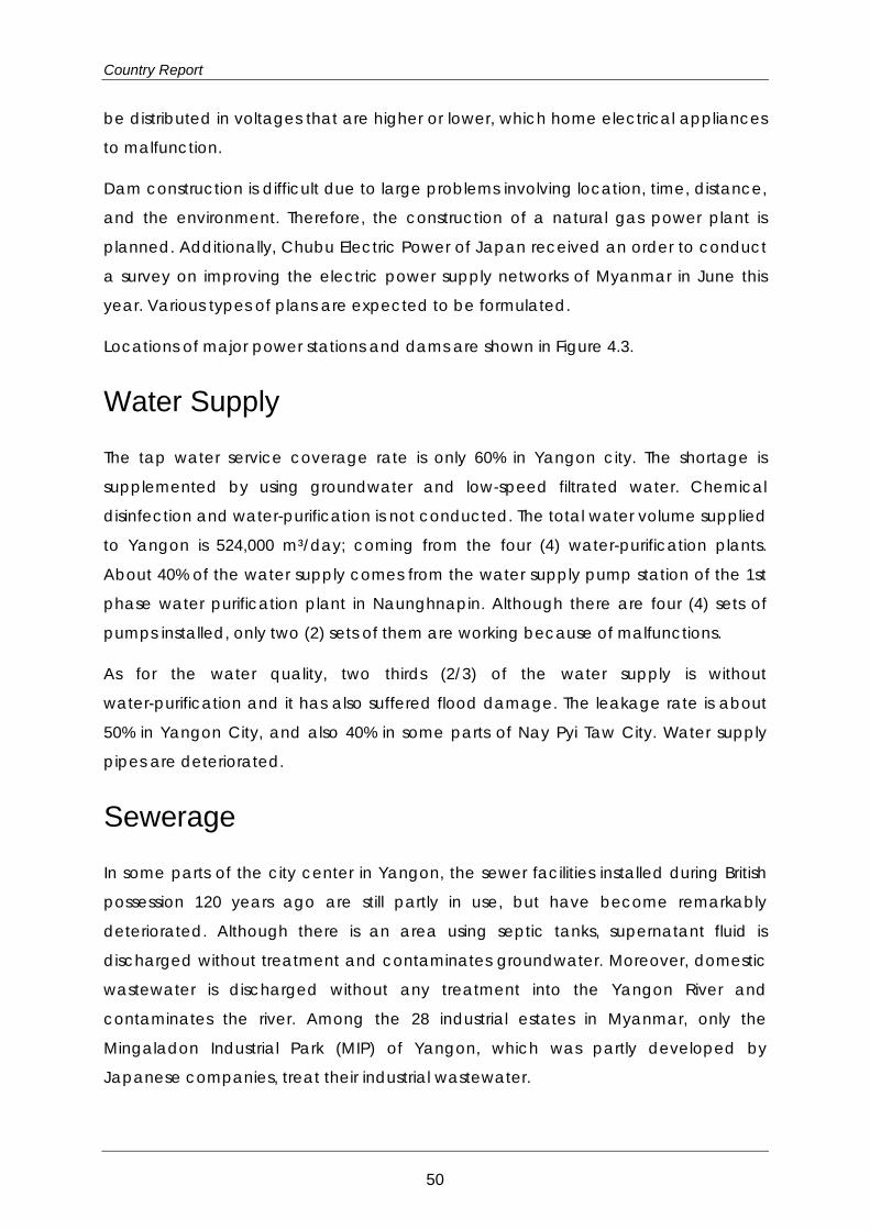
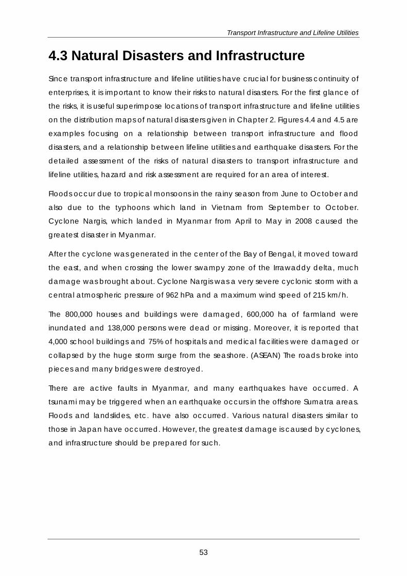
4.3 Natural Disasters and Infrastructure Since transport infrastructure and lifeline utilities have crucial for business continuity of
enterprises, it is important to know their risks to natural disasters. For the first glance of
the risks, it is useful superimpose locations of transport infrastructure and lifeline utilities
on the distribution maps of natural disasters given in Chapter 2. Figures 4.4 and 4.5 are
examples focusing on a relationship between transport infrastructure and flood
disasters, and a relationship between lifeline utilities and earthquake disasters. For the
detailed assessment of the risks of natural disasters to transport infrastructure and
lifeline utilities, hazard and risk assessment are required for an area of interest.
Floods occur due to tropical monsoons in the rainy season from June to October and
also due to the typhoons which land in Vietnam from September to October.
Cyclone Nargis, which landed in Myanmar from April to May in 2008 caused the
greatest disaster in Myanmar.
After the cyclone was generated in the center of the Bay of Bengal, it moved toward
the east, and when crossing the lower swampy zone of the Irrawaddy delta, much
damage was brought about. Cyclone Nargis was a very severe cyclonic storm with a
central atmospheric pressure of 962 hPa and a maximum wind speed of 215 km/h.
The 800,000 houses and buildings were damaged, 600,000 ha of farmland were
inundated and 138,000 persons were dead or missing. Moreover, it is reported that
4,000 school buildings and 75% of hospitals and medical facilities were damaged or
collapsed by the huge storm surge from the seashore. (ASEAN) The roads broke into
pieces and many bridges were destroyed.
There are active faults in Myanmar, and many earthquakes have occurred. A
tsunami may be triggered when an earthquake occurs in the offshore Sumatra areas.
Floods and landslides, etc. have also occurred. Various natural disasters similar to
those in Japan have occurred. However, the greatest damage is caused by cyclones,
and infrastructure should be prepared for such.
53
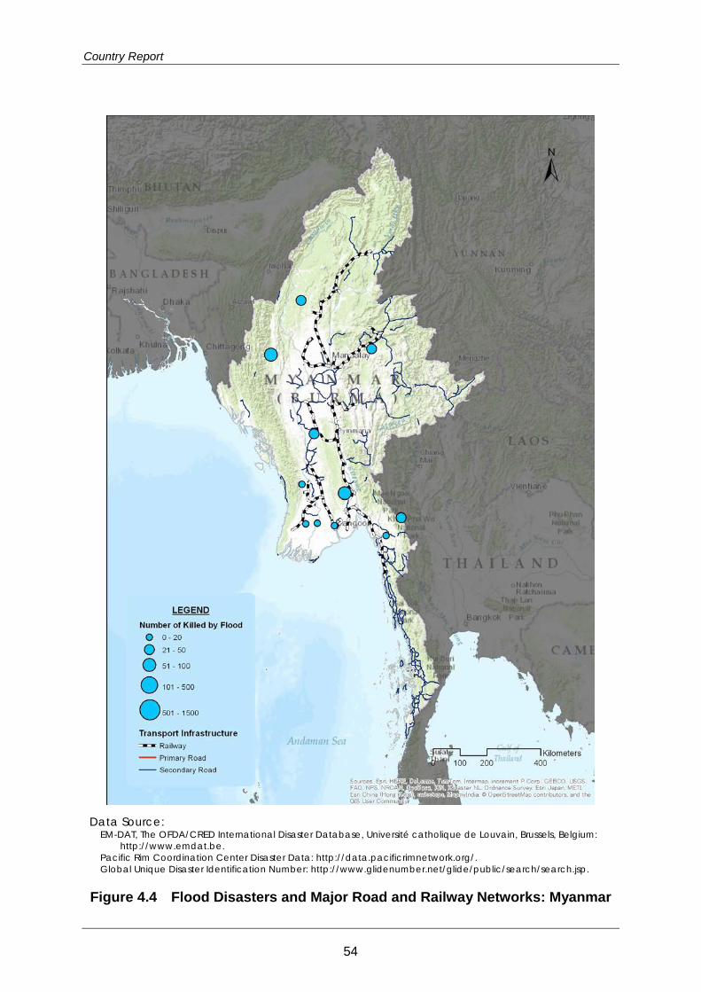
Country Report
Data Source:
EM-DAT, The OFDA/CRED International Disaster Database, Université catholique de Louvain, Brussels, Belgium: http://www.emdat.be.
Pacific Rim Coordination Center Disaster Data: http://data.pacificrimnetwork.org/. Global Unique Disaster Identification Number: http://www.glidenumber.net/glide/public/search/search.jsp.
Figure 4.4 Flood Disasters and Major Road and Railway Networks: Myanmar
54
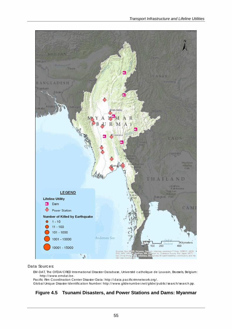
Transport Infrastructure and Lifeline Utilities
Data Sources: EM-DAT, The OFDA/CRED International Disaster Database, Université catholique de Louvain, Brussels, Belgium:
http://www.emdat.be. Pacific Rim Coordination Center Disaster Data: http://data.pacificrimnetwork.org/. Global Unique Disaster Identification Number: http://www.glidenumber.net/glide/public/search/search.jsp.
Figure 4.5 Tsunami Disasters, and Power Stations and Dams: Myanmar
55
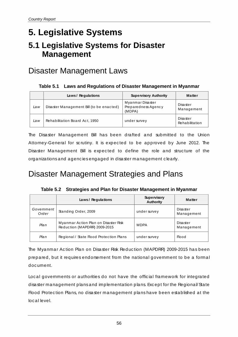
Country Report
5. Legislative Systems 5.1 Legislative Systems for Disaster
Management
Disaster Management Laws
Table 5.1 Laws and Regulations of Disaster Management in Myanmar
Laws / Regulations Supervisory Authority Matter
Law Disaster Management Bill (to be enacted) Myanmar Disaster Preparedness Agency (MDPA)
Disaster Management
Law Rehabilitation Board Act, 1950 under survey Disaster Rehabilitation
The Disaster Management Bill has been drafted and submitted to the Union
Attorney-General for scrutiny. It is expected to be approved by June 2012. The
Disaster Management Bill is expected to define the role and structure of the
organizations and agencies engaged in disaster management clearly.
Disaster Management Strategies and Plans
Table 5.2 Strategies and Plan for Disaster Management in Myanmar
Laws / Regulations Supervisory Authority Matter
Government Order Standing Order, 2009 under survey Disaster
Management
Plan Myanmar Action Plan on Disaster Risk Reduction (MAPDRR) 2009-2015 MDPA Disaster
Management
Plan Regional / State Flood Protection Plans under survey Flood
The Myanmar Action Plan on Disaster Risk Reduction (MAPDRR) 2009-2015 has been
prepared, but it requires endorsement from the national government to be a formal
document.
Local governments or authorities do not have the official framework for integrated
disaster management plans and implementation plans. Except for the Regional/State
Flood Protection Plans, no disaster management plans have been established at the
local level.
56
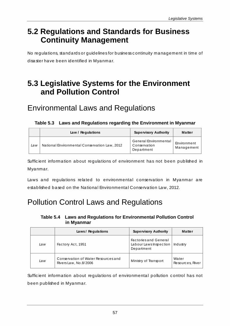
Legislative Systems
5.2 Regulations and Standards for Business Continuity Management
No regulations, standards or guidelines for business continuity management in time of
disaster have been identified in Myanmar.
5.3 Legislative Systems for the Environment and Pollution Control
Environmental Laws and Regulations
Table 5.3 Laws and Regulations regarding the Environment in Myanmar
Law / Regulations Supervisory Authority Matter
Law National Environmental Conservation Law, 2012 General Environmental Conservation Department
Environment Management
Sufficient information about regulations of environment has not been published in
Myanmar.
Laws and regulations related to environmental conservation in Myanmar are
established based on the National Environmental Conservation Law, 2012.
Pollution Control Laws and Regulations
Table 5.4 Laws and Regulations for Environmental Pollution Control in Myanmar
Laws / Regulations Supervisory Authority Matter
Law Factory Act, 1951 Factories and General Labour Laws Inspection Department
Industry
Law Conservation of Water Resources and Rivers Law, No.8/2006 Ministry of Transport Water
Resources, River
Sufficient information about regulations of environmental pollution control has not
been published in Myanmar.
57

Country Report
As a law for environmental pollution control related to industrial activities, the Factory
Act, 1951 was enacted. Furthermore, regulations for the conservation of water
resources and rivers are regulated in the Conservation of Water Resources and Rivers
Law, No.8/2006.
5.4 Legislative Systems for Development including Land Use, Rivers, and Building Code in Myanmar
Table 5.5 Laws and Regulations for Land, Rivers, and Building Code in Myanmar
Laws / Regulations Supervisory Authority Matter
Law Board of Development Affairs Act, 1993 under survey Development
Law Forest Law, No.8/92 Forest Department Forestry
Law Protection of Wildlife and Conservation of Natural Areas Law, No.6/94 Forest Department Nature
Conservation
Several laws for town development and forest use have been enacted in Myanmar.
However, although the policies for conservation of forests and natural areas are
issued in the Forest Law and Protection of Wildlife and Conservation of Natural Areas
Law, there are few direct provisions about the regulation of industrial activities.
In our research, specific building codes enacted in Myanmar could not be verified.
58
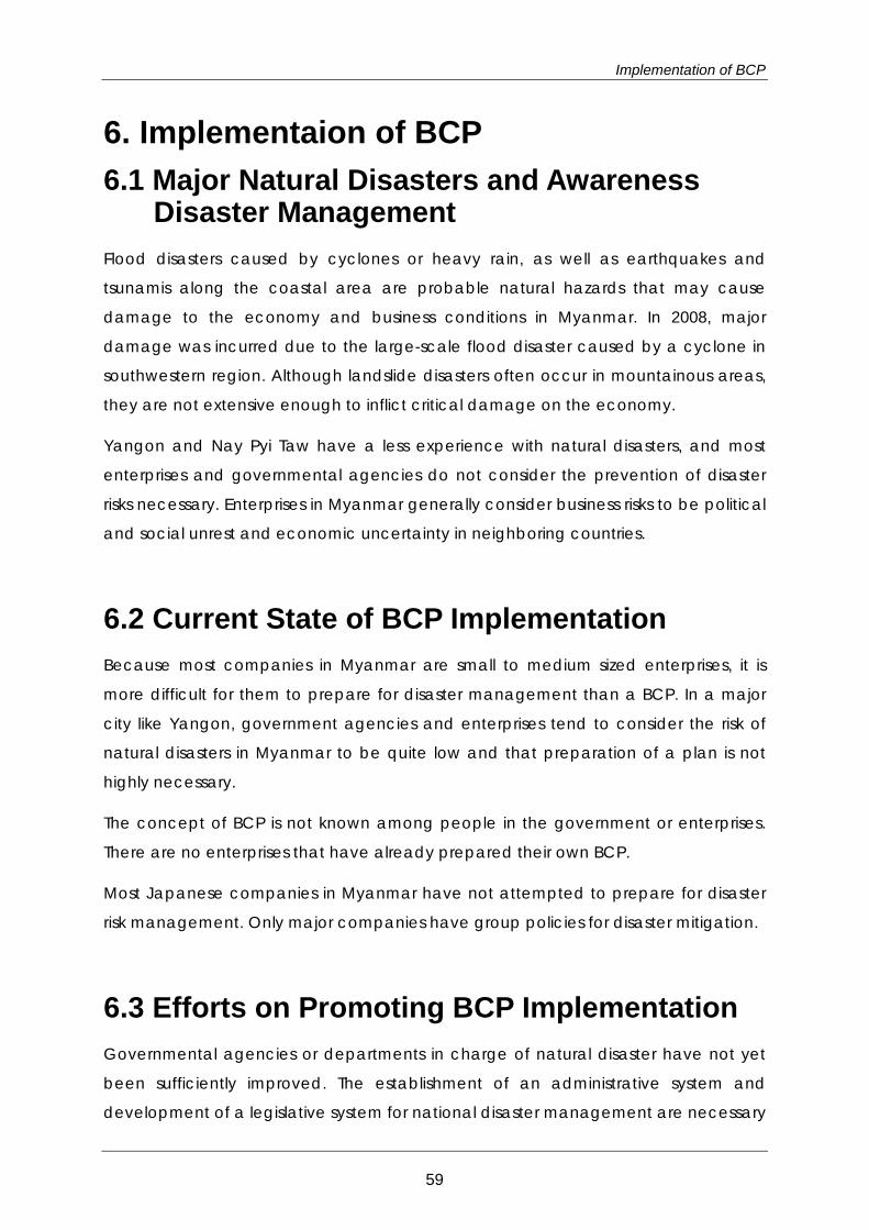
Implementation of BCP
6. Implementaion of BCP 6.1 Major Natural Disasters and Awareness
Disaster Management Flood disasters caused by cyclones or heavy rain, as well as earthquakes and
tsunamis along the coastal area are probable natural hazards that may cause
damage to the economy and business conditions in Myanmar. In 2008, major
damage was incurred due to the large-scale flood disaster caused by a cyclone in
southwestern region. Although landslide disasters often occur in mountainous areas,
they are not extensive enough to inflict critical damage on the economy.
Yangon and Nay Pyi Taw have a less experience with natural disasters, and most
enterprises and governmental agencies do not consider the prevention of disaster
risks necessary. Enterprises in Myanmar generally consider business risks to be political
and social unrest and economic uncertainty in neighboring countries.
6.2 Current State of BCP Implementation Because most companies in Myanmar are small to medium sized enterprises, it is
more difficult for them to prepare for disaster management than a BCP. In a major
city like Yangon, government agencies and enterprises tend to consider the risk of
natural disasters in Myanmar to be quite low and that preparation of a plan is not
highly necessary.
The concept of BCP is not known among people in the government or enterprises.
There are no enterprises that have already prepared their own BCP.
Most Japanese companies in Myanmar have not attempted to prepare for disaster
risk management. Only major companies have group policies for disaster mitigation.
6.3 Efforts on Promoting BCP Implementation Governmental agencies or departments in charge of natural disaster have not yet
been sufficiently improved. The establishment of an administrative system and
development of a legislative system for national disaster management are necessary
59
Country Report
for the Myanmar government. Moreover, urban development in Yangon and other
towns has continued in recent years, bringing environmental change that could have
an impact on disaster risk. The establishment of regulations for environmental
conservation has also become urgent, and the preparation of a comprehensive
policy for disaster risk management is needed.
Governmentally and non-governmentally, disaster risk management systems are less
developed in Myanmar. Such a management system is not regarded as an important
issue at the present stage.
6.4 Problems Facing for Implementation of BCP National policy for disaster management by the government has not yet been
significantly defined, and governmental agencies have not reached the stage of
developing BCP implementation.
In Myanmar, since most enterprises are still small to medium sized, they cannot afford
to invest in disaster risk management and need to further their businesses in terms of
economic development and growth. Because understanding of BCP has not grown
in the current situation, it is still very difficult to promote wide dissemination of BCP.
60
Appendix 1: Method for Evaluating Predominant Hazards
Appendix 1: Method for Evaluating Predominant Hazards The “Damage Amount / GDP” and “Number of Deaths” are used as the indices to
show the impacts of the disasters considered and 6 natural hazards will be studied
and compared. At the beginning of the study, only the “Damage Amount / GDP”
was used as an index because the results can be used for Area BCP planning.
However, the scarcity of information related to damage amounts became clear as
the study progressed. As the information on the “Number of Deaths” is substantial
compared to the damage amount, the “Number of Deaths” has been added as an
index of impact.
The process of the study is as follows;
1) Based on the Damage Amount / GDP or Number of Death, each disaster is
classified according to the ranking system outlined in Table A1.
2) The number of disaster events for each country is added by type of hazard and
disaster rank, and then classified into
Table A2 below,
3) The above information is then plotted on the impacts - frequency matrix by
country,
4) As for earthquakes, tsunamis and volcanic hazards, if an event occurred before
1983 that was of the same (or higher) disaster rank as the maximum disaster rank
recorded between 1983 to 2012, a point is plotted on the matrix which
corresponds to the relevant disaster and frequency rank ( =1).
Table A1 Disaster Rank and Damage
Disaster Rank Damage Amount / GDP3 Number of Death
5 1.0% - 10,001 -
4 0.1% - 1.0% 1,001 - 10,000
3 0.01% - 0.1% 101 - 1,000
2 0.001% - 0.01% 11 - 100
1 - 0.001% - 10
3 Gross domestic product based on purchasing-power-parity (PPP) valuation of country GDP, International Monetary Fund, World Economic Outlook Database, October 2012
61
Country Report
Table A2 Frequency Rank and Number of Events
Frequency Rank Number of Events
from 1983 to 2012
Average Frequency
(Events / Year)
5 7 or more 1/5 -
4 4 to 6 1/10 - 1/5
3 2 to 3 1/15 - 1/10
2 1 1/30
1 Large Events occurred before 1983 -
62
Appendix 2: Data Sheets Outline of Existing Investigations and Studies
Appendix 2: Data Sheets Outline of Existing Investigations and Studies
63
Country Report
No.: FL-001 Published Year: 2010 Study/ Report Name: Synthesis Report on Ten ASEAN Countries Disaster Risks
Assessment Access to Information: www.unisdr.org/files/18872_asean.pdf Research Organization: UNISDR/World Bank Study Area (Country): ASEAN (10 countries) Studied Hazard: Flood Studied Damage/ Risk: Flood Main Data Sources: CRED EM-DAT, ADRC, NGDC, GSHAP, MRC, WAMIS,
DWR, Munich Re, World Bank, UNISDR, GAR, In Terragate, IFNet, CCFSC, DESINVENTAR
Summary of the Study: 1) Overview Disaster risks are assessed for years (1970-2009) by 1) Scenario, Exposure, Vulnerability, Damage and Loss analysis using existing database. The dominant disaster risks are cyclonic storms (typhoons), earthquakes, tsunamis, floods, epidemics, landslides, droughts volcanic eruptions and forest-fires. In total 1,211 reported disasters caused over 414,900 deaths. 2) Vulnerability Method: the number of disaster events, deaths, affected population and economic losses are plotted against hazard types for 5 year intervals. To estimate social vulnerability=> the average number of people killed. ASEAN 17.7 death/year/million, Cambodia 3.56, Indonesia 20.38, Lao PDR 4.22, Malaysia 1.26, Myanmar 72.35, Philippines 11.93, Thailand4.63, Vietnam 4.60. Brunei and Singapore have no data. 3) Risk assessment framework A status of risk assessment framework is assessed by country to view the current capacity of risk assessment. The evaluation table is show below.
64
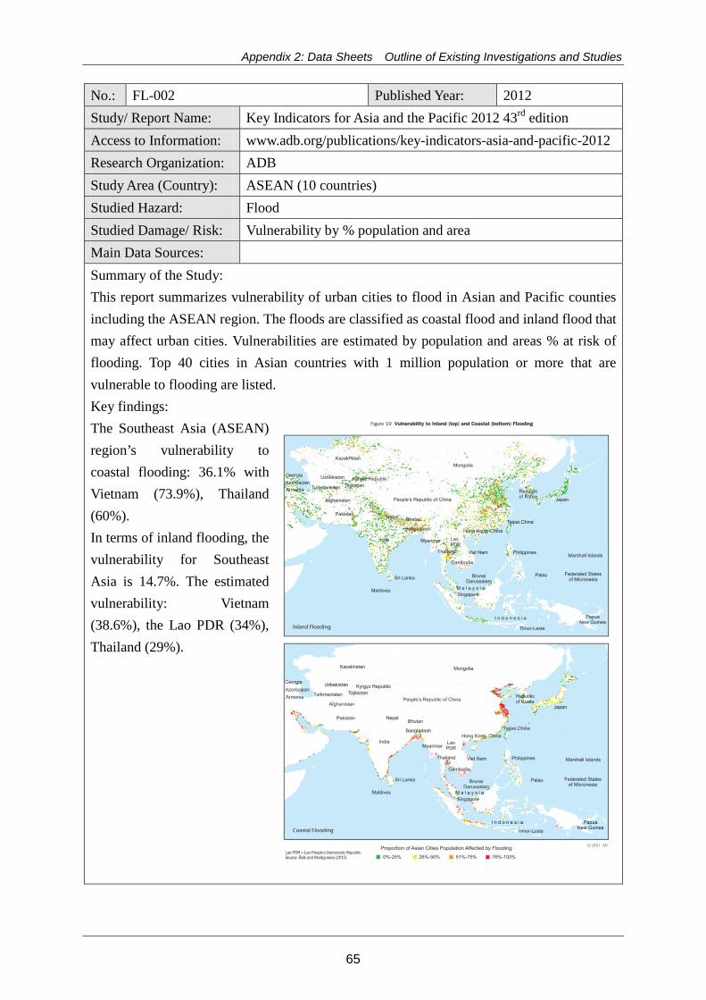
Appendix 2: Data Sheets Outline of Existing Investigations and Studies
No.: FL-002 Published Year: 2012 Study/ Report Name: Key Indicators for Asia and the Pacific 2012 43rd edition Access to Information: www.adb.org/publications/key-indicators-asia-and-pacific-2012 Research Organization: ADB Study Area (Country): ASEAN (10 countries) Studied Hazard: Flood Studied Damage/ Risk: Vulnerability by % population and area Main Data Sources: Summary of the Study: This report summarizes vulnerability of urban cities to flood in Asian and Pacific counties including the ASEAN region. The floods are classified as coastal flood and inland flood that may affect urban cities. Vulnerabilities are estimated by population and areas % at risk of flooding. Top 40 cities in Asian countries with 1 million population or more that are vulnerable to flooding are listed. Key findings: The Southeast Asia (ASEAN) region’s vulnerability to coastal flooding: 36.1% with Vietnam (73.9%), Thailand (60%). In terms of inland flooding, the vulnerability for Southeast Asia is 14.7%. The estimated vulnerability: Vietnam (38.6%), the Lao PDR (34%), Thailand (29%).
65
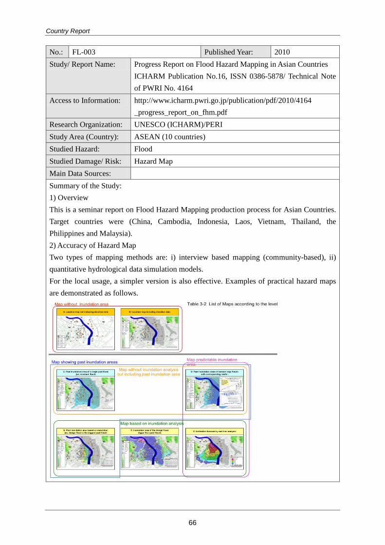
Country Report
No.: FL-003 Published Year: 2010 Study/ Report Name: Progress Report on Flood Hazard Mapping in Asian Countries
ICHARM Publication No.16, ISSN 0386-5878/ Technical Note of PWRI No. 4164
Access to Information: http://www.icharm.pwri.go.jp/publication/pdf/2010/4164 _progress_report_on_fhm.pdf
Research Organization: UNESCO (ICHARM)/PERI Study Area (Country): ASEAN (10 countries) Studied Hazard: Flood Studied Damage/ Risk: Hazard Map Main Data Sources: Summary of the Study: 1) Overview This is a seminar report on Flood Hazard Mapping production process for Asian Countries. Target countries were (China, Cambodia, Indonesia, Laos, Vietnam, Thailand, the Philippines and Malaysia). 2) Accuracy of Hazard Map Two types of mapping methods are: i) interview based mapping (community-based), ii) quantitative hydrological data simulation models. For the local usage, a simpler version is also effective. Examples of practical hazard maps are demonstrated as follows.
66
Appendix 2: Data Sheets Outline of Existing Investigations and Studies
No.: FL-004 Published Year: 2005 Study/ Report Name: A Primer: Integrated Flood Risk Management in Asia 2 Access to Information: www.adpc.net/maininforesource/udrm/floodprimer.pdf Research Organization: Asian Disaster Preparedness Center (ADPC)/UNICEF Study Area (Country): Asia including ASEAN countries Studied Hazard: Flood Studied Damage/ Risk: Assessment method Main Data Sources: Summary of the Study: This is a comprehensive and practical how-to-handbook for policy makers and implementation stakeholders of flood risk management in Asia, with updated resources to (1) authorize programs; (2) formulate decisions; (3) plan, develop and implement decisions; (4) support implementation of decisions. There are extensive glossaries of words and concepts in relation to flood risk management. Topics include:
Chapter 2: Types and levels of flood: riverine flood, slow-onset, rapid-onset, normal flood (1 year flood), catastrophic flood (100 year flood). Causes of flood: meteological, hydrological and anthropogenic. Chapter 3: Policies, legal and institutional arrangement plans: Chapter 4: Flood risk assessment, data required for an assessment of potential damages and losses, Flood frequency calculations Chapter 5: Importance of watershed and floodplain management for flood risk management Chapter 6: Structural interventions: flood storage reservoir, dykes, levee and embankment, EIA, cost benefit analysis Chapter 7: Flood-proofing measures, relocation, elevation, dry-flood proofing, wet-flood proofing, flood-proofing measures categories: permanent, contingent and emergency measures Chapter 8: Flood preparedness planning: preparedness framework, activities, flood forecasting, public awareness Chapter 9: Effective emergency response in environment healthe management, evacuation camps, delivery of goods
Case studies of ASEAN countries include: Disaster Management and Relief in Malaysia, Hazard Assessment in the Philippines, Flood mitigation mix measures/community level management in Thailand, Mekong River Commission Mediation of Transboundary Flood Issues
67
Country Report
No.: FL-006 Published Year: 2012 Study/ Report Name: Reducing Vulnerability and Exposure to Disasters The
Asia-Pacific Disaster Report 2012 Access to Information: http://www.unisdr.org/we/inform/publications/29288 Research Organization: ESCAP/UNISDR Study Area (Country): ASEAN (10 countries) Studied Hazard: Hydro-meteolological Hazard Studied Damage/ Risk: Economic losses, fatalities, houses, risk-sensitive plans of
investment Main Data Sources: Summary of the Study: 1) Overview The Asia-Pacific region represents 75% of all global disaster fatalities. The economic and population growth contribute to a greater exposure to natural disasters. The population was doubled from 2.2 to 4.2 billion between 1970 and 2010. But the number of people who are exposed to flooding has increased from 29.5 to 63.8 million. The urban settlements are more vulnerable as the urban population increased from 17 to 44% of the total population between 1950 and 2010. 2) Vulnerability Generally, smaller and less diversified economies are more vulnerable to disaster risks. Flood mortality risks are higher in rural areas with a densely concentrated and rapidly growing population with weak governance. 3) Risk Risks are associated with economic and mortality risks. The exposure to flooding events constantly increases as of 1980 but mortality risks are decreasing as countries strengthened their risk governance capacities. However economic risks are increasing, due to slow adaptation of the existing fixed assets, such as old buildings and infrastructure, and institutional instruments such as land use planning and building regulation to cope with flooding particularly in rapidly urbanizing areas. 4) Spatial and land use plan The national spatial and land use plans and policies are a key to reduce flood risks. Brunei, Indonesia, Lao PDR, Malaysia, Philippines, Singapore and Vietnam have land-use policies, plans or measures for DRR.
68
Appendix 2: Data Sheets Outline of Existing Investigations and Studies
No.: FL-008 Published Year: 2011 Study/ Report Name: Advancing Disaster Risk Financing and Insurance in ASEAN
Countries: Framework and Options for Implementation, Volume2: Appendix 1
Access to Information: https://www.gfdrr.org/sites/gfdrr.org/files/documents/DRFI_ASEAN_ Appendices_June12.pdf
Research Organization: GFDRR/World Bank Study Area (Country): ASEAN (10 countries) Studied Hazard: Flood (multiple disasters) Studied Damage/ Risk: Damage, affected population, vulnerability index Main Data Sources: World Bank, EM-DAT, Relief Web, GFDRR, CIA fact book Summary of the Study: 1) Overview Disaster risks were compiled for ASEAN countries with data between 1982 and 2011. The following items are analyzed: disaster profile (% of different disasters), damage ($), affected population, vulnerability index (estimated number of people killed/year). 2) Disaster profile: Typhoon is the dominant incidence causing flood and landslide in most countries except Singapore and Brunei Cambodia: 45% flood (Mekong river), 9% storm, 16% drought, 29% epidemic Indonesia: west and dry zones most severely hit (Jakarta, Medan, Bandug) Lao PDR: 50% flood, 22% epidemics, 13% storm, 13% drought Malaysia: dominantly flood Myanmar: multiple hazards, earthquake serious risk Philippines: dominantly typhoons causing other hazards in conjunction Thailand: multiple hazard (flood, drought, storms and landslide) Vietnam: 49% storm, 37% floods, 5% epidemic, 3% landslide, 2% drought 3) Vulnerable areas Mekong River Delta in Vietnam, all regions of the Philippines, most regions in Cambodia, North and East Lao PDR, Bangkok in Thailand, the west and south of Sumatra and western and eastern Java in Indonesia. 4) Vulnerability Urban (especially coastal) areas are more vulnerable against disasters due to a rapid population growth, urbanization, deforestation, and unplanned land use.
69
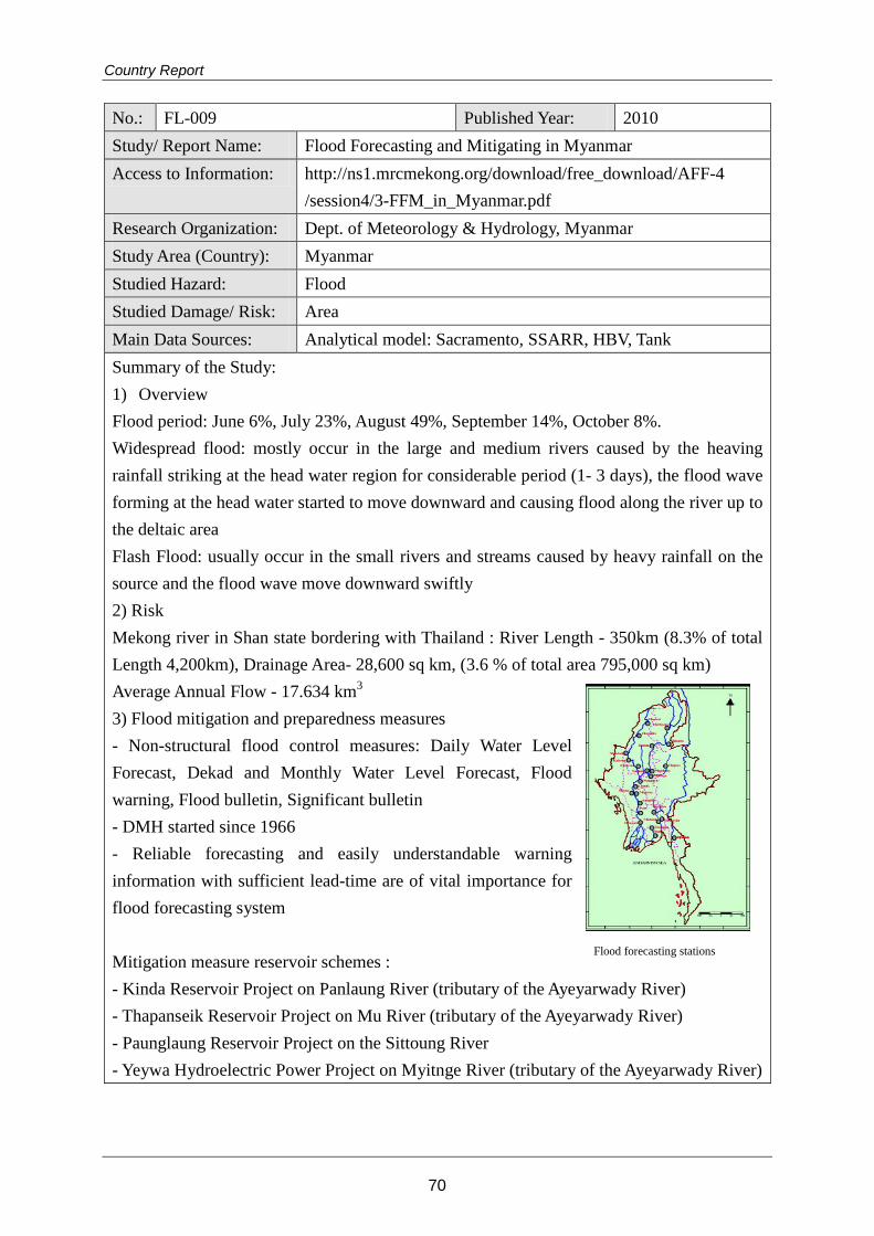
Country Report
No.: FL-009 Published Year: 2010 Study/ Report Name: Flood Forecasting and Mitigating in Myanmar Access to Information: http://ns1.mrcmekong.org/download/free_download/AFF-4
/session4/3-FFM_in_Myanmar.pdf Research Organization: Dept. of Meteorology & Hydrology, Myanmar Study Area (Country): Myanmar Studied Hazard: Flood Studied Damage/ Risk: Area Main Data Sources: Analytical model: Sacramento, SSARR, HBV, Tank Summary of the Study: 1) Overview Flood period: June 6%, July 23%, August 49%, September 14%, October 8%. Widespread flood: mostly occur in the large and medium rivers caused by the heaving rainfall striking at the head water region for considerable period (1- 3 days), the flood wave forming at the head water started to move downward and causing flood along the river up to the deltaic area Flash Flood: usually occur in the small rivers and streams caused by heavy rainfall on the source and the flood wave move downward swiftly 2) Risk Mekong river in Shan state bordering with Thailand : River Length - 350km (8.3% of total Length 4,200km), Drainage Area- 28,600 sq km, (3.6 % of total area 795,000 sq km) Average Annual Flow - 17.634 km3 3) Flood mitigation and preparedness measures - Non-structural flood control measures: Daily Water Level Forecast, Dekad and Monthly Water Level Forecast, Flood warning, Flood bulletin, Significant bulletin - DMH started since 1966 - Reliable forecasting and easily understandable warning information with sufficient lead-time are of vital importance for flood forecasting system Mitigation measure reservoir schemes : - Kinda Reservoir Project on Panlaung River (tributary of the Ayeyarwady River) - Thapanseik Reservoir Project on Mu River (tributary of the Ayeyarwady River) - Paunglaung Reservoir Project on the Sittoung River - Yeywa Hydroelectric Power Project on Myitnge River (tributary of the Ayeyarwady River)
Flood forecasting stations
70
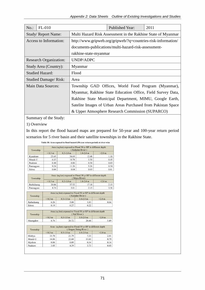
Appendix 2: Data Sheets Outline of Existing Investigations and Studies
No.: FL-010 Published Year: 2011 Study/ Report Name: Multi Hazard Risk Assessment in the Rakhine State of Myanmar Access to Information: http://www.gripweb.org/gripweb/?q=countries-risk-information/
documents-publications/multi-hazard-risk-assessment- rakhine-state-myanmar
Research Organization: UNDP/ADPC Study Area (Country): Myanmar Studied Hazard: Flood Studied Damage/ Risk: Area Main Data Sources: Township GAD Offices, World Food Program (Myanmar),
Myanmar, Rakhine State Education Office, Field Survey Data, Rakhine State Municipal Department, MIMU, Google Earth, Satelite Images of Urban Areas Purchased from Pakistan Space & Upper Atmosphere Research Commission (SUPARCO)
Summary of the Study: 1) Overview In this report the flood hazard maps are prepared for 50-year and 100-year return period scenarios for 5 river basin and their satellite townships in the Rakhine State.
71
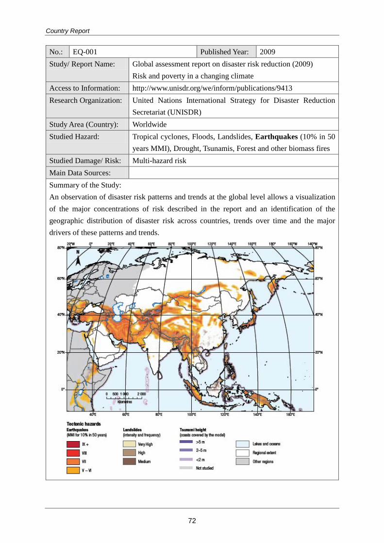
Country Report
No.: EQ-001 Published Year: 2009 Study/ Report Name: Global assessment report on disaster risk reduction (2009)
Risk and poverty in a changing climate Access to Information: http://www.unisdr.org/we/inform/publications/9413 Research Organization: United Nations International Strategy for Disaster Reduction
Secretariat (UNISDR) Study Area (Country): Worldwide Studied Hazard: Tropical cyclones, Floods, Landslides, Earthquakes (10% in 50
years MMI), Drought, Tsunamis, Forest and other biomass fires Studied Damage/ Risk: Multi-hazard risk Main Data Sources: Summary of the Study: An observation of disaster risk patterns and trends at the global level allows a visualization of the major concentrations of risk described in the report and an identification of the geographic distribution of disaster risk across countries, trends over time and the major drivers of these patterns and trends.
72
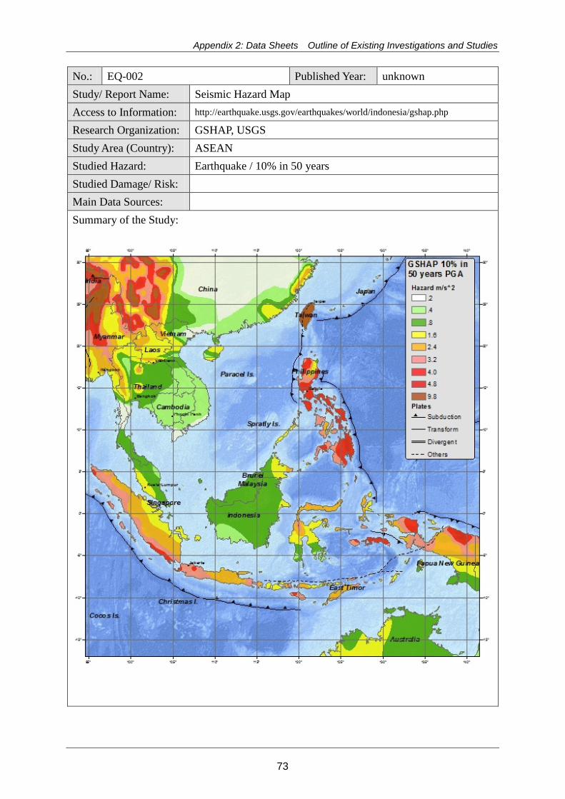
Appendix 2: Data Sheets Outline of Existing Investigations and Studies
No.: EQ-002 Published Year: unknown Study/ Report Name: Seismic Hazard Map Access to Information: http://earthquake.usgs.gov/earthquakes/world/indonesia/gshap.php
Research Organization: GSHAP, USGS Study Area (Country): ASEAN Studied Hazard: Earthquake / 10% in 50 years Studied Damage/ Risk: Main Data Sources: Summary of the Study:
73
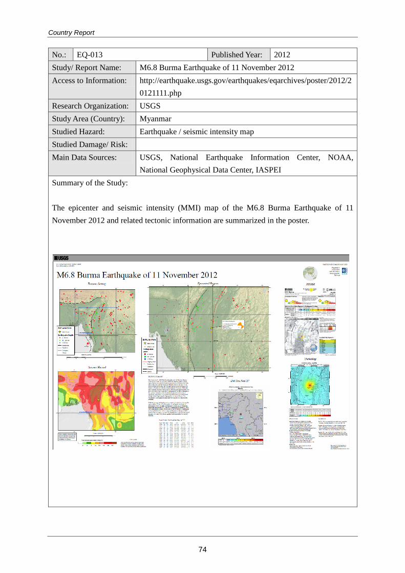
Country Report
No.: EQ-013 Published Year: 2012 Study/ Report Name: M6.8 Burma Earthquake of 11 November 2012 Access to Information: http://earthquake.usgs.gov/earthquakes/eqarchives/poster/2012/2
0121111.php Research Organization: USGS Study Area (Country): Myanmar Studied Hazard: Earthquake / seismic intensity map Studied Damage/ Risk: Main Data Sources: USGS, National Earthquake Information Center, NOAA,
National Geophysical Data Center, IASPEI Summary of the Study: The epicenter and seismic intensity (MMI) map of the M6.8 Burma Earthquake of 11 November 2012 and related tectonic information are summarized in the poster.
74
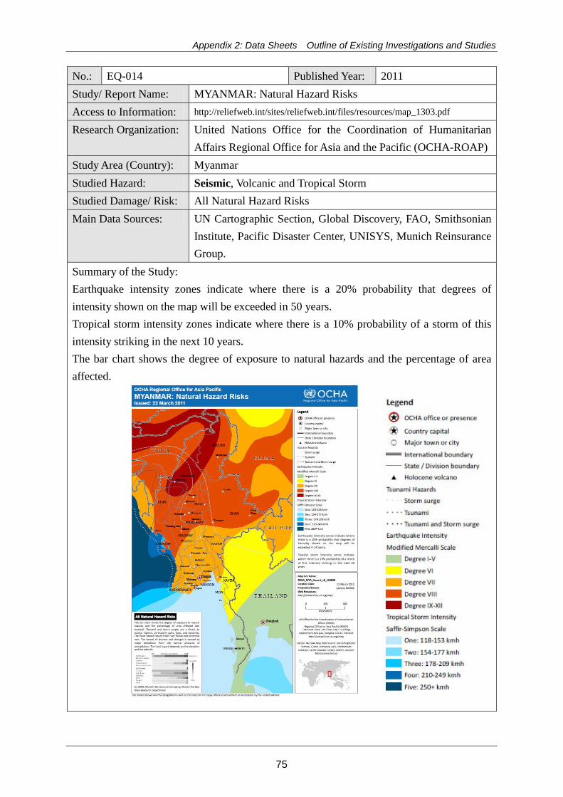
Appendix 2: Data Sheets Outline of Existing Investigations and Studies
No.: EQ-014 Published Year: 2011 Study/ Report Name: MYANMAR: Natural Hazard Risks Access to Information: http://reliefweb.int/sites/reliefweb.int/files/resources/map_1303.pdf
Research Organization: United Nations Office for the Coordination of Humanitarian Affairs Regional Office for Asia and the Pacific (OCHA-ROAP)
Study Area (Country): Myanmar Studied Hazard: Seismic, Volcanic and Tropical Storm Studied Damage/ Risk: All Natural Hazard Risks Main Data Sources: UN Cartographic Section, Global Discovery, FAO, Smithsonian
Institute, Pacific Disaster Center, UNISYS, Munich Reinsurance Group.
Summary of the Study: Earthquake intensity zones indicate where there is a 20% probability that degrees of intensity shown on the map will be exceeded in 50 years. Tropical storm intensity zones indicate where there is a 10% probability of a storm of this intensity striking in the next 10 years. The bar chart shows the degree of exposure to natural hazards and the percentage of area affected.
75
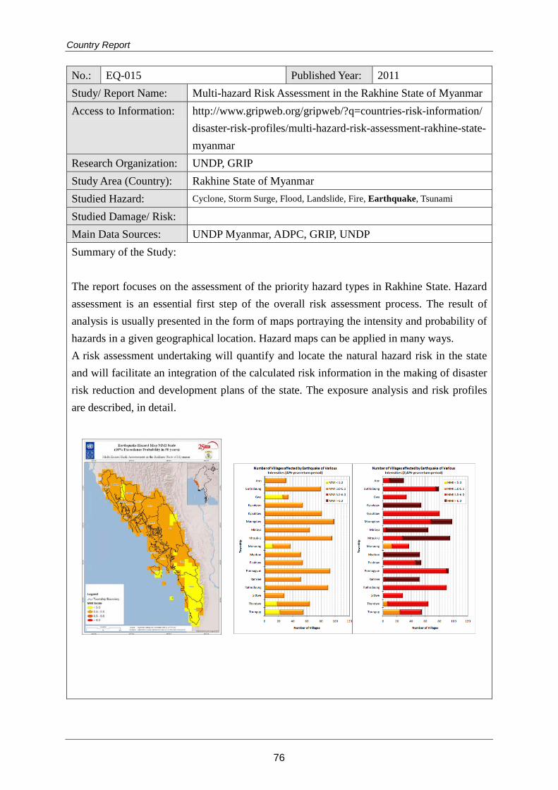
Country Report
No.: EQ-015 Published Year: 2011 Study/ Report Name: Multi-hazard Risk Assessment in the Rakhine State of Myanmar Access to Information: http://www.gripweb.org/gripweb/?q=countries-risk-information/
disaster-risk-profiles/multi-hazard-risk-assessment-rakhine-state-myanmar
Research Organization: UNDP, GRIP Study Area (Country): Rakhine State of Myanmar Studied Hazard: Cyclone, Storm Surge, Flood, Landslide, Fire, Earthquake, Tsunami
Studied Damage/ Risk: Main Data Sources: UNDP Myanmar, ADPC, GRIP, UNDP Summary of the Study: The report focuses on the assessment of the priority hazard types in Rakhine State. Hazard assessment is an essential first step of the overall risk assessment process. The result of analysis is usually presented in the form of maps portraying the intensity and probability of hazards in a given geographical location. Hazard maps can be applied in many ways. A risk assessment undertaking will quantify and locate the natural hazard risk in the state and will facilitate an integration of the calculated risk information in the making of disaster risk reduction and development plans of the state. The exposure analysis and risk profiles are described, in detail.
76
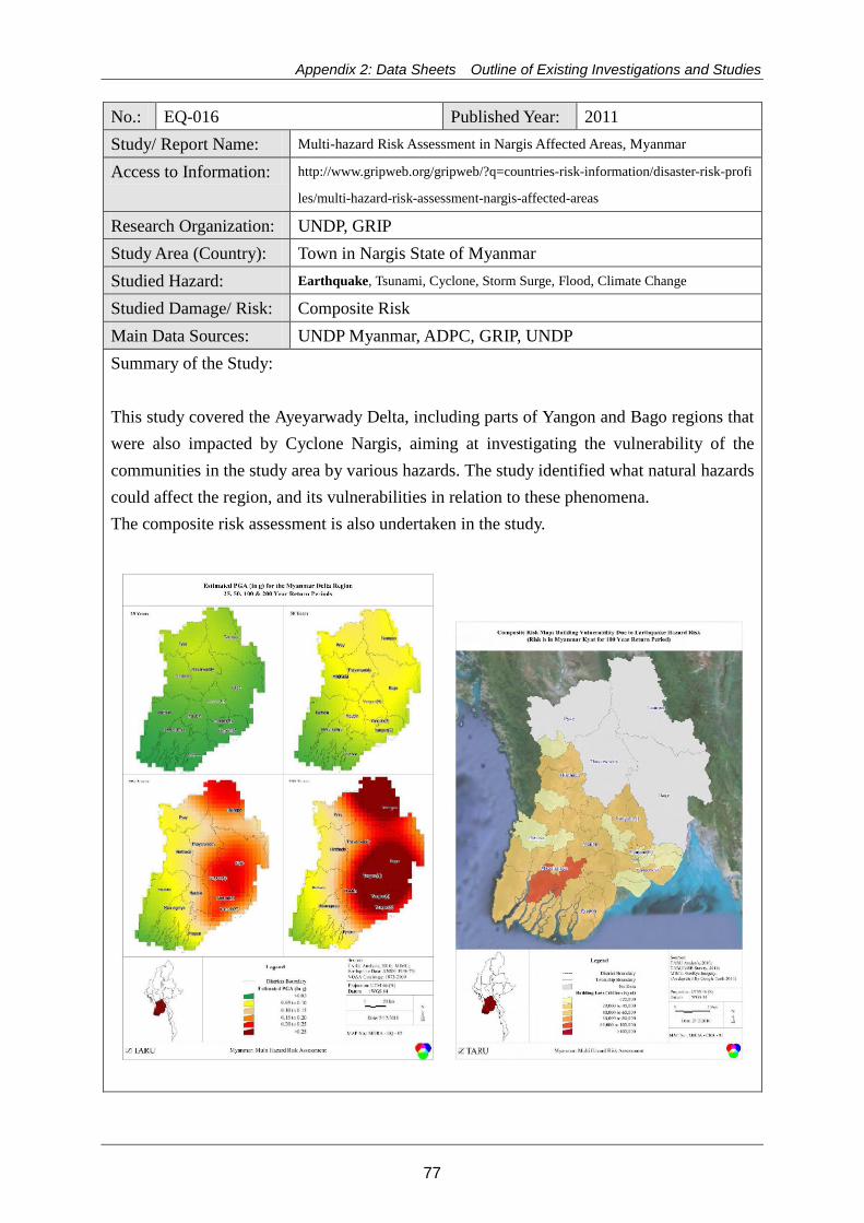
Appendix 2: Data Sheets Outline of Existing Investigations and Studies
No.: EQ-016 Published Year: 2011 Study/ Report Name: Multi-hazard Risk Assessment in Nargis Affected Areas, Myanmar
Access to Information: http://www.gripweb.org/gripweb/?q=countries-risk-information/disaster-risk-profi
les/multi-hazard-risk-assessment-nargis-affected-areas
Research Organization: UNDP, GRIP Study Area (Country): Town in Nargis State of Myanmar Studied Hazard: Earthquake, Tsunami, Cyclone, Storm Surge, Flood, Climate Change
Studied Damage/ Risk: Composite Risk Main Data Sources: UNDP Myanmar, ADPC, GRIP, UNDP Summary of the Study: This study covered the Ayeyarwady Delta, including parts of Yangon and Bago regions that were also impacted by Cyclone Nargis, aiming at investigating the vulnerability of the communities in the study area by various hazards. The study identified what natural hazards could affect the region, and its vulnerabilities in relation to these phenomena. The composite risk assessment is also undertaken in the study.
77
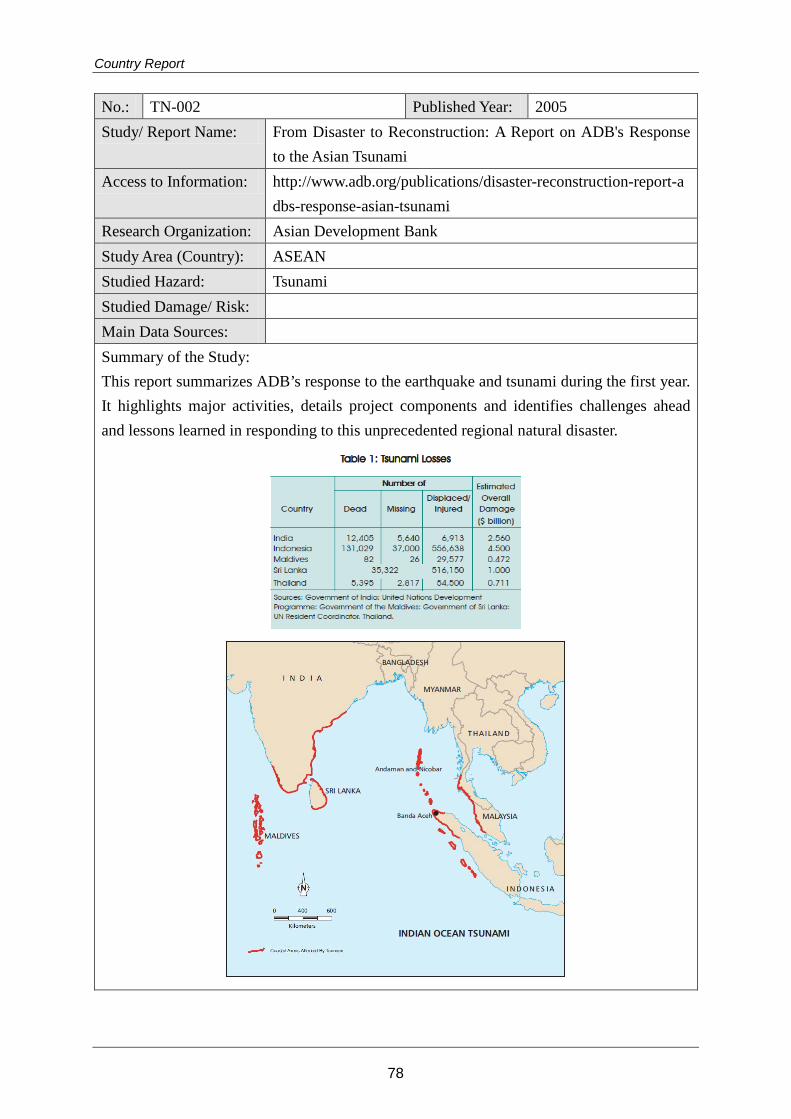
Country Report
No.: TN-002 Published Year: 2005 Study/ Report Name: From Disaster to Reconstruction: A Report on ADB's Response
to the Asian Tsunami Access to Information: http://www.adb.org/publications/disaster-reconstruction-report-a
dbs-response-asian-tsunami Research Organization: Asian Development Bank Study Area (Country): ASEAN Studied Hazard: Tsunami Studied Damage/ Risk: Main Data Sources: Summary of the Study: This report summarizes ADB’s response to the earthquake and tsunami during the first year. It highlights major activities, details project components and identifies challenges ahead and lessons learned in responding to this unprecedented regional natural disaster.
78

Appendix 2: Data Sheets Outline of Existing Investigations and Studies
No.: TN-007 Published Year: 2011 Study/ Report Name: Multi-hazard Risk Assessment in the Rakhine State of Myanmar
Part 1 : Hazard Assessment Access to Information: http://www.gripweb.org/gripweb/?q=countries-risk-information/
disaster-risk-profiles/multi-hazard-risk-assessment-rakhine-state-myanmar
Research Organization: UNDP, GRIP Study Area (Country): Rakhine State of Myanmar Studied Hazard: Cyclone, Storm Surge, Flood, Landslide, Fire, Earthquake,
Tsunami Studied Damage/ Risk: Main Data Sources: UNDP Myanmar, ADPC, GRIP, UNDP Summary of the Study: The report focuses on the assessment of the priority hazard types in Rakhine State. Hazard assessment is an essential first step of the overall risk assessment process. The result of analysis is usually presented in the form of maps portraying the intensity and probability of hazards in a given geographical location. Hazard maps can be applied in many ways.
79
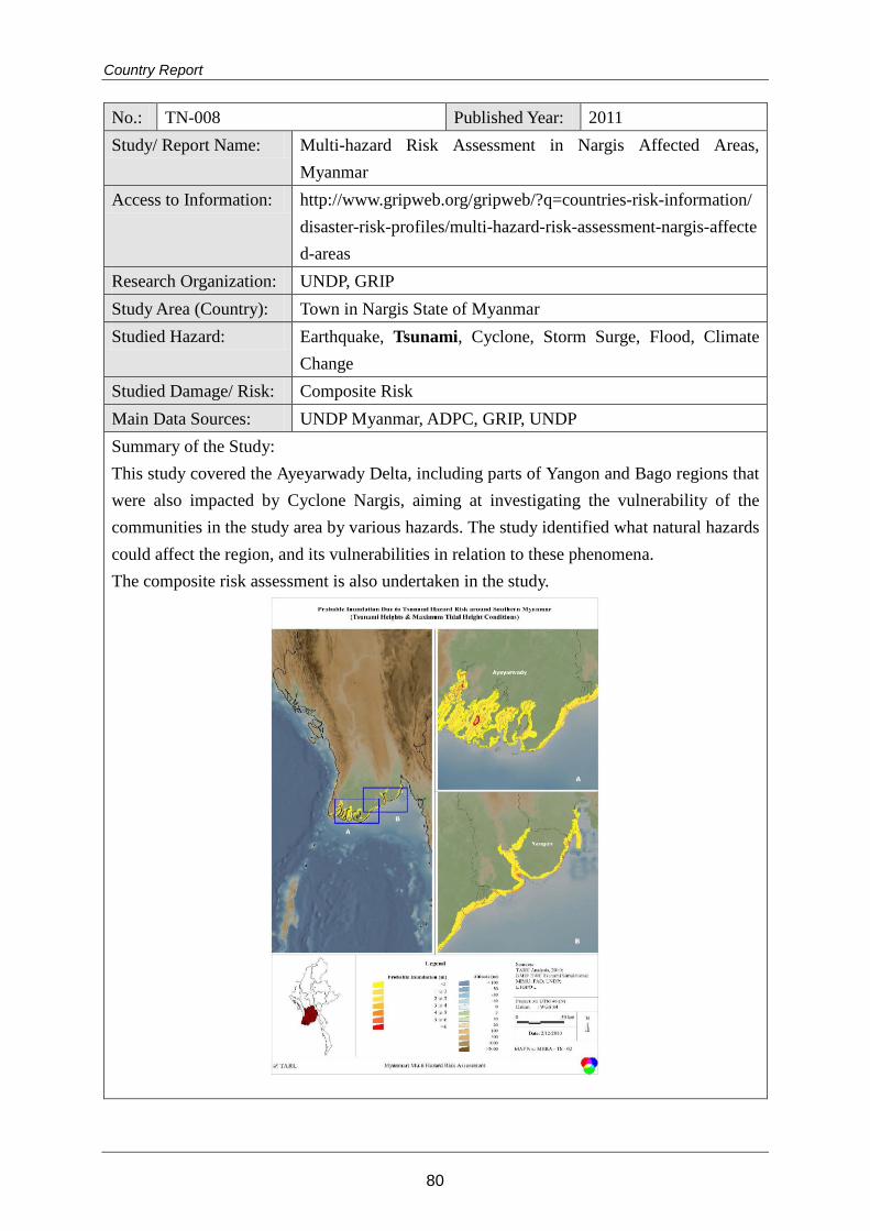
Country Report
No.: TN-008 Published Year: 2011 Study/ Report Name: Multi-hazard Risk Assessment in Nargis Affected Areas,
Myanmar Access to Information: http://www.gripweb.org/gripweb/?q=countries-risk-information/
disaster-risk-profiles/multi-hazard-risk-assessment-nargis-affected-areas
Research Organization: UNDP, GRIP Study Area (Country): Town in Nargis State of Myanmar Studied Hazard: Earthquake, Tsunami, Cyclone, Storm Surge, Flood, Climate
Change Studied Damage/ Risk: Composite Risk Main Data Sources: UNDP Myanmar, ADPC, GRIP, UNDP Summary of the Study: This study covered the Ayeyarwady Delta, including parts of Yangon and Bago regions that were also impacted by Cyclone Nargis, aiming at investigating the vulnerability of the communities in the study area by various hazards. The study identified what natural hazards could affect the region, and its vulnerabilities in relation to these phenomena. The composite risk assessment is also undertaken in the study.
80
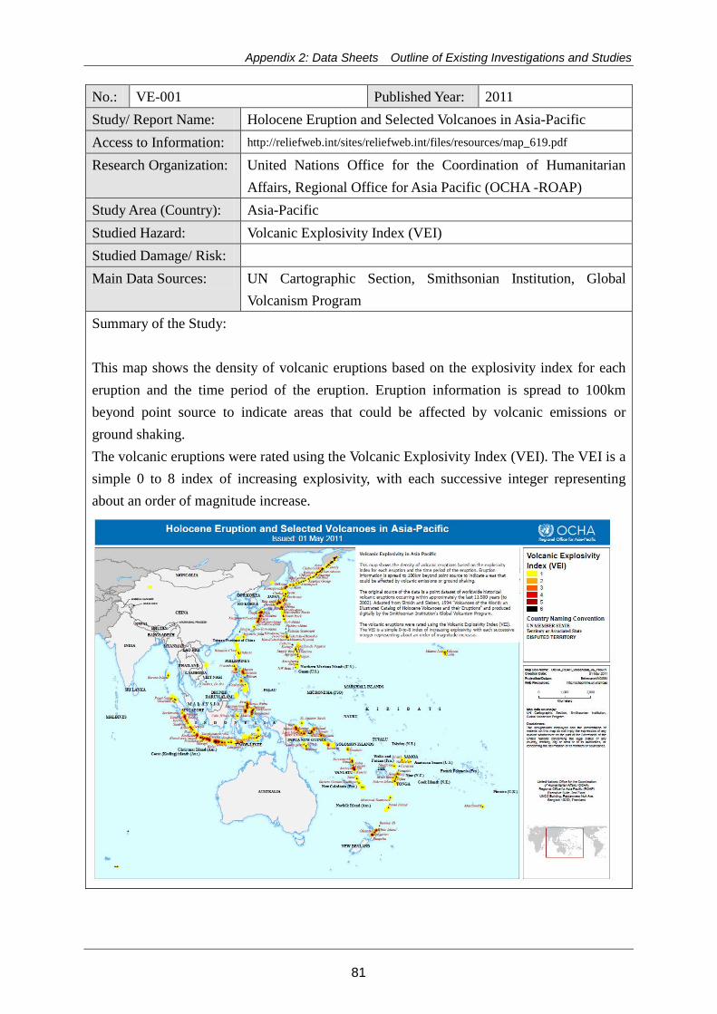
Appendix 2: Data Sheets Outline of Existing Investigations and Studies
No.: VE-001 Published Year: 2011 Study/ Report Name: Holocene Eruption and Selected Volcanoes in Asia-Pacific Access to Information: http://reliefweb.int/sites/reliefweb.int/files/resources/map_619.pdf
Research Organization: United Nations Office for the Coordination of Humanitarian Affairs, Regional Office for Asia Pacific (OCHA -ROAP)
Study Area (Country): Asia-Pacific Studied Hazard: Volcanic Explosivity Index (VEI) Studied Damage/ Risk: Main Data Sources: UN Cartographic Section, Smithsonian Institution, Global
Volcanism Program Summary of the Study: This map shows the density of volcanic eruptions based on the explosivity index for each eruption and the time period of the eruption. Eruption information is spread to 100km beyond point source to indicate areas that could be affected by volcanic emissions or ground shaking. The volcanic eruptions were rated using the Volcanic Explosivity Index (VEI). The VEI is a simple 0 to 8 index of increasing explosivity, with each successive integer representing about an order of magnitude increase.
81
Country Report
No.: LS-001 Published Year: 2011 Study/ Report Name: Multi-Hazard Risk Assessment in the Rakhine State, Access to Information: http://www.gripweb.org/gripweb/sites/default/files/documents_p
ublications/Hazard_Assessment_Report%20reduced.pdf Research Organization: United Nations Development Program (UNDP) Study Area (Country): Myanmar Studied Hazard: Cyclones and Storm Surge Riverine Flood
Landslides Rural and Forest Fire Earthquakes Tsunami Studied Damage/ Risk: Landslide hazard susceptibility by 5 grading Main Data Sources: Slope:ASTER DEM, Geology: Myanmar Geo-science Society
(MGS), Land use: Myanmar Information Management Unit (MIMU, 2000) with updatedfrom Google map (Year 2003-2010), Soil type and Geomorphologic info: FAO (2006) and Landsat ETM imagery, Trigger factors: Department ofMeteorological and Hydrology (DMH) of Myanmar,National Seismic Hazard Maps of Myanmar by the Myanmar Earthquake Committee and Myanmar Earthquake Risk Assessment by ADPC and the Department of Meteorology and Hydrology
Summary of the Study: 1)overview This report presents a comprehensive risk profile of the Rakhine State of Myanmar. This study systematically investigated the vulnerability of communities to various natural hazards and identified what natural disasters could affected the region and its vulnerability in relation to these hazards. Through the whole course of the project implementation, GRIP has provided full technical support and guidance including reviewing the report. 2) Landslide hazard susceptibility Map The map of landslide hazard susceptibility zones in Rakhine State of Myanmar,as shown in below, shows the spatial distribution of landslide hazard susceptibility zones induced by rainfall and earthquake at state level.
(induced by rainfall)
(induced by earthquake/seismic)
Landslide hazard susceptibility map
82
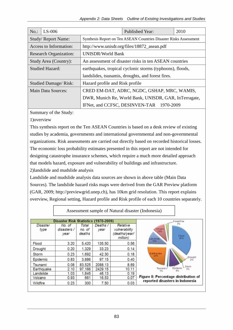
Appendix 2: Data Sheets Outline of Existing Investigations and Studies
No.: LS-006 Published Year: 2010 Study/ Report Name: Synthesis Report on Ten ASEAN Countries Disaster Risks Assessment
Access to Information: http://www.unisdr.org/files/18872_asean.pdf Research Organization: UNISDR/World Bank Study Area (Country): An assessment of disaster risks in ten ASEAN countries Studied Hazard: earthquakes, tropical cyclonic storms (typhoons), floods,
landslides, tsunamis, droughts, and forest fires. Studied Damage/ Risk: Hazard profile and Risk profile Main Data Sources: CRED EM-DAT, ADRC, NGDC, GSHAP, MRC, WAMIS,
DWR, Munich Re, World Bank, UNISDR, GAR, InTerragate, IFNet, and CCFSC, DESINVEN-TAR 1970-2009
Summary of the Study: 1)overview This synthesis report on the Ten ASEAN Countries is based on a desk review of existing studies by academia, governments and international governmental and non-governmental organizations. Risk assessments are carried out directly based on recorded historical losses. The economic loss probability estimates presented in this report are not intended for designing catastrophe insurance schemes, which require a much more detailed approach that models hazard, exposure and vulnerability of buildings and infrastructure. 2)landslide and mudslide analysis Landslide and mudslide analysis data sources are shown in above table (Main Data Sources). The landslide hazard risks maps were derived from the GAR Preview platform (GAR, 2009; http://previewgrid.unep.ch), has 10km grid resolution. This report explains overview, Regional setting, Hazard profile and Risk profile of each 10 countries separately.
Assessment sample of Natural disaster (Indonesia)
83
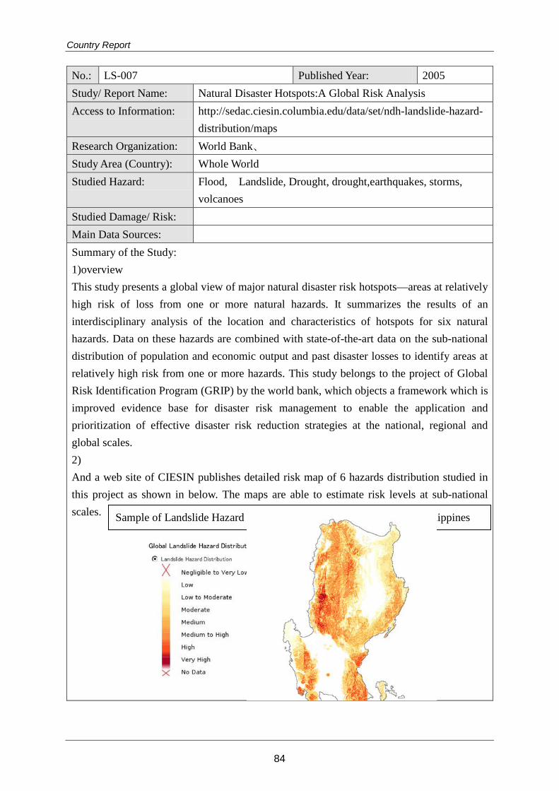
Country Report
No.: LS-007 Published Year: 2005 Study/ Report Name: Natural Disaster Hotspots:A Global Risk Analysis Access to Information: http://sedac.ciesin.columbia.edu/data/set/ndh-landslide-hazard-
distribution/maps Research Organization: World Bank、 Study Area (Country): Whole World Studied Hazard: Flood, Landslide, Drought, drought,earthquakes, storms,
volcanoes Studied Damage/ Risk: Main Data Sources: Summary of the Study: 1)overview This study presents a global view of major natural disaster risk hotspots—areas at relatively high risk of loss from one or more natural hazards. It summarizes the results of an interdisciplinary analysis of the location and characteristics of hotspots for six natural hazards. Data on these hazards are combined with state-of-the-art data on the sub-national distribution of population and economic output and past disaster losses to identify areas at relatively high risk from one or more hazards. This study belongs to the project of Global Risk Identification Program (GRIP) by the world bank, which objects a framework which is improved evidence base for disaster risk management to enable the application and prioritization of effective disaster risk reduction strategies at the national, regional and global scales. 2) And a web site of CIESIN publishes detailed risk map of 6 hazards distribution studied in this project as shown in below. The maps are able to estimate risk levels at sub-national scales.
Sample of Landslide Hazard Distribution Map indicating Northern Philippines
84
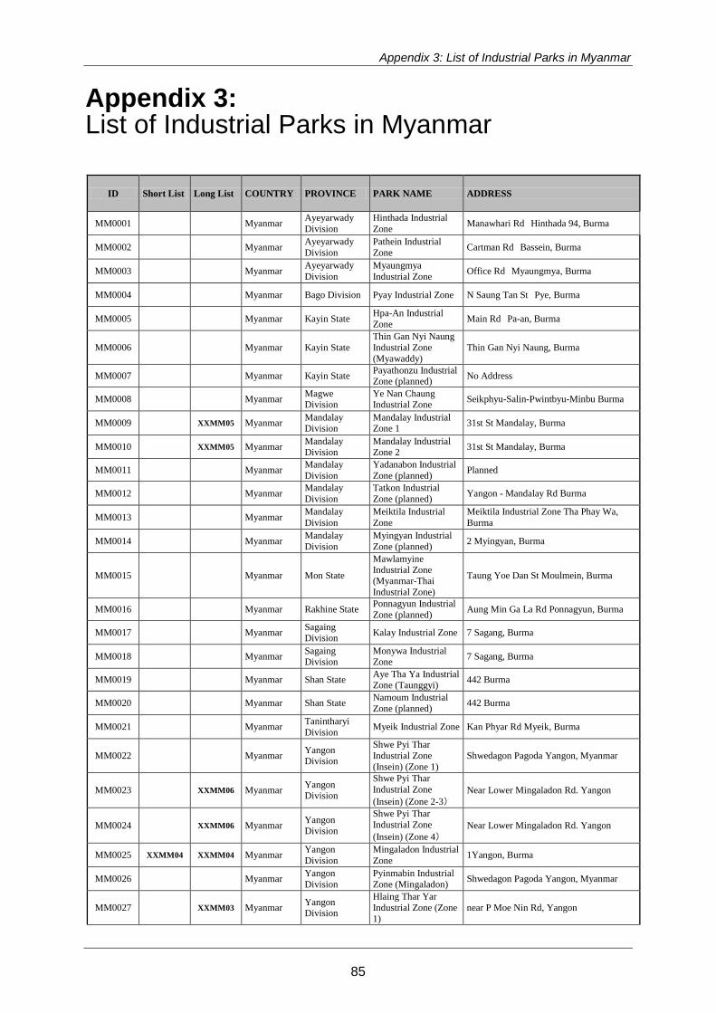
Appendix 3: List of Industrial Parks in Myanmar
Appendix 3: List of Industrial Parks in Myanmar
ID Short List Long List COUNTRY PROVINCE PARK NAME ADDRESS
MM0001 Myanmar Ayeyarwady Division
Hinthada Industrial Zone Manawhari Rd Hinthada 94, Burma
MM0002 Myanmar Ayeyarwady Division
Pathein Industrial Zone Cartman Rd Bassein, Burma
MM0003 Myanmar Ayeyarwady Division
Myaungmya Industrial Zone Office Rd Myaungmya, Burma
MM0004 Myanmar Bago Division Pyay Industrial Zone N Saung Tan St Pye, Burma
MM0005 Myanmar Kayin State Hpa-An Industrial Zone Main Rd Pa-an, Burma
MM0006 Myanmar Kayin State Thin Gan Nyi Naung Industrial Zone (Myawaddy)
Thin Gan Nyi Naung, Burma
MM0007 Myanmar Kayin State Payathonzu Industrial Zone (planned) No Address
MM0008 Myanmar Magwe Division
Ye Nan Chaung Industrial Zone Seikphyu-Salin-Pwintbyu-Minbu Burma
MM0009 XXMM05 Myanmar Mandalay Division
Mandalay Industrial Zone 1 31st St Mandalay, Burma
MM0010 XXMM05 Myanmar Mandalay Division
Mandalay Industrial Zone 2 31st St Mandalay, Burma
MM0011 Myanmar Mandalay Division
Yadanabon Industrial Zone (planned) Planned
MM0012 Myanmar Mandalay Division
Tatkon Industrial Zone (planned) Yangon - Mandalay Rd Burma
MM0013 Myanmar Mandalay Division
Meiktila Industrial Zone
Meiktila Industrial Zone Tha Phay Wa, Burma
MM0014 Myanmar Mandalay Division
Myingyan Industrial Zone (planned) 2 Myingyan, Burma
MM0015 Myanmar Mon State
Mawlamyine Industrial Zone (Myanmar-Thai Industrial Zone)
Taung Yoe Dan St Moulmein, Burma
MM0016 Myanmar Rakhine State Ponnagyun Industrial Zone (planned) Aung Min Ga La Rd Ponnagyun, Burma
MM0017 Myanmar Sagaing Division Kalay Industrial Zone 7 Sagang, Burma
MM0018 Myanmar Sagaing Division
Monywa Industrial Zone 7 Sagang, Burma
MM0019 Myanmar Shan State Aye Tha Ya Industrial Zone (Taunggyi) 442 Burma
MM0020 Myanmar Shan State Namoum Industrial Zone (planned) 442 Burma
MM0021 Myanmar Tanintharyi Division Myeik Industrial Zone Kan Phyar Rd Myeik, Burma
MM0022 Myanmar Yangon Division
Shwe Pyi Thar Industrial Zone (Insein) (Zone 1)
Shwedagon Pagoda Yangon, Myanmar
MM0023 XXMM06 Myanmar Yangon Division
Shwe Pyi Thar Industrial Zone (Insein) (Zone 2-3)
Near Lower Mingaladon Rd. Yangon
MM0024 XXMM06 Myanmar Yangon Division
Shwe Pyi Thar Industrial Zone (Insein) (Zone 4)
Near Lower Mingaladon Rd. Yangon
MM0025 XXMM04 XXMM04 Myanmar Yangon Division
Mingaladon Industrial Zone 1Yangon, Burma
MM0026 Myanmar Yangon Division
Pyinmabin Industrial Zone (Mingaladon) Shwedagon Pagoda Yangon, Myanmar
MM0027 XXMM03 Myanmar Yangon Division
Hlaing Thar Yar Industrial Zone (Zone 1)
near P Moe Nin Rd, Yangon
85
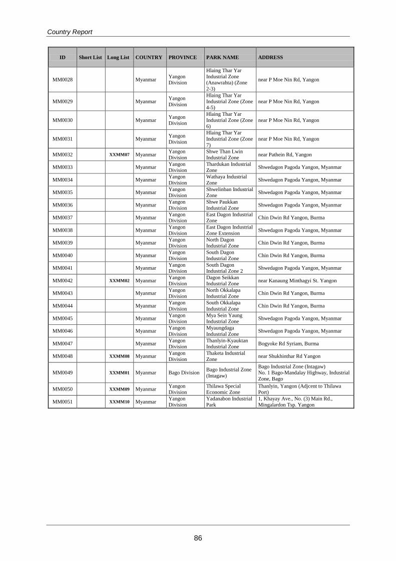
Country Report
ID Short List Long List COUNTRY PROVINCE PARK NAME ADDRESS
MM0028 Myanmar Yangon Division
Hlaing Thar Yar Industrial Zone (Anawrahta) (Zone 2-3)
near P Moe Nin Rd, Yangon
MM0029 Myanmar Yangon Division
Hlaing Thar Yar Industrial Zone (Zone 4-5)
near P Moe Nin Rd, Yangon
MM0030 Myanmar Yangon Division
Hlaing Thar Yar Industrial Zone (Zone 6)
near P Moe Nin Rd, Yangon
MM0031 Myanmar Yangon Division
Hlaing Thar Yar Industrial Zone (Zone 7)
near P Moe Nin Rd, Yangon
MM0032 XXMM07 Myanmar Yangon Division
Shwe Than Lwin Industrial Zone near Pathein Rd, Yangon
MM0033 Myanmar Yangon Division
Thardukan Industrial Zone Shwedagon Pagoda Yangon, Myanmar
MM0034 Myanmar Yangon Division
Wathaya Industrial Zone Shwedagon Pagoda Yangon, Myanmar
MM0035 Myanmar Yangon Division
Shwelinban Industrial Zone Shwedagon Pagoda Yangon, Myanmar
MM0036 Myanmar Yangon Division
Shwe Paukkan Industrial Zone Shwedagon Pagoda Yangon, Myanmar
MM0037 Myanmar Yangon Division
East Dagon Industrial Zone Chin Dwin Rd Yangon, Burma
MM0038 Myanmar Yangon Division
East Dagon Industrial Zone Extension Shwedagon Pagoda Yangon, Myanmar
MM0039 Myanmar Yangon Division
North Dagon Industrial Zone Chin Dwin Rd Yangon, Burma
MM0040 Myanmar Yangon Division
South Dagon Industrial Zone Chin Dwin Rd Yangon, Burma
MM0041 Myanmar Yangon Division
South Dagon Industrial Zone 2 Shwedagon Pagoda Yangon, Myanmar
MM0042 XXMM02 Myanmar Yangon Division
Dagon Seikkan Industrial Zone near Kanaung Minthagyi St. Yangon
MM0043 Myanmar Yangon Division
North Okkalapa Industrial Zone Chin Dwin Rd Yangon, Burma
MM0044 Myanmar Yangon Division
South Okkalapa Industrial Zone Chin Dwin Rd Yangon, Burma
MM0045 Myanmar Yangon Division
Mya Sein Yaung Industrial Zone Shwedagon Pagoda Yangon, Myanmar
MM0046 Myanmar Yangon Division
Myaungdaga Industrial Zone Shwedagon Pagoda Yangon, Myanmar
MM0047 Myanmar Yangon Division
Thanlyin-Kyauktan Industrial Zone Bogyoke Rd Syriam, Burma
MM0048 XXMM08 Myanmar Yangon Division
Thaketa Industrial Zone near Shukhinthar Rd Yangon
MM0049 XXMM01 Myanmar Bago Division Bago Industrial Zone (Intagaw)
Bago Industrial Zone (Intagaw) No. 1 Bago-Mandalay Highway, Industrial Zone, Bago
MM0050 XXMM09 Myanmar Yangon Division
Thilawa Special Economic Zone
Thanlyin, Yangon (Adjcent to Thilawa Port)
MM0051 XXMM10 Myanmar Yangon Division
Yadanabon Industrial Park
1, Khayay Ave., No. (3) Main Rd., Mingalardon Tsp. Yangon
86
Appendix 4: General Investment Risk of Myanmar
Appendix 4: General Investment Risk of Myanmar (1) Political Risk
In April 2011, a civilian government formed by the Union Solidarity and Development
Party (USDP) took office after five decades of military rule. The military remains
influential as the Constitution guarantees it 25% of parliamentary seats and three
cabinet posts. The government, led by President Thein Sein, a former Army general,
has initiated a political reform process, releasing hundreds of political prisoners and
inviting opposition leader Aung San Suu Kyi, and her National League for Democracy
(NLD) Party successfully to contest by-elections in April 2012.
As a result, Western sanctions have been largely suspended, with the exception of
arms embargos and some US restrictions on doing business with military-owned firms
or blacklisted individuals. The government is also opening the economy to foreign
investment. There has been speculation of a backlash against reforms from military
and political hardliners, but this is unlikely. Since most within the political elite do stand
to benefit from the recent changes, large-scale upsets from within, such as a new
military coup, are unlikely, as is a reversal to isolationist policies that were seen prior to
1988.
In addition to Thein Sein, other stakeholders are establishing rival centers of influence.
Shwe Mann, the Speaker of Parliament and also an ex- general, is positioning himself
as a successor to Thein Sein, who is unlikely to continue in office beyond 2015. Former
army chief Than Shwe is also an important force behind the scenes, and a hardline
group of MPs who are opposed to reform are also coalescing in parliament.
Suu Kyi has declared her intention to run for president after the November 2015
general elections in June 2013. A constitutional amendment allowing Suu Kyi to do so
is likely. The military is interested in improving the image of the country and its history of
military rule. Removing obstacles stopping Suu Kyi from becoming a presidential
candidate would achieve this to a large extent. However, the military knows that the
USDP is unlikely to lose an election. Even if it does, constitutionally, the military is
guaranteed 25% of all parliamentary seats and three cabinet positions, meaning that
its influence is certain in any government.
87
Country Report
Beyond political instability, foreign investors face a range of political risks. There are
10-12 large local conglomerates owned by well-connected Myanmar elite that
control a large portion of the economy and hold monopolistic positions over certain
sectors. These companies include Htoo Trading, Max Myanmar and military-owned
Myanmar Economic Corporation and Union of Myanmar Economic Holdings. The
interests behind these companies could well interfere with foreign investments in their
sectors. However, projects requiring foreign expertise, such as airport and other large
infrastructure development, are less likely to experience interference as the
government hopes to establish Myanmar's credentials as an investment destination.
Accordingly, outright expropriation is unlikely. Corruption is another significant risk.
Bribery is accepted as a part of doing business in Myanmar and companies will
probably be expected to pay bribes in order to secure business deals, permits or
concessions from governmental agencies, politicians and the military.
(2) Economic Risk
Myanmar's economy has gone into reverse after decades of isolation and
mismanagement under the rule of successive military regimes, compounded by the
imposition of international sanctions. The reformist path recently taken by the new
semi-civilian government has provided the country with a chance to jump-start its
economy and lift the living standards of its 50 million people, over a quarter of which
still live in poverty.
The economy holds considerable potential, given substantial natural resources and
Myanmar's strategic location on the borders of India, China, and South-East Asia.
Regional hunger for energy is likely to continue attracting foreign direct investment
into Myanmar's hydrocarbon sector following the large investments already made by
China and Thailand. Meanwhile, Western business interests have also risen
significantly, following the re-established political dialogue of Myanmar’s
administration with Western governments and the subsequent suspension of the
economic sanctions. Nonetheless, the reform agenda is long, as nearly all aspects of
Myanmar’s economy and business environment need to be transformed. The
rudimentary infrastructure and financial system, inadequate legal framework, weak
private sector, endemic corruption, and other inefficiencies bolstered by the central
planning will have to be overcome if Myanmar is to realize its economic potential.
88
Appendix 4: General Investment Risk of Myanmar
Economic activity will receive support from the ongoing reform momentum, with
exports and foreign investment remaining the main drivers of growth. Following the
removal of sanctions by Western governments, FDI into Myanmar is expected to rise,
particularly into the energy sector. Meanwhile, exports will benefit from the removal
of foreign-exchange restrictions, as well as rising demand from Asian neighbors,
especially following the sharp rise in gas production in fiscal year (FY) 2013/14
(beginning 1 April), when the gas pipeline transporting gas from Daewoo
International's offshore reserves in the Bay of Bengal to the Yunnan province in China
comes on line (expected in second-quarter 2013) and later in 2014, when a twin oil
pipeline also becomes operational. The hydrocarbon sector is likely to remain the
mainstay of the economy in coming years. On the domestic front, the economy will
benefit from rising demand and investment. Construction of new infrastructure
projects will drive industrial production, while anticipated acceleration of credit
growth and private-sector development will lead investment and services.
(3) Legal Risk
Myanmar retains the remnants of a British colonial-era legal system. Following nearly
five decades of successive military regimes the new semi-civilian government that
took power in March 2011 inherited a judicial system with a weak legal framework
that lacks transparency, in which political overlay and interference remain pervasive,
and where arbitrary decisions are common. With the coming into force of the 2008
constitution, Myanmar now has a rule of law that provides for a strengthened
judiciary, and the government has made it one of its priorities to increase the fairness
and efficiency of judicial proceedings. This includes the updating of a raft of
antiquated laws, as well as new legislation, including a new foreign investment law.
While the situation is slowly improving, the regulatory and legal situation remains
unpredictable. It is often unclear what regulations are in place, which laws are still
valid, and which legislation is applicable to specific processes. There are no standard
processes in place for notifying new laws, or amendments to existing legislation, and
developments often occur without advance or written notice. Excerpts of laws
however, are increasingly published through state-run media.
In the event of a dispute, foreign companies have limited domestic or international
legal recourse. Myanmar is not a member of the International Center for the
Settlement of Investment Disputes or a signatory to The Convention on the
89
Country Report
Recognition of Foreign Arbitration Awards (New York Convention). All disputes must
be settled under the country's own arbitration procedures. The 1944 Arbitration Act
allows for international arbitration, but the government usually attempts to
circumvent this and use local mechanisms, which it controls to a large extent. The
lack of independence and impartiality of courts means that this often works to the
distinct disadvantage in disputes between foreign businesses and the government, or
entities with close connections to the government and/or the military.
On 5 November 2012, Myanmar's president approved the new Foreign Direct
Investment Law 2012. The legislation establishes a framework for FDI, but is vague. The
law will only be the guiding document for more detailed rules that will be drafted and
published by the Myanmar Investment Commission (MIC). This means that there is
great potential for changes to FDI regulations that are not favorable to foreign
investors. The forms of investments permissible under the FDI Law 2012 are a limited
liability company that is 100% foreign owned if permitted by the MIC, or a joint
venture between a foreigner and Myanmar citizens or government departments or
organizations, for which the ceiling of foreign capital shall be agreed by both parties.
Companies can also be established under the Companies Act 1914. Whether a
company needs to be established under the FDI Law 2012 or the Companies Act
1914 appears to depend on the size and nature of the investment, although most
substantial investments will likely be required to register under the FDI Law 2012. Firms
established under the Companies Act 1914 are not entitled to tax incentives.
According FDI Law 2012, foreign investors are required to apply for a permit from the
Myanmar Investment Commission. After the obtaining of the permit, foreign investors
are required to conclude a contract with the relevant government departments or
organization.
(4) Tax Risk
Myanmar's tax system, like other regulatory frameworks, suffers from lack of
transparency and consistent enforcement of regulations. As a result the risk of
arbitrary or politically-motivated selective enforcement is high. Myanmar's tax base is
also narrow, and tax-evasion levels are high. Confusion and inconsistent enforcement
undermine the significant tax incentives that exist for investors. Tax reforms will
probably be forthcoming as part of the broader reform moves undertaken by the
government.
90
Appendix 4: General Investment Risk of Myanmar
Myanmar's maximum corporate tax rate is 25%. Firms in the oil and gas sector are also
liable for a tax on profits arising from asset transfers, ranging from 40% for profits up to
USD 100 million to 50% for profits over USD 150 million. There is no withholding tax on
dividends, but other payments are subject to withholding taxes ranging from 3.5% to
20%, depending on whether the payee is resident or non-resident. The new foreign
investment law provides for a five-year tax holiday for companies if the investment is
considered to be in the national interest. The new law also allows investors to apply to
the MIC for waivers of import taxes and duties on parts and machinery during
construction and on raw material imports for the first three years of a company's
production operations. While the application is made to the MIC, it is the cabinet that
grants the specific tax incentives.
Myanmar has three SEZs, all of which offer tax incentives for investors, including
income tax exemptions for export sales for the first five years of production, and 50%
income tax relief on export sales for the next five years of production. Further relief is
available for the following five years if profits from exports are reinvested.
(5) War Risk
Since 2011 reforms began, Myanmar’s relations with other countries have improved,
leaving Bangladesh as its most difficult international relationship. Myanmar and
Bangladesh's long-standing sea boundary dispute in the Bay of Bengal was resolved
by the International Tribunal for the Law and Sea in March 2012. Myanmar accepted
the decision and lost significant mineral resources. Contract awards made by the
government in the disputed area were voided. Given this, conflict with Bangladesh is
unlikely, but diplomatic relations are increasingly strained over communal unrest
issues related to the Rohingya community.
Internally, Myanmar suffers from protracted ethnic insurgencies in its border areas.
Several ethnic rebel groups, particularly in the eastern part of the country, demand
federal autonomy in their regions. The most significant of these include the Karen
National Union (KNU), the United Wa State Army (UWSA), the Shan State Army (SSA)
and a splinter group of the Democratic Karen Buddhist Army (DKBA). These groups
mostly use small-arms. Since November 2011, the government has signed ceasefire
agreements with almost all the ethnic rebel groups.
91
Country Report
The Kachin Independence Army (KIA), which is based in the northern state of Kachin,
bordering China, has not signed a ceasefire with the government. In early 2013, the
army attacked the KIA's de facto headquarters in Lajayang, Kachin, with ground
troops supported by Mi-8 helicopters, artillery and fighter planes. Following a lull in
fighting, the KIA and the government reached a seven-point agreement intended to
reduce fighting. But importantly, the deal is not a ceasefire, and as such, sporadic
gun battles are likely in Lajayang, Hpakant and Pan Wan. However, the army is less
likely to initiate large operations with aerial support as it did earlier this year. Trade and
infrastructure developments along the Myanmar-China border face risks of disruption
and collateral damage during fighting. This would include sections of the Shwe
pipeline from Myanmar's Rakhine state to China's Yunnan province that passes
through Shan and Kachin state. Moreover, NGO workers, such as SwissAid employees
in Kachin, will face collateral injury risks as result of the fighting.
(6) Terrorism Risk
The principle source of income for ethnic militias is protection money on cargo
convoys from smugglers bringing in goods from Thailand and China. Any attempts by
the military to take control of KIA-controlled smuggling routes would probably result in
KIA attacks on infrastructure projects and power facilities in the area. Potential targets
include the Shwe gas pipeline to Yunnan, (China National Petroleum Corporation)
and the Taping Hydropower dam (China Datang Corporation).
Dissident militant groups, notably the Vigorous Burmese Student Warriors (VBSW) and
the All Burma Democratic Front, also have the capability to stage crude IED attacks,
primarily in Yangon. Though the risk of such attacks has declined since 2011, they
would likely resume if the reform process were to stall. Probable targets include
government facilities, hotels and restaurants. Past targets of dissident plots include
City Hall (in September 2008), Insein Prison (to coincide with the visit of UN Secretary
General Ban Ki Moon in August 2009), Traders Hotel, Panorama Hotel and the Zawgyi
House restaurant. A notable vehicle-borne IED was detonated in Yangon during New
Year celebrations in April 2010, injuring 60 people. In any such attacks, property
damage is likely to be comparatively minor.
92
Appendix 4: General Investment Risk of Myanmar
(7) Civil Unrest Risk
There has been an increase in protests over a variety of issues since the accession to
power of the semi-civilian government in 2011. Myanmar's civil society is increasingly
making use of recently relaxed laws on freedom of expression and assembly,
including a law allowing peaceful protests that was passed in March 2012. Thus, while
risks of large-scale political protests, such as those led by monks in 2007, have
declined, protest frequency is likely to continue to increase. Urban protests are likely
to be related to particular political policies, land confiscation, and infrastructure
issues, such as power shortages.
The protests that pose the greatest risks to business continuity are likely to be
environmental ones against large infrastructure and mining projects. In some cases,
such protests are likely to lead to contract suspension, revision or cancelation. This has
already occurred with the some dam and power plant projects, including the
Myitsone Dam. In November 2012, protesters fought with security forces near the site
of the Latpadaung copper mine in Sagaing region. A cross-section of groups,
including Buddhist monks, have protested against the mine, which is a joint venture
between the Union of Myanmar Economic Holdings and the Chinese Wanbao
Group.
Strikes also pose risks of business disruption. In October 2011, the Labor Organization
Law allowed the creation of labor unions. Protests over inflation and industrial disputes
are increasingly likely, and are at risk of some low-level violence. In May 2013, workers
in 41 factories in Yangon's Hlaing Tharyar Industrial Zone-3 went on a strike to demand
higher wages. The government pre-emptively deployed hundreds of fully armed riot
police in the area. It is very probable that that there will be further strikes, particularly
in the garment sector, over inflation and poor working conditions
Another potential source of unrest and business disruption is communal unrest,
especially due to religious disputes between Muslim and Buddhist communities.
Communal violence between Rohingya Muslims and Buddhists resulted in a state of
emergency being imposed in June 2012. The Rohyingya community is located only in
Rakhine state, which has little onshore foreign investment. As such, this conflict is
unlikely to spread or pose significant business disruption risks. However, other Muslim
communities are located in major commercial cities, including Yangon. Since the
start of 2013, there have been multiple examples of violent religious unrest leading to
93
Country Report
significant property damage in central Myanmar. If such unrest were to spread to
major urban areas, there would be security, property damage and business
disruption concerns for foreign investors operating there.
94