Corsica River Stream Corridor Assessment And...
77
Channel Alteration Inadequate Buffer Erosion Fish Migration Barrier Pipe Outfall Exposed Pipes Channel Alteration Inadequate Buffer Erosion Fish Migration Barrier Pipe Outfall Exposed Pipes Channel Alteration Inadequate Buffer Erosion Fish Migration Barrier Pipe Outfall Exposed Pipes Channel Alteration Inadequate Buffer Erosion Fish Migration Barrier Pipe Outfall Exposed Pipes Channel Alteration Inadequate Buffer Erosion Fish Migration Barrier Pipe Outfall Exposed Pipes Channel Alteration In adequate Buffer Erosion Fish Migration Barrier Pipe Outfall Exposed Pipes Channel Alteration Inadequate Buffer Erosion Fish Migration Barrier Pipe Outfall Exposed Pipes Channel Alteration Inadequate Buffer Erosion Fish Migration Barrier Pipe Outfall Expose d Pipes Stream Corridor Assessment And Shoreline Surveys Watershed Assessment and Targeting Division Watershed Services Unit Maryland Department of Natural Resources August 2004 Corsica River
Transcript of Corsica River Stream Corridor Assessment And...

Channel Alteration Inadequate Buffer Erosion Fish Migration Barrier Pipe Outfall Exposed Pipes
Channel Alteration Inadequate Buffer Erosion Fish Migration Barrier Pipe Outfall Exposed Pipes
Channel Alteration Inadequate Buffer Erosion Fish Migration Barrier Pipe Outfall Exposed Pipes
Channel Alteration Inadequate Buffer Erosion Fish Migration Barrier Pipe Outfall Exposed Pipes
Channel Alteration Inadequate Buffer Erosion Fish Migration Barrier Pipe Outfall Exposed Pipes
Channel Alteration In adequate Buffer Erosion Fish Migration Barrier Pipe Outfall Exposed Pipes
Channel Alteration Inadequate Buffer Erosion Fish Migration Barrier Pipe Outfall Exposed Pipes
Channel Alteration Inadequate Buffer Erosion Fish Migration Barrier Pipe Outfall Expose d Pipes
Stream Corridor Assessment And
Shoreline Surveys
Watershed Assessment and Targeting Division Watershed Services Unit Maryland Department of Natural Resources August 2004
Corsica River

Robert L. Ehrlich, Jr. Michael S. Steele Governor Lieutenant Governor
A Message To Maryland Citizens
The Maryland Department of Natural Resources (DNR) seeks to preserve, protect and enhance the living resources of the state. Working in partnership with the citizens of Maryland, this worthwhile goal will become a reality. This publication provides information that will increase your understanding of how DNR strives to reach that goal through its many diverse programs.
C. Ronald Franks Secretary
Maryland Department of Natural Resources
Tawes State Office Building 580 Taylor Avenue Annapolis, Maryland 21401
Toll free in Maryland: 1-(877) 620-8DNR (ext. 8796)
Out of state call: 410-260-8796 www.dnr.maryland.gov
The facilities and services of the Maryland Department of Natural Resources are available to all
without regard to race, color, religion, sex, sexual orientation, age, national origin, physical or mental disability.
This document is available in alternative format upon request from a qualified individual with a
disability.
PRINTED ON RECYCLED PAPER

CORSICA RIVER
STREAM CORRIDOR ASSESSMENT AND
SHORELINE SURVEYS
BY
Stephen Czwartacki, Ken Yetman & Anne Patterson Watershed Assessment and Targeting Division
Watershed Services Unit Maryland Department of Natural Resources
August 2004
Financial Assistance provided by the Coastal Zone Management Act of 1972, as amended, administered by the Office of Ocean and Coastal Resource Management, National Oceanic and Atmospheric Administration (NOAA). A report of the Maryland Coastal Zone Management Program, Department of Natural Resources pursuant to NOAA Award No. NA170Z2337

I
SUMMARY In 1998, the Maryland Clean Water Action Plan identified the Corsica River watershed as
one of the State’s water bodies that did not meet water quality requirements. In response to this finding, the Maryland Department of Natural Resources (DNR), the Town of Centreville, Queen Anne’s County and local stakeholders formed a partnership to develop a Watershed Restoration Action Strategy (WRAS) for the Corsica River watershed. The following Stream Corridor Assessment (SCA) and Shoreline Surveys is part of the WRAS development process.
The SCA and Shoreline Surveys provide descriptive and positional data for potential
environmental problems along a watershed’s non-tidal streams and tidal shoreline. Developed by DNR’s Watershed Services Unit, the surveys are a watershed management tool to identify environmental problems and help prioritize restoration opportunities on a watershed basis. As part of the surveys, specially trained personnel either walk a watershed’s streams, or slowly cruise along the shoreline in a small boat and record data and the location for potential environmental problems that can be easily observed. Each potential problem site is also ranked on a scale of one to five for its severity, correctability, and access for restoration work. SCA survey fieldwork for the Corsica River began in May 2003 and was completed by August 2003. The tidal portion of the survey was conducted in October, 2003. To complete the survey, field crews walked over 45 miles of streams, and slowly cruised along the 25 miles of shoreline.
During the stream survey, field teams identified 247 potential environmental problem
sites. The observed potential problems were: erosion sites (57 sites, 12.2 miles), pipe outfalls (56 sites), fish barriers (53 sites), inadequately buffered stream or river banks (34 sites, 4 miles), altered shorelines (24 sites), channel alterations (20 sites, 1.17 miles), unusual conditions/comments (11 sites), trash dumping sites (8 sites), in/near stream construction (4 sites), and exposed pipes (4 sites). Additionally, crews recorded descriptive habitat condition data at 27 representative sites.
The shoreline survey identified 49 potential environmental problems. The most
frequently reported problem was altered shorelines, which were seen at 24 sites and estimated to be 10% (2.5 miles) of the tidal shoreline of the Corsica River. The second most frequently observed problem was inadequate shoreline buffers. Eighteen inadequate buffer sites were identified, which covered approximately 19% (4.7 miles) of the total shoreline. The last problem identified during the shoreline survey was shoreline erosion. Excessive shoreline erosion was seen at 7 sites and covered 3% (0.7 miles) of the tidal shoreline. The Stream Corridor Assessment and Shoreline Surveys provides a rapid overview of the entire stream network in order to determine the location of potential environmental problems and to collect some basic environmental information. The value of the present surveys are that they help in placing individual problems into a watershed context so that future restoration work can be prioritized. Results of the present surveys have been given to the Corsica River Watershed WRAS committee, which is developing a Watershed Restoration Action Strategy for the Corsica River. Information on the Corsica River WRAS can be found on the Department of Natural Resources’ website www.dnr.state.md.us/watersheds/surf/proj/wras.html).

II
ACKNOWLEDGEMENTS
Without the hard work and dedication of the Elk Neck Crew of the Maryland Conservation Corps, this survey would not have been possible. The crew chief during the survey was Margot Pruett. The crewmembers were Heidi Butterworth, Mike Elliott, Grant Holly, Mike Miller, Joe Supik, and Matt Webb. We also wish to acknowledge The Chester Riverkeeper, Dr. Eileen McLellan and the Chester River Association who volunteered both their time and boat to assist us in doing the Shoreline Survey.

III
TABLE OF CONTENTS
SUMMARY…………………………………………………………….... I ACKNOWLEDGEMENTS…………………………………………….. II TABLE OF CONTENTS……………………………………………..… III INTRODUCTION………………….………………………………….… 1 METHODS………………………………………………………………. 6 RESULTS………………………………………………………………... 11 STREAM CORRIDOR ASSESSMENT
Erosion Sites………………………………………………………….... 14 Pipe Outfalls…………………………………………………………… 18 Fish Blockages………………………………………………………… 20 Inadequate Buffers…………………………………………………….. 23 Channel Alterations…………………………………………………… 26 Trash Dumping..…..…………………………………………………... 29 Exposed Pipes...……………..………………………………………… 31 In/Near Stream Construction………………………………………….. 33 Representative Sites……………………………………..…………….. 35

IV
SHORELINE SURVEY
Altered Shorelines.……………………………………………………. 38 Shoreline Inadequate Buffers…………………………………………. 40 Shoreline Erosion……………………………………………………... 42 DISCUSSION…………………………………………………………….
44
REFERENCES…………………………………………………………... 46 APPENDIX A- Listing of sites by site number 47 APPENDIX B- Listing of sites by problem 54
1
INTRODUCTION
In 1998, Maryland’s Clean Water Action Plan identified bodies of water that failed to meet water quality requirements or other natural resource goals. One of the areas identified in the report was the Corsica River Watershed. This watershed encompasses approximately 25,298 acres of land and water in the Chester River Watershed of Maryland’s Eastern Shore (Figure 1). In response to the findings of the Maryland Clean Water Action Plan, the Maryland Department of Natural Resources formed a partnership with the Town of Centreville, Queen Anne’s County and local stakeholders to assess and improve environmental conditions in the Corsica and Chester River Watersheds. The main goal of this partnership is to develop and implement a Watershed Restoration Action Strategy (WRAS) for the Corsica River.
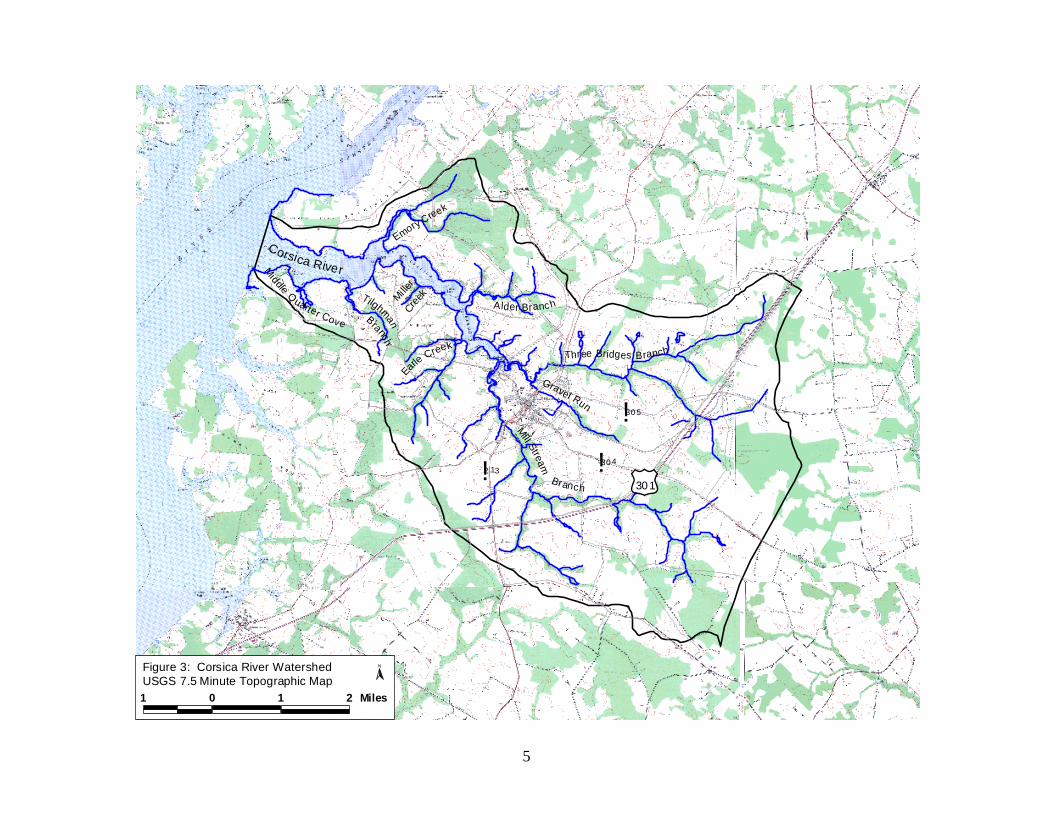
The Corsica River is a tributary of the Chester River. Located in central Queen Anne’s County with the Town of Centreville located at the river’s tidal head (Shanks, 2003). The watershed covers approximately 23,903 acres of land (37.3 square miles) and 1,395 acres of water (2.2 square miles). According to categories established by the Maryland Department of Planning land use data for 2000, the land use in the watershed is 64% agricultural, 28% forest/scrub/shrub, 7% developed, and less than 0.5% wetland. Figure 2 shows a digital orthophoto map of the watershed. Figure 3 shows the same watershed boundaries superimposed on a 7.5 minute USGS topographic quadrangle maps.
The first step in developing a Restoration Action Strategy for this watershed is to complete an overall assessment of the condition of the watershed and the streams it contains. This initial step was accomplished using three approaches. First, a watershed characterization was completed that compiles and analyzes existing water quality, land use, and living resource data about the watersheds (Shanks, 2004). Secondly, a synoptic water quality surveys, as well as surveys of the fish and macroinvertebrate communities, were conducted at selected stations throughout the Corsica River watershed to provide information on the present condition of water quality and aquatic resources (Primrose, 2003). Lastly, Stream Corridor Assessment (SCA) and Shoreline Surveys are done to provide specific information on the location of potential environmental problems and restoration opportunities. This report details the results of the Corsica River Stream Corridor Assessment and Shoreline Surveys.
Survey teams walked over 48 miles of the Corsica River’s stream network from May 2003 to August 2003, and boated over 24 miles of coastline in October 2003. At each site during the survey, field crews collected descriptive data, recorded the location on field maps, and took a photograph to document each potential environmental problem observed. As an aid to prioritizing future restoration work, crews rated all problem sites on a scale of one to five in three categories: 1) how severe the problem is compared to others in its category; 2) how correctable the specific problem is using current restoration techniques; and 3) how accessible the site is for work crews and any machinery necessary to complete restoration work. In addition, field teams collect descriptive data for both in- and near-stream habitat conditions at representative sites spaced at approximately 1-mile intervals along the stream.
One of the main goals of the Corsica River SCA survey is to compile a list of observable environmental problems in this watershed to help target future restoration efforts. Once this list is compiled and distributed, county planners, resource managers, and others can initiate a dialog

2
to cooperatively set the direction and goals for the watersheds’ management and plan future restoration work at specific problem sites.
To this end, the Maryland Department of Natural Resources is working with the town of
Centreville, Queen Anne’s County and the WRAS committee to develop a Watershed Restoration Action Strategy (WRAS) of the Corsica River Watershed. As part of this process, data collected during the Stream Corridor Assessment and the Shoreline Surveys will be used to help define present environmental conditions and possible restoration opportunities in the watershed. This information, combined with the watershed characterization, synoptic water quality surveys, recent biological surveys, and local knowledge of the watershed will be used to develop a Watershed Restoration Action Strategy for the Corsica River. The Watershed Restoration Action Strategy, in turn, will help guide future restoration and preservation efforts with the ultimate goals of restoring the area’s natural resources and meeting State water quality standards.

3
Corsica River
Emory
Creek
Gravel Run
Three Bridges Branch
Mill Stream
Branch
Alder Branch
M iddle Quarter Cove
TilghmanBranch
Earle Creek
Miller
Creek
Corsica River WatershedQueen Anne's County, Maryland
Figure 1: Corsica River Watershed, Maryland

4
Cors ica River
Alder Bran ch
Three Bridges BranchGrave l Run
M ill S treamBranch
Em ory Creek
"!305
"!304
"!213
(/301(/301"!213
"!304
"!305
Earl Creek
Mil ler
Creek
Midd le Q ua rterCov e T ilghman Cove
1 0 1 2 Miles
NFigure 2: Cors ica River WatershedBlack & White Aerial Photograph 2002
5
Corsica River
Gravel Run
Three Bridges Branch
Mi ll Stream
Emory Creek
A lder Branch
Middle Quarter Cove
Ti lghmanBranch
Miller
Cree
k
Earle Creek
Branch (/301
"!30 5
"!30 4
"!2 13
1 0 1 2 Miles
Figure 3: Corsica River WatershedUSGS 7.5 Minute Topographic Map
N

6
METHODS Goals of the Stream Corridor Assessment and Shoreline Surveys
To help identify some of the common problems that affect streams and shorelines in a rapid and cost effective manner, the Watershed Services Unit of the Maryland Department of Natural Resources developed the Stream Corridor Assessment (SCA) and Shoreline Surveys. The main objectives of the surveys are to provide:
1. A list of easily observable environmental problems present either along the non-tidal stream network or tidal shoreline.
2. Sufficient data on each problem in order to make a preliminary determination of both
the severity and correctability of each problem. 3. Sufficient data so that restoration efforts can be prioritized.
4. For the stream survey a quick assessment of both in- and near-stream habitat conditions to make comparisons among the conditions of different stream segments.
The two surveys provides a rapid method of examining and cataloguing the observable
environmental problems within a watershed so that better targeting of future monitoring, management and/or conservation efforts can be done. This surveys are not a detailed scientific surveys, nor will it replace chemical and biological surveys in determining overall stream and estuary conditions. One advantage of the surveys over chemical and biological surveys is that they can be done on a watershed basis both quickly and at relatively low cost. Field Training and Procedure for Stream Corridor Assessment Survey
While almost any group of dedicated volunteers can be trained to do a SCA survey, the Maryland Conservation Corps (MCC) has proven to be an ideal group to do this work in Maryland. The Maryland Conservation Corps is part of the AmeriCorps Program, initiated to promote greater involvement of young volunteers in their communities and the environment. The MCC program is managed by DNR’s Forest and Park Service. Volunteers with the MCC are 17-25 years old and can have educational backgrounds ranging from high school to graduate degrees. With the proper training and supervision, MCC volunteers are able to significantly contribute to the State's efforts to inventory and evaluate water quality and habitat problems from a watershed perspective. For more information on the Maryland Conservation Corps call their main office in Annapolis at (410) 260-8166 or visit their web site at: www.dnr.state.md.us/mcc.
Prior to the start of the Corsica River SCA Survey, the members of the MCC’s Elk Neck Crew received training in assessing both environmental problem sites and habitat conditions in and along Maryland streams. For problem sites, crewmembers learned how to identify common problems observable within the stream corridor, record problem locations on survey maps, and accurately complete data sheets for each specific problem type. For habitat conditions, the crew

7
learned and practiced assessing stream health based on established criteria indicating both favorable conditions for macroinvertebrates and fish and healthy riparian habitat. These reference sites for habitat condition are located at approximately 1-mile intervals along the stream. In addition, the field crew reviewed a standard procedure for assigning site numbers based on the 3-digit map number, 1-digit team number, and 2-digit problem number for each problem and reference site during the survey. Lastly, in order to have a visual record of existing conditions at the time of the SCA survey, the MCC’s Elk Neck Crew received guidelines for taking photographs at all problem and reference sites.
Several weeks prior to the beginning of the survey, property owners along the stream
were contacted and asked if field crews could cross their property during the survey. Most individuals gave permission and of the watersheds 48 miles of streams, only 3 miles were not surveyed because field teams were denied access by landowners
The MCC crew conducted field surveys of the Corsica River Watershed from May to
August 2003. The survey teams walked most of the River’s drainage network, collecting information on potential environmental problems. Common potential problems identified during the SCA Survey include: inadequate stream buffers, excessive bank erosion, channelized stream sections, fish migration blockages, in or near stream construction, trash dumping sites, unusual conditions, and pipe outfalls. In addition, the survey recorded information on the general condition of in-stream and riparian habitats and the location of potential wetland creation sites.
More detailed information on the procedures used in the Maryland SCA survey can be found in, “Stream Corridor Assessment Survey – Survey Protocols” (Yetman, 2001). A copy of the survey protocols can found on Maryland Department of Natural Resource’s web site at http://www.dnr.state.md.us/streams/pubs/other.html. Hard copies of the protocols also can be obtained by contacting the Watershed Services Unit of the Maryland Department of Natural Resources, Annapolis, MD. Overall Ranking System for Stream Corridor Assessment Survey
The SCA survey field crews evaluate and score all problems on a scale of 1 to 5 in three separate areas: problem severity, correctability, and accessibility. A major part of the crew’s training on survey methods is devoted to properly rating the different problems identified during the survey. This ranking system developed from an earlier survey that found 453 potential environmental problems along 96 miles of stream of the Swan Creek Watershed in Harford County. The most frequently reported problem during the survey was stream bank erosion, reported at 179 different locations (Yetman et. al., 1996). Follow-up surveys found that while stream bank erosion was a common problem throughout the watershed, the severity of the erosion problem varied substantially among the sites and that the erosion problems at many sites were minor in severity. Based on this experience and its goal of helping to prioritize restoration work, the SCA survey rates the severity, correctibility, and access of each problem site.
While the ratings are subjective, they have proven to be very valuable in providing a
starting point for more detailed follow-up evaluations. Once the SCA survey is completed, the collected data can be used by different resource professionals to help target future restoration efforts. A regional forester, for example, can use data collected on inadequate stream buffers to help plan future riparian buffer plantings, while the local fishery biologist can use the data on

8
fish blockages to help target future fish passage projects. The inclusion of a rating system in the survey gives resource professional an idea of which sites the field crew believed were the most severe, easiest to correct and easiest to access. This information combined with photographs of the site can help resource managers focus their own follow up evaluations and fieldwork at the most important sites.
A general description of the rating system is given below. More specific information on
the criteria used to rate each problem category is provided in the SCA – Survey Protocols (Yetman, 2000). It is important to note that the rating system is designed to contrast problems within a specific problem category and is not intended to be applied across categories. When assigning a severity rating to a site with an inadequate stream buffer for example, the rating is only intended to compare the site to other in the State with inadequate stream buffers. A trash dumping site with a very severe rating may not necessarily be a more significant environmental problem than a stream bank erosion site that received a moderate severity rating.
The severity rating indicates how bad a specific problem is relative to others in the same problem category. It is often the most useful rating because it answers questions such as: where are the worst stream bank erosion sites in the watershed, or where is the largest section of stream with an inadequate buffer? The scoring is based on the overall impression of the survey team of the severity of the problem at the time of the survey, based on the established criteria for each problem category (Yetman, 2000). * A very severe rating of 1 is used to identify problems that have a direct and wide
reaching impact on the stream’s aquatic resources. Within a specific problem category, a very severe rating indicates that the problem is among the worst that the field teams have seen or would expect to see. Examples include a discharge from a pipe that was discoloring the water over a long stream reach (greater than 1000 feet) or a long section of stream (greater than 1000 feet) with high raw vertical banks that are unstable and eroding at a rapid rate.
* A moderate severity rating of 3 is identifies problems that have some adverse
environmental impacts but the severity and/or length of affected stream is fairly limited. While a moderate severity rating would indicate that field crews did believe it was a significant problem, it also indicates that they have seen or would expect to see worse problems in the specific problem category. Examples include: a small fish blockage that is passable by strong swimming fish like trout, but a barrier to resident species such as sculpins or a site where several hundred feet of stream has an inadequate forest buffer.
* A minor severity rating of 5 identifies problems that do not have a significant impact on
stream and aquatic resources. A minor rating indicates that a problem is present, but compared to other problems in the same category it is considered minor. One example of a site with a minor rating is an outfall pipe from a storm water management structure that is not discharging during dry weather and does not have an erosion problem at the outfall or immediately downstream. Another example is a section of stream with stable banks that has a partial forest buffer less than 50 feet wide along both banks.
The correctability rating provides a relative measure on how easily the field teams believe the problem can be corrected. The correctability rating can be helpful in determining

9
which problems can be easily dealt with when developing a restoration plan for a drainage basin. One restoration strategy, for example, would initially target the severest problems that are the easiest to fix. The correctability rating also can be useful in identifying simple projects that can be done by volunteers, as opposed to projects that require more significant planning and engineering efforts to complete. * A minor correctability rating of 1 indicates problems that can be corrected quickly and
easily using hand labor, with a minimal amount of planning. These types of projects would usually not need any Federal, State or local government permits. It is a job that small group of volunteers (10 people or less) could fix in a day or two without using heavy equipment. Examples include removing debris from a blocked culvert pipe, removing less than two pickup truck loads of trash from an easily accessible area or planting trees along a short stretch of stream.
* A moderate correctability rating of 3 indicates sites that may require a small piece of
equipment, such as a backhoe, and some planning to correct the problem. This would not be the type of project that volunteers would usually do alone, although volunteers could assist in some aspects of the project, such as final landscaping. This type of project would usually require a week or more to complete. The project may require some local, State or Federal government notification or permits. However, environmental disturbance would be small and approval should be easy to obtain.
* A very difficult correctability rating of 5 indicates problems that would require a large
expensive effort to correct. These projects would usually require heavy equipment, significant amount of funding ($100,000 or more), and construction could take a month or more. The amount of disturbance would be large and the project would need to obtain a variety of Federal, State and/or local permits. Examples include a potential restoration area where the stream has deeply incised several feet over a long distance (i.e., several thousand feet) or a fish blockage at a large dam.
The accessibility rating provides a relative measure of how difficult it is to reach a specific problem site. The rating is made at the site by the field survey team, using a survey map and field observations. While factors such as land ownership and surrounding land use can enter into the field judgments of accessibility, the rating assumes that access to the site could be obtained if requested from the property owner. * A very easy accessibility rating of 1 indicates sites that are readily accessible both by car
and on foot. Examples include a problem in an open area inside a public park where there is sufficient room to park safely near the site.
* A moderate accessibility rating of 3 indicates sites that are easily accessible by foot but
not easily accessible by a vehicle. Examples would include a stream section that can be reached by crossing a large field or a site that is accessible only by 4-wheel drive vehicles.
* A very difficult accessibility rating of 5 is assigned to sites that are difficult to reach both
on foot and by a vehicle. To reach the site it would be necessary to hike at least a mile, and if equipment were needed to do the restoration work, an access road would need to

10
be built through rough terrain. Examples include a site where there are no roads or trails nearby.
Procedure and Ranking for Shoreline Survey The Shoreline Survey is a new survey that is being developed by DNR to help assess the environmental condition of Maryland shorelines and identify the location of potential environmental problems. The methods used for the shoreline survey generally follow the protocols for the Stream Corridor Assessment Survey. The two main differences from the SCA survey were: 1) Instead of walking, the survey was completed from a small boat that cruised just offshore of the shoreline and 2) Instead of using the MCC, the survey was done members of DNR’s Watershed Service Unit. The ranking of the severity of potential problems identified during the Shoreline Survey were done using criteria presented in Table 1. Correctability and accessibility rating generally follow the same criteria of the SCA survey. Table 1. Criteria used to rank problem severity in the Corica River Shoreline Survey. Very Severe Moderate Minor Altered Shoreline >1000 feet long 500 feet long <100 feet long Wall/Bulkhead Combination Rip-rap Fish Barrier Complete blockage Blockage mainly Temporary or to both anadromous to resident fish seasonal blockage and resident fish Inadequate Buffer >1000 feet long 500 feet long <100 feet long No trees or marsh 0 foot width <50 foot forest buffer present Lawn Shrubs/Small trees Pipe Outfall Large amount of discharge Small discharge Stormwater outfalls Strong odor and color Little/no odor or color No dry weather discharge Significant impact downstream Local impact downstream Not causing erosion Shoreline Erosion >1000 feet long 500 feet long <100 feet long >10 feet high banks 5 feet high banks 1-2 foot high banks
Data Analysis and Presentation Following the completion of the surveys, crews entered and information from the field data sheets into a Microsoft Access database and verified the accuracy of the data. Field crews labeled and organized the photographs taken during the survey by site number and placed them in binders in both print and digital form. Members of the Department of Natural Resources’ Watershed Services Unit incorporated the map location, recorded data, and digitized photographs into the ArcGIS computer software. The GIS project is an electronic geodatabase that integrates all the collected problem locations and descriptive data by site number, links photographs to each potential problem site, and produces the maps presented in this report. This data can then be used alongside of other digital geographic datasets available for features within the watersheds. A final copy of the ArcView files was given to the partners in the Watershed Restoration Action Strategy committee for their use in developing a Watershed Action Strategy for the Corsica River Watershed.

11
RESULTS
The Stream Corridor Assessment Survey identified a total of 247 potential environmental problems within the stream corridor (Table 2). Of these, 10 are considered very severe, 31 severe, 23 moderate, 96 of low severity, and 87 minor. The most frequently observed problem sites were erosion sites, reported at 57 sites (or 12.18 miles of stream) and pipe outfalls, reported at 56 sites. Although not as numerous, inadequately forested stream buffers [34 sites (3.96 miles of stream)] were present throughout the watershed. Erosion sites occur along 26% of the 45 miles of streams walked during the survey, and inadequately buffered streams occur along 8%. The Shoreline Survey identified a total of 49 potential environmental problems (Table 3). Of these, 2 were considered very severe, 7 severe, 15 moderate, 13 low severity and 12 minor. The most frequently observed potential environmental problem was altered shorelines. Approximately 2.5 miles or 10 % of the Corsica Rivers 42.44 miles of shoreline had been altered primarily with bulkheads and rip-rap. The second most frequently reported potential problem was inadequate buffers along the shoreline. Inadequate shoreline buffers were observed at 18 sites and results indicate that there are approximately 4.7 miles (19%) of shoreline along the tidal portion of the Corsica River with either no tree buffer or a tree buffer of less than 50 feet. The final problem that was reported during the Shoreline Survey was shoreline erosion. Excessive erosion was seen at 7 sites and the total amount of shoreline in the Corsica River with an erosion problem was estimated to be 0.7 miles . Table 2 presents a summary of non-tidal survey results; Table 3 is a summary of the tidal survey results. Appendices A and B list the data collected during the survey. Appendix A provides a listing of information by site number and location, referenced latitude and longitude. In Appendix B, the data is presented by problem type and lists the collected descriptive data. Presenting the data by problem type allows the reader to see which problems are rated as most severe or easiest to correct within each category.

12
Table 2. Summary of results from the Corsica River SCA Non-tidal Survey.
Potential Problems Identified Number Estimated Length Ve
ry S
ever
e
Seve
re
Mod
erat
e
Low
Sev
erity
Min
or
Channel Alterations 20 6,185ft. (1.17 Miles) 0 0 0 9 11
Erosion Sites 57 64,312ft. (12.18 Miles) 3 17 7 25 5
Exposed Pipes 5 365ft. 0 1 0 1 3
Fish Barriers 52 NA 1 0 0 22 29
In/Near Stream Construction 4 4,150ft. (0.79 Miles) 1 0 1 1 1
Inadequate Buffers 34 20,915ft. (3.96 Miles) 2 8 2 8 14
Pipe Outfalls 56 NA 3 1 9 23 20
Trash Dumpings 8 NA 0 0 1 4 3
Unusual Conditions 11 NA 0 1 4 5 1
Total 247 10 28 24 98 87
Representative Sites 27
Table 3. Summary of results from the Corsica River SCA Tidal Survey.
Potential Problems Identified Number Estimated Length Ve
ry S
ever
e
Seve
re
Mod
erat
e
Low
Sev
erity
Min
or
Altered Shoreline 24 13,055ft. (2.47 Miles) 1 1 10 6 6
Inadequate Buffers 18 24,705ft. (4.68 Miles) 1 5 4 6 2
Shoreline Erosion 7 3,630ft. (0.69 Miles) 0 1 1 1 4
Total 49 2 7 15 13 12

STREAM CORRIDOR ASSESSMENT SURVEY RESULTS

14
Erosion Sites Erosion is a natural process necessary to maintain good aquatic habitat. Too much erosion, however, can have the opposite effect on the stream by destabilizing stream banks, destroying in-stream habitat, and causing significant sediment pollution problems downstream. Erosion problems occur when either a stream’s hydrology and/or sediment supply are significantly altered. This often occurs below a specific alteration, such as a pipe outfall or road crossing, or in area’s where land use in a watershed changes. For example, as a watershed becomes more urbanized, forest and agricultural fields are developed into residential housing complexes and commercial properties. As a result, the amount of impervious surface, or land area where rainwater cannot seep into the groundwater directly, increases in a drainage basin. This causes the amount of runoff entering a stream to increase. Over time, a stream channel will adjust to the greater rain-induced flows by eroding the streambed and banks to raise water-carrying capacity. This channel readjustment can extend over decades, during which time excessive amounts of sediment from unstable eroding stream banks can have very detrimental impacts on a stream’s aquatic resources.
In this survey, unstable eroding streams are defined as areas where the stream banks are almost vertical, and the vegetative roots along the stream are unable to hold the soil onto the banks. While survey teams are asked to visually assess whether the stream was down-cutting, widening, or head-cutting at a specific site, the only way to evaluate the full significance of the erosion processes at a specific site is to do more detailed monitoring over time. During the Corsica River survey, 50 sites were identified as widening, 6 as down-cutting, and 1 as a headcut.
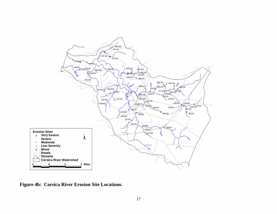
The SCA survey found 57 eroding stream banks over the length of 64,312 feet (12.18
miles) of stream, or about 26% of streams surveyed. The severity and location of erosion sites is shown in Figure 4b. Three sites are ranked as very severe, 17 as of severe, 7 as moderate, 25 as low severity, and 5 as minor (Figure 4a). Length of these sites varies from 15 to 7,230 feet. Heights of the stream banks at erosion sites in the Corsica River watershed vary from 1 to 12 feet (Appendix B).
Twelve erosion sites are most likely caused by specific infrastructure placed in the
stream. Seven sites are below a road crossing, 3 may possibly be related to a land use change upstream, 1 is below channelization, and 1 is caused by in-stream debris. To restore the stream banks in these cases, stormwater management and reinforcement of the stream banks using natural design techniques may be a possibility. Methods, such as using stone cross-veins in the channel and vegetative stabilization on the banks, could succeed in reducing the erosion at some location, however, while stream restoration projects that physical alter the stream can be effective, the monitory cost of these projects can be fairly high. Also it is important to first identify and treat the cause of the problem before attempting to deal with a specific erosion problem. If for example the erosion problem is caused by excessive storm runoff entering upstream of the site it is important that the possibility of improving stormwater management in the watershed be examined before the specific erosion problem is addressed.
Land use in the stream corridor along the stream’s banks was also recorded. At 30
erosion sites, forest was present on both sides of the stream, and at 14 sites crop fields were present along both banks. The remaining site had a combination of forest, pasture, crop field and lawns in the stream’s riparian zone.

15
Three sites were found to be very severe. Site 021103 is on the south tributary to Emory
Creek, and was identified as widening erosion site. The erosion problem extends for 1,037 feet, average bank height was 4 feet, and is surrounded by forest. Site 138202 is located on the south fork of the Three Bridges Branch, and is possibly being caused by an altered channel upstream. This site stretches for 7,230 feet, with average stream bank height of 4 feet and is surrounded by forest. Site 160102 is on the headwaters of Gravel Run and is found below a railroad crossing. This site is 3,430ft. long with 4 feet high banks and a crop field on the right and forest on the left. Seventeen additional sites were identified as severe (Figure 4a) and information on them is presented in Appendix A & B.
Erosion SitesCorsica River Watershed
05
1015202530
Very Severe Severe Moderate Low Severity Minor
Figure 4a. Histograph showing the frequency of severity ratings given to
erosion sites during the Corsica River SCA survey.
17
Figure 4b: Corsica River Erosion Site Locations.
Minor#S
Low Severity+
Moderate#³
Severe"́
Very Severe#
Erosion Sites
RoadsStreamsCorsica River Watershed
N
1 0 1 2 Miles
++
+#
+#³#³
#³+
"́ #³"́
+
#S"́ +
#S"́
+ +
++
+"́+"́
"́
"́ ++
"́ ++
"́
+ #³+#³
"́#S# #S
"́ +"́ "́
#³
"́+ # #S
++
"́"́ +
+
++
#S #S #³
+"́
163101
139107138101150101
138106138202
198201
160102
146103134103
133101
134105
149201
124201
207203
195201
195205182101
170102
158201
144102143202
156203
005102005104
021103021102
027001
038002049002048001
061101
017002
036003036001
091203091201105202
118105118101
129101
121101
109203 109202
096212110201
110101
099105
099103
099106
099101111103
111101
098103
085105
054102054103
054104054106
053201
066203066202

18
Pipe Outfalls
Pipe outfalls include any pipes or small, constructed channels that discharge into the stream through the stream corridor. Pipe outfalls are considered a potential environmental problem in the survey because they can carry uncontrolled runoff and pollutants such as oil, heavy metals and nutrients to a stream system. The survey crew identified a total of 56 pipe outfalls. The severity and location of pipe outfall sites is shown in Figure 5b, and the distribution of severity ratings in Figure 5a.
Ninety-three percent, or 52 of 56, of pipe outfalls surveyed were given a minor to
moderate severity rating. These outfalls drained crop fields, carried stormwater, or discharged from a small pond. No pipe outfalls were cited as potential causes of stream bank erosion. Of the outfalls observed, 22 were dry when surveyed and 29 had a clear discharge with no associated odor. The remaining 5 pipe outfalls all had a medium brown discharge associated with them.
Three pipes were rated very severe and one severe. Site 096211 is a very severely rated
plastic 6in. pipe on the right bank of a tributary of Three Bridges Branch. This pipe has created a channel 2ft. wide, and has a medium brown discharge. The purpose for the pipe is unknown. Site 121104 is a 12-inch smooth metal sewage overflow pipe on the left bank of Gravel Run. Although no discharge was observed the field crew did see debris caught under the clapper valve and believed that the pipe could have recently discharged. The pipe outfall was given a very severe rating. Site 121106 is an 18 inch 4 feet long corrugated metal stormwater pipe located on the left bank of Gravel Run. A medium brown musky smelling discharged was observed, and the site was given a very severe rating. Site 121110 is a 4-inch pipe with a medium brown discharge on Gravel Run. This site was given a severe rating.
No immediate follow up actions were taken as part of this study to determine the source
of the color coming from the pipe. In some cases, coloration from a storm drainpipe may be a sporadic occurrence; this is especially true in areas where no stormwater management system is present. In addition, we made no estimate of the amount of fluid released from the pipes.
Pipe OutfallsCorsica River Watershed
05
10152025
Very Severe Severe Moderate Low Severity Minor
Figure 5a. Histograph showing the frequency of severity ratings given to
pipe outfalls during the Corsica River SCA survey.

19
#S
#S#S#³+##S
#S#S+
+##++"́#S#S#³++#³#³ +
+ + #S#S#S+
+
#³ #S#S#S + +
#S+
+
#³
#S#S
#S+
#³+++++ #S
#S#³+
#³
040101
091202
130101
234102
140101
150104
138102
149206
100102
111202
124 20 4
100103100105096203
196201
207206207207
207201
160103
160101
121104 - 121121
170 10 1
134104
194106
182111
182102
182110
170101
143204 144202 144204144101
096207096210
096210
206103 - 206108
206101
1 0 1 2 Miles
N
Corsica River WatershedStreamsRoads
Pipe Outfalls# Very Severe"́ Severe#³ Moderate+ Low Severity#S Minor
Figure 5b: Corsica River Pipe Outfall Locations.

20
Fish Migration Barriers
Fish migration barriers include anything in the stream that significantly interferes with the free, upstream movement of fish. Unimpeded fish passage is especially important for anadromous fish that live most of their lives in tidal waters but must migrate into non-tidal rivers and streams to spawn. Unobstructed upstream movement is also important for resident fish species, many of which also travel both up and down stream during different parts of their life cycle. In addition, without free fish passage, certain sections in a stream network become isolated from others. This becomes detrimental to species survival when a disturbance occurs in an isolated stretch of stream. A sediment discharge from a construction project, for example, or a sewage line break discharging into a small tributary can eliminate some or all of the fish species in an isolated stream stretch. With a fish blockage present, there is no avenue for fish to repopulate the inaccessible sectio. As a result, the disturbance will reduce diversity of the fish community in the area, and the remaining biological community may deviate from its natural balance and composition.
Fish blockages can be caused by man-made structures such as dams or road culverts and
by natural features such as waterfalls or beaver dams. A structure becomes a blockage for fish if the stream water over or under it is too high, shallow, or fast. First, a vertical water drop such as a dam can be too high for fish to migrate over the obstacle. A vertical drop of 6 inches may cause a fish passage problem for some resident fish species, while anadromous fish can usually move through water drops of up to one foot, providing there is sufficient water flow and depth. Second, water too shallow for fish passage can occur in channelized stream sections or at road crossings, where the entire stream volume is spread over a large, flat area. Finally, a structure may be a fish blockage if the water is moving too fast through it for fish to swim through. This can occur at road crossings where the culvert pipe is placed at a steep angle, and the water moving through the pipe has a velocity higher than a fish’s swimming ability.
In restoration work, priority is given to removing fish barriers that will yield access to the
greatest quality and quantity of upstream habitat per dollar spent. The mainstem is ideally kept as barrier-free as possible, allowing anadromous fish to migrate to spawn and a source of fish species for tributaries in the event of a disturbance. Restoration planning includes targeting barriers for removal that isolate entire tributaries, those that isolate significant portions of the upper tributary, and those that isolate quality fish habitat. The best restoration sites also are far from other existing fish barriers.
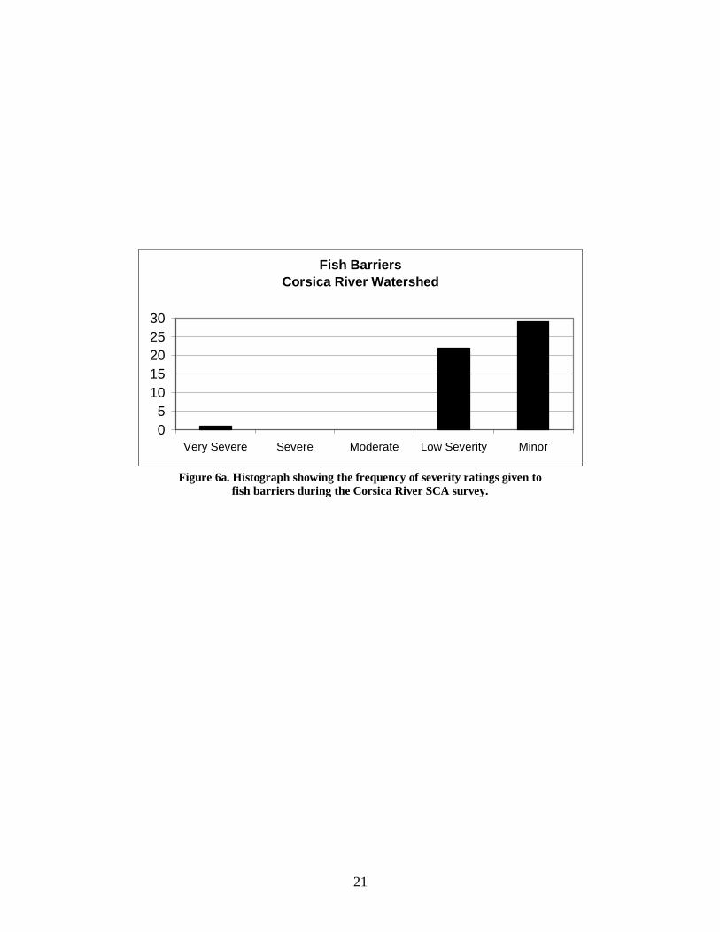
The Corsica River SCA survey found 52 fish migration barriers. The locations of fish
blockages are shown in Figure 6a. Fish barriers in these watersheds are due to natural falls (24 sites), road crossings (11 sites), beaver dams (5 sites), pipe crossings (3 sites), channelized streams (1 site), and a dam. The majority of fish migration barriers (51 out of 52) are low to minor in severity (Figure 6a). These sites were given low severity rankings because they are either temporary blockages, or they isolate only a short section of stream. Site 121122 is a dam on Gravel Run with a drop of 60in. at the extent of the tidal area. This dam may impede the movement of anadromous fish in the tributary. This site is located on public land and is a potential fish passage project site.
In all cases, areas should be assessed for viable fish habitat before restoration work
begins, giving preference to sites with the most potential habitat area created.
21
Fish BarriersCorsica River Watershed
05
1015202530
Very Severe Severe Moderate Low Severity Minor
Figure 6a. Histograph showing the frequency of severity ratings given to
fish barriers during the Corsica River SCA survey.

22
Minor#S
Low Severity+
Moderate#³
Severe"́
Very Severe#
Fish Barriers
RoadsStreamsCorsica River Watershed
N
1 0 1 2 Miles
#S+
#S
+
++
#S
#S#S #S
+ #S #S+
++#S#S +
#S#S
##S+ #S#S #S
#S + #S+#S#S
+
#S#S#S #S
++ #S
#S
#S
+ #S
+#S
++
+
+
+
005101005103
040102
053202
054105
066201
054101
088101085101
186201
208101
234101
215101
207202
207205195203
090101
129102
194105
182109
182103
171201
158203147102
163102156202
143201150108
137202
125202111201111203
124205
124203110104
096204
096208109205
079201
092201
105204104201
144105144107
121125
139108
139104139105
139101121122
121123
Figure 6b: Corsica River Fish Barrier Locations.

23
Inadequate Buffers Forests are the historically occurring ecosystem around Maryland streams and are very important for maintaining stream health in Maryland. Forested buffer areas along streams play a crucial role in increasing water quality, stabilizing stream banks, trapping sediment, mitigating floods, and providing the required habitat for all types of stream life, including fish. Tree roots capture and remove pollutants and excess nutrients from shallow flowing water, and their structure helps prevent erosion and slow down water flow, reducing sediment load and the risk of flooding. Shading from the tree canopy provides the cooler water temperatures necessary for most stream life, especially cold-water species like trout. In smaller streams such as those surveyed, terrestrial plant material falling into the stream is the primary source of plant food for stream life. Tree leaves provide seasonal, instant food for stream life, while fallen tree branches and trunks provide a more consistent, slow-release food source throughout the year. Tree roots and snags also provide necessary fish habitat. Maintaining healthy streams is important in reducing the nutrient and sediment loadings to the coastal bays. While there is no single minimum standard for how wide a stream buffer should be in Maryland, for the purposes of this study a forest buffer is considered inadequate if it is less than 50 feet wide, measured from the edge of the stream. The severity of inadequate forest buffers is based on both the length and width of the site. Those sites over 1,000 feet long with no forest on either side of the stream rank as the most severe.
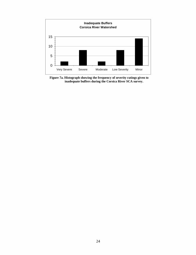
Survey crews identified 34 inadequate buffer sites with a total length of 20,915ft. (3.96 miles), or approximately 8% of streams surveyed. The severity and location of inadequate buffer sites is shown in Figure 7a. Twenty-four of these sites are ranked as moderate to minor severity, while the other ten sites are very severe and severe (Figure 7b). Lengths of inadequately buffered streams ranged from 70ft. to 2,165ft. Six of the 34 sites did not have a forest buffer on either side of the stream. Land use along the stream at inadequate buffer sites is recorded for both sides of the stream; therefore the land use amounts will be double the site amounts. Examples of land use for the sides of streams are as follows: cropland (39 sites), forest (9 sites), lawn (9 sites), pasture (5 sites), shrubs and small trees (4 sites), railroad tracks (1 site), and a construction site (1 site). Site 085103 had a recent buffer planting along the stream on a tributary of Three Bridges Branch. Crews reported that horses had access to the stream at site 215102.
Site 128101 is a very severe site with no buffer width stretching for 1,615ft. through a crop field on the headwaters of Three Bridges Branch. Site 193103 is also a very severe site with no buffer width for 1,575ft. through a crop field on the headwaters of Mill Stream Branch. Eight sites were given severe ratings and include: Sites 156201, 199203, 217201, and 229201 on Mill Stream Branch; Sites 117201, and 130102 on Earle Creek; Site 090102 on Middle Quarter Creek; and Site 149205 on Three Bridges Branch.
24
Inadequate BuffersCorsica River Watershed
0
5
10
15
Very Severe Severe Moderate Low Severity Minor
Figure 7a. Histograph showing the frequency of severity ratings given to
inadequate buffers during the Corsica River SCA survey.

25
Minor#S
Low Severity+
Moderate#³
Severe"́
Very Severe#
Inadequate Buffers
RoadsStreamsCorsica River Watershed
N
1 0 1 2 Miles
+
+
´
#S#S #S
+
#S#S #S
´++
#S#
´#S
#S
+#S+ + ´
´
#S
#S#S
##S
´
#³
#³´
´
090102
117201
130102143203
156201
193103182104
194103
215102
217201
207204
229201
199203
149205
138109139103
128101
073102
113101
124206
111102
085103098102
097202
110102
096201
096205
121124121102
146101
158204
144203144103
Figure 7b: Corsica River Inadequate Buffer Locations.
26
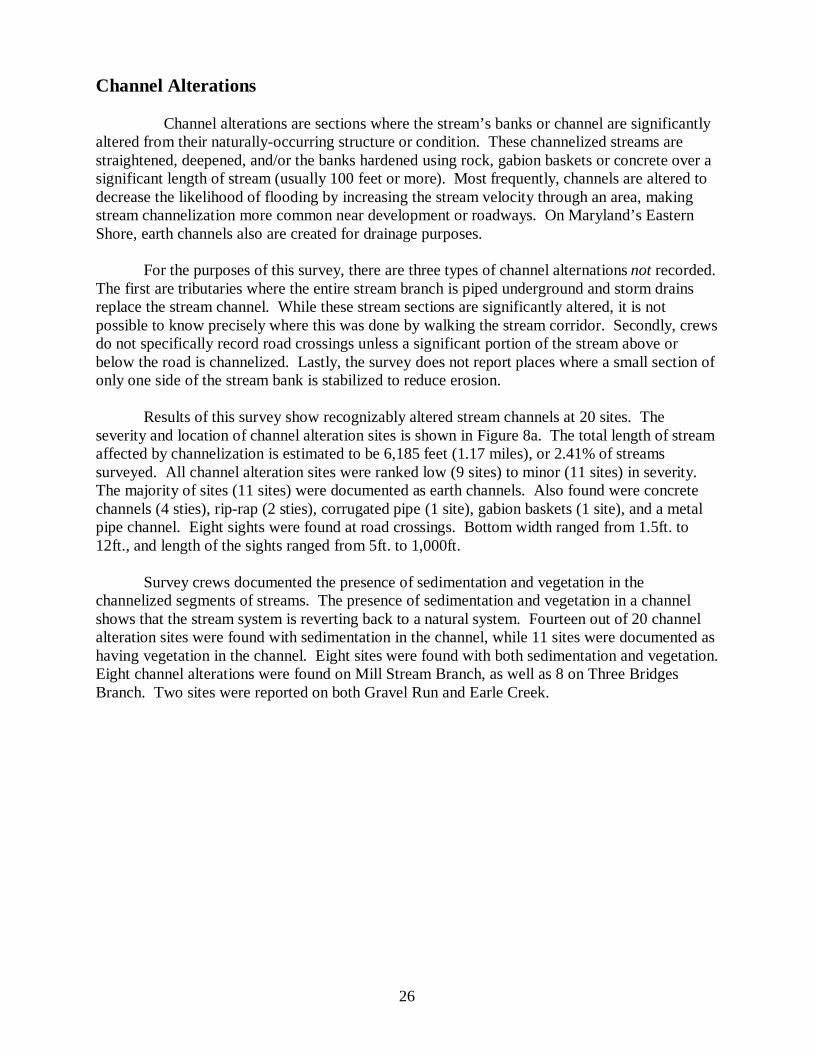
Channel Alterations Channel alterations are sections where the stream’s banks or channel are significantly altered from their naturally-occurring structure or condition. These channelized streams are straightened, deepened, and/or the banks hardened using rock, gabion baskets or concrete over a significant length of stream (usually 100 feet or more). Most frequently, channels are altered to decrease the likelihood of flooding by increasing the stream velocity through an area, making stream channelization more common near development or roadways. On Maryland’s Eastern Shore, earth channels also are created for drainage purposes.
For the purposes of this survey, there are three types of channel alternations not recorded.
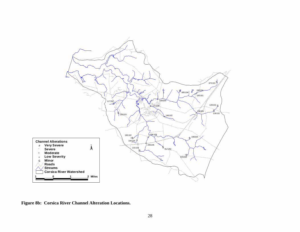
The first are tributaries where the entire stream branch is piped underground and storm drains replace the stream channel. While these stream sections are significantly altered, it is not possible to know precisely where this was done by walking the stream corridor. Secondly, crews do not specifically record road crossings unless a significant portion of the stream above or below the road is channelized. Lastly, the survey does not report places where a small section of only one side of the stream bank is stabilized to reduce erosion. Results of this survey show recognizably altered stream channels at 20 sites. The severity and location of channel alteration sites is shown in Figure 8a. The total length of stream affected by channelization is estimated to be 6,185 feet (1.17 miles), or 2.41% of streams surveyed. All channel alteration sites were ranked low (9 sites) to minor (11 sites) in severity. The majority of sites (11 sites) were documented as earth channels. Also found were concrete channels (4 sties), rip-rap (2 sties), corrugated pipe (1 site), gabion baskets (1 site), and a metal pipe channel. Eight sights were found at road crossings. Bottom width ranged from 1.5ft. to 12ft., and length of the sights ranged from 5ft. to 1,000ft.
Survey crews documented the presence of sedimentation and vegetation in the channelized segments of streams. The presence of sedimentation and vegetation in a channel shows that the stream system is reverting back to a natural system. Fourteen out of 20 channel alteration sites were found with sedimentation in the channel, while 11 sites were documented as having vegetation in the channel. Eight sites were found with both sedimentation and vegetation. Eight channel alterations were found on Mill Stream Branch, as well as 8 on Three Bridges Branch. Two sites were reported on both Gravel Run and Earle Creek.

27
Channel AlterationsCorsica River Watershed
0
5
10
15
Very Severe Severe Moderate Low Severity Minor
Figure 8a. Histograph showing the frequency of severity ratings given to
channel alterations during the Corsica River SCA survey.
28
Minor#S
Low Severity+
Moderate#³
Severe"́
Very Severe#
Channel Alterations
RoadsStreamsCorsica River Watershed
N
1 0 1 2 Miles
+
#S
#S+
+
#S+ #S
#S +#S
+
#S+
#S
+
+
#S
#S
#S
130103
117202
121118
146102
109204
085104100101
100104
073101
128102
139102138201
199204
229202
217202
206105
206109
215103
194104
193102
Figure 8b: Corsica River Channel Alteration Locations.

29
Trash Dumping Trash dumping sites are places where large amounts of trash are inside the stream corridor, either as a site of deliberate dumping or as a place where trash tends to accumulate (often a result of storm drainage). Site severity rankings are based on size, contents of trash, and potential impact on the stream. Survey crews found 8 trash dumping sites (Figure 9a). This is a very low number of sites compared to other watersheds previously surveyed throughout Maryland. In terms of severity rating, 1 sites were ranked as moderate, 4 were given a low severity rating, and 3 were considered minor (Figure 9b). Two sites contained residential waste, 3 sites had construction materials and lumber, 1 site had industrial material, 1 site had tires and one site was characterized as junkyard of cars and buses. The one moderate site (144106) consisted of a junkyard of cars and buses over a larger area within the stream corridor behind a residence on Mill Stream Branch. Site 096202 at a construction site on Three Bridges Branch, was the only other site considered a large area. All other sites were located at confined sites, and 5 sites, 096202, 099102, 105203, 118102, and 147103 are potential sites for volunteer clean-up projects. Ownership of lands containing the trash dumping sites were either private (5 sites) or unknown (3 sites).
Trash Dumping SitesCorsica River Watershed
012345
Very Severe Severe Moderate Low Severity Minor
Figure 9a. Histograph showing the frequency of severity ratings given to
trash dumping sites during the Corsica River SCA survey.

30
Minor#S
Low Severity+
Moderate#³
Severe"́
Very Severe#
Trash Dumping
RoadsStreamsCorsica River Watershed
N
1 0 1 2 Miles
#S#S
++
+
#³+ #S
118102
144205144106 147103
096202
099102105203105205
Figure 9b: Corsica River Trash Dumping Locations.

31
Exposed Pipes Any pipes that are in the stream or along the stream’s immediate banks that could be damaged by a high flow event are recorded as exposed pipes in the SCA survey. Exposed pipes include: 1) manhole stacks in or along the edge of the stream channel, 2) pipes that are exposed along the stream banks, 3) pipes that run under the stream bed and were exposed by stream down-cutting, and 4) pipes built over a stream that are low enough to be affected by frequent high storm flows. Exposed pipes do not include pipe outfalls, where only the open end of the pipe is exposed. In urban areas, it is very common for pipelines and other utilities to be placed in the stream corridor. This is especially true for gravity sewage lines, which depend on the continuous downward slope of the pipeline to move sewage to a pumping station or treatment plant. Since streams flow through the lowest points of the local landscape, engineers often build sewage lines paralleling streams to collect sewage from adjacent neighborhoods. While the pipelines are stationary, streams migrate to different areas within the floodplain. Over time, this variance in stream location can expose previously buried pipelines, making them vulnerable to puncture by debris in the stream. Fluids in the pipelines can be discharged into the stream, causing a serious water quality problem. Field crews observed 5 exposed pipes during the survey. One of these sites received a severe rating while the others were given low severity (1 site) or minor (3 site) ratings (Figure 10a). Figure 10b shows the location of these sites. Two pipes were exposed across the bottom of the stream, 2 were exposed along the stream bank, and 1 pipe was exposed below a bridge. Three pipes were documented as smooth metal pipes, 1 as a plastic pipe, and 1 as a concrete sewage pipe. Pipe diameters ranged from 2 to 36 inches, and the lengths of the exposed pipes ranged from 8 to 300 feet. None of the observed pipes had a discharge, and all but one sewage pipe were unknown in origin. Site 121108 is the only severe pipe to be documented. This site is a pipe 36in. in diameter concrete sewage pipe exposed across the bottom of the stream below the Rte. 213 bridge on Gravel Run. Follow-up visits could be made to the sites to further evaluate their severities and a means for repairing or replacing the pipes.
Exposed PipesCorsica River Watershed
012345
Very Severe Severe Moderate Low Severity Minor
Figure 10a. Histograph showing the frequency of severity ratings given to
exposed pipes during the Corsica River SCA survey.

32
Minor#S
Low Severity+
Moderate#³
Severe"́
Very Severe#
Exposed Pipes
RoadsStreamsCorsica River Watershed
N
1 0 1 2 Miles
#S
#S
+
#S
"́
021101
144201
121112
112201
121108
Figure 10b: Corsica River Pipe Outfall Locations

33
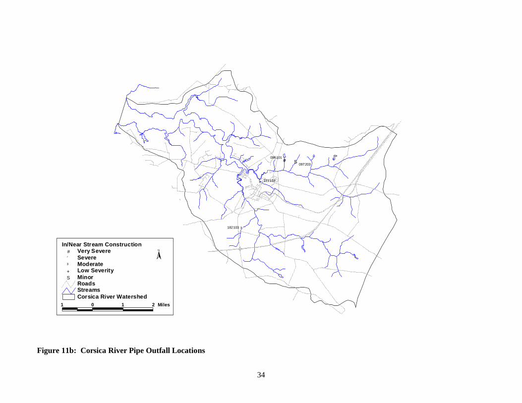
In/Near Stream Construction In or near stream construction data sheets are used to document the locations of construction disturbances seen by the survey teams inside or near the stream corridor. Survey team members are not trained sediment inspectors, but as part of their training they do receive a quick review of the different type of sediment control measures they may see while doing an SCA survey. Survey teams report evidence of inadequate sediment control measures or fine sediment pollution from the site that has affected the stream.
In or near stream construction was reported at 4 sites during the Corsica River survey. Two sites were found on tributaries of Three Bridges Branch, 1 site was observed on Gravel Run and one was observed on Mill Stream Branch. Three sites were involving residential development, and one was involving logging. Three sites were found to have adequate sediment control, while one (site 182105) did not. Two sites had excess sediment in the stream. Lengths of sites ranged from 150ft. to 1800ft. The locations of in/near stream construction sites are shown in Figure 11b.
Most sites were given a low to minor severity rating (Figure 11a). One site (096101) was given a severe rating. The site is located at a new residential development site at the head of a tributary on Three Bridges Branch. Field crews reported what appeared to be excess sediment in the stream channel downstream of the new development. The town of Centreville was notified about this site shortly after it was observed.
In/Near Stream ConstructionCorsica River Watershed
012345
Very Severe Severe Moderate Low Severity Minor
Figure 11a. Histograph showing the frequency of severity ratings given to
in/near stream construction sites during the Corsica River SCA survey.
34
Minor#S
Low Severity+
Moderate#³
Severe"́
Very Severe#
In/Near Stream Construction
RoadsStreamsCorsica River Watershed
N
1 0 1 2 Miles
# #S
+
#³182103
121103
096101
097203
Figure 11b: Corsica River Pipe Outfall Locations
35
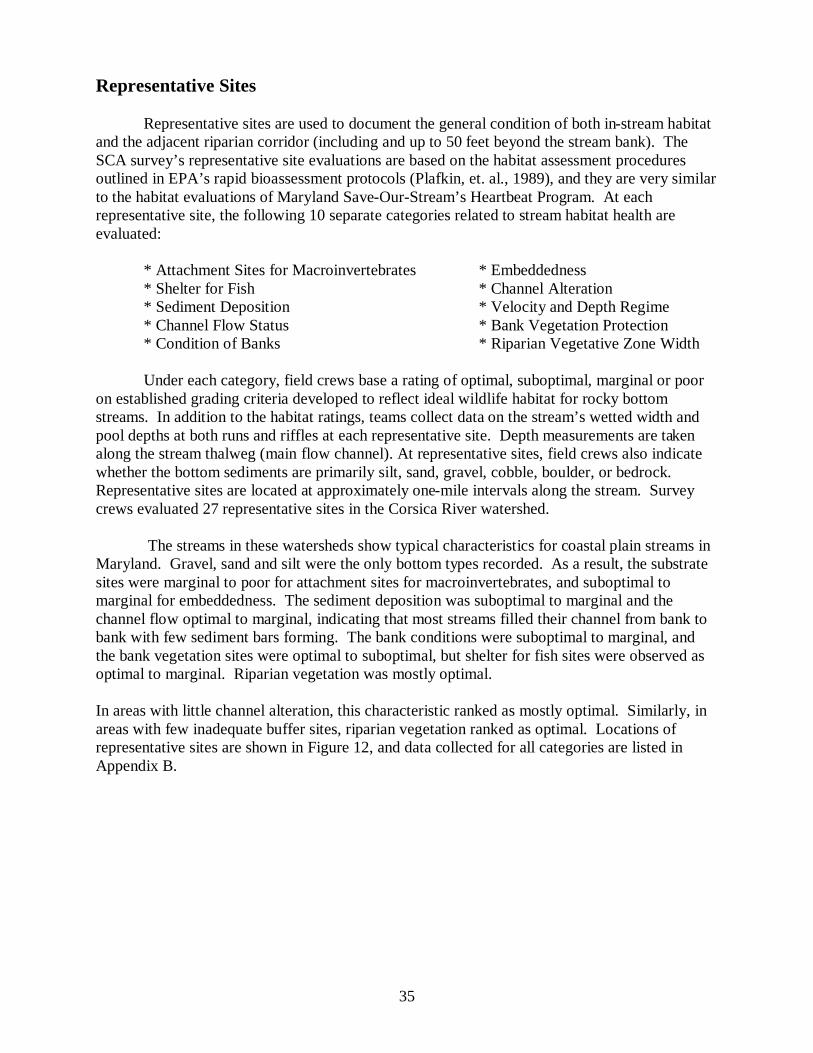
Representative Sites Representative sites are used to document the general condition of both in-stream habitat and the adjacent riparian corridor (including and up to 50 feet beyond the stream bank). The SCA survey’s representative site evaluations are based on the habitat assessment procedures outlined in EPA’s rapid bioassessment protocols (Plafkin, et. al., 1989), and they are very similar to the habitat evaluations of Maryland Save-Our-Stream’s Heartbeat Program. At each representative site, the following 10 separate categories related to stream habitat health are evaluated: * Attachment Sites for Macroinvertebrates * Embeddedness * Shelter for Fish * Channel Alteration * Sediment Deposition * Velocity and Depth Regime * Channel Flow Status * Bank Vegetation Protection * Condition of Banks * Riparian Vegetative Zone Width Under each category, field crews base a rating of optimal, suboptimal, marginal or poor on established grading criteria developed to reflect ideal wildlife habitat for rocky bottom streams. In addition to the habitat ratings, teams collect data on the stream’s wetted width and pool depths at both runs and riffles at each representative site. Depth measurements are taken along the stream thalweg (main flow channel). At representative sites, field crews also indicate whether the bottom sediments are primarily silt, sand, gravel, cobble, boulder, or bedrock. Representative sites are located at approximately one-mile intervals along the stream. Survey crews evaluated 27 representative sites in the Corsica River watershed. The streams in these watersheds show typical characteristics for coastal plain streams in Maryland. Gravel, sand and silt were the only bottom types recorded. As a result, the substrate sites were marginal to poor for attachment sites for macroinvertebrates, and suboptimal to marginal for embeddedness. The sediment deposition was suboptimal to marginal and the channel flow optimal to marginal, indicating that most streams filled their channel from bank to bank with few sediment bars forming. The bank conditions were suboptimal to marginal, and the bank vegetation sites were optimal to suboptimal, but shelter for fish sites were observed as optimal to marginal. Riparian vegetation was mostly optimal. In areas with little channel alteration, this characteristic ranked as mostly optimal. Similarly, in areas with few inadequate buffer sites, riparian vegetation ranked as optimal. Locations of representative sites are shown in Figure 12, and data collected for all categories are listed in Appendix B.

36
c Representative SitesRoadsStreamsCorsica River Watershed
N
1 0 1 2 Miles
cc
cc c
cc
c c c c
cc
cc
cc
c c
c
c
c
cc
c
c c 210201
195202
195204
206102
194101
171202
158202
144206
143205147101 150102
138108125201
124202
099104
098101
110103097201
109201
096213
108201
121105
066204
092202
105201
118103
061102
Figure 12: Corsica River Representative Site Locations.

SHORELINE SURVEY RESULTS

38
Altered Shoreline Twenty-four altered shoreline sites were documented during the tidal survey. Altered shorelines are anywhere in the tidal area of a river where the bank of the river has been armored in order to protect it from erosion. Erosion can occur when shorelines are inadequately buffered, therefore altered shorelines being used to fix erosion problem sites are commonly found around inadequately buffered areas. Fourteen of twenty-four altered shoreline sites (58%) were documented at sites where inadequate buffers were found. The total amount of altered shorelines found adds up to 2.47 miles, or 9.89%, of the shoreline of the Corsica River. The majority of altered shoreline sites were rated to be moderate to minor in severity, but one was found to be very severe and one severe (Figure 13a). The location of the Corsica River’s altered shoreline sites can be found in Figure 13b. Altered shorelines in the Corsica include: rip-rap (12 sites), wood bulkhead (6 sites), a mix of rip-rap and bulkhead (4 sites), rip-rap and gravel (1 site), and a groin and broken concrete (1 site). Land uses above these sites were found to be lawn (6 sites), residential (6 sites), single home (5 sites), crop field (2 sites), unknown (2 sites), 1 boat landing, 1 emergent marsh, and 1 shrub and small tree site. Land use below was found to include open water (20 sites), beach (3 sites), and phragmites (1 site). Site 034003 is a section of broken concrete extending for 2,500ft, with a crop field above and open water below. The site is rated very severe and is located on the southern shoreline and near the mouth of the Corsica River. Site 064002 is a wood bulkhead extending for 825ft. with lawn above and open water below. The site is located on the northern shore below the Alder Branch.
Altered ShorelinesCorsica River Watershed
0
5
10
15
Very Severe Severe Moderate Low Severity Minor
Figure 13a. Histograph showing the frequency of severity ratings given to
altered shoreline sites during the Corsica River Tidal SCA survey.

39
#³
+#³
#
#³ #S
#S
#S+
#³
"́+
#S
#³
#S#³
#³#³
+#³#³
+
+#S
016001
034001034003
047002047001
035001
107002
107004094004
093005093004
093001080011
080010
064002064005
051004051002
038003038001
029003029006
049003
036005
1 0 1 2 Miles
N
Corsica River WatershedStreamsRoads
Altered Shorelines# Very Severe"́ Severe#³ Moderate+ Low Severity#S Minor
Figure 13b: Corsica River Altered Shoreline Locations.

40
Shoreline Inadequate Buffers Shoreline inadequate buffer sites are considered inadequate in this survey when the forest buffer does not extend more than 50ft. beyond the bank of the tidal river. Forest buffers along the banks of tidal areas of a river greatly reduce erosion of a shoreline. Twenty inadequate buffer sites were identified along the banks of the tidal portion of the Corsica River. These sites total 24,705ft. (4.67 miles), and make up about 19% of the Corsica’s total shoreline. The majority of sites identified by the survey were given severe to low severity ratings, as seen in Figure 14a. Three sites were given very severe ratings. The locations of the Shoreline Inadequate Buffers are shown in Figure 14b. Land use above these sites were found to be residential communities (6 sites), crop fields (4 sites), lawn (2 sites), single homes (2 sites), 1 boat landing, 1 crop field/residential community, 1 sandy boat landing/lawn, and one site filled with shrubs and small trees. Land use below the identified inadequate buffers included: emergent marsh/phragmites (5 sites), emergent marsh (4 sites), open water (2 sites), open water/emergent marsh (2sites), 1 altered shoreline, and 1 beach. Sites were found to range from 230 to 5,430 feet in length. No sites were identified as having recently established buffers. As stated before, three sites were given very severe ratings. Site 016002 is a 1,725ft. long site with a crop field above and open water below. This site is located on the North shore at the mouth of the Corsica River. Site 047003 has no buffer extending for 2,705ft., with a residential community located above, and open water below. This site is located on the South shore at Middle Quarter Cove. Site 107003 is 1,005ft. long with shrubs and small trees above, and emergent marsh below. This site is located on the western shore of the tidal portions of Mill Stream Branch. The six sites identified as severe include: 017001, 029004, 034002, 039002, 094001, and 094003. Information on these sites can be found in Appendixes A and B.
Shoreline Inadequate BuffersCorsica River Watershed
02468
10
Very Severe Severe Moderate Low Severity Minor
Figure 14a. Histograph showing the frequency of severity ratings given to
inadequate buffer sites during the Corsica River Tidal SCA survey.

41
Minor#S
Low Severity+
Moderate#³
Severe"́
Very Severe#
Shoreline Inadequate Buffers
RoadsStreamsCorsica River Watershed
N
1 0 1 2 Miles
#´ +
++ ´
´ ³
+
³ ´#
+ +
++
´
´
#³
016002
017001
027002
028002
028001 029004
039002
038002036004047003
034002
064006 064001
080002093002
094003094001
107003
037001
107001
Figure 14b: Corsica River Altered Shoreline Locations.

42
Shoreline Erosion Sites
Shoreline erosion in tidal areas is mostly due to natural causes such the location of a bank in a high-energy area. Erosion of a shoreline can provide sand and gravel to the river-bed, which can provide habitat for many water-dwelling creatures including oysters. Erosion can also produce siltation, which can be a detriment to water-dwelling creatures by drowning them, in a sense, with an overload of silt. Historically oysters have been present in the Corsica River. Today there are “no oyster beds or oyster leases designated by DNR in the Corsica River.” (Shanks, 2003). It has not been proven why there are no oysters occurring in the Corsica River today, but sedimentation due to erosion could be a factor. More study of the Corsica River Watershed’s sedimentation would be needed to determine where the majority of the sedimentation is coming from.
Seven shoreline erosion sites were identified during the Corsica River survey. The
majority of these sites (5 of 7) were rated low severity to minor (Figure 15a). One site was rated severe and one moderate. Length of the erosion sites documented ranged from 125 to 1,420 feet, and height 1.5 to 15 feet. Five of the sites were located on the Northern banks of the river, and 2 on the Southern. Land use above the documented sites included: crop fields (4 sites), forest (2 sites), and lawn/shrubs & small trees/single home (1 site). Land use below included: beach (4 sites), open water (2 sites), and emergent marsh/rip-rap. Shoreline geometry of the sites were documented as straight (4 sites), cove (2 sites), and meander/irregular (1 site).
Site 049002 is a severely rated site located just upriver from Tilghman Cove on the
Southern bank of the river. This site was found to be 10ft tall, 1,420 ft long with lawn, shrubs & small trees, and a single home above the site, and an emergent marsh and rip-rap below the erosion. The site is located at a meandering irregular part of the river and is posing a threat to the house located 100ft away.. It was also noted that the erosion does not look active. Site 038002 is a moderately rated 690ft long, 15ft high erosion site located on the Southern bank of the Corsica River just downstream from Miller Creek. This site was found to have forest above and open water below, and is located on a section of the river in a cove. The location of all the shoreline erosion sites can be found in Figure 15b.
Shoreline ErosionCorsica River Watershed
012345
Very Severe Severe Moderate Low Severity Minor
Figure 15a. Histograph showing the frequency of severity ratings given to
shoreline erosion sites during the Corsica River Tidal SCA survey.

43
Minor#S
Low Severity+
Moderate#³
Severe"́
Very Severe#
Shoreline Erosion
RoadsStreamsCorsica River Watershed
N
1 0 1 2 Miles
++
#S #S #³
+´
017002 027001
038002
049002048001
036003036001
Figure 15b: Corsica River Shoreline Erosion Locations.

44
DISCUSSION
One of the main objectives of the Corsica River Stream Corridor Assessment and Shoreline Surveys was to quickly survey the River’s stream network and shoreline to identify the location of potential environmental problems. The surveys were completed in the spring/summer of 2003, and over 48 miles of streams were walked, and 24.4 miles of shoreline were surveyed by boat. During the surveys 247 potential environmental problems were identified in the non-tidal streams and 49 potential problems were identified along the tidal shoreline. The most common environmental concern seen during the non-tidal SCA survey was erosion sites, which were reported at 57 sites. Other potential environmental problems identified during the SCA survey include: 56 pipe outfalls, 52 fish barriers, 34 inadequate buffers, 20 channel alterations, 11 unusual conditions, 8 trash dumping sites, 5 exposed pipes, and 4 in/near stream construction sites. During the tidal Shoreline Survey, 24 altered shorelines, 18 shoreline inadequate buffers, and 7 shoreline erosion sites were identified. Erosion sites were the most common problems observed in the Corsica River stream survey. This is typical in a suburban area in which a lot of development occurs. Although storm water management measures are put into place, this often does not adequately control runoff and results in excessive stream bank erosion in the receiving stream. Erosion can also be caused by the absence of adequate forest buffers along a stream corridor. This is another common problem in the Corsica River watershed. Forest buffers along streams can greatly reduce the amount of erosion, and therefore greatly reduce the amount of sediment and nutrients flowing downstream. Pipe outfalls are another common problem in a suburban environment. These pipes are normally stormwater outfall pipes. Pipe outfalls can discharge harmful pollutants to the stream, especially in areas with older communities that were built before stormwater management requirements were in affect. Erosion sites can be related with the number of stormwater pipes discharging directly in the stream. During storm events run-off will be concentrated into stormwater management pipes. When the resulting water goes into the stream it is usually traveling at a high velocity. This high velocity will scour the stream even in areas where there is an adequate forest buffer, while some of the more minor erosion problems, especially in areas that also had inadequate buffers, may be cured with buffer plantings. The more severe erosion problems will probably require more costly engineering solutions both to stabilize the stream’s banks and to control upstream runoff, which ultimately is causing the stream to become unstable. During the shoreline survey of the Corsica River, numerous altered shorelines were found corresponding with inadequate buffers. In a suburban setting along a shoreline, residents often remove the forest buffer to enhance their water view. This, in turn, leads to more shoreline erosion, which causes them to alter their shorelines to prevent erosion and land loss. Many natural ways of altering a shoreline, such as living shorelines etc., are now replacing the bulkhead and rip-rap techniques. These alternative methods of armoring shorelines offer a natural solution to shoreline loss, and could be applied in the Corsica River, especially in places where there is low energy in water movement and less of a chance for extreme erosion to occur. Overall, results of the Corsica River Shoreline found that approximately 23% of the total shoreline was affected by altered shorelines, inadequate buffers or shoreline erosion.
As mentioned earlier, the Maryland Department of Natural Resources has formed a
partnership with the Town of Centreville, and Queen Anne’s County to develop a Watershed

45
Restoration Action Strategy (WRAS) for the Corsica River watershed. Results from this survey will be combined with other information about the area to help establish priorities for the types and location of restoration projects that will be pursued in the watershed in the future. Information on the Corsica River Watershed Action Strategy can be found on DNR’s website (www.dnr.state.md.us/watersheds/surf/proj/wras.html).

46
REFERENCES Hosmer, A.W. 1988. MaryPIRG’S Streamwalk manual. Univ. of Maryland, College Park. Kazyak, P. F. 1996. Maryland biological stream survey sampling manual. Maryland Department of Natural Resources, Annapolis, MD. Maryland Clean Water Action Plan. 1998. Maryland Department of Natural Resources, Annapolis. MD. Web address is http://misdata/cwap/index.html Maryland Save Our Streams (SOS). 1970. Conducting a stream survey. Maryland Department of Natural Resource’s Adopt-A-Stream Program. Annapolis, MD. Mower J. and M. McGinty. 2002. Anadromous and Estuarine Finfish Spawning Locations in Maryland. MD DNR, Annapolis, MD. National Resources Conservation Service (NRCS). 1998. Stream visual assessment protocols. National Water and Climate Center Technical Note 99-1. Plafken, J., M. T. Barbour, K. D. Porter, S. K. Gross and R. M. Hughes. 1989. Rapid bioassessment protocols for use in streams and rivers. U.S. Environmental Protection Agency (EPA), Office of Water, EPA/444/4-89-001. Riley, A. L., 1998. Restoring Streams in Cities. Island Press. Washington, DC. Roth, N. E., M. T. Southerland, G. Mercurio, J. C. Chaillou, P.F. Kazyak, S. S. Stranko, A. P. Prochaska, D. G. Heimbuch, and J. C. Seibel. 1999. State of the Streams: 1995-1997 Maryland Biological Stream Survey Results. Maryland Department of Natural Resources, Annapolis. MD. Shanks, Kenneth. 2003. Corsica River Watershed Characterization. Maryland Department of Natural Resources, Annapolis. MD. United States Environmental Protection Agency EPA (USEPA), 1992. Streamwalk Manual. Water Division Region 10, Seattle WA. EPA 910/9-92-004. Yetman, K.T, 2001. Stream corridor assessment survey – survey protocols. Maryland Department of Natural Resources, Annapolis. MD. Yetman, K. T., D. Bailey, C. Buckley, P. Sneeringer, M. Colosimo, L. Morrison and J. Bailey. 1996. Swan Creek watershed assessment and restoration. Proceedings Watershed ‘96. June 8 - 12, 1996 Baltimore, MD. Prepared by Tetra Tech Inc. under contract to EPA.

APPENDIX A: Problem Sites by Site Number

Problem Site Severity Correctability Acccess Northing EastingChannel Alteration 073101 5 2 2 487287.82387 156123.77684Channel Alteration 085104 5 2 3 483884.96860 155256.75871Channel Alteration 100101 4 2 2 485297.58040 154959.96681Channel Alteration 100104 4 4 2 485434.93591 155048.05143Channel Alteration 109204 4 5 1 481837.71375 154449.93078Channel Alteration 117202 5 4 2 477751.91570 154018.01081Channel Alteration 121118 4 5 1 481187.34509 153766.30546Channel Alteration 128102 5 3 2 487367.26279 153809.65183Channel Alteration 130103 5 2 2 478192.90268 153111.59794Channel Alteration 138201 4 4 1 485399.99783 153119.04678Channel Alteration 139102 5 3 2 487010.82643 153331.23324Channel Alteration 146102 4 4 2 482433.42518 152757.45932Channel Alteration 193102 5 4 2 479489.29487 150662.74766Channel Alteration 194104 4 3 2 479918.58060 150457.90953Channel Alteration 199204 5 3 3 484785.57570 150666.21545Channel Alteration 206105 4 5 2 480749.04959 150155.54965Channel Alteration 206109 4 4 2 480956.30969 150727.15354Channel Alteration 215103 5 3 2 480148.63176 149443.95244Channel Alteration 217202 5 2 1 482323.52410 149761.97047Channel Alteration 229202 5 2 1 484471.80212 149013.25564Erosion Site 005102 4 2 2 478529.14942 159149.92792Erosion Site 005104 4 2 2 478375.87775 159049.30406Erosion Site 021102 4 2 2 478220.80562 158157.00528Erosion Site 021103 1 2 2 478273.85936 158123.11526Erosion Site 053201 4 2 3 480439.58079 156724.06656Erosion Site 054102 3 2 3 481145.57043 156458.41790Erosion Site 054103 3 3 3 481124.88756 156564.19650Erosion Site 054104 3 3 3 480919.82028 156401.58302Erosion Site 054106 4 3 3 480745.14165 156370.18865Erosion Site 061101 2 2 4 476500.01639 155890.60424Erosion Site 066202 3 3 3 480949.81592 155900.85595Erosion Site 066203 2 2 4 480729.10702 155993.84047Erosion Site 085105 4 3 3 483610.59651 155230.05301Erosion Site 091201 5 2 3 477709.59768 154632.09540Erosion Site 091203 2 2 2 477850.18451 154818.62293Erosion Site 096212 4 3 3 481788.46828 154855.08679Erosion Site 098103 5 1 3 483733.35956 155079.96659Erosion Site 098104 2 3 4 483753.32419 155047.58784Erosion Site 099101 4 3 2 484302.08562 154708.40466Erosion Site 099103 4 2 2 484668.03869 154773.41570Erosion Site 099105 4 1 2 485019.91836 154807.82206Erosion Site 099106 4 2 2 484684.12656 155093.02272Erosion Site 105202 4 2 2 478349.00138 154346.73956Erosion Site 109102 2 4 3 482281.46437 154501.75225Erosion Site 109202 4 1 5 482269.42632 154494.40496Erosion Site 109203 2 3 2 481746.18972 154456.85558Erosion Site 110101 2 2 3 483316.67297 154160.36175Erosion Site 110201 2 3 4 482696.02919 154569.12030Erosion Site 111101 4 2 3 483870.57703 154569.18926Erosion Site 111103 4 2 3 484074.33006 154588.12496

Problem Site Severity Correctability Acccess Northing EastingErosion Site 118101 2 2 2 478159.23888 153590.06877Erosion Site 118105 4 4 4 478708.10938 153647.81715Erosion Site 121101 4 3 2 481026.28102 153905.92573Erosion Site 124201 2 4 3 483889.97068 153555.86769Erosion Site 129101 4 2 1 477882.11667 153108.39204Erosion Site 133101 3 4 2 481475.87685 153155.90222Erosion Site 134103 4 3 2 481598.03592 153087.12637Erosion Site 134105 3 4 2 481749.48384 153322.25860Erosion Site 138101 2 3 3 486131.51896 153051.48787Erosion Site 138106 5 3 2 485629.61252 153040.56525Erosion Site 138202 1 5 4 485411.67441 153108.35173Erosion Site 139107 5 2 2 486678.79610 153173.24097Erosion Site 143202 2 5 1 479164.76660 152541.59946Erosion Site 144102 4 2 3 480140.45043 152631.48987Erosion Site 146103 2 3 4 482417.43865 152773.14909Erosion Site 149201 2 2 4 484805.08461 152791.35282Erosion Site 150101 3 3 3 485841.35072 152928.78478Erosion Site 156203 2 2 2 479179.05176 152097.33346Erosion Site 158201 4 1 3 480920.17596 152281.56874Erosion Site 160102 1 4 2 483366.03291 152370.47068Erosion Site 163101 5 3 3 485924.41110 152378.63760Erosion Site 170102 4 3 3 480472.35699 151498.21801Erosion Site 182101 4 3 3 480164.88646 151278.92325Erosion Site 195201 2 3 3 481569.20548 150501.19237Erosion Site 195205 2 3 4 481428.66325 150781.71866Erosion Site 198201 4 2 2 483699.98804 150783.73714Erosion Site 207203 4 2 2 481810.62734 150157.90711Exposed Pipe 021101 5 2 1 478239.88615 158132.56387Exposed Pipe 112201 4 2 1 484317.61174 154166.98508Exposed Pipe 121108 2 5 2 481178.64790 153786.71702Exposed Pipe 121112 5 5 1 481184.23289 153782.99174Exposed Pipe 144201 5 2 1 480313.86628 152827.11030Fish Barrier 005101 4 2 1 478770.25428 159282.06226Fish Barrier 005103 5 2 3 478575.65894 159174.79344Fish Barrier 040102 5 3 3 479480.36381 157251.36329Fish Barrier 053202 4 4 1 480441.65214 156732.66560Fish Barrier 054101 4 4 2 481438.31008 156382.62197Fish Barrier 054105 4 5 1 480775.60641 156379.71510Fish Barrier 066201 5 1 2 480987.80798 155883.63173Fish Barrier 079201 5 2 3 478499.32914 155142.76585Fish Barrier 085101 5 5 2 483889.51952 155268.71386Fish Barrier 088101 5 2 3 486532.78685 155345.44749Fish Barrier 090101 4 2 1 476903.64548 155101.77473Fish Barrier 092201 5 3 4 478180.46928 155002.50281Fish Barrier 096204 5 1 2 481839.95030 155068.08876Fish Barrier 096208 4 5 3 481786.03240 154877.45511Fish Barrier 104201 4 4 2 477908.10928 154090.85355Fish Barrier 105204 4 3 1 477965.67950 154145.88673Fish Barrier 109205 5 2 3 481933.18245 154442.74100Fish Barrier 109206 5 1 3 481926.46100 154442.09927

Problem Site Severity Correctability Acccess Northing EastingFish Barrier 110104 4 2 5 482615.42540 154378.81525Fish Barrier 111201 5 2 2 484310.01600 154169.59672Fish Barrier 111203 5 1 4 484053.62220 154242.97391Fish Barrier 121122 1 5 1 481198.98324 153758.09972Fish Barrier 121123 5 1 2 481253.61428 153732.37394Fish Barrier 121125 4 4 3 481453.54657 153670.08859Fish Barrier 124203 5 5 3 483689.26141 153870.71291Fish Barrier 124205 5 1 3 483838.30340 153654.20971Fish Barrier 125202 5 2 2 484716.00439 153947.90678Fish Barrier 129102 5 2 2 477907.62738 153361.31128Fish Barrier 137202 4 3 1 485090.38638 153490.90179Fish Barrier 139101 5 1 2 487037.29723 153367.93963Fish Barrier 139104 5 3 2 486955.26572 153248.95480Fish Barrier 139105 4 4 2 486995.23985 153265.89299Fish Barrier 139108 5 2 3 486645.87975 153168.00465Fish Barrier 143201 4 4 1 479163.13255 152536.24479Fish Barrier 144105 5 2 2 480246.68188 152895.05697Fish Barrier 144107 5 3 2 480253.15597 152903.53964Fish Barrier 147102 5 1 3 482985.59450 152566.20147Fish Barrier 150108 5 1 2 485297.52613 152536.03606Fish Barrier 156202 4 4 2 479173.47609 152086.42188Fish Barrier 158203 4 4 3 481253.39382 152275.24228Fish Barrier 163102 5 3 3 485937.86600 152318.88851Fish Barrier 171201 5 2 4 480865.02475 151871.17491Fish Barrier 182103 5 2 3 480277.79344 151342.93451Fish Barrier 182109 4 4 1 479943.89318 150938.14681Fish Barrier 186201 5 5 1 483868.90499 151017.70172Fish Barrier 194105 4 5 2 479913.97047 150434.38291Fish Barrier 195203 5 3 4 481557.74075 150656.12988Fish Barrier 207202 4 4 2 481873.47191 150123.78135Fish Barrier 207205 4 5 1 481682.64027 150270.79430Fish Barrier 208101 4 5 2 483313.31089 150116.09552Fish Barrier 215101 4 4 2 480361.54215 149340.76443Fish Barrier 234101 4 5 2 482124.32777 148566.92680In/Near Stream Construction 096101 1 -- -- 482352.23314 155054.82387In/Near Stream Construction 097203 5 -- -- 482956.75727 154998.51581In/Near Stream Construction 121103 4 -- -- 481074.35753 153855.21934In/Near Stream Construction 182105 3 -- -- 480113.76770 151236.19807Inadequate Buffer 073102 4 2 2 487324.48360 156253.91220Inadequate Buffer 085103 4 2 3 483889.69823 155269.16929Inadequate Buffer 090102 2 3 2 476914.31444 154718.51721Inadequate Buffer 096201 5 2 2 481848.41354 155079.27142Inadequate Buffer 096205 5 2 3 481784.37189 154918.26414Inadequate Buffer 097202 5 2 4 482957.37972 154999.72108Inadequate Buffer 098102 4 2 3 483560.29680 155269.22311Inadequate Buffer 110102 5 1 4 482874.47408 154313.59861Inadequate Buffer 111102 5 3 3 483914.75464 154572.59562Inadequate Buffer 113101 5 2 1 485299.83808 154547.37726Inadequate Buffer 117201 2 3 2 477567.10596 153974.92825Inadequate Buffer 121102 4 4 2 481262.90854 153728.41608

Problem Site Severity Correctability Acccess Northing EastingInadequate Buffer 121124 4 1 2 481349.21194 153702.73266Inadequate Buffer 124206 5 2 2 483897.55786 153550.62599Inadequate Buffer 128101 1 4 2 487369.54969 153814.12273Inadequate Buffer 130102 2 2 2 478222.79815 152794.94403Inadequate Buffer 138109 5 3 2 485461.14302 153037.43576Inadequate Buffer 139103 5 2 2 486996.30934 153311.30662Inadequate Buffer 143203 4 3 1 479166.60471 152547.61648Inadequate Buffer 144103 5 3 2 480184.04887 152746.67198Inadequate Buffer 144203 4 2 1 480301.12875 152836.68228Inadequate Buffer 146101 4 4 2 482465.02387 152743.78275Inadequate Buffer 149205 2 3 2 484800.83813 152788.55550Inadequate Buffer 156201 2 3 1 479013.28862 151747.93218Inadequate Buffer 158204 5 3 3 481536.83336 152271.47535Inadequate Buffer 182104 5 3 2 480103.26105 151224.57895Inadequate Buffer 182106 5 3 2 480081.71151 151196.94661Inadequate Buffer 193103 1 3 2 479295.80977 150655.91982Inadequate Buffer 194103 5 3 2 479910.38751 150416.56457Inadequate Buffer 199203 2 3 3 484786.76284 150675.58065Inadequate Buffer 207204 3 3 2 481865.35368 150126.34970Inadequate Buffer 215102 3 3 2 480147.51220 149445.15135Inadequate Buffer 217201 2 3 1 482359.83447 149747.72904Inadequate Buffer 229201 2 3 1 484471.84670 149013.27146Pipe Outfall 040101 5 -1 -1 479483.26009 157248.73150Pipe Outfall 091202 5 2 1 477844.31021 154810.97688Pipe Outfall 096203 5 4 2 481839.94970 155068.08890Pipe Outfall 096207 3 5 3 481786.03256 154877.45531Pipe Outfall 096209 5 5 3 481786.05155 154877.29187Pipe Outfall 096210 4 5 3 481787.62512 154862.86962Pipe Outfall 096211 1 5 3 481788.21078 154857.41229Pipe Outfall 100102 5 5 1 485395.98637 155022.68176Pipe Outfall 100103 5 4 2 485414.67845 155034.65720Pipe Outfall 100105 4 4 2 485407.33470 155050.82185Pipe Outfall 111202 4 3 2 484277.62667 154190.05956Pipe Outfall 121104 1 5 2 481068.59905 153880.49039Pipe Outfall 121106 1 5 2 481156.88489 153826.07639Pipe Outfall 121109 4 5 1 481178.74730 153786.72460Pipe Outfall 121110 4 5 1 481180.86041 153776.90362Pipe Outfall 121111 2 5 1 481180.74662 153773.35774Pipe Outfall 121114 5 5 1 481187.70607 153764.96156Pipe Outfall 121115 5 5 1 481188.22981 153764.49247Pipe Outfall 121116 3 5 1 481188.99038 153763.86853Pipe Outfall 121117 4 5 1 481190.01509 153763.18539Pipe Outfall 121119 4 5 1 481192.19574 153761.51804Pipe Outfall 121120 3 5 1 481192.85078 153760.79268Pipe Outfall 121121 3 5 1 481193.63905 153760.21905Pipe Outfall 124204 4 5 3 483821.91685 153665.51560Pipe Outfall 130101 4 2 2 478175.40670 153211.20163Pipe Outfall 134104 4 2 2 481703.64932 153227.97724Pipe Outfall 138102 5 3 1 485452.25160 153083.51439Pipe Outfall 138103 5 3 1 485452.71235 153087.04681

Problem Site Severity Correctability Acccess Northing EastingPipe Outfall 138104 5 3 1 485453.86422 153090.69440Pipe Outfall 138105 4 3 1 485457.43503 153089.69611Pipe Outfall 140101 4 2 1 487114.29652 153436.88241Pipe Outfall 143204 3 2 1 479182.42111 152576.51581Pipe Outfall 144101 5 4 3 480118.54595 152552.52660Pipe Outfall 144202 5 1 1 480318.11165 152822.73859Pipe Outfall 144204 5 1 1 480324.26042 152816.03461Pipe Outfall 149206 4 3 2 484882.20185 152877.73864Pipe Outfall 150104 4 3 2 485846.87261 152836.83080Pipe Outfall 160101 4 3 2 483370.99782 152366.50225Pipe Outfall 160103 5 3 2 483329.78600 152399.76904Pipe Outfall 170101 4 5 3 480526.45034 151764.40211Pipe Outfall 182102 3 3 3 480311.16169 151362.78179Pipe Outfall 182110 5 3 1 479922.61351 150937.79724Pipe Outfall 182111 5 2 1 479924.17455 150931.57447Pipe Outfall 194106 5 3 2 479950.91161 150430.17428Pipe Outfall 196201 4 3 1 482408.11451 150696.63380Pipe Outfall 206101 3 2 2 480704.94953 149837.47906Pipe Outfall 206103 4 5 2 480735.28201 150099.27664Pipe Outfall 206104 4 5 2 480744.95276 150110.85034Pipe Outfall 206106 4 5 2 480752.43533 150131.06977Pipe Outfall 206107 4 5 2 480751.74456 150141.09704Pipe Outfall 206108 4 3 2 480749.70717 150170.25039Pipe Outfall 207201 5 1 2 481926.08138 150141.61419Pipe Outfall 207206 5 1 1 481668.74784 150291.22983Pipe Outfall 207207 3 2 1 481650.06571 150313.49101Pipe Outfall 207208 4 2 1 481649.17946 150314.83651Pipe Outfall 234102 3 3 3 481938.66438 148702.03169Representative Site 061102 -- -- -- 476699.13954 155910.28329Representative Site 066204 -- -- -- 480683.47909 156091.42470Representative Site 092202 -- -- -- 478228.58245 155012.18268Representative Site 096213 -- -- -- 481810.89766 154732.25149Representative Site 097201 -- -- -- 482802.25687 154763.28284Representative Site 098101 -- -- -- 483773.84281 155074.24367Representative Site 099104 -- -- -- 484674.84306 154770.41926Representative Site 105201 -- -- -- 478524.73839 154295.66973Representative Site 108201 -- -- -- 481422.89825 154385.68906Representative Site 109201 -- -- -- 482072.30713 154458.40691Representative Site 110103 -- -- -- 482764.06015 154346.13296Representative Site 118103 -- -- -- 478210.90370 153688.27080Representative Site 121105 -- -- -- 481093.07816 153857.96788Representative Site 124202 -- -- -- 483692.89856 153837.80861Representative Site 125201 -- -- -- 484978.32469 153605.26453Representative Site 138108 -- -- -- 485694.60430 153013.05876Representative Site 143205 -- -- -- 479394.32962 152856.01866Representative Site 144206 -- -- -- 480613.87293 152611.23631Representative Site 147101 -- -- -- 483077.80889 152552.71073Representative Site 150102 -- -- -- 485827.11168 152963.09461Representative Site 158202 -- -- -- 481219.20091 152281.83747Representative Site 171202 -- -- -- 480981.31061 151416.17918

Problem Site Severity Correctability Acccess Northing EastingRepresentative Site 194101 -- -- -- 480024.78537 150865.81047Representative Site 195202 -- -- -- 481571.64596 150558.72460Representative Site 195204 -- -- -- 481291.10952 150880.36038Representative Site 206102 -- -- -- 480770.19414 149983.40412Representative Site 210201 -- -- -- 484560.51160 150080.30749Trash Dumping 096202 5 2 2 481848.41601 155079.27283Trash Dumping 099102 5 1 3 484526.17571 154742.25165Trash Dumping 105203 4 1 2 478018.32403 154203.75820Trash Dumping 105205 4 2 2 477949.38694 154130.65821Trash Dumping 118102 4 2 2 478192.70640 153652.42451Trash Dumping 144106 3 4 2 480225.45082 152877.98282Trash Dumping 144205 4 4 3 480594.82591 152621.86625Trash Dumping 147103 5 3 3 482628.41650 152666.22627Unusual Condition 085102 3 3 2 483888.17699 155265.17081Unusual Condition 098105 4 3 3 483810.03459 154954.49780Unusual Condition 109101 4 4 3 482306.36301 154558.37359Unusual Condition 118104 5 3 3 478558.32935 153918.38196Unusual Condition 121107 2 2 2 481165.78395 153810.35795Unusual Condition 134101 4 3 2 482043.08906 153330.56767Unusual Condition 134106 3 3 2 481813.72029 153398.73723Unusual Condition 139106 3 3 2 486952.56292 153251.14922Unusual Condition 143206 3 4 3 479398.68913 152855.82597Unusual Condition 150106 4 2 3 485434.27468 152805.75886Unusual Condition 220201 4 4 1 484674.61487 149348.19627Comment 038002 0 -- -- 477737.32284 156898.74493Altered Shoreline 016001 3 2 3 474178.70793 158047.62014Altered Shoreline 029003 4 2 3 477390.31124 157695.65326Altered Shoreline 029006 3 3 3 477115.60795 157604.61384Altered Shoreline 034001 4 3 2 473668.90735 157040.17680Altered Shoreline 034003 1 3 3 474476.87613 157097.94288Altered Shoreline 035001 3 3 2 474585.68430 156712.81583Altered Shoreline 036005 5 2 2 475977.28700 156770.46714Altered Shoreline 038001 5 2 2 477248.48689 157195.91174Altered Shoreline 038003 5 3 2 477872.17593 156837.43350Altered Shoreline 047001 4 3 3 474761.41531 156595.51895Altered Shoreline 047002 5 3 3 474956.68063 156727.41673Altered Shoreline 049003 4 3 2 476439.49332 156626.79199Altered Shoreline 051002 3 3 2 478217.97536 156649.86997Altered Shoreline 051004 3 4 3 478581.75995 156445.85055Altered Shoreline 064002 2 2 2 479327.76271 155858.17122Altered Shoreline 064005 4 3 2 479006.87763 155956.28889Altered Shoreline 080010 5 1 2 479037.49880 155536.64247Altered Shoreline 080011 5 2 2 479152.53838 155279.28035Altered Shoreline 093001 3 3 2 479284.85637 155076.47693Altered Shoreline 093004 3 3 2 479568.85781 154919.35142Altered Shoreline 093005 3 3 2 479736.44958 154986.40237Altered Shoreline 094004 4 3 2 480081.65642 154642.82653Altered Shoreline 107002 3 3 1 480048.57949 154307.25123Altered Shoreline 107004 3 3 1 480178.48578 154545.19123Shoreline erosion 017002 4 1 3 474578.00745 157816.85271
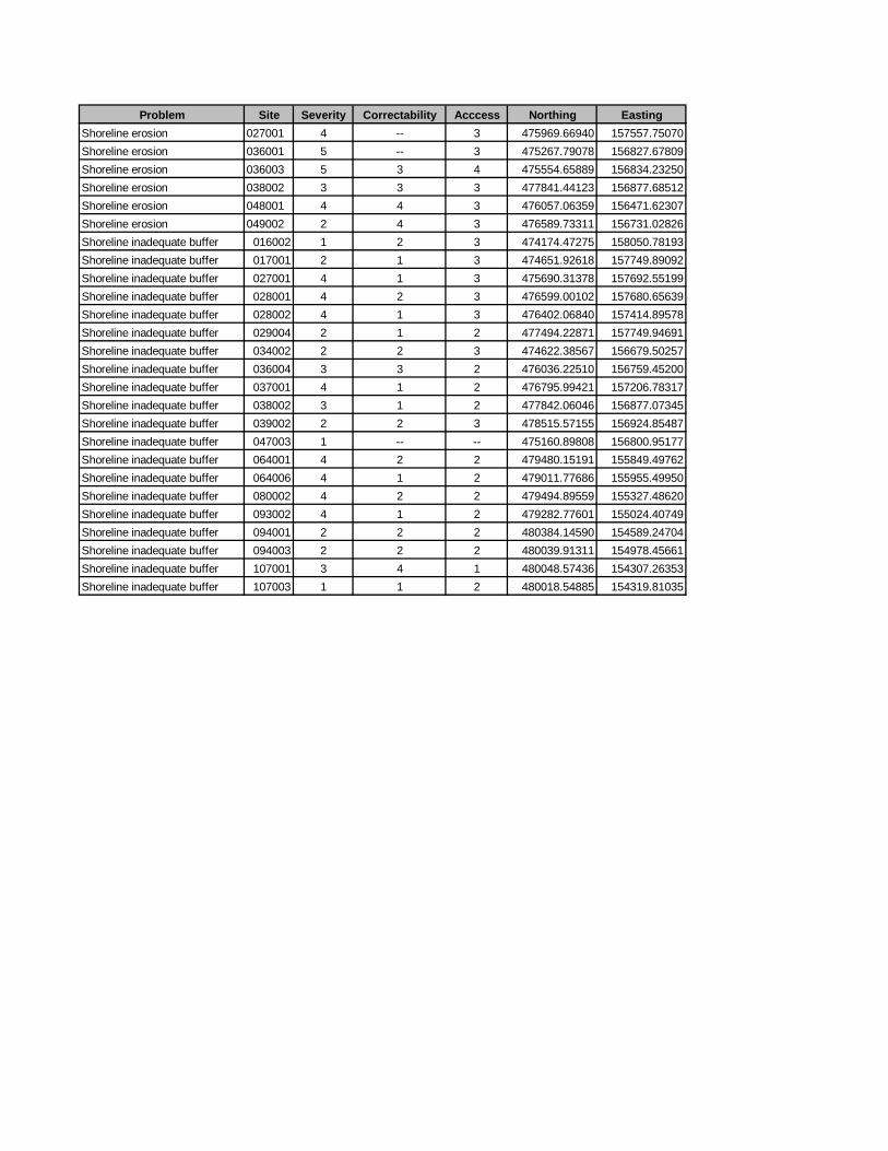
Problem Site Severity Correctability Acccess Northing EastingShoreline erosion 027001 4 -- 3 475969.66940 157557.75070Shoreline erosion 036001 5 -- 3 475267.79078 156827.67809Shoreline erosion 036003 5 3 4 475554.65889 156834.23250Shoreline erosion 038002 3 3 3 477841.44123 156877.68512Shoreline erosion 048001 4 4 3 476057.06359 156471.62307Shoreline erosion 049002 2 4 3 476589.73311 156731.02826Shoreline inadequate buffer 016002 1 2 3 474174.47275 158050.78193Shoreline inadequate buffer 017001 2 1 3 474651.92618 157749.89092Shoreline inadequate buffer 027001 4 1 3 475690.31378 157692.55199Shoreline inadequate buffer 028001 4 2 3 476599.00102 157680.65639Shoreline inadequate buffer 028002 4 1 3 476402.06840 157414.89578Shoreline inadequate buffer 029004 2 1 2 477494.22871 157749.94691Shoreline inadequate buffer 034002 2 2 3 474622.38567 156679.50257Shoreline inadequate buffer 036004 3 3 2 476036.22510 156759.45200Shoreline inadequate buffer 037001 4 1 2 476795.99421 157206.78317Shoreline inadequate buffer 038002 3 1 2 477842.06046 156877.07345Shoreline inadequate buffer 039002 2 2 3 478515.57155 156924.85487Shoreline inadequate buffer 047003 1 -- -- 475160.89808 156800.95177Shoreline inadequate buffer 064001 4 2 2 479480.15191 155849.49762Shoreline inadequate buffer 064006 4 1 2 479011.77686 155955.49950Shoreline inadequate buffer 080002 4 2 2 479494.89559 155327.48620Shoreline inadequate buffer 093002 4 1 2 479282.77601 155024.40749Shoreline inadequate buffer 094001 2 2 2 480384.14590 154589.24704Shoreline inadequate buffer 094003 2 2 2 480039.91311 154978.45661Shoreline inadequate buffer 107001 3 4 1 480048.57436 154307.26353Shoreline inadequate buffer 107003 1 1 2 480018.54885 154319.81035

APPENDIX B: Problem Sites by Category
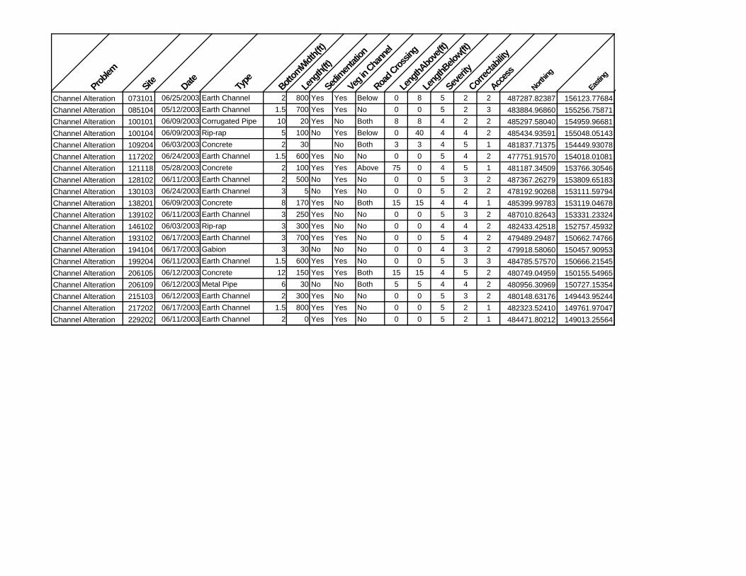
Channel Alterations - Corsica River
Problem
Site
Date Type
Bottom
Width(f
t)
Leng
th(ft)
Sedim
entat
ion
Veg in
Chann
el
Road C
rossin
g
Leng
thAbo
ve(ft)
Leng
thBelo
w(ft)
Severi
ty
Correc
tability
Access
Northin
g
Eastin
g
Channel Alteration 073101 06/25/2003 Earth Channel 2 800 Yes Yes Below 0 8 5 2 2 487287.82387 156123.77684Channel Alteration 085104 05/12/2003 Earth Channel 1.5 700 Yes Yes No 0 0 5 2 3 483884.96860 155256.75871Channel Alteration 100101 06/09/2003 Corrugated Pipe 10 20 Yes No Both 8 8 4 2 2 485297.58040 154959.96681Channel Alteration 100104 06/09/2003 Rip-rap 5 100 No Yes Below 0 40 4 4 2 485434.93591 155048.05143Channel Alteration 109204 06/03/2003 Concrete 2 30 No Both 3 3 4 5 1 481837.71375 154449.93078Channel Alteration 117202 06/24/2003 Earth Channel 1.5 600 Yes No No 0 0 5 4 2 477751.91570 154018.01081Channel Alteration 121118 05/28/2003 Concrete 2 100 Yes Yes Above 75 0 4 5 1 481187.34509 153766.30546Channel Alteration 128102 06/11/2003 Earth Channel 2 500 No Yes No 0 0 5 3 2 487367.26279 153809.65183Channel Alteration 130103 06/24/2003 Earth Channel 3 5 No Yes No 0 0 5 2 2 478192.90268 153111.59794Channel Alteration 138201 06/09/2003 Concrete 8 170 Yes No Both 15 15 4 4 1 485399.99783 153119.04678Channel Alteration 139102 06/11/2003 Earth Channel 3 250 Yes No No 0 0 5 3 2 487010.82643 153331.23324Channel Alteration 146102 06/03/2003 Rip-rap 3 300 Yes No No 0 0 4 4 2 482433.42518 152757.45932Channel Alteration 193102 06/17/2003 Earth Channel 3 700 Yes Yes No 0 0 5 4 2 479489.29487 150662.74766Channel Alteration 194104 06/17/2003 Gabion 3 30 No No No 0 0 4 3 2 479918.58060 150457.90953Channel Alteration 199204 06/11/2003 Earth Channel 1.5 600 Yes Yes No 0 0 5 3 3 484785.57570 150666.21545Channel Alteration 206105 06/12/2003 Concrete 12 150 Yes Yes Both 15 15 4 5 2 480749.04959 150155.54965Channel Alteration 206109 06/12/2003 Metal Pipe 6 30 No No Both 5 5 4 4 2 480956.30969 150727.15354Channel Alteration 215103 06/12/2003 Earth Channel 2 300 Yes No No 0 0 5 3 2 480148.63176 149443.95244Channel Alteration 217202 06/17/2003 Earth Channel 1.5 800 Yes Yes No 0 0 5 2 1 482323.52410 149761.97047Channel Alteration 229202 06/11/2003 Earth Channel 2 0 Yes Yes No 0 0 5 2 1 484471.80212 149013.25564

Exposed Pipes - Corsica River
Problem
Site
Date Locat
ion of
Pipe
Type
Diamete
r(in)
Leng
th(ft)
Purpo
se
Discha
rge
Color
Odor
Severi
ty
Correc
tability
Access
Northin
g
Eastin
g
Exposed Pipe 021101 06/24/2003 Across Bottom of Stream Smooth Metal 3 8 Unknown No 5 2 1 478239.88615 158132.56387Exposed Pipe 112201 06/09/2003 Along Stream Bank Plastic 2 300 Unknown No 4 2 1 484317.61174 154166.98508Exposed Pipe 121108 05/28/2003 Across Bottom of Stream Concrete 36 12 Sewage No 2 5 2 481178.64790 153786.71702Exposed Pipe 121112 05/28/2003 Along Stream Bank Smooth Metal 6 15 Unknown No 5 5 1 481184.23289 153782.99174Exposed Pipe 144201 06/12/2003 Along Bottom of Bridge Smooth Metal 8 30 Unknown No 5 2 1 480313.86628 152827.11030

Erosion Sites - Corsica River
Problem
Site
Date Type
Possib
le Cau
se
Leng
th(ft)
Height(
ft)
Land
useri
ght
Land
usele
ft
Threa
t to In
frastr
uctur
e?
Severi
ty
Correc
tability
Access
Northin
g
Easting
Erosion Site 005102 06/25/2003 Widening Bend at Steep Slope 900 3 Forest Forest No 4 2 2 478529.14942 159149.92792Erosion Site 005104 06/25/2003 Widening Bend at Steep Slope 100 6 Forest Forest No 4 2 2 478375.87775 159049.30406Erosion Site 021102 06/25/2003 Widening Bend at Steep Slope 15 5 Forest Forest No 4 2 2 478220.80562 158157.00528Erosion Site 021103 06/25/2003 Widening Natural 1037 4 Forest Forest No 1 2 2 478273.85936 158123.11526Erosion Site 053201 07/01/2003 Downcutting Below Road Crossing 620 2 Crop Field Forest No 4 2 3 480439.58079 156724.06656Erosion Site 054102 07/01/2003 Widening Bend at Steep Slope 470 4 Crop Field Crop Field No 3 2 3 481145.57043 156458.41790Erosion Site 054103 07/01/2003 Widening Bend at Steep Slope 300 4 Crop Field Crop Field No 3 3 3 481124.88756 156564.19650Erosion Site 054104 07/01/2003 Widening Bend at Steep Slope 475 4 Crop Field Crop Field No 3 3 3 480919.82028 156401.58302Erosion Site 054106 07/01/2003 Widening Bend at Steep Slope 260 5 Crop Field Crop Field No 4 3 3 480745.14165 156370.18865Erosion Site 061101 06/24/2003 Widening Bend at Steep Slope 4380 1 Forest Forest No 2 2 4 476500.01639 155890.60424Erosion Site 066202 07/01/2003 Downcutting Bend at Steep Slope 700 4 Forest Forest No 3 3 3 480949.81592 155900.85595Erosion Site 066203 07/07/2003 Downcutting Bend at Steep Slope 1000 1.5 Forest Forest No 2 2 4 480729.10702 155993.84047Erosion Site 085105 05/12/2003 Widening Unknown 400 3 Crop Field Crop Field No 4 3 3 483610.59651 155230.05301Erosion Site 091201 06/24/2003 Downcutting Bend at Steep Slope 140 2 Forest Forest No 5 2 3 477709.59768 154632.09540Erosion Site 091203 06/24/2003 Downcutting Bend at Steep Slope 3200 1 Forest Forest No 2 2 2 477850.18451 154818.62293Erosion Site 096212 06/03/2003 Widening Bend at Steep Slope 770 3 Forest Forest No 4 3 3 481788.46828 154855.08679Erosion Site 098103 05/12/2003 Headcutting Instream Debris 120 3 Crop Field Crop Field No 5 1 3 483733.35956 155079.96659Erosion Site 098104 05/12/2003 Widening Bend at Steep Slope 1720 2 Forest Forest No 2 3 4 483753.32419 155047.58784Erosion Site 099101 06/09/2003 Widening Bend at Steep Slope 75 12 Crop Field Forest No 4 3 2 484302.08562 154708.40466Erosion Site 099103 06/09/2003 Widening Bend at Steep Slope 50 5 Crop Field Forest No 4 2 2 484668.03869 154773.41570Erosion Site 099105 06/09/2003 Widening Bend at Steep Slope 20 4 Crop Field Forest No 4 1 2 485019.91836 154807.82206Erosion Site 099106 06/25/2003 Widening Bend at Steep Slope 25 4 Forest Forest No 4 2 2 484684.12656 155093.02272Erosion Site 105202 06/24/2003 Widening Bend at Steep Slope 800 2 Forest Lawn No 4 2 2 478349.00138 154346.73956Erosion Site 109102 05/27/2003 Widening Land Use Change Upstream 1720 3 Forest Forest No 2 4 3 482281.46437 154501.75225Erosion Site 109202 06/03/2003 Widening Bend at Steep Slope 310 2 Forest Forest No 4 1 5 482269.42632 154494.40496Erosion Site 109203 06/03/2003 Widening Bend at Steep Slope 1480 2 Forest Forest No 2 3 2 481746.18972 154456.85558Erosion Site 110101 05/27/2003 Widening Bend at Steep Slope 1390 1 Forest Forest No 2 2 3 483316.67297 154160.36175Erosion Site 110201 06/03/2003 Widening Bend at Steep Slope 3080 2 Forest Forest No 2 3 4 482696.02919 154569.12030Erosion Site 111101 06/09/2003 Widening Bend at Steep Slope 50 5 Pasture Forest No 4 2 3 483870.57703 154569.18926Erosion Site 111103 06/09/2003 Widening Bend at Steep Slope 50 10 Crop Field Forest No 4 2 3 484074.33006 154588.12496Erosion Site 118101 06/24/2003 Widening Natural 2060 2.5 Lawn Forest No 2 2 2 478159.23888 153590.06877Erosion Site 118105 06/24/2003 Widening Bend at Steep Slope 20 5 Forest Forest No 4 4 4 478708.10938 153647.81715Erosion Site 121101 05/28/2003 Widening Land Use Change Upstream 600 3 Pasture Pasture No 4 3 2 481026.28102 153905.92573Erosion Site 124201 06/09/2003 Widening Bend at Steep Slope 2280 2 Forest Forest No 2 4 3 483889.97068 153555.86769Erosion Site 129101 06/24/2003 Widening Natural 430 2 Pasture Crop Field No 4 2 1 477882.11667 153108.39204Erosion Site 133101 06/03/2003 Widening Bend at Steep Slope 375 5 Forest Forest No 3 4 2 481475.87685 153155.90222

Erosion Sites - Corsica River
Problem
Site
Date Type
Possib
le Cau
se
Leng
th(ft)
Height(
ft)
Land
useri
ght
Land
usele
ft
Threa
t to In
frastr
uctur
e?
Severi
ty
Correc
tability
Access
Northin
g
Easting
Erosion Site 134103 06/03/2003 Widening Natural 500 2 Forest Forest No 4 3 2 481598.03592 153087.12637Erosion Site 134105 06/03/2003 Widening Bend at Steep Slope 570 4 Forest Forest No 3 4 2 481749.48384 153322.25860Erosion Site 138101 06/11/2003 Widening Bend at Steep Slope 1725 3 Crop Field Crop Field No 2 3 3 486131.51896 153051.48787Erosion Site 138106 06/11/2003 Widening Bend at Steep Slope 290 3 Crop Field Crop Field No 5 3 2 485629.61252 153040.56525Erosion Site 138202 06/09/2003 Widening Below Channelization 7230 4 Forest Forest No 1 5 4 485411.67441 153108.35173Erosion Site 139107 06/11/2003 Widening Natural 30 3 Crop Field Crop Field No 5 2 2 486678.79610 153173.24097Erosion Site 143202 06/17/2003 Widening Below Road Crossing 4600 3 Forest Forest No 2 5 1 479164.76660 152541.59946Erosion Site 144102 06/17/2003 Widening Bend at Steep Slope 45 5 Crop Field Crop Field No 4 2 3 480140.45043 152631.48987Erosion Site 146103 06/03/2003 Widening Bend at Steep Slope 3060 2 Forest Forest No 2 3 4 482417.43865 152773.14909Erosion Site 149201 06/09/2003 Widening Land Use Change Upstream 1715 1 Forest Forest No 2 2 4 484805.08461 152791.35282Erosion Site 150101 06/11/2003 Widening Bend at Steep Slope 480 4 Crop Field Crop Field No 3 3 3 485841.35072 152928.78478Erosion Site 156203 06/17/2003 Widening Below Road Crossing 1630 2 Pasture Pasture No 2 2 2 479179.05176 152097.33346Erosion Site 158201 06/12/2003 Downcutting Bend at Steep Slope 500 1 Forest Forest No 4 1 3 480920.17596 152281.56874Erosion Site 160102 06/03/2003 Widening Below Road Crossing 3430 4 Crop Field Forest No 1 4 2 483366.03291 152370.47068Erosion Site 163101 06/11/2003 Widening Natural 230 3 Crop Field Crop Field No 5 3 3 485924.41110 152378.63760Erosion Site 170102 06/17/2003 Widening Natural 545 2 Crop Field Crop Field No 4 3 3 480472.35699 151498.21801Erosion Site 182101 06/17/2003 Widening Bend at Steep Slope 550 3 Crop Field Crop Field No 4 3 3 480164.88646 151278.92325Erosion Site 195201 06/17/2003 Widening Below Road Crossing 1000 1 Forest Forest No 2 3 3 481569.20548 150501.19237Erosion Site 195205 06/17/2003 Widening Below Road Crossing 3700 1 Forest Forest No 2 3 4 481428.66325 150781.71866Erosion Site 198201 06/11/2003 Widening Bend at Steep Slope 500 1 Forest Forest No 4 2 2 483699.98804 150783.73714Erosion Site 207203 06/17/2003 Widening Below Road Crossing 560 1 Forest Forest No 4 2 2 481810.62734 150157.90711
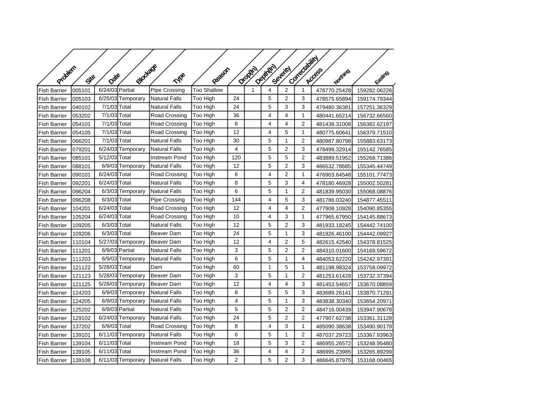
Problem
Site
Date Blockag
e
Type
Reason
Drop(In
)
Depth(
In)
Severi
ty
Correc
tability
Access
Northin
g
Eastin
g
Fish Barrier 005101 6/24/03 Partial Pipe Crossing Too Shallow 1 4 2 1 478770.25428 159282.06226Fish Barrier 005103 6/25/03 Temporary Natural Falls Too High 24 5 2 3 478575.65894 159174.79344Fish Barrier 040102 7/1/03 Total Natural Falls Too High 24 5 3 3 479480.36381 157251.36329Fish Barrier 053202 7/1/03 Total Road Crossing Too High 36 4 4 1 480441.65214 156732.66560Fish Barrier 054101 7/1/03 Total Road Crossing Too High 6 4 4 2 481438.31008 156382.62197Fish Barrier 054105 7/1/03 Total Road Crossing Too High 12 4 5 1 480775.60641 156379.71510Fish Barrier 066201 7/1/03 Total Natural Falls Too High 30 5 1 2 480987.80798 155883.63173Fish Barrier 079201 6/24/03 Temporary Natural Falls Too High 4 5 2 3 478499.32914 155142.76585Fish Barrier 085101 5/12/03 Total Instream Pond Too High 120 5 5 2 483889.51952 155268.71386Fish Barrier 088101 6/9/03 Temporary Natural Falls Too High 12 5 2 3 486532.78685 155345.44749Fish Barrier 090101 6/24/03 Total Road Crossing Too High 6 4 2 1 476903.64548 155101.77473Fish Barrier 092201 6/24/03 Total Natural Falls Too High 8 5 3 4 478180.46928 155002.50281Fish Barrier 096204 6/3/03 Temporary Natural Falls Too High 6 5 1 2 481839.95030 155068.08876Fish Barrier 096208 6/3/03 Total Pipe Crossing Too High 144 4 5 3 481786.03240 154877.45511Fish Barrier 104201 6/24/03 Total Road Crossing Too High 12 4 4 2 477908.10928 154090.85355Fish Barrier 105204 6/24/03 Total Road Crossing Too High 10 4 3 1 477965.67950 154145.88673Fish Barrier 109205 6/3/03 Total Natural Falls Too High 12 5 2 3 481933.18245 154442.74100Fish Barrier 109206 6/3/03 Total Beaver Dam Too High 24 5 1 3 481926.46100 154442.09927Fish Barrier 110104 5/27/03 Temporary Beaver Dam Too High 12 4 2 5 482615.42540 154378.81525Fish Barrier 111201 6/9/03 Partial Natural Falls Too High 3 5 2 2 484310.01600 154169.59672Fish Barrier 111203 6/9/03 Temporary Natural Falls Too High 6 5 1 4 484053.62220 154242.97391Fish Barrier 121122 5/28/03 Total Dam Too High 60 1 5 1 481198.98324 153758.09972Fish Barrier 121123 5/28/03 Temporary Beaver Dam Too High 3 5 1 2 481253.61428 153732.37394Fish Barrier 121125 5/28/03 Temporary Beaver Dam Too High 12 4 4 3 481453.54657 153670.08859Fish Barrier 124203 6/9/03 Temporary Natural Falls Too High 8 5 5 3 483689.26141 153870.71291Fish Barrier 124205 6/9/03 Temporary Natural Falls Too High 4 5 1 3 483838.30340 153654.20971Fish Barrier 125202 6/9/03 Partial Natural Falls Too High 5 5 2 2 484716.00439 153947.90678Fish Barrier 129102 6/24/03 Temporary Natural Falls Too High 24 5 2 2 477907.62738 153361.31128Fish Barrier 137202 6/9/03 Total Road Crossing Too High 8 4 3 1 485090.38638 153490.90179Fish Barrier 139101 6/11/03 Temporary Natural Falls Too High 6 5 1 2 487037.29723 153367.93963Fish Barrier 139104 6/11/03 Total Instream Pond Too High 18 5 3 2 486955.26572 153248.95480Fish Barrier 139105 6/11/03 Total Instream Pond Too High 36 4 4 2 486995.23985 153265.89299Fish Barrier 139108 6/11/03 Temporary Natural Falls Too High 2 5 2 3 486645.87975 153168.00465

Problem
Site
Date Blockag
e
Type
Reason
Drop(In
)
Depth(
In)
Severi
ty
Correc
tability
Access
Northin
g
Eastin
g
Fish Barrier 143201 6/17/03 Total Road Crossing Too High 18 4 4 1 479163.13255 152536.24479Fish Barrier 144105 6/17/03 Partial Natural Falls Too High 18 5 2 2 480246.68188 152895.05697Fish Barrier 144107 6/17/03 Partial Natural Falls Too High 24 5 3 2 480253.15597 152903.53964Fish Barrier 147102 6/3/03 Temporary Natural Falls Too High 8 5 1 3 482985.59450 152566.20147Fish Barrier 150108 6/11/03 Temporary Natural Falls Too High 12 5 1 2 485297.52613 152536.03606Fish Barrier 156202 6/17/03 Total Road Crossing Too High 48 4 4 2 479173.47609 152086.42188Fish Barrier 158203 6/12/03 Total Pipe Crossing Too High 12 4 4 3 481253.39382 152275.24228Fish Barrier 163102 6/11/03 Temporary Natural Falls Too High 12 5 3 3 485937.86600 152318.88851Fish Barrier 171201 6/12/03 Temporary Beaver Dam Too High 8 5 2 4 480865.02475 151871.17491Fish Barrier 182103 6/17/03 Temporary Natural Falls Too High 8 5 2 3 480277.79344 151342.93451Fish Barrier 182109 6/17/03 Total Road Crossing Too High 24 4 4 1 479943.89318 150938.14681Fish Barrier 186201 6/11/03 Temporary Natural Falls Too High 18 5 5 1 483868.90499 151017.70172Fish Barrier 194105 6/17/03 Total Instream Pond Too High 60 4 5 2 479913.97047 150434.38291Fish Barrier 195203 6/17/03 Total Natural Falls Too High 12 5 3 4 481557.74075 150656.12988Fish Barrier 207202 6/17/03 Total Road Crossing Too High 12 4 4 2 481873.47191 150123.78135Fish Barrier 207205 6/17/03 Total Channelized Too Shallow 0.5 4 5 1 481682.64027 150270.79430Fish Barrier 208101 6/17/03 Total Instream Pond Too High 60 4 5 2 483313.31089 150116.09552Fish Barrier 215101 6/12/03 Total Instream Pond Too High 36 4 4 2 480361.54215 149340.76443Fish Barrier 234101 6/12/03 Total Instream Pond Too High 60 4 5 2 482124.32777 148566.92680

Proble
m
Site
Date Sides
Unsha
ded
WidthL
eft(ft)
WidthR
ight(ft
)
Leng
thLeft
(ft)
Leng
thRigh
t(ft)
Land
UseLeft
Land
UseRigh
t
Recentl
yestab
lished
Livest
ock
Livest
ock T
ype
Severity
Correc
tability
Access
Wetland
Northin
g
Easting
Inadequate Buffer 073102 06/24/2003 Both Both 2 2 670 670 Crop Field Crop Field No No 4 2 2 5 487324.48360 156253.91220Inadequate Buffer 085103 05/12/2003 Both Neither 20 20 770 770 Shrubs & Small Trees Shrubs & Small Trees Yes No 4 2 3 2 483889.69823 155269.16929Inadequate Buffer 090102 06/24/2003 Both Neither 5 5 1350 1350 Crop Field Crop Field No No 2 3 2 5 476914.31444 154718.51721Inadequate Buffer 096201 06/03/2003 Right Neither 10 115 Forest Lawn No No 5 2 2 5 481848.41354 155079.27142Inadequate Buffer 096205 06/03/2003 Left Left 20 110 Lawn Forest No No 5 2 3 3 481784.37189 154918.26414Inadequate Buffer 097202 06/03/2003 Right Neither 10 70 Forest Construction Site No No 5 2 4 5 482957.37972 154999.72108Inadequate Buffer 098102 05/12/2003 Right Neither 15 860 Forest Crop Field No No 4 2 3 3 483560.29680 155269.22311Inadequate Buffer 110102 05/27/2003 Right Neither 15 300 Forest Crop Field No No 5 1 4 4 482874.47408 154313.59861Inadequate Buffer 111102 06/09/2003 Left Neither 30 115 Crop Field Forest No No 5 3 3 4 483914.75464 154572.59562Inadequate Buffer 113101 06/25/2003 Both Both 15 0 180 180 Crop Field Lawn No No 5 2 1 5 485299.83808 154547.37726Inadequate Buffer 117201 06/24/2003 Both Both 2 2 1175 1175 Crop Field Crop Field No No 2 3 2 5 477567.10596 153974.92825Inadequate Buffer 121102 05/28/2003 Both Both 10 10 980 400 Pasture Pasture No No 4 4 2 4 481262.90854 153728.41608Inadequate Buffer 121124 05/28/2003 Right Neither 10 270 Forest Lawn No No 4 1 2 5 481349.21194 153702.73266Inadequate Buffer 124206 06/09/2003 Both Neither 20 20 300 300 Crop Field Crop Field No No 5 2 2 4 483897.55786 153550.62599Inadequate Buffer 128101 06/11/2003 Both Both 0 0 1615 1615 Crop Field Crop Field No No 1 4 2 2 487369.54969 153814.12273Inadequate Buffer 130102 06/24/2003 Both Both 3 7 1000 1000 Crop Field Crop Field No No 2 2 2 5 478222.79815 152794.94403Inadequate Buffer 138109 06/11/2003 Both Both 0 0 150 150 Crop Field Crop Field No No 5 3 2 4 485461.14302 153037.43576Inadequate Buffer 139103 06/11/2003 Right Neither 15 260 Crop Field Crop Field No No 5 2 2 3 486996.30934 153311.30662Inadequate Buffer 143203 06/17/2003 Both Neither 10 10 340 340 Lawn Lawn No No 4 3 1 3 479166.60471 152547.61648Inadequate Buffer 144103 06/17/2003 Right Neither 15 130 Crop Field Lawn No No 5 3 2 3 480184.04887 152746.67198Inadequate Buffer 144203 06/12/2003 Both Both 10 10 350 350 Shrubs & Small Trees Shrubs & Small Trees No No 4 2 1 4 480301.12875 152836.68228Inadequate Buffer 146101 06/03/2003 Left Left 0 140 Railroad Track Forest No No 4 4 2 5 482465.02387 152743.78275Inadequate Buffer 149205 06/09/2003 Both Neither 6 6 850 850 Crop Field Crop Field No No 2 3 2 4 484800.83813 152788.55550Inadequate Buffer 156201 06/17/2003 Both Neither 3 3 870 870 Pasture Pasture No No 2 3 1 3 479013.28862 151747.93218Inadequate Buffer 158204 06/12/2003 Both Neither 15 15 850 850 Crop Field Crop Field No No 5 3 3 4 481536.83336 152271.47535Inadequate Buffer 182104 06/17/2003 Right Right 0 75 Crop Field Crop Field No No 5 3 2 4 480103.26105 151224.57895Inadequate Buffer 182106 06/17/2003 Both Both 0 0 85 90 Lawn Lawn No No 5 3 2 3 480081.71151 151196.94661Inadequate Buffer 193103 06/17/2003 Both Both 0 0 1575 1575 Crop Field Crop Field No No 1 3 2 2 479295.80977 150655.91982Inadequate Buffer 194103 03/17/2003 Both Neither 20 30 105 105 Crop Field Crop Field No No 5 3 2 2 479910.38751 150416.56457Inadequate Buffer 199203 06/11/2003 Both Both 10 10 1220 1220 Crop Field Crop Field No No 2 3 3 4 484786.76284 150675.58065Inadequate Buffer 207204 06/17/2003 Right Neither 10 975 Forest Crop Field No No 3 3 2 3 481865.35368 150126.34970Inadequate Buffer 215102 06/12/2003 Both Both 0 0 785 785 Crop Field Pasture No Yes Horses 3 3 2 3 480147.51220 149445.15135Inadequate Buffer 217201 06/17/2003 Both Both 1 1 1050 1050 Crop Field Crop Field No No 2 3 1 3 482359.83447 149747.72904Inadequate Buffer 229201 06/11/2003 Both Both 10 10 2165 2165 Crop Field Crop Field No No 2 3 1 4 484471.84670 149013.27146

Problem
Site Date Type
of Activ
ity
Sedim
ent C
ontro
l
Why, if
inade
quate
Exces
s Sed
imen
t?
Leng
thCom
pany
Locat
ion
Severity
Northin
g
Easting
In/Near Stream Construction 096101 05/27/2003 Residential Development Adequate Yes 1700 David A. Bramble, Inc. Tributary off Three Bridges Branch 1 482352.23314 155054.82387In/Near Stream Construction 097203 06/03/2003 Residential Development Adequate No 1800 Barkers Tributary of Three Bridges Branch 5 482956.75727 154998.51581In/Near Stream Construction 121103 05/28/2003 Residential Development Adequate No 500 Unknown Gravel Run under 213 Dam 4 481074.35753 153855.21934In/Near Stream Construction 182105 06/17/2003 Logging Inadequate No Controls Present Yes 150 Unknown 3 480113.76770 151236.19807
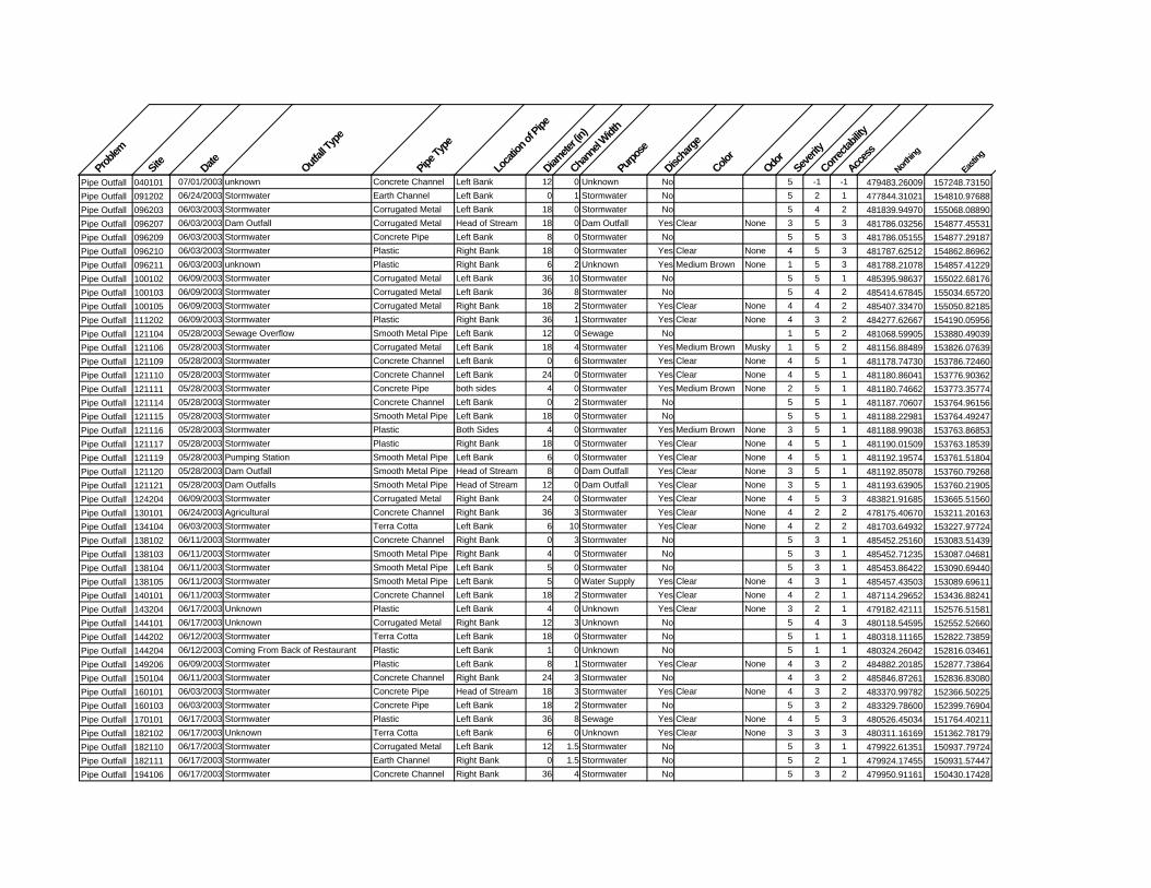
Problem
Site Date Outfall
Type
Pipe T
ype
Locat
ion of
Pipe
Diamete
r (in)
Chann
el Widt
h
Purpo
se
Discha
rge
Color
Odor
Severity
Correct
ability
Access
Northin
g
Easting
Pipe Outfall 040101 07/01/2003 unknown Concrete Channel Left Bank 12 0 Unknown No 5 -1 -1 479483.26009 157248.73150Pipe Outfall 091202 06/24/2003 Stormwater Earth Channel Left Bank 0 1 Stormwater No 5 2 1 477844.31021 154810.97688Pipe Outfall 096203 06/03/2003 Stormwater Corrugated Metal Left Bank 18 0 Stormwater No 5 4 2 481839.94970 155068.08890Pipe Outfall 096207 06/03/2003 Dam Outfall Corrugated Metal Head of Stream 18 0 Dam Outfall Yes Clear None 3 5 3 481786.03256 154877.45531Pipe Outfall 096209 06/03/2003 Stormwater Concrete Pipe Left Bank 8 0 Stormwater No 5 5 3 481786.05155 154877.29187Pipe Outfall 096210 06/03/2003 Stormwater Plastic Right Bank 18 0 Stormwater Yes Clear None 4 5 3 481787.62512 154862.86962Pipe Outfall 096211 06/03/2003 unknown Plastic Right Bank 6 2 Unknown Yes Medium Brown None 1 5 3 481788.21078 154857.41229Pipe Outfall 100102 06/09/2003 Stormwater Corrugated Metal Left Bank 36 10 Stormwater No 5 5 1 485395.98637 155022.68176Pipe Outfall 100103 06/09/2003 Stormwater Corrugated Metal Left Bank 36 8 Stormwater No 5 4 2 485414.67845 155034.65720Pipe Outfall 100105 06/09/2003 Stormwater Corrugated Metal Right Bank 18 2 Stormwater Yes Clear None 4 4 2 485407.33470 155050.82185Pipe Outfall 111202 06/09/2003 Stormwater Plastic Right Bank 36 1 Stormwater Yes Clear None 4 3 2 484277.62667 154190.05956Pipe Outfall 121104 05/28/2003 Sewage Overflow Smooth Metal Pipe Left Bank 12 0 Sewage No 1 5 2 481068.59905 153880.49039Pipe Outfall 121106 05/28/2003 Stormwater Corrugated Metal Left Bank 18 4 Stormwater Yes Medium Brown Musky 1 5 2 481156.88489 153826.07639Pipe Outfall 121109 05/28/2003 Stormwater Concrete Channel Left Bank 0 6 Stormwater Yes Clear None 4 5 1 481178.74730 153786.72460Pipe Outfall 121110 05/28/2003 Stormwater Concrete Channel Left Bank 24 0 Stormwater Yes Clear None 4 5 1 481180.86041 153776.90362Pipe Outfall 121111 05/28/2003 Stormwater Concrete Pipe both sides 4 0 Stormwater Yes Medium Brown None 2 5 1 481180.74662 153773.35774Pipe Outfall 121114 05/28/2003 Stormwater Concrete Channel Left Bank 0 2 Stormwater No 5 5 1 481187.70607 153764.96156Pipe Outfall 121115 05/28/2003 Stormwater Smooth Metal Pipe Left Bank 18 0 Stormwater No 5 5 1 481188.22981 153764.49247Pipe Outfall 121116 05/28/2003 Stormwater Plastic Both Sides 4 0 Stormwater Yes Medium Brown None 3 5 1 481188.99038 153763.86853Pipe Outfall 121117 05/28/2003 Stormwater Plastic Right Bank 18 0 Stormwater Yes Clear None 4 5 1 481190.01509 153763.18539Pipe Outfall 121119 05/28/2003 Pumping Station Smooth Metal Pipe Left Bank 6 0 Stormwater Yes Clear None 4 5 1 481192.19574 153761.51804Pipe Outfall 121120 05/28/2003 Dam Outfall Smooth Metal Pipe Head of Stream 8 0 Dam Outfall Yes Clear None 3 5 1 481192.85078 153760.79268Pipe Outfall 121121 05/28/2003 Dam Outfalls Smooth Metal Pipe Head of Stream 12 0 Dam Outfall Yes Clear None 3 5 1 481193.63905 153760.21905Pipe Outfall 124204 06/09/2003 Stormwater Corrugated Metal Right Bank 24 0 Stormwater Yes Clear None 4 5 3 483821.91685 153665.51560Pipe Outfall 130101 06/24/2003 Agricultural Concrete Channel Right Bank 36 3 Stormwater Yes Clear None 4 2 2 478175.40670 153211.20163Pipe Outfall 134104 06/03/2003 Stormwater Terra Cotta Left Bank 6 10 Stormwater Yes Clear None 4 2 2 481703.64932 153227.97724Pipe Outfall 138102 06/11/2003 Stormwater Concrete Channel Right Bank 0 3 Stormwater No 5 3 1 485452.25160 153083.51439Pipe Outfall 138103 06/11/2003 Stormwater Smooth Metal Pipe Right Bank 4 0 Stormwater No 5 3 1 485452.71235 153087.04681Pipe Outfall 138104 06/11/2003 Stormwater Smooth Metal Pipe Left Bank 5 0 Stormwater No 5 3 1 485453.86422 153090.69440Pipe Outfall 138105 06/11/2003 Stormwater Smooth Metal Pipe Left Bank 5 0 Water Supply Yes Clear None 4 3 1 485457.43503 153089.69611Pipe Outfall 140101 06/11/2003 Stormwater Concrete Channel Left Bank 18 2 Stormwater Yes Clear None 4 2 1 487114.29652 153436.88241Pipe Outfall 143204 06/17/2003 Unknown Plastic Left Bank 4 0 Unknown Yes Clear None 3 2 1 479182.42111 152576.51581Pipe Outfall 144101 06/17/2003 Unknown Corrugated Metal Right Bank 12 3 Unknown No 5 4 3 480118.54595 152552.52660Pipe Outfall 144202 06/12/2003 Stormwater Terra Cotta Left Bank 18 0 Stormwater No 5 1 1 480318.11165 152822.73859Pipe Outfall 144204 06/12/2003 Coming From Back of Restaurant Plastic Left Bank 1 0 Unknown No 5 1 1 480324.26042 152816.03461Pipe Outfall 149206 06/09/2003 Stormwater Plastic Left Bank 8 1 Stormwater Yes Clear None 4 3 2 484882.20185 152877.73864Pipe Outfall 150104 06/11/2003 Stormwater Concrete Channel Right Bank 24 3 Stormwater No 4 3 2 485846.87261 152836.83080Pipe Outfall 160101 06/03/2003 Stormwater Concrete Pipe Head of Stream 18 3 Stormwater Yes Clear None 4 3 2 483370.99782 152366.50225Pipe Outfall 160103 06/03/2003 Stormwater Concrete Pipe Left Bank 18 2 Stormwater No 5 3 2 483329.78600 152399.76904Pipe Outfall 170101 06/17/2003 Stormwater Plastic Left Bank 36 8 Sewage Yes Clear None 4 5 3 480526.45034 151764.40211Pipe Outfall 182102 06/17/2003 Unknown Terra Cotta Left Bank 6 0 Unknown Yes Clear None 3 3 3 480311.16169 151362.78179Pipe Outfall 182110 06/17/2003 Stormwater Corrugated Metal Left Bank 12 1.5 Stormwater No 5 3 1 479922.61351 150937.79724Pipe Outfall 182111 06/17/2003 Stormwater Earth Channel Right Bank 0 1.5 Stormwater No 5 2 1 479924.17455 150931.57447Pipe Outfall 194106 06/17/2003 Stormwater Concrete Channel Right Bank 36 4 Stormwater No 5 3 2 479950.91161 150430.17428
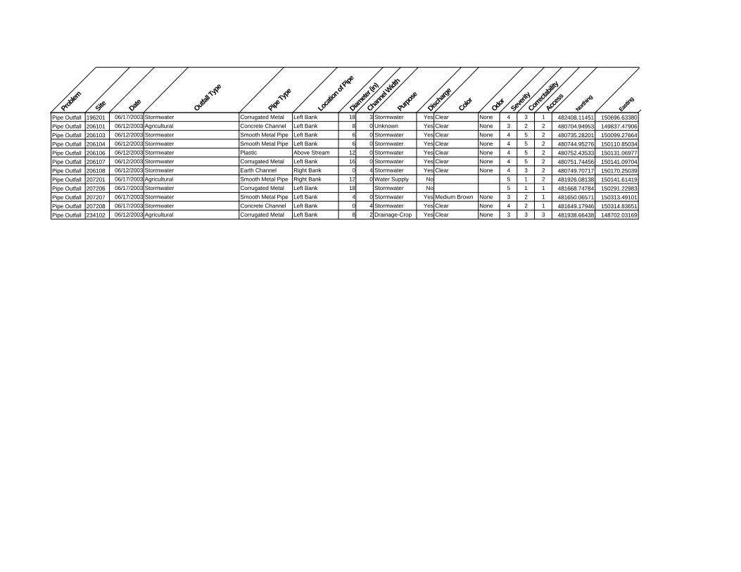
Problem
Site Date Outfall
Type
Pipe T
ype
Locat
ion of
Pipe
Diamete
r (in)
Chann
el Widt
h
Purpo
se
Discha
rge
Color
Odor
Severity
Correct
ability
Access
Northin
g
Easting
Pipe Outfall 196201 06/17/2003 Stormwater Corrugated Metal Left Bank 18 3 Stormwater Yes Clear None 4 3 1 482408.11451 150696.63380Pipe Outfall 206101 06/12/2003 Agricultural Concrete Channel Left Bank 8 0 Unknown Yes Clear None 3 2 2 480704.94953 149837.47906Pipe Outfall 206103 06/12/2003 Stormwater Smooth Metal Pipe Left Bank 6 0 Stormwater Yes Clear None 4 5 2 480735.28201 150099.27664Pipe Outfall 206104 06/12/2003 Stormwater Smooth Metal Pipe Left Bank 6 0 Stormwater Yes Clear None 4 5 2 480744.95276 150110.85034Pipe Outfall 206106 06/12/2003 Stormwater Plastic Above Stream 12 0 Stormwater Yes Clear None 4 5 2 480752.43533 150131.06977Pipe Outfall 206107 06/12/2003 Stormwater Corrugated Metal Left Bank 16 0 Stormwater Yes Clear None 4 5 2 480751.74456 150141.09704Pipe Outfall 206108 06/12/2003 Stormwater Earth Channel Right Bank 0 4 Stormwater Yes Clear None 4 3 2 480749.70717 150170.25039Pipe Outfall 207201 06/17/2003 Agricultural Smooth Metal Pipe Right Bank 12 0 Water Supply No 5 1 2 481926.08138 150141.61419Pipe Outfall 207206 06/17/2003 Stormwater Corrugated Metal Left Bank 18 Stormwater No 5 1 1 481668.74784 150291.22983Pipe Outfall 207207 06/17/2003 Stormwater Smooth Metal Pipe Left Bank 4 0 Stormwater Yes Medium Brown None 3 2 1 481650.06571 150313.49101Pipe Outfall 207208 06/17/2003 Stormwater Concrete Channel Left Bank 0 4 Stormwater Yes Clear None 4 2 1 481649.17946 150314.83651Pipe Outfall 234102 06/12/2003 Agricultural Corrugated Metal Left Bank 8 2 Drainage-Crop Yes Clear None 3 3 3 481938.66438 148702.03169
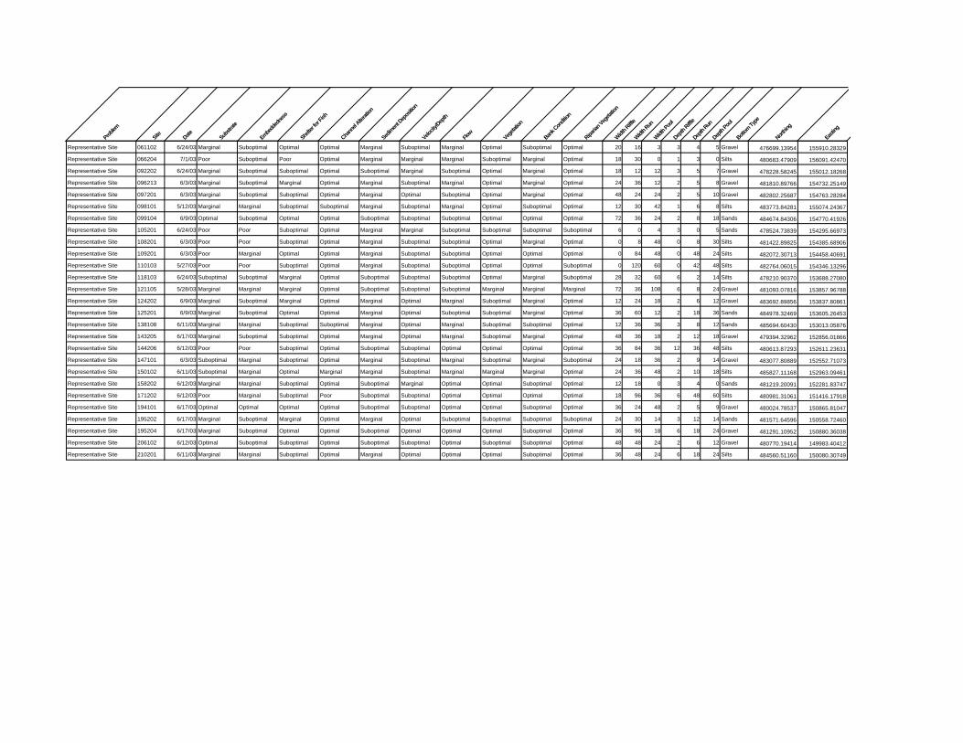
Proble
m
Site Date Substr
ate
Embe
dded
ness
Shelter
for F
ish
Chann
el Alter
ation
Sedim
ent D
epos
ition
Velocity
/Depth
Flow
Vege
tation
Bank C
onditi
on
Riparia
n Veg
etatio
n
Width R
iffle
Width Run
Width Po
ol
Depth
Riffle
Depth
Run
Depth
Pool
Bottom
Type
Northin
g
Eastin
g
Representative Site 061102 6/24/03 Marginal Suboptimal Optimal Optimal Marginal Suboptimal Marginal Optimal Suboptimal Optimal 20 16 3 3 4 5 Gravel 476699.13954 155910.28329
Representative Site 066204 7/1/03 Poor Suboptimal Poor Optimal Marginal Marginal Marginal Suboptimal Marginal Optimal 18 30 0 1 3 0 Silts 480683.47909 156091.42470
Representative Site 092202 6/24/03 Marginal Suboptimal Suboptimal Optimal Suboptimal Marginal Suboptimal Optimal Marginal Optimal 18 12 12 3 5 7 Gravel 478228.58245 155012.18268
Representative Site 096213 6/3/03 Marginal Suboptimal Marginal Optimal Marginal Suboptimal Marginal Optimal Marginal Optimal 24 36 12 2 5 8 Gravel 481810.89766 154732.25149
Representative Site 097201 6/3/03 Marginal Suboptimal Suboptimal Optimal Marginal Optimal Suboptimal Optimal Marginal Optimal 48 24 24 2 5 10 Gravel 482802.25687 154763.28284
Representative Site 098101 5/12/03 Marginal Marginal Suboptimal Suboptimal Marginal Suboptimal Marginal Optimal Suboptimal Optimal 12 30 42 1 6 8 Silts 483773.84281 155074.24367
Representative Site 099104 6/9/03 Optimal Suboptimal Optimal Optimal Suboptimal Suboptimal Suboptimal Optimal Optimal Optimal 72 36 24 2 8 18 Sands 484674.84306 154770.41926
Representative Site 105201 6/24/03 Poor Poor Suboptimal Optimal Marginal Marginal Suboptimal Suboptimal Suboptimal Suboptimal 6 0 4 3 0 5 Sands 478524.73839 154295.66973
Representative Site 108201 6/3/03 Poor Poor Suboptimal Optimal Marginal Suboptimal Suboptimal Optimal Marginal Optimal 0 8 48 0 8 30 Silts 481422.89825 154385.68906
Representative Site 109201 6/3/03 Poor Marginal Optimal Optimal Marginal Suboptimal Suboptimal Optimal Optimal Optimal 0 84 48 0 48 24 Silts 482072.30713 154458.40691
Representative Site 110103 5/27/03 Poor Poor Suboptimal Optimal Marginal Suboptimal Suboptimal Optimal Optimal Suboptimal 0 120 60 0 42 48 Silts 482764.06015 154346.13296
Representative Site 118103 6/24/03 Suboptimal Suboptimal Marginal Optimal Suboptimal Suboptimal Suboptimal Optimal Marginal Suboptimal 28 32 60 6 2 14 Silts 478210.90370 153688.27080
Representative Site 121105 5/28/03 Marginal Marginal Marginal Optimal Suboptimal Suboptimal Suboptimal Marginal Marginal Marginal 72 36 108 6 8 24 Gravel 481093.07816 153857.96788
Representative Site 124202 6/9/03 Marginal Suboptimal Marginal Optimal Marginal Optimal Marginal Suboptimal Marginal Optimal 12 24 18 2 6 12 Gravel 483692.89856 153837.80861
Representative Site 125201 6/9/03 Marginal Suboptimal Optimal Optimal Marginal Optimal Suboptimal Suboptimal Marginal Optimal 36 60 12 2 18 36 Sands 484978.32469 153605.26453
Representative Site 138108 6/11/03 Marginal Marginal Suboptimal Suboptimal Marginal Optimal Marginal Suboptimal Suboptimal Optimal 12 36 36 3 8 12 Sands 485694.60430 153013.05876
Representative Site 143205 6/17/03 Marginal Suboptimal Suboptimal Optimal Marginal Optimal Marginal Suboptimal Marginal Optimal 48 36 18 2 12 18 Gravel 479394.32962 152856.01866
Representative Site 144206 6/12/03 Poor Poor Suboptimal Optimal Suboptimal Suboptimal Optimal Optimal Optimal Optimal 36 84 36 12 36 48 Silts 480613.87293 152611.23631
Representative Site 147101 6/3/03 Suboptimal Marginal Suboptimal Optimal Marginal Suboptimal Marginal Suboptimal Marginal Suboptimal 24 18 36 2 9 14 Gravel 483077.80889 152552.71073
Representative Site 150102 6/11/03 Suboptimal Marginal Optimal Marginal Marginal Suboptimal Marginal Marginal Marginal Optimal 24 36 48 2 10 18 Silts 485827.11168 152963.09461
Representative Site 158202 6/12/03 Marginal Marginal Suboptimal Optimal Suboptimal Marginal Optimal Optimal Suboptimal Optimal 12 18 0 3 4 0 Sands 481219.20091 152281.83747
Representative Site 171202 6/12/03 Poor Marginal Suboptimal Poor Suboptimal Suboptimal Optimal Optimal Optimal Optimal 18 96 36 6 48 60 Silts 480981.31061 151416.17918
Representative Site 194101 6/17/03 Optimal Optimal Optimal Optimal Suboptimal Suboptimal Optimal Optimal Suboptimal Optimal 36 24 48 2 5 9 Gravel 480024.78537 150865.81047
Representative Site 195202 6/17/03 Marginal Suboptimal Marginal Optimal Marginal Optimal Suboptimal Suboptimal Suboptimal Suboptimal 24 30 14 3 12 14 Sands 481571.64596 150558.72460
Representative Site 195204 6/17/03 Marginal Suboptimal Optimal Optimal Suboptimal Optimal Optimal Optimal Suboptimal Optimal 36 96 18 6 18 24 Gravel 481291.10952 150880.36038
Representative Site 206102 6/12/03 Optimal Suboptimal Suboptimal Optimal Suboptimal Suboptimal Optimal Suboptimal Suboptimal Optimal 48 48 24 2 6 12 Gravel 480770.19414 149983.40412
Representative Site 210201 6/11/03 Marginal Marginal Suboptimal Optimal Marginal Optimal Optimal Optimal Suboptimal Optimal 36 48 24 6 18 24 Silts 484560.51160 150080.30749

Problem
Site Date Type
Truck
loads
Other mea
sure
Extent
Volunteer P
rojec
t?
Owner Typ
e
Owner Nam
e
Severi
ty
Correcta
bility
Acces
s
Northing
Eastin
g
Trash Dumping 096202 06/03/2003 Construction 3 Large Area Yes Unknown 5 2 2 481848.41601 155079.27283Trash Dumping 099102 06/09/2003 Lumber/Building Materials 1 Single Site Yes Private 5 1 3 484526.17571 154742.25165Trash Dumping 105203 06/24/2003 Residential 1 Single Site Yes Private 4 1 2 478018.32403 154203.75820Trash Dumping 105205 06/24/2003 Industrial 2 Single Site No Unknown 4 2 2 477949.38694 154130.65821Trash Dumping 118102 06/24/2003 Residential 1 Single Site Yes Private 4 2 2 478192.70640 153652.42451Trash Dumping 144106 06/17/2003 Cars/Buses 30 40-50 Cars, junkyard Large Area No Private 3 4 2 480225.45082 152877.98282Trash Dumping 144205 06/12/2003 Tires 3 Single Site No Unknown 4 4 3 480594.82591 152621.86625Trash Dumping 147103 06/03/2003 Lumber 1 Single Site Yes Private 5 3 3 482628.41650 152666.22627

Proble
m
Site Date Type
Descrip
tion
Potenti
al Cau
se
Severity
Correc
tability
Access
Northin
g
Eastin
g
Comment 038002 10/06/2003 SE Healing over w/ trees and toe protection 0 477737.32284 156898.74493Unusual Condition 085102 05/12/2003 Red Flock Red Flock In Stream below instream pond 3 3 2 483888.17699 155265.17081Unusual Condition 098105 05/12/2003 Black Organic Material Stream has large amount of black organic material present 4 3 3 483810.03459 154954.49780Unusual Condition 109101 05/27/2003 Excessive Sediment Whole Tributary w/excessive sediment from upstream construction Upstream Construction 4 4 3 482306.36301 154558.37359Unusual Condition 118104 06/24/2003 Scum Orange Scum Washing into Stream 5 3 3 478558.32935 153918.38196Unusual Condition 121107 05/28/2003 Orange Substance Leaking from Bank Musky Smelling Seep 3ft long, 10 inches wide Land Use Change Upstream 2 2 2 481165.78395 153810.35795Unusual Condition 134101 06/03/2003 Red Flock Discharge from Bank Runoff 4 3 2 482043.08906 153330.56767Unusual Condition 134106 06/03/2003 Red Flock Excessive Red Flock Present Iron Oxides 3 3 2 481813.72029 153398.73723Unusual Condition 139106 06/11/2003 Channel Discharging into Stream Dark Brown Discharge in Channel entering stream Unknown 3 3 2 486952.56292 153251.14922Unusual Condition 143206 06/17/2003 Orange Substance Leaking from Bank
Orange Substance leaking from bank in many different places along section of bank Runoff from field 3 4 3 479398.68913 152855.82597
Unusual Condition 150106 06/11/2003 Water Color/Clarity Water dark brown/red in color - darkens as you proceed upstream Runoff 4 2 3 485434.27468 152805.75886Unusual Condition 220201 06/11/2003 Red Flock Field Drainage 4 4 1 484674.61487 149348.19627
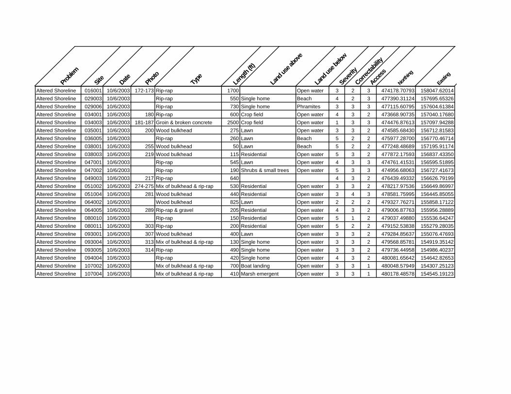
Proble
m
Site
Date Photo
Type
Leng
th (ft)
Land
use a
bove
Land
use b
elow
Severi
ty
Correc
tability
Access
Northin
g
Eastin
g
Altered Shoreline 016001 10/6/2003 172-173 Rip-rap 1700 Open water 3 2 3 474178.70793 158047.62014Altered Shoreline 029003 10/6/2003 Rip-rap 550 Single home Beach 4 2 3 477390.31124 157695.65326Altered Shoreline 029006 10/6/2003 Rip-rap 730 Single home Phramites 3 3 3 477115.60795 157604.61384Altered Shoreline 034001 10/6/2003 180 Rip-rap 600 Crop field Open water 4 3 2 473668.90735 157040.17680Altered Shoreline 034003 10/6/2003 181-187 Groin & broken concrete 2500 Crop field Open water 1 3 3 474476.87613 157097.94288Altered Shoreline 035001 10/6/2003 200 Wood bulkhead 275 Lawn Open water 3 3 2 474585.68430 156712.81583Altered Shoreline 036005 10/6/2003 Rip-rap 260 Lawn Beach 5 2 2 475977.28700 156770.46714Altered Shoreline 038001 10/6/2003 255 Wood bulkhead 50 Lawn Beach 5 2 2 477248.48689 157195.91174Altered Shoreline 038003 10/6/2003 219 Wood bulkhead 115 Residential Open water 5 3 2 477872.17593 156837.43350Altered Shoreline 047001 10/6/2003 Rip-rap 545 Lawn Open water 4 3 3 474761.41531 156595.51895Altered Shoreline 047002 10/6/2003 Rip-rap 190 Shrubs & small trees Open water 5 3 3 474956.68063 156727.41673Altered Shoreline 049003 10/6/2003 217 Rip-rap 640 4 3 2 476439.49332 156626.79199Altered Shoreline 051002 10/6/2003 274-275 Mix of bulkhead & rip-rap 530 Residential Open water 3 3 2 478217.97536 156649.86997Altered Shoreline 051004 10/6/2003 281 Wood bulkhead 440 Residential Open water 3 4 3 478581.75995 156445.85055Altered Shoreline 064002 10/6/2003 Wood bulkhead 825 Lawn Open water 2 2 2 479327.76271 155858.17122Altered Shoreline 064005 10/6/2003 289 Rip-rap & gravel 205 Residential Open water 4 3 2 479006.87763 155956.28889Altered Shoreline 080010 10/6/2003 Rip-rap 150 Residential Open water 5 1 2 479037.49880 155536.64247Altered Shoreline 080011 10/6/2003 303 Rip-rap 200 Residential Open water 5 2 2 479152.53838 155279.28035Altered Shoreline 093001 10/6/2003 307 Wood bulkhead 400 Lawn Open water 3 3 2 479284.85637 155076.47693Altered Shoreline 093004 10/6/2003 313 Mix of bulkhead & rip-rap 130 Single home Open water 3 3 2 479568.85781 154919.35142Altered Shoreline 093005 10/6/2003 314 Rip-rap 490 Single home Open water 3 3 2 479736.44958 154986.40237Altered Shoreline 094004 10/6/2003 Rip-rap 420 Single home Open water 4 3 2 480081.65642 154642.82653Altered Shoreline 107002 10/6/2003 Mix of bulkhead & rip-rap 700 Boat landing Open water 3 3 1 480048.57949 154307.25123Altered Shoreline 107004 10/6/2003 Mix of bulkhead & rip-rap 410 Marsh emergent Open water 3 3 1 480178.48578 154545.19123

Proble
m
Site Date Photo
Locat
ion (b
ank)
Leng
th (ft)
Height
(ft)
Land
use a
bove
Land
use b
elow
Threa
t to Inf
rastru
cture?
Shorel
ine ge
ometr
y
Severity
Correct
ability
Access
Northin
g
Eastin
g
Shoreline erosion 017002 10/6/2003 163-164 North 475 2 Crop field Beach No Straight 4 1 3 474578.00745 157816.85271Shoreline erosion 027001 10/6/2003 146 North 410 1.5 Forest Beach No Cove 4 3 475969.66940 157557.75070Shoreline erosion 036001 10/6/2003 212 South 125 2.5 Crop field Beach No Straight 5 3 475267.79078 156827.67809Shoreline erosion 036003 10/6/2003 216 South 130 3 Beach No Straight 5 3 4 475554.65889 156834.23250Shoreline erosion 038002 10/6/2003 266-268 South 690 15 Forest Open water No Cove 3 3 3 477841.44123 156877.68512Shoreline erosion 048001 10/6/2003 238 South 380 12 Crop field Open water No Straight 4 4 3 476057.06359 156471.62307Shoreline erosion 049002 10/6/2003 218 South 1420 10 Lawn/Shrubs & small trees/Single home Emergent marsh/rip-rap 1 ft from house, but not active Meander/Irregular 2 4 3 476589.73311 156731.02826

Problem
Site DatePhoto
Buffer w
idth (ft)
Buffer le
ngth (ft)
Land use
above
Land use
below
Recently es
tablished?
Livestock?
Severity
Correctabilit
y
Access
Weland potential
Northing
Eastin
g
Shoreline inadequate buffer 016002 10/6/2003 175 0 1725 Crop field Open water No 1 2 3 3 474174.47275 158050.78193Shoreline inadequate buffer 017001 10/6/2003 164-165 5 1350 Crop field Open water/Emergent marsh No 2 1 3 1 474651.92618 157749.89092Shoreline inadequate buffer 027001 10/6/2003 10 535 Residential community Emergent marsh No 4 1 3 3 475690.31378 157692.55199Shoreline inadequate buffer 028001 10/6/2003 135-137 50 690 Crop field Emergent marsh No 4 2 3 1 476599.00102 157680.65639Shoreline inadequate buffer 028002 10/6/2003 0 230 Sandy boat landing/Lawn Open water No 4 1 3 1 476402.06840 157414.89578Shoreline inadequate buffer 029004 10/6/2003 10 2240 Emergent marsh/Phragmites No 2 1 2 1 477494.22871 157749.94691Shoreline inadequate buffer 034002 10/6/2003 181, 184-201 20 5430 Crop field/Residential community Altered shoreline No 2 2 3 3 474622.38567 156679.50257Shoreline inadequate buffer 036004 10/6/2003 0 685 Lawn Open water No 3 3 2 2 476036.22510 156759.45200Shoreline inadequate buffer 037001 10/6/2003 248 20 950 Emergent marsh/Phragmites No 4 1 2 2 476795.99421 157206.78317Shoreline inadequate buffer 038002 10/6/2003 255 0 690 Lawn Beach No 3 1 2 2 477842.06046 156877.07345Shoreline inadequate buffer 039002 10/6/2003 80-82 50 1150 Crop field Emergent marsh/Phragmites No 2 2 3 2 478515.57155 156924.85487Shoreline inadequate buffer 047003 10/6/2003 201 0 2075 Residential community Open water No 1 475160.89808 156800.95177Shoreline inadequate buffer 064001 10/6/2003 5 535 Single home Open water/Emergent marsh No 4 2 2 3 479480.15191 155849.49762Shoreline inadequate buffer 064006 10/6/2003 289 15 360 Residential community Open water No 4 1 2 4 479011.77686 155955.49950Shoreline inadequate buffer 080002 10/6/2003 10 760 Residential community Emergent marsh No 4 2 2 3 479494.89559 155327.48620Shoreline inadequate buffer 093002 10/6/2003 50 400 Single home Open water No 4 1 2 3 479282.77601 155024.40749Shoreline inadequate buffer 094001 10/6/2003 24-26 10 1300 Residential community Emergent marsh/Phragmites No 2 2 2 2 480384.14590 154589.24704Shoreline inadequate buffer 094003 10/6/2003 28-33 5 1875 Residential community Emergent marsh/Phragmites No 2 2 2 2 480039.91311 154978.45661Shoreline inadequate buffer 107001 10/6/2003 0 720 Boat landing Open water No 3 4 1 2 480048.57436 154307.26353Shoreline inadequate buffer 107003 10/6/2003 0 1005 Shrubs & small trees Emergent marsh No 1 1 2 3 480018.54885 154319.81035