Corridor Rationale - bogi.evs.anl.gov · Corridor 111-226 Section 368 Energy Corridor Regional...
8
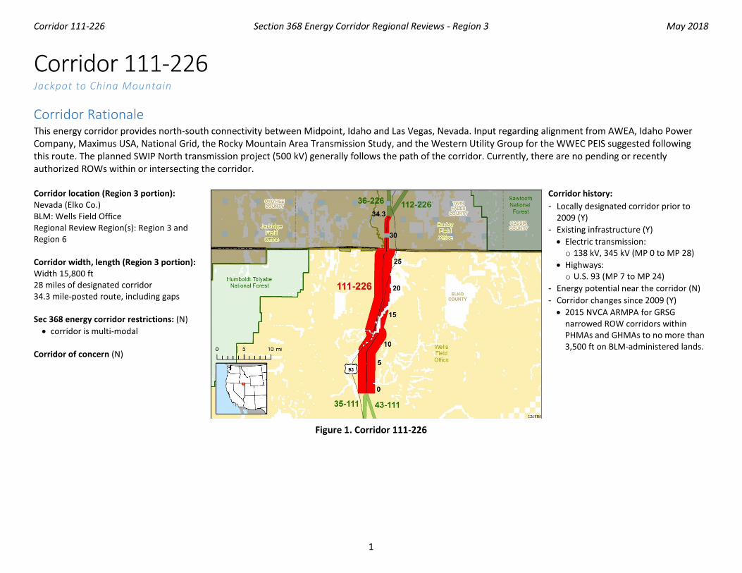
Corridor 111-226 Section 368 Energy Corridor Regional Reviews - Region 3 May 2018 1 Corridor 111-226 Jackpot to China Mountain Corridor Rationale This energy corridor provides north-south connectivity between Midpoint, Idaho and Las Vegas, Nevada. Input regarding alignment from AWEA, Idaho Power Company, Maximus USA, National Grid, the Rocky Mountain Area Transmission Study, and the Western Utility Group for the WWEC PEIS suggested following this route. The planned SWIP North transmission project (500 kV) generally follows the path of the corridor. Currently, there are no pending or recently authorized ROWs within or intersecting the corridor. Corridor location (Region 3 portion): Nevada (Elko Co.) BLM: Wells Field Office Regional Review Region(s): Region 3 and Region 6 Corridor width, length (Region 3 portion): Width 15,800 ft 28 miles of designated corridor 34.3 mile-posted route, including gaps Sec 368 energy corridor restrictions: (N) • corridor is multi-modal Corridor of concern (N) Corridor history: - Locally designated corridor prior to 2009 (Y) - Existing infrastructure (Y) • Electric transmission: o 138 kV, 345 kV (MP 0 to MP 28) • Highways: o U.S. 93 (MP 7 to MP 24) - Energy potential near the corridor (N) - Corridor changes since 2009 (Y) • 2015 NVCA ARMPA for GRSG narrowed ROW corridors within PHMAs and GHMAs to no more than 3,500 ft on BLM-administered lands. Figure 1. Corridor 111-226
-
Upload
nguyennguyet -
Category
Documents
-
view
221 -
download
0
Transcript of Corridor Rationale - bogi.evs.anl.gov · Corridor 111-226 Section 368 Energy Corridor Regional...
Corridor 111-226 Section 368 Energy Corridor Regional Reviews - Region 3 May 2018
1
Corridor 111-226 Jackpot to China Mountain
Corridor Rationale This energy corridor provides north-south connectivity between Midpoint, Idaho and Las Vegas, Nevada. Input regarding alignment from AWEA, Idaho Power Company, Maximus USA, National Grid, the Rocky Mountain Area Transmission Study, and the Western Utility Group for the WWEC PEIS suggested following this route. The planned SWIP North transmission project (500 kV) generally follows the path of the corridor. Currently, there are no pending or recently authorized ROWs within or intersecting the corridor. Corridor location (Region 3 portion): Nevada (Elko Co.) BLM: Wells Field Office Regional Review Region(s): Region 3 and Region 6 Corridor width, length (Region 3 portion): Width 15,800 ft 28 miles of designated corridor 34.3 mile-posted route, including gaps Sec 368 energy corridor restrictions: (N) • corridor is multi-modal
Corridor of concern (N)
Corridor history: - Locally designated corridor prior to
2009 (Y) - Existing infrastructure (Y) • Electric transmission: o 138 kV, 345 kV (MP 0 to MP 28)
• Highways: o U.S. 93 (MP 7 to MP 24)
- Energy potential near the corridor (N) - Corridor changes since 2009 (Y) • 2015 NVCA ARMPA for GRSG
narrowed ROW corridors within PHMAs and GHMAs to no more than 3,500 ft on BLM-administered lands.
Figure 1. Corridor 111-226

Corridor 111-226 Section 368 Energy Corridor Regional Reviews - Region 3 May 2018
2
Keys for Figures 1 and 2
Figure 2. Corridor 111-226 and nearby electric transmission lines and pipelines (grayed out area outside of Region 2 and 3 Review)

Corridor 111-226 Section 368 Energy Corridor Regional Reviews - Region 3 May 2018
3
Conflict Map Analysis
Figure 3. Map of Conflict Areas in Vicinity of Corridor 111-226
Figure 3 reflects a comprehensive resource conflict assessment developed to enable the Agencies and stakeholders to visualize a corridor’s proximity to environmentally sensitive areas and to evaluate options for routes with lower potential conflict. The potential conflict assessment (low, medium, high) shown in the figure is based on criteria found on the WWEC Information Center at www.corridoreis.anl.gov. To meet the intent of the Energy Policy Act and the Settlement Agreement siting principles, corridors may be located in areas where there is potentially high resource conflict; however, where feasible, opportunity for corridor revisions should be identified in areas with potentially lower conflict.
Visit the 368 Mapper for a full view of the Potential conflict map (https://bogi.evs.anl.gov/section368/portal/)

Corridor 111-226 Section 368 Energy Corridor Regional Reviews - Region 3 May 2018
4
Figure 4. Corridor 111-226, Corridor Density Map
Figure 4 shows the density of energy use to assist in evaluating corridor utility. ROWs granted prior to the corridor designation (2009) are shown in grey; ROWs granted after corridor designation are shown in blue; and pending ROWs under current review for approval are shown in turquoise. Note the ROW density shown for the corridor is only a snapshot that does not fully illustrate remaining corridor capacity. Not all ROWs have GIS data at the time this abstract was developed. BLM and USFS agencies are currently improving their ROW GIS databases and anticipate more complete data in the near future.

Corridor 111-226 Section 368 Energy Corridor Regional Reviews - Region 3 May 2018
5
General Stakeholder Feedback on Corridor Utility Stakeholders did not provide specific input on corridor utility.
Corridor Review Table The table below captures details of the Agencies’ review of the energy corridor. Consideration of the general corridor siting principles of the 2012 Settlement Agreement framed each corridor review, to identify potential improvements to maximize corridor utility and minimize impacts on the environment. Initial Agency analysis is provided to facilitate further discussion during stakeholder workshops.
CORRIDOR 111-226 REVIEW TABLE
ID Agency Agency Jurisdiction
County Primary Issue
Corridor Location (by Milepost [MP]) Source Agency Review and Analysis1, 2
ENVIRONMENTAL RESOURCE ISSUES Specially Designated Areas 111-226 .001
BLM Wells FO Elko, NV California Trail Back Country Byway
MP 25 GIS Analysis: back country byway adjacent to corridor.
Coordination with NDOT would be required to identify any management prescriptions related to the back country byway. (3)
111-226 .002
BLM Wells FO, Jarbidge FO
Elko, NV and Twin Falls, ID
Salmon Falls SRMA MP 28 Agency Input: corridor is located within the Salmon Falls SRMA in Region 6, just north of the border with Region 3.
Existing and proposed transmission lines already occur within the corridor where it passes though the Salmon Falls SRMA. Collocation of future infrastructure with existing transmission lines would minimize the impacts within or near the SRMA.(1)
Ecology 111-226 .003
BLM Wells FO Elko, NV GRSG (BLM and USFS sensitive species) NVCA GRSG PHMA
Entire length of corridor
RFI: delete/replace the corridor- 100% overlap with GRSG PACs. GIS Analysis: GRSG PHMA intersects corridor. Comment on corridor: apply a 4-mi buffer around corridor. This corridor contains 211,038 acres of GRSG PHMA and 27,175 acres of GRSG GHMA, as well as 202,919 acres of Sagebrush Focal Area. These categories of
Per BLM land use plan prescription, the current alignment maintains a preferred route for potential future energy development by being collocated with existing infrastructure (per BLM regulation). The corridor was also narrowed to a maximum of 3,500 ft. wide in the 2015 NVCA ARMPA for the GRSG. As such, the current alignment of the corridor best meets the siting principles. (1)

Corridor 111-226 Section 368 Energy Corridor Regional Reviews - Region 3 May 2018
6
CORRIDOR 111-226 REVIEW TABLE
ID Agency Agency Jurisdiction
County Primary Issue
Corridor Location (by Milepost [MP]) Source Agency Review and Analysis1, 2
habitat are essential for the GRSG life cycle. Delete/replace the corridor- 100% overlap with GRSG PACs.
111-226 .004
BLM Wells FO Elko, NV GRSG leks Not specified. Comment on abstract: 6 active status leks, 6 pending status leks, and 7 unknown status leks within these corridor areas. These lek sites are crucial for breeding season. Pending status indicates that GRSG breeding activity has been observed at this site and the site is awaiting additional data collection. Unknown status means that more information or data needs to be collected at this time, but that this is likely to be a significant area for GRSG.
This corridor location within the current range where GRSG leks occur is not easily resolved or avoided by corridor-level planning because alternate routes might also intersect lek sites. Further analysis to determine the presence of lek sites will be considered outside of corridor-level planning. (3)
111-226 .005
BLM Wells FO Elko, NV Pronghorn Antelope MP 3 to MP 8, MP 23 to MP 26
Comment on abstract: these areas have been identified as crucial winter habitat for Pronghorn Antelope and should be avoided if at all possible.
Pronghorn Antelope winter habitat is an important consideration but further analysis of this species is not a consideration for corridor-level planning. (3)
111-226 .006
BLM Wells FO Elko, NV Mule Deer MP 24 to MP 28 MP 9 to MP 12
Comment on abstract: these areas have been identified as crucial winter habitat for Mule Deer and should be avoided if at all possible. If avoidance is not possible, extra planning and/or measures should be incorporated to reduce or minimize impacts to this habitat. This area has been identified as transitional range for Mule Deer and extra planning and/or measures should be
Mule Deer winter habitat and transitional range are important considerations but further analysis of this species is not a consideration for corridor-level planning. (3)

Corridor 111-226 Section 368 Energy Corridor Regional Reviews - Region 3 May 2018
7
CORRIDOR 111-226 REVIEW TABLE
ID Agency Agency Jurisdiction
County Primary Issue
Corridor Location (by Milepost [MP]) Source Agency Review and Analysis1, 2
incorporated to reduce or minimize impacts to this habitat.
111-226 .007
BLM Wells FO Elko, NV Streams: Knoll Creek, Salmon Falls Creek, and Cottonwood Creek
MP 2, MP 8 to MP 19, MP 24 to MP 28, MP 26 to MP 27 MP 24 to MP 28
GIS Analysis: streams intersect corridor and corridor gaps. Comment on abstract: these areas cross Salmon River Creek, Cottonwood Creek, White Creek, and Steptoe Creek, all fishable waterways, and should be avoided if possible. If avoidance is not possible, extra planning and/or measures should be incorporated to reduce or minimize impacts to these waterways.
Alternate routes would still require crossing of one or more of the streams. Existing and proposed transmission lines within the corridor currently intersect the streams. Collocating future infrastructure within the corridor would minimize the spatial extent of impacts to the streams compared to their placement in a different corridor location. Fishable waterways are an important consideration but further analysis of these streams is not a consideration for corridor-level planning. (3)
Visual Resources 111-226 .008
BLM Wells FO Elko, NV VRM Class II MP 24 to MP 28 GIS Analysis: VRM Class II area and corridor intersect.
Future development within the corridor could be limited as VRM Class II allows for low level of change to the characteristic landscape. Management activities may be seen, but should not attract the attention of the casual observer. (3)
111-226 .009
BLM Wells FO Elko, NV VRM Class III MP 0 to MP 28 GIS Analysis: VRM Class III areas and corridor intersect.
VRM Class III allows for moderate change to the characteristic landscape, although minimizing visual contrast remains a requirement. Management activities may attract the attention of the casual observer, but shall not dominate the view. (1)
111-226 .010
BLM Wells FO Elko, NV VRM Class IV MP 0 to MP 7 and MP 9 to MP 13
GIS Analysis: VRM Class IV areas and corridor intersect.
The existing corridor location best meets the siting principles. (1)
Cultural Resources 111-226 .011
BLM Wells FO Elko, NV Known cultural resources
MP 7 to MP 28 Agency Input: portions of this corridor are known to have a high concentration of sensitive cultural resources. Browns
The potential for cultural resources is a concern for the Agencies that cannot be resolved during corridor-level planning. Surveys will occur as part of

Corridor 111-226 Section 368 Energy Corridor Regional Reviews - Region 3 May 2018
8
CORRIDOR 111-226 REVIEW TABLE
ID Agency Agency Jurisdiction
County Primary Issue
Corridor Location (by Milepost [MP]) Source Agency Review and Analysis1, 2
Bench is an area of cultural concern. Comment on abstract: Browns Bench. This area is near to an obsidian source and is known to have a high density of cultural resources.
the ROW application process. Existing IOPs specific to cultural resources and tribal consultation would be followed in connection with any proposed energy project in the corridor. (3)
Land Use Concerns Military and Civilian Aviation 111-226 .012
BLM Wells FO Elko, NV MTR – VR MP 0 to MP 20 GIS Analysis: VR intersects corridor.
The concern related to MTRs is noted and the adherence to existing IOP regarding coordination with DoD would be required to ensure this potential conflict is considered at the appropriate time. In addition, there is an opportunity to consider a revision to the existing IOP to include height restrictions for corridors in the vicinity of DoD training routes. (2)
111-226 .013
BLM Wells FO Elko, NV MTR – IR MP 0 to MP 20 GIS Analysis: IR intersects corridor.
1 Projects proposed in the corridor would be reviewed during their ROW application review process and would adhere to Federal laws, regulations, and policy. 2 (1) = confirm existing corridor best meets siting principles; (2) = identify opportunities to improve corridor placement or IOPs; (3) = acknowledge concern not easily resolved or
avoided by corridor-level planning.
Abstract Acronyms and Abbreviations ARMPA = Approved Resource Management Plan Amendment; AWEA = American Wind Energy Association; BLM = Bureau of Land Management; DoD = Department of Defense; FO = Field Office; GHMA = General Habitat Management Area; GIS = geographic information system; GRSG = Greater Sage-grouse; IOP = interagency operating procedure; IR = Instrument Route; MP = milepost; MTR = Military Training Route; NDOT = Nevada Department of Transportation; NVCA = Nevada and Northeastern California; PAC = Priority Area for Conservation; PEIS = Programmatic Environmental Impact Statement; PHMA = Priority Habitat Management Area; RFI = request for information; RMP = Resource Management Plan; ROW = right-of-way; SRMA = Special Recreation Management Area; USFS = U.S. Forest Service; VR = Visual Route; VRM = Visual Resource Management; WWEC = West-wide Energy Corridor.