Cornwall Industrial Settlements Initiative · Conservation Area Partnership Name: Praze an Beeble...
26
Report No: 2004R095 Cornwall Industrial Settlements Initiative PRAZE AN BEEBLE (Tregonning/Porkellis Area) 2004
Transcript of Cornwall Industrial Settlements Initiative · Conservation Area Partnership Name: Praze an Beeble...
Report No: 2004R095
Cornwall Industrial Settlements Initiative
PRAZE AN BEEBLE
(Tregonning/Porkellis Area)
2004

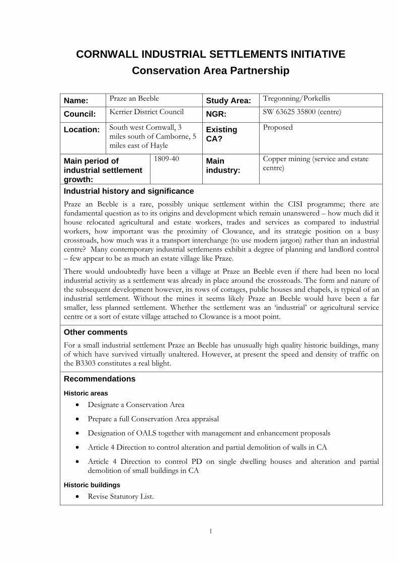
CORNWALL INDUSTRIAL SETTLEMENTS INITIATIVE Conservation Area Partnership
Name: Praze an Beeble Study Area: Tregonning/Porkellis
Council: Kerrier District Council NGR: SW 63625 35800 (centre)
Location: South west Cornwall, 3 miles south of Camborne, 5 miles east of Hayle
Existing CA?
Proposed
Main period of industrial settlement growth:
1809-40 Main industry:
Copper mining (service and estate centre)
Industrial history and significance Praze an Beeble is a rare, possibly unique settlement within the CISI programme; there are fundamental question as to its origins and development which remain unanswered – how much did it house relocated agricultural and estate workers, trades and services as compared to industrial workers, how important was the proximity of Clowance, and its strategic position on a busy crossroads, how much was it a transport interchange (to use modern jargon) rather than an industrial centre? Many contemporary industrial settlements exhibit a degree of planning and landlord control – few appear to be as much an estate village like Praze.
There would undoubtedly have been a village at Praze an Beeble even if there had been no local industrial activity as a settlement was already in place around the crossroads. The form and nature of the subsequent development however, its rows of cottages, public houses and chapels, is typical of an industrial settlement. Without the mines it seems likely Praze an Beeble would have been a far smaller, less planned settlement. Whether the settlement was an ‘industrial’ or agricultural service centre or a sort of estate village attached to Clowance is a moot point.
Other comments For a small industrial settlement Praze an Beeble has unusually high quality historic buildings, many of which have survived virtually unaltered. However, at present the speed and density of traffic on the B3303 constitutes a real blight.
Recommendations
Historic areas • Designate a Conservation Area
• Prepare a full Conservation Area appraisal
• Designation of OALS together with management and enhancement proposals
• Article 4 Direction to control alteration and partial demolition of walls in CA
• Article 4 Direction to control PD on single dwelling houses and alteration and partial demolition of small buildings in CA
Historic buildings • Revise Statutory List.
1
2
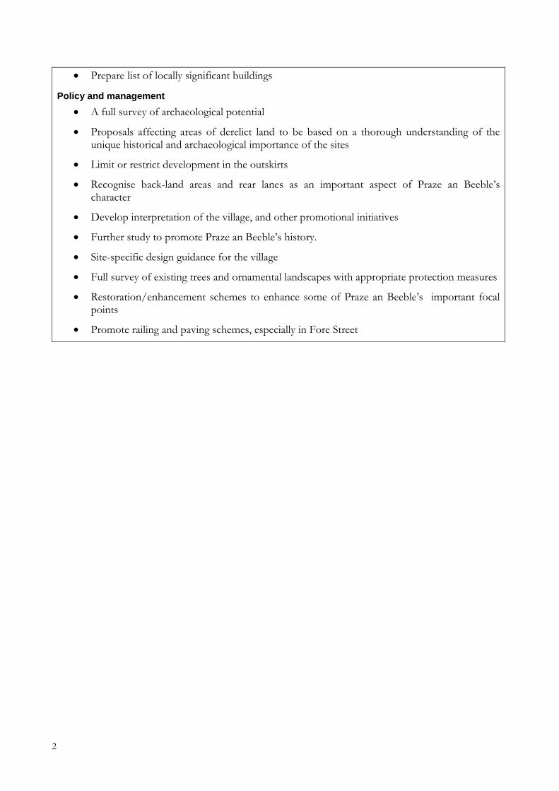
• Prepare list of locally significant buildings
Policy and management • A full survey of archaeological potential
• Proposals affecting areas of derelict land to be based on a thorough understanding of the unique historical and archaeological importance of the sites
• Limit or restrict development in the outskirts
• Recognise back-land areas and rear lanes as an important aspect of Praze an Beeble’s character
• Develop interpretation of the village, and other promotional initiatives
• Further study to promote Praze an Beeble’s history.
• Site-specific design guidance for the village
• Full survey of existing trees and ornamental landscapes with appropriate protection measures
• Restoration/enhancement schemes to enhance some of Praze an Beeble’s important focal points
• Promote railing and paving schemes, especially in Fore Street
Conservation Area Partnership
Cornwall Industrial Settlements Initiative PRAZE AN BEEBLE
(Tregonning/Porkellis Area)
Bridget Gillard, Historic Environment Service and
The Cahill Partnership
2004
Report No: 2004R095
1
2
Acknowledgements This report presents the results of an assessment carried out by Bridget Gillard (HES) advised by Nick Cahill of the Cahill Partnership following desktop research by Bryn Perry Tapper (HES). Assistance was also provided by Andrew Richards, Kerrier District Council. The report text and map drafts were prepared by Bridget Gillard, advised by Nick Cahill and edited by Nick Cahill and Pete Herring (CISI Project Manager, HES). The report maps were produced by John Brinkhoff (CCC Planning Directorate Technical Services Section) from roughs prepared by Bridget Gillard.
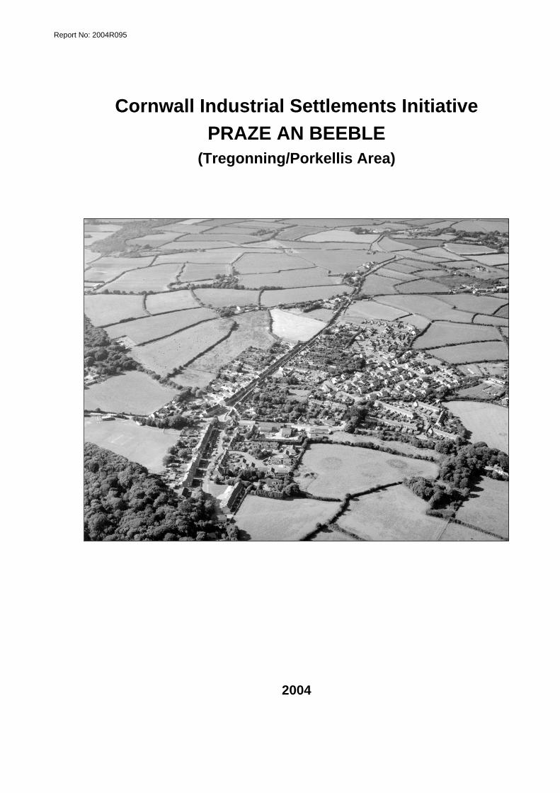
Front cover illustration: Praze an Beeble from the air (HES – F57/P184)
©Cornwall County Council 2004 Historic Environment Service, Planning, Transportation and Estates, Cornwall County Council, Kennall Building, Old County Hall, Station Road, Truro, Cornwall TR1 3AY. All rights reserved. No part of this document may be reproduced, stored in a retrieval system, or transmitted in any form or by any means without the prior permission of the publisher.
3
Contents Page
1 Introduction.........................................................................................................5 1.1 Background................................................................................................................................5 1.2 Project Aims ..............................................................................................................................5 1.1 Project methodology ................................................................................................................5 1.2 Date of Assessment ..................................................................................................................5
2 Location and setting...........................................................................................6 2.1 Geographical location ..............................................................................................................6 2.2 Landscape setting......................................................................................................................6
3 History and physical development....................................................................6 3.1 Pre-1809 .....................................................................................................................................6
3.1.1 Economic activity.................................................................................................................6 3.1.2 Extent of settlement.............................................................................................................6
3.2 1809-1840...................................................................................................................................7 3.2.1 Economic activity.................................................................................................................7 3.2.2 Extent of settlement.............................................................................................................7
3.3 1840-1876...................................................................................................................................8 3.3.1 Economic activity.................................................................................................................8 3.3.2 Extent of settlement.............................................................................................................8
3.4 1880-1906...................................................................................................................................9 3.4.1 Economic activity.................................................................................................................9 3.4.2 Extent of settlement.............................................................................................................9
3.5 1907- 1946..................................................................................................................................9 3.5.1 Economic activity.................................................................................................................9 3.5.2 Extent of settlement.............................................................................................................9
3.6 Post 1946....................................................................................................................................9 4 Current Character (Figs 3 & 4)..........................................................................10
4.1 General .....................................................................................................................................10 4.2 Built environment ...................................................................................................................10
4.2.1 Public/ecclesiastical buildings ..........................................................................................10 4.2.2 Commercial buildings ........................................................................................................10 4.2.3 Housing................................................................................................................................11 4.2.4 Paving/street ephemera.....................................................................................................12 4.2.5 Materials and local details..................................................................................................12
4.3 Views, Vistas and Green Space.............................................................................................12 4.3.1 Views and vistas..................................................................................................................12 4.3.2 Greenery ..............................................................................................................................13
5 Industrial significance......................................................................................13 6 Designations .....................................................................................................13
6.1 Scheduled monuments ...........................................................................................................13 6.2 Historic Buildings (Fig 4).......................................................................................................13 6.3 Historic Area Designations (Fig 4).......................................................................................14 6.4 Other designations..................................................................................................................14
7 Current issues and forces for change ............................................................14 7.1 Current Issues..........................................................................................................................14 7.2 Forces for Change...................................................................................................................14
8 Recommendations............................................................................................14
4
8.1 Historic areas .......................................................................................................................... 14 8.2 Historic buildings ................................................................................................................... 15 8.3 Policy and management......................................................................................................... 16
9 References ........................................................................................................17 9.1 Primary Sources...................................................................................................................... 17 9.2 Publications ............................................................................................................................. 18
Appendix: Gazetteer of archaeological sites and historic buildings ..................19
List of figures 1. Location map
2. Historical development
3. Surviving historic components
4. Gazetteer sites, existing designations and recommendations
Abbreviations in main text AGHV Area of Great Historic Value
AGSV Area of Great Scientific Value
AONB Area of Outstanding Natural Beauty
CA Conservation Area
CAU Cornwall Archaeological Unit (Historic Environment Service, CCC)
CCC Cornwall County Council
CISI Cornwall Industrial Settlements Initiative
GPDO General Permitted Development Order
HES Historic Environment Service, Cornwall County Council
HERS Heritage Economic Regeneration Scheme (English Heritage)
HLF Heritage Lottery Fund (ing)
LB Listed Building
OALS Open Areas of Local Significance to Settlement Character
OS Ordnance Survey
PD Permitted Development
SPG Supplementary Planning Guidance
THI Townscape Heritage Initiative (Heritage Lottery Fund)
UNESCO United Nations Education, Social and Cultural Organisation
WHS World Heritage Site
[1] Site number on Figure 4 and in the gazetteer (Appendix)
5
1 Introduction 1.1 Background Cornwall’s industrial settlements are the subject of a Conservation Area Partnership under the heading Cornwall Industrial Settlements Initiative (CISI). This partnership between English Heritage (with the Heritage Lottery Fund), Cornwall County Council, and the District Councils is intended to assess the character and significance of the County’s 112 industrial settlements. These include villages, ports and towns associated with Cornwall’s 19th century industrial revolution, based on metalliferous mining, slate and granite quarrying, and china clay extraction. The historic importance and distinctive character of such settlements has previously been undervalued, and their existing status does not adequately represent the industrial history of the county. CISI is aimed at redressing this imbalance.
The Cornish Mining World Heritage Site Bid is being prepared for submission to UNESCO by February 2005 (for inscription in June 2006). The bid areas will include the full range of 18th-20th century mining landscape components, including the settlements that were created or rapidly expanded as a result of mining and associated industries. All mining settlements are of significance to the World Heritage Site Bid - those that fall in the final Bid areas will be covered by the WHS Management Plan, while those that fall outside these areas will form part of the context for the World Heritage Site and will need to be sensitively managed in the light of this.
1.2 Project Aims The aim of CISI is to produce a settlement-by-settlement analysis in order to obtain an overview of the history, present character and importance of Cornwall’s industrial settlements. This will help determine where, for example, new Conservation Areas should be designated (and existing ones revised), and could provide the basis for Conservation Area Statements (to be drawn up subsequently by or for District Conservation Officers).
1.1 Project methodology The methodology involved historical research, followed by a site visit(s). For the historical research, a date range of 1750 to 1945 was chosen, as this represented the period of industrial growth and decline in Cornwall. Archaeological and historical sources housed at CCC (see Section 10.1) were consulted, together with Listed Building data supplied by the District Councils. Using this information, Ordnance Survey base maps were hand coloured to show: the different phases of historical development; surviving historic components from each development phase; archaeological sites, key historic buildings, and statutory designations. These maps (which formed the basis for Figures 2-4), together with copies of the primary sources consulted, were bound into a folder for each settlement, for use during site visits.
The focus of the site visits was to assess settlement character and consider ways in which this could be protected and enhanced in the future. This was achieved using a checklist drawn from Conservation Area Practice: English Heritage’s guidance on the management of Conservation Areas (1995) and Conservation Area Management - A Practical Guide (published by the English Towns Forum, 1998). The maps compiled during the historical phase were enhanced during the site visits, particularly with information relating to the survival and significance of historic buildings, and a general photographic record (colour prints) and video was made of each settlement. Meetings on site were arranged with the District Conservation Officers in order to discuss current initiatives and recommendations for future management.
1.2 Date of Assessment Praze an Beeble was assessed as part of CISI during February 2004
6
2 Location and setting 2.1 Geographical location Praze an Beeble is situated on a crossroads of the B 3303, Camborne to Helston Road and the B3280 Redruth to Marazion Road. The nearest town is Camborne, three miles to the north. The village, the largest in a wide rural area between Camborne and Helston, is in the parish of Crowan and the district of Kerrier.
2.2 Landscape setting The village lies on either side of a river valley, a tributary of the Red River, in an area of rolling countryside. The surrounding land is good quality agricultural land and to the south west lies the Clowance estate. Further still to the west the land rises to the hills of Tregonning and Godolphin. To the east the land rises in closer proximity to the anciently enclosed lands, later smallholdings, mines and ancient monuments on the former moorland around Carwynnen, with Pendarves park about a mile north-east.
3 History and physical development This section should be read in conjunction with the mapped historical development in Figure 2.
3.1 Pre-1809
3.1.1 Economic activity There was a manor house at Clowance from the 13th century and around the 1400s it became the home of the St Aubyn family. From 1426 Geoffrey St Aubyn farmed the tithe of Clowance under the Abbey of Tewkesbury. The estate itself would have been a provider of employment for the local people, and the village of Praze an Beeble developed around its north eastern boundary. The importance to Praze for employment and servicing of the Clowance estate cannot be underestimated – it was one of the most important estates, houses and parks in Cornwall, the ancient manor house continuously altered, the grounds extensively planted and ornamented from the 1720s and again in the 1770s. The surrounding countryside was a prosperous farming area with a number of medieval settlements.
The village is situated in an area famous for its late eighteenth and early nineteenth century mining activity. The nearest operation was at Trevoole a mile and a half to the north of the settlement on land owned by the St Aubyn Estate. Production probably began at the mine in the late eighteenth century. Another early mine in the district was at Binner Downs, a copper producing mine first recorded in 1758; although some three miles to the west all the intervening land was part of the St Aubyn’s Clowance estate. Another mine just to the south of the estate at Crenver was in production at least by the second half of the eighteenth century, while there was a suggestive field name recorded on the Tithe map just north-east of the village (Wheal-an-gogue). Praze stood in a central position to these various mines situated on St Aubyn lands and, although most were at some distance from the village, it may have had a service and marketing role.
3.1.2 Extent of settlement To the east of the village lies a field recorded in the tithe awards as ‘round meadow’. There are no visible remains, but this could be the site of a prehistoric defended enclosure; there are many other surviving rounds and ancient enclosures in the surrounding landscape. The earliest recorded settlement was not in the village itself but in the surrounding farms – Trerise, first recorded in 1262 and Trethannas, Borthog and Trefewha all recorded in the early fourteenth century.
7
The settlement of Praze-an-Beeble is not mentioned until 1697; its name means the pipe meadow or drained area, and the village, such as it was, followed the course of the east-west flowing Beeble stream as it ran alongside the ancient cross-county route to St Michael’s Mount (now the B3280).
By 1779 the vicar of Crowan reported 500 families living in the parish, but we do not know how many were in Praze an Beeble itself. It seems likely the village initially developed as a staging post on the major historic cross-county route. This suggest that from the outset the village was different from its farming neighbours – a creation of the St Aubyn’s as part of their estate assets, conveniently close to their estate, the mines, the farms and a major crossroads; this is a theme that recurs in Praze’s history. Whether the settlement was an ‘industrial’ or agricultural service centre or a sort of estate village attached to Clowance is a moot point.
The early development took place mainly around the crossroads and the village’s earliest buildings - the inn, smithy and two coach houses - would all appear to confirm this. There was mention as late as 1939 of a medieval wayside cross in the village, but its exact location is not known.
By 1801 the population of the parish of Crowan, one of the major industrial parishes of 18th century Cornwall, stood at 2,587.
3.2 1809-1840
3.2.1 Economic activity During 1824 and 1829 the mine at Trevoole experienced a boom producing 1,408 tons of copper ore. In 1829 the slump in copper prices led to a period of depression but the mine reopened between 1837 and 1841, albeit far less profitably. This was also a great period for the mine at Binner Downs which between 1819 and 1839 showed profits of £100,000 and at the time of its closure in 1839 was employing 390 workers. The other major employer in the area was the mine at Crenver, one of Cornwall’s most important copper mines, which by 1822 was the deepest mine in Cornwall and employed 560 men and boys underground and around the same number for surface dressing. On a smaller scale Rosewarne United mine, a mile to the north-west of Praze an Beeble, was producing copper.
Clowance continued to develop as one of the most celebrated parks and gardens in Cornwall though this period – despite a serious fire in 1836.
3.2.2 Extent of settlement During this period the village expanded almost to its fullest extent until the late 20th century developments. The overall population of the parish continued to grow - in 1811 the census return listed 3,021, which had risen to 4,638 by 1841.
Rows of stone cottages fringed the road leading north to Camborne, and to the mine at Trevoole. These were set in an orderly pattern with regular plot sizes suggesting a planned development, while the road itself was straightened and diverted from its ancient course to the north west via Trefewha, and given a marked elongated funnel shape opening out into the small square at the main crossroads. This was a planned extension, undertaken in a very short space of time (there was nothing there in 1809, the Chapel, more than half way along the street, was built by 1828), and can only have been undertaken under the auspices of the St Aubyn estate for both estate workers and miners. One interesting aspect of the growth of Praze was that it happened at the same time as the disappearance of a number of small cottage groups along Cathebedron Road, probably squatters on the edge of commons west and north-west of the village (Howe Downs/Penhale Moor); clearly marked in some density on the 1809 OS map, they had all gone by mid century - a consequence of enclosure and agricultural improvement. The relocation of
8
much of that population may account for some of the growth in Praze, and suggests it was not a simple industrial settlement.
The uniformly good quality of the buildings further suggests estate cottages, and the long strip of gardens to the rear, large enough to grow vegetables, were typical of mine workers’ cottages throughout the county, but also of agricultural workers. Another feature, more typical in this part of Cornwall of industrial settlements, was the Nonconformist chapel - a Wesleyan Methodist chapel built around 1828.
The earlier Inn and coach houses were integrated into the development, and it was clearly more than just a miners’ village – with inns, commercial stabling/carriage housing, smithies and so-on, it appears to have been an important local transport and service centre, responding to the demand from the surrounding mines, the still prosperous farming community, and the busy roads through the village.
3.3 1840-1876 ‘Praze an Beeble, a respectable, compact, and well-built village’ -Polsue, J, 1872.
3.3.1 Economic activity By 1861 the mine at Trevoole employed 75 men, 6 boys and 25 girls, but was running at a loss and was forced to close in September of that year. Between 1864 and 1876 the mine at Crenver reopened and the mine at Rosewarne United continued to operate until 1873. Although the boom years were over, the Post Office Directory of 1856 still described mining as the chief pursuit of the parish of Crowan and it clearly still dominated the landscape, Polsue noting ‘the rich and highly interesting pleasure grounds and thriving plantations of Clowance form a gladdening contrast with the surrounding desolation’. During this period a quarry was in operation to the south of the settlement, set up most probably to meet local needs – perhaps as much for the Clowance estate as for the village – the house was completely rebuilt in 1843 following another fire to the designs of James Piers St Aubyn. The large farms established in the medieval period continued to work the land surrounding the village.
3.3.2 Extent of settlement The Post Office Directory of 1856 illustrates the extent to which the village had become a centre of local commerce. Listed were two shop keepers, two grocers, and two publicans at the St Aubyn’s Arms and the Royal Standard Inn. The Directory also gives an insight into the importance of the mines to the local economy as the village accommodated three carpenters, two boot makers, a wheelwright and a blacksmith – all trades associated with mining.
The village expanded physically to the east and to the north (along the new course of the main road beyond its old turning point to the north-west), with much of the new development in the form of cottage rows. There were seventeen new residences built at this time including Trethannas House, a sizeable building set in its own grounds. Unlike many other industrial settlements Praze an Beeble housed a number of professional people including a mine agent, a vet, a County engine reporter, and a registrar.
A formal open space at the southern end of the village was created, possibly the venue for the yearly cattle fair.
Despite the village’s thriving economy the overall population of the parish began to fall during this period as the mines began to close down. In 1851 the population stood at 3,984, but had fallen to 3,464 by 1871.
9
3.4 1880-1906
3.4.1 Economic activity In 1886 the mine at Trevoole reopened under a new name, West Wheal Grenville. This new speculation was based entirely on a rumour that just before the mine closed in 1861 the miners had cut through to the Great Flat Lode. The new company had London directors who financed a number of new engine houses and poured money into the mine. However, by May 1891 the Lode remained undiscovered and work ceased by August. The enterprise proved to be one of the most expensive failures in the Camborne-Redruth district. All the other surrounding mines had ceased production by this time.
Farming once again became the major employer in the area and a new stud farm was set up in the village.
In 1887 the Helston Railway Company opened a branch line from Gwinear Road to Helston with a station at Praze an Beeble; the historic role of the village as an important local transport interchange developed on a new level. The line was worked from the outset by the Great Western Railway and linked the village with the town of Helston and the mainline, providing access to Camborne, Redruth and beyond.
3.4.2 Extent of settlement Despite the drop in population of the parish of Crowan, 2,603 in 1881 falling to 2,243 by 1901, Praze an Beeble remained an important commercial centre. Praze shared some typical churchtown functions with the actual churchtown at Crowan (less than a mile away). The village could still support two pubs, four shops, a butcher and a shoemaker. There was also now a new school just outside the village on the eastern side (actually the Crowan Board School rather than simply Praze School), a new Free United Methodist Chapel, a Sunday school, a post office and a village hall. The thriving nature of the community in contrast to the decline and collapse of the local industry reflected the influence of the new railway providing access to other centres of employment for the villagers. Indeed the village continued to expand at this time with many of the new houses located at the southern end of the village near the new station. The influence of Clowance perhaps still counted for much – the grounds were still famed in gardening and horticultural circles until 1921 when the Clowance branch of the Molesworth-St Aubyn finally sold the estate after 640 years.
3.5 1907- 1946
3.5.1 Economic activity All industrial activity in the area was now at an end. Local people found employment either in the commercial enterprises within the village itself, on the local farms and estate or in Helston, Camborne and Redruth, easily accessible by rail or car.
3.5.2 Extent of settlement The population of the parish continued to fall with 2,066 persons recorded in 1911 and 1,838 in 1931. The continuing presence of the railway, however, resulted in a small growth in the physical size of the village. Ten further detached and semi-detached houses were built on the road to the station, and a new garage. The chapels, school, post office, shops and pubs continued to flourish.
3.6 Post 1946 The roads which first encouraged development in Praze an Beeble have continued to ensure the community’s viability. Its close proximity to the conurbation of Camborne and Redruth and the town of Helston has ensured that, even after the closure of the railway in 1963, the village
10
continues to thrive. Although the chapels and one of the pubs have closed there are still a number of shops, a garage, a village hall and a post office. There is also a branch of Cornwall Farmers Ltd serving the needs of the local agricultural community. On the eastern side of the village two large housing developments have taken place with both public and private housing. In recent years there has been further building to the south of the village on land leading down to the disused railway. As always, the Clowance estate remains an important factor in the local economy, now as a thriving time-share and leisure facility.
4 Current Character (Figs 3 & 4) 4.1 General The regimented setting of the buildings either side of the road which runs north-to-south through the village, gives the strong impression of a planned settlement, a character emphasised by the ubiquitous use of the local stone, a generally consistent height and sense of scale to the buildings, and, on the west side of the village at least, the sharp division between the built-up area and the surrounding countryside. Due to the high survival of historic buildings and their original features the unusual combination in the character of Praze of estate village and industrial settlement still persists. There is a sense in which Praze, although not much bigger than many similar industrial villages around the area, has a more developed character - an urbane quality but one that never quite developed into an urban scale - with a certain formality of streetscape, exceptional quality of building details and a wide range of buildings and facilities including chapel, Inn/Hotel, shops, smithies, workshops, station, middle-class housing as well as workers’ cottages, Institute, public park, school etc.
4.2 Built environment
4.2.1 Public/ecclesiastical buildings The Wesleyan Methodist Chapel [5] both in its bulk and design sounds a strong urban note amongst the more modest neighbouring domestic buildings. Its colour-washed façade enriched with simple classical features seems more typical of the larger towns in Cornwall rather than a small village. In contrast the adjoining Sunday school [45] is simpler, with killas walls with granite dressings and a central gable decorated with a simple oculus. Both buildings are in the process of conversion and it is to be hoped that any alterations do not detract from their original character or impact detrimentally on their setting.
The United Methodist Chapel [6], a building of similar construction to the Sunday School has already been converted, but its strong external features, a steeply pitched roof and granite voussoirs around the first floor windows, remain unaltered, providing a prominent end-stop to the village.
Number 55 Forest Street [61] is now a pre-school but was built as a meeting hall. The granite walls are similar to its older neighbours, but the windows have decorative brick arches in common with several other houses in the village built in the second half of the nineteenth century.
4.2.2 Commercial buildings The major surviving commercial buildings in Praze an Beeble are the group comprising and adjoining the St Aubyn's Arms [3]. The simple granite ashlar façade with sturdy lintels was extended and remodelled during the late nineteenth century including a half-timbered gable. The alterations could have been undertaken by the ‘family’ architect James Piers St Aubyn who worked in Praze building Clowance [68] and Praze School [7]. The post office, which forms part of this group [3], has a modern shopfront. Behind this group a large number of outbuildings,
11
possibly store houses and stables, are still extant, but similar buildings behind 59 Fore Street have recently been demolished.
Just off the main street a group of small shops now occupy a former outbuilding [18]. The external stone steps and wide original ground floor openings suggest either stables or agricultural storage as its original use.
There is still some evidence of the other historic commercial premises in the village – at 19 Fore Street [55] the original shopfront including stall riser, console brackets and fascia board are still in place and at 27 Fore Street [55] there is a more modern shopfront.
The village’s other public house The Royal Standard Inn [56] is now domestic, but its impressive doorway with granite voussoirs and floating capitals, and long lintel which once supported the sign board are reminders of its former function.
There is an unusual group of buildings in Praze with arched or lintelled carriageway entrances leading to rear yards; it is unclear what there original use or status was in most cases, but this feature alone marks it out a very different from most surrounding ‘industrial’ settlements, and reflects its commercial, service and roadside character [1][2][59]) .
4.2.3 Housing Praze an Beeble appears to be a single road of stone houses from roughly the same era, but closer inspection reveals a rich mixture of styles and periods in the wider village. The continuing use of similar materials and features throughout the years has lent a sense of homogeneity and continuity, saved from blandness by subtle details.
Pre 1809. There are no surviving houses from this period (excluding the St Aubyn’s Arms groups [3]), but it is possible elements of the Gables [29] could date from this time. This building of simple stone construction has been extended in the early twentieth century with an Arts and Crafts style façade dominated by large bay windows – looking for all the world like a regency sea-side shopfront.
1809-40. The housing style from this period is represented by stone constructions of either killas with granite quoins and lintels, squared granite blocks or a combination of the two, with original slate roofs. The houses appear very solid, flat fronted and largely unadorned, the major variation being the size of the building. The smallest type is represented by simple one up one down constructions (52-56 Fore Street [41], 45 Fore Street [57] and 51 Fore Street [60]). Larger building types include a paired arrangement - adjacent front doors have a shared window above at first floor level (62-68 Fore Street [39], 32-34 fore Street [49], 20-26 Fore Street [49], 11-17 fore Street [55] and 37-39 Fore Street [55]). There are simple one up one down cottages with rear access doors (40 Fore Street [49], 36 Fore Street [49], 12-14 Fore Street [49], 29 Fore Street [55]) and a house whose attached coachman’s cottage has a large rear-access doorway supported by a granite lintel [2]. There are a large number of simple stone double fronted houses: 46 Fore Street [41], 42-44 Fore Street [49], 28-30 Fire Street [49], 16-18 Fore Street [49]9 Fore Street [55], 21-25 Fore Street [55], 31 Fore Street [55], 35 Fore Street [55], 42 Fore Street [55], 53 Fore Street [60] and 57 Fore Street [62]). Some of these larger building types have additional decorative features such as a projecting cornice above the front door of 59 Fore Street [62], segmental window heads and a wooden door case 50 Fore Street [41], and a dentil eaves band and granite voussoirs at 48 Fore Street [41].
1840-76. Surviving houses from this period are again of similar killas and granite construction and on first inspection are virtually indistinguishable from their neighbours. However they tend to be on a slightly larger scale - 74-76 Fore Street [38] has a higher roofline, 10 Fore Street [52] unlike its earlier double fronted neighbours has three windows at first floor level and 1-3 Fore Street [53] although of the familiar paired doorway type is again on a larger scale with a shared
12
central archway. There are two houses with coach houses attached from this period (5 Fore Street [1] and 7 Fore Street [59]) both of which retain their original sash windows. The cottages from this period off the main street have been greatly altered with modern render, windows and doors, but the granite façade of the detached Trethannas House [22] still survives.
1876-1906. The houses from this period reflect the new range of materials made available through the railway. The houses in Fore Street remain basically of typical local construction, but new decorative features appear in the form of crested ridge tiles 78-80 Fore Street [36], and brick window arches 47-49 Fore Street [58]. The new row of cottages on Station Hill [15] again took their construction of granite walls and slate roofs from Fore Street, but the roofs have decorative ridge tiles.
1906-46. The houses from this period are larger, either detached or semi-detached and decoration is more evident. The Edwardian houses on Station Hill [11] [12] [14] have bay windows with decorative panels, terracotta finials, and decorative cast ironwork. However, despite these innovations, their stone walls and position – in steps up the side of a hill - link them with the earliest cottages in the village.
4.2.4 Paving/street ephemera Praze has some of the best and most extensive surfacing and paving to be found in any settlement of similar size in west Cornwall. Contributing factors to the high quality of the streetscape in Fore Street are the stone steps and flags outside the cottages on the eastern side of the road [50][51]. These areas before the Second World War would have been delineated by cast-iron railings. The railings still survive outside the Wesleyan Methodist Chapel [42] above a rubble stone wall, along with cast iron lamp standards decorated with scroll work above the granite gate posts which flank granite steps. Again the streetscape here is of an extremely high quality; the pavement formed from wide slate slabs bordered by granite kerbs [44]. This is also the site of a water fountain [42] constructed in 1889 from simple slabs of granite with an inscription panel in the form of an escutcheon.
Other paving treatments in the village include cobbles ([31], and particularly [40]) and stable block [33]. Original street features such as the telephone box [20], post box [32] and inn sign bracket [34] again add to the overall quality of the streetscape.
Despite the building of a modern housing development of Trethannas Gardens the original track with its hedges and cobble metalling connecting the farm at Trethannas with the main road still survives [24][25].
4.2.5 Materials and local details The majority of buildings in Praze an Beeble are constructed either from local killas, granite or a combination of the two. There are a number of scantle slate roofs, and most of the chimney stacks are brick-built. The stone paved front garden areas are a feature of Praze, although the low walled front garden type more commonly associated with industrial settlements is also represented in the village [35].
4.3 Views, Vistas and Green Space
4.3.1 Views and vistas Due to its position either side of a small river valley there are no long vistas from Praze an Beeble out to the surrounding countryside, but the topography, and the open nature of the centre of the village means that from the central crossroads almost all the historic buildings can be seen.
This open area in the heart of Praze, which dissipates in a somewhat formless and ill-defined way along the east-west road, contrasts with the sense of enclosure and strongly urban character
13
of Fore Street. From the northern side of the village looking south there is an extremely pleasing prospect down over the roof tops which follow the curve of the road in a series of gentle steps before rising in a similar sweep on the hillside beyond; the view up Fore Street is no less dramatic. This is without doubt one of the best village streets in Cornwall in architectural and streetscape terms; the intrusive impact of the parked cars and busy through traffic is striking and obvious.
4.3.2 Greenery In terms of greenery the village can be divided into two distinct areas. The houses along Station Hill all have front gardens, many with small trees and shrubs. Fore Street is dominated by a hard streetscape where the houses on the western side are built hard against the pavement, and on the eastern side have stone paved areas with very little planting. The long back gardens of these properties are largely hidden from the road, but can occasionally be glimpsed through the side entrances and alleyways. Interestingly the majority of these long back gardens still survive and the original hedge is still in place forming a boundary between 86 Fore Street and the road [64]. In contrast, the southern end of the settlement is characterised by the village green and the playing field beyond, bordered by a stand of trees delineating the site of the railway line. Trees are, in fact, a dominant feature in all views around the outer skirtings of the village, in rear gardens, along the railway, along the old hedges which have been absorbed into the housing estates to the east of Fore Street, along the valleys and stream , giving Praze a surprisingly sylvan setting compared with the baldness of the main road.
5 Industrial significance Praze an Beeble is a rare, possibly unique settlement within the CISI programme. Its history remains relatively unexplored and obscure, and there are fundamental question as to its origins and development which remain unanswered – how much did it house relocated agricultural and estate workers, trades and services as compared to industrial workers, how important was the proximity of Clowance, and its strategic position on a busy crossroads, how much was it a transport interchange (to use modern jargon) rather than an industrial centre? Praze shared some typical churchtown functions with the actual churchtown at Crowan (less than a mile away, and perhaps that is its true character and significance. Without the mines it seems likely Praze an Beeble might have been a far smaller, less planned settlement, but further, more detailed research may prove that this is not the case – the mines were, for the most part, at some distance, and there were other settlements better placed to serve them in the large and densely populated parish of Crowan.
Many contemporary industrial settlements exhibit it a degree of planning and landlord control – few appear to be as much an estate village as an industrial village like Praze. Its proximity to Pendarves House, and the slightly later, but equally estate-village style of developments at Pendarves Road, Troon may be more than coincidence – in both cases the settlements seem to have been conceived as formal approaches to a great estate as much a simply somewhere to house workers, in both, but perhaps more especially Praze, the quality of building styles and details sets it apart from many contemporary industrial settlements in the area.
6 Designations 6.1 Scheduled monuments There are no scheduled monuments in the village.
6.2 Historic Buildings (Fig 4) There are three grade II listed buildings.
14
There is no local list.
6.3 Historic Area Designations (Fig 4) There is a proposed conservation area.
6.4 Other designations (All policy numbers refer to Kerrier local plan drafted 1999) The village has a fairly tightly drawn development boundary.
The area of land at Borthog and Trefewha, and the recreation ground have been designated as Open Areas of Local Significance – Policy EL346
7 Current issues and forces for change 7.1 Current Issues The area of land opposite the St Aubyn Estate has been designated an area for the development of 15 medium density dwellings. This is a site that was previously proposed for industry.
The area of the B3303 by the old railway bridge has been identified as an area of concern for highway efficiency and safety.
The village has been identified as suffering from heavy traffic levels, the passage of heavy vehicles and pedestrian/vehicular conflicts resulting in the need for traffic management.
The prominent buildings of the Chapel and Sunday School are at present in the process of conversion to domestic dwellings.
Street lighting in the village is very utilitarian and makes no reference to the historic environment. In some cases, such as outside 50 Fore Street, it has a positively damaging effect.
7.2 Forces for Change Development in the past has concentrated on the eastern side of the village. It is important that the separate character of the ancient farm settlements at Trethannas, Trerise, and North Tremayne should not be compromised by the encroaching development on this side of the village. The historic character of Praze was always that there was a sharp division between the built-up area, especially the tightly planned Fore Street; this has been lost in the extensive estates to the east, (showing little regard for historic character in their detailing, street layout and connectivity with either the village or the countryside), but survives as an important part of historic character to the west and south-west of the village.
A number of traditional sash windows and doors on Fore Street have been replaced, no doubt partly due to noise pollution from the traffic, however a significant number still remain and these should be valued.
8 Recommendations 8.1 Historic areas
Recommendation: 1 Conservation Area At present a conservation area is proposed which includes the historic properties of Fore Street. It is suggested this should be extended to include the historic buildings off School Lane and Station Hill.
15
Reason: To recognise the areas of special architectural and historic importance in Praze an Beeble, and to promote policies and schemes for the preservation and enhancement of those areas. Recommendation: 2 Conservation Area Appraisal
Prepare a full and detailed conservation area appraisal to accompany CA designation.
Reason: To accord with statutory requirements and departmental policy advice, to ensure a full and adequate understanding of the special historic and architectural importance of the CA, the range of historic fabric and archaeological potential, and to establish effective parameters for management and policy proposals.
Recommendation: 3 Open Areas of Local Significance There are already two OALS designated in the village. In addition consideration should be given to designating the land between the current village boundary and the ancient farm settlements at Trethannas, Trerise, and North Tremayne.
Reason: To retain the discrete identity of Praze an Beeble and to manage and protect the setting of the proposed conservation area.
OALS are an extremely important and useful policy both to contain the spread of development around settlements and to act, in effect, as a secondary layer of management and control around a conservation area, preserving the setting of such an area. Recommendation: 4 Article 4 Directions (Walls)
Article 4 Directions to control the demolition of walls and hedges, especially for the creation of hard standings.
Reason: To protect the character of Praze an Beeble against inappropriate incremental alterations and demolition.
Recommendation: 5 Article 4 Directions (Buildings) Article 4 Directions to control the demolition and alterations to individual houses, to prevent demolition of free-standing outbuildings and to prevent the loss of such features as unlisted shop fronts, especially when now in residential use.
Reason: To protect the character of Praze an Beeble against inappropriate incremental alterations and demolition.
8.2 Historic buildings A fuller understanding of the stock of historic structures in Praze an Beeble as elsewhere in Cornwall, is urgently required – local list surveys, thematic surveys, detailed recording as part of Article 4 Directions should all be viewed not only as a first stage to Listing, but as an end in themselves, as critically important elements in the creation of policies, in prioritising action, in targeting funding strategies, and as a means of successfully managing change and promoting opportunities.
Recommendation: 6 Statutory listed building review Review the statutory list of buildings of special architectural or historic interest for the Praze an Beeble area.
Reason: To update the statutory list to reflect changes in understanding of the historic environment, in order to preserve or enhance the special character of the buildings and the area.
16
The following list puts forward a range of structures that might be considered for listing - there are others not given here which on closer inspection might also be included; the intention here is to give an idea of the scale of any potential listing exercise. Wesleyan Methodist Chapel [5] Wesleyan Sunday School [45] 7 Fore Street [54] 43 Fore Street [56] 50 Fore Street [41] 48 Fore Street [41]
Recommendation: 7 Non-statutory historic buildings survey (Local list) Prepare a list of locally significant structures which contribute substantially to the character of the settlement, based on the combined criteria of both listing and Article 4 Directions, and backed up by a Buildings-at-Risk survey, detailed Article 4 Directions and substantive and enforceable policies in the local plan. This could also back up applications for grant aid.
Reason: To ensure a full and accurate record of the historic fabric of the settlement, to strengthen existing Local Plan commitments to prevent proposals that would harm the historic heritage of the village and guide development and promote change that will preserve and enhance the character of the village.
8.3 Policy and management
Recommendation: 8 Archaeology Undertake a full survey of archaeological potential in Praze an Beeble, backed up by an additional policy requiring proper recording of archaeologically sensitive sites before development.
Reason: To comply with and strengthen existing Local Plan commitments to prevent proposals that would harm the archaeological heritage of the village, and thereby preserve the special character of Praze an Beeble.
Recommendation: 9 Derelict land Base proposals affecting the areas of derelict land that surround and permeate Praze an Beeble on a thorough understanding of the unique historical and archaeological importance of the sites themselves, and also of their value to the setting of Praze an Beeble. Conserve surviving historic fabric and landscape.
Reason: To ensure that the sites retain both their historical relevance to Praze an Beeble and Cornwall, and their own archaeological and historical integrity.
Recommendation: 10 Limit or restrict development Further development on the outskirts should be avoided or limited in extent and, where necessary, fully integrated into the historic topography and settlement form.
Reason: To retain both the discrete identity of Praze an Beeble and comply with existing Local Plan commitments.
Recommendation: 11 Back-land and trackways Recognise the importance to historic character of back-land areas, tracks and lanes as an important aspect of Praze an Beeble’s character; preserve and enhance their informal qualities and important surviving buildings.
17
Reason: To preserve and enhance the special character of Praze an Beeble, especially in areas unlikely to attract private investment and attention.
Recommendation: 12 Interpretation and Promotion The high quality of the architecture in the village would merit a mini architectural guide/ village trail. This could possibly be available from the post office in the village and possibly make connections with local mining sites and trails and the Clowance estate.
Reason: To present Praze an Beeble’s heritage to a wider audience and to attract new visitors and associated regeneration initiatives, and to set the village within its historic industrial context.
Recommendation: 13 Further study Undertake a more in depth study of the historic ownership of properties within the village, especially those in Fore Street; undertake fuller analyses of census returns and other information to determine exactly the historic role and functions of the settlement.
Reason: To determine who built the cottages and houses and for whom, and thus increase our understanding of how much the settlement was influenced by the mining industry and how much by the nearby estate.
Recommendation: 14 Design Guidance Produce design guidance specific to the village, based on a detailed audit of materials, designs, details and character, both of standing buildings and of street paving materials.
Reason: To preserve and enhance the special character of Praze an Beeble, and promote change that will preserve and enhance the character of the settlement.
Recommendation: 15 Trees and ornamental landscapes Undertake a full survey of existing trees and ornamental landscapes and take protection measures where appropriate.
Reason: To ensure that the contribution made by existing trees to the townscape on both private and public land is recognised and protected where necessary
Recommendation: 16 Restoration/enhancement schemes Concentrate restoration/enhancement schemes on some of Praze an Beeble’s important focal points, particularly Fore Street and the central cross roads
Reason: To recognise and enhance the importance of focal points in the development of Praze and Beeble’s townscape. Recommendation: 17 Promote railing and paving schemes
A railing scheme could be instigated to reinstate the missing railings, especially on the eastern side of Fore Street; this could have a major impact on the appearance and quality of the historic streetscape of the whole village, and, given the volume of traffic passing through, of a much wider area. The quality of paving in the village would in addition justify an audit, and proposals fro reinstatement and enhancement.
Reason: To preserve and enhance the special character of Praze an Beeble, and promote change that will preserve and enhance the character of the settlement.
9 References 9.1 Primary Sources 1809 OS map
1840 Tithe Map
18
1876 OS 25 inch map
1906 OS 25 inch map
1946 RAF air photograph
Cornwall Sites and Monuments Record (computerised database of archaeological sites maintained by CCC HES)
9.2 Publications Barton, D, B, 1973. A Guide to the Mines of West Cornwall. Buck, C, 1996. Shaft Capping Binner Downs. Clowance Holdings Ltd, 2004. A Brief History of Clowance. Dines, H, G, 1988. The Metaliferous Mining Region of South-West England.
Doble, G, H, 1939. A History of the Parish of Crowan. Herring, P, 1992. Kerrier Shaft Capping. Kelly, 1893. Directory.
Morrison, T, A, 1983. Cornwall’s Central Mines – The Southern District 1810-95.
Pett, D, E, 1998, The Parks and Gardens of Cornwall Pevsner, N, 1996. The Buildings of England, Cornwall. Polsue, J, 1872. Lake’s Parochial History of the County of Cornwall. Post Office, 1856. Directory
Strengelhofen, J, 1991. Cornwall’s Railway Heritage.
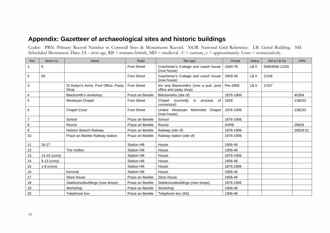
Appendix: Gazetteer of archaeological sites and historic buildings Codes: PRN: Primary Record Number in Cornwall Sites & Monuments Record. NGR: National Grid Reference. LB: Listed Building. SM: Scheduled Monument. Date: IA – iron age, RB = romano-british, MD = medieval . C = century, c = approximately. Cons = consecutively.
Ref. Street no. Name Road Site type Period Status SM or LB No PRN
1 5 Fore Street Coachman’s Cottage and coach house (now house)
1840-76 LB II SW63NW 1/155
2 60 Fore Street Coachman’s Cottage and coach house (now house)
1809-40 LB II 1/156
3 St Aubyn’s Arms, Post Office, Pasty Shop
Fore Street Inn and Blacksmiths (now a pub, post office and pasty shop)
Pre-1809 LB II 1/157
4 Blacksmith’s workshop Praze an Beeble Blacksmiths (site of) 1876-1906 403545 Wesleyan Chapel Fore Street Chapel (currently in process of
conversion) 1828 138232
6 Chapel Court Fore Street United Wesleyan Methodist Chapel (now house)
1876-1906 138233
7 School Praze an Beeble School 1876-1906 8 Round Praze an Beeble Round IA/RB 29626 9 Helston Branch Railway Praze an Beeble Railway (site of) 1876-1906 29534.01 10 Praze an Beeble Railway station Praze an Beeble Railway station (site of) 1876-1906
11 16-17 Station Hill House 1906-4612 The Hollies Station Hill House 1906-46 13 14-15 (cons) Station Hill House 1876-1906 14 9-13 (cons) Station Hill House 1906-46 15 1-8 (cons) Station Hill House 1876-1906 16 Kenvole Station Hill House 1906-4617 Store house Praze an Beeble Store house 1906-46 18 Stables/outbuildings (now shops) Praze an Beeble Stables/outbuildings (now shops) 1876-1906 19 Workshop Praze an Beeble Workshop 1906-46 20 Telephone box Praze an Beeble Telephone box (K6) 1906-46
19
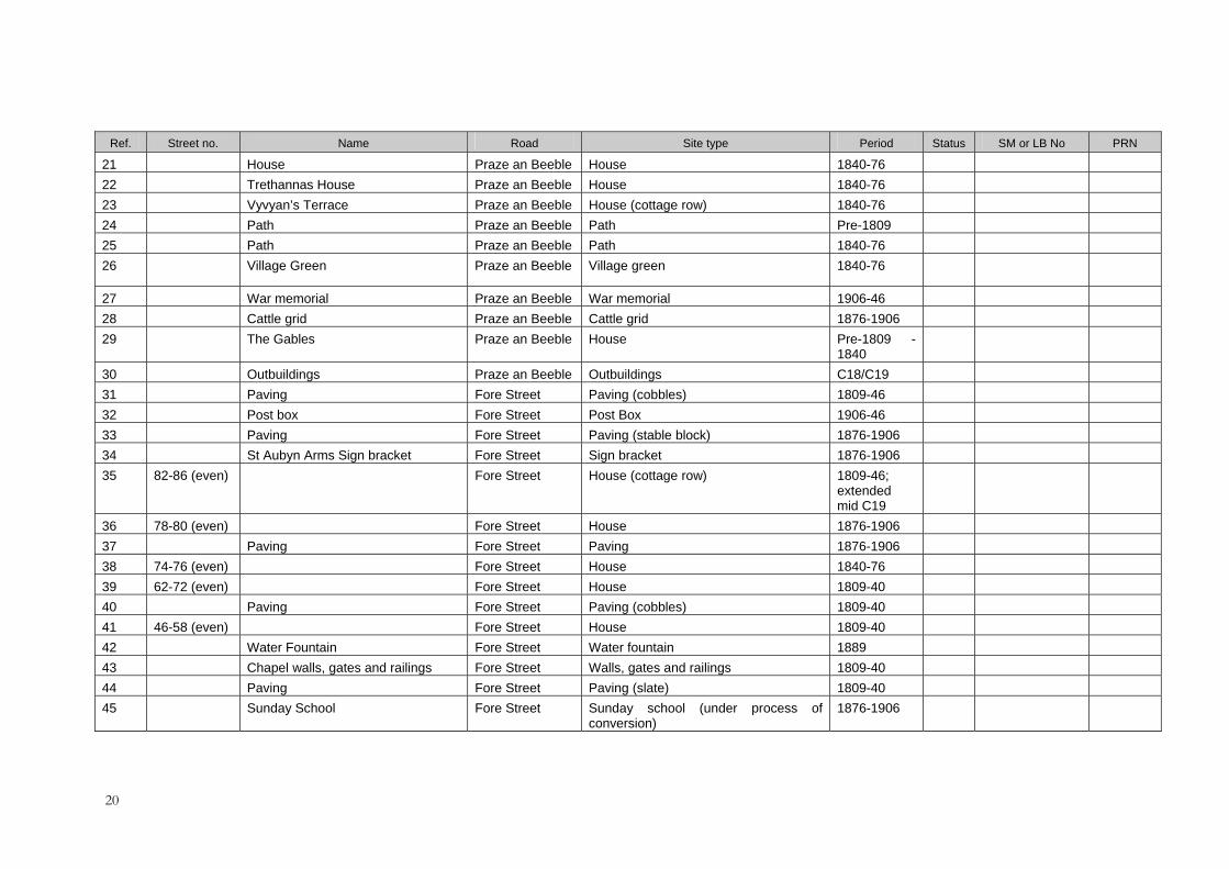
Ref. Street no. Name Road Site type Period Status SM or LB No PRN
21 House Praze an Beeble House 1840-76 22 Trethannas House Praze an Beeble House 1840-76 23 Vyvyan’s Terrace Praze an Beeble House (cottage row) 1840-76 24 Path Praze an Beeble Path Pre-1809 25 Path Praze an Beeble Path 1840-76 26 Village Green Praze an Beeble Village green 1840-76
27 War memorial Praze an Beeble War memorial 1906-46 28 Cattle grid Praze an Beeble Cattle grid 1876-1906 29 The Gables Praze an Beeble House Pre-1809 -
1840
30 Outbuildings Praze an Beeble Outbuildings C18/C19 31 Paving Fore Street Paving (cobbles) 1809-46 32 Post box Fore Street Post Box 1906-46 33 Paving Fore Street Paving (stable block) 1876-1906 34 St Aubyn Arms Sign bracket Fore Street Sign bracket 1876-1906 35 82-86 (even) Fore Street House (cottage row) 1809-46;
extended mid C19
36 78-80 (even) Fore Street House 1876-1906 37 Paving Fore Street Paving 1876-190638 74-76 (even) Fore Street House 1840-76 39 62-72 (even) Fore Street House 1809-40 40 Paving Fore Street Paving (cobbles) 1809-40 41 46-58 (even) Fore Street House 1809-40 42 Water Fountain Fore Street Water fountain 1889 43 Chapel walls, gates and railings Fore Street Walls, gates and railings 1809-40 44 Paving Fore Street Paving (slate) 1809-40 45 Sunday School Fore Street Sunday school (under process of
conversion) 1876-1906
20
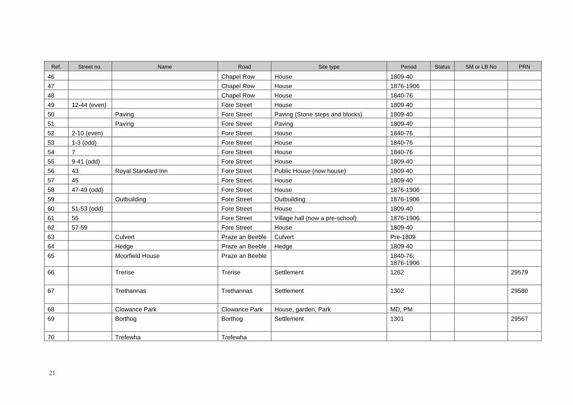
Ref. Street no. Name Road Site type Period Status SM or LB No PRN
46 Chapel Row House 1809-4047 Chapel Row House 1876-190648 Chapel Row House 1840-7649 12-44 (even) Fore Street House 1809-40 50 Paving Fore Street Paving (Stone steps and blocks) 1809-40 51 Paving Fore Street Paving 1809-40 52 2-10 (even) Fore Street House 1840-76 53 1-3 (odd) Fore Street House 1840-76 54 7 Fore Street House 1840-7655 9-41 (odd) Fore Street House 1809-40 56 43 Royal Standard Inn Fore Street Public House (now house) 1809-40 57 45 Fore Street House 1809-4058 47-49 (odd) Fore Street House 1876-1906 59 Outbuilding Fore Street Outbuilding 1876-190660 51-53 (odd) Fore Street House 1809-40 61 55 Fore Street Village hall (now a pre-school) 1876-1906 62 57-59 Fore Street House 1809-4063 Culvert Praze an Beeble Culvert Pre-1809 64 Hedge Praze an Beeble Hedge 1809-40 65 Moorfield House Praze an Beeble 1840-76;
1876-1906
66 Trerise Trerise Settlement
1262
29579
67 Trethannas Trethannas Settlement
1302
29580
68 Clowance Park Clowance Park House, garden, Park MD, PM 69 Borthog Borthog Settlement
1301
29567
70 Trefewha Trefewha
21

Ref. Street no. Name Road Site type Period Status SM or LB No PRN
71 Wheal-an-gogue Mine (site of)
Praze an Beeble Mine (site of)
Pre 1838
40353
72 Former line of road Praze an Beeble Road (line of) Pre-1809 73 Buildings (site of) Praze an Beeble Buildings (site of) Pre-1809
22