Copyright restrictions: Copyright © 2009: Gabriola ...
15
Context: Geology, structural, Gabriola Citations : 1. Doe, N.A., Gabriola’s shape—including some surmises, SHALE 20, pp.29–40, April 2009. 2. Doe, N.A., Gabriola’s nose and tail, SHALE 22, pp.34–35, January 2010. Copyright restrictions : Copyright © 2009: Gabriola Historical & Museum Society. For reproduction permission e-mail: [email protected] Errors and omissions : None. Later references : N/A. Date posted : January 21, 2012. Author : Nick Doe, 1787 El Verano Drive, Gabriola, BC, Canada V0R 1X6 Phone: 250-247-7858 E-mail: [email protected]
Transcript of Copyright restrictions: Copyright © 2009: Gabriola ...

Context: Geology, structural, Gabriola
Citations: 1. Doe, N.A., Gabriola’s shape—including some surmises, SHALE 20, pp.29–40, April 2009. 2. Doe, N.A., Gabriola’s nose and tail, SHALE 22, pp.34–35, January 2010.
Copyright restrictions: Copyright © 2009: Gabriola Historical & Museum Society. For reproduction permission e-mail: [email protected]
Errors and omissions: None.
Later references: N/A.
Date posted: January 21, 2012.
Author: Nick Doe, 1787 El Verano Drive, Gabriola, BC, Canada V0R 1X6 Phone: 250-247-7858 E-mail: [email protected]

SHALE No. 20 April 2009 29
Gabriola’s shape —including some surmises
by Nick Doe
Gabriola (including Mudge) has a rather curious orientation with respect to its neighbours. The Vancouver Island coast from Lantzville north of us runs west of northwest (N 68º W), but the islands to the south of us—Valdes, the De Courcy Group, Thetis, Kuper, etc.—run north of northwest (N 35º W). The geological axis of central Gabriola, the syncline, runs N 68º W, so we
are clearly an extension of the coast of to the north of Nanaimo rather than an extension of the islands to the south of us. Numerologists will however be quick to spot that the average orientation of the trend of the coast south and north of us is: 0.5 × (35º +68º) = N 51º W, the average for Vancouver Island as a whole.
Looking west across the Strait of Georgia on a 3-D model highlights Gabriola’s estranged surface orientation relative to the more southerly Gulf Islands. Notice too how Gabriola’s northern “nose” appears to have been pushed out of shape. The northwesterly-oriented trough off Gabriola’s north shore was carved by a glacier flowing down the strait, but guided by pre-existing fractures.
Model in the entrance hall of the Institute of Ocean Sciences‘ facility at Patricia Bay.
Nick Doe Gabriola’s shape
SHALE No. 20 April 2009 30
adapted from Tim England, 1989, see SHALE 22, pp.34–5 for additonal comments
Map showing the folding of Gabriola Island and its surrounding areas. The arrows point in the direction of the dip or downward slope of the bedding planes at various points. Most of these bedding planes would have been virtually horizontal when first laid own, but folds and creases have tilted them. Solid black lines are major (regional) faults. Dotted lines are the hinges of the folds—either crests or troughs’. Anticlines are ∩-shaped crests in a series of folds. a : Leboeuf Bay-Cox’s Bay (north-end) fault Synclines are ∪-shaped troughs in a series of folds. b : Maples-Dragon’s Lane strike-slip (south-end) fault, N47°E A : Gabriola syncline, N68°W C : Boat Harbour syncline c : Flat-Top Islands fault, N47°W B : Stuart Channel anticline D : Extension anticline d : Chase River right strike-slip fault e : Thrust faults (Lakes, Village, Extension Main, White Rapids, etc.)
Nick Doe Gabriola’s shape
SHALE No. 20 April 2009 31
Folds on Gabriola An indispensible account of the folding of Gabriola’s bedrock is the Ph.D. thesis of Tim England. The map shown here is adapted from his work and shows only a fraction of the detail his maps contain. The arrows show the dip of the bedding planes, so two arrows pointing at each other show a valley bottom as it were, while two pointing away from each other show a hilltop ridge. This is a whole lot easier to comprehend on a 3-dimensional map, but two is the best I can do. Most of Gabriola sits, as probably every reader knows by now, in a ∪-shaped trough known as a syncline, which is why the strata along both of the long sides of the island,
north and south, point gently skyward, at angles between five and fifteen degrees, away from the central axis of the island. Apart from the orientation of the north and south shores, fractures running parallel to the central fold axis, the E-set (N76º W),4 were probably responsible for, among others, the orientations of bays southwest of Twin Beaches; the depression on the southwest side of South Road from Hoggan Lake to the Good Earth Market Garden; the bluff above Whalebone; the bluff behind the school and church overlooking Tim Brown’s land; the depression running north of west from Degnen Bay toward Petroglyph Way; and several other familiar features of Gabriola’s landscape now softened by erosion.
The north-end “hole” Along the shore from east of the ferry terminal, past Twin Beaches, around Berry Point, and into Leboeuf Bay, the strata dip north and northwest into the sea (photographs on the next page). It appears from the map that the cross-island fault “a” is a hinge for this dip to the north. The dip is accommodated by a series of parallel minor normal faults distributed across the north end of the island like a skewed pack of cards. Perhaps there’s a large hole to the north, off the coast, into which the island is sliding! What’s funny about this is that a gravity map of the area does show lower than normal gravity here (see map bottom of next page). Unfortunately though, there are several possible geological explanations for such an anomaly and not all would imply events old or deep enough to account for any such “hole”.
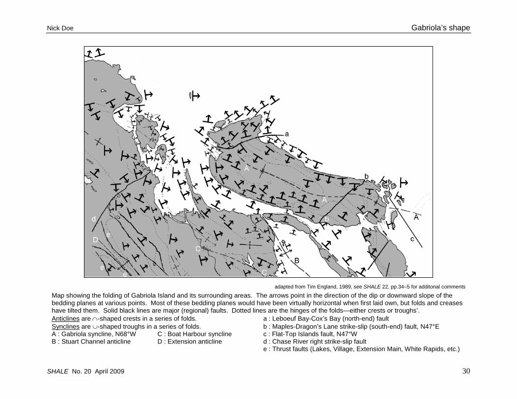
Folding of the bedrock around Gabriola. Gabriola’s bedrock forms a syncline (a trough), the axis of which is marked A on the map, and seen here on the right. Another syncline, the Boat Harbour syncline, marked C on the map, is seen here on the left. The anticline (hump) between them is the Stuart Channel anticline, marked B on the map. The two synclines merge as one travels north toward Nanaimo Harbour, and the fold axes dip downward (they plunge).

Gabriola’s shape Nick Doe
32 SHALE No. 20 April 2009
Top: Bedding planes dipping gently to the northwest (left) and into the sea along McConvey Road.
This is common north of the Leboeuf Bay-Cox’s Bay fault, marked a on the map, p.30.
Middle: The dip shown above is accompanied by minor fractures and minor normal faults sloping down to the northwest (left). These are easily seen, as here, from the ferry on the north side of Descanso Bay.
Bottom: A gravity map of the Gulf Islands showing a curious anomalous spot of lower than normal gravity off Gabriola’s north shore. The lighter the grey in this picture, the weaker the gravity. The lower gravity has several possible causes. My favourite conjecture, albeit totally unsupported by any actual evidence or concurrence by any real structural geologist, is that the “hole” is a depression in the basement rock created by the weight of Mount Benson—the root cause of Gabriola’s droopy nose.
The anomaly is also shown in magnetic anomaly and GPS data.
Adapted from Lowe, Dehler, Zelt, NRC, Canada, 2003

Nick Doe Gabriola’s shape
SHALE No. 20 April 2009 33
Faults on Gabriola Although many topographical features, particularly cliff faces, suggest the presence of major faults, relatively few of these are identifiable as such. In most cases, while it is possible, or even probable, that there once was a fault there, all trace of it has long since been eroded away. Gabriola only has three known faults recognizable as such of any size:
• a curious fault (a on the map) that runs from Leboeuf Bay to Cox’s Bay, just east of the ferry terminal, across the syncline axis. Its orientation is east-northeast (N 67º E);
• a strike-slip fault (b on the map) that runs northeast, (N47º E) across the island’s syncline axis, from the Maples on the south shore to Dragon’s Lane Bay on the north shore; and
• a third, seldom-noted but significant, fault (c on the map) discovered by the Canadian Hydrographic Service in 1999. It is below sealevel and runs southeast-northwest (N47º W) between Breakwater and Saturnina Islands in the Flat Top Islands.
The north-end fault (Dan’s fault) The Leboeuf Bay to Cox’s Bay fault was for a long time unrecognized as such.1 In 1 Cox’s Bay (also called Hoggan Bay, Paradise Bay, and the Peacock Farm Bay) is the small bay, not named on charts, east of the ferry landing in Descanso Bay.
Leboeuf Bay, it appears to be a thrust fault, but in Cox’s Bay, it appears to be strike-slip fault but with no clear indicators as to direction or magnitude of the displacement. The fault forms gullies with the northern scarps higher and steeper than the southern. The course of the fault is easy to follow but both the main gulley and the side gullies are covered with vegetation, and the few outcrops of sandstone heavily weathered.
After much study, my conclusions as to the nature of this fault are as follows:
• the fault is a continuation of the Chase River fault on Vancouver Island
• it is a right strike-slip fault, but the slip decreases as one approaches Leboeuf Bay and finally stops a little off shore
• the final segment of the NW fault block has undergone a slight clockwise rotation about a roughly
Much simplified and highly speculative diagram of the north-end fault. It is a right strike-slip fault (the NW block has moved to the right compared to the SE block), but with a small detached segment that has been rotated clockwise. The rotation about a roughly vertical axis has produced extension faults (white) near Descanso Bay, an off-shore area of tight folds (dark grey) where compressive stress was high, and thrust faults (black) in Leboeuf Bay. The thrust faults are where the NW block undercuts the SE block. The rotation, which is greatly exaggerated in this diagram, may be due to the stress accumulated at the east-end termination of the Chase River strike-slip fault that crosses over to Gabriola from Vancouver Island.

Gabriola’s shape Nick Doe
34 SHALE No. 20 April 2009
vertical axis producing extension faults northeast of Descanso Bay and thrust faults in Leboeuf Bay.
extension(pull-apart faults)
Geological Survey Canada (the shades of grey here do not accurately represent the colour in the source map)
Bathymetric map of the seafloor off the north coast of Gabriola. Although not a view of the bedrock, it’s possible to envisage that the bedrock north of the north-end fault may have been deformed, re-oriented, and re-positioned rather more than that of the central part of the island and long before the onset of glaciation two million years ago (the Pleistocene).
Much simplified diagram showing how the surmised clockwise rotation may have created parallel extension faults at the ferry-terminal end of Taylor Bay Road. The front face is horizontal with north at the top.
A thrust fault in Leboeuf Bay. The white lines indicate the displacements of some of the strata across the fault plane. The SE fault block (left) has been forced upwards by the NW block (right) as indicated by the two black half-arrows (see SHALE 7, p.19).
Nick Doe Gabriola’s shape
SHALE No. 20 April 2009 35
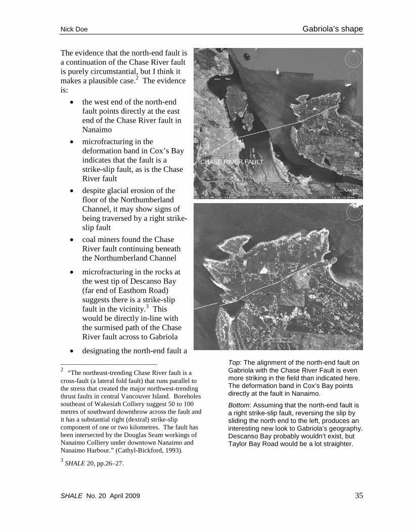
The evidence that the north-end fault is a continuation of the Chase River fault is purely circumstantial, but I think it makes a plausible case.2 The evidence is:
• the west end of the north-end fault points directly at the east end of the Chase River fault in Nanaimo
• microfracturing in the deformation band in Cox’s Bay indicates that the fault is a strike-slip fault, as is the Chase River fault
• despite glacial erosion of the floor of the Northumberland Channel, it may show signs of being traversed by a right strike-slip fault
• coal miners found the Chase River fault continuing beneath the Northumberland Channel
• microfracturing in the rocks at the west tip of Descanso Bay (far end of Easthom Road) suggests there is a strike-slip fault in the vicinity.3 This would be directly in-line with the surmised path of the Chase River fault across to Gabriola
• designating the north-end fault a 2 “The northeast-trending Chase River fault is a cross-fault (a lateral fold fault) that runs parallel to the stress that created the major northwest-trending thrust faults in central Vancouver Island. Boreholes southeast of Wakesiah Colliery suggest 50 to 100 metres of southward downthrow across the fault and it has a substantial right (dextral) strike-slip component of one or two kilometres. The fault has been intersected by the Douglas Seam workings of Nanaimo Colliery under downtown Nanaimo and Nanaimo Harbour.” (Cathyl-Bickford, 1993). 3 SHALE 20, pp.26–27.
Top: The alignment of the north-end fault on Gabriola with the Chase River Fault is even more striking in the field than indicated here. The deformation band in Cox’s Bay points directly at the fault in Nanaimo.
Bottom: Assuming that the north-end fault is a right strike-slip fault, reversing the slip by sliding the north end to the left, produces an interesting new look to Gabriola’s geography. Descanso Bay probably wouldn’t exist, but Taylor Bay Road would be a lot straighter.

Gabriola’s shape Nick Doe
36 SHALE No. 20 April 2009
right strike-slip fault would fit the current topography, even though direct evidence of displacement is lacking.
Reversing the conjectured right slip along the north-end fault makes interesting changes to the local geography. Completely gone are those twists and the three dips at the ferry-terminal end of a now- perfectly-straight Taylor Bay Road. Descanso Bay becomes either an enclosed harbour, or more likely, wouldn’t be there, as it would have been more protected from glacial erosion. Those lovely homes at the far end of Daniel Way would probably be on an islet and Leboeuf and Lock Bays would likely be one.
The east side of Descanso Bay is medium-grained sandstone of the Gabriola Formation, while the west tip, where the land turns into Northumberland Channel, is gritty sandstone of the Geoffrey Formation so it’s not easy to predict what form the conjectured narrow entrance to Descanso Bay might have been in the absence of the fault. Probably just a narrow inlet, useless for ferry terminals, where the ice carved away a band of the soft shale of the intervening Spray Formation. Removing the slip at the Leboeuf Bay end adds weight to the theory by straightening out exposures of contacts between the Gabriola, Spray, and Geoffrey Formations which otherwise do curious right-angled bends to the east at the north end of Sandwell Park (see map, SHALE 1, p.31, November 2000).
Adapted from Geological Survey Canada (source is in false colour)
Right strike-slip feature or glacial erosion? Bathymetric view of the entrance to the Northumberland Channel, which might be traversed by the Chase River fault. Descanso Bay is on the right.
North-end fault in Cox’s Bay showing the heavily veined and fractured shear zone. The west tip of Descanso Bay and Jack Point is in the middle distance on the left.

Nick Doe Gabriola’s shape
SHALE No. 20 April 2009 37
The north-end fault is associated with the F-set fractures (N73°E), which I’ll describe later.4
The south-end fault The south-end strike-slip fault that runs from the Maples to Dragon’s Lane Bay on the north shore probably (N47º E) has had less influence on Gabriola’s geography than the north-end fault though it may account for the break between Mudge Island and Link Island. The rise in South Road by the Community Hall would also not be so steep without it. It evidently has had some effect on the groundwater however. There is a permanent spring at the south end of the fault and a permanent groundwater-fed lake at the end of Dorby Road.
The south-end fault is associated with the G-set fractures (N47°E), which I’ll describe in the next article.4
The third fault Gabriola’s “third” major fault (c) I’ve seen described in a general (not geological) article as being a strike-slip fault, but appears to me more likely to be a normal fault dipping northeast.
The fault runs N47°W into the Flat Top
4 SHALE 20, pp.41–55.
Canadian Hydrographic Service
Gabriola’s “hidden” major fault runs N47°W into the Flat Top Islands, almost at right angles to another strike-slip fault between the Maples and Dragon’s Lane. The righthand side of the fault as seen here appears to have moved toward the northeast (top right of the picture).

Gabriola’s shape Nick Doe
38 SHALE No. 20 April 2009
Islands, almost at right angles to the south-end fault (b) between the Maples and Dragon’s Lane.
This third fault is associated with the C-family set of fractures on Gabriola (N56°W, N36°W, N25°W), which I describe in the next article.4
Judging from its orientation alone—parallel to the coasts of Valdes and Galiano Islands—the fault is a member of the Outer
Islands Fault Zone, which runs down the floor of the Strait of Georgia off the outer coasts of the southern Gulf Islands. The faults in the Outer Islands Fault Zone are high-angle faults that dip to the northeast and are probably still active (Barrie & Hill, 2004).
Geological Survey Canada
The NNE-trending A-set fractures show extension, indicated by the arrows, roughly parallel to Gabriola’s syncline axis. They are clearly a fundamental characteristic of Gabriola’s structure. Normal faults dropping right and left and wrench faults, indicating extension, are common along both north and south shores.

Nick Doe Gabriola’s shape
SHALE No. 20 April 2009 39
The big “stretch” Although there is no single major fault that exemplifies the big “stretch”, there is lots of evidence in the form of minor faults and joints that Gabriola has been stretched along its central axis. The fractures that constitute this evidence are the A-set fractures (N29°E), and again, I’ll describe them in the next article.4
It’s easy enough to come up with explanations for the stretch, but hard to make a convincing case that any of them is right. One of my favourites starts with the
observation that the stress causing the A-set fractures seems to have rotated clockwise going east across the island. You can also see this clockwise trend in the curved orientation of Mudge and Link Islands. Perhaps this radiating pattern of compression stress creates circumferential stress relief as one moves northeast, hence the northwest-southeast expansion.
Speculating even more precariously, I would say the opportunity for such a stretch was provided by the topography of the mainland on the opposite side of the strait. The northern Vancouver Island coastline of the Strait of Georgia looks directly across to the formidable and heavy Coast Mountains, including the Garibaldi volcanic complex. The southern outer Gulf Islands coastline of the Strait of Georgia in contrast looks out over the extensive lowlands of the Fraser Valley. Perhaps this transition allows for margin-parallel stress relief just like the toothpaste I’m about to go and use.
Orientation? All this leaves unanswered the question as to why the coastline south of us appears to be rotated clockwise. I’m still not sure. Part of the answer may be that what we see is actually a lack of counter-clockwise rotation. The further south you go, the more severe the folding, the greater the contraction, and hence the less northeast-directed horizontal movement there has been (Johnston & Acton, 2003), but the whole story has to wait for another day.
Minor fractures As I remarked in the introductory article, “minor” fractures often reflect the presence of the much larger fractures that shaped the island. Already mentioned are the E-set, G-set, A-set, and C-family of fractures, but as we’ll see later,4 there are a few more. ◊
Vertical tensile fractures in the cliff along the Northumberland Channel looking north. The west side has dropped a couple of metres or so relative to the east side. There’s another at the exit of Hoggan Lake. One of the many signs of the big stretch.

Gabriola’s shape Nick Doe
40 SHALE No. 20 April 2009
References J. Vaughn Barrie & P.R. Hill, Holocene faulting on a tectonic margin: Georgia Basin, British Columbia , Canada, Geo-Marine Letters, 24, pp.86–96, 2004. W.L. Brown & R.B. Erdman, Habitat of groundwater, Gabriola Island, Department of Lands, Forests, and Water Resources, January 1975. C. Gwyneth Cathyl-Bickford, Geology and Petrography of the Wellington Seam, Nanaimo Coalfield, Vancouver Island, M.Sc. thesis, UBC, March 1993. R.K. Dash, G.D. Spence, M. Riedel, R.D. Hyndman, & T.M. Brocher, Upper-crustal structure beneath the Strait of Georgia, Southwest British Columbia, International Journal of Geophysics, 170, pp.800–812, 2007.
T.D.J. England, Late Cretaceous to Paleogene evolution of the Georgia Basin, Southwestern British Columbia, Ph.D. thesis, Memorial University of Newfoundland, 1989. Rob Hare, Ernie Sargent, Kalman Czotter, & Neil Sutherland (CHS), David Mosher & Vaughn Barrie (GSC), A multi-disciplinary, multi-agency, multi-beam survey of Georgia Basin, LIGHTHOUSE, Journal of the Canadian Hydrographic Association, 59, pp.25–34, Spring 2001. T.S. Hamilton & B.D. Ricketts, Contour map of the sub-Quaternary bedrock surface, Strait of Georgia
and Fraser Lowland, Geol. Survey of Canada, Bulletin 481, pp.193–6, 1994. Stephen T. Johnston & Shannon Acton, The Eocene Southern Vancouver Island Orocline—a response to seamount accretion and the cause of fold-and-thrust belt and extensional basin formation, Techtonophysics, 365: pp.165–83, 2003. C. Lowe, S.A. Dehler, and B.C. Zelt, Basin architecture and density structure beneath the Strait of Georgia, British Columbia, Canadian Journal of Earth Sciences, 40: pp.965–81, 2003. Daniel C. Mackie, An integrated structural and hydrogeologic investigation of the fracture system in the Upper Cretaceous Nanaimo Group, southern Gulf Islands, British Columbia, Simon Fraser University, M.Sc., 2002. J.W.H. Monger & J.M. Journeay, Basement geology and tectonic evolution of the Vancouver region, Geol. Survey of Canada, Bulletin 481, pp.3–25, 1994. James W.H. Monger & J. Murray Journeay, Guide to the geology and tectonic evolution of the southern Coast Mountains, Geol. Survey of Canada, Open File 2490, 1994. J.E. Muller and J.A. Jeletzky, Geology of the Upper Cretaceous Nanaimo Group, Vancouver Island and Gulf Islands, British Columbia, Geol. Survey of Canada, Paper 69-25, 1970. John A. Packard, Paleoenvironments of the Cretaceous rocks, Gabriola Island, British Columbia, Oregon State University, M.Sc., 1972.
A
C3
C2
C1
E
The C-family fractures, which are often short joints on Gabriola, appear nevertheless to have played a significant role in defining the shoreline in Drumbeg Park. A glance at a chart will show why. Fractures with the C-family orientation follow the general trend of Valdes Island, where they likely have a different origin from those on Gabriola. See SHALE 20, pp.41–55.

Notes
34 SHALE No.22 January 2010
Gabriola’s nose and tail —by Nick Doe
In a recent article on the folds and faults of Gabriola,1 I advanced the idea that the major righthand strike-slip fault that runs from Leboeuf Bay to Cox’s Bay near the ferry terminal—the fault that creates those twists and turns and ups and downs at the start of Taylor Bay Road—that this fault was a continuation of the Chase River Fault on Vancouver Island. Turns out this idea is not entirely new. The fault has been labelled the Cassidy Fault in the past by some very observant Gabriolan.
Turns out though that both names are probably too parochial. The fault runs over
thirty kilometres inland into the Nanaimo River and Nanaimo Lakes region.
As the diagrams show,2 it runs in a northeasterly direction identical to that of the compressive stress that created the northwest-tending folds and faults of southern Vancouver Island. The impression that Gabriola’s “nose” has been pushed out of shape by Mount Benson is therefore not a bad idea, but is wrong. All land northwest of the fault, including Gabriola’s nose and Mount Benson, has been pushed further northeast relative to land southeast of it.
Considering that Gabriola’s south-end fault is a lefthand strike-slip fault, it looks as though both Gabriola’s “nose” and Gabriola’s “tail” have moved northeast
Geological structure map2 of Vancouver Island showing NW-SE-trending fold and thrust or reverse faults (barbed) and NE-SW trending slip faults (solid), the result of Vancouver Island being pushed up against the mainland by “continental drift”. The slip fault shown here passing north of Gabriola is the fault that actually cuts through Gabriola from near Descanso Bay to Leboeuf Bay. Possibly a second slip fault to the SE, shown here stopping short of the coast, is the same as the fault that extends across Gabriola to Dragon’s Lane, but this is speculative.

Notes
SHALE No.22 January 2010 35
relative to the central block. If so, the F-set and G-set fractures on Gabriola are likely of the same age and origin, and are younger than the A-set and E-set.3
A conjectured source of the “lag” of the central block of Gabriola is the pairing of reverse (thrust) faults with opposite sense in the Harewood Mine area between Nanaimo and the small town of Extension. Just as two parallel normal faults with opposite sense indicate stretch,4 two parallel thrust faults with opposite sense indicate squeeze.
The top left of the diagram below shows compression stress along a NE-SW axis causing contraction, not by folding, but by forcing a block between two thrust faults upward (a shiver in potters’ terms, a horst in geologists’ terms). The two overhangs shown in the diagram are in real life quickly eroded away to steep scarps. “A” at the base of the scarp on the SW side is where there is coal—the Wellington seam. It has been brought to the surface by the fault. That particular scarp is also honeycombed.5 Seen from above, bottom right, the uplifted block, shown grey, is bounded by two NE-SW trending faults. Blocks to the NW and SE have not been contracted and extend further to the NE. This creates strike-slip faults—righthand on the NW side, lefthand on the SE side. We see these same faults on Gabriola. Anyway…that’s my contention.
◊
References: 1. SHALE 20, pp.29–40. 2. N.W.D. Massey, Geology and mineral resources of the Alberni-Nanaimo Lakes Sheet, BC Ministry of Energy and Mines, Paper 1992-2. 3. SHALE 20, pp.41–54. 4. SHALE 20, p.17. 5. The old mine shaft on the A scarp is at 49°07.159’N, 123°57.911’W.
The geological map on the previous page with my conjectured extensions of the slip faults across Gabriola superimposed on a road map. Gabriola’s north-end fault appears to be the fault defining the south branch of the Nanaimo River.
north
NE-verge
nt
thrus
t fault
ASW
-verge
nt
thrus
t fault
NE-direc
ted
thru
st
SW-di
rected
thru
st
NE-to G
abrio
la
north
-end f
ault
NE-to G
abrio
la
south
-end f
ault
right
strike
-slip
fault
left strik
e-slip
fault
contr
acted
slive
r
unco
ntrac
ted
unco
ntrac
ted
cliff t
op
cliff t
op


![NOTICE CONCERNING COPYRIGHT RESTRICTIONSlroot/ConflictMgtConcept... · NOTICE CONCERNING COPYRIGHT RESTRICTIONS The copyright law of the United States [Title 17, United States Code]](https://static.fdocuments.net/doc/165x107/5eb922834d07996dc605c399/notice-concerning-copyright-restrictions-lrootconflictmgtconcept-notice-concerning.jpg)