Copy of 2001 JIRP Survey Report - Juneau...
156
HE Foundation for Glacier and Environmental Research Juneau Icefield Research Program Seattle, Washington and Glaciological and Arctic Sciences Institute University of Idaho Moscow, Idaho JIRP Open File Survey Report—2001
Transcript of Copy of 2001 JIRP Survey Report - Juneau...

HE
Foundation for Glacier and Environmental Research Juneau Icefield Research Program
Seattle, Washington and
Glaciological and Arctic Sciences Institute University of Idaho
Moscow, Idaho
JIRP Open File Survey Report—2001

GEODETIC ACTIVITIES DURING
THE 2001 JUNEAU ICEFIELD RESEARCH PROGRAM
FIELD SEASON
Compiled By
Scott R. McGee Foundation for Glacier and Environmental Research
Prof. Dr.-Ing. Walter Welsch
Dipl.-Ing. Martin Lang Universität der Bundeswehr, München
With Student Contributions By Jake Amadon Ellie Boyce Eric Chin Shara Feld
Colby Smith Haley Wight
Foundation for Glacier and Environmental Research Juneau Icefield Research Program
Seattle, Washington and
Glaciological and Arctic Sciences Institute University of Idaho
Moscow, Idaho
JIRP OPEN FILE SURVEY REPORT—2001

Geodetic Activities During the 2001 JIRP Field Season Compiled by Scott McGee and Walter Welsch Foundation for Glacier and Environmental Research Juneau Icefield Research Program 514 East 1st Street Moscow, Idaho 83843 USA © Copyright 2001 Cover photo: Performing a GPS survey on the Vaughan Lewis Glacier, Juneau Icefield, Alaska, August, 2001.
The Vaughan Lewis Glacier is known for a series of spectacular wave and band ogives at the base of the Vaughan Lewis Icefall. A longitudinal survey was performed to quantify the amplitude and wavelength of the ogives. Lakes in the troughs between several crests provided a unique challenge, requiring the combination of GPS positioning and hydrologic soundings to determine the underwater elevation of the ice surface. Photo by Scott McGee.
All data contained herein were collected from 1992 to 2001 by the Foundation for Glacier and Environmental Research, Juneau Icefield Research Program with additional financial support from the University of Idaho, National Science Foundation, NASA, the Army Research Office, and the Universität der Bundeswehr, Munich, Germany. These data are available to the public at no charge for scholarly use. Researchers wishing to use the information contained herein may do so provided the author and the Foundation for Glacier and Environmental Research, Juneau Icefield Research Program are properly credited and cited as the originators of the data. Survey reports from previous field seasons of the Juneau Icefield Research Program may be obtained from the Foundation for Glacier and Environmental Research at the above address, or on the Internet at http://crevassezone.org.

CONTENTS SUMMARY............................................................................................................................................. 1 1. Introduction......................................................................................................................................... 2 2. Survey Methods .................................................................................................................................. 5
2.1 Establishment of Profiles.............................................................................................................. 5 2.2 GPS Survey Methods ................................................................................................................... 5
3. Survey Projects ................................................................................................................................... 6 3.1 Transverse Profiles ....................................................................................................................... 7
3.1.1 Surface Velocity.................................................................................................................... 7 3.1.1.1 Taku Glacier .................................................................................................................. 7 3.1.1.2 Icy Basin ...................................................................................................................... 10 3.1.1.3 Gilkey Glacier.............................................................................................................. 12
3.1.2 Short-term Height Change .................................................................................................. 12 3.1.3 Long-term Height Change .................................................................................................. 14
3.1.3.1 Taku and Demorest Glaciers........................................................................................ 15 3.1.3.2 Gilkey Glacier.............................................................................................................. 15 3.1.3.3 Lemon Glacier ............................................................................................................. 17
3.2 Longitudinal profiles .................................................................................................................. 19 3.2.1 Surface velocity and Gradient............................................................................................. 20
3.2.1.1 Taku/Matthes/Llewellyn Glaciers................................................................................ 20 3.2.1.2 Northwest and West Branches of the Taku Glacier..................................................... 22
3.2.2 Long-term height change .................................................................................................... 32 3.2.2 Long-term height change .................................................................................................... 33
3.2.2.1 Taku / Matthes / Llewellyn Glaciers............................................................................ 33 3.2.2.2 Demorest Glacier ......................................................................................................... 35 3.2.2.3 Southwest Branch of the Taku Glacier ........................................................................ 37 3.2.2.4 Northwest and West Branches of the Taku Glacier..................................................... 38
3.2.3 Longitudinal Surface Flow Times....................................................................................... 42 3.3 Profile 4 ...................................................................................................................................... 44
3.3.1 Height Change and Local Surface Mass Balance ............................................................... 45 3.3.2 Strain ................................................................................................................................... 53
3.4 Matthes Glacier / Llewellyn Glacier Divide............................................................................... 54 3.5 Gilkey Glacier Surveys .............................................................................................................. 56
3.5.1 Ogive Wavelength and Amplitude...................................................................................... 56 3.6 Test Pits ...................................................................................................................................... 60
4. Future Work...................................................................................................................................... 61 5. Acknowledgements........................................................................................................................... 61 References.............................................................................................................................................. 62 Appendix 1 – GPS Benchmark Coordinates.......................................................................................... 67 Appendix 2 – Movement Profile Flag Coordinates ............................................................................... 69 Appendix 3 – Surface Movement Vectors........................................................................................... 127 Appendix 4 – Short-term Height Change Graphs................................................................................ 134 Appendix 5 – Longitudinal Surface Flow Times................................................................................. 139 Appendix 6 – Profile 4 Surface Elevations, 1993 to 2001................................................................... 147 Appendix 7 – Profile 4 Surface Strain, July 19-25, 2001 .................................................................... 148 Notes .................................................................................................................................................... 149


JIRP Survey Report — 2001
1
GEODETIC ACTIVITIES DURING THE 2001 JUNEAU ICEFIELD RESEARCH PROGRAM
FIELD SEASON
FOUNDATION FOR GLACIER AND ENVIRONMENTAL RESEARCH,
JUNEAU ICEFIELD RESEARCH PROGRAM,
SEATTLE, WASHINGTON
SUMMARY
The JIRP 2001 field season proved to be a productive one for the survey team. GPS surveys were conducted at six previously established transverse movement profiles. Four longitudinal movement profiles were extended in length, and one new longitudinal movement profile was established. Additional surveys were conducted within the wave-bulge zone of the Vaughan Lewis Glacier, including a longitudinal profile to determine the wavelength and amplitude of the ogives. Several 1995 positions on the Gilkey Glacier were also resurveyed this year, and a new benchmark was established at Knowl Point. The locations of several mass balance test pits were also surveyed. As in past years, the survey work focused on determining surface movements, surface elevations and changes, strain rates, ablation data, and local surface mass balance. Additionally, evaluation of the surface velocity along the longitudinal profiles has enabled the calculation of more precise flow lag times for the Taku, Matthes, Llewellyn, Demorest, Southwest Branch, Northwest Branch, and West Branch Glaciers. Results of the surveys show that, for the third consecutive year, there was an overall increase in surface elevations on the Juneau Icefield, ranging from the Lemon Glacier to the Llewellyn Glacier at F-10 Peak. As with the conditions seen in 2000, the surface elevation of the Gilkey Glacier decreased from 2000 to 2001. Evaluation of the local surface mass balance changes at Profile 4 reveals a positive net balance for the third consecutive year. The observed surface velocities at all locations remain consistent with that found in previous years.
Foundation for Glacier and Environmental Research
2
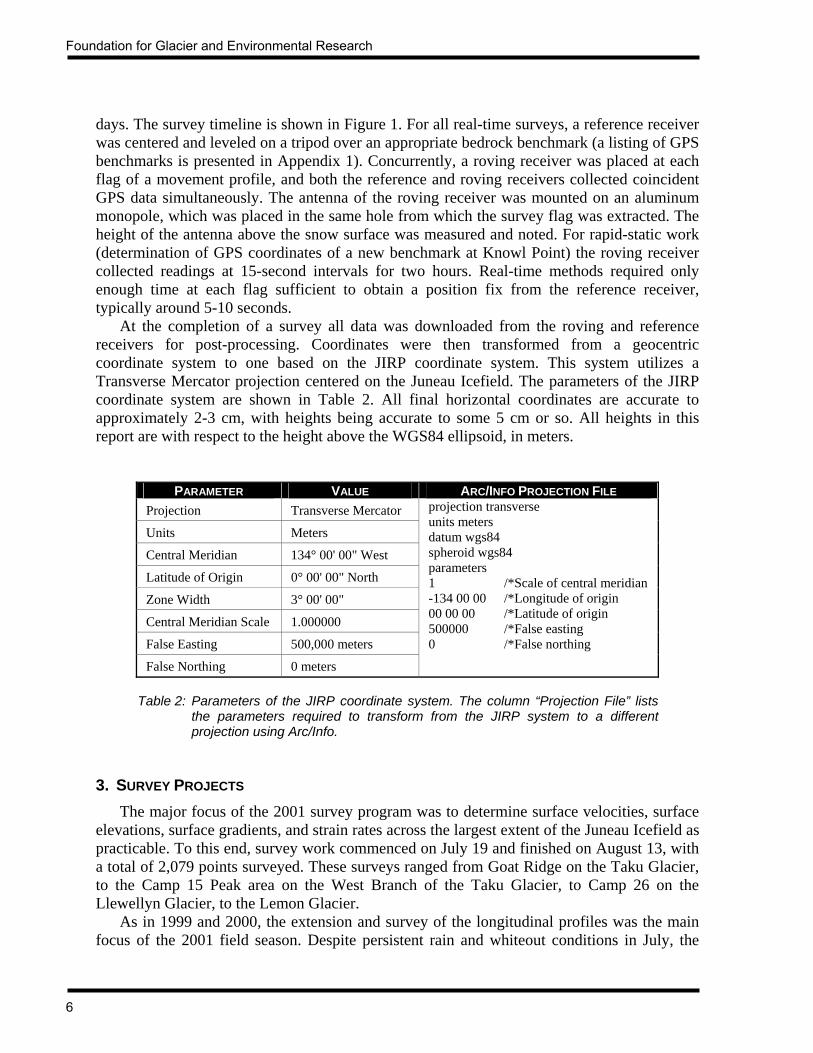
1. INTRODUCTION The 2001 JIRP field season was significant in that more survey work was accomplished, in terms of points surveyed, than was done in any other previous season. The number of surveys completed in 2000 was certainly impressive, at 570 points surveyed. However, this was easily surpassed in 2001, due to several special projects that were undertaken this year. The surveys conducted this summer comprised 17 distinct profiles with a total of 1,919 points, and considering the resurvey of selected flags, a grand total of 2,079 points were surveyed in 2001. Figure 1 presents a graphical timeline of the surveys, while Table 1 provides additional details of the surveys completed during the 2001 field season. Refer to Figure 2 for a map showing the locations of profiles surveyed. The major focus of the survey program this season was to continue monitoring the network of longitudinal profiles that has been established over the past three years. The longitudinal network was also extended this year with additional points on the lower Taku Glacier, the West Branch and the Echo Glacier branches of the Taku Glacier, and the Rhino Peak and Snow Towers branches of the Northwest Branch of the Taku Glacier. A new benchmark was established on Knowl Point in order to provide control for the extension of the profiles on the Northwest and West branches of the Taku Glacier. Together, these new longitudinal points added 34 kilometers to the existing network of 93.5 kilometers of longitudinal profiles. Approximately 25 kilometers remain to be surveyed, primarily on the upper Demorest Glacier. Continuing a project started in 1995 with the first survey of the Matthes/Llewellyn divide area, a comprehensive topographic survey of this area was completed this summer. Over 1,200 points were surveyed with kinematic differential GPS to produce a topographic map of 19.5 square kilometers at the divide between the Matthes and Llewellyn Glaciers.
July August
Lemon Gl.
Icy BasinProfile 3
Profile 3aProfile 4
Long. A
Long. B
Long. C
Long. D
Long. F
Gilkey Gl.
V.L. Ogives
Benchmarks
Test Pits
Long.E
Long. G
M/L Divide
V.L. Long.
2621 22 31 3 52824 1 723 29 2 427 625 30 8 9 10 11 1219 20 13
= Survey performed on this date
Figure 1: Timeline of surveys conducted during the 2001 JIRP field season.

JIRP Survey Report — 2001
3
PROFILE LOCATION SURVEY DATES DATA
COLLECTED SURVEY METHOD
# OF FLAGS
Profile 3 Demorest Glacier July 26, 2001 HC RT-DGPS 12 Profile 3a Demorest Glacier August 3, 2001 HC RT-DGPS 15
Profile 4 Taku Glacier July 19, 2001 July 25, 2001
MV, AB, HC, MB, SR
RT-DGPS RT-DGPS
31 31
Longitudinal A Taku / Matthes / Llewellyn Glaciers
July 20, 2001 July 21, 2001 July 23, 2001
August 1, 2001 August 5, 2001 August 8, 2001
MV, AB, HC, GR
RT-DGPS (all dates)
36 17 10 27 31 8
Longitudinal B Demorest Glacier July 26, 2001 August 3, 2001 HC, GR RT-DGPS
(all dates) 24 10
Longitudinal C Southwest Branch July 25, 2001 HC, GR RT-DGPS 28
Longitudinal D Northwest Branch July 28, 2001 July 29, 2001
August 7, 2001
MV, HC, AB, GR
RT-DGPS (all dates)
30 18 34
Longitudinal E West Branch of Northwest Branch
July 29, 2001 August 7, 2001 MV, AB, GR RT-DGPS
(all dates) 14 14
Longitudinal F West Branch July 30, 2001 August 6, 2001
MV, HC, AB, GR
RT-DGPS (all dates)
25 12
Longitudinal G Echo Glacier Branch July 28, 2001 August 6, 2001 MV, AB, GR RT-DGPS
(all dates) 11 11
Icy Basin Icy Basin July 23, 2001 July 24, 2001 July 29, 2001
MV, AB RT-DGPS (all dates)
22 15 37
Lemon Glacier Lemon Glacier August 2, 2001 HC, MB RT-DGPS 123
M/L Divide Matthes / Llewellyn Glacier Divide area August 13, 2001 POS, TM RT-DGPS 1218
VL Longitudinal Vaughan Lewis Glacier below Icefall
August 10, 2001 August 11, 2001 POS, GR RT-DGPS 180
VL Ogives Vaughan Lewis Glacier below Icefall
August 10, 2001 August 11, 2001 MV, AB RT-DGPS 11
11 Gilkey Trench Gilkey Glacier August 10, 2001 HC RT-DGPS 9
Test Pits Various locations July 25, 2001 July 27, 2001 POS Garmin 3
Benchmarks NW Branch Taku Gl. July 27, 2001 POS DGPS 1
Explanation of Codes
Data Collected:
AB = Ablation HC = Height comparison MB = Mass balance TM = Topographic mapping
MV = Movement POS = Position SR = Strain rates GR = Surface Gradient
Survey Method: DGPS = Rapid static differential GPS RT-DGPS = Real time differential GPS Garmin = Garmin 45 handheld GPS
Table 1: Detail of surveys conducted during the 2001 JIRP field season.

Foundation for Glacier and Environmental Research
4
Figure 2: Location of transverse and longitudinal profiles surveyed during the 2001 JIRP field season.
3a
34
IcyBasin
LemonGlacier
M/L DivideGilkey
VaughanLewis
5 km

JIRP Survey Report — 2001
5
Two special projects were completed in the Gilkey Trench, focusing on the ogive zone of the Vaughan Lewis Glacier. Velocities at the crests of the first four ogives were determined, and a longitudinal profile down the center of the ogives, from Ogive 1 to Ogive 11 was established. This longitudinal profile reveals the wavelength and amplitude of the ogives, from the foot of the Vaughan Lewis Icefall to the point at which the amplitude of the ogives is reduced to zero. As with the previous several years, all survey work was accomplished using real-time differential GPS, utilizing Leica System 530 survey-grade receivers. The use of snow machines and Thiokol oversnow vehicles again contributed to the very productive season. Scott McGee and Walter Welsch supervised all survey work and provided fundamental lecture and field training for all the students on the summer program. Comprehensive GPS theory and field instruction were given to the six students that formed the core survey group. 2. SURVEY METHODS As in the past several years, standard rapid static and real-time differential GPS methods were utilized for all of the 2001 surveys. For a complete description of the techniques used, refer to the discussion by Lang (1993) and McGee (1994). However, recognizing that these references may be unavailable to the reader of this report, and in order to document the procedures used and to provide evidence of the quality and validity of the data collected, a brief overview of the methodology used for the 2001 survey work will be given here. 2.1 ESTABLISHMENT OF PROFILES One of the main goals of the surveying program is to collect data that allows quantitative comparison of surface movement and surface elevation change from year to year. In order to ensure the consistency of year-to-year movement and elevation data, all survey flags were located within one meter of the standard point coordinates as published in the JIRP Coordinate Tables (McGee, 2000a). Refer to Appendix 2 for the JIRP 2001 flag placement coordinates. The official stakeout coordinates from the Coordinate Tables were entered into a Garmin 48 handheld GPS receiver. The driver of the vehicle used the Garmin unit to navigate to within several meters of the stakeout locations. A member of the survey crew then used the same stakeout coordinates programmed into the Leica GPS to locate and survey the point within ±1 meter of the official stakeout coordinates. 2.2 GPS SURVEY METHODS After the initial establishment of the survey profiles was completed, the points were surveyed. Because of the survey program’s emphasis on extending the longitudinal network and monitoring annual surface height change, less importance was placed on surface velocity determination for several of the traditional transverse profiles and for those points of the longitudinal profiles that were surveyed in 1999 and 2000. These points were surveyed only once in 2001 in order to determine annual height change. Those points comprising the extension of the longitudinal profiles, and those within Profile 4, Icy Basin, the Vaughan Lewis Longitudinal, and the Vaughan Lewis ogives, were surveyed two times, with the time differential between the surveys ranging from 1 day to 6
Foundation for Glacier and Environmental Research
6
days. The survey timeline is shown in Figure 1. For all real-time surveys, a reference receiver was centered and leveled on a tripod over an appropriate bedrock benchmark (a listing of GPS benchmarks is presented in Appendix 1). Concurrently, a roving receiver was placed at each flag of a movement profile, and both the reference and roving receivers collected coincident GPS data simultaneously. The antenna of the roving receiver was mounted on an aluminum monopole, which was placed in the same hole from which the survey flag was extracted. The height of the antenna above the snow surface was measured and noted. For rapid-static work (determination of GPS coordinates of a new benchmark at Knowl Point) the roving receiver collected readings at 15-second intervals for two hours. Real-time methods required only enough time at each flag sufficient to obtain a position fix from the reference receiver, typically around 5-10 seconds. At the completion of a survey all data was downloaded from the roving and reference receivers for post-processing. Coordinates were then transformed from a geocentric coordinate system to one based on the JIRP coordinate system. This system utilizes a Transverse Mercator projection centered on the Juneau Icefield. The parameters of the JIRP coordinate system are shown in Table 2. All final horizontal coordinates are accurate to approximately 2-3 cm, with heights being accurate to some 5 cm or so. All heights in this report are with respect to the height above the WGS84 ellipsoid, in meters.
PARAMETER VALUE ARC/INFO PROJECTION FILE Projection Transverse Mercator
Units Meters
Central Meridian 134° 00' 00" West
Latitude of Origin 0° 00' 00" North
Zone Width 3° 00' 00"
Central Meridian Scale 1.000000
False Easting 500,000 meters
False Northing 0 meters
projection transverse units meters datum wgs84 spheroid wgs84 parameters 1 /*Scale of central meridian -134 00 00 /*Longitude of origin 00 00 00 /*Latitude of origin 500000 /*False easting 0 /*False northing
Table 2: Parameters of the JIRP coordinate system. The column “Projection File” lists
the parameters required to transform from the JIRP system to a different projection using Arc/Info.
3. SURVEY PROJECTS The major focus of the 2001 survey program was to determine surface velocities, surface elevations, surface gradients, and strain rates across the largest extent of the Juneau Icefield as practicable. To this end, survey work commenced on July 19 and finished on August 13, with a total of 2,079 points surveyed. These surveys ranged from Goat Ridge on the Taku Glacier, to the Camp 15 Peak area on the West Branch of the Taku Glacier, to Camp 26 on the Llewellyn Glacier, to the Lemon Glacier. As in 1999 and 2000, the extension and survey of the longitudinal profiles was the main focus of the 2001 field season. Despite persistent rain and whiteout conditions in July, the
JIRP Survey Report — 2001
7
survey crew succeeded in establishing an additional 34 kilometers of longitudinal profiles on the Taku, Demorest, Southwest Branch, Northwest Branch, West Branch, Matthes, and Llewellyn Glaciers. Additionally, all longitudinal points that were first established and surveyed in 1999 and 2000 were again surveyed this year. Combined, the 1999-2001 longitudinal profiles encompass 127.5 kilometers of the Taku/Llewellyn glacier system. Other survey work accomplished this year included ongoing surveys of the standard transverse movement profiles, with emphasis on long-term height change rather than velocity determination. This was necessary so that adequate field time could be allocated to the longitudinal surveys. Additionally, surveys were performed on the first 11 wave ogives at the base of the Vaughan Lewis Icefall, and several points surveyed on the Gilkey Glacier in 1995 were resurveyed this year. Three transverse and one longitudinal profile on the Lemon Glacier were also resurveyed this year. 3.1 TRANSVERSE PROFILES Surface velocity, short-term height change, and long-term height change at the transverse profiles are discussed in this section. Refer to Section 3.2 for a discussion of the survey results at the longitudinal profiles. 3.1.1 SURFACE VELOCITY Although emphasis was given to surveying the longitudinal profiles, the standard transverse movement profiles remain an important element in the ongoing monitoring of the Juneau Icefield. Periodic annual surveys of these profiles allow quantitative comparisons of the temporal velocity and height changes across the Icefield, at a variety of elevations. With 22 transverse profiles already established, it is not possible to survey each one every year. With this in mind, 3 profiles were selected for resurvey in 2000. Several of these profiles have not been surveyed in recent years, notably Profile 2 on the Taku Glacier, Profile 8 on the Matthes Glacier, Profile 9 on the Vaughan Lewis Glacier, Profile 11 on the Llewellyn Glacier, and the 1995 GPS points on the Gilkey Glacier. The discussion in this section will focus on the surface velocity at the transverse profiles. Refer to Section 3.2.1 for details regarding the surface velocities along the longitudinal profiles. All surface velocity data are presented in Appendix 3. 3.1.1.1 TAKU GLACIER The main Taku/Matthes/Llewellyn (TML) glacier system bisects the southern half of the Juneau Icefield, extending some 93 kilometers from the tidewater of Taku Inlet in Alaska to the terminal lake of the Llewellyn Glacier in British Columbia. To date, a total of ten transverse profiles have been established on the TML system (additionally, other transverse profiles have been established on other glaciers of the Juneau Icefield), with a spacing of 5 to 10 kilometers. Of these ten, only Profile 4 was resurveyed during the 2001 field season. Profile 4 is located on the main Taku Glacier at Camp 10 and extends southwesterly 4.8 kilometers from Taku B to just downglacier of Shoehorn Peak. Of the numerous cross-glacier profiles on the Juneau Icefield, this profile has the most extensive continuous survey history.

Foundation for Glacier and Environmental Research
8

JIRP Survey Report — 2001
9
Although early surveys of Profile 4 varied in the number of points and in the location of those points, this situation was rectified in 1993 with the establishment, via GPS, of standardized stake-out coordinates and with the number of points surveyed, as detailed in the JIRP movement profile stake-out coordinate tables (McGee, 2000a). Profile 4 consists of 31 flags arranged in two parallel transects, placed approximately 240 meters apart, which are offset so as to form a series of 29 triangles between the 16 flags on the downglacier transect and the 15 flags on the upglacier transect. All surveys since 1993 have utilized this arrangement, which allows for the computation of strain rates, height change, and mass balance in addition to velocity, and their annual comparison. As in past years, the benchmark FFGR 19.1 (Scott) at Camp 10 was utilized as the real-time GPS reference point.
The maximum measured velocity in 2000 was 62.1 cm/day at Flag 19, and the mean velocity for all 31 flags was 35.3 cm/day. These data show no statistically significant deviation of the measured velocities from 1993 through 2000. Therefore, a steady-state flow regime is operative. The mean elevation of all flags at Epoch 0 in 2001 was 1129.33 meters. The cross-glacier velocity distribution curves along the downglacier line and the upglacier line are shown in Figures 5 and 6, respectively. Among the two parallel transects, the downglacier line had the highest measured velocity of 62.1 cm/day at Flag 19. The maximum velocity measured at the upglacier line was 61.9 cm/day at Flag 18. Mean velocities are 34.8 cm/day for the downglacier line and 35.9 cm/day for the upglacier line. Again, no significant velocity differences are found between the two parallel transects. This is supported by the observation of a lack of unusual crevassing or other surface strain indicators in the 240-meter lateral distance between the two transects. Figures 3, 4, and 5 reveal that the flow at this profile can be characterized as a transitional stage between parabolic and block-schollen. Well-defined marginal crevasse zones give clear indication of large velocity differences along both margins of the profile, while the central portion between Flags 13 and
800850
900950
10001050
11001150
12001250
13001350
140014501500
15501600
16501700
17501800
18501900
Heig
ht ab
ove
WGS
84 E
llips
oid
(m)
05
1015
2025
3035
4045
5055
606570
7580
8590
95100
105110
Velo
city
(cm
/ da
y)
0 500 1000 1500 2000 2500 3000 3500 4000 4500 5000
Cross gla ci er di st anc e (m)
Velocity (observed)
Velocity (adjusted)
Height
Northeast Southwest
Figure 4: Surface velocity and height of Profile 4, lower line
800850
900950
10001050
11001150
12001250
13001350
140014501500
15501600
16501700
17501800
18501900
Heig
ht ab
ove
WGS
84 E
llips
oid
(m)
05
1015
2025
3035
4045
5055
606570
7580
8590
95100
105110
Velo
city
(cm
/ da
y)
0 500 1000 1500 2000 2500 3000 3500 4000 4500 5000
Cross gl aci er di st anc e (m )
Velocity (observed)
Velocity (adjusted)
Height
Northeast Southwest
Figure 5: Surface velocity and height of Profile 4, upper line
Foundation for Glacier and Environmental Research
10
23 moves as a coherent block, with no evidence of crevasses. Although the marginal crevasses are numerous, the shear zones are not nearly as chaotic as those at Profile 2, some 12 kilometers further downglacier. 3.1.1.2 ICY BASIN Icy Basin is a small glacier-filled cirque situated approximately 30 kilometers upglacier from the terminus of the Taku Glacier. It is immediately southeast of Camp 10, bordering the Vantage Peak nunatak. The basin is roughly U-shaped in plan view, and approximately 1.6 kilometers in diameter. The surface elevation is roughly 1,100 meters above the WGS84 ellipsoid. The dominant feature of the basin is a large surficial lake adjacent to the headwall of Vantage Peak. Seppälä (1973) described the formation of Salla Lake, as it is named. The focus of this paper was on explaining the morphology of the lake and its subsequent annual subglacial draining. Casual observations of the lake and the ice of Icy Basin throughout a period of years reveals that, while Salla Lake does in fact appear at the surface of the glacier, it is quite likely that there is an additional quantity of englacial and/or subglacial water that is entrapped by the ice. Salla Lake usually drains by early to mid-July, with subsequent crevasses appearing as a series of circumferential bands around the perimeter of the lake. In concert with the appearance of the crevasses, the ice at the bed of the lake seems to slump downward, giving the impression of the draining of an englacial or subglacial lake. It has been informally speculated by some researchers on the Juneau Icefield that there may be some sort of eddy flow occurring in the ice of the Basin. The speculation is that the main mass of the Taku Glacier, as it flows southeastward across the mouth of Icy Basin, forms a dam that prevents the ice of the Basin from entering the Taku Glacier system. Thus, any movement of the ice must somehow be redirected to a southeast direction, but because of the influence of the Taku Glacier, it stays within the confines of the cirque, eventually to become a counterclockwise-moving mass that is constrained within the walls of the cirque. In order to test this idea, a series of four profiles were established in Icy Basin in the summer of 2001. The profiles were arranged in three transverse lines and one short longitudinal line. Line 1 extended from the base of the Camp 10 hill across the mouth of the Basin to the west ridge of Taku A peak. Line 2 was roughly parallel to Line 1, but was located midway between the cirque headwall and the mouth. Line 3, although not perfectly straight like Lines 1 and 2, was located as near the edge of the drained Salla Lake as was practicable due to the presence of the numerous large concentric crevasses. Line 4 was a longitudinal profile at the mouth of the Basin and intersected Line 1 at a somewhat perpendicular angle. By measuring the velocity and plotting the movement vectors of the 37 stakes in these four profiles, it should be possible to ascertain if eddy flow is in fact occurring. Figure 6 presents the somewhat inconclusive results of the survey. There are clearly some outliers in the dataset, evidenced by the observed velocities and vectors at Line 1. The velocities at this line are the least of all the points surveyed. This makes sense because this line is nearer the blocking effect of the main Taku glacier, and it is farthest away from the influence of the cirque sidewalls and the local influence of the drained lake. Lines 2 and 3 show a more expected velocity and vector pattern. The vectors along the south half of these lines reflect the downslope movement of the ice on the cirque headwalls, while the vectors along the north half are directed toward the lake. This is apparently due to the concentric

JIRP Survey Report — 2001
11

Foundation for Glacier and Environmental Research
12
crevassing around the lake. As the subglacial water drained, the ice apparently slumped, forming the extensional concentric crevasse pattern. As a result, the surface vectors would also show movement toward the lake, and this is borne out by the survey observations. With the small velocities in the Basin, it may be desirable to repeat this survey at a future date, but with a survey period of at least 12-14 days. This survey was conducted over a period of only 6 days, which explains some of the erratic results. Appendix 2 lists the survey data for the Icy Basin profiles. The movement data are shown in Appendix 3. 3.1.1.3 GILKEY GLACIER The confluence zone of the Gilkey Glacier has been the site of numerous surface velocity studies in the past (McGee, 1990; Lang, 1995; Welsch, et al., 1997). In particular, the wave ogives, or wave bulges as they are sometimes called, have been surveyed to determine the velocity along the crests of the ogives. The most recent survey of this type was performed in 2000, and was repeated again in 2001. Due to time constraints, only the first three ogives were surveyed this year, in contrast to the first ten ogives that were measured in 2000. In addition, a longitudinal profile extending downglacier along the centerline of the ogives was surveyed this year. The results of this survey are presented in Section 3.5.1. The surface velocity along the crests of the first three ogives at the base of the Vaughan Lewis Icefall is displayed in Figure 7, and tabulated in Appendix 3. As can be seen, the velocities are rather consistent, ranging from 33.7 cm/day to 41.1 cm/day. The movement vectors are as expected. 3.1.2 SHORT-TERM HEIGHT CHANGE For the purposes of this report, short-term height change is defined as the change in height of the glacier surface between the summer Epoch 0 and Epoch 1 surveys, typically covering a time span of 7 to 14 days. Ablation, downslope movement, and firn compaction are the main contributors to short-term height change. The accuracy to which this change can be detected on a glacier with survey-grade differential GPS is roughly 1-5 cm, depending on the magnitude of suncup-induced surface roughness. A smooth surface devoid of suncups allows for more precise measurement of the GPS antenna above the well-defined snow surface. The presence of large suncups mandates estimation of the mean surface between the crest and the troughs. With a smooth, suncup-free surface (typical at the higher elevations of the Matthes and Llewellyn Glaciers), surface heights relative to a known benchmark can be determined within about ±0.5-1 cm. As the surface becomes rougher, the height determination may degrade to ±5-6 cm. Nevertheless, with an elapsed time between Epoch 0 and Epoch 1 surveys of 7 to 14 days, and daily ablation rates of roughly 5-8 cm/day, it is possible to determine significant short-term height changes during the time period of the surveys. It is important to note that the short-term height changes reported here include the component of downslope movement of the surveyed flags. Surface height changes due to the downslope movement of the flags between Epoch 0 and Epoch 1 have not been extensively investigated on the Juneau Icefield. However, with surface gradients ranging from 1-2 degrees, the contribution to short-term height change due to downslope movement amounts to roughly 20% of the total observed short-term height change. The remaining 80% can be attributed to actual ablation of the surface.

JIRP Survey Report — 2001
13

Foundation for Glacier and Environmental Research
14
Most survey work this summer focused on the longitudinal profiles and as a result, only Profile 4 and the transverse profiles at Icy Basin and the Vaughan Lewis Glacier wave ogives were surveyed twice. The short-term height change for these profiles is shown in Table 3. Refer to Appendix 4 for detailed graphs of short-term height change at the transverse and longitudinal profiles. Appendix 2 lists the surveyed height of the flags at all profiles for both the Epoch 0 and Epoch 1 surveys.
SHORT-TERM HEIGHT CHANGE (CM/DAY) PROFILE
MEAN SURFACE HEIGHT OF PROFILE AT EPOCH 0
(HAE M) MINIMUM MAXIMUM MEAN Icy Basin Line 1 1098.06 -3.3 -6.2 -5.0 Icy Basin Line 2 1104.52 -3.7 -9.7 -7.0 Icy Basin Line 3 1101.03 -5.6 -8.0 -6.4 Icy Basin Line 4 1097.57 -4.6 -5.5 -5.2
V.L. ogive 1 1098.87 -3.2 -7.6 -5.7 V.L. ogive 2 1091.31 -4.5 -10.1 -8.2 V.L. ogive 3 1088.31 -3.2 -5.9 -4.3
4 1129.333 -3.3 -9.6 -6.2
Table 3: Short-term height change at Profile 4 and Icy Basin on the Taku Glacier, and on the Vaughan Lewis Glacier wave ogives.
3.1.3 LONG-TERM HEIGHT CHANGE Long-term height change analysis is important in determining the relationship between surface height changes, the elevation of ablation and accumulation zones, and the accumulation area ratio (AAR) of a glacier system. This is particularly important when assessing the likely response of a glacier to climate change because the zones of net increase or decrease in elevation of the surface with respect to the elevation of the accumulation and ablation zones determine whether the glacier will ultimately advance, retreat, or remain stable. This is because changes in surface height have a direct correlation with mass balance. For example, suppose a glacier has an AAR of 0.67. In this case, the accumulation area is twice the size of the ablation area. If the surface height increases 2 meters water equivalent in the accumulation area, then the glacier will likely increase its mass (assuming that the accumulation is not offset by extreme ablation lower on the glacier). In addition, since the accumulation area is twice the size of the ablation area, the surface height of the glacier in the ablation zone (and/or retreat of the terminus) would have to decrease 4 meters water equivalent to nullify the 2 meter surface height increase in the accumulation area. Recognizing the critical importance of surface height changes and the elevations at which they occur, and the ability of GPS to consistently measure heights over time, transverse and longitudinal profiles on the Juneau Icefield are monitored to determine long-term height changes. As used in this report, long-term height change refers to the change in height of the glacier surface from one year to another. This is determined by taking GPS height readings in subsequent years at the standard flag coordinates as published in the JIRP Coordinate Tables (McGee, 2000a). Because the measurements are taken within a 10-50 cm radius of the
JIRP Survey Report — 2001
15
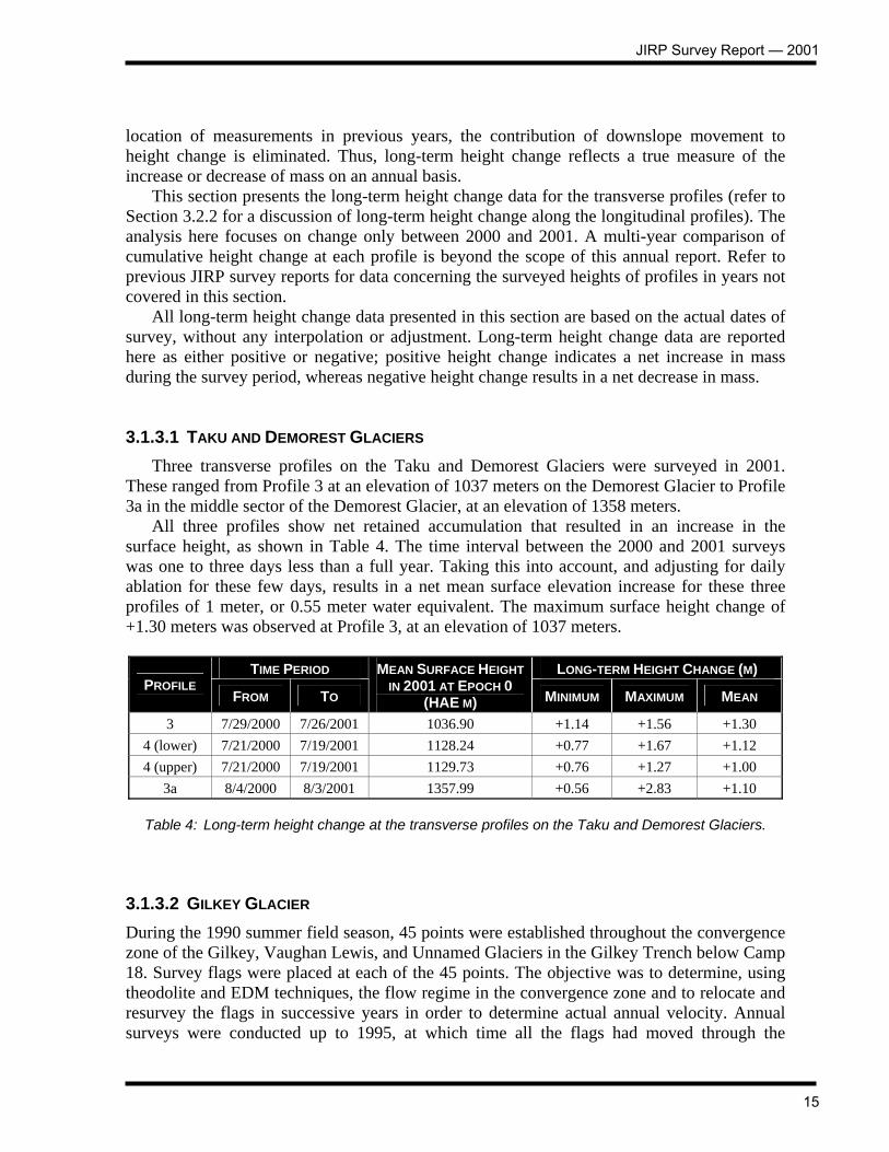
location of measurements in previous years, the contribution of downslope movement to height change is eliminated. Thus, long-term height change reflects a true measure of the increase or decrease of mass on an annual basis. This section presents the long-term height change data for the transverse profiles (refer to Section 3.2.2 for a discussion of long-term height change along the longitudinal profiles). The analysis here focuses on change only between 2000 and 2001. A multi-year comparison of cumulative height change at each profile is beyond the scope of this annual report. Refer to previous JIRP survey reports for data concerning the surveyed heights of profiles in years not covered in this section. All long-term height change data presented in this section are based on the actual dates of survey, without any interpolation or adjustment. Long-term height change data are reported here as either positive or negative; positive height change indicates a net increase in mass during the survey period, whereas negative height change results in a net decrease in mass. 3.1.3.1 TAKU AND DEMOREST GLACIERS Three transverse profiles on the Taku and Demorest Glaciers were surveyed in 2001. These ranged from Profile 3 at an elevation of 1037 meters on the Demorest Glacier to Profile 3a in the middle sector of the Demorest Glacier, at an elevation of 1358 meters. All three profiles show net retained accumulation that resulted in an increase in the surface height, as shown in Table 4. The time interval between the 2000 and 2001 surveys was one to three days less than a full year. Taking this into account, and adjusting for daily ablation for these few days, results in a net mean surface elevation increase for these three profiles of 1 meter, or 0.55 meter water equivalent. The maximum surface height change of +1.30 meters was observed at Profile 3, at an elevation of 1037 meters.
TIME PERIOD LONG-TERM HEIGHT CHANGE (M) PROFILE
FROM TO
MEAN SURFACE HEIGHT IN 2001 AT EPOCH 0
(HAE M) MINIMUM MAXIMUM MEAN
3 7/29/2000 7/26/2001 1036.90 +1.14 +1.56 +1.30 4 (lower) 7/21/2000 7/19/2001 1128.24 +0.77 +1.67 +1.12 4 (upper) 7/21/2000 7/19/2001 1129.73 +0.76 +1.27 +1.00
3a 8/4/2000 8/3/2001 1357.99 +0.56 +2.83 +1.10
Table 4: Long-term height change at the transverse profiles on the Taku and Demorest Glaciers. 3.1.3.2 GILKEY GLACIER During the 1990 summer field season, 45 points were established throughout the convergence zone of the Gilkey, Vaughan Lewis, and Unnamed Glaciers in the Gilkey Trench below Camp 18. Survey flags were placed at each of the 45 points. The objective was to determine, using theodolite and EDM techniques, the flow regime in the convergence zone and to relocate and resurvey the flags in successive years in order to determine actual annual velocity. Annual surveys were conducted up to 1995, at which time all the flags had moved through the
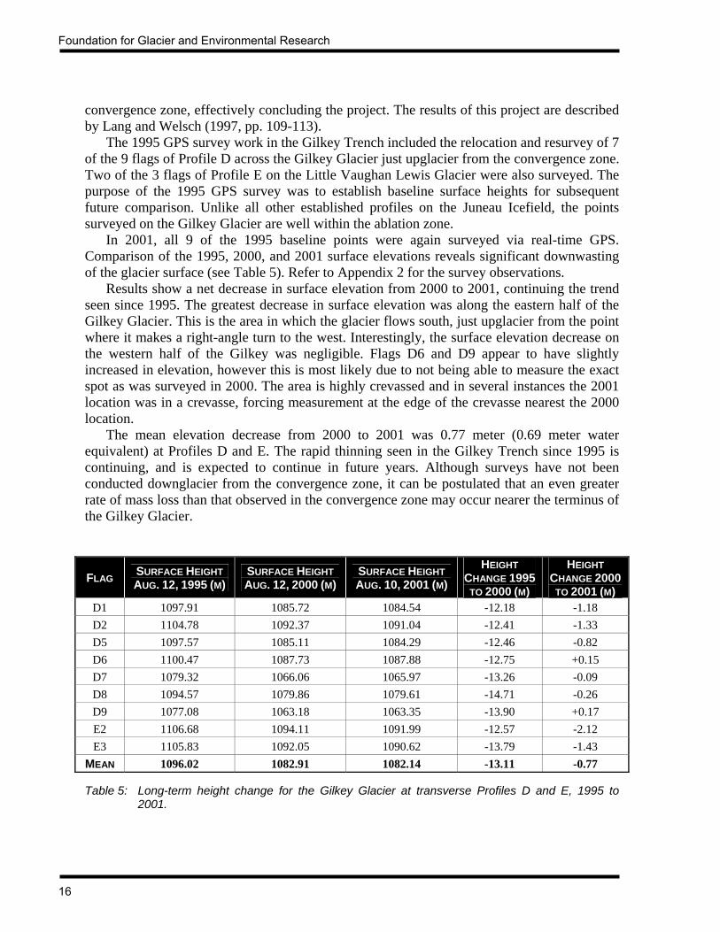
Foundation for Glacier and Environmental Research
16
convergence zone, effectively concluding the project. The results of this project are described by Lang and Welsch (1997, pp. 109-113). The 1995 GPS survey work in the Gilkey Trench included the relocation and resurvey of 7 of the 9 flags of Profile D across the Gilkey Glacier just upglacier from the convergence zone. Two of the 3 flags of Profile E on the Little Vaughan Lewis Glacier were also surveyed. The purpose of the 1995 GPS survey was to establish baseline surface heights for subsequent future comparison. Unlike all other established profiles on the Juneau Icefield, the points surveyed on the Gilkey Glacier are well within the ablation zone. In 2001, all 9 of the 1995 baseline points were again surveyed via real-time GPS. Comparison of the 1995, 2000, and 2001 surface elevations reveals significant downwasting of the glacier surface (see Table 5). Refer to Appendix 2 for the survey observations. Results show a net decrease in surface elevation from 2000 to 2001, continuing the trend seen since 1995. The greatest decrease in surface elevation was along the eastern half of the Gilkey Glacier. This is the area in which the glacier flows south, just upglacier from the point where it makes a right-angle turn to the west. Interestingly, the surface elevation decrease on the western half of the Gilkey was negligible. Flags D6 and D9 appear to have slightly increased in elevation, however this is most likely due to not being able to measure the exact spot as was surveyed in 2000. The area is highly crevassed and in several instances the 2001 location was in a crevasse, forcing measurement at the edge of the crevasse nearest the 2000 location. The mean elevation decrease from 2000 to 2001 was 0.77 meter (0.69 meter water equivalent) at Profiles D and E. The rapid thinning seen in the Gilkey Trench since 1995 is continuing, and is expected to continue in future years. Although surveys have not been conducted downglacier from the convergence zone, it can be postulated that an even greater rate of mass loss than that observed in the convergence zone may occur nearer the terminus of the Gilkey Glacier.
FLAG SURFACE HEIGHT AUG. 12, 1995 (M)
SURFACE HEIGHT AUG. 12, 2000 (M)
SURFACE HEIGHT AUG. 10, 2001 (M)
HEIGHT CHANGE 1995
TO 2000 (M)
HEIGHT CHANGE 2000
TO 2001 (M) D1 1097.91 1085.72 1084.54 -12.18 -1.18 D2 1104.78 1092.37 1091.04 -12.41 -1.33 D5 1097.57 1085.11 1084.29 -12.46 -0.82 D6 1100.47 1087.73 1087.88 -12.75 +0.15 D7 1079.32 1066.06 1065.97 -13.26 -0.09 D8 1094.57 1079.86 1079.61 -14.71 -0.26 D9 1077.08 1063.18 1063.35 -13.90 +0.17 E2 1106.68 1094.11 1091.99 -12.57 -2.12 E3 1105.83 1092.05 1090.62 -13.79 -1.43
MEAN 1096.02 1082.91 1082.14 -13.11 -0.77
Table 5: Long-term height change for the Gilkey Glacier at transverse Profiles D and E, 1995 to 2001.
JIRP Survey Report — 2001
17
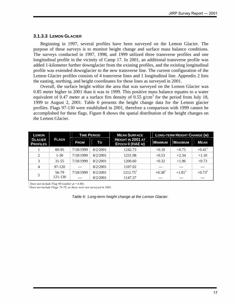
3.1.3.3 LEMON GLACIER Beginning in 1997, several profiles have been surveyed on the Lemon Glacier. The purpose of these surveys is to monitor height change and surface mass balance conditions. The surveys conducted in 1997, 1998, and 1999 utilized three transverse profiles and one longitudinal profile in the vicinity of Camp 17. In 2001, an additional transverse profile was added 1-kilometer further downglacier from the existing profiles, and the existing longitudinal profile was extended downglacier to the new transverse line. The current configuration of the Lemon Glacier profiles consists of 4 transverse lines and 1 longitudinal line. Appendix 2 lists the easting, northing, and height coordinates for these lines as surveyed in 2001. Overall, the surface height within the area that was surveyed on the Lemon Glacier was 0.85 meter higher in 2001 than it was in 1999. This positive mass balance equates to a water equivalent of 0.47 meter at a surface firn density of 0.55 g/cm3 for the period from July 18, 1999 to August 2, 2001. Table 6 presents the height change data for the Lemon glacier profiles. Flags 97-130 were established in 2001, therefore a comparison with 1999 cannot be accomplished for these flags. Figure 8 shows the spatial distribution of the height changes on the Lemon Glacier.
TIME PERIOD LONG-TERM HEIGHT CHANGE (M) LEMON GLACIER PROFILES
FLAGS FROM TO
MEAN SURFACE HEIGHT IN 2001 AT EPOCH 0 (HAE M) MINIMUM MAXIMUM MEAN
1 80-95 7/18/1999 8/2/2001 1242.73 +0.18 +0.75 +0.411 2 1-30 7/18/1999 8/2/2001 1231.98 +0.53 +2.34 +1.10 3 31-55 7/18/1999 8/2/2001 1200.60 +0.32 +1.96 +0.73 4 97-120 --- 8/2/2001 1107.02 --- --- ---
5 56-79
121-130 7/18/1999
--- 8/2/2001 8/2/2001
1212.751 1147.37
+0.382 ---
+1.812 ---
+0.732 ---
1 Does not include Flag 80 (outlier at +4.60). 2 Does not include Flags 74-79, as these were not surveyed in 2001.
Table 6: Long-term height change at the Lemon Glacier.

Foundation for Glacier and Environmental Research
18

JIRP Survey Report — 2001
19
3.2 LONGITUDINAL PROFILES While the transverse profiles have provided invaluable data relating to the flow regime of the Taku Glacier and its tributaries, they have not allowed a comprehensive examination of the surface morphology and flow patterns across the entire extent of the Juneau Icefield. Recognizing this shortcoming, a comprehensive network of longitudinal profiles was first established in 1999. These longitudinal profiles are designed to ultimately extend along the centerlines of the main Taku/Matthes/Llewellyn Glaciers and the major tributaries to them. Initially, the glaciers of the Taku system have been given first priority. Thereafter, it is hoped that the longitudinal network can be further extended to include the main Llewellyn Glacier system and possibly the Norris Glacier. Unlike the transverse profiles, the longitudinal profiles provide detailed data regarding the flow regime along the entire length of the surveyed glaciers, at a nominal flag spacing of 500 meters. Data collected includes surface velocity, surface height, surface gradient, and both short-term (1-2 weeks) and long-term (annual) height change. The height change data, in particular, may provide important insights into accumulation and ablation patterns across the Icefield with respect to elevation. The continued monitoring and extension of the longitudinal profiles on the Taku Glacier system was the major focus of the survey program in 2001. Of the initial 150 kilometers of longitudinal profiles first planned during the winter of 1998, 49.5 kilometers were established and surveyed during the 1999 JIRP field season. This network was further extended during the summer of 2000 with the survey of an additional 44 kilometers, and summer of 2001 saw an additional 40.5 kilometers established and surveyed. At the same time, the existing network of 93.5 kilometers first surveyed in 1999 and 2000 were again resurveyed in 2001 to allow for the determination of annual height change. We now have a longitudinal network extending across 134 kilometers of the Taku Glacier and its tributaries. The flags of Longitudinal A, on the Taku/Matthes/Llewellyn system, were renumbered this year. This was necessary because the original numbering system began with Flag 1 at the current terminus location. As the Taku Glacier continues to advance toward Taku Point, future extension of the longitudinal in concert with the advancement of the terminus would have necessitated an illogical numbering scheme. Beginning this year, the flag numbers for Longitudinal A begin with Flag 1 at the bedrock of Taku Point, on the south bank of the Taku River. The numbers continue northward from Taku Point to the terminus, and connect with the existing flags of Longitudinal A. The nominal 500-meter spacing is maintained with the new numbering system. The net result of this change is the addition of 25 new flags that extend from Taku Point to the location of the original Flag 1 position. The numbering system for Longitudinal A now starts with Flag 1 at Taku Point and extends to Flag 147 on the Llewellyn Glacier near Camp 26. The significant increase in retained accumulation seen across the Icefield during the summer of 2001 allowed the extension of the survey of Longitudinal A an additional 5 kilometers downglacier from the most downglacier point that was surveyed in 2000. This is in the area where the Taku Glacier valley is at its narrowest point, and it is some 6-7 kilometers downglacier from the location of the historical névé line. The extension of the longitudinal profiles was focused mainly on the Northwest and West Branches of the Taku Glacier. Longitudinal D, which begins at Longitudinal F (the West Branch), was extended an additional 17 kilometers to the south, past Rhino Peak and onto the head of the Mendenhall Glacier. Longitudinal E was newly established on the Snow Towers
Foundation for Glacier and Environmental Research
20
Branch of the Taku Glacier. Fourteen flags, extending 7 kilometers to the Herbert/Taku divide were surveyed. Longitudinal F was also extended this year with the addition of 12 flags. And a new profile, Longitudinal G, was established across 5.5 kilometers of the Echo Glacier. This glacier begins at an indistinct divide in the vicinity of Echo Mountain. Refer to Figure 2 for a map showing the locations and extent of all longitudinal profiles surveyed in 2001. 3.2.1 SURFACE VELOCITY AND GRADIENT Perhaps one of the most interesting applications of longitudinal velocity is the evaluation of the velocity as it relates to elevation, gradient, and the locations of glaciomorphological features such as the terminus, ELA, and glacial divides. As with the transverse profiles, surveys of the longitudinal profiles in 1999, 2000, and 2001 have shown no significant difference in the surface velocities from one year to the next. 3.2.1.1 TAKU/MATTHES/LLEWELLYN GLACIERS The Taku, Matthes, and Llewellyn glacier system extends from Taku Inlet, Alaska to near Atlin Lake, British Columbia, a distance of 93 kilometers. The broad divide between the Matthes and Llewellyn Glaciers is located 58 kilometers from the Taku Glacier terminus (in 2001, the terminus was approximately 1.5 kilometers north of the bedrock on the south side of the Taku River at Taku Point). Beginning approximately 12 kilometers upglacier from the Taku Glacier terminus (Point 28) and extending nearly to Camp 26 (Point 147), 60 kilometers have now been surveyed at a nominal observation interval of 500 meters. See Table 7 for a list of GPS reference points used for the surveys. The survey data confirm the general trend of increasing velocity with increasing distance from the Matthes/Llewellyn divide (see Figure 13). This is true on both the Taku/Matthes Glaciers and the Llewellyn Glacier.
LONGITUDINAL A REFERENCE POINT USED
EASTING (LONGITUDE)
NORTHING (LATITUDE)
Points 28 to 60 Lupine (Taku A) 490,263.717
(134° 10' 3.247" W) 6,500,621.560
(58° 37' 20.701" N)
Points 61 to 78 Scott (Camp 10) 487,963.303
(134° 12' 26.303" W) 6,503,372.111
(58° 38' 49.388" N)
Points 79 to 100 C-9 Bolt 489,442.431
(134° 10' 55.823" W) 6,510,665.042
(58° 42' 45.226" N)
Points 101 to 120 FFGR 39 (Blizzard) 487,443.145
(134° 13' 2.776" W) 6,524,360.975
(58° 50' 7.663" N)
Points 121 to 147 FFGR 62 (F-10) 492,497.562
(134° 7' 49.040" W) 6,535,469.195
(58° 56' 7.081" N)
Table 7: GPS reference points used for the survey of Longitudinal A. Easting and northing coordinates are with respect to the JIRP coordinate system (see Table 2). Latitude and longitude are with respect to the WGS84 datum and spheroid.

JIRP Survey Report — 2001
21
Significant retained accumulation from the winter of 2000-2001 allowed for the extension of Longitudinal A downglacier from Flag 38 to Flag 28, approximately 12 kilometers upglacier from the location of the Taku terminus in 2001. This is below the historical mid-summer névé line and in an area where the valley is at its minimum width of 3 kilometers. Not surprisingly, the highest velocities thus far recorded on the Taku Glacier occur here. The velocity at Point 28 was 1.14 m/day. In fact, the velocities measured at the newly established Flags 28-37 show velocities decreasing from Flag 28 upglacier to Flag 37. This seems to indicate that the velocity, downglacier from Flag 28, may in fact be even greater than that found at Flag 28. Therefore, the maximum velocity on the Taku Glacier is likely to be found somewhere between Flag 28 and the location of transverse Profile 1, which was observed to have a maximum velocity of 84 cm/day in 1994. Figure 9 graphs the velocity versus the surface height and the centerline distance from Taku Point for Longitudinal A. Relative velocities are indicated by the size of the circles; the larger the circle, the higher the velocity. Refer to Appendix 3 for a tabular listing of the velocities at Flags 28-37. The surface gradient between adjacent surveyed points (28 to 29, 29 to 30, etc.) is indicated by the vertical bars, the magnitude of which is shown on the right-hand Y-axis. All points surveyed to date are shown; Flags 49-110 were first surveyed for velocity in 1999 (shown in green), Flags 38-48 and Flags 111-147 were first surveyed for velocity in 2000 (shown in red), and Flags 28-37 were first surveyed for velocity in 2001, shown in blue. All comments by Welsch (1999) and McGee (2000b) regarding Flags 38-147 remain valid; therefore this discussion will focus mainly on the new points surveyed in 2001.
Foundation for Glacier and Environmental Research
22
POINTS FROM-TO
GRADIENT (DEGREES)
MEAN VELOCITY (CM/DAY)
28-29 1.91 1.139 29-30 1.71 1.132 30-31 1.66 1.103 31-32 1.81 1.067 32-33 2.12 1.039 33-34 2.03 1.025 34-35 1.40 1.004 35-36 0.99 0.973 36-37 1.02 0.915
Table 8: Surface gradient and velocity for those flags of Longitudinal A that
were newly established in 2001. Refer to Lang (1999) for the gradient and velocity between Flags 24 and 85, and to McGee (2000b) for the gradient and velocity between Flags 38-48 and Flags 111-147.
Beginning at Flag 28 (the point closest to the Taku terminus) at a height of 663.3 meters, the velocity was observed to be 114 cm/day. The Taku Glacier slopes at about 1.9 degrees at this point. Continuing upglacier to Flag 117, the velocity decreases to 3.9 cm/day at a height of 1870 meters. The surface slope varies from 1 to 2 degrees between Flags 28 to 37. Referring to Figure 9, it can be seen that the centerline velocity of the Taku and Matthes Glaciers gradually decreases with increasing distance from Taku Point. A notable exception occurs some 50 kilometers from Taku Point, where increased velocities (~51 cm/day) occur over a 1-kilometer distance. As noted by Welsch (1999), this is due to the significant gradient increase of the Matthes Glacier (~5 degrees) in conjunction with local narrowing of the constraining valley walls. Velocities measured in 1999 upglacier from the steep slope gradually decrease from 43.6 cm/day at Flag 101, to 3.9 cm/day at Flag 117 in the vicinity of the Matthes/Llewellyn divide. From the divide, velocities increase to 40.4 cm/day at Flag 147 on the Llewellyn Glacier. Refer to Figure 14 for a plot of the 2001 surface velocities along Longitudinal A. A vertical cross-section along Longitudinal A reveals a bench and step morphology on the surface of the Taku and Matthes Glaciers. This is clearly seen by the vertical bars in Figure 9, where surface gradients vary intermittently between 1 and 2 degrees. Upglacier from the steep 5 degree slope of the Matthes Glacier at kilometer 50, surface gradients consistently decrease to 0.1 degree at the divide. The gradient then increases from the divide to Flag 139 on the Llewellyn Glacier, where it was observed to be 1.9 degrees in 2000. From Flag 139 to 147, the surface gradient is similar to the bench and step morphology of the Taku and Matthes Glaciers. 3.2.1.2 NORTHWEST AND WEST BRANCHES OF THE TAKU GLACIER Two new longitudinal profiles (D and F) were extended on the Northwest and West Branches of the Taku Glacier, and one new longitudinal (E) was established in 2001.

JIRP Survey Report — 2001
23
Longitudinal D begins at the centerline of the Taku Glacier between Taku Northwest Point and Taku C Peak, and trends in a northwest and westerly direction to a point midway between Knowl Peak and Tricouni Peak. It then turns south and follows the centerline of the tributary branch on the west side of Flower Tower, Little Matterhorn, Cathedral Peak, and the Taku Towers, continuing south past Rhino Peak to the divide between the Taku and Mendenhall Glaciers (see Figure 2). Point numbering begins with Flag 1 on the Taku Glacier and ends with Flag 50 west of the Taku Towers, giving a total length of 25 kilometers for the profile. Surveys on July 28 and 29 extended this profile 17 kilometers from Flag 15 to Flag 48, on the Mendenhall Glacier side of the Taku/Mendenhall divide. Longitudinal E, newly established this year, branches off from Flag 28 of Longitudinal D. It trends in a southwesterly direction for 7 kilometers to the divide between the Taku and Herbert Glaciers. Fourteen flags were surveyed in order to determine both velocity and gradient. Longitudinal F begins with Point 1 at the location where Longitudinal D makes the turn to the south. The profile proceeds west along the centerline of the West Branch to a point north of Tricouni Peak where it makes a gradual turn to the south-southwest, terminating with Point 27 at the divide between the West Branch and the Eagle Glacier (see Figure 2). In 2001, Flags 15-26 were established and surveyed for surface velocity and gradient. The total distance of Longitudinal F is approximately 13.5 kilometers. In order to extend the surveys across the western sector of the Taku Glacier system, it was necessary to establish a new benchmark for the use of the GPS base station. This benchmark, named Knowl, was set on a small nunatak of the same name some 2.5 kilometers west of Taku Northwest Point, and is the most westerly outcrop of Carpet Peak. From this location, a radio link between the base station and the rover can be maintained over 13-14 kilometers, allowing surveys to extend to the Taku/Mendenhall divide area. See Table 12 for a list of the benchmarks used for the surveys of Longitudinals D, E, F, and G. There are no unusual results seen in the velocities and vectors measured at Longitudinals D, E, and F (see Figures 15 and 16). The minimum velocity at Longitudinal D was 1 cm/day and the maximum was 28.3 cm/day. Longitudinal E had a minimum of 0.5 cm/day and a maximum of 10.3 cm/day. The minimum at Longitudinal F was 2.1 cm/day and the maximum was 9.3 cm/day. These results are only for the points within the profiles that were first established and surveyed in 2001. Refer to Welsch (1999) and McGee (2000b) for the velocities measured at the other points of the longitudinals. The movement vectors at Longitudinals D, E, and F reveal the locations of the divides between the Taku Glacier system and the Mendenhall and Herbert Glaciers. The Taku/Mendenhall divide is located between Flags 43 and 44 of Longitudinal D, and the divide between the Taku and Herbert Glaciers along Longitudinal E is between Flags 10 and 11 of that profile (see Figure 15). The divide between the Taku and Herbert Glaciers at Longitudinal F is somewhat uncertain, as we were not able to survey points beyond Flag 26. The movement vector at Flag 26 indicates cross-glacier flow, neither directed toward the Herbert Glacier nor the Taku Glacier (see Figure 16). The vector at Flag 25 was not obtained because the radio link between the reference and roving receivers was not obtained at the time of the first survey. However, it is certain that the vector direction at this flag is toward the Taku system. It may be possible that the Taku/Herbert divide at Longitudinal F is located southwest of Flag 26. Only the establishment of additional flags will determine this. It would

Foundation for Glacier and Environmental Research
24
be necessary to establish a new benchmark in the vicinity of Flag 26 in order to extend this profile. The gradient of the Northwest and West Branches is fairly consistent at around 1° (see Figures 10, 11, and 12). The one notable exception is between Longitudinal F Points 5 and 6, located midway between transverse Profiles 6 and 6c. The maximum gradient here is 2.84°. Tables 9 and 10 present the surface gradient along Longitudinals D, E, and F for those points first established and surveyed in 2001. Longitudinal G, a new profile established this year, is located in a sector of the Taku Glacier system that is somewhat of a sub-tributary of the Northwest Branch. The profile extends 5 kilometers north from Flag 9 of Longitudinal D, and it reaches the divide area between the Taku and Echo Glaciers. This divide delineates flow to the south, via the Taku Glacier, and flow to the north, via the Echo Glacier into Avalanche Canyon. Eleven flags were established and surveyed in 2001. The minimum velocity was 2 cm/day at Flag 11, and the maximum was 31.2 cm/day at Flag 1. Refer to Figures 13 and 17 for details on the surface flow at this profile. The surface gradient is shown in Table 11 and Figure 13. As with Longitudinal F, this profile needs to be extended another 1 kilometer in order to definitively delineate the divide between the Taku Glacier and the Echo Glacier. This would be a simple matter, as the Taku D Lower benchmark is nearby. An interesting observation at this longitudinal was the observation of a grizzly bear in the vicinity of Flag 6 on August 6, 2001. We observed the bear walking along the base of Taku D. It then continued west some 5-6 kilometers up the middle of the West Branch, where it then turned north toward the peaks lining the north margin of the glacier.
LONG. D FROM-TO
GRADIENT (DEGREES)
MEAN VELOCITY (CM/DAY)
LONG. D FROM-TO
GRADIENT (DEGREES)
MEAN VELOCITY (CM/DAY)
15-16 1.10 0.280 31-32 1.82 0.063 16-17 1.08 0.277 32-33 1.21 0.077 17-18 1.03 0.273 33-34 0.91 0.075 18-19 1.35 0.266 34-35 0.80 0.072 19-20 1.53 0.259 35-36 0.84 0.069 20-21 1.10 0.248 36-37 1.08 0.067 21-22 1.05 0.230 37-38 1.03 0.062 22-23 1.49 0.204 38-39 0.93 0.053 23-24 1.69 0.178 39-40 0.75 0.041 24-25 1.41 0.158 40-41 1.01 0.032 25-26 1.02 0.140 41-42 1.27 0.025 26-27 0.79 0.114 42-43 1.21 0.015 27-28 0.83 0.087 43-44 0.41 0.012 28-29 0.78 0.073 44-45 1.41 0.019 29-30 0.22 0.060 45-46 0.60 0.044 30-31 1.80 0.051 46-47 1.54 0.071
47-48 1.25 0.083
Table 9: Surface gradient and velocity for those flags of Longitudinal D, which were newly established in 2001.

JIRP Survey Report — 2001
25
LONG. E FROM-TO
GRADIENT (DEGREES)
MEAN VELOCITY (CM/DAY)
LONG. F FROM-TO
GRADIENT (DEGREES)
MEAN VELOCITY (CM/DAY)
1-2 0.97 0.100 15-16 1.11 0.090 2-3 0.71 0.087 16-17 0.74 0.082 3-4 0.69 0.071 17-18 0.74 0.075 4-5 0.73 0.053 18-19 1.35 0.074 5-6 1.23 0.040 19-20 1.11 0.067 6-7 0.88 0.033 20-21 0.87 0.059 7-8 0.79 0.026 21-22 1.21 0.052 8-9 0.54 0.027 22-23 0.90 0.046 9-10 0.91 0.020 23-24 0.50 0.037
10-11 0.25 0.009 24-25 No data No data 11-12 -0.49 0.012 25-26 57.89 0.021 12-13 -0.57 0.022 13-14 -0.56 0.030
Table 10: Surface gradient and velocity for those flags of Longitudinal E
and Longitudinal F, which were newly established in 2001.
LONG. G FROM-TO
GRADIENT (DEGREES)
MEAN VELOCITY (CM/DAY)
1-2 0.53 0.302 2-3 0.20 0.243 3-4 0.62 0.137 4-5 0.98 0.065 5-6 1.00 0.044 6-7 0.96 0.035 7-8 0.82 0.031 8-9 0.74 0.031 9-10 0.40 0.029
10-11 0.03 0.023
Table 11: Surface gradient and velocity for those flags of Longitudinal G, which were newly established in 2001.

Foundation for Glacier and Environmental Research
26
PROFILE (POINTS) REFERENCE POINT
USED EASTING
(LONGITUDE) NORTHING (LATITUDE)
Long. D (1 to 16) Taku NW (UniBm) 479,188.345
(134° 21' 30.949" W) 6,505,144.633
(58° 39' 45.478" N)
Long. D (17 to 48) Knowl 476,860.898
(134° 23’ 55.244” W) 6,504,945.914
(58° 39’ 38.631” N)
Long. E (1 to 14) Knowl 476,860.898
(134° 23’ 55.244” W) 6,504,945.914
(58° 39’ 38.631” N)
Long. F (1 to 26) Knowl 476,860.898
(134° 23’ 55.244” W) 6,504,945.914
(58° 39’ 38.631” N)
Long. G (1 to 11) Taku NW (UniBm) 479,188.345
(134° 21' 30.949" W) 6,505,144.633
(58° 39' 45.478" N)
Table 12: GPS reference points used for the survey of Longitudinals D, E, F, and G. Easting and northing coordinates are with respect to the JIRP coordinate system (see Table 2). Latitude and longitude are with respect to the WGS84 datum and spheroid.
JIRP Survey Report — 2001
27

Foundation for Glacier and Environmental Research
28

JIRP Survey Report — 2001
29

Foundation for Glacier and Environmental Research
30

JIRP Survey Report — 2001
31

Foundation for Glacier and Environmental Research
32

JIRP Survey Report — 2001
33
3.2.2 LONG-TERM HEIGHT CHANGE The longitudinal profiles contribute to a greater understanding of the velocity fields and mass balance of the Juneau Icefield. This network of profiles, across the entire extent of the Icefield, enables a close examination of the relationship between surface elevation and year-to-year height change. By determining the elevation at which the least and greatest height change occurs, it is possible to make more precise predictions of glacier advance, retreat, or stability. Weather conditions and field logistics from year-to-year conspire to produce time intervals between annual surveys of slightly less or slightly more than one year. For example, Points 63-75 of Longitudinal A were surveyed on August 3, 1999 and August 1, 2000, giving a time interval of 363 days. This makes it necessary to adjust the data to a 365 day time period by adjusting the surveyed heights either up or down, based on the average daily summer ablation rate times the number of days that must be either subtracted or added to the dates of the Epoch 0 or Epoch 1 surveys that will result in a time period of exactly 365 days. This adjustment was done for all points compared here. Thus the height change data reported in this section reflects the height change over a full one year time period. These data are reported in terms of the change in surface elevation above the WGS84 ellipsoid rather than in terms of water equivalent. This year, the surface elevations of 109 points along Longitudinal A, 34 points along Longitudinal B, 16 points along Longitudinal C, 16 points along Longitudinal D, and 18 points along Longitudinal F were determined and compared with the elevations from the 2000 surveys. For all but a few points, there was an increase in surface elevation of the points, indicating a positive mass balance for the 2000-2001 time period. This correlates well with the height change data found at the transverse profiles (see Section 3.1.3). The only exception to the system-wide increase in surface height from July, 2000 to July, 2001 was the area between Flags 129-141 of Longitudinal A on the Llewellyn Glacier. The surface height at these flags decreased an average of 0.21 meter. 3.2.2.1 TAKU / MATTHES / LLEWELLYN GLACIERS The Taku/Matthes/Llewellyn system provides a unique opportunity to examine mass balance trends along a 100-kilometer north/south transect from the maritime conditions of Taku Inlet to the interior continental climate of the Atlin Lake area. This year, 119 points along Longitudinal A were surveyed. Of these, 109 points were also surveyed in 2000 (Flags 38-146). The adjusted 2001 elevations of Flags 38-146 range from 802.48 meters at Flag 38 (located at Profile 2 at the north end of Goat Ridge) to 1874.56 meters at Flag 119 (located at the Matthes/Llewellyn divide), to 1618.95 meters at Flag 146 on the Llewellyn Glacier. This is an elevation range of 1072.08 meters over a longitudinal distance of 53.64 kilometers. The survey data show a strong relationship between elevation and surface height change for the Taku and Matthes Glaciers (see Table 13 and Figure 19). The greatest increase in the surface elevation was observed at the lowest elevations along Longitudinal A on the Taku Glacier. This was clearly evident in the snowcover that remained in mid-July in the vicinity of Goat Ridge. The accumulation was so great in fact, that we were able to drive snowmachines some 5 kilometers further downglacier than has ever been done in the past 56-year history of the Juneau Icefield Research Program. This is what allowed us to establish and survey Flags

Foundation for Glacier and Environmental Research
34
28-37 of Longitudinal A. Nearing the divide between the Matthes and Llewellyn Glaciers, the magnitude of surface height change decreased, to +0.256 meter at the divide (Flag 119). All points surveyed on the Taku and Matthes Glaciers experienced an increase in surface height. The surface height change of the Llewellyn Glacier was a bit more varied. From the Matthes/Llewellyn divide at Flag 119 downglacier to Flag 128, the height change was positive. From Flags 129 to 141, the height change was negative, and from Flags 142 to 146 the change was positive. Figure 18 clearly shows the trend in surface height change versus surface elevation. From 2000 to 2001, the entire Taku Glacier system experienced positive height change, while the surface height of the Llewellyn Glacier increased near the Matthes/Llewellyn divide and decreased in the vicinity of Profile 11.
FLAGS EPOCH 0 DATE EPOCH 1 DATE ELEVATION RANGE (M) MEAN HEIGHT CHANGE (M) 38 to 62 7/24/2000 7/24/2001 802 to 1117 +1.41 63 to 78 7/23/2000 7/23/2001 1127 to 1314 +1.02
79 to 100 8/1/2000 8/1/2001 1323 to 1625 +0.69 101 to 119 8/2/2000 8/2/2001 1647 to 1875 +0.44 120 to 127 8/2/2000 8/2/2001 1873 to 1834 +0.12 128 to 134 8/3/2000 8/3/2001 1826 to 1766 -0.08 135 to 146 8/4/2000 8/4/2001 1756 to 1619 -0.14
Table 13: Adjusted survey dates, elevation ranges, and mean long-term height change for Flags 24-
146 of Longitudinal A. Future survey dates for the points listed should be adjusted to match those shown here. Flags 38-119 are on the Taku/Matthes system, and Flags 120-146 are on the Llewellyn Glacier.
Figure 18: Histogram of long-term height change for Longitudinal A from 2000 to 2001. The mean surface elevation increase was 0.676 meter.
JIRP Survey Report — 2001
35
Figure 19: Long-term surface height change as a function of elevation and distance from the terminus of the Taku Glacier along Longitudinal A from 2000 to 2001. The magnitude of height change is indicated by the size of the circles and the length of the vertical bars. Height change was measured at 500 meter intervals along 53.6 kilometers of the Taku, Matthes, and Llewellyn Glaciers from Flags 38 to 146. The surface elevation increased between Flags 38-128 and Flags 142-146. It decreased at Flags 129-141. The mean surface elevation increase for the area between Flags 38 and 146 was 0.676 m.
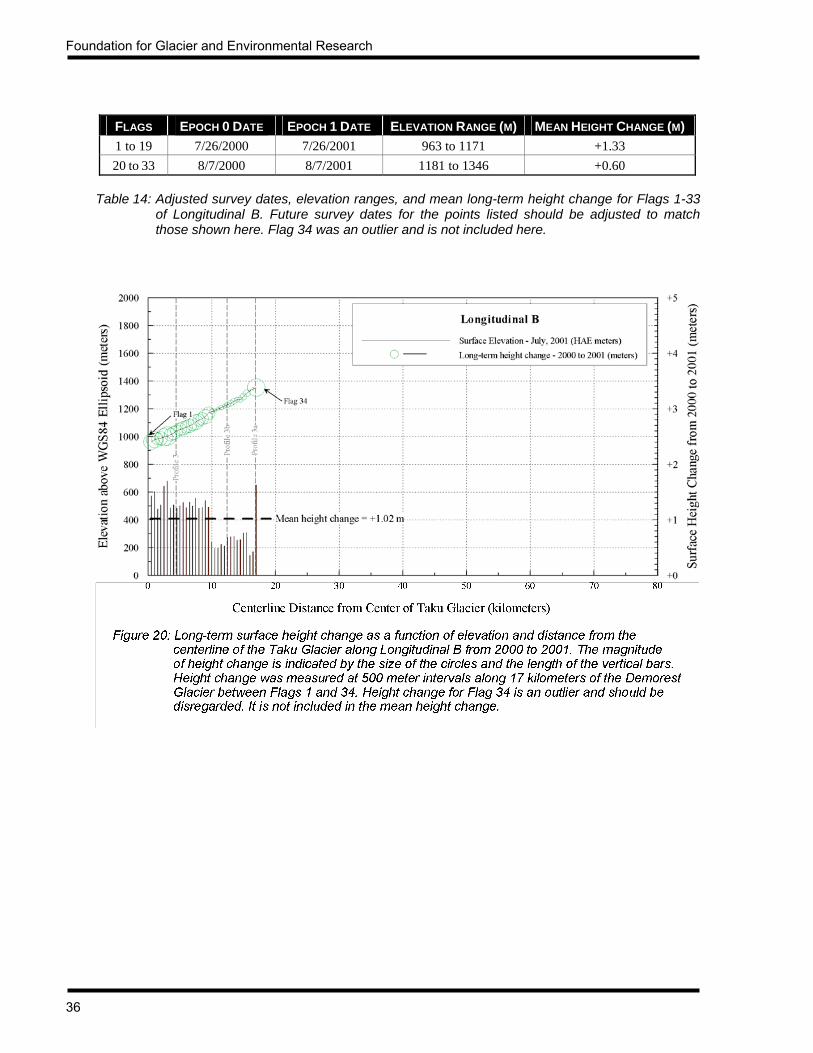
3.2.2.2 DEMOREST GLACIER All 34 points along Longitudinal B, first established and surveyed in 1999 and 2000, were resurveyed in 2001. These points ranged in elevation from 963.45 meters at Point 1 to 1353.78 meters at Point 34 in 2001. Unlike Longitudinal A on the Taku/Matthes/Llewellyn glaciers, Longitudinal B on the Demorest Glacier does not appear to exhibit a strong relationship between elevation and height change (see Figure 20). Flags 1-19 had a mean surface height increase of 1.33 meters, while the surface height at Flags 20-33 increased only 0.60 meter. The height change at each of the flags within each bin (Flags 1-19 and Flags 20-33) was relatively consistent. The wide discrepancy of the mean height change between the bins is most likely due to the fact that the comparison date for Flags 1-19 was July 26, while it was August 7 for Flags 20-33. The height change results for Flag 34 were unreliable and are not considered in this analysis. Overall, the Demorest Glacier at Longitudinal B had a mean surface elevation in 2001 that was 1.02 meters higher than it was in 2000.
Foundation for Glacier and Environmental Research
36
FLAGS EPOCH 0 DATE EPOCH 1 DATE ELEVATION RANGE (M) MEAN HEIGHT CHANGE (M) 1 to 19 7/26/2000 7/26/2001 963 to 1171 +1.33 20 to 33 8/7/2000 8/7/2001 1181 to 1346 +0.60
Table 14: Adjusted survey dates, elevation ranges, and mean long-term height change for Flags 1-33
of Longitudinal B. Future survey dates for the points listed should be adjusted to match those shown here. Flag 34 was an outlier and is not included here.

JIRP Survey Report — 2001
37
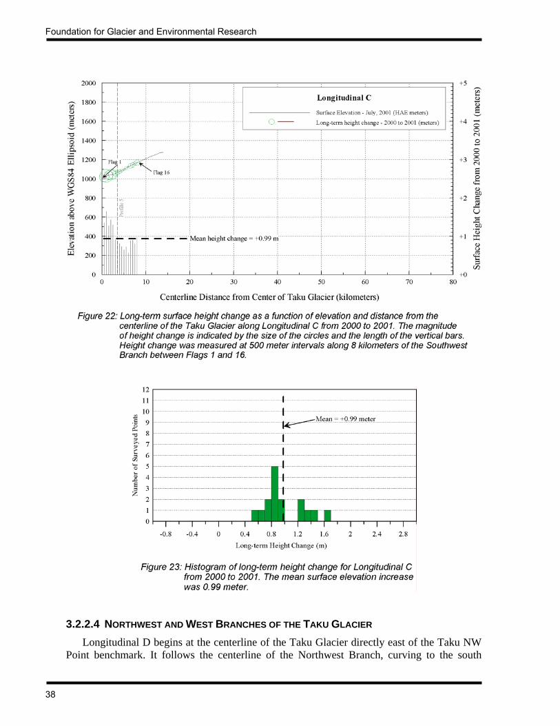
3.2.2.3 SOUTHWEST BRANCH OF THE TAKU GLACIER Longitudinal C was first established on the Southwest Branch of the Taku Glacier in 1999, when Flags 1-14 were set and surveyed twice. In 2000, two additional flags were set, however they were surveyed only once, preventing the calculation of surface movement for these two flags. The profile was further extended in 2001 to the divide between the Southwest Branch and the Norris Glacier in Death Valley. Benchmark “Lupine” at Sunday Point served as the site for the GPS base station. Unfortunately, the 12 flags added this year were surveyed only one time, so velocities cannot be calculated. As with Longitudinals A and B, this profile also experienced an increase in the surface elevation from 2000 to 2001. As with Longitudinal A, there seems to be somewhat of an inverse correlation between height change and surface elevation. The greatest height change occurred along the lower elevation portions of the profile, while the least magnitude of height change occurred at the higher elevation area of the profile (see Figure 22).
FLAGS EPOCH 0 DATE EPOCH 1 DATE ELEVATION RANGE (M) MEAN HEIGHT CHANGE (M) 1 to 16 7/26/2000 7/26/2001 1018 to 1169 +0.99
Table 15: Adjusted survey dates, elevation ranges, and mean long-term height change for Flags 1-16
of Longitudinal C. Future survey dates for the points listed should be adjusted to match those shown here.
Foundation for Glacier and Environmental Research
38
3.2.2.4 NORTHWEST AND WEST BRANCHES OF THE TAKU GLACIER Longitudinal D begins at the centerline of the Taku Glacier directly east of the Taku NW Point benchmark. It follows the centerline of the Northwest Branch, curving to the south

JIRP Survey Report — 2001
39
between Knowl Point and Tricouni Peak, and terminating at the divide between the Taku and Mendenhall Glaciers in the vicinity of Rhino Peak and Princess Peak. The profile was first established in 2000, when Flags 1-16 were surveyed. The profile was extended in 2001 to the Taku/Mendenhall divide with the establishment of Flags 17 to 48. Flags 1-16 were surveyed in both 2000 and 2001, allowing the comparison of annual surface elevation change. Benchmark “Knowl” on Knowl Point was set and surveyed in order to support the extension of the profile. It is not possible to determine a correlation between surface height change and elevation for this profile, as the elevation range between Flag 1 and Flag 16 is only 139 meters. As with the other longitudinal profiles, the surface heights for all flags of Longitudinal D increased from 2000 to 2001. The mean surface height increase for Flags 1-16 was 0.63 meter.
FLAGS EPOCH 0 DATE EPOCH 1 DATE ELEVATION RANGE (M) MEAN HEIGHT CHANGE (M) 1 to 16 7/28/2000 7/28/2001 1209 to 1348 +0.63
Table 16: Adjusted survey dates, elevation ranges, and mean long-term height change for Flags 1-16
of Longitudinal D. Future survey dates for the points listed should be adjusted to match those shown here.

Foundation for Glacier and Environmental Research
40
Longitudinal F branches off from Longitudinal D at a point due north of Knowl Point, and trends west and southwest 13 kilometers along the centerline of the West Branch to the divide between the Taku, Herbert, and Eagle Glaciers. Flags 1-18 of this profile were first established in 2000. The surveys in 2001 extended the profile from Flags 19 to 26. Flags 1-18 are used for the annual height change comparison, as these flags were surveyed in both 2000 and 2001. Benchmark “Knowl” at Knowl Point served as the site for the GPS base station. As with Longitudinal D, the elevation range from Flag 1 to Flag 16 of Longitudinal F is too small to definitively ascertain a correlation between the surface height change and elevation. All flags experienced an increase in surface elevation from 2000 to 2001. The mean height increase for Flags 1-18 was 0.53 meter.
FLAGS EPOCH 0 DATE EPOCH 1 DATE ELEVATION RANGE (M) MEAN HEIGHT CHANGE (M) 1 to 18 7/30/2000 7/30/2001 1357 to 1522 +0.53
Table 17: Adjusted survey dates, elevation ranges, and mean long-term height change for Flags 1-18
of Longitudinal F. Future survey dates for the points listed should be adjusted to match those shown here.
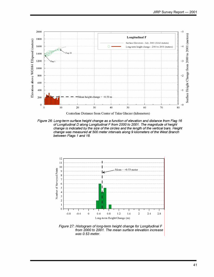
JIRP Survey Report — 2001
41

Foundation for Glacier and Environmental Research
42
3.2.3 LONGITUDINAL SURFACE FLOW TIMES With the establishment of the longitudinal profiles, it is now possible to quantitatively determine system-wide longitudinal flow times with a much higher degree of accuracy than has been possible in the past. Previously, estimates of flow time were based on the observed surface velocity at widely spaced (8-12 km apart) transverse profiles, with no data for the intervening 8-12 km gaps. The current longitudinal profiles provide much higher resolution data due to the nominal flag spacing of 500 meters. Calculation of the longitudinal surface flow is based on surveyed surface velocities at an interval of 500 meters. For each flag pair (e.g., Flag 50 to Flag 49, Flag 48 to Flag 47, etc.) the velocity at each flag is used to determine the mean velocity between the flag pairs. The surface slope between the flag pairs is used in the calculation of the time it takes the upglacier flag to move to the location of the downglacier flag of the flag pairs. The flow times of all the flag pairs are then summed to derive the cumulative flow time in units of days. This is then converted to cumulative flow time in years, taking into account leap years. This calculation of surface flow times is only theoretical, as it does not account for the vertical component of glacier movement. It assumes that a particle of ice at the surface of the glacier remains on the surface as it moves downglacier. In reality, there is a downward velocity component in the accumulation zone and an upward velocity component in the ablation area. These vertical velocity components differ from the surface velocity, and have not yet been measured on the Juneau Icefield. The calculation of surface flow times reported here is intended to be used only for the comparison of longitudinal flow times of the various glaciers with respect to each other. Table 18 presents summary data for the longitudinal profiles. Detailed data are shown in Appendix 5.
GLACIER PROFILE FROM TO SLOPE DISTANCE (KM)
SURFACE FLOW TIME (YEARS)
MEAN VELOCITY (M/YEAR)
Matthes / Taku A A117 A28 44.193 348.050 126.973 Demorest B B34 B5 14.472 151.572 95.479 Llewellyn A A118 A147 14.458 309.541 46.708
Northwest Branch D D43 D1 20.956 607.416 34.500 Southwest Branch C C14 C6 3.992 124.578 32.044
West Branch F F26 D16 12.991 446.218 29.114 Snow Towers Branch E E10 E1 4.495 319.811 14.055
Table 18: Longitudinal flow times for Profiles A through F. As would be expected, the main trunk of
the Taku Glacier (which includes the Matthes Glacier) has the highest mean velocity. Tributaries to the main trunk have slower mean velocities. Refer to Figure 28 for a map showing the locations of the noted profiles.

JIRP Survey Report — 2001
43
Figure 28: Plot of longitudinal surface flow times. Numbers refer to the time in years it takes for ice to
flow from the upglacier black dots to the downglacier dots for each profile.
Foundation for Glacier and Environmental Research
44
With the strongly positive mass balance in the summer of 2001, it was possible to extend Longitudinal A 5.5 kilometers further down the Taku Glacier with the addition of Flags 28 to 37. The original flag numbering scheme for this profile placed Flag 1 at an arbitrary point some 12 kilometers upglacier from the terminus as shown on the USGS 1:63,360 Juneau B-1 quadrangle dated 1948, with minor revisions in 1971. Thus, under the original scheme, extension of the profile downglacier would have resulted in flag numbers with negative numbers. Additionally, the old scheme was not referenced to a fixed point. To rectify these problems, the numbering scheme for Longitudinal A was modified in 2001, using Taku Point, on the south side of the Taku River, as the fixed starting point of the numbering system. With Flag 1 at Taku Point, flags proceed across the Taku River and up the Taku Glacier every 500 meters to the downglacier end of the existing profile. The net result of modifying the numbering system was to add 25 flags, forcing the reassignment of flag numbers for the entire Longitudinal A profile. Conversion of the pre-2001 numbering system to the new one is accomplished by adding 25 to the pre-2001 flag numbers. The extension of Longitudinal A provides additional velocity data for the computation of the longitudinal surface flow time from the Matthes/Llewellyn divide to the Taku terminus. McGee (2000b) computed the flow time from Flag 117 to Flag 38 at 334.676 years. The addition of Flags 37 to 28 in 2001 increases the longitudinal distance of the profile 5.5 kilometers, adding 13.374 years to the flow time estimate. In other words, based on surface velocity data taken at 500 meter intervals along the centerline of the Matthes and Taku Glaciers, the flow time from Flag 117 at the Matthes/Llewellyn Divide to Flag 28, approximately 12 kilometers upglacier from the terminus (as shown on the USGS 1:63,360 Juneau B-1 quadrangle dated 1948), is 348.05 years, over a slope distance of 44.193 kilometers. This gives a mean flow rate of 126.973 meters per year. As shown in Table 18, the Taku/Matthes system has the highest mean annual velocity of the glaciers thus far surveyed. The annual flow of the Demorest Glacier is 75 percent that of the Taku/Matthes at 95 meters per year. Other tributaries of the Taku Glacier show corresponding slower rates of annual movement. This is to be expected, and no unusual results are seen in the data. 3.3 PROFILE 4 Profile 4, located on the main Taku Glacier some 30 kilometers upglacier from the terminus, has historically been the focus of much research. Miller (1951) conducted glacier borehole research to investigate ice fabric structures and firn stratigraphy, and to determine englacial temperatures and the vertical flow profile. Long-term mass balance studies (Pelto and Miller, 1990) have documented the dynamic response of the Taku Glacier to decadal climate cycles, and seismic reflection studies by Poulter (1950), Sprenke, et al (1993), and Echelmeyer, et al (1995) have investigated the ice thickness of the Taku Glacier at this location. Surface velocity, strain-rate, and volume change studies by Kersting (1986), Daellenbach and Welsch (1993), Lang (1993, 1995, 1997, 1999), and McGee (1988, 1994, 1996, 1997) have provided detailed information relating to the flow regime of the Taku Glacier at this profile.
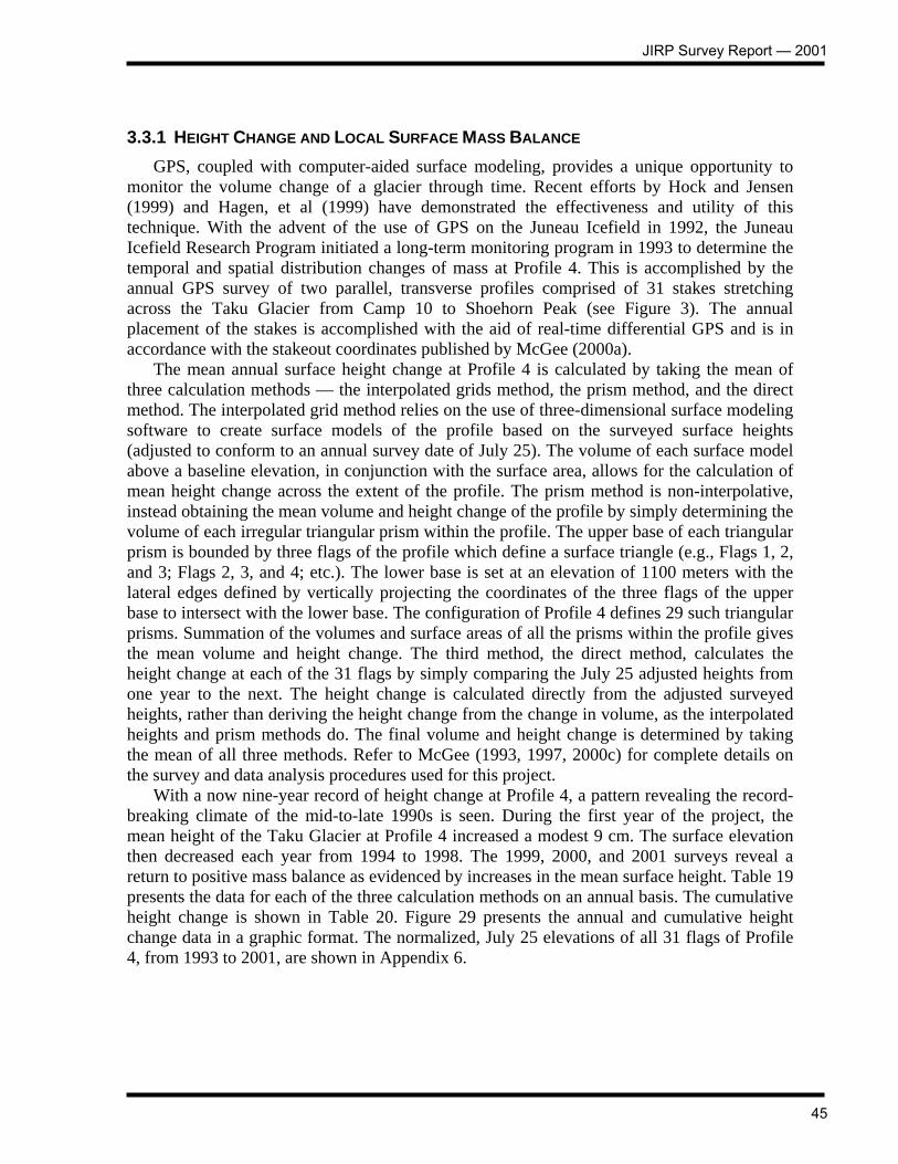
JIRP Survey Report — 2001
45
3.3.1 HEIGHT CHANGE AND LOCAL SURFACE MASS BALANCE GPS, coupled with computer-aided surface modeling, provides a unique opportunity to monitor the volume change of a glacier through time. Recent efforts by Hock and Jensen (1999) and Hagen, et al (1999) have demonstrated the effectiveness and utility of this technique. With the advent of the use of GPS on the Juneau Icefield in 1992, the Juneau Icefield Research Program initiated a long-term monitoring program in 1993 to determine the temporal and spatial distribution changes of mass at Profile 4. This is accomplished by the annual GPS survey of two parallel, transverse profiles comprised of 31 stakes stretching across the Taku Glacier from Camp 10 to Shoehorn Peak (see Figure 3). The annual placement of the stakes is accomplished with the aid of real-time differential GPS and is in accordance with the stakeout coordinates published by McGee (2000a). The mean annual surface height change at Profile 4 is calculated by taking the mean of three calculation methods — the interpolated grids method, the prism method, and the direct method. The interpolated grid method relies on the use of three-dimensional surface modeling software to create surface models of the profile based on the surveyed surface heights (adjusted to conform to an annual survey date of July 25). The volume of each surface model above a baseline elevation, in conjunction with the surface area, allows for the calculation of mean height change across the extent of the profile. The prism method is non-interpolative, instead obtaining the mean volume and height change of the profile by simply determining the volume of each irregular triangular prism within the profile. The upper base of each triangular prism is bounded by three flags of the profile which define a surface triangle (e.g., Flags 1, 2, and 3; Flags 2, 3, and 4; etc.). The lower base is set at an elevation of 1100 meters with the lateral edges defined by vertically projecting the coordinates of the three flags of the upper base to intersect with the lower base. The configuration of Profile 4 defines 29 such triangular prisms. Summation of the volumes and surface areas of all the prisms within the profile gives the mean volume and height change. The third method, the direct method, calculates the height change at each of the 31 flags by simply comparing the July 25 adjusted heights from one year to the next. The height change is calculated directly from the adjusted surveyed heights, rather than deriving the height change from the change in volume, as the interpolated heights and prism methods do. The final volume and height change is determined by taking the mean of all three methods. Refer to McGee (1993, 1997, 2000c) for complete details on the survey and data analysis procedures used for this project. With a now nine-year record of height change at Profile 4, a pattern revealing the record-breaking climate of the mid-to-late 1990s is seen. During the first year of the project, the mean height of the Taku Glacier at Profile 4 increased a modest 9 cm. The surface elevation then decreased each year from 1994 to 1998. The 1999, 2000, and 2001 surveys reveal a return to positive mass balance as evidenced by increases in the mean surface height. Table 19 presents the data for each of the three calculation methods on an annual basis. The cumulative height change is shown in Table 20. Figure 29 presents the annual and cumulative height change data in a graphic format. The normalized, July 25 elevations of all 31 flags of Profile 4, from 1993 to 2001, are shown in Appendix 6.
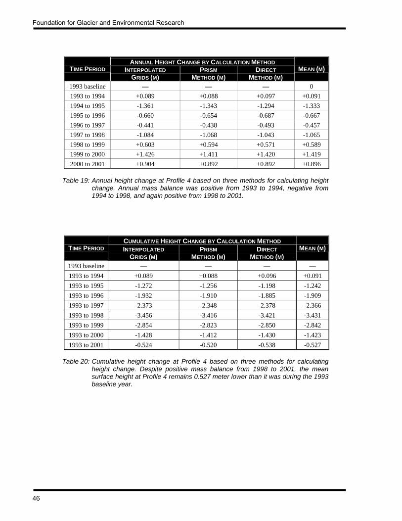
Foundation for Glacier and Environmental Research
46
ANNUAL HEIGHT CHANGE BY CALCULATION METHOD TIME PERIOD INTERPOLATED
GRIDS (M) PRISM
METHOD (M) DIRECT
METHOD (M) MEAN (M)
1993 baseline — — — 0 1993 to 1994 +0.089 +0.088 +0.097 +0.091 1994 to 1995 -1.361 -1.343 -1.294 -1.333 1995 to 1996 -0.660 -0.654 -0.687 -0.667 1996 to 1997 -0.441 -0.438 -0.493 -0.457 1997 to 1998 -1.084 -1.068 -1.043 -1.065 1998 to 1999 +0.603 +0.594 +0.571 +0.589 1999 to 2000 +1.426 +1.411 +1.420 +1.419 2000 to 2001 +0.904 +0.892 +0.892 +0.896
Table 19: Annual height change at Profile 4 based on three methods for calculating height
change. Annual mass balance was positive from 1993 to 1994, negative from 1994 to 1998, and again positive from 1998 to 2001.
CUMULATIVE HEIGHT CHANGE BY CALCULATION METHOD TIME PERIOD INTERPOLATED
GRIDS (M) PRISM
METHOD (M) DIRECT
METHOD (M) MEAN (M)
1993 baseline — — — — 1993 to 1994 +0.089 +0.088 +0.096 +0.091 1993 to 1995 -1.272 -1.256 -1.198 -1.242 1993 to 1996 -1.932 -1.910 -1.885 -1.909 1993 to 1997 -2.373 -2.348 -2.378 -2.366 1993 to 1998 -3.456 -3.416 -3.421 -3.431 1993 to 1999 -2.854 -2.823 -2.850 -2.842 1993 to 2000 -1.428 -1.412 -1.430 -1.423 1993 to 2001 -0.524 -0.520 -0.538 -0.527
Table 20: Cumulative height change at Profile 4 based on three methods for calculating
height change. Despite positive mass balance from 1998 to 2001, the mean surface height at Profile 4 remains 0.527 meter lower than it was during the 1993 baseline year.

JIRP Survey Report — 2001
47
0.00 0.09
-1.33
-0.67-0.46
-1.06
0.59
1.42
0.90
0.00 0.09
-1.24
-1.91
-2.37
-3.43
-2.84
-1.42
-0.53
-4
-3
-2
-1
0
1
2
1993 1994 1995 1996 1997 1998 1999 2000 2001
Year (measured July 25 each year)
Ele
vatio
n C
hang
e (m
eter
s)Annual Surface Elevation ChangeCumulative Surface Elevation Change
Figure 29: Mean year-to-year and cumulative surface height change of the Taku Glacier at Profile 4 from 1993 to 2001.
Annual three-dimensional modeling of the glacier surface at Profile 4 provides a means to determine not only the surface height change, and hence mass balance, but also to determine the spatial distribution of mass as it varies from year to year, and cumulatively. Figures 30-38 show the year-to-year spatial distribution changes at Profile 4, along with the cumulative effects from 1993 to 2001. In all figures, yellow, orange, and red represent a decrease in surface height and mass balance. Green, blue, and violet indicate an increase in surface height and mass balance. As seen in Figure 30, the mass increased for approximately 75% of the profile from 1993 to 1994. The mean surface height increase was 9.1 cm (5 cm water equivalent, based on a surface firn density of 0.55 g/cm3). The decrease in surface height from 1993 to 1994 occurred primarily at the southwest end of Profile 4, with decreases also evident near the center and northeast end of the profile. 1994 marked the beginning of a four-year negative balance trend as seen in Figures 31-34. From 1994 to 1995, the mean surface height decrease was 1.332 meters (0.733 meter w.e.). The mean surface height decreased 0.666 meter (0.366 meter w.e.) from 1995 to 1996. The mean decrease was slightly less from 1996 to 1997 at 0.457 meter (0.251 meter w.e.), but then more than doubled between 1997 and 1998, with a mean surface height decrease of 1.066 meters (0.586 meter w.e.). The spatial distribution of the height and mass decrease from 1994 to 1998 was relatively uniform across the extent of the profile. After four consecutive years of negative mass balance, there was a mean surface height increase of 0.589 meter (0.324 meter w.e.) from 1998 to 1999. Figure 35 shows the spatial distribution pattern between 1998 and 1999, with the maximum increase occurring near the center of the profile. The positive mass balance trend continued from 1999 to 2000, with a mean surface height increase of 1.412 meters (0.777 meter w.e.). The spatial

Foundation for Glacier and Environmental Research
48
distribution pattern was remarkably consistent from 1999 to 2000, as shown in Figure 36. The positive balance trend continued for the third consecutive year from 2000 to 2001, with the mean surface height increasing 0.896 meter (0.493 meter w.e.). Figure 38 presents the cumulative surface height change from 1993 to 2001. The mean decrease in surface height over this nine year time period was 0.527 meters (0.290 meter w.e).
Figure 30: Surface height change at Profile 4 from July 25, 1993 to July 25, 1994.

JIRP Survey Report — 2001
49
Figure 31: Surface height change at Profile 4 from July 25, 1994 to July 25, 1995.
Figure 32: Surface height change at Profile 4 from July 25, 1995 to July 25, 1996.

Foundation for Glacier and Environmental Research
50
Figure 33: Surface height change at Profile 4 from July 25, 1996 to July 25, 1997.
Figure 34: Surface height change at Profile 4 from July 25, 1997 to July 25, 1998.

JIRP Survey Report — 2001
51
Figure 35: Surface height change at Profile 4 from July 25, 1998 to July 25, 1999.
Figure 36: Surface height change at Profile 4 from July 25, 1999 to July 25, 2000.

Foundation for Glacier and Environmental Research
52
Figure 37: Surface height change at Profile 4 from July 25, 2000 to July 25, 2001.
Figure 38: Surface height change at Profile 4 from July 25, 1993 to July 25, 2001.

JIRP Survey Report — 2001
53
3.3.2 STRAIN In conjunction with the monitoring of surface height and mass balance change at Profile 4, strain rates have been analyzed annually. This is accomplished by determining the change in the geometry of the triangles formed by the dual line setup of Profile 4. Calculation of strain rates is based on the method described by Welsch (1987), which evaluates the changes in the elements (interior angles and the length of sides) of a triangle. The result, strain, is expressed in terms of a strain ellipse, with the maximum strain (e1) representing extension and the minimum strain (e2) representing compression. Vertical strain (e3) is derived from the equation e1 + e2 + e3 = 0. Additionally, the orientation of the strain ellipse is given by the value θ. The strain regime at Profile 4 has been relatively consistent since 1993. Figure 39 presents the results of the 2001 strain analysis of the profile. Lang (1999) presents the strain results from 1993 to 1999. As seen in Figures 39 and 40, both extensional and compressional strains are greatest along the northeast and southwest margins of the profile. Strains in the center of the profile are relatively small. As expected, this is consistent with the flow and crevasse patterns of the Taku Glacier. As seen in Figures 3, 4, and 5, the rate of increase in the surface flow is greatest along the margins, with the rate of increase lessening to zero in the center of the glacier. This reflects the normal flow and strain regime, and resultant crevassing, of a glacier exhibiting a mode of flow somewhere between parabolic and rectilinear. The computed strain data are presented in Appendix 7.
Figure 39: Observed surface strains at Profile 4 between July 19 and July 25, 2001. Maximum strain is extensional and minimum strain is compressional. A positive vertical strain indicates an increase in surface elevation, while a negative vertical strain results in a lowering of the surface.

Foundation for Glacier and Environmental Research
54
3.4 MATTHES GLACIER / LLEWELLYN GLACIER DIVIDE The divide between the Matthes and Llewellyn Glaciers has been of interest in recent years because it offers the potential for ice core climate research. Ranging in elevation from 1800 meters to 2000 meters just north of the Alaska/Canada boundary, the divide area experiences the least amount of summer ablation on the Juneau Icefield, which, when combined with minimal movement and ice deformation, provides an almost ideal environment for the retrieval of ice cores. The divide between the Matthes and Llewellyn Glaciers is morphologically complex, being in fact a three-way glacial divide with a small influx of ice from the west. The Llewellyn Glacier trends north from the divide, the Matthes Glacier trends southerly, and the eastern sector of the divide forms the head of the east-trending Tulsequah Glacier. A small accumulation area to the west of the divide, and several tens of meters higher, contributes a minor quantity of ice to the divide plateau. The easterly-trending surface flow vectors reflect the inflow of this ice mass (see Figure 41).

JIRP Survey Report — 2001
55
Figure 41: Topographic map of the Matthes Glacier/Llewellyn Glacier divide. Contour interval is one meter, as interpolated from the X, Y, and Z coordinates of 1,218 surveyed points. Data were collected using differential, kinematic, survey-grade GPS.
Recognizing the importance that ice core studies could contribute to the understanding of the climate record of southeast Alaska, the Juneau Icefield Research Program began preliminary studies in 1997 to determine the depth of the ice, the surface velocity and direction of movement, the location of the surface divide and minimum movement, and to ascertain if the surface divide coincided with the bedrock divide (Sprenke, 1999). To

Foundation for Glacier and Environmental Research
56
determine the surface velocity field, a grid of 30 points was established and surveyed in August, 1997. The grid was oriented transverse to the longitudinal centerline of the Matthes and Llewellyn Glaciers, roughly straddling the divide. Establishment of Longitudinal A in 2000 augmented the divide grid. Results of the surveys reveal the zone of minimum surface movement, and the divergent movement vectors to be in the southeast corner of the grid between Flags 19, 20, 29, and 30. The minimum velocity observed in 1997 was 1.3 cm/day at Flag 30. While work in 1997 and 2000 defined the velocity field at the Matthes/Llewellyn divide, it did not ascertain the overall topography of the area. An objective of the survey program in 2001 was to conduct a topographic survey of the divide. This was accomplished in 3½ hours on August 13, the last day in which the GPS survey equipment was available for use. To accomplish this survey, the roving GPS was affixed to a snowmobile and configured for a kinematic survey, with a 10-second recording interval. The GPS base station was placed at FFGR 39 at Blizzard Point. Beginning on the Llewellyn Glacier side of the divide, 12 transverse profiles were surveyed (see Figure 41). A total of 1,218 points were measured, providing X, Y, and Z coordinates from which a topographic map was generated using Surfer, a commercial 3-D surface modeling computer program. Contours, with an interval of one meter, were interpolated from the surveyed points. Coordinates of the surveyed points are presented in Appendix 2. Figure 41 presents the generated topographic map, with movement vectors from the 1997 divide grid and 2000 Longitudinal A profile superimposed. The approximate position of the Matthes/Llewellyn divide is indicated by the dashed line. From this divide, the Matthes Glacier flows south-southwest, the Llewellyn Glacier flows north-northeast, and the Tulsequah Glacier flows east-southeast.. 3.5 GILKEY GLACIER SURVEYS Several survey projects were conducted in the Gilkey Trench in 2001. The major focus was on determining the wavelength and amplitude of the wave bulges and ogives at the base of the Vaughan Lewis Icefall. Other adjunct projects included a resurvey of wave bulge surface velocity and determining surface height change on the Gilkey Glacier. These two projects are discussed in previous sections of this report. Refer to Section 3.1.1.3 and Figure 7 for details on the surface velocity of wave bulges 1 through 3. Surface height change of the Gilkey Glacier is presented in Section 3.1.3.2 and Table 5. 3.5.1 OGIVE WAVELENGTH AND AMPLITUDE The Vaughan Lewis Glacier is known for its well-defined series of wave bulges and ogives. This glacier heads in a cirque basin west of the Matthes Glacier, and some two kilometers south of the Alaska/Canada border. From its divide with the Matthes Glacier, it flows approximately four kilometers to the edge of the cirque basin, spilling down some 600 meters in a spectacular icefall (see Figure 42).

JIRP Survey Report — 2001
57
Figure 42: View of the Vaughan Lewis Icefall and the first five bulges at its base, as seen from Camp 19. The first three arcuate surface structures are classified as wave bulges, downglacier from which are wave ogives which de-amplify at ogive 12 to become two-dimensional. View is to the northeast. Photo taken August 16, 1989.
Figure 43: Detailed view of wave bulges 2, 3, and 4. Photo taken August 16, 1989.

Foundation for Glacier and Environmental Research
58
Numerous interesting morphological structures are present at the base of the Vaughan Lewis Icefall, including ogives, wave bulges, supraglacial lakes and streams, flow and tectonic foliation, and an extensive medial moraine system. Principal among these features are the ogives and wave bulges. Typically, most glaciologists refer to alternating light and dark banded structures on the surface of a glacier as ogives. Those with no amplitude are simply known as ogives, while those with an undulating vertical cross-section are referred to as wave ogives. The term ogive refers to a bullet shape, similar to the shape that would be produced by compressing the limbs of a semi-circle toward its center, resulting in an elongated, ellipse-type structure with a somewhat pointed central sector. As applied to glaciological structures, the pointed end of the ogive is downglacier of the ends of the limbs. The ogive shape becomes more pronounced over time due to the increased rate of flow in the middle of the glacier as compared to its sides. The structures at the base of the Vaughan Lewis Icefall include typical ogives and wave ogives. These ogives generally begin at the fourth bulging structure downglacier from the base of the icefall. Upglacier from this point, three structures similar to wave ogives exist. As with wave ogives, they exhibit a light and dark banded structure, have amplitude, and one forms every year. Unlike true ogives however, they have a semi-circular plan view rather than a bullet shape. Technically, these are undeformed ogives, but are referred to in this report as wave bulges, in order to differentiate them from the true ogives immediately downglacier from them. The objective of this survey was to determine the physical characteristics of the wave bulges and ogives at the base of the Vaughan Lewis Icefall. This included the wavelength, amplitude, cross-sectional profile, surface elevations of the crests and troughs, and the depth of the supraglacial lakes in the troughs. Given the significant decrease in surface height of the glaciers in the Gilkey Trench in recent years (see Section 3.1.3.2 for additional discussion), quantifying these characteristics will allow for detailed temporal and spatial monitoring of the ogives and wave bulges. This survey was conducted using standard real-time differential GPS techniques utilizing a survey-grade Leica System 530 GPS. A total of 179 points were surveyed along a longitudinal profile through the centerline of the bulges and ogives, starting at the lowest part of the trough upglacier from wave bulge 1 and extending downglacier to the trough on the downglacier side of ogive 11. The total distance surveyed was 1.75 kilometers, with an average spacing of 9.8 meters. Lakes in the troughs between wave bulges 1 through 4 prevented direct measurement of the surface height of the ice in the troughs. To obtain this important measurement, an inflatable rubber raft was used in conjunction with the GPS system. A weighted sounding line was used to find the deepest water that was in line with the longitudinal profile. Once positioned, a GPS reading was recorded and the depth of the water at that position was noted. The water depth and height of the GPS antenna above the water surface were then subtracted from the GPS-obtained height, giving the elevation of the ice at the bottom of the lake. The results of the survey are shown in Figure 44 and Table 21. Appendix 2 lists the surveyed coordinates. As referenced in this report, wave bulge #1 is the first fully-formed bulge at the immediate base of the Vaughan Lewis Icefall, with well-defined troughs both upglacier and downglacier from the crest of the bulge. The average gradient from the crest of wave bulge 1 to the crest of ogive 11 is 5 degrees. Because of the gradient, the troughs on the upglacier and downglacier sides of the crests are at differing elevations. Thus the amplitude of

JIRP Survey Report — 2001
59
the bulges and ogives is dependant upon whether the height differential is measured from the crest to either the upglacier or downglacier trough. This issue is resolved by calculating the average of the upglacier and downglacier amplitude for each crest. The wavelength is calculated from crest to crest. The wavelength of bulges 1 through 4 is relatively consistent at around 130 meters, after which the wavelength steadily increases. For example, the wavelength between the crests of ogives 7 and 8 is 224 meters. From ogive 8, the wavelength decreases. From examining the morphology of the bulges and ogives in Figure 44, several distinct zones can be identified. The first three structures at the base of the icefall are characterized by short wavelength and high amplitude. These are the hemispherical wave bulges in the compression zone at the base of the icefall. In plan view they exhibit minimal lateral deformation of the limbs. The fourth bulge represents a transitory stage between the true wave bulges and the wave ogives. In plan view, the effects of lateral compression and flow deformation begin to transform this structure from a hemispherical wave bulge to a bullet, or chevron, shaped ogive. Ogives 5, 6, and 7 are located within the extension zone downglacier from the compression zone at the base of the icefall, while ogives 8 through 11 appear to be located in another compression zone. The amplitude of the wave bulges and ogives decreases to nearly zero at ogive 11. Downglacier from the crest of ogive 11 the amplitude disappears and the ogives are represented as typical two-dimensional alternating light and dark banded surface structures.
Figure 44: Longitudinal cross-section through the Vaughan Lewis Glacier from wave bulge 1 downglacier to ogive 11. Refer to Figure 7 for a planimetric view of this profile.
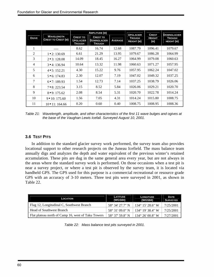
Foundation for Glacier and Environmental Research
60
AMPLITUDE (M)
OGIVE WAVELENGTH CREST TO CREST (M)
CREST TO UPGLACIER
TROUGH
CREST TO DOWNGLACIER
TROUGH AVERAGE
UPGLACIER TROUGH
HEIGHT (M)
CREST HEIGHT
(M)
DOWNGLACIER TROUGH
HEIGHT (M)
1 ---- 8.62 16.74 12.68 1087.79 1096.41 1079.67 2 1•2: 130.69 6.61 21.29 13.95 1079.67 1086.28 1064.99 3 2•3: 128.08 14.09 18.45 16.27 1064.99 1079.08 1060.63 4 3•4: 136.94 10.64 13.32 11.98 1060.63 1071.27 1057.95 5 4•5: 152.21 4.30 15.22 9.76 1057.95 1062.24 1047.02 6 5•6: 174.83 2.30 12.07 7.19 1047.02 1049.32 1037.25 7 6•7: 189.93 1.54 12.73 7.14 1037.25 1038.79 1026.06 8 7•8: 223.54 3.15 8.52 5.84 1026.06 1029.21 1020.70 9 8•9: 175.62 2.08 8.54 5.31 1020.70 1022.78 1014.24
10 9•10: 175.60 1.56 7.05 4.31 1014.24 1015.80 1008.75 11 10•11: 164.66 0.20 0.60 0.40 1008.75 1008.95 1008.36
Table 21: Wavelength, amplitude, and other characteristics of the first 11 wave bulges and ogives at
the base of the Vaughan Lewis Icefall. Surveyed August 10, 2001. 3.6 TEST PITS In addition to the standard glacier survey work performed, the survey team also provides locational support to other research projects on the Juneau Icefield. The mass balance team annually digs and analyzes the depth and water equivalent of the previous winter’s retained accumulation. These pits are dug in the same general area every year, but are not always in the areas where the standard survey work is performed. On those occasions when a test pit is near a survey project, or where a test pit is observed by the survey team, it is located via handheld GPS. The GPS used for this purpose is a commercial recreational or resource grade GPS with an accuracy of 3-10 meters. Three test pits were surveyed in 2001, as shown in Table 22.
LOCATION LATITUDE (WGS84)
LONGITUDE (WGS84)
DATE SURVEYED
Flag 12, Longitudinal C, Southwest Branch 58° 34' 27.7" N 134° 15' 28.6" W 7/25/2001 Head of Southwest Branch 58° 31' 09.0" N 134° 19' 38.4" W 7/25/2001 Flat plateau north of Camp 16, west of Taku Towers 58° 37' 59.8" N 134° 26' 00.8" W 7/27/2001
Table 22: Mass balance test pits surveyed in 2001.

JIRP Survey Report — 2001
61
4. FUTURE WORK Steady progress has been made on determining the overall velocity field and vertical elevation profiles of the main portion of the Juneau Icefield. Future survey work should focus on extending the extension of Longitudinal B to the divide between the Demorest and Tulsequah Glaciers. This will require the establishment of a new benchmark east of Camp 8. Longitudinal profiles must also be established and surveyed on the Hades Highway branch of the Demorest Glacier, also requiring a new benchmark. Additionally, Flags 17-28 of Longitudinal C have been surveyed for position only. These flags must be surveyed twice in the same field season to determine the surface movement. 5. ACKNOWLEDGEMENTS As usual, the survey work detailed in this report could not have been accomplished without the financial, logistical, and field support of the Foundation for Glacier and Environmental Research, Juneau Icefield Research Program. Financial support from NASA enabled several students to assist with the survey projects. Significant personnel and equipment support was provided by the Universität der Bundeswehr in Munich, Germany. As always, many thanks are extended to Dr. Maynard Miller and Joan Miller for their countless efforts in organizing and carrying out the summer field season. The tireless efforts of Annette Erickson and other staff in providing the necessary logistical support in Juneau during the summer are greatly appreciated.

Foundation for Glacier and Environmental Research
62
REFERENCES Daellenbach, Keith, and Walter Welsch (1993) Determination of Surface Velocities, Strain
Rates, and Mass Flow Rates on the Taku Glacier, Juneau Icefield, Alaska. Zeitschrift fűr Gletscherkunde und Glazialgeologie, Band 26, Heft 2, p. 169-177. Universitätsverlag Wagner, Innsbruck, Austria.
Echelmeyer, Keith, Matt Nolan, Roman Motyka, and Dennis Trabant (1995) Ice-
thickness Measurements of Taku Glacier, Alaska, USA, and their Relevance to it Recent Behavior. Journal of Glaciology, Vol. 41, No. 139. Cambridge, England; p. 541-552.
Hagen, J., K. Melvold, T. Eiken, E. Isaksson, and B. Lefauconnier (1999) Mass Balance
Methods on Kongsvegen, Svalbard. Geografiska Annaler, Series A, Physical Geography, Vol. 81a, No. 4, 1999, Stockholm, Sweden. p. 593-601.
Hock, Regine, and Holger Jensen (1999) Application of Kriging Interpolation for Glacier
Mass Balance Computations. Geografiska Annaler, Series A, Physical Geography, Vol. 81a, No. 4, 1999, Stockholm, Sweden. p. 611-619.
Kersting, N. (1986) Determination of the Taku Glacier Movement, Juneau Icefield, Alaska,
1986. Open File Survey Report. Juneau Icefield Research Program, Foundation for Glacier and Environmental Research, Moscow, Idaho, and Universität der Bundeswehr München.
Lang, Martin (1993) Geodetic Activities of the 1993 Juneau Icefield Research Program Field
Season. Open File Survey Report. Juneau Icefield Research Program, Foundation for Glacier and Environmental Research, Moscow, Idaho. 35 pp.
Lang, Martin (1995) Geodetic Activities of the 1995 Juneau Icefield Research Program Field
Season. Open File Survey Report. Juneau Icefield Research Program, Foundation for Glacier and Environmental Research, Moscow, Idaho. 91 pp.
Lang, Martin (1997) Geodetic Activities of the 1997 Juneau Icefield Research Program Field
Season. Open File Survey Report. Juneau Icefield Research Program, Foundation for Glacier and Environmental Research, Moscow, Idaho. 110 pp.
Lang, Martin (1999) Geodetic Activities of the 1999 Juneau Icefield Research Program Field
Season. Open File Survey Report. Juneau Icefield Research Program, Foundation for Glacier and Environmental Research, Moscow, Idaho. 117 pp.
McGee, Scott, Carl Byers, Keith Daellenbach, Erik Petersen, and Jeff Markillie (1988)
Results of the Summer 1988 Surveying Program. Open File Survey Report. Juneau Icefield Research Program, Foundation for Glacier and Environmental Research, Moscow, Idaho.

JIRP Survey Report — 2001
63
McGee, Scott (1990) Surface Strain-Rate Measurements of the Gilkey Glacier, Juneau Icefield, Alaska, 1989. Open File Survey Report. Juneau Icefield Research Program, Foundation for Glacier and Environmental Research, Moscow, Idaho.
McGee, Scott (1993) A Comparison of Methods for Determining the Mass Balance of a GPS
Surveyed Movement Profile. Open File Survey Report. Juneau Icefield Research Program, Foundation for Glacier and Environmental Research, Moscow, Idaho.
McGee, Scott (1994) Geodetic Activities of the 1994 Juneau Icefield Research Program
Field Season. Open File Survey Report. Juneau Icefield Research Program, Foundation for Glacier and Environmental Research, Moscow, Idaho. 88 pp.
McGee, Scott (1996) Geodetic Activities of the 1996 Juneau Icefield Research Program
Field Season. Open File Survey Report. Juneau Icefield Research Program, Foundation for Glacier and Environmental Research, Moscow, Idaho. 79 pp.
McGee, Scott (1997) Using GPS to Determine Local Surface Mass Balance: A Case Study on
the Taku Glacier, Alaska, 1993-1995. Schriftenreihe des Studiengangs Vermessungswesen, Universität der Bundeswehr München, Heft 50, p. 127-135.
McGee, Scott (2000a) Juneau Icefield GPS Movement Profile Coordinates. JIRP Open File
Survey Report. Juneau Icefield Research Program, Foundation for Glacier and Environmental Research. Moscow, Idaho. September, 2000. 54 pp.
McGee, Scott (2000b) Geodetic Activities of the 2000 Juneau Icefield Research Program
Field Season. Open File Survey Report. Juneau Icefield Research Program, Foundation for Glacier and Environmental Research, Moscow, Idaho. 103 pp.
McGee, Scott (2000c) Profile 4 Long-Term Height Change. Microsoft Excel data
spreadsheet. Juneau Icefield Research Program, Foundation for Glacier and Environmental Research.
Miller, Maynard M. (1951) Englacial Investigations Related to Core Drilling on the Upper
Taku Glacier, Alaska. Journal of Glaciology, Vol. 1, No. 10, Cambridge, England; p. 578-580.
Pelto, Mauri, and M.M. Miller (1990) Mass Balance of the Taku Glacier, Alaska from 1946
to 1986. Northwest Science. Vol. 64, No.3, p. 121-130. Poulter, Thomas (1950) The Poulter Seismic Method of Geophysical Exploration.
Geophysics, Vol. 15, No. 2, p. 181-207. Seppälä, Matti (1973) On the Formation of Small marginal Lakes on the Juneau Icefield,
Southeastern Alaska, USA. Journal of Glaciology, Vol. 12, No. 65, Cambridge, England; p. 267-273.
Foundation for Glacier and Environmental Research
64
Sprenke, Ken, Tim Benedict, Greg Gilbert, Jamie Stirling, and M.M. Miller (1993) New Seismic Depth Profiles on the Taku Glacier, 1993, Juneau Icefield, Alaska. JIRP Open File Report. Juneau Icefield Research Program, Foundation for Glacier and Environmental Research.
Sprenke, Ken, Maynard Miller, Guy Adema, Scott McGee, and Martin Lang (1999) The
High Ice Plateau of the Juneau Icefield, British Columbia: Form and Dynamics. The Canadian Geographer. Vol. 43, No.1, p. 99-104.
Welsch, Walter (1987) Computing Principal Strains from the Changes of the Elements of a
Triangle. Open File Report. Juneau Icefield Research Program, Foundation for Glacier and Environmental Research, Moscow, Idaho. 6 pp.
Welsch, Walter, Martin Lang, and M.M. Miller (1997) Geodetic Activities Juneau
Icefield, Alaska 1981-1996. Schriftenreihe des Studiengangs Vermessungswesen, Universität der Bundeswehr München, Heft 50. 268 pp.
Welsch, Walter, Martin Lang, and Scott McGee (1999) Geodetic Activities of the 1999
Juneau Icefield Research Program Field Season. Open File Survey Report. Juneau Icefield Research Program, Foundation for Glacier and Environmental Research, Moscow, Idaho. 117 pp.

JIRP Survey Report — 2001
65
APPENDICES

Foundation for Glacier and Environmental Research
66
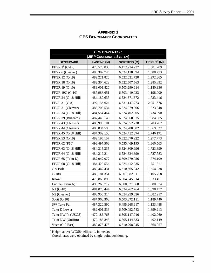
JIRP Survey Report — 2001
67
APPENDIX 1 GPS BENCHMARK COORDINATES
GPS BENCHMARKS (JIRP COORDINATE SYSTEM)
BENCHMARK EASTING (M) NORTHING (M) HEIGHT1 (M) FFGR 12 (C-17) 478,573.838 6,472,234.227 1,301.709 FFGR 6 (Cleaver) 483,309.746 6,524,118.094 1,388.753 FFGR 12 (C-19) 482,221.820 6,522,621.728 1,292.865 FFGR 18 (C-19) 482,304.622 6,522,507.563 1,285.892 FFGR 19 (C-10) 488,001.820 6,503,290.614 1,180.836 FFGR 19C (C-10) 487,983.651 6,503,410.033 1,198.000 FFGR 24 (C-18 Hill) 484,189.635 6,524,371.872 1,733.416 FFGR 31 (C-8) 492,136.624 6,521,147.773 2,051.576 FFGR 31 (Cleaver) 483,705.534 6,524,279.606 1,623.548 FFGR 34 (C-18 Hill) 484,554.464 6,524,402.905 1,734.890 FFGR 39 (Blizzard) 487,443.145 6,524,360.975 1,984.385 FFGR 43 (Cleaver) 483,990.101 6,524,352.738 1,703.762 FFGR 44 (Cleaver) 483,834.598 6,524,280.382 1,669.527 FFGR 45 (C-18 Hill) 484,309.150 6,524,412.394 1,746.191 FFGR 53 (C-19) 482,195.157 6,522,670.922 1,277.773 FFGR 62 (F10) 492,497.562 6,535,469.195 1,860.563 FFGR 63 (C-18 Hill) 484,315.335 6,524,309.996 1,723.699 FFGR 64 (C-18 Hill) 484,219.214 6,524,334.390 1,727.783 FFGR 65 (Taku D) 482,942.072 6,509,779.956 1,774.109 FFGR 68 (C-18 Hill) 484,425.554 6,524,412.335 1,751.611 C-9 Bolt 489,442.431 6,510,665.042 1,554.938 C-10A 489,181.351 6,501,882.011 1,105.758 Knowl 476,860.898 6,504,945.914 1,533.461 Lupine (Taku A) 490,263.717 6,500,621.560 1,080.574 N1 (C-18) 484,073.444 6,524,262.764 1,698.457 N2 (Cleaver) 483,956.314 6,524,239.526 1,682.217 Scott (C-10) 487,963.303 6,503,372.111 1,189.740 SW Taku Pt. 487,320.590 6,495,968.917 1,133.488 Taku D Lower 482,601.539 6,509,092.743 1,399.213 Taku NW Pt (USGS) 479,186.763 6,505,147.716 1,402.060 Taku NW (UniBm) 479,188.345 6,505,144.633 1,402.149 Vista (C-9 East) 489,873.478 6,510,298.945 1,564.057
1 Height above WGS84 ellipsoid, in meters. 2 Coordinates were obtained by single-point positioning.
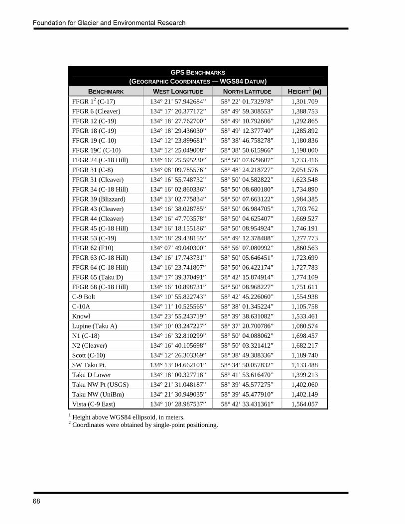
Foundation for Glacier and Environmental Research
68
GPS BENCHMARKS
(GEOGRAPHIC COORDINATES — WGS84 DATUM) BENCHMARK WEST LONGITUDE NORTH LATITUDE HEIGHT1 (M)
FFGR 12 (C-17) 134° 21’ 57.942684” 58° 22’ 01.732978” 1,301.709 FFGR 6 (Cleaver) 134° 17’ 20.377172” 58° 49’ 59.308553” 1,388.753 FFGR 12 (C-19) 134° 18’ 27.762700” 58° 49’ 10.792606” 1,292.865 FFGR 18 (C-19) 134° 18’ 29.436030” 58° 49’ 12.377740” 1,285.892 FFGR 19 (C-10) 134° 12’ 23.899681” 58° 38’ 46.758278” 1,180.836 FFGR 19C (C-10) 134° 12’ 25.049008” 58° 38’ 50.615966” 1,198.000 FFGR 24 (C-18 Hill) 134° 16’ 25.595230” 58° 50’ 07.629607” 1,733.416 FFGR 31 (C-8) 134° 08’ 09.785576” 58° 48’ 24.218727” 2,051.576 FFGR 31 (Cleaver) 134° 16’ 55.748732” 58° 50’ 04.582822” 1,623.548 FFGR 34 (C-18 Hill) 134° 16’ 02.860336” 58° 50’ 08.680180” 1,734.890 FFGR 39 (Blizzard) 134° 13’ 02.775834” 58° 50’ 07.663122” 1,984.385 FFGR 43 (Cleaver) 134° 16’ 38.028785” 58° 50’ 06.984705” 1,703.762 FFGR 44 (Cleaver) 134° 16’ 47.703578” 58° 50’ 04.625407” 1,669.527 FFGR 45 (C-18 Hill) 134° 16’ 18.155186” 58° 50’ 08.954924” 1,746.191 FFGR 53 (C-19) 134° 18’ 29.438155” 58° 49’ 12.378488” 1,277.773 FFGR 62 (F10) 134° 07’ 49.040300” 58° 56’ 07.080992” 1,860.563 FFGR 63 (C-18 Hill) 134° 16’ 17.743731” 58° 50’ 05.646451” 1,723.699 FFGR 64 (C-18 Hill) 134° 16’ 23.741807” 58° 50’ 06.422174” 1,727.783 FFGR 65 (Taku D) 134° 17’ 39.370491” 58° 42’ 15.874914” 1,774.109 FFGR 68 (C-18 Hill) 134° 16’ 10.898731” 58° 50’ 08.968227” 1,751.611 C-9 Bolt 134° 10’ 55.822743” 58° 42’ 45.226060” 1,554.938 C-10A 134° 11’ 10.525565” 58° 38’ 01.345224” 1,105.758 Knowl 134° 23’ 55.243719” 58° 39’ 38.631082” 1,533.461 Lupine (Taku A) 134° 10’ 03.247227” 58° 37’ 20.700786” 1,080.574 N1 (C-18) 134° 16’ 32.810299” 58° 50’ 04.088062” 1,698.457 N2 (Cleaver) 134° 16’ 40.105698” 58° 50’ 03.321412” 1,682.217 Scott (C-10) 134° 12’ 26.303369” 58° 38’ 49.388336” 1,189.740 SW Taku Pt. 134° 13’ 04.662101” 58° 34’ 50.057832” 1,133.488 Taku D Lower 134° 18’ 00.327718” 58° 41’ 53.616470” 1,399.213 Taku NW Pt (USGS) 134° 21’ 31.048187” 58° 39’ 45.577275” 1,402.060 Taku NW (UniBm) 134° 21’ 30.949035” 58° 39’ 45.477910” 1,402.149 Vista (C-9 East) 134° 10’ 28.987537” 58° 42’ 33.431361” 1,564.057
1 Height above WGS84 ellipsoid, in meters. 2 Coordinates were obtained by single-point positioning.
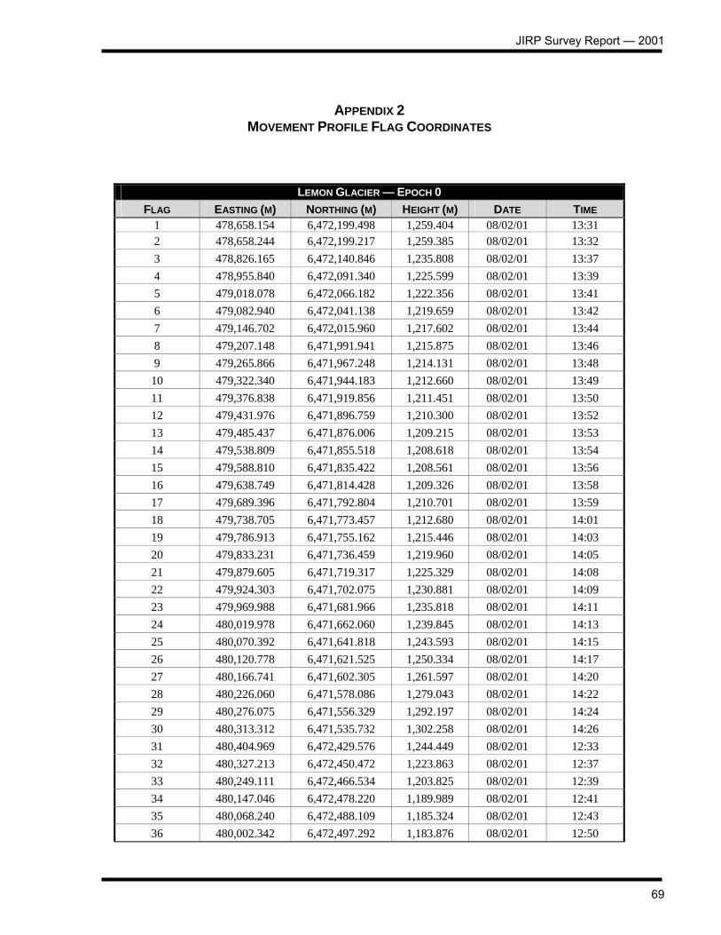
JIRP Survey Report — 2001
69
APPENDIX 2 MOVEMENT PROFILE FLAG COORDINATES
LEMON GLACIER — EPOCH 0 FLAG EASTING (M) NORTHING (M) HEIGHT (M) DATE TIME
1 478,658.154 6,472,199.498 1,259.404 08/02/01 13:31 2 478,658.244 6,472,199.217 1,259.385 08/02/01 13:32 3 478,826.165 6,472,140.846 1,235.808 08/02/01 13:37 4 478,955.840 6,472,091.340 1,225.599 08/02/01 13:39 5 479,018.078 6,472,066.182 1,222.356 08/02/01 13:41 6 479,082.940 6,472,041.138 1,219.659 08/02/01 13:42 7 479,146.702 6,472,015.960 1,217.602 08/02/01 13:44 8 479,207.148 6,471,991.941 1,215.875 08/02/01 13:46 9 479,265.866 6,471,967.248 1,214.131 08/02/01 13:48
10 479,322.340 6,471,944.183 1,212.660 08/02/01 13:49 11 479,376.838 6,471,919.856 1,211.451 08/02/01 13:50 12 479,431.976 6,471,896.759 1,210.300 08/02/01 13:52 13 479,485.437 6,471,876.006 1,209.215 08/02/01 13:53 14 479,538.809 6,471,855.518 1,208.618 08/02/01 13:54 15 479,588.810 6,471,835.422 1,208.561 08/02/01 13:56 16 479,638.749 6,471,814.428 1,209.326 08/02/01 13:58 17 479,689.396 6,471,792.804 1,210.701 08/02/01 13:59 18 479,738.705 6,471,773.457 1,212.680 08/02/01 14:01 19 479,786.913 6,471,755.162 1,215.446 08/02/01 14:03 20 479,833.231 6,471,736.459 1,219.960 08/02/01 14:05 21 479,879.605 6,471,719.317 1,225.329 08/02/01 14:08 22 479,924.303 6,471,702.075 1,230.881 08/02/01 14:09 23 479,969.988 6,471,681.966 1,235.818 08/02/01 14:11 24 480,019.978 6,471,662.060 1,239.845 08/02/01 14:13 25 480,070.392 6,471,641.818 1,243.593 08/02/01 14:15 26 480,120.778 6,471,621.525 1,250.334 08/02/01 14:17 27 480,166.741 6,471,602.305 1,261.597 08/02/01 14:20 28 480,226.060 6,471,578.086 1,279.043 08/02/01 14:22 29 480,276.075 6,471,556.329 1,292.197 08/02/01 14:24 30 480,313.312 6,471,535.732 1,302.258 08/02/01 14:26 31 480,404.969 6,472,429.576 1,244.449 08/02/01 12:33 32 480,327.213 6,472,450.472 1,223.863 08/02/01 12:37 33 480,249.111 6,472,466.534 1,203.825 08/02/01 12:39 34 480,147.046 6,472,478.220 1,189.989 08/02/01 12:41 35 480,068.240 6,472,488.109 1,185.324 08/02/01 12:43 36 480,002.342 6,472,497.292 1,183.876 08/02/01 12:50
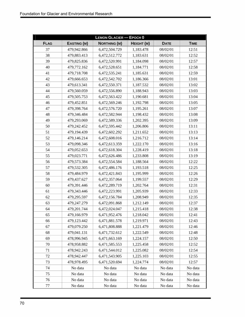
Foundation for Glacier and Environmental Research
70
LEMON GLACIER — EPOCH 0 FLAG EASTING (M) NORTHING (M) HEIGHT (M) DATE TIME
37 479,942.866 6,472,504.729 1,183.478 08/02/01 12:51 38 479,883.413 6,472,512.772 1,183.631 08/02/01 12:52 39 479,825.836 6,472,520.991 1,184.098 08/02/01 12:57 40 479,772.162 6,472,528.651 1,184.771 08/02/01 12:58 41 479,718.708 6,472,535.241 1,185.631 08/02/01 12:59 42 479,666.653 6,472,542.702 1,186.366 08/02/01 13:01 43 479,613.341 6,472,550.371 1,187.532 08/02/01 13:02 44 479,560.059 6,472,556.890 1,188.943 08/02/01 13:03 45 479,505.753 6,472,563.422 1,190.681 08/02/01 13:04 46 479,452.851 6,472,569.246 1,192.798 08/02/01 13:05 47 479,398.764 6,472,576.720 1,195.261 08/02/01 13:07 48 479,346.484 6,472,582.944 1,198.432 08/02/01 13:08 49 479,293.069 6,472,589.336 1,202.395 08/02/01 13:09 50 479,242.452 6,472,595.442 1,206.806 08/02/01 13:11 51 479,194.439 6,472,602.292 1,211.652 08/02/01 13:13 52 479,146.214 6,472,608.016 1,216.712 08/02/01 13:14 53 479,098.346 6,472,613.359 1,222.170 08/02/01 13:16 54 479,052.653 6,472,618.304 1,228.419 08/02/01 13:18 55 479,023.771 6,472,626.486 1,233.808 08/02/01 13:19 56 479,573.384 6,472,554.584 1,188.564 08/02/01 12:22 57 479,532.305 6,472,486.176 1,193.518 08/02/01 12:25 58 479,484.979 6,472,421.843 1,195.999 08/02/01 12:26 59 479,437.627 6,472,357.064 1,199.557 08/02/01 12:29 60 479,391.446 6,472,289.719 1,202.764 08/02/01 12:31 61 479,343.446 6,472,223.991 1,205.939 08/02/01 12:33 62 479,295.597 6,472,156.784 1,208.949 08/02/01 12:35 63 479,247.279 6,472,091.868 1,212.149 08/02/01 12:37 64 479,201.744 6,472,024.047 1,215.418 08/02/01 12:38 65 479,166.979 6,471,952.476 1,218.042 08/02/01 12:41 66 479,123.442 6,471,881.578 1,219.971 08/02/01 12:43 67 479,079.250 6,471,808.888 1,221.479 08/02/01 12:46 68 479,041.131 6,471,732.612 1,222.549 08/02/01 12:48 69 478,996.945 6,471,663.169 1,224.157 08/02/01 12:50 70 478,958.882 6,471,585.553 1,225.458 08/02/01 12:52 71 478,942.243 6,471,544.012 1,225.082 08/02/01 12:54 72 478,942.447 6,471,543.905 1,225.103 08/02/01 12:55 73 478,978.495 6,471,520.694 1,224.774 08/02/01 12:57 74 No data No data No data No data No data 75 No data No data No data No data No data 76 No data No data No data No data No data 77 No data No data No data No data No data
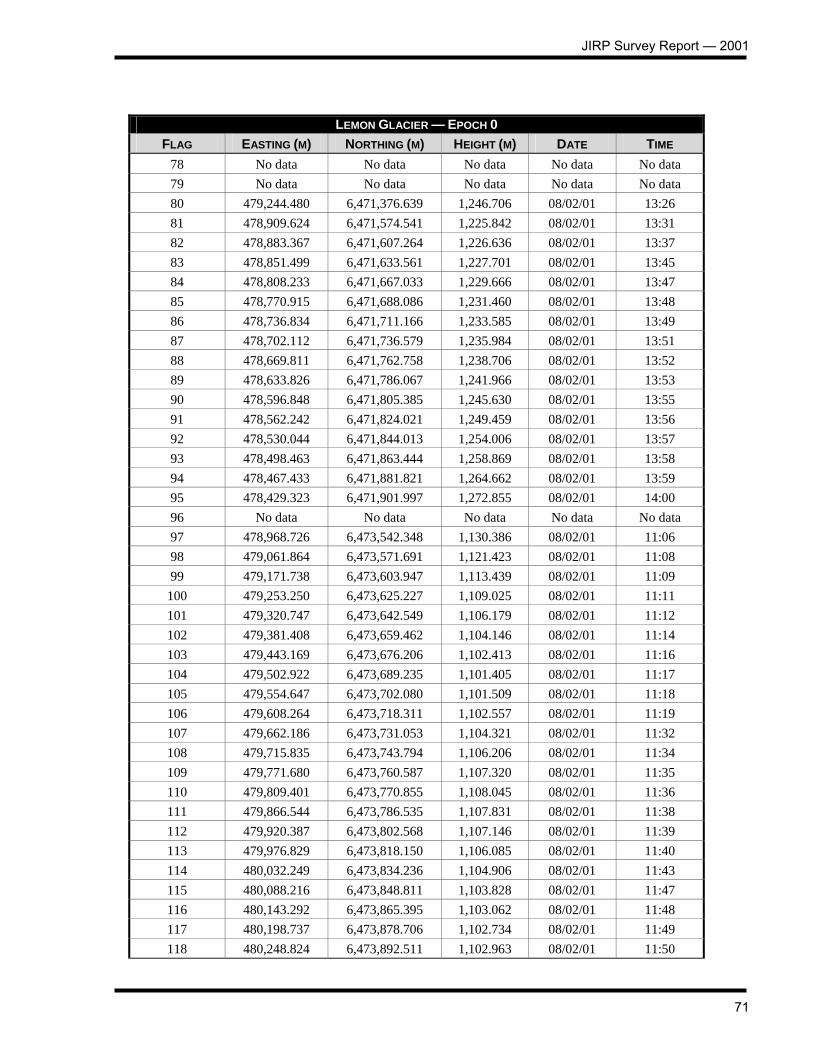
JIRP Survey Report — 2001
71
LEMON GLACIER — EPOCH 0 FLAG EASTING (M) NORTHING (M) HEIGHT (M) DATE TIME
78 No data No data No data No data No data 79 No data No data No data No data No data 80 479,244.480 6,471,376.639 1,246.706 08/02/01 13:26 81 478,909.624 6,471,574.541 1,225.842 08/02/01 13:31 82 478,883.367 6,471,607.264 1,226.636 08/02/01 13:37 83 478,851.499 6,471,633.561 1,227.701 08/02/01 13:45 84 478,808.233 6,471,667.033 1,229.666 08/02/01 13:47 85 478,770.915 6,471,688.086 1,231.460 08/02/01 13:48 86 478,736.834 6,471,711.166 1,233.585 08/02/01 13:49 87 478,702.112 6,471,736.579 1,235.984 08/02/01 13:51 88 478,669.811 6,471,762.758 1,238.706 08/02/01 13:52 89 478,633.826 6,471,786.067 1,241.966 08/02/01 13:53 90 478,596.848 6,471,805.385 1,245.630 08/02/01 13:55 91 478,562.242 6,471,824.021 1,249.459 08/02/01 13:56 92 478,530.044 6,471,844.013 1,254.006 08/02/01 13:57 93 478,498.463 6,471,863.444 1,258.869 08/02/01 13:58 94 478,467.433 6,471,881.821 1,264.662 08/02/01 13:59 95 478,429.323 6,471,901.997 1,272.855 08/02/01 14:00 96 No data No data No data No data No data 97 478,968.726 6,473,542.348 1,130.386 08/02/01 11:06 98 479,061.864 6,473,571.691 1,121.423 08/02/01 11:08 99 479,171.738 6,473,603.947 1,113.439 08/02/01 11:09
100 479,253.250 6,473,625.227 1,109.025 08/02/01 11:11 101 479,320.747 6,473,642.549 1,106.179 08/02/01 11:12 102 479,381.408 6,473,659.462 1,104.146 08/02/01 11:14 103 479,443.169 6,473,676.206 1,102.413 08/02/01 11:16 104 479,502.922 6,473,689.235 1,101.405 08/02/01 11:17 105 479,554.647 6,473,702.080 1,101.509 08/02/01 11:18 106 479,608.264 6,473,718.311 1,102.557 08/02/01 11:19 107 479,662.186 6,473,731.053 1,104.321 08/02/01 11:32 108 479,715.835 6,473,743.794 1,106.206 08/02/01 11:34 109 479,771.680 6,473,760.587 1,107.320 08/02/01 11:35 110 479,809.401 6,473,770.855 1,108.045 08/02/01 11:36 111 479,866.544 6,473,786.535 1,107.831 08/02/01 11:38 112 479,920.387 6,473,802.568 1,107.146 08/02/01 11:39 113 479,976.829 6,473,818.150 1,106.085 08/02/01 11:40 114 480,032.249 6,473,834.236 1,104.906 08/02/01 11:43 115 480,088.216 6,473,848.811 1,103.828 08/02/01 11:47 116 480,143.292 6,473,865.395 1,103.062 08/02/01 11:48 117 480,198.737 6,473,878.706 1,102.734 08/02/01 11:49 118 480,248.824 6,473,892.511 1,102.963 08/02/01 11:50

Foundation for Glacier and Environmental Research
72
LEMON GLACIER — EPOCH 0 FLAG EASTING (M) NORTHING (M) HEIGHT (M) DATE TIME 119 480,302.384 6,473,904.633 1,103.999 08/02/01 11:52 120 480,348.945 6,473,915.733 1,107.538 08/02/01 11:57 121 479,801.438 6,473,699.885 1,112.017 08/02/01 11:37 122 479,788.488 6,473,563.849 1,119.277 08/02/01 11:42 123 479,777.569 6,473,497.672 1,123.523 08/02/01 11:55 124 479,750.467 6,473,384.544 1,131.860 08/02/01 11:57 125 479,721.920 6,473,278.022 1,140.364 08/02/01 11:59 126 479,692.978 6,473,181.624 1,147.257 08/02/01 12:01 127 479,635.213 6,473,047.997 1,158.900 08/02/01 12:03 128 479,580.406 6,472,903.421 1,171.205 08/02/01 12:07 129 479,529.204 6,472,781.125 1,179.874 08/02/01 12:09 130 479,458.483 6,472,651.235 1,189.413 08/02/01 12:11

JIRP Survey Report — 2001
73
PROFILE 3 (LOWER DEMOREST GLACIER) — EPOCH 0 FLAG EASTING (M) NORTHING (M) HEIGHT (M) DATE TIME
1 491,627.141 6,501,358.271 1,018.796 7/26/01 12:01 2 491,862.917 6,501,154.390 1,024.239 7/26/01 12:09 3 492,098.797 6,500,950.664 1,026.971 7/26/01 12:18 4 492,334.508 6,500,746.853 1,031.480 7/26/01 12:43 5 492,570.369 6,500,543.233 1,030.252 7/26/01 12:55 6 492,806.066 6,500,338.826 1,029.354 7/26/01 13:06 7 493,041.594 6,500,135.004 1,038.313 7/26/01 13:15 8 493,277.695 6,499,931.316 1,048.142 7/26/01 13:31 9 493,513.509 6,499,727.920 1,051.339 7/26/01 13:41
10 493,749.546 6,499,523.793 1,050.119 7/26/01 13:52 11 493,985.208 6,499,319.560 1,048.150 7/26/01 14:04 12 494,103.094 6,499,235.251 1,045.648 7/26/01 14:11
PROFILE 3A (DEMOREST GLACIER EAST OF CAMP 9) — EPOCH 0 FLAG EASTING (M) NORTHING (M) HEIGHT (M) DATE TIME
1 492,009.481 6,510,931.270 1,356.650 8/3/01 10:00 2 492,309.449 6,510,940.918 1,345.904 8/3/01 10:07 3 492,609.063 6,510,949.875 1,339.093 8/3/01 10:10 4 492,909.607 6,510,958.515 1,337.682 8/3/01 10:12 5 493,209.287 6,510,968.154 1,337.169 8/3/01 10:14 6 493,509.269 6,510,977.180 1,340.220 8/3/01 10:16 7 493,808.925 6,510,986.291 1,344.852 8/3/01 10:18 8 494,108.860 6,510,995.323 1,350.399 8/3/01 10:20 9 494,408.692 6,511,004.430 1,356.549 8/3/01 10:24
10 494,708.403 6,511,013.659 1,361.548 8/3/01 10:26 11 495,008.388 6,511,022.720 1,366.999 8/3/01 10:35 12 495,308.159 6,511,031.686 1,371.698 8/3/01 10:38 13 495,608.230 6,511,040.472 1,377.708 8/3/01 10:41 14 495,908.064 6,511,050.052 1,384.631 8/3/01 10:43 15 495,458.195 6,511,036.079 1,374.703 8/3/01 10:46
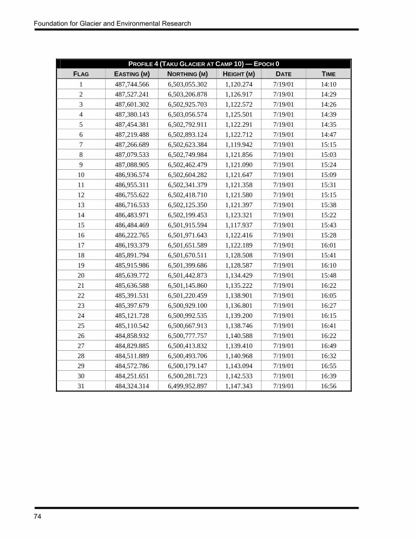
Foundation for Glacier and Environmental Research
74
PROFILE 4 (TAKU GLACIER AT CAMP 10) — EPOCH 0 FLAG EASTING (M) NORTHING (M) HEIGHT (M) DATE TIME
1 487,744.566 6,503,055.302 1,120.274 7/19/01 14:10 2 487,527.241 6,503,206.878 1,126.917 7/19/01 14:29 3 487,601.302 6,502,925.703 1,122.572 7/19/01 14:26 4 487,380.143 6,503,056.574 1,125.501 7/19/01 14:39 5 487,454.381 6,502,792.911 1,122.291 7/19/01 14:35 6 487,219.488 6,502,893.124 1,122.712 7/19/01 14:47 7 487,266.689 6,502,623.384 1,119.942 7/19/01 15:15 8 487,079.533 6,502,749.984 1,121.856 7/19/01 15:03 9 487,088.905 6,502,462.479 1,121.090 7/19/01 15:24
10 486,936.574 6,502,604.282 1,121.647 7/19/01 15:09 11 486,955.311 6,502,341.379 1,121.358 7/19/01 15:31 12 486,755.622 6,502,418.710 1,121.580 7/19/01 15:15 13 486,716.533 6,502,125.350 1,121.397 7/19/01 15:38 14 486,483.971 6,502,199.453 1,123.321 7/19/01 15:22 15 486,484.469 6,501,915.594 1,117.937 7/19/01 15:43 16 486,222.765 6,501,971.643 1,122.416 7/19/01 15:28 17 486,193.379 6,501,651.589 1,122.189 7/19/01 16:01 18 485,891.794 6,501,670.511 1,128.508 7/19/01 15:41 19 485,915.986 6,501,399.686 1,128.587 7/19/01 16:10 20 485,639.772 6,501,442.873 1,134.429 7/19/01 15:48 21 485,636.588 6,501,145.860 1,135.222 7/19/01 16:22 22 485,391.531 6,501,220.459 1,138.901 7/19/01 16:05 23 485,397.679 6,500,929.100 1,136.801 7/19/01 16:27 24 485,121.728 6,500,992.535 1,139.200 7/19/01 16:15 25 485,110.542 6,500,667.913 1,138.746 7/19/01 16:41 26 484,858.932 6,500,777.757 1,140.588 7/19/01 16:22 27 484,829.885 6,500,413.832 1,139.410 7/19/01 16:49 28 484,511.889 6,500,493.706 1,140.968 7/19/01 16:32 29 484,572.786 6,500,179.147 1,143.094 7/19/01 16:55 30 484,251.651 6,500,281.723 1,142.533 7/19/01 16:39 31 484,324.314 6,499,952.897 1,147.343 7/19/01 16:56
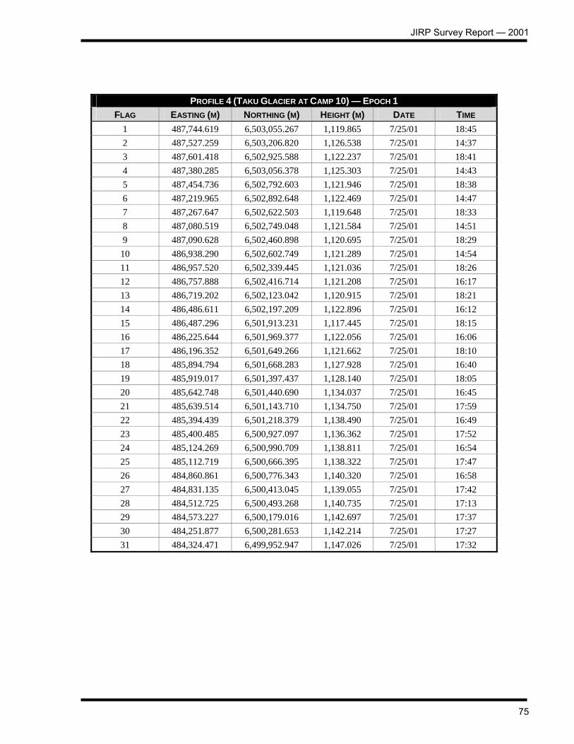
JIRP Survey Report — 2001
75
PROFILE 4 (TAKU GLACIER AT CAMP 10) — EPOCH 1
FLAG EASTING (M) NORTHING (M) HEIGHT (M) DATE TIME 1 487,744.619 6,503,055.267 1,119.865 7/25/01 18:45 2 487,527.259 6,503,206.820 1,126.538 7/25/01 14:37 3 487,601.418 6,502,925.588 1,122.237 7/25/01 18:41 4 487,380.285 6,503,056.378 1,125.303 7/25/01 14:43 5 487,454.736 6,502,792.603 1,121.946 7/25/01 18:38 6 487,219.965 6,502,892.648 1,122.469 7/25/01 14:47 7 487,267.647 6,502,622.503 1,119.648 7/25/01 18:33 8 487,080.519 6,502,749.048 1,121.584 7/25/01 14:51 9 487,090.628 6,502,460.898 1,120.695 7/25/01 18:29
10 486,938.290 6,502,602.749 1,121.289 7/25/01 14:54 11 486,957.520 6,502,339.445 1,121.036 7/25/01 18:26 12 486,757.888 6,502,416.714 1,121.208 7/25/01 16:17 13 486,719.202 6,502,123.042 1,120.915 7/25/01 18:21 14 486,486.611 6,502,197.209 1,122.896 7/25/01 16:12 15 486,487.296 6,501,913.231 1,117.445 7/25/01 18:15 16 486,225.644 6,501,969.377 1,122.056 7/25/01 16:06 17 486,196.352 6,501,649.266 1,121.662 7/25/01 18:10 18 485,894.794 6,501,668.283 1,127.928 7/25/01 16:40 19 485,919.017 6,501,397.437 1,128.140 7/25/01 18:05 20 485,642.748 6,501,440.690 1,134.037 7/25/01 16:45 21 485,639.514 6,501,143.710 1,134.750 7/25/01 17:59 22 485,394.439 6,501,218.379 1,138.490 7/25/01 16:49 23 485,400.485 6,500,927.097 1,136.362 7/25/01 17:52 24 485,124.269 6,500,990.709 1,138.811 7/25/01 16:54 25 485,112.719 6,500,666.395 1,138.322 7/25/01 17:47 26 484,860.861 6,500,776.343 1,140.320 7/25/01 16:58 27 484,831.135 6,500,413.045 1,139.055 7/25/01 17:42 28 484,512.725 6,500,493.268 1,140.735 7/25/01 17:13 29 484,573.227 6,500,179.016 1,142.697 7/25/01 17:37 30 484,251.877 6,500,281.653 1,142.214 7/25/01 17:27 31 484,324.471 6,499,952.947 1,147.026 7/25/01 17:32

Foundation for Glacier and Environmental Research
76
ICY BASIN (TAKU GLACIER AT CAMP 10) — EPOCH 0
FLAG EASTING (M) NORTHING (M) HEIGHT (M) DATE TIME 1-01 488,132.894 6,503,115.838 1,101.449 07/23/01 16:19 1-02 488,227.306 6,503,005.034 1,098.546 07/23/01 16:27 1-03 488,306.694 6,502,910.844 1,097.894 07/23/01 16:31 1-04 488,384.706 6,502,815.279 1,097.661 07/23/01 16:34 1-05 488,469.253 6,502,710.975 1,097.568 07/23/01 16:38 1-06 488,558.899 6,502,597.723 1,097.926 07/23/01 16:51 1-07 488,685.015 6,502,446.055 1,098.324 07/23/01 16:55 1-08 488,803.651 6,502,298.531 1,097.972 07/23/01 17:00 1-09 488,913.311 6,502,134.313 1,097.673 07/23/01 17:03 1-10 488,955.224 6,502,069.981 1,096.758 07/23/01 17:07 1-11 489,040.058 6,502,049.251 1,096.872 07/23/01 17:11 2-01 489,566.291 6,502,330.834 1,125.596 07/23/01 17:24 2-02 489,485.163 6,502,508.087 1,119.402 07/23/01 17:29 2-03 489,424.950 6,502,628.570 1,116.130 07/23/01 17:32 2-04 489,352.303 6,502,766.184 1,111.556 07/23/01 17:39 2-05 489,273.667 6,502,899.901 1,107.250 07/23/01 17:45 2-06 489,201.422 6,503,008.494 1,103.256 07/23/01 17:49 2-07 489,135.992 6,503,113.722 1,099.298 07/23/01 17:52 2-08 489,074.492 6,503,222.395 1,094.872 07/23/01 17:54 2-09 488,999.014 6,503,356.777 1,092.176 07/23/01 18:00 2-9a 489,002.702 6,503,355.930 1,092.166 07/23/01 18:02 2-10 488,915.475 6,503,502.544 1,088.020 07/23/01 18:06 3-01 489,120.300 6,503,634.466 1,083.688 07/24/01 9:57 3-02 489,161.028 6,503,542.677 1,083.872 07/24/01 10:01 3-03 489,216.987 6,503,476.788 1,081.497 07/24/01 10:04 3-04 489,282.494 6,503,417.237 1,080.347 07/24/01 10:06 3-05 489,404.679 6,503,339.065 1,083.066 07/24/01 10:09 3-06 489,524.861 6,503,269.727 1,091.045 07/24/01 10:12 3-07 489,634.755 6,503,219.667 1,101.700 07/24/01 10:20 3-08 489,714.878 6,503,103.895 1,118.005 07/24/01 10:23 3-09 489,797.895 6,502,948.754 1,125.471 07/24/01 10:25 3-10 489,868.341 6,502,714.899 1,129.898 07/24/01 10:48 3-11 489,838.586 6,502,503.559 1,132.774 07/24/01 10:51 4-01 488,786.165 6,502,759.567 1,099.843 07/24/01 11:09 4-02 488,651.267 6,502,603.723 1,098.579 07/24/01 11:06 4-03 488,425.177 6,502,414.230 1,096.648 07/24/01 11:14 4-04 488,211.463 6,502,408.150 1,095.188 07/24/01 11:17 4-04 488,132.894 6,503,115.838 1,101.449 07/23/01 16:19

JIRP Survey Report — 2001
77
ICY BASIN (TAKU GLACIER AT CAMP 10) — EPOCH 1
FLAG EASTING (M) NORTHING (M) HEIGHT (M) DATE TIME 1-01 488,132.892 6,503,115.846 1,101.197 07/29/01 14:38 1-02 488,227.300 6,503,005.015 1,098.261 07/29/01 14:41 1-03 488,306.693 6,502,910.841 1,097.554 07/29/01 14:44 1-04 488,384.723 6,502,815.273 1,097.346 07/29/01 14:49 1-05 488,469.295 6,502,710.986 1,097.314 07/29/01 14:58 1-06 488,558.914 6,502,597.745 1,097.639 07/29/01 15:07 1-07 488,684.988 6,502,446.078 1,097.986 07/29/01 15:15 1-08 488,803.653 6,502,298.539 1,097.679 07/29/01 15:20 1-09 488,913.301 6,502,134.313 1,097.360 07/29/01 15:31 1-10 488,955.240 6,502,069.995 1,096.563 07/29/01 15:36 1-11 489,040.024 6,502,049.242 1,096.505 07/29/01 15:43 2-01 489,566.261 6,502,330.898 1,125.265 07/29/01 15:56 2-02 489,485.077 6,502,508.107 1,119.183 07/29/01 16:03 2-03 489,352.177 6,502,766.282 1,111.219 07/29/01 16:10 2-04 489,352.178 6,502,766.283 1,111.212 07/29/01 16:11 2-05 489,273.546 6,502,899.947 1,106.914 07/29/01 16:15 2-06 489,201.311 6,503,008.651 1,102.851 07/29/01 16:18 2-07 489,135.978 6,503,113.903 1,098.790 07/29/01 16:22 2-08 489,074.592 6,503,222.579 1,094.292 07/29/01 16:50 2-09 488,999.170 6,503,356.888 1,091.675 07/29/01 16:42 2-9a 489,002.892 6,503,356.046 1,091.668 07/29/01 16:43 2-10 488,915.633 6,503,502.593 1,087.556 07/29/01 17:11 3-01 489,120.338 6,503,634.537 1,083.265 07/29/01 17:34 3-02 489,161.045 6,503,542.763 1,083.547 07/29/01 17:42 3-03 489,217.000 6,503,476.834 1,081.178 07/29/01 17:48 3-04 489,282.550 6,503,417.314 1,079.985 07/29/01 17:51 3-05 489,404.683 6,503,339.129 1,082.742 07/29/01 17:56 3-06 489,524.837 6,503,269.803 1,090.726 07/29/01 18:02 3-07 489,634.642 6,503,219.804 1,101.387 07/29/01 18:14 3-08 489,714.801 6,503,103.933 1,117.691 07/29/01 18:20 3-09 489,797.788 6,502,948.781 1,125.170 07/29/01 18:31 3-10 489,868.234 6,502,714.943 1,129.541 07/29/01 18:36 3-11 489,838.494 6,502,503.578 1,132.384 07/29/01 18:42 4-01 488,786.146 6,502,759.563 1,099.550 07/29/01 18:58 4-02 488,651.265 6,502,603.731 1,098.299 07/29/01 19:02 4-03 488,425.205 6,502,414.217 1,096.356 07/29/01 19:07 4-04 488,211.568 6,502,408.097 1,094.942 07/29/01 19:11 4-04 488,132.892 6,503,115.846 1,101.197 07/29/01 14:38
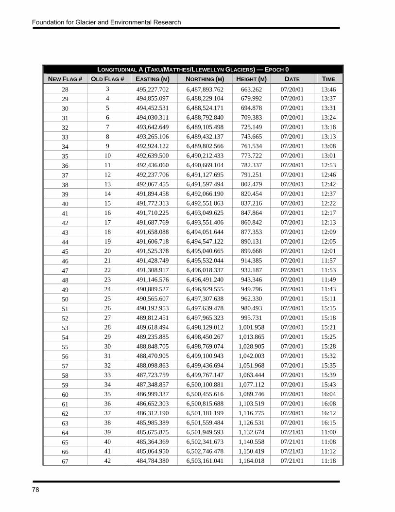
Foundation for Glacier and Environmental Research
78
LONGITUDINAL A (TAKU/MATTHES/LLEWELLYN GLACIERS) — EPOCH 0
NEW FLAG # OLD FLAG # EASTING (M) NORTHING (M) HEIGHT (M) DATE TIME 28 3 495,227.702 6,487,893.762 663.262 07/20/01 13:46 29 4 494,855.097 6,488,229.104 679.992 07/20/01 13:37 30 5 494,452.531 6,488,524.171 694.878 07/20/01 13:31 31 6 494,030.311 6,488,792.840 709.383 07/20/01 13:24 32 7 493,642.649 6,489,105.498 725.149 07/20/01 13:18 33 8 493,265.106 6,489,432.137 743.665 07/20/01 13:13 34 9 492,924.122 6,489,802.566 761.534 07/20/01 13:08 35 10 492,639.500 6,490,212.433 773.722 07/20/01 13:01 36 11 492,436.060 6,490,669.104 782.337 07/20/01 12:53 37 12 492,237.706 6,491,127.695 791.251 07/20/01 12:46 38 13 492,067.455 6,491,597.494 802.479 07/20/01 12:42 39 14 491,894.458 6,492,066.190 820.454 07/20/01 12:37 40 15 491,772.313 6,492,551.863 837.216 07/20/01 12:22 41 16 491,710.225 6,493,049.625 847.864 07/20/01 12:17 42 17 491,687.769 6,493,551.406 860.842 07/20/01 12:13 43 18 491,658.088 6,494,051.644 877.353 07/20/01 12:09 44 19 491,606.718 6,494,547.122 890.131 07/20/01 12:05 45 20 491,525.378 6,495,040.665 899.668 07/20/01 12:01 46 21 491,428.749 6,495,532.044 914.385 07/20/01 11:57 47 22 491,308.917 6,496,018.337 932.187 07/20/01 11:53 48 23 491,146.576 6,496,491.240 943.346 07/20/01 11:49 49 24 490,889.527 6,496,929.555 949.796 07/20/01 11:43 50 25 490,565.607 6,497,307.638 962.330 07/20/01 15:11 51 26 490,192.953 6,497,639.478 980.493 07/20/01 15:15 52 27 489,812.451 6,497,965.323 995.731 07/20/01 15:18 53 28 489,618.494 6,498,129.012 1,001.958 07/20/01 15:21 54 29 489,235.885 6,498,450.267 1,013.865 07/20/01 15:25 55 30 488,848.705 6,498,769.074 1,028.905 07/20/01 15:28 56 31 488,470.905 6,499,100.943 1,042.003 07/20/01 15:32 57 32 488,098.863 6,499,436.694 1,051.968 07/20/01 15:35 58 33 487,723.759 6,499,767.147 1,063.444 07/20/01 15:39 59 34 487,348.857 6,500,100.881 1,077.112 07/20/01 15:43 60 35 486,999.337 6,500,455.616 1,089.746 07/20/01 16:04 61 36 486,652.303 6,500,815.688 1,103.519 07/20/01 16:08 62 37 486,312.190 6,501,181.199 1,116.775 07/20/01 16:12 63 38 485,985.389 6,501,559.484 1,126.531 07/20/01 16:15 64 39 485,675.875 6,501,949.593 1,132.674 07/21/01 11:00 65 40 485,364.369 6,502,341.673 1,140.558 07/21/01 11:08 66 41 485,064.950 6,502,746.478 1,150.419 07/21/01 11:12 67 42 484,784.380 6,503,161.041 1,164.018 07/21/01 11:18

JIRP Survey Report — 2001
79
LONGITUDINAL A (TAKU/MATTHES/LLEWELLYN GLACIERS) — EPOCH 0 NEW FLAG # OLD FLAG # EASTING (M) NORTHING (M) HEIGHT (M) DATE TIME
68 43 484,537.175 6,503,595.758 1,181.943 07/21/01 11:22 69 44 484,290.190 6,503,967.963 1,198.965 07/21/01 11:27 70 45 484,084.564 6,504,426.690 1,211.115 07/21/01 11:40 71 46 483,954.437 6,504,907.871 1,218.617 07/21/01 11:54 72 47 483,910.898 6,505,404.185 1,223.451 07/21/01 11:59 73 48 483,900.198 6,505,903.502 1,228.037 07/21/01 13:14 74 49 483,952.561 6,506,402.367 1,238.983 07/21/01 13:19 75 50 484,058.022 6,506,888.876 1,260.673 07/21/01 13:23 76 51 484,277.656 6,507,336.925 1,279.524 07/21/01 13:28 77 52 484,569.024 6,507,741.207 1,297.502 07/21/01 13:32 78 53 484,851.900 6,508,149.951 1,313.835 07/21/01 13:36 79 54 485,108.809 6,508,581.960 1,323.096 07/21/01 13:40 80 55 485,356.202 6,509,017.561 1,333.596 07/21/01 13:46 81 56 485,598.043 6,509,453.915 1,347.807 08/01/01 13:01 82 57 485,844.252 6,509,890.081 1,360.449 08/01/01 13:04 83 58 486,093.574 6,510,323.933 1,369.015 08/01/01 13:08 84 59 486,352.610 6,510,750.539 1,376.809 08/01/01 13:11 85 60 486,622.631 6,511,171.179 1,388.692 08/01/01 13:14 86 61 486,907.902 6,511,581.934 1,401.524 08/01/01 13:17 87 62 487,209.567 6,511,979.632 1,412.320 08/01/01 13:20 88 63 487,519.864 6,512,370.110 1,428.245 08/01/01 13:25 89 64 487,829.390 6,512,765.134 1,445.305 08/01/01 13:28 90 65 488,126.962 6,513,166.696 1,458.678 08/01/01 13:31 91 66 488,414.237 6,513,574.612 1,469.438 08/01/01 13:33 92 67 488,676.886 6,513,997.129 1,478.991 08/01/01 13:36 93 68 488,896.232 6,514,444.890 1,491.508 08/01/01 13:38 94 69 489,045.297 6,514,919.176 1,504.886 08/01/01 13:44 95 70 489,154.789 6,515,405.878 1,516.566 08/01/01 13:47 96 71 489,161.526 6,515,901.225 1,525.539 08/01/01 13:49 97 72 489,071.851 6,516,388.674 1,539.413 08/01/01 13:52 98 73 488,909.278 6,516,860.794 1,552.228 08/01/01 13:55 99 74 488,844.954 6,517,355.809 1,581.973 08/01/01 13:57
100 75 488,838.067 6,517,852.632 1,624.755 08/01/01 14:00 101 76 488,853.575 6,518,347.992 1,647.187 08/01/01 14:03 102 77 488,886.987 6,518,845.203 1,660.574 08/01/01 14:23 103 78 488,939.325 6,519,340.655 1,687.550 08/01/01 14:25 104 79 488,996.293 6,519,837.212 1,710.543 08/01/01 14:28 105 80 489,057.130 6,520,334.372 1,727.466 08/01/01 14:30 106 81 489,151.948 6,520,825.169 1,743.078 08/01/01 14:33 107 82 489,247.083 6,521,315.493 1,757.727 08/01/01 14:35 108 83 489,358.583 6,521,802.235 1,770.560 08/08/01 11:39

Foundation for Glacier and Environmental Research
80
LONGITUDINAL A (TAKU/MATTHES/LLEWELLYN GLACIERS) — EPOCH 0 NEW FLAG # OLD FLAG # EASTING (M) NORTHING (M) HEIGHT (M) DATE TIME
109 84 489,506.361 6,522,278.132 1,782.436 08/08/01 11:55 110 85 489,654.314 6,522,754.722 1,795.953 08/08/01 11:58 111 86 489,809.012 6,523,229.595 1,809.928 08/08/01 12:02 112 87 489,978.971 6,523,699.626 1,823.421 08/08/01 12:04 113 88 490,149.133 6,524,168.109 1,834.177 08/08/01 12:07 114 89 490,319.248 6,524,637.646 1,843.934 08/08/01 12:10 115 90 490,495.293 6,525,103.029 1,852.973 08/08/01 12:12 116 91 490,706.941 6,525,556.221 1,862.290 08/05/01 13:39 117 92 490,917.380 6,526,008.624 1,869.940 08/05/01 13:35 118 93 491,128.137 6,526,461.048 1,873.065 08/05/01 13:30 119 94 491,337.755 6,526,912.869 1,874.378 08/05/01 13:21 120 95 491,548.834 6,527,365.355 1,872.841 08/05/01 13:19 121 96 491,759.331 6,527,818.794 1,867.374 08/05/01 13:16 122 97 491,966.170 6,528,271.320 1,862.648 08/05/01 13:12 123 98 492,172.469 6,528,724.390 1,858.944 08/05/01 13:10 124 99 492,387.991 6,529,173.619 1,854.736 08/05/01 13:07 125 100 492,602.189 6,529,625.703 1,848.427 08/05/01 13:03 126 101 492,813.767 6,530,075.868 1,840.895 08/05/01 12:55 127 102 493,026.931 6,530,526.840 1,834.065 08/05/01 12:52 128 103 493,214.349 6,530,990.068 1,825.715 08/05/01 12:46 129 104 493,394.127 6,531,455.755 1,814.483 08/05/01 12:43 130 105 493,567.726 6,531,923.872 1,804.141 08/05/01 12:40 131 106 493,730.855 6,532,395.676 1,796.230 08/05/01 12:37 132 107 493,894.668 6,532,868.700 1,785.236 08/05/01 12:34 133 108 494,017.295 6,533,351.821 1,774.043 08/05/01 12:31 134 109 494,140.628 6,533,836.154 1,766.119 08/05/01 12:28 135 110 494,263.738 6,534,319.168 1,755.839 08/05/01 12:24 136 111 494,386.549 6,534,801.756 1,744.511 08/05/01 12:07 137 112 494,514.933 6,535,284.707 1,733.041 08/05/01 12:04 138 113 494,639.456 6,535,767.638 1,720.538 08/05/01 12:01 139 114 494,743.679 6,536,255.837 1,703.934 08/05/01 11:58 140 115 494,848.563 6,536,743.897 1,688.713 08/05/01 11:56 141 116 494,952.635 6,537,229.419 1,681.350 08/05/01 11:53 142 117 495,045.488 6,537,721.198 1,673.371 08/05/01 11:45 143 118 495,109.468 6,538,214.241 1,660.795 08/05/01 11:43 144 119 495,173.309 6,538,708.716 1,646.446 08/05/01 11:40 145 120 495,237.166 6,539,201.839 1,633.172 08/05/01 11:37 146 121 495,301.374 6,539,697.417 1,618.888 08/05/01 11:34 147 122 No data No data No data No data No data
The flag numbers for Longitudinal A were reassigned this year. This was necessary because the original numbering system began with Flag 1 at the present Taku Glacier terminus. The new numbering system begins with Flag 1 at the bedrock of Taku Point, across the Taku River from the terminus. This will allow the continued use of the new numbering system even as the Taku advances or recedes in the future.

JIRP Survey Report — 2001
81
LONGITUDINAL A (TAKU/MATTHES/LLEWELLYN GLACIERS) — EPOCH 1
NEW FLAG # OLD FLAG # EASTING (M) NORTHING (M) HEIGHT (M) DATE TIME 28 3 495,230.530 6,487,891.710 662.762 07/23/01 15:18 29 4 494,858.098 6,488,227.343 679.578 07/23/01 14:59 30 5 494,455.521 6,488,522.475 694.569 07/23/01 14:52 31 6 494,033.002 6,488,790.918 709.035 07/23/01 14:47 32 7 493,644.973 6,489,103.275 724.852 07/23/01 14:43 33 8 493,267.138 6,489,429.744 743.368 07/23/01 14:38 34 9 492,925.952 6,489,800.077 761.235 07/23/01 13:33 35 10 492,641.141 6,490,209.965 773.425 07/23/01 13:13 36 11 492,437.420 6,490,666.570 782.031 07/23/01 12:41 37 12 492,238.792 6,491,125.335 790.920 07/23/01 12:34
Only Flags 28-37 of Longitudinal A were surveyed a second time. This year was the first time that these points had been surveyed, so they were resurveyed in order to obtain velocity.

Foundation for Glacier and Environmental Research
82
LONGITUDINAL B (DEMOREST GLACIER) — EPOCH 0
FLAG EASTING (M) NORTHING (M) HEIGHT (M) DATE TIME 1 490,756.974 6,497,410.760 963.449 07/26/01 11:26 2 490,726.122 6,497,907.583 978.744 07/26/01 11:35 3 490,830.969 6,498,393.087 984.332 07/26/01 11:40 4 491,050.755 6,498,840.681 988.260 07/26/01 11:45 5 491,377.641 6,499,212.503 995.992 07/26/01 11:49 6 491,790.886 6,499,498.062 1,004.185 07/26/01 11:54 7 492,235.178 6,499,730.224 1,014.202 07/26/01 11:59 8 492,684.752 6,499,945.306 1,026.014 07/26/01 12:04 9 493,117.671 6,500,194.978 1,040.681 07/26/01 12:09
10 493,564.643 6,500,418.561 1,052.254 07/26/01 12:14 11 493,989.982 6,500,677.824 1,060.492 07/26/01 12:19 12 494,413.490 6,500,940.145 1,069.990 07/26/01 12:23 13 494,810.757 6,501,238.800 1,078.033 07/26/01 12:32 14 495,165.759 6,501,591.235 1,088.976 07/26/01 12:42 15 495,483.791 6,501,968.402 1,104.499 07/26/01 12:49 16 495,732.499 6,502,400.941 1,120.024 07/26/01 12:57 17 495,894.537 6,502,875.014 1,128.921 07/26/01 13:04 18 495,987.354 6,503,365.528 1,145.354 07/26/01 13:07 19 495,989.827 6,503,864.795 1,170.526 07/26/01 13:11 20 495,941.052 6,504,359.971 1,182.124 07/26/01 13:15 21 495,864.560 6,504,850.138 1,189.235 07/26/01 13:19 22 495,719.360 6,505,325.546 1,200.046 07/26/01 13:27 23 495,497.078 6,505,774.590 1,211.030 07/26/01 13:33 24 495,248.623 6,506,209.016 1,222.006 07/26/01 13:39 25 495,037.630 6,506,662.325 1,231.373 08/03/01 11:34 26 494,854.687 6,507,126.817 1,241.354 08/03/01 11:29 27 494,690.332 6,507,599.212 1,255.820 08/03/01 11:25 28 494,530.510 6,508,074.701 1,266.113 08/03/01 11:20 29 494,391.233 6,508,553.258 1,267.691 08/03/01 11:16 30 494,281.880 6,509,041.128 1,288.876 08/03/01 11:07 31 494,193.195 6,509,530.180 1,312.604 08/03/01 11:04 32 494,177.440 6,510,028.876 1,332.432 08/03/01 11:01 33 494,192.461 6,510,525.600 1,345.917 08/03/01 10:59 34 494,282.624 6,511,013.727 1,354.113 08/03/01 10:55

JIRP Survey Report — 2001
83
LONGITUDINAL C (TAKU SW BRANCH) — EPOCH 0
FLAG EASTING (M) NORTHING (M) HEIGHT (M) DATE TIME 1 489,153.809 6,498,307.544 1,018.130 07/25/01 14:48 2 488,654.906 6,498,351.015 1,031.353 07/25/01 14:59 3 488,156.899 6,498,317.744 1,037.812 07/25/01 15:09 4 487,670.895 6,498,185.777 1,042.682 07/25/01 15:17 5 487,235.704 6,497,941.826 1,046.631 07/25/01 15:22 6 486,870.029 6,497,605.917 1,055.014 07/25/01 15:26 7 486,548.767 6,497,225.969 1,065.677 07/25/01 15:30 8 486,232.735 6,496,840.986 1,075.247 07/25/01 15:41 9 485,914.554 6,496,458.309 1,086.721 07/25/01 15:46
10 485,611.454 6,496,063.039 1,096.891 07/25/01 15:50 11 485,307.455 6,495,666.556 1,111.986 07/25/01 15:54 12 485,006.245 6,495,264.229 1,126.073 07/25/01 16:00 13 484,718.189 6,494,857.236 1,134.601 07/25/01 16:07 14 484,440.975 6,494,443.191 1,145.713 07/25/01 16:17 15 484,156.924 6,494,031.933 1,159.555 07/25/01 16:22 16 483,873.516 6,493,618.847 1,168.899 07/25/01 16:27 17 483,597.213 6,493,204.584 1,178.631 07/25/01 16:37 18 483,320.296 6,492,786.812 1,188.177 07/25/01 16:42 19 483,039.283 6,492,369.678 1,200.750 07/25/01 16:46 20 482,758.809 6,491,957.603 1,211.521 07/25/01 16:51 21 482,477.833 6,491,544.731 1,220.719 07/25/01 16:57 22 482,198.009 6,491,133.963 1,230.694 07/25/01 17:02 23 481,915.336 6,490,721.166 1,240.868 07/25/01 17:07 24 481,634.045 6,490,308.903 1,248.174 07/25/01 17:11 25 481,359.857 6,489,890.123 1,255.829 07/25/01 17:15 26 481,087.121 6,489,472.597 1,267.226 07/25/01 17:19 27 480,807.389 6,489,056.342 1,275.983 07/25/01 17:23 28 480,545.104 6,488,669.598 1,274.830 07/25/01 17:28

Foundation for Glacier and Environmental Research
84
LONGITUDINAL D (TAKU NORTHWEST BRANCH) — EPOCH 0
FLAG EASTING (M) NORTHING (M) HEIGHT (M) DATE TIME 1 483,965.198 6,504,345.588 1,208.551 07/28/01 11:16 2 483,617.811 6,504,705.162 1,213.764 07/28/01 11:22 3 483,260.827 6,505,053.181 1,221.167 07/28/01 11:25 4 482,878.584 6,505,374.433 1,231.619 07/28/01 11:29 5 482,486.281 6,505,682.773 1,242.181 07/28/01 11:32 6 482,085.076 6,505,979.635 1,251.078 07/28/01 11:35 7 481,672.922 6,506,262.792 1,257.120 07/28/01 11:38 8 481,252.568 6,506,529.849 1,268.199 07/28/01 11:42 9 480,838.469 6,506,756.439 1,279.460 07/28/01 11:45
10 480,392.870 6,506,982.462 1,288.768 07/28/01 13:33 11 479,914.760 6,507,132.078 1,298.172 07/28/01 13:36 12 479,426.659 6,507,236.809 1,308.910 07/28/01 13:38 13 478,939.317 6,507,330.641 1,320.794 07/28/01 13:41 14 478,448.481 6,507,421.309 1,330.505 07/28/01 14:02 15 477,957.459 6,507,505.490 1,338.338 07/28/01 14:06 16 477,471.034 6,507,579.854 1,347.805 07/28/01 14:09 17 476,984.168 6,507,457.935 1,357.277 07/28/01 14:13 18 476,520.843 6,507,275.387 1,366.226 07/28/01 14:17 19 476,094.206 6,507,016.407 1,377.981 07/28/01 14:21 20 475,687.381 6,506,727.948 1,391.308 07/28/01 14:25 21 475,308.937 6,506,402.201 1,400.877 07/28/01 14:28 22 474,995.153 6,506,014.747 1,409.985 07/28/01 14:32 23 474,802.539 6,505,552.350 1,423.044 07/28/01 16:10 24 474,782.393 6,505,051.370 1,437.806 07/28/01 16:14 25 474,829.564 6,504,555.451 1,450.069 07/28/01 16:17 26 474,966.852 6,504,076.837 1,458.941 07/28/01 16:21 27 475,116.445 6,503,601.620 1,465.775 07/28/01 16:24 28 475,288.470 6,503,132.810 1,473.005 07/28/01 16:28 29 475,490.553 6,502,675.758 1,479.851 07/28/01 16:42 30 475,691.726 6,502,217.791 1,481.749 07/28/01 16:49 31 475,854.276 6,501,743.200 1,497.531 07/29/01 11:49 32 476,000.706 6,501,264.410 1,513.465 07/29/01 11:52 33 476,115.985 6,500,778.536 1,524.006 07/29/01 11:55 34 476,194.752 6,500,283.479 1,532.007 07/29/01 11:59 35 476,239.171 6,499,783.022 1,538.986 07/29/01 12:05 36 476,258.539 6,499,282.764 1,546.346 07/29/01 12:09 37 476,229.471 6,498,784.339 1,555.755 07/29/01 12:12 38 476,128.065 6,498,295.386 1,564.754 07/29/01 12:16 39 476,037.200 6,497,802.371 1,572.894 07/29/01 12:22 40 476,010.845 6,497,300.470 1,579.433 07/29/01 12:26

JIRP Survey Report — 2001
85
LONGITUDINAL D (TAKU NORTHWEST BRANCH) — EPOCH 0 FLAG EASTING (M) NORTHING (M) HEIGHT (M) DATE TIME
41 476,029.187 6,496,797.708 1,588.343 07/29/01 12:29 42 476,058.246 6,496,300.400 1,599.398 07/29/01 12:34 43 476,117.310 6,495,804.953 1,609.921 07/29/01 12:39 44 476,205.534 6,495,311.449 1,606.329 07/29/01 12:43 45 476,330.060 6,494,826.524 1,594.009 07/29/01 12:49 46 476,456.198 6,494,341.923 1,588.766 07/29/01 12:54 47 476,589.670 6,493,861.259 1,575.357 07/29/01 12:57 48 476,734.373 6,493,381.578 1,564.465 07/29/01 13:03

Foundation for Glacier and Environmental Research
86
LONGITUDINAL D (TAKU NORTHWEST BRANCH) — EPOCH 1 FLAG EASTING (M) NORTHING (M) HEIGHT (M) DATE TIME
15 477,960.222 6,507,505.226 1,337.739 08/07/01 9:47 16 477,473.753 6,507,579.815 1,347.216 08/07/01 9:50 17 476,986.865 6,507,458.248 1,356.723 08/07/01 9:53 18 476,523.397 6,507,276.070 1,365.684 08/07/01 9:56 19 476,096.614 6,507,017.314 1,377.370 08/07/01 9:59 20 475,689.633 6,506,729.054 1,390.589 08/07/01 10:01 21 475,310.957 6,506,403.403 1,400.186 08/07/01 10:04 22 474,996.768 6,506,016.176 1,409.293 08/07/01 10:06 23 474,803.360 6,505,553.988 1,422.414 08/07/01 10:09 24 474,782.563 6,505,052.995 1,437.232 08/07/01 10:12 25 474,829.390 6,504,556.887 1,449.558 08/07/01 10:14 26 474,966.486 6,504,078.063 1,458.462 08/07/01 10:17 27 475,116.062 6,503,602.472 1,465.190 08/07/01 10:21 28 475,288.094 6,503,133.478 1,472.402 08/07/01 10:25 29 475,490.261 6,502,676.341 1,479.251 08/07/01 10:27 30 475,691.513 6,502,218.269 1,481.211 08/07/01 10:30 31 475,854.155 6,501,743.607 1,497.032 08/07/01 10:32 32 476,000.618 6,501,265.116 1,512.981 08/07/01 10:46 33 476,115.985 6,500,779.204 1,523.449 08/07/01 10:51 34 476,194.849 6,500,284.151 1,531.503 08/07/01 10:54 35 476,239.257 6,499,783.633 1,538.600 08/07/01 10:56 36 476,258.656 6,499,283.376 1,545.865 08/07/01 10:59 37 476,229.534 6,498,784.919 1,555.323 08/07/01 11:05 38 476,128.059 6,498,295.913 1,564.380 08/07/01 11:24 39 476,037.186 6,497,802.793 1,572.392 08/07/01 11:26 40 476,010.850 6,497,300.779 1,578.895 08/07/01 11:29 41 476,029.220 6,496,797.971 1,587.912 08/07/01 11:31 42 476,058.203 6,496,300.572 1,598.910 08/07/01 11:34 43 476,117.226 6,495,804.986 1,609.398 08/07/01 11:36 44 476,205.568 6,495,311.338 1,605.791 08/07/01 11:38 45 476,330.096 6,494,826.294 1,593.410 08/07/01 11:40 46 476,456.066 6,494,341.383 1,588.158 08/07/01 11:43 47 476,589.438 6,493,860.585 1,574.761 08/07/01 11:51 48 476,734.018 6,493,380.888 1,563.774 08/07/01 11:55

JIRP Survey Report — 2001
87
LONGITUDINAL E (TAKU WEST BRANCH) — EPOCH 0
FLAG EASTING (M) NORTHING (M) HEIGHT (M) DATE TIME 1 475,171.608 6,503,106.364 1,472.272 07/29/01 13:46 2 475,151.770 6,502,607.001 1,480.695 07/29/01 14:04 3 474,980.751 6,502,137.086 1,486.923 07/29/01 14:07 4 474,761.437 6,501,689.438 1,492.917 07/29/01 14:12 5 474,507.725 6,501,258.496 1,499.269 07/29/01 14:16 6 474,220.474 6,500,848.766 1,510.000 07/29/01 14:19 7 473,889.613 6,500,476.214 1,517.650 07/29/01 14:23 8 473,529.854 6,500,127.702 1,524.599 07/29/01 14:31 9 473,161.846 6,499,790.882 1,529.260 07/29/01 14:44
10 472,744.198 6,499,520.473 1,537.161 07/29/01 15:00 11 472,298.026 6,499,299.424 1,539.328 07/29/01 15:04 12 471,847.592 6,499,088.159 1,535.091 07/29/01 15:07 13 471,420.015 6,498,831.304 1,530.120 07/29/01 15:11 14 471,027.333 6,498,521.724 1,525.261 07/29/01 15:15
LONGITUDINAL E (TAKU WEST BRANCH) — EPOCH 1 FLAG EASTING (M) NORTHING (M) HEIGHT (M) DATE TIME
1 475,171.274 6,503,107.223 1,471.751 08/07/01 12:24 2 475,151.542 6,502,607.833 1,480.202 08/07/01 12:27 3 474,980.712 6,502,137.783 1,486.400 08/07/01 12:30 4 474,761.559 6,501,689.991 1,492.463 08/07/01 12:32 5 474,507.891 6,501,258.832 1,498.771 08/07/01 12:34 6 474,220.666 6,500,849.047 1,509.514 08/07/01 12:37 7 473,889.764 6,500,476.402 1,517.131 08/07/01 12:39 8 473,529.974 6,500,127.896 1,524.070 08/07/01 12:43 9 473,161.915 6,499,791.118 1,528.770 08/07/01 12:47
10 472,744.254 6,499,520.573 1,536.632 08/07/01 12:49 11 472,298.014 6,499,299.377 1,538.772 08/07/01 12:51 12 471,847.527 6,499,088.013 1,534.603 08/07/01 12:54 13 471,419.933 6,498,831.088 1,529.639 08/07/01 12:56 14 471,027.217 6,498,521.452 1,524.692 08/07/01 13:02
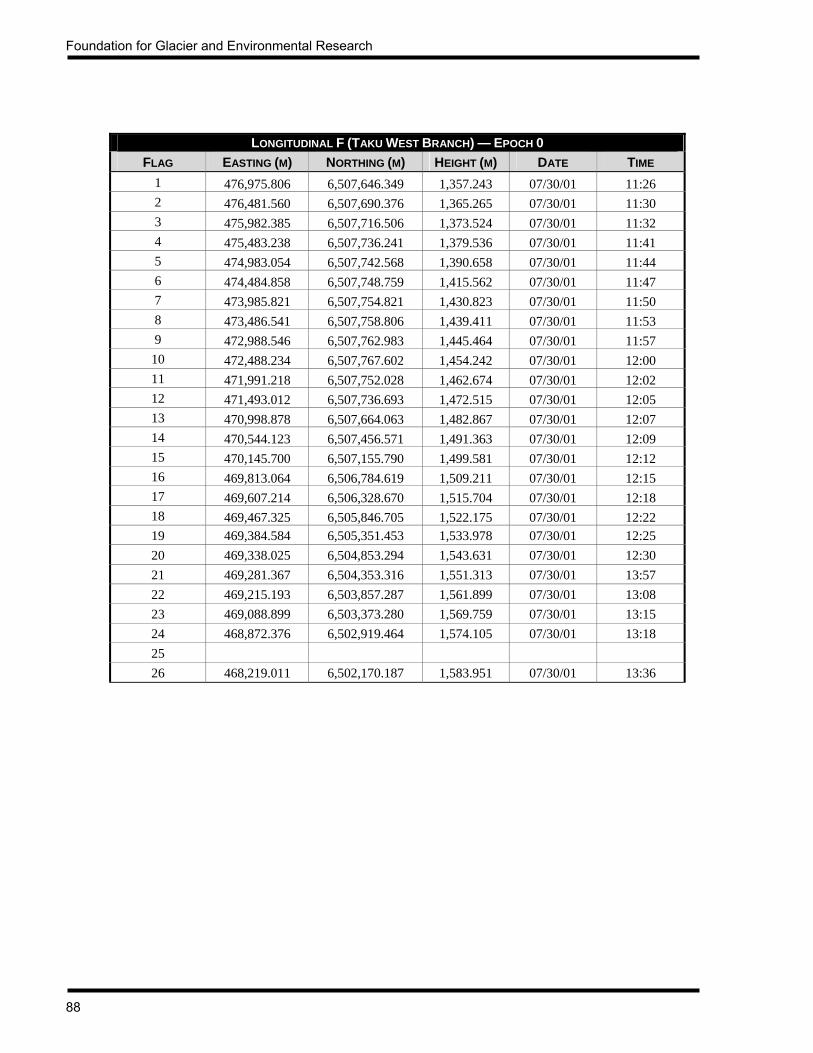
Foundation for Glacier and Environmental Research
88
LONGITUDINAL F (TAKU WEST BRANCH) — EPOCH 0
FLAG EASTING (M) NORTHING (M) HEIGHT (M) DATE TIME 1 476,975.806 6,507,646.349 1,357.243 07/30/01 11:26 2 476,481.560 6,507,690.376 1,365.265 07/30/01 11:30 3 475,982.385 6,507,716.506 1,373.524 07/30/01 11:32 4 475,483.238 6,507,736.241 1,379.536 07/30/01 11:41 5 474,983.054 6,507,742.568 1,390.658 07/30/01 11:44 6 474,484.858 6,507,748.759 1,415.562 07/30/01 11:47 7 473,985.821 6,507,754.821 1,430.823 07/30/01 11:50 8 473,486.541 6,507,758.806 1,439.411 07/30/01 11:53 9 472,988.546 6,507,762.983 1,445.464 07/30/01 11:57
10 472,488.234 6,507,767.602 1,454.242 07/30/01 12:00 11 471,991.218 6,507,752.028 1,462.674 07/30/01 12:02 12 471,493.012 6,507,736.693 1,472.515 07/30/01 12:05 13 470,998.878 6,507,664.063 1,482.867 07/30/01 12:07 14 470,544.123 6,507,456.571 1,491.363 07/30/01 12:09 15 470,145.700 6,507,155.790 1,499.581 07/30/01 12:12 16 469,813.064 6,506,784.619 1,509.211 07/30/01 12:15 17 469,607.214 6,506,328.670 1,515.704 07/30/01 12:18 18 469,467.325 6,505,846.705 1,522.175 07/30/01 12:22 19 469,384.584 6,505,351.453 1,533.978 07/30/01 12:25 20 469,338.025 6,504,853.294 1,543.631 07/30/01 12:30 21 469,281.367 6,504,353.316 1,551.313 07/30/01 13:57 22 469,215.193 6,503,857.287 1,561.899 07/30/01 13:08 23 469,088.899 6,503,373.280 1,569.759 07/30/01 13:15 24 468,872.376 6,502,919.464 1,574.105 07/30/01 13:18 25 26 468,219.011 6,502,170.187 1,583.951 07/30/01 13:36

JIRP Survey Report — 2001
89
LONGITUDINAL F (TAKU WEST BRANCH) — EPOCH 1 FLAG EASTING (M) NORTHING (M) HEIGHT (M) DATE TIME
15 470,146.201 6,507,156.227 1,499.165 08/06/01 15:55 16 469,813.452 6,506,785.112 1,508.815 08/06/01 15:58 17 469,607.474 6,506,329.155 1,515.355 08/06/01 16:06 18 469,467.496 6,505,847.207 1,521.778 08/06/01 16:09 19 469,384.717 6,505,351.964 1,533.540 08/06/01 16:12 20 469,338.136 6,504,853.714 1,543.224 08/06/01 16:19 21 469,281.486 6,504,353.702 1,550.974 08/06/01 16:24 22 469,215.262 6,503,857.620 1,561.504 08/06/01 16:27 23 469,088.831 6,503,373.593 1,569.400 08/06/01 16:31 24 468,872.347 6,502,919.671 1,573.708 08/06/01 16:34 25 468,586.174 6,502,508.721 1,580.842 08/06/01 16:40 26 468,218.886 6,502,170.275 1,583.617 08/06/01 16:43
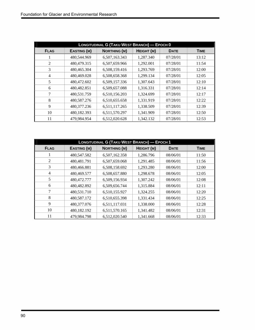
Foundation for Glacier and Environmental Research
90
LONGITUDINAL G (TAKU WEST BRANCH) — EPOCH 0
FLAG EASTING (M) NORTHING (M) HEIGHT (M) DATE TIME 1 480,544.969 6,507,163.343 1,287.340 07/28/01 13:12 2 480,479.315 6,507,659.966 1,292.001 07/28/01 11:54 3 480,465.304 6,508,159.416 1,293.769 07/28/01 12:00 4 480,469.028 6,508,658.368 1,299.134 07/28/01 12:05 5 480,472.602 6,509,157.336 1,307.643 07/28/01 12:10 6 480,482.851 6,509,657.088 1,316.331 07/28/01 12:14 7 480,531.759 6,510,156.203 1,324.699 07/28/01 12:17 8 480,587.276 6,510,655.658 1,331.919 07/28/01 12:22 9 480,377.236 6,511,117.265 1,338.509 07/28/01 12:39
10 480,182.393 6,511,570.297 1,341.909 07/28/01 12:50 11 479,984.954 6,512,020.628 1,342.132 07/28/01 12:53
LONGITUDINAL G (TAKU WEST BRANCH) — EPOCH 1 FLAG EASTING (M) NORTHING (M) HEIGHT (M) DATE TIME
1 480,547.582 6,507,162.358 1,286.796 08/06/01 11:50 2 480,481.791 6,507,659.068 1,291.485 08/06/01 11:56 3 480,466.881 6,508,158.692 1,293.280 08/06/01 12:00 4 480,469.577 6,508,657.880 1,298.678 08/06/01 12:05 5 480,472.777 6,509,156.934 1,307.242 08/06/01 12:08 6 480,482.892 6,509,656.744 1,315.884 08/06/01 12:11 7 480,531.710 6,510,155.927 1,324.255 08/06/01 12:20 8 480,587.172 6,510,655.398 1,331.434 08/06/01 12:25 9 480,377.076 6,511,117.031 1,338.000 08/06/01 12:28
10 480,182.192 6,511,570.165 1,341.482 08/06/01 12:31 11 479,984.798 6,512,020.540 1,341.668 08/06/01 12:33
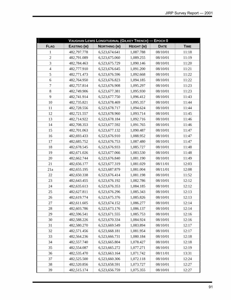
JIRP Survey Report — 2001
91
VAUGHAN LEWIS LONGITUDINAL (GILKEY TRENCH) — EPOCH 0
FLAG EASTING (M) NORTHING (M) HEIGHT (M) DATE TIME 1 482,797.778 6,523,674.641 1,087.788 08/10/01 11:18 2 482,791.089 6,523,675.060 1,089.255 08/10/01 11:19 3 482,784.463 6,523,675.729 1,090.146 08/10/01 11:20 4 482,777.910 6,523,676.645 1,091.200 08/10/01 11:21 5 482,771.473 6,523,676.596 1,092.668 08/10/01 11:22 6 482,764.950 6,523,676.823 1,094.185 08/10/01 11:22 7 482,757.814 6,523,676.908 1,095.297 08/10/01 11:23 8 482,749.906 6,523,677.381 1,095.930 08/10/01 11:23 9 482,741.914 6,523,677.750 1,096.412 08/10/01 11:43
10 482,735.821 6,523,678.469 1,095.357 08/10/01 11:44 11 482,728.556 6,523,678.717 1,094.624 08/10/01 11:44 12 482,721.557 6,523,678.960 1,093.714 08/10/01 11:45 13 482,714.922 6,523,678.184 1,092.716 08/10/01 11:46 14 482,708.353 6,523,677.592 1,091.765 08/10/01 11:46 15 482,701.063 6,523,677.132 1,090.487 08/10/01 11:47 16 482,693.433 6,523,676.910 1,088.952 08/10/01 11:47 17 482,685.752 6,523,676.753 1,087.480 08/10/01 11:47 18 482,678.545 6,523,676.933 1,085.727 08/10/01 11:48 19 482,671.026 6,523,677.066 1,083.530 08/10/01 11:48 20 482,662.744 6,523,676.840 1,081.190 08/10/01 11:49 21 482,656.177 6,523,677.319 1,081.029 08/11/01 12:03 21a 482,655.195 6,523,687.879 1,081.004 08/11/01 12:08 22 482,650.338 6,523,676.414 1,081.198 08/10/01 11:52 23 482,643.455 6,523,676.192 1,082.786 08/10/01 12:12 24 482,635.613 6,523,676.353 1,084.185 08/10/01 12:12 25 482,627.811 6,523,676.296 1,085.343 08/10/01 12:13 26 482,619.774 6,523,675.376 1,085.826 08/10/01 12:13 27 482,611.605 6,523,674.152 1,086.277 08/10/01 12:14 28 482,603.786 6,523,673.176 1,086.137 08/10/01 12:14 29 482,596.541 6,523,671.555 1,085.753 08/10/01 12:16 30 482,588.226 6,523,670.334 1,084.924 08/10/01 12:16 31 482,580.270 6,523,669.549 1,083.894 08/10/01 12:17 32 482,571.456 6,523,668.181 1,081.954 08/10/01 12:17 33 482,564.236 6,523,666.731 1,080.184 08/10/01 12:18 34 482,557.740 6,523,665.804 1,078.427 08/10/01 12:18 35 482,554.087 6,523,665.272 1,077.271 08/10/01 12:19 36 482,535.470 6,523,663.164 1,071.742 08/11/01 13:31 37 482,525.500 6,523,660.306 1,072.118 08/10/01 12:24 38 482,520.856 6,523,658.591 1,073.727 08/10/01 12:27 39 482,515.174 6,523,656.759 1,075.355 08/10/01 12:27

Foundation for Glacier and Environmental Research
92
VAUGHAN LEWIS LONGITUDINAL (GILKEY TRENCH) — EPOCH 0 FLAG EASTING (M) NORTHING (M) HEIGHT (M) DATE TIME
40 482,509.386 6,523,655.038 1,076.453 08/10/01 12:28 41 482,502.425 6,523,652.607 1,077.418 08/10/01 12:28 42 482,494.576 6,523,650.218 1,078.416 08/10/01 12:29 43 482,486.910 6,523,647.326 1,079.077 08/10/01 12:29 44 482,479.071 6,523,644.040 1,078.855 08/10/01 12:30 45 482,471.419 6,523,641.203 1,078.702 08/10/01 12:32 46 482,464.053 6,523,640.315 1,077.694 08/10/01 12:32 47 482,456.230 6,523,639.609 1,076.533 08/10/01 12:33 48 482,448.094 6,523,638.849 1,075.027 08/10/01 12:34 49 482,440.748 6,523,637.540 1,073.375 08/10/01 12:39 50 482,434.498 6,523,636.541 1,071.551 08/10/01 12:40 51 482,429.629 6,523,634.714 1,069.946 08/10/01 12:41 52 482,422.297 6,523,632.695 1,063.783 08/11/01 14:57 53 482,417.230 6,523,630.508 1,063.729 08/11/01 15:01 54 482,402.452 6,523,632.095 1,063.986 08/10/01 12:47 55 482,396.334 6,523,630.226 1,065.564 08/10/01 12:48 56 482,390.461 6,523,628.162 1,066.836 08/10/01 12:49 57 482,385.280 6,523,626.441 1,068.184 08/10/01 12:50 58 482,378.579 6,523,623.603 1,069.435 08/10/01 12:50 59 482,370.485 6,523,621.762 1,070.115 08/10/01 12:53 60 482,363.018 6,523,618.748 1,070.853 08/10/01 12:54 61 482,355.193 6,523,616.484 1,071.269 08/10/01 12:54 62 482,347.981 6,523,614.477 1,071.147 08/10/01 12:55 63 482,340.201 6,523,611.987 1,071.048 08/10/01 12:56 64 482,332.777 6,523,609.102 1,070.812 08/10/01 12:57 65 482,325.993 6,523,606.665 1,070.224 08/10/01 12:57 66 482,319.755 6,523,604.540 1,069.398 08/10/01 12:59 67 482,311.763 6,523,602.296 1,068.318 08/10/01 12:59 68 482,304.628 6,523,600.204 1,066.789 08/10/01 12:59 69 482,297.616 6,523,597.784 1,065.509 08/10/01 13:00 70 482,290.830 6,523,595.632 1,064.087 08/10/01 13:01 71 482,283.911 6,523,594.330 1,062.658 08/10/01 13:01 72 482,276.664 6,523,592.755 1,061.000 08/10/01 13:07 73 482,270.553 6,523,591.872 1,058.592 08/10/01 13:09 74 482,262.480 6,523,591.189 1,057.948 08/10/01 13:11 75 482,253.813 6,523,588.216 1,058.183 08/10/01 13:11 76 482,246.056 6,523,584.302 1,059.460 08/10/01 13:12 77 482,239.644 6,523,581.150 1,059.710 08/10/01 13:12 78 482,232.713 6,523,577.847 1,060.253 08/10/01 13:13 79 482,225.276 6,523,577.389 1,060.880 08/10/01 13:13 80 482,218.142 6,523,573.289 1,061.932 08/10/01 13:14

JIRP Survey Report — 2001
93
VAUGHAN LEWIS LONGITUDINAL (GILKEY TRENCH) — EPOCH 0 FLAG EASTING (M) NORTHING (M) HEIGHT (M) DATE TIME
81 482,211.272 6,523,570.467 1,062.244 08/10/01 13:14 82 482,202.915 6,523,568.884 1,062.213 08/10/01 13:15 83 482,194.630 6,523,567.918 1,062.003 08/10/01 13:16 84 482,186.572 6,523,565.417 1,061.630 08/10/01 13:17 85 482,178.315 6,523,562.647 1,061.238 08/10/01 13:17 86 482,170.905 6,523,559.689 1,060.480 08/10/01 13:18 87 482,163.533 6,523,556.679 1,059.441 08/10/01 13:18 88 482,156.506 6,523,552.529 1,058.227 08/10/01 13:19 89 482,150.459 6,523,548.877 1,057.001 08/10/01 13:20 90 482,144.143 6,523,545.074 1,055.601 08/10/01 13:20 91 482,136.367 6,523,542.404 1,054.059 08/10/01 13:21 92 482,129.496 6,523,542.310 1,052.850 08/10/01 13:21 93 482,121.803 6,523,541.599 1,051.510 08/10/01 13:22 94 482,114.441 6,523,538.201 1,050.337 08/10/01 13:22 95 482,107.878 6,523,534.878 1,049.527 08/10/01 13:23 96 482,101.603 6,523,532.748 1,049.075 08/10/01 13:23 97 482,094.049 6,523,531.961 1,048.069 08/10/01 13:24 98 482,085.721 6,523,531.236 1,047.020 08/10/01 13:24 99 482,078.276 6,523,529.076 1,047.176 08/10/01 13:25
100 482,071.940 6,523,524.168 1,047.711 08/10/01 13:27 101 482,064.402 6,523,520.145 1,048.636 08/10/01 13:27 102 482,056.266 6,523,518.192 1,049.012 08/10/01 13:28 103 482,048.205 6,523,514.768 1,049.320 08/10/01 13:28 104 482,038.733 6,523,513.151 1,049.282 08/10/01 13:29 105 482,030.070 6,523,508.802 1,049.135 08/10/01 13:30 106 482,022.142 6,523,507.234 1,048.777 08/10/01 16:11 107 482,014.565 6,523,504.067 1,048.441 08/10/01 16:12 108 482,006.522 6,523,500.127 1,047.883 08/10/01 16:12 109 482,000.176 6,523,495.415 1,047.080 08/10/01 16:13 110 481,992.281 6,523,491.113 1,046.161 08/10/01 16:13 111 481,984.863 6,523,487.588 1,045.058 08/10/01 16:14 112 481,976.528 6,523,484.363 1,043.625 08/10/01 16:14 113 481,969.612 6,523,480.419 1,042.400 08/10/01 16:15 114 481,961.849 6,523,477.685 1,041.051 08/10/01 16:15 115 481,953.483 6,523,474.729 1,039.476 08/10/01 16:16 116 481,945.749 6,523,471.599 1,038.581 08/10/01 16:16 117 481,938.084 6,523,467.445 1,037.651 08/10/01 16:16 118 481,930.668 6,523,461.694 1,037.253 08/10/01 16:20 119 481,923.494 6,523,456.425 1,037.265 08/10/01 16:20 120 481,914.697 6,523,451.463 1,037.571 08/10/01 16:21 121 481,905.849 6,523,447.692 1,038.150 08/10/01 16:21

Foundation for Glacier and Environmental Research
94
VAUGHAN LEWIS LONGITUDINAL (GILKEY TRENCH) — EPOCH 0 FLAG EASTING (M) NORTHING (M) HEIGHT (M) DATE TIME 122 481,896.984 6,523,444.744 1,038.485 08/10/01 16:22 123 481,888.024 6,523,442.206 1,038.529 08/10/01 16:23 124 481,876.468 6,523,437.310 1,038.794 08/10/01 16:24 125 481,865.643 6,523,435.957 1,038.374 08/10/01 16:25 126 481,856.932 6,523,430.959 1,038.050 08/10/01 16:25 127 481,845.166 6,523,427.566 1,037.371 08/10/01 16:27 128 481,836.832 6,523,425.476 1,036.894 08/10/01 16:27 129 481,827.771 6,523,423.189 1,036.309 08/10/01 16:27 130 481,818.679 6,523,420.102 1,035.465 08/10/01 16:28 131 481,808.333 6,523,419.889 1,034.487 08/10/01 16:29 132 481,800.655 6,523,417.551 1,033.791 08/10/01 16:30 133 481,790.582 6,523,414.610 1,032.557 08/10/01 16:30 134 481,782.110 6,523,410.990 1,031.365 08/10/01 16:31 135 481,773.042 6,523,409.000 1,030.497 08/10/01 16:31 136 481,764.584 6,523,408.799 1,029.665 08/10/01 16:32 137 481,756.673 6,523,407.591 1,028.840 08/10/01 16:32 138 481,748.841 6,523,406.405 1,028.080 08/10/01 16:32 139 481,740.162 6,523,405.544 1,027.228 08/10/01 16:33 140 481,726.465 6,523,405.342 1,026.593 08/10/01 16:35 141 481,719.057 6,523,402.417 1,026.063 08/10/01 16:35 142 481,705.345 6,523,397.823 1,026.928 08/10/01 16:37 143 481,694.400 6,523,387.998 1,028.162 08/10/01 16:37 144 481,682.651 6,523,378.047 1,029.038 08/10/01 16:38 145 481,669.336 6,523,368.986 1,029.212 08/10/01 16:39 146 481,655.454 6,523,360.747 1,028.910 08/10/01 16:41 147 481,639.064 6,523,357.337 1,027.895 08/10/01 16:42 148 481,623.385 6,523,353.535 1,026.391 08/10/01 16:42 149 481,605.645 6,523,353.218 1,024.588 08/10/01 16:43 150 481,589.799 6,523,351.024 1,022.760 08/10/01 16:43 151 481,574.163 6,523,347.266 1,021.195 08/10/01 16:44 152 481,557.187 6,523,344.674 1,020.696 08/10/01 16:44 153 481,544.619 6,523,335.678 1,021.078 08/10/01 16:45 154 481,535.713 6,523,322.518 1,021.617 08/10/01 16:45 155 481,525.937 6,523,313.049 1,022.347 08/10/01 16:46 156 481,514.032 6,523,304.512 1,022.777 08/10/01 16:47 157 481,499.674 6,523,297.169 1,022.492 08/10/01 16:47 158 481,484.814 6,523,291.904 1,021.942 08/10/01 16:49 159 481,469.853 6,523,290.733 1,021.022 08/10/01 16:49 160 481,454.756 6,523,288.102 1,019.587 08/10/01 16:50 161 481,438.654 6,523,285.381 1,017.919 08/10/01 16:50 162 481,425.515 6,523,280.010 1,016.530 08/10/01 16:51
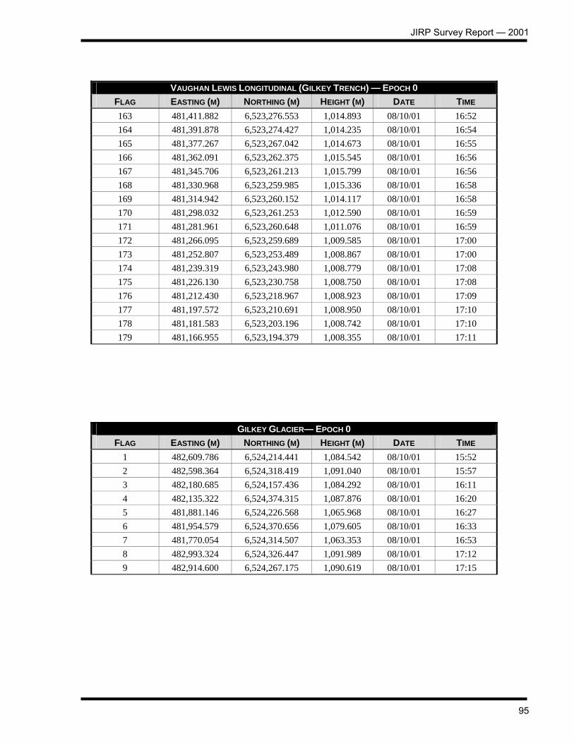
JIRP Survey Report — 2001
95
VAUGHAN LEWIS LONGITUDINAL (GILKEY TRENCH) — EPOCH 0 FLAG EASTING (M) NORTHING (M) HEIGHT (M) DATE TIME 163 481,411.882 6,523,276.553 1,014.893 08/10/01 16:52 164 481,391.878 6,523,274.427 1,014.235 08/10/01 16:54 165 481,377.267 6,523,267.042 1,014.673 08/10/01 16:55 166 481,362.091 6,523,262.375 1,015.545 08/10/01 16:56 167 481,345.706 6,523,261.213 1,015.799 08/10/01 16:56 168 481,330.968 6,523,259.985 1,015.336 08/10/01 16:58 169 481,314.942 6,523,260.152 1,014.117 08/10/01 16:58 170 481,298.032 6,523,261.253 1,012.590 08/10/01 16:59 171 481,281.961 6,523,260.648 1,011.076 08/10/01 16:59 172 481,266.095 6,523,259.689 1,009.585 08/10/01 17:00 173 481,252.807 6,523,253.489 1,008.867 08/10/01 17:00 174 481,239.319 6,523,243.980 1,008.779 08/10/01 17:08 175 481,226.130 6,523,230.758 1,008.750 08/10/01 17:08 176 481,212.430 6,523,218.967 1,008.923 08/10/01 17:09 177 481,197.572 6,523,210.691 1,008.950 08/10/01 17:10 178 481,181.583 6,523,203.196 1,008.742 08/10/01 17:10 179 481,166.955 6,523,194.379 1,008.355 08/10/01 17:11
GILKEY GLACIER— EPOCH 0 FLAG EASTING (M) NORTHING (M) HEIGHT (M) DATE TIME
1 482,609.786 6,524,214.441 1,084.542 08/10/01 15:52 2 482,598.364 6,524,318.419 1,091.040 08/10/01 15:57 3 482,180.685 6,524,157.436 1,084.292 08/10/01 16:11 4 482,135.322 6,524,374.315 1,087.876 08/10/01 16:20 5 481,881.146 6,524,226.568 1,065.968 08/10/01 16:27 6 481,954.579 6,524,370.656 1,079.605 08/10/01 16:33 7 481,770.054 6,524,314.507 1,063.353 08/10/01 16:53 8 482,993.324 6,524,326.447 1,091.989 08/10/01 17:12 9 482,914.600 6,524,267.175 1,090.619 08/10/01 17:15

Foundation for Glacier and Environmental Research
96
VAUGHAN LEWIS OGIVES— EPOCH 0
FLAG EASTING (M) NORTHING (M) HEIGHT (M) DATE TIME wb1-1 482,789.875 6,523,855.133 1,092.359 08/10/01 11:02 wb1-2 482,751.690 6,523,736.577 1,093.586 08/10/01 11:09 wb1-3 482,754.809 6,523,600.255 1,101.714 08/10/01 11:48 wb1-4 482,787.452 6,523,508.947 1,107.820 08/10/01 11:43 wb2-1 482,635.333 6,523,820.108 1,088.441 08/10/01 12:15 wb2-2 482,607.153 6,523,691.319 1,086.172 08/10/01 12:11 wb2-3 482,674.744 6,523,510.540 1,099.330 08/10/01 12:02 wb3-1 482,516.246 6,523,811.890 1,087.740 08/10/01 12:55 wb3-2 482,476.707 6,523,692.423 1,080.922 08/10/01 12:49 wb3-3 482,543.645 6,523,535.853 1,088.721 08/10/01 12:40 wb3-4 482,628.912 6,523,448.099 1,095.842 08/10/01 12:34
VAUGHAN LEWIS OGIVES— EPOCH 1 FLAG EASTING (M) NORTHING (M) HEIGHT (M) DATE TIME wb1-1 482,789.505 6,523,855.220 1,092.327 08/11/01 11:10 wb1-2 482,751.319 6,523,736.694 1,093.508 08/11/01 11:49 wb1-3 482,754.441 6,523,600.388 1,101.668 08/11/01 11:46 wb1-4 482,787.084 6,523,509.081 1,107.747 08/11/01 11:43 wb2-1 482,634.990 6,523,820.119 1,088.395 08/11/01 12:40 wb2-2 482,606.775 6,523,691.414 1,086.072 08/11/01 12:36 wb2-3 482,674.383 6,523,510.618 1,099.227 08/11/01 12:30 wb3-1 482,515.883 6,523,811.829 1,087.697 08/11/01 12:50 wb3-2 482,476.301 6,523,692.362 1,080.863 08/11/01 12:56 wb3-3 482,543.279 6,523,535.880 1,088.688 08/11/01 13:09 wb3-4 482,628.561 6,523,448.157 1,095.802 08/11/01 13:05
TEST PITS — EPOCH 0
LOCATION Longitudinal C, Flag C-12
Head of Southwest Branch
Flat plateau north of C-16, west of
Taku Towers LATITUDE 58° 34’ 27.7N 58° 31’ 09.0 N 58° 37’59.8 N
LONGITUDE 134° 15’ 28.6” W 134° 19’ 38.4” W 134° 26’ 00.8” W JIRP EASTING 484,992.036 480,924.843 474,816.927
JIRP NORTHING 6,495,285.388 6,489,155.072 6,501,900.540 DATE MEASURED 7/25/01 7/25/01 7/27/01
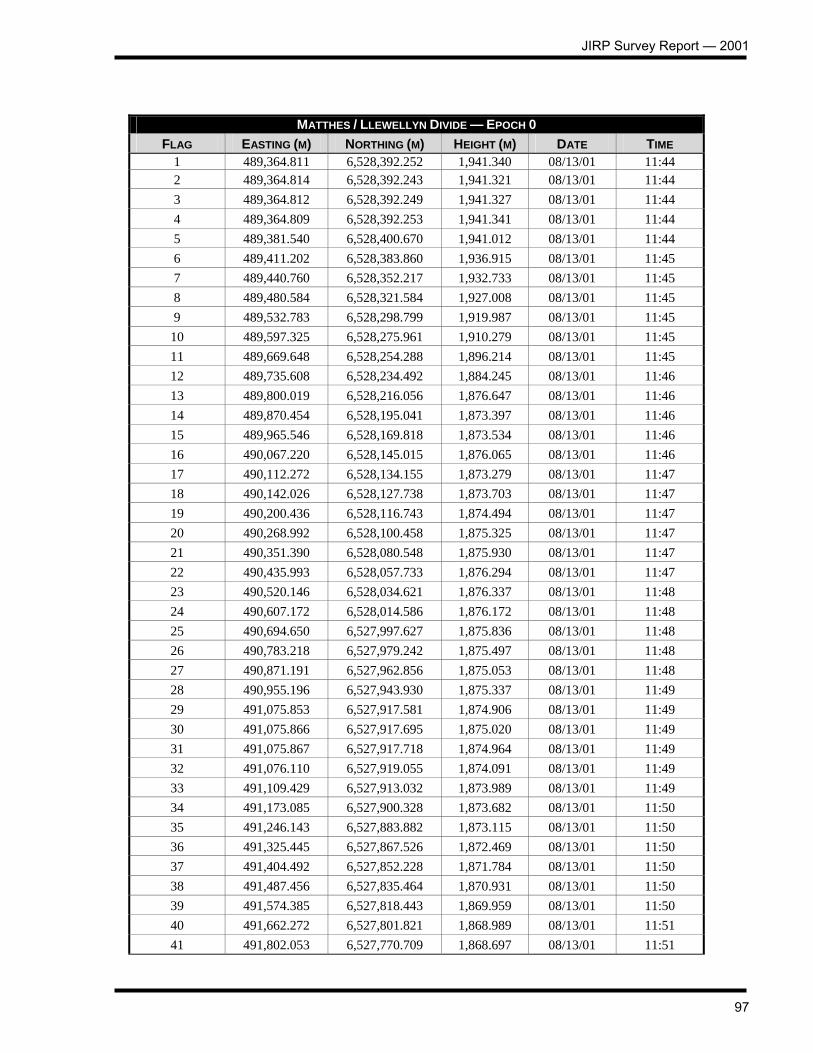
JIRP Survey Report — 2001
97
MATTHES / LLEWELLYN DIVIDE — EPOCH 0 FLAG EASTING (M) NORTHING (M) HEIGHT (M) DATE TIME
1 489,364.811 6,528,392.252 1,941.340 08/13/01 11:44 2 489,364.814 6,528,392.243 1,941.321 08/13/01 11:44 3 489,364.812 6,528,392.249 1,941.327 08/13/01 11:44 4 489,364.809 6,528,392.253 1,941.341 08/13/01 11:44 5 489,381.540 6,528,400.670 1,941.012 08/13/01 11:44 6 489,411.202 6,528,383.860 1,936.915 08/13/01 11:45 7 489,440.760 6,528,352.217 1,932.733 08/13/01 11:45 8 489,480.584 6,528,321.584 1,927.008 08/13/01 11:45 9 489,532.783 6,528,298.799 1,919.987 08/13/01 11:45
10 489,597.325 6,528,275.961 1,910.279 08/13/01 11:45 11 489,669.648 6,528,254.288 1,896.214 08/13/01 11:45 12 489,735.608 6,528,234.492 1,884.245 08/13/01 11:46 13 489,800.019 6,528,216.056 1,876.647 08/13/01 11:46 14 489,870.454 6,528,195.041 1,873.397 08/13/01 11:46 15 489,965.546 6,528,169.818 1,873.534 08/13/01 11:46 16 490,067.220 6,528,145.015 1,876.065 08/13/01 11:46 17 490,112.272 6,528,134.155 1,873.279 08/13/01 11:47 18 490,142.026 6,528,127.738 1,873.703 08/13/01 11:47 19 490,200.436 6,528,116.743 1,874.494 08/13/01 11:47 20 490,268.992 6,528,100.458 1,875.325 08/13/01 11:47 21 490,351.390 6,528,080.548 1,875.930 08/13/01 11:47 22 490,435.993 6,528,057.733 1,876.294 08/13/01 11:47 23 490,520.146 6,528,034.621 1,876.337 08/13/01 11:48 24 490,607.172 6,528,014.586 1,876.172 08/13/01 11:48 25 490,694.650 6,527,997.627 1,875.836 08/13/01 11:48 26 490,783.218 6,527,979.242 1,875.497 08/13/01 11:48 27 490,871.191 6,527,962.856 1,875.053 08/13/01 11:48 28 490,955.196 6,527,943.930 1,875.337 08/13/01 11:49 29 491,075.853 6,527,917.581 1,874.906 08/13/01 11:49 30 491,075.866 6,527,917.695 1,875.020 08/13/01 11:49 31 491,075.867 6,527,917.718 1,874.964 08/13/01 11:49 32 491,076.110 6,527,919.055 1,874.091 08/13/01 11:49 33 491,109.429 6,527,913.032 1,873.989 08/13/01 11:49 34 491,173.085 6,527,900.328 1,873.682 08/13/01 11:50 35 491,246.143 6,527,883.882 1,873.115 08/13/01 11:50 36 491,325.445 6,527,867.526 1,872.469 08/13/01 11:50 37 491,404.492 6,527,852.228 1,871.784 08/13/01 11:50 38 491,487.456 6,527,835.464 1,870.931 08/13/01 11:50 39 491,574.385 6,527,818.443 1,869.959 08/13/01 11:50 40 491,662.272 6,527,801.821 1,868.989 08/13/01 11:51 41 491,802.053 6,527,770.709 1,868.697 08/13/01 11:51

Foundation for Glacier and Environmental Research
98
MATTHES / LLEWELLYN DIVIDE — EPOCH 0 FLAG EASTING (M) NORTHING (M) HEIGHT (M) DATE TIME
42 491,802.034 6,527,770.701 1,868.594 08/13/01 11:51 43 491,802.145 6,527,771.609 1,867.235 08/13/01 11:51 44 491,849.804 6,527,761.730 1,866.649 08/13/01 11:51 45 491,934.713 6,527,745.070 1,865.586 08/13/01 11:52 46 492,022.084 6,527,726.380 1,865.662 08/13/01 11:52 47 492,068.018 6,527,717.065 1,865.417 08/13/01 11:52 48 492,068.175 6,527,718.104 1,864.054 08/13/01 11:52 49 492,114.793 6,527,708.479 1,863.310 08/13/01 11:52 50 492,186.581 6,527,693.144 1,862.195 08/13/01 11:52 51 492,260.745 6,527,676.910 1,861.004 08/13/01 11:53 52 492,335.623 6,527,660.730 1,859.706 08/13/01 11:53 53 492,410.223 6,527,646.764 1,858.413 08/13/01 11:53 54 492,482.828 6,527,632.322 1,857.089 08/13/01 11:53 55 492,556.071 6,527,616.255 1,855.793 08/13/01 11:53 56 492,632.990 6,527,600.870 1,854.293 08/13/01 11:53 57 492,708.402 6,527,583.839 1,852.694 08/13/01 11:54 58 492,851.755 6,527,550.688 1,849.819 08/13/01 11:55 59 492,895.161 6,527,539.806 1,848.734 08/13/01 11:55 60 492,968.808 6,527,522.878 1,846.888 08/13/01 11:55 61 493,048.021 6,527,506.431 1,844.949 08/13/01 11:55 62 493,129.326 6,527,487.851 1,843.044 08/13/01 11:55 63 493,209.575 6,527,470.099 1,841.162 08/13/01 11:55 64 493,290.859 6,527,452.136 1,838.960 08/13/01 11:56 65 493,371.476 6,527,433.603 1,836.401 08/13/01 11:56 66 493,456.029 6,527,415.454 1,833.320 08/13/01 11:56 67 493,540.404 6,527,398.015 1,830.154 08/13/01 11:56 68 493,625.234 6,527,378.795 1,827.063 08/13/01 11:56 69 493,709.458 6,527,357.321 1,824.322 08/13/01 11:56 70 493,793.515 6,527,338.874 1,821.947 08/13/01 11:57 71 493,875.274 6,527,319.614 1,819.602 08/13/01 11:57 72 493,956.955 6,527,297.754 1,817.460 08/13/01 11:57 73 494,039.973 6,527,277.204 1,815.401 08/13/01 11:57 74 494,123.440 6,527,256.497 1,813.258 08/13/01 11:57 75 494,209.798 6,527,235.168 1,810.873 08/13/01 11:57 76 494,242.960 6,527,226.881 1,810.030 08/13/01 11:58 77 494,307.008 6,527,210.629 1,808.256 08/13/01 11:58 78 494,386.574 6,527,190.884 1,805.874 08/13/01 11:58 79 494,473.002 6,527,169.129 1,803.522 08/13/01 11:58 80 494,561.380 6,527,146.318 1,801.395 08/13/01 11:58 81 494,651.520 6,527,126.117 1,799.780 08/13/01 11:58 82 494,739.670 6,527,107.460 1,798.857 08/13/01 11:59

JIRP Survey Report — 2001
99
MATTHES / LLEWELLYN DIVIDE — EPOCH 0 FLAG EASTING (M) NORTHING (M) HEIGHT (M) DATE TIME
83 494,828.715 6,527,093.319 1,798.584 08/13/01 11:59 84 494,915.300 6,527,077.707 1,798.608 08/13/01 11:59 85 494,998.395 6,527,062.500 1,798.995 08/13/01 11:59 86 495,080.396 6,527,047.002 1,798.807 08/13/01 11:59 87 495,161.651 6,527,028.595 1,799.157 08/13/01 11:59 88 495,247.083 6,527,010.368 1,799.192 08/13/01 12:00 89 495,331.024 6,526,994.276 1,799.754 08/13/01 12:00 90 495,413.490 6,526,978.881 1,800.438 08/13/01 12:00 91 495,493.980 6,526,958.790 1,802.147 08/13/01 12:00 92 495,568.802 6,526,942.893 1,807.358 08/13/01 12:00 93 495,632.780 6,526,931.852 1,814.866 08/13/01 12:00 94 495,690.425 6,526,923.906 1,822.640 08/13/01 12:01 95 495,739.528 6,526,917.450 1,828.562 08/13/01 12:01 96 495,788.238 6,526,905.711 1,833.551 08/13/01 12:01 97 495,837.390 6,526,891.199 1,837.837 08/13/01 12:01 98 495,887.051 6,526,874.912 1,841.832 08/13/01 12:01 99 495,937.267 6,526,857.721 1,845.373 08/13/01 12:01
100 495,987.384 6,526,841.639 1,848.816 08/13/01 12:02 101 496,009.218 6,526,835.535 1,850.264 08/13/01 12:02 102 496,004.054 6,526,801.759 1,850.114 08/13/01 12:02 103 495,991.293 6,526,752.644 1,849.835 08/13/01 12:02 104 495,981.850 6,526,703.813 1,849.875 08/13/01 12:02 105 495,976.427 6,526,656.689 1,850.581 08/13/01 12:02 106 495,965.168 6,526,614.840 1,851.072 08/13/01 12:03 107 495,963.719 6,526,613.545 1,850.959 08/13/01 12:03 108 495,930.178 6,526,613.315 1,847.782 08/13/01 12:03 109 495,891.480 6,526,621.220 1,844.129 08/13/01 12:03 110 495,852.671 6,526,630.124 1,840.855 08/13/01 12:03 111 495,804.623 6,526,639.347 1,836.357 08/13/01 12:03 112 495,753.497 6,526,647.794 1,829.792 08/13/01 12:04 113 495,719.144 6,526,649.027 1,824.322 08/13/01 12:04 114 495,671.067 6,526,648.825 1,815.943 08/13/01 12:04 115 495,618.078 6,526,657.708 1,807.547 08/13/01 12:04 116 495,558.944 6,526,671.316 1,800.935 08/13/01 12:04 117 495,495.118 6,526,685.644 1,797.552 08/13/01 12:04 118 495,420.360 6,526,702.359 1,797.156 08/13/01 12:05 119 495,340.920 6,526,720.761 1,797.387 08/13/01 12:05 120 495,256.190 6,526,738.533 1,796.583 08/13/01 12:05 121 495,172.883 6,526,757.828 1,795.821 08/13/01 12:05 122 495,090.866 6,526,776.498 1,796.176 08/13/01 12:05 123 495,057.805 6,526,784.803 1,796.309 08/13/01 12:05
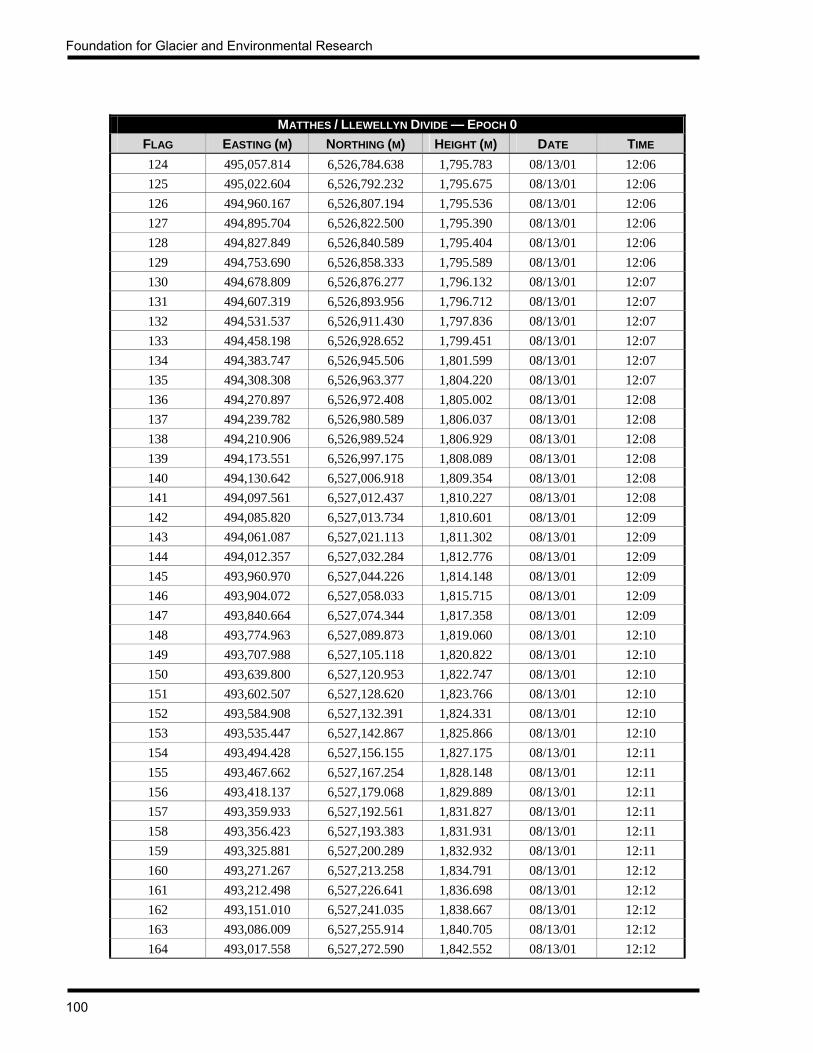
Foundation for Glacier and Environmental Research
100
MATTHES / LLEWELLYN DIVIDE — EPOCH 0 FLAG EASTING (M) NORTHING (M) HEIGHT (M) DATE TIME 124 495,057.814 6,526,784.638 1,795.783 08/13/01 12:06 125 495,022.604 6,526,792.232 1,795.675 08/13/01 12:06 126 494,960.167 6,526,807.194 1,795.536 08/13/01 12:06 127 494,895.704 6,526,822.500 1,795.390 08/13/01 12:06 128 494,827.849 6,526,840.589 1,795.404 08/13/01 12:06 129 494,753.690 6,526,858.333 1,795.589 08/13/01 12:06 130 494,678.809 6,526,876.277 1,796.132 08/13/01 12:07 131 494,607.319 6,526,893.956 1,796.712 08/13/01 12:07 132 494,531.537 6,526,911.430 1,797.836 08/13/01 12:07 133 494,458.198 6,526,928.652 1,799.451 08/13/01 12:07 134 494,383.747 6,526,945.506 1,801.599 08/13/01 12:07 135 494,308.308 6,526,963.377 1,804.220 08/13/01 12:07 136 494,270.897 6,526,972.408 1,805.002 08/13/01 12:08 137 494,239.782 6,526,980.589 1,806.037 08/13/01 12:08 138 494,210.906 6,526,989.524 1,806.929 08/13/01 12:08 139 494,173.551 6,526,997.175 1,808.089 08/13/01 12:08 140 494,130.642 6,527,006.918 1,809.354 08/13/01 12:08 141 494,097.561 6,527,012.437 1,810.227 08/13/01 12:08 142 494,085.820 6,527,013.734 1,810.601 08/13/01 12:09 143 494,061.087 6,527,021.113 1,811.302 08/13/01 12:09 144 494,012.357 6,527,032.284 1,812.776 08/13/01 12:09 145 493,960.970 6,527,044.226 1,814.148 08/13/01 12:09 146 493,904.072 6,527,058.033 1,815.715 08/13/01 12:09 147 493,840.664 6,527,074.344 1,817.358 08/13/01 12:09 148 493,774.963 6,527,089.873 1,819.060 08/13/01 12:10 149 493,707.988 6,527,105.118 1,820.822 08/13/01 12:10 150 493,639.800 6,527,120.953 1,822.747 08/13/01 12:10 151 493,602.507 6,527,128.620 1,823.766 08/13/01 12:10 152 493,584.908 6,527,132.391 1,824.331 08/13/01 12:10 153 493,535.447 6,527,142.867 1,825.866 08/13/01 12:10 154 493,494.428 6,527,156.155 1,827.175 08/13/01 12:11 155 493,467.662 6,527,167.254 1,828.148 08/13/01 12:11 156 493,418.137 6,527,179.068 1,829.889 08/13/01 12:11 157 493,359.933 6,527,192.561 1,831.827 08/13/01 12:11 158 493,356.423 6,527,193.383 1,831.931 08/13/01 12:11 159 493,325.881 6,527,200.289 1,832.932 08/13/01 12:11 160 493,271.267 6,527,213.258 1,834.791 08/13/01 12:12 161 493,212.498 6,527,226.641 1,836.698 08/13/01 12:12 162 493,151.010 6,527,241.035 1,838.667 08/13/01 12:12 163 493,086.009 6,527,255.914 1,840.705 08/13/01 12:12 164 493,017.558 6,527,272.590 1,842.552 08/13/01 12:12
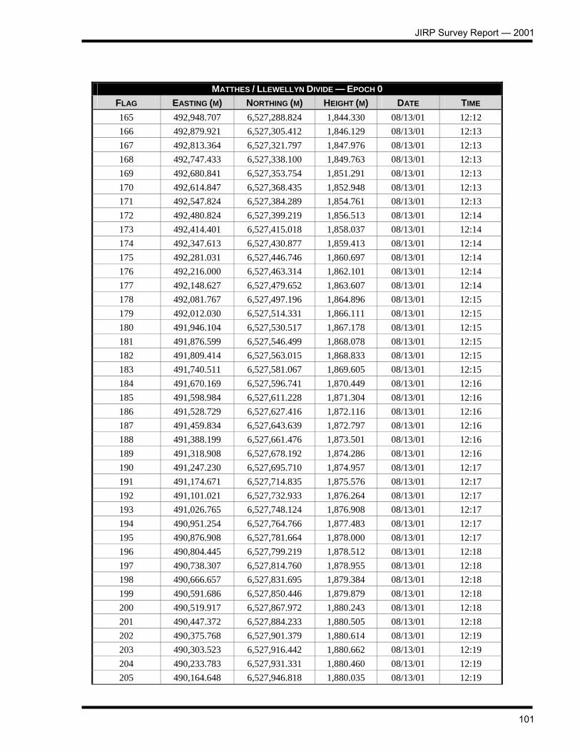
JIRP Survey Report — 2001
101
MATTHES / LLEWELLYN DIVIDE — EPOCH 0 FLAG EASTING (M) NORTHING (M) HEIGHT (M) DATE TIME 165 492,948.707 6,527,288.824 1,844.330 08/13/01 12:12 166 492,879.921 6,527,305.412 1,846.129 08/13/01 12:13 167 492,813.364 6,527,321.797 1,847.976 08/13/01 12:13 168 492,747.433 6,527,338.100 1,849.763 08/13/01 12:13 169 492,680.841 6,527,353.754 1,851.291 08/13/01 12:13 170 492,614.847 6,527,368.435 1,852.948 08/13/01 12:13 171 492,547.824 6,527,384.289 1,854.761 08/13/01 12:13 172 492,480.824 6,527,399.219 1,856.513 08/13/01 12:14 173 492,414.401 6,527,415.018 1,858.037 08/13/01 12:14 174 492,347.613 6,527,430.877 1,859.413 08/13/01 12:14 175 492,281.031 6,527,446.746 1,860.697 08/13/01 12:14 176 492,216.000 6,527,463.314 1,862.101 08/13/01 12:14 177 492,148.627 6,527,479.652 1,863.607 08/13/01 12:14 178 492,081.767 6,527,497.196 1,864.896 08/13/01 12:15 179 492,012.030 6,527,514.331 1,866.111 08/13/01 12:15 180 491,946.104 6,527,530.517 1,867.178 08/13/01 12:15 181 491,876.599 6,527,546.499 1,868.078 08/13/01 12:15 182 491,809.414 6,527,563.015 1,868.833 08/13/01 12:15 183 491,740.511 6,527,581.067 1,869.605 08/13/01 12:15 184 491,670.169 6,527,596.741 1,870.449 08/13/01 12:16 185 491,598.984 6,527,611.228 1,871.304 08/13/01 12:16 186 491,528.729 6,527,627.416 1,872.116 08/13/01 12:16 187 491,459.834 6,527,643.639 1,872.797 08/13/01 12:16 188 491,388.199 6,527,661.476 1,873.501 08/13/01 12:16 189 491,318.908 6,527,678.192 1,874.286 08/13/01 12:16 190 491,247.230 6,527,695.710 1,874.957 08/13/01 12:17 191 491,174.671 6,527,714.835 1,875.576 08/13/01 12:17 192 491,101.021 6,527,732.933 1,876.264 08/13/01 12:17 193 491,026.765 6,527,748.124 1,876.908 08/13/01 12:17 194 490,951.254 6,527,764.766 1,877.483 08/13/01 12:17 195 490,876.908 6,527,781.664 1,878.000 08/13/01 12:17 196 490,804.445 6,527,799.219 1,878.512 08/13/01 12:18 197 490,738.307 6,527,814.760 1,878.955 08/13/01 12:18 198 490,666.657 6,527,831.695 1,879.384 08/13/01 12:18 199 490,591.686 6,527,850.446 1,879.879 08/13/01 12:18 200 490,519.917 6,527,867.972 1,880.243 08/13/01 12:18 201 490,447.372 6,527,884.233 1,880.505 08/13/01 12:18 202 490,375.768 6,527,901.379 1,880.614 08/13/01 12:19 203 490,303.523 6,527,916.442 1,880.662 08/13/01 12:19 204 490,233.783 6,527,931.331 1,880.460 08/13/01 12:19 205 490,164.648 6,527,946.818 1,880.035 08/13/01 12:19

Foundation for Glacier and Environmental Research
102
MATTHES / LLEWELLYN DIVIDE — EPOCH 0 FLAG EASTING (M) NORTHING (M) HEIGHT (M) DATE TIME 206 490,089.836 6,527,963.396 1,879.358 08/13/01 12:20 207 489,977.310 6,527,988.123 1,878.425 08/13/01 12:20 208 489,952.187 6,527,994.516 1,878.298 08/13/01 12:20 209 489,921.215 6,528,000.156 1,878.484 08/13/01 12:20 210 489,876.437 6,528,006.189 1,878.677 08/13/01 12:20 211 489,863.140 6,528,008.232 1,878.500 08/13/01 12:20 212 489,863.181 6,528,008.760 1,877.935 08/13/01 12:21 213 489,863.266 6,528,009.473 1,877.292 08/13/01 12:21 214 489,702.329 6,528,037.620 1,889.308 08/13/01 12:21 215 489,663.787 6,528,042.788 1,893.652 08/13/01 12:22 216 489,617.969 6,528,044.948 1,899.306 08/13/01 12:22 217 489,571.660 6,528,043.640 1,904.859 08/13/01 12:22 218 489,530.384 6,528,048.906 1,909.744 08/13/01 12:22 219 489,498.087 6,528,054.974 1,913.179 08/13/01 12:22 220 489,497.800 6,528,055.019 1,913.170 08/13/01 12:22 221 489,467.177 6,528,057.944 1,915.922 08/13/01 12:23 222 489,443.378 6,528,060.459 1,917.751 08/13/01 12:23 223 489,419.327 6,528,063.723 1,919.393 08/13/01 12:23 224 489,387.936 6,528,066.315 1,921.109 08/13/01 12:23 225 489,359.935 6,528,069.821 1,922.585 08/13/01 12:23 226 489,332.706 6,528,072.612 1,923.676 08/13/01 12:23 227 489,332.685 6,528,072.613 1,923.578 08/13/01 12:24 228 489,303.457 6,528,073.740 1,924.338 08/13/01 12:24 229 489,268.990 6,528,072.126 1,924.906 08/13/01 12:24 230 489,231.740 6,528,073.158 1,925.367 08/13/01 12:24 231 489,190.034 6,528,079.725 1,925.830 08/13/01 12:24 232 489,144.186 6,528,089.948 1,926.369 08/13/01 12:24 233 489,096.550 6,528,099.783 1,926.836 08/13/01 12:25 234 489,050.282 6,528,109.002 1,927.636 08/13/01 12:25 235 489,040.171 6,528,111.087 1,927.855 08/13/01 12:25 236 489,020.089 6,528,085.785 1,927.333 08/13/01 12:25 237 488,997.879 6,528,038.696 1,926.355 08/13/01 12:25 238 488,974.291 6,527,989.376 1,925.669 08/13/01 12:25 239 488,950.526 6,527,939.670 1,925.326 08/13/01 12:26 240 488,930.675 6,527,895.523 1,925.169 08/13/01 12:26 241 488,926.422 6,527,886.104 1,925.160 08/13/01 12:26 242 488,950.507 6,527,869.212 1,924.320 08/13/01 12:26 243 489,004.911 6,527,852.347 1,922.833 08/13/01 12:26 244 489,058.818 6,527,836.872 1,921.322 08/13/01 12:26 245 489,114.974 6,527,818.973 1,919.816 08/13/01 12:27 246 489,177.828 6,527,800.192 1,918.038 08/13/01 12:27

JIRP Survey Report — 2001
103
MATTHES / LLEWELLYN DIVIDE — EPOCH 0 FLAG EASTING (M) NORTHING (M) HEIGHT (M) DATE TIME 247 489,246.141 6,527,778.678 1,916.029 08/13/01 12:27 248 489,316.513 6,527,758.957 1,913.391 08/13/01 12:27 249 489,372.685 6,527,745.172 1,910.223 08/13/01 12:27 250 489,372.682 6,527,745.175 1,910.232 08/13/01 12:27 251 489,420.945 6,527,732.061 1,907.540 08/13/01 12:28 252 489,495.296 6,527,713.038 1,902.967 08/13/01 12:28 253 489,543.970 6,527,701.165 1,899.828 08/13/01 12:28 254 489,601.637 6,527,688.064 1,896.355 08/13/01 12:28 255 489,604.850 6,527,686.999 1,896.901 08/13/01 12:28 256 489,611.272 6,527,685.884 1,896.589 08/13/01 12:28 257 489,670.208 6,527,671.816 1,893.942 08/13/01 12:29 258 489,722.075 6,527,660.100 1,892.173 08/13/01 12:29 259 489,788.945 6,527,645.259 1,890.517 08/13/01 12:29 260 489,865.129 6,527,627.781 1,889.654 08/13/01 12:29 261 489,948.531 6,527,608.903 1,889.230 08/13/01 12:29 262 490,084.131 6,527,577.033 1,889.201 08/13/01 12:30 263 490,083.938 6,527,577.300 1,888.987 08/13/01 12:30 264 490,083.939 6,527,577.300 1,888.994 08/13/01 12:30 265 490,136.366 6,527,566.677 1,888.833 08/13/01 12:30 266 490,213.174 6,527,548.676 1,888.319 08/13/01 12:30 267 490,289.088 6,527,530.983 1,887.757 08/13/01 12:30 268 490,368.975 6,527,513.410 1,886.995 08/13/01 12:31 269 490,455.560 6,527,494.224 1,885.982 08/13/01 12:31 270 490,564.625 6,527,470.836 1,884.601 08/13/01 12:31 271 490,616.026 6,527,460.639 1,883.898 08/13/01 12:32 272 490,722.987 6,527,436.649 1,882.703 08/13/01 12:32 273 490,743.669 6,527,432.802 1,882.374 08/13/01 12:32 274 490,799.561 6,527,420.630 1,881.711 08/13/01 12:32 275 490,865.859 6,527,405.413 1,880.924 08/13/01 12:33 276 490,936.571 6,527,389.588 1,880.032 08/13/01 12:33 277 491,010.813 6,527,372.837 1,879.242 08/13/01 12:33 278 491,084.932 6,527,355.376 1,878.360 08/13/01 12:33 279 491,161.611 6,527,339.500 1,877.518 08/13/01 12:33 280 491,239.625 6,527,321.579 1,876.651 08/13/01 12:33 281 491,320.154 6,527,302.716 1,875.677 08/13/01 12:34 282 491,398.462 6,527,282.945 1,874.722 08/13/01 12:34 283 491,478.578 6,527,263.345 1,873.814 08/13/01 12:34 284 491,557.721 6,527,243.070 1,872.849 08/13/01 12:34 285 491,637.837 6,527,223.267 1,872.005 08/13/01 12:34 286 491,718.976 6,527,203.262 1,871.148 08/13/01 12:34 287 491,799.608 6,527,183.094 1,870.123 08/13/01 12:35

Foundation for Glacier and Environmental Research
104
MATTHES / LLEWELLYN DIVIDE — EPOCH 0 FLAG EASTING (M) NORTHING (M) HEIGHT (M) DATE TIME 288 491,880.640 6,527,162.604 1,868.789 08/13/01 12:35 289 491,959.535 6,527,141.581 1,867.676 08/13/01 12:35 290 492,039.112 6,527,122.742 1,866.578 08/13/01 12:35 291 492,119.695 6,527,104.690 1,865.280 08/13/01 12:35 292 492,202.340 6,527,086.291 1,863.616 08/13/01 12:35 293 492,281.950 6,527,068.151 1,862.076 08/13/01 12:36 294 492,364.554 6,527,051.352 1,860.467 08/13/01 12:36 295 492,445.162 6,527,034.276 1,858.892 08/13/01 12:36 296 492,524.245 6,527,016.047 1,857.136 08/13/01 12:36 297 492,604.967 6,526,998.262 1,855.351 08/13/01 12:36 298 492,685.960 6,526,978.491 1,853.455 08/13/01 12:36 299 492,768.356 6,526,958.397 1,851.355 08/13/01 12:37 300 492,850.515 6,526,940.088 1,849.079 08/13/01 12:37 301 492,935.493 6,526,919.815 1,846.549 08/13/01 12:37 302 493,112.020 6,526,878.414 1,841.002 08/13/01 12:38 303 493,137.768 6,526,871.793 1,840.127 08/13/01 12:38 304 493,217.914 6,526,854.494 1,837.330 08/13/01 12:38 305 493,290.421 6,526,836.468 1,835.036 08/13/01 12:38 306 493,365.892 6,526,818.971 1,832.207 08/13/01 12:38 307 493,419.318 6,526,807.205 1,829.966 08/13/01 12:38 308 493,467.242 6,526,796.358 1,827.682 08/13/01 12:39 309 493,512.112 6,526,786.183 1,826.393 08/13/01 12:39 310 493,555.981 6,526,775.831 1,824.587 08/13/01 12:39 311 493,596.829 6,526,766.242 1,822.936 08/13/01 12:39 312 493,641.831 6,526,755.668 1,821.083 08/13/01 12:39 313 493,700.297 6,526,741.031 1,818.780 08/13/01 12:39 314 493,757.132 6,526,726.185 1,816.544 08/13/01 12:40 315 493,757.047 6,526,726.442 1,816.936 08/13/01 12:40 316 493,783.233 6,526,719.933 1,816.226 08/13/01 12:40 317 493,825.897 6,526,708.051 1,815.351 08/13/01 12:40 318 493,860.469 6,526,699.706 1,815.164 08/13/01 12:40 319 493,860.816 6,526,699.747 1,813.660 08/13/01 12:40 320 493,877.909 6,526,695.036 1,813.048 08/13/01 12:41 321 493,929.196 6,526,681.515 1,811.200 08/13/01 12:41 322 493,985.714 6,526,668.146 1,809.537 08/13/01 12:41 323 494,032.086 6,526,656.740 1,808.077 08/13/01 12:41 324 494,064.876 6,526,648.261 1,807.188 08/13/01 12:41 325 494,126.339 6,526,631.867 1,805.528 08/13/01 12:41 326 494,164.159 6,526,622.781 1,805.189 08/13/01 12:42 327 494,164.218 6,526,622.794 1,806.733 08/13/01 12:42 328 494,164.313 6,526,622.877 1,808.803 08/13/01 12:42

JIRP Survey Report — 2001
105
MATTHES / LLEWELLYN DIVIDE — EPOCH 0 FLAG EASTING (M) NORTHING (M) HEIGHT (M) DATE TIME 329 494,283.238 6,526,593.898 1,798.397 08/13/01 12:43 330 494,303.509 6,526,588.113 1,797.661 08/13/01 12:43 331 494,357.833 6,526,574.248 1,795.911 08/13/01 12:43 332 494,414.928 6,526,561.667 1,794.499 08/13/01 12:43 333 494,469.259 6,526,549.853 1,792.906 08/13/01 12:43 334 494,517.421 6,526,538.118 1,791.982 08/13/01 12:43 335 494,573.453 6,526,525.110 1,791.469 08/13/01 12:44 336 494,628.476 6,526,511.730 1,791.336 08/13/01 12:44 337 494,686.315 6,526,499.006 1,791.436 08/13/01 12:44 338 494,744.890 6,526,483.288 1,791.678 08/13/01 12:44 339 494,804.861 6,526,470.553 1,792.301 08/13/01 12:44 340 494,869.294 6,526,454.639 1,792.872 08/13/01 12:44 341 494,934.008 6,526,439.602 1,793.207 08/13/01 12:45 342 495,002.943 6,526,424.304 1,793.568 08/13/01 12:45 343 495,072.203 6,526,410.123 1,793.503 08/13/01 12:45 344 495,141.993 6,526,396.558 1,793.150 08/13/01 12:45 345 495,211.794 6,526,381.042 1,792.498 08/13/01 12:45 346 495,282.327 6,526,364.589 1,792.593 08/13/01 12:45 347 495,352.380 6,526,346.919 1,792.111 08/13/01 12:46 348 495,421.948 6,526,326.694 1,791.271 08/13/01 12:46 349 495,493.910 6,526,307.468 1,791.405 08/13/01 12:46 350 495,561.526 6,526,291.433 1,793.369 08/13/01 12:46 351 495,627.255 6,526,276.571 1,795.810 08/13/01 12:46 352 495,691.345 6,526,260.663 1,798.584 08/13/01 12:46 353 495,751.046 6,526,244.154 1,802.131 08/13/01 12:47 354 495,802.639 6,526,233.020 1,808.284 08/13/01 12:47 355 495,841.042 6,526,225.357 1,815.702 08/13/01 12:47 356 495,874.302 6,526,217.856 1,822.736 08/13/01 12:47 357 495,908.646 6,526,208.639 1,829.620 08/13/01 12:47 358 495,922.402 6,526,186.615 1,831.657 08/13/01 12:47 359 495,919.069 6,526,155.067 1,829.386 08/13/01 12:48 360 495,905.581 6,526,121.132 1,823.905 08/13/01 12:48 361 495,881.983 6,526,106.241 1,816.062 08/13/01 12:48 362 495,857.350 6,526,104.321 1,809.554 08/13/01 12:48 363 495,809.869 6,526,108.714 1,802.197 08/13/01 12:48 364 495,743.146 6,526,118.521 1,797.493 08/13/01 12:48 365 495,678.938 6,526,130.363 1,794.139 08/13/01 12:49 366 495,614.407 6,526,139.979 1,791.844 08/13/01 12:49 367 495,549.724 6,526,151.258 1,790.043 08/13/01 12:49 368 495,484.754 6,526,176.128 1,788.056 08/13/01 12:49 369 495,415.370 6,526,182.490 1,786.060 08/13/01 12:49

Foundation for Glacier and Environmental Research
106
MATTHES / LLEWELLYN DIVIDE — EPOCH 0 FLAG EASTING (M) NORTHING (M) HEIGHT (M) DATE TIME 370 495,347.728 6,526,193.617 1,786.728 08/13/01 12:49 371 495,276.609 6,526,204.816 1,787.379 08/13/01 12:50 372 495,198.695 6,526,217.504 1,788.454 08/13/01 12:50 373 495,120.069 6,526,231.353 1,790.090 08/13/01 12:50 374 494,976.391 6,526,257.734 1,791.161 08/13/01 12:50 375 494,974.995 6,526,258.003 1,791.186 08/13/01 12:51 376 494,926.183 6,526,266.449 1,791.161 08/13/01 12:51 377 494,858.555 6,526,278.462 1,790.826 08/13/01 12:51 378 494,782.226 6,526,292.111 1,789.991 08/13/01 12:51 379 494,701.581 6,526,307.097 1,788.874 08/13/01 12:51 380 494,617.975 6,526,322.404 1,788.002 08/13/01 12:52 381 494,487.993 6,526,344.959 1,787.802 08/13/01 12:52 382 494,434.155 6,526,355.306 1,788.326 08/13/01 12:52 383 494,372.267 6,526,366.965 1,789.723 08/13/01 12:53 384 494,308.761 6,526,379.181 1,791.765 08/13/01 12:53 385 494,271.035 6,526,386.188 1,793.449 08/13/01 12:53 386 494,238.772 6,526,390.971 1,794.084 08/13/01 12:53 387 494,194.146 6,526,399.751 1,796.191 08/13/01 12:53 388 494,160.360 6,526,406.169 1,797.530 08/13/01 12:53 389 494,124.411 6,526,414.107 1,798.894 08/13/01 12:54 390 494,069.992 6,526,423.714 1,801.671 08/13/01 12:54 391 494,015.017 6,526,435.619 1,803.928 08/13/01 12:54 392 493,950.110 6,526,448.449 1,806.235 08/13/01 12:54 393 493,914.413 6,526,457.037 1,807.879 08/13/01 12:54 394 493,878.153 6,526,464.509 1,809.092 08/13/01 12:54 395 493,824.470 6,526,475.597 1,811.079 08/13/01 12:55 396 493,785.572 6,526,484.295 1,812.516 08/13/01 12:55 397 493,756.657 6,526,489.487 1,813.463 08/13/01 12:55 398 493,728.408 6,526,494.494 1,814.429 08/13/01 12:57 399 493,392.164 6,526,558.643 1,833.480 08/13/01 12:57 400 493,382.214 6,526,560.446 1,833.967 08/13/01 12:57 401 493,338.868 6,526,570.505 1,835.986 08/13/01 12:57 402 493,327.321 6,526,574.661 1,836.455 08/13/01 12:58 403 493,327.323 6,526,574.620 1,836.432 08/13/01 12:58 404 493,327.338 6,526,574.682 1,836.531 08/13/01 12:58 405 493,327.436 6,526,574.784 1,836.821 08/13/01 12:58 406 493,327.613 6,526,574.977 1,837.343 08/13/01 12:58 407 493,327.317 6,526,574.661 1,836.395 08/13/01 12:58 408 493,324.819 6,526,575.721 1,836.607 08/13/01 12:59 409 493,282.287 6,526,585.349 1,838.672 08/13/01 12:59 410 493,235.476 6,526,596.159 1,840.263 08/13/01 12:59
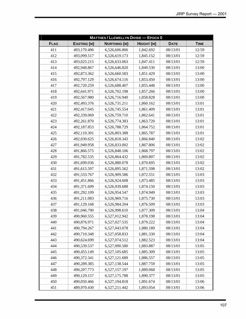
JIRP Survey Report — 2001
107
MATTHES / LLEWELLYN DIVIDE — EPOCH 0 FLAG EASTING (M) NORTHING (M) HEIGHT (M) DATE TIME 411 493,170.496 6,526,606.806 1,842.692 08/13/01 12:59 412 493,099.517 6,526,619.173 1,845.152 08/13/01 12:59 413 493,025.215 6,526,633.063 1,847.411 08/13/01 12:59 414 492,948.867 6,526,646.820 1,849.530 08/13/01 13:00 415 492,873.362 6,526,660.583 1,851.429 08/13/01 13:00 416 492,797.129 6,526,674.116 1,853.450 08/13/01 13:00 417 492,720.259 6,526,688.407 1,855.448 08/13/01 13:00 418 492,641.971 6,526,702.198 1,857.266 08/13/01 13:00 419 492,567.980 6,526,716.940 1,858.828 08/13/01 13:00 420 492,493.376 6,526,731.211 1,860.162 08/13/01 13:01 421 492,417.045 6,526,745.554 1,861.409 08/13/01 13:01 422 492,339.069 6,526,759.710 1,862.641 08/13/01 13:01 423 492,261.870 6,526,774.383 1,863.720 08/13/01 13:01 424 492,187.853 6,526,788.729 1,864.752 08/13/01 13:01 425 492,110.301 6,526,803.388 1,865.787 08/13/01 13:01 426 492,030.625 6,526,818.343 1,866.840 08/13/01 13:02 427 491,949.958 6,526,833.002 1,867.806 08/13/01 13:02 428 491,866.575 6,526,848.106 1,868.797 08/13/01 13:02 429 491,782.535 6,526,864.432 1,869.807 08/13/01 13:02 430 491,699.036 6,526,880.078 1,870.695 08/13/01 13:02 431 491,615.597 6,526,895.562 1,871.598 08/13/01 13:02 432 491,533.767 6,526,909.586 1,872.551 08/13/01 13:03 433 491,451.866 6,526,924.608 1,873.485 08/13/01 13:03 434 491,371.609 6,526,939.688 1,874.150 08/13/01 13:03 435 491,292.109 6,526,954.547 1,874.949 08/13/01 13:03 436 491,211.083 6,526,969.716 1,875.730 08/13/01 13:03 437 491,129.168 6,526,984.204 1,876.509 08/13/01 13:03 438 491,046.790 6,526,998.610 1,877.309 08/13/01 13:04 439 490,960.555 6,527,012.942 1,878.198 08/13/01 13:04 440 490,876.971 6,527,027.535 1,879.222 08/13/01 13:04 441 490,794.267 6,527,043.078 1,880.189 08/13/01 13:04 442 490,710.348 6,527,058.833 1,881.330 08/13/01 13:04 443 490,624.699 6,527,074.512 1,882.523 08/13/01 13:04 444 490,539.537 6,527,090.580 1,883.887 08/13/01 13:05 445 490,455.149 6,527,105.685 1,885.309 08/13/01 13:05 446 490,372.341 6,527,121.689 1,886.557 08/13/01 13:05 447 490,289.385 6,527,138.544 1,887.759 08/13/01 13:05 448 490,207.773 6,527,157.197 1,889.068 08/13/01 13:05 449 490,129.157 6,527,175.788 1,890.377 08/13/01 13:05 450 490,050.466 6,527,194.818 1,891.674 08/13/01 13:06 451 489,970.430 6,527,211.442 1,893.054 08/13/01 13:06
Foundation for Glacier and Environmental Research
108
MATTHES / LLEWELLYN DIVIDE — EPOCH 0 FLAG EASTING (M) NORTHING (M) HEIGHT (M) DATE TIME 452 489,890.308 6,527,228.834 1,894.436 08/13/01 13:06 453 489,812.612 6,527,248.225 1,895.920 08/13/01 13:06 454 489,735.927 6,527,265.073 1,897.673 08/13/01 13:06 455 489,660.628 6,527,282.475 1,899.504 08/13/01 13:06 456 489,587.225 6,527,296.917 1,901.389 08/13/01 13:07 457 489,513.151 6,527,311.782 1,903.612 08/13/01 13:07 458 489,443.331 6,527,324.924 1,905.894 08/13/01 13:07 459 489,373.478 6,527,338.693 1,908.278 08/13/01 13:07 460 489,304.580 6,527,351.709 1,910.568 08/13/01 13:07 461 489,257.624 6,527,360.273 1,912.052 08/13/01 13:07 462 489,212.876 6,527,367.115 1,913.396 08/13/01 13:08 463 489,152.484 6,527,378.185 1,914.928 08/13/01 13:08 464 489,093.712 6,527,389.797 1,916.364 08/13/01 13:08 465 489,038.077 6,527,400.246 1,917.847 08/13/01 13:08 466 488,994.171 6,527,407.643 1,919.421 08/13/01 13:08 467 488,985.780 6,527,408.867 1,920.248 08/13/01 13:08 468 488,985.953 6,527,408.396 1,921.097 08/13/01 13:09 469 488,986.172 6,527,407.822 1,922.115 08/13/01 13:09 470 488,906.089 6,527,422.838 1,920.863 08/13/01 13:09 471 488,875.271 6,527,429.032 1,921.842 08/13/01 13:10 472 488,835.804 6,527,438.150 1,922.667 08/13/01 13:10 473 488,793.848 6,527,449.144 1,923.657 08/13/01 13:10 474 488,758.390 6,527,457.092 1,924.510 08/13/01 13:10 475 488,724.003 6,527,464.137 1,925.262 08/13/01 13:10 476 488,685.689 6,527,472.845 1,926.407 08/13/01 13:10 477 488,650.397 6,527,481.598 1,926.841 08/13/01 13:11 478 488,613.336 6,527,491.873 1,927.808 08/13/01 13:11 479 488,571.797 6,527,502.564 1,928.834 08/13/01 13:11 480 488,530.610 6,527,513.583 1,929.922 08/13/01 13:11 481 488,490.849 6,527,522.855 1,930.955 08/13/01 13:11 482 488,467.155 6,527,528.337 1,931.641 08/13/01 13:11 483 488,466.999 6,527,528.371 1,931.624 08/13/01 13:12 484 488,466.996 6,527,528.384 1,931.640 08/13/01 13:12 485 488,452.378 6,527,531.736 1,932.016 08/13/01 13:12 486 488,415.503 6,527,541.613 1,932.875 08/13/01 13:12 487 488,389.966 6,527,544.931 1,933.424 08/13/01 13:12 488 488,376.495 6,527,518.851 1,933.360 08/13/01 13:12 489 488,369.081 6,527,492.735 1,933.010 08/13/01 13:13 490 488,367.184 6,527,484.016 1,932.640 08/13/01 13:13 491 488,337.415 6,527,370.084 1,933.290 08/13/01 13:14 492 488,331.341 6,527,348.031 1,933.300 08/13/01 13:14

JIRP Survey Report — 2001
109
MATTHES / LLEWELLYN DIVIDE — EPOCH 0 FLAG EASTING (M) NORTHING (M) HEIGHT (M) DATE TIME 493 488,320.947 6,527,305.073 1,933.462 08/13/01 13:14 494 488,311.165 6,527,266.303 1,933.693 08/13/01 13:14 495 488,304.758 6,527,228.225 1,933.736 08/13/01 13:14 496 488,301.135 6,527,191.220 1,933.694 08/13/01 13:14 497 488,303.264 6,527,188.884 1,933.215 08/13/01 13:15 498 488,376.765 6,527,165.275 1,933.194 08/13/01 13:15 499 488,407.483 6,527,157.736 1,932.605 08/13/01 13:15 500 488,438.672 6,527,152.283 1,931.977 08/13/01 13:16 501 488,462.655 6,527,146.967 1,931.383 08/13/01 13:16 502 488,462.834 6,527,147.303 1,931.234 08/13/01 13:16 503 488,483.357 6,527,141.538 1,930.661 08/13/01 13:16 504 488,601.958 6,527,104.359 1,928.878 08/13/01 13:17 505 488,606.354 6,527,103.057 1,928.739 08/13/01 13:17 506 488,654.198 6,527,089.693 1,927.900 08/13/01 13:17 507 488,710.114 6,527,073.093 1,926.984 08/13/01 13:17 508 488,760.614 6,527,057.756 1,926.224 08/13/01 13:17 509 488,801.726 6,527,046.405 1,925.732 08/13/01 13:17 510 488,854.621 6,527,032.239 1,923.998 08/13/01 13:18 511 488,888.816 6,527,022.576 1,922.987 08/13/01 13:18 512 488,906.627 6,527,018.479 1,922.409 08/13/01 13:18 513 488,906.437 6,527,018.651 1,922.073 08/13/01 13:18 514 488,906.216 6,527,018.929 1,921.596 08/13/01 13:18 515 488,923.000 6,527,014.265 1,922.327 08/13/01 13:18 516 488,960.076 6,527,005.120 1,921.439 08/13/01 13:19 517 488,960.111 6,527,005.123 1,921.458 08/13/01 13:19 518 488,960.104 6,527,005.103 1,921.403 08/13/01 13:19 519 488,960.068 6,527,005.189 1,921.554 08/13/01 13:19 520 488,960.099 6,527,005.115 1,921.456 08/13/01 13:23 521 488,960.161 6,527,004.802 1,921.216 08/13/01 13:23 522 488,960.149 6,527,004.730 1,921.259 08/13/01 13:23 523 488,968.206 6,527,003.521 1,921.409 08/13/01 13:23 524 489,013.516 6,526,992.349 1,920.448 08/13/01 13:23 525 489,068.836 6,526,976.394 1,919.340 08/13/01 13:23 526 489,129.896 6,526,960.352 1,918.114 08/13/01 13:24 527 489,199.922 6,526,940.308 1,916.632 08/13/01 13:24 528 489,273.019 6,526,920.893 1,914.555 08/13/01 13:24 529 489,347.555 6,526,901.209 1,911.931 08/13/01 13:24 530 489,428.471 6,526,879.223 1,908.629 08/13/01 13:24 531 489,511.312 6,526,854.120 1,904.796 08/13/01 13:24 532 489,596.425 6,526,830.566 1,900.814 08/13/01 13:25 533 489,680.066 6,526,809.076 1,897.118 08/13/01 13:25

Foundation for Glacier and Environmental Research
110
MATTHES / LLEWELLYN DIVIDE — EPOCH 0 FLAG EASTING (M) NORTHING (M) HEIGHT (M) DATE TIME 534 489,763.159 6,526,788.407 1,893.759 08/13/01 13:25 535 489,844.539 6,526,766.959 1,890.972 08/13/01 13:25 536 489,924.687 6,526,744.524 1,888.627 08/13/01 13:25 537 490,005.215 6,526,723.665 1,886.664 08/13/01 13:25 538 490,084.411 6,526,702.989 1,885.077 08/13/01 13:26 539 490,167.558 6,526,682.806 1,883.441 08/13/01 13:26 540 490,252.873 6,526,662.086 1,881.910 08/13/01 13:26 541 490,338.821 6,526,639.349 1,880.351 08/13/01 13:26 542 490,426.675 6,526,617.816 1,878.862 08/13/01 13:26 543 490,516.009 6,526,595.207 1,877.381 08/13/01 13:26 544 490,607.762 6,526,571.670 1,876.202 08/13/01 13:27 545 490,700.142 6,526,547.350 1,875.178 08/13/01 13:27 546 490,791.190 6,526,524.700 1,874.433 08/13/01 13:27 547 490,880.896 6,526,501.860 1,873.852 08/13/01 13:27 548 490,969.238 6,526,480.148 1,873.540 08/13/01 13:27 549 491,056.719 6,526,458.800 1,873.252 08/13/01 13:27 550 491,145.994 6,526,437.643 1,872.989 08/13/01 13:28 551 491,232.936 6,526,415.966 1,872.754 08/13/01 13:28 552 491,317.750 6,526,394.176 1,872.560 08/13/01 13:28 553 491,402.046 6,526,373.991 1,872.421 08/13/01 13:28 554 491,488.363 6,526,352.338 1,872.225 08/13/01 13:28 555 491,576.551 6,526,331.697 1,872.005 08/13/01 13:28 556 491,664.340 6,526,310.393 1,871.766 08/13/01 13:29 557 491,751.851 6,526,289.053 1,871.300 08/13/01 13:29 558 491,836.722 6,526,267.834 1,870.859 08/13/01 13:29 559 491,920.124 6,526,247.059 1,870.396 08/13/01 13:29 560 492,003.399 6,526,225.059 1,869.754 08/13/01 13:29 561 492,087.965 6,526,203.333 1,868.928 08/13/01 13:29 562 492,169.697 6,526,182.249 1,868.130 08/13/01 13:30 563 492,254.459 6,526,160.365 1,867.101 08/13/01 13:30 564 492,338.832 6,526,138.366 1,866.185 08/13/01 13:30 565 492,420.229 6,526,116.561 1,865.243 08/13/01 13:30 566 492,499.760 6,526,094.449 1,864.299 08/13/01 13:30 567 492,580.654 6,526,072.875 1,863.239 08/13/01 13:30 568 492,663.667 6,526,050.485 1,861.968 08/13/01 13:31 569 492,746.404 6,526,029.830 1,860.666 08/13/01 13:31 570 492,825.625 6,526,009.577 1,859.009 08/13/01 13:31 571 492,905.463 6,525,989.592 1,857.216 08/13/01 13:31 572 492,988.023 6,525,968.351 1,855.326 08/13/01 13:31 573 493,069.714 6,525,948.047 1,853.260 08/13/01 13:31 574 493,151.073 6,525,929.003 1,850.633 08/13/01 13:32

JIRP Survey Report — 2001
111
MATTHES / LLEWELLYN DIVIDE — EPOCH 0 FLAG EASTING (M) NORTHING (M) HEIGHT (M) DATE TIME 575 493,231.273 6,525,909.455 1,847.694 08/13/01 13:32 576 493,311.338 6,525,888.567 1,844.667 08/13/01 13:32 577 493,362.247 6,525,876.466 1,842.948 08/13/01 13:32 578 493,413.854 6,525,863.153 1,841.353 08/13/01 13:32 579 493,429.423 6,525,859.210 1,840.356 08/13/01 13:32 580 493,429.782 6,525,859.040 1,840.977 08/13/01 13:33 581 493,434.881 6,525,854.898 1,840.737 08/13/01 13:33 582 493,421.645 6,525,823.459 1,841.332 08/13/01 13:33 583 493,396.895 6,525,787.016 1,842.548 08/13/01 13:33 584 493,359.705 6,525,753.128 1,844.037 08/13/01 13:33 585 493,323.146 6,525,717.098 1,845.279 08/13/01 13:33 586 493,284.103 6,525,687.601 1,846.595 08/13/01 13:34 587 493,239.561 6,525,690.074 1,848.654 08/13/01 13:34 588 493,196.334 6,525,699.790 1,850.920 08/13/01 13:34 589 493,164.154 6,525,713.411 1,852.467 08/13/01 13:34 590 493,128.617 6,525,720.534 1,853.871 08/13/01 13:34 591 493,101.725 6,525,726.201 1,855.399 08/13/01 13:34 592 493,088.599 6,525,729.676 1,855.863 08/13/01 13:35 593 493,041.587 6,525,740.481 1,857.626 08/13/01 13:35 594 492,991.551 6,525,751.177 1,859.349 08/13/01 13:35 595 492,931.435 6,525,764.915 1,860.964 08/13/01 13:35 596 492,867.734 6,525,780.208 1,862.377 08/13/01 13:35 597 492,800.480 6,525,796.928 1,863.529 08/13/01 13:35 598 492,730.139 6,525,814.170 1,864.762 08/13/01 13:36 599 492,654.597 6,525,833.004 1,865.817 08/13/01 13:36 600 492,581.951 6,525,851.253 1,866.628 08/13/01 13:36 601 492,512.195 6,525,868.367 1,867.478 08/13/01 13:36 602 492,444.712 6,525,886.434 1,868.159 08/13/01 13:36 603 492,375.353 6,525,903.698 1,869.004 08/13/01 13:36 604 492,303.069 6,525,922.334 1,869.880 08/13/01 13:37 605 492,228.949 6,525,939.954 1,870.644 08/13/01 13:37 606 492,152.269 6,525,955.023 1,871.391 08/13/01 13:37 607 492,075.443 6,525,970.317 1,871.941 08/13/01 13:37 608 491,998.424 6,525,985.357 1,872.495 08/13/01 13:37 609 491,921.750 6,526,000.948 1,872.801 08/13/01 13:37 610 491,842.916 6,526,015.197 1,873.046 08/13/01 13:38 611 491,763.533 6,526,029.820 1,873.176 08/13/01 13:38 612 491,691.492 6,526,042.477 1,873.179 08/13/01 13:38 613 491,621.886 6,526,056.495 1,873.076 08/13/01 13:38 614 491,547.731 6,526,071.046 1,873.052 08/13/01 13:38 615 491,470.679 6,526,084.847 1,872.973 08/13/01 13:38

Foundation for Glacier and Environmental Research
112
MATTHES / LLEWELLYN DIVIDE — EPOCH 0 FLAG EASTING (M) NORTHING (M) HEIGHT (M) DATE TIME 616 491,392.896 6,526,100.317 1,872.883 08/13/01 13:39 617 491,313.830 6,526,115.144 1,872.751 08/13/01 13:39 618 491,255.085 6,526,125.879 1,872.499 08/13/01 13:39 619 491,187.309 6,526,139.643 1,872.218 08/13/01 13:39 620 491,113.933 6,526,154.325 1,872.030 08/13/01 13:39 621 491,038.629 6,526,168.726 1,871.813 08/13/01 13:39 622 490,963.650 6,526,184.300 1,871.584 08/13/01 13:40 623 490,888.001 6,526,198.927 1,871.413 08/13/01 13:40 624 490,815.456 6,526,213.648 1,871.336 08/13/01 13:40 625 490,739.859 6,526,228.253 1,871.397 08/13/01 13:40 626 490,661.256 6,526,243.214 1,871.578 08/13/01 13:40 627 490,583.510 6,526,258.062 1,871.829 08/13/01 13:40 628 490,506.108 6,526,273.096 1,872.292 08/13/01 13:41 629 490,426.770 6,526,288.547 1,872.944 08/13/01 13:41 630 490,348.505 6,526,303.071 1,873.716 08/13/01 13:41 631 490,273.258 6,526,317.686 1,874.643 08/13/01 13:41 632 490,202.154 6,526,331.261 1,875.677 08/13/01 13:41 633 490,130.305 6,526,344.796 1,876.741 08/13/01 13:41 634 490,057.568 6,526,358.065 1,877.783 08/13/01 13:42 635 489,985.049 6,526,371.838 1,878.943 08/13/01 13:42 636 489,913.758 6,526,384.756 1,880.140 08/13/01 13:42 637 489,846.000 6,526,397.509 1,881.401 08/13/01 13:42 638 489,830.657 6,526,400.397 1,881.750 08/13/01 13:42 639 489,830.661 6,526,400.397 1,881.785 08/13/01 13:42 640 489,830.664 6,526,400.387 1,881.777 08/13/01 13:43 641 489,830.661 6,526,400.387 1,881.773 08/13/01 13:43 642 489,830.661 6,526,400.388 1,881.778 08/13/01 13:43 643 489,830.667 6,526,400.388 1,881.773 08/13/01 13:43 644 489,830.662 6,526,400.395 1,881.788 08/13/01 13:43 645 489,830.662 6,526,400.387 1,881.775 08/13/01 13:43 646 489,830.662 6,526,400.390 1,881.784 08/13/01 13:44 647 489,830.661 6,526,400.396 1,881.785 08/13/01 13:44 648 489,830.661 6,526,400.373 1,881.779 08/13/01 13:44 649 489,830.664 6,526,400.372 1,881.767 08/13/01 13:44 650 489,830.671 6,526,400.389 1,881.782 08/13/01 13:44 651 489,795.836 6,526,407.248 1,882.591 08/13/01 13:44 652 489,734.126 6,526,421.504 1,884.439 08/13/01 13:45 653 489,667.735 6,526,437.368 1,886.918 08/13/01 13:45 654 489,599.770 6,526,453.371 1,890.228 08/13/01 13:45 655 489,530.729 6,526,469.007 1,894.443 08/13/01 13:45 656 489,464.386 6,526,484.342 1,899.224 08/13/01 13:45

JIRP Survey Report — 2001
113
MATTHES / LLEWELLYN DIVIDE — EPOCH 0 FLAG EASTING (M) NORTHING (M) HEIGHT (M) DATE TIME 657 489,400.851 6,526,500.138 1,904.382 08/13/01 13:45 658 489,336.361 6,526,516.086 1,909.583 08/13/01 13:46 659 489,272.084 6,526,532.113 1,914.458 08/13/01 13:46 660 489,206.549 6,526,547.786 1,918.608 08/13/01 13:46 661 489,140.769 6,526,563.859 1,921.589 08/13/01 13:46 662 489,078.100 6,526,579.921 1,923.501 08/13/01 13:46 663 489,012.392 6,526,597.525 1,924.781 08/13/01 13:46 664 488,946.308 6,526,612.825 1,925.617 08/13/01 13:47 665 488,882.676 6,526,628.349 1,926.498 08/13/01 13:47 666 488,819.896 6,526,643.858 1,927.689 08/13/01 13:47 667 488,757.271 6,526,659.750 1,929.106 08/13/01 13:47 668 488,694.716 6,526,674.601 1,930.778 08/13/01 13:47 669 488,667.950 6,526,680.605 1,931.429 08/13/01 13:47 670 488,634.830 6,526,687.882 1,932.096 08/13/01 13:48 671 488,603.085 6,526,695.456 1,932.998 08/13/01 13:48 672 488,603.100 6,526,695.440 1,933.022 08/13/01 13:48 673 488,603.089 6,526,695.447 1,933.003 08/13/01 13:48 674 488,603.090 6,526,695.450 1,933.009 08/13/01 13:48 675 488,603.096 6,526,695.432 1,932.996 08/13/01 13:48 676 488,603.092 6,526,695.441 1,933.005 08/13/01 13:49 677 488,603.091 6,526,695.452 1,933.008 08/13/01 13:49 678 488,603.094 6,526,695.450 1,933.046 08/13/01 13:49 679 488,590.989 6,526,699.291 1,933.335 08/13/01 13:49 680 488,556.524 6,526,710.096 1,934.238 08/13/01 13:49 681 488,535.040 6,526,714.844 1,934.405 08/13/01 13:49 682 488,528.764 6,526,716.229 1,934.568 08/13/01 13:50 683 488,485.758 6,526,726.455 1,935.449 08/13/01 13:50 684 488,435.704 6,526,739.400 1,936.465 08/13/01 13:50 685 488,380.688 6,526,751.695 1,937.528 08/13/01 13:50 686 488,348.953 6,526,760.106 1,938.061 08/13/01 13:50 687 488,315.952 6,526,768.504 1,938.548 08/13/01 13:50 688 488,276.849 6,526,777.916 1,939.048 08/13/01 13:51 689 488,241.936 6,526,786.580 1,939.763 08/13/01 13:51 690 488,224.919 6,526,777.397 1,940.090 08/13/01 13:51 691 488,217.895 6,526,750.531 1,940.537 08/13/01 13:51 692 488,205.337 6,526,711.311 1,941.151 08/13/01 13:51 693 488,194.270 6,526,663.233 1,941.844 08/13/01 13:51 694 488,175.521 6,526,616.961 1,942.416 08/13/01 13:52 695 488,166.159 6,526,572.785 1,942.966 08/13/01 13:52 696 488,172.701 6,526,546.223 1,943.120 08/13/01 13:52 697 488,204.523 6,526,536.151 1,942.944 08/13/01 13:52

Foundation for Glacier and Environmental Research
114
MATTHES / LLEWELLYN DIVIDE — EPOCH 0 FLAG EASTING (M) NORTHING (M) HEIGHT (M) DATE TIME 698 488,254.616 6,526,521.443 1,942.406 08/13/01 13:52 699 488,311.308 6,526,505.224 1,941.716 08/13/01 13:52 700 488,357.363 6,526,493.559 1,939.932 08/13/01 13:53 701 488,387.186 6,526,486.211 1,939.085 08/13/01 13:53 702 488,446.662 6,526,473.254 1,937.502 08/13/01 13:53 703 488,511.192 6,526,457.202 1,935.889 08/13/01 13:53 704 488,579.660 6,526,440.242 1,934.446 08/13/01 13:53 705 488,649.637 6,526,423.530 1,933.060 08/13/01 13:53 706 488,722.572 6,526,405.840 1,931.827 08/13/01 13:54 707 488,793.569 6,526,389.659 1,930.824 08/13/01 13:54 708 488,863.842 6,526,375.441 1,929.772 08/13/01 13:54 709 488,931.141 6,526,361.323 1,928.001 08/13/01 13:54 710 489,001.129 6,526,345.419 1,925.091 08/13/01 13:54 711 489,075.819 6,526,327.494 1,920.588 08/13/01 13:54 712 489,145.497 6,526,311.019 1,915.713 08/13/01 13:55 713 489,218.532 6,526,294.829 1,909.697 08/13/01 13:55 714 489,293.539 6,526,279.466 1,902.469 08/13/01 13:55 715 489,360.316 6,526,265.072 1,895.623 08/13/01 13:55 716 489,433.950 6,526,249.219 1,888.914 08/13/01 13:55 717 489,504.384 6,526,232.729 1,883.891 08/13/01 13:55 718 489,578.218 6,526,214.509 1,880.068 08/13/01 13:56 719 489,656.429 6,526,197.942 1,877.707 08/13/01 13:56 720 489,733.968 6,526,181.503 1,876.127 08/13/01 13:56 721 489,812.121 6,526,163.005 1,874.817 08/13/01 13:56 722 489,893.425 6,526,144.270 1,873.546 08/13/01 13:56 723 489,974.534 6,526,124.557 1,872.341 08/13/01 13:56 724 490,059.487 6,526,104.273 1,871.048 08/13/01 13:57 725 490,146.934 6,526,083.234 1,869.937 08/13/01 13:57 726 490,234.300 6,526,061.702 1,868.969 08/13/01 13:57 727 490,322.796 6,526,040.895 1,868.195 08/13/01 13:57 728 490,411.602 6,526,019.971 1,867.695 08/13/01 13:57 729 490,501.960 6,525,997.349 1,867.404 08/13/01 13:57 730 490,590.460 6,525,977.109 1,867.475 08/13/01 13:58 731 490,677.057 6,525,956.687 1,867.744 08/13/01 13:58 732 490,764.577 6,525,936.684 1,868.132 08/13/01 13:58 733 490,854.440 6,525,915.738 1,868.671 08/13/01 13:58 734 490,944.222 6,525,894.360 1,869.267 08/13/01 13:58 735 491,033.452 6,525,873.095 1,869.985 08/13/01 13:58 736 491,121.000 6,525,851.163 1,870.639 08/13/01 13:59 737 491,207.860 6,525,829.420 1,871.353 08/13/01 13:59 738 491,294.628 6,525,809.219 1,871.955 08/13/01 13:59

JIRP Survey Report — 2001
115
MATTHES / LLEWELLYN DIVIDE — EPOCH 0 FLAG EASTING (M) NORTHING (M) HEIGHT (M) DATE TIME 739 491,379.957 6,525,789.513 1,872.568 08/13/01 13:59 740 491,466.106 6,525,769.702 1,873.165 08/13/01 13:59 741 491,551.712 6,525,748.713 1,873.749 08/13/01 13:59 742 491,637.313 6,525,728.354 1,874.377 08/13/01 14:00 743 491,721.823 6,525,709.332 1,874.778 08/13/01 14:00 744 491,807.020 6,525,688.285 1,875.295 08/13/01 14:00 745 491,890.817 6,525,663.316 1,875.633 08/13/01 14:00 746 491,976.451 6,525,645.208 1,875.939 08/13/01 14:00 747 492,060.831 6,525,627.207 1,876.105 08/13/01 14:00 748 492,146.940 6,525,608.637 1,876.206 08/13/01 14:01 749 492,228.336 6,525,591.409 1,876.270 08/13/01 14:01 750 492,311.276 6,525,574.292 1,876.349 08/13/01 14:01 751 492,393.555 6,525,558.450 1,876.328 08/13/01 14:01 752 492,478.066 6,525,541.997 1,876.119 08/13/01 14:01 753 492,560.672 6,525,524.736 1,875.940 08/13/01 14:01 754 492,641.165 6,525,507.846 1,875.694 08/13/01 14:02 755 492,722.093 6,525,490.530 1,875.131 08/13/01 14:02 756 492,801.588 6,525,474.187 1,873.882 08/13/01 14:02 757 492,864.864 6,525,460.353 1,872.301 08/13/01 14:02 758 492,911.795 6,525,447.543 1,870.767 08/13/01 14:02 759 492,946.890 6,525,437.377 1,869.231 08/13/01 14:02 760 492,984.853 6,525,427.521 1,866.783 08/13/01 14:03 761 493,021.609 6,525,419.749 1,864.141 08/13/01 14:03 762 493,052.145 6,525,413.601 1,861.362 08/13/01 14:03 763 493,074.475 6,525,409.368 1,858.703 08/13/01 14:03 764 493,093.234 6,525,396.192 1,856.240 08/13/01 14:03 765 493,085.717 6,525,346.857 1,857.212 08/13/01 14:07 766 492,946.576 6,525,120.000 1,889.578 08/13/01 14:07 767 492,946.571 6,525,120.001 1,889.576 08/13/01 14:07 768 492,920.511 6,525,117.268 1,890.518 08/13/01 14:07 769 492,871.803 6,525,124.272 1,890.761 08/13/01 14:08 770 492,815.706 6,525,136.255 1,890.359 08/13/01 14:08 771 492,754.371 6,525,149.989 1,889.371 08/13/01 14:08 772 492,690.904 6,525,163.118 1,888.170 08/13/01 14:08 773 492,618.884 6,525,178.049 1,886.615 08/13/01 14:08 774 492,543.588 6,525,195.316 1,885.011 08/13/01 14:08 775 492,460.950 6,525,214.176 1,883.240 08/13/01 14:09 776 492,375.493 6,525,233.573 1,881.606 08/13/01 14:09 777 492,290.691 6,525,254.106 1,880.076 08/13/01 14:09 778 492,204.899 6,525,271.240 1,878.919 08/13/01 14:09 779 492,119.810 6,525,286.875 1,877.744 08/13/01 14:09

Foundation for Glacier and Environmental Research
116
MATTHES / LLEWELLYN DIVIDE — EPOCH 0 FLAG EASTING (M) NORTHING (M) HEIGHT (M) DATE TIME 780 492,034.910 6,525,305.491 1,876.641 08/13/01 14:09 781 491,948.111 6,525,323.339 1,875.553 08/13/01 14:10 782 491,861.595 6,525,340.963 1,874.364 08/13/01 14:10 783 491,772.367 6,525,359.971 1,872.997 08/13/01 14:10 784 491,685.300 6,525,378.296 1,871.720 08/13/01 14:10 785 491,598.711 6,525,396.149 1,870.675 08/13/01 14:10 786 491,514.394 6,525,414.183 1,869.876 08/13/01 14:10 787 491,427.861 6,525,432.068 1,869.014 08/13/01 14:11 788 491,343.809 6,525,449.306 1,868.108 08/13/01 14:11 789 491,260.825 6,525,466.770 1,867.406 08/13/01 14:11 790 491,179.957 6,525,485.166 1,866.746 08/13/01 14:11 791 491,100.911 6,525,503.901 1,866.189 08/13/01 14:11 792 491,020.340 6,525,522.350 1,865.661 08/13/01 14:11 793 490,939.704 6,525,540.312 1,864.988 08/13/01 14:12 794 490,858.759 6,525,558.146 1,864.289 08/13/01 14:12 795 490,778.151 6,525,576.525 1,863.533 08/13/01 14:12 796 490,695.855 6,525,594.395 1,862.728 08/13/01 14:12 797 490,614.723 6,525,612.003 1,861.921 08/13/01 14:12 798 490,534.643 6,525,629.249 1,861.346 08/13/01 14:12 799 490,453.818 6,525,646.369 1,860.990 08/13/01 14:13 800 490,371.905 6,525,663.619 1,860.750 08/13/01 14:13 801 490,290.364 6,525,681.400 1,860.636 08/13/01 14:13 802 490,208.257 6,525,698.520 1,860.620 08/13/01 14:13 803 490,128.905 6,525,715.622 1,860.930 08/13/01 14:13 804 490,054.613 6,525,732.052 1,861.436 08/13/01 14:13 805 489,981.723 6,525,746.109 1,862.105 08/13/01 14:14 806 489,908.266 6,525,760.605 1,862.818 08/13/01 14:14 807 489,836.820 6,525,775.132 1,863.601 08/13/01 14:14 808 489,759.386 6,525,789.983 1,864.504 08/13/01 14:14 809 489,686.109 6,525,805.355 1,865.347 08/13/01 14:14 810 489,613.253 6,525,820.106 1,866.200 08/13/01 14:14 811 489,539.766 6,525,834.752 1,867.162 08/13/01 14:15 812 489,465.370 6,525,852.270 1,868.234 08/13/01 14:15 813 489,401.011 6,525,866.875 1,869.570 08/13/01 14:15 814 489,335.019 6,525,879.271 1,871.889 08/13/01 14:15 815 489,274.638 6,525,890.692 1,875.651 08/13/01 14:15 816 489,215.777 6,525,901.737 1,881.205 08/13/01 14:15 817 489,159.972 6,525,912.122 1,887.874 08/13/01 14:16 818 489,101.573 6,525,921.455 1,895.274 08/13/01 14:16 819 489,045.816 6,525,931.342 1,902.026 08/13/01 14:16 820 488,989.432 6,525,942.947 1,908.045 08/13/01 14:16
JIRP Survey Report — 2001
117
MATTHES / LLEWELLYN DIVIDE — EPOCH 0 FLAG EASTING (M) NORTHING (M) HEIGHT (M) DATE TIME 821 488,931.307 6,525,955.799 1,913.080 08/13/01 14:16 822 488,869.717 6,525,969.568 1,917.335 08/13/01 14:16 823 488,805.348 6,525,985.045 1,921.214 08/13/01 14:17 824 488,738.559 6,526,000.134 1,925.520 08/13/01 14:17 825 488,671.671 6,526,015.570 1,930.243 08/13/01 14:17 826 488,610.370 6,526,029.545 1,934.640 08/13/01 14:17 827 488,553.546 6,526,042.471 1,938.245 08/13/01 14:17 828 488,502.873 6,526,053.958 1,940.393 08/13/01 14:17 829 488,477.050 6,526,059.329 1,940.994 08/13/01 14:18 830 488,443.078 6,526,066.676 1,942.192 08/13/01 14:18 831 488,399.413 6,526,075.453 1,944.021 08/13/01 14:18 832 488,367.021 6,526,080.076 1,945.824 08/13/01 14:18 833 488,366.370 6,526,079.826 1,946.339 08/13/01 14:18 834 488,365.484 6,526,080.755 1,945.005 08/13/01 14:18 835 488,344.349 6,526,084.510 1,945.823 08/13/01 14:19 836 488,302.218 6,526,093.048 1,947.643 08/13/01 14:19 837 488,259.774 6,526,101.661 1,949.396 08/13/01 14:19 838 488,218.288 6,526,110.809 1,950.764 08/13/01 14:19 839 488,181.948 6,526,118.099 1,951.510 08/13/01 14:19 840 488,164.879 6,526,119.193 1,951.770 08/13/01 14:19 841 488,119.898 6,526,124.893 1,952.243 08/13/01 14:20 842 488,091.328 6,526,122.332 1,952.723 08/13/01 14:20 843 488,080.535 6,526,061.988 1,956.418 08/13/01 14:20 844 488,063.160 6,526,010.405 1,960.201 08/13/01 14:20 845 488,050.172 6,525,962.375 1,963.646 08/13/01 14:20 846 488,065.554 6,525,921.800 1,966.514 08/13/01 14:20 847 488,104.302 6,525,892.714 1,967.899 08/13/01 14:21 848 488,146.260 6,525,868.836 1,968.644 08/13/01 14:21 849 488,191.558 6,525,854.653 1,969.473 08/13/01 14:21 850 488,229.594 6,525,843.280 1,970.493 08/13/01 14:21 851 488,265.144 6,525,834.302 1,970.374 08/13/01 14:21 852 488,306.361 6,525,823.692 1,968.920 08/13/01 14:21 853 488,338.214 6,525,814.745 1,966.345 08/13/01 14:22 854 488,362.802 6,525,806.891 1,963.842 08/13/01 14:22 855 488,394.250 6,525,799.458 1,959.653 08/13/01 14:22 856 488,426.527 6,525,797.191 1,954.640 08/13/01 14:22 857 488,462.296 6,525,795.155 1,948.608 08/13/01 14:22 858 488,490.483 6,525,793.037 1,943.375 08/13/01 14:22 859 488,518.305 6,525,788.185 1,937.904 08/13/01 14:23 860 488,548.557 6,525,781.838 1,931.833 08/13/01 14:23 861 488,589.997 6,525,773.324 1,923.193 08/13/01 14:23

Foundation for Glacier and Environmental Research
118
MATTHES / LLEWELLYN DIVIDE — EPOCH 0 FLAG EASTING (M) NORTHING (M) HEIGHT (M) DATE TIME 862 488,632.491 6,525,761.944 1,912.794 08/13/01 14:23 863 488,677.068 6,525,749.194 1,901.533 08/13/01 14:23 864 488,726.365 6,525,737.847 1,892.269 08/13/01 14:23 865 488,775.916 6,525,725.582 1,886.586 08/13/01 14:24 866 488,836.799 6,525,711.933 1,883.369 08/13/01 14:24 867 488,880.087 6,525,703.623 1,883.182 08/13/01 14:24 868 488,880.091 6,525,703.619 1,883.218 08/13/01 14:24 869 488,892.365 6,525,700.695 1,882.874 08/13/01 14:24 870 488,908.255 6,525,697.377 1,882.520 08/13/01 14:24 871 488,908.248 6,525,697.365 1,882.493 08/13/01 14:25 872 488,908.239 6,525,697.400 1,882.561 08/13/01 14:25 873 488,908.245 6,525,697.379 1,882.509 08/13/01 14:25 874 488,927.930 6,525,693.579 1,881.204 08/13/01 14:25 875 488,968.619 6,525,686.387 1,880.269 08/13/01 14:25 876 489,026.610 6,525,673.937 1,878.373 08/13/01 14:25 877 489,093.443 6,525,660.135 1,875.618 08/13/01 14:26 878 489,172.309 6,525,644.583 1,871.794 08/13/01 14:26 879 489,257.112 6,525,628.581 1,867.922 08/13/01 14:26 880 489,342.780 6,525,609.174 1,864.951 08/13/01 14:26 881 489,427.871 6,525,590.130 1,862.923 08/13/01 14:26 882 489,515.009 6,525,572.344 1,861.368 08/13/01 14:26 883 489,607.996 6,525,553.268 1,859.939 08/13/01 14:27 884 489,701.969 6,525,533.676 1,858.551 08/13/01 14:27 885 489,797.810 6,525,513.510 1,857.308 08/13/01 14:27 886 489,938.835 6,525,483.952 1,856.919 08/13/01 14:27 887 489,938.775 6,525,483.971 1,857.024 08/13/01 14:27 888 489,938.770 6,525,483.924 1,856.968 08/13/01 14:28 889 489,938.763 6,525,483.906 1,856.904 08/13/01 14:28 890 489,938.787 6,525,483.845 1,856.855 08/13/01 14:28 891 489,938.787 6,525,483.825 1,856.858 08/13/01 14:28 892 489,938.787 6,525,483.847 1,856.881 08/13/01 14:28 893 489,938.779 6,525,483.834 1,856.899 08/13/01 14:28 894 489,938.796 6,525,483.846 1,856.892 08/13/01 14:29 895 489,938.781 6,525,483.837 1,856.873 08/13/01 14:29 896 489,959.434 6,525,479.507 1,856.769 08/13/01 14:29 897 489,960.062 6,525,479.400 1,856.848 08/13/01 14:29 898 489,960.066 6,525,479.400 1,856.856 08/13/01 14:29 899 489,960.055 6,525,479.394 1,856.839 08/13/01 14:29 900 489,960.074 6,525,479.403 1,856.860 08/13/01 14:30 901 489,960.085 6,525,479.383 1,856.812 08/13/01 14:30 902 489,960.072 6,525,479.389 1,856.814 08/13/01 14:30

JIRP Survey Report — 2001
119
MATTHES / LLEWELLYN DIVIDE — EPOCH 0 FLAG EASTING (M) NORTHING (M) HEIGHT (M) DATE TIME 903 489,960.050 6,525,479.377 1,856.846 08/13/01 14:30 904 489,960.062 6,525,479.404 1,856.854 08/13/01 14:30 905 489,960.059 6,525,479.379 1,856.840 08/13/01 14:30 906 489,960.064 6,525,479.418 1,856.873 08/13/01 14:32 907 489,960.018 6,525,479.067 1,856.399 08/13/01 14:32 908 489,960.040 6,525,478.977 1,856.330 08/13/01 14:32 909 489,960.060 6,525,479.002 1,856.314 08/13/01 14:33 910 489,960.242 6,525,478.937 1,856.320 08/13/01 14:33 911 489,965.636 6,525,477.749 1,856.323 08/13/01 14:33 912 490,025.415 6,525,465.875 1,856.145 08/13/01 14:33 913 490,102.986 6,525,450.177 1,855.774 08/13/01 14:33 914 490,185.035 6,525,435.249 1,855.491 08/13/01 14:33 915 490,269.926 6,525,418.777 1,855.419 08/13/01 14:34 916 490,395.008 6,525,394.957 1,856.279 08/13/01 14:34 917 490,394.931 6,525,395.032 1,856.416 08/13/01 14:34 918 490,394.901 6,525,395.138 1,856.579 08/13/01 14:34 919 490,394.905 6,525,395.150 1,856.531 08/13/01 14:34 920 490,394.903 6,525,395.136 1,856.551 08/13/01 14:35 921 490,394.896 6,525,395.160 1,856.595 08/13/01 14:35 922 490,394.955 6,525,395.052 1,855.932 08/13/01 14:35 923 490,421.162 6,525,389.879 1,856.089 08/13/01 14:35 924 490,484.630 6,525,377.126 1,856.696 08/13/01 14:35 925 490,558.577 6,525,362.170 1,857.398 08/13/01 14:35 926 490,638.224 6,525,345.835 1,858.305 08/13/01 14:36 927 490,716.634 6,525,330.113 1,859.226 08/13/01 14:36 928 490,799.158 6,525,315.028 1,860.081 08/13/01 14:36 929 490,883.727 6,525,298.982 1,860.473 08/13/01 14:36 930 490,915.828 6,525,293.598 1,862.089 08/13/01 14:36 931 490,915.865 6,525,293.394 1,861.627 08/13/01 14:36 932 490,915.868 6,525,293.295 1,861.465 08/13/01 14:37 933 490,915.873 6,525,293.240 1,861.271 08/13/01 14:37 934 490,915.895 6,525,293.186 1,861.175 08/13/01 14:37 935 490,915.898 6,525,293.170 1,861.099 08/13/01 14:37 936 490,915.888 6,525,293.172 1,861.095 08/13/01 14:37 937 490,915.901 6,525,293.172 1,861.040 08/13/01 14:37 938 490,915.882 6,525,293.215 1,861.133 08/13/01 14:38 939 490,945.138 6,525,287.310 1,861.352 08/13/01 14:38 940 491,010.468 6,525,273.254 1,861.809 08/13/01 14:38 941 491,079.683 6,525,258.277 1,862.405 08/13/01 14:38 942 491,150.661 6,525,245.281 1,863.125 08/13/01 14:38 943 491,220.687 6,525,232.288 1,863.681 08/13/01 14:38

Foundation for Glacier and Environmental Research
120
MATTHES / LLEWELLYN DIVIDE — EPOCH 0 FLAG EASTING (M) NORTHING (M) HEIGHT (M) DATE TIME 944 491,293.817 6,525,216.372 1,864.462 08/13/01 14:39 945 491,372.340 6,525,199.333 1,865.310 08/13/01 14:39 946 491,450.594 6,525,183.628 1,866.167 08/13/01 14:39 947 491,528.858 6,525,166.646 1,867.105 08/13/01 14:39 948 491,608.422 6,525,149.770 1,867.521 08/13/01 14:39 949 491,662.762 6,525,139.232 1,869.017 08/13/01 14:39 950 491,662.757 6,525,139.177 1,868.982 08/13/01 14:40 951 491,688.706 6,525,134.464 1,869.430 08/13/01 14:40 952 491,755.455 6,525,120.447 1,870.653 08/13/01 14:40 953 491,825.498 6,525,105.843 1,871.952 08/13/01 14:40 954 491,900.210 6,525,088.868 1,873.411 08/13/01 14:40 955 491,972.533 6,525,074.004 1,874.744 08/13/01 14:40 956 492,048.887 6,525,058.562 1,876.316 08/13/01 14:41 957 492,126.127 6,525,041.457 1,877.060 08/13/01 14:41 958 492,167.990 6,525,033.463 1,878.805 08/13/01 14:41 959 492,167.988 6,525,033.361 1,878.507 08/13/01 14:41 960 492,167.994 6,525,033.291 1,878.339 08/13/01 14:41 961 492,167.982 6,525,033.274 1,878.306 08/13/01 14:41 962 492,167.982 6,525,033.280 1,878.308 08/13/01 14:42 963 492,167.994 6,525,033.251 1,878.272 08/13/01 14:42 964 492,168.001 6,525,033.222 1,878.186 08/13/01 14:42 965 492,167.988 6,525,033.243 1,878.232 08/13/01 14:42 966 492,167.978 6,525,033.228 1,878.220 08/13/01 14:42 967 492,167.970 6,525,033.244 1,878.233 08/13/01 14:42 968 492,167.991 6,525,033.239 1,878.202 08/13/01 14:43 969 492,167.995 6,525,033.233 1,878.162 08/13/01 14:43 970 492,167.990 6,525,033.230 1,878.137 08/13/01 14:43 971 492,167.996 6,525,033.219 1,878.157 08/13/01 14:43 972 492,167.993 6,525,033.235 1,878.153 08/13/01 14:43 973 492,167.960 6,525,033.130 1,878.367 08/13/01 14:43 974 492,187.645 6,525,028.978 1,878.808 08/13/01 14:44 975 492,251.058 6,525,014.028 1,880.191 08/13/01 14:44 976 492,317.928 6,524,999.473 1,881.748 08/13/01 14:44 977 492,390.761 6,524,985.642 1,883.523 08/13/01 14:44 978 492,463.729 6,524,972.133 1,885.736 08/13/01 14:44 979 492,536.095 6,524,957.133 1,888.256 08/13/01 14:44 980 492,607.232 6,524,942.196 1,891.107 08/13/01 14:45 981 492,672.844 6,524,928.684 1,894.189 08/13/01 14:45 982 492,742.496 6,524,914.004 1,897.586 08/13/01 14:45 983 492,811.697 6,524,898.684 1,900.735 08/13/01 14:45 984 492,878.526 6,524,883.867 1,903.112 08/13/01 14:45

JIRP Survey Report — 2001
121
MATTHES / LLEWELLYN DIVIDE — EPOCH 0 FLAG EASTING (M) NORTHING (M) HEIGHT (M) DATE TIME 985 492,902.276 6,524,878.438 1,903.688 08/13/01 14:45 986 492,902.284 6,524,878.424 1,903.669 08/13/01 14:46 987 492,902.217 6,524,878.671 1,904.302 08/13/01 14:46 988 492,902.218 6,524,878.656 1,904.287 08/13/01 14:46 989 492,915.792 6,524,875.590 1,904.619 08/13/01 14:46 990 492,964.630 6,524,864.550 1,905.167 08/13/01 14:46 991 493,004.494 6,524,855.466 1,904.727 08/13/01 14:46 992 493,033.487 6,524,848.619 1,903.239 08/13/01 14:47 993 493,060.614 6,524,829.956 1,901.630 08/13/01 14:47 994 493,057.375 6,524,791.277 1,903.858 08/13/01 14:47 995 493,044.280 6,524,742.266 1,907.312 08/13/01 14:47 996 493,030.905 6,524,691.976 1,911.048 08/13/01 14:47 997 493,021.653 6,524,648.707 1,914.071 08/13/01 14:47 998 493,004.719 6,524,610.729 1,917.238 08/13/01 14:48 999 492,973.899 6,524,600.337 1,918.327 08/13/01 14:48 1000 492,956.152 6,524,603.582 1,917.289 08/13/01 14:48 1001 492,904.504 6,524,613.530 1,914.487 08/13/01 14:48 1002 492,846.685 6,524,625.404 1,911.432 08/13/01 14:48 1003 492,782.050 6,524,639.213 1,907.612 08/13/01 14:48 1004 492,720.160 6,524,652.167 1,903.188 08/13/01 14:49 1005 492,649.577 6,524,667.015 1,897.814 08/13/01 14:49 1006 492,579.551 6,524,682.354 1,893.475 08/13/01 14:49 1007 492,508.115 6,524,697.169 1,890.019 08/13/01 14:49 1008 492,432.190 6,524,713.118 1,886.937 08/13/01 14:49 1009 492,350.091 6,524,729.756 1,884.127 08/13/01 14:49 1010 492,269.270 6,524,745.376 1,881.657 08/13/01 14:50 1011 492,189.323 6,524,761.775 1,879.388 08/13/01 14:50 1012 492,108.003 6,524,779.424 1,877.331 08/13/01 14:50 1013 492,027.011 6,524,797.133 1,875.410 08/13/01 14:50 1014 491,944.486 6,524,814.734 1,873.459 08/13/01 14:50 1015 491,861.680 6,524,832.515 1,871.723 08/13/01 14:50 1016 491,782.664 6,524,849.981 1,870.327 08/13/01 14:51 1017 491,704.154 6,524,866.302 1,869.087 08/13/01 14:51 1018 491,625.511 6,524,883.039 1,867.734 08/13/01 14:51 1019 491,547.048 6,524,899.025 1,866.368 08/13/01 14:51 1020 491,470.748 6,524,915.535 1,865.070 08/13/01 14:51 1021 491,391.656 6,524,931.690 1,863.662 08/13/01 14:51 1022 491,312.664 6,524,947.846 1,862.538 08/13/01 14:52 1023 491,233.876 6,524,963.677 1,861.395 08/13/01 14:52 1024 491,154.782 6,524,980.024 1,860.429 08/13/01 14:52 1025 491,074.715 6,524,996.590 1,859.454 08/13/01 14:52

Foundation for Glacier and Environmental Research
122
MATTHES / LLEWELLYN DIVIDE — EPOCH 0 FLAG EASTING (M) NORTHING (M) HEIGHT (M) DATE TIME 1026 490,995.117 6,525,011.816 1,858.505 08/13/01 14:52 1027 490,918.267 6,525,027.323 1,857.594 08/13/01 14:52 1028 490,845.312 6,525,041.763 1,856.961 08/13/01 14:53 1029 490,767.093 6,525,059.115 1,856.196 08/13/01 14:53 1030 490,689.780 6,525,074.878 1,855.326 08/13/01 14:53 1031 490,610.243 6,525,092.438 1,854.390 08/13/01 14:53 1032 490,530.374 6,525,109.647 1,853.507 08/13/01 14:53 1033 490,450.988 6,525,127.049 1,852.740 08/13/01 14:53 1034 490,371.328 6,525,142.661 1,851.714 08/13/01 14:54 1035 490,289.605 6,525,159.976 1,850.965 08/13/01 14:54 1036 490,211.623 6,525,176.013 1,850.575 08/13/01 14:54 1037 490,136.788 6,525,191.955 1,850.542 08/13/01 14:54 1038 490,063.371 6,525,206.476 1,850.683 08/13/01 14:54 1039 489,987.048 6,525,222.963 1,851.040 08/13/01 14:54 1040 489,926.788 6,525,235.929 1,852.257 08/13/01 14:55 1041 489,926.800 6,525,235.857 1,852.138 08/13/01 14:55 1042 489,926.738 6,525,235.646 1,851.284 08/13/01 14:55 1043 489,907.388 6,525,239.980 1,851.403 08/13/01 14:55 1044 489,835.211 6,525,255.356 1,852.026 08/13/01 14:55 1045 489,763.775 6,525,269.532 1,852.512 08/13/01 14:55 1046 489,690.465 6,525,285.227 1,852.895 08/13/01 14:56 1047 489,615.064 6,525,301.161 1,853.770 08/13/01 14:56 1048 489,539.366 6,525,318.019 1,854.909 08/13/01 14:56 1049 489,463.156 6,525,334.366 1,856.206 08/13/01 14:56 1050 489,369.487 6,525,355.180 1,859.165 08/13/01 14:56 1051 489,369.333 6,525,354.985 1,858.183 08/13/01 14:57 1052 489,340.740 6,525,361.317 1,858.813 08/13/01 14:57 1053 489,280.897 6,525,376.142 1,860.380 08/13/01 14:57 1054 489,216.570 6,525,389.164 1,862.121 08/13/01 14:57 1055 489,150.257 6,525,401.731 1,864.326 08/13/01 14:57 1056 489,084.660 6,525,414.276 1,866.746 08/13/01 14:57 1057 489,022.345 6,525,426.578 1,868.704 08/13/01 14:58 1058 488,963.672 6,525,437.525 1,869.783 08/13/01 14:58 1059 488,907.495 6,525,448.812 1,869.835 08/13/01 14:58 1060 488,851.545 6,525,459.384 1,868.778 08/13/01 14:58 1061 488,793.716 6,525,474.135 1,866.705 08/13/01 14:58 1062 488,732.365 6,525,489.088 1,864.420 08/13/01 14:58 1063 488,672.074 6,525,499.068 1,864.393 08/13/01 14:59 1064 488,616.532 6,525,509.858 1,869.937 08/13/01 14:59 1065 488,578.696 6,525,522.504 1,879.349 08/13/01 14:59 1066 488,560.437 6,525,499.350 1,880.750 08/13/01 14:59

JIRP Survey Report — 2001
123
MATTHES / LLEWELLYN DIVIDE — EPOCH 0 FLAG EASTING (M) NORTHING (M) HEIGHT (M) DATE TIME 1067 488,552.235 6,525,476.963 1,879.956 08/13/01 14:59 1068 488,540.621 6,525,461.686 1,881.006 08/13/01 14:59 1069 488,525.754 6,525,446.174 1,882.809 08/13/01 15:00 1070 488,509.425 6,525,433.072 1,885.155 08/13/01 15:00 1071 488,497.115 6,525,420.635 1,886.520 08/13/01 15:00 1072 488,481.866 6,525,403.441 1,887.959 08/13/01 15:00 1073 488,464.143 6,525,393.541 1,890.523 08/13/01 15:00 1074 488,448.002 6,525,380.221 1,892.227 08/13/01 15:00 1075 488,433.038 6,525,366.863 1,893.627 08/13/01 15:01 1076 488,449.245 6,525,354.617 1,889.206 08/13/01 15:01 1077 488,502.420 6,525,341.821 1,880.872 08/13/01 15:01 1078 488,577.494 6,525,324.743 1,873.543 08/13/01 15:01 1079 488,654.888 6,525,306.816 1,869.170 08/13/01 15:01 1080 488,721.674 6,525,288.239 1,867.074 08/13/01 15:01 1081 488,796.126 6,525,267.783 1,865.961 08/13/01 15:02 1082 488,875.343 6,525,249.706 1,865.301 08/13/01 15:02 1083 488,958.521 6,525,230.421 1,863.464 08/13/01 15:02 1084 489,045.305 6,525,212.605 1,860.236 08/13/01 15:02 1085 489,134.576 6,525,193.888 1,856.860 08/13/01 15:02 1086 489,222.984 6,525,175.074 1,854.409 08/13/01 15:02 1087 489,309.084 6,525,155.672 1,852.522 08/13/01 15:03 1088 489,396.220 6,525,135.595 1,850.896 08/13/01 15:03 1089 489,484.205 6,525,117.724 1,849.769 08/13/01 15:03 1090 489,571.463 6,525,100.677 1,849.123 08/13/01 15:03 1091 489,658.007 6,525,083.003 1,848.540 08/13/01 15:03 1092 489,743.308 6,525,065.004 1,847.902 08/13/01 15:03 1093 489,826.600 6,525,049.068 1,847.436 08/13/01 15:04 1094 489,911.285 6,525,029.636 1,846.950 08/13/01 15:04 1095 489,996.531 6,525,011.048 1,846.547 08/13/01 15:04 1096 490,080.795 6,524,994.043 1,846.446 08/13/01 15:04 1097 490,163.441 6,524,977.584 1,846.744 08/13/01 15:04 1098 490,244.482 6,524,961.058 1,847.490 08/13/01 15:04 1099 490,325.740 6,524,945.611 1,848.294 08/13/01 15:05 1100 490,405.215 6,524,929.297 1,849.175 08/13/01 15:05 1101 490,484.771 6,524,913.900 1,850.251 08/13/01 15:05 1102 490,563.412 6,524,898.426 1,851.213 08/13/01 15:05 1103 490,644.557 6,524,883.571 1,852.108 08/13/01 15:05 1104 490,724.990 6,524,866.693 1,852.959 08/13/01 15:05 1105 490,804.504 6,524,850.508 1,853.937 08/13/01 15:06 1106 490,882.841 6,524,832.343 1,854.912 08/13/01 15:06 1107 490,960.755 6,524,817.160 1,856.053 08/13/01 15:06
Foundation for Glacier and Environmental Research
124
MATTHES / LLEWELLYN DIVIDE — EPOCH 0 FLAG EASTING (M) NORTHING (M) HEIGHT (M) DATE TIME 1108 491,036.396 6,524,803.106 1,857.175 08/13/01 15:06 1109 491,115.980 6,524,786.587 1,858.476 08/13/01 15:06 1110 491,192.199 6,524,771.303 1,859.799 08/13/01 15:06 1111 491,268.648 6,524,755.922 1,861.079 08/13/01 15:07 1112 491,346.929 6,524,739.687 1,862.136 08/13/01 15:07 1113 491,422.778 6,524,724.558 1,863.326 08/13/01 15:07 1114 491,499.651 6,524,711.056 1,864.797 08/13/01 15:07 1115 491,575.105 6,524,697.116 1,866.226 08/13/01 15:07 1116 491,650.700 6,524,680.973 1,867.768 08/13/01 15:07 1117 491,722.029 6,524,666.381 1,869.231 08/13/01 15:08 1118 491,794.493 6,524,652.139 1,870.691 08/13/01 15:08 1119 491,872.095 6,524,638.452 1,872.252 08/13/01 15:08 1120 491,915.191 6,524,631.275 1,873.182 08/13/01 15:08 1121 491,983.492 6,524,618.812 1,874.700 08/13/01 15:08 1122 492,058.567 6,524,606.289 1,876.940 08/13/01 15:08 1123 492,134.578 6,524,594.542 1,879.549 08/13/01 15:09 1124 492,211.900 6,524,583.516 1,882.415 08/13/01 15:09 1125 492,288.847 6,524,570.287 1,885.394 08/13/01 15:09 1126 492,362.512 6,524,552.368 1,888.301 08/13/01 15:09 1127 492,435.788 6,524,530.318 1,891.228 08/13/01 15:09 1128 492,508.305 6,524,507.629 1,893.962 08/13/01 15:09 1129 492,580.039 6,524,494.320 1,896.616 08/13/01 15:10 1130 492,649.681 6,524,480.209 1,899.708 08/13/01 15:10 1131 492,718.503 6,524,464.593 1,903.789 08/13/01 15:10 1132 492,785.549 6,524,446.922 1,908.751 08/13/01 15:10 1133 492,850.047 6,524,431.036 1,914.227 08/13/01 15:10 1134 492,909.479 6,524,422.446 1,919.180 08/13/01 15:10 1135 492,935.194 6,524,415.440 1,921.325 08/13/01 15:11 1136 492,948.309 6,524,408.362 1,921.506 08/13/01 15:11 1137 492,952.039 6,524,385.373 1,920.652 08/13/01 15:11 1138 492,939.461 6,524,349.848 1,919.746 08/13/01 15:11 1139 492,929.405 6,524,307.632 1,918.317 08/13/01 15:11 1140 492,919.449 6,524,266.456 1,917.519 08/13/01 15:11 1141 492,910.012 6,524,227.505 1,917.701 08/13/01 15:12 1142 492,900.786 6,524,194.371 1,918.174 08/13/01 15:12 1143 492,875.123 6,524,194.542 1,915.749 08/13/01 15:12 1144 492,827.585 6,524,201.295 1,912.883 08/13/01 15:12 1145 492,770.888 6,524,213.605 1,910.365 08/13/01 15:12 1146 492,709.979 6,524,227.781 1,907.214 08/13/01 15:12 1147 492,650.345 6,524,238.241 1,904.891 08/13/01 15:13 1148 492,575.733 6,524,250.738 1,902.678 08/13/01 15:13
JIRP Survey Report — 2001
125
MATTHES / LLEWELLYN DIVIDE — EPOCH 0 FLAG EASTING (M) NORTHING (M) HEIGHT (M) DATE TIME 1149 492,498.099 6,524,264.165 1,900.159 08/13/01 15:13 1150 492,420.449 6,524,276.838 1,897.065 08/13/01 15:13 1151 492,344.917 6,524,290.256 1,893.547 08/13/01 15:13 1152 492,270.228 6,524,304.021 1,889.593 08/13/01 15:13 1153 492,193.806 6,524,317.639 1,885.398 08/13/01 15:14 1154 492,120.273 6,524,330.002 1,881.571 08/13/01 15:14 1155 492,041.144 6,524,344.570 1,878.061 08/13/01 15:14 1156 491,958.876 6,524,357.999 1,874.976 08/13/01 15:14 1157 491,873.689 6,524,372.090 1,872.321 08/13/01 15:14 1158 491,813.423 6,524,383.965 1,870.604 08/13/01 15:14 1159 491,743.354 6,524,396.006 1,868.849 08/13/01 15:15 1160 491,666.661 6,524,409.237 1,867.134 08/13/01 15:15 1161 491,585.534 6,524,423.402 1,865.669 08/13/01 15:15 1162 491,502.562 6,524,437.494 1,864.148 08/13/01 15:15 1163 491,418.526 6,524,451.569 1,862.460 08/13/01 15:15 1164 491,334.832 6,524,465.615 1,860.939 08/13/01 15:15 1165 491,251.318 6,524,479.132 1,859.432 08/13/01 15:16 1166 491,169.030 6,524,493.988 1,857.748 08/13/01 15:16 1167 491,086.638 6,524,507.857 1,856.116 08/13/01 15:16 1168 491,003.560 6,524,521.085 1,854.293 08/13/01 15:16 1169 490,918.581 6,524,536.077 1,852.482 08/13/01 15:16 1170 490,833.539 6,524,551.329 1,850.763 08/13/01 15:16 1171 490,748.340 6,524,564.801 1,849.093 08/13/01 15:17 1172 490,663.694 6,524,579.278 1,847.808 08/13/01 15:17 1173 490,582.528 6,524,593.450 1,846.775 08/13/01 15:17 1174 490,498.933 6,524,606.733 1,845.925 08/13/01 15:17 1175 490,417.177 6,524,619.930 1,844.972 08/13/01 15:17 1176 490,336.469 6,524,633.994 1,844.094 08/13/01 15:17 1177 490,256.182 6,524,647.747 1,843.437 08/13/01 15:18 1178 490,176.419 6,524,660.925 1,842.860 08/13/01 15:18 1179 490,094.596 6,524,675.374 1,842.193 08/13/01 15:18 1180 490,013.500 6,524,689.678 1,841.278 08/13/01 15:18 1181 489,933.263 6,524,704.647 1,840.753 08/13/01 15:18 1182 489,907.211 6,524,697.843 1,840.408 08/13/01 15:18 1183 489,923.958 6,524,699.521 1,840.631 08/13/01 15:19 1184 489,879.740 6,524,713.455 1,840.673 08/13/01 15:19 1185 489,812.362 6,524,727.883 1,840.589 08/13/01 15:19 1186 489,740.985 6,524,742.122 1,840.913 08/13/01 15:19 1187 489,666.889 6,524,755.672 1,841.084 08/13/01 15:19 1188 489,590.181 6,524,769.629 1,841.198 08/13/01 15:19 1189 489,513.577 6,524,783.610 1,841.235 08/13/01 15:20
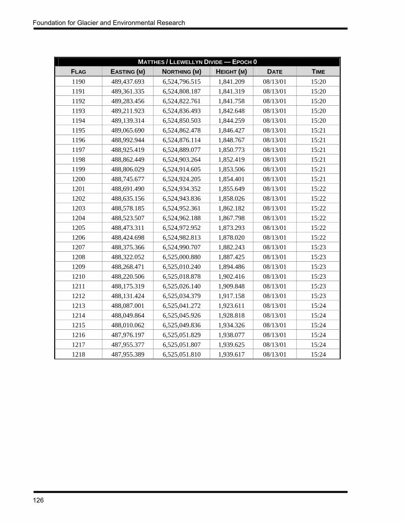
Foundation for Glacier and Environmental Research
126
MATTHES / LLEWELLYN DIVIDE — EPOCH 0 FLAG EASTING (M) NORTHING (M) HEIGHT (M) DATE TIME 1190 489,437.693 6,524,796.515 1,841.209 08/13/01 15:20 1191 489,361.335 6,524,808.187 1,841.319 08/13/01 15:20 1192 489,283.456 6,524,822.761 1,841.758 08/13/01 15:20 1193 489,211.923 6,524,836.493 1,842.648 08/13/01 15:20 1194 489,139.314 6,524,850.503 1,844.259 08/13/01 15:20 1195 489,065.690 6,524,862.478 1,846.427 08/13/01 15:21 1196 488,992.944 6,524,876.114 1,848.767 08/13/01 15:21 1197 488,925.419 6,524,889.077 1,850.773 08/13/01 15:21 1198 488,862.449 6,524,903.264 1,852.419 08/13/01 15:21 1199 488,806.029 6,524,914.605 1,853.506 08/13/01 15:21 1200 488,745.677 6,524,924.205 1,854.401 08/13/01 15:21 1201 488,691.490 6,524,934.352 1,855.649 08/13/01 15:22 1202 488,635.156 6,524,943.836 1,858.026 08/13/01 15:22 1203 488,578.185 6,524,952.361 1,862.182 08/13/01 15:22 1204 488,523.507 6,524,962.188 1,867.798 08/13/01 15:22 1205 488,473.311 6,524,972.952 1,873.293 08/13/01 15:22 1206 488,424.698 6,524,982.813 1,878.020 08/13/01 15:22 1207 488,375.366 6,524,990.707 1,882.243 08/13/01 15:23 1208 488,322.052 6,525,000.880 1,887.425 08/13/01 15:23 1209 488,268.471 6,525,010.240 1,894.486 08/13/01 15:23 1210 488,220.506 6,525,018.878 1,902.416 08/13/01 15:23 1211 488,175.319 6,525,026.140 1,909.848 08/13/01 15:23 1212 488,131.424 6,525,034.379 1,917.158 08/13/01 15:23 1213 488,087.001 6,525,041.272 1,923.611 08/13/01 15:24 1214 488,049.864 6,525,045.926 1,928.818 08/13/01 15:24 1215 488,010.062 6,525,049.836 1,934.326 08/13/01 15:24 1216 487,976.197 6,525,051.829 1,938.077 08/13/01 15:24 1217 487,955.377 6,525,051.807 1,939.625 08/13/01 15:24 1218 487,955.389 6,525,051.810 1,939.617 08/13/01 15:24

JIRP Survey Report — 2001
127
APPENDIX 3 SURFACE MOVEMENT VECTORS
ICY BASIN PROFILES (TAKU GLACIER AT CAMP 10) JULY 23 AND 24, 2001 → JULY 29, 2001
FLAGS PR1 01 TO PR2 10 SURVEYED JULY 23, 2001 → JULY 29, 2001 FLAGS PR3 01 TO PR4 04 SURVEYED JULY 24, 2001 → JULY 29, 2001
FLAG DISTANCES FLAG MOVEMENT SURFACE HEIGHT CHANGEFLAG
FLAG TO FLAG (M) SUM (M) TOTAL (M) DAILY (M) BEARING (GON) TOTAL (M) DAILY (CM) PR1 01 — 0.000 0.008 0.001 384.4042 -0.252 -4.25 PR1 02 145.572 145.572 0.020 0.003 219.4729 -0.285 -4.81 PR1 03 123.184 268.755 0.003 0.001 220.4833 -0.340 -5.74 PR1 04 123.363 392.119 0.018 0.003 121.6000 -0.315 -5.31 PR1 05 134.267 526.386 0.043 0.007 83.6929 -0.254 -4.28 PR1 06 144.438 670.824 0.027 0.004 38.0965 -0.287 -4.84 PR1 07 197.252 868.076 0.035 0.006 344.9179 -0.338 -5.70 PR1 08 189.309 1057.385 0.008 0.001 15.5958 -0.293 -4.94 PR1 09 197.466 1254.851 0.010 0.002 299.9999 -0.313 -5.27 PR1 10 76.781 1331.632 0.021 0.004 54.2379 -0.195 -3.28 PR1 11 87.330 1418.962 0.035 0.006 283.5261 -0.367 -6.18 PR2 01 0.000 0.000 0.071 0.012 372.0946 -0.331 -5.57 PR2 02 194.937 194.937 0.088 0.015 314.5465 -0.219 -3.69 PR2 03 134.691 329.628 155.758* * 369.0512* -4.911* -82.64* PR2 04 155.612 485.241 0.159 0.027 342.6436 -0.344 -5.79 PR2 05 155.125 640.366 0.129 0.022 323.1279 -0.336 -5.66 PR2 06 130.429 770.795 0.192 0.032 360.8216 -0.405 -6.82 PR2 07 123.911 894.706 0.182 0.031 395.0857 -0.508 -8.56 PR2 08 124.868 1019.575 0.209 0.035 31.6924 -0.580 -9.74 PR2 09 154.128 1173.703 0.191 0.032 60.6297 -0.501 -8.43 PR2 9A 3.784 1177.487 0.223 0.037 65.1054 -0.498 -8.38 PR2 10 170.600 1348.086 0.165 0.028 80.8555 -0.464 -7.78 PR3 01 0.000 0.000 0.081 0.015 31.2847 -0.423 -7.95 PR3 02 100.419 100.419 0.088 0.016 12.4242 -0.325 -6.11 PR3 03 86.445 186.864 0.048 0.009 17.5342 -0.319 -5.99 PR3 04 88.530 275.394 0.095 0.018 40.0304 -0.362 -6.80 PR3 05 145.052 420.446 0.064 0.012 3.9737 -0.324 -6.09 PR3 06 138.750 559.195 0.080 0.015 380.5271 -0.319 -5.99 PR3 07 120.759 679.954 0.178 0.033 356.0929 -0.313 -5.87 PR3 08 140.794 820.748 0.086 0.016 329.1852 -0.314 -5.89 PR3 09 175.956 996.704 0.110 0.021 315.7357 -0.301 -5.64 PR3 10 244.235 1240.939 0.116 0.022 324.8369 -0.357 -6.70 PR3 11 213.424 1454.363 0.094 0.018 312.9653 -0.390 -7.32

Foundation for Glacier and Environmental Research
128
ICY BASIN PROFILES (TAKU GLACIER AT CAMP 10) JULY 23 AND 24, 2001 → JULY 29, 2001
FLAGS PR1 01 TO PR2 10 SURVEYED JULY 23, 2001 → JULY 29, 2001 FLAGS PR3 01 TO PR4 04 SURVEYED JULY 24, 2001 → JULY 29, 2001
FLAG DISTANCES FLAG MOVEMENT SURFACE HEIGHT CHANGEFLAG
FLAG TO FLAG (M) SUM (M) TOTAL (M) DAILY (M) BEARING (GON) TOTAL (M) DAILY (CM) PR4 01 0.000 0.000 0.019 0.004 286.7904 -0.293 -5.50 PR4 02 206.118 206.118 0.008 0.002 384.4042 -0.280 -5.25 PR4 03 294.999 501.117 0.031 0.006 127.6720 -0.292 -5.48 PR4 04 213.800 714.918 0.118 0.022 129.7588 -0.246 -4.62 MEAN — — 0.085 0.015 — -0.341 -6.01
* Invalid data. Not used in calculation of means.

JIRP Survey Report — 2001
129
PROFILE 4 — DOWNGLACIER LINE (TAKU GLACIER AT CAMP 10) JULY 19, 2001 → JULY 25, 2001
FLAG DISTANCES FLAG MOVEMENT SURFACE HEIGHT CHANGEFLAG
FLAG TO FLAG (M) SUM (M) TOTAL (M) DAILY (M) BEARING (GON) TOTAL (M) DAILY (CM) 1 — 0.000 0.064 0.010 137.1554 -0.409 -6.61 3 193.185 193.185 0.163 0.026 149.7244 -0.335 -5.42 5 198.039 391.224 0.470 0.076 145.4945 -0.345 -5.59 7 252.918 644.143 1.302 0.212 147.3360 -0.294 -4.79 9 239.787 883.929 2.338 0.382 147.2656 -0.395 -6.45
11 180.312 1064.241 2.936 0.480 145.7805 -0.322 -5.26 13 321.999 1386.241 3.529 0.577 145.3904 -0.482 -7.88 15 312.812 1699.053 3.685 0.603 144.3235 -0.492 -8.06 17 392.978 2092.031 3.773 0.620 142.2254 -0.527 -8.65 19 374.703 2466.733 3.774 0.621 140.6393 -0.447 -7.35 21 377.480 2844.213 3.631 0.598 140.3424 -0.472 -7.78 23 322.587 3166.800 3.448 0.569 139.4670 -0.439 -7.25 25 388.158 3554.958 2.654 0.439 138.7641 -0.424 -7.01 27 378.584 3933.541 1.477 0.245 135.7717 -0.355 -5.88 29 348.105 4281.646 0.460 0.076 118.3824 -0.397 -6.58 31 336.047 4617.693 0.165 0.027 80.3720 -0.317 -5.26
MEAN 307.846 — 2.117 0.348 137.4022 -0.403 -6.61
PROFILE 4 — UPGLACIER LINE (TAKU GLACIER AT CAMP 10) JULY 19, 2001 → JULY 25, 2001
FLAG DISTANCES FLAG MOVEMENT SURFACE HEIGHT CHANGEFLAG
FLAG TO FLAG (M) SUM (M) TOTAL (M) DAILY (M) BEARING (GON) TOTAL (M) DAILY (CM) 2 — 0.000 0.061 0.010 180.8428 -0.379 -6.31 4 210.307 210.307 0.242 0.040 160.0856 -0.198 -3.30 6 229.185 439.493 0.674 0.112 149.9332 -0.243 -4.05 8 200.191 639.684 1.360 0.227 148.3442 -0.272 -4.54
10 204.123 843.807 2.301 0.384 146.4180 -0.358 -5.98 12 259.192 1102.999 3.020 0.500 145.9724 -0.372 -6.16 14 349.096 1452.095 3.465 0.574 144.8495 -0.425 -7.04 16 346.592 1798.687 3.664 0.608 142.4506 -0.360 -5.97 18 447.462 2246.149 3.737 0.619 140.6667 -0.580 -9.60 20 339.609 2585.758 3.691 0.611 140.2904 -0.392 -6.49 22 333.304 2919.062 3.575 0.593 139.5277 -0.411 -6.82 24 353.190 3272.252 3.129 0.519 139.6684 -0.389 -6.45 26 339.398 3611.650 2.392 0.397 140.2692 -0.268 -4.45 28 448.468 4060.118 0.944 0.157 130.7234 -0.233 -3.86 30 335.650 4395.768 0.237 0.039 119.1217 -0.319 -5.29
MEAN 313.983 — 2.166 0.359 144.6109 -0.347 -5.75

Foundation for Glacier and Environmental Research
130
LONGITUDINAL A (TAKU GLACIER AT GOAT RIDGE) JULY 20, 2001 → JULY 23, 2001
FLAG DISTANCES FLAG MOVEMENT SURFACE HEIGHT CHANGEFLAG
Flag to Flag (m) SUM (M) TOTAL (M) DAILY (M) BEARING (GON) TOTAL (M) DAILY (CM) 28 — 0.000 3.494 1.140 139.9608 -0.500 -16.32 29 501.287 501.287 3.480 1.138 133.7829 -0.414 -13.54 30 499.123 1000.410 3.438 1.125 132.8477 -0.309 -10.11 31 500.453 1500.863 3.307 1.082 139.4841 -0.348 -11.38 32 498.033 1998.896 3.216 1.051 148.5861 -0.297 -9.71 33 499.231 2498.127 3.139 1.026 155.1822 -0.297 -9.71 34 503.476 3001.603 3.089 1.024 159.6393 -0.299 -9.91 35 499.000 3500.602 2.964 0.985 162.6440 -0.297 -9.87 36 499.936 4000.538 2.876 0.961 168.6417 -0.306 -10.23 37 499.650 4500.188 2.598 0.868 172.5440 -0.331 -11.06
MEAN 500.021 — 3.160 1.040 151.3313 -0.340 -11.19
LONGITUDINAL D (NORTHWEST BRANCH, WEST OF TAKU TOWERS) FLAGS 15-30 SURVEYED JULY 28, 2001 → AUGUST 7, 2001 FLAGS 31-48 SURVEYED JULY 29, 2001 → AUGUST 7, 2001
FLAG DISTANCES FLAG MOVEMENT SURFACE HEIGHT CHANGEFLAG
FLAG TO FLAG (M) SUM (M) TOTAL (M) DAILY (M) BEARING (GON) TOTAL (M) DAILY (CM) 15 498.186 6959.450 2.776 0.283 106.0644 -0.599 -6.10 16 492.077 7451.526 2.719 0.277 100.9131 -0.589 -6.00 17 501.899 7953.425 2.715 0.277 92.6446 -0.554 -5.64 18 497.990 8451.415 2.644 0.269 83.3646 -0.542 -5.52 19 499.089 8950.504 2.573 0.262 77.0673 -0.611 -6.22 20 498.714 9449.218 2.509 0.256 70.9372 -0.719 -7.32 21 499.331 9948.548 2.351 0.239 65.8281 -0.691 -7.04 22 498.579 10447.127 2.156 0.220 53.8852 -0.692 -7.05 23 500.910 10948.038 1.832 0.188 29.5789 -0.630 -6.46 24 501.385 11449.422 1.634 0.168 6.6359 -0.574 -5.89 25 498.157 11947.580 1.447 0.148 392.3235 -0.511 -5.24 26 497.915 12445.495 1.279 0.131 381.5311 -0.479 -4.91 27 498.206 12943.701 0.934 0.096 373.1051 -0.585 -6.00 28 499.375 13443.076 0.767 0.079 367.3622 -0.603 -6.19 29 499.734 13942.810 0.652 0.067 370.4396 -0.600 -6.16 30 500.204 14443.014 0.523 0.054 373.3133 -0.538 -5.53 31 501.656 14944.671 0.425 0.047 381.6033 -0.499 -5.58 32 500.681 15445.352 0.711 0.079 392.1055 -0.484 -5.41 33 499.362 15944.714 0.668 0.075 0.0000 -0.557 -6.22

JIRP Survey Report — 2001
131
LONGITUDINAL D (NORTHWEST BRANCH, WEST OF TAKU TOWERS) FLAGS 15-30 SURVEYED JULY 28, 2001 → AUGUST 7, 2001 FLAGS 31-48 SURVEYED JULY 29, 2001 → AUGUST 7, 2001
FLAG DISTANCES FLAG MOVEMENT SURFACE HEIGHT CHANGEFLAG
FLAG TO FLAG (M) SUM (M) TOTAL (M) DAILY (M) BEARING (GON) TOTAL (M) DAILY (CM) 34 501.284 16445.998 0.679 0.076 9.1263 -0.504 -5.63 35 502.424 16948.423 0.617 0.069 8.9021 -0.386 -4.31 36 500.633 17449.055 0.623 0.070 12.0256 -0.481 -5.37 37 499.272 17948.327 0.583 0.065 6.8880 -0.432 -4.83 38 499.358 18447.685 0.527 0.059 399.2752 -0.374 -4.17 39 501.319 18949.003 0.422 0.047 397.8888 -0.502 -5.60 40 502.592 19451.596 0.309 0.034 1.0300 -0.538 -6.00 41 503.096 19954.692 0.265 0.030 7.9465 -0.431 -4.81 42 498.156 20452.849 0.177 0.020 384.4042 -0.488 -5.45 43 498.955 20951.804 0.090 0.010 323.8308 -0.523 -5.84 44 501.328 21453.132 0.116 0.013 181.0776 -0.538 -6.01 45 500.659 21953.790 0.233 0.026 190.1157 -0.599 -6.69 46 500.748 22454.539 0.556 0.062 215.2625 -0.608 -6.79 47 498.851 22953.390 0.713 0.080 221.1046 -0.596 -6.66 48 501.032 23454.422 0.776 0.087 230.2505 -0.691 -7.72
MEAN 499.848 — 1.118 0.116 — -0.551 -5.89
LONGITUDINAL E (SNOW TOWERS FORK OF NORTHWEST BRANCH) JULY 29, 2001 → AUGUST 7, 2001
FLAG DISTANCES FLAG MOVEMENT SURFACE HEIGHT CHANGEFLAG
FLAG TO FLAG (M) SUM (M) TOTAL (M) DAILY (M) BEARING (GON) TOTAL (M) DAILY (CM) 1 0.000 0.000 0.922 0.103 376.3919 -0.521 -5.83 2 499.757 499.757 0.863 0.097 382.9722 -0.493 -5.52 3 500.068 999.824 0.698 0.078 396.4416 -0.523 -5.86 4 498.485 1498.310 0.566 0.063 13.8233 -0.454 -5.08 5 500.081 1998.390 0.375 0.042 29.2129 -0.498 -5.58 6 500.392 2498.782 0.340 0.038 38.1598 -0.486 -5.44 7 498.261 2997.043 0.241 0.027 43.0790 -0.519 -5.81 8 500.886 3497.929 0.228 0.026 35.2657 -0.529 -5.93 9 498.876 3996.806 0.246 0.028 18.1083 -0.490 -5.49
10 497.545 4494.351 0.115 0.013 32.4987 -0.529 -5.94 11 497.928 4992.278 0.049 0.005 215.9141 -0.556 -6.24 12 497.518 5489.796 0.160 0.018 226.6654 -0.488 -5.48 13 498.795 5988.591 0.231 0.026 223.0981 -0.481 -5.40 14 500.039 6488.630 0.296 0.033 225.6631 -0.569 -6.39
MEAN 499.125 — 0.381 0.043 — -0.510 -5.71

Foundation for Glacier and Environmental Research
132
LONGITUDINAL F (WEST BRANCH OF TAKU GLACIER)
JULY 30, 2001 → AUGUST 6, 2001 FLAG DISTANCES FLAG MOVEMENT SURFACE HEIGHT CHANGE
FLAG FLAG TO FLAG (M) SUM (M) TOTAL (M) DAILY (M) BEARING (GON) TOTAL (M) DAILY (CM)
15 499.209 6984.982 0.665 0.093 54.3370 -0.416 -5.81 16 498.412 7483.394 0.627 0.088 42.4482 -0.396 -5.53 17 500.264 7983.658 0.550 0.077 31.3278 -0.349 -4.88 18 501.856 8485.514 0.530 0.074 20.9009 -0.397 -5.55 19 502.116 8987.630 0.528 0.074 16.2099 -0.438 -6.12 20 500.330 9487.960 0.434 0.061 16.4489 -0.407 -5.69 21 503.178 9991.138 0.404 0.057 19.0378 -0.339 -4.77 22 500.424 10491.561 0.340 0.048 13.0072 -0.395 -5.53 23 500.213 10991.774 0.320 0.045 386.3809 -0.359 -5.03 24 502.823 11494.598 0.209 0.029 391.1388 -0.397 -5.56 25 — — — — — — — 26 994.134 12488.731 0.153 0.021 339.0506 -0.334 -4.68
MEAN 499.148 — 0.433 0.061 — -0.384 -5.38
LONGITUDINAL G (ECHO GLACIER) JULY 28, 2001 → AUGUST 6, 2001
FLAG DISTANCES FLAG MOVEMENT SURFACE HEIGHT CHANGEFLAG
FLAG TO FLAG (M) SUM (M) TOTAL (M) DAILY (M) BEARING (GON) TOTAL (M) DAILY (CM) 1 0.000 0.000 2.792 0.312 122.9494 -0.544 -6.08 2 500.944 500.944 2.634 0.293 122.1498 -0.516 -5.73 3 499.646 1000.590 1.735 0.193 127.3998 -0.489 -5.43 4 498.966 1499.556 0.735 0.082 146.2595 -0.456 -5.07 5 498.981 1998.537 0.438 0.049 173.8615 -0.401 -4.46 6 499.857 2498.394 0.346 0.038 192.4480 -0.447 -4.97 7 501.506 2999.900 0.280 0.031 211.1858 -0.444 -4.93 8 502.531 3502.431 0.280 0.031 224.2238 -0.485 -5.39 9 507.147 4009.578 0.283 0.032 238.1809 -0.509 -5.66
10 493.155 4502.732 0.240 0.027 263.0072 -0.427 -4.75 11 491.711 4994.444 0.179 0.020 267.3028 -0.464 -5.16
MEAN 499.444 — 0.904 0.101 — -0.471 -5.24

JIRP Survey Report — 2001
133
VAUGHAN LEWIS OGIVES (BASE OF VAUGHAN LEWIS ICEFALL) AUGUST 10, 2000 → AUGUST 11, 2000
FLAG DISTANCES FLAG MOVEMENT SURFACE HEIGHT CHANGEFLAG
FLAG TO FLAG (M) SUM (M) TOTAL (M) DAILY (M) BEARING (GON) TOTAL (M) DAILY (CM) Ogive1-1 0.000 0.000 0.380 0.378 314.7021 -0.032 -3.18 Ogive1-2 124.554 124.554 0.389 0.379 319.4482 -0.078 -7.59 Ogive1-3 136.358 260.911 0.391 0.392 322.0784 -0.046 -4.61 Ogive1-4 96.968 357.879 0.392 0.392 322.2312 -0.073 -7.30 Ogive2-1 0.000 0.000 0.343 0.337 302.0409 -0.046 -4.52 Ogive2-2 131.836 131.836 0.390 0.383 315.6751 -0.100 -9.82 Ogive2-3 193.002 324.837 0.369 0.362 313.5470 -0.103 -10.10 Ogive3-1 0.000 0.000 0.368 0.369 289.4010 -0.043 -4.32 Ogive3-2 125.840 125.840 0.411 0.409 290.5060 -0.059 -5.87 Ogive3-3 170.279 296.119 0.367 0.360 304.6879 -0.033 -3.24 Ogive3-4 122.357 418.476 0.356 0.348 310.4254 -0.040 -3.92
MEAN 137.649 — 0.378 0.374 309.522 -0.059 -5.86
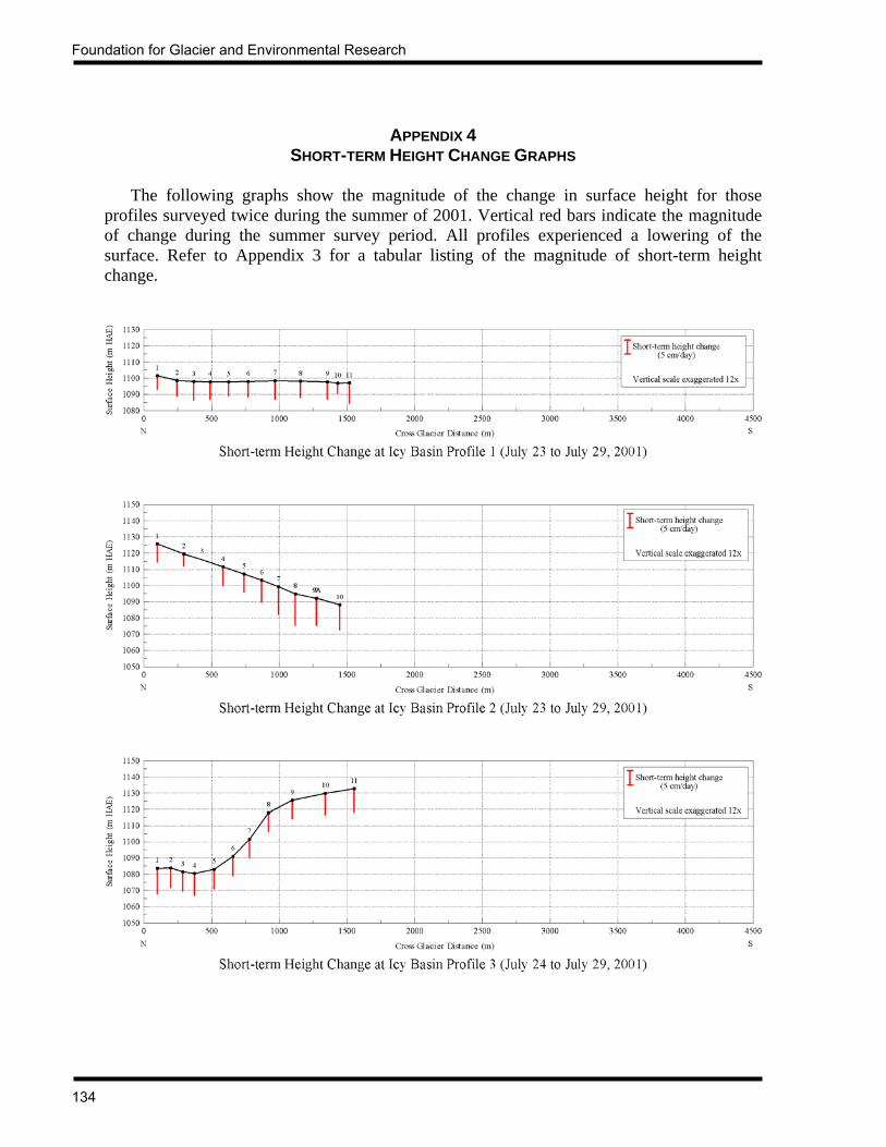
Foundation for Glacier and Environmental Research
134
APPENDIX 4 SHORT-TERM HEIGHT CHANGE GRAPHS
The following graphs show the magnitude of the change in surface height for those profiles surveyed twice during the summer of 2001. Vertical red bars indicate the magnitude of change during the summer survey period. All profiles experienced a lowering of the surface. Refer to Appendix 3 for a tabular listing of the magnitude of short-term height change.

JIRP Survey Report — 2001
135

Foundation for Glacier and Environmental Research
136

JIRP Survey Report — 2001
137
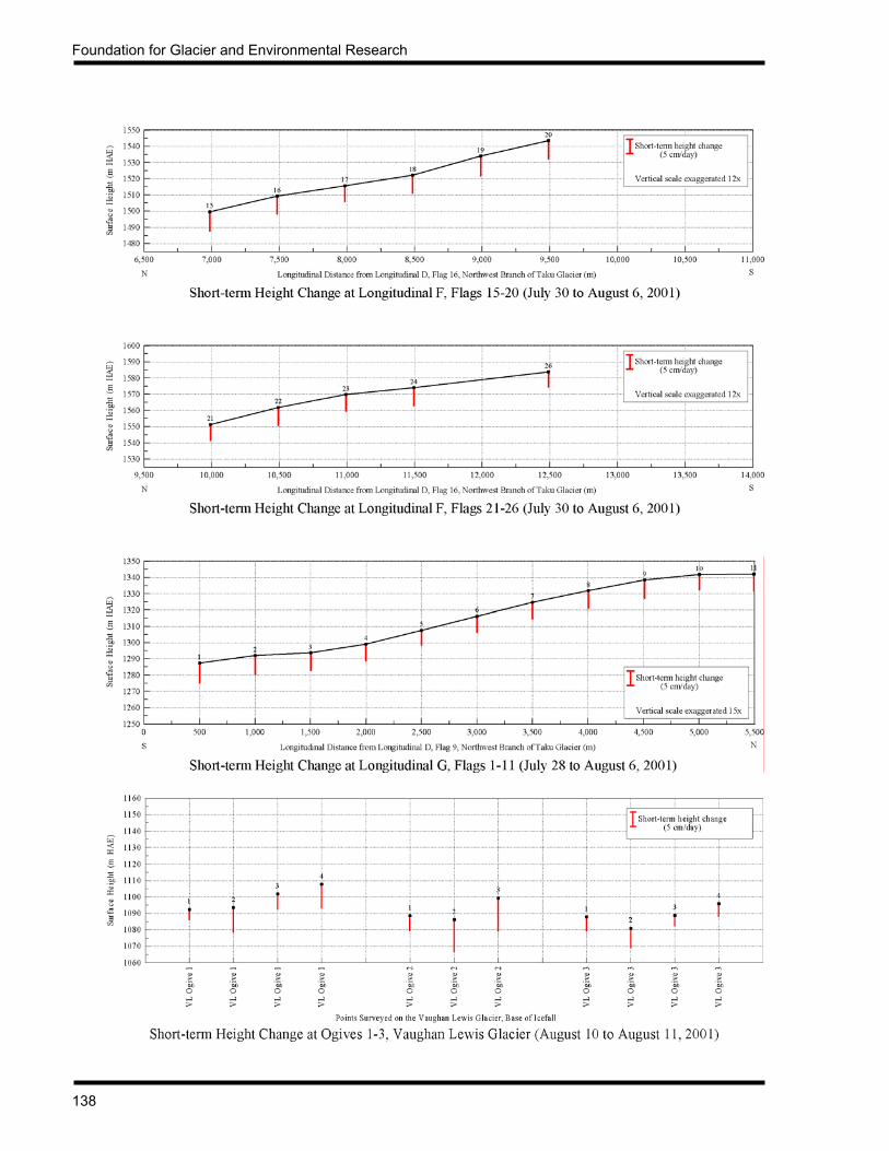
Foundation for Glacier and Environmental Research
138

JIRP Survey Report — 2001
139
APPENDIX 5 LONGITUDINAL SURFACE FLOW TIMES
LONGITUDINAL A (MATTHES AND TAKU GLACIERS)
FROM — TO MEAN
VELOCITY/DAY BETWEEN FROM AND
TO POINTS (M)
FROM — TO SLOPE
DISTANCE (M)
FROM – TO MOVEMENT
TIME (YEARS)
CUMULATIVE SLOPE
DISTANCE (KM)
CUMULATIVE MOVEMENT
TIME (YEARS)
a117 — a116 0.046 499.158 29.407 0.499 29.407 a116 — a115 0.063 500.105 21.864 0.999 51.271 a115 — a114 0.081 497.492 16.740 1.497 68.011 a114 — a113 0.094 499.390 14.515 1.996 82.526 a113 — a112 0.112 498.868 12.216 2.495 94.741 a112 — a111 0.134 499.879 10.245 2.995 104.986 a111 — a110 0.147 500.467 9.324 3.495 114.310 a110 — a109 0.160 498.542 8.517 3.994 122.826 a109 — a108 0.175 498.518 7.815 4.492 130.641 a108 — a107 0.190 499.151 7.202 4.992 137.843 a107 — a106 0.216 499.938 6.330 5.492 144.173 a106 — a105 0.257 499.981 5.320 5.991 149.492 a105 — a104 0.300 501.187 4.579 6.493 154.071 a103 — a103 0.337 500.544 4.069 6.993 158.141 a103 — a102 0.375 498.907 3.640 7.492 161.781 a102 — a101 0.416 498.598 3.280 7.991 165.061 a101 — a100 0.474 495.951 2.867 8.487 167.928 a100 — a99 0.511 498.927 2.675 8.986 170.603 a99 — a98 0.492 500.349 2.782 9.486 173.386 a98 — a97 0.459 499.126 2.976 9.985 176.361 a97 — a96 0.431 495.994 3.150 10.481 179.512 a96 — a95 0.410 495.316 3.311 10.976 182.823 a95 — a94 0.396 499.009 3.452 11.475 186.275 a94 — a93 0.380 497.592 3.581 11.973 189.856 a93 — a92 0.358 498.638 3.815 12.472 193.671 a92 — a91 0.340 497.541 4.005 12.969 197.677 a91 — a90 0.331 499.010 4.122 13.468 201.798 a90 — a89 0.325 499.995 4.209 13.968 206.008 a89 — a88 0.326 501.648 4.217 14.470 210.225 a88 — a87 0.334 499.086 4.092 14.969 214.317 a87 — a86 0.340 499.806 4.027 15.469 218.344 a86 — a85 0.353 499.606 3.872 15.968 222.216 a85 — a84 0.343 500.356 3.996 16.469 226.212 a84 — a83 0.325 499.806 4.207 16.968 230.419 a83 — a82 0.348 499.793 3.928 17.468 234.347

Foundation for Glacier and Environmental Research
140
LONGITUDINAL A (MATTHES AND TAKU GLACIERS)
FROM — TO MEAN
VELOCITY/DAY BETWEEN FROM AND
TO POINTS (M)
FROM — TO SLOPE
DISTANCE (M)
FROM – TO MOVEMENT
TIME (YEARS)
CUMULATIVE SLOPE
DISTANCE (KM)
CUMULATIVE MOVEMENT
TIME (YEARS)
a82 — a81 0.379 500.984 3.620 17.969 237.967 a81 — a80 0.388 499.527 3.529 18.469 241.497 a80 — a79 0.397 500.687 3.450 18.969 244.947 a79 — a78 0.412 502.995 3.344 19.472 248.291 a78 — a77 0.406 496.930 3.351 19.969 251.642 a77 — a76 0.408 499.358 3.347 20.469 254.989 a76 — a75 0.422 498.754 3.238 20.968 258.228 a75 — a74 0.430 499.065 3.177 21.467 261.404 a74 — a73 0.440 501.037 3.118 21.968 264.523 a73 — a72 0.445 497.866 3.064 22.465 267.587 a72 — a71 0.454 499.856 3.013 22.965 270.599 a71 — a70 0.479 498.318 2.849 23.464 273.448 a70 — a69 0.510 503.245 2.700 23.967 276.149 a69 — a68 0.531 446.994 2.305 24.414 278.454 a68 — a67 0.541 500.534 2.532 24.914 280.986 a67 — a66 0.547 500.988 2.506 25.415 283.492 a66 — a65 0.555 503.300 2.482 25.919 285.974 a65 — a64 0.568 500.870 2.415 26.420 288.389 a64 — a63 0.580 497.783 2.349 26.917 290.738 a63 — a62 0.598 500.339 2.292 27.418 293.030 a62 — a61 0.613 498.873 2.228 27.917 295.259 a61 — a60 0.619 498.274 2.206 28.415 297.464 a60 — a59 0.628 500.530 2.182 28.915 299.647 a59 — a58 0.646 501.918 2.127 29.417 301.773 a58 — a57 0.655 500.506 2.093 29.918 303.866 a57 — a56 0.670 501.486 2.049 30.419 305.916 a56 — a55 0.731 502.886 1.882 30.922 307.798 a55 — a54 0.755 501.655 1.819 31.424 309.616 a54 — a53 0.741 500.305 1.848 31.924 311.464 a53 — a52 0.747 253.377 0.929 32.178 312.393 a52 — a51 0.766 498.622 1.783 32.676 314.176 a51 — a50 0.828 502.139 1.660 33.178 315.836 a50 — a49 0.842 497.649 1.619 33.676 317.455 a49 — a48 0.832 507.937 1.671 34.184 319.126 a48 — a47 0.850 500.563 1.613 34.684 320.739 a47 — a46 0.852 501.147 1.611 35.186 322.350 a46 — a45 0.858 500.707 1.598 35.686 323.948 a45 — a44 0.863 500.445 1.588 36.187 325.536 a44 — a43 0.869 497.870 1.568 36.685 327.104

JIRP Survey Report — 2001
141
LONGITUDINAL A (MATTHES AND TAKU GLACIERS)
FROM — TO MEAN
VELOCITY/DAY BETWEEN FROM AND
TO POINTS (M)
FROM — TO SLOPE
DISTANCE (M)
FROM – TO MOVEMENT
TIME (YEARS)
CUMULATIVE SLOPE
DISTANCE (KM)
CUMULATIVE MOVEMENT
TIME (YEARS)
a43 — a42 0.880 501.570 1.560 37.186 328.663 a42 — a41 0.896 502.316 1.534 37.688 330.198 a41 — a40 0.911 501.667 1.508 38.190 331.706 a40 — a39 0.918 501.359 1.495 38.692 333.201 a39 — a38 0.929 500.353 1.475 39.192 334.676 a38 — a37 0.903 499.453 1.515 39.691 336.190 a37 — a36 0.915 499.729 1.495 40.191 337.686 a36 — a35 0.973 500.010 1.407 40.691 339.092 a35 — a34 1.004 499.148 1.361 41.190 340.453 a34 — a33 1.025 503.793 1.346 41.694 341.799 a33 — a32 1.039 499.574 1.317 42.194 343.115 a32 — a31 1.067 498.282 1.279 42.692 344.394 a31 — a30 1.103 500.663 1.242 43.193 345.637 a30 — a29 1.132 499.345 1.208 43.692 346.845 a29 — a28 1.139 501.566 1.205 44.193 348.050

Foundation for Glacier and Environmental Research
142
LONGITUDINAL A (LLEWELLYN GLACIER)
FROM — TO MEAN VELOCITY/DAY BETWEEN FROM AND
TO POINTS (M)
FROM — TO SLOPE
DISTANCE (M)
FROM — TO MOVEMENT
TIME (YEARS)
CUMULATIVE SLOPE
DISTANCE (KM)
CUMULATIVE MOVEMENT
TIME (YEARS) a118 — a119 0.059 498.412 23.177 0.498 23.177 a119 — a120 0.073 498.921 18.834 0.997 42.011 a120 — a121 0.076 500.143 17.990 1.497 60.000 a121 — a122 0.073 497.524 18.620 1.995 78.621 a122 — a123 0.070 497.872 19.394 2.493 98.015 a123 — a124 0.072 498.244 18.990 2.991 117.005 a124 — a125 0.075 500.127 18.313 3.491 135.318 a125 — a126 0.078 497.735 17.401 3.989 152.719 a126 — a127 0.083 498.968 16.449 4.488 169.169 a127 — a128 0.086 499.373 15.806 4.987 184.975 a128 — a128 0.092 499.667 14.886 5.487 199.861 a129 — a130 0.100 499.365 13.606 5.986 213.467 a130 — a131 0.112 498.403 12.144 6.485 225.611 a131 — a132 0.130 501.502 10.527 6.986 236.138 a132 — a133 0.155 498.299 8.775 7.485 244.913 a133 — a134 0.192 500.138 7.117 7.985 252.030 a134 — a135 0.232 498.493 5.880 8.483 257.910 a135 — a136 0.265 498.086 5.137 8.981 263.047 a136 — a137 0.288 499.747 4.751 9.481 267.798 a137 — a138 0.293 498.971 4.664 9.980 272.461 a138 — a139 0.290 499.076 4.707 10.479 277.168 a139 — a140 0.293 499.826 4.678 10.979 281.846 a140 — a141 0.305 496.771 4.467 11.476 286.313 a141 — a142 0.319 500.473 4.295 11.976 290.608 a142 — a143 0.334 497.205 4.082 12.473 294.689 a143 — a144 0.346 498.898 3.946 12.972 298.635 a144 — a145 0.357 497.352 3.816 13.470 302.452 a145 — a146 0.372 499.774 3.680 13.969 306.132 a146 — a147 0.392 488.575 3.409 14.458 309.541

JIRP Survey Report — 2001
143
Longitudinal B (Demorest Glacier)
From — To Mean Velocity/day
Between From and To Points (m)
From — To Slope
Distance (m)
From — To Movement
Time (years)
Cumulative Slope
Distance (km)
Cumulative Movement
Time (years) b34 — b33 0.184 496.338 7.401 0.496 7.401 b33 — b32 0.190 497.020 7.174 0.993 14.575 b32 — b31 0.205 499.704 6.689 1.493 21.264 b31 — b30 0.212 497.422 6.429 1.990 27.693 b30 — b29 0.219 499.933 6.248 2.490 33.940 b29 — b28 0.248 498.613 5.498 2.989 39.438 b28 — b27 0.258 501.247 5.315 3.490 44.753 b27 — b26 0.245 500.899 5.598 3.991 50.350 b26 — b25 0.252 499.658 5.434 4.491 55.784 b25 — b24 0.257 500.470 5.334 4.991 61.118 b24 — b23 0.260 500.536 5.275 5.492 66.393 b23 — b22 0.265 500.181 5.159 5.992 71.552 b22 — b21 0.278 497.782 4.906 6.490 76.458 b21 — b20 0.293 496.287 4.642 6.986 81.100 b20 — b19 0.316 497.773 4.309 7.484 85.409 b19 — b18 0.334 499.138 4.091 7.983 89.500 b18 — b17 0.339 499.681 4.032 8.483 93.532 b17 — b16 0.339 501.350 4.052 8.984 97.585 b16 — b15 0.324 498.834 4.212 9.483 101.797 b15 — b14 0.312 493.799 4.338 9.977 106.135 b14 — b13 0.297 500.480 4.608 10.477 110.743 b13 — b11 0.280 994.289 9.982 11.471 120.725 b11 — b10 0.272 497.902 5.011 11.969 125.736 b10 — b9 0.257 499.920 5.333 12.469 131.069 b9 — b8 0.248 500.205 5.518 12.969 136.587 b8 — b7 0.266 498.602 5.133 13.468 141.720 b7 — b6 0.278 501.244 4.939 13.969 146.659 b6 — b5 0.280 502.561 4.913 14.472 151.572
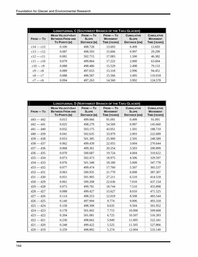
Foundation for Glacier and Environmental Research
144
LONGITUDINAL C (SOUTHWEST BRANCH OF THE TAKU GLACIER)
FROM — TO MEAN VELOCITY/DAY BETWEEN FROM AND
TO POINTS (M)
FROM — TO SLOPE
DISTANCE (M)
FROM — TO MOVEMENT
TIME (YEARS)
CUMULATIVE SLOPE
DISTANCE (KM)
CUMULATIVE MOVEMENT
TIME (YEARS) c14 — c13 0.100 498.728 13.693 0.499 13.693 c13 — c12 0.087 498.593 15.606 0.997 29.299 c12 — c11 0.081 502.715 17.083 1.500 46.382 c11 — c10 0.079 499.864 17.222 2.000 63.604 c10 — c9 0.088 498.480 15.529 2.498 79.133 c9 — c8 0.089 497.653 15.318 2.996 94.451 c8 — c7 0.088 498.587 15.566 3.495 110.018 c7 — c6 0.094 497.263 14.560 3.992 124.578
LONGITUDINAL D (NORTHWEST BRANCH OF THE TAKU GLACIER)
FROM — TO MEAN VELOCITY/DAY BETWEEN FROM AND
TO POINTS (M)
FROM — TO SLOPE
DISTANCE (M)
FROM — TO MOVEMENT
TIME (YEARS)
CUMULATIVE SLOPE
DISTANCE (KM)
CUMULATIVE MOVEMENT
TIME (YEARS) d43 — d42 0.015 499.066 91.091 0.499 91.091 d42 — d41 0.025 498.279 54.569 0.997 145.660 d41 — d40 0.032 503.175 43.051 1.501 188.710 d40 — d39 0.041 502.635 33.979 2.003 222.689 d39 — d38 0.053 501.385 25.900 2.505 248.589 d38 — d37 0.062 499.439 22.055 3.004 270.644 d37 — d36 0.068 499.361 20.254 3.503 290.899 d36 — d35 0.070 500.687 19.724 4.004 310.622 d35 — d34 0.073 502.473 18.975 4.506 329.597 d34 — d33 0.076 501.348 18.180 5.008 347.778 d33 — d32 0.077 499.474 17.760 5.507 365.537 d32 — d31 0.063 500.935 21.770 6.008 387.307 d31 — d30 0.051 501.905 27.211 6.510 414.518 d30 — d29 0.061 500.208 22.636 7.010 437.154 d29 — d28 0.073 499.781 18.744 7.510 455.898 d28 — d27 0.088 499.427 15.627 8.010 471.525 d27 — d26 0.114 498.253 12.019 8.508 483.544 d26 — d25 0.140 497.994 9.774 9.006 493.318 d25 — d24 0.158 498.308 8.635 9.504 501.952 d24 — d23 0.178 501.602 7.715 10.006 509.668 d23 — d22 0.204 501.081 6.725 10.507 516.393 d22 — d21 0.230 498.662 5.949 11.005 522.341 d21 — d20 0.248 499.422 5.525 11.505 527.866 d20 — d19 0.259 498.892 5.274 12.004 533.140

JIRP Survey Report — 2001
145
LONGITUDINAL D (NORTHWEST BRANCH OF THE TAKU GLACIER)
FROM — TO MEAN VELOCITY/DAY BETWEEN FROM AND
TO POINTS (M)
FROM — TO SLOPE
DISTANCE (M)
FROM — TO MOVEMENT
TIME (YEARS)
CUMULATIVE SLOPE
DISTANCE (KM)
CUMULATIVE MOVEMENT
TIME (YEARS) d19 — d18 0.266 499.227 5.148 12.503 538.288 d18 — d17 0.273 498.070 4.995 13.001 543.283 d17 — d6 0.277 501.989 4.962 13.503 548.244 d16 — d5 0.283 492.143 4.764 13.995 553.009
d15 — d14 0.291 498.714 4.697 14.494 557.706 d14 — d13 0.294 498.672 4.644 14.993 562.350 d13 — d12 0.299 497.020 4.550 15.490 566.900 d12 — d11 0.303 498.649 4.509 15.988 571.409 d11 — d10 0.308 501.288 4.460 16.490 575.869 d10 — d9 0.314 499.459 4.348 16.989 580.217 d9 — d8 0.320 472.022 4.042 17.461 584.259 d8 — d7 0.327 498.793 4.179 17.960 588.439 d7 — d6 0.345 499.655 3.970 18.459 592.408 d6 — d5 0.389 498.784 3.514 18.958 595.922 d5 — d4 0.439 499.383 3.114 19.458 599.037 d4 — d3 0.473 499.321 2.890 19.957 601.927 d3 — d2 0.492 499.376 2.782 20.456 604.709 d2 — d1 0.505 499.354 2.707 20.956 607.416
LONGITUDINAL E (SNOW TOWERS FORK OF THE NORTHWEST BRANCH OF THE TAKU GLACIER)
FROM — TO MEAN VELOCITY/DAY BETWEEN FROM AND
TO POINTS (M)
FROM — TO SLOPE
DISTANCE (M)
FROM — TO MOVEMENT
TIME (YEARS)
CUMULATIVE SLOPE
DISTANCE (KM)
CUMULATIVE MOVEMENT
TIME (YEARS) e10 — e9 0.021 497.608 66.457 0.498 66.457 e9 — e8 0.027 498.898 50.589 0.997 117.047 e8 — e7 0.027 500.935 51.754 1.497 168.801 e7 — e6 0.033 498.320 41.979 1.996 210.780 e6 — e5 0.040 500.507 34.258 2.496 245.038 e5 — e4 0.053 500.121 26.081 2.996 271.119 e4 — e3 0.071 498.521 19.360 3.495 290.479 e3 — e2 0.088 500.106 15.648 3.995 306.127 e2 — e1 0.100 499.828 13.685 4.495 319.811

Foundation for Glacier and Environmental Research
146
LONGITUDINAL F (WEST BRANCH OF THE TAKU GLACIER)
FROM — TO MEAN VELOCITY/DAY BETWEEN FROM AND
TO POINTS (M)
FROM — TO SLOPE
DISTANCE (M)
FROM — TO MOVEMENT
TIME (YEARS)
CUMULATIVE SLOPE
DISTANCE (KM)
CUMULATIVE MOVEMENT
TIME (YEARS) f26 — f24 0.025 994.182 108.877 0.994 108.877 f24 — f23 0.037 502.842 37.208 1.497 146.085 f23 — f22 0.047 500.275 29.455 1.997 175.541 f22 — f21 0.053 500.536 26.103 2.498 201.643 f21 — f20 0.059 503.237 23.352 3.001 224.996 f20 — f19 0.068 500.423 20.298 3.501 245.293 f19 — f18 0.074 502.255 18.582 4.004 263.876 f18 — f17 0.076 501.897 18.200 4.506 282.076 f17 — f16 0.085 500.512 16.133 5.006 298.209 f16 — f15 0.097 498.445 14.086 5.505 312.296 f15 — f14 0.104 499.254 13.167 6.004 325.463 f14 — f13 0.109 499.789 12.557 6.504 338.020 f13 — f12 0.122 499.534 11.213 7.003 349.232 f12 — f11 0.127 498.719 10.774 7.502 360.006 f11 — f10 0.124 497.379 10.988 7.999 370.994 f10 — f9 0.129 500.317 10.652 8.500 381.646 f9 — f8 0.131 498.076 10.391 8.998 392.036 f8 — f7 0.138 499.281 9.875 9.497 401.911 f7 — f6 0.159 499.419 8.617 9.996 410.528 f6 — f5 0.179 498.729 7.616 10.495 418.144 f5 — f4 0.201 500.419 6.808 10.996 424.952 f4 — f3 0.231 499.585 5.926 11.495 430.878 f3 — f2 0.252 499.822 5.431 11.995 436.309 f2 — f1 0.269 496.225 5.055 12.491 441.364
f1 — d16 0.282 499.789 4.854 12.991 446.218
LONGITUDINAL G (SNOW TOWERS FORK OF THE NORTHWEST BRANCH OF THE TAKU GLACIER)
FROM — TO MEAN VELOCITY/DAY BETWEEN FROM AND
TO POINTS (M)
FROM — TO SLOPE
DISTANCE (M)
FROM — TO MOVEMENT
TIME (YEARS)
CUMULATIVE SLOPE
DISTANCE (KM)
CUMULATIVE MOVEMENT
TIME (YEARS) g11 — g10 0.023 491.712 57.666 0.492 57.666 g10 — g9 0.029 493.167 46.333 0.985 103.999 g9 — g8 0.031 507.190 44.343 1.492 148.342 g8 — g7 0.031 502.583 44.211 1.995 192.553 g7 — g6 0.035 501.575 39.438 2.496 231.991 g6 — g5 0.044 499.933 31.385 2.996 263.376 g5 — g4 0.065 499.053 20.966 3.495 284.342 g4 — g3 0.137 498.995 9.957 3.994 294.298 g3 — g2 0.243 499.650 5.636 4.494 299.934 g2 — g1 0.302 500.966 4.535 4.995 304.469

JIRP Survey Report — 2001
147
APPENDIX 6 SURFACE ELEVATIONS AT PROFILE 4, 1993 TO 2001
The data in the following table represent the annual surveyed elevations of the 31 flags of Profile 4 as adjusted to the standard July 25 measurement date.
ELEVATION (METERS ABOVE WGS84 ELLIPSOID) FLAG 1993 1994 1995 1996 1997 1998 1999 2000 2001
1 1119.852 1119.712 1119.258 1118.492 1117.755 1116.810 1117.351 1118.938 1119.8652 1126.923 1127.012 1126.009 1125.174 1124.304 1123.633 1124.055 1125.725 1126.5383 1122.832 1122.969 1122.095 1121.371 1120.630 1119.721 1120.234 1121.481 1122.2374 1125.882 1126.146 1124.930 1124.049 1123.357 1122.611 1122.956 1124.491 1125.3035 1122.850 1122.966 1121.965 1121.496 1120.560 1119.512 1119.849 1121.322 1121.9466 1123.484 1123.614 1122.522 1121.613 1120.742 1119.897 1120.193 1121.637 1122.4697 1120.656 1120.882 1119.808 1118.947 1118.077 1117.092 1117.425 1118.712 1119.6488 1122.545 1122.874 1121.783 1120.645 1119.810 1119.043 1119.256 1120.741 1121.5849 1121.201 1121.600 1120.377 1119.311 1118.679 1117.479 1117.916 1119.464 1120.695
10 1122.394 1122.754 1121.279 1120.202 1119.514 1118.770 1119.014 1120.497 1121.28911 1121.657 1122.262 1120.793 1120.109 1119.511 1118.267 1118.696 1119.987 1121.03612 1121.675 1121.901 1120.663 1120.006 1119.448 1118.405 1118.821 1120.269 1121.20813 1121.566 1121.661 1120.580 1119.590 1119.200 1117.612 1118.472 1119.832 1120.91514 1123.383 1123.648 1122.108 1121.450 1121.101 1119.661 1120.482 1121.846 1122.89615 1117.945 1117.940 1116.604 1115.803 1115.383 1114.449 1115.128 1116.670 1117.44516 1122.471 1122.218 1121.047 1120.528 1120.005 1119.013 1119.617 1121.159 1122.05617 1121.898 1122.234 1120.483 1119.877 1119.899 1118.589 1119.360 1120.910 1121.66218 1128.331 1128.335 1126.707 1126.491 1125.941 1124.837 1125.678 1127.090 1127.92819 1128.305 1128.404 1126.888 1126.455 1126.134 1124.804 1125.842 1127.027 1128.14020 1134.260 1134.696 1132.867 1132.486 1132.003 1130.874 1131.705 1133.157 1134.03721 1134.681 1134.869 1133.364 1132.868 1132.584 1131.601 1132.204 1133.695 1134.75022 1138.596 1138.685 1137.382 1136.945 1136.534 1135.168 1136.062 1137.586 1138.49023 1136.935 1136.628 1135.203 1135.003 1134.798 1133.288 1134.164 1135.556 1136.36224 1139.334 1139.522 1138.113 1137.418 1136.997 1136.037 1136.551 1137.904 1138.81125 1138.734 1139.024 1137.252 1136.849 1136.301 1135.319 1136.060 1136.873 1138.32226 1140.840 1141.494 1140.094 1139.224 1138.843 1137.834 1138.078 1139.627 1140.32027 1139.350 1139.409 1138.197 1137.490 1137.453 1136.608 1136.864 1138.318 1139.05528 1141.612 1141.157 1139.878 1139.152 1138.967 1137.734 1138.566 1139.804 1140.73529 1143.362 1142.899 1141.810 1141.122 1140.884 1139.981 1140.338 1142.012 1142.69730 1143.137 1142.646 1141.209 1140.486 1140.228 1139.432 1140.128 1141.420 1142.21431 1147.676 1147.197 1145.975 1145.288 1145.017 1144.250 1144.952 1146.282 1147.026
MEAN 1129.496 1129.592 1128.298 1127.611 1127.118 1126.075 1126.646 1128.066 1128.957

Foundation for Glacier and Environmental Research
148
APPENDIX 7 SURFACE STRAINS AT PROFILE 4, JULY 19 TO JULY 25, 2001
µSTRAIN / DAY TRIANGLE FLAGS MAXIMUM
STRAIN (e1) MINIMUM
STRAIN (e2) VERTICAL
STRAIN (e3)
ORIENTATION (θ)
1 1 2 3 46.675 -16.960 -29.714 105.927 2 2 3 4 59.357 -64.168 4.811 94.600 3 3 4 5 105.726 -119.008 13.282 106.246 4 4 5 6 117.594 -162.227 44.633 101.231 5 5 6 7 292.130 -230.775 -61.355 105.617 6 6 7 8 295.470 -258.487 -36.982 105.417 7 7 8 9 384.321 -322.254 -62.066 105.760 8 8 9 10 387.282 -405.588 18.305 105.435 9 9 10 11 272.725 -307.402 34.677 107.484
10 10 11 12 278.808 -187.759 -91.050 111.797 11 11 12 13 167.310 -135.355 -31.955 110.244 12 12 13 14 215.591 -91.059 -124.532 123.995 13 13 14 15 105.176 -50.330 -54.846 132.110 14 14 15 16 106.269 -93.253 -13.015 128.391 15 15 16 17 58.229 -66.218 7.988 228.930 16 16 17 18 63.023 -46.749 -16.274 134.376 17 17 18 19 33.904 -41.742 7.837 139.632 18 18 19 20 48.940 -9.164 -39.776 -38.261 19 19 20 21 38.109 -18.858 -19.250 91.612 20 20 21 22 24.284 -21.538 -2.746 181.593 21 21 22 23 29.956 -44.970 15.014 198.978 22 22 23 24 176.609 -49.649 -126.960 192.153 23 23 24 25 200.950 -153.118 -47.832 3.381 24 24 25 26 242.048 -153.760 -88.288 3.418 25 25 26 27 292.601 -274.944 -17.657 5.611 26 26 27 28 288.487 -266.497 -21.990 2.161 27 27 28 29 282.274 -207.534 -74.741 1.871 28 28 29 30 205.116 -194.889 -10.227 12.769 29 29 30 31 131.540 -72.718 -58.822 101.426
The orientation of θ is clockwise from grid north of the JIRP coordinate system, in gons (grads).

JIRP Survey Report — 2001
149
NOTES
Foundation for Glacier and Environmental Research
150
NOTES