Coping with Urban Sprawl: A Critical Discussion of the ...
17
Coping with Urban Sprawl: A Critical Discussion of the Urban Containment Strategy in a Developing Country City, Accra George Owusu 1 Accra, Ghana’s largest metropolis, exhibits unique features in terms of low densities in central locations due to large number of under-used plots, except inner-city informal residential areas. Over the last three decades, the metropolis has grown to encompass it surround district, now referred to as the Greater Accra Metropolitan Area. The massive sprawl has largely occurred in the west and east of the city, where growth rates of over 30% per annum have been recorded. This paper examines factors underlying the massive expansion of Accra, and the urban containment strategy to curtail the sprawl. It concludes that though many factors account for the sprawl, the key is the weak public control over land and the resultant poor spatial planning. As such, any urban containment strategy is unlikely to succeed within the context of the existing land management system where land is held privately under customary institutions while planning remains a public functions for local governments. Keywords: Urban sprawl, Urban containment, Accra, Ghana 1 Department of Geography and Resource Development, Institute of Statistical, Social and Economic Research (ISSER), University of Ghana, Legon, Ghana. Email: [email protected]
Transcript of Coping with Urban Sprawl: A Critical Discussion of the ...

Coping with Urban Sprawl: A Critical Discussion of the Urban Containment Strategy in
a Developing Country City, Accra
George Owusu1
Accra, Ghana’s largest metropolis, exhibits unique features in terms of low densities in central locations due to large number of under-used plots, except inner-city informal residential areas. Over the last three decades, the metropolis has grown to encompass it surround district, now referred to as the Greater Accra Metropolitan Area. The massive sprawl has largely occurred in the west and east of the city, where growth rates of over 30% per annum have been recorded. This paper examines factors underlying the massive expansion of Accra, and the urban containment strategy to curtail the sprawl. It concludes that though many factors account for the sprawl, the key is the weak public control over land and the resultant poor spatial planning. As such, any urban containment strategy is unlikely to succeed within the context of the existing land management system where land is held privately under customary institutions while planning remains a public functions for local governments. Keywords: Urban sprawl, Urban containment, Accra, Ghana
1 Department of Geography and Resource Development, Institute of Statistical, Social and Economic Research
(ISSER), University of Ghana, Legon, Ghana. Email: [email protected]

Planum. The Journal of Urbanism 2 | 17
Introduction Urban sprawl also referred to as urban decentralization has been a subject of intense debate among academics, urban planners, and the general public (Wasserman, 2008; Jaret et al., 2009; Angel et al., 2011). It refers to the physical outward expansion of cities characterized by low densities, separated land uses and car-dependent communities. The debate on urban sprawl features two contesting thoughts – for and against. Opponents of urban sprawl supported by environmentalist have argued that the phenomenon results in increased automobile travel and congestion, high levels of pollution, loss of farmland, duplicative infrastructure at high costs to society, limited employment accessibility, concentrated poverty, and many other undesirable outcomes in metropolitan areas (Wasserman, 2000, 2008; Angel et al., 2011). Arguing from this point and concluding on an analyzes of state management programmes on urban sprawl in the USA, Ming Yin and Jian Sun (2007) noted that governments should more fully exercise their responsibilities to control urban sprawl rather than just leave this issue to local devices. On the other hand, proponents of urban sprawl have argued that urban decentralization can yield positive outcomes. These positive outcomes include improved satisfaction of housing preferences, good quality and serene environment (especially air quality and noise pollution), lower crime rates and better public schools (Glaeser and Kahn 2003). While the debate on urban sprawl is divided, policy has largely been on the side of curtailing sprawl. Consequently, a number of strategies referred to as urban containment have been developed with the view to reshape urban development patterns. As the name implies, urban containment aims to reign in the outward expansion of urban areas into the surrounding rural areas beyond defined boundary. According to Nelson et al. (2004), it does so in part by choreographing public infrastructure investment, land use and development regulation, and incentives and disincentives to influence the rate, timing, intensity, mix, and location of urban physical expansion. They add that in broad terms urban containment programmes are distinguished from traditional approaches to land use regulation by the presence of policies that are explicitly designed to limit the development of land outside a defined urban area, while encouraging infill development and redevelopment inside the urban area. The debate on urban containment measures has engaged much of the developed world particularly, North America and Western Europe, or broadly speaking matured urban societies. However, there has been relatively little academic research on the subject in Sub-Saharan Africa, where recent studies indicate ever-growing cities of sizes and population unprecedented in the continent’s history. In much of the developing world (including Sub-Saharan Africa), the discussions about urban sprawl have largely centered on city expansion and the consumption of agricultural lands with limited discussions on strategies to contain sprawl. This paper examines containment strategies to cope with urban sprawl in Ghana’s largest metropolitan area, Greater Accra Metropolitan Area (GAMA). It proceeds by looking at the causes of urban sprawl, followed by a discussion of the growth and physical expansion of Accra. The paper then looks at the containment strategies employed to deal with the sprawl of GAMA, and ends with a conclusion.
Forms and Causes of Urban Sprawl According to the UNFPA (2007, p.45), the space taken up by urban localities is increasing faster than the population itself. It adds that between 2000 and 2030, the world’s urban population is expected to increase by about 72%, while the built-up areas of cities with populations of 100,000 or more could increase by 175%.

Planum. The Journal of Urbanism 3 | 17
Much of the city expansion and the emergence of large cities will occur in the developing world, especially Sub-Saharan Africa where currently the urbanization level is relatively low compared to other regions of the world. It has been noted that the growth of cities in the developing world is dynamic, diverse and disordered – and increasingly land and space-intensive (UNFPA, 2007). This rapid urbanization process will require a large amount of land, mostly prime agricultural land to be converted to urban land use (e.g. residential construction), especially in the urban periphery – a process referred to as peri-urbanization. A key feature of urban sprawl in both developing and developed countries is the declining levels of densities – a key driver of urban growth and sprawl. According to Angel et al. (2011), if urban densities decline by 2% per annum in developing countries, urban land cover will grow by nearly factor 3 between 2000 and 2030 and factor 6 between 2000 and 2050. They projected that urban land cover in developing countries will increase from 300,000 km² in 2000 to 770,000 km² in 2030 and then 1.2 million km² in 2050. Urban sprawl takes several forms as illustrated in Fig. 1. These include low density development (low-rise buildings largely due to cheap land prices in the periphery); strip or ribbon development (transport arteries or corridors driven development); uncontrolled outward development (unregulated outward expansion due to weak planning and zoning regimes) and; leapfrog development (urban development ‘jumping’ over greenbelts and other growth boundaries).
Figure 1: Forms of Urban Sprawl (Source: Siedentop 2011) A review of the literature on urban sprawl identifies three main broad causal and sometimes interrelated factors as accounting for sprawl, namely: natural evolution, flight from blight, and effects of land speculation. Some have posited that urban sprawl represents a natural growth phenomenon (Jaret et al., 2009). In other words, since cities represent the hub of economic activities and populations there is a natural tendency for the outward expansion of cities. The conclusion here is that urban sprawl (or urban decentralization) is not the result of a market system out of control, but that it generally follows an orderly natural growth process.

Planum. The Journal of Urbanism 4 | 17
Flight from blight has also been put forward as another important theory for the increased sprawl of cities. This theory proposes that greater decentralization of urban areas is in part driven by the repellant factors of higher tax rates, higher crime rates, crumbling infrastructures, low-performing public schools, and a greater presence of the poor and lower class in central or inner-city neighbourhoods (Wasserman, 2008). Wasserman (2008) adds that the flight from blight explanation looks beyond the natural forces (as accounting for the increased footprint of an urban area and decreased population density), and seeks a further explanation for urban decentralization based upon the desire to avoid the real and perceived blight of more centralized locations of cities. A third explanatory factor of urban sprawl not well-highlighted in studies of the subject in developed and matured urbanized societies of Europe and North America is the effects of land speculation on urban sprawl. In cities of the developing world with weak land markets and urban governance systems, land speculation is rife. This leads to a situation where developers who need land for housing and other productive activities must find land far away from the city centre and the urban built-up area – a process sometimes referred to as peri-urbanization. According to the UNFPA (2007), peri-urbanization is fuelled in part by land speculators who nurtured by the prospect of rapid urban growth hold on to land in and around city, expecting land values to increase. This allows cities to expand their footprints and reduce their densities, and sprawl while empty plots of land remain in inner-city areas. To what extent do the broad factors underlying urban sprawl discussed here drive urban growth and expansion in Accra? In the next section, we discussed the sprawl of Accra over the last three decades and analyzed the factors underlying it.
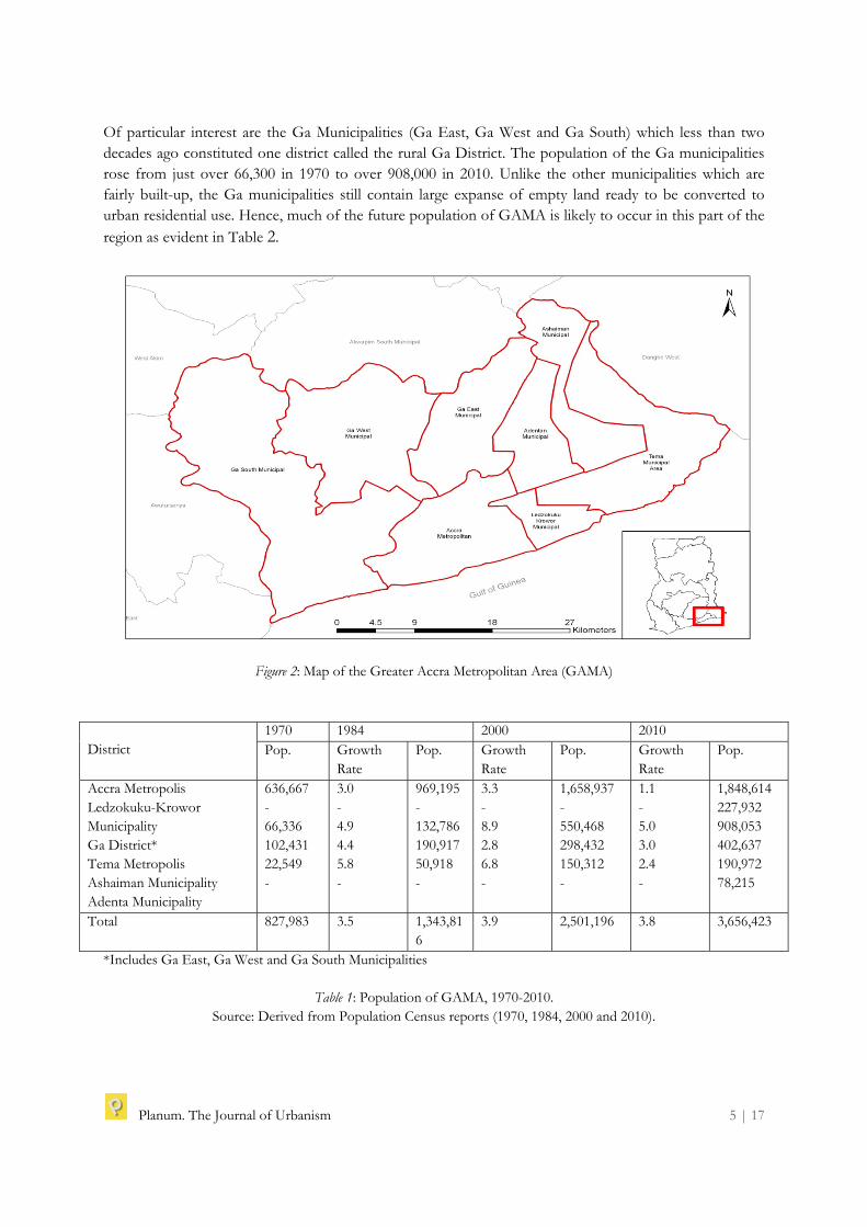
Growth and Expansion of Accra: What are the Driving Factors? The decision by the colonial British government in 1877 to relocate the administrative capital of Ghana (then Gold Coast) from Cape Coast to Accra is one of the most important factors in the development of GAMA (MLG/DTCP 1993a). Consequently, Accra has attracted significant public and private investments towards its infrastructural and services development over the years, making it the ‘most developed’ region in Ghana. Today, GAMA comprising the Accra Metropolis, Tema Metropolis and six other municipalities (Ga South, Ga East, Ga West, Adenta, Ashaiman and Ledzokuku Krowor) is the largest and the densest urban population concentrated area in Ghana. Though administratively defined as independent, the municipalities which were a few decades ago purely rural, are now geographically and functionally part and parcel of the built-up area of the Accra Metropolis – constituting the GAMA (see Fig. 2). The built-up of the surrounding municipalities is largely attributed to the spillover of the population of the Accra Metropolis (GSS, 2002). Even though Accra’s growth dates back several decades, the growth of the city seems to have picked up steam in the last three decades of economic liberalization and increased in the intensity of engagement with global capital (Grant and Nijman, 2002; Grant and Yankson, 2003; Owusu, 2008). Within the last three decades, the population of GAMA grew from almost 828,000 in 1970 to over 2.5 million in 2000 and over 3.6 million in 2010 (see Table 1). Increasingly, much of the population of the region is settling outside the Accra Metropolis, hence the sprawl of the metropolitan area. While the population of the Accra Metropolis was about 77% of the total population of GAMA in 1970, it declined to 72% in 1984 and about 50% in 2010. The growth of the metropolis was just 1.1% for the period 2000-2010, compared to 3.3% for 1984-2000. While the proportion of the total population in the Accra Metropolis within GAMA has declined dramatically, the share of the population in the surrounding municipalities have grown steadily.
Planum. The Journal of Urbanism 5 | 17
Of particular interest are the Ga Municipalities (Ga East, Ga West and Ga South) which less than two decades ago constituted one district called the rural Ga District. The population of the Ga municipalities rose from just over 66,300 in 1970 to over 908,000 in 2010. Unlike the other municipalities which are fairly built-up, the Ga municipalities still contain large expanse of empty land ready to be converted to urban residential use. Hence, much of the future population of GAMA is likely to occur in this part of the region as evident in Table 2.
Figure 2: Map of the Greater Accra Metropolitan Area (GAMA)
District
1970 1984 2000 2010 Pop. Growth
Rate Pop. Growth
Rate Pop. Growth
Rate Pop.
Accra Metropolis Ledzokuku-Krowor Municipality Ga District* Tema Metropolis Ashaiman Municipality Adenta Municipality
636,667 - 66,336 102,431 22,549 -
3.0 - 4.9 4.4 5.8 -
969,195- 132,786 190,917 50,918 -
3.3- 8.9 2.8 6.8 -
1,658,937 - 550,468 298,432 150,312 -
1.1 - 5.0 3.0 2.4 -
1,848,614227,932 908,053 402,637 190,972 78,215
Total 827,983 3.5 1,343,816
3.9 2,501,196 3.8 3,656,423
*Includes Ga East, Ga West and Ga South Municipalities
Table 1: Population of GAMA, 1970-2010. Source: Derived from Population Census reports (1970, 1984, 2000 and 2010).

Planum. The Journal of Urbanism 6 | 17
Community Growth Rate (%)Anyaa Awoshie Tantra Lashibi Amanfrom Gbawe Ogbojo Ashaley-Botwe Taifa Adenta West Dome Sakumono Ofankor New Achimota Pokuase Ashaiman Madina
37.532.7 25.9 25.5 23.6 22.2 22.1 21.1 20.3 19.1 16.9 16.7 14.3 14.0 19.1 6.8 6.2
City (Accra) 3.3
Table 2: Growth Rates of Selected Fringe Communities of Accra Metropolis, 1984-2000 Source: GoG/MLG&RD (2010)
Table 2 illustrates the contrast with respect to annual growth between the Accra Metropolis and urban settlements within the Municipalities or fringes of the city. While the annual growth rate of the Accra Metropolis and the average for the Ga municipalities for the period 1984 and 2000 was about 3.3% and 8.9% respectively, it was extremely high for fringe communities, especially those in the east and west of the metropolis. In these parts of GAMA, annual growth rates in excess of 20% are very common with Anyaa and Awoshie (all in Ga South Municipality) recording growth rates of well over 37% and 32% respectively. It is these high population growth rates and the unresponsiveness of city authorities which account for the massive sprawl and the under-serviced urban communities. Estimates indicate that the built-up area of GAMA increased from about 133 km² in the mid-1980s to over 344 km² in 2000. Within the same period, the average density (persons/km²) declined dramatically from about 14,120 per km² to about 8,103 persons per km² (Yeboah, 2009; GoG/MLG&RD, 2010). According to Owusu (2008), a number of interrelated factors or conditions at various spatial scales (global, national and cities local levels) accounts for the sprawl of Accra. Fig. 3 illustrates that, at the global level, economic globalization facilitated by the implementation of economic reforms in the mid-1980s, led to Ghana adopting an open-door policy towards global capital and its actors. This policy was reinforced in the early 1990s with the return to democratic constitutional rule – political liberalization. As a result, GAMA has attracted global capital and its actors, namely multi-national corporations, international NGOs, expatriates and international returned migrants – all seeking a foothold in GAMA (Owusu, 2008). In addition, the country’s open door policy within the Economic Community of West Africa (ECOWAS) protocol on free movement of people, civil strives in some West African countries and relatively stable economy have attracted a number of West African migrants (especially from Nigeria, Sierra Leone, Liberia and Cote d’Ivoire) into Accra.

Planum. The Journal of Urbanism 7 | 17
It needs to be stressed that the tendency for globalization to favour the concentration of economic activities, capital and people in large cities such as Accra, inevitably leads to pressure on land resources within and at the peripheries of these cities, and consequently city sprawl.
Figure 3: Analytical Framework of Spatial Levels and Factors Accounting for GAMA’s Sprawl (Source: Adapted from Owusu 2008, p. 181)
To the global factors are national and city/local factors which condition land use and planning and consequently city sprawl. In particular, either implicit or explicit Ghana has pursued a policy of concentration resulting in Accra becoming the hub and epicenter of socio-economic and political activities in the country. This has served to make Accra and GAMA as the most sought after destinations in Ghana. The influx of population to GAMA has been exacerbated by the national policy of compulsory land acquisition for public purposes2, and the absence of national and regional urban policy and spatial planning frameworks. Consequently, land is inefficiently and ineffective use resulting in low density development and open spaces in built areas, while there is constant search for land in fringe areas.
2 Although in terms of land mass, the Greater Accra Region is the smallest in Ghana, however, as result of the presence of the national capital, Accra Metropolis, the state has compulsorily acquired land for public uses in this region than any other region in the country (Owusu, 2008).
Global Level
National Level
City/Local Level
-Economic globalization and capital influx -Influx of MNCs and international NGOs - Inflow of expatriates/foreign migrants -International returned migrants (Ghanaian Diaspora)
-Economic liberalization -National policy of concentration -Land titling/registration -Policy of compulsory land acquisition for public purposes -Absence of regional spatial planning
-Urban growth (high rural-urban migration/natural population growth) -Road corridors development -Outmoded city planning and building codes (e.g. CAP 84) -Low rise buildings -Weak urban governance institutions -Weakened social-cultural networks and ties
City Sprawl - Leapfrog development -Ribbon development - Low density development - Uncontrolled outwards development

Planum. The Journal of Urbanism 8 | 17
At the city level, a number of factors related to the national level have exacerbated the sprawl of the city. The manifestation of interacting factors at the global and national levels leads in particular to land scarcity at the local level due to the influx and concentration of population as well as absence of strong land use and planning institutions. In particular, the management of urban areas in Ghana (including Accra) based on the Town and Country Planning Ordinance (Cap 84) passed in 1945 is quite striking. This ordinance transplanted from the British’s Town and Country Planning Act Ordinance of 1932 centring around planning schemes, layouts and more importantly minimum plot sizes of 70ft by 100ft, do not promote intensify development but low-rise buildings with large open spaces. In other words, the current urban management framework based on CAP 84 which may have been realistic in the 1950s of low urban growth and abundance of land is unrealistic under the current conditions of rapid urbanization and urban growth (Owusu, 2008), especially in large metropolitan areas such as GAMA. Another key factor at the city which has facilitated sprawl is the development of dualized road corridors in and out of the city of Accra. Many of these city road projects have been built with donor assistance, funds which were obtained as a result of the Ghana’s liberalized economy. Intensify peri-urban development tends to follow these road corridors by linking the city to other urban areas and rural surroundings. Three key road corridors are worth being mentioned, namely the Kwame Nkrumah Circle-Nsawam corridor (linking east of Accra); CBD-Mallam-Kasoa corridor (linking the west of the city) and; CBD-Madina-Aburi Corridor (linking the north-east of Accra) (see Fig. 4). These road corridors have been critical to the massive expansion of GAMA, especially to the east and west in recent years. According to Doan and Oduro (2011), improved roads make peri-urban development attractive to middle-class residents while at the same time allowing peri-urban residents to commute to the central city and other locations within the metropolitan area where their livelihoods are located.
Figure 4: GAMA’s Main Road Corridors

Planum. The Journal of Urbanism 9 | 17
Overall, the conditions driving sprawl are exacerbated by weak urban governance structures and institutional coordination. Even though the existing legal framework establishes the Metropolitan and Municipal Assemblies (local governments) as the main agents of urban development in Ghana, these institutions are very weak (GoG/MLG&RD, 2010). This is because the current system of decentralized planning still operates in a top-down fashion, and local governments lack both the capacity and the political will to plan, design, implement and monitor programmes and policies at the local level. As Doan and Oduro (2011) notes, planning functions in GAMA and elsewhere in urban Ghana, are severely hampered by the inability of local governments to direct physical development in an orderly manner, hence the unregulated and out of control sprawl of the region. As a result of the multiplicity of factors and conditions driving the sprawl of GAMA, the region exhibits the many different forms of sprawl as indicated in Fig. one. These include leapfrog, ribbon, low-density and uncontrolled outwards developments. Evidence exists to indicate that at all places within GAMA, developments have breached greenbelts and natural boundaries resulting in leapfrog sprawl. Also, there are strong developments along the main road corridors in and out of Accra reflecting ribbon development. However, leapfrog and ribbon sprawl are accompanied by a general pattern of low-density and uncontrolled outwards developments.
Containing the Sprawl: Urban Containment Strategies of GAMA Urban containment strategies for contemporary GAMA can be found in the Strategic Plan for the Greater Accra Metropolitan Area Volumes 1&2 and Summary Report (MLG/DTCP, 1993a, 1993b, 1993c). This plan prepared by the Accra Planning and Development Programme (APDP) in association with the United Nations Development Programme (UNDP) and the United Nations Centre for Human Settlements (UN-Habitat) covered a 10-year period, 1995-2005. The GAMA Strategic Plan projected that the population of GAMA will be about four million in 2010, which will in turn place severe strain on the demand for land for housing, industry, recreation, open-space, etc. The GAMA Strategic Plan examined five alternative concepts to contain and meet the needs of an expanding GAMA up to 2010 and beyond. These concepts were urban consolidation, multi-city structure, twin-city, satellite towns and laissez faire. Urban consolidation involves basically the freezing of urban development in peripheral areas of Accra by intensively utilizing land within the existing city boundaries. Key measures considered include the utilization of vacant lands or plots, redevelopment of selected old low-density inner city areas, infilling and upgrading of blight areas of Accra. A second concept to contain the sprawl of GAMA in the GAMA Strategic Plan was the concept of multi-city structure which meant the establishment of several cities within the metropolitan area, each with its own central business district (CBD) and servicing population of 250,000-300,000. The idea here was to decentralize economic activities from the existing well-established centres, namely Accra and Tema, and create four more centres at strategic locations with GAMA. The third urban containment strategy considered was the concept of satellite towns. This strategy was thought of to restrict the growth of Accra by directing future urban development consciously to potential growth centres such as Dodowa, Nsawam, Amasaman, Kasoa, etc – all within easy commuting distance from Accra. In other words, these towns will join Tema as towns prepared to absorb additional population from Accra, while Accra remained as the principal business centre but its physical growth curtailed (MLG/DTCP, 1993a).
Planum. The Journal of Urbanism 10 | 17
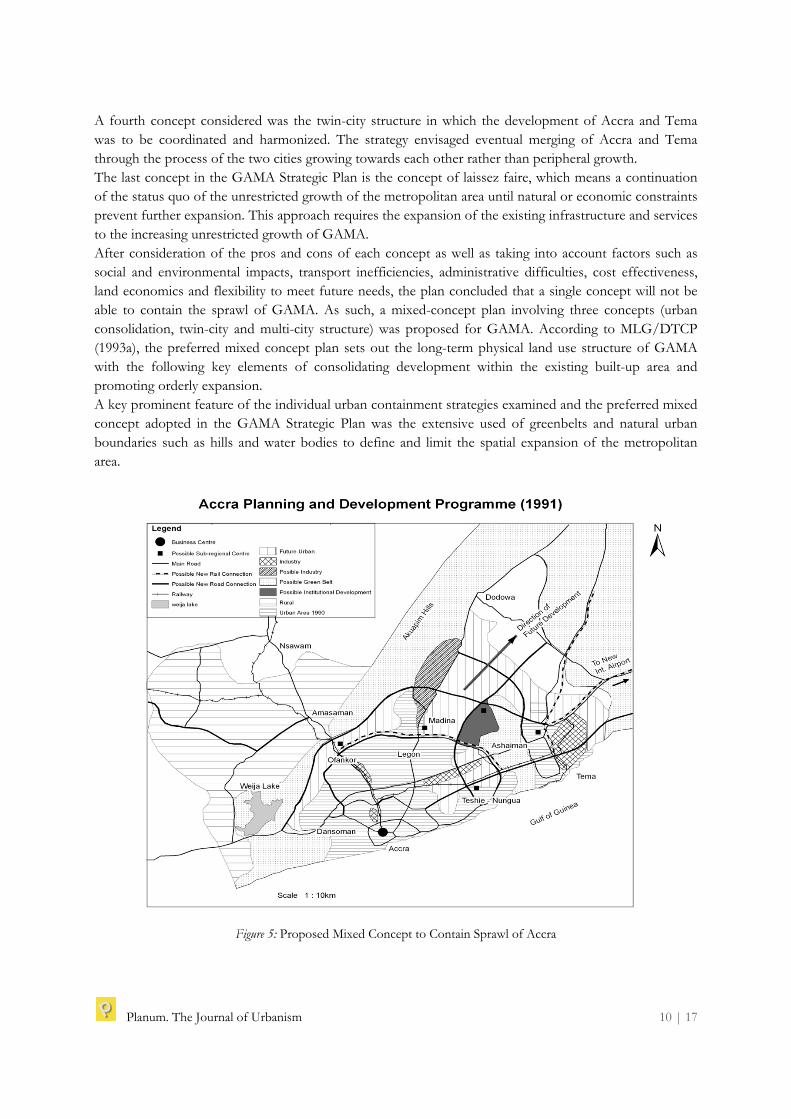
A fourth concept considered was the twin-city structure in which the development of Accra and Tema was to be coordinated and harmonized. The strategy envisaged eventual merging of Accra and Tema through the process of the two cities growing towards each other rather than peripheral growth. The last concept in the GAMA Strategic Plan is the concept of laissez faire, which means a continuation of the status quo of the unrestricted growth of the metropolitan area until natural or economic constraints prevent further expansion. This approach requires the expansion of the existing infrastructure and services to the increasing unrestricted growth of GAMA. After consideration of the pros and cons of each concept as well as taking into account factors such as social and environmental impacts, transport inefficiencies, administrative difficulties, cost effectiveness, land economics and flexibility to meet future needs, the plan concluded that a single concept will not be able to contain the sprawl of GAMA. As such, a mixed-concept plan involving three concepts (urban consolidation, twin-city and multi-city structure) was proposed for GAMA. According to MLG/DTCP (1993a), the preferred mixed concept plan sets out the long-term physical land use structure of GAMA with the following key elements of consolidating development within the existing built-up area and promoting orderly expansion. A key prominent feature of the individual urban containment strategies examined and the preferred mixed concept adopted in the GAMA Strategic Plan was the extensive used of greenbelts and natural urban boundaries such as hills and water bodies to define and limit the spatial expansion of the metropolitan area.
Figure 5: Proposed Mixed Concept to Contain Sprawl of Accra

Planum. The Journal of Urbanism 11 | 17
Fig. 5 is drawn based on the preferred mixed-concept of urban consolidation, twin-city and multi-city structure. It envisaged that the Weija Dam adjoined by hills and greenbelts would serve as the limit of the metropolitan area in the western direction. In the north and north-east, greenbelts and the foot of the Akwapim Hills would served as the limits of GAMA, while future urban development was envisaged to occur only in the east leading to the eventual merging of Accra and Tema. The Plan as captured in Fig. 5 proposed that future urban development to the east was expected to be complemented by infilling, redevelopment and upgrading of poor inner city areas within the existing built-up areas of the metropolitan area – urban consolidation. In addition, Accra and Tema would be developed separately (twin-city concept) while at the same time encouraging decentralization of economic activities from these centres to new potential growth points or CBDs such as Madina, Dansoman, Ashaiman, etc (multi-city structure). These developments were be facilitated by improved transportation networks (roads and rail), especially the construction of ring and orbital roads to link the east-west and north-south sections of GAMA.
Land Use
Year (Area in hectares)1990 2000 2010
Commercial Civil/Cultural Institutional/Special uses Residential Industrial Defence Major roads Transportation (terminal) Open space
1,650130 4,280 26,350 2,690 1,640 1,460 920 2,000
2,050150 5,550 33,380 5,190 1,640 1,950 920 11,250
2,250 180 6,980 41,940 7,690 1,640 7,200 1,200 12,550
Urban Total 41,120 62,080 81,630 Rural Total (%) 68 52 37
Table 3: Summary of Land Use Requirements
Source: MLG/DTCP (1993a, p. 49)
In terms of land size for various land uses, the GAMA Strategic Plan envisaged a required total land area of 129,250 ha (about 1292.5 km²) (see Table three). It was projected that by 2000, total urban land use will be 48% with 52% being rural; 63% and 37% by 2010. Based on an estimated average gross residential density for new development of 80 persons per hectare, a substantial proportion of the total urban land use was allocated to residential use which was projected to increase from 26,350 ha (263.5 km²) in 1990 to 33,380 ha (333.8 km²) in 2000 and almost 42,000 ha (420 km²) in 2010. Given the fact that the GAMA Strategic Plan sought among others to promote urban consolidation, it was interesting that a large amount of land was earmarked for residential development, open spaces, roads and transportation terminals, etc. In fact, as Table 3 indicates, total land use was expected to grow from 41,120 ha (411.20 km²) in 1990 to 62,080 ha (620.8 km²) in 2000 and 81,630 ha (816.3 km²) in 2010. It would suggest that large amount of land given to open spaces and roads runs counter to the plan’s intention to promote urban consolidation and compact development. Again, it is difficult to see how these proposed large land use allocations were going to be contained in the set boundary limits as illustrated in Fig. 5.
Planum. The Journal of Urbanism 12 | 17
Failure Planned Containment Strategy Two decades after the formulation and implementation of the GAMA Strategic Plan, the shape and size of GAMA revealed a metropolitan area growing and expanding in all directions except to the south which is occupied by the ocean, Gulf of Guinea. Today, the urban footprint of GAMA goes far beyond the limits set in the Strategic Plan. As indicated in Fig. five, from the west, GAMA stretches from Kasoa/Awutu-Senya District in the Central Region to Nsawam and the Aburi/Akwapim Hills (in the northeast) in the Eastern Region to Dodowa in the Dangme West District of the Greater Accra Region. In other words, the size of the metropolitan area to a large extent is better defined only by the regional administrative boundaries rather than greenbelts and natural urban boundaries (see Fig. 5). Why has the urban containment strategy failed to limit the spatial limits of the metropolitan area? In the following we analyzed a number of interrelated factors which account for this situation: Challenge posed by existing land management system The GAMA Strategic Plan acknowledged the challenges in land delivery and the difficulties in projecting the demand for land due to inadequate records as well as informal land acquisition processes in GAMA. However, a critical issue not properly highlighted in the Plan is the disconnection between land delivery for development purposes and planning. Key to this disconnection is the existing land management system (mode of land alienation and tenure) where land is held privately under customary institutions, while planning remains a public function for local governments with limited or no control over the ownership and the acquisition of land. According to Owusu et al. (2012), ineffective coordination, communication and harmonization between customary landholders and public planning agencies lead to a situation where chiefs and others dispose of land for purposes other than what it has been zoned for by planners. Like many regions in Ghana, land in GAMA is largely held or owned by chiefs and family heads. The normal process of land acquisition starts by prospective developers identifying vacant lands and then proceeding to negotiate for payment for leasehold titles, often 99 years for residential development and 50 years for other uses (Farvacque-Vitkovic et al., 2008). Due to delays in obtaining building permits and rent-seeking behaviours of public officials, developers hardly seek approval for permits from local government and the Department of Town and Country Planning (DTCP) as mandated by law before starting the development of their land (Gough & Yankson, 2000; Grant, 2009; Antwi & Adams, 2003; Owusu, 2008; Yeboah & Obeng-Odoom, 2010). Again, customary land owners are in many instances either ignorant of planning regulations and building bye-laws or show little appreciation for even the need for physical planning (GoG/MLG&RD, 2010) and therefore allocate land for development without reference, in most cases, to institutions like the DTCP and the local governments charged with planning, zoning, regulation and development control. The disconnection between land delivery for development and planning leads to physical development that is not in conformity with planning schemes (that is, where they exist) or to zoning and sub-division regulations that are supposed to guide the overall development of GAMA. Again, the weaknesses in the land delivery system result in a situation where vacant lands exist in inner city areas while there is intense competition for land beyond the built-up area contributing extensively to the sprawl of GAMA. Weak planning and development control institutions While the existing land management system contributes significantly to the sprawl of GAMA, the situation is exacerbated by weak planning and development control institutions.

Planum. The Journal of Urbanism 13 | 17
The Metropolitan and Municipal Assemblies are responsible for the overall planning and development of Ghanaian towns and cities. They are supported technically by the DTCP and other public land-sector agencies. However, many studies have described these institutions as weak and therefore unable to direct physical development in an orderly manner (Farvacque-Vitkovic et al., 2008; Doan & Oduro, 2011). An examination of planning schemes in GAMA reveals that many Municipalities do not even have schemes for many areas and where they exist are manually-developed and outdated. Thus, the existing planning schemes tend to bear little semblance to actual development on the ground. This situation is blamed on limited and outdated mapping equipment and inadequate trained and qualified staff. Again, weaknesses in development planning and control as a result of limited logistics and human resources are further exacerbated by cumbersome and non-transparent official building permit approval process. Therefore, frustrated land developers proceed with development without going through the existing cumbersome development permit application procedures (Yeboah & Obeng-Odoom, 2010). Since the Assemblies lack the personnel and other resources to enforce development controls, it is difficult to reverse unauthorized development once it starts. This situation contributes to the sprawl of GAMA. Metropolitan fragmentation Even though the GAMA region exists geographically and functionally as one contiguous entity, politico-administratively, it is fragmented into independent and separate autonomous local government areas. At the time of the preparation of the GAMA Strategic Plan, the region was made up of the AMA, Tema Municipal Assembly (including Ashaiman) and the Ga District. However, over the years these local government areas have been further sub-divided into eight independent and separate autonomous local government areas. As noted earlier, the Ga District is now made up of the Ga South, Ga West and Ga East. In addition, the Ashaiman and Adenta Municipal Assemblies have been carved out of the Tema Municipal Assembly while the Ledzokuku Krowor Municipal Assembly has been split from the AMA. The process of fragmentation of GAMA has hindered inter-local government cooperation (Owusu et al., 2012). Using solid waste disposal as an example, Owusu et al. (2012) demonstrate the difficulties encountered by the AMA to deal with waste in the Accra Metropolis partly as a result of the non-cooperation among local governments in GAMA. The politico-administrative fragmentation of GAMA as a result of the creation of several independent local governments is further compounded by the absence of enabling legislative instruments within Ghana’s Local Government Act, 1993 (Act 462) which allows local governments to work together. Thus, although Act 462 provides a framework to facilitate adjoining local government areas to coordinate and harmonize their development planning, subsidiary legislative instruments to activate some provisions of the law are not in place (GoG/MLG&RD, 2010). In addition, the Greater Accra Region lacks a regional spatial planning framework which allows districts within the region to align and harmonize their planning effort towards achieving a common development planning goal. At the moment, broad national development goals are implemented by the Assemblies through the preparation of development plans which include specific programmes, projects and activities which are relevant to the specific Assembly in question. Weak enforcement of plan While the GAMA Strategic Plan for the period mid-1990s to 2010 provides a comprehensive picture regarding the growth of the region, it is very difficult to assess the extent to which the provisions in the plan was aligned to programmatic expenditure patterns.
Planum. The Journal of Urbanism 14 | 17
This is reflected in the limited coordination between central government’s investments, especially development of road corridors, and the plan objectives in terms of curtailing sprawl. Accra and for that matter GAMA has attracted significant investments in the road sector, leading to the development of road major corridors. However, these road corridors have been constructed without due regard to their spatial implications for the sprawl of GAMA. Again, evidence over the plan period suggests there has not been significant attempt to decentralize investment and economic activities away from Accra as envisaged in the GAMA strategic plan. Like many countries in the developing world, central government is the key investor in infrastructure and services. The tendency to concentrate public investments development in Accra has led to a situation where private sector has also responded in similar fashion by concentrating private investments in the metropolitan area. This situation has persisted despite attempts through Ghana’s investments laws to promote decentralization of investments. Impact of Globalization Although the GAMA Strategic Plan was formulated at a time when Ghana and more specifically Accra has intensified its incorporation into the global economy, the plan failed to acknowledged this process and more importantly the implications of the process for the spatial development of GAMA. In other words, the plan seems to have taken cognisance of city/local and national factors to the neglect of the global conditions. Nevertheless, it has been widely accepted that recent urbanization trends in large cities in developing world are strongly characterized by an unprecedented scale of urban change which is strongly influenced by globalization than ever before (Cohen, 2004). In Ghana, GAMA is the favourite destination of global capital and its actors. For instance, between 2001 and 2008, the Greater Accra received about 84% of total direct foreign investment (including agriculture) in Ghana (ISSER, 2009). This has led to an increase in the number of multinational companies, UN and other international agencies and international NGOs using the metropolitan area as the national and/or West Africa headquarters. In addition, foreign and Ghanaian-owned real estate companies have been active in the region’s housing market for the last two decades. This has led to the development of gated communities and other housing estates mainly targeting foreign expatriates, the Ghanaian middle and upper classes as well as Diaspora Ghanaian community. The overall impact of global capital and its actors in GAMA is increasing pressure on land and housing due to scarcity and high prices. Within the context of weak land market and development, land speculation in peri-urban areas tends to be widespread, and consequently leading to ever expanding GAMA without proper services and infrastructure.
Conclusion Unlike other developing country cities where urban sprawl is triggered by a combination of peri-urbanized economic and residential activities, in the case of GAMA, peri-urbanization is mainly for residential development characterized by low-density development. This study assessed urban growth in GAMA, Ghana’s largest metropolitan area and the adoption of mixed-urban containment measure (urban consolidation, twin-city concept and multi-city structure approach) to curtail the sprawl. However, the present size and scale of GAMA suggests the failure of the containment strategy to limit the sprawl of GAMA. At the heart of the failed urban containment strategy of GAMA is the existing land management system. The policy issue here is that the existing land management system needs to be reformed to allow public control over the use of customary/privately-held lands.

Planum. The Journal of Urbanism 15 | 17
Until this situation changes, urban containment strategies seeking to explicitly limit the development of land outside the defined urban area are unlikely to succeed within the context of the existing land management system where land is held privately under customary institutions, while planning remains a public functions for local governments with limited control over the acquisition of land. In this direction, existing urban land reforms under the Land Administration Project (LAP) and the Draft Land Use and Spatial Planning Bill, 2011 – which seek to strength the capacity and enforcement roles of the DTCP and other public land sector agencies as well as local governments – need to be given serious attention. Large metropolitan areas of Ghana, such as GAMA, need particular attention in terms of land management, and planning and environmental management systems which involve the active participation of and collaboration with customary landholding institutions, as strongly proposed in recent national policy documents such as the new Decentralization Policy Framework and Action Plan and the draft National Urban Policy (NUP) and Action Plan. Within the context of strengthening urban governance, a much greater commitment to collaborative and deliberative approach to metropolitan regional planning is warranted to chart a growth management strategy for GAMA. In this new collaborative and deliberative approach to metropolitan regional planning, the active engagement of customary land owners must be of priority concern for public planning bodies.
Acknowledgements This study was made possible through the support of the International Development Research Centre (IDRC), Canada, under its Think Tank Initiative (TTI). However, the views expressed herein do not necessarily represent those of IDRC or its Board of Governors

Planum. The Journal of Urbanism 16 | 17
References Angel, S., Parent,J., Civco, D.L., Blei, A., Potere, D. (2011). ‘The Dimensions of Global Urban Expansion:
Estimates and Projections for all Countries’, 2000-2050. Progress in Planning, 75(2), 53-107. Antwi, A. Y., & Adams, J. (2003). ‘Rent-Seeking Behaviour and its Economic Costs in Urban Land
Transactions in Accra, Ghana; Urban Studies, 40, 2083-2098. Cohen, B. (2004). ‘Urban Growth in Developing Countries: A Review of Current Trends and a Caution
Regarding Existing Forecasts’, World Development, 32, 23–51. Doan,P., and Oduro, C.Y. (2011). ‘Patterns of Population Growth in Peri-Urban Accra’, Ghana.
International Journal of Urban and Regional Research. DOI:10.1111/j.1468-2427.2011.01075.x. Farvacque-Vitkovic, C., Raghunath, M., Eghoff, C., Boakye, C. (2008). ‘Development of the Cities of
Ghana: Challenges, Priorities and Tools’, Africa Region Working Paper Series No. 110, The World Bank. Glaeser, E. L., & Kahn, M. E. (2003). ‘Sprawl and Urban Growth’, Harvard Institute of Economic Research
Discussion Paper, Number 2004. GoG/MLG&RD. (2010), Draft National Urban Policy 2010. Accra Government of Ghana/Ministry of
Local Government and Rural Development. Gough, K.V., and Yankson, P.W.K. (2000). ‘Land Markets in African Cities, The Case of Peri-Urban
Accra, Ghana’, Urban Studies, 37, 2485-2500. Grant, R. (2009), Globalizing City. The Urban and Economic Transformation of Accra, Ghana’,( New York:
Syracuse University Press). Grant, R., and Nijman, J. (2002). ‘Globalization and the Corporate Geography of Cities in the Less
Developed World’, Annals of the Association of American Geographers, 92, 320-340. Grant, R., and Yankson, P. (2003), ‘Accra. Cities’, 20, 65-74. GSS. (2002), 2000 Population and Housing Census, Special Report on Urban Localities Accra (GSS). ISSER. (2009) The State of the Ghanaian Economy in 2008. (Accra: ISSER). Jaret, C., Ghadge, R., Reid, L.W., Adelman, R.M. (2009). ‘The Measurement of Suburban Sprawl’, an
Evaluation. City & Community 8(1), 65-84. Memon, P. A. (2003). ‘Urban Growth Management in Christchurch’, New Zealand Geographer 59(1), 27-39. MLG/DTCP. (1993a), Strategic Plan for the Greater Accra Metropolitan Area Volume 1. (Accra: MLG/DTCP). MLG/DTCP. (1993b), Strategic Plan for the Greater Accra Metropolitan Area Volume 2. (Accra: MLG/DTCP). MLG/DTCP. (1993c), Strategic Plan for the Greater Accra Metropolitan Area Summary Report. (Accra:
MLG/DTCP). Nelson, A.C., Sanchez, T.W., Dawkins, C.J. (2004). ‘The Effect of Urban Containment and Mandatory
Housing Elements on Racial Segregation in US Metropolitan areas’, 1990–2000. Journal of Urban Affairs 26(3): 339–350.
Owusu- G. (2008), ‘Indigenes and Migrants Access to Land in Peri-Urban Areas of Ghana’s largest City of Accra’, International Development Planning Review (IDPR), 30/2: 177-198.
Owusu, G., Oteng-Ababio, M., Afutu-Kotey, R. L. (2012), ‘Conflicts and Governance of Landfills in a Developing Country City Accra’, Landscape and Urban Planning 104/1 105-113 DOI: 10.1016/j.landurbplan.2011.10.005
Owusu, G. and Agyei, J. (2008), ‘Changes in Land Access Rights and Livelihoods in Peri-Urban Ghana’, The case of Accra, Kumasi and Tamale Metropolis ISSER Technical Publication No. 83. Accra: ISSER.
Siedentop, S. (2011),‘How to Cope with Urban Sprawl A Critical Discussion of the Urban Containment StrategyA presentation made at International Seminar on Sustainable Urban and Regional Planning’, University of Stuttgart May 6, 2011.

Planum. The Journal of Urbanism 17 | 17
UNFPA. (2007), UNFPA state of world population report 2007: Unleashing the Potential of Urban Growth. (New York: UNFPA).
Wasserman, M. (2000), ‘Urban Sprawl: American Cities just Keep Growing, Growing, and Growing’, Regional Review 10. http://www.bos.frb.org/economic/nerr/rr2000/q1/wass00_1.htm; accessed in 2012.
Wasserman, R. W.( 2008) ‘Causes of Urban Sprawl in the United States, Auto Reliance as Compared to Natural Evolution, Flight from Blight, and Local Revenue Relianc’,. Journal of Policy Analysis and Management, 27/3: 536-555.
Yeboah, K. (2009), ‘Urbanization in Ghana Past, Present and Future Perspectives. A Paper Presented at the Regional Sensitization Workshops on Formulating Ghana’s Urban Policy, Organized by the Ministry of Local Government and Rural Development’, (MLG&RD) at Four Regional Centres (Sekondi-Takoradi, Koforidua, Tamale and Kumasi), November-December 2009.
Yeboah, E., and Obeng-Odoom, F. (2010), ‘We are Not the Only Ones to Blame District Assemblies’ perspectives on the state of planning in Ghana’, Commonwealth Journal of Local Governance, 7/ 78-98.
Yin, M., and Sun, J. (2007), ‘The Impacts of State Growth Management Programs on Urban Sprawl in the 1990s’, Journal of Urban Affairs, 29/2: 149–179.