Cooperative Extension Service Monitor Fence Lines
7
1 Cooperative Extension Service | Agriculture and Natural Resources | Family and Consumer Sciences | 4-H Youth Development | Community and Economic Development University of Kentucky College of Agriculture, Food and Environment Cooperative Extension Service AEN-159 Using Drones to Monitor Fence Lines Josh Jackson, Biosystems and Agricultural Engineering Table 1. Annual average ownership and maintenance cost by fence type on a per-foot basis. Item Woven Wire Barbed Wire High Tensile Non- Electric (8 strand) High Tensile Electric (5 strand) Electrified Polywire Total Initial Cost/Foot $ 2.22 $ 1.70 $ 1.43 $ 1.02 $ 0.05 Estimated Useful Life (Years) 20 20 25 25 4 Average Annual Mainte- nance (% of Initial Cost) 8% 8% 5% 5% 5% Maintenance Cost/Foot/Year $ 0.18 $ 0.14 $ 0.16 $ 0.05 $ 0.01 Total Cost/Foot/Year * $ 0.38 $ 0.29 $ 0.18 $ 0.14 $ 0.08 *Includes depreciation, interest, and maintenance Adapted from Edwards et al., 2012 and adjusted 15 percent for inflation A drone’s-eye view of cattle resting in a field. FAA Part 107 Guidelines Pertinent Part 107 guidelines associated with the opera- tion of UAS for fence line monitoring: • Visual line of sight aircraft operation (VLOS). “With vision that is unaided by any device other than correc- tive lenses, the remote pilot in command, the visual observer (if one is used), and the person manipulating the flight control of the small unmanned aircraft system must be able to see the unmanned aircraft throughout the entire flight…” • Register UAS with FAA • Operate below 400 feet (ft) above ground level (AGL) • Daylight operations only • Perform preflight inspection. Weather, airspace, lo- cation of people and property, operating conditions, aircraft T here is an old saying that a good fence is pig tight, horse high, and bull strong. For livestock producers in Kentucky, the legal requirement for boundary fences is that the fences containing the livestock must be “strong and sound” (KRS. 256). A “strong and sound” fence is one that keeps the livestock where they should be. e responsibility for keeping livestock from damaging another individual’s property lies with the livestock producer. erefore, ensuring that the boundary fence is well maintained is essential for any livestock operation. Maintenance and monitoring of interior fences is also an essential task for livestock producers engaging in rotational grazing or managing separate groups and ages of livestock. Fences are one of the farm assets that must work 24/7. For instance, on a 50-cow beef operation annual fence ownership cost represents 5 percent of the total annual costs incurred. Depending upon the type of fence, the annual maintenance cost for fence varies between 5 and 8 percent of the initial costs. e average maintenance cost per foot of fence is shown in Table 1. e cost of inspection varies with the frequency of checking and terrain challenges. However, the cost of not checking can be the loss of valuable livestock and/or the cost of any lawsuits related to damages or injury that occurred. Monitoring fence lines can be a laborious task. Even on small farms, the distance of fence lines adds up quickly. Walking each fence line on a daily, weekly, or monthly basis is impractical for many producers. Even with the aid of all-terrain vehicles (ATVs) or utility vehicles (UTVs), the number of gates to open, streams or other wet areas to cross, and wooded areas to traverse, can be challenging. One potential option is to utilize a drone or unmanned aircraft systems (UAS) as defined by the Federal Aviation Administration (FAA). UAS can accomplish this ob- servation task and potentially speed up the process. UAS are tools which allow for the visualization of large amounts of area and can cover a lot of ground quickly. Using UAS to perform pertinent tasks on the farm constitutes a commercial application and therefore is subject to government regulations. Federal Aviation Administration (FAA) Regulations FAA Part 107 regulates the operation of small drones (less than 55 lb) for commer- cial purposes. A Remote Pilot Certification is required in this instance as fence line inspection on the farm is a commercial application. e Remote Pilot Certification is obtained by passing a knowledge test. e test covers rules associated with airspace, piloting, and other requirements for the safe operation of the UAS. Waivers can be obtained if there is a need to deviate from Part 107 regulations. Private pilots can obtain their remote pilot certification through an online training course.
Transcript of Cooperative Extension Service Monitor Fence Lines

1Cooperative Extension Service | Agriculture and Natural Resources | Family and Consumer Sciences | 4-H Youth Development | Community and Economic Development
University of KentuckyCollege of Agriculture,Food and EnvironmentCooperative Extension Service
AEN-159
Using Drones to Monitor Fence LinesJosh Jackson, Biosystems and Agricultural Engineering
Table 1. Annual average ownership and maintenance cost by fence type on a per-foot basis.
Item Woven
WireBarbed
Wire
High Tensile Non-
Electric(8 strand)
High Tensile Electric
(5 strand)Electrified Polywire
Total Initial Cost/Foot $ 2.22 $ 1.70 $ 1.43 $ 1.02 $ 0.05 Estimated Useful Life (Years) 20 20 25 25 4Average Annual Mainte-nance (% of Initial Cost)
8% 8% 5% 5% 5%
Maintenance Cost/Foot/Year $ 0.18 $ 0.14 $ 0.16 $ 0.05 $ 0.01 Total Cost/Foot/Year * $ 0.38 $ 0.29 $ 0.18 $ 0.14 $ 0.08
*Includes depreciation, interest, and maintenanceAdapted from Edwards et al., 2012 and adjusted 15 percent for inflation
A drone’s-eye view of cattle resting in a field.
FAA Part 107 GuidelinesPertinent Part 107 guidelines associated with the opera-tion of UAS for fence line monitoring:• Visual line of sight aircraft operation (VLOS). “With
vision that is unaided by any device other than correc-tive lenses, the remote pilot in command, the visual observer (if one is used), and the person manipulating the flight control of the small unmanned aircraft system must be able to see the unmanned aircraft throughout the entire flight…”
• Register UAS with FAA• Operate below 400 feet (ft) above ground level (AGL)• Daylight operations only• Perform preflight inspection. Weather, airspace, lo-
cation of people and property, operating conditions, aircraft
There is an old saying that a good fence is pig tight, horse high, and bull strong. For livestock producers in Kentucky,
the legal requirement for boundary fences is that the fences containing the livestock must be “strong and sound” (KRS. 256). A “strong and sound” fence is one that keeps the livestock where they should be. The responsibility for keeping livestock from damaging another individual’s property lies with the livestock producer. Therefore, ensuring that the boundary fence is well maintained is essential for any livestock operation. Maintenance and monitoring of interior fences is also an essential task for livestock producers engaging in rotational grazing or managing separate groups and ages of livestock. Fences are one of the farm assets that must work 24/7. For instance, on a 50-cow beef operation annual fence ownership cost represents 5 percent of the total annual costs incurred. Depending upon the type of fence, the annual maintenance cost for fence varies between 5 and 8 percent of the initial costs. The average maintenance cost per foot of fence is shown in Table 1. The cost of inspection varies with the frequency of checking and terrain challenges. However, the cost of not checking can be the loss of valuable livestock and/or the cost of any lawsuits related to damages or injury that occurred. Monitoring fence lines can be a laborious task. Even on small farms, the distance of fence lines adds up quickly. Walking each fence line on a daily, weekly, or monthly basis is impractical for many producers. Even with the aid of all-terrain vehicles (ATVs) or utility vehicles (UTVs), the number of gates to open, streams or other wet areas to cross, and wooded areas to traverse, can be challenging. One potential option is to utilize a drone or unmanned aircraft systems (UAS) as defined by the Federal Aviation Administration (FAA). UAS can accomplish this ob-servation task and potentially speed up the process. UAS are tools which allow for the visualization of large amounts of area and can cover a lot of ground quickly. Using UAS to perform pertinent tasks on the farm constitutes a commercial application and therefore is subject to government regulations.
Federal Aviation Administration (FAA) Regulations FAA Part 107 regulates the operation of small drones (less than 55 lb) for commer-cial purposes. A Remote Pilot Certification is required in this instance as fence line inspection on the farm is a commercial application. The Remote Pilot Certification is obtained by passing a knowledge test. The test covers rules associated with airspace, piloting, and other requirements for the safe operation of the UAS.
Waivers can be obtained if there is a need to deviate from Part 107 regulations. Private pilots can obtain their remote pilot certification through an online training course.

2
UAS Considerations Prior to obtaining a UAS, consider all the additional activities that it could be used for on the farm. The images collected by the drone could be used for evaluating stand counts, crop yield and quality esti-mations, weed and pest challenges, and irrigation issues. Careful consideration must be utilized for the UAS specifica-tions: flight time (duration), resolution of camera, ability to record images and video, costs, and flight controls.
Flight Time Flight time and range are important for the selection of the drone for fence line monitoring. For example, the 5,870 mAh battery in the DJI Phantom 4 allows for approximately 30 minutes of flight time. Wind and other factors play a role in the achievable flight time. Plan to reserve abundant remaining battery capacity during flights to land safely. Thus, 24 minutes would be a more realistic flight time. Although 24 minutes of flight time may allow everything of interest to be covered all at once, splitting the project into sections or multiple routes may be a safer approach in the event of an unforeseen circumstance. Plan different goals for different flights. For instance, one flight route could examine boundary fences, another could check interior polywire, and another could monitor water gaps and other areas of interest. That way, if time is limited, only essential flights on a given day are performed.
Image Resolution, Speed, and Altitude Relationship The resolution of the photos or video collected is important for the fence line evaluation, yet there are inherent tradeoffs when considering resolution, altitude, and speed. The higher the UAS is flown, the larger the observable area. For instance, approximately five acres are visible at 400 AGL (Figure 1) when using the DJI Phantom 4 with the camera oriented straight down. However, at the higher altitudes, the ability to evaluate the fence line and other specific aspects will be diminished.
Items Required for UAS Monitoring of Fence Lines• UAS, controller station (remote control) ($1,200-2,000), and additional bat-
teries for multiple flights • Micro SD cards (64 GB is typically the maximum size for most commercially
available drones)• Android or iOS tablet or mobile devices ($200-500)
• Most consumer drones will not work with a Windows tablet• Some UAS controller stations possess a screen, so another tablet or device
is not required• Install associated flight control apps
Flying lower (approximately 50 feet or less AGL) will improve the resolution, but the risk of encountering trees, power lines, buildings, or other objects dramatically increases. Similarly, the faster the UAS is flown, the more ground that can be covered. Nonetheless, spatial resolution depends on speed of travel and the ability of the camera frame rate to keep up with the increased speed. When flying in a field evaluating fence lines, speed and altitude must be cautiously controlled when first being utilized around animals who are not acclimated to the sight or sound of a UAS. Therefore, fly higher and slower initially to allow the animals to become acclimated to the sound and sight of the drone.
Cost of Flight The total initial cost of a UAS can be more than one might expect. In addition to the actual cost of the UAS itself (for instance, assume $1,500 for a DJI Phantom 4 V2), there are the costs of all associated accessories: display screen, spare propellers, spare batteries, micro SD cards, landing pad, and card reader. These UAS-related accesso-ries would potentially add an additional $1,000. Drone insurance to cover the hull and liability is approximately $600 annually. Taking the knowledge test to fly commercially is $150 (valid for two years). Study guides for the test cost approximately $20. The registration of the drone is $5 (valid for three years). In all, the license and cer-tificates cost $175.
Figure 1. Left: the UAS view at 400 ft AGL; the red circle identifies the cows at a mineral feeder. Right: the UAS at 50 ft AGL shows the cows at the same mineral feeder.

3
There is also the personnel cost as-sociated with flying a drone. The time spent flying the UAS is time that could be applied to other farm activities. Thus, a minimum value of $15 per hour was applied to this analysis. Assuming each flight has 5 minutes of preparation for takeoff/landing, 20 minutes of flight, and 25 minutes of video evaluation, the costs can add up quickly. The annual cost to charge the batteries is mostly negligible as it would cost less than $0.01 to charge the battery each time. Assuming a 5-year service life, $500 salvage value, and no additional software costs, the annual cost per flight is shown in Figure 2. Cost per f light decreases with increasing use of the drone. Thus, careful consideration about how the UAS would be utilized as well as how often it is employed is essential. While the cost per flight does decrease with an increasing average number of flights per week, the total annual cost only increases as shown in Figure 3 and is largely driven by the personnel cost.
UAS Flight Controls There are two main ways in which a UAS can be operated—direct manipu-lation of control sticks on the controller station and preprogramed flight controls. Both control methods currently require that VLOS is maintained.
Direct Manipulation With the direct manipulation of flight controls, commercially available UAS apps should allow for real-time live video output and recording options. If the re-mote pilot is watching the video feed, then a visual observer is required to maintain the VLOS requirement. Therefore, when flying alone, recording video and reviewing it afterward is the correct procedure. For this type of flight control, the repeatabil-ity of the flight will be dependent upon the skill of the remote pilot.
Preprogramed (Automated) Preprogrammed flight control, or automated control, can be performed by designing UAS GPS-waypoint designated naviga-tion patterns within commercially available apps for the UAS to follow. From a UAS control standpoint, waypoints are comprised of a set of latitude and longitude along with elevation and other UAS parameters (speed, camera pitch, camera orientation, etc.).
UAS waypoints are used to ensure similar flight patterns are flown every time. Again, if the remote pilot is watching the video feed, then a visual observer is required to maintain the VLOS requirement. Therefore, when flying alone, recording video and reviewing it afterward is the correct procedure. For mobile devices and tablets, there are a multitude of UAS-specific and third-party apps that can be used for creating waypoint flight routes for monitoring fence lines and points of interest. Some apps are operating system specific (iOS or An-droid); while other apps exist across both. Be cautious as some apps may exist on both platforms but have limited functionality on one of the operating systems. Most UAS flight control apps allow for either the creation of waypoints via digital map with the apps or the recording of waypoints during flight.
Figure 2. Total annual cost per UAS flight with three different labor costs con-sidered as wages would most likely vary between producers. The cost per flight decreases with the increasing number of flights as the input costs are spread out over more flights.
Figure 3. Total annual and personnel cost of UAS flights with labor cost at $15 per hour.
4
Considerations when Creating Preprogrammed Waypoints via Digital Maps The creation of waypoints via digital maps can be performed prior to the flight for each of the apps. For the digital map method, the waypoints are added to a satellite image map on the device and parameters such as speed, pitch, orien-tation, and other factors can be specified at each point. Err on the side of caution when setting up flight routes via digital maps. A limitation of the flight creation via digital map is that the safe distance to the actual tree line or view angle may not be represented perfectly on the map, requiring some adjustment after the flight. Test the manually created flight path in the field in order to avoid limbs, power lines, or other objects which may not have been immediately visible when creating the flight path on the digital map. It is essential to test and observe the flight path after creating it to ensure the safety of the aircraft and nearby objects. Be sure to understand how to abort the mission by using the app or by switching modes on the controller station.
Considerations when Creating Preprogrammed Waypoints via Recorded Flight Recording the flight path would be ideal for a field where there are large number of trees, power lines, building, or other hazards that would need be avoided in a specific manner. Try to fly at least 20 feet away from any obstacle as the UAS global navigation satellite system (GNSS) locational devices is accurate to within approximately 10 to 15 feet. When recording the flight, add waypoints immediately prior, along, and after the obstruction (such as trees or powerlines) to ensure that the obstruction will be cleared in the automated flight route. When recording the flight path directly fly in the location, orientation, and altitude that is desired (Figure 4). Various flight
Figure 4. Flight path shown in 2D on the left and 3D on the right. The 3D flight path on the right also shows the orientation of the camera.
Figure 5. The view from UAS flown directly above fence line (left). The view from the UAS being flown to the side of the same fence (right).
parameters are saved during the recording flight but can be modified prior to subsequent flights. Allocate plenty of time and battery power to recording the desired route. Flight speed is not imperative at this point, as this can be altered as needed during subsequent flight planning. For planned flights, some apps allow speed to be manually controlled: increase/decrease speed as needed during the flight, set to constant speed, or specific for each waypoint. Tailor the speed to the desired task.
Additional UAS Considerations Assuming VLOS is maintained, the UAS live video feed can be fed into a HDMI output module. The HDMI output module is typically not a standard feature for the controller station but can be added if desired. Switching to a HDMI output allows for the video output to be displayed on a larger screen or TV. Either way, maintain VLOS. For high tensile and woven wire fence lines with limited trees, flying directly over the fence when performing the evaluation may limit visibility. In each case, flying on either side may allow the remote pilot in command to discern fence features more easily (Figure 5).
5
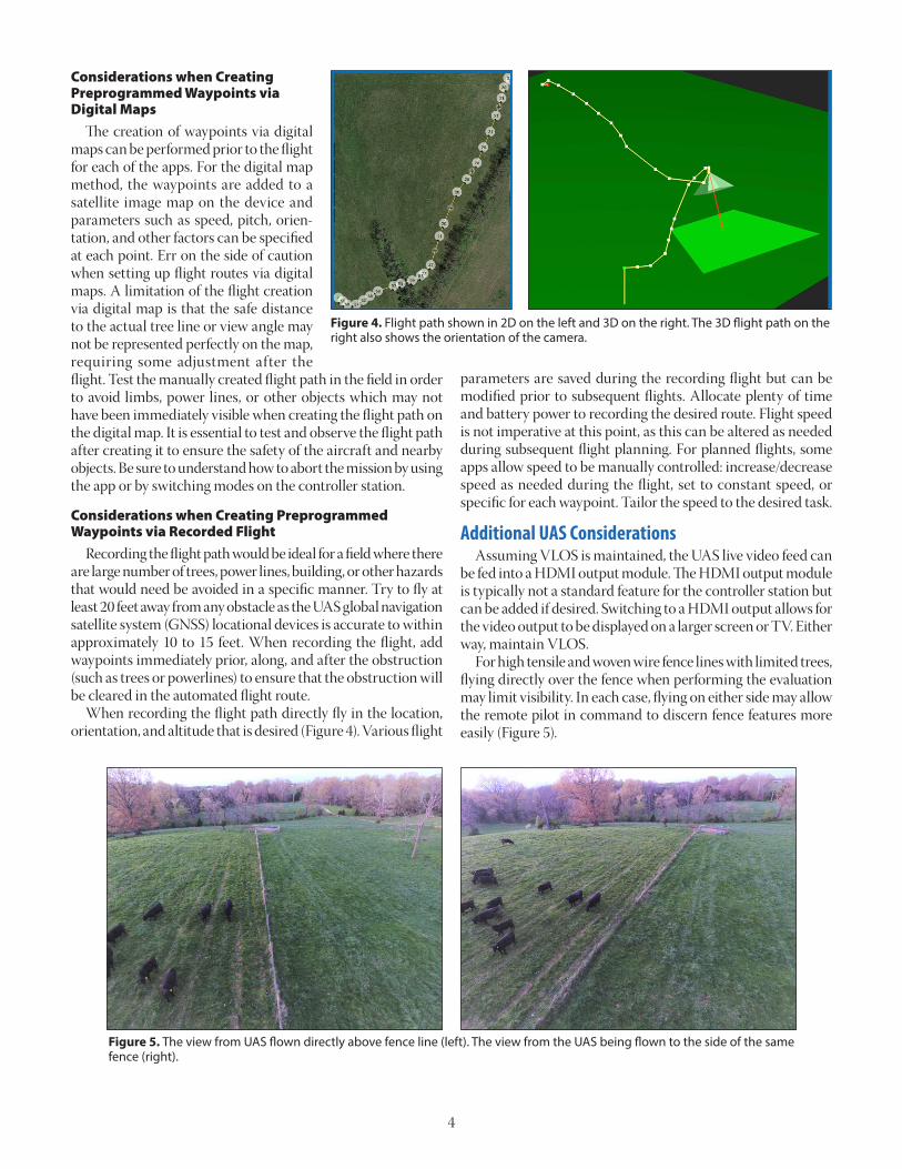
Takeoff and Landing Locations Verify in the UAS settings that the drone will return to designated takeoff/landing spot or follow another pre-planned action if the signal between the controller station and the UAS is disrupt-ed. The range at which the control station can operate will be influenced by weather conditions, large objects (hills), and other nearby devices such as WiFi or other signals in the 2.4 and the 5.8 GHz range. The use of a foldable launch pad is a standard protocol with multirotors UAS deployed from grass since the launch pad keeps the propeller blades out of the grass and lets low-altitude manned aircraft in the vicinity know that a UAS is likely nearby. If the takeoff and landing locations are going to be a different field than the designated flight path be sure that the altitude of approach to and from the takeoff/landing spot is appropriate to avoid trees and other hazards.
Limitations During the summer, densely vegetated sections may limit visibility from the drone. Fence lines surrounded by large number of trees or brush may not be visible at any time of year from the UAS. For these lines, the use of a UAS would be limited to potentially identifying that a tree has fallen. Single-strand wire separating different interior pastures may also be hard to vi-sualize even when flying at low altitudes. However, this can be partially ameliorat-ed with the use of ribbons/flags hung on the fence line (Figure 6). With the current regulations, UAS operations can typically only take place during daylight hours. In the U.S., this includes 30 minutes prior to official sun-rise and 30 minutes after sunset. Flying during sunrise or sunset can cause lens flares to appear in the images or video being collected. Lens flares can limit the ability to discern characteristics of the fence line being evaluated. If possible, orient the drone so that the sun is behind the camera. Different flight parameters may have to be set up for early morning and late evening flights.
Figure 6. The view from UAS flown above a single strand of wire with ribbons. The inset provides the view from the ground.
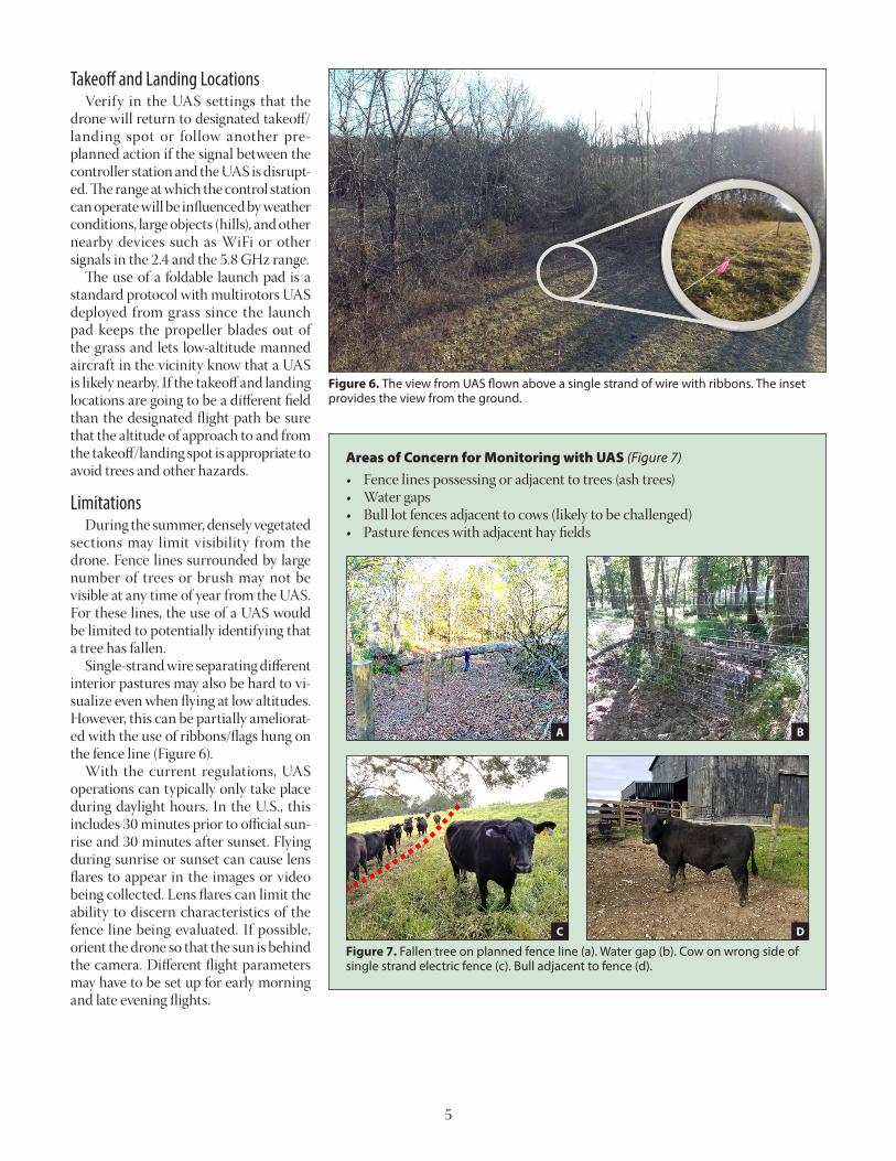
Figure 7. Fallen tree on planned fence line (a). Water gap (b). Cow on wrong side of single strand electric fence (c). Bull adjacent to fence (d).
Areas of Concern for Monitoring with UAS (Figure 7)• Fence lines possessing or adjacent to trees (ash trees)• Water gaps• Bull lot fences adjacent to cows (likely to be challenged)• Pasture fences with adjacent hay fields
A
C
B
D

6
Figure 8. UAS view of downed tree limb on fence after high wind event.
Figure 9. Neglected fence line where a UAS can be used to deter-mine when trees have fallen.
Frequency of Monitoring The frequency of checking a fence line will depend on several factors. Weather plays a huge role in determining when and if flights should be conducted. After a large storm event with high winds and/or heavy rains, checking boundary fences for downed trees and water gaps for washout issues is advisable (Figure 8). Time of year can also play a role in determining the frequen-cy of flying as well. Deer breeding season, when deer are most active (typically mid-November), would be a good time to more frequently check interior temporary fencing such as poly tapes and poly wires. Deer have been known to knock out several sections of temporary fencing during this time of year. For severely neglected fence lines, fast growing trees such as ashes have become relatively common, as shown in Figure 9. However, the emerald ash borer is having a major impact on the ash trees across the state. Ash trees infested with the emerald ash borer are dying and can fall on these neglected fence lines. Flying on a regular basis ensures that trees have not fallen and helps determine which trees need to be felled in the near future. Monitoring livestock on a daily (especially important during times of parturition) or weekly basis is typically advisable. If any of these searches demonstrate that livestock are missing from their designated fields, start trying to locate them. First search the entirety of the property. If the livestock are not located, contact your neighbors and request permission to search over their property. Once found, place the animals in a secure lot until all fencing issues have been resolved. A UAS can be used to aid in each step of the search process.
Example Flight for Fence Line Monitoring The flight path (Figure 4) for evaluating the single strand electric fence line with ribbons (Figure 6) was monitored in January and February of 2020 with a DJI Phantom 4 V2. The flight route was recorded and subsequently flown using vari-ous apps. The 1,200 feet of fence line observed by the UAS was flown in approximately 1 to 3 minutes (depending upon the flight speed) (Figure 10). The average time to walk the fence line was approximately 5 minutes. While the UAS does save time in covering the distance of the fence line, time is required for preflight/postflight preparations and analysis of video. Thus, the UAS provided no time savings for evaluating the 1,200-foot section of fence. However, the potential to save time during the evaluation of longer fence lines or multiple fence lines is there, as preflight/postflight preparations would already be considered. Time savings should be greater for longer distances of fence. From a time standpoint, approximately 7,300 feet of fence line is required for the UAS to break even with manual inspection (walking). Table 2 shows the minimum break even UAS speed of 7.5 mph required to cover the 7,300 feet and account for the preflight/postflight preparations and analysis of video. The ex-pedited monitoring of multiple fence lines should free up time to perform other pertinent tasks on the farm.
Figure 10. Flight route for the 1,200-foot section of fence line.
Similarly, using an ATV or UTV, the 1,200-foot distance could be covered in a similar timeframe as the drone. However, any portion of fence that goes through a section of trees would still require evaluation to be conducted on foot. The use of the UTV would require a similar number of gates to be opened and closed. UAS use in adjacent fields would result in fewer gates being opened/closed, saving some time. Furthermore, the UAS would also result in fewer tracks being made through the field. Inclement weather will restrict the ability to fly, but after a rain event, flooded waterways could be flown over instead of crossed. There may be other site-specific factors for each farm which may augment or impair the justification for the use of a UAS for fence line monitoring.
Summary The feasibility of UAS for fence line monitoring needs to be carefully evaluated by each livestock enterprise considering the purchase. The cost associated with UAS flights for monitoring must be determined to be less than that required by walking or other means. The potential for time savings exists when flying multiple fence lines. If a UAS is determined to be an economical-ly viable option for fence line inspection, UAS-associated rules and regulations must be followed. Furthermore, fight paths must be carefully considered. Rather than coming up with a flight path based on a digital map, flying it manually and recording the path so that it can be repeated is the safest approach. Site-specific factors may aid or impair the effectiveness of the UAS to evaluate fence lines. A UAS is another tool that could be used to ensure that livestock are within a well-maintained fence.
Acknowledgments This work was supported by the USDA National Institute of Food and Agriculture under Grant No. 2018-67021-27416 and through the Multistate Project S1069 (accession No. 1015710).
ReferencesEdwards, W., Chamra, A., Mayer, R., and Olsen, T., 2012. Es-
timated costs for livestock fencing. Iowa State Publication File B1-75, Ames, Iowa. www.extension.iastate.edu/agdm/livestock/pdf/b1-75.
Electronic Code of Federal Regulations. 2020. Part 107—Small Unmanned Aircraft Systems. https://www.ecfr.gov/cgi-bin/text-idx?SID=dc908fb739912b0e6dcb7d7d88cfe6a7&mc=true&node=pt14.2.107&rgn=div5#se14.2.107_131.
Kentucky General Assembly. 2020. Kentucky Revised Statutes: KRS Chapter 256. https://apps.legislature.ky.gov/law/statutes/chapter.aspx?id=38469.
Thompson, L.J., Y. Shi, R. Ferguson. 2018. Getting Start-ed with Drones in Agriculture. University of Nebras-ka-Lincoln Extension. http://extensionpubs.unl. edu/publication/9000019610474/ getting-started-with-drones-in-agriculture-g2296/.
Educational programs of Kentucky Cooperative Extension serve all people regardless of economic or social status and will not discriminate on the basis of race, color, ethnic origin, national origin, creed, religion, political belief, sex, sexual orientation, gender identity, gender expression, pregnancy, marital status, genetic information, age, veteran status, or physical or mental disability. Issued in furtherance of Cooperative Extension work, Acts of May 8 and June 30, 1914, in cooperation with the U.S. Department of Agriculture, Nancy M. Cox, Director of Cooperative Extension Programs, University of Kentucky College of Agriculture, Food and Environment, Lexington, and Kentucky State University, Frankfort. Copyright © 2021 for materials developed by University of Kentucky Cooperative Extension. This publication may be reproduced in portions or its entirety for educational or non-profit purposes only. Permitted users shall give credit to the author(s) and include this copyright notice. Publications are also available on the World Wide Web at www.ca.uky.edu.
Issued 2-2021
Table 2. Break even distance and speed required for UAS fence line inspection to be preferential to manual inspection.
Duration (Minutes)
Distance of Fence Line Inspected (feet)
Walking at 3.1 MPH
UAS Flight at 7.5 MPH
1 270 Preflight Preparation 2 540
3 8104 1080 6605 1350 13206 1620 19807 1890 26408 2160 33009 2430 3960
10 2700 462011 2970 528012 3240 594013 3510 660014 3780 726015 4050 Postflight
Preparation 16 432017 4590 Video Analysis18 486019 513020 540021 567022 594023 621024 648025 675026 702027 7290
Mention or display of a trademark, proprietary product, or firm in text or figures does not constitute an endorsement and does not imply approval to the exclusion of other suitable products or firms.