Coombabah Lakelands Conservation Area, Arundel … · adjacent to Tee Trees Boulevard, Arundel. The...
31
Coombabah Lakelands Conservation Area, Arundel Section Community Engagement Report FINAL Prepared by Promedia Public Relations
Transcript of Coombabah Lakelands Conservation Area, Arundel … · adjacent to Tee Trees Boulevard, Arundel. The...
Coombabah LakelandsConservation Area,
Arundel SectionCommunity Engagement Report
FINAL
Prepared by Promedia Public Relations

Document version Author Edited by Date
Version 1 Ryan Ellem 19 February 2013
Version 2 Ryan Ellem 21 February 2013
Version 3 Ryan Ellem 22 February 2013
Version 4 Karen Irwin 15 March 2013
Disclaimer
This report has been prepared by Promedia Public Relations for its client, Gold Coast City Council. Promedia has undertaken research, analysed information and prepared the report in good faith. Promedia accepts no responsibility for decisions made or actions undertaken as a result of the contents of this report.

Page | i
ContentsExecutive Summary .......................................................................................................................... 1
Section 1 – Introduction .................................................................................................................... 3
Section 2 – Communications and Engagement................................................................................ 4
2.1 Engagement methodology ...................................................................................................... 4
2.1.1 The wider community........................................................................................................ 4
2.1.2 Directly affected residents ................................................................................................ 4
2.1.3 Adjacent landowners ........................................................................................................ 5
2.2 Communications methodology ................................................................................................ 5
2.2.1 Communication with Residents ........................................................................................ 6
Section 3 – Findings ......................................................................................................................... 8
3.1 Demographics ......................................................................................................................... 8
3.2 Nature conservation values..................................................................................................... 8
3.3 Management of wetlands ........................................................................................................ 9
3.3.1 Directly affected stakeholder meetings........................................................................... 10
3.4 Recreational infrastructure .................................................................................................... 11
3.4.1 Importance of recreational infrastructure ........................................................................ 11
3.4.2 Information Session............................................................................................................ 16
3.4.3 Other suggestions........................................................................................................... 18
3.5 Recreational connections to and throughout the site ............................................................ 23
3.5.1 Response to connection options..................................................................................... 23
3.5.2 Adjoining residents and connections from streets .......................................................... 25
3.6 Other comments.................................................................................................................... 26
Section 4 – Engagement evaluation ............................................................................................... 27
Section 5 – Conclusion ................................................................................................................... 28

Page | 1
EXECUTIVE SUMMARY Gold Coast City Council conducted an eight week engagement program from December 2012 to January 2013 to determine what the community would like for the future of a 64 hectare site adjacent to Tee Trees Boulevard, Arundel.
The site, Coombabah Lakelands Conservation Area - Arundel Section, was purchased by Council in February 2012. The purchase was part of Council's wider Nature Conservation Strategy, which identifies areas of high significance and public benefit for nature conservation.
After acquiring the site, Council undertook preliminary assessment of the site to determine opportunities and constraints, including stormwater flows, wetlands and habitats. The preliminary assessment enabled Council's project team to identify areas which could host recreational infrastructure, enhance natural attributes and facilitate stormwater areas.
Council did not want to undertake detailed assessment of the area without prior engagement with the local community particularly as the site had strong associations as a potential golf course under its previous owner. With the information gathered from the preliminary assessment, Council was able to approach the community with concepts and gather their input regarding the future of the site.
The intent of the community engagement program was to: alert the community and stakeholders to the consultation program and the opportunity to have
its say inform the community and stakeholders of the reasons for Council’s purchase of the site, and
how it was relevant to Council’s Nature Conservation Strategy communicating negotiable and non-negotiable (based on environmental constraints) aspects
associated with the site determine the community’s preference for Council to manage the site, including its water
bodies learn to what extent the community wants to develop or enhance the site in relation to aesthetic
values, recreational opportunities, environmental values and built infrastructure
Response
A genuine effort was made to engage the community including a community information session; meetings with directly affected stakeholders; and a presentation to adjacent landowners. Advertising, direct mail and signage and online information promoted the engagement process and opportunities.
While all consultation is encouraged city-wide, this program did target a group of 970 landowners in the 64 hectare site’s catchment area. In total, the consultation program attracted an adequate response rate by receiving:
123 survey responses five written submissions / comments provided to the consultation email 155 visits to the project webpage, including 145 unique visitors 120 attendees at the community information session.
The community information session participation rate of 120 participants from the 970 properties direct mail targeted in the catchment area (approximately 10 per cent) was adequate and demonstrates that the community is interested in being consulted with on this issue.
Due to the engagement period including the Christmas and New Year holiday period, consultation was extended to an eight week period. An additional direct mail piece (the postcard) was mailed to the catchment area in the third week of January reminding residents of the survey close on 31 January 2013. Survey response rates around this date indicate it was a useful reminder tool.

Page | 2
Key findings
Key findings about the community and their preferences to use and enjoy the site included:
93 per cent of respondents placed a very important or important value on the site's conservation values
respondents would like the area to be maintained to celebrate its environmental attributes, with 76 per cent indicating they would like water bodies to be rehabilitated for birdlife and to filter stormwater
respondents indicated low-impact recreational infrastructure, such as walking trails and concrete paths(85.6 per cent), mown grass buffers to properties (78.2 per cent) and informal picnic areas (63.64 per cent) were very important or important to them
high impact recreational options such as playgrounds (52.51 per cent) and formalised picnic areas (49.49 per cent) were not important to them
between 53 per cent and 58.71 per cent of respondents rated formalised access into and throughout the site, as well as a walkway / bikeway across Coombabah Creek to Westfield Helensvale as very important or important to them.
The findings offer a level of validation for Council's decision to purchase the site for conservation purposes. It is important to note, however, that while respondents advocated preservation of the site, they were still interested in introducing low-scale infrastructure, such as formal paths, to enjoy the Conservation Area.
The feedback provided through this consultation process is being provided to Council for consideration in their decision making regarding the development of a future Master Plan for the Coombabah Lakelands Conservation Area, Arundel Section. As the current level of information is conceptual, it is recommended that the community be consistently informed about the future and ongoing work within the site with regards to proposed location and types of infrastructure, wetlands and vegetation management areas as well as timing associated with works programs.

Page | 3
SECTION 1 – INTRODUCTION In February 2012, Gold Coast City Council resolved to purchase a 64 hectare site in Arundel adjacent to Tee Trees Boulevard.
The site was originally a residential golf course development.
Council purchased the site via the Open Space Preservation Levy (OSPL) land acquisition program.
The purchase was influenced by the site's inherent natural values, including: its location within the Moreton Bay to Clagiraba Critical Wildlife Corridor its proximity to existing Council managed lands and its corridor link between the Coombabah
Lakelands Conservation Area and Nerang National Park its wetlands and habitat values, which are important to threatened species including the koala
and white-bellied sea eagle its boundary with Coombabah Creek, which is recognised as an important fish habitat area,
linking with Coombabah Lake and Moreton Bay Marine Park, an internationally listed Ramsar wetland site and declared Fish Habitat Area.
In addition, Council also investigated the opportunity of incorporating recreational opportunities that would not significantly compromise the areas natural values.
Council recognised that engaging residents impacted by the proposed golf course-estate development was integral to determining the most appropriate future and management of the site which would be embraced by the community. Effective engagement not only provides Council with clarity on the public's preferences for the site; it also encourages the community to take ownership and pride in the area.
Council developed a consultation program which engaged directly and indirectly affected stakeholders within the Tee Trees estate and wider Arundel - Parkwood catchments. The community was invited to have its say over an eight week consultation period between late 2012 and early 2013.
This report details the consultation methodology, the key findings from the community engaged through the consultation process, and the recommendations for future planning of the site.

Page | 4
SECTION 2 – COMMUNICATIONS AND ENGAGEMENT Gold Coast City Council developed a communications and engagement program which enabled the public - from directly to indirectly affected stakeholders and the wider community - to have its say on the future of the Coombabah Lakelands Conservation Area, Arundel Section. Vital to the communications and engagement program was the availability of the project team, inclusivity of the engagement process and channels for feedback.
2.1 Engagement methodology
As mentioned in Section 1, when the original developer went into receivership after the approved development plan for the site to become a golf-course was abandoned.
Community engagement was required to ascertain the level of public preference for options for the site. A suite of options along a spectrum of development impacts taking into consideration the opportunities and constraints of the site were put forward to the community through a variety of community engagement techniques.
2.1.1 The wider community
It was determined to engage the wider community through an Information Session hosted on-site on 8 December 2012 where the community learned about the constraints and opportunities of the site, discussed the future of the site with the project team, and provided feedback.
Information Day attendees nominating their preferred recreational opportunities
Attendees viewing the proposals
2.1.2 Directly affected residents
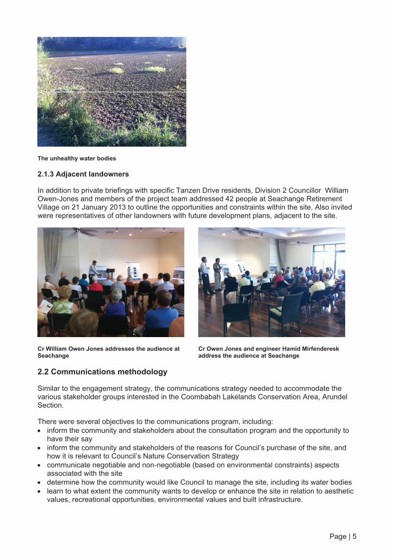
Several residents on the northern and western side of Tanzen Drive border the Conservation Area site. Several residents live adjacent to water bodies which were developed as part of early works for the golf course.
Over time, the water bodies had become overgrown with weeds; water quality was impacted by high nutrient build-up and not constructed to be sustainable. Council determined the management of the water bodies required a specific strategy and engaged neighbouring residents to consider specific options. Meetings were conducted with interested residents, who are directly affected, in the first week of December 2012.
Page | 5
The unhealthy water bodies
2.1.3 Adjacent landowners
In addition to private briefings with specific Tanzen Drive residents, Division 2 Councillor William Owen-Jones and members of the project team addressed 42 people at Seachange Retirement Village on 21 January 2013 to outline the opportunities and constraints within the site. Also invited were representatives of other landowners with future development plans, adjacent to the site.
Cr William Owen Jones addresses the audience at Seachange
Cr Owen Jones and engineer Hamid Mirfenderesk address the audience at Seachange
2.2 Communications methodology
Similar to the engagement strategy, the communications strategy needed to accommodate the various stakeholder groups interested in the Coombabah Lakelands Conservation Area, Arundel Section.
There were several objectives to the communications program, including: inform the community and stakeholders about the consultation program and the opportunity to
have their say inform the community and stakeholders of the reasons for Council’s purchase of the site, and
how it is relevant to Council’s Nature Conservation Strategy communicate negotiable and non-negotiable (based on environmental constraints) aspects
associated with the site determine how the community would like Council to manage the site, including its water bodies learn to what extent the community wants to develop or enhance the site in relation to aesthetic
values, recreational opportunities, environmental values and built infrastructure.

Page | 6
2.2.1 Communication with Residents
A range of communication options were developed to promote the community engagement: a direct mail distributed to 970 properties (occupiers and absentee owners) in the 64 hectare
site’s catchment area, promoting the information session on 8 December 2012, online survey and consultation opportunities
a banner, erected on-site at Tee Trees Boulevard on 4 December 2012, advising passing motorists and residents of the information session
On-site banner, promoting the information day
an advertisement in the Gold Coast Sun’s Northern Edition (published 5 December 2012) promoting the consultation process, the Information session and the Council website (goldcoastcity.com.au/teetrees)
a poster, promoting the consultation process, at Arundel Plaza, between 7 December 2012 and 31 January 2013.
Arundel Plaza poster

Page | 7
a Frequently Asked Questions sheet addressing the key objectives (produced in hard copy for the information day and display at Helensvale Library, and soft copy for the website)
an online resource (goldcoastcity.com.au/teetrees) where the community could learn about the site, read the FAQs, and provide feedback through a project email and an online survey (the same as the hard copy)
a postcard, mailed to the catchment area (owners and residents) on 21 January 2013, advising of the closure of the consultation period on 31 January 2013 and encouraging them to provide feedback
a direct mail letter to Tanzen Drive residents on 21 November 2012 offering them the opportunity of a one to one briefing between 3 – 7 December 2012.
Examples of communications collateral are available in Appendix 1.
Page | 8
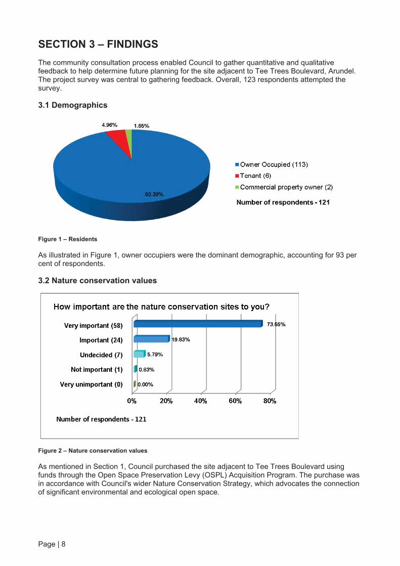
SECTION 3 – FINDINGS The community consultation process enabled Council to gather quantitative and qualitative feedback to help determine future planning for the site adjacent to Tee Trees Boulevard, Arundel. The project survey was central to gathering feedback. Overall, 123 respondents attempted the survey.
3.1 Demographics
Figure 1 – Residents
As illustrated in Figure 1, owner occupiers were the dominant demographic, accounting for 93 per cent of respondents.
3.2 Nature conservation values
Figure 2 – Nature conservation values
As mentioned in Section 1, Council purchased the site adjacent to Tee Trees Boulevard using funds through the Open Space Preservation Levy (OSPL) Acquisition Program. The purchase was in accordance with Council's wider Nature Conservation Strategy, which advocates the connection of significant environmental and ecological open space.

Page | 9
Council wanted to determine if the community also recognised the natural attributes of the purchased site. As represented in Figure 2, 93.4 per cent of respondents believed the nature conservation values of the site were either 'very important' or 'important'.
3.3 Management of wetlands
Respondents were asked within the survey: "Existing wetlands and waterways perform a number of roles, including stormwater and flood management and habitat for birds. How would you like Council to manage the wetlands in the future?" Responses to the question are detailed below in Figure 3.
The original development plan for the site included the construction of numerous water bodies throughout the site. Many of the water bodies that had been constructed were partially completed or at various stages of construction. In addition, the site - including the adjacent Coombabah Creek is within the Moreton Bay to Clagiraba Critical Wildlife Corridor - also contains wetlands and habitat important to threatened species including the koala and whitebellied eagle.
Figure 3 – Management of wetlands
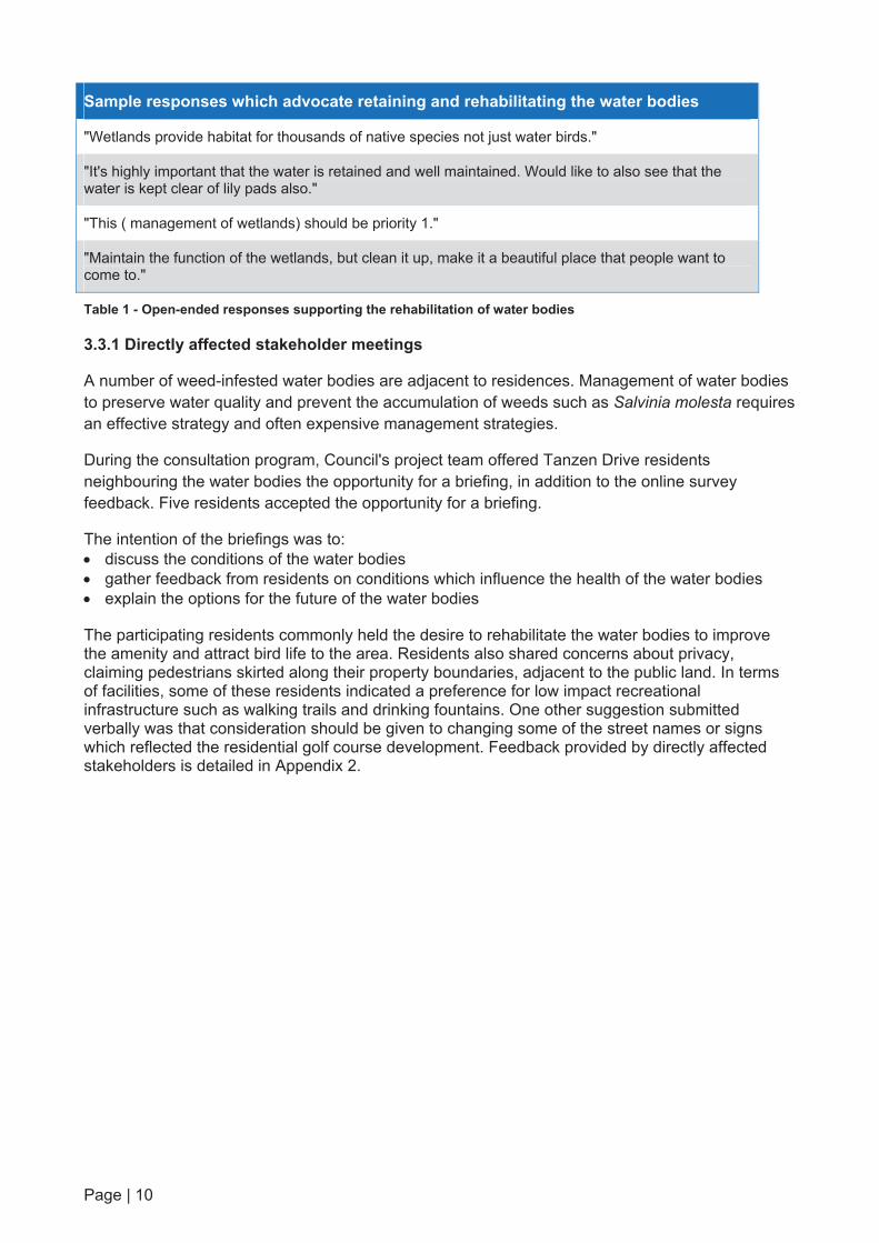
Just over 76 per cent of respondents indicated a preference for the maintenance and enhancement of existing wetlands and surrounding vegetation throughout the site for habitat and stormwater management. Some residents qualified their preference by listing the wetlands as the highest priority for the site (See Table 1).
Correspondingly, 15.25 per cent of respondents believed Council should manage the water bodies to primarily offer stormwater solutions. Less than 10 per cent of respondents opted to fill in some wetlands and install underground stormwater pipes.
Open-ended comments provided by respondents echoed the quantitative response, as seen in Table 1.
Sample responses which advocate retaining and rehabilitating the water bodies
"We need to get the lakes back to normal so the birds etc have their habitat back !!"
"The lakes along Tanzen Drive need cleaning and deepening. There were a lot of birds in the past and now the area looks dead and unfriendly. Would love to see the birds return."
"Wetlands should be of main concern for the amount of birds and also wildlife as there are quite a number of Kangaroos."
"Weed removal, providing swimming area for birds and fish, crabs etc"
Page | 10
Sample responses which advocate retaining and rehabilitating the water bodies
"Wetlands provide habitat for thousands of native species not just water birds."
"It's highly important that the water is retained and well maintained. Would like to also see that the water is kept clear of lily pads also."
"This ( management of wetlands) should be priority 1."
"Maintain the function of the wetlands, but clean it up, make it a beautiful place that people want to come to."
Table 1 - Open-ended responses supporting the rehabilitation of water bodies
3.3.1 Directly affected stakeholder meetings
A number of weed-infested water bodies are adjacent to residences. Management of water bodies to preserve water quality and prevent the accumulation of weeds such as Salvinia molesta requires an effective strategy and often expensive management strategies.
During the consultation program, Council's project team offered Tanzen Drive residents neighbouring the water bodies the opportunity for a briefing, in addition to the online survey feedback. Five residents accepted the opportunity for a briefing.
The intention of the briefings was to: discuss the conditions of the water bodies gather feedback from residents on conditions which influence the health of the water bodies explain the options for the future of the water bodies
The participating residents commonly held the desire to rehabilitate the water bodies to improve the amenity and attract bird life to the area. Residents also shared concerns about privacy, claiming pedestrians skirted along their property boundaries, adjacent to the public land. In terms of facilities, some of these residents indicated a preference for low impact recreational infrastructure such as walking trails and drinking fountains. One other suggestion submitted verbally was that consideration should be given to changing some of the street names or signs which reflected the residential golf course development. Feedback provided by directly affected stakeholders is detailed in Appendix 2.
Page | 11
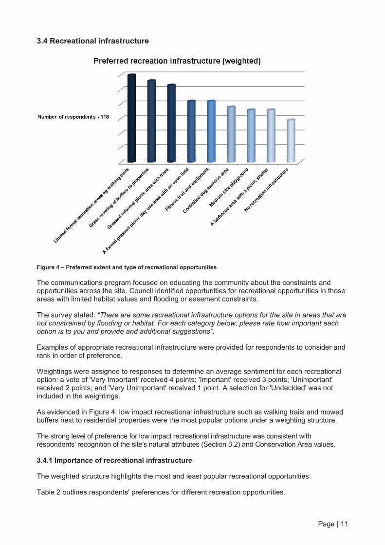
3.4 Recreational infrastructure
Figure 4 – Preferred extent and type of recreational opportunities
The communications program focused on educating the community about the constraints and opportunities across the site. Council identified opportunities for recreational opportunities in those areas with limited habitat values and flooding or easement constraints.
The survey stated: “There are some recreational infrastructure options for the site in areas that are not constrained by flooding or habitat. For each category below, please rate how important each option is to you and provide and additional suggestions”.
Examples of appropriate recreational infrastructure were provided for respondents to consider and rank in order of preference.
Weightings were assigned to responses to determine an average sentiment for each recreational option: a vote of 'Very Important' received 4 points; 'Important' received 3 points; 'Unimportant' received 2 points; and 'Very Unimportant' received 1 point. A selection for 'Undecided' was not included in the weightings.
As evidenced in Figure 4, low impact recreational infrastructure such as walking trails and mowed buffers next to residential properties were the most popular options under a weighting structure.
The strong level of preference for low impact recreational infrastructure was consistent with respondents' recognition of the site's natural attributes (Section 3.2) and Conservation Area values.
3.4.1 Importance of recreational infrastructure
The weighted structure highlights the most and least popular recreational opportunities.
Table 2 outlines respondents' preferences for different recreation opportunities.

Page | 12
Very important Important Undecided Unimportant Very
unimportant
Grass mowing of buffers to residential properties 52 40 12 6 8
Limited formal recreation areas eg walking trails 50 45 10 4 2
Level grassed informal picnic area with shade trees 38 36 7 25 10
A formal grassed picnic day use area with an open field 23 23 12 40 17
A barbecue area with a picnic shelter 19 32 14 27 22
Controlled dog exercise area available on the site 19 25 11 19 40
Medium size playground with swing and slide combination 15 19 19 30 29
Fitness trail and equipment 14 38 11 29 20
No recreation infrastructure 14 16 27 12 34
Table 2 - Tabulated responses (recreational preferences)
As the following Figures indicate, recreational opportunities that were informal, carry a low-impact and moderate level of usage (Figures 5-7) were preferred over infrastructure carrying a larger footprint which would facilitate higher use of the site (Figures 8-12).
3.4.1.1 - Walking trails
Figure 5 – Walking trails
Walking trails were the most popular recreational option among respondents, attracting an 85.60 per cent response rate as very important/important. Five per cent of respondents indicated walking trails were unimportant / very unimportant.
Page | 13
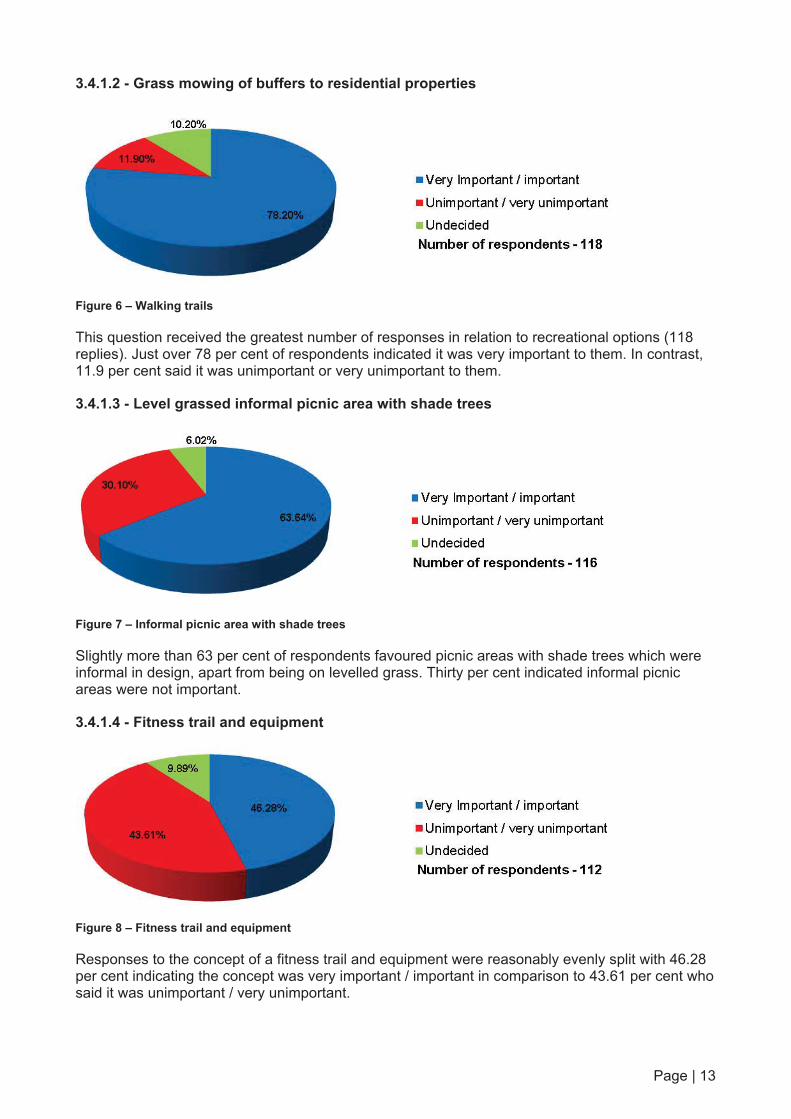
3.4.1.2 - Grass mowing of buffers to residential properties
Figure 6 – Walking trails
This question received the greatest number of responses in relation to recreational options (118 replies). Just over 78 per cent of respondents indicated it was very important to them. In contrast, 11.9 per cent said it was unimportant or very unimportant to them.
3.4.1.3 - Level grassed informal picnic area with shade trees
Figure 7 – Informal picnic area with shade trees
Slightly more than 63 per cent of respondents favoured picnic areas with shade trees which were informal in design, apart from being on levelled grass. Thirty per cent indicated informal picnic areas were not important.
3.4.1.4 - Fitness trail and equipment
Figure 8 – Fitness trail and equipment
Responses to the concept of a fitness trail and equipment were reasonably evenly split with 46.28 per cent indicating the concept was very important / important in comparison to 43.61 per cent who said it was unimportant / very unimportant.

Page | 14
3.4.1.5 - Barbecue area with picnic shelter
Figure 9 – Barbecue area with picnic shelter
Opinion was fairly evenly split between those respondents who preferred a barbecue area with picnic shelter and those who did not.
3.4.1.6 - Formal grassed picnic area with open field
Figure 10 – Formal grassed picnic area with open field
Almost 50 per cent of the respondents indicated that a proposed formal grassed picnic area with open field was not important to them. This compares with 40.02 per cent who said it was very important / important.
3.4.1.7 - Controlled dog exercise area
Figure 11 – Controlled dog exercise area
Almost 52 per cent rated a controlled dog exercise area as unimportant or very unimportant. In contrast, almost 39 per cent indicated it was very important or important to them.

Page | 15
3.4.1.8 - Medium size playground with swing and slide combination
Figure 12 – Medium size playground with swing and slide combination
As represented in Figure 12, 52.51 per cent thought it was 'unimportant' or 'very unimportant' to include a playground within the Conservation Area. This quantitative rating was also supported by qualitative statements (see Section 3.6). This compares with 30.26 per cent who indicated a medium size playground with swing and slide was very important or important.
3.4.1.9 - No recreational infrastructure
Figure 13 – No recreational infrastructure
There were a large percentage of 'undecided' respondents in Figure 13 which has undermined the benefit of the data. However, more respondents indicated that having no recreational infrastructure was unimportant or very unimportant to them (44.62 per cent) than those who felt if very important or important (29.13 per cent). This response could be interpreted that the community would prefer some level of recreational opportunities within the Conservation Area, as opposed to closing it off completely. This conclusion is supported by previous questions (3.4.1.1, 3.4.1.2 and 3.4.1.3) responses which indicated a preference for low-impact infrastructure as opposed to high-impact facilities.

Page | 16
3.4.2 Information Session
On 8 December 2012, the project team hosted an information day on site at Tee Trees Boulevard.
Approximately 120 community members attended the day, from 8am-12pm.
Community members and the project team discussed a wide range of issues, including: how the site came to be in Council's possession the different kinds of wildlife and birdlife around the site the process of approval and timing for any works on the site the details of development approvals adjacent to the site the flow of stormwater across the site spaces for dogs on the site the range of recreational infrastructure which could be introduced to the site constraints and opportunities on the site
In addition, visitors to the Information session were encouraged to prioritise their preferred recreational options on a display board. Visitors chose a red sticker for their first preference, blue for their second and green for their third preferences.
The display board listed eight options: an informal picnic area with shade trees a fitness trail and equipment concrete pathway access from all adjoining streets and access points a playground a formal picnic day use area grass mowing of buffers to residential properties limited formal recreation areas eg walking trails water features - habitat for waterbirds
The display board was also presented to 42 residents who attended an audience briefing at Seachange Retirement Village on 21 January 2013.
At the end of the consultation process, the display board appeared as illustrated in the following photograph.

Page | 17
Colour coded preferences from information day and Seachange presentation
As seen in the photograph, the concrete pathway access attracted the most number of red dots (first preferences). The preference for pedestrian infrastructure was consistent with the survey responses, which listed low impact infrastructure such as walking trails as the highest priority.

Page | 18
Indeed, concrete pathways received the most number of votes overall, followed by water features for birds and grass mowing of buffers. While the placement of preferential dots on the display boards was not quality controlled, the results are still worth examining in Table 3.
Red (3) Blue (2) Green (1)
Concrete pathway access from all adjoining streets and access points 52 14 17
Water features - habitat for waterbirds 38 21 18
Grass mowing of buffers to residential properties 43 16 14
Limited formal recreation areas eg walking trails 26 23 17
Fitness trail and equipment 11 5 6
Informal picnic area with shade trees 8 11 12
Playground 3 9 11
A formal picnic day use area 2 7 11
Table 3 - Recreational preferences from information day and Seachange presentation
Similar to the survey, those who ranked recreational preferences on the display board placed a playground as a low priority. A formal picnic area likewise attracted a low level of preference.
Attendees at the information session and Seachange Retirement Village presentation preferred concrete surfaces to walking trails on the sticker display board - a result which was reversed in the online survey and feedback form. This may be attributed to the demographics of this group of respondents and their recreational preferences.
3.4.3 Other suggestions
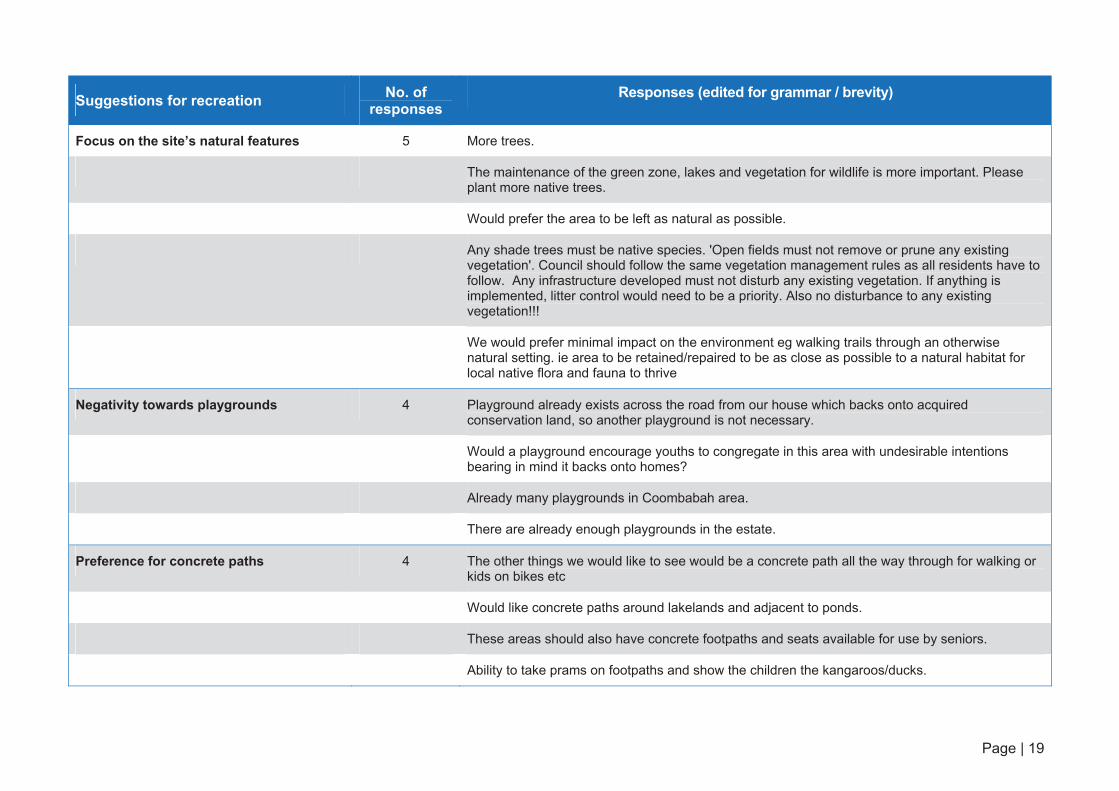
Respondents were also encouraged to provide other ideas for recreational infrastructure, which are detailed in Table 4 on the following pages. Again, preservation of the natural environment was the highest priority.
Page | 19
Suggestions for recreation No. of responses
Responses (edited for grammar / brevity)
Focus on the site’s natural features 5 More trees.
The maintenance of the green zone, lakes and vegetation for wildlife is more important. Please plant more native trees.
Would prefer the area to be left as natural as possible.
Any shade trees must be native species. 'Open fields must not remove or prune any existing vegetation'. Council should follow the same vegetation management rules as all residents have to follow. Any infrastructure developed must not disturb any existing vegetation. If anything is implemented, litter control would need to be a priority. Also no disturbance to any existing vegetation!!!
We would prefer minimal impact on the environment eg walking trails through an otherwise natural setting. ie area to be retained/repaired to be as close as possible to a natural habitat for local native flora and fauna to thrive
Negativity towards playgrounds 4 Playground already exists across the road from our house which backs onto acquired conservation land, so another playground is not necessary.
Would a playground encourage youths to congregate in this area with undesirable intentions bearing in mind it backs onto homes?
Already many playgrounds in Coombabah area.
There are already enough playgrounds in the estate.
Preference for concrete paths 4 The other things we would like to see would be a concrete path all the way through for walking or kids on bikes etc
Would like concrete paths around lakelands and adjacent to ponds.
These areas should also have concrete footpaths and seats available for use by seniors.
Ability to take prams on footpaths and show the children the kangaroos/ducks.

Page | 20
Suggestions for recreation No. of responses
Responses (edited for grammar / brevity)
BBQ facilities 4 No barbeque facilities nearby, so this would be great. Would be good to have picnic tables/bbq for community/neighbourhood gatherings such as Australia Day to get to know neighbours - doesn't happen much these days.
Picnic areas and BBQ preferred.
Would also like BBQ area with shelters.
The area most suited to any picnic/recreation infrastructure I feel would be the area between Christina Ryan Way, Tee Trees Blvd and numbers 30-46 Golden Bear Dr as there is close access from the street and you wouldn't be destroying any natural beauty as it currently looks like a construction site!
Walking trails 3 Walking trails would be great.
I like the idea of a fitness trail/ walking path, not so much for the equipment though.
Pedestrian links to Driftwood Park.
Clearing vegetation from rear boundaries 3 The most important aspect for infrastructure is the grass mowing of buffers to residential properties, this is very important.
Remove bushfire fuel (particularly at my rear boundary).
Maintained and mowed regularly.
Dog exercise areas 3 We desperately need an off-leash dog area in this area. Most residents have dogs - if not on this site maybe one of the many unused playgrounds in the area.
Exercise area for dogs would be wonderful as yards are so small and there are no areas nearby.
Whole area open to dogs on leashes. Due to traffic and parking problems in the area this is an ideal opportunity to allow residents to walk, ride and exercise animals in a safe environment.

Page | 21
Suggestions for recreation No. of responses
Responses (edited for grammar / brevity)
High impact trails 2 Dedicated horse riding, mountain bike riding, four wheel drive and trail bike tracks like Mt Mee in Brisbane.
Make dedicated 4WD and motor bike trails available.
Positivity towards a skatepark 1 Skateboard park would be good for the kids in the area as there is not much for them to do in Arundel.
Negativity towards a skatepark / trail path 1 No skateboard parks or trail bike tracks please.
Improvements to lighting 1 Can we please have adequate lighting so this does not become a crime area - unlike the surrounding streets where the street lighting is appalling.
Nine hole golf course 1 9 Hole par 3 golf course.
Model the site on Rosser Park 1 Model it similar to Rosser Park - we bought here thinking it would be a golf course estate - not an overgrown dumping ground.
Table 4 - Other suggestions for recreation
Page | 23
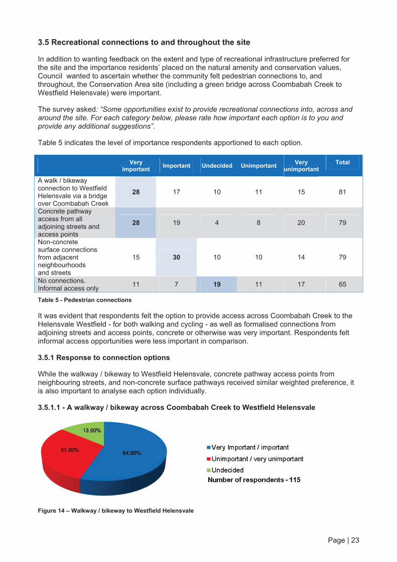
3.5 Recreational connections to and throughout the site
In addition to wanting feedback on the extent and type of recreational infrastructure preferred for the site and the importance residents’ placed on the natural amenity and conservation values, Council wanted to ascertain whether the community felt pedestrian connections to, and throughout, the Conservation Area site (including a green bridge across Coombabah Creek to Westfield Helensvale) were important.
The survey asked: “Some opportunities exist to provide recreational connections into, across and around the site. For each category below, please rate how important each option is to you and provide any additional suggestions”.
Table 5 indicates the level of importance respondents apportioned to each option.
Very important Important Undecided Unimportant Very
unimportant Total
A walk / bikeway connection to Westfield Helensvale via a bridge over Coombabah Creek
28 17 10 11 15 81
Concrete pathway access from all adjoining streets and access points
28 19 4 8 20 79
Non-concrete surface connections from adjacent neighbourhoods and streets
15 30 10 10 14 79
No connections. Informal access only 11 7 19 11 17 65
Table 5 - Pedestrian connections
It was evident that respondents felt the option to provide access across Coombabah Creek to the Helensvale Westfield - for both walking and cycling - as well as formalised connections from adjoining streets and access points, concrete or otherwise was very important. Respondents felt informal access opportunities were less important in comparison.
3.5.1 Response to connection options
While the walkway / bikeway to Westfield Helensvale, concrete pathway access points from neighbouring streets, and non-concrete surface pathways received similar weighted preference, it is also important to analyse each option individually.
3.5.1.1 - A walkway / bikeway across Coombabah Creek to Westfield Helensvale
Figure 14 – Walkway / bikeway to Westfield Helensvale

Page | 24
Almost 55 per cent of respondents indicated that a pedestrian connection to Westfield Helensvale across the Coombabah Creek was very important or important to them. Just over 31 per cent said it was ‘unimportant’ or ‘very unimportant’.
3.5.1.2 - Concrete pathways from all adjoining streets and access points
Figure 15 – Concrete pathway access from neighbouring streets
Responses about concrete connections from neighbouring streets and access points to the Conservation Area were comparable to the very important and important rankings received for the connection to Westfield Helensvale, with 53.15 per cent indicating that was an important to them in comparison to 39.63 per cent who rated it not important.
3.5.1.3 - Non-concrete surface connections from adjacent streets
Figure 16 – Non-concrete surface connections
Non-concrete surface walkways from adjacent streets received the highest very important or important ranking of all the recreation connection options.
When comparing the responses to the various surface options, it was evident that respondents were less equivocal in their assessment of concrete, than non-concrete, materials.
While the response received for the options (58.71 per cent for non-concrete and 53.15 per cent for concrete) was comparable, the lack of importance was not (27.52 per cent for non-concrete compared to 39.63 per cent for concrete).
Therefore, while respondents to the survey favoured designated connections, they displayed a greater inclination for lower-impact surfaces.

Page | 25
3.5.1.4 - No connections: informal access only
Figure 17 – No connections
Most respondents (45.83%) thought that it was unimportant/very unimportant to have no connections throughout the site. Just over 31 per cent thought it was very important / important that there be no connections. A higher number of responses (than was received on other survey questions) showed that people were undecided as to whether connections are required throughout the park (22.92 per cent).
3.5.2 Adjoining residents and connections from streets
As noted in Section 3.5, the majority of respondents replied designated connections from adjoining streets, whether it be concrete or otherwise, were important to them.
A number of residents in Tanzen Drive told the project team, during private meetings, that security between rear property boundaries and the site was a common concern. By establishing designated connections into the site, residents may, potentially, consider their privacy would be further impacted.
This feedback encouraged the community consultation team to examine in detail whether the designated connections were less important to neighbouring residents than other respondents.
Analysis was undertaken of respondents who lived in directly neighbouring streets: Tanzen Drive (11 respondents) Golden Bear Drive (10) Tiger Drive (10) Christina Ryan Way (15) Napper Road (35)
The analysis indicated several differences in responses from residents neighbouring the site compared with the wider pool, including: Napper Road residents placed greater importance on non-concrete surfaces (78.50 per cent
compared with 58.70 per cent) and no connections (45.10 per cent compared to 31.25 per cent) Tanzen Drive respondents indicated a greater importance on non-concrete surfaces (80 per
cent compared with 58.70 per cent) and placed less importance on connections (12.50 per cent compared to 45.83 per cent)
Golden Bear Drive respondents placed lower importance on concrete surfaces (60 per cent compared with 39.63 per cent) and placed less importance on no connections (25 per cent compared with 45.83 per cent)
Christina Ryan Way respondents placed lower importance on non-concrete surfaces (46.62 per cent compared with 58.70 per cent) and less importance on no connections (66.60 per cent compared with 45.83 per cent)
Tiger Drive respondents placed less importance on having no connections (60 per cent compared with 45.83 per cent)
Page | 26
In summary, the directly impacted Napper Road and Tanzen Road residents greatly preferred non-concrete paths and no connections reinforcing qualitative comments voicing concern about privacy and security issues. However Christina Ryan Way and Tiger Drive prefer concrete paths.
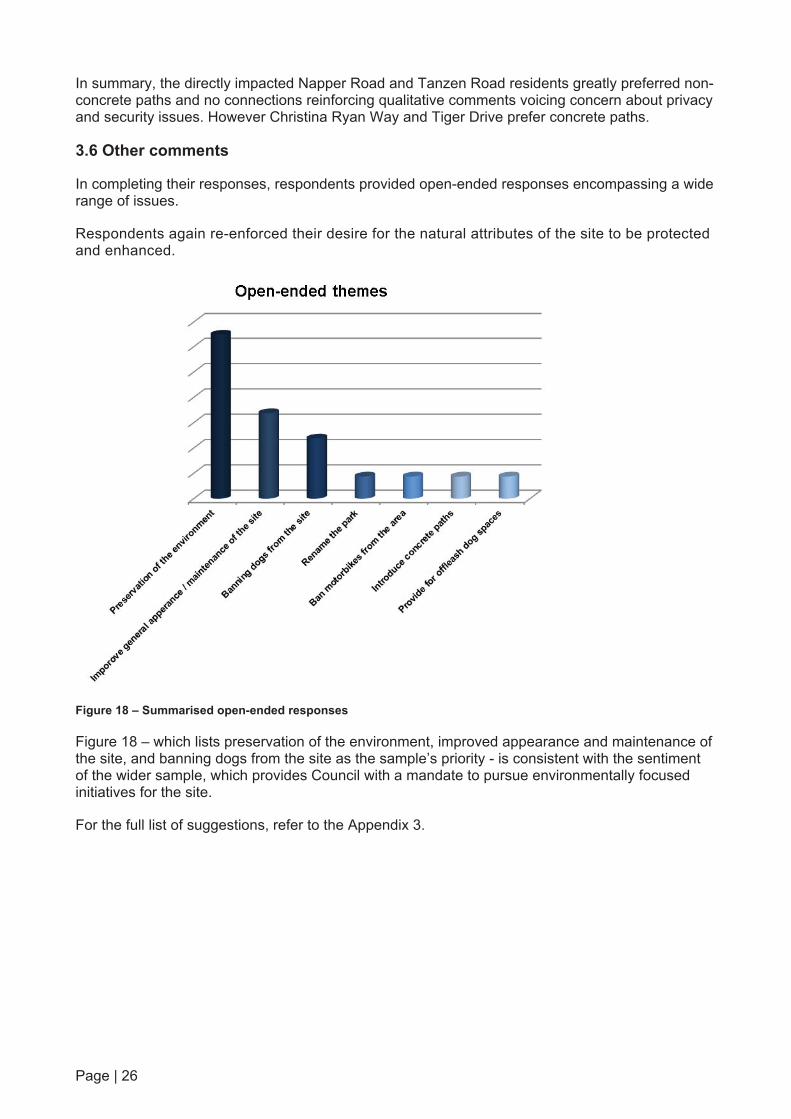
3.6 Other comments
In completing their responses, respondents provided open-ended responses encompassing a wide range of issues.
Respondents again re-enforced their desire for the natural attributes of the site to be protected and enhanced.
Figure 18 – Summarised open-ended responses
Figure 18 – which lists preservation of the environment, improved appearance and maintenance of the site, and banning dogs from the site as the sample’s priority - is consistent with the sentiment of the wider sample, which provides Council with a mandate to pursue environmentally focused initiatives for the site.
For the full list of suggestions, refer to the Appendix 3.

Page | 27
SECTION 4 – ENGAGEMENT EVALUATION The program achieved its engagement objectives (refer Executive Summary) by: promoting the consultation program to stakeholders via a wide variety of communication
channels including direct mail, public notice advertising, signage, landowner meetings and a community information session
promoting the consultation process through two direct mails to more 970 residents and property owners in the catchment area and an on-site banner, poster reaching thousands of shoppers at Arundel Plaza; communicating to more than 40,000 households via an advertisement in the Gold Coast Sun; and attracting 155 visits to the project website
producing and distributing communications material – hard copy and online material - which detailed Council's purchase of the site, and its relevance to the city's wider Nature Conservation Strategy
producing communications collateral which outlined the opportunities and constraints of the site such as habitat, stormwater and flooding and possible recreational opportunities
providing communications in a timely, concise way with information written in plain English for ease of understanding
offering stakeholders and the community several participation methods including the survey and communication information session (falling within the consultation range of the International Association for Public Participation’s ‘Participation Spectrum’)
providing the opportunity for stakeholders to have their say which was demonstrated by a response of more than 120 visitors to the information session day on 8 December 2012; five resident meetings; one neighbour briefing; and receipt of 123 completed surveys and five written submissions, which enabled Council to understand what community would like for the future of the site
gathering quantitative and qualitative feedback on how the community would like Council to manage the site
gathering quantitative and qualitative feedback about the extent the community wants to develop or enhance the site in relation to aesthetic values, recreational opportunities, environmental values and built infrastructure.
In addition, the program created a general awareness with those who participated (and potentially those who did not) that Gold Coast City Council is committed to undertaking engagement with community members.
Overall, the study did reveal that the most popular information channels used by the community were website visitation (145 unique visitors), online survey (123 responses) available from the Council website followed closely by attendance at a community information session (120 people).
The community information session participation rate of 120 participants from the 970 properties direct mail targeted in the catchment area (approximately 10 per cent) was adequate and demonstrates that the community is interested in being consulted with on this issue.
Due to the engagement period including the Christmas and New Year holiday period, consultation was extended to an eight week period. An additional direct mail piece (the postcard) was mailed to the catchment area in the third week of January reminding residents of the survey close on 31 January 2013. Survey response rates around this date indicate it was a useful reminder tool.
In summary, the consultation process allowed the community an opportunity to influence future Council decision making and therefore, met the project team’s needs.

Page | 28
SECTION 5 – CONCLUSION Gold Coast City Council set out with clear objectives for its eight week community engagement program for the future of the 64ha site adjacent to Tee Trees Boulevard, Arundel. The level of participation in the consultation process was adequate and can be used as a fair and reasonable guide to community values. The response indicates the site is of particular interest to many Arundel residents, some of whom advised that they purchased property in the estate under the expectation that the land would be developed into a golf course by the previous landowner.
Council addressed this through its objective of informing stakeholders of the reasons for Council’s purchase of the site, and how it was relevant to Council’s Nature Conservation Strategy. Council also communicated the negotiable and non-negotiable aspects of potential infrastructure associated with the site.
Overall, respondents preferred Council manage the site to preserve its natural values, while introducing low-key amenities.
Consultation confirmed that: almost all respondents (93.4 per cent) feel the nature conservational values of the site are
important (69.1 per cent very important) 76.27 per cent prefer wetlands for bird life habitat and water filtration there is a preference for low impact infrastructure such as walking trails (85.6 per cent), mowing
of buffers (78.2 per cent) and informal picnic areas with trees (63.64 per cent) were the preferred recreational opportunities and
between 53.15 per cent and 58.71 per cent prefer designated connections within the site - concrete or non-concrete, and another 54.8 per cent prefer a bikeway / pathway over Coombabah Creek, linking with Westfield Helensvale.
These key findings will help provide Council with clarity in their development of a future Master Plan for the site. Council should consider the consultation process as the first step in the long-term, proactive management of the Conservation Area.
In developing a future Master Plan for the site, Council should consider re-engaging the community to assess expectations of proposed: vegetation management strategies the location and types of recreational infrastructure and the timing of capital works.
Ongoing engagement will help to engender community and stakeholder support for future stages of the project and its ultimate outcome.