Cooks River Integrated Interpretation Strategy · Cooks River Integrated Interpretation Strategy,...
111
Cooks River Integrated Interpretation Strategy, January 2008 Cooks River Integrated Interpretation Strategy for the Cooks River Foreshores Working Group January 2008 By Cath Renwick John Pastorelli Lesley Muir Hilary Sheppard Judy Denby Graham Chalcroft
Transcript of Cooks River Integrated Interpretation Strategy · Cooks River Integrated Interpretation Strategy,...

Cooks River Integrated Interpretation Strategy, January 2008
Cooks River Integrated Interpretation Strategy
for the Cooks River Foreshores Working Group
January 2008
By Cath Renwick John Pastorelli
Lesley Muir Hilary Sheppard
Judy Denby Graham Chalcroft
Cooks River Integrated Interpretation Strategy, January 2008
Page i
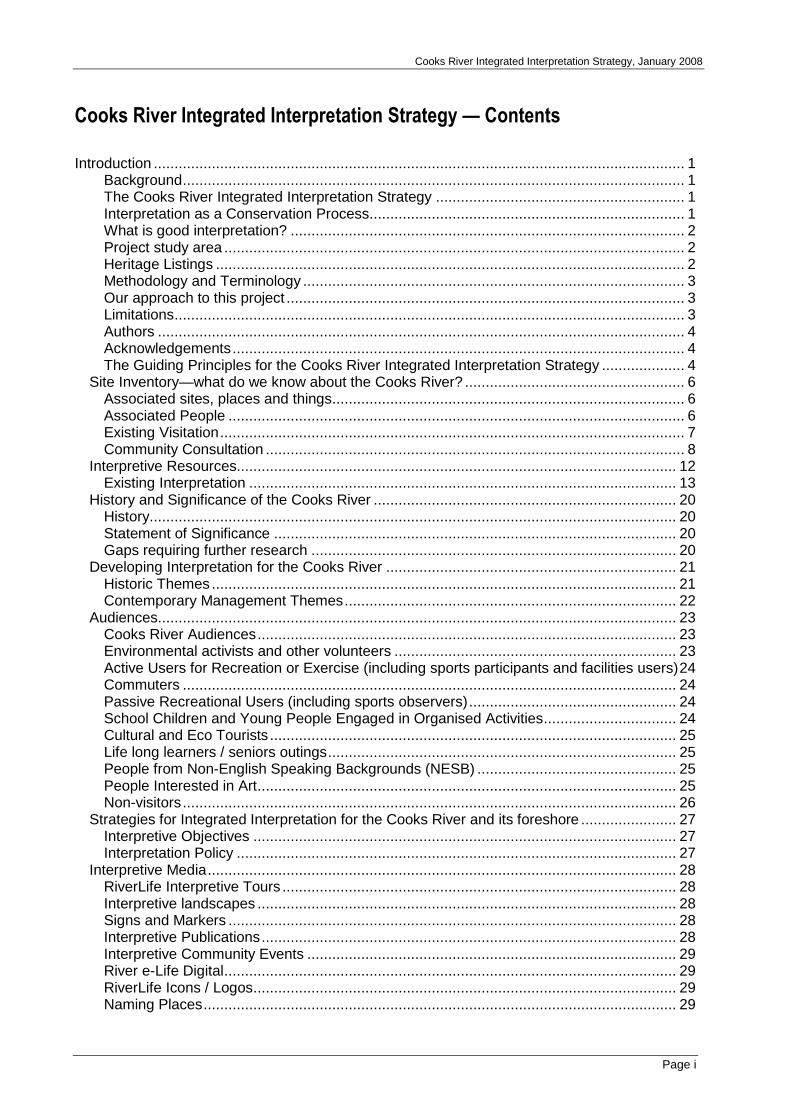
Cooks River Integrated Interpretation Strategy — Contents
Introduction ................................................................................................................................ 1 Background......................................................................................................................... 1 The Cooks River Integrated Interpretation Strategy ............................................................ 1 Interpretation as a Conservation Process............................................................................ 1 What is good interpretation? ............................................................................................... 2 Project study area ............................................................................................................... 2 Heritage Listings ................................................................................................................. 2 Methodology and Terminology ............................................................................................ 3 Our approach to this project ................................................................................................ 3 Limitations........................................................................................................................... 3 Authors ............................................................................................................................... 4 Acknowledgements............................................................................................................. 4 The Guiding Principles for the Cooks River Integrated Interpretation Strategy .................... 4
Site Inventory—what do we know about the Cooks River? ..................................................... 6 Associated sites, places and things..................................................................................... 6 Associated People .............................................................................................................. 6 Existing Visitation................................................................................................................ 7 Community Consultation ..................................................................................................... 8
Interpretive Resources.......................................................................................................... 12 Existing Interpretation ....................................................................................................... 13
History and Significance of the Cooks River ......................................................................... 20 History............................................................................................................................... 20 Statement of Significance ................................................................................................. 20 Gaps requiring further research ........................................................................................ 20
Developing Interpretation for the Cooks River ...................................................................... 21 Historic Themes ................................................................................................................ 21 Contemporary Management Themes................................................................................ 22
Audiences............................................................................................................................. 23 Cooks River Audiences..................................................................................................... 23 Environmental activists and other volunteers .................................................................... 23 Active Users for Recreation or Exercise (including sports participants and facilities users)24 Commuters ....................................................................................................................... 24 Passive Recreational Users (including sports observers).................................................. 24 School Children and Young People Engaged in Organised Activities................................ 24 Cultural and Eco Tourists .................................................................................................. 25 Life long learners / seniors outings.................................................................................... 25 People from Non-English Speaking Backgrounds (NESB) ................................................ 25 People Interested in Art..................................................................................................... 25 Non-visitors....................................................................................................................... 26
Strategies for Integrated Interpretation for the Cooks River and its foreshore ....................... 27 Interpretive Objectives ...................................................................................................... 27 Interpretation Policy .......................................................................................................... 27
Interpretive Media................................................................................................................. 28 RiverLife Interpretive Tours ............................................................................................... 28 Interpretive landscapes ..................................................................................................... 28 Signs and Markers ............................................................................................................ 28 Interpretive Publications.................................................................................................... 28 Interpretive Community Events ......................................................................................... 29 River e-Life Digital............................................................................................................. 29 RiverLife Icons / Logos...................................................................................................... 29 Naming Places.................................................................................................................. 29

Cooks River Integrated Interpretation Strategy, January 2008
Page ii
Interpretation Zones ............................................................................................................. 30 Indentifying Locations, Themes and Key Messages and Interpretive Devices ...................... 31 Interpretive and Artistic Landscape Concepts developed at the Cooks River Interpretation Strategy Creative Workshop................................................................................................. 37
Coxs Creek junction with Cooks River .............................................................................. 37 Punch Bowl (Punchbowl) .................................................................................................. 37 Cup and Saucer Creek junction with Cooks River ............................................................. 38 Sheetpiling ........................................................................................................................ 38 The Warren Park and Richardson Reserve....................................................................... 38 Wolli Creek junction with Cooks River and Gough Whitlam Park....................................... 39
Recommendations to Encourage Authentic and Enjoyable Interpretation............................. 40 Interpret Aboriginal Values and Heritage........................................................................... 40 Pursue Excellence in Face-to-Face Interpretation Delivery ............................................... 40 Evaluate Interpretive Initiatives ......................................................................................... 41 Rationalise Plaques and Panels........................................................................................ 41 Resource Educational Experiences................................................................................... 41
Interpretation into the future.................................................................................................. 42 Appendix A – Known Organisations, Community Groups and Individuals associated with the Cooks River Appendix B - Known Documentary Resources on the Cooks River—Annotated Bibliography Appendix C - Thematic History of the Cooks River Valley by Lesley Muir Appendix D - Process for Supporting Interpretation of Aboriginal Culture, Country and Community

Cooks River Integrated Interpretation Strategy, January 2008
Page 1
Introduction
Background
This report is the culmination of a wider project commissioned by the Cooks River Foreshores Working Group (CRFWG) to develop an interpretation strategy for the Cooks River Foreshore. It is one of a number of long term initiatives to develop and improve facilities on the river foreshore for the residents of Strathfield, Burwood, Rockdale, Marrickville and Canterbury local government areas and others.
Over the past 200 years the Cooks River has experienced a tumultuous history—it has been dammed, diverted, dredged, dumped and thoroughly degraded. In recent years, it has been recovering through the enormous work and efforts of individuals, government bodies and community groups.
Increasingly the River itself is being recognised as a valuable community resource with many natural and cultural features. The adjoining open space varies from broad parkland expanses to narrow pathways, playing fields, wooded landscapes and private property offering many recreational opportunities for resident and others. It also provides an effective wildlife corridor.
The Cooks River Integrated Interpretation Strategy
The Cooks River Integrated Interpretation Strategy aims to provide direction for effective and engaging on- and off-site interpretation of the values of the Cooks River. It includes the relevant resources available for interpreting the river and identifies relevant themes, audiences and gaps in the resources. It also provides interpretive objectives, key messages, techniques and recommendations to apply the interpretive strategies.
This Strategy is likely to be followed by site-specific interpretation planning involving the collaboration of community members and others with management responsibilities—particularly council’s cultural and amenity planners, architects and landscape architects. Site-specific interpretation planning and content development will continue into the future (for recommendations see page 27).
Interpretation as a Conservation Process
Interpretation is an essential part of the heritage conservation process. As important as authentic restoration and regular maintenance, the active interpretation of heritage places supports community recognition and understanding of a site’s values and significance.
People, place and their inter-relationships are extremely important in any interpretive process. Interpretation should start from the place itself … from the questions that it raises.
Questions are where stories, and the interpretive process, begin. The focus for a story might be an event, a tangible object, or an intangible representation of something that happened thousands of years prior. Through exploring stories, visitors will make meaning of places and things.
Traditionally, understanding comes from close association amongst small communities—sharing values and making connections in neighbourhood areas. However, these days fewer and fewer people have these associations in their everyday lives. Connections made while visiting a heritage place is part of the reason why many people enjoy such visits, discovering something new and making new links.
A place’s significance is reflected and informed by the contemporary relationships between people and the place. The values can also help identify suitable and compatible uses. It is important to listen to the stories of a place and of its associated people to ensure that messages are clearly defined and articulated to best express the significance and values to identified audiences. Contemporary values will also contribute to assessment of feasible and sustainable uses and opportunities for people to engage with place.
In 2004, the NSW Heritage Office prepared materials to encourage good practice in the interpretation of heritage items across New South Wales. This Interpretation Framework supports the standards set by the Heritage Interpretation Policy and Guidelines, as endorsed by the Heritage Council of NSW, August 2005. The NSW Heritage Office’s guidelines are founded on the principles of The Burra Charter: The Australia ICOMOS Charter for Places of Cultural Significance 1999, which identifies interpretation as ‘all the ways of presenting the cultural significance of the place’. The Burra Charter states ‘Significant associations between people and a
Cooks River Integrated Interpretation Strategy, January 2008
Page 2
place should be respected, retained and not obscured. Opportunities for the interpretation, commemoration and celebration of these associations should be investigated and implemented’ and continues ‘the cultural significance of many places is not readily apparent, and should be explained by interpretation. Interpretation should enhance understanding and enjoyment and be culturally appropriate’.
Interpretation Australia Association (IAA), Australia’s professional interpretation organisation, largely adheres to the 1957 definition of interpretation by American interpreter and educator Freeman Tilden, as an ‘activity which aims to reveal meanings and relationships through the use of original objects, by first hand experience, and by illustrative media, rather than simply to communicate factual information’.
There are also two useful publications to guide approaches to interpreting Aboriginal values, culture and country: Ask First: A guide for respecting Indigenous heritage places and values published by the Australian Heritage Commission in 2002, and Interpretation Australia Association’s Guidelines for Interpreting Australian Aboriginal and Torres Strait Islander Culture and Country, work-in-progress, 2006 (see Appendix B for details).
What is good interpretation?
Interpretation raises public awareness of natural and cultural heritage values by creating enjoyable opportunities to enhance understanding. Interpretation is an essential part of heritage conservation. The active interpretation of heritage supports community appreciation of and respect for a place.
A place’s significance is informed by, and reflected in, the contemporary relationships between people and the place. It is important to define the stories of a place and its associated people to ensure that messages are articulated to best express the significance and values to identified audiences. Contemporary values also contribute to assessment of sustainable uses and opportunities for people to engage with places.
Project study area
The focus of this study is the Cooks River, its tributary junctions, and the natural and cultural heritage along its length. The River passes through six local government areas on its journey from its source to Botany Bay. Its catchment extends through 13 Council areas. While much of the River foreshore is publicly accessible, there are stretches that flow through privately owned land as well as council and government owned lands that preclude access.
Heritage Listings
This report is designed to capture the relevant and significant values of the Cooks River. Several elements associated with the River are listed as significant. Items listed on the State Heritage Register include:
� The ASC Sugar Mill Buildings listed by Canterbury.
� Cooks River Sewerage Aqueduct listed by Canterbury and Marrickville.
� Wolli Creek Aqueduct listed by Canterbury and Rockdale.
� Kyeemagh and Arncliffe market gardens listed by Rockdale.
For up-to-date listings into the future it is appropriate to access the interactive website maintained by the NSW Heritage Office’s at www.heritage.nsw.gov.au/07_subnav_02.cfm
Local Government Environment Plans
Each council has a Local Environment Plan (LEP) that lists items of local significance. These listings can be found on each council’s website.
Canterbury www.canterbury.nsw.gov.au/www/html/152-environmental-planning-instruments.asp
Burwood www.burwood.nsw.gov.au/default.asp?iNavCatId=6&iSubCatId=193
Rockdale www.rockdale.nsw.gov.au/cms/cmswebcontent.nsf/Content/Environment?OpenDocument
Strathfield www.strathfield.nsw.gov.au/localplan/
Marrickville www.marrickville.nsw.gov.au/MARRICKVILLE/TEMPLATE/me.get?site.home&FFFF1669

Cooks River Integrated Interpretation Strategy, January 2008
Page 3
Other Lists of Places and Items of Significance
Other government agencies and non-government organisations have lists of items of value to them and their constituents, in the main these are also available through their corporate websites or through contacting the organisation by phone or email.
Institution of Engineers www.engineersaustralia.org.au
National Trust www.nsw.nationaltrust.org.au
NPWS www.nationalparks.nsw.gov.au
NSW Dept of Planning www.planning.nsw.gov.au
NSW RTA www.rta.nsw.gov.au
RailCorp www.railcorp.nsw.gov.au
Sydney Metropolitan Catchment Management Authority www.sydney.cma.nsw.gov.au
Sydney Water www.sydneywater.com.au
Methodology and Terminology
Strategic Planning for Interpretation
This interpretation project is being undertaken in stages. The strategic stage is intended to inform and guide collaborative and iterative interpretive planning with community stakeholders as well as council and NSW government workers with responsibilities for the Cooks River and its foreshores. Its primary aim is to integrate interpretation into the forward planning, management and conservation of the River. There are 3 papers that will document the project:
The Cooks River Interpretation Framework provided a beginning place for discussion and was circulated prior to the Listening Workshop, held on 15 March 2007.
The Cooks River Interpretation Resource Guide recorded the relevant resources available for interpreting the river and identifies gaps in the resources and was delivered to the PSC in May 2007.
The Cooks River Integrated Interpretation Strategy, the final report in this project, defines interpretive objectives, themes and key messages, audiences and techniques, and recommends actions to implement the interpretive strategies.
Our approach to this project
For sites managed for visitor interaction, our approach is shaped by our desire to engage visitors, to encourage them to explore a place beyond the obvious and gain an appreciation of the links and processes that have shaped it. We are also committed to facilitating the connection people can make with a place, and to the meaning it can hold for them.
The Integrated Interpretation Strategy for Cooks River will:
� focus on the River’s significant values: natural, Aboriginal, historic and contemporary;
� encourage positive action for River health;
� integrate with recent and ongoing projects and studies;
� facilitate meaningful connections between place and people, and between people and people;
� encourage passion and creativity; and
� provide value for money.
Limitations
This report responds to the project briefs dated 30/6/06 and 3/10/06 and information and materials provided by the Project Steering Committee. It is limited by resource constraints and availability of documents etc.

Cooks River Integrated Interpretation Strategy, January 2008
Page 4
Authors
The project was undertaken collaboratively by a group that includes:
� Cath Renwick who co-managed the project and was responsible for communications with the client group and for development and delivery of the Cooks River Integrated Interpretation Strategy.
� John Pastorelli who co-managed the project and is responsible for stakeholder liaison and engagement and for development and delivery of the Cooks River Integrated Interpretation Strategy.
� Dr Lesley Muir was the project historian. Lesley was integral to the project with a particular emphasis on developing a thematic history of the Cooks River and integrating historic perspectives.
� Hilary Sheppard provided input and support, assisting with administration and consultation as well as providing valuable perspectives to planning and developing the interpretation.
� Judy Denby participated in several phases of the project providing strategic creative input and planning for engaging interpretive media.
� Graham Chalcroft participated in several phases of the project providing creative input for engaging interpretive media.
Acknowledgements
The project managers would like to acknowledge the following people and groups for their assistance during the development of the report.
Project Steering Committee
� Judy Pincus—Cooks River Foreshore Working Group Coordinator—for enthusiastic project management and on-going guidance through the maze of bureaucracy.
� David Bell—Team Leader, Environmental Issues at Canterbury Council.
� Nell Graham—Manager, Environmental Services at Marrickville Council.
� Chrys Meader—Marrickville Historian.
� Geoff Swinney—Open Space Technical Officer at Strathfield Council.
� Paula Kennedy—Landscape Officer at Rockdale Council.
� Debra Jones— Manager, Community Services at Burwood Council.
Community Groups and their Members
� Cooks River Valley Association: Amanda Barker, President and others.
� The Mudcrabs: Peter Munro, Coordinator and others.
� Wolli Creek Preservation Society: Peter Stevens, President; Paul Fitzgerald and others.
� RiverLife Tour Guides: Rebecca Whitehall, Coordinator; Drew Garrison; Leigh Shearer-Heriot; Pam Campbell; and others.
� Marrickville Historical Society: Richard Blair, Newsletter Editor, and others.
� Friends of Ewen Park: Nadia Wheatley, co-convenor and others.
There are also numerous community members that assisted the project in one way or another. See Appendix A for a list of known community groups associated with the river)
The Guiding Principles for the Cooks River Integrated Interpretation Strategy
This strategy is drafted in line with the following principles, to:
� focus on the significant elements of the site and its values, and from these develop site-specific themes and stories;
� involve people with skills and experience in heritage interpretation;
� involve associated people to contribute to the interpretation process;

Cooks River Integrated Interpretation Strategy, January 2008
Page 5
� use documentary research and graphic material, as well as built fabric and landscape elements, to convey and interpret the history and significance of the site;
� ensure all research is thorough and that accumulated materials are publicly available at the completion of the project;
� investigate current users and potential audiences;
� ensure that recommendations and devices have potential to engage and stimulate public interest by evaluation during and after development;
� ensure that recommendations and devices are integrated with conservation and planning;
� ensure that interpretive devices will be accessible, reversible and compatible with the character of the site; and
� plan for continuing maintenance and regular review of interpretive media.
Cooks River Integrated Interpretation Strategy, January 2008
Page 6
Site Inventory—what do we know about the Cooks River?
Stretches of the Cooks River Foreshore can be quiet at times during the day, but a hive of activity at other times with recreational walkers, exercisers, dog-walkers, joggers, cyclists, anglers, sports teams, picnicking groups and others actively or passively interacting with the open space and the River.
Associated sites, places and things
Sites, places and things associated with the River include:
� remnant native habitats forming a vital wildlife corridor;
� Aboriginal sites and resources;
� many road bridges;
� many pedestrian bridges;
� the Bay-to-Bay Cycleway
� river banks and edges (both natural and manufactured);
� water, oil, gas and sewer pipelines;
� stormwater drains, outlets and pollution traps;
� built and industrial remains (potential archaeology);
� surrounding suburbs;
� vistas to and from the River;
� buildings (public and private) some with community uses; and
� numerous parks, sports facilities and other areas of open space.
Associated People
People with connections to the River include: Aboriginal people and groups; local schools, associations, clubs and groups; family associations; public agency staff; residents, neighbours and landowners.
Aboriginal People and Groups
� Metropolitan Local Aboriginal Land Council
� Marrickville Aboriginal Consultative Committee
� Canterbury Aboriginal Advisory Group
� Darug Tribal Aboriginal Corporation
There are likely to be other Aboriginal people associated with the River, however these are the known group connections.
Local Associations and Groups
An enormous number of enthusiastic community groups each have an interest in certain aspects of the river. As is usual in any community group some individuals and groups will have plenty of resources (time, energy, interest, enthusiasm) to get involved in projects and will have an ongoing interest in the interpretation of heritage, while others will not.
Many have been have been actively involved in the development of this document.
A list of known community groups and individuals associated with the Cooks River can be found at Appendix A.
Family Associations
Members of many families will have an interest in various activities of the river. They would include: workers’ and others associated with the building or maintenance of the bridges, channel walls, and other infrastructure of the Cooks River; owners of farming land and other properties as well as developers. We have not knowingly sought input from people with family associations to the river, though we would recommend this to be done at a later stage when resources are available.

Cooks River Integrated Interpretation Strategy, January 2008
Page 7
Public Agencies
There are 13 councils that manage land in the catchment of the River: Ashfield; Auburn; Bankstown; Botany Bay; Burwood; Canterbury; Hurstville; Kogarah; Marrickville; Randwick; Rockdale; Strathfield; and Sydney.
There are also many NSW Government agencies that have responsibilities for aspects of the River and its catchment.
Residents, Businesses, Clubs and Land Owners
Local residents, businesses, clubs and property owners will have an interest in proposals relating to the River, especially those that have adjacent property.
Existing Visitation
There is little known research about the numbers or the motivations of visitors to the River as a whole (limited information was recorded in 19761). Anecdotal evidence and some site-specific research suggest that visitation and use of parklands adjacent to the River is increasing gradually as the River’s amenity improves.
The consultant team spent several hours beside the River throughout the course of the project and people were using the River corridor as:
� a commuter corridor (cyclists and walkers, including school children);
� a sporting venue (tennis, soccer, canoeing etc);
� an area for exercise (walking, jogging often with companion animals), and
� a passive and active recreation location (playing, walking, strolling, chatting, contemplating, relaxing, picnicking, youth ‘hangout’, learning to ride bikes etc, often with companion animals).
In October 2006 a community group, The Friends of Ewen Park, sought responses to a survey2 about the broad community uses of Ewen Park at a community picnic. The findings show that individuals and families use Ewen Park in a variety of ways.
A typical family with young children may use the playing fields for a few hours a week in winter for soccer, but also use the picnic and play area throughout the year for community picnics and children’s birthdays. Children and adults play informal games in the picnic area and children love to play on the hills and run between the swings and other item of play equipment.
As well, a significant number of park users do not have children. They also use the picnic and play area for parties, and for resting and relaxation.
This is illustrated by the comments below elicited in response to the following question “In what ways do you or your family use Ewen Park and/or the nearby Cooks River parkland?”:
Soccer, cycling, scootering, roller-blading, picnics, swings, play equipment, parties, walking, route home
from school, relaxing, thinking, drawing (Liz and Steve, Earlwood)
Soccer, picnics, dog-walking (Bronwyn, Campsie)
Bicycle, walking, equipment, picnics, parties, relaxation (Andrew, Hurlstone Park)
Picnics, riding bikes, parties, playground and playing soccer (Edwina, Marrickville)
Further research to develop a better understanding of existing visitation and use of the River and its foreshores is recommended to ascertain who uses it, how they use it and for what purposes. If users are benchmarked in the near future and repeated at relevant periods, it will provide useful information about changes over time.
1 Cooks River Environment Survey and Landscape Design, Report to the Cooks River Project Total Environment Center 1976 p101 2 Responses to registration questionnaire collected at Ewen Park Community Picnic, 26 October 2006, reproduced by permission of Friends of Ewen Park email: [email protected] mail: PO Box 172, Hurlstone Park 2193
Cooks River Integrated Interpretation Strategy, January 2008
Page 8
Community Consultation
Community Perceptions
For many years community perceptions of the Cooks River have been fairly negative. However, these perceptions are changing, and changing rapidly as the River’s amenity improves.
The following reports were reviewed in relation to the community consultation undertaken during each project.
Clouston 1997 Cooks River Foreshores Strategic Plan, prepared for the Cooks River Regional Working Party (predecessor to the CRFWG).
Junor, B, 1999. A Case for the Formation of a Cooks River Catchment Management Trust, prepared for The Association of Councils of the Cooks River Catchment, photocopy.
Yeung K. 1995. Environmental Conditions of the Cook River and Community Vision Strategy. Total Environment Centre, Sydney.
The table below aims to outline community responses on a variety of issues:
Environmental concerns
• water quality
• litter
• sewage overflows
• stormwater
• industrial water pollution
• river banks
• foreshore vegetation
• wildlife
• recreation use
• sedimentation of the river bed and banks
• concrete channels and
• loss of amenity values of the river and foreshore
Management concerns
• catchment management,
• management practice
• funding
• crowding / competing uses
• marketing and
• education
Perceptions of the River and the landscape
Positive + meandering river is particularly beautiful at full tide
+ historic bridges
+ sounds of birds
+ wide spaces adjoining the River and
+ structured exotic and native tree plantings
Negative - sewer overflow
- structures in water and adjacent parks
- litter in the waterways and parks
- high voltage overhead cables
- concrete channels
- fencing along channels
- poor health quality of trees
- lack of shade trees
- erosion
- traffic noise
- graffiti
- presence of weeds and
- fences to adjoining properties are sometimes in disrepair
Aspirations for the future
general • more visual connection to the river
• more outdoor events
• more outdoor sites conveying information to school children and public
• improved profile
• school initiatives very important
• develop a community culture that is proud of the River with a sense of community ownership
recreation/activity • Amphitheatre (eg at Warren Park)
• Outdoor cinema – Flicker Festival (perhaps a water screen)
• canoe hire and boat hire
• more historic walks
• fitness routes and
• outdoor restaurants
Issues to be considered during interpretation planning
• the rivers upper reaches are often perceived as a drain
• the rivers middle reaches have the appearance of a backyard
• some people associate the mangroves with mosquitoes while others are encouraged by the regrowth of mangroves
• residents have noticed pelicans starting to come back to the river
• some find Bay to Bay cycle way route ambiguous in certain parts and
• signage needs to be consistent with clear information/safety messages

Cooks River Integrated Interpretation Strategy, January 2008
Page 9
Community site survey c2002 (as documented at the time)
Other sources of input from the community and selected stakeholders included a survey undertaken in 2002 by the CRFWG Coordinator to help inform the development of a signage strategy for the foreshores. The following
request was made “Please help us identify the most significant and interesting sites along the Cooks River”. Participants were asked to list their top 5 sites in ranked order. The results are listed below:
Points of interest
1. Eve Street Wetlands
2. Alexandra Canal (Sheas Creek)
3. Cooks River Valley Garden
4. Tempe House
5. Richardsons Lookout (The Warren)
6. Cooks River & Wolli Creek Sewer Aqueduct
7. Marrickville Golf Course ( remnant vegetation & clubhouse)
8. Old Sugar Works
9. Cox’s Creek Junction
10. Dean Reserve
11. Chain of Ponds Reserve
The following places and items were also identified as significant.
� All creek junctions and tributaries
� Bark Huts
� Botany Bay
� Bush revegetation sites
� Canterbury Park Racecourse
� Concrete channel
� Cup and Saucer Creek
� Access to cycleway @ Strathfield
� Fatima Island
� Ford Park, Maria Reserve
� Gough Whitlam Park
� Gross Pollutant Traps and stormwater infrastructure
� Gumbramorra Swamp (as was)
� Holt Family Vault
� Aboriginal middens
� Mangroves and other species near Keir Avenue
� Original River mouth
� Punchbowl
� Relocated river mouth and sea grasses
� St Anne’s Church
� Third Avenue, Campsie, remnant vegetation
� Wolli Creek Wetlands
� Illawarra Road bridge
� Mangroves
� Market gardens
� Rockdale Wetlands
� Tempe Reserve
� Three Sisters Viaduct
Riverlife—Sustainable Water Environments Project
Marrickville Council, jointly with Monash University and funding partner the NSW Department of Environment and Climate Change, are continuing work on the Urban Stormwater Integrated Management (USWIM) project.
A recently published ‘Catchment Action Plan for the Illawarra Road Sub-catchment 2006’, included the following Community Water Vision 2050 for the Illawarra Road sub-catchment, which was developed through resident and community group planning sessions.
In 2050, our community is time-rich, smart, connected and awake to the value of water as a scarce resource. Awareness of the value of water is passed on through the generations.
Our people have ownership through ongoing participation in planning and maintaining self-sufficient dwellings and infrastructure where water, transport, energy and land use systems are integrated.

Cooks River Integrated Interpretation Strategy, January 2008
Page 10
In 2050, appropriate technology works for the community, supporting the systems. There is equity of access to clean water. 'Fit-for-purpose' usage is the norm and wastewater and pollution are forgotten concepts.
In 2050, there is native habitat with wildlife around Cooks River, which is clean and safe for recreation, fishing and swimming.
Cooks River Festival 2007
The 2007 Cooks River Festival was held in Steel Park, Marrickville on Sunday 15 April from 11am till 4pm. During the festival further informal investigation was undertaken, specifically to capture the variety of activities that people engage in along the River and the distance people range along the River from their home bases.
Individuals were asked to mark on a map the areas of foreshore that they or their family use, they were also asked how they use them.
Overall, as was expected, people reported using the River corridor in a variety of ways and clearly people vary widely in the distance they range within the corridor. Cyclists and dog walkers reported that they regularly ranged for comparatively long distances from their homebases. Several cyclists reported riding well beyond the corridor from each end of the cycleway.
Walkers also reported using sections of the corridor, though they ranged less distance along the foreshore.
80% of people surveyed reported that they use the river for more than one activity, and most reported that members of a family group were likely to use the river corridor for different activities.
The following additional questions were posed (anonymous responses are listed below each question).
What questions do you have about the River?
� Can you fish in the river?
� How is the river being fixed?
� Why does the river kind of stop (towards Strathfield)?
� Are there dead fish in the river (there should be a penalty for pollution)
� What are the large machines doing near Wanstead Avenue and now also near the Club? I would like to know.
� Why isn’t there a penalty for pollution?
� Why do fish float in the river?
� Why is there still rubbish after rain—why no more Gross Pollutant Traps?
� When will the Canterbury Road crossing [underpass] be fixed for bikes?
� Why don’t all the councils agree on an overall plan?
� Please, stricter controls on industry and whoever pollutes the river (last week Cooks River was full of rubbish—100’s of plastic bottles.
What stories should we tell and how should we tell them?
� History of industry
� Aboriginal context
� The Botanic Gardens display “Kadigal” [sic] is a great example of how to tell the stories.
� Tell all sides of stories
� Earlier recreational uses of the river.
� Talk about tides etc
� ‘Accidental’ cyanide in river in 1975—carp and fish died, cats and dogs died … low point in river history. Has it got better?
Images of a range of interpretive devices in other locations were also displayed, they provoked inquiry and discussion. The general impression received from the discussion was that people would be interested in creative interpretation along the River, and that they would be happy if it included interpretive public art.

Cooks River Integrated Interpretation Strategy, January 2008
Page 11
Cooks River Sustainability Festival 2007
Judy Pincus, Cooks River Foreshores Working Group (CRFWG) Coordinator, and the Interpretation Project team’s Cath Renwick, shared a stall at the Festival.
Above: people read and talk about Cooks River issues at the stall.
Above right: A discussion between a local resident and Cath Renwick about the River and how families interact with it.
Right: Mapping use patterns along the river.
Photos: Judy Pincus
The questions and ideas raised at the Festival have been taken into account when finalising this Strategy.

Cooks River Integrated Interpretation Strategy, January 2008
Page 12
Interpretive Resources
In order to interpret the places and things near the Cooks River, it is essential to identify all the resource materials, actual and documented, that have a potential to engage one or all of the identified audiences and to inform them about significant values. The River, its associated infrastructure and the surrounding natural and cultural elements are the most important and authentic interpretive resources. They include:
� the River, its banks and tributaries;
� the original course of the River;
� Aboriginal sites and resources;
� historic fabric and remains;
� monuments;
� native animals and birds
� remnants of original vegetation, and
� locally-provenanced plantings.
Documentary resources are also important, a full listing can be found in Appendix B, they include:
� Aboriginal Time Line, Marrickville Aboriginal History Project, prepared by Marrickville Council and the Marrickville Aboriginal Consultative Committee. Prepared by Marrickville Historian Chrys Meader and available for research purposes at the History & Archival Reference Centre, Petersham Town Hall, Crystal Street, Petersham. Enquiries contact 9335 2287.
� Cooks River Valley Thematic History, prepared by Lesley Muir for this project and appended (Appendix C);
� Missing Jigsaw Pieces, The Bushplants of the Cooks River Valley by Doug Benson, Danie Ondinea and Virginia Bear and published by the Royal Botanic Gardens Sydney;
� documents, images, moving images, and sound recordings and other resources held in the library and local history collections of each participating council as well as local historical societies and friends groups;
� documents, images, moving images, and sound recordings and other resources held in State institutions such as the State Library of NSW and State Records NSW Office as well as other state and national collections;
� the publications and reports, including but not limited to those listed in the bibliography (Appendix B); and
� research notes /collections of RiverLife Guides and other community groups including precinct species lists.
Internet resources are also important and are listed in Appendix B. The websites of the two local Environmental Education Centres of the New South Wales Department of Education & Training can be found at www.georgesriv-e.schools.nsw.edu.au and www.observhill-e.schools.nsw.edu.au/ and have resources to offer particularly in relation to developing resources for school students.
Internet resources also provide comprehensive insights, a full listing can be found in Appendix B, they include:
CookNet – The Cooks River Portal www.canterbury.nsw.gov.au/cooknet.htm is a useful interpretive resource, though in need of upgrading and updating.
The Dictionary of Sydney www.dictionaryofsydney.org is another useful resource that is currently in development—in time it will have a history of the River and histories and demographic profiles of all the suburbs in the catchment.
Cadigal Wangal – People of the Cooks River website www.marrickville.nsw.gov.au/cadigalwangal/main.htm hosted by Marrickville Council and developed by Brett Leavy of Cyber Dreaming. It provides a valuable insight into Aboriginal life in and around the Cooks River.
Estuaries in NSW – www.dnr.nsw.gov.au/estuaries/inventory/cooks.shtml provides information on the natural and created aspects of the Cooks River, NSW Department of Natural Resources
The Cooks River Wikipedia Entry is a wiki (easily-editable, collaborative website) on the online encyclopaedia Wikipedia en.wikipedia.org/wiki/Cooks_River there is also a wiki about Riverlife at en.wikipedia.org/wiki/Riverlife
Cooks River Integrated Interpretation Strategy, January 2008
Page 13
CRFWG Councils’ Websites are increasingly supplying interpretive information particularly about natural and cultural heritage within their boundaries. Photograph and image collections are also increasingly available. While these do not specifically interpret the river as a whole, they certainly shed light on various aspect of life and work on the river.
Existing Interpretation
Many activities have been undertaken, or are currently taking place within the Cooks River Foreshore corridor and throughout the Cooks River catchment. Many of them have interpretive aspects and most have effectively engaged community members. In most cases they involve collaboration between various levels of government, individual locals, community groups, NGOs, artists and others. The following list was included in the CRFWG Interpretation project brief dated 30 June 2006.
� Riverworks Cooks River Environmental Sculpture Competition (The Mudcrabs - Cooks River Eco Volunteers, March 2006 and June 2007)
� Secrets of the City: Gumbramorra Swamp Thing! Project - community arts project conceived and run by local artist (Graham Chalcroft, VERTEBRAE, 2005)
� Marrickville Aboriginal Oral History Project (Marrickville Council, 2004 - 05)
� So the Earth Can Relax and We Can have Fun: The Evaluation of Three Stormwater Education Programmes in the Cooks River Catchment – evaluation of Stormwater Trust-funded stormwater education projects in the Cooks River Catchment (Culture Shift, 2003)
� RiverLife Interpretive Tour Program – training and support for community volunteers to develop and deliver interpretive tours along or about the River (Marrickville and Canterbury Councils, 2003 - ongoing)
� Riverlife Cooks River Film Festival - short film competition focusing on Cooks River and stormwater issues (Marrickville, Canterbury and Strathfield Councils, 2003)
� Streets to Rivers stormwater education program - stalls at Council festivals, street performers and educators, brochures in community languages, etc. (Marrickville Council, 1998 - 2003)
� Development of a Cooks River ESL teaching resource (Canterbury Council, 2003)
� Cooks River Valley Garden - living museum of indigenous vegetation at Tempe Recreational Reserve (Marrickville Council, 2001 - ongoing)
� Cooks River Environmental Assessment and Education Program – catchment-wide environmental assessment and education of catchment businesses / industries (Cooks River Association of Councils, 1999 - 2000)
� Wolli Creek Preservation Society (WCPS) website, tours, publications and development of walking trails (WCPS, ongoing)
� CookNet website (http://www.canterbury.nsw.gov.au/cooknet.htm)) (Canterbury Council, ongoing. Needs upgrading and updating)
� Cadigal Wangal website (Marrickville Council, ongoing)
� Canterbury Council historic plaque and signage program (Canterbury Council, ongoing)
� Rockdale Aboriginal Heritage Study (ERM Mitchell McCotter, 1999)
� Wolli Creek oral history project (Wolli Creek Preservation Society, current)
� Missing Jigsaw Pieces–Bush Plants of the Cooks River Valley (Sydney Royal Botanic Gardens with assistance from the CRFWG, 1999).
Guided Tours
The Wolli Creek Preservation Society, Two Valley Trail Coalition, the River Canoe Club and others offer tours along the River. However, the following are or have been more widely accessible to date.
The Cooks River Tour brochure (A3 gate-fold) presents a self-guided tour of a section of the River. It was prepared for the Marrickville Heritage Society by Mark Matheson (c2002). It illustrates a route and interprets many historic locations and features along the River between Canterbury and Tempe.

Cooks River Integrated Interpretation Strategy, January 2008
Page 14
RiverLife Cooks River Interpretive Tours are volunteer-guided tours of the River. They aim to engage community members and offer insights into the cultural heritage of the River and their unique social and physical environments. The variety of tours offered are as diverse as the individual guides involved—they explore the relationship between the urban environment and the Cooks River. Access to information about the RiverLife Tours is through Canterbury, Strathfield and Marrickville council websites and the CookNet.

Cooks River Integrated Interpretation Strategy, January 2008
Page 15
Overview of Physical Installations
There are several installations in the vicinity of the River, only some are interpretive. A representative selection are illustrated below. A complete inventory is found in the Cooks River Foreshore Signage Audit prepared for the CRFWG, 2000. Where known, providence is provided, together with the agency responsible for maintenance and upkeep.
Stormwater Stencil
Located: Strathfield South
“Save the Cooks River don’t pollute this drain’
Condition: faded
Interpretive value: limited due to degradation, could be revised to better reflect interpretive themes
Responsibility: Strathfield Council
Waymarker for Bay to Bay Walk (Homebush Bay to Botany Bay)
Located: Strathfield South
Condition: faded and graffiti tagged
Interpretive value: bird image indicates natural values
Soon to be removed and replaced as part of the Cooks River Path Signage renewal program of the CRFWG.
Cooks River Cycleway Sign
Located: Charles Street, Canterbury
Condition: graffiti tagged
Interpretive value: none— could be improved to better reflect interpretive themes. A “you are here” arrow would also benefit users
Responsibility: Canterbury Council
Soon to be removed and replaced as part of the Cooks River Path Signage renewal program of the CRFWG.

Cooks River Integrated Interpretation Strategy, January 2008
Page 16
Interpretive Sign for Sugar Works Residential Adaptive Reuse (one of several)
Located: Sugar House Road, Hurlstone Park
Condition: slight damage no affect to readability.
Interpretive value: good, though text is very small with some correction needed (review under discussion ref: C King, Canterbury Historian Jan08)
Canterbury Council Nobbs Flat Heritage Sign
Located: Wardell Road entry to Beaman Park, Earlwood
Condition: good
Interpretive value: high
Responsibility: Canterbury Council
Sign Pollution
Located: Wardell Road entry to Beaman Park, Earlwood
Condition: number and density of signs renders them redundant. There is too much clutter, so users tend to disregard all information
Interpretive value: none
Responsibility: Canterbury Council
Juhan Munna Heritage Sign
Located: intersection of Stafford Walk and Illawarra Road, Undercliff
Condition: good
Interpretive value: high
Responsibility: Canterbury Council

Cooks River Integrated Interpretation Strategy, January 2008
Page 17
Sydney Water Stormwater Sign
Located: Mackey Park, Marrickville
Condition: good, though view is obscured by fence
Interpretive value: adequate for purpose—though it could be improved by site specific references
Responsibility: Sydney Water
Cooks River River’s Life Sign
Located: Kendrick Park, Marrickville
Condition: faded and graffiti tagged
Interpretive value: good
Responsibility: Marrickville Council
Gough Whitlam Park Entry Sign
Located: Bayview Avenue, Undercliffe near park entry
Condition: reasonable
Interpretive value: some value, , though it is difficult to read and could be much improved through the use of intepretive graphic design and the inclusion of relevant images.
Responsibility: Canterbury Council
River-themed Interpretive Installation
Located in Gough Whitlam Park
Condition: good
Interpretive value: some intrinsic value relating to river themes, but could be improved and more authentically interpret the stories of the River
Responsibility: Canterbury Council

Cooks River Integrated Interpretation Strategy, January 2008
Page 18
Known recent or continuing interpretive initiatives
There are several recently commenced or on-going projects that will interpret elements of the Cooks River, each of these are important for raising awareness and increasing understanding of the issues of the River. Several are mentioned elsewhere in this report. They include:
RiverLife Interpretive Guided Tours continue to grow and develop with the skills and interest of the trained volunteer guides. However, on-going funding is not assured (see images below).
Riverworks Cooks River Environmental Sculpture Competition, first undertaken in March 2006, Riverworks was held again in June 2007 and plans are in development for the third day-long event to be held in 2008.
Two Valley Trail project is promoted by the Wolli Creek Preservation Society and supported by several other community groups including the Mudcrabs, the Friends of Ewen Park and the Cooks River Valley Association. The project proposes, and is working towards, a waymarked and interpreted track of 12km, through bushland, parkland and riverside from Bexley North via the Wolli and Cooks River Valleys to Campsie (see image below).
Going Bush, by Nadia Wheatley and Ken Searle, in collaboration with several local schools, and published in March 2007 by Allen and Unwin, interprets the learning and experiences of a group of primary school children exploring the Wolli Creek Valley and the concept of intercultural and personal harmony.
Cooks River Wikipedia Entry is a collaborative resource, and has the potential to be useful as long as it remains authentic and accurate. URL is listed above (see p 13)
Cooks River to Iron Cove GreenWay (www.greenway.org.au) is a grass roots initiative to provide a cycling and walking trail and wildlife corridor linking the Cooks River and Iron Cove. Community art and heritage interpretation is planned for the GreenWay.
RiverLife Guided Tours Promotional Poster
Located: several posted along the foreshore of the River
Condition: good (but ephemeral)
Interpretive value: the poster has some intrinsic interpretive worth. RiverLife tours have great interpretive value
Responsibility: RiverLife Interpretive Tour Guides Coordinator (Marrickville Council).
Sweet & Sour RiverLife Tour Promotional Poster
Located: several posted along the foreshore of the River
Condition: good (but ephemeral)
Interpretive value: the poster has some intrinsic interpretive worth. RiverLife tours have great interpretive value
Responsibility: RiverLife Interpretive Tour Guides (voluntary)

Cooks River Integrated Interpretation Strategy, January 2008
Page 19
Sweet & Sour RiverLife Tour
Located: Sugar House Road, Hurlstone Park
Condition: excellent
Interpretive value: high
Responsibility: RiverLife Interpretive Tour Guides (voluntary)
Wolli Creek Preservation Society Guided Walk
Located: photo taken at meeting point for walk in Wolli Creek Regional Park near Bexley North Railway Station
Condition: excellent
Interpretive value: high

Cooks River Integrated Interpretation Strategy, January 2008
Page 20
History and Significance of the Cooks River
History
This project commissioned a Cooks River Valley Thematic History (see Appendix C). It was researched and written by respected historian Dr Lesley Muir. Doug Benson, botanist and author of Missing Jigsaw Pieces; Chrys Meader, Marrickville Council Historian; Chris King, Canterbury Local History Librarian; Brian Madden, historian and Judy Pincus, Coordinator, CRFWG, peer-reviewed the draft and provided additional material.
Statement of Significance
The Cooks River is a prime example of a large, severely impacted urban river whose ongoing rehabilitation will provide evidence as to whether a large urban population can coexist with natural and cultural features over the long term. This degraded part of Sydney presents a challenge to rehabilitate and to show that we can do something worthwhile in an urban area. The Cooks River is also significant for the following reasons when measured against the criteria for the State Heritage Inventory:
� It is important in the course of NSW’s cultural history as a source of resources and a barrier to expansion
� It has special association with the life of people and groups important in NSW’s cultural history such as Aboriginal people and groups, landholders, farmers and industrialists;
� The River demonstrates aesthetic characteristics and a high degree of creative or technical achievement in NSW with associated plans for canals connecting the Cooks River, Sydney Harbour and the Parramatta River as well as other utilities infrastructure and achievements;
� It has special association with community groups in NSW for social reasons including Aboriginal people and groups; various Cooks River valley lobbyists over 150 years and others;
� It has potential to yield further information that will contribute to an understanding of NSW’s cultural or natural history relating to Aboriginal cultural landscapes; industrial heritage and other values;
� The River possesses uncommon and rare aspects of NSW’s natural history in remnant patches of endemic vegetation, wildlife corridors and their associated animal life; and
� It also demonstrates the characteristic life cycle of an urban river with the potential to represent both positive and negative aspects of urban water management and community participation to improve shared resources.
Gaps requiring further research
As with most complex interpretation projects gaps appear in the records as work progresses. In the process of reviewing resources for the Cooks River Integrated Interpretation Strategy it is clear that there are several areas where further work should be undertaken. A list of these areas follows.
First person accounts / oral histories—should be recorded through contact with associated people: people who grew up by the River; builders of the structures and workers at industries along the River or their family members; and people who have taken, and continue to take, action to restore the River.
User Survey—would define who uses the River and its Foreshores, how and for what purposes. A survey program should be designed to set a benchmark and be repeatable, to show changes in use, motivation and perception. Exit Surveys for events would also provide useful information. Analysis would assist in understanding changes in motivations and needs over time. It would also benefit councils’ amenity planners.
Image Research—there are an enormous number of images of the Cooks River, many are historic. These are held in public and private collections. A comprehensive survey would be very useful but time consuming.
Map Significant Art Sites—following significant image research it would be appropriate to accurately map sites, both historic and contemporary, that are depicted in art,. This would allow ‘then and now’ comparisons.
Interpretive and Accessible Illustrations and Diagrams—are needed for complex remedial issues and natural processes. These might interpret the difficulties relating to removal of the sheet piling; restoration of natural river bank; removal of sludge and the location of River’s catchment and subcatchment boundaries.

Cooks River Integrated Interpretation Strategy, January 2008
Page 21
Developing Interpretation for the Cooks River
In preparing to interpret places, it is important to present their past in an informative, interesting and easily accessible way. This is achieved through communicating detail about the key themes that have formed the site. These are usually derived from the Statement of Significance, contemporary social values and other information.
Historic Themes
The Australian Heritage Commission published a national framework of historic themes in 2001. The Australian Historic Themes Framework aims to ‘assist in structuring research and to emphasize the … values of a place … by identifying historical processes that might be used in assessing and interpreting heritage significance’. Nine national theme groups were identified, with focused subthemes. The NSW Heritage Office has also developed state historic themes that, to a large degree, link with the national framework. See page 30 for development of site-specific themes and key messages.
Theme Subtheme Local representation
National: Tracing the evolution of the Australian environment
NSW: Environment – naturally evolved
The River as a natural landscape
The evolution of the landscape: cliffs, valleys, wetlands, floodplains, swamps, tributaries and meanders.
Significant/representative/endemic/useful plants and animals.
Other natural aspects such as revegetation and restoration activities and sites.
National: Peopling Australia
NSW: Aboriginal cultures and interactions with other cultures; Convict; Ethnic influences; Migration
The River as a source of survival (this needs significant input from Aboriginal community members).
Aboriginal cultural landscapes including sandstone shelters, middens and resources.
Aboriginal cultural heritage including creation stories, pathways, resistance and continuing lifestyles.
Settler heritage of water supply, farming and market gardening.
The River offers places for inspiration, reflection, contemplation or respite from nearby urban environments.
National: Developing local, regional and national economies
NSW: Agriculture; Commerce; Communication; Environmental cultural landscape; Events; Exploration; Fishing; Forestry; Health; Industry; Mining; Pastoralism; Science; Technology; Transport
The River as a barrier.
The early use of Aboriginal pathways to access the area.
The challenge of crossing places, rights-of-way and roads and the resulting effects on settlement.
National: Building settlements, towns and cities
NSW: Towns, suburbs and villages; Land tenure; Utilities; Accommodation
The River as a picturesque retreat.
19th century “gentry” establishing country houses and estates beside the River.
The River as a locality for historic and contemporary art.
The River as a place for contemplation.
People go to the river to reflect, think, meditate, watch and contemplate—not to recreate but to rejuvenate.

Cooks River Integrated Interpretation Strategy, January 2008
Page 22
The River as a route for services and transport.
A services corridor including water supply, sewerage, gas, electricity.
A transport corridor and hub including walking paths, cycleways, railways, airport and freeways both proposed and achieved.
National: Working
NSW: Labour
The River as an industrial locality.
Early lime-burning, land clearing, timber-getting, coal-mining and quarrying.
Sugarworks, woolwashes, boiling-down works, tanneries, brickpits and kilns, and 20th century industry.
Resulting industrial pollution and attempts to control it from mid 19th century on.
Ongoing consequences of clearing and development including flood mitigation works, canals and engineering.
National: Developing Australia’s cultural life
NSW: Domestic life; Creative endeavour; Leisure; Religion; Social institutions; Sport
The River as recreation area.
Reclamation of public access, open space, and delivery of amenity landscaping.
Passive recreation including family gatherings, community events and quiet contemplation.
Active recreation including swimming, boating, walking, cycling and kayaking as well as organised sports such as football codes; golf; horse and cycle racing.
The River Valley as a place to live.
19th, 20th and 21st century subdivisions and redevelopments. Was / is the river an asset or a liability?
Community action to improve the River over many decades.
Contemporary Management Themes
There are burning management issues that relate to the health of the River and its foreshores. These could be integrated into the historic themes outlined above, as they will undoubtedly be integrated into the historic record in the future. However, currently these issues come up again and again at community gatherings; they seem to be at the forefront of locals’ minds and as such it is better to deal with them separate to the historic themes.
Management: The Cooks River is a severely impacted urban river. The River presents a challenge to locals and others to restore and conserve it and to learn to live harmoniously with it.
Pollution, its causes and effects.
What to do and what not to do to protect the River from pollution.
Stormwater carries rubbish, chemicals and sediment from gutters.
Ageing sewage infrastructure and sewage overflows.
Why fish from the River shouldn’t be eaten.
The complexity of ameliorating and managing the impacts of historic infrastructure changes to the River.
Steps taken to improve the River over many decades.
Stabilising the river banks.
Sedimentation in the channel.
Toxic residues in the riverbed sediment
The spread of mangroves / saltmarsh.
Managing stormwater sustainably (water sensitive urban design)
The complexity of restoring the River’s ecology in an urban landscape.
Restoring native plant and animal habitat, communities and corridors.
Improving water quality.
Creating ecologically viable embankments

Cooks River Integrated Interpretation Strategy, January 2008
Page 23
Audiences
Interpretation aims to reveal meanings and connections rather than basic facts. All effective communication is predicated on knowing the audience and using appropriate media.
Interpretation is most successful when it is targeted specifically to audience needs in terms of orientation, information and personal safety, and when it responds to known audience behaviour. Interpretation aims to engage, entertain, inform, delight and provoke, and hopefully leave the audience with evocative memories or challenging thoughts.
It is important to identify specific audience segments with an aim to develop suitable interpretive media. It should respond to their different needs and motivations, and take into account factors such as English literacy levels, disability, gender, ethnicity and age.
Cooks River Audiences
Accessible interpretation of heritage values will help to ensure the River is appreciated by residents of the adjacent council areas, their visitors and the wider community and this appreciation will continue to grow into the future.
There is a good understanding of the current socio-demographics of the municipalities through which the Cooks River flows but less is known about the various groups’ use of the river.
From previous community consultation programs (see pages 8-10), we know that locals are concerned about a range of environmental and river management issues. However, there are large and expanding groups of people who are enthusiastically and actively supporting the regeneration of the River and its foreshores as the relevant councils improve access, amenity, biodiversity and water quality.
People fit in to many different audience groups depending on their motivation at any given time. Some will be quiet sunrise walkers exercising their dog, later that same morning they might ride to work along the foreshore path, then in the late afternoon they may participate in a rowdy sporting activity, or on the weekend they may gather with friends and family for a celebratory picnic. People use the River and its foreshore for multiple purposes, most of which must be catered for.
Casual observation of visitors to the urban open space adjacent to the River would suggest that most are local, using the area for recreation, entertainment and exercise. The number and type of visitors will change over time, especially as people learn more about the opportunities. Several projected audience segments are outlined below.
� environmental activists and other volunteers
� active users for recreation or exercise (including sports participants)
� commuters
� passive recreational users (including sports observers)
� school children and young people engaged in organised activities
� children and young people
� cultural tourists
� life long learners / seniors outings
� people from Non-English Speaking Background (NESB) communities
� facilities users
� people interested in art and
� non-visitors
Environmental activists and other volunteers
Environmental activists and other volunteers working on the River are already engaged and are, in fact, part of the story of the River. They are likely to be very demanding of interpretation, requiring more from it than it

Cooks River Integrated Interpretation Strategy, January 2008
Page 24
maybe able to provide as they are already knowledgeable about many aspects of the river – especially the areas local to them.
Potential to engage this audience is high. They are likely to promote ‘good’ interpretation to newcomers but will demand exacting quality and innovative approaches.
Potential age range: 8–101.
Active Users for Recreation or Exercise (including sports participants and facilities users)
Local residents walking or jogging for exercise and dog owners walking their pets seem to be the main recreational users of the River’s foreshore paths. In the main the paths are ‘wheel-friendly’ and it is common to observe strollers and cyclists, and in many areas the grades and access are suitable for wheelchair users.
Potential to engage recreational users and exercisers is high but short term. While they are likely to be interested in the history of their locality, if they use the track regularly any interpretation will be ignored after they have explored the place. The challenge is getting them to slow down and take an interest in their surroundings. If we manage to ‘hook’ their attention, they may bring friends or family to visit and to explore further. There is a good chance they will tell neighbours and others.
Potential age range: 0-101.
Commuters
It would seem that many people use the route of the River to commute to work, school and other locations. Many will choose the route because it is relatively peaceful, others will use it because it is relatively direct. Many train and bus routes cross the river with stations and bus stops nearby. Many cyclists also use the track as an efficient commuter route.
Potential to engage commuters is low because, even though they are often locals, they are simply using the fastest route between home and work. Initially, however, some will be interested in local stories and may return with friends or family to visit and explore further.
Potential age range : 12-70.
Passive Recreational Users (including sports observers)
Family groups, including people of all ages, looking for an area of open space to picnic and relax in, play in or explore are an important user group of the Cooks River foreshore. Outdoor functions, family picnics, playgroups are all events where parents can interact with others during the week and where families can gather at weekends. The river also provides intercultural meeting places, bringing people together across ages, cultural background and social status. People go to the river to reflect, think, meditate, observe and contemplate.
Potential to engage recreational users is high but short term. While they are likely to be interested in the history of their locality, they are also likely to be frequent visitors and interpretation will be ignored after they have explored the place though they may return with different groups of friends and / or family. There is a good chance they will talk about stories of the River as the come to know about them with neighbours and others.
Potential age range: 0-101.
School Children and Young People Engaged in Organised Activities
Groups of children and young people use the foreshores as part of organised educational programs, scientific investigation (WaterWatch) and recreation and exercise. Several schools and other institutions are known to use the River’s foreshores as a place of learning and recreation.
Classes of school children comprise an important component of the visitor mix.
Teachers are looking to take their students to sites that demonstrate aspects of our material past and the methods used to restore, manage and explore it. Current directions of school curricula can inform aspects of the site’s interpretation programs.
Potential age range : 4–18.

Cooks River Integrated Interpretation Strategy, January 2008
Page 25
Children and Young people
Children and young people use the park as an active playground – they are sometimes accompanied by adults and / or friends. They use parks and open spaces to play games, and even occasionally cycle along the concrete walls of the canal. They use the river as an active playground. It should be noted that many 8-year-olds will understand environmental issues better than their parents. Children and young people may partcipate in planting programs, bushcare and river restoration and they will respond to restored places, bushland, trees, dry creek beds, water access and animal habitat. This, in turn, will enhance their understanding and appreciation of such places.
They are not usually specifically involved in learning about places and people during this time, but are likely to enjoy and value places and engage in active interpretation if it is made available.
Potential age range : 8–18.
Cultural and Eco Tourists
Cultural tourists are people who enjoy visiting places with heritage values; they often enjoy a combination of natural and cultural heritage. They plan their visit and they arrive with an expectation to engage in an interpretive experience.
Potential to engage this audience is very high. They will respond well to engaging experiences with cohesive themes and creative interpretive media. They are likely to promote ‘good’ interpretation by word of mouth.
Potential age range: 8–80, mainly middle to older age, educated people who have time on their hands.
Life long learners / seniors outings
Similar to the cultural tourist audience, seniors are often looking for stories that link to their own experiences. They enjoy visiting places with heritage values; they often enjoy a combination of natural and cultural heritage. However, visits to heritage places are often pre-planned and seniors do not know what to expect. Suitable and accessible facilities are a paramount requirement, likely to impact on the places that seniors will plan to visit. Chocolate at the Adora Café, for example, would be a good motivator.
Potential to engage this audience is high. They will respond well to engaging experiences with well-presented themes.
Potential age range: 55–101.
People from Non-English Speaking Backgrounds (NESB)
There is no doubt that there is an enormous mix of people that live in the areas adjacent to the Cooks River, and there is clear evidence, everyday, of people from NESB communities using the open space along the River. Social research undertaken by the Department of Environment and Conservation3 provides some insight. It suggests that people relate well to information provided by environmental groups, scientists and technical experts.
Potential to engage this audience is high. They are best served, as are most people, by plain English media. NESB community members are likely to respond to interpretation provided in their own community languages, which might be made available through community newspapers and schools, or through specialist tours such as those occasionally delivered by RiverLife guides.
Potential age range: 5–101.
People Interested in Art
The Art Gallery Society of New South Wales may also be interested in participating in specialist tours when the stories of the River and artworks made in response to the River are more accessible. There is a lively artistic community on the River now, with several talented artists engaged in projects including writing, painting, photography and sculpture.
3 DEC 2005 The Environment and Ethnic Communities in 2004, NSW DEC; DEUS and SCA

Cooks River Integrated Interpretation Strategy, January 2008
Page 26
Potential to engage this audience is high, especially if the interpretation is promoted through arts community channels.
Potential age range: 8–80, mainly middle aged and older adults, though it will include younger people.
Non-visitors
In any given place, there is usually less known about non-visitors. In the case of the Cooks River, there is almost nothing concrete known about the use patterns of any of the potential audience—this will change if research is undertaken as recommended (p 20). People will have many reasons for not visiting the River. Most will say that they simply do not know of its existence, while some will still regard the river as ‘wasteland’ not knowing how much improvement has occurred along the River in recent years. Others will simply take it for granted—knowing it is there, but not having the inclination or need to visit it themselves.
Virtual visitors are another group about which there is little known, these are the people who ‘visit’ by looking at various websites, including those listed in this report. In the future it may be appropriate and feasible to collect email addresses from virtual visitors to inform them about initiatives, events and community activities on the river.
Potential to engage this audience is high however, it will rely on successful promotion of the River and its values—relating marketing and interpretation to personal experiences, and promoting personal benefits.
Potential age range: 8–101

Cooks River Integrated Interpretation Strategy, January 2008
Page 27
Strategies for Integrated Interpretation for the Cooks River and its foreshore
Interpretive Objectives
In planning for effective, engaging and integrated interpretation of the values of the Cooks River the CRFWG is providing opportunities for people to enjoy and understand its many-layered stories. By making connections with the past they will better understand the context of their surrounding and come to value them.
This project has worked to recommend:
� devices that will engage locals and visitors;
� an exploration of the values of the River beyond the obvious;
� providing ways to appreciate the links and processes that have shaped the River;
� facilitate the connection between people and their surroundings, and
� build understanding and meaning.
Interpretation Policy
The Interpretation Policy for the Cooks River and its foreshore is to interpret the significance of its heritage values (as outlined in the Statement of Significance on page 19) employing a range of media and access opportunities.
The interpretation of the Cooks River and its foreshore will:
� support foreshore track consistency, marking and marketing;
� integrate interpretive material with orientation media;
� develop site-specific themes and stories that are clear, accurate and concise;
� present the River’s significance and values thematically where they are most appropriate and without unwarranted repetition;
� involve associated people;
� respond to current users and potential audiences;
� engage and provoke public interest, allow for alternative audiences and provide a variety of experiences;
� be reversible;
� recommend static media that is compatible with the character of the places in which they are sited but distinguishable as new works;
� be integral to conservation and planning;
� be sustainable into the future by providing for maintenance, evaluation and review;
� allow for secure conservation of in-situ fabric and archaeological remains;
� ensure against any compromise to the research potential of the fabric or in-situ archaeological remains;
� provide links for people to follow up their on-site learning experiences by seeking further information; and
� recommend interpretation that discourage graffiti and vandalism through use of durable materials and creative devices.
Cooks River Integrated Interpretation Strategy, January 2008
Page 28
Interpretive Media
There are many types of interpretive devices and media. The following initiatives have been developed to interpret the themes and key messages, described above, to the identified audiences. To ensure best practice interpretation all initiatives must be authentic and site-specific. A commitment to high quality design development as well as rigorous evaluation in the development stages is also vitally important. Adequate resourcing for maintenance and renewal is also vital.
Linking the repeated interpretation devices to strong design guidelines, such as those developed for orientation along the River by Anne Gordon Design for the CRFWG, would ensure a unified, accessible and consistent interpretive experience.
The following interpretive initiatives are recommended.
RiverLife Interpretive Tours
Commit to sufficient ongoing support: RiverLife, a volunteer community program, administered by Marrickville Council in 2007, must have ongoing and adequate resources. RiverLife guides provide many great interpretive experiences for locals and others along the River. To further develop the program, guides should explore culturally appropriate and sustainable partnerships with Aboriginal and other community members with an aim of developing “two views” interpretive approaches and tours in community languages. There are also opportunities to explore alternative delivery timing, modes and audiences. The program will grow and develop if it is given adequate support. Currently, it is a great flagship program for the Cooks River councils.
Interpretive landscapes
Interpretive plantings: continue to enhance the River foreshore by planting appropriate, locally-provenanced species and augment and maintain existing plantings along entire foreshore with local species.
Reveal past landscapes: where available reveal and restore natural landscapes, built heritage and past uses (built landscapes may require archaeological investigations); interpret utilities and services where they cross the River; interpret the junctions of creeks with the River.
Interpretive Art Installations: artistic installations to enhance and interpret aspects of the River’s natural and cultural heritage—included in interactive play areas, contemplative landscapes and other amenity infrastructure such as seating, banners, bollards and pavements. Several concepts for interpretive artworks resulted from a Creative Workshop which was part of this project. The results are outlined below.
RiverStencils: embrace ephemeral graffiti and provide direction to artists by providing site-specific themes or images, host a stencil workshop or festival using contemporary graffiti to deliver new views of history. Tunnels and canal walls provide good locations. Stencils are recommended in some of the Creative Workshop concepts for interpretive artworks outlined below.
Signs and Markers
Interpretive panels: variety of small and large panels interpreting values including temporary signs that can be replaced quickly when tagged; ephemeral interpretation on pathways or chalk or slate boards; cheap, easily replaceable vinyl panels and more permanent panels showing historic images and maps associated with orientation infrastructure already in process by Anne Gordon Design for the for the CRFWG.
Interpretive Markers: where possible the Cooks River and the bridge names should be identified, using texture or colour, at every road and pedestrian bridge. Creeks that feed into the River also need strong identification as creeks rather than drains.
Interpretive Publications
History of the Cooks River: an interpretive, illustrated book integrating the rich history of the River is recommended. It could be authored by project historian Lesley Muir.
Resource Kits: develop kits including maps and images for child / adult interaction with the River providing interpretive learning activities for use at formal learning sessions (ie schools), a family picnic or a children’s

Cooks River Integrated Interpretation Strategy, January 2008
Page 29
party. Education resource kits are in development by members of the Friends of Ewen Park, the Wolli Creek Preservation Society and the Cooks River Valley Association.
Venue collateral: in time supportive local commercial enterprises should be encouraged to extend the interpretation of the values of the River. Examples might include: Clubs could provide in their membership packages; shops could display historic photos, cafes and pubs could present interpretation on their coasters or menus.
Interpretive Community Events
Community events: many happen each year along the River. Mud Crab clean-up days; Cooks River Festival; public art competitions (such as RiverWorks and the RiverLife short film competitions); and the Cooks River Forum. The challenge remains to include interpretive elements to build links between people and the River and make meaningful connections.
Encourage all local clubs, groups and to engage with the River. Encourage all types of community activities along the length of the River: schools activities; music performances; group walks; group cycle rides; outdoor cinema; summer theatre; museum roadshows; sculpture “by the River”; stencilling festivals; community try-a-sport activities; community research projects (monitoring wildlife); environmental games; archaeological investigations; art exhibitions; artefact exhibitions; soundscapes and even celebrate natural phenomenon (eg annual highest tide – RiverLife Interpretive Guides staged a high tide event during this project on 17 May 2007).
Community resources: as interest in the River and its foreshores continues to build, facilities and services will develop and expand close by offering food and beverage sales and cycle / kayak hire. New and revitalised public facilities will also follow.
River e-Life Digital
Interpretive website: a well-resourced and maintained website with links to community groups; downloadable maps and self-guided tours (printable or MP3 audio); accessible histories and historic images; bird and animal webcams; a community managed image gallery and, most importantly, an well managed events calendar.
RiverLife Icons / Logos
Cooks River Advocate: the established community groups (see Appendix A) could consider inviting a prominent local to become an honorary advocate or ambassador for the River. The role would inform and inspire others , especially residents of the catchment, about the River and the person could also promote the the River in the political realm.
Cooks River Logo / Brand: use the new logo for the River and use it consistently. When it is reviewed in the future consider incorporating a pelican which would provide a link to Aboriginal cultural values.
Naming Places
Interpretive Names: always question the naming or renaming of any place or item. Many places along the river, and infact the river itself, have already been renamed from their original Aboriginal language name. If the name of a place or thing does not have a site specific association consider using an authentic Aboriginal, historic or contemporary association eg Sugarworks Dam footbridge or Ham and Bacon Park. If a name reflects an authentic site specific association resist re-naming.

Cooks River Integrated Interpretation Strategy, January 2008
Page 30
Interpretation Zones
This strategy has identified discrete Interpretation Zones along the River. They are largely defined by river crossings and by the team's observations of visitor use. A diverse range of themes are interpreted within each zone and along the length of the River.
Given the objective of interpreting the rich and varied natural and cultural heritage of the Cooks River and its foreshore, together with the challenges of managing the River’s health, the following themes and key messages are recommended. Suggested locations for interpretive devices are also noted. These should be read in conjunction with the list of interpretive techniques or devices above.
Map of Interpretation Zones
(base map courtesy of Anne Gordon Design)
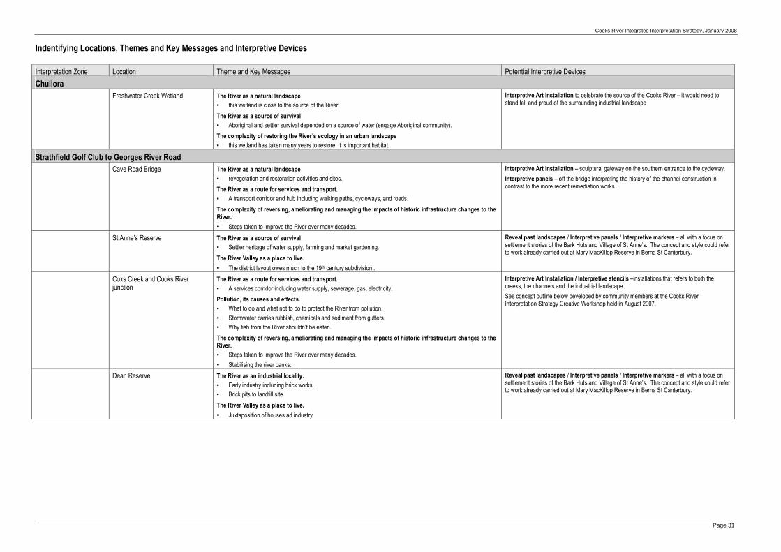
Cooks River Integrated Interpretation Strategy, January 2008
Page 31
Indentifying Locations, Themes and Key Messages and Interpretive Devices
Interpretation Zone Location Theme and Key Messages Potential Interpretive Devices
Chullora
Freshwater Creek Wetland The River as a natural landscape
• this wetland is close to the source of the River
The River as a source of survival
• Aboriginal and settler survival depended on a source of water (engage Aboriginal community).
The complexity of restoring the River’s ecology in an urban landscape
• this wetland has taken many years to restore, it is important habitat.
Interpretive Art Installation to celebrate the source of the Cooks River – it would need to stand tall and proud of the surrounding industrial landscape
Strathfield Golf Club to Georges River Road
Cave Road Bridge The River as a natural landscape
• revegetation and restoration activities and sites.
The River as a route for services and transport.
• A transport corridor and hub including walking paths, cycleways, and roads.
The complexity of reversing, ameliorating and managing the impacts of historic infrastructure changes to the River.
• Steps taken to improve the River over many decades.
Interpretive Art Installation – sculptural gateway on the southern entrance to the cycleway.
Interpretive panels – off the bridge interpreting the history of the channel construction in contrast to the more recent remediation works.
St Anne’s Reserve The River as a source of survival
• Settler heritage of water supply, farming and market gardening.
The River Valley as a place to live.
• The district layout owes much to the 19th century subdivision .
Reveal past landscapes / Interpretive panels / Interpretive markers – all with a focus on settlement stories of the Bark Huts and Village of St Anne’s. The concept and style could refer to work already carried out at Mary MacKillop Reserve in Berna St Canterbury.
Coxs Creek and Cooks River junction
The River as a route for services and transport.
• A services corridor including water supply, sewerage, gas, electricity.
Pollution, its causes and effects.
• What to do and what not to do to protect the River from pollution.
• Stormwater carries rubbish, chemicals and sediment from gutters.
• Why fish from the River shouldn’t be eaten.
The complexity of reversing, ameliorating and managing the impacts of historic infrastructure changes to the River.
• Steps taken to improve the River over many decades.
• Stabilising the river banks.
Interpretive Art Installation / Interpretive stencils –installations that refers to both the creeks, the channels and the industrial landscape.
See concept outline below developed by community members at the Cooks River Interpretation Strategy Creative Workshop held in August 2007.
Dean Reserve The River as an industrial locality.
• Early industry including brick works.
• Brick pits to landfill site
The River Valley as a place to live.
• Juxtaposition of houses ad industry
Reveal past landscapes / Interpretive panels / Interpretive markers – all with a focus on settlement stories of the Bark Huts and Village of St Anne’s. The concept and style could refer to work already carried out at Mary MacKillop Reserve in Berna St Canterbury.

Cooks River Integrated Interpretation Strategy, January 2008
Page 32
Interpretation Zone Location Theme and Key Messages Potential Interpretive Devices
Georges River Road to Canterbury–Campsie Railway Bridge
The Punch Bowl nr Walsh Avenue Croydon Park / Belfield
The River as a natural landscape
• The Punch Bowl is the limit of tidal flow.
The River as a source of survival
• Aboriginal pathways were vitally important for settlers access.
The River as a barrier
• The early use of Aboriginal pathways to access the area.
The River as a picturesque retreat.
• 19th century “gentry” establishing country houses and estates beside the River.
The River as a route for services and transport.
• A services corridor including water supply, sewerage, gas, electricity.
Interpretive Art Installation / Interpretive panels / Interpretive markers –sculptural installation that interprets Aboriginal pathways, the head of the tide and Clareville.
See concept outline below developed by community members at the Cooks River Interpretation Strategy Creative Workshop held in August 2007.
Third Avenue Reserve The River as a natural landscape
• Significant/representative/endemic/useful plants, animals and birds.
• Other natural aspects such as revegetation and restoration activities and sites.
The River as a source of survival
• Aboriginal cultural landscapes including sandstone shelters and resources
The River as a place for contemplation.
• People go to the river to reflect, think, meditate, watch and contemplate—to rejuvenate.
The complexity of restoring the River’s ecology in an urban landscape.
• Restoring native vegetation and fauna habitat communities and corridors with plants, birds and animals.
• Creating more ecologically viable embankments
Interpretive plantings / RiverStencils / Interpretive panels / Interpretive Markers / Community events / Interpretive Names
Fence the reserve with a with interpretive fencing and panels, add stencils to the channel walls to interpret the site from the opposite bank, celebrate the reserve with a community event, possibly even rename Third Avenue Reserve to something that would better reflect its significance and remnant bushland.
Laycocks Bridge (between Beamish Street and Rosedale Reserve, Ashbury)
The River as a source of survival
• Aboriginal pathways were vitally important for settler access.
• This was an early area of settler farming etc.
The River as a barrier.
• The challenge of crossing places, rights-of-way and roads and the resulting effects on settlement.
Interpretive Art Installations / RiverStencils / Interpretive panels
Laycocks Bridge was the earliest bridge across the Cooks River and probably followed an Aboriginal pathway. May also be possible to include reference to Governor Macquarie’s experience noted in his diary of 1810.
After resting for half an hour at Mrs Laycock’s, we pursued our journey to Canterbury; thus crossing Cook’s river twice over a slender bad Bridge within two miles of Mrs Laycock’s Farm and is rather dangerous for a carriage.
Lindesay Street Footbridge The River as a source of survival
• Aboriginal pathways were vitally important for settlers access.
• This was an early area of settler farming etc.
The River Valley as a place to live.
• 19th and 20th century subdivisions and developments
• Community action to improve the River over many decades.
RiverStencils / Interpretive panels
Interpret the 1830s story of Bramshot Farm bought by a confidence trickster who started up the ‘Sydney Deposits Bank’ (defrauding his customers of over £80,000). The land was sold by his creditors as the ‘Mildura Estate’ in the Depression of the 1890s with the slogan ‘Land is a bank which never fails’.
Canterbury Racecourse The River as a natural landscape
• Other natural aspects such as revegetation and restoration activities and sites.
The River as recreation area.
• Reclamation of public access, open space, and delivery of amenity landscaping.
Interpretive plantings / RiverStencils
Horse racing at Canterbury has been a popular past time since the Sugar Works was built just down the river in the 1840s. The current boundary between the racecourse and the Cooks River Walk is a high retaining wall with a narrow weedy strip of vegetation. To create a more interesting environment, and to celebrate the ongoing racing heritage associated with Canterbury, replant with local endemic species, also resurface the retaining wall and invite stencil artists to interpret the colour and movement of horse racing.

Cooks River Integrated Interpretation Strategy, January 2008
Page 33
Interpretation Zone Location Theme and Key Messages Potential Interpretive Devices
Canterbury–Campsie Railway Bridge to Lang Road Bridge
Cup and Saucer Creek Junction The River as a natural landscape
• The evolution of the landscape: cliffs, valleys, wetlands, floodplains, swamps, tributaries and meanders..
The River as a source of survival
• Aboriginal cultural landscapes including sandstone shelters and resources
The River as an industrial locality.
• Early industry including sugar works, tannery and smallgoods factory.
• Resulting industrial pollution and attempts to control it.
• Ongoing consequences of clearing and development including flood mitigation works, canals and engineering.
The complexity of reversing, ameliorating and managing the impacts of historic infrastructure changes to the River.
• Steps taken to improve the River over many decades.
• Managing stormwater sustainably (water sensitive urban design)
Interpretive plantings/ Interpretive Art Installation / Reveal Past landscapes / Interpretive stencils –installations that refers to the creek, the sandstone, the channels and the industrial landscape.
See concept outline below developed by community members at the Cooks River Interpretation Strategy Creative Workshop held in August 2007.
Sugarworks / other Industry The River as an industrial locality.
• The effect of the sugarworks, woolwash and other industries.
• Resulting industrial pollution and attempts to control it.
The River Valley as a place to live.
• 21st century redevelopments. Was / is the river an asset or a liability?
Interpretive panels / RiverStencils to simplify, correct and made more accessible the existing interpretation at the Sugar Works as resources allow
Install images and first person narratives where possible
Boat Harbour (Hutton street, Hurlstone Park)
The River as recreation area.
• Reclamation of public access, open space, and delivery of amenity landscaping.
• Passive recreation including family gatherings, community events, quiet contemplation and birdwatching.
• Active recreation including swimming, boating, walking, cycling and kayaking as well as organised sports such as football codes; golf; horse and cycle racing.
The complexity of reversing, ameliorating and managing the impacts of historic infrastructure changes to the River.
• Stabilising the river banks.
• Toxic residues in the riverbed sediment
Interpretive Art Installations / Interpretive panels
The boat harbour was created in the 1960s for the Sea Scouts as a place where rowing boats could be safely launched.
A kinetic sculpture that moves with the tides or a sculpture that is only visible at low tide would effectively interpret the site.
Ewen Park (Tennent Parade, Hurlstone Park)
The River as a natural landscape
• The evolution of the landscape: cliffs, valleys, wetlands, floodplains, swamps, tributaries and meanders.
• Significant/representative/endemic/useful plants and animals.
The River as a barrier.
• The challenge of crossing places and the effects on settlement ie Pickerings Punt was closed in 1829
The River as recreation area.
• Passive recreation including family gatherings, community events and quiet contemplation.
The complexity of reversing, ameliorating and managing the impacts of historic infrastructure changes to the River.
• Steps taken to improve the River over many decades.
The complexity of restoring the River’s ecology in an urban landscape.
• Restoring native vegetation and fauna habitat communities and corridors with plants, birds and animals.
Interpretive plantings / Interpretive Markers – the Friends of Ewen Park have been negotiating for some time with Council to retain the many uses of the reserve. It is well used by children and families. Offer interpretation aimed at early and pre-reading age, for example mosaic stepping stones depicting water life or animals that live on the river leading to cast concrete seats in the form of seed pods and shells. Active games such as Hopscotch or Snakes and Ladders with an environmental theme may also be appropriate

Cooks River Integrated Interpretation Strategy, January 2008
Page 34
Interpretation Zone Location Theme and Key Messages Potential Interpretive Devices
Sheet Piling (on bank opposite Ewen Park)
The River as a natural landscape
• The evolution of the landscape: cliffs, valleys, wetlands, floodplains, swamps, tributaries and meanders.
The River Valley as a place to live.
• Was / is the river an asset or a liability?
The complexity of reversing, ameliorating and managing the impacts of historic infrastructure changes to the River.
• Steps taken to improve the River over many decades.
• The pros and cons of stabilising the river banks.
The complexity of restoring the River’s ecology in an urban landscape.
• Creating more ecologically viable embankments
Interpretive plantings/ Interpretive Art Installation / Reveal Past landscapes / Interpretive stencils –installations that refer to the decision to install the steel piling and the difficulties in removing
See concept outline below developed by community members at the Cooks River Interpretation Strategy Creative Workshop held in August 2007.
Lang Road Bridge to Tempe–Wolli Creek Railway Bridge
Beaman Park (Wardell Road, Dulwich Hill)
The River as a source of survival
• Settler water supply, farming and market gardening.
The River as a barrier.
• The challenge of crossing places and the effects on settlement.
The River as recreation area.
• Reclamation and provision of public access open space.
Interpretive plantings / Interpretive panels – interpret Nobbs Flat market gardens and other themes in this important visitor node.
Sheet Piling (on bank opposite track in Marrickville Golf Club)
The River as a natural landscape
• The evolution of the landscape: cliffs, valleys, wetlands, floodplains, swamps, tributaries and meanders.
The River Valley as a place to live.
• Was / is the river an asset or a liability?
The complexity of reversing, ameliorating and managing the impacts of historic infrastructure changes to the River.
• Steps taken to improve the River over many decades.
• Stabilising the river banks.
The complexity of restoring the River’s ecology in an urban landscape.
• Creating more ecologically viable embankments
Interpretive plantings/ Interpretive Art Installation / Reveal Past landscapes / Interpretive stencils –installations that refer to the decision to install the steel piling and the difficulties in removing
See concept outline below developed by community members at the Cooks River Interpretation Strategy Creative Workshop held in August 2007.
Illawarra Road Bridge The River as a barrier.
• The challenge of crossing places, rights-of-way and roads and the resulting effects on settlement.
The River as a picturesque retreat.
• 19th century “gentry” establishing country houses and estates beside the River.
The complexity of reversing, ameliorating and managing the impacts of historic infrastructure changes to the River.
• Steps taken to improve the River over many decades.
Interpretive panels / Interpretive Markers / Interpretive plantings – interpret the complex story of the river as a barrier and its great inonvenience to locals etc
Steel Park (Illawarra Road, Marrickville)
The River as a natural landscape
• The evolution of the landscape: cliffs, valleys, wetlands, floodplains, swamps, tributaries and meanders.
• Significant/representative/endemic/useful plants and animals.
The River as a source of survival
• The River and creek offers space for inspiration, reflection, contemplation or respite from nearby urban environments.
The River as recreation area.
• Reclamation of public access, open space, and delivery of amenity landscaping.
Interpretive plantings / Interpretive Art Installations – interpret and enhance the landscape including the mangroves on both sides of the river. A short boardwalk and a viewing platform could be built —canter-levered over the river. The viewing platform could have a simple interpretive element that allows a magnified view of the animals in the water and an identification chart.

Cooks River Integrated Interpretation Strategy, January 2008
Page 35
Interpretation Zone Location Theme and Key Messages Potential Interpretive Devices
Warren Park (Thornley Street, Marrickville
Also Richardson Reserve
The River as a source of survival
• Aboriginal cultural landscapes including sandstone shelters and resources.
• Aboriginal cultural heritage including creation stories, pathways, resistance and continuing lifestyles.
The River as a picturesque retreat.
• 19th century “gentry” establishing country houses and estates beside the River.
The River Valley as a place to live.
• 20th century subdivisions.
The complexity of reversing, ameliorating and managing the impacts of historic infrastructure changes to the River.
• Managing stormwater sustainably (water sensitive urban design)
Interpretive Art Installation / Reveal Past landscapes / Interpretive panels –installations that refer to Aboriginal heritage, settler heritage, Holt’s house ‘The Warren’, subsequent subdivisions and storm water harvesting etc
See concept outline below developed by community members at the Cooks River Interpretation Strategy Creative Workshop held in August 2007.
Gumbramorra Swamp near Mackey Park, Tempe
The River as a natural landscape
• The evolution of the landscape: cliffs, valleys, wetlands, floodplains, swamps, tributaries and meanders
• Significant/representative/endemic/useful plants and animals
The River as a source of survival
• Aboriginal cultural landscapes including sandstone shelters and resources
• Aboriginal cultural heritage including creation stories, pathways, resistance and continuing lifestyles
The River Valley as a place to live.
• 19th and 20th century subdivisions and redevelopments. Was / is the river an asset or a liability?
The complexity of reversing, ameliorating and managing the impacts of historic infrastructure changes to the River.
• Steps taken to improve the River over many decades.
• Managing stormwater sustainably (water sensitive urban design)
Interpretive Art Installation / Reveal Past landscapes / Interpretive panels Gumbramorra Swamp was a huge area north from the Cooks River. Interpret Aboriginal resources, 1880s subdivision(with its regular flooding)
The interpretation of the site should include the extent of the once vast swamp and what happens when watercourses are built on. There is potential to include a sculpture of a bark canoe and swamp plants as a walk-through sculpture.
Gough Whitlam Park The River as a natural landscape
• The evolution of the landscape: cliffs, valleys, wetlands, floodplains, swamps, tributaries and meanders.
• Significant/representative/endemic/useful plants and animals.
The River as a barrier
• The challenge of crossing places, rights-of-way and roads and the resulting effects on settlement.
The River as a picturesque retreat.
• 19th century “gentry” establishing country houses and estates beside the River ie ‘Wanstead’
The River as recreation area.
• Passive recreation including family gatherings, community events and quiet contemplation.
Pollution, its causes and effects.
• Stormwater carries rubbish, chemicals and sediment from gutters.
The complexity of restoring the River’s ecology in an urban landscape.
• Restoring native vegetation and fauna habitat communities and corridors with plants, birds and animals.
Interpretive Art Installation / Reveal Past landscapes / Interpretive panels –installations that refer to natural heritage, the early dam, other infrastructure and management issues
See concept outline (developed with Wolli Creek Junction) below developed by community members at the Cooks River Interpretation Strategy Creative Workshop held in August 2007.
Waterworth Park (Bayview Avenue, Undercliffe)
The River as a picturesque retreat
• The River as a locality for historic and contemporary art.
The River as recreation area.
• Active recreation including swimming, boating, walking, cycling and kayaking as well as organised sports such as football codes; golf; horse and cycle racing.
Interpretive Art Installation – to interpret he Sydney Long painting, ‘By Tranquil Waters’ (1889), that is believed to have been painted at the junction of Cooks River and Wolli Creek.

Cooks River Integrated Interpretation Strategy, January 2008
Page 36
Location Theme and Key Messages Potential Interpretive Devices
Tempe–Wolli Creek Railway Bridge to the River Mouth
Tempe Reserve (Holbeach Avenue, Tempe)
The River as a picturesque retreat.
• The River as a locality for contemporary art.
The River as a route for services and transport.
• The Alexandra Canal as a transport corridor.
The River as an industrial locality.
• Industrial pollution and attempts to control it from mid 19th century on.
• Ongoing consequences of clearing and development including flood mitigation works, canals and engineering.
The River as recreation area.
• Reclamation of public access, open space, and delivery of amenity landscaping.
Pollution, its causes and effects.
• Why fish from the River shouldn’t be eaten.
The complexity of ameliorating and managing the impacts of historic infrastructure changes to the River.
• Toxic residues in the riverbed sediment
Interpretive Art Installations / River Stencils / Interpretive panels / Interpretive Markers / Community events Reserve has been significantly enhances in recent years with the saltmarsh garden and Bronwyn Bancroft’s the Gift Given art work. Various media could interpret the elements including the Alexandra Canal (possibly the most polluted waterways in Australia).
Eve Street Wetland The River as a natural landscape
• The evolution of the landscape: cliffs, valleys, wetlands, floodplains, swamps, tributaries and meanders.
• Significant/representative/endemic/useful plants and animals.
• Other natural aspects such as revegetation and restoration activities and sites.
• Managing stormwater sustainably (water sensitive urban design)
The complexity of restoring the River’s ecology in an urban landscape.
• Restoring native vegetation and fauna habitat communities and corridors with plants, birds and animals.
• Improving water quality.
Creating more ecologically viable embankments
RiverStencils / Interpretive panels – would interpret of the fight to retain and restore these wetlands and the importance of wetlands in natural ecosystems.
Market Gardens, Bestic Street Rockdale
The River as a source of survival
• Settler heritage of market gardening.
The River as a route for services and transport.
• Local sewerage farm
Interpretive panels / Interpretive Markers – would interpret both the current market gardens and the previous local history of sewage farms
Cook Park (General Holmes Drive,)
The River as a natural landscape
• The evolution of the landscape: cliffs, valleys, wetlands, floodplains, swamps, tributaries and meanders.
The River as a source of survival
• Aboriginal cultural landscapes including sandstone shelters and resources.
The River as a route for services and transport.
• A transport corridor and hub including walking paths, cycleways, railways, airport and freeways both proposed and achieved.
The complexity of restoring the River’s ecology in an urban landscape.
• Restoring native vegetation and fauna habitat communities and corridors with plants, birds and animals.
• Improving water quality.
Interpretive plantings / Interpretive Art Installations / Interpretive panels / Community events – would interpret the changes environment of the river mouth, Aboriginal values, early ‘explorer’ perceptions of the River, and the many perspectives on migration – both contemporary (associated with the airport) and historic; and flight – planes and shorebirds.

Cooks River Integrated Interpretation Strategy, January 2008
Page 37
Interpretive and Artistic Landscape Concepts developed at the Cooks River Interpretation Strategy Creative Workshop
A Creative Workshop was held on 12 August 2007 as part of the project’s community engagement plan. A small group of creative and dynamic stakeholders were invited to attend and the participants focussed on key areas, identified throughout the project, for interpretive devices. Following information sharing and creative thinking sessions, ideas were generated, discussed and documented by the participants. The participants included: artists, designers, community members and project team members who each contributed generously. The 4-hour workshop resulted in the creative concepts for the locations outlined below.
Coxs Creek junction with Cooks River
Enhance natural aspects of the broad landscape – without necessarily changing the structure of the concrete channels (but preempting their decay). Erect a huge sculpture of a frog at the watercourse junction to represent a ‘phoenix’ rising … a frog rising out of industrial disaster. The channel walls could be painted with a mural or stenciled to interpret the history of the locality.
The Water Street Bridge could be treated with paint and stencils to interpret the connections. Install media to direct people to Maria Reserve.
Natural elements in the landscape would slow the flow of water and encourage ponding in reed beds.
Landscape design would include: � View points to natural and industrial landscapes � Seating � Enhanced locally provenanced plantings � Water ponds � A giant sculpture interpreting nature and industry – for example a Green and Golden Bell Frog fashioned from industrial
waste. � 2D installations such as murals and stencils Interpretation would focus on: � Extreme differences between natural and industrial landscapes � The complexity of restoring the River’s ecology in an urban landscape. � Improving water quality and animal and plant habitat � Bush regeneration at Maria Reserve and use of remnant bushland for seed store.
Punch Bowl (Punchbowl)
Enhance some natural aspects in the locality but some interpretive embellishments are also recommended. The Punch Bowl is the head of the tide. An Aboriginal pathway crossed the River at the Punch Bowl and existed before the first surveys.
Landscape design would include: � Enhance some natural aspects � The undercroft of the road bridge would be enhanced with sculptural elements and better lighting but would discourage
loitering � Modern urban totems � New interpretive railings on the bridge � Remove fencing along channel – soften edges with locally provenanced plants � Install seating in the parkland areas � Planting put under bridge using non comfortable rocks as mulch will dislodge into river discourage congregation of people
under bridge but install lighting Interpretation would focus on: � Extreme differences between natural and industrial landscapes � Tidal movement and flow – mark the high tide point as it gave some surety for crossing the river � Footpath installations could lead visitors on a journey interpreting stories of the locality � Clareville –a retreat for high class people, country estates, regal seating, conventional plantings
The location is well located for a biannual (every 6 months) stencil art festival – the artwork would stay relevant, and regular renewal of the art would be a bonus for local users. A stenciling festival could be linked with other arts programs and it would encourage young artists.

Cooks River Integrated Interpretation Strategy, January 2008
Page 38
Cup and Saucer Creek junction with Cooks River
Recreate and enhance a natural landscape – a creek through sandstone a series of cup and saucer-like ponds and wetlands, with trees as appropriate – a place for meeting, eating, community life and celebration.
Landscape design would include: � Recreated wetland with a “reconciliation garden” meeting place with paving, seating, interpretation and sculpture � a wetland focussing on the junction between salt and fresh water � seats and other places for contemplation � interpretive sculptural pieces – perhaps derived from school students sketches - possibly exploring the natural processes
Cup and Saucer Creek � sculptural elements would interpret industrial legacy, tannery etc � sculptural totems interpreting aquatic / terrestrial ecology including animals and plants Interpretation would focus on: � Aboriginal use of the creek/river junction salt/fresh water Aboriginal peoples use of land and resources (land, fresh and salt
water resources) � interpret formation of “cup and saucer” potholes in the sandstone creek bed – some of these potholes are still visible � “cup and saucer” effect � aquatic life in the area � terrestrial animals � pre-contact and settler crossing point at low tide � meeting of salt and fresh water ecology interpret industrial use of fresh water � the contemporary reasons for turning it into a stormwater drain, the consequences of concreting roads and backyards � integrating historic images
This location is also a central and easily accessible location for an annual Sculpture by the River event with a permanent installation resulting every year from the more ephemeral entries – ultimately there would be a permanent sculpture walk cf Forest of Dean which would be a great tourist walk and a valuable cultural site in western Sydney.
Sheetpiling
A couple of sites along the river could be used to interpret themes associated with the use of metal sheetpiling. It provides an opportunity to explore the decisions made in the past and how they might affect the present and the future. The River as survived but it is difficult to restore it to a natural state. Each generation make decisions, using the knowledge, ideas and beliefs that they have, to meet current needs. It is important to take responsibility for the future. Sites for contemplation would also be included.
Landscape design would include: � Enhanced natural landscapes including wetlands � Contemplative spaces � Perches for birds in river � Soundscape glimpses of oral history � Sculptural elements made from sheetpiling – maybe maze-like � Reflections of the rhythm of sheetpiling a “dig’ behind the piling to show what was used as infill – leave a cross-section for
people to see the ‘miasmatic morass’ Interpretation would focus on: � Decision making in the past, the present and the future – taming the River � Sustenance work in the depression of the 1930s � The river as a source of survival for people, plants, animals and birds � Positive aspects of installing sheet piling – how it was used to control the river, now it provides a walking place that isn’t
inundated � The problem of the ‘miasmic morass’ of swampy reeds � Interpret the difficulties in removing the sheet piling � Stormwater management and innovation
Historic decisions about sheetpiling and ‘taming the river’ have resonance with contemporary decisions about action for climate change and water access and management.
The Warren Park and Richardson Reserve
The Warren Park and Richardson Reserve are excellent venues for interpretation of natural values(topography and wildlife), Aboriginal country, the Warren and later subdivisions, as well as storm

Cooks River Integrated Interpretation Strategy, January 2008
Page 39
water management. Interpretation should be included in the amenity infrastructure such as seats, stairs, gardens, fences and pathways that could be the canvas for stories about the site.
Warren Park has vestiges of its colonial past still visible. Two pillars from the Warren Estate have been moved to the top section of the park and burial vaults in the section near the river are still intact. This particular area is highly significant to local Aboriginal people. It is believed to be an important lookout point. Aboriginal artwork (hand and foot stencils) and a midden still exists on private land across the river at Undercliffe. Further evidence of Aboriginal occupation may also occur in the relatively undisturbed soils in the vaults.
Landscape design would include: � Views to natural landscape elements � Enhanced opportunities to see wildlife – bird hide etc � Paths with sculptures elements, bird images � Long path up the hill should include mosaic installations interpreting natural history, Aboriginal values etc maybe as a
timeline ending in a sculpture of wading birds and water plants Interpretation would focus on: � Sandstone landscape and outcrops � Wildlife, in particular birds: water birds and waders on saltmarsh / mangrove to birds on higher slopes and woodlands � Aboriginal resistance: Gadigal- Pemulwuy crossing and Aboriginal lookout if they can be confirmed � Council has made efforts to revegetate and restore – talk about rain gardens??? � Places to live – include Warren, barracks and subdvision
Wolli Creek junction with Cooks River and Gough Whitlam Park
This area is a meeting place for children, families and communities – including people of diverse backgrounds. It fits with proposals for Two Valley Trail as an outdoor classroom - a place where children can educate their families about indigenous plants, animals and culture. It allows space to meet and imagine. It includes media in community languages about the surrounding habitat and the importance on conservation. The site might include interactive sculpture trail with oversized elements of creatures that interpret and explore plants and animals eg scales of snakes / reptiles, claws of mudcrab, seed pods, flowers etc. Voice or wind sounds, would be included. Landscape Design would include: � creative and naturalistic use of billabong at Gough Whitlam Park � a new wetland � creative furniture and equipment for children and family use � outdoor classrooms � local animals as larger than life sculptures able to swivel on spot – sited on a sand pit or on water – suitable to climb inside
and look through (crabs, fish, birds etc) with textures and moving parts for children to explore � tubular sculptures allowing play with water and sand Interpretation would include interpretation in community languages and focus on: � plants and animals associated with restored environments: existing billabong and newly created wetland including fish;
crabs; eels; birds and invertebrates � Aboriginal survival – middens and resources � old Cooks River Dam wall � mouth of Wolli Creek � nearby Fatima Island has Catholic associations but has now been adopted by Muslim families – it is a friendly place � origins of people – movement of tide symbolizing people moving – emphasizing connections to Botany Bay and the River
and place of first non-Aboriginal arrival

Cooks River Integrated Interpretation Strategy, January 2008
Page 40
Recommendations to Encourage Authentic and Enjoyable Interpretation
Communicating effectively is a fundamental responsibility for the ongoing management of the River and its foreshores and it is a vital part of the conservation process. To ensure interpretation opportunities are well integrated into councils’ activities, it is recommended that the following questions are always ‘asked’ when planning works and initiatives:
� How can this initiative/event/activity/publication interpret the values and management of the River?
� How can the catchment communities and associated people be involved?
� Which theme/s will this initiative interpret?
� How can we interpret Aboriginal culture, country or community with this initiative?
� How can we incorporate, engage and acknowledge community diversity?
� How do we deliver a diverse range of interpretive devices?
� How can people with limited mobility or sight/hearing impairment access this interpretation?
� How can people find out more?
� Which evaluation methods should be used to assess the interpretation concept while it is in development?
� How can this interpretive initiative stimulate children/families/non-English speakers/others to understand more about the River?
Community members in the Cooks River catchment and the many interest groups focused on the River have embraced the concepts outlined in this report and regular activities are held to broaden appreciation of, and enhance, the Cooks River and its foreshores.
In addition to the interpretive initiatives outlined above, the following recommendations are put forward for the consideration of the Cooks River councils and others with management responsibility.
Interpret Aboriginal Values and Heritage
Create continuing links to appropriate people and groups in the Aboriginal community and, in turn, encourage collaboration in developing interpretive devices. Aboriginal staff should be encouraged to explore the Aboriginal history of the River and to develop interpretive initiatives for Aboriginal values and bring them to completion.
Lead by example by employing more Aboriginal staff.
Consider providing an Aboriginal keeping place and cultural centre. Following appropriate consultation with the Aboriginal groups associated with the Cooks River and the council areas, it could combine with other community activities in a well-used location, such as the Olympic Sports Club building which is adjacent to the River and very centrally located.
There is potential for Aboriginal values to be interpreted using any of the initiatives proposed above, but particular devices might include art work that could provide an appropriate ‘Welcome to Country’ along the River. It could emphasise the lack of documented evidence relating to the connections of Aboriginal people to the River, a poignant reminder of the experience of Aboriginal people’s dispossession and displacement (see Appendix D).
Pursue Excellence in Face-to-Face Interpretation Delivery
The RiverLife Interpretive Guided Tours deliver excellent interpretive experiences. Continue to support and grow the RiverLife program with a professional approach to face-to-face interpretation. The Cooks River councils, along with other tour operators and agencies working in Sydney, should work together to continue to grow and support a professional approach to face-to-face heritage interpretation.
The councils should resource the RiverLife volunteers, by providing regular training and skills enhancement collaborative learning, management of groups and appropriate group control skills.
Where possible RiverLife Guides should be encouraged to work with Aboriginal community members to include Aboriginal values as well as diverse community perspectives.
New volunteer guides should be recruited and trained annually or every two years.

Cooks River Integrated Interpretation Strategy, January 2008
Page 41
Evaluate Interpretive Initiatives
Interpretation along the Cooks River should deliver world quality initiatives that enhance visitor experiences in informal learning settings that effectively communicate to, and inspire, the wide variety of identified audiences. To ensure this, effective evaluation of interpretive initiatives is necessary.
Most museums, public agencies and tourist operations evaluate or test communication initiatives and programs for their effectiveness. This happens while they are in development and after they are installed or in operation. In order to deliver high-quality, accessible interpretation that enhances visitor experiences, it will be important for the CRFWG councils to evaluate new interpretive media to ensure that it communicates effectively to target audiences. This could be done by engaging test audiences in evaluation when initiatives are in concept stage (formative evaluation) by using the following techniques:
� small focus groups of lay audiences during development stages of interpretive media concepts and design;
� peer review by professionals engaged in developing communications, particularly heritage interpretation and media;
� informal, but focused, inquiry of visitor and others of on-site mock-ups; and
� broad community consultation.
Once interpretive media is installed, or being delivered in the case of tours, events etc, it is important to regularly evaluate, refine and review each installation or activity to measure the effectiveness of the interpretation in delivering key messages on identified themes. This could be achieved by adapting the techniques listed above, but other methods would include using TAFE or university students with relevant skills to track, observe and conduct direct participant interviews.
Rationalise Plaques and Panels
The Cooks River councils are in the process of rationalising and reducing the sheer number of signs, information plaques and markers along the River as a result of the Cooks River Foreshore Signage Audit, 2000. Over time, some will be replaced with more interpretive media.
This would include installations that are commemorative, memorial or simple markers that do not have intrinsic heritage values or do not extend the stories of the River. As this Interpretation Strategy is implemented throughout the study area, existing media should be carefully reviewed, including the removal of simple markers and duplicated information. Their replacement, with interpretive installations that reveal an authentic story, should involve consultation with appropriate individuals or groups.
Existing plaques, or the information on them, could then be incorporated into new interpretive media. Redundant plaques would be documented and stored.
Resource Educational Experiences
Plans are in development for educational experiences along the River, many schools already use the open spaces for learning venues and topic areas. The Cooks River councils should support excellent learning programs, where possible providing resources and enhancing partnership networks.

Cooks River Integrated Interpretation Strategy, January 2008
Page 42
Interpretation into the future
The initiatives outlined in this strategy and the recommendations above provide opportunities to infuse world class interpretive devices along the Cooks River. Some of the interpretive media will be subtle, some surprising, some bold and provocative—but together the initiatives will create a unique atmosphere; engage a variety of audiences, evoking for them a deeper, more authentic and textural experience of the past and the present, and reveal meanings otherwise obscured in the busy day-to-day experience of the Cooks River foreshore.
Implementation of the Cooks River Integrated Interpretation Strategy will require site-specific interpretation planning involving the collaboration of community members, artists, designers and those with responsibilities for managing the site – particularly council’s cultural and amenity planners, architects and landscape architects.
Site-specific interpretation planning and content development may include the following:
� Content Development where the recommendations would be developed into site-specific interpretive media by supporting community activities, commissioning artworks, or defining suitable content for static or printed media including text and images. It would include input by specialists in art, design, interpretation and community engagement.
� Implementation would detail design, production and installation of interpretive media as appropriate.
Ideally, future interpretive planning would be undertaken in a collaborative way:
� under the direction of the Cooks River Foreshores Working Group;
� as resources become available; and
� with heritage, interpretation and design professionals either within council or external consultants.
Each site would be interpreted according to recommendations in the Strategy but each site could be developed and implemented as and when opportunities occur ie when landscape amenity works or location upgrades are being undertaken in the future.

Cooks River Integrated Interpretation Strategy, January 2008
Appendix A – Known Organisations, Community Groups and Individuals Associated with the Cooks River
Appendix A
Known Organisations, Community Groups and Individuals associated with the Cooks River

Cooks River Integrated Interpretation Strategy, January 2008
Appendix A – Known Organisations, Community Groups and Individuals Associated with the Cooks River - Page 1
Known Organisations, Community Groups and Individuals Associated with the Cooks River CG = Community group, C = Council, SG = State Government, I = Individual, NGO = Non-Government Organisation
Contacts made to date and outcomes of consultation
Type Organisation Who Contact Connected? Outcome
CG Cooks River Valley Association
Amanda Barker, President 0410 217 965 yes Team members attended organisation meeting to talk about project and how they might get involved.
Team members attended Cooks River Forum.
Organisation member attended Listening Workshop.
CG The Mudcrabs
began cleaning up litter and weeding, July 2005.
Peter Munro, Chris Barltett, Bronwyn Tuohy
Peter: [email protected]
Chris: 9558 2656
Bronwyn: 9558 2656; 0407 005 250; [email protected]
yes Team members attended organisation meeting to talk about project and how they might get involved
Meeting planned with Bronwyn Tuohy re: Riverworks 2007.
CG Friends of Ewen Park
seek balanced use of community resources of Ewen Park
Nadia Wheatley, Co-Convenor
yes Team members met with Nadia to talk about project and how they might get involved.
Organisation members attended Listening Workshop.
On-going involvement.
CG Wolli Creek Preservation Society
Peter Stevens, Vice Pres 9554 3176 H yes Team member met with Peter
Team members participated in Two Valley Trail walk
Organisation member attended Listening Workshop and two are nominated for the Creative Workshop
LG RiverLife Interpretive Tour Program
Rebecca Whitehall, Coordinator
[email protected] 0439 139 396
yes Team members attended organisation meeting to talk about project and how they might get involved.
On-going discussions and involvement including with the High Tide Event on May 17.
Volunteer guides attended Listening Workshop.
CG South West Environment Centre (and Botany Bay & Catchment Alliance)
Gary Blaschke, Convenor [email protected]
9759 0997 W
Emails and phone
Team member discussed project on the phone.
Project team yet to arrange site visit to Freshwater Creek Wetlands In Chullora

Cooks River Integrated Interpretation Strategy, January 2008
Appendix A – Known Organisations, Community Groups and Individuals Associated with the Cooks River - Page 2
Type Organisation Who Contact Connected? Outcome
CG, LG
Cooks River to Iron Cove GreenWay Committee
Bruce Ashley and Hilary Sheppard
9560 9281 H www.greenway.org.au
Yes Team members meet to talk about overlaps of CR project and GreenWay We aim to put synergies to work.
GreenWay Coordinator, Hilary Sheppard, is a member of project team.
SG NPWS – Girrawheen Regional Park
Paul Ibbetson, Ranger 9337-5511 0438 274 749
Yes Met and discussed project. Invited to Listening Workshop. Will be invited to Creative Workshop. May have further involvement
SG Sydney Metropolitan CMA Judy Christie Regional Natural Resource Management Facilitator -Sydney Metropolitan
9895 7753 [email protected]
Yes Met briefly and discussed project.
Invited to Listening Workshop—unavailable.
Will be invited to Creative Workshop.
May have further involvement.
LG Marrickville Council Caroline Glass-Pattison Community Development Worker, Aboriginal Services
PO Box 14, Petersham NSW 2049 w:9335 2243 [email protected]
Yes Met and discussed project. Caroline and members of Marrickville Aboriginal Consultative Council (MACC) invited to Listening Workshop.
Will be invited to Creative Workshop.
Further involvement intended with MACC.
CG Metropolitan Local Aboriginal Land Council
Allen Madden
Education Officer
Yes Very brief telephone discussion with Allen.
Invited to Listening Workshop—unavailable.
Will be invited to Creative Workshop.
May have further involvement.
LG Canterbury Council Joanna Stobinski
Admin: Canterbury Aboriginal Advisory Group
w: 9789 9472 [email protected]
Yes Team members to attend May 2007 meeting of Canterbury Aboriginal Advisory Group to talk about project and how they might get involved.
CG, LG
Canterbury Aboriginal Advisory Community
Cindy Berwick
Chair: Canterbury Aboriginal Advisory Group
0411 557 079 Yes Our team will attend meeting of 16 May at 5.30 to discuss interps project – the group has ½ hour meetings every three months. (see above)
I Local Resident, Plant Ecologist and Author
Doug Benson
Royal Botanic Gardens Sydney
w: 9231 8148 [email protected]
Yes Emails about the project sent—responses received.
Attended Listening Workshop.
Doug’s (and others) Missing Jigsaw Pieces provides an important resource for this project.
Doug reviewed Lesley Muir’s history and provided thoughtful and constructive critisism.
May have further involvement.

Cooks River Integrated Interpretation Strategy, January 2008
Appendix A – Known Organisations, Community Groups and Individuals Associated with the Cooks River - Page 3
Type Organisation Who Contact Connected? Outcome
CG Marrickville Heritage Society Richard Blair (newsletter) [email protected]
9557 3823
Yes Organisation member attended Listening Workshop.
On-going involvement.
LG Marrickville Historian Chrys Meader, Marrickville Council
Petersham Town Hall
107 Crystal Street
Petersham
9335-2287 [email protected]
Yes Team members met with Chrys. CR history, local history, library resources, contacts, vast knowledge & very enthusiastic. Chrys provided access to Marrickville Aboriginal Oral History Project.
Chrys reviewed Lesley Muir’ history.
May have further involvement.
LG Canterbury Council Chris King
Canterbury Librarian
02 9789 9380 [email protected]
Yes Telephone discussions with Chris.
Invited to Listening Workshop—unavailable.
Chris reviewed Lesley Muir’ history.
May have further involvement.
I Local historian Cathy Jones [email protected] C/ Strathfield Council 9748 9937
Indirect Cathy reviewed Lesley Muir’ history.
May have further involvement
SG Sydney Metropolitan CMA Phillip Birtles
Community Support Officer - Local GovernmentProject Officer
989562199895 6223 M 0422 266 070 [email protected]
Phone calls and emails
Emails about the project sent – responses received.
Invited to Listening Workshop—unavailable.
Will be invited to Creative Workshop.
May have further involvement.
SG Sydney Metropolitan CMA Tabitha Timbery-Cann Community Support Officer - Aboriginal
9895 7907 Emails Emails about the project sent – responses received.
Invited to Listening Workshop but did not attend.
Will be invited to Creative Workshop.
May have further involvement.
NGO Total Environment Centre Jeff Angel
Level 2, 362 Kent Street, Sydney 2000
9299 5599
www.tec.org.au
Email + phone
Emails about the project sent – responses received.
Invited to Listening Workshop but did not attend.
May have further involvement.
CG Canterbury and District Historical Society
Louise Roberts 9312 9563 wk [email protected] 0402 228 330
Indirect Project team member, Lesley Muir, is in regular contact with the Society.

Cooks River Integrated Interpretation Strategy, January 2008
Appendix A – Known Organisations, Community Groups and Individuals Associated with the Cooks River - Page 4
Type Organisation Who Contact Connected? Outcome
I Local resident and historian Brian Madden Yes Attended Listening and Creative Workshop.
Peer Review of Lesley Muir’s History.
I Local resident and historian Mark Matheson 9559 5502 Email + phone
Phone calls and emails to discuss project—has deferred to Lesley Muir’s historical skills
CG Inner West Aboriginal Community Cooperative
Phemie Bostock and others Personal contact
Incidental meetings
LG, CG
Marrickville Aboriginal Consultative Committee (MACC)
Lester Bostok Via Caroline Glass-Pattison
Personal contact
Waiting for confirmation of members of MACC Cultural Heritage Working Group.
Invited to Listening Workshop but did not attend.
Incidental meetings

Cooks River Integrated Interpretation Strategy, January 2008
Appendix A – Known Organisations, Community Groups and Individuals Associated with the Cooks River - Page 5
Local Venues
Organisation Who Contact Connected? Outcome
Club Sydney Olympic Sporting Club
64 Tennant Parade HURLSTONE PARK 2193 NSW
9559 4707
Yes Venue for Listening workshop
Now defunct
Club River Canoe Club Kim Reeves Kim: 9559 5834 [email protected]
It isn’t fully accessible due to stairs
Equipt: 2 small tables (trestles in storage downstairs) plenty of chairs, visit before you book
Club Canterbury Hurlstone Park RSL Club
20-26 Canterbury Road HURLSTONE PARK 2193 NSW
David Starr [email protected] (02)9559-0000
Club Cooks River Motor Boat Club
Holbeach Ave, Tempe 9558 5522
Club Concordia Club Ltd 1 Richardson Crs Tempe 2044
p: (02) 9554 7388
LG & Club
Debbie & Abbey Borgia
Community Recreation Centre
531 Illawarra Road, Marrickville, 2204
p: 9559 7722
I believe council leases this facility to the Police & Citizens Youth Club (PCYC)

Cooks River Integrated Interpretation Strategy, January 2008
Appendix B - Known Documentary Resources on the Cooks River—Annotated Bibliography
Appendix B
Annotated bibliography of known documentary resources relating to the Cooks River

Cooks River Integrated Interpretation Strategy, January 2008
Appendix B - Known Documentary Resources on the Cooks River—Annotated Bibliography - Page 1
Known Documentary Resources on the Cooks River—Annotated Bibliography
Publications
Printed works both published and unpublished are listed here. The list does not include publications that are deemed unlikely to provide on-going use to the interpretation planning process.
ACU National, Centre for Environmental Restoration & Stewardship, 2006. Cooks River Ecological Monitoring Program – Phase I, Pilot Study and Monitoring Program Design – Final Report.
ACU National, Centre for Environmental Restoration & Stewardship, 2006. Cooks River Ecological Monitoring Program – Phase 2
Angel J. 1975. “The Waterway Sydney Forgot: The Cooks River” in Education p.398-9, November 19, 1975.
Article written by a Research Officer with the Total Environment Centre to motivate teachers to raise awareness of the state of the Cooks River and of opportunities to improve it.
Attenbrow V. 2002 Sydney’s Aboriginal Past: Investigating the Archaeological and Historical Records, UNSW Press.
A good resource covering Sydney’s Aboriginal History. No specific reference to the study area other than two references to fishing in the Cooks River in the 1830s on p84 & p103.
Benson D, D Ondinea and V Bear. 1999. Missing Jigsaw Pieces the Bushplants of the Cooks River Valley. Royal Botanic Gardens Sydney.
This book presents the interwoven values of people, plants and landscape of the study region – it is a vital source of information to interpretation of the river.
Clouston. Cooks River Foreshores Strategic Plan Volume 1 Summary Paper and Issues. Unpublished report prepared for the Cook River Regional Working Party. December 1997. Photocopy.
This volume describes the management issues as seen by the study team including: the urban context of the river; its landscape character; and access and circulation. It makes recommendations for plant, animal and water management. It also lists and briefly describes the river’s cultural heritage along with general recommendations for interpretation etc.
Clouston. Cooks River Foreshores Strategic Plan Volume 2 Strategies and Implementation. Unpublished
report prepared for the Cook River Regional Working Party. December 1997. Photocopy.
This volume contains the strategies recommended by the study team in 1997 to manage and improve the Cooks River Foreshores. Some recommendations have been implemented in the intervening years.
Clouston. Cooks River Foreshores Strategic Plan Volume 3 Appendices. Unpublished report prepared for the Cook River Regional Working Party. December 1997. Photocopy.
This volume contains several useful reports including:
Remnant Indigenous Plants and Communities—describes the remaining patches of native vegetation on the river, other remnant endemic vegetation in the catchment and other reference vegetation.
Vegetation Communities of the Cooks River Valley—describes specific communities and lists the relevant plant species that currently grow, have grown or are likely to have occurred historically in each plant community.
Fauna Models—lists the relevant bird, mammal, reptile and frog, fish and other aquatic fauna, and invertebrates species that currently occur, have occurred or are likely to have occurred historically along the Cooks River.
Explanatory Notes for Water and River Bank Management Strategies—these notes provide clear explanations that may be useful to interpret management decisions.
Minutes of Community Workshops—lists stakeholders attending, and comments arising at, community workshops in 1996. Several recommendations for interpretation including historical walks; festivals; interpretive education centre (Eve St Wetlands and/or Wolli Creek intersection); interpretation at view points (Tempe House, The Warren and other prominent locations);
Cooks River Integrated Interpretation Strategy, January 2008
Appendix B - Known Documentary Resources on the Cooks River—Annotated Bibliography - Page 2
Public Response via Postcards—ranks ‘environmental education’ as a priority response behind prevention of pollution, protection / planting of native vegetation and naturalising river banks.
Clouston 2005 Kendrick Park Foreshore Restoration Plan, A3 hard copy report.
While this report is quite site specific, it documents a number of green engineering projects which serve as inspiration for good practice in the Kendrick Park Project which is a good contextual reference for interpretation in the Cooks region. It also provides a brief tabulated summary of stakeholder consultation responses.
Cooks River Catchment Management Committee. 1993. Cooks River Catchment Management Strategy, CRCMC.
Contains (another) concise history, good and simple catchment map and strategies to improve the catchment.
Cooks River Catchment Management Committee. 1995. Cooks River Newsletter First Edition, May 1995, CRCMC.
First newsletter of the now defunct CRCMC.
Cooks River Catchment Management Committee. 1999. Cooks River Catchment Management Strategy. CRCMC.
Contains summary of the River catchment, its constituent flora and environmental progress. Of particular importance for interpretation of the Cooks River is s5.6 Education and Awareness Action Plan.
Cooks River Environmental Assessment and Education Project (folder). c2000. Bringing the Cooks River to Life. Cooks River Association of Councils, Sydney.
An information package about pollution and how to prevent it - information about the project and project outputs are available on CookNet.
Cooks River Foreshores Working Group. 2000. Cooks River Reporter First Edition, Summer 2000-01. CRFWG.
First newsletter of the CRFWG, contains some useful information — now superseded by the CookNet website, CRFWG Annual Reports and the February 2007 Cooks River Community Update (SMCMA).
Cooks River Foreshore Working Group 2004. Annual Report 2004, CRFWG.
First annual report of the CRFWG. Includes a history of the CRFWG and the Cooks River Foreshores Strategic Plan, as well as information on CRFWG and member-initiated projects. The projects include: Access recreation and use projects, Natural conservation and restoration projects, Water and riverbank management projects, Character and cultural heritage projects, Interpretation and promotion projects and Planning and administration projects.
Cooks River Foreshore Working Group 2005. Annual Report 2004 - 2005, CRFWG.
This report details Cooks River-related projects underway or completed by the CRFWG, member organisations and local community groups during FY 2004/05, and summarises external developments impacting on the River.
Cooks River Foreshores Working Group 2006. Annual Report 2005/06, CRFWG
As above, this report details the recent Local Government, State Government and community initiatives in the catchment including the Riverlife Tours Program, Riverworks sculpture competition and the Cooks River Festival. As the most recent Annual Report it is a useful resource detailing many key activities associated with the River.
Dallas M. & Steel D. 2001 Appendix D: Aboriginal and Non-Indigenous Heritage Assessment M5 Cycle Way between Bexley North and Turrella Reserve, NSW, Report prepared for the NSW Roads and Traffic Authority.
The regional archaeological context of this report summarises studies and findings of surveys within the Cooks River Catchment area. The majority of these studies have found little of note due to disturbance however some sites were recorded and a number of potential sites identified.

Cooks River Integrated Interpretation Strategy, January 2008
Appendix B - Known Documentary Resources on the Cooks River—Annotated Bibliography - Page 3
Department of Environment and Conservation (NSW) 2005 The Environment and Ethnic Communities in 2004, DEC Social Research Series.
This is basically a book of survey results indicating the importance of environmental issues to specific language groups. When combined with demographic information regarding the population on or near the Cooks River, this information could assist in targeting ethnic communities in interpretation on the foreshore.
Drane W. 1989 Interview with Mr Ted Daley, Mrs K Mathieson and Mrs M Jones (Two Sisters) of 41 and 51 Dean Street, South Strathfield By Wilma Drane, 23 September 1989 - Subject: the Brick Fields, held by Margaret Roberts, Strathfield Library.
Oral history transcript containing interesting, personal accounts of life in the area, covers not only Brick Fields but life during the depression for occupants of the area, information on local personalities and personal anecdotes.
Gregg J & Goff S 2002 So the Earth Can Relax and We Can Have Fun, The Evaluation of Three Stormwater Education Programmes in the Cooks River Catchment, photocopy.
This evaluation is an important resource for interpretation of the Cooks River. The report, the first of six steps in a larger evaluation project of Stormwater education in the Cooks River develops a benchmarking framework that includes “Good Practice Categories”, “Category Themes”, “Performance Indicators” and “Questions”. This framework provides some guidelines for message focused interpretation of the Cooks River.
In addition, the evaluation provides a tabulated summary of the participatory strategies that have been undertaken with regards to stormwater education on the Cooks River. These include, mural painting projects, recycled art projects, stencil art projects, festivals, street parties, performances etc. Levels of participation and success of past events provide an excellent research base for the development of future strategies.
Hinkson M. 2001 Aboriginal Sydney; A guide to Important Places of the Past and Present, Aboriginal Studies Press.
This book details important Aboriginal sites in Sydney, some Aboriginal history and important indigenous leaders in the post-colonial period. It includes both sites of archaeological importance and modern interpretation of Aboriginal past and culture. No sites are recorded in the Cooks River region, however, the book is an excellent source of reference, exploring and illustrating links and connections between Sydney’s indigenous history and present incarnations of Aboriginal art and culture.
Jamieson Foley Traffic & Transport Pty Ltd, Sustainable Transport Consultants Pty Ltd, and The Environment Works Pty Ltd 2006 Cooks River Pedestrian and Cycle Path Study: Pathway Development Strategy, prepared for the Cooks River Foreshores Working Group.
This strategy addresses many of the issues relevant to the interpretation strategy including factual data such of pathway lengths within LGAs (Table 2.1 p11), a list of current pathway(s) Entities (the Bay to Bay Cycleway, Ryde to Botany Bay Cycleway, Cooks River Cycleway, Alexandra Canal Cycleway, and the Botany Bay Cycleway), a list of regional environmental planning strategies (Metropolitan Strategy for Sydney, Metropolitan Greenspace Program, Regional Recreational Trails Network, SMCMA Catchment Action Plan for Sydney, Cooks River Foreshores Strategic Plan, Cooks River Foreshores Working Group, Alexandra Canal Masterplan and the Cooks River to Iron Cove GreenWay), a list of major projects potentially impacting on the Cooks River Pathway (F6 FreeWay connections north/Edgeware, Wolli Creek Development, Canterbury Town Centre, Proposed M5 East Cycleway, Cooks Cove Development, Cooks River County Road Reservation, Sydney Airport Development, Desalination Plant, Tempe Lands and Tempe Lands Reserve, and Steel Sheet Piling Removal and Replacement Program), Local Government planning and works (Council Agenda 21 and Environmental Management Plans, etc.), Cycling, Walking and Active Transport Strategies (State - Integrated Transport Plan 2010, Integrated Land Use and Transport, Travelsmart, Bikeplan 2010, Walking and Cycling Guidelines, NSW Bicycle Guidelines) Environmental Programs along the corridor (Riverlife Interpretive Tours Program, Planting the Seed, RiverScience, GreenWeb Sydney and Cooks River Enviro Workers). The report also includes details about the changing demographics of the Cooks River and surrounds and concepts and ideas that tie in to interpretation of the foreshore in s 3. There is also a list (s4.2) of items of cultural and environmental significance, listed by LGA.

Cooks River Integrated Interpretation Strategy, January 2008
Appendix B - Known Documentary Resources on the Cooks River—Annotated Bibliography - Page 4
The strategy includes examples of place management and shared path behavioral signage as well as recommendations for the placement of signs and markings (eg warning signs at all road crossings, before playgrounds, etc and path improvement priorities. It also recommends that pathway intersections be marked with coloured pavement, distance marker posts be used, and on-route facilities and services be developed through Public – Private Partnerships (could be developed as formal pedestrian and bicycle “service centres”).
Improvements to the pathway are organized regionally by LGA and are prioritized. These proposed changes are worth noting. Cooks River usage data (including comparative data) is available in Appendix B, and Appendix D contains some useful detailed maps of the study area including satellite images.
This Resource is an invaluable tool and source of information for the development of future reporting on the Cooks River.
John Chetham & Associates 2000 Kyeemagh Boat Ramp Reserve Landscape Improvement Plan and Management Report, report prepared for Rockdale City Council.
Report contains a history and condition summary of the Kyeemagh Boat Ramp reserve as of April 2000 as well as options for future rehabilitation. The report also contains a number of landscape maps of the reserve and surrounds.
Kollias, G. 2005. ‘Riverscience Literature Search – A Comprehensive Reference List of Scientific and Technical Literature Regarding the Cooks River’.
Prepared for the Riverscience Ecological Monitoring Program. Available from www.canterbury.nsw.gov.au/www/html/228-river-science-literature.asp
Madden B and L Muir. 1996. The Wolli Creek Valley: A History of Survival. Wolli Creek Preservation Society Inc. Sydney.
A comprehensive and thoughtful history of Wolli Creek with many references to the Cooks River.
Marrickville, Strathfield and Canterbury Councils. November 2003 Riverlife Final Report, Volume 1 - Education, prepared for the NSW Stormwater Trust.
This report details the content, success and methodology of the Riverlife project prior to 2003. The report contains information on the Riverlife Film Festival, Riverlife Interpretative Tours Program and English as a Second Language education program. Understanding of the project’s methodology and success provides a useful resource towards the development of future interpretation and education strategies.
Marrickville, Canterbury and Strathfield Councils, 2004. Riverlife Final Report, Volume 2 - Structural Works, prepared for the NSW Stormwater Trust.
This report details progress on the structural works program undertaken as part of the Riverlife Project, involving riverbank stabilization and restoration works in Freshwater Park, Strathfield.
Nature Conservation Council New South Wales 2003. Urban Bushland Under Threat – Rockdale LGA Available: from CRFWG Coordinator
A table summarizing remnant vegetation and fauna species, proposed action to best preserve and/or maximize remnant bushland. Also contains reference list.
Riverlife Cooks River Film Festival compilation [20 short films - on a videocassette and CD-Rom], 2003, Available via Judy Pincus and/or Nell Graham.
Compilation of short films, created for a competition aimed at educating the community about the values of the Cooks River and the impact of stormwater / stormwater pollution on the River, and motivating behavioural change to reduce pollution. The film competition was held as part of the RiverLife Project (2002 – 2003), jointly run by Marrickville, Canterbury and Strathfield Councils with assistance from the Stormwater Trust of the NSW Government. Useful to derive some of the community values associated with the Cooks River at the time.
Sign Audit Report : Appendix – Green, UTS students, 2000, excerpt from Cooks River Foreshores Signage Audit, conducted for CRFWG, electronic resource.
This resource is an important document, both recording current signs along the Cooks River and supplying recommendations for future signage along the foreshore route (in spreadsheet format). Full audit reports

Cooks River Integrated Interpretation Strategy, January 2008
Appendix B - Known Documentary Resources on the Cooks River—Annotated Bibliography - Page 5
including original photos of all signage along the foreshores at the time of the audit, are available from the CRFWG Coordinator
Sydney Metropolitan Catchment Management Authority with the Cooks River Foreshores Working Group. 2007 Cooks River Community Update. CMA, Sydney.
An informative document presenting an overview of activities to February 2007 within the Cooks River Catchment and providing contact details for a range of groups and agencies engaged in restoration and improvement along the River.
Thorp W. 1998 Conservation Plan and Heritage Action Statement Richardson Lookout, Warren Park, Marrickville, Prepared for Marrickville Council.
An excellent resource regarding the specific Richardson Lookout site, including historical context, Cultural Significance, Masterplan and Interpretation Discussion and Policy for the site.
Totally Wild Story – Chullora Wetlands, Network Ten [on video cassette], 2003.
Copy of the Totally Wild story about the Freshwater Creek Wetlands in Chullora, telecast on 19 August 2003. Available from the CRFWG Coordinator for presentation, archival and training purposes.
Unknown. nd. Cooks River Morphology Study. Department of Public Works. Incomplete, unpublished and un-credited photocopy.
The provenance of this partial report is unknown, though it does seem to have some useful historic information (if it can be trusted).
Yeung K. 1995. Environmental Conditions of the Cook River and Community Vision Strategy. Total Environment Centre, Sydney.
Commissioned under the Rivers Reborn program, this report provides a useful introduction to the management of the river and the aspirations of the community as established by the study in 1995. It includes details of many community groups, particularly those with an interest in natural systems and heritage values. It also describes long-term visions for the future of the river. Section 5.12 proposes strategies for Marketing and Education. They include improving the overall understanding of the river by staging regular events and celebrations, developing ‘entertaining’ interpretive sites and ongoing promotion to increase community understanding—in all, the development of a local culture that is proud of its river and builds and empowers community ownership. The website of Global Rivers Environmental Education Network (Australia) Incorporated reproduces the history section from this report www.ozgreen.org.au/cooksriver/a_brief_history_of_the_cooks_riv.htm
A Summary of the Brochures Pamphlets and Information held by Judy Pincus CRFWG Coordinator at February 2007.
Please Note: most of the pamphlets included in this table are useful sources to indicate the potential uses of the Cooks River Foreshore and to provide information regarding the links between the Cooks River and other activities within the various municipal areas.
Title Distributor Comments
About Strathfield Municipality (2005-2006).
Strathfield Council This pamphlet presents a good summary of the history, people and role of the Cooks River in the Strathfield area.
Discover Your Own Heritage .nd.
Marrickville Heritage Society
This pamphlet is useful in providing potential contact information.
Staying Active in Marrickville (map/ pamphlet) .nd.
Marrickville Council This pamphlet indicates how the Marrickville area is and can be used, the linkages between other areas and the Cooks River and significant sites of interest in the area. A good resource to assist in the identification of use and linkages in interpretation.
Survey – “Please Help us Identify the most significant and
CRFWG Coordinator This Survey lists sites of interest along the Cooks River and asks for participants to number them in importance from 1-5. The results of this survey

Cooks River Integrated Interpretation Strategy, January 2008
Appendix B - Known Documentary Resources on the Cooks River—Annotated Bibliography - Page 6
interesting sites along the Cooks River”. nd.
would be an excellent resource for interpretation of the Cooks River.
Active Marrickville – Your Active Guide to Marrickville (2006).
This pamphlet indicates how the Marrickville area is and can be used, community meeting places, and contains contact details for community groups who use the Cooks Rover in their leisure activities.
Bay to Bay Walk .nd. Strathfield Council This A4 pamphlet contains a annotated map covering the Homebush to Botany Bay walk (which travels along the north side of the Cooks River) and includes time estimations for sections of the walk.
“The Great Kai’mia Way” .nd
Planning NSW A brief information pamphlet regarding the Great Kai'mia Way project. The project aims to create a network of way-marked routes for informal recreation linking river foreshores, parks, bushland reserves, public transport and other facilities in the Georges River region, by making connections between existing tracks and trails including the Cooks River trail.
Parks and Reserves. Strathfield Council Annotated map of Strathfield includes parks and walking and cycling tracks.
Marrickville Galleries and Museum Guide (MGM).
Marrickville Council Details Commercial and community Galleries and Museums in Marrickville and provides some information on the Newtown Art space program.
The Heritage in Our Sewers (pamphlet).
Sydney Water and The New South Wales Heritage Office
Contains list of items included in Sydney Water's s170 Heritage and Conservation Register.
Cooks River – A list of Sources (small booklet).
Canterbury City Council/ Canterbury City Library
A brief list of sources regarding the Cooks River held in the Canterbury Council. Possibly a good guide identifying past activity and projects related to the Cooks River.
Heritage Item details (printout from Sydney water website) separate sheets for:
• Alexandra Canal
• Cooks River Sewage Aqueduct
• Sewage Pumping Station - Wharf St
• Wolli Creek Sewage Aqueduct
• Botany Water Reserve
Sydney Water Identifies listed heritage items managed by Sydney water including sites on or related to the Cooks River. Provides brief history of site, significance level and identifies national state and local themes of specific sites. To search for these and other heritage sites managed by Sydney Water see: http://inetdev.sw.com.au/heritage/search.cfm
Cooks River ink map of Canterbury and Petersham Estates 2003 (photocopy A4).
Lesley Muir Attractive hand-drawn map, possibly of use in future brochures or signage.
Heritage Panels in the City of Canterbury – “Commemorating Historic Sites” (brochure)
Canterbury Council Replicates heritage panels in Canterbury. Also available at: http://www.canterbury.nsw.gov.au/www/html/1075-heritage-panels-program
Fisheries Management Act 1994 Section 8 Notification Fishing
NSW Fisheries Contains a series of schedules detailing fishing closures in area. Attached to Facsimile to Judy Pincus 15 June 2001. A useful resource to identify

Cooks River Integrated Interpretation Strategy, January 2008
Appendix B - Known Documentary Resources on the Cooks River—Annotated Bibliography - Page 7
Closure Botany Bay and tributaries including Georges and Cooks River (1998).
important fishing information that needs to be received by River users. Current information can be downloaded from http://www.fisheries.nsw.gov.au/recreational/places_to_fish/fishing_guides/southern_sydney
Marrickville Heritage Society Newsletter.
Marrickville Heritage Society
Newsletter put out by Heritage Society that covers Dulwich Hill, Enmore, Lewisham, Marrickville, Petersham, Stanmore, St Peters, Sydenham, Tempe and Parts of Camperdown, Hurlstone Park and Newtown. Potential source of information on history and past events concerning the Cooks River.
Industrial Heritage – Heritage Festival 2006 (booklet)
Strathfield Council (Cathy Jones)
Contains summarised history of Strathfield council’s areas industrial heritage.
Image Collections There are a number of images available of the Cooks River and associated waterways in the collections of the National Library of Australia, Sydney Water Archives, NSW State Library and the various councils’ Local History Collections.
Other Resources including webpages
Bediagal Webpage [website] Available: www.canterbury.nsw.gov.au/www/html/1696-aboriginal-people.asp
A site offering information about the Bediagal people, including contemporary and historic perspectives.
Cadigal Wangal [website] Available: www.marrickville.nsw.gov.au/cadigalwangal/main.htm
The history of the Cadigal and Wangal people, and the land along the Cooks River that they inhabited.
Cooks River Environmental Assessment and Education Project [website] case study, NSW Department of Environment and Conservation (DEC), Available: www.epa.nsw.gov.au/stormwater/casestudies/cooksriver.htm
This one-year project (c1999-2000) concentrated on the removal of pollutants at source by increasing awareness in the business and general community of stormwater issues and pollutants, and ways to minimise their impact on the environment. Canterbury City Council administered the project on behalf of the 13 Councils in the Cooks River Catchment. The project was made up of two discrete yet overlapping components: working with small to medium-size businesses to identify areas where environmental performance could be improved, and encouraging the general community to play its part, supported by special programs for school students and the Arabic, Chinese and Vietnamese communities.
Cooks River to Iron Cove Green Way [website] Available: http://greenway.org.au The website and concept document describes a project which aims to provide a recognisable environmental,
cultural and non-motorised transport corridor linking the sub-catchments of the Parramatta River and the Cooks River by linking the scattered open space reserves, utilising available railway land, water reserves and the existing road and footpath network. The route starts at Lang Rd in Canterbury and is something to be aware of in the creation of an interpretation strategy.
CookNet: the Cooks River Portal [website] Available: www.canterbury.nsw.gov.au/cooknet.htm
Contains links to Cooks River history, Cooks River Catchment Management Strategy, Cooks River Stormwater Management Plan, Cooks River Environmental Assessment and Education Program (CREAEP), Cooks River Foreshores Working Group, Cooks River Community Groups, RiverLife Cooks River Interpretive Program, Cooks River Seed Stores, Cooks River images, and other reports and resources. Main website being used by the CRFWG to make available information and reports to the community. Needs updating and upgrading. Hosted and managed by Canterbury City Council.
Cooks River / Castlereagh Ironbark Forest in the Sydney Basin Bioregion – profile [website] Available: www.threatenedspecies.environment.nsw.gov.au/tsprofile/profile.aspx?id=10174

Cooks River Integrated Interpretation Strategy, January 2008
Appendix B - Known Documentary Resources on the Cooks River—Annotated Bibliography - Page 8
This site provides information about the Cooks River/Castlereagh Ironbark Forest in the Sydney Basin Bioregion, which is one of the indigenous species to the Cooks River area and is now an Endangered Ecological Community.
Native Plants of the Cooks River Valley [website] Available: www.ozemail.com.au/~casliber/cooksriverflora.html List of local native flora of the Cooks River Valley, taken from Missing Jigsaw Pieces: the Bushplants of the Cooks River Valley, by Doug Benson, Danie Ondinea and Virginia Bear. Contains links to illustrations, and to descriptions of individual plants on the website of the Association of Societies for Growing Australian Plants (ASGAP).
OzGreen Cooks River [website] Available: http://www.ozgreen.org.au/cooksriver/index.htm An online resource kit for schools, containing a brief history of the river, a timeline, a catchment walk guide, notes on the major threats to water quality, and class activities on interpreting water quality. Developed as part of the Cooks River Environmental Assessment and Education Project (1999-2000), administered by Canterbury City Council on behalf of the thirteen councils in the Cooks River Catchment with assistance from the NSW Stormwater Trust.
Riverlife Cooks River Film Festival compilation [20 short films on a video cassette], 2003, Available via Judy Pincus and/or Nell Graham.
Compilation of short films, created for a competition, useful to derive some of the community values associated with the Cooks River at the time.
Streets to Rivers Project, Stage 1 [website] / NSW Department of Environment and Conservation, Available: www.epa.nsw.gov.au/stormwater/casestudies/streetstorivs.htm Summary of a community stormwater education project undertaken jointly by Marrickville and Canterbury Councils, with assistance from the NSW Government’s Stormwater Trust. The project aimed to reduce levels of pollutants in the Cooks River by installing gross pollutant traps (GPTs) and reducing polluting practices through community education; and to pilot innovative stormwater education methods, particularly for communities from non-English speaking backgrounds.
Streets to Rivers Project, Stage 2 [website] / NSW Department of Environment and Conservation, Available: www.epa.nsw.gov.au/stormwater/casestudies/streetstoriv2.htm Summary of Stage 2 of the above project, as continued by Marrickville Council with assistance from the Stormwater Trust. The project was devised to inform residents, business owners, workers and visitors to subcatchments of the Cooks River of the impact of pollution on the Cooks River and how they could help prevent pollution.
Streets to Rivers Project, Stage 3 [website] / NSW Department of Environment and Conservation, Available: www.epa.nsw.gov.au/stormwater/casestudies/streetstorivs3.htm
Summary of the 3rd stage of the Streets to Rivers Project, run by Marrickville Council with assistance from the Stormwater Trust. This comprehensive program built on past programs and policies, developed new strategies and focused on maintaining ongoing, improved stormwater pollution outcomes. It consolidated the outcomes achieved in stage 1 and stage 2. It also sought to expand the previous stages to include a larger subcatchment of the Cooks River and a significant section of the Marrickville Council area.
Wolli Creek Preservation Society [website] Available: www.wollicreek.org.au/
The Wolli Creek Valley contains the only bushland of any size left in inner south-west Sydney. It is also the only large, high-quality open space that remains in a heavily developed residential and industrial region. The Society is committed to saving and improving this special place for the people of Sydney and are actively involved with many projects.
Relevant documents on interpretation and trail design
Australian Heritage Commission, 2002, Ask First: a guide to respecting Indigenous heritage places and values Available: www.ahc.gov.au/publications/ask-first.html
A practical guide for land developers, land users and managers, cultural heritage professionals and many others who may have an impact on Indigenous heritage.

Cooks River Integrated Interpretation Strategy, January 2008
Appendix B - Known Documentary Resources on the Cooks River—Annotated Bibliography - Page 9
Interpretation Australia Association 2006 Guidelines for Interpreting Australian Aboriginal and Torres Strait Islander Culture and Country Available: www.interpretationaustralia.asn.au/membersdraft.htm
A practical guide for interpreters – a work-in-progress.
Enting P and J Gregory. 2006. Sensory-rich trails – a design framework. Nillumbik Shire Council, Victoria. This brief report provides good information on how best to design sensory-rich track and trails that engage the senses and provide full access.
—. Various. Bundle of brochures from Merri Creek Management Committee. Brunswick East, Victoria. Available from CRFWG Coordinator.
—. nd. Bundle of brochures from CERES Community Environment Park. Brunswick East, Victoria. Available from CRFWG Coordinator.

Cooks River Integrated Interpretation Strategy, January 2008
Appendix C - Cooks River Valley Thematic History
Appendix C
Thematic History of the Cooks River Valley by Lesley Muir

Cooks River Integrated Interpretation Strategy, January 2008
Appendix C - Cooks River Valley Thematic History
Cooks River Valley
Thematic History
Lesley Muir
Cooks River Interpretation Strategy
2007

Cooks River Integrated Interpretation Strategy, January 2008
Appendix C - Cooks River Valley Thematic History - Page 1
Introduction This document gives an outline of the history of the Cooks River Valley, in the thematic format recommended in the Australian Heritage Commission’s Australian Historic Themes: a framework for use in heritage assessment and management. It was written to provide historical background for the Cooks River Integrated Interpretation Strategy. The theme “Tracing the evolution of the Australian environment”, which deals with the natural history of the Cooks River and its catchment is not included, having already been thoroughly covered in Missing Jigsaw Pieces: the Bushplants of the Cooks River Valley, by Doug Benson, Danie Ondinea and Virginia Bear. I am grateful to Doug Benson for his very helpful comments on this history. The draft history has also been read by Judy Pincus, Chrys Meader, Kathy Jones and Chris King, as well as Cath Renwick and the Integrated Interpretation Strategy Team. Additional useful information from Judy and Cath has been incorporated in the text. The inventory section which appears at the end of the history includes works on the natural history as well as the Aboriginal and later occupation of the Cooks River Valley. Detailed references to primary sources, particularly dealing with the 19th century history of Cooks River, can be found in my MA thesis A Wild and Godless Place: Canterbury 1788-1895, held at the University of Sydney. Lesley Muir

Cooks River Integrated Interpretation Strategy, January 2008
Appendix C - Cooks River Valley Thematic History - Page 2
Contents Cooks River Valley as a Source of Survival 4 Cooks River as a Barrier 10 Cooks River Valley as a Picturesque Retreat 13 Cooks River as an Industrial Locality 17 Cooks River Valley as a Route for Services and Transport 26 Cooks River Valley as a Place to Live 31 Cooks River as a Recreation Area 36 Inventory of Existing Resources 40

Cooks River Integrated Interpretation Strategy, January 2008
Appendix C - Cooks River Valley Thematic History - Page 3
The Cooks River Valley as a source of survival The Australian Historic Themes which are useful for understanding the Cooks River Valley as a source of survival include:
• 2.1 Living as Australia’s earliest inhabitants The Aboriginal people of the Cooks River Valley all belonged to the Eora or coastal Darug language group4. Within this language group was a number of clans, each identified with a part of the country5. The Gameygal or Kameygal clan lived on the north side of Botany Bay, probably between the mouth of Cooks River and present day La Perouse. To the north of Cooks River, the country of the Gadigal or Cadigal clan extended along the shore of Port Jackson from South Head to Darling Harbour, while the Wangal clan inhabited the area between the Parramatta River and Cooks River from Darling Harbour to Rose Hill. The majority of scholars believe that the country to the south, between Cooks River and Georges River from Botany Bay to Rose Hill was associated with the Bediagal clan. At the centre of the territory was a camp near Salt Pan Creek. Pemulwuy and his son Tedbury were members of this clan6. One source, however, combines the clan names of Bediagal, Bidjigal and Bejigal into one group, and places their lands north-west of Parramatta near Castle Hill7. The Cooks River Valley was criss-crossed with tracks which formed trade, social and ceremonial networks fundamental to the social and economic structure of Aboriginal society. These pathways linked sources of water and food from bays, rivers, creeks and waterholes. It is believed that clans travelled in response to the changing seasons, spending spring and summer near the coast, and autumn and winter further inland8. Early British surveyors, Charles Grimes (1798) and James Meehan (1807), encountered and mapped an existing track from Parramatta River via Long Cove Creek to Georges River crossing Cooks River at “the Punch Bowl”, the head of the tide; other tracks branched off this one, leading from Cooks River to Botany Bay, Kogarah Bay and to Salt Pan Creek9.
4 J. L. Kohen, The Darug and Their Neighbours, Sydney, 1993. Australian Museum, Aboriginal People of Coastal Sydney, (Online) http://www.livingharbour.net/maps/aboriginal_language_txt.htm (Accessed 7/11/2006) 5 Australian Museum, Aboriginal People of Coastal Sydney, (Online) http://www.livingharbour.net/aboriginal/clan_names.htm (Accessed 7/11/2006). Keith Vincent Smith, Eora: Mapping Aboriginal Sydney, 1770-1850, Sydney, State Library of NSW, 2006. 6 J. L. Kohen, The Darug and Their Neighbours, Sydney, 1993. J.L. Kohen ‘Pemulwuy (c.1750 – 1802)’ Australian Dictionary of Biography, Supplementary volume, Melbourne University Press, 2005. Footprints on Rock: Aboriginal Art of the Sydney Region, Metropolitan Local Aboriginal Land Council, 1997, quoted in Hurstville City Council, Indigenous Communities Social Plan, 1999. 7 Australian Museum, Aboriginal People of Coastal Sydney, (Online) http://www.livingharbour.net/aboriginal/clan_names.htm (Accessed 7/11/2006), however, J.L. Kohen believes that the Bediagal (Botany Bay/Salt Pan Creek) and the Bidjigal (Castle Hill) are two different clans. Keith Vincent Smith, Eora: Mapping Aboriginal Sydney, 1770-1850, Sydney, State Library of NSW, 2006, claims the clan name of the Botany Bay/Salt Pan Creek people is the Bidjigal, but acknowledges Pemulwuy as one of this clan. 8 Les Bursill ‘The Shire’ Placenames Australia, June 2004, p.10. Val Donovan and Colleen Wall (eds.), Making Connections: a Journey Along Central Australian Aboriginal Trading Routes, Brisbane, Arts Queensland, 2004. 9 All early maps show the same pattern of tracks, e.g. A.O. Map 5035 Plan of Part of Cumberland Shewing the New Lines of Road, 1830, and A.O. Map 5037 Plan of a Direct Line

Cooks River Integrated Interpretation Strategy, January 2008
Appendix C - Cooks River Valley Thematic History - Page 4
The farmers of the area always referred to the Georges River Old Road as the “oldest road in the Colony of New South Wales”, and it is one which, in its geography, shows its Aboriginal origins. The clans spent some months of the year at regular campsites. In 1788, Watkin Tench noted in his diary: “On the northwest arm of Botany Bay [i.e. Cooks River] stands a village, which contains more than a dozen houses, and perhaps five times that number of people”10. An observer from the First Fleet described his first encounter with the inhabitants of the lower part of the river, probably between Botany Bay and Wolli Creek:
As they advanced up the first [river], numbers of natives seemed fishing in their canoes, while others were employed dressing the fish on its banks: they ran away on our peoples’ approach, howling and making a strange noise, they were observed for the first time to have dogs, they are of the wolf kind, with long shaggy hair. When they found our people did not molest them, they ventured to come near us in their canoes, and when the boats were returning down the river, they ran after them along upon the beach and sometimes stopped abreast of the boats calling out as usual warraw! warraw! The country was here observed to be very low and marshy, but very fit for growing rice11.
Large shell middens at camp sites near the mouth of the river and in sandstone rock shelters on its north and south banks are evidence of occupation of the valley for at least between 1000 and 4000 years12. It is probable that limeburning, quarrying and other land excavation activities since 1788 have disturbed many of the archaeological deposits, but a stone axe head was found on the site of Marrickville Golf Course, two stone artefacts were located with shell material in Kendrick Park, and one rock art site remains. Within one of the sandstone caves at Undercliffe are twenty-three white hand stencils, two of them with forearms, and two foot stencils, a rarity in the Sydney region. There is also an extensive midden. • 2.6 Fighting for land By 1790 the new colony was starving, as no storeships had arrived for two years, and Governor Phillip authorised hunting expeditions to take game from the country of the Wangal close to Sydney, known to the British as the “Kangaroo Ground”. In December 1790, one party of hunters crossed at the “treacherous” ford of the North Arm of Botany Bay (Cooks River) in search of food, and built a hut of boughs for overnight shelter on the “peninsula” (sand spit) at the river’s mouth. One of the hunters, John McIntyre, the Governor’s gamekeeper, was feared and hated by Bennelong, a Wangal man, and his intimidation of the Eora people was well known. Once over the river, he was stalked by five men of the Bediagal clan, and was speared by Pemulwuy, a young man who had been “lately among us … evident from his being newly shaved”13. The spear was barbed with small pieces of red stone, confirming that Pemulwuy belonged to one of the “woods tribes”. A retaliatory expedition of forty-nine marines, sent by Governor Phillip to “bring
of Road from Sydney To Illawarra, 1831, both use a base map with the early tracks noted by Grimes and Meehan marked on it. 10 Watkin Tench A Complete Account of the Settlement at Port Jackson, in New South Wales, London, 1793, reprinted Sydney, Angus and Robertson, 1961. 11 An Authentic and Interesting Narrative of the Late Expedition to Botany Bay, as Performed by Commodore Phillips … written by An Officer, 1789, Republished Sydney, Library of Australian History, 1978. 12 Cadigal Wangal website http://www.cadigalwangal.com.au lists middens at Warren Park, Marrickville Golf Course, Undercliffe and Kendrick Park. 13 Watkin Tench A Complete Account of the Settlement at Port Jackson, in New South Wales, London, 1793, reprinted Sydney, Angus and Robertson, 1961.

Cooks River Integrated Interpretation Strategy, January 2008
Appendix C - Cooks River Valley Thematic History - Page 5
in six of those natives who reside near the head of Botany Bay” crashed through the bush “in various directions … without seeing a native”. In 1793 and 1794, Lieutenant-Governor Grose, intending to form a chain of farms between Sydney and Parramatta, began to grant away the land of the Wangal clan. It is possible that the Rev Richard Johnson, who maintained good relationships with the Aboriginal people, chose his farm, “Canterbury Vale”, above Cooks River as a result of their advice to follow the existing pathway to Georges River. No land south of the river was granted until after 1804, and it was not until a large number of grants were given in 1808-9 that there was real conflict over the alienation of Bediagal land. New farms bordered the pathways to Georges River, Kogarah Bay and Salt Pan Creek, and, when William Bond and Frederick Meredith tried to occupy their land between Cox’s Creek and Salt Pan Creek, they had to battle a possession dispute with Aboriginal leader Tedbury and his companions. William Bond was “first driven off by the Natives, with a providential escape for his life”14, while Frederick Meredith “narrowly missed being speared thro the Temple by the Natives”.15 The Sydney Gazette reported a few weeks later that “numerous banditti” stole 43 sheep from Edward Powell’s stockyard at Concord on the Parramatta Road, and drove most of them to their camp on the northern side of Cooks River in order to kill and roast them.16 Tedbury was killed the following year, and there were no more accounts of Aboriginal resistance in the Cooks River valley. By 1845, when Mahroot (known also as Boatswain) gave evidence to the NSW Legislative Council Select Committee on Aborigines, beside himself, there were only three women from the “Botany Bay Tribe” still alive, and only fifty Aboriginal people in the area altogether. Netting the fish in Botany Bay had depleted the stock, and their food supply was severely reduced by the demands of colonial settlement; it is likely that those who survived the epidemics of infectious diseases which ravaged the Eora population moved further west or into Sydney, and thus lost their connection with the Cooks River valley.
• 3.5 Developing primary production Rev Richard Johnson was an experienced and enthusiastic farmer, who immediately began to clear and cultivate his “Canterbury Vale” property with convict labour. Within a year, he could report his first harvest of “six hundred bushells of Indian Corn”17, and by 1795 he had thirty-eight acres in wheat, thirty sheep and fifty goats. In 1799, his farm was extended down to the northern bank of Cooks River between Canterbury and Croydon Park. William Cox, Paymaster of the NSW Corps, bought Canterbury farm in 1800, and extended its area to 600 acres. By 1803, when the Sydney merchant Robert Campbell bought the property, it was carrying 150 sheep, as well as horses and cattle, there was a two acre vineyard “which some years bore abundantly”, and an orchard of orange, nectarine, peach and apricot trees18. In the same year, 1803, Thomas Moore, the Government Boatbuilder and Purveyor of Timber was granted 760 acres to the east of Canterbury. This extended his existing 470 acre “Douglas Farm”, granted 1799, down to the north bank of the river stretching from
14 William Bond Memorial to the Colonial Secretary re land no.29A, 1810. NSW State Records 4/1822. 15 Frederick Meredith Memorial to the Colonial Secretary re land no.218, 1810. NSW State Records 4/1822. 16 Sydney Gazette 15 October 1809. 17 Richard Johnson, Letter to Thomas Gill, 29 July 1794, reprinted in Some Letters of Rev Richard Johnson B.A., collected and edited by George Mackaness. Dubbo, Review Publications, 1979. 18 Memoirs of Joseph Holt, edited by T. Crofton Crocker, London, Colburn, 1838, v.2.

Cooks River Integrated Interpretation Strategy, January 2008
Appendix C - Cooks River Valley Thematic History - Page 6
Canterbury to Gumbramorra Swamp.19 He used the land as a source of timber rather than as a farm, although he rented some of his land close to Sydney to tenant farmers. Further east, Thomas Smyth, a sergeant in the Marine Corps was granted 30 acres in 1794, and the grant was enlarged to 470 acres in 1799 on the north side of the river between Gumbramorra Swamp and the swamp near the mouth of Shea’s Creek. He worked the land with the help of nine convicts, and, by 1804, when it was assigned to Robert Campbell in payment of a debt, it carried an assortment of livestock including 21 sheep. In 1808, 800 acres west of Canterbury Vale was granted to William Faithful. He later exchanged it for better land, and the property was taken up by emancipist merchant Simeon Lord. It was called “Brighton Farm” and extended along Cooks River as far as the “Punch Bowl” ford of the river on the old Aboriginal pathway. The 570 acres west of the Punch Bowl was granted to Faithful’s brother-in-law James Wilshire, a clerk and storekeeper in the Commissary Department, who had business connections with both Robert Campbell and Simeon Lord. No evidence has been found to suggest that these owners used either of these properties for any purpose other than some grazing and as a source of timber. South of the river, between 1809 and 1831, land was granted in small parcels of from 30 to 120 acres, mostly to members of the Sydney Loyal Association, trusted emancipist constables who worked with John Redman, Chief Constable of Sydney. Redman amassed a landholding of 500 acres along the south side of the river, covering most of today’s Campsie and Belfield, and employed sawyers to clear the timber and supply it as firewood to the Sydney Gaol. Before about 1850, the land in the Cooks River valley was considered to be a “convenient locality” from which to “furnish Sydney with split timber, shingles, firewood, charcoal, &c”20, but it was just too far from Sydney, and transport was too difficult, to allow market gardening to be a viable proposition. From the early days, the timber was considered to be a valuable resource, but, since few of the new owners actually lived on their properties, regular warnings in the newspapers about trespass were necessary.
NOTICE IS HEREBY GIVEN, There being great Quantities of TIMBER cut down and destroyed on my and Captain Bunker’s farm and adjoining to it, near Sydney, which would have been useful for Naval Purposes, it is therefore particularly requested that no Person will cut down, unbark, or otherwise damage any of the Trees, Posts, Paling, Shingles, &c on the said Premises, unless for the above Use, else they will be prosecuted to the utmost rigour of the Law provided against such Offenders. July 25th, 1803 T.MOORE21
By the mid-19th century, a small farming population had settled along the river and creeks, and sawyers, shinglesplitters and charcoal burners were spread over the rest of the Cooks River valley, wherever the trees were available. Rev James Hassall, curate of St Peter’s Cooks River, considered the district “as wild and godless a place as I have ever known”22. It was the home of the “Cabbage Tree Hat Mob”, young sawyers who organised bare knuckle boxing bouts, cockfights, and dog fights in secluded clearings in the forest. The daughter of one of these men remembered:
19 Historical Records of Australia v.3. 20 Sydney Gazette 18 June 1833, Advertisement by James Chandler 21 Sydney Gazette 17 July 1803. Thomas Moore’s farm extended across much of today’s Marrickville and Petersham 22 James Samuel Hassall, In Old Australia, Sydney, Library of Australian History, 1978

Cooks River Integrated Interpretation Strategy, January 2008
Appendix C - Cooks River Valley Thematic History - Page 7
Mother used to make all our school hats from the leaves of the cabbage-tree palms which grew wild in the Bardwell Creek gully. These cabbage-tree hats, as they were called, were very popular in those days and were worn by nearly everybody. At times my mother used to make extra ones for the gay young “bloods” of the district. The best hats brought three or four guineas each.23
Demand for timber was particularly high during the 1850s, and the area became the source of timber sleepers for the new railway from Sydney to Parramatta, which opened in 1855. The more timber on a farm, the higher its value to the owner: “it is a fortune to a person, I go out there twice a week looking after the timber with a six shooter in my pocket”24. After the railway was completed, suburbs began to form along the route, and timber was in high demand from owners of brick kilns supplying the building trade. Once the land was cleared, farmers planted orchards; Frederick Lee, a farmer living on Cup and Saucer Creek, advertised his property for sale, listing an orchard of orange, lemon, citron, apple, pear, peach, loquat, nectarine, apricot, plum, quince, fig, medlar, pomegranate and almond trees: “the orchard … is well worth the attention of any party who can devote his time to the culture of fruits which are now returning a handsome profit to the growers”.25 Market gardening and dairying became a viable proposition north of the river with the growth of suburban subdivision in the 1850s and 1860s, particularly in the “Sydenham Farms” area, and on the Canterbury Estate. Once new all-weather roads and permanent river crossings were established, market gardening spread south of the river as well. On the rich alluvial flats near Muddy Creek (Kyeemagh), Nobbs Flat (Earlwood) and along the creeks flowing into Cooks River farmers planted potatoes, corn and melons, crops that would not spoil on the rough trip into Sydney. Later, specialist crops like strawberries and flowers were also grown, and pig and poultry farmers fattened their livestock on the refuse from Sydney’s restaurants26. These farmers were to remain on their land until the subdivision boom of the early 20th century. Chinese market gardeners rented land along the Cooks River from Croydon Park to Kyeemagh from the 1880s, and three of these gardens at Arncliffe and Muddy Creek are still operating today27. • 3.11.5 Establishing water supplies The Cooks River was either salt or brackish water to the Punch Bowl, the head of the tide. It is probable, however, that further west, the river and its tributary creeks provided a more or less reliable water supply. At the end of 1838, when New South Wales was enduring a severe drought, Alexander Brodie Spark, who lived at “Tempe”, on the south bank of the river, “had a conversation with the Governor [Sir George Gipps] on the subject of damming up Cook’s River for the purpose of obtaining a constant supply of fresh water for Sydney”28. Busby’s Bore, the
23 Interview with Mrs Frances Cary, daughter of Isaac Parkes, Propeller 30 November 1939 24 Primary Application 5465, NSW Land Titles Office. Letter from Daniel Macnamara, 4 May 1857 describing a farm in today’s Belmore on a small tributary creek of Cooks River. 25 Sydney Morning Herald 14 March 1854 26 Noxious and Offensive Trades Inquiry Commission Report. NSW Legislative Council, 31 May 1883. 27 NSW Heritage Office State Heritage Register. Arncliffe Market Gardens, Kyeemagh market Gardens, Toomevara Lane Market Gardens. 28 A.B. Spark Diary 5 November 1838. Mitchell Library Manuscript A4869.

Cooks River Integrated Interpretation Strategy, January 2008
Appendix C - Cooks River Valley Thematic History - Page 8
existing water supply, had not proved to be equal to the demand, so the Governor took up the idea with enthusiasm, and immediately sent the Colonial Engineer, George Barney, to survey the river near “Tempe”. Spark recorded in his diary:
9th November 1838 … Major Barney called on me afterwards in town and said that if I did not object to it the dam might be run across below the Bathing house, and the only apprehension was that my garden might be flooded. To be surrounded with fresh water instead of salt would be highly desirable and I did not object to his proposal if he could previously ascertain that no bad consequences would follow.
Completing the sandstone dam took four years. It initially employed a gang of two hundred men, mostly convicts, who were housed in a stockade on the north side of the river. In December 1839, a further one hundred and seventy convicts were sent to commence building on the southern side. The work gave A.B. Spark an access road from his estate into town, which he inspected, with great satisfaction, on its completion in August 1840. The dam and sluice gates took a further two years to finish29. Unfortunately, the water of Cooks River above the dam remained brackish, the porous sandstone dam walls allowing some salt water to permeate through. It failed to provide Sydney with a water supply, and the structure itself proved to be a menace to the river’s ecology, preventing tidal flushing of deposited urban silt, and hastening clogging of the river. In 1869, Thomas Holt, owner of “The Warren” at Marrickville, offered to build a new dam with his own money, in order to secure the water supply, but Edward Campbell, who had a dairy farm opposite, refused to allow it anywhere near his property30. A second dam was built to serve the river’s first manufacturing industry, the Australian Sugar Company’s refinery at Canterbury. It was a low structure of “beautiful white sandstone”31 with stepping stones across the top; the water behind the dam was fresh enough to use in the company’s boilers. This dam also served later industries located at the junction of Cooks River and Cup and Saucer Creek, but the industrial pollution which resulted made the water unfit to drink. Deaths from typhoid fever in the droughts of the 1870s and 1880s suggest that Cooks River was being used as an emergency water supply, but, with the arrival of a water supply from the Upper Nepean Scheme after 1888, Sydney’s water crisis was solved for the time being.
29 Colonial Engineer out-letters 1836-1842. NSW State Records 30 Sydney Morning Herald 18 January 1869 31 Sydney Herald 4 October 1841.

Cooks River Integrated Interpretation Strategy, January 2008
Appendix C - Cooks River Valley Thematic History - Page 9
The Cooks River as a barrier The Australian historic themes which are useful for understanding the Cooks River valley as a barrier include:
• 3.3 Surveying the continent. Although pathways criss-crossed the land linking sites important in Aboriginal physical and social life on both sides of Cooks River, the stream was seen as an inconvenient barrier by the British, which hindered the settlement of the land south of the river. Watkin Tench’s expedition party of December 1790 found the ford of the “North Arm of Botany Bay” treacherous, describing it as “only narrow slips of ground, on each side of which are dangerous holes”32 One of his party complained that they were “breaist high in water” when crossing, and then were forced to wade “over a swamp of mud which was up to the armpits and like to have smothred several of the men in the mud”33. In disgust, Tench reported:
We had passed through the country, which the discoverers of Botany Bay extol as ‘some of the finest meadows in the world’. These meadows, instead of grass, are covered with high coarse rushes, growing in a rotten spungy bog, into which we plunged knee-deep at every step.
By 1798, surveyor Charles Grimes had followed the existing pathways to successfully survey and map the track to Georges River, from Parramatta River via Long Cove Creek to Georges River crossing Cooks River at “the Punch Bowl”, the head of the tide; other tracks branched off this one, leading from Cooks River to Botany Bay, Kogarah Bay and to Salt Pan Creek34. The same year, Governor Hunter sent to England a map showing the country around Sydney and on it, for the first time, Cooks River is named. The name does not appear on an earlier map which Hunter sent in 179635. Later, James Meehan followed the existing tracks to measure out land grants in the district south of the river36.
• 3.3.5 Laying out boundaries. Apart from the “treacherous” fords somewhere near its junction with Wolli Creek, the earliest recorded reliable ford of Cooks River was the one at the “Punch Bowl”, at the junction of today’s Georges River Road and Coronation Parade. This crossing had probably been used by the Aboriginal people long before the British surveyors recorded it. When Hannah Laycock acquired land south of the river at King’s Grove in 1804, her family built a “very slender bad bridge” at a crossing at the end of today’s Beamish Street, Campsie. Governor Macquarie, on his tour of the colony in 1810, remarked that it
32 Watkin Tench, A Complete Account of the Settlement at Port Jackson, in New South Wales, London, 1793. Reprinted Sydney, Angus and Robertson, 1961. p.205 33 John Easty, memorandum of the Transactions of a Voyage from England to Botany Bay, 1787-1793: a First Fleet Journal. Sydney, Public Library of NSW, 1965. p.122 34 All early maps show the same pattern of tracks, e.g. A.O. Map 5035 Plan of Part of Cumberland Shewing the New Lines of Road, 1830, and A.O. Map 5037 Plan of a Direct Line of Road from Sydney To Illawarra, 1831, both use a base map with the early tracks noted by Grimes and Meehan marked on it. 35 James Jervis A History of the Municipality of Canterbury, Canterbury Municipal Council, 1951. 36 James Meehan Surveyor’s Fieldbook 23 (1807), Surveyor’s Fieldbook 61(1808) NSW State Records SZ860, SZ884.

Cooks River Integrated Interpretation Strategy, January 2008
Appendix C - Cooks River Valley Thematic History - Page 10
was “rather dangerous for a carriage”.37 Early land grants south of the river were measured around the pathways that led to these two crossings, this being the most accessible land for the boundary surveyor. A third crossing, by punt, was opened up around 1814 between Thomas Moore’s farm and the heavily timbered land of today’s Earlwood. John Parkes, a convict, was assigned to Moore at the Government Boatyard; he later worked as a sawyer on Moore’s Petersham land, and was granted his own farm on the other side of the river. It is thought that the punt, near today’s Lang Road footbridge, was used to ferry timber across the stream. It was named “Pickering’s Punt” in the 1830s, after the market gardener who rented the fertile river flats nearby. In 1814, the High Road to Liverpool was built by William Roberts, who received land grants around the headwaters of Cooks River as a reward. A bridge, known as “Moore’s Bridge”, became the first highway crossing of the river on Liverpool Road, and the Cooks River valley became more accessible for cart traffic. In 1821, John Redman advertised a meeting at his house in George Street, Sydney, for all the “settlers, sawyers and others” residing in the “Districts of Cooke’s River and Botany Bay” to consider “the necessity of erecting a bridge over the Punch-Bowl Creek”38. This became a reliable all-weather road, adding value to the land south of the Cooks River. • 7.2.1 Protesting. By the mid-1820s, the land north of the river between Gumbramorra Creek on the east and the Punch Bowl crossing on the west was in the hands of only three landowners. Thomas Moore’s estate was purchased by Dr Robert Wardell, barrister, who arrived from England in 1824. He stocked his “Petersham Estate” with imported deer to provide entertainment for hunting parties which frequently included the Governor and the chief military and civil officers. To maintain the security of his livestock, he closed off the track to Pickering’s Punt. The Canterbury Estate, immediately to the west, had no roads leading to Cooks River. There was no access to the south along its river frontage. In 1824, Simeon Lord sold his “Brighton Farm” to William Henry Moore, the Crown Solicitor, who immediately closed off the Old Road to Georges River, and warned “all sawyers, shingle-splitters, wood and grass-cutters” against being found on his farm. Instead, he opened up a road on his western boundary leading from Liverpool Road to the Punch Bowl. This road is today’s Coronation Parade, Enfield. The desire of these three landowners to own undisturbed estates effectively closed access to the Cooks River Valley. Woodcutters from areas as near to Sydney as today’s Earlwood were forced to take their loaded carts west to the Punch Bowl crossing, up to Liverpool Road, and then turn east for town. It added several hours to the journey to Sydney. In 1829, Joshua Thorp, the Assistant Government Architect, who owned a country house on the banks of the river at today’s Undercliffe, decided to force the issue. With the backing of the Governor, Thorp asserted his right-of-way through Petersham, and became the nominal defendant in a case for trespass brought by Robert Wardell. He lost the case, after it was found that no right-of-way was shown on maps in the Surveyor-General’s office . To add insult to injury, Wardell awarded himself £69/0/8 court costs, which the
37 Lachlan Macquarie Journals of his Tours in New South Wales and Van Diemen’s Land 1810-1822 Sydney, Library of Australian History, 1979. p.37. 38 Sydney Gazette 26 May 1821

Cooks River Integrated Interpretation Strategy, January 2008
Appendix C - Cooks River Valley Thematic History - Page 11
Government had to pay39. Only one road crossing, ten miles from Sydney, remained open to give access to the land between Cooks and Georges Rivers. Thomas Mitchell, the Surveyor-General, took his revenge in 1831 by surveying a “Direct Line of Road from Sydney to Illawarra” right through Wardell’s Petersham Estate40. It was not constructed at that time. Instead, Joshua Thorp’s brother-in-law, Cornelius Prout, bought a country estate on the other side of the river from the Canterbury Estate, (now the Canterbury Road crossing) and negotiated an agreement with Robert Campbell to clear a road and operate a punt crossing the river. The Sydney Gazette reported:
We understand that Mr PROUT has just finished a large and substantial punt, at his residence, Cook’s River, capable of conveying a loaded wagon and a team of bullocks across the river with perfect ease and safety. This will, no doubt, prove of very great advantage to the settlers in that district, as they may thus save a distance of six miles in their journey to Sydney, and avoid a long range of bush-road, at times almost impassable, owing to the want of necessary repairs. Indeed, the settlers in the district of Cook’s River have long complained of the want of a proper road to the capital …41
There was an ironic postscript to the story. Robert Wardell had indeed ensured the privacy of his estate through his celebrated victory in court. But, on 8 September 1834, three convict runaways found Petersham an excellent hiding place to escape capture. Challenged by Wardell near Cooks River, they murdered him, and his body was stiff and cold when discovered by his servants many hours later42. When the Australian Sugar Company in 1840 chose Canterbury as the location for a new sugar processing works, Cornelius Prout saw an opportunity for profit. He announced that he would construct a stone and timber bridge on the site of his punt, taking up a public subscription to pay the cost of materials and wages. When the amount raised fell short by £120, he made up the deficit on the agreement that he could charge a toll to cross his bridge until the debt was paid, and an octagonal stone toll house and gate was added to the structure. Ten years later, Prout was still charging the toll of 3d to cross. When local people protested, Prout closed the bridge altogether. A local committee was formed to fight the road closure; they asked the police for help, but were refused. In September 1853, a local landowner, John Chard, demanded to pay the toll and cross the bridge, but was turned away. In front of witnesses, he took his axe and cut through the lock, then, for good measure, chopped the bars of the gate down. Prout had Chard arrested, but when the matter came to court, the local people produced proof that Prout had been paid about twenty times his original outlay, and he was awarded damages of only a shilling. But it took two more years before the Government took over the bridge and opened the Canterbury Road as a Trust Road43.
39 Lesley Muir A Wild and Godless Place: Canterbury 1788-1895. MA Thesis, University of Sydney, 1985. 40 NSW State Records Map 5037. 41 Sydney Gazette 18 June 1833. 42 Sydney Monitor 10 September 1834 43 Lesley Muir A Wild and Godless Place: Canterbury 1788-1895. MA Thesis, University of Sydney, 1985.

Cooks River Integrated Interpretation Strategy, January 2008
Appendix C - Cooks River Valley Thematic History - Page 12
The Cooks River Valley as a picturesque retreat The Australian historic themes which are useful for understanding the Cooks River valley as a picturesque retreat include:
• 2.5 Promoting settlement. William Cox, Robert Campbell, Thomas Moore and William Henry Moore, the early landowners in the Cooks River valley, used their properties for primary production, timbergetting and grazing, rather than as their own residences. Farm buildings were constructed to house their labourers, but in each case, the owner’s own residence was elsewhere. In the 1820s, however, this situation changed. Better roads encouraged the “gentry” to think of Cooks River as a picturesque locality for a country house, far from the dirt and polluted water supply of Sydney, yet close enough to town to be only a carriage ride away. The new landowners were motivated by the eighteenth-century British tradition of admiration for the Picturesque landscape, and, wanting the prestige of owning a villa within park-like grounds in the Capability Brown style, they saw the Cooks River as a desirable locality, with its stream, woods, and “fine” sandstone outcrops. In 1826, the sixty acre Alford’s Farm near the Punch Bowl, which had been cleared, planted with wheat, and grazed forty cattle, was transferred to Justice John Stephen, appointed first puisne judge of the Supreme Court of New South Wales in 1825. He also acquired the former grants of John Nichols and Joseph Broadbent nearby. He built a country estate, which he named ‘Clareville’, on the 250 acres. The residence of ‘Clareville’ was located on the north side of the road to George’s River, just west of the Punch Bowl crossing of Cooks River, and is said to have been a single storey spreading colonial bungalow set on the highest river terrace, with a carriage loop in front44. The property covered much of today’s suburb of Belfield. At about the same time, Robert Wardell acquired the Petersham Estate, and, in 1828, Joshua Thorp brought his new bride to a country house on the other side of the river from Petersham. The difficult negotiations over establishing a right-of-way to his new punt crossing (at today’s Undercliffe Bridge) have already been described. Thorp called his estate “Juhan Munna”, said to mean “to go away” in the Darug language; a name probably supplied by the Aboriginal apprentice he had living in his household. The main house was a very simple colonial style, probably of stone, with a shingled roof and a front veranda. Outbuildings were of slab construction with bark roof45. Thorp planted an orchard of oranges and stone fruit, and rented the adjoining 790 acres of land to the west as a grazing property, but as industry moved into the area in 1840, he sought farming opportunities elsewhere. In the early 1840s, he moved his family to the North Island of New Zealand46. Immediately to the east of “Juhan Munna”, solicitor, investor and land speculator Frederick Wright Unwin built his country retreat, “Wanstead”, in 1836. A pencil drawing of the house shows a cluster of single-storey buildings on a terrace above the junction of Cooks River and Wolli Creek. The house was probably of stone construction, with shingle roof; the windows had shutters, and the homestead was surrounded by a fenced
44 Personal communication with May Lees, 1985. 45 Edward Turner Undercliff, 1857. (Pencil drawings of Sydney and surrounds) Mitchell Library, PXE 879/1. 46 Joshua Thorp Correspondence with William Woolcott. Private collection.

Cooks River Integrated Interpretation Strategy, January 2008
Appendix C - Cooks River Valley Thematic History - Page 13
garden47. Unwin also invested in New Zealand, and in the Canterbury Sugarworks, but his various speculations sent him bankrupt in the depression of the 1840s, and he was forced to subdivide “Wanstead” to recoup some of his losses. In 1856, a more sympathetic owner, Edward Campbell, turned the river flat property into a dairy farm which lasted until after 1900. Other landowners on both sides of the river began to settle on their farms in the 1820s and 1830s. Francis Stephen, who lived with his father at Clareville, bought W.H. Moore’s Brighton Farm adjoining the property on the east and in 1836 subdivided it into mostly five-acre farms48, some of which were occupied by the owners; south of the river, as the timber was cut, orchards were planted. “Bramshot Farm”, at today’s Campsie, was described in 1841 as:
A pretty homestead … weather-boarded, brick-nogged Verandah Cottage around which is a first-rate garden, well stocked with choice fruit trees, under a high state of cultivation. The Cottage forms part of a sweet villa residence, with coach house and stabling detached; also, overseer and men’s huts, weatherboarded and shingled, and all within a fence surrounding the Cottage; besides a water hole, an immense lagoon furnishes this property with a never-failing supply of pure water …49
The “immense lagoon” is now Croydon Park and Picken Oval. • 8.10.4 Designing and building fine buildings. None of the estates described so far had pretensions to grandeur. The houses were pleasant, but of local vernacular construction. In 1828, however, Alexander Brodie Spark, a merchant, bought land grants on the south side of Cooks River between Wolli Creek and Muddy Creek, and, being an art connoisseur, designed himself an estate in the best traditions of gentleman farmers back in Britain. He commissioned John Verge, the most fashionable architect of his day, to design him a suitable house for his “Tempe Estate”, named after the valley in classical Greece. “Tempe” and its landscaped grounds became famous, both within the colony and outside it. Lady Franklin, the wife of the Governor of Tasmania, visited in 1840:
To the left and behind Tempe, rock rises steep, but is of most insignificant height, though styled Mt Olympus – forms a sort of small promontory, at the foot of which is a small wharf or jetty and bathing house … view from Mt Olympus of winding of river in flat bush and swamps, and see heads of Botany Bay – all ugly enough … garden walks at right angles crossing and Norfolk Island pines at intersections … orange and lemon trees … casuarina trees stripped of leaves with convenient branches planted in aviaries for perches of birds.
Further along the river, about 1850, Arthur Jeffreys R.N. and his wife Sarah Campbell commissioned Edmund Blacket to build them a rustic Gothic residence. “Canterbury House”, on a hill overlooking Cooks River, had all the refinements – an orangery, a circular drive and spectacular flower garden filled with camellias and azaleas, a “lodge” at the gate, as well as a clearing creating an impressive vista of the house from Cooks River. A carriage road lined with pine trees led to Ashfield Railway Station. In the 1870s, the house was sold to John Hay Goodlet, who owned a very large business selling building materials. It was demolished in 1929. In 1857, Thomas Holt, merchant and investor, bought part of “Petersham” from the estate of Dr Robert Wardell, and built a house, “The Warren”, designed by George Allen
47 John Vine Hall Residence, S.H. Marsh, Cooks River, Sydney, 1854. Mitchell Library, ZPXA 4461-2. 48 Brighton Estate [Map] M2 811.1835/1838?/1 Mitchell Library 49 Sydney Morning Herald 20 April 1841

Cooks River Integrated Interpretation Strategy, January 2008
Appendix C - Cooks River Valley Thematic History - Page 14
Mansfield. A stalwart of the New South Wales Acclimatisation Society, Holt stocked the property with imported rabbits to provide harmless hunting amusement for his friends. “To promote the objects of the Society, Holt invited the Governor, Sir John Young, and a number of public men to his property to a luncheon at which all the viands consumed, animals, fruits and vegetables had been introduced into the colony and acclimatised, including ‘delicately flavoured rabbits’ and ‘unusually fat lambs’”50. Reporters of the Sydney Morning Herald described the estate in 1868:
The mansion itself, of noble extent, and standing on the summit of a hill, is the most prominent feature in the view … The scenery of “the Warren” is bold and fine. Nature has done much, but she has been materially ‘assisted’ by art. The sight of a rabbit or two scampering off now and then towards their burrows gives life to the scene … Mr Holt has erected a very picturesque little building for a ‘Turkish Bath’, near the river, and opposite to this building stands a small bathing house, belonging to Mr Campbell51.
“The Warren” was built from stone quarried on the property, and had thirty rooms, including a dining room which could seat 50 to 60, and a picture gallery 30 metres long and 5 metres wide. Schoolchildren were encouraged to come to the house to view the sculptures and paintings, and to picnic in the grounds. Holt had burial vaults cut from the sandstone beside the river. When Holt planned to return to England, he tried to sell the house to Governor Augustus Loftus as his country residence, but the government acquired “Hillview” in the Southern Highlands for Loftus and his family instead. Eventually the house became a Carmelite Convent, then during World War I it was used as an artillery camp. It was demolished in 1919, and Sir John Sulman was engaged to build a housing estate for returned soldiers on the site.
• 8.10.2 Creating Visual Arts. Building a mansion in the best ‘picturesque tradition’ was only for the wealthy, but the public could be encouraged to appreciate the fine landscape of the Cooks River Valley through the work of artists. One of the earliest painters to work in the area was the emancipist forger Joseph Lycett, who produced two views of the Cooks River where it flowed into Botany Bay52. Lycett, a portrait-painter, brought with him an “image” of how trees should be painted, and it is evident in the paintings that he found it difficult to adapt to the very different Australian vegetation. His representation of Cooks River could equally be English woodland. Conrad Martens arrived in Sydney in 1836, and very soon established himself as society’s favourite painter. A.B. Spark thought his paintings “superior to any thing I have seen in this Colony”, and, in the spring of 1837, arranged to have his Tempe immortalised on canvas. His work was eminently satisfactory – Spark wrote “It forms as beautiful a landscape as I think I have ever seen”53. The paintings of Martens were in the style of J.M.W. Turner’s early English landscapes of twenty years earlier, when many of the colonial gentry would have acquired their taste in art and culture. Martens also
50 Henry E. Holt, An Energetic Colonist, Melbourne, Hawthorn Press, 1972, p.123 51 Sydney Morning Herald 21 August 1868. 52 Joseph Lycett View of the Heads and Part of Botany Bay, ca.1822. “Drawings of Scenery of NSW f.5” Mitchell Library ZDG D1. Joseph Lycett Botany Bay, ca.1822. in “Views in Australia” 1824. Reprinted Melbourne, Nelson, 1971. 53 Alexander Brodie Spark Diary 1 February 1838.

Cooks River Integrated Interpretation Strategy, January 2008
Appendix C - Cooks River Valley Thematic History - Page 15
immortalised Canterbury House in the same style in 1860 for the Jeffreys Family, just before they went to England. Frederick Garling54 and Joseph Fowles55 both painted the Canterbury Sugarworks soon after the factory opened in 1842. The painting by Fowles is clear and detailed, in the same style as his drawings of Sydney in 1848. Garling’s painting is a much more interesting representation, in that it places the factory in the context of its surroundings, showing a cleared space beside the building, which had obviously been the builder’s yard, a slab hut, and a delivery cart on the road. Samuel Elyard, a very prolific painter of Sydney’s scenery, grew up in Sydney. He produced several paintings of the river from Prout’s Bridge to Tempe, between the early 1840s and the 1860s. Influenced by his teachers Conrad Martens and John Skinner Prout, his watercolours are beautifully composed, and show a romantic landscape, but with, as far as we can estimate, perfect accuracy. He always painted his studies from life. Probably the best known 19th century painter to work in the area was Sydney Long, whose first major oil painting, “By tranquil waters” showing the junction of Cooks River and Wolli Creek, was purchased by the National Art Gallery of New South Wales in 1894. He returned to the area again to paint Edward Campbell’s dairy farm, a painting now held in the Ballarat Fine Art Gallery.
54 Australian Sugar Company's Works, Canterbury, [ca. 1842 / watercolour by Frederick Garling] Mitchell Library DG SV1A/13. 55 Drawings in Sydney, [ca. 1840-1850] 1c Sugar Works at Canterbury. Mitchell Library PX*D123.

Cooks River Integrated Interpretation Strategy, January 2008
Appendix C - Cooks River Valley Thematic History - Page 16
The Cooks River as an industrial locality The Australian historic themes which are useful for understanding the Cooks River valley as an industrial locality include:
• 3.4 Utilising natural resources. Sydney had no natural limestone to make mortar for building, so improvisation was necessary. The substantial middens in Botany Bay and along Cooks River were a resource which could be burned to make lime, and this became one of the earliest industries of the region, recorded from before the 1828 census. The shells, mostly Sydney cockle and Sydney rock oyster, were reduced to lime by alternating layers of brush timber and shells in a conical kiln, starting fires in the airways, and then sealing the kiln for three days to retain the heat. A photograph of the Cooks River Dam shows a lime kiln beside the road on the north bank56. After 1803, the valley was considered a good source of timber, both for Sydney and for export to Britain for the use of the Royal Navy. Ironbark and turpentine from the ridges provided good building material, and casuarina trees from the riverbanks could be split into durable roofing shingles. Pipeclay deposits found in the Cooks River Clay Plain area were turned into pipes and tiles in localities from today’s Campsie to Punchbowl after 1810. Sandstone outcrops along the river were quarried for building stone from at least the 1830s. The sandstone used for the Cooks River Dam in 1838-40 was almost certainly quarried locally on both sides of the river; the Canterbury Sugarworks was built from stone quarried in today’s Hurlstone Park, as was the church and schoolhouse of St Paul’s, Canterbury. By the 1870s, demand for sandstone to construct mansions along the railway line from Stanmore to Redmire (Strathfield) was so high that a quarry was opened on the south side of the river overlooking Cup and Saucer Creek. The stone from this River Street Quarry was considered to be particularly high quality, and it was used by the Government Architect in the construction of the Old Medical School at the University of Sydney, as well as for such less exalted uses as house footings, kerbs, and the edges of Canterbury’s municipal gardens. At the beginning of the 20th century, the Schwebel family had quarries in Marrickville and Undercliffe, on each side of the river, and William Jackson opened a quarry above Wolli Creek. The street of six stone cottages he built for his family, Jackson Place, is an important site in the heritage of the area57. • 3.13 Developing an Australian manufacturing capacity. Simeon Lord, on 21 October 1815, announced in the Sydney Gazette that he had built a fulling mill on the creek flowing into Botany Bay. The actual location was near the later Botany Waterworks, between Botany Road and the bay. The 1823 land grant to Lord of 600 acres included much of the water reserve, and Lord’s Mill was on the Mascot side of the Mill Stream. “A commodious house” was built, as well as cottages for his workmen. Built for the Australian Sugar Company as a sugar refinery, work began on the Canterbury Sugarworks in late 1840 and it opened in September 1842. Local sandstone
56 Limekiln, Cooks River Dam, N.S.W. [ca.1870s] Mitchell Library SPF/634. 57 Judy Finlason The Place that Jackson Built. Wolli Creek Preservation Society, 1999

Cooks River Integrated Interpretation Strategy, January 2008
Appendix C - Cooks River Valley Thematic History - Page 17
and ironbark timber was used by Scottish stonemasons to construct the building, and Cooks River was dammed to provide fresh water for boilers. Raw sugar was imported from overseas and brought by cart from Sydney to Canterbury for processing into white sugar and molasses. (The story that sugar was brought up the river by barge is without foundation) Though extremely efficient, the Sugarworks closed in 1854 in a labour shortage caused by the goldrush. The company was re-formed as the Colonial Sugar Refining Co., and it concentrated its operations closer to the city, where one of the managers, Ralph Mayer Robey, had opened a second factory. The presence of the Sugarworks Dam encouraged other industry to the area around the junction of Cooks River and Cup and Saucer Creek. In 1863, Samuel Lucas opened a primitive woolwash on the western bank of the creek, using the strong flow of water over the rocky falls to remove the grease from the wool in the final cleansing operation. Frederick Clissold, a fellmonger from the upper reaches of Shea’s Creek on the Waterloo Estate, set up a more elaborate woolwash on the eastern bank of the creek, opening in 1868. Wool prices were at their highest, and these industries took advantage of the boom. By July that year, an unpleasant “greasy scum” was beginning to collect around the stonework of the dam at Tempe, and Cooks River’s water became so polluted that the fish and prawns “for which it was most celebrated”58 were no longer to be found. Once the price of wool began to fall in the 1870s, the Cup and Saucer Creek site was briefly used for a gold-stamping works, crushing tailings from the Tambaroora Gold Field. This industry failed in less than a year, probably because the site was too far from rail transport. In the meantime, William Mayne set himself up in Lucas’s old woolwash buildings, boiling down horses and cattle which had died of disease or old age. The creek provided a reliable water supply, and a bacon-curing factory and slaughterhouse also began operations along its banks, while Clissold’s land became the location for a very successful tannery with twenty-six tanpits, six lime pits and surface drainage. The continued use of the Lachlan and Botany swamps for Sydney’s water supply diverted new industries of the 1870s elsewhere. Several slaughterhouses, woolwashes and boiling-down establishments were located on the Arncliffe and Wincanton estates beside Wolli Creek, where the waste added itself to the sludge from Cooks River, slowly backing up behind the dam at Tempe. The real estate boom of the 1880s encouraged the opening of many small brickworks to exploit the clays in the Cooks River catchment. In Marrickville, Hurlstone Park, Campsie, and along the river at Croydon Park and Enfield, brickworks accompanied the spread of suburban housing. At the head of Cooks River, the Enfield Brick Company operated from 1903 to 1905, on a site later to become Enfield Marshalling Yards59, the Strathfield and Enfield Steam Brick Works opened up in Water Street and the Western Suburbs Brick and Tile Company was located in Dean Street. The Dean Street Brickworks was later redeveloped into Dunlop Street industrial precinct in the late 1950s60. In the meantime, the Sugarworks building was bought as a heavy engineering factory by Owen Blacket and partners, in anticipation of a railway being constructed along the northern bank of Cooks River. The enterprise failed when the railway did not materialise, and eventually the building became a bacon processing works, first owned by Denham’s Refrigeration, and later by J.C. Hutton Pty Ltd. This industry lasted until 1982.
58 Sydney Morning Herald 20 June 1868, Report by Charles St Julian of Marrickville Council. 59 Graham Brooks and Associates, Proposed Intermodal Logistics Centre at Enfield. European Heritage Assessment, N.S.W. Dept. of Planning, 2005. 60 Research by Cathy Jones, 2006. http://www.strathfieldhistory.org.au/Industrial%20Heritage%20in%20Strathfield.htm (Accessed 13 February 2007)
Cooks River Integrated Interpretation Strategy, January 2008
Appendix C - Cooks River Valley Thematic History - Page 18
Nigel Borland Love, an aviator with the Australian Flying Corps in World War I, and another Australian airman W.J. Warneford, joined H.E. Broadsmith, chief designer for the aircraft manufacturers A.V. Roe & Co Ltd, who had secured the Australian agency for the Avro company. When he returned to Sydney after the War in June 1919, Love searched for a suitable airfield, and eventually leased a grazing paddock near Cooks River at Mascot, which proved to be ideal.
The partners, registered as the Australian Aircraft & Engineering Co Ltd with Love as managing director, began to assemble Avro 504K aircraft at Mascot in February 1920. While Broadsmith worked on the aircraft Love tried to raise money and create interest in aviation by joy flights and charter operations including flights over Sydney for photographic purposes and piloting the first fare-paying passenger from Sydney to Melbourne. The company supplied Queensland and Northern Territory Aerial Services Ltd with its first passenger commercial aircraft. However, lack of orders, expenditure in designing and developing a five-seat commercial aircraft, and failure to gain assistance from the Commonwealth government forced the company into voluntary liquidation in 1923. When their lease expired the Commonwealth resumed the airfield, now Kingsford Smith Airport61.
N.B. Love married the daughter of a flour miller, and, in 1935, opened a Flour Mill in Braidwood Avenue, Enfield, west of the Cooks River Bridge over Liverpool Road. In 1952 he set up Millmaster Feeds Pty Ltd to produce stock-feed pellets at Enfield, introducing a high-speed dough development technique and also manufacturing gluten and starch. The mill was acquired by Weston Milling in 1962.
In the 20th century, the Enfield Marshalling Yard was the largest industrial development in the Cooks River Valley. It was developed in 1916 on Enfield Council’s proposed “Enfield Park” site at the head of the river, which was resumed by the State Government. The Yard’s location was an important terminus in the Metropolitan Goods Line rail network, proposed in 1908-10. In subsequent years, the large marshalling yard at Enfield became the lynchpin of the State's rail freight system and provided employment to many local residents. Within the Marshalling Yard was a Tarpaulin Factory which operated from 1925 until 1991. At its peak in wartime, there were 81 employees. Tarpaulins made in this shed had a variety of uses including cover for the loaded wagons, tool covers, leggings and other railway-related items. The factory and its associated Fireproof Store comprises two 19th century prefabricated cast and wrought iron single bay buildings that were once in the Sydney Yard near Central Station. Based on its heritage assessment, the item is considered to be of State significance62. In 1975, the Cooks River catchment contained 22% of Sydney’s industrial land, with about 2100 industrial establishments, many of them using oils, chemical solvents, cleaning and stripping solutions, plating solutions and other chemicals. Large quantities of polluted water were being discharged into the river, and monitoring by the State Pollution Control Commission showed high concentrations of heavy metals and other toxic substances in the water63.
61 Australian Dictionary of Biography v.10 p.153 62 Tropman and Tropman, Statement of significance, Tarpaulin Factory and associated buildings. NSW Heritage Office, 2005. 63 Cooks River Environment Survey and Landscape Design. Report of the Cooks River Project, 1976.

Cooks River Integrated Interpretation Strategy, January 2008
Appendix C - Cooks River Valley Thematic History - Page 19
By 1997, even more industrial activity was located in the catchment, with over 6,000 industrial premises from the Hume Highway and railway area in South Strathfield, Enfield and Greenacre, to the Alexandra Canal in the east. Smaller concentrations also occurred in Canterbury, Arncliffe, Turrella and Marrickville64. However industrial pollution had been strongly regulated so that industry was no longer considered a major contributor65. • 7.6.10 Conserving fragile environments. • 3.11 Altering the environment • 3.11.1 Regulating waterways By the late 1860s, as a result of the industrial development along the river, the polluted state of Cooks River had become a talking point. Complaints, particularly about the woolwash, were published in the Sydney Morning Herald:
… There was a very perceptible odour of the kind usually met with in the vicinity of woolwashing establishments. This appeared to be caused by the accumulation of refuse matter among the herbage on the banks of the river at points where the bends of the stream, and its ordinary flow, favoured such accumulations. These evidences of pollution were as strong, at intervals, in the lower portion of the river as near to the establishment in question. Above the small dam the river was literally covered with scum for some distance, and had a most filthy appearance … Already has much injury been done by the destruction of the fish, and by the pollution of the river to such an extent as to render it unfit for bathing purposes. Already are those who reside in its vicinity annoyed, and the value of their properties diminished. These injuries and annoyances must increase, the public health must be endangered, and the value of property near the river must be still more seriously diminished, unless the nuisance complained of be effectually and permanently abated66.
As a result of these complaints, Frederick Clissold and his partner George Hill “set themselves earnestly to work to remedy the evil complained of, and all the water used on their establishment … is now strained and filtered ere it is returned to the river”67 The industrial site at Cup and Saucer Creek continued to contribute to the pollution of the river. By 1883, the Royal Commission on Noxious and Offensive Trades singled out Tebbutt’s tannery and William Mayne’s knacker-yard for special mention, as drainage from both went straight into Cooks River unfiltered. Near the mouth of the river, Shea’s Creek had also become a similar problem, as noxious industries, banned from the Sydney water catchment, had located to the banks of the creeks in the Waterloo Estate. In addition, Sydney’s sewage was being dumped on the banks of the creek. In 1886, an idea first proposed by Thomas Holt in 1869 was partially implemented: Shea’s Creek was dredged and confined within sandstone walls to form the Alexandra Canal, in an attempt to improve the flow of water and encourage barge transport. The Government hoped that the new channel, constructed by unemployment relief labour, would provide a route for carrying coal from Botany Bay to the Government Railway Workshops at Eveleigh, and that “once the channel was completed the banks would be lined with manufactories”.68 Very soon, new wool sheds were built along the canal, barges taking the wool down to Botany Bay, but, in addition, boiling down works, tanneries, and other noxious trades
64 “Cooks River Catchment Pollution Source Inventory, 1997”, quoted in the Cooks River Stormwater Management Plan, 1999. 65 Cooks River Catchment Pollution Source Inventory, 1997. 66 Sydney Morning Herald 20 June 1868, Report from Charles St Julian, Marrickville 67 Sydney Morning Herald 21 August 1868. 68 Sydney Morning Herald 1 October 1888
Cooks River Integrated Interpretation Strategy, January 2008
Appendix C - Cooks River Valley Thematic History - Page 20
crowded into the area throughout the first half of the 20th century. Even in 1993, the site had “the reputation of being one of Sydney's most polluted waterways, particularly in its upper reaches”.69 As well as being polluted, Cooks River flooded every time there was a downpour. In April 1841, after a very rainy and windy night, A.B. Spark noted that “the river has overflown the dam, and the whole of the lower ground is under water”70. On one spectacular weekend in May 1889, seventeen inches of rain fell in one weekend, and residents of the new “Tramvale” estate at Gumbramorra Swamp had to be rescued in rowing boats. At Canterbury, the omnibus was swept off Prout’s Bridge by the raging river, and the fare-boy and all the horses were drowned. Chinese market gardeners, who cultivated the alluvial terraces all along the banks, “presented a most pitiable spectacle”71, because their houses were completely flattened. All the creeks feeding the river became torrents: Cup and Saucer Creek was described as “an insignificant and quiet feeder enough in summer, but in flood time, after heavy rains, a brawling little cataract”72. In 1896, an engineer, H.B. Henson, gave a paper to the Engineering Association of NSW73 in which he made several drastic recommendations to clean up the river. He believed that, because the river meandered through flat land near its source, the streams that carried the runoff were not swift flowing enough to carry the silt out to sea. The Cooks River Dam and weir not only prevented tidal flushing from the bay, but also actively encouraged silt deposition, making flooding worse in heavy rain. Stage one of his plan was the removal of both obstructions; stage two was the construction of a canal and tunnel from Parramatta River via Long Cove through Dulwich Hill and into Cooks River. Water from the swifter-flowing Sydney Harbour would flush out the silt. Stage three, seen as being ultimately necessary, would join the two rivers by a second canal from Homebush Bay through Strathfield to the headwaters of Cooks River at Chullora. The stage two canal would be large enough to take barge transport from the Alexandra Canal to the Sydney docks, saving freight distances and costs. No action was taken on the plan, apart from some desultory attempts at dredging. Concern about public health in the valley continued to grow as population moved into the surrounding suburbs. In 1897, the medical advisor to the Metropolitan Water, Sewerage and Drainage Board declared that, in areas where stormwater drains were constructed, the health of the population improved dramatically. Mortality from diarrhoea, diphtheria and typhoid fever all fell when “foul creeks and ditches” were turned into “clean concrete channels, with a proper fall, so that there is no stagnation of slop waters”74. At that time, local councils were also responsible for improving drainage, but, in 1924, after the spectacular floods of 1922 had aroused public anger, the Board became the sole constructing authority for stormwater drains. The boom time for settlement of the Valley was from 1895 to the end of the 1920s, and complaints from new residents grew about the silted and polluted state of the river. In
69Study of Chemical Pollutants in the Alexandra Canal and Cooks River, by M. Dawson, L.H. Gillespie, P.B. Klein, & A.G. Turner, Environmental Trust Report G/RR58, Environment Protection Authority, Sydney, 1993, quoted in: http://www.epa.nsw.gov.au/soe/97/ch3/14_1.htm (Accessed 16 February 2007) 70 A.B. Spark Diary 29-30 April 1841. 71 Illustrated Sydney News 6 June 1889 72 R.B. Parry, ‘Canterbury: an old Sydney suburb, interesting reminiscences’, Evening News 14 November 1908, p.13 73 H.B. Henson “Cook’s River: its Condition and its Destiny” Proceedings of the Engineering Association of NSW, vol.xi, 1895-96 74 W.V. Aird, The Water Supply, Sewerage and Drainage of Sydney, Sydney, Metropolitan Water Sewerage and Drainage Board, 1961, p.204

Cooks River Integrated Interpretation Strategy, January 2008
Appendix C - Cooks River Valley Thematic History - Page 21
1925, the Cooks River Improvement League was formed. It published a booklet, Our Ocean to Ocean Opportunity, designed to arouse public anger, in which it demanded that the Government take some action to clean up the river. It considered the main problems of the river to be “obstructions, which prevented tidal flushing; siltation, caused by stormwater drainage; and pollution from sewage, sullage and trade wastes”75. A letter from the local MLA, Varney Parkes, who lived near the river in Canterbury, predicted that the watercourse would become a “miasmatic morass” within thirty years if it continued to be ignored76.
On the upper reaches beyond Brighton Avenue Bridge, Campsie, to which a small tide still flows, and beyond which the river consists of a series of water holes, these ponds, about 40 years ago quite extensive in size, are now reduced to one-half their original capacity, and are fast completely filling up with mud and slime and the enormous growth of beds of rush and reed. All along the main salt water channel dense beds of rush and reed, thriving on the ever extending mud banks, are year by year reducing the width of the waterway. This filling-in is caused by hundreds of street water tablings and drains running down the slopes into the channel – carrying soil and organic matter in abundance – aided by the solid dam blocking the watercourse at Tempe. The seriousness of the question, besides the destroying of a pretty serpentine watercourse, lies in the fact that in some 30 years or much less this channel will become, by filling up, nought but a miasmatic morass, overspreading the flat lands, which are fairly extensive on the river banks. The conditions now are dangerous to public health – and what will these conditions become as years roll on – and it should be borne in mind that the population now living on the river slopes is very great, numbering about 300,000 souls.
The Government’s response in 1928 was to approve the expenditure of ₤94,000 to dredge the river up to Burwood Road, Campsie, and to remove obstructions at Tempe and at the Sugarworks Dam. The greatest expansion of the stormwater drainage system took place during the Depression, as the Prevention and Relief of Unemployment Act of 1930, followed by an amendment of the Board’s Act in 1935, allowed many new works and extensions to be built. It was during this era that the Cox’s Creek and upper Cooks River canals were created, as well as the Cup and Saucer Creek, Marrickville, and Muddy Creek storm water canal systems. The work was not completed until 1947. In 1946, the Cooks River Improvement Act was passed, its primary aim being to control flows and prevent degradation of the banks. It gave control of the lower reaches of Cooks River (from Tempe to Canterbury Road) to the NSW Public Works Department for flood mitigation and river diversion works. The river was dredged, “swamps” were reclaimed, and the banks of the lower river were strengthened with iron sheet piling. These works reduced dry weather flow, but, conversely, during wet weather, they caused major flood damage. “The solutions chosen for the river’s problems were engineering ones which had the effect of providing a more efficient stormwater drain for the urbanised Cooks River Valley”77. Between 1947 and 1955, the Alexandra Canal and lower reaches of the river were diverted 1.6 kilometres west of the natural outlet to allow for the reclamation of the large mangrove and saltmarsh basin at the mouth of Cooks River to enlarge Sydney Airport. This area had been relatively isolated from development, and the tidal flats “were the summer home of great numbers of migrating waders, from their far northern breeding
75 Cooks River Environment Survey and Landscape Design. Report of the Cooks River Project, 1976. 76 Letter to the Editor from Varney Parkes Sydney Morning Herald 11 March 1925 77 Cooks River Environment Survey and Landscape Design. Report of the Cooks River Project, 1976.

Cooks River Integrated Interpretation Strategy, January 2008
Appendix C - Cooks River Valley Thematic History - Page 22
grounds”78. The works “embraced old works and landmarks closely associated with the early history of Sydney’s water supply and sewerage, including the pump-house and adjacent supply ponds for the Botany Swamps water supply, and the sites of the one-time Botany and Rockdale sewage farms”79. Despite best efforts, by the end of the 1960s there was little improvement in the river. Regular chemical spills from factories in the area, as well as illegal dumping, took place, and very large fish kills resulted. Factory pollutants were precipitated out when they met the saline waters of the estuary, and the result was that the sediment at the bottom of the river contained higher concentrations of toxins than the water itself. In 1975, the Cooks River and its estuaries were classified under the Clean Waters Act No.78, 1970 by the State Pollution Control Commission as “Restricted”, that is, unsuitable for domestic purposes but suitable to maintain aquatic life and associated wildlife. This classification was given to control industry and domestic outflows into the river. The Cooks River Project launched its Cooks River Environment Survey and Landscape Design in 1976, supported by the Total Environment Centre and several of the Councils bordering the river, and the Cooks River Valley Association sponsored a Cooks River Festival80. Both these events raised public awareness and increased pressure for the river’s improvement. Despite the major engineering works, very little had changed since the time of Varney Parkes, and urbanisation was identified in the Cooks River Report as a major contributor to the pollution of the river. Land clearing was followed by erosion, increasing the sediment in the river bed; streams stagnated away from the tidal zone; and unchecked runoff from paved backyards, roads and footpaths ran direct into the river not filtered or purified by natural processes. The drainage system of pipes and channels which had been constructed to alleviate the problem only managed to move it downstream. The Report strongly recommended reducing the amount of impermeable surface; roads, footpaths, parking lots; school playgrounds and all backyard paving had to be converted to porous surfaces to encourage natural filtration of urban runoff. In addition, councils were encouraged to acquire land that lay along the drainage lines of the river to provide a natural flood plain and recreational easement. Sheet piling in the estuary was to be replaced by “safer and more natural bank treatments”81.
Throughout the 1980s, local councils along the river carried out improvements to parklands, versions of the landscaping that had been recommended by the Cooks River Project. The New South Wales Government formalised a Total Catchment Management policy in 1984, and an operational and legislative framework was created by the passing of the Catchment Management Act in 1989. In 1991, the Cooks River Catchment Management Committee was formed with representatives from local Councils, State government agencies and the community. It published a Draft Management Action Plan the same year, and followed it in 1993 with the initial Cooks River Catchment Management Strategy and a further Cooks River Catchment Management Strategy and Cooks River Stormwater Management Plan was issued in December 1999. The Cooks River Foreshores Strategic Plan was
78 Arnold McGill, quoted in Cooks River Environment Survey and Landscape Design. Report of the Cooks River Project, 1976. 79 W.V. Aird, The Water Supply, Sewerage and Drainage of Sydney, Sydney, Metropolitan Water Sewerage and Drainage Board, 1961, p.198 80 The booklet, A History of Cooks River, by Lesley Muir, was commissioned by the Cooks River Festival Committee in 1977, and launched at a Cooks River Festival held at Marrickville in 1978. 81 Cooks River Environment Survey and Landscape Design. Report of the Cooks River Project, 1976.

Cooks River Integrated Interpretation Strategy, January 2008
Appendix C - Cooks River Valley Thematic History - Page 23
prepared in 1997 for a Cooks River Regional Working Party, comprising representatives from a number of foreshore councils, State Government agencies and an NGO, to provide the foreshore councils with a management tool and action-oriented strategies for addressing the long-standing issues facing the River. While the focus of the Plan, which covered the years 1998-2007, was on improving the foreshores and ensuring it would be managed in a co-ordinated manner, the Plan also addressed wider catchment and waterway issues impacting upon the condition and amenity of the foreshores82.
The Cooks River Foreshores Working Group (CRFWG) was established in 1998 to coordinate implementation of the Strategic Plan. Over the ensuing years, the CRFWG succeeded in generating increased regional collaboration between Local and State Government authorities and the community, resulting in increased funding and a number of significant regional projects for improving the River and its foreshore open space corridor. Some key projects initiated or led by the CRFWG from 1998 to 2007 included: the Cooks River Seedbank and Remnant Restoration Project; the Cooks River Riverbank Restoration Project; the Riverlife Interpretive Tour Program and other community education and engagement programs under the ‘Riverlife’ logo; Riverscience – the first ecological monitoring program ever established for the River; an ongoing program to remove litter and dumped materials from the River and foreshores (Cooks River Enviro Workers or CREW); the development of an improvement and development strategy for the Cooks River pedestrian and cycle path from Strathfield to Botany Bay; and the preparation of a coordinated signage strategy and regional family of signs for use by all the foreshore councils along the foreshore path83.
In 2003, the NSW Government announced the establishment of the Cooks River Foreshore Improvement Program, a $2 million grants program targeting council and community projects aimed at improving green space along the foreshores, restoring riverine habitat, naturalising riverbanks, improving foreshore and water access, and implementing other objectives identified in the Cooks River Foreshores Strategic Plan. At the same time, after years of lobbying by councils, community and the CRFWG, the State Government announced a commitment of $2.9 million towards the removal of the deteriorating steel sheet piling embankments and their replacement with safer, more ecologically sound treatments.
In 2007, the NSW Government awarded $2 million to a collaborative initiative, spearheaded by the CRFWG and involving eight catchment councils, aimed at improving catchment management to achieve a healthier river, conserve water resources and improve the sustainability performance of the councils and communities located within the Cooks River Catchment. The Government also announced that it had earmarked $2 million out of a $20 million Urban Waterways Priority Catchments grants program, for the Cooks River catchment area.
82 Among its 121 strategies, the Cooks River Foreshores Strategic Plan identified the need for coordinated interpretation and promotion of natural and cultural heritage along the River. 83 Information supplied by Judy Pincus

Cooks River Integrated Interpretation Strategy, January 2008
Appendix C - Cooks River Valley Thematic History - Page 24
In 1996 and 2000, Oz GREEN was given two small grants by the Cooks River Catchment Management Committee to carry out “Kids, Companies and Creeks” projects in the Cooks River Catchment. The 2000 grant was supplemented by the Cooks River Environmental Assessment and Education project, so the catchment study could be expanded to include a greater number of schools and sites along the river. The aim was to encourage cleaner production in industry, support individual actions to reduce pollutants and manage stormwater at source and raise awareness of stormwater environmental issues. The project was coordinated by Canterbury Council on behalf of the thirteen councils in the Cooks River Catchment, and was assisted by the NSW Government through its Stormwater trust84 Over the same time, various Streamwatch groups, run by Sydney Water, have been formed in local schools to raise awareness of the natural environment through testing water quality in local rivers and streams in the Cooks River catchment area85.
Community groups concerned with the Cooks River are now flourishing and the number of volunteers involved in these groups and other community-based initiatives has grown rapidly in recent years. In 1999, members of the South West Enviro Centre helped create an offline artificial wetland alongside the River in Chullora (Freshwater Creek Wetland), which is helping to improve water quality and providing habitat for migratory birds, native fish and eels migrating from as far away as the Coral Sea. The Wolli Creek Preservation Society has recently been able to shift its focus from struggling to save the Wolli Creek Valley from motorways and other threats, to working to improve the valley through bush regeneration, trail development, etc. The Cooks River Valley Association was revived by members of the Hurlstone Park Community Group in 2006, and has become an important lobbyist for greater State Government investment in improving the health of the River. The Mudcrabs - Cooks River Eco Volunteers emerged in 2005, and within their first year were running well-attended monthly foreshore clean-ups, revegetating a foreshore area in Canterbury with the help of Canterbury Council and had initiated the Riverworks Cooks River Environmental Sculpture Competition, which looks to become an annual foreshore event. Volunteer interpretive tour guides trained and supported by some of the Cooks River Foreshores Working Group member councils, offer a wide range of popular walking, cycling and kayaking tours for members of the community through the Riverlife Interpretive Tour Program, to help raise awareness and appreciation of the River and its natural and cultural heritage86.
84 http://www.ozgreen.org.au/cooksriver/index.htm (Accessed 15 February 2007) 85 https://www.streamwatch.org.au/streamwatch/connect/Streamwatch/Home/About+Streamwatch/ (Accessed 15 February 2007) 86 Information from Judy Pincus.

Cooks River Integrated Interpretation Strategy, January 2008
Appendix C - Cooks River Valley Thematic History - Page 25
The Cooks River Valley as a route for services and transport The Australian historic themes which are useful for understanding the Cooks River valley as a route for services and transport include:
• 4.2 Supplying urban services. The only attempt, in 1839, to dam Cooks River as a source of water for Sydney, started with the best of intentions:
The government, with a view to securing for Sydney a sure supply of fresh water in order to remedy the serious inconvenience resulting at times from the scanty supply from the Botany Swamps, has determined to erect a dam across Cooks River a little distance above Mr A.B. Spark’s house, at Tempe, in order to prevent the ingress of salt water. A canal is then to be cut through the country from the spot to within about a mile of Sydney, whence the water will be conducted into the town in pipes. A gang of 200 men will set to work immediately87.
The sandstone dam wall was porous, so the water remained brackish and unfit for drinking, and the only result was an obstruction which, though it formed a convenient crossing for the Road to Illawarra, also contributed to the pollution of the river. In 1867, a Royal Commission was appointed to examine the question of Sydney’s water supply. Thomas Holt of “The Warren” proposed dams across both Cooks River and Georges River, connected by a canal along Muddy Creek and the wetlands to the south parallel with the shoreline of Botany Bay, and forming an access route into Shea’s Creek to the north. He believed that the canals would allow the land “along the canal and swamps” to be “the manufacturing part of Sydney”88. Holt’s scheme was rejected, despite his very active lobbying, because the Commission believed that it would take too long for the salt to be entirely removed, and it would cost too much for the masonry to be made entirely sound. Ten years later, the Government made a start on building the Upper Nepean Water Scheme, but, in the early 1880s, a severe drought brought water shortages and typhoid epidemics to the city and suburbs while the pipes and dams were still under construction. In 1885, Hudson Brothers offered to build a temporary connection for the water supply from Pipe Head at Sherwood Heights to the dams at the Botany Swamps, using corrugated iron flumes sealed with asphalt and carried on timber frames. The company guaranteed to bring three million gallons of water daily into Sydney from the Pheasant's Nest at a cost not exceeding £60,000. The Cooks River Valley formed a convenient corridor for carrying “Hudson’s Temporary Water Scheme” to Botany, and, by Christmas Day 1885, water carts were able to tap the pipes to supply the Burwood, Ashfield and Marrickville districts. On Saturday 30 January 1886, a fountain of muddy, tarry-tasting water exploded out of a weakness in the pipe at Botany, circumventing the carefully laid plans for the official opening ceremony where a plug was to be knocked out of the end of the pipe to stream the water into the Botany Dams. After the trunk mains from Potts Hill to Petersham reservoir became operational in 1888, the Hudson’s Scheme fluming and pipes were re-used elsewhere. In 1915, an additional trunk main was built from Potts Hill
87 Sydney Gazette, quoted in Cooks River Environment Survey and Landscape Design. Report of the Cooks River Project, 1976, p.5. 88 NSW Legislative Assembly Votes and Proceedings 1869, v.2, Report of the Commission appointed to enquire into the supply of water to Sydney and suburbs. Evidence of Thomas Holt MLC, 7 September 1869.

Cooks River Integrated Interpretation Strategy, January 2008
Appendix C - Cooks River Valley Thematic History - Page 26
to the Cooks River Valley to supply Bankstown, Canterbury and the Illawarra suburbs formerly supplied from Petersham reservoir89. In the 1880s, a great deal of Sydney’s sewerage and drainage network was also constructed. In 1887 a sewage farm began operating on Webb’s Grant, a sand spit at the mouth of Cooks River, amid fears for public health. About 1.5 million gallons of sewage would arrive at the farm each day in the main outfall of the Southern and Western Suburbs System, constructed between 1889 and 1898. This crossed Cooks River and Wolli Creek via brick aqueducts carrying circular steel barrels. The aqueducts are now heritage listed. The sewage was transported to the irrigation beds; the effluent went into Cooks River. By early in the 20th century, over six million gallons of sewage per day from the western suburbs reached the 620 acre farm, and on the floodplains of Marrickville, Sydenham and other low-lying areas, raw sewage would back up after heavy rains and become trapped in the mangroves. The farm was closed after the Long Bay outfall was completed in 1916.90 The Canterbury-Enfield branch of the system, constructed between 1910 and 1928 along the north side of the valley from Canterbury Park to South Strathfield, was one of many services to use the banks of Cooks River as a convenient corridor. Another branch, completed in 1927, provided for the reticulation of the Cooks River and Wolli Creek valleys, terminating at the railway property at Chullora91. In 1961, the Electricity Commission obtained an easement to house high-tension overhead electricity power lines along the upper reaches of the river between Enfield and Canterbury. The Southern Sydney Regional Organisation of Councils (SSROC) in 2006 expressed concern over the New South Wales Government’s proposal to build a Desalination Plant at Kurnell. The 9.5 kilometre water distribution pipeline would run along the Cooks River foreshores from Kyeemagh to Marsh Street, then under the River through Tempe Reserve and into Marrickville to connect to the main City Water Tunnel at Erskineville. It was believed that construction of this pipeline would have an adverse impact on the quality of the Cooks River, its foreshore areas and parklands. • 3.8 Moving goods and people. The bridges built over Cooks River allowed settlement and cultivation of the land to the south. The Punch Bowl ford at the head of the tide was the first all-weather crossing for wheeled transport; Laycock’s Bridge at the end of Beamish Street Campsie, built some time between 1804 and 1810, was the first bridge across the river. Moore’s Bridge, on the high road to Liverpool (South Strathfield) opened in 1814. Further downstream, the river was crossed by punts – at Thorp’s Punt (Undercliffe) in 1828, at Pickering’s Punt (Hurlstone Park) some time between 1814 and 1828, and at Prout’s Punt (Canterbury) in 1833, a substantial ferry which was “capable of conveying a loaded waggon and a team of bullocks across the river with perfect ease and safety”92.
89 W.V. Aird, The Water Supply, Sewerage and Drainage of Sydney. Sydney, Metropolitan Water Sewerage and Drainage Board, 1961. 90 Sharon Beder, “From Sewage Farms to Septic Tanks: Trials and Tribulations in Sydney”. Journal of the Royal Australian Historical Society, vol. 79, parts 1 and 2, 1993 91 W.V. Aird, The Water Supply, Sewerage and Drainage of Sydney, Sydney, Metropolitan Water Sewerage and Drainage Board, 1961, p.290-1 92 Sydney Gazette 18 June 1833.

Cooks River Integrated Interpretation Strategy, January 2008
Appendix C - Cooks River Valley Thematic History - Page 27
In 1840, Cornelius Prout replaced his punt with a sandstone bridge, and Frederick Wright Unwin constructed a low-level bridge to “Wanstead”, his country house. His road is still known as “Unwin’s Bridge Road”. The completion of Cooks River Dam at Tempe created a solid and permanent crossing, allowing a Road to Illawarra through the forest (Forest Road) to be surveyed in 1841 and opened about two years later. In 1854, Undercliffe Bridge opened on the site of Thorp’s Punt as a by-pass to the tollgate near the dam; the “new road to Illawarra” through Marrickville to Undercliffe Bridge is still called “Illawarra Road”. Once the resources of New South Wales began to be exported, there was a push to build railways as a faster and more efficient means of freight transport. The first railway, opened in 1855, ran on timber sleepers cut from the forests of Cooks River valley, but it was not until the great age of railway expansion, 1881-1895, that the district attracted the attention of railway speculators. At the end of the 1870s, coal gained in importance as a commodity, and merchants and speculators pressured the government to build a rail line to the rich coal fields of the Illawarra escarpment. It was approved in 1880, and its construction in 1882-84 added a railway bridge to the Cooks River’s obstructions, causing silting to occur at the mouth of Wolli Creek. The Illawarra Line was not only a freight railway – long before it was approved, land speculators had subdivided estates along the line to as far away as Sutherland ready for sale. It was unfortunate that, close to Sydney, the route chosen was parallel to the Gumbramorra Swamp; early subdivisions like Thomas Saywell’s “Tramvale” (Sydenham), dangerously low-lying and swampy land, were the first to flood when it rained. The Bankstown Line started as a proposal to relieve congestion on the main Southern and Western Lines. A loop railway was surveyed from St Peters to Liverpool across Cooks River and along the valley of Cup and Saucer Creek (“Bell’s Line”), thus by-passing the increasingly crowded rail junctions at Homebush and Granville. Alternative proposals, “Sanderson’s Line” along Wolli Creek and “Kennedy’s Line” along the north bank of Cooks River, were drawn up by groups of land speculators in the 1880s; eventually it was a shorter variation of Kennedy’s Line, a purely suburban railway which had powerful support from successive Ministers for Public Works, which was finally built to Belmore in 1895, and extended to Bankstown in 1909. Because the St Peters to Liverpool loop line was not built, early in the twentieth century, the only route for goods trains to and from Darling Harbour was on the suburban railway lines through Redfern. By 1908, passenger and goods traffic had grown so much that the movement of goods trains in peak hours was prohibited. This made it very difficult to operate efficiently. Enfield Marshalling Yard was an important terminus in the Metropolitan Goods Line rail network, proposed in 1908-10. A separate Metropolitan Goods Line from Flemington to Glebe Island and Darling Harbour via Campsie and Dulwich Hill was approved in 1910. The first section to open was between Flemington and Campsie in April 1916 and the line through to Glebe Island opened a few months later. It was extended from Rozelle to Darling Harbour in 1922, and the line from Marrickville to Botany opened in 1925. In subsequent years, the large marshalling yard at Enfield became the lynchpin of the State's rail freight system and provided employment to many local residents. Proposals for a container terminal on the site of the Enfield Marshalling Yard surfaced in the last quarter of the 20th century. This was foreshadowed in the County of Cumberland Plan, and, in the March 3, 1976 edition of The Torch, it was reported that approximately 1000 residents protested about the proposed container terminal in the Enfield Marshalling Yards.

Cooks River Integrated Interpretation Strategy, January 2008
Appendix C - Cooks River Valley Thematic History - Page 28
In the early 1990s, National Rail proposed an intermodal terminal [rail/truck transfer and storage facility] at Enfield. Eventually this proposal was moved to Chullora. In 2001 Sydney Ports Corporation also proposed a major intermodal terminal at Enfield; it was to be Sydney’s first inland port. As a result of opposition by the local community and affected Councils, an “Independent Review of the Proposed Enfield Intermodal Terminal” was convened. The report concluded that the proposal for an intermodal terminal at Enfield in its current form was unacceptable and should not proceed93. The most recent proposal for the Enfield Intermodal Logistics Centre was raised in January 2005, when the Department of Infrastructure, Planning and Natural Resources (DIPNR) and Sydney Ports Authority held a briefing meeting for local Councils and agencies in regard to a new proposal for a rail freight intermodal facility at the former Enfield Marshalling Yards. This proposal has also met with community opposition. After agitation to open up new land for settlement, a suburban railway from Tempe to East Hills along the Wolli Creek valley was approved at the end of 1924. Railway construction was delayed, however, and only commenced in 1928. It opened to Kingsgrove in September 1931 and to East Hills in December 1931. In February 1995 contracts were signed between the State Rail Authority and private companies for the construction of a line to link Sydney Airport by rail to the city. It opened on 21 May 2000, in time for the Sydney Olympic Games. In the Cumberland County Council’s comprehensive plan for Sydney, two major road reservations were established, a “County Road” along the banks of Cooks River, and the “South-Western Expressway” beside the railway along the Wolli Creek valley. It appeared that Cooks River and Wolli Creek were destined to become highway corridors. The Cumberland Plan’s successor, the Sydney Region Outline Plan, drawn up to guide Sydney’s growth until 2000, recognised the need to develop Botany Bay as a port “to cope with increased trade, new handling techniques (especially containerisation), and increased levels of movement of goods”94. It was clear that the new port would require new transport links, and that the “Inner Circumferential Highway” along Cooks River would be necessary to link Botany and Kyeemagh to the major freight handling centres at Chullora and Flemington. In 1975, after the Sydney Area Transportation Study had urged its construction, the highway was expected to be completed in 1985 at a cost of $32.8 million. The first container terminal opened at Port Botany in 1979, and a second followed in 1982. The area grew rapidly and became the dominant port for handling containers. In the meantime, David Sheridan Kirby was commissioned in 1978 to “enquire into and report on the need for a major regional road link in the planned County Road corridor reservation known as the Kyeemagh-Chullora Road. In 1981, his Inquiry recommended a range of measures for taking containers by rail to and from Port Botany. While the pressure remained to construct the South-Western Expressway, because of the expansion of housing development into the Liverpool and Campbelltown development corridors identified in the Sydney Region Outline Plan, the Kirby Report rejected the Cooks River Highway as an option. Persistent agitation by the Cooks River Valley Association, the Total Environment Centre and local residents eventually achieved the abandonment of the County Road Reservation over the bank of Cooks River in 1998, which opened the way for Canterbury City Council to rezone a portion of the land for open space in 2005.
93 Research by Cathy Jones, 2006. http://www.strathfieldhistory.org.au/Port%20Enfield%20history.htm (Accessed 15 February 2007) 94 Sydney Region: Growth and Change. Prelude to a Plan, report by the State Planning Authority of New South Wales, 1967.

Cooks River Integrated Interpretation Strategy, January 2008
Appendix C - Cooks River Valley Thematic History - Page 29
The Cumberland Plan’s South Western Expressway west from King Georges Road to Casula was constructed as a toll road, and opened in two stages in 1992. Pressure to construct the eastern extension, the M5 East, intensified after the opening. Environmental Impact Statements were published with various solutions for preserving the Wolli Creek corridor in 1989 and 1994, and, after a supplementary EIS was released in 1996 giving the option of a tunnel under both Wolli Creek and Cooks River, planning approval was given in December 1997. The M5 East tunnel opened on 9 December 2001. In the mid-1970s, Cooks River valley also offered a convenient route for petroleum pipelines between the Rosehill region on the Parramatta River and Botany Bay. Shell applied for a licence to lay an 8-inch diameter pipeline to carry jet fuel from the Shell Refinery at Clyde to Sydney Airport, with plans for expansion. Mobil and Caltex jointly applied to lay a 14 inch pipeline to carry refined petroleum products from their refinery at Kurnell to a distribution terminal in the Rosehill area. Concerns were expressed about both proposals, because of the danger of structural defects or leakage leading to the pollution of Cooks River, and also about the possible deterioration of the river banks by being weakened by the digging for the laying of pipelines. Both impacts were a matter of dispute between the oil companies and the opponents of the pipelines95. There is a high pressure ethane gas line, constructed in 1995, that passes through the valley and under Cooks River to an easement on the eastern side of the Kogarah Golf Course near Muddy Creek. This carries gas from the Moomba Field in South Australia to an industrial complex in Botany Bay.
95 Brian Martin, “The Contexts of Environmental Decision-Making” Australian Quarterly v.50 no.1 (April 1978), p.105-118.

Cooks River Integrated Interpretation Strategy, January 2008
Appendix C - Cooks River Valley Thematic History - Page 30
The Cooks River Valley as a place to live The Australian historic themes which are useful for understanding the Cooks River valley as a place to live include:
• 4.1.1 Selecting township sites. One of the earliest townships in the Cooks River valley developed around St Peter’s Church of England on the Cooks River Road (now Prince’s Highway). The “gentry” of the district formed a committee of the richest residents in 1836, as these people, it was hoped, would make donations to finance the building of a church. The ground for the new church was donated by Robert Campbell, who successfully subdivided and sold the surrounding allotments as well. The area became known as “St Peter’s”, after the new church. When the foundation stone of St Peter’s Church was laid, the ceremony was celebrated with “refreshments provided in an adjoining field ... a long table ornamented with delicacies, flowers and fruits”. A.B. Spark recorded that after the “distinguished guests” had withdrawn, “the table was a second time furnished with guests, and finally the workmen had their turn”. There were eighty-five carriages counted at the consecration of the church, on 20 November 1839. It is thought to have been designed by Thomas Bird, and originally had a central spire. The National Estate register description is:
Built in 1838-9 from stuccoed brick, the church has aisle arcading and plaster vaulting in the nave. At the eastern end is a tower originally capped by a needle spire (removed 1963). Alterations were carried out in 1875 by Edmund Blacket. The graveyard contains a number of fine Neo-Classical monuments. A virtually intact Gothic Revival church which is a fine example of Bird’s work.
At the other end of the river valley, the parish church and Village of St Anne’s was a dream of Father Therry, one of the first Catholic priests to arrive in the colony with the approval of both Rome and England. In the 1820s he was promised land from which to obtain timber for the building of St Mary’s Cathedral in Sydney. In 1837 Governor Bourke granted him 47 acres of land at “Bark Huts” (Enfield). In 1841, as a way to raise money for church and school buildings, he planned two townships on the circumference of Irishtown (North Bankstown); these were St Anne’s at Bark Huts, and St Joseph’s at Liberty Plains (Lidcombe). St Anne’s church stands in a square from which radiate streets planned by Father Therry, still bearing the names which he gave to them. John and Bede were the names of Archbishop Polding, Australia’s first Catholic bishop. His friend Archdeacon John McEncroe, who arrived in 1832, became a leader particularly among Irish Catholics and later founded the Freeman’s Journal. Gregory and Anselm were both saints associated with the history of the Benedictine Order, which dominated early Catholic administration in Australia. Therry sold four-acre blocks of land for £25, but the 33-acre Township of St Anne’s saw little development until 29 July 1854 when Father Therry celebrated Mass there in a tent, following the laying of the foundation stone of the “church of St Anne’s at the Bark Huts”. Yet another foundation stone was laid there by Archbishop Polding on 2 July 1859. The church was built between 1859 and 1864, but, because the township was very slow to be settled, the parish did not become a separate parish until 1953.

Cooks River Integrated Interpretation Strategy, January 2008
Appendix C - Cooks River Valley Thematic History - Page 31
In the mid-1980s, the local Parish Priest became involved in controversy by attempting to demolish the church. There was a public outcry, and the church was protected by a Permanent Conservation Order in 1987, and it was listed on the State Heritage Register in 1999. The third township in the Cooks River Valley was formed, not as a result of church activity, but as an industrial settlement, serving the construction and operation of the Canterbury Sugar Works. On 12 July 1840, the Ann Gales sailed into Sydney Harbour, bringing the nucleus of a company town: “one sugar plant (complete)”, thirty bounty immigrants, and two families in first class who were to set up the new enterprise. An agreement was promptly made with Robert Campbell to exchange 60 acres of land on the Canterbury Estate for 24 shares in the company. Managers William Knox Child and, later, Francis Kemble, moved into Joshua Thorp’s “Juhan Munna”, renamed “Undercliff”, and the immigrants built themselves slab huts around the Sugar Works construction site. In 1841, most of the sixty acres was subdivided into “plots of half, and quarter of an acre, most eligible for building on and for gardens”96, and was auctioned to raise finance for the new company. Streets were named after the largest investors in the company, Frederick Wright Unwin, George Minter, and John Tingcombe. Scottish stonemasons who quarried the stone and constructed the factory were paid in allotments of land. Three months later, Robert Campbell subdivided the land adjoining to the west into the allotments of the “Village of Canterbury”, with streets named after his family97. At the height of its success, just before the gold rush, the Sugarworks Village at Canterbury had a Methodist church, a school, four pubs, a brickworks, a butcher, and at least one general store, as well as blacksmiths, carpenters and other tradesmen. The village went into a severe decline after the factory closed in 1854, and only revived after permanent industry and a railway came to the district in the 1890s. • 4.1 Planning urban settlements. The first stage of suburban settlement came with the subdivision of large estates into small farms, a change to the land ownership pattern which took place on the north bank of the Cooks River Valley from as early as 1836, with the subdivision of Brighton Farm, and continued right through the mid-19th century. “Redmire Estate”, between Brighton Farm and the Village of St Annes’s, was divided into farm allotments in 1867 by William Whaley Billyard, the trustee of Samuel Terry’s estate. Sophia Campbell subdivided her Canterbury Estate inheritance in 1865, and “Petersham” was turned into garden and dairy farm allotments by Robert Wardell’s heirs in the late 1840s. On the south side of the river, there were some early subdivisions along the main roads, but none were particularly successful. The “Village of Arncliffe”, “Wanstead” and “Bridgewater”, speculative subdivisions of the early 1840s, only brought bankruptcy to their respective owners. On the Brighton Estate, to the west, Thomas Hyndes financed the building of St Thomas’s Church of England, designed by John Frederick Hilly, and the Adelaide Park Free School which opened in 1847, forming the social centre of a new village called “Enfield”. After the construction of the railway from Sydney to Parramatta, suburbs spread slowly west along the line. Early subdivisions at Petersham, capitalising on street names associated with London’s Crystal Palace, took a long time to be settled. Through the
96 Sydney Morning Herald 30 July 1841. 97 Mitchell Library map M2 811.1829/1843/1.

Cooks River Integrated Interpretation Strategy, January 2008
Appendix C - Cooks River Valley Thematic History - Page 32
1870s, new railway stations were approved along the line – Henry Parkes was an early speculator, creating the estate of “Croydon Park” in 1876 to capitalise on the new station approved by his government in 1874. The large blocks of “Redmire” (Strathfield) and Ashfield, formerly market gardens, orchards and dairies, allowed the wealthy to build mansions in large expanses of garden. Surveys of a railway to Illawarra between 1874 and 1879 fuelled land speculation south of Cooks River along all the likely and unlikely routes. Thomas Holt and his friend George Alfred Lloyd bought up most of the land in a line along the swamps from Muddy Creek to Rocky Point early in the 1870s, in the hope that Sydney’s industrial expansion would take place there. Later, politicians and their friends scrambled for estates on all the heights along Forest Road from Arncliffe to Oatley, believing that their guess about the route would be profitable98. Following approval of the Illawarra Line in 1880, an enormous real estate boom both north and south of the river cleared the forest from part of the catchment area, and covered the land with houses and paved roads; the consequent increase in run-off made the siltation of Cooks River worse. During the 1880s, dramatic improvements in public transport around Sydney encouraged further land subdivision. When the tramway reached Marrickville in 1882, land surrounding “The Warren” was subdivided and sold to the Excelsior Land Investment and Building Company, and houses, mostly designed by architects Thornley and Smedley, were built. At the same time, the Croydon Park and Rosedale subdivisions on the former Brighton Farm anticipated a promised tramline from Ashfield to Druitt Town. Uncertainty about the final route of the Bankstown Railway Line did not hinder subdivision – by the time the line was completed along the Cooks River Valley in 1895, a great deal of the area from Erskineville to Campsie had been cut up into allotments. Even before the railway opened, the “Campsie Park Estate” and “Silver Park” both had influential backers among the investors, “Harcourt Model Suburb”, with its landscaped public gardens and white fencing, was closely linked with politicians as well. “Mildura”, known locally now as “Poet’s Corner”, was created by the creditors of a confidence trickster who had started his own bank and absconded with the money. It was sold with the slogan “Land is a bank which never fails”. The opening of the Bankstown Line as far as Burwood Road Belmore in 1895 opened the main catchment area for settlement, and the suburbs of Marrickville, Dulwich Hill, Fernhill (Hurlstone Park), and parts of “Wattle Hill” (Ashbury), Canterbury and Campsie were soon covered with Federation era houses. The years from 1900 to 1929 marked a major period of suburban building in the Cooks River Valley. Soldiers returning from World War I were promised a “land fit for heroes”, and schemes such as the Commonwealth War Service Homes Scheme were set up to help them rebuild their lives and establish their families. “The Warren” was demolished to build one such estate of soldiers’ homes, designed by Sir John Sulman. The first War Service Home in Australia was built in Kennedy Avenue Belmore99. At Belfield, near the new Marshalling Yard, large estates of War Service Homes were built, designed by architect John Kirkpatrick, who also designed many of the early buildings of Canberra. Earlwood, too, had a very large War Service Homes estate on the heights above the river, with street names commemorating World War I battlefields in France and Belgium. This estate was served by an extension of the tramline from Undercliffe to Earlwood Terminus in 1924. At the same time, speculative builders were also very active; the last section of the Canterbury Estate, known locally as “Goodlet’s Bush” (Ashbury), was subdivided and settled in the 1920s, as was the last of Redman’s Estate in Belmore. Altogether, between
98 Lesley Muir Shady Acres: Politicians, Developers and the Design of Sydney’s Public Transport System, 1873-1895. Ph.D. Thesis, University of Sydney, 1995. 99 It was mutilated beyond recognition by an unsympathetic owner in 1994.

Cooks River Integrated Interpretation Strategy, January 2008
Appendix C - Cooks River Valley Thematic History - Page 33
1919 and 1929, 10,000 houses were built in the Canterbury Municipality alone – thousands more than any other Municipality in the Sydney region. Clearing and paving the valley had disastrous consequences for the Cooks River. It became a muddy and very smelly eyesore, which flooded regularly in heavy rain. The building of the Tempe-East Hills Railway in 1931 opened the Wolli and Bardwell Creek valleys for settlement, and this made the problems of urban run-off and siltation worse. The formation of the Cooks River Improvement League in 1925 was a direct result of suburban settlement – the state of Cooks River was perceived as a liability by the new householders, who were alarmed at the pollution and fearful for the health of their families. Land along the river and its tributaries was believed to be unhealthy and flood-prone, and, for many families during the 1930s, the aim was to move to higher land as soon as possible, where the risk to life and property was not as great100. It was not until after World War II, when drainage work had been completed and some dredging had been done, that the image of the Cooks River began to change. To the planners who drew up the Cumberland Plan in 1948, Cooks River became part of a “green web”, a network of existing open spaces linked together “following the lines of watercourses and land generally unsuitable for building to make an almost continuous network through the urban areas bringing everyone within reasonable reach of green grass and shady trees”. The network was to stretch from Marrickville and Petersham westward to Enfield, south-west to Riverwood and the foreshores of Salt Pan Creek, and southward to Sans Souci and the mouth of the Georges River, thus creating “a series of lungs or breathing spaces between some of the most densely developed areas in the County”101 • 8.13 Living in cities and suburbs.
By 1971, the population of the Cooks River catchment area had grown to over 670,000 people102. The Cooks River Report noted that:
There is a high mobility in the valley population. This is particularly so in Marrickville, Burwood and South Sydney, where 50% to 60% of residents moved between 1966 and 1971. In Rockdale, Canterbury, Botany and Strathfield 40% to 50% of residents moved in the same period. A large percentage of these people would be migrants who have chosen the Cooks River Valley as their first Australian homeplace. Where possible, they move elsewhere to find more pleasant surroundings and a better standard of living.
It is no accident that the same period was the peak time for demolition of houses and construction of thousands of blocks of red-brick walk-up flats in the older areas of the Cooks River catchment. Large parts of the valley became notorious for cheap and crowded housing, a transient population, and a drastic reduction in private green space. The process of redevelopment and the building of medium- and high-rise blocks of flats continues along the river to this day. The opportunity to re-create the historically significant garden setting of “Tempe”, near Wolli Creek, for instance, has been lost to political pressure for high-density “urban consolidation” on every metre of available land near the Airport Rail Line.
100 Interview with Mrs Reid, Canterbury and District Historical Society, ca.1979. My own parents moved in 1939 from the low end of the street, near Redman’s Creek, to the higher end of the same street, because the creek flooded after rain before the drainage canals were built. 101 Denis Winston Sydney’s Great Experiment: the Progress of the Cumberland County Plan, Sydney: Angus and Robertson, 1957 102 Cooks River Environment Survey and Landscape Design. Report of the Cooks River Project, 1976, p.85.
Cooks River Integrated Interpretation Strategy, January 2008
Appendix C - Cooks River Valley Thematic History - Page 34
In the mid-1970s, a trend for “gentrification” of the inner-city gained momentum, and this trend gradually spread through the 1980s and 1990s into Marrickville, Dulwich Hill, Hurlstone Park, Earlwood, Ashbury, Croydon Park and parts of Canterbury, Belfield, and Belmore where the Victorian, Federation, and Inter-War Bungalow housing stock and large gardens were valued by a new generation of home buyers. Cooks River became a desirable place to live once more.

Cooks River Integrated Interpretation Strategy, January 2008
Appendix C - Cooks River Valley Thematic History - Page 35
The Cooks River as a recreation area The Australian historic themes which are useful for understanding the Cooks River valley as a recreation area include:
• 8.1 Organising recreation From earliest times, the people of Sydney appreciated Cooks River as a retreat from the noise, dirt and disease of Sydney. Residents like A.B. Spark walked along the banks, swam regularly in summer, and cultivated gardens for pleasure as well as for household fruit and vegetables. Throughout the 19th century, the river was a destination in itself, a green space with fine scenery. The Rev Stanley Howard, of St Peter’s, Cooks River, described one of his rides over Undercliffe Bridge to his family in England:
Down we came to the river, which was approached by a road passing through a rather pretty low shrub. Then over the rustic wooden bridge and up the other side, under the shade of overhanging acacia trees, with grey rocks jutting out from the steep hill in front, two or three pretty little houses giving life to the scene … The hill sloped steeply down to Arncliffe, which looked very pretty, and then the land stretched away in half wooded plain, until in the distance you had a perfect view of Botany Bay, which was as blue as it could be … The view, as I came back was also very delightful, with the river winding in and out among the hilly country covered with a thick growth of young sapling trees with their rich colour from the fresh young summer leaves103.
Beyond the industrial sites around the Sugarworks, it was a pleasant place for a picnic. At Hilly’s Orchard and river ford, a boating party of journalists paused for refreshments:
The land opposite to that of Mr Hilly belongs, we are told, to Mr Redman [i.e. Harcourt] Here we made a fire and refreshed ourselves with a capital “pot o’tea”, in true bush fashion. Our tea was made, of course, with water from the river, and very excellent it was. There was no lack of creature comforts, either in the shape of eatables or drinkables … In England such a stream – lying within a convenient distance from a great commercial city – would have its banks studded with villas, each with its boat and boat-house, and would also, in all probability, have a steamer or two plying upon it. With a comparatively trifling outlay, Cook’s River could be made navigable for a small steamer to the point where we took our boat … I dare say all this will be done by-and-bye … and that people will be found enterprising enough to establish tea-gardens, or something of the kind, high up the river, to which pleasant little trips may be taken at holiday times104.
Joseph Hilton and his wife Elizabeth, the “Fighting Hen of Cooks River”, kept boats for hire at the Cooks River Dam in the mid-19th century, as did the owner of Bramshot Farm, but, by the end of the century, they were gone:
In the vicinity of the old sugar works, and looking down the river towards Undercliff, the visitant of to-day would scarcely believe that here only a few years ago there flourished ferns in great variety, waterlilies, the gay epacris, grandifloras, waratahs, native roses, and last, but not least, the golden-blossomed wattles, rendering the air redolent with their powerful perfume. Alas, tempora mutantur! With the advent of the iron horse the romantic has vanished before the utilitarian. One may look in vain for the pleasant boating parties that oft frequented this locality, and lifting their rowing boats over the dam, where the tannery now stands, passed up between the gardens in
103 Stanley Howard, Diary 3 December 1874. Republished in Stanley: a Young Man’s Colonial Experience, edited by Laurel Horton. St Peters Publications, 2005. The road is probably Illawarra Road and Homer Street. 104 “A Day on Cook’s River” Sydney Morning Herald 21 August 1868

Cooks River Integrated Interpretation Strategy, January 2008
Appendix C - Cooks River Valley Thematic History - Page 36
the direction of picturesque Croydon Park, to cast in their rods for mullet, or to gather the much-coveted ferns, or to picnic to their heart’s content amid surrounding ferns and foliage105.
Croydon Park and Rosedale Reserve were early reservations of open space within subdivided estates, each being a good example of the flood-prone and unsaleable land being dedicated as “parkland” by the developer. Much of the open space along the river was preserved in this way. In the late 1870s, politicians also took up the idea of reserving land for public parks, to give the people a place for recreation. In 1883, an area of 20 acres bounded by the original Canterbury Farm on the north was purchased by the Government for a park at ₤250 an acre. Canterbury Park, one of the early parks of suburban Sydney, was dedicated in the same year, and proclaimed on 8 December 1885. Throughout the 19th century, Cooks River was popular with swimmers; the painting, “By tranquil waters” records the scene at its junction with Wolli Creek. Indeed, newspaper correspondents frequently complained about the impossibility of taking ladies down to the river, because “from ‘Starkey’s Corner’ (Hurlstone Park) to Tempe there could be counted 30 to 40 men and boys openly bathing in a perfectly nude state, some standing on projecting rocks without the slightest show of concealment”106. At the end of the 19th century, swimming baths were built near Undercliffe Bridge (now Steel Park and Mahony Reserve). Public bathing facilities were also provided at Riverside Park in 1918107.The boat hire trade revived, and there are many photographs from this era of young men and women spending pleasant afternoons rowing on the river. The Steel Park River Patrol Life Saving Club was active in the late 1920s and early 1930s to rescue people after the inevitable accidents. It is said that the “Million Dollar Mermaid”, Annette Kellerman, used to swim at Undercliffe. Living in Marrickville, Annette Kellerman (1886-1975) took up swimming at the age of six to strengthen her legs, which had been semi-crippled by rickets. She began swimming competitively to improve her family's finances and in 1902 set NSW records for the women's 100 yards and the mile. She later travelled to England where she began giving demonstrations and made headlines by swimming 21km of the River Thames. At a time when female swimmers wore restrictive, cumbersome bathing costumes, Kellerman came up with the idea of a more practical one-piece swimsuit. When invited to give an exhibition of swimming and diving before members of the Royal Family at London's Bath Club, she was forbidden to show any bare leg. Her solution was to buy a long pair of black stockings and sew them onto a boy's short racing swimsuit. In 1906 Kellerman, once dubbed "the perfect woman", appeared on a Boston beach in her revealing one-piece bathing suit where she was quickly arrested for indecent exposure108. Cooks River’s alluvial flats were convenient places for organised sport. Horse racing had been popular in Canterbury from the early days of the Sugarworks Village, and by 1871 meetings were held on a level paddock behind the houses. A crowd of 3000 attended a meeting there to celebrate Queen Victoria's Birthday in 1878, and by 1884 meetings were formalised on a seven-furlong course under the banner of the Canterbury Park Race Club. The Directors were Frederick Clissold and William Lovel Davis. In 1886, Davis consulted Arthur Frederick Jeffreys, whose mother had inherited the land from Robert
105 R.B. Parry, ‘Canterbury: an old Sydney suburb, interesting reminiscences’, Evening News 14 November 1908, p.13 106 Sydney Morning Herald 6 January 1891 107 Chrys Meader, Richard Cashman and Anne Carolan Marrickville: People and Places, Sydney, Hale & Iremonger, 1994, p.167. 108 Australian Dictionary of Biography v.9 Melbourne, University Press, 1983.

Cooks River Integrated Interpretation Strategy, January 2008
Appendix C - Cooks River Valley Thematic History - Page 37
Campbell, and purchased almost 53 acres at £200 per acre for the use of the club. Many horse and pony trainers moved in to large blocks of land surrounding Canterbury, and by the 1890's there was quite a flourishing network, especially in Minter, Church, King and Broughton Streets, and over the river in Northcote Street. Remnants of some of these stables can still be seen. Kyeemagh Polo Ground was located on the eastern side of Muddy Creek, and Ascot Racecourse operated on a site at the mouth of the river near the Botany Dams, but both were closed when Kingsford Smith Airport was expanded between 1947 and 1955.
William (Bill) Picken purchased the land which subsequently became Picken Oval in 1954. As president of the Canterbury Trotters, Owners & Trainers Association, he applied to Canterbury Council on 17 September 1954 to construct a training track on an area of 6.5 acres, and offered to dedicate sufficient land for Croydon Park Bowling Club to construct 3 greens and a clubhouse. Because the land was part of the County Road Reservation, Council agreed to support the application to the Cumberland County Council initially for 10 years. The track was in use from 1955 until the 1990s. In the early part of the 20th century, golf clubs occupied land along Cooks River which was mostly flood-prone, and further land became available when the river’s course was changed in the 1930s and 1940s. North Brighton Golf Links was on the site of the sewage farm, and Bonnie Doon Golf Links, on the western side of Muddy Creek, occupied the site of a 19th century mansion, “Bonnie Doon”, nearby. When the Upper Nepean Water Scheme was finally completed, Sydney’s earlier water supply lakes of the Botany Swamps became the site of the Lakes Golf Club. Strathfield Golf Club, which extends along both banks of Cooks River, was formed in 1931 as a nine-hole club, occupying land at Freshwater Park leased from Strathfield Council and from the NSW State Railways. It was later extended to eighteen holes. Marrickville Golf Course occupies an area of infill, created in 1938 when the course of the river was straightened and moved south a few hundred metres. When Sydney has heavy rain, the depression that was once the riverbed fills with water, and it is easy to see the river’s former course. The golf club was formed in 1941 by local devotees. Several other parks and sporting fields are the result of the 1930s reclamation works. Tasker Park was enlarged when a bend in the river at Canterbury was straightened. This work removed the site of the original Canterbury Velodrome, built in 1928 near Canterbury Railway Station. Both Ewen Park and Beaman Park, the home of the Western Suburbs Cricket Union, were widened at the same time. A “boat harbour” with “moorings for forty boats”109 was constructed in 1964-65 below the Sugarworks building for the local Sea Cadets. The name “T.S. (training ship) Shropshire” was associated with the group. Meetings of the Cooks River Valley Association were held in the Sea Cadets Hall in the 1970s. In 1976, the Cooks River Environment Survey and Landscape Design report noted that “the lack of passive open space is the most serious recreational problem in the Cooks River area”110, and that existing provisions were seriously inadequate. It recommended that the river itself be transformed into a usable recreational resource, with boat, canoe and bicycle hire centres, cycling and walking trails with underpasses and river crossings, natural bush areas and quiet areas for relaxing, and riverside cafes and barbecue areas for
109 Torch 14 October 1964. 110 Cooks River Environment Survey and Landscape Design. Report of the Cooks River Project, 1976.

Cooks River Integrated Interpretation Strategy, January 2008
Appendix C - Cooks River Valley Thematic History - Page 38
socialising. Playing field space was also considered to be inadequate, but the report believed that problems could be solved by creating “a more rational pattern of use and allocation of existing playing fields”, rather than taking over any of the passive recreation space. Publication of the report raised awareness of the potential of the Cooks River Valley. Landscaping of the banks improved its appearance, and a bike and walking track was constructed which stretched from Homebush Bay to Botany Bay. Walking trails through the valleys of Wolli Creek and Cup and Saucer Creek have increased awareness of the catchment area, and the Cooks River to Iron Cove GreenWay Project, which follows the route of the proposed 19th century canal from Parramatta River to Cooks River, is in the planning stage.
In 2006, the Cooks River Foreshores Working Group conducted a review of the entire pedestrian and cycle path network along and linking to the River across seven council areas, resulting in the preparation of a regionally coherent strategy to guide the foreshore councils in the future development and enhancement of the path to improve its condition, functionality and safety111.
Urban consolidation will, however, increase pressure still further on the valley to provide a green space for the crowded suburbs. There is already conflict at times between walkers and power cyclists on the track beside the river; organised sporting clubs form a powerful lobby to alienate parkland in order to increase the area of sporting fields. Maintaining the Cooks River as a place for all to enjoy is a challenge for the future.
111 Cooks River Pedestrian and Cycle Pathway Development Strategy, Dec 2006. Information supplied by Judy Pincus.

Cooks River Integrated Interpretation Strategy, January 2008
Appendix C - Cooks River Valley Thematic History - Page 39
Cooks River: Inventory of Existing Resources PRIMARY SOURCES Newspapers Australian Bell’s Life in Sydney Campsie News and Lakemba Advance Evening News Illustrated Sydney News Propeller Saint George and Sutherland Shire Leader Sydney Gazette Sydney Monitor Sydney Morning Herald Torch Valley Times Western Suburbs Courier Official Correspondence, documents, field books and reports NSW. Colonial Engineer NSW. Colonial Secretary NSW. Department of Lands. Roads Branch NSW. Executive Council NSW. Surveyor-General Old System Title Deeds, Primary Applications, Torrens Titles, NSW Land Titles Office Noxious and Offensive Trades Inquiry Commission Report. NSW Legislative Council, Votes and Proceedings, 1883 Report of the Commission appointed to enquire into the supply of water to Sydney and suburbs. NSW Legislative Assembly, Votes and Proceedings, 1869. Other Primary Sources An Authentic and Interesting Narrative of the Late Expedition to Botany Bay, as Performed by Commodore Phillips … written by An Officer, 1789, Republished Sydney, Library of Australian History, 1978. Archives of the Australian and Australasian Sugar Companies, 1840-1856. Noel Butlin Archives, Canberra. Bradley, William, A Voyage to New South Wales: the Journal of Lieutenant William Bradley RN of HMS Sirius 1786-1792. Sydney, Trustees of the Public Library of NSW and Ure Smith, 1969.

Cooks River Integrated Interpretation Strategy, January 2008
Appendix C - Cooks River Valley Thematic History - Page 40
Easty, John memorandum of the Transactions of a Voyage from England to Botany Bay, 1787-1793: a First Fleet Journal. Sydney, Public Library of NSW, 1965. Hassall, James Samuel, In Old Australia, Sydney, Library of Australian History, 1978 Historical Records of Australia. Holt, Joseph Memoirs of Joseph Holt, edited by T. Crofton Crocker, London, Colburn, 1838. Howard, Stanley Stanley: a Young Man’s Colonial Experience, edited by Laurel Horton. St Peters Publications, 2005 Johnson, Richard Some Letters of Rev Richard Johnson B.A., collected and edited by George Mackaness. Dubbo, Review Publications, 1979 Macquarie, Lachlan Journals of his Tours in New South Wales and Van Diemen’s Land 1810-1822 Sydney, Library of Australian History, 1979. Spark, Alexander Brodie Diary Mitchell Library Manuscript A4869. Tench, Watkin A Complete Account of the Settlement at Port Jackson, in New South Wales, London, 1793, reprinted Sydney, Angus and Robertson, 1961 SECONDARY SOURCES Aird, W.V. The Water Supply, Sewerage and Drainage of Sydney, Sydney, Metropolitan Water Sewerage and Drainage Board, 1961 Australian Dictionary of Biography, Melbourne University Press, 1966- Beder, Sharon “From Sewage Farms to Septic Tanks: Trials and Tribulations in Sydney”. Journal of the Royal Australian Historical Society, vol. 79, parts 1 and 2, 1993 Benson, Doug, Ondinea, Danie, and Bear, Virginia, Missing Jigsaw Pieces: the Bushplants of the Cooks River Valley, Sydney, Royal Botanic Gardens Sydney, 1999. Benson, D.H. Taken For Granted: the Bushland of Sydney and its Suburbs. Sydney, Kangaroo Press in association with the Royal Botanic Gardens Sydney, 1990. Brooks, Graham and Associates, Proposed Intermodal Logistics Centre at Enfield. European Heritage Assessment, N.S.W. Dept. of Planning, 2005. Bursill, Les ‘The Shire’ Placenames Australia, June 2004. Cashman, Richard, Marrickville, Rural Outpost to Inner City / Richard Cashman & Chrys Meader ; with research assistance from Anne Carolan, Petersham, Hale and Iremonger, 1990. Cooks River Draft Total Catchment Management Action Plan / Cooks River TCM Committee. Sydney: Soil Conservation Service of N.S.W., 1991. v. 1. Summary report -- v. 2. Task group reports. Cooks River Environment Survey and Landscape Design. Report of the Cooks River Project, 1976

Cooks River Integrated Interpretation Strategy, January 2008
Appendix C - Cooks River Valley Thematic History - Page 41
Cooks River Stormwater Management Plan, 1999 Crawford, Doug Kyeemagh-Chullora Route Study, Cooks River Visual Study, [Sydney, New South Wales : Planning and Environment Commission,1979?]. Dawson, M. Gillespie, L.H. Klein, P.B. & Turner, A.G. Study of Chemical Pollutants in the Alexandra Canal and Cooks River, Environmental Trust Report G/RR58, Environment Protection Authority, Sydney, quoted in: http://www.epa.nsw.gov.au/soe/97/ch3/14_1.htm Donovan ,Val and Wall, Colleen (eds.), Making Connections: a Journey Along Central Australian Aboriginal Trading Routes, Brisbane, Arts Queensland, 2004. Dunlop, Eric W. Harvest of the Years: the Story of Burwood, 1794-1974, Council of the Municipality of Burwood, 1974. Etheridge, R. “The Further discovery of dugong bones on the coast of New South Wales”. Records of the Australian Museum, vol.6 no.1, 1905 p.17-19. Finlason, Judy The Place that Jackson Built. Wolli Creek Preservation Society, 1999 Footprints on Rock: Aboriginal Art of the Sydney Region, Metropolitan Local Aboriginal Land Council, 1997. Geeves, Philip Rockdale, its Beginning and Development, Rockdale Municipal Council, 1954. Henson, H.B. “Cook’s River: its Condition and its Destiny” Proceedings of the Engineering Association of NSW, vol.xi, 1895-96 Holt, Henry E. An Energetic Colonist, Melbourne, Hawthorn Press, 1972. Hurstville City Council, Indigenous Communities Social Plan, 1999. Jervis, James A History of the Municipality of Canterbury, Canterbury Municipal Council, 1951. Jones, Michael A. Oasis in the West: Strathfield's First Hundred Years North Sydney, Allen & Unwin, 1985. Kohen, J.L. The Darug and Their Neighbours, Sydney, 1993. Kohen, J.L. ‘Pemulwuy (c.1750 – 1802)’ Australian Dictionary of Biography, Supplementary volume, Melbourne University Press, 2005. Larcombe, Frederick Change and Challenge, Canterbury Municipal Council, 1979. The Long Bay ocean outfall sewer and Cook's River improvements / Department of Public Works. [Sydney]: Dept. of Public Works, [1916]. Madden, Brian J. and Muir, Lesley, Campsie’s Past, Canterbury City Council, 1987. Madden, Brian J. and Muir, Lesley, Canterbury Farm 200 Years, Canterbury & District Historical Society, 1993.

Cooks River Integrated Interpretation Strategy, January 2008
Appendix C - Cooks River Valley Thematic History - Page 42
Madden, Brian J. and Muir, Lesley, Earlwood’s Past, Canterbury City Council, 1988. Madden, Brian J. and Muir, Lesley, The Wolli Creek Valley: a History of Survival, Earlwood, Wolli Creek Preservation Society, 1996. Martin, Brian “The Contexts of Environmental Decision-Making” Australian Quarterly vol.50 no.1, April 1978, p.105-118. Meader, Chrys Cooks River: a Profile. Marrickville, Marrickville Council Library Services, 1993. Meader, Chrys, Cashman, Richard and Carolan, Anne Marrickville: People and Places, Sydney, Hale & Iremonger, 1994 Muir, Lesley Shady Acres: Politicians, Developers and the Design of Sydney’s Public Transport System, 1873-1895. Ph.D. Thesis, University of Sydney, 1995. Muir, Lesley A Wild and Godless Place: Canterbury 1788-1895. MA Thesis, University of Sydney, 1984. NSW Heritage Office State Heritage Register. Arncliffe Market Gardens, Kyeemagh market Gardens, Toomevara Lane Market Gardens. Smith, Keith Vincent Eora: Mapping Aboriginal Sydney, 1770-1850, Sydney, State Library of NSW, 2006. Sydney Region: Growth and Change. Prelude to a Plan, report by the State Planning Authority of New South Wales, 1967. Sydney's Vale of Tempe, Cooks River / prepared by the State Pollution Control Commission. [Sydney]: The Commission, 1978. The Tide is Turning : Towards an Environmental Strategy for Botany Bay / prepared for the Southern Sydney Regional Organisation of Councils by the Botany Bay Program ; Jim Colman, manager ; Micaela Hopkins, project officer. Mascot, N.S.W.: SSROC, 2001. Final report. Funding provided by the Natural Heritage Trust, Coast and Clean Seas Program Tropman and Tropman, Statement of Significance, Tarpaulin Factory and associated buildings. NSW Heritage Office, 2005. Turning the Tide: a Draft Discussion Paper on Management Challenges and Options for the Botany Bay Catchment / prepared for the Southern Sydney Regional Organisation of Councils by the Botany Bay Program ; Jim Colman [manager]. Sutherland, N.S.W.: Botany Bay Program, 2001. Discussion paper. Water Quality and River Flow Interim Environmental Objectives: Guidelines for River, Groundwater and Water Management Committees: Cooks River Catchment. Sydney: Environment Protection Authority, 1999. Wheatley, Nadia and Searle, Ken Going Bush, Sydney, Allen & Unwin, 2007. Winston, Denis Sydney’s Great Experiment: the Progress of the Cumberland County Plan, Sydney: Angus and Robertson, 1957

Cooks River Integrated Interpretation Strategy, January 2008
Appendix C - Cooks River Valley Thematic History - Page 43
Yeung, Kai Environmental Condition of the Cooks River and Community Plan: initial report / Sydney : Total Environment Centre, 1995. Yeung, Kai Environmental Condition of the Cooks River and Community Vision Strategy, A Rivers Reborn Project / Total Environment Centre Inc., 1995. Yeung, Kai, Environmental Condition of the Cooks River and community vision strategy : final report / Sydney : Total Environment Centre, 1995. MAPS (Preliminary survey only) A.O. Map 5035 Plan of Part of Cumberland Shewing the New Lines of Road, 1830 A.O. Map 5037 Plan of a Direct Line of Road from Sydney to Illawarra, 1831 Brighton Estate [Map] M2 811.1835/1838?/1 Mitchell Library Village of Canterbury M2 811.1829/1843/1 Mitchell Library. Sydney Subdivision Plans, Mitchell Library PAINTINGS AND PHOTOGRAPHS (Preliminary survey only) Elyard, Samuel, From Old Sugar Works, Cooks River, looking east, 1864. Folio 11. Views of Sydney … Mitchell Library ZDG D5 Elyard, Samuel, Tempe House, Cooks River, 1836. Mitchell Library SSV*/Sp Coll/Elyard/2. Limekiln, Cooks River Dam, N.S.W. [ca.1870s] Mitchell Library SPF/634. Long, Sydney By Tranquil Waters, 1887. Art Gallery of NSW Lycett, Joseph Botany Bay, ca.1822. in “Views in Australia” 1824. Reprinted Melbourne, Nelson, 1971. Lycett, Joseph View of the Heads and Part of Botany Bay, ca.1822. “Drawings of Scenery of NSW f.5” Mitchell Library ZDG D1 Turner, Edward Undercliff, 1857. (Pencil drawings of Sydney and surrounds) Mitchell Library, PXE 879/1. Vine Hall, John Residence, S.H. Marsh, Cooks River, Sydney, 1854. Mitchell Library, ZPXA 4461-2. WEBSITES Australian Museum, Aboriginal People of Coastal Sydney, http://www.livingharbour.net/maps/aboriginal_language_txt.htm Cadigal Wangal website http://www.cadigalwangal.com.au
Cooks River Integrated Interpretation Strategy, January 2008
Appendix C - Cooks River Valley Thematic History - Page 44
CookNet: the Cooks River Portal 2006. http://www.canterbury.nsw.gov.au/www/html/170-cooknet---the-cooks-river-portal.asp Contains links to Cooks River history, Cooks River Catchment Management Strategy, Cooks River Stormwater Management Plan, Cooks River Environmental Assessment and Education Program (CREAP), Cooks River Foreshores Working Group, Cooks River Community Groups, RiverLife Cooks River Interpretive Program, Cooks River Seed Stores, Cooks River images, and other reports and resources Cooks River Cooks River Environmental Assessment and Education Project, administered by Canterbury City Council on behalf of the thirteen councils in the Cooks River Catchment, and sponsored by OzGREEN and the NSW Stormwater Trust. [2000?] http://www.ozgreen.org.au/cooksriver/index.htm An online resource kit for schools, containing a brief history of the river, a timeline, a catchment walk guide, notes on the major threats to water quality, and class activities on interpreting water quality. Cooks River Catchment Management Strategy / Cooks River Catchment Management Committee, 1999 http://www.canterbury.nsw.gov.au/resources/documents/crcmc_strat_1999.pdf PDF document This strategy follows the completion of the actions contained in the Cooks River CMC's 1993 Strategic Plan. It builds on the actions completed under the 1993 Plan and seeks to complement the now very comprehensive planning framework for the catchment, including the Cooks River Foreshores Strategy and the Cooks River Stormwater Management Plan. Cooks River Environmental Assessment and Education Project / NSW Department of Environment and Conservation. 2005 http://www.epa.nsw.gov.au/stormwater/casestudies/cooksriver.htm This project concentrated on the removal of pollutants at source by increasing awareness in the business and general community of stormwater issues and pollutants, and ways to minimise their impact on the environment. Project partners were Canterbury City Council and the Cooks River Association of Councils The project was made up of two discrete yet overlapping components: working with small to medium-size businesses to identify areas where environmental performance could be improved, and encouraging the general community to play its part, supported by special programs for school students and the Arabic, Chinese and Vietnamese communities. Cooks River Survey 2005 http://www.canterbury.nsw.gov.au/www/html/223-cooks-river-survey.asp PDF document A report on sediment characteristics and geochemistry and the distribution of benthic fauna in Cooks River. Prepared for Marrickville Council by A/Professor A.D. Albani with G. Kollias, University of New South Wales, based on sediment sampling and analysis conducted in 2002 and 2004. Cooks River to Iron Cove GreenWay [2004?] http://www.greenway.org.au/ The website and concept document describes a project which aims to provide a recognisable environmental, cultural and non-motorised transport corridor linking the sub-catchments of the Parramatta River and the Cooks River by linking the scattered open space reserves, utilising available railway land, water reserves and the existing road and footpath network Jones, Cathy, Strathfield History, Research chiefly by Cathy Jones, http://www.strathfieldhistory.org.au.htm

Cooks River Integrated Interpretation Strategy, January 2008
Appendix C - Cooks River Valley Thematic History - Page 45
Kollias, George RiverScience Literature Search: A comprehensive reference list of scientific and technical literature regarding the Cooks River / by George Kollias for the RiverScience Ecological Monitoring Program. 2005. http://www.canterbury.nsw.gov.au/resources/documents/riverscience.pdf PDF document Muir, Lesley, A History of Cooks River, written and published for the Cooks River Festival Committee. [Belmore, N.S.W.] : L. Muir, [1978]. http://www.canterbury.nsw.gov.au/www/html/209-history-of-cooks-river.asp Text, but not illustrations, copied on the Canterbury City Council website. OzGreen http://www.ozgreen.org.au/cooksriver/index.htm Streamwatch https://www.streamwatch.org.au/streamwatch/connect/Streamwatch/Home/About+Streamwatch/ Streets to Rivers Project, Stage 1 [website] / NSW Department of Environment and Conservation. 2005 http://www.epa.nsw.gov.au/stormwater/casestudies/streetstorivs.htm Report of a community education project in association with Marrickville and Canterbury Councils which aimed to reduce levels of pollutants in the Cooks River by installing gross pollutant traps (GPTs) and reducing polluting practices through community education; and to pilot innovative stormwater education methods, particularly for communities from non-English speaking backgrounds. Streets to Rivers Project, Stage 2 [website] / NSW Department of Environment and Conservation. 2005 http://www.epa.nsw.gov.au/stormwater/casestudies/streetstoriv2.htm The project was devised to inform residents, business owners, workers and visitors to the subcatchments of the impact of pollution on the Cooks River and how they could help prevent pollution. Streets to Rivers Project, Stage 3 [website] / NSW Department of Environment and Conservation. 2005. http://www.epa.nsw.gov.au/stormwater/casestudies/streetstorivs3.htm

Cooks River Integrated Interpretation Strategy, January 2008
Appendix D - Supporting Interpretation of Aboriginal Culture, Country and Community on the Cooks River
Appendix D
Process for Supporting Interpretation of Aboriginal Culture, Country and Community

Cooks River Integrated Interpretation Strategy, January 2008
Appendix D - Supporting Interpretation of Aboriginal Culture, Country and Community on the Cooks River - Page 1
Supporting Interpretation of Aboriginal Culture, Country and Community
There are at least two useful publications to guide approaches to interpreting Aboriginal values, culture and experience. Ask First: A guide for respecting Indigenous heritage places and values was published by the Australian Heritage Commission in 2002, and it clearly outlines strategies and approaches to identifying and managing heritage places. Best Practice Guidelines for Interpreting Aboriginal Culture and Country is available from Interpretation Australia Association, and is a working draft document that guides the development of cross-cultural interpretation between Aboriginal Australians and others. It advocates the need for respect and adequate time frames while working with Aboriginal community groups and individuals to cultivate interpretive initiatives.
Recommended Approach
Broadly, the recommended approach for the Cooks River Foreshore Working Croup and individual member Councils is to develop a long-term relationship of trust, respect and honesty with interested or associated Aboriginal people and groups to:
• identify Aboriginal people with interest in, and associations with the Cooks River, including the Metropolitan Local Aboriginal Land Council, Gadigal Information Service/Koori Radio, other organisations and Aboriginal people and families (see Appendix A) who are associated with the river through living or working nearby. Advertise in the Aboriginal broadcast and print media to reach potential participants and follow up known family groups associated with the river; and
• meet with interested people to describe the aims of interpretation in the river.
If Aboriginal people agree, proceed with collaborative interpretation planning; otherwise consider abandoning or collaboratively revising the concept.
If proceeding:
• Form a project planning group, with payment for participation as appropriate, to manage the collaborative development of interpretive media along the river that tell Aboriginal stories.
• Where possible, include training and employment for Aboriginal people within the process.
• Negotiate a flexible working environment and allow plenty of time for development of interpretive initiatives.
• Agree who will undertake the work.
• Provide for flexible, continuing and regular participation of the project group.
Thematic Content
In recent years the Department of Environment and Heritage has developed an Australian Historic Themes Framework (see p 22 of Integrated Interpretation Strategy for the Cooks River Foreshore). It reflects a mainly non-Aboriginal approach to life in Australia, although it does include many themes relevant to Aboriginal peoples. The table below suggests some possible additional themes that may be worth pursuing in relation to developing interpretation of Aboriginal values of the Cooks River.
Theme Subtheme
Creation and Custodianship of Country (land and water)
Dreaming Places
Caring for Country
Renewal of Country
Returning to Country

Cooks River Integrated Interpretation Strategy, January 2008
Appendix D - Supporting Interpretation of Aboriginal Culture, Country and Community on the Cooks River - Page 2
Theme Subtheme
Maintaining Spirituality
Surviving Invasion
Conflict over Country
Effect of Serial Government Policies
Loss of Land and Resources
Recognising Rights and Responsibilities
Knowledge Systems
Customary Knowledge
Use of Land and Water Resources
Routes through Country
Influential Aboriginal People
Strengthening Identity
Power and Authority
Acknowledgement of Loss
Maintaining Family Connections
Sustaining Communities
Protests
Participating in Industry and Business
Repatriation
Intellectual Property Rights
Remember that the nature of Aboriginal culture dictates that each of the themes above are connected and interwoven. Ultimately the approach to the interpretation of Aboriginal values along the Cooks River will be negotiated and decided by Aboriginal people engaged in the on-going process.
For further detail and guidance on developing interpretation of Aboriginal values, refer to the evolving IAA Guidelines for Interpreting Aboriginal Culture and Country at www.interpretationaustralia.asn.au and the recently revised Ask First at www.ahc.gov.au/publications/ask-first.html