Converting ICS telecom results to vector, ASCII and other ... · PDF fileConverting ICS...
10
Software solutions in radiocommunications Converting ICS telecom results to vector, ASCII and other popular formats May 2007 Daniel Humire
Transcript of Converting ICS telecom results to vector, ASCII and other ... · PDF fileConverting ICS...

Software solutions in radiocommunications
Converting ICS telecom results to vector, ASCII and other popular formats May 2007 Daniel Humire

Abstract
All calculations in ICS telecom are performed over three dimensional, metrically projected,
raster workspaces. The visual output of ICS telecom’s calculations displayed over the map
interface is also a metrically projected raster grid of values. These raster result grids can be
output to a variety formats compatible with popular GIS tools such as MapInfo, ESRI
products and Google Earth. This document will review how this is possible either directly
through ICS telecom’s vectorization features or through ICS map server’s dedicated features
for reprojecting these grids so that they can be loaded directly onto the exact geographic
location in Google Earth.
2
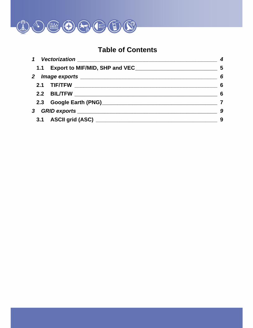
Table of Contents 1 Vectorization ______________________________________________ 4
1.1 Export to MIF/MID, SHP and VEC ___________________________ 5 2 Image exports _____________________________________________ 6
2.1 TIF/TFW _______________________________________________ 6 2.2 BIL/TFW _______________________________________________ 6 2.3 Google Earth (PNG) ______________________________________ 7
3 GRID exports ______________________________________________ 9 3.1 ASCII grid (ASC) ________________________________________ 9

4
4
4/10
EXPORTING ATDI RESULTS TO OTHER FORMATS
Note: all provided values are FOR INFORMATION ONLY, and can be replaced with values specific to equipment vendors
1 Vectorization
ICS telecom can capture a vector contour of a raster result grid through a process called vectorization. The
entire output of a given result layer is traced and converted to a vector outline of the user’s choosing. These
conversions can be to popular GIS formats including MapInfo’s interchange format MIF/MID, ESRI’s SHP format
and ATDI’s own vector format VEC. Due to the fragmented nature of a result grid, it is suggested that the user
simplify the results to single color raster layers. The user can access the vectorization box globally from the
Files / Export / Vectorize coverage layer menu for all coverages or results on their map or they can specify the
portion of the results they wish to convert to vector format by using ICS telecom’s marquee selection tool:
Global vectorization
Area of interest specific vectorization

5
5
5/10
1.1 Export to MIF/MID, SHP and VEC Through a dedicated ‘Vectorization’ box, the user can select to convert the result information to a vector file in
one of several formats including Map Info’s interchange format, MIF/MID. The MIF/MID file format is a
combination vector/binary file format. The user can define the resampling factor and grid step of the
vectorization that will define how fine the vector line will trace the raster result. :
The magnifying glass buttons and hand tool allow the user to center the area of their coverage plot that they
desire to be exported to the center of the Vectorizing bounding box. The user can then define a Sampling factor
that will multiply itself by the resolution of the grid thus reducing the number of pixels to be considered for the
vectorization. They can also define a low pass filter which serves to filter out anywhere from 1 to 6 pixels in the
vectorization process. In the case of exporting to MIF/MID, using the sampling and low pass filtering options can

6
6
6/10
decrease the time it takes to vectorize a raster result and simplify the contour output in the case that the raster
result is heavily fragmented.
In the case of converting result grids to ESRI’s SHP format, the output will not be simply a contour of the result
but an area wide polygon representation of field strength values that a user can associate with a legend. The
output result will be three files compatible with ESRI tools: *.SHP, *.DBF, *.SHX.
The user also has the option to convert their raster grid based results to ATDI’s own ASCII format known as
.VEC file. This format can be read and manipulated with any word processing or spreadsheet application
including NotePadTM and ExcelTM.
2 Image exports
2.1 TIF/TFW A very common geographic output of the image of the result layer is an export to TIF/TFW. This option will
output simply the result layer to a non LZW compressed geocoded TIF file that can be imported to any GIS
interface. The user can access this option from the Files / Export / Export TIF TFW…:
2.2 BIL/TFW A very common geographic output of the image of the result layer is an export to BIL/TFW. This option will
output simply the result layer to a geocoded BIL file that can be imported to any GIS interface. The user can
access this option from the Files / Export / Export BIL TFW…. In this case however, the user can also choose to
output the clutter and terrain model layers as well as the result layer.

7
7
7/10
2.3 Google Earth (PNG) Via ICS map server, ATDI’s GIS tool, the user can output their result layer to a file format compatible with the
basic edition of Google Earth. This file format, known as the PNG, is a web compatible format that allows the
user to make the background of the image output transparent – an option that is not available in the TIF TFW
and BIL TFW outputs.
In order to simplify the output PNG format, ICS map server must export a reprojected grid output of the result
layer. The way to accomplish this is to simply output the result grid to a file through ICS telecom.
This result file (*.FLD) can then be exported through ICS map server version 9.3.2 and above to the Google
Earth compatible *.PNG format:
The user can define if they wish to make the white background of the resulting PNG file transparent and if they
wish to launch Google Earth upon completion with the result already imported into the Google Earth interface:

8
8
8/10
The user will receive a message saying the export is completed. Upon clicking ‘Ok’, ICS map server will have
exported the result grid to the PNG format and, if requested, automatically launch Google Earth while
simultaneously placing the results over the correct geographic location in the Google Earth.

9
9
9/10
3 GRID exports
3.1 ASCII grid (ASC) ICS telecom and ICS map server offer exports to ASCII GRID format (ASC) for not just results but also terrain
and clutter. This format is compatible with most any GIS tool. With MapInfo specifically, this format is
compatible with the Vertical Mapper add-on module sold by MapInfo. The result will be a text grid of the entire
matrix of interest with values (terrain altitudes in meters, clutter codes or result values) in the appropriate places
in the grid. This output allows the user to retain the gradient of values as well so it will reappear in MapInfo as a
result output similar to what is in ICS telecom and not simply a contour representation. In the case of a coverage
it will retain the coverage values of the entire coverage and reintroduce them into MapInfo very much the same
way they appear in ICS telecom:
Please note that if your map is >> than your coverage area of interest, you may want to cut the map to limit the
size of the grid you are exporting to .ASC format.

10
10
10/10
ATDI Inc.1420 Beverly Road, Suite 140 McLean - VA 22101 – USA Tel.: +1 703 848 4750 Fax: +1 703 848 4752 e-mail : [email protected] http://www.atdi-us.com
ATDI SA 8, rue de l’Arcade 75008 Paris - France Tel. +33 (0) 53 30 89 40 Fax +33 (0)1 53 30 89 49 e-mail : [email protected] http://www.atdi.com
ATDI Ibérica c/Manuel González Longoria,8 28010 Madrid - Spain Tel. +34 91 446 72 52 Fax +34 91 445 03 83 e-mail : [email protected] http://www.atdi.es
ATDI Ltd. Kingsland Court - Three Bridges Road Crawley - West Sussex - RH10 1HL - UK Tel. +44 (0)1293 522052 Fax +44 (0)1293 522521 e-mail : [email protected] http://www.atdi.co.uk
ATDI SAL Due to recent events this office is managed by ATDI SA. Azarieh Bldg. A-5 Downtown Beirut – LEBANON e-mail : [email protected] http://www.atdi.com
ATDI EST Bd. Aviatorilor, 59 Bucharest Romania Tel +40 21 222 42 10 Fax +40 21 222 42 13 e-mail : [email protected] http://www.atdi.ro
ATDI OOO Sadovnicheskaya st. 72 bld 1 115035 Moscow - Russian Federation Tel. +7 095 252 96 10 Fax +7 501 408 50 74 e-mail : [email protected] http://www.atdi.ru
ATDI South Pacific PTY Ltd 79 Macarthur Street - Ultimo NSW 2007 - Australia Tel. +61 (0)2 9213 2200 Fax +61 (0)2 9213 2299 e-mail : [email protected] http://www.atdi.com
ATDI UA partnership with LIS erbitskogo str. 1 02068 Kiev Ukraine Tel +380 44 564 33 68 e-mail : v [email protected] http:// www.lissoft.com.ua
Software solutions in radiocommunications