Controlling Polluted Stormwater - Westchester Polluted Stormwater ... This nonpoint source pollution...
411
Department of Planning Controlling Polluted Stormwater A Management Plan for the Sheldrake and Mamaroneck Rivers and Mamaroneck Harbor PREPARED BY WATERSHED ADVISORY COMMITTEE 4 JANUARY 2001
Transcript of Controlling Polluted Stormwater - Westchester Polluted Stormwater ... This nonpoint source pollution...
Department of Planning
Controlling Polluted StormwaterA Management Plan for the Sheldrake andMamaroneck Rivers and Mamaroneck Harbor
PREPARED BYWATERSHED ADVISORY COMMITTEE 4 JANUARY 2001

2
WESTCHESTER COUNTY EXECUTIVE
Andrew J. Spano
WESTCHESTER COUNTY DEPARTMENT OF PLANNING
Joyce M. Lannert, AICP, Commissioner
Gerard Mulligan, AICP, Deputy Commissioner Gina D’Agrosa, AICP, Director of Environmental Planning/Watermaster
PROJECT STAFF
Robert Doscher, PWS, CPESC, Associate Environmental Planner, Project Manager
Paul Gisondo, Associate Planner Claudia Ng Maxwell, Environmental Planner
Mindy Moore, Assistant Environmental Planner Michael Saviola, Environmental Planner Michael Selig, Program Specialist (GIS)
COMMITTEE ON NONPOINT SOURCE POLLUTION
Warren Ross, Chair
WATERSHED ADVISORY COMMITTEE 4
Ronald Bianchi, Harrison Holly Bukofser, Harrison Paula Lebowitz, Harrison
Stephen Altieri, Mamaroneck Town Wallace Irwin, Mamaroneck Town
Howard McMichael, Mamaroneck Town Phyllis Wittner, Mamaroneck Town Carl Alterman, Mamaroneck Village Michael Blau, Mamaroneck Village Doris Erdman, Mamaroneck Village Barbara Stein, Mamaroneck Village Edward Lynch, AICP, New Rochelle
Howard Blitman, Scarsdale Alfred Gatta, Scarsdale
Elizabeth Marrinan, Scarsdale Peter Van de Water, Scarsdale
Rod Johnson, White Plains Pauline Oliva, White Plains
January 2001
5
WAC 4 “STREAMWALK VOLUNTEERS” The “Streamwalk Volunteers” listed below made an invaluable contribution to this plan. Together, these volunteers assessed more than 30 miles of stream in the WAC 4 study area. Their accomplishments have been well recognized. The United States Department of Agriculture - Natural Resources Conservation Service presented them with both regional and national “group” awards for their outstanding volunteerism as part of its Earth Te am Volunteers Program. Wallace Irwin, who organized the volunteers, also earned regional and national “individual” awards for his efforts. The Westchester County Committee on Nonpoint Source Pollution and Soil and Water Conservation District also awarded the “Streamwalk Volunteers” and Mr. Irwin with plaques, recognizing them for their “outstanding” efforts. On October 4, 1998, the Westchester County Board of Legislators further honored the WAC 4 “Streamwalk Volunteers” with a proclamation, thanking them “for all they did to help protect our environment.”.
Alpert, Linda Athey, James Bonica, Jim
Bonica, Patricia Bukofser, Holly
D'Annunzio, Diane Eberhardt, Amy
Genatowski, Roselee Goldstein, Arthur Irwin, Wallace, Jr.
Joseph, Cynthia Kaphan, Mitchell Lebowitz, Paula Leitner, Pinky
Mannix, Mary Lou Marrafino, Paul
Marrafino, Sandra Martin, Angel
Martin, Carolee
McMichael Carole McMichael, Howard
Mitsch, Sasha Mitsch, Steve Model, Alice
Mulhern, Dorothy Mulhern, William
Ottinger, June Robb, Marion Sandler, Oreon Spillo, Angelo Stein, Barbara
Watnick, Carole Watnick, David
Wharton, Phillippa Wiener, Geoffrey Wiener, Margaret
Winkelstein, Nancy

6
This plan has been prepared using a grant from the New York State Environmental Protection Fund, administered by the New York Department of State. Watershed Advisory Committee 4 is thankful for the department ’s assistance in making this plan a reality. WAC 4 also recognizes the assistance provided by the Town of Mamaroneck, which applied for and received the grant that funded the development of this plan. The town’s effort in seeking this funding and bringing the six municipalities and county together to focus their attention on stormwater runoff affecting the Sheldrake and Mamaroneck rivers and Mamaroneck Harb or is much appreciated. WAC 4 especially recognizes the assistance with this effort provided by Mamaroneck Town Council Member Phyllis Wittner.
7
PREFACE This nonpoint source pollution control plan is published in accordance with the “Report and Recommendations” (1993) of the Citizens Committee on Nonpoint Source Pollution in Long Island Sound. Its preparation is made possible by a state grant through the Environmental Protection Fund administered by the New York Department of State. The plan is divided into two sections. The first section contains recommendations specific to the Watershed Advisory Committee 4 (WAC 4) study area, which is comprised of the watersheds of the Mamaroneck and Sheldrake rivers and Mamaroneck Harbor. These tributaries drain i nto the western end of Long Island Sound. Section I also provides a broad understanding of watershed planning for the Long Island Sound watershed. But, most importantly, it makes specific recommendations for controlling nonpoint source pollution in each municipality in the study area. This section describes characteristics of the study area, such as land use, streams and wetlands, and includes the results of watershed analyses and recommendations to reduce the volume of nonpoint source pollution entering Long Island Sound in Westchester County. Section I is specific to the WAC 4 study area and is “action-oriented.” The second section is an appendix containing supplemental information and recommendations supporting the recommendations made in the first s ection. Section II highlights threats to water resources, identifies pollutants impacting water quality, and discusses management strategies and practices to protect, preserve and restore natural features that are essential to ensuring good water quality in the watersheds that make up the WAC 4 study area. This section is intended to be an educational tool to introduce the public and municipal officials to watershed planning, nonpoint source pollution control, and the various ways to reduce the threat of nonpoint source pollution. Section II also explains important federal stormwater regulations that will impact all municipalities in the study area. The two sections complement each other and provide all the necessary components of a comprehensive watersh ed management plan. The plan is intended to improve water quality throughout the WAC 4 study area and ultimately to assist in the restoration of one of the region ’s most valuable natural resources - Long Island Sound. The municipalities that comprise the WAC 4 study area have endorsed the principles of this plan. Resolutions endorsing the plan were adopted by the Town/Village of Harrison on , the Town of Mamaroneck on , the Village of Mamaroneck on , the City of New Rochelle on , the Village of Scarsdale on and the City of White Plains on (copies of resolutions in Appendix).


CO
NN
EC
TI C
UT
SOMERS
NEW CASTLE
OSSINING
MOUNT PLEASANT
NORTH CASTLE
HARRISON
Bronxville
Tuckahoe
Larchmont
PortChester
RyeBrook
Hastingson
Hudson
DobbsFerry
Irvington
Tarrytown
Elmsford
Crotonon
Hudson
ManorBriarcliff Pleasantville
Sleepy
RYE
YONKERS
VERNONMOUNT
Pelham
Pelham Manor
Ardsley
GREENBURGH
WHITE
Mamaroneck
NEW
Ossining
BEDFORD
POUND RIDGE
CORTLANDT
YORKTOWN
Hollow
L O
NG
I S L A ND
S O U N D
CO
NN
EC
T I CU
T
N E W Y O R K C I T Y
MOUNTKISCO
SCARSDALE
H
UD
SO
NR
IV
ER
LEWISBORO
NECKMAMARO-
EAST
CH
ESTE
R
ROCHELLE
PLAINS
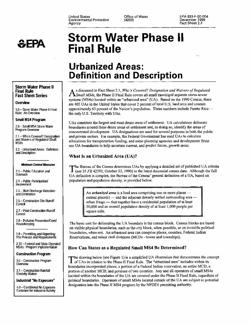
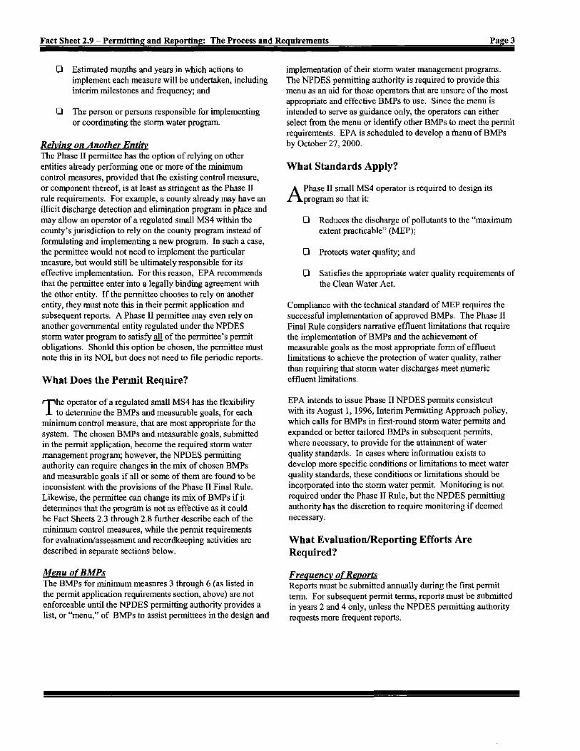
Long Island SoundWatershed Advisory Committees
6 5
4 3
1
Numbers denote WatershedAdvisory Committee (WAC)Study Areas.
MAP 1
N
Andrew J. SpanoCounty Executive
Department of Planning
Joyce M. Lannert
Commissioner
2 2
2


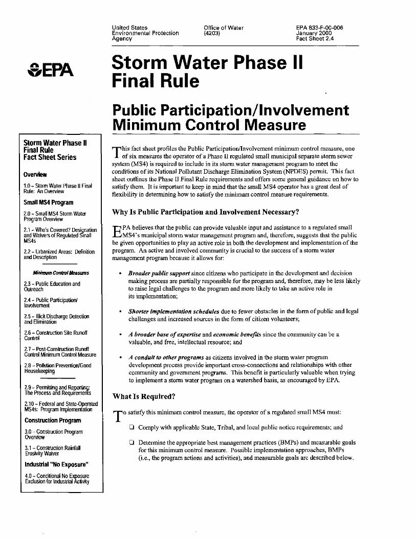
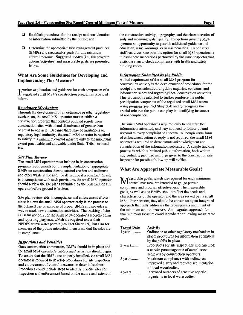
Study AreaWatershed Advisory Committee 4
Sheldrake River, Mamaroneck Harbor & Mamaroneck River Watersheds
MAP 2
HARRISON
GREENBURGH
NEW
RYECITY
Tuck
ahoe
Port
BrookRye
Elmsford
WHITE PLAINS
MamaroneckVillage
ROCHELLE
Chester
RYE
RYETOWN
EAST
CHES
TER
SCARSDALE
TOWN
684
95
1
22
287
287
22
287
100
100
127
120A
120
120A
MOUNT PLEASANT NORTH CASTLE
I
I
LAR
0 7000
Scale in Feet
N
Lo n
g I s
l an
d S
o un
d
CO
NN
EC
TI C
UT
MamaroneckRiverBasin
SheldrakeRiverBasin
MamaroneckHarborBasin
Hutchinson
Pkwy
Rive
r
Bron
x
Rive
r
Parkw
ay
Spra
inBr
ook
Park
way
Rye Lake
BlindBrook
Port ChesterHarbor
Milt
on H
arbo
r
Mamaroneck Harbor
Mam
aron
eck R
iver
Sheldrake Lake(Larchmont Res.)
Beav
er Sw
amp B
rook
WhitePlainsResrevoirs
KensicoReservoir
SilverLake
North
Street
100
119
Main St.
Taconic Pkwy
9A
MAMARONECKTOWN
SheldrakeR.
Hutchinson
Pkwy
Rive
r
Andrew J. SpanoCounty Executive
Department of PlanningJoyce M. Lannert
Commissioner


87
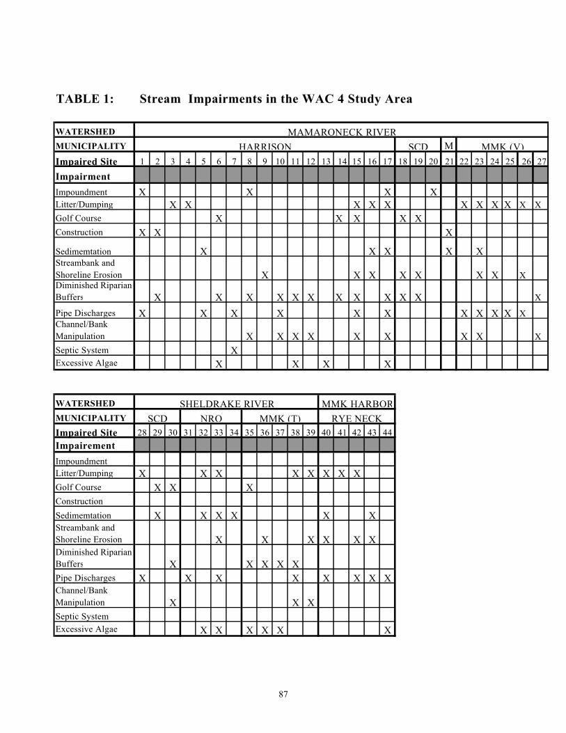
TABLE 1: Stream Impairments in the WAC 4 Study Area
WATERSHEDMUNICIPALITY MImpaired Site 1 2 3 4 5 6 7 8 9 10 11 12 13 14 15 16 17 18 19 20 21 22 23 24 25 26 27
ImpairmentImpoundment X X X XLitter/Dumping X X X X X X X X X X XGolf Course X X X X XConstruction X X X
Sedimemtation X X X X XStreambank and Shoreline Erosion X X X X X X X XDiminished Riparian Buffers X X X X X X X X X X X X
Pipe Discharges X X X X X X X X X X XChannel/Bank Manipulation X X X X X X X X XSeptic System X Excessive Algae X X X X
WATERSHEDMUNICIPALITYImpaired Site 28 29 30 31 32 33 34 35 36 37 38 39 40 41 42 43 44ImpairementImpoundmentLitter/Dumping X X X X X X X XGolf Course X X XConstruction Sedimemtation X X X X X XStreambank and Shoreline Erosion X X X X X XDiminished Riparian Buffers X X X X XPipe Discharges X X X X X X X XChannel/Bank Manipulation X X XSeptic System Excessive Algae X X X X X X
SCD MMK (V)MAMARONECK RIVER
HARRISON
MMK (T)SHELDRAKE RIVER MMK HARBOR
RYE NECKSCD NRO

88
TABLE 2: Best Management Practices for Streams in WAC 4 Study Area
WATERSHEDMUNICIPALITY MTImpaired Site 1 2 3 4 5 6 7 8 9 10 11 12 13 14 15 16 17 18 19 20 21 22 23 24 25 26 27
ImpairementHousekeeping X X X X X X X X X X XBuffer/bank Enhancement X X X X X X X X X X X X XNutrient Management X X X X X X XErosion/Sediment Control X X X XNatural Channel Restoration X X X X X X X X X XStream and Shore Stabilization X X X X X X X X X XSeptic System Maintenance X XStormdrain Retrofit X X X X X X X X X X X X XMowing Practices X X X X X X X X XSediment Removal X X X X
WATERSHEDMUNICIPALITY
Impaired Site 28 29 30 31 32 33 34 35 36 37 38 39 40 41 42 43 44
ImpairementHousekeeping X X X X X X X XBuffer/bank Enhancement X X X X XNutrient Management X X X X X X X XErosion/Sediment Control Natural Channel Restoration X X X XStream and Shore Stabilization X X X X XSeptic System MaintenanceStormdrain Retrofit X X X X X X XMowing Practices X X X X X X
Sediment Removal X X X X X X
MTSHELDRAKE RIVER MMK HARBOR
RYE NECKSCD NRO
SCD MVMAMARONECK RIVER
HARRISON

Andrew J. SpanoCounty Executive
HARRISON
GREENBURGH
RYECITY
Tuck
ahoe
Port
BrookRye
Elmsford
WHITE PLAINS
NEWROCHELLE
Chester
RYE
EAST
CHES
TER
SCARSDALE
TOWN
684
95
1
22
287
287
22
287
100
100
127
120A
120
120A
MOUNT PLEASANT NORTH CASTLE
I
I
Lo n
g I s
l an
d S
o un
d
CO
NN
EC
TI C
UT
MamaroneckRiverBasin
SheldrakeRiverBasin
Hutch
inson
Parkway
Rive
r
Bron
x
Rive
r
Parkw
ay
Spra
inBr
ook
Park
way
Rye Lake
BlindBrook
Port ChesterHarbor
Milt
on H
arbo
r
Mamaroneck Harbor
Mam
aron
eck R
iver
Sheldrake Lake(Larchmont Res.)
Beav
er Sw
amp B
rook
WhitePlainsResrevoirs
KensicoReservoir
SilverLake
North
Street
100
119
Main St.
Taconic Pkwy
9A
MAMARONECKTOWN
Kensico Basin
12
3
4
5
6
713
8
10
1728
1512 1114
16
20
21
3233
34
30
3637
3839
MamaroneckVillage
24 2523 22
MamaroneckHarborBasin
RYETOWN
2627
4041-44
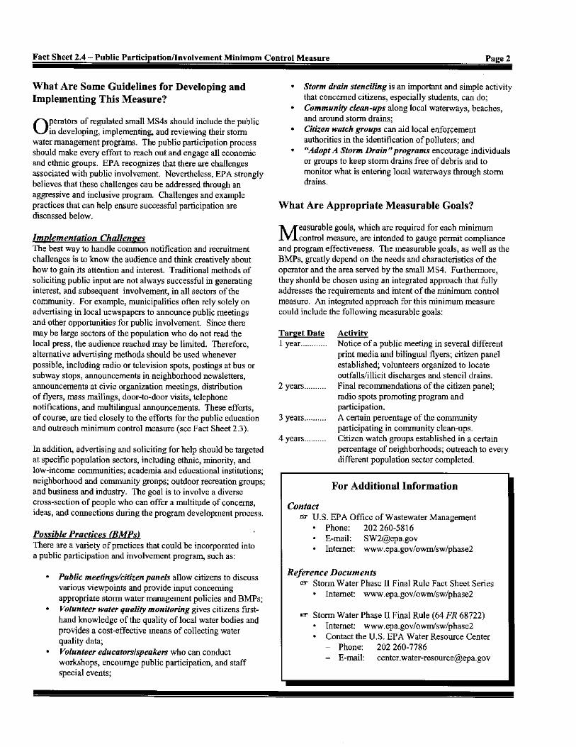
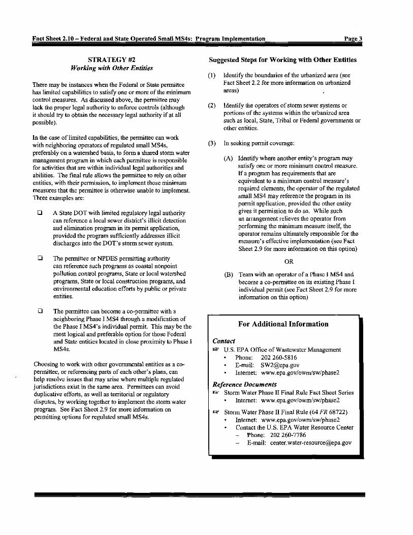
Impaired Stream SitesWAC4 STUDY AREA
MAP 3
Impaired Site Stream WaterbodiesWAC4 Boundary
0 7000
Scale in Feet
N
SheldrakeR.
9
29
18 1931
35
Department of PlanningJoyce M. Lannert
Commissioner


93
Effects Of Nonpoint Source Pollutants From Different Land Uses
On Wetlands
Land Use/Source Typical Pollutants Effect on Wetlands Agricultural Runoff (cattle grazing land, manure)
Bacteria (coliform, streptococcus)
Contamination of shellfish, rendering them inedible
Suspended solids Clogged bottom sediments, interfering with fish spawning and benthic invertebrates; sediment buildup can significantly alter wetland hydrology, flood waters storage capacity, and plant and animal communities.
Nutrients Increased vegetative productivity, resulting in increased standing stocks of vegetation, followed by increased rates of vegetative decay and higher community respiration rates
Organic matter Greater oxygen demand/depletion Pesticides, salts Alteration of species distribution Agricultural Runoff (feedlots)
Nitrogen, phosphorus Increased vegetative productivity, resulting in increased standing stocks of vegetation followed by increased rates of vegetative decay and higher community respiration rates
Heavy metals (Pb, Zn, Cu, Cd)
Alteration of species distribution
Petroleum residues Decreased growth and respiration rates (chronic toxicity) Residential Stormwater Runoff (low to moderate density)
Total nitrogen Increased vegetative productivity, resulting in creased standing stocks of vegetation, followed by increasing rates of vegetative decay and higher community respiration rates
Bacteria (coliform) Contamination of shellfish, rendering them inedible Heavy metals
(Pb, Zn, Cu, Cd) Alteration of species distribution
Pesticides (diazinon) Alteration of species distribution


HARRISON
GREENBURGH
RYECITY
Tuck
ahoe
Port
BrookRye
Elmsford
WHITE PLAINS
MamaroneckVillage
NEWROCHELLE
Chester
RYE
RYETOWN
EAST
CHES
TER
SCARSDALE
TOWN
684
95
1
22
287
287
22
287
100
100
127
120A
120
120A
MOUNT PLEASANT NORTH CASTLE
I
I
LAR
Lo n
g I s
l an
d S
o un
d
CO
NN
EC
TI C
UT
MamaroneckRiverBasin
SheldrakeRiverBasin
MamaroneckHarborBasin
Bron
x
Rive
r
Parkw
ay
Spra
inBr
ook
Park
way
Rye Lake
BlindBrook
Port ChesterHarbor
Milt
on H
arbo
r
Mamaroneck Harbor
Mam
aron
eck R
iver
Sheldrake Lake(Larchmont Res.)
Beav
er Sw
amp B
rook
WhitePlainsResrevoirs
KensicoReservoir
SilverLake
North
Street
100
119
Main St.
Taconic Pkwy
9A
MAMARONECKTOWN
BronxRiverBasin
BronxRiverBasin
GrassySprainBasin
Saw MillRiverBasin
SheldonBrookBasin
Kensico Basin
BlindBrookBasin
ByramRiverBasin
BeaverSwampBrookBasin
BeaverSwampBrookWestBasin
Stephenson Brook Basin
LarchmontHarborBasin
PineBrookBasin
MiltonHarborBasin
Port ChesterHarborBasin
BlindBrookBasin
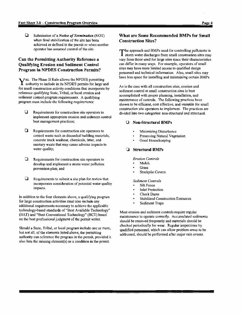
Tidal WetlandFreshwater Wetland Streams Minor Drainage Divide
Major Drainage DivideWater Bodies
HydrologyWAC4 STUDY AREA
MAP 4
0 7000
Scale in Feet
N
LOWE
R
LONG
ISLA
ND
SOUN
D
BASINS
BRON
X
RIVER
BASIN
Hydric Soil (Possible Wetland)
Hutchinson
Pkw
y
Rive
rHutchinson
Pkwy
Rive
r
SheldrakeR.
Andrew J. SpanoCounty Executive
Department of PlanningJoyce M. Lannert
Commissioner


124
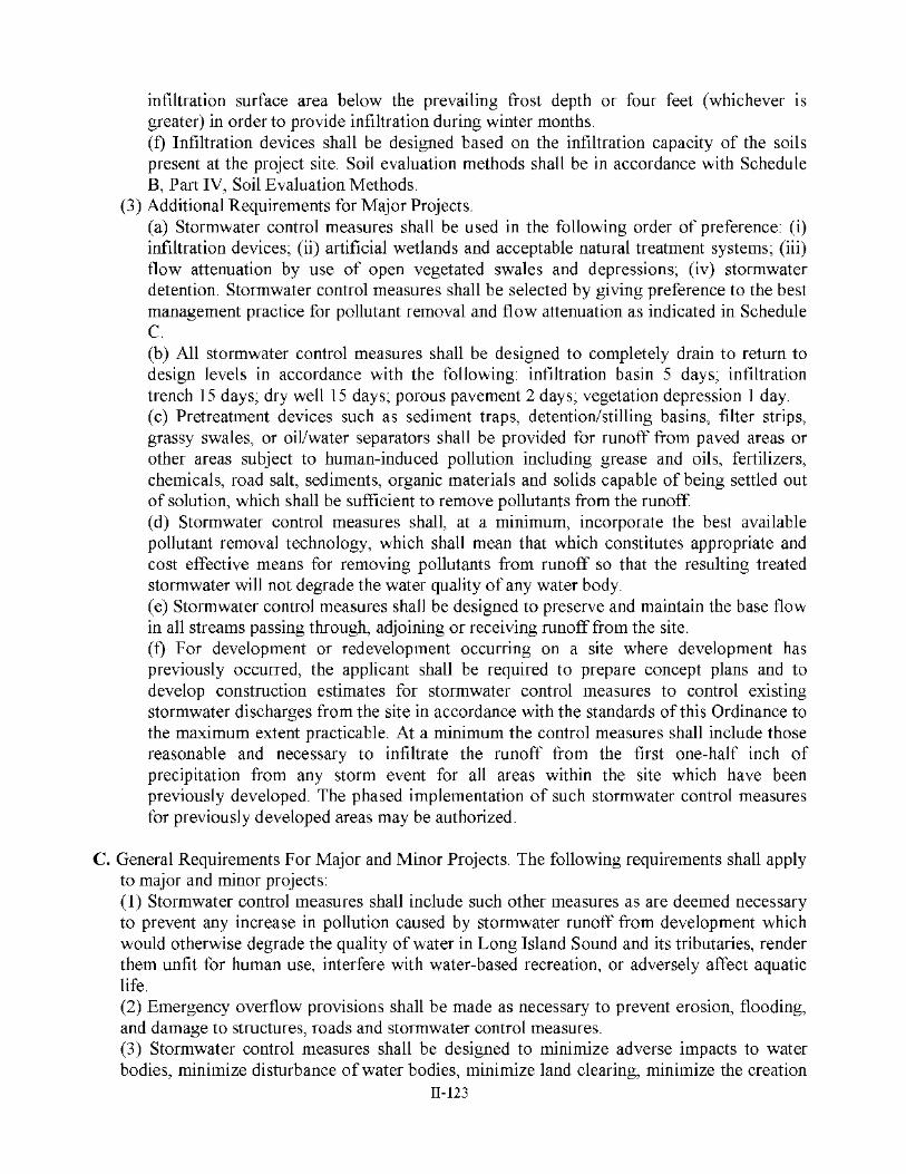
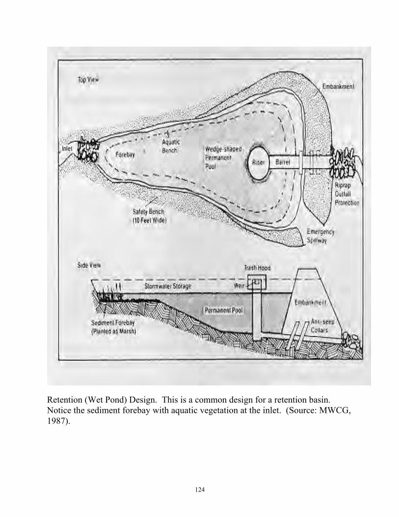
Retention (Wet Pond) Design. This is a common design for a retention basin. Notice the sediment forebay with aquatic vegetation at the inlet. (Source: MWCG, 1987).

125
Extended Detention Design. The standard extended detention control device typically consists of a stand pipe with perforations designed to detain runoff for an extended period of time, such as 24 hours or more. (Source: MWCG, 1987).

126
Extended Detention Basin with Shallow Marsh. The shallow marsh feature will enhance the nutrient removal capability of this extended detention basin. However, when displaced by urban runoff during summer months, the warm marsh water may be problematic if the receiving water body or watercourse supports a cold water fishery. (Source: MWCG, 1987).

127
PUBLICATIONS FOR SITING AND SIZING STORMWATER MANAGEMENT
FACILITIES*


149
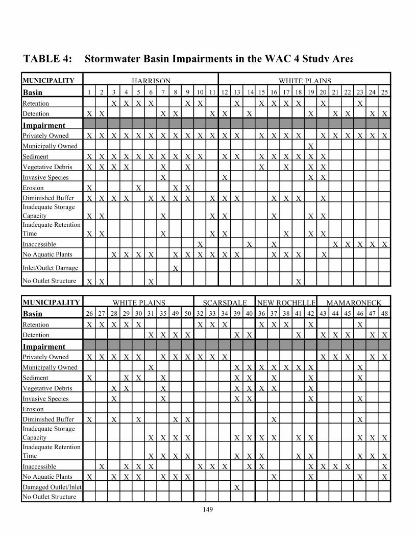
TABLE 4: Stormwater Basin Impairments in the WAC 4 Study Area
MUNICIPALITY
Basin 1 2 3 4 5 6 7 8 9 10 11 12 13 14 15 16 17 18 19 20 21 22 23 24 25Retention X X X X X X X X X X X X X Detention X X X X X X X X X X X XImpairmentPrivately Owned X X X X X X X X X X X X X X X X X X X X X X XMunicipally Owned XSediment X X X X X X X X X X X X X X X X X XVegetative Debris X X X X X X X X X XInvasive Species X X X XErosion X X X X Diminished Buffer X X X X X X X X X X X X X X XInadequate Storage Capacity X X X X X X X XInadequate Retention Time X X X X X X X XInaccessible X X X X X X X XNo Aquatic Plants X X X X X X X X X X X X X X
Inlet/Outlet Damage XNo Outlet Structure X X X X
MUNICIPALITYBasin 26 27 28 29 30 31 35 49 50 32 33 34 39 40 36 37 38 41 42 43 44 45 46 47 48Retention X X X X X X X X X X X X XDetention X X X X X X X X X X X XImpairmentPrivately Owned X X X X X X X X X X X X X X X XMunicipally Owned X X X X X X X X X Sediment X X X X X X X X XVegetative Debris X X X X X X X XInvasive Species X X X X X XErosionDiminished Buffer X X X X X X XInadequate Storage Capacity X X X X X X X X X X X X XInadequate Retention Time X X X X X X X X X X X XInaccessible X X X X X X X X X X X X X XNo Aquatic Plants X X X X X X X X X X XDamaged Outlet/Inlet XNo Outlet Structure
WHITE PLAINS
WHITE PLAINS SCARSDALE NEW ROCHELLE MAMARONECK
HARRISON

150
TABLE 5: Best Management Practices for Stormwater ManagementBasins in the WAC 4 Study Area
MUNICIPALITYBasin 1 2 3 4 5 6 7 8 9 10 11 12 13 14 15 16 17 18 19 20 21 22 23 24 25Retention X X X X X X X X X X X X X Detention X X X X X X X X X X X XBest Management PracticeHousekeepingSediment Removal X X X X X X X X X X X X X X X X X XInvasive Species Removal X X X XMowing Practices X X X X X X X X X X X X XBank Stabilization X XUpland Buffer X X X X X X X X X X X X X XAquatic Plantings X X X X X X X X X X X X X X X X XErosion/ Sediment Control X X X XNutrient Management X XStructural Retrofit X X X X XInstallation of Outlet Structure X Increase Access X X X X X X X
MUNICIPALITYBasin 26 27 28 29 30 31 35 49 50 32 33 34 39 40 36 37 38 41 42 43 44 45 46 47 48Retention X X X X X X X X X X X X XDetention X X X X X X X X X X X XBest Management PracticeHousekeeping XSediment Removal X X X X X X X X X X XMowing Practices X X X X X XBank StabilizationUpland Buffer X X X X X XAquatic Plantings X X X X X X X X X X X X X X XErosion/ Sediment ControlNutrient ManagementStructural Retrofit X X X X X X X X XInstallation of Outlet Structure X X XIncrease Access X X X X X X X X X X X X X X
HARRISON
MAMARONECKNEW ROCHELLESCARSDALEWHITE PLAINS
WHITE PLAINS

HARRISON
GREENBURGH
NEW
RYECITY
Tuck
ahoe
Port
BrookRye
Elmsford
WHITE PLAINS
MamaroneckVillage
ROCHELLE
Chester
RYE
RYETOWN
EAST
CHES
TER
SCARSDALE
TOWN
684
95
1
22
287
287
22
287
100
100
127
120A
120
120A
MOUNT PLEASANT NORTH CASTLE
I
I
LAR
0 7000
Scale in Feet
N
Lo n
g I s
l an
d S
o un
d
CO
NN
EC
TI C
UT
MamaroneckRiverBasin
SheldrakeRiverBasin
MamaroneckHarborBasin
Bron
x
Rive
r
Parkw
ay
Spra
inBr
ook
Park
way
Rye Lake
BlindBrook
Port ChesterHarbor
Milt
on H
arbo
r
Mamaroneck Harbor
Mam
'k Ri
ver
Sheldrake Lake(Larchmont Res.)
Beav
er Sw
amp B
rook
WhitePlainsReservoirs
KensicoReservoir
SilverLake
North
Street
100
119
Main St.
Taconic Pkwy
9A
MAMARONECKTOWN
Stormwater BasinsWAC4 STUDY AREA
MAP 5
Wet BasinsDry Basins
Hutchinson
Pkwy
Rive
rHutchinson
Pkwy
SheldrakeR.
12
34
56 7
9
49 50
13
14
1516
1718
19 2021
2223
2425
2627
2930
31
32
33 34
35
36
3738
3940
41
4243
4445
46
47
48
8
28
Department of PlanningJoyce M. Lannert
Commissioner
1112
Andrew J. SpanoCounty Executive
10
151
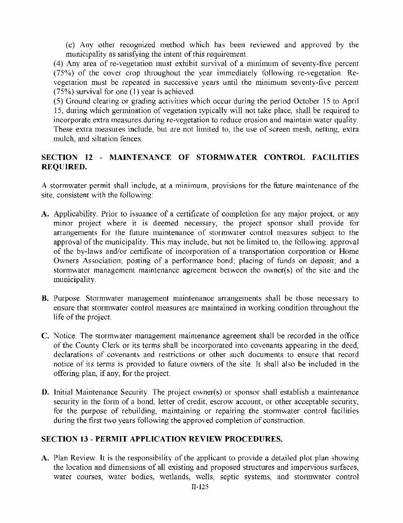
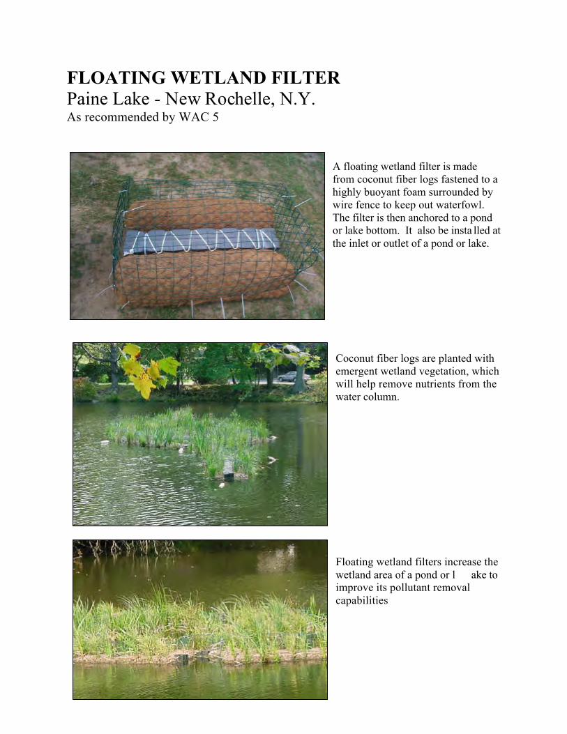
FLOATING WETLAND FILTER Paine Lake - New Rochelle, N.Y. As recommended by WAC 5
A floating wetland filter is made from coconut fiber logs fastened to a highly buoyant foam surrounded by wire fence to keep out waterfowl. The filter is then anchored to a pond or lake bottom. It also be insta lled at the inlet or outlet of a pond or lake.
Coconut fiber logs are planted with emergent wetland vegetation, which will help remove nutrients from the water column. Floating wetland filters increase the wetland area of a pond or l ake to improve its pollutant removal capabilities


HARRISON
GREENBURGH
NEW
RYECITY
Tuck
ahoe
Port
BrookRye
Elmsford
WHITE PLAINS
MamaroneckVillage
ROCHELLE
Chester
RYE
RYETOWN
EAST
CHES
TER
SCARSDALE
TOWN
684
95
1
22
287
287
22
287
100
100
127
120A
120
120A
MOUNT PLEASANT NORTH CASTLE
I
I
LAR
0 7000
Scale in Feet
N
Lo n
g I s
l an
d S
o un
d
CO
NN
EC
TI C
UT
MamaroneckRiverBasin
SheldrakeRiverBasin
MamaroneckHarborBasin
Bron
x
Rive
r
Parkw
ay
Spra
inBr
ook
Park
way
Rye Lake
BlindBrook
Port ChesterHarbor
Milt
on H
arbo
r
Mamaroneck Harbor
Mam
aron
eck R
iver
Sheldrake Lake(Larchmont Res.)
Beav
er Sw
amp B
rook
WhitePlainsResrevoirs
KensicoReservoir
SilverLake
North
Street
100
119
Main St.
Taconic Pkwy
9A
MAMARONECKTOWN
Generalized Land UseWAC4 STUDY AREA
MAP 6
1996 LAND USE CATEGORIESRESIDENTIAL
Very Low Density (.2 to 2 du/acre)
Low Density (2-6 du/acre)
Medium Density (6-16 du/acre)
High Density (16+ du/acre)
NON-RESIDENTIAL
Institutional & Public Assembly
Mixed Use
Retail
Campus Office & Research
Manufacturing, Industrial, Warehouse
Transportation, Communication, Utility
OPEN SPACE
Public Parks, Parkway Lands
Water Supply Lands
Nature Preserves
Private Recreation
Cemeteries
Interior Water Body
Undeveloped
Hutchinson
Pkwy
Rive
r
Hutchinson
Pkwy
Rive
r
SheldrakeR.
Andrew J. SpanoCounty Executive
Department of PlanningJoyce M. Lannert
Commissioner


II-18
PUBLIC EDUCATION TECHNIQUES WATERSHED MANAGEMENT
METHOD MOST EFFECTIVE USE RESULTS Newsletters Announce meeting times and dates, update
information, list issues to be discussed at upcoming meeting
Public awareness
Newspaper Articles (same as newsletter) – Provide additional detail about local stories, photos of citizen activities, feature articles provide information about problems and solutions
Public awareness
Demonstration Sites Exhibit innovative technology, and should be accompanied by signs, brochures or permanent on-site interpretive staff
Public awareness, knowledge, understanding
Printed and Taped Material (e.g., fact sheets, videos)
Explain new technology, describe case studies, provide training information for new employees, outline facts to stakeholders
Public awareness, knowledge, understanding
Signs Mark watershed boundaries, identify critical areas, promote specific behaviors in specific places, identify cooperators in project, explain adjacent project and its best management practices (BMPs), provide interpretive natural resources information
Public awareness, knowledge, understanding
Meetings Share information, plan actions, eva luate process Public awareness, knowledge, understanding, desire/ability to act
Field trips Observe the natural resources to be protected, view installed and functioning best management practices (BMPs), learn how BMPs operate, monitor BMPs for assessment or compliance
Public awareness, knowledge, understanding, desire/ability to act
On-site Inspections Identify problems, recommend corrective actions, evaluate effectiveness of pollution controls, identify noncompliant stakeholders, educate individuals
Action
Training Provide new skills to stakeholders Action Technical Assistance Identify problems, recommend solutions, assist
with installation of BMPs, educate individuals, evaluate effectiveness of solutions
Understanding, desire/ability to act, action
Source: Terrene Institute, Clean Water In Your Watershed: A Citizen’s Guide to Watershed Protection, 1991


II-36
STORMWATER MANAGEMENT

II-37
STORMWATER MANAGEMENT
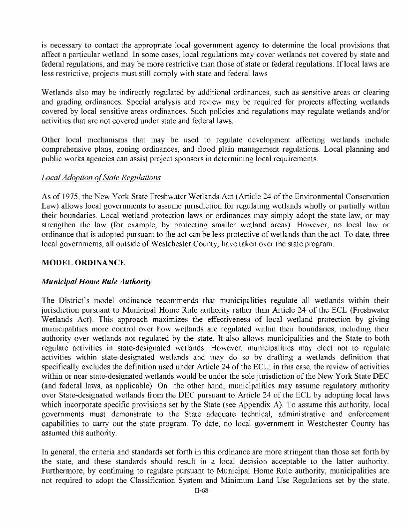
THE NATURE OF STORMWATER RUNOFF Stormwater runoff is that part of the total precipitation that flows over the ground. Under natural conditions, during and following precipitation, stormwater within a watershed flows to lower elevations where it is either recharged to groundwater or drains as runoff to streams, ponds, bays, and other surface waters. The amount of runoff from an undeveloped watershed area depends upon: ? ? storm characteristics ? ? type and amount of vegetative cover ? ? soils and soil permeability ? ? slope characteristics ? ? type and capacity of natural drainage systems Storms are characterized by their: ? ? duration (period of rainfall) ? ? total precipitation ? ? intensity ? ? frequency ? ? number of antecedent dry days The number of antecedent dry days is one of the most important variables determining the amount of runoff and concentration of contaminants in stormwater due to its impact on th e water storage capacity of soil and buildup of contaminants. A portion of stormwater runoff also evaporates during overland flow and from surface waters. Recharge water (infiltration water) is that portion of stormwater that infiltrates the soil and moves downward to recharge the aquifers. A portion of the infiltration water is taken up by plants and lost to the atmosphere by evapotranspiration. Due to the gradual percolation of much of the rainfall into the soil in relatively undisturbed watersheds, both the volume of runoff and rate of overland flow are reduced, thus maximizing aquifer replenishment in some areas and minimizing erosion. In developed watersheds, the amount of runoff also depends upon: ? ? amount of impervious surface area ? ? existing stormwater control measures ? ? other factors The presence of impervious surfaces and of stormwater drainage systems that conduct runoff

II-38
from the site may increase the volume, accelerate the flow, and in some cases, contribute to soil and streambank erosion. In areas where stormwater drainage systems have been installed, stormwater flows to stormwater management basins or other drainage structures for detention, extended detention, retention, or infiltration. In coastal areas, stormwater is sometimes discharged directly into surface water bodies or streams; in other cases, the overflow of drainage structures is directed into surface waters. Stormwater as runoff or infiltration water is the vehicle by which pollutants move across land and through the soils to ground or s urface waters. Contaminants will accumulate or be disposed of on natural and urban land surfaces. Sources of contaminants include: ? ? animal wastes ? ? highway deicing materials ? ? decay products of vegetation and animal matter ? ? fertilizers ? ? pesticides ? ? airborne contaminants deposited by gravity, wind or rainfall ? ? general urban refuse ? ? by-products of industry and urban development ? ? improper storage and disposal of toxic and hazardous material The contaminants associated with and carried in stormwater runoff include the following major categories: ? ? Metals ? ? Organic Chemicals ? ? - Base Neutral Compounds - Acid Compounds - Volatiles - Pesticides ? ? Organic Chemicals - Phosphates - Nitrates - Chlorides ? ? Bacteria and Viruses ? ? Oxygen Demanding Substances Raindrops dislodge soil particles and contaminants from land surfaces. This material is then carried in solution or suspension and travels with the runoff. Suspended particles are deposited en route if/when the velocity of stormwater decreases. Contaminants carried in stormwater solution enter the soil through the larger pores at the soil surface and move downward and horizontally through the pore network. Water diffuses into the smaller pores by capillary or soil moisture tension. The rate of movement through the soils and surfic ial materials depends on the size, shape, continuity and arrangement of the pore network system. The most soluble

II-39
constituents such as nitrates and chlorides and many organic chemicals continue to move downward through the aquifer system or t the bays. Soi ls with a high clay, fine sand, or silt content or with the presence of interspersed clay lenses retard the rate of movement of water and some contaminants through the soil; contaminants may adsorb to soil particles. A portion of the nutrients and pollutan ts also may be used by plants and soil bacteria. STORMWATER MANAGEMENT BASINS Two major types of stormwater systems exist in Westchester: nonstructural and structural. Nonstructural Nonstructural systems attempt to deal with stormwater problems at thei r source. A variety of techniques are used to minimize stormwater runoff and erosion, maximize recharge and to maintain natural stormwater receiving areas. These include the use of: ? ? ecological and land use planning ? ? conservation easements ? ? zoning ordinances (establishment of the amount of site development and coverage) ? ? maintenance of natural vegetation ? ? the use of swales, depressions and other grading and planting techniques Vegetative controls provide contact between stormwater runoff and vegetated areas an d accomplish pollutant removal by a combination of filtration, sedimentation and biological uptake that reduce pollutant concentrations, and/or by a reduction in runoff volume due to infiltration and evapotranspiration. Structural Structural controls use built systems such as: ? ? stormwater sewerage systems ? ? detention basins ? ? extended detention basins ? ? retention basins ? ? infiltration basins ? ? sedimentation basins ? ? dry wells ? ? other systems The treated water from these systems may be discharged into a stream or other surface waters. Most of the runoff into stormwater management basins comes from impervious surfaces. Occasionally pervious surfaces are a source of runoff when the infiltration rate and water holding capacity are exceeded due to periods of high intensity rainfall. The so-called “first flush,” or first half-inch of runoff from land which has been made impervious, delivers a disproportionately

II-40
large load of pollutants during the early part of storms due to the rapid runoff of accumulated nutrients and pollu tants. From 70 to 90 percent of the contaminants in stormwater can be removed by detaining the first flush of runoff. Stormwater management basins can be classified into the following three categories: ? ? Dry Basins - These are basins with the outlet locate d at the bottom. They are almost always
dry, except for relatively short periods following larger storm events. The outlet size is restricted to limit the maximum flow rate. Dry ponds are often used for flood and erosion control and are not as effective as extended detention and retention basins for water quality purposes. They may, however, be retrofitted to achieve water quality control.
? ? Extended Detention Basins - These basins employ an outlet structure that will cause stormwater runoff from most storms to pond in the basin. Following a storm, these basins drain in about 24 hours or more and will be dry at all other times. The outlet structures may be either perforated risers or subsurface drains. They provide a practical technique for retrofitting dry po nds to obtain water quality benefits, and can provide particulate (and the associated pollutant) removal efficiency nearly equivalent to that of wet ponds.
? ? Wet Basins - These basins employ outlet structures designed to maintain a permanent pool of water, w hich is not released except by means of evaporation, infiltration, or attenuated release when runoff volume exceeds the present storage capacity of the permanent pool. They can provide high removal efficiencies for particulates, and have been observed to effectively reduce soluble nitrogen and phosphorus concentrations by means of biological activity.
DESIGN OF STRUCTURAL STORMWATER MANAGEMENT BASINS Proper management of stormwater requires informed judgment in order to interpret data and evaluate empiric al runoff projections. Knowledge of the quantitative and qualitative characteristics of rainfall and the watershed is needed to permit the prediction of rates of runoff. Since there is considerable variation in the frequency, intensity and duration of rain fall, the designer must rely upon data derived from observations over long periods of time. Rain gauges have been used for almost a century to measure the intensity, duration and amounts of rainfall from specific storms. Historical records can be used to identify future probabilities. Storm Characteristics Several general conclusions can be drawn concerning storms in Westchester: ? ? Intense storms usually cover small areas and are of short duration; storms of lower intensity
tend to cover larger areas and ar e of longer duration ? ? Storms of high intensity and/or high total rainfall tend to have relatively lower frequencies of
occurrence ? ? Storms of high intensity often cause flooding and damage due to erosion and sedimentation

II-41
Design of Closed Stormwater Drainage Systems The most important consideration in designing stormwater control systems is to provide sufficient capacity to accommodate the peak rate of runoff. It is also necessary to determine the total amount of runoff for a given time period to insure adeq uate storage capacity of runoff. Stormwater drainage and stormwater systems are sometimes underdesigned due to high costs. The “rational method ” is generally used as a first step for computing stormwater runoff for the design of closed stormwater drainage systems when the contributing area is less than 200 acres. This calculation method is based on selecting a design storm event that is characterized by its duration, average intensity and frequency of occurrence. This technique provides the average peak rat e of runoff from a storm, but it does not provide a description of the actual storm. The formula for the Rational Method is Q = CiA where: ? ? Q equals the amount of discharge (peak runoff rate) in cubic feet per second (SFS) ? ? C equals the runoff coefficient(s) of the drainage area ? ? I equals the intensity of rainfall inches per hour ? ? A equals the area of the watershed (acres) Also considered i the design of stormwater management basins is the basin volume needed to store the required number of inches of rainfall . For instance, the volume of rainfall from a 5 -inch storm for a 100-acre watershed area would be determined as follows: 5” 12”/ft x 100 acres x 43,560 ft.2/acre x the runoff coefficient (0.30) = 554,500 ft.3 The storage area of the basin is then calculated. Soil and surficial permeability rates are used to determine the capacity of stormwater management basins. The USDA-Natural Resources Conservation Service has classified soils into hydrologic soil groups ranging from hydrologic soil group A, which has a low runoff potential and a high infiltration rate, to soil group D, which has a very low infiltration rate. Soil storage capacity is dependent upon other soil characteristics in addition to the infiltration rate. For instance, a fine sandy loam may have the highest storage capacity but will have a lower percentage of large pores than a sand or loamy sand. A find sandy loam has a high storage capacity because of soil moisture tension. It should be noted that once the recharge basin is in operation, the permeability rates may decrease due to sediment clogging of the soil pores or they may increase due to the establishment of vegetation and associated increased soil porosity. Test drilling should be performed at each proposed recharge basin site to determine whether there is a clay lens beneath the site. Runoff Coefficients Runoff coefficients refers to the percentage of ratio of runoff to the total amount of rainfall that will reach a stormwater management basin. A watershed that is completely for ested and located

II-42
on gentle slopes will have minimum runoff following a storm of relatively high intensity and duration due to the high retention capacity and low runoff coefficients associated with natural groundcover. A watershed that is primarily develo ped with extensive impervious surface areas has limited storage capacity and high runoff coefficients. The amount of runoff is a function of the amount of rainfall, amount of evaporation and plant evapotranspiration (seasonally variable), soil permeability , slope, and possibly texture of the surface area. Runoff from impervious surfaces usually varies from 80 percent to more than 90 percent. Therefore, the runoff coefficient as a ratio is 0.80 or 0.90 accordingly. The runoff ratios from pervious surfaces us ually vary from 0.10 (natural vegetation) to 0.60 (compacted bare soils) or higher. The runoff ratio for a lawn or golf course is approximately 0.20 to 0.35. The coefficients used to calculate runoff from pervious surfaces may be low in some cases, particu larly during a storm that occurs when the ground is frozen. If snow is present, runoff is further increased due to snow melt. Key Problems In the past, stormwater runoff systems were designed to get stormwater off the site and into stormwater drainage sy stems or onto roadways as fast as possible, sometimes at the expense of neighbors and downstream communities. Although a portion of the inland runoff was directed toward stormwater management systems, most of the stormwater and associated contaminants from areas adjacent to coastal waters were discharged untreated through drainage system outfalls and fr om roadways into surface waters and wetlands with impervious and modified pervious surfaces. Individual sites were developed without providing land for the r echarge or treatment of stormwater and erosion control measures. Over time, this resulted in increased volumes and rates of runoff. Accelerated erosion and sedimentation were associated with the higher rates of runoff. An increase in runoff (and sedimentat ion) created the need for more extensive drainage systems to prevent the accumulation of water in streets and flood -prone areas. Since stormwater runoff is a transport vehicle for contaminants deposited on impermeable or relatively impermeable surfaces, it is often an important contributor to surface water degradation. To compound the problem, many coastal and inland wetlands were filled and developed, further reducing the storage area for stormwater, sediments and contaminants associated with the sediments . These conditions resulted in the following major effects: ? ? increased local expenditures for the installation and maintenance of stormwater drainage
systems and roadway maintenance ? ? increased outlays for channel maintenance ? ? increased flooding of roads and of lowland areas resulting in hazardous driving conditions,
dangerous flash floods and property damage ? ? loss of viable wetlands due to sedimentation ? ? increased concentrations of contaminants in groundwater ? ? the closing of a large portion of the area ’s shellfi shing grounds due to high coliform
concentrations introduced by stormwater ? ? changes in the values of aquatic and estuarine water quality parameters with possible adverse
affects on aquatic and marine species

II-43
Health Related Problems Stormwater runoff and stream base flow are important sources of pollutant loadings to Westchester streams, ponds and bays. Two categories of runoff to estuarine waters have been observed: upland runoff entering the freshwater portions of streams and conveyed thereby to the Sound, and overland runoff that enters the Sound (or the tidal portions of the streams) usually by direct overland flow or storm drainage systems. Impervious surfaces constitute the major source of stormwater runoff to streams and bays, but some runoff from pervious surfaces also occurs. Stormwater runoff has been associated with high concentrations of bacteria in estuarine water and the closing of shellfishing areas due to high indicator bacteria counts. A study on Long Island involved monitoring bacterial co unts following storms in freshwater storm events. It was calculated that stormwater runoff accounted for at least 93 percent of the total and fecal coliform discharge. Sedimentation rather than bacteriological die -off appears to be the mechanism for the attenuation of bacteria in stormwater runoff from ponds before discharge into marine water. Nitrogen and phosphorus from fertilizers and other sources enter fresh and marine waters by stormwater runoff, stream flow and groundwater flow. Elevated nitrogen le vels can result in a phytoplankton bloom and rooted aquatic growth (e.g., eelgrass), since nitrogen is a limiting growth factor in estuarine waters. Impacts On Fresh Surface Waters Biological monitoring has been used to measure the impact of stormwater u pon aquatic communities. Increased pollution in urban ponds and streams has resulted in marked changes in the type and number of species present. High concentrations of phosphorus from fertilizers applied to landscaped areas and phosphorus from other sourc es in the immediate watershed area can result in algal blooms and other eutrophic conditions. The depletion of oxygen as measured by high biological oxygen demand (BOD) values in receiving waters is one of the most important impacts on freshwater systems. When high BOD loadings are discharged to surface waters, the resultant depressed oxygen levels eliminate those species that cannot survive at low oxygen levels. Aquatic life changes over time as high oxygen demanding species are replaced by those that can tolerate lower dissolved oxygen (DO) levels. This is an especially important problem in lakes and ponds. A pond that once had species indicative of good water quality such as mayflies, stoneflies and caddisflies may now have large numbers of worms such as Tubifex and Limnodrilus udekamianus. Other types of worms may be present that have special types of blood or breathing mechanisms that allow them to adapt to waters with low DO levels. Grease and oil products are sometimes disposed of on the land, into storm sewers, or directly into surface waters. If sufficient concentrations of these products are found in the water column or accumulate on aquatic plants, they can harm or kill aquatic biota. High concentrations of salts from highway deicing practices also may impact aquatic vegetation and aquatic ecosystems. Basin Bank Stabilization

II-44
One of the most important features to include in basin designs and bank stabilization is to establish a vegetative buffer around stormwater management basins. The establishm ent of a vegetative buffer, utilizing a diversity of native plant species, is the most practical and cost -efficient alternative to protect and prevent degradation of detention ponds. Vegetative buffers should be established at or near the shoreline and con tinue landward for a desired distance ranging in size from 20 to 30 feet for most urban basins to 100 feet or more depending on the management objectives. Aquatic plant species also may be established in shallow water areas, or benches, along the shoreline . A vegetative buffer around the perimeter of a detention, extended detention or retention basin serves to: ? ? reduce stormwater runoff from adjacent lawns, roads, and rooftops by encouraging
infiltration ? ? stabilize the banks and shoreline of the basin to prevent soil and bank erosion ? ? filter nutrients and contaminants from runoff to prevent water quality degradation ? ? provide shade for aquatic species and reduce the effects of thermal pollution ? ? provide fish and wildlife habitat for feeding, breeding, avoiding predators, and shelter ? ? maintain a diversity of native plant species, including grasses, herbs, shrubs and trees ? ? discourage large nuisance flocks of Canada geese and gulls, who do not like habitat with
taller grasses, shrubs or trees Existing Management Practices: Local and State Controls Stormwater runoff management in Westchester generally consists of local laws and ordinances, standards and guidelines for stormwater collection systems that are predominantly structural in nature. These standards and guidel ines are based on the premise that watershed characteristics and various types of development will produce specific quantities of runoff. Collection systems are based on design standards and engineering practices that include the use of empirical formulas (such as the “rational method ”), the construction and use of stormwater management systems according to a specified storage capacity (number of inches of rainfall), or the use of leaching systems, catch basins, dry wells or other structures deemed appropri ate. The use of these standard structural systems has generally been successful. However, they have not always proved to be the best in respect to long -term environmental impacts, are implemented too infrequently, and are not the most cost beneficial in terms of maintenance costs. A comprehensive approach to stormwater runoff management, in which performance standards and site development techniques are used to protect a site ’s natural resources and downstream watershed, is becoming more widely accepted. D rainage designs are increasingly based on individual site characteristics and watershed management goals. This type of approach implements certain stormwater management objectives, such as preserving the integrity of natural drainage patterns to prevent fl ooding and damage to stream channels or other surface waters. It also requires adherence to standards that will insure the attainment of these objectives. The requirement that stormwater runoff from a developed site not exceed that generated under natural or undisturbed conditions is an example of such a standard. In this instance, developers are not required to install a specified type of drainage facility but are given the flexibility to choose the stormwater management system best suited to the needs of each development, subject to the requirements of a performance standard. The type of system that should be installed will

II-45
be determined by the system’s effectiveness given the variations of: ? ? slope ? ? lot size ? ? vegetation ? ? water resources ? ? soils ? ? type of development under consideration The State Environmental Review Act (SEQRA) review process can be used on a local level to incorporate environmental concerns, including stormwater management, into the planning and decision-making processes for development. Accordi ng to SEQR, each municipality can, under its own local law, provide a list of those critical environmental areas (CEAs), such as existing natural drainage systems, flood prone areas, wetlands and watercourses (and associated uplands), and/or steep slopes o r areas prone to erosive forces where potentially hazardous or harmful environmental impacts may occur. Following CEA designation, the potential impact of any Type I or Unlisted Action on the environmental characteristics of the CEA is a relevant area of environmental concern and must be evaluated in the determination of significance of adverse environmental impact. This local law procedure can become a tool for the protection of the environment from the adverse impacts of inadequate or improperly designed stormwater controls.
GENERAL RECOMMENDATIONS Regulations and Administration The following recommendations comprise preventive measures that can be used to minimize stormwater contamination of surface waters and groundwater resulting from site developmen t and future land use activities as well as suggestions for reducing or eliminating existing impacts. For specific recommendations for municipalities in the WAC 5 study area, see Section 1 of this plan. Criteria are also provided for the selection and inst allation of appropriate stormwater control measures including both nonstructural and structural techniques. This section also describes a number of management practices, erosion and sediment control measures and the suitability of these measures for various types of site conditions. Municipalities, County and State
? ? On publicly-owned lands adjacent to surface waters and wetlands, limit development and the establishment of impermeable paving.
? ? Prohibit any new direct discharge of stormwater runoff into surf ace waters of freshwater or tidal wetlands.
? ? Evaluate existing stormwater systems that currently discharge into surface waters to determine whether the systems can be modified to include additional control measures to minimize impacts on surface waters and adjacent areas:
- Inventory direct discharges and assign remediation priority ratings based upon
environmental impacts.

II-46
- Determine if there is sufficient land area to develop cost -effective energy dissipation areas and sediment basins as well as extended detention or retention basins to eliminate or reduce direct discharge and accompanying nutrient, pollutant and sediment loadings to surface waters and wetlands.
? ? Local governments need to develop more complex design requirements for stormwater management basins and wetlands. The frequent practice of specifying a fixed treatment volume may not be sufficient to assure reliable pollutant removal. Local governments may wish to develop additional design criteria to improve pond and wetland performance. These might include requirements for sediment forebays, minimum length to width ratios, redundant treatment techniques, and greater structural complexity for wetlands.
? ? Ensure adequate long -term maintenance of stormwater management basins through public acquisition, easements or permit/approval conditions. The retention and maintenance of these areas will facilitate the recharge and treatment of runoff, thus reducing the amount of stream flow following a storm and the subsequent associated high coliform loadings t hat would otherwise reach the bays. A reduction in coliform loadings to the Sound can be achieved through the use of basins to retain sediments thus allowing for the die -off of most coliform bacteria.
? ? Do not mow or remove vegetation in or adjacent to storm water management basins unless such removal is part of a prescribed maintenance program because plant growth generally enhances infiltration and nutrient/pollutant removal.
? ? Incorporate the erosion and sediment control recommendations into municipal law (se e separate municipal laws section).
? ? Require adherence to the following performance standards for all new site development: - Protect and maintain the natural functions of the site by maintaining the absorptive,
purifying and retentive functions that exist ed on the site before construction began. - Limit the post-construction volume and rate of runoff leaving the site to that calculated on
the basis of natural or predevelopment conditions. The peak release rate of stormwater from all developments where ret ention is required should not exceed the peak stormwater runoff from the area in its undeveloped state for a storm of any intensity up to and including the 100 -year frequency, and for rainfall of any duration. Calculations of the rate should be based upon an assumed runoff coefficient of 0.20, 0.25, and 0.35 for average slopes of 2 percent, 2 to 7 percent, and more than 7 percent, respectively.
- Design the site stormwater system so that the runoff release rate from natural drainage channels will not exceed the natural carrying capacity of the channel.
- Limit the release rate for stormwater systems serving new development. The volume and velocity of runoff discharged should not exceed the safe capacity of the existing drainage systems into which the discharge flows.
? ? Require a stormwater management plan for any property when - a plat is to be recorded - land is to be subdivided - an existing drainage system may require alteration Site Planning Recommendations Success in the reduction of stormwater rela ted impacts and the costs of installing stormwater systems depends, in large measure, on proper site analysis and the selection and placement of development suited to the site.

II-47
? ? Undertake a careful site analysis to identify any developmental constraints aff ecting the design of a stormwater control system that may be imposed by the location of existing on-site and off-site features.
The site analysis process should include the following steps: - Prepare a key map locating the site within the watershed - Prepare a watershed analysis map showing the site drainage system in relation to the
watershed. Locate all natural drainage swales, depressions, steep slopes, high points, low points, flood prone areas, areas with depth to seasonal high water table less tha n six feet, areas of existing vegetation, sensitive wildlife habitats, and soil constraints. Stormwater impacts can be minimized by avoiding soil conditions with severe or moderate constraints
- a slight constraint indicates no limitations or a few that c an be overcome with relatively little cost
- a moderate constraint indicates limitations that are more difficult and expensive to correct - a severe constraint indicates the soil is very poor and will require replacement filling or
modification if used (filling is not recommended) ? ? Locate on-site areas suitable for the treatment of stormwater ? ? Locate on-site areas suitable for development. Site building and paved areas only where the
presence of the environmental conditions are favorable. The following soil and slope conditions may indicate soil suitability for development:
- nearly level or moderately sloped terrain (less than 15 percent gradient) - moderately to rapidly drained soils (moderate to high permeability rate) - a coarse or medium textured soil - a seasonal high water table more than six feet below the surface - other soil listed under slight constraints in the USDA -NRCS Soil Survey of Putnam and
Westchester Counties (1994) Use proper site design, including the following: ? ? Minimize grade changes and site clearing ? ? Retain native vegetation on steep slopes, in swales, on soils with a high content of silts, fine
sands and clays, and in areas with a high water table or adjacent to surface waters ? ? Avoid the use of paved surfaces such as parking lots and roadways where the presence of the
following conditions indicate potential problems: - severely sloped terrain - floodplains - existing swales - depressions or lowlands - soil constraints listed as severe or moderate

II-48
? ? Incorporate the following general stormwater controls checklist into the site design as needed to meet the performance standards listed:
- Reduce the extent of impermeable surfaces insofar as possible - Use swales and shallow depressions to collect stormwater on-site, wherever possible - Preserve swales in their natural state; avoid disturbance of existing grades, vegetation
(particularly ground cover) or soils and the alteration of surface hydrology - Provide temporary on -site areas to receive stormwater runoff flows that are gen erated by
construction and other site development activities - Do not allow increased sediment resulting from the construction or operational phase of
site development to leave the site or to be discharged into stream corridors or tidal or freshwater wetlands
- Minimize the amount of soil area exposed to rainfall and the period of exposure. Cover or plant exposed soils as soon as possible
- Do not allow the dumping or filling of excess soil or other materials generated from site development into swales and surface waters
- Detain runoff on -site and direct stormwater from road surfaces to sediment basins before discharge to a sump wherever topography limits or precludes on-site detention or retention. At sites where vertical drainage is not feasible, all runoff from a 25 -year frequency, 24 -hour storm from unstabilized soil areas should be collected, desilted, and released into stable channels at an acceptable design velocity appropriate for channel characteristics
Once the site plan has been partially completed, undertake the following steps: ? ? Calculate the amount of stormwater entering the site ? ? Calculate the amount of natural runoff from the site ? ? Calculate the additional amount of runoff due to the proposed installation of impermeable
paving and other sur faces ? ? Locate areas on-site for the storage and recharge of stormwater ? ? Re-evaluate the site plan if the storage and recharge area capacity is not sufficient Combine Development and Stormwater Controls ? ? Use cluster development as a viable alternative to con ventional subdivision layout to
preserve environmentally sensitive qualities of wetlands, aquifer recharge areas, swales and woodlands
? ? Reduce the length of roadways, thereby reducing the extent of cut and fill and stormwater runoff volumes and minimizing t he possibility of erosion/sedimentation
? ? Reduce the area of other impermeable surfaces such as walkways, patios and recreational facilities
? ? Allocate open space for recreation and water quality protection Natural Vegetation ? ? Use natural vegetation as an imp ortant nonstructural alternative in the control of stormwater
runoff and erosion/sedimentation. Natural vegetation includes woodland, free -standing trees, old fields, unmowed grasses, and wetlands. When left undisturbed, vegetation stabilizes steep

II-49
slopes, streambanks, and drainageways by: - reducing stormwater velocity, allowing for absorption of water by soils to occur, thus
recharging the aquifer below and allowing for greater filtration of nutrient -rich and contaminated water;
- acting as a filter by trapping sediment particles - holding soil particles in place. ? ? Identify site locations where existing vegetation will not be disturbed by grading, filling or
removal; removal exposes valuable topsoil, making it highly susceptible to erosion/sedimentation
? ? Stabilize exposed slopes during and after construction, by using temporary and/or permanent, structural or nonstructural stabilization measures. All areas not to be covered with an impervious surface should be temporarily stabilized immediately following d isturbance. Permanent stabilization measures should be installed as soon as possible.
Natural Depressions ? ? Use natural depressions to collect runoff from the surrounding devilment and slow its
velocity, allowing for recharge. Natural depressions consist o f gently sloping land, vegetated with grasses, understory vegetation, and/or trees. Depressions also function as runoff holding areas, allowing sediment particles and debris to settle out before discharge to nearby surface waters. Except during storm events, depressions also may serve as recreational open space.
Wetlands ? ? Do not discharge untreated stormwater runoff directly into tidal or freshwater wetlands, and
do not construct stormwater management basins in naturally -existing wetlands. Stormwater Detention ? ? Use stormwater extended detention (temporary detainment of stormwater runoff, with
gradual release to surface or groundwaters) to main the same volume and rate of site runoff after development as that which existed prior to the development. Extended detention basins are designed to drain completely 24 hours or more after a storm. An emergency spillway should be provided to allow release of runoff during storms that exceed the design capacity of the retention area. Except during storm event, detention areas also may serve as open space and should be as visually attractive as possible.
? ? Maintenance of the control facility should be provided to insure sustained flow rates and visual attractiveness.
Stormwater Retention Ponds ? ? Stormwater retention should be used to permanently hold stormwater runoff on the site or for
long-term detention to allow for the die -off of coliform bacteria. Retention basins can provide recreational and aesthetic benefits for development by supporting certain native plants and aqu atic life. They also can provide a habitat for wildlife when the pond is planted with upland and aquatic vegetation. The retention pond should be sized to contain both the

II-50
normal dry weather water volume and expected runoff flows. It is recommended that th e retention pond be designed to accommodate a 100-year, 24-hour storm. In areas where heavy sediment loads are anticipated, the aesthetic value of the permanent ponds and its surroundings will be severely reduced by deposited sediment and debris. Therefore , maintenance will be required or a more easily maintained sediment basin should be constructed immediately upstream from the basin.
Drainage Channels ? ? Naturally-vegetated swales or other types of drainage channels should be used to carry
stormwater. Use grassed or vegetated waterways in areas where design velocities are low and soils have a low erosion potential. Stabilized vegetation also reduces the energy of flow, allowing for infiltration of runoff. Vegetative waterways are usually preferred over structurally-lined channels for reasons of aesthetic value.
? ? Bare channels should be used only as a temporary measure for construction sites in areas where the slope is minimal, and the runoff velocity is low. Do not install bare drainage channels in areas with highly erodible soils. The permanent use of bare channels should be avoid.
? ? Structurally-lined channels should be used only as necessary in drainage areas where the slope is high or runoff velocities and concentrations are erosive, particularly in areas of highly erodible soils that preclude the establishment of vegetative cover. The most common structural linings include stone riprap.
? ? Shallow detention and recharge areas should be used upgradient of natural swales as required so that the existing volume an d velocity of runoff into the swales is not exceeded. If this is not possible due to lack of land area or the presence of a high water table, etc., then vegetative and/or structural stabilization measures will be required to provide the swale with the capability to carry and/or recharge runoff without risk of erosion/sedimentation.
? ? Protect the channel until a uniform vegetative cover has been obtained, eliminating the risk of erosion and/or sedimentation damage. Common channel stabilization methods include the use of seeding, mulches, and sod. Jute netting and other mulching techniques are frequently used to protect channels until vegetation is established.
Diversion Control Measures ? ? Use diversion control measures to direct stormwater away from an area whe re it could cause
damage from flooding erosion and/or sedimentation. A surface drainageway is one type of a diversion control measure. It is a natural or constructed channel or waterway used to divert stormwater runoff. A berm is another type of diversion control measure. Surface drainageways and berms should be used to divert stormwater away from natural slopes where slopes or soils were exposed during construction and newly constructed fill slopes. Channels and waterways should have the capacity to provid e a path for flow to move at non -erosive velocities to a stable outlet. Diversion control measures should not direct stormwater runoff to an adjacent property.
Energy Dissipation
II-51
? ? Use energy dissipation devices to slow the velocity of stormwater runoff to a non -erosive rate. This can be done by establishing a control area immediately adjacent to an outfall or other discharge point. Usually a pile of rocks, stones, gravel/crushed stone or boulders is used to reduce the velocity of the stormwater as it moves through the area. Energy dissipaters may also serve as sediment filters, trapping suspended particles and debris.
Sediment Basins ? ? Use sediment basins to protect surface waters from increased sediment loads by trapping the
suspended solids before the runoff is released. ? ? Remove accumulated sediment and debris periodically, so that the basin will function
properly and its visual attractiveness will remain. Wherever possible, retain vegetation because the roots can increase soil permeability.
Biofiltration Systems ? ? Use a biofiltration system to detain runoff and reduce contaminant loadings. Biofiltration by
a combination of physical and biological processes can minimize concentrations of coliform bacteria, heavy metals, and nutrients carried in stormwater runoff. A biofiltration system is essentially a man -made pond or wetland. The system includes an energy dissipater, located below the inlet pipe, to reduce water velocity and trap suspended solids (sediment and debris). The entire basin is lined with an im permeable vinyl sheet or clay layer to prevent leaching of trapped containment ’s to groundwaters. The vinyl or clay is covered with clean sand and loam, and planted with indigenous aquatic plant species, such as Typha angustifolia, or cattails. All above-water areas are stabilized by plantings of rye grass, Lolium multiflorum, or Tall Fescue, Festuca arundivacea, or Red Fescue, Festuca rubra, to name a few. Removal of pollutants is accomplished as the runoff moves across the plants. After a detention time o f several days, during which the contaminants are absorbed by the plants, significant reductions in contaminant levels occur. The treated runoff is then released to adjoining surface waters. The overflow chamber, located at the pond outlet (equipped with backflow and adjustable weir) controls the storage capacity. Maintenance involves the periodic cleaning of the surge tank and overflow chamber of floating debris and sediments, and biannual harvesting of aerial portions of aquatic plants.
Permeable Paving ? ? Use permeable or “porous” paving for patios, walkways and parking lots to reduce the
volume of stormwater runoff by increasing infiltration to the ground below, thus allowing for recharge of the aquifer. Permeable paving may be used in areas where permeab ility of the soil is sufficient to allow rapid drainage and where a seasonally high water table is not anticipated.

II-52
A comparative assessment of the effectiveness of current urban best management practices URBAN BMP OPTIONS*
RELIABILITY FOR POLLUTANT REMOVAL
LONGEVITY*
APPLICABLE TO MOST DEVELOPMENTS
WILDLIFE HABITAT POTENTIAL
ENVIRONMENTAL CONCERNS
COMPARATIVE COST
SPECIAL CONSIDERATIONS
STORMWATER WETLANDS
Moderate to high, depending on design
20+ years Applicable to most sites if land is available
High Stream warming; natural wetland alteration
Marginally higher than wet ponds
Recommended with design improvements and the use of micropools and wetlands
EXTENDED DETENTION PONDS
Moderate, but not always reliable
20+ years, but frequent clogging and short detention common
Widely applicable, but requires at least 10 acres of drainage area
Moderate Possible stream warming and habitat destruction
Lowest cost alternative to size range
Recommended with design improvements and the use of micropools and wetlands
WET PONDS Moderate to high 20+ years Widely applicable, but requires drainage area of greater than 2 acres
Moderate to high Possible stream warming, trophic shifts, habitat
Moderate to high compared to conventional
Recommended, with careful site evaluation
MULTIPLE POND SYSTEMS
Moderate to high; redundancy in-creases reliability
20+ years Widely applicable Moderate to high Selection of appropriate pond option minimized overall environmental impact
Most expensive pond option
Recommended
INFILTRATION TRENCHES
Presumed moderate 50% failure rate within five years
Highly restricted (soils, groundwater, slope, area, sediment input)
Low Slight risk of groundwater contamination
Cost-effective on smaller sites; rehab costs can be considerable
Recommended with pretreatment and geotechnical evaluation
INFILTRATION BASINS
Presumed moderate if working
60-100% failure within 5 years
Highly restricted (see infiltration trench)
Low to moderate Slight risk of groundwater contamination
Construction cost moderate, but rehab cost high
Not widely recommended until longevity is improved
POROUS PAVEMENT
High (if working) 75% failure within 5 years
Extremely restricted (traffic, soils, groundwater, slope, area, sediment input)
Low Possible groundwater contamination
Cost-effective compared to conventional asphalt when working properly
Recommended in highly restricted applications with careful construction and effective maintenance
SAND FILTERS Moderate to high 20+ years Applicable for smaller developments
Low Minor Comparatively high construction costs and frequent maintenance
Recommended, with local demonstration
GRASSED SWALES Low to moderate, but unreliable
20+ years Low density development and roads
Low Minor Low compared to curb and gutter
Recommended, with checkdams as one element of a BMP system
FILTER STRIPS Unreliable in urban settings
Unknown, but may be limited
Restricted to low-density areas
Moderate if forested Minor Low Recommended as one element of a BMP system
WATER QUALITY INLETS
Presumed low 20+ years Small, highly impervious catchments (<2 acres)
Low Resuspension of hydrocarbon loadings; disposal of hydrocarbon and toxic residuals
High, compared to trenches and sand filters
Not currently recommended as a primary BMP option
* Based on current designs and prevailing maintenance practices. Source: Metropolitan Washington Council of Governments 1992.

II-53
WETLAND
AND STREAM BUFFERS

II-54
WETLAND AND STREAM BUFFERS
NATURAL WATER FILTERS A relatively simple way to reduce or eliminate impacts to aquatic res ources from adjacent land uses is to maintain buffers around the resources. Buffers are vegetated zones located between natural resources and adjacent areas subject to human alteration. In some locations, a buffer may be referred to as a vegetated filter strip. The emphasis on the filtering functions of buffers is derived from their widespread use to remove sediments and other waterborne nutrients and pollutants from surface runoff. In general, riparian and wetland buffers do the following: ? ? moderate runoff and stream temperatures (runoff from pavement is significantly warmer than
runoff that passes through soil and vegetation, and trees provide shade for streams); ? ? control the velocity, quantity and quality of stream flows; ? ? enhance wildlife habitat diversity; ? ? stabilize streambanks and reduce channel erosion; ? ? regulate channel shape and size, reducing potential future impacts on adjacent properties; ? ? provide principal energy source for the base of the food chain (detritus/leaf litter); ? ? enhance food web and species richness; ? ? reduce potential formation of fish migration barriers (shallow areas and accumulated
sediment); ? ? enhance recreational opportunities; ? ? attenuate nitrogen from shallow groundwater flows to streams; ? ? mitigate the effects of watershed imperviousness; ? ? increase property values; ? ? allow for future restoration/reforestation of stream corridors. Recent research has shown that stream and wetland buffers can improve the quality of water resources by removing or ameliorating the effects of pollutants in runo ff and increase the biological diversity and productivity of stream and wetland communities by improving habitat and adding to the organic food base. Forest buffers can function, often simultaneously, as filters, sources, transformers and sinks. Forest bu ffers filter sediment and other suspended solids from surface runoff. Sediment is probably the most common and most easily recognized of the nonpoint source pollutants. Sediment suspended in the water can reduce or block sunlight penetration, adversely aff ecting the growth and reproduction of beneficial aquatic plants. Sediment deposited on stream bottoms can interfere with the feeding and reproduction of bottom dwelling fish and aquatic insects, weakening the food chain. Large deposits of sediment can over fill stream channels and floodplains, greatly increasing the potential for flooding. Furthermore, nutrient and pollutants adsorb to sediment particles. When sediment is transported via erosion, these nutrients and

II-55
pollutants also are transported. Several mechanisms of sediment removal work in the streamside forest. Some sediment settles out as the water flow speed is reduced by the many obstructions encountered in forest litter. Additional sediment is filtered out by the porous soil structure, vegetation a nd organic litter as the runoff flows over and into the floor of the forest buffer. Phosphorus also is reduced by the filtering action of the forest buffer because about 85 percent of available phosphorus is attached to the small soil particles comprising the sediment. Approximately 4 percent of the phosphorus is bonded to the small soil particles comprising the sediment. Approximately 4 percent of the phosphorus is attached to soil particles too small to be filtered by these processes resulting in a removal of about 80 percent of phosphorus by the forest filter. The minor amount of ammonium which is bound to sediment can be filtered out in the same way. Nitrogen, too, is filtered out in large amounts by the buffer. However, dissolved phosphorus and nitrate must be removed by either microbial or biochemical transformation processes. The forest buffer also acts as a transformer when chemical and biological processes within it change the chemical makeup of compounds. For example, under oxygenated soil conditi ons, bacteria and fungi in the forest buffer convert nitrogen in runoff and decaying organic debris into mineral forms. These forms can then be synthesized into proteins by plants or bacteria. When soil moisture is high enough to create anaerobic condition s in the litter and surface soil layers, denitrifying bacteria convert dissolved nitrogen into various nitrogen gasses, returning it to the atmosphere. Studies have shown that the amount of nitrogen in runoff and shallow groundwater can be reduced by as much as 80 percent after passing through a forest buffer. The forest buffer further acts as a transformer when toxic chemicals such as pesticides are converted to non -toxic forms. Because of continued improvements in the formulation and management of pestic ides, only very small amounts manage to leave the area of application. These residues, borne by runoff, are converted to non -toxic compounds by microbial decomposition, oxidation, reduction, hydrolysis, solar radiation and other biodegrading forces at work in the soil and litter of the buffer. The forest buffer also functions as a sink when nutrients are taken up by plants and sequestered in plant tissue. Some estimates indicate that 25 percent of the nitrogen removed by the forest buffer is assimilated in tree growth which may be stored for long periods of time in woody tissue and possibly removed as logs or other forest products. Nitrogen and other nutrients also may be passed up the food chain when litter can be stored for longer periods as peat. Sedimen ts filtered out by the buffer remain to become incorporated into the forest soil. Four criteria have been identified for determining adequate buffer sizes for aquatic resources: (i) resource functional value, (ii) intensity of adjacent land use, (iii) buf fer characteristics, and (iv) specific buffer functions required. Generally, smaller buffers are adequate when the buffer is in good condition (e.g., dense native vegetation, undisturbed soils), the wetland or stream is of relatively low functional value ( e.g., high disturbance regime, dominated by non -native plants), and the adjacent land use has low impact potential (e.g., parkland, low density residences). Larger buffers are necessary for high value wetlands and streams that are buffered from intense
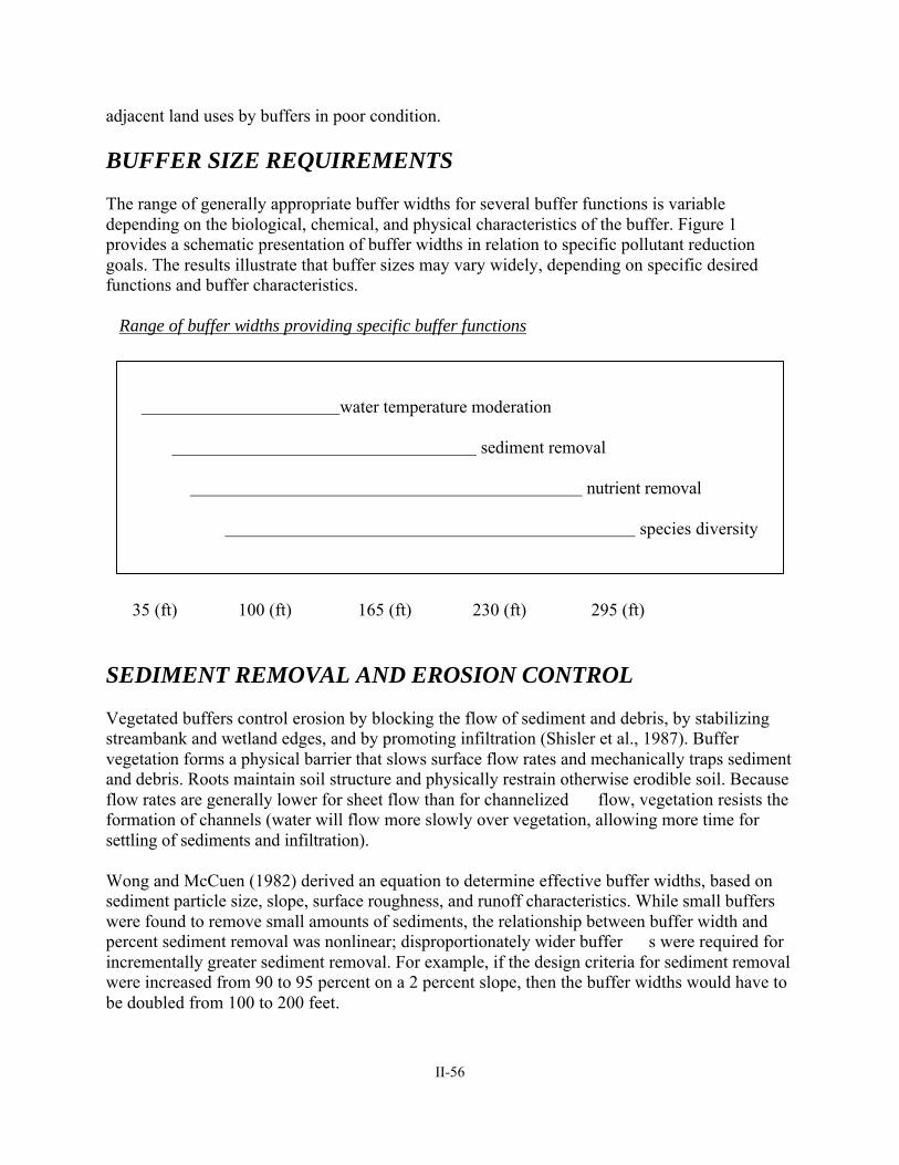
II-56
adjacent land uses by buffers in poor condition. BUFFER SIZE REQUIREMENTS The range of generally appropriate buffer widths for several buffer functions is variable depending on the biological, chemical, and physical characteristics of the buffer. Figure 1 provides a schematic presentation of buffer widths in relation to specific pollutant reduction goals. The results illustrate that buffer sizes may vary widely, depending on specific desired functions and buffer characteristics.
Range of buffer widths providing specific buffer functions water temperature moderation sediment removal nutrient removal species diversity 35 (ft) 100 (ft) 165 (ft) 230 (ft) 295 (ft) SEDIMENT REMOVAL AND EROSION CONTROL Vegetated buffers control erosion by blocking the flow of sediment and debris, by stabilizing streambank and wetland edges, and by promoting infiltration (Shisler et al., 1987). Buffer vegetation forms a physical barrier that slows surface flow rates and mechanically traps sediment and debris. Roots maintain soil structure and physically restrain otherwise erodible soil. Because flow rates are generally lower for sheet flow than for channelized flow, vegetation resists the formation of channels (water will flow more slowly over vegetation, allowing more time for settling of sediments and infiltration). Wong and McCuen (1982) derived an equation to determine effective buffer widths, based on sediment particle size, slope, surface roughness, and runoff characteristics. While small buffers were found to remove small amounts of sediments, the relationship between buffer width and percent sediment removal was nonlinear; disproportionately wider buffer s were required for incrementally greater sediment removal. For example, if the design criteria for sediment removal were increased from 90 to 95 percent on a 2 percent slope, then the buffer widths would have to be doubled from 100 to 200 feet.
II-57
Young et al. (1980) found that an 80 -foot-wide vegetated buffer reduced the suspended sediment in feedlot runoff by 92 percent, but Schellinger and Clausen (1992) determined that a 75 -foot-wide buffer removed just 33 percent of the suspended solids from dairy farm runoff. Horner and Mar (1982) reported that a 200 -foot-wide grassy swale removed 80 percent of the suspended solids and total recoverable lead; Broderson (1973) also found that 200 -foot-wide buffers effectively control sedimentation, even on steep slopes. According to Lynch et al. (1985), a 98 -foot-wide buffer between logging activity and water resources removed an average of approximately 75 to 80 percent of the suspended sediment in stormwater. Greater sedimentation resulted from forested areas that had b een commercially clear -cut and then denuded with an herbicide because of channelization, which developed following these activities. Ghaffarzadeh et al. (1992) examined sediment removal by grass vegetated filter strips ranging from 0 to 60 feet on 7 and 12 percent slopes. They found no different in vegetated filter strip performance on either slope beyond 30 feet, where 85 percent of the sediment was removed. EXCESS NUTRIENT AND POLLUTANT REMOVAL Buffers remove pollutants and excess nutrients from runoff, but the rate of removal appears to be a function of the length, slope and soil permeability of the buffer, the size of the contributing buffer area, and the runoff velocity. Therefore, recommended buffer widths for nutrient and pollutant attenuation vary widely. In general, the recommended width is 100 feet or more. However, few opportunities exist in the WAC 5 study area to establish 100 -foot-wide buffers. Fortunately, some research indicates that lesser buffers may contribute significantly to the reduction of nonpoint source pollutants. Madison et al. (1992) examined the ability of grass vegetated filter strips (VFSs) to reduce nitrogen and phosphorus during two simulated storm events (the equivalents of the 1 -year and 10 -year events). Grass VFSs which we re 30 feet wide had trapping efficiencies of between 96 and 99.9 percent. Vegetated filter strips wider than 30 feet did not result in further improved trapping efficiencies, according to Madison. Dillaha et al. (1989) reported that 30 -foot-wide and 15 -foot-wide VFSs removed an average of 84 and 70 percent of suspended solids, 79 and 61 percent of phosphorus, and 73 and 54 percent of nitrogen, respectively. Xu et al. (1992) found that nitrogen concentrations were reduced from 764 mg to approximately 0.5 mg in a 30 -foot-wide mixed herbaceous and forested buffer strip in the North Carolina Piedmont. Wooded riparian buffers in the Maryland coastal region were found to remove as much as 80 percent of excess phosphorus and 89 percent of excess nitrogen, most of it in the first 62.3 feet (Shisler et al. 1987). Schueler (1987) suggested that, as an “absolute minimum,” an unmanaged/unmowed grass strip should be at least 20 feet wide, but better performance is achieved if the strip is 50 to 75 feet wide, plus an addit ional 4 feet per each 1 percent of the site’s slope. MODERATION OF STORMWATER RUNOFF AND WATER TEMPERATURE Wetland stream buffers affect the quantity as well as the quality of stormwater runoff. A vegetated buffer zone that resists channelization is effe ctive in decreasing the rate of water flow and, in turn, increasing the rate of infiltration (Broderson, 1973). Bertulli (1981) concluded that adjacent forest vegetation and litter lowered stream water elevations from 32.3 feet to 17.3 feet for a 100-year flood.

II-58
Forested buffers adjacent to wetlands provide cover, thereby helping to maintain lower water temperatures in summer and lessen temperature decreases in winter. Broderson (1973) found that 50-foot-wide buffers provided adequate shade for small strea ms; further, buffer widths along slopes can decrease with increasing tree height with no significant loss of shading. Lynch et al. (1985) determined that a 100 -foot-wide buffer from logging operations maintained water temperatures within 2 to 3 degrees Fahrenheit of their former average temperature.