Planning Biped Navigation Strategies in Complex Environments
Conference on Modelling Complex Urban Environments June 21-22, 2018
University of Waterloo, Canada

Schedule at a Glance Thursday June 21, 2018 - Day 1
8:30-9:00 AM Coffee and Opening Remarks
9:00-10:00 AM Keynote 1: Hedwig van Delden
10:00-10:20 AM Coffee Break
10:20-12:20 PM Session 8 Session 2A Session 4
12:20-1:30 PM Lunch
1:30-2:30 PM Keynote 2: Geoffrey West
2:30-3:00 PM Coffee Break
3:00-5:00 PM Session 7 Session 9 Session 3
5:00-6:00 PM Poster Contest/Reception
Friday June 22, 2018 - Day 2
9:00-10:00 AM Keynote 3: Alex Anas
10:00-10:20 AM Coffee Break
10:20-12:20 PM Session 5A Session 2B
12:20-1:30 PM Lunch
1:30-2:30 PM TBA
2:30-3:00 PM Coffee Break
3:00-5:00 PM Session 1 Session 5B
5:00-6:00 PM Session 10
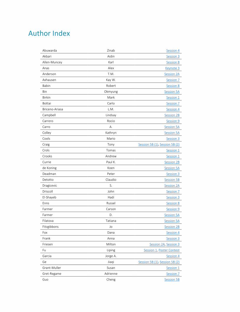
Author Index
Abuwarda Zinab Session 4
Akbari Aidin Session 3
Allen-Muncey Karl Session 8
Anas Alex Keynote 3
Anderson T.M. Session 2A
Axhausen Kay W. Session 7
Babin Robert Session 8
Bin Okmyung Session 5A
Birkin Mark Session 1
Bottai Carlo Session 7
Briceno-Ariasa L.M. Session 4
Campbell Lindsay Session 2B
Carrero Rocio Session 9
Carro A. Session 5A
Colley Kathryn Session 5A
Cools Mario Session 3
Craig Tony Session 5B (1), Session 5B (2)
Crols Tomas Session 1
Crooks Andrew Session 1
Currie Paul K. Session 2B
de Koning Koen Session 5A
Deadman Peter Session 3
Detotto Claudio Session 5B
Dragicevic S. Session 2A
Driscoll John Session 7
El-Shayeb Hadi Session 3
Enns Russel Session 8
Farmer Carson Session 9
Farmer D. Session 5A
Filatova Tatiana Session 5A
Fitzgibbons Jo Session 2B
Fox Dana Session 4
Frank Anna Session 3
Friesen Milton Session 2A, Session 3
Fu Liping Session 1, Poster Contest
Garcia Jorge A. Session 4
Ge Jiaqi Session 5B (1), Session 5B (2)
Grant-Muller Susan Session 1
Gret-Regame Adrienne Session 7
Guo Cheng Session 5B
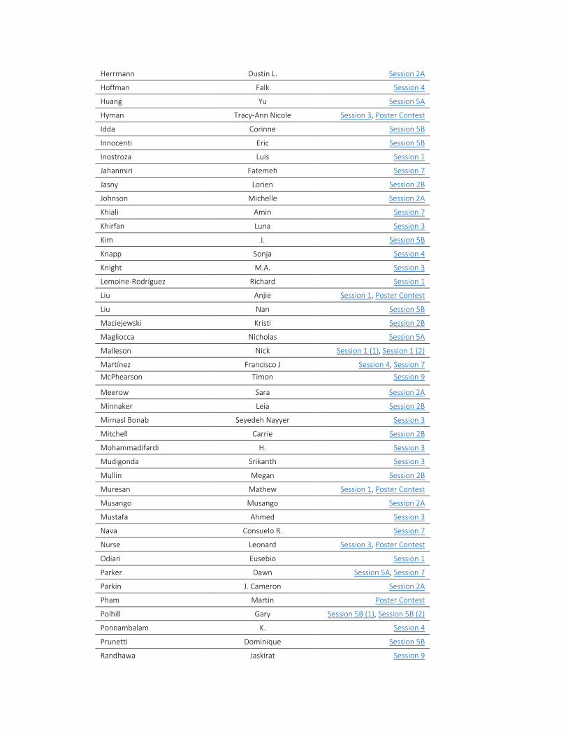
Herrmann Dustin L. Session 2A
Hoffman Falk Session 4
Huang Yu Session 5A
Hyman Tracy-Ann Nicole Session 3, Poster Contest
Idda Corinne Session 5B
Innocenti Eric Session 5B
Inostroza Luis Session 1
Jahanmiri Fatemeh Session 7
Jasny Lorien Session 2B
Johnson Michelle Session 2A
Khiali Amin Session 7
Khirfan Luna Session 3
Kim J. Session 5B
Knapp Sonja Session 4
Knight M.A. Session 3
Lemoine-Rodríguez Richard Session 1
Liu Anjie Session 1, Poster Contest
Liu Nan Session 5B
Maciejewski Kristi Session 2B
Magliocca Nicholas Session 5A
Malleson Nick Session 1 (1), Session 1 (2)
Martínez Francisco J Session 4, Session 7
McPhearson Timon Session 9
Meerow Sara Session 2A
Minnaker Leia Session 2B
Mirnasl Bonab Seyedeh Nayyer Session 3
Mitchell Carrie Session 2B
Mohammadifardi H. Session 3
Mudigonda Srikanth Session 3
Mullin Megan Session 2B
Muresan Mathew Session 1, Poster Contest
Musango Musango Session 2A
Mustafa Ahmed Session 3
Nava Consuelo R. Session 7
Nurse Leonard Session 3, Poster Contest
Odiari Eusebio Session 1
Parker Dawn Session 5A, Session 7
Parkin J. Cameron Session 2A
Pham Martin Poster Contest
Polhill Gary Session 5B (1), Session 5B (2)
Ponnambalam K. Session 4
Prunetti Dominique Session 5B
Randhawa Jaskirat Session 9
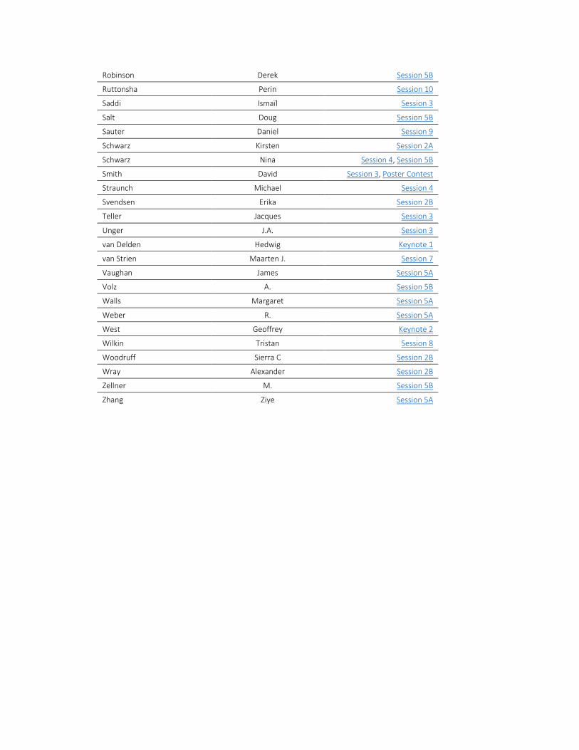
Robinson Derek Session 5B
Ruttonsha Perin Session 10
Saddi Ismaïl Session 3
Salt Doug Session 5B
Sauter Daniel Session 9
Schwarz Kirsten Session 2A
Schwarz Nina Session 4, Session 5B
Smith David Session 3, Poster Contest
Straunch Michael Session 4
Svendsen Erika Session 2B
Teller Jacques Session 3
Unger J.A. Session 3
van Delden Hedwig Keynote 1
van Strien Maarten J. Session 7
Vaughan James Session 5A
Volz A. Session 5B
Walls Margaret Session 5A
Weber R. Session 5A
West Geoffrey Keynote 2
Wilkin Tristan Session 8
Woodruff Sierra C Session 2B
Wray Alexander Session 2B
Zellner M. Session 5B
Zhang Ziye Session 5A
Session Details Session 1: Integrating “Big Data” and “Smart Cities” Data With Urban Modelling Organizer: Alison Heppenstall June 22, 2018; 3:00-5:00 PM Location: From spectral values to three dimensional estimation of urban form: Assessing quantitative relationships between Technomass and radiometric indexes Authors: Richard Lemoine Rodriguez (Ruhr Universität Bochum); Luis Inostroza (Ruhr Universität Bochum; Universidad Autónoma de Chile) Abstract: The representation of complex ecological systems as aspatial networks, i.e. food webs, pest-parasitoid webs, and mutualistic webs, provides insight into their organization and function. Recently, spatial networks are leveraged in the form of landscape connectivity networks, composed of geolocated habitat patches that link together as a function of the maximum dispersal distance of the species of interest. Landscape connectivity networks are used to understand dispersal patterns and how these patterns respond to changes in landscape structure and connectivity. However, landscape connectivity networks are mostly limited to static representations at the larger landscape-scales and do not account for complexity in dispersal processes where the emergent structure and evolution of network structure is a function of dispersal dynamics at smaller scales. The main objective of this research study is to develop a modelling approach that integrates network theory and agent-based modelling (ABM) for the representation of a dynamic dispersal network of the emerald ash borer (EAB) forest insect infestation in an urban setting. The proposed Network-ABM (N-ABM) generates dynamic spatio-temporal patterns of EAB spread together with the spatio-temporal EAB dispersal network using geospatial datasets of the urban forest environment from the Town of Oakville, Canada as a case study. Graph theory measures are used to characterize the N-ABM simulation results to provide insight into the dynamics of the EAB dispersal and spatial network structure in the urban landscape. The proposed model can be useful for urban forest management as it is capable to identify important EAB dispersal pathways and habitat features. Keywords: urban morphology, remote sensing, urban indicators, land surface temperature Estimating vehicle emissions using big traffic data Authors: Anjie Liu (University of Waterloo); Liping Fu (University of Waterloo); Mathew Muresan (University of Waterloo) Abstract: As climate change and urban air quality become growing concerns around the world, there is greater need to quantify vehicle emissions. Vehicle emissions generate a significant portion of greenhouse gases. Since these emissions are influenced by traffic flow conditions, it is beneficial for traffic management professionals to have methods to estimate emissions in real time. Unfortunately, direct measurement of emissions from all road vehicles is both costly and impractical. However, emissions can be estimated through the relationships between emission generation and traffic flow. This poster will present a method to estimate emissions in real time using big traffic data. Traffic data from video cameras, Wifi detectors, and loop detectors at intersections are used to model the traffic flow along a road corridor. An emission model is developed to use the traffic flow as input to estimate
the emissions generated. New sources of traffic data, such as vehicle tracking through video cameras using image processing, provide opportunities for improved traffic flow modelling and, subsequently, emission estimation. To calibrate and validate the emission estimation methods, a pre-validated simulation approach is taken. The traffic network is simulated in Vissim, a microscopic traffic flow simulator, and calibrated according to the traffic data. Outputs of the simulation are input into MOVES, an emission simulator developed by the Environmental Protection Agency US, to generate emission estimates. These results serve as the ground truth used to evaluate the real-time emission estimation method. Keywords: emission modelling; traffic data; traffic simulation; traffic flow modelling The use of big data in simulating attributes and mobilities of passengers on the UK Rail network Authors: Eusebio Odiari (University of Leeds); Mark Birkin (University of Leeds); Susan Grant-Muller (University of Leeds); Nick Malleson (University of Leeds) Abstract: The now wide-spread use of electronic devices has meant that novel sources of large consumer datasets (called ‘Big Data’) are increasingly readily available. These datasets are typically created for a particular purpose, and as such are skewed and do not have the broad spectrum of attributes required for their wider application. For example, in the rail sector, ticketing data consists of ~60% commuters, whilst the wider Census population consists of ~10% commuters making ticketing data a skewed (or biased) subset of the wider Census population. Ticketing data also often have little or no supplementary information about the passengers who purchase them (such as journey purpose, socio-demographic attributes, etc.). Furthermore, the ticketing data does not have information about the context in which the ticket was used (such as the level of crowding in the train when the ticket was used, or the waiting times the passenger endured). This lack of context presents challenges in the planning and management of railways, and in causal inference on the drivers of mobility choice. This research questions whether biased large consumer data available within the railways industry can be combined with supplementary representative data to augment current estimates of passenger attributes and activity on the railways. In the first stage of the research, spatial micro-simulation is used to adjust the resolution and geographic scale of three disparate datasets: ‘big data’ consisting of every railway ticket sold in the West Yorkshire UK study area; the 2011 Census interaction data; and the National Rail Travel Survey. The methodology extends for the first time the concept of simultaneously constraining for 3-levels of variables, enabling the inclusion of mobility interaction in the spatial microsimulation process. The outcome is a synthetic population of attribute-rich individuals who are representative of all railway passengers in the study area. In the second stage, the synthetic population is used as input into a rail GIS network that has been logistically constrained by real transit schedules. This produces a rich dataset of railway passengers including both exogenous and endogenous attributes, enabling the identification of context rich space-time volumes of individual passengers on train carriages, platforms and stations. This also enables the assignment of passengers to traffic on the rail network, precluding the need for the complexities of a utility optimizing transit assignment. The hypothesis is that such micro-level information on passenger demand will have a significant impact on the quality of inputs to strategic, tactical and operational rail-sector analysis planning models. Furthermore, an accurate GIS rail network model would be beneficial to network operators for the management, maintenance and interventions assessment on the railways. Keywords: consumer data, big data, passenger mobility, network simulation, spatial microsimulation
Combining Big Data and Traditional Data in an Agent-Based Model of the Ambient Population Authors: Tomas Crols (University of Leeds) and Nick Malleson (University of Leeds) Abstract: Modelling the ambient population in urban areas can have applications in fields that need population estimations with highly detailed spatial and temporal resolutions. These fields include crime science, modelling exposure to air pollution, or transport studies. ‘Big’ data allow us to track human movements at the desired resolution, but still have a number of issues that make them sometimes difficult to apply or to get access to. The best datasets, like mobile phone data, can be unavailable because of commercial or privacy-related reasons. Geolocated data from social media platforms are not always fully representative of the entire population. Footfall data are limited to specific locations and are better suitable for model validation than for calibration. Hence, big data and more traditional spatial data could be combined for model calibration and validation. In this presentation, we discuss the development of an agent-based model of the ambient population at an individual level in an urban environment. Ultimately, the goal is to calibrate the model with different big data streams in real time by using dynamic data assimilation techniques. Currently, we have developed an application for the town centre of Otley, West Yorkshire, UK. We model daily routines of individual commuters (working, shopping, leisure, etc.) that we calibrated with census data of commuting flows and a recent British time-use survey. For validation, we use hourly Wi-Fi sensor footfall data of mobile phones passing by at different points in town. Keywords: agent-based modelling, ambient population, big data, traditional data Leveraging Open Data for Urban Agent-based Models: Examples and Challenges Authors: Andrew Crooks (George Mason University); Sarah Wise (University College London) Abstract: Today we are awash with new sources of open data, from CCTV to crowdsourced data. New forms of data range in their characteristics and purpose. One example is Volunteered Geographical Information (VGI), were users purposely contribute Geographic Information (GI) as in the case of OpenStreetMap; another is Ambient Geographic Information (AGI), where the intention of contributors is not necessarily to provide GI, but GI can be derived, as from Twitter. While much progress has been made in utilizing these new sources of data in GIScience, they have only recently begun to be integrated into agent-based models (ABMs). This talk will discuss the opportunities that open data provides for ABMs, specifically focusing on how such information gives us a new lens to study the micro interactions of individuals or to validate emergent patterns from ABMs. Through a series of examples, we will demonstrate how such data can be integrated into geographically explicit ABMs. By building on these examples we will showcase how the spatial environment and agent populations can be built using open data and highlight how agent behaviors can be informed along with how aggregated outcomes can be validated by such information. We will further discuss the challenges associated with this program of research: using such data is not without its difficulties, including gathering or accessing the data, storing the data, analyzing the collected data, and assessing its validity. Together, this work provides a brief overview of the current state of open data-informed ABM. Keywords: agent-based modeling, open data, volunteered geographical information, social media, crowdsourcing, urban systems
Session 2A: Social-Ecological Networks in the City Organizer: Jeremy Pittman and Carrie Mitchell June 21, 2018; 10:20 AM-12:20 PM Location: Integrating spatial networks and agent-based modelling for representation of forest insect infestation in urban landscapes Authors: T.M. Anderson (Simon Fraser Univeristy); S. Dragicevic (Simon Fraser University) Abstract: The representation of complex ecological systems as aspatial networks, i.e. food webs, pest-parasitoid webs, and mutualistic webs, provides insight into their organization and function. Recently, spatial networks are leveraged in the form of landscape connectivity networks, composed of geolocated habitat patches that link together as a function of the maximum dispersal distance of the species of interest. Landscape connectivity networks are used to understand dispersal patterns and how these patterns respond to changes in landscape structure and connectivity. However, landscape connectivity networks are mostly limited to static representations at the larger landscape-scales and do not account for complexity in dispersal processes where the emergent structure and evolution of network structure is a function of dispersal dynamics at smaller scales. The main objective of this research study is to develop a modelling approach that integrates network theory and agent-based modelling (ABM) for the representation of a dynamic dispersal network of the emerald ash borer (EAB) forest insect infestation in an urban setting. The proposed Network-ABM (N-ABM) generates dynamic spatio-temporal patterns of EAB spread together with the spatio-temporal EAB dispersal network using geospatial datasets of the urban forest environment from the Town of Oakville, Canada as a case study. Graph theory measures are used to characterize the N-ABM simulation results to provide insight into the dynamics of the EAB dispersal and spatial network structure in the urban landscape. The proposed model can be useful for urban forest management as it is capable to identify important EAB dispersal pathways and habitat features. Keywords: Networks; Agent-based modeling; Forest insect infestation; Urban forest management, Geographic information systems Comparing Social Capital and Spatial Use Patterns in Urban Environments Author: Milton Friesen (University of Waterloo) Abstract: This paper utilizes the results of a new social capital measurement instrument (Social Capital General Social Survey – SCGSS) developed for neighbourhood scale measurement of citizens social network and trust levels. Understanding and reliably quantifying social infrastructure at this scale is becoming increasingly urgent and this exploratory paper extends our knowledge of those dynamics. The survey instrument is paired with Global Positioning System (GPS) data to measure spatial behaviour of a random sample of participants (n=97) across three East Hamilton Census Tracts differentiated by income – median (Rosedale) and a standard deviation above (Delta) and below the median (McQueston) for adults aged 18-64 years. The spatial statistics of the GPS data are analyzed and summarized in ArcGIS for comparison with the SCGSS data collected from the same participants to determine the validity of the central hypothesis that greater movement in the urban environment correlates with higher levels of social capital. The comparative data are analyzed using linear regression (LM), random forest (RFM) and principal component analysis (PCA) in an R environment and the results are summarized. Keywords: social capital, social networks, spatial statistics, social infrastructure, GPS
Modeling Avian Patch Networks in Dense Urban Settings Author: J. Cameron Parkin (University of Waterloo) Abstract: This research focuses on the movement and accommodation of avian and other vagile species through patch networks in dense urban fabric. The goal of this research is to analyze and visualize existing urban patch networks in order to inform the location, strategy, and composition of interventions in the urban fabric. These interventions are designed to promote urbanite-fauna interaction, which has potential to increase city dwellers' environmental stewardship, and benefit their psychological well-being. In order to manage the inherent complexity of negotiating urban and ecological systems in the dense downtown core, digital methods of modelling networks are borrowed from landscape ecology, graph theory, and parametric architecture. Computational workflows are created to simulate two dimensional and three dimensional agent movement within patch networks, populate these networks with bird sighting data, and use this information to locate and inform a variety of intervention typologies. Keywords: Ecology; Urban Ecology; Ecological Data; Ecological Networks; Computational Design A Green Infrastructure Spatial Planning model for evaluating ecosystem service tradeoffs and synergies in three coastal megacities Author: Sara Meerow (Arizona State University) Abstract: A growing number of cities are expanding green infrastructure to foster resilience. While these nature-based solutions are often promoted on the basis of their multifunctionality, in practice, most studies and plans focus on a single benefit, such as stormwater management. This represents a missed opportunity to strategically site green infrastructure to leverage social and ecological co-benefits. To address this gap, this paper presents the Green Infrastructure Spatial Planning (GISP) model as a tool for identifying and comparing spatial tradeoffs and synergistic ‘hotspots’ for multiple benefits in three diverse coastal megacities: New York City, Los Angeles (United States), and Manila (Philippines). Spatial multi-criteria evaluation is used to examine how strategic areas for green infrastructure development across the cities change depending on which benefit is prioritized. Preliminary GIS layers corresponding to six planning priorities (managing stormwater, reducing social vulnerability, increasing access to green space, improving air quality, reducing the urban heat island effect, and increasing landscape connectivity) are mapped using existing datasets and spatial tradeoffs assessed. Criteria are weighted to reflect local stakeholders’ priorities as determined through surveys and stakeholder meetings, and the combined results visualized. While additional model improvements are clearly needed, preliminary results empirically illustrate the complexities of planning green infrastructure and urban resilience more generally. Community engagement with green infrastructure as a mechanism to promote urban resilience Authors: Kirsten Schwarz (Northern Kentucky University), Dustin L. Herrmann (University of Cincinnati) Abstract: Green infrastructure is a mechanism for promoting urban resilience through its social and ecological benefits, but its potential to confer resilience may depend on the level of community engagement in the design, implementation, and maintenance of such projects. We use a case study of a community-engaged green infrastructure project in northern Kentucky as well as an emerging framework, Ecology for the Shrinking City, to examine the potential role of community engagement in building urban resilience. A central tenet of resilience is the ability to “return to desired functions in the face of disturbance, to adapt to change, and to quickly transform systems that limit current or future adaptive capacity” (Meerow et al. 2016). Resilience, therefore, is a goal only attainable through
sustained effort and investment. When green infrastructure projects are implemented with little input from the community in which they are embedded, they not only miss an opportunity to develop environmental stewardship but may impact the long-term ability of a community to respond to disturbance in a way that promotes urban resilience. Understanding the role of community engagement in building urban resilience is especially important in shrinking cities and areas of concentrated disinvestment, as vacant lands represent places of potential social-ecological transformation.
Session 2B: Social-Ecological Networks in the City Organizer: Jeremy Pittman and Carrie Mitchell June 22, 2018; 10:20 AM-12:20 PM Location:
Exploring Perceptions of the Western Cape Water Crisis through Social Network Analysis Author: Kristi Maciejewski (Stellenbosch University); Paul K Currie (Stellenbosch University); Josephine Kaviti Musango (Stellenbosch University) Abstract: The Western Cape Province of South Africa is currently experiencing the worst drought in its recorded history. Like many cities in recent years, Cape Town is facing an existential threat to its economy and the wellbeing of its residents due the rapid reduction in water availability. Numerous demand-side-management and off-grid water supply interventions have resulted in an unprecedented reduction in daily water consumption, from 1.1 billion litres to near 450 litres, over just 24 months. The fundamental direct causes of the crisis, and of changes in water consumption levels, are as yet unclear. However, it is apparent that residents hold varied perceptions of: (i) the causes of the crisis; (ii) the contributions of different economic sectors towards water saving or over-consumption; (iii) how the crisis has been managed by the City and other stakeholders; (iv) the key institutions involved in communications or interventions; and (v) the efficacy of residents’ own contributions to water saving at household and community level. Thus, the objective of this paper was to draw links between residents’ perceptions of the crisis and their associated behavioural changes. This was achieved using Social Network Analysis, which was developed through a wide, convenient survey of key stakeholders, and which identified key events, campaigns, institutions and community members that initiated change and influenced human behaviour. The paper provides useful information for understanding how residents’ perceptions could be influenced should future crises emerge. Keywords: social-ecological system, drought, institutions, human behaviour change Understanding environmental stewardship outcomes through the lens of social network analysis: towards a social-ecological network analysis Authors: Michelle Johnson (USDA Forest Service, Northern Research Station), Erika Svendsen (USDA Forest Service, Northern Research Station), Lindsay Campbell (USDA Forest Service, Northern Research Station), Lorien Jasny (University of Exeter) Abstract: Social-ecological networks have emerged as a field of research to understand how social connectivity and ecological connectivity may interface and interact, but finding alignment of social-ecological connectivity for such analysis can be challenging in complex urban systems. However, governance social networks still have the potential to affect ecological conditions at multiple scales,
regardless of ecological connectivity. The large number of individuals and organizations in cities result in complex networks; how these organizations together can affect ecological conditions has been theorized but have been empirically measured infrequently. In 2017, the New York City Stewardship Mapping and Assessment Project (STEW-MAP) collected survey-based data on environmental stewardship organizational networks, individual organizations’ perceived outcomes, and other organizational-level characteristics of environmental stewardship groups. Here, we apply this social network dataset of urban environmental stewardship organizations to investigate how a social network can influence cumulative environmental outcomes in New York City. Beginning with perceived outcomes, we also consider available plot-level data on forest and wetland conditions and remotely-sensed land use/land cover data, to gain an understanding of overall system changes. From this empirical analysis, we identify how perceived environmental outcomes relate to network structure and position, as well as overall ecological condition. We also identify the potential for future social-ecological network analysis in cities like New York, by identifying aspects of the larger urban social-ecological system where connectivity can influence both stewardship outcomes and ecological condition in a social-ecological manner. Is climate change adaptation a public good? Authors: Sierra C Woodruff (Texas A&M University), Megan Mullin (Duke University) Abstract: As the impacts of climate change begin to be felt across the globe – including more intense hurricanes and extreme wildfires - it is clear that adaptation is essential. The question remains, however, who is responsible? Insufficient attention has been dedicated to the identification of the providers and beneficiaries of climate adaptation. Specifically, we examine when adaptation is a public good. This information is critical to identify actors, design accurate models of adaptation, and create effective policy instruments. Climate change mitigation – reducing greenhouse gas emissions – is a classic public goods problem with implications for who engages in mitigation efforts and how. Many aspects of adaptation also have public good characteristics. The widespread, trans-boundary consequences of climate change pushes adaptation towards the public goods end of the conceptual continuum. However, there are significant “impurities” in adaptation since climate change impacts are not equally distributed. The fact that some communities and some individuals will be more heavily affected narrows the “public” nature of climate impacts. The unequal distribution of impacts, means that the benefits of adaptation are also unequal with potential implications for who takes action, policy and financing decisions. In this paper we consider where sea level rise strategies, such as elevation of buildings and construction of sea walls, fall on the continuum from private to public goods. We draw on these thought experiments to consider the financial instruments available to mobilize public and private resources to advance adaptation. Keywords: Climate adaptation; public goods; sea level rise Principles of justice in urban resilience Authors: Jo Fitzgibbons (University of Waterloo), Carrie Mitchell (University of Waterloo) Abstract: As cities globally deal with increasingly complex and interrelated problems such as climate change, the idea of building general “resilience” in urban systems is outpacing other policy frameworks in popularity. Yet, many scholars have cautioned that resilience is an inherently conservative (rather than transformative) concept which obscures issues of power and justice (Meerow, Newell & Stults, 2016; Joseph, 2013; Ziervogel et al., 2017). To date, there has been little by way of in-situ or empirical findings to test these claims. The Rockefeller Foundation’s 100 Resilient Cities (100RC) is one major initiative that attempts to mainstream resilience thinking into city planning. We have taken this ongoing
program as an opportunity generate empirical findings on how planners confront issues of justice and inequity in resilience planning, focusing on the global South. To support our analysis, we have drawn on Anguelovski et al.’s (2016) concepts of “acts of commission” and “acts of omission” to consider both procedural and distributive justice. Procedural justice processes such as negotiation and redistribution of power are necessary to generate the transformative systems changes that resilience narratives promise (Harris, Chu & Ziervogel, 2017). These procedural considerations also influence distributive justice by affecting spatial and infrastructure planning which, in turn, affect economic and resource inequities. Using key informant interviews and directed content analysis of 13 Resilience Strategies, we examine whether and how the 100RC Chief Resilience Officers have understood and implemented principles of justice in the development of their city’s Resilience Strategy. Our findings confirm that resilience planning has not sought to radically transform power relations within cities, nor focused explicitly on justice. These findings will help guide future planners and policymakers to reflect on justice not only as an outcome for resilience, but also as a part of the planning process. Key words: resilience, environmental justice, critical planning, climate change, procedural justice The social-ecological networks of cancer prevention in urban Environments Author: Alexander Wray (University of Waterloo); Leia Minnaker (University of Waterloo) Abstract: This paper explores the network of dependencies between social structures, ecological systems, and cancer outcomes. The global burden of cancer is substantial and growing, of which half are preventable through changes to lifestyle and/or environmental factors. Primary forms of cancer prevention often revolve around altering behavioural or environmental conditions to reduce exposure risk, while secondary forms of prevention aim to understand existing contributions of socioecological conditions to cancer epidemiology. Therefore, given the majority of the human population now resides in urban areas, the city becomes the dominant place to explore the complex system-level relationships between health and environment. We present results of a scoping review of 308 peer-reviewed journal articles published between January 1990 and April 2017, across 14 subject databases. The review of the evidence published to date reveals a trend towards accounting for complex social and environmental contributions to cancer risk. Researchers have explored the role of socioeconomic factors, as well as anthropogenic environmental exposures in alleviating or aggravating the risk of all types of cancer. The spatial patterning and access to housing, transportation, greenspace, and public services all contribute to a real or perceived risk of cancer for people. Furthermore, the evidence suggests that urban and health related disciplines operate in relative isolation, often not sharing research across each other’s primary literature networks.
Session 3: Modelling and the planning process Organizer: Jeremy Pittman June 21, 2018; 3:00-5:00 PM Location:
A Systems-Oriented Vulnerability Approach to Flooding in Cave, Westmoreland Author: Tracy-Ann Nicole Hyman (University of the West Indies); David Smith (University of the West Indies); Leonard Nurse (University of the West Indies)
Abstract: The Community of Cave is approximately 4.8 km² and lies just off the southeast coast of Westmoreland, Jamaica. It is approximately 12 km from the parish capital, Savanna-la-Mar, with major economic activities namely farming and fishing. Like many island eco-systems, Cave is prone to tropical cyclones that give rise to flooding. Of special note is the 1979 flood event, which caused significant damage to terrain, disruption to transportation systems and devastation to lives and property in Western Jamaica. The parish of Westmoreland experienced 31 of the 41 deaths, and many persons were trapped in their communities, unable to evacuate. Still today, there are limited rainfall gauges and no flood gauges, early warning systems nor an official evacuation shelter. With a 50-year return period, any recurrence of this type of flood in 2016, could be worse than in 1979. The overall aim of this research was thus to construct a basic simulation of a 1979 flood-like event assessing the vulnerability of stakeholders to flooding in 2016. This based on geographical considerations, flood characteristics and the movement patterns of residents – analyzed through the use of Agent-Based Models, Geographic Information Systems, and implemented with Netlogo software. Preliminary results reveal that possible loss of life takes place on each of the three days sampled, [1] with most fatalities on a Friday. The expected results from this research should guide local government in the appropriate citing for evacuation shelters, safe zones, along with implications for early warning and land use planning in South-East Westmoreland. Keywords: Cave, flooding, agent-based model, evacuation Institutional Emergence and the Persistence of Inequality in Hamilton, ON 1851-1861 Author: Milton Friesen (University of Waterloo); Srikanth Mudigonda (St. Louis University) Abstract: Economic inequality in urban settings is a readily observable phenomena in contemporary cities but historical research reflects that the problem is not new. In this paper we argue that there are citizen level interactions and arrangements that contribute to the stability of a small group of wealthy citizens alongside a high degree of transience in the poor and populous part of the city. We develop an R coded agent based model that draws on citizen agency and economic dynamics revealed in a study of Hamilton, Ontario (1851-1861) by Michael Katz (1975). The Katz study drew on tax assessment, census and related formal documentation to establish economic, institutional and mobility citizen patterns across a ten year span. Our central hypothesis is that the wealthy citizens developed and had access to institutional resources that buffered negative externalities whereas the poor did not. In our Axtell and Esptein based model, a probability function leads to proto-institutions that emerge from agent interactions and thereafter produce greater stability, higher levels of wealth (sugar) and longer lifespans for their participating agents. The inverse is true for the agents who do not have institutional access. Keywords: agent-based modeling, insitutional emergence, citizen agency, social evolution, inequality, urban policy, citizen transience Application of System Dynamic modeling tool in sustainability assessment of water and wastewater asset management plans Author: H. Mohammadifardi (University of Waterloo); M. A. Knight (University of Waterloo); A. J. A. Unger (University of Waterloo) Abstract: The public infrastructures, specifically underground water and wastewater pipe network systems, are reaching their end of service life, and their replacement will need significant capital work. The government of Canada announced the $53-billion New Building Plan for rejuvenation of Canadian public infrastructure, the largest infrastructure investment in country’s history. However, the accelerated rehabilitation and reconstruction of infrastructures will not happen without consequences on social, ecological, and economic systems through the choices taken in their asset management plans.
The complexity of planning decisions is more compounded when planners realize that different economic, social, and environmental dimensions of the challenge are inherently interrelated. In fact, technological systems are noted to have the highest level of complexities, in which they interact with all social, natural, and economic systems (Halliday & Glaser, 2011). Complying with existing and changing regulatory policies and requirements, and development of socially acceptable, environmentally friendly and financially viable asset management plans calls for a comprehensive sustainability assessment. This paper, demonstrate the application of System Dynamic (SD) modeling and Life-Cycle Assessment (LCA) tool for sustainability assessment of municipal water and wastewater asset management plan scenarios. Keywords: System dynamic modeling, Sustainability assessment, Life cycle assessment, Water and wastewater, asset management planning Equitable Modes of Planning Practise for Urban Climate Resilience: A Case Study in Charlottetown, PEI Author: Luna Khirfan (University of Waterloo); Hadi El-Shayeb (University of Toronto) Abstract: The unpredictability of climate change impacts on urban areas cannot be ignored in order to avoid significant losses in the built environment, economy, and human health. Climate vulnerable cities require context-specific resilience plans, where natural and constructed systems are able to return to an original state (persist), respond (adapt), and reorganize (transform) in the wake of disturbance. Yet, the discussion on urban resilience cannot be given due process without the tethering of the ecological dimension, where blue and green natural elements are preserved and valued for their services. Furthermore, the singular emphasis on the expert at the expense of community knowledge of biotic and abiotic functions can render the design process void of context-specific and community value essential for creating climate resilience. In this paper, we underscore the socio-ecological elements of urban climate resilience by developing a theoretical framework that adapts the charrette, as a participatory design tool, to capitalize on local ecological knowledge (LEK) and attribute a local value system for blue-green design interventions. Thus, the framework is grounded in an interdependent triad of values including the design of the built form, blue-green interventions, and local knowledge transfer to action, to succeed transformative resilience. We apply this theoretical framework to Charlottetown, Prince Edward Island (P.E.I.), a city that is increasingly subjected to intense storm surges and sea level rise in Atlantic Canada, where a series of design charrettes integrated the LEK into urban climate resilience proposals. Keywords: Urban Climate Resilience; Local Ecological Knowledge; Blue-Green Infrastructure; Transformation Integrated Watershed Modeling in Urban-Rural Gradient: Review of the SWAT Modeling Framework Author: Seyedeh Nayyer Mirnasl Bonab (University of Waterloo); Aidin Akbari (University of Manitoba); Anna Frank (University of Waterloo); Peter Deadman (University of Waterloo) Abstract: The constant growth of human impact on natural settings and the reciprocal influences of physical environment on social settings have left no room for mutually exclusive thinking frameworks with respect to natural systems and human societies. The intense use of land by human societies for agricultural production and the adverse impacts of the range of activities in urban environments contributing to this intensity on both natural and social settings are clear indicators of the complexity of flows and interactions that lie within and among both contexts. It is plausible to infer that Integrated Watershed Modeling (IWM) should transcend the old boundaries of thoughts and must be defined, implemented, and measured within a new thinking framework embracing both urban and rural settings. In this regard, this paper aims to draw a general conclusion based on inductive reasoning on the necessity of defining a new framework for IWM in urban-rural gradient. We focused on the SWAT model
as an exemplary IWM tool, and conducted a literature review of the frameworks used and searched for examples of coupled urban-rural models. We made a structured review of technical challenges and benefits of using SWAT model as a decision making support tool for sustainable urban planning. Keywords: SWAT, urban and rural planning, integrated watershed modeling, coupled human and natural systems An integrated Cellular Automata Agent Based model to simulate urbanization Author: Ahmed Mustafa (University of Liège); Ismaïl Saadi (University of Liège); Mario Cools (University of Liège), Jacques Teller (University of Liège) Abstract: Several statistical and geospatial approaches have been proposed and developed to model urban expansion, including logistic regression, cellular automata, and agent-based models. This study proposes an integrated cellular automata and agent-based model (CA-AB). The model simulates two development processes: expansion and densification. The model is applied to Wallonia (Belgium), as a case study. The urban land use maps of 1990, 2000, and 2010 and several urbanization explanatory factors are used to calibrate the model. The agents are categorized into three groups with different characteristics and goals: developer (DevAG), existing resident (ExtAG) and planning permission authority (PPA). At each time step, corresponding to one year, a number of DevAGs select locations to develop. The selection of target location is a spatial knowledge-based decision. Each developer agent tends to build within the existing urban area (densification) or close to it in order to benefit from existing services. In this study, a 3×3 neighborhood window is used to represent the DevAGs preferences regarding local attractiveness. After the respective developer has selected a cell to develop or densify and at which density level, it has to ask for a development permit from the PPA. The PPA determines to allow the development according to two factors: (i) land use regulations, and (ii) the resistance of existing residents against proposed new development. The validation of the model shows comparable results to those reported in the literature with Kappa indices between 0.88 and 0.92.
Session 4: Artificial Intelligence & Optimization Models in Urban Environments Organizer: Jorge Garcia June 21, 2018; 10:20 AM-12:20 PM Location: Land use planning and optimal subsidies Author: L.M. Briceno-Ariasa (Universidad Tecnica Federico Santa Maria); F. Martinez (University of Chile) Abstract: The urban planification is a complex problem involving the choice of a social objective for a built city, from which an optimal allocation of agents should be found as a market equilibrium with the help of some policy like subsidies. In order to find the optimal allocation and subsidies, we prove a fundamental result which asserts that any feasible allocation can be achieved as a market equilibrium by applying suitable subsidies, which can be computed even in the case with location externalities. This allow us to split the problem in two independent steps. First, we find the optimal allocation for a social objective and, second, we use the fundamental result to derive subsidies that reproduce the optimal allocation as a market equilibrium. The computation of the optimal allocation is obtained from a convex optimization urban planning problem applicable to a wide class of objective functions. Optimal subsidies can be obtained even when the policy maker seeks to reduce the impact of the policy, or faces

implementation constraints, e.g., some agents or zones can not be subsidized or taxed, or in some specific zones the budget for subsidies is limited. As an example, we simulate a small city which aims at improving social inclusion. Keywords: convex optimization; land use planning problem; location subsidies; urban segregation. Sharing or sparing? Optimising a virtual urban region to foster biodiversity and climate regulation Author: Nina Schwarz (University of Twente); Falk Hoffmann (Helmholtz Centre for Environmental Research UFZ); Michael Strauch (Helmholtz Centre for Environmental Research UFZ); Sonja Knapp (Helmholtz Centre for Environmental Research UFZ) Abstract: Similar to the land sparing versus land sharing debate for agricultural landscapes, urban scientists discuss the pros and cons of different urban forms, i.e. the spatial layout of cities and use intensities, under the terms of “compact city” or “smart growth” and urban sprawl. While a compact urban development is often assumed as the goal to strive for, more scattered built-up and green areas in cities could be beneficial for some ecosystem services provided by urban green spaces, especially if close proximity between residents and urban green spaces is required. Thus, in this paper we optimise the spatial layout of a virtual city regarding two objectives, namely biodiversity, operationalised as species richness of vascular plants, and one ecosystem service, local climate regulation. We derived both underlying models from empirical findings and employed a multi-objective genetic algorithm. In this paper, we present preliminary results regarding the spatial arrangement of urban green spaces, low-density residential and high-density residential areas. Also, we discuss challenges we faced when choosing an appropriate spatial extent and resolution and when setting up simple models to be used during optimisation based on complex results from empirical studies. Keywords: optimisation; biodiversity; climate regulation; virtual landscape Opioid Pandemic - Breaking the Back of Canadian Healthcare Author: Dana Fox (Independent Consultant) Abstract: In the effort to address the opioid crisis, The Institute for Smarter Government, a non profit organization, discovered that data science can be used to minimize the impact and spread of opioids in Canada. Based on the research done with the public domain data, predictive and prescriptive data science models will help to address the opioid crisis in the following ways. 1. Predicting the future impacts on municipalities by estimating, a) the number of people affected by opioids b) the number of deaths caused by opioids 2. Identifying the factors leading to the use of opioids and their contributions 3. Providing recommendations to reduce the spread and impact of the opioids Comprehensive Schedule Optimization in Construction Using Constraint Programming Author: Zinab Abuwarda (University of Waterloo) Abstract: Delays and cost overruns are common facts in construction projects due to its increasing complexity, the day-to-day dynamic changes, the stricter execution constraints, and the general lack of efficient scheduling tools to support the optimization of construction plans. Currently, many scheduling tools and techniques are available, in addition to a large body of literature that focus on schedule
optimization. Such tools and techniques, however, do not adequately represent or incorporate various practical decisions and constraints, nor provide the project manager with the ability to examine the combinations of actions in order to either plan or bring the project back within the constraints. In this paper, the schedule optimization research is enhanced by efficiently modeling real-life decisions and constraints, and develops a framework to optimize planning and corrective-action decisions; dynamically before and during construction. The development of the proposed framework starts with a basic model that suits the schedule optimization decisions at the preconstruction stage. This model is then extended to a generic model that accommodates the dynamic schedule optimization needs during construction. The enhancements and extensions are formulated in a generic mathematical formulation to optimize the schedule’s decisions at any stage. This formulation integrates a wide range of scheduling options (e.g., linear crashing, activity multimodes, overlapping, and multipath networks), and incorporates the project manager’s preferences about the corrective-action decisions’ implementation. The formulation also considers a variety of practical constraints (e.g., variable resource availability, correlated modes, and intermediate milestones); and uses a multi-objective optimization to tradeoff among the project time, cost, resources, and permissible schedule changes during construction. Based on the mathematical formulation, the proposed framework was then coded using the advanced constraint programming tool “IBM ILOG CPLEX Optimization Studio”. To validate the model, multiple experiments on four case studies were used to prove the functionality, practicality, and its better representation of real-life construction challenges. Two of these case studies are taken from the literature to prove the ability of the comprehensive model to achieve better solutions. Construction experts were also consulted at multiple stages of this work to investigate the relevance of the framework. Introducing the proposed framework as an add-on to standard project management software is expected to change the practitioners’ perception that optimization is a theoretical and complex tool. Therefore, it helps to present optimization as useful decision support and cost-benefit analysis tools for construction scheduling. Keywords: Construction Management, Scheduling, Constraint Programming, Multi-Mode Resource-Constrained Scheduling, Constrained Resource Scheduling, Schedule Optimization Bayesian Algorithm to Estimate Travel Times in Road Networks Authors: Jorge A. Garcia (University of Waterloo); K. Ponnambalam (University of Waterloo) Abstract: The use of Advance Traveller Information Systems (ATIS) aim at improving the performance of a road network as well as improving drivers’s decision-making in regard to route selection. Having accurate information about current travel times is essential for drivers to decide the route to follow according to their preferences and risk aversion. In this study we developed an algorithm for updating states of road segments using the information of current vehicles traveling on the road network, such algorithm includes a diffusion term to account for the deterioration of information over time. Drivers are supplied with estimates from the Bayesian algorithm and they choose the route to follow by optimizing a utility function that includes individual and social gain and a risk aversion component. We compared the results from the simulation against solutions obtained from an optimization model of the same system. We also measured the efficiency achieved in the road network by using the Bayesian algorithm. Finally, we created and tested an online learning procedure to let drivers remove any bias coming from the Bayesian algorithm.
Session 5A: Agent-Based Models of Housing Organizer: Yu Huang June 22, 2018; 10:20 AM-12:20 PM Location:
The impact of transport infrastructure on housing markets: An agent-based modelling approach Authors: A. Carro (University of Oxford); D. Farmer (University of Oxford) Abstract: In this contribution, we study some of the main channels and mechanisms by which infrastructure has an impact on the economy. In particular, we focus on its effect on housing markets, housing being the largest asset class in the economy as well as one of its main drivers. To this end, we develop a spatial agent-based model of the housing market, based on a discrete set of districts or locations, each of them containing a non-spatial housing market model. This non-spatial model simulates a large pool of households with realistic demographic characteristics, life-cycles, and housing decisions. Among other aspects, the dynamics of both the ownership and the rental market are modelled in detail, including the buy-to-let sector. Furthermore, households are allowed to move between these different local markets in order to accommodate their different budget constraints while trying to stay close to their job locations, thus embedding the non-spatial models into a spatially distributed commuting network. As a case study, the model is calibrated against a large set of UK microdata from household surveys and housing market data sources such as the Financial Conduct Authority's (FCA) loan-level Product Sales Data (PSD) and the WhenFresh/Zoopla data on rental listings, as well as confidential data from the Bank of England. Once these microdata sources have been used to fine-tune household's individual characteristics and behaviours, a macro-calibration is performed to ensure consistency with different economic aggregates and housing market core indicators. Keywords: agent-based modelling, spatial economics, housing markets, transport infrastructure, commuting An Overview of ILUTE in 2018 Author: James Vaughan (University of Toronto) Abstract: ILUTE (Integrated Land Use, Transportation Environment) has been in development by the University of Toronto over the past twenty years. The goal of ILUTE is to provide urban planners within the Greater Toronto and Hamilton Area with a tool that is capable of testing different long-term policy positions related to land use and transportation infrastructure. ILUTE historically consisted of several primary models: Birth / Death, Marriage / Divorce, Migration, Dwelling construction, and Dwelling ownership. For 2018, we are focusing on the development of two components, an improved dwelling construction model, and the integration of the operational Agent-Based Urban Travel Demand Model, GTAModel version 4. This work will help provide better explanatory variables and allow for better spatial behaviour for the agents and provide information about greenhouse gas emissions.
Agent-based housing markets in face of natural hazards Authors: Tatiana Filatova (University of Twente; University of Technology Sydney); Koen de Koning (University of Twente), Okmyung Bin (East Carolina University) Abstract: About 80% of population is to live in cities by 2050 according to the UN projections. Many of these cities are within coastal zone or within river floodplains, driven by agglomeration forces close to historic locations. Yet, with climate change projections these developments become more prone to natural hazards, which are getting more severe and frequent. Combined with rapid urbanization, this leads to increasing risks for such a long-term asset as housing. Notably, flood zones are usually spatially correlated with rich environmental and urban amenities. Individual preferences for locations play a crucial role in the formation of spatial patterns and prices in urban land markets, and consequently potential damages. We apply an empirical agent-based housing market model, RHEA, to study how flood risks capitalize in housing prices. In particular, we model a bilateral trade between individual heterogeneous buyers and sellers of residential properties. Building upon previous research on agent-based modeling of urban land markets, we make a step forward towards empirical modeling by using actual hedonic analysis and spatial data for flood-prone areas in North Carolina, USA. Our agents differ in incomes and behavioral assumptions regarding risk perceptions. We explicitly model adaptive price expectations within a spatial agent-based model using actual housing transactions data. In this talk discuss a number of methodological steps required to move from stylized to empirical agent model of a housing market. Keywords: hedonic analysis, agent-based market, risk perception Exploring distributional influences on and effects of dynamic adaptive policy pathways for repeated coastal hazards Authors: Nicholas Magliocca (University of Alabama); Margaret Walls (Resources for the Future) Abstract: The economic costs of coastal hazards have been increasing for decades, and future projections are only exacerbated by continued coastal economic growth and frequency and/or severity of coastal hazards. Policy interventions in the United States to discourage coastal development, preserve or reclaim coastal habitat, and/or decrease regional vulnerability to subsequent hazards have been largely ineffective. The urgent need for more effective adaptation policy has shifted the question from “what is the best policy” to “what is the best combination and sequence of policies” – a shift captured by the increasingly popular concept of adaptive policy pathways. However, accounting for the dynamic values and behaviors of heterogeneous coastal residents that affect, and are in turn affected by, coastal adaptation policies remains a challenge for the design and analysis of adaptive policy pathways. We present an agent-based model (ABM) of a stylized coastal region experiencing uncertain increases in storm frequency and severity, exogenous population growth, and endogenous socio-economic change. The ABM is used to investigate how the socio-economic characteristics and risk perceptions of a coastal population change over time in response to coastal hazards and alternative adaptation policies. The relative costs and benefits, effectiveness, and unintended consequences of a set of plausible adaptive policy pathways that focus on land use in coastal areas are evaluated and compared. While this model implementation is strictly exploratory, we illustrative its usefulness for isolating and identifying key trade-offs and specific pathways among policy options by accounting for the inherently dynamic and heterogeneous behaviors of coastal residents. Keywords: Land-use change, housing markets, land markets, computational economics, computational social science
Modeling Buy-Seller in Housing Market—A Bidding Network Perspective to Understand Market Mechanism Author: Ziye Zhang (Cornell University) Abstract: This paper proposes an agent-based model (ABM) for housing markets including a new type of households who are both buyer and seller at the same time. Traditionally, economic models treat buyers and sellers in a dichotomic manner. However, housing markets witness many households buy and sell at the same time (called “buy-seller”). According to my housing buyer survey in Beijing 2016, 45% are “exchange buyers”, who are selling a housing unit while purchasing a new one. The essential feature of the buy-sellers is the interdependence between buying and selling decisions. As a buyer, a new purchase depends on a successful sale due to budget and policy restrictions; as a seller, a sale may rely on a success in bidding to avoid renting for living. This interdependence generates a bidding and transaction network, through which one household’s success or failure in bidding or selling will trigger a ripple effect and influence all other connected households. This paper, for the first time, proposes an ABM to model buy-seller agents and the bidding network mechanism of urban housing markets. One challenge is to identify the loop pattern—one of the two potential transaction patterns in the network—in ABM. This paper provides a new algorithm for this identification and make it possible to run ABM with buy-sellers. Purchase restriction policies are interpreted as a shock converting some pure buyers into buy-sellers, and direct and indirect influences are examined in the ABM. Keywords: Buy-Seller; Market Mechanism; Bidding Network; Housing Purchase Restriction; Agent-based Model Unfolding housing market complexity: empirical housing market analysis and spatial agent-based modeling Authors: Yu Huang (University of Waterloo); Dawn Parker (University of Waterloo) Abstract: The housing market in Kitchener-Waterloo (KW) has taken a surprising turn, with a 20.7% average sales price increase from 2016 to 2017. What has led to the housing price volatility and pre-LRT speculation in the region? How have changing demographics and location choice preferences influenced the market in this region? This study aims to interpret the recent market dynamics, unpack, if possible, the dominant factors, and build an empirical geo-computational housing market model. In contrast to conventional aggregated market analysis, this study takes individual preferences for housing and residential choice behaviour into account, so as to explain the market from bottom up. Accordingly, two approaches are proposed in our research, 1) a comprehensive housing survey and analysis; and 2) agent-based housing market modelling. The home buyer and seller survey has been distributed to home movers in KW and received 506 responses from 06/2015 to 04/2017. Taking advantage of our detailed micro-data from the survey, we propose to estimate the heterogeneous preferences among different households and their associated willingness to pay (WTP) for the houses by a demand analysis, adapted from Bajari and Kahn (2005). We then present simulations that highlight the added-value of an agent-based modeling approach, in terms of strong theoretical and empirical micro foundations for the behavioral rules of actions, interactions and learning of heterogeneous agents. Growing housing markets from the bottom up enhances our understanding of their complex dynamics and offers tools for the design of sustainable urban development strategies. Keywords: housing market; agent-based modelling; computational economics; complexity
Session 5B: Agent-Based Models of Retail, Office and Industrial Markets, and Integrated Models Organizer: Yu Huang June 22, 2018; 3:00-5:00 PM Location:
From oil wealth to green growth - An empirical agent-based model of recession, migration and sustainable urban transition Authors: Jiaqi Ge (The James Hutton Institute); Gary Polhill (The James Hutton Institute); Tony Craig (The James Hutton Institute); Nan Liu (The James Hutton Institute) Abstract: This paper develops an empirical, multi-layered and spatially-explicit agent-based model that explores sustainable pathways for Aberdeen City and surrounding area to transition from an oil-based economy to green growth. The model takes an integrated, complex system approach to urban systems and incorporates the interconnectedness between individuals, households, businesses, industries and neighbourhoods. We find that the oil price collapse could potentially lead to enduring regional decline and recession. With green growth, however, the crisis could be used as an opportunity to restructure the regional economy, reshape its neighbourhoods, and redefine its identity in the global economy. We find that the type of the green growth and the location of the new businesses will have profound ramifications for development outcomes, not only by directly creating businesses and employment opportunities in strategic areas, but also by redirecting households and service businesses to these areas. New residential and business centres emerge as a result of this process. Finally, we argue that industries, businesses and the labour market are essential components of a deeply integrated urban system. To understand urban transition, models should consider both household and industrial aspects. Keywords: spatial agent-based model; recession, migration; urban transition; oil crises; sustainability Modelling fuel poverty and market failures Authors: Gary Polhill (The James Hutton Institute); Jiaqi Ge (The James Hutton Institute); Tony Craig (The James Hutton Institute); Doug Salt (The James Hutton Institute); Kathryn Colley (The James Hutton Institute) Abstract: Fuel poverty has been defined in Scotland as a situation in which more than 10% of household income needs to be spent on all fuel use to keep the house ‘acceptably’ warm (based on Boardman 1991). Building fabric is a major contributing factor to maintaining a comfortable temperature in the home. The housing and home improvement markets thus play an important role in ameliorating fuel poverty. Houses in Scotland have an Energy Performance Certificate, giving them a rating using seven bands from A, the most energy efficient, to G, the least. In work currently under review, Liu et al. have shown that in Aberdeenshire, more efficient homes do attract a premium on the rental price. Grants and interest-free loans are available for home improvements through government-funded schemes. Though aimed primarily at homeowners (some of whom are fuel poor), some private landlords are eligible; there are also schemes that tenants can apply for. Further, energy companies have obligations to provide free insulation and heating improvements to qualifying households. Many such schemes are not taken up by households, however, and this is a cause for concern. Another major market is domestic energy supply. Here, low-income families are at a disadvantage as many are on prepayment meters. Tariffs for these are typically higher than on credit meters, so low-income households generally pay more per unit of energy consumed than better-off households. Understanding fuel poverty requires
modelling that does justice to the complexities of interacting markets and multidimensional priorities of the actors in them. Keywords: Fuel poverty, complexity, agent-based modelling Drawing on analogies from ecology to model retail competition using ABM Author: Derek Robinson (University of Waterloo) Abstract: Agent-based models (ABM) have been used to represent and formalize our knowledge of the drivers of land-use and land-cover change over the past two decades. Most of these models represent residential or farm households, which is likely due to the availability of survey data or the potential to survey households about how they make settlement or crop choice and land management decisions. Fewer models exist that represent actors that develop land. Among those that exist, the focus has been on developing residential lands and involved statistical models (e.g., survival analysis), with a couple cases where surveys of developer actors have been used to inform agent behaviours. Another uniquely developed ABM has been used to investigate petrol pricing competition among petrol service stations. Despite these latter examples, the creation of ABMs to represent commercial and retail development have been under represented given their influence on urban-to-exurban morphologies as employment lands and a destination for commerce. We present the results of empirical research on consumer spending and retail location site selection as the foundation for the development of an ABM of retail competition. We use these insights in combination with ecology theory about competition to create a conceptual model of the processes and behaviours of retail agents competing for store sales. The overarching goal of the presented research is to evaluate if real-world patterns of store locations can be generated using an ABM approach so that we can enrich future land-use and land-cover change models by better representing commercial development. Towards an Agent Based Model of Downtown Office Market Supply-Demand Dynamics Authors: A. Volz (University of Illinois at Chicago); M. Zellner (University of Illinois at Chicago), R. Weber (University of Illinois at Chicago); J. Kim (University of Illinois at Chicago) Abstract: Agent-based models (ABM) of real estate predominantly analyze the residential market, with the 2008 recession stimulating significant interest in the area. Less attention has been paid to the commercial office market, as the busts of the late 80’s predate ABM as an analytic tool. However, the changing structure of office-using firms, the resurgence of central cities, and the continuing growth of the service industry present future uncertainty in the market and demand new attention. In this paper, we present an ABM of a metropolitan area’s office market: OMITD (Office Market Internal Transition Dynamics). The model posits mechanisms underlying search behaviors of commercial tenants for new space (adapting to availability and rent) and the responses from building managers to their observations of the market (adjusting rent to individual and market vacancy, developing or demolishing buildings). The market is driven by an exogenously generated labor force. The interaction between tenants and building managers over relatively short durations (64-80 quarters) results in outcomes resembling a metropolitan area’s office market rent cycles, distributions of establishments by size, and distributions of buildings by class. With confidence that our model reproduces the market’s macro-level structure from these micro-level interactions, we use the model to examine phenomena that have received little attention, including filtering, where smaller firms move up the office quality ladder. We find that OMITD provides a suitable test bed for exploring the market and policy implications of behavioral assumptions about agents, and generates reasonable simulated data of the internal dynamics of an office market. Keywords: office markets, agent based models, filtering, price adjustment processes, firm life cycles
Exploring the effects of policy instruments on urban sprawl and income segregation Authors: Cheng Guo (Cheng Guo, Helmholtz Centre for Environmental Research, UFZ); Nina Schwarz (University of Twente) Abstract: Different policies have been implemented in different cities for controlling urban sprawl. These policies have been classified into three categories: 1. regulation, 2. economic intervention, 3. institutional change, management and advocacy. While it has been shown that they can control urban sprawl, few studies so far have investigated their effects onto income segregation. For this paper, we implemented several policy instruments per category in a stylized urban agent-based model (ABM) with individual behaviors building on Alonso’s bid rent theory. For each policy instrument, we ran simulations with different income distributions. We measured the overall emergent patterns with and without policies using indicators for urban sprawl and income segregation and compared these patterns qualitatively and quantitatively. Simulation results confirmed positive effects of these policies onto urban sprawl, but also revealed their – in some cases counterproductive - effects onto income segregation. Of all tested policies, homogenous density control is the one that most effectively controls both urban sprawl and income segregation. While giving practical suggestions to practitioners about urban policies, this study also demonstrates the potential of ABMs for policy design Keywords: agent-based model; urban sprawl; segregation; policy, residential mobility Urban, agricultural and touristical land use patterns: combining spatial econometrics and ABM/LUCC Authors: Claudio Detotto (Université de Cors); Corinne Idda (Université de Cors); Eric Innocenti (Université de Cors); Dominique Prunetti (Université de Cors) Abstract: This work deals with computer simulation of complex spatiotemporal systems based on Agent-Based Models of Land Use Cover Change (ABM/LUCC). We propose a modeling framework and its modular and scalable implementation in order to simulate and evaluate territorial planning policies. The setting of this study is a collection of tourist areas that have faced -and still face- an intense residential development leading to a huge pressure on land prices as well as to land-use conflicts (local residential market, tourist rental investment, agricultural production). The aim is to identify new management practices, able to combine economic development and land competition in a strongly constrained environment. By means of computer models, we intend to represent the behavior of heterogeneous economic agents in both time and space. Existing spatial territory management models are mostly analytically intractable. Discrete-event simulation modeling offers practicable solving techniques. In particular, it allows to process ABM/LUCC models and to deal with heterogeneous behaviour shaped by many interacting components. In this work we show how to combine spatial econometrics with ABM/LUCC computer simulation. Furthermore we explain how to obtain parameters estimation about: their distribution over space and according spatial economic activities; price determinants of land and real estate; The predictive parameters are computed from real data as well as our data simulations. Keywords: ABM/LUCC, spatial econometrics, cellular models, complex spatial systems
Session 7: Measuring, modelling and interpreting scaling/power laws in urban systems Organizer: Fatemeh Jahanmiri June 21, 2018; 3:00-5:00 PM Location: Combining polycentricity and urban scaling to explain socio-economic variables Authors: Amin Khiali-Miab (PLUS Zurich); Maarten J. van Strien (PLUS Zurich); Kay W. Axhausen (PLUS Zurich) and Adrienne Gret-Regamey (PLUS Zurich) Abstract: Recent studies predict that 75 percent of people will be living in cities by 2030 (Triantakonstantis and Mountrakis 2012). This fast urbanization process and an increasing per capita utilization of resources, raises serious concerns about the resilience and future performance of socio-economic systems. In order to ensure sustainable growth of settlements, requires a good understanding of the way in which settlement patterns affect socio-economic processes. This knowledge will allow us to predict the future performance of settlement areas (Czamanski 2008, Ernstson, van der Leeuw et al. 2010, Grêt-Regamey, Celio et al. 2013). Meijers (2006) and Bertaud and Malpezzi (2003) show how studying the spatial structure of settlement networks can reveal the economic performance and transitions of these networks. In general, it is believed that settlement networks are formed by the combination of two processes. The first process is the bottom-up self-organisation of settlement systems which results in the universal scaling-law in settlement systems. The second process is the top-down regulations which are set by regulations, policies or environmental conditions of a region (Strano and Sood 2016). A large amount of research has been done to understand bottom-up self-organisation of settlement systems (Lämmer, Gehlsen et al. 2006, Deville, Song et al. 2016). Based on these studies a unified theory of urban scaling can be suggested (Bettencourt and West 2010). However, deviations from the universal scaling-law in settlement areas have been reported (Bettencourt, Lobo et al. 2010, Strano and Sood 2016). The reason for these deviations is still an open question in this research area. Theoretical and empirical studies in the field of landscape planning showed that polycentricty, which refers to the existence of multiple centers in the organisation of settlement areas, is associated with the higher efficiency (Meijers and Burger 2010), increased territorial cohesion (González-González and Nogués 2016) and consequently the higher performance of settlement areas. Polycentricity has become a normative planning goal in many top-down spatial development plans at global, European and national scales. Recent advances in complex network science can provide indicators to assess polycentric network structures. For example, in previous research we have shown that the structural hierarchy indicators (e.g. GRC: Global reaching centrality) is a good approximate measure of polycentricity in settlement networks (Khiali-Miab, van Strien et al. 2017) Here we show that GRC can also be used to explain deviations from the scaling law. Making use of a linear regression model (R2 = 0.77), we show that the combination of scaling law and hierarchical structure of settlement networks can be used to predict the median income in settlement areas in Switzerland. These findings provide spatial planners with quantitative methods that can aid them to determine whether settlement development moves towards a socio-economically efficient state. Urban scaling: A Bayesian panel data approach Authors: Carlo Bottai (University of Turin) and Consuelo R. Nava (University of Aosta Valley) Abstract: The role of cities for socio-economic development have attracted an increasing popularity in recent years, so that urban scaling is become a urgent topic of analysis. Our contribution focuses on the
European OECD FUAs development [Bettencourt and Lobo, 2016]. We estimate their nonlinear agglomeration and scaling effects by comparing their population size with key aggregate variables, like urbanized area size, number of granted patents, total employment level and GDP. Indeed, several contributions have characterized cities as the emergent property of a Complex Adaptive System. Accordingly, the relationship between their size and many macroscopic variables turns out to be describable by power-law distributions [Bettencourt and West, 2010]. This suggests that general scale-free laws may govern cities agglomeration dynamics, while geographical, historical and cultural features play only a secondary role [Bettencourt et al., 2010]. Compared to the previous literature, in the paper temporal dynamics and Bayesian methods are, to our knowledge, jointly exploited for the first time in this framework, in order to obtain more robust estimates and policy implications. We assess scaling parameters consistency across nations and over time, by taking advantage of a panel data approach. In that way, we overcome small sample size drawbacks, also obtaining more accurate estimates. We suitably specify the econometric model to deal with variable endogeneity and we add time-specific random effects, modeled with a Bayesian method. Both city-specific fixed and random effects are considered as a way to estimate the under- or over-performances of each metropolitan area, relative to expectations for their size. Keywords: Urban scaling; Panel data; Bayesian inference; European metropolitan areas Fractal dimension as objective function in genetic algorithms, towards a new architecture Author: John Driscoll (Portland State University) Abstract: In 2011, the United Nations reported that 3.6 billion people are living in urban areas, and this is expected to grow to 6.3 billion people by 2050 (World Urbanization Prospects, 2012). Limits to growth are inevitable as the carrying capacity of the planet is tested beyond anything we have seen before. Many indicators such as peak oil, drought, climate change, top soil depletion, bio diversity loss, ocean acidification, and so on, are having an effect on societies worldwide and especially on the third world. Cities in as much as they represent the problem are also a potential solution in many ways. Research into the science of cities has shown that densely populated urban environments are generally more efficient the larger they become (West, Bettencourt, 2010). A theory as to why this is true relates to fractal geometry and space filling characteristics. A key question is, can architects and planners leverage this important aspect of urban dynamics? This question is not simply how can we apply science to architecture, for instance using the power laws we observe in cities to improve the way we design buildings but rather – how can we do this in a field increasingly dominated by artificial intelligence and retain the spirit of architecture and the creativity of the designer? This paper develops and tests a design process integrating fractal geometry as a means to produce higher quality designs. The research develops a genetic algorithm to select for geometries that have higher fractal dimension in successive generations of design variants. After a number of converging generations, the highest fractal dimension geometries were selected and used as schematic design impetuses in a human-centric design charrette and then reintroduced as baselines for additional GA runs. Results of this study are presented graphically and discussed. Keywords: Fractals, Genetic Algorithm, Urban Planning, Architecture A microeconomic explanation of cities’ scaling laws Author: Francisco J Martínez (University of Chile) Abstract: The empirical evidence of scaling laws in cities as universal regularity (Bettencourt, et al., 2007, 2008) has been followed by several models searching for a theoretical explanation of this phenomena, most them based on models from physics. In Martínez (2016) I show that this law emerges
for land rents from the microeconomic assumption of rational agents with stochastic behavior. In this result, the extreme value distribution is a key assumption, which is theoretically justified in the context of a utility maximization. In this work, this initial result is further analyzed both theoretically and on its implications for cities evolution. Moreover, a new result is the emergence of scaling laws in the production of goods & services, regarding the industry type defined by its returns to scale, and in the labor market. These theoretical results consider open cities in a system of cities (e.g. a country), where migration leads to market equilibrium in the whole system. In sum, this work uses microeconomic principles –individuals’ behavior and market equilibrium- and extreme value distributions of behavior, to build a theoretical model of the cities land use consistent with the emergence of scale laws on its economic variables. Building a polycentric city from the bottom up: An agent-based modeling approach Authors: Fatemeh Jahamiri (University of Waterloo); Dawn Parker (University of Waterloo) Despite their differences, cities share basic properties that connect their building blocks in a power law order. Mathematical frameworks have been proposed to explain the origin of these regularities. However, the underlying chain of processes that is responsible for these patterns is yet to unveil. In our previous work, we have developed an agent-based model that generates power law distributed urban blocks from very basic dynamics. The model suggested that the complexity of urban physical form emerges from very basic human interaction processes that operate locally. In the present research, I extend our previous work by modeling endogenous evolution of urban density and the behavior of the model based on aggregation and segregation parameters. The simulation results indicate that polycentric patterns emerge in model landscape with spatial and statistical fractal properties. The results contribute to the theory of urban complexity by providing a possible explanation for the polycentric structure in cities and the link between the power law social and spatial profiles. Keywords: Urban form, power law size distribution, fractal, agent-based model, polycentricity.
Session 8: Identifying the Modelling Needs of Policy Makers and Practitioners Organizer: Dawn Parker June 21, 2018; 10:20 AM-12:20 PM Location:
Contemporary Challenges at MPAC: Equitable data acquisition, maintenance, and application Authors: Russel Enns (MPAC) and Robert Babin (MPAC) Abstract: The Municipal Property Assessment Corporation (MPAC) represents the largest property assessment jurisdiction in North America, responsible for the classification and valuation of over five million properties across Ontario. The ability to develop well-performing valuation models is highly dependent on the quality of data that goes into them. One of the largest challenges at MPAC is maintaining existing internal data and establishing protocols for the systematic ingestion and equitable application of new data sources. MPAC maintains the most comprehensive dataset of property characteristics in the province; however, the ability to capture and validate data, especially pertaining to the interior of buildings, is limited by the increasing desire of homeowners for privacy. While the amount of open data provided at the municipal level has been increasing over time, the quality and

availability of these data are not standard across the province. To ensure that valuation at MPAC is completed equitably, data must be collected in a systematic, standardized fashion with ongoing feeds of updates as the data changes. Keywords: Property Assessment, Valuation, Data, Equity Monitoring Change in the Central Transit Corridor (CTC): Author: Tristan Wilkin (Region of Waterloo) Abstract: In 2011 The Region of Waterloo committed to implement Light Rail Transit (LRT). From the beginning, the Region has recognized the importance of monitoring change in the Central Transit Corridor (CTC) over time. ION, the new rapid transit system, will do more than just increase transit access throughout the Region. It creates an opportunity to build healthy and vibrant communities along the route. The CTC monitoring program will monitor the corridor from the baseline year of 2011 until at least 2021, after ION has been constructed, opened for service, and is functioning within the community. With an objective to quantify ION’s benefits in moving people and building community within the CTC, sixteen baseline indicators were selected and, where data permits, are monitored annually. Themed indicators are selected each year to provide a more comprehensive lens for monitoring CTC activity by presenting selected dimensions in a more robust way. The Region of Waterloo entered a partnership with the University of Waterloo to engage in a three-year study to quantify, monitor and measure socioeconomic, and core-area intensification impacts of ION on the CTC in order to explore and understand the causal dynamics of these changes. The research intends to link connections between indicators of economic success and social equity to socio-economic and urban infrastructure changes in the Region. The key outcome of the UW researchers’ contribution to the project will be an improvement on traditional assessments of public interventions and quantified correlations amongst conditions before and after government actions. Keywords: monitoring change, transit corridor, intensification Kitchener Innovation Hub Author: Karl Allen-Muncey (City of Kitchener) Abstract: Pending
Session 9: Learning Session - Data Visualization
Exploring Frontiers of High Resolution Dynamic Spatial Modeling to Support Decision Making in Complex Urban Systems Presenters: Timon McPhearson (The New School); Daniel Sauter (The New School); Carson Farmer (University of Colorado Boulder); Rocio Carrero (The New School) and Jaskirat Randhawa (The New School) Session Description: In this Learning Session we aim to ignite a constructive and engaging discussion on the current frontiers and challenges on developing usable and transferable High Resolution Dynamic Spatial Models to support decision making in cities. Working on the interface of geo-computation, spatial modeling, machine learning and data visualization, our team has developed a flexible model that
can be applied to different urban contexts and different purposes (e.g. green infrastructure analysis, vulnerability to extreme events, scenarios simulations). We have applied our model to cities such as New York (USA), San Juan, Puerto Rico, Valdivia (Chile) and Hermosillo (Mexico) and co-developed scenarios through local collaboration with practitioners and stakeholders. In the process we have confronted and (to some extent) solved multiple challenges from developing stakeholder engagement processes for scenario development, data limitations, need for flexible modeling options that we propose to share with peers in this Learning Session. Specifically, we propose to cover topics such as: data-driven models on data-scarce cities, pros and cons of machine-learning approaches, pseudo-customizable modeling environments online, integrating real planning into models, and approaches to visualizing indicator interactions and uncertainty. We will facilitate an interactive session were we will invite participants to explore the aforementioned topics while generating a discussion on how methods can be shared towards advancing understanding of complex urban systems. Insights will be captured via smart-phones surveys so the session collective ‘knowledge outputs’ can be shared with the conference attendants. We plan a collaborative publication as result from the learning in this session.
Poster Contest Organizers: WICI June 21, 2018; 5:00-6:00 PM Location: A Systems-Oriented Vulnerability Approach to Flooding in Cave, Westmoreland Authors: Tracy-Ann Nicole Hyman (University of the West Indies); David Smith (University of the West Indies); Leonard Nurse (University of the West Indies) Abstract: The Community of Cave is approximately 4.8 km² and lies just off the southeast coast of Westmoreland, Jamaica. It is approximately 12 km from the parish capital, Savanna-la-Mar, with major economic activities namely farming and fishing. Like many island eco-systems, Cave is prone to tropical cyclones that give rise to flooding. Of special note is the 1979 flood event, which caused significant damage to terrain, disruption to transportation systems and devastation to lives and property in Western Jamaica. The parish of Westmoreland experienced 31 of the 41 deaths, and many persons were trapped in their communities, unable to evacuate. Still today, there are limited rainfall gauges and no flood gauges, early warning systems nor an official evacuation shelter. With a 50-year return period, any recurrence of this type of flood in 2016, could be worse than in 1979. The overall aim of this research was thus to construct a basic simulation of a 1979 flood-like event assessing the vulnerability of stakeholders to flooding in 2016. This based on geographical considerations, flood characteristics and the movement patterns of residents – analyzed through the use of Agent-Based Models, Geographic Information Systems, and implemented with Netlogo software. Preliminary results reveal that possible loss of life takes place on each of the three days sampled,[1]with most fatalities on a Friday. The expected results from this research should guide local government in the appropriate citing for evacuation shelters, safe zones, along with implications for early warning and land use planning in South-East Westmoreland. Keywords: Cave, flooding, agent-based model, evacuation
Estimating Vehicle Emissions using Big Traffic Data Authors: Anjie Liu (University of Waterloo); Liping Fu (University of Waterloo); Mathew Muresan (University of Waterloo) Abstract: As climate change and urban air quality become growing concerns around the world, there is greater need to quantify vehicle emissions. Vehicle emissions generate a significant portion of greenhouse gases. Since these emissions are influenced by traffic flow conditions, it is beneficial for traffic management professionals to have methods to estimate emissions in real time. Unfortunately, direct measurement of emissions from all road vehicles is both costly and impractical. However, emissions can be estimated through the relationships between emission generation and traffic flow. This poster will present a method to estimate emissions in real time using big traffic data. Traffic data from video cameras, Wifi detectors, and loop detectors at intersections are used to model the traffic flow along a road corridor. An emission model is developed to use the traffic flow as input to estimate the emissions generated. New sources of traffic data, such as vehicle tracking through video cameras using image processing, provide opportunities for improved traffic flow modelling and, subsequently, emission estimation. To calibrate and validate the emission estimation methods, a pre-validated simulation approach is taken. The traffic network is simulated in Vissim, a microscopic traffic flow simulator, and calibrated according to the traffic data. Outputs of the simulation are input into MOVES, an emission simulator developed by the Environmental Protection Agency US, to generate emission estimates. These results serve as the ground truth used to evaluate the real-time emission estimation method. Keywords: emission modelling; traffic data; traffic simulation; traffic flow modelling
Fractal cities: cellular automata and urban land use patterns Author: Martin Pham Abstract: Fractals are mathematical objects that exhibit a high degree of self-similarity and scale-free complexity. Fractal dimension is a measure of the complexity or space-filling capacity of a pattern across different resolutions of measurement. Cellular automata are a class of discrete spatial models used to consider evolutionary phenomenon based on simple rules determining the state of each cell. Presented is an approach to investigate the growth of urban forms and arising land use patterns in metropolitan areas. A multi-state cellular automaton coupled to logistic population growth is developed to simulate the spatial structure of different types of urban land uses. The relationship between the fractal dimension of the urbanized area and spatial entropy is established, with implications on how to approach fractal-based modelling. Applications to policy-making and planning are then discussed by a motivating example: greenbelts, greenways and urban open space are simulated for twin city regions in order to investigate urban sprawl and edge cities. Finally, further improvements and directions of research are explored Keywords: fractal dimension, urban land use, cellular automata, spatial entropy
Session 10: Workshop - A Science of Cities for Sustainable Development Organizer: Perin Ruttonsha (University of Waterloo) June 22, 2018; 5:00-6:00 PM Location: Description: Cities are increasingly garnering attention on the international political stage, in light of the challenges and opportunities urbanization trends engender for sustainability and resilience. Meanwhile, science of cities discourse is mobilizing on the premise that it could lead to a unified understanding of sustainability. With the United Nations incorporating a city-centric category into the newest Sustainable Development Goals (SDGs), a unification of purpose between sustainable development and urban reform is nascent. This goal (Goal 11) is listed as one among seventeen, though it has also been acknowledged that a considerable number of the others link directly with or could be implemented through urban contexts. The ambiguous position of cities within the global sustainability problem space is indicative of a more central challenge: Both sustainability and cities are impacted by and arise from dynamic, interactive, cross-scale phenomena. In this collaborative workshop, we will examine how the integration of qualitative, quantitative and design-based analyses of cities as complex adaptive socio-ecological systems could inform sustainable development agendas. For example, how could these methods help us interpret the systems complexity from which we are beginning; the ranges of human-environment interactions that perpetuate unsustainability; the indirect impacts of human action on ecological systems; path dependent development trajectories; the cumulative effects of development; the underlying drivers of resource flows; the networks that enable quality of life; the scales at which our systems are most robust; the entrenchment of values and behaviours; emergent, globalized patterns of systems organization; and, points of leverage for systems change?
Keynote Details
Keynote 1: Hedwig van Delden, Research Institute for Knowledge Systems (RIKS), Netherlands Title: TBD Abstract: TBD
Keynote 2: Geoffrey West, Santa Fe Institute, United States Title: TBD Abstract: TBD
Keynote 3: Alex Anas, University of Buffalo, United States Title: TBD Abstract: TBD