
Comprehensive Plan - 1961 - Part 3.pdf
80
For Reference Not to be taken from this room MINNESOTA COLLECTION COMPREHENSIVE GUIDE PLAN STILLWATER PLANNING AREA
Transcript of Comprehensive Plan - 1961 - Part 3.pdf
For Reference Not to be taken from this room
MINNESOTA
COLLECTION
COMPREHENSIVE GUIDE PLAN STILLWATER PLANNING AREA

Community Planning & Design Assoc ia tes , Inc. October 1961
COMPREHENSIVE GUIDE PLAN STILLWATER PLANNING AREA

CITY O F STILLWATER
MAYOR
Andrew Mads en
CITY COUNCIL
D. Cha r l s en Edward Simonet, Jr. J. L. Simpson R. B. Tennant
PLANNING AND ZONING COMMISSION
Robert D. Hagen, Cha i rman C. D. Bourdaghs, Vice Chai rman I. A. Bergen Leighton Cha r l s en Sherman S. Crane Richard Dewhurst Ar thur L. E d s t r o m W. G. Handevidt Mrs . Roger Hayes J ack Hooley Glen Johns ton Myron Mels t rom
STILLWATER TOWNSHIP
TOWN BOARD
George L. Rydeen, Cha i rman H a r r y Hooley E l m e r H. Olson Char les M. Alcorn, C le rk P e r c y S la te r , T r e a s u r e r
PLANNING CONSULTANT
J a m e s Mulvey Richard N. Olsen Mrs . John Or i e l Sear le Sandeen Arno Schwante s Shields Smith Ches te r Wilson C. T. Thompson, S e c r e t a r y
(Ex-officio) Ronald Ehlinger, City
Engineer (Ex-officio)
Community Planning & Design Associates , Inc.

ACKNOWLEDGMENTS
In addition to the members of the Stillwater Planning and Zoning Commi s s ion and the Town Board, who all contributed immeasurably to the preparation of this repor t through many meetings and lengthy discussions over the contents, special acknowledgment i s al-so due the City Engineer and his staff, the Building Inspector, the Chamber of Commerce, the U. S. Department of Agriculture Soil Conservation Service, Northern States Power Company, the Minnesota State High- way Department, Stillwater a r e a Public Schools, and the Twin Cities Metropolitan Planning Commission. If we have overlooked anyone in our listing of helpful contributors to this repor t it i s only because there were s o many they may have slipped our mind.
Community Planning & Design Associates, Inc. , a s sole contractors for the professional content of this report , assume full responsibility for any misrepresentat ions o r e r r o r s that may be presented.
COMMUNITY PLANNING & DESIGN ASSOCIATES INC ARCHITECTS PLANNING CONSULTANTS DESIGNERS
9 October 1961
City Planning and Zoning Commission City of Stillwater Stillwate r , Minnesota
Town Board Stillwater Township Stillwater, Minnesota
Gentlemen:
The t ransmit ta l of this repor t represents the final phase of tech- nical a id under your cu r ren t planning program. It presents you with a plan fo r guiding the future development of the a r e a and with proposed zoning and subdivision controls to a s s i s t in implementing the plan.
The guide plan i s now a real i ty and important devices to implement i t s recommendations a r e proposed. The next s tep i s to work with what you have, using this basis to d i rec t future development, con- tinually reviewing it to mee t changing conditions and strengthening the administrative and legal devices necessa ry to do the job. It i s our deep felt des i r e to continue beyond the completion of the present planning program a s technical ass i s tan ts to the Planning Commission in guiding these a s well a s other aspects of a con- tinuing planning program.
Our association with the community in assis t ing in their planning effort has been part icular ly rewarding. We were impressed with the degree of cooperation and understanding exhibited by al l those concerned a s we worked through the various phases of your plan- ning program - - in te r im efforts, special studies, basic studies, plan preparat ion and effectuation devices.
Sincerely,
COMMUNITY PLANNING & DESIGN ASSOCIATES INC
Thomas H. Hodne
RI: dlf
ROBERT ISAACSON ASSOC AIP: PRINCIPAL PLANNER 3F;-5 L lN lVERSlTY A V E S T P A U L 14 MlNN MI 6-8617

TABLE O F CONTENTS
ACKNOWLEDGMENTS LETTER O F TRANSMITTAL LIST O F TABLES LIST O F ILLUSTRATIONS
Chapter
I. SUMMARY O F PLAN RECOMMENDATIONS
Land Use Community Facil i t ies Major Thoroughfares
11. INTRODUCTION
Planning Area Approach Purpose of Planning Planning Goals Comprehensive Guide P lan
111. PHYSICAL CHARACTERISTICS
Natural Fea tu res Existing Urban Development
IV. BASIC STUDIES REVIEW
Economy Population Land Use
V. COMPREHENSIVE GUIDE PLAN
Page ... 111
i v vii vii
Major Land Use Assignments Community Faci l i t ies Major Thoroughfare System

TABLE O F CONTENTS (continued)
VI. PLAN IMPLEMENTATION DEVICES
Zoning Subdivision Control Urban Renewal Capital Improvements Budgeting Official Map
APPENDIXES
I. .ZONING AND SUBDIVISION CONTROLS - - INTRODUCTORY REMARKS
11. PROPOSED ZONING ORDINANCE STILLWATER, MINNESOTA STILLWATER TOWNSHIP, MINNESOTA
111. PROPOSED SUBDIVISION ORDINANCE STILLWATER, MINNESOTA STILLWATER TOWNSHIP, MINNESOTA
LIST O F TABLES
Table
1. Existing and Future Land Use Acreages
2. Residential Neighborhood Analyses
3 . Functional Roadway Classification
LIST O F ILLUSTRATIONS
Figure
1. Comprehensive Guide Plan, Stillwater Urban Area
2. Land Use - Circulation Plan, Stillwater Planning Area
3. Zoning Use Distr ic ts , City of Stillwater
4. Zoning Use Distr ic ts , Stillwater Township
Page
12
17
26
Page
vii.

I. SUMMARY O F PLAN RECOMMENDATIONS
-This chapter has been included to provide the hurr ied reader with the basic elements of the Comprehensive Guide Plan. It should be s t r e s sed that the recommendations reviewed below a r e only the major proposals - - that they provide a framework for m o r e detailed plan recommendations which a r e included in the report and commended to the studied reader .
LAND USE
- - Establish four c lear ly definable residential neighborhoods to accommodate most of the medium and high density housing developments and their related uses .
- - Encourage the construction of multiple -family s t ruc tures in scenic locations near the Central Business District (C BD).
- - P e r m i t the development of medium density housing along most of the r ive r front a r e a in the northern portion of the Planning Area.
- - P e r m i t only low density housing such a s residential es ta tes and f a r m s in the remainder of the Planning Area.
- - Strengthen and maintain the existing Central Business Distr ic t a s the Area ' s foremost t rade center .
- - P e r m i t the horizontal expansion of the CBD only to the surrounding bluffs so that a natural buffer i s provided between the CBD and the higher residential land.
- - Rest r ic t the development of highway-oriented com- merc ia l establishments to four concentrated a r e a s thereby minimi zing a "string" development.
- - P e r m i t in residential neighborhoods only those com- merc ia l establishments that would serve pr imar i ly the neighborhood within which the activity i s located.
- - Reserve two a r e a s , in addition to the industrial land near the CBD, for use by new o r expanded industrial development. One should have r a i l access and the other highway access .

- - Protec t the proposed industrial a r e a s f rom encroachment by other land uses , and establish minimum requirements to a s s u r e proper industrial development.
COMMUNITY FACILITIES
- - Encourage the construction of the two new elementary schools that will be required by 1980, if population grows a s forecast , to occur near the center of the two proposed western neighborhoods.
- - Reserve the bluffs, ravines and portions of the r ive r and lake front a r e a s for permanent public use. Some of this land should be developed with facilities for use a s neigh- borhood parks.
- - Provide playgrounds in urban a r e a s where the distance to an elementary school play a r e a i s more than one- half mile.
- - Encourage the reservat ion of the ravine, bluffs and
attendant woodland north of the "boom" a r e a for use a s a regional park. I ts development might be undertaken by the County o r some other la rge scale authority.
- - Encourage the construction of a new municipal building and f i r e and police station, that will be needed within the planning period, to occur in the vicinity of the CBD.
- - Encourage the retention and expansion of the existing institutional c luster immediately above the bluffs to the south of the CBD. Construction of the new County Court House in this a r e a would be advantageous to both the County and the Planning Area. This a r e a would also provide a fine site for a new municipal building housing City administration offices.
MAJOR THOROUGHFARES
- - Provide a new "western bypass" route to serve a s the major north-south traffic a r t e r y in the a rea .
- - Construct a new bridge over the Saint Croix River to relieve CBD congestion and to improve the flow of traffic.

- - Upgrade Owens and Greeley Streets and a l t e r their align- ment to se rve a s one facility f o r accommodating the major internal north-south traffic in Stillwater.
- - Upgrade and extend Myrtle Street wester ly to a c t a s the major east-west a r t e r y between Highway 96 and Highway 212 in the north and south respectively.
- - Provide a ring road sys tem around the intensely used a r e a of the CBD to bring about a n order ly movement of vehicular traffic with due respect to the pedestrian.
- - Provide internal s t r ee t s in the four neighborhoods to ac t a s routes for the collection and distribution of local traffic. Their use a s through traffic a r t e r i e s should be discouraged.
- - Construct a system of parkways to connect and provide access to the many sesnis . a r e a s of the community.

11. INTRODUCTION
Planning activity in the Stillwater a r e a the l a s t two years has been character ized by revitalization and initiation of the planning function utilizing in ter im approaches designed to meet cr i t ical and special problems. The City of Stillwater has completed Phase I of their comprehensive planning program which was presented a s Stillwater Inter im Plan Report. Based upon this work two special studies have been conducted. One, the Downtown Parking Study, i s being evaluated by a special committee; the other , Downtown Circulation Plan, i s serving the purpose of presenting the community's des i r e s to the State of Minnesota Highway Department relative to highway proposals in the Central Business District .
Stillwater Township became aware of the benefits of planned develop- ment and initiated Phase I of their comprehensive planning program, including the provision of inter im zoning controls. Their Phase I work was presented in repor t fo rm a s Interim Development Guide Plan. They a r e a l so preparing subdivision controls to expand on their powers to regulate future development.
PLANNING AREA APPROACH
F o r purposes of continuing planning activity, an a r e a consisting of both the City and Township of Stillwater has been defined and te rmed the "Planning Area. ' I Comprehensive planning has been conducted on the basis of the expanded Planning Area. Because of the concentrated urban development within the City of Stillwater, special consideration must be given that segment of the Planning Area, which i s r e fe r red to a s the Stillwater Urban Area.
The most important aspect of the Planning Area approach i s that mutual problems can be analyzed in their t rue perspective and that future development can be guided on a uniform basis. This i s especially t rue since two governmental units, both possessing the necessa ry powers to regulate and d i rec t construction, have decided to approach their planning jointly. Stillwater City and Township a r e to be highly commended for the farsighted approach they have elected to follow in meeting their planning needs.
PURPOSE O F PLANNING
The purpose of the present planning program i s to develop a long- range Comprehensive Plan for guiding the future physical development of the Stillwater Planning Area in line with i t s social

and economic needs. Unless a community has planned in advance, day to day decisions which will necessar i ly affect i t s future fo rm will be made with no basis upon which to evaluate them. These decisions mus t be based upon a competent analysis of basic data and the determination of des i red community goals.
PLANNING GOALS
A fundamental element of any plan o r program i s the formation of general policies o r goals within o r toward which more detailed planning and action can be directed. The general goals which served a s the framework for the development of the Comprehensive Guide P lan for the Stillwater Planning Area a r e a s follows:
To protect pr ime agricultural land f rom encroachment by urban development.
To preserve open space a r e a s within and around urbanization.
To encourage residential development to occur , a s nearly a s possible, in such a manner a s to provide identity and neighborhood feeling.
To encourage commercial growth that would strengthen the existing downtown core. Outlying commercial activity should complement downtown uses and serve the function it i s designed to perform, i e . , highway- oriented business and neighborhood convenience.
To encourage commercial growth to occur in well regu- lated and planned centers ra ther than in ribbon fashion along major thoroughfares o r on a l l four quadrants of a n intersection.
To provide unified, single purpose a r e a s for industrial development where i t can be protected f rom encroach- ment and m o r e efficiently provided with necessary services .
To plan roads a s a n integral network, each designed to per form a specific function.
To locate al l land uses on land best suited to their par t icular ne eds and group them so that they relate logically to each other.
To pe rmi t urban development only where adequate facil i t ies and serv ices a r e practical to provide.
To encourage the development of civic and related buildings in balanced, harmonious and functional groupings.
To prevent and eliminate urban blight and encourage desirable urban charac ter and appearance.
COMPREHENSIVE GUIDE PLAN
The Comprehensive Guide Plan i s a policy document which will s e rve a s a guide for future physical development. It will help a s s u r e that a l l elements of the physical layouts relate logically to each other and that urban development will occur in an order ly , efficient and economical manner .
The Plan i s general and flexible enough to meet varying conditions of actual development a s they occur . It i s long-range so a s to anticipate the needs of an expected population twenty years in the future. It i s comprehensive, taking into account physical, social and economic needs, and their relation to the future.
Planning and anticipating the future needs of the Stillwater Area i s necessar i ly a continuous process . To enable the P lan to meet any unforeseen changes that may occur, i t should be periodically studied and revised. Its end goals should remain intact, but the method by which these a r e achieved may require alteration. After adequate public review and discussion, the Plan should be adopted by the Stillwater City Council and the Stillwater Town Board to serve a s official policy for the future physical development of the Area.

111. PHYSICAL CHARAC TERHSTICS
An examination of the physical charac ter i s t ics of the Stillwater Planning Area - - both natural and man-made - - will a id great ly in fashioning a plan for the Areas s future growth.
NATURAL FEATURES
Pos sibly the most important a s s e t the Stillwater Area enjoys i s i t s bountiful supply of natural beauty and charm. Its location on the scenic Saint Croix River where the turbulent northern water i s t r ans - formed into the "still water t t of Lake Saint Croix i s indeed impressive. The Area i s dominated by quite hilly and broken topography. The mos t abrupt slopes occur north of Stillwater City where the land drops to the Saint Croix River exhibiting a slope in excess of 45O in places. Three sizable a r e a s of relatively level land exis t which do not conform to this general description. They a r e located in the northeast, west, and south central portion of the Area.
A succession of low rounded hills and depressions a r e apparent through- out the a rea . Nine good sized lakes and numerous smal l ponds occupy some of the depressions. Others , which have no surface outlet and probably were once smal l lakes, a r e now filled with peat and muck. Although the Area i s in close proximity to the deepcut Saint Croix River Valley, only three shor t s t r e a m s flow into this drainageway. Elsewhere in the Area drainage i s downward into underlying sands and gravels o r for short distances into lakes, ponds and semi- swampy a r e a s .
Numerous woodland c lus te rs remain throughout the Area but the l a rges t concentrations a r e -grouped along the shores of inland water bodies, on the r ive r bluffs and in the many ravines. These a r e mainly scrub oaks, however, stately pines abound along the northern r ive r banks and add great ly to the scenic view afforded f rom State Highway 95.
EXISTING URBAN DEVELOPMENT
Generally speaking, the urban development in the Stillwater Area i s ve ry impressive. I t presents an attractive physical appearance and a lso operates well f rom a social standpoint. But like al l communities, some elements of i t s urban s t ruc ture leave something to be desired. A brief, general rundown of the strengths and weaknesses of Stil lwater 's man-made environment f rom a planning viewpoint will provide a n invaluable insight regarding i t s present and future development.

Area Strengths
The a r e a i s fortunate in being very well served by a major highway network. Recent improvements on Highways 3 6 , 21 2 and 95 have provided fine facilities for the movement of people and goods. Additional improvements on Highway 95 will be forthcoming.
F o r the mos t part , the major land uses - - residence, commerce and industry - - have been concentrated in separate groupings thereby precluding conflicts resulting f rom incompatible developments.
Nearly a l l industrial development has occurred in the vicinity of the CBD where ra i l access i s available o r , more recently, south of the City near Highway 212.
The region- serving commercial establishments a r e con- centrated in one a r e a (the CBD) rather than being strung out along a major highway.
Most of the buildings in the CBD a r e s t ructural ly sound. Recent building activity in the CBD reflects i t s vitality.
With few exceptions, only neighborhood commercial serv ice establishments have diffused into residential a reas .
On* one significant a r e a of highway-oriented commerce has developed thus far.
Most of the residential additions to the City have not exhibited a tendency to "leapfrog" (locate on land some distance f rom existing built-up a reas ) , but instead have occurred a s a natural outgrowth of the City.
Numerous stately residences exist in the a rea , many of historical significance.
The location of the Municipal Building, F i r e Station, Armory, Pos t Office, Library, Court House and other institutional land uses near the CBD gives life to the Area 's p r imary trade center.
The Area i s fortunate in having a fine Country Club Gulf Course facility.
The Lowell P a r k waterfront and r iver development complex i s an immeasurable asse t .

The attractive new hospital i s well located and i ts in- fluence upon surrounding development has been and will continue to be beneficial.
The Area i s fortunate in having a new senior high school on a site large enough to permit future building expansion and ins tallation of outdoor athletic fields.
Area Weaknesses
Vehicular circulation within Stillwater City does not operate well in relation to existing land uses. There a r e numerous through s t ree ts illogically located for accommodating east-west traffic; thus, heavy traffic i s permitted to use s t ree ts which should logically function a s local service routes.
There is need for a good north-south route in the western portion of the Area.
The CBD i s congested, due in pa r t to the presence of large volumes of through traffic especially in peak hours and seasons.
The absence of over -all planning i s evidenced by the relation among some of the various additions to the City. In many cases where one subdivision has been developed adjacent to another, the internal s t r ee t s do not meet logically, but instead a r e offset and sometimes discontinued.
The unregulated subdividing of land has resulted in the formation of illogical block shapes and s t r ee t in ter - sections in some subdivisions.
The system of s t r ee t labeling is quite confusing to some- one not familiar with the Area since s t r ee t s a r e not named alphabetically, and, in the southeast portion of the City, s t ree ts with identical numerical designation run parallel to each other.
The blighted residential a r e a in the northern par t of the City i s a definite liability.
There a r e a number of land uses in the CBD that a r e incompatible with its function.

Residential development has been permitted to occur up to the edge of the ravines and r iver bluffs in Stillwater thereby precluding their use a s public open space. Unfortunately, some of the ravines have been filled in places.
While the new senior high school i s a fine facility, i ts location i s somewhat unfortunate due to i t s traffic generating qualities. Ingress ; and egress to the school i s gained through a well established residential area.
There i s a definite lack of neighborhood parks and play- lots in most of the residential a reas .
IV. BASIC STUDIES REVIEW
The purpose of this chapter i s to present the highlights of the three basic studies that have been undertaken a s a pa r t of the planning program. Its inclusion will r e f r e sh the r eade r ' s mind a s to the framework upon which the development of the Comprehensive Guide Plan i s based.
ECONOMY
Washington County economic activity, which to a considerable degree ref lects Planning Area t rends, indicates continuing r i s e in manu- facturing activity and marked stability in retai l , wholesale and business serv ice activit ies. The Planning Area ' s economic s t ruc ture i s much the same today a s it was in the 1930's.
The Stillwater Area has not maintained i t s sha re of employment in Washington County during the pas t two decades although the total absolute employment in the Area has increased. Retail t rade and business serv ices appear to represent a r e a s of l a rges t potential employment growth.
The Stillwater Retail Trade Area extends to a substantial degree into Wisconsin and s e r v e s both s ides of the Saint Croix Valley north of Highway 12 and just south of Highway 8. Due to metropolitan expansion, Sti l lwater 's share of Washington County's re tai l sa les has been decreasing. This situation may be reversed af te r 1970 when Twin City metropolitan growth i s felt m o r e in Stillwater.
POPULATION
The population of the Planning Area decreased steadily f r o m 1910 to 1940 when the t rend was reversed. Today the Area totals 9,700 persons of which eighty-six p e r cent reside in the City of Stillwater. The Area 's share in Washington County total population has been decreasing steadily since the turn of the century but this i s expected to be reversed toward the la t te r pa r t of the planning period. Absolute population increases of 1, 600 persons by 1970 and 6, 200 persons for a total count of 17, 500 by 1980 i s anticipated.
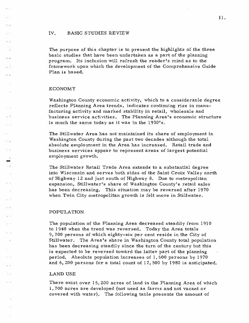
LAND USE
There exis t over 15,200 a c r e s of land in the Planning Area of which 1,700 a c r e s a r e developed (not used a s f a rms and not vacant o r covered with water). The following table presents the amount of
developed land by use category that exists in the Planning Area today and that may be required by 1980.
TABLE 1
EXISTING AND FUTURE: LAND USE ACREAGES
Existing 20 Year 1980 Category Acreage Demand Acreage
Residential 589 5 80 1,169 Commercial 27 65 92 Industrial 6 0 8 0 140 Institutional 11 8 8 0 198 Park-Recreat ion 181 35 21 6 Roads 628 21 0 838 Rail 8 1 - 8 1
TOTAL 1, 684 1,050 2,734
The following a r e some observations relating to how the land in the Area i s used:
Rural land amounts to an overwhelming majori ty of the total land in the Planning Area, near ly seventy-eight pe r cent.
The overwhelming amount of ru ra l land gives an indication of the cu r ren t importance of agricul ture to the Area 's economy.
A ve ry sparce eleven a c r e s of park land exis t in the Planning Area, a l l of which i s in the City.
The City contains only fifteen per cent of the total land in the Planning Area while i t contains near ly fifty-seven p e r cent of the total developed land.
The Township contains over eighty-five p e r cent of the total land in the Planning Area and for ty- three p e r cent of the total developed land.
The l a rges t single developed land use in the Planning Area i s roads, accounting for over thirty-seven p e r cent of the developed land.
Residential land is the next l a rges t single u s e r of land with slightly over thirty-five p e r cent of the developed land.
The 2,315 dwelling units in the City plus the 172 in the Towns'hip results in an average household s ize of 4.4 persons per household.

COMPREHENSIVE GUIDE PLAN, STILLWATER URBAN AREA
LAND USE
RESIDENTIAL-MEDIUM DENSITY . . . . . , . . . o.....:... :::...:...: ... RESIDENTIAL - HIGH DENSITY
COMMERCIAL
INDUSTRIAL
INSTITUTIONAL
PARK-RECREATION-OPEN SPACE ---- NEIGHBORHOOD BOUNDARY
COMMUNITY FACILITIES
PUBLIC FACILITY
O PRIVATE FACILITY
ES ELEMENTARY SCHOOL
JHS JUNIOR HlGH SCHOOL
SHS SENIOR HlGH SCHOOL
CH COURT HOUSE
FS FIRE STATION
L LIBRARY
H HOSPITAL
MB MUNICIPAL BUILDING
MAJOR THOROUGHFARES
- EXPRESSWAY - MAJOR ARTERIAL - MINOR ARTERIAL
COLLECTOR
PARKWAY
FEET
0 600 I I I I I
C O M M U N I T Y P L A N N I N G .I D E S I G N A S S O C I A T E S
FIGURE 1
- 7
V. COMPREHENSIVE GUIDE PLAN
The Comprehensive Guide Plan in graphic form (Figure 1) together with the textural material in this report and the Land Use - Circulation Plan (Figure Z ) , constitute the Comprehensive Guide Plan for the Stillwater Planning Area. The Comprehensive Plan illustrates graphically the desirable relationships between the physical parts of the Area. It i s designed according to principles of sound planning and in recognition of local civic aspirations. It does not attempt to distinguish between existing and proposed fea- tures and, in most cases, designates only the general pattern of development. Detailed design and location of specific developments must be studied further by interested individuals and organizations.
The Plan i s comprised of three basic elements - - land use, community facilities and major thoroughfares. These three elements a r e very closely related to one another; hence, i t would be unrealistic to plan for one without considering the others. To illustrate, activity on the land generates traffic which requires transportation facilities. The type of land use is a factor in determining the type of transportation facility required. Similarly, transportation has an appreciable effect on land use as witnessed by the varying shapes of land parcels created by transportation routes, the blighting effect of some transportation facilities on adjacent land,and the effect on land values, occasioned by access to transportation routes.
The following sections should be read with the realization that they a r e integral parts of the Comprehensive Guide Plan and were developed a s such.
MAJOR LAND USE ASSIGNMENTS
Land use classifications as designated on the Plan a r e based on a 1980 population of 17, 500 persons ; however, in as signing land use acreages, i t was necessary to envision the area as i t may be well beyond the twenty year planning period.
Residential Development
Existing and future housing in the Area can be classed as either high density (apartments, row housing, group housing, etc. ); medium density (single family detached dwellings and duplexes); o r low density (farms and country estates).
Sites for high density residential development have been suggested on the Plan generally in the older parts of the community and, for the
most part , in close proximity to the CBD. The natural beauty of the Area affords many sites where high quality multiple family s tructures might be constructed. If properly regulated, their addition to the community could be a highly valuable asset .
Medium density housing should be located within residential neigh- borhood units except a s discussed la ter . The ideal neighborhood i s a logical a rea for living and i s large enough to support one elementary school within a half-mile walking distance of the neighborhoods' r e s i - dences. Pa rks , churches and certain community facilities which serve the families within the neighborhood should be conveniently located. Commercial development should be limited to establishments which serve primari ly the population living within the neighborhood. Where possible, heavy traffic should be channeled around the neigh- borhood units ra ther than through them so that internal living i s not disrupted. The purpose of delineating neighborhoods i s to provide a logical framework for planning the long-range development of the total community.
Generally speaking, upon a cursory analysis of Stillwater's physical development, the elements of the ideal neighborhood a r e not situated s o that neighborhood units a r e apparent. The main reason for this i s that the existing major thoroughfare system does not operate according to the neighborhood concept of guiding heavy traffic around residential a r e a s where possible. Fortunately, however, the service a r e a s of most of the commercial establishments presently existing in r e s i - dential a r e a s a r e local ra ther than city-wide in scope. Further , industrial activity, for the most part , does not occur within residential a reas , but instead, has been concentrated in the vicinity of the Central Business District where nearly al l the city-wide and region-serving commercial establishments in Stillwater a r e also centered.
With consideration given to the above factors, four residential neighbor- hoods have been delineated on the Comprehensive Guide Plan. They will be refer red to a s the Northeast, Northwest, Southeast and Southwest neighborhoods. Their boundaries consist of either major thoroughfares o r physical b a r r i e r s such a s bluffs o r ravines. Governmental boundaries were not adhered to in the delineation of the neighborhoods; hence, the Southeast unit contains par ts of the City of Stillwater and the Townships of Stillwater and Oak Park .
In the Land Demand section of the Basic Planning Studies, it was determined that 580 a c r e s of land will be needed for residential development by 1980. The amount of undeveloped land that i s suitable for future urban development in the four neighborhoods ( less the land needed for parks, schools and s t r ee t s ) totals over 900 a c r e s in area . A breakdown of the undeveloped land in the four neighborhoods i s given below.

TABLE 2
RESIDENTIAL NEIGHBORHOOD ANALYSIS
Undeveloped Land Neighborhood Total Area Suitable for Urban Use*
Northeast Southeast Northwest Southwest
.-600 Acres 800 Acres 850 Acres 800 Acres
60 Acres 130 Acres 350 Acres 400 Acres
TOTAL 3,050 Acres 940 Acres
'gLess land needed for parks , schools, and s t r ee t s .
It i s evident that sufficient space exis ts in the four neighborhoods to accommodate a l l the medium density housing that will be demanded during the planning period. Ample space for the schools, parks , churches and other facil i t ies to se rve the new families i s a l so available within the four a r e a s . By adopting this development policy, necessary municipal serv ices such a s f i re and police protection, s t r ee t maintenance, water supply, sewage disposal, and rubbish removal m a y be m o r e efficiently provided. Fur ther , each proposed development m a y be real is t ical ly evaluated to determine if i t h a r - monizes well with the over-al l development goals of the community a s expressed on the Comprehensive Guide Plan.
Beyond the neighborhood units, medium density housing should be allowed only along the r ive r bluffs in the northern pa r t of the Planning Area a s indicated on Figure 2 . There i s a definite demand in force for lots with r ive r frontage. This s e e m s compatible with the development objectives of the a r e a although c a r e should be taken to avoid the complete utilization of the scenic r ive r front by private in te res ts .
The only other residential development that should be permitted beyond the neighborhoods i s low density housing which would utilize a t leas t one a c r e of land. The customary f a r m operation a s well a s the ex- urban country estate i s envisioned here . The fo rmer will continue a s i t i s today and the la t te r will increase in quantity and importance. Land surrounding Long Lake and Lily Lake and overlooking the r iver north of the City will be the pr ime recipient of estate housing.
It would be beneficial for the Stillwater Area to preserve i t s historical heritage exhibited by the many stately residences of an ea r l i e r e ra . The restorat ion of these s t ruc tures should be encouraged. A fine example of the restorat ion of an aged s t ruc ture i s the "Victorian" women's shop located on Myrtle Street nea r the Lowell Inn.


Commercial
For discussion purposes commercial land use has been separated into three categories - - Central Business District (CBD), highway-oriented service, and neighborhood service. Since the lat ter category was adequately discussed ear l ier in the chapter, only the other two will be discussed here.
As a general development policy i t i s recommended that the existing Central Business District be strengthened and maintained a s the Area's foremost t rade center. It was discovered ear l ier than an equivalent demand of thirty ac res of additional land may be needed by 1980 for expansion of the CBD. This demand may be satisfied by three means - - lateral expansion which would necessitate removal of other adjacent land uses since vacant land is almost non-existent; vertical expansion made necessary by high land costs and the limiting effect of surrounding bluffs ; and replacement of existing establishments in the CBD that a r e incompatible with i t s character . Examples of some in- compatible uses a r e warehouses, production plants, and highway- oriented establishments . It i s recommended that the CBD be allowed to expand horizontally no further than i s indicated on the Plan. Thus, the high bIuffs,that surround the CBD would act a s a buffer between the CBD and the residential neighborhoods on the higher land. It i s suggested that a hard core of retail-office s tructures be developed within the proposed ring road and that wholesale - service activity be concentrated on the periphery of the road. There i s need for a comprehensive program of revitalization of the CBD to achieve a stronger center that will comp'Mk successfully with any future shopping centers that might be developed within i t s present trade area. Such a program would demand the active part ici- pation of a unified business community with the backing of Stillwater's citizenry. This i s not meant to indicate that individual "face lifting" projects should not be undertaken. On the contrary, remodeling should be encouraged but i t would be helpful if the various projects were under- taken with common objectives in mind. Recommended objectives are: unified sign regulations, cooperative off-street parking a reas , uniform remodeling (shy away from bizarre 'aluminum and glass fronts) for over-all character, and blending of the historical with good contemporary design.
Suggested sites for development of highway-oriented commercial establishments have been outlined on the Plan in four locations. Only the t rac t a t the intersection of Highway 21 2 and Fourth Street contains existing development of this nature; the others a r e presently vacant o r in agricultural use. Since al l the t racts a r e located adjacent to major thoroughfares, ca re should be taken to limit the number of access and egress points so that the movement of through traffic on the main a r t e r i es i s not impeded.

The 1980 demand for commercial land outside the CBD i s thirty-five a c r e s . If ten a c r e s of this i s needed for new neighborhood service establishments , the remainder represents highway-oriented develop- ment. This should be protected f rom encroachment by other land uses and i t s physical development should be controlled to a s s u r e proper development.
Industrial Development
During the cu r ren t planning program various civic and private organizations have voiced the des i re to work towards the attraction of new industry to the Stillwater Area. To accomplish this objective three related approaches were deemed necessary. The basic r e - quirement i s a good site with adequate transportation facilities and available utilities. The second factor , which has been neglected in many communities in the past , i s the protection of industrial land f r o m encroachment by other land uses . The third and possibly the most important consideration in light of the keen competition for industrial development among Upper Midwest communities, i s the at t ract iveness of the ent i re community f rom a physical a s well a s a social and economic viewpoint.
With the above c r i t e r i a in mind, i t i s recommended that two a r e a s , in addition to the existing industrial land near the CBD, be se t aside for industrial use - - one with r a i l access , the other with highway access . Indications a r e that the availability of r a i l access would not be a major requirement of the industries desiring to locate in the Saint Croix Valley. Thus, the P lan outlines only a twenty a c r e t r ac t near the Northern Pacific r a i l line in the western portion of Stillwater Township. If this develops beyond present anticipations, additional surrounding land may be made available a t a future date.
The Plan a lso indicates a sizable t rac t of land adjacent to Highway 212 for use by industries which ship or receive goods by motor vehicle. I ts a r e a measures over 200 a c r e s and contains three existing industr ies , two of which were constructed in recent years . Since the demand for additional industrial land totals eighty a c r e s , it i s evident that the industrial space needs of the a r e a will be satisfied well pas t the planning period.
The la rge amount of land to be reserved fo r industrial use will afford flexibility in the choice of plant location. The recently completed Highway 21 2 and 36 expressway provides an excellent link between the proposed industrial a r e a s and the Twin Cities. In addition, newly upgraded Highway 95 offers good access to Interstate Freeway 94 which extends f r o m the Twin Cities to Chicago.
It i s imperative that the industrial a r e a s be reserved for use wholly by industrial developments. There a r e a grea t many cases in the

Twin Cities ' a r e a where well established industries have been en- gulfed by new residential developments. The inevitable c r i e s f rom the new residents concerning the industry's noise, odor, appearance, e tc . , s e e m unfounded since the industry was there f i r s t . If the com- plaints a r e not satisfied by some means, the incentive for home- owners to maintain their propert ies i s not present and the neighborhood gradually degenerates.
Protect ion for Stil lwater 's future industries includes not only guarding against encroachment f rom other uses but a lso means controlling the type of industrial development within the dis t r ic t . Certain minimum requirements should be established to a s su re good development. In- dustrial concerns a r e well aware of the advantages of locating in an a r e a where proper development of surrounding land i s assured . A desirable appearance i s especially important in Stillwater where m o s t of the proposed industrial land i s plainly visible f rom Highway 21 2.
The third requirement for inducing industry to locate in Stillwater - - an attractive community f rom a physical, social and economical viewpoint - - i s well on i t s way toward being accomplished. Stillwater i s widely recognized for the beauty of i t s natural features -- i t s many bodies of water , wooded bluffs and ravines, parks and surrounding rolling agricul tural land. Many i t ems of his tor ic in te res t a r e located in the Area. Most of i t s residential a r e a s a r e well kept and the many stately houses of a n ea r l i e r period offer a n additional attraction. I t i s the center for administration of county affairs . Some of i t s com- merc ia l and industrial concerns have f a r - reaching influence. These a r e a few of the attributes that come to mind. Of course, like al l communities, Stillwater has i t s weaknesses. These were brought out in the f i r s t p a r t of the report . Recommendations f o r alleviating these shortcomings a r e a l so contained in this report . Thus, i t m a y be demonstrated that the Stillwater Area i s attempting to provide equitably and adequately for a l l pa r t s of i t s urban s t ruc ture through a detailed appraisal of i t s existing make-up and a systematic plan for i t s future development.
COMMUNITY FACILITIES
In planning f o r community facil i t ies, par t icular attention was given to the need for and the location of schools, parks and recreat ion a r e a s , and municipal administration and service buildings.
School s
In describing the ideal neighborhood in the preceding section, i t was noted that each neighborhood should contain one elementary school near i t s center , thereby providing a reasonable walking distance between schools and home and a desirable enrollment range.

Unfortunately, only one of the two existing public elementary schools i s located near the center of the neighborhood that contains i t a s evidenced on the Plan.
The Washington School has fourteen classrooms and two kindergartens which accommodate a total enrollment of about 500 students who reside in an a r ea slightly l a rge r than one square mile. This i s a walk-in school. In contrast, the Oak Park School has twenty classrooms and two kindergartens which serve a student body of 700 who live in about a fifty square mile area . This i s primari ly a bus -in school. The service a rea of Washington l ies within the Oak P a r k district . This situation i s due to the large size of School District 834 - - one of the largest in Minnesota.
Washington School was constructed in 1938 and will serve beyond the planning period. The Oak Pa rk facility was built in 1954 and should be adequate until near the turn of the century. Officials of the School District have no plans for expanding these facilities. They do foresee the possible need in the a r ea in the near future for additional facilities equivalent to fourteen elementary classrooms.
The estimated 1980 Planning Area population indicates a possible 5,200 persons in the school age group a s compared with 2,700 students today. If this occurs, some 1, 300 additional elementary students may need to be accommodated in over forty public school classrooms. Thus, a t l eas t two new elementary schools will be needed in the Planning Area by 1980. Suggested si tes for these facilities have been indicated on the Plan near the center of the Northwest and Southwest neighborhoods. The site north of McKusick Lake in the Northwest neighborhood contains deposits of peat. If construction i s unfeasible due to the peat, alternate sites eas t o r west of McKusick Lake should be considered.
The junior high school and senior high school have current enrollments of 1,100 and 870 students respectively. These facilities serve the entire School District. School officials see the need for an additional junior high school by 1965. Expansion of the present facility i s not feasible. The new high school presently accommodates slightly more than two-thirds of i ts 1, 200 student capacity. When i t i s filled, the plant may be expanded to serve an additional 400 students, but no further expansion a t the present site would be undertaken after that capacity i s reached.
The School District contains two parochial schools serving students in grades one through eight. Both of the facilities a r e located in the Southeast neighborhood of Stillwater. Saint Michaels i s the larger of the two and serves nearly 500 students while Saint Marys accommodates about 150 persons. It i s assumed that these facilities will be gradually expanded a s population increases.

Parks - Open Space - Recreation
The natural character is t ics of Stillwater's physical setting provide quite a substantial amount of land that i s well suited for park o r permanent open space use. As discussed ea r l i e r , one of the unfortunate aspects of the Area 's past physical development i s that only a relatively small amount of park land has been provided. As a result , private develop- ment has utilized most of the scenic a r e a s in the built-up portion of the Community. To a s s u r e that this situation will not prevail in the future, i t i s recommended that the l a rge wooded a r e a s , ravines and portions of the r iver and la'ke front a r e a s be reserved for permanent public use a s indicated on the Plan.
There i s a need for five levels of developed park land in the ' ~ r e a . These a r e regional parks, community parks, neighborhood parks, playgrounds and playlots. Each of these se rves a different function a s will be dis - cussed la ter .
The estimate of thirty-five a c r e s of land to be developed into parks by 1980 was based on only the a r e a requirements of the la t te r three facilities that were mentioned above. Their standards of development a r e presented below.
Type Quantity Size
Neighborhood Parks 1 /2 ,000 persons 1-1 12 a c r e s Playgrounds 1 /1 ,00Opersons 5 a c r e s Playlots 11 700 persons 112 a c r e s
The ravines, bluffs and attendant wooded land above the "boom" a r e a should be reserved for use a s permanent public open space and for possible development a s a regional park to serve the entire Saint Croix Valley and beyond. As discussed l a t e r in the report , a "sky l inet t parkway should be constructed to provide access to the Area. Develop- ment of the regional park which would include over 200 a c r e s of ,land might be undertaken by a County park agency o r some other large' scale authority.
Stillwater's attractive Lowell P a r k presently serves a s a community park and should be retained a s such. While other a r e a s , such a s the Lily Lake swimming beach, will be utilized by the entire community, Lowell P a r k should continue to serve a s Stillwater's p r imary "City park" during the planning period.
Neighborhood parks should provide le i sure t ime opportunities for a l l age groups, but elderly persons and mothers with small children might use the facilities most . These facilities should b e provided a s indicated on the Plan. An attempt has been made to locate them within neighborhood units so that they will be easily accessible to the bulk of the neighborhood residents.

Hopefully, the existing and future elementary school play a r e a s will satisfy the requirements for playground facilities. Where a signifi- cant residential a r e a i s situated m o r e than one-half mile f rom an elementary school, an additional playground should be provided for the five to fifteen year age group.
Playlots for use wholly by the pre-school age group should be d is - tributed throughout the Community. The Plan does not suggest s i tes for these facilities. It i s recommended that they be developed in line with standards s e t for th above.
Municipal Administration and Service Buildings
The existing municipal building in Stillwater contains the City adminis- trative and police offices. Adjacent to the building i s the f i re station. The location of these buildings within the City seems quite logical but the physical condition and appearance of these s t ruc tures leaves something to be desired due pr imar i ly to their age. Sometime within the planning period these buildings will need to be replaced.
Various alternatives have been considered regarding the location of a new municipal building. Expansion a t the present si te seems feasible only in one direction - - to the e a s t ac ross Third Street. The idea of a City-County combine has been voiced - - this would neces- si tate an ent i rely new si te . In any event, i t i s felt that i t s location should be reasonably nea r the CBD due to i t s nature.
The existing l ib ra ry and grounds presents a handsome appearance and should serve we19 during the duration of the planning period.
Institutional Cluster
Immediately above the bluffs to the south of the CBD there exis ts a concentration of institutional activity. It i s comprised of Saint Marys ' and Saint Michaels' churches and schools, the junior high school and the Washington County Court House. The replacement of the la t te r facility has been deemed necessary due to i t s physical condition and insufficient space. A new structure will require m o r e land than i s current ly used, but the decision whether to acquire more land a t the present s i te o r to provide an ent i rely new location i s st i l l under study.
I t i s felt that the retention and expansion of the existing institutional c luster would be a desirable a s s e t to the Area. By de-emphasizing Third Street a s shown on the Plan, a common core of institutional uses f r e e f rom disruption by heavy t raff ic will be afforded. I t would provide identity, a campus -like charac ter and an opportunity for cooperative off - s t r ee t parking and other facil i t ies. Upon initial investigation i t appears that the a r e a south of the present Court House would be well suited for construction of a new County facility. Use of

the existing s tructure a s a historical museum has been suggested. This would fi t in well with the institutional c luster concept, The a r e a would also be a fine s i te for a municipal building housing adminis- trative offices. Space for a new f i re and police station would then be available a t the present site. Land for the probable expansion of Saint Michaels' parochial school and ancillary facili t ies within the complex would also be available.
MAJOR THOROUGHFARE SYSTEM
The proper planning for facilities for the-movement of people and goods should resul t in a n integrated sys tem which i s safe, economical and efficient. In selecting a major thoroughfare sys tem for the Still- water Area, particular attention was given to past, present and future traffic volumes, the function.. of each facility and the relation of the sys tem to the over-al l land use pattern.
Before a major s t r e e t sys tem for Stillwater can be outlined, it i s necessary to have a c l ea r understanding of the functional classification of the various existing and proposed roadways in the City. An efficient circulation sys tem provides some s t r ee t s which give preference to movement, others to access to adjacent land uses and some to serve both of these needs. Six classifications of roadways a r e proposed for the Stillwater Area. Their functional character is t ics a r e reviewed below:
Expressway - provides for the movement of large volumes of traffic a t relatively high speeds on relatively long tr ips . The expressway i s a multi-laned, divided roadway, providing access connections with selected public roads only. Grade separations a r e provided with intersecting roads which c a r r y la rge volumes of traffic.
Major Ar ter ia l Roadway - provides for those major movements of traffic within an a r e a not served by expressways. It provides pr imar i ly grade access connections to intersecting public roads a t key points.
Minor Arter ial Roadway - provides for through traffic movement between major a r t e r i a l s and collector s t r ee t s . It has a secondary function of serving some of the access needs of abutting property.
Collector S t ree t - distributes the internal traffic within an urban a r e a , such a s a residential neighborhood o r industrial dis t r ic t , between the minor a r t e r i a l s and local s t r ee t s . It provides access to abutting property. Continuity should be de-emphasized so that through movement i s discouraged.

Local Street - provides for direct access to residential , commercial , industrial , o r other abutting property. Continuity i s not important; a l l through traffic movement should be discouraged.
Parkway - connects the various pa r t s of a community where possible and i s used pr imar i ly for pleasure driving. It i s a specially landscaped and protected roadway which se rves ma jo r parks, lakes and other scenic and recreational a reas . I t i s not intended to ac t a s a link in the collector, a r t e r i a l o r expressway system.
TABLE 3
FUNCTIONAL ROADWAY CLASSIFICATION
Express- Major Minor Elements way Ar ter ia l Ar ter ia l Collector Local
Traffic P r i m a r y P r i m a r y P r i m a r y Same relative i m - Secondary Move me nt portance a s access
Access to Te r t i a ry Ter t i a ry Secondary Same relative i m - P r i m a r y Land portance a s
movement
Parking None None None Ter t i a ry Secondary
Tr ip Over 3 O v e r 3 O v e r 1 Under 1 mile Under 112 Length mi les mi les mile mile
Designated Always Always Always Sometimes Through Streets
Width of 150-300 100-200 80-100 80 feet Right-of - feet feet feet wav
Never
60 feet
Source: Adapted f rom Twin Cities Metropolitan Planning Commission publication Local Planning Bulletin No. 3, Street and Highway Standards, March 1961.
Much of the planning for a major thoroughfare sys tem in the Stillwater Area has been accomplished a s a pa r t of the Interim Guide P lan and Downtown Circulation Plan that preceded this present report . Only a

small number of changes have been undertaken in the sys tem that was suggested in the e a r l i e r reports . The alterations will s e rve to bring about a more efficient flow of traffic and a n improved relationship between land use and circulation elements.
It i s recommended that p r imary traffic a r t e r i e s in the Stillwater Area be provided and designated a s shown on the Comprehensive Guide Plan and a s discussed below.
Maior Arter ial Roadwavs
Provide a new "western bypass" route to serve a s the major north- south a r t e r y in the Area. It i s envisioned that this facility would eventually become a new route for Highway 95, f rom the southern p a r t of Washington County to a point north of Stillwater where it would join existing Highway 95. The present roadway through Saint Croix Beach, Bayport and Stillwater should be retained a s an a l t e r - nate "scenic" route. Provis ion of the new "western bypasslt around Stillwater would expedite traffic that does not intend to stop in Still- water. It will a l so decrease the traffic congestion that present ly exists in the CBD. A fu i ther function of the roadway i s i t s role a s the western boundary of two future neighborhoods. If a stage develop- ment i s necessary, it i:s recommended that the portion between Highway 36 and Highway 96 be considered a s the f i r s t priority.
Extend Highway 95 and 21 2 a s a four lane divided facil i ty f rom the south to approximately the intersection of E a s t Pine St ree t extended.
Provide a new bridge over the Saint Croix River commencing a t the Eas t Pine Street line and joining the existing causeway on the Wisconsin side of the r ive r . This new facility will fur ther relieve the heavy traffic congestion now present in the CBD and make possible a n o rde r ly and unrestr ic ted flow of traffic. The existing bridge should be retained to accommodate traffic to and f rom the CBD and Wisconsin. I t could a l so serve a s a bicycle and pedestrian connection to Still- water ' s park land on the Wisconsin side of the r iver .
Minor Ar ter ia l Roadways
Upgrade Owans and Greeley Streets and a l te r their alignment to se rve a s one facility for accommodating the ma jo r internal north-south traffic in Stillwater. This route would a lso a c t a s the east-west division of the four proposed neighborhoods.
Upgrade and extend Myrtle S t ree t wester ly to in te rsec t with Willernie Road (County Road 12) a t the western boundary of the Planning Area. This route would be the major eas t -wes t a r t e r y between Highway 96 in the north and Highway 212 in the south. It will a lso fo rm the north- south boundary of the four neighborhoods. The Washington

County Highway Department has been exploring the possibility of providing a more direct approach for Willernie Road a s it en ters Stillwater City. The above recommendation would benefit both the County and the Planning Area.
Provide a "ring road" system around the intensely used a r e a of the CBD. Off -s t r ee t parking facilities should be provided along this peripheral route to accommodate shoppers and business people. The exclusion of vehicular traffic f rom some s t r ee t s i s suggested in favor of pedestrian malls . Vehicular circulation within the p r imary t rade center will then occur in an order ly fashion with due respect to the pedestrian. The publications Downtown Circulation Plan and Downtown Parking Study, a r e commended for a more detailed CBD analysis and Plan.
Collector Streets
A description of each collector s t r ee t i s not necessary since the Plan indicates their location quite clearly. Many of the collectors a r e already in existence. If necessary, these should be brought up to adequate design standards. With appropriate signalization local traffic will be channeled onto the collectors and thence to the minor and major a r te r ia l s . Where new o r realigned collectors have been proposed, an attempt has been made to discourage their use a s through traffic a r t e r i e s , yet provide logical routes for the collection and distribution of local traffic. Those collectors that require some explanation a r e discussed below.
Re-route County Road 5 f r o m the intersection of Highways 36 and 212 onto the new western bypass to where Myrtle Street (County Road 12) will intersect , thence on Myrtle Street to Owens Street. The present diagonal route of County Road 5 should then function a s an internal collector in the Southwest neighborhood.
Extend Orleans Street wester ly to intersect with Greeley Street. The vert ical relief southwest of the high school var ies about forty feet but the horizontal distance i s grea t enough to resul t in a grade of about five per cent o r slightly more . It i s suggested that an entrance to the high school off Orleans Street be considered. Residential s t r ee t s would then be relieved of heavy traffic.
Improve and extend Fourth St ree t northerly to Olive Street a s indi- cated on the Plan. The grade north of the junior high school would be s imi lar to that of Third Street in the same a rea . This action would a s s u r e that the institutional c luster on each side of Third Street would not be disrupted by heavy traffic.

Realign Wilkins Street where i t intersects Fourth St ree t to bring about a smooth flow of traffic.
Utilize a portion of existing County Road 1 2 (Willernie Road) in the Northwest neighborhood for a collector which would extend northeasterly a s a new road to join County Road 64 north of McKusick Lake.
Extend County Road 11 southerly a s a new route through a wooded ravine to intersect with Highway 96. This would relieve traffic a t the poorly designed junction of County Road 11 and Highway 95.
Parkwavs
It i s felt that a system of specially landscaped parkways which would connect and provide access to the many scenic a r e a s of the Community would be highly desirable. A fur ther function of the parkways would be to ac t a s a link between residential neighborhoods. It i s not fea- sible to provide parkways within existing urban a r e a s ; hence, they have been suggested only where urbanization has not occurred to a la rge extent. Generally speaking, these roadways will course around existing and proposed park land thereby encouraging quality r e s i - dential development to occur overlooking the public land. Suggested locations of the parkways a r e discussed below.
Provide a four mile long parkway to extend from Lily Lake northerly around McKusick Lake, along Browns Creek, by the golf course to in tersec t Fourth St ree t in the northeast portion of the City. This route would utilize existing roads where possible. Provision of this service route could be accomplished in stages but action should be taken in the near future to a s s u r e acquisition of i ts right-of-way.
Provide a s imi lar route around the eas te rn side of Long Lake ex- tending southerly f rom proposed County Road 12 (Myrtle Street). Only estate housing should be allowed in this a r e a during the planning period.
Provide a "sky line" drive along the r iver bluffs above the "boom" a r e a and encompassing F a i r y Falls. Here, again only estate housing should be permitted during the planning period.

, ,
VI. PLAN IMPLEMENTATION DEVICES
The goals and recommendations of any comprehensive planning program do not represent an end in themselves, even when embodied in the form of a plan for the development of the Community. Such a plan actually has little value until i t i s implemented by governmental and citizen action. Without general public approval and acceptance of suggested goals and recommendations pertaining to the development of the Still- water Planning Area, little can be done in guiding i t s future growth. The Comprehensive Guide Plan represents the best judgment of the Planning Commission and its planning consultants on what course of action to follow in guiding Stillwater's future development. Only when the Plan, o r an element of i t , i s transformed into officially adopted policy, can action be taken to c a r r y out i t s recommendations. Five means by which policy decisions based on a comprehensive plan a r e put into effect a r e zoning, subdivision control, urban renewal, capital improvements budgeting and the official map. Most important in t e rms of Stillwater's immediate needs a r e the f i r s t two devices. A brief dis- cussion relating how each of the five plan implementation devices could be used in Stillwater i s offered below. In addition, a suggested zoning ordinance and a subdivision control ordinance, tailored to the needs of the Stillwater Area and based on the Comprehensive Guide Plan, a r e
1
I contained in the Appendix.
The five effectuation devices a r e , of course, in addition to regular programs of such other public agencies a s the State and County Highway Departments. With a well conceived Plan enjoying general citizen acceptance, Stillwater's wants and des i res can be graphically presented to those higher forms of government that do much to form the pattern of local development in their plans and programs. These plans and pro- grams can be influenced through the presentation of a plan developed by a local community.
Zoning
Probably the most important legal device for carrying out the Area ' s development objectives i s zoning. Its basic purpose i s to prevent the inappropriate development of privately owned land so a s to safeguard the general welfare of the Community. By grouping the most com- patible uses into dis tr ic ts according to residential, commercial, industrial , and other uses the entire community will be bes t served. Individual land uses also benefit since they a r e protected f rom the ill effects of other incompatible uses.
It should be s t r e s sed that zoning and planning a r e not synoilymous. While zoning may be used independently of planning, it i s most effective 'when used a s a n integral pa r t of a Community's comprehensive

plan. In fact, the very legality of zoning which i s not a par t of a comprehensive plan i s questionable. Moreover, a zoning ordinance without a plan behind i t i s usually amended so much to satisfy indi - vidual property owners that no concentrated plan of development i s evident; hence the general welfare of the community and i ts citizens i s forsaken.
Zoning i s a preventive measure rather than a cure; i t cannot correc t existing bad conditions but instead guards against future decay and blight caused by the inappropriate mixture of land uses.
Although i t i s concerned primari ly with privately owned land, the zoning ordinance should also deal with sites for public buildings and facilities. This device i s also an effective method of controlling an a rea ' s population density.
While the outstanding feature of zoning control i s the division of a community into separate distr icts , i t also regulates such things within the districts as:
Minimum yards, lots, and building height.
Minimum off-street parking and loading.
Kind, number and a r ea of signs.
Yard requirements provide clear , open space around buildings. Accessory buildings, except for garages in the r e a r yard, will not be permitted.
Yard requirements should be a function of zoning. The zoning ordinance should place front, r e a r and sideyard regulations in one document, thus simplifying the task of the prospective builder. The zoning ordinance should tailor the yard requirements to the particular needs of each district .
Zoning will require off-street parking and loading spaces tailored to the needs of each district . Minimum design standards for s ize, screening, and other treatment of parking and loading facilities a r e included.
Outdoor advertising controls should be included in the zoning ordinance, again tailored to fit the character of each district - - ranging from highly restrictive for residence zones to a more liberal standard for manufacturing districts.
Part icular attention must be given to protection of the existing and future park system and rights -of-way of new highways. Sign controls will afford each establishment protection from misuse of signs and
billboards while assuring every establishment the right to advert ise .
Every aspect of the zoning ordinance should be se t for th in adequate detail, leaving a s l i t t le room a s possible for guesswork o r loose interpretation which might cause undue controversy o r unfairness to property owners o r their neighbors. Modern methods of adminis t r a - tion a r e specified in the zoning ordinance and the prec ise duties and responsibilities of administrative officers a r e c lear ly defined.
Where pract ical difficulties o r par t icular hardships in the way of carrying out the s t r i c t le t te r of the regulations occur , provision i s made for relief, by providing the par t ies affected the right to appeal the provisions of the ordinance, a s they may crea te any undue hard- ships in relation to the land. Definite standards for var iances, a s well a s prec ise kinds of authorized variances should be s e t for th in the ordinance .
Subdivision Control
Subdivision control regulations a r e concerned with the division of one parcel of land into two o r more parcels for the purpose of sa le o r development. Subdivision regulations provide for the development of an appropriate pat tern of land use in accord with the over-al l compre- hensive plan and in relation to land uses prescr ibed in the zoning ordinance. Like zoning, they a r e used to prevent blight and deterioration by prescr ibing acceptable legal standards of development. Subdivision regulations a l so state official public policy in relation to the provision of municipal serv ices ( s t r ee t s , water , sewer , etc. ).
The ma jo r difference between zoning and subdivision regulation i s that whereas the fo rmer regulates the type of building and the use of land, the la t te r i s concerned with the manner in which land i s made ready for building. Standards involving widths of s t r ee t s , length and depth of blocks, width and depth of lots , open space, sewer and water sys tems, construction of s t r ee t s , and utility easements a r e included in a subdivision ordinance.
While land may be subdivided for any type of urban use, the most common i s the development of land for residential building s i tes . The Planning Area has witnessed a significant amount of this activity i n recent years. As the population of the Area increases , the demand for new housing will be m e t pr imar i ly by subdividing open land for residential development. Since Stillwater will have to provide a number of serv ices such a s utilities, f i re and police protection, and space for parks, playgrounds, and public buildings, i t s in te res t s must be protected. Subdivision controls a r e ve ry effective in this role.

The p r imary purpose of subdivision control i s to a s s u r e that newly developed land will be a permanent a s s e t to the Community and will provide sufficient health, comfort, convenience, and beauty. In turn, it provides adequate protection to the developer and the future home owner a s well. The developer receives equal treatment; moreover , he i s assured that his competitors mus t comply with minimum standards. The home owner knows that adequate s t r ee t s and other public facilities will be provided and may expect that the value of his property will not drop, but will remain reasonably stable.
In the review process se t up a s a requirement of approval, the pro- posed subdivision can be checked to make certain that it does not violate any goals and policies established a s pa r t of the Comprehensive Plan. In other words, s t r ee t s will be provided in relation to the established long-range s t r e e t requirements, a r e a s can be reserved for park land in relation to that need, etc. ,
Urban Renewal
Urban renewal i s a lso a device to achieve plan recommendations that represents an effort by public and private agencies, usually with Federa l aid, to cure existing blight and decay in urban a reas . During the f i r s t pa r t of this century most cit ies had no plan of development o r land-use controls. As a resul t , their rapid unplanned growth caused slum and generally blighted a r e a s .
Fortunately, Stillwater's ra te of growth compared to l a r g e r urban a r e a s has been relatively slow so that i t s s ize has not yet caused ser ious blight. While some sections of the Area a r e old and require r epa i r , an over-al l urban renewal program i s not deemed necessary a t this time. It i s possible; however, that cer tain sections of the Area might be designated renewal a r e a s for which Federa l funds could be obtained to help finance the project.
Capital Improvements Budgeting:
A fur ther plan implementation device which the Planning Commission should consider i s a capital improvement program. Every year the City and Township of Stillwater find it necessary to expend sub- stantial sums of money to provide facili t ies for their protection and necessary serv ices for their citizens. Regular annual budgets usually distinguish between funds reserved for sa lar ies , operations, and debt service and those to be used for physical plant and equipment. These la t te r expenditures a r e usually labeled "capital expenditures . ' I
The capital expenditures program then i s a pr ior i ty l i s t of projects, prepared with regard to the Community's financial situation and in relation to i t s long-range development objectives. Since Stillwater would be unable to undertake al l desirable public improvement

projects a t once, a spending program i s of vital importance so that all projects can be related in an integrated program. Failure to do this may result in uneconomical spending a s well a s endangering Stillwater ' s prope r physical development.
Briefly, the most prevalent type of program consists o i three parts. The f i r s t year i s called the capital budget, the next five years i s the capital program, and then a general l i s t of long-range projects which can be postponed until sometime after the programmed s ix year period. Projec ts scheduled for the f i r s t year a r e more de- tailed than la ter ones. This par t becomes a section of the annual budget when adopted by the City Council and Town Board. Each year the entire program i s reviewed and revised, t ransferr ing the f i r s t year of the capital program to the annual budget.
Planning and the capital improvement program go hand in hand. Without a planning program Stillwater would have no rea l basis for deciding which project to undertake f i rs t . With a planning program outlining the needs for such facilities a s roads, parking, schools, parks, e t c . , an excellent basis for deciding project pr iori t ies is available.
Official Map
An additional tool by which planning policies a r e put into effect, and that i s suggested for consideration by the Planning Commission and the Town Board, i s the official map. I t i s designed to a ssure that buildings will not be located in the beds of mapped s t r ee t s and that land needed for s t r ee t widening, s t ree t extension, future s t ree ts and other public purposes will be available a t bare land prices. To accomplish this, the Planning Commission and Town Board should prepare such a map and, when completed, take steps to officially adopt it so that it will be legally binding. Before approving the map, however, the Council o r Town Board should hold a public hearing. After approval, the map and the resolution adopting the map should be published in the official newspaper.
Compliance with the official map can be assured by use of the building permi t device. The building code makes it necessary for a prospective builder to furnish a building plan showing location of his property with reference to the neares t existing s t ree ts . If buildings a r e indicated in the path of a proposed s t ree t , no building permit should be issued. A Board of Appeals should be s e t up to hear appeal petitions in cases of building permi t denial.
An official map would not give Stillwater the right to acquire reserved a r e a s without payment o r compensation; however, Stillwater would not need to pay for any structure placed in the path of mapped lands r e - served for public uses without building permit o r in violation of the conditions of a permit.

APPENDIX

I. ZONING AND SUBDIVISION CONTROLS - INTRODUCTORY REMARKS
To best meet the needs of the Stillwater Planning Area, i t was felt that a fair ly detailed presentation of zoning and subdivision controls be included a s pa r t of the comprehensive plan report. They a r e appended in this manner to form an integral, yet individual, segment. They a r e drafted to reflect the intent of the plan and thus logically form a par t of the plan. They a r e also policy and legal documents that must be weighed on their individual mer i t s . It i s intended that they be discussed by the official bodies charged with their administration to assure that the contents a r e understood and relate harmoniously to local objectives.
The presentation of these regulations in final ordinance form i s the responsibility of the governing bodies ' legal staff. This a s sure s that the standards and planning considerations a r e prase'nted in an ordinance form acceptable to the locality and not in conflict with existing controls, ordinances, etc. They a r e , in effect, models to be used by the governing bodies and their representation in strengthening the a rea ' s legal authority in directing i ts future growth.
At present, the City of Stillwater has a zoning ordinance in effect but does not have a separate subdivision controls ordinance. The Township of Stillwater has an inter im zoning ordinance as well a s a recently adopted subdivision controls ordinance. The Township zoning ordinance was adopted to meet pressing development problems following the com- pletion of the Interim Development Guide Plan. Since the City zoning ordinance was drafted pr ior to the comprehensive planning program now underway and no subdivision controls a r e in effect, and since the Town- ship zoning ordinance and subdivision controls will require alteration so a s to reflect refinements in the Interim Plan, new ordinances for the entire Planning Area a r e recommended.
P a r t of the importance of these ordinances s tems from presentation of common standards for guiding the future development of an a r e a of two governmental jurisdictions - - closely related in a physical, social and cultural sense. This tends to create certain administrative pro- blems that must be solved in the months ahead. Since the City and Township have cooperated in their planning effort i t i s felt that this can be accomplished in the program's continuation.
11. PROPOSED ZONING ORDINANCE STILLWATER, MINNESOTA STILLWATER TOWNSHIP, MINNESOTA

ZONING CONTENTS
Page
ZONING USE DISTRICTS, CITY O F STILLWATER (MAP) ZONING USE DISTRICTS, STILLWATER TOWNSHIP (MAP)
Section
I. GENERAL PROVISIONS
A. Title B. Purpose C. Legal Authority
11. DEFINITIONS
111. USE DISTRICTS
A. Zoning Use Dis t r ic t s B. General Description C. Compliance D. Boundaries
IV. DISTRICT REQUIREMENTS
Agricul tural Dis t r ic t Single Fami ly Dist r ic t General Residence Multi -Fami ly Cent ra l Commerc ia l Area l Commerc ia l Heavy Industrial Light Industrial
V. GENERAL REQUIREMENTS
A. Signs B. Residential Y a r d s t o r a g e C. Refuse D. Screening E . Landscaping F. Parking
Z l l
Z l l Z1 3 21 5 21 7 220 223 225 227

ZONING CONTENTS (continued)
Section
V. GENERAL REQUIREMENTS (continued)
G. Architectural Requirements H. Non-Conforming Building I. Non-Conforming Use of Building J. Non-Conforming Use of Land K. Non-Conforming Uses Created by Rezoning L. Institutional Lot Requirements
VI. ADMINISTRATION
A. Appeals B. Interpretation C. Special Use Permi ts D. Amendments E. Change in Zoning Use District Boundaries
VII. EFFECT O F INVALIDITY O F ONE SECTION
VIII. EFFECTIVE DATE
Page

ZONING USE DISTRICTS, CITY O F STILLWATER
AGRICULTURAL
SINGLE FAMILY RESIDENCE
RR GENERAL RESIDENCE
R C MULTI-FAMILY RESIDENCE
CA CENTRAL COMMERCIAL
CB AREAL COMMERCIAL
I A HEAVY INDUSTRIAL
I B LIGHT INDUSTRIAL
FEET
0 I 600 I I I I
C O M M U N I T Y P L A N N I N G h D E S I G N A S S O C I A T E S
FIGURE 3


I. GENERAL PROVISIONS
A. Title
This Ordinance from the date of i ts passage shall be entitled:
ZONING ORDINANCE STILLWATER, MINNESOTA STILLWATER TOWNSHIP, MINNESOTA
B. Purpose
The enactment of this Ordinance into law shall be for the purpose of promoting the health, safety, morals and general welfare of the people of the (City o r Township) of Stillwater, Minnesota. To this end, this Ordinance will regulate and res t r i c t the location of buildings designed for specified uses, the height and bulk of buildings hereafter erected and regulate and determine the a r e a of yards and other open spaces.
C. Legal Authority
The enactment of this Ordinance i s in pursuance of the authority granted by Chapter (no. ) (year) Session Laws of Minnesota (G. S. (no.) ) -
11. DEFINITIONS
A. F o r the purpose of this Ordinance certain t e rms and words a r e herein defined a s follows:
1, Arter ial Street
A s t r ee t o r highway of considerable continuity designed pr imar i ly a s a radial o r crosstown traffic se rve r for intercommunication between various s e c t o r s of the a r e a (such a s from within the City to outlying a reas ) .
2. Billboard o r Pos ter Panel
Any sign o r advertisement used a s an outdoor display by painting, posting o r affixing on any surface, of a picture emblem, words, figures, numbers, o r lettering for the purpose of making anything known, the matter advertised o r displayed being remote from i ts origin o r point of sale.
44. 2 6 .
Ground signs exceeding 100 square feet in a r e a shall be deemed a s Billboards by the t e rms of this Ordinance.
3. Collector Street
A s t r ee t designed to serve the internal traffic circulation of an a r e a (such a s a neighborhood) which distributes and collects traffic f rom local s t ree ts and connects with Highways and/or Arter ial Streets.
4. Lot
A piece, parcel o r plot of land intended for building develop- ment o r a s a unit for t ransfer of ownership.
5. Lot Depth
The distance between front and r e a r lot l ines .
6. Lot Width
The distance between straight side lot lines measured a t a point fifty (50) feet back f rom the front line thereof.
7. P la t
The map, drawing o r char t on which the subdivider's plan of subdivision i s presented to the (City o r Town) Clerk for approval.
8. Sign
Any words, lettering, par t s of le t te rs , f igures, numerals , phrases , sentences, emblems, devices, designs, t rade names o r t rade marks by which anything i s made known such a s a r e used to designate an individual, a f i rm, an association, a corporation, a profession, a business, o r a commodity o r products, which a r e visible f rom any public highway and used to a t t rac t attention.
9. Sign, Ground
A sign erected, constructed, o r maintained for the purpose of displaying outdoor advertising by means of posters , pictures, pictorial o r reading mat ter , when such sign i s supported by upright braces , o r posts, placed upon o r in the ground and not attached to any part of the building.

10. Sign, Marquee
A sign, affixed to any hood o r canopy over the entrance to s tores , buildings and places of public assembly, extending wholly o r in pa r t ac ross the sidewalk and supported f rom the building.
11. Sign, Pole
Signs constructed of metal, plastic o r other approved mater ia l affixed o r erected upon a metallic pole o r pole of other mater ial to be approved by the (City o r Township) Building Inspector.
12;. Sign, Projecting
Any le t te r , word, model, sign, device, o r representat isa used in the nature of an advertisement o r announcement'of direction extending over the sidewalk o r beyond the building line. Projecting illuminated o r non-illuminated signs shall, fo r the purpose of this Ordinance, be divided into two c lasses ; (a) Projecting signs, which a r e affixed to the building wall and which extend over the sidewalk; and (b) F la t signs which a r e attached in a rigid manner and lying parallel to the building wall and projecting beyond the building line.
13. Sign, Roof
A sign erected, constructed, o r maintained upon the roof of any building.
14. Sign, Wall
A sign o r poster of any surface o r plane that may be affixed to the front, r e a r o r side wall of any building.
15. Street Line
That line representing the extent of the right-of-way of a public thoroughfare.
16. Yard
An open space on the same lot with a building o r group of buildings, which open space l ies between the building o r group of buildings and the neares t lot line and i s un- occupied and unobstructed f rom the ground upward.

It i s fur ther intended that words used in the present tense include the future; words in the singular number include the plural, and words in the plural number include the singular number; the word "shall" i s mandatory and not direct0 ry.

111. USE DIS TRIC TS
A. Zoning Use Distr icts
F o r the purposes of this Crdinance the (City o r Township) of Stillwater i s hereby subject to division into the following Zoning Use Districts:
A - Agricultural District .
RA - Single Family Residence District .
RB - General Residence District .
RC - Multi- Family Residence District .
CA - Central Commercial District.
CB - Areal Commercial District .
I A - Heavy Industrial Dis t r ic t .
I B - Light Industrial District .
B. General Description
A brief general description of the Zoning Use Distr icts i s a s follows:
A - Rural land reserved for agricultural purposes with the provision of estate type residential development (minimum of one ac re s i tes ) with further provision for open space and passive recreation.
- Single family residences a t a comparatively low concentration of development together with such other uses a s schools, parks, churches, and certain public facilities which serve the families living in the dis tr ic t and customary home occupations and profes - sional offices.
- Single family residences a t a somewhat higher concentration of development than permitted in the RA zone and two family residences in addition to the other uses permitted in the RA zone.
- Uses permitted in the RB Zone with the inclusion of apartment residences.
CA - Central Business District , permitting offices and a wide range of business and commercial enterprise .
CB - Highway oriented and local busine s s service with emphasis on planned shopping facilities providing off - s t ree t parking, loading and circulation facilities.
- All industrial uses , with provision for
review by the Planning Commission to a s s u r e that proposed industries would be protected f rom commercial and residential uses.
IB - Clean and quiet industrial uses with pro- vision for offices and limited sales and repair services.
Compliance
No building o r s t ructure shall be erected o r al tered which does not comply with the regulations of this Ordinance for the zoning use dis tr ic t wherein located, nor shall any building o r premises be used for any purpose other than a use permitted by this Ordinance in the dis tr ic t wherein located, except a s permitted in Section V. , subsections I. , J. of this Ordinance..
Boundaries
The boundaries of the zoning use dis tr ic ts a r e hereby established a s indicated upon a map entitled "Zoning Use Districts, (City o r Township) of Stillwater, Minnesota" which accompanies and i s made a par t of this Ordinance. All notations, dimensions, and designations shown thereon shall be a s much a par t of this Ordinance a s i f the same were al l fully described herein.
49. Z l l ,
IV. DISTRIC T REQUIREMENTS
The requirements se t forth below for each of the use dis tr icts defined a s par t of this Ordinance in Section 111. shall govern the development within the said dis tr icts a s outlined on the map entitled I r Zoning Use Distr icts , (City o r Township) of Stillwater, Minnesota. I t
A - Agricultural District
A - Uses Permit ted
1. All uses commonly classed a s agricultural, with no restrictions a s to operation of such vehicles o r machinery a s a r e incident to such uses, provided that any building, structure o r yard for the raising o r housing of livestock o r poultry shall be located not l e s s than one hundred (100) feet from any s t ree t o r lot line. Provided further that poultry and livestock shall be housed in approved enclosures and shall not be allowed to roam a t large.
2. One family dwellings (not to include house t r a i l e r s ) and their normal accessory buildings.
A - Uses by Special Pe rmi t
1. Churches , chapels, temples and synagogues including Sunday Schools and parish houses meeting the require- ments of the district , provided they meet the parking and loading and unloading facilities requirements a s se t forth for such uses in Institutional Lot Requirements, Section V. of this Ordinance.
2. Pa rks , playgrounds and elementary schools, provided they meet the parking and loading and unloading facilities requirements a s se t forth for such uses in Institutional Lot Requirements, Section V. of this Ordinance.
3. The offices of members of recognized professions, such as doctors of medicine, dentistry and chiropractic, and engineers, lawyers and architects, provided such professions a r e car r ied on in their respective residences.
4. Customary home occupations in the residence, provided that such occupation shall be car r ied on in the main building, and provided further that not more than twenty- five (25) per cent of the floor space of the residence i s
used for this purpose, and that only ar t icles made on the premises shall be sold on the premises , and that no ar t icles for sale shall be displayed so a s to be visible from the s treet .
5. Accessory buildings other than private garages.
6 . Local neighborhood service commercial, where in the opinion of the Planning Commission it will not be obnoxious o r detrimental to the dis tr ict in which located; and provided that it be located on a collector s t r ee t and limited in i ts service to grocery, da i ry products, light sundries and generally those convenience items normally found a t the "corner store;" no sale of food for consumption on the premises or preparation of food for consumption a t home with little o r no cooking, i s permitted; provision be made for off-street loading and that the building shall be in appropriate harmony with the residential character of the a r e a and i s land- scaped in such a way a s to be screened from neighboring residences.
7. Junior and senior high schools, and incidental uses when situated on the same site o r unit of property and provided that they meet the parking and loading and unloading facilities requirements a s s e t forth for such uses in Institutional Lot Requirements, Section V.
8. Cemeteries
A - Building Height Limit
1. No building shall exceed a height of two and one -half (2-1 12) s tories o r thirty-five (35) feet.
A - Lot Requirements
1. No dwelling unit shall be constructed in the dis tr ict on a lot of l e s s than one (1) a c r e i n a r e a o r on a lot of l e s s than one hundred fifty (150) feet in width measured a s the mean distance between straight side lot lines a t a point fifty (50) feet back f rom the front line thereof.
2. Each lot shall have a front yard of not l e s s than thirty (30) feet.
3. Each lot shall have a r e a r yard of not l e s s than thirty (30) feet.
4. Each lot shall have a side yard along each side of each building; the s u m of the width of the two side yards shall not be l e s s than thir ty (30) p e r cent of the width of the lot divided equally between the two (2) side yards.
RA - Single Familv Distr ic t
RA - Uses Permi t ted
1. One family dwellings (not to include house t r a i l e r s ) and their normal accesso ry buildings.
Churche s , chapels, temples and synagogue s including Sunday Schools and par i sh houses meeting the require- ments of the dis t r ic t , provided they m e e t the parking and loading and unloading facilities requirements a s s e t for th for such uses in Institutional Lot Requirements, Section V. of this Ordinance.
3. P a r k s , playgrounds and elementary schools, provided they mee t the parking and loading and unloading facilitijes requirements a s s e t for th for such uses in Institutional Lot Requirements, Section V. of this Ordinance.
4. The offices of members of recognized professions, such a s doctors of medicine, dent is t ry and chiropractic, and engineers, lawyers and archi tects , provided such pro- fessions a r e c a r r i e d on in their respective residences.
5. Customary home occupations in the residence, provided that such occupation shall be ca r r i ed on in the main building, and provided fur ther that not m o r e than twenty- five (25) p e r cent of the floor space of the residence is used for this purpose, and that only a r t ic les made on the p remises shall be sold on the p remises , and that no ar t ic les for sale shall be displayed so a s to be visible f rom the s t r ee t .
RA - Uses by Special P e r m i t
1. Accessory buildings other than private garages.
2. Hospitals o r sanatoriums, philathropic, o r eleemosynary institutions except correctional institutions and animal hospitals. Any building permitted to be used shal l be se t back not l e s s than one hundred (100) feet f rom any lot o r s t r ee t line and that the appearance of the building shall be in appropriate harmony with the residential
character of the a r e a and provided that they meet the parking and loading and unloading facilities requirements a s s e t forth on such uses in Institutional Lot Requirements, Section V.
3. Local neighborhood service commercial, where in the opinion of the Planning Commission it will not be obnoxious or detrimental to the dis tr ict in which located; and provided that it be located on a collector s t r ee t and limited in i ts service to grocery, dairy products, light sundries and generally those convenience items normally found a t the "corner s tore;" no sale of food for consumption on the premises o r preparation of food for consumption a t home with little o r no cooking, i s permitted; provision be made for off-street loading and that the building shall be in appropriate harmony with the residential character of the a r e a and i s land- scaped in such a way a s to be screened from neighboring residences.
4. Junior and senior high schools, and incidental uses when situated on the same site o r unit of property and provided that they meet the parking and loading and unloading facilities requirements a s se t forth for such uses in Institutional Lot Requirements, Section V.
5. Cemeteries
RA - Building Height Limit
1. Same a s specified for A zone.
RA - Lot Requirements
1. Each dwelling, together with its accessory buildings hereafter erected shall be located on a lot having an a r e a not l e s s than ten thousand (10,000) square feet and width of not l e s s than seventy-five (75) feet and depth of not l e s s than one hundred twenty (120) feet, except that a dwelling may be erected on a lot having l e s s than the foregoing minimum a r e a and width pro- vided it existed under one ownership by virtue of a recorded plat o r deed a t the time of the passage of this Ordinance.
2. All lots shall front on, and have ingress and egress by means of a public right-of-way.

3. All dwellings and accessory buildings on any lot shall not cover more than thirty (30) per cent of the a r e a of the lot. Lot coverage shall be computed to include a minimum of one hundred eighty (180) square feet of accessory building space, o r ground space, specifi- cally designed for the use of automobile storage.
4. No building shall be erected, reconstructed, al tered o r moved nea re r to the s t r ee t line on which it faces than the average setback observed by the residential buildings on the same side of the s t ree t and fronting thereon within the same block. Further , no building shall be closer than thirty (30) feet to the s t ree t line on which it faces.
5. There shall be a side yard along each side of each building the sum of the width of which shall not be l e s s than thirty (30) per cent of the width of the lot; provided, that no side yard shall be l e s s than nine (9 ) feet; and provided further that a l l lots subdivided pr ior to the passage of this Ordinance shall have a side yard of not l e s s than six (6) feet.
6. Each lot shall have a r e a r yard of not l e s s than twenty- five (25) feet in depth.
RB - General Residence
RE - Uses Permit ted
1. All uses permitted in RA zone.
2. Two family dwellings.
RB - Uses by Special P e r m i t
1. All uses by special permit in RA zone.
RB - Building Height Limit
1. Same a s specified for A zone.
RB - Lot Requirements
1. The following minimum lot requirements shall apply to all single family dwellings in the RB zone:
a. Each dwelling, together with its accessory buildings, hereafter erected shall be located on
a lot having an a r e a not l e s s than seven thousand five hundred (7 , ,500) square feet and width not l e s s than fifty (50) feet and depth not l e s s than one hundred twenty (120) feet, except that a dwelling may be erected on a lot having l e s s than the fore- going minimum a r e a and width prdvided it existed under one (1) ownership by virtue of a recorded plat o r deed a t the time of the passage of this Ordinance .
b. All lots shall front on, and have ingress and egress by means of a public right-of-way.
c. Lot coverage shall be the same a s outlined under RA - Lot Requirements.
d. Setbacks shall be the same a s outlined under RA - Lot Requirements, paragraph 4.
e. There shall be a side yard along each side of each building the sum of the width of which shall not be l e s s than thirty (30) per cent of the width of the lot, provided that no side yard shall be l e s s than five (5) feet; and provided further that al l lots subdivided pr ior to the passage of this Ordinance shall have a side yard of not l e s s than five (5) feet.
f . Each lot shall have a r e a r yard of not l e s s than twenty-five (2 5) feet.
2. The following minimum lot requirements shall apply to a l l two family dwellings in the RB zone:
a. Same a s outlined under RB - Lot Requirements, paragraph I . , subparagraphs a , , b . , d . , e . , and f . , except that no provision i s made for the use of lots l e s s than the minimum dimensions.
b. All two family dwellings and accessory buildings on any lot shall not cover more than forty (40) per cent of the a r e a of the lot. Lot coverage shall be computed to include a minimum of three hundred and sixty (360) square feet of accessory building space, o r ground space, specifically designed for the use of automobile storage.

RC - Multi-Familv
RC - Uses Permitted
1. All uses permitted in the RB zone, except that the following a r e permitted only in one and two family dwellings in the RC zone:
a. The offices of resident members of recognized professions a s se t forth in RA - Uses Permit ted, paragraph 4.
b. Customary home occupations as s e t forth in RA - Uses Permit ted, paragraph 5.
2. Apartment Houses
3. Churches, chapels, temples and synagogues including Sunday Schools and parish houses meeting the require - ments of the RA zone.
4. Community Center.
5. Convent.
6. Educational institutions, both public and private, and including pre - schools, elementary and senior high schools and colleges and universities and incidental uses when situated on the same site o r unit of property.
7. Exhibition hall.
8. F i r e station.
9. Hospitals o r sanatoriums, philanthropic o r eleemosy- nary institutions except correctional institutions and animal hospitals .
10. Institutions for children o r the aged.
11. Pa rks and playgrounds.
12. Police station.
13, Pool, swimming.

3. The screening required in this section shall consist of a solid fence o r wall not l e s s than five (5) feet high, but shall not extend within fifteen (1 5) feet of any s t r ee t o r driveway. The screening shall be placed along property l ines o r in case of screening along a s t reet , fifteen (15) feet f rom the s t r ee t right-of -way with landscaping between the screening and the pavement. A louvered fence shall be considered "solid" i f it blocks direct vision.
E. Landscaping
1. In the A, RA, RB, RC, IB and CB zoning use dis tr ic ts , a l l developed uses shall provide a landscaped yard along al l s t ree ts . This yard shall be kept c l ea r of a l l s t ruc tures , storage, and off-street parking. This yard shall be a t l eas t twenty (20) feet i n depth along a l l s t r ee t s , measured f rom the s t r e e t right-of -way. Except for driveways, the yard shall extend along the ent i re frontage of the lot, and along both s t ree ts in the case of a corner lot.
F. Parking
1. Surfacing and Drainage.
Off-street parking a r e a s shall be improved with a durable and dust less surface. Such a r e a s shall be so graded and drained a s to dispose of a l l surface water accumulation within the area . These requirements shall a lso apply to open sa les lots for c a r s , trucks and other equipment. Parking and driveway a r e a s located within thirty-five (35) feet of the s t r ee t pavement shall have curbs.
2. Determination of Areas
A parking space shall be not l e s s than 300 square feet of standing and maneuvering area. When application of these regulations resul ts in a requirement of a fractional space, any fraction up to and including one -half (1 / 2) shall be disregarded. Fractions over one-half (112) shall count a s one (1) additional space.
3. Sale of Parking -eas
P roper ty that constitutes required off-street parking a r e a may not be separated, through sale o r other means, f rom the property containing the principal use for which the parking a r e a i s required.

G. Architectural Requirements
1. In al l zoning use districts all principal buildings except one (1) and two (2) family dwellings must be designed by a registered architect.
H. Non- Conforming Buildings
1. No repairs o r alterations may be made to a non-conforming building o r structure except those needed to maintain the structural soundness of such building o r structure and those which may be permitted by law o r ordinance.
A non-conforming building shall not be added to o r en- larged in any manner unless such additions and enlargements a r e made to conform to all the requirements of the zone in which such building o r structure is located, nor shall i t be moved in whole o r part to any other location on the same lot o r on any other lot, unless every portion of such building o r structure is made to conform to all the regulations of the zone in which such building o r structure i s situated.
3. A non-conforming building o r structure which i s damaged o r partially destroyed by f i re , flood, wind, explosion, o r other calamity, o r Act of God, shall not again be restored o r used for such purposes if the expense of such restoration exceeds fifty (50) per cent of the replacement cost of the building o r s tructure a t the time such damage occurred. Any non-conforming building o r structure partially de- stroyed may be restored, provided that restoration i s s tar ted within one (1) year of the date of partial destruction and i s deligently prosecuted to completion. Whenever a non- conforming building o r s tructure i s damaged in exces s of i ts replacement value a t that time, the repair o r r e - construction of such building or structure shall conform to al l of the regulations of the zone in which i t i s located, and i t shall be treated a s a new building.
4. A non-conforming building o r structure o r portion thereof which i s , o r hereafter becomes vacant, and remains un- occupied for a continuous period of one (1) year, shall be deemed an abandonment of such use and shall not there- after be occupied, except for a use permitted by the regulations of the zone in which i t i s situated.

I. Non-Conforming Use of Building
1. Except a s otherwise provided in this Ordinance, the non-conforming use of a building o r structure lawfully existing a t the time of the effective date of this Ordinance, may be continued.
The use of a non-conforming building o r structure may be changed to a use of the same, o r more restr icted classification, but where the use of a non-conforming building o r structure i s hereafter changed to a use of a more restr icted classification, said act shall be deemed an abandonment of the original use, and i t shall not thereafter be changed to a use of a l e s s restr icted classification.
3. The use of a non-conforming building o r structure which becomes vacant after the effective date of this Ordinance, may be occupied by the use for which the building or structure was designed or intended, i f so occupied within a period of one (1) year after the building becomes vacant.
4. A non-conforming use of a conforming building o r structure (a commercial use in a dwelling and the like) shall not be expanded o r extended into any other portion of such con- forming building o r s tructure, nor changed except to a conforming use. If such non-conforming use o r portion thereof i s discontinued o r changed to a conforming use, any future use of such building, s tructure o r portion thereof shall conform with the regulations of the zone in which such building o r s tructure i s located.
5. All non-conforming uses of conforming buildings o r s tructures shall be discontinued not la ter than five (5) years f rom the effective date of this Ordinance.
Non-Conforming Use of Land
1. The non-conforming use of land (where no main building o r s tructure i s involved), existing a t the time of the effective date of this Ordinance may be continued on the same basis and in accordance with the foregoing pro- visions in this section, provided that no such non- conforming use of land shall in any way be expanded o r extended either on the same or adjoining property and further provided that i f such non-conforming use of land o r any portion thereof i s discontinued o r changed, any future use of such land shall be in conformity with the regulations of the zone in which such use is situated.

K. Non-Conforming Uses Created by Rezoning
1. The foregoing provisions of this section shall apply to buildings, s t ructures, land o r uses which may hereafter become non-conforming by reason of the rezoning of the a r e a in which the same may be situated.
L. Institutional Lot Requirements
1. None except that no building shall be reconstructed, al tered o r moved nea re r to any s t r ee t o r property line than fifty (50) feet, and provided further that each lot o r plat of ground shall provide off-street parking and loading and unloading facilities according to the following standards (such standards being applicable to such uses regardless of which use dis tr ict they may be located in):
a. Churches , chapels, temples, s ynogugue s and exhibition halls - - one (1) parking space shall be provided for each six (6) seats.
b. Community centers - - parking spaces shall be provided equal in number to thirty (30) pe r cent of the capacity of persons.
c. Convents - - parking spaces shall be provided in adequate number, a s determined by the Planning Commission, to serve persons employed o r residing on the premises, a s well a s the visiting public.
d. Educational institutions shall provide parking a s s e t forth herein a s follows:
i. Pre-schools and elementary schools - - one (1) space for each two (2) employees.
. . 11. Junior and senior high schools - - one (1)
space for each two (2) faculty members and other full time employees, plus one (1) space for each seven (7) students, based on the maximum number of students attending c lasses on the premises a t any one time during any twenty-four (24) hour period.
... 111. Colleges and universities - - same a s for
junior and senior high schools, except that one (1) space shall be provided for each five (5) students.

VII. EFFECT O F INVALIDITY O F ONE SECTION
If any section, subsection, sentence, clause o r phrase of this Ordinance i s for any reason held to be unconstitutional, such decision shall not affect the validity of the remaining portions of this Ordinance.
VIII. EFFECTIVE DATE
This Ordinance shall take effect and be in force f rom and after the date of i t s passage and publication.

111. PROPOSED SUBDIVISION CONTROLS ORDINANCE STILLWATER, MINNESOTA STILLWATER TOWNSHIP, MINNESOTA

SUBDIVISION CONTROLS CONTENTS
Page Section
GENERAL PROVISIONS
A. Title B. Pu rpose C. Legal Authority
DEFINITIONS
PROCEDURES
A. P r e -Application Meeting B. P re l imina ry P l a t C. Final P l a t
PRESENTA REQUIREMENTS IV.
v.
A. P re l imina ry P l a t B. Final P l a t
DESIGN STANDARDS
A. S t r e e t s a n d A l l e y s B. Easements C. Blocks D. Lots
VI. REQUIRED IMPROVEMENTS
Monuments S t ree t s Water Mains Sani tary Sewer Drainage Faci l i t ies S t ree t Name Signs Stop Signs Specifications Financing
PUBLIC LAND DEDICATION VII.
VIII. MISCELLANEOUS
A. Variances and Exceptions B. Building P e r m i t s C. Validity D. Violations E . Effective Date

I. GENERAL PROVISIONS
A. Tit le
This ordinance f r o m the date of i t s passage shall be entitled:
SUBDIVISION CONTROLS ORDINANCE STILLWATER, MINNESOTA STILLWATER TOWNSHIP, MINNESOTA
B. Purpose
The enactment of this Ordinance into law shall be for the purpose of promoting the health, safety, m o r a l s and general welfare of the people of the (City o r Township) of Sti l lwater, Minnesota. To this end, this Ordinance will regulate the subdividing of land within the (City o r Township) of Sti l lwater, Minnesota so tha t new subdivisions will be integrated with the Comprehensive Guide P lan of said (City o r Township) and contribute to a n a t t ract ive, stable and wholesome community environment, adequate municipal s e rv i ces and safe s t r ee t s .
C. Legal Authority
The enactment of this Ordinance i s in pursuance of the authori ty granted by Chapter (no. ) , (yea r ) Session Laws of Minnesota (G. S. (no . ) ).
public health and welfare; tax balance of industry, agriculture and residences ; and community planning. The Commission shall notify the owner o r subdivider a s to the time and place of the Planning Commission meeting a t which he will be afforded an opportunity to be heard.
4. If approved, the Planning Commission shall express i ts approval o r conditional approval and state the conditions of such approval, if any, or if disapproved shall express i ts disapproval and i ts reasons therefore. Such approval o r disapproval shall be transmitted to the (City Council o r Town Board).
5. After the (City Council or Town Board) receives the report of the Planning Commission, the (City Council o r Town Board) shall ac t to approve o r disapprove the plat, and the (City Council o r Town Board) may, before they act upon the Pre l iminary Pla t , submit i t to any employee of the (City o r Town) they may designate for further review and study. If the (Council o r Board) shall disapprove said plat the grounds for any such refusal shall be s e t forth in the proceedings of the (Council o r Board) and reported to the person or persons applying for such approval.
6. Approval shall mean the acceptance of the design as a basis for preparation of the final plat.
7. At the time of filing the prel iminary plat, the owner o r owners of the land covered by such plat shall submit to the (City o r Town) Clerk a petition for rezoning to the precise proposed future use of said land if the land i s not already so zoned.
8. Subsequent approval will be required by the (City Council o r Town Board) of al l engineering proposals presented in the preliminary plat which pertain to such things a s water supply, sewage disposal, s to rm drainage, gas and electr ic service, road gkqdients and widths and the surfacing of s t ree ts p r io t to the approval of the final plat by the (City Council o r Town Board). The (City Council or Town Board) may, af ter notifying the sub- divider, employ qualified persons to check and verify such proposals, such persons shall make full reports of their findings. The (Council o r Board) may require the subdivider to reimburse the (City or Town) for the cost of such services; and if such services a r e rendered by a salar ied employee of the (City o r Town) the charge

therefore may be computed on the basis of such employee's regular hourly, daily, weekly o r monthly wage o r salary.
Final P la t
1. The owner o r subdivider shall file with the (City o r Town) Clerk a t l eas t two (2) weeks before the next regular ly scheduled Planning Commission meeting and within ninety (90) days of the date of the l a s t approval of the prel iminary plat, s ix (6) copies of the final plat which shall conform subs tantially to the prel iminary plat a s approved. Final plat approval shall become null and void on al l plats which a r e not filed within the t ime herein specified unless an extension i s requested, in writing, to the (City Council on Town Board) and for the good cause granted by the (City Council o r Town Board).
2. The subdivider may file a final plat l imited to such portion of the prel iminary plat which he proposes to record and develop a t one time, provided that such portion must con- form to al l requirements of this Ordinance.
3. The (City o r Town) Clerk will r e fe r two (2) copies of the final plat to the Planning Commission and the (City o r Town) Engineer and the Planning Consultant for their review and report.
4. The Planning Commission, with the assis tance of the (City o r Town) Engineer and the Planning Consultant, shall check the final plat to see that it i s in substantial agreement with the prel iminary plat a s approved and that it meets a l l ordinances and regulations of the (City o r Town). In the event the plat involves special problems o r i s in conflict with the Comprehensive Guide Plan o r with the planning studies being conducted by the Planning Commission, the Commission shall notify the owner o r subdivider a s to the t ime and place of the Planning Commission meeting a t which he will be afforded an opportunity to be heard.
5. When a final plat meets al l the conditions of this Ordinance the Planning Commission shall recommend approval to the (Council or Board) and the (Council o r Board) shall ac t the reon. Following final plat approval o r disapproval by the (City Council o r Town Board), the (City o r Town) Clerk shall notify the owner o r subdivider of the (Council's o r Board's) action and within thir ty (30) days thereafter the final plat, i f approved, shall be filed with the (City o r Town) C l ~ r k Any approval of the final plat, however, by the

(City Council o r Town Board) shall be null and void if the plat i s not recorded with the Registrar of Deeds of Washington County within thirty (30) days af ter the date of approval unless application for an extension of time i s made, in writing, during said thir ty (30) day period, to the (City Council o r Town Board) and granted by the (City Council o r Town Board). A duplicate and five (5) paper prints of the final plat after the plat has been recorded with the Re g is t rar of Deeds of Washington County shall be filed with the (City o r Town) Clerk.
IV. PRESENTATION REQUIREMENTS
A. Pre l iminary P l a t
1. Scale: 1 inch equals 100 feet.
2. Identification and Description
a. Proposed name of subdivision, which name shall not duplicate o r be s imi lar in pronounciation to t h e name of any plat theretofore recorded in the County.
b. Location by section, town, range o r by other legal description.
c. Names and addresses of the owner, subdivider, surveyor and designer of the plan.
d. Graphic seale.
e. North-Point.
f . Date of preparation.
3. Existing conditions in t r a c t and in surrounding a r e a to a distance of one hundred (100) feet:
a. Boundary line of proposed subdivision, c lear ly indicated.
b. Total approximate acreage.
c. Platted s t ree ts , railroad right-of -way and utility easements.
d. Boundary lines and ownership of adjoining unsub- divided land.
e. Sewers, water mains, culverts o r other underground facilities.
f . Permanent buildings and s tructures .
g. Topography, showing lakes, watercourses, m a r s h a r e a s , and contours at vertical intervals of not more than two feet. All elevation data shall mean sea level.
h. Other information, such a s soil tests , i f requested by the Planning Commission to aid in their review.
4. Subdivision Design Features
a. Layout and width of proposed s t ree ts and utility easements showing s t ree t names, lot dimensions, parks and other public areas . The name of any s t ree t heretofore used in the (City o r Town) shall not be used, unless the proposed s t ree t i s an ex- tension of an already named s t ree t , in which event the name shall be used. The s t ree t layout shall include all contiguous land owned o r controlled by the subdivider.
b. Proposed use of all parcels, and i f zoning change i s contemplated, proposed r e zoning.
c. Prel iminary s t ree t grades and drainage plan shall be shown on a copy of the contour map.
B. Final Pla t
1. Plans for water supply, sewage disposal, drainage and flood control.
2. Soil borings, i f required by the Planning Commission.
3. Evidence that ground water co,ntrol i s a t leas t ten (10) feet below the level 6f finished grades o r plan for solving ground water problem.
4. Data required under regulation by County Surveyor, i. e . accurate angular and lineal dimensions for all l ines, angles and curvatures used to describe boundaries, s t ree ts , easements, a r ea s to be reserved for public use and other important features.
5. An identification system for all lots and blocks.
6. The size (in square feet) and dimensions of all lots.
7. Certification by a registered land surveyor to the effect that the plat represents a survey made by him and that monuments and markers shown thereon exist a s located and that all dimensional and geodetic details a r e correct .
V. DESIGN STANDARDS
Generally, design standards should assure that the layout of the sub- division harmonize with existing plans affecting the development and i t s surroundings and shall be in conformity with the Comprehensive Guide Plan for the development of the ent ire area.
A. Streets and Alleys
1. General Street Design
The design of all s t ree ts shall be considered in their relation to existing and planned s t ree ts , to reasonable circulation of traffic, to topographical conditions, to runoff of s to rm waters, and to the proposed uses of the a r e a to be served.
Where new s t ree ts extend existing adjoining s t ree ts , their projections shall be a t the same o r greater width, but in no case l e s s than the minimum required width.
Where adjoining a reas a r e not subdivided, the ar range- ment of s t r ee t s in new subdivisions shall make provision for the proper projection of s t ree ts , When a new sub- division adjoins unsubdivided land susceptible to being subdivided, then the new s t ree ts shall be car r ied to the boundaries of such unsubdivided land.
2. Street Width and Grades,
The following standards of s t r ee t design shall be observed by the subdivider:
- - -
Minimum Width Maximum Minimum Streets (lot line to lot line) Grade Grade
Highways and 100 to 300 feet 5% 0.5% Major and Minor Arter ials
Collector 80 feet 6% 0. 570
Local 60 feet 8% 0.5%
Cul-de-sac 60 feet 8% 0. 570

Reverse Curves
Tangents of a t least one hundred (100) feet in length shall be introduced between reverse curves on collector s t ree ts and fifty (50) feet on l e s s e r s t r ee t s .
Local Streets
Local s t ree ts shall be so aligned that their use by through traffic will be discouraged.
Street Jogs
Street jogs with center line off-sets of l e s s than one hundred and twenty-five (125) feet shall be avoided.
Street Intersections
Insofar a s practical, s t ree ts shall intersect a t right angles and no intersection shall be a t an angle of l e s s than forty- five (45) degrees. It mus t be evidenced that safe and efficient traffic flow is encouraged.
Alleys
Alleys shall not be permitted in residential a reas .
Maximum length of permanent cul-de-sac s t ree ts shall be four hundred (400) feet measured along the center line f rom the intersection of origin to end of right-of-way. Each cul-de-sac shall be provided a t the closed end with a turn-around having a minimum outside roadway diameter of one hundred (100) feet, and a minimum s t ree t property line diameter of one hundred and twenty (120) feet.
Half Streets
Half s t ree ts shall be prohibited except where the (Council o r Town Board) finds i t to be practicable to require the dedication of the other half when the adjoining property i s subdivided.
Street Names
Proposed s t ree ts obviously in alignment with existing and named s t ree ts shall bear the names of such existing streets . In n o z a s e shall the name for the proposed s t r ee t duplicate existing s t r ee t names, including phonetically.

11. . , Street Surfacing
Street surfacing done by the developer shall be approved by the (City o r Town) Engineer.
12. Private Streets
Private s t ree ts shall not be approved nor shall public improvements be approved for any previously existing private s treet .
13. Local Service Drives
Where a proposed plat i s adjacent to a major thorough- fare the (City Council o r Town Board) may require the developer to provide local service drives along the right-of-way of such facilities o r they may require that lots should back on the thoroughfare, in which case vehicular and pedestrian access between the lots and thoroughfare shall be prohibited.
14. Hardship to Owners of Adjoining Property
The s t r ee t arrangements shall not be such a s to cause hardship to owners of adjoining property in platting their own land and providing convenient access to it.
15. Corners
Proper ty lines a t s t r ee t intersections shall be rounded a t a radius of not l e s s than ten (10) feet and curb lines on a radius of not l e s s than twenty (20) feet.
B. Easements
Easements of a t l eas t ten (10) feet wide centered on r e a r lot lines shall be provided for utilities, s t o r m o r sanitary sewers and public service poles where necessary. They shall have continuity of alignment f rom block to block, and a t deflection points, easements for pole line anchors shall be provided.
C. Blocks
1. Length
Block lengths shall not exceed 1,200 feet and, i f possible, shall not be l e s s than four hundred (400) feet.

VI. REQUIRED IMPROVEMENTS
A. Monuments
Steel monuments shall be placed a t al l block corners , angle points, points of curves in s t ree ts and a t intermediate points, a s shown on the final plat. All U. S., state, county, o r other official benchmarks, monuments o r triangulation stations in o r adjacent to the property shall be preserved in precise position.
B. Streets
All the s t ree ts shall be improved in accordance with the engineering specifications established by the (City o r Town) Engineer.
C. Water Mains
Where connection with community water systems shall be required, the public water shal l be used.
D. Sanitary Sewer
In a l l cases where trunk line sanitary sewer facilities a r e available, the subdivider shall be required to ins tall sani tary sewers and connect the same to such trunk line sewers.
E. Drainage Facili t ies
Such facilities and easements shall be installed a s will adequately provide for the drainage of surface waters.
F. Street Name Signs
These shall be placed a t a l l s t r ee t intersections within o r abutting the subdivisions and shall conform to the standard of design accepted for all s t r ee t name signs by the Planning Commission.
G. Stop Signs
These shall be placed a t a l l s t ree ts intersecting Highways, Arter ial Streets, and Collector Streets, where the intersection is not of the directional interchange type.
VII. PUBLIC LAND DEDICATION
Because subdivision activity crea tes a need for a full range of public facilities, the (City Council or Town Board) may require the dedi- cation of a par t of the subdivision for public use, provided such land reserved conforms to the Comprehensive Guide Plan of the (City o r Town) of Stillwater.
VII. MISCELLANEOUS
A. Variances and Exceptions
Where there a r e practical difficulties or unnecessary hardships in the way of carrying out the s t ~ i c t le t ter of the provisions of this Ordinance, the (City Council o r Town B o a ~ d ) shall have the power to vary the requirements of this Ordinance in harmony with the general purpose and intent thereof.
B. Building Permi t s
No building permits shall be issued by any governing official for the construction of any building, s t ructure o r improvement on any land henceforth subdivided until all requirements of this Ordinance have been fully complied with.
C. Validity
If any section, subsection, sentence, clause o r phrase of this Ordinance i s for any reason held to be invalid, such decision shall not affect the validity of the remaining portions of this Ordinance.
D. Violations
Any person violating any provision of this Ordinance shall be guilty of a misdemeanor, punishable by a fine of not more than one hundred (100) dollars o r by imprisonment not ex- ceeding ninety (90) days.
E. Effective Date
This Ordinance shall become effective f rom the date of i ts pas sage.


![Library, JLW. AUG 1 1 1961 CRPL-F 203 PART B FOR OFFICIAL … · library, jlw. aug 1 1 1961 . crpl-f 203 part b for official use . tsken . ffopi] b 'iq. part b . solar-geophysical](https://static.fdocuments.net/doc/165x107/605d6bcc68a1f140ec615290/library-jlw-aug-1-1-1961-crpl-f-203-part-b-for-official-library-jlw-aug-1-1.jpg)