Comprehensive Mobility Plan Allahabad · Comprehensive Mobility Plan for Allahabad Draft Final...
167
Draft Final Report September 2012 Comprehensive Mobility Plan Allahabad
Transcript of Comprehensive Mobility Plan Allahabad · Comprehensive Mobility Plan for Allahabad Draft Final...
Draft Final Report
September 2012
Comprehensive Mobility Plan Allahabad
Comprehensive Mobility Plan for Allahabad Draft Final Report
i
Table of contents
Table of contents .........................................................................................................................i
List of Figures............................................................................................................................. vi
List of Tables ............................................................................................................................... x
List of Abbreviations ................................................................................................................. xii
1. Introduction ..................................................................................................................1
1.1 Background ............................................................................................................................... 1
1.2 Comprehensive Mobility Plan .................................................................................................... 1
1.3 Need for Comprehensive Mobility Plan, Allahabad .................................................................... 2
1.3.1 Improving mobility of people ............................................................................................................ 2
1.3.2 Integrated approach ......................................................................................................................... 2
1.4 Scope of Work ........................................................................................................................... 3
1.5 Status of the Project .................................................................................................................. 7
1.6 Structure of the report .............................................................................................................. 7
2 Approach and Methodology ..........................................................................................9
2.1 Approach .................................................................................................................................. 9
2.2 Methodology........................................................................................................................... 10
2.2.1 Collection and review of existing secondary information ................................................................. 10
2.2.2 Collection of data through primary surveys ..................................................................................... 11
2.2.3 Analyse existing traffic/transport situation ..................................................................................... 12
2.2.4 Travel demand modeling ................................................................................................................ 12
2.2.5 Develop urban mobility plan ........................................................................................................... 12
3 City Profile ...................................................................................................................13
3.1 Geographical setting ............................................................................................................... 13
3.2 Study Area............................................................................................................................... 13
3.3 Regional Connectivity .............................................................................................................. 14
3.4 Growth Directions ................................................................................................................... 16
Comprehensive Mobility Plan for Allahabad Draft Final Report
ii
3.5 Land Use ................................................................................................................................. 18
3.6 Demography ........................................................................................................................... 20
3.7 Population Projection .............................................................................................................. 22
4 Existing Transportation Scenario .................................................................................24
4.1 Introduction ............................................................................................................................ 24
4.2 Secondary data ....................................................................................................................... 24
4.3 Primary data analysis............................................................................................................... 24
4.3.1 Road network characteristics .......................................................................................................... 24
4.3.2 Speed and Delay Profile .................................................................................................................. 28
4.3.3 Classified traffic volume count at mid-block locations ..................................................................... 30
4.3.4 Turning traffic volume counts at intersections locations .................................................................. 31
4.3.5 Classified traffic volume counts at outer cordon locations ............................................................... 33
4.3.6 Public transport characteristics ....................................................................................................... 36
4.3.7 Bus Terminals and Bus Depot .......................................................................................................... 37
4.3.8 Intermediate public transport characteristics .................................................................................. 39
4.3.9 Parking Characteristics ................................................................................................................... 39
4.3.10 Pedestrian volume count ................................................................................................................ 40
4.3.11 Railway Terminals .......................................................................................................................... 41
4.3.12 Road safety .................................................................................................................................... 42
4.3.13 Household Characteristics............................................................................................................... 43
4.4 Summary of data analysis ........................................................................................................ 44
4.5 Service Level Benchmark ......................................................................................................... 47
4.6 Conclusion............................................................................................................................... 48
5 Travel Demand Assessment ........................................................................................49
5.1 Background ............................................................................................................................. 49
5.2 Model Structure ...................................................................................................................... 49
5.3 Study Area Zoning ................................................................................................................... 50
Comprehensive Mobility Plan for Allahabad Draft Final Report
iii
5.4 Network Development ............................................................................................................ 51
5.5 Base Year (2011) Travel Pattern ............................................................................................... 51
5.6 Base Year (2011) Traffic Characteristics ................................................................................... 51
5.7 Trip Distribution and Pivoting Process ..................................................................................... 52
5.8 Travel Demand Forecasting ..................................................................................................... 52
5.9 Traffic Forecast under Mobility Scenarios ................................................................................ 55
6 Mobility Plan ...............................................................................................................58
6.1 Vision Statement ..................................................................................................................... 58
6.2 Mobility Pillars ........................................................................................................................ 58
6.3 Goals ....................................................................................................................................... 59
6.4 Objectives ............................................................................................................................... 59
6.5 Mobility plan approach ........................................................................................................... 61
6.5.1 Integrated land use and transport strategy ..................................................................................... 62
6.5.2 Mobility corridor strategy ............................................................................................................... 62
6.5.3 Public transit strategy ..................................................................................................................... 64
6.5.4 Non-motorized transport strategy .................................................................................................. 65
6.5.5 Freight management strategy ........................................................................................................ 65
6.5.6 Traffic engineering and management measures .............................................................................. 66
6.5.7 Travel Demand Management ......................................................................................................... 66
6.6 Mobility Plan ........................................................................................................................... 66
6.6.1 Land Use and Transport .................................................................................................................. 66
6.6.2 Public Transit .................................................................................................................................. 76
6.6.3 Non-Motorised Transport ............................................................................................................... 87
6.6.4 Area Traffic Improvement Plan ....................................................................................................... 92
6.6.5 Freight Management .....................................................................................................................110
6.6.6 Traffic Engineering Measures ........................................................................................................112
6.7.1 Parking Management ....................................................................................................................122
6.7.2 Education & Enforcement ..............................................................................................................124
Comprehensive Mobility Plan for Allahabad Draft Final Report
iv
6.7.3 Airport ..........................................................................................................................................124
7 Implementation Programme and Costing ................................................................. 126
7.1 Phasing Plan .......................................................................................................................... 126
7.2 Project Prioritisation.............................................................................................................. 126
7.3 Cost Estimation ..................................................................................................................... 129
7.4 Funding Options .................................................................................................................... 131
7.5 Alternative Sources of Funding .............................................................................................. 131
8 Institutional Framework ............................................................................................ 134
8.1 Introduction .......................................................................................................................... 134
8.2 Issues with the Present Institutional Set up ........................................................................... 136
8.3 Proposed Institutional Framework......................................................................................... 137
8.3.1 Unified Metropolitan Transport Authority (UMTA) .........................................................................137
8.3.2 City Level Unified Metropolitan Transport Authority .......................................................................137
8.3.3 Broad Functions.............................................................................................................................137
8.3.4 Proposed Structure of UMTA .........................................................................................................138
8.3.5 Composition of UMTA....................................................................................................................139
8.3.6 Legal backing of UMTA ..................................................................................................................140
8.3.7 Manpower Requirement and Staffing Plan .....................................................................................141
8.3.8 Urban Transport Fund (UTF) ..........................................................................................................141
8.4 Eligibility Criteria and Approval Mechanism from the Fund .................................................... 143
9 Environmental and Social Impact Assessment .......................................................... 144
9.1 National Level Policy and Legal Framework ........................................................................... 144
9.2 Screening and Identification of Impacts ................................................................................. 144
9.3 Location Impacts ................................................................................................................... 147
9.4 Construction Impacts ............................................................................................................ 148
9.5 Operation Impacts ................................................................................................................. 149
9.6 Social Impact ......................................................................................................................... 150
Comprehensive Mobility Plan for Allahabad Draft Final Report
v
10 Outcomes .................................................................................................................. 152
10.1 Level of Service ..................................................................................................................... 152
10.2 Improved Level of Service ...................................................................................................... 153
10.3 Conclusion............................................................................................................................. 153
Comprehensive Mobility Plan for Allahabad Draft Final Report
vi
List of Figures
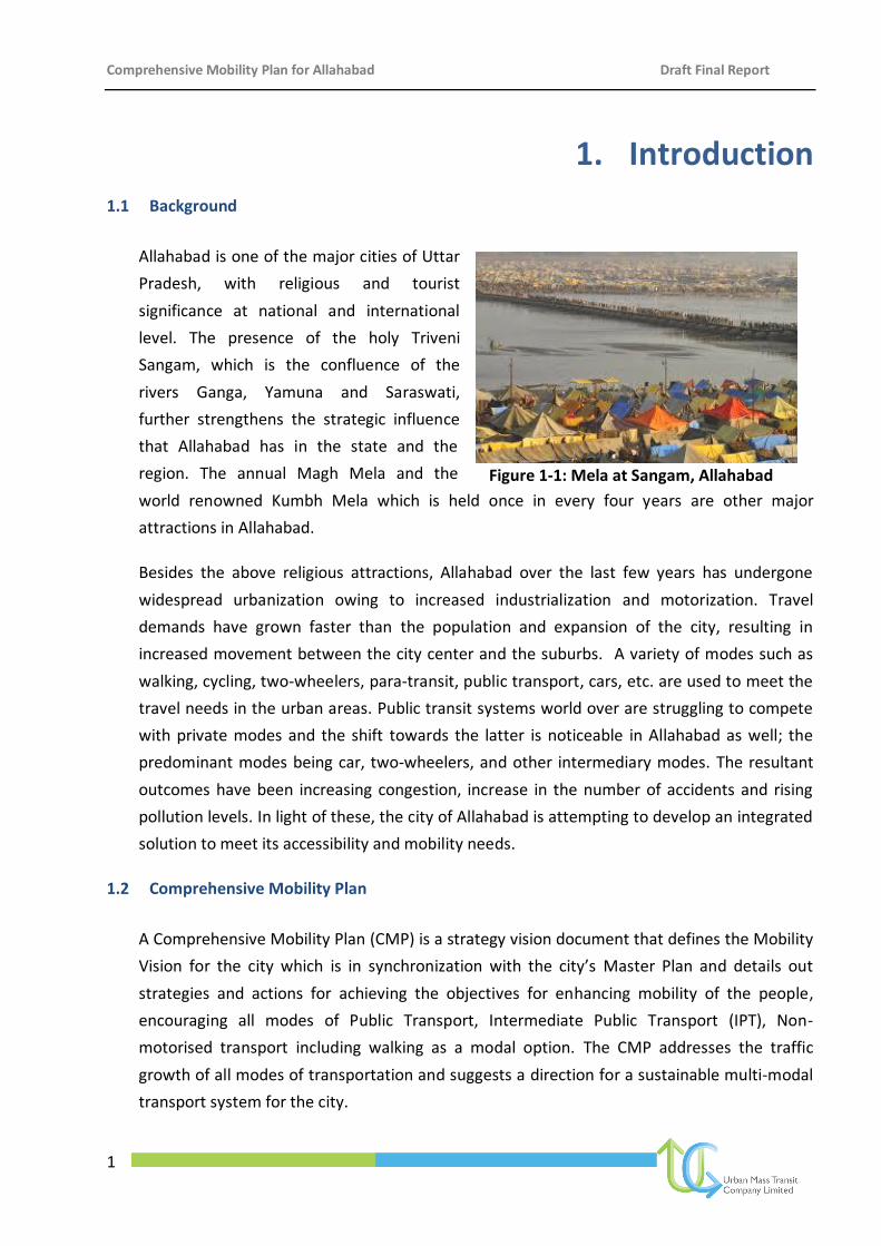
Figure 1-1: Mela at Sangam, Allahabad ....................................................................................................... 1
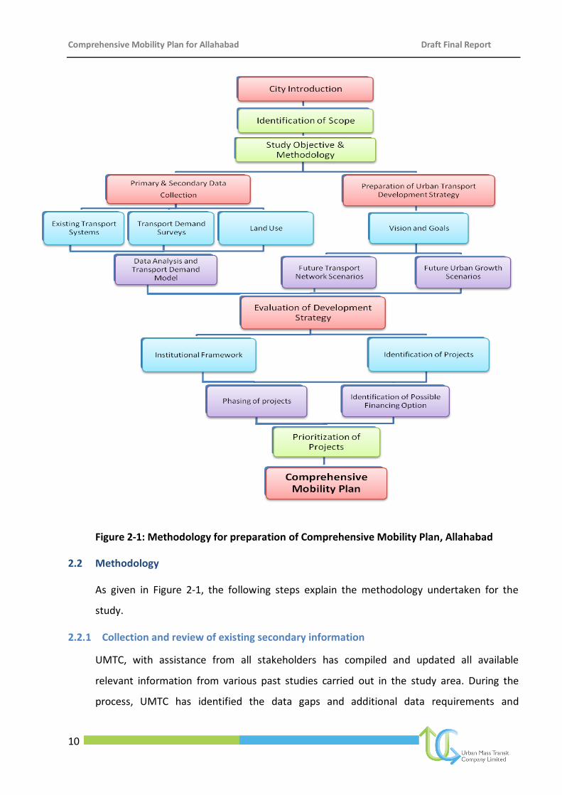
Figure 2-1: Methodology for preparation of Comprehensive Mobility Plan, Allahabad .............................. 10
Figure 3-1: Location of Allahabad ............................................................................................................. 13
Figure 3-2: Study area delineation ............................................................................................................ 15
Figure 3-3: Regional connectivity for Allahabad ........................................................................................ 15
Figure 3-4: Allahabad growth during Mughal and British period................................................................ 16
Figure 3-5: Spatial growth of Allahabad from 1994-2000 .......................................................................... 17
Figure 3-6: Civil lines area-grid iron pattern of roads................................................................................. 18
Figure 3-7: Land use distribution, 2001 and 2021 ...................................................................................... 19
Figure 3-8: Proposed Land use Plan, 2021 ................................................................................................. 20
Figure 3-9: Growth rates for population in Allahabad ............................................................................... 21
Figure 3-10: Ward wise population densities, 2001 ................................................................................... 21
Figure 3-11: Ward wise population densities, 2011 ................................................................................... 22
Figure 3-12: Projected Population for Allahabad ....................................................................................... 22
Figure 4-1: Congested roads in old Allahabad ........................................................................................... 25
Figure 4-2: Distribution of Road by Right of Way....................................................................................... 27
Figure 4-3: Distribution of RoW Type ........................................................................................................ 27
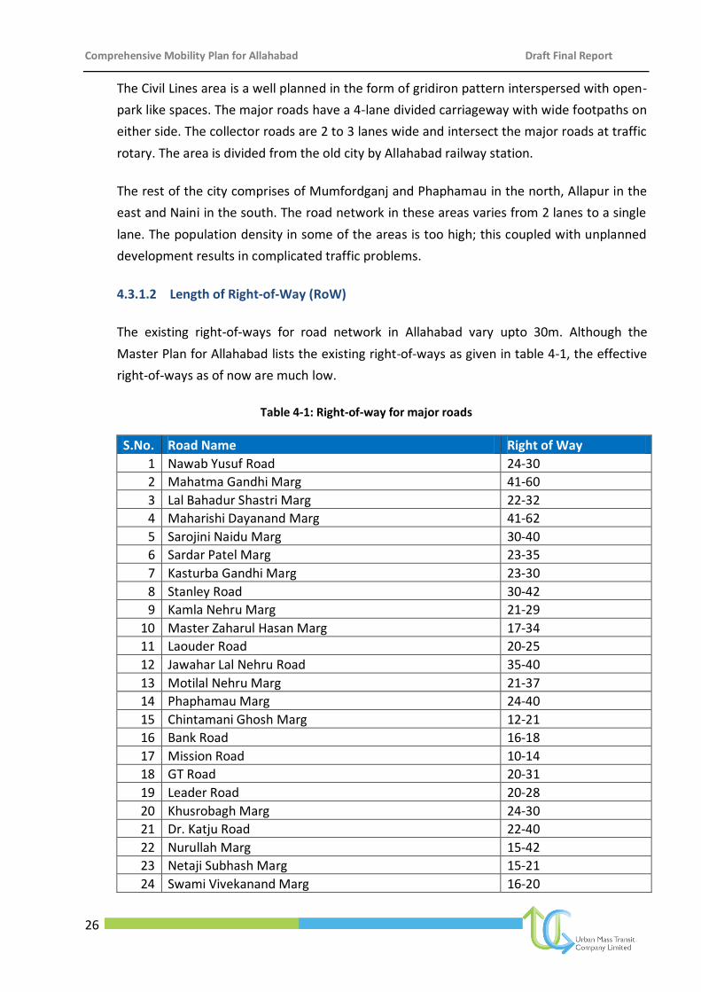
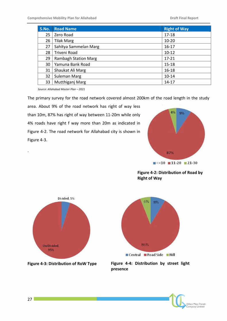
Figure 4-4: Distribution by street light presence ....................................................................................... 27
Figure 4-5: Road network in Allahabad ..................................................................................................... 28
Figure 4-6: Distribution of Carriage ........................................................................................................... 28
Figure 4-7: Speed and delay profile of road network in Allahabad............................................................. 29
Figure 4-8: Traffic volume count at junctions (vehicle numbers) ............................................................... 32
Figure 4-9: PCU count during morning and evening peak hours ................................................................ 33
Figure 4-10: Traffic volume at cordon locations ........................................................................................ 34
Figure 4-11: Composition of Total Traffic at Kanpur Road ......................................................................... 35
Figure 4-12: Composition of total traffic at Lucknow Road ........................................................................ 35
Comprehensive Mobility Plan for Allahabad Draft Final Report
vii
Figure 4-13: Public Transport Routes in Allahabad .................................................................................... 37
Figure 4-14: Existing Bus Terminals in Allahabad ....................................................................................... 38
Figure 4-15: Distribution of bus users by trip purpose ............................................................................... 38
Figure 4-16: Parking demand at major locations ....................................................................................... 40
Figure 4-17: Distribution of railway users by trip purpose ......................................................................... 42
Figure 4-18: Accident profile ..................................................................................................................... 42
Figure 4-19: Distribution household by household size ............................................................................. 43
Figure 4-20: Distribution Household by number of workers ...................................................................... 43
Figure 4-21: Distribution of Individuals by their household income ........................................................... 43
Figure 4-22: Distribution of housolds by expenditure on transport ........................................................... 44
Figure 5-1 Four Stage Transport Model Structure ..................................................................................... 49
Figure 5-2 Traffic Analysis Zones for Allahabad ......................................................................................... 50
Figure 5-3 Allahabad Road Network.......................................................................................................... 51
Figure 5-4 Desire Line diagram for Base Year ........................................................................................... 52
Figure 5-5 Identified Lite Bus Based Transit Corridors for the year 2031 ................................................... 55
Figure 6-1: Sustainable Mobility Solutions ................................................................................................ 59
Figure 6-2: Integrated Land Use Transport Strategy .................................................................................. 62
Figure 6-3: Concept of Mobility Corridors for Allahabad ........................................................................... 63
Figure 6-4: Public Transit Strategy for Allahabad ....................................................................................... 65
Figure 6-5: Traffic engineering measures .................................................................................................. 66
Figure 6-6: Concept of four self – contained sub-cities .............................................................................. 68
Figure 6-7: Proposed locations for Induced Growth Centres ..................................................................... 69
Figure 6-8: Proposed mobility corridors .................................................................................................... 71
Figure 6-9: Proposed new links ................................................................................................................. 72
Figure 6-10: Proposed bypasses ................................................................................................................ 75
Figure 6-11: Proposed River Bridges ......................................................................................................... 76
Figure 6-12: Proposed Public Transit System for Allahabad ....................................................................... 78
Comprehensive Mobility Plan for Allahabad Draft Final Report
viii
Figure 6-13: Existing and Proposed Bus Terminals and Depots in Allahabad .............................................. 82
Figure 6-14: Locations of Proposed ROBs/Flyovers in Allahabad ............................................................... 83
Figure 6-15: ITS architecture for promoting public transport .................................................................... 84
Figure 6-16: Proposed NMT plan .............................................................................................................. 88
Figure 6-17: Locations of junctions for grade separated pedestrian facility ............................................... 90
Figure 6-18: Typical drawing of a raised crossing ...................................................................................... 91
Figure 6-19: Examples of raised crossing ................................................................................................... 91
Figure 6-20: Improvements for Civil lines/MG road (from High Court to Hanumat Niketan) ...................... 95
Figure 6-21: Improvement for Kutchery and Katra Market Area ................................................................ 97
Figure 6-22: Improvements for Railway Station and Johnsonganj ............................................................. 99
Figure 6-23: Improvements for Khusro Bagh and Khuldabad Area........................................................... 100
Figure 6-24: Improvements for Ram Bagh, Medical, Sohbatiya Bagh and Alopi Bagh Area ...................... 102
Figure 6-25: Improvements for Chowk and Ghantaghar .......................................................................... 104
Figure 6-26: Improvements for the underpasses ..................................................................................... 105
Figure 6-27: Stretches and intersections for lighting ............................................................................... 107
Figure 6-28: Traffic Signages ................................................................................................................... 108
Figure 6-29: Locations for Traffic Signages .............................................................................................. 108
Figure 6-30: Stretches for Road Markings ............................................................................................... 109
Figure 6-31: Proposals for Freight Management ..................................................................................... 111
Figure 6-32: Phaphamau Junction Improvement ..................................................................................... 114
Figure 6-33: MNIT Junction Improvement ............................................................................................... 115
Figure 6-34: Traffic line Intersection Improvement ................................................................................. 116
Figure 6-35: Mayohall Intersection Improvement ................................................................................... 117
Figure 6-36: Income tax intersection & Hanumat Niketan Intersection Improvement ............................. 118
Figure 6-37: Johnsonganj Intersection Improvement .............................................................................. 119
Figure 6-38: Railway Station city side Intersection Improvement ............................................................ 120
Figure 6-39: Balson Intersection Improvement ....................................................................................... 121
Comprehensive Mobility Plan for Allahabad Draft Final Report
ix
Figure 6-40: Proposed locations for off-street parking lots ...................................................................... 123
Figure 6-41: Streets for On-street Parking ............................................................................................... 124
Figure 8-1: Departments and Organisations involved in Urban Affairs and Urban Transport ................... 134
Figure 8-2: Departments and Organisations involved in Urban Affairs and Urban Transport ................... 140
Comprehensive Mobility Plan for Allahabad Draft Final Report
x
List of Tables
Table 3-1: Proposed Land use distribution, 2021 ...................................................................................... 19
Table 3-2: Population Growth Rates for Allahabad .................................................................................... 20
Table 4-1: Right-of-way for major roads.................................................................................................... 26
Table 4-2: Daily traffic volume (16 hr.) at mid – block locations ................................................................ 30
Table 4-3: Peak hour traffic intensities ...................................................................................................... 30
Table 4-4: Average traffic volume at major intersections .......................................................................... 31
Table 4-5: Peak hour traffic distribution at intersections ........................................................................... 32
Table 4-6: Total traffic distribution at outer cordon locations ................................................................... 33
Table 4-7: Details of traffic characteristics at outer cordon ....................................................................... 34
Table 4-8 Local bus routes ........................................................................................................................ 36
Table 4-9: Fare structure: Public Transport ............................................................................................... 37
Table 4-10: Daily boarding/alighting at bus terminals ............................................................................... 38
Table 4-11: IPT Routes (shared taxi) in Allahabad ...................................................................................... 39
Table 4-12: PV2 values at some of the important intersections ................................................................. 41
Table 4-13: Daily boarding/alighting at railway stations ............................................................................ 41
Table 4-14 V/C ratios of some of the major roads ..................................................................................... 47
Table 4-15 Service Level Benchmark ......................................................................................................... 47
Table 5-1 Base Year Travel Characteristics ................................................................................................ 52
Table 5-2 Projected Population and Employment ..................................................................................... 53
Table 5-3 Estimated Total Trips for Horizon Period ................................................................................... 53
Table 5-4 Mode Shares for Motorized passenger modes in 2031 for different Scenarios ........................... 56
Table 5-5: V/C Ratios on Selected Corridors for Different Scenarios in 2031. ............................................ 56
Table 6-1: Road widening proposals for Allahabad .................................................................................... 73
Table 6-2: New Terminals cum Depots for bus Public Transport ................................................................ 81
Table 6-3 Pedestrian-vehicular conflict represented by PV2 ...................................................................... 89
Table 6-4: Problems and suggested interventions ................................................................................... 112
Comprehensive Mobility Plan for Allahabad Draft Final Report
xi
Table 7-1: Prioritisation and Phasing of Projects ..................................................................................... 127
Table 7-2: Phase wise cost details ........................................................................................................... 129
Table 7-3: Detailed costing of Projects in Phase I .................................................................................... 129
Table 7-4: Detailed costing of Projects in Phase II ................................................................................... 130
Table 7-5: Detailed costing of Projects in Phase III .................................................................................. 130
Table 9-1: Environmental Impacts of Important Projects ........................................................................ 144
Table 9-2: Project Impacts ...................................................................................................................... 150
Table 10-1: Scenario wise outcomes ....................................................................................................... 152
Table 10-2: Overall LOS........................................................................................................................... 153
Comprehensive Mobility Plan for Allahabad Draft Final Report
xii
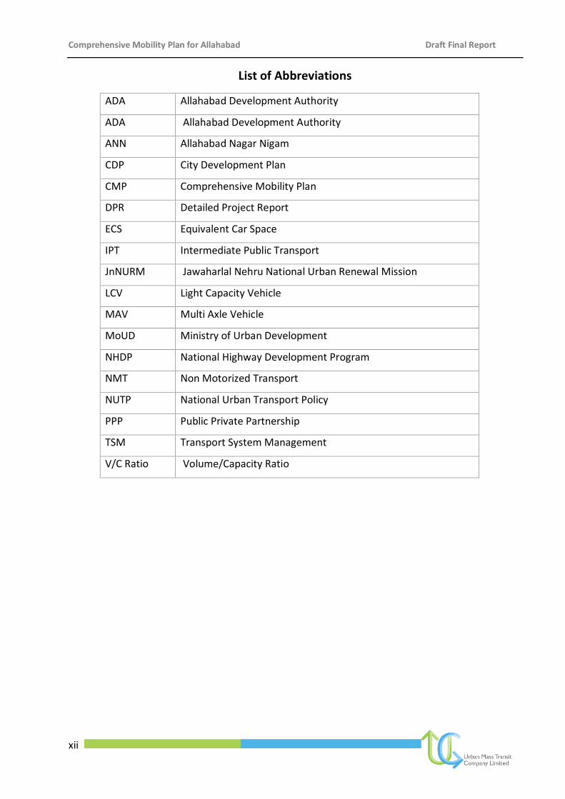
List of Abbreviations
ADA Allahabad Development Authority
ADA Allahabad Development Authority
ANN Allahabad Nagar Nigam
CDP City Development Plan
CMP Comprehensive Mobility Plan
DPR Detailed Project Report
ECS Equivalent Car Space
IPT Intermediate Public Transport
JnNURM Jawaharlal Nehru National Urban Renewal Mission
LCV Light Capacity Vehicle
MAV Multi Axle Vehicle
MoUD Ministry of Urban Development
NHDP National Highway Development Program
NMT Non Motorized Transport
NUTP National Urban Transport Policy
PPP Public Private Partnership
TSM Transport System Management
V/C Ratio Volume/Capacity Ratio
Comprehensive Mobility Plan for Allahabad Draft Final Report
1
Figure 1-1: Mela at Sangam, Allahabad
1. Introduction
1.1 Background
Allahabad is one of the major cities of Uttar
Pradesh, with religious and tourist
significance at national and international
level. The presence of the holy Triveni
Sangam, which is the confluence of the
rivers Ganga, Yamuna and Saraswati,
further strengthens the strategic influence
that Allahabad has in the state and the
region. The annual Magh Mela and the
world renowned Kumbh Mela which is held once in every four years are other major
attractions in Allahabad.
Besides the above religious attractions, Allahabad over the last few years has undergone
widespread urbanization owing to increased industrialization and motorization. Travel
demands have grown faster than the population and expansion of the city, resulting in
increased movement between the city center and the suburbs. A variety of modes such as
walking, cycling, two-wheelers, para-transit, public transport, cars, etc. are used to meet the
travel needs in the urban areas. Public transit systems world over are struggling to compete
with private modes and the shift towards the latter is noticeable in Allahabad as well; the
predominant modes being car, two-wheelers, and other intermediary modes. The resultant
outcomes have been increasing congestion, increase in the number of accidents and rising
pollution levels. In light of these, the city of Allahabad is attempting to develop an integrated
solution to meet its accessibility and mobility needs.
1.2 Comprehensive Mobility Plan
A Comprehensive Mobility Plan (CMP) is a strategy vision document that defines the Mobility
Vision for the city which is in synchronization with the city’s Master Plan and details out
strategies and actions for achieving the objectives for enhancing mobility of the people,
encouraging all modes of Public Transport, Intermediate Public Transport (IPT), Non-
motorised transport including walking as a modal option. The CMP addresses the traffic
growth of all modes of transportation and suggests a direction for a sustainable multi-modal
transport system for the city.
Comprehensive Mobility Plan for Allahabad Draft Final Report
2
1.3 Need for Comprehensive Mobility Plan, Allahabad
1.3.1 Improving mobility of people
The city of the holy rivers, Allahabad, has lately witnessed unprecedented urbanization. The
urban sprawl has extended far beyond the existing territorial jurisdiction of the city
administration and is continuing to spill over into the fringe areas. Despite number of
provisions and measures being adopted, the impact of uncontrolled urbanization is
widespread. Although a number of measures have been adopted by the city authority to
improve basic infrastructure services, congested roads and increasing traffic numbers remain
the major issue. Limited road widths together with increase in number of private vehicles
have led to traffic congestion and delays becoming common phenomenon. The situation
becomes more acute during peak hours.
Growth and development of commercial activities along both sides of the road and on-street
parking of private vehicles by resident users, has further aggravated the situation. On the
other hand, the pedestrians have become more vulnerable due to lack of dedicated
pedestrian lanes. In areas like High Court, Railway Station City side, Johnsonganj etc. without
adequate movement space for pedestrians and cyclists, the use of NMT is highly
discouraged. Thus, in order to sustain its glory and to promote it as one of the most
accessible heritage rich city of the country, Allahabad requires a comprehensive vision
document for urban mobility. This vision document should bring out the transport
infrastructural needs and requirements of Allahabad for both the existing situation and
future years upto 2031 in conjunction with the other plans and schemes (such as Master Plan
or Development Plan etc.) as conceived by authorities.
The Comprehensive Mobility Plan for Allahabad aims at developing an integrated land use
transport vision document for creating an organized transport system to achieve sustainable
mobility goal for Allahabad. The CMP for Allahabad should emphasize on movement of
people and goods by both motorized and non-motorized mode of transport giving priority to
public transport.
1.3.2 Integrated approach
As per the National Urban Transport Policy (NUTP), it is important to focus on personal
mobility to achieve cost-effective and equitable urban transport measures through an
appropriate and consistent methodology. Accordingly, the Ministry of Urban Development,
Government of India (MoUD) encourages each city to prepare a CMP as part of long-term
urban transport strategy for sustainable improvement in the mobility of people and goods in
regions, which is integrated with the land use plan. CMP should also highlight the projected
Comprehensive Mobility Plan for Allahabad Draft Final Report
3
mobility needs of the city as also the manner in which such mobility needs are proposed to
be met. As per MoUD, CMP is a pre-requisite for submission of Detailed Project Reports
(DPRs) for JnNURM funding for transport infrastructure projects.
City civic agencies have undertaken various programmes/studies on improving the
transportation system. Several road widening and network improvement proposals
(including planning and construction of flyovers, junction improvement etc.) are undertaken.
These programmes are sometimes isolated from each other, with each of them being
planned to meet an objective set by the respective program. There is a strong need for
coordinated implementation strategy for these projects in the entire study city.
1.4 Scope of Work
The scope of work for preparation of Comprehensive Mobility Plan for Allahabad is given
below:
(i) Define objectives of the Mobility Plan and delineate the planning area and horizon of
the mobility plan.
Task 1: Delineation of the planning area and the planning horizon
Delineation of planning boundary for Mobility Plan based on existing planning and
municipal area boundary and discussions with relevant agencies.
Defining short, medium and long term planning horizons. The target duration of the
CMP would be 20 years, from the base year. In addition, 2 years and 10 years would
be defined as short-term and mid-term target years respectively.
Task 2: Define objectives of the Mobility Plan
Define objectives of preparation of the Mobility Plan. These objectives would aim at
addressing following aspects:
To develop a long-term strategy for the desirable city mobility pattern that recognizes
all transport modes and avoids a piecemeal, reactive approach to arising problems
Improvement and promotion of public transport, NMVs and pedestrians as important
transport modes
To promote integrated land use and transport planning
To develop an urban transport strategy that is in line with the current National Urban
Transport Policy (NUTP)
Comprehensive Mobility Plan for Allahabad Draft Final Report
4
To ensure that the most appropriate, sustainable, and cost-effective investments are
made in the transport sector
(ii) Demand-supply gap analysis of transportation needs and related infrastructure over the
planning horizon.
Task 3: Collection of secondary information and primary data
UMTC shall compile and update available relevant information from various past
studies carried out in the study area. UMTC shall identify the data gaps and additional
data requirements.
Data on existing land use and land use plans would be collected and presented,
through a detailed review of existing development plans, including the Master Plan
and/or the City Development Plan (CDP). In particular, new development areas that
will affect transport demand in the planning area should be inventoried and
summarized.
The secondary data required for the development of study will be collected from
various sources primarily from the government/planning organizations of the study
area.
The secondary data collected would be used in studying the past and existing growth
pattern, land use plan of the city & its suburbs. The data would also be used in
projecting future growth patterns, land use patterns and possible growth directions.
In case, there are data gaps or the survey data is more than 2 years old, if considered
necessary in consultation with the client, fresh primary surveys shall be carried out by
UMTC. The primary data would help in analysis of travel and traffic characteristics of
the city along with travel pattern of the city population.
Task 4: Travel demand modeling
The purpose of travel demand modeling is to project future travel demand in order to
estimate the likely consequences of several alternatives. The travel demand forecasts will be
carried out for different horizon years. The traffic forecast will be for different modes and in
different alternate scenarios and for different time slabs. Transportation demand will be
estimated for both passengers as well as goods traffic.
Task 5: Infrastructure demand-supply gap analysis
Based on the information/data collected, and existing and projected travel demand,
requirements of transport related infrastructure needs would be estimated. On the basis of
road and transport infrastructure inventory available through secondary data and primary
Comprehensive Mobility Plan for Allahabad Draft Final Report
5
surveys, a gap analysis of the infrastructure requirements over the horizon year would be
estimated.
(iii) Assessment of existing problems and issues for mobility of people and goods within the
study area.
Task 6: Analysis of existing traffic/transport situation
Based on the information/data collected, an analysis of the transport and traffic situation
would be carried out, identifying urban transport characteristics and issues for the city. The
existing transport related problems and issues would be classified into following heads:
Public transportation
Intermediate Public Transport
Pedestrian and other Non-Motorized Transport
Personal Motorized Transport
Road network
Intersections (both at grade and grade separated)
Parking facilities
Freight movement
Multi-modal transport options including Ropeway, Waterway etc
Traffic signals, Traffic signage, lane marking, street furniture
Passenger and freight terminals including logistic hubs
Safety and Others
(iv) Develop Urban Mobility Plan
Task 7: Define mobility vision and goals
Define a long term mobility vision for the city that would define the desired form of long-term
urban transport system in the city.
Task 8: Identify strategies and action plan for achieving the mobility vision
On the basis of the travel demand model, demand-supply gap analysis and assessment of the
existing traffic and transport situation, strategies and plan would be formulated for achieving
the mobility vision and goals set thereof.
Comprehensive Mobility Plan for Allahabad Draft Final Report
6
Task 9: Identification of projects and policy measures that the city authorities would need
to implement as part of the mobility plan
A set of specific projects and policy measures would be identified that the city authorities
would need to implement as part of the Mobility Plan. These projects and proposals could be
categorized into following categories:
(i) Public Transport Improvement Plan
(ii) Road Network Development Plan
(iii) NMT Facilities
(iv) Mobility Management Measures
(v) Regulatory and Institutional Measures
(vi) Fiscal Measures
Task 10: Prioritization of projects
The proposed projects/measures would be evaluated and prioritized based on the
implementation time period and priority. All the measures would be prioritized into short,
medium and long-term along with justification and block cost estimates.
(v) Implementation program
Task 11: Stakeholder consultations
To make the mobility plan a collaborative effort, detailed workshop meetings will be held to
solicit the comments and concerns from the stakeholders and disseminate the findings of the
draft mobility plan. Input from the stakeholder workshops and meetings would provide input
to the development of the mobility plan on various aspects and issues of the transportation
system. The mobility plan would be updated accordingly.
Task 12: Implementation plan
An implementation programme including practical procedures to implement the proposed
measures, in terms of timeframe, financing options would be prepared, identifying key
agencies for implementing the proposed measures. The CMP would identify a number of
specific projects that need to be taken up for implementation. Many of these projects can be
taken up on a PPP framework, but some would not be amenable to such an approach and
would need to be developed through funding from the Government. In the CMP, UMTC
would identify those projects that can be taken up on a PPP format and projects that will
need to be taken up through Government funding.
Comprehensive Mobility Plan for Allahabad Draft Final Report
7
1.5 Status of the Project
1. Inception Report: Scope of work, area under study, list of primary survey to be
conducted, list of secondary data collected, list of stakeholders consulted.
2. Interim Report: GIS mapping of the study area, analysis of secondary and primary
survey data, evaluation of existing transport scenario of the city and project concepts
based on preliminary analysis and site observations.
3. Draft Final Report: Development of Travel Demand Model using transportation
software to project the transport scenario for the both base year and horizon year,
establishment of traffic and transportation issues, and formulation of draft proposals in
respect of mobility corridors, public transport, non motorized transport and pedestrian
facility, parking and freight etc.
4. Final Report: Based on the feedback obtained from stakeholders the proposals
discussed in the Draft Final Report shall be reformulated or modified as required with
detailed block cost estimates.
1.6 Structure of the report
This Draft Final Report consists of nine chapters - Profile of Allahabad, Approach and
Methodology, Existing Transportation Scenario, Travel Demand Assessment, Mobility Plan
Strategies, Implementation Programme and Costing, Institutional Framework, Environmental
and Social Impact Assessment and Outcomes.
Chapter One, “Introduction” describes the need for CMP for Allahabad and the scope of work
for the preparation of the Comprehensive Mobility Plan for the city.
Chapter Two discusses the “Approach and Methodology” adopted to prepare Comprehensive
Mobility Plan for Allahabad.
Chapter Three highlights the profile of Allahabad city covering aspects such as connectivity,
demography and important centres of attraction.
Chapter Four describes the “Existing Transportation Scenario” of the study area in terms of
network, traffic and travel, parking, pedestrian and public transport characteristics based on
both primary and secondary data.
Chapter Five “Travel Demand Assessment” describes the process of developing transportation
model to forecast the future or horizon year travel demand. This chapter also describes the
process of scenario building to arrive at feasible and sustainable mobility goal for Allahabad.
Comprehensive Mobility Plan for Allahabad Draft Final Report
8
Chapter Six on “Mobility Plan Strategies and Projects” describes the various approaches for
achieving mobility vision of the study area. This chapter include identification of number of
intervention measures ranging from landuse-transport integration to junction improvement
for improving mobility of the study area based on data analysis and transportation model.
Chapter Seven “Implementation Programme and Costing” defines phases for implementing
the projects identified in chapter five in terms of priority. This chapter also describes the cost
estimates associated with implementation of each projects. The financing options to
implement each of the projects are also described in this chapter.
Chapter Eight “Institutional Framework” describes the pros and cons of existing city and state
level institutional structures responsible for managing and monitoring urban transport. This
chapter recommends number of reform measures for improvement of existing city and state
level institutional structures.
Chapter Nine “Environmental and Social Impact Assessment” describes the environmental
and social impacts of projects identified.
Chapter Ten on “Outcomes” assessed the outcomes and accordingly justifies the projects
suggested in terms of overall improvement in mobility situation.
The primary survey formats, detailed existing situation analysis and population and
employment projections are annexed with the report.
Comprehensive Mobility Plan for Allahabad Draft Final Report
9
2 Approach and Methodology
2.1 Approach
The methodology for preparing CMP for Allahabad has been formulated after studying the
need for preparing the CMP and is based on following aspects:
1. Demographic characteristics of Allahabad
2. Land use characteristics of Allahabad
3. Traffic & travel characteristics of Allahabad
4. Challenges and issues relating to mobility of residents of Allahabad
5. Suggestions and inputs of project stakeholders
6. Guidelines of National Urban Transport Policy
The methodology for preparation of CMP, Allahabad is shown in Figure 2-1. As per the
JNNURM guidelines, the broad scope for the Comprehensive Mobility Plan for a city is
defined. However, considering the distinct characteristics of each of the city, there is a
flexibility of adopting a city-specific approach towards strategizing a mobility vision and plan
for the city.
Allahabad being an ancient city with a multi-varied activity base such as religious, business
and others, hence an inclusive methodology to prepare a focused vision, goals and objectives
based on recent and updated database is essential. The methodology shall include primary
and secondary data collection which shall be used to study the existing transportation system.
Since secondary data may be old, hence primary surveys especially transport demand surveys
such as volume counts, origin-destination survey, parking and pedestrian survey, household
surveys become essential. Analysis of this primary and secondary information along with
inputs from land use information shall then be used to develop transport demand model for
base year scenario. Based on the existing scenario, a mobility vision for Allahabad shall be
developed with goals and specific objectives. Together with goals and objectives and inputs
from urban growth strategies, future growth and travel demand scenarios shall be developed
alongwith the transport demand model. Working out a development strategy through project
identification, costing and implementation framework will be further taken up. Based on the
vision and goals set out, the prioritization of projects based on time and priority shall be
done.
Comprehensive Mobility Plan for Allahabad Draft Final Report
10
Figure 2-1: Methodology for preparation of Comprehensive Mobility Plan, Allahabad
2.2 Methodology
As given in Figure 2-1, the following steps explain the methodology undertaken for the
study.
2.2.1 Collection and review of existing secondary information
UMTC, with assistance from all stakeholders has compiled and updated all available
relevant information from various past studies carried out in the study area. During the
process, UMTC has identified the data gaps and additional data requirements and

Comprehensive Mobility Plan for Allahabad Draft Final Report
11
accordingly, UMTC has carried out number of primary surveys. Data on existing land use
and land use plans have been collected and presented, through a detailed review of
existing development plans, including the Master Plan and the City Development Plan
(CDP). The secondary data as required for the development of study has been collected
from various sources primarily from the government/planning organizations of the study
area.
2.2.2 Collection of data through primary surveys
A number of primary surveys such as traffic survey, household survey and GIS mapping of
the study area have been carried out by UMTC. An illustrative list of surveys conducted by
UMTC, is enlisted below:
Road network inventory
Speed & Delay survey
Household survey
Outer cordon classified traffic volume count
Outer cordon origin-destination survey
Turning traffic volume count at intersection
Classified traffic volume count at mid block
Pedestrian count at intersection
Pedestrian count at mid blocks
Transport infrastructure user opinion survey
Bus terminal OD interview survey
Railway terminal survey
On-street parking survey
Off street parking survey (12 Hrs.)
Truck operator survey
Taxi & IPT operator surveys
Details of primary surveys are furnished in Annexure. The information collected from
secondary source and primary surveys are used for assessment of existing travel pattern
and for development of transportation modal, model validation and forecasting of future
travel demand.
Comprehensive Mobility Plan for Allahabad Draft Final Report
12
2.2.3 Analyse existing traffic/transport situation
Based on the information/data collected, a basic analysis of the transport and traffic
situation was done, identifying characteristics and issues for the city, which includes
analysis of existing urban transport situation and traffic characteristics.
2.2.4 Travel demand modeling
The purpose of travel demand modeling has been to project future travel demand in order
to estimate the likely consequences of several alternatives taking into consideration the
“Do- nothing Alternative”.
The travel demand forecast has been done for different horizon years. The forecast has
been done for different modes, in different alternative scenarios.
2.2.5 Develop urban mobility plan
The Urban Mobility Plan includes development of vision and goals, planning of short-term
improvement measures such as pedestrian and other non-motorized transport, public
transportation, road network etc., planning of medium and long range measures, along
with cost estimates and prioritization of project. To make the mobility plan a collaborative
effort, detailed meetings, consultation were held to solicit the comments and concerns
from the stakeholders and disseminate the findings of the draft mobility plan. Input from
the stakeholder meetings provided input to the development of the mobility plan on
various aspects and issues of the transportation system.
Comprehensive Mobility Plan for Allahabad Draft Final Report
13
3 City Profile
The city of Allahabad, founded by Mughal Emperor Akbar in the year 1575 AD by the name of
‘Illahabas’, is the modern Allahabad today. The city located in alluvial plains of rivers Ganga
and Yamuna, is a city of historical, cultural and religious significance.
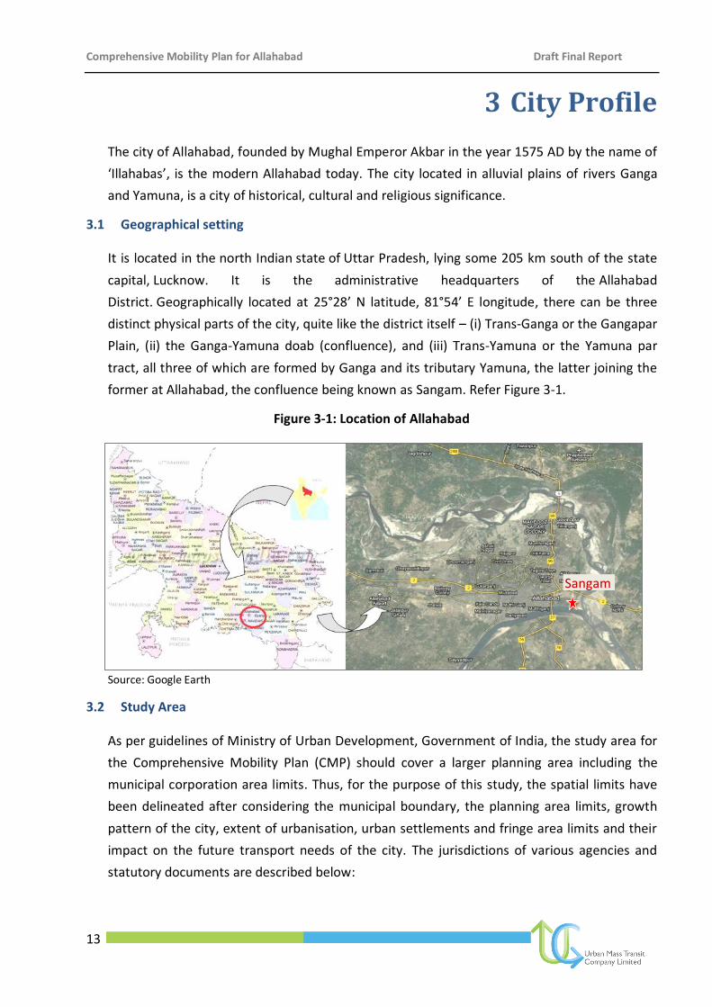
3.1 Geographical setting
It is located in the north Indian state of Uttar Pradesh, lying some 205 km south of the state
capital, Lucknow. It is the administrative headquarters of the Allahabad
District. Geographically located at 25°28’ N latitude, 81°54’ E longitude, there can be three
distinct physical parts of the city, quite like the district itself – (i) Trans-Ganga or the Gangapar
Plain, (ii) the Ganga-Yamuna doab (confluence), and (iii) Trans-Yamuna or the Yamuna par
tract, all three of which are formed by Ganga and its tributary Yamuna, the latter joining the
former at Allahabad, the confluence being known as Sangam. Refer Figure 3-1.
Figure 3-1: Location of Allahabad
Source: Google Earth
3.2 Study Area
As per guidelines of Ministry of Urban Development, Government of India, the study area for
the Comprehensive Mobility Plan (CMP) should cover a larger planning area including the
municipal corporation area limits. Thus, for the purpose of this study, the spatial limits have
been delineated after considering the municipal boundary, the planning area limits, growth
pattern of the city, extent of urbanisation, urban settlements and fringe area limits and their
impact on the future transport needs of the city. The jurisdictions of various agencies and
statutory documents are described below:
Sangam
Comprehensive Mobility Plan for Allahabad Draft Final Report
14
Allahabad Nagar Nigam (ANN): The Allahabad Nagar Nigam covers an area of about 84 sq.km
divided into 80 municipal wards. The ANN covers the entire existing main Allahabad city area
from the banks of river Ganga in the north to the banks of river Yamuna in the south, also
extending beyond Yamuna with a major portion of Naini area under it. The main city extends
towards the west, towards Bamrauli airport bringing Subedarganj and Prayag Dairy under its
jurisdiction. Also the main Phaphamau urban area including the main market area falls under
the jurisdiction of ANN.
Cantonment Board (CB): The Cantonment area in Allahabad is spread over three sections. The
main Cantonment Board area is located on the western edge of the city bulk, around Carriapa
Road. Thereafter, a significant area is under the Cantonment Board jurisdiction along the
Bank Road. Further the Fort area next to the Minto Park is also under the Cantonment Board.
Refer Figure 3-2.
Allahabad Development Authority: The Allahabad Development Authority is the agency
responsible for preparation of the Master Plan for Allahabad, thereby guiding the growth of
the area. The 2001 Allahabad Master Plan planned for an area of 216 sq. km which the 2021
Master Plan extended to 309.27 sq. km for planning and has prepared the land use plan for
the same. This area includes the areas of Naini, Phaphamau and Jhunsi.
The Study Area: Since the Master Plan for Allahabad envisages an urbanized development for
309.27 sq. km, and a major portion of the same is not yet developed, as also considering the
trend of actual development of area as against the planned area, the developed/urbanized
area is expected to be 309.27 sq.km and ideal to be taken up as the study area. Hence,
though the study focuses on the existing study area and the proposed planned area, the area
under consideration for providing total mobility solution to the city is the Allahabad
Development Authority’s Master Plan Area spread over 500 sq.km (approx). The hierarchy of
jurisdiction areas is shown in Figure 3-2.
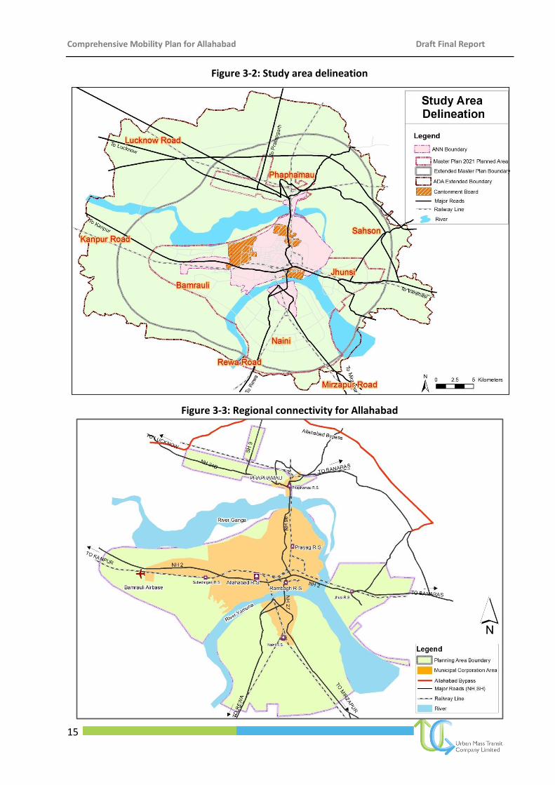
3.3 Regional Connectivity
Allahabad is well connected with other parts of the country by rail and road network. Existing
NH-2 (Grand Trunk Road) divides the city into two parts, the Civil Lines area and the Old City
area. The Allahabad Bypass, connecting NH-2, is a part of the National Highway Development
Program (NHDP). The city lies on Delhi-Calcutta rail route of Eastern Railways and has direct
rail connections with important cities viz. Kolkata, Delhi, Patna, Guwahati, Chennai, Mumbai,
Gwalior, Meerut, Lucknow, Kanpur and Varanasi. The regional connectivity is shown in Figure
3-3.
Comprehensive Mobility Plan for Allahabad Draft Final Report
15
Figure 3-2: Study area delineation
Figure 3-3: Regional connectivity for Allahabad
Comprehensive Mobility Plan for Allahabad Draft Final Report
16
Mughal Period British Era
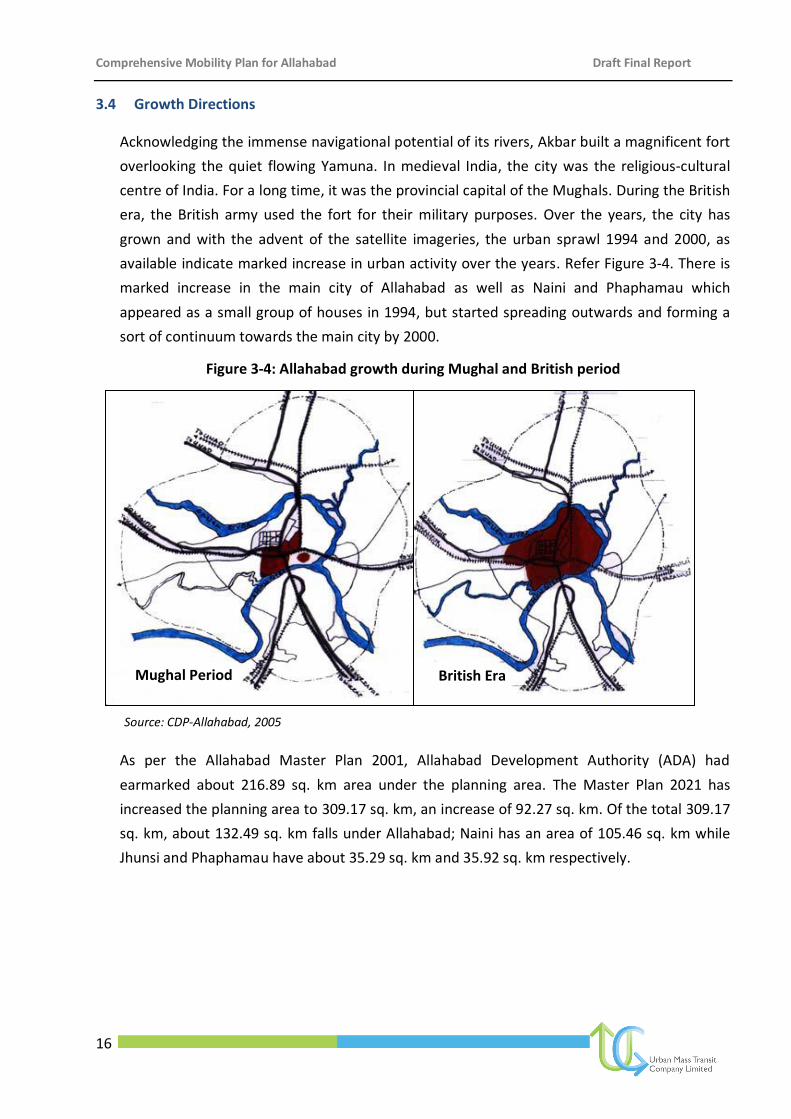
3.4 Growth Directions
Acknowledging the immense navigational potential of its rivers, Akbar built a magnificent fort
overlooking the quiet flowing Yamuna. In medieval India, the city was the religious-cultural
centre of India. For a long time, it was the provincial capital of the Mughals. During the British
era, the British army used the fort for their military purposes. Over the years, the city has
grown and with the advent of the satellite imageries, the urban sprawl 1994 and 2000, as
available indicate marked increase in urban activity over the years. Refer Figure 3-4. There is
marked increase in the main city of Allahabad as well as Naini and Phaphamau which
appeared as a small group of houses in 1994, but started spreading outwards and forming a
sort of continuum towards the main city by 2000.
Figure 3-4: Allahabad growth during Mughal and British period
Source: CDP-Allahabad, 2005
As per the Allahabad Master Plan 2001, Allahabad Development Authority (ADA) had
earmarked about 216.89 sq. km area under the planning area. The Master Plan 2021 has
increased the planning area to 309.17 sq. km, an increase of 92.27 sq. km. Of the total 309.17
sq. km, about 132.49 sq. km falls under Allahabad; Naini has an area of 105.46 sq. km while
Jhunsi and Phaphamau have about 35.29 sq. km and 35.92 sq. km respectively.
Comprehensive Mobility Plan for Allahabad Draft Final Report
17
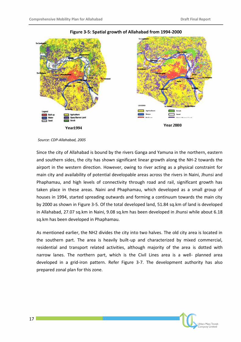
Figure 3-5: Spatial growth of Allahabad from 1994-2000
Source: CDP-Allahabad, 2005
Since the city of Allahabad is bound by the rivers Ganga and Yamuna in the northern, eastern
and southern sides, the city has shown significant linear growth along the NH-2 towards the
airport in the western direction. However, owing to river acting as a physical constraint for
main city and availability of potential developable areas across the rivers in Naini, Jhunsi and
Phaphamau, and high levels of connectivity through road and rail, significant growth has
taken place in these areas. Naini and Phaphamau, which developed as a small group of
houses in 1994, started spreading outwards and forming a continuum towards the main city
by 2000 as shown in Figure 3-5. Of the total developed land, 51.84 sq.km of land is developed
in Allahabad, 27.07 sq.km in Naini, 9.08 sq.km has been developed in Jhunsi while about 6.18
sq.km has been developed in Phaphamau.
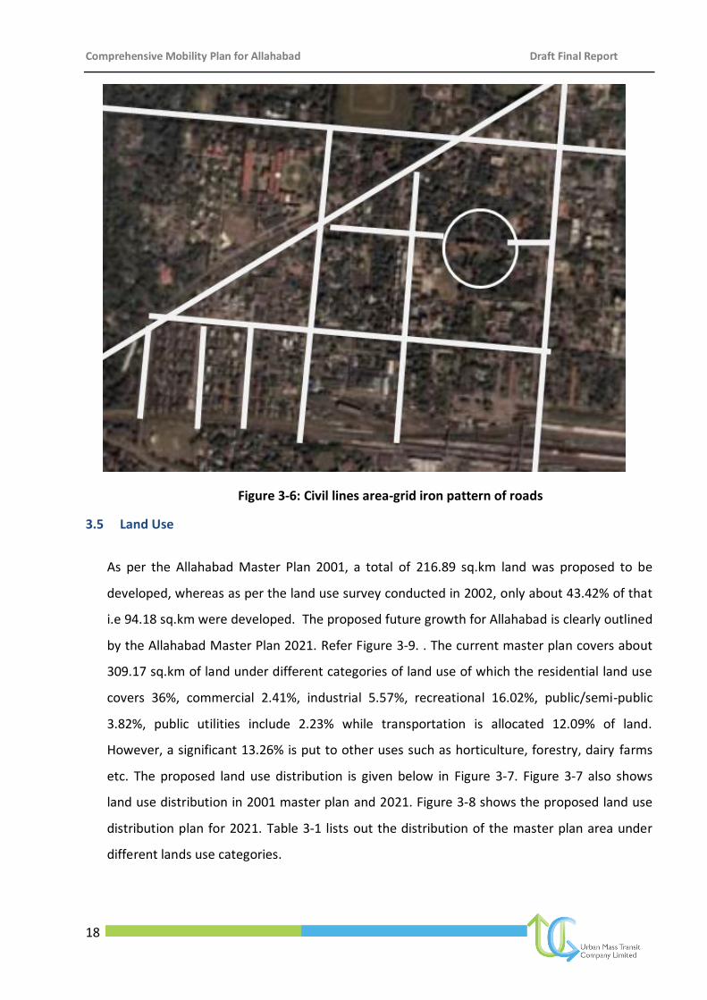
As mentioned earlier, the NH2 divides the city into two halves. The old city area is located in
the southern part. The area is heavily built-up and characterized by mixed commercial,
residential and transport related activities, although majority of the area is dotted with
narrow lanes. The northern part, which is the Civil Lines area is a well- planned area
developed in a grid-iron pattern. Refer Figure 3-7. The development authority has also
prepared zonal plan for this zone.
Comprehensive Mobility Plan for Allahabad Draft Final Report
18
Figure 3-6: Civil lines area-grid iron pattern of roads
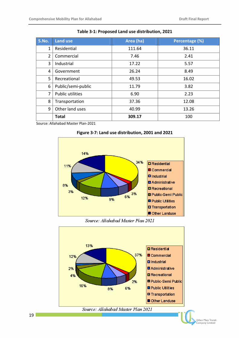
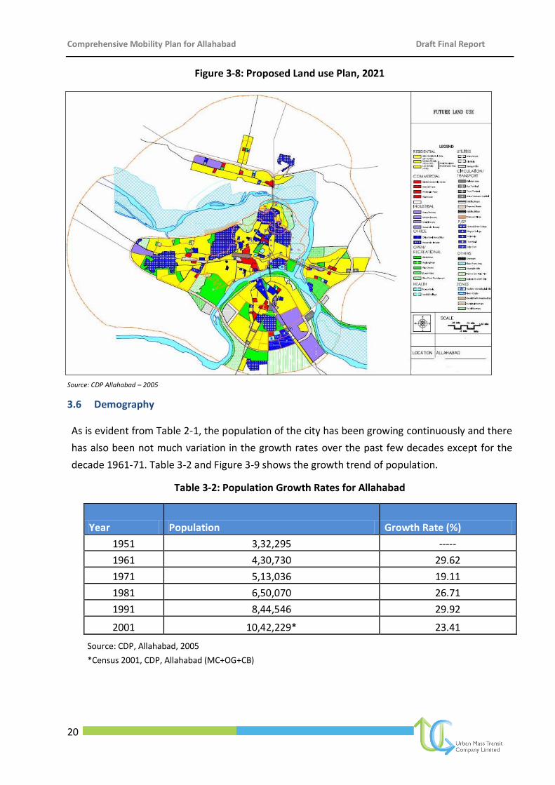
3.5 Land Use
As per the Allahabad Master Plan 2001, a total of 216.89 sq.km land was proposed to be
developed, whereas as per the land use survey conducted in 2002, only about 43.42% of that
i.e 94.18 sq.km were developed. The proposed future growth for Allahabad is clearly outlined
by the Allahabad Master Plan 2021. Refer Figure 3-9. . The current master plan covers about
309.17 sq.km of land under different categories of land use of which the residential land use
covers 36%, commercial 2.41%, industrial 5.57%, recreational 16.02%, public/semi-public
3.82%, public utilities include 2.23% while transportation is allocated 12.09% of land.
However, a significant 13.26% is put to other uses such as horticulture, forestry, dairy farms
etc. The proposed land use distribution is given below in Figure 3-7. Figure 3-7 also shows
land use distribution in 2001 master plan and 2021. Figure 3-8 shows the proposed land use
distribution plan for 2021. Table 3-1 lists out the distribution of the master plan area under
different lands use categories.
Comprehensive Mobility Plan for Allahabad Draft Final Report
19
Table 3-1: Proposed Land use distribution, 2021
S.No. Land use Area (ha) Percentage (%)
1 Residential 111.64 36.11
2 Commercial 7.46 2.41
3 Industrial 17.22 5.57
4 Government 26.24 8.49
5 Recreational 49.53 16.02
6 Public/semi-public 11.79 3.82
7 Public utilities 6.90 2.23
8 Transportation 37.36 12.08
9 Other land uses 40.99 13.26
Total 309.17 100
Source: Allahabad Master Plan-2021
Figure 3-7: Land use distribution, 2001 and 2021
Comprehensive Mobility Plan for Allahabad Draft Final Report
20
Figure 3-8: Proposed Land use Plan, 2021
Source: CDP Allahabad – 2005
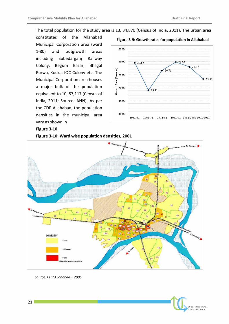
3.6 Demography
As is evident from Table 2-1, the population of the city has been growing continuously and there
has also been not much variation in the growth rates over the past few decades except for the
decade 1961-71. Table 3-2 and Figure 3-9 shows the growth trend of population.
Table 3-2: Population Growth Rates for Allahabad
Year Population Growth Rate (%)
1951 3,32,295 -----
1961 4,30,730 29.62
1971 5,13,036 19.11
1981 6,50,070 26.71
1991 8,44,546 29.92
2001 10,42,229* 23.41
Source: CDP, Allahabad, 2005
*Census 2001, CDP, Allahabad (MC+OG+CB)
Comprehensive Mobility Plan for Allahabad Draft Final Report
21
The total population for the study area is 13, 34,870 (Census of India, 2011). The urban area
constitutes of the Allahabad
Municipal Corporation area (ward
1-80) and outgrowth areas
including Subedarganj Railway
Colony, Begum Bazar, Bhagal
Purwa, Kodra, IOC Colony etc. The
Municipal Corporation area houses
a major bulk of the population
equivalent to 10, 87,117 (Census of
India, 2011; Source: ANN). As per
the CDP-Allahabad, the population
densities in the municipal area
vary as shown in
Figure 3-10.
Figure 3-10: Ward wise population densities, 2001
Source: CDP Allahabad – 2005
Figure 3-9: Growth rates for population in Allahabad
Comprehensive Mobility Plan for Allahabad Draft Final Report
22
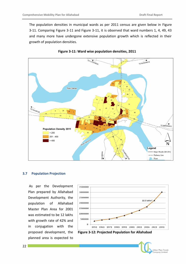
The population densities in municipal wards as per 2011 census are given below in Figure
3-11. Comparing Figure 3-11 and Figure 3-11, it is observed that ward numbers 1, 4, 49, 43
and many more have undergone extensive population growth which is reflected in their
growth of population densities.
Figure 3-11: Ward wise population densities, 2011
3.7 Population Projection
As per the Development
Plan prepared by Allahabad
Development Authority, the
population of Allahabad
Master Plan Area for 2001
was estimated to be 12 lakhs
with growth rate of 42% and
in conjugation with the
proposed development, the
planned area is expected to
Figure 3-12: Projected Population for Allahabad
Comprehensive Mobility Plan for Allahabad Draft Final Report
23
accommodate a population of 22,60,000 by 2021. Keeping the Master Plan projections intact,
and considering the high rate of growth in the area, the CMP for Allahabad has also projected
the population of Allahabad for the horizon year i.e for 2031 as 30 lakhs. The projected
population is shown in
Comprehensive Mobility Plan for Allahabad Draft Final Report
24
4 Existing Transportation Scenario
4.1 Introduction
Assessment of traffic characteristics within an urban area is an essential pre-requisite to
appreciate the problems with respect to traffic movement and to understand the need for
organizing the same in an efficient and economical manner. Traffic characteristics help in
appreciating the spatial and temporal features of travel within the area, relationship of traffic
intensity with network capacity and the prevailing level of service obtained on various
corridors of the network in the study area. This appreciation and understanding is essential
for identifying the present conditions and constraints for formulating suitable policies and
strategies, selecting relevant systems, and designing individual components of the system.
Apart from collection, compilation and analysis of secondary data, in order to appreciate an
in-depth and comprehensive traffic and transport system and to understand mobility pattern
of Allahabad, a number of primary surveys (details in Annexure) were conducted within the
study area such as classified traffic volume count at outer cordons and junctions, origin
destination survey at outer cordon, household survey, parking survey, pedestrian survey,
speed & delay survey etc. Based on secondary data and primary data, the analysis and
inferences of existing transportation scenario of Allahabad are depicted herein.
4.2 Secondary data
Secondary data collected from the Allahabad Nagar Nigam, Allahabad Development Authority
and various other departments and officials was reviewed to under the transportation
scenario in Allahabad. However, majority of the secondary data available was found to be
outdated and hence, post review and analysis, primary surveys as discussed earlier were
conducted.
4.3 Primary data analysis
The secondary data collected from various departments helped in understanding the basic
structure and working of the city. However, majority of the secondary data and information is
old and required updation. In order to update the same, primary surveys as detailed in
annexure were conducted. The Existing Transportation Scenario for Allahabad based on
analysis of primary and secondary data is given below.
4.3.1 Road network characteristics
The appreciation of road network characteristics is important to assess existing capacity
level of the roads, existing level of service, identify the constraints, if any, and assess the
Comprehensive Mobility Plan for Allahabad Draft Final Report
25
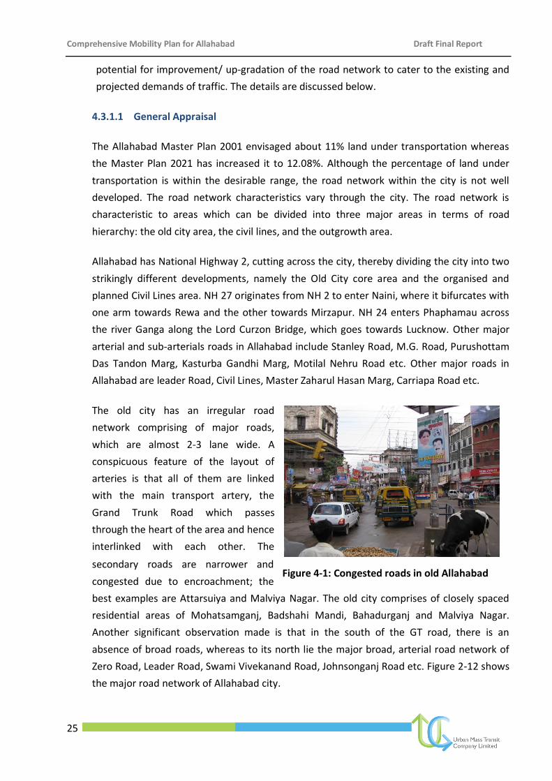
Figure 4-1: Congested roads in old Allahabad
potential for improvement/ up-gradation of the road network to cater to the existing and
projected demands of traffic. The details are discussed below.
4.3.1.1 General Appraisal
The Allahabad Master Plan 2001 envisaged about 11% land under transportation whereas
the Master Plan 2021 has increased it to 12.08%. Although the percentage of land under
transportation is within the desirable range, the road network within the city is not well
developed. The road network characteristics vary through the city. The road network is
characteristic to areas which can be divided into three major areas in terms of road
hierarchy: the old city area, the civil lines, and the outgrowth area.
Allahabad has National Highway 2, cutting across the city, thereby dividing the city into two
strikingly different developments, namely the Old City core area and the organised and
planned Civil Lines area. NH 27 originates from NH 2 to enter Naini, where it bifurcates with
one arm towards Rewa and the other towards Mirzapur. NH 24 enters Phaphamau across
the river Ganga along the Lord Curzon Bridge, which goes towards Lucknow. Other major
arterial and sub-arterials roads in Allahabad include Stanley Road, M.G. Road, Purushottam
Das Tandon Marg, Kasturba Gandhi Marg, Motilal Nehru Road etc. Other major roads in
Allahabad are leader Road, Civil Lines, Master Zaharul Hasan Marg, Carriapa Road etc.
The old city has an irregular road
network comprising of major roads,
which are almost 2-3 lane wide. A
conspicuous feature of the layout of
arteries is that all of them are linked
with the main transport artery, the
Grand Trunk Road which passes
through the heart of the area and hence
interlinked with each other. The
secondary roads are narrower and
congested due to encroachment; the
best examples are Attarsuiya and Malviya Nagar. The old city comprises of closely spaced
residential areas of Mohatsamganj, Badshahi Mandi, Bahadurganj and Malviya Nagar.
Another significant observation made is that in the south of the GT road, there is an
absence of broad roads, whereas to its north lie the major broad, arterial road network of
Zero Road, Leader Road, Swami Vivekanand Road, Johnsonganj Road etc. Figure 2-12 shows
the major road network of Allahabad city.
Comprehensive Mobility Plan for Allahabad Draft Final Report
26
The Civil Lines area is a well planned in the form of gridiron pattern interspersed with open-
park like spaces. The major roads have a 4-lane divided carriageway with wide footpaths on
either side. The collector roads are 2 to 3 lanes wide and intersect the major roads at traffic
rotary. The area is divided from the old city by Allahabad railway station.
The rest of the city comprises of Mumfordganj and Phaphamau in the north, Allapur in the
east and Naini in the south. The road network in these areas varies from 2 lanes to a single
lane. The population density in some of the areas is too high; this coupled with unplanned
development results in complicated traffic problems.
4.3.1.2 Length of Right-of-Way (RoW)
The existing right-of-ways for road network in Allahabad vary upto 30m. Although the
Master Plan for Allahabad lists the existing right-of-ways as given in table 4-1, the effective
right-of-ways as of now are much low.
Table 4-1: Right-of-way for major roads
S.No. Road Name Right of Way
1 Nawab Yusuf Road 24-30
2 Mahatma Gandhi Marg 41-60
3 Lal Bahadur Shastri Marg 22-32
4 Maharishi Dayanand Marg 41-62
5 Sarojini Naidu Marg 30-40
6 Sardar Patel Marg 23-35
7 Kasturba Gandhi Marg 23-30
8 Stanley Road 30-42
9 Kamla Nehru Marg 21-29
10 Master Zaharul Hasan Marg 17-34
11 Laouder Road 20-25
12 Jawahar Lal Nehru Road 35-40
13 Motilal Nehru Marg 21-37
14 Phaphamau Marg 24-40
15 Chintamani Ghosh Marg 12-21
16 Bank Road 16-18
17 Mission Road 10-14
18 GT Road 20-31
19 Leader Road 20-28
20 Khusrobagh Marg 24-30
21 Dr. Katju Road 22-40
22 Nurullah Marg 15-42
23 Netaji Subhash Marg 15-21
24 Swami Vivekanand Marg 16-20
Comprehensive Mobility Plan for Allahabad Draft Final Report
27
S.No. Road Name Right of Way
25 Zero Road 17-18
26 Tilak Marg 10-20
27 Sahitya Sammelan Marg 16-17
28 Triveni Road 10-12
29 Rambagh Station Marg 17-21
30 Yamuna Bank Road 15-18
31 Shaukat Ali Marg 16-18
32 Suleman Marg 10-14
33 Mutthiganj Marg 14-17
Source: Allahabad Master Plan – 2021
The primary survey for the road network covered almost 200km of the road length in the study
area. About 9% of the road network has right of way less
than 10m, 87% has right of way between 11-20m while only
4% roads have right f way more than 20m as indicated in
Figure 4-2. The road network for Allahabad city is shown in
Figure 4-3.
.
Figure 4-2: Distribution of Road by Right of Way
Figure 4-3: Distribution of RoW Type
Figure 4-4: Distribution by street light presence
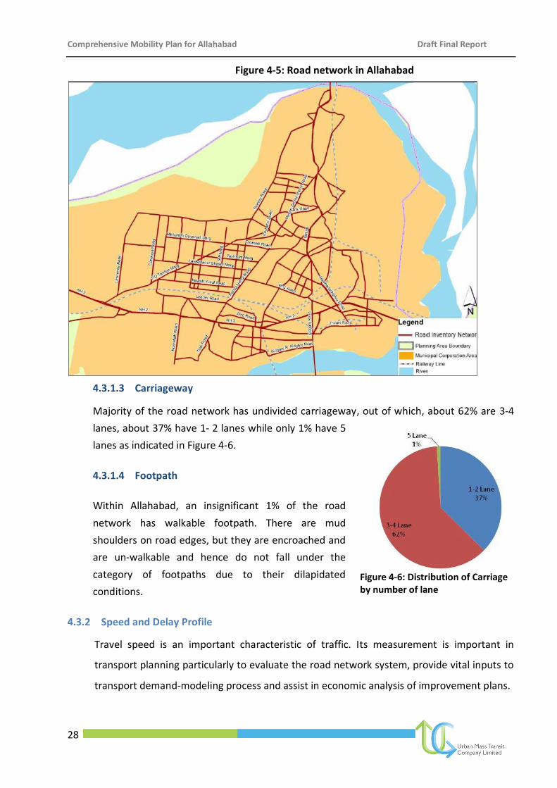
Comprehensive Mobility Plan for Allahabad Draft Final Report
28
Figure 4-5: Road network in Allahabad
4.3.1.3 Carriageway
Majority of the road network has undivided carriageway, out of which, about 62% are 3-4
lanes, about 37% have 1- 2 lanes while only 1% have 5
lanes as indicated in Figure 4-6.
4.3.1.4 Footpath
Within Allahabad, an insignificant 1% of the road
network has walkable footpath. There are mud
shoulders on road edges, but they are encroached and
are un-walkable and hence do not fall under the
category of footpaths due to their dilapidated
conditions.
4.3.2 Speed and Delay Profile
Travel speed is an important characteristic of traffic. Its measurement is important in
transport planning particularly to evaluate the road network system, provide vital inputs to
transport demand-modeling process and assist in economic analysis of improvement plans.
Figure 4-6: Distribution of Carriage by number of lane
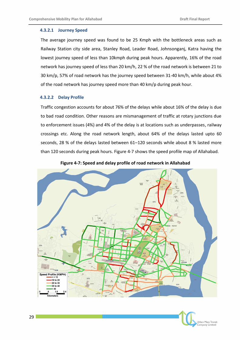
Comprehensive Mobility Plan for Allahabad Draft Final Report
29
4.3.2.1 Journey Speed
The average journey speed was found to be 25 Kmph with the bottleneck areas such as
Railway Station city side area, Stanley Road, Leader Road, Johnsonganj, Katra having the
lowest journey speed of less than 10kmph during peak hours. Apparently, 16% of the road
network has journey speed of less than 20 km/h, 22 % of the road network is between 21 to
30 km/p, 57% of road network has the journey speed between 31-40 km/h, while about 4%
of the road network has journey speed more than 40 km/p during peak hour.
4.3.2.2 Delay Profile
Traffic congestion accounts for about 76% of the delays while about 16% of the delay is due
to bad road condition. Other reasons are mismanagement of traffic at rotary junctions due
to enforcement issues (4%) and 4% of the delay is at locations such as underpasses, railway
crossings etc. Along the road network length, about 64% of the delays lasted upto 60
seconds, 28 % of the delays lasted between 61–120 seconds while about 8 % lasted more
than 120 seconds during peak hours. Figure 4-7 shows the speed profile map of Allahabad.
Figure 4-7: Speed and delay profile of road network in Allahabad
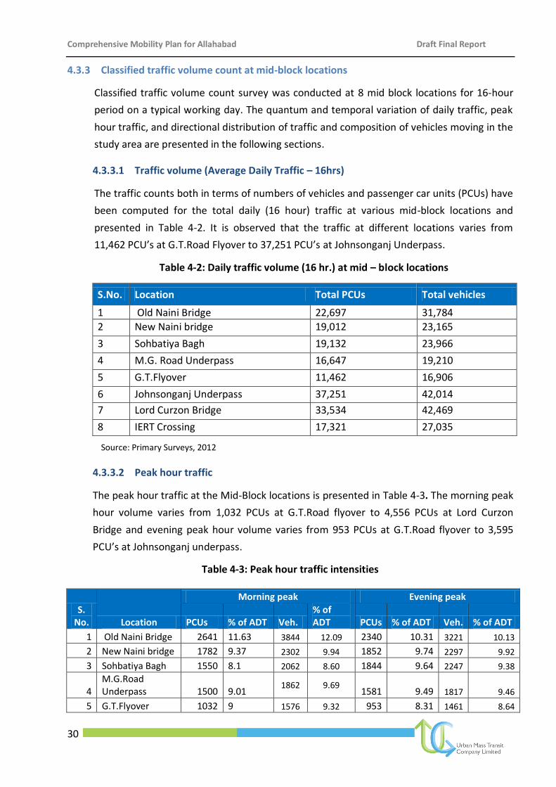
Comprehensive Mobility Plan for Allahabad Draft Final Report
30
4.3.3 Classified traffic volume count at mid-block locations
Classified traffic volume count survey was conducted at 8 mid block locations for 16-hour
period on a typical working day. The quantum and temporal variation of daily traffic, peak
hour traffic, and directional distribution of traffic and composition of vehicles moving in the
study area are presented in the following sections.
4.3.3.1 Traffic volume (Average Daily Traffic – 16hrs)
The traffic counts both in terms of numbers of vehicles and passenger car units (PCUs) have
been computed for the total daily (16 hour) traffic at various mid-block locations and
presented in Table 4-2. It is observed that the traffic at different locations varies from
11,462 PCU’s at G.T.Road Flyover to 37,251 PCU’s at Johnsonganj Underpass.
Table 4-2: Daily traffic volume (16 hr.) at mid – block locations
S.No. Location Total PCUs Total vehicles
1 Old Naini Bridge 22,697 31,784
2 New Naini bridge 19,012 23,165
3 Sohbatiya Bagh 19,132 23,966
4 M.G. Road Underpass 16,647 19,210
5 G.T.Flyover 11,462 16,906
6 Johnsonganj Underpass 37,251 42,014
7 Lord Curzon Bridge 33,534 42,469
8 IERT Crossing 17,321 27,035
Source: Primary Surveys, 2012
4.3.3.2 Peak hour traffic
The peak hour traffic at the Mid-Block locations is presented in Table 4-3. The morning peak
hour volume varies from 1,032 PCUs at G.T.Road flyover to 4,556 PCUs at Lord Curzon
Bridge and evening peak hour volume varies from 953 PCUs at G.T.Road flyover to 3,595
PCU’s at Johnsonganj underpass.
Table 4-3: Peak hour traffic intensities
S. No. Location
Morning peak Evening peak
PCUs % of ADT Veh. % of ADT PCUs % of ADT Veh. % of ADT
1 Old Naini Bridge 2641 11.63 3844 12.09 2340 10.31 3221 10.13
2 New Naini bridge 1782 9.37 2302 9.94 1852 9.74 2297 9.92
3 Sohbatiya Bagh 1550 8.1 2062 8.60 1844 9.64 2247 9.38
4 M.G.Road Underpass 1500 9.01
1862 9.69 1581 9.49 1817 9.46
5 G.T.Flyover 1032 9 1576 9.32 953 8.31 1461 8.64
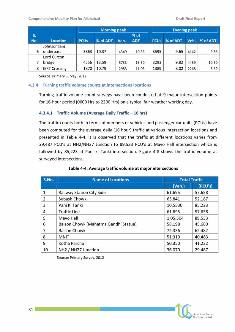
Comprehensive Mobility Plan for Allahabad Draft Final Report
31
S. No. Location
Morning peak Evening peak
PCUs % of ADT Veh. % of ADT PCUs % of ADT Veh. % of ADT
6 Johnsonganj underpass 3863 10.37 4349 10.35 3595 9.65 4142 9.86
7 Lord Curzon bridge 4556 13.59 5733 13.50 3293 9.82 4459 10.50
8 IERT Crossing 1870 10.79 2983 11.03 1389 8.02 2268 8.39
Source: Primary Survey, 2012
4.3.4 Turning traffic volume counts at intersections locations
Turning traffic volume count surveys have been conducted at 9 major intersection points
for 16-hour period (0600 Hrs to 2200 Hrs) on a typical fair weather working day.
4.3.4.1 Traffic Volume (Average Daily Traffic – 16 hrs)
The traffic counts both in terms of numbers of vehicles and passenger car units (PCUs) have
been computed for the average daily (16 hour) traffic at various intersection locations and
presented in Table 4-4. It is observed that the traffic at different locations varies from
29,487 PCU’s at NH2/NH27 Junction to 89,533 PCU’s at Mayo Hall intersection which is
followed by 85,223 at Pani ki Tanki intersection. Figure 4-8 shows the traffic volume at
surveyed intersections.
Table 4-4: Average traffic volume at major intersections
S.No. Name of Locations Total Traffic
(Veh.) (PCU's)
1 Railway Station City Side 61,695 57,658
2 Subash Chowk 65,841 52,187
3 Pani Ki Tanki 10,5530 85,223
4 Traffic Line 61,695 57,658
5 Mayo Hall 1,05,504 89,533
6 Balson Chowk (Mahatma Gandhi Statue) 58,198 45,680
7 Balson Chowk 72,336 62,482
8 MNIT 51,319 40,483
9 Kotha Parcha 50,350 41,232
10 NH2 / NH27 Junction 36,070 29,487
Source: Primary Survey, 2012
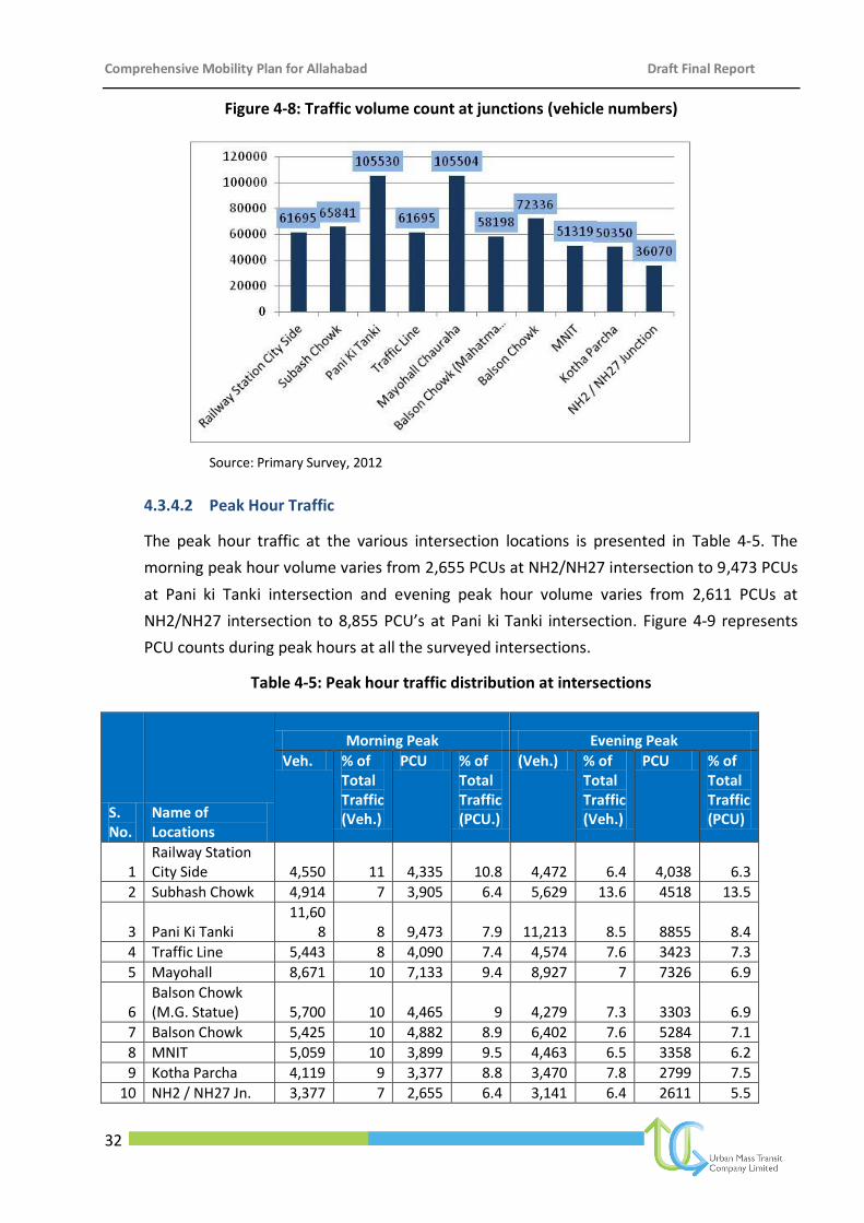
Comprehensive Mobility Plan for Allahabad Draft Final Report
32
Figure 4-8: Traffic volume count at junctions (vehicle numbers)
Source: Primary Survey, 2012
4.3.4.2 Peak Hour Traffic
The peak hour traffic at the various intersection locations is presented in Table 4-5. The
morning peak hour volume varies from 2,655 PCUs at NH2/NH27 intersection to 9,473 PCUs
at Pani ki Tanki intersection and evening peak hour volume varies from 2,611 PCUs at
NH2/NH27 intersection to 8,855 PCU’s at Pani ki Tanki intersection. Figure 4-9 represents
PCU counts during peak hours at all the surveyed intersections.
Table 4-5: Peak hour traffic distribution at intersections
S. No.
Name of Locations
Morning Peak Evening Peak
Veh. % of Total Traffic (Veh.)
PCU % of Total Traffic (PCU.)
(Veh.) % of Total Traffic (Veh.)
PCU % of Total Traffic (PCU)
1 Railway Station City Side 4,550 11 4,335 10.8 4,472 6.4 4,038 6.3
2 Subhash Chowk 4,914 7 3,905 6.4 5,629 13.6 4518 13.5
3 Pani Ki Tanki 11,60
8 8 9,473 7.9 11,213 8.5 8855 8.4
4 Traffic Line 5,443 8 4,090 7.4 4,574 7.6 3423 7.3
5 Mayohall 8,671 10 7,133 9.4 8,927 7 7326 6.9
6 Balson Chowk (M.G. Statue) 5,700 10 4,465 9 4,279 7.3 3303 6.9
7 Balson Chowk 5,425 10 4,882 8.9 6,402 7.6 5284 7.1
8 MNIT 5,059 10 3,899 9.5 4,463 6.5 3358 6.2
9 Kotha Parcha 4,119 9 3,377 8.8 3,470 7.8 2799 7.5
10 NH2 / NH27 Jn. 3,377 7 2,655 6.4 3,141 6.4 2611 5.5
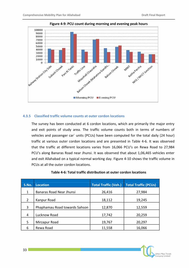
Comprehensive Mobility Plan for Allahabad Draft Final Report
33
Figure 4-9: PCU count during morning and evening peak hours
4.3.5 Classified traffic volume counts at outer cordon locations
The survey has been conducted at 6 cordon locations, which are primarily the major entry
and exit points of study area. The traffic volume counts both in terms of numbers of
vehicles and passenger car` units (PCUs) have been computed for the total daily (24 hour)
traffic at various outer cordon locations and are presented in Table 4-6. It was observed
that the traffic at different locations varies from 16,066 PCU’s on Rewa Road to 27,984
PCU’s along Banaras Road near Jhunsi. It was observed that about 1,06,465 vehicles enter
and exit Allahabad on a typical normal working day. Figure 4-10 shows the traffic volume in
PCUs at all the outer cordon locations.
Table 4-6: Total traffic distribution at outer cordon locations
S.No. Location Total Traffic (Veh.) Total Traffic (PCUs)
1 Banaras Road Near Jhunsi 26,416 27,984
2 Kanpur Road 18,112 19,245
3 Phaphamau Road towards Sahson 12,870 12,559
4 Lucknow Road 17,742 20,259
5 Mirzapur Road 19,767 20,297
6 Rewa Road 11,558 16,066
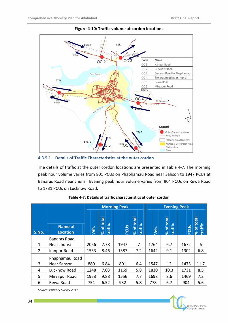
Comprehensive Mobility Plan for Allahabad Draft Final Report
34
Figure 4-10: Traffic volume at cordon locations
4.3.5.1 Details of Traffic Characteristics at the outer cordon
The details of traffic at the outer cordon locations are presented in Table 4-7. The morning
peak hour volume varies from 801 PCUs on Phaphamau Road near Sahson to 1947 PCUs at
Banaras Road near Jhunsi. Evening peak hour volume varies from 904 PCUs on Rewa Road
to 1731 PCUs on Lucknow Road.
Table 4-7: Details of traffic characteristics at outer cordon
S.No. Name of Location
Morning Peak Evening Peak
Veh
.
% o
f to
tal
traf
fic
PC
Us
% o
f to
tal
traf
fic
Veh
.
% o
f to
tal
traf
fic
PC
Us
% o
f to
tal
traf
fic
1 Banaras Road Near Jhunsi 2056 7.78 1947 7 1764 6.7 1672 6
2 Kanpur Road 1533 8.46 1387 7.2 1642 9.1 1302 6.8
3 Phaphamau Road Near Sahson 880 6.84 801 6.4 1547 12 1473 11.7
4 Lucknow Road 1248 7.03 1169 5.8 1830 10.3 1731 8.5
5 Mirzapur Road 1953 9.88 1556 7.7 1698 8.6 1469 7.2
6 Rewa Road 754 6.52 932 5.8 778 6.7 904 5.6
Source: Primary Survey 2011
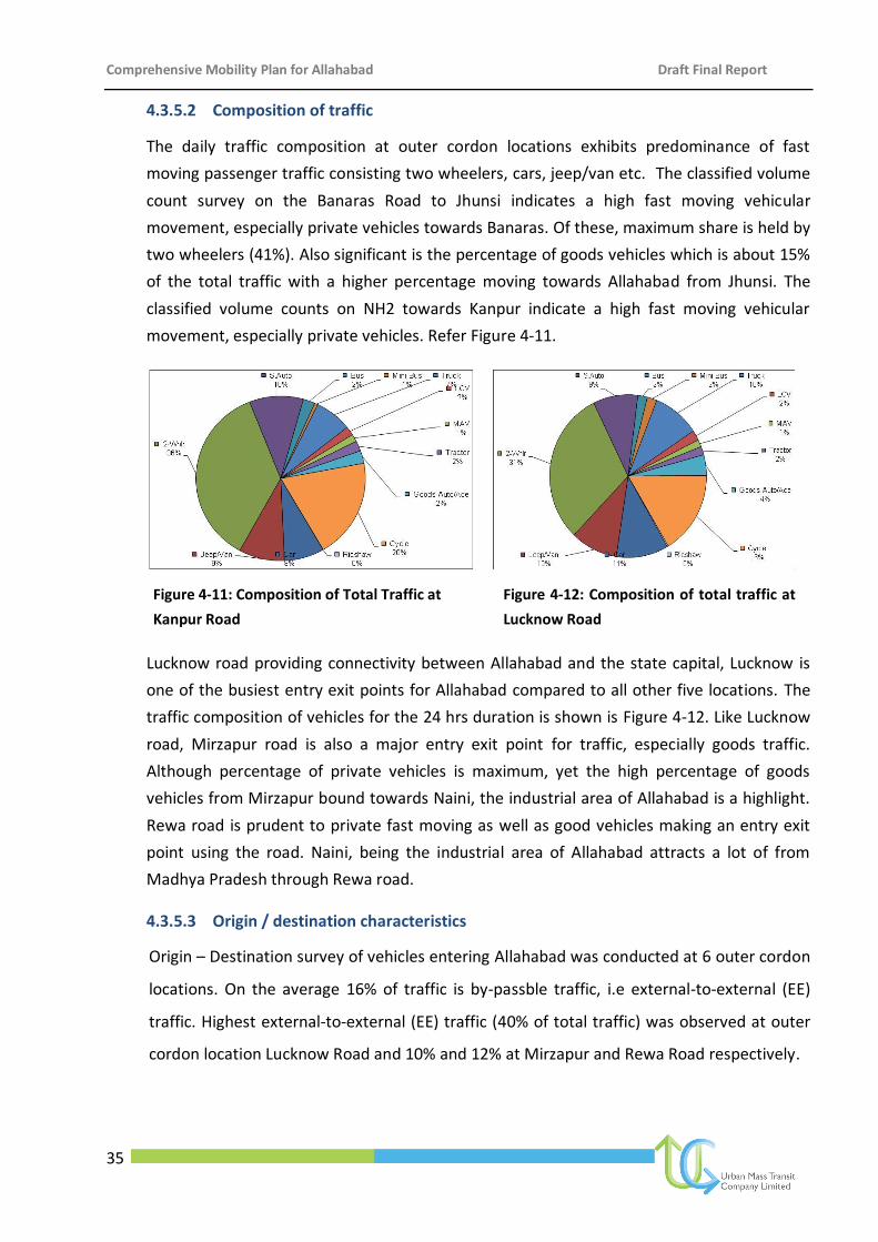
Comprehensive Mobility Plan for Allahabad Draft Final Report
35
4.3.5.2 Composition of traffic
The daily traffic composition at outer cordon locations exhibits predominance of fast
moving passenger traffic consisting two wheelers, cars, jeep/van etc. The classified volume
count survey on the Banaras Road to Jhunsi indicates a high fast moving vehicular
movement, especially private vehicles towards Banaras. Of these, maximum share is held by
two wheelers (41%). Also significant is the percentage of goods vehicles which is about 15%
of the total traffic with a higher percentage moving towards Allahabad from Jhunsi. The
classified volume counts on NH2 towards Kanpur indicate a high fast moving vehicular
movement, especially private vehicles. Refer Figure 4-11.
Figure 4-11: Composition of Total Traffic at
Kanpur Road
Figure 4-12: Composition of total traffic at
Lucknow Road
Lucknow road providing connectivity between Allahabad and the state capital, Lucknow is
one of the busiest entry exit points for Allahabad compared to all other five locations. The
traffic composition of vehicles for the 24 hrs duration is shown is Figure 4-12. Like Lucknow
road, Mirzapur road is also a major entry exit point for traffic, especially goods traffic.
Although percentage of private vehicles is maximum, yet the high percentage of goods
vehicles from Mirzapur bound towards Naini, the industrial area of Allahabad is a highlight.
Rewa road is prudent to private fast moving as well as good vehicles making an entry exit
point using the road. Naini, being the industrial area of Allahabad attracts a lot of from
Madhya Pradesh through Rewa road.
4.3.5.3 Origin / destination characteristics
Origin – Destination survey of vehicles entering Allahabad was conducted at 6 outer cordon
locations. On the average 16% of traffic is by-passble traffic, i.e external-to-external (EE)
traffic. Highest external-to-external (EE) traffic (40% of total traffic) was observed at outer
cordon location Lucknow Road and 10% and 12% at Mirzapur and Rewa Road respectively.
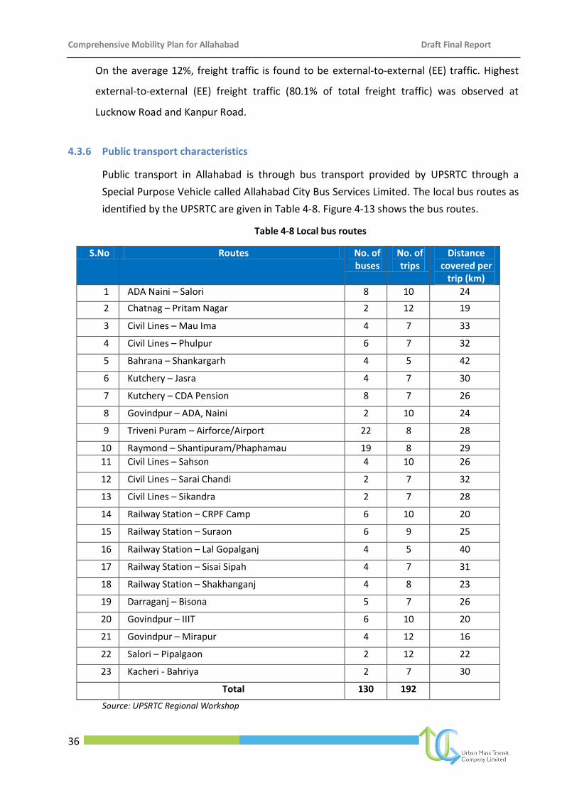
Comprehensive Mobility Plan for Allahabad Draft Final Report
36
On the average 12%, freight traffic is found to be external-to-external (EE) traffic. Highest
external-to-external (EE) freight traffic (80.1% of total freight traffic) was observed at
Lucknow Road and Kanpur Road.
4.3.6 Public transport characteristics
Public transport in Allahabad is through bus transport provided by UPSRTC through a
Special Purpose Vehicle called Allahabad City Bus Services Limited. The local bus routes as
identified by the UPSRTC are given in Table 4-8. Figure 4-13 shows the bus routes.
Table 4-8 Local bus routes
S.No Routes No. of buses
No. of trips
Distance covered per
trip (km)
1 ADA Naini – Salori 8 10 24
2 Chatnag – Pritam Nagar 2 12 19
3 Civil Lines – Mau Ima 4 7 33
4 Civil Lines – Phulpur 6 7 32
5 Bahrana – Shankargarh 4 5 42
6 Kutchery – Jasra 4 7 30
7 Kutchery – CDA Pension 8 7 26
8 Govindpur – ADA, Naini 2 10 24
9 Triveni Puram – Airforce/Airport 22 8 28
10 Raymond – Shantipuram/Phaphamau 19 8 29
11 Civil Lines – Sahson 4 10 26
12 Civil Lines – Sarai Chandi 2 7 32
13 Civil Lines – Sikandra 2 7 28
14 Railway Station – CRPF Camp 6 10 20
15 Railway Station – Suraon 6 9 25
16 Railway Station – Lal Gopalganj 4 5 40
17 Railway Station – Sisai Sipah 4 7 31
18 Railway Station – Shakhanganj 4 8 23
19 Darraganj – Bisona 5 7 26
20 Govindpur – IIIT 6 10 20
21 Govindpur – Mirapur 4 12 16
22 Salori – Pipalgaon 2 12 22
23 Kacheri - Bahriya 2 7 30
Total 130 192
Source: UPSRTC Regional Workshop
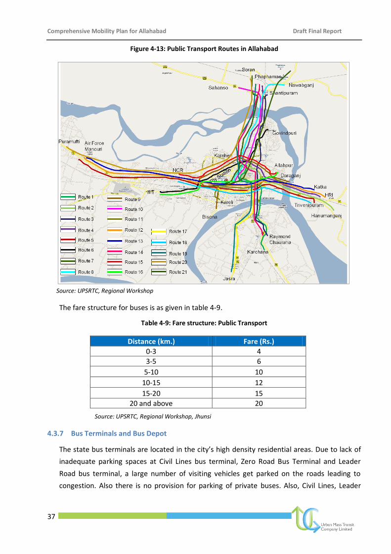
Comprehensive Mobility Plan for Allahabad Draft Final Report
37
Figure 4-13: Public Transport Routes in Allahabad
Source: UPSRTC, Regional Workshop
The fare structure for buses is as given in table 4-9.
Table 4-9: Fare structure: Public Transport
Distance (km.) Fare (Rs.)
0-3 4
3-5 6
5-10 10
10-15 12
15-20 15
20 and above 20
Source: UPSRTC, Regional Workshop, Jhunsi
4.3.7 Bus Terminals and Bus Depot
The state bus terminals are located in the city’s high density residential areas. Due to lack of
inadequate parking spaces at Civil Lines bus terminal, Zero Road Bus Terminal and Leader
Road bus terminal, a large number of visiting vehicles get parked on the roads leading to
congestion. Also there is no provision for parking of private buses. Also, Civil Lines, Leader
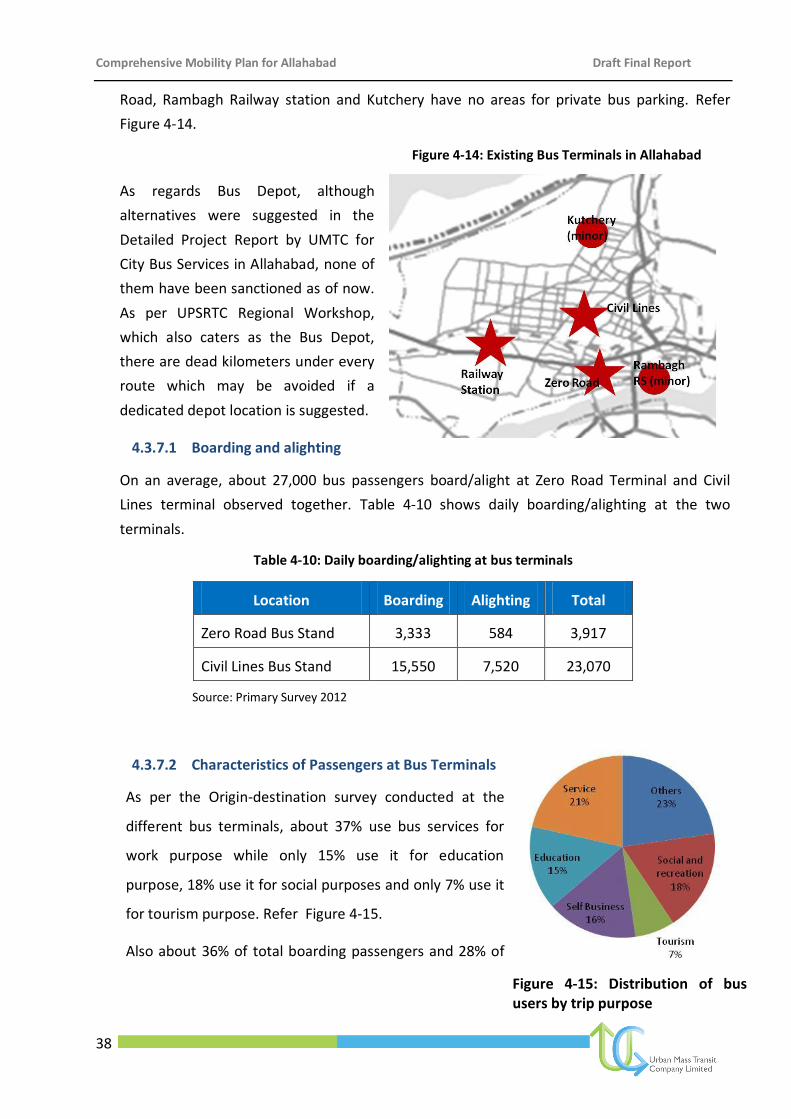
Comprehensive Mobility Plan for Allahabad Draft Final Report
38
Road, Rambagh Railway station and Kutchery have no areas for private bus parking. Refer
Figure 4-14.
Figure 4-14: Existing Bus Terminals in Allahabad
As regards Bus Depot, although
alternatives were suggested in the
Detailed Project Report by UMTC for
City Bus Services in Allahabad, none of
them have been sanctioned as of now.
As per UPSRTC Regional Workshop,
which also caters as the Bus Depot,
there are dead kilometers under every
route which may be avoided if a
dedicated depot location is suggested.
4.3.7.1 Boarding and alighting
On an average, about 27,000 bus passengers board/alight at Zero Road Terminal and Civil
Lines terminal observed together. Table 4-10 shows daily boarding/alighting at the two
terminals.
Table 4-10: Daily boarding/alighting at bus terminals
Location Boarding Alighting Total
Zero Road Bus Stand 3,333 584 3,917
Civil Lines Bus Stand 15,550 7,520 23,070
Source: Primary Survey 2012
4.3.7.2 Characteristics of Passengers at Bus Terminals
As per the Origin-destination survey conducted at the
different bus terminals, about 37% use bus services for
work purpose while only 15% use it for education
purpose, 18% use it for social purposes and only 7% use it
for tourism purpose. Refer Figure 4-15.
Also about 36% of total boarding passengers and 28% of
Figure 4-15: Distribution of bus users by trip purpose
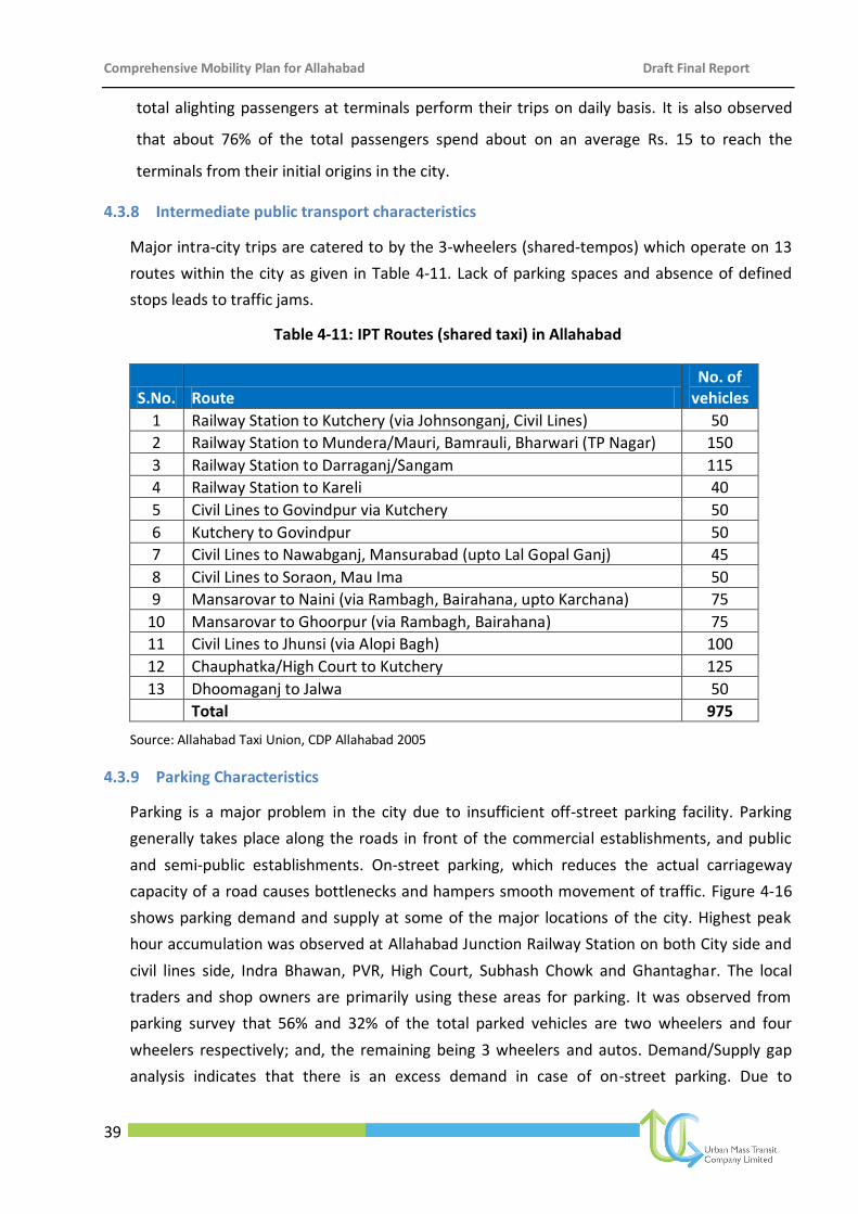
Comprehensive Mobility Plan for Allahabad Draft Final Report
39
total alighting passengers at terminals perform their trips on daily basis. It is also observed
that about 76% of the total passengers spend about on an average Rs. 15 to reach the
terminals from their initial origins in the city.
4.3.8 Intermediate public transport characteristics
Major intra-city trips are catered to by the 3-wheelers (shared-tempos) which operate on 13
routes within the city as given in Table 4-11. Lack of parking spaces and absence of defined
stops leads to traffic jams.
Table 4-11: IPT Routes (shared taxi) in Allahabad
S.No. Route No. of
vehicles
1 Railway Station to Kutchery (via Johnsonganj, Civil Lines) 50
2 Railway Station to Mundera/Mauri, Bamrauli, Bharwari (TP Nagar) 150
3 Railway Station to Darraganj/Sangam 115
4 Railway Station to Kareli 40
5 Civil Lines to Govindpur via Kutchery 50
6 Kutchery to Govindpur 50
7 Civil Lines to Nawabganj, Mansurabad (upto Lal Gopal Ganj) 45
8 Civil Lines to Soraon, Mau Ima 50
9 Mansarovar to Naini (via Rambagh, Bairahana, upto Karchana) 75
10 Mansarovar to Ghoorpur (via Rambagh, Bairahana) 75
11 Civil Lines to Jhunsi (via Alopi Bagh) 100
12 Chauphatka/High Court to Kutchery 125
13 Dhoomaganj to Jalwa 50
Total 975
Source: Allahabad Taxi Union, CDP Allahabad 2005
4.3.9 Parking Characteristics
Parking is a major problem in the city due to insufficient off-street parking facility. Parking
generally takes place along the roads in front of the commercial establishments, and public
and semi-public establishments. On-street parking, which reduces the actual carriageway
capacity of a road causes bottlenecks and hampers smooth movement of traffic. Figure 4-16
shows parking demand and supply at some of the major locations of the city. Highest peak
hour accumulation was observed at Allahabad Junction Railway Station on both City side and
civil lines side, Indra Bhawan, PVR, High Court, Subhash Chowk and Ghantaghar. The local
traders and shop owners are primarily using these areas for parking. It was observed from
parking survey that 56% and 32% of the total parked vehicles are two wheelers and four
wheelers respectively; and, the remaining being 3 wheelers and autos. Demand/Supply gap
analysis indicates that there is an excess demand in case of on-street parking. Due to
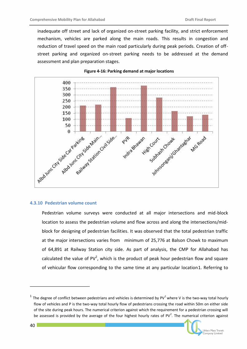
Comprehensive Mobility Plan for Allahabad Draft Final Report
40
inadequate off street and lack of organized on-street parking facility, and strict enforcement
mechanism, vehicles are parked along the main roads. This results in congestion and
reduction of travel speed on the main road particularly during peak periods. Creation of off-
street parking and organized on-street parking needs to be addressed at the demand
assessment and plan preparation stages.
Figure 4-16: Parking demand at major locations
4.3.10 Pedestrian volume count
Pedestrian volume surveys were conducted at all major intersections and mid-block
location to assess the pedestrian volume and flow across and along the intersections/mid-
block for designing of pedestrian facilities. It was observed that the total pedestrian traffic
at the major intersections varies from minimum of 25,776 at Balson Chowk to maximum
of 64,891 at Railway Station city side. As part of analysis, the CMP for Allahabad has
calculated the value of PV2, which is the product of peak hour pedestrian flow and square
of vehicular flow corresponding to the same time at any particular location1. Referring to
1 The degree of conflict between pedestrians and vehicles is determined by PV2 where V is the two-way total hourly
flow of vehicles and P is the two-way total hourly flow of pedestrians crossing the road within 50m on either side
of the site during peak hours. The numerical criterion against which the requirement for a pedestrian crossing will
be assessed is provided by the average of the four highest hourly rates of PV2. The numerical criterion against
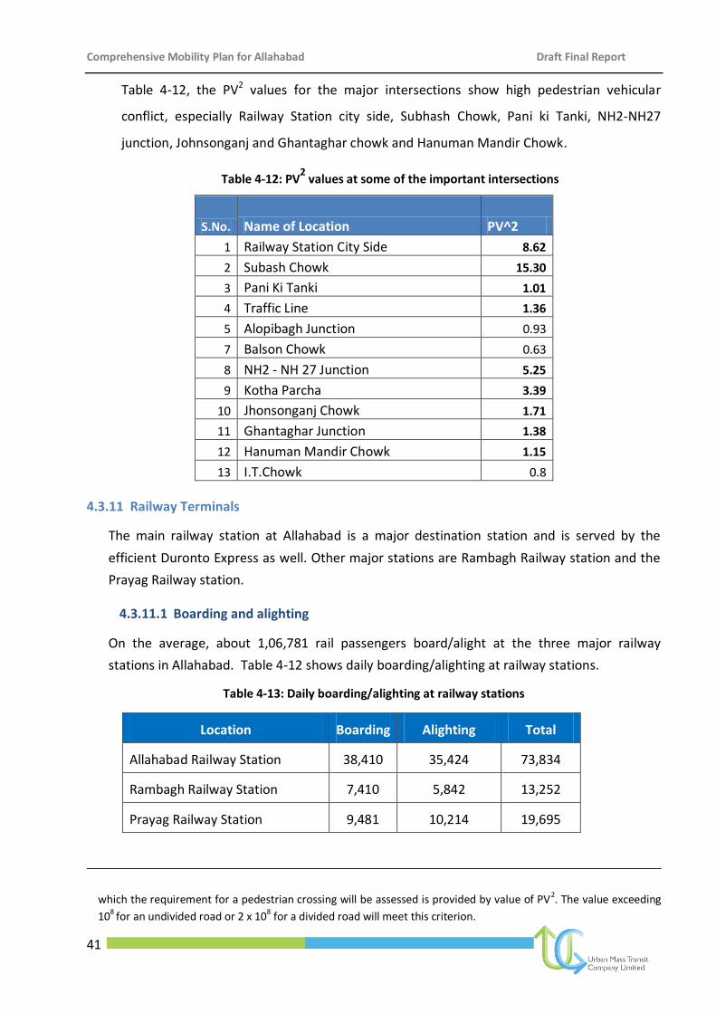
Comprehensive Mobility Plan for Allahabad Draft Final Report
41
Table 4-12, the PV2 values for the major intersections show high pedestrian vehicular
conflict, especially Railway Station city side, Subhash Chowk, Pani ki Tanki, NH2-NH27
junction, Johnsonganj and Ghantaghar chowk and Hanuman Mandir Chowk.
Table 4-12: PV2 values at some of the important intersections
S.No. Name of Location PV^2
1 Railway Station City Side 8.62
2 Subash Chowk 15.30
3 Pani Ki Tanki 1.01
4 Traffic Line 1.36
5 Alopibagh Junction 0.93
7 Balson Chowk 0.63
8 NH2 - NH 27 Junction 5.25
9 Kotha Parcha 3.39
10 Jhonsonganj Chowk 1.71
11 Ghantaghar Junction 1.38
12 Hanuman Mandir Chowk 1.15
13 I.T.Chowk 0.8
4.3.11 Railway Terminals
The main railway station at Allahabad is a major destination station and is served by the
efficient Duronto Express as well. Other major stations are Rambagh Railway station and the
Prayag Railway station.
4.3.11.1 Boarding and alighting
On the average, about 1,06,781 rail passengers board/alight at the three major railway
stations in Allahabad. Table 4-12 shows daily boarding/alighting at railway stations.
Table 4-13: Daily boarding/alighting at railway stations
Location Boarding Alighting Total
Allahabad Railway Station 38,410 35,424 73,834
Rambagh Railway Station 7,410 5,842 13,252
Prayag Railway Station 9,481 10,214 19,695
which the requirement for a pedestrian crossing will be assessed is provided by value of PV2. The value exceeding
108 for an undivided road or 2 x 10⁸ for a divided road will meet this criterion.
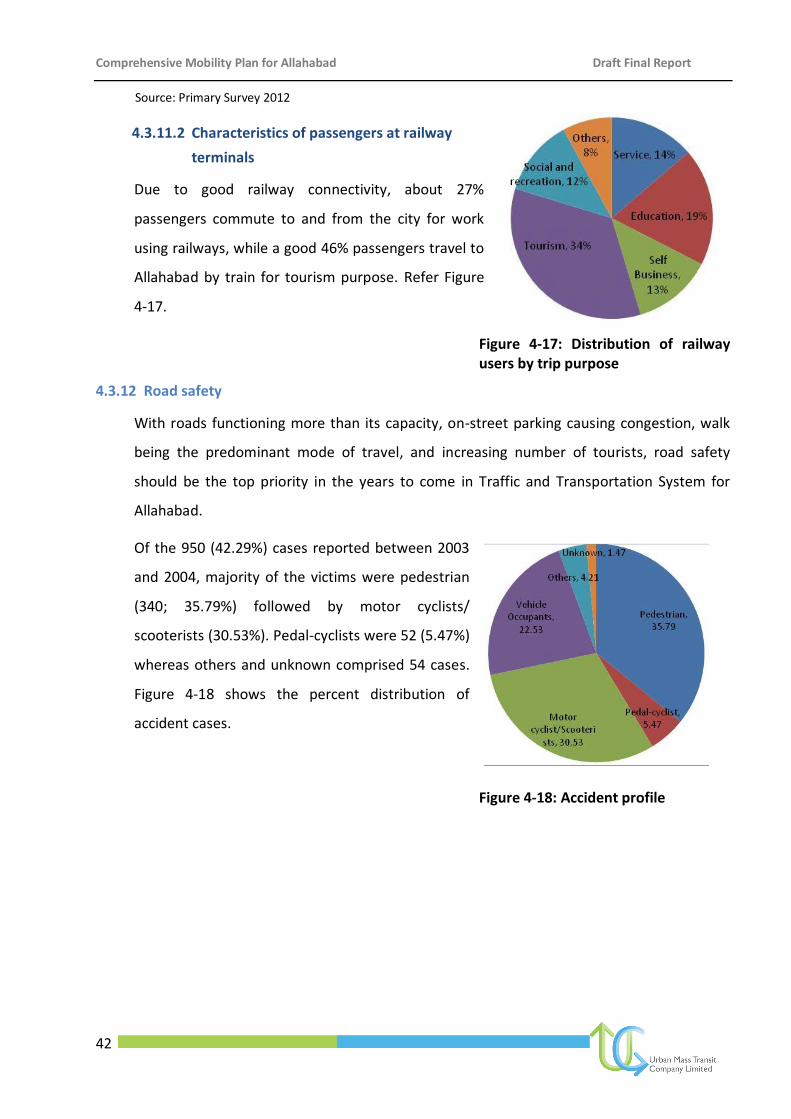
Comprehensive Mobility Plan for Allahabad Draft Final Report
42
Source: Primary Survey 2012
4.3.11.2 Characteristics of passengers at railway
terminals
Due to good railway connectivity, about 27%
passengers commute to and from the city for work
using railways, while a good 46% passengers travel to
Allahabad by train for tourism purpose. Refer Figure
4-17.
Figure 4-17: Distribution of railway users by trip purpose
4.3.12 Road safety
With roads functioning more than its capacity, on-street parking causing congestion, walk
being the predominant mode of travel, and increasing number of tourists, road safety
should be the top priority in the years to come in Traffic and Transportation System for
Allahabad.
Of the 950 (42.29%) cases reported between 2003
and 2004, majority of the victims were pedestrian
(340; 35.79%) followed by motor cyclists/
scooterists (30.53%). Pedal-cyclists were 52 (5.47%)
whereas others and unknown comprised 54 cases.
Figure 4-18 shows the percent distribution of
accident cases.
Figure 4-18: Accident profile
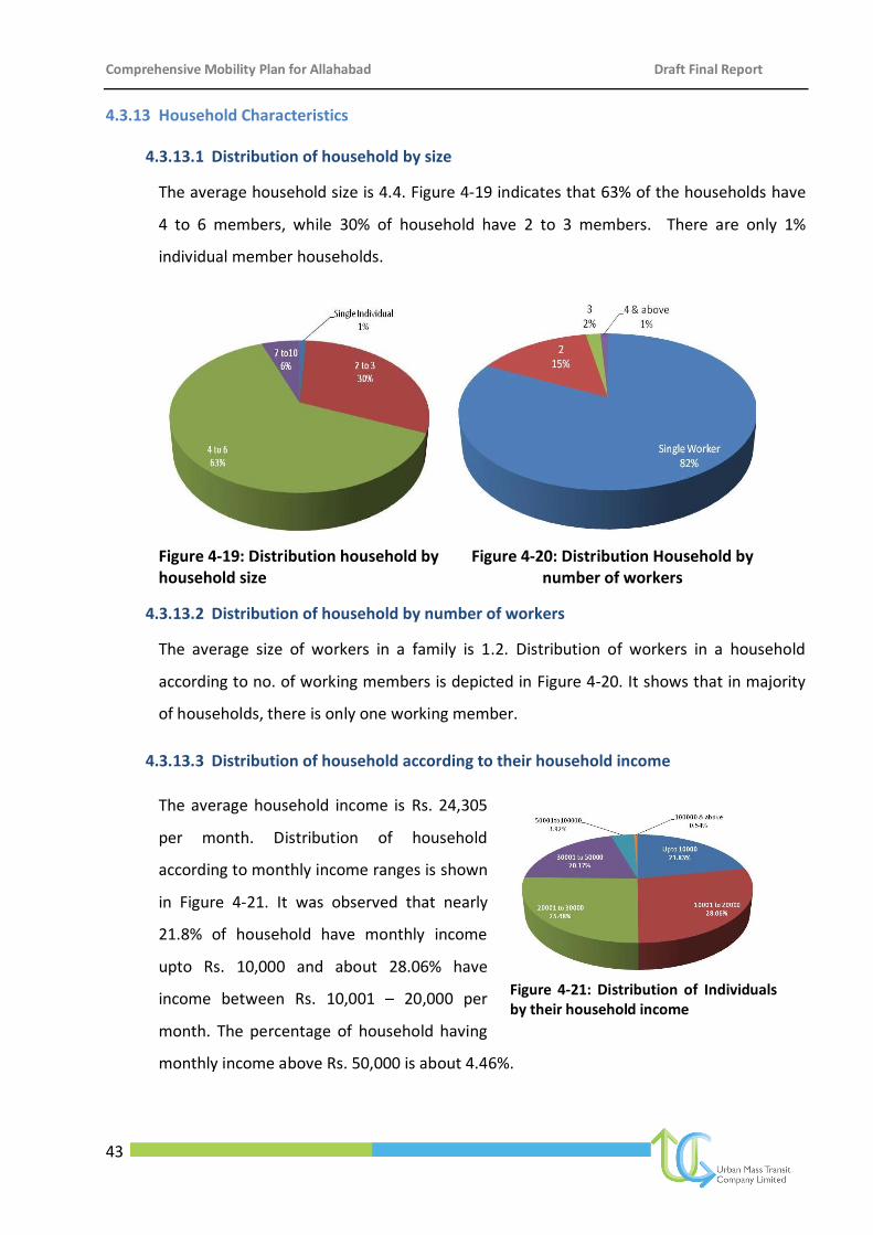
Comprehensive Mobility Plan for Allahabad Draft Final Report
43
4.3.13 Household Characteristics
4.3.13.1 Distribution of household by size
The average household size is 4.4. Figure 4-19 indicates that 63% of the households have
4 to 6 members, while 30% of household have 2 to 3 members. There are only 1%
individual member households.
Figure 4-19: Distribution household by household size
Figure 4-20: Distribution Household by number of workers
4.3.13.2 Distribution of household by number of workers
The average size of workers in a family is 1.2. Distribution of workers in a household
according to no. of working members is depicted in Figure 4-20. It shows that in majority
of households, there is only one working member.
4.3.13.3 Distribution of household according to their household income
The average household income is Rs. 24,305
per month. Distribution of household
according to monthly income ranges is shown
in Figure 4-21. It was observed that nearly
21.8% of household have monthly income
upto Rs. 10,000 and about 28.06% have
income between Rs. 10,001 – 20,000 per
month. The percentage of household having
monthly income above Rs. 50,000 is about 4.46%.
Figure 4-21: Distribution of Individuals by their household income
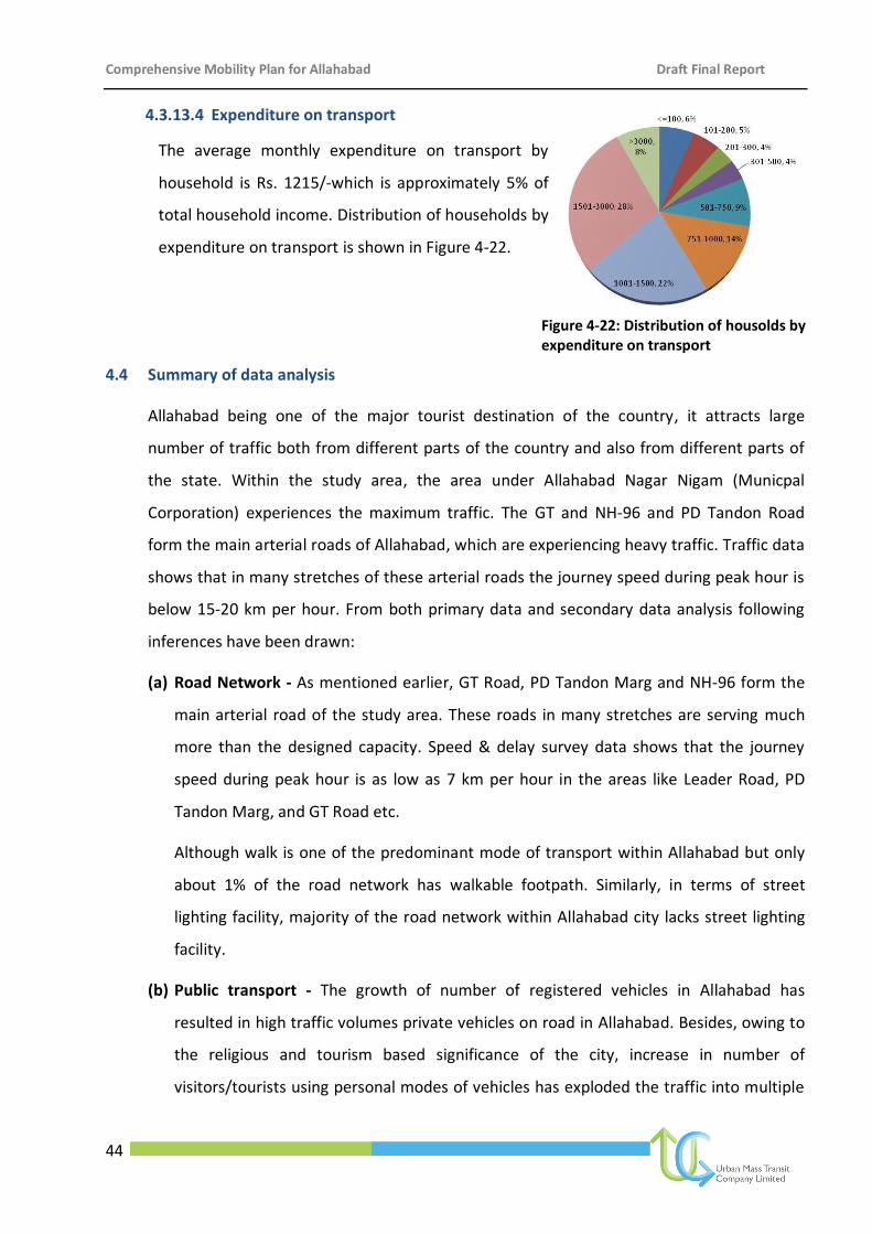
Comprehensive Mobility Plan for Allahabad Draft Final Report
44
4.3.13.4 Expenditure on transport
The average monthly expenditure on transport by
household is Rs. 1215/-which is approximately 5% of
total household income. Distribution of households by
expenditure on transport is shown in Figure 4-22.
Figure 4-22: Distribution of housolds by expenditure on transport
4.4 Summary of data analysis
Allahabad being one of the major tourist destination of the country, it attracts large
number of traffic both from different parts of the country and also from different parts of
the state. Within the study area, the area under Allahabad Nagar Nigam (Municpal
Corporation) experiences the maximum traffic. The GT and NH-96 and PD Tandon Road
form the main arterial roads of Allahabad, which are experiencing heavy traffic. Traffic data
shows that in many stretches of these arterial roads the journey speed during peak hour is
below 15-20 km per hour. From both primary data and secondary data analysis following
inferences have been drawn:
(a) Road Network - As mentioned earlier, GT Road, PD Tandon Marg and NH-96 form the
main arterial road of the study area. These roads in many stretches are serving much
more than the designed capacity. Speed & delay survey data shows that the journey
speed during peak hour is as low as 7 km per hour in the areas like Leader Road, PD
Tandon Marg, and GT Road etc.
Although walk is one of the predominant mode of transport within Allahabad but only
about 1% of the road network has walkable footpath. Similarly, in terms of street
lighting facility, majority of the road network within Allahabad city lacks street lighting
facility.
(b) Public transport - The growth of number of registered vehicles in Allahabad has
resulted in high traffic volumes private vehicles on road in Allahabad. Besides, owing to
the religious and tourism based significance of the city, increase in number of
visitors/tourists using personal modes of vehicles has exploded the traffic into multiple
Comprehensive Mobility Plan for Allahabad Draft Final Report
45
proportions. Past time-series traffic data shows vehicular traffic has grown at an annual
rate of 10-15%, which is significantly high since the road network in Allahabad for
circulation has not been substantiated at par with the traffic growth. Although the
share of trips by public transport (bus) is as a meager 8%, there are substantial issues in
public transport are as:
Lake of dedicated bus shelters leading to haphazard/ unregulated stoppage of
buses on road for boarding and alighting of passengers causing traffic congestion
Non-reliability of bus service due to absence of real time passenger information
system at terminals and bus stops
Lack of integration of public transport system with other feeding modes such as
IPT/Autos/Shared Tempos/Taxi
Lack of accessibility from across the city to the bus terminals
(c) Parking: Parking is another major issue of concern for Allahabad. There are about 125
parking spaces in Allahabad, which are inadequate due to ever increasing private
vehicles. The existing parking demand is estimated to be approximately 1998 ECS in the
form of supply of both off-street and on-street parking with demand supply gap of 1873
ECS.
(d) Traffic and Travel: Traffic Congestion is the most significant issue that Allahabad is
facing today. The coverage of road network for vehicular movement is low and existing
roads are operating more than its desired capacity. The effective carriageway capacity
of roads is reducing with increasing traffic volume and increase in activity centers along
the roads including encroachments impairing traffic movement and creating
bottlenecks. The Outer cordon - origin destination survey shows the share of through
traffic is as high as 16%, which necessitates creation of additional bypass roads.
(e) Major bottleneck Points: Following are the major bottleneck points of Allahabad city
Leader Road
Railway Station City Side
Railway Station Civil Side
Subhash Chowk
Alopi Bagh
Comprehensive Mobility Plan for Allahabad Draft Final Report
46
Pani ki Tanki
High Court
Kutchery Road
Mayohall
Hanuman Mandir/IT Chowk
Johnsonganj
Ghantaghar
Old Katra
Subedarganj
Bairahana
Lukarganj
Sohbatia Bagh
Kidganj
Kotha Parcha
NH2-NH27 crossing close to Bairahana
Zero Road
Malakka
(f) Pedestrians Facilities: Although walk is the predominant mode of transport (35% trips
are made by walk as per HH survey) in Allahabad, but the city lacks proper pedestrian
facilities. Only about 1% of the total road network has walkable footpaths. The
pedestrian crossing facility is also inadequate. Lack of proper footpaths and absence of
crossing facilities for uninterrupted movement of pedestrians is a safety concern in
Allahabad.
(g) Congestion: The areas like Railway Station, Civil Lines, Johnsonganj, Pani ki tanki, High
Court, Civil Lines Bus Terminal, Ghantaghar, Kutchery, Darranganj, Alopi Bagh, Triveni
Road remain congested throughout the day (refer to figure 3-23). Referring to Table
4-14, the values of volume by capacity (V/C) ratio of some of the highly congested roads
of Allahabad city shows, majority of the roads have V/C ratio greater than one (1), even
in the base year. Ideally, for urban roads (ranging from C to D level of service) the
desired value of v/c ratio should remain 0.6 to 0.8. The value of V/C ratio more than 0.8
indicates that there is need for improvement / management measures. Table 4-14 is
clearly indicating the deteriorated quality of service in Allahabad.
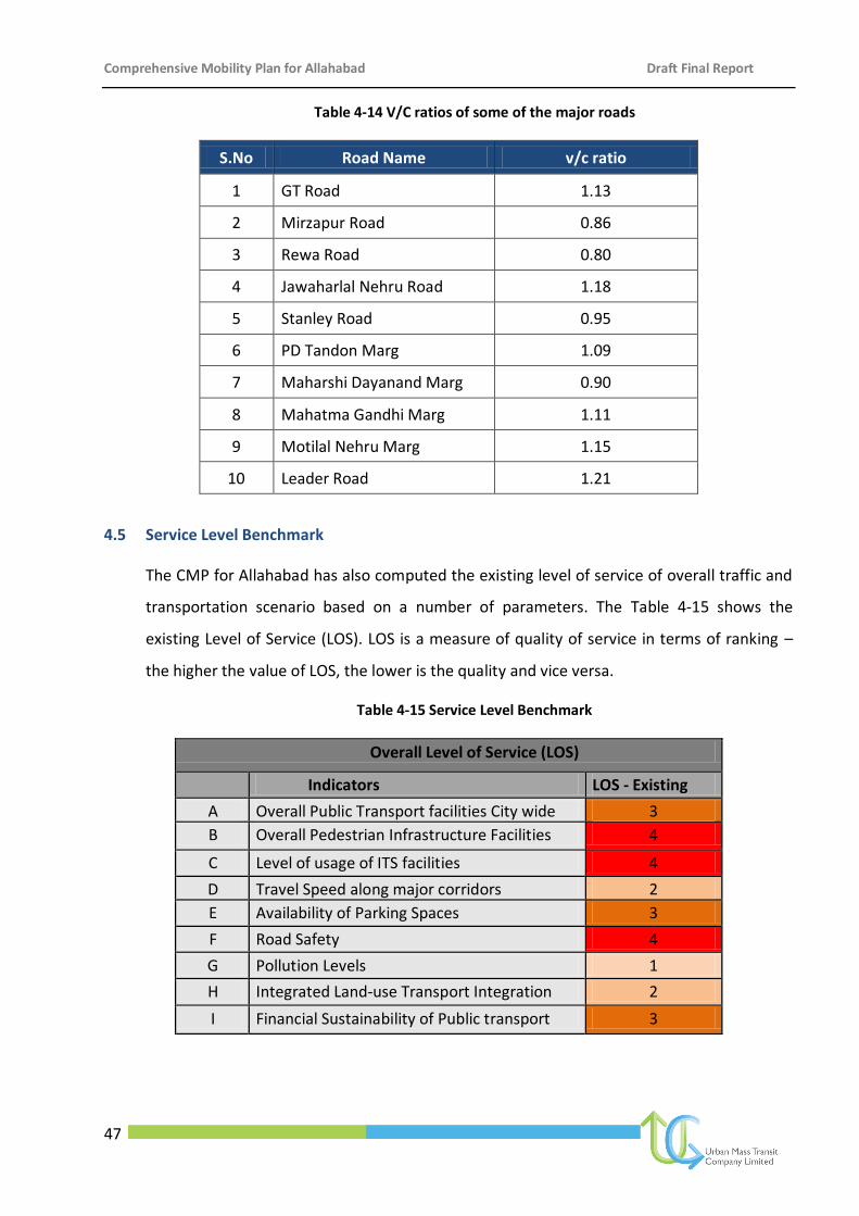
Comprehensive Mobility Plan for Allahabad Draft Final Report
47
Table 4-14 V/C ratios of some of the major roads
S.No Road Name v/c ratio
1 GT Road 1.13
2 Mirzapur Road 0.86
3 Rewa Road 0.80
4 Jawaharlal Nehru Road 1.18
5 Stanley Road 0.95
6 PD Tandon Marg 1.09
7 Maharshi Dayanand Marg 0.90
8 Mahatma Gandhi Marg 1.11
9 Motilal Nehru Marg 1.15
10 Leader Road 1.21
4.5 Service Level Benchmark
The CMP for Allahabad has also computed the existing level of service of overall traffic and
transportation scenario based on a number of parameters. The Table 4-15 shows the
existing Level of Service (LOS). LOS is a measure of quality of service in terms of ranking –
the higher the value of LOS, the lower is the quality and vice versa.
Table 4-15 Service Level Benchmark
Overall Level of Service (LOS)
Indicators LOS - Existing
A Overall Public Transport facilities City wide 3
B Overall Pedestrian Infrastructure Facilities 4
C Level of usage of ITS facilities 4
D Travel Speed along major corridors 2
E Availability of Parking Spaces 3
F Road Safety 4
G Pollution Levels 1
H Integrated Land-use Transport Integration 2
I Financial Sustainability of Public transport 3
Comprehensive Mobility Plan for Allahabad Draft Final Report
48
4.6 Conclusion
The present situation in Allahabad will only continue to worsen unless the Government
responds appropriately in this regard. In the absence of Government interference, by 2031,
the share of public transport will go down leading to more congested road space attributed
by higher use of private mode. Traffic forecasts show network speeds of less than 15 kmph
in 2031, a really serious and unsustainable situation. A set of performance indicators has
been developed to arrive at goals to be achieved for the city. The goals have been defined
with vision and objectives. The mobility strategies developed will aim at attaining these
goals.
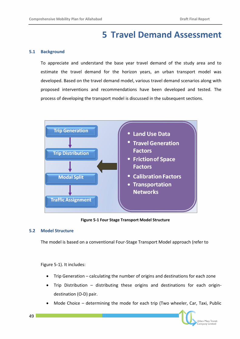
Comprehensive Mobility Plan for Allahabad Draft Final Report
49
5 Travel Demand Assessment
5.1 Background
To appreciate and understand the base year travel demand of the study area and to
estimate the travel demand for the horizon years, an urban transport model was
developed. Based on the travel demand model, various travel demand scenarios along with
proposed interventions and recommendations have been developed and tested. The
process of developing the transport model is discussed in the subsequent sections.
Figure 5-1 Four Stage Transport Model Structure
5.2 Model Structure
The model is based on a conventional Four-Stage Transport Model approach (refer to
Figure 5-1). It includes:
Trip Generation – calculating the number of origins and destinations for each zone
Trip Distribution – distributing these origins and destinations for each origin-
destination (O-D) pair.
Mode Choice – determining the mode for each trip (Two wheeler, Car, Taxi, Public
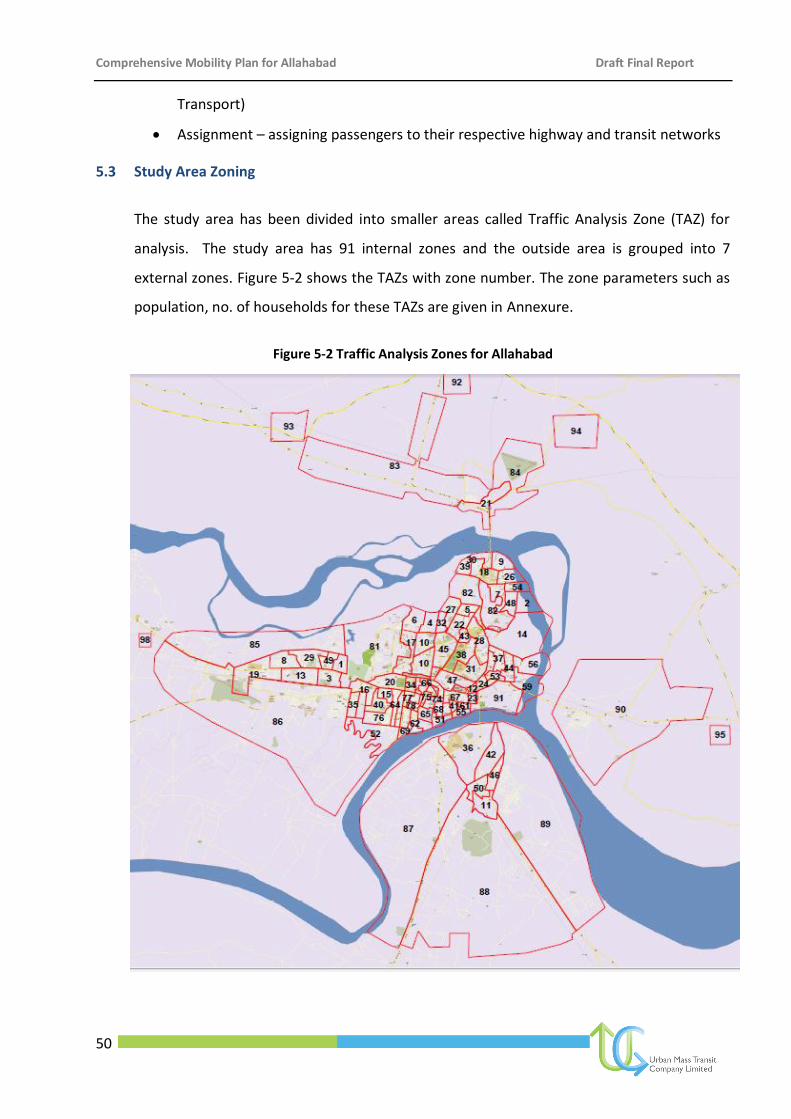
Comprehensive Mobility Plan for Allahabad Draft Final Report
50
Transport)
Assignment – assigning passengers to their respective highway and transit networks
5.3 Study Area Zoning
The study area has been divided into smaller areas called Traffic Analysis Zone (TAZ) for
analysis. The study area has 91 internal zones and the outside area is grouped into 7
external zones. Figure 5-2 shows the TAZs with zone number. The zone parameters such as
population, no. of households for these TAZs are given in Annexure.
Figure 5-2 Traffic Analysis Zones for Allahabad
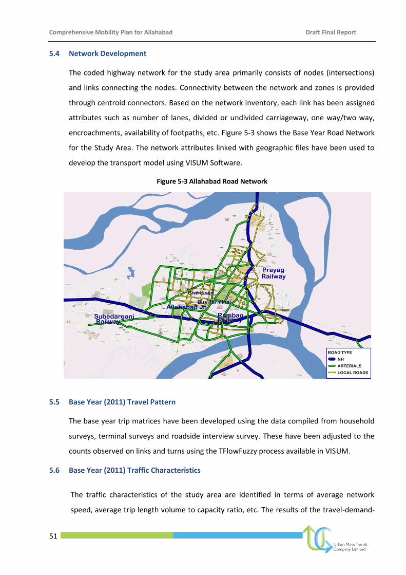
Comprehensive Mobility Plan for Allahabad Draft Final Report
51
5.4 Network Development
The coded highway network for the study area primarily consists of nodes (intersections)
and links connecting the nodes. Connectivity between the network and zones is provided
through centroid connectors. Based on the network inventory, each link has been assigned
attributes such as number of lanes, divided or undivided carriageway, one way/two way,
encroachments, availability of footpaths, etc. Figure 5-3 shows the Base Year Road Network
for the Study Area. The network attributes linked with geographic files have been used to
develop the transport model using VISUM Software.
Figure 5-3 Allahabad Road Network
5.5 Base Year (2011) Travel Pattern
The base year trip matrices have been developed using the data compiled from household
surveys, terminal surveys and roadside interview survey. These have been adjusted to the
counts observed on links and turns using the TFlowFuzzy process available in VISUM.
5.6 Base Year (2011) Traffic Characteristics
The traffic characteristics of the study area are identified in terms of average network
speed, average trip length volume to capacity ratio, etc. The results of the travel-demand-
Faizabad Road
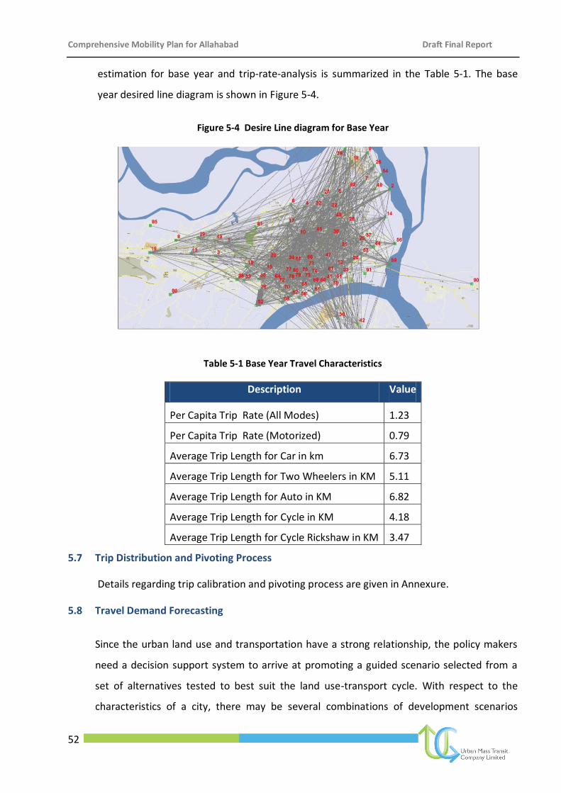
Comprehensive Mobility Plan for Allahabad Draft Final Report
52
estimation for base year and trip-rate-analysis is summarized in the Table 5-1. The base
year desired line diagram is shown in Figure 5-4.
Figure 5-4 Desire Line diagram for Base Year
Table 5-1 Base Year Travel Characteristics
Description Value
Per Capita Trip Rate (All Modes) 1.23
Per Capita Trip Rate (Motorized) 0.79
Average Trip Length for Car in km 6.73
Average Trip Length for Two Wheelers in KM 5.11
Average Trip Length for Auto in KM 6.82
Average Trip Length for Cycle in KM 4.18
Average Trip Length for Cycle Rickshaw in KM 3.47
5.7 Trip Distribution and Pivoting Process
Details regarding trip calibration and pivoting process are given in Annexure.
5.8 Travel Demand Forecasting
Since the urban land use and transportation have a strong relationship, the policy makers
need a decision support system to arrive at promoting a guided scenario selected from a
set of alternatives tested to best suit the land use-transport cycle. With respect to the
characteristics of a city, there may be several combinations of development scenarios
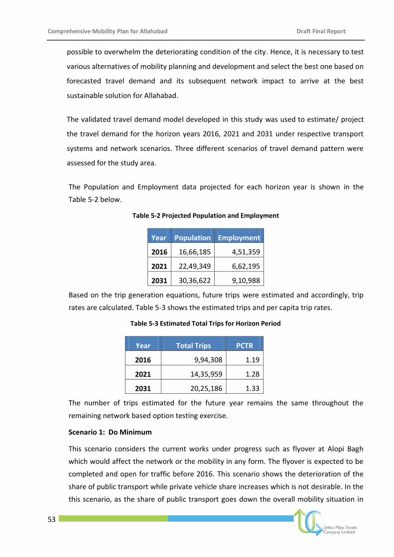
Comprehensive Mobility Plan for Allahabad Draft Final Report
53
possible to overwhelm the deteriorating condition of the city. Hence, it is necessary to test
various alternatives of mobility planning and development and select the best one based on
forecasted travel demand and its subsequent network impact to arrive at the best
sustainable solution for Allahabad.
The validated travel demand model developed in this study was used to estimate/ project
the travel demand for the horizon years 2016, 2021 and 2031 under respective transport
systems and network scenarios. Three different scenarios of travel demand pattern were
assessed for the study area.
The Population and Employment data projected for each horizon year is shown in the
Table 5-2 below.
Table 5-2 Projected Population and Employment
Year Population Employment
2016 16,66,185 4,51,359
2021 22,49,349 6,62,195
2031 30,36,622 9,10,988
Based on the trip generation equations, future trips were estimated and accordingly, trip
rates are calculated. Table 5-3 shows the estimated trips and per capita trip rates.
Table 5-3 Estimated Total Trips for Horizon Period
Year Total Trips PCTR
2016 9,94,308 1.19
2021 14,35,959 1.28
2031 20,25,186 1.33
The number of trips estimated for the future year remains the same throughout the
remaining network based option testing exercise.
Scenario 1: Do Minimum
This scenario considers the current works under progress such as flyover at Alopi Bagh
which would affect the network or the mobility in any form. The flyover is expected to be
completed and open for traffic before 2016. This scenario shows the deterioration of the
share of public transport while private vehicle share increases which is not desirable. In the
this scenario, as the share of public transport goes down the overall mobility situation in
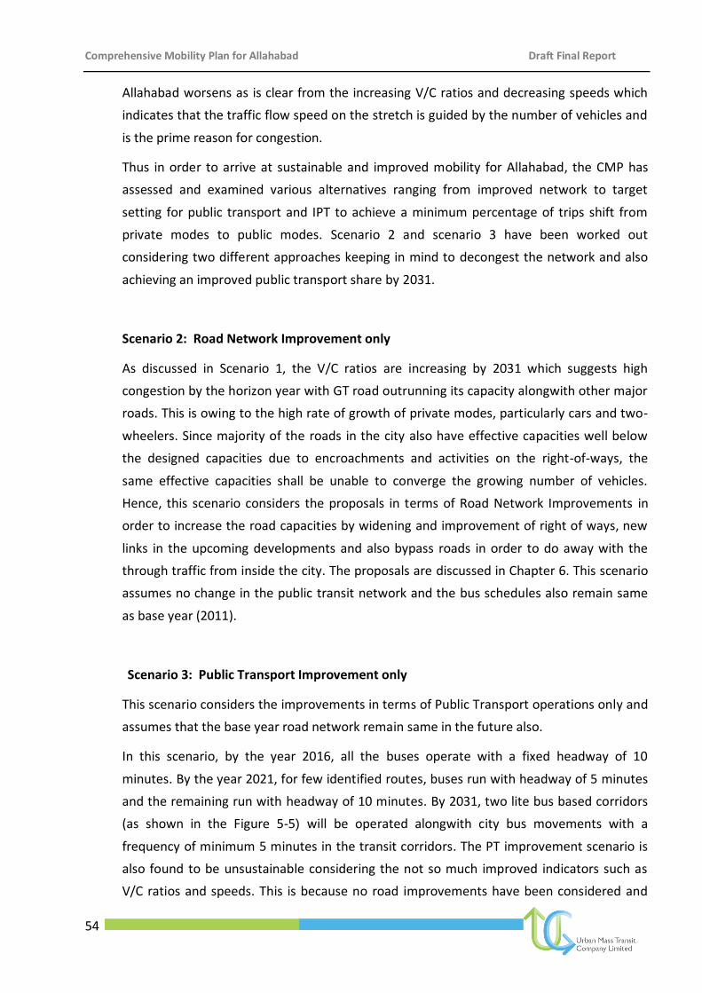
Comprehensive Mobility Plan for Allahabad Draft Final Report
54
Allahabad worsens as is clear from the increasing V/C ratios and decreasing speeds which
indicates that the traffic flow speed on the stretch is guided by the number of vehicles and
is the prime reason for congestion.
Thus in order to arrive at sustainable and improved mobility for Allahabad, the CMP has
assessed and examined various alternatives ranging from improved network to target
setting for public transport and IPT to achieve a minimum percentage of trips shift from
private modes to public modes. Scenario 2 and scenario 3 have been worked out
considering two different approaches keeping in mind to decongest the network and also
achieving an improved public transport share by 2031.
Scenario 2: Road Network Improvement only
As discussed in Scenario 1, the V/C ratios are increasing by 2031 which suggests high
congestion by the horizon year with GT road outrunning its capacity alongwith other major
roads. This is owing to the high rate of growth of private modes, particularly cars and two-
wheelers. Since majority of the roads in the city also have effective capacities well below
the designed capacities due to encroachments and activities on the right-of-ways, the
same effective capacities shall be unable to converge the growing number of vehicles.
Hence, this scenario considers the proposals in terms of Road Network Improvements in
order to increase the road capacities by widening and improvement of right of ways, new
links in the upcoming developments and also bypass roads in order to do away with the
through traffic from inside the city. The proposals are discussed in Chapter 6. This scenario
assumes no change in the public transit network and the bus schedules also remain same
as base year (2011).
Scenario 3: Public Transport Improvement only
This scenario considers the improvements in terms of Public Transport operations only and
assumes that the base year road network remain same in the future also.
In this scenario, by the year 2016, all the buses operate with a fixed headway of 10
minutes. By the year 2021, for few identified routes, buses run with headway of 5 minutes
and the remaining run with headway of 10 minutes. By 2031, two lite bus based corridors
(as shown in the Figure 5-5) will be operated alongwith city bus movements with a
frequency of minimum 5 minutes in the transit corridors. The PT improvement scenario is
also found to be unsustainable considering the not so much improved indicators such as
V/C ratios and speeds. This is because no road improvements have been considered and
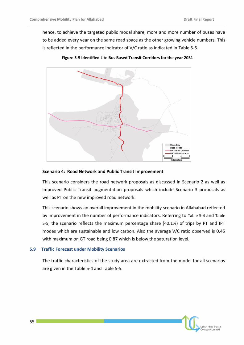
Comprehensive Mobility Plan for Allahabad Draft Final Report
55
hence, to achieve the targeted public modal share, more and more number of buses have
to be added every year on the same road space as the other growing vehicle numbers. This
is reflected in the performance indicator of V/C ratio as indicated in Table 5-5.
Figure 5-5 Identified Lite Bus Based Transit Corridors for the year 2031
Scenario 4: Road Network and Public Transit Improvement
This scenario considers the road network proposals as discussed in Scenario 2 as well as
improved Public Transit augmentation proposals which include Scenario 3 proposals as
well as PT on the new improved road network.
This scenario shows an overall improvement in the mobility scenario in Allahabad reflected
by improvement in the number of performance indicators. Referring to Table 5-4 and Table
5-5, the scenario reflects the maximum percentage share (40.1%) of trips by PT and IPT
modes which are sustainable and low carbon. Also the average V/C ratio observed is 0.45
with maximum on GT road being 0.87 which is below the saturation level.
5.9 Traffic Forecast under Mobility Scenarios
The traffic characteristics of the study area are extracted from the model for all scenarios
are given in the Table 5-4 and Table 5-5.
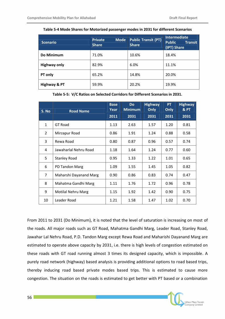
Comprehensive Mobility Plan for Allahabad Draft Final Report
56
Table 5-4 Mode Shares for Motorized passenger modes in 2031 for different Scenarios
Scenario Private Mode Share
Public Transit (PT) Share
Intermediate Public Transit (IPT) Share
Do Minimum 71.0% 10.6% 18.4%
Highway only 82.9% 6.0% 11.1%
PT only 65.2% 14.8% 20.0%
Highway & PT 59.9% 20.2% 19.9%
Table 5-5: V/C Ratios on Selected Corridors for Different Scenarios in 2031.
S. No Road Name
Base Year
Do Minimum
Highway Only
PT Only
Highway & PT
2011 2031 2031 2031 2031
1 GT Road 1.13 2.63 1.57 1.20 0.81
2 Mirzapur Road 0.86 1.91 1.24 0.88 0.58
3 Rewa Road 0.80 0.87 0.96 0.57 0.74
4 Jawaharlal Nehru Road 1.18 1.64 1.24 0.77 0.60
5 Stanley Road 0.95 1.33 1.22 1.01 0.65
6 PD Tandon Marg 1.09 1.55 1.45 1.05 0.82
7 Maharshi Dayanand Marg 0.90 0.86 0.83 0.74 0.47
8 Mahatma Gandhi Marg 1.11 1.76 1.72 0.96 0.78
9 Motilal Nehru Marg 1.15 1.92 1.42 0.90 0.75
10 Leader Road 1.21 1.58 1.47 1.02 0.70
From 2011 to 2031 (Do Minimum), it is noted that the level of saturation is increasing on most of
the roads. All major roads such as GT Road, Mahatma Gandhi Marg, Leader Road, Stanley Road,
Jawahar Lal Nehru Road, P.D. Tandon Marg except Rewa Road and Maharishi Dayanand Marg are
estimated to operate above capacity by 2031, i.e. there is high levels of congestion estimated on
these roads with GT road running almost 3 times its designed capacity, which is impossible. A
purely road network (highway) based analysis is providing additional options to road based trips,
thereby inducing road based private modes based trips. This is estimated to cause more
congestion. The situation on the roads is estimated to get better with PT based or a combination
Comprehensive Mobility Plan for Allahabad Draft Final Report
57
of road network and PT based schemes, although even PT only scenario puts the entire transport
system at near saturation levels.
Considering all the scenarios, scenario 4 is found to be most sustainable and optimum mobility
solution for Allahabad.
Comprehensive Mobility Plan for Allahabad Draft Final Report
58
6 Mobility Plan
6.1 Vision Statement
The Comprehensive Mobility Plan for Allahabad is proposed to be developed with the
following vision.
Truly reflecting the status that the Allahabad city and the holy Sangam have across the globe,
it is proposed to have a sustainable, low carbon well networked integrated transportation
system, by developing and sustaining quality transportation infrastructure with the help of
an urban transport strategy. The srategy is envisioned to be in line with the current National
Urban Transport Policy (NUTP),
that will move people and goods safely,efficiently and securely.
that will provide affordable mobility for people, goods and commerce (and maximize
the benefit of transportation investments and facilitating implementation of priority
projects of city and region wide significance over the short, medium and long term).
that will improve quality of life (by providing a recognized and effective platform for
integrating land use, transportation, and economic development that minimizes the
need for travel, provides choices for modes that are safe and also socially,
economically, financially and environmentally sustainable).
6.2 Mobility Pillars
The three most important pillars for ensuring sustainable mobility in urban areas are:
(a) Integrated land use-transport planning
(b) Bringing a control on movement of personal vehicles
(c) Encourage public transport system and other sustainable modes of transport
Sustainable mobility however can only be ensured if the solutions are environmentally,
socially, and economically sustainable as presented in Figure 6-1.
“To provide safe, efficient, and environmentally sustainable means of transportation
system for improving mobility of people and goods in Allahabad.”
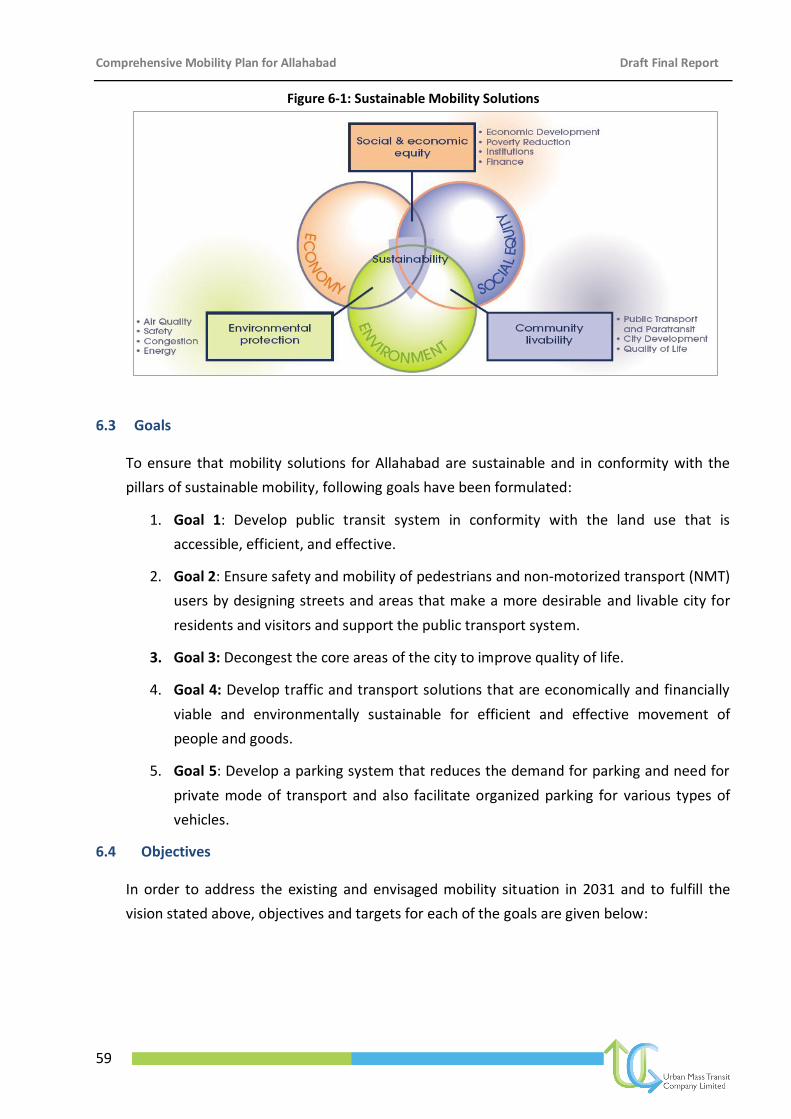
Comprehensive Mobility Plan for Allahabad Draft Final Report
59
Figure 6-1: Sustainable Mobility Solutions
6.3 Goals
To ensure that mobility solutions for Allahabad are sustainable and in conformity with the
pillars of sustainable mobility, following goals have been formulated:
1. Goal 1: Develop public transit system in conformity with the land use that is
accessible, efficient, and effective.
2. Goal 2: Ensure safety and mobility of pedestrians and non-motorized transport (NMT)
users by designing streets and areas that make a more desirable and livable city for
residents and visitors and support the public transport system.
3. Goal 3: Decongest the core areas of the city to improve quality of life.
4. Goal 4: Develop traffic and transport solutions that are economically and financially
viable and environmentally sustainable for efficient and effective movement of
people and goods.
5. Goal 5: Develop a parking system that reduces the demand for parking and need for
private mode of transport and also facilitate organized parking for various types of
vehicles.
6.4 Objectives
In order to address the existing and envisaged mobility situation in 2031 and to fulfill the
vision stated above, objectives and targets for each of the goals are given below:
Comprehensive Mobility Plan for Allahabad Draft Final Report
60
1. Goal 1: Develop public transit system in conformity with the land use that is
accessible, efficient and effective.
Objectives:
(a) Provide good quality public transport system that is accessible, efficient and
effective.
(b) Develop strategy to integrate public transport system with existing IPT system.
(c) Develop strategies to encourage people to use public transport system and
discourage use of private vehicles, specially two wheelers and IPT modes such
as tempos.
(d) Develop policies that encourage concentrated mixed land use development
along the public transport corridors.
2. Goal 2: Ensure safety and mobility of pedestrians and non-motorized transport (NMT)
users by designing streets and areas that make a more desirable and livable city for
residents and visitors and support the public transport system.
Objectives
(a) To improve pedestrian facilities in areas of pedestrian concentration and
encourage pedestrian movement in heavy pedestrian movement areas and
restrict use of private vehicles.
(b) To provide facilities to pedestrians and NMT users in order to ensure safety by
segregating their movement from vehicles along major corridors.
(c) To provide safe pedestrian facilities along major public transport nodes and
transfer points.
(d) To develop a pedestrian strategy for safe and efficient movement of people
within the city.
3. Goal 3: Decongest the core areas of the city to improve quality of life.
Objectives
(a) Develop strategies to encourage people to shift out of the core city area.
(b) To shift major activity centers out of the core city area.
(c) To restrict entry of personal vehicles in the core city area and reduction of on
street parking and encourage public transport and pedestrian movement in the
core city area.

Comprehensive Mobility Plan for Allahabad Draft Final Report
61
4. Goal 4: Develop traffic and transport solutions that are economically and financially
viable and environmentally sustainable for efficient and effective movement of people
and goods.
Objectives
(a) Develop short term strategies such as traffic management and engineering
solutions to ease flow of traffic at major congestion points within the city.
(b) Develop medium and long-term measures such as construction of bypass, new
link roads, road network development etc. to ease traffic flow along major
roads within the city.
5. Goal 5: Develop a parking system that reduces the demand for parking and need for
private mode of transport and also facilitate organized parking for various types of
vehicles.
Objectives
(a) Restrict on-street parking at critical locations in the city.
(b) Create off-street parking (wherever possible multi-level parking) near major
activity centers, transit stations/terminals to meet the growing parking
demand.
(c) To suggest various measures through a combination of demand management
and fiscal measures to restrain the demand for parking of private vehicles at
critical locations.
6.5 Mobility plan approach
Urban mobility solutions cannot be evolved by a single source strategy, the mobility goals for
Allahabad will need to be addressed through a multi-pronged approach. The following
strategies need to be adopted in tandem to meet the various goals set for Allahabad:
Integrated land use and transport strategy
Mobility corridor strategy
Public transit strategy
Non-motorized transport strategy
Freight management strategy
Traffic engineering measures
Travel demand management
All the listed strategies are equally important and the order of listing does not imply priority.
Each of the broad strategies includes sub- strategies of immense importance. The strategies
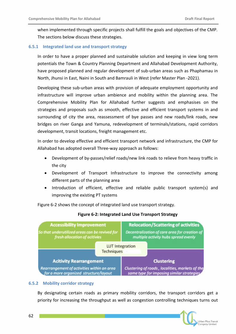
Comprehensive Mobility Plan for Allahabad Draft Final Report
62
when implemented through specific projects shall fulfill the goals and objectives of the CMP.
The sections below discuss these strategies.
6.5.1 Integrated land use and transport strategy
In order to have a proper planned and sustainable solution and keeping in view long term
potentials the Town & Country Planning Department and Allahabad Development Authority,
have proposed planned and regular development of sub-urban areas such as Phaphamau in
North, Jhunsi in East, Naini in South and Bamrauli in West (refer Master Plan -2021).
Developing these sub-urban areas with provision of adequate employment opportunity and
infrastructure will improve urban ambience and mobility within the planning area. The
Comprehensive Mobility Plan for Allahabad further suggests and emphasises on the
strategies and proposals such as smooth, effective and efficient transport systems in and
surrounding of city the area, reassessment of bye passes and new roads/link roads, new
bridges on river Ganga and Yamuna, redevelopment of terminals/stations, rapid corridors
development, transit locations, freight management etc.
In order to develop effective and efficient transport network and infrastructure, the CMP for
Allahabad has adopted overall Three-way approach as follows:
Development of by-passes/relief roads/new link roads to relieve from heavy traffic in
the city
Development of Transport Infrastructure to improve the connectivity among
different parts of the planning area
Introduction of efficient, effective and reliable public transport system(s) and
improving the existing PT systems
Figure 6-2 shows the concept of integrated land use transport strategy.
Figure 6-2: Integrated Land Use Transport Strategy
6.5.2 Mobility corridor strategy
By designating certain roads as primary mobility corridors, the transport corridors get a
priority for increasing the throughput as well as congestion controlling techniques turns out
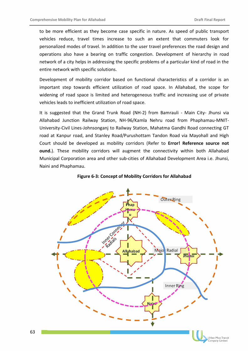
Comprehensive Mobility Plan for Allahabad Draft Final Report
63
to be more efficient as they become case specific in nature. As speed of public transport
vehicles reduce, travel times increase to such an extent that commuters look for
personalized modes of travel. In addition to the user travel preferences the road design and
operations also have a bearing on traffic congestion. Development of hierarchy in road
network of a city helps in addressing the specific problems of a particular kind of road in the
entire network with specific solutions.
Development of mobility corridor based on functional characteristics of a corridor is an
important step towards efficient utilization of road space. In Allahabad, the scope for
widening of road space is limited and heterogeneous traffic and increasing use of private
vehicles leads to inefficient utilization of road space.
It is suggested that the Grand Trunk Road (NH-2) from Bamrauli - Main City- Jhunsi via
Allahabad Junction Railway Station, NH-96/Kamla Nehru road from Phaphamau-MNIT-
University-Civil Lines-Johnsonganj to Railway Station, Mahatma Gandhi Road connecting GT
road at Kanpur road, and Stanley Road/Purushottam Tandon Road via Mayohall and High
Court should be developed as mobility corridors (Refer to Error! Reference source not
ound.). These mobility corridors will augment the connectivity within both Allahabad
Municipal Corporation area and other sub-cities of Allahabad Development Area i.e. Jhunsi,
Naini and Phaphamau.
Figure 6-3: Concept of Mobility Corridors for Allahabad
Comprehensive Mobility Plan for Allahabad Draft Final Report
64
6.5.3 Public transit strategy
The public transport strategy for Allahabad derives considering all the existing factors of
urban mobility and recommends the best possible reorganization for the same.
The main existing mode of public transport in Allahabad is City Bus Service operated by
UPSRTC, private buses by some private operators under RTO permit, IPT modes (shared
three wheeler i.e. Vikram/Auto) and Cycle Rickshaw (mainly in city center). However, there
exists number of possible interventions for improvement of the existing condition of city bus
service such as improvement in service frequency, headways, quality, coverage and
accessibility, introduction of Intelligent Transport Systems (real time passenger information
system at terminals & inside buses), Integration of PT systems, identification of possibility of
Trunk & Feeder kind of systems, improvement of essential physical infrastructure such as
Terminals, depots, workshops, stations, interchanges, shelters and stops etc.
Considering all these aspects, the CMP Allahabad suggests developing the following tiers of
public transport system for Allahabad, which consists of City Bus Services, Light Bus Based
Transit Systems on identified corridor(s), restructuring of IPT system and its integration with
the City Bus Services and the Bus based system. However the detailed feasibility studies
need to be carried out for the development of each of the above systems.
The strategy for public transport for the study area is based on following postulates:
Complete connectivity within Allahabad Planning Area i.e. within the main city growing
towards the western direction as well as inter-connectivity between the main city, Naini,
Jhunsu and Phaphamau for improved mobility and to facilitate better regional
connectivity
Transport Infrastructure to support the public transit system guiding sustainable growth
of the city
Provision of alternative Public Transport Systems and their integration with other modes
such as IPT (shared autos/Cycle rickshaws) and NMT.
The strategy for integrated public transport for Allahabad Planning Area is shown in Figure
6-4.
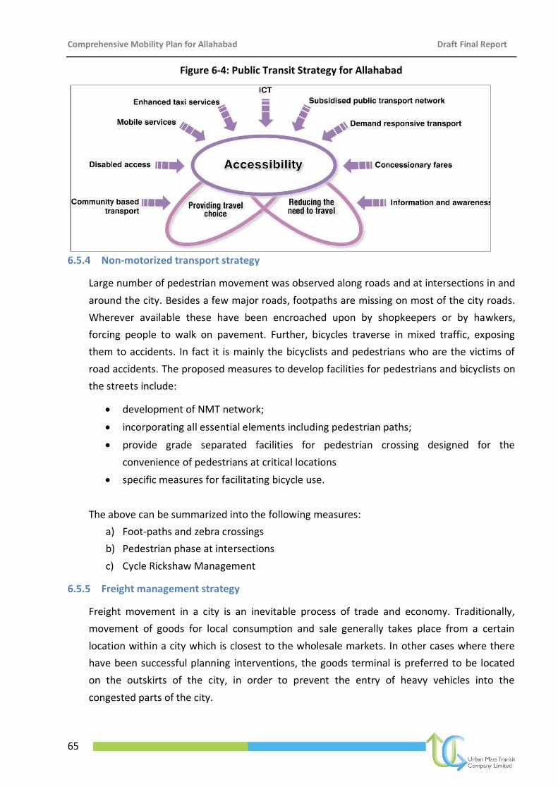
Comprehensive Mobility Plan for Allahabad Draft Final Report
65
Figure 6-4: Public Transit Strategy for Allahabad
6.5.4 Non-motorized transport strategy
Large number of pedestrian movement was observed along roads and at intersections in and
around the city. Besides a few major roads, footpaths are missing on most of the city roads.
Wherever available these have been encroached upon by shopkeepers or by hawkers,
forcing people to walk on pavement. Further, bicycles traverse in mixed traffic, exposing
them to accidents. In fact it is mainly the bicyclists and pedestrians who are the victims of
road accidents. The proposed measures to develop facilities for pedestrians and bicyclists on
the streets include:
development of NMT network;
incorporating all essential elements including pedestrian paths;
provide grade separated facilities for pedestrian crossing designed for the
convenience of pedestrians at critical locations
specific measures for facilitating bicycle use.
The above can be summarized into the following measures:
a) Foot-paths and zebra crossings
b) Pedestrian phase at intersections
c) Cycle Rickshaw Management
6.5.5 Freight management strategy
Freight movement in a city is an inevitable process of trade and economy. Traditionally,
movement of goods for local consumption and sale generally takes place from a certain
location within a city which is closest to the wholesale markets. In other cases where there
have been successful planning interventions, the goods terminal is preferred to be located
on the outskirts of the city, in order to prevent the entry of heavy vehicles into the
congested parts of the city.
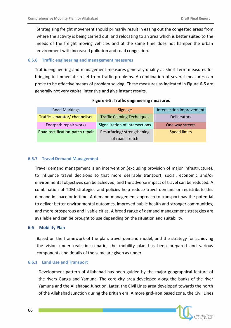
Comprehensive Mobility Plan for Allahabad Draft Final Report
66
Road Markings Signage Intersection improvement
Traffic separator/ channeliser Traffic Calming Techniques Delineators
Footpath repair works Signalization of intersections One way streets
Road rectification-patch repair Resurfacing/ strengthening
of road stretch
Speed limits
Strategizing freight movement should primarily result in easing out the congested areas from
where the activity is being carried out, and relocating to an area which is better suited to the
needs of the freight moving vehicles and at the same time does not hamper the urban
environment with increased pollution and road congestion.
6.5.6 Traffic engineering and management measures
Traffic engineering and management measures generally qualify as short term measures for
bringing in immediate relief from traffic problems. A combination of several measures can
prove to be effective means of problem solving. These measures as indicated in Figure 6-5 are
generally not very capital intensive and give instant results.
Figure 6-5: Traffic engineering measures
6.5.7 Travel Demand Management
Travel demand management is an intervention,(excluding provision of major infrastructure),
to influence travel decisions so that more desirable transport, social, economic and/or
environmental objectives can be achieved, and the adverse impact of travel can be reduced. A
combination of TDM strategies and policies help reduce travel demand or redistribute this
demand in space or in time. A demand management approach to transport has the potential
to deliver better environmental outcomes, improved public health and stronger communities,
and more prosperous and livable cities. A broad range of demand management strategies are
available and can be brought to use depending on the situation and suitability.
6.6 Mobility Plan
Based on the framework of the plan, travel demand model, and the strategy for achieving
the vision under realistic scenario, the mobility plan has been prepared and various
components and details of the same are given as under:
6.6.1 Land Use and Transport
Development pattern of Allahabad has been guided by the major geographical feature of
the rivers Ganga and Yamuna. The core city area developed along the banks of the river
Yamuna and the Allahabad Junction. Later, the Civil Lines area developed towards the north
of the Allahabad Junction during the British era. A more grid-iron based zone, the Civil Lines
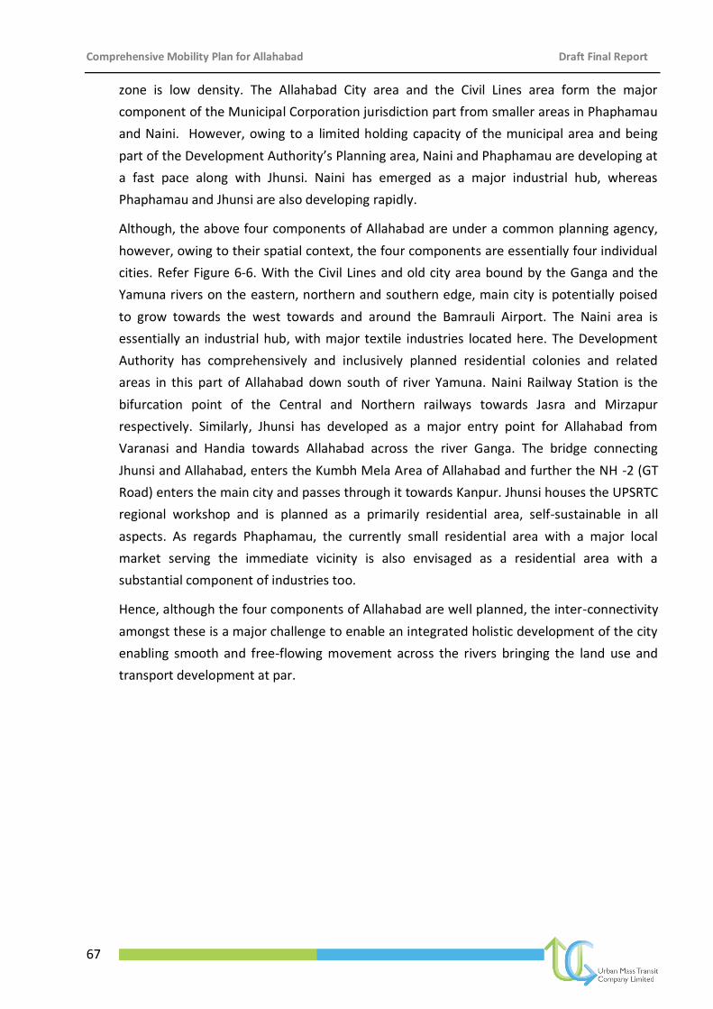
Comprehensive Mobility Plan for Allahabad Draft Final Report
67
zone is low density. The Allahabad City area and the Civil Lines area form the major
component of the Municipal Corporation jurisdiction part from smaller areas in Phaphamau
and Naini. However, owing to a limited holding capacity of the municipal area and being
part of the Development Authority’s Planning area, Naini and Phaphamau are developing at
a fast pace along with Jhunsi. Naini has emerged as a major industrial hub, whereas
Phaphamau and Jhunsi are also developing rapidly.
Although, the above four components of Allahabad are under a common planning agency,
however, owing to their spatial context, the four components are essentially four individual
cities. Refer Figure 6-6. With the Civil Lines and old city area bound by the Ganga and the
Yamuna rivers on the eastern, northern and southern edge, main city is potentially poised
to grow towards the west towards and around the Bamrauli Airport. The Naini area is
essentially an industrial hub, with major textile industries located here. The Development
Authority has comprehensively and inclusively planned residential colonies and related
areas in this part of Allahabad down south of river Yamuna. Naini Railway Station is the
bifurcation point of the Central and Northern railways towards Jasra and Mirzapur
respectively. Similarly, Jhunsi has developed as a major entry point for Allahabad from
Varanasi and Handia towards Allahabad across the river Ganga. The bridge connecting
Jhunsi and Allahabad, enters the Kumbh Mela Area of Allahabad and further the NH -2 (GT
Road) enters the main city and passes through it towards Kanpur. Jhunsi houses the UPSRTC
regional workshop and is planned as a primarily residential area, self-sustainable in all
aspects. As regards Phaphamau, the currently small residential area with a major local
market serving the immediate vicinity is also envisaged as a residential area with a
substantial component of industries too.
Hence, although the four components of Allahabad are well planned, the inter-connectivity
amongst these is a major challenge to enable an integrated holistic development of the city
enabling smooth and free-flowing movement across the rivers bringing the land use and
transport development at par.
Comprehensive Mobility Plan for Allahabad Draft Final Report
68
Figure 6-6: Concept of four self – contained sub-cities
6.6.1.1 Development of Induced Growth Centres based on TOD Concept
Higher density development is concentrated near the station to make transit convenient for
more people and encourage ridership. This form of development utilizes existing
infrastructure, optimizes use of the transit network and creates mobility options for transit
riders and the local community. Successful TOD provides a mix of land uses and densities
that create a convenient, interesting and vibrant community for local residents and visitors
alike.
Development of a ring-radial road network will allow the city to grow in all the directions as
it is growing in recent times. Since in the existing situation there is only one core
commercial zone, i.e. the old city area, there has been a heavy flow of trips attracted to the
core city area. Thus, Induced Growth Centres (IGC) have been proposed at the major
residential areas along the proposed by-pass or outer ring road on the periphery based on
the Transit Oriented Development principle. The purpose of developing IGCs of sub-city
centres is to promote mix of commercial and public/semi-public landuse, thus enhancing
the ridership on the outer ring road. Once developed, they would result in a decentralised
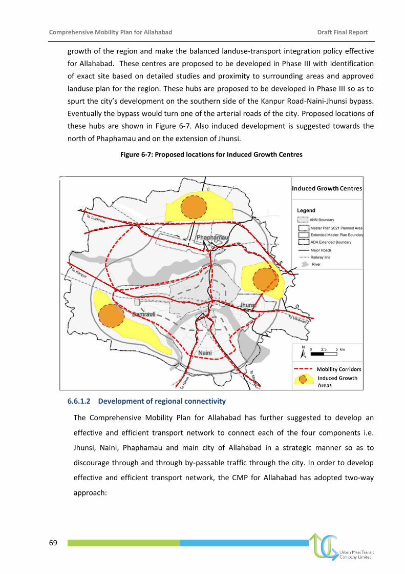
Comprehensive Mobility Plan for Allahabad Draft Final Report
69
growth of the region and make the balanced landuse-transport integration policy effective
for Allahabad. These centres are proposed to be developed in Phase III with identification
of exact site based on detailed studies and proximity to surrounding areas and approved
landuse plan for the region. These hubs are proposed to be developed in Phase III so as to
spurt the city’s development on the southern side of the Kanpur Road-Naini-Jhunsi bypass.
Eventually the bypass would turn one of the arterial roads of the city. Proposed locations of
these hubs are shown in Figure 6-7. Also induced development is suggested towards the
north of Phaphamau and on the extension of Jhunsi.
Figure 6-7: Proposed locations for Induced Growth Centres
6.6.1.2 Development of regional connectivity
The Comprehensive Mobility Plan for Allahabad has further suggested to develop an
effective and efficient transport network to connect each of the four components i.e.
Jhunsi, Naini, Phaphamau and main city of Allahabad in a strategic manner so as to
discourage through and through by-passable traffic through the city. In order to develop
effective and efficient transport network, the CMP for Allahabad has adopted two-way
approach:
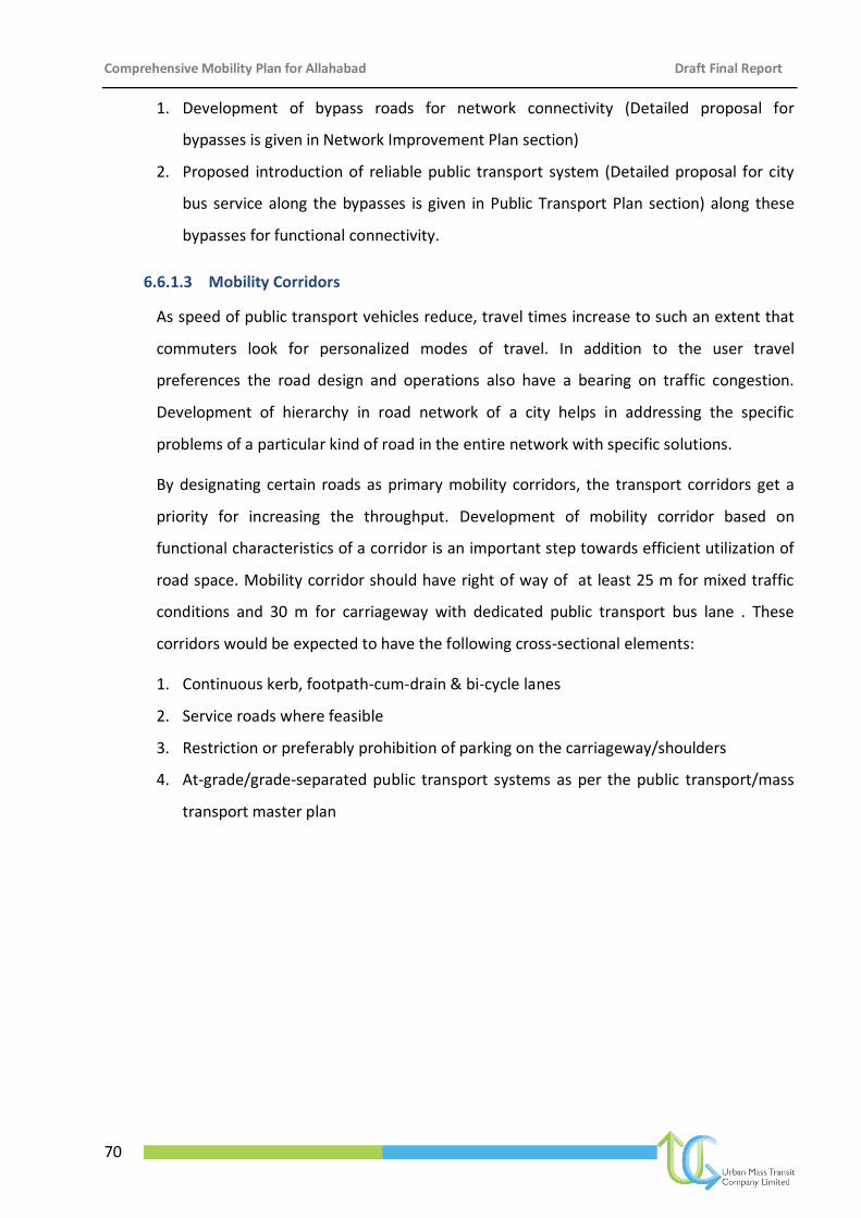
Comprehensive Mobility Plan for Allahabad Draft Final Report
70
1. Development of bypass roads for network connectivity (Detailed proposal for
bypasses is given in Network Improvement Plan section)
2. Proposed introduction of reliable public transport system (Detailed proposal for city
bus service along the bypasses is given in Public Transport Plan section) along these
bypasses for functional connectivity.
6.6.1.3 Mobility Corridors
As speed of public transport vehicles reduce, travel times increase to such an extent that
commuters look for personalized modes of travel. In addition to the user travel
preferences the road design and operations also have a bearing on traffic congestion.
Development of hierarchy in road network of a city helps in addressing the specific
problems of a particular kind of road in the entire network with specific solutions.
By designating certain roads as primary mobility corridors, the transport corridors get a
priority for increasing the throughput. Development of mobility corridor based on
functional characteristics of a corridor is an important step towards efficient utilization of
road space. Mobility corridor should have right of way of at least 25 m for mixed traffic
conditions and 30 m for carriageway with dedicated public transport bus lane . These
corridors would be expected to have the following cross-sectional elements:
1. Continuous kerb, footpath-cum-drain & bi-cycle lanes
2. Service roads where feasible
3. Restriction or preferably prohibition of parking on the carriageway/shoulders
4. At-grade/grade-separated public transport systems as per the public transport/mass
transport master plan
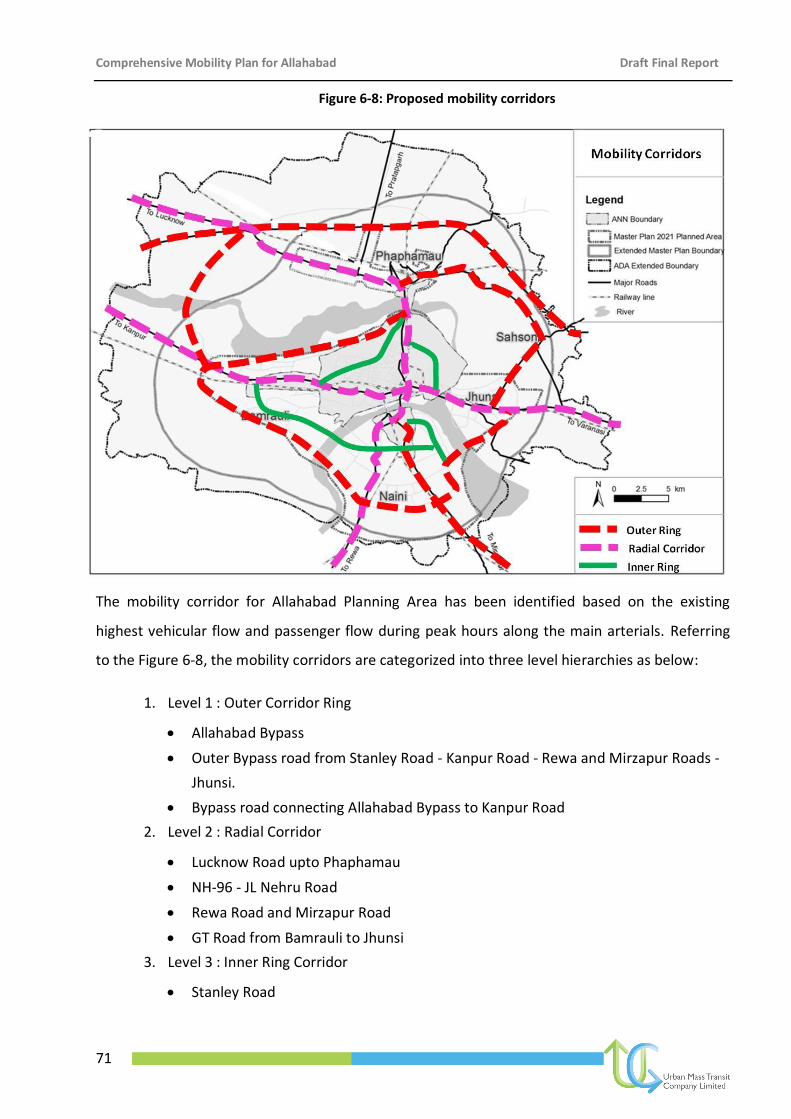
Comprehensive Mobility Plan for Allahabad Draft Final Report
71
Figure 6-8: Proposed mobility corridors
The mobility corridor for Allahabad Planning Area has been identified based on the existing
highest vehicular flow and passenger flow during peak hours along the main arterials. Referring
to the Figure 6-8, the mobility corridors are categorized into three level hierarchies as below:
1. Level 1 : Outer Corridor Ring
Allahabad Bypass
Outer Bypass road from Stanley Road - Kanpur Road - Rewa and Mirzapur Roads -
Jhunsi.
Bypass road connecting Allahabad Bypass to Kanpur Road
2. Level 2 : Radial Corridor
Lucknow Road upto Phaphamau
NH-96 - JL Nehru Road
Rewa Road and Mirzapur Road
GT Road from Bamrauli to Jhunsi
3. Level 3 : Inner Ring Corridor
Stanley Road
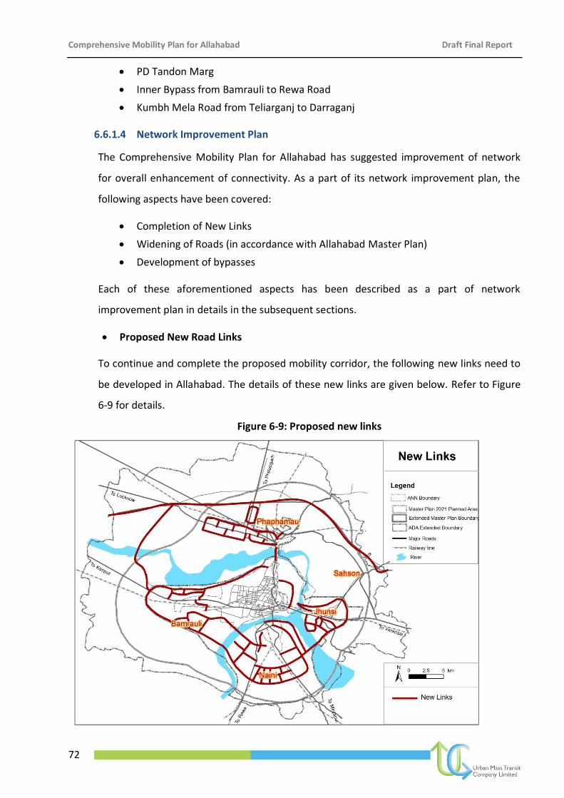
Comprehensive Mobility Plan for Allahabad Draft Final Report
72
PD Tandon Marg
Inner Bypass from Bamrauli to Rewa Road
Kumbh Mela Road from Teliarganj to Darraganj
6.6.1.4 Network Improvement Plan
The Comprehensive Mobility Plan for Allahabad has suggested improvement of network
for overall enhancement of connectivity. As a part of its network improvement plan, the
following aspects have been covered:
Completion of New Links
Widening of Roads (in accordance with Allahabad Master Plan)
Development of bypasses
Each of these aforementioned aspects has been described as a part of network
improvement plan in details in the subsequent sections.
Proposed New Road Links
To continue and complete the proposed mobility corridor, the following new links need to
be developed in Allahabad. The details of these new links are given below. Refer to Figure
6-9 for details.
Figure 6-9: Proposed new links
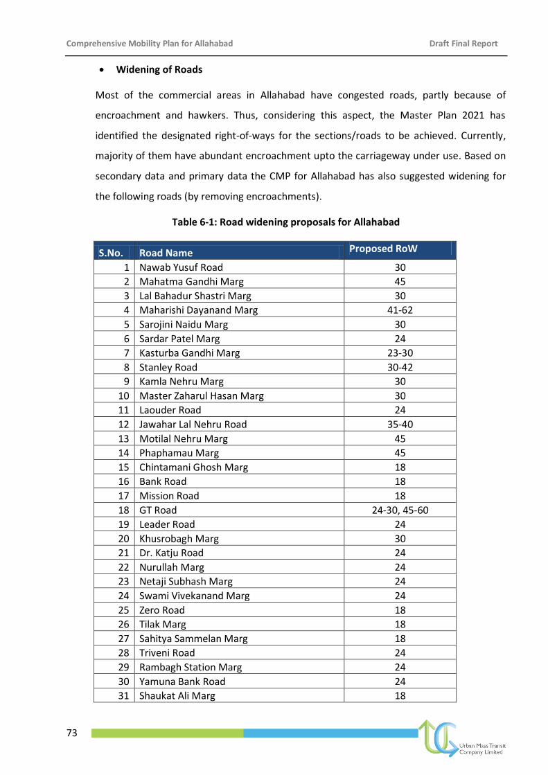
Comprehensive Mobility Plan for Allahabad Draft Final Report
73
Widening of Roads
Most of the commercial areas in Allahabad have congested roads, partly because of
encroachment and hawkers. Thus, considering this aspect, the Master Plan 2021 has
identified the designated right-of-ways for the sections/roads to be achieved. Currently,
majority of them have abundant encroachment upto the carriageway under use. Based on
secondary data and primary data the CMP for Allahabad has also suggested widening for
the following roads (by removing encroachments).
Table 6-1: Road widening proposals for Allahabad
S.No. Road Name Proposed RoW
1 Nawab Yusuf Road 30
2 Mahatma Gandhi Marg 45
3 Lal Bahadur Shastri Marg 30
4 Maharishi Dayanand Marg 41-62
5 Sarojini Naidu Marg 30
6 Sardar Patel Marg 24
7 Kasturba Gandhi Marg 23-30
8 Stanley Road 30-42
9 Kamla Nehru Marg 30
10 Master Zaharul Hasan Marg 30
11 Laouder Road 24
12 Jawahar Lal Nehru Road 35-40
13 Motilal Nehru Marg 45
14 Phaphamau Marg 45
15 Chintamani Ghosh Marg 18
16 Bank Road 18
17 Mission Road 18
18 GT Road 24-30, 45-60
19 Leader Road 24
20 Khusrobagh Marg 30
21 Dr. Katju Road 24
22 Nurullah Marg 24
23 Netaji Subhash Marg 24
24 Swami Vivekanand Marg 24
25 Zero Road 18
26 Tilak Marg 18
27 Sahitya Sammelan Marg 18
28 Triveni Road 24
29 Rambagh Station Marg 24
30 Yamuna Bank Road 24
31 Shaukat Ali Marg 18
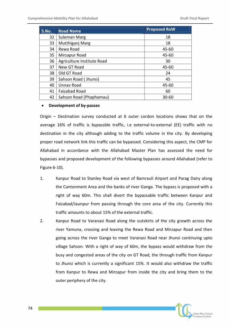
Comprehensive Mobility Plan for Allahabad Draft Final Report
74
S.No. Road Name Proposed RoW
32 Suleman Marg 18
33 Mutthiganj Marg 18
34 Rewa Road 45-60
35 Mirzapur Road 45-60
36 Agriculture Institute Road 30
37 New GT Road 45-60
38 Old GT Road 24
39 Sahson Road ( Jhunsi) 45
40 Unnav Road 45-60
41 Faizabad Road 60
42 Sahson Road (Phaphamau) 30-60
Development of by-passes
Origin – Destination survey conducted at 6 outer cordon locations shows that on the
average 16% of traffic is bypassble traffic, i.e external-to-external (EE) traffic with no
destination in the city although adding to the traffic volume in the city. By developing
proper road network link this traffic can be bypassed. Considering this aspect, the CMP for
Allahabad in accordance with the Allahabad Master Plan has assessed the need for
bypasses and proposed development of the following bypasses around Allahabad (refer to
Figure 6-10).
1. Kanpur Road to Stanley Road via west of Bamrauli Airport and Parag Dairy along
the Cantonment Area and the banks of river Ganga. The bypass is proposed with a
right of way 60m. This shall divert the bypassable traffic between Kanpur and
Faizabad/Jaunpur from passing through the core area of the city. Currently this
traffic amounts to about 15% of the external traffic.
2. Kanpur Road to Varanasi Road along the outskirts of the city growth across the
river Yamuna, crossing and leaving the Rewa Road and Mirzapur Road and then
going across the river Ganga to meet Varanasi Road near Jhunsi continuing upto
village Sahson. With a right of way of 60m, the bypass would withdraw from the
busy and congested areas of the city on GT Road, the through traffic from Kanpur
to Jhunsi which is currently a significant 15%. It would also withdraw the traffic
from Kanpur to Rewa and Mirzapur from inside the city and bring them to the
outer periphery of the city.
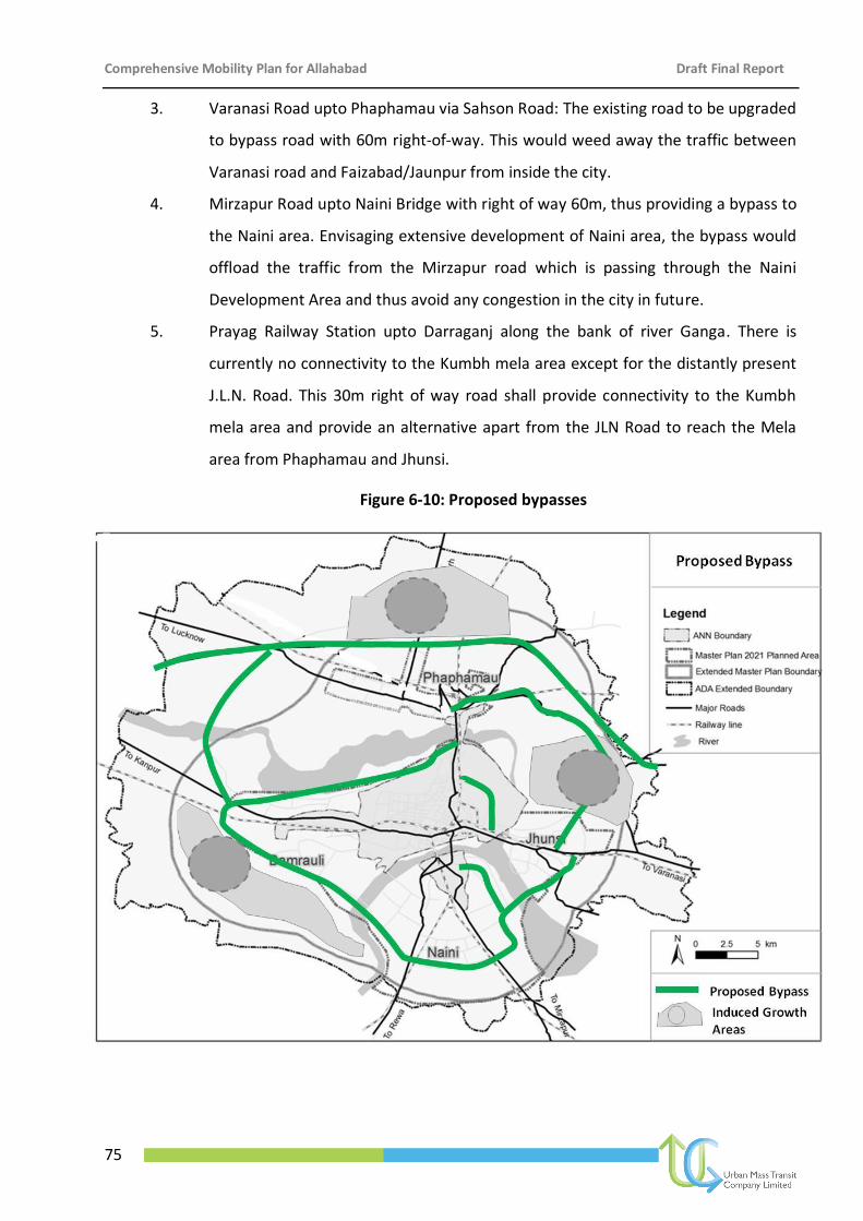
Comprehensive Mobility Plan for Allahabad Draft Final Report
75
3. Varanasi Road upto Phaphamau via Sahson Road: The existing road to be upgraded
to bypass road with 60m right-of-way. This would weed away the traffic between
Varanasi road and Faizabad/Jaunpur from inside the city.
4. Mirzapur Road upto Naini Bridge with right of way 60m, thus providing a bypass to
the Naini area. Envisaging extensive development of Naini area, the bypass would
offload the traffic from the Mirzapur road which is passing through the Naini
Development Area and thus avoid any congestion in the city in future.
5. Prayag Railway Station upto Darraganj along the bank of river Ganga. There is
currently no connectivity to the Kumbh mela area except for the distantly present
J.L.N. Road. This 30m right of way road shall provide connectivity to the Kumbh
mela area and provide an alternative apart from the JLN Road to reach the Mela
area from Phaphamau and Jhunsi.
Figure 6-10: Proposed bypasses
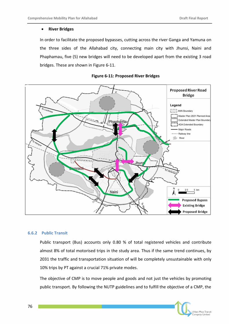
Comprehensive Mobility Plan for Allahabad Draft Final Report
76
River Bridges
In order to facilitate the proposed bypasses, cutting across the river Ganga and Yamuna on
the three sides of the Allahabad city, connecting main city with Jhunsi, Naini and
Phaphamau, five (5) new bridges will need to be developed apart from the existing 3 road
bridges. These are shown in Figure 6-11.
Figure 6-11: Proposed River Bridges
6.6.2 Public Transit
Public transport (Bus) accounts only 0.80 % of total registered vehicles and contribute
almost 8% of total motorised trips in the study area. Thus if the same trend continues, by
2031 the traffic and transportation situation of will be completely unsustainable with only
10% trips by PT against a crucial 71% private modes.
The objective of CMP is to move people and goods and not just the vehicles by promoting
public transport. By following the NUTP guidelines and to fulfill the objective of a CMP, the
Comprehensive Mobility Plan for Allahabad Draft Final Report
77
CMP for Allahabad has carried out various alternative scenarios to arrive at the best
feasible and sustainable public transport scenario for Allahabad. The details of scenarios
are described in Travel Demand Assessment Chapter.
As per the Public Transit only scenario with improved frequencies and augmented services,
only 14% PT share was achieved. However, with the integrated approach of network
improvement, City Bus Augmentation and integration of City Bus System with IPT modes in
an organised and rationalized manner, about 21% PT share is achieved.
It is important to note that Allahabad is a compact city with primary dependence on IPT
and private modes. It is the IPT which has deep penetrations into the city, although the
shared autos follow fixed routes, yet they carry a substantial percentage of moving
population. Hence, a strategic approach of rationalizing the IPT routes and using them as
feeders for City Bus Services and for the Light Bus Based services (Midi and Mini Buses)
would considerably increase PT share encouraging shift from private modes to public
modes apart from stabilizing the PT share in 2031 relative to current status. Adopting these
strategic measures, the Public Mode trip share in Allahabad is estimated to touching 40%
(PT + IPT) of the total in horizon year 2031. However, it is essential to note that this also
requires emphasis on revitalization and retrofitting of areas along the city arterial roads
proposed to be developed as Lite Bus based corridor with Midi buses as well as along the
routes under City Bus Services. Also induced development along the new links together
with rationalized IPT system shall encourage increased PT ridership in future.
1 Development of three tiers of Public Transport system which shall include:
City Bus Services Augmentation
Lite Bus Based Transit Service
Integration of IPT and PT towards an organised and rationalised system
2 Improvement and development of adequate infrastructure for promotion of public
transport and multi-modal integration
3 Implementation of ITS for improving reliability of public transport
4 Initiating reform measures in Urban Transport
5 Promoting public participation and campaigning mass awareness programme
6 Encouraging private sector in promotion of public transport
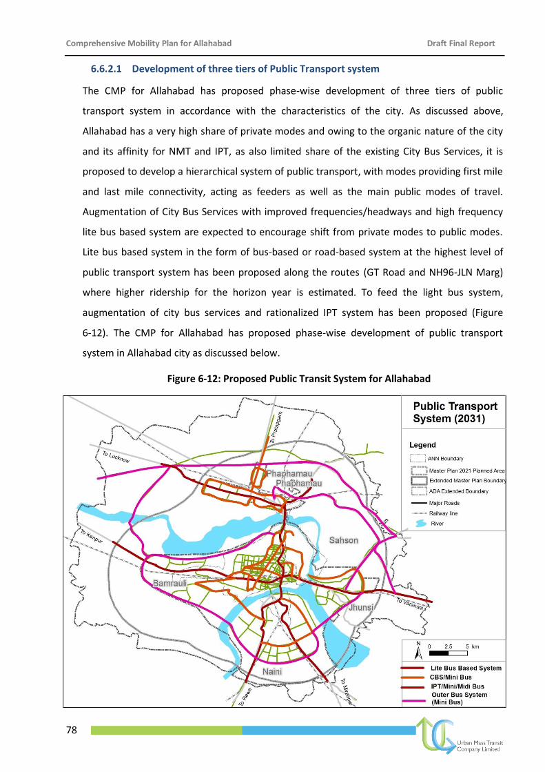
Comprehensive Mobility Plan for Allahabad Draft Final Report
78
6.6.2.1 Development of three tiers of Public Transport system
The CMP for Allahabad has proposed phase-wise development of three tiers of public
transport system in accordance with the characteristics of the city. As discussed above,
Allahabad has a very high share of private modes and owing to the organic nature of the city
and its affinity for NMT and IPT, as also limited share of the existing City Bus Services, it is
proposed to develop a hierarchical system of public transport, with modes providing first mile
and last mile connectivity, acting as feeders as well as the main public modes of travel.
Augmentation of City Bus Services with improved frequencies/headways and high frequency
lite bus based system are expected to encourage shift from private modes to public modes.
Lite bus based system in the form of bus-based or road-based system at the highest level of
public transport system has been proposed along the routes (GT Road and NH96-JLN Marg)
where higher ridership for the horizon year is estimated. To feed the light bus system,
augmentation of city bus services and rationalized IPT system has been proposed (Figure
6-12). The CMP for Allahabad has proposed phase-wise development of public transport
system in Allahabad city as discussed below.
Figure 6-12: Proposed Public Transit System for Allahabad
Comprehensive Mobility Plan for Allahabad Draft Final Report
79
Phase I, Public transport plan for Allahabad includes:
1. Augmented City Bus service along the existing routes with increased frequency (15
minutes)
2. Increase in frequency of city bus service (10 minutes) in order to augment the existing
services along:
Corridor-1: Phaphamau-Teliarganj-Bank Road-MNIT-Alopi Bagh-Bairahana-Minto Park-
Naini
Corridor-2: Bamrauli Airport-Subedarganj-GT Road- Bairahana-Alopi Bagh-Jhunsi
3. Organising and scheduling IPT routes for the main city to bring people onto the CBS
routes
Phase II, Public transport plan for Allahabad includes:
1. Augmentation of City Bus Service along the existing city bus service routes with minimum
frequency of 10 minutes: Frequency of 5 minutes along the Corridor 1 and 2 and 10 min
frequency along Kamla Nehru Road-Master Zahurul Hasan Marg and P D Tandon Marg-
Stanley Road
2. Introduction of Mini buses/IPT on identified roads other than city bus routes to act as
feeders
3. Rationalisation of IPT Routes: In order to minimise the overlapping of IPT routes with city
Bus Service routes and to develop IPT to act as feeder service to the city bus service and
mini buses, IPT services should be promoted in the areas to promote multi-modal
integration.
4. Rural IPT: IPT services should also be promoted in the rural/peripheral areas of the city
on the proposed bypasses to bring the trips on to CBS/Bus system for travel in the city.
Phase III, Public transport plan for Allahabad includes:
1. Augmentation of City Bus Service across the city
2. Organised and restructured Mini Bus Routes and IPT routes
3. Introduction of Lite Bus-based transit system in two corridors
Corridor-1: Phaphamau-Teliarganj-Bank Road-MNIT-Alopi Bagh-Bairahana-Minto
Park-Naini
Corridor-2: Bamrauli Airport-Subedarganj-GT Road- Bairahana-Alopi Bagh-Jhunsi
Comprehensive Mobility Plan for Allahabad Draft Final Report
80
4. Outer Bus System/Rural IPT: IPT services should also be promoted in the rural/peripheral
areas of the city on the proposed bypasses to bring the trips on to CBS/Bus system for
travel in the city.
6.6.2.2 Restructuring of IPT and adoption of strategies for sustainable City Bus Service
As per Government of India’s flagship Scheme of JnNURM, Ministry of Urban Development,
Government of India, has sanctioned 150 buses for augmenting the city bus service in
Allahabad. Out of these 150 sanctioned buses, 132 buses are now operated by UPSRTC on 23
identified routes. Since the IPT, particularly the shared auto/taxi routes, overlaps with almost
60% of the existing city bus service routes, it is clear that route overlapping reduces the
commercial viability and sustainability of city bus service. Thus, considering this aspect, the
CMP for Allahabad has proposed to develop IPT as a feeder service to the city bus service by
rationalising the IPT routes. Figure 6-12 shows the city bus service routes and the IPT routes.
Also IPT is seen as a sustainable mode for rural travel and for transition from rural system to
city based travel.
6.6.2.3 Infrastructure for public transport and multi-modal integration
For development of three tiers of public transport, it is imperative to develop adequate
infrastructure. Considering the multimodal integration of different types of public transport,
there should be complete and supportive public transport infrastructure. Thus, CMP for
Allahabad has proposed the following infrastructures to promote public transport and
achieve the target of 30% share of public transport by 2031. The infrastructure requirement
for Allahabad is classified as follows:
(A) Infrastructure for bus-based public transport: Following are the list of infrastructure
requirements for bus-based public transport:
1. Improvement of Existing Bus Terminals of UPSRTC: At present, there are three (3) bus
terminals/stations in Allahabad maintained by UPSRTC namely at Civil Lines, Zero Road
and Leader Road i.e. Railway Station City side. Refer Figure 6-13. A bus station is
located near District Courts (Kutchery) where primarily private buses are parked.
These need to be revamped and developed with basic amenities to facilities public
comfort and convenience. The ingress and egress trips to the Allahabad Junction (RS)
are attracted and produced all around the main city as well as areas in Jhunsi,
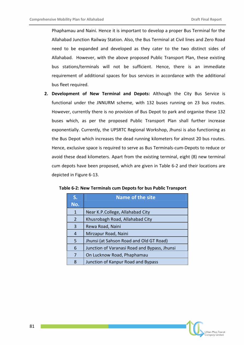
Comprehensive Mobility Plan for Allahabad Draft Final Report
81
Phaphamau and Naini. Hence it is important to develop a proper Bus Terminal for the
Allahabad Junction Railway Station. Also, the Bus Terminal at Civil lines and Zero Road
need to be expanded and developed as they cater to the two distinct sides of
Allahabad. However, with the above proposed Public Transport Plan, these existing
bus stations/terminals will not be sufficient. Hence, there is an immediate
requirement of additional spaces for bus services in accordance with the additional
bus fleet required.
2. Development of New Terminal and Depots: Although the City Bus Service is
functional under the JNNURM scheme, with 132 buses running on 23 bus routes.
However, currently there is no provision of Bus Depot to park and organise these 132
buses which, as per the proposed Public Transport Plan shall further increase
exponentially. Currently, the UPSRTC Regional Workshop, Jhunsi is also functioning as
the Bus Depot which increases the dead running kilometers for almost 20 bus routes.
Hence, exclusive space is required to serve as Bus Terminals-cum-Depots to reduce or
avoid these dead kilometers. Apart from the existing terminal, eight (8) new terminal
cum depots have been proposed, which are given in Table 6-2 and their locations are
depicted in Figure 6-13.
Table 6-2: New Terminals cum Depots for bus Public Transport
S. No.
Name of the site
1 Near K.P.College, Allahabad City
2 Khusrobagh Road, Allahabad City
3 Rewa Road, Naini
4 Mirzapur Road, Naini
5 Jhunsi (at Sahson Road and Old GT Road)
6 Junction of Varanasi Road and Bypass, Jhunsi
7 On Lucknow Road, Phaphamau
8 Junction of Kanpur Road and Bypass
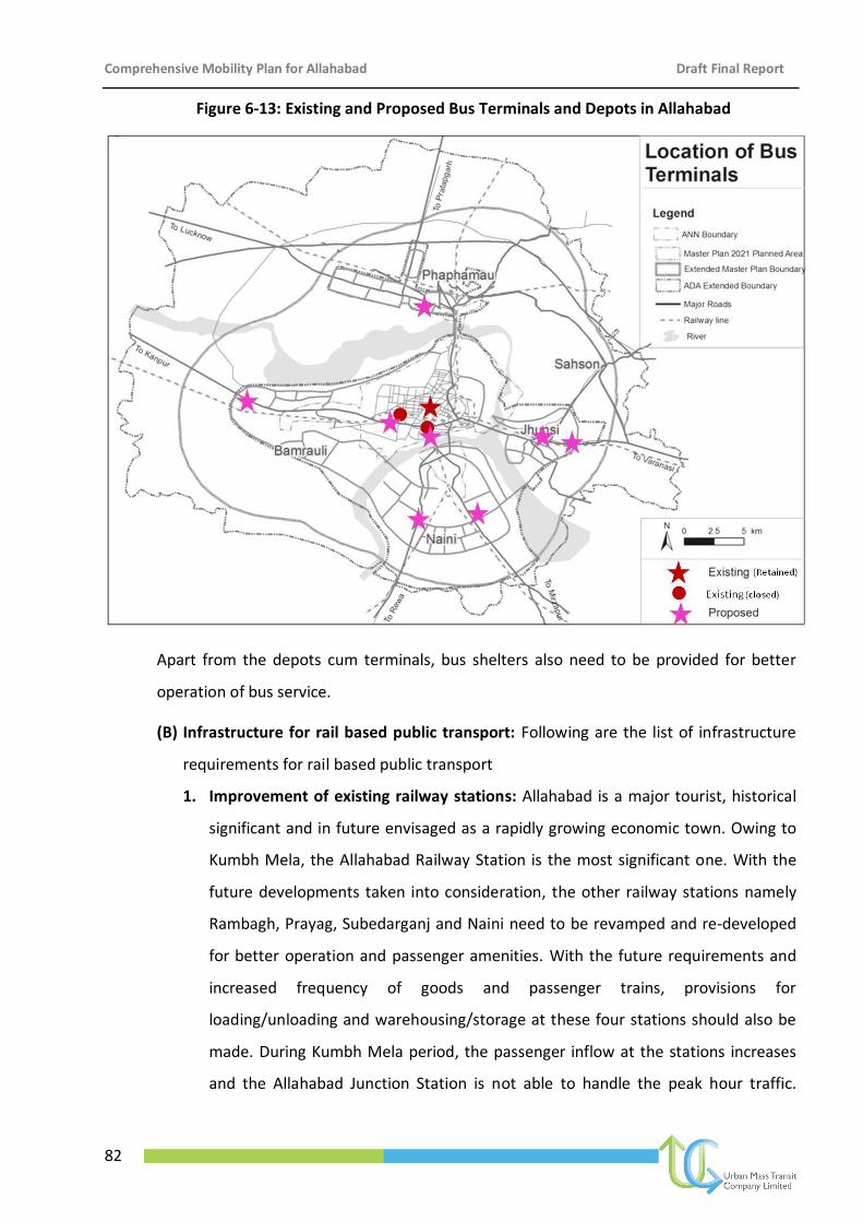
Comprehensive Mobility Plan for Allahabad Draft Final Report
82
Figure 6-13: Existing and Proposed Bus Terminals and Depots in Allahabad
Apart from the depots cum terminals, bus shelters also need to be provided for better
operation of bus service.
(B) Infrastructure for rail based public transport: Following are the list of infrastructure
requirements for rail based public transport
1. Improvement of existing railway stations: Allahabad is a major tourist, historical
significant and in future envisaged as a rapidly growing economic town. Owing to
Kumbh Mela, the Allahabad Railway Station is the most significant one. With the
future developments taken into consideration, the other railway stations namely
Rambagh, Prayag, Subedarganj and Naini need to be revamped and re-developed
for better operation and passenger amenities. With the future requirements and
increased frequency of goods and passenger trains, provisions for
loading/unloading and warehousing/storage at these four stations should also be
made. During Kumbh Mela period, the passenger inflow at the stations increases
and the Allahabad Junction Station is not able to handle the peak hour traffic.
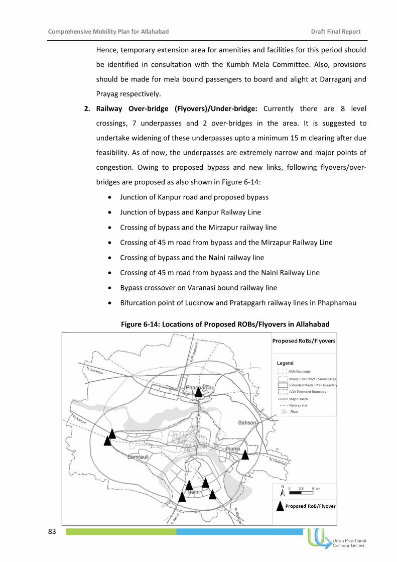
Comprehensive Mobility Plan for Allahabad Draft Final Report
83
Hence, temporary extension area for amenities and facilities for this period should
be identified in consultation with the Kumbh Mela Committee. Also, provisions
should be made for mela bound passengers to board and alight at Darraganj and
Prayag respectively.
2. Railway Over-bridge (Flyovers)/Under-bridge: Currently there are 8 level
crossings, 7 underpasses and 2 over-bridges in the area. It is suggested to
undertake widening of these underpasses upto a minimum 15 m clearing after due
feasibility. As of now, the underpasses are extremely narrow and major points of
congestion. Owing to proposed bypass and new links, following flyovers/over-
bridges are proposed as also shown in Figure 6-14:
Junction of Kanpur road and proposed bypass
Junction of bypass and Kanpur Railway Line
Crossing of bypass and the Mirzapur railway line
Crossing of 45 m road from bypass and the Mirzapur Railway Line
Crossing of bypass and the Naini railway line
Crossing of 45 m road from bypass and the Naini Railway Line
Bypass crossover on Varanasi bound railway line
Bifurcation point of Lucknow and Pratapgarh railway lines in Phaphamau
Figure 6-14: Locations of Proposed ROBs/Flyovers in Allahabad
Comprehensive Mobility Plan for Allahabad Draft Final Report
84
6.6.2.4 ITS for Public Transport
In order to promote public transport in general and city bus service in particular
improvement in the quality of service, efficiency, reliability and safety is utmost important
which can lead to wider acceptance of the service. In the wake of newly started city bus
service under JnNURM, there is an urgent need of installation of ITS and control system
facilities. Installation of ITS will improve the efficiency, reliability, and safety of the city bus
service which will create value addition to the service and thereby will contribute to
increase in ridership. The CMP for Allahabad has proposed phase wise installation of ITS
system for improvement in the quality of city bus service and to promote public transport.
Figure 5-19 shows the ITS architecture for promoting public transport.
Figure 6-15: ITS architecture for promoting public transport
Comprehensive Mobility Plan for Allahabad Draft Final Report
85
Installation of ITS on vehicles:
– GPS and Data Logger Facilities: The system would record latitude, longitude,
fuel consumption data (optional), with time stamp so as to be able to facilitate
computation of stoppage data, speed data, distance covered, route deviation,
stoppage deviation, skipping of scheduled stoppages, and provide passenger
information like next bus queue shelter, expected time to arrive at next bus
queue shelter, etc.
– LED display in vehicles capable of providing information of current location of
bus and the next stop.
– Automated announcement facilities on the bus to inform the current position
of the bus, next stoppage and the time left to reach next stoppage.
– A modem/GSM-based transceiver for maintaining contact between the bus
driver and the control centre.
– Fuel sensor to provide correct information on fuel consumption per kilometer,
fuel theft, etc.
Installation of ITS at the bus stops
– LED display at bus shelter to provide a wide range of message display
attributes including the information on departure sequence number, route
number, destination, scheduled departure time, predicted time of arrival, etc.
– Communication interlink system for maintaining communication between the
bus stop and the control centre
Installation of ITS at the control station
– Communication centre (GSM/CDMA/GPRS based)
– GIS Application Software
– Other hardware and software requirements at the control centre
The central control system shall have suitable facilities for detecting and reporting
malfunctions and failures of system elements without continuous supervision. The
system shall include a comprehensive, efficient and user-friendly Database
Configuration Management Tool for managing the process of entering/changing data,
Comprehensive Mobility Plan for Allahabad Draft Final Report
86
verifying the data, testing the data, activating the data in the live data set, distributing
the live data set around the whole system (including the vehicle fleet) and
withdrawing the data. The tool shall enable the number of routes covered by the
system to be increased with minimal disruption to the settings of previously
configured routes. In addition to the above mentioned ITS Facilities, it is proposed that
the following will be included at a later stage in the second phase for a more
comprehensive ITS environment for public transport system management and control
in the city.
It also proposes for the introduction of Management Information System (MIS)
covering the aspects related to vehicle details, fare collection details, etc.
6.6.2.5 Initiating reform measures in Urban Transport
To effectively promote and implement public transport, a robust institutional
arrangement is essential. In line with the Government of India guidelines, it is proposed to
set up a single agency that would coordinate public transport services in the city so that
there is an integrated service. Refer to Chapter 8, Institutional Framework where the
details of institutional setup has been discussed.
6.6.2.6 Public participation and Awareness Programme
For successful implementation of the public transport project, it is considered necessary
to promote public awareness and create a sense of public ownership of the project. It is
necessary to evolve an outreach and education strategy for public transport. Refer to
Annexure, where public participation and campaigning mass awareness programme has
been discussed in detail.
6.6.2.7 Encouraging private sector in promotion of public transport
Traditionally, the responsibility of providing public transport lies with the Government
financed and operated using resources from taxes and various levies. Over the years,
experience have shown that important urban utility services like urban transport is
controlled by multiple institutions resulting in fragmentation of functional responsibilities
and large scale inefficiencies in service delivery. In order to improve the quality of service
delivery of public transport and to effectively infuse and utilise private fund for supply of
Comprehensive Mobility Plan for Allahabad Draft Final Report
87
public transport, participation of private players should be encouraged through adopting
various Public Private Partnership (PPP) models. Details of various PPP model have been
discussed in Chapter 8, Implementation Programme and Costing.
6.6.3 Non-Motorised Transport
About 56% of trips within Allahabad are made by Non-Motorised Transport (NMT) which
includes walk, bicycles and cycle rickshaw with 35% trips by walk alone. The CMP for
Allahabad targets these NMT trips. To ensure safe pedestrian mobility, provision of footpath,
safe pedestrian crossing facilities and slow moving vehicle lanes are proposed as part of the
NMT Improvement Plan.
6.6.3.1 Footpaths
A significant portion of the trips (35%) are walk trips; however, almost 100% of the road
network do not have footpath. The target has been set to achieve walkability index of 100%
by 2031 from existing walkability index of 0% in 2010. The CMP for Allahabad has therefore
proposed the development of 350 kms of footpath in phase-wise manner (Figure 6-16). The
following measures needs be undertaken as a part of improvement in pedestrian mobility:
Construction of Foot Path on the proposed mobility corridors and also the secondary
arterials, as a minimum requirement. It should also be created in all the residential
roads, wherever possible.
A minimum usable width of 1.5 meters should be provided for footpath.
It is desirable to have a footpath width of 2.0 meter for all roads.
Obstructions on footpath must be relocated. The footpath must be cleaned and even
made comfortable to walk on.
Footpath design must discourage two wheelers using the footpath during periods of
congestion.
At signalised intersections, pedestrian zebra crossings must be clearly marked.
Footpaths at all busy intersections must be provided with handrails to enforce
pedestrians cross at zebra crossings.
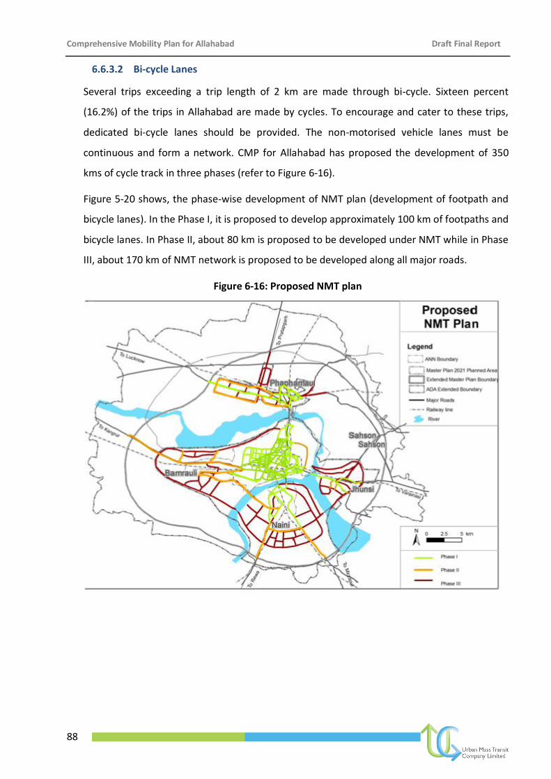
Comprehensive Mobility Plan for Allahabad Draft Final Report
88
6.6.3.2 Bi-cycle Lanes
Several trips exceeding a trip length of 2 km are made through bi-cycle. Sixteen percent
(16.2%) of the trips in Allahabad are made by cycles. To encourage and cater to these trips,
dedicated bi-cycle lanes should be provided. The non-motorised vehicle lanes must be
continuous and form a network. CMP for Allahabad has proposed the development of 350
kms of cycle track in three phases (refer to Figure 6-16).
Figure 5-20 shows, the phase-wise development of NMT plan (development of footpath and
bicycle lanes). In the Phase I, it is proposed to develop approximately 100 km of footpaths and
bicycle lanes. In Phase II, about 80 km is proposed to be developed under NMT while in Phase
III, about 170 km of NMT network is proposed to be developed along all major roads.
Figure 6-16: Proposed NMT plan
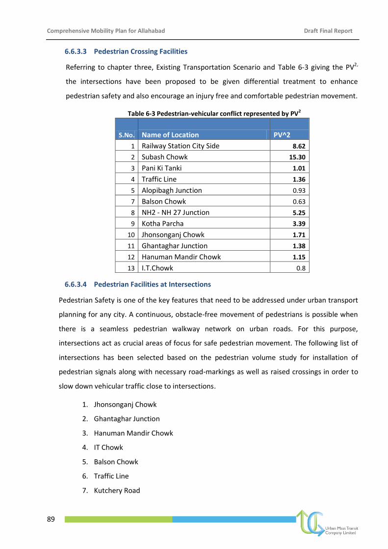
Comprehensive Mobility Plan for Allahabad Draft Final Report
89
6.6.3.3 Pedestrian Crossing Facilities
Referring to chapter three, Existing Transportation Scenario and Table 6-3 giving the PV2,
the intersections have been proposed to be given differential treatment to enhance
pedestrian safety and also encourage an injury free and comfortable pedestrian movement.
Table 6-3 Pedestrian-vehicular conflict represented by PV2
S.No. Name of Location PV^2
1 Railway Station City Side 8.62
2 Subash Chowk 15.30
3 Pani Ki Tanki 1.01
4 Traffic Line 1.36
5 Alopibagh Junction 0.93
7 Balson Chowk 0.63
8 NH2 - NH 27 Junction 5.25
9 Kotha Parcha 3.39
10 Jhonsonganj Chowk 1.71
11 Ghantaghar Junction 1.38
12 Hanuman Mandir Chowk 1.15
13 I.T.Chowk 0.8
6.6.3.4 Pedestrian Facilities at Intersections
Pedestrian Safety is one of the key features that need to be addressed under urban transport
planning for any city. A continuous, obstacle-free movement of pedestrians is possible when
there is a seamless pedestrian walkway network on urban roads. For this purpose,
intersections act as crucial areas of focus for safe pedestrian movement. The following list of
intersections has been selected based on the pedestrian volume study for installation of
pedestrian signals along with necessary road-markings as well as raised crossings in order to
slow down vehicular traffic close to intersections.
1. Jhonsonganj Chowk
2. Ghantaghar Junction
3. Hanuman Mandir Chowk
4. IT Chowk
5. Balson Chowk
6. Traffic Line
7. Kutchery Road
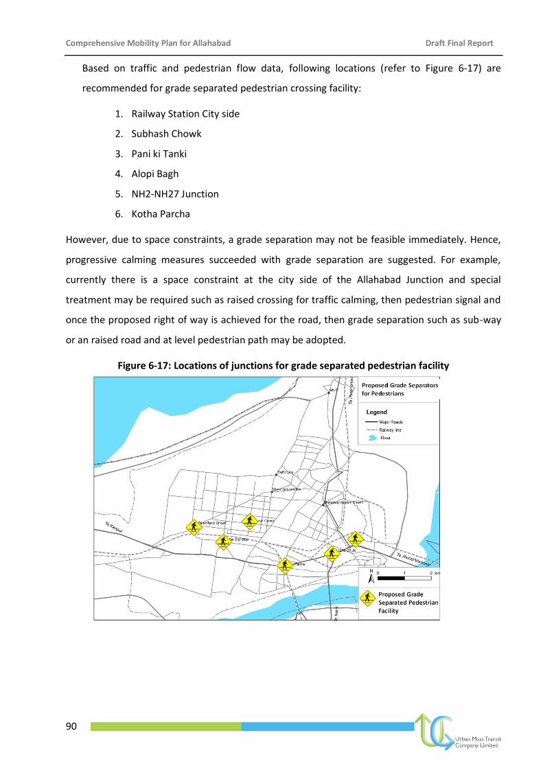
Comprehensive Mobility Plan for Allahabad Draft Final Report
90
Based on traffic and pedestrian flow data, following locations (refer to Figure 6-17) are
recommended for grade separated pedestrian crossing facility:
1. Railway Station City side
2. Subhash Chowk
3. Pani ki Tanki
4. Alopi Bagh
5. NH2-NH27 Junction
6. Kotha Parcha
However, due to space constraints, a grade separation may not be feasible immediately. Hence,
progressive calming measures succeeded with grade separation are suggested. For example,
currently there is a space constraint at the city side of the Allahabad Junction and special
treatment may be required such as raised crossing for traffic calming, then pedestrian signal and
once the proposed right of way is achieved for the road, then grade separation such as sub-way
or an raised road and at level pedestrian path may be adopted.
Figure 6-17: Locations of junctions for grade separated pedestrian facility
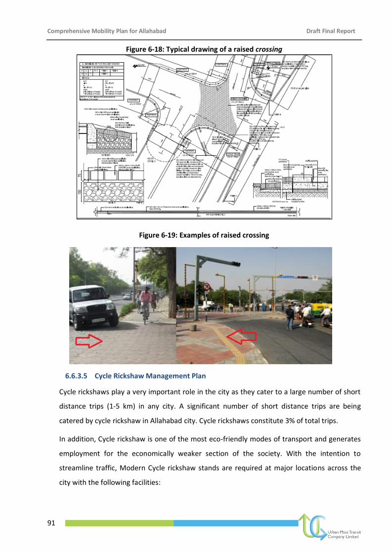
Comprehensive Mobility Plan for Allahabad Draft Final Report
91
Figure 6-18: Typical drawing of a raised crossing
Figure 6-19: Examples of raised crossing
6.6.3.5 Cycle Rickshaw Management Plan
Cycle rickshaws play a very important role in the city as they cater to a large number of short
distance trips (1-5 km) in any city. A significant number of short distance trips are being
catered by cycle rickshaw in Allahabad city. Cycle rickshaws constitute 3% of total trips.
In addition, Cycle rickshaw is one of the most eco-friendly modes of transport and generates
employment for the economically weaker section of the society. With the intention to
streamline traffic, Modern Cycle rickshaw stands are required at major locations across the
city with the following facilities:
Comprehensive Mobility Plan for Allahabad Draft Final Report
92
Sitting facility
Fare Chart
Free-of-cost drinking water facility for the registered cycle rickshaw pullers
Free-of-cost urinal and bathing facility for the registered cycle rickshaw pullers
Rickshaw repair facility
Night Shelters for the cycle rickshaw pullers subject to land availability by the
Municipal body
The CMP for Allahabad has proposed the development of modern cycle rickshaw stand in
old city areas.
6.6.4 Area Traffic Improvement Plan
6.6.4.1 Core area
The areas such as Chowk, Johnsonganj, Kutchery etc. form the old city area of Allahabad city.
A distinguishing characteristic in Allahabad is that all the activities, such as commercial or
mixed-use, takes place mostly at the mouth of the junctions. Slow moving traffic such as
cycle, cycle rickshaw, animal cart etc. in the old city areas along with fast moving traffic leads
to congestion and safety hazards for NMT users. CMP for Allahabad thus proposes to
segregate the slow moving traffic from the fast moving traffic to improve the speed profile
and avoid mixing of traffic, which acts as a safety hazard for the NMT.
6.6.4.2 Traffic and Area Improvement
With a multifaceted commercial nature of the CBD area, it is seen that people from within the
city, outside regions and tourists frequently visit the area. The proximity of the transport hub
and activities like retail commercial and wholesale trading for decades has resulted in severe
degradation of the area and its environs.
As part of the short term improvement plan, a comprehensive area traffic improvement
comprising of one ways, signage, parking etc are proposed; so as to retain its importance as a
trading and commercial hub, at the same time, improve the overall appearance and the
surroundings so that it becomes an attractive and a more liveable area. The following areas
was have been taken up as part of the short term plan:
1. Civil lines/MG road (from high court to Hanumat Niketan)
2. Railway Station city side area
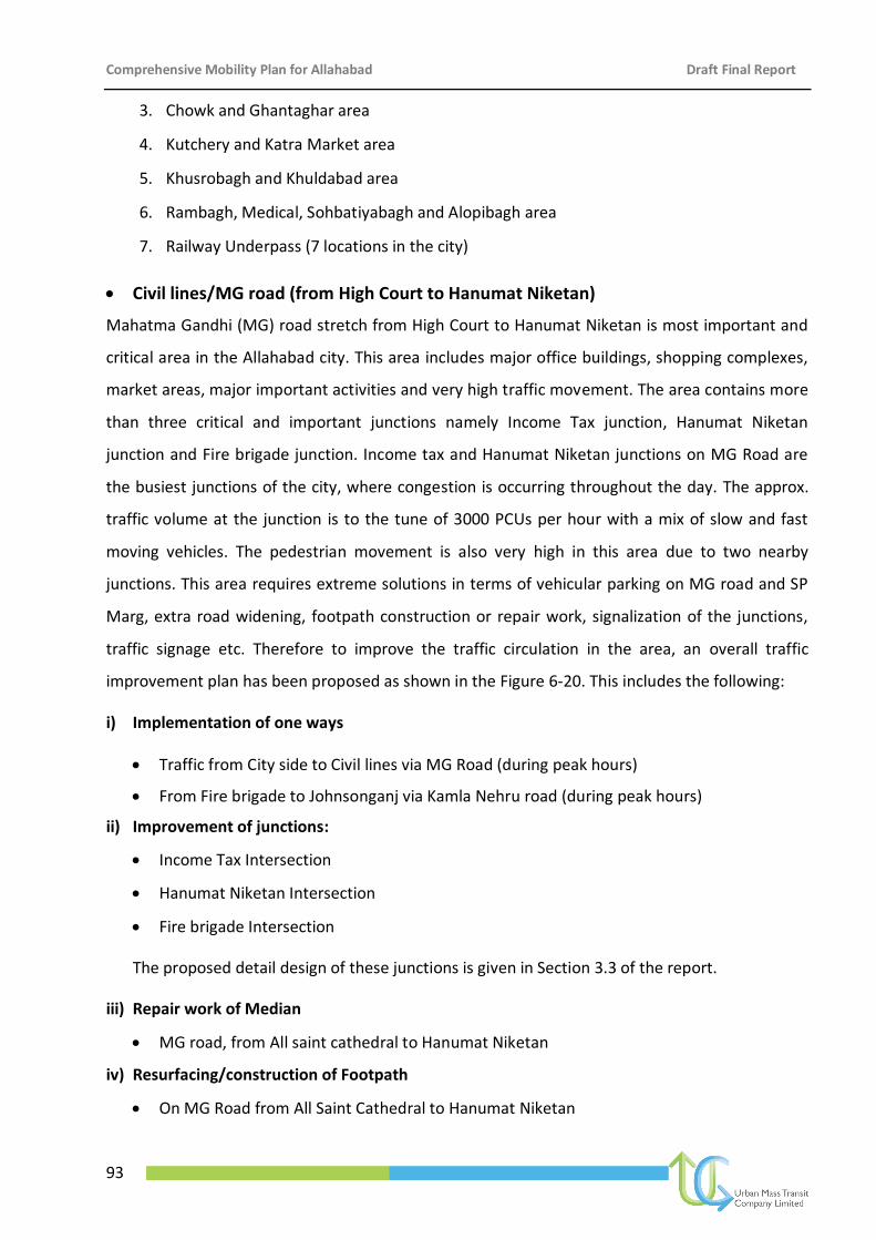
Comprehensive Mobility Plan for Allahabad Draft Final Report
93
3. Chowk and Ghantaghar area
4. Kutchery and Katra Market area
5. Khusrobagh and Khuldabad area
6. Rambagh, Medical, Sohbatiyabagh and Alopibagh area
7. Railway Underpass (7 locations in the city)
Civil lines/MG road (from High Court to Hanumat Niketan)
Mahatma Gandhi (MG) road stretch from High Court to Hanumat Niketan is most important and
critical area in the Allahabad city. This area includes major office buildings, shopping complexes,
market areas, major important activities and very high traffic movement. The area contains more
than three critical and important junctions namely Income Tax junction, Hanumat Niketan
junction and Fire brigade junction. Income tax and Hanumat Niketan junctions on MG Road are
the busiest junctions of the city, where congestion is occurring throughout the day. The approx.
traffic volume at the junction is to the tune of 3000 PCUs per hour with a mix of slow and fast
moving vehicles. The pedestrian movement is also very high in this area due to two nearby
junctions. This area requires extreme solutions in terms of vehicular parking on MG road and SP
Marg, extra road widening, footpath construction or repair work, signalization of the junctions,
traffic signage etc. Therefore to improve the traffic circulation in the area, an overall traffic
improvement plan has been proposed as shown in the Figure 6-20. This includes the following:
i) Implementation of one ways
Traffic from City side to Civil lines via MG Road (during peak hours)
From Fire brigade to Johnsonganj via Kamla Nehru road (during peak hours)
ii) Improvement of junctions:
Income Tax Intersection
Hanumat Niketan Intersection
Fire brigade Intersection
The proposed detail design of these junctions is given in Section 3.3 of the report.
iii) Repair work of Median
MG road, from All saint cathedral to Hanumat Niketan
iv) Resurfacing/construction of Footpath
On MG Road from All Saint Cathedral to Hanumat Niketan
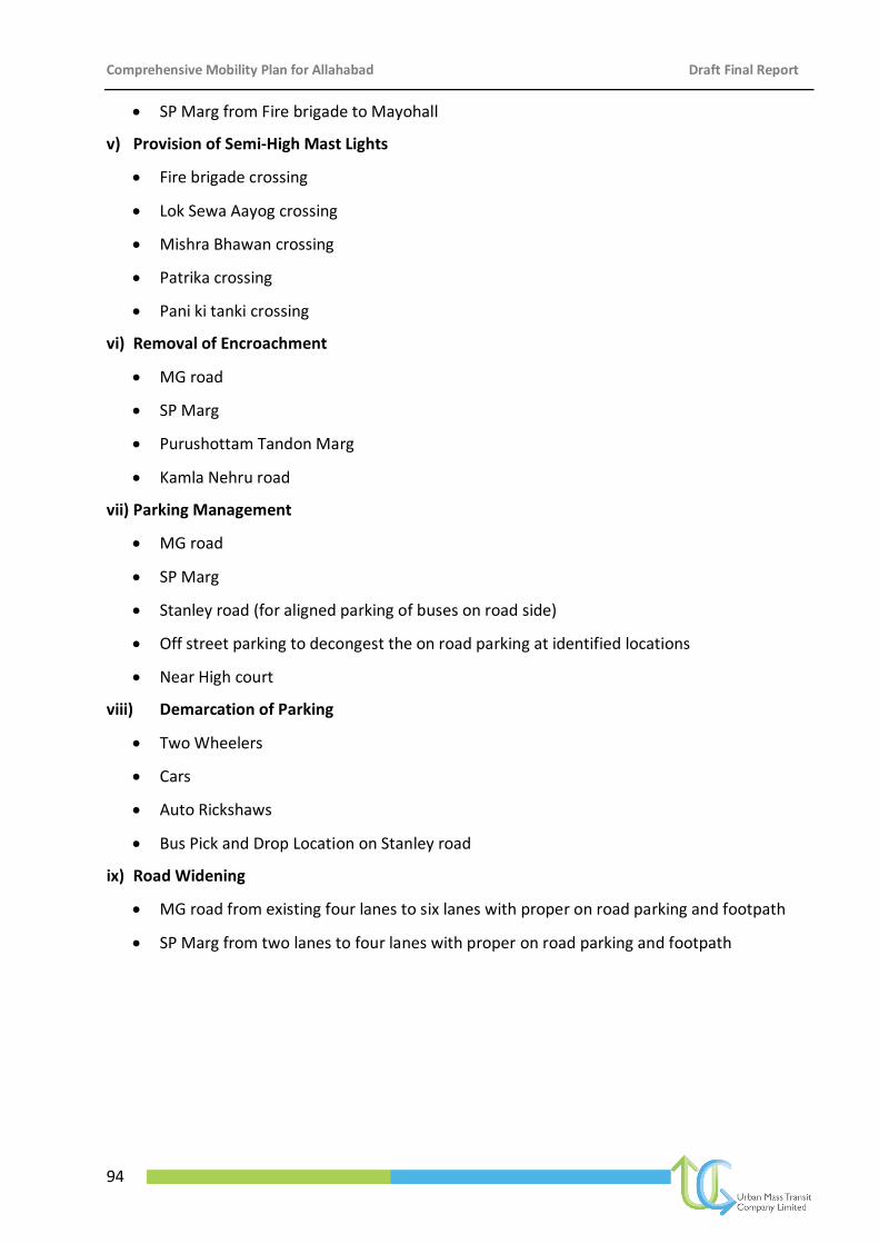
Comprehensive Mobility Plan for Allahabad Draft Final Report
94
SP Marg from Fire brigade to Mayohall
v) Provision of Semi-High Mast Lights
Fire brigade crossing
Lok Sewa Aayog crossing
Mishra Bhawan crossing
Patrika crossing
Pani ki tanki crossing
vi) Removal of Encroachment
MG road
SP Marg
Purushottam Tandon Marg
Kamla Nehru road
vii) Parking Management
MG road
SP Marg
Stanley road (for aligned parking of buses on road side)
Off street parking to decongest the on road parking at identified locations
Near High court
viii) Demarcation of Parking
Two Wheelers
Cars
Auto Rickshaws
Bus Pick and Drop Location on Stanley road
ix) Road Widening
MG road from existing four lanes to six lanes with proper on road parking and footpath
SP Marg from two lanes to four lanes with proper on road parking and footpath
Comprehensive Mobility Plan for Allahabad Draft Final Report
95
Figure 6-20: Improvements for Civil lines/MG road (from High Court to Hanumat Niketan)
Comprehensive Mobility Plan for Allahabad Draft Final Report
96
Kutchery and Katra Market Area
The Kutchery and Katra area is very old and very busy area during the peak hours. Both the areas
turn high volume of four wheelers and two wheelers on the surrounding roads. Therefore to
improve the traffic circulation in the area, an overall traffic improvement plan has been proposed
as shown in the Figure 6-21. The proposal for Kutchery and Katra includes the following:
i) Demarcation of Parking
Two Wheelers
Cars
Auto Rickshaws ii) Signalization of Intersection
Kutchery junction
iii) Removal of Encroachment
Kamla Nehru Road
iv) Implementation of one ways
One full loop from Katra junction to Bank road to SP traffic office to Kutchery to Katra Junction
One way from Kutchery to Katra main junction
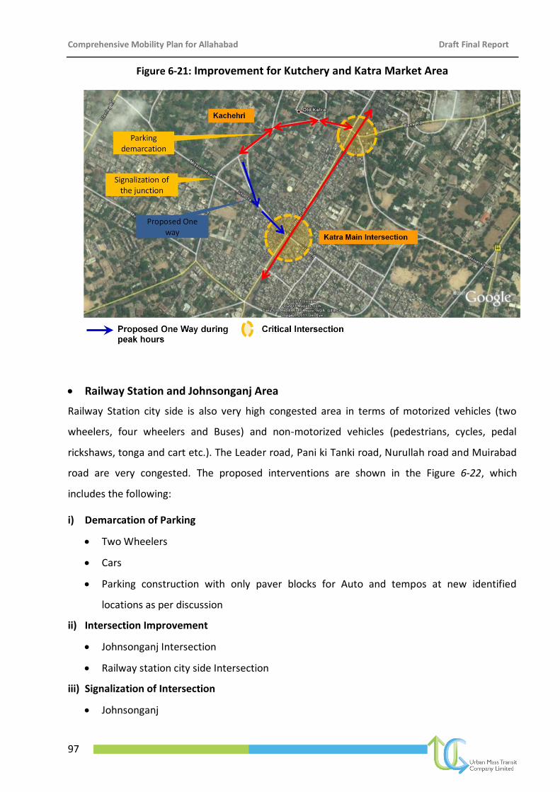
Comprehensive Mobility Plan for Allahabad Draft Final Report
97
Figure 6-21: Improvement for Kutchery and Katra Market Area
Railway Station and Johnsonganj Area
Railway Station city side is also very high congested area in terms of motorized vehicles (two
wheelers, four wheelers and Buses) and non-motorized vehicles (pedestrians, cycles, pedal
rickshaws, tonga and cart etc.). The Leader road, Pani ki Tanki road, Nurullah road and Muirabad
road are very congested. The proposed interventions are shown in the Figure 6-22, which
includes the following:
i) Demarcation of Parking
Two Wheelers
Cars
Parking construction with only paver blocks for Auto and tempos at new identified
locations as per discussion
ii) Intersection Improvement
Johnsonganj Intersection
Railway station city side Intersection
iii) Signalization of Intersection
Johnsonganj
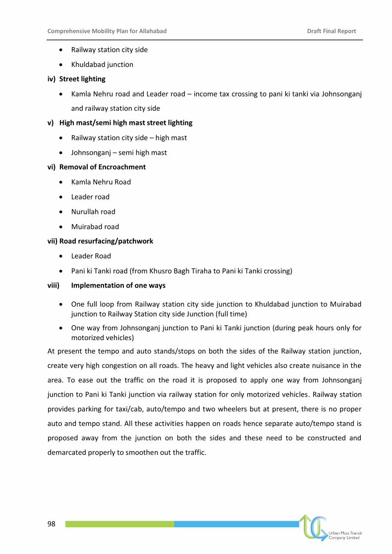
Comprehensive Mobility Plan for Allahabad Draft Final Report
98
Railway station city side
Khuldabad junction
iv) Street lighting
Kamla Nehru road and Leader road – income tax crossing to pani ki tanki via Johnsonganj
and railway station city side
v) High mast/semi high mast street lighting
Railway station city side – high mast
Johnsonganj – semi high mast
vi) Removal of Encroachment
Kamla Nehru Road
Leader road
Nurullah road
Muirabad road
vii) Road resurfacing/patchwork
Leader Road
Pani ki Tanki road (from Khusro Bagh Tiraha to Pani ki Tanki crossing)
viii) Implementation of one ways
One full loop from Railway station city side junction to Khuldabad junction to Muirabad junction to Railway Station city side Junction (full time)
One way from Johnsonganj junction to Pani ki Tanki junction (during peak hours only for motorized vehicles)
At present the tempo and auto stands/stops on both the sides of the Railway station junction,
create very high congestion on all roads. The heavy and light vehicles also create nuisance in the
area. To ease out the traffic on the road it is proposed to apply one way from Johnsonganj
junction to Pani ki Tanki junction via railway station for only motorized vehicles. Railway station
provides parking for taxi/cab, auto/tempo and two wheelers but at present, there is no proper
auto and tempo stand. All these activities happen on roads hence separate auto/tempo stand is
proposed away from the junction on both the sides and these need to be constructed and
demarcated properly to smoothen out the traffic.
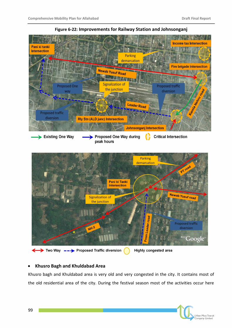
Comprehensive Mobility Plan for Allahabad Draft Final Report
99
Figure 6-22: Improvements for Railway Station and Johnsonganj
Khusro Bagh and Khuldabad Area
Khusro bagh and Khuldabad area is very old and very congested in the city. It contains most of
the old residential area of the city. During the festival season most of the activities occur here
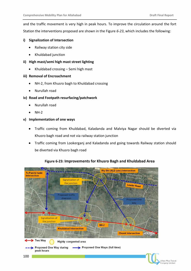
Comprehensive Mobility Plan for Allahabad Draft Final Report
100
and the traffic movement is very high in peak hours. To improve the circulation around the fort
Station the interventions proposed are shown in the Figure 6-23, which includes the following:
i) Signalization of Intersection
Railway station city side
Khuldabad junction
ii) High mast/semi high mast street lighting
Khuldabad crossing – Semi high mast
iii) Removal of Encroachment
NH-2, from Khusro bagh to Khuldabad crossing
Nurullah road
iv) Road and Footpath resurfacing/patchwork
Nurullah road
NH-2
v) Implementation of one ways
Traffic coming from Khuldabad, Kaladanda and Malviya Nagar should be diverted via
Khusro bagh road and not via railway station junction
Traffic coming from Lookerganj and Kaladanda and going towards Railway station should
be diverted via Khusro bagh road
Figure 6-23: Improvements for Khusro Bagh and Khuldabad Area
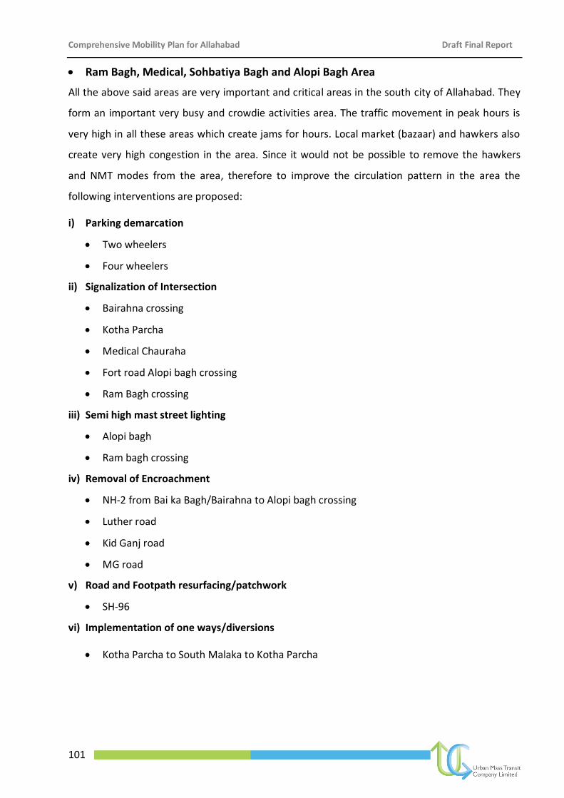
Comprehensive Mobility Plan for Allahabad Draft Final Report
101
Ram Bagh, Medical, Sohbatiya Bagh and Alopi Bagh Area
All the above said areas are very important and critical areas in the south city of Allahabad. They
form an important very busy and crowdie activities area. The traffic movement in peak hours is
very high in all these areas which create jams for hours. Local market (bazaar) and hawkers also
create very high congestion in the area. Since it would not be possible to remove the hawkers
and NMT modes from the area, therefore to improve the circulation pattern in the area the
following interventions are proposed:
i) Parking demarcation
Two wheelers
Four wheelers
ii) Signalization of Intersection
Bairahna crossing
Kotha Parcha
Medical Chauraha
Fort road Alopi bagh crossing
Ram Bagh crossing
iii) Semi high mast street lighting
Alopi bagh
Ram bagh crossing
iv) Removal of Encroachment
NH-2 from Bai ka Bagh/Bairahna to Alopi bagh crossing
Luther road
Kid Ganj road
MG road
v) Road and Footpath resurfacing/patchwork
SH-96
vi) Implementation of one ways/diversions
Kotha Parcha to South Malaka to Kotha Parcha
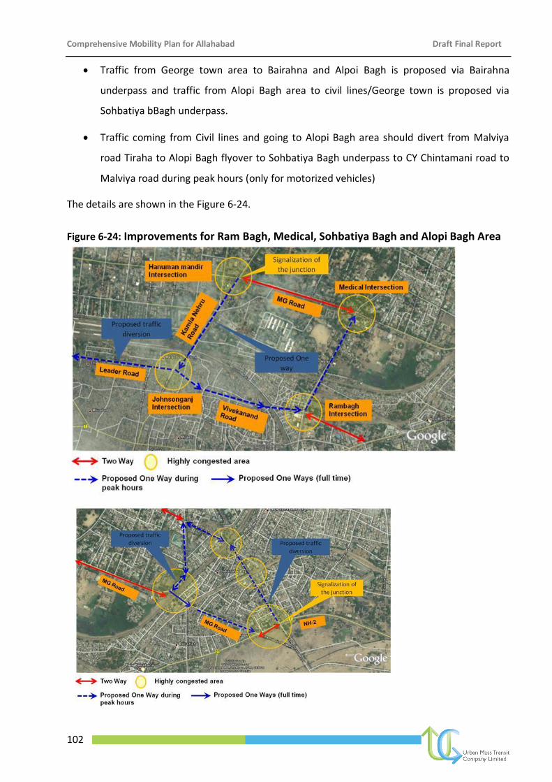
Comprehensive Mobility Plan for Allahabad Draft Final Report
102
Traffic from George town area to Bairahna and Alpoi Bagh is proposed via Bairahna
underpass and traffic from Alopi Bagh area to civil lines/George town is proposed via
Sohbatiya bBagh underpass.
Traffic coming from Civil lines and going to Alopi Bagh area should divert from Malviya
road Tiraha to Alopi Bagh flyover to Sohbatiya Bagh underpass to CY Chintamani road to
Malviya road during peak hours (only for motorized vehicles)
The details are shown in the Figure 6-24.
Figure 6-24: Improvements for Ram Bagh, Medical, Sohbatiya Bagh and Alopi Bagh Area
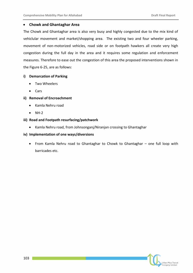
Comprehensive Mobility Plan for Allahabad Draft Final Report
103
Chowk and Ghantaghar Area
The Chowk and Ghantaghar area is also very busy and highly congested due to the mix kind of
vehiclular movement and market/shopping area. The existing two and four wheeler parking,
movement of non-motorized vehicles, road side or on footpath hawkers all create very high
congestion during the full day in the area and it requires some regulation and enforcement
measures. Therefore to ease out the congestion of this area the proposed interventions shown in
the Figure 6-25, are as follows:
i) Demarcation of Parking
Two Wheelers
Cars
ii) Removal of Encroachment
Kamla Nehru road
NH-2
iii) Road and Footpath resurfacing/patchwork
Kamla Nehru road, from Johnsonganj/Niranjan crossing to Ghantaghar
iv) Implementation of one ways/diversions
From Kamla Nehru road to Ghantaghar to Chowk to Ghantaghar – one full loop with
barricades etc.
Comprehensive Mobility Plan for Allahabad Draft Final Report
104
Figure 6-25: Improvements for Chowk and Ghantaghar
Railway Underpasses (7 locations) in the city
At present the city has railway underpasses at 7 locations to connect the northern part and
southern part. All these 7 underpasses are become bottlenecks during the morning and evening
peak hours as they are very narrow. The frequent traffic jams occur over there. The essential
transport infrastructure is in very poor condition at all the above said railway underpasses. Given
below is the list of all 7 locations:
Johnsonganj/Niranjan
Ram Bagh
South Malaka
TP Nagar near Kotha parcha
Bairahna
Sohbatiya Bagh
Alopi Bagh
Proposed Interventions at the above said railway underpasses:
Removal of encroachment
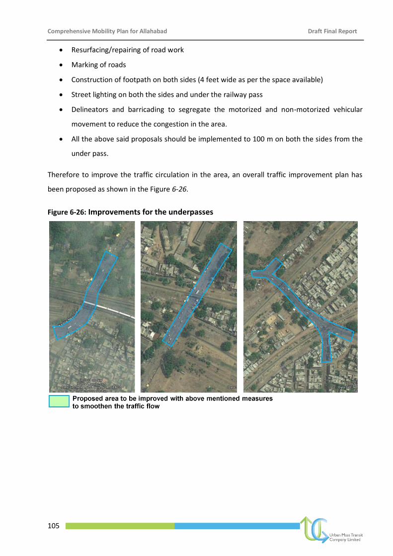
Comprehensive Mobility Plan for Allahabad Draft Final Report
105
Resurfacing/repairing of road work
Marking of roads
Construction of footpath on both sides (4 feet wide as per the space available)
Street lighting on both the sides and under the railway pass
Delineators and barricading to segregate the motorized and non-motorized vehicular
movement to reduce the congestion in the area.
All the above said proposals should be implemented to 100 m on both the sides from the
under pass.
Therefore to improve the traffic circulation in the area, an overall traffic improvement plan has
been proposed as shown in the Figure 6-26.
Figure 6-26: Improvements for the underpasses
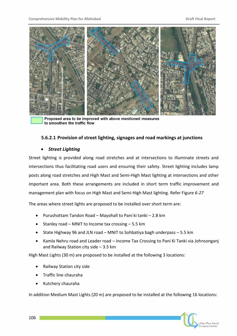
Comprehensive Mobility Plan for Allahabad Draft Final Report
106
5.6.2.1 Provision of street lighting, signages and road markings at junctions
Street Lighting
Street lighting is provided along road stretches and at intersections to illuminate streets and
intersections thus facilitating road users and ensuring their safety. Street lighting includes lamp
posts along road stretches and High Mast and Semi-High Mast lighting at intersections and other
important area. Both these arrangements are included in short term traffic improvement and
management plan with focus on High Mast and Semi-High Mast lighting. Refer Figure 6-27
The areas where street lights are proposed to be installed over short term are:
Purushottam Tandon Road – Mayohall to Pani ki tanki – 2.8 km
Stanley road – MNIT to Income tax crossing – 5.5 km
State Highway 96 and JLN road – MNIT to Sohbatiya bagh underpass – 5.5 km
Kamla Nehru road and Leader road – Income Tax Crossing to Pani Ki Tanki via Johnsonganj and Railway Station city side – 3.5 km
High Mast Lights (30 m) are proposed to be installed at the following 3 locations:
Railway Station city side
Traffic line chauraha
Kutchery chauraha
In addition Medium Mast Lights (20 m) are proposed to be installed at the following 16 locations:
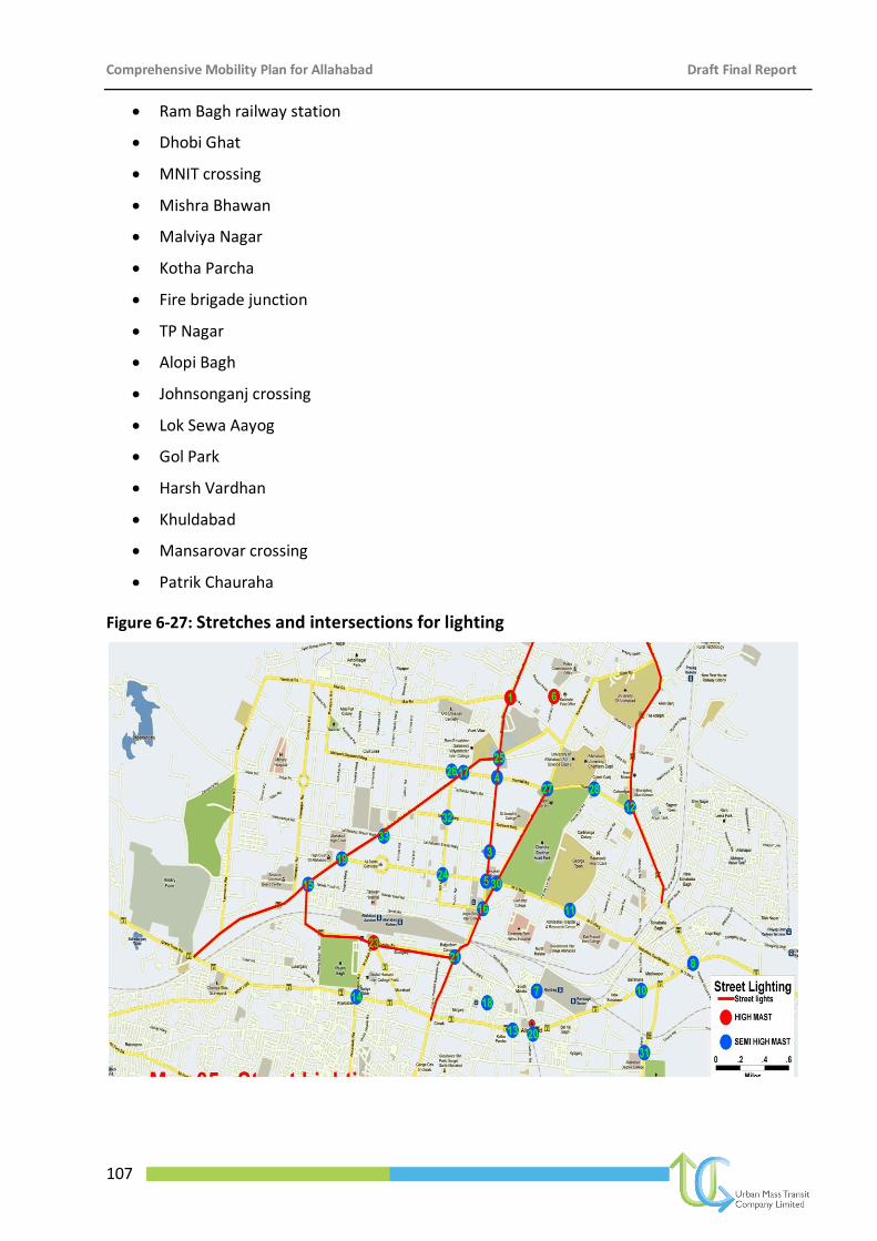
Comprehensive Mobility Plan for Allahabad Draft Final Report
107
Ram Bagh railway station
Dhobi Ghat
MNIT crossing
Mishra Bhawan
Malviya Nagar
Kotha Parcha
Fire brigade junction
TP Nagar
Alopi Bagh
Johnsonganj crossing
Lok Sewa Aayog
Gol Park
Harsh Vardhan
Khuldabad
Mansarovar crossing
Patrik Chauraha
Figure 6-27: Stretches and intersections for lighting
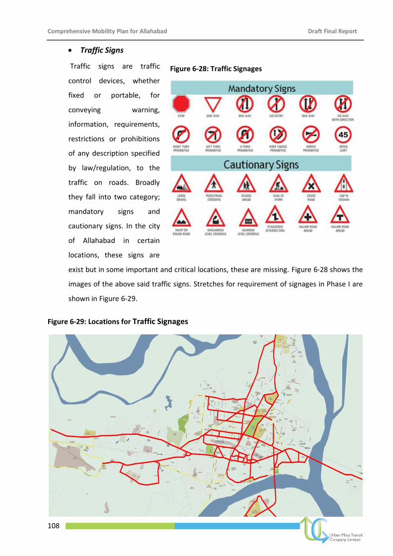
Comprehensive Mobility Plan for Allahabad Draft Final Report
108
Traffic Signs
Traffic signs are traffic
control devices, whether
fixed or portable, for
conveying warning,
information, requirements,
restrictions or prohibitions
of any description specified
by law/regulation, to the
traffic on roads. Broadly
they fall into two category;
mandatory signs and
cautionary signs. In the city
of Allahabad in certain
locations, these signs are
exist but in some important and critical locations, these are missing. Figure 6-28 shows the
images of the above said traffic signs. Stretches for requirement of signages in Phase I are
shown in Figure 6-29.
Figure 6-29: Locations for Traffic Signages
Figure 6-28: Traffic Signages
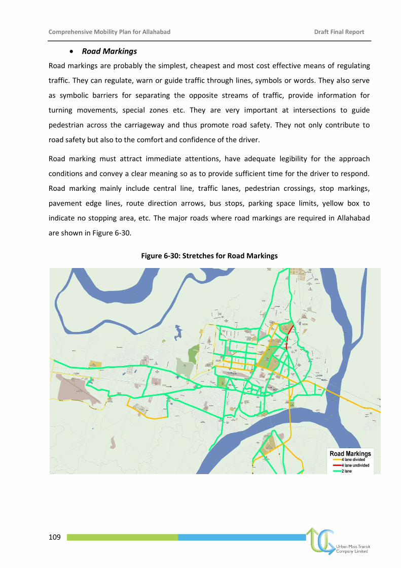
Comprehensive Mobility Plan for Allahabad Draft Final Report
109
Road Markings
Road markings are probably the simplest, cheapest and most cost effective means of regulating
traffic. They can regulate, warn or guide traffic through lines, symbols or words. They also serve
as symbolic barriers for separating the opposite streams of traffic, provide information for
turning movements, special zones etc. They are very important at intersections to guide
pedestrian across the carriageway and thus promote road safety. They not only contribute to
road safety but also to the comfort and confidence of the driver.
Road marking must attract immediate attentions, have adequate legibility for the approach
conditions and convey a clear meaning so as to provide sufficient time for the driver to respond.
Road marking mainly include central line, traffic lanes, pedestrian crossings, stop markings,
pavement edge lines, route direction arrows, bus stops, parking space limits, yellow box to
indicate no stopping area, etc. The major roads where road markings are required in Allahabad
are shown in Figure 6-30.
Figure 6-30: Stretches for Road Markings
Comprehensive Mobility Plan for Allahabad Draft Final Report
110
6.6.5 Freight Management
Freight movement in a city is an inevitable process of trade and economy. Traditionally,
movement of goods for local consumption and sale generally takes place from a certain
location within a city which is closest to the wholesale markets. In other cases where there
have been successful planning interventions, the goods terminal is preferred to be located
on the outskirts of the city, in order to prevent the entry of heavy vehicles into the
congested parts of the city. In Allahabad the wholesale markets are located in the heart of
the city areas of Mutthiganj and Khuldabad. The Khuldabad market is now shifted to the
Market Committee on Kanpur Road over an area of 45 ha. Baans Mandi wholesale market
is proposed to be shifted to Naini near Rewa Marg apart from two other markets in Naini
and one each in Jhunsi and Phaphamau. Developing wholesale markets in Naini, Jhunsi and
Phaphamau with improved connectivity through bypasses and new links, would reduce the
pressure and congestion in core areas of Allahabad.
6.6.5.1 Warehousing and Truck Terminals
Warehousing is suggested on the southern side on Subedarganj Railway Station in addition
to one in Phaphamau and two each in Jhunsi and Naini.
Also the master plan proposes to develop the Civil Lines zone as a City/Regional Business
Centre and reduce the daily local commercial activity. However, this may not be enough,
hence two city centres in Jhunsi and one each in Naini and Phaphamau are proposed.
As part of freight mobility improvement strategy, the CMP for Allahabad has made an in-
depth assessment of the proposals suggested by ADA apart from analysis of primary data
on freight traffic movement pattern. From the analysis it was found that the shifting of
wholesale market in the proposed activity area will reduce 30% of freight related traffic
form the congested core city areas. This reduction in traffic will have significant impact on
the level of service of GT Road.
In order to smoothening of freight traffic the CMP for Allahabad has proposed development
of truck terminals at the proposed locations as suggested by the ADA. Bypasses have been
proposed for through movement of freight traffic.
The freight traffic mobility improvement strategies with respect to road transport are
summarised below:
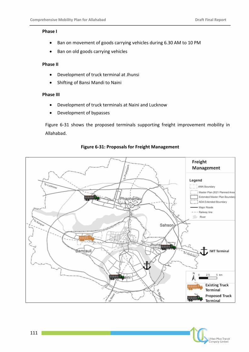
Comprehensive Mobility Plan for Allahabad Draft Final Report
111
Phase I
Ban on movement of goods carrying vehicles during 6.30 AM to 10 PM
Ban on old goods carrying vehicles
Phase II
Development of truck terminal at Jhunsi
Shifting of Bansi Mandi to Naini
Phase III
Development of truck terminals at Naini and Lucknow
Development of bypasses
Figure 6-31 shows the proposed terminals supporting freight improvement mobility in
Allahabad.
Figure 6-31: Proposals for Freight Management
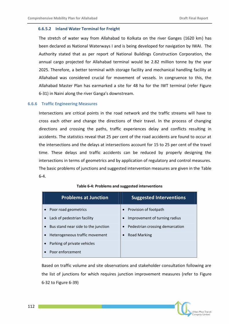
Comprehensive Mobility Plan for Allahabad Draft Final Report
112
6.6.5.2 Inland Water Terminal for Freight
The stretch of water way from Allahabad to Kolkata on the river Ganges (1620 km) has
been declared as National Waterways I and is being developed for navigation by IWAI. The
Authority stated that as per report of National Buildings Construction Corporation, the
annual cargo projected for Allahabad terminal would be 2.82 million tonne by the year
2025. Therefore, a better terminal with storage facility and mechanical handling facility at
Allahabad was considered crucial for movement of vessels. In congruence to this, the
Allahabad Master Plan has earmarked a site for 48 ha for the IWT terminal (refer Figure
6-31) in Naini along the river Ganga’s downstream.
6.6.6 Traffic Engineering Measures
Intersections are critical points in the road network and the traffic streams will have to
cross each other and change the directions of their travel. In the process of changing
directions and crossing the paths, traffic experiences delay and conflicts resulting in
accidents. The statistics reveal that 25 per cent of the road accidents are found to occur at
the intersections and the delays at intersections account for 15 to 25 per cent of the travel
time. These delays and traffic accidents can be reduced by properly designing the
intersections in terms of geometrics and by application of regulatory and control measures.
The basic problems of junctions and suggested intervention measures are given in the Table
6-4.
Table 6-4: Problems and suggested interventions
Based on traffic volume and site observations and stakeholder consultation following are
the list of junctions for which requires junction improvement measures (refer to Figure
6-32 to Figure 6-39)
Problems at Junction Suggested Interventions
Poor road geometrics
Lack of pedestrian facility
Bus stand near side to the junction
Heterogeneous traffic movement
Parking of private vehicles
Poor enforcement
Provision of footpath
Improvement of turning radius
Pedestrian crossing demarcation
Road Marking
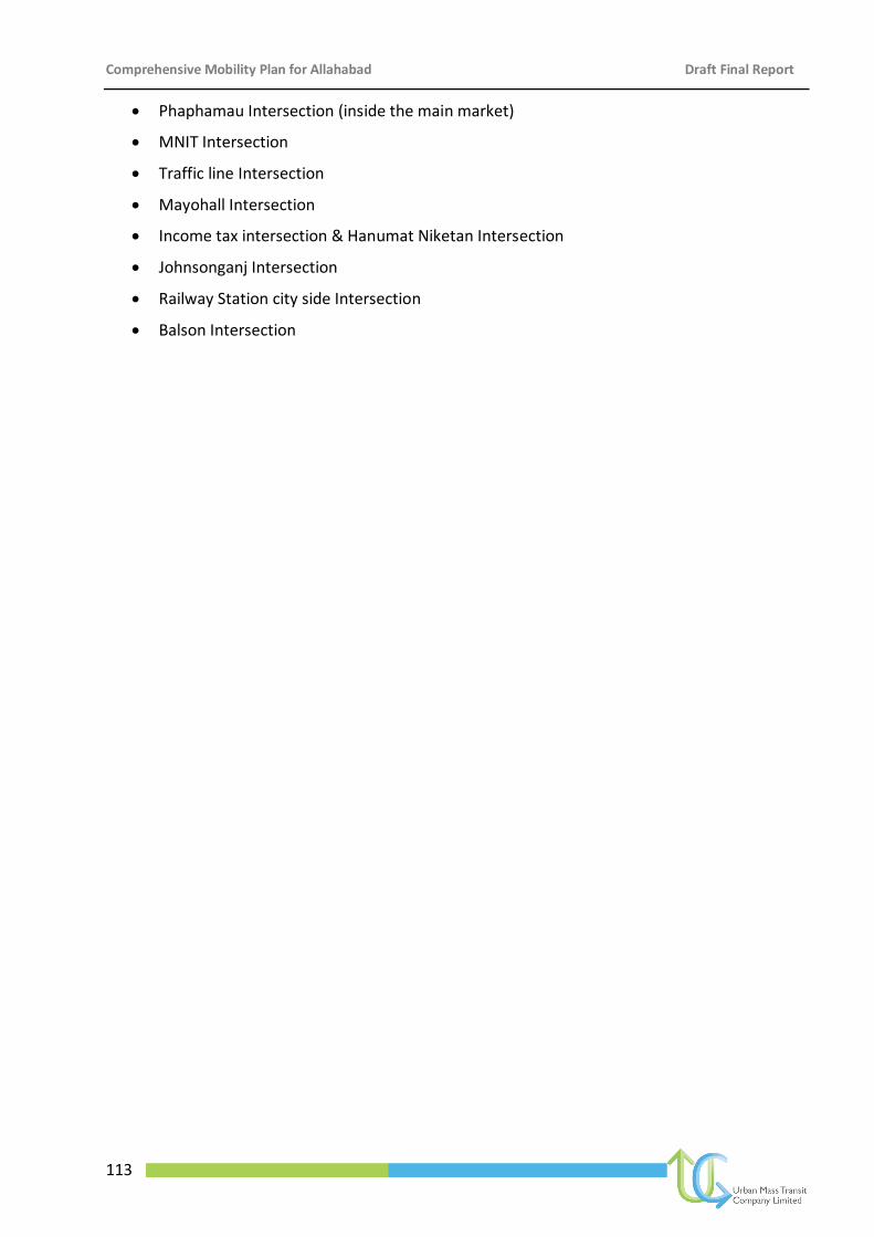
Comprehensive Mobility Plan for Allahabad Draft Final Report
113
Phaphamau Intersection (inside the main market)
MNIT Intersection
Traffic line Intersection
Mayohall Intersection
Income tax intersection & Hanumat Niketan Intersection
Johnsonganj Intersection
Railway Station city side Intersection
Balson Intersection
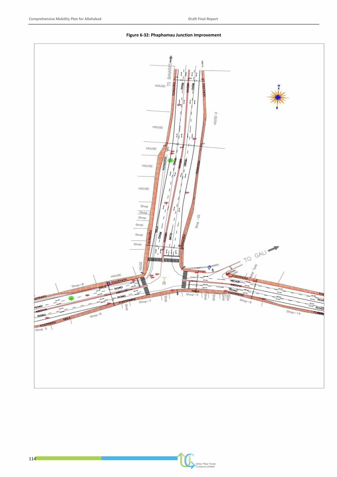
Comprehensive Mobility Plan for Allahabad Draft Final Report
114
Figure 6-32: Phaphamau Junction Improvement
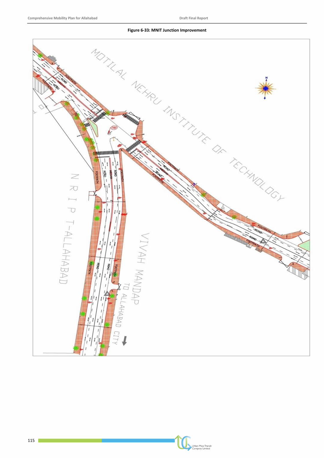
Comprehensive Mobility Plan for Allahabad Draft Final Report
115
Figure 6-33: MNIT Junction Improvement
Comprehensive Mobility Plan for Allahabad Draft Final Report
116
Figure 6-34: Traffic line Intersection Improvement

Comprehensive Mobility Plan for Allahabad Draft Final Report
117
Figure 6-35: Mayohall Intersection Improvement
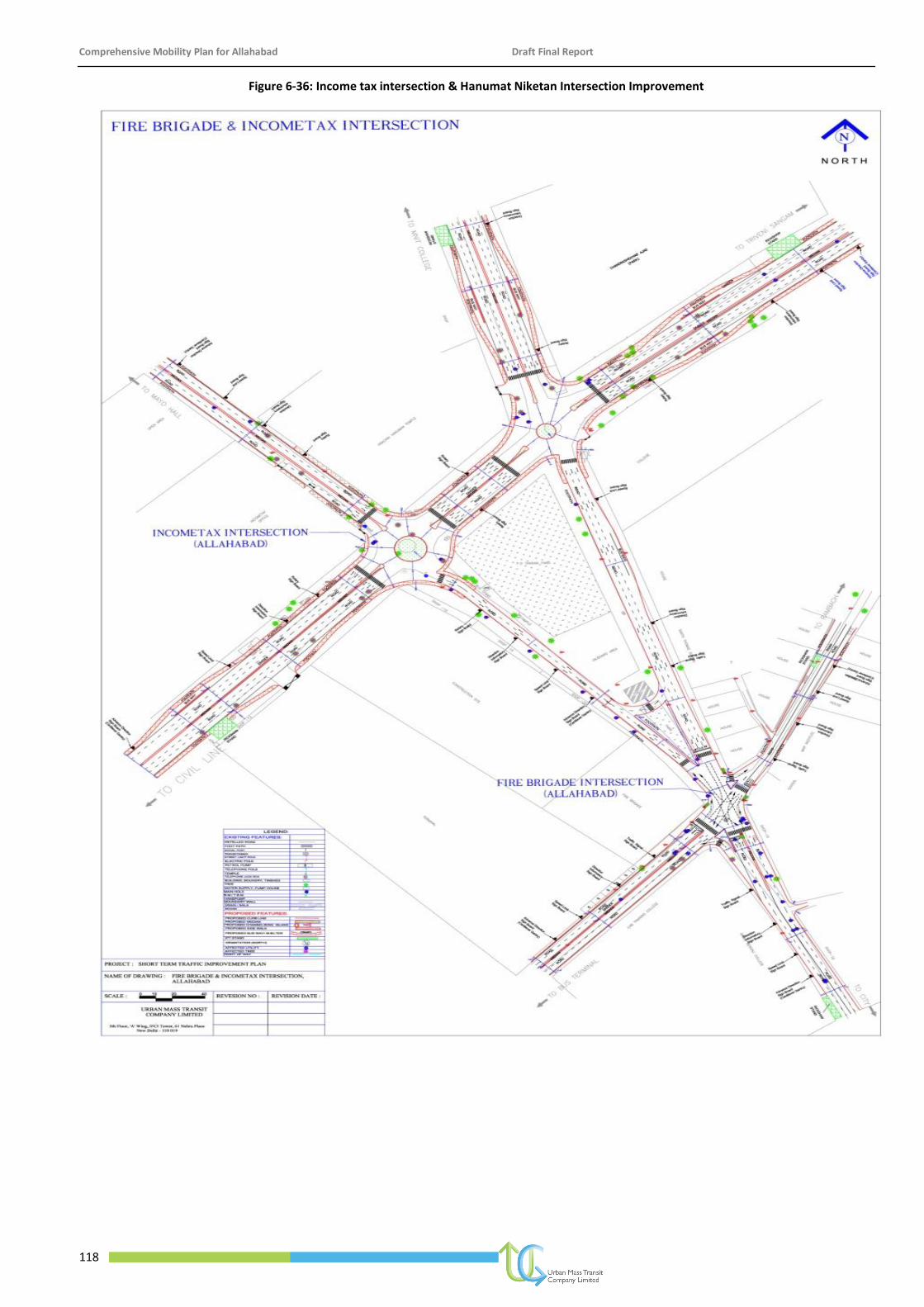
Comprehensive Mobility Plan for Allahabad Draft Final Report
118
Figure 6-36: Income tax intersection & Hanumat Niketan Intersection Improvement
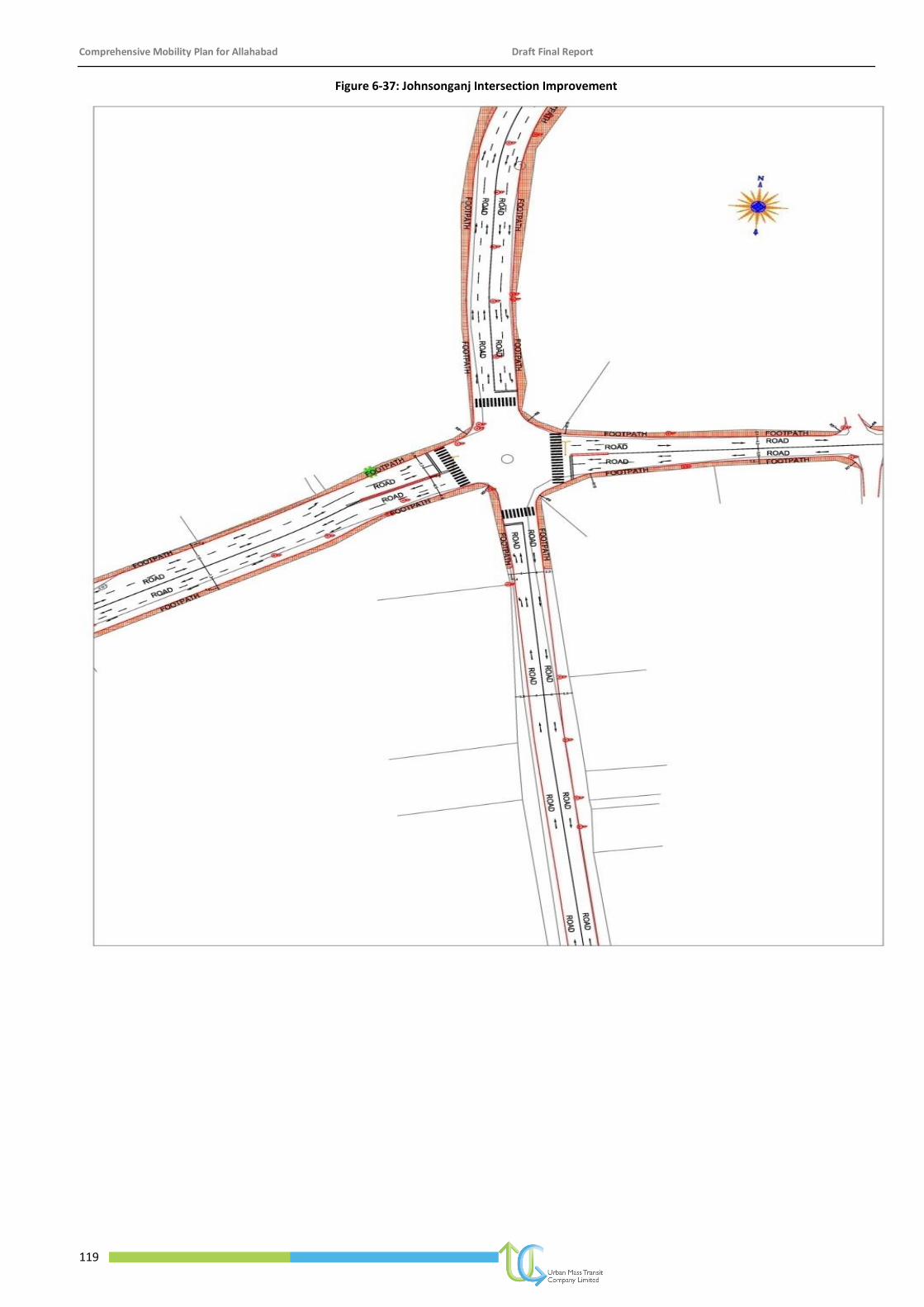
Comprehensive Mobility Plan for Allahabad Draft Final Report
119
Figure 6-37: Johnsonganj Intersection Improvement
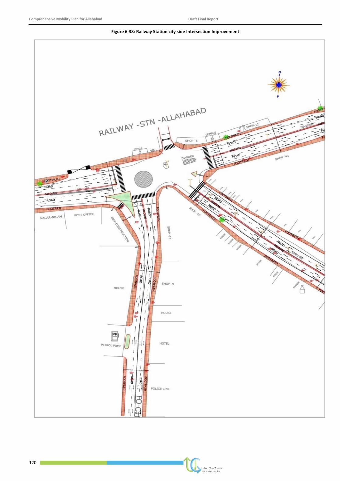
Comprehensive Mobility Plan for Allahabad Draft Final Report
120
Figure 6-38: Railway Station city side Intersection Improvement
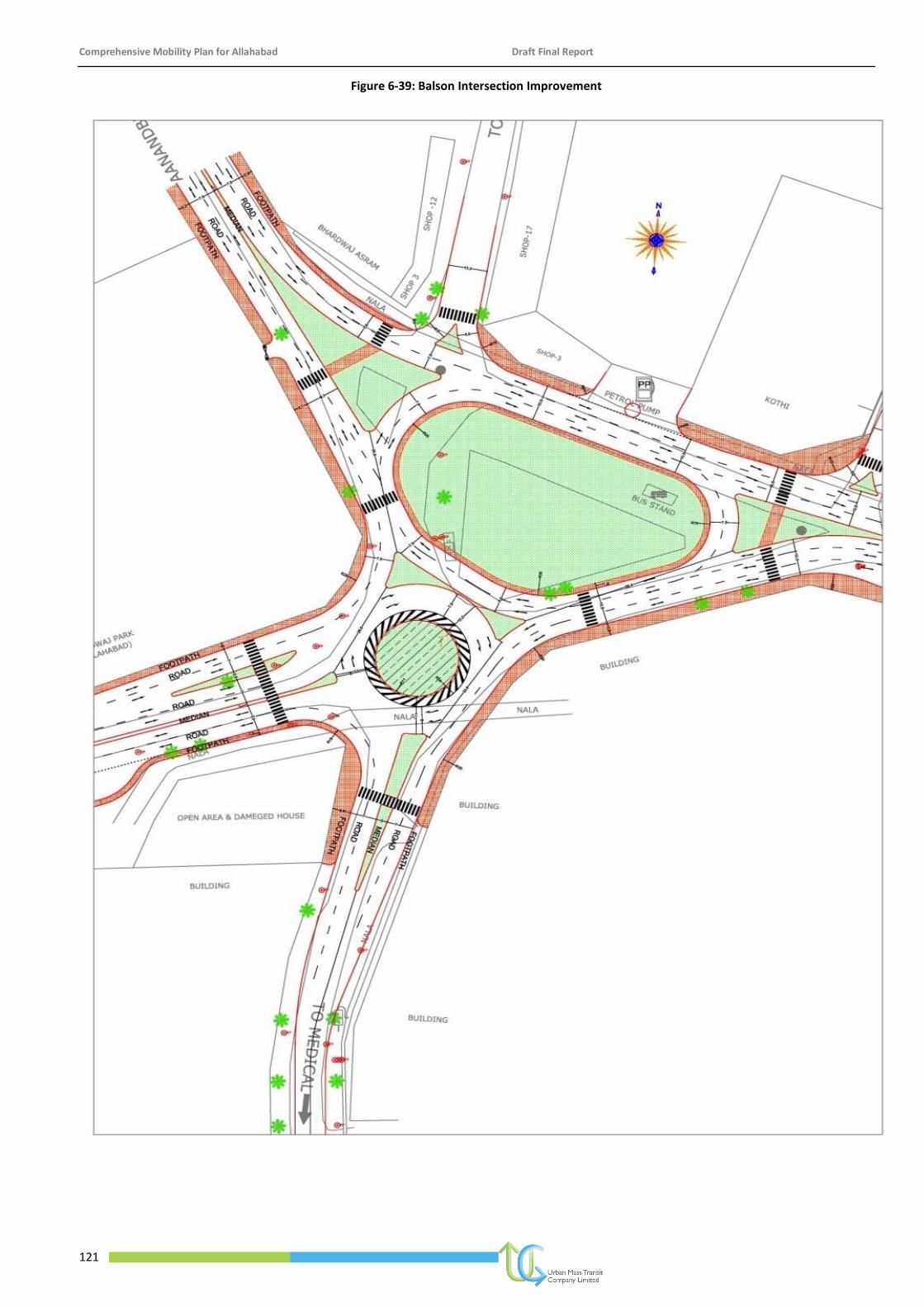
Comprehensive Mobility Plan for Allahabad Draft Final Report
121
Figure 6-39: Balson Intersection Improvement
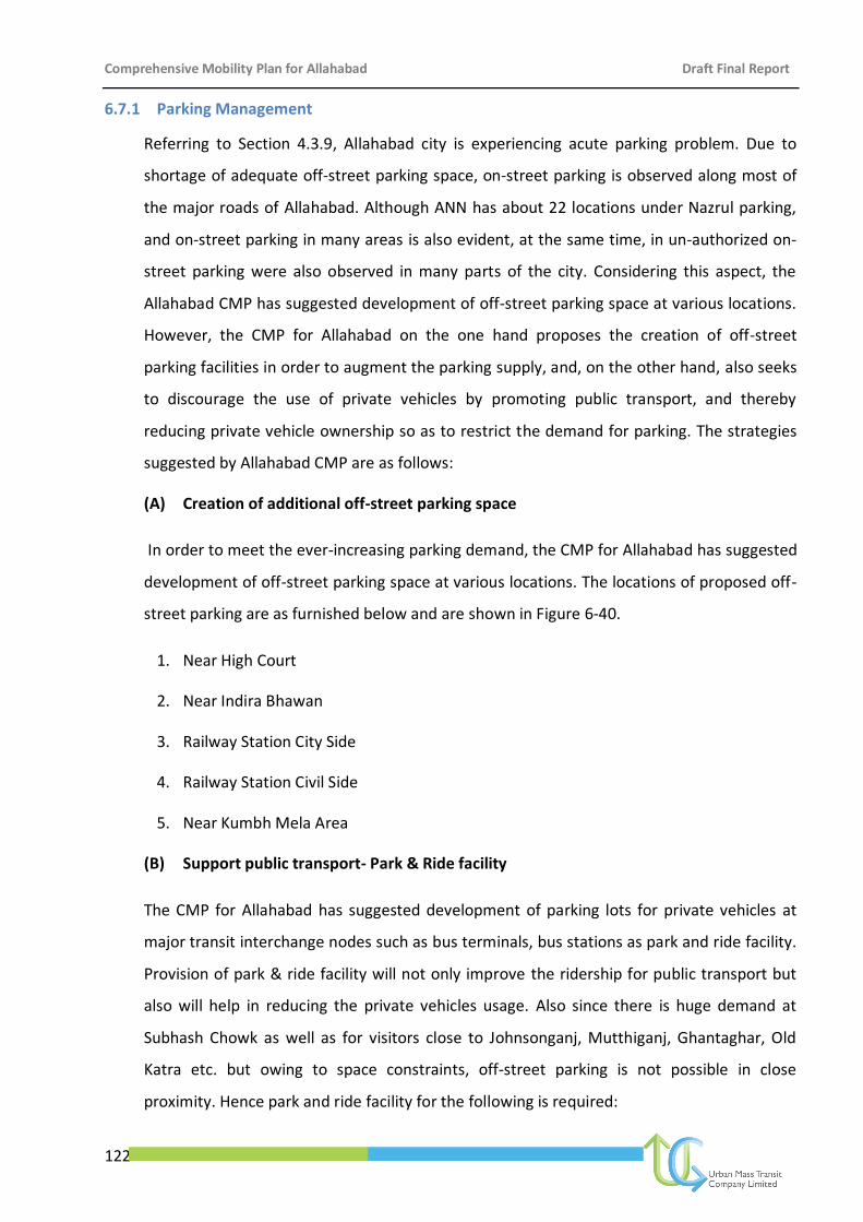
Comprehensive Mobility Plan for Allahabad Draft Final Report
122
6.7.1 Parking Management
Referring to Section 4.3.9, Allahabad city is experiencing acute parking problem. Due to
shortage of adequate off-street parking space, on-street parking is observed along most of
the major roads of Allahabad. Although ANN has about 22 locations under Nazrul parking,
and on-street parking in many areas is also evident, at the same time, in un-authorized on-
street parking were also observed in many parts of the city. Considering this aspect, the
Allahabad CMP has suggested development of off-street parking space at various locations.
However, the CMP for Allahabad on the one hand proposes the creation of off-street
parking facilities in order to augment the parking supply, and, on the other hand, also seeks
to discourage the use of private vehicles by promoting public transport, and thereby
reducing private vehicle ownership so as to restrict the demand for parking. The strategies
suggested by Allahabad CMP are as follows:
(A) Creation of additional off-street parking space
In order to meet the ever-increasing parking demand, the CMP for Allahabad has suggested
development of off-street parking space at various locations. The locations of proposed off-
street parking are as furnished below and are shown in Figure 6-40.
1. Near High Court
2. Near Indira Bhawan
3. Railway Station City Side
4. Railway Station Civil Side
5. Near Kumbh Mela Area
(B) Support public transport- Park & Ride facility
The CMP for Allahabad has suggested development of parking lots for private vehicles at
major transit interchange nodes such as bus terminals, bus stations as park and ride facility.
Provision of park & ride facility will not only improve the ridership for public transport but
also will help in reducing the private vehicles usage. Also since there is huge demand at
Subhash Chowk as well as for visitors close to Johnsonganj, Mutthiganj, Ghantaghar, Old
Katra etc. but owing to space constraints, off-street parking is not possible in close
proximity. Hence park and ride facility for the following is required:
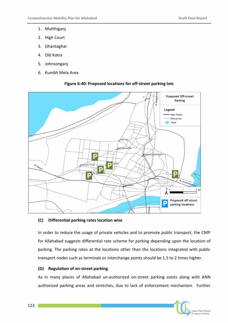
Comprehensive Mobility Plan for Allahabad Draft Final Report
123
1. Mutthiganj
2. High Court
3. Ghantaghar
4. Old Katra
5. Johnsonganj
6. Kumbh Mela Area
Figure 6-40: Proposed locations for off-street parking lots
(C) Differential parking rates location wise
In order to reduce the usage of private vehicles and to promote public transport, the CMP
for Allahabad suggests differential rate scheme for parking depending upon the location of
parking. The parking rates at the locations other than the locations integrated with public
transport nodes such as terminals or interchange points should be 1.5 to 2 times higher.
(D) Regulation of on-street parking
As in many places of Allahabad un-authorized on-street parking exists along with ANN
authorized parking areas and stretches, due to lack of enforcement mechanism. Further
Comprehensive Mobility Plan for Allahabad Draft Final Report
124
Allahabad CMP has suggested development of parking lots in various parts of Allahabad
Planning Area, which will reduce the on-street parking demand. Considering these aspects
the CMP for Allahabad has suggested regulation of on-street parking on stretches as
shown in Figure 6-41.
Figure 6-41: Streets for On-street Parking
6.7.2 Education & Enforcement
Overall awareness of the traffic discipline and compliance with the traffic rules by road users
in Lucknow is far below the desired level. Traffic Police in Lucknow will have to offer positive
leadership in this direction to make people responsible and rule-abiding road users. Special
traffic drives have to be planned by them for making the public aware of the traffic rules.
Also, imposing fines at the spot procedure for defaulters may be reviewed in view of the large
backlog of pending traffic offence cases. The Road Safety programmes are aimed at users and
should serve three main purposes:
1. To inform the public about the new regulations or changes to the traffic regulation
system
2. To influence the attitudes towards road safety
3. To persuade road users to change their behavior in relation to identified causal
factors in road accidents
6.7.3 Airport
As per the Master Plan, there is a proposal to expand the existing airport at Bamrauli as it is
envisaged that it would become an international airport in future. Apart from the above, to
Comprehensive Mobility Plan for Allahabad Draft Final Report
125
more airstrips are proposed by the Master Plan, one near Iradatganj Railway Station in Naini
and the other near Phaphamau.
Comprehensive Mobility Plan for Allahabad Draft Final Report
126
7 Implementation Programme and Costing
7.1 Phasing Plan
The projects identified have been phased depending upon several criteria like urgency of
implementation, capital investment, ease of implementation, resource availability and
environmental considerations. The phasing is generally done according to Long Term,
Medium Term and Short Term requirements.
Projects, which do not require high capital investment and resource allocation and would
prove useful in providing instant relief to the traffic problems of the city are given high
priority and fall under Short Term Projects. Similarly, projects requiring high amounts of
capital inflow and which have other issues like land availability problems and do not cater to
immediate demand, are identified for medium and long term.
7.2 Project Prioritisation
As given in the above section, and in accordance with NUTP and based on the detailed
analysis, all the projects identified have been prioritized as follows:
1. Public Transport
2. Pedestrianisation
3. Non-Motorised Transport
4. Para Transit Facilities (IPT)
5. TDM
6. Parking
7. Terminal Facilities
8. Intersection Improvements
9. Road Development
10. Bridges and Flyovers
The details of prioritisation are given in the Table 7-1.
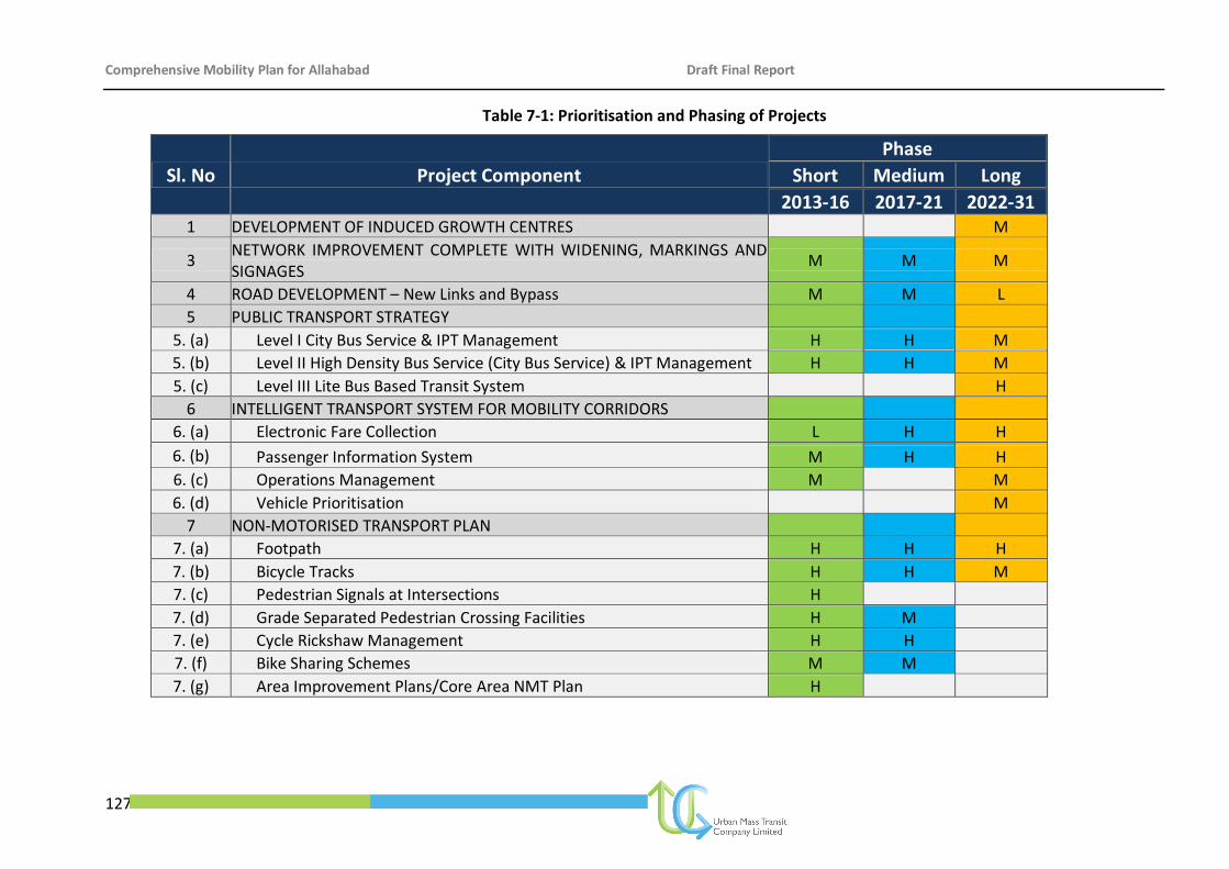
Comprehensive Mobility Plan for Allahabad Draft Final Report
127
Table 7-1: Prioritisation and Phasing of Projects
Sl. No Project Component
Phase
Short Medium Long
2013-16 2017-21 2022-31 1 DEVELOPMENT OF INDUCED GROWTH CENTRES
M
3 NETWORK IMPROVEMENT COMPLETE WITH WIDENING, MARKINGS AND SIGNAGES
M M M
4 ROAD DEVELOPMENT – New Links and Bypass M M L
5 PUBLIC TRANSPORT STRATEGY 5. (a) Level I City Bus Service & IPT Management H H M
5. (b) Level II High Density Bus Service (City Bus Service) & IPT Management H H M
5. (c) Level III Lite Bus Based Transit System
H
6 INTELLIGENT TRANSPORT SYSTEM FOR MOBILITY CORRIDORS 6. (a) Electronic Fare Collection L H H
6. (b) Passenger Information System M H H
6. (c) Operations Management M
M
6. (d) Vehicle Prioritisation
M
7 NON-MOTORISED TRANSPORT PLAN 7. (a) Footpath H H H
7. (b) Bicycle Tracks H H M
7. (c) Pedestrian Signals at Intersections H 7. (d) Grade Separated Pedestrian Crossing Facilities H M
7. (e) Cycle Rickshaw Management H H 7. (f) Bike Sharing Schemes M M 7. (g) Area Improvement Plans/Core Area NMT Plan H
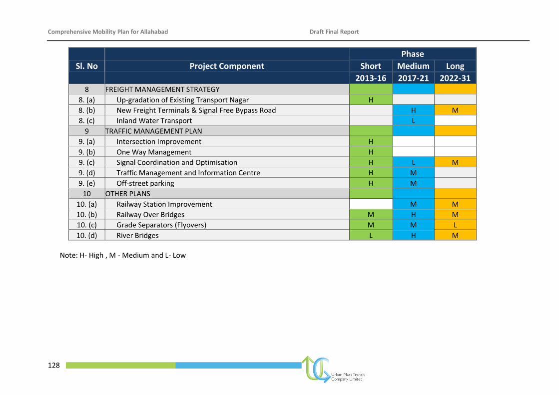
Comprehensive Mobility Plan for Allahabad Draft Final Report
128
Sl. No Project Component
Phase
Short Medium Long
2013-16 2017-21 2022-31 8 FREIGHT MANAGEMENT STRATEGY
8. (a) Up-gradation of Existing Transport Nagar H 8. (b) New Freight Terminals & Signal Free Bypass Road
H M
8. (c) Inland Water Transport
L 9 TRAFFIC MANAGEMENT PLAN
9. (a) Intersection Improvement H 9. (b) One Way Management H 9. (c) Signal Coordination and Optimisation H L M
9. (d) Traffic Management and Information Centre H M 9. (e) Off-street parking H M 10 OTHER PLANS
10. (a) Railway Station Improvement
M M
10. (b) Railway Over Bridges M H M
10. (c) Grade Separators (Flyovers) M M L
10. (d) River Bridges L H M
Note: H- High , M - Medium and L- Low
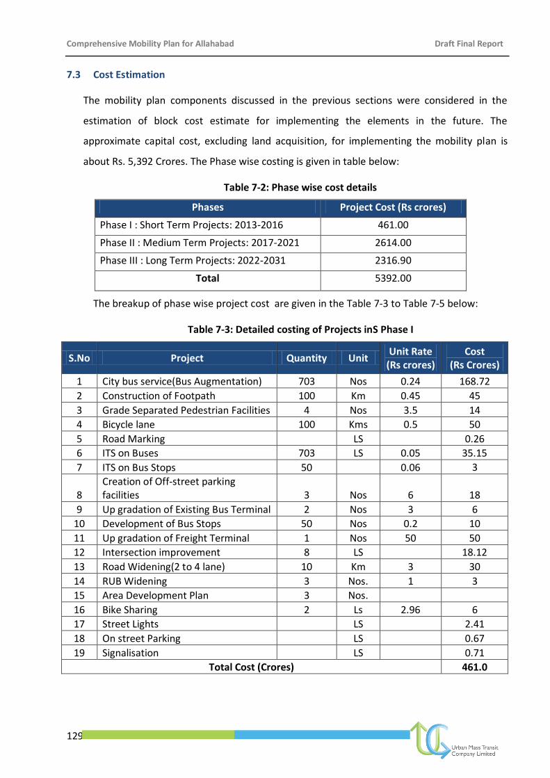
Comprehensive Mobility Plan for Allahabad Draft Final Report
129
7.3 Cost Estimation
The mobility plan components discussed in the previous sections were considered in the
estimation of block cost estimate for implementing the elements in the future. The
approximate capital cost, excluding land acquisition, for implementing the mobility plan is
about Rs. 5,392 Crores. The Phase wise costing is given in table below:
Table 7-2: Phase wise cost details
Phases Project Cost (Rs crores)
Phase I : Short Term Projects: 2013-2016 461.00
Phase II : Medium Term Projects: 2017-2021 2614.00
Phase III : Long Term Projects: 2022-2031 2316.90
Total 5392.00
The breakup of phase wise project cost are given in the Table 7-3 to Table 7-5 below:
Table 7-3: Detailed costing of Projects inS Phase I
S.No Project Quantity Unit Unit Rate
(Rs crores) Cost
(Rs Crores)
1 City bus service(Bus Augmentation) 703 Nos 0.24 168.72
2 Construction of Footpath 100 Km 0.45 45
3 Grade Separated Pedestrian Facilities 4 Nos 3.5 14
4 Bicycle lane 100 Kms 0.5 50
5 Road Marking LS 0.26
6 ITS on Buses 703 LS 0.05 35.15
7 ITS on Bus Stops 50
0.06 3
8 Creation of Off-street parking facilities 3 Nos 6 18
9 Up gradation of Existing Bus Terminal 2 Nos 3 6
10 Development of Bus Stops 50 Nos 0.2 10
11 Up gradation of Freight Terminal 1 Nos 50 50
12 Intersection improvement 8 LS 18.12
13 Road Widening(2 to 4 lane) 10 Km 3 30
14 RUB Widening 3 Nos. 1 3
15 Area Development Plan 3 Nos.
16 Bike Sharing 2 Ls 2.96 6
17 Street Lights LS 2.41
18 On street Parking LS 0.67
19 Signalisation LS 0.71
Total Cost (Crores) 461.0
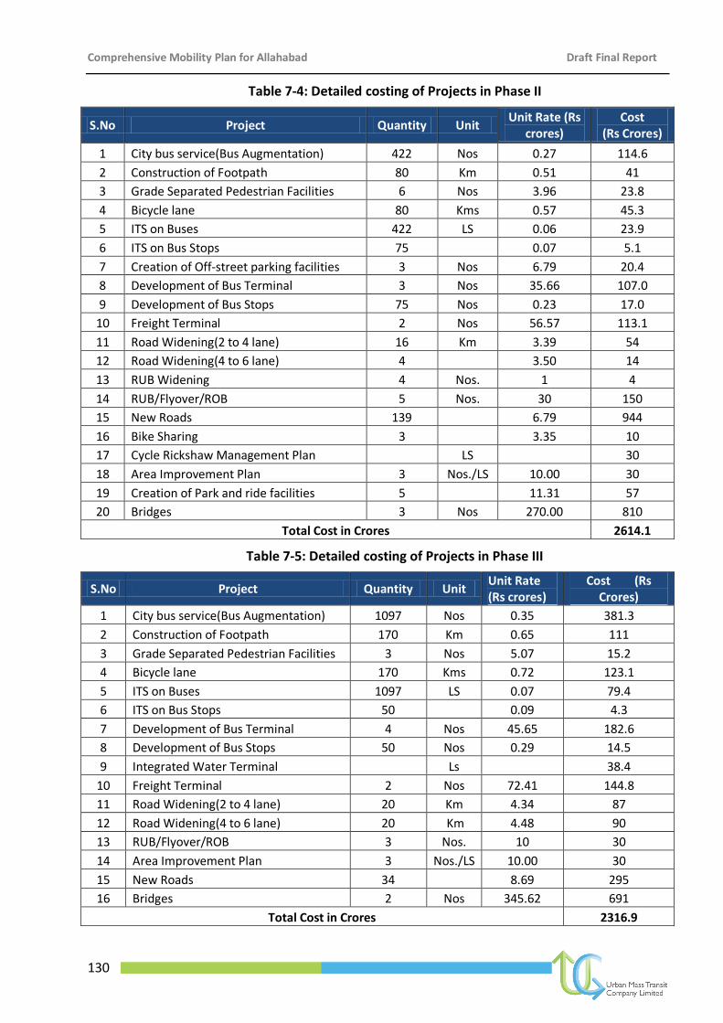
Comprehensive Mobility Plan for Allahabad Draft Final Report
130
Table 7-4: Detailed costing of Projects in Phase II
S.No Project Quantity Unit Unit Rate (Rs
crores) Cost
(Rs Crores)
1 City bus service(Bus Augmentation) 422 Nos 0.27 114.6
2 Construction of Footpath 80 Km 0.51 41
3 Grade Separated Pedestrian Facilities 6 Nos 3.96 23.8
4 Bicycle lane 80 Kms 0.57 45.3
5 ITS on Buses 422 LS 0.06 23.9
6 ITS on Bus Stops 75
0.07 5.1
7 Creation of Off-street parking facilities 3 Nos 6.79 20.4
8 Development of Bus Terminal 3 Nos 35.66 107.0
9 Development of Bus Stops 75 Nos 0.23 17.0
10 Freight Terminal 2 Nos 56.57 113.1
11 Road Widening(2 to 4 lane) 16 Km 3.39 54
12 Road Widening(4 to 6 lane) 4 3.50 14
13 RUB Widening 4 Nos. 1 4
14 RUB/Flyover/ROB 5 Nos. 30 150
15 New Roads 139 6.79 944
16 Bike Sharing 3 3.35 10
17 Cycle Rickshaw Management Plan LS 30
18 Area Improvement Plan 3 Nos./LS 10.00 30
19 Creation of Park and ride facilities 5 11.31 57
20 Bridges 3 Nos 270.00 810
Total Cost in Crores 2614.1
Table 7-5: Detailed costing of Projects in Phase III
S.No Project Quantity Unit Unit Rate (Rs crores)
Cost (Rs Crores)
1 City bus service(Bus Augmentation) 1097 Nos 0.35 381.3
2 Construction of Footpath 170 Km 0.65 111
3 Grade Separated Pedestrian Facilities 3 Nos 5.07 15.2
4 Bicycle lane 170 Kms 0.72 123.1
5 ITS on Buses 1097 LS 0.07 79.4
6 ITS on Bus Stops 50
0.09 4.3
7 Development of Bus Terminal 4 Nos 45.65 182.6
8 Development of Bus Stops 50 Nos 0.29 14.5
9 Integrated Water Terminal Ls 38.4
10 Freight Terminal 2 Nos 72.41 144.8
11 Road Widening(2 to 4 lane) 20 Km 4.34 87
12 Road Widening(4 to 6 lane) 20 Km 4.48 90
13 RUB/Flyover/ROB 3 Nos. 10 30
14 Area Improvement Plan 3 Nos./LS 10.00 30
15 New Roads 34 8.69 295
16 Bridges 2 Nos 345.62 691
Total Cost in Crores 2316.9
Comprehensive Mobility Plan for Allahabad Draft Final Report
131
7.4 Funding Options
Since cities and towns in India constitute the second largest urban system in the world and
contribute over 50% of the country’s GDP, they are central to economic growth. For the cities
to realize their full potential and become effective engines of growth, it is necessary that
focused attention be given to the improvement of infrastructure in an organised manner. As
such, the JnNURM was launched in December 2005 with the aim to encourage reforms and
fast track planned development of identified cities. Focus is to be on efficiency in urban
infrastructure and service delivery mechanisms, community participation, and accountability
of ULBs/ Parastatal agencies towards citizens. The period of the Mission is seven years, up to
2012. During this period, funds shall be provided for proposals that would meet the Mission’s
requirements. Assistance under JnNURM is additional central assistance, which would be
provided as Grant (100 % Central grant) to the implementing agencies.
The funding from JnNURM is supported by counterpart funding in the form of grants from the
State and the ULBs, for which the ratio has been fixed by the mission for different categories
of cities. In the case of Allahabad, the funding pattern is as follows:
Government of India grant under JnNURM: 50%
State Government grant under JnNURM: 20%
Contribution from Cities/ ULBs: 30%
7.5 Alternative Sources of Funding
For the projects, which are not admissible under JnNURM, the alternative sources of funding
available are given below.
Real Estate Development - It is one of the most widely used source for raising funds
particularly for projects like public transport, flyovers etc. In this process, property developers
are invited to develop the land along the transport corridors and share profit arising out of
such sale of property. The model is widely accepted around the globe and has been well
adopted in India by a number of states like Maharashtra and cities such as Indore and
Ahmadabad, etc.
Dedicated Urban Transport Fund - Various states such as Tamil Nadu and Punjab have
created dedicated Road Fund for development of roads, by levying cess on turnover,
betterment levy, shops and establishment levy, tax on employment, surcharge on octroi and
Comprehensive Mobility Plan for Allahabad Draft Final Report
132
other levies. In Madhya Pradesh, the Infrastructure Initiative Fund has also been created.
Cities like Surat in Gujarat have also set-up a dedicated fund for Urban Transport. The
following types of cess/levy can be used to mobilise resources to the afore-mentioned Fund:
Viability Gap Funding - In a recent initiative, the Government of India has established a
special financing facility called "Viability Gap Funding" under the Department of Economic
Affairs, Ministry of Finance, to provide support to PPP infrastructure projects that have at
least 40% private equity committed to each such project. The Government of India has set
certain criteria to avail this facility under formal legal guidelines, issued in August 2004, to
support infrastructure under PPP framework.
Viability Gap Funding can take various forms such as capital grants, subordinated loans, O&M
support grants and interest subsidies. It will be provided in installments, preferably in the
form of annuities. However, the Ministry of Finance guidelines require that the total
government support to such a project, including Viability Gap Funding and the financial
support of other Ministries and agencies of the Government of India, must not exceed 20% of
the total project cost as estimated in the preliminary project appraisal, or the actual project
cost, whichever is lower.
Projects in the following sectors implemented by the Private Sector are eligible for funding:
(a) Roads and bridges, railways, seaports, airports, inland waterways
(b) Power
(c) Urban transport, water supply, sewerage, solid waste management and other physical
infrastructure in urban areas
(d) Infrastructure projects in Special Economic Zones
(e) International convention centers and other tourism infrastructure projects
Cess on Turnover - A substantial amount of revenue could be generated through cess on
turnover, particularly in cities, based on industry, trade and commerce activities. Such cess
has already been levied for Bangalore MRTS project.
Betterment Levy through Value Capture Mechanism - It is a fiscal instrument to generate
funds by recouping the land value increment. It aims to recover the project cost from the
beneficiaries of the project. This method has been experimented in the case of Bangalore for
Comprehensive Mobility Plan for Allahabad Draft Final Report
133
LRT project in the form of metro tax. In Mumbai, for the improvement of transportation
system, resource mobilisation is proposed through raising revenues from value capture
resources, which include contribution from employees, transport development levy,
development cess on daily rail and intercity bus tickets, surcharge on seasonal tickets,
property development levy, etc.
Shops and Establishment Levy - This method has the potential to be one of the large revenue
gathering measures, particularly in Indore city, where the predominant economic base is
trade and commerce:
Tax on Employment - An additional source of revenue can be generated by an
additional levy on the employer. This has been successfully adopted in cities of
developed countries like Paris and France.
Surcharge Levy on Octroi Rates - This method involves levying a surcharge on
Octroi. In areas where there is a proposal for abolishment of Octroi, a substitute in
the form of Entry Tax has been enforced which has potential to generate sizeable
source of revenue.
Sale of Government Land and other Property - It is an efficient source of raising
resources by local bodies. Cities in India have been raising funds through sale of
government land for road infrastructure improvement projects.
Besides the above-identified sources, the city can also access carbon credits and grants from
other international sources including GEF, DFID, GIZ, etc. It can also access loans from
international banks like ADB, World Bank, etc.
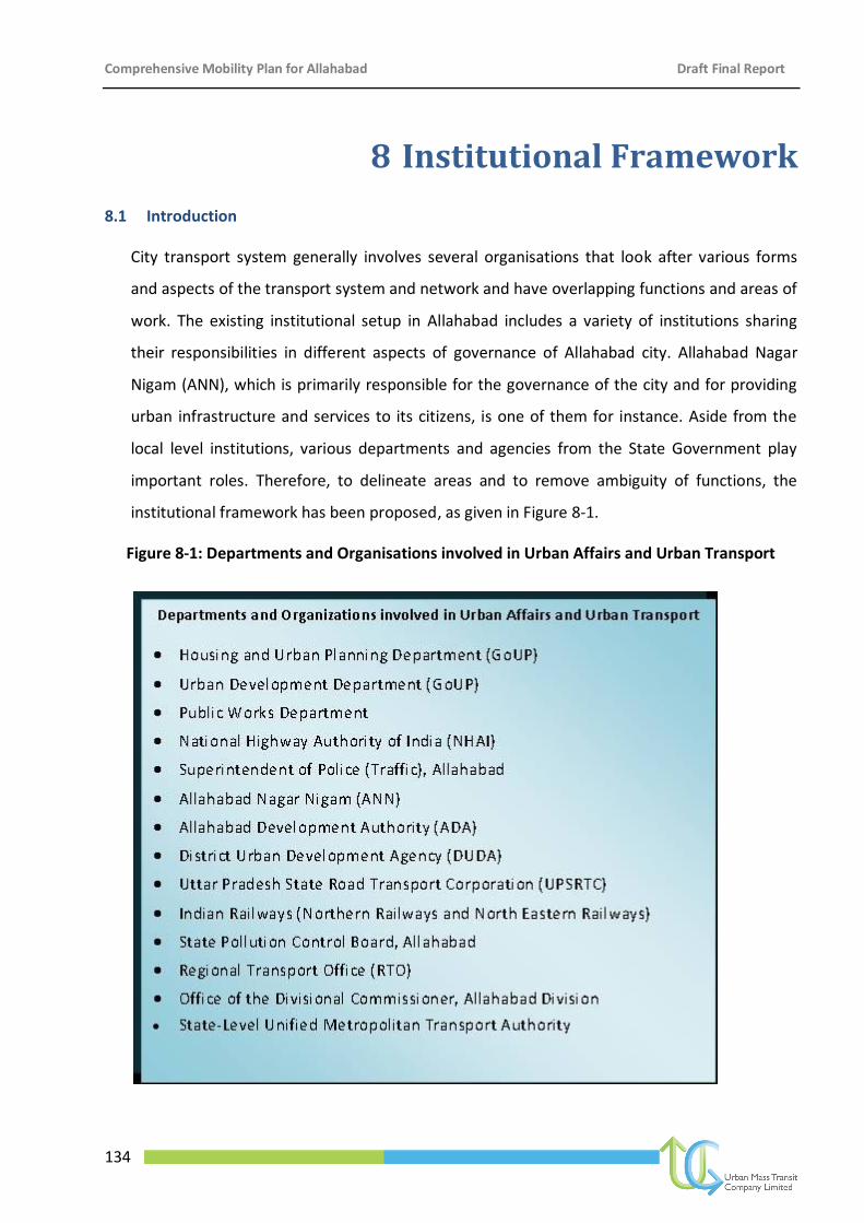
Comprehensive Mobility Plan for Allahabad Draft Final Report
134
8 Institutional Framework
8.1 Introduction
City transport system generally involves several organisations that look after various forms
and aspects of the transport system and network and have overlapping functions and areas of
work. The existing institutional setup in Allahabad includes a variety of institutions sharing
their responsibilities in different aspects of governance of Allahabad city. Allahabad Nagar
Nigam (ANN), which is primarily responsible for the governance of the city and for providing
urban infrastructure and services to its citizens, is one of them for instance. Aside from the
local level institutions, various departments and agencies from the State Government play
important roles. Therefore, to delineate areas and to remove ambiguity of functions, the
institutional framework has been proposed, as given in Figure 8-1.
Figure 8-1: Departments and Organisations involved in Urban Affairs and Urban Transport
Comprehensive Mobility Plan for Allahabad Draft Final Report
135
(A) Existing City Level Institutions
Allahabad Nagar Nigam (ANN): Local level governance; Primary Collection of Solid
Waste; Maintenance of Storm Water Drains; Maintenance of municipal roads;
Allotment of Trade Licenses under the Prevention of Food Adulteration Act; O&M of
internal sewers and community toilets; Street lighting
Allahabad Development Authority (ADA): Preparation of Master Plans for land use;
Development of new areas as well as provision of housing and necessary
infrastructure.
District Urban Development Authority (DUDA): Implementing agency for plans
prepared by SUDA. Responsible for the field work relating to community development
– focusing on the development of slum communities, construction of community
toilets, assistance in construction of individual household latrines, awareness
generation, etc.
Allahabad City Bus Services Limited: A newly created special purpose company with
share of UPSRTC, ADA, ANN to monitor and regulate city bus service in the city.
(B) Existing State Level Institutions
State Urban Development Authority (SUDA): Is an apex policy-making and monitoring
agency for the urban areas of the state. Responsible for providing overall guidance to
the District Urban Development Authority (DUDA) for implementation of community
development programmes.
UP Awas Vikas Parishad (UPAVP): Is a Nodal agency for Housing in the state. Involved
in planning, designing, construction and development of almost all types of urban
development projects in the state. Autonomous body generating its own resources
through loans from financial institutions.
UP State Transport Corporation (UPSRTC): Provides intra-city and state-wide public
transport; maintenance of buses, bus stands.
Public Works Department (PWD): Construction of main roads and transport
infrastructure, including construction and maintenance of Government houses and
Institutions.
Comprehensive Mobility Plan for Allahabad Draft Final Report
136
State Tourism Department (STC): Responsible for promotion of tourism
UP Pollution Control Board (UPPCB): Pollution control and monitoring, especially river
water quality and regulating industries.
Town and Country Planning Department (TCPD): Preparation of Town Plans, including
infrastructure for the state (rural and urban)
Office of the Commissioner, Allahabad Division: Coordination of activities of various
institutions
8.2 Issues with the Present Institutional Set up
As observed, there are multiple organizations that are involved in urban and rural planning
for the City and Region. The municipal corporation’s role in urban transport is miniscule and
so is their area of control. The PWD and NHAI are in charge of constructing roads and
maintaining them; however, their functioning is independent of the urban/rural planning
body of the state. Bus operations, land ownership issues, collection of parking fees and traffic
violation fines, NMT planning, pedestrian safety, etc are several issues that are
interconnected, but they fall under the ambit of completely disconnected organisations.
Some of these issues are listed below:
There is no clear segregation between the planning and implementing bodies.
There is lack of coordination amongst all the departments in the urban transport
sector.
All departments related to urban transport do not function in coherence.
Road projects are implemented in isolation with other projects, which should
otherwise be an integral part of road development like footpath, cycle tracks,
pedestrian facilities, etc.
There is no control over mushrooming growth of IPT modes in the city, which lead to
issues of road congestion and also competing environment with the buses for
passengers.
Operation issues in public transport due to poor route and service planning.
There is no dedicated organisation that is in charge of long-term urban transport
planning for the city.
Comprehensive Mobility Plan for Allahabad Draft Final Report
137
Thus, the need is felt for setting-up an umbrella level organisation for the overall planning and
monitoring of the Urban Transport in the city.
8.3 Proposed Institutional Framework
8.3.1 Unified Metropolitan Transport Authority (UMTA)
In order to facilitate integration of transport services holistically and pragmatically, an
“institution” needs to be created to coordinate the activities and functions of multiple
organisations dealing with complex issues of urban transport. With the formation of a
State-level UMTA, part of the problem would be sorted out. However, this would have a
macroscopic view of resolving policy issues for all urban centers within the state. Still,
there is a need to set-up a localised organisation that results in coordinated strategic
level planning at the city level and deals with more day-to-day issues of urban transport.
8.3.2 City Level Unified Metropolitan Transport Authority
With a view to coordinate all urban transport activities in the city, it is recommended
that a UMTA be set up at the city level also that acts as a planning and decision-making
body for all matters related to urban transport in the city.
It is recommended that the city level UMTA be set up on an executive order for the
ease of formation; however, it must be given a legal backing so that its functioning falls
under an act and commands greater authority.
8.3.3 Broad Functions
The following functions are proposed to fall under the purview of the city level UMTA:
Undertake overall planning for public transport in the city, covering all modes -
road, rail, water and air transport systems
Allocate routes amongst different operators
Procure public bus services for different routes through contracting,
concessioning, etc.
Ensure compliance of terms and conditions of license
Recommend revocation of license for non-compliance of terms and conditions of
the license
Comprehensive Mobility Plan for Allahabad Draft Final Report
138
Carry out surveys and manage a database for scientific planning of public transport
requirements
Co-ordinate fare integration among different operators of public transport and
determine the basis for sharing of revenues earned from common tickets or
passes
Operate a scheme of passes for the users of public transport and channelise
subsidies to operators for any concessions that are offered in accordance with
government policy
Regulate the arrangement amongst operators for the sharing of their revenue
derived from the use of passes
Promote efficiency in public transport operation
Protect the interest of the consumers
Settle disputes between different operators and between operators and
infrastructure providers
Levy fees and other charges at such rates and in respect of such services as may be
determined by regulations
8.3.4 Proposed Structure of UMTA
The National Urban Transport Policy, 2006 and GoI recommends setting up of UMTA in
all million-plus cities, the extract of which is re-produced herein below:
“The current structure of governance for the transport sector is not equipped to deal
with the problems of urban transport. Those structures were put in place well before
the problems of urban transport began to surface in India and hence do not provide for
the right co-ordination mechanisms to deal with urban transport.
The Central Government will therefore recommend the setting up of Unified
Metropolitan Transport Authorities (UMTAs) in all million-plus cities to facilitate more
co-ordinated planning and implementation of urban transport programmes and
projects and an integrated management of urban transport systems. Such Metropolitan
Transport Authorities would need statutory backing in order to be meaningful.
Comprehensive Mobility Plan for Allahabad Draft Final Report
139
The Central Government would also encourage the setting up of professional bodies
that have the capacity to make scientific assessment of the demand on various routes
and contract services that can be properly monitored. Towards this end, it would
encourage the setting up of umbrella bodies that regulate the overall performance of
the Public Transport System and ensure that the city has a Comprehensive Public
Transport System”.
The overall aim of the UMTA will be to promote public transport in the urban areas
through formulation of policies, programmes, rules and regulations related to urban
transit. Its function is to facilitate/ co-ordinate planning and implementation of urban
transport programmes and projects in an integrated management framework. To be
effective, such Urban Metropolitan Transport Authority would need statutory backing.
The National Urban Transport Policy clearly identifies land use and transport as two
intricately linked elements of urban system that has bearing on each other. Hence, the
distinctive role of UMTA regarding formation of progressive land use and transportation
policy for metropolitan area becomes critical.
8.3.5 Composition of UMTA
As per the National Urban Transport Policy (NUTP-2006), representation of agencies
involved in the preparation of land use and transportation plan is required in UMTA. In
the light of the above guidelines/recommendations, the following structure is proposed
for UMTA. Refer Figure 8-2.
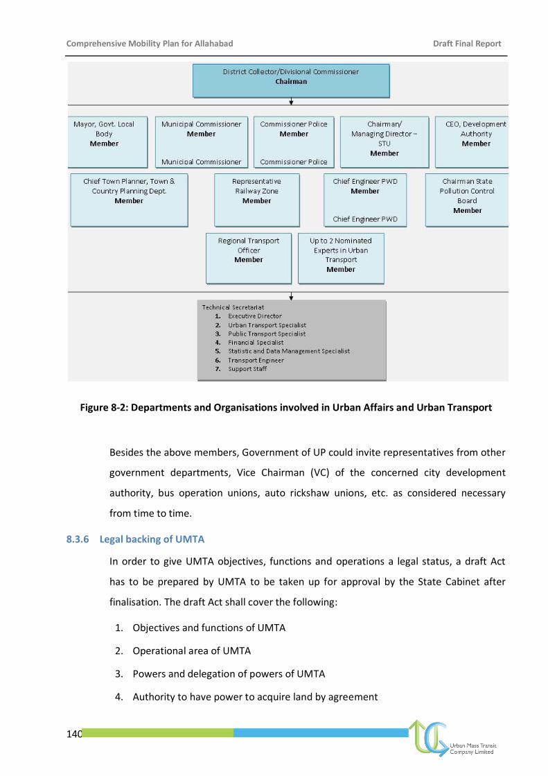
Comprehensive Mobility Plan for Allahabad Draft Final Report
140
Figure 8-2: Departments and Organisations involved in Urban Affairs and Urban Transport
Besides the above members, Government of UP could invite representatives from other
government departments, Vice Chairman (VC) of the concerned city development
authority, bus operation unions, auto rickshaw unions, etc. as considered necessary
from time to time.
8.3.6 Legal backing of UMTA
In order to give UMTA objectives, functions and operations a legal status, a draft Act
has to be prepared by UMTA to be taken up for approval by the State Cabinet after
finalisation. The draft Act shall cover the following:
1. Objectives and functions of UMTA
2. Operational area of UMTA
3. Powers and delegation of powers of UMTA
4. Authority to have power to acquire land by agreement
Comprehensive Mobility Plan for Allahabad Draft Final Report
141
5. Power of Government to transfer to the Authority lands belonging to it or to other
ULBs, etc.
6. Power of Authority to borrow
7. Laying of annual estimate of income and expenditure
8. Authority to approve or amend such estimate
9. Estimates to be submitted to Government for sanction
10. Supplementary estimates may be prepared and submitted when necessary
11. Provisions regarding expenditure
12. Accounts and audit
13. Schedule of officers and employees to be submitted for sanction of Government
14. Appointments, etc., by whom to be made
15. Powers of entry
16. Directions by the Authority
17. Members and officers to be public servants
18. Power to make rules
19. Power to make regulations
8.3.7 Manpower Requirement and Staffing Plan
UMTA shall have to avail the services of an expert team of traffic and transportation
planners, engineers, urban planners and other technical advisers. In order to strengthen
its human resource, UMTA shall have to form a schedule of officers and employees
whom it shall deem it necessary and proper to maintain for the purposes of UMTA Act.
In addition to this, various powers related to appointment, promotion, suspension, etc
shall also have to be worked out as per the Government’s schedule.
8.3.8 Urban Transport Fund (UTF)
As cities and towns are the generators of national wealth, there is a growing recognition
that the resources needed for urban development be generated from within the urban
economies by use of principles like "beneficiaries pay", "users pay" and "polluters pay".
Provision of public transport/transit facilities act as ‘facilitators’ and go a long way in
triggering the multiplier effect in the city economy. As per the guidelines of National
Comprehensive Mobility Plan for Allahabad Draft Final Report
142
Urban Transport Policy, an Urban Transport Fund is desired to be set up to sustain and
expand the transit operations (city buses) and to develop the transit infrastructure (bus
stands, terminals, inter-changes, depots, workshops, etc).
A reasonable quality of service has to be maintained in order to encourage residents to
use public transport instead of private vehicles. From domestic and worldwide
experience, we know that as the fares are regulated, city bus operations would be a
loss-making proposition from operations’ point-of-view. There would be a viability gap
and hence, non-operational revenues and state support would be required to bridge
the gap.
Public transport sector in most cities have been running in losses leaving little or no
scope for enhanced services to the users. On the physical infrastructure side, vehicle
sales generate large revenues, through taxation. Most of the proceeds, however, are
treated as general taxes and do not trickle down to the urban area level as a ready pool
of resources for urban transport projects.
It is thus suggested that a separate collection of funds be generated locally so that the
same may be spent locally on development and maintenance of urban transport
infrastructure. This fund can be managed by a professional fund manager appointed by
the city level Unified Metropolitan Transport Authority so that the balances in this fund
can earn appropriate returns, in accordance with prevailing market potential.
Any local investment proposal that would require funding/part-funding from the Local
Govt. /State Govt. could be posed to the UTF for financial support. Approval could be
given by the UMTA, after due appraisal by the Local Administrator/Secretariat. An
Urban Transport Fund at State and City level has to be created to support the Public
Transport system. The State Government is actively considering the possible streams for
this fund as:
Cess/Tax/Additional Duty
1) Cess on fuel: A small cess of 50 paise per litre can be levied, with amendment to
the Act.
2) Higher Registration Charges on private vehicles
Comprehensive Mobility Plan for Allahabad Draft Final Report
143
3) Rationalisation of MV taxes on Private Vehicles: By increasing taxes on cars, 2
wheelers etc. As the diesel cars contribute to the pollution load in greater
degree, the MV tax on cars can be increased to a higher degree.
4) Luxury tax and professional taxes, as levied by Bangalore
5) Additional stamp duty (5%) on registration of property
Advertisement Rights
Coupled with an appropriate advertisement policy, allowing the SPV
(company/ULB/STU responsible for bus operation) rights on the Bus
Stops/Terminals and on other infrastructure created especially for bus priority
measures would also yield advertisement income to flow into the Urban Transport
Fund.
8.4 Eligibility Criteria and Approval Mechanism from the Fund
The Fund, in due course of time, due to its intrinsic purpose of set-up, shall be approached for
funding by various urban transport projects besides the SPV for the bus operations. A suitable
mechanism shall have to be evolved for the concerned secretariat to judge/appraise the
claim, put it up for approval from UMTA, and disbursement of the same to the concerned
agency for implementation. The detailed guidelines on the type of claims and the appraisal
criteria shall be evolved on the lines of the existing MoUD guidelines and procedures.
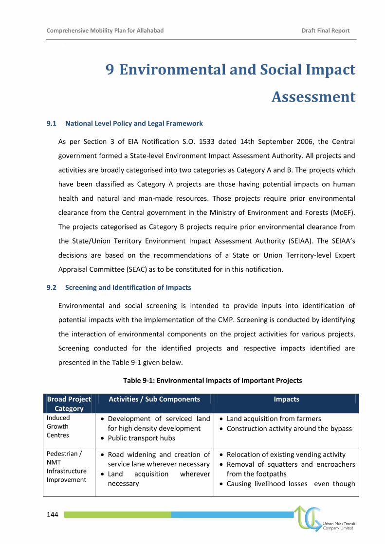
Comprehensive Mobility Plan for Allahabad Draft Final Report
144
[
9 Environmental and Social Impact
Assessment
9.1 National Level Policy and Legal Framework
As per Section 3 of EIA Notification S.O. 1533 dated 14th September 2006, the Central
government formed a State-level Environment Impact Assessment Authority. All projects and
activities are broadly categorised into two categories as Category A and B. The projects which
have been classified as Category A projects are those having potential impacts on human
health and natural and man-made resources. Those projects require prior environmental
clearance from the Central government in the Ministry of Environment and Forests (MoEF).
The projects categorised as Category B projects require prior environmental clearance from
the State/Union Territory Environment Impact Assessment Authority (SEIAA). The SEIAA’s
decisions are based on the recommendations of a State or Union Territory-level Expert
Appraisal Committee (SEAC) as to be constituted for in this notification.
9.2 Screening and Identification of Impacts
Environmental and social screening is intended to provide inputs into identification of
potential impacts with the implementation of the CMP. Screening is conducted by identifying
the interaction of environmental components on the project activities for various projects.
Screening conducted for the identified projects and respective impacts identified are
presented in the Table 9-1 given below.
Table 9-1: Environmental Impacts of Important Projects
Broad Project Category
Activities / Sub Components Impacts
Induced Growth Centres
Development of serviced land for high density development
Public transport hubs
Land acquisition from farmers
Construction activity around the bypass
Pedestrian / NMT Infrastructure Improvement
Road widening and creation of service lane wherever necessary
Land acquisition wherever necessary
Relocation of existing vending activity
Removal of squatters and encroachers from the footpaths
Causing livelihood losses even though
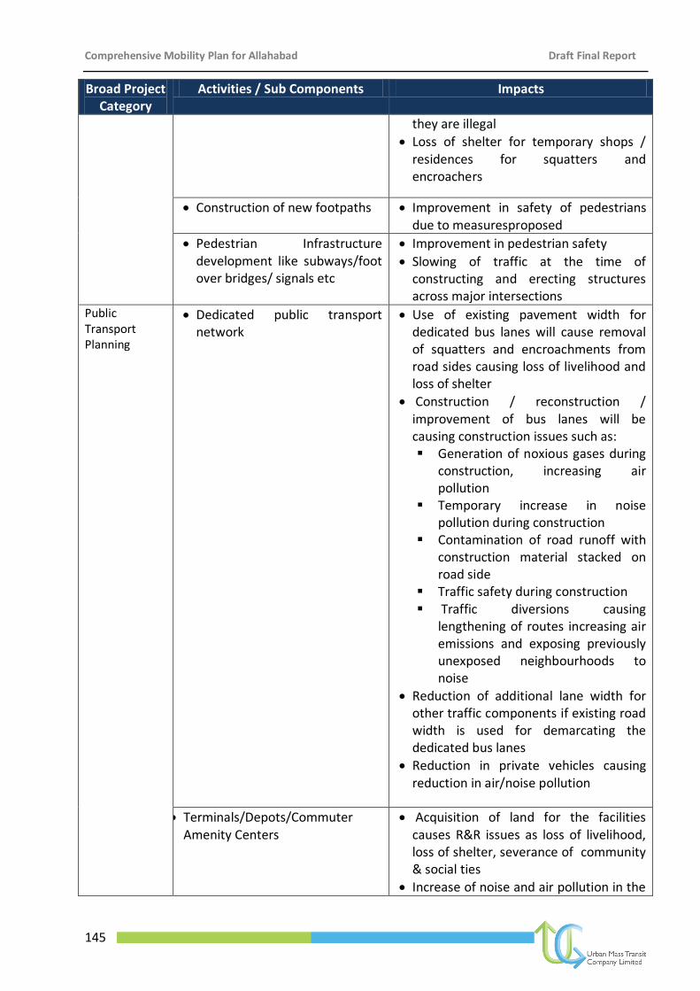
Comprehensive Mobility Plan for Allahabad Draft Final Report
145
Broad Project Category
Activities / Sub Components Impacts
they are illegal
Loss of shelter for temporary shops / residences for squatters and encroachers
Construction of new footpaths Improvement in safety of pedestrians due to measuresproposed
Pedestrian Infrastructure development like subways/foot over bridges/ signals etc
Improvement in pedestrian safety
Slowing of traffic at the time of constructing and erecting structures across major intersections
Public Transport Planning
Dedicated public transport network
Use of existing pavement width for dedicated bus lanes will cause removal of squatters and encroachments from road sides causing loss of livelihood and loss of shelter
Construction / reconstruction / improvement of bus lanes will be causing construction issues such as: Generation of noxious gases during
construction, increasing air pollution
Temporary increase in noise pollution during construction
Contamination of road runoff with construction material stacked on road side
Traffic safety during construction Traffic diversions causing
lengthening of routes increasing air emissions and exposing previously unexposed neighbourhoods to noise
Reduction of additional lane width for other traffic components if existing road width is used for demarcating the dedicated bus lanes
Reduction in private vehicles causing reduction in air/noise pollution
Terminals/Depots/Commuter Amenity Centers
Acquisition of land for the facilities causes R&R issues as loss of livelihood, loss of shelter, severance of community & social ties
Increase of noise and air pollution in the
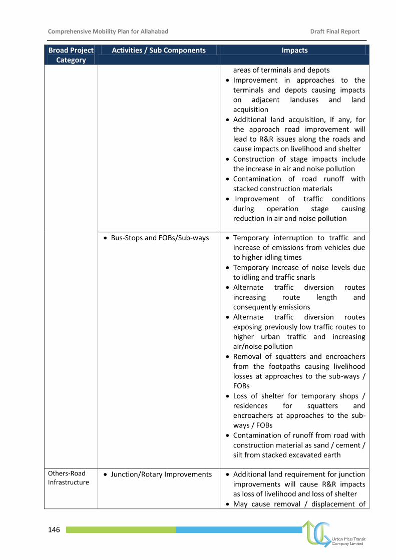
Comprehensive Mobility Plan for Allahabad Draft Final Report
146
Broad Project Category
Activities / Sub Components Impacts
areas of terminals and depots
Improvement in approaches to the terminals and depots causing impacts on adjacent landuses and land acquisition
Additional land acquisition, if any, for the approach road improvement will lead to R&R issues along the roads and cause impacts on livelihood and shelter
Construction of stage impacts include the increase in air and noise pollution
Contamination of road runoff with stacked construction materials
Improvement of traffic conditions during operation stage causing reduction in air and noise pollution
Bus-Stops and FOBs/Sub-ways
Temporary interruption to traffic and increase of emissions from vehicles due to higher idling times
Temporary increase of noise levels due to idling and traffic snarls
Alternate traffic diversion routes increasing route length and consequently emissions
Alternate traffic diversion routes exposing previously low traffic routes to higher urban traffic and increasing air/noise pollution
Removal of squatters and encroachers from the footpaths causing livelihood losses at approaches to the sub-ways / FOBs
Loss of shelter for temporary shops / residences for squatters and encroachers at approaches to the sub-ways / FOBs
Contamination of runoff from road with construction material as sand / cement / silt from stacked excavated earth
Others-Road Infrastructure
Junction/Rotary Improvements
Additional land requirement for junction improvements will cause R&R impacts as loss of livelihood and loss of shelter
May cause removal / displacement of
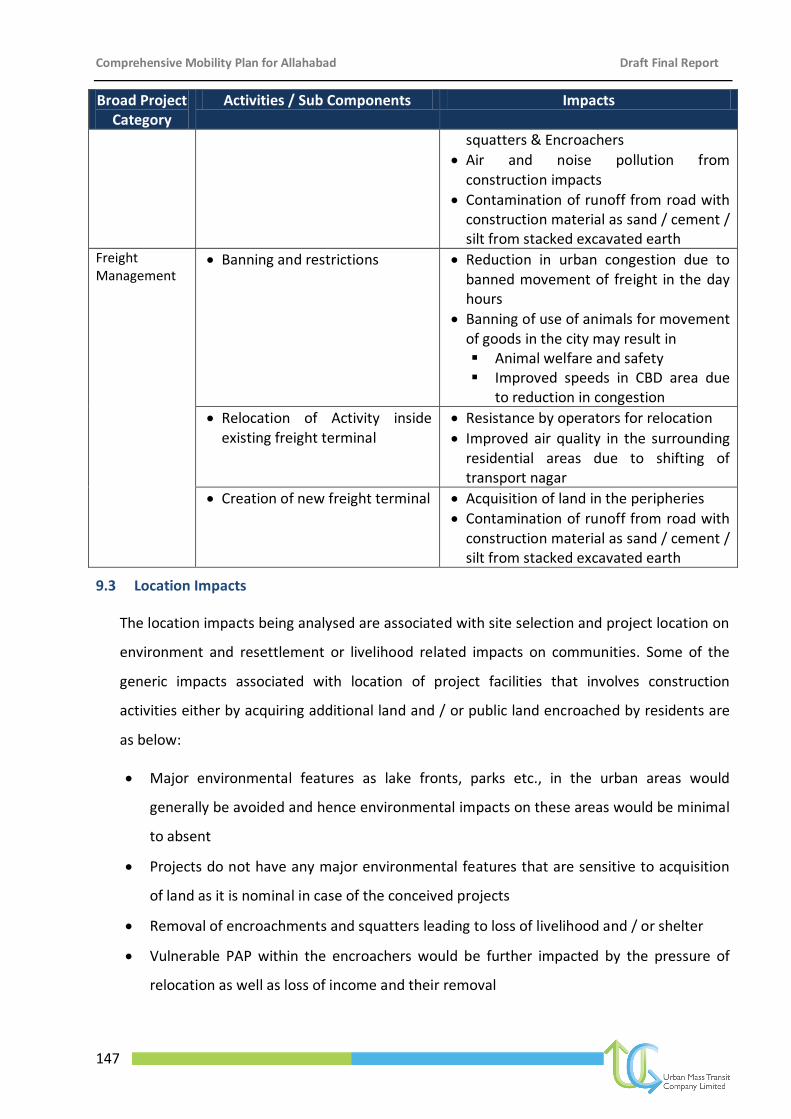
Comprehensive Mobility Plan for Allahabad Draft Final Report
147
Broad Project Category
Activities / Sub Components Impacts
squatters & Encroachers
Air and noise pollution from construction impacts
Contamination of runoff from road with construction material as sand / cement / silt from stacked excavated earth
Freight Management
Banning and restrictions Reduction in urban congestion due to banned movement of freight in the day hours
Banning of use of animals for movement of goods in the city may result in Animal welfare and safety Improved speeds in CBD area due
to reduction in congestion
Relocation of Activity inside existing freight terminal
Resistance by operators for relocation
Improved air quality in the surrounding residential areas due to shifting of transport nagar
Creation of new freight terminal Acquisition of land in the peripheries
Contamination of runoff from road with construction material as sand / cement / silt from stacked excavated earth
9.3 Location Impacts
The location impacts being analysed are associated with site selection and project location on
environment and resettlement or livelihood related impacts on communities. Some of the
generic impacts associated with location of project facilities that involves construction
activities either by acquiring additional land and / or public land encroached by residents are
as below:
Major environmental features as lake fronts, parks etc., in the urban areas would
generally be avoided and hence environmental impacts on these areas would be minimal
to absent
Projects do not have any major environmental features that are sensitive to acquisition
of land as it is nominal in case of the conceived projects
Removal of encroachments and squatters leading to loss of livelihood and / or shelter
Vulnerable PAP within the encroachers would be further impacted by the pressure of
relocation as well as loss of income and their removal
Comprehensive Mobility Plan for Allahabad Draft Final Report
148
Break-up of established social fabric that can cause severance of established
relationships amongst the community
Temporary loss of services provided by the encroaching PAPs due to their removal
Some of the specific impacts associated with construction of bridges and flyovers involves
disruption to existing traffic flow, especially, if located in the congested urban stretches.
These would also involve land acquisition (either temporary or permanent) and would also
impact the squatters and encroachers affecting residences and / or livelihood.
They would cause traffic congestion and delays and may also involve changes in the project
design and alternatives. Project interventions as ITS application and improvement in public
transport infrastructure would only improve the environment rather than causing pollution
though resettlement impacts would be present to a limited extent.
9.4 Construction Impacts
Impacts resulting from pre-construction and construction activities including site clearance,
earthworks, civil works, etc are identified in this section. Pre-construction and construction
impacts arise due to dismantling of existing facilities, use of heavy construction machinery,
spillage/disposal of construction debris, runoff from construction site, inadequate or
inappropriate drainage of the construction site, inadequate safety measures, etc. These are
some of the direct impacts of construction in the project area.
In addition to the above, there are few indirect impacts or impacts that result from
construction activities though not causing the impacts, support to cause the impacts. Some of
these impacts include generation of vectors and vector borne diseases, spread of STD / HIV
amongst the construction workers and within the community in the vicinity of construction
activities, etc. The above environmental impacts are generic in nature occurring along all the
project activities where civil works are involved. Impacts that are specific to the construction
activities in a project intervention are presented below:
Construction activities in case of reconstruction of footpaths or construction of new foot
paths would cause temporary interruption to traffic and increase of emissions from
vehicles due to higher idling times apart from temporary increase of noise levels due to
idling and traffic snarls.
Comprehensive Mobility Plan for Allahabad Draft Final Report
149
Loss of adequate frontage in few cases of foot path construction or provision of
additional cycle lanes and bus lanes
Relocation of utilities in the pre-construction stage causing temporary disruption to
services. These impacts would be more severe in case of construction of exclusive bus
lanes and foot paths.
Safety of pedestrians and traffic in the area is likely to be affected due to the progress of
construction activities.
Contamination of runoff from road with construction material as sand / cement / silt
from stacked excavated earth.
Construction activities elevate the air pollution and noise pollution in the project area
temporarily. Air pollution is due to generation of noxious gases emanating from asphalt
plants, construction equipment, crushers, etc., while noise pollution is due to operation
of various types of construction equipments.
Stacking of construction waste causing interruption to traffic and pedestrian movements.
Runoff from stacked construction waste entering the water bodies and existing drainage
systems causing clogging of drain outlets as well as the drains themselves.
Project interventions as procurement of low emission vehicle fleets, traffic signal
prioritisation, ITS, provision of signages, etc., involve minimal construction activities and
hence, environmental and social benefits from these activities will outweigh any minimal
impacts that may occur.
9.5 Operation Impacts
These are the Impacts associated with the operation and maintenance of the infrastructure
built in the project. The project interventions are conceived to provide maximum benefits to
the community with the implementation of the project. The project interventions, as could be
judged from the discussion so far, involve environmental and resettlement impacts during
pre-construction and construction stages of the project and appropriate mitigation and
management measures would be undertaken to avoid the same.
Negative environmental / social impacts in the operation stage would mostly be limited to air
and noise pollution along the improved road infrastructure as well as the parking areas. While
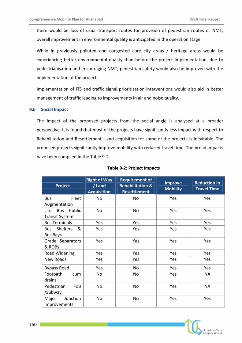
Comprehensive Mobility Plan for Allahabad Draft Final Report
150
there would be loss of usual transport routes for provision of pedestrian routes or NMT,
overall improvement in environmental quality is anticipated in the operation stage.
While in previously polluted and congested core city areas / heritage areas would be
experiencing better environmental quality than before the project implementation, due to
pedestrianisation and encouraging NMT, pedestrian safety would also be improved with the
implementation of the project.
Implementation of ITS and traffic signal prioritisation interventions would also aid in better
management of traffic leading to improvements in air and noise quality.
9.6 Social Impact
The impact of the proposed projects from the social angle is analysed at a broader
perspective. It is found that most of the projects have significantly less impact with respect to
Rehabilitation and Resettlement. Land acquisition for some of the projects is inevitable. The
proposed projects significantly improve mobility with reduced travel time. The broad impacts
have been compiled in the Table 9-2.
Table 9-2: Project Impacts
Project Right of Way
/ Land Acquisition
Requirement of Rehabilitation &
Resettlement
Improve Mobility
Reduction in Travel Time
Bus Fleet Augmentation
No No Yes Yes
Lite Bus Public Transit System
No No Yes Yes
Bus Terminals Yes Yes Yes Yes
Bus Shelters & Bus Bays
Yes Yes Yes Yes
Grade Separators & ROBs
Yes Yes Yes Yes
Road Widening Yes Yes Yes Yes
New Roads Yes Yes Yes Yes
Bypass Road Yes No Yes Yes
Footpath cum drains
No No Yes NA
Pedestrian FoB /Subway
No No Yes NA
Major Junction Improvements
No No Yes Yes
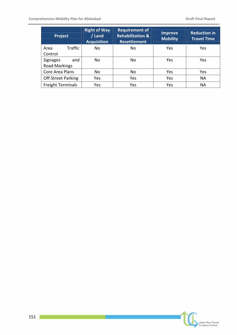
Comprehensive Mobility Plan for Allahabad Draft Final Report
151
Project Right of Way
/ Land Acquisition
Requirement of Rehabilitation &
Resettlement
Improve Mobility
Reduction in Travel Time
Area Traffic Control
No No Yes Yes
Signages and Road Markings
No No Yes Yes
Core Area Plans No No Yes Yes
Off-Street Parking Yes Yes Yes NA
Freight Terminals Yes Yes Yes NA
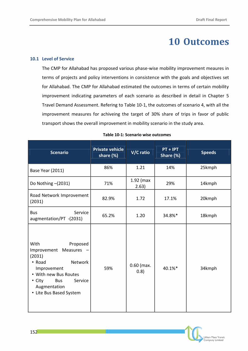
Comprehensive Mobility Plan for Allahabad Draft Final Report
152
10 Outcomes
10.1 Level of Service
The CMP for Allahabad has proposed various phase-wise mobility improvement meaures in
terms of projects and policy interventions in consistence with the goals and objectives set
for Allahabad. The CMP for Allahabad estimated the outcomes in terms of certain mobility
improvement indicating parameters of each scenario as described in detail in Chapter 5
Travel Demand Assessment. Refering to Table 10-1, the outcomes of scenario 4, with all the
improvement measures for achiveing the target of 30% share of trips in favor of public
transport shows the overall improvement in mobility scenario in the study area.
Table 10-1: Scenario wise outcomes
Scenario Private vehicle
share (%) V/C ratio
PT + IPT Share (%)
Speeds
Base Year (2011) 86% 1.21 14% 25kmph
Do Nothing –(2031) 71% 1.92 (max
2.63) 29% 14kmph
Road Network Improvement (2031)
82.9% 1.72 17.1% 20kmph
Bus Service augmentation/PT -(2031)
65.2% 1.20 34.8%* 18kmph
With Proposed Improvement Measures –(2031) • Road Network
Improvement • With new Bus Routes • City Bus Service
Augmentation • Lite Bus Based System
59% 0.60 (max.
0.8) 40.1%* 34kmph

Comprehensive Mobility Plan for Allahabad Draft Final Report
153
The outcomes of the projects proposed could be assessed in terms of improvements in the
Level of Service (LOS) for the 10 Benchmarks defined by the Ministry of Urban
Development, Government of India.
10.2 Improved Level of Service
The overall LOS achieved for all the Benchmarks are given in Table 10-2. A significant
improvement can be observed from the existing LOS. These could be attributed to various
factors as given below:
Table 10-2: Overall LOS
Overall Level of Service (LOS)
S.No. Indicators LOS - Existing LOS - Improved
1 Overall Public Transport facilities City wide 3 1
2 Overall Pedestrian Infrastructure Facilities 4 1
3 Overall NMT Facilities 4 1
4 Level of usage of ITS facilities 4 2
5 Travel Speed along major corridors 3 2
6 Availability of Parking Spaces 4 2
7 Road Safety 4 2
8 Pollution Levels 2 1
9 Integrated Land-use Transport Integration 2 1
10 Financial Sustainability of Public transport 3 1
10.3 Conclusion
During the last decade, the urban sprawl in Indian cities has extended far beyond the
existing territorial jurisdiction of the city administration resulting in high usage of private
modes. Despite substantial efforts, cities are facing difficulty in coping with increase of
private vehicles along with improving personal mobility and goods distribution. Allahabad
city has been experiencing high growth of population over the years, which can be
attributed to high natural growth and migration from the adjacent rural areas and towns
with expectation of better employment and livelihood opportunity.
With rapid pace of urbanisation together with increase in population and private vehicles in
Allahabad city will pose an unimaginable load on city’s already struggling transport
infrastructure. On the other hand the extremely low share of public transport is leading to

Comprehensive Mobility Plan for Allahabad Draft Final Report
154
more usage of private vehicles for mobility needs and inreased demand for parking of
private vehicles.
The National Urban Transport Policy (NUTP), 2006, therefore emphasises on personal
mobility to achieve cost-effective and equitable urban transport measures within an
appropriate and consistent methodology. Accordingly, the Comprehensive Mobility Plan
(CMP) for Allahabad city lays out a set of measured steps that are designed to improve
transportation in the city in a sustainable manner to meet the needs of a growing
population.


![Terms of reference for preparation of a Comprehensive ......Comprehensive Mobility Plan 1. Introduction [IMPLEMENTING AGENCY] is requesting applicants to develop Comprehensive Mobility](https://static.fdocuments.net/doc/165x107/5fe383a69368d25e98043785/terms-of-reference-for-preparation-of-a-comprehensive-comprehensive-mobility.jpg)