Comprehensive Historical/Architectural Site Survey of ... · Comprehensive Historical/Architectural...
125
Comprehensive Historical/Architectural Site Survey of Brunswick County, North Carolina Prepared for Brunswick County Board of Commissioners PO Box 249 Bolivia, NC 28422 Prepared by Landmark Preservation Associates 6 Houston Street Lexington, VA 24450 September 2010
Transcript of Comprehensive Historical/Architectural Site Survey of ... · Comprehensive Historical/Architectural...

Comprehensive Historical/Architectural Site Survey of Brunswick County, North Carolina
Prepared for Brunswick County Board of Commissioners PO Box 249 Bolivia, NC 28422 Prepared by Landmark Preservation Associates 6 Houston Street Lexington, VA 24450 September 2010


i
Table of Contents Introduction and Methodology ........................................................................................ ii Historic and Architectural Contexts Early History: 1664‐1800 ......................................................................................................... 1‐1 Plantation Society: 1800‐1865................................................................................................. 1‐9 Later History: 1865‐1960 ....................................................................................................... 1‐20
Recommendations ........................................................................................................ 1-50 Proposed Gause Landing Historic District Map ...................................................................... 1‐53 Southport Historic District & Recommended Study Areas District Map ................................ 1‐54
Appendix A – Brunswick County Historic Resources Map Coding ........................ A-1 Appendix B – Brunswick County Historic Photographs............................................B-1 Appendix C – Brunswick County Surveyed Properties by Survey Site Number ... C-1 Appendix D – Brunswick County NRAC Study List Candidate Narratives/Presentation ................................................................................................ D-1 Cover image: Map of Brunswick County in Branson’s North Carolina Business Directory, 1897.
ii
Introduction and Methodology In September 2009 the Brunswick County Board of Commissioners contracted with Landmark Preservation Associates to conduct a comprehensive survey of Brunswick County’s historic architectural resources. The purpose of the survey was to document a total of 470 buildings and other historic built resources located in municipalities, unincorporated communities, and rural areas throughout the County. An additional twenty-five resources were added to the contract in Spring 2010. In all, 506 surveys were completed. The project was administered by the County’s Planning and Community Development Department, represented by Director J. Leslie Bell, AICP, HDFP, and Christopher Gibbons, Planner I, and was conducted in consultation with Claudia Brown, Survey and National Register Branch supervisor, North Carolina State Historic Preservation Office (HPO), with assistance from HPO preservation specialist Jessica Dockery and National Register coordinator Ann Swallow. The Landmark Preservation Associates principals who conducted the survey were J. Daniel Pezzoni and Leslie A. Giles. The project was divided into three phases. The Planning Phase, conducted in September and October 2009, entailed the establishment of a Survey Committee and the reconnaissance or “windshield” survey of the County to identify properties for intensive survey. The Survey Committee was made up of historians, preservationists, and others with an interest in the County’s history and architecture, and its primary purpose was to advise the County and the consultant on the location and history of properties that warranted consideration for the survey. The committee comprised Bertha Bell, Gwen Causey, Gail Graham, Marian Chadwick Hobbs, Ronald (Craig) Hobbs, John Hobgood, Glenn Kye, Bobby Long, Musette Steck, Reecie Tate, and Eulis Willis. David Covington, Marvin Graham and Roberta Brady also provided valuable assistance. Several committee members devoted their time as drivers or guides during the reconnaissance survey, which visited every part of the County and resulted in the identification of survey candidates and typological map coding for historic resources that did not appear to warrant intensive survey (see Appendix 1 for an explanation and analysis of the map coding). The Survey Phase, begun in October 2009 and completed in June 2010, resulted in the documentation of 506 historic resources or resource groupings. Of this number, 276 resources were surveyed in the city of Southport and the remaining 230 resources were surveyed in the County’s other municipalities and unincorporated areas. Survey outside of Southport was conducted by Dan Pezzoni and extended throughout the entire phase. Survey in Southport was conducted by Leslie Giles and began in January 2010 with a planning meeting that involved Southport officials and staff, County planning staff, and other interested persons. Whereas survey outside Southport focused almost exclusively on resources that had not already been documented for the HPO (very few had), the Southport survey was largely a resurvey of the Southport Historic District, which is listed in the National Register of Historic Places. Survey entailed visiting properties, noting architectural features, digital photography, and gathering historical information on site from owners and occupants. Follow-up work

iii
involved phone interviews and research in secondary historical sources and, occasionally, primary sources. Narrative descriptions were written for each surveyed property and information was entered into the HPO’s survey database. At the end of the project, a report form on each of the properties was generated from the database, the photographs were printed, and these and other information were compiled into survey files. The original files were presented to the County and the files were provided digitally to the HPO. The Survey Phase also included a number of informal meetings with County staff and committee members and numerous consultations with HPO staff. A noteworthy feature of the phase was the concept of “reserve” survey sites, approximately ten properties that were not chosen for survey until late in the process as a way to include resources that were overlooked earlier. The addition of twenty-five properties to the contract late during the survey provided the same benefit. Dating of buildings was often approximate, based on architectural cues and historical sources such as oral history. In the narrative entries and the report, the abbreviation “ca.” stands for “circa,” a Latin word meaning “about” that indicates a date is approximate or conjectural. All report images were taken by Dan Pezzoni unless otherwise noted. The third and final phase, the Report Phase, nominally occurred during the summer of 2010, but work on the survey report began in 2009 and continued apace in early 2010. The report includes an overview of the County’s historic and architectural development and draws heavily on information from field work and interviews. The report also makes general preservation, memorialization (signage), and Study List recommendations. Study List candidates have been reviewed by HPO staff and are scheduled for consideration by the North Carolina National Register Advisory Committee (NRAC) at its October 14, 2010 meeting. An explanation of the Study List appears in the recommendations section of the report. The results of two related but separate projects—a documentation of Brunswick County communities and a survey of the County’s cemeteries—appear in a separate volume. Acknowledgements Many individuals assisted the County and the consultant during the course of the survey. In addition to the Survey Committee members listed above, the following property owners and other individuals assisted the project: Jeff Adolphsen, W. Frank Ainsley, Hyton W. Babson, Jackie Babson, Kenneth Babson, Ronnie M. Babson, Russell Baldwin, Ralph Beer, Barbara Bell, Margie Catherine Bell, Stevie Bell, Elise Bennett, Muriel Bennett, Mary Benton, Jesse Best, Joe Best, Catherine Bishir, Roberta Brady, Rodney Harold Brady, Brenda Bryant, Harry Bryant, Sheila Buchanan, Nancy Bunker, Tony Burgess, Charles Burney, B. Joseph Causey, Betty Jo Chaisson, Nan Chandler, Michelle Cicero, Nancy Lennon Clark, Robert Clark, Edwina Clemmons, Cathy Crawley, Janie Crouch, Jerry Evans, Courtney Foley, Woody Fulford, Furman L. Galloway Jr., Janice Gore, Marvin Ray Graham, Susan Grantier, Barbara Gray, Lillian M. Gray, Duval Guyton, Sue Guyton, Dolores Hall, Geraldine Hall, Joel
iv
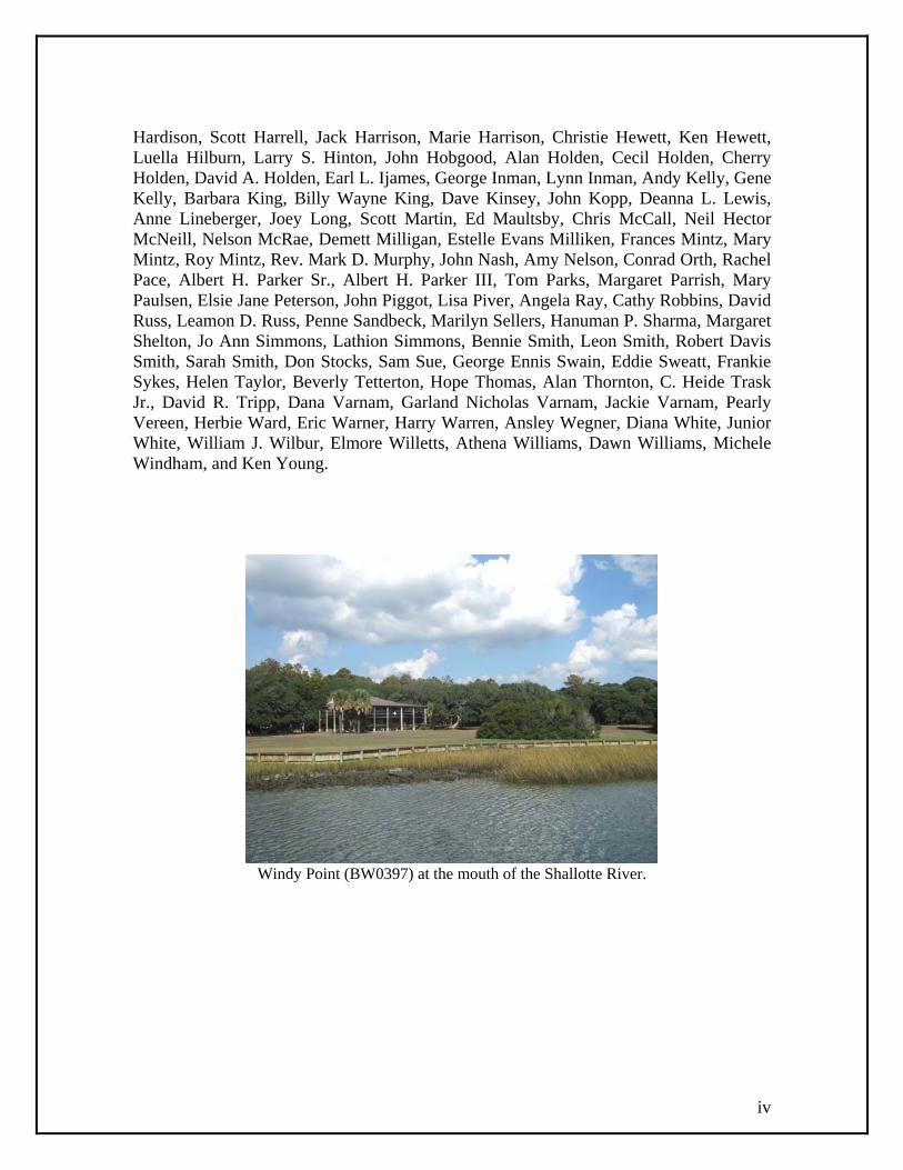
Hardison, Scott Harrell, Jack Harrison, Marie Harrison, Christie Hewett, Ken Hewett, Luella Hilburn, Larry S. Hinton, John Hobgood, Alan Holden, Cecil Holden, Cherry Holden, David A. Holden, Earl L. Ijames, George Inman, Lynn Inman, Andy Kelly, Gene Kelly, Barbara King, Billy Wayne King, Dave Kinsey, John Kopp, Deanna L. Lewis, Anne Lineberger, Joey Long, Scott Martin, Ed Maultsby, Chris McCall, Neil Hector McNeill, Nelson McRae, Demett Milligan, Estelle Evans Milliken, Frances Mintz, Mary Mintz, Roy Mintz, Rev. Mark D. Murphy, John Nash, Amy Nelson, Conrad Orth, Rachel Pace, Albert H. Parker Sr., Albert H. Parker III, Tom Parks, Margaret Parrish, Mary Paulsen, Elsie Jane Peterson, John Piggot, Lisa Piver, Angela Ray, Cathy Robbins, David Russ, Leamon D. Russ, Penne Sandbeck, Marilyn Sellers, Hanuman P. Sharma, Margaret Shelton, Jo Ann Simmons, Lathion Simmons, Bennie Smith, Leon Smith, Robert Davis Smith, Sarah Smith, Don Stocks, Sam Sue, George Ennis Swain, Eddie Sweatt, Frankie Sykes, Helen Taylor, Beverly Tetterton, Hope Thomas, Alan Thornton, C. Heide Trask Jr., David R. Tripp, Dana Varnam, Garland Nicholas Varnam, Jackie Varnam, Pearly Vereen, Herbie Ward, Eric Warner, Harry Warren, Ansley Wegner, Diana White, Junior White, William J. Wilbur, Elmore Willetts, Athena Williams, Dawn Williams, Michele Windham, and Ken Young.
Windy Point (BW0397) at the mouth of the Shallotte River.
1-1
Early History: 1664-1800 Brunswick County occupies the southernmost tip of North Carolina. The wedge-shaped County land area of 854.79 square miles is bounded on the south by the Atlantic Ocean, on the east by the Cape Fear River (across which are New Hanover and Pender counties and the city of Wilmington), on the west by the South Carolina state line, and on the northwest by Columbus County and the Waccamaw River. The County is North Carolina’s fifth largest. Topography is low and generally level; the highest elevations, generally in the northeast quadrant of the County around Winnabow and Bolivia, stand at about seventy-five feet above sea level. Soils are sandy, although “silty and sandy blue to gray clay” is also found. Due to the low elevation and the proximity to ocean storms, vast areas of the County are covered by forested swamps and pocosins. Over seventy-seven percent of the County was classified as commercial forest in the 1950s. Palmetto and other flora grow in the County as a result of its mild winter climate, the warmest in the state. In addition to the Cape Fear and Waccamaw rivers, the County is drained by short, partly estuarine watercourses like the Shallotte and Lockwoods Folly rivers. Numerous creeks flow into the Cape Fear, prominent among them Town Creek, which was navigable during the historic period. Part of the Cape Fear diverges from the main stream to form the Brunswick River, with the large marshy expanse of Eagle Island between the river and the main channel of the Cape Fear. The Cape Fear River takes its name from Cape Fear, the southernmost of North Carolina’s famous capes, which juts into the Atlantic Ocean at the south end of Smith Island, now known as Bald Head Island. From here to the South Carolina line extends a succession of sandy barrier islands separated by inlets. Unlike the barrier islands of the Outer Banks, which are backed by deepwater sounds, some of Brunswick County’s barrier islands were wedded to the mainland by marshes prior to the construction of the Intracoastal Waterway. Historically it was possible to wade from some islands to the mainland at low tide. Of the County’s barrier islands, only Smith Island (Bald Head Island) and Oak Island were consistently referred to as islands in historic times.1 The County was created out of New Hanover and Bladen counties in 1764. Columbus County was formed from Brunswick’s western part in 1808 and another large cession was made to Columbus County in 1877 resulting in the County’s present boundaries. In 2008 Brunswick County’s population was estimated at 103,160. The County has nineteen municipalities, the largest number of any county in the state. In 2000, according to the census of that year, the most populous was Oak Island (6,571 persons), followed by Boiling Spring Lakes (2,972 persons), Southport (2,351), Leland (1,938), Sunset Beach (1,824), Carolina Shores (1,482), and Shallotte (1,381). Bolivia, the County seat, had a population of 148 in 2000. The oldest existing towns are Southport, founded as Smithville in 1792; Shallotte, incorporated in 1899; and Bolivia, incorporated in 1911. Southport, formerly the County seat, was the largest community from the turn of the nineteenth century until the late twentieth century when the growth of resort communities overtook it. The County is traversed by US Highway 17, which enters the County on the east across the Cape Fear River from Wilmington and exits at the South Carolina state line on the west. Highway 17 has figured as the main arterial route since the 1920s. The 1 Jackson, Big Book of the Cape Fear River, 2; Sharpe, New Geography of North Carolina, 600, 607.

1-2
Atlantic Intracoastal Waterway, or simply the Intracoastal Waterway, was completed along the County’s coast in 1936. Railroads were built through the County beginning in the 1850s.2 Native Americans lived in Brunswick County for many millennia prior to the first European attempt at settlement. In 1663 Sir John Colleton, one of North Carolina’s eight Lords Proprietors, merchant John Vassall of Barbados, and others formed the “Corporation of Barbadian Adventurers” to promote settlement in the Carolinas. The corporation selected William Hilton of Massachusetts to explore the lower Cape Fear and its tributaries. Hilton’s favorable account of the area led to the establishment of Charles Town at the mouth of Town Creek in Brunswick County in May 1664. The settlement may have been located at or near an Indian village referred to as Sachom’s on period maps, and it consisted of a fortification and several buildings. Charles Town became the focus of plantation settlement that extended to the north and south along the Cape Fear, and which may have numbered eight hundred persons including slaves by 1666. The whites in the settlement came from Barbados, New England, and England. The Charles Town venture was plagued by political disagreements and the town and plantations were disbanded in 1666.3
St. Philip’s Church, Brunswick Town.
The Charles Town settlement was a notable development in North Carolina’s seventeenth-century history, but more significant to the life of the colony and longer lasting was Brunswick Town, settled about 1725. The naval stores trade, which was bolstered by British bounties, is considered to have been vital to the founding of the town. Maurice Moore, son of a South Carolina governor, laid out 336 half-acre lots on the Cape Fear downstream from the site of Charles Town. The new town quickly rose to prominence as a port and political center. Construction of a courthouse for newly formed New Hanover County (which then included Brunswick) was authorized in 1731. Archaeological investigation discovered the courthouse to have been twenty-five-feet square in plan. Other important buildings included St. Philip’s Church (1754-68), its 2 “North Carolina County Road Survey of Brunswick County;” Shorey, Bolivia, 12. 3 “Charles Town;” Jackson, Big Book of the Cape Fear River, 16-17; Lee, History of Brunswick County, 11-19.

1-3
elegant brick ruins today one of the County’s most important standing structures; the six-room Publick House or inn; and, on the north side of town, the substantial verandah-encircled mansion completed by Governor Arthur Dobbs in 1758 and known variously as Russellborough (after John Russell, who began construction ca. 1751), Castle Dobbs, Bellfont, “the house of universal hospitality,” and Castle Tryon. The last name reflected the occupancy of William Tryon, one of two colonial governors to make Brunswick Town their home, who lived at Russellborough until Tryon Palace was completed in New Bern in 1770. A map of the town made by C. J. Sauthier in 1769 shows dozens of structures including houses, outbuildings, and warehouse-like buildings and piers along the waterfront. Brunswick Town survived a Spanish attack in 1748 but faded in later decades. The mostly deserted community was burned by British forces in 1776 and subsequently abandoned. Problems with malaria and competition from Wilmington a few miles upstream were factors in Brunswick Town’s demise.4 In 1745, during a period of heightened concern about Brunswick Town’s survival, the colonial legislature passed “An Act to encourage Persons to settle in the Town of Brunswick.” The act required each lot purchaser to build a “good substantial habitable House, of the Dimensions of Twenty Feet Long and Sixteen Feet wide, without Shed” (the size requirement was apparently stipulated in the 1720s as well). Evidence that good and substantial houses were indeed built in the town has been demonstrated by archaeologist Stanley South and others who have investigated the town’s remains. One excavated dwelling is the Hepburn-Reonalds House, believed to have been built between 1734 and 1742. The rectangular dwelling stood on a raised “English basement” that functioned as living or work space. The surviving basement level was constructed with ballast stones, rounded beach stones picked up at distant ports of call and used as ballast or weight in ships. When the ships arrived at Brunswick Town and other North Carolina ports, they were loaded with heavy cargoes and the ballast stones discarded to be reused for construction. Ballast stone serves as a house and chimney foundation material in surviving houses such as the Elijah Pigott House (BW0381) at Shallotte Point. The Hepburn-Reonalds basement was divided into two unequal rooms. The smaller room, believed to have functioned as a shop, has a ballast stone floor and a sunken street entry. The larger room had a wood floor and a rectangular feature on the end that may have been a brick hearth for a chimney (the other end of the house also had a chimney). The asymmetrical two-room basement plan would likely have been duplicated on the level above—the popular hall-parlor plan of the eighteenth and nineteenth centuries. The house is believed to have had a front porch and to the rear it had what is described as a brick patio.5 Another well-documented Brunswick Town ruin is the house known as Nath Moore’s Front, built before 1728 during the early years of the town’s development. This house also had a ballast stone foundation and a two-part basement division with one wood-floored room (the charred floor boards were well preserved at the time of excavation in 4 Lee, History of Brunswick County, 32-34, 55-56; Ijames, “Real Tar Heels;” Jackson, Big Book of the Cape Fear River, 18-21; South, Archaeological Evolution, 139; South, “Colonial Brunswick,” 49. 5 Acts of the North Carolina General Assembly, 1745, 241; South, Method and Theory in Historical Archeology, 51; South, “Colonial Brunswick,” 5; Bishir and Southern, Guide to the Historic Architecture of Eastern North Carolina, 231.

1-4
1958-59) and the other decoratively paved with broken brick bats in fan-shaped arcing patterns. The wood-floored room had a brick chimney and fireplace; the other room had foundation supports for a chimney in the room above. A porch wrapped around the house on two sides, its long-vanished posts or columns supported at grade by mortared stone footers. Architectural historians Catherine Bishir and Michael Southern have noted that Brunswick Town had “some of the state’s earliest known uses of the broad, full-width porch or piazza, a distinctive feature that became characteristic of coastal architecture.” The excavation of Nath Moore’s Front also revealed evidence for weatherboard siding, window shutters, and plaster-and-lath interior wall finishes.6 Russelborough, another excavated Brunswick Town residence, was described in 1765 by Governor William Tryon as a two-story frame house on a high cellar level, wrapped on all sides by a two-tier porch which Tryon called a “Piaza,” using a term still known to the County’s older inhabitants. Tryon noted the verandah’s four-foot-high balustrade, which he considered “a great Security for my little girl.” Archaeology has confirmed the basic form and is consistent with Tryon’s description of four rooms on each floor, including a parlor and drawing room on the lower level. Tryon’s room dimensions suggest each floor was bisected by a center passage. Carpenter Thomas Dick was mentioned as having worked on the house in 1762. The “Out Houses” surrounding the residence included a stable and coach houses, and Tryon hoped to construct a sizable (thirty by forty foot) kitchen at the time of his writing. Archaeological investigations of Russelborough’s foundations revealed back-to-back fireplaces serving rooms on one side of the house; an indoor well with a wrought-iron well hoop or “Dutch crown,” probably for suspending wine bottles in the well to cool; and a cellar floor paved with yellow Dutch bricks set on edge. A tunnel-like brick drain ran from the verandah’s understory to the river. Mixed in with the plaster that fell into the cellar from the rooms above were fragments of a marble mantelpiece.7 The grand governor’s mansion of Russellborough stood at one extreme of eighteenth-century Brunswick County’s domestic architecture. On the bottom rungs of the socioeconomic ladder were the hardscrabble dwellings described by Rhode Island merchant Elkanah Watson in his account of travel through the County in 1777. The road from Brunswick Town to the Lockwoods Folly River passed through “an unbroken wilderness,” wrote Watson. “Not a house, not even a wild tar-burner’s hut, was presented to our view, the whole distance.” He and his party spent one night in a “wretched hovel, without floor or furniture.”8 Brunswick County’s position at the mouth of one of North Carolina’s major rivers endowed it with a strategic importance that was appreciated by British colonial authorities. In 1744, during troubles with Spain and France, Governor Gabriel Johnston called an emergency council meeting in Brunswick Town to plan for the construction of a
6 South, Method and Theory in Historical Archeology, 57; South, “Colonial Brunswick,” 146; Bishir and Southern, Guide to the Historic Architecture of Eastern North Carolina, 267. 7 Lee, History of Brunswick County, 55-56; South, Archaeological Evolution, 137-139; South, “Colonial Brunswick,” 120-129; Bishir, North Carolina Architecture, 26; North Carolina Architects and Builders website; Brunswick Town visitor center exhibits. 8 Watson, Men and times of the Revolution, 50.

1-5
fort on the lower Cape Fear. After considering sites on the islands near the mouth of the river, in 1745 the commissioners appointed for the task decided on a site in present Southport, a location inhabited by the pilots who assisted ship traffic through the dangerous shoals around the river mouth. The fortification, named Fort Johnston (BW0004) in honor of the governor, was under construction in September 1748 when the Spanish attacked the area. It was garrisoned in 1750 and construction was declared finished in 1764. The fort had features of military design such as bastions and curtains, as well as a “good House built in the Fort which can contain an officer and 12 or 14 men with guns and Stores.”9 A detailed plan of Fort Johnston was made by John Abraham Collet in 1767. The Swiss-born military engineer had fought in Germany and had studied mathematics, engineering, and drawing before he was commissioned commander of Fort Johnston, a post he took up in late 1767. His drawing shows a classic four-point fortification with gun embrasures along the parapet and a firing platform inside the walls on the water side. The “Lodging of the Commander” is a long gabled building with a chimney at one end and what appears to be a shed-roofed porch across half the front elevation. Two small barracks for the soldiers, each gable-roofed with a chimney at one end, stand off the back corners of the commander’s lodgings. Set apart in the rhomboidal spaces of the rear bastions are features that constituted fire hazards such as the powder magazine and a bake oven. A draw bridge crosses what appears to be a dry moat. Collet had a low opinion of the fortifications he found upon his arrival, so his drawing probably represents plans for improvement rather than the fort’s actual form. As it turns out, he left the fort in 1768, presumably too soon to make major changes. Collet returned in the early 1770s and made improvements at his own expense including a house and stables, which were destroyed by patriot forces in 1775.10 Like Collet, most period commentators had negative impressions of Fort Johnston. In 1766 Governor Tryon noted that “there is so great a proportion of sand that every gun fired brings down some of the parapet.” Tryon probably meant that the tabby with which the fort was constructed—a mixture of sand, oyster shells, and lime poured in wooden forms—was prepared with too much sand. In 1775 Scottish diarist Janet Schaw described the fort as resembling a “Leith timber-bush,” meaning a lumber yard, with “guns peeping thro’ the sticks.” Her description suggests the fort had a log palisade. The same year Schaw glimpsed the fort from shipboard, Governor Josiah Martin called it a “most contemptible thing” and a “little wretched place.” A more positive assessment was made by an officer charged with rebuilding the fort in 1804, who wrote, “In clearing away the sand I found much of the tapia [tabby] walls then erected, finer in their whole length, on a front of the ordinary half bastion flanks and curtain of two hundred and forty feet extent, far superior to our contemplated plan for the battery of tapia.” Two masses of tabby or coquina-like material survive at the site of the fort and may be remnants of colonial or later construction.11
9 Lee, History of Brunswick County, 45-47. 10 Jackson, Big Book of the Cape Fear, 138. Schaw, Journal of a Lady of Quality, 330-333. 11 Schaw, Journal of a Lady of Quality, 142; Waddell, History of New Hanover County, 217; Sprunt, Chronicles of the Cape Fear River, 54, 137.

1-6
Fort Johnston (center) and the surrounding community of Southport.
Fort Johnston’s location was praised for its healthiness, which in addition to its advantages as a port attracted the interest of town developers. The first attempt was made in 1784 when John Walker received legislative authorization to establish the town of Walkersburg near the fort. Walker hoped to lure the County seat to the new community, but Walkersburg “remained nothing more than a paper town,” according to historian Lawrence Lee. About the same time, in the mid-1780s, Wilmington merchant Joshua Potts visited Fort Johnston in the hope that the salt air of the location would give him respite from a life-threatening fever. His recovery ultimately inspired Potts to develop the town of Smithville (renamed Southport in 1887) at the fort, as detailed in his journal. On his initial visit Potts observed “two or three pilots’ houses on the bank” next to the fort, and during a subsequent visit he and his family lodged in the loft of pilot Joseph Swain’s dwelling. While there Potts received a letter from John Huske of Wilmington, who proposed he and Potts develop a town “on the level, near Fort Johnston.” Potts paced off the town site and found its water frontage to be less than desired, but with Huske’s encouragement he nevertheless circulated a petition among the gentlemen of the County and began the process of town establishment.12 Meanwhile, in 1791 Potts and Captain John Brown, a friend who had suggested Potts’ first visit, had house frames made in Wilmington for erection as summer cottages at the site of Smithville (Southport). Potts’ description of the process is one of the most detailed accounts of prefabricated construction to survive from the eighteenth century. Brown and Potts “proceeded to have each a cabin formed and framed in Wilmington and procured a sufficiency of the boards and shingles to complete these; employed a pettiauger [dugout canoe or small boat] and put on board the frames and other materials of both houses, engaged carpenters with their tools,” and shipped the materials and workmen to Fort Johnston. “In a few days,” Potts continued, “we had erected each a summer house, in a temporary manner, near the water . . . The said two houses, or camps, had not chimneys of any kind, and only rough shutters to the windows . . . the whole of the sawmill roughness, as a plane had not been used about them.”13 12 Carson, Joshua’s Dream, 24-25; Potts, “Location of Smithville,” 88; “New and Exact Plan of Cape Fear River.” 13 Carson, Joshua’s Dream, 25; Potts, “Location of Smithville,” 88.

1-7
Efforts to establish a town at the location came to fruition in 1792 when Smithville was created by legislative act. Potts had been successful in securing the support of legislator Benjamin Smith, for whom the town was named, and with whom Potts “sketched off” the town plan of one hundred lots. The act of establishment made provisions for public use of certain parcels but unlike most town acts of the period did not set minimum building requirements. Other sources, however, provide insights into Southport’s early architecture. For example, specifications survive for the town’s schoolhouse, planned in 1798. The frame building was to have weatherboard siding, a wood shingle roof, and a brick chimney and foundation piers.14 Brunswick County’s eighteenth-century economy was sustained by the distinctive products of the region. “The Trade of Cape Fear River consists in Naval Stores, Rice and Lumber,” declared the colonial authorities in 1745. Tar, extracted from pine wood through burning in kilns, was essential to the British navy and merchant marine, and the Cape Fear region’s accessibility and ample supply of pine timber ideally suited it to tar production. Pine boards were the region’s second-most-valuable product and turpentine, another naval stores product, ranked third. As early as 1732 it was reported that the region’s planters were erecting an “abundance of saw mills” to convert logs rafted down the river from upcountry planters as well as their own timber into value-added board lumber and scantling, much of it for export to the deforested sugar islands of the West Indies. Brunswick County’s poor soils did not allow large scale agriculture in inland areas; the marshy land or “tide swamps” bordering the Cape Fear River, however, proved adaptable to rice and indigo production. The two cash crops were not as significant in gross terms as lumber and naval stores production during the eighteenth century, but they generated excitement among the wealthier planters and they were the economic basis for the plantations that lined the lower Cape Fear by the eve of the American Revolution. Such were the fortunes that could be made on rice, indigo, and forest products that Roger Moore, owner of 250 slaves and the Orton and Kendall plantations near Brunswick Town, was probably the colony’s wealthiest planter at the time of his death in 1751. Cash crop cultivation required a large work force and fueled planter reliance on slavery. About two-thirds of Brunswick County’s estimated colonial population of 3,000 is thought to have been African American. The County’s smaller farmers and landless whites focused on the less labor-intensive activities of tar production, timber harvesting, and cattle ranching.15 Other than the ruins at Brunswick Town, the ca. 1730 brick core of Roger Moore’s Orton Plantation house (BW0005), and possibly a roofless brick outbuilding on the Clarendon Plantation (BW0227), no eighteenth-century buildings are known to survive in Brunswick County. The 2009-2010 architectural survey confirmed the paucity of early architecture, which is explained by several factors. Brunswick County’s coastal location exposes it to hurricanes and other destructive storms. Hurricane Hazel, which in 1954 swept the County’s barrier islands clean of most of their buildings and caused flood and
14 Carson, Joshua’s Dream, 24-28, 31-32, 141-143; Bishir and Southern, Guide to the Historic Architecture of Eastern North Carolina, 263; Potts, “Location of Smithville,” 86-88. 15 Acts of the North Carolina General Assembly, 1745, 239-240; Wood, This Remote Part of the World, 37, 181-182, 185, 187-189, 191, 193-194, 197, 201.

1-8
wind damage far inland, is a recent example of the storms that have devastated Brunswick’s architecture through the centuries. The County’s swampy landscape and humid subtropical climate foster rot and termite damage in frame structures. Because local building stone was nonexistent and alternatives such as ballast stones, brick, and tabby were either imported or difficult and expensive to produce locally, builders relied more heavily on wooden construction that was most prone to decay. Socioeconomic factors also worked against the construction of lasting architecture. The houses of Brunswick Town and the Cape Fear plantations were the exception in eighteenth-century Brunswick, and even these relatively well-constructed houses have largely disappeared. It is not surprising then that the hovels encountered by Elkanah Watson and other visitors passed into oblivion long ago. The factors that worked against the survival of eighteenth-century buildings were present in later periods as well, and only from the late nineteenth century and later do buildings survive in appreciable numbers in the County. Somewhat better represented in the County’s architectural landscape are the tombs of its wealthier inhabitants. St. Philip’s Churchyard in Brunswick Town, a place of burial in existence by 1745, contains a group of artistically refined ledger and box tombs from the second half of the century which were probably made in English workshops. The expertly crafted box tomb of Eleazer Allen (d. 1749), which formerly stood on the Lilliput Plantation just north of Brunswick Town, appears to have been made in England as well. The ruin of St. Philip’s Church contains twelve floor graves that reflect the British practice of burying community leaders within church walls. Another early tomb of note is the brick tomb of Roger Moore (d. 1751) at Orton Plantation, which has a gabled and ribbed brick roof. The grave of colonial governor Nathaniel Rice (d. 1753), located in the Winnabow area, is covered by a brick barrel vault.16
Marble chest tomb in St. Philip’s Churchyard, Brunswick Town.
16 John Hobgood personal communication; Little, Sticks and Stones, 49; “Lilliput Plantation” survey file (BW00241), N.C. State Historic Preservation Office; Jackson, Big Book of the Cape Fear River, 123.

1-9
Plantation Society: 1800-1860 The 1790 federal census provides the first quantitative picture of Brunswick County’s population, which at the time included the inhabitants of present Columbus County. A total of 3,070 persons were enumerated for the County in 1790. Despite the loss of people to Columbus County in the first decade of the nineteenth century, the population rose to 8,406 by 1860. Of the latter figure, 4,775 persons were free and 3,631 were enslaved. The County led North Carolina in rice production in 1860, with 7.6 million pounds of the eight million pounds harvested in the state, and rice remained an important crop through the end of the nineteenth century.17 Southport, known as Smithville during the period, figured as the County’s only true town. Its early economy was based in large part on its status as a place of resort for Wilmingtonians who possessed the means to escape the summer heat and disease of their burgeoning city up river. An early account of the town’s resort character that also provides a glimpse of its early domestic architecture is contained in the memoirs of a military officer who visited in 1804. “Agreeable families from Wilmington,” wrote the officer, “passed the warm season in slight frame houses at ‘The Fort,’ as the village of Smithville is called.” The town’s permanent population in 1816 was estimated at three hundred residents, swelling to five or six hundred during the summer and fall, and its small grid of streets contained about sixty houses. A visitor in 1830 described boarding houses, retail shops, and warehouses, the latter reflecting Smithville’s port status. Smithville remained the abode of pilots, who had resided at the location at least as far back as the 1740s. In 1808 another dimension was added to the town’s economy when the state legislature authorized the removal of the County court to Smithville from its previous location at a site on the Lockwood Folly River near the present community of Supply. (Nothing survives aboveground at the earlier courthouse site.) A one-story brick courthouse was completed soon after, described by Lawrence Lee as having stood on brick arches that were later filled in with offices. A larger courthouse, constructed to replace the original building in 1826, was in turn replaced by the present two-story brick building, designed by Wilmington architect Benjamin Gardner and completed in 1854. The construction of the (former) Brunswick County Courthouse (BW0007) is attributed to builder W. D. Morrell. The altered 1854 building, which was decommissioned when the County court facilities were moved to Bolivia in 1977, now serves as the Southport City Hall.18 By the antebellum period, according to the reminiscences of Southport physician Walter Gilman Curtis, the town’s houses were “of the simplest kind, still in every house were evidences of an aesthetic taste. Especially their taste ran in the direction of mantle pieces and stair cases with carved balusters for [although] the houses were of one story there were always finished rooms in the attic as was plainly evident by dormer windows.”
17 U.S. census; North Carolina Business History website. 18 Carson, Joshua’s Dream, 24-28, 31-32, 141-143; Lee, History of Brunswick County, 93; Sprunt, Chronicles of the Cape Fear River, 135; Lee, History of Brunswick County, 93; Bishir and Southern, Guide to the Historic Architecture of Eastern North Carolina, 263; Lounsbury, “Southport Historic District”, 7.1.

1-10
Some of these would have been built by Benjamin Blaney, a Massachusetts carpenter who had settled in Smithville by about 1810 and who built the “palatial” summer house of Governor Benjamin Smith in the town. The Walker-Pyke House (BW0178), built sometime between 1800 and 1820 as a two-story summer home for a Wilmington merchant, is believed to be Southport’s oldest surviving residence.19 A community of some description named Shallotte had come into existence by the mid-nineteenth century, although Shallotte’s origins, and in fact its original location, remain a mystery. In 1890 a Southport newspaper reported: “At the mouth of the [Shallotte] river, there was about 50 years ago town lots laid off, several good houses erected, a saw mill and two stores were operated several years, but most of them have gone down.” This original Shallotte may have been at Bowen Point, the most southerly mainland site on the west side of the estuary, or it may have been at the community a short distance up the river that was known later in the century as Pigottsville or Picketsville and is now called Shallotte Point. An 1853 coastal map shows a community identified as “Shallotte” at the same general location as Shallotte Point, and a ca. 1865 Confederate engineer’s map shows a cluster of three buildings, unnamed, at the location. One of them was likely the surviving Elijah Pigott House (BW0381), an altered story-and-a-half frame dwelling with brick and ballast stone foundations and other features consistent with a date of construction in or around the 1840s. Another early house in the community was the Tripp House, a two-story frame residence with massive end chimneys that may have been built for the Russ family. The Tripp House, which no longer stands, had Georgian mantels, poplar paneling, and exposed ceiling joists. Upriver at the present location of downtown Shallotte the ca. 1865 map shows a building labeled “Old Stores.” Although there is little written evidence of community development at the location earlier than the 1860s (as the word “old” implies), the present location of downtown Shallotte is the head of sloop navigation on the Shallotte River and also the point where the river narrows sufficiently to be easily bridged, which it was as early as 1807 to facilitate traffic on what was then the main road linking Wilmington and South Carolina. The location was ideal for commercial activity and presumably also village development. A Shallotte Post Office was established in 1837, although it may originally have operated out of a store or dwelling closer to the Lockwood’s Folly River.20 Embryonic villages may also have existed at Gause Landing and at other landing, mill, and store locations, but these would have paled in comparison to the well appointed architectural assemblages of the County’s larger plantations. Sale advertisements in period newspapers portray some of these large complexes in detail. An 1831 advertisement for Belvidere Plantation, which was located in present Leland, described numerous outbuildings in addition to the two-story main residence. Owner William W. Jones listed “a building one and one half story with kitchen, wash house, stable, carriage house, smokehouse, etc.,” a two-story barn, and an overseer’s house and kitchen, all or 19 Sprunt, Chronicles of the Cape Fear River, 136; Lee, History of Brunswick County, 93; Bishir and Southern, Guide to the Historic Architecture of Eastern North Carolina, 263; Lounsbury, Architecture of Southport, 9. 20 Ronald Hobbs personal communication; “Map of parts of Brunswick and New Hanover Counties;” “Map of part of Brunswick County showing the approaches to Wilmington;” Furstenau, Long Beach, 317; Postal Museum website.

1-11
most of which were constructed of brick. Another barn on the river, constructed of wood, was used for rice storage and had its own dock. Buildings on the Clarendon Plantation (BW0227) near the mouth of Town Creek included in 1834 “Negro quarters capable of containing one hundred hands built of brick, and covered with Dutch pan tile.” Surviving at Clarendon is a wide channel that connected the foot of the bluff in front of the house with the Cape Fear, as well as other, narrower channels that may have been associated with transportation and rice culture. The Belleville Plantation at present Belville included a building known as a winnowing house for processing rice in 1844. Cooper sheds were common during the era of turpentine production as barrels were needed to store and transport the product.21 The County’s best preserved antebellum plantation is Orton Plantation (BW0005) on the Cape Fear. The site was first settled by Roger Moore of the powerful South Carolina Moore family. There is a tradition that Moore’s first residence at Orton, thought to have been built as early as ca. 1725, was burned by Indians. Moore rebuilt in brick, as a 1734 description of his “exceedingly pleasantly situated” residence indicates, and this story-and-a-half house is believed to form the core of the present Greek Revival-style mansion. An 1824 sale advertisement described the plantation soon after the death of its recent owner Governor Benjamin Smith. The plantation contained “4,975 acres, more or less. Of this track [sic] between 400 and 500 acres is swamp land of a strong and fertile soil, which, it is believed will produce at least 1,000 lbs. of cotton or four times of rice to the acre . . . Included in the premises is a very superior and never failing mill stream with an excellent dam, wanting only flood gates. The rice machine mill and gin having been recently destroyed by fire.” The mill pond served double duty as a reservoir that could be used to flood the rice fields when needed. Roger Moore’s 1730s house was apparently raised to two stories in height before a major renovation was completed in the 1840s by then owner Frederick James Hill. The renovation added a monumental Doric portico with an elliptical fanlight in the tympanum. The antebellum design was made more imposing in 1910 by the addition of symmetrical side wings and other classical embellishments designed by New York architect Kenneth M. Murchison, Jr. Ornamental gardens dating to the same period were enlarged in the 1930s according to specifications by Massachusetts landscape architect Robert Swann Sturtevant. Architectural historians Catherine Bishir and Michael Southern note that Orton Plantation epitomizes “the romanticized ideal of the grand southern mansion.”22 Two other plantation houses of note are Hickory Hall and Winnabow, both two-story frame residences on residual acreages. Hickory Hall (BW0234) in Calabash appears to date to the 1810s, either 1812 or 1819, and its original section is detailed in a simplified version of the Georgian style. Dr. Lorenzo Frink acquired the house in 1841 and soon after added a two-story Greek Revival section. A broad, simple Georgian mantel in the large reception room and an attic ladder stair with beaded stringers are early features. Warming cabinets are built into the chimney breasts in the Greek Revival wing.
21 Jackson, Big Book of the Cape Fear River, 100, 105, 107; Lee, History of Brunswick County, 108; Edwards, “Clarendon Plantation.” 22 “Orton Plantation;” Sprunt, Story of Orton Plantation, 3, 16; Jackson, Big Book of the Cape Fear River, 125; Bishir and Southern, Guide to the Historic Architecture of Eastern North Carolina, 268.

1-12
Winnabow (BW0253), located near the depot community that took its name, was the plantation seat of Daniel Russell Sr., who amassed a 28,000-acre tract on Town Creek in the early 1800s. Russell’s son and future governor Daniel L. Russell Jr. was born on the property in 1845, presumably in the present Greek Revival house. The property is one of the few antebellum houses in the County to retain early outbuildings, in this case a large wood-shingled log barn of unknown specific original function. The barn may have been moved to its present site from elsewhere on the plantation during the historic period. The Gauses were another influential planter family of the first half of the nineteenth century, and two burial sites attest to their wealth and prestige. The impressive Gause Tomb (BW0405) near Ocean Isle Beach may date to the 1830s. The tomb is rectangular in form, with stepped sides and a cambered brick-paved roof supported on the interior by vaulting and a central brick pier. An obelisk and memorial plaque is reported to have formerly been positioned above the jack-arched entry. The construction of the Gause Tomb is reminiscent of the vaulted brickwork undertaken at Fort Caswell during the 1820s and 1830s; perhaps a group of government-employed brickmasons built the tomb as a sideline. Modestly scaled brick tombs, more typical of the ones constructed for the County’s planter elite, survive in deteriorated condition in the Gause Cemetery (BW0412) in Sunset Beach. One of the tombs has a mortar inscription block, which appears to have an almost illegible1830s date, that was part of a barrel vault or rounded cresting. Also of note is a small headstone in the Smithville Burying Ground (BW0228) in Southport that marks the grave of Rhode Island ship captain David Hicks (d. 1804). Hicks’s slate tombstone was carved in New England and shipped to the captain’s final resting place.23
Coastal cottage on the Sykes Farm (BW0430).
23 John Hobgood, Ronald Hobbs, and Claudia Brown personal communication; Herring and Williams, Fort Caswell, 9.

1-13
Most Brunswick County farms of the period between 1800 and the Civil War were more modest than Orton Plantation. Architectural evidence survives for a handful of these dwellings and their outbuildings. The farmhouse on the Sykes Farm (BW0430) in the County’s extreme northern tip is probably representative of the dwellings of the period’s middling farmers. The farm’s one-story dwelling, built in the mid-nineteenth century if not earlier, has the form known to scholars of North Carolina’s vernacular architecture as the coastal cottage, identifiable by a front porch, core rooms, and rear shed rooms contained or engaged under a single side-gable roof. The Sykes farmhouse is distinguished by a handsome American-bond brick chimney, hewn sills and joists, and cut-nailed weatherboard siding. (Nail form is a useful dating tool. Wrought nails gave way to cut nails in the early years of the nineteenth century, which in turn were replaced by modern wire nails in the 1890s, although continued use of earlier nail types occurred.) A tall nine-over-six double-hung sash window on the front was a mark of elegance at a time when many dwellings had unglazed windows fitted only with batten shutters. According to Sykes family tradition, the kitchen wing was once a separate building that “they drug . . . up here on slides” and attached to the rear of the house. For a while the connection was an open breezeway, but in more recent decades the breezeway was enclosed. The evolution of the Sykes kitchen illustrates two themes in the County’s domestic architecture. Traditional kitchens were typically built away from dwellings to protect the latter from fire. This was especially prudent in Brunswick and other southeast North Carolina counties where highly flammable longleaf pine heartwood was often used in construction. The Sykes kitchen story also points to the regional practice of moving buildings and sections of buildings to suit shifting requirements. The small size of most dwellings, their relatively portable frame construction, and level sandy topography encouraged house moving.24 Kitchens were perhaps the most important of the domestic outbuildings, but it is interesting to note that there are historical accounts of Brunswick County families making do without them, at least temporarily. Joshua Potts, who erected a prefabricated summer cottage at the site of Southport in 1791, recalled that “instead of a kitchen our cooking fires were made among thick bushes near hand, which screened the inconvenience of the wind, but rain would sometimes moisten our cooking and depredating hogs would run off with our hot cakes in their mouths.” In the early twentieth century, Winnabow area farmer and widower W. Walker Willetts cooked his meals (or had them cooked for him) at a “camp” outside his coastal cottage-form residence (BW0368), until he remarried and his new wife insisted that he build a kitchen.25 One of the County’s most interesting complexes of early outbuildings survives on the farm (BW0369) at 6130 Best Farm Road NE near Winnabow. Behind the farmhouse—a frame dwelling with a Greek Revival mantel and a double-register paneled wainscot that suggest a date of construction in the antebellum period—stands a diminutive gabled outbuilding with wood shingle siding. The building has a batten door and a batten shutter
24 Frankie Sykes personal communication. 25 Elmore Willets personal communication; Potts, “Location of Smithville,” 88.
1-14
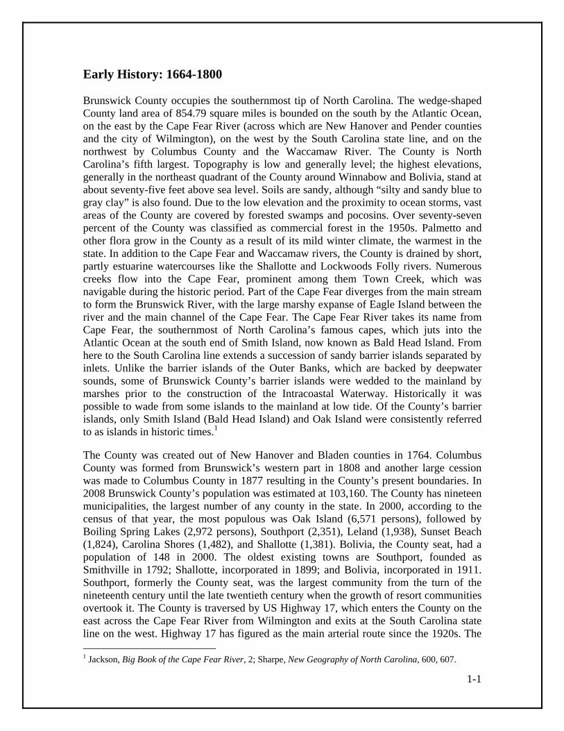
for an unglazed window that are both constructed with wrought-headed nails, one of the few documented uses of such nails in the County’s surviving buildings. The building probably functioned as a dairy, an outbuilding for keeping dairy products cool, based on its similarity in form and placement to a late-nineteenth-century dairy at the John and Theresa Mintz House (BW0536) near Shallotte. In addition to the putative antebellum dairy is a rectangular, saddle-notched log building with wood shingle siding that may have functioned as a store. Its location at the intersection of farm lanes in front of the house suggests a public function.
Probable dairy on the farm at 6130 Best Farm Road (BW369). Wood shingles such as those used to sheathe the two outbuildings on the farm at 6130 Best Farm Road NE were produced in enormous quantities in the County’s forests from the eighteenth century into the early twentieth century. A 1905 business directory lists no less than five shingle manufacturers in the County. Most of the County’s production went to the West Indies trade, but their availability made shingles a handy local siding material as well, especially after mass-produced nails became increasingly numerous and affordable as the nineteenth century progressed. Brunswick County possesses one of the largest concentrations of wood-shingle-sided historic vernacular buildings in the state.26 Log construction was common in the County during colonial times. A traveler who followed the post road through the County in 1774 lodged in a “log hut called a Tavern” near present Shallotte and later encountered a “small log house” near Town Creek or Winnabow. The County’s vernacular builders constructed log buildings in two basic ways. Some outbuildings were built relatively crudely of round logs joined together at the corners with simple saddle notches, as was the case for the mid- to late-nineteenth-century building described above. This is a log building technique that was used throughout the South, and it is seen most frequently in Brunswick County in the construction of first generation tobacco barns from the early twentieth century. Wood shingle siding was standard on these barns. The other tradition appears to have served 26 Claudia Brown personal communication; North Carolina Year Book (1905), 117.
1-15
most often for house construction. The technique is more refined, with the logs hewn down and joined with narrow spaces between them that could be chinked with mortar. Such plank log construction is documented for two or possibly three houses. A house located near Southport (BW0237) that was photographed shortly before its destruction in 1998 had logs that were fitted together almost without gaps and corners joined with half-dovetail notches. Curiously, the notches are upside down compared to normative half-dovetail notching; their slanted faces are at the bottom of each log end rather than the top. The house was chinked with mortar and had a whitewashed interior.27 Another plank log house, which like the Southport example probably dated to before the Civil War, was owned by historian Ronald Hobbs, who documented the house before it had to be taken down owing to deterioration. The house stood on the edge of the Waccamaw River swamp off of Ash Little River Road and was of dovetailed construction with pegged sapling pole rafters, plaster on the logs both on the inside and exterior, and a brick chimney coated with sand and whitewash. The chimney treatment calls to mind the chimneys of houses in the Crusoe Island section located across the Waccamaw River in Columbus County. In 1926 it was reported that the older Crusoe Island houses had mud and stick chimneys “covered with white clay that is found there in the swamps, and [polished and smoothed] until they looked like weathered marble.” The author of the Raleigh News and Observer article in which the description was first published attributed the finish and “curving grace of line” of the chimneys to the French, specifically Norman, and Haitian roots of the Crusoe Islanders, although in more recent years other theories have been put forward to explain the distinctive Crusoe Island culture. (Brunswick Countians have remarked on Crusoe Island culture and dialect as far as a Southport Leader article of April 17.) Only one house with plank log affinities was identified during the 2009-2010 survey. A farm building on the Ross-Smith Farm (BW0439) near Ash incorporates a one-story three-bay house that formerly had the coastal cottage form. The gaps between the logs are relatively wide for plank log construction, but the finely shaped logs are consistent with the tradition. This house, like the others, apparently dates to the nineteenth century. Similar in character to it was a wood-shingled and saddle-notched log building known as the Glass Window Schoolhouse, which is reported to have been built in 1856 and no longer extant.28
27 Lee, History of Brunswick County, 121. 28 Ron Hobbs personal communication; Rogers, Columbus County, 77-78; Southport Leader, April 17, 1890; Lee, History of Brunswick County, after 120; Cheers, Shallotte Centennial Commemorative Book, 80.

1-16
Front walls of the log house on the Ross-Smith Farm (BW0439).
Logs, posts, and split sticks, liberally slathered with mud, were also used to build chimneys. Wooden chimneys dated to the earliest years of settlement in the region, as indicated by a 1745 act that regulated house construction in Wilmington. “Dangers of Fire,” the act stipulated, “arising from Wooden Chimneys, or any such hazardous Buildings,” were to be investigated and presumably ordered down by the town commissioners. The poorer class of homebuilders built wooden chimneys because of their serviceability and affordability, despite the risk. Architectural evidence for the former existence of wooden chimneys such as points of attachment and projecting gables has not been identified in Brunswick County, but the chimneys are recalled in local tradition and some longtime residents remember seeing them. The early chimneys that do survive, and that may be original to their dwellings, are brick. These have a number of distinctive characteristics. One is the mortar coating of stepped shoulders to create a smooth weathering that sheds rainwater. Mortared chimney shoulders appear on houses as early as the mid-nineteenth century Sykes House and as late as the 1907 Sam Phelps House (BW0390). Also, a number of chimneys have stepped shoulders on all three faces, the outward-facing face as well as the more customary side faces. Wide stepped bases are also common, perhaps a structural feature to compensate for sandy soils.29 In the late nineteenth and early twentieth centuries some chimneys were built with what is known as “sand brick,” which was apparently made locally. This brick, which has a grayish or buff appearance, occasionally has bits of shell mixed in with it, which may indicate that tabby was a component. An early use of sand brick is the chimneys of the John and Theresa Mintz House (BW0536) near Shallotte, which was probably built in the 1880s. The residence of Taft Clemmons (Taft Clemmons House and Store; BW0372), which probably dates to the 1910s-30s period, has a chimney with both three-sided shoulders and sand brick construction that appears to have been frequently whitewashed and painted white, perhaps as a way to protect the more friable brick from deterioration.30
29 Glenn Kye and Ron Hobbs personal communication; Acts of the North Carolina General Assembly, 1745, 234. 30 Ron Hobbs personal communication.

1-17
Brunswick County farms were connected by a spider web of wandering sandy lanes during the nineteenth century. The lanes appear on Civil War maps and even survived as functioning transportation routes as late as the 1940s when they were documented on early U.S. Geological Survey maps. For the transport of bulk items like naval stores and agricultural produce, most farmers hauled their goods to the nearest river and creek landings and shipped them on the small water craft that plied the Cape Fear coast. Construction materials such as sawn lumber were often freighted on the water as well, as recorded in the oral history of Shrub Hill Plantation (BW0365) near Winnabow. The farm’s dwelling was enlarged in the late 1880s and sided with weatherboards that were shipped by barge up Town Creek.31 The great transportation development of the nineteenth century was the introduction of rail transport. Brunswick County’s proximity to Wilmington placed it in the path of railroad development at a relatively early date. Wilmington civic leaders spearheaded the formation of the Wilmington and Manchester Railroad in 1847 with the objective of tapping trade from the interior of South Carolina, where the town of Manchester is located. Work on the line began in February 1849 near the Brunswick County terminus of the Brunswick River ferry in the Belville-Leland area. By 1852, twenty-five miles of track were operational, suggesting the line was essentially complete through Brunswick County. The line was completed to Manchester in 1854 and was extended across Eagle Island to a point opposite Wilmington by the eve of the Civil War. A second line, the Wilmington, Charlotte, and Rutherford Railroad, was constructed through the County in the late 1850s. This railroad had its eastern terminus at Walkers Ferry on the Cape Fear at the present town of Navassa. A Confederate engineers map from 1864 does not show station buildings along these lines where they passed through the County, although some sort of facilities must have existed at the river terminuses.32 As during the colonial period, Brunswick County’s strategic location prompted extensive military construction throughout the national period and during the Civil War. Fort Johnston (BW0004) received new attention in 1794 when the federal government authorized construction of a fortification of the mouth of the Cape Fear. The old fort site made the natural choice, and work began on improvements but lagged until Lieutenant Joseph G. Swift was assigned to the project in 1804. Swift augmented the tabby walls of the colonial period and either he or contractor (and governor) Benjamin Smith began construction of a substantial Officers’ Quarters, also known as the Garrison House. The hip-roofed two-story brick building, built 1805-09, survives much as originally constructed, with one-story hip-roofed flanking wings, American-bond brickwork, and interior chimneys, but a two-tier front porch has been replaced by a Colonial Revival portico, window and door openings have been changed, and the interior altered. By 1816 Fort Johnston included a block house, a guard house, a hospital, and quarters for enlisted men.33
31 Helen Taylor personal communication; “Map of parts of Brunswick and New Hanover Counties.” 32 Watson, Wilmington, 50-51; “Map of parts of Brunswick and New Hanover Counties;” “Masonboro Inlet to Shallotte Inlet;” P&W Supplement to Railroads of North Carolina website. 33 Lee, History of Brunswick County, 94-96; Lounsbury, Architecture of Southport, 7, 21, 24; Bishir and Southern, Guide to the Historic Architecture of Eastern North Carolina, 263.
1-18
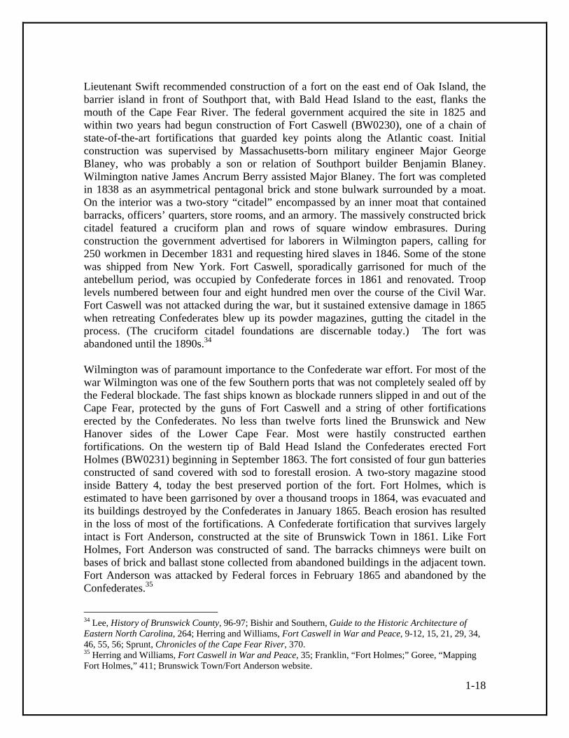
Lieutenant Swift recommended construction of a fort on the east end of Oak Island, the barrier island in front of Southport that, with Bald Head Island to the east, flanks the mouth of the Cape Fear River. The federal government acquired the site in 1825 and within two years had begun construction of Fort Caswell (BW0230), one of a chain of state-of-the-art fortifications that guarded key points along the Atlantic coast. Initial construction was supervised by Massachusetts-born military engineer Major George Blaney, who was probably a son or relation of Southport builder Benjamin Blaney. Wilmington native James Ancrum Berry assisted Major Blaney. The fort was completed in 1838 as an asymmetrical pentagonal brick and stone bulwark surrounded by a moat. On the interior was a two-story “citadel” encompassed by an inner moat that contained barracks, officers’ quarters, store rooms, and an armory. The massively constructed brick citadel featured a cruciform plan and rows of square window embrasures. During construction the government advertised for laborers in Wilmington papers, calling for 250 workmen in December 1831 and requesting hired slaves in 1846. Some of the stone was shipped from New York. Fort Caswell, sporadically garrisoned for much of the antebellum period, was occupied by Confederate forces in 1861 and renovated. Troop levels numbered between four and eight hundred men over the course of the Civil War. Fort Caswell was not attacked during the war, but it sustained extensive damage in 1865 when retreating Confederates blew up its powder magazines, gutting the citadel in the process. (The cruciform citadel foundations are discernable today.) The fort was abandoned until the 1890s.34 Wilmington was of paramount importance to the Confederate war effort. For most of the war Wilmington was one of the few Southern ports that was not completely sealed off by the Federal blockade. The fast ships known as blockade runners slipped in and out of the Cape Fear, protected by the guns of Fort Caswell and a string of other fortifications erected by the Confederates. No less than twelve forts lined the Brunswick and New Hanover sides of the Lower Cape Fear. Most were hastily constructed earthen fortifications. On the western tip of Bald Head Island the Confederates erected Fort Holmes (BW0231) beginning in September 1863. The fort consisted of four gun batteries constructed of sand covered with sod to forestall erosion. A two-story magazine stood inside Battery 4, today the best preserved portion of the fort. Fort Holmes, which is estimated to have been garrisoned by over a thousand troops in 1864, was evacuated and its buildings destroyed by the Confederates in January 1865. Beach erosion has resulted in the loss of most of the fortifications. A Confederate fortification that survives largely intact is Fort Anderson, constructed at the site of Brunswick Town in 1861. Like Fort Holmes, Fort Anderson was constructed of sand. The barracks chimneys were built on bases of brick and ballast stone collected from abandoned buildings in the adjacent town. Fort Anderson was attacked by Federal forces in February 1865 and abandoned by the Confederates.35
34 Lee, History of Brunswick County, 96-97; Bishir and Southern, Guide to the Historic Architecture of Eastern North Carolina, 264; Herring and Williams, Fort Caswell in War and Peace, 9-12, 15, 21, 29, 34, 46, 55, 56; Sprunt, Chronicles of the Cape Fear River, 370. 35 Herring and Williams, Fort Caswell in War and Peace, 35; Franklin, “Fort Holmes;” Goree, “Mapping Fort Holmes,” 411; Brunswick Town/Fort Anderson website.

1-19
In addition to defending the mouth of the Cape Fear River, the new national government was obligated to aid navigation of the treacherous waterway. Consequently, it first erected a lighthouse on Bald Head Island at the river mouth in the mid-1790s. This was followed by the present Bald Head Island Lighthouse (BW0001) in 1817, the oldest lighthouse in the state. The 110-foot tower of stuccoed brick has a tapering octagonal form with brownstone trimmings. The solid-looking structure was erected by Daniel S. Way using bricks from the earlier tower, which had a similar octagonal form. The iron, copper, and glass lanthorn or lantern room from which the light shone came from the earlier lighthouse as well. Old Baldy, as the installation is popularly known, was superceded in 1903 by the taller steel and concrete Cape Fear Lighthouse, also known as the Cape Fear Light Station. The 1903 lighthouse was destroyed after the present Oak Island Lighthouse was built in 1958, but the Cape Fear Lighthouse Complex (BW0003) and its restored keeper’s cottages survive.36 In 1848 appropriations were made for the construction of smaller lighthouses on Oak Island and at sites along the lower Cape Fear. A number of these suffered destruction during the Civil War, but one stands in recognizable condition: the twenty-foot-tall front range Price Creek Beacon (BW0573), completed in 1849. Located just upstream from the Southport-Fort Fisher ferry landing, the tapered cylindrical brick lighthouse operated in conjunction with a taller rear range light that was mounted like a cupola on a two-story brick keeper’s house, which now survives only as a foundation. Mariners navigated by aligning the front and rear lights. A wooden range light stood near the entrance to Fort Caswell until it burned in 1958. The structure had a tapering timber structure with a board enclosed upper portion and an observation deck supported by heavy brackets of unusual Gothic form. The Fort Caswell light’s brick base still stands.37
Bald Head Island Lighthouse (BW0001).
36 Old Baldy Foundation website; Bishir and Southern, Guide to the Historic Architecture of Eastern North Carolina, 265-266; Lee, History of Brunswick County, 115-116; Herring and Williams, Fort Caswell, 4-5. 37 Lee, History of Brunswick County, 115-116; Lighthouse Friends website; Herring and Williams, Fort Caswell, 4-6.

1-20
Later History: 1865-1960 Military actions affected Brunswick County directly during the Civil War, but the most significant outcome of the conflict was the end of slavery. By the eve of war in 1860, the federal census enumerated 3,631 African American slaves and 260 free blacks out of a total population of 8,406. (These figures included part of what is now Columbus County, although a substantial majority of the slaves would have resided in the present Brunswick County section.) After the war, a Freedman’s Bureau was established in Smithville and many blacks who had lived on plantations along the Cape Fear relocated to the town. Their settlement coalesced into modern Southport’s two African American neighborhoods in the area on the west side of Howe Street adjacent to the Southport Historic District and along Jabbertown Road.38 Historian Eulis Willis has documented the post-bellum transition of blacks living in the Navassa area, located across the Cape Fear River from Wilmington in the northeast part of the County. At the close of the war five separate black communities existed in the area, each associated with an antebellum plantation. Some of the plantations remained operational but others were abandoned or underutilized after the war. Employment prospects improved for the area’s African Americans when the Navassa Guano Company established its fertilizer plant at the east end of the present town of Navassa, which was incorporated in 1977 and took the name of the company. The company was part of a new industrial development in Wilmington and other southern port cities like Charleston and Savannah. Shippers of lumber to the West Indies found that guano, phosphate-rich bird droppings suitable for fertilizer, made a profitable return cargo, and in 1869 investors formed the Navassa Guano Company, named for a Caribbean island guano source. The completion of the Navassa Railroad Bridge (BW0546) by the end of 1869 aided the success of the fertilizer company. (The present bridge at the location is a twentieth-century replacement that reuses the quarry-faced stone abutment from the original bridge.) A 1921 discussion of the industry noted its reliance on the labor of African American tenant farmers who returned to farming when the January to May manufacturing season came to a close. Because of the seasonal nature of the industry, many Wilmington fertilizer plants lodged their workforces in bunk houses.39 A station known as Mears Bluff stood at the location of Navassa in 1882 and by 1888 the guano company’s phosphate works were surrounded by clusters and rows of houses and some individual homesteads, as portrayed on a detailed 1888 coastal survey map. A photograph from ca. 1890 shows four row houses in the area known as Bluff Hill near the Navassa Railroad Bridge. The one-story or story-and-a-half gable-roofed houses were sided with vertical boards, an indication of board-and-batten frame construction or boxed construction, the latter a form using planks that doubled as both structure and enclosure. Each had a central brick chimney indicating a two-room or possibly four-room plan
38 Lee, History of Brunswick County, 98; Lounsbury, Architecture of Southport, 4. 39 Willis, Navassa, 44; Watson, Wilmington, 114; Economic Survey of Wilmington, 30-32; “Seaboard Air Line Railroad Company,” 504-505.

1-21
within. These Navassa worker houses were similar in appearance to ones built on Eagles Island for naval stores workers in the late nineteenth century.40 Most of the houses occupied by Navassa’s African American population were owned by white landowners or corporations during the nineteenth century, but beginning in the 1870s blacks purchased small tracts to the west of the present Navassa Town Hall. The 1888 map seems to show three dwellings in the area, each set in a small clearing in the woods. The area was distant enough from the phosphate works that it was probably not considered prime ground for industrial development. Settlement patterns changed in the early twentieth century when white owners laid out residential areas in Navassa’s present downtown. The Fair Oaks Subdivision (1919), the Weeks Subdivision (1920), and other developments began to fill with small frame houses in the Queen Anne and Craftsman styles. Representative houses from the period include the 1920s Samuel and Harriet Williams House (BW0419) and the 1920s Gaston and Lonnie Waddell House (BW0420), late examples of Queen Anne influence, and the 1930s or 1940s John and Mary Thomas House (BW0422), a well preserved hip-roofed Craftsman bungalow. Churches provided institutional stability to the evolving community, as did Pride of Navassa Lodge #790 (BW0421), a product of the Prince Hall Freemasonry movement which originated in the 1770s and established a lodge in Wilmington in 1866. By 1932 the basic plan of Navassa had taken form, with the present course of Main Street angling off the rail line at the center of the community. A line of over a dozen closely spaced buildings extended along Main Street in the vicinity of the present Pride of Navassa Lodge, with more scattered development in the vicinity of Park Avenue and Pine Valley Drive in addition to the nineteenth-century area of settlement near what had become several fertilizer plants.41
Samuel and Harriet Williams House (BW0419), Navassa.
40 Willis, Navassa, 102, 128; “Masonboro Inlet to Shallotte Inlet;” Kirkland, “Map of Columbus County;” Block, Along the Cape Fear, 64. 41 Willis, Navassa, 47-49, 52-54; Most Worshipful Prince Hall website; “Soil Map, North Carolina, Brunswick County Sheet.”
1-22
Southport experienced substantial growth in the late nineteenth and early twentieth centuries. An important factor was the federal government’s project to close New Inlet, located across the Cape Fear River. This was accomplished by the construction of massive stone seawalls, the New Inlet Dam and the Swash Defense Dam (which connects to the north end of Bald Head Island), in the 1870s and 1880s. The Rocks, as the seawalls are popularly known, measure a combined three miles in length and are regarded as one of the greatest engineering works undertaken in the state in the nineteenth century. The Rocks channeled the entire flow of the Cape Fear River past Southport, scoured out the river mouth, and transformed the town into a deep-water port. In a reflection of the town’s improved shipping prospects its name was changed from Smithville to Southport in 1887. The town had high hopes of attracting West Indian and South American commerce and of becoming a shipping point for American coal. Several schemes were hatched to build railroads to Southport and connect it with rail centers as far distant as Memphis and Cincinnati. The grander schemes failed, but a more modest project proved successful. The Wilmington, Brunswick, and Southern Railroad was incorporated in 1907 and completed to Southport in 1911. The line arced through eastern Brunswick County with a station at the newly incorporated town of Bolivia and on to connect at Navassa to the Atlantic Coast Line and Seaboard Air Line, successors to the troubled Wilmington rail lines of the post-bellum period. The WB&S, known to some as the Willing But Slow, constructed a handsome Queen Anne station at Southport (no longer extant) and shipped forest and agricultural products, but it did not lead to major port status for Southport. Two Winnabow-area buildings associated with the line have been identified: the Wilmington, Brunswick, and Southern Brunswick Station (BW0366) and the Wilmington, Brunswick, and Southern Winnabow Depot (BW0542).42 The rebranding of Smithville as Southport in 1887 coincided with the kind of rapid development that newspapers of the era called a “boom.” Architectural historian Carl Lounsbury has traced the resultant expansion of building activity statistically. In 1889 alone, twenty-five new residences were built and a dozen existing houses were revamped. Construction cooled off somewhat during the nationwide economic downturn of the 1890s but on average ten new houses were added to the town every year so that by 1900 approximately half of Southport’s 260 dwellings had been built in the preceding eleven years. Building was facilitated by the opening of the Southport Brick and Tile Company in 1890 and the Southport Lumber Company the following year. The lumber company churned out the narrow beaded tongue-and-groove boards that were popular among County builders of the period for interior sheathings and the brickworks produced many of the bricks used to construct store buildings in Southport’s nascent commercial district on the 100 block of East Moore Street. Construction activity provided work for builders like W. T. Ottoway, Ed Swain, George Davis, Henry and Joseph Daniel, A. J. Robbins, and William Weeks. Ottoway’s designs show a relatively sophisticated architectural sense, and some builders billed themselves as architects in early twentieth century business directories. These included A. J. Robbins, T. T. Allard, Furpless Price, G. W. Rappleyea, and Ernest Burris. According to information on the North Carolina Architects and Builders website, Wilmington architect Henry E. Bonitz designed the N. E. Parker
42 Lee, History of Brunswick County, 189-193; Bishir and Southern, Guide to the Historic Architecture of Eastern North Carolina, 266.
1-23
House in Southport in 1907, one of the few documented instances of a non-local architect at work in the town. (A house by this name has not been identified by the survey.)43 Historic photographs of Southport show that the coastal cottage form was a popular house type in the first half of the nineteenth century, and it remained in more limited use in later decades, as illustrated by the ca. 1892 Adkins-Dosher House (BW0011; destroyed) and the early-twentieth-century Ed Swain House (BW0219). The Swain House was built by Ed Swain, a prominent black carpenter in the Southport area. Most builders of the boom and later were conversant with a broad range of house types which they dressed up with the Victorian “gingerbread” ornament that was mass produced during the era. A representative example of the new style is the Thomas Carr House (BW0038), designed and built for Carr by W. T. Ottoway in 1893. The story-and-a-half house features intersecting gables of exaggerated steepness, with narrow board sheathing arranged in sunburst and chevron patterns, decorative wood shingle sheathing, and an angled bay window under a cutaway gable supported by slender arched brackets. Occasionally, distinctive house forms were used more than once in the town. The Carr House was essentially replicated by the 1894 R. W. McKeithan House (BW0123), and two two-story houses on the 100 block of North Lord Street, the 1889 Melvin Craig House (BW0042) and the 1890 Adkins-Ruark House (BW0012), feature nearly identical forms with prominent front gables. The Adkins-Ruark House, associated with acclaimed local author Robert Ruark, is distinguished by porches with turned posts, sawn brackets, and grid balustrades, decorative wood shingle gable sheathing, and sawn brackets in the house, porch, and bay window cornices. Bracketed cornices were introduced locally during the pre-boom period and appear on the imposing ca. 1868 Thomas M. Thompson House (BW0171), a cubical residence built for a retired blockade runner that features a two-tier front porch and a belvedere.44 The period around 1900 also saw the growth of Shallotte into a true town. A short but detailed account of the town’s incipient development appeared in an 1890 Southport newspaper. “What is called Shallotte now,” wrote Shallotte area contributor J. H. M., “is at the head of sloop navigation at the public bridge. It has never been laid off in lots, but has been conveyed in small tracts of one or two acres, and several good buildings have been put up. There are about one hundred people in a radius of one mile.” The contributor listed numerous businesses in Shallotte and its vicinity, including five stores, two saw and grist mills, two turpentine distilleries, a large cotton gin, a blacksmith shop, and a shoe shop. Also in the community were a doctor and an artist. In 1897 sixteen general merchants listed Shallotte as their post office, although a smaller number would have been located in the actual community, and six turpentine-related businesses were listed. Photographs from the decades around 1900 show a busy waterfront on the banks of the Shallotte River. One- and two-story gabled-fronted frame store buildings, some with the sawn and turned ornament of the period, lined Main Street to the east of the river bridge. Shallotte’s growth was sufficient for it to be incorporated in 1899. The W. A. Frink House (BW0480), plausibly dated 1892, and the antebellum Rourk House (BW0581) are 43 Lounsbury, Architecture of Southport, 10-12, 26-28; North Carolina Year Book; North Carolina Architects and Builders website. 44 Lounsbury, Architecture of Southport, 9, 19, 45, 47, 49, 54, 55; Bishir and Southern, Guide to the Historic Architecture of Eastern North Carolina, 263.
1-24
among the few buildings to survive in Shallotte proper from its early years. The oldest surviving commercial building is likely the brick Goley Building (BW0364), probably erected between 1906 and 1910, to which a Classical Revival rear wing was added in the 1910s to house the Citizens Bank.45 Considerable excitement attended the rapid growth of Bolivia in the early 1910s. John Peter Cox had operated a store at the location as early as 1884, and it was Cox who reputedly conceived the name of the town by reading the South American country’s name on a fertilizer bag. Around 1910 it became known that the Wilmington, Brunswick, and Southern Railroad would establish a depot at the location, and merchants and industrialists flocked in. Foremost among the new businesses was the Waccamaw Shingle Company, which employed at its peak around a hundred men, according to historian Earleen Shorey. A tobacco warehouse was erected near the depot in 1911, evidence of the local introduction of the cash crop, and a letter writer reported the opening of three stores the same year. The profitability of agriculture and especially tobacco cultivation into the early 1920s kept Bolivia’s boom going. A 1920 newspaper account noted, “Just now Bolivia is the mecca for homemakers and investors. The surrounding country is a vast, idle, virgin land section that has waited so many years for the settlers of the substantial kind now seeking opportunities.” The 1920 population of the town was estimated at 350 to 400, although the closing of the shingle mill around that time and a gradual general decline in business resulted in lower population figures, which hovered in the one-hundred to two-hundred range by mid-century.46 The end of the nineteenth century and the beginning of the twentieth saw the proliferation of smaller communities across the County. Many of these were no more than isolated country stores and perhaps a loose cluster of dwellings that received post office designation for a fleeting period, giving them a nominal existence in directories and on maps. Others, such as Ash, Exum, Supply, and Calabash, achieved permanence as local service centers. Another form of community development resulted when large lumber companies finally penetrated the County’s interior in the early twentieth century. The Wilmington, Brunswick, and Southport opened the southeast quadrant of the County to harvesting, and six lumber plants were active along the line between Wilmington and Southport in 1920. In 1917 the Whiteville Lumber Company was authorized to construct a bridge over the Waccamaw River at Pireway Ferry, allowing the company to extend a rail line from Whiteville in Columbus County to Longwood in Brunswick County. Longwood area resident Leamon Russ recalls that the company or its successor, the Jackson Lumber Company, operated a lumber mill in Longwood in the 1920s until the area’s timber stands were cut over, the mill closed, and Longwood devolved from a booming lumber town to a hamlet serving the needs of local farmers. A 1937 soil map based on a 1932 survey shows a tram line running to Longwood and what may be rows of worker houses to the east of the village crossroads.47
45 Cheers, Shallotte Centennial Commemorative Book, 7-9, 79; Southport Leader, March 6, 1890; Branson’s North Carolina Business Directory, 1897, 112-113. 46 Shorey, Bolivia, 1, 4, 6, 9, 11-13, 16; Brunswick County Historical Society Newsletter 28:4 (February 1988), 1-3. 47 Leamon Russ and Bobby Long personal communication; Shorey, Bolivia, 13; United States Statutes at Large (Volume 40, Part 1, Sixty-fifth Congress), 342; Rogers, Columbus County, 55; United States Statutes

1-25
That there was a sufficient number of farmers to support the existence of communities like Longwood and others in the northwest quadrant of the County is due largely to the forest clearance that resulted from lumbering activities, which created “new land” suitable for agriculture. In addition to developments at Longwood, the Waccamaw Lumber Company, formed in 1907, constructed a standard gauge railroad from its mill at Bolton in Columbus County to its lumber camp at Makatoka in Brunswick County and commenced large scale lumbering in the extensive timber stands of the Green Swamp area. At Makatoka the lumber company constructed one-story frame buildings, most with vertical board siding (perhaps an indication of boxed construction). The mess hall was larger than the others and had weatherboard siding and a small belfry on the wood-shingled roof that called the workers to meals. According to area resident Arthur Little, interviewed for the Hallsboro High School publication Kin’Lin’ in the early 1980s, “The single men stayed in the shanties, about eight by ten feet. The family houses had two or three rooms.” One account provides a general description of housing in the region’s lumber camps: “The companies maintained ‘camps’ near where the logging was being done . . . these ‘camps’ were room size and gave housing for two men. They were early portables—that is, when the logging was completed in one area, these crude little buildings could be loaded on flat cars and moved by rail to a fresh site. They were heated by little stoves.”48 Resort development, present in the County from the late eighteenth century when summer cottages were built at Southport, continued into the twentieth and spread beyond its traditional focus at Southport. An interesting case study is the village of Gause Landing, which grew up on the tidal creeks near Tubbs Inlet and inland from Ocean Isle Beach. The village has eighteenth-century roots and remnants of tabby construction have been discovered by the waterfront. An 1864 Confederate engineers map shows the community as a semicircle of four buildings. The fact that the unlabeled buildings are connected to the Gause plantation a couple of miles inland suggests the landing consisted of warehouses and perhaps a simple dwelling or two for workers or watermen. One of the buildings may have been the eighteenth-century home of the Gauses. The community in its present form dates to the early 1930s when a Captain Williamson subdivided his acreage and sold lots. A soil map based on survey work undertaken in 1932 shows four buildings at the location with an additional two on a road that extended across the marshes to the Coast Guard Station on “Gause Beach” (Ocean Isle Beach). The 1943 Shallotte USGS quad map, based on 1942 aerial photographs, shows about a dozen buildings at Gause Landing.49
at Large (Volume 40, Part 1, Sixty-fifth Congress), 342; Rogers, Columbus County, 55; “Soil Map, North Carolina, Brunswick County Sheet.” 48 Causey, “Brunswick/Columbus Connections;” “Timber and Turpentine Industries;” Earley, “Two Days in John Green’s Swamp,” 194; Kin’Lin’ Lumber Industry Issue, 18, 21, 23. 49 Ron Hobbs personal communication; Armstrong, “Memories,” 10; “Map of parts of Brunswick and New Hanover Counties;” “Soil Map, North Carolina, Brunswick County Sheet;” “Shallotte, N.C.” U.S. Geological Survey quadrangle map, 1943.

1-26
Gause Landing Road.
One of Gause Landing’s 1930s buildings is the Bridger-Lineberger Clubhouse (BW0483), a spacious albeit plain weatherboarded frame lodge built by a Bladenboro textile executive for the use of his employees. More whimsical architecturally is the Rufus Brown House (BW0406), built for a Fayetteville lumber mill owner in the 1920s or possibly the 1930s. The unusual construction of the house features halved logs joined at the corners by saddle notches, and the entries have rough-sawn batten Dutch doors hung on heavy iron strap hinges that are believed to be reused rail car hinges. Inside, log trusses span a great room with a stone fireplace. The Baird House, another Gause Landing Rustic-style log house, was rebuilt after Hurricane Hazel but destroyed by fire in the late twentieth century. The grandest of the County’s historic log vacation homes is Windy Point (BW0397) at the mouth of the Shallotte River, built by Perry Quattlebaum in 1934 as a saddle-notched two-story residence with a fully wraparound two-tier veranda. The house was acquired by Quattlebaum’s cousin John H. Martin in 1953 and destroyed by Hurricane Hazel the following year. Undaunted, Martin gathered up the washed away logs and rebuilt it in its original form in 1955. Two-story log porch columns, casement windows, and a log-built stair case are notable features of this evocative property.50 Brunswick County’s rural architecture underwent many important changes during the last quarter of the nineteenth century and the early years of the twentieth, the first period for which substantial numbers of historic resources survive. The enduring popularity of the coastal cottage is represented by such examples as the ca. 1890 Christopher C. King House (BW0440) near Ash, which has exposed hewn ceiling joists and a semidetached rear kitchen with an unusual angled corner entry; the ca. 1900 Fulford House (BW0393) near Holden Beach, with peaked lintels over its windows and front entry; the 1907 Sam Phelps House (BW0390) near Varnamtown, which has punched sawtooth vergeboards and lightwood foundation piers with the chevron pattern of the box faces still on them; and the 1870s or 1880s Lancaster-Roach House (BW0370) in Varnamtown.
50 Armstrong, “Memories,” 11-12.

1-27
The Lancaster-Roach House also has many other notable features. It retains a well-preserved early or original polychrome paint scheme with a center-passage ceiling painted blue with yellow trim, green passage walls above a red chair rail and brown wainscot, a brown and yellow grained front entry surround, and, on the exterior, yellow weatherboards, green door and window surrounds, red window sashes, and a blue porch ceiling. Also of note is the center-passage ceiling, which gently curves downward toward the rear. Curved or bowed ceilings also appear in the nearby farmhouse on the Swain Farm (BW0371), completed in 1914 and modeled on the Lancaster-Roach House, in the ca. 1900 Bill and Alice Somersett House (BW0456), which originally stood in Grissettown but has been moved to Shallotte, and in the late-nineteenth-century house on the Little-Evans Farm (BW0553) near Makatoka. (The Galloway House, BW0474, and the Pigott-Moffitt House, BW0593, may also have center-passage ceilings with curved or partly curved profiles.) A somewhat similar ceiling with stepped flat sections instead of a bow appears in the center passage of the Hewett-Goley House (BW0592), which originally stood in Shallotte but has been moved to the Shallotte Point vicinity. The Daniel and Rosy Vereen House (BW0575) near Exum has a center passage ceiling with a horizontal front half and a sloping back half, which, like the ceiling of the Hewett-Goley House, is related to the tradition but is not curved.
Center-passage ceiling of the Lancaster-Roach House (BW0370).
The concentration of curved or bowed center-passage ceilings in Brunswick County suggests the form may be a localism. The principal function of the curve may have been to mediate in graceful fashion a change in ceiling level from the front of the house to the rear. The form may have been inspired by the curved ceilings of ships’ cabins, a source of interior design familiar to the County’s carpenters. Local boat building and the centrality of brightly painted boats to the County’s lifeways may be associated with the rainbow hues used to decorate dwellings like the Lancaster-Roach House. Another County house form is distinguished by its extremely tall one-story profile. The 1904 Riley and Delphia Hewett House (BW0377) near Varnamtown and the 1924 John and Lona Russ House (BW0464) near Longwood have the height of a story-and-a-half dwelling due to the high ceilings of the first-floor rooms. The ceiling height may have helped cool the rooms during long and sweltering Brunswick County summers. Full two-

1-28
story houses were rare in the County outside of Southport. This is in stark contrast to the large numbers of such houses in North Carolina counties farther inland. The reason may lie in the modest incomes provided to residents from marginal farming, fishing, and lumbering activities, reinforced by the cultural conservatism represented by the coastal cottage form. Among the largest historic houses to survive in the County, other than those in Southport and the few remaining antebellum plantation houses, are the Samuel K. Mintz House (BW0457) near Exum, probably built in the 1890s, and the ca. 1908 Stanland-White House (BW0409) in Shallotte. Both houses are associated with general merchants who also owned turpentine distilleries.
Gainey House (BW0493), Leland. Photo by Ann V. Swallow.
The Samuel K. Mintz House is also notable as an example of stylistic influence, in this case the Italianate style, indicated by the house’s bracketed cornice. Despite the fact that Italianate-style houses were common in Southport and in the nearby metropolis of Wilmington, surviving examples are rare in rural Brunswick County. The Gothic Revival style, another popular nineteenth-century style, is also rare in the rural sections of the County, with the notable exception of two houses located side by side on Lincoln Road in Leland. One of these is the Kranke House (BW0492), thought to have been built in 1874 by its owner, a German carpenter. The house is characterized by undulating sawn vergeboards in the gables and eaves of the main and porch roofs. The board-and-batten-sided Gainey House (BW0493) next door, which may date to the 1870s, also has undulating vergeboards that in this example terminate at spearhead-like pendants. The vergeboards were originally ornamented with rounded cusps. The Kranke House and especially the Gainey House are reminiscent of railroad-related construction of the post-bellum period such as section houses. It may not be coincidental that the two dwellings are located near a rail line constructed by 1882 to connect the old bed of the Wilmington and Manchester Railroad (then known as the Wilmington, Columbia, and Augusta Railroad) with the Navassa Railroad Bridge (BW0546). Greek Revival stylistic influence, discussed in the previous period, continued into the latter part of the century, as illustrated by the crossetted door surrounds inside the late 1880s house at Shrub Hill Plantation (BW0365) near Winnabow.51 51 Kirland, “Map of Columbus County.”

1-29
The Gothic Revival style was an inspiration for the fanciful sawn and turned ornament with which builders decorated houses during the late nineteenth and early twentieth centuries. One of the best preserved rural examples of so-called Victorian ornament appears on the hip-roofed frame house built near Shallotte by carpenter Thomas Clemmons as his own residence in 1902 (BW0238). Despite the fact the house was moved a short distance from its original location in the 1970s and remodeled as a restaurant, the house retains gable ornament with sawtooth vergeboards, sawtooth and fishscale wood shingles, and diamond-shaped louvered vents, as well as a wraparound porch with turned balusters and faceted and chamfered posts with sawn brackets. Two buildings in the Winnabow area, the Erastus Goodman Doctor’s Office (on the Goodman Farm, BW0232) and the
nearby McKeithan House (BW0469), make decorative use of beaded tongue-and-groove boards as gable sheathings and have distinctive carved vergeboards—curved on the Goodman office and rectilinear on the McKeithan House—that imply the buildings were built by the same carpenter. An interesting localism inspired by the Victorian style is represented by hand-made porch posts with a faceted form. These were made for the ca. 1900 John and Berlyn Lancaster House (BW0401) near Supply, the 1914 Swain House (BW0371) in Varnamtown (pictured below), and an early-twentieth-century house at 5246 Marlow Road NW near Ash. In the case of the first two houses the posts are known or suspected to have been made by the owners of the houses, who did some or most of their own carpentry (John Lancaster was a carpenter by trade). The posts are similar to those on the aforementioned Thomas Clemmons House, suggesting period carpenters shared the same aesthetics. New styles were introduced during the early and mid-twentieth century. The Craftsman style, the style of the bungalows that sprang up like mushrooms in suburbs nationwide during the 1910s, 1920s, and 1930s, was locally employed for smaller houses during the same period and later. A representative example is the Harry and Annie Bryant House (BW0379) between Supply and Varnamtown, a one-story front-gabled house with sawtooth wood shingles and diminutive triangular brackets in the eaves. Harry Bryant, a farmer and fisherman, hired carpenter Jack Mitchell to build the house in 1941, making it a late example of the style. In fact, many Brunswick County gable-fronted Craftsman bungalows are late expressions of the style. The Robert and Katie White House (BW0579) in downtown Shallotte is another late (and exceptionally well preserved) example, built in 1940 for a leading town merchant, and the gable-fronted house (BW0464) of John and Lona Russ near Longwood dates to 1948. The Crafstman style was often blended with other popular styles of the period, a process that also occurred
Swain Farm (BW0371) farmhouse porch post.
1-30
elsewhere in the state and nation. A good local example of stylistic hybridization is the C. P. and Hattie Willetts House (BW0473) in Bolivia, built in the late 1930s. The house is essentially a Craftsman bungalow in form, with characteristic Craftsman details like four-over-one double-hung sash windows, but features such as fanlight windows in the gables are Colonial Revival and the brick arches and pillars of the front porch evoke the Tudor Revival style in form. As the Willetts House illustrates, the Tudor Revival and Colonial Revival styles were popular during the middle decades of the twentieth century. Because of the modest budgets of most Brunswick County homebuilders, these styles were not expressed to the extent they were in nearby cities, but their influence is nevertheless present and points to the growing integration of the County’s culture with the national mainstream. Tudor Revival influence is most apparent in a 1930s and later dwelling type known as the Period Cottage, which compressed the typically complex massing of a Tudor Revival house into a more compact (and affordable) form, often mixed with details from other styles. Representative Period Cottages in the County include the 1943 Claude and Elizabeth Baldwin House (BW0404) in Leland, a stuccoed concrete block house, and the 1952 H. D. and Margaret Parrish House (BW0375) near Varnamtown. The Parrish House was based on a design in a plan book owned by Mrs. Parrish’s brother Norman Bellamy, a Shallotte hardware merchant and carpenter. Like the Baldwin House, the Parrish House is constructed of concrete block, but it has a brick veneer, and its stuccoed gable is studded with colored pebbles. The Balwin and Parrish houses share a characteristic feature of the Tudor Revival and Period Cottage styles: a juxtaposed front chimney and gable. The Cape Cod genre of the Colonial Revival style became popular in rural areas at mid-century. Colonial Revival residences like the farmhouses on the Ivan and Muriel Bennett Farm (BW0435) near Exum, the Gore Farm (BW0460) near Shallotte, and the James and Mary Rowell Farm (BW0427, a remodeling of a 1900 house) near Northwest date, or appear to date, to the 1950s. The County’s most impressive Colonial Revival residence is the 1923 Devereux H. Lippitt House on the Clarendon Plantation (BW0227). The Lippitt House ranks second only to Orton Plantation as a surviving representative of the great houses constructed in Brunswick County during the historic period. Refinements include quoining, pedimented dormers, modillion cornices, arched fanlights and accent windows, and Georgian and Federal Revival mantels in a variety of shapes and forms. Wilmington architect James B. Lynch collaborated with Herbert Caleb Chivers, an architect based in New York at the time, to arrange the house for maximum comfort in warm weather, with banks of bifold French doors that could be opened to allow river breezes to flow through the interior. A monumental portico is missing from the river front, but the house still commands views of the Cape Fear River and the distant Wilmington skyline across a terraced yard.52
52 Rachel Pace personal communication; Edwards, “Clarendon Plantation.”
1-31
Devereux H. Lippitt House, Clarendon Plantation (BW0227).
Rural and small town houses of the mid-nineteenth through the mid-twentieth centuries were often accompanied by outbuildings that assisted the operation of households. Several meat houses, used to preserve meat by smoking or salt curing, were built during the period. (When used primarily for smoking meat the buildings are typically called smokehouses.) Some of these have a form that is standard elsewhere in North Carolina, with a front gable roof that in some cases overhangs the front entry, providing a small sheltered work area. Examples of the form include the 1923 board-and-batten smokehouse on the Frank and Madge Inman Farm (BW0446) near Ash; the board-and-batten smokehouse with barred windows behind the ca. 1910 John J. Knox House (BW0476) near Winnabow; and the vertical-board-sided meat house next to the Gainey House (BW0493) in Leland. Some Brunswick County residents built meat houses with a somewhat different form, still gable-fronted but with lower and wider proportions. Examples survive on the Goodman Farm (BW0232) and at the Tharp House, both near Winnabow, and on the Harry and Vera Peterson Farm (BW0428) near Northwest. An early example of the form is the crudely saddle-notched log smokehouse on the Peadrick-Maultsby Farm (BW0528) near Winnabow, which may date to the early 1890s. At Clarendon Plantation (BW0227) is an approximately square-plan outbuilding ruin that presumably functioned as a smokehouse. The expertly constructed Flemish bond brick ruin may date to the eighteenth century. An eighteenth-century square-plan smokehouse was excavated at the Maurice Moore property in Brunswick Town and was found to have had a separate firebox connected to the smokehouse proper by a brick tunnel for the smoke.53 The Harry and Vera Peterson Farm, established in the 1910s, also possesses one of the County’s few surviving stilted dairies. The small structure stands on wood posts and has a cabinet sheathed with beaded tongue-and-groove boards. It was ventilated by diamond-shaped openings, originally screened and now covered. In form and detail the Peterson dairy is similar to one that stands on the nearby James and Mary Rowell Farm (BW0427), which was established by Vera Peterson’s mother, Mary Burns Rowell. The Rowell dairy also has diamond-shaped openings. Another denizen of the Peterson Farm is a board-and- 53 Edwards, “Clarendon Plantation;” South, “Colonial Brunswick,” 40-43.
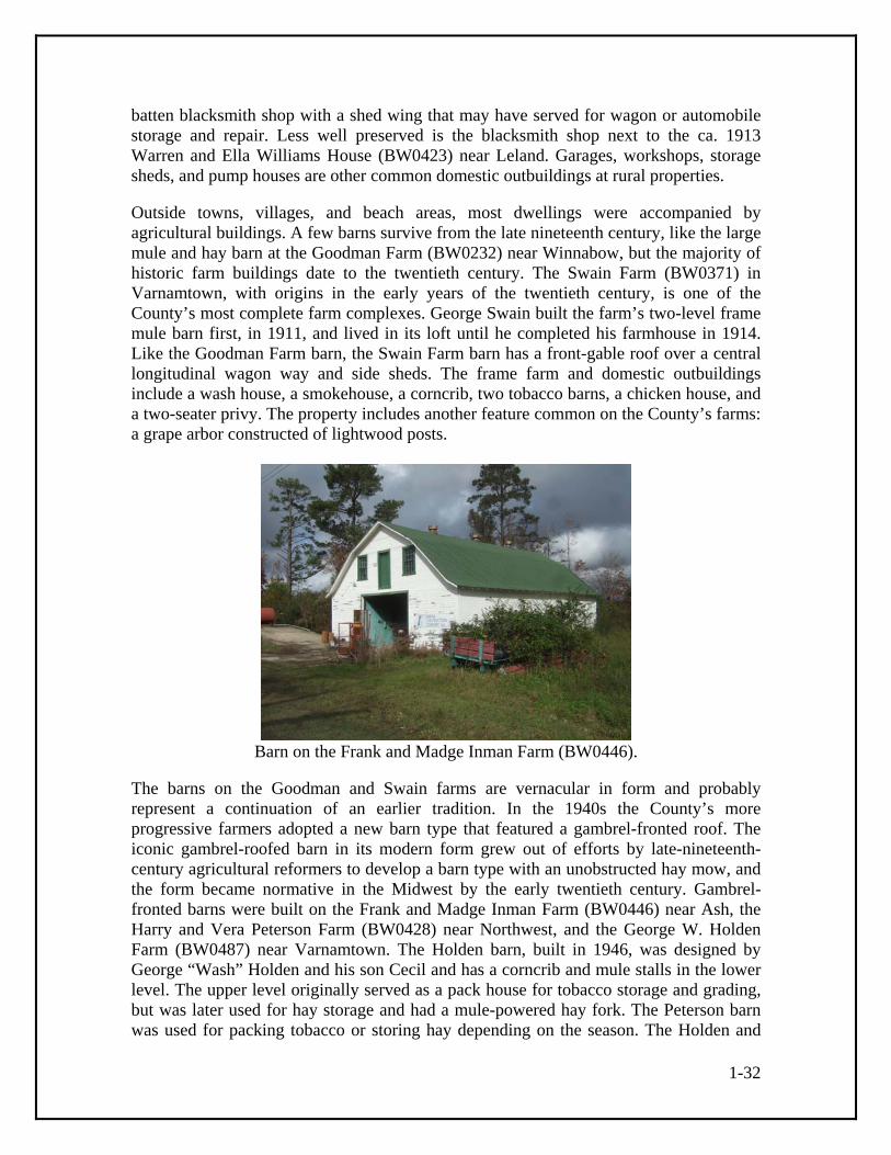
1-32
batten blacksmith shop with a shed wing that may have served for wagon or automobile storage and repair. Less well preserved is the blacksmith shop next to the ca. 1913 Warren and Ella Williams House (BW0423) near Leland. Garages, workshops, storage sheds, and pump houses are other common domestic outbuildings at rural properties. Outside towns, villages, and beach areas, most dwellings were accompanied by agricultural buildings. A few barns survive from the late nineteenth century, like the large mule and hay barn at the Goodman Farm (BW0232) near Winnabow, but the majority of historic farm buildings date to the twentieth century. The Swain Farm (BW0371) in Varnamtown, with origins in the early years of the twentieth century, is one of the County’s most complete farm complexes. George Swain built the farm’s two-level frame mule barn first, in 1911, and lived in its loft until he completed his farmhouse in 1914. Like the Goodman Farm barn, the Swain Farm barn has a front-gable roof over a central longitudinal wagon way and side sheds. The frame farm and domestic outbuildings include a wash house, a smokehouse, a corncrib, two tobacco barns, a chicken house, and a two-seater privy. The property includes another feature common on the County’s farms: a grape arbor constructed of lightwood posts.
Barn on the Frank and Madge Inman Farm (BW0446).
The barns on the Goodman and Swain farms are vernacular in form and probably represent a continuation of an earlier tradition. In the 1940s the County’s more progressive farmers adopted a new barn type that featured a gambrel-fronted roof. The iconic gambrel-roofed barn in its modern form grew out of efforts by late-nineteenth-century agricultural reformers to develop a barn type with an unobstructed hay mow, and the form became normative in the Midwest by the early twentieth century. Gambrel-fronted barns were built on the Frank and Madge Inman Farm (BW0446) near Ash, the Harry and Vera Peterson Farm (BW0428) near Northwest, and the George W. Holden Farm (BW0487) near Varnamtown. The Holden barn, built in 1946, was designed by George “Wash” Holden and his son Cecil and has a corncrib and mule stalls in the lower level. The upper level originally served as a pack house for tobacco storage and grading, but was later used for hay storage and had a mule-powered hay fork. The Peterson barn was used for packing tobacco or storing hay depending on the season. The Holden and

1-33
Peterson barns have large glazed windows at the ends of the pack house lofts to provide light for workers while they graded tobacco and doors for transferring the leaf to and from wagons or truck beds. The doors and windows also provided cross ventilation that made the spaces more tolerable during warm weather. Tobacco farmer George Ennis Swain (the son of the founder of the Swain Farm, BW0371) notes that placing the pack houses high off the ground protected the tobacco from the excessive moisture of the County’s damp soils. A departure from upper-level tobacco packing is the Liston Babson Pack House (BW0444) near Ash, a one-story warehouse-like building of board-and-batten frame construction dating to ca. 1950, but even the Babson Pack House stands on tall brick foundation piers that lift it above its water-logged site.54 Sweet potatoes were another County crop that prompted the construction of specialized farm buildings. Shrub Hill Plantation (BW0365) near Winnabow retains a ca. 1923 potato house, a house-sized gabled frame building with board-and-batten siding, ventilation cupolas along the ridge, and wall cavities insulated with sawdust. Much smaller than the Shrub Hill potato house, which was used for commercial production, is the low, gable-fronted, brick potato cellar on the Sykes Farm (BW0430) near Northwest, which used the insulating properties of its partially sunken construction to keep potatoes for household consumption. Tobacco cultivation in Brunswick County was a development of the early twentieth century and an extension of the New Belt tobacco growing region. The New Belt is a band of counties in eastern North and South Carolina that switched from cotton to bright leaf tobacco in the 1890s. A number of market and agricultural factors motivated the change. Low cotton prices inspired the farmers and business interests of the region to seek an alternative crop, and beginning in the 1870s the introduction of phosphate fertilizers made the ordinarily infertile sandy soils of the region ideal for bright leaf cultivation. Consumer tastes, an increase in cigarette consumption, and the growth of foreign markets made bright leaf tobacco more profitable. Commercial tobacco cultivation in eastern North Carolina began around 1880 and slowly gained momentum over the following decade. Explosive growth occurred after 1890, as shown by census figures. In 1890, the North Carolina New Belt counties produced about 1,400,000 pounds of tobacco; by 1900 production had skyrocketed to about 59,700,000 pounds. An important promoter and facilitator of the transformation was the Atlantic Coast Line Railroad, which placed boosterish articles in trade journals and distributed 20,000 copies of a how-to pamphlet for new tobacco growers. A Kinston businessman who convinced local farmers to grow tobacco promised to erect a warehouse to store the leaf by harvest time.55 The expansion of tobacco cultivation into Brunswick County began in the early 1910s and was motivated by the construction of the Wilmington, Brunswick and Southport Railroad, which provided affordable transportation to eastern and central sections of the County and stimulated the lumbering activity that made “new land” for agriculture. Lumber exploitation in the northwest quadrant of the County during the 1910s and 1920s
54 George Ennis Swain personal communication; Causey, “Brunswick/Columbus Connections.” 55 Biles. “Tobacco Towns,” 111; Mathewson, “Export and Manufacturing Tobaccos,” 57, 65, 67.
1-34
created a similar impetus for tobacco cultivation in that area. As with the inception of the New Belt two decades earlier, census figures track the tobacco boom in Brunswick. No acreage was devoted to the crop in 1910, a decline from fifteen acres in 1900. The 1920 census counted 837 acres in cultivation and the production of over 500,000 pounds of tobacco. After acreage and production dropped in the middle years of the 1920s, tobacco cultivation rose to 1,326 acres and over a million pounds of leaf in 1929. The Brunswick County figures are small compared to blockbuster tobacco counties farther inland, yet tobacco production contributed to a doubling of County crop values during the 1910s and quickly became important to the local economy. The opening of a tobacco warehouse in Bolivia in 1911 hints at the kind of active promotion seen in the New Belt earlier, and tobacco’s local debut was propitiously timed for County farmers to take advantage of the increased demand and prices resulting from World War I. A Wilmington newspaper reporter described the enthusiasm in 1920. “Around Bolivia,” wrote reporter T. W. Clawson, “hundreds of thousands of dollars are changing hands in land transactions” as farmers escaping exhausted lands, high land prices, and the boll weevil moved to the area from other counties in North and South Carolina and commenced growing bright leaf tobacco. Tobacco remained strong through the mid-twentieth century, accounting for sixty-three percent of the County’s crop value in 1953. The crop also sustained rural communities. Nearly half the County’s labor force was engaged in farming in the 1950s.56 The bright leaf tobacco favored by County farmers was flue cured using a process developed in the Old Belt of North Carolina and Virginia during the mid-nineteenth century. Key to the process was the flue-cure tobacco barn, a tall, generally square-plan structure that may have been adapted from the traditional smokehouse form, and which used flues attached to externally-fed fireboxes to heat the barn interior and cure the leaves. Many of the County’s first generation flue-cure barns built after 1910 were apparently log, judging by surviving examples. Log construction had a number of advantages. County farmers were familiar with the cruder saddle-notched form of log construction. A log tobacco barn could use small-diameter logs cut in the farmer’s own woodlot and could be raised in a day by a barn-raising team of relatives and neighbors. As late as 1947 one expert opined that “from the standpoint of heat conservation [log barns] are distinctly superior to frame structures unless the latter are effectively insulated.”57
56 U.S. census; Biles, “Tobacco Towns,” 114; Shorey, Bolivia, 11-12; Wilmington Star, January 4, 1920; Sharpe, New Geography of North Carolina, 604, 609. 57 Pezzoni, “Architectural History of Halifax County, Virginia,” 14, 17, 18; Garner, Production of Tobacco, 162.

1-35
Tobacco barn on the Harry and Vera Peterson Farm (BW0428).
Frame tobacco barns, which were in use elsewhere in the New Belt by the 1910s and 1920s, probably also numbered among Brunswick’s first generation of barns. By mid-century frame barns came to dominate new construction. A lovingly preserved example of a frame tobacco barn from the 1920s or 1930s stands on the Harry and Vera Peterson Farm (BW0428) near Northwest. The roughly square-plan barn has board-and-batten siding, a metal-sheathed gable roof, and a wraparound shed that once sheltered workers and is still used for storing the tobacco sticks from which the tobacco leaves were hung on tier poles inside. The barn originally had a wood-burning brick firebox or furnace of rounded form. This was replaced by an oil burner, but the barn retains its original arrangement of flues that snake across the dirt floor with air intakes and outtakes in a section of brick walling built into the side of the barn. In a domestic parallel, a similar form of brick stove backing was constructed for some of the County’s houses, for example the Louis and Rose Evans House (BW0443) near Ash. A frame tobacco barn that once stood near the Christopher C. King House (BW0440) near Ash had the added feature of slats or laths nailed horizontally to the inside faces of the studs and daubed with clay to insulated the walls. Lathing and daubing the interior framing of flue-cure barns had been recommended as early as the 1830s in the Old Belt. Varnamtown farmer George Swain, who began raising tobacco in the mid-1930s, built his frame barns with a double thickness of sheathing boards and an outer layer of tar paper to keep in the heat. Swain’s son, George Ennis Swain, notes that log tobacco barns, the “poor man’s way” of barn building, were no longer erected after about 1940 in the south-central part of the County.58 Farms are the defining element of the County’s rural areas, but many other building types and structures contribute to the historic landscape. The larger plantations often had sawmills, and both water-powered sawmills and gristmills dotted the countryside. Evidently no mills survive from the historic period, although mill ponds such as Orton Pond, which is several miles in length, still exist. The formerly extensive naval stores industry is best represented by its tar kilns, which were once ubiquitous in County forests. 58 Elsie Jane Peterson, Billy Wayne King, and George Ennis Swain personal communication; Pezzoni, “Architectural History of Halifax County, Virginia,” 18.
1-36
Surveyed examples include a kiln associated with the Stanley family on the west side of the Shallotte River (BW0388) and another associated with the Evans family in the Ev-Henwood Nature Preserve near Winnabow (BW0525). Tar kilns (pronounced locally as “tar kill” or “tarkle”) appear as donut-shaped mounds of earth with a collecting basin at one end. Wood was piled in the donut, covered with earth, set on fire, and left to smolder to drive off the tar, which trickled into the basin. The examples cited above (probably two of many yet to be identified) are relatively large constructions measuring tens of feet across. Other tar kilns may have been much smaller. A cluster of four small kilns stood in an area of less than two acres close to New Hope Presbyterian Church near Winnabow in the mid-twentieth century (two of these survive today). Proximity to isolated stands of the longleaf pine from which the tar was produced may partly explain the smaller kilns. It is possible, however, that the County’s smaller kilns were used for making charcoal instead of tar.59 During the Civil War a number of saltworks were established along the County’s coast to provide salt to inland counties deprived of the article by the federal blockade. Saltwater was evaporated over fires in large iron-bottomed pans. Some of the County’s saltworks were sizable affairs; the Eureka Salt Works had two boiling houses, twenty-three pans, two water tanks, two pumps, and a warehouse for storing the salt. A saltworks at the mouth of Shallotte River had a windmill for pumping the water to the pans.60 Fishing was a commercial enterprise from the early years of settlement, and it was practiced on an industrial scale in the twentieth century. Fishing camps existed on several barrier beaches, but their impermanent shanties and other buildings are long gone. Fishing-related resources, which were necessarily located near salt water, were more exposed to hurricane and storm damage than other resource types. The Smith Meal Company constructed a menhaden processing facility adjacent to the Wilmington, Brunswick and Southern tracks and the Oak Island bridge near Southport in 1939. One of the few seafood industry resources to survive from the historic period is Garland’s Fish House (BW0376) near Varnamtown, also known as Honey’s Place. Garland Varnam bought a fish house on the Lockwood’s Folly River estuary a few weeks before Hurricane Hazel made landfall on October 15, 1954. The storm destroyed the business but Garland resourcefully gathered fallen telephone poles on Holden Beach, towed them to his site, sawed them in two, and made pilings for a new fish house. The simple frame building, enlarged in the 1960s and otherwise altered through the years, is decorated with dockside scenes painted by Varnam.61 Country stores were another vital part of the historic landscape. The wood-shingled log building on the farm (BW0369) at 6130 Best Farm Road NE, which local tradition identifies as a store, may be typical of the relatively undifferentiated buildings that served as rural stores in the County’s early history. A more sophisticated store form eventually made its appearance in the County. Historic photographs of Shallotte’s main street show the type: a gable-fronted building of one or two stories in height, often with large display 59 Glenn Kye, Joel Hardison, Musette Steck, and Harry Warren personal communication; Wood, This Remote Part of the World, 194. 60 Brunswick County Historical Society Newsletter 24:1 (February 1983), 1-3. 61 Harry Bryant, Cecil Holden, and Garland Varnam personal communication; Furstenau, Long Beach, 17.

1-37
windows that presented goods to potential purchasers and lured them inside. False fronts were sometimes added to store buildings to give them a more imposing appearance and, coincidentally, a look that reminds present-day observers of the Wild West. An example is the late-nineteenth-century Stevens-Taylor Building (BW0165) in Southport, which has a stepped rectilinear wooden parapet that compensates for the building’s diminutive size.62 Most of the country stores identified by the survey date to the early and mid-twentieth century and have the standard gable-fronted form. Some are small, like the Scoggins Store (BW0425) near Navassa and the Taft Clemmons Store (Taft Clemmons House and Store; BW0372) near Supply. The Clemmons Store, which probably dates to the same period as the adjacent 1910s or 1920s Taft Clemmons House, is a board-and-batten building with a characteristic three-bay front consisting of a batten door flanked by windows with batten shutters. By the 1920s and 1930s some rural stores were built with front drive-through canopies to shelter gas pumps and attendants. The Simmons Store and Ash Post Office (BW0438) in Ash, which was probably built in 1939 or 1940, has a drive-through supported by thick brick pillars. Other features of the store include small and high side windows that allowed for uninterrupted shelving inside, and, as the property’s dual name indicates, a rear section used as a post office. The small post offices that proliferated in the County at the turn of the twentieth century (and were mostly discontinued as the century progressed) were often located in country stores, although sometimes they were located in homes. A building on the Harry and Vera Peterson Farm (BW0428) near Northwest was built as a store in the early 1940s but never used as such. The store was set to open when World War II rationing was instituted, and Vera Peterson, who had operated a store on the farm previously, converted the building to a residence. A characteristic store feature of the building is its front door, which is constructed of tongue-and-groove boards set in a chevron pattern. Notable gable-fronted country stores that survived until recent years but have since been torn down include the Goodman Store on the Goodman Farm (BW0232) near Winnabow and the Antioch Crossroads Stores near Bolivia.63 Commercial buildings were increasingly constructed of brick during the twentieth century, a trend to which a number of factors contributed. One was the greater permanence of brick, which was more resistant to fire and storm damage. Fire was a particular concern to communities where commercial buildings were concentrated, since a fire starting in one building could quickly devastate an entire downtown. Southport’s business district along East Moore Street was built or rebuilt almost entirely in brick during the ca. 1900 to 1930 period. Most of the buildings were modestly detailed, with brick parapets on which signs could be painted or mounted, simple corbelling or other decorative brickwork to emphasize the top of the parapet, and storefronts with recessed entries flanked by plate glass display windows. A few of Southport’s commercial buildings were more ambitious. The two-story 1920s Smith Building (BW0158) is ornamented with white terra cotta detail including fluted pilasters with Tower of the
62 Cheers, Shallotte Centennial Commemorative Book, 79, 85-87; Lounsbury, Architecture of Southport, 28. 63 Elsie Peterson personal communication; Mattson, “Phase II,” 22; Greiner, “Historical Architectural Survey,” VII-13.
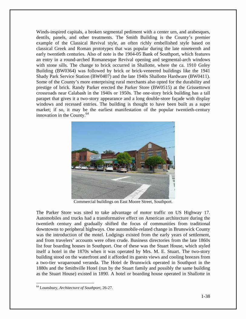
1-38
Winds-inspired capitals, a broken segmental pediment with a center urn, and arabesques, dentils, panels, and other treatments. The Smith Building is the County’s premier example of the Classical Revival style, an often richly embellished style based on classical Greek and Roman prototypes that was popular during the late nineteenth and early twentieth centuries. Also of note is the 1904-05 Bank of Southport, which features an entry in a round-arched Romanesque Revival opening and segmental-arch windows with stone sills. The change to brick occurred in Shallotte, where the ca. 1910 Goley Building (BW0364) was followed by brick or brick-veneered buildings like the 1941 Shady Park Service Station (BW0407) and the late 1940s Shallotte Hardware (BW0411). Some of the County’s more enterprising rural merchants also opted for the durability and prestige of brick. Randy Parker erected the Parker Store (BW0515) at the Grissettown crossroads near Calabash in the 1940s or 1950s. The one-story brick building has a tall parapet that gives it a two-story appearance and a long double-store façade with display windows and recessed entries. The building is thought to have been built as a super market; if so, it may be the earliest manifestation of the popular twentieth-century innovation in the County.64
Commercial buildings on East Moore Street, Southport.
The Parker Store was sited to take advantage of motor traffic on US Highway 17. Automobiles and trucks had a transformative effect on American architecture during the twentieth century and gradually shifted the focus of communities from traditional downtowns to peripheral highways. One automobile-related change in Brunswick County was the introduction of the motel. Lodgings existed from the early years of settlement, and from travelers’ accounts were often crude. Business directories from the late 1860s list four boarding houses in Southport. One of these was the Stuart House, which styled itself a hotel in the 1870s when it was operated by Mrs. M. E. Stuart. The two-story building stood on the waterfront and it afforded its guests views and cooling breezes from a two-tier wraparound veranda. The Hotel de Brunswick operated in Southport in the 1880s and the Smithville Hotel (run by the Stuart family and possibly the same building as the Stuart House) existed in 1890. A hotel or boarding house operated in Shallotte in
64 Lounsbury, Architecture of Southport, 26-27.
1-39
the first decade of the twentieth century and one opened in Bolivia in the 1910s. Also, in the 1910s, Winnabow area physician Erastus G. Goodman constructed a two-story frame hotel (BW0235) in the depot village of Lanvale along the Wilmington, Brunswick and Southern line. The hotel was photographed for the North Carolina State Historic Preservation Office in the 1970s, by which time the gable-fronted building was in ruinous condition (it is now gone), but it retained a monumental portico and a diamond-shaped vent in the front gable.65 The County’s motels differed from earlier hostelries in a number of respects. The Green and White Tourist Court (BW0472) in Bolivia is representative of the new form. J. Dallas Johnson had the motel built in the late 1940s, naming it for its white-painted weatherboards and green trim. Period post cards show it as an arc of five double-occupancy frame cottages each with a gable roof and a small projecting gable over dual entries. Separating the guest accommodations provided greater privacy, but it also reflected the desire of motoring guests to park next to their rooms, a convenience that was impossible in traditional hotels. About 1960 five additional units were added to create a courtyard to the rear, the exteriors of all units were brick-veneered, and porches were added to give the complex a Colonial Revival appearance. The same style was used about the same time for a motel complex (BW0490) constructed in Belville close to where US Highway 17 crosses to Wilmington. Near the Belville motel stood another product of car culture, a service station (BW0488) with Art Deco and Mission style features such as piers with layered profiles and decorative curved tops and roof-like copings of simulated Spanish tiles. The station, which was torn down for urban development in 2010, is thought to have been built in the late 1930s, but it was a near twin of the Standard Oil Station (BW0218) in Southport believed to have been built in the late 1920s. Shallotte’s Shady Park Service Station (BW0407), opened in 1941, is also associated with car culture, as is the 1940s or 1950s Willetts and Son Motor Sales (BW0470) in Bolivia, a large brick dealership with a bow-truss roof behind a stepped parapet. After World War II, some car-related buildings took on a more futuristic character. The Woodrow Russ Shell Station, built in the 1950s or early 1960s, sported a futuristic angled drive-through canopy and outward tilting plate glass windows. Russ’s station no longer stands but it was the model for Woody’s Store (BW0400) on the highway between Shallotte and Holden Beach, built as a service station in the 1960s for Woody Fulford and standing today converted to a convenience mart and games arcade.66 Late nineteenth and twentieth century institutional buildings—primarily schools and churches—are more numerous than their commercial counterparts outside of Southport. Schools were a bulwark of the County’s social life in the twentieth century, but less important in earlier periods. The school planned for Southport in 1798 was a rare exception in the early history of the County, where the children of the elite were tutored on the plantation or sent to distant boarding schools and the children of most other whites and blacks received no formal education. Local historian Berlyn Lancaster recalled that
65 Ibid., 2. 66 Ibid., 53; Shorey, Bolivia, after p. 36; Cheers, Shallotte Centennial Commemorative Book, 95.

1-40
the schools of her youth were “about the size of a large living room.” Public schooling gained slow momentum through the nineteenth century, but the most significant advance occurred in the first decade of the twentieth century during the term of Governor Charles B. Aycock, a strong backer of public education. Aycock’s better schools campaign resulted in the development and dissemination of architect-designed school plans with classical details and varied numbers and arrangements of rooms. How many public schools were built to these designs in Brunswick County is currently unknown, but at least one appears to have been influenced by them. Mill Creek Academy (BW0367) between Bolivia and Funston, believed to have been built in 1909, has a multigabled roof and other features akin to designs promoted by the state. Sunnyside School (BW0250), built in Shallotte in 1916, may have been more directly inspired by state-issued school designs. The weatherboard-sided frame building has a complex front elevation with an entry porch recessed behind a round-arch opening, an entryway cornice with a decorative balustrade and brackets, and ranks of tall windows that flooded classrooms with natural light, a key feature of progressive schoolhouse design.67 In the 1920s the Rosenwald Fund assisted Brunswick County in the construction of schools for African American students. The fund, set up by philanthropist Julius Rosenwald, the president of Sears, Roebuck, and Company, provided matching grants for the construction of thousands of black schools throughout the South. Eleven school buildings are known to have been built in Brunswick County including the seven-room County Training School No. 2, which presumably stood in Shallotte. Additional surviving schools of note include Southport’s 1904 public school (BW0161), later used as the Southport City Hall and altered from its original appearance, and Oak Grove School (BW0399), a gable-fronted building near Shallotte later converted to a dwelling. Large, consolidated schools with decorative brick veneers were built in the County beginning in the 1920s, but all have been demolished. An especially notable school building was the log auditorium constructed at Waccamaw School in the 1930s using Civilian Conservation Corps labor. The large log building was torn down in 1952.68 Early on churches provided some of the educational function later assumed by schools. The County’s tradition of religious architecture began in the mid-eighteenth century with the construction of St. Philip’s Church in Brunswick Town. When it was completed in 1768 the refined Georgian edifice of Flemish-bond brick was the colony’s largest church building. Splayed segmental-arch door and window openings pierce the front and sides of the rectangular building and a Palladian window graces the chancel end. A belfry and what may have been an arched ceiling were other features of the church, which Governor Arthur Dobbs—who contributed furnishings for the interior—credited to the opulence of the Cape Fear planters. The carefully restored walls of St. Philip’s Church testify to the important role that the Church of England played in the affairs of the colony.69
67 Gwen Causey personal communication; Challman, Rural School Plant, 124-125; Brunswick County Historical Society Newsletter 24:2 (May 1983). 68 Gwen Causey and Roberta Brady personal communication; Lounsbury, Architecture of Southport, 43; Rosenwald School Plans website. 69 Bishir, North Carolina Architecture, 39, 41.

1-41
Information on church architecture for the first half of the nineteenth century is sketchy, but some congregations probably met in log chapels which they eventually replaced with simple gable-fronted frame buildings. Later congregations and their builders often departed from traditional simplicity and erected churches with towers and ornamentation. The local epitome of this trend is Southport’s St. Philip’s Episcopal Church (BW0157), built in the late 1850s but remodeled to its present appearance in the 1890s. In its original form the church appears to have been a temple-fronted building with a plastered facade under a Greek Revival pediment. In 1894 a Queen Anne style entry and bell tower was added to the side. The tower is richly ornamented with sawn brackets and belfry louvers shaped to create undulating surfaces. The pyramidal spire once sprouted miniature Gothic gables and was sheathed with sawtooth wood shingles. A stained glass window with wooden tracery replaced the former front entry and in 1896 builder W. T. Ottoway sheathed the interior with beaded tongue-and-groove boards arranged in patterns. Goshen Baptist Church (BW0426) near Navassa is another church dating to the 1850s. Goshen has been remodeled, but its gable-front form and tall side windows are still evident.70
Tower of St. Philip’s Episcopal Church (BW0157), Southport.
Towers are the character defining feature of many of the County’s historic churches. Some are centered on the façade, as is the case with Bethel United Methodist Church (BW0468) in Bolivia, St. Mark A.M.E. Zion Church (BW0414) near Shallotte, and Concord United Methodist Church (BW0228) in Supply. The two towers that rise on the façade of Blackwell Chapel A.M.E. Zion Church (BW0403) near Belville, one at each front corner, create a form that was popular with African American congregations during the early and mid-twentieth century. (Blackwell Chapel is believed to date to 1940.) Trinity United Methodist Church (BW0173) in Southport, built in 1888-90, has a low tower with a spike-like spire in the angle of the sanctuary and Sunday school wing, and a 70 Lounsbury, Architecture of Southport, 15, 29.

1-42
similar tower-like cupola at the front of the main roof. An unusual façade treatment was adopted for New Hope Presbyterian Church (BW0243) near Winnabow. The small building, dedicated in 1895, has a gable-fronted roof that engages a front porch with heavy chamfered posts and a solid railing sheathed with octagonal-edged wood shingles. Bands of the same shingles alternate with square-edged shingles in the gable above, around a large louvered vent in the form of a Palladian window. The interior is sheathed with stained and beaded tongue-and-groove boards and spanned by queen-post trusses with beveled edges, turned pendants, and sawn brackets with quatrefoil cutouts. Purple and yellow glass fills a Palladian window in the chancel end. These features combine to make New Hope Presbyterian Church the most decorative church outside of Southport.71 Stained glass was a decorative treatment in other churches. The triangular-headed windows of Navassa’s Reeves Chapel A.M.E. Zion Church (BW0257) have a patchwork of clear, amber, pale yellow, red, and blue glass panes. Another African American church of note is Moore’s Chapel A.M.E. Zion Church (BW0548) off of River Road between Leland and Southport. The congregation, which was organized in 1874, built the present church in the 1890s or early twentieth century and extensively remodeled the building in 1943-44. The church features a belfry, an apse (now collapsed), and tongue-and-groove wainscoting. The churches of black and white congregations alike were often the centers of rural communities. The County’s larger historic cemeteries—many still active—are associated with churches, or were at one time in the case of congregations that have moved to newer buildings elsewhere. Many of the County’s inhabitants could not afford permanent or inscribed markers for their deceased. Wooden headboards and footboards were often used in lieu of the fieldstones that were standard in inland regions, for as one eighteenth-century visitor to the County put it, there was “not a stone to be met with in a thousand acres.” Relative to other North Carolina counties, Brunswick County has many surviving wooden gravemarkers, but the survivors are a small percentage of the many that once existed. A survey conducted about 1940 suggests wooden markers or other uninscribed memorials could outnumber inscribed stone and concrete memorials by ten to one in some cemeteries. The survival of wooden gravemarkers in the County is a testament to the durable longleaf pine lightwood from which they were cut. Most wooden markers were carved in the form known to cemetery researchers as discoid for the head-like disk that crowns the shaft. The anthropomorphic form has an ancient pedigree in Europe and was also used by African and Native American cultures. A variant of the discoid form, with a diamond-shaped head instead of a round one, is also common in county cemeteries. Evidence suggests that for at least some paired wooden markers, the discoid form indicated the head of the grave and the diamond form’s the foot.72 Brunswick County has several wooden gravemarkers that are among the most elaborate in the state. Graves associated with Bryant and Gore family members in the Riley Hewett Cemetery (BW0378) in the Cedar Grove Community (located between Supply and
71 Ibid., 39. 72 John Hobgood personal communication; Schaw, Journal of a Lady of Quality, 164; Niernsee, Brunswick County Cemetery Survey; McNerney, “Discoid Gravemarkers.”

1-43
Varnamtown) are marked by discoid boards that feature secondary “bed knobs” flanking the center disk. A very similar bed-knob headboard in a Brunswick County cemetery was photographed by archaeologist Stanley South in the 1950s. Whether the curious secondary disks are actually an allusion to bed knobs—gravemarkers were sometimes conceived of as headboards of beds—whether they are exaggerated epaulets, or whether they reflect some as yet unexplored folk tradition is unknown. The wooden gravemarkers in the Riley Hewett Cemetery were probably carved by Charlie Bryant, who made coffins, church pews, and other wooden objects for the community. The complex forms of certain Brunswick County headboards suggest the possibility they are products of Gullah/Geechee culture. Gullah and Geechee are names for African American residents of the southeastern coast who preserve elements of their African linguistic and cultural heritage. Historically Gullah/Geechee influence extended up the coast to southeastern North Carolina where it is associated with rice cultivation. Gullah/Geechee culture is known for its expressive wood carving traditions. The remarkable wooden grave art carved by Sunbury, Georgia, resident Cyrus Bowens about 1920 comes to mind.73
Wooden gravemarkers in the Riley Hewett Cemetery (BW0378).
In Chapel Hill Cemetery (BW0415) near Shallotte are wooden markers in a variety of forms, the most interesting of which is a discoid headboard and diamond-headed footboard linked by a single wood rail that is fitted into slots in the shafts of the two upright boards. The form is reminiscent of the “leaping board” type of gravemarker that was common in southeast England dating back to the 1600s, although it may be a variation of the more general grave rail form, which usually features two wooden rails connecting the head and foot markers. The headboard of this unusual marker also has pointed shoulder extensions that suggest an association with the bed knob tradition seen in the Riley Hewett Cemetery headboards. The local tradition of flamboyant wooden gravemarkers appears to have continued as late as the 1920s. The African American Clay Branch Cemetery (BW0533) near Supply has wooden markers with barbed and diamond tops that presumably date to the establishment of the cemetery in the 1920s. Most dated
73 Bertha Bell personal communication; Ferris, Afro-American Folk Art and Crafts, 49.

1-44
markers in the cemetery are from the 1930s on, suggesting a transition to concrete and stone soon after the first generation of wood markers. The fact that similar carving appears in both black and white cemeteries suggest the possibility of a complex ethnic and cultural interplay.74 In contrast to these elaborate wooden gravemarkers are the simple wood stakes that mark a cluster of graves in the Silent Grove Cemetery (BW0398) near Shallotte. Unlike the more carefully made wood markers that appear to have been intended as permanent memorials, the Silent Grove markers may have been intended as temporary markers that were for some reason left in place. Also apparently distinct in character are the few surviving wooden markers in the Camp Branch Missionary Baptist Church Cemetery (BW0499) in the heart of Green Swamp near the County’s north-central border. The Camp Branch markers include small discoid headboards that seem more typical of the Southeast North Carolina region and may represent a different cultural tradition. None of the County’s surviving and heavily weathered wooden markers have been observed to have an inscription or other carving, although Exum-area carpenter and coffinmaker Mance Little carved names and dates onto the discoid headboards he made around 1900. One of the discoid headboards in the Camp Branch cemetery meets the description of markers made by Little. Wooden markers that once existed in the Sykes Cemetery near Northwest, and one that still stands in the Ward Cemetery (BW0519) near Longwood, were painted. The Ward Cemetery is also notable for its nineteenth-century picket fence and ornamental gate.75 In the nineteenth century, many of the County’s more prosperous farming and merchant families ordered marble headstones for their graves. These are generally tabular in form, upright slabs carved with stock motifs such as clasped hands and flowers and top profiles that are curved or flat. The marble ledger that caps the brick tomb of Eliza L. Fitz Gerald (d. 1826) at Shrub Hill Plantation (BW0365) near Winnabow has a tripartite top with a center tympanum flanked by epaulets that is more common in upright tombstones of the era. Taste switched to more weather-resistant granite over the course of the first half of the twentieth century. The County relied on outside workshops for professionally carved monuments. W. C. Milligan of Wilmington carved an ornate Victorian marble monument for Samuel Rowell (ca. 1788-1859) that stands beside Goshen Baptist Church (BW0426). John Maunder advertised his Wilmington Marble Yard in the Southport Leader in 1890. A reading of selected business directories from the late nineteenth and early twentieth centuries does not indicate the presence of a tombstone carver in the County. Railroad and shipping that facilitated imports from Wilmington and other cities would have discouraged local production. One of the few professional tombstone outlets in the County in recent years was White Memorials in Supply, which has now closed, leaving the County without a resident source. Delores White of White Memorials notes that many County families purchase their memorials in Columbus County and Horry County, South Carolina.76 74 Gwen Causey personal communication; Arscott, Dead & Buried in Sussex, 4-6; South, Archaeological Evolution, 133. 75 Pearly Vereen and Frankie Sykes personal communication. 76 Delores White personal communication; Southport Leader, March 6, 1890; North Carolina Year Book, 1902, 1905, 1910, 1915, and 1916 editions.

1-45
Although stone monuments were rarely if ever made in the County, Brunswick supported a vigorous concrete gravemarker tradition. Concrete was less expensive than stone but more permanent than wood, and its common use in construction projects beginning about 1900 made both the material and the skill to work it familiar to local residents. It appears that family members themselves sometime fashioned concrete markers, such as was probably the case for the undated monument of the infant daughter of D. T. and Rebecca Hewett in the Silent Grove Cemetery (BW0398), which was inscribed with a mix of block and cursive letters using a tool as simple as a stick. Another Hewett family concrete monument in the same cemetery used coat hangers as reinforcement. Other of the County’s concrete monuments show considerable artistry. Markers in the St. Thomas Cemetery (BW0402) near Belville have white-painted inscriptions and decoration, some of it possibly stenciled. The monument of Rev. Joseph A. Reaves (1881-1930) has a painted panel with a cross, shepherd’s crooks, recumbent animal figures that probably represent sheep, and a crescent moon above the phrase “The Lord is my shephard [sic]”. The side by side monuments of Robert H. Cherry (1880-1976) and Sarah A. Cherry (1884-1963) in Silent Grove Cemetery exhibit some of the most exuberant concrete folk art in the County, with scalloped and dentilated edges, star, floral, and leaf figures, and metal lettering set into the concrete.
Detail of a painted concrete monument in the St. Thomas Cemetery (BW0402).
Even though many concrete monuments were probably made locally, there is a marker dated 1922 in the Mears Cemetery (BW0418) in Navassa and another dated 1908 or 1909 in the Riley Hewett Cemetery with characteristic “typewriter” inscriptions that identify them as examples of a class of markers distributed throughout the Southeast. Historian Ruth Little has discovered evidence that orders for these markers were collected by traveling salesmen and the finished monuments were then shipped to the customer by train, but the company that produced the markers has not been identified. Another source for Brunswick concrete monuments was probably Shaw Funeral Home in Wilmington, a leading African American mortuary which produced markers with paper inscription panels (now mostly gone or illegible) in the 1960s. Markers fitting this description are found in the St. Thomas, Mt. Calvary, and (possibly) the Mears cemeteries in the Navassa-Belville area. In the latter half of the twentieth century, decorative burial vault
1-46
lids served in place of upright markers in many of the County’s African American cemeteries. Another alternative to stone memorials was zinc, marketed in the late nineteenth century as “white bronze.” The Smithville Burying Ground (BW0628) in Southport preserves several white bronze memorials, their cast inscriptions and ornament almost as crisp today as they were when manufactured over a hundred years ago.77 One of the County’s most enduring traditions is the covering of graves with sea shells. Shell graves have precedent in both England and Africa. Historian Ron Hobbs tells the story of his ancestor Herbert Chadwick, who in the 1910s and 1920s took carloads of Brunswick sea shells to inland towns to demonstrate their use in covering graves. (The family recalls that people in those towns were using light bulbs, Bromo-Seltzer bottles, and other objects for this.) Historian Bertha Bell notes that shells helped to keep the grave mound from washing away. Bell also explains a feature of the Riley Hewett Cemetery where pottery and glassware adorn graves marked by uninscribed headboards. The different objects identified the person buried in the grave, the association of person and object passed down to younger generations.78 Brunswick County remained of interest to the military during the late nineteenth and twentieth centuries, and in the 1890s attention returned to the site of Fort Caswell (BW0230) on the eastern tip of Oak Island. In 1897 the federal government contracted with Philadelphia builder John L. Grimm to construct massive concrete batteries and a support infrastructure of roads and buildings. A seawall over a mile in length was constructed around the tip of the island in 1900-01. The buildings were described by an early resident of the fort as a “perfect little city.” Gable- and hip-roofed frame residences, barracks, a headquarters building, a hospital, and a host of other buildings were constructed during the first decade of the twentieth century. The design of the buildings was based on standardized plans prepared by the Quartermaster General’s Office and incorporated influences from the Queen Anne and Colonial Revival styles. One- and two-story verandas were a necessary amenity during the years before air conditioning. Fresh water was supplied by cisterns filled with rain water from the buildings’ gutters. More facilities, many of them prefabricated buildings, were constructed during World War I. Fort Caswell’s modern history began in 1949 with the purchase of the site by the North Carolina Baptist Assembly. Today, an estimated one thousand young people attend summer camp at the fort each year. The construction of the Oceana Motel and the conversion of many buildings to lodgings has added a family resort element as well.79 The federal government developed other types of installations along the County’s sea and river shores. The U.S. Lifesaving Service erected a station near Fort Caswell in the late 1880s (BW0244). The Queen Anne style station from the early years survives near its original site. The story-and-a-half frame building has board-and-batten siding, gable ornament, and a small observation tower on its steep gable roof. The U.S. Coast Guard erected a replacement station in 1932, which in turn was replaced by the current facility 77 Little, Sticks and Stones, 242, 250, 309. 78 Ronald Hobbs and Bertha Bell personal communication; Little, Sticks and Stones, 235, 240. 79 Herring and Williams, Fort Caswell, 59-60, 75, 79-80, 84, 87, 109; Bishir and Southern, Guide to the Historic Architecture of Eastern North Carolina, 264-265; “North Carolina Baptist Assembly at Fort Caswell.”

1-47
in 1992. The government also turned to the Cape Fear estuary, which over the decades had been deepened for successively larger ocean-going vessels. In the early 1950s the Sunny Point Army Terminal, known officially as the Military Ocean Terminal at Sunny Point, or MOTSU, was constructed as a deep-water port upstream from Southport. The facility, begun in 1952 and dedicated in 1955, is used for shipping ammunition and equipment. As the principal employer in the southeastern part of the County, it has benefited the economies of Southport and nearby communities. Another boon to Southport is the use of Fort Johnson as housing for Sunny Point personnel, which results in upkeep of the historic installation. (Sunny Point falls under the purview of federal cultural resources programs and was not included in the survey.) After World War II, the Brunswick River was designated a reserve fleet basin for shipping left over from the hostilities. In 1958 a peak of 649 ships were mothballed on the river. The last ship was removed in 1970.80 As the transformation of Fort Caswell into a resort destination indicates, Brunswick County’s beach islands became a major draw in the twentieth century. Bald Head Island was apparently the first beach to experience resort development. Richmond County businessman T. F. Boyd acquired the island in 1916, renamed it Palmetto Island, and constructed an eight-room hotel, pavilion, and boardwalk. Boyd also laid out streets and lots but his plans succumbed to the Depression of the 1930s. A more ambitious initiative was announced in 1964 by new owner Frank Sherrill, but environmental concerns inspired the low-density development that has been undertaken by Bald Head Island Limited since 1983. Aerial photos taken in 1938 show incipient beachside development in Holden Beach: a row of about five to ten widely separated houses in the vicinity of Hillside Drive. In 1958 geographer Bill Sharpe described the island as a “cottage beach,” and noted, “A thin line of cottages stretching over about three miles of the strand. Damaged by Hazel, it largely escaped subsequent hurricanes, and is slowly rebuilding.”81 Charleston, South Carolina, lumber baron Ernest Felder Middleton became familiar with Brunswick County through his business activities in the 1930s. In 1938, the Blue Water Beach Company, formed by Middleton and others, purchased 2,000 acres on Oak Island for the purpose of development. The first lots were sold in February 1939 and the official opening of Long Beach, as Middleton’s development became known, followed in July. The development included the open-air Long Beach Pavilion, where an orchestra serenaded dancers, a canteen, a dining room, bath houses, and a three-room cottage, presumably for rental. Lot purchasers also began constructing houses in the summer of 1939. In January 1940 it was projected that forty houses would be completed on the beach by summer. Maps from 1943 indicate about thirty-seven structures at the west end of the island and about a half dozen between the west end and Fort Caswell at the east end of the island. By 1954 a drive-in movie theater had opened at Long Beach (now part of the Town of Oak Island) and there were plans to erect a two-story entertainment center and a nondenominational church.82
80 Bishir and Southern, Guide to the Historic Architecture of Eastern North Carolina, 264; Carson, Joshua’s Dream, 135-136; Watson, Wilmington, 155. 81 Old Baldy Foundation website; Sharpe, New Geography of North Carolina, 609. 82 Furstenau, Long Beach, 13-16, 18, 20, 22-24, 28-29; Southport USGS map (1943).

1-48
Hurricane Hazel made landfall in the County on October 15, 1954, and caused extensive devastation on the barrier islands and inland. The damage is especially well documented for Long Beach. According to historian Wolfgang Furstenau, maximum wind speed on the island was measured at 140 miles per hour and the storm surge swept over parts of the island to the level of second-story windows. Of the 357 buildings that stood on Long Beach on the eve of the storm, only five remained on their foundations afterward. E. F. Middleton led the charge to rebuild, and one of the first projects was the construction of a new pavilion, which began in November 1954. The post-Hazel reconstruction included the establishment of a second community on the island, Yaupon Beach (now part of the town of Oak Island), in 1955, and a steel fishing pier using the Nelson stud welding construction technique was erected in the new community the same year. At present, the County’s incorporated beach communities are (from east to west): Bald Head Island, Caswell Beach, Oak Island, Holden Beach, Ocean Isle Beach, and Sunset Beach. Several of these towns also have jurisdiction over portions of the mainland. Sunset Beach is home to the innovative Sunset Beach Swing Bridge (BW0597), which connects the island to the mainland across the Intracostal Waterway but will soon be decommissioned when a modern fixed span bridge is completed. In the late twentieth century, developers moved inland to create such communities as Boiling Spring Lakes in the 1960s and St. James Plantation in the 1980s and 1990s. Golf is a central activity at many of these new communities. At St. James courses were opened in 1991, 1995, and 2006-2007.83
House (BW0541), 701 Country Club Road, Caswell Beach.
Most of the beach houses built during the decades before Hurricane Hazel were simple affairs. A representative example is the house (BW0541) at 701 Country Club Road in Caswell Beach. (Together with the Town of Oak Island, Caswell Beach is one of two incorporated municipalities on Oak Island.) The one-story frame dwelling, which was probably built in 1948, stands on timber piers and has a low-pitched shed roof and vertical board siding painted turquoise. Unlike the lofty mini-mansions of recent years, this quaint beach cottage barely peeks over the dunes to the ocean. Its present tax assessment—under $10,000 for the house and $450,000 for the lot—underscores its
83 Furstenau, Long Beach, 29-31, 36; St. James Plantation website.

1-49
simplicity and speaks volumes about the redevelopment pressures that have resulted in the loss of similar houses. Modernism gained speed for beach development in the 1950s and 1960s, as demonstrated by such buildings as the Driftwood Motel (BW0537) in the Town of Oak Island and the house at 198 Ocean Boulevard East (BW0508) in Holden Beach. Inland homebuilders also adopted modernism, specifically the Ranch or Rambler house form that populated vast post-war suburbs. Some County Ranch houses were sophisticated in form and finish. The Edwin and Theodocia Clemmons House (BW0532), built in 1955-56 by a Supply area tobacco farmer and sawmiller, features sea-sawing forward and backward sloped shed roofs, alternating stretcher and Flemish bond brick veneer, and a porch and carport supported by clustered wood posts on brick pedestals (a lingering Craftsman influence). The interior centers on a Wrightian (but nonfunctional) stone fireplace with built-in shelves and plinths for displaying art objects, and walls, ceilings, and floors sheathed with a variety of woods. Edwin Clemmons was his own architect and did much of the carpentry. Modernism, as a house style, gradually lost favor among County residents and the retirees who moved to or bought second homes in newly established golf course communities. The majority of new homes are revivalist in style, with the Colonial Revival style enjoying the greatest popularity. An interesting footnote to post-war construction in the County is the use of surplus military Quonset huts. A large Quonset hut with its characteristic corrugated-metal-sheathed barrel-vaulted form was acquired in 1948 by the Brunswick Electric Membership Corporation for use as its Shallotte headquarters (BW0582). A house (BW0374) in the Varnamtown vicinity was converted from a smaller Quonset hut model.84 The twentieth century witnessed the beginnings of historic preservation in Brunswick County. Preservation of a sort was undertaken at Orton Plantation (BW0004) on two occasions in the antebellum period and the 1910s when the house was enlarged and embellished, and over the years some homeowners have carefully maintained the historic character of their properties, but work to actively save historic places from destruction or unsympathetic alteration really begins with the establishment of the Brunswick Town State Historic Site in the 1950s. The Sprunt family and the Episcopal Diocese of East Carolina donated the site to the state Department (now Office) of Archives and History, and research by historian Lawrence Lee and archaeologist Stanley South aided “the reclamation of this long dead village,” as Lee wrote in his history of the County. Earthworks of the adjacent Fort Anderson were preserved in the bargain. Historical and preservation associations such as the Brunswick County Historical Society (organized in 1954), the Southport Historical Society (1976), Old Baldy Foundation (1985), and the Shallotte Point Preservation Group have worked to raise awareness of the County’s heritage and to preserve its historic places. With the sponsorship of the Comprehensive Historical/Architectural Site Survey of Brunswick County in 2009-2010, the County government has assisted citizens and local organizations in their preservation goals.85
84 Gwen Causey personal communication. 85 Lee, History of Brunswick County, 208; Asbury, Souvenir Booklet, 2.
1-50
Recommendations Recommendation 1: Identification of historic resources that appear to have potential for inclusion in North Carolina’s Study List. The principal recommendation of the project is the identification of historic resources that merit placement on North Carolina’s Study List of properties and districts that appear to be potentially eligible for the National Register of Historic Places. Detailed information on the Study List and the National Register, and what the two listings do and do not mean, appears on the North Carolina State Historic Preservation Office website (www.hpo.ncdcr.gov). Briefly presented below are the National Register Criteria for Evaluation, which are used to assess the appropriateness of placing properties on the Study List:
Criterion A: Property is associated with events that have made a significant contribution to the broad patterns of our history. Criterion B: Property is associated with the lives of persons significant in our past. Criterion C: Property embodies the distinctive characteristics of a type, period or method of construction or represents the work of a master, or possesses high artistic values, or represents a significant and distinguishable entity whose components lack individual distinction. Criterion D: Property has yielded, or is likely to yield information important in prehistory or history.
Of the four criteria, Criterion D, which is generally applied to archaeological resources, was not considered since archaeology was outside the purview of the project. None of the Study List candidates listed below were considered under Criterion B, although it is possible that research would reveal that some of the candidates and other historic resources in the County qualify under that criterion. In addition to satisfying one or more of the criteria, a resource must generally be fifty years old or older to be considered for the National Register and it must retain sufficient integrity (essentially, historic appearance, character, or authenticity). Maps showing two historic district study areas follow the list of candidates. Note: A privately owned property may not be listed in the National Register over the objection of its owner or, in the case of a property with multiple owners, over the objection of a majority of owners. National Register listing is achieved through preparation of a nomination (a research report), which would be initiated by the property owner. Placement on the Study List merely signals that a property is likely to be eligible for the National Register and does not guarantee future listing in the Register. The following table presents the Study List candidates, which are discussed more fully in the draft National Register Advisory Committee (NRAC) presentation script that appears as Appendix D.

1-51
Table 1. Brunswick County Study List Candidates
Site No. Resource Name Location BW0234 Hickory Hall 10055 Beach Drive, Calabash BW0253 Winnabow 677 Governors Road SE, Winnabow vicinity
BW0369 Best Farm Dairy 6130 Best Farm Road NE, Winnabow vicinity
BW0370 Lancaster-Roach House 2985 Stone Chimney Road SW, Varnamtown
BW0365 Shrub Hill Plantation 678 Cherrytree Road NE, Winnabow vicinity
BW0536 John and Theresa Mintz House 5320 Minta Lane NW, Shallotte vicinity BW0440 Christopher C. King House 5810 Old King Road NW, Ash vicinity BW0409 Stanland-White House 4745 Main Street, Shallotte BW0371 Swain Farm 208 Varnamtown Road, Varnamtown
BW0428 Harry and Vera Peterson Farm 4514 Mount Misery Road NE, Northwest vicinity
BW0372 Taft Clemmons House and Store 880 Taft Road SW, Supply vicinity BW0579 Robert and Katie White House 4748 Main Street, Shallotte
BW0379 Harry and Annie Bryant House 1909 Stone Chimney Road SW, between Supply and Varnamtown
BW0435 Ivan and Muriel Bennett Farm 5014 Big Neck Road NW, Exum vicinity
BW0397 Windy Point 3819 Windy Point Road SW, Holden Beach vicinity
BW0532 Edwin and Theodocia Clemmons House
944 Little Macedonia Road NW, Supply vicinity
BW0243 New Hope Presbyterian Church 800 Cherrytree Road NE, Winnabow vicinity
BW0414 St. Mark A.M.E. Zion Church Village Point/Bricklanding roads, Shallotte vicinity
BW0405 Gause Tomb Hale Swamp Road SW, Ocean Isle Beach vicinity
BW0415 Chapel Hill Cemetery Ocean Highway, Shallotte vicinity BW0519 Ward Cemetery Daniel Butler Road NW, Longwood vicinity
BW0378 Riley Hewett Cemetery Turkey Trap Road SW, in Cedar Grove Community (between Supply & Varnamtown)
BW0573 Price Creek Beacon Price Creek at Cape Fear River, Southport
BW0546 Navassa Railroad Bridge Quality Drive Navassa (partly in New Hanover Co.)
BW0582 (former) Brunswick Electric Membership Corporation Warehouse
201 Village Road, Shallotte
BW0470 Willetts and Son Motor Sales 3865 Business 17 East, Bolivia BW0715 Gause Landing Historic District Gause Landing
BW0468 Southport Historic District Boundary Amendment Southport
1-52
The proposed Gause Landing Historic District encompasses parcels with historic resources that appear to cohere as a district warranting consideration for the Study List. As Southport has a National Register historic district in place, the proposed district amendment shows considerations that would apply if the boundaries were to be modified. Since the date of the Southport district’s listing in the National Register of Historic Places in 1980, development, alteration, and demolition have resulted in changes to the character and distribution of historic resources. Also, reconnaissance and survey undertaken during the 2009-2010 project have documented a continuation of the concentration of historic resources beyond the district’s existing northern boundary along West Street. The limited amount of survey undertaken in areas adjacent to the current Southport Historic District makes precise boundary recommendations infeasible at the present time. Therefore the study area map in the appendix shows areas that should be considered for closer scrutiny and future survey. Three considerations are portrayed on the map. District Expansion Study Area 1 shows an area with a concentration of historic resources that warrant comprehensive survey and within which potential boundary expansion would be most likely. (The 2009-2010 project surveyed selected buildings in this area.) District Expansion Study Area 2 areas have sparser concentrations of historic resources where potential boundary expansion appears to be possible but not as likely as in the Priority 1 area. The map also shows two areas within the existing district that have lost integrity due to demolition and/or unsympathetic alteration of historic resources. These areas, being located on edges, could be considered for exclusion if boundary modifications were undertaken. If the boundaries of the Southport Historic District were to be modified as the result of a future project, the action would also entail reexamination of the period of significance for the district, which currently ends at 1930. If such a reexamination were to occur in 2010, for example, resources built through 1960 (and possibly a few years later) would have potential to be reclassified as contributing to the district.

Proposed Gause Landing Historical District Study Area
L,..,,,",,",,:-="~..--..~......J""'''-'''''; ' :: . i ;: :~ ~ .. TIMBER HITCH 0 VE OAK AVE 5 . . .... .. ... ........ ............ .
...... ... . . . . ~. , ~~
!-__ ---"l'-"> .~~-.,---~:;::_:::r:..:..:.;.=-.::..:r__,_-If:;~: ;~; ;;K-!; ;-!+;. "!:1:; ; . .
Prepared by: Brunswick CounLy Planning & Community Development Dept,
(Revised 9122/10)
B nlos\\;('k eQl !nt)' assumes no le~ responsibilit)' rOi the 'Ll tllrr 01: COlllent o r, 01 aCClII<lC}' or <my II1rOlmallon
contained on litis map. This 111ilp mOl) nol h(' ;In'ural e o .
11['l 10 da le , All lIlap mkm llalion milst ht' \"t'lilied by fC Cipl ent ,
• • 0 ", • ••• ....... .... . 1--'--41:'::::::::;: :
[ '[ TU\ '(
........... .. ... ... .. ..... , 00 , ••• ,
' .0 1 ' • • 0
Legcnd
till Gausc Landing Histori(' District Study Area
D Parcd
o I
i\1ap ScaJe
150
I inch - 300 reel
1-53

--------Prepared by: Brunswick County
Planning & Community Development Dept. (Revised 9/22110)
Bnmswick Coullty assumes no legal J cspuns~)ilil}' for Ihe naLure of, ("olllenl of, Ofa("nl1<KY or an)' inrollllaLion
conl<lincu on thls map. This map may nol he accUr.lte or up La elale . AJllmp Infol1n .. 1tioll must be \'erilied hl' recipienl
, I
Southport Historical District and Recommended Study Areas
Legend Southport Historical District (Designated 1960)
Area within District w/Subslantial Loss of Inlegrity
~ District Expansion Study Area I
", ;Z~1 District Expansion Study Area II
.c=J Parcel
rfl Ceme1ery l. __ J
()
I
Map Scale
275 550 ft. I
1 inch = 550 feet
1-54

1-55
Recommendation 2: Brunswick County can encourage preservation of historic resources through public/private/non-profit partnerships and other means. Brunswick County possesses a historically and architecturally varied legacy of historic buildings. These resources face a number of threats, some of them common to the state and nation, some more acute in the County. Threats to the County’s historic resources include:
• Abandonment • Weather (wind, flooding, damp) • Insect damage • Plant growth • Fire • Demolition (active or through neglect) • Redevelopment • Inappropriate remodeling • Removal from historic context
Some of the threats are interrelated; for example, an abandoned historic building is more prone to weather, insect, and fire damage, and is more likely to be demolished for redevelopment or other reasons. In Brunswick County, with its warm humid climate and exposure to ocean storms, weather and insect damage are particularly devastating and probably largely account for the relative scarcity of buildings from before the Civil War. The last two threats are not as severe or irreversible as demolition, although they lessen the integrity of historic resources. Moving a historic resource is generally to be avoided, since it severs the connection of a resource to its historic surroundings and associated buildings and landscape features, but it may be the only preservation option if the resource cannot be saved at its historic location. It should be noted that the moving of buildings was historically a common practice in the County, and some buildings that have had a long association with a certain location may in fact have been moved there. The National Register of Historic Places recognizes the need to move historic resources under some circumstances, and a designated building that is moved may retain its designation if certain criteria are met (for example, if the new setting is similar). The state and federal governments encourage private-sector preservation efforts through a number of programs. Perhaps the most widely used are the federal and state historic preservation tax credit programs. These are explained in detail at the North Carolina State Historic Preservation Office website (www.hpo.ncdcr.gov), but in short the programs may provide up to a combined 40% in state and federal tax credits against eligible project costs for the rehabilitation of certain historic properties in accordance with the Secretary of the Interior’s Standards. For income-producing properties including residential rental a 20% state credit may be added to the 20% federal credit; for non-income-producing properties such as owner-occupied residences a 30% state credit is available. One qualification for participation in the programs is the listing of the building in the National Register, either individually or as a contributing building in a district. Many of the historic buildings in the Southport Historic District meet this criterion. The HPO also
1-56
provides technical advice on rehabilitation. The Brunswick County Planning and Community Development Department also encourages preservation. The Department considers the survey information a tool for identifying the location and characteristics of historic resources so that it can encourage consideration of the resources in development projects.86 Ultimately the majority of the County’s historic buildings has been, and will continue to be, preserved by private property owners. The preservation ethos is strongest in Southport, which is blessed with historically and architecturally significant properties and has many property owners who appreciate the historic qualities of their houses and commercial buildings. Southport’s historic character contributes to tourism and economic development in the community. The Village of Bald Head Island, Bald Head Island Limited, the Bald Head Island Association, the Old Baldy Foundation, and other island organizations have worked to preserve the island’s few remaining historic resources and have made them integral to the experience of residents and visitors. Brunswick County’s county and municipal governments often work to encourage the preservation of historic properties, although no jurisdiction currently has a historic preservation ordinance in place. The Southport Historic District, for example, does not have an accompanying local historic ordinance governing the alteration or demolition of historic buildings. In the central areas of such communities as Shallotte, Navassa, Bolivia, and Gause Landing, a combination of continued functionality of historic buildings and lack of intense development pressure has helped preserve historic buildings. In North Carolina, county-wide architectural surveys often result in follow-up projects with preservation benefits. One is the nomination of multiple resources to the National Register of Historic Places as a coordinated effort. Another is the publication of an architectural history that presents the survey findings to the general public. Attractively designed, accessibly written, and well-illustrated hardcover architectural publications are warmly received by communities. The North Carolina State Historic Preservation Office website (www.hpo.ncdcr.gov) has information on these kinds of initiatives. A direct benefit of the survey is the information it provides to planners and others for making informed decisions about development and other activities that have the potential to affect historic resources. Public/private/non-profit partnerships would be one means by which Brunswick County could foster preservation activity. The 2009-2010 survey project could be considered a product of such a partnership in the sense that individuals from a range of private non-profit historical and preservation groups donated their time and expertise to the project. Local non-profits that the County could partner with include the Brunswick County Historical Society and the Southport Historical Society and grassroots/community resource organizations like the Shallotte Preservation Group, the Aboriginal Old Town Historical Society, and the Cedar Grove Neighborhood Improvement Association. At the regional and state levels groups such as the Historic Wilmington Foundation and Preservation North Carolina have been active in support of Brunswick County preservation and are likely to be interested in partnering with the County. 86 J. Leslie Bell personal communication.

1-57
Recommendation 3: Brunswick County and interested citizens should consider exploring the value and practicality of a County-wide historic signage program. Memorialization of historic properties and communities typically involves signage, either highway markers or plaques mounted on buildings. The North Carolina Highway Historical Markers program (www.ncmarkers.com) administered by the state’s Office of Archives and History is the principal source for highway markers in North Carolina. The state marker program, authorized by the General Assembly in 1935, is one of the oldest such programs in the nation. Since the first marker placement in 1936, over 1,400 of the familiar silver and black metal markers have been erected in the state. The program’s website describes the benefits of highway historical markers: “For young people the markers may spark a curiosity that leads to further study of and appreciation for the historical development of the region. For visitors the signs may be their only exposure to the history of the Tar Heel State. For native North Carolinians the presence of a state marker in their community can be a source of pride, a signal that an event of historical significance took place close to home.”87 Historic plaque programs are implemented by sponsoring organizations to acknowledge the owners and stewards of historic properties and to foster public appreciation. Such programs also have the advantage of generating historical information of use to the sponsor and the community. One of the largest and perhaps oldest plaque programs in North Carolina is operated by the Historic Wilmington Foundation which has placed plaques on (at present) 385 properties. The Foundation’s website (www.historicwilmington.org) explains the eligibility requirements, application process, and costs, and it includes a link to the Port City Architecture Online website, a joint project with the New Hanover County Public Library that displays images and text for recipient properties. In Brunswick County, the Southport Historical Society provides plaques to historic property owners and the Bald Head Island Association has been involved with the placement of free-standing markers at a number of the island’s historic sites. Another method for indicating historic properties with signage is National Register of Historic Places plaques.88
Historical marker, Cape Fear Lighthouse Complex
(BW0003), Bald Head Island.
87 North Carolina Highway Historical Markers website. 88 Emily Bonney personal communication; Historic Wilmington Foundation website; Southport Historical Society website.

1-58
Brunswick County has a number of state highway historical markers. The program can approve markers only for places or persons of statewide significance and will not approve them for subjects of purely local or regional importance. Some of the properties identified by the survey and some of the communities included in the appendix may satisfy this basic criterion, but most probably do not, making the state highway historical marker program an unlikely method for memorializing the County’s historic buildings and communities. For properties of architectural significance, the program recommends National Register designation as a possible alternative, since, as the program website explains, “Structures are not marked for architectural value.” For properties or historic districts listed in the National Register, the North Carolina State Historic Preservation Office website (www.hpo.ncdcr.gov) provides contact information for suppliers of custom or generic National Register markers. Some suppliers offer roadside markers in addition to the more standard wall-mounted bronze National Register plaques.89 Because of the narrow eligibility criteria for state highway historical markers and National Register plaques, these two methods of memorialization would be of very limited benefit or applicability to Brunswick County’s historic properties and communities. A locally sponsored signage program along the lines of the ones created for Wilmington, Southport, and Bald Head Island would potentially be a better model for a County-wide signage program, should one be considered. Local plaque programs are ordinarily supervised by a committee; therefore, should a County-wide signage program be proposed for Brunswick County, a logical first step would be to convene a plaque committee. A hypothetical committee might consider the following questions, among others:
• Does a plaque program make sense for Brunswick County? Would the program be available for rural properties as well as town properties?
• What would be the criteria for approving or selecting historic properties and communities as plaque recipients?
• How would the information on the plaques be researched and written? • How would the plaques be designed and made? • Would there be provisions for replacing lost or damaged plaques? • Would wall-mounted plaques, free-standing markers, or a combination of the two
standard sign types be best? • How would the program be funded and administered?
During the project the author noted the limited effectiveness of certain state highway historical markers in the County, specifically a line of markers along River Road (Highway 133) in Belville just south of the Highway 17 interchange. At the time the markers were placed they may have been accessible, but at present they are located on a heavily traveled section of highway with limited pull-off. The County could work with the state and the Town of Belville to explore improving public access for the makers. The Town of Belville is currently exploring redevelopment options; perhaps the signs could
89 North Carolina Highway Historical Markers website; North Carolina State Historic Preservation Office website.

1-59
be incorporated into a public square, walkway, or entry area. Also, the County has developed parks along Highway 133 to the south of the signs that might provide improved public access. Some of the signs reference the location of the site they commemorate as a distance from their present position, so relocating them near their present position or providing additional signage that clarifies the true locational relationship would be a consideration.
State highway historical markers along River Road (Highway 133), Belville.
Recommendation 4: Brunswick County’s wooden gravemarkers are an important cultural resource that should be documented and preserved. Brunswick County has a vibrant wooden gravemarker tradition in its older cemeteries. The tradition represents one of the most visible reminders of the County’s African American history and material culture. Wooden markers were also used in white cemeteries. The significance of this tradition and the preservation challenges it faces were acknowledged by the Historic Wilmington Foundation in its 2010 Most Threatened Historic Places List. As the Foundation’s website (www.historicwilmington.org) notes, “Some of Brunswick County’s cemeteries are graced by rare, wooden grave markers. These extant examples of a regional mourning tradition are threatened by neglect and lack of proper attention.” The gravemarkers are made of rot- and insect-resistant wood, which has helped some of them weather the County’s corrosive climate for a century or more, but surviving examples nevertheless show varying degrees of decay. Because of their deteriorated condition they are subject to replacement in cemetery improvement projects and some have probably been lost due to routine cemetery maintenance. In the Clay Branch Cemetery (BW0533), anonymous wooden markers have been discarded as the individuals they commemorate have been identified and granite markers placed in their stead. In contrast, the stewards of the Riley Hewett Cemetery (BW0378) have left deteriorated and fallen wooden gravemarkers on the ground where they lay.90
90 Historic Wilmington Foundation website.

1-60
Ordinarily historic resources should be preserved in their original location and context. This may be possible for Brunswick County’s wooden gravemarkers if they can be protected from further decay and intentional or inadvertent destruction. An example of an approach to preserving wooden gravemarkers in situ is provided by the St. Mary Catholic Church Cemetery on FM 1774 near Plantersville, Grimes County, Texas. A deteriorated wood cross in the cemetery has been enclosed in a wood and clear plastic frame so that the marker is protected from the weather yet remains visible on both sides. Whether the marker is also protected from termites and humidity is unknown. It may be that the marker is continuing to deteriorate but at a slower rate—or at a faster rate if a protected environment has encouraged insects. An analogous example closer at hand is a display in front of the Cedar Grove Baptist Church at 1229 Cedar Grove Road SW near Supply, where pieces of cedar trees have been placed in a glass- or plastic-fronted display case as a memento of the grove where the congregation formerly worshipped.
Wooden gravemarker, St. Mary Catholic Church Cemetery, Grimes County, Texas.
The best long-term solution for the preservation of Brunswick County’s wooden gravemarkers would probably be to remove the markers and curate them in a climate-controlled facility. An example of this approach is demonstrated by the Museum of the Rockies in Bozeman, Montana, where exhibit preparator Dave Kinsey has constructed an exhibit for two wooden gravemarkers from the 1870s-1880s period. Prior to exhibition the headboards were frozen and thawed twice to kill any insects that may have been in them. For Brunswick County cemeteries that are associated with specific churches, curation in the church would be an option. Most of the markers are small and flat enough that they could be mounted on a wall and displayed under glass with an explanatory plaque or label.91 91 Dave Kinsey personal communication.
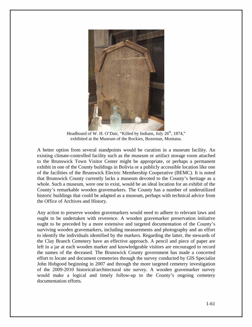
1-61
Headboard of W. H. O’Dair, “Killed by Indians, July 26th, 1874,”
exhibited at the Museum of the Rockies, Bozeman, Montana. A better option from several standpoints would be curation in a museum facility. An existing climate-controlled facility such as the museum or artifact storage room attached to the Brunswick Town Visitor Center might be appropriate, or perhaps a permanent exhibit in one of the County buildings in Bolivia or a publicly accessible location like one of the facilities of the Brunswick Electric Membership Cooperative (BEMC). It is noted that Brunswick County currently lacks a museum devoted to the County’s heritage as a whole. Such a museum, were one to exist, would be an ideal location for an exhibit of the County’s remarkable wooden gravemarkers. The County has a number of underutilized historic buildings that could be adapted as a museum, perhaps with technical advice from the Office of Archives and History. Any action to preserve wooden gravemarkers would need to adhere to relevant laws and ought to be undertaken with reverence. A wooden gravemarker preservation initiative ought to be preceded by a more extensive and targeted documentation of the County’s surviving wooden gravemarkers, including measurements and photography and an effort to identify the individuals identified by the markers. Regarding the latter, the stewards of the Clay Branch Cemetery have an effective approach. A pencil and piece of paper are left in a jar at each wooden marker and knowledgeable visitors are encouraged to record the names of the deceased. The Brunswick County government has made a concerted effort to locate and document cemeteries through the survey conducted by GIS Specialist John Hobgood beginning in 2007 and through the more targeted cemetery investigation of the 2009-2010 historical/architectural site survey. A wooden gravemarker survey would make a logical and timely follow-up to the County’s ongoing cemetery documentation efforts.

1-62
A potential source of support for such a survey might be the Gullah/Geechee Cultural Heritage Corridor initiative. Aspects of Brunswick County’s vibrant wooden gravemarker traditions may reflect Gullah/Geechee culture. If so, certain wooden gravemarkers and the historic cemeteries in which they stand may represent the most visible remnant of Gullah Geechee culture on the County’s landscape. The Gullah/Geechee Cultural Heritage Corridor was designated by Congress in 2006. The corridor extends from Jacksonville, Florida, to Pender County, North Carolina, and includes Brunswick County. The Heritage Corridor is charged with assisting “federal, state and local governments, grassroots organizations and public and private entities in interpreting the story of the Gullah/Geechee culture and preserving its folklore, arts, crafts and music. The Heritage Corridor will also preserve historical sites and artifacts unique to this culture.”92
92 Christopher Gibbons personal communication; Gullah/Geechee Cultural Heritage Corridor website.

1-63
Bibliography Acts of the North Carolina General Assembly, 1745.
On line at the Documenting the American South website, http://docsouth.unc.edu/csr/index.html/document/csr23-0015\, accessed January 27, 2010.
Annual Report of Farmers’ Institutes. Bulletin of the North Carolina Department of Agriculture. Vol. 37 no. 1 (January 1916). Armstrong, Robert Powell. “Memories from my Youth Growing Up at Gause Landing,
North Carolina.” Report, 2009. Arscott, David. Dead & Buried in Sussex. Seaford, England: S. B. Publications, 1997. Asbury, R. V., Jr., ed. Souvenir Booklet, Bicentennial, Brunswick County, North
Carolina. Brunswick County Historical Society, ca. 1965. Bald Head Island Conservancy website (www.bhic.org), accessed June 23, 2010. Barefoot, Daniel W. Touring the backroads of North Carolina’s lower coast. Winston-Salem, N.C.: John F. Blair, 1995. Berry, Bobbie Lou. “Hickory Hall.” Brunswick County Historical Society Newsletter
11:1 (February 1971). Berry, C. B. “Frink Paved the Way for Horry Settlement.” Article online at Horry County
Historical Society website. Bishir, Catherine W. North Carolina Architecture. Chapel Hill: University of North
Carolina Press, 1990. Bishir, Catherine W., and Michael T. Southern. A Guide to the Historic Architecture of
Eastern North Carolina. Chapel Hill: University of North Carolina Press, 1996. Block, Susan Taylor. Along the Cape Fear. Dover, N.H.: Arcadia Publishing, 1998. Branson, Levi, ed. Branson’s North Carolina Agricultural Almanac for the Year of Our
Lord 1890. Raleigh: Levi Branson, 1890. ________. The North Carolina Business Directory [for 1872]. Raleigh: J. A. Jones,
1872. ________. The North Carolina Business Directory, 1877 and 1878. Raleigh: L. Branson,
1878.

1-64
________. Branson’s North Carolina Business Directory for 1884. Raleigh: Levi Branson, 1884.
________. Branson’s North Carolina Business Directory, 1896. Raleigh: Levi Branson, 1896.
________. Branson’s North Carolina Business Directory, 1897. Raleigh: Levi Branson,
1897. Branson’s North Carolina Business Directory for 1867-8. Raleigh: Branson and Jones, 1867. Branson’s North Carolina Business Directory for 1869. Raleigh: J. A. Jones, 1869. Brunswick Beacon. Brunswick County Historical Society Newsletter. Brunswick Town/Fort Anderson website. Online at
http://www.nchistoricsites.org/Brunswic/brunswic.htm, accessed January 28, 2010.
Carriker, S. David. “The North Carolina Railroad Map: A History of North Carolina
Railroads, 1830-1990.” Charlotte: Heritage Publishing, 1990. Carson, Susan S. Joshua’s Dream: A Town with Two Names, a Story of Old Southport.
Southport, N.C.: Carolina Power and Light Company, 1992. Carson, Susan S., and Jon C. Lewis. Joshua’s Legacy: Dream Makers of Old Southport.
Southport, N.C.: Southport Historical Society, 2003. Causey, Gwen. “Brunswick/Columbus Connections: Some things the two counties
share.” Article online at the Southeastern North Carolina Genealogical Society website, http://www.sencgs.org/local/brunswickcolumbus.html, accessed January 17, 2010.
Causey, Gwen, ed. Great is Thy Faithfulness: A Glorious Century, a Centennial History, 1899-1999. Supply, N.C.: Brunswick Baptist Association, 1999. Challman, Samuel Andrew. The Rural School Plant for Rural Teachers and School
Boards. Milwaukee: Bruce Publishing Company, 1917. Chapman, Heather. “Say Goodbye to The Last of its Kind—Sunset Beach Swing Bridge Soon To Be Replaced.” On Sunset Beach Bliss website (http://blog.sunsetbeachbliss.com/2009_08_01_archive.html),
accessed June 28, 2009.

1-65
“Charles Town.” Essay on line at the North Carolina Highway Historical Markers website (www.ncmarkers.com), accessed August 26, 2010. Chataigne, J. H., comp. Chataigne’s North Carolina State Directory and Gazetteer, 1883-84. Raleigh: Alfred Williams, 1883. Cheers, Elwood, ed. Shallotte Centennial Commemorative Book. Shallotte, N.C.:
Town of Shallotte North Carolina Centennial Commission, 1999.
Clarendon Courier. Clemmons, Anthony. “Calabash and Cotton.” Article online at Town of Calabash
website, accessed July 12, 2010. Crow, Jeffrey J., and Robert Franklin Durden. Maverick Republican in the Old North
State. Baton Rouge: Louisiana State University Press, 1977. Earley, Lawrence S. “Two Days in John Green’s Swamp.” In Richard Rankin, editor.
North Carolina Nature Writing: Four Centuries of Personal Narratives and Descriptions. Winston-Salem: J. F. Blair, 1996.
Economic Survey of Wilmington, North Carolina. Chapel Hill: University of North
Carolina, 1921. Edwards, George. “Clarendon Plantation.” North Carolina State Historic Preservation
Office Study List Application, 2005. Epperson, Will, comp. “Ev-Henwood Nature Preserve.” Report (n.d.) online at
http://www.uncwil.edu/BA/physicalplant/arboretum, accessed February 12, 2010. Ferris, William R. ed. Afro-American Folk Art and Crafts. Boston: G. K. Hall, 1983. Flynn, Mary B., and Betsy L. Summerville, eds. “The Land of Goshen.” Typescript (ca. 2005). Foley, Courtney. “Doing Hard Time on the Hard Top: NC Prison Field Camp
Architecture.” Presentation, ca. 2006. ________. “Historic Architectural Resources Survey Report, US 21 (Sparta Western
Loop) from SR 1172 (Grandview Drive) to US 21, Alleghany County, North Carolina.” N.C. Department of Transportation, 2006.
Forest Fire Lookout Association, North Carolina Chapter website. Online at http://www.nclookouts.com/index_files/coastal.htm, accessed May 5, 2010.

1-66
Franklin, Susannah. “Fort Holmes.” North Carolina State Historic Preservation Office Study List Application, 2005.
Furstenau, Wolfgang. Long Beach, A North Carolina Town: It’s Origin and History.
Long Beach, N.C.: author, 1995. Galloway, Ruth. “History of Supply Baptist Church.” Ca. 1993? Garner, Wightman W. The Production of Tobacco. Philadelphia: The Blakiston
Company, 1947. Goree, John A. “Mapping Fort Holmes: A Search for Confederate Ruins at Bald Head.”
North Carolina Historical Review 83:4 (October 2006): 411-446. Greiner, Inc. “An Historical Architectural Survey Report for Wilmington Bypass.”
Report, 1994. ________. “A Photographic Inventory of An Historical Architectural Survey Report for
Wilmington Bypass.” Report, 1994. Gullah/Geechee Cultural Heritage Corridor website (www.nps.gov/guge/). Herring, Ethel, and Carolee Williams. Fort Caswell in War and Peace, Wendell, N.C.:
Broadfoot’s Bookmark, 1983. Hewett, Joy. “The Goodman Homestead: A Brunswick County Heritage.”
Cape Fear Tidewater 2:9 (October 1985): 12-15. Historic Wilmington Foundation, “2008 Most Threatened Historic Places List.” Online at Historic Wilmington Foundation website (www.historicwilmington.org). Accessed September 13, 2010. Historic Wilmington Foundation website (www.historicwilmington.org). “History of Bald Head Island.” Online at the Village of Bald Head Island website,
www.villagebhi.org, accessed June 23, 2010. Horry County Historical Society website (www.hchsonline.org). Ijames, Earl L. “The Real Tar Heels.” Report, 2010. Jackson, Claude V., III. The Big Book of the Cape Fear River. (Originally titled
“A Maritime History of the Cape Fear and Northeast Cape Fear Rivers, Wilmington Harbor,, N.C., Vol. 1 [1996].) Wilmington, N.C.: Dram Tree Books, 2008.

1-67
Judah, Joyce C. Brunswick County: The Best of the Beaches, A Photographic Journey. Supply, N.C.: Lulu Publishing Company, 2007.
________. Legends of Brunswick County. Supply, N.C.: Lulu Publishing Company,
2008. Kernan, Charles. “Rails to Weeds: Searching Out the Ghost Railroads Around
Wilmington.” Report (n.d.). Kin’Lin’ Lumber Industry Issue. Volume 3 Number 2 (1982-83). Hallsboro
High School, Hallsboro, N.C. Kirkland, A. “Map of Columbus County.” 1882. Lee, Lawrence. History of Brunswick County, North Carolina. Brunswick County, 1980. Lewis, J. D, comp. Carolana website. Online at http://www.carolana.com/, accessed
February 3, 2010. Lighthouse Friends website. Online at http://www.lighthousefriends.com/, accessed
February 7, 2010. Little, M. Ruth. Sticks and Stones: Three Centuries of North Carolina Gravemarkers.
Chapel Hill: University of North Carolina Press, 1998. Lounsbury, Carl. The Architecture of Southport. Southport, N.C.: Southport Historical
Society, 1979. ________. “Southport Historic District.” National Register of Historic Places Inventory-
Nomination Form, 1980. “Map of part of Brunswick County showing the approaches to Wilmington, N.C.”
Ca. 1865. “Map of parts of Brunswick and New Hanover Counties showing the approaches to
Wilmington, N.C.” 1864. “Masonboro Inlet to Shallotte Inlet, including Cape Fear, North Carolina.” Map, 1888. Mattson, Alexander and Associates, Inc. “Phase II . . . S.R. 1500 (Midway Road) and
S.R. 1401 (Caldwell Road) Improvements . . .” Report, 2005. Most Worshipful Prince Hall Grand Lodge of Free and Accepted Masons of North
Carolina and Jurisdictions, Inc., website. Online at http://www.mwphglnc.com, accessed December 7, 2009.

1-68
Mouzon, Henry. “An Accurate Map of North and South Carolina.” 1775. McNerney, Michael J. “Discoid Gravemarkers.” Presentation to the Pioneer America
Society Conference, Pipestem, W.V., October 30, 2009. “A New and Exact Plan of Cape Fear River from the bar to Brunswick.” Map, ca. 1768
(based on a 1749 survey). New Hope Presbyterian Church website. Online at http://www.littlenewhopechurch.com/, Accessed February 26, 2010. News and Observer. Raleigh, N.C. Niernsee, Eleanor S. Brunswick County Cemetery Survey. Typescript inscription lists
and card catalog of county cemeteries generated by a survey conducted 1938-41 for the North Carolina Works Progress Administration Historical Records Survey at Archives and History, Raleigh.
North Carolina Architects and Builders website. Online at
http://ncarchitects.lib.ncsu.edu/people/, accessed January 29, 2010. “North Carolina Baptist Assembly at Fort Caswell.” Brochure, 2009. North Carolina Business History website (www.historync.org), accessed September 8, 2010. “North Carolina County Road Survey of Brunswick County.” Map, 1930. North Carolina Highway Historical Markers website (www.ncmarkers.com), accessed
July 12, 2010. North Carolina State Historic Preservation Office survey files, Raleigh. North Carolina State Historic Preservation Office website (www.hpo.ncdcr.gov). North Carolina Year Book. Raleigh: News and Observer. 1902, 1905, 1910, 1915, and
1916 editions. Oak Island Pier website. On line at http://www.oakislandpier.com, accessed February 15,
2010. Old Baldy Foundation website. Online at http://www.oldbaldy.org/, accessed February 7
and June 23, 2010. “Orton Plantation.” National Register of Historic Places Inventory-Nomination Form,
1972.

1-69
Pezzoni, J. Daniel. “The Architectural History of Halifax County, Virginia.” Manuscript (2008) prepared for the Virginia Department of Historic Resources, Richmond.
Postal Museum website. Online at
http://postalmuseum.si.edu/statepostalhistory/brunswick%20County.pdf, accessed January 28, 2010.
Potts, Joshua. “The Location of Smithville.” In James Sprunt Historical Monograph
No. 4. Chapel Hill: University of North Carolina, 1903. Pride of Navassa #790, Navassa, N.C. website. Online at
http://www.prideofnavassa790.com/, accessed December 7, 2009. P&W Supplement to Railroads of North Carolina website,
http://www.pwrr.org/ncrrs.html, accessed January 16, 2010. Rogers, James A. Columbus County, North Carolina, 1946. Whiteville, N.C.: The News
Reporter, 1946. Rosenwald School Plans website. Online at http://www.rosenwaldplans.org, accessed February 12, 2010. St. James Plantation website. Online at http://www.stjamesplantation.com/, accessed February 16, 2010. Schaw, Janet. Journal of a Lady of Quality. New Haven: Yale University Press, 1921. “Seaboard Air Line Railroad Company v. Atlantic Coast Line Railroad Company and
Wilmington Railway Bridge Company.” Supreme Court of North Carolina, filed 9 July 1954. Ruling on line at New York State Bar Association website, http://www.loislaw.com, accessed May 9, 2010.
Sharpe, Bill. A New Geography of North Carolina. Raleigh: Sharpe Publishing, 1958. Shorey, Earleen Danford. Bolivia, Our Town: The First One Hundred Years, 1882-1992.
1993. Smith, Charles Henry. “Map of Brunswick County, NC.” 1910. “Soil Map, North Carolina, Brunswick County Sheet.” U.S. Department of Agriculture,
1937. South, Stanley A. An archaeological evolution. New York: Springer Science + Business
Media, 2005.

1-70
________. “Colonial Brunswick: Archaeology of a British Colonial Town.” Manuscript, 2007. ________. Method and Theory in Historical Archeology. New York: Academic Press,
1977. Southport Leader (Southport, N.C.). Southport Historical Society website (www.southporthistoricalsociety.com). Accessed
July 12, 2010. Sprunt, James. Chronicles of the Cape Fear River, 1660-1916. Raleigh: Edwards and
Broughton, 1916. ________. The Story of Orton Plantation, As Gathered from Various Histories and
Documents. Wilmington, N.C.: 1958.
Star News Online. Steck, Musette. “Moore’s Chapel A.M.E. Zion Church.” Historic Wilmington Foundation Most Threatened Historic Places List Application, 2008. Thompson, Robert, and Matthew Ridpath. “Intracoastal Waterway Bridge.” Online at
Historic Bridges of the United States website (www.bridgehunter.com), accessed June 28, 2009.
“Timber and Turpentine Industries.” Article on the Horry County Historical Society
website, http://www.hchsonline.org/places/turpentine.html, accessed January 17, 2010.
Town of Calabash website (www.townofcalabashnc.com). urbanSMARTgrowth. “Renaissance Plan.” 2007. On line at
http://www.townofbelville.com/ReconaissancePlan.pdf , accessed December 1, 2009.
United States Censuses of Agriculture, 1900 to 1930. United States Statutes at Large. Waddell, Alfred M. A History of New Hanover County and the Lower Cape Fear Region,
1723-1800. Volume 1. Wilmington, N.C.: 1909. Watson, Alan D. Wilmington, Port of North Carolina. Columbia: University of South Carolina Press, 1992.

1-71
Watson, Winslow C., ed. Men and times of the Revolution; or, Memoirs of Elkanah
Watson. New York: D. Appleton and Co., 1861. Willis, Eulis A. Navassa: The Town and Its People, 1735-1991. Navassa, N.C.:
Eulis A. Willis, 1993. Wilmington [Morning] Star. Wilmington, N.C. Wood, Bradford J. This Remote Part of the World: Regional Formation in Lower Cape
Fear, North Carolina, 1725-1775. Columbia: University of South Carolina Press, 2004.

A-1
Appendix A Brunswick County Historic Resources Map Coding The survey resulted in the identification of 1,552 resources and resource groupings such as farms that are or appear to be fifty years old or older. Of these resources, 506 were surveyed and the remaining 1,046 were map-coded. Map-coding is used by the North Carolina State Historic Preservation Office to record basic information about non-surveyed historic resources on USGS quadrangle maps. A set of USGS maps with map-coded labeling was presented to the HPO at the end of the project and scanned versions of the maps exist at the Brunswick County Planning and Community Development Department. Parcel maps were used to record properties in Southport. The notation used to label the resources, which is explained by a key written onto the maps, follows with discussion. A table with map-coding and survey totals for selected building types by USGS quadrangle appears at the end of the appendix. Map-coding Key 1 = 1-story. 1 1/2 = 1-1/2-story. 2 = 2-story. B = Bungalow. In this context meaning a house with pronounced bungalow or Craftsman-style features such as triangular eaves brackets, porch supports with wood posts on masonry pedestals, and 4/1 windows. br = brick or brick-veneered. Most houses designated “br” have frame construction with a brick veneer. cb = concrete block. CC = Coastal Cottage, a house type common in the coastal areas of North Carolina characterized by main rooms, rear shed rooms, and a front porch covered by a continuous side-gable roof. E = Elevated. In this context meaning a house that is raised above ground level on wood posts or other supports. Used in map-coding for houses on the County’s beach islands. fg = front-gable, with the front entry on the gable end rather than the side. ob[s] = outbuilding[s]. PC = Period Cottage, a house type common in the middle decades of the twentieth century that is essentially Tudor Revival in inspiration but often with influence from such styles as the Craftsman and Colonial Revival. remod = remodeled. sg = side-gable, with the front entry on the side rather than the gable end. tb = tobacco barn. vbd = vertical-board sided. Certain especially common or notable map-coded building types are presented in the following discussion and table arranged by USGS quadrangle. The specific building type counts and totals include surveyed examples. Note that the totals are more than the sum

A-2
of the building types listed in the table because they include additional surveyed and map-coded building types. One-story front-gable houses (1fg): Most of these houses date to the first half of the twentieth century and most are simplified versions of the front-gable Craftsman bungalows of the era. They were especially popular among the County’s farmers and low- to middle-income town residents. Virtually all are frame construction and most have or originally had weatherboard siding. The type includes a few houses that may be classified as shotguns, a narrow front-gable house that is a single room wide and two or more rooms deep. Story-and-a-half front-gable houses are less common than the one-story version and are not included in this count. A total of 533 one-story front-gable houses were surveyed or map-coded by the survey, over a third of the total survey/map-code count for the County. One-story side-gable houses (1sg): Most of these houses date to the first half of the twentieth century although a number may date to the late nineteenth century. They appear to be derived from the small side-gabled one-room and hall-parlor plan houses of the early and mid-nineteenth century. Virtually all are frame construction and most have or originally had weatherboard siding, although it is possible that some map-coded examples have log cores. A total of 307 one-story side-gable houses were surveyed or map-coded by the survey, nearly a fifth of the total survey/map-code count for the County. Coastal Cottage (CC): A one-story or story-and-a-half house type identifiable by a front porch, core rooms, and rear shed rooms contained under a single side-gable roof. The house type was popular in the coastal areas of the state beginning in the eighteenth century and remained in use into the early twentieth century. Coastal cottages are now relatively rare in the County—only thirty-nine were surveyed or map-coded by the survey—but documentary evidence suggests they were once more common and that their present scarcity is a product of the general loss of pre-1900 dwellings. Period Cottage (PC): A one-story or story-and-a-half house type from the 1930s-50s period that was derived from Tudor Revival prototypes with influence from other styles. Local examples are often brick-veneered frame. Twenty-four period cottages were surveyed or map-coded by the survey. Tobacco barn (tb): All surviving historic tobacco barns in the County appear to be flue-cure barns, distinguishable by their square or approximately square plan and tall form. Tobacco cultivation was introduced to the County in the early 1910s. The first flue-cure barns included many log examples, some sided with wood shingles. Frame construction was also used during the early years and by the 1940s had probably become the prevalent form of construction, with asphalt roll material a common form of siding. The flue-cure barn type remained popular into the 1950s and some local examples may have been built after 1960. A total of eighty-seven flue-cure tobacco barns were surveyed or map-coded by the survey.
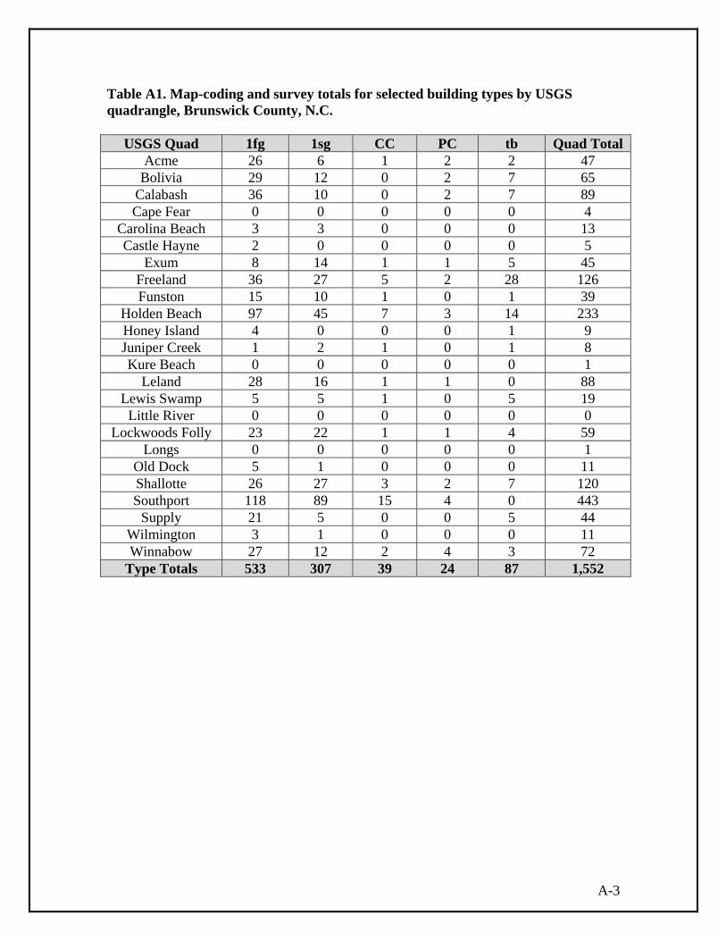
A-3
Table A1. Map-coding and survey totals for selected building types by USGS quadrangle, Brunswick County, N.C.
USGS Quad 1fg 1sg CC PC tb Quad Total Acme 26 6 1 2 2 47
Bolivia 29 12 0 2 7 65 Calabash 36 10 0 2 7 89 Cape Fear 0 0 0 0 0 4
Carolina Beach 3 3 0 0 0 13 Castle Hayne 2 0 0 0 0 5
Exum 8 14 1 1 5 45 Freeland 36 27 5 2 28 126 Funston 15 10 1 0 1 39
Holden Beach 97 45 7 3 14 233 Honey Island 4 0 0 0 1 9 Juniper Creek 1 2 1 0 1 8 Kure Beach 0 0 0 0 0 1
Leland 28 16 1 1 0 88 Lewis Swamp 5 5 1 0 5 19
Little River 0 0 0 0 0 0 Lockwoods Folly 23 22 1 1 4 59
Longs 0 0 0 0 0 1 Old Dock 5 1 0 0 0 11 Shallotte 26 27 3 2 7 120 Southport 118 89 15 4 0 443
Supply 21 5 0 0 5 44 Wilmington 3 1 0 0 0 11 Winnabow 27 12 2 4 3 72
Type Totals 533 307 39 24 87 1,552


B-1
Appendix B Brunswick County Historic Photographs
The following list provides information on original historic photographs encountered during fieldwork for the Comprehensive Historical/Architectural Site Survey of Brunswick County. The list provides owner/contact names and contact information and notes the general subject matter of the photographs. The list is arranged in the order of the site numbers assigned to properties using the system of the North Carolina State Historic Preservation Office (HPO). Note that in addition to photograph contacts listed here, there is good potential for members of families who have long-term associations with other surveyed properties to have photograph collections. BW0007: Brunswick County Courthouse, 201 E. Moore Street, Southport Contact: Mayor Robert D. Howard (910) 457-7900 Photo of courthouse mounted on wall of City Hall. BW0232: Goodman Farm, 340 Goodman Road NE Contact: Margaret Shelton (910) 253-5964 Photos of the farm and family. These photos have been published in Joy Hewett, “The Goodman Homestead: A Brunswick County Heritage,” Cape Fear Tidewater 2:9 (October 1985): 12-15. BW0243: New Hope Presbyterian Church, 800 Cherrytree Road NE Contact: Glenn Kye (910) 253-5311 Framed photos of church displayed inside. Historic photo also viewable online at the New Hope Presbyterian Church website, www.littlenewhopechurch.com. BW0397: Windy Point, 3819 Windy Point Road SW Contact: Scott Martin (910) 842-4600 or 616-8467 Framed photos of house and family photo album. BW0401: John and Berlyn Lancaster House, 800 block Turnpike Road SW Contact: Gwen Causey (910) 754-8445 or 470-8445 Drawing of house by Berlyn Lancaster BW0426: Goshen Baptist Church, 4124 Mount Misery Road NE Contact: Pastor Barbara Bell (910) 371-6899 Framed photos of church displayed inside. BW0427: James and Mary Rowell Farm, 4355 Mount Misery Road NE Contact: Nancy Lennon Clark, 4355 Mount Misery Road NE Reports that she has a photograph of her grandfather next to the dairy. Reports that the Samuel James Rowell Papers at Joyner Library, East Carolina University, has many historic photos related to the family.

B-2
BW0456: Bill and Alice Somersett House, 5211 South Main Street, Shallotte Contact: B. Joseph Causey (910) 755-6414 and Mary Benton Framed photo of house, family photos. BW0472: Green and White Tourist Court, 3972 Business 17 East, Bolivia Contact: Ralph Beer (910) 392-1083 Postcard collection with views of motel. BW0478: Jack and Charlotte BradyHouse, 3004 Exum Road NW Contact: Rodney Brady (910) 287-5272 Photo of log tobacco barn. BW0487: George W. Holden Farm, 3869 Stone Chimney Road SW Contact: Cecil Holden (910) 842-6516 Framed photo of house. BW0576: Russ-Vereen Farm, 2943 Exum Road NW Contact: Pearly Vereen (910) 287-3210 Photo of farmhouse, photos of other historic properties in the Exum area. BW0582: (former) Brunswick Electric Membership Corporation Warehouse, 201 Village Road, Shallotte Contact: Ronald Hobbs (910) 754-4912 or (910) 754-8349 Old photo of BEMC in possession of family. BW0584: Freeland Post Office, 1701 Village Point Loop SW Contact: John Pigott (910) 754-2632 Photos of post office. Mr. Pigott and also Ronald Hobbs have photos of the former Tripp House that was located at Shallotte Point. BW0592: Hewett-Goley House, 1415 Shallotte Point Loop SW Contact: Lillian M. Gray (910) 754-8324 Photos of the Hewett-Goley House being moved, a photo of the former (?) Smith House near Ash, taken in the early twentieth century, other photos. BW0710: Wellington C. Howe House, 312 W. Saint George St., Southport Contact: Linda Murakata (910) 454-0134 Photos of house. General/other collections: J. Alan Holden, Mayor of Holden Beach, notes that John Q. Holden has many historic photographs of Holden Beach. Hope Thomas of Shallotte believes Holden may also have photographs of Shallotte. John Holden’s contact information is: 14584 San Pablo Drive North, Jacksonville, FL 32224 (904) 992-9411. Survey committee members Gwen Causey, Ronald Craig Hobbs, and Glenn Kye have collections of historic photographs as well as photographs of Brunswick County historic resources they have taken in recent decades. Roberta Brady at (910) 253-4886 has historic photographs of Waccamaw School and log auditorium.

C-1
Appendix C Brunswick County Surveyed Properties by Survey Site Number
The list is organized numerically by HPO assigned site number, which begins BW for Brunswick. All resources within the HPO survey database as of September 2010 appear, including properties documented as part of the 2009-2010 survey and previously surveyed resources that were not resurveyed. Table C1. Brunswick County Surveyed Properties
BW# Property Name and Location Town/Vicinity BW0001 Bald Head Island Lighthouse Bald Head Island 101 Lighthouse Wynd BW0002 Allen Graves Anderson Landing E sd Hwy 133 opp Orton Church Cupola (see file) BW0003 Cape Fear Lighthouse Complex Bald Head Island 700 Federal Road SE end of Smith Island @ Cape Fear BW0004 Fort Johnston and Officers' Quarters Southport 201 E. Bay Street 200 block between E. Bay and E. Moore streets BW0005 Orton Plantation Smithville E side jct of SR 1530 & SR 1529, down lane 0.8 mi BW0006 Saint Philip's Church Ruins Brunswick NC 130 off US 17 (Brunswick Co State Hist Site) BW0007 (former) Brunswick County Court House Southport 201 E. Moore Street BW0009 D. Adams House Southport 310 Brunswick Street BW0010 James J. Adkins House Southport 113 E. Bay Street BW0011 Adkins-Dosher House (DESTROYED) Southport 116 W. Bay Street BW0012 Adkins-Ruark House Southport 119 N. Lord Street BW0013 H. Aldredge House Southport 312 W. West Street BW0014 Charles Almgreen House Southport 316 W. West Street BW0015 (former) Amuzu Theatre (DESTROYED) Southport 109 N. Howe Street BW0016 Amuzu Theatre (second) Southport
111 N. Howe Street
BW0017 Avery House Southport 302 E. Bay Street

C-2
BW# Property Name and Location Town/Vicinity
BW0018 Bank of Southport Building Southport 112 E. Moore Street BW0019 Joseph A. Bell House Southport 210 N. Lord Street BW0020 Bell-Clemmons House Southport 313 E. Moore Street BW0021 Daniel Bender House Southport 109 W. Nash Street BW0022 Richard Bensalt [Bensell] House Southport 120 W. Nash Street BW0023 Samuel Brinkman House Southport 110 N. Caswell Avenue BW0024 Brinkman-Lingle House Southport 114 W. Nash Street BW0025 Brunswick County Jail (former) Southport 318 E. Nash Street alternate address: 320 E. Nash St. BW0026 Brunswick Inn Southport 301 E. Bay Street BW0027 Belvidere Plantation Belville Near jct of 17-74-76 & River Rd, 2 mi E of Wilmington BW0028 Brunswick Inn Annex Southport 114 S. Davis Street BW0029 Bryant-Davis House (DESTROYED) Southport 208 N. Rhett Street BW0030 Commercial Building Southport 315 E. Nash Street BW0031 Grey Burriss House Southport 410 Brunswick Street BW0032 James A. Burriss House Southport 110 W. Nash Street BW0033 John Burriss House Southport 111 N. Caswell Avenue BW0034 Joseph N. Burriss House Southport 503 W. West Street BW0035 W.G. Butler House Southport 422 W. West Street BW0036 Carolina House (DESTROYED) Southport 102 W. Bay Street

C-3
BW# Property Name and Location Town/Vicinity
BW0037 Carr House Southport 315 E. Moore Street BW0038 Thomas Carr House Southport 112 Dry Street BW0039 E. Moore Commercial Block, part A Southport 104 E. Moore Street BW0040 Maxie Cooker House Southport 316 Brunswick Street BW0041 Harry Corlett House Southport 206 W. Bay Street BW0042 Melvin Craig House Southport 108 N. Lord Street BW0043 Sterling F. Craig House Southport 112 N. Caswell Avenue BW0044 E.H. Cranmer House Southport 318 N. Atlantic Avenue BW0045 Henry Daniel House Southport 216 W. Nash Street BW0046 J.N. Daniel House Southport 214 W. Nash Street BW0047 Dunbar Davis House Southport 103 N. Caswell Avenue BW0048 George Davis House Southport 421 W. West Street BW0049 Mary C. Davis House Southport 110 N. Atlantic Avenue BW0050 Rob Davis House Southport 202 W. Bay Street BW0051 Will S. Davis House Southport 307 Brunswick Street BW0052 Asa Dosher House Southport 210 W. West Street BW0053 George Dosher House Southport 216 W. West Street BW0054 Richard Dosher Cottage #1 Southport 111 N. Davis Street BW0055 Richard Dosher House Southport 106 W. Bay Street

C-4
BW# Property Name and Location Town/Vicinity
BW0056 Richard Dosher, Sr. House Southport 112 N. Lord Street BW0057 Dosher-Erikson House Southport 414 W. West Street BW0058 Drew-Jorgensen House Southport 202 W. West Street BW0059 Drew-Platt House Southport 309 E. Moore Street BW0060 Wilson Edwards House (DESTROYED) Southport 107 N. Lord Street BW0061 Evans-Mckenzie House Southport 312 E. West Street BW0062 Fargusson House Southport 111 Fort Johnston Place BW0063 W.R. Ferguson House Southport 301 E. West Street BW0064 Amanda Foley Cottage Southport 114 N. Atlantic Avenue BW0065 Foley-Hood House Southport 301 E. Moore Street BW0066 Fort Johnston Hospital (former) Southport 413 E. Bay Street BW0067 Frink-Cotten House Southport 313 E. Bay Street BW0068 Frying Pan Lightship (MOVED to VA) Southport BW0069 Tucker Fulcher House Southport 316 N. Atlantic Avenue BW0070 Price Furpless House Southport 207 N. Caswell Avenue BW0071 T. Gall House Southport 312 Brunswick Street BW0072 Galloway House Southport 204 N. Rhett Street BW0073 Garcia-Smith-Pullan House Southport 233 E. Bay Street BW0074 Garcia-Swann House Southport 113 W. Nash Street BW0075 Garrison-Potter House Southport 404 Brunswick Street

C-5
BW# Property Name and Location Town/Vicinity
BW0076 Gause Building Southport 113 S. Howe Street BW0077 Grimes House Southport 237 E. Bay Street BW0078 M.C. Guthrie House Southport 108 Dry Street BW0079 Tom Harper Cottage Southport 402 E. Moore Street BW0080 Harper-Newbold House Southport 405 E. Bay Street BW0081 Harper-Northrup Building Southport 111 E. Moore Street BW0082 Harrelson House [DESTROYED] Southport 109 Kingsley BW0083 W.T. Haskitt House Southport 219 N. Lord Street BW0084 Hood Building Southport 129 E. Moore Street BW0085 House Southport 111 N. Atlantic Avenue BW0086 House Southport 118 N. Atlantic Avenue BW0087 Hewit-Wescott House Southport 119 N. Atlantic Avenue BW0088 House Southport 120 N. Atlantic Avenue BW0089 Wescott House Southport 310 N. Atlantic Avenue BW0090 White House Southport 312 N. Atlantic Avenue BW0091 House Southport 112 W. Bay Street BW0092 House Southport 114 W. Bay Street BW0093 McKeithan Homestead Southport 318 Brunswick Street BW0094 Theodore McKeithan House Southport 319 Brunswick Street BW0095 House Southport 322 Brunswick Street

C-6
BW# Property Name and Location Town/Vicinity
BW0096 House (DESTROYED) Southport 5-- Brunswick Street 3rd house west of Short BW0097 House Southport 105 N. Caswell Avenue BW0098 House Southport 203 N. Caswell Avenue
BW0099 House Southport 215 N. Caswell Avenue BW0100 House Southport 217 N. Caswell Avenue BW0101 Houses Southport 217 N. Howe Street BW0102 House Southport 308 E. Nash Street BW0103 House Southport 310 E. Nash Street BW0104 House Southport 307 E. Nash Street BW0105 Ruark-Potter House Southport 106 W. West Street BW0106 Jacob Brinkman Cottage Southport 114 W. West Street BW0107 Jones-Burriss House Southport 116 W. West Street BW0108 W. Thompson House Southport 231 N. Caswell Avenue BW0109 Hubbard House Southport 216 N. Atlantic Avenue BW0110 Hudgins House Southport 518 Brunswick Street BW0111 Michael Isenberg House Southport 105 N. Lord Street BW0112 R.P. Jackson House Southport 108 N. Caswell Avenue BW0113 Thomas Jones House Southport 302 Dry Street BW0114 Kincaid House Southport 208 N. Lord Street BW0115 Lambeth House Southport 409 E. Bay Street

C-7
BW# Property Name and Location Town/Vicinity
BW0116 Larsen House Southport 306 N. Atlantic Avenue BW0117 S.W. Lehew House Southport 112 E. Nash Street BW0118 Lewis-Walton House Southport 305 E. West Street BW0119 McDonald-Pait House Southport 313 E. West Street BW0120 Clint C. McKeithan House Southport 306 E. West Street BW0121 John W. McKeithan House Southport 504 Brunswick Street BW0122 Moses McKeithan House Southport 502 Brunswick Street BW0123 R.W. McKeithan House Southport 119 N. Davis Street BW0124 McKeithan-Clunk House Southport 114 S. Howe Street BW0125 McKeithan-Ford House Southport 209 Short Street BW0126 Michael Madigan House Southport 416 Brunswick Street BW0127 Masonic Lodge Southport 201 E. Nash Street BW0128 (former) Methodist Parsonage Southport 315-1/2 E. Nash Street BW0129 Henry Mintz House Southport 113 W. West Street BW0130 Benjamin F. Newton House Southport 207 N. Lord Street BW0131 John R. Newton House Southport 308 W. West Street BW0132 Julius Newton House Southport 114 W. Moore Street BW0133 Walker Newton House Southport 120 W. Moore Street BW0134 Newton-Daniel House Southport 106 W. Nash Street

C-8
BW# Property Name and Location Town/Vicinity
BW0135 Newton-McKeithan House Southport 209 N. Lord Street BW0136 Newton-Pinner House Southport 214 N. Lord Street BW0137 Norment House Southport 206 W. Nash Street BW0138 (Former) Northrup Funeral Home Southport 212 N. Caswell Avenue BW0139 Northrup House Southport 229 N. Caswell Avenue BW0140 James Pearce House Southport 406 Brunswick Street BW0141 Lewis Pepper House Southport 110 W. Bay Street 110 W Bay St BW0142 James Pinner House Southport 120 W. West Street BW0143 Jesse Price House Southport 320 N. Atlantic Avenue BW0144 Quarantine Office Southport 306 E. Bay Street BW0145 John Ramseur House Southport 314 E. Moore Street BW0146 River Pilot's Tower Southport 111 W. Bay Street BW0147 Robbins-Chadbourne House Southport 115 E. Bay Street BW0148 Robbins-Gause House Southport 102 W. Nash Street BW0149 C.G. Ruark Store (DESTROYED) Southport 113 N. Howe Street BW0150 Hanson Ruark House Southport 306 W. Moore Street BW0151 J.B. Ruark House Southport 307 E. Moore Street BW0152 Wade Ruark House Southport 214 W. West Street BW0153 Ruark-Small House Southport 230 E. Moore Street BW0154 Thomas Saint George House Southport 111 N. Lord Street
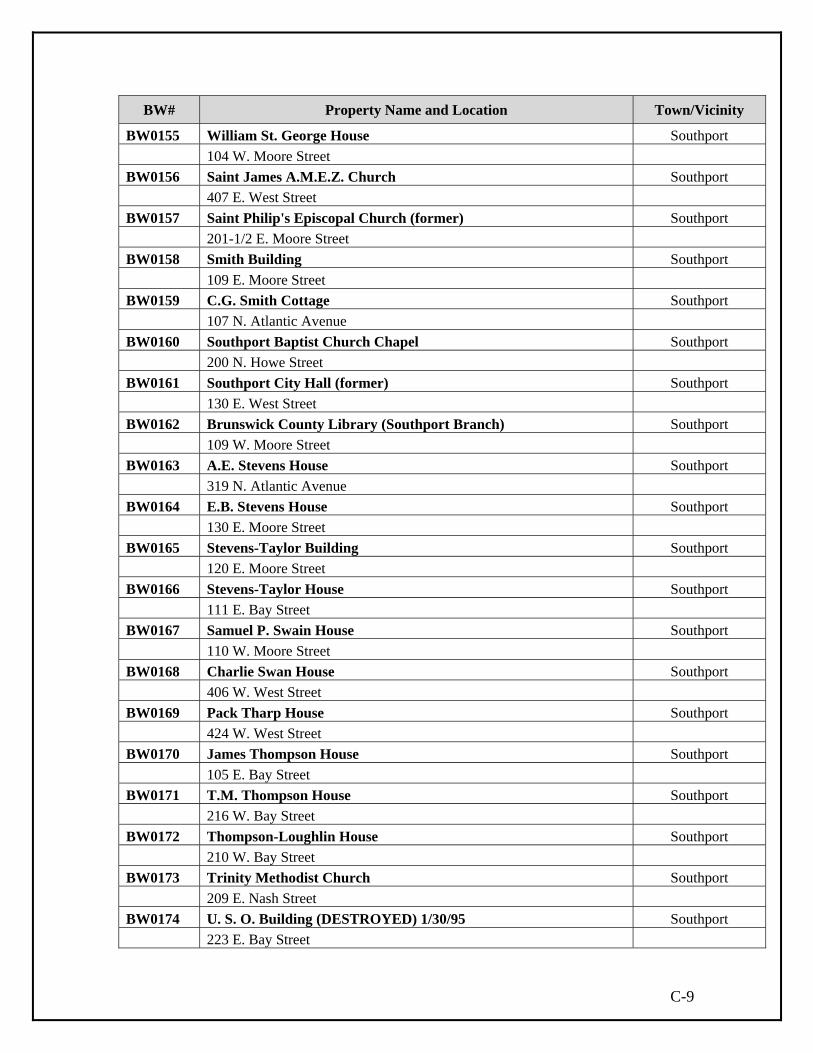
C-9
BW# Property Name and Location Town/Vicinity
BW0155 William St. George House Southport 104 W. Moore Street BW0156 Saint James A.M.E.Z. Church Southport 407 E. West Street BW0157 Saint Philip's Episcopal Church (former) Southport 201-1/2 E. Moore Street BW0158 Smith Building Southport 109 E. Moore Street BW0159 C.G. Smith Cottage Southport 107 N. Atlantic Avenue BW0160 Southport Baptist Church Chapel Southport 200 N. Howe Street BW0161 Southport City Hall (former) Southport 130 E. West Street BW0162 Brunswick County Library (Southport Branch) Southport 109 W. Moore Street BW0163 A.E. Stevens House Southport 319 N. Atlantic Avenue BW0164 E.B. Stevens House Southport 130 E. Moore Street BW0165 Stevens-Taylor Building Southport 120 E. Moore Street BW0166 Stevens-Taylor House Southport 111 E. Bay Street BW0167 Samuel P. Swain House Southport 110 W. Moore Street BW0168 Charlie Swan House Southport 406 W. West Street BW0169 Pack Tharp House Southport 424 W. West Street BW0170 James Thompson House Southport 105 E. Bay Street BW0171 T.M. Thompson House Southport 216 W. Bay Street BW0172 Thompson-Loughlin House Southport 210 W. Bay Street BW0173 Trinity Methodist Church Southport 209 E. Nash Street BW0174 U. S. O. Building (DESTROYED) 1/30/95 Southport 223 E. Bay Street

C-10
BW# Property Name and Location Town/Vicinity
BW0175 Post Office Building (former) Southport 122 E. Moore Street BW0176 Post Office (former) Southport 115 E. Moore Street BW0177 Waccamaw Bank Building (former) Southport 104 S. Howe Street BW0178 Walker-Pyke House Southport 239 E. Bay Street BW0179 Watson's Pharmacy Southport 110 E. Moore Street BW0180 Watson-Formy-Duval House Southport 105 E. West Street BW0181 Watts House Southport 402 W. West Street BW0182 Jesse Weeks House Southport 308 W. Moore Street BW0183 Julius Weeks House Southport 312 W. Moore Street BW0184 Wells House Southport 120 W. Bay Street BW0185 J.L. Wescott House (DESTROYED) Southport 114 E. Moore Street BW0186 J.A. Williams House Southport 202 W. Nash Street BW0187 Willing House Southport 110 S. Lord Street BW0188 Nathan Windsor House Southport 205 E. West Street BW0189 Robert T. Woodside House Southport 404 W. West Street BW0190 Woodside-Bryant House Southport 211 N. Caswell Avenue BW0191 E.G. Daniels House Southport 612 N. Atlantic Avenue BW0192 Dopp House Southport 405 N. Atlantic Avenue BW0193 Harry Dosher House Southport 614 N. Atlantic Avenue BW0194 Bell-Fulcher-Lewis House Southport 308 Dry Street
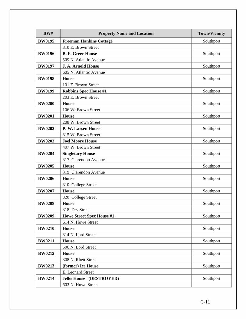
C-11
BW# Property Name and Location Town/Vicinity
BW0195 Freeman Hankins Cottage Southport 310 E. Brown Street BW0196 B. F. Greer House Southport 509 N. Atlantic Avenue BW0197 J. A. Arnold House Southport 605 N. Atlantic Avenue BW0198 House Southport 101 E. Brown Street BW0199 Robbins Spec House #1 Southport 203 E. Brown Street BW0200 House Southport 106 W. Brown Street BW0201 House Southport 208 W. Brown Street BW0202 P. W. Larsen House Southport 315 W. Brown Street BW0203 Joel Moore House Southport 407 W. Brown Street BW0204 Singletary House Southport 317 Clarendon Avenue BW0205 House Southport 319 Clarendon Avenue BW0206 House Southport 310 College Street BW0207 House Southport 320 College Street BW0208 House Southport 318 Dry Street BW0209 Howe Street Spec House #1 Southport 614 N. Howe Street BW0210 House Southport 314 N. Lord Street BW0211 House Southport 506 N. Lord Street BW0212 House Southport 308 N. Rhett Street BW0213 (former) Ice House Southport E. Leonard Street BW0214 Jelks House (DESTROYED) Southport 603 N. Howe Street

C-12
BW# Property Name and Location Town/Vicinity
BW0215 Johnson-Griffin House Southport 319 Burrington Avenue BW0216 Mount Carmel Church Southport 501 N. Lord Street BW0217 Perry Reaves House (DESTROYED) Southport 103 W. Saint George Street BW0218 Standard Oil Garage Southport 310 N. Howe Street BW0219 Ed Swain House Southport 116 W. Saint George Street BW0220 L. Swain House Southport 110 W. Saint George Street BW0221 Swasey Cottage Southport 320 N. Lord Street BW0222 T.B. McClintic Shallotte Point Tripp's Marina BW0223 Bethel United Methodist Church Bolivia 3909 Business 17 East BW0224 Cape Fear Coast Guard Life Saving Station Smith Island BW0225 Carolina Power & Light Co. Nuclear Plant Southport BW0226 Cemetery (Shell) Grissettown N side NC 179 & NC 904 0.1 mi E of jct w/ SR 1232 BW0227 Clarendon Plantation Winnabow 2260 River Road SE NC 133 5 miles S of Belville BW0228 Concord Methodist Church Supply 247 Southport Supply Road SW S cor jct of NC 211 & SR 1115 BW0229 Farmstead Smith Island BW0230 Fort Caswell Historic District Fort Caswell At end of BW0231 Fort Holmes (DESTROYED) Smith Island BW0232 Goodman Farm Winnabow 340 Goodman Road NE NE sd SR 1414 .8 mi NW of NC 17 BW0233 Green Swamp Supply 9 mi N of town of Supply BW0234 Hickory Hall Calabash
10055 Beach Drive S side NC 179 .5 mi E of jct w/ SR 1168, .2 mi down ln
BW0235 Erastus G. Goodman Hotel Lanvale NE side SR 1700 opp jct w/ SR 1415
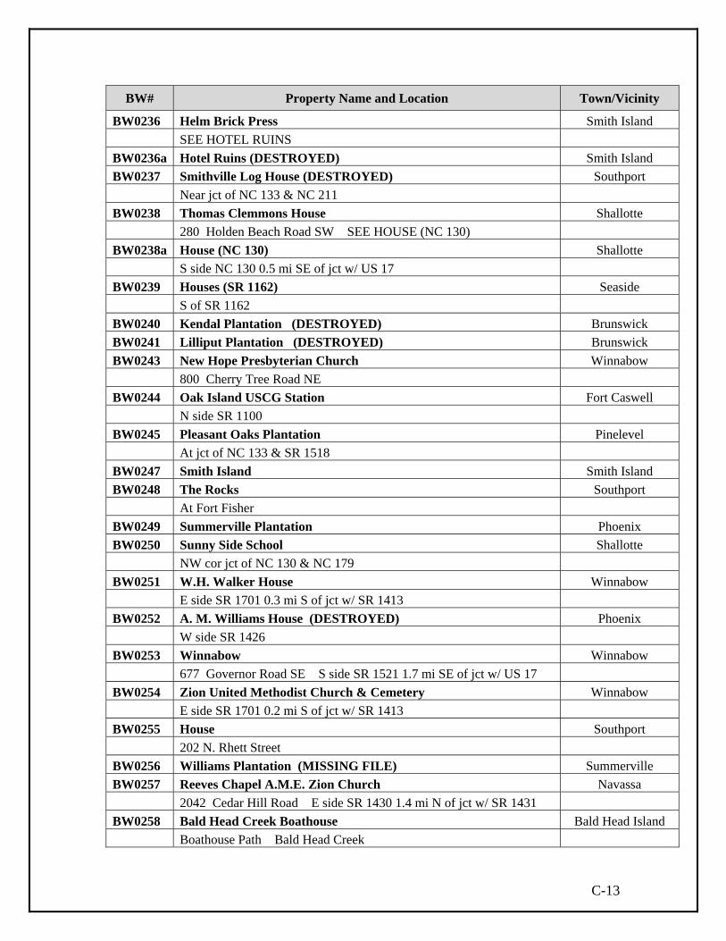
C-13
BW# Property Name and Location Town/Vicinity
BW0236 Helm Brick Press Smith Island SEE HOTEL RUINS BW0236a Hotel Ruins (DESTROYED) Smith Island BW0237 Smithville Log House (DESTROYED) Southport Near jct of NC 133 & NC 211 BW0238 Thomas Clemmons House Shallotte 280 Holden Beach Road SW SEE HOUSE (NC 130) BW0238a House (NC 130) Shallotte S side NC 130 0.5 mi SE of jct w/ US 17 BW0239 Houses (SR 1162) Seaside S of SR 1162 BW0240 Kendal Plantation (DESTROYED) Brunswick BW0241 Lilliput Plantation (DESTROYED) Brunswick BW0243 New Hope Presbyterian Church Winnabow 800 Cherry Tree Road NE BW0244 Oak Island USCG Station Fort Caswell N side SR 1100 BW0245 Pleasant Oaks Plantation Pinelevel At jct of NC 133 & SR 1518 BW0247 Smith Island Smith Island BW0248 The Rocks Southport At Fort Fisher BW0249 Summerville Plantation Phoenix BW0250 Sunny Side School Shallotte NW cor jct of NC 130 & NC 179 BW0251 W.H. Walker House Winnabow E side SR 1701 0.3 mi S of jct w/ SR 1413 BW0252 A. M. Williams House (DESTROYED) Phoenix W side SR 1426 BW0253 Winnabow Winnabow 677 Governor Road SE S side SR 1521 1.7 mi SE of jct w/ US 17 BW0254 Zion United Methodist Church & Cemetery Winnabow E side SR 1701 0.2 mi S of jct w/ SR 1413 BW0255 House Southport 202 N. Rhett Street BW0256 Williams Plantation (MISSING FILE) Summerville BW0257 Reeves Chapel A.M.E. Zion Church Navassa 2042 Cedar Hill Road E side SR 1430 1.4 mi N of jct w/ SR 1431 BW0258 Bald Head Creek Boathouse Bald Head Island Boathouse Path Bald Head Creek

C-14
BW# Property Name and Location Town/Vicinity
BW0364 Goley Building Shallotte 4802 Main Street BW0365 Shrub Hill Plantation Winnabow 678 Cherrytree Road NE BW0366 Wilmington, Brunswick and Southern Brunswick Station Winnabow Brave Venture Drive NE N. side Bell Swamp Rd. 0.65 mi. W. of US17 BW0367 Mill Creek Academy Bolivia 1141 Old Mill Creek Road SE BW0368 W. Walker Willetts House Winnabow 850 George II Hwy. SE BW0369 Farm Winnabow 6130 Best Farm Road NE BW0370 Lancaster-Roach House Varnamtown 2985 Stone Chimney Road SW BW0371 Swain Farm Varnamtown 208 Varnamtown Road BW0372 Taft Clemmons House and Store Supply vicinity 880 Taft Road SW BW0373 Phelps House Supply vicinity 1246 Stone Chimney Road SW BW0374 House Varnamtown 2394 Vermont Lane SW BW0375 H. D. and Margaret Parrish House Varnamtown 916 Stanbury Road SW BW0376 Garland's Fish House Varnamtown 2 Fisherman Road BW0377 Riley and Delphia Hewett House Varnamtown 1885 Turkey Trap Road SW
BW0378 Riley Hewett Cemetery Between Supply &
Varnamtown
Turkey Trap Road SW E. side SR1181 0.4 mi. S. of jct. w/ SR1125 in Cedar Grove Community
BW0379 Harry and Annie Bryant House Between Supply &
Varnamtown 1909 Stone Chimney Road SW BW0380 Boyd House Shallotte Point 3959 Boyd Drive SW BW0381 Elijah Pigott House Shallotte Point 1600 Village Point Road SW BW0382 House Shallotte Point 3967 Boyd Drive SW

C-15
BW# Property Name and Location Town/Vicinity
BW0383 House Shallotte Point
1592 Village Point Road SW
BW0384 Charlotte P. Tripp House Shallotte Point
3993 Boyd Drive SW
BW0385 Charles and Mae Grubb House Shallotte Point
1545 Shady Rest Place SW
BW0386 Bloodgood House Shallotte Point 1773 Village Point Road SW
BW0387 Village Point United Methodist Church Shallotte Point 1392 Village Point Road SW BW0388 Tar Kiln Shallotte Point
Copas Road SW N. side Copas Rd. (SR 1191) 1.0 mi. E. of jct. w/ SR 1145
BW0389 William and Sarah Rourk House Shallotte 422 Village Road BW0390 Sam Phelps House Varnamtown
1404 Stanley Road SW N. side Stanley Rd. (SR 1119) 0.25 mi. E. of jct. w/ SR 1126
BW0391 Building Varnamtown
1700 block Stanley Road SW E. side Stanley Rd. (SR 1119) 0.2 mi. N. of jct. w/ SR 1125
BW0392 Jehu Sermon House Varnamtown
900 block Cedar Grove Road SW N. side Cedar Grove Rd. (SR 1125) 0.2 mi. W. of jct. w/ SR 1119
BW0393 Fulford House Holden Beach 2920 Holden Beach Road SW BW0394 House Holden Beach
2374 Boones Neck Road SW N. side SR 1137 0.45 mi. E. of jct. w/ SR 1140
BW0395 House Holden Beach
2500 block Boones Neck Road SW N. side SR 1137 0.3 mi. E. of jct. w/ SR 1140
BW0396 House Holden Beach
2300 block Oxpen Road SW W. side SR 1140 0.1 mi. N. of jct. w/ SR 1137
BW0397 Windy Point Holden Beach 3819 Windy Point Road SW At W. end of SR 1137 at Long Point BW0398 Silent Grove Cemetery Holden Beach Oxpen Road SW S. side of jct. of SR 1140 and NC 130

C-16
BW# Property Name and Location Town/Vicinity
BW0399 House Shallotte vicinity
2122 Empire Road SW
BW0400 Woody's Store Shallotte vicinity
1100 block Holden Beach Road SW W. side NC 130 0.1 mi. N. of jct. w/ SR 1132
BW0401 John and Berlyn Lancaster House Supply vicinity
800 block Turnpike Road SW N. side SR 1129 0.7 mi. NE of jct. w/ SR 1130
BW0402 St. Thomas Cemetery Belville vicinity
Chappell Loop SE N. side SR 1524 0.7 mi. S. of jct. w/ Old US 17
BW0403 Blackwell Chapel A.M.E. Zion Church Belville vicinity
10051 Blackwell Road SE BW0404 Claude and Elizabeth Baldwin House Leland 218 Village Road BW0405 Gause Tomb Ocean Isle Beach E. side Hale Swamp Rd. 0.25 mi. N. of jct. w/ NC 179 BW0406 Rufus Brown House Gause Landing 1735 Gause Landing Road SW BW0407 Shady Park Service Station Shallotte 4718 Main Street BW0408 Shallotte Theatre Shallotte 4733 Main Street BW0409 Stanland-White House Shallotte 4745 Main Street BW0410 Jackson and Minnie Stanland House Shallotte 4700 block Main Street BW0411 Shallotte Hardware Sandy Creek 4757 Main Street BW0412 Gause Cemetery Sunset Beach
1700 block Seaside Road SW W. side Seaside Rd. 0.1 mi. S. of jct. of NC 179 and NC 904
BW0413 Cox House Gause Landing 1667 Gause Landing Road SW BW0414 St. Mark A.M.E. Zion Church Shallotte
Brick Landing Road SW SW side jct. of Village Point Rd. and Brick Landing Rd.
BW0415 Chapel Hill Cemetery Shallotte N. side Ocean Highway (US17) at the jct. w/ Red Bug Rd. SW

C-17
BW# Property Name and Location Town/Vicinity
BW0416 Pierson Dunbar Store Shallotte
5790 Washington Road SW
BW0417 Mt. Calvary Cemetery Navassa
N. side Cedar Hill Rd. (SR 1430) 0.3 mi. N. of jct. w/ SR 1435
BW0418 Mears Cemetery Navassa
Davis Creek Drive NE N. side Cedar Hill Rd. (SR 1430) 0.8 mi. E. of jct. w/ SR 1431
BW0419 Samuel and Harriet Williams House Navassa
315 Main Street
BW0420 Gaston and Lonnie Waddell House Navassa
313 Main Street
BW0421 Pride of Navassa Lodge #790 Navassa
322 Main Street
BW0422 John and Mary Thomas House Navassa 803 Pine Valley Drive BW0423 Warren and Ella Williams House Leland 1664 Leland School Road NE BW0424 Stuarts Store Navassa 3204 Mount Misery Road NE BW0425 Scoggins Store Navassa
Mount Misery Road NE N. side SR 1426 1.5 mi. N. of jct. w/ SR 1430
BW0426 Goshen Baptist Church Navassa 4124 Mount Misery Road NE BW0427 James and Mary Rowell Farm Northwest 4355 Mount Misery Road NE BW0428 Harry and Vera Peterson Farm Northwest 4514 Mount Misery Road NE BW0429 All Souls Episcopal Church Northwest 5087 Blue Banks Loop Road NE BW0430 Sykes Farm Northwest 5836 Woodman Circle NE BW0431 Gaylord House Northwest 5808 Goose Neck Road NE BW0432 House Northwest 4680 Northwest Road

C-18
BW# Property Name and Location Town/Vicinity
BW0433 House Leland
1399 Old Fayetteville Road NE
BW0434 Winnabee Masonic Lodge #786 Shallotte
1649 Ocean Hwy W
BW0435 Ivan and Muriel Bennett Farm Exum
5014 Big Neck Road NW
BW0436 Tobacco Barn Ash
4195 Babson Road NW W. side Babson Rd. 0.35 mi. NW of jct. w/ SR 1330 at Wac. School
BW0437 Simmons Pack House Ash
Ash Little River Road NW N. side SR 1300 0.05 mi. W. of jct. w/ US 130
BW0438 Simmons Store and Ash Post Office Ash
Whiteville Road NW W. side US 130 0.05 mi. N. of jct. w/ SR 1300
BW0439 Ross-Smith Farm Ash
5160 New Britton Loop Road NW W. side SR 1327 0.75 mi. S, of jct. w/ SR 1333
BW0440 Christopher C. King Farm Ash
5810 Old King Road NW BW0441 Ross Farm Ash
4990 New Britton Loop Road NW W. side SR 1327 0.65 mi. S. of jct. w/ SR 1326
BW0442 Raleigh and Carrie Babson House Ash 4412 Whiteville Road NW BW0443 Louis and Rose Evans House Ash
4300 block Whiteville Road NE, side US 130 0.25 mi. N. of jct. w/ SR 1300
BW0444 Liston Babson Pack House Ash
5900 block Simmons Road NW S. side SR 1328 in SE corner of jct. w/ SR 1329
BW0445 Solon Smith House Ash
4800 block Project Road NW W. side SR 1333 0.2 mi. N. of the jct. w/ SR 1337
BW0446 Frank and Madge Inman Farm Ash 4915 Project Road NW BW0447 House Ash 5560 Cox Road NW
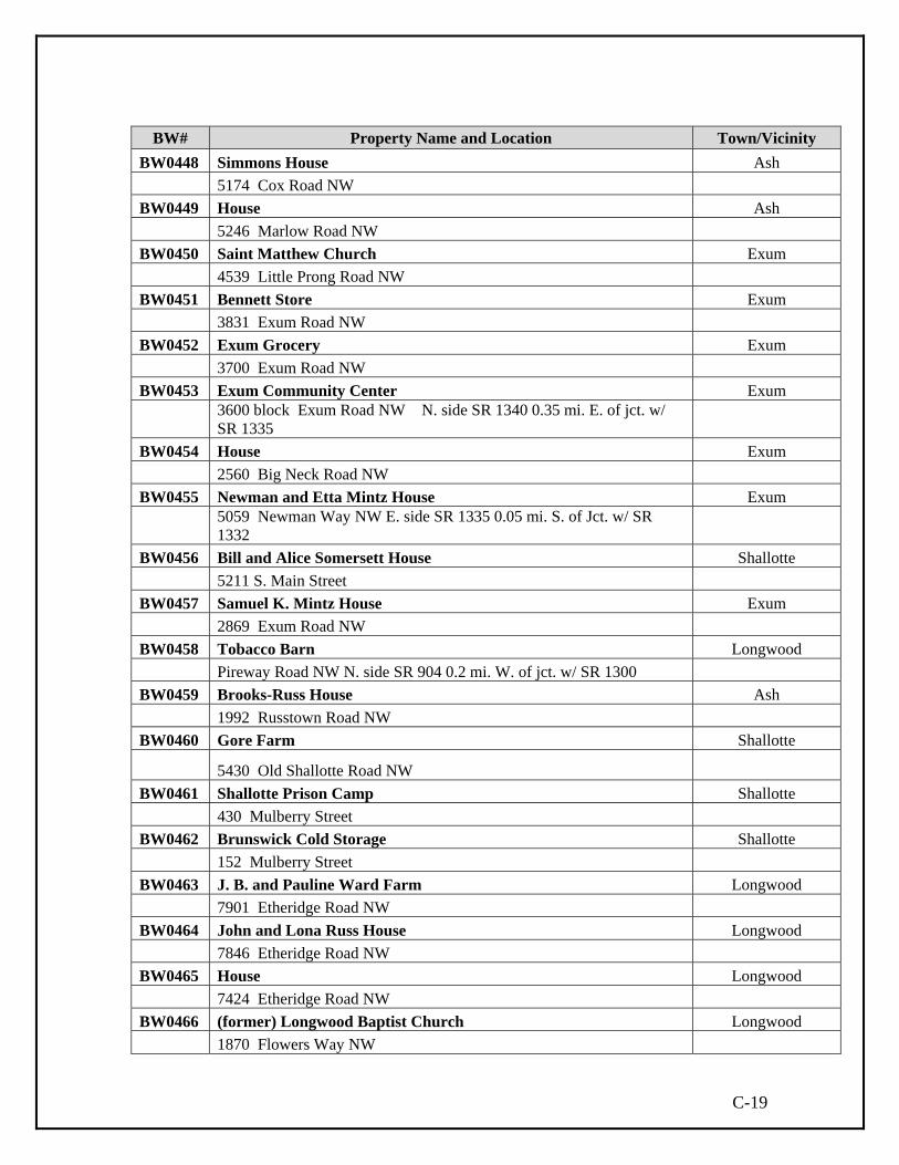
C-19
BW# Property Name and Location Town/Vicinity
BW0448 Simmons House Ash 5174 Cox Road NW BW0449 House Ash 5246 Marlow Road NW BW0450 Saint Matthew Church Exum 4539 Little Prong Road NW BW0451 Bennett Store Exum 3831 Exum Road NW BW0452 Exum Grocery Exum 3700 Exum Road NW BW0453 Exum Community Center Exum
3600 block Exum Road NW N. side SR 1340 0.35 mi. E. of jct. w/ SR 1335
BW0454 House Exum 2560 Big Neck Road NW BW0455 Newman and Etta Mintz House Exum
5059 Newman Way NW E. side SR 1335 0.05 mi. S. of Jct. w/ SR 1332
BW0456 Bill and Alice Somersett House Shallotte 5211 S. Main Street BW0457 Samuel K. Mintz House Exum 2869 Exum Road NW BW0458 Tobacco Barn Longwood Pireway Road NW N. side SR 904 0.2 mi. W. of jct. w/ SR 1300 BW0459 Brooks-Russ House Ash 1992 Russtown Road NW BW0460 Gore Farm Shallotte
5430 Old Shallotte Road NW BW0461 Shallotte Prison Camp Shallotte 430 Mulberry Street BW0462 Brunswick Cold Storage Shallotte 152 Mulberry Street BW0463 J. B. and Pauline Ward Farm Longwood 7901 Etheridge Road NW BW0464 John and Lona Russ House Longwood 7846 Etheridge Road NW BW0465 House Longwood 7424 Etheridge Road NW BW0466 (former) Longwood Baptist Church Longwood 1870 Flowers Way NW

C-20
BW# Property Name and Location Town/Vicinity BW0467 (former) Supply Baptist Church Supply 28 Blanton Road SE BW0468 Southport Historic District Expansion Study Area Southport BW0469 McKeithan House Winnabow 340 block Goodman Road NE BW0470 Willetts and Son Motor Sales Bolivia 3865 Business 17 East BW0471 House Bolivia 100 Wilson Street BW0472 Green and White Tourist Court Bolivia 3972 Business 17 East BW0473 C. P. and Hattie Willetts House Bolivia 3904 Business 17 East BW0474 Galloway House Bolivia 1270 Gilbert Road SE BW0475 J. M. Parker and Sons Supply 2 Ocean Hwy W BW0476 John J. Knox House Winnabow 7941 Ocean Hwy E BW0477 William and Kate Mintz House Exum 3536 Big Neck Road NW BW0478 Jack and Charlotte Brady House Exum 3004 Exum Road NW BW0479 Charles and Mary Hemingway House Shallotte 339 Mulberry Street BW0480 W. A. Frink House Shallotte
120 Shallotte Avenue BW0481 Bailey and Edna Russ House Shallotte 4700 Shallotte Avenue BW0482 Bolivia Lookout Tower Bolivia Old Ocean Hwy SE BW0483 Bridger-Lineberger Clubhouse Gause Landing 6369 Mazelle Trail SW BW0484 Lee and Sade Pigott House Gause Landing 1695 Gause Landing Road SW BW0485 Elbert Pigott House Gause Landing 1725 Gause Landing Road SW BW0486 House Gause Landing 1668 Gause Landing Road SW

C-21
BW# Property Name and Location Town/Vicinity
BW0487 George W. Holden Farm Varnamtown 3869 Stone Chimney Road SW BW0488 Service Station Belville 155 Main Street BW0489 House Belville Main Street BW0490 Motel Belville Main Street BW0491 Service Station Leland 1712 Fletcher Road NE BW0492 Kranke House Leland 1531 Lincoln Road BW0493 Gainey House Leland 1547 Lincoln Road BW0494 New Hope Baptist Church of Leland Navassa 2727 Mount Misery Road NE BW0495 Clarence Alston House Navassa 708 Park Avenue BW0496 Waddell-Lofton House Navassa 331 Main Street BW0497 Pleasant View Cemetery Sunset Beach Old Georgetown Road BW0498 Frink Cemetery Sunset Beach Old Georgetown Road SW BW0499 Camp Branch Missionary Baptist Church Honey Island 90 Camp Branch Road NW BW0500 Davis Building Shallotte 103 Wall Street BW0501 R. E. Bellamy Hardware Shallotte 4810 Main Street BW0502 Mintz Building Shallotte
4806 Main Street BW0503 House Holden Beach 109 Ocean Blvd E BW0504 House Holden Beach 122 Ocean Blvd E BW0505 House Holden Beach 182 Ocean Blvd E

C-22
BW# Property Name and Location Town/Vicinity
BW0506 House Holden Beach 186 Ocean Blvd E BW0507 House Holden Beach 188 Ocean Blvd E BW0508 House Holden Beach 198 Ocean Blvd E BW0509 House Holden Beach 200 Ocean Blvd E BW0510 House Holden Beach 202 Ocean Blvd E BW0511 House Holden Beach 204 Ocean Blvd E BW0512 House Holden Beach 194 Ranger Street BW0513 House Holden Beach 195 Ranger Street BW0514 Farm Calabash 500 Shingletree Road NW BW0515 Parker Store Calabash 7102 Ocean Hwy W BW0516 Building Calabash 9660 Ocean Hwy W BW0517 Hughes Building Calabash
2611 Ash Little River Road NW W. side SR 1300 3.4 mi. N. of jct. w/ SR 1301
BW0518 Philadelphia Wesleyan Church Calabash 1994 Ash Little River Road NW BW0519 Ward Cemetery Longwood Daniel Butler Road NW BW0520 Shallotte Lookout Tower Shallotte 1165 Whiteville Road NW BW0521 (former) Sharon United Methodist Church Shallotte
1100 block Holden Beach Road SW BW0522 House Sunset Harbor 3879 Point Road SE BW0523 Weston and Irene Evans Pack House Supply N. side SR 1341 2.0 mi. W. of jct/ w/ US 211 BW0524 Ottaway House Winnabow 7353 Ocean Hwy E

C-23
BW# Property Name and Location Town/Vicinity
BW0525 Ev-Henwood Tar Kiln Winnabow 8132 Rock Creek Road NE BW0526 Tharp House Winnabow 249 Old Town Creek Road NE BW0527 Building Navassa Quality Drive BW0528 Peadrick-Maultsby Farm Winnabow 5125 Maultsby Road NE BW0529 T. B. Johnson House Winnabow 2280 Town Creek Road NE BW0530 House Winnabow 2177 Town Creek Road NE BW0531 Henry and Susan Zeblin House Winnabow 6836 Zion Church Road NE BW0532 Edwin and Theodocia Clemmons House Supply 944 Little Macedonia Road NW BW0533 Clay Branch Cemetery Supply 944 Little Macedonia Road NW BW0534 Mimi Holland House Winnabow 2747 River Road SE BW0535 Lebanon Baptist Church Funston 7342 Funston Road SE BW0536 John and Theresa Mintz House Shallotte 5320 Minta Lane NW BW0537 Driftwood Motel Oak Island 604 Ocean Drive BW0538 House Oak Island 1945 Fish Factory Road SE BW0539 Oak Island Pier Oak Island 705 Ocean Drive BW0540 House Oak Island
316 Sherrill Street BW0541 House Caswell Beach 701 Country Club Road BW0542 Wilmington, Brunswick and Southern Winnabow Depot Winnabow 129 Green Hill Road NE BW0543 Asa and Irene Henry House Winnabow
129 Green Hill Road NE

C-24
BW# Property Name and Location Town/Vicinity
BW0544 Corncrib Saint James 2397 Southport-Supply Road SE
BW0545 Boiling Spring Lake Dam Boiling Spring
Lakes Alton Lennon Drive BW0546 Navassa Railroad Bridge Navassa Quality Drive Seaboard Coast Line at Cape Fear River BW0547 Bridge Supply Middle River Road NE N. side SR 1448 0.75 mi. E. of jct. w/ SR 1400 BW0548 Moore’s Chapel A.M.E. Zion Church Belville River Road SE E. side SR 133 1.25 mi. N. of jct. w/ SR 1518 BW0549 Maude Gray House Exum 4690 Makatoka Road NW BW0550 George Ward House Longwood 7798 Pireway Road NW BW0551 Jesse Oliver House Ash 6869 Kingtown Road NW BW0552 Bethel Baptist Church Cemetery Southport E. side Bethel Rd. 0.65 mi. E. of jct. w/ River Rd. BW0553 Little-Evans Farm Exum 7249 Parker Road NW BW0554 William W. Drew Farm Winnabow 7883 Ocean Hwy East BW0555 House Belville 10255 Blackwell Road BW0556 Lum Wright House Ash Old King Road NW N. side SR 1326 0.15 mi. E. of jct. w/ NC 130 BW0557 Kendall Chapel Community Center Funston W. side NC 133 0.7 mi. S. of jct. w/ SR 1521 BW0558 Barn Funston W. side NC 133 0.9 mi. S. of jct. w/ SR 1521 BW0559 Old American Fish Company Southport
150 Yacht Basin Drive at southern terminus of street BW0560 Flava's Ice Cream Southport 318 W. Bay Street BW0561 Potter's Seafood Southport 90 Yacht Basin Drive BW0562 Seafood Booth Southport 96 Yacht Basin Drive

C-25
BW# Property Name and Location Town/Vicinity BW0563 Fishy Fishy Café Southport 100 Yacht Basin Drive BW0564 Tatum's Seafood, Ice, Bait and Fuel Southport 112 Yacht Basin Drive BW0565 Cape Fear Pilots' Association Office Southport 120 Yacht Basin Drive BW0566 The Shell Shop Southport 122 Yacht Basin Drive BW0567 Yacht Basin Provision Company Southport 130 Yacht Basin Drive BW0568 House Southport 422 Brunswick Street BW0569 House Southport 426 Brunswick Street BW0570 (former) Sacred Heart Catholic Church Southport 230 N. Caswell Avenue BW0571 House Southport 106 S. Lord Street BW0572 House Southport 211 N. Lord Street BW0573 Price Creek Beacon Southport N. side Price Ck. at Cape Fear River BW0574 Jesse and Bertha Little House Supply 129 Egypt Road NW BW0575 Daniel and Rosy Vereen House Exum 2734 Exum Road NW BW0576 Russ-Vereen House Exum 2943 Exum Road NW BW0577 Barney and Thelma Bennett Farm Exum 3605 Exum Road NW BW0578 Robert S. White Store Shallotte 4279 Main Street BW0579 Robert and Katie White House Shallotte
4748 Main Street BW0580 Chandler Rourk Store Shallotte 209 Village Road BW0581 Rourk House Shallotte 202 Village Road BW0582 (former) Brunswick Electric Membership Corporation Shallotte 201 Village Road

C-26
BW# Property Name and Location Town/Vicinity BW0583 Raleigh Phelps House Shallotte Point 1498 Village Point Road SW BW0584 Freeland Post Office Shallotte Point 1701 Village Point Loop SW BW0585 Store Ash vicinity 2598 Whiteville Road NW BW0586 George W. Piver House and Store Ash vicinity 2180 Whiteville Road NW BW0587 Randolph Long Store Ash vicinity 3997 Ash Little River Road NW BW0588 Purvis House Ash vicinity 5967 Waccamaw School Road NW BW0589 Lee Tolman House Ash vicinity 3316 Whiteville Road NW BW0590 Store Ocean Isle Beach 1593 Bricklanding Road SW BW0591 Hewett Outbuildings Ocean Isle Beach 1661 Bricklanding Road SW BW0592 Hewett-Goley House Shallotte Point 1415 Shallotte Point Loop SW BW0593 Pigott-Moffitt House Shallotte Point 1641 Cotton Patch Road SW BW0594 Wilson's Garage Ash 5180 Whiteville Road NW BW0595 Leland School Teacherage Leland 1508 Village Road BW0596 House Leland 1696 Village Road BW0597 Sunset Beach Swing Bridge Sunset Beach Sunset Blvd. crossing of Intracoastal Waterway BW0598 Tom Harper Cottage Southport 408 E. Moore Street BW0599 House Southport
108 S. Davis Street BW0600 (former) State Port Pilot Building Southport 105 S. Howe Street BW0601 Southport Antiques Southport 105 E. Moore Street BW0602 E. Moore Commercial Block, part B Southport 106 E. Moore Street

C-27
BW# Property Name and Location Town/Vicinity BW0603 E. Moore Commercial Block, part C Southport 108 E. Moore Street BW0604 Richard Dosher Cottage #2 Southport 113 N. Davis Street BW0605 House Southport 316 W. Moore Street BW0606 House Southport 418-420 W. West Street BW0607 Ruark House Southport 202 N. Atlantic Avenue BW0608 House Southport 212 N. Atlantic Avenue BW0609 Southport City Gymnasium Southport 215 N. Atlantic Avenue BW0610 House Southport 105 S. Atlantic Avenue BW0611 House Southport 109 S. Atlantic Avenue BW0612 House Southport 111 S. Atlantic Avenue BW0613 House Southport 112 S. Atlantic Avenue BW0614 House Southport 309 E. Bay Street BW0615 House Southport 319 E. Bay Street BW0616 Franklin Square Southport 130 E. West Street BW0617 Commercial Building Southport 116 N. Howe Street BW0618 Commercial Building Southport 122 N. Howe Street BW0619 House Southport
209 E. Moore Street BW0620 House Southport 222 E. Moore Street BW0621 House Southport 232 E. Moore Street BW0622 House Southport 320 E. Moore Street

C-28
BW# Property Name and Location Town/Vicinity BW0623 House Southport 205 W. Moore Street BW0624 Price Thompson House Southport 215 W. Moore Street BW0625 Commercial Building Southport 312 E. Nash Street BW0626 C. C. Morse House Southport 112 W. Nash Street BW0627 House Southport 208 W. Nash Street BW0628 Smithville Burying Ground Southport 100 block N. Rhett Street BW0629 House Southport 106 S. Rhett Street BW0630 House Southport 108 S. Rhett Street BW0631 House Southport 320 E. West Street BW0632 House Southport 408 E. West Street BW0633 Camey House Southport 109 W. West Street BW0634 House Southport 111 W. West St. BW0636 D. I. Watson House Southport 318 Willis Drive BW0686 The Oaks Apartments Southport 402-414 N. Atlantic Avenue BW0687 House Southport 407 N. Atlantic Avenue BW0688 Detached-housing quad Southport 411-417 N. Atlantic Avenue BW0689 House Southport
501 N. Atlantic Avenue BW0690 House Southport 502 N. Atlantic Avenue BW0691 McKeithan House Southport 512 N. Atlantic Avenue BW0692 House Southport 517 N. Atlantic Avenue

C-29
BW# Property Name and Location Town/Vicinity BW0693 John C. Westcott House Southport 710 N. Atlantic Avenue BW0694 House Southport 202 E. Brown Street BW0695 Robbins Spec House #2 Southport 205 E. Brown Street BW0696 Robbins Spec House #3 Southport 207 E. Brown Street BW0697 House Southport 210 E. Brown Street BW0698 House Southport 213 E. Brown Street BW0699 William L. Stratman House Southport 114 W. Brown Street BW0700 Melvin L. Singletary House Southport 309 Clarendon Avenue BW0701 House Southport 312 Dry Street BW0702 House Southport 314 Dry Street BW0703 House Southport 316 Dry Street BW0704 House Southport 611 N. Howe Street BW0705 Howe Street Spec House #2 Southport 618 N. Howe Street BW0706 Howe Street Spec House #3 Southport 620 N. Howe Street BW0707 House Southport 311 N. Lord Street BW0708 Sarah Jane Cotton House Southport 319 N. Lord Street BW0709 House Southport
312 N. Rhett Street BW0710 Wellington C. Howe House Southport 312 W. Saint George Street BW0711 George Cotton House Southport 316 W. Saint George Street BW0712 House Southport 510 W. West Street

C-30
BW# Property Name and Location Town/Vicinity
BW0713 House Southport 514 W. West Street BW0714 George Y. Watson House Southport 316 Willis Drive BW0715 Gause Landing Historic District Study Area Gause Landing Gause Landing Road and adjacent lots

D-1
Appendix D Brunswick County NRAC Study List Candidate Narratives/Presentation (The following draft script was written for the presentation of Brunswick County Study List candidates to the National Register Advisory Committee and has been partially modified for inclusion here.) In September 2009 the Brunswick County Board of Commissioners contracted with Landmark Preservation Associates to conduct a survey of Brunswick County’s historic resources. The purpose of the survey was to document a total of 470 historic resources located in municipalities, unincorporated communities, and rural areas throughout the County. An additional 25 resources were added to the survey in Spring 2010. The project was administered by the County’s Planning and Community Development Department, represented by Director J. Leslie Bell and planner Christopher Gibbons, and was conducted in consultation with Claudia Brown and Jessica Dockery of the HPO. The Landmark Preservation Associates principals who completed the survey were Dan Pezzoni and Leslie Giles. Creation of a Survey Committee was one of the first activities of the project Planning Phase. The phase included a reconnaissance or “windshield” survey of the County to identify properties for survey. The Survey Phase that followed extended from October 2009 to June 2010 and resulted in the survey or resurvey of 506 resources, of which 276 were in the Town of Southport and the remaining 230 in the County’s other communities and rural areas. At the outset of the survey there were 363 survey sites in the HPO database. Most of these were located in the Southport Historic District, surveyed by Carl Lounsbury and listed in the National Register in 1980. The Report Phase of the project culminated with a presentation to the Brunswick County Board of Commissioners followed by a presentation to the NRAC to consider 28 resources and resource groupings for the Study List. Brunswick County occupies approximately 855 square miles at the southern tip of North Carolina and is the state’s fifth largest county. The topography is low and generally level; the highest elevations stand at about seventy-five feet above sea level. Due to low elevation and exposure to ocean storms, vast areas of the County are covered by forested swamps and pocosins. Cape Fear is located on Bald Head Island at the County’s southeast corner. From Bald Head Island to the state line extends a series of sandy barrier islands such as Holden Beach. The County was created out of New Hanover and Bladen counties in 1764. Columbus County was formed from Brunswick’s western part in 1808 and another large cession was made to Columbus County in 1877 resulting in Brunswick’s present boundaries. In 2008 the County’s population was estimated at over 103,000 people. The County has nineteen municipalities, the largest number of any county in the state. In 2000 the most populous was Oak Island with over 6,000 people, followed by Boiling Spring Lakes, Southport, Leland, Sunset Beach, Carolina Shores, and Shallotte. The oldest existing

D-2
towns are Southport, founded as Smithville in 1792; Shallotte incorporated in 1899; and Bolivia, incorporated in 1911. Southport, formerly the County seat, was the largest community from the turn of the nineteenth century until the late twentieth century when resort community development overtook it. Railroads were built through the County beginning in the 1850s and were a factor in the growth of such communities as Navassa, Leland, and Bolivia, the present County seat. Native Americans lived in the County for many millennia prior to the first European outpost in the area, the short-lived Charles Town settlement dating to the 1660s, which was followed by the more permanent establishment of Brunswick Town in 1725. Brunswick County’s position at the mouth of one of North Carolina’s major rivers endowed it with a strategic importance that was appreciated by British colonial authorities, resulting in the construction of Ft. Johnston in present Southport beginning in the 1740s. This is the fort’s Officers’ Quarters or Garrison House, built in 1805-09. Other military installations followed such as Ft. Caswell, Ft. Anderson, Ft. Holmes, and Sunny Point. Naval stores production and lumbering were the most important land uses from the early eighteenth century through the early twentieth. A mound-like tar kiln located next to a Shallotte golf course is one of two such structures documented by the survey. Rice and indigo were important products of the plantations that lined the Cape Fear. A network of irrigation ditches and boat canals survives at Clarendon Plantation. Plantation agriculture and the forest products industry relied on the labor of enslaved African Americans. Following the Civil War freed men and women formed congregations throughout the County. Churches such as St. Mark, Moore’s Chapel, and Reeves Chapel—all affiliated with the AME Zion movement—served as catalysts for the growth of rural communities. Moore’s Chapel gained its present appearance in the 1940s but incorporates earlier fabric. The town of Navassa developed in the early twentieth century as an African American community centered on the fertilizer industry. The 1920s Samuel and Harriet Williams House is one of Navassa’s better preserved historic houses. Despite a sizable population and a vigorous economy during Brunswick’s early history, very little architecture survives from before the Civil War. The Sykes House, a coastal cottage built by the 1860s, is probably typical of the once numerous dwellings of middling farmers. The lack of early buildings can be attributed to several factors. Hurricanes and other storms, among them Hazel in 1954 and Fran in 1996, and a warm humid climate have decimated early wood structures. The economic dislocations of the postbellum period led to a decline of the plantations and their extensive building complexes. Losses from the rapid development of recent decades were an important motivation on the part of County planners, local historians, and preservationists in support of the 2009-10 survey project. The resources that do survive include a tiny number of Georgian style houses. Two have been documented although there would have been many more, such as the Tripp House at Shallotte Point. More numerous are brick and marble tombs from the eighteenth and early nineteenth centuries. A chest tomb which was probably made in England resides in St. Philip’s Churchyard in Brunswick Town. There are scattered representatives of the
D-3
nineteenth-century styles such as the Gothic Revival Gainey House in Leland, which may have been associated with the Wilmington and Manchester Railroad that passes a block or two away. Southport has many examples of Victorian architecture such as the 1890 Adkins-Ruark House The town also has the County’s richest collection of commercial architecture from the early twentieth century. With the exception of Orton Plantation the County’s Cape Fear plantation houses are gone, although in the 1920s Wilmington cotton broker Devereux H. Lippitt built Clarendon in the spirit of the old days. Clarendon is on the Study List. The 1950s Parrish House is more typical of the modest houses built by County farmers and merchants in the twentieth century. Institutional buildings include churches such as Reeves Chapel AME Zion. Many County cemeteries, both churchyard and family burial grounds, have memorials fashioned from wood. Wooden gravemarkers were once common in Brunswick and other coastal plain counties. The tradition—partly a response to the lack of indigenous stone—used the County’s incredibly durable, rot- and termite-resistant longleaf pine lightwood. Some markers take the anthropomorphic discoid or effigy form. A group of wooden markers in the African American Riley Hewett Cemetery are among the most elaborate in North Carolina and suggest a connection with Gullah-Geechee woodworking traditions. A few schools survive from the historic period such as the Study Listed Sunnyside School in Shallotte. Also few in number are historic industrial complexes like Garland’s Fish House, also known as Honey’s Place, built by Garland Varnam shortly after Hurricane Hazel wrecked his earlier fish house on Lockwoods Folly River in 1954. Farm buildings from the nineteenth century are rare. The stock and hay barn on the Goodman Farm is one of the few that have been identified. Tobacco barns, of which 87 were identified by the survey, first appeared in the 1910s when large-scale tobacco farming was introduced to the County. Many of the earliest tobacco barns were built of logs sheathed with wood shingles or shakes. In the 1940s gambrel-roofed barns were built by some of the more progressive farmers. The lower level of this barn type housed animals and equipment and the upper level was used for hay or as a tobacco pack house depending on the season. Commercial buildings include a handful of country stores such as the early twentieth century Taft Clemmons Store. The Green and White Tourist Court was built on Highway 17 in Bolivia in the 1940s. Its originally green and white weatherboard cabins were brick-veneered about 1960. Tourism developed as an increasingly important aspect of the County economy over the course of the twentieth century. The early community of Gause Landing attracted vacation home builders such as Rufus Brown of Fayetteville who constructed a Rustic style log house in the 1920s or 1930s. Windy Point is one of the County’s largest historic vacation houses. The Rustic style log house was built in 1934, wrecked by Hurricane Hazel in 1954, and rebuilt to the same design. Holden Beach has the County’s largest concentration of beach houses from the 1940s and 1950s, houses that survived Hazel or were built soon after. Currently twelve resources are listed in the National Register, including the former Brunswick County Courthouse in Southport. The list includes two districts: Southport
D-4
and Brunswick Town. Most of the other designations are maritime resources like lighthouse complexes, a lifesaving station, a boat house, and a tug boat. Farm or plantation complexes are well represented in the National Register rosters of most North Carolina counties, but in Brunswick only one such resource, Orton Plantation, is listed. All of the County’s National Register resources are located on the County’s barrier islands and estuaries; none are inland. The resources proposed for the Study List fall into several categories. Most are individual houses, domestic outbuildings, or farm complexes, which will be presented in chronological order from ca. 1800 through the 1950s. These are followed by several churches and cemeteries. The houses, farms, churches, and cemeteries are proposed under Criterion C in the architecture area of significance for the buildings and the art area of significance for the cemeteries. Each of the farm complexes presented may also have potential under Criterion A in the agriculture area of significance. The final group of individual resources has transportation or infrastructure as themes. It is possible that some of the resources presented here, or others in the County, may prove to have potential under Criterion B for association with significant persons. The presentation concludes with a potential historic district in Gause Landing and potential boundary modifications to the existing Southport Historic District. BW0234: Hickory Hall, 10055 Beach Drive, Calabash: Hickory Hall is a timber frame house that appears to date to the 1810s, either 1812 or 1819. It occupies a wooded site in what is now downtown Calabash. The plantation may have been important as early as the 1770s. Dr. Lorenzo Frink acquired the house in 1841 and soon after added a two-story Greek Revival section. A broad, simple Georgian mantel in the large reception room and an attic ladder stair with beaded stringers are early features. Warming cabinets are built into the chimney breasts in the Greek Revival wing. The house is undergoing rehabilitation by Heidi Trask of Wilmington. BW0253: Winnabow, 677 Governors Road SE, Winnabow vicinity: Daniel Russell Sr. acquired what eventually grew to become a 28,000-acre tract on Town Creek in the early 1800s and his son and future governor Daniel L. Russell Jr. was born on the property in 1845. The Greek Revival detail of the house suggests construction in the 1840s. The property is one of the few antebellum houses in the County to retain early outbuildings, in this case a large wood-shingled log barn of unknown specific original function. The barn may have been moved to its present site from elsewhere on the plantation during the historic period. The house and barn now occupy a small lot. BW0369: Best Farm Dairy, 6130 Best Farm Road NE, Winnabow vicinity: The ca. 1840s house on this secluded farm on upper Town Creek was enlarged and altered in recent decades, but it retains a relatively unaltered antebellum outbuilding, again one of the few to survive in the County. The wood-shingled frame building stands behind the house and probably functioned as a dairy. BW0370: Lancaster-Roach House, 2985 Stone Chimney Road SW, Varnamtown: This is the first house in my career that had to be surveyed with the aid of a machete. The
D-5
house’s coastal cottage form is apparent in this photo, which is the best that could be taken. Despite the vegetation the house retains good architectural integrity and it has the best preserved historic interior paint scheme encountered in the survey. Turpentine opportunities may have attracted the Lancaster family to the Varnamtown area on the Lockwood Folly River estuary in the 1840s. The house appears to be later, however, with milled detail that suggests construction in the 1870s or 1880s. It has a center-passage ceiling that bows downward at the back. This is an elegant treatment that we saw in several Brunswick County houses that may be a localism. The mantels are postbellum milled versions of Federal, a phenomenon seen in Onslow County houses of the same period. In addition to architecture the property could be proposed under Criterion C: art for the gravemarkers in its cemetery, which include several wooden markers. BW0365: Shrub Hill Plantation, 678 Cherrytree Road NE, Winnabow vicinity: Shrub Hill Plantation is the name by which the Taylor family has known this picturesque farm for over a hundred years. Early in the nineteenth century it belonged to the Gause family, a family you’ll hear a lot about during the presentation. The sole surviving tomb in the family cemetery has an 1826 obit date. The house may have antebellum fabric but most of it was built in the late 1880s. The interior shows late Greek Revival influence such as the crossettes or shoulders at the top of this door surround and it has a back-rising stair. The ca. 1923 potato house, the largest of its kind documented by the survey, has features for the insulating and ventilation of the crop. BW0536: John and Theresa Mintz House, 5320 Minta Lane NW, Shallotte vicinity: Farmer and grist miller John Mints and his wife, Theresa, had this two-story frame house built in the late nineteenth century, probably the 1880s, on a terrace above the Shallotte River. The next generation, mail carrier Harry Mintz and his wife, Minta, a former Brunswick County Register of Deeds, remodeled the house in the Craftsman style and adapted it for better light and ventilation. The light-filled sewing room wing added by Minta Mintz is one indication of this interest. Another is the sleeping porch visible in this rear view. Inside are features from the original construction and the Craftsman remodeling. Two-story houses like this one are rare in the County. BW0440: Christopher C. King House, 5810 Old King Road NW, Ash vicinity: Christopher Columbus King had this well-preserved coastal cottage built in the late nineteenth century, probably in the late 1880s or early 1890s. Cut-nailed weatherboards and an interior sheathed with relatively wide beaded tongue-and-groove boards are features. Hewn ceiling joists are exposed inside the porch. The semidetached kitchen and dining wing is believed to have been built at the same time as the house. BW0409: Stanland-White House, 4745 Main Street, Shallotte: Turpentine distiller and general merchant Jackson M. Stanland began construction of the house but died in 1908 before completing it. The unfinished house was purchased by R. D. White, who was one of Shallotte’s leading businessmen in the mid-twentieth century. The house stands today as one of Shallotte’s largest and best-preserved dwellings.

D-6
BW0371: Swain Farm, 208 Varnamtown Road, Varnamtown: A virtually complete assemblage of domestic and farm outbuildings is the hallmark of this farm, established by George Swain in the 1910s. Swain built a mule barn first in 1911 and lived there until his house was completed in 1914. The asbestos shingles were added in the early 1960s. He crafted the faceted porch posts and front step newels himself. The interior is sheathed with original beaverboard and beaded tongue-and-groove. Aspects of it were directly modeled on the nearby Lancaster-Roach House, such as the center-passage ceiling that bows downward at the back. You’ll recognize the form of this mantel from the Lancaster-Roach House as well, an echo of the Federal style. The faceted stair newels and other details were presumably crafted by Swain. Except for the shed-roofed two-seater privy the outbuildings are all gable-roofed frame buildings of simple character. They include a wash house, a smokehouse, a two-level pack house constructed in 1952, a corncrib, a chicken house, and two flue-cure tobacco barns with tarpaper-and-batten siding. BW0428: Harry and Vera Peterson Farm, 4514 Mount Misery Road NE, Northwest vicinity: The Peterson Farm, like the Swain Farm, is another outstanding complex of historic domestic and agricultural buildings. H. O. Peterson and his wife, Vera, established the farm in the 1910s and added to it into the 1940s. Their front-gable Craftsman bungalow dates to 1917 but may have achieved its present appearance in the 1920s. Behind the house stands a small dairy supported on wood posts. On the sides are diamond-shaped openings, originally screened and now covered. In form and detail the dairy is very similar to one that stands on the nearby farm of Vera Peterson’s parents. A pump house stands next to it. Also near the house are a smokehouse with the low-slung form characteristic of the County’s smokehouses, and a garage. The barn was built in the 1940s and has animal stalls in the lower level. The upper floor was used seasonally as a pack house and hay mow. Vera Peterson operated a store and filling station across the road from her house. The store burned in 1939 or 1940 and Peterson quickly rebuilt, but because of the onset of World War II and the complexities of rationing she never operated the store as such. The one-story frame building served instead as a dwelling, its present use. A store-type front door with diagonal beaded tongue-and-groove leaves is visible in this view. Beyond the store is the farm blacksmith shop, one of only two such buildings identified by the survey. In the back field is an immaculately preserved tobacco barn from the 1920s or early 1930s. Current owner Elsie Peterson has carefully restored the tobacco barn, the farm pond, and the blacksmith shop in recent decades. BW0372: Taft Clemmons House and Store, 880 Taft Road SW, Supply vicinity: Taft Clemmons is believed to have built his gable-front bungalow in the 1910s-1930s period. Beyond stands his simple board-and-batten store, one of the very few rural stores to survive in the County from before World War II. A notable feature of the house is this whitewashed sand brick chimney. Sand brick is a local term for a friable brick with a high sand content and possibly also tabby mixed in. The brick had to be whitewashed or painted to protect it. The Mintz House also has sand brick chimneys. The interior has simple details like window surrounds fashioned from beaded tongue-and-groove and a batten back door.
D-7
BW0579: Robert and Katie White House, 4748 Main Street, Shallotte: Merchant R. S. White and his wife, first-grade teacher Katie Russ White, had this bungalow built in 1940. It stands across Main Street from the Stanland-White House. Interior features include a brick mantel, original kitchen cabinetry, and knotty-pine sheathing in the attic. Today the well-preserved Craftsman house is one of Shallotte’s least altered downtown historic buildings. BW0379: Harry and Annie Bryant House, 1909 Stone Chimney Road SW, between Supply and Varnamtown: The Bryant House is a well-preserved example of the County’s twentieth-century front-gable bungalows, of which over 400 were documented outside of Southport. The house was built in 1941 for Harry Bryant, who made a living tobacco farming and working at an industrial fishing operation on one of the County’s barrier islands. His wife Annie Bryant carved the small triangular bracket that ornaments the peak of the main gable. The simple finishes and features of the exterior and interior preserve good integrity. BW0435: Ivan and Muriel Bennett Farm, 5014 Big Neck Road NW, Exum vicinity: The Bennett Farm is one of the County’s largest historic farm complexes. Ivan “Bill” Bennett and his wife, Muriel Bennett, built their Colonial Revival residence in 1952. An aesthetic and practical feature is the grove of large oaks, cedars, and pines between the house and the road, which provides a park-like setting and shades the house from late afternoon summer sun. The size of the agricultural buildings on the farm testifies to the scale of the Bennetts’ tobacco and corn production. One tobacco barn survives from eight or ten that once stood on the farm. BW0397: Windy Point, 3819 Windy Point Road SW, Holden Beach vicinity: The log house known as Windy Point ranks among the grandest of the County’s historic coastal vacation homes. The house is dramatically sited on the east side of the mouth of Shallotte River. Equally dramatic is Windy Point’s story. The house was built in 1934 by Perry Quattlebaum but was completely destroyed by Hurricane Hazel in 1954. Then owner John H. Martin located nearly all the logs, which had been washed a quarter mile away, and proceeded to reconstruct the house in its original form in 1955. The house is sheltered on all four sides by a deep double-tiered veranda supported by two-story log pillars. The Martin family has carefully preserved the exterior and the rustic interior. On the second floor are louvered saloon-type bedroom doors that combine air flow and privacy. Behind the main house stands a one-story frame dwelling that was occupied in the 1950s and 1960s by Porter Singleton, who cooked for the Martin family during their summer stays. In addition to working for the Martins, Singleton cooked for restaurants in the Murrells Sound area and is remembered as a “backwoods preacher.” BW0532: Edwin and Theodocia Clemmons House, 944 Little Macedonia Road NW, Supply vicinity: Tobacco farmer and sawmiller Edwin Clemmons admired a modernist residence in Columbus County and based his 1955-56 Ranch-style house on it. He built the house with the aid of brickmason Henry Woodard. The interior centers on a stone fireplace of horizontal form, a non-functional architectural feature. The walls, ceilings, and floors of the Clemmons House are sheathed with a variety of woods. The older

D-8
children were allowed to choose the wood for their bedrooms; daughter Gwen Causey chose alternating light and dark vertical boards for her room. Wood was also used decoratively to frame a functional kitchen fireplace and a kitchen oven enclosure. BW0243: New Hope Presbyterian Church, 800 Cherrytree Road NE, Winnabow vicinity: New Hope Presbyterian Church, dedicated in 1895, has one of the County’s most pristine settings of fields and woods. The church itself is an architectural gem. The diminutive building has an engaged front porch with heavy chamfered posts, decorative wood shingles in its railing and gable, and a vent in the form of a Palladian window. In 1947 the congregation purchased a surplus building from Camp Davis in Onslow County and attached it as a fellowship hall. The sanctuary is spanned by queen-post trusses with beveled edges, turned pendants, and sawn brackets with quatrefoil cutouts, and the walls are sheathed with decorative beaded tongue-and-groove. BW0414: St. Mark A.M.E. Zion Church, SW side jct. Village Point Road and Brick Landing Road, Shallotte vicinity: St. Mark is one of the County’s least altered historic churches. Dedicated in 1917, the building has the classic nave form with a front entry tower and an apse. BW0405: Gause Tomb, Hale Swamp Road SW, Ocean Isle Beach vicinity: The Gause Tomb is one of North Carolina’s most impressive antebellum funerary monuments. The tomb is believed to date to the 1830s and is rectangular in form with stepped sides and a cambered, brick-paved roof. An obelisk and memorial plaque are reported to have formerly been positioned above the jack-arched entry. The tomb’s roof is supported on the interior by vaulting and a central brick pier. The construction of the Gause Tomb is reminiscent of the vaulted brickwork undertaken at Fort Caswell during the 1820s and 1830s. Other grave sites were visible around the tomb in the second quarter of the twentieth century, but no other markers are apparent today. The Gauses ranked among Brunswick County’s leading planter families. BW0415: Chapel Hill Cemetery, Ocean Highway, Shallotte vicinity: Chapel Hill Cemetery was associated with Chapel Hill Baptist Church, which was constituted in 1837. Benjamin Lehew and his wife donated the land for the cemetery. In 1940 a WPA cemetery researcher counted 102 marked graves in the cemetery and 249 “unmarked” graves. Many of the so-called unmarked graves were probably indicated by wooden gravemarkers, of which a handful survives. One consists of a discoid headboard and diamond-headed footboard linked by a wood rail, a form reminiscent of the “leaping board” gravemarkers common in southeast England. Another wooden marker is notable for its thickness, unlike the almost universal narrow board thickness of wooden markers in the region. Historic stone monuments include the marble tombstone of Susan Carrie Russ and her newborn son, which expresses the relationship of mother and son in its two-part, double-arched form. For this cemetery and the ones that follow, only those sections containing the most significant masonry and non-masonry memorials would be nominated should nominations be prepared.

D-9
BW0519: Ward Cemetery, Daniel Butler Road NW, Longwood vicinity: The Ward Cemetery preserves a feature that may once have been more common in the region’s cemeteries but is now rare: a nineteenth-century picket fence with an ornamental gateway. The fence encloses burials of the Butler family, several dating to 1883. Monuments outside the Butler plot include the marble tree-trunk Woodsmen of the World memorial of Thad Smith, who died in 1929, and the cast concrete memorial of Rebecca Long, who died in 1908, which belongs to a family of such markers observed throughout the Southeast. The grave of Catherine Hickman is marked by a rectangular wooden headboard and matching but smaller footboard. Hickman’s headboard preserves traces of red paint. Several graves have mounds covered by conch shells. BW0378: Riley Hewett Cemetery, Turkey Trap Road SW, in Cedar Grove Community (between Supply & Varnamtown): A one-acre tract donated by local farmer Riley Hewett about 1930 marks the official beginning of this African American cemetery, although the location was used for burials earlier. The cemetery is notable for its large collection of wooden gravemarkers. Graves associated with Bryant and Gore family members are marked by boards carved with the round-headed discoid form and feature in addition secondary “bed knobs” flanking the center disk. Other wood markers have basic discoid forms, discoid forms with diamond shapes for the heads, or are unadorned boards. The wooden gravemarkers in this cemetery were probably carved by Charlie Bryant, who made coffins, church pews, and other wooden objects for the community. Concrete monuments include one that has the same form as the one in the Ward Cemetery. Conch mound graves are also present. BW0573: Price Creek Beacon, Price Creek at Cape Fear River, Southport: The Price Creek Beacon, built in 1849, is the only survivor of a system of lighthouses along the Cape Fear River authorized by Congress in 1848. The beacon functioned as one of a pair of range lights. Behind it was a higher beacon on the roof of a two-story brick lightkeeper’s house, which now survives only as a foundation. Pilots lined up the two lights as a navigational aid. During the Civil War the beacon would have guided blockade runners, and the lightkeeper’s house was used as a signal station for communication between Fort Fisher and Fort Caswell. Damage to the structure, said to have been caused by shelling during the Civil War, has been repaired. The beacon is readily visible from the Southport-Fort Fisher ferry. Criterion A: maritime history would probably be the most appropriate criterion and area of significance under which to nominate the beacon. Perhaps also Criterion C: architecture. BW0546: Navassa Railroad Bridge, Quality Drive, Navassa (partly New Hanover Co.): When the Wilmington, Charlotte, and Rutherford Railroad was constructed before the Civil War, it approached Wilmington via a causeway across Eagles Island. In 1866 the railroad and two other lines serving Wilmington formed the Wilmington Railway Bridge Company to bridge the Cape Fear River. The bridge, built from 1867 to 1869, stimulated the growth of the fertilizer industry in Navassa. Of this first bridge the quarry-faced stonework of the abutment on the Brunswick County bank appears to be the principal survival. The main steel through truss span and a shorter but impressive drawbridge span at the New Hanover County end of the bridge appear to date to the

D-10
1930s or 1940s. The Seaboard Coast Line Railroad uses the bridge at present. Criterion A: transportation would probably be the most appropriate criterion and area of significance under which to nominate the bridge. BW0582: (former) Brunswick Electric Membership Corporation Warehouse, 201 Village Road, Shallotte: The Brunswick Electric Membership Corporation, or BEMC, was incorporated in 1939 to extend the benefits of the New Deal rural electrification program to Brunswick and parts of Columbus counties. In 1948 the BEMC acquired a Quonset hut, presumably from one of the decommissioned military bases of the region, and had it moved to Shallotte for use as its warehouse and office. The building has the standard barrel-vaulted Quonset form and corrugated steel exterior. It is a large example of the Quonset type. BW0470: Willetts and Son Motor Sales, 3865 Business 17 East, Bolivia: C. P. “Peal” Willetts had this dealership and repair facility built in the 1940s or 1950s. Willetts sold Ford automobiles as well as Gulf gasoline from pumps out front. The white-painted building was originally unpainted—now only the rear elevation remains unpainted—and the name of the business was once painted in the long rectangular signage panel in the parapet. The Willetts dealership survives as one of the County’s best preserved representatives of early automobile culture. In addition to architecture the property could be proposed under Criterion A: commerce. Gause Landing Historic District, Gause Landing: The village of Gause Landing fronts the tidal creeks and Intracoastal Waterway across from Ocean Isle Beach. The village has eighteenth-century roots and remnants of tabby construction have been discovered on the waterfront. An 1864 Confederate engineers map shows a cluster of four buildings at the location, probably warehouses and worker dwellings associated with a nearby Gause plantation. One of the buildings may have been the eighteenth-century home of the Gauses. The community in its present form dates to the early 1930s when a Captain Williamson subdivided his acreage and sold lots. The 1943 Shallotte USGS quad map shows about a dozen buildings. A whimsical vacation home is the Rufus Brown House, built for a Fayetteville lumber mill owner in the 1920s or possibly the 1930s. The unusual construction of the house features halved logs joined at the corners by saddle notches, and the entries have rough-sawn Dutch doors hung on heavy iron hinges that are believed to be reused rail car hinges. Inside, log trusses span a great room with a stone fireplace. From the same period is the 1930s Bridger-Lineberger Clubhouse, a spacious albeit plain weatherboard-sided frame lodge built by a Bladenboro textile executive for the use of his employees. At least two houses date to before the 1920s-30s resort era, among them the ca. 1900 Lee and Sadie Pigott House and the more altered Cox House, possibly built in the 1890s. About a half dozen Craftsman bungalows comprise the remaining houses. One of the outstanding features of the village is its moss-draped canopy of live oaks. The district could be proposed under Criterion A: community planning and development or entertainment/recreation in addition to Criterion C: architecture.

D-11
Southport Historic District Boundary Amendment, Southport: The Southport Historic District was listed in the National Register in 1980. Southport has fascinating origins. The construction of Fort Johnston in the 1740s set things in motion, and two or three pilots had houses at the location in the 1780s when Wilmington merchant Joshua Potts came to the spot to restore his health in the sea air. In 1791 Potts and a friend returned along with their families and prefabricated house frames which they had erected for summer cottages. Tourism was therefore a component of Southport’s economy from the outset. A year later, in 1792, Potts was successful in gaining legislative approval for the town of Smithville, named for local politico and future governor Benjamin Smith. Southport was historically the County’s largest community and for much of the nineteenth and twentieth centuries its political and commercial hub. It has the County’s largest historic commercial district. But it is for its rich collection of historic homes that Southport is best known. The town also boasts important institutional buildings such as the (former) Brunswick County Jail and St. Philip’s Episcopal Church, the descendent of Brunswick Town’s church. The main focus of the 2009-2010 survey project was to update information on the historic resources of the district, which were last surveyed thirty years ago. Because the district’s period of significance ended at 1930, the project was also an opportunity to document resources constructed between 1930 and 1960 or otherwise missed during the original survey. Recommendations for Southport are in the form of study areas for potential boundary decreases and/or increases. Demolition has created a large vacant area on the waterfront at the west end of the district which in a boundary reevaluation would be a candidate for removal. It is my belief and the belief of my co-investigator Leslie Giles that the district could be expanded on its north side. Survey in that area was not comprehensive enough to result in definite boundaries, but the work that was done in combination with reconnaissance suggests areas into which the district could potentially be expanded. The area is essentially a continuation of patterns in the existing district. The Howe Street commercial district, downtown Southport’s main connection to the rest of the County and to Wilmington, extends into the area. In addition to commercial buildings Howe Street is lined with houses on a par with those in the existing district. The bulk of the study area is houses, which on average are younger and more modest than the houses of the existing district but which at times achieve the same density. Southport’s historic African American neighborhood and associated churches are located in the study area. The African American business district is centered on the 400 block of N. Howe Street. The Southport Historical Society has been active in signing houses in the area, as the sign on the William L. Stratman House indicates. The area includes two housing complexes from the 1950s when Southport benefited from the creation of MOYSU or Sunny Point installation.