Comprehensive Assessment of North American Air Emissions ... · HFC hydrofluorocarbons Hg mercury ....
84
Commission for Environmental Cooperation Comprehensive Assessment of North American Air Emissions Inventories and Ambient Air Monitoring Networks September 2009
Transcript of Comprehensive Assessment of North American Air Emissions ... · HFC hydrofluorocarbons Hg mercury ....
Commission for Environmental Cooperation
Comprehensive Assessment of North American Air Emissions Inventories and
Ambient Air Monitoring Networks September 2009

2
This background paper was prepared by the North American Expert Consortium—Paulette Middleton, Panorama Pathways (United States); Luisa T. Molina, Molina Center for Energy and the Environment (MCE2) (United States/Mexico) and Agustín García, Universidad Nacional Autónoma de México (UNAM) (Mexico); and Don McKay and Doug Johnson, ORTECH Environmental (Canada)—for the Secretariat of the Commission for Environmental Cooperation. The information contained herein is the responsibility of the author and does not necessarily reflect the views of the CEC, or the governments of Canada, Mexico or the United States of America. The material herein may be reproduced without seeking permission, provided that it is accurately reproduced, is not used for commercial purposes, and includes an acknowledgement of the Commission for Environmental Cooperation. Except where otherwise noted, this work is protected under a Creative Commons Attribution-Noncommercial-No Derivative Works License.
Commission for Environmental Cooperation, 2009 Publication Details
Publication type: Background paper Publication date: September 2009 Original language: English
Resumen ejecutivo disponible en español ; résumé disponible en français
For more information:
Commission for Environmental Cooperation 393, rue St-Jacques ouest Bureau 200 Montreal (Quebec) Canada H2Y 1N9 t 514.350.4300 f 514.350.4372 [email protected] / www.cec.org
3
Table of Contents List of Acronyms................................................................................................. 4 Executive Summary............................................................................................ 7 1.0 Introduction ............................................................................................... 11 2.0 Scope ......................................................................................................... 13 3.0 Approach ................................................................................................... 17 4.0 Status: Inventory and Monitoring Programs.......................................... 18
4.1 Emission Inventories ............................................................................... 19 4.2 Monitoring Networks................................................................................ 37
5.0 Intercomparisons and Priority Needs ..................................................... 59 5.1 Issues and Database Completeness....................................................... 59 5.2 Priority Areas for Improvement................................................................ 64 5.3 Compatibility and Accessibility ................................................................ 66 5.4 Infrastructure and Capacity Building ....................................................... 67
6.0 Recommendations.................................................................................... 69 6.1 Overarching Goals and Guidelines ......................................................... 69 6.2 Key Strategies ......................................................................................... 69
7.0 References, Interviews and Reviews ...................................................... 73 7.1 References .............................................................................................. 73 7.2 Interviews and/or Reviews* ..................................................................... 81
4
List of Acronyms
ACRONYM MEANING AIRMoN Atmospheric Integrated Research Monitoring Network AMTIC Ambient Monitoring Technology Information Center AQ Air Quality AQI Air Quality Index AQS Air Quality System BC black carbon BRAVO Big Bend Regional Aerosol and Visibility Observational BTX benzene, toluene, xylene CA Canada CAA Clean Air Act CAC Criteria Air Contaminant CAM Metropolitan Environmental Commission CAPs Criteria Air Pollutants CAPMoN Canadian Air and Precipitation Monitoring Network CASNET Clean Air Status and Trends Network Cd cadmium CEC Commission for Environmental Cooperation Cenica Centro Nacional de Investigación y Capacitación Ambiental CEPA Canadian Environmental Protection Act CERR Consolidated Emissions Reporting Rule CFCs chlorofluorocarbons CH4 methane CMAQ Community Multi-scale Air Quality modeling system CO2 carbon dioxide CO carbon monoxide COA Canada-Ontario Agreement Cofepris Comisión Federal para la Protección contra Riesgos Sanitarios (Federal
Commission for Protection Against Health Risks) CSN Chemical Speciation Network DATGEN Spanish acronym for General Information EPA US Environmental Protection Agency EIS Emissions Inventory System FEM Federal Equivalent Method GAW Global Atmosphere Watch GHG Greenhouse Gases GHNEI Greenhouse Gas National Emission Inventory GIS Geographic Information System GPMN Gaseous Pollutant Monitoring Network H2 hydrogen H2S hydrogen sulfide HAPs Hazardous Air Pollutants HCFCs hydrochlorofluorocarbons HFC hydrofluorocarbons Hg mercury
5
HM heavy metals HTML HyperText Markup Language IADN Integrated Atmospheric Deposition Network Imeca Indice Metropolitano de la Calidad del Aire (Metropolitan Air Quality Index) IMPROVE Interagency Monitoring of Protected Visual Environments INE Instituto Nacional de Ecología (National Institute of Ecology) Inegi Instituto Nacional de Estadística y Geografía (National Institute for Statistics and
Geography) IPCC Intergovernmental Panel on Climate Change JICA Japan International Cooperation Agency LGEEPA General Act on Ecological Equilibrium and Environmental Protection MCMA Mexico City Metropolitan Area MDAMN Mexican Dioxin Air Monitoring Network MILAGRO Megacity Initiative: Local and Global Research Observations MNEI Mexican National Emissions Inventory MX Mexico N2O nitrous oxide NAAQS National Air Quality Standards NAAWG North American Air Working Group NADP National Acid Deposition Program NAPS National Air Pollutant Surveillance network NARSTO North American Research Strategy for Tropospheric Ozone NATA National Air Toxics Assessment NATTS National Air Toxics Trends Stations NCore National Core Network NEI US National Emissions Inventory NH3 ammonia NIR National Greenhouse Gas Inventory Report NMHC nonmethane hydrocarbons NPS National Park Service NOAA National Oceanic and Atmospheric Administration NOX nitrogen oxides NPRI National Pollutant Release Inventory NTN National Trends Network MDN Mercury Deposition Network O3 ozone OAQPS Office of Air Quality Planning and Standards PAH polycyclic aromatic hydrocarbons PCB polychlorinated biphenyls QA quality assurance QC quality control PAMS Photochemical Assessment Monitoring Stations PBTS Persistent Bioaccumulating Toxic Substances PDD Pollutant Data Division PFC perfluorocarbons Pb lead PM Particulate Matter PM10 Inhalable Particulate Matter (particles less than 10 microns in diameter) PM2.5 Respirable Particulates (particles less than 2.5 microns in diameter) PNMA Programa Nacional de Monitoreo Atmosférico (National Air Quality Monitoring
Program)
6
POMS Portable Ozone Monitor Systems POPs persistent organic pollutants Proaire Programa para Mejorar la Calidad del Aire en el Valle de México (Program to
Improve the Air Quality in the Mexico City Metropolitan Area) Proname Programa Nacional de Monitoreo y Evaluación (National Program of Monitoring
and Environmental Evaluation) PRTR Pollutant Release and Transfer Register RAMA Red Automática de Monitoreo Atmosférico (Automatic Air Monitoring Network) Redda Red de Depósito Atmosférico (Atmospheric Deposition Network) Redma Red Manual de Monitoreo Atmosférico (Manual Air Monitoring Network) Redmet Red de Meteorología y Radiación Solar (Solar Radiation and Meteorological
Network) RETC Registro de Emissiones y Transferencia de Contaminantes RPO Regional Planning Organizations Semarnat Secretaría de Medio Ambiente y Recuros Naturales (Mexican Secretariat of the
Environment and Natural Resources) SF6 sulfur hexafluoride Simat Atmospheric Monitoring System Sinaica Sistema Nacional de Información de la Calidad del Aire (National Air Quality
Information System) Sine Sistema Nacional de Emisiones (National Emissions Inventory System) S/L/T State/Local and Tribal Agencies SLAMS State, Local Air Monitoring Stations SMOKE Sparse Matrix Operator Kernel Emissions Model SO2 sulfur dioxide SOX sulfur oxides STN Speciation Trends Network TPM Total Particulate Matter TRI Toxics Release Inventory UABC Universidad Autónoma de Baja California (Autonomous University of Baja
California) UNFCCC United Nations Framework Convention on Climate Change US United States UV Ultraviolet VOC Volatile Organic Compounds WMO World Meteorological Organization WGA Western Governors’ Association XML Extensible Markup Language ZMVM Zona Metropolitana del Valle de México (see MCMA)
7
Executive Summary
The Comprehensive Assessment of North American Air Emissions Inventories and Ambient Air Monitoring Networks has four overarching objectives.
• First, the assessment seeks to establish how: o Comparable inventory and monitoring methodologies are across the three
countries; and o Comparable and accessible inventory and monitoring databases are.
• Second, the assessment aims to establish how well existing inventories and networks in Canada, US, and Mexico are able to:
o Support analytical tools for addressing high priority national, cross border, and North American air quality human health and environmental issues;
o Support multi-pollutant management strategies which deal with several high priority issues at once; and
o Inform deliberations about the connections between climate change, global air quality concerns (e.g., long-range transport of mercury, acids and ozone), and air quality across North America, and the implications for air quality management strategies in North America.
• Third, the assessment seeks to identify: o Existing and/or planned infrastructures that could be used to help improve
information content, comparability, and accessibility across countries; and o Existing levels of capacity building that are needed to achieve more
comparability and accessibility across countries. • Fourth, the assessment sets out to recommend trilateral, short- and long-term
strategies for improving the adequacy, comparability, and use of emissions and monitoring information by a broad audience including researchers, analysts, decision makers, and the general public, primarily in all three countries.
The scope of issues taken into account by the assessment is broad: human health and welfare in highly populated areas, some of which are considered mega cities; visibility degradation and ecosystem damages in rural and remote, as well as urban, regions; and contamination of water bodies, wildlife and fish from deposition of harmful toxics, which in turn adversely affect human health. The adequacy of existing air emission inventories and ambient air quality monitoring network databases to address these concerns in light of changes in emission sources and patterns, particularly those directly related to trade (e.g., transportation corridors and environmentally hazardous imports) is also taken into account. The assessment goes beyond how well these databases can be used to deal with individual issues, to cover how well the databases are positioned to assist in dealing with the interconnectedness of air quality issues since effective management of multiple concerns can be greatly enhanced by multi-pollutant strategies. Finally the assessment also considers emissions and monitoring information’s ability to address the chemical connections between greenhouse gases, criteria air pollutants and toxics, which influence the effectiveness of air quality management strategies. The assessment explores comprehensiveness, effectiveness, compatibility, and accessibility of information for addressing long-range transport of pollutants across countries (e.g., how US air quality
8
affects both Mexico and Canada and is affected by both), particularly problematic US-Mexico and Canada-US border concerns, and national priorities. The assessment also points out key data gaps and research needs, infrastructure for improving the databases, capacity building opportunities for achieving improvements, and resource leveraging opportunities within and across countries. Based on this assessment of needs and opportunities, a set of recommendations is developed. The assessment has benefited from a variety of reviews, interviews, analyses, and group discussions and workshops. Reports, write-ups and databases, many of which are publicly accessible from the web, have been reviewed. Interviews with experts and managers of emissions inventory and monitoring network programs have provided additional insights on the ongoing and planned processes and analyses. Reviews of the background report, the foundation of the assessment, provided by technical and policy experts have strengthened the assessment’s coverage and accuracy. In depth discussions about the assessment goals, guiding principals, and key steps at the fall workshop of experts from all three countries have provided a more meaningful framework for the assessment. The assessment document is organized as follows:
• Detailed emission inventory and monitoring network database descriptions by country – including database objectives, characteristics, and accessibility with emissions being presented first and monitoring second;
• Intercomparison and evaluation of databases – outlining high priority improvements needed to better deal with full scope of concerns being addressed in the assessment; noting those that are common for all three countries and those that are high priority individually; and discussing compatibility and accessibility of the databases and opportunities, including capacity building and resource leveraging, for improving these; and
• Recommendations for addressing these high priority improvements – highlighting opportunities for database development and improvement through appropriate trilateral activities and developing suggested approaches to implementing these strategies.
Assessment of the databases shows that emission inventories for all three countries can be used to address urban air quality assessments. The emission inventories in the US and Canada are comprehensive enough to explicitly be used to address urban and regional air quality, border, and long-range transport human health and environmental well-being issues. The greenhouse gas national total emissions inventories for all three countries, developed under the UNFCCC guidelines, can be directly compared and used for analyses at the national total levels. Review of monitoring networks shows that monitoring of basic urban air quality is reasonably complete for gases across the three countries. Coverage for PM2.5, however, is very limited for Mexico. There are no PM2.5 speciation or VOC speciation networks in Mexico. Monitoring outside of the urban areas for PM2.5, ozone, deposition (acid, nitrogen, and mercury) along with visibility is covered in the US and Canada, but not in Mexico. There is reasonable coverage for toxics monitoring in Canada and the United
9
States, but there is a limited number of air toxic networks in Mexico. Greenhouse gases are monitored at background sites in the United States and Canada. The US and Canada databases are comprehensive enough to support management of many multiple pollutant issues and Mexico is working toward this goal, although additional resources will be needed. Developing formal multi-pollutant management strategies, including comprehensive air quality modeling, that deal with North America as a whole will require careful integration of national inventories and reconciliation and expansion of monitoring systems. Databases are already reasonably in place to begin developing modeling and management structures to simultaneously address issues associated with CAPs and HAPs. Co-management of GHG issues with CAPs and HAPs concerns will require more effort: current GHG inventories at the national level are “top-down” and national averages are not easily integrated with spatially refined gridded inventories for other key air pollutants; plus GHG monitoring will need to be enhanced, particularly for Mexico. In order to be able to explore, in depth, the connections between air quality and climate change, it will be important to have more complete and highly resolved inventories for the GHGs. In particular, area sources (e.g., agriculture, landfills) that are not adequately taken into account or spatially disaggregated in the inventories limit efforts to explore these links and need to be better addressed. Of special note are the emissions of CH4 which influence ozone and fine particle chemistry regionally. At this point, the only official GHG inventories for the three countries are national average inventories. In addition, it also is important to be able to develop emission projections that properly take into account key factors that influence future emissions—changes in meteorological conditions caused by climate change and behavioral changes that are influenced by climate change. In the critiques of individual country databases, a number of key areas for improvement have been outlined. The high priority areas, applicable to all three countries include treatment of chemical speciation, difficult to measure and assess chemicals, and adequate characterization of source categories. Of particular concern are emissions related to trade and additional monitoring needed to assess impacts related to these emissions. Developing procedures for characterizing climate change sensitive emission projections and planning for commensurate future monitoring needs pose the greatest challenge. Improvement in inventory development and monitoring in all countries will benefit from periodic rethinking of how best to use the systems for multiple, evolving, and emerging environmental concerns; ensuring that approaches are flexible enough to take advantage of technology advances that can lead to improved collection and distribution of data; and promoting continued evaluation of quality assurance and use of resulting improved protocols. North American air quality management will benefit from the following:
• Expanded coordination of information development with special attention on compatibility of processes; issue assessments including the full scope of North

10
American concerns; planning with special focus on capacity building and leveraging resources; and communication strategy development for multiple users and needs across countries.
• Centralized North American air quality information web portal for data, documentation of data development and protocols, reports on use of the data and evaluation of data, presentations of summary information for multiple audiences, and planning activities.
• Eventual development of a consistent, comprehensive North American inventory that can simultaneously address all of the major air quality and climate related concerns with the help of sophisticated state-of-the-art, gridded air quality models, and commensurate expansion of monitoring in all three countries to help consistently track changes in all of the key air quality issues.
Guiding principles for improving air quality management databases include
• Building on existing efforts including the North American working arrangements already in place through the CEC and others and the current planning for next steps in each country and
• Leveraging infrastructure and resources across countries to improve information development and sharing.
To make progress toward improved air quality management, specific steps dealing with emission inventory and monitoring network development are recommended. These are organized under three major headings: coordination-communication-capacity building, information portal development, and data management planning.
11
1.0 Introduction
Air quality issues in the 21st century are complex and the strategies for successfully addressing these issues need to be comprehensive. In general, air quality management strategies have focused on achieving ambient air quality goals through emission reductions. Development of air emission inventories and air monitoring networks, along with air quality modeling, remain critical components of air quality management. Now, with the ever-increasing interconnections of air quality concerns across country and continental boundaries, the comparability of country inventories and networks is essential for assessing and protecting air quality. The Comprehensive Assessment of North American Air Emissions Inventories and Ambient Air Monitoring Networks has four overarching objectives.
• First, the assessment seeks to establish how: o Comparable inventory and monitoring methodologies are across the three
countries; and o Comparable and accessible inventory and monitoring databases are.
• Second, the assessment aims to establish how well existing inventories and networks in Canada, US, and Mexico are able to:
o Support analytical tools for addressing high priority national, cross border, and North American air quality human health and environmental issues;
o Support multi-pollutant management strategies which deal with several high priority issues at once; and
o Inform deliberations about the connections between climate change, global air quality concerns (e.g., long-range transport of mercury, acids and ozone), and air quality across North America, and the implications for air quality management strategies in North America.
• Third, the assessment seeks to identify: o Existing and/or planned infrastructures that could be used to help improve
information content, comparability, and accessibility across countries; and o Existing levels of capacity building that are needed to achieve more
comparability and accessibility across countries. • Fourth, the assessment sets out to recommend trilateral, short- and long-term
strategies for improving the adequacy, comparability, and use of emissions and monitoring information by a broad audience including researchers, analysts, decision makers, and the general public, primarily in all three countries.
The next section, Scope, summarizes the issues and information needs. Approach, Section 3, discusses the steps used in obtaining information for this report, developing critiques, and arriving at recommendations. Section 4 reviews emissions inventory and monitoring network databases available for each country. The completeness and comparability of these databases are summarized and compared in Section 5. Recommendations for moving forward based on current status of inventories and networks are outlined in Section 6. Reference materials appear at the end of the assessment. In addition, the report is accompanied (separately) by two appendixes:

12
Appendix A: Emissions Inventory Summary – US, Canada, Mexico (see http://www.cec.org/files/PDF/POLLUTANTS/Appendix_A-Emissions_Inventory_Summary.xls); and Appendix B: Monitoring Network Summary – US, Canada, Mexico (see: http://www.cec.org/files/PDF/POLLUTANTS/Appendix_B-Monitoring_Network_Summary.xls).
13
2.0 Scope
The scope of issues considered is broad: human health and welfare in highly populated areas, some of which are considered mega cities; visibility degradation and ecosystem damages in rural and remote, as well as urban, regions; and contamination of water bodies, wildlife and fish from deposition of harmful toxics, which in turn adversely affect human health. The ability of databases to address these concerns in light of changes in emission sources and patterns, particularly those related to trade (e.g., transportation corridors and environmentally hazardous imports) also is taken into account. The Assessment goes beyond how well databases deal with individual issues and covers how well the databases are positioned to deal with the interconnectedness of air quality issues since effective management of multiple concerns can be greatly enhanced by multi-pollutant strategies. Finally the Assessment also comments on emission and monitoring information’s ability to address the influence of climate change on air quality now and in the future, as well as the chemical connections between greenhouse gases, criteria air pollutants and toxics which influences the effectiveness of air quality management strategies. The assessment explores comprehensiveness, compatibility, and accessibility of information for addressing long-range transport of pollutants across countries (e.g., how US air quality affects both Mexico and Canada and is affected by both), particularly problematic US-Mexico and Canada-US border concerns, and national priorities. The assessment also points out key data gaps and research needs, infrastructure for improving the databases, needs for capacity building to achieve improvements, and resource leveraging opportunities within and across countries. Based on this assessment of needs and opportunities, a set of recommendations is developed. To address all of these issues, the assessment considers emissions and monitoring information available for the major chemicals associated with these issues: criteria air pollutants (CAPs) and their precursors, toxic (i.e., hazardous) air pollutants (HAPs), and greenhouse gases (GHGs). Specifically, the list of key chemicals of concern includes: carbon monoxide, nitrogen oxides (NOX), sulfur dioxide (SO2), lead (Pb), volatile organic compounds (VOCs—particularly those that are toxic and/or important in producing ozone), ammonia (NH3), ozone (O3), mercury (speciated into elemental, oxidized and particulate forms), particulate matter differentiated by size (PM10 and PM2.5) and composition (e.g., sulfate, nitrate, ammonium, others particularly the toxic elements), wet and dry deposition (speciated) related to acidity and excess nitrogen, mercury deposition, carbon dioxide, methane, nitrous oxide, hydrofluorocarbons, perfluorocarbons, and sulfur hexafluoride. As is summarized in Table 1 below, emissions inventory and ambient air monitoring network information on most of the pollutants is critical for adequately addressing human health and environmental welfare issues from short- and long-range transport, cross-border and national priority issue management perspectives. Dealing with country and
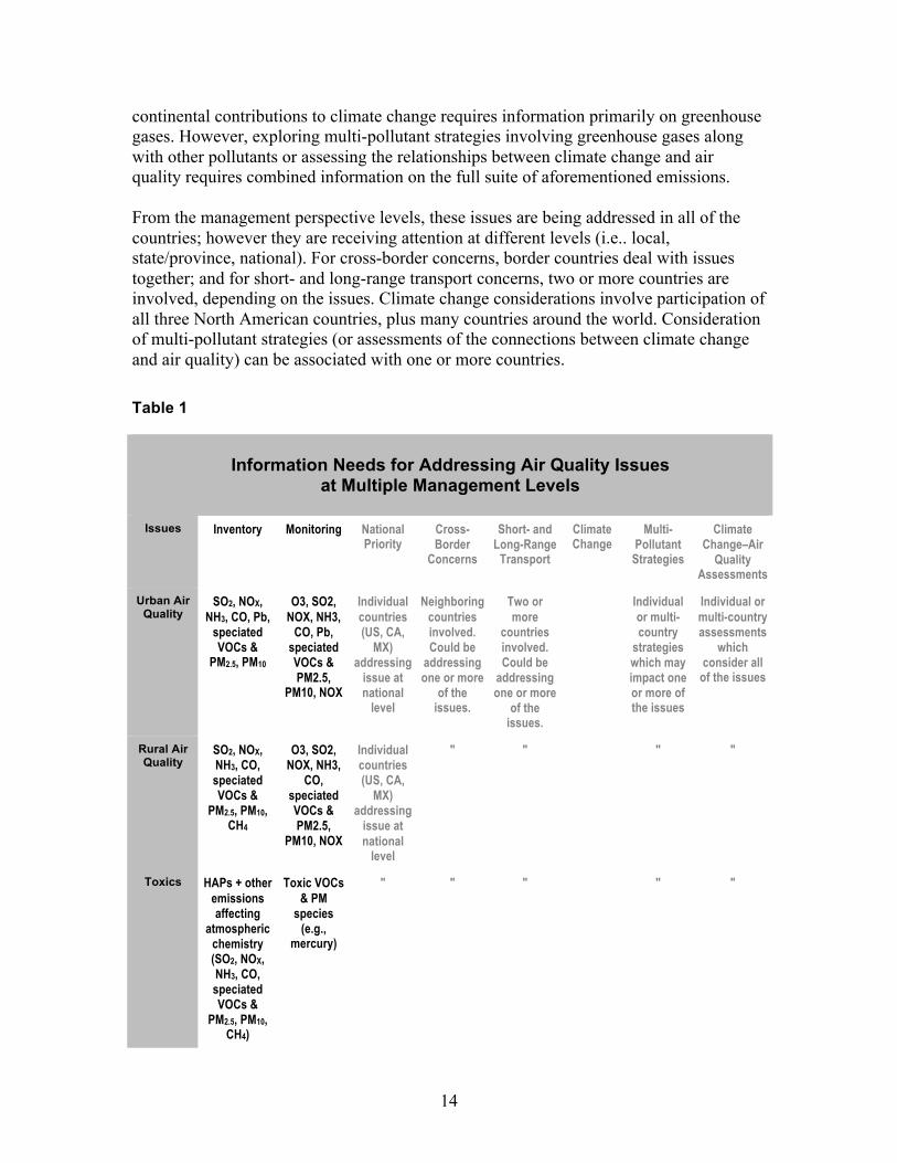
14
continental contributions to climate change requires information primarily on greenhouse gases. However, exploring multi-pollutant strategies involving greenhouse gases along with other pollutants or assessing the relationships between climate change and air quality requires combined information on the full suite of aforementioned emissions. From the management perspective levels, these issues are being addressed in all of the countries; however they are receiving attention at different levels (i.e.. local, state/province, national). For cross-border concerns, border countries deal with issues together; and for short- and long-range transport concerns, two or more countries are involved, depending on the issues. Climate change considerations involve participation of all three North American countries, plus many countries around the world. Consideration of multi-pollutant strategies (or assessments of the connections between climate change and air quality) can be associated with one or more countries. Table 1
Information Needs for Addressing Air Quality Issues
at Multiple Management Levels
Issues Inventory Monitoring National Priority
Cross-Border
Concerns
Short- and Long-Range
Transport
Climate Change
Multi-Pollutant
Strategies
Climate Change–Air
Quality Assessments
Urban Air Quality
SO2, NOX, NH3, CO, Pb,
speciated VOCs &
PM2.5, PM10
O3, SO2, NOX, NH3,
CO, Pb, speciated VOCs & PM2.5,
PM10, NOX
Individual countries (US, CA,
MX) addressing
issue at national
level
Neighboring countries involved. Could be
addressing one or more
of the issues.
Two or more
countries involved. Could be
addressing one or more
of the issues.
Individual or multi-country
strategies which may impact one or more of the issues
Individual or multi-country assessments
which consider all
of the issues
Rural Air Quality
SO2, NOX, NH3, CO, speciated VOCs &
PM2.5, PM10, CH4
O3, SO2, NOX, NH3,
CO, speciated VOCs & PM2.5,
PM10, NOX
Individual countries (US, CA,
MX) addressing
issue at national
level
" " " "
Toxics HAPs + other emissions affecting
atmospheric chemistry (SO2, NOX, NH3, CO, speciated VOCs &
PM2.5, PM10, CH4)
Toxic VOCs & PM
species (e.g.,
mercury)
" " " " "

15
Acid Deposition,
Excess Nitrogen
Deposition
SO2, NOX, NH3 + other emissions affecting
atmospheric chemistry
(CO, speciated VOCs &
PM2.5, PM10, CH4)
Speciated wet & dry
deposition
" " " " "
Mercury Speciated mercury +
other emissions affecting
atmospheric chemistry (SO2, NOX, NH3, CO, speciated VOCs &
PM2.5, PM10, CH4)
Speciated mercury
deposition
" " " " "
Visibility Speciated PM2.5 & PM10
+ other emissions affecting
formation of PM2.5 &
atmospheric chemistry (SO2, NOX, NH3, CO, speciated VOCs, CH4
Light extinction,
visual indices
" ` " " "
Climate Change
CO2, CH4, N2O, CFCs,
O3 precursors,
aerosols, etc.
CO2, CH4, N2O,
aerosols, O3
Individual countries (US, CA,
MX) addressing
issue at national
level
" " Multiple countries involved
" "
Note that ["] means that the information is the same as for the box above. US-United States, CA-Canada, MX-Mexico
Many pollutant concentrations (ozone, fine particles, and some toxics), acid deposition and excess nitrogen deposition, and visibility are determined by complex chemical processes involving many chemicals (some directly emitted like ammonia and others created in the atmosphere). As a result, comprehensive emission inventories are needed to thoroughly address (i.e., characterize, model and manage) these issues. This is why the full suite of emissions listed under rural air quality is listed for toxics, deposition, mercury and visibility issues.

16
Examination of the inventories and networks, available for these responsible pollutants, requires careful assessment of how well the chemicals are characterized and/or measured; the adequacy of the temporal and spatial characteristics of the databases, including coverage and resolution; and, for the inventories, the adequacy of source coverage. Data accessibility is important for all of the topics. Data compatibility across countries is important for addressing all of the concerns that go beyond the high priority, more localized, national issues.
17
3.0 Approach
Information for this background paper comes from a number of reports, write-ups and databases, many of which are directly accessible from the web. These include materials for individual countries as well as reports discussing bilateral and North American activities. Particularly helpful are previous assessments of emission inventory compatibilities across North America (CEC 2001; NARSTO 2005; CEC 2005; CEC 2007). CEC 2001 presents a detailed summary of inventory development, status of inventories across North America, and opportunities for enhanced compatibility. The NARSTO 2005 report provides additional review of inventories and outlines sources of greatest known uncertainties, and recommends high priority needs for improving inventories across North America. The other CEC reports (2005, 2007) focus on toxics release inventories. In addition, a number of interviews with experts and managers of key emission inventory and monitoring programs have provided additional insights on the ongoing and planned processes and analyses. These have been particularly valuable in pointing out information that is not available yet through formal reports. The assessment also has benefited from reviews of the earlier background report that is the technical foundation of the assessment; the CEC-sponsored workshop of 28–29 October 2008; and follow-up reviews and discussions. The workshop provided an important opportunity for the experts and managers to discuss recommendations and next steps. For each country, the databases for emissions and monitoring are presented in detail separately. They are discussed in terms of motivation and issues addressed, data characteristics, analysis methods, accessibility and related analysis features available. The databases are critiqued with respect to how well they are addressing air quality issues of highest concern and key data gaps of greatest importance. Databases across countries are then compared mainly on their ability to address the issues, characteristics, and accessibility. Recommendations follow from these comparisons. The Expert Consortium responsible for developing this assessment prepared information for each country separately. These were then synthesized and each member provided input into the development of overall critiques and summary recommendations. This close collaborative approach has continued throughout the development of the background report and this final assessment.
18
4.0 Status: Inventory and Monitoring Programs
This section describes the emission inventories and monitoring networks that are fundamental to the overall assessment. The inventory programs are discussed first and then the monitoring. Inventories for each country are described separately, as are the networks. Cross border efforts involving inventory development and network development also are noted as examples of how compatibility across countries is being addressed for specific border programs. To facilitate inter-comparison of information across countries, identification of compatibility issues, and development of recommendations for addressing these issues and creating enhanced North American assessment capabilities, key programs are summarized using the following general template. --------------------------------------------------------- Emissions Inventories General Program Name (Acronym) Administering Organization Ongoing/Planned Characteristics Key Air Quality Issues Addressed Regulatory Initiatives Addressed Parameters Addressed Sectors/Categories Covered Geographical Coverage Spatial Resolution Years Available Averaging Period Methods Other Descriptors Accessibility Type of Document (Report, Database) Electronic Access to Reported Data Electronic Analytical Capabilities Ease of Access (Any Restrictions)
Key Contact Info (Name, Email) Monitoring Networks General Program Name (Acronym) Administering Organization Ongoing/Planned Characteristics Key Air Quality Issues Addressed Regulatory Initiatives Addressed Parameters Addressed Geographical Coverage, Locale (Urban or Rural) Number of Sites Years Available Averaging Period Methods

19
Other Descriptors Accessibility Type of Document (Report, Database) Electronic Access to Reported Data Electronic Analytical Capabilities Ease of Access (Any Restrictions)
Key Contact Info (Name, Email) ------------------------------------------------------------ 4.1 Emission Inventories
Inventory development for each country is discussed, highlighting air quality issues being addressed; spatial, temporal, chemical, and sector coverage and resolution; infrastructure, IT and resources required to manage the information; and how data at the state/provincial level is being integrated into national programs. Key areas for improvement are noted. Detailed intercomparisons across countries are provided in Appendix A. Emissions Inventory Summary – US, Canada, Mexico, see separate Excel file. 4.1.1 United States
Emission inventories in the United States are produced on a variety of scales and covering a variety of chemicals, depending on the application. At the national level, the National Emissions Inventory (NEI) covers criteria air pollutants, incorporates air toxics emissions, and is planning to include greenhouse gases. The Toxics Release Inventory (TRI) addresses emissions of air toxics from individual facilities. Greenhouse gas emissions are being addressed at the national and state levels, and the US EPA is proposing a reporting rule to collect GHGs at the facility level. Regional-scale inventories have been developed for detailed assessment of issues in specific regions (e.g., the Western Regional Air Partnership). Metropolitan-scale inventories also are prevalent and used to assist in state implementation planning and in developing strategies in non-attainment areas. The inter-relationships among these national, state, regional, local, and facility inventories can help inform discussions of integrating emissions information across countries. EPA staff members (Anne Pope, Lee Tooly, Martin Husk, Rich Mason, Reid Harvey) have provided additional insights on emission inventory development work in the US. NEI NEI. The NEI is EPA’s compilation of estimates of air pollutants discharged on an annual basis from a wide spectrum of sources. EPA uses the NEI to track emissions trends over time; develop regional pollutant reduction strategies; set and analyze regulations; perform air toxics risk assessments including inhalation risks and multi-pathway exposure; model air pollutant transport, transformation, and deposition; and measure environmental performance as required by the Government Performance and Results Act. The inventory is updated every three years: the 2008 NEI will use data collected in 2008 and will be published in 2010. A new data collection and management system is being implemented—the Emissions Inventory System—and is expected to help reduce the time it takes to compile a comprehensive inventory for a given year. The
20
NEI/EIS Implementation Plan outlines the planned inventory development process, QA strategy, system design and data acquisition, and data covered in the national inventory (http://www.epa.gov/ttn/chief/net/neip.html). EIS. The Emissions Inventory System (EIS) is the new information system for storing all current and historical emissions inventory data. It will be used to receive and store emissions data and generate annual and triennial NEIs, beginning with the 2008 NEI. The EIS may also be used as a repository for facility GHG emissions. Reporting Guidelines and Groups. The EPA’s Consolidated Emissions Reporting Rule (CERR) published in 2002 updated the regulatory basis for the collection of emissions inventory information. The 50 states, the District of Columbia, and territories must report emissions inventory data; tribal agencies are not required but are strongly encouraged to submit emissions inventory data. These reporting groups are referred to as the S/L/Ts (NEI/EIS Implementation Plans 2008). Chemicals. The 2008 NEI includes emissions estimates for the following air pollutants:
• Criteria air pollutants (CAPs) that are directly emitted and emissions of precursors involved in the formation of ozone and fine particulate are in the inventory.
• Specifically included are carbon monoxide, nitrogen oxides, sulfur dioxide, particulate matter (PM10, PM2.5), volatile organic compounds (VOCs), ammonia, and lead. Particulate matter is distinguished as fractions—filterable, condensable, and primary (sum of filterable and condensable).
• Hazardous air pollutants (HAPs) – reporting not required, but strongly urged. EPA completes a HAPs inventory in the NEI, and supplements emissions data where not reported by the S/L/Ts through use of other reported data such as from the Toxics Release Inventory (TRI). For the NEI 2008, all of the data sets (i.e., S/L/T derived, TRI, etc) will be made available and the user can select the data whereas in the past EPA has selected the information and complied a single data set. There are 188 HAPs (http://www.epa.gov/ttn/atw/orig189.html) from major point sources, area and mobile sources. As EPA is moving toward a more comprehensive “one atmosphere” assessment concept, the inventory post processors (i.e., SMOKE) are including an estimate of VOC chemical constituents important for ozone formation while retaining some of the key toxic and well characterized individual VOC estimates from the NEI. More speciation for mercury also is included. Air quality models like CMAQ are updating chemical mechanisms to accommodate the more detailed VOC speciation and individual toxics.
• Greenhouse gases (GHGs) – reporting not required, but included as an option. Optionally reported GHG emissions will be stored in the EIS. Publication and use of these data are yet to be determined.
Categories:
• Point – Emission sites, which are individually estimated, identified, and reported, as opposed to those sources that are estimated and reported as an aggregate, typically as a county level total. Offshore drilling and oil and gas drilling and
21
airports will be addressed as point sources, rather than a stationary area source as in the past. All point emissions reported to the NEI must have a facility site stored in the EIS Facility Inventory. The Facility Inventory will be a permanent and continually maintained description for large stationary sources and voluntarily-reported smaller sources, providing information about site location and operation, emission units, emission processes, release points, controls and applicable regulations.
• Nonpoint – Aggregates of smaller stationary sources, typically reported at the county level.
• Onroad and Nonroad Mobile – Onroad includes vehicles used on roads and highways for transportation of passengers or freight. Usually reported at the county level, but there is a movement toward developing link-based emissions for these sources. Nonroad includes vehicles, engines, and equipment used off highways for construction, agriculture, transportation, recreation, and many other purposes. Nonroad also covers aircraft, locomotive and commercial marine vessels. As locomotive and commercial marine emissions are developed using activity data that is in a GIS format, the EIS will have capability to collect and store the data in a GIS format. The EPA develops initial NEI emission estimates for onroad and nonroad sources using standard models and readily available national data resources A new feature of EIS will allow the EPA to pre-populate the mobile inventory and then compare it with data reported by the S/L/Ts and will help facilitate improvement of the estimate, e.g., use of updated activity data from the states. This provides another level of cross comparison and QA.
• Events – Unexpected activities resulting in significant, reportable air emissions, including wildfires, controlled burns, wildland and agricultural burns, and natural disasters. Previously these were reported as either point or nonpoint sources: the EIS now provides a more flexible and robust reporting approach designated specifically for events.
• Biogenic – Naturally occurring. For the 2008 NEI, EPA will calculate all biogenic emissions and will not accept submissions from the S/L/Ts.
Reporting Formats. The CERR requires electronic reporting and provides discretion to the EPA in establishing formats and methods. EPA has determined that for the 2008 NEI, all data must be reported using pre-defined Extensible Markup Language (XML) format. This involves a transition from previous NEI Input Format to XML. XML operates much like HTML and is widely used internationally. It identifies the structure that the system will use and data files are embedded within the standard structure. This is very different from previous data input instructions for the S/L/Ts, which included several options. With the movement toward only XML, the reporting will be much more efficient and compatible across domains. NEI / EIS Reengineering Outcomes. The main outcomes, aimed at streamlining reporting and facilitating use of the emissions information, are the following:
• EIS Facility Inventory • EIS website for submitters • Tools to enhance data quality

22
• Data identifying sources and methods • Process based on categories of emissions (reporting instructions for each
category) • EIS quality assurance environment. The QA process is significantly enhanced and
streamlined with S/L/Ts being able to submit drafts that go through the full suite of QA to illuminate problems that then can be quickly fixed before final submissions.
• Storing multiple emissions values to accommodate multiple reporting such as is the case with electric generating units where some emissions are reported directly to EPA as part of the Acid Rain program and may also be reported to the NEI by the States. Separate data sources are stored but only one entry is retained in the NEI.
• Use of alternative sources of emissions data (data from sources such as the Toxics Release Inventory that are not part of the S/L/Ts reporting will be included and can be used to augment / add data that is missing from the S/L/T data reports). In some situations, inventory information that has been developed by a RPO is used directly when a state has not fully reported emissions data.
Accessibility. Data is accessible through the web: http://www.epa.gov/ttn/chief/net/2005inventory.html. Detail and summary data files for each of the major sector categories are available for download. Also available via the Web, are pollutant emission summaries by state and county, including multiple pollutant emission contributions by sector, and facility locations and emissions are provided using Google Earth display, see http://www.epa.gov/air/emissions/where.htm. Data accessibility will be greatly improved by the new EIS. The new EIS web site will allow updates to the Facility Inventory beginning in October 2008. There are plans for making it possible to access the legacy 2002 and 2005 NEI via the new EIS gateway and to illustrate data queries to obtain emissions for individual chemicals from individual categories and locations. TRI Overview. The Emergency Planning and Community Right to Know Act of 1986 was enacted to facilitate emergency planning, to minimize the effects of potential toxic chemical accidents, and to provide the public with information on releases of toxic chemicals in their communities. The Pollution Prevention Act of 1990 mandates collection of data on toxic chemicals that are treated on-site, recycled, and combusted for energy recovery. Together, these laws require facilities in certain industries, which manufacture, process, or use toxic chemicals above specified amounts, to report annually on disposal or other releases and other waste management activities related to these chemicals (see http://www.epa.gov/tri). Chemicals and Categories. The TRI contains detailed information on nearly 650 chemicals and chemical categories that 22,880 industrial and other facilities manage through disposal or other releases, recycling, energy recovery or treatment. Many of the individual chemicals (e.g., benzene, formaldehyde) on this list are part of the general
23
class of volatile organic compounds (VOC). Other prominent chemicals include mercury compounds, arsenic compounds, radionuclides, and lead compounds. Some toxics are emitted in gaseous form, other as aerosols, and others both. The 2006 TRI indicated metal mining, electric utilities, chemical manufacturing, primary metals, paper, hazardous waste/solvent recovery, and food processing as the major activities responsible for emissions of HAPs. It is important to note that TRI is not all-inclusive for HAPs. Most air toxics originate from human-made sources, including mobile sources and stationary sources, as well as indoor sources (e.g., building materials and cleaning solvents), and some are also released from natural sources such as forest fires. TRI covers major stationary sources only. Accessibility. TRI data are easy to access through the TRI Explorer. (http://www.epa.gov/triexplorer). The TRI explorer also provides customized reports and can answer questions about a particular facility, geographic area, or industry sector. Information in the TRI is updated annually. Relationship to NEI. In principle, the information in TRI should be directionally consistent with the facility information in NEI for those facilities that must be included in TRI. As the two data sets have different purposes and intended uses, HAP emissions information in each is characterized at different levels of detail. TRI does not typically contain the process-specific information that is compiled in the NEI to support the air quality and risk assessment modeling. The NEI does use TRI data directly as an indication of apparent missing data from the S/L/T reports. GHG National. Inventory of US Greenhouse Gas Emissions and Sinks: 1990–2006 (http://www.epa.gov/climatechange/emissions/usinventoryreport.html) provides nationwide total emissions for all of the greenhouse gases by sector as prescribed by the UNFCCC reporting guidelines. This inventory quantifies the primary anthropogenic emissions for the GHGs. By following the guidelines, emissions can be compared across countries. It is important to note that the UNFCC has created a centralized database which houses this compatible GHG information for all parties to the convention, including US, Canada, and Mexico (http://unfccc.int/ghg_data/items/3800.php). This inventory follows a top-down approach and is based largely on energy balance estimates. The US updates this annually. In terms of the bottom up approach, emissions of carbon dioxide (CO2) from the major power sector emitter must be reported: these are reported as hourly emissions and information for these are updated quarterly as part of the acid rain database (http://www.epa.gov/airmarkt/). Details for some manufacturing sectors also are obtained as part of voluntary reporting programs. There is some required reporting for methane as part of landfill and coal mining regulations and reporting for the CFCs and HCFCs is already required through the Montreal Protocol. A mechanism currently exists in which potential alternatives to CFCs and HCFCs are submitted for approval to EPA, intended to ensure that alternatives do not pose possibility of increasing GHG emissions.
24
State Inventories. As of April 2006, 42 states and Puerto Rico had completed inventories. States use these to understand their emissions, develop State Climate Change Action Plans, and implement policies and programs to reduce GHG emissions (http://www.epa.gov/climatechange/emissions/state_ghginventories.html). These inventories typically cover the major GHGs and anthropogenic sector emissions. The methods on which the inventories are based generally estimate greenhouse gas emissions as a function of (a) activity data (e.g., coal consumption, cement production, fertilizer consumption, etc.) and (b) activity- and gas-specific emission factors. EPA has been instrumental in developing methods for state GHG inventories that are consistent with those used for the United States national inventory, and with the IPCC Guidelines. In some cases, state emission estimates are significantly different from what would be calculated using EPA tools and guidance and these cases are noted within the state summaries provided by EPA. Some reasons for the differences are use of consumption rather than production estimates to determine emissions from the electricity sector; use of individual state data rather than defaults; addition of sub-categories of sources; and treatment of soil related sources and sinks. While states generally include the same set of major sources and GHG, the processes for estimating emissions varies from state to state. GHG Reporting Rule. In December 2007, Congress passed an appropriations bill that included $3.5 million in funding for the US EPA to establish a mandatory GHG reporting program in the US. The legislation requires the US EPA to establish a draft rule for this program within 9 months and a final rule within 18 months. The objective of the program is to collect comprehensive and accurate data relevant to future climate policy decisions, including potential future regulation under the Clean Air Act. It likely will require mandatory reporting of GHG emissions for carbon dioxide (CO2), methane (CH4), nitrous oxide (N2O), hydrofluorocarbons (HFC), perfluorocarbons (PFC) and sulfur hexafluoride (SF6) from both upstream production (i.e., fossil fuel and chemical producers and importers) and downstream (i.e., direct emitters—large industrial facilities) sources. More information on the status of this effort is expected to be available in the final quarter of 2008. Summary and Priority Improvements US emissions inventory development continues to make substantial progress. Creative work remains in several areas. Priority areas of improvement for inventory developments include:
• Remote sensing techniques and data aggregation methods for characterizing emission contributions from wildfires and industrial sources,
• Review and synthesis of economic modeling tools and techniques for projecting future year emissions,
• Taking into account changes in emissions due to climate change, • Speciation methods and tools for estimating primary and secondarily-formed
pollutants involved in the formation of fine particulate matter, • Speciation of VOCs to adequately and consistently cover those that are HAPs as
well as ozone precursors from all sources, • Characterization of ammonia from all sources,
25
• Dealing with information gaps for sources and chemicals of increasing concern, • Quality assurance for addressing multiple data sources, • Query systems that enhance usefulness of the information, and • Transparency of information on emissions.
4.1.2 Canada
Canadian emission inventories are compiled at various scales and for a variety of common and/or potentially hazardous airborne substances in order to address key air quality issues and specific regulatory requirements. The National CAC Air Pollutant Emission Inventory has been prepared for many years to document Canada-wide emissions of criteria air contaminants (CAC) and most recently has incorporated specific heavy metals (HM) and persistent organic pollutants (POP) within the program. The National Pollutant Release Inventory (NPRI) covers releases of many toxic substances to air, land and water at the facility level for individual major industrial, commercial and institutional sources. The National Greenhouse Gas Inventory addresses GHG emissions on a Canada-wide sectoral basis with recent implementation of reporting for the most significant individual facility contributors. Along with other ongoing inventory improvements, the facility level emissions compiled within NPRI are being incorporated, as point source data, into other national emission inventories as a means to internally integrate the programs and harmonize with other international initiatives. Specific emission inventories are also being compiled by various provinces and municipalities in order to support more localized air management requirements and provide input to both national and regional assessments (e.g., joint province/state Memoranda of Understanding). However, as focused on here, the national emission inventory data provide necessary information used in federal air quality management mechanisms and commitments such as agreements, response plans, various regulations and legislated requirements. National CAC Inventory General. The National CAC Emission Inventory is prepared by Environment Canada’s Pollutant Data Division (PDD), in conjunction with inputs from provincial and territorial government agencies as well as industry, and represents the most comprehensive summary of Canadian emission estimates for the substances compiled. In addition to potential health and environmental effects, the associated substances are known to contribute to air pollutant issues such as ground-level ozone formation, visible haze, acid precipitation, and material damage. The inventory and trends are compiled to assess relative source contributions, track/report emission reduction progress, support air management programs and atmospheric science (modeling) assessments as well as provide information pertinent to public health and/or environmental risk. Reporting of applicable emissions data is also required under domestic and international commitments such as the Canadian Environmental Protection Act (CEPA) and the Ozone Annex to the Canada-US Air Quality Agreement. It was initially compiled in the late 1970s; emission trends are available from 1990 with projections to 2015; and the inventory is now being updated annually. Specific toxic substances have been added only recently and CEPA
26
Section 71 now requires facilities within various industry sectors to report CAC, GHG and other HAP emissions annually from 2006. Chemicals. The following chemicals or chemical classes are reported: • A group of seven Criteria Air Contaminants (CAC) including Total Particulate Matter
(TPM), Inhalable Particulate Matter (PM10), Respirable Particulate Matter (PM2.5), sulfur oxides (SOX), nitrogen oxides (NOX), Volatile Organic Compounds (VOC) and carbon monoxide (CO)
• Ammonia (NH3) • Specific Heavy Metals (HM) including Lead (Pb), Cadmium (Cd) and Mercury (Hg) • Persistent Organic Pollutants (POPs), including dioxins and furans (DF),
benzo[a]pyrene (B[a]P), benzo[b]fluoranthene (B[b]F), benzo[k]fluoranthene (B[k]F), indeno[1,2,3-cd]pyrene (I[1,2,3-cd]P) and hexachlorobenzene (HCB)
Source Categories. The general source categories within the inventory are: • Facility – continually maintained inventory records of stationary source facilities
reporting to NPRI in accordance with substance-specific NPRI thresholds. Contains information about facility sites, location coordinates, industry classification, operations/processes, release point stack parameters, emission controls, estimated emissions, monthly apportionments, applicable estimation methods and quality ratings. The associated information serves as a basis for all point sources within the inventory.
• Point – process-level emission site (usually stack) for which individual source records are maintained based on facility data and emissions supplied in NPRI.
• Area – small collective/aggregated sources that are inventoried as a group, typically at the process level, by which emissions are often calculated using data collected at the provincial scale or smaller and with applicable emission factors or algorithms. Both point and area sources are grouped within sectors and further classified within an industrial, stationary fuel combustion or other major source category.
• Mobile – comprises both on- or off-road vehicles, engines or other equipment used to either transport passengers/freight or applied in various industrial, construction, agricultural or other activities (e.g., highway vehicles, air, rail, shipping, recreation and other non-road equipment).
• Incineration – includes municipal and other waste incineration facilities or activities. • Miscellaneous – accounts for a variety of area sources that are not readily categorized
(e.g., solvent use, retail fueling/service stations, printing, surface coatings, etc.). • Open – includes large open area sources in which the levels of the related fugitive
emissions may partly be meteorologically dependent (e.g., road dust, agricultural and construction activities, prescribed burning, etc.).
• Natural – includes emissions from forest fires and other biogenic sources (vegetation, soil, bogs).
Reporting and Accessibility. Summaries of the annual emissions by parameter, source sector and province, (http://www.ec.gc.ca/pdb/cac/Emissions1990-2015/2006/2006_canada_e.cfm) as well as trends are provided on the Environment Canada website (http://www.ec.gc.ca/pdb/cac/Emissions1990-2015/emissions_e.cfm).
27
NPRI In a similar manner to the US TRI program, the Canadian Environmental Protection Act (CEPA), in part, mandates the collection of facility-specific data on toxic chemicals in a National Pollutant Release Inventory, as related to a broad list of substances that are treated or released on site, recycled, combusted for energy recovery or disposed from the site. The NPRI is a pollutant release and transfer register (PRTR) that requires facilities, in certain industries which manufacture, process or otherwise use applicable toxic chemicals above specified amounts, to report the releases on an annual basis. Created by legislation, it is a nationwide, publicly accessible inventory of compiled emissions from certain industrial, commercial and institutional sectors and its reporting requirements have been modified over several years since the program’s inception in 1993 (http://www.ec.gc.ca/pdb/npri/documents/WG2008/p1_e.cfm). The program objectives are to compile data on releases of substances of concern, make progress on pollution prevention, provide information relevant to risk management and regulatory policy initiatives, and improve public access to pollution information. The NPRI contains pertinent emissions and other detailed information for over 300 listed substances that have been reported by over 9,000 facilities (i.e., those meeting reporting requirements such as specified thresholds). Most of the 2006 on-site releases, by mass, were air emissions (consisting of facility point, fugitive, accidental and other non-point releases) of which the predominant substances were Criteria Air Contaminants (CAC) whereby approximately 2% of the total air releases were other hazardous substances (http://www.ec.gc.ca/pdb/npri/2006Summary/p3_1_e.cfm). The largest non-CAC substance emissions were ammonia, methanol, sulfuric acid and hydrochloric acid. As the NPRI covers only the major stationary sources, it is recognized that only a portion of the total emissions for a given substance is captured by the inventory and often major quantities can be collectively emitted by other smaller industrial or non-industrial (area or open) sources. NPRI data are readily accessible on the Environment Canada website (http://www.ec.gc.ca/pdb/npri/npri_data_e.cfm) and include: summary data overviews, online searches in which facility-specific, substance-specific or sector releases can be queried, NPRI Google Earth maps of reported facility releases and the NPRI database of releases over the years 1994–2006 on MS Access. GHG Under reporting obligations of the UNFCCC and the Kyoto Protocol, Environment Canada compiles a National Greenhouse Gas Inventory Report (NIR) to document and archive associated GHG emissions which are reviewed and verified by a UN Expert Review Team. Although modifications can occur with new information, annual emissions of related substances from all relevant sectors have been estimated in a common format, over the period 1990 to present, using the most up-to-date comprehensive methods. If methods change, previous estimates are then updated to provide both consistent and
28
comparable trends in conjunction with defining progress toward achieving an agreed-upon emission reduction target (http://www.ec.gc.ca/pdb/ghg/inventory_report/2006/som-sum_eng.cfm). An analysis is also reported of the factors affecting the emission trends. The most recent annual compilation is available for the year 2006. An additional GHG Emissions Reporting program has also recently been implemented, in a separate initiative, in which the largest individual facilities (i.e., exceeding 100,000 tonnes of CO2 equivalent emissions) must report under authority of CEPA (Section 71), Statistics Act and Alberta’s Climate Change and Emissions Management Act. In 2006, 343 facilities reported in which the collective facility emissions accounted for approximately one-third of the total national emissions (http://www.ec.gc.ca/pdb/ghg/onlinedata/downloadDB_e.cfm). The NIR compiles estimates of specific mass quantities and CO2 equivalent emissions, using a top-down approach for the following major GHGs: carbon dioxide (CO2), methane (CH4), nitrous oxide (N2O), sulfur hexafluoride (SF6), perfluorocarbons (PFCs), and hydrofluorocarbons (HFCs). It addresses both sources and sinks grouped within the following major source categories: Energy, Industrial Processes, Solvent and Other Product Use, Agriculture, Waste, Land-Use, Land-Use Change and Forestry. Emission trends have been reported for the 1990–2006 period (http://www.ec.gc.ca/pdb/ghg/inventory_report/2006/tab_eng.cfm). The NIR data are reported by sector on both a nationwide and provincial basis, along with a detailed description of the inventory methodology (http://www.ec.gc.ca/pdb/ghg/inventory_report/2005_report/tdm-toc_eng.cfm). The facility-specific GHG data can be custom searched by facility, location, industrial sector (NAISC code), and by specific gas (CAS code) (http://www.ec.gc.ca/pdb/ghg/onlinedata/datasearch_e.cfm). Summary and Priority Improvements Emission inventory development activities in Canada have increased significantly over the last 20-year period, considerable resources have been applied to address the relevant air quality issues and associated management strategies, and most accurate estimation techniques available are being used. Improvements of high priority include:
• Implementation of regular reporting of CAC emission inventory methods and information used in compiling the national inventory, in sufficient detail and accessibility to facilitate investigation by stakeholders or other interested parties of both data inputs and quality, with updates to identify methodology changes which affect the reported emission trends;
• Enhancement of quality assurance checks of reported facility-level emissions for a selected number of key parameters reported to NPRI (e.g., CAC and other specific substances);
29
• Further clarifications of the condensable fraction of particulate matter in emission inventories in order to maintain consistency and/or address needs for particulate species profiles; and
• Continued research into elemental carbon sources, ammonia emissions (particularly with respect to agricultural activities), and fine particulate and VOC emissions from vegetative and other major open sources.
4.1.3 Mexico
The Mexican National Emissions Inventory (MNEI), which includes criteria pollutants and precursors, has been developed for the base year of 1999. The MNEI for the year 2005 will be released in 2010. Biogenic emission inventories that include non-methane VOCs from vegetation and nitrogen oxides at the national level (Semarnat 2004) and for the Mexico City Metropolitan Area (MCMA) have been developed. Greenhouse gas emissions are also being estimated at the national level. Large databases such as Mexico’s pollutant release and transfer—the RETC—as well as DATGEN and Sine (the Sistema Nacional de Emisiones), described below, compile emissions data at the national level in a single data depository. A number of emission inventories for urban areas in Mexico have been developed by different government entities addressing various objectives. Specialized inventories for multi-pollutant sources have been developed for Mexico City, Monterrey, Guadalajara, Toluca, Mexicali, Tijuana, Ciudad Juarez, and other urban areas (Appendix A, see separate Excel file.). However, there are important differences between these inventories such as the base year of the emissions, the number and type of source categories included, and data quality and validation protocols. An air toxics emissions inventory was prepared for the MCMA only in 2004 and 2006. The following sections present the emissions inventory and database for the national emissions inventory. Because the first emissions inventory for Mexico was developed for the MCMA (with a population of nearly 20 million, about 20% of the country), it has the most detailed inventories; they are described separately.
30
Mexican National Emissions Inventory The first Mexican National Emissions Inventory (MNEI) for criteria pollutants and precursors (NOx, SO2, CO, VOCs, PM10 and NH3) was developed for the year 1999 and was released in September 2006 (Semarnat 2006a). This inventory, developed in partnership with the CEC, US EPA and Western Governors Association (WGA). The development of the MNEI follows similar bottom-up emissions estimate techniques used by the environmental agencies in Canada and the US through the use of locally adjusted emission factors, estimation of emission controls and activity patterns applicable to Mexican sources, including a special version1 of MOBILE6 and the use of EPA’s AP-42 guidance. The inventory has an annual resolution and emissions are estimated and disaggregated at the municipality level. The MNEI for the year 2005 is currently under development and will be released in 2010. Chemicals. The 1999 MNEI includes emissions estimates for the following air pollutants:
• Criteria air pollutants (CAPs) and their precursors: nitrogen oxides (NOx), sulfur dioxide (SO2), carbon monoxide (CO), particulate matter (PM10 and PM2.5), volatile organic compounds (VOCs), and ammonia (NH3).
• MNEI does not include HAPs or GHGs. Categories are:
• Point source emissions. • Area source emissions, including emissions from airports, locomotives,
commercial activities, and others. • Onroad and nonroad emissions. • Biogenic emissions from vegetation, soil, lighting, volcanoes, geothermic and
wind erosion. Guide to Development and Use of Emissions Inventories The Guide to Development and Use of Emissions Inventories (Semarnat 2005) aims to standardize the development, maintenance and updating of emission inventories in the country and to provide the legal and regulatory framework for the planning and management of air quality using emissions inventories. According to the pollutants and source categories to be included in the inventory, the guide describes the techniques and data resource needs (i.e., base year, temporal and spatial distribution, quality assurance), for the emissions estimates. The guide also provides guidance on the use of the inventories for mass balance models, surveys and extrapolation techniques, and for modeling and emission projections. It should be noted that the Guide was developed as a by-product of the MNEI Project.
1 Adapted to some Mexican activity data.
31
National Emissions Inventory System (Sine) The Sistema Nacional de Emisiones—Sine 2008) was developed by Semarnat and INE as part of the 1999 MNEI as a communication tool. It is intended as a database that concentrates emissions data at the national level for 1999 in a single depository, thereby simplifying public access and allowing high-level maintenance, updating and management protocols. Sine provides access to the following information on emissions:
• Point sources emission inventory • Mobile sources emission inventory • Natural sources emission inventory • Area sources emission inventory • Greenhouse Gas Inventory • Pollutant Release and Transfer Registry database
Currently, Sine provides access to information of emissions from point sources. Starting 2009, efforts to upgrade accessibility of data and speedup consults will be carried out by Semarnat and INE. Conceived as an assembly of wide-ranging data provided by different sources that often use the same inputs, Sine will also be a useful tool to optimize inventory development resources. In addition, this system will provide valuable information to track performance and compliance with international commitments related to climate change and emissions of criteria pollutants. Consultations will be available using different criteria, like municipality or state, by source categories or pollutants, and will be obtained in a spreadsheet. The database is available at http://aplicaciones.semarnat.gob.mx/sine/. Greenhouse Gas National Emission Inventory (GHNEI) 1990–2002 The GHNEI, developed by INE/Semarnat, presents the annual emissions from 1990 to 2002 for CO2, CH4, N2O, HFCs, PFC, and SF6 for Mexico. The information is grouped under five emissions categories from the IPCC: Energy, Industrial Processes, Solvents, Agriculture and Wastes. The GHNEI used the methodology from the Guidelines for National Greenhouse Gas Inventories, Volume 2, Energy (IPCC 2007); the 2006 IPCC Guidelines for National Greenhouse Gas Inventories, Volume 3, Industrial Processes and Product Use (IPCC 2006); and the 2006 IPCC Guidelines for National Greenhouse Gas Inventories (IPCC 2006). The latest report was published in 2006 (Semarnat 2006b). The information used to develop the emission inventory was provided by the government agencies, industry and industrial chambers: this emission inventory uses the bottom-up approach. Pollutant Release and Transfer Registry (RETC) Database Mexico’s pollutant release and transfer register (the Registro de Emisiones y Transferencia de Contaminantes—RETC) is a database containing information on 104 substances and pollutants that are released into the environment (air, water, soil and subsoil) or are transferred into the wastewater and/or hazardous waste from industrial sources. This data is reported by industries under federal jurisdiction to the government by law and available to the public under the community “right-to-know” programs. The
32
information contained in the RETC that is publicly available includes the name of the facility, its location and the quantity of material issued or transferred from a list of 104 substances (list of compounds from the Health Ministry, pesticides, greenhouse gases, CFCs). The database emanates from Article 109 bis of the General Act on Ecological Equilibrium and Environmental Protection (LGEEPA) and integrates mandatory information from different related sources from the three levels of government: federal, state and municipality. The RETC is a component of the National Environmental Information System. The data can be obtained from the following website: http://app1.semarnat.gob.mx/retc/index.php. RETC is a basic tool of environmental management to undertake, at different levels (industrial, municipal governments, state and federal), actions such as compliance with environmental regulations, assessment, prevention and reporting of environmental chemical risks, pollution prevention and reduction of waste at source and throughout the process, air quality management, administration of watersheds, reduction of greenhouse gases pursuant to the UNFCC, administration of environmental certification, law of the public to environmental information. All the information for the RETC is collected through the Annual Certificate of Operations (COA—Cédula de Operación), an electronic system to gather information of point sources under federal jurisdiction, which is multimedia and allows collecting information for hazardous waste, releases to air, soil and water. The information contained in the RETC will enable development of effective policies to preserve and protect the environment, in addition to supporting the assessment of international conventions. The current legal framework of RETC allows its implementation in states and municipalities to strengthen the collection of environmental information, facilitating the design and implementation of environmental policies and control strategies. The RETC is being gradually implemented by local authorities to collect information from state and municipal jurisdiction sources. Part of this information is displayed by the CEC’s new map layer for Google Earth, which allows users to explore pollution data from over 30,000 industrial facilities in North America that reported releases and transfers of pollutants in 2004 and 2005, the most recent data available from all three countries (http://www.cec.org/naatlas/prtr/). DATGEN Database DATGEN (Sánchez-Martínez et al. 2005) is a spreadsheet database that contains information on emissions (mainly from combustion processes) from stationary sources under federal and state jurisdiction, located in areas where they have developed management plans for air quality. The database DATGEN (Spanish acronym for General Information) is updated every two years. The availability of this database is by request. The following describes the areas and years of emission information contained in the current DATGEN:
• Mexico City Metropolitan Area and State of Mexico (preliminary for 2000); • Guadalajara, Jalisco (1995); • Metropolitan area of Monterrey, Nuevo Leon (1995);
33
• Tijuana and Rosarito, Baja California (1998); • Ciudad Juarez, Chihuahua (1996); • Valle de Toluca, Mexico (preliminary for 2000); • Mexicali, Baja California (1996); and • La Laguna (i.e., Torreon, Coahuila and Gomez Palacio and Lerdo, Durango)
(2002). Most of the information used in DATGEN is associated with the years prior to 1999, and most establishments are also included in the federal and state COA (Annual Certificate of Operations). Because the information is collected by the state, the update of this database varies depending on state programs. North America Power Plant Air Emissions This report addressed fossil fuel-fired power plant information for the year 2002 across North America (Canada, Mexico and the United States), which includes 82 facilities in Mexico (CEC, 2005). The report presents the plant-by-plant emissions of three key pollutants: SO2, NOx, and mercury (Hg); it also includes the releases of CO2 but not the releases of particulate matter. The information on Mexico-wide power plant air emissions inventory in the report was compiled by Vijay et al. (2004). Emissions Inventory for the MCMA The first emission inventory developed for the Mexico City Metropolitan Area in 1986-88 was a collaborative effort between the Department of Federal District and Japan International Cooperation Agency (JICA) (for a historical perspective on the MCMA emissions inventory, see e.g., Molina and Molina 2002). However, a more complete inventory organized under the four categories—point (industry), area (services and residential), mobile (transportation) and natural (vegetation and soil)—was developed starting 1994. Since then, it has been under continuous biennial updating (CAM 2006). Currently, the MCMA (SMA 2008a) has the most detailed emissions inventory in Mexico, which includes annual emission estimates for CO, NOx, SO2, VOCs, NMHC, NH3, PM10 and PM2.5 for area, point, mobile and natural source emissions. The emissions estimates are obtained by using source sampling, emission models, emission factors (including AP-42 EPA guidance), mass balance, surveys and data extrapolation techniques. The inventory has information on the temporal and spatial distribution of the emissions, and it has been formatted for its use in air quality modeling activities (SMA 2008b). Air Toxic Emissions Inventory for the MCMA This inventory, which has been under continuous biennial development since 2004, contains annual emissions information for 109 compounds from point, area, and mobile sources for the MCMA. The latest emissions inventory is for the year 2006. The
34
emissions estimates are obtained using models (Fires, Speciate, Tanks), emission factors (EPA AP-42), mass balance, surveys and data extrapolation techniques (SMA 2007). Greenhouse Gas Inventory for the MCMA Sheinbaum et al. (2000) developed GHG inventory associated with the use and production of energy in the MCMA for the year 1996. Additional inventories have been developed since then. The most recent inventory is for the year 2006 that includes annual emissions estimates of CO2, CH4 and N2O from point, area and mobile sources for the MCMA (SMA 2008c). It uses the methodology from the Guidelines for National Greenhouse Gas Inventories, Volume 2, Energy (IPCC 2006); the 2006 IPCC Guidelines for National Greenhouse Gas Inventories, Volume 3, Industrial Processes and Product Use (IPCC 2006) and the 2006 IPCC Guidelines for National Greenhouse Gas Inventories (IPCC 2006). Emissions Inventories from Other States and Urban Areas In addition to the MCMA, there are emissions inventories from other cities (Semarnat 2006c and 2008), including Toluca (2002, 2004), Mexicali (1996), Monterrey (1994), Guadalajara (1995), Ciudad Juarez (1996, 2001,2002), Mexicali, Salamanca (2000, 2004), Tijuana-Rosarito (1998), Zona Metropolitana de Puebla (2004), Corredor Industrial del Bajío (2000, 2004), Morelos (2004), Tula-Tepeji (2005), and Tabasco (2001,2002) (SEDESO-PMA, 2003). The characteristics about these local emissions inventories are summarized in Appendix A (see separate Excel file). Some States already have GHG inventories, e.g., Baja California. INE is coordinating a project to help states to develop their own Climate Strategy, which includes, as a first step, the GHG inventory. Other Emissions Inventories Because of strong concern for high levels of ozone and particulate matter, measurements and modeling activities have focused on speciated VOCs and NOx emissions, as well as PM10 or PM2.5 mass concentration and bulk composition. While some measurements of pollutants from stationary sources (e.g., Mejía et al. 2007), area sources (Velasco et al. 2005a; Velasco et al., 2005b) and biogenic VOCs (Domínguez-Taylor et. al. 2007) have been reported recently, much of the effort has been concerned with motor vehicle emissions, particularly in the MCMA. Investigations have ranged from vehicle dynamometer studies (e.g., Jazcilevich et al., 2007) to remote sensing (Schifter et al. 2003) and mobile laboratory sampling (Zavala et al. 2006). Validation of Emissions Inventory The validation of the emissions inventory estimates for Mexico City has been performed through different techniques, including inverse air quality modeling and source
35
apportionment approaches (Vega et al., 1997; Vega et al., 2000) and direct emissions measurements (Schifter et al., 2003; Velasco et al., 2005a; Zavala et al., 2006). Summary and Priority Improvements Mexico has developed and released the first national emissions inventory for the year 1999; the inventory for 2005 is currently underway. The development of the emissions inventory for the MCMA has been ongoing since the first inventory was completed for the year 1994. Many states in Mexico do not prepare a local emissions inventory such as the MCMA because of lack of infrastructure, tools, financial and human resources. The MCMA has the most advanced metropolitan emissions inventory: it includes CAP, GHG and air toxics and has a gridded emissions inventory for air quality modeling. Other entities can benefit from documentation of the MCMA methods and data. It is also important to develop a separate national air toxics emissions inventory and more frequently update emissions inventories for CAP and GHG. There are plans in Mexico to update the CAP emissions inventory every three years, similar to Canada and US. New methods and information that will improve the quality of the national inventory will be used during the 2005 update. Many key improvements shared by all three countries are discussed together in Section 5. The following are priority improvements that are particularly important for Mexico:
• Obtain specific emissions factors for native plants, industries, mobile sources, wastewater irrigation lands, street vendors' emissions, diesel, gasoline, biofuels emissions, erosion, dust, fires, brick kilns, industrial fugitive emissions, etc.
• Obtain and/or improve information on industrial sources (e.g., stack height and specific location for modeling purposes), operational calendar, emission rates) and the characteristics and distribution of vehicular fleet.
• Develop local activity data for vehicles, economic activities and industries based on criteria established by Semarnat and INE.
• Include black carbon (BC) emissions into the GHG inventory (INEGEI) • Generate and update information for data input to the EPA model, Mobile6. • Develop inventories for indoor emissions.
4.1.4 Cross Border Examples
Canada – US The Great Lakes Regional Toxic Air Emissions Inventory (http://wiki.glin.net/display/RAPIDS/Home) is a unique, regional inventory focused on the Great Lakes area. Participants include Ontario and Quebec from Canada and several US states (Michigan, Illinois, Minnesota, Indiana, New York, Ohio, Pennsylvania, and Wisconsin. The inventory covers about 200 compounds from more than 2000 sources. This project centers upon quantifying these emissions and presenting the results in a format that facilitates the use of the data to form local, regional and binational strategies and policies for reducing the multi-media exposures and resulting impacts these toxic
36
pollutants have on the region's lakes, wildlife and human health. Improved data quality, accuracy and consistency are ongoing goals. Several elements of this program provide examples for successful multi-national collaboration. The program has been developed from the ground up by the participating states and provinces, starting with the mutually developed protocol, design and implementation of project software, creation of an internet data access tool, and production of triennial regional inventories (1993, 1996, 1999, 2002) with updates for intervening years (1997, 1998, 2001). The binational Steering Committee manages the effort and in addition to meeting the goals of the project, the inventory is compiled to achieve numerous state and regional goals such as data exchange with the US NEI. One of the major achievements has been the development of complete, user-friendly access to the emissions data. Mexico – US BRAVO. The Big Bend Regional Aerosol and Visibility Observational (BRAVO) Study (http://cat.inist.fr/?aModele=afficheN&cpsidt=16758867) was commissioned to investigate the sources of haze at Big Bend National Park in southwest Texas. The modeling domain of the BRAVO Study includes most of the continental United States and Mexico. The BRAVO emissions inventory was constructed from the 1999 National Emissions Inventory for the United States modified to include finer-resolution data for Texas and 13 US states in close proximity. The first regional-scale Mexican emissions inventory designed for air-quality modeling applications was developed for 10 northern Mexican states, the Tula Industrial Park in the state of Hidalgo, and the Popocatépetl volcano in the state of Puebla. Emissions data were compiled from numerous sources, including the US EPA, the Texas Natural Resources Conservation Commission (now Texas Commission on Environmental Quality), the Eastern Research Group, the Minerals Management Service, the Instituto Nacional de Ecología, and the Instituto Nacional de Estadística Geografía y Informática. The inventory includes emissions for CO, NOX, SO2, VOCs, NH3, PM10, and PM2.5. Wind-blown dust and biomass burning were not included in the inventory, although high concentrations of dust and organic PM attributed to biomass burning have been observed at Big Bend National Park. The SMOKE modeling system was used to generate gridded emissions fields for use with the air quality modeling systems. Comparisons of the BRAVO emissions inventory for Mexico with other emerging Mexican emission inventories helps highlight uncertainties and implications of these for developing multi-national inventory databases. El Paso – Juárez Offset. This activity represents the development of a useful model for creating binational, multi-stakeholder, public-private cooperation that benefits countries, economies and the environment. The offset itself involves El Paso Electric’s direction of their penalty fees to refurbish brick making kiln in Mexico, as well as develop modeling and emission factors which can be used in other situations, to offset the offset of one of their power plants. The lead up to this successful result involved the creation of the Joint Advisory Committee, nongovernment stakeholder building, legislation needed to officially recognize an airshed which includes more than one country and more than one state, the development of new necessary emission factors and modeling, and the
37
dedication to creative thinking to achieve the long term protection of the border area. http://www.jac-ccc.org/. This model also provides an excellent example of how annex and non-annex countries can work together to achieve “win-win” reductions in GHGs (Carlos Rincon, personal communications). 4.2 Monitoring Networks
As with the review of inventory development, monitoring networks for each country are discussed, highlighting air quality issues being addressed; spatial, temporal, and chemical coverage and resolution; infrastructure, IT and resources required to manage the information; and how network data are complimentary. Key improvements are noted. Detailed intercomparisons across countries are provided in Appendix B. Monitoring Network Summary – US, Canada, Mexico, see separate Excel file. 4.2.1 US
EPA's principal responsibilities under the CAA, as it was amended in 1990, include: • Setting National Air Quality Standards (NAAQS) for pollutants considered
harmful to the public health and environment, • Ensuring the air quality standards are met or attained (in cooperation with the
States) through national standards and strategies to control air emission from sources,
• Ensuring the sources of toxic air pollutants are well controlled, and • Monitoring the effectiveness of the program.
To monitor the effectiveness of programs and to provide valuable trend information and data to support assessments, a number of networks have been developed over the years. These are aimed at monitoring criteria air pollutants, toxic chemicals, acid deposition, excess nitrogen deposition, mercury deposition and visibility degradation. Much progress has been made in getting important air quality information to the public in a timely fashion. In addition to the extensive information available through EPA and other program web sites noted below, EPA staff (Phil Dickerson, Lew Weinstock, and Nealson Watkins) provided additional insights and reviews. Monitoring of GHG, ozone, aerosols and radiation is conducted primarily by NOAA, as part of coordinated international efforts. Valuable information on these programs was provided by NOAA staff (Russ Schnell). Overview Information Sources A comprehensive overview of air pollution monitoring is located at http://www.epa.gov/oar/oaqps/montring.html. The Ambient Monitoring Technology Information Center http://www.epa.gov/ttn/amtic/, operated by EPA’s Ambient Air Monitoring Group, contains information and files on ambient air quality monitoring programs, details on monitoring methods, relevant documents and articles, information on air quality trends and nonattainment areas, and federal regulations related to ambient air quality monitoring. It also covers monitoring information on air toxics (trends and
38
special urban studies), PM (routine mass and speciation), ozone precursors (PAMS), multi-pollutant sites (NCore), and visibility (IMPROVE). The Ambient Air Monitoring Program webpage located at http://www.epa.gov/air/oaqps/qa/monprog.html provides information on monitoring criteria pollutants. The Ambient Air Monitoring Guidance Document http://www.epa.gov/ttn/amtic/cpreldoc.html provides guidance on network assessments that facilitate developing an optimal balance between scientific quality, protection of health and welfare, and available resources. The Air Quality System (http://www.epa.gov/ttn/airs/airsaqs/detaildata/) stores air quality data that State, local and tribal air pollution control offices collect and submit. There are data from thousands of monitoring sites dating back from the present to 1980. Most of the data are for criteria pollutants (roughly 90–95%) and some data for hazardous air pollutants, primarily collected in the past 5–10 years time period. The data in AQS are accessible in a variety of ways (http://www.epa.gov/ttn/airs/airsaqs/detaildata) and trends are located at (http://www.epa.gov/ttn/amtic/tnalinks.html). There are several tools available for exploring the data, including http://www.epa.gov/airexplorer/monitor_kml.htm and http://www.epa.gov/airexplorer/. Ambient Air Quality Ambient air quality monitoring in the United States is largely carried out by state and local agencies, although the more rural/regionally representative networks such as the Interagency Monitoring of Protected Visual Environments (IMPROVE), the Clean Air Status and Trends Network (CASTNET), and the National Acid Deposition Program (NADP) are typically federally maintained. The primary network that carries out criteria pollutant (CO, SO2, NO2, PM10/PM2.5, Pb, O3) monitoring is labeled as State, Local Air Monitoring Stations (SLAMS). Other related monitoring networks exist that often are partially integrated with SLAMS sites, including the Photochemical Assessment Monitoring Stations (PAMS) network, and the Chemical Speciation Network (CSN). The PAMS network measures ozone precursors (approximately 60 VOCs), which has been required by the 1990 Amendments to the Clean Air Act. The CSN provides speciated PM2.5 data. Detail descriptions and information on many of the ambient networks can be found on EPA’s Ambient Monotiring Technology Information Center (AMTIC) webpage, found at http://www.epa.gov/ttn/amtic. Air Toxics The CAA does not require a national air toxic monitoring network, but EPA and state and local agencies have recognized the need for such a network. Since 2000, EPA has increased its ambient air toxics monitoring efforts and has established 23 national sites (National Air Toxics Trends Stations—NATTS) to assess ambient air toxics trends, and state and local agencies have established over 300 fixed ambient air toxics monitoring stations nationwide. There is still concern that additional effort is needed to ensure that sufficient ambient air toxics data is available to identify areas of unhealthy air, estimate trends, and assess reduction strategies. Locations of monitors, inconsistencies in the
39
sampling frequencies, and air quality measures have been identified as key areas for improvement (http://www.epa.gov/ttn/amtic/toxover.html, http://www.epa.gov/ttn/atw/). In addition to the specific air toxic monitoring activities, several other monitoring programs, primarily intended to address other air pollution concerns, incorporate some aspects of air toxics monitoring. For example, PAMS collects data on VOCs important for ozone production: some of these also are classified as air toxics. EPA’s IMPROVE, CASTNET, and PM2.5 speciation network (all noted below) provide details toxic metals, which are monitored as part of characterizing the chemical composition of particulates through these monitoring programs. Multi-pollutant Monitoring Sites (NCore) The National Core Network (NCore), described at http://www.epa.gov/ttnamti1/ncore/index.html, is a subset of the SLAMS network, which focuses on multi-pollutant monitoring at select sites through the US. These sites will utilize advanced measurement systems for particles, pollutant gases and meteorology. EPA is coordinating with its state, local and tribal partners, who will operate the NCore sites, on a list of possible site locations. Final site selections are not due until July 1, 2009 and full operation is not required until 1 January 2011. It is anticipated that when complete the network will consist of approximately 75 sites, mostly in urban areas. HAPs and GHGs are not currently being considered. However, in addition to the CAPs, total reactive nitrogen will be measured and ammonia and nitric acid are being considered. Particulate Matter Filter-based Continuous and Speciation Monitoring. Particulate matter is being monitored throughout the US at three different and important levels of detail. Federally-required PM2.5 mass monitoring is conducted by either filter-based, 24-hour integrated methods, or by continuous, so called “real-time” instrumentation. The continuous methods are especially useful since they allow quick turnaround of data for public dissemination in varying forms. Speciation monitoring uses a filter-based method to collect samples, which are then analyzed in the laboratory for particle composition. The ability to provide continuous speciation monitoring methods are still not quite mature enough for implementation into routine monitoring networks, but EPA is continuing to encourage method development. Chemical Speciation Network (CSN). The CSN, previously know as the Speciation Trends Network (STN) operates in largely urban locations throughout the US. Aerosol data is collected to better understand the components of, and ultimately, the causes of PM2.5 levels that exceed the National Ambient Air Quality Standards for Particulate Matter (PM) established in 1997. PM2.5 Continuous Monitoring. Continuous PM monitoring methods began to be developed in the mid 1990s. In 2006, EPA finalized the PM NAAQS and monitoring rules with several provisions for PM2.5 continuous monitors. In March 2008, the EPA-
40
ORD approved the MetOne BAM 1020 as an FEM. EPA expects other vendors of continuous methods to apply for and receive equivalent status in 2008 and 2009. Currently, even though equivalent status for certain continuous methods is new or forthcoming, there are already multiple types of continuous monitoring methods in use across the SLAMS network. Interagency Monitoring of Protected Visual Environments (IMPROVE) Recognizing the importance of visual air quality, congress included legislation in the 1977 Clean Air Act to prevent future and remedy existing visibility impairment in Class I areas. To aid with the implementation of this legislation, the IMPROVE program was initiated in 1985. This program implemented an extensive long-term monitoring program to establish the current visibility conditions, track changes in visibility and determine causal mechanism for the visibility impairment in the National Parks and Wilderness Areas. IMPROVE provides information on speciated PM2.5, coarse PM, and visibility at national parks and wilderness areas throughout the US (http://vista.cira.colostate.edu/improve/). It also should be noted that visibility is monitored at a number of urban locations through state and local programs. Ozone Monitoring – National Parks and Wilderness Areas Gaseous Pollutant Monitoring Network (GPMN), operated by the NPS Air Resources Division, is a network of 33 air quality monitoring stations that measures primarily meteorological parameters and ozone. Sulfur dioxide is measured using continuous analyzers or with filter samplers in a subset of the network. The 1991 NPS Monitoring Strategy contains the monitoring plan that includes long-term "trends sites" and 3-5 year "baseline sites." Many stations are now operated jointly with the EPA CASTNET. Only selected limited studies measure gaseous pollutants (e.g., other photochemical oxidants, nitrogen compounds, and toxic organic compounds) within the National Park System. Ozone and sulfur dioxide monitoring in national parks has been ongoing since the early 1980s using EPA reference or equivalent methods. This allows for the direct comparison of NPS data with data collected by state and local air pollution control agencies and EPA. http://www.nature.nps.gov/air/Monitoring/network.cfm#data Portable Ozone Monitor Systems (POMS) recently became available when a small low-power ozone analyzer was offered commercially. NPS has configured the analyzers with a datalogger, weather measurements, and solar-power on an open-frame system that is transportable and has low site impact. Two POMS versions are available: one with and one without filter-pack sampling. POMS are located at around 14 sites throughout the US. The portable systems measure the following parameters: * Ambient ozone * Wind speed * Wind direction * Relative humidity * Ambient temperature * Rainfall
41
* With CASTNET-protocol filter pack (optional): sulfate, nitrate, ammonium, nitric acid, sulfur dioxide http://www.nature.nps.gov/air/studies/portO3.cfm Passive Ozone Sampler Monitoring Program provides a low-cost alternative for the monitoring of ozone on a weekly basis at 46 parks. The samplers require no power, have a simple deployment system, and take only a few minutes each week to exchange samplers. Their main uses are in determining trends, getting base-line conditions, and for mapping distributions of ozone over space. http://www.nature.nps.gov/air/Studies/Passives.cfm National Atmospheric Deposition Program/National Trends Network (NADP/NTN) The network is a nationwide network of precipitation monitoring sites and is cooperative effort between many different groups, including the State Agricultural Experiment Stations, US Geological Survey, US Department of Agriculture, and numerous other governmental and private entities. http://nadp.sws.uiuc.edu/ The NADP/NTN has grown from 22 stations at the end of 1978 to over 250 sites spanning the continental United States, Alaska, and Puerto Rico, and the Virgin Islands. The purpose of the network is to collect data on the chemistry of precipitation for monitoring of geographical and temporal long-term trends. The precipitation at each station is collected weekly according to strict clean-handling procedures. It is then sent to the Central Analytical Laboratory where it is analyzed for hydrogen (acidity as pH), sulfate, nitrate, ammonium, chloride, and base cations (such as calcium, magnesium, potassium and sodium). Mercury Deposition Network (MDN) The National Atmospheric Deposition Program has also expanded its sampling to two additional networks. The Mercury Deposition Network (MDN), currently with over 90 sites, was formed in 1995 to collect weekly samples of precipitation which are analyzed for total mercury. The objective of the MDN is to monitor the amount of mercury in precipitation on a regional basis. AIRMoN Another network, the Atmospheric Integrated Research Monitoring Network (AIRMoN), was formed for the purpose of studying precipitation chemistry trends with greater temporal resolution. Precipitation samples are collected daily from a network of seven sites and analyzed for the same constituents as the NADP/NTN samples. CASTNET The Clean Air Status and Trends Network (CASTNET) is the nation's primary source for data on dry acidic deposition and rural, ground-level ozone. Operating since 1987, CASTNET is used in conjunction with other national monitoring networks to provide information for evaluating the effectiveness of national emission control strategies.
42
CASTNET consists of over 80 sites across the eastern and western United States and is cooperatively operated and funded by EPA with the National Park Service. Each CASTNET dry deposition station measures:
• Weekly average atmospheric concentrations of sulfate, nitrate, ammonium, base cations, sulfur dioxide, and nitric acid.
• Hourly concentrations of ambient ozone levels. • Meteorological conditions required for calculating dry deposition rates.
Dry deposition rates are calculated using atmospheric concentrations, meteorological data, and information on land use, vegetation, and surface conditions. CASTNET complements the database compiled by NADP. Because of the interdependence of wet and dry deposition, NADP wet deposition data are collected at all CASTNET sites. Together, these two long-term databases provide the necessary data to estimate trends and spatial patterns in total atmospheric deposition (http://www.epa.gov/CASTNET/). RadNet RadNet is a national network of monitoring stations that regularly collect air, precipitation, drinking water, and milk samples for analysis of radioactivity. The RadNet network, which has stations in each State, has been used to track environmental releases of radioactivity from nuclear weapons tests and nuclear accidents. Future uses of this network might include monitoring waste disposal and radioactive cleanup sites. RadNet also documents the status and trends of environmental radioactivity. These data are published by the National Air and Radiation Environmental Laboratory in a quarterly report entitled Environmental Radiation Data (http://www.epa.gov/narel/radnet/). Baseline Monitoring of GHG, Aerosols and Air Quality The NOAA Earth System Research Laboratory’s Global Monitoring Division (http://www.esrl.noaa.gov/gmd/index.html) conducts sustained observations related to climate forcing, stratospheric ozone depletion and air quality. These efforts provide information on global distributions, trends, sources and sinks of atmospheric constituents that are capable of forcing change in the climate of the Earth; track changes in the stratospheric ozone layer; and monitor levels of air quality elements such as tropospheric ozone, carbon monoxide and aerosol particles in non-source regions which may be affected by long-range transport from distant sources of pollution (Russ Schnell). These efforts are part of the World Meteorological Organization’s (WMO) Global Atmosphere Watch (GAW) which coordinates activities and data from 24 global stations, 200 regional stations, and 19 contributing stations from around the world (http://www.wmo.int/pages/prog/arep/gaw/gaw_home_en.html). The baseline stations, beginning as early as 1957, are located at Mauna Loa, HI, Point Barrow, AK, American Samoa, and the South Pole; Trinidad Head, CA, and Summit, Greenland, have been added as new baseline observatories in more recent years. Summit, Greenland, is a lower instrumented station than the others. These stations monitor CO2,
43
CO, CH4, O3, SF6, N2O, H2, CFCS, HCFCs, HFCs, aerosols, solar radiation, and surface meteorology. The GHG monitoring is also enhanced by cooperative air sampling efforts at Niwot Ridge, CO, Cape Grim Observatory, Harvard Forest, MA, Grifton, NC, Park Falls, WI and Alert Canada, plus several other fixed sites, and commercial ships. Air samples are collected approximately weekly from a globally disturbed network of sites. Baseline stations, along with several regional stations (Boulder, CO, Bondville, IL, Lamont, OK, Lulan Taiwan), provide detailed information on long-term changes in background aerosol properties and the influence of regional sources on aerosol optical properties and their trends. Information on surface radiation quantities is available through continuous measurements at several field sites around the world and across the continental US (including the Boulder and Bondville sites) and an evolving spectral UV network within the US. With the assistance of other federal agencies and universities, additional networks provide a variety of measurement platforms (including additional fixed surface sites, aircraft, remote sensing and towers) to supplement information on the spatial and vertical distribution of these pollutants. In addition, since the mid-1990s, some routine international airline flights have been used to provide measurements along their flight paths (horizontal and vertical) for pollutants primarily associated with ozone and carbon products. Recently, NOAA has developed 12 “tall towers” across the United States to assess atmospheric carbon budgets. Information Distributors AIRNow The US EPA, NOAA, and NPS, along with tribal, state, and local agencies, developed the AIRNow Web site (http://airnow.gov/) to provide the public with easy access to national air quality information. AIRNow is not a monitoring network: rather AIRNow presents monitoring data to the general public in useful formats. The Web site offers daily AQI forecasts for ozone and PM2.5 as well as real-time AQI conditions for over 300 cities across the US, and provides links to more detailed state and local air quality web sites. In addition to forecasts, AIRNow provides nationwide and regional real-time ozone air quality maps covering 46 US States and parts of Canada. These maps are updated daily every hour. The air quality data used in these maps and to generate forecasts are collected using either federal reference or equivalent monitoring techniques or techniques approved by the state, local or tribal monitoring agencies. Since the information needed to make maps must be as "real-time" as possible, the data are displayed as soon as practical after the end of each hour. Although some preliminary data quality assessments are performed, the data as such are not fully verified and validated through the quality assurance procedures monitoring organizations use to officially submit and certify data on the EPA AQS (Air Quality System). Therefore, data are used on the AIRNow web site only for the purpose of reporting the Air Quality Index (AQI). Information on the AIRNow web site is not
44
used to formulate or support regulation, guidance or any other Agency decision or position. One of the next planned advancements for AIRNow will be implementation of a new mapping system AIRNowMapper. It will produce higher quality maps, with terrain features for instance, and will allow more flexibility in mapping. Also, EPA is developing a distributable product similar to AIRNow called AIRNow-International. AIRNow-International is a complete redevelopment of the AIRNow system for international use. This upgrading of AIRNow is being built in collaboration with the local air pollution agency in Shanghai, China. NATA Periodic risk assessments for air toxics are provided by the National Air Toxics Assessment to give an indication of nationwide health risks http://www.epa.gov/ttn/atw/natamain/. NATA assessments estimate the risk of cancer and other serious health effects from breathing (inhaling) air toxics. Assessments include estimates of cancer and non-cancer health effects based on chronic exposure from outdoor sources, including assessments of non-cancer health effects for diesel particulate matter. Assessments provide a snapshot of the outdoor air quality and the risks to human health that would result if air toxic emissions levels remained unchanged. Summary and Priority Improvements In the most recent National Ambient Air Monitoring Strategy report (http://www.scribd.com/doc/1778385/Environmental-Protection-Agency-naamstrat2005, updated report to be available in fall 2008), three overarching themes are acknowledged as the basis for improving monitoring in the US: periodic rethinking of how best to use the monitoring systems for multiple, evolving, and emerging environmental concerns; ensuring that monitoring approaches are flexible enough to take advantage of technology advances that can lead to improved monitoring and use of monitoring data; and promoting continued evaluation of quality assurance and use of resulting improved protocols. The following improvements have been highlighted as priorities: NAAQS Monitoring.
• Identify areas in the existing monitoring networks for disinvestment in order to re-invest resources into a multi-pollutant monitoring paradigm, such as the NCore network.
• Continue promoting continuous PM monitoring • Promote newer, digital data acquisition and management systems as an inherent
part of monitoring program Air Toxics Monitoring
• Support existing state and local program monitoring by continuing to find projects to assess conditions at the local level
• Utilize PAMS, IMPROVE, and CASTNET, where possible Rural Monitoring
45
• Use rural monitoring networks to track rural background ambient conditions • Seek ways to formally integrate CASTNET, and maybe other rural networks, with
more urban oriented monitoring networks to enhance ability to manage current and future air quality management challenges
Climate-Air Quality. The GAW strategic plan strives for several developments that would enhance coordinated monitoring of climate and air quality and improved assessments. These include integration of surface-based, balloon, aircraft satellite and other remote sensing observations; ensured compatibility of data; and fusion of observational systems, data assimilation and modeling. Assessing Information. Work is underway through EPA OAQPS to advance data sharing capabilities and to make information more transparent to the air quality community at large. IT has advanced considerably and, even under budget constraints, there are opportunities for greatly advancing data management and sharing. Some of the major attributes of the desired future model are that it would be more economically efficient, have less redundancy in information, provide much room for innovation, and encourage more cooperation and less competition (e.g., National Air Quality Conferences, April 2008, presentation David Mintz for Nick Mangus EPA-OAQPS http://airnow.gov/index.cfm?action=conference2008.index). Issues of governance, cooperation, integration, resources and boundaries (i.e., where one provider’s boundary ends and another one’s begins) are being discussed as part of this major effort and these discussions have implications for coordination of information across countries. Resources. Common issues for monitoring agencies in the US were discussed as part of a recent overview of monitoring activities (Pitchford, Louks, and McLeod WRAP 2008, www.wrapair.org/forums/toc/meetings/080515m/Final_presentation_compressed.pdf). These resource concerns include: reductions in total funding which are having an impact on capacity; uncertainty in funding (i.e., current White House proposal versus continuing resolutions) impact planning; re-direction of existing funds for new programs (e.g., NCore) impact discretionary monitoring; monitoring agencies are being forced to find alternate funding sources to maintain networks (e.g., equipment replacement); and programs are being compelled to compete for available funds. All of these need to be considered when exploring ways to better coordinate monitoring and information exchange across countries. 4.2.2 Canada
Ambient air monitoring in Canada has traditionally been conducted, to a large extent, by cooperative federal and provincial government programs designed to support various internal regulatory policies, track actual concentration trends, permit comparisons with accepted air quality standards and fulfill geopolitical regional obligations. The primary nationwide programs include the National Air Pollutant Surveillance network (NAPS), the Canadian Air and Precipitation Monitoring Network (CAPMoN) and participation in the Integrated Atmospheric Deposition Network (IADN). Comprehensive monitoring programs also exist in some provinces and municipalities: these help address
46
jurisdictional issues, ascertain regulatory effectiveness and provide timely air quality index information for public awareness. In addition, various airshed monitoring networks are operated by industrial consortia to detect any potential source impacts and facilitate associated emission control mechanisms. GHG and aerosols are monitored in the Climate Chemistry Baseline Network within Environment Canada’s Climate Research Division as part of the WMO Global Atmosphere Watch Program. NAPS The NAPS monitoring network has operated jointly between Environment Canada and provincial/territorial government agencies since 1969 and represents the most comprehensive and multipurpose ambient network in Canada with 239 monitoring sites in 10 provinces and 3 territories (http://www.ec.gc.ca/cleanair-airpur/Monitoring-WS9847DOE3-1_En.htm). The primary program objectives are to determine the nature, extent and trends of a large variety of air pollutants especially within urban areas, provide data to assess industrial and mobile source effects on nearby communities and for health research as well as data to verify emission estimates and support issue management legislation and international agreements. For example, the data are required to provide information relevant to the Ozone Annex of the Canada-US Air Quality Agreement; the national Smog Management Plan; Canada Wide Standards for Particulate Matter and Ozone, the Air Quality Health Index, and other substances; CEPA Priority Substance Lists; and various other commitments and the associated results are compared with National Air Quality Objectives as well as provincially regulated standards and criteria. Both continuous real-time monitoring and regularly scheduled daily sampling/analysis methods are used to measure the various parameters (http://www.etc-cte.ec.gc.ca/NAPS/naps_summary_e.html). CAC gases (SO2, CO, NOX, O3) and total suspended particulate matter (PM) levels are determined at over 152 stations in 55 cities, PM2.5 mass is continuously measured at many sites, filtered PM10/PM2.5 samples are analyzed for 50 elements, speciated measurements of VOCs (e.g., aromatics, halogenated compounds, carbonyls, etc.) and SVOCs (PAH, PCDD, PCDF) are conducted at up to 40 urban and rural sites. A rigorous QA/QC program, with instrumental/operational standardization, is applied in an effort to maintain inter-jurisdictional data comparability and is used for both continuous and laboratory parameters. Along with various reports that can be acquired, regarding speciated toxics, the NAPS CAC and particle size mass concentration data are summarized (e.g., frequency distributions, hourly, daily and monthly mean levels), by parameter and station, in an annual report which is published on the Environment Canada website. It also contains site concentration averages for PM2.5 and O3 in a format to determine the level of CWS achievement for these parameters. The most recently published annual report is available for 2005 and 2006 (http://www.etccte.ec.gc.ca/publications/naps/naps2005_annual.pdf). Raw and more recent data are also available on the web site, http://www.etccte.ec.gc.ca/napsdata/Default.aspx.
47
CAPMoN The CAPMoN is a non-urban monitoring network, operated by Environment Canada, in which air and precipitation constituents are measured at regionally representative locations across Canada (i.e., at sites considered to be unaffected by local sources) (http://www.msc.ec.gc.ca/capmon/index_e.cfm). In conjunction with CEPA requirements, the CWS on acid rain, Ozone Annex, and the Canada-wide Acid Rain Strategy Post 2002, and more recently the CARA, the primary network objectives are: to determine patterns and temporal trends of pollutants related to issues of acid rain and smog, and to provide data for long-range transport model evaluations and aquatic/terrestrial effects assessments. The network began operations in 1983. There are reportedly 32 air and precipitation monitoring sites in the network, including one US site for methodology comparisons. The precipitation measurements include (24-hour integrated sample) determinations of the major anions and cations at some sites to derive wet deposition loadings. Airborne gaseous nitrogen compounds and ozone are measured continuously (hourly averages) at some stations to characterize precursor levels and assess dry deposition. Similarly, particulate mass, size distributions and ionic components (24-hour samples) along with ammonia measurements are monitored in order to deduce dry deposition loadings and other interactions. Stringent QA/QC practices are applied in the siting and measurement methods. Along with input to various science assessment reports (http://www.msc-smc.ec.gc.ca/saib/acid/assessment2004/summary/summary_e.pdf), a NAtChem Precipitation Chemistry database system is maintained at EC which contains annual and seasonal statistics, spatial concentrations and deposition patterns as well as temporal trends of the measured species which can be acquired by request (http://www.msc-smc.ec.gc.ca/natchem/precip/index_e.html). Individual daily levels of both precipitation and particulate constituent measurements at each station are also compiled by year in this comprehensive and accessible database that permits detailed internal analyses to be done. The EC initiated an air and precipitation mercury monitoring network in 1996 to better understand atmospheric processes of this toxic environmental constituent and which, in part, helps address requirements of the CWS for mercury. Specific objectives are: to define background levels, spatial and temporal trends of mercury in air and precipitation, to identify major point and regional emission sources, to improve understanding of transport, transformation, deposition and removal processes of elemental and other mercury species, and to provide data for modeling and health risk assessments. Total gaseous mercury is measured continuously in ambient air (hourly averaged integrated determinations using Tekran Analyzers) at six sites across Canada, four CAPMoN and two arctic stations, Alert and Little Fox Lake. Total and methylmercury laboratory analyses are done on precipitation samples that are collected at five CAPMoN sites, following the US MDN protocol.
48
Data are stored, processed and analyzed in a RDMQ system at EC. Hourly gaseous mercury concentrations for each site are contained within the NAtChem database. IADN The IADN program has been operated cooperatively between US and Canada since 1990 to determine specific toxic and persistent organic pollutant (POP) atmospheric deposition to the Great Lakes basin. It was mandated under Annex 15 of the Great Lakes Water Quality Agreement (GLWQA), the Canada-Ontario Agreement (COA), Section 112 (m) of the US Clean Air Act Amendments of 1990 (CAA) and the US/Canada Binational Great Lakes Toxic Strategy (BGLTS) (http://www.msc-smc.ec.gc.ca/iadn/overview/background_e.html). The goals are to: determine the atmospheric loadings and spatial/temporal trends of priority toxic chemicals to the Great Lakes basin; and to measure air and precipitation constituent concentrations in a consistent manner to define trends and help determine sources of the chemical inputs. The network comprises six Canadian sites, including a master station on each Great Lake supplemented by satellite stations. A broad list of speciated semi-volatile organic compounds (SVOC) has been measured at some sites including speciated organochlorine pesticides (OC pesticides), speciated polycyclic aromatic hydrocarbons (PAH), congener-specific polychlorinated biphenyls (PCB) and selected trace elements. High volume filter/adsorption techniques are used to determine gas/particle phases of the substances in air, at various sites, and automated wet only collectors were used in precipitation measurements at all sites. The most recently published loadings and trends reports, for year 2005, include loadings to the Lakes and trends of each class of chemicals. Climate Chemistry Baseline Network Ongoing monitoring of carbon dioxide, methane, nitrous oxide, sulfur hexafluoride, carbon monoxide and CFC’s at eight remote/regional sites representing coastal, interior and Arctic regions in Canada. EC also conducts an extensive aerosol measurement program at four sites that includes aerosol chemistry (major ions, metals, sulfate and isotopes), black carbon, aerosol size and distribution as well scattering efficiency. The network of stations is strategically located to reflect the regional and long-range transport of greenhouse gases (GHG) and aerosols into and out of Canada. Measurements from the oldest stations have been conducted since 1985. The data are analyzed to detect seasonal and annual variations, long-term trends and to determine the magnitude of the Canadian and global greenhouse gas sources and sinks. The emphasis of the program is on developing a better understanding of the natural biogeochemical cycles and the impact of human activities on these cycles. These measurements constitute Canada’s contribution to the World Meteorological Organization’s WMO, Global Atmospheric Watch (GAW) Program, and are highly integrated with the US NOAA Global Monitoring Program. Environment Canada is the only agency in North America making continuous GHG measurements, in addition to the flask measurement networks.

49
The isotopes monitoring is focused on understanding the effect of the terrestrial carbon cycle on global warming by measuring 13C/12C and 18O/16O of CO2 at six sites. This network provides an opportunity to examine the regional scale spatial and temporal distributions of the sources/sinks of CO2 and their strength. The carbon and oxygen isotopes of CO2 are also used as tracers to partition carbon fluxes from different sources and to understand the controlling mechanisms of carbon cycle on different scales, from canopy to global. The atmospheric greenhouse-gas and aerosol measurements not only provide the critical capacity to monitor the increase in atmospheric GHG concentrations but also support top-down, atmospheric inversion estimates of terrestrial GHG sources and sinks. Data are publicly available from the WMO World Data Centres for GHGs and Aerosols. Summary and Priority Improvements Ambient air monitoring in Canada is relatively comprehensive and has been operative over a sufficient time period, making it possible to establish and verify trends of several parameters. Strong efforts are being made in maintaining quality assurance within the programs (e.g., method intercomparisons, protocols, auditing) and, more recently, to report real-time information to the public (e.g., smog indices). Significant focus has been directed toward fine particulate matter and associated issues with recognition of both measurement and interpretive complexities due to the many physical/chemical interactions and transboundary pollutant transport (http://www.msc-smc.ec.gc.ca/saib/smog/docs/summary-pm2_5-Eng.pdf). The NAPS network’s O3 and PM2.5 monitoring has expanded in recent years to meet CWS requirements (http://www.ccme.ca/assets/pdf/pm_oz_2000_2005_rpt_e.pdf). GHG and associated aerosol monitoring also has increased. Environment Canada will continue to invest in new instruments to fill gaps in pollutant coverage at existing monitoring facilities. A priority will be placed on upgrading existing continuous PM2.5 instruments and improving the PM2.5 monitoring sampling and consistency during the cold season, from October 1 to March 31. These improvements may allow cold-season reporting, thereby better representing the regional climatic differences and variations across Canada (e.g., CESI 2007, http://www.environmentandresources.gc.ca/default.asp?lang=en&n=62FFB5B1-1), As Canada is moving toward more accountability in a multi-pollutant air quality management environment, the Government of Canada Treasury Board is mandating the preparation of Results-Based Management and Accountability Frameworks (RMAF) for new spending initiatives. A key element of the RMAF is an ongoing performance measurement strategy that identifies indicators and methodologies for routine measurement of progress on outputs and immediate outcomes. Work is underway to assess the adequacy of technical tools to quantify the success of regulations. Of particular high priority is having adequate monitoring to be able to further characterize acid deposition in the West and develop and track critical load exceedances for Canada; define the impact of mercury from base metal smelter and electricity sectors; and better
50
estimate neighborhood-scale exposure conditions. Further characterization and monitoring of the impact of global emission changes on the Canadian environment is also a high priority (Keith Puckett 2008, Accountability in a Multi-Pollutant Air Quality Management Environment: A Canadian Perspective; available from http://mce2.org/narsto/). 4.2.3 Mexico
National Air Quality Monitoring Program The National Air Quality Monitoring Program is operated and maintained by the Center for Environmental Research and Training (DGCenica), a component of the National Institute of Ecology (INE) of the Ministry of the Environment (Semarnat). Historical and validated data from the air quality monitoring networks are centralized by INE at http://www.ine.gob.mx/dgicur/calaire/indicadores.html and distributed as biannual publications, such as: http://www.ine.gob.mx/dgicur/calaire/descargas/tercer_almanaque_calaire_2007_v4.pdf. INE maintains the National Air Quality Information System (SINAICA in Spanish), http://sinaica.ine.gob.mx/, which allows the public to access air quality raw data of 22 cities with air quality monitoring systems, as well as information about DGCenica research air quality monitoring station in real time and data of two particulate matter networks, located in Torreón and in the Tula-Tepeji region. Currently, Mexico is consolidating the monitoring efforts under the National Air Quality Monitoring Program (Programa Nacional de Monitoreo Atmosférico—PNMA) to provide diagnostic and surveillance capability of air quality at the national level that enables comparability across different sites and air quality networks and serves as a foundation for the design and establishment of environmental policy to protect the health of the population and the ecosystems. This program is divided in three stages with specific objectives:
• Stage 1 is the analysis and development of tools. This initial stage focuses on the development of tools and procedures fostering quality systems and data comparability, as well as strengthening the Standard Reference and Calibration Laboratory of the Center for Environmental Research and Training (DGCenica), a component of the National Institute of Ecology (INE).
• Stage 2 addresses network design and identifies priority sites for implementing air quality monitoring programs. The design strategy includes selection criteria, a communications plan and initial implementation of the monitoring plans of the various states. Air quality monitoring regulations about air quality monitoring will be enforced in 2008.
• Stage 3 reflects operational status of monitoring and QA/QC practices enabling national air quality surveillance, and provides analytical basis for subsequent planning of a National Atmospheric Program incorporating nationwide multi-
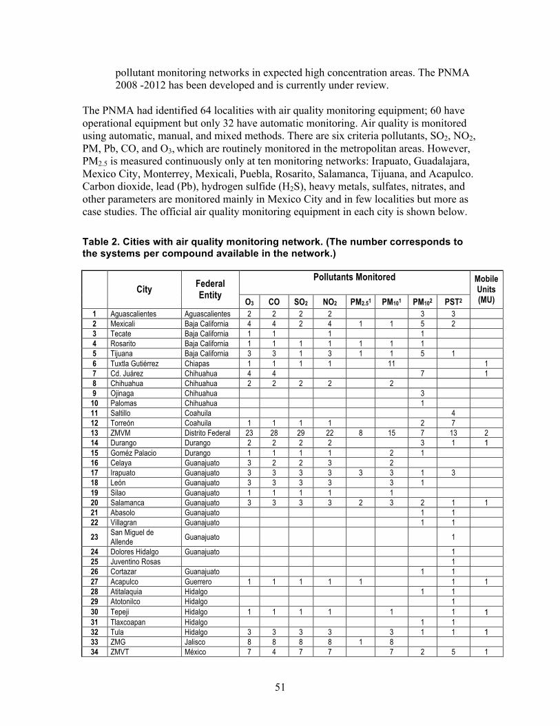
51
pollutant monitoring networks in expected high concentration areas. The PNMA 2008 -2012 has been developed and is currently under review.
The PNMA had identified 64 localities with air quality monitoring equipment; 60 have operational equipment but only 32 have automatic monitoring. Air quality is monitored using automatic, manual, and mixed methods. There are six criteria pollutants, SO2, NO2, PM, Pb, CO, and O3, which are routinely monitored in the metropolitan areas. However, PM2.5 is measured continuously only at ten monitoring networks: Irapuato, Guadalajara, Mexico City, Monterrey, Mexicali, Puebla, Rosarito, Salamanca, Tijuana, and Acapulco. Carbon dioxide, lead (Pb), hydrogen sulfide (H2S), heavy metals, sulfates, nitrates, and other parameters are monitored mainly in Mexico City and in few localities but more as case studies. The official air quality monitoring equipment in each city is shown below. Table 2. Cities with air quality monitoring network. (The number corresponds to the systems per compound available in the network.)
Pollutants Monitored City
Federal Entity
O3 CO SO2 NO2 PM2.51 PM101 PM102 PST2
Mobile Units (MU)
1 Aguascalientes Aguascalientes 2 2 2 2 3 3 2 Mexicali Baja California 4 4 2 4 1 1 5 2 3 Tecate Baja California 1 1 1 1 4 Rosarito Baja California 1 1 1 1 1 1 1 5 Tijuana Baja California 3 3 1 3 1 1 5 1 6 Tuxtla Gutiérrez Chiapas 1 1 1 1 11 1 7 Cd. Juárez Chihuahua 4 4 7 1 8 Chihuahua Chihuahua 2 2 2 2 2 9 Ojinaga Chihuahua 3
10 Palomas Chihuahua 1 11 Saltillo Coahuila 4 12 Torreón Coahuila 1 1 1 1 2 7 13 ZMVM Distrito Federal 23 28 29 22 8 15 7 13 2 14 Durango Durango 2 2 2 2 3 1 1 15 Goméz Palacio Durango 1 1 1 1 2 1 16 Celaya Guanajuato 3 2 2 3 2 17 Irapuato Guanajuato 3 3 3 3 3 3 1 3 18 León Guanajuato 3 3 3 3 3 1 19 Silao Guanajuato 1 1 1 1 1 20 Salamanca Guanajuato 3 3 3 3 2 3 2 1 1 21 Abasolo Guanajuato 1 1 22 Villagran Guanajuato 1 1
23 San Miguel de Allende
Guanajuato 1
24 Dolores Hidalgo Guanajuato 1 25 Juventino Rosas 1 26 Cortazar Guanajuato 1 1 27 Acapulco Guerrero 1 1 1 1 1 1 1 28 Atitalaquia Hidalgo 1 1 29 Atotonilco Hidalgo 1 30 Tepeji Hidalgo 1 1 1 1 1 1 1 31 Tlaxcoapan Hidalgo 1 1 32 Tula Hidalgo 3 3 3 3 3 1 1 1 33 ZMG Jalisco 8 8 8 8 1 8 34 ZMVT México 7 4 7 7 7 2 5 1
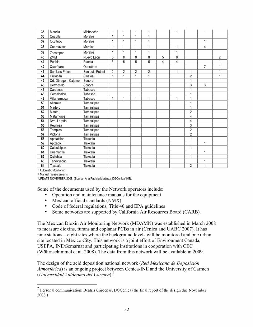
52
35 Morelia Michoacán 1 1 1 1 1 1 36 Cuautla Morelos 1 1 1 1 37 Ocuituco Morelos 1 1 1 1 1
38 Cuernavaca Morelos 1 1 1 1 1 4
39 Zacatepec Morelos 1 1 1 1 1 40 ZMM Nuevo León 5 8 8 8 5 8 2 41 Puebla Puebla 5 5 5 5 4 4 1 42 Querétaro Querétaro 7 1 43 San Luis Potosí San Luis Potosí 2 2 2 2 1 1 1 44 Culiacán Sinaloa 1 1 1 1 2 1 45 Cd. Obregón, Cajeme Sonora 1 46 Hermosillo Sonora 3 3 47 Cárdenas Tabasco 1 48 Comalcalco Tabasco 1 49 Villahermosa Tabasco 1 1 1 1 1 1 50 Altamira Tamaulipas 1 51 Madero Tamaulipas 1 52 Mante Tamaulipas 2 53 Matamoros Tamaulipas 4 54 Nvo. Laredo Tamaulipas 4 55 Reynosa Tamaulipas 3 56 Tampico Tamaulipas 2 57 Victoria Tamaulipas 2 58 Apetatitlan Tlaxcala 1 59 Apizaco Tlaxcala 1 60 Calpulalpan Tlaxcala 1 61 Huamantla Tlaxcala 1 62 Quilehtla Tlaxcala 1 63 Tenexyecac Tlaxcala 1 64 Tlaxcala Tlaxcala 2 1
1 Automatic Monitoring 2 Manual measurements UPDATE NOVEMBER 2008. (Source: Ana Patricia Martinez, DGCenica/INE).
Some of the documents used by the Network operators include:
• Operation and maintenance manuals for the equipment • Mexican official standards (NMX) • Code of federal regulations, Title 40 and EPA guidelines • Some networks are supported by California Air Resources Board (CARB).
The Mexican Dioxin Air Monitoring Network (MDAMN) was established in March 2008 to measure dioxins, furans and coplanar PCBs in air (Cenica and UABC 2007). It has nine stations—eight sites where the background levels will be monitored and one urban site located in Mexico City. This network is a joint effort of Environment Canada, USEPA, INE/Semarnat and participating institutions in cooperation with CEC (Wöhrnschimmel et al. 2008). The data from this network will be available in 2009. The design of the acid deposition national network (Red Mexicana de Deposición Atmosférica) is an ongoing project between Cenica-INE and the University of Carmen (Universidad Autónoma del Carmen).2
2 Personal communication: Beatriz Cárdenas, DGCenica (the final report of the design due November 2008.)
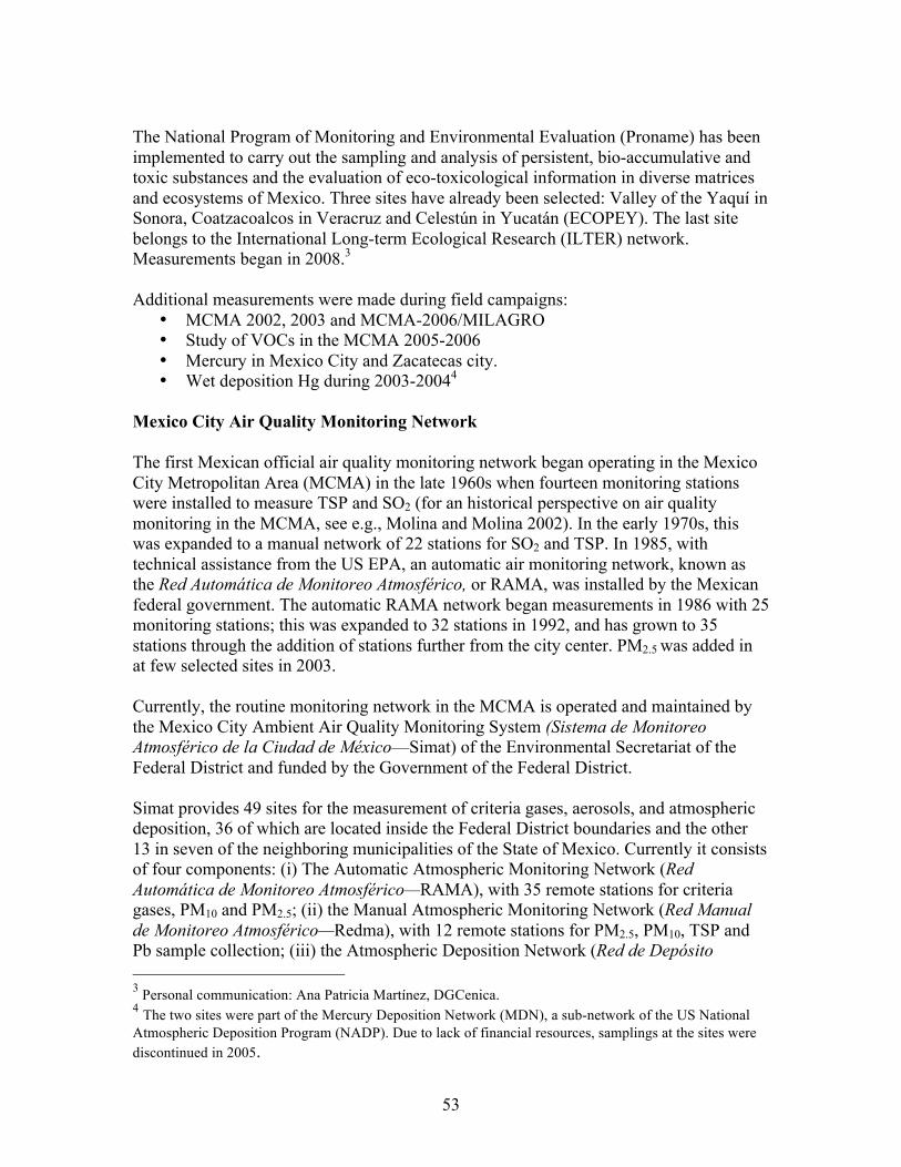
53
The National Program of Monitoring and Environmental Evaluation (Proname) has been implemented to carry out the sampling and analysis of persistent, bio-accumulative and toxic substances and the evaluation of eco-toxicological information in diverse matrices and ecosystems of Mexico. Three sites have already been selected: Valley of the Yaquí in Sonora, Coatzacoalcos in Veracruz and Celestún in Yucatán (ECOPEY). The last site belongs to the International Long-term Ecological Research (ILTER) network. Measurements began in 2008.3 Additional measurements were made during field campaigns:
• MCMA 2002, 2003 and MCMA-2006/MILAGRO • Study of VOCs in the MCMA 2005-2006 • Mercury in Mexico City and Zacatecas city. • Wet deposition Hg during 2003-20044
Mexico City Air Quality Monitoring Network The first Mexican official air quality monitoring network began operating in the Mexico City Metropolitan Area (MCMA) in the late 1960s when fourteen monitoring stations were installed to measure TSP and SO2 (for an historical perspective on air quality monitoring in the MCMA, see e.g., Molina and Molina 2002). In the early 1970s, this was expanded to a manual network of 22 stations for SO2 and TSP. In 1985, with technical assistance from the US EPA, an automatic air monitoring network, known as the Red Automática de Monitoreo Atmosférico, or RAMA, was installed by the Mexican federal government. The automatic RAMA network began measurements in 1986 with 25 monitoring stations; this was expanded to 32 stations in 1992, and has grown to 35 stations through the addition of stations further from the city center. PM2.5 was added in at few selected sites in 2003. Currently, the routine monitoring network in the MCMA is operated and maintained by the Mexico City Ambient Air Quality Monitoring System (Sistema de Monitoreo Atmosférico de la Ciudad de México—Simat) of the Environmental Secretariat of the Federal District and funded by the Government of the Federal District. Simat provides 49 sites for the measurement of criteria gases, aerosols, and atmospheric deposition, 36 of which are located inside the Federal District boundaries and the other 13 in seven of the neighboring municipalities of the State of Mexico. Currently it consists of four components: (i) The Automatic Atmospheric Monitoring Network (Red Automática de Monitoreo Atmosférico—RAMA), with 35 remote stations for criteria gases, PM10 and PM2.5; (ii) the Manual Atmospheric Monitoring Network (Red Manual de Monitoreo Atmosférico—Redma), with 12 remote stations for PM2.5, PM10, TSP and Pb sample collection; (iii) the Atmospheric Deposition Network (Red de Depósito 3 Personal communication: Ana Patricia Martínez, DGCenica. 4 The two sites were part of the Mercury Deposition Network (MDN), a sub-network of the US National Atmospheric Deposition Program (NADP). Due to lack of financial resources, samplings at the sites were discontinued in 2005.
54
Atmosférico—Redda), with 16 remote stations for dry/wet atmospheric deposition sampling; and iv) the Solar Radiation and Meteorological Network (Red de Meteorología y Radiación Solar—Redmet) for surface meteorology and continuous monitoring of solar radiation. Data from the RAMA stations are automatically sent to a central data processing facility, where the data are quality controlled and released to the public on an hourly basis at http://www.sma.df.gob.mx/simat/. Measurements from the RAMA network have been cited extensively in government documents, the press, and in scientific publications, as these measurements are the basis for discussing air quality relative to national standards. Air quality measurements are reported daily to the public in the form of an index value or “Imeca” (Indice Metropolitano de la Calidad del Aire). The Imeca value for each of the criteria pollutants is set so that the air quality standard is equal to 100 Imeca points. Air pollution contingencies are established on the basis of Imeca values, and actions are taken to reduce emissions during these periods. The instruments used at RAMA stations are in accordance with US EPA reference or equivalent monitoring methods. The stations are certified periodically by the US EPA, which includes certifying the measurement procedures and comparisons of measurements against co-located US EPA measurement equipment. During the initial five years of its operation, the network suffered from poor quality assurance protocols for some instrumentation; however, since then, the network has maintained the highest standards and quality assurance protocols. In addition to routine measurements, trace gases and particulate matter were measured extensively during the intensive field campaigns of relatively short duration, e.g., MCMA-2003 (Molina et al. 2007) and MCMA-2006/MILAGRO (Molina et al. 2008). In 2003, a mobile laboratory with state-of-the-art, high-time resolution instrumentation was located at several RAMA stations to validate the data. Summary and Priority Improvements The Mexican National Air Quality Monitoring Program (PNMA) is currently establishing an atmospheric monitoring program to provide diagnostic and surveillance capability of air quality at the national level (INE/Semarnat). This will enable comparability across different sites and air quality networks and will provide the basis to design and implement environmental policies to protect the health of the population and ecosystems. Routine monitoring of persistent, bioaccumulating, toxic substances (PBTSs) are limited to a few sites that started in 2008; the measurements are sporadic and chemical-specific at best making it difficult to assess exposure and risk to these chronic toxicants. The Mexico City Metropolitan Area has conducted routine continuous ambient air and deposition monitoring since 1986 initiated by the federal government and currently maintained and operated under the Secretariat of the Environment of the Government of Federal District (SMA/GDF). The MCMA has extensive air quality monitoring network; in contrast, many other urban/rural areas in Mexico do not have monitoring sites.
55
The following recommendations were compiled from recent INE publications concerning ambient air quality monitoring at the national level, as well as from interviews with air quality management officials. National and MCMA improvements are discussed. National Regarding the networks in operation in the country, some of the equipment is obsolete and should be updated or replaced with state-of-the-art models. Not all the criteria pollutants are measured and therefore there is no coverage in urban and relevant ecosystems areas. The coverage of the networks considers only around 33% of the total population of the country. In some cases there is a need to relocate stations due to new construction around the monitoring station that influence its measurements. AQ networks have different equipment and their performance varies; quality control and quality assurance are inadequate, for example, there are very few external audits of the network systems. Finally there is a need to improve maintenance and calibration of the monitoring equipment. The following are considered priority steps:
• Establish monitoring system for CAP at least in the localities where they meet the population criteria for setting up air quality monitoring system in order to keep records of those pollutants.
• Set up inter-comparison with other networks (meteorological and water agencies) in urban development
• Standardize equipment and systems; this is important especially during the update of equipment.
• Increase the spatial coverage of the networks and in the number of pollutants monitored for specific sites.
• Develop the following networks at national level o Air toxics (i.e., POPs, Hg) and visibility o PM2.5 speciation o Speciated VOCs o National Deposition monitoring. o Measurement of biological matter (i.e., pollen, spores, bacteria, etc.)
• Develop PM supersites and Photochemical Assessment Monitoring Stations • Improve study of toxics (Ambient air pollution is well studied but only for CAP
and not for air toxics due to lack of regulation). • Obtain information about the health of ecosystems with a new integrated vision:
land use, land management, social order, health, etc. in order to integrate this concept of ecosystem health in the commitments of mitigation and adaptation to climate change (nitrogen cycle and carbon cycle).
• Develop standards for generation, storage and handling of information from the AQ networks to the data center in order to increase its efficiency, exchange and performance.
• Promote QA/QC practices and enhance the evaluation (QA/QC) of the networks systems by external audits.
• Design an epidemiological surveillance system (registration, monitoring, assessment and cost benefit and health) in illnesses associated with air quality.
• Integrate satellite (already existent) and field-reported wildfire monitoring programs in Mexico with current AQ networks.
56
• Develop studies to identify or relocate monitoring sites depending on the objectives of the network (i.e., air toxics, CAP, PM2.5)
• Monitor key VOCs with reasonably discrete temporal resolution in the networks to help in the design of control strategies.
• Launch a national ambient monitoring network in background and less-human-influenced areas, particularly for long-lived species and GHG.
• Identify VOCs and PM speciation in fires • Include measurement of vertical profiles for meteorology and CAP. • Improve indoor air quality monitoring. (Regarding structural and biomass fires in
urban areas: the fire departments often keep records on information relevant to the fires that happen daily in the city: fire location, timing, materials burned and intensity, among others. Such information should be continuously compiled by the networks and made available together with the logs. Ambient air pollution is well studied; however, in Mexico there is a lack of indoor air pollution assessment. Indoor pollution is only considered in the labor law but not as a protection of human health (lack of regulation).
Although the impacts of air pollution on health and the environment are well established, there is a lack of awareness in the general public and the decision makers: some do not consider their towns, cities or states have air pollution problems. This is partly because of the lack of interaction and coordination between AQ management and the public health programs or studies, but also because there is a lack of disclosure of information. Additionally there are no regulations to perform a risk assessment for air toxics due to normal operation in Mexico. For that reason there is no preventive monitoring, risk assessment in industry, or enforcement of any emission control of air toxics. To address these, the following institutional steps are needed:
• Develop institutional program for education and outreach to increase the awareness to air pollution problems.
• Application of passive monitoring for CAP (biomarkers and spectroscopic methods such as MAX-DOAS).
• Reinforce and create programs or projects with public health institutions (Cofepris5) to provide evidence of improvements in air quality or identify new issues that have to be addressed.
• Develop standards between Semarnat and Cofepris for air toxics to prevent future adverse health and environmental effects. Based on the LGEEPA (art. 110, 111, 111bis and 112).
• Ensure universal maintenance and calibration protocols among the different country AQ networks in urban areas.
• Enhance the development of standards for ambient concentrations and measurement methodologies for air toxics, PM2.5 speciated and VOC speciation.
• Establish standards for methods to measure acid rain, visibility, and air toxics, GHG. Currently there are no standards, therefore it is difficult to enforce monitoring or design control strategies to improve air quality.
5 Comisión Federal para la Protección contra Riesgos Sanitarios (Federal Commission for Protection Against Health Risks).
57
• Implementation of new tools for air quality management (i.e., GIS, databases, web blog, etc).
• Standardize administrative and legal procedures among different entities.
In order to achieve the goals of the monitoring networks, it is necessary to have adequate financial support, human resources and materials for operational work. A significant amount of financial resources is required to increase the coverage, operation, quality assurance and maintenance of the AQ networks. Increasing network coverage would require additional trained technical staff with adequate wages in order to keep them. MCMA The air quality network of the Mexico City Metropolitan Area (MCMA, Simat) is the most complete monitoring network in Mexico. However the urban sprawl and the advance in knowledge about air pollution effects and interactions require that the Simat’s network be updated:
• Increase the spatial coverage of the network and in the number of pollutants (for example air toxics, VOC and PM2.5 speciated and visibility).
• Set up a background/rural site to evaluate incoming or outgoing pollution. • Establish a passive monitoring network for CAP to measure the urban pollution
impact in the surrounding ecosystems such as forest and agricultural lands. • Establish wildfire and smoke monitoring network due to its location and
surrounding forest. • Design a monitoring network addressing biogenic emissions.
The Metropolitan Environmental Commission (CAM) is one of the entities in charge of the air quality in the MCMA and will benefit from the following:
• Facilitate the interaction between universities and research centers to improve and modify the Proaire projects.
• Coordinate with CAM and the environmental authorities in neighboring states regarding the transport of pollutants between neighboring cities.
In order to achieve the goals of the monitoring networks, it is necessary to have adequate financial support, human resources and materials for operational work. A significant amount of financial resources is required to increase the coverage, operation, quality assurance and maintenance of Simat. 4.2.4 Cross Border Monitoring Examples
Cross border studies provide illustrations of monitoring cooperation and data integration. For example, as part of the “Canada-US Transboundary Particulate Matter Science Assessment” (http://www.msc-smc.ec.gc.ca/saib/smog/transboundary/transboundary_e.pdf), trends of PM2.5 in the border area were examined. This required blending of data from different networks collected with different techniques and sampling frequencies.

58
As already described in more detail in the Canada section, the Integrated Atmospheric Deposition Network (IADN), a cooperative network of the US and Canada in operation since 1990 is designed to assess the role of persistent, toxic substances on aquatic systems. IADN has master stations on each of the 5 Great Lakes and is supplemented by a number of satellite stations to provide more detail on deposition http://www.epa.gov/glnpo/monitoring/air2/index.html. The US-Mexico Border 2012 Program addresses environmental conditions along the entire US-Mexico border. See http://www.epa.gov/usmexicoborder/publications.html#results. As part of this effort, Mexico, US states, and tribes are working together to monitor air quality conditions and to provide real time reporting of air quality. A more recent example is the addition of the Mexican component to the North American Dioxin and Furans Monitoring Network by Canada and the USA. This is an example in which in addition to accomplishing the goal of having information about the levels of dioxins and furans in ambient air in the region of North America, there are other important co-benefits such as capacity building and scientific collaboration among researchers from the three countries. In another example of capacity building under the border program, US EPA and California EPA transferred ownership and operation of the Baja California monitoring network to the Secretariat of Environment for the state of Baja California, Mexico. Through this program, real-time data for Tijuana, Tecate, Rosarito, and Mexicali is made available to the public online at (http://yosemite.epa.gov/opa/admpress.nsf/a883dc3da7094f97852572a00065d7d8/21657011371d71988525729f0067da5d!OpenDocument). As noted above, AIRNow is in the process of expanding capabilities to report on air quality worldwide. This new AIRNow International could be very helpful in distributing information consistently throughout North America. The Global Atmosphere Watch also provides an example of coordination of monitoring across countries. GAW focuses on global networks for GHGs, ozone, UV, aerosols, selected reactive gases, and precipitation chemistry. GAW is a partnership involving contributors from 80 countries. The GAW program (http://gaw.empa.ch/gawsis/) indicates reporting from 132 stations in the US, 71 in Canada, and 2 in Mexico. As already discussed in the US and Canada sections on monitoring, these countries have extensive GHG and related measurements as part of this international effort. Those in Mexico are limited ozone and radiation.
59
5.0 Intercomparisons and Priority Needs
Intercomparison first summarizes how databases currently can help: • Address high priority national, cross border, and North American air quality
human health and environmental issues; • Support multi-pollutant management strategies which deal with several major
issues at once; and • Inform deliberations about the connections between climate change and air
quality and the implications for air quality management effectiveness. Priority areas for improvement are highlighted. Intercomparison then reveals:
• Comparability and accessibility of the databases • Existing and/or planned infrastructures that could used to help improve
information content, comparability, and accessibility across countries; and • Levels of capacity building needed to achieve more comparability and
accessibility across countries.
5.1 Issues and Database Completeness 5.1.1 Individual Issues
The availability of inventories and networks to address the key air quality issues is summarized in Table 3 below.
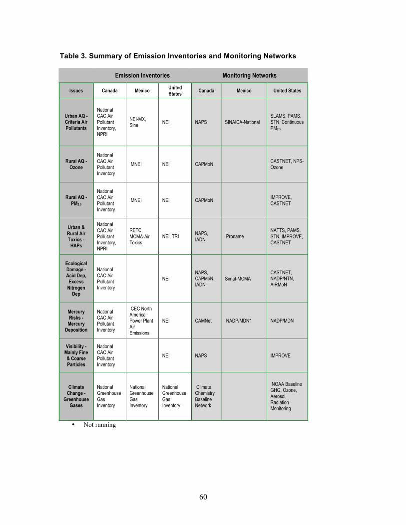
60
Table 3. Summary of Emission Inventories and Monitoring Networks
Emission Inventories Monitoring Networks
Issues Canada Mexico United States
Canada Mexico United States
Urban AQ - Criteria Air Pollutants
National CAC Air Pollutant Inventory, NPRI
NEI-MX, Sine
NEI NAPS SINAICA-National SLAMS, PAMS, STN, Continuous PM2.5
Rural AQ - Ozone
National CAC Air Pollutant Inventory
MNEI NEI CAPMoN CASTNET, NPS-Ozone
Rural AQ - PM2.5
National CAC Air Pollutant Inventory
MNEI NEI CAPMoN IMPROVE, CASTNET
Urban & Rural Air Toxics -
HAPs
National CAC Air Pollutant Inventory, NPRI
RETC, MCMA-Air Toxics
NEI, TRI NAPS, IADN
Proname NATTS, PAMS. STN, IMPROVE, CASTNET
Ecological Damage - Acid Dep,
Excess Nitrogen
Dep
National CAC Air Pollutant Inventory
NEI NAPS, CAPMoN, IADN
Simat-MCMA CASTNET, NADP/NTN, AIRMoN
Mercury Risks -
Mercury Deposition
National CAC Air Pollutant Inventory
CEC North America Power Plant Air Emissions
NEI CAMNet NADP/MDN* NADP/MDN
Visibility - Mainly Fine & Coarse Particles
National CAC Air Pollutant Inventory
NEI NAPS IMPROVE
Climate Change -
Greenhouse Gases
National Greenhouse Gas Inventory
National Greenhouse Gas Inventory
National Greenhouse Gas Inventory
Climate Chemistry Baseline Network
NOAA Baseline GHG, Ozone, Aerosol, Radiation Monitoring
• Not running
61
Urban Air Quality Emissions. Urban air quality issues are well covered by inventories across all three countries. The US and Canada have detailed national inventories. Mexico’s national inventory covers many urban areas throughout the country. Given the similarity of inventory development for the major criteria air pollutants, there is opportunity for further coordination of the databases across countries to address these issues. Monitoring. Monitoring of urban air quality is extensive in all three countries. There is one comprehensive national network in Canada (NAPS), one national (Sinaica) and one MCMA network (Simat) in Mexico, and several inter-related ones in the US (SLAMS, PAMS, STN, and Continuous PM2.5). These databases have similar chemical coverage and resolution. For Canada and the US, more information on speciation of PM2.5 is available. In Mexico there is one site that has the capability of measuring and reporting PM2.5 speciated (Cenica). As for speciated VOC, important to assessing ozone, Canada’s NAPS and the US PAMS regularly monitor speciated urban VOCs. In Mexico there are some measurements for speciated VOC that were taken during field campaigns (MCMA 2002, MCMA 2003 and MILAGRO 2006) and one Cenica site measures speciated VOC on a regular basis. Rural Ozone and Fine Particles Emissions. The national emissions inventories for Canada and the US, with their detailed coverage across all parts of the countries, provide reasonably comprehensive inventories for addressing rural ozone and fine particles. It is important to note that some rural areas are becoming significant emissions source areas (e.g., oil and gas drilling in the western US), posing a challenge for development of emission inventories and for establishing adequate monitoring to track impacts of increased emissions in these areas. The role of natural emissions, particularly for VOCs and related fine particle organics, are the largest source of uncertainty. Treatment of emissions from large events (e.g., wildfires) is improving through use of satellite imagery. Monitoring. Monitoring the regional characteristics of ozone and fine particles is covered in Canada by CAPMoN and in the US by CASTNET and the NPS-ozone monitoring for ozone and by CASTNET and IMPROVE for fine particles. Air Toxics Emissions. Emissions of air toxics are reported in the National CAC Air Pollutant Inventory (2006) and NPRI from Canada; in RETC 2004, MCMA-Air Toxics in Mexico; and NEI (2005) and TRI in the US. Major point sources are best accounted for in the inventories, while area sources are less well known. Proper accounting of smaller sources, which taken together can amount to significant emission levels, remains an important challenge. CEC’s North America Power Plant Air Emissions reports mercury emissions from the power sector along the three countries.
62
Monitoring. There are two networks in Canada (NAPS, IADN) that measure air toxics on a regular basis. In the US, the NATTS is the main network dedicated to toxics; and PAMS, STN, CASTNET and IMPROVE provide additional monitoring related to toxics. There is one similar monitoring network that measures dioxins in Mexico. In addition, air toxics were measured during certain time periods e.g., during field campaigns (MCMA 2002, 2003 and MILAGRO-2006) and specific Hg (Semarnat) and BTX (Cenica) campaigns. There is an ongoing project to evaluate air toxics in different matrices (Proname). Acid Deposition, Excess Nitrogen Deposition Emissions. The national inventories for Canada and the US provide detailed information on precursors of acid deposition and nitrogen deposition. Mexico does not have a national inventory developed to address these issues: however, there is coverage throughout the country for SO2 and NOX precursor emissions. Emissions of SO2 are well documented in both US and Canada. NOX emissions also are well characterized. Ammonia emissions, important for understanding acid rain and excess nitrogen, are most uncertain. Monitoring. There are three national networks in Canada (NAPS, CAPMoN, IADN) and three in the US (CASTNET, NADP/NTN, AIRMoN). In Mexico there is only one local network for the MCMA (Simat) that measures deposition and some major ions; there is an ongoing project to design a national network. The IADN network is operated jointly by Canada and the US and provides an example of how long-term compatible monitoring between two countries can be developed. Mercury Deposition Emissions. Mercury emissions are covered in the national inventories for Canada and the US. There is no formal inventory that covers all sources for mercury in Mexico. Work continues on characterizing mercury species being emitted from facilities, wildfires and natural processes. Monitoring. Mercury deposition is monitored by Canada through CAPMoN and by US in NADP/MDN. Mercury deposition was formally monitored in Mexico at two sites that were certified as MDN official stations; however, they were discontinued due to lack of financial resources. Visibility Emissions. Emissions of particles and gases that form secondary aerosols and in the case of NO2 directly contribute to visibility degradation are covered to a large extent in the national inventories for Canada and the US. Of greatest concern for visibility assessments are the uncertainties associated with the ammonia inventory, natural emissions of VOCs that form organic particles and primary emissions of organic aerosols. Emissions of SO2, NOx and particulates, available in the national inventory for Mexico, could be used for rough estimates of visibility in the urban areas where data is available.
63
Monitoring. There is one national network in Canada (NAPS) and one in the US (IMPROVE) that measure and report visibility; Mexico currently does not have such a network. Climate Change Emissions. All three countries report their national totals for greenhouse gas emissions across key sectors as part of the UNFCCC top down analysis approach. These data are comparable since well-defined procedures are used by all three countries. Bottom up reporting (i.e., information from individual sources) is and will provide additional detail helpful for addressing country and continent contributions to climate change and ozone depletion. It should be noted that Mexico is the only Non-Annex 1 country (under the Kyoto Protocol) that has reported three National Communications to UNFCC. Monitoring. GHGs and related entities (i.e., ozone, aerosols, other air quality pollutants, and radiation) are being monitored in the US and Canada: both efforts are part of the extensive international activities of the WMO/GAW program. These measurements provide comparable information on long-term trends in more remote areas. Enhanced monitoring across all of North America will be helpful in evaluating the success of GHG mitigation strategies and monitor in-flow of chemicals from other regions of the world. Summary Emissions. Emission inventories for all three countries can be used to address urban air quality assessments. The emission inventories in the US and Canada are comprehensive enough to explicitly be used to address urban and regional air quality, border, and long-range transport human health and environmental well-being issues. The greenhouse gas national total emissions inventories for all three countries, developed under the UNFCCC guidelines, can be directly compared and used for analyses at the national total levels. Monitoring. Review of monitoring networks shows that monitoring of basic urban air quality is reasonably complete for gases across the three countries. Coverage for PM2.5, however, is very limited for Mexico. There are no PM2.5 speciation or VOC speciation networks in Mexico. Monitoring outside of the urban areas for PM2.5, ozone, deposition (acid, nitrogen, and mercury) along with visibility is covered in the US and Canada, but not in Mexico. There is reasonable coverage for toxic monitoring in Canada and the US, but there are a limited number of air toxic networks in Mexico. Greenhouse gases are monitored consistently at a number of background sites in the US and Canada. 5.1.2 Multi-pollutant Air Quality Management Strategies
The US and Canada databases are comprehensive enough to support management of many multiple pollutants and issues and Mexico is working toward this goal. Developing formal multi-pollutant management strategies, including comprehensive air quality modeling, that deal with North America as a whole will require careful integration of
64
national inventories and reconciliation and expansion of monitoring systems. Databases are already reasonably in place to begin developing modeling and management structures to simultaneously address issues associated with CAPs and HAPs. Co-management of GHG issues with CAPs and HAPs concerns will require more effort for both inventories and networks. Current GHG inventories at the national level are “top-down” and national averages, which are not easily integrated with spatially refined gridded inventories for other key air pollutants. In addition, background monitoring of GHGs will need to be enhanced, particularly for Mexico. 5.1.3 Climate Change & Air Quality Connections
In order to be able to explore, in depth, the connections between air quality and climate change, it will be important to have more complete and highly resolved inventories for the GHGs. In particular, area sources (e.g., agriculture, landfills) that are not adequately taken into account or spatially disaggregated in the inventories limit efforts to explore these links and need to be better addressed. Of special note are the emissions of CH4 which influence ozone and fine particle chemistry regionally. At this point, the only official GHG inventories for the three countries are national average inventories. In addition, it also is important to be able to develop emission projections that properly take into account key factors that influence future emissions—changes in meteorological conditions caused by climate change and behavioral changes that are influenced by climate change. 5.2 Priority Areas for Improvement
In the critiques of individual country databases, a number of key areas for improvement have been outlined. The high priority areas, applicable to all three countries include treatment of chemical speciation, difficult to measure and assess chemicals, and adequate characterization of source categories. Of particular concern are emissions related to trade and additional monitoring needed to assess impacts related to these emissions. Developing procedures for characterizing climate change sensitive emission projections and planning for commensurate future monitoring needs pose the greatest challenge. Improvement in inventory development and monitoring in all countries will benefit from periodic rethinking of how best to use the systems for multiple, evolving, and emerging environmental concerns; ensuring that approaches are flexible enough to take advantage of technology advances that can lead to improved collection and distribution of data; and promoting continued evaluation of quality assurance and use of resulting improved protocols. 5.2.1 Chemicals and Sources
VOCs. Source-specific VOC species profiles need to be updated with special consideration of those VOCs that are toxic and/or contribute to ozone formation and secondary particulate formation. Biogenic emissions vary depending on plant species and environmental conditions: these differences across countries need to be adequately reflected in emission factors for this class of sources. Monitoring of key VOC species
65
also is a priority. For example, the conceptually potential significance of olefinic releases from plants during vegetative cutting (e.g., cutting hay and other agricultural crops, residential lawns, golf courses) on episodic smog formation, in southeastern Canada and elsewhere, should be considered from both inventory and monitoring research perspectives. In addition, the vapor/particle phase distributions of various high molecular weight semi-volatile organic compounds (e.g., PAH constituents) are important, with respect to both exposure and atmospheric deposition, but challenging to accurately measure or characterize because of their complex chemical nature and potential alterations or reactions during conventional sampling. Ammonia. Source characterization and monitoring of ammonia needs to expand in all of the countries. Of particular concern are ammonia emissions from agricultural practices and mobile sources and how these may be changing as practices and technologies evolve. The possible increases in emissions of ammonia, as well as CO2 generation, from fertilizer use (e.g., urea decomposition) also needs more careful examination, particularly with growing awareness of the intimate chemical connections between GHGs and other pollutants. Particulate Matter. Species profiles for processes that emit PM need to be updated carefully and periodically to improve estimates for the PM component emissions. For example, a consistent means to apply the condensable fraction components (e.g., semi-volatile substances), in conjunction with the inventoried primary particle releases, may need further consideration in deriving total particulate emissions for various sources. In terms of sources, road dust emissions need more careful investigation since this is a large source of PM10 concentration variability in most urban areas. The relationship between elemental carbon and tire wear also needs to be better understood. Monitoring of PM species needs to continue to expand across countries and in a consistent complimentary fashion. Mercury. Source characterization of mercury by species, along with commensurate monitoring, in terms of emissions and deposition remains a challenge. Wildfires. Characterizing wildfires is difficult since these emissions are sporadic and variable. However, more effective use of satellite data, as is being done in the US, should lead to better estimates of this important source of multiple pollutants. Biomass Burning. Biomass burning is an important source of particulate matter and PAHs particularly in Mexico where slash and burn techniques are used to prepare agricultural lands; open dump fires are common; and there is widespread wood burning for cooking and heating as well as for the artesian process production (charcoal, brick and pottery production). Account of self-cut wood for residential heating within Canada also represents an inventory uncertainty. Oil and Gas Drilling. This category is considered significant in the aggregate; however, finer resolution is needed for better assessment through air quality modeling. As is being already explored in the US where this source is a growing concern, hard to quantify
66
emissions from refinery storage tanks, flares, and wastewater are being estimated using remote sensors. Near Roadway. Increased pollutant exposure to persons living or working near major traffic routes has been documented; however, these risks are not likely to be fully reflected in the current monitoring networks since sites are positioned at a distance from roads in accordance with conventional site selection criteria. They also are not being completely captured in inventories, making assessment of the risks difficult. 5.2.2 Emissions and Monitoring Directly Related to Trade
Emissions associated with increased trade-related transportation need to be better addressed in inventories. Shipping channels, trucking lanes, and air transport increases associated with trade need to be consistently described across countries. Enhanced monitoring of key chemicals in these corridors also is needed. 5.2.3 Emission Projections and Future Monitoring Needs
A major challenge in developing future emissions is properly characterizing advances in technology. It also is challenging to reasonably predict human activity patterns with respect to energy use, transportation, and consumer behavior. In addition the role of climate change on emission estimates on GHG as well as other air pollutants has yet to be properly and fully considered in emission projections. Monitoring will need to keep up with changing emission characteristics. For example, many US locations, particularly in the intermountain west, where oil and gas drilling has dramatically increased recently, do not have adequate monitoring to be able to establish current levels and track changes in harmful pollutants. 5.3 Compatibility and Accessibility
Compatibility of emissions inventories and monitoring networks can be described on multiple levels with the key attributes being chemicals included, spatial and temporal resolution and coverage, and underlying database development assumptions, techniques, and processes. For the inventories, it also is important to have compatible characterizations of activities and factors, and compatible as well as adequate source coverage. For the networks, it is important to have similar collection, analysis, and reporting, along with adequate spatial and temporal coverage. Accessibility can be judged based on what is being offered; whether this information meets the needs of modelers and other analysts, policy makers, and general public; and how easy it is to obtain the needed information. 5.3.1 Compatibility
For the emission inventories, the national GHG inventories are most compatible since each country follows the same guidelines and the resulting inventories are national totals for consistent years. For the national inventories for the key all pollutants, similar techniques are being applied across countries. However, spatial coverage for Mexico is not as comprehensive as for the US and Canada. For analysis involving all of the
67
countries, the 2005 inventories for Mexico, Canada and the US provide the best opportunity for creating a North American inventory that is reasonably compatible across countries. The inventories for hazardous air pollutants are being developed using similar procedures: this means that there is a reasonable level of consistency across countries. Monitoring techniques for the major criteria air pollutants are similar across countries. However levels of spatial coverage differ with many areas in Mexico still lacking in monitoring. Accurate, consistent measurements of ammonia, speciated VOCs, and speciated PM2.5 remain important challenges for all three countries. Monitoring of GHGs, along with entities (ozone, aerosols, other pollutants, and radiation) at sites in Canada and the US as part of the international GAW program are comparable for these sites since the protocols are the same. 5.3.2 Accessibility
As discussed in the individual country database analyses, most can be accessed through the Internet. However, in many cases, the interfaces are difficult to use, whether more detailed model-ready databases or relevant summary information is needed. In addition to retrieving the data, several other key needs have been noted. Reporting of Methods. Regular reporting of emission inventory methods and input data (i.e., factors and activity information) used in compiling inventories is recognized as an important need. This kind of detail helps analysts combine, reproduce, and develop new inventories that are compatible with others. Improving Public Awareness. Assessing the connections between emissions and public health and welfare relies on highest quality emissions information integrated with scientifically sound modeling. Communicating the results of these assessments effectively to decision makers and the general public requires packaging information in ways that clearly illuminate the problems and solutions. In addition, characterizing the uncertainties in the data used and the model analysis also is an important part of the communications. For example, it has been noted that well-known, reported industrial sources of toxics may be only a fraction of these emissions and these data gaps need to be factored into analyses and presentations of risks. Improving accessibility to this level and breadth of analysis deserves more attention. 5.4 Infrastructure and Capacity Building
Several ongoing and planned efforts provide opportunities for improving infrastructure and building capacity. Data Sharing Capabilities. As noted in the previous section, work is underway through EPA OAQPS to advance data sharing capabilities and to make information more transparent to the air quality community at large. IT has advanced considerably and, even under budget constraints, there are opportunities for greatly advancing data management and sharing. Some of the major attributes of the desired future model are that it would be
68
more economically efficient, have less redundancy in information, provide much room for innovation, and encourage more cooperation and less competition (e.g., National Air Quality Conferences, April 2008, presentation David Mintz for Nick Mangus EPA-OAQPS, http://airnow.gov/index.cfm?action=conference2008.index). Issues of governance, cooperability, integration, resources and boundaries (i.e., where one provider’s boundary ends and another one’s begins) are being discussed as part of this major effort. These discussions have positive implications for coordination of information across countries. IT-Enhanced Quality. The new US EIS will have more streamline reporting. As a result, emissions data should eventually be easier to report and lead to more consistency across states. The enhanced quality assurance environment, another feature of the new EIS, should lead to higher quality emissions reporting and overall inventory consistency throughout the US. Some of these structures could be helpful for enhancing data sharing and management across countries. Network Deficiencies. A number of concerns have been cited, particularly for Mexico: obsolete equipment, calibration problems, need to relocate stations due to new construction around the monitoring station, inadequate quality assurance, and limited network coverage. Accompanying these are the human resource capacity limitations in the following areas:
• Operation and maintenance of monitoring equipment. • Handling and QA/QC of data. • Prevention and control of air pollutants. • Air quality management to diagnose air pollution problems and to formulate,
execute and evaluate the policies and programs for air quality improvement. • Enhanced skill in risk communication.
Exploring ways to help address these deficiencies is critical for maintaining and improving network coverage across North America. Inventory Development. The overall infrastructure, and associated resource requirements, for creating a national inventory is substantial, including comprehensive reporting requirements, QA procedures, processes for addressing data gaps, synthesis of data consistently across the county, and extensive post-processing of the inventory into model-ready databases that accurately provide emissions for CAPs, VOC groupings relevant for ozone chemistry, individual VOC-HAPs of greatest concern (e.g., benzene), other important HAPs (i.e., mercury), and speciated PM. Development of consistent detailed bottom-up national inventory for GHGs that can be part of the national inventory remains a challenge for all of the countries. The new US effort at establishing more extensive GHG reporting may be able to provide some guidance on how development and integration of a more refined GHG inventory could be accomplished. AIRNow. The AIRNow system provides forecasts and current conditions for air quality throughout the US. Expanding AIRNow to be a more comprehensive system that considers data across North America could enhance distribution of information and deepen air quality awareness of the general public throughout the continent.
69
6.0 Recommendations
Based on the findings outlined in the previous sections, the assessment recommends technical and communication strategies for improving the adequacy, comparability, and use of emission and monitoring information by a broad audience including researchers, air quality modelers, decision makers, and the public. 6.1 Overarching Goals and Guidelines
North American air quality management will benefit from the following:
• Expanded coordination of information development with special attention on compatibility of processes; issue assessments including the full scope of North American concerns; planning with special focus on capacity building and leveraging resources; and communication strategy development for multiple users and needs across countries;
• Centralized North American air quality information web portal for data, documentation of data development and protocols, reports on use of the data and evaluation of data, presentations of summary information for multiple audiences, and planning activities; and
• Eventual development of a consistent, comprehensive North American inventory that can simultaneously address all of the major air quality and climate related concerns with the help of sophisticated state-of-the-art gridded air quality models, and commensurate expansion of monitoring in all three countries to help consistently track changes in all of the key air quality and climate issues.
Guiding principles for improving air quality management databases include:
• Building on existing efforts including the North American working arrangements already in place through the CEC and others and the current planning for next steps in each country; and
• Leveraging infrastructure and resources across countries to improve information development and sharing.
6.2 Key Strategies
To make progress toward improved air quality management, the following steps dealing with emission inventory and monitoring network development, are recommended. These are organized under 3 major headings:
• Coordination-communication-capacity building, • Information portal development, and • Data management planning.
1. Coordination-Communication-Capacity Building.
70
o Coordination. Establish a coordinating group composed of the CEC NAAWG plus other advisors as necessary to implement the strategies presented here. The coordinating group will guide the development and implementation of communication and capacity building strategies that will help determine the success of the information portal development and data management planning.
o Communication. Institute a broader based group of technical and policy oriented
leaders to create a clear strategy for communication and outreach among the database developers, decision makers, air quality policy groups, atmospheric and health researchers, integrated assessment analysts, and the general public. An important aspect of the overall North American strategy is gaining support from citizens as well as policy makers and others making key decisions. A broad-based communication strategy that details how existing communication avenues in each country and across countries can be enhanced to properly raise awareness of new efforts in science and policy making is an important and critical first step. A particularly important aspect is support of ongoing educational programs (governmental and nongovernmental) aimed at raising public awareness on air pollution and its impacts.
o Resources and Capacity Building. Evaluate opportunities for developing
resources and building capacity in order to implement the steps presented in this assessment. Enhanced human resource capacity in many of the recommended areas. The extent to which personnel and materials already in place can be directed toward these key steps needs to be carefully assessed.
2. Information Portal. Set up a team to design and manage the web portal and organize the following content for the portal:
o Overview of North American air quality management needs as described in this assessment.
o Brief descriptions of the databases plus web links to the data and information, following the organizational structure provided in Section 4 of this assessment.
o List of priority data needs for trinational data improvement as summarized in Section 5 and priority data needs for each county as summarized in Section 4, plus links to plans for addressing these priority needs.
o Additional summaries or links to summaries comparing details of the development of inventories (i.e., emission factors and activity data) and networks (i.e., measurement protocols and reporting).
o Summarized information or links to summaries that are particularly helpful to decision makers and the public.
o Outline of how data is being used to improve air quality management in individual countries; for border issues and for broader scope of North American concerns as well as clarifying climate change and air quality connections.
71
o Plans for updating and expanding the portal to include materials discussed in the next set of planning steps.
o Clearinghouse for documents. There is a need of a clearinghouse of reports and research made by different environmental and academic entities in order to increase the access and dissemination of official and useful information (e.g., health databases, air quality measurements, reports).
3. Data Management Planning. Enhance engagement of the key decision makers for emissions and monitoring in all three countries in developing data management plans, including the following steps:
Emission Inventories o Develop protocols for reconciling different approaches to emission inventory
developments at each stage of processing with additional attention to post-processing data for comprehensive modeling and processing data for public-friendly summaries. Of particular concern are the following inventory development immediate next steps:
Base Inventory. Target 2005 national inventories as the base-year inventory for North America and work toward maximizing compatibility across the country databases.
Chemicals. Identify and reconcile differences in treatments of VOC speciation, PM2.5 speciation, ammonia, and mercury speciation.
Point Sources. Confirm different thresholds for major point sources in each country and make sure that small point sources are being accurately accounted for under area sources.
Source Categories. Regroup data into consistent categories where it is important to do so.
Data Gaps. Insure consistent treatment of data gaps for open sources, natural and event emissions, as well as other sources that are not well defined.
Spatial Scales. Develop methods for dealing with spatial data gaps in Mexico in the near term.
Temporal Scales. Insure that current methods for translating annual emissions into more temporally resolved data are consistent across countries.
Forecasting. Evaluate current tools and data being used for forecasting and determine if these are adequate to address how changes in technologies and human activities are impacting air quality.
o Develop a single database that includes emissions data, activity data, cost information, as well as background information data such as technology, implementation details, etc., to enable the use of the matrix approach for policy measures that are not single pollutant specific, but consist of a set of actions to reduce single or multi-pollutants, considering their specific costs and other details in their implementation.
72
Monitoring Networks o Outline sets of maintenance, calibration, collection, analyses, and reporting
protocols for networks that have similar management objectives, with special consideration of these immediate next steps: Chemicals. Explore needs for monitoring urban air greenhouse gases or
other chemicals not currently being tracked. Sites. Establish which processes can best handle data sparseness for
highest priority issues that need to be addressed in the near future. Methods. Determine consistency of QA programs for existing networks. Temporal resolution. Determine if temporal resolution of speciated VOC
measurements are adequate for effects assessments.
Inventories and Networks o Identify which formats are most suitable for cataloguing, consolidating and
querying and managing all of the information produced during inventory and monitoring database development.
o Develop a standard emissions and monitoring data reporting system for air quality managers and public users.
o Identify actions that can be taken to reduce uncertainties in linking observed changes in ambient air quality to emission changes.
o Set up process for properly addressing data development needs associated with emerging issues not currently properly assessed (e.g., indoor air quality) and with issues of growing concern (e.g., connections between climate and air quality).
o Explore opportunities for creating a mutually beneficial, easy to access and operate central database system within each country that helps address each country’s key information needs as well as those for North America.
73
7.0 References, Interviews and Reviews 7.1 References
Emission Inventories US
US EPA NEI/EIS Implementation Plan (Draft). 2008. http://www.epa.gov/ttn/chief/net/neip.html US EPA Toxics Release Inventory. 2008. http://www.epa.gov/tri/tridata/tri06/index.htm www.epa.gov/triexplorer
US EPA Inventory of US Greenhouse Gas Emissions and Sinks: (2008). 1990-2006 http://www.epa.gov/climatechange/emissions/usinventoryreport.html US EPA Greenhouse Gas Reporting Rule. 2008. http://www.epa.gov/climatechange/emissions/ghgrulemaking.html US EPA Air Markets http://www.epa.gov/airmarkt/ US EPA GHG State and Local Programs http://www.epa.gov/climatechange/emissions/state_ghginventories.html Canada Environment Canada. 2007. Criteria Air Contaminants (CAC) Emissions http://www.ec.gc.ca/pdb/cac/Emissions1990-2015/2006/2006_canada_e.cfm Environment Canada. 2007. CAC Emission Trends www.ec.gc.ca/pdb/cac/Emissions1990-2015/emissions_e.cfm Environment Canada. 2008. NPRI (PRTR Substance) Emissions www.ec.gc.ca/pdb/npri/npri_data_e.cfm Environment Canada. 2008. NPRI Summary www.ec.gc.ca/pdb/npri/2006Summary/p3_1_e.cfm Environment Canada. 2007. National Inventory Report, 1990–2005: Greenhouse Gas Sources and Sinks in Canada www.ec.gc.ca/pdb/ghg/inventory_report/2005_report/tdm-toc_eng.cfm Environment Canada. 2007. Facility Greenhouse Gas Emissions Reporting Program
74
http://www.ec.gc.ca/pdb/ghg/onlinedata/downloadDb_e.cfm Environment Canada. 2008. GHG Inventory Report www.ec.gc.ca/pdb/ghg/inventory_report/2006/som-sum_eng.cfm Environment Canada. 2008. GHG Inventory Trends www.ec.gc.ca/pdb/ghg/inventory_report/2006/tab_eng.cfm Mexico Commission for Environmental Cooperation (CEC). 2005. North American Power Plant Air Emissions, p. 93. Available from: http://www.cec.org/files/PDF/POLLUTANTS/PowerPlant_AirEmission_en.pdf. Comision Ambiental Metropolitana (CAM). 2006. Inventario de emisiones [a la atmósfera. Zona Metropolitana del Valle de México] 2004. Comisión Ambiental Metropolitana, Mexico, D.F. November 2006. Accessible from: http://www.sma.df.gob.mx/ceina/index.php?bus=emisiones&cat=0&op=2&tipo=2. Domínguez Taylor P, L.G. Ruiz-Suarez, I. Rosas-Perez, J.M. Hernandez-Solis, R. Steinbrecher. 2007. Monoterpene and isoprene emissions from typical tree species in forest around Mexico City. Atmospheric Environment 41(13): 2780–2790. Intergovernmental Panel on Climate Change. 2006. 2006 IPCC Guidelines for National Greenhouse Gas Inventories. Available from: http://www.ipcc-nggip.iges.or.jp/public/2006gl/index.html. Jazcilevich, A. D., A. Garcia-Fragoso, A. G. Reynoso, M. Grutter, U. Diego-Ayala, J. Lents and N. Davis. 2007. “A vehicle emissions system using a car simulator and a geographical information system: Part 1- System description and testing. Journal of the Air & Waste Management Association 57(10): 1234–1240. Mejía, G.M., D.D. Tejeda, M.P. Bremauntz, M.A. Martínez, P.C. Montufar, M.J. Sierra, A. Valdez and C.A. González. 2007. VOC Speciation from Steam Boiler Stacks of Industries Located in Naucalpan. American Geophysical Union Joint Assembly. Acapulco, Mexico.” Molina, L.T. and M.J. Molina. 2002. Air Quality in the Mexico Megacity: An Integrated Assessment. The Netherlands, Kluwer Academic Publishers. 384pp. Registro de Emisiones y Transferencia de Contamiantes (RETC) last visited on 8 Aug 2008: http://www.ine.gob.mx/ueajei/publicaciones/libros/327/i.html. http://www.semarnat.gob.mx/gestionambiental/calidaddelaire/Pages/retc.aspx.
http://app1.semarnat.gob.mx/retc/index.php.
75
Sánchez–Martínez, S., E. Rebolledo, H. Landa Fonseca, R. Martínez Verde, R.C. Mercado Martínez, A. Cruzado, V. Garibay Bravo, A. Matus Kramer, L. Rojas-Bracho, A. Fernández Bremauntz, P.G. Fields, M.E. Wolf, R. Halvey, W. Kuykendal and P. Miller. 2005a. Phase III Mexico National Emissions Inventory: Point Sources and Future Activities. Available from: www.epa.gov/ttn/chief/conference/ei14/session9/martinez.pdf Sánchez–Martínez, S., E. Rebolledo, H. Landa Fonseca, R. Martínez Verde, R.C. Mercado Martínez, A. Cruzado, V. Garibay Bravo, A. Matus Kramer, L. Rojas-Bracho, A. Fernández Bremauntz, P.G. Fields, M.E. Wolf, R. Halvey, W. Kuykendal and P. Miller. 2005b. Phase III Mexico National Emissions Inventory: Point Sources and Future Activities. Available from: www.epa.gov/ttn/chief/conference/ei14/session9/martinez.pdf Schifter, I., L. Diaz, J. Duran, E. Guzman, O. Chavez and E. Lopez-Salinas. 2003. Remote Sensing Study of Emissions from Motor Vehicles in the Metropolitan Area of Mexico City. Environmental Science & Technology 37(2): 395–401. Secretaría de Desarrollo Social y Protección del Medio Ambiente del Gobierno de Tabasco (SEDESO-PMA). 2003. Primer Informe de la calidad del aire del estado de Tabasco 2001–2002 [First report of air quality in the state of Tabasco 2001–2002]. p. 54. Semarnat. 2005a. Guia de elaboración y usos de inventarios de emisiones [Guide to development and use of emissions inventories]. 2005 Instituto Nacional de Ecología. http://www.ine.gob.mx/ueajei/publicaciones/consultaPublicacion.html?id_pub=457. Semarnat. 2005b. Sistema Nacional de Emisiones 2005 Instituto Nacional de Ecología www.ine.gob.mx/dgicur/calaire/descargas/sine.pdf. Semarnat. 2006a. Inventario Nacional de Emisiones de Mexico, 1999 [Mexican National Emissions Inventory, 1999.]. Instituto Nacional de Ecología. http://www.ine.gob.mx/dgicur/calaire/inem.html. Semarnat. 2006b. Inventario Nacional de Emisiones de Gases de Efecto Invernadero, 1990–2002 [Greenhouse gas national emission inventory 1990–2002]. Instituto Nacional de Ecología. http://www.ine.gob.mx/ueajei/publicaciones/consultaPublicacion.html?id_pub=502. Semarnat. 2006c. Compendio histórico de inventarios de emisiones en México [Historical Compendium of emission inventories in Mexico], p. 173. Semarnat. 2008. Emissions inventories available on the Web at: http://www.semarnat.gob.mx/gestionambiental/calidaddelaire/Pages/InventarioNacionaldeEmisiones.aspx. Last visited 08/01/2008.
76
SMA. 2007. Inventario de Emisiones de Contaminantes Tóxicos de la Zona Metropolitana del Valle de México 2006 [Valley of Mexico Metropolitan Area toxic pollutants emissions inventory 2006]. Dirección General de Gestión de la Calidad del Aire, Dirección de Programas de Calidad del Aire e Inventario de Emisiones. Ciudad de México, 2007 http://www.sma.df.gob.mx/sma/index.php?opcion=26&id=502. SMA. 2008a. Inventario de Emisiones de Contaminantes Criterio de la Zona Metropolitana del Valle de México 2006 [Valley of Mexico Metropolitan Area criteria pollutants emissions inventory, 2006]. Dirección General de Gestión de la Calidad del Aire, Dirección de Programas de Calidad del Aire e Inventario de Emisiones. Ciudad de México, 2008. http://www.sma.df.gob.mx/sma/index.php?opcion=26&id=501. SMA. 2008b. http://www.sma.df.gob.mx/modelacion/ SMA. 2008c. Inventario de emisiones de gases efecto invernadero para la zona metropolitana del valle de México [Greenhouse Gases emissions Inventory for MCMA, 2006]. Secretaria del Medio Ambiente (SMA) preliminary version available from http://www.sma.df.gob.mx/sma/index.php?opcion=26&id=528. Sine. 2008. Sistema Nacional de Emisiones [National Emissions Inventory System]. Sine Semarnat 2008. http://aplicaciones.semarnat.gob.mx/sine/ Vega, E., I. Garcia, D. Apam, M.E. Ruiz, and M. Barbiaux. 1997. Application of a chemical mass balance receptor model to respirable particulate matter in Mexico city. Journal of the Air & Waste Management Association 47(4): 524–529. Vega, E., V. Mugica, R. Carmona, and E. Valencia. 2000. Hydrocarbon source apportionment in Mexico City using the chemical mass balance receptor model. Atmospheric Environment 34(24): 4121–4129. Velasco, E. and R.M. Bernabé. 2004. Emisiones biogénicas [Biogenic emissions]. Semarnat, INE 2004 http://www.ine.gob.mx/ueajei/publicaciones/consultaPublicacion.html?id_pub=439. Velasco, E., B. Lamb, S. Pressley, E. Allwine, H. Westberg, B.T. Jobson, M. Alexander, P. Prazeller, L. Molina, and M. Molina. 2005a. Flux measurements of volatile organic compounds from an urban landscape. Geophysical Research Letters 32(20). Velasco, E., S. Pressley, E. Allwine, H. Westberg, and B. Lamb. 2005b. Measurements of CO2 fluxes from the Mexico City urban landscape. Atmospheric Environment 39(38): 7433–7446. Vijay, S., L.T. Molina, and M.J. Molina. 2004. Estimating Air Pollution Emissions from Fossil Fuel Use in the Electricity Sector in Mexico. Prepared by the Integrated Program
77
on Urban, Regional, and Global Air Pollution at the Massachusetts Institute of Technology. April 2004. (Available online at http://www.cec.org). Zavala, M., S.C. Herndon, R.S. Slott, E.J. Dunlea, L.C. Marr, J.H. Shorter, M. Zahniser, W.B. Knighton, T.M. Rogers, C.E. Kolb, L. T. Molina, and M. J. Molina. 2006. Characterization of on-road vehicle emissions in the Mexico Valley Metropolitan Area using a mobile laboratory in chase and fleet average measurement modes during the MCMA-2003 field campaign. Atmospheric Chemistry and Physics 6: 5129–5142. Canada – US –Mexico CEC. 2001. Enhancing the Comparability of the Emission Inventories in Canada, Mexico and United States. http://www.cec.org/programs_projects/pollutants_health/project/index.cfm?projectID=22&varlan=english&ID=docs. CEC. 2005. Action Plan to Enhance the Comparability of Pollutant Release and Transfer Registers in North America. http://www.cec.org/pubs_docs/documents/index.cfm?varlan=english&ID=896. CEC. 2007. Taking Stock – 2004. North American Pollutant Releases and Transfers. http://www.cec.org/pubs_docs/documents/index.cfm?varlan=English&ID=2170. NARSTO. 2005. Improving Emission Inventories for Effective Air Quality Management Across North America. www.narsto.org/section.src?SID=8#5. Canada – US Great Lakes Commission Great Lakes Regional Toxic Air Emissions Inventory http://wiki.glin.net/display/RAPIDS/Home. Mexico – US Kuhns, H., E.M. Knipping, J.M. Vukovich. 2005. Development of a United Status-Mexico Emissions Inventory for the Big Bend Regional Aerosol and Visibility Observational (BRAVO) Study. J. Air & Waste Management Association. El Paso-Juarez Offset – El Paso electric project. Available: http://www.jac-ccc.org/ (Contact: Carolos Rincon Rincon: [email protected]).
78
Monitoring Networks US US EPA Air Pollution Monitoring http://www.epa.gov/oar/oaqps/montring.html US EPA Ambient Monitoring Technology Information Center http://www.epa.gov/ttn/amtic/ US EPA Ambient Air Monitoring Program http://www.epa.gov/air/oaqps/qa/monprog.html US EPA Ambient Air Monitoring Guidance Document (2007) http://www.epa.gov/ttn/amtic/cpreldoc.html US EPA Ambient Monitoring http://www.epa.gov/air/oaqps/qa/monprog.html http://www.epa.gov/cludygxb/programs/namslam.html US EPA Air Toxics http://www.epa.gov/ttn/amtic/toxover.html, http://www.epa.gov/ttn/atw/ US EPA NCore NCore http://www.epa.gov/ttnamti1/ncore/index.html NPS IMPROVE http://vista.cira.colostate.edu/improve/ NPA Ozone Monitoring http://www.nature.nps.gov/air/Monitoring/network.cfm#data, http://www.nature.nps.gov/air/studies/portO3.cfm, http://www.nature.nps.gov/air/Studies/Passives.cfm US Agencies National Atmospheric Deposition Program (NADP) http://nadp.sws.uiuc.edu/ US EPA Clean Air Status and Trends Network (CASTNET) http://www.epa.gov/castnet/ NOAA Earth System Research Laboratory’s Global Monitoring Division http://www.esrl.noaa.gov/gmd/index.html US EPA AIR NOW http://airnow.gov/ US EPA NATA http://www.epa.gov/ttn/atw/natamain/
79
Canada Environment Canada. 2001. Precursor Contributions to Ambient Fine Particulate Matter in Canada. Available: http://www.msc-smc.ec.gc.ca/saib/smog/docs/summary-pm2_5-Eng.pdf. Environment Canada. 2008. NAPS Summary Information www.etc-cte.ec.gc.ca/NAPS/naps_summary_e.html Environment Canada. 2008. NAPS Report www.etc-cte.ec.gc.ca/publications/naps/naps2004_annual.pdf Environment Canada. 2008. CAPMoN Summary Information www.msc.ec.gc.ca/capmon/index_e.cfm Environment Canada. 2008. CAMNeT Summary Information www.msc.ec.gc.ca/arqp/camnet_e.cfm Environment Canada. 2008. CAMNeT Data www.msc.ec.gc.ca/nattchem/particle/n_camnet_e.html; www.msc-smc.ec.gc.ca/natchem/toxics/index_e.html Environment Canada. 2008. IADN Summary Information www.msc-smc.ec.gc.ca/iadn/overview/background_e.html Environment Canada. 2008. IADN Data http://www.msc-smc.ec.gc.ca/iadn/results/result_tables_e.html Mexico Cenica and UABC. 2007. Evaluación y definición de sitios potenciales que conformarán la red de monitoreo de niveles de fondo de dioxinas y furanos en aire [Evaluation and definition of potential sites that will shape the monitoring network background levels of dioxins and furans in air] Final Report.
Martinez-Bolivar, A.P., et al. 2006. National Atmospheric Monitoring Program” “Programa Nacional de Monitoreo Atmosférico. 2006 Semarnat, INE. Available at http://sinaica.ine.gob.mx/downloads/taller-sinaica-11-06-04/pnma-dgcenica-ine/pnma-2004.pdf.
Fentanes-Arriaga et al. 2004. Situación Actual de Monitoreo Atmosférico [Atmospheric Monitoring present situation]. Instituto Nacional de Ecologia
Atmospheric Monitoring System in Baja California. Web page describing the air quality network in Baja California Sistema de Monitoreo Atmosférico del Estado de Baja California. Web page: http://sinaica.ine.gob.mx/red_bc.html.
80
Atmospheric Monitoring System in Cd. Juárez. Web page describing the air quality network in Cd. Juárez, Sistema de Monitoreo Atmosférico de Ciudad Juárez. Web page: http://sinaica.ine.gob.mx/red_juarez.html. Atmospheric Monitoring System in Durango. Web page describing the air quality network in Durango, Sistema de Monitoreo Atmosférico del Estado de Durango. Web page http://sinaica.ine.gob.mx/red_durango.html.
Atmospheric Monitoring System in Mexico City (ZMVM). Web page describing the air quality network in metropolitan Mexico City, Sistema de Monitoreo Atmosférico de la ZMVM (Simat) http://www.sma.df.gob.mx/simat/. Atmospheric Monitoring System in Guadalajara. Web page describing the air quality network in Guadalajara, Red Automático de Monitoreo Atmosférico de la Zona Metropolitana de Guadalajara (RAMAG). Web page http://sinaica.ine.gob.mx/red_guada.html. Atmospheric Monitoring System in Hidalgo. Web page describing the air quality network in Hidalgo, Red Automático de Monitoreo Atmosférico del Estado de Hidalgo. Web page http://sinaica.ine.gob.mx/red_hidalgo.html.
Atmospheric Monitoring System in Monterrey. Web page describing the air quality network in Monterrey, Sistema de Monitoreo Atmosférico del Estado de Monterrey. Web page http://sinaica.ine.gob.mx/red_monterrey.html. Atmospheric Monitoring System in Morelos. Web page describing the air quality network in the state of Morelos, Red Automático de Monitoreo Atmosférico del Estado de Morelos (RAMAMOR). Web page http://sinaica.ine.gob.mx/red_morelos.html.
Molina, L.T., C.E. Kolb, B. de Foy, B.K. Lamb, W.H. Brune, J.L. Jimenez, R. Ramos-Villegas, J. Sarmiento, V. H. Paramo-Figueroa, B. Cardenas, V. Gutierrez-Avedoy, and M. J. Molina. 2007. Air Quality in North America’s Most Populous City – Overview of MCMA-2003 Campaign. Atmospheric Chemistry and Physics 7, 2447–2473.
Molina, L.T., S. Madronich, J.S. Gaffney, and H.B. Singh. 2008. Overview of MILAGRO/INTEX-B Campaign, IGAC Newsletter, Issue No. 38, pp. 2-15, April.
Molina, L.T. and M. Molina. 2002. Air Quality in the Mexico Megacity. An Integrated Assessment. The Netherlands: Kluwer Academic Publishers. 384 pp.
Reis, Stefan. 2005. Costs of Air Pollution Control. Heidelberg, Berlin: Springer Verlag. State air quality monitoring network in Puebla. Web page describing the air quality network. Red Estatal de Monitoreo Atmosférico (REMA) de Puebla. Web page: http://sinaica.ine.gob.mx/red_puebla.html.
Sheinbaum, C., L.V. Osawa, O. Vazquez, and G. Robles. 2000. Inventario de Emisiones de gases de efecto invernadero asociado a la producción y uso de energía en la Zona Metropolitana del Valle de México. [Final Report of Energy and Environmental Group UNAM to GEF and CAM].
Sistema Nacional de Información de la calidad del aire (Sinaica). Available from: http://sinaica.ine.gob.mx/. Last visited, 13 May 2008.
81
Wöhrnschimmel, H., C. Marquez, V. Macías, F. Ángeles, T. Ortuño, A. Tellez, J. Ferrario, C. Byrne, D. Winters, A. Avila, S. Blanco, E. Caetano, J. Carabias, C. Cario, G. Galindo, I. Galindo, G. Gold, E. Herrera, C. Welsh, B. Cárdenas. 2008. Design and operation of the Mexican Dioxin Air Monitoring Network (MDAMN) 28th International Symposium on Halogenated Persistent Organic Pollutants (POPs) Birmingham England UK. August.
Zuk, M., M.G. Tzintzun Cervantes, L. Rojas Bracho. 2007. Third almanac data and trends of air quality in nine Mexican cities. [This book collects, analyzes and systematizes the information generated by local networks monitoring the metropolitan areas of the Valley of Mexico, Guadalajara, Toluca Valley, and Monterrey, as well as cities of Puebla, Tijuana, Mexicali, Salamanca and Ciudad Juarez, for the period 1997–2005]. US - Canada Environment Canada - US EPA. 2004. Canada-United States Transboundary Particulate Matter Science Assessment. See: http://www.msc-smc.ec.gc.ca/saib/smog/transboundary/transboundary_e.pdf. US – Mexico US EPA US-Mexico Environmental Program: Border 2012 Implementation and Mid-Term Report 2007. See: http://www.epa.gov/usmexicoborder/publications.html#result. US – Canada – Mexico Global Atmosphere Watch http://www.wmo.int/pages/prog/arep/gaw/gaw_home_en.html 7.2 Interviews and/or Reviews* * Indicates person served as a reviewer only. Canada Keith Puckett (Science & Technology Branch) [email protected] Tel: 416-739-4836 Robert Vet (Science & Technology Branch) [email protected] Tel: 416-739-4853 Marjorie Shepherd (GHG/CC monitoring)* [email protected]
82
Tel: 416-739-4230 Marc Deslauriers (Emissions inventories) [email protected] Tel: 819-994-3069 Art Jaques (GHG emissions inventory)* [email protected] Tel: 819-994-3098 Richard Turle (Urban air pollutant monitoring)* [email protected] Tel: 613-949-1802 Pierrette Blanchard (Non-urban air pollutant monitoring)* [email protected] Tel: 416-739-5701 Mexico Víctor Hugo Páramo (SMA-DF/ Air Quality) [email protected] Tel. +52 (55) 5272 6338 Armando Retama (SMA-DF/ Simat-Monitoring) [email protected] Tel. +52 (55) 5719 0420 Jorge Sarmiento (SMA-DF/ Emissions Inventory) [email protected] Tel. +52 (55) 5278 9931 ext 6170 Ana María Contreras Vígil (Semarnat/ Inventories-RETC) [email protected] Tel. +52 (55) 5624 3502 Ramiro Barrios (Semarnat/ Emissions Inventories) [email protected] Tel. +52 (55) 5624 3404 Hugo Landa Fonseca (Semarnat/ Emissions Inventories)* [email protected] Tel. +52 (55) 5624 3404 Ana Patricia Martínez (Cenica-INE/ Monitoring) [email protected]
83
Tel. +52 (55) 5294 2585 Beatríz Cárdenas (Cenica-INE/ Air Toxics) [email protected] Tel. +52 (55) 5613 3787 Julia Martínez (INE/ Greenhouse Gases)* [email protected] Tel. +52 (55) 5424 6424 Leonora Rojas (INE/ Air Quality)* [email protected] Tel. +52 (55) 5424 6454 Verónica Garibay (INE/ Emissions)* [email protected] Tel. +52 (55) 5424 6423 Ing. María Idolina de la Cerda Hinojosa (APMARN) [email protected] Tel +52 (81) 2020 7415 and 7421 Meeting 31 July 2008, and 1 August 2008, in Mexico City: with representatives from INE, Semarnat, Cenica and SMA/DF. Workshop 3–4 October 2008, in Guadalajara: with representatives from INE, Semarnat, Cenica, SMA-DF, and from the states of Hidalgo, Morelos, Nuevo Leon, Guanajuato, and Jalisco. United States Sue Stendebach (US-Mexico Border Programs) [email protected] Tel: 202-564-8309 Lee Tooly (Emission Inventories) [email protected] Tel: 919-541-5292 Anne Pope (NEI)) [email protected] Tel. 919-541-5373 Martin Husk (NEI) [email protected]

84
Tel: 919-541-3621 Rich Mason (NEI) [email protected] Tel: 919-541-3405 Reid Harvey (GHG Inventory) [email protected] Tel. 202-343-9429 Lew Weinstock (Ambient Monitoring) [email protected] Tel: 919-541-3661 Phil Dickerson (AIRNow) [email protected] Tel. 919-541-4814 Nealson Watkins (Ambient Monitoring)* [email protected] Tel. 919-541-5522 Mausami Desai (Climate Change)* [email protected] Tel. 202-343-9381 Russ Schnell (NOAA Global Monitoring Division) [email protected] 303-497-6733 Carlos Rincon (Saludos desde El Paso Del Norte – EPS Region 6 Border Office Director) [email protected] Tel: 915-533-7273