![cut · cut cut cut cut cut cut cut cut 不 被 老 闆 發 現 版 單字 加 油 卡! 【主題11】Holiday & Festival launchlayover ['le0`D?vD] n.( ) (=stopover)(旅途中)中途停留](https://static.fdocuments.net/doc/165x107/60277625d0fafc4cf54e998f/cut-cut-cut-cut-cut-cut-cut-cut-cut-e-e-e-c-c-c-.jpg)
Compartment Review Presentation - DNR - … · Compartment Review Presentation Atlanta Forest ... e...
47
County Acreage: Entry Year Compartment Compartment Review Presentation Forest Management Unit Atlanta 54014 2019 1,548 Montmorency Management Area: Avery Hills Legal Description: Identified Planning Goals: Soil and topography: Ownership Patterns, Development, and Land Use in and Around the Compartment: Unique Natural Features: Archeological, Historical, and Cultural Features: Special Management Designations or Considerations: Watershed and Fisheries Considerations: Wildlife Habitat Considerations: Mineral Resource and Development Concerns and/or Restrictions Vehicle Access: T29N R03E Sec 2-4, 9-11, and 14-17 To provide for the protection, integrated management and responsible use of a healthy, productive, and undiminished forest resource base for the social, recreational, environmental, and economic benefit of the State of Michigan. Harvests prescribed will help to balance the age classes of aspen to sustainably produce various timber products, enhance game and non-game wildlife habitat and provide for forest-based recreational uses. Soils are primarily loamy sands, sands, and muck. The topography of the compartment is primarily level with some minor areas of rolling terrain. The compartment is predominately aspen. Forest habitat types are primarily dominated by PArVHa, PArVCo, PArVVb, and unclassified lowland. The northeastern part of the compartment is predominately small blocks of state land surrounded by private. The southwestern part of the compartment has private on one or more sides but does connect to large areas of state land. The southwest 40 within section 15 is in the process of being removed from State ownership. The compartment has some recreational use by ORVs and snowmobiles and receives a large amount of use by Antrim Gas Companies. Rare and Endanger Species Present- Great Blue Heron Potential Other Rare and Endangered Species Present- None known. Some sites exist. Contact the state historical preservation office for more information or reporting of new sites. None. Fisheries Division asks for a 300 foot buffer strip as per Fisheries Division Policy and Procedure 02.02.011 for the Gilchrist and Hunt creeks. Both are designated trout streams which are less than 50 feet wide and have wild trout populations. These reaches are also hampered at times by beaver activity which can significantly warm stream temperatures. This compartment is near to a multiple compartment, large scale block of public land providing contiguous wildlife pathways that are necessary for many of our large game animals such as black bear. Habitat components of heavy aspen and oak provide food and cover for multiple species at a variety of age classes. We are working to maintain oak and other mast producing trees as well as keep a good age rotation of aspen in this compartment as well as adjacent compartments. Species which benefit from our management include white-tailed deer, black bear, ruffed grouse, woodcock, and many other game and non-game species. There is no metallic mineral potential in this part of the state. Active and former sand/gravel pits are located in the area and there is good potential for additional sand & gravel within the compartment. The compartment has been completely developed for Antrim Shale gas and all state mineral rights are currently under lease and held by production. This compartment is accessed from County Roads: Schmallers Rd, Hunt Creek Rd, Harwood Rd, Co Rd 612 and Co rd 487. There are several two tracks for traversing the area. Revision Date: 2017-05-26 Stand Examiner: Darrick Coy 10/04/2017 11:16:23 AM - Page 1 of 2 SWARTZN3
Transcript of Compartment Review Presentation - DNR - … · Compartment Review Presentation Atlanta Forest ... e...

CountyAcreage:
Entry YearCompartment
Compartment Review Presentation Forest Management UnitAtlanta
5401420191,548Montmorency
Management Area: Avery Hills
Legal Description:
Identified Planning Goals:
Soil and topography:
Ownership Patterns, Development, and Land Use in and Around the Compartment:
Unique Natural Features:
Archeological, Historical, and Cultural Features:
Special Management Designations or Considerations:
Watershed and Fisheries Considerations:
Wildlife Habitat Considerations:
Mineral Resource and Development Concerns and/or Restrictions
Vehicle Access:
T29N R03E Sec 2-4, 9-11, and 14-17
To provide for the protection, integrated management and responsible use of a healthy, productive, and undiminished forest resource base for the social, recreational, environmental, and economic benefit of the State of Michigan. Harvestsprescribed will help to balance the age classes of aspen to sustainably produce various timber products, enhance game and non-game wildlife habitat and provide for forest-based recreational uses.
Soils are primarily loamy sands, sands, and muck. The topography of the compartment is primarily level with some minor areas of rolling terrain. The compartment is predominately aspen. Forest habitat types are primarily dominated by PArVHa, PArVCo, PArVVb, and unclassified lowland.
The northeastern part of the compartment is predominately small blocks of state land surrounded by private. The southwestern part of the compartment has private on one or more sides but does connect to large areas of state land. The southwest 40 within section 15 is in the process of being removed from State ownership. The compartment has some recreational use by ORVs and snowmobiles and receives a large amount of use by Antrim Gas Companies.
Rare and Endanger Species Present- Great Blue HeronPotential Other Rare and Endangered Species Present- None known.
Some sites exist. Contact the state historical preservation office for more information or reporting of new sites.
None.
Fisheries Division asks for a 300 foot buffer strip as per Fisheries Division Policy and Procedure 02.02.011 for the Gilchrist and Hunt creeks. Both are designated trout streams which are less than 50 feet wide and have wild trout populations. These reaches are also hampered at times by beaver activity which can significantly warm stream temperatures.
This compartment is near to a multiple compartment, large scale block of public land providing contiguous wildlife pathways that are necessary for many of our large game animals such as black bear. Habitat components of heavy aspen and oak provide food and cover for multiple species at a variety of age classes. We are working to maintain oak and other mast producing trees as well as keep a good age rotation of aspen in this compartment as well as adjacent compartments. Species which benefit from our management include white-tailed deer, black bear, ruffed grouse, woodcock, and many other game and non-game species.
There is no metallic mineral potential in this part of the state. Active and former sand/gravel pits are located in the area and there is good potential for additional sand & gravel within the compartment. The compartment has been completely developed for Antrim Shale gas and all state mineral rights are currently under lease and held by production.
This compartment is accessed from County Roads: Schmallers Rd, Hunt Creek Rd, Harwood Rd, Co Rd 612 and Co rd 487. There are several two tracks for traversing the area.
Revision Date: 2017-05-26
Stand Examiner: Darrick Coy
10/04/2017 11:16:23 AM - Page 1 of 2 SWARTZN3

Survey Needs:
Recreational Facilities and Opportunities:
Fire Protection:
Additional Compartment Information:
Some areas exist within sections 9 and 10.
There are many opportunities for hunting and wildlife viewing in the area.
Fire response to the compartment will be covered by the Atlanta DNR office as well as the Tri-Township Fire Department.
The following reports from the Inventory are attached: Total Acres by Cover Type and Age Class Cover Type by Harvest Method Proposed Treatments – No Limiting Factors Proposed Treatments – With Limiting Factors Stand Details (Forested and Nonforested) Dedicated and Proposed Special Conservation Areas Site Condition Details
The following information is displayed, where pertinent, on the attached compartment maps: Base feature information, stand boundaries, cover types, and numbers Proposed treatments Site condition boundaries Details on the road access system
10/04/2017 11:16:23 AM - Page 2 of 2 SWARTZN3

NugentCreek
HuntCreek
LockwoodLake
"!(33
5th St S
County Road 612
4th St
Solom
on R
d
County Road 487
Avery Lake Rd
Beauregard Rd
HardwoodHills Ln
8th St7th S
t
Loud Rd
Harwood Rd
3rd St
W Lockwood Lake Rd
W Sa
ndy T
rl
Hardwoods Rd
S Loc
kwoo
dLa
ke R
d
Blue L
akes
Club D
r
Sand
y Trl
HuntersHome Rd
Greasy C
reek R
d
V 8 Trl
Lockwood Lake Rd
Sage
Cree
k Rd
BlueLake Rd
Heppner Dr
Avery Lake Rd
Harwood Rd
Franc
isco R
d
Schmallers Rd
E Sandy T
rl
Root Rd
Hardwood
Hills Rd
Gree
n Vall
ey Tr
l
54014042-Cut
54014049-Cut
54014020-Cut
54014020-Cut
54014040-Cut
54014103-Cut
54014103-Cut
54014057-Cut
54014057-Cut54014055-Cut
54014113-Other
54014457-NF
54014475-NF
54014446-NF
54014451-NF
54014444-NF
54014011-NF
54014424-NF
54014420-NF
Atlanta 42015
Atlanta 122019
Atlanta 152020
Atlanta 162011
Atlanta 182013
Atlanta 192020
Atlanta 242012
Atlanta 252013
016001-CCut
24055-Burn
54004_St8-Burn
54004028-CCR
54004037-CCR54004040-CT
54004041-CT
54004048-CCR
54004058-CT
54004060-CCR
54004063-CCR
54004066-CT
54004067-CCR
54004072-CCR
54004085-CCR
54004095-CCR
54004097-CCR
54015013-Thin_Survey
54015029-Single_Survey
54015055-_Plant_Hem_Ced
54025091.19_Cut
NF_54004065-NonFor
NF_54004073-NonForNF_54015076-NonFor
NF_54015077-NonForNF_54015079-NonFor
NF_54015083-NonFor
NF_54024061-NonFor
54025102.32_NF
54025103.31_NF54025104.30_NF
54025107.29_NF
54025108.28_NF
54025111.27_NF
54025114.26_NF54024060-Monitor
54025106.18_Monitor
54016079-Monitor
54015007-Monitor
54015084-Monitor
54015012-Monitor
54015036-Monitor
54015071-Monitor
54015082-Monitor
54015021-Monitor
54015013-Monitor
54004033-Monitor
54025099.14_Monitor
54019011-Monitor 54019028-Monitor
54025100.55_Monitor
54015035-Cut-SBW
54015031-Cut-SBW
54018007-Monitor
54018010-Monitor54018003-Monitor54018002-Monitor
54004018-Monitor
54004032-Monitor54004020-Burn
103A6
442U0
138L0
154A6
31A3
74D0
89N0
435U0
106L0
81A6
25Q5
135A3
82L0
147U0
72C5
109L0
28X0
84MD5
430G0
80MD6
44A3
121A5
51A2
87MD6
118L0
3Q8
17UM5
243G0
125U0
56V0
92C6
41UM9
6P8
112O9
67MC5
20A9
76O9
159D0
26A3
130LM6
415G0
475U0
104U0
34L0
95A3
66L0
79C6
47A3
133Q5
23L0
496G0
424G0
107C6
136A3
117N0
115L0
7A6
85J6
1C6
431G0
39L0
108L0
110A3
49A6
35D0
52A6
4P6
10D0
438G0
156C9
48L0
18C6
448G0
29UM5
90P6
132U0
57A6
113A3
141A6
42A9
403G0
69D0
93T6
21L0
15A3
457G0
45N0
152U0 122
C9
88LM2
484G0
70L0
286G0
96O8
68A9
24D0
99C9
425G0
77Q3
102C5
137Q2
131A3
30A2
419G0
2Q5
446G0
105C5
148J6
50D0
33N0
55S5
91A3
37C6
5N0
40A6
36C4
126L0
13L0
43A3
8Q5
143A9
86A6
11G0
22L0
16L0
46P8
459G0
420G0
487G0
139Q6
97A6
295U0
19A3
123A5
120A5
142UM5
14C9
32N0
94L0
38D0
161N0
114A8
124L0
101UM9
116L0
158U0
27S6
65L0
451G0
283X0
299X0
53L0
129MD8
222X0
444G0
59C9
140L0
160D0
71E5
155L0
54U0
98G0
127L0
134A3
128D0
12N0
111L0
441U0 450
G0
58L0
119L0
150G0
61N0
146U0
64U0
75O9
407G0
145Q6
84°0'30"W84°1'0"W84°1'30"W84°2'0"W84°2'30"W84°3'0"W84°3'30"W84°4'0"W84°4'30"W84°5'0"W84°5'30"W84°6'0"W84°6'30"W84°7'0"W84°7'30"W84°8'0"W84°8'30"W
44°5
6'30"N
44°5
6'0"N
44°5
5'30"N
44°5
5'0"N
44°5
4'30"N
0 10.5Miles
Miris CornersÓ Remonumented Section CornersXW Survey Grade GPS Corners
CountiesD Gate# Berms× Cabin
County Paved RoadsPaved RoadsCounty Gravel RoadsGravel RoadsCounty Poor Dirt RoadsPoor Dirt RoadsClosed
StreamsLakes and Rivers All
\\\\\PipelineFenceNon-Designated Recreational TrailCompartment BoundaryTreatments with Site ConditionsOther Treatment - See CommentsClearcut (w/Reserves)Opening Maintenance412 - Oak Types413 - Aspen419 - Mixed Upland Deciduous422 - Natural Pines423 - Other Upland Conifers
430 - Upland Mixed Forest611 - Lowland Deciduous Forest612 - Lowland Coniferous Forest613 - Lowland Mixed Forest122 - Roads/Parking Lot310 - Herbaceous Openland330 - Low Density Trees622 - Lowland Shrub623 - Emergent Wetland790 - Other Bare/Sparsely VegetatedLakes
"!(33
"!(32
±
Cover Type &Treatments Map
Compartment: 14T29N, R03E, Sec: 2-4, 9-11, 14-17County: MontmorencyUnit: AtlantaMgmt Area: Avery HillsYOE: 2019Acres: 1548.1 GIS CalculatedExaminer: Darrick CoyMap Revised: 10/3/2017Map Phase: Post-Review

4th St
5th St S
W LockwoodLake Rd
HardwoodHills Ln
7th S
t
Hardwood Hills Rd
W Sa
ndy T
rl
3rd St
S Loc
kwoo
dLa
ke R
d
HuntersHome Rd
Franc
isco R
d Hepp
ner D
r
V 8 Trl
E Sand
y Trl
Schmallers Rd
54014042-Cut
54014049-Cut
54014020-Cut
54014040-Cut
54014057-Cut
54014057-Cut
54014055-Cut
54014457-NF
54014446-NF
54014451-NF
54014444-NF
54014011-NF
54014424-NF
54014420-NF
54015029-Single_Survey
54015055-_Plant_Hem_Ced
54025091.19_Cut
54025107.29_NF54025108.28_NF
54025111.27_NF
54025114.26_NF
54025106.18_Monitor
54015021-Monitor
54015013-Monitor
54025100.55_Monitor
54015035-Cut-SBW
54015031-Cut-SBW
111G0
107G0
44G0
105A3
91O9
48O6
22A3
114G0
28G0
85J3
45O8
100U0
57A6
34M6
14A3
74U0
51C6
31Q6
106U0
86G0
63A6
40A6
112P2
109A6
66G0
43O9
80A6
98O9
26G0
46G0
69J6 89
J6
32M6
52C649
C6
115MD9
29M6
61A3
38E3
55O9
18A6
35A6
110MD6
41A3
47O9
21M6
113P6
13O9
53MD6
73J6
50A3
30A3
33G0
108G0
42G0
19G0
59G0
39G0
16G0
56C9
442U0
31A3
74D0
89N0
25Q5
72C5
28X0
109L0
44A3
51A2
118L0
3Q8
17UM5
243G0
125U0
56V0
41UM9
6P8
67MC5
20A9
159D0
26A3
415G0
34L0
66L0
47A3
23L0
424G0
117N0
115L0
7A6
1C6
39L0
431G0
108L0
49A6
35D0
52A6
4P6
10D0
48L0
448G0
18C6
29UM5
90P6
57A6
42A9
69D0
21L0
15A3
457G0
45N0
70L0
54U0
68A9
24D0
425G0
30A2
419G0
2Q5
12N0
446G0
50D0
33N0
55S5
37C6
5N0
40A6
126L0
13L0
43A3
8Q5
11G0
22L0
16L0
46P8
459G0
420G0
139Q6
19A3
14C9
32N0
Atlanta 152020
Atlanta 252013
38D0
161N0
114A8
124L0
116L0
27S6
65L0
451G0
53L0
129MD8
444G0
59C9
160D0
71E5
155L0
127L0
128D0
441U0
450G0
58L0
119L0
61N0
64U0
84°2'0"W84°2'30"W84°3'0"W84°3'30"W84°4'0"W84°4'30"W84°5'0"W84°5'30"W84°6'0"W84°6'30"W84°7'0"W
44°5
6'30"N
44°5
6'0"N
44°5
5'30"N
0 10.5Miles
Miris CornersÓ Remonumented Section CornersXW Survey Grade GPS Corners
CountiesD Gate# Berms
Paved RoadsCounty Gravel RoadsGravel RoadsCounty Poor Dirt RoadsPoor Dirt RoadsClosedStreamsLakes and Rivers All
\\\\\PipelineFenceNon-Designated Recreational TrailCompartment BoundaryTreatments with Site ConditionsClearcut (w/Reserves)Opening Maintenance413 - Aspen419 - Mixed Upland Deciduous423 - Other Upland Conifers430 - Upland Mixed Forest611 - Lowland Deciduous Forest612 - Lowland Coniferous Forest310 - Herbaceous Openland330 - Low Density Trees
622 - Lowland Shrub623 - Emergent Wetland790 - Other Bare/Sparsely VegetatedLakes
"!(33
"!(32
±
Cover Type &Treatments Map
Compartment: 14T29N, R03E, Sec: 2-4, 9-11, 14-17County: MontmorencyUnit: AtlantaMgmt Area: Avery HillsYOE: 2019Acres: 1548.1 GIS CalculatedExaminer: Darrick CoyMap Revised: 10/3/2017Map Phase: Post-Review

NugentCreek
HuntCreek
BlueLake
Coun
ty Ro
ad 48
7
Blue
Lake
sClu
b Dr
Harwood Rd
W Sa
ndy T
rl
County Road 612
Hunt
Creek R
d
Sand
y Trl
Blue Lakes C
lub Dr
Heppner Dr
Greasy
Creek R
d
Root R
d
BlueLake Rd
Franc
isco R
d
E Sandy T
rl
Gree
n Vall
ey Tr
l
HardwoodHills Rd54014049-Cut
54014040-Cut
54014103-Cut
54014103-Cut 54014113-Other
54014475-NF
54014446-NF
54014451-NF
Atlanta 152020
Atlanta 162011 Atlanta 18
2013Atlanta 19
2020
54015055-_Plant_Hem_Ced
NF_54015083-NonFor
54016079-Monitor
54016012-Monitor
54015084-Monitor
54015071-Monitor
54019011-Monitor
54019028-Monitor
54018007-Monitor
54018010-Monitor54018003-Monitor
54018002-Monitor
2C6
65G0
71A3
91C9
1Q3
85J3
128P6
81A6
54A6
8A6
57A6
17P6 7
U0
34M6
28U0
11D0
74U0
51C6
10U0
79U0
94U0
86G0
63A6
103G0
17C9
83G0
66G0
43O9
80A6
12U0
5A3
69J6
89J6
129L0
52C649
C6
92G0
2U0
55O9
42C6
15U0
95UM5
15G0
81U0
98J6
84A9
67G0
87G0
45A3
47O9
73J6
50A3
3U0
24G0
47A6
6G0
70G0
90C9
59G0
99G0
102MD6
56C9
100X0
23M9
60MD6
14X0
23X0
30G0
43G0
61A3
35Y0
103A6
442U0
138L0
154A6
31A3
74D0
89N0
435U0
106L0
81A6
135A3
82L0
147U0
72C5
109L0
84MD5
430G0
80MD6
44A3
121A5
51A2
87MD6
118L0
243G0
125U0
92C6
41UM9
112O9
76O9
130LM6
475U0
104U0
95A3
79C6
47A3
133Q5
496G0
107C6
136A3
117N0
115L0
85J6
110A3
49A6
52A6
438G0
156C9
48L0
448G0
90P6
132U0
113A3
42A9
403G0
141A6
93T6
45N0
152U0 122
C9
88LM2
484G0
286G0
96O8
99C9
77Q3
102C5
137Q2
131A3
30A2
12N0
446G0
105C5
148J6
50D0
91A3
40A6
36C4
126L0
43A3
143A9
86A6
46P8
487G0
97A6
295U0
123A5
120A5
142UM5
32N0
94L0
114A8
124L0
101UM9
116L0
158U0
451G0
283X0
299X0
222X0
444G0
140L0
71E5
98G0
127L0
134A3
128D0
111L0
441U0
450G0
119L0
150G0
146U0
75O9
407G0
145Q6
84°2'0"W84°2'30"W84°3'0"W84°3'30"W84°4'0"W84°4'30"W84°5'0"W84°5'30"W84°6'0"W84°6'30"W84°7'0"W
44°5
5'30"N
44°5
5'0"N
44°5
4'30"N
44°5
4'0"N
0 10.5Miles
Miris CornersÓ Remonumented Section Corners
CountiesD Gate× Cabin
County Paved RoadsPaved RoadsCounty Gravel RoadsGravel RoadsCounty Poor Dirt RoadsPoor Dirt RoadsClosedStreamsLakes and Rivers All
\\\\\PipelineFenceCompartment BoundaryTreatments with Site ConditionsOther Treatment - See CommentsClearcut (w/Reserves)Opening Maintenance412 - Oak Types413 - Aspen419 - Mixed Upland Deciduous422 - Natural Pines423 - Other Upland Conifers430 - Upland Mixed Forest611 - Lowland Deciduous Forest612 - Lowland Coniferous Forest
613 - Lowland Mixed Forest122 - Roads/Parking Lot310 - Herbaceous Openland330 - Low Density Trees622 - Lowland Shrub623 - Emergent WetlandLakes
"!(33
"!(32
±
Cover Type &Treatments Map
Compartment: 14T29N, R03E, Sec: 2-4, 9-11, 14-17County: MontmorencyUnit: AtlantaMgmt Area: Avery HillsYOE: 2019Acres: 1548.1 GIS CalculatedExaminer: Darrick CoyMap Revised: 10/3/2017Map Phase: Post-Review

4th St
5th St S
W LockwoodLake Rd
Hardwood Hills Ln7th
St
Hardw
ood
Hills R
d
W SandyTrl
3rd St
HuntersHome Rd
S Loc
kwoo
dLa
ke R
d
Franc
isco R
d Hepp
ner D
r
V 8 Trl
E Sand
y Trl
Schmallers Rd
91O9
48O6
22A3
114G0
28G0
85J3
45O8
100U0
57A6
34M6
14A3
74U0
51C6
31Q6
106U0
86G0
40A6
112P2
109A6
66G0
43O9
80A6
98O9
26G0
46G0
69J6 89
J6
32M6
52C649
C6
115MD9
29M6
61A3
38E3
55O9
18A6
35A6
110MD6
41A3
47O9
21M6
113P6
13O9
53MD6
73J6
50A3
30A3
33G0
108G0
42G0
19G0
59G0
39G0
16G0
56C9
4423303 - U0
386224 - D0
1616239 - N0
1144134 - A8
1246220 - L0
896239 - N0
1166220 - L0
726120 - C5
28790 - X0
1096229 - L0
276122 - S6
656220 - L0
451310 - G0118
6220 - L0
36124 - Q8
2433102 - G0
1253301 - U0
566225 - V0
6742380 - MC5
1596224 - D0
4153102 - G0
34622 - L0
236220 - L0
536220 - L0 424
3102 - G0
1294191 - MD8
1176239 - N0 115
6229 - L0
396220 - L0
4313102 - G0
4443102 - G0
596120 - C9
1086220 - L0
486220 - L0
448310 - G0
186120 - C6
906112 - P6
1606224 - D0
696224 - D0
216220 - L0
716119 - E5
1556220 - L0
70622 - L0
543303 - U0
1276229 - L0
246224 - D0
4253102 - G0
1286224 - D0
4193102 - G0
126239 - N0
4463102 - G0
336239 - N0
376120 - C6
56239 - N0
4413303 - U0
450310 - G0
1266229 - L0
136220 - L0
586220 - L0
1196220 - L0
86129 - Q5
113102 - G0
226220 - L0
466112 - P8
4593102 - G0
61623 - N0
1396124 - Q6
643303 - U0
146120 - C9
326239 - N0
111G0
63A6
107G0
44G0
105A3
314130 - A3
746224 - D0
256124 - Q5
444130 - A3
514130 - A2
174319 - UM5
414319 - UM9
66112 - P8
204139 - A9
264139 - A3
666220 - L0
474130 - A3
74134 - A6
16120 - C6
494136 - A6
356224 - D0
524134 - A6
46112 - P6
106224 - D0
294319 - UM5
574130 - A6
424134 - A9
154130 - A3
4573102 - G0
456239 - N0
684136 - A9
304130 - A2
26129 - Q5
506224 - D0
556122 - S5
404134 - A6 43
4136 - A3
166220 - L0
4203102 - G0
194130 - A3
84°2'0"W84°2'30"W84°3'0"W84°3'30"W84°4'0"W84°4'30"W84°5'0"W84°5'30"W84°6'0"W84°6'30"W84°7'0"W
44°5
6'30"N
44°5
6'0"N
44°5
5'30"N
0 10.5Miles
Miris CornersÓ Remonumented Section CornersXW Survey Grade GPS Corners
CountiesD Gate# Berms
Paved RoadsCounty Gravel RoadsGravel RoadsCounty Poor Dirt RoadsPoor Dirt RoadsClosedStreamsLakes and Rivers All
\\\\\PipelineFenceNon-Designated Recreational TrailCompartment BoundaryStand Boundaries413 - Aspen419 - Mixed Upland Deciduous423 - Other Upland Conifers430 - Upland Mixed Forest611 - Lowland Deciduous Forest612 - Lowland Coniferous Forest310 - Herbaceous Openland330 - Low Density Trees622 - Lowland Shrub623 - Emergent Wetland
790 - Other Bare/Sparsely Vegetated
"!(33
"!(32
±
Stand BoundaryMap
Compartment: 14T29N, R03E, Sec: 2-4, 9-11, 14-17County: MontmorencyUnit: AtlantaMgmt Area: Avery HillsYOE: 2019Acres: 1548.1 GIS CalculatedExaminer: Darrick CoyMap Revised: 10/3/2017Map Phase: Post-Review

NugentCreek
BlueLake
HuntCreek
Coun
tyRo
ad48
7
Blue
Lake
sClu
b Dr
Harwood Rd
W Sandy Trl
Hunt
Creek R
d
County Road 612
Sand
y Trl
Blue Lakes C
lub Dr
Heppner Dr
Greasy
Creek R
d
Root R
d
BlueLake Rd
Franc
isco R
d
E Sandy T
rl
Gree
n Vall
ey Tr
l
HardwoodHills Rd
100X0
23M 9
60M D 6
14X0
23X0
30G 0 43
G 0
61A3
35Y0
1034130 - A6
1544136 - A 6
746224 - D 0
814136 - A6
1354130 - A3
844191 - M D580
4191 - M D6
444130 - A3
1214130 - A5
514130 - A 2
874199 - M D 6
926120 - C6
414319 - UM9
4753301 - U0
954130 - A 3
796120 - C6
474130 - A3
1336128 - Q 5
1076120 - C 6
1364134 - A3
8542221 - J6
1104130 - A3
494136 - A6
524134 - A 6
4383102 - G 0
1134131 - A3
424134 - A 9
1414134 - A6
456239 - N0
1226120 - C 9
886139 - LM2
9942360 - C 9
1026120 - C5
1376124 - Q 2
1314130 - A3
1056120 - C5
14842221 - J6
506224 - D 0
404134 - A6 43
4136 - A 3
864131 - A 6
974133 - A6
2953301 - U 0
1234130 - A 5
1204130 - A 5
2C6
65G 0
71A 3
91C9
1Q 3
85J3
128P6
81A6
54A6
8A6
57A6
17P6
7U0
34M 6
28U0
11D0
74U0
51C6
10U0
79U0
94U0
86G0
63A6
103G0
17C9
83G0
66G0
43O 9
80A6
12U0
5A3
69J6
89J6
129L0
52C649
C6
92G0
2U0
55O 9
42C6
15U0
95UM 5
15G0
81U0
98J6
84A9
67G0
87G0
45A3
47O 9
73J6
50A3
3U0
24G 0
47A6
6G0
70G0
90C9
59G0
99G0
102M D6
56C9
4423303 - U 0
1386220 - L0
314130 - A3
1144134 - A 8
1246220 - L089
6239 - N0
4353303 - U0
1066229 - L0
1014319 - UM 9
11 66220 - L0
1583303 - U0
826229 - L0
1473303 - U0
726120 - C5
1096229 - L0
4303102 - G 0
451310 - G 0
283122 - X0
1186220 - L0
2433102 - G 0
1253301 - U0
1124123 - O 9299
122 - X0
764122 - O 9
1306139 - LM 6
1043303 - U0
496310 - G0
1176239 - N0
1156229 - L0
222122 - X0
4443102 - G 0
1406229 - L0
1566120 - C9
486220 - L 0
448310 - G 0
906112 - P6
1323303 - U0
403310 - G 0
936121 - T6
716119 - E5
1523301 - U0
4843102 - G 0
286310 - G 0
98310 - G 0
964125 - O8
1276229 - L0
1344130 - A3
776124 - Q 3
1286224 - D 0 30
4130 - A2
126239 - N0
4463102 - G 0
1116220 - L 0
914130 - A3
366120 - C 4
4413303 - U0
450310 - G 0
1266229 - L0
1196220 - L0
150310 - G 0
1434134 - A9
466112 - P8
4873102 - G 0
1463303 - U0
754125 - O 9
407310 - G 0
1424319 - UM 5
1456124 - Q6
326239 - N 0
946229 - L0
84°2'0"W84°2'30"W84°3'0"W84°3'30"W84°4'0"W84°4'30"W84°5'0"W84°5'30"W84°6'0"W84°6'30"W84°7'0"W
44°5
5'30"N
44°5
5'0"N
44°5
4'30"N
44°5
4'0"N
0 10.5Miles
Miris CornersÓ Remonumented Section Corners
CountiesD Gate× Cabin
County Paved RoadsPaved RoadsCounty Gravel RoadsGravel RoadsCounty Poor Dirt RoadsPoor Dirt RoadsClosedStreamsLakes and Rivers All
\\\\\PipelineFenceCompartment BoundaryStand Boundaries412 - Oak Types413 - Aspen419 - Mixed Upland Deciduous422 - Natural Pines423 - Other Upland Conifers430 - Upland Mixed Forest611 - Lowland Deciduous Forest612 - Lowland Coniferous Forest613 - Lowland Mixed Forest122 - Roads/Parking Lot310 - Herbaceous Openland
330 - Low Density Trees622 - Lowland Shrub623 - Emergent Wetland
"!(33
"!(32
±
Stand BoundaryMap
Compartment: 14T29N, R03E, Sec: 2-4, 9-11, 14-17County: MontmorencyUnit: AtlantaMgmt Area: Avery HillsYOE: 2019Acres: 1548.1 GIS CalculatedExaminer: Darrick CoyMap Revised: 10/3/2017Map Phase: Post-Review

4th St
5th St S
W LockwoodLake Rd
Hardwood Hills Ln7th
St
Hardw
ood
Hills R
d
W SandyTrl
3rd St
HuntersHome Rd
S Loc
kwoo
dLa
ke R
d
Franc
isco R
d Hepp
ner D
r
V 8 Trl
E Sand
y Trl
Schmallers Rd
2I - 79
2I - 27
5B - 31
5B - 64
5C - 47
5C - 765C - 76
5F - 4
4423303 - U0
386224 - D0
1616239 - N0
1144134 - A8
1246220 - L0
896239 - N0
1166220 - L0
726120 - C5
28790 - X0
1096229 - L0
276122 - S6
656220 - L0
451310 - G0
1186220 - L0
36124 - Q8
2433102 - G0
1253301 - U0
566225 - V0
6742380 - MC5
1596224 - D0
4153102 - G0
34622 - L0
236220 - L0
536220 - L0
4243102 - G0
1294191 - MD8
1176239 - N0
1156229 - L0
396220 - L0
4313102 - G0
4443102 - G0
596120 - C9
1086220 - L0
486220 - L0
448310 - G0
186120 - C6
906112 - P6
1606224 - D0
696224 - D0
216220 - L0
716119 - E5
1556220 - L0
70622 - L0
543303 - U0
1276229 - L0
246224 - D0
4253102 - G0
1286224 - D0
4193102 - G0
126239 - N0
4463102 - G0 33
6239 - N0
376120 - C6
56239 - N0
4413303 - U0
450310 - G0
1266229 - L0
136220 - L0
586220 - L0
1196220 - L0
86129 - Q5
113102 - G0
226220 - L0
466112 - P8
4593102 - G0
61623 - N0
1396124 - Q6
643303 - U0
146120 - C9
326239 - N0
2A - 63
2G - 35
2G - 80
2G - 60
2G - 23
2G - 25
5E - 11
5E - 36
5E - 29
5E - 22
5E - 12
5E - 16
5E - 56
5E - 19
5E - 19
5A - 61
5A - 61
5E - 17
5E - 445E - 49
5E - 34
5E - 57
5E - 57 3J - 59
3J - 48
3J - 3
3J - 53
3J - 53
3J - 53
3J - 37
5A - 6
3D - 33
3G - 45
3J - 50
3J - 2
3J - 8
3J - 1
2G - 14
2G - 5
2G - 78
2G - 30
2H - 74
3A - 73
2G - 32
2G - 43
2G - 43
2G - 43
2G - 82
2G - 18
2G - 62
2G - 102G - 10
2G - 10
2G - 10
2G - 10
2G - 7
2F - 3
5E - 65E - 1
5E - 32
1C - 4
91O9
48O6
22A3
114G0
28G0
85J3
45O8
100U0
57A6
34M6
14A3
74U0
51C6
31Q6
106U0
86G0
40A6
112P2
109A6
66G0
43O9
80A6
98O9
26G0
46G0
69J6 89
J6
32M6
52C649
C6
115MD9
29M6
61A3
38E3
55O9
18A6
35A6
110MD6
41A3
47O9
21M6
113P6
13O9
53MD6
73J6
50A3
30A3
33G0
108G0
42G0
19G0
59G0
39G0
16G0
56C9
111G0
63A6
107G0
44G0
105A3
314130 - A3
746224 - D0
256124 - Q5
444130 - A3
514130 - A2
174319 - UM5
414319 - UM9
66112 - P8
204139 - A9
264139 - A3
666220 - L0
474130 - A3
74134 - A6
16120 - C6
494136 - A6
356224 - D0
524134 - A6
46112 - P6
106224 - D0
294319 - UM5
574130 - A6
424134 - A9
154130 - A3
4573102 - G0
456239 - N0
684136 - A9
304130 - A2
26129 - Q5
506224 - D0
556122 - S5
404134 - A6
434136 - A3
166220 - L0
4203102 - G0
194130 - A3
5C - 36
5C - 15
5C - 225C - 22
5B - 5
84°2'0"W84°2'30"W84°3'0"W84°3'30"W84°4'0"W84°4'30"W84°5'0"W84°5'30"W84°6'0"W84°6'30"W84°7'0"W
44°5
6'30"N
44°5
6'0"N
44°5
5'30"N
0 10.5Miles
Miris CornersÓ Remonumented Section CornersXW Survey Grade GPS Corners
CountiesD Gate# Berms
Paved RoadsCounty Gravel RoadsGravel RoadsCounty Poor Dirt RoadsPoor Dirt RoadsClosedStreamsLakes and Rivers All
\\\\\PipelineFenceNon-Designated Recreational TrailCompartment Boundary
\\ Available w/ Constraints\\ Unavailable
2I: Survey needed5B: Maintain for regeneration purposes5C: Delay treatment for age/size classdiversity or exceptional site quality2A: Adjacent landowner denied access2G: Too wet (sensitive soils, does notinclude access issues)2H: Blocked by physical obstacle (e.g.upland stand in a lowland area)
3A: Conservation Values incompatiblewith harvest at this time3D: Recreational / Scenic values3G: Other Influence zones - Seecomments3J: Water quality / BMPs (stream, river, orlake)5A: Not able to obtain desirableregeneration5E: Long-Term RetentionStand BoundariesCold Water StreamsHigh Priority Trout Stream Buffer
"!(33
"!(32
±
Special Conservation Areas& Site Conditions Map
Compartment: 14T29N, R03E, Sec: 2-4, 9-11, 14-17County: MontmorencyUnit: AtlantaMgmt Area: Avery HillsYOE: 2019Acres: 1548.1 GIS CalculatedExaminer: Darrick CoyMap Revised: 10/3/2017Map Phase: Post-Review

NugentCreek
BlueLake
HuntCreek
Coun
tyRo
ad48
7
Blue
Lake
sClu
b Dr
Harwood Rd
W Sandy Trl
Hunt
Creek R
d
County Road 612
Sand
y Trl
Blue Lakes C
lub Dr
Greasy
Creek R
d
Heppner Dr
Root R
d
BlueLake Rd
Franc
isco R
d
E Sandy T
rl
Gree
n Vall
ey Tr
l
HardwoodHills Rd
2I - 79
2I - 27
4A - 39
5B - 31
5B - 71
5C - 69
5C - 65
5C - 67
5C - 70
5C - 70
5C - 72
5E - 265E - 7
5E - 6
2F - 3
5E - 16 3J - 24
5E - 1 5E - 27
5E - 25
1034130 - A6
1544136 - A6
746224 - D0
814136 - A6
1354130 - A3
844191 - MD580
4191 - MD6
444130 - A3
1214130 - A5
514130 - A2
874199 - MD6
926120 - C6
414319 - UM9
4753301 - U0
954130 - A3
796120 - C6
474130 - A3
1336128 - Q5
1076120 - C6
1364134 - A3
8542221 - J6
1104130 - A3
494136 - A6
524134 - A6
4383102 - G0
1134131 - A3
424134 - A9
1414134 - A6
456239 - N0
1226120 - C9
886139 - LM2
9942360 - C9
1026120 - C5
1376124 - Q2
1314130 - A3
1056120 - C5
14842221 - J6
506224 - D0
404134 - A6
434136 - A3
864131 - A6
974133 - A6
2953301 - U0
1234130 - A5
1204130 - A5
4423303 - U0
1386220 - L0
314130 - A3
1144134 - A8
1246220 - L0
896239 - N0
4353303 - U0
1066229 - L0
1014319 - UM9
1166220 - L0
1583303 - U0
826229 - L0
1473303 - U0
726120 - C5
1096229 - L0
4303102 - G0
451310 - G0
283122 - X0
1186220 - L0
2433102 - G0
1253301 - U0
1124123 - O9
299122 - X0
764122 - O9
1306139 - LM6
1043303 - U0
496310 - G0
1176239 - N0
1156229 - L0
222122 - X0
4443102 - G0
1406229 - L0
1566120 - C9
486220 - L0
448310 - G0
906112 - P6
1323303 - U0
403310 - G0
936121 - T6
716119 - E5
1523301 - U0
4843102 - G0
286310 - G0
98310 - G0
964125 - O8
1276229 - L0
1344130 - A3
776124 - Q3
1286224 - D0
304130 - A2
126239 - N0
4463102 - G0
1116220 - L0
914130 - A3
366120 - C4
4413303 - U0
450310 - G0
1266229 - L0
1196220 - L0
150310 - G0
1434134 - A9
466112 - P8
4873102 - G0
1463303 - U0
754125 - O9
407310 - G0
1424319 - UM5
1456124 - Q6
326239 - N0
946229 - L0
2C6
65G0
71A3
91C9
1Q3
85J3
128P6
81A6
54A6
8A6
57A6
17P6
7U0
34M6
28U0
11D0
74U0
51C6
10U0
79U0
94U0
86G0
63A6
103G0
17C9
83G0
66G0
43O9
80A6
12U0
5A3
69J6
89J6
129L0
52C649
C6
92G0
2U0
55O9
42C6
15U0
95UM5
15G0
81U0
98J6
84A9
67G0
87G0
45A3
47O9
73J6
50A3
3U0
24G0
47A6
6G0
70G0
90C9
59G0
99G0
102MD6
56C9
1C - 58
2F - 75
2G - 80
2G - 462G - 462G - 46
2G - 402G - 40
2G - 40
2G - 40
2G - 40
2G - 40
2G - 23
5E - 12
5E - 20
5E - 16
5E - 38
5E - 365E - 22
5A - 28
5E - 17
5E - 41
5E - 21
5E - 21
5E - 15
5E - 29
3J - 68
3J - 68
3J - 54
3J - 130
3J - 51
3J - 37
5A - 66
5A - 66
3D - 33
3G - 112
3J - 55
3J - 52
3J - 13
2G - 52G - 5
2G - 78
2G - 30
2G - 26
3A - 73
2G - 9
2G - 7
2G - 24
2G - 82
2G - 18
2G - 42
100X0
23M9
60MD6
14X0
23X0
30G0
43G0
61A3
35Y0 84°2'0"W84°2'30"W84°3'0"W84°3'30"W84°4'0"W84°4'30"W84°5'0"W84°5'30"W84°6'0"W84°6'30"W84°7'0"W
44°5
5'30"N
44°5
5'0"N
44°5
4'30"N
44°5
4'0"N
0 10.5Miles
Miris CornersÓ Remonumented Section Corners
CountiesD Gate× Cabin
County Paved RoadsPaved RoadsCounty Gravel RoadsGravel RoadsCounty Poor Dirt RoadsPoor Dirt RoadsClosedStreamsLakes and Rivers All
\\\\\PipelineFenceCompartment Boundary
\\ Available w/ Constraints\\ Unavailable
2I: Survey needed4A: No Markets Available for theseForest Products5B: Maintain for regeneration purposes5C: Delay treatment for age/size classdiversity or exceptional site quality1C: Other dept or div proc/practices2F: Too steep2G: Too wet (sensitive soils, does notinclude access issues)
3A: Conservation Values incompatiblewith harvest at this time3D: Recreational / Scenic values3G: Other Influence zones - Seecomments3J: Water quality / BMPs (stream, river, orlake)5A: Not able to obtain desirableregeneration5E: Long-Term RetentionStand BoundariesCold Water StreamsCold Water LakesHigh Priority Trout Stream Buffer"!(33
"!(32
±
Special Conservation Areas& Site Conditions Map
Compartment: 14T29N, R03E, Sec: 2-4, 9-11, 14-17County: MontmorencyUnit: AtlantaMgmt Area: Avery HillsYOE: 2019Acres: 1548.1 GIS CalculatedExaminer: Darrick CoyMap Revised: 10/3/2017Map Phase: Post-Review

Report 1 – Total Acres by Cover Type and Age ClassCompartmentMgt. Unit
10-1
9
20-2
9
30-3
9
40-4
9
50-5
9
60-6
9
70-7
9
80-8
9
Tota
l
Year of Entry
Age Class
90-9
9
100-
109
110-
119
0-9
: Examiner
Non-F
ores
t
120-
129
130-
139
140-
149
150+
Uneve
n-Age
d
Atlanta
Darrick Coy
14 2019
0 0 76200120253331902375275 0 0 0 0 0Aspen1 0 100000000000 0 0 0 0 0Bare/Sparsely Vegetated2 0 200000000000 0 0 0 0 0Bog0 31 13647362000000000 3 0 0 0 0Cedar66 0 6600000000000 0 0 0 0 0Herbaceous Openland0 0 66000004620000 0 0 0 0 0Jack Pine25 0 2500000000000 0 0 0 0 0Low-Density Trees0 0 410100007024000 0 0 0 0 0Lowland Aspen/Balsam Poplar0 20 884730007011000 0 0 0 0 0Lowland Conifers0 0 100000100000 0 0 0 0 0Lowland Deciduous0 0 22001300000090 0 0 0 0 0Lowland Mixed Forest93 0 9300000000000 0 0 0 0 0Lowland Shrub0 0 700000700000 0 0 0 0 0Lowland Spruce/Fir47 0 4700000000000 0 0 0 0 0Marsh0 0 590010003602200 0 0 0 0 0Mixed Upland Deciduous0 0 16301400000000 0 0 0 0 0Oak0 0 500005000000 0 0 0 0 0Tamarack53 0 5300000000000 0 0 0 0 0Treed Bog0 0 500000000000 0 0 0 0 5Upland Conifers0 0 34000014497000 0 0 0 0 0Upland Mixed Forest19 0 1900000000000 0 0 0 0 0Urban
500306 1548974960443631264284 45275 0 0351Total
10/04/2017 11:13:28 AM - Page 1 of 1 SWARTZN3
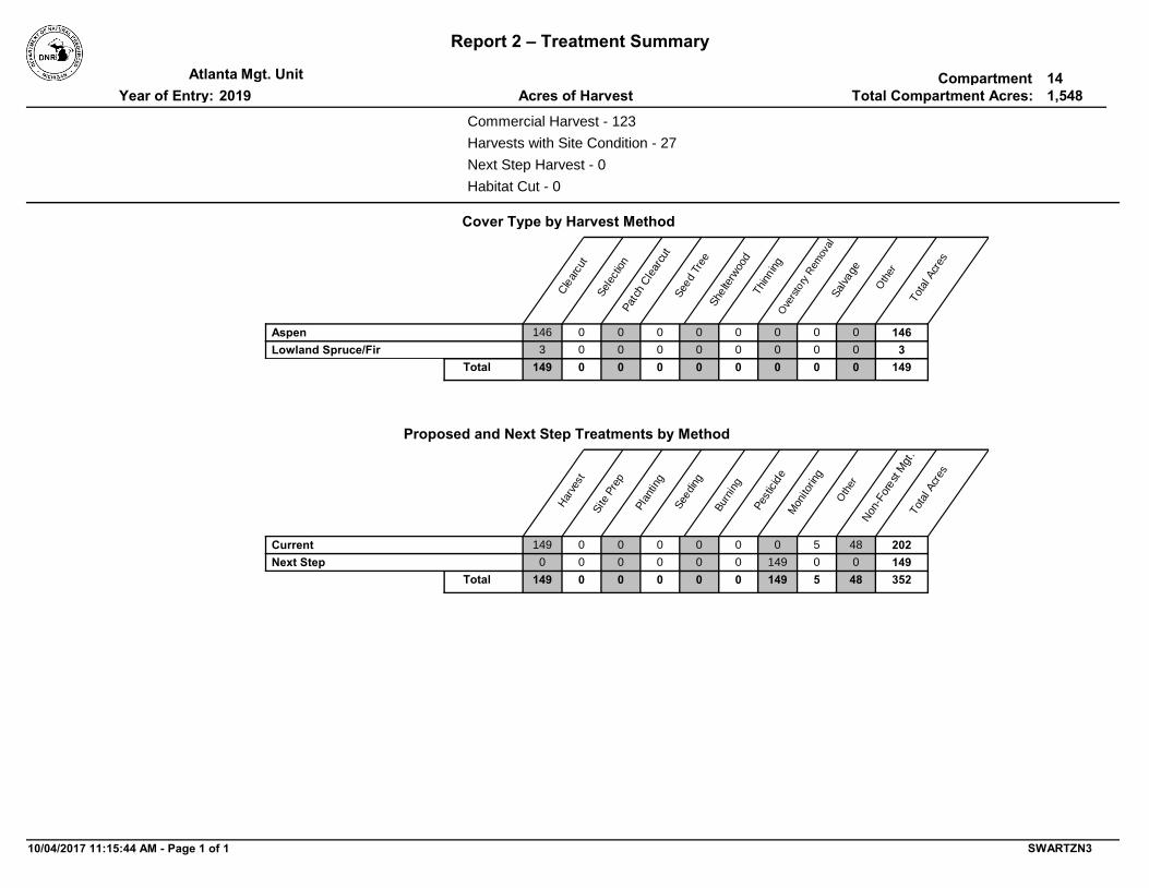
Report 2 – Treatment Summary
CompartmentMgt. UnitTotal Compartment Acres:Acres of HarvestYear of Entry:
Atlanta2019
141,548
Commercial Harvest - 123
Habitat Cut - 0
Harvests with Site Condition - 27
Next Step Harvest - 0
Cover Type by Harvest Method
Pat
ch C
lear
cut
Ove
rsto
ry R
emov
alSal
vage
Oth
er
Cle
arcu
t
Sel
ectio
n
See
d Tr
eeShe
lterw
ood
Thi
nnin
g
Tot
al A
cres
000 14600000146Aspen000 3000003Lowland Spruce/Fir000 1490000 0149Total
Proposed and Next Step Treatments by Method
Tot
al A
cres
Oth
er
Non
-For
est
Mgt
.
Mon
itorin
g
Pes
ticid
e
Bur
ning
See
ding
Pla
ntin
g
Site
Pre
p
Har
vest
500 202480000149Current01490 149000000Next Step51490 35248000Total 0149
10/04/2017 11:15:44 AM - Page 1 of 1 SWARTZN3

TreatmentName
Acres StandAge
Cover TypeObjective
SizeDensity
TreatmentType
TreatmentMethod
Stand CoverType
Mgt. Unit Report 3 -- Treatments Compartment:Year of Entry:S
tand
Approval Status
BA Range
Atlanta 142019
Age Structure
54014011-NF 0Nonstocked 3102 - GrassNonForestMgt Herbaceous/Crop/Grass Planting
Opening will be maintained on an ongoing rotational basis to produce wildlife forage through burning, mowing, planting, or other agriculture practices
OtherComment:
PrescriptionSpecs:
11 3102 - Grass
Acceptable Regen:
Site Condition:
Draft Field Boundary
Unspecified
Proposed Start Date: 10/01/2018
2.5
Next Step Treatments:
Habitat Cut: No
54014020-Cut 56Sawtimber Well
-aspen, maple, fir, ash, birch, and pine of medium to high stocking
4130 - AspenHarvest Clearcut with Retention
-E property line corners are in and the established fencing appears to be straight
-clearcut-leave all cedar, oak, rp, and wp species not to exceed a cumulative BA of 10 (should not need to mark)-cut outside of Spring due to seasonally wet areas-area retention of 3-10% is already excluded (see site conditions layer)-include standard grouse specification
OtherComment:
PrescriptionSpecs:
20 4139 - Aspen, Mixed Deciduous
Acceptable Regen:
Site Condition:
Draft Field Boundary
81-110
Proposed Start Date: 10/01/2018
50.9
Monitoring, Natural Regen (Re-Inventory)Next Step Treatments:
Even-Aged
Habitat Cut: No
54014040-Cut 55Poletimber Well
-aspen, maple, fir, ash, birch, spruce, oak, and pine of medium to high stocking
4136 - Aspen, Mixed Conifer
Harvest Clearcut with Retention
-may need a survey request- survey corner to NW is likely not established; fencing along E-W line is off and cut to north on private buffers ownership-use low density tree stand 442 for a landing location
-clearcut-leave all rp and wp species not to exceed a cumulative BA of 10 (should not need to mark)-require leaving 1 brush/tops/slash pile every acre along the west edge of treatment to provide habitat for hare and reptiles-cut outside of Spring due to seasonally wet areas-do not cut within 300ft of Hunt Creek (counted as area retention- already excluded in site conditions layer)-leave internal retention pocket for white spruce over 26" (already excluded- see site conditions)-include standard grouse specification
OtherComment:
PrescriptionSpecs:
40 4134 - Aspen, Spruce/Fir
Acceptable Regen:
Site Condition: Survey Needed
Draft Field Boundary
81-110
Proposed Start Date: 10/01/2018
7.3
Monitoring, Natural Regen (Re-Inventory)Next Step Treatments:
Even-Aged
Habitat Cut: No
10/04/2017 11:15:05 AM - Page 1 of 6 SWARTZN3

TreatmentName
Acres StandAge
Cover TypeObjective
SizeDensity
TreatmentType
TreatmentMethod
Stand CoverType
Mgt. Unit Report 3 -- Treatments Compartment:Year of Entry:S
tand
Approval Status
BA Range
Atlanta 142019
Age Structure
54014042-Cut 63Sawtimber Well
-aspen, maple, fir, ash, birch, spruce, oak, and pine of medium to high stocking
4136 - Aspen, Mixed Conifer
Harvest Clearcut with Retention
-clearcut -leave all rp and wp species not to exceed a cumulative BA of 10 -areas that are under 1/2 acre and too wet to harvest should be included within the cut area -include protection for small non-forest lowland shrub pockets within sale specs and consider identifying them on the sale map -cut outside of Spring -area retention already excluded to SE (see site conditions layer) -include standard grouse specification
OtherComment:
PrescriptionSpecs:
42 4134 - Aspen, Spruce/Fir
Acceptable Regen:
Site Condition: Survey Needed
Draft Field Boundary
51-80
Proposed Start Date: 10/01/2018
19.4
Monitoring, Natural Regen (Re-Inventory)Next Step Treatments:
Even-Aged
Habitat Cut: No
54014049-Cut 53Poletimber Well
-aspen, maple, fir, ash, birch, and pine of medium to high stocking
4130 - AspenHarvest Clearcut with Retention
-access stand from NE well pad
-clearcut-leave all cedar and wp (special protection spec for those >26" dbh)-area retention already excluded to the north-cut outside of Spring-put the 4-5 intermittent drainages (N-S running) on the sale map but do not exclude them from harvest, unless there is a significant amount of timber within; producer should be able to operate around them without causing soil damage-include standard grouse specification
OtherComment:
PrescriptionSpecs:
49 4136 - Aspen, Mixed Conifer
Acceptable Regen:
Site Condition:
Draft Field Boundary
81-110
Proposed Start Date: 10/01/2018
18.1
Monitoring, Natural Regen (Re-Inventory)Next Step Treatments:
Even-Aged
Habitat Cut: No
54014055-Cut 58Poletimber Medium
-any combination of spruce, fir, aspen, maple, ash, birch, oak, and pine of medium to high stocking-it is acceptable if the surrounding aspen encroaches into this stand converting it to a deciduous cover type as well
6128 - Lowland Coniferous,
Mixed Deciduous
Harvest Clearcut
-clearcut-area retention and low stocked areas that are too wet have already been excluded from harvest (see site conditions layer)
OtherComment:
PrescriptionSpecs:
55 6122 - Black Spruce
Acceptable Regen:
Site Condition:
Draft Field Boundary
51-80
Proposed Start Date: 10/01/2018
3.2
Monitoring, Natural Regen (Re-Inventory)Next Step Treatments:
Even-Aged
Habitat Cut: No
10/04/2017 11:15:05 AM - Page 2 of 6 SWARTZN3

TreatmentName
Acres StandAge
Cover TypeObjective
SizeDensity
TreatmentType
TreatmentMethod
Stand CoverType
Mgt. Unit Report 3 -- Treatments Compartment:Year of Entry:S
tand
Approval Status
BA Range
Atlanta 142019
Age Structure
54014057-Cut 53Poletimber Well
-aspen, maple, fir, ash, birch, spruce, oak, and pine of medium to high stocking
4130 - AspenHarvest Clearcut with Retention
-east fence posts appear to be surveyed and corners in
-clearcut-leave all cedar, oak, rp, and wp species not to exceed a cumulative BA of 10 (should not need to mark)-leave a minimum of 100ft distance from the edge of a tributary of Gilchrist out of the treatment to minimize sedimentation and erosion -require leaving 1 brush/tops/slash pile every acre along the creek to provide habitat for hare and reptiles-cut outside of Spring due to seasonally wet areas-area retention already excluded (see site conditions layer)-include standard grouse specification
OtherComment:
PrescriptionSpecs:
57 4130 - Aspen
Acceptable Regen:
Site Condition:
Draft Field Boundary
51-80
Proposed Start Date: 10/01/2018
30.4
Monitoring, Natural Regen (Re-Inventory)Next Step Treatments:
Even-Aged
Habitat Cut: No
54014103-Cut 56Poletimber Well
-aspen, maple, fir, ash, birch, spruce, oak, and pine of medium to high stocking
4136 - Aspen, Mixed Conifer
Harvest Clearcut with Retention
-clearcut-leave all rp and wp species not to exceed a cumulative BA of 10-mark healthy mast oak to leave as they occur (only a few present)-area retention already excluded (see site conditions layer)-cut outside of Spring-include standard grouse specification
OtherComment:
PrescriptionSpecs:
103 4130 - Aspen
Acceptable Regen:
Site Condition:
Draft Field Boundary
81-110
Proposed Start Date: 10/01/2018
20.1
Monitoring, Natural Regen (Re-Inventory)Next Step Treatments:
Even-Aged
Habitat Cut: No
54014113-Other
6Sapling Well
-see current stage 1 data
4131 - Aspen, Oak
Other Other
-requesting a variance through compartment review to the accept the clearcut treatment and aspen, oak cover type change
OtherComment:
PrescriptionSpecs:
113 4131 - Aspen, Oak
Acceptable Regen:
Site Condition:
Draft Field Boundary
Immature
Proposed Start Date: 10/01/2018
5.1
Next Step Treatments:
Even-Aged
Habitat Cut: No
10/04/2017 11:15:05 AM - Page 3 of 6 SWARTZN3

TreatmentName
Acres StandAge
Cover TypeObjective
SizeDensity
TreatmentType
TreatmentMethod
Stand CoverType
Mgt. Unit Report 3 -- Treatments Compartment:Year of Entry:S
tand
Approval Status
BA Range
Atlanta 142019
Age Structure
54014415-NF Nonstocked 3102 - GrassNonForestMgt Herbaceous/Crop/Grass Planting
Opening will be maintained on an ongoing rotational basis to produce wildlife forage through burning, mowing, planting, or other agriculture practices
OtherComment:
PrescriptionSpecs:
415 3102 - Grass
Acceptable Regen:
Site Condition:
Draft Field Boundary
Unspecified
Proposed Start Date: 10/01/2018
3.3
Next Step Treatments:
Habitat Cut: No
54014420-NF Nonstocked 3102 - GrassNonForestMgt Herbaceous/Crop/Grass Planting
Opening will be maintained on an ongoing rotational basis to produce wildlife forage through burning, mowing, planting, or other agriculture practices
OtherComment:
PrescriptionSpecs:
420 3102 - Grass
Acceptable Regen:
Site Condition:
Draft Field Boundary
Unspecified
Proposed Start Date: 10/01/2018
9.6
Next Step Treatments:
Habitat Cut: No
54014424-NF Nonstocked 3102 - GrassNonForestMgt Herbaceous/Crop/Grass Planting
Opening will be maintained on an ongoing rotational basis to produce wildlife forage through burning, mowing, planting, or other agriculture practices
OtherComment:
PrescriptionSpecs:
424 3102 - Grass
Acceptable Regen:
Site Condition:
Draft Field Boundary
Unspecified
Proposed Start Date: 10/01/2018
3.0
Next Step Treatments:
Habitat Cut: No
54014425-NF Nonstocked 3102 - GrassNonForestMgt Herbaceous/Crop/Grass Planting
Opening will be maintained on an ongoing rotational basis to produce wildlife forage through burning, mowing, planting, or other agriculture practices
OtherComment:
PrescriptionSpecs:
425 3102 - Grass
Acceptable Regen:
Site Condition:
Draft Field Boundary
Unspecified
Proposed Start Date: 10/01/2018
2.1
Next Step Treatments:
Habitat Cut: No
10/04/2017 11:15:05 AM - Page 4 of 6 SWARTZN3

TreatmentName
Acres StandAge
Cover TypeObjective
SizeDensity
TreatmentType
TreatmentMethod
Stand CoverType
Mgt. Unit Report 3 -- Treatments Compartment:Year of Entry:S
tand
Approval Status
BA Range
Atlanta 142019
Age Structure
54014431-NF Nonstocked 3102 - GrassNonForestMgt Herbaceous/Crop/Grass Planting
Opening will be maintained on an ongoing rotational basis to produce wildlife forage through burning, mowing, planting, or other agriculture practices
OtherComment:
PrescriptionSpecs:
431 3102 - Grass
Acceptable Regen:
Site Condition:
Draft Field Boundary
Unspecified
Proposed Start Date: 10/01/2018
2.1
Next Step Treatments:
Habitat Cut: No
54014444-NF Nonstocked 3102 - GrassNonForestMgt Herbaceous/Crop/Grass Planting
Opening will be maintained on an ongoing rotational basis to produce wildlife forage through burning, mowing, planting, or other agriculture practices
OtherComment:
PrescriptionSpecs:
444 3102 - Grass
Acceptable Regen:
Site Condition:
Draft Field Boundary
Unspecified
Proposed Start Date: 10/01/2018
1.4
Next Step Treatments:
Habitat Cut: No
54014446-NF Nonstocked 3102 - GrassNonForestMgt Herbaceous/Crop/Grass Planting
Opening will be maintained on an ongoing rotational basis to produce wildlife forage through burning, mowing, planting, or other agriculture practices
OtherComment:
PrescriptionSpecs:
446 3102 - Grass
Acceptable Regen:
Site Condition:
Draft Field Boundary
Unspecified
Proposed Start Date: 10/01/2018
2.2
Next Step Treatments:
Habitat Cut: No
54014448-NF Nonstocked 310 - Herbaceous
Openland
NonForestMgt Herbaceous/Crop/Grass Planting
Opening will be maintained on an ongoing rotational basis to produce wildlife forage through burning, mowing, planting, or other agriculture practices
OtherComment:
PrescriptionSpecs:
448 310 - Herbaceous Openland
Acceptable Regen:
Site Condition:
Draft Field Boundary
Unspecified
Proposed Start Date: 10/01/2018
3.5
Next Step Treatments:
Habitat Cut: No
10/04/2017 11:15:05 AM - Page 5 of 6 SWARTZN3

TreatmentName
Acres StandAge
Cover TypeObjective
SizeDensity
TreatmentType
TreatmentMethod
Stand CoverType
Mgt. Unit Report 3 -- Treatments Compartment:Year of Entry:S
tand
Approval Status
BA Range
Atlanta 142019
Age Structure
54014451-NF Nonstocked 310 - Herbaceous
Openland
NonForestMgt Herbaceous/Crop/Grass Planting
Opening will be maintained on an ongoing rotational basis to produce wildlife forage through burning, mowing, planting, or other agriculture practices
OtherComment:
PrescriptionSpecs:
451 310 - Herbaceous Openland
Acceptable Regen:
Site Condition:
Draft Field Boundary
Unspecified
Proposed Start Date: 10/01/2018
1.0
Next Step Treatments:
Habitat Cut: No
54014457-NF Nonstocked 3102 - GrassNonForestMgt Herbaceous/Crop/Grass Planting
Opening will be maintained on an ongoing rotational basis to produce wildlife forage through burning, mowing, planting, or other agriculture practices
OtherComment:
PrescriptionSpecs:
457 3102 - Grass
Acceptable Regen:
Site Condition:
Draft Field Boundary
Proposed Start Date: 10/01/2018
13.1
Next Step Treatments:
Habitat Cut: No
54014459-NF Nonstocked 3102 - GrassNonForestMgt Herbaceous/Crop/Grass Planting
Opening will be maintained on an ongoing rotational basis to produce wildlife forage through burning, mowing, planting, or other agriculture practices
OtherComment:
PrescriptionSpecs:
459 3102 - Grass
Acceptable Regen:
Site Condition:
Draft Field Boundary
Proposed Start Date: 10/01/2018
1.7
Next Step Treatments:
Habitat Cut: No
54014475-NF Nonstocked 3301 - Low Density
Deciduous Trees
NonForestMgt Other - Specify
Opening will be maintained on an ongoing rotational basis to produce wildlife forage through burning, mowing, planting, or other agriculture practices
OtherComment:
PrescriptionSpecs:
475 3301 - Low Density Deciduous Trees
Acceptable Regen:
Site Condition:
Draft Field Boundary
Unspecified
Proposed Start Date: 10/01/2018
4.2
Next Step Treatments:
Habitat Cut: No
204.2Total Treatment Acreage Proposed:
10/04/2017 11:15:05 AM - Page 6 of 6 SWARTZN3

Report 4 – Site ConditionsCompartment:Mgt. UnitYear of Entry:: Examiner
Atlanta
Darrick Coy
142019
*Due to limitations in the current Site Conditions Analysis tool, all nonforested acres are considered available. Future development will enable analysis of nonforested types.
Dominant Site Condition AcresSiteNo. Other Site Condition Other Site Condition Other Site Condition Other Site Condition
Dominant Site Cond Availability
1 3J: Water quality / BMPs (stream, river, or lake)
2G: Too wet (sensitive soils, does not include
access issues)
20
-300 ft special management buffer for Hunt Creek
Unspecified Unspecified Unspecified
Comments:
Unavailable
2I
Dominant Site Conditions5B 5C 5F 1C 2A 2F 2G 2H 3A 3D 3G 3J 5A 5E4A
174Aspen 27 12 111 16 32005 3415
Bare/Sparsely VegetatedBog
42Cedar 3713 019
Herbaceous Openland 0 1
Jack PineLow-Density Trees 0 3
3Lowland Aspen/Balsam Poplar 3 18
39Lowland Conifers 41 11
Lowland DeciduousLowland Mixed Forest 15 2
0Lowland Shrub 10 2
3Lowland Spruce/Fir 0
Marsh 0 5 0
Mixed Upland Deciduous 1 1
5Oak 8 2
5Tamarack0Treed Bog 4
Upland Conifers1Upland Mixed Forest 012
Urban 01
1105427 8 15 111 16 3714231205 4040Total Forested Acres
Relative Percent
Availability for ManagementAcres Acres AvailTotal
Available With ConditionAcres
Acres
Not Available
490 165762 107
1 01 0
2 02 0
23 0135 112
65 066 1
66 066 0
22 025 3
16 340 21
6 088 82
1 01 0
6 022 17
80 092 12
4 07 3
42 047 5
57 058 2
1 817 7
0 05 5
49 053 4
5 05 0
20 033 14
18 019 1
974 1771,548
11%63%
398
26%
10/04/2017 11:16:05 AM - Page 1 of 15 SWARTZN3

Report 4 – Site ConditionsCompartment:Mgt. UnitYear of Entry:: Examiner
Atlanta
Darrick Coy
142019
2 3J: Water quality / BMPs (stream, river, or lake)
Unspecified12
-300 ft special management buffer for Hunt Creek
Unspecified Unspecified Unspecified
Comments:
Unavailable
3 3J: Water quality / BMPs (stream, river, or lake)
Unspecified17
-300 ft special management buffer for Hunt Creek
Unspecified Unspecified Unspecified
Comments:
Unavailable
4 5F: Evaluated for Forest Health Considerations
Unspecified16
Revaluate for next YOE
Unspecified Unspecified Unspecified
Comments:
Available
5 2G: Too wet (sensitive soils, does not include
access issues)
Unspecified3
-left surrounding timber around many lowland shrub pockets in this stand
Unspecified Unspecified Unspecified
Comments:
Unavailable
6 5A: Not able to obtain desirable regeneration
2A: Adjacent landowner denied access
16 Unspecified Unspecified Unspecified
Comments:
Unavailable
7 2G: Too wet (sensitive soils, does not include
access issues)
5A: Not able to obtain desirable regeneration
29 Unspecified Unspecified Unspecified
Comments:
Unavailable
10/04/2017 11:16:05 AM - Page 2 of 15 SWARTZN3

Report 4 – Site ConditionsCompartment:Mgt. UnitYear of Entry:: Examiner
Atlanta
Darrick Coy
142019
8 3J: Water quality / BMPs (stream, river, or lake)
2G: Too wet (sensitive soils, does not include
access issues)
11 Unspecified Unspecified Unspecified
Comments:
Unavailable
9 2G: Too wet (sensitive soils, does not include
access issues)
5A: Not able to obtain desirable regeneration
9 Unspecified Unspecified Unspecified
Comments:
Unavailable
10 2G: Too wet (sensitive soils, does not include
access issues)
Unspecified5 Unspecified Unspecified Unspecified
Comments:
Unavailable
11 5E: Long-Term Retention Unspecified1 Unspecified Unspecified Unspecified
Comments:
Unavailable
12 5E: Long-Term Retention Unspecified6 Unspecified Unspecified Unspecified
Comments:
Unavailable
13 3J: Water quality / BMPs (stream, river, or lake)
3G: Other Influence zones - See comments
0 Unspecified Unspecified Unspecified
Comments:
Unavailable
10/04/2017 11:16:05 AM - Page 3 of 15 SWARTZN3
Report 4 – Site ConditionsCompartment:Mgt. UnitYear of Entry:: Examiner
Atlanta
Darrick Coy
142019
14 2G: Too wet (sensitive soils, does not include
access issues)
Unspecified3 Unspecified Unspecified Unspecified
Comments:
Unavailable
15 5E: Long-Term Retention 3J: Water quality / BMPs (stream, river, or
lake)
2 Unspecified Unspecified Unspecified
Comments:
Unavailable
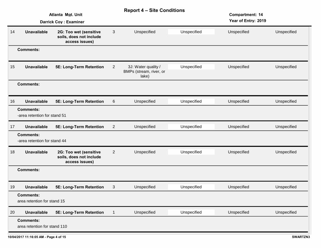
16 5E: Long-Term Retention Unspecified6
-area retention for stand 51
Unspecified Unspecified Unspecified
Comments:
Unavailable
17 5E: Long-Term Retention Unspecified2
-area retention for stand 44
Unspecified Unspecified Unspecified
Comments:
Unavailable
18 2G: Too wet (sensitive soils, does not include
access issues)
Unspecified2 Unspecified Unspecified Unspecified
Comments:
Unavailable
19 5E: Long-Term Retention Unspecified3
area retention for stand 15
Unspecified Unspecified Unspecified
Comments:
Unavailable
20 5E: Long-Term Retention Unspecified1
area retention for stand 110
Unspecified Unspecified Unspecified
Comments:
Unavailable
10/04/2017 11:16:05 AM - Page 4 of 15 SWARTZN3

Report 4 – Site ConditionsCompartment:Mgt. UnitYear of Entry:: Examiner
Atlanta
Darrick Coy
142019
21 5E: Long-Term Retention Unspecified1
area retention for stand 108
Unspecified Unspecified Unspecified
Comments:
Unavailable
22 5E: Long-Term Retention Unspecified1
-area retention for stand 30
Unspecified Unspecified Unspecified
Comments:
Unavailable
23 2G: Too wet (sensitive soils, does not include
access issues)
Unspecified1 Unspecified Unspecified Unspecified
Comments:
Unavailable
24 2G: Too wet (sensitive soils, does not include
access issues)
5A: Not able to obtain desirable regeneration
8 Unspecified Unspecified Unspecified
Comments:
Unavailable
25 2G: Too wet (sensitive soils, does not include
access issues)
Unspecified3 Unspecified Unspecified Unspecified
Comments:
Unavailable
26 2G: Too wet (sensitive soils, does not include
access issues)
Unspecified1 Unspecified Unspecified Unspecified
Comments:
Unavailable
10/04/2017 11:16:05 AM - Page 5 of 15 SWARTZN3

Report 4 – Site ConditionsCompartment:Mgt. UnitYear of Entry:: Examiner
Atlanta
Darrick Coy
142019
27 2I: Survey needed Unspecified19 Unspecified Unspecified Unspecified
Comments:
Available
28 5A: Not able to obtain desirable regeneration
Unspecified1 Unspecified Unspecified Unspecified
Comments:
Unavailable
29 5E: Long-Term Retention 3G: Other Influence zones - See comments
2
-a residential home is adjacent to state property line
Unspecified Unspecified Unspecified
Comments:
Unavailable
30 2G: Too wet (sensitive soils, does not include
access issues)
Unspecified0 Unspecified Unspecified Unspecified
Comments:
Unavailable
31 5B: Maintain for regeneration purposes
Unspecified1 Unspecified Unspecified Unspecified
Comments:
Available
32 2G: Too wet (sensitive soils, does not include
access issues)
Unspecified1 Unspecified Unspecified Unspecified
Comments:
Unavailable
10/04/2017 11:16:05 AM - Page 6 of 15 SWARTZN3

Report 4 – Site ConditionsCompartment:Mgt. UnitYear of Entry:: Examiner
Atlanta
Darrick Coy
142019
33 3D: Recreational / Scenic values
Unspecified12 Unspecified Unspecified Unspecified
Comments:
Unavailable
34 5E: Long-Term Retention Unspecified4
area retention for stand 20
Unspecified Unspecified Unspecified
Comments:
Unavailable
35 2G: Too wet (sensitive soils, does not include
access issues)
Unspecified2 Unspecified Unspecified Unspecified
Comments:
Unavailable
36 5E: Long-Term Retention 3J: Water quality / BMPs (stream, river, or
lake)
1
-area retention for stand 40-300 ft buffer for Hunt Creek, which is a designated trout stream
Unspecified Unspecified Unspecified
Comments:
Unavailable
37 3J: Water quality / BMPs (stream, river, or lake)
Unspecified7
-300 ft buffer for Hunt Creek, which is a designated trout stream
Unspecified Unspecified Unspecified
Comments:
Unavailable
38 5E: Long-Term Retention 3G: Other Influence zones - See comments
2
-area retention for stand 103
Unspecified Unspecified Unspecified
Comments:
Unavailable
10/04/2017 11:16:05 AM - Page 7 of 15 SWARTZN3

Report 4 – Site ConditionsCompartment:Mgt. UnitYear of Entry:: Examiner
Atlanta
Darrick Coy
142019
39 4A: No Markets Available for these Forest Products
Unspecified8 Unspecified Unspecified Unspecified
Comments:
Available
40 2G: Too wet (sensitive soils, does not include
access issues)
Unspecified20 Unspecified Unspecified Unspecified
Comments:
Unavailable
41 5E: Long-Term Retention Unspecified1
-area retention for stand 135
Unspecified Unspecified Unspecified
Comments:
Unavailable
42 2G: Too wet (sensitive soils, does not include
access issues)
Unspecified6 Unspecified Unspecified Unspecified
Comments:
Unavailable
43 2G: Too wet (sensitive soils, does not include
access issues)
5A: Not able to obtain desirable regeneration
3 Unspecified Unspecified Unspecified
Comments:
Unavailable
44 5E: Long-Term Retention Unspecified0
-area retention for stand 55
Unspecified Unspecified Unspecified
Comments:
Unavailable
10/04/2017 11:16:05 AM - Page 8 of 15 SWARTZN3

Report 4 – Site ConditionsCompartment:Mgt. UnitYear of Entry:: Examiner
Atlanta
Darrick Coy
142019
45 3G: Other Influence zones - See comments
Unspecified0
-trees in area are adjacent and within the gas facility fencing
Unspecified Unspecified Unspecified
Comments:
Unavailable
46 2G: Too wet (sensitive soils, does not include
access issues)
Unspecified0 Unspecified Unspecified Unspecified
Comments:
Unavailable
47 5C: Delay treatment for age/size class diversity or
exceptional site quality
Unspecified0 Unspecified Unspecified Unspecified
Comments:
Available
48 3J: Water quality / BMPs (stream, river, or lake)
5E: Long-Term Retention
1
-many large diameter pre-legacy and legacy RP and WP trees
Unspecified Unspecified Unspecified
Comments:
Unavailable
49 5E: Long-Term Retention Unspecified3
-many large diameter pre-legacy and legacy RP and WP trees
Unspecified Unspecified Unspecified
Comments:
Unavailable
50 3J: Water quality / BMPs (stream, river, or lake)
Unspecified4
-10-20ft drainage that is cattails and tag alder, likely backed up water from surrounding beaver dams
Unspecified Unspecified Unspecified
Comments:
Unavailable
10/04/2017 11:16:05 AM - Page 9 of 15 SWARTZN3
Report 4 – Site ConditionsCompartment:Mgt. UnitYear of Entry:: Examiner
Atlanta
Darrick Coy
142019
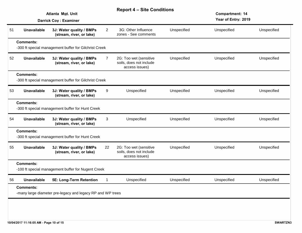
51 3J: Water quality / BMPs (stream, river, or lake)
3G: Other Influence zones - See comments
2
-300 ft special management buffer for Gilchrist Creek
Unspecified Unspecified Unspecified
Comments:
Unavailable
52 3J: Water quality / BMPs (stream, river, or lake)
2G: Too wet (sensitive soils, does not include
access issues)
7
-300 ft special management buffer for Gilchrist Creek
Unspecified Unspecified Unspecified
Comments:
Unavailable
53 3J: Water quality / BMPs (stream, river, or lake)
Unspecified9
-300 ft special management buffer for Hunt Creek
Unspecified Unspecified Unspecified
Comments:
Unavailable
54 3J: Water quality / BMPs (stream, river, or lake)
Unspecified3
-300 ft special management buffer for Hunt Creek
Unspecified Unspecified Unspecified
Comments:
Unavailable
55 3J: Water quality / BMPs (stream, river, or lake)
2G: Too wet (sensitive soils, does not include
access issues)
22
-100 ft special management buffer for Nugent Creek
Unspecified Unspecified Unspecified
Comments:
Unavailable
56 5E: Long-Term Retention Unspecified1
-many large diameter pre-legacy and legacy RP and WP trees
Unspecified Unspecified Unspecified
Comments:
Unavailable
10/04/2017 11:16:05 AM - Page 10 of 15 SWARTZN3

Report 4 – Site ConditionsCompartment:Mgt. UnitYear of Entry:: Examiner
Atlanta
Darrick Coy
142019
57 5E: Long-Term Retention 2H: Blocked by physical obstacle (e.g. upland
stand in a lowland area)
3 Unspecified Unspecified Unspecified
Comments:
Unavailable
58 1C: Other dept or div proc/practices
Unspecified40
-this 40 acre parcel is currently being disposed of, inventory was done remotely
Unspecified Unspecified Unspecified
Comments:
Unavailable
59 3J: Water quality / BMPs (stream, river, or lake)
2G: Too wet (sensitive soils, does not include
access issues)
8 Unspecified Unspecified Unspecified
Comments:
Unavailable
60 2G: Too wet (sensitive soils, does not include
access issues)
5A: Not able to obtain desirable regeneration
1 Unspecified Unspecified Unspecified
Comments:
Unavailable
61 5A: Not able to obtain desirable regeneration
Unspecified2 Unspecified Unspecified Unspecified
Comments:
Unavailable
62 2G: Too wet (sensitive soils, does not include
access issues)
5A: Not able to obtain desirable regeneration
10 2A: Adjacent landowner denied access
Unspecified Unspecified
Comments:
Unavailable
10/04/2017 11:16:05 AM - Page 11 of 15 SWARTZN3

Report 4 – Site ConditionsCompartment:Mgt. UnitYear of Entry:: Examiner
Atlanta
Darrick Coy
142019
63 2A: Adjacent landowner denied access
Unspecified4 Unspecified Unspecified Unspecified
Comments:
Unavailable
64 5B: Maintain for regeneration purposes
5C: Delay treatment for age/size class diversity
or exceptional site quality
4 Unspecified Unspecified Unspecified
Comments:
Available
65 5C: Delay treatment for age/size class diversity or
exceptional site quality
Unspecified8 Unspecified Unspecified Unspecified
Comments:
Available
66 5A: Not able to obtain desirable regeneration
Unspecified17 Unspecified Unspecified Unspecified
Comments:
Unavailable
67 5C: Delay treatment for age/size class diversity or
exceptional site quality
Unspecified5 Unspecified Unspecified Unspecified
Comments:
Available
68 3J: Water quality / BMPs (stream, river, or lake)
2G: Too wet (sensitive soils, does not include
access issues)
9
-100 ft special management buffer for Sage Creek
Unspecified Unspecified Unspecified
Comments:
Unavailable
10/04/2017 11:16:05 AM - Page 12 of 15 SWARTZN3

Report 4 – Site ConditionsCompartment:Mgt. UnitYear of Entry:: Examiner
Atlanta
Darrick Coy
142019
69 5C: Delay treatment for age/size class diversity or
exceptional site quality
Unspecified23 Unspecified Unspecified Unspecified
Comments:
Available
70 5C: Delay treatment for age/size class diversity or
exceptional site quality
Unspecified19 Unspecified Unspecified Unspecified
Comments:
Available
71 5B: Maintain for regeneration purposes
Unspecified11 Unspecified Unspecified Unspecified
Comments:
Available
72 5C: Delay treatment for age/size class diversity or
exceptional site quality
Unspecified10 Unspecified Unspecified Unspecified
Comments:
Available
73 3A: Conservation Values incompatible with harvest
at this time
Unspecified0 Unspecified Unspecified Unspecified
Comments:
Unavailable
74 2H: Blocked by physical obstacle (e.g. upland
stand in a lowland area)
Unspecified5 Unspecified Unspecified Unspecified
Comments:
Unavailable
10/04/2017 11:16:05 AM - Page 13 of 15 SWARTZN3

Report 4 – Site ConditionsCompartment:Mgt. UnitYear of Entry:: Examiner
Atlanta
Darrick Coy
142019
75 2F: Too steep Unspecified5
-the SE portion of this stand is a ridge down to a cedar stand
Unspecified Unspecified Unspecified
Comments:
Unavailable
76 5C: Delay treatment for age/size class diversity or
exceptional site quality
Unspecified47 Unspecified Unspecified Unspecified
Comments:
Available
78 2G: Too wet (sensitive soils, does not include
access issues)
5A: Not able to obtain desirable regeneration
3 Unspecified Unspecified Unspecified
Comments:
Unavailable
79 2I: Survey needed Unspecified7 Unspecified Unspecified Unspecified
Comments:
Available
80 2G: Too wet (sensitive soils, does not include
access issues)
5A: Not able to obtain desirable regeneration
1 Unspecified Unspecified Unspecified
Comments:
Unavailable
82 2G: Too wet (sensitive soils, does not include
access issues)
5A: Not able to obtain desirable regeneration
0 Unspecified Unspecified Unspecified
Comments:
Unavailable
10/04/2017 11:16:05 AM - Page 14 of 15 SWARTZN3

Report 4 – Site ConditionsCompartment:Mgt. UnitYear of Entry:: Examiner
Atlanta
Darrick Coy
142019
112 3G: Other Influence zones - See comments
Unspecified3 Unspecified Unspecified Unspecified
Comments:
Unavailable
130 3J: Water quality / BMPs (stream, river, or lake)
Unspecified12
-300 ft special management buffer for Gilchrist Creek
Unspecified Unspecified Unspecified
Comments:
Unavailable
10/04/2017 11:16:05 AM - Page 15 of 15 SWARTZN3

SCA Category Acres
Mgt. Unit
Report 5 – PROPOSED SPECIAL CONSERVATION AREA* (SCA) DETAILS
Compartment:
Recommendation
* This is a partial list of SCAs for this compartment. Not included are those areas identified under other Department initiatives (Natural Rivers, Deer Wintering Areas, etc.). Those will be identified in separate, future map and report products.
Year of Entry:
SCA Name Detail Type
#Type!
Comments
10/04/2017 11:13:58 AM - Page 1 of 1 SWARTZN3

Type
Mgt. Unit Compartment:
Description
* This is a list of SCA's for this compartment along with a 1/4 mile buffer surrounding the compartment. Refer to the Special Conservation Area Map for locations of the below listed Conservation Areas.
Report 6 – EXISTING SPECIAL CONSERVATION AREA DETAILS
Conservation Area SCA = Special Conservation Area
HCVA = High Conservation Value Area
ERA = Ecological Reference Area
Year of EntryAtlanta 14
2019
A coldwater lake has temperature and dissolved oxygen conditions that allow naturally-reproduced or stocked trout populations and those of other coldwater fish species to persist from year to year. Suitable conditions for coldwater fishes may occur in Michigan lakes if they are relatively deep, have substantial groundwater inflows, or are located in colder (northern) areas of the state. Such lakes are established by Director's action and designated as trout resources by Fisheries Order 200.
Cold Water LakeSCA
A coldwater stream has temperature and dissolved oxygen conditions that allow naturally-reproduced or stocked trout populations and those of other coldwater fish species (e.g., slimy sculpin) to persist from year to year. Coldwater streams in Michigan typically provide these conditions due to substantial contributions of groundwater to their stream flows. Such streams are established by Director's action and designated as trout resources by Fisheries Order 210.
Cold Water Stream
SCA
A transitional area between aquatic and terrestrial ecosystems in which the terrestrial ecosystem influences the aquatic ecosystem and vice-versa. Because of the unique conditions adjacent to lakes, streams and open water wetlands, riparian areas harbor a high diversity of plants and wildlife. Riparian communities are ecologically and socially significant in their effects on water quality and quantity, as well as aesthetics, habitat, bank stability, timber production, and their contribution to overall biodiversity.
Riparian AreaSCA
10/04/2017 11:13:43 AM - Page 1 of 1
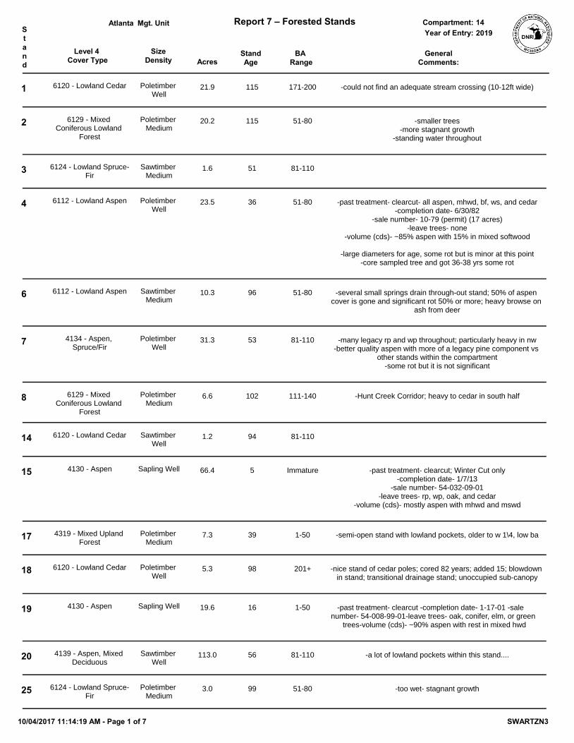
Level 4 Cover Type Acres
StandAge
SizeDensity
BA Range
Mgt. Unit Report 7 – Forested Stands Compartment:Stand
GeneralComments:
Year of Entry:Atlanta
201914
1 6120 - Lowland Cedar Poletimber Well
21.9 115 171-200 -could not find an adequate stream crossing (10-12ft wide)
2 6129 - Mixed Coniferous Lowland
Forest
Poletimber Medium
20.2 115 51-80 -smaller trees-more stagnant growth
-standing water throughout
3 6124 - Lowland Spruce-Fir
Sawtimber Medium
1.6 51 81-110
4 6112 - Lowland Aspen Poletimber Well
23.5 36 51-80 -past treatment- clearcut- all aspen, mhwd, bf, ws, and cedar-completion date- 6/30/82
-sale number- 10-79 (permit) (17 acres)-leave trees- none
-volume (cds)- ~85% aspen with 15% in mixed softwood
-large diameters for age, some rot but is minor at this point-core sampled tree and got 36-38 yrs some rot
6 6112 - Lowland Aspen Sawtimber Medium
10.3 96 51-80 -several small springs drain through-out stand; 50% of aspen cover is gone and significant rot 50% or more; heavy browse on
ash from deer
7 4134 - Aspen, Spruce/Fir
Poletimber Well
31.3 53 81-110 -many legacy rp and wp throughout; particularly heavy in nw-better quality aspen with more of a legacy pine component vs
other stands within the compartment-some rot but it is not significant
8 6129 - Mixed Coniferous Lowland
Forest
Poletimber Medium
6.6 102 111-140 -Hunt Creek Corridor; heavy to cedar in south half
14 6120 - Lowland Cedar Sawtimber Well
1.2 94 81-110
15 4130 - Aspen Sapling Well 66.4 5 Immature -past treatment- clearcut; Winter Cut only-completion date- 1/7/13
-sale number- 54-032-09-01-leave trees- rp, wp, oak, and cedar
-volume (cds)- mostly aspen with mhwd and mswd
17 4319 - Mixed Upland Forest
Poletimber Medium
7.3 39 1-50 -semi-open stand with lowland pockets, older to w 1\4, low ba
18 6120 - Lowland Cedar Poletimber Well
5.3 98 201+ -nice stand of cedar poles; cored 82 years; added 15; blowdown in stand; transitional drainage stand; unoccupied sub-canopy
19 4130 - Aspen Sapling Well 19.6 16 1-50 -past treatment- clearcut -completion date- 1-17-01 -sale number- 54-008-99-01 -leave trees- oak, conifer, elm, or green
trees -volume (cds)- ~90% aspen with rest in mixed hwd
20 4139 - Aspen, Mixed Deciduous
Sawtimber Well
113.0 56 81-110 -a lot of lowland pockets within this stand....
25 6124 - Lowland Spruce-Fir
Poletimber Medium
3.0 99 51-80 -too wet- stagnant growth
10/04/2017 11:14:19 AM - Page 1 of 7 SWARTZN3

Level 4 Cover Type Acres
StandAge
SizeDensity
BA Range
Mgt. Unit Report 7 – Forested Stands Compartment:Stand
GeneralComments:
Year of Entry:Atlanta
201914
26 4139 - Aspen, Mixed Deciduous
Sapling Well 8.5 17 Immature -past treatment- clearcut -completion date- 1-17-01 -sale number- 54-008-99-01 -leave trees- oak, conifer, elm, or green
trees -volume (cds)- ~90% aspen with rest in mixed hwd -mostly rm south of 2 track
27 6122 - Black Spruce Poletimber Well
1.2 53 51-80 -S portion has pole sap fir and spruce, 6 inch
29 4319 - Mixed Upland Forest
Poletimber Medium
8.6 46 51-80 -lowland shrub pocket and legacy trees; was not cut due to surrounding lowland; fairly diverse stand
30 4130 - Aspen Sapling Medium
8.9 7 Immature -clearcut in 2010; scattered pocket regent on higher ground-variance granted 7-6-2010- clearcut stand; acceptable regen is
any mix of aspen and conifer
31 4130 - Aspen Sapling Well 18.1 17 Immature -past treatment- clearcut -completion date- 1-17-01 -sale number- 54-008-99-01 -leave trees- oak, conifer, elm, or green
trees -volume (cds)- ~90% aspen with rest in mixed hwd
36 6120 - Lowland Cedar Poletimber Poor
4.9 105 1-50 -weak cedar crowns with this balsam understory to S half-n half is less forested with more tag alder due to it being more
wet-standing water throughout
37 6120 - Lowland Cedar Poletimber Well
1.8 104 171-200
40 4134 - Aspen, Spruce/Fir
Poletimber Well
10.8 55 81-110 -higher density pole stand
41 4319 - Mixed Upland Forest
Sawtimber Well
12.4 65 81-110 -appears that wp and rp were left from previous harvest and significantly larger/older
-scenic stand that does not meet old growth criteria but definitely contains remnants of old growth forest throughout
-not quite 2 aged
42 4134 - Aspen, Spruce/Fir
Sawtimber Well
25.0 63 51-80
43 4136 - Aspen, Mixed Conifer
Sapling Well 16.5 17 1-50 -past treatment- clearcut -completion date- 1-17-01 -sale number- 54-008-99-01 -leave trees- oak, conifer, elm, or green
trees -volume (cds)- ~90% aspen with rest in mixed hwd
44 4130 - Aspen Sapling Well 30.8 5 Immature -past treatment- clearcut; winter cut only-completion date- 1/7/13
-sale number- 54-032-09-01-leave trees- rp, wp, oak, and cedar
-volume (cds)- mostly aspen with mhwd and mswd
46 6112 - Lowland Aspen Sawtimber Medium
2.9 59 51-80 -left uncut due to lowland with meandering boundary
10/04/2017 11:14:19 AM - Page 2 of 7 SWARTZN3

Level 4 Cover Type Acres
StandAge
SizeDensity
BA Range
Mgt. Unit Report 7 – Forested Stands Compartment:Stand
GeneralComments:
Year of Entry:Atlanta
201914
47 4130 - Aspen Sapling Well 11.1 17 Immature -past treatment- clearcut -completion date- 1-17-01 -sale number- 54-008-99-01 -leave trees- oak, conifer, elm, or green
trees -volume (cds)- ~90% aspen with rest in mixed hwd
49 4136 - Aspen, Mixed Conifer
Poletimber Well
27.7 53 81-110
51 4130 - Aspen Sapling Medium
61.8 5 Immature -past treatment- clearcut-completion date- 1/7/13
-sale number- 54-032-09-01-leave trees- rp, wp, oak, and cedar
-volume (cds)- mostly aspen with mhwd and mswd
52 4134 - Aspen, Spruce/Fir
Poletimber Well
6.0 57 81-110
55 6122 - Black Spruce Poletimber Medium
6.3 58 51-80
57 4130 - Aspen Poletimber Well
42.8 53 51-80 -S portion has pole sap fir and spruce, 6 inch
59 6120 - Lowland Cedar Sawtimber Well
1.0 94 81-110
67 42380 - Non Pine Upland Conifer, Mixed
Deciduous
Poletimber Medium
5.1 47 51-80 -canopy is undefined by stratum, appears uneven aged-intermittent drainage area in middle of stand
68 4136 - Aspen, Mixed Conifer
Sawtimber Well
9.2 54 81-110
71 6119 - Mixed Lowland Deciduous Forest
Poletimber Medium
1.4 58 51-80
72 6120 - Lowland Cedar Poletimber Medium
3.1 94 81-110 -too wet, stagnant growth, cedar crowns 50% alive
75 4125 - Black, N. Pin Oak Sawtimber Well
5.0 85 51-80 -oak over story with M3/W3 understory. Steep slopes going down to swamp.
76 4122 - Oak, Pine Sawtimber Well
1.4 87 81-110
77 6124 - Lowland Spruce-Fir
Sapling Well 3.7 37 1-50 -past treatment- clearcut-completion date- 4/10/78
-sale number- 14-78 (permit) -leave trees- none
-volume (cds)- ~85% cedar with 15% in mixed softwood
79 6120 - Lowland Cedar Poletimber Well
25.0 93 111-140 -good cedar on edges, some slowdown; interior cedar is pole cedar with weak crowns
80 4191 - Mixed Upland Deciduous with Conifer
Poletimber Well
5.6 49 51-80 -transitional deciduous stand
10/04/2017 11:14:19 AM - Page 3 of 7 SWARTZN3

Level 4 Cover Type Acres
StandAge
SizeDensity
BA Range
Mgt. Unit Report 7 – Forested Stands Compartment:Stand
GeneralComments:
Year of Entry:Atlanta
201914
81 4136 - Aspen, Mixed Conifer
Poletimber Well
8.2 49 51-80 -mostly rm to nw corner; aspen throughout rest of stand; primarily upland with lowland to n-nw; small diameter
84 4191 - Mixed Upland Deciduous with Conifer
Poletimber Medium
29.5 49 51-80 -age is same as surrounding stands
85 42221 - Natural Jack Pine, Mixed Deciduous
Poletimber Well
62.1 49 51-80 -scattered oak, white pine & balsam fir; stand is variable in size and stocking
86 4131 - Aspen, Oak Poletimber Well
4.9 49 51-80
87 4199 - Other Mixed Upland Deciduous
Poletimber Well
22.2 26 51-80 -most log oak is significant mast oak serving wildlife values-lower end mixed oak (vha), regenerates well here; good white
oak regen-past treatment- Thinning- all aspen, jp, maple, cedar, and yellow
painted oak-completion date- 8/8/90
-sale number- 54-068-89-01-leave trees- unmarked oak (assume 70-90 BA)
-volume (cds)- jp= 46, rm= 58, bta= 37 (35 total cut);
88 6139 - Mixed Lowland Forest
Sapling Medium
8.7 17 1-50 -mixed ages, but young to stagnant-cattails throughout-a lot of blowdown
-stand naturally regenerated-past harvest blew down a lot of cedar
-too wet for any harvesting-remnant older weak crowned cedar poles-scattered small spruce fir to SE portion
90 6112 - Lowland Aspen Poletimber Well
3.8 57 51-80 -high tag alder
91 4130 - Aspen Sapling Well 12.9 27 1-50 -past treatment- clearcut-completion date- 05/01/90-sale number- 54-014-89-01
-leave trees- none-volume (cds)- jp= ~90% aspen with rest in mixed hwd
92 6120 - Lowland Cedar Poletimber Well
23.8 105 111-140 -too wet
93 6121 - Tamarack Poletimber Well
4.9 62 111-140 -cored 54 yr tamarack, dense pure stand
95 4130 - Aspen Sapling Well 12.0 7 1-50 -past treatment- clearcut-completion date- 5/13/2010-sale number- 54-013-09-01
-leave trees- oak, wp, rp (no area retention due to small stand size)
-volume (cds)- 145 aspen, 2 fir, 2 chry, 2 jp
96 4125 - Black, N. Pin Oak Sawtimber Medium
8.2 87 51-80
10/04/2017 11:14:19 AM - Page 4 of 7 SWARTZN3

Level 4 Cover Type Acres
StandAge
SizeDensity
BA Range
Mgt. Unit Report 7 – Forested Stands Compartment:Stand
GeneralComments:
Year of Entry:Atlanta
201914
97 4133 - Aspen, Mixed Pine
Poletimber Well
24.4 51 81-110 -N-NE 1/3rd aspen age based on cutting record (41); S 2/3rds age based on current core (56); ave age 51
-legacy trees present within stand-lowland shrub pockets to SE leg of stand that were too small to
map-more natural wp regeneration found in this aspen stand vs
others within the compartment-past treatment- thinned (N1/2 only)- all fir, aspen, maple, birch,
and jp-completion date- 12/3/75 (40)
-sale number- 73-74-20 (timber cutting permit) (60 acres)-leave trees- left red and white oak
-volume (cds)- ~90% aspen with rest in mixed how'd
99 42360 - Upland Cedar Sawtimber Well
4.6 101 111-140 -fast growing healthy cedar with lowland portion to NW
101 4319 - Mixed Upland Forest
Sawtimber Well
1.2 60 111-140
102 6120 - Lowland Cedar Poletimber Medium
3.0 125 51-80
103 4130 - Aspen Poletimber Well
40.6 56 81-110
105 6120 - Lowland Cedar Poletimber Medium
8.7 112 111-140 -2 aged stand; seems spruce cut 50 yrs ago.-ne & w is primarily cedar and center is primarily dense black
spruce-treated both as inclusions due to similar drainage type and
small stand size
107 6120 - Lowland Cedar Poletimber Well
9.3 100 111-140 -more overstory aspen to ne
110 4130 - Aspen Sapling Well 38.9 7 Immature -past treatment- clearcut-completion date- 5/13/2010-sale number- 54-013-09-01-leave trees- 1-2 oak/acre
-volume (cds)- 74 aspen, 37 rm, 23 ro, 12 bf, 2 wo (S of rd)-volume (cds)- 253 aspen, 60 rm, 12 ro, 2 wo, 30 bf, 1 chry, wa 2
(N of rd)
112 4123 - Red Oak Sawtimber Well
2.5 106 81-110 -fairly steep slope down to road
113 4131 - Aspen, Oak Sapling Well 5.1 6 Immature OPIC - FMD: treat with adjacent aspen stand. Species thin down to 40-50 BA. No retention needed due to stand 112 is
same species and will never be cut. Regen mix of aspen, oak, and pine is acceptable. May want to underplant white pine.
Stand was cut in spring of 2010. 54-013-09-01 Mystic Aspen: Logger made an error when treating this unit of sale. It was
actually clear cut and only scattered oak were left. Damages were charged.
-past treatment- clearcut-completion date- 5/13/2010-sale number- 54-013-09-01-leave trees- 1-2 oak/acre
-volume (cds)- 29 oak, 18 aspen, 7 rm
10/04/2017 11:14:19 AM - Page 5 of 7 SWARTZN3
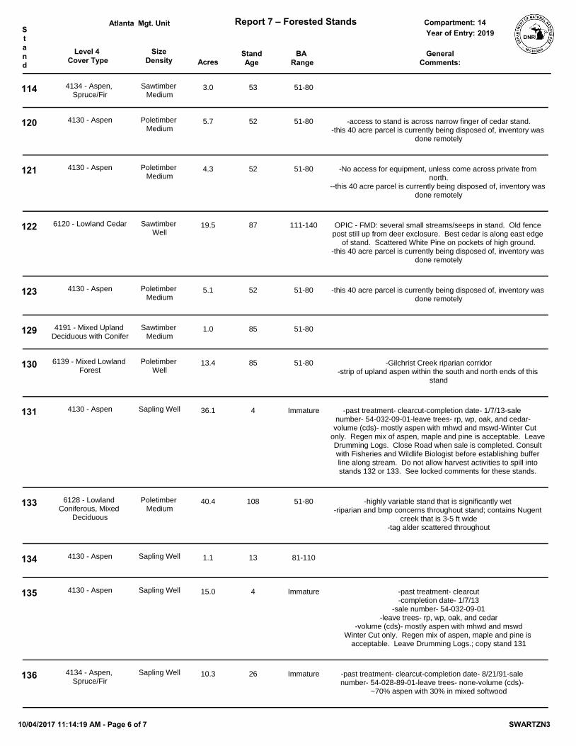
Level 4 Cover Type Acres
StandAge
SizeDensity
BA Range
Mgt. Unit Report 7 – Forested Stands Compartment:Stand
GeneralComments:
Year of Entry:Atlanta
201914
114 4134 - Aspen, Spruce/Fir
Sawtimber Medium
3.0 53 51-80
120 4130 - Aspen Poletimber Medium
5.7 52 51-80 -access to stand is across narrow finger of cedar stand.-this 40 acre parcel is currently being disposed of, inventory was
done remotely
121 4130 - Aspen Poletimber Medium
4.3 52 51-80 -No access for equipment, unless come across private from north.
--this 40 acre parcel is currently being disposed of, inventory was done remotely
122 6120 - Lowland Cedar Sawtimber Well
19.5 87 111-140 OPIC - FMD: several small streams/seeps in stand. Old fence post still up from deer exclosure. Best cedar is along east edge
of stand. Scattered White Pine on pockets of high ground.-this 40 acre parcel is currently being disposed of, inventory was
done remotely
123 4130 - Aspen Poletimber Medium
5.1 52 51-80 -this 40 acre parcel is currently being disposed of, inventory was done remotely
129 4191 - Mixed Upland Deciduous with Conifer
Sawtimber Medium
1.0 85 51-80
130 6139 - Mixed Lowland Forest
Poletimber Well
13.4 85 51-80 -Gilchrist Creek riparian corridor-strip of upland aspen within the south and north ends of this
stand
131 4130 - Aspen Sapling Well 36.1 4 Immature -past treatment- clearcut -completion date- 1/7/13 -sale number- 54-032-09-01 -leave trees- rp, wp, oak, and cedar -volume (cds)- mostly aspen with mhwd and mswd -Winter Cut
only. Regen mix of aspen, maple and pine is acceptable. Leave Drumming Logs. Close Road when sale is completed. Consult with Fisheries and Wildlife Biologist before establishing buffer line along stream. Do not allow harvest activities to spill into stands 132 or 133. See locked comments for these stands.
133 6128 - Lowland Coniferous, Mixed
Deciduous
Poletimber Medium
40.4 108 51-80 -highly variable stand that is significantly wet -riparian and bmp concerns throughout stand; contains Nugent
creek that is 3-5 ft wide-tag alder scattered throughout
134 4130 - Aspen Sapling Well 1.1 13 81-110
135 4130 - Aspen Sapling Well 15.0 4 Immature -past treatment- clearcut-completion date- 1/7/13
-sale number- 54-032-09-01-leave trees- rp, wp, oak, and cedar
-volume (cds)- mostly aspen with mhwd and mswdWinter Cut only. Regen mix of aspen, maple and pine is
acceptable. Leave Drumming Logs.; copy stand 131
136 4134 - Aspen, Spruce/Fir
Sapling Well 10.3 26 Immature -past treatment- clearcut -completion date- 8/21/91 -sale number- 54-028-89-01 -leave trees- none -volume (cds)-
~70% aspen with 30% in mixed softwood
10/04/2017 11:14:19 AM - Page 6 of 7 SWARTZN3

Level 4 Cover Type Acres
StandAge
SizeDensity
BA Range
Mgt. Unit Report 7 – Forested Stands Compartment:Stand
GeneralComments:
Year of Entry:Atlanta
201914
137 6124 - Lowland Spruce-Fir
Sapling Medium
6.3 31 1-50
139 6124 - Lowland Spruce-Fir
Poletimber Well
5.1 54 111-140 -20-30%moss coverage, healthy stand, more cedar to south narrow portion
141 4134 - Aspen, Spruce/Fir
Poletimber Well
9.6 52 81-110 -northwest portion was younger mid 30s aspen; count as an inclusion for main stand
142 4319 - Mixed Upland Forest
Poletimber Medium
3.7 55 51-80 -rather large crowned rm overstory with thick spruce fir -noticed 2 large legacy wp near road
143 4134 - Aspen, Spruce/Fir
Sawtimber Well
11.8 85 81-110 OPIC - FMD: Stand has several small Ptypes mixed in but surrounded by low/wet ground. Hold stand for retention/wildlife
and stream buffer.-the majority of this stand contains significant rot within the aspen and is providing a significant number of cavities for
nesting wildlife
145 6124 - Lowland Spruce-Fir
Poletimber Well
1.1 37 51-80 -this 40 acre parcel is currently being disposed of, inventory was done remotely
148 42221 - Natural Jack Pine, Mixed Deciduous
Poletimber Well
4.1 58 81-110
154 4136 - Aspen, Mixed Conifer
Poletimber Well
6.0 41 51-80 -past treatment- all fir, aspen, maple, birch, and jp-completion date- 12/3/75 (40)
-sale number- 73-74-20 (timber cutting permit) (60 acres)-volume (cds)- ~90% aspen with rest in mixed hwd
156 6120 - Lowland Cedar Sawtimber Well
2.4 102 111-140 -renmant of cedar that didn't blowdown
10/04/2017 11:14:19 AM - Page 7 of 7 SWARTZN3

Cover Type Acres
Mgt. Unit Report 8 – Nonforested Stands Compartment:
Stand General Comments:
Year of Entry:
Managed Site
Atlanta 142019
5 2.0 -Mix of marsh, alder, and mixed low density trees; mostly marsh6239 - Mixed Emergent Wetland No
10 4.2 -Hunt Creek Corridor; mostly dead cedar; some pole spruce fir ; heavy blowdown throughout
6224 - Treed Bog No
11 2.5 -antrim gas well3102 - Grass Yes
12 1.4 -60%marsh, 40% alder on edges6239 - Mixed Emergent Wetland No
13 0.96220 - Alder/willow No
16 21.8 -lowland with scattered trees, mostly shrub6220 - Alder/willow No
21 1.76220 - Alder/willow No
22 2.16220 - Alder/willow No
23 1.46220 - Alder/willow No
24 7.3 -scattered trees with tag alder6224 - Treed Bog No
28 1.3 -gas facility site.790 - Other Bare/Sparsely Vegetate No
32 8.4 -marsh with some water6239 - Mixed Emergent Wetland No
33 4.8 -alder and marsh6239 - Mixed Emergent Wetland No
34 2.3 -left as area retention for stand 15-lowland shrub with scattered aspen along perimeter
622 - Lowland Shrub No
35 16.7 -lowland low density trees-scattered weak crowned cedar and dead ash with thick tag alder
-considered non-forest-alder thicker to north with less tree cover
6224 - Treed Bog No
38 1.5 -lowland low density trees-alder with scattered trees
6224 - Treed Bog No
39 1.16220 - Alder/willow No
10/04/2017 11:14:38 AM - Page 1 of 6 SWARTZN3

Cover Type Acres
Mgt. Unit Report 8 – Nonforested Stands Compartment:
Stand General Comments:
Year of Entry:
Managed Site
Atlanta 142019
45 20.6 -shrub and marsh, alder willow6239 - Mixed Emergent Wetland No
48 11.46220 - Alder/willow No
50 10.6 -dead saps ash over alder and marsh; standing water throughout6224 - Treed Bog No
53 1.16220 - Alder/willow No
54 0.93303 - Mixed Low Density Trees No
56 1.9 -soft ground with snow, seems semi-wet6225 - Bog No
58 1.36220 - Alder/willow No
61 3.4 -beaver flooding in middle of stand; marsh; surface water throughout623 - Emergent Wetland No
64 1.13303 - Mixed Low Density Trees No
65 3.26220 - Alder/willow No
66 6.66220 - Alder/willow No
69 3.6 -dead ash over alder with low density fir and cedar, standing water throughout6224 - Treed Bog No
70 5.9 -Hunt Creek Corridor. Beaver dam in middle of stand.622 - Lowland Shrub No
74 3.9 -dead ash with low density trees over mostly tag alder; bog with trees or lowland shrub
6224 - Treed Bog No
82 2.16229 - Mixed lowland shrub No
89 0.9 -alder with marsh in middle6239 - Mixed Emergent Wetland No
94 2.4 -mix for ro dogwood and alder6229 - Mixed lowland shrub No
98 1.7310 - Herbaceous Openland No
10/04/2017 11:14:38 AM - Page 2 of 6 SWARTZN3

Cover Type Acres
Mgt. Unit Report 8 – Nonforested Stands Compartment:
Stand General Comments:
Year of Entry:
Managed Site
Atlanta 142019
104 1.23303 - Mixed Low Density Trees No
106 2.56229 - Mixed lowland shrub No
108 1.76220 - Alder/willow No
109 1.26229 - Mixed lowland shrub No
111 0.7 -alder surrounded by standing trees6220 - Alder/willow No
115 1.16229 - Mixed lowland shrub No
116 5.1 -alder willow with some scattered trees6220 - Alder/willow No
117 5.0 -portion of stand is marsh; alder on perimeter with marsh in middle; mixed emergent wetland
6239 - Mixed Emergent Wetland No
118 2.36220 - Alder/willow No
119 0.9 OPIC - FMD: OI Stand Year Origin was 6220 - Alder/willow No
124 1.16220 - Alder/willow No
125 1.23301 - Low Density Deciduous Tree No
126 2.3 -alder with marsh in interior6229 - Mixed lowland shrub No
127 1.4 -alder with marsh in interior6229 - Mixed lowland shrub No
128 1.5 -lowland shrub pockets to the east and west with scattered aspen and red maple around the perimeter
6224 - Treed Bog No
132 1.6 -used as a landing area north of the 2-track3303 - Mixed Low Density Trees No
138 3.1 OPIC - FMD: OI Stand Year Origin was 6220 - Alder/willow No
140 0.96229 - Mixed lowland shrub No
10/04/2017 11:14:38 AM - Page 3 of 6 SWARTZN3
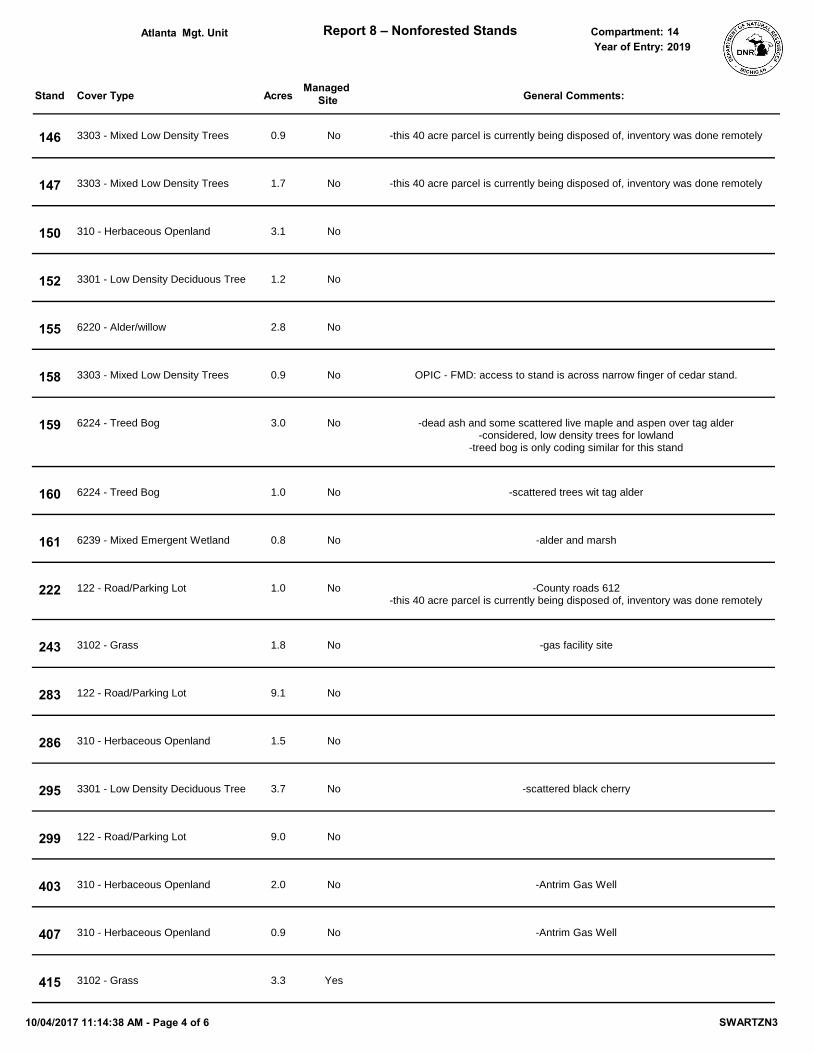
Cover Type Acres
Mgt. Unit Report 8 – Nonforested Stands Compartment:
Stand General Comments:
Year of Entry:
Managed Site
Atlanta 142019
146 0.9 -this 40 acre parcel is currently being disposed of, inventory was done remotely3303 - Mixed Low Density Trees No
147 1.7 -this 40 acre parcel is currently being disposed of, inventory was done remotely3303 - Mixed Low Density Trees No
150 3.1310 - Herbaceous Openland No
152 1.23301 - Low Density Deciduous Tree No
155 2.86220 - Alder/willow No
158 0.9 OPIC - FMD: access to stand is across narrow finger of cedar stand.3303 - Mixed Low Density Trees No
159 3.0 -dead ash and some scattered live maple and aspen over tag alder-considered, low density trees for lowland
-treed bog is only coding similar for this stand
6224 - Treed Bog No
160 1.0 -scattered trees wit tag alder6224 - Treed Bog No
161 0.8 -alder and marsh6239 - Mixed Emergent Wetland No
222 1.0 -County roads 612-this 40 acre parcel is currently being disposed of, inventory was done remotely
122 - Road/Parking Lot No
243 1.8 -gas facility site3102 - Grass No
283 9.1122 - Road/Parking Lot No
286 1.5310 - Herbaceous Openland No
295 3.7 -scattered black cherry3301 - Low Density Deciduous Tree No
299 9.0122 - Road/Parking Lot No
403 2.0 -Antrim Gas Well310 - Herbaceous Openland No
407 0.9 -Antrim Gas Well310 - Herbaceous Openland No
415 3.33102 - Grass Yes
10/04/2017 11:14:38 AM - Page 4 of 6 SWARTZN3

Cover Type Acres
Mgt. Unit Report 8 – Nonforested Stands Compartment:
Stand General Comments:
Year of Entry:
Managed Site
Atlanta 142019
419 0.9 -Antrim Gas Well3102 - Grass No
420 9.63102 - Grass Yes
424 3.0 -Antrim Gas Well3102 - Grass Yes
425 2.13102 - Grass Yes
430 2.03102 - Grass No
431 2.13102 - Grass Yes
435 3.33303 - Mixed Low Density Trees No
438 2.33102 - Grass No
441 1.03303 - Mixed Low Density Trees No
442 2.43303 - Mixed Low Density Trees No
444 1.43102 - Grass Yes
446 2.2 -gas well in stand3102 - Grass No
448 3.5310 - Herbaceous Openland No
450 0.6 -Antrim Gas Well310 - Herbaceous Openland No
451 1.0310 - Herbaceous Openland No
457 13.13102 - Grass Yes
459 1.73102 - Grass Yes
475 4.23301 - Low Density Deciduous Tree No
10/04/2017 11:14:38 AM - Page 5 of 6 SWARTZN3

Cover Type Acres
Mgt. Unit Report 8 – Nonforested Stands Compartment:
Stand General Comments:
Year of Entry:
Managed Site
Atlanta 142019
484 1.1 -Antrim Gas Well3102 - Grass No
487 1.1 -Antrim Gas Well3102 - Grass No
496 1.3 -Antrim Gas Well310 - Herbaceous Openland No
10/04/2017 11:14:38 AM - Page 6 of 6 SWARTZN3