Www.eurosoftsrl.eu Euro.Soft Company Profile Euro.Soft Company Profile.

Company Profile

GBGMAPS Company Profile
GBGMAPS, formed in 2008, is a joint venture between GBG Australia and McMullen Nolan Group. The partnership brings GBG’s advanced sub-surface investigation techniques together with McMullen Nolan Group’s industry leading survey and spatial information services. Through a process of consultation and pre-project planning, GBGMAPS can tailor a geophysical solution to provide enhanced structural or sub-surface information to add value to almost any geotechnical, engineering or remediation project including:
• Mining and infrastructure• Marine• Environmental and groundwater• Archaeology• Structural and non-destructive testing
The application of appropriate geophysical methods carried out by trained and experienced personnel makes GBGMAPS a leader in sub-surface geophysical solutions.
About Us
Acquisition of ERI data
Page 3
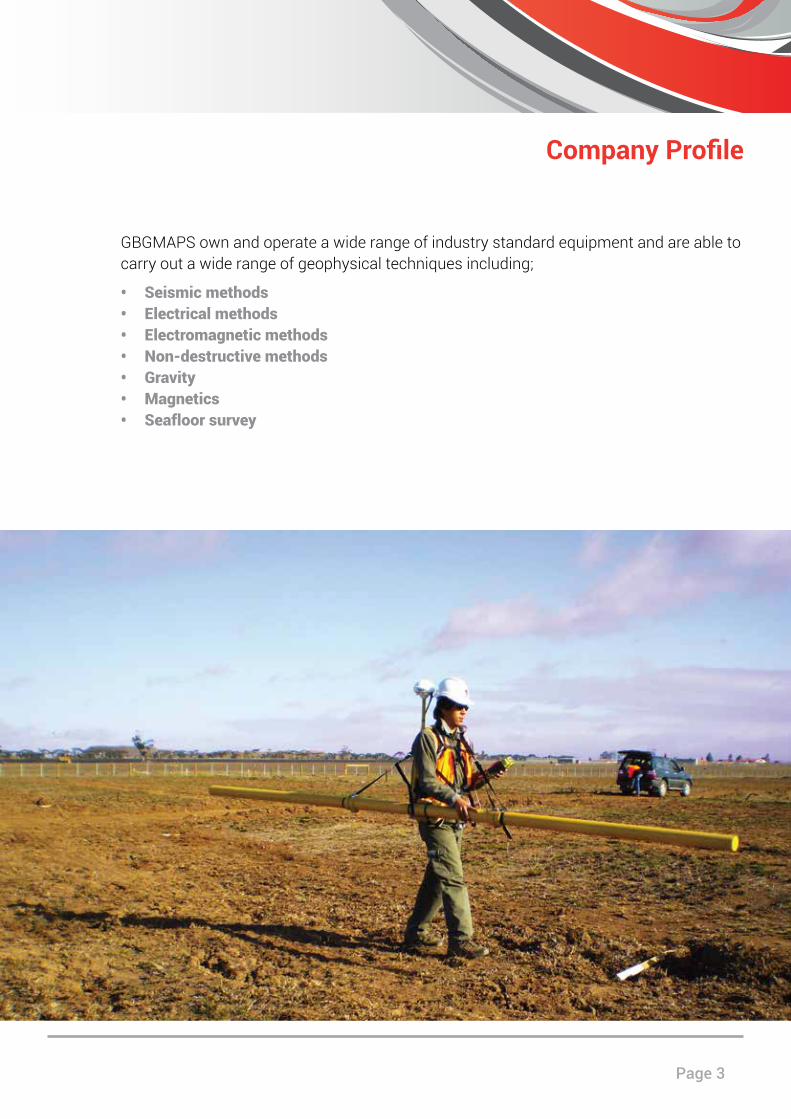
GBGMAPS own and operate a wide range of industry standard equipment and are able to carry out a wide range of geophysical techniques including;
• Seismic methods• Electrical methods• Electromagnetic methods• Non-destructive methods• Gravity• Magnetics• Seafloor survey
Company Profile
GBGMAPS Company Profile
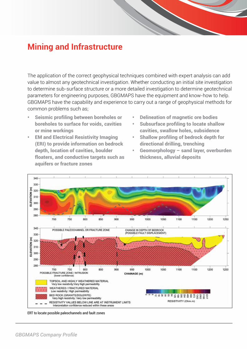
Mining and Infrastructure
The application of the correct geophysical techniques combined with expert analysis can add value to almost any geotechnical investigation. Whether conducting an initial site investigation to determine sub-surface structure or a more detailed investigation to determine geotechnical parameters for engineering purposes, GBGMAPS have the equipment and know-how to help. GBGMAPS have the capability and experience to carry out a range of geophysical methods for common problems such as;
• Seismic profiling between boreholes or boreholes to surface for voids, cavities or mine workings
• EM and Electrical Resistivity Imaging (ERI) to provide information on bedrock depth, location of cavities, boulder floaters, and conductive targets such as aquifers or fracture zones
• Delineation of magnetic ore bodies• Subsurface profiling to locate shallow
cavities, swallow holes, subsidence• Shallow profiling of bedrock depth for
directional drilling, trenching• Geomorphology – sand layer, overburden
thickness, alluvial deposits
ERT to locate possible paleochannels and fault zones
Page 5
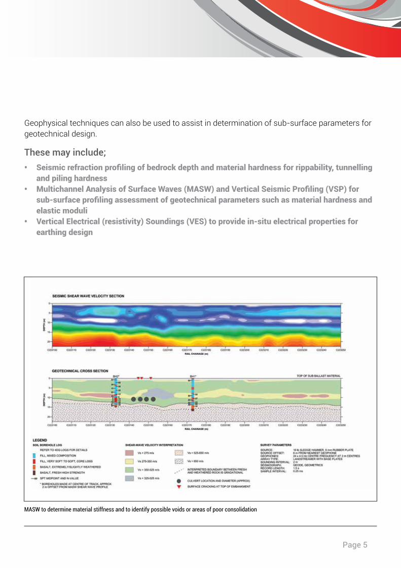
Geophysical techniques can also be used to assist in determination of sub-surface parameters for geotechnical design.
These may include;• Seismic refraction profiling of bedrock depth and material hardness for rippability, tunnelling
and piling hardness• Multichannel Analysis of Surface Waves (MASW) and Vertical Seismic Profiling (VSP) for
sub-surface profiling assessment of geotechnical parameters such as material hardness and elastic moduli
• Vertical Electrical (resistivity) Soundings (VES) to provide in-situ electrical properties for earthing design
MASW to determine material stiffness and to identify possible voids or areas of poor consolidation
GBGMAPS Company Profile
GBGMAPS have the equipment and expertise to provide advanced seafloor and sub-bottom profiling for shallow water and transition zone projects such as port and harbour developments, dredging programs and seafloor obstacle mapping.
The use of geophysical methods can greatly enhance sub-bottom information, particularly when coupled with traditional geotechnical data from methods such as boreholes and CPTs. The use of geophysics can also add value while minimising costs associated with the use of jack-up barges and the like.
Marine
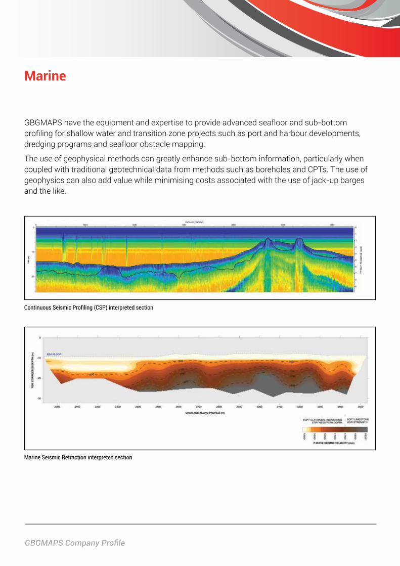
Continuous Seismic Profiling (CSP) interpreted section
Marine Seismic Refraction interpreted section
Page 7
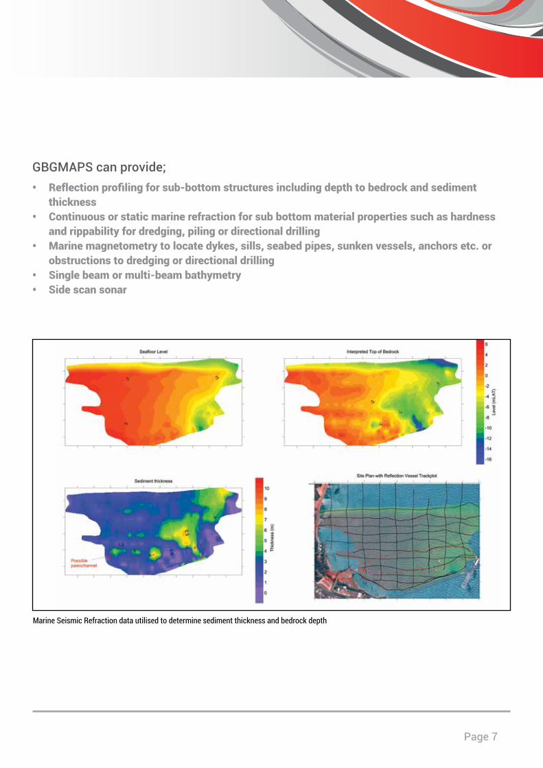
Marine Seismic Refraction data utilised to determine sediment thickness and bedrock depth
GBGMAPS can provide;• Reflection profiling for sub-bottom structures including depth to bedrock and sediment
thickness• Continuous or static marine refraction for sub bottom material properties such as hardness
and rippability for dredging, piling or directional drilling• Marine magnetometry to locate dykes, sills, seabed pipes, sunken vessels, anchors etc. or
obstructions to dredging or directional drilling• Single beam or multi-beam bathymetry• Side scan sonar
GBGMAPS Company Profile
Environmental / Groundwater
Environmental geophysics covers a wide variety of applications ranging from locating unexploded ordnance at former military sites to targeting geological sequences with high groundwater yields. Environmental investigations where geophysical methods have proven to be invaluable include:
• Location of buried services, underground storage tanks and other remnant structures• Delineation of landfill extents, fill base and capping thickness; and location of
uncontrolled fill such as buried waste drums• Location of unexploded ordnance (UXOs)• Delineation of inorganic contaminant plumes• Assessment of dry land salinity and groundwater studies• Tree root mapping
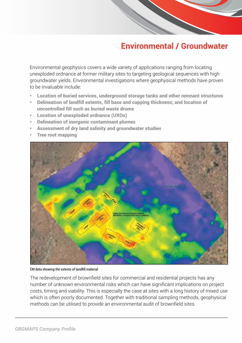
EM data showing the extents of landfill material
The redevelopment of brownfield sites for commercial and residential projects has any number of unknown environmental risks which can have significant implications on project costs, timing and viability. This is especially the case at sites with a long history of mixed use which is often poorly documented. Together with traditional sampling methods, geophysical methods can be utilised to provide an environmental audit of brownfield sites.

Page 9
Geophysical environmental investigations carried out at the planning stage of a project are inexpensive and can provide a valuable insight into potential environmental risks which may otherwise only be uncovered further into the development when considerable expenditure and resources have already been committed.
Cart mounted for rapid data acquisition with high positioning accuracy
Archaeology Location of archaeologically significant features such as building remains, unmarked grave sites and abandoned mine shafts.
3D GPR with interpreted section showing location of unmarked gravesites
GBGMAPS Company Profile
Structural and Non-Destructive Testing
Non-Destructive Testing (NDT) utilises a number of methods designed to non-invasively measure the internal properties and condition of engineered structures. NDT methods can be carried out on a wide range of building materials including concrete, masonry, timber, and asphalt pavement.
Using NDT methods, GBGMAPS can obtain detailed internal condition assessments of a variety of engineered structures including buildings, bridges, tunnels and roads. Together with targeted invasive testing, laboratory testing and visual inspection a complete assessment of an engineered structure can be made.
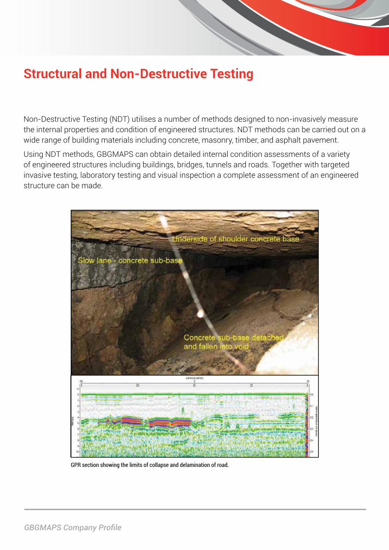
GPR section showing the limits of collapse and delamination of road.
Page 11
• Construction detail of concrete structures including reinforcement spacing, depth of cover and diameters, and concrete thickness and strength
• Assessment of concrete condition including honey combing, delamination, voiding and reinforcement corrosion potential
• Mapping of features within concrete structures including service conduits, poorly grouted PT ducts and void formers
• Assessment of internal condition of timber structures including bridges and power poles
• Construction detail and condition within brick and concrete lined tunnels
• Construction detail and condition of retaining structures including dams and retaining walls
• Assessment of heritage structures • Pavement layer thickness and condition for
roads and runways• Ballast layer thickness and condition/
fouling along rail tracks• Measuring pile lengths• Thermal imaging for void and leak detection
GBGMAPS and joint parent company with McMullen Nolan Group, GBG Australia, have carried out NDT investigations for a wide range of applications including:
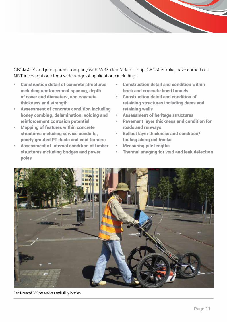
Cart Mounted GPR for services and utility location
www.gbgmaps.com.au
GBGMAPS Contact GBG Australia ContactLevel 1, 2 Sabre Crescent 18 Fennell StreetJandakot WA 6164 North Parramatta NSW 2151PO Box 3526 T: +61 (2) 9890 2122Success WA 6964 E: [email protected]: +61(8) 6436 1599 W: www.gbgoz.com.au E: [email protected]: www.gbgmaps.com.au