COMMUNITY PROFILE CITY OF FREMONT
25
Lower Platte North NRD Multi-Jurisdictional Hazard Mitigation Plan | 2020 1 COMMUNITY PROFILE CITY OF FREMONT LOWER PLATTE NORTH NATURAL RESOURCES DISTRICT MULTI-JURISDICTIONAL HAZARD MITIGATION PLAN UPDATE 2020
Transcript of COMMUNITY PROFILE CITY OF FREMONT

Lower Platte North NRD Multi-Jurisdictional Hazard Mitigation Plan | 2020 1
COMMUNITY PROFILE
CITY OF FREMONT
LOWER PLATTE NORTH NATURAL RESOURCES DISTRICT
MULTI-JURISDICTIONAL HAZARD MITIGATION PLAN UPDATE
2020

Section Seven: City of Fremont Community Profile
2 Lower Platte North NRD Multi-Jurisdictional Hazard Mitigation Plan | 2020
LOCAL PLANNING TEAM
Table FMT.1: City of Fremont Local Planning Team
NAME TITLE JURISDICTION
Brian Newton City Administrator City of Fremont
Don Simon Chief Building Inspector/Floodplain
Administration City of Fremont
Jennifer Dam Director of Planning City of Fremont
Lottie Mitchell Executive Assistant City of Fremont Veronica Trujillo City Engineer City of Fremont
LOCATION AND GEOGRAPHY
The City of Fremont is in the southeastern portion of Dodge County (on the border with Saunders County)
and covers an area of 10.48 square miles. Fremont is located in the Platte River Valley. The rural areas
surrounding the city are used primarily for row crop production and pasturing. The Elkhorn River travels
north to south about three miles from the eastern edge of the city. Fremont lies immediately adjacent to the
Platte River Valley, which flows generally from northwest to the southeast to form the community’s
southwestern border.
TRANSPORTATION
Transportation information is important to hazard mitigation plans because it suggests possible evacuation
corridors in the community and areas more at risk of transportation incidents. Fremont’s major
transportation corridors include US Highways 30, 77 and 275. US Highway 30 transports a total annual
average of 10,370 vehicles daily from east to west on its busiest segment, 1,375 of which are trucks. US
Highway 77 runs north to south through the center of Fremont and is traveled by a total annual average of
12,880 vehicles daily at its highest traffic segment, 785 of which are trucks. US Highway 275 runs north to
south on the eastern side of Fremont; it is traveled by a total annual average of 16,380 vehicles daily, 1,605
of which are trucks.1 A number of railroads wind through Fremont, owned by Union Pacific Railroad,
Burlington Northern Santa Fe Railway, and Fremont & Elkhorn Valley Railroad. The Fremont Municipal
Airport is home to 50 aircraft and a local chapter of the Civil Air Patrol. The airport is located on the
northwestern edge of the city. It can accommodate aircraft up to the size of corporate jets.
1 Nebraska Department of Roads. 2018. “Interactive Statewide Traffic Counts Map.” [map].
https://gis.ne.gov/portal/apps/webappviewer/index.html?id=bb00781d6653474d945d51f49e1e7c34.

Section Seven: City of Fremont Community Profile
Lower Platte North NRD Multi-Jurisdictional Hazard Mitigation Plan | 2020 3
Figure FMT.1: City of Fremont
Section Seven: City of Fremont Community Profile
4 Lower Platte North NRD Multi-Jurisdictional Hazard Mitigation Plan | 2020
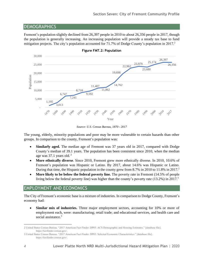
DEMOGRAPHICS
Fremont’s population slightly declined from 26,397 people in 2010 to about 26,356 people in 2017, though
the population is generally increasing. An increasing population will provide a steady tax base to fund
mitigation projects. The city’s population accounted for 71.7% of Dodge County’s population in 2017.2
Figure FMT.2: Population
Source: U.S. Census Bureau, 1870 - 2017
The young, elderly, minority populations and poor may be more vulnerable to certain hazards than other
groups. In comparison to the county, Fremont’s population was:
• Similarly aged. The median age of Fremont was 37 years old in 2017, compared with Dodge
County’s median of 39.1 years. The population has been consistent since 2010, when the median
age was 37.1 years old. 2
• More ethnically diverse. Since 2010, Fremont grew more ethnically diverse. In 2010, 10.6% of
Fremont’s population was Hispanic or Latino. By 2017, about 14.6% was Hispanic or Latino.
During that time, the Hispanic population in the county grew from 8.7% in 2010 to 11.8% in 2017.2
• More likely to be below the federal poverty line. The poverty rate in Fremont (14.5% of people
living below the federal poverty line) was higher than the county’s poverty rate (13.2%) in 2017.3
EMPLOYMENT AND ECONOMICS
The City of Fremont’s economic base is a mixture of industries. In comparison to Dodge County, Fremont’s
economy had:
• Similar mix of industries. Three major employment sectors, accounting for 10% or more of
employment each, were: manufacturing; retail trade; and educational services, and health care and
social assistance.3
2 United States Census Bureau. “2017 American Fact Finder: DP05: ACS Demographic and Housing Estimates.” [database file].
https://factfinder.census.gov/.
3 United States Census Bureau. “2017 American Fact Finder: DP03: Selected Economic Characteristics.” [database file].
https://factfinder.census.gov/.
1,195 3,013
6,747
7,241
8,718
9,592
11,407
11,862
14,762
19,698
22,962 23,979
23,680
25,174 26,397
26,356
-
5,000
10,000
15,000
20,000
25,000
30,000
Pop
ula
tion
Year

Section Seven: City of Fremont Community Profile
Lower Platte North NRD Multi-Jurisdictional Hazard Mitigation Plan | 2020 5
• Lower per capita income. Fremont’s per capita income in 2017 ($24,743) was about $2,419 lower
than the county ($27,162).3
• Fewer long-distance commuters. About 59.8% of workers in Fremont commuted for fewer than
15 minutes, compared with about 54.4% of workers in Dodge County. About 19.8% of workers in
the city commuted 30 minutes or more to work, compared to about 22.9% of county workers.4
MAJOR EMPLOYERS Fremont’s top three major employers include Wholestone Farms, Methodist Fremont Health, and Fremont
Public Schools. About 3,000 residents commute to Omaha daily for work.
HOUSING
In comparison to Dodge County, Fremont’s housing stock was:5
• Similarly aged. Fremont had a similar share of housing built prior to 1970 than the county (58.6%
compared to 58.5%).
• Less mobile and manufactured housing. Fremont had a smaller share of mobile and
manufactured housing (3.6%) compared to the county (5.0%). However, there are three mobile
home parks located in the community, which are: Regency II Mobile Home Park, Meadowbrook
Mobile Home Park, and Westlake Mobile Home Park.
• More renter-occupied. About 41.7% of occupied housing units in Fremont were renter-occupied
compared with 36.1% of occupied housing in Dodge County.
• Slightly more occupied. Approximately 7.2% of Fremont’s housing units were vacant compared
to 9.6% of units in Dodge County.
The age of housing may indicate which housing units were built prior to the development of state building
codes. Homes built within a flood hazard area before the adoption of their community’s Flood Rate
Insurance Map (FIRM) are not likely to be built above the 1% annual chance floodplain. Older and vacant
housing stock may also be more vulnerable to hazard events if it is poorly maintained. Communities with
a substantial number of mobile homes may be more vulnerable to the impacts of high winds, tornadoes, and
severe winter storms if those homes are not anchored correctly. Renter occupied housing depends on the
initiative of landlords for proper maintenance and retrofitting to be resilient to disasters. They are less likely
than homeowners to have renter’s insurance or flood insurance, or to know their risks to flooding and other
hazards.
FUTURE DEVELOPMENT TRENDS
In the last five years, two new housing developments were completed. Developers are required to follow
floodplain regulations when subdividing and getting a building permit. Lincoln Premium Poultry
production plant opened in 2019, the RTG building is expanding, Hormel is constructing a stand-alone
wastewater treatment plant, and the pork processing plant is expanding. The city is currently working on
ADA compliance on all city owned buildings and the city auditorium is being remodeled. In the next five
years, new housing developments are planned, the library will be remodeled, and a new law enforcement
center will be built.
4 United States Census Bureau. “2017 American Fact Finder: S0802: Means of Transportation to Work by Selected Characteristics.” [database
file]. https://factfinder.census.gov/.
5 United States Census Bureau. “2017 American Fact Finder: DP04: Selected Housing Characteristics.” [database file].
https://factfinder.census.gov/.
Section Seven: City of Fremont Community Profile
6 Lower Platte North NRD Multi-Jurisdictional Hazard Mitigation Plan | 2020
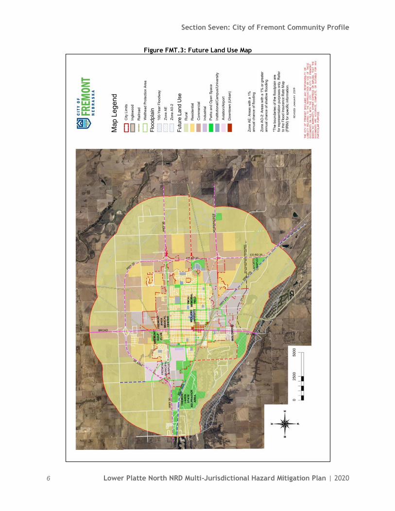
Figure FMT.3: Future Land Use Map

Section Seven: City of Fremont Community Profile
Lower Platte North NRD Multi-Jurisdictional Hazard Mitigation Plan | 2020 7
PARCEL IMPROVEMENTS AND VALUATION
The planning team acquired GIS parcel data from the County Assessor to analyze the location, number, and
value of property improvements (e.g. buildings, paved lots, roads, etc.) at the parcel level. The data did not
contain the number of structures on each parcel. The parcel data was analyzed to determine the number and
valuation of property improvements located in the 1% annual chance floodplain. A summary of the results
of this analysis is provided in the following table.
Table FMT.2: Parcel Improvements and Value in the Floodplain
NUMBER OF IMPROVEMENTS
TOTAL IMPROVEMENT
VALUE
MEAN VALUE OF IMPROVEMENTS
PER PARCEL
NUMBER OF IMPROVEMENTS IN
FLOODPLAIN
VALUE OF IMPROVEMENTS IN FLOODPLAIN
9,470 $1,249,897,513 $131,985 1,423 $175,432,319 Source: GIS Workshop/Dodge County Assessor, 20196
CRITICAL INFRASTRUCTURE
CHEMICAL STORAGE FIXED SITES According to the Tier II System reports submitted to the Nebraska Department of Environment and Energy,
there are a total of 48 fixed hazardous chemical storage sites within two miles of the city. The following
table lists these sites. CF Industries in the north part of Fremont is the biggest site of concern for the city
because they store large amounts of anhydrous ammonia. The Fremont Fire Department has the appropriate
training and equipment to respond to chemical spills.
Table FMT.3: Chemical Storage Fixed Sites
FACILITY NAME ADDRESS IN FLOODPLAIN
(YES/N0)
3M Co 515 S Main St Yes Adams Oil Inc 1500 Front St Yes
All Metals Market Inc 1225 County Road Y No
Alliance Liquid Feeds LLC 350 E County Road T Yes AmeriCold Logistics LLC 950 Schneider St Yes
Archer Daniels Midland Co 130 N Broad St Yes
Ardent Mills LLC 125 S Broad St Yes Arps Red-E-Mix Inc 250 W Vine St Yes
C F Industries Sales LLC 1949 County Rd S Yes
CenturyLink 510 N D St Yes
CRD Inc Transfer Station 1200 Hamilton St Yes Fremont Beef Company 960 Schneider St Yes
Fremont Municipal Airport 1203 W 23rd St Yes
Fremont Peak Shaving Plant 401 N Pierce Yes Fremont Potable Water Trtmnt 649 S Luther Rd Yes
Fremont Warehouse & Garage 3000 E 1st St Yes
Fremont Wastewater Treatment 6325 Morningside Rd Yes
Fremont Water Pumping Station 1410 N Irving St Yes Fremont Water Pumping Station 837 N Clarkson St Yes
Fremont Water Pumping Station 1818 N I St Yes
Fremont Water Pumping Station 1129 E 8th St Yes Gerhold Concrete Co 3300 N Broad St Yes
Helena Agri-Enterprises LLC 1880 Proctor Rd Yes
6 GIS Workshop/Dodge County Assessor. 2019. [Personal correspondence].
Section Seven: City of Fremont Community Profile
8 Lower Platte North NRD Multi-Jurisdictional Hazard Mitigation Plan | 2020
FACILITY NAME ADDRESS IN FLOODPLAIN
(YES/N0)
Holcim US Inc 3350 N Broad St Yes
Horizon Biofuels Inc Pellets 950 S Union St Yes
Interstate Chemical Company 327 E County Road T Yes
Jayhawk Boxes Inc 1150 S Union St Yes Lextron Animal Health 1577 N Airport Rd Yes
Lon D Wright Power Plant 2701 E 1st St Yes
Loveland Products Inc 325 S Union St Yes Lyman-Richey Sand & Gravel 45 4204 N Luther Rd Yes
Magnus Division of LV Ventures 1300 Morningside Rd Yes
Materials Packaging Corp 3300 N Broad St Yes
Methodist Fremont Health 450 E 23rd St Yes NDOT Fremont Yard 2550 W 23rd Rd Yes
Nutrien Ag Solutions 750 S Union St Yes
OPPD Substation No 991 County Rd 26 & U Blvd No Peets Feeds 787 County Road T Yes
Provimi North America Inc 943 Schneider St Yes
Rawhide Chemoil Inc 3630 N Ridge Rd Dr Yes Rawhide Chemoil Inc 1146 Proctor Rd Yes
Rawhide Chemoil Inc North 2650 Rawhide Dr Yes
Royal Canin USA Inc 2779 Rademakers Way Yes
Sapp Bros 4260 N Broad St Yes Substation No 976 3741 N Somers Ave Yes
The Oilgear Company 905 S Downing St Yes
Titan Machinery Inc 3701 W Highway 30 Yes WholeStone Farms Cooperative 900 S Platte Ave Yes
Source: Nebraska Department of Environment and Energy, 20197
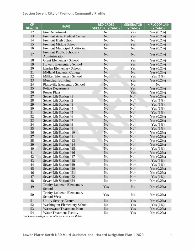
CRITICAL FACILITIES The planning team identified critical facilities necessary for the City of Fremont’s disaster response and
continuity of operations. Critical facilities were identified during the 2015 planning process and revised for
this plan update. The following table and figure provide a summary of the critical facilities for the
community.
Table FMT.4: Critical Facilities CF
NUMBER NAME
RED CROSS SHELTER (YES/NO)
GENERATOR (YES/NO)
IN FLOODPLAIN (YES/NO)
1 Bell Field Elementary School No Yes Yes (0.2%)
2 Bergan Catholic School No No Yes (0.2%)
3 Bergan Elementary School No No Yes (0.2%) 4 City Well #1 No No* Yes (0.2%)
5 City Well #2 No No* Yes (0.2%)
6 City Well #3 No No* Yes (0.2%) 7 City Well #4 No No* Yes (0.2%)
8 City Well #5 No No* Yes (Floodway)
9 City Well Field No No* Yes (0.2%) 10 Clarmar Elementary School No Yes Yes (0.2%)
11 Combustion Turbine No Yes Yes (0.2%)
7 Nebraska Department of Environmental Quality. 2019. "Nebraska DEQ Tier 2 Data Download: 2018." https://deq-iis.ne.gov/tier2/.
Section Seven: City of Fremont Community Profile
Lower Platte North NRD Multi-Jurisdictional Hazard Mitigation Plan | 2020 9
CF NUMBER
NAME RED CROSS
SHELTER (YES/NO) GENERATOR
(YES/NO) IN FLOODPLAIN
(YES/NO)
12 Fire Department No Yes Yes (0.2%)
13 Fremont Area Medical Center No Yes Yes (0.2%)
14 Fremont High School No No Yes (0.2%)
15 Fremont Middle School Yes Yes Yes (0.2%) 16 Fremont Municipal Auditorium No No Yes (0.2%)
17 Fremont Public Schools -
Administration No No Yes (0.2%)
18 Grant Elementary School No Yes Yes (0.2%)
19 Howard Elementary School No Yes Yes (0.2%)
20 Linden Elementary School No Yes Yes (0.2%)
21 Midland Lutheran College No No Yes (0.2%) 22 Miliken Elementary School No Yes Yes (1%)
23 Municipal Building No Yes Yes (0.2%)
24 Platteville Elementary School No No No 25 Police Department No Yes Yes (0.2%)
26 Power Plant No Yes Yes (0.2%)
27 Sewer Lift Station #1 No No* Yes (0.2%) 28 Sewer Lift Station #2 No No* Yes (1%)
29 Sewer Lift Station #3 No No* Yes (1%)
30 Sewer Lift Station #4 No No* Yes (1%)
31 Sewer Lift Station #5 No No* Yes (1%) 32 Sewer Lift Station #6 No No* Yes (0.2%)
33 Sewer Lift Station #7 No No* Yes (0.2%)
34 Sewer Lift Station #8 No No* Yes (1%) 35 Sewer Lift Station #9 No No* Yes (1%)
36 Sewer Lift Station #10 No No* Yes (0.2%)
37 Sewer Lift Station #11 No No* Yes (0.2%) 38 Sewer Lift Station #13 No No* Yes (0.2%)
39 Sewer Lift Station #14 No No* Yes (0.2%)
40 Sewer Lift Station #15 No No* Yes (1%)
41 Sewer Lift Station #16 No No* Yes (0.2%) 42 Sewer Lift Station #17 No No* Yes (0.2%)
43 Sewer Lift Station #18 No No* Yes (1%)
44 Sewer Lift Station #19 No No* Yes (1%) 45 Sewer Lift Station #20 No No* Yes (0.2%)
46 Sewer Lift Station #21 No No* Yes (0.2%)
47 Sewer Lift Station #22 No No* Yes (1%)
48 Sewer Lift Station #24 No No* Yes (0.2%)
49 Trinity Lutheran Elementary
School Yes No Yes (0.2%)
50 Trinity Lutheran Elementary School West
Yes No Yes (0.2%)
51 Utility Service Center No Yes Yes (0.2%)
52 Washington Elementary School No Yes Yes (1%) 53 Wastewater Treatment Plant No Yes Yes (0.2%)
54 Water Treatment Facility No Yes Yes (0.2%) *Indicates hookups to portable generator available

Section Seven: City of Fremont Community Profile
10 Lower Platte North NRD Multi-Jurisdictional Hazard Mitigation Plan | 2020
Figure FMT.4: Critical Facilities #1-26

Section Seven: City of Fremont Community Profile
Lower Platte North NRD Multi-Jurisdictional Hazard Mitigation Plan | 2020 11
Figure FMT.5: Critical Facilities #27-54

Section Seven: City of Fremont Community Profile
12 Lower Platte North NRD Multi-Jurisdictional Hazard Mitigation Plan | 2020
HISTORICAL OCCURRENCES
See the Dodge County profile for historical hazard events, including the number of events, damage
estimates, and any fatalities or injuries.
HAZARD PRIORITIZATION
The hazards discussed in detail below were prioritized by the local planning team based on historical hazard
occurrences and the community’s capabilities. For an in-depth discussion of regional hazards, please see
Section Four: Risk Assessment.
CHEMICAL TRANSPORTATION SPILLS The rail line is the transportation route of most concern in the community because of the large volume of
chemicals it transports, including fracking oil and coal. In 2019 a train derailment between the Village of
Valley and Fremont left coal all along the train tracks. The rail line travels close to Highway 30, a main
thoroughfare for the city, so a transportation incident on the rail line could interrupt vehicular traffic flow
on this important highway. Anhydrous ammonia pipelines running from Sioux City to the City of Blair to
Fremont are also a concern. In 2016 a man died while driving through an anhydrous ammonia fume cloud
that had escaped from an aging pipeline just north of the City of Blair. About 40 people were evacuated
from their homes because of this spill and Highway 75 was closed for several days. Much of this pipeline
was built in the 1960s.
FLOODING The 2008 Flood Insurance Study (FIS) for Dodge County and Fremont states that most floods along the
Platte River occur from March to June. They are usually the result of rapid snowmelt accompanied by
rainfall, aggravated by ice jams. Historical incidents have demonstrated that when ice jams are present,
river stages sufficiently high enough to overtop existing levees like the Fremont Levee can occur even with
river flows of less than the 1% annual chance flood. Future flooding from the Platte River due to ice
blockage is highly probably, but also highly unpredictable as to the precise location of ice blockage and the
resulting severity of flooding. It should be assumed that ice jams may form anywhere along the Platte river
and where ice jams do occur, stages may be sufficiently high enough to cause levee failure.
Fremont has longstanding drainage issues in the city because of its flat terrain. Especially south of the
junction, near Rawhide Creek, in the Washington Heights housing subdivision, and on 19th Street near the
high school. This issue was exacerbated during the March 2019 flood event when heavy rains combined
with a frozen ground created excessive stormwater that funneled to the Platte River, Elkhorn River, and
Rawhide Creek. These waterways were also logged with ice that the additional water turned to ice jams.
Flash flooding from heavy rains combined with poor stormwater drainage, riverine flooding, and levee
failures flooded all transportation routes in and out of the city. Flooding also threatened the hospital and
YMCA, requiring massive amounts of pumping to hold back the water. Fremont was an island from March
16th to March 20th. The National Guard escorted semi-trucks of food into the city when supplies began to
run low. Highway 77 was clear of water after a few days, but Highway 30 east of Fremont was closed for
months, causing economic impacts as workers struggled to commute to work in and out of the city. The
well fields were also flooded, though the wells were not affected because they had been elevated to mitigate
flood damage. The power plant was also unharmed even though it is in the floodplain. Evacuations were
called for in Davenport, Deerfield, and south of the railroad junction. The Platte River had previously
flooded in June 2016. It rose six to seven inches, flooding basements across the city and inundating the
sewer plant because the stormwater and sewer systems were overloaded with water.

Section Seven: City of Fremont Community Profile
Lower Platte North NRD Multi-Jurisdictional Hazard Mitigation Plan | 2020 13
Additional flood history was collected from the NCEI database:
• July 5, 2000 – Flash Flood: Heavy rainfall of 4 to 6 inches caused extensive flooding from North
Bend to the Fremont area.
• March 8-10, 2010 – Flood: An ice jam around the North Bend area caused flooding of agricultural
lowlands from North Bend to around Fremont. In addition, several homes were threatened by the
flood waters, and a few county roads were flooded. Some water damage was likely noted due to
rising groundwater or backing up of sewers. The ice jam broke loose on March 10th, which caused
additional jamming and flooding around the Big Island area near Fremont. Six to ten people had to
be evacuated by boat from the rising waters. Property damage was estimated at $75,000.
• February 18, 2011 – Flood: An ice jam near the Highway 77 bridge caused flooding that closed
Ridge Road for a while, just southwest of Fremont. Damage was minimal.
• August 6, 2013 – Flood: Rainfall from heavy thunderstorms created areas of street flooding across
the city. A thunderstorm dropped about 1.80 inches in less than an hour followed by a second storm
less than an hour later. This second storm dropped about 0.5 inch in less than an hour. Many
intersections in town were under water.
In response to the March 2019 flood, the City initiated several actions to reduce flood risk to the community.
First, they partnered with several communities and districts to form the Joint Water Management Advisory
Board, which is a group of communities and drainage districts along the Platte River in Dodge County.
They’ve partnered together to develop a comprehensive flood risk reduction and mitigation strategy along
the Platte River. The Board is currently looking for funding alternatives to develop a Flood Mitigation and
Flood Resiliency Plan to identify, evaluate, and prioritize flood mitigation alternatives to improve flood
resiliency along the Platte river.
Second, the City is submitting a HMGP grant to fund property elevation projects for homeowners impacted
during the March floods. In coordination with this effort, a parcel-level flood risk assessment and flood risk
reduction plan were completed as a part of this HMP update (Appendix F). The overall purpose of this
assessment and resulting plan is to identify and prioritize flood risk reduction alternatives on a property by
property basis for selected structures in the SFHA. The plan also identifies programmatic actions that can
be taken by the community to reduce flood risks and insurance costs for all property owners with floodprone
property.
Fremont has 679 NFIP policies in-force for $117,943,300. There are four single family repetitive loss and
three single family severe repetitive loss properties in the community, according to NeDNR (November
2019).
LEVEE FAILURE Ice jams that occurred during the March 2019 floods resulted in a series of levee failures along the Platte
River. The location of these breaches, as outlined by the Joint Water Management Advisory Board, are
shown in Figure 7. The shredded bark on trees near the river indicated that the water rose ten feet in places.
The farm levee north of the city was overtopped and destroyed and the levee south of the city failed in three
places. Emergency protection measures were coordinated on Highway 30, 275, 277, and on Rawhide Creek.
Levee failures were a major contributing factor to catastrophic flooding in and around the city. The Hormel
Park boat ramp was lost to the flooding and the northern bank of the Platte River along the city was sheared
off by the flood waters. The levee at the Rod and Gun Club lake community had previously been breached
in the 1960s and has since been well upkept and repaired so that it held up in the 2019 floods.

Section Seven: City of Fremont Community Profile
14 Lower Platte North NRD Multi-Jurisdictional Hazard Mitigation Plan | 2020
Figure FMT.6: Levee Location

Section Seven: City of Fremont Community Profile
Lower Platte North NRD Multi-Jurisdictional Hazard Mitigation Plan | 2020 15
Figure FMT.7: March 2019 Levee Failures

Section Seven: City of Fremont Community Profile
16 Lower Platte North NRD Multi-Jurisdictional Hazard Mitigation Plan | 2020
SEVERE THUNDERSTORMS A hail storm in 2008 caused extensive damage with hail 1.75 inches in diameter. So many properties were
damaged that building materials and contractors were scarce leading to delayed repairs. No significant
damage would occur should the power plant be hit by lightning. Brief power outages have occurred in the
city but there is a good amount of power redundancies to protect the power infrastructure. Municipal records
are protected with surge protectors on electronic devices.
SEVERE WINTER STORMS Fremont experiences annual severe snow and ice storms. Recently, a blizzard in 2016 left ten inches of
snow on the ground. Severe winter storms are a concern because of power outages and road closures. Snow
removal is done by the Street Department.
TORNADOES A high wind event in June 2017 caused significant tree damage across a one-mile wide area. A tree dump
was opened specifically to accommodate the large number of trees and limbs downed during this event. A
tornado in 2014 passed from Midland University then the high school but caused little damage. In case of
a disaster, Mutual Aid Agreements are in place with surrounding communities.
GOVERNANCE
The City of Fremont is governed by a mayor and an eight-member city council; other governmental offices
and departments are listed below. The community government will oversee the implementation of hazard
mitigation projects.
• City Administrator
• Clerk
• Attorney
• Director of Public Works/City Engineer
• Police Department
• Fire Department
• Wastewater Treatment Plant Supervisor
• Street Superintendent
• Water & Sewer Superintendent
• Power Plant Superintendent
• Chief Building Inspector
• Park & Recreation Director
• Planning Director
• Finance Director
• Human Resources Director
• Information Systems Director
• Library Director
CAPABILITY ASSESSMENT
The capability assessment consisted of a review of local existing policies, regulations, plans, and programs
with hazard mitigation capabilities. The following tables summarize the community’s planning and
regulatory capability; administrative and technical capability; fiscal capability; educational and outreach
capability; and overall capability to implement mitigation projects.

Section Seven: City of Fremont Community Profile
Lower Platte North NRD Multi-Jurisdictional Hazard Mitigation Plan | 2020 17
Table FMT.5: Capability Assessment
SURVEY COMPONENTS/SUBCOMPONENTS YES/NO
Planning
&
Regulatory Capability
Comprehensive Plan Yes
Capital Improvements Plan Yes
Economic Development Plan Yes
Emergency Operational Plan Yes
Floodplain Management Plan No
Storm Water Management Plan No
Zoning Ordinance Yes
Subdivision Regulation/Ordinance Yes
Floodplain Ordinance Yes
Building Codes Yes
National Flood Insurance Program Yes
Community Rating System Yes – Class 8
Other (if any) No
Administrative &
Technical
Capability
Planning Commission Yes
Floodplain Administration Yes
GIS Capabilities Yes
Chief Building Official Yes
Civil Engineering Yes
Local Staff Who Can Assess Community’s
Vulnerability to Hazards Yes
Grant Manager Yes
Mutual Aid Agreement Yes
Other (if any) Joint Water Management Advisory Board - Member
Fiscal
Capability
Applied for grants in the past Yes
Awarded a grant in the past Yes
Authority to Levy Taxes for Specific Purposes such
as Mitigation Projects Yes
Gas/Electric Service Fees Yes
Storm Water Service Fees No
Water/Sewer Service Fees Yes
Development Impact Fees No
General Obligation Revenue or Special Tax Bonds Yes
Other (if any)
Education
& Outreach
Capability
Local citizen groups or non-profit organizations focused on environmental protection, emergency
preparedness, access and functional needs
populations, etc. Ex. CERT Teams, Red Cross, etc.
No
Ongoing public education or information program
(e.g., responsible water use, fire safety, household preparedness, environmental education)
Yes
Natural Disaster or Safety related school programs Yes
StormReady Certification No
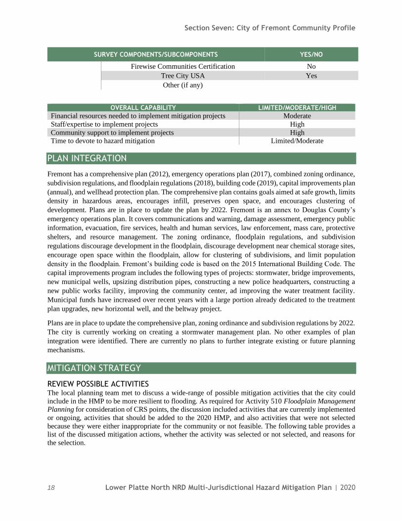
Section Seven: City of Fremont Community Profile
18 Lower Platte North NRD Multi-Jurisdictional Hazard Mitigation Plan | 2020
SURVEY COMPONENTS/SUBCOMPONENTS YES/NO
Firewise Communities Certification No
Tree City USA Yes
Other (if any)
OVERALL CAPABILITY LIMITED/MODERATE/HIGH
Financial resources needed to implement mitigation projects Moderate
Staff/expertise to implement projects High
Community support to implement projects High Time to devote to hazard mitigation Limited/Moderate
PLAN INTEGRATION
Fremont has a comprehensive plan (2012), emergency operations plan (2017), combined zoning ordinance,
subdivision regulations, and floodplain regulations (2018), building code (2019), capital improvements plan
(annual), and wellhead protection plan. The comprehensive plan contains goals aimed at safe growth, limits
density in hazardous areas, encourages infill, preserves open space, and encourages clustering of
development. Plans are in place to update the plan by 2022. Fremont is an annex to Douglas County’s
emergency operations plan. It covers communications and warning, damage assessment, emergency public
information, evacuation, fire services, health and human services, law enforcement, mass care, protective
shelters, and resource management. The zoning ordinance, floodplain regulations, and subdivision
regulations discourage development in the floodplain, discourage development near chemical storage sites,
encourage open space within the floodplain, allow for clustering of subdivisions, and limit population
density in the floodplain. Fremont’s building code is based on the 2015 International Building Code. The
capital improvements program includes the following types of projects: stormwater, bridge improvements,
new municipal wells, upsizing distribution pipes, constructing a new police headquarters, constructing a
new public works facility, improving the community center, ad improving the water treatment facility.
Municipal funds have increased over recent years with a large portion already dedicated to the treatment
plan upgrades, new horizontal well, and the beltway project.
Plans are in place to update the comprehensive plan, zoning ordinance and subdivision regulations by 2022.
The city is currently working on creating a stormwater management plan. No other examples of plan
integration were identified. There are currently no plans to further integrate existing or future planning
mechanisms.
MITIGATION STRATEGY
REVIEW POSSIBLE ACTIVITIES The local planning team met to discuss a wide-range of possible mitigation activities that the city could
include in the HMP to be more resilient to flooding. As required for Activity 510 Floodplain Management Planning for consideration of CRS points, the discussion included activities that are currently implemented
or ongoing, activities that should be added to the 2020 HMP, and also activities that were not selected
because they were either inappropriate for the community or not feasible. The following table provides a list of the discussed mitigation actions, whether the activity was selected or not selected, and reasons for
the selection.

Section Seven: City of Fremont Community Profile
Lower Platte North NRD Multi-Jurisdictional Hazard Mitigation Plan | 2020 19
Flood Mitigation Action Selected Not
Selected Reason
Parcel Level Evaluation of Floodprone Properties X Action completed during HMP
update
Open Space Preservation X Minimal political support
Emergency Management Exercise X
Works with County Emergency
Management to conduct
exercises as needed
Stream Bank Stabilization X Not started
Channel/Ditch Improvements X Ongoing priority
Community Rating System Strategy for Class Change X
Create a Community-Wide Master Plan to Prioritize all Flood Related Projects (Flood Mitigation and Resiliency
Plan)
X
City is member of Joint Water
Management Advisory Board. First priority to complete a
flood mitigation plan to
prioritize projects
Detention Cells X New detention cells under
construction
Comprehensive Backflow Prevention X Ongoing on all new
construction
Drainage Study/Stormwater Master Plan X High priority to improve urban
drainage and upsize pipes
Improve Highway Drainage X
Working with County NDOT
to improve drainage along
Highway 30
Emergency Response and Preparedness Plan X Need identified following
March 2019 flood
Update FIRM Maps for Regulatory Use X Future priority
Flood Prone Property Acquisition X
Acquisition is not a priority.
City needs to preserve housing
stock
Flood Prone Property Elevation X
Flood Warning System X New stream gauge needed to improve flood warnings for
Fremont
Floodplain Regulation Enforcement and Updates X Ongoing and high priority
Improvements to Flood Warning System X
Levee/Floodwall Construction X
City evaluating levee and
making repairs and
improvements
An action plan for each of the selected mitigation actions can be found under the “New Mitigation Actions” or “Ongoing Mitigation Actions” below. The ongoing mitigation actions are updates to mitigation actions
that were included in the 2015 HMP.

Section Seven: City of Fremont Community Profile
20 Lower Platte North NRD Multi-Jurisdictional Hazard Mitigation Plan | 2020
COMPLETED MITIGATION ACTIONS MITIGATION ACTION PARCEL LEVEL EVALUATION OF FLOODPRONE PROPERTIES
Hazard(s) Addressed Flooding
Status
Parcel level assessment conducted during this planning process, which
prioritizes mitigation alternatives on a property by property basis. City submitted grant to fund the property elevation projects.
ONGOING MITIGATION ACTIONS FROM 2015 HMP MITIGATION ACTION ALERT/WARNING SIRENS
Description Perform an evaluation of existing alert sirens to determine which should
be replaced or upgraded, then replace or upgrade them
Hazard(s) Addressed All hazards Estimated Cost $30,000
Funding Local budget
Timeline 5+ years Priority Low
Lead Agency Executive Assistant, County Emergency Management
Status Sirens are repaired, replaced, or added as needs are identified. Meets Expectations Yes
MITIGATION ACTION BACKUP AND EMERGENCY GENERATORS
Description Provide a portable or stationary backup generator to municipal wells, lift stations, shelters, and other critical facilities
Hazard(s) Addressed All hazards
Estimated Cost $20,000+
Funding Local budget Timeline Ongoing
Priority Low
Lead Agency City Administrator
Status The city has several portable generators but would like to add more
portable and permanent generators
Meets Expectations Yes

Section Seven: City of Fremont Community Profile
Lower Platte North NRD Multi-Jurisdictional Hazard Mitigation Plan | 2020 21
MITIGATION ACTION DRAINAGE STUDY/STORMWATER MASTER PLAN
Description
Stabilization improvements, including rock rip rap, vegetative cover, j-
hooks, boulder vanes, etc. to reestablish channel banks. Channel stabilization can protect structures, increase conveyance, and provide
flooding benefits.
Hazard(s) Addressed Flooding
Estimated Cost $30,000 Funding Local budget
Timeline 2-5 years
Priority High Lead Agency Public Works
Status
The city has identified the need for improved urban drainage and upsized
pipes. Funding for this project has been included in the 2020-2022 public
works budget Meets Expectations Yes
MITIGATION ACTION FLOODPLAIN MANAGEMENT
Description
Decrease the number of structures in the floodplain by raising structures
or purchasing repetitive loss structures to use as recreation fields, picnic
areas, etc. Hazard(s) Addressed Flooding
Estimated Cost $5,000,000+
Funding Local budget, foundations, HMGP Timeline 1-2 years
Priority High
Lead Agency Executive Assistant, Chief Building Inspector/Floodplain Administration
Status The city is actively assisting interested property owners with elevation projects in flood prone areas. An HMGP application for funding is
underway.
Meets Expectations Yes
MITIGATION ACTION FLOODPLAIN REGULATION ENFORCEMENTS AND UPDATES
Description Continue to enforce local floodplain regulations for old and new structures. Update regulations as appropriate. Educate building inspectors
and floodplain managers on regulations
Hazard(s) Addressed Flooding Estimated Cost $0
Funding Local budget
Timeline Ongoing
Priority High Lead Agency Chief Building Inspector, Floodplain Administration
Status The city continues to enforce floodplain regulations and updates as
needed.
Meets Expectations Yes
Section Seven: City of Fremont Community Profile
22 Lower Platte North NRD Multi-Jurisdictional Hazard Mitigation Plan | 2020
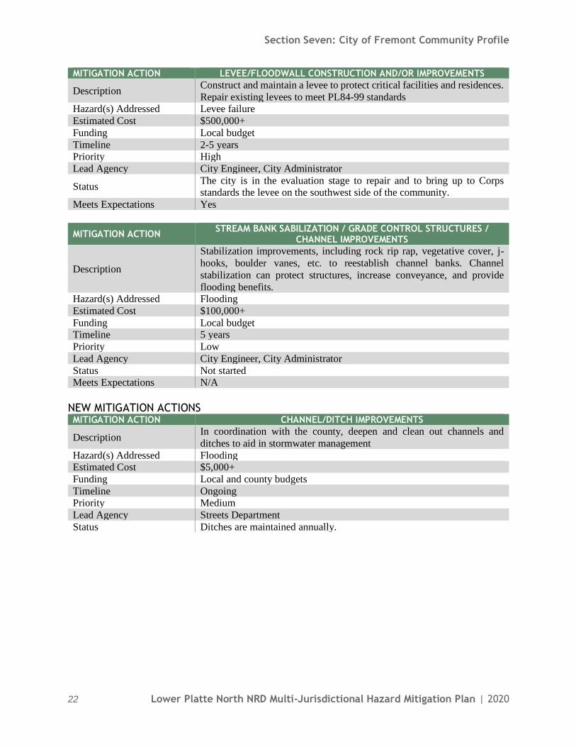
MITIGATION ACTION LEVEE/FLOODWALL CONSTRUCTION AND/OR IMPROVEMENTS
Description Construct and maintain a levee to protect critical facilities and residences.
Repair existing levees to meet PL84-99 standards Hazard(s) Addressed Levee failure
Estimated Cost $500,000+
Funding Local budget
Timeline 2-5 years Priority High
Lead Agency City Engineer, City Administrator
Status The city is in the evaluation stage to repair and to bring up to Corps standards the levee on the southwest side of the community.
Meets Expectations Yes
MITIGATION ACTION STREAM BANK SABILIZATION / GRADE CONTROL STRUCTURES /
CHANNEL IMPROVEMENTS
Description
Stabilization improvements, including rock rip rap, vegetative cover, j-
hooks, boulder vanes, etc. to reestablish channel banks. Channel
stabilization can protect structures, increase conveyance, and provide
flooding benefits. Hazard(s) Addressed Flooding
Estimated Cost $100,000+
Funding Local budget Timeline 5 years
Priority Low
Lead Agency City Engineer, City Administrator
Status Not started Meets Expectations N/A
NEW MITIGATION ACTIONS MITIGATION ACTION CHANNEL/DITCH IMPROVEMENTS
Description In coordination with the county, deepen and clean out channels and
ditches to aid in stormwater management
Hazard(s) Addressed Flooding Estimated Cost $5,000+
Funding Local and county budgets
Timeline Ongoing Priority Medium
Lead Agency Streets Department
Status Ditches are maintained annually.

Section Seven: City of Fremont Community Profile
Lower Platte North NRD Multi-Jurisdictional Hazard Mitigation Plan | 2020 23
MITIGATION ACTION COMMUNITY EDUCATION AND AWARENESS
Description Continue community education program to increase awareness related to
household level mitigation actions, especially focused on flooding. Hazard(s) Addressed All hazards
Estimated Cost Staff time
Funding Local budget
Timeline Ongoing Priority Medium
Lead Agency Floodplain Administrator, Emergency Management
Status Flood map information is available and provided as requested. Utility bills are used to insert educational flyers. Staff attend home shows and other
outreach opportunities to provide flood information.
MITIGATION ACTION COMMUNITY RATING SYSTEM
Description Develop a strategy to lower Fremont’s CRS Class from a 8 to a 6.
Hazard(s) Addressed Flooding
Estimated Cost Staff time
Funding Local budget Timeline Ongoing
Priority Medium
Lead Agency Floodplain Administrator Status Early planning stage
MITIGATION ACTION COMPREHENSIVE BACKFLOW PREVENTION FOR HOMEOWNERS
Description Provide comprehensive backflow prevention for homeowners to prevent excess stormwater from backing up into home basements
Hazard(s) Addressed Flooding
Estimated Cost $30,000 Funding Local budget
Timeline Ongoing
Priority High
Lead Agency Floodplain Administrator Status Ongoing
MITIGATION ACTION COMPREHENSIVE DISASTER / EMERGENCY RESPONSE PLAN
Description Create an EPP to organize the city’s response to disasters Hazard(s) Addressed All hazards
Estimated Cost $50,000
Funding Local budget Timeline 5 years
Priority Medium
Lead Agency City Administrator Status Not started

Section Seven: City of Fremont Community Profile
24 Lower Platte North NRD Multi-Jurisdictional Hazard Mitigation Plan | 2020
MITIGATION ACTION DODGE COUNTY PLATTE RIVER COMMUNITIES FLOOD MITIGATION
AND RESILIENCY PLAN
Description
Develop a flood mitigation and resiliency plan to holistically look at local
flood risks and measures to reduce them from North Bend to Fremont
along the Platte River. The plan will include hydrologic and hydraulic
analyses to assess the nature of the flood risks and evaluate flood risk reduction improvement projects. Structural and non-structural mitigation
may be considered and prioritized. The conceptual flood risk reduction
recommendations will serve to provide a path forward towards implementation and a reduction of further damage to structures and
critical facilities.
Hazard(s) Addressed Flooding
Estimated Cost $1,000,000 Funding Water Sustainability Fund, Community Block Grant, HMPG, local budget
Timeline 2-3 years
Priority High
Lead Agency Joint Water Advisory Board (Fremont is a partner on the Board); Fremont
City Administrator
Status Initial planning stage; looking for funding alternatives
MITIGATION ACTION EMERGENCY OPERATIONS CENTER
Description Set up a permanent Emergency Operations Center
Hazard(s) Addressed All hazards Estimated Cost $15,000+
Funding Local budget
Timeline 5+ years Priority Low
Lead Agency City Administrator, Fire & Police
Status Not started
MITIGATION ACTION IMPROVE FLOOD AND DAM FAILURE WARNING SYSTEM
Description Evaluate current flood level alert warning system. Install and/or
improvement warning system. Install additional gauges as needed. Hazard(s) Addressed Flooding
Estimated Cost $50,000
Funding Local budget Timeline 5+ years
Priority High
Lead Agency Floodplain Administrator, Emergency Management
Status Identifying funding alternatives for new stream gauge on Highway 77 bridge south of Fremont on Platte River.

Section Seven: City of Fremont Community Profile
Lower Platte North NRD Multi-Jurisdictional Hazard Mitigation Plan | 2020 25
MITIGATION ACTION IMPROVE HIGHWAY DRAINAGE
Description Construct culverts and improve the drainage system on the Highway 30
bypass Hazard(s) Addressed Flooding
Estimated Cost $25,000
Funding Local budget
Timeline 2-5 years Priority Medium
Lead Agency Public Works, County Highway Supervisor, NDOT
Status Not started
MITIGATION ACTION NEW DETENTION CELLS
Description Construct new stormwater detention cells to aid in stormwater
management Hazard(s) Addressed Flooding
Estimated Cost $50,000+
Funding Local budget Timeline 5+ years
Priority High
Lead Agency Public Works
Status There’s a need for detention cells west of town to provide protection to
hospital. Johnson Road Cell to be completed by end 2020.
MITIGATION ACTION NIMS TRAINING
Description Provide incident management system or emergency response training
such as NIMS to city officials
Hazard(s) Addressed All hazards Estimated Cost $10,000
Funding Local budget
Timeline Ongoing Priority Low
Lead Agency All departments
Status Ongoing
REMOVED MITIGATION ACTIONS
MITIGATION ACTION MAINTAIN PARTICIPATION IN THE NATIONAL FLOOD INSURANCE
PROGRAM
Hazard(s) Addressed Flooding
Reason for Removal This project is no longer considered a mitigation action by FEMA
MITIGATION ACTION STORMWATER SYSTEM IMPROVEMENTS
Hazard(s) Addressed Flooding
Reason for Removal Expanded into four new, focused projects