COMMUNITY PLANNING & ECONOMIC DEVELOPMENT …
260
COUNTY COMMISSIONERS Carolina Mejia-Barahona District One Gary Edwards District Two Tye Menser District Three COMMUNITY PLANNING & ECONOMIC DEVELOPMENT DEPARTMENT Creating Solutions for Our Future Joshua Cummings, Director May 20, 2021 Thurston County Board of Commissioners 2000 Lakeridge Drive SW Olympia, WA 98502 Subject: Planning Commission Recommendation on Thurston County-Tumwater UGA Joint Plan Update The Thurston County Planning Commission has completed its review of the Tumwater Joint Plan. The Planning Commission held two (2) work sessions on March 31 and April 15, 2021 and a public hearing on May 20, 2021. The Planning Commission produced a recommendation of seven-to- zero (7 yays, 0 nays, and 1 absent). The Thurston County Planning Commission recommends approval of the Tumwater Joint Plan, including six separate land use and zoning amendments, with an amendment to strike Section 11.1.6 “Recommended Amendments to the Thurston County Code”. The Planning Commission further recommends approval of amendments to the Thurston County Code, Titles 20 and 22 to amend regulations to the Airport Hazard Overlay in the rural county and the Tumwater Urban Growth Area, and to Title 22 to repeal Chapter 22.21 “Commercial Development” and Chapter 22.28 “Business Park”. The Planning Commission produces this recommendation with the following findings: Findings: 1. The recommendation for the updated Joint Plan is consistent with the Growth Management Act 36.70A RCW. 2. The recommendation for the updated Joint Plan is consistent with the Thurston County County-Wide Planning Policies. 3. The recommendation for the updated Joint Plan is considers the 1995 Memorandum of Understanding between Thurston County and the City of Tumwater. 4. The Thurston County Planning Commission held a duly noticed public hearing on May 20, 2021, as required by Thurston County Code Chapter 2.05 Growth Management Public Participation
Transcript of COMMUNITY PLANNING & ECONOMIC DEVELOPMENT …

COUNTY COMMISSIONERS
Carolina Mejia-Barahona District One Gary Edwards District Two Tye Menser District Three
COMMUNITY PLANNING & ECONOMIC DEVELOPMENT DEPARTMENT
Creating Solutions for Our Future Joshua Cummings, Director
May 20, 2021
Thurston County Board of Commissioners 2000 Lakeridge Drive SW Olympia, WA 98502
Subject: Planning Commission Recommendation on Thurston County-Tumwater UGA Joint Plan Update
The Thurston County Planning Commission has completed its review of the Tumwater Joint Plan. The Planning Commission held two (2) work sessions on March 31 and April 15, 2021 and a public hearing on May 20, 2021. The Planning Commission produced a recommendation of seven-to-zero (7 yays, 0 nays, and 1 absent).
The Thurston County Planning Commission recommends approval of the Tumwater Joint Plan, including six separate land use and zoning amendments, with an amendment to strike Section 11.1.6 “Recommended Amendments to the Thurston County Code”. The Planning Commission further recommends approval of amendments to the Thurston County Code, Titles 20 and 22 to amend regulations to the Airport Hazard Overlay in the rural county and the Tumwater Urban Growth Area, and to Title 22 to repeal Chapter 22.21 “Commercial Development” and Chapter 22.28 “Business Park”.
The Planning Commission produces this recommendation with the following findings:
Findings: 1. The recommendation for the updated Joint Plan is consistent with the Growth
Management Act 36.70A RCW.2. The recommendation for the updated Joint Plan is consistent with the Thurston County
County-Wide Planning Policies.3. The recommendation for the updated Joint Plan is considers the 1995 Memorandum of
Understanding between Thurston County and the City of Tumwater.4. The Thurston County Planning Commission held a duly noticed public hearing on May
20, 2021, as required by Thurston County Code Chapter 2.05 Growth ManagementPublic Participation
Thurston County Planning Commission Tumwater Joint Plan
2
Thank you for the opportunity to review and comment on the proposed amendment. If you have any questions, please feel free to contact me.
Sincerely,
_________________________ Jim Simmons, Chair
Attachments: • Tumwater Joint Plan (Draft)• TCC 20.03, 20.30D, 22.04 and 22.32 (Draft)• Zoning Amendment Maps (1-6)
cc: Thurston County Planning Commission Ramiro Chavez, County Manager Joshua Cummings, CPED Director Travis Burns, Deputy Prosecuting Attorney

CITY OF TUMWATER
AND/ THURSTON COUNTY
JOINT PLAN

CITY OF TUMWATER AND /THURSTON COUNTY JOINT PLAN
2
An Element of the City of Tumwater Comprehensive
Plan And and the Thurston County Comprehensive Plan
Adopted April, 1995
2009Draft 2021 Update


CITY OF TUMWATER AND /THURSTON COUNTY JOINT PLAN
i
TUMWATER CITY COUNCIL
Pete Kmet, Mayor
Joan Cathey, Mayor Pro Tem
Michael Althauser
Leatta Dahlhoff
Angela Jefferson
Charlie Schneider
Debbie Sullivan
Eileen Swarthout
THURSTON COUNTY COMMISSIONERS
Carolina Mejia, District 1
Gary Edwards, District 2
Tye Menser, District 3
CITY OF TUMWATER PLANNING COMMISSION
Elizabeth Robbins, Chair
Meghan Sullivan, Vice Chair
Terry Kirkpatrick
Joel Hansen
Nam Duc Nguyen
Doty Catlin
Michael Tobias
Nathan Peters
[Staff Note: Position Open June 2021]
THURSTON COUNTY PLANNING COMMISSION
Jim Simmons, Chair
Eric Casino, Vice Chair
Raul de Leon
Tyle Zuchowski
Don DeHan
Ed Fleisher
Doug Karman
Donna Nickerson
Scott Nelson

CITY OF TUMWATER AND /THURSTON COUNTY JOINT PLAN
ii
CITY OF TUMWATER AND /THURSTON COUNTY JOINT PLAN
iii
CITY OF TUMWATER STAFF
John Doan, AICP, City Administrator
Mike Matlock, AICP, Community Development Director
Brad Medrud, AICP, Planning Manager
David Ginther, Senior Planner
THURSTON COUNTY STAFF
Ramiro Chavez, County Manager
Joshua Cummings, Community Planning and Economic Development Director
Jennifer Davis, Community Planning Manager
Leah Davis, Associate Planner, Community Planning
TUMWATER CITY COUNCIL
Pete Kmet, Mayor
Joan Cathey
Ed Hildreth
Judith Hoefling
Neil McClanahan
Tom Oliva
Betsy Spath
Ed Stanley
TUMWATER PLANNING COMMISSION
Debbie Sullivan, Chair
Marcus Glasper
Kathy Goebel
Bill Mandeville
Jessica Moore
Sally Nash
Nancy Stevenson
Steven Wish
TUMWATER CITY STAFF
John Doan, City Administrator
Michael Matlock, Community Development Director
Tim Smith, AICP, Planning Manager
CITY OF TUMWATER AND /THURSTON COUNTY JOINT PLAN
iv
Kathleen Jolliffe, Planning Technician
Also,
ADVANCE PLANNING AND
HISTORIC PRESERVATION STAFF
THURSTON COUNTY PLANNING COMMISSION
THURSTON COUNTY COMMISSIONERS
Cover Photo: Mt. Rainier taken from Overlook Park in the City of Tumwater (2006)

CITY OF TUMWATER AND/ THURSTON COUNTY JOINT PLAN
i
TABLE OF CONTENTS
Chapter 1. INTRODUCTION
1.1 Background .............................................................................................. 1-1
1.2 Purpose of Joint Planning ....................................................................... 1-2
1.3 Public Involvement ................................................................................. 1-2
1.4 Plan Organization and Content .............................................................. 1-3
Chapter 2. DESCRIPTION OF JOINT PLANNING AREA
2.1 2000 Existing Conditions ........................................................................ 2-1
2.2 Urban Growth Boundary ........................................................................ 2-5
Chapter 3. LAND USE
3.1 Introduction ............................................................................................. 3-1
3.1.1 Growth Management Act Goals Compliance ......................................... 3-1
3.1.2 County-Wide Planning Policy Compliance 3-5
3.1.3 Amendments ............................................................................................ 3-7
3.2 Goals/Policies/Objectives ......................................................................... 3-8
3.3 Land Supply Analysis ........................................................................... 3-24
3.4 1994 Land Uses and Zoning ................................................................. 3-31
3.5 Proposed Land Use Designations ......................................................... 3-31
3.5.1 Policies/Designations/Definitions ......................................................... 3-31
3.5.1.1 Residential Uses .................................................................................... 3-34
3.5.1.2 Mixed Use .............................................................................................. 3-44
3.5.1.3 Commercial Uses ................................................................................... 3-47
3.5.1.4 Industrial Uses ...................................................................................... 3-48
3.5.1.5 Designations for Public Purposes ........................................................ 3-50
3.5.2 Innovative Housing and Land Use Methods - Definitions ............... 3-51
3.5.3 Eastern Subarea .................................................................................. 3-56
3.5.3.1 Introduction ........................................................................................... 3-56
3.5.3.2 Future Land Uses .................................................................................. 3-58
3.5.4 Southern Subarea .................................................................................. 3-67
3.5.4.1 Introduction ........................................................................................... 3-67
3.5.4.2 Future Land Uses .................................................................................. 3-69
3.5.5 Western Subarea ................................................................................... 3-80
3.5.5.1 Introduction ............................................................................................. 3-80
3.5.5.2 Future Land Uses .................................................................................. 3-82

CITY OF TUMWATER AND/ THURSTON COUNTY JOINT PLAN
ii
Chapter 4. LANDS FOR PUBLIC PURPOSES/ESSENTIAL PUBLIC
FACILITIES
4.1 Background .............................................................................................. 4-1
4.2 Summary.................................................................................................. 4-1
Chapter 5. UTILITIES
5.1 Background .............................................................................................. 5-1
5.2 Summary.................................................................................................. 5-1
Chapter 6. HOUSING
6.1 Background .............................................................................................. 6-1
6.2 Summary.................................................................................................. 6-1
Chapter 7. PARKS, RECREATION AND OPEN SPACE
7.1 Background .............................................................................................. 7-1
7.2 Summary.................................................................................................. 7-2
Chapter 8. TRANSPORTATION ........................................................................... 8-1
8.1 Summary.................................................................................................. 8-1
CITY OF TUMWATER AND/ THURSTON COUNTY JOINT PLAN (2009 Update)
TABLE OF CONTENTS
2021 Update / Adopted ________
Updated 2009
iii
Contents
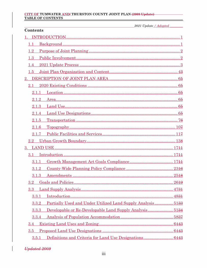
1. INTRODUCTION .................................................................................................... 1
1.1 Background ....................................................................................................... 1
1.2 Purpose of Joint Planning ................................................................................ 2
1.3 Public Involvement ........................................................................................... 2
1.4 2021 Update Process ........................................................................................ 3
1.5 Joint Plan Organization and Content ............................................................ 43
2. DESCRIPTION OF JOINT PLAN AREA ............................................................ 65
2.1 2020 Existing Conditions ............................................................................... 65
2.1.1 Location .................................................................................................... 65
2.1.2 Area........................................................................................................... 65
2.1.3 Land Use................................................................................................... 65
2.1.4 Land Use Designations ............................................................................ 65
2.1.5 Transportation ......................................................................................... 76
2.1.6 Topography ............................................................................................. 107
2.1.7 Public Facilities and Services ................................................................ 117
2.2 Urban Growth Boundary .............................................................................. 138
3. LAND USE ........................................................................................................ 1711
3.1 Introduction ................................................................................................ 1711
3.1.1 Growth Management Act Goals Compliance ...................................... 1711
3.1.2 County-Wide Planning Policy Compliance ......................................... 2316
3.1.3 Amendments ........................................................................................ 2518
3.2 Goals and Policies ....................................................................................... 2619
3.3 Land Supply Analysis ................................................................................. 4731
3.3.1 Introduction .......................................................................................... 4831
3.3.2 Partially Used and Under Utilized Land Supply Analysis ................ 5133
3.3.3 Developable or Re-Developable Land Supply Analysis ...................... 5134
3.3.4 Analysis of Population Accommodation .............................................. 5837
3.4 Existing Land Uses and Zoning ................................................................. 6443
3.5 Proposed Land Use Designations .............................................................. 6443
3.5.1 Definitions and Criteria for Land Use Designations .......................... 6443

CITY OF TUMWATER AND/ THURSTON COUNTY JOINT PLAN (2009 Update)
TABLE OF CONTENTS
2021 Update / Adopted ________
Updated 2009
iv
3.5.2 Innovative Housing and Land Use Methods – Definitions ................ 9062
3.5.3 Eastern Subarea................................................................................... 9666
3.5.4 Southern Subarea ................................................................................ 9767
3.5.5 Western Subarea ................................................................................ 12378
4. LANDS FOR PUBLIC PURPOSES ................................................................ 14087
4.1 Background ............................................................................................... 14087
4.2 Summary ................................................................................................... 14087
5. UTILITIES ...................................................................................................... 14288
5.1 Background ............................................................................................... 14288
5.2 Summary ................................................................................................... 14488
6. HOUSING ....................................................................................................... 14589
6.1 Introduction .............................................................................................. 14589
6.2 Summary ................................................................................................... 14589
7. PARKS, RECREATION, AND OPEN SPACE ............................................... 14791
7.1 Background ............................................................................................... 14791
8. ECONOMIC DEVELOPMENT ...................................................................... 15193
8.1 Summary ................................................................................................... 15193
9. TRANSPORTATION ....................................................................................... 15294
9.1 Summary ................................................................................................... 15294
10. PUBLIC FACILITIES AND SERVICES ........................................................ 15395
10.1 Introduction .............................................................................................. 15395
10.2 Goals and Policies ..................................................................................... 15596
10.3 Projected Needs for Public Facilities and Services ................................. 15999
10.3.1 General Governmental ....................................................................... 15999
10.3.2 Potable Water ................................................................................... 161100
10.3.3 Sanitary Sewer ................................................................................. 161100
10.3.4 Stormwater ....................................................................................... 161100
10.3.5 Transportation ................................................................................. 161100
11. IMPLEMENTATION .................................................................................... 162101
11.1 Implementation Actions Tables ............................................................... 162101
11.1.1 Comprehensive Planning Actions.................................................... 165101

CITY OF TUMWATER AND/ THURSTON COUNTY JOINT PLAN (2009 Update)
TABLE OF CONTENTS
2021 Update / Adopted ________
Updated 2009
v
11.1.2 Urban Growth Boundaries and Annexations Actions .................... 167103
11.1.3 Comprehensive Plan Land Use Designations Actions ................... 168104
11.1.4 Public Involvement Actions ............................................................. 169105
11.1.5 Capital Facilities Actions ................................................................. 170106
11.1.6 Zoning and Development Regulations Actions ............................... 173109
11.1.6 Recommended Amendments to Thurston County Code ................. 177113
[Staff Note: Page numbers in the Table of Contents refer to the version of the Plan
with all edits accepted.]
LIST OF FIGURES
Figure 1. Land Use Designations in the Joint Plan Area ......................................... 76
Figure 2. Transportation Inventory ........................................................................... 97
Figure 3. Topography Inventory .............................................................................. 118
Figure 4. Public Facilities Services Inventory ......................................................... 128
Figure 5. City of Tumwater and Joint Plan Area 20-Year Population Projection 5034
Figure 6. Buildable Commercial Land in Acres .................................................... 5336
Figure 7. Buildable Industrial Lands in Acres ...................................................... 5537
Figure 8. Parcel Area by Acres in Each Zone District in the Joint Plan Area ..... 5738
Figure 9. Residential Capacity by Planning Area, City and Joint Plan Area ...... 5838
Figure 10. Residential Land Supply and Future Development Capacity – City . 5939
Figure 11. Residential Land Supply and Future Development Capacity – Joint Plan
Area .......................................................................................................................... 6040
Figure 12. Approved Dwelling Units, 2000 – 2019 ............................................... 6041
Figure 13. Density of Residential Subdivisions in the City and Joint Plan Area, 1970s
– 2010s...................................................................................................................... 6141
Figure 14. Total Dwelling Unit Forecast in the City and Joint Plan Area .......... 6142
Figure 15. Residential Supply Versus Demand .................................................... 6242
Figure 16. New Dwelling Units Required for 20-Year Planning Period .............. 6343
Figure 17. Joint Plan Land Use Designations ....................................................... 6545
Figure 18. Innovative Land Use Management Techniques for Residential
Development ............................................................................................................ 8156

CITY OF TUMWATER AND/ THURSTON COUNTY JOINT PLAN (2009 Update)
TABLE OF CONTENTS
2021 Update / Adopted ________
Updated 2009
vi
Figure 19. Comprehensive Planning Implementation Actions ......................... 165102
Figure 20. Urban Growth Boundaries and Annexations Implementation Actions
.............................................................................................................................. 168105
Figure 21. Comprehensive Plan Land Use Designations Implementation Actions
.............................................................................................................................. 169106
Figure 22. Public Involvement Implementation Actions .................................. 170107
Figure 23. Capital Facilities Implementation Actions ...................................... 170108
Figure 24. Zoning and Development Regulations Implementation Actions .... 173110
Figure 25. Recommended Changes to the Thurston County Code for Consistency with
the Tumwater Municipal Code ............................................................................ 177114
[Staff Note: Page numbers in the List of Figures refer to the version of the Plan with
all edits accepted.]
LIST OF MAPS
Map 2-1 City of Tumwater Joint Planning Area 2-6a
Map 2-2 Fire Protection 2-6b
Map 2-3 City of Tumwater Urban Growth Boundary 2-6c
Map 3-14 Future Land Use after page 3-32
Map 5 Subarea Map
Map 3-26 Eastern Subarea 19942020 Existing Zone Districtsing after page 3-
56
Map 3-37 Eastern Subarea 19942020 Existing Land Use after page 3-56
Map 3-48 Eastern Subarea 19942020 Future Land Use after page 3-56
Map 3-59 Southern Subarea 19942020 Existing Zone Districtsing after page 3-
68
Map 3-610 Southern Subarea 19942020 Existing Land Use after page 3-68
Map 3-711 Southern Subarea 2020 Future Land Use after page 3-68
Map 3-812 Western Subarea 19942020 Existing Zone Districtsing after page 3-
80
Map 3-913 Western Subarea 19942020 Existing Land Use after page 3-80
Map 3-1014 Western Subarea 2020 Future Land Use after page 3-80
Map 8-1 15 Future Bicycle Route / Trail Connection after page 8-
1Connections
Map 16 Water Map
Map 17 Sewer Map
APPENDICES

CITY OF TUMWATER AND/ THURSTON COUNTY JOINT PLAN (2009 Update)
TABLE OF CONTENTS
2021 Update / Adopted ________
Updated 2009
vii
Appendix A: Summary of Process and Criteria Used to Develop the 1988 Urban
Growth Management Agreement
Appendix B: Analysis of City of Tumwater / Thurston County Joint Plan Urban
Growth Boundary'’s Consistency with County-Wide Planning
Policies
Appendix C: Thurston County County-Wide Planning Policies
Appendix D: City of Tumwater Lands for Public Purposes/Essential Public
Facilities Plan* Element1
Appendix E: City of Tumwater Utilities Plan*Element1
Appendix F: City of Tumwater Housing Plan*Element1
Appendix G: City of Tumwater Parks and, Recreation Plan*, and Open Space
Plan1
Appendix H: City of Tumwater Transportation Plan1
Appendix I: City of Tumwater Economic Development Plan1
*Note: These plans are contained in their entirety as elements of the Tumwater Comprehensive Plan.
Appendix J: Memorandum of Understanding on Urban Growth Management
(January 31, 1983)
Appendix K: Memorandum of Understanding: An Urban Growth Management
Agreement (June 1988)
Appendix L: Memorandum of Understanding: Urban Growth Area Zoning and
Development Standards (December 7, 1995)
1 These plans are contained in their entirety as Elements of the City of Tumwater Comprehensive
Plan.

CITY OF TUMWATER AND/ THURSTON COUNTY JOINT PLAN
CHAPTER 1 (2004
Update)
INTRODUCTION
1
1. INTRODUCTION
1.1 Background
The Cities of Lacey, Olympia, and Tumwater and Thurston Country initially agreed
upon the process of joint planning was initially agreed upon in the 1988 Memorandum
of Understanding: An Urban Growth Management Agreement by the Cities of
Tumwater, Olympia and Lacey, and Thurston County.. This agreement established
short- and long-term urban growth areas for the three citiesCities of Lacey, Olympia,
and Tumwater and outlined a process for theThurston County to jointly plan for these
areas with each cCity.
In 1990, the Washington State Legislature passed the Growth Management Act. The
Act requires Thurston County and each of its cCities to adopt a comprehensive
plan,Comprehensive Plan and to jointly establish a 20-year urban growth boundary
jointly for each urban area. To guide this planning effort, the Act mandated that
theThurston County to promulgatecreate County-Wide Planning Policies.
Thurston County adopted County-Wide Planning Policies in September, 1992, in
collaboration with its cities and towns. The Policies policies reaffirmed that joint
planning would be used to plan for each cCity'’s urban growth area. In August, 1993,
representatives of Thurston County and its cities and towns met to clarify the intent
of the County-Wide Planning Policies and affirm the long- and short-term urban
growth boundaries established in the 1988 Memorandum of Understanding: An
Urban Growth Management Agreement for Olympia, Lacey, and Tumwater. The
Policies state that changes to these boundaries may be proposed through the joint
planning process.
The Tumwater City Council and Thurston County Commissioners authorized work
to begin on the City of Tumwater and Thurston Countya joint planJoint Plan for the
City of Tumwater urban growth area in 1993. The City of Tumwater -/ Thurston
County Joint Planning Committee was created to develop the Joint Plan. The
Committee consisted of the City of Tumwater Planning Commissioners, and one
representative each from the Thurston County Planning Commission, Tumwater
School District, and Port of Olympia.
The Joint Planning Committee'’s mission was to develop a comprehensive
planComprehensive Plan to guide future development in the urban growthJoint Plan
area during its transition from rural- to urban-level development. Development of
the planJoint Plan was to:
Bring together local officials, residents, property owners, and
other interested parties to discuss the future of the area; and
CITY OF TUMWATER AND/ THURSTON COUNTY JOINT PLAN
CHAPTER 1 (2004
Update)
INTRODUCTION
2
Be consistent with the requirements of the Washington State
Growth Management Act.
To ensure successful implementation of the Joint Plan, Thurston County and the
cCities of Lacey, Olympia, and Tumwater, Lacey, and Olympia entered into an
agreement in 1995 titled Memorandum of Understanding—: Urban Growth Area
Zoning and Development Standards.
The Joint Plan was subsequently amended in 2009 and 2021.
1.2 Purpose of Joint Planning
This document is a comprehensive planComprehensive Plan for the unincorporated
portion of the City of Tumwater urban growth area prepared jointly by the City of
Tumwater and Thurston County and the City of Tumwater. It has been adopted by
each jurisdiction as a comprehensive planComprehensive Plan amendment. Its
purpose is to provide a framework to guide future development in the area during its
transition from rural-- to urban-level development. It serves as the basis for future
planning decisions by each jurisdiction in the urban growthJoint Plan aarea. (NOTE:
This plan applies to the unincorporated portion of the Tumwater urban growth area
only. The term "urban growth area" is used in this document to refer to the
unincorporated portions of the urban growth area.)2
1.3 Public Involvement
The Joint Plan has been developed to serve as a guide for future growth and to meet
the needs of current residents in the unincorporated portion of the City of Tumwater
Tumwater urban growth area. It evolved through the participation of existing, as of
1994, residents, property owners, local government officials, and many other
interested parties at numerous public meetings, hearings, and other forums for
citizen and community involvement.
As described in Section 1.1, Background, above, the Joint Planning Committee was
formed to draft the City of Tumwater-Thurston County Joint Plan. The Committee
held public meetings at least once pera month from October, 1993, through July, 1994
to develop the Joint Plan. Public comment was encouraged and received throughout
each of the Joint Planning Committee'’s meetings. The Committee also received
numerous written comments as it developed the Joint Plan.
2 The Joint Plan and the term “Joint Plan area” apply only to the unincorporated portion of the City
of Tumwater urban growth area.

CITY OF TUMWATER AND/ THURSTON COUNTY JOINT PLAN
CHAPTER 1 (2004
Update)
INTRODUCTION
3
Committee meetings were advertised through the local newspaper, The Olympian,
and through the information sheets that were available at customer service counters
at the City of Tumwater and Thurston County. An extensive mailing list was
developed to provide individual notices of Joint Planning Committee activities.
Periodic informationInformation regarding the Joint Planningjoint planning process
also was provided in the City of Tumwater's monthly newsletter, The Pioneer, and by
Thurston County in its regular progrcess reports.
The Joint Planning Committee also produced a newsletter, called Joint Plan News,
that was distributed through mass mailings to the entire study area three times
during the development of the Joint Plan. These mass mailings were distributed to
all postal customers in the study area vicinity.
Periodic updates on the Joint Planningjoint planning process were given at public
meetings ofto the Thurston County Planning Commission, Tumwater City Council,
and Thurston County Commissioners. Updates were also provided, upon request, to
other local citizen and community groups and local governments (e.g.,, such as rural
fire districts)..
As the Joint Planning Committee completed the dDraft Joint Plan, individual notices
were sent to owners of property for which the dDraft Joint Plan proposed changes
from existing, as of 1994, Thurston County plans or policies in 1994. These property
owners were given the opportunity to testify at all public hearings during
consideration of the Joint Plan by Thurston County and City of Tumwater planning
commissionsand Thurston County Planning Commissions and elected officials.
Following the completion of the Ddraft Joint Plan by the Joint Planning Committee,
the Joint Plan was reviewed during a series of public workshops and hearings by the
City of Tumwater and Thurston County Planning Commissions, the Tumwater City
Council, and the Thurston County Commissioners. Public comment was received at
each of these meetings. Notice of each of these meetings was provided, in accordance
with state law and City of Tumwater and Thurston County policies, through the
environmental and intergovernmental review processes, notices published in The
Olympian and posted at public places, individual notices to citizens and the
community on the Joint Plan mailing lists, the Joint Plan News, and through other
local media.
1.4 2021 Update Process
As part of the City of Tumwater 2016 Comprehensive Plan Update adopted in
December 2016, City staff prepared a first revision to the 2009 Joint Plan to reflect
the 2016 City of Tumwater Comprehensive Plan update. City staff provided a draft
of the revised Joint Plan to County staff on November 30, 2016. County staff reviewed

CITY OF TUMWATER AND/ THURSTON COUNTY JOINT PLAN
CHAPTER 1 (2004
Update)
INTRODUCTION
4
and provided City staff with their comments on March 13, 2017. City staff reviewed
and responded to the County staff comments on March 21, 2017 and a joint City and
County Planning Commission meeting was held on April 19, 2017. The update
process was subsequently put on hold by Thurston County.
The amendment process was restarted after discussions between City and County
staff in 2019 and 2020.
[Staff Note: Will update to add next steps related to the 2021 amendment process]
1.5 Joint Plan Organization and Content
This planThe Joint Plan is organized into eleventen chapters.
Chapter 1, Introduction, includes background information whichthat provides the
context in which the planJoint Plan was developed. It also states the purpose of the
planJoint Plan and describes the public involvement process whichthat was used in
its development.
Chapter 2, Description of Joint Planning Area, describes the study area of the
planJoint Plan. It also illustratesdiscusses the urban growth boundary established
by this planthe Joint Plan, as well as and how thethat boundary differsis different
from the urban growth boundariesy established by the 1988 Memorandum of
Understanding: An Urban Growth Management Agreement between Thurston County
and the Cities of Tumwater, Olympia and Lacey.
Chapters 3 through Chapter 9 10 each includeaddress an eelement of the planJoint
Plan as required or suggested by the Washington State Growth Management Act.
Chapter 3 addresses land use, including maps showing future land use designations
whichthat will be applied within the Tumwater urban growth Joint Plan area.
Chapters 4 through 7 8 incorporate into theis Joint Plan the Lands for Public
Purposes/Essential Public Facilities, Utilities, Housing, and Parks and, Recreation
elements, and Open Space, and Economic Development Elements of the City of
Tumwater Comprehensive Plan, respectively. Chapters 8 9 and 109 address future
transportation and other public facilities and services that will be needed to serve the
projected development within the Tumwater urban growthJoint Plan area over the
next 20 years.
Chapter 110 describes how the Joint Plan should be implemented. It includes
recommendations for zoning changes, coordination between local governments and
other public service providers to ensure smooth transitions of service provision as the
planning area urbanizes, future plan amendments, and other necessary
considerations to accomplish the goals of the Joint Plan.

CITY OF TUMWATER AND/ THURSTON COUNTY JOINT PLAN
CHAPTER 1 (2004
Update)
INTRODUCTION
5

CITY OF TUMWATER AND/ THURSTON COUNTY JOINT PLAN
CHAPTER 2 (2004
Update)
DESCRIPTION OF JOINT PLANNING AREA
6
2. DESCRIPTION OF JOINT PLANNING AREA
2.1 200220 Existing Conditions
For the 2021 Joint Plan update 2020 data was used, as it was the most current
available at the start of the update adoption process.
2.1.1 Location:
East, southSouth and west of the City of Tumwater citymunicipal limits, plus
"“islands"” of unincorporated territory surrounded by the City of Tumwater (see Map
2-1, Joint Planning Area).
2.1.2 Area:
• The total area of the otal 2002joint planning urban growth area in 2020 was=
8,782 2,820 acres (Source: 2002 Profile)3
[Staff Note: The total area of 2,820 acres calculated above does not match the total
acreage shown in Figure 1 below. Staff will need to check this before the Plan goes
to public hearing.]
2.1.3 Land Use:
• Land use is varied;. The area is semi-rural in character, with portions
experiencing transition to urban-level development.
2.1.4 • Land Use Designations
Thurston County Comprehensive Plan 1994 land use designations (see Maps 3-3, 3-6
and 3-9 in Section 3.5).
• Zoning (and acreage) as of 1994 in Thurston County (see Maps 3-2, 3-5 and 3-8
in Section 3.5):
› RR 1/5 Rural Residential 3,601 acres
(1 unit per 5 acres)
› RR 1/1 Rural Residential 315 acres
(1 unit per acre)
› RR 1/2 Rural Residential 96 acres
(1 unit per 2 acres)
3 Source: City of Tumwater GIS data - Joint Plan.shp
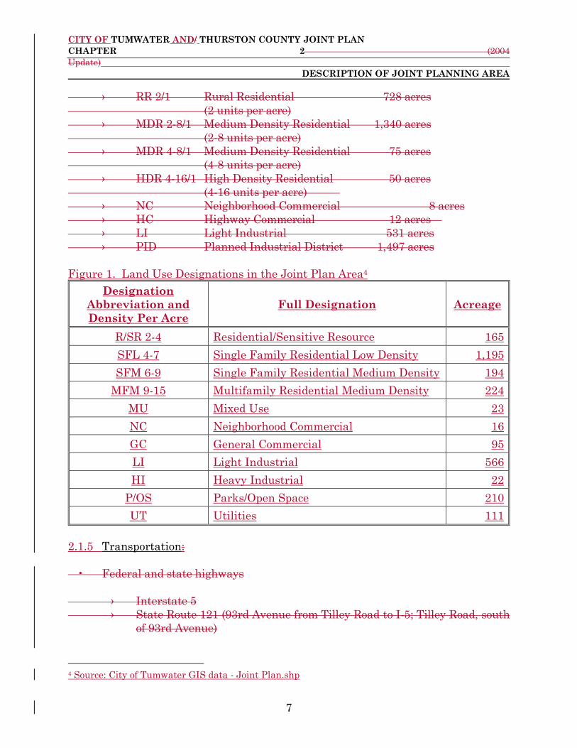
CITY OF TUMWATER AND/ THURSTON COUNTY JOINT PLAN
CHAPTER 2 (2004
Update)
DESCRIPTION OF JOINT PLANNING AREA
7
› RR 2/1 Rural Residential 728 acres
(2 units per acre)
› MDR 2-8/1 Medium Density Residential 1,340 acres
(2-8 units per acre)
› MDR 4-8/1 Medium Density Residential 75 acres
(4-8 units per acre)
› HDR 4-16/1 High Density Residential 50 acres
(4-16 units per acre)
› NC Neighborhood Commercial 8 acres
› HC Highway Commercial 12 acres
› LI Light Industrial 531 acres
› PID Planned Industrial District 1,497 acres
Figure 1. Land Use Designations in the Joint Plan Area4
Designation
Abbreviation and
Density Per Acre
Full Designation Acreage
R/SR 2-4 Residential/Sensitive Resource 165
SFL 4-7 Single Family Residential Low Density 1,195
SFM 6-9 Single Family Residential Medium Density 194
MFM 9-15 Multifamily Residential Medium Density 224
MU Mixed Use 23
NC Neighborhood Commercial 16
GC General Commercial 95
LI Light Industrial 566
HI Heavy Industrial 22
P/OS Parks/Open Space 210
UT Utilities 111
2.1.5 Transportation:
• Federal and state highways
› Interstate 5
› State Route 121 (93rd Avenue from Tilley Road to I-5; Tilley Road, south
of 93rd Avenue)
4 Source: City of Tumwater GIS data - Joint Plan.shp
CITY OF TUMWATER AND/ THURSTON COUNTY JOINT PLAN
CHAPTER 2 (2004
Update)
DESCRIPTION OF JOINT PLANNING AREA
8
• Major local roadways
› Littlerock Road
› Old Highway 99
› 93rd Avenue (other than State Route 121)
› 88th Avenue
› Henderson Boulevard
› 70th Avenue/Kirsop Road/66th Avenue
› Trosper Road
› Black Lake-Belmore Road
› Black Lake Boulevard
• Transit service
› As of December 2003, Intercity Transit daily service is not available within
the Tumwater urban growth area. Some service routes do exist within the
City limits of Tumwater.
• Trails
› None. However, Thurston County has obtained the southern portion of the
Burlington Northern Santa Fe railroad line, which lies in the western
portion of the urban growth area, for a future trail.
• Railroads
› Burlington Northern Santa Fe line running north-south through western
portion of study area.
› Union Pacific line running along the north side of the Deschutes River
Valley.

CITY OF TUMWATER AND/ THURSTON COUNTY JOINT PLAN
CHAPTER 2 (2004
Update)
DESCRIPTION OF JOINT PLANNING AREA
9
Figure 2. Transportation Inventory
Category Item
Federal and state highways
Interstate 5
State Route 121, which includes 93rd Avenue from
Tilley Road to Interstate 5; Tilley Road, South of
93rd Avenue
Major local roadways
Littlerock Road
Old Highway 99
93rd Avenue other than State Route 121
88th Avenue
66th Avenue
Trosper Road
Black Lake-Belmore Road
Black Lake Boulevard
Fairview Road
Transit service
As of June 2020, Intercity Transit daily service is
not available within the Joint Plan area. Service
routes do exist within the municipal limits of the
City of Tumwater.
Trails
None. However, Thurston County has obtained
the southern portion of the Burlington Northern
Santa Fe railroad line, which lies in the western
portion of the Joint Plan area, for a future trail.
Railroads
Burlington Northern Santa Fe railroad line
running north to south through the western
portion of the Joint Plan area.

CITY OF TUMWATER AND/ THURSTON COUNTY JOINT PLAN
CHAPTER 2 (2004
Update)
DESCRIPTION OF JOINT PLANNING AREA
10
2.1.6 Topography:
• Land features
› Primarily flat, except for steep slopes northwest of Black Lake Boulevard
and moderate to steep slopes on either side of the Deschutes River Valley.
• Water features
› Deschutes River
› Lake Susan/Munn Lake/Trail's End Lake
› Swamp Lake on 73rd Avenue (and stream connection to north to the
Deschutes River)
› Percival Creek
› Black Lake
› Black Lake Drainage Ditch
› Fishpond Creek
› Trosper Lake
› Salmon Creek
› Numerous marshes and wetlands, particularly in the western portions of
urban growth area.
› Extremely sensitive aquifer recharge areas throughout most of urban
growth area.
› High ground water areas located within the Salmon Creek Basin

CITY OF TUMWATER AND/ THURSTON COUNTY JOINT PLAN
CHAPTER 2 (2004
Update)
DESCRIPTION OF JOINT PLANNING AREA
11
Figure 3. Topography Inventory
Category Item
Land features Primarily flat, except for steep slopes
northwest of Black Lake Boulevard
Water features
Deschutes River
Percival Creek
Black Lake
Black Lake Drainage Ditch
Fishpond Creek
Trosper Lake
Numerous marshes and wetlands
Sensitive aquifer recharge areas
throughout most of the Joint Plan area
High groundwater areas located within
the Salmon Creek Basin in the
southern half of the Joint Plan area
2.1.7 Public Facilities and Services:
• Tumwater School District
› Black Lake Elementary School (located at 66th Avenue and Black Lake-
Belmore Road).
› Bush Middle School (located just inside City limits at 93rd Avenue and
Kimmie Road).
› Black Hills High School (located west of Littlerock Road and south of 70th
Avenue).
• Parks
› Kenneydell County Park (located between Fairview Avenue and Black
Lake).
• Emergency services
› Fire districts (see Map 2-2)
- Black Lake #5
- East Olympia #6
- Littlerock #11
- McLane #9

CITY OF TUMWATER AND/ THURSTON COUNTY JOINT PLAN
CHAPTER 2 (2004
Update)
DESCRIPTION OF JOINT PLANNING AREA
12
- Munn Lake #15 (Tumwater Fire Department is on contract to
provide services for this fire district)
Note: The City of Tumwater Fire Department also responds to calls
within the urban growth area as a result of the county-wide mutual
aid agreement.
› Police
- Thurston County Sheriff's Department
Note: The Tumwater Police Department also responds to calls
within the urban growth area due to a mutual response agreement.
• Utilities
› Sewage treatment
- Primarily on-site septic systems.
- Sewer lines extend into the urban growth area in several areas
including the 79th Avenue/Old Highway 99 area on the east side
and the 70th Avenue/Black Hills High School area on the west side.
› Water supply
- Primarily on-site wells.
- City of Tumwater service to several areas (70th/66th
Avenues/Black Lake Elementary/Kenneydell Park; 58th Avenue
east of Henderson Blvd; Old Highway 99/Trail's End area/79th
Avenue).
› Stormwater management
- Various; ranges from no facilities to on-site containment to roadside
ditches.
› Electric, cable television, telephone, natural gas (see Chapter 5 and
Appendix E).
› Solid waste
- Private disposal franchises.
Figure 4. Public Facilities Services Inventory
Category Item
Tumwater School District
The school district purchased land for a
future elementary school near the
intersection of Old Highway 99 and 93rd
Avenue
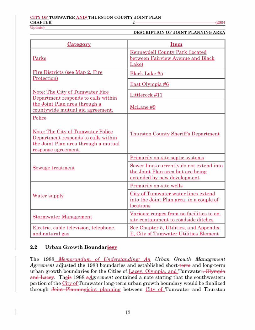
CITY OF TUMWATER AND/ THURSTON COUNTY JOINT PLAN
CHAPTER 2 (2004
Update)
DESCRIPTION OF JOINT PLANNING AREA
13
Category Item
Parks
Kenneydell County Park (located
between Fairview Avenue and Black
Lake)
Fire Districts (see Map 2, Fire
Protection)
Note: The City of Tumwater Fire
Department responds to calls within
the Joint Plan area through a
countywide mutual aid agreement.
Black Lake #5
East Olympia #6
Littlerock #11
McLane #9
Police
Note: The City of Tumwater Police
Department responds to calls within
the Joint Plan area through a mutual
response agreement.
Thurston County Sheriff’s Department
Sewage treatment
Primarily on-site septic systems
Sewer lines currently do not extend into
the Joint Plan area but are being
extended by new development
Water supply
Primarily on-site wells
City of Tumwater water lines extend
into the Joint Plan area in a couple of
locations
Stormwater Management Various; ranges from no facilities to on-
site containment to roadside ditches
Electric, cable television, telephone,
and natural gas
See Chapter 5, Utilities, and Appendix
E, City of Tumwater Utilities Element
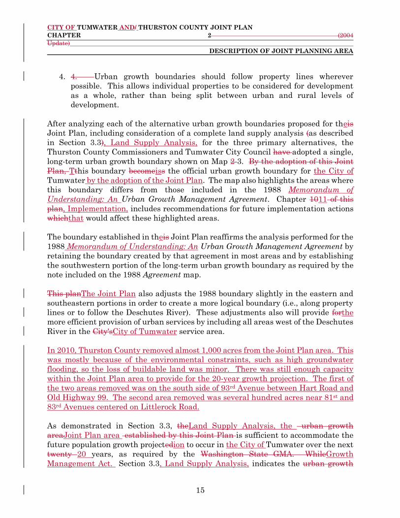
2.2 Urban Growth Boundariesy
The 1988 Memorandum of Understanding: An Urban Growth Management
Agreement adjusted the 1983 boundaries and established short-term and long-term
urban growth boundaries for the Cities of Lacey, Olympia, and Tumwater, Olympia
and Lacey. Theis 1988 aAgreement contained a note stating that the southwestern
portion of the City of Tumwater long-term urban growth boundary would be finalized
through Joint Planningjoint planning between City of Tumwater and Thurston

CITY OF TUMWATER AND/ THURSTON COUNTY JOINT PLAN
CHAPTER 2 (2004
Update)
DESCRIPTION OF JOINT PLANNING AREA
14
County. (Please see Appendix A for a summary of the process and criteria used to
develop the 1988 urban growth boundaries.5
In 1992, the long-term urban growth boundaries established in the 1988 aAgreement
were designated by the Thurston County Commissioners as the "interim" urban
growth boundaries for these three cCities under the Washington State Growth
Management Act (GMA).. The 1992 Thurston County County-Wide Planning Policies
(CPP's) established criteria and a process for amending the 1988 urban growth
boundaries (see Appendix B for an analysis of how the urban growth boundaries
proposed in this plan meet the CPP's criteria)..6 The CPP'sCounty-Wide Planning
Policies require a long-term (20-year) urban growth boundary, but make optional a
short-term (10-year) urban growth boundary.). Joint planning between Thurston
County and the affected City is established in the CPP'sCounty-Wide Planning
Policies as the mechanism forom amending the boundaries.
During the development of thisthe Joint Plan, the City of Tumwater and Thurston
County appointed and elected officials reviewed and re-affirmed the process and
criteria that were used to develop the 1988 short- and long-term and short-term
urban growth boundaries. They also considered several alternatives to these
boundaries for theis Joint Plan. In addition to the considerations required by the
GMA and CPP'sGrowth Management Act and County-Wide Planning Policies, they
evaluated the various growth boundary alternatives using the following general
principles:
1. 1. Urban development should be served by municipal utilities, which are
better suited to providing necessary services at urban densities.
2. 2. Urban growth boundaries should recognize logical service areas for
urban services. These services include, but are not limited to, roads, potable
water, sanitary sewer, and storm drainage facilities. Provision of some of these
services, especially storm drainage and sanitary sewer, is often determined by
topography, since they rely primarily on gravity flow.
3. 3. Existing land use should be one determinantdeterminate of urban
growth boundary location. Areas already characterized by urban levels of
development may be appropriate for inclusion within urban growth
boundaries.
5 See Appendix A, Summary of Process and Criteria Used to Develop the 1988 Urban Growth
Management Agreement for a summary of the process and criteria used to develop the 1988 urban
growth boundaries. 6 See Appendix B, Analysis of City of Tumwater and Thurston County Joint Plan Urban Growth
Boundary’s Consistency with County-Wide Planning Policies for an analysis of how the urban growth
boundaries proposed in the Joint Plan meet the County-Wide Planning Policies’ criteria.
CITY OF TUMWATER AND/ THURSTON COUNTY JOINT PLAN
CHAPTER 2 (2004
Update)
DESCRIPTION OF JOINT PLANNING AREA
15
4. 4. Urban growth boundaries should follow property lines wherever
possible. This allows individual properties to be considered for development
as a whole, rather than being split between urban and rural levels of
development.
After analyzing each of the alternative urban growth boundaries proposed for theis
Joint Plan, including consideration of a complete land supply analysis (as described
in Section 3.3), Land Supply Analysis, for the three primary alternatives, the
Thurston County Commissioners and Tumwater City Council have adopted a single,
long-term urban growth boundary shown on Map 2-3. By the adoption of this Joint
Plan, Tthis boundary becomeiss the official urban growth boundary for the City of
Tumwater by the adoption of the Joint Plan. The map also highlights the areas where
this boundary differs from those included in the 1988 Memorandum of
Understanding: An Urban Growth Management Agreement. Chapter 1011 of this
plan, Implementation, includes recommendations for future implementation actions
whichthat would affect these highlighted areas.
The boundary established in theis Joint Plan reaffirms the analysis performed for the
1988 Memorandum of Understanding: An Urban Growth Management Agreement by
retaining the boundary created by that agreement in most areas and by establishing
the southwestern portion of the long-term urban growth boundary as required by the
note included on the 1988 Agreement map.
This planThe Joint Plan also adjusts the 1988 boundary slightly in the eastern and
southeastern portions in order to create a more logical boundary (i.e., along property
lines or to follow the Deschutes River). These adjustments also will provide forthe
more efficient provision of urban services by including all areas west of the Deschutes
River in the City'sCity of Tumwater service area.
In 2010, Thurston County removed almost 1,000 acres from the Joint Plan area. This
was mostly because of the environmental constraints, such as high groundwater
flooding, so the loss of buildable land was minor. There was still enough capacity
within the Joint Plan area to provide for the 20-year growth projection. The first of
the two areas removed was on the south side of 93rd Avenue between Hart Road and
Old Highway 99. The second area removed was several hundred acres near 81st and
83rd Avenues centered on Littlerock Road.
As demonstrated in Section 3.3, theLand Supply Analysis, the urban growth
areaJoint Plan area established by this Joint Plan is sufficient to accommodate the
future population growth projectedion to occur in the City of Tumwater over the next
twenty 20 years, as required by the Washington State GMA. WhileGrowth
Management Act. Section 3.3, Land Supply Analysis, indicates the urban growth

CITY OF TUMWATER AND/ THURSTON COUNTY JOINT PLAN
CHAPTER 2 (2004
Update)
DESCRIPTION OF JOINT PLANNING AREA
16
areaJoint Plan area may be able to accommodate a larger population than is
projected, . tThe land use policies contained in Chapter 3 (e.g.,, including minimum
density requirements) and, contained in Chapter 3, Land Use, and Chapter 9,
Transportation, of the Joint Plan and the concurrency policies contained in the City
of Tumwater and Thurston County Capital Facilities Plans and Chapter 8-
Transportation of the Joint Plan will prevent urban sprawl and ensure that future
development occurs in an orderly manner with cost-efficient urban service provision.

CITY OF TUMWATER AND /THURSTON COUNTY JOINT PLAN
CHAPTER 3 (2009
Update)
LAND USE
17
3. LAND USE
3.1 Introduction
This chapter of the Joint Plan presents the 20 -year vision for land use in the
Tumwater urban growth areaJoint Plan area. This planThe Joint Plan covers the
planning period from 200221 to 2022. 2041.
This planThe Joint Plan addresses all areas within the urban growth boundary of the
City of Tumwater, including the twelve several "islands" of unincorporated “islands”
of land that are surrounded by the citymunicipal limits of the City of Tumwater.
The Joint Plan Land Use Map (Map 4) included in this chapter represents the general
future land use patterns that are desired for the Tumwater urban growth area over
the next 20 years. It is a graphic expression of the goals, policies, and
objectivesactions in this chapter. Together, the land use map and goals, policies, and
objectivesactions present a framework to guide future land use decisions in the
greater Tumwater areaJoint Plan area.
This chapter complies with the requirements of the Washington State Growth
Management Act for a land use elementLand Use Element of a comprehensive plan.
This chapterComprehensive Plan. It serves as the land use elementLand Use Element
for both the City of Tumwater and Thurston Countyy and the City of Tumwater for
the Tumwater urban growth areaJoint Plan area. In accordance with the County-
Wide Planning Policies for Thurston County, this eelement has been developed
through joint planning between the City of Tumwater and Thurston County.
Following is a demonstration of this element'sthe element’s compliance with the
Growth Management Act and the County-Wide Planning Policies.
3.1.1 Growth Management Act Goals Compliance
The Growth Management Act requires that the City of Tumwater and Thurston
County show how the land use elementLand Use Element meets the relevant
planning goals contained within the Act. All thirteenNot all fourteen of the goals do
not apply to land use; thereforefor that reason,, the following is a listing of the
applicable goals to land use and an analysis of how the Land Use PlanElement helps
meet these goals:
1. 1. Urban gGrowth. Encourage development in urban areas where
adequate public facilities and services exist or can be provided in an efficient
manner.
CITY OF TUMWATER AND /THURSTON COUNTY JOINT PLAN
CHAPTER 3 (2009
Update)
LAND USE
18
This chapter contains goals, policies, and actions that encourage
consideration of the availability of services, including roads, water and sewer
facilities when applying all land use designations in the Land Use Element. The
density ranges for all residential land use designations are consistent with
available or planned public facilities and services. (Goal #1, Policies 1.1 and 1.4;
Goal #2. , Policies 2.1 through 2.3; Goal #3, Policies 3.1 through 3.9; Goal
#5, Policies 5.1, 5.2, 5.4 through 5.8, and 5.10 through 5.12; Goal #10, Policies
10.3 and 10.9; and Section 3.5, Proposed Land Use Designations).
2. Reduce sprawl. Reduce the inappropriate conversion of undeveloped land into
sprawling, low -density development.
This chapter contains goals, policies, and objectivesactions that encourage
compact, efficient urban development and encourages urban growth to be
phased outward from the urban core. It also proposes residential and mixed -
use land use designations that will encourage the development of compact
urban areas. (Goal #1, Policies 1.1, 1.2, 1.4, and 1.7; Goal #2, Policies 2.1
through 2.3, and 2.8; Goal #3, Policies 3.4 and 3.5; Goal #4, Policy 4.5 and 4.7;
Goal #5, Policies 5.2, 5.4 through 5.8; Goal #9, Policy 9.3; Goal #10, Policies
10.3, 10.4, 10.9, and 10.10; and Section 3.5, Proposed Land Use Designations).
(Goal #2, Policies 2.1 through 2.4; Goal #3, Policies 3.1 through 3.9; Goal #4,
Policies 4.2, 4.4 & 4.5; Section 3.5, Proposed Land Use Designations)
3. 3. Transportation. Encourage efficient multi-modal transportation
systems that are based on regional priorities and coordinated with county and
city comprehensive plans.
This chapter contains goals, policies, and objectivesactions that ensure
coordination with regional and local transportation plans and promote land
use development that is consistent with multi-modal transportation facilities.
(Goal #1, Policies 1.1 1.4, and 1.5; Goal #5, Policies 5.1 through 5.1215)) It. It
also proposes residential, mixed use, and neighborhood commercial land use
designations that will encourage multi-modal, transit- oriented development.
(Section 3.5, Proposed Land Use Designations) ).
4. 4. Housing. Encourage the availability of affordable housing to all
economic segments of the population of this State; promote a variety of
residential densities and housing types; and encourage preservation of existing
housing stock.
This chapter, in conjunction with Chapter 6, Housing, includes policies and
land use designations designed to ensure the provision of affordable housing
and a variety of housing options (Goal #4, Policies 4.1 through 4.67; and Section

CITY OF TUMWATER AND /THURSTON COUNTY JOINT PLAN
CHAPTER 3 (2009
Update)
LAND USE
19
3.5, Proposed Land Use Designations). The City of Tumwater Housing
PlanElement, adopted by reference in Chapter 6 of this document, Housing,
includes a variety of policies and recommended regulatory changes expressly
designed to encourage housing affordability.
5. 5. Economic development. Encourage economic development
throughout the state that is consistent with adopted comprehensive plans;
promote economic opportunity for all citizens of this State, especially for
unemployed and for disadvantaged persons; and encourage growth in areas
experiencing insufficient economic growth, all within the capacities of the
State'’s natural resources, public services, and public facilities.
The Joint Plan land use elementLand Use Element ensures the provision of
adequate land for commerce and industry in the Tumwater areaJoint Plan
area (Section 3.5, Proposed Land Use Designations). The City of Tumwater
Economic Development Plan, an eelement of the City of Tumwater
Comprehensive Plan, also makes specific recommendations for economic
development in the City of Tumwater and the Joint Plan area (Goal #10, Policy
10.1).
6. 6. Property rights. Private property shall not be taken for public use
without just compensation having been made. The property rights of
landowners shall be protected from arbitrary and discriminatory actions.
This chapter was developed with sensitivity to property rights issues.
Designation of areas for future land uses were based upon many factors
including the impact of designations on private property. The Attorney
General’s Advisory Memorandum and Recommended Process for Evaluating
Proposed Regulatory or Administrative Actions to Avoid Unconstitutional
Takings of Private Property (September 2018) was reviewed and utilized in
objectively evaluating the proposed changes.
7. 7. Permits. Application for both State and local government permits
should be processed in a timely and fair manner to ensure predictability.
The Joint Plan includes a policy to ensure timely and fair processing of
development permits (Goal #2, Policy 2.67). . However, Chapter 1011 of this
document, Implementation, outlines how the implementation of Joint Plan
recommendations. will be enacted. Implementation actions will be
accomplished as follow on development regulations by both the City of
Tumwater and Thurston County, as appropriate. The City of Tumwater
Tumwater Housing Plan (see Chapter 6)Element contains an assessment of
barriers to affordable housing and includes an analysis of average development

CITY OF TUMWATER AND /THURSTON COUNTY JOINT PLAN
CHAPTER 3 (2009
Update)
LAND USE
20
permit processing times in the City of Tumwater. The City of Tumwater is
currently achieving quick turnaround times for permits, and can typically
process permits quickly enough toso that this is not be a factor in housing
affordability. See the further discussion in Chapter 6, Housing.
8. 8. Natural resource industries. Maintain and enhance natural
resource-based industries, including productive timber, agricultural, and
fisheries industries. Encourage the conservation of productive forest lands and
productive agricultural lands, and discourage incompatible uses.
This chapter ensures the viability of natural resource industries through the
identification of such lands in the text and land use maps. Additionally, the
City of Tumwater and Thurston County comprehensive plansComprehensive
Plans contain specific guidelines and policies regarding critical areas and
resource lands that ensure the viability of natural resource industries and
activities (Goal #2, Policy 2.10 and Goal #7, Policy 7.3).
9.
9. Open space and recreation. Encourage the retention of open space and
development of recreational opportunities, conserve fish and wildlife habitat,
increase access to natural resource lands and water, and develop parks.
This chapter, in conjunction with Chapter 7, Parks, Recreation, and Open
Space, designates areas that would be appropriate for future open space and
recreation uses. The Joint Plan land use elementLand Use Element reinforces
the recommendations of the Tumwater Parks and, Recreation, and Open Space
Plan (, adopted by reference in Chapter 7 of this document), Parks, Recreation,
and Open Space, through the land use designations and in goals and policies
(Goal #5, Policy 5.12; Goal #7, Policies 7.1 &through 7.42; and Section 3.5,
Proposed Land Use Designations).
10. 10. Environment. Protect the environment and enhance the State'’s
high quality of life, including air and water quality, and the availability of
water.
The goals and policies in this chapter ensure coordination of land use with the
Northern Thurston County Groundwater Plan, and comprehensive plansthe
City of Tumwater’s Comprehensive Stormwater Implementation Plan, Water
System Plan, and Wellhead Protection Plan for stormwater, sewer and water.
The City of Tumwater Conservation PlanElement and the Natural
Environment chapter of the Thurston County comprehensive
planComprehensive Plan also contain specific policies relating to air and water
quality and water availability. The City of Tumwater Urban Forestry

CITY OF TUMWATER AND /THURSTON COUNTY JOINT PLAN
CHAPTER 3 (2009
Update)
LAND USE
21
Management Plan also makes specific recommendations for the urban forest
in the City of Tumwater and the Joint Plan area (Goal #8, Policy 8.7). This
chapter also makes recommendations for clustering and other creative
development techniques in sensitive areas. (Goal #3, Policies 3.2 , 3.6 through
3.9& 3.3; Goal #6, Policies 6.1 through 6.511; Goal #8, Policies 8.1 through 8.5;
and Section 3.5, Proposed Land Use Designations)).
Climate change is already affecting our communities. Impacts like hotter
summers, wildfire smoke, and flooding endanger our homes, affect public
health, and impinge on local business.
Thurston County and the cities of Lacey, Olympia, and Tumwater worked with
the Thurston Regional Planning Council to develop and accept the Thurston
Climate Mitigation Action Plan in 2021 as the framework for reducing climate
polluting greenhouse gases while maintaining and improving our quality of
life. The Joint Plan includes a number of policies and actions that will support
the implementation of the Thurston Climate Mitigation Action Plan, including
land use policies that support the development urban level land uses in the
Urban Growth Area to reduce sprawl and the need for more motorized vehicle
trips, supports environmental protections, including the actions identified in
the City of Tumwater Urban Forestry Management Plan, which support carbon
sequestration using the urban forest to reduce greenhouse gases.
11. 11. Citizen participation and coordination. Encourage the
involvement of citizens in the planning process and ensure coordination between
communities and jurisdictions to reconcile conflicts.
This documentThe 1995 Joint Plan was prepared in open public meetings by
the Joint Planning Committee, a citizen's advisory committee authorized by
the Thurston County Commissioners and Tumwater City Council. The
cCommittee included representatives from the City of Tumwater and Thurston
County Planning Commissions, the Port of Olympia, and the Tumwater School
District. Additionally, a newsletter calledthe Joint Plan News was sent to all
residents of the joint planning study area periodically throughout the planning
process to keep them informed on progress of the planJoint Plan. Joint public
hearings on the draft Joint Plan were held by theThe City of Tumwater/ and
Thurston County Planning Commissions and the Tumwater City Council and
Thurston County Commissioners held joint public hearings on these
amendments to the Joint Plan. Notice of these hearings was sent to all
residents of the joint planning study area (Goal #1, Policy 1.3).
The 2021 Joint Plan update was prepared.

CITY OF TUMWATER AND /THURSTON COUNTY JOINT PLAN
CHAPTER 3 (2009
Update)
LAND USE
22
[Staff Note: Next steps related to the 2021 amendment process will be added.
12. 12. Public facilities and services. Ensure that those public facilities
and services necessary to support development shall be adequate to serve the
development at the time the development is available for occupancy and use
without decreasing current service levels below locally established minimum
standards.
The Joint Plan land use elementLand Use Element of the Joint Plan has been
closely coordinated with the development of Chapter 89, Transportation, and
Chapter 910, Public Facilities and Services. The Joint Plan will ensure
concurrency through coordination of the City of Tumwater and Thurston
County Capital Facilities Plans, as outlined in Chapters 9 10, Public Facilities
and Services, and Chapter 110 of this document., Implementation. This
chapter contains goals and policies that ensure this coordination. (Goal #1,
Policiesy 1.1 and 1.4; Goal #2, Policies 2.1 through 2.4; Goal #3, Policies 3.1
through 3.9; Goal #5, Policiesy 5.1 and 5.8; Goal #6, Policies 6.1 & 6.2; Goal #7,
Policy 7.1; and Goal #10, Policy 10.3)).
13. 13. Historic preservation. Identify and encourage the preservation of
lands, sites, and structures that have historical or archaeological significance.
The City of Tumwater and Thurston County have historic preservation
programs whichthat provide processes for designation of local historic sites for
protection. Similar programs are conducted at the State and national levels.
The Joint Plan land use elementLand Use Element contains goals and policies
encouraging consistency with and support for these programs. (Goal #12,
Policies 12.1 &and 12.2)).
14. Shorelines of the state. The goals and policies of the Shoreline Master Program
shall be considered an element of the County's Comprehensive Plan.
The Thurston County Shoreline Master Program was adopted in 1990 and is the
process of being updated in 2021. Once the Thurston County Shoreline Master
Program is updated, it will be become an element of the County Comprehensive
Plan. The Thurston County Shoreline Master Program addresses land uses on
all lands under the jurisdiction of the Shoreline Management Act in order to
protect and preserve fish and wildlife habitat and the shorelines of the state
(RCW 36.70A.480(1)). The Joint Plan Land Use Element contains goals and
policies encouraging consistency with and support for these programs (Goal #1,
Policy 1.6; Goal #8, Policy 8.3).

CITY OF TUMWATER AND /THURSTON COUNTY JOINT PLAN
CHAPTER 3 (2009
Update)
LAND USE
23
3.1.2 County-Wide Planning Policy Compliance
The Growth Management Act requires that comprehensive plansComprehensive
Plans be consistent with adopted County-Wide Planning Policies. The adopted
County-Wide Planning Policies are included in this document in their entirety in
Appendix C. The following is a brief description of how the Joint Plan land use
elementLand Use Element is consistent with the adopted County-Wide Planning
Policies for Thurston County:
I. General Policies
The Joint Plan as a whole satisfies and is consistent with the policies in Article
I. of the County-Wide Planning Policies
I.II. Urban Growth Areas
Chapter 2 of this document, Description of Joint Plan Area, establishes growth
boundaries in accordance with these policies. This chapter has been developed
consistent with Chapter 2, Description of Joint Plan Area.
II.III. II. Promotion of Contiguous & Orderly Development & Provision of Urban
Services
This chapter contains goals, policies and objectivesactions that encourage
compact, efficient urban development and encourages urban growth to be
phased outward from the urban core. It also proposes residential and mixed -
use land use designations that will encourage the development of compact
urban areas. (Goal #2, Policies 2.1 through 2.54; Goal #3, Policies 3.1 through
3.9; Goal #4, Policyies 4.2, 4.4 5& 4.5, ; and Section 3.5, Proposed Land Use
Designations)).
III.IV. III. Joint County & City Planning Within Urban Growth Areas
Theis Joint Plan has been developed in accordance with the policies and
process in this section of the County-Wide Planning Policies.
IV.V. IV. Siting County-Wide & State-Wide Public Capitoal Facilities
This chapter does not directly address the siting of County-wideCountywide
and State-wideStatewide public capital facilities. Siting of these facilities has
been addressed through development of a regional process, which is adopted

CITY OF TUMWATER AND /THURSTON COUNTY JOINT PLAN
CHAPTER 3 (2009
Update)
LAND USE
24
by reference in Chapter 4, Lands for Public Purposes/Essential Public Facilities
of this document.
V.VI. V . Analysis of Fiscal Impact
Fiscal impacts of development in the Tumwater urban growth areaJoint Plan
area are addressed in Chapter 109, Public Facilities and Services, and Chapter
1110, Public Facilities and Services and Implementation Issues. Capital
facilities projects necessary to support the land uses designated in this chapter
are listed in Chapter 910, Public Facilities and Services. Chapter 110,
Implementation, describes the follow-on implementation actions whichthat
will specifically address fiscal impacts.
VI.VII. VI. Economic Development and Employment
This chapter, in conjunction with Chapter 8, Economic Development, includes
policies and land use designations designed to ensure that economic
development and employment are addressed (Goal # 10, Policy 10.1; and
Section 3.5, Proposed Land Use Designations). The Joint Plan land use
elementLand Use Element ensures the provision of adequate land for
commerce and industry in the City of Tumwater and the Joint Plan area. The
Tumwater Economic Development Plan is an element of the City of Tumwater
Comprehensive Plan and also makes specific recommendations for economic
development in the City of Tumwater. This chapter is consistent with the City
of Tumwater Tumwater Economic Development Plan.
VII.VIII. VII. Affordable Housing
This chapter, in conjunction with Chapter 6, Housing, includes policies and
land use designations designed to ensure the provision of affordable housing.
(Goal #4, Policies 4.1 through 4.67; and Section 3.5, Proposed Land Use
Designations)). The City of Tumwater Housing PlanElement, adopted by
reference in Chapter 6, Housing, includes a variety of policies expressly
designed to encourage housing affordability, including but not limited to, a
multitude of regulatory changes dispersed throughout the document.
VIII.IX. VIII. Transportation
This chapter contains goals, policies, and objectivesactions that ensure
coordination with regional and local transportation plans. (Goal #1, Policy
1.11.1; and Goal #5, Policyies 5.1 & 5.2)). It also proposes residential, mixed

CITY OF TUMWATER AND /THURSTON COUNTY JOINT PLAN
CHAPTER 3 (2009
Update)
LAND USE
25
use, and neighborhood commercial land use designations that will encourage
multi-modal, transit-oriented development.
IX.X. IX . Environmental Quality
The goals and policies in this chapter ensure coordination of land use with the
Northern Thurston County Groundwater Protection Plan, and comprehensive
plansthe City of Tumwater Comprehensive Stormwater Implementation Plan,
Water System Plan, and Wellhead Protection Plan for stormwater, sewer and
water. The critical areas eelements of the City of Tumwater and Thurston
County comprehensive plansComprehensive Plans also contain specific policies
relating to air and water quality and water availability. The City of Tumwater
Urban Forestry Management Plan also makes specific recommendations for
the urban forest in the City of Tumwater and the Joint Plan area (Goal #8,
Policy 8.7). This chapter also makes recommendations for clustering and other
creative development techniques in sensitive areas. (Goal #32, Policy 2.33.2;
Goal #4, Policy 4.4; Goal #6, Policies 6.1 through 6.114; Goal #8, Policies 8.1
through 8.5; and Section 3.5, Proposed Land Use Designations)). The goals
and policies in this chapter also support the implementation of the actions of
the Thurston Climate Mitigation Plan.
X . County-Wide Policies Which Establish A Process Policies
1. Population Projections and Urban Growth Areas
X.XI. 2. Review of theseto Develop Future Policies
The Joint Plan has been developed to accommodate the regional population
allocation developed using these County-Wide Planning Policies. ( See Section
3.43, Land Supply Analysis). The Joint Plan is designed to be a flexible
document. As conditions and circumstances change, or as regional plans and
policies are amended, it can be revised accordingly.
3.1.3 Amendments
The City of Tumwater and Thurston County will review, and if appropriate, amend
or update the Joint Plan every five eight years or as necessary to ensure internal and
interjurisdictional consistency, and consistency with other eelements of the City of
Tumwater and Thurston County Comprehensive Plans. Linkage with all of the
eelements of these comprehensive plansComprehensive Plans is important in order to
maintain orderly, cost-efficient development that is phased outward from the urban
core. The City of Tumwater and Thurston County may jointly amend theis Joint Plan
at any time, consistent with the Growth Management Act.

CITY OF TUMWATER AND /THURSTON COUNTY JOINT PLAN
CHAPTER 3 (2009
Update)
LAND USE
26
The Joint Plan is meant to be a flexible and easily used document. As changes occur
in the urban growth areaJoint Plan area, the Joint Plan will need to be revised and
amended in order to reflect new circumstances. An evaluation of new conditions will
be an integral part of the amendment process.
State law does not allow more frequent amendments than once annually, except in
cases of emergency. The amendment process will consider concurrently all proposed
changes to the document accumulated over time since the last amendment, in order
to ascertain the cumulative impact of the proposed changes.
3.2 Goals/ and Policies/Objectives
This section of the Joint Plan specifies the goals and, policies and objectives meant
tothat set forth a the direction for the future growth of the Tumwater urban growth
areaJoint Plan area. The goals, and policies and objectives also serve to ensure
coordination with other City of Tumwater and Thurston County Comprehensive Plan
eElements, regional plans, and County-Wide Planning Policies. Additionally, they
serve to as define thean action plan for implementing the Joint Plan certain
recommendations within the Joint Planfound in Chapter 11, Implementation. TThe
goals and, policies of this section and objectivesactions in Chapter 11,
Implementation, should be looked at in conjunction with Chapter 10, Public Facilities
and Services, Section 10.2, Goals and Policies, and Chapter 3, Land Use, Subsection
3.5.1, Definitions and Criteria for Land Use DesignationsPolicies/
Designations/Definitions. The two sectionsse are meant to work together as a whole.
GOAL #1
Ensure that the Joint Plan land use elementLand Use Element is implementable and
coordinated with all applicable City of Tumwater and Thurston County plans and
regulations and the plans of other jurisdictions in the Thurston region.

CITY OF TUMWATER AND /THURSTON COUNTY JOINT PLAN
CHAPTER 3 (2009
Update)
LAND USE
27
Policiesy Objective
1.1 Ensure that the consistency of the Joint Plan land use
elementLand Use Element is consistent with adopted County-Wide
Planning Policies and the integration of transportation considerations
into land use decisions, and vice versa.
1.2 Integrate the goals of the Sustainable Thurston Plan into the Joint Plan
Land Use Element.
1.1.1 Ensure that the nine elements in the
County-Wide Planning Policies are implemented (see the
Introduction to this chapter for an analysis of the County-
Wide Planning Policies).
1.32 Seek active public involvement during updates of the Joint Plan.
1.4 Ensure consistency between the Joint Plan Land Use Element and all
other elements of the City of Tumwater and Thurston County
Comprehensive Plans and the Port of Olympia Comprehensive Scheme
of Harbor Improvements.Coordinate the Joint Plan land use element
with the Olympia Regional Airport Master Plan and the Port of Olympia
Strategic Plan.
1.3
1.5 Ensure consistency between the Joint Plan land use element and all
other elements of the City of Tumwater and Thurston County
Comprehensive Plans and the Port of Olympia Comprehensive Plan.
Coordinate the Joint Plan Land Use Element with the Port of Olympia Regional
Airport Master Plan and the Port of Olympia Strategic Plan.
Thurston County and Tumwater, in accordance with Section 36.70A.120 RCW, shall
make capital budget decisions in conformity with the comprehensive plan.
1.64 Coordinate the Joint Plan land use element withEnsure that
development in the Joint Plan area is consistent with the Thurston
County Shoreline Master Program forShoreline the Thurston Region.
Master Program.
1.4.1 Ensure that the adoption of the "Management Unit
Regulations" chapter in Volume 2 of the Percival Creek
CITY OF TUMWATER AND /THURSTON COUNTY JOINT PLAN
CHAPTER 3 (2009
Update)
LAND USE
28
Corridor Plan is implemented (to be accomplished through
implementing regulations developed after completion of
the Joint Plan).
1.4.2 Ensure that the Joint Plan land use section is consistent
with the recommendations of the Deschutes Special Area
Management Plan.
1.75 Ensure consistency between the Joint Plan land use elementLand
Use Element and the City of Tumwater and Thurston County
development regulations regulations (see Chapter 10 for a list of
additional implementation actions recommended to accomplish this
objective). .
1.8 Coordinate the Joint Plan Land Use Element with local, state, and
national initiatives that support the Joint Plan vision whenever
practical to increase the chance of additional funding.
1.5.1 Amend City and County development
regulations as necessary to ensure implementation of Joint
Plan policies and recommendations.
1.5.2 Develop and adopt an urban services
agreement between the City of Tumwater and Thurston
County whichthat identifies specific City development
standards and design guidelines to be applied by
theThurston County within the short-term City of
Tumwater urban growth area prior to annexation.
1.9 Update the Memorandum of Understanding between the City of
Tumwater and Thurston County addressing Joint Plan area Zoning and
Development Standards as needed to ensure it remains relevant.
GOAL #2
Ensure that development takes place in an orderly and cost-efficient manner in order
to best utilize available land and public services, preserve open space, and reduce
sprawl.
Policiesy Objective

CITY OF TUMWATER AND /THURSTON COUNTY JOINT PLAN
CHAPTER 3 (2009
Update)
LAND USE
29
2.11 Encourage the higherst intensity growth to locate within the most
appropriate areas.
2.1.1 Implement the Goals and associated
policies and objectives of the City of Tumwater Economic
Development Plan.
2.22 Reduce the inappropriate conversion of undeveloped land into
sprawling low -density development.
2.2.1 Ensure that the County-Wide Planning Policies are
implemented (see the Introduction to this chapter for an analysis of the County-Wide
Planning Policies).
2.2.2 Revise County zoning to be compatible with future land
uses shown on the Joint Plan Land Use Map (see Chapter 10 for a list of
implementation actions recommended to accomplish this objective).
2.2.3 Implement County zoning provisions for properties
designated for residential land uses within the urban growth area to
require development to be configured so urban growth areas may
eventually infill and become urban.
2.33 Encourage innovative land use management techniques such as
density bonuses, cluster housing, z-lots, planned unit developments, and
transfer of development rights.
2.3.1 Revise the City's Development
Standards to encourage innovative land use management
techniques.
2.3.2 Consider future participation in a
county-wide transfer of development rights program, in
which some portion of the density range within a low
density residential designation is achievable through
purchase of transferred development rights. The objective
of a county-wide transfer of development rights program
would be to support conservation of important natural
and/or cultural resources (e.g., long-term agricultural
lands, historic properties, or significant wildlife habitat).

CITY OF TUMWATER AND /THURSTON COUNTY JOINT PLAN
CHAPTER 3 (2009
Update)
LAND USE
30
2.44 Consider presence of critical areas and efficiencies in providing
public services such as police, fire, and emergency medical services in
the Joint Plan area when determining the urban growth boundaries.
2.5 Ensure that new annexations adhere to the City of Tumwater's
Annexation Policies.
2.4.1 Continue land use designations shown
on the Joint Plan Land Use Map immediately upon
annexation as amendments to the Tumwater Land Use
Plan Map. The City shall honor the land use designation
for at least one year following annexation.
2.4.2 To implement this Joint Plan, the City
may adopt zoning measures for unincorporated land which
become effective immediately upon annexation. The City
shall honor such zoning measures for at least one year
following annexation.
2.4.3 Do not approve any annexation that
includes territory outside the long-term urban growth
boundary adopted by this Joint Plan, or subsequent
amendments to this Joint Plan.
2.65 Coordinate the Joint Plan Land Use Element with the City of
Tumwater Citywide Design GuidelinesEncourage the development of
architectural and landscape design standards, where appropriate.
2.76 Ensure the processing ofat applications for development permits
are processed in a timely and fair manner, and that processing is
coordinate processingd between the City of Tumwater and Thurston
County, to enhance predictability.
2.8 Create vibrant centers, corridors, and neighborhoods that support active
transportation and housing, jobs, and services.
2.9 Create safe and vibrant neighborhoods with places that build
community and encourage active transportation.
2.10 Protect designated mineral resource lands from incompatible
development.
CITY OF TUMWATER AND /THURSTON COUNTY JOINT PLAN
CHAPTER 3 (2009
Update)
LAND USE
31
2.11 Reduce the carbon footprint where possible and move towards a carbon-
neutral community.
GOAL #3
Ensure that adequate public services, facilities, and publicly- owned utilities are
available to proposed and existing development.
Policiesy Objective
3.1 Coordinate development with the City'sCity of Tumwater and
Thurston County's six-year Capital Facilities Plans.
3.1.1 Ensure that the Capital Facilities
Plans can be implemented through the Joint Plan's
projected land use densities.
3.2 Ensure that development is in conformance with the City of
Tumwater Master Plans for Potable Water System Plan and Sanitary
Sewer Comprehensive Plan.
3.3 Analyze all proposed development should be analyzed for
anticipated impact on services, either as an elementcomponent of site
plan review, or as part of environmental impact assessment.
3.4 Give pPreference normally should be given to providing adequate
public facilities and services to settled developed areas rather than
extending new services to sparsely settled developed or undeveloped
areas.
3.4.1 Allow public sewer and water service to
be extended, consistent with the City's annexation policies,
to serve development within the urban growth boundary.
Extensions beyond the urban growth boundary shall only
be allowed when they meet the conditions specified in the
Thurston County Sewerage General Plan and
implementing agreement and the Thurston County
Coordinated Water System Agreement, respectively.
Water systems and community on-site sewage systems in
the urban growth area that the City agrees to own and

CITY OF TUMWATER AND /THURSTON COUNTY JOINT PLAN
CHAPTER 3 (2009
Update)
LAND USE
32
operate should conform to adopted utility plans and
standards.
3.5 Public agencies should Wwork with developers to determine
where and when placing new public facilities are to be placed to permit
proper development of commercial and residential projects. This process
should be Ddirectly relate this processd to the City of Tumwater and
Thurston County six-year Capital Facilities Plans and site plan review
in order to achieve concurrency.
3.5.1 Ensure that the County-Wide Planning Policies are
implemented (see the Introduction to this chapter for an analysis of the
County-Wide Planning Policies).
3.6 Require residential and commercial development utilizing septic
tanks for sewage disposal, which have sanitary sewer laterals readily
available, should be required to hook up to the sanitary sewer when the
system fails, needs replacement, or requires major repairs, or when
necessary for groundwater resource protection.
3.7 Require residences and businesses utilizing private wells for
water systems whichthat have City of Tumwater water service available
shall be required to connect to it when the well fails, needs replacement,
or requires major repairs.
3.8 When development is placed in areas where growth is planned
and full municipal utility connection is not yet available, Design and
construct water and sewage conveyance, and disposal systems and
stormwater facilities should be designed and constructed in
conformance with adopted utility plans to facilitate future connection to
the City of Tumwater systems when placing development in areas where
growth is planned and full municipal utility connection is not yet
available.
3.9 Consider wWater systems designed and built prior to full utility
connection should be considered for integration into the water utility to
maximize potential for water source development.
GOAL #4
Encourage land use patterns that will increase the availability of affordable housing
for all economic segments of the City of Tumwater population.
CITY OF TUMWATER AND /THURSTON COUNTY JOINT PLAN
CHAPTER 3 (2009
Update)
LAND USE
33
Policiesy Objective
4.1 Coordinate the Joint Plan land use sectionLand Use Element with
the City of Tumwater Tumwater Housing PlanElement and fully
implement the goals, policies, and objectives of the City of Tumwater
Housing PlanElement..
4.2 Encourage innovative techniques for providing affordable
housing that will result in an attractive product that will be an asset to
the Tumwater community.
4.2.1 Revise the City's Development
Standards to encourage innovative land use management
techniques.
4.3 Allow Modular manufactured housing should be allowed to site
on individual lots in residential land use designations, as well as within
mobile and manufactured home parks, to encourage affordable housing.
4.3.1 Revise the City's Zoning Code to allow
manufactured housing as an alternative construction
method. Thurston County and he City of Tumwater should
periodically review their regulations for consistency, as
time allows.
4.4 Permit consideration of new approaches to iImplementing
regulations should permit experimentation in newer forms of residential
development where amenities of open space, privacy, and visual quality
can be maintained or improved, and flexible solutions to land use
problems such as affordability can be achieved.
4.4.1 Revise the City's Development
Standards to encourage innovative land use management
techniques.
4.5 Encourage hHigher density residential uses should be
encouraged in order to provide affordable housing. Blend tThese uses
should blend with the existing character of the community.
4.5.1 Develop architectural design standards
for multi-family development to assure the compatibility of
higher densities with existing neighborhoods.

CITY OF TUMWATER AND /THURSTON COUNTY JOINT PLAN
CHAPTER 3 (2009
Update)
LAND USE
34
4.6 Treat mMobile home parks which were legally established prior
to adoption of this planthe Joint Plan and that are located on lands
designated Residential/Sensitive Resource, Single-Family Residential,
or Light Industrial should be treated as a permitted use in the
implementing zoning, except where there is a cessation of the use ceases
for three or more years. Do not allow eExpansion of the mobile home
park area should not be allowed; however, enlargement of units within
existing mobile home spaces should be permitted. Consider adding
existing mobile home parks to the Manufactured Home Park (MHP)
land use designation and zone district.
4.7 Increase housing types and densities in corridors and centers to meet
the needs of a changing population.
The Hazard Mitigation Plan should be referenced for more specific information and
guidance.
GOAL #5
Ensure that development patterns that will encourage efficient multi-modal
transportation systems are coordinated with regional, City of Tumwater, and
Thurston County Transportation Plans.
Policiesy Objective
5.1 Ensure coordination with of the City of Tumwater Transportation
Plan Transportation Plan and the Thurston Regional Transportation
Plans.
5.2 Pedestrian and bicycle trail links with other parts of Tumwater
and surrounding jurisdictions should be established.
5.2.1 Ensure coordination of this chapter with the Tumwater,
Olympia and Thurston County Parks and Recreation Plans.
5.2 Create vibrant urban centers and activity nodes along potential transit
corridors that support active transportation and housing, jobs, and
services.
5.33 Encourage pProvision of urban plazas and access to transit stops
should be encouraged when new construction or major renovation is
proposed. Seek iIncentives for providing such amenities should be
sought.

CITY OF TUMWATER AND /THURSTON COUNTY JOINT PLAN
CHAPTER 3 (2009
Update)
LAND USE
35
5.3.1 Revise the City's Development
Standards to encourage provision of these amenities,
including possible development of a City-wide design
standards program.
5.44 Allow densities and mixes of uses that reduce the number and
lengths of vehicle trips and increase the opportunity to use public transit
and non-motorized modes of travel.
5.55 Reinforce the link between land use and public transportation by
encouraging development to occur at urban residential densities along
designatedpotential transit corridors, nodes and near commercial
centers.
5.66 Ensure that the design of proposed capacity improvements to the
City's transportation systems in the Joint Plan area are designed to
serve proposals that are contiguous to existing development, as a means
to discourage the occurrence of "leap frog" development patterns.
5.77 Provide development incentives, (such as increased density,
increased square footage, increased heightt,) for proposed land
developments located adjacent to transportation corridors when
amenities for transit users, bicyclists and pedestrians are included.
5.8 Encourage land development proposals to utilize the capacity of
the existing transportation system, especially transit and non-motorized
modes.
5.8 Encourage land development proposals to utilize the capacity of the
existing transportation system, especially transit and non-motorized
modes.
5..99 Encourage Require public and private development proposals to
enhance the street side environment to maximize comfort for the transit
users and the pedestrians.
5.100 Encourage Require subdivision and commercial and /retail
project design whichto facilitates cost-effective transit and emergency
service delivery.

CITY OF TUMWATER AND /THURSTON COUNTY JOINT PLAN
CHAPTER 3 (2009
Update)
LAND USE
36
5.11 Discourage transportation improvements, regardless of their
financing mechanisms, that would trigger premature development; that
is, development which is inconsistent with applicable comprehensive
plans and zoning.
5.11 Ensure that the Joint Plan, subdivisions, other land developments, as
well as City of Tumwater and Thurston County transportation projects
provide for alternative transportation modes, such as transit, bicycling,
and walking.
5.12 Ensure coordination with between Thurston County Parks, Trails, and
Open Space Plan and the City of Tumwater Parks, Recreation, and Open
Space Plan when establishing pedestrian and bicycle trail links with
other parts of the City of Tumwater and surrounding jurisdictions.
5.12 Ensure that alternative transportation modes are
5.13 Expand bicycle and pedestrian data collection efforts.
5.14 Establish a regional bicyclist and pedestrian advisory body.
5.15 Support efforts of the local traffic safety campaigns to educate bicyclists
and pedestrians of the laws pertaining to walking and biking. included
in comprehensive plans, subdivisions and other land developments.
CITY OF TUMWATER AND /THURSTON COUNTY JOINT PLAN
CHAPTER 3 (2009
Update)
LAND USE
37
GOAL #6
Reduce impacts from flooding,; encourage efficient stormwater management,; and
ensure that protect and preserve the City of Tumwater’sthe groundwater. of
Tumwater is protected and preserved.
Policiesy Objective
6.1 Ensure that new development is in conformanceconforms withto
the requirements and standards of the North Thurston Groundwater
Protection Plan the Northern Thurston Groundwater Protection Plan.
6.2 Ensure that new development is in conformance with requirements and
standards of the Thurston County Drainage Design and Erosion Control
Manual, as amended.
6.3 Use low impact development standards the Thurston County Drainage
Design and Erosion Control Manual and the low impact development
requirements in State law.
6.4 Ensure coordination with the Percival Creek Comprehensive Drainage
Basin Plan.
6.5 Follow the recommendations of the Salmon Creek Comprehensive
Drainage Basin Plan and keep the development regulations for high
groundwater flooding hazards for both the City of Tumwater and
Thurston County consistent.
6.6 Ensure that new development is in conformance with aquifer protection
standards of the City of Tumwater Conservation Element and
development regulations.
6.2 Ensure that new development is in conformance with the requirements
and standards of the City of Tumwater's Master Storm Drainage Plan.
6.3 Ensure that new development meets the quality and quantity control
requirements contained in the Drainage Design and Erosion Control Manual for the
Thurston Region.
6.4 Ordinances meeting applicable legal standards should be adopted
by the City of Tumwater and Thurston County

CITY OF TUMWATER AND /THURSTON COUNTY JOINT PLAN
CHAPTER 3 (2009
Update)
LAND USE
38
6.7 Avoid or mitigate negative effects on groundwater quality rby
regulating land use and developments within wellhead protection areas
in conformance with regional wellhead protection policies and adopted
wellhead protection programs of the City of Tumwater and Thurston
County.s to ensure that negative effects on groundwater quality are
avoided or mitigated.
6.5 Ensure that future land use and development is in conformance
with regional wellhead protection policies and adopted wellhead
protection programs of Thurston County and the City of Tumwater.
6.6 Ensure coordination with the Percival Creek Comprehensive
Drainage Basin Plan.
6.7 Ensure that new development is in conformance with aquifer
protection standards of the City's Conservation Plan.
6.8 Review and update regulations for land uses within wellhead protection
areas as guided by critical areas protections.
6.9 Ensure implementation of the Natural Hazards Mitigation Plan for the
Thurston Region to reduce or eliminate the human and economic costs
of natural disasters for the overall good and welfare of the community.
6.8 10 Prohibit Limit new residential and commercial development in
the 100-year floodplain to the extent legally feasible.
6.9 11 Encourage consistency between the City of Tumwater and
Thurston County critical area regulations within the urban growth
areaJoint Plan area and as they apply to natural features which form
the City of Tumwater urban growth boundary (e.g.,, such as the
Deschutes River, Black Lake, or the Salmon Creek Basin). .
6.10 Encourage the development and use of low impact development
standards similar to those contained in the Zero Effect Drainage
Discharge Ordinance as adopted by the City of Tumwater [Chapter
13.22 TMC].
6.11 Ensure that the recommendations of the Salmon Creek Comprehensive
Drainage Basin Plan are followed and work to keep the development

CITY OF TUMWATER AND /THURSTON COUNTY JOINT PLAN
CHAPTER 3 (2009
Update)
LAND USE
39
regulations for high groundwater flooding hazards for both Tumwater
and Thurston County consistent.
GOAL #7
Encourage the retention of open space, parks, trails, and development of recreational
opportunities within the TumwaterJoint Plan area.
Policiesy Objective
7.1 Coordinate the Joint Plan Land Use Element with the City of
Tumwater Parks, Recreation, and Open Space Plan and support Ensure
implementation of the planTumwater Parks and Open Space Plan.
7.2 Ensure coordination of the Joint Plan with the open space
retention and natural area preservation standards of the City of
Tumwater City's Conservation PlanElement.
7.2.1 A geological/critical area study and mapping
program should be performed and updated regularly for all areas of the
City'sCity of Tumwater’s urban growth boundary. This study should
address:
_ Geologic hazard areas
_ Erosion hazard areas
_ Landslide hazard areas
_ Mine hazard areas
_ Seismic hazard areas
_ Volcanic hazard areas
_ Aquatic hazard areas
o • Floodways
• 100 year flood plains
• 500 year flood plains
• Floodplain, one-percent
Floodplain, 0.2 percent
o Wetlands
_ Aquifer recharge areas
_ SpecialShoreline management areas
_ Groundwater flooding in the Salmon
Creek Basin and other areas that experience groundwater flooding.
CITY OF TUMWATER AND /THURSTON COUNTY JOINT PLAN
CHAPTER 3 (2009
Update)
LAND USE
40
7.3 Preserve environmentally sensitive lands, farmlands, mineral
resources, and prairies, by developing compact urban areas.
7.43 Provide a variety of open spaces including landscaped buffers,
small parks, plazas, and other community areas to balance higher
density development and enhance the quality of living.
7.3.1 To make certain that areas of
developments dedicated to open space provide the
functions intended, the City's Zoning Ordinance should
specify the amount of area that must be dedicated for open
space and require that it be in a configuration that is useful
for the purpose desired.
GOAL #8
Ensure Observe theat physical limitations of the land are observed during the
development process.
Policiesy Objective
8.1 Ensure that new development is in conformance withconforms to
the applicable standards and requirements for critical areas.
8.1.1 Conduct a geological study and mapping program for the
City of Tumwater urban growth area. and update it on a regular basis (See Policy
7.2.1)).
8.2 Reserve the right to prohibit or set conditions on development
based on anticipated adverse environmental impact.Prohibit or set
conditions on development based on anticipated adverse environmental
impact.
8.3 Inventory the hillside areas to determine which areas, because of
known hazards, topographic formations and unstable soils, should be
limited to extent of development.
8.3.1 Conduct a geological study and mapping program for the
City of Tumwater urban growth area. and update it on a regular basis (See Policy
7.2.1)).

CITY OF TUMWATER AND /THURSTON COUNTY JOINT PLAN
CHAPTER 3 (2009
Update)
LAND USE
41
8.43 Ensure that dDevelopment in the Joint Plan area within the
jurisdiction of the Shoreline Management JurisdictionAct shall adheres
to the flood control policies, land use controls and regulations of the
applicable environmental designation as described in the Thurston
County Thurston Region Shoreline Master Program and floodplain
regulations adopted by the City of Tumwater and Thurston County.
Consider applying
8.4 Ensure that new development is in conformance with the standards of
the City of Tumwater Protection of Trees and Vegetation Ordinance the
standards of the City's Tree Protection Ordinance to the unincorporated
urban growth area through an intergovernmental agreement.
8.56 Revise and update critical area maps and regulatory language A
geological/critical area study and mapping program should be performed
and updated regularly for in all areas of the City of Tumwater’s urban
growth Joint Planboundary. This study should and the City of
Tumwater and Thurston County development regulations to reflect best
available science, as needed.
8.6 Support the actions of the accepted Thurston Climate Mitigation Plan
to reduce communitywide greenhouse gas emissions 45 percent below
2015 levels by 2030 and 85 percent below 2015 levels by 2050 to ensure
that local communities do their part to keep the global average
temperature from rising more than 2° C.
8.7 Integrate the goals, objectives, policies, and actions of the City of
Tumwater Urban Forestry Management Plan into the protection and
maintenance of the urban forest in the Joint Plan area.address:
Geologic hazard areas
Erosion hazard areas
Landslide hazard areas
Mine hazard areas
Seismic hazard areas
Volcanic hazard areas
Aquatic hazard areas
Floodways
Floodplain, one-percent
Floodplain, 0.2 percent
Wetlands
Aquifer recharge areas
Shoreline management areas

CITY OF TUMWATER AND /THURSTON COUNTY JOINT PLAN
CHAPTER 3 (2009
Update)
LAND USE
42
Groundwater flooding in the Salmon Creek Basin and other areas that experience
groundwater flooding.
GOAL #9
Identify what conditions should be applied to development inCreate and protect
vibrant residential areas., using appropriate City or County implementing
regulations.
Policiesy Objective
9.1 Create safe and vibrant neighborhoods with places that build
community and encourage active transportation.
9.2 Protect rResidential developments should be protected from excessive
noise, odors, dirt, glare, and other nuisances emanating from
commercial, and industrial, or other uses.
9.32 Allow for multi-family residential development through
appropriate zoning. Consideration should be given to encouraging this
type of development on multimodal transportation corridors and near
centers of community services.
9.2.1 Development Standards should
encourage innovative land use management techniques.
9.43 Integrate existing natural systems into the dDesign features of
new residential areas s should integrate the existing natural systems
into and the layout and siting of dwelling units. Preserve tTrees and
significant ecological systems, in so far as possiblefeasible, should be
preserved.
9.3.1 Development Standards should
encourage innovative land use management techniques.
9.54 Implementing regulations should Ppermit experimentation
consideration ofin newer forms of residential development in
implementing regulations whileere maintaining or improving amenities
of open space, privacy, and visual qualityy can be maintained or
improved, and achieving flexible solutions to land use problems can be
achieved.
CITY OF TUMWATER AND /THURSTON COUNTY JOINT PLAN
CHAPTER 3 (2009
Update)
LAND USE
43
9.4.1 Development Standards should
encourage innovative land use management techniques.
9.6 Do not permit private residential gated communities to prevent isolating
neighborhoods and limiting transportation options.
9.7 Promote nearby access to healthy food for residential developments.
9.5 Implementing regulations should address the issue of private
residential communities and their impacts.
GOAL #10
Create and protect active Identify policies and regulations that should be applied to
commercial and industrial areas and uses, using appropriate City or County
implementing regulations.
Policiescy Objective
10.1 Make tThe Joint Plan land use designations in this Joint Plan
should be consistent with the City'sCity of Tumwater Economic
Development PlanPlan.
10.2 Encourage industry clusters to create jobs, andjobs and increase
revenue circulation locally.
10.3 Ensure adequate supply of developable land along primary
transportation corridors and invest in commercial and industrial
redevelopment.
10.24 Encourage dDeveloperss shall be encouraged to concentrate non-
residential land uses in integrated centers in order to insure convenient
access and prevent strip development.
10.3.5 Group cCommercial, industrial, and manufacturing uses should
be grouped into landscaped, urban park quality centers rather than
dispersed throughout the urban growth areaJoint Plan area. These
centers shall have a landscaped, urban park quality.
10.46 Future development ofDevelop future commercial,
manufacturing, and light industrial areas in the Tumwater areaJoint
Plan area should rest on a comprehensive, integrated planning scheme

CITY OF TUMWATER AND /THURSTON COUNTY JOINT PLAN
CHAPTER 3 (2009
Update)
LAND USE
44
incorporating performance standards regarding:the City of Tumwater
Citywide Design Guidelines.
1. 1. Green belts and buffering
2. 2. Landscaping
3. 3. Parking facilities
4. 4. Other items of site design as appropriate
10.57 Land Employ land use regulations toshould guide new industrial
development into areas and patterns that minimize , if possible, heavy
trucking through residential and business areas.
10..68 Ensure cCommercial and industrial structures, where practical,
should be are low profile when feasible, and should provide landscaping
including lawns, trees, and shrubs.
10.6.1 Consider implementation of
Tumwater’s Design Guidelines a commercial landscaping
ordinance within the urban growth area.
10..79 Locate cCommercial and industrial land uses should be located
close to arterial routes and freeway access and rail facilities.
10..810 Encourage nNeighborhood commercial uses that supply nearby
residents with everyday convenience shopping goods should be
encouraged to reduce traffic generation. Generally, these uses should
be very small, not generate excessive traffic, and be compatible with
nearby residences.
10.8.1 Create a neighborhood commercial zone as
part of the Tumwater Zoning Code.
10..911 Provide landscaping and bBuffering should be provided between
lands designated rResidential and iIndustrial and commercial land
uses.
The implementing zoning for this Joint Plan should ensure that buffering is equally
shared between the abutting residential and industrial developments,
unless one of the uses is already developed as of the effective date of the
implementing zoning. If the residential use already exists, no further
buffering should be required of the residential property owner. If the
industrial use already exists, any change in the use which increases
impacts on abutting residential lands, whether or not it involves

CITY OF TUMWATER AND /THURSTON COUNTY JOINT PLAN
CHAPTER 3 (2009
Update)
LAND USE
45
enlargement of an existing structure or adding new structures, may
require additional reasonable buffering measures.
10.120 Provide direct access for lLight industrial development on
properties east of Interstate 5 and south of 93rd Avenue SW shall take
direct access from either 93rd Avenue SW or Kimmie Road SW.
10.13 Encourage businesses to allow food trucks at work sites to bring diverse
meal options and fresh produce to workers.
10.14 Emphasize sustainable practices while encouraging economic
development.
10.11 In addition to industrial uses, one mobile home should be allowed on any
lot existing as of the effective date of this plan within the
Light Industrial designation.
GOAL #11
Promote energy efficiency in new development.
Policiesy Objective
11.1 Promote the potential energy efficiencies associated with mixed -
use developments and centers.
11.2 Encourage building design, orientation, and land use
arrangements that take advantage of natural land formslandforms,
existing vegetation, and climatic features for the purpose of reducing
energy demands for heating and cooling purposes.
11.3 Where appropriate, Aaggressively pursue conservation and/or
system improvements as a potential means to defer the siting and
development of new facilities where appropriate.
11.4 Recognize the savings in energy usage for heating and cooling
purposes associated with common wall construction.
11.5 Encourage existing and new development to use landscaping to
take advantage of the sun's warming rays in winter and to provide shade
in summer.

CITY OF TUMWATER AND /THURSTON COUNTY JOINT PLAN
CHAPTER 3 (2009
Update)
LAND USE
46
11.6 Orient development sites to take advantage of the potential
energy savings through optimally using solar energy.
11.7 Consider the impact of new development and landscaping on solar
accessibility of adjoining lots and mitigate wherever feasible.Mitigate
wherever feasible the impact of new development and landscaping on
the solar accessibility of adjoining lots.
11.8 Encourage development and integration of new energy
technologies in the design of new development and redevelopment
whichthat result in energy and cost savings.
11.9 Develop a program to encourage energy retrofits of existing buildings to
improve their energy efficiency.
GOAL #12
Promote the preservation of sites of historical and cultural significance.
Policiesy Objective
12.1 Ensure coordination of the Joint Plan land use elementLand Use
Element with the City of Tumwater and Thurston County historic
preservation programs.
12.2 Make land use decisions that protect designated state and
national landmarks and cultural resources of indigenous peoples
identified listed by the State Office Department of Archaeology and
Historic Preservation.
GOAL #13
Protect the Olympia Regional Airport from incompatible land uses and activities that
could impactaffect present and future use of airport facilities and operations.
Regulations and/or criteria should reflect the urban environment adjacent to the
airport.
Policiesy Objective
13.1 Promote the safe operation of the Olympia Regional Airport by
encouraging compatible land uses and activities, andactivities and

CITY OF TUMWATER AND /THURSTON COUNTY JOINT PLAN
CHAPTER 3 (2009
Update)
LAND USE
47
discouraging uses or activities that will impede safe flight operations or
endanger the lives of people on the ground.
13.2 Coordinate the protection of the Olympia Regional Airport with
Thurston County and the Port of Olympia by developing consistent
implementing regulations.
13.3 Amend the Title 22, Tumwater Urban Growth ZoningTumwater Urban
Growth Area Zoning Code, Thurston County Code including the Airport
Hazard Hazard (AH) Overlay Zone, to protect the Olympia Regional
Airport from incompatible land uses and activities. Consider the
Washington State Department of Transportation Aviation Division
Publication “Airports and Compatible Land Use, Volume 1”,, and other
[best available] technical information [to the extent practical
within an urban area].71 The following issues should be considered
when amending the zoning code: 1 Bracketed, bold text was approved by the Tumwater City Council in September 2003, but was not approved by
the Thurston County Board of Commissioners.
Amend Thurston County Code to regulate land uses within the Airport Hazard
Overlay to ensure they are compatible with Olympia Airport activities and protect
the health and safety of citizens in this area.Height Hazards. Prohibit structures and
trees from penetrating airspace surfaces as defined by Title 14 of the Code of Federal
Regulations Part 77, except as necessary and incidental to airport operations.
Land Use Types and Intensities. Determine appropriate land uses and the intensity
of land uses that are compatible with airport and aviation uses. Consider methods
for developing contiguous open space areas within the Airport Hazard Overlay Zone
that provide functional open space needs for aircraft in cases of an emergency. Open
space areas should be large and contiguous to other open space areas.
Disclosure Statement. Require a note to be recorded with the Thurston County
Auditor for each lot when subdivision, short subdivision, binding site plan, building
permit or other development activity is located within the Airport Hazard Overlay
Zone. The note should state that the property is located within the Airport Hazard
Overlay Zone in which a variety of aviation activities occur. Such activities may
include but are not limited to noise, vibration, chemicals, odors, hours of operation
and other associated activities.
14.
3.3 Land Supply Analysis
7 Bracketed, bold text was approved by the Tumwater City Council in September 2003, but was not approved by
the Thurston County Board of Commissioners.

CITY OF TUMWATER AND /THURSTON COUNTY JOINT PLAN
CHAPTER 3 (2009
Update)
LAND USE
48
3.3.1 Introduction
The purpose of the urban area land supply analysis is to determine how much
residential, commercial, and industrial land will be needed in the Joint Plan
Tumwater will need to have in orderarea to accommodate at least 20 years of projected
growth. The urban area includes not only the unincorporated portion but also the
entire City so the calculations in this subsection are for the City and the Joint Plan
area.
Under the GrowthThe State Office of Financial Management Act,gives counties
planning under the Growth Management Act are given a 20-year population forecast
by the State Office of Financial Management (OFM). These population estimates are
to be used by theprojection. The counties and the cities within them use these
population estimates to designate their urban growth areas. Thurston County and
all of the cities and towns within it must accommodate at least the population forecast
by OFMprojection by State Office of Financial Management.
County-Wide Policy X (Ten)XI – County-Wide Policies Which Establish a Process to
Develop Future Policies addresses population distribution in the City of Tumwater:
11.1. Process to determine and assure sufficiency of urban growth areas Urban
Growth Areas to permit projected urban population.:
a. The Sstate Office of Financial Management (OFM) growth
management planning population projections for Thurston
County will be used as a minimum amountthe range of population
to be accommodated for the coming 20 years.
b. Within the overall framework of the OFM population
projections for the County and by August 1, 1992, Thurston
Regional Planning Council will develop countywide and smaller
area population projections, pursuant to RCW 36.70A.110 and
based on current adopted plans, zoning and environmental
regulations, and buildout trends.
c. A review and evaluation program pursuant to RCW
36.70A.215 (“Buildable Lands Program”) will be established. The
Urban Growth Management Subcommittee ofevaluation and
subsequent updates required under the Buildable Lands Program
will follow timelines in the RCWs, subject to availability of State
funding. This evaluation may be combined with the review and
evaluation of county and city comprehensive land use plans and

CITY OF TUMWATER AND /THURSTON COUNTY JOINT PLAN
CHAPTER 3 (2009
Update)
LAND USE
49
development regulations required by RCW 36.70A.130 (1), and the
review of urban growth areas required by RCW 36.70A.130 (3).
i. In the event of a dispute among jurisdictions relating to
inconsistencies in collection and analysis of data, the
affected jurisdictions shall meet and discuss methods of
resolving the dispute.
ii. Nothing in this policy shall be construed to alter the land
use power of any Thurston County jurisdiction under
established law.
iii. Because inclusion of this policy is as a result of state
mandated legislation, implementation of this policy shall
be commensurate with state funding.
d. The Thurston Regional Planning Council will review the Thurston
Regional Planning Council's smaller area population projections
to assure that the minimum 20-year population is accommodated
Ccounty-wide, and that urban growth areas are of sufficient area
and densities to permit the projected urban population.
Explanatory Comment: If the smaller area projections under "b" above
indicate, for example, that based on existing planning/zoning and
buildout trends that one or all urban growth areas would be full before 20
years, the County and cities will be in a position through the review that
would take place under provision "c" to identify needed actions, such as
enlarging growth boundaries, encouraging more compact development
inside growth areas, mechanisms to cut the amount of population coming
into the County, etc.
Figure 3-15 shows a forecastprojection of population growth for the City of Tumwater
and its the Joint Plan urban growth boundary. This forecast wasarea developed by
the Thurston Regional Planning Council and. It is based upon a hybrid economic and
demographic model. Bear in mind that the Joint Plan addresses the urban growth area
(land that is
Thurston Regional Planning Council applied two growth scenarios in their model:
current trends and full density. The current trends projection assumes that growth
will occur as it has with existing zoning and development regulations. The full
density assumes that development will occur in a more compact manner than
presently outsideoccurs and that more growth will be accommodated in the City and
the Joint Plan area. Given the goals and mandates of the Growth Management Act
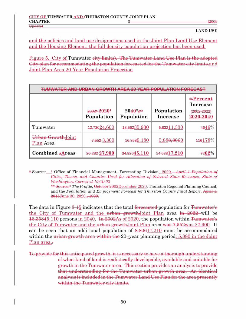
CITY OF TUMWATER AND /THURSTON COUNTY JOINT PLAN
CHAPTER 3 (2009
Update)
LAND USE
50
and the policies and land use designations used in the Joint Plan Land Use Element
and the Housing Element, the full density population projection has been used.
Figure 5. City of Tumwater city limits). The Tumwater Land Use Plan is the adopted
City plan for accommodating the population forecasted for the Tumwater city limits.and
Joint Plan Area 20-Year Population Projection
TUMWATER AND URBAN GROWTH AREA 20 YEAR POPULATION FORECAST
2002* 20201
Population
204022**
Population
Population
Increase
%Percent
Increase
(2002-2022) 2020-2040
Tumwater 12,73024,600 18,56235,930 5,83211,330 4646%
Urban GrowthJoint
Plan Area 7,552 3,300 16,3589,180 5,888,8060 116178%
Combined aAreas 20,282 27,900 34,92045,110 14,63817,210 7262%
* Source: 1 Office of Financial Management, Forecasting Division, 2020.—April 1 Population of
Cities, Towns, and Counties Used for Allocation of Selected State Revenues, State of
Washington, Corrected 10/3/02
** Source:2 The Profile, October 2002December 2020, Thurston Regional Planning Council,
and the Population and Employment Forecast for Thurston County Final Report, April 1,
2015June 30, 2020., 1999.
The data in Figure 3-15 indicates that the total forecasted population for Tumwater's
the City of Tumwater and the urban growthJoint Plan area in 2022 will be
16,35845,110 persons in 2040. In 2002As of 2020, the population within Tumwater's
the City of Tumwater and the urban growthJoint Plan area was 7,552was 27,900. It
can be seen that an additional population of 8,80617,210 must be accommodated
within the urban growth area within the 20 -year planning period, 5,880 in the Joint
Plan area..
To provide for this anticipated growth, it is necessary to have a thorough understanding
of what kind of land is realistically developable, available and suitable for
growth in the Tumwater area. This section provides an analysis to provide
that understanding for the Tumwater urban growth area. An identical
analysis is included in the Tumwater Land Use Plan for the area presently
within the Tumwater city limits.
CITY OF TUMWATER AND /THURSTON COUNTY JOINT PLAN
CHAPTER 3 (2009
Update)
LAND USE
51
The first step in performing an urban area land supply analysis is to determine what
land uses are within the entire City of Tumwater urban growth boundary, including
the City of Tumwater and the Joint Plan area, through a land use inventory and land
use database. As indicated in Chapter 1, Introduction, this has been completed by
the Thurston Regional Planning Council through the Buildable Lands Program.
3.3.2 Partially Used and Under Utilized Land Supply Analysis
It is particularly difficult to determine build out of partially used and under-utilized
land due to several factors such as current economic conditions, property owners
holding property from the market for an anticipated increase in value, businesses
retaining property for future expansion, and residential property owners holding
property in order to retain privacy around an existing unit. Thurston Regional
Planning Council has incorporated these factors into their buildable lands estimates
for 200221.
[Staff Note: References to Buildable Lands Report in the Joint Plan update are the
Draft 2020 Buildable Land Report for Thurston County dated November 2020. The
final 2021 Buildable Lands Report is expected in the summer 2021. In some cases,
as noted below, the data is from the final 2013 Buildable Lands Report, if the
equivalent data was not available yet from the 2021 Buildable Lands Report.
The key findings of the 2013 final and 2021 draft Buildable Lands Reports are that
1) There is sufficient residential, commercial, and industrial land to accommodate the
expected population growth; and 2) There is not a need to adjust the urban growth
area boundary for the City of Tumwater to meet the population targets.]
3.3.3 Developable or Re-Developable Land Supply Analysis
It is important to know that not all of the vacant land in the City of Tumwater and
the Joint Plan area is available for development. Land might not be available for
development for some or all of the following reasons:
1. 1. The land is undevelopable due to environmental constraints such
as geological hazards, and wetlands. These constraints are clarified in the City
of Tumwater Conservation Element. Previously, a factor of 20% was used to
estimate the amount of this type of undevelopable land. However, due to new
data and mapping systems, almost all of the environmental constraints have
beenwere mapped and can be calculated at an acceptable accuracy level.
Thurston Regional Planning Council has done this task and incorporated it
into the 2002 Buildable Lands Report. (Buildable Lands Technical

CITY OF TUMWATER AND /THURSTON COUNTY JOINT PLAN
CHAPTER 3 (2009
Update)
LAND USE
52
Documentation, Table 12) for Thurston County (2021).8
Note: Thurston Regional Planning Council did not use steep slope data in
determining the 2002 buildable lands data for Tumwater and the urban growth
area due to an unacceptable level of accuracy when applied to a parcel based
map. (Buildable Lands Technical Documentation, p.34 and Table 11)
2. A certain amount of vacant land is needed for roads and rights-of-ways.
Thurston Regional Planning Council has calculated that 17% of the vacant
developable land will be needed for future roads and rights-of-way.
3. 3. A certain amount of vacant land will be developed into uses other than
residential. These uses include churches, parks, schools, and daycares;, all of
which are currently allowed within residential zones. Thurston Regional
Planning Council estimates that these uses will consume varying amounts of
land within different residential zones. The amounts are as follows: Multi-
Family High Density is 0%, Multi-Family Medium Density is 2.5%, Single
Family Medium Density is 7.5%, Single Family Low Density is 7.5%,
Residential/Sensitive Resource is 7.5%, and Mixed Use is 0%. (Buildable Lands
Technical Documentation, Table 21)
Thurston Regional Planning Council has determined that 25% of the vacant
developable land, which is being held out of the marketplace for investment, future
expansion, or personal use, will be available for development every five years. It is
assumed that all of this type of land will be available for development at one time or
another during the 20-year planning period.
As a general ruleGenerally, land with the fewest site constraints develops first
because it is less expensive and more convenient to develop. Remaining vacant land
may have more site constraints and be more difficult to develop.
When the preceding factors are taken into consideration, there may be less land
available for development or re-development than is initially apparent. This is shown
in Figures 6, 7, and 8 below.
[Staff Note: The data in Figure 6 is from the final 2013 Buildable Lands Report. If
updated data is available in the final 2021 Buildable Lands Report before the Joint
8 Thurston Regional Planning Council did not use steep slope data in determining the Buildable Lands
data for the City of Tumwater due to an unacceptable level of accuracy when applied to a parcel based
citywide map of the City of Tumwater.

CITY OF TUMWATER AND /THURSTON COUNTY JOINT PLAN
CHAPTER 3 (2009
Update)
LAND USE
53
Plan is adopted, the data in this figure will be updated.]
Figure 6. Buildable Commercial Land in Acres
NET BUILDABLE RESIDENTIAL LAND IN ACRES
City or
Joint Plan
AreaZone
ZoneResidenti
al Buildable
Land*
Future
Roads**Vaca
nt or
Partially-
used
Redevelopable1Oth
er Uses***
OtherNet
Residentia
l Buildable
Land
R/SRCity
SFL
SFM
MFM
MFH
160Brewery
District 2711 12 121-
2261Capitol
Boulevard
Corridor
3848 17028 1707-
570Communit
y Services 970 43- 430-
General
Commercial 164 39 -
Historic
Commercial2 1 11 -
Mixed Use 46 6 -
Neighborhood
Commercial52
9
9013 132 426-
Town Center5 119 010 4Unknow
n3
MU****Joi
nt Plan
Area
3Business
Park
Commercial
Development
017
6
0
10
3
-
General
Commercial 33 2 -
Neighborhood
Commercial 2 1 -
Total for City Only 262 108 -
Total for Joint Plan Area
Only 58 13 -

CITY OF TUMWATER AND /THURSTON COUNTY JOINT PLAN
CHAPTER 3 (2009
Update)
LAND USE
54
Grand Total 35280 599121 238-
Figure 3-2.
R/SR Residential/Sensitive Resource
SFL Single Family Low Density SFM Single Family Medium Density
MFM Multi-Family Medium Density MFH Multi-Family High Density
MU Mixed Use
Source: Thurston Regional Planning Council(TRPC).
*TRPC data was adjusted for annexations and rezones that occurred between January 2000 and
December 2003.
**TRPC estimates 17% of buildable land will be consumed Notes: 1 Land with a moderate to high
likelihood of intensifying uses.with roads.
***TRPC estimates that churches, parks, and schools will consume varying amounts of land within
different residential zones. The amounts are as follows: MFH is 0%, MFM is 2.5%, SFM is 7.5%, SFL
is 7.5%, R/SR is 7.5%, and MU at 0%.
****TRPC estimates that in Tumwater only 10% of land zoned for Mixed Use will develop as residential.
This changes the original 25 acres of buildable Mixed Use land into 3 acres. Source: TRPC 2002
Buildable Lands Technical Documentation—Table 20.
Figure 3-2 shows the net buildable residential land within the urban growth area by
zoning district. The figure first starts with the gross buildable land
acreage of each residential zone. Then land is subtracted for future roads
and other non-residential uses which are allowed in these residential zones
(daycares, churches etc.)
Starting with the Thurston Regional Planning Council buildable lands data, the following assumptions were used for the population accommodation/land supply calculations:
_ 17% of land area will consist of right-of-way and utilities. (Thurston Regional
Planning Council)
_ Churches, parks, and schools will consume varying amounts of land within
different residential zones. (Thurston Regional Planning Council--Buildable
Land Report 2002, Technical Documentation, Table 21)
_ Critical areas and developed land were removed from the buildable lands data
by Thurston Regional Planning Council. (Thurston Regional Planning
Council--Buildable Land Report 2002, Technical Documentation, Table 12)
_ The average number of persons per household in Thurston County will remain
at 2.67 for the twenty year planning period. (Thurston Regional Planning
Council—The Profile October 2002, Table II-9)

CITY OF TUMWATER AND /THURSTON COUNTY JOINT PLAN
CHAPTER 3 (2009
Update)
LAND USE
55
_ 10% of the Mixed Use areas will develop with residential uses and these will
have a density of 14 dwelling units per acre. (Thurston Regional Planning
Council--Buildable Land Report 2002, Technical Documentation, Table 20)
_ 2 Numbers based on Alternative 3 (Maximum Development Intensity) of the
Tumwater Brewery Planning Action Final Environmental Impact Statement. 3 Development will occur with a minimum density policy (potential not
estimated for Port of Olympia's properties in the City of Tumwater Land Use
Plan).and Brewery Properties.
[Staff Note: The data in Figure 7 is from the final 2013 Buildable Lands Report. If
updated data is available in the final 2021 Buildable Lands Report before the Joint
Plan is adopted, the data in this figure will be updated.]
Figure 7. Buildable Industrial Lands in Acres
TOTAL DWELLING UNITS POSSIBLE AT MAXIMUM AND MINIMUM DENSITY BUILDOUT
City or
Joint Plan
AreaZone
ZoneDensity
Range
Dwelling
Units/Acre
Net Buildable
AcresVacant
or
Partially-
used
Dwellings at Minimum
Density
BuildoutRedevelopable1
OtherDwellings
at Maximum
Density Buildout
R/SRCity
SFL
SFM
2-4Airport
Related
Industry 1210 2420 484Unknown 2
Heavy
Industrial4-7 17074 68281 11949-
Light
Industrial6-9 430811 2580131
3870Unknown 2
MFMJoint
Plan Area
Light
Industrial9-
15 426189 392427
6390Unknown 2

CITY OF TUMWATER AND /THURSTON COUNTY JOINT PLAN
CHAPTER 3 (2009
Update)
LAND USE
56
City or
Joint Plan
AreaZone
ZoneDensity
Range
Dwelling
Units/Acre
Net Buildable
AcresVacant
or
Partially-
used
Dwellings at Minimum
Density
BuildoutRedevelopable1
OtherDwellings
at Maximum
Density Buildout
Total for City Only 815 132 -
Total for Joint Plan
Area Only 189 27 -
Grand Total 1,004 159 -
MFH 14-29 4 56 116
MU 14 3 42 42
Total N/A 2691 13672
Figure 3-3.
R/SR Residential/Sensitive Resource
SFL Single Family Low Density
SFM Single Family Medium Density
MFM Multi-Family Medium Density
MFH Multi-Family High Density
MU Mixed Use
Figure 3-3 shows the total number of dwelling units possible at both minimum density
buildout and at maximum density buildout. If all of the net buildable
residential land was built out at the minimum density, there would be
13,672 new dwelling units. If buildout occurred at the maximum density
permitted there would be 22,851 new dwelling units. Both of these
scenarios would provide more than the minimum amount of dwelling units
needed to accommodate the projected population of the Tumwater urban
growth area during the 20-year planning period.
Thurston Regional Planning Council has calculated the average household size in
unincorporated Thurston County to be 2.67 persons. Based on the
projected population increase of 8,806 people and the average household
size of 2.67 persons it can be assumed that there will be a need for 3,298
new residential units in the Tumwater urban growth area in the 20-year
planning period.

CITY OF TUMWATER AND /THURSTON COUNTY JOINT PLAN
CHAPTER 3 (2009
Update)
LAND USE
57
Figure 3-4
Figure 3-4Notes: 1 Land with moderate to high likelihood of intensifying uses. 2 Development potential not estimated for Port of Olympia's properties in the City of
Tumwater and Brewery Properties.
Figure 8. Parcel Area by Acres in Each Zone District in the Joint Plan Area
Zone District Acres
Commercial
Commercial Development (CD)1 21
General Commercial (GC) 62
Neighborhood Commercial (NC) 6
Industrial
Business Park (BP)1 76
High Industrial (HI) 27
Low Industrial (LI) 450
Residential
Greenbelt (GB) 35
Open Space (OS) 122
Residential / Sensitive Resource (RSR) 189
Single Family Low Density 1,297
Single Family Medium Density 175
0 5000 10000 15000 20000
Units at Maximum…
Units at Minimum Density
Units Needed
22851
13672
3298
Joint Planning Area Potential New Dwelling Units
20 Year Planning Period (2002-2022)

CITY OF TUMWATER AND /THURSTON COUNTY JOINT PLAN
CHAPTER 3 (2009
Update)
LAND USE
58
Zone District Acres
Multifamily Medium (MFM) 228
Notes: Information from Appendix III: Residential Capacity and Model Assumptions, Draft 2020
Buildable Land Report for Thurston County dated November 2020. 1 Designations found only in the Joint Plan area.
3.3.4 Analysis of Population Accommodation
In order to determine whether the City and the Joint Plan area have the capacity to
accommodate the projected population, an analysis of all of the proposed residential
land use designations was performed. The Mixed Use designation has been included
in these calculations to reflect the potential of this designation to accommodate
residential development.
Figure 9. Residential Capacity by Planning Area, City and Joint Plan Area
Planning Area City Joint Plan Area Total
Airport 740 0 740
Brewery 660 0 660
Bush Prairie 650 0 650
Deschutes 180 0 180
Littlerock 2,560 100 2,660
Mottman-Black
Lake 150 0 150
New Market 100 0 100
SE Capitol
Boulevard 790 0 790
Southside 0 1,710 1,710
SW Tumwater 90 0 90
Trosper 980 10 980
Tumwater Hill 770 70 840
Westside 0 1,250 1,250
Total 7,660 3,140 10,800
Note: Based on Residential Capacity by Planning Area, Appendix II of the Draft 2020 Buildable
Land Report for Thurston County dated November 2020.
[Staff Note: The data in Figure 10 is from the final 2013 Buildable Lands Report.
If updated data is available in the final 2021 Buildable Lands Report before the Joint
Plan is adopted, the data in this figure will be updated.]

CITY OF TUMWATER AND /THURSTON COUNTY JOINT PLAN
CHAPTER 3 (2009
Update)
LAND USE
59
Figure 10. Residential Land Supply and Future Development Capacity – City
City or
Joint
Plan
Area
Zone
Residential
Buildable Land
Estimate in
year 2013
(Acres)
2014
Dwelling
Units
Additional
Residential
Capacity on
Buildable
Land (2015-
Buildout)
Redevelopment
and Accessory
Dwelling Unit
Estimate
City
Brewery District 1 36 26 221
Capitol Boulevard
Corridor 1 62 25 347
General Commercial 6 99 76 10
Light Industrial - 75 - -
Multifamily High
Density Residential 12 1,053 356 0
Multifamily Medium
Density Residential 157 1,658 1,062 -
Manufactured Home
Park 6 506 28 -
Mixed Use 5 84 117 8
Residential and
Sensitive Resource 149 256 414 -
Single Family Low
Density Residential 674 2,314 2,979 6
Single Family
Medium Density
Residential
414 3,468 1,998 44
Town Center Mixed
Use 0 0 6 1
Town Center
Residential 1 165 18 14
Total for City Only 1,426 9,776 7,105 651
[Staff Note: The data in Figure 11 is from the final 2013 Buildable Lands Report.
If updated data is available in the final 2021 Buildable Lands Report before the Joint
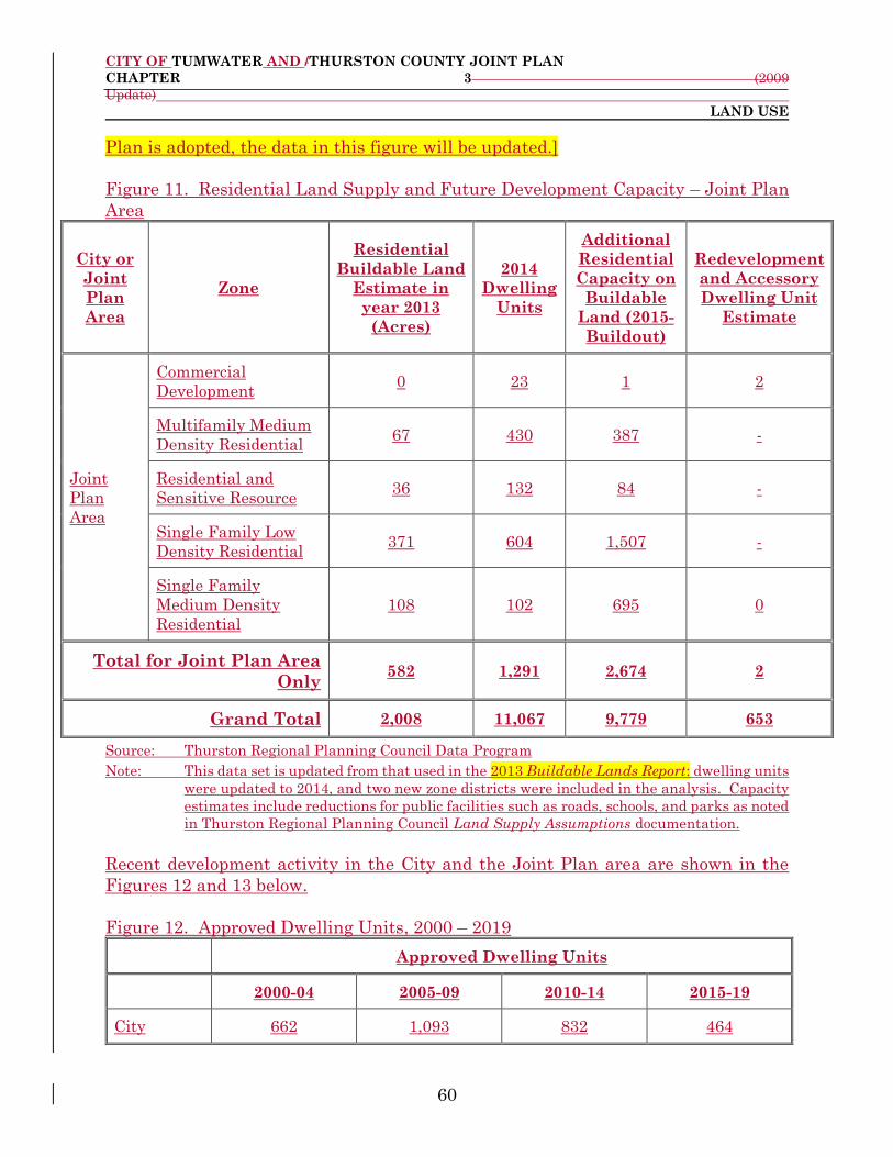
CITY OF TUMWATER AND /THURSTON COUNTY JOINT PLAN
CHAPTER 3 (2009
Update)
LAND USE
60
Plan is adopted, the data in this figure will be updated.]
Figure 11. Residential Land Supply and Future Development Capacity – Joint Plan
Area
City or
Joint
Plan
Area
Zone
Residential
Buildable Land
Estimate in
year 2013
(Acres)
2014
Dwelling
Units
Additional
Residential
Capacity on
Buildable
Land (2015-
Buildout)
Redevelopment
and Accessory
Dwelling Unit
Estimate
Joint
Plan
Area
Commercial
Development 0 23 1 2
Multifamily Medium
Density Residential 67 430 387 -
Residential and
Sensitive Resource 36 132 84 -
Single Family Low
Density Residential 371 604 1,507 -
Single Family
Medium Density
Residential
108 102 695 0
Total for Joint Plan Area
Only 582 1,291 2,674 2
Grand Total 2,008 11,067 9,779 653
Source: Thurston Regional Planning Council Data Program Note: This data set is updated from that used in the 2013 Buildable Lands Report: dwelling units
were updated to 2014, and two new zone districts were included in the analysis. Capacity
estimates include reductions for public facilities such as roads, schools, and parks as noted
in Thurston Regional Planning Council Land Supply Assumptions documentation.
Recent development activity in the City and the Joint Plan area are shown in the
Figures 12 and 13 below.
Figure 12. Approved Dwelling Units, 2000 – 2019
Approved Dwelling Units
2000-04 2005-09 2010-14 2015-19
City 662 1,093 832 464

CITY OF TUMWATER AND /THURSTON COUNTY JOINT PLAN
CHAPTER 3 (2009
Update)
LAND USE
61
Joint Plan
Area 20 6 0 8
Total 682 1,099 832 472
Note: Based on Table 2-1 Achieved Densities in Thurston County Urban Areas, 2000-2019, Draft
2020 Buildable Land Report for Thurston County, dated November 2020.
Figure 13. Density of Residential Subdivisions in the City and Joint Plan Area, 1970s
– 2010s
1970s 1980s 1990s 2000s 2010s
Net 2.1 2.9 3.0 7.8 8.3
Gross 1.6 1.9 1.9 4.0 3.2
Note: Based on Table 2-4 Density of Residential Subdivisions, Draft 2020 Buildable Land Report
for Thurston County, dated November 2020.
Figure 14 shows the expected dwelling units forecasted in the City and Joint Plan
area.
Figure 14. Total Dwelling Unit Forecast in the City and Joint Plan Area
2017 2020 2025 2030 2035 2040
City 10,200 11,510 13,200 14,620 15,870 16,820
Joint Plan
Area 1,400 1,620 2,360 3,110 3,650 4,000
Total 11,600 13,130 15,560 17,730 19,520 20,820
Note: Based on Table 3-2 Total Dwelling Unit Forecast by Jurisdiction, Draft 2020 Buildable
Land Report for Thurston County, dated November 2020.
The draft 2020 Buildable Land Report for Thurston County noted that the urban
areas in the County (cities plus the unincorporated Urban Growth Areas), contains
sufficient land to accommodate the projected population growth. Based on adopted
policies in Thurston County as of 2017, the evaluation shows that:
There is sufficient land supply to accommodate projected population growth to
the year 2040 in Thurston County’s urban areas; and
Each urban area in Thurston County has designated sufficient land supply to
accommodate its projected population growth to the year 2040.

CITY OF TUMWATER AND /THURSTON COUNTY JOINT PLAN
CHAPTER 3 (2009
Update)
LAND USE
62
Questions remain as to how much of the residential land supply will be available for
development due to federal endangered species listings, the availability of water, and
the difficulty of extending sewer service to some parts of the Urban Growth Areas.
Figure 15 shows the forecasted supply and demand of residential dwelling units.
Figure 15. Residential Supply Versus Demand
2020
Dwelling
Units
2040
Dwelling
Units
Future
Demand
2020-2040
Future
Supply
(1) 2020-
Plus
Excess
Capacity
(2)
Percent
Excess
Capacity
(3)
City and
Joint Plan
Area
12,150 20,820 8,670 10,800 2,130 20%
Note: Based on Table 3-3 Residential Supply Versus Demand, Draft 2020 Buildable Land Report
for Thurston County dated November 2020.
Notes: 1. “Future Supply” includes capacity reserved for the market factor plus any additional
unused capacity.
2. “Excess Capacity” is the difference between future demand and future supply. It
includes capacity not available due to market conditions.
3. “Percent Excess Capacity” is excess capacity as a percent of future supply. A value
between 10 and 25 percent across the urban areas is considered reasonable for a healthy
housing market.
[Staff Note: The data in Figure 16 is from the final 2013 Buildable Lands Report.
If updated data is available in the final 2021 Buildable Lands Report before the Joint
Plan is adopted, the data in this figure will be updated.]

CITY OF TUMWATER AND /THURSTON COUNTY JOINT PLAN
CHAPTER 3 (2009
Update)
LAND USE
63
Figure 16. New Dwelling Units Required for 20-Year Planning Period
Figure 16 shows the results of the calculations graphically for the Tumwater urban
growth area. The first third bar of the graph shows the number of residential units
needed to accommodate projected population growth. The second and third bars of the
graph indicate the potential new units that could be constructed. The minimum and
maximum density bars are based on the density ranges of each residential land use
designation. and the Mixed Use designation.
Figure 3-4What the graph shows is that the City of Tumwater and the Joint Planurban
growth area can accommodate the projected population growth. The land supply
analysis demonstrates that the projected population increase of 8,806, and the
resulting need for 3,298 residential dwelling units, can be accommodatedEven if all
development occurs at either the minimum or maximumdensity, accommodation of all
the projected population will be possible. However, it is not expected that the majority
of development will occur at minimum densities allowed by the Joint Plan Future. As
population increases in the Thurston County area and housing costs become
increasingly more expensive due to land and construction costs, it is likely that a larger
market for higher density development will occur.
Each land use designation intended for residential uses will utilize a minimum density
policy. A minimum density policy would require development to be configured so that
infill may occur in the future and would ensure that valuable urban land is not
12,150
20,820
8,670
10,800
2,130
0 5,000 10,000 15,000 20,000 25,000
2020 Dwelling Units
2040 Dwelling Units
Future Demand 2020-2040
Future Supply (1) 2020-Plus
Excess Capacity (2)
Number of Dwelling Units
Dwelling Unit Supply, Demand, and Capacity, 2020 - 2040

CITY OF TUMWATER AND /THURSTON COUNTY JOINT PLAN
CHAPTER 3 (2009
Update)
LAND USE
64
developed at extremely low densities. The minimum density policy is one of the main
tools to accommodate future population in the Joint Plan Land Use Map. Element.
The land supply analysis should be reviewed on a regular basis and new development
should be tracked to determine if the City of Tumwater and the Joint Plan area urban
growth area will meet its population accommodation goals for the 20-year time
period. The population allocated to the City of Tumwater and the Joint Plan area
urban growth area is a forecast; it may not actually occur. The calculations may need
to be adjusted as regional population projections change in the future.
3.4 1994Existing Land Uses and Zoning
Existing land uses and zoning in Thurston County as of 1994 for each of the three
Joint Plan subareas are shown on maps in the appropriate sections of this chapter
whichthat address those subareas. (Sections 3.5.3 through 3.5.5)
3.5 Proposed Land Use Designations
This section of the Joint Plan makes specific recommendations for land use
designations within the Tumwater urban growth areaJoint Plan area. These land
use designations will beare implemented in Title 22, Tumwater Urban Growth
Zoning, Thurston County Code, through follow-on zoning by Thurston Countyand the
Official Zoning Map for the North County Urban Growth Areas, as updated by
Thurston County. For properties that have been assigned residential land use
designations, this zoning will require development to be configured so that the
properties may eventually infill at the designated urban density.
The first subsection below (SectionSubsection 3.5.1, Definitions and Criteria for Land
Use Designations,) defines each of the land use designations used in theis Joint Plan.
It also contains the Joint Plan Land Use Map, which shows locations where these
land uses will be applied. Subsection 3.5.2, Innovative Housing and Land Use
Methods – Definitions, further defines several of the innovative housing and land use
methods recommended in this planthe Joint Plan.
The urban growth areaJoint Plan area has been divided into three subareas:
Eastern 9 , Southern, and Western. Each subarea is addressed in a separate
subsection through the use ofwith maps and text identifying specific land use
designations for particular areas (see Subsections 3.5.3 through 3.5.5). .
3.5.1 Policies/Definitions and Criteria for Land Use Designations/Definitions
9 The entire Eastern Subarea was annexed to City of Tumwater in 2016.

CITY OF TUMWATER AND /THURSTON COUNTY JOINT PLAN
CHAPTER 3 (2009
Update)
LAND USE
65
The purpose of this subsection is to define each land use designation and to identify
criteria for their use. These definitions and criteria should be used to understand the
Joint Plan land use maps and subarea text recommendations. Additionally, these
definitions and criteria are also meant to be used in conjunction with Section 3.2,
Goals/ and Policies/Objectives.. The categories of land use designations in this
subsection are consistent with those in the City of Tumwater Land Use PlanElement,
which applies to the area currently within the City of Tumwater citymunicipal limits.
At the end of this subsection are definitions of the innovative housing and land use
methods discussed in the residential land use portions of this subsection.
Figure 3-517 shows all of the land use designations that have beenare currently
applied within the Joint Plan. These designations are meant to address all existing
as of 1994 land uses and potential land uses that could occur in the Tumwater urban
growth areaJoint Plan area.
The number of designations have been kept to a minimum in the interest of
simplicity.
[Staff Note: Need to recalculate these areas based on annexations and any maps
changes agree to do as part of these discussions.]
Figure 17. Joint Plan Land Use Designations
Designation
Abbreviation and
Density Per Acre
Full Designation Acreage
R/SR 2-4 Residential/Sensitive
Resource 206
SFL 4-7 Single Family Low
Density 1,208
SFM 6-9 Single Family Medium
Density 196
MFM 9-15 Multifamily Medium
Density 224
MU Mixed Use 23
NC Neighborhood Commercial 16
GC General Commercial 95
LI Light Industry 566
HI Heavy Industry 22
P/OS Parks/Open Space 210
UT Utilities 111
Figure 3-5

CITY OF TUMWATER AND /THURSTON COUNTY JOINT PLAN
CHAPTER 3 (2009
Update)
LAND USE
66
Source: City of Tumwater GIS data - Joint Plan.shp
One of the purposes of the land use designations that have been used in the Joint
Plan is to implement and achieve the goals, policies, and objectivesactions listed in
Section 3.2, Goals and Policies.
The Joint Plan Land Use Map (Map 3-1) represents the general future land use
patterns that are desired for the Tumwater urban growth areaJoint Plan area within
the 20 -year planning period. The designations and policy recommendations for areas
on the map are based on a number of factors, including:
_ Natural features
_ The unique physical and social and /economic characteristics in the area
_ The type of existing development
_ Existing zone districtsing
_ Ownership patterns
_ The condition of existing structures
_ Plans previously adopted by the City and/or County that affect land use.
Examples include the Shoreline Master Program Thurston County Shoreline
Master Program, the City of Tumwater Urban Forestry Management Plan,
and the Tumwater City of Tumwater Economic Development Plan.
The Joint Plan Land Use Map may be used to evaluate individual land use proposals.
It is intended to be a guide for both public and private actions affecting the growth
and development of the City of Tumwater.
In interpreting this planthe Joint Plan, the following definitions and criteria of the
land use designations and the associated goals, policies, and objectivesactions in
Section 3.2, Goals and Policies, should be given the greatest weight and importance.
The Joint Plan Future Land Use Map is intended to be a visual representation of the
descriptions and policies. Where there are apparent inconsistencies between the text
and the map, the text shall control.
The Joint Plan Land Use Map is not a zoning map. In many cases, more than one
zoneing district cwould be consistent with the policy recommendations of a particular
land use designation.
CITY OF TUMWATER AND /THURSTON COUNTY JOINT PLAN
CHAPTER 3 (2009
Update)
LAND USE
67
It should be noted that density ranges for the residential land use designations are
based on net density. Net density means the total number of dwelling units divided
by the net area of the site or area. Net area typically excludes streets; streams, ponds,
and other water areas; and areas with environmental constraints such as flood plains,
wetlands, and steep slopes. Net density can also be defined as developable land.
Gross density means the total number of dwelling units divided by the total land area
of the site or area excluding nothing. The difference between gross and net density
is critical. Roads and parking, both included in gross density, often require up to 20%
of a site.
The Joint Plan Land Use Map is intended to indicate the type of future development
that is desired as the growth areaJoint Plan area is gradually annexed into the City
of Tumwater, while allowing flexibility for previously approved development. It is
important to keep in mind that this planthe Joint Plan addresses a twenty 20-year
time period. The changes that result from the policy recommendations in this planthe
Joint Plan will likely take place slowly over time and will result in incremental
changes as annexation and development occur.
Following are specific definitions for each land use designation and criteria for their
use.
3.5.1.1 Residential Uses
The quality and integrity of residential neighborhoods defines the character of
the community and makes it unique. Ensuring that these neighborhoods remain
stable and vital is of primary importance. Residential designations in the Tumwater
areaJoint Plan area should provide a broad range of housing choices to meet the needs
of all people in the community.
Residential development should be developed with the following guidelines:
_ Residential development should provide for a dynamic mix of
housing types to accommodate many diverse housing needs.
_ New residential development should provide open spaces. "Wall
to wall" development is not acceptable.

CITY OF TUMWATER AND /THURSTON COUNTY JOINT PLAN
CHAPTER 3 (2009
Update)
LAND USE
68
_ Ensure that housing is compatible in quality, design, and
intensity with surrounding land uses, traffic patterns, public facilities and
services, and environmentally sensitive areas.
_ Ensure that new residential development promotes a reasonable
diversity in housing types.
_ Support the stability of established residential neighborhoods.
_ Support incentives for housing ownership in addition to rental
housing.
_ Enhance the appearance of and maintain public spaces in
residential areas.
_ Promote community involvement to achieve neighborhood
improvement.
In order to meet the goals of the Growth Management Act, the County-Wide
Planning Policies, and this planthe Joint Plan, six designations for residential land
use have been developed. Each of these designations has specific criteria and
characteristics for development:
Residential/Sensitive Resource (2-4 DU/Dwelling Units Per
Acre)
The purpose of this designation is to recognize areas of unique open
space character and sensitivity to environmental disturbance such as around
stream corridors, lakes, wetlands, and environmentally hazardous areas such
as high groundwater flooding areas.
Residential/Sensitive Resource areas are intended to be used only for
exceptional places. This designation should be applied to areas that are not
protected by the State Shoreline Management Act and are not already built
out. These areas are where intensive urban development would adversely
affect ground or surface waters or environmental resource areas. In addition
to being of a relatively low density, development in these areas should be
clustered. Clustering means grouping or "clustering" development onto part of
a property so that the remainder can be preserved as unbuilt open space.
The intent of clustering development in this area is to preserve open space
along environmentally sensitive areas and provide a lot configuration that
allows for future applied density to be achieved over the twenty 20-year time

CITY OF TUMWATER AND /THURSTON COUNTY JOINT PLAN
CHAPTER 3 (2009
Update)
LAND USE
69
period. In addition to clustering, other methods of preserving open space shall
be strongly encouraged such as purchase or donation, easements or deed
restrictions, covenants, land exchanges, and transfer of development rights as
a method of preserving open space and to guideguiding development into less
sensitive portions of the land. Densities in this designation should be 2-4
DU/Acre.
In order to protect groundwater and surface water resources from
contamination by failing septic tanks and runoff and to ensure that urban
services can be provided to certain areas in a cost efficient manner, a minimum
density of 2 DU/Acretwo dwelling units per acre and a maximum density of 4
DU/Acre isfour dwelling units per acre are recommended.
It is not Tthe intent of this policy is not to prohibit construction on lots
larger than those required for to meet minimum density requirements. What
is important is that the property haves the capacity to be developed at the
minimum density in the future.
For example: If a property owner proposes to construct a house on a 5five acre
lot and the minimum density is 2two dwelling units per acre (1/2 acre lots) they
would not be prohibited from doing so. However, the house must be sited on
the 5 -acre lot such that other houses could be built on the site in the future if
needed.
Soils and other natural systems should be capable of supporting
densities of up to 4four dwelling units per acre with urban services without
resulting in the degradation of sensitive areas such as stream corridors, lakes,
and sensitive aquifers.
The full range of urban services should be available or be planned in the
near future in accordance with the City'sCity of Tumwater Capital Facilities
Plan. In order to protect ground and surface water resources from
contamination by failing septic tanks, densities should be adequate to ensure
the provision of sewers to these areas.
In areas where septic systems presently exist, on-site sewage disposal
systems may be required to be repaired or replaced to ensure proper
functioning to prevent pollution of groundwater and wetland areas.
This designation is appropriate for environmentally sensitive areas such
as stream corridors, lakes, sensitive aquifers, and environmentally hazardous
areas such as high groundwater flooding areas. Areas designated

CITY OF TUMWATER AND /THURSTON COUNTY JOINT PLAN
CHAPTER 3 (2009
Update)
LAND USE
70
Residential/Sensitive Resource are extremely sensitive to environmental
disturbance, and development in these areas may be subject to additional
environmental constraints not encountered in other parts of the urban growth
areaJoint Plan area.
Construction activities in areas assigned this designation should only
occur in the drier months of the year in order to protect surface water from
sedimentation and construction associated runoff. This policy
recommendation should be addressed along with other construction related
concerns in the development of implementing regulations relative to this
Residential/Sensitive Resource designation.
Density transfer provisions are not appropriate in this designation due
to the extreme sensitivity of these areas to environmental disturbance and the
desire to provide relative density continuity between different development
sites within this density designation that may or may not qualify for the
density transfer provisions.
Additionally, density transfer provisions for wetland and buffer areas as
outlined in the Thurston County Critical Areas Ordinance should be limited.
Any transfer of density from wetlands, buffer areas, and clustering bonuses
should be capped so the maximum net development density in the remaining
developable area excluding dedications is not greater than 125% of the
maximum density that would otherwise be allowed. This density transfer
provision is limited at this time to the Residential/Sensitive Resource
designation but this policy should be examined as part of the implementing
regulations for inclusion throughout the urban growth areaJoint Plan area.
[Staff Note: Further discussion needed. The City uses net density (excluding
critical areas from the calculation) and the County uses gross density for a site.
This makes development in the Joint Plan area different than development in
the City.]
Where clustering is used, it should be applied in the following manner
in areas with this designation:
o _ Clustering is recommended for development proposals in
the Residential/Sensitive Resource designation.
o _ Open space preserved through clustering should be at least
30% of the gross area of the site. Of this 30%, at least half should be
useable for passive recreational purposes. Passive recreational uses
include activities such as hiking, bicycling, horseback riding, and

CITY OF TUMWATER AND /THURSTON COUNTY JOINT PLAN
CHAPTER 3 (2009
Update)
LAND USE
71
fishing; and areas that provide access to shorelines and other
recreational uses (Tumwater based on the City of Tumwater Parks and,
Recreation, and Open Space Plan). If half (50%) of the 30% preserved
for open space on a lot or development proposal is not useable for passive
recreational purposes, then an additional amount of open space should
be set aside to make the amount of area useable for passive recreational
purposes. This area should be equal to the amount of open space area
that is not useable for passive recreational purposes.
Both UIBC and HUD types of manufactured housing should be
permitted on single lots in this designation, subject to design standards.
Mobile home parks which were legally established prior to adoption of
this plan andthe Joint Plan that are located on lands designated
Residential/Sensitive Resource, Single-Family Residential, Multifamily
Residential, or Light Industrial should be treated as a permitted use in the
implementing zoning, except where there is a cessation of the use for three or
more years. Expansion of the mobile home park area should not be allowed;
however, enlargement of units within existing mobile home spaces should be
permitted. Consider adding existing mobile home parks to the Manufactured
Home Park (MHP) land use designation and zone district.
Single-Family Low Density (4-7 DU/Dwelling Units Per Acre)
Design standards have not been recommended for this designation because
development at this density generally has less visual impacts than higher
densities.
The density of new development in the Single-Family Low Density
designation should be averaged over the entire site in order to reach the
required densities. It is not the intent to require that lots be of a specific size
but that densities beare met as an average of the overall site.
Clustering should be considered in this residential designation to
protect sensitive areas yet still accommodate residential development.
Both UIBC and HUD types of manufactured housing should be
permitted on single lots in this designation, subject to design standards.
Accessory units should be permitted in this designation within the
permitted density on sewered lots with sewer, except where the Thurston
County Public Health and Social Services Department has approved septic
CITY OF TUMWATER AND /THURSTON COUNTY JOINT PLAN
CHAPTER 3 (2009
Update)
LAND USE
72
systems. Accessory units will provide affordable housing and extra income for
homeowners.
Duplexes should not be permitted in this designation due to density
considerationssubject to limitations in new short plats and subdivisions and
the lack of design standards. However, duplexes which were legally
established prior to adoption of this plan and that are located on lands
designated Single-Family Residential Low Density should be treated as a
permitted use in the implementing zoning, except where there is a cessation of
the use for three or more years. Additional dwelling units should not be
allowed to be added to existing duplex structures; however, enlargement of
existing duplex units should be permitted within the limitations established
by the implementing zoning.
Some neighborhood-scale commercial uses are appropriate in this residential
designation to serve the needs of the local neighborhood. These uses may
include neighborhood-scale retail uses, personal services, and small
professional offices, including residences in conjunction with these businesses.
These uses should be allowed only as conditional uses in all residential zones
to ensure that the uses demonstrate compatibility with the existing
neighborhood. Compatibility should be achieved through the use of buildings
that are sized and designed to be residential in scale; small overall area
devoted to neighborhood-scale commercial use; and design and layout which
screens residential areas from excessive noise, lights, storage and parking
areas. These uses should be oriented primarily to pedestrian and bicycle use;
uses which would result in excessive automobile traffic should be discouraged
(e.g., gas stations, drive-thru restaurants).
Most neighborhood-scale commercial areas serving a particular
neighborhood will consist of one business. However, new neighborhood-scale
commercial uses may be considered in areas where one or more such uses
already exist. In those cases, additional businesses should be located adjacent
to the existing business in small clusters to avoid the development of
commercial strips or many small businesses strung out along transportation
corridors.
Mobile home parks which were legally established prior to adoption of
this plan and that are located on lands designated Residential/Sensitive
Resource, Single-Family Residential or Light Industrial should be treated as a
permitted use in the implementing zoning, except where there is a cessation of
the use for three or more years. Expansion of the mobile home park area
should not be allowed; however, enlargement of units within existing mobile
home spaces should be permitted.

CITY OF TUMWATER AND /THURSTON COUNTY JOINT PLAN
CHAPTER 3 (2009
Update)
LAND USE
73
Single Family Medium Density (6-9 DU/Acre)
The density of new development in the Single-Family Medium Density
designation should be averaged over the entire site in order to reach the
required densities. It is not the intent to require that lots be of a specific size
but that densities be met as an average of the overall site.
Design review should be applied in this designation for development
that is of a greater intensity and scale than the existing and adjacent
neighborhood in order to ensure neighborhood compatibility of new
development.
It is envisioned that underlying zoning in this designation would permit
innovative housing techniques such as attached single family, alley houses, Z-
lot and alternate width lot housing. In order for these techniques to be used,
there must be mechanisms to ensure neighborhood compatibility and design
quality. Some of the innovative techniques that could be used in this
designation include small single family housing with alleys and zero lot line or
Z-lot developments.
Clustering should be considered in this residential designation to
protect sensitive areas yet still accommodate residential development.
Accessory units should be permitted within the permitted density in this
designation on sewered lots to provide affordable housing and extra income for
homeowners.
Duplexes should be permitted in this designation subject to design
standards. Both UBC and HUD types of manufactured housing should be
permitted on single lots in this designation, subject to design standards.
This residential designation should provide a mix of housing types in
order to provide affordable housing and ensure neighborhood stability.
Some neighborhood-scale commercial uses are appropriate in this
residential designation to serve the needs of the local neighborhood. These
uses may include neighborhood-scale retail uses, personal services, and small
professional offices, including residences in conjunction with these businesses.
These uses should be allowed only as conditional uses in all residential zones
to ensure that the uses demonstrate compatibility with the existing
neighborhood. Compatibility should be achieved through the use ofwith
buildings that are sized and designed to be residential in scale; small overall

CITY OF TUMWATER AND /THURSTON COUNTY JOINT PLAN
CHAPTER 3 (2009
Update)
LAND USE
74
area devoted to neighborhood-scale commercial use; and design and layout
whichthat screens residential areas from excessive noise, lights, storage, and
parking areas. These uses should be oriented to primarily to pedestrian and
bicycle use; uses which would resultresulting in excessive automobile traffic
and noise and light impacts should not be allowdiscouraged (e.g.,, such as gas
stations, drive-thru restaurants)..
Most neighborhood-scale commercial areas serving a particular
neighborhood will consist of one business. However, new neighborhood-scale
commercial uses may be considered in areas where one or more such uses
already exist. In those cases, additional businesses should be located adjacent
to the existing business in small clusters to avoid the development of
commercial strips or many small businesses strung out along transportation
corridors.
Mobile home parks which were legally established prior to adoption of
this plan and that are located on lands designated Residential/Sensitive
Resource, Single-Family Residential or Light Industrial should be treated as a
permitted use in the implementing zoning, except where there is a cessation of
the use for three or more years. Expansion of the mobile home park area
should not be allowed; however, enlargement of units within existing mobile
home spaces should be permitted.
Multi-Family Medium Density (9-15 DU/Acre)
Design review should be applied in this designation for development
that is of a greater intensity and scale than the existing and adjacent
neighborhood in order to ensure that multi-family development is compatible
with existing and surrounding neighborhoods.
The density of new development in the Multi-Family Medium Density
designation should be averaged over the entire site in order to reach the
required densities. It is not the intent to require that lots be of a specific size
but that densities be met as an average of the overall site.
Detached single-family housing could be provided in the Multi-Family
Medium Density designation as long as the overall site meets the density goals
of the designation. The intent of this policy is to ensure diversity in housing
types in these areas. This residential designation is meant to provide
primarily for multi-family condominium and apartment types of structures.
Clustering should be considered in this residential designation to
protect sensitive areas yet still accommodate residential development.

CITY OF TUMWATER AND /THURSTON COUNTY JOINT PLAN
CHAPTER 3 (2009
Update)
LAND USE
75
Accessory units should be permitted in this designation within the
permitted density on sewered lots to provide affordable housing and extra
income for homeowners.
Both UBC and HUD types of manufactured housing should be permitted on
single lots in this designation subject to design standards.
Mobile home parks should be permitted in the Multi-Family Residential
Medium Density designation subject to development at City standards and site
plan review by the Hearing Examiner.
Additionally, Multi-Family Medium Density designated areas should be
accompanied by open space, environmental protection for sensitive areas and
mass transit linkage in order to make these higher densities viable and
compatible with the community.
Some neighborhood-scale commercial uses are appropriate in this residential
designation to serve the needs of the local neighborhood. These uses may
include neighborhood-scale retail uses, personal services, and small
professional offices, including residences in conjunction with these businesses.
These uses should be allowed only as conditional uses in all residential zones
to ensure that the uses demonstrate compatibility with the existing
neighborhood. Compatibility should be achieved through the use of buildings
that are sized and designed to be residential in scale; small overall area
devoted to neighborhood-scale commercial use; and design and layout which
screens residential areas from excessive noise, lights, storage and parking
areas. These uses should be oriented primarily to pedestrian and bicycle use;
uses which would result in excessive automobile traffic should be discouraged
(e.g., gas stations, drive-thru restaurants).
Most neighborhood-scale commercial areas serving a particular
neighborhood will consist of one business. However, new neighborhood-scale
commercial uses may be considered in areas where one or more such uses
already exist. In those cases, additional businesses should be located adjacent
to the existing business in small clusters to avoid the development of
commercial strips or many small businesses strung out along transportation
corridors.
Multi-Family High Density (14-29 DU/Acre)
Mobile home parks legally established prior to adoption of the Joint Plan
that are located on lands designated Residential/Sensitive Resource, Single-
CITY OF TUMWATER AND /THURSTON COUNTY JOINT PLAN
CHAPTER 3 (2009
Update)
LAND USE
76
Family Residential, Multifamily Residential, or Light Industrial should be
treated as a permitted use in the implementing zoning, except where there is
a cessation of the use for three or more years. Expansion of the mobile home
park area should not be allowed; however, enlargement of units within existing
mobile home spaces should be permitted. Consider adding existing mobile
home parks to the Manufactured Home Park (MHP) land use designation and
zone district.
Single Family Medium Density (6-9 Dwelling Units Per Acre)
The density of new development in the Single-Family Medium Density
designation should be averaged over the entire site in order to reach the
required densities. It is not the intent to require that lots be of a specific size
but that densities are met as an average of the overall site.
Design review should be applied in this designation for development that is of
a greater intensity and scale than the existing and adjacent neighborhood in
order to ensure neighborhood compatibility of new development.
It is envisioned that underlying zone district in this designation would permit
innovative housing techniques such as attached single family, alley houses, Z-
lot, and alternate width lot housing. In order for these techniques to be used,
there must be mechanisms to ensure neighborhood compatibility and design
quality. Some of the innovative techniques that could be used in this
designation include small single-family housing with alleys and zero lot line or
Z-lot developments.
Design review should be applied to development in this designation to ensure
that multi-family development is compatible with existing and surrounding
neighborhoods.
The Multi-Family High Density designation should primarily be applied in
areas that are planned-for major transportation corridors. Specific minimum
density requirements for certain areas will be developed in the Tumwater
Zoning Ordinance. The density of new development in the Multi-Family High
Density designation should be averaged over the entire site in order to reach
the required densities. It is not the intent to require that lots be of a specific
size but that densities be met as an average of the overall site.
Clustering should be considered in this residential designation to
protect sensitive areas yet still accommodate residential development.
Accessory units should be permitted within the permitted density in this
CITY OF TUMWATER AND /THURSTON COUNTY JOINT PLAN
CHAPTER 3 (2009
Update)
LAND USE
77
designation on sewered lots to provide affordable housing and extra income for
homeowners.
Accessory unitsDuplexes should be permitted in this designation only in
areas subject to the City of Tumwater Citywide Design Guidelines.
Both IBC and HUD types of existing lower density manufactured housing
should be permitted on single family development on sewered lots in this
designation.
This residential designation should provide a mix of housing types in order to
provide affordable housing and ensure neighborhood stability.
Some neighborhood-scale commercial uses are appropriate in this residential
designation to serve the needs of the local neighborhood. These uses may
include neighborhood-scale retail uses, personal services, and small
professional offices, including residences in conjunction with these businesses.
These uses should be allowed only as conditional uses in all residential zones
to ensure that the uses demonstrate compatibility with the existing
neighborhood.
Compatibility should be achieved with buildings that are sized and designed
to be residential in scale; small overall area devoted to neighborhood-scale
commercial use; and design and layout that screens residential areas from
excessive noise, lights, storage, and parking areas. These uses should be
oriented to primarily pedestrian and bicycle use. Uses resulting in excessive
automobile traffic and noise and light impacts should not be allowed, such as
gas stations, drive-thru restaurants.
Most neighborhood-scale commercial areas serving a particular neighborhood
will consist of one business. However, new neighborhood-scale commercial
uses may be considered in areas where one or more such uses already exist. In
those cases, additional businesses should be located adjacent to the existing
business in small clusters to avoid the development of commercial strips or
many small businesses strung out along transportation corridors.
Mobile home parks legally established prior to adoption of the Joint Plan that
are located on lands designated Residential/Sensitive Resource, Single-Family
Residential, Multifamily Residential, or Light Industrial should be treated as
a permitted use in the implementing zone district, except where there is a
cessation of the use for three or more years. Expansion of the mobile home
park area should not be allowed; however, enlargement of units within existing
mobile home spaces should be permitted. Consider adding existing mobile
CITY OF TUMWATER AND /THURSTON COUNTY JOINT PLAN
CHAPTER 3 (2009
Update)
LAND USE
78
home parks to the Manufactured Home Park (MHP) land use designation and
zone district.
. Minimum density requirements would preclude accessory units within new
development in this designation.
Multif-Family Medium Density (9-15 Dwelling Units Per Acre)
Design review should be applied in this designation designation for
development that is of a greater intensity and scale than the existing and
adjacent neighborhood in order to ensure that multi-familymultifamily
development is compatible with existing and surrounding neighborhoods.
The density of new development in the Multifamily Medium Density
designation should be averaged over the entire site in order to reach the
required densities. It is not the intent to require that lots be of a specific size
but that densities are met as an average of the overall site.
Detached single-family housing could be provided in the Multi-
FamilyMultifamily Medium Density designation as long as the overall site
meets the density goals of the designation. The intent of this policy is to ensure
diversity in housing types in these areas. This residential designation is meant
to provide primarily for multi-familymultifamily condominium and apartment
types of structures.
Clustering should be considered in this residential designation to protect
sensitive areas yet still accommodate residential development.
Accessory units should be permitted in this designation within the permitted
density on sewered lots to provide affordable housing and extra income for
homeowners.
Both IBC and HUD types of manufactured housing should be permitted on
single lots in this designation.
Mobile home parks should be permitted in the Multi-Family Residential Medium
Density designation subject to development at City standards and site plan review
by the Hearing Examiner.High
Mobile home parks legally established prior to adoption of the Joint Plan that
are located on lands designated Residential/Sensitive Resource, Single-Family
Residential, Multifamily Residential, or Light Industrial should be treated as
a permitted use in the implementing zone district, except where there is a
cessation of the use for three or more years. Expansion of the mobile home
park area should not be allowed; however, enlargement of units within existing

CITY OF TUMWATER AND /THURSTON COUNTY JOINT PLAN
CHAPTER 3 (2009
Update)
LAND USE
79
mobile home spaces should be permitted. Consider adding existing mobile
home parks to the Manufactured Home Park (MHP) land use designation and
zone district.
Additionally, Multifamily Medium Density designated areas should be
accompanied by significant open spaces, environmental protection for sensitive
areas, and mass transit linkage in order to make these higher densities viable
and compatible with the community.
Some neighborhood-scale commercial uses are appropriate in this
residential designation to serve the needs of the local neighborhood. These
uses may include neighborhood-scale retail uses, personal services, and small
professional offices, including residences in conjunction with these businesses.
These uses should be allowed only as conditional uses in all residential zones
to ensure that the uses demonstrate compatibility with the existing
neighborhood.
Compatibility should be achieved through the use ofwith buildings that are
sized and designed to be residential in scale; small overall area devoted to
neighborhood-scale commercial use; and design and layout whichthat screens
residential areas from excessive noise, lights, storage, and parking areas.
These uses should be oriented to primarily to pedestrian and bicycle use; uses
which would resultresulting in excessive automobile traffic and noise and light
impacts should not be allowdiscouraged (e.g.,, such as gas stations, drive-thru
restaurants)..
Most neighborhood-scale commercial areas serving a particular neighborhood
will consist of one business. However, new neighborhood-scale commercial
uses may be considered in areas where one or more such uses already exist.
In those cases, additional businesses should be located adjacent to the existing
business in small clusters to avoid the development of commercial strips or
many small businesses strung out along transportation corridors.
Multifamily High Density (14-29 Dwelling Units Per Acre)
Design review should be applied to development in this designation to ensure
that multi-familymultifamily development is compatible with existing and
surrounding neighborhoods.
The Multi-FamilyMultifamily High Density designation should primarily be
applied in areas that are planned-for major transportation corridors. Specific
minimum density requirements for certain areas will be developed in the

CITY OF TUMWATER AND /THURSTON COUNTY JOINT PLAN
CHAPTER 3 (2009
Update)
LAND USE
80
Tumwater Municipal Code. The density of new development in the Multi-
FamilyMultifamily High Density designation should be averaged over the
entire site in order to reach the required densities. It is not the intent to
require that lots be of a specific size but that densities
Clustering should be considered in this residential designation to protect
sensitive areas yet still accommodate residential development.
Accessory units should be permitted in this designation only in areas of
existing lower density single-family development on sewered lots. Minimum
density requirements would preclude accessory units within new development
in this designation.
Multifamily High Density designated areas should be accompanied by
significant open spaces, environmental protection for sensitive areas, and mass
transit linkage in order to make these higher densities viable and compatible
with the community.
Some neighborhood-scale commercial uses are appropriate in this residential
designation to serve the needs of the local neighborhood. These uses may
include neighborhood-scale retail uses, personal services, and small
professional offices, including residences in conjunction with these businesses.
These uses should be allowed only as conditional uses in all residential zones
to ensure that the uses demonstrate compatibility with the existing
neighborhood.
Compatibility should be achieved with buildings that are sized and designed
to be residential in scale; small overall area devoted to neighborhood-scale
commercial use; and design and layout that screens residential areas from
excessive noise, lights, storage, and parking areas. These uses should be
oriented to primarily pedestrian and bicycle use; uses resulting in excessive
automobile and noise and light impacts should not be allowed, such as gas
stations, drive-thru restaurants.
Most neighborhood-scale commercial areas serving a particular neighborhood
will consist of one business. However, new neighborhood-scale commercial
uses may be considered in areas where one or more such uses already exist. In
those cases, additional businesses should be located adjacent to the existing
business in small clusters to avoid the development of commercial strips or
many small businesses strung out along transportation corridors.
Most neighborhood-scale commercial areas serving a particular
neighborhood will consist of one business. However, new neighborhood-scale

CITY OF TUMWATER AND /THURSTON COUNTY JOINT PLAN
CHAPTER 3 (2009
Update)
LAND USE
81
commercial uses may be considered in areas where one or more such uses
already exist. In those cases, additional businesses should be located adjacent
to the existing business in small clusters to avoid the development of
commercial strips or many small businesses strung out along transportation
corridors.
Figure 3-6181 provides a summary of innovative land use techniques
that are recommended to be used in each applicable residential designation.
Figure 18. Innovative Land Use Management Techniques for Residential
Development
INNOVATIVE LAND
USE MANAGEMENT
TECHNIQUES FOR
RESIDENTIAL
DEVELOPMENT
Single-
Family
Low
Density 4-7
Dwelling
Units Per
Acre
Single-
Family
Medium
Density 6-9
Dwelling
Units Per
Acre
Multifamily
Medium
Density 9-15
Dwelling
Units Per
Acre
Multifamily
High Density
14-29
Dwelling
Units Per
Acre
Design Review
XSingle-Family
Low Density
4-7
DU/Acre
Single-Family
Medium Density
6-9
DU/AcreX
Multi-Family
Medium Density
9-15
DU/AcreX
Multi-Family
High Density
14-29
DU/AcreX
Design
ReviewRevised
Development
Standards
X xX xX xX
Minimum Average
DensityRevised
Development
Standards
xX
xX
xX
xX
Minimum Average
Density x x x x
Clustering xX xX xX xX
Manufactured
Homes
on single lots
xX
xX
xX
CITY OF TUMWATER AND /THURSTON COUNTY JOINT PLAN
CHAPTER 3 (2009
Update)
LAND USE
82
INNOVATIVE LAND
USE MANAGEMENT
TECHNIQUES FOR
RESIDENTIAL
DEVELOPMENT
Single-
Family
Low
Density 4-7
Dwelling
Units Per
Acre
Single-
Family
Medium
Density 6-9
Dwelling
Units Per
Acre
Multifamily
Medium
Density 9-15
Dwelling
Units Per
Acre
Multifamily
High Density
14-29
Dwelling
Units Per
Acre
Accessory
Dwelling units X X X
Figure 3-6
3.5.1.2 Mixed Use [4 -14] (Residential [Minimum 14] DU/Dwelling Units per
Acre)1
It is the intent of the Mixed- Use designation that there beis a mixture of
commercial and residential uses in close proximity. Mixed use can include but is not
limited to mixed -use buildings with retail or office uses on the first floor and
residential above.
The Mixed Use designation provides an opportunity to develop areas that are
transit oriented and pedestrian friendly while still accommodating automobiles,
support small businesses and consumers, and provide affordable housing and quality
community design.
With architectural design and creative site planning, it is very possible to
provide fine, livable dwelling units that are mixed in with commercial uses.
However, it is not enough to merely allow a mixing togethermixture of uses.
Land use regulations and zoning need to encourage mixed -use development. New
models of mixed -use development require a finer grain of mixture, to encourage
walkability and vitality. Such development concepts as urban villages, pedestrian
pockets, and neo-traditional neighborhood design rely heavily on a mixture of uses to
be successful.
1 Bracketed, underlined text was adopted by the Tumwater City Council in October 1998. Bracketed, bold text
was retained by the Thurston County Board of Commissioners, but was deleted by the Tumwater City Council.

CITY OF TUMWATER AND /THURSTON COUNTY JOINT PLAN
CHAPTER 3 (2009
Update)
LAND USE
83
Residential densities in the Mixed Use designation should be [between 4 and]
[a minimum of] 14 dwelling units per acre. It is expected that these densities will be
difficult to reach in the near term. However, it is in the best interest of the citizens
of the City of Tumwater that the City moves in the direction of reaching these goals
by the end of the 20 -year planning period.
Mixed -use areas, when developed with design and development guidelines,
have characteristics that include:
_ Transit orientation whichthat lessens traffic impacts by providing
ready access to mass transit and provides places to work and shop adjacent to
living spaces, thus lessening the need to drive.
_ The provision of affordable housing by providing more available
building lots at a lower cost.
_ A pedestrian friendly environment due to well -designed streets,
parks, and public open spaces.
_ The provision of a sense of community and place due to quality
community design.
Areas designated Mixed Use should be developed according to design and
development guidelines that promote quality community design. Design and
development guidelines can supplement zoning codes. They are typically concise,
easy to understand, and illustrated with diagrams and drawings. They have proven
very effective in promoting well-designed mixed -use development. Incompatible uses
such as industry, warehousing and distribution, chemical handling, and those uses
which generate significant noise or are heavily truck-dependent should not be
permitted in mixed use areas.
Mixed -use areas designated on the Joint Plan Land Use Map consist of two
distinct types of mixed use: those that are presently partially developed and have
existing mixed uses on site and those areas that are predominantly vacant and of a
larger area than the built out mixed use areas. The zoning for these areas should
recognize the distinct differences in these two areas and ensure that zoning is
workable and does not act as a disincentive for the development of mixed uses.
Mixed-use areas should be dense and compact. The close proximity of
employment, residential and commercial activities, and public uses will provide
residents and workers a realistic and convenient choice of walking or cycling to work,
home, or shopping, thus lessening dependence on the automobile.

CITY OF TUMWATER AND /THURSTON COUNTY JOINT PLAN
CHAPTER 3 (2009
Update)
LAND USE
84
Integral to the success of mixed-use areas will be good urban design. Urban
design not only refers to the appearance and attractiveness of development, but also
to its function. It is important that there be well-designed buildings to maintain
compatibility with surrounding development, as well as site design that provides for
pathways, open community spaces, and other connecting features that facilitate easy
access between developments and inspire a sense of unity.
In order to ensure that mixed use development occurs where it is desired,
incentives should be provided for development. These can include:
- Development of detailed area master plans that address the
following:
o · Location, type and size of land use
·
o Targeted residential densities
·
o Street improvements
·
o Location and amounts of off- street parking
·
o Public incentives for development in focus areas
·
o Parks and open spaces
·
o Phasing plan for capital improvements
Master plans should use site plans, eye level and aerial
perspectives, street sections, elevations, and text to illustrate key concepts.
_ Development of a process for coordinating multiple property
ownerships in order to provide consistent development that is consistent and
provideand open space in large enough areas as to be useful.
_ Parking standards could be reduced in recognition of the
efficiencies of mixed -use development.
_
Develop creative funding mechanisms to finance capital improvements and
housing such as local improvement districts, public/private partnerships,
housing funds, targeted capital facility funds, and impact fees.
_ Identify focus areas within the Mixed Use designation that:

CITY OF TUMWATER AND /THURSTON COUNTY JOINT PLAN
CHAPTER 3 (2009
Update)
LAND USE
85
o · Build on existing strengths and magnets, or create
new ones.
o · Group new development to get maximum benefit
from public and private improvements or investment.
o · Designate focus areas as a priority for street
improvements and other capital facilities.
_
If focus areas are identified within areas designated mixed use, the City of
Tumwater and Thurston County cshould plan for the use and timing of public
incentives in focus areas. Some incentives that could be considered include:
o Prepare site plans for focus areas whichthat specify uses, development
patterns, and improvements so that development can be expedited.
o Identify, prioritize, and phase specific public street improvements in the
Capital Facilities Plan.
o Conduct environmental review for focus areas so issues are resolved and
individual development permits can go forward more quickly.
o Acquire parks and open space (if included)).
o Build transit improvements.
o Waive or share impact fees for low -income residential development.
o Market master plans and focus areas to the development community.
Experiences from other successful communities suggest that
aggressive marketing of focus areas by jurisdictions is needed for areas to
redevelop as envisioned. Help make the process smooth so that the maximum
amount of funds can be used on the project and not the process. If the zoning
and master plan process has been completed with interest group involvement
many of the concerns about development in the area should have already been
answered.
3.5.1.3 Commercial Uses
Neighborhood Commercial

CITY OF TUMWATER AND /THURSTON COUNTY JOINT PLAN
CHAPTER 3 (2009
Update)
LAND USE
86
Some non-residential uses, such as neighborhood-scale retail uses and
personal services, are appropriate in next to residential areas when they serve
the needs of the local neighborhood. The Neighborhood Commercial
designation would allow neighborhood scale retail uses, personal services, and
professional offices in residential areas where local demand, community
support, and design solutions demonstrate compatibility with the
neighborhood. Areas designated Neighborhood Commercial should be of a low
intensity and minimally impactaffect adjacent residential areas.
Neighborhood Commercial areas should provide a buffer area between
adjacent residential uses. This buffer should consist of landscaping and sound
barriers. Uses whichthat produce nuisances such light and, glare, and
excessive noise and traffic should be discouraged. This buffer should also allow
for bicycle and pedestrian access to encourage the use of adjacent services
without requiring a car trip.
General Commercial
The intent of the General Commercial designation is to support and
implement commercial development and to achieve the goals of the City of
Tumwater Tumwater Economic Development Plan. Among these goals are
preserving areas for commercial facilities whichthat make use of the close
proximity to Interstate 5, and minimizing the undesirable impacts of such uses
on the residential neighborhoods whichthat they serve.
To ensure commercial development that is compatible with surrounding
uses and the general character of the community, the implementing zoning for
this designation should includes architectural and landscapingthe City of
Tumwater Citywide Design standardsGuidelines. These standardsguidelines
should apply to multi-familymultifamily development as well as commercial
development.
3.5.1.4 Industrial Uses
Light Industrial
To augment the role of industry in the City of Tumwater's future, and
the future of theThurston County as a whole, it is necessary to provide a
reasonable supply of land for a variety of uses consistent with the policies of
the City of Tumwater Tumwater Economic Development Plan. The Light
Industrial designation provides for the location of a broad array of activities,
including manufacturing, wholesale trade, and distribution activities. The

CITY OF TUMWATER AND /THURSTON COUNTY JOINT PLAN
CHAPTER 3 (2009
Update)
LAND USE
87
purpose of the Light Industrial designation is to provide lands for industrial
development that will allow for attraction of new industries and expansion of
existing ones while maintaining a high quality environment.
Industrial uses should be grouped on a variety of parcel sizes in order to
provide coordinated development and sharing of facilities and services. Light
industrial areas should also have controls to establish compatibility with
surrounding non-industrial development and to protect from nuisance-
creating occurrences such as noise, dust, odor, vibration, and air and water
pollution.
Additionally, areas designated Light Industrial should follow the
recommendations and regulations of the North Thurston Groundwater
Protection Plan, the Thurston County Drainage Design and Erosion Control
Manual, and the low impact development requirements in State law.
Light industrial areas need to be located within reasonable access to
truck routes, rail, freeway, and/or air routes. Similarly, light industrial areas
should be able to be readily provided with public sewer, water, and storm
drainage facilities.
In addition to these uses, one mobile home should also be allowed on any
lot existing as of the effective date of this plan within the Light Industrial
designation.
Mobile home parks which were legally established prior to adoption of
this plan andthe Joint Plan that are located on lands designated
Residential/Sensitive Resource, Single-Family Residential, Multifamily
Residential, or Light Industrial should be treated as a permitted use in the
implementing zoning, except where there is a cessation of the use for three or
more years. Expansion of the mobile home park area should not be allowed;
however, enlargement of units within existing mobile home spaces should be
permitted. Consider adding existing mobile home parks to the Manufactured
Home Park (MHP) land use designation and zone district.
Heavy Industrial
The Heavy Industrial designation recognizes the need for heavy
industrial uses in certain areas of the Tumwater urban growth areaJoint Plan
area in order to provide needed materials, goods, and services to ensure the
economic vitality of the City and the region.

CITY OF TUMWATER AND /THURSTON COUNTY JOINT PLAN
CHAPTER 3 (2009
Update)
LAND USE
88
Heavy industrial uses include but are not limited to chemical processing,
mining, and mineral extraction. The rock quarry on Black Lake Boulevard
(historically called Jones Rock Quarry) is an example of a heavy industrial use
in the City of Tumwater. Heavy industrial uses may have impacts that are
difficult to control such as heavy truck traffic, noise, vibration, light, glare, or
odors. Heavy industrial areas should be separated from residential and
commercial uses by such methods as vegetative or lighter intensity land use
buffers and should also have controls to establish compatibility with
surrounding non-industrial development and to protect from nuisance-
creating occurrences such as noise, dust, odor, vibration, and air and water
pollution. Additionally, areas designated Heavy Industrial in Tumwater should
follow the recommendations and regulations of the North Thurston
Groundwater Protection Plan.
3.5.1.5 Designations for Public Purposes
Utilities
The Utilities designation includes those areas of land devoted primarily
to the transport and provision of utilities such as electricity, natural gas,
telephone, and other utilities. Most of the areas receiving this designation are
electrical utility easements and owned facilities. Utilities such as natural gas,
telephone, and other utilities can be provided within areas designated for other
land uses in ways that are compatible with other land uses. The City of
Tumwater Tumwater Utilities PlanElement should be referenced for specific
recommendations and information on utility provision in the Tumwater
areaJoint Plan area.
Public/Institutional
The Public/Institutional designation recognizes those parcels where the
primary function is to provide public services. The intent of this designation
is to assure continuation and potential expansion of acreage, facilities, and
services at levels consistent with population requirements, and effected in a
manner that is compatible with surrounding land uses. Public institutional
uses include but are not limited to schools, fire stations, police stations, general
government buildings, libraries, and hospitals, and cemeteries.
Parks/Open Space
CITY OF TUMWATER AND /THURSTON COUNTY JOINT PLAN
CHAPTER 3 (2009
Update)
LAND USE
89
The Parks/Open Space designation is meant to support and implement
the City of Tumwater Tumwater Parks, Recreation, and Open Space Plan,
which was adopted by reference into this plan (the Joint Plan in Chapter 7).,
Parks, Recreation, and Open Space. This designation is also intended to
recognize land with severe development limitations that is protected through
the City of Tumwater Conservation PlanElement or the Thurston County
critical areas ordinance.
The Parks/Open Space designation accommodates public recreational
pursuits, retains views and historical features, or preserves land in essentially
a natural and open state. It also provides for continuation of an existing
agricultural use. A site may contain support uses consistent with community
needs and accessory uses to the primary use, provided there is appropriate
opportunity for public review and comment.
Areas that have been designated Parks/Open Space include developed
active parks, privately operated parks and camps, designated open space, flood
plains, areas of steep slopes or other physical constraints, golf courses,
delineated wetlands or other environmentally sensitive areas, lakes not under
shoreline jurisdiction and watershed areas..
With regard to river floodplains, it is the intent of this plan the Joint
Plan and its future land use map to designate as parks/open space Parks/Open
Space those areas within the 100-yearone percent floodplain. Surveys and
other additional information used during implementation of this plan the Joint
Plan may more precisely locate the 100-yearone percent floodplain boundary.
Areas that are not within the 100-yearone percent floodplain would receive the
adjacent land use designation shown on the Joint Plan Future Land Use Map.
Specific recommendations for many Parks/Open Space designated areas
are contained in the City of Tumwater Tumwater Parks and, Recreation, and
Open Space Plan.
Shoreline Environment
The Parks/Open Space designation has been applied to areas subject to
jurisdiction of The purpose of the Shoreline Environment designation is to
integrate existing (as of 1994) shoreline plans such as the Thurston County
Shoreline Master Program for the Thurston Region and the Deschutes Special
Area Management Plan into the Joint Plan land use element. Both of these
plans contain specific recommendations for areas under shoreline jurisdiction
such as the Black Lake drainage ditch, the middle reach of Percival Creek,
Trosper Lake, and the Deschutes River to achieve consistency with the

CITY OF TUMWATER AND /THURSTON COUNTY JOINT PLAN
CHAPTER 3 (2009
Update)
LAND USE
90
Thurston County Shoreline Master Program. The Joint Plan Land Use Map
delineates specific areas based on these plans; however, this map is not meant
to be used as a source of definitive boundaries for these areas. The shoreline
regulations from the Thurston County Shoreline Master Program take
precedence when they are more restrictive than local zoning regulations. The
Thurston County Shoreline Master Program should be referenced for more
specific land use recommendations and regulations for these areas.
3.5.2 Innovative Housing and Land Use Methods -– Definitions
The following provides detailed descriptions of the innovative land use techniques
recommended in the previous subsection for residential development. Some of these
descriptions, such as design review and revision of Development Standards, also
apply to non-residential designations.
The intent of encouraging innovative housing techniques is to ensure a diverse and
dynamic mixture of housing types. Present development patterns in the Tumwater
areaJoint Plan area do not address all of the housing needs of the community. Most
new residential development that takes place is either very small multi-
familymultifamily units or very large expensive single-family houses on large lots. In
order to address this problem new residential development in the City of Tumwater
should:
_ Create a sense of place, of neighborhood and of community that builds
on what is locally unique and enduring to replace the anonymity and
placelessness of urban andof suburban sprawl.
_ Provide a denser, richer, and more equitable mixture of land uses,
household types, building types, and socioeconomic groups.
_ Provide increased walkability and public transit to reduce dependence
on the automobile wherever possible.
_ Create more compact communities that are built so asmore compact to
preserve open space and natural systems and habitats.
Design Review
The City of Tumwater is, for the most part, a designed environment. Design will
influence the degree to which development is attractive and appealing, comfortable
and safe, compact, efficient, encourages natural and social interaction, provides most
needs within short distances, discourages environmentally disruptive influences, and
is well connected with other areas. Greater awareness and appreciation of the value

CITY OF TUMWATER AND /THURSTON COUNTY JOINT PLAN
CHAPTER 3 (2009
Update)
LAND USE
91
of design will continue, and the demand for development whichthat demonstrates
design excellence will increase.
This trend and the trend to plan comprehensively will create new partnerships to
achieve community goals. Public participation and interest in design will continue to
increase with greater emphasis on design in development projects. With increasing
density in some areas, design will become an important factor in providing stylistic
compatibility and privacy.
Design guidelines can act as a corollary to zoning codes. They are typically shorter,
easier to understand, and are illustrated with diagrams and drawings. Unlike zoning
codes, which are prohibitive and exclusionary in their tone and language, design
guidelines are illustrative and prescriptive. They have proved very effective in
promoting well-designed, mixed use new and infill development.
In 2016, the City of Tumwater adopted new Citywide Design Guidelines. The
Citywide Design Guidelines deal with almost all aspects of development and they
should be utilized within the Joint Plan area.
The intent of design review inpurpose of the City of Tumwater Citywide Design
Guidelines is to:
Provide clear objectives for those embarking on the planning and design of
development projects within Tumwater;
Ensure attractive, functional development;
Promote social and economic vitality;
Foster safety and comfort through design;
Promote compact, walkable development patterns;
Promote original and high quality design;
Enhance the character and function of the City of Tumwater' s streets;
Promote building and site design that fits into the context of established
neighborhoods;
Promote sustainable design principles;
Promote design that enhances the "sense of place" for neighborhoods;

CITY OF TUMWATER AND /THURSTON COUNTY JOINT PLAN
CHAPTER 3 (2009
Update)
LAND USE
92
Increase the awareness of design considerations amongst the Tumwater
community; and
Maintain and enhance property values through appropriate aesthetic and
functional design considerations.
_ Infill and strengthen existing neighborhoods.
_ Develop focus centers.
_ Create liveable neighborhoods.
_ Create affordable housing.
_ Create diversity in housing types and styles.
Design establishes a context for development.
Design review must respond to established guidelines.
Design Review encourages:
· Conformance to Comprehensive Plan.
· Conformance to zoning and zoning processes.
· Community image.
· Resolution of technical planning and urban design issues such as
pedestrian and traffic circulation, stormwater runoff, landscaping and
buffering and building location and design.
Functions of Design Review:
· Establishes a community design context.
· Creates community planning and urban design policy.
· Assures conformance to city plans and policies.
· Makes policy makers focus on policy issues.
· Expedites project approval.
A design review process should include elements such as:
_ Suburban townscape*
_ Community structure**
_ Street layout and design
_ Incorporating transit
_ Natural and scenic resources
_ Streetscape
o · Street character and liveliness

CITY OF TUMWATER AND /THURSTON COUNTY JOINT PLAN
CHAPTER 3 (2009
Update)
LAND USE
93
o · Pedestrian environment
o · Landscape design
o · Residence and street transition
_ Site Planning
o · Neighborhood character
o · Adjacent properties
* Suburban townscape means the appearance image of a community.
** Community structure means the layout and design of a community. For example, the location of
transit facilities, parks, and the transportation and pedestrian network.
o · Siting
o · Natural elements
o · Transit facilitation
_ Building Design
o · Architectural character***
o · Character and massing
o · Architectural elements
o · Exterior finish materials
o · Parking garages
o · Mixed use buildings
o · Conversions and additions
o · Special needs housing
*** Architectural character refers to the relationship of a building with its surroundings and can
include building design, location on a site and building layout.
Design review is necessary in Tumwater to ensure that new development is
compatible with existing neighborhoods; to provide guidelines for innovative land use
management techniques; and to provide guidelines for special areas such as Mixed
Use designated areas.
The goals and purpose of developing urban design standards in Tumwater are to
encourage the development of visually sensitive developments; to encourage
developments that will contribute to the stability and integrity of a safe and attractive
neighborhood; to recognize that aesthetic considerations along with environmental
review contribute toward an enhanced environment; and to recognize that aesthetic
considerations are appropriate in order to protect property values of adjacent
properties and to ensure that developments contribute to desirable neighborhood

CITY OF TUMWATER AND /THURSTON COUNTY JOINT PLAN
CHAPTER 3 (2009
Update)
LAND USE
94
character. Design standards should ensure compatibility with the existing
neighborhood above all else.
Revision of Development Standards
The City's
The 1995 Memorandum of Understanding: Urban Growth Area Zoning and
Development Standards was adopted by Thurston County, and the Cities of Lacey,
Olympia, and Tumwater. This agreement specifies that Thurston County will utilize
each City’s design guidelines and standards within their respective urban growth
area for commercial and multifamily development projects. This agreement should
be expanded to deal with all forms of development so development in the Joint Plan
area is consistent with development inside the City of Tumwater.
Development Standards
The City of Tumwater Development Standards and Citywide Design Guidelines are
currently being revisedintended to allow and provide incentives for the recommended
innovative land use techniques to take place. Issues that are being addressed include
but are not limited to: sidewalk standards, transit stops, traffic calming devices, and
landscaping buffers. Part of this discussion could also include use of alleys in
residential subdivisions.
The 1995 Memorandum of Understanding: Urban Growth Area Zoning and
Development Standards was adopted by Thurston County, and the Cities of Lacey,
Olympia, and Tumwater. This agreement specifies that Thurston County will utilize
each City’s design guidelines and standards within their respective urban growth
area for commercial and multifamily development projects.
Maximum and /Minimum Densities
Minimum densities are recommended for application to all residential areas in order
to promote more cost-efficient provision of City services, the provision of affordable
housing and the encouragement of transportation modes other than the single
occupancy vehicle. Proposed development at less than the minimum density
permitted should not be allowed. Proposed development at more than the maximum
density should be allowed for cottage developments.
Clustering
Small pockets of intense development, surrounded by open space characterize
cCluster development is characterized by small pockets of fairly intense development,
surrounded by open space. Although the development is more compact, gross density

CITY OF TUMWATER AND /THURSTON COUNTY JOINT PLAN
CHAPTER 3 (2009
Update)
LAND USE
95
does not increase. The advantages of cluster development are many: more efficient
and less expensive provision of services; reduced transportation costs; the protection
of open space and sensitive areas; and lower land development costs.
The main purpose of clustering in the Tumwater urban growth areaJoint Plan area
would be to protect and preserve environmentally sensitive areas. Clustering should
be encouraged wherever it is necessary to protect sensitive areas in all residential
designations. Examples of clustered building types include Z-lot developments
(residences placed closely together on Z-shaped lots), attached single- family or row
houses, coach homes, stacked townhouses, and townhouse mews.
Modular and /Manufactured Housing
Manufactured homes are recommended to be allowed on single lots within the Single-
Family Low Density designation and the Single-Family Medium Density designation.
Both UniformInternational Building Code (UIBC) and Housing and Urban
Development (HUD) standard manufactured homes now feature much improved
designs that allow them to blend very nicely with stick built homes. In addition, in
recent years and in the future, homes of this type may be the only option for many
families wishing to purchase single -family housing. For these reasons, this planthe
Joint Plan recommends permitting these dwelling units in single-family residential
designations.
It is not the intent of this planthe Joint Plan to promote the development of
traditional new mobile home parks; rather, it is to recognize that modular or
/manufactured housing is a viable form of housing construction and that existing
mobile home parks should be maintained and protected, if possible as an affordable
housing option. The City of Tumwater Housing PlanElement should be referenced
for more information on manufactured housing policies in the City of Tumwater. The
City of Tumwater Housing PlanElement is included as Appendix F in the Tumwater
Joint Plan Plan.element of the Thurston County Comprehensive Plan.
In 2008, the City of Tumwater conducted a lengthy public process on the subject of a
new designation and zone district specifically for manufactured home parks. At the
time, there had been a number of conversions of mobile and manufactured home
parks to other forms of development. Although these conversions were occurring in
the more urbanized parts of Puget Sound region, the residents of the parks in the
City of Tumwater and the City Council became alarmed and decided to be proactive
on this issue. This designation and zone was created to protect, but not prohibit,
manufactured and mobile home parks from conversion to other uses. Although
designed to protect the parks, there are many other uses allowed within the zone
district.
CITY OF TUMWATER AND /THURSTON COUNTY JOINT PLAN
CHAPTER 3 (2009
Update)
LAND USE
96
Thurston County should consider similar action for the several parks that exist
within the Joint Plan area. Special care should be taken in designating these parks.
In some instances, these parks may not be in a suitable location for the typically
vulnerable inhabitants, such as the elderly, disabled, and low income. For example,
several of the parks within the City of Tumwater were built on filled wetlands and
peat bogs before regulations would preclude this sort of development. These parks
experienced substantial damage during the 2001 Nisqually earthquake. Access to
transit and goods and services should be factored in when deciding whether or not to
apply this designation to a mobile or manufactured home park.
3.5.3 Eastern Subarea
On January 1, 2016, the City finished a lengthy annexation process for the entire
Eastern Subarea. This area will no longer be addressed in the Joint Plan. Two small,
unincorporated “islands” of Joint Plan area surrounded by the City could not be
included in the annexation, because they were not contiguous with the annexation
area.
One of these “islands” was located near Yelm Highway and Delta Lane and was
annexed by the City of Tumwater in 2018.
The other single property “island” is located on Dennis Street directly north of Silver
Ridge Court, which has a home located on the site. This property has had an auto
repair business operating out of the house. The property is designated and it is zoned
Single Family Low Density. It is located within the approach for the Olympia
Regional Airport and should have appropriate overlay zone applied either when
Thurston County adopts the Airport Overlay from the City of Tumwater or when the
property is annexed. Similar to the Yelm Highway and Delta Lane property, this
owner also refused to annex when the surrounding properties were brought into the
City in 1981 and again in 1992. Water and sewer lines are on the road in front of the
property but the property is not connected to either.
There are two other “islands” that should be noted. They historically have not been
considered part of the Eastern Subarea due to their remote location. These two very
small “islands” are located far to the north and one actually touches the City of
Olympia at one corner of the property. Both are located at the southern end of Quince
Street. Both are single-family residences. One of the two is comprised of two tax
parcels; the other is comprised of only one. Both “islands” are designated and zoned
Single Family Medium Density Residential 6-9 dwelling units per acre.
Due to the inefficiencies, extra costs, and confusion created by these unincorporated
“islands,” they should be annexed to the City of Tumwater. “Islands” typically cause
confusion and problems for a number of service providers including emergency

CITY OF TUMWATER AND /THURSTON COUNTY JOINT PLAN
CHAPTER 3 (2009
Update)
LAND USE
97
responders (both Fire Department or District and Police or Sheriff), the Auditor’s
office (voting), code enforcement by the City of Tumwater and Thurston County, and
others.
3.5.4 Southern Subarea
3.5.3.1 Introduction
The easouthern subarea is generally located eastsouth of the Olympia Regional
Airport and along 93rd Avenue. The subarea extends from the Deschutes River on
the east to the vicinity of Blomberg Street to the west.
current Since 2000, annexations to the City of Tumwater cityhave taken sizeable
areas out of the southern subarea. Several annexations have occurred in the
southeastern portion of the subarea and have extended the City limits and west of
the Deschutes River. The subarea extends to the north to the urban growth boundary
separating thepast 93rd Avenue. The area between Kimmie Road and Interstate 5 as
well as the entire area surrounding the 93rd Avenue and Interstate 5 interchange
were also annexed to the City of Tumwater and Olympia urban growth areas, and to
the south to the vicinity of 88th Street.
The 19942016, zoning in Thurston County for the easouthern subarea is shown
in Map 3-2. 1994 land use is 8. Land uses from 2014 are illustrated in Map 3-39. It
should be noted that the land uses shown on this map are based on tax Thurston
County Aassessor's land use categories. They do not directly correspond to the land
use categories used on the future land use map located later in this subsection.
Additionally, tax Thurston County Aassessor's land use categories are applied to an
entire tax parcel regardless of the portion of the parcel that is currently developed.
Thus, forFor example, an entire 40-acre parcel may be shown on Map 3-39 as being
in residential use, even though only one residence may currently be located on that
parcel.
The major transportation routes through the eastern subarea are Henderson
Boulevard, which runs generally north-south through the northern portion of the
subarea, and Old Highway 99, which angles northwest-southeast along the eastern
boundary of the subarea, bisecting the southern portion of it. Another major
east/west transportation route through the southern subarea is 88th Avenue, which
intersects with Old Highway 99 in the southern portion of this subarea. Also,
Tumwater Boulevard (formerly Airdustrial Way) is a major transportation route
between the Tumwater town center area and Henderson Boulevard.
The City of Tumwater currently provides water service to the Bush Prairie and Trail's
End area east of Old Highway 99. Municipal sewer service is provided in the eastern

CITY OF TUMWATER AND /THURSTON COUNTY JOINT PLAN
CHAPTER 3 (2009
Update)
LAND USE
98
subarea along Old Highway 99, River Road, 79th Avenue, and into the northern part
of the Parkridge subdivision.
There are several physical limitations to development within the eastern subarea.
The Deschutes River floodplain occupies the eastern and northern portions of the
subarea. The river is under the jurisdiction of the Shoreline Management Act and
subject to the provisions of the Shoreline Master Program of the Thurston Region.
The floodplain area is subject to seasonal flooding and high water tables, and includes
soils with severe limitations for roads, buildings and septic systems. Several wetland
systems are located in the floodplain area. There are some steep slopes on the
western edge of the floodplain which may have limitations to development.
Several lakes with associated wetlands are located in the eastern subarea. These
include Munn Lake, Trail's End Lake, Lake Susan, and Swamp Lake. Of these, Munn
Lake is under the jurisdiction of the Shoreline Management Act and subject to the
provisions of the Shoreline Master Program of the Thurston Region. A stream and
associated wetland system runs northward from Swamp Lake to the Deschutes River.
As is the case throughout the Tumwater urban growth area, the eastern subarea is
located over an extremely sensitive aquifer.
The Tumwater Economic Development Plan, an element of the Tumwater
Comprehensive Plan, makes specific recommendations for the portion of this
subarea along the east side of Old Highway 99 and the area immediately north of
the Olympia Regional Airport's primary north-south runway. The Economic
Development Plan recommends these areas be developed with
Industrial/Commercial land uses, with specific preferred land uses being the
following:
• wholesale
• warehouse
• industrial
• heavy equipment
The Deschutes River Special Area Management Plan (SAMP), part of the City of
Tumwater's Shoreline Master Program, includes a recommendation that the policies
of that plan be applied to areas of the Deschutes River floodplain upstream of the city
limits which fall under shoreline jurisdiction until such time as those areas are
subject to a new special area management plan. To implement that recommendation,
future land use designations upstream of the Henderson Boulevard bridge should
reflect the policies of the Deschutes River SAMP until that time.
3.5.3.2 Future Land Uses

CITY OF TUMWATER AND /THURSTON COUNTY JOINT PLAN
CHAPTER 3 (2009
Update)
LAND USE
99
Future land use designations for the eastern subarea are shown on Map 3-4. These
land use designations will be implemented as described in Chapter 10 of this plan.
Complete descriptions of the land use designations are contained in Section 3.5.1 of
this chapter. They should be used in conjunction with Map 3-4. The remainder of
this section is a discussion of each of the land use designations as they are applied
within the east side subarea.
Residential/Sensitive Resource (2-4 Dwelling Units Per Acre)
One portion of this subarea has been designated Residential/Sensitive Resource. This
area is surrounding a pond known as Swamp Lake just south of 73rd Avenue and
east of Bonniewood Road. This designation is appropriate to ensure the protection of
the sensitive environmental resource present in this area, and because the
configuration of parcels in this area limits the possible development options.
Single-Family Residential Low Density (4-7 Dwelling Units Per Acre)
Several areas within the eastern subarea are suitable for the Single-Family
Residential Low Density designation because of existing development patterns,
natural and physical constraints, and in consideration of Olympia Regional Airport
operations.
The area west of Henderson Boulevard, south of the Deschutes River and north of the
Bonneville Power transmission lines also is appropriate for the Single-Family Low
Density Residential designation. This area is on a bluff overlooking the Deschutes
River Valley, and is partially developed with low-density residential development.
Adjacent areas to the west within the Tumwater city limits are designated for low-
density residential development in the Tumwater Land Use Plan. Portions of this
area near the existing city limits also contain wetlands associated with a stream
which flows into the Deschutes River. Tumwater's adopted Deschutes River Special
Area Management Plan contains the following recommendations for this bluff area:
The City should recognize the view potential of properties overlooking the Deschutes
River Valley and should encourage quality construction and development. New
development should be sited to prevent the obstruction of views of existing units.
The Single-Family Residential Low Density designation is the most appropriate to
implement these recommendations, as well as to support existing development. Low
density development with strict development controls should ensure a careful regard
for sensitive environmental conditions and to ensure neighborhood compatibility.

CITY OF TUMWATER AND /THURSTON COUNTY JOINT PLAN
CHAPTER 3 (2009
Update)
LAND USE
100
The area west of Henderson Boulevard and south of the existing Thunderbird Villa
manufactured home park has been designated Single-Family Residential Low
Density. This area includes one small County "island" that is surrounded by
incorporated Tumwater. The portion of this area south of the Tumwater Boulevard
contains an established single-family residential development on Monaco Drive.
North of Tumwater Boulevard, the area contains some environmentally sensitive
areas, and is bordered to the north and west by existing low-density residential
development in Tumwater.
The western part of this area is within the airport approach area for the
Olympia Regional Airport. Uses which tend to induce large gatherings of people,
such as churches, theaters or schools, and above-ground flammable storage tanks
should be prohibited because of potential catastrophic results of a single plane
accident. Strong light sources such as flood lights, glare producing uses such as
metal roofs, and smoke/steam sources or open burning should also be prohibited
because of possible effects on pilot visibility during takeoff and landing. All
residential development should be closely evaluated in terms of safety to the home
to be constructed, the impact of noise, and the potential impact on airport
operations. New residents should be aware they are within an airport approach
area, and new homes should be constructed with additional sound proofing to
mitigate noise from aircraft.
To the south and west of this area is an area designated light industrial due to its
closer proximity to the airport runway. Where this light industrial area is adjacent
to the planned residential development, landscaping, screening and buffering should
be used to protect the residential development from possible adverse impacts and to
visually separate the different uses.
East of Henderson Boulevard is another area designated Single-Family Residential
Low Density. This area includes several established low density neighborhoods, some
rather large, which would be preserved under this designation. Three lakes, Lake
Susan, Munn Lake and Trail's End Lake, are located within this area. There are
wetlands associated with these lakes, and additional isolated wetland areas are
located in this area. Development in these areas should be of a lower density to
ensure a careful regard for the sensitivity of the environment and to ensure
neighborhood compatibility.
Single-Family Residential Medium Density (6-9 Dwelling Units Per Acre)
Five areas have been designated Single-Family Residential Medium Density. One is
located in the vicinity of the intersection of Henderson Boulevard and 65th Avenue,
and a second is generally located around the intersection of Trail's End Drive and
Arab Drive. Both these areas now contain a mixture of housing types, including

CITY OF TUMWATER AND /THURSTON COUNTY JOINT PLAN
CHAPTER 3 (2009
Update)
LAND USE
101
single-family homes and duplexes. These neighborhoods are established and should
be encouraged to infill with similar, compatible types of residential uses in order to
provide a mixture of housing types for all income levels in the eastern subarea.
Some portions of the area near Henderson Boulevard and 65th Avenue are adjacent
to lakes and wetland areas, and development in this area should be designed with
regard for these considerations. The area near Trail's End and Arab Drive abuts an
area recommended for light industrial development to the west and south. In this
area, landscaping, screening and buffering should be used to protect the residential
development from possible adverse impacts and to visually separate the different
uses.
The third area designated Single-Family Residential Medium Density is
located north of Yelm Highway and just east of Delta Lane. This is a relatively
small area between the Tumwater city limits and the Olympia urban growth area.
It contains single-family residences on large lots, with potential for infill on the
vacant portions of those lots. The area to the north and east in Tumwater is
designated Single-Family Residential Medium Density in the Tumwater Land Use
Plan. The area to the east, currently occupied by the Briggs Nursery, is designated
as an urban village in the Olympia Comprehensive Plan. This designation would
provide for a mix of uses, including single-family residential at densities similar to
the Tumwater Single-Family Residential Medium Density designation.
Two other very small county “islands” located on Quince Street, south of
North Street, are also designated Single-Family Residential Medium Density. The
areas surrounding these two “islands” are designated as Single-Family Residential
Medium Density in the Tumwater Land Use Plan.
Multi-Family Residential Medium Density (9-15 Dwelling Units Per Acre)
The area near the intersections of Henderson Boulevard with 73rd Avenue and Trail's
End Drive is designated Multi-Family Residential Medium Density. This area
contains some multi-family development currently. The remainder of this area is
primarily vacant, with a portion occupied by single-family residences. It is expected
that this area will transition into multi-family residential development in the future.
A second area designated multi-family medium density is located along the
south side of 79th Avenue east of Old Highway 99. It is bordered by a light
industrial designation to the west, light industrial and commercial to the north, and
low-density residential to the east and south. A multi-family medium density
designation for this area will provide a transition from the light industrial
designation to the lower density residential areas. Where the multi-family

CITY OF TUMWATER AND /THURSTON COUNTY JOINT PLAN
CHAPTER 3 (2009
Update)
LAND USE
102
residential development abuts the light industrial, landscaping, screening and
buffering should be used to protect the residential development from possible
adverse impacts and to visually separate the different uses.
A Thurston County designated historic site is located south of this area.
Development should occur in a manner that is sensitive to and preserves this
historically significant area. Clustering and density transfer through the use of a
Planned Unit Development (PUD) should be considered. This area is northwest of
the Runway Protection Zone for the Olympia Regional Airport's east-west runway.
Protection of this airspace is vital to the continued operation of the Airport. To
ensure that new residents of this area are aware they are close to an airport and
protect public health and safety, the City should apply an air hazard overlay zone to
this area upon annexation. New residential development should be constructed
using noise abatement measures to mitigate noise from aircraft.
These two areas designated multi-family medium density will provide
alternative housing types in the eastern subarea. Providing for a variety of housing
options will help enable citizens of various income levels to find appropriate housing
in the Tumwater area. These two areas are located in close proximity to possible
job centers along Old Highway 99, at the Tumwater Town Center, and the New
Market Industrial Campus in the city limits. The intention of this location is to
provide opportunities for housing close to places of employment, reducing the need
for long, single-occupancy vehicle commute trips.
Multi-family development should be subject to specific multi-family urban design
standards, which would assure compatibility of the development with the
surrounding neighborhoods.
Multi-Family Residential High Density (14-29 Dwelling Units Per Acre)
The only area, just west of Henderson Boulevard and south of the Bonneville
Power Administration transmission lines, was annexed to Tumwater in 2000. It is
suitable for the Multi-Family Residential High Density designation. It is located
along a major transportation route, Henderson Boulevard, which will likely serve as
a primary transit corridor. It also is located adjacent to areas designated single-
family medium density to the east, and neighborhood commercial to the south. To
the west is the Thunderbird Villa manufactured home park. These types of
development would be compatible with high-density residential development.
Because of its location, and the policy direction in this plan to provide for a variety
of housing types, this area is suitable for a multi-family high density residential
designation.

CITY OF TUMWATER AND /THURSTON COUNTY JOINT PLAN
CHAPTER 3 (2009
Update)
LAND USE
103
Mixed Use
The area near the intersection of 88th Avenue and Old Highway 99 has
historically been a residential neighborhood that, in recent years, has begun to
transition to a mix of commercial and residential development. The area north of
the intersection should be encouraged to continue this transition because it is more
compatible with the adjacent Olympia Regional Airport (see description under
General Commercial heading below). The area south of the intersection, however, is
more appropriate for a transition to a mixed use type of development. The Mixed
Use designation would provide an opportunity to develop and infill this area in a
way that provides for affordable housing close to needed services and quality
community design. This area currently consists of primarily single-family
residential uses and, therefore, should remain in the short term within a single-
family medium density residential zoning designation. This zoning would allow for
a gradual increase in residential densities and additional neighborhood-oriented
commercial uses. The area should be periodically evaluated for a change to a mixed
use zoning designation when development trends and market conditions warrant.
Neighborhood Commercial
This designation is intended to provide small scale commercial services to
surrounding residential areas to help reduce automobile trips and enhance
neighborhoods. In the eastern subarea, this designation has been applied to one
location, on the west side of Henderson Boulevard near its intersection with
Tumwater Boulevard. This intersection will likely become a focus of activity in the
near future. The northernmost property in this area is already occupied by a
neighborhood commercial use. Surrounding residential development is likely to
increase in density, raising the need for neighborhood commercial uses in the area.
Commercial uses in this area should be buffered from adjacent residential
development, using landscaping, walls, or other appropriate means. The intent of
this buffering is to ensure that residential areas are not adversely impacted by noise,
light, or traffic that may be associated with commercial development.
General Commercial
The area containing the property commonly known as The Trails on 79th
Avenue east of Old Highway 99 has been designated General Commercial. This
establishment has served in the past as a center of equestrian events, including
stables, and as a dining/entertainment facility. As surrounding residential
development continues, this type of use has greater potential for conflict with

CITY OF TUMWATER AND /THURSTON COUNTY JOINT PLAN
CHAPTER 3 (2009
Update)
LAND USE
104
neighboring land uses. This area has been designated general commercial to allow
for reasonable continuing use of the structures on the property; however, care
should be taken to ensure that future uses of this property are compatible with
surrounding residential development. Commercial uses adjacent to residential uses
should be screened and buffered to protect residences from adverse impacts.
Existing trees and other vegetation with landscaping and aesthetic value should be
preserved where practical.
Another area that has been designated General Commercial is on the northwest side
of the intersection of 88th Avenue and Old Highway 99. This intersection is likely to
become a major transportation route in the future. The designated area currently
contains some commercial uses and some residential uses. Because of its proximity
to the adjacent Olympia Regional Airport and the major road intersection, the area
is most appropriately designated commercial rather than residential. Automobile
access should be limited to a few points along the two major roadways providing
access to this area. Provision of urban plazas and access to transit stops should be
encouraged as part of development design. While residential uses remain,
commercial uses adjacent to them should be screened or buffered to minimize adverse
impacts to neighboring residences.
Light Industrial
The Tumwater Economic Development Plan, an element of the Tumwater
Comprehensive Plan, makes specific recommendations for the portion of this
subarea along the east side of Old Highway 99 and area immediately north of the
Olympia Regional Airport's primary north-south runway. This plan incorporates
the Economic Development Plan recommendation that these areas be developed
with Industrial/Commercial land uses, with specific preferred land uses being the
following:
• wholesale
• warehouse
• industrial
• heavy equipment
These areas have been designated Light Industrial in this plan. The area along the
east side of Old Highway 99 is zoned Light Industrial in Thurston County, and much
of it is currently occupied by industrial uses. The area northeast of the airport is part
of the approach area for the primary north-south runway. This area, which is along
Tumwater Boulevard just east of the city limits, currently contains some residences
on larger lots. Greater densities of residential development should not be encouraged
in this area due to noise impacts and potential safety hazards. In the long term, this

CITY OF TUMWATER AND /THURSTON COUNTY JOINT PLAN
CHAPTER 3 (2009
Update)
LAND USE
105
area is most appropriately preserved as open space or low-intensity industrial
development to maintain compatibility with the Olympia Regional Airport
operations.
The area adjacent to the southeast corner of the airport property, on the north side of
88th Avenue, is also designated light industrial. This is the most appropriate
designation because of its proximity to the airport. The area to the east is designated
general commercial because of its location at a major road intersection.
Utilities
A Bonneville Power Administration transmission line easement crosses the northern
part of the eastern subarea. This area has been designated Utilities to reflect this
use. The Tumwater Utilities Plan, which is adopted by reference in Chapter 5 of this
Joint Plan, provides information on future improvements, if any, that are planned for
this easement. Future electrical facilities should be developed in accordance with the
policies contained in the Tumwater Utilities Plan.
Shoreline Environment
The Shoreline Environment designation has been applied along the Deschutes River
and Munn Lake to achieve consistency with the Deschutes River Special Area
Management Plan (SAMP) and the Shoreline Master Program for the Thurston
Region. The shoreline regulations from these documents take precedence when they
are more restrictive than local zoning regulations.
Along the Deschutes River west of Henderson Boulevard, an area has been
designated Shoreline Environment to maintain consistency with designations in the
Tumwater Land Use Plan for adjacent areas within the city limits. Munn Lake is
also given this designation because it is under the auspices of the Shoreline Master
Program for the Thurston Region. The Shoreline Environment designation is also
applied to other lakes in the Tumwater area regulated by this Master Program. The
Deschutes River SAMP and the Shoreline Master Program for the Thurston Region
should be referenced for more specific land use recommendations and regulations for
these areas.
Parks/Open Space
A large area surrounding Trail's End Lake on three sides and including the area
between that lake and the Deschutes River is owned and occupied by a church camp
organization. Because of this existing use, and the presence of numerous wetlands
on the property, the parks/open space designation is appropriate for this area.

CITY OF TUMWATER AND /THURSTON COUNTY JOINT PLAN
CHAPTER 3 (2009
Update)
LAND USE
106
Lake Susan and Swamp Lake are given the Parks/Open Space designation. To
maintain consistency with the Tumwater Land Use Plan, all lakes not under the
jurisdiction of the Shoreline Master Program for Thurston County are designated
parks/open space.
The 100-year floodplain of the Deschutes River is designated parks/open space,
consistent with the goals, policies and objectives of this plan. The floodplain
boundary has been determined using Flood Insurance Rate Maps produced by the
Federal Emergency Management Agency. The intent of this plan and its future land
use map is to designate as parks/open space those areas within the 100-year
floodplain. Surveys and other additional information used during implementation of
this plan may more precisely locate the 100-year floodplain boundary. Areas that are
not within the 100-year floodplain would receive the adjacent land use designation
shown on the Joint Plan Future Land Use Map.
Because of the dynamic nature of the river and the environmental benefits it
provides, most development is inappropriate in its floodplain. The Parks/Open Space
designation will provide for uses that are compatible with the river floodplain, such
as parks and other recreational uses, existing agricultural uses, and other uses
involving primarily open space.
There are existing residences in the floodplain on the north side of the
Deschutes River just east of Henderson Boulevard. The Parks/Open Space
designation in this area reflects the desire to transition away from residential
uses in the floodplain. The intent of this designation is not to immediately
remove existing residences. The existing residences should be permitted on
these parcels by the zoning created to implement this plan. Additional
residences or renovations which would enlarge the existing residences should
not be permitted.
3.5.4 Southern Subarea
3.5.4.1 Introduction
The southern subarea is generally located south of the current Tumwater city
limits to just south of 93rd Avenue. The subarea extends from the Deschutes River
on the east to the vicinity of Blomberg Street to the west.
The 1994 zoning in Thurston County for the southern subarea is shown in Map
3-5. 1994 land use is illustrated in Map 3-6. It should be noted that the land
uses shown on this map are based on tax assessor's land use categories. They
do not directly correspond to the land use categories used on the future land

CITY OF TUMWATER AND /THURSTON COUNTY JOINT PLAN
CHAPTER 3 (2009
Update)
LAND USE
107
use map located later in this section. Additionally, tax assessor's land use
categories are applied to an entire tax parcel regardless of the portion of the
parcel that is currently developed. Thus, for example, an entire 40-acre parcel
may be shown on Map 3-6 as being in residential use, even though only one
residence may currently be located on that parcel.
As of 1994, the major transportation route through the southern subarea is
Interstate 5, which bisects the subarea in a generally north-south direction. Another
significant transportation corridor for east/west travel is the eastern portion of 88th
Avenue. MajorOther major north-south corridors include Kimmie and Tilley Roads,
which extend to the south from the Olympia Regional Airport area. Old Highway 99
is at an angles northwest to- southeast along the eastern boundary of the subarea.
Littlerock Road angles northeast-southwest acrossIn the western portion ofearly
2000s, the subarea, and Case Road follows the same general direction south of the
Olympia Regional Airport. Major transportation routes in the east-west direction are
93rd Avenue, and 88th Avenue between Tilley Road and Old Highway 99. The Port
of Olympia is currently working on designing new roadway alignments for the
northernrelocated portions of Case Roand, Tilley Roads, and 88th Avenue in response
to the proposed relocationshifting of the main north/south runway several hundred
feet south. The runway was determined to be too close to Old Highway 99 at the
north end, this is what necessitated the shifting of the runway to the south.
Municipal water and sewer service are currently serving only one customer in
the southern subarea, the Washington State Patrol site on Armstrong Road.
Municipal water and sewer service are currently serving only one customer in
the southern subarea, the Washington State Patrol site on Armstrong Road.
However, water and sewer lines are located within most of the abutting areas
of the City of Tumwater. For example, services are located along the entire length of
Kimmie Street and along most of the eastern portion of 88th Avenue. Additionally,
the City obtained ownership of the water system on Lathrop Industrial Drive SW.
This system serves several dozen properties on the west side of Interstate 5, both
north and south of 93rd Avenue. The Lathrop water system, which is owned by the
City of Tumwater, the well at the Black Hills Soccer properties northwest of the
Interstate 5 and 93rd Avenue interchange, and the City water system will be
connected as development extends the service lines across the Interstate 5.
There are several physical limitations to development within the southern subarea.
The Deschutes River floodplain occupies the eastern portion of the subarea. The
riverDeschutes River is under the jurisdiction of the Shoreline Management Act and
subject to the provisions of the Shoreline Master Program of the Thurston
Region.County Shoreline Master Program. The floodplain area is subject to seasonal
flooding and high water tables and includes soils with severe limitations for roads,
CITY OF TUMWATER AND /THURSTON COUNTY JOINT PLAN
CHAPTER 3 (2009
Update)
LAND USE
108
buildings, and septic systems. There are some steep slopes on the western edge of
the floodplain whichbluffs between Old Highway 99 and the Deschutes River. These
may havepresent limitations to development.
Several isolated wetlands exist in the area south of the Olympia Regional
Airport between 88th and 93rd Avenues. There are also several wetland areas on the
west side of Interstate 5, north of the 93rd Avenue interchange. Salmon Creek and
its associated wetland system runs westward along the southern portion of the
subarea.
As is the case throughout the Tumwater urban growth areaJoint Plan area,
the southern subarea is located over an extremely sensitive aquifer.
Most of the southern subarea is part of the Salmon Creek drainage basin. This
basin is characterized by flat topography, resulting in slow-moving surface drainage.
Drainage is made even more problematic for development due to the nature of
groundwater in this area. Soil types vary greatly throughout the area and, in many
places, the existing soil type drains poorly. During long periods of rainfall, or very
intense rain events, these soils can become saturated. Saturation of the upper soil
layer can lead to periodic flooding, even in areas that may not be designated as flood
plains or wetlands.
The City of Tumwater and Thurston County should jointly determine
appropriate methods for managing stormwater in this subarea in advance of
urban development. Consideration should be given to the insertion of special
development standards in the Drainage Design and Erosion Control Manual
for the Thurston Region. Such standards could apply in areas where soil
investigations demonstrate the presence of extremely poorly-drained soils that
may preclude effective functioning of a stormwater infiltration system.
Examples of soil types in this area that may possess these characteristics (as
defined and mapped in the Soil Survey of Thurston County) include:
McKenna gravelly silt loam
Mukilteo muck
Norma silt loam
Shalear variant muck
Tilsch silt loam
Everson clay loam
In the future the The City of Tumwater and Thurston County jointly adopted
the Salmon Creek Drainage Basin Plan in 2004 after several years of work. There
are now special regulations for development in, and near, areas of high groundwater.

CITY OF TUMWATER AND /THURSTON COUNTY JOINT PLAN
CHAPTER 3 (2009
Update)
LAND USE
109
The City of Tumwater City of Tumwater and Thurston County should consider
re-evaluating the southern subarea of the Joint Planning area in regards to the
Salmon Creek Basin. Some of the issues to address include the following: the
type of development in the basin, the possible effects of new development on the
rest of the basin, the appropriateness of the current land use designations, and
the location of the urban growth boundary.
The Tumwater Economic Development Plan, an element of the Tumwater
Comprehensive Plan, makes several recommendations for portions of thisthe
southern subarea. This planThe Joint Plan incorporates these Economic
Development Plan recommendations. For the area immediately south of the Olympia
Regional Airport, the Economic Development Plan recommends
Industrial/Commercialindustrial and commercial land uses, with specific preferred
land uses being the following:
Wholesale
Warehouse
Industrial • wholesale
• warehouse
• industrial
• heavy
Heavy equipment
The Economic Development Plan also recommends industrial/commercial uses
for the vicinity of the Interstate 5 - 93rd Avenue interchange. The Economic
Development Plan recommends industrial and commercial uses for the vicinity of the
Interstate 5 - 93rd Avenue interchange. North of the interchange area, the
planEconomic Development Plan also recommends industrial/ and commercial uses,
except for low density residential along the west side of the Interstate in areas
containing environmentally sensitive conditions.
3.5.4.21 Future Land Uses
Future land use designations for the southern subarea are shown on Map 3-
710. These land use designations will be implemented as described in Chapter 1011
of this plan., Implementation. Complete descriptions of the land use designations are
contained in Subsection 3.5.1 of this chapter., Definitions and Criteria for Land Use
Designations. They should be used in conjunction with Map 3-710. The remainder

CITY OF TUMWATER AND /THURSTON COUNTY JOINT PLAN
CHAPTER 3 (2009
Update)
LAND USE
110
of this subsection is a discussion of each of the land use designations as they are
applied within the southern subarea.
Residential/Sensitive Resource (2-4 Dwelling Units Per Acre)
The residential area located on the south side of 88th Avenue from just west of
Case Road westward to just west of Walter Court is designated for
Residential/Sensitive Resource low-density residential development. There are
three established single -family subdivisions in this area. Two of these
subdivisions (89th Avenue and Marlene Court) represent the majority of lots
within this area and have an average lot size of half ½ acre. This lot size is already
consistent with density of the Residential/Sensitive Resource designation, which
is 2-4two to four dwellings per acre. These neighborhoods should be preserved
and protected.
.3
This area is within the Salmon Creek Drainage Basin and the majority of high
groundwater flooding that has occurred east of Interstate I-5 in residential zones
has been concentrated in this particular area. The Residential/Sensitive Resource
designation is appropriate to ensure the protection of the sensitive environmental
resource present in this area, and because of the history of high groundwater
flooding.
Due to the contamination from septic systems during flooding events, extension of
both sewer and water service to this area should be a priority for the residents,
businesses, the City of Tumwater, and Thurston County.
The easternmost of these neighborhoods (89th Avenue) is west of the Olympia
Regional Airport Runway Protection Zone. Protection of this airspace is vital to
the continued operation of the airport. To ensure that new residents ofin this area
are aware they are close to an airport and to protect public health and safety,
Thurston County should adopt the City should apply an air hazard overlay zone
to this area upon annexationof Tumwater Airport Overlay Zone. Any new
residential development should be constructed using noise abatement measures
to mitigate noise from aircraft.
Single-Family Residential Low Density (4-7 Dwelling Units Per Acre)
Several areas within the southern subarea are suitable for the Single-Family
Residential Low Density designation because of existing development patterns,
and natural and physical constraints.

CITY OF TUMWATER AND /THURSTON COUNTY JOINT PLAN
CHAPTER 3 (2009
Update)
LAND USE
111
The area east of Old Highway 99 and west of the Deschutes River flood plain
is partially developed with low -density single-family housing. Development in
this area should be of a lower density to ensure a careful regard for the sensitivity
of the environment and to ensure neighborhood compatibility.
The area generally located along the north side of 88th Avenue from the
Washington State Patrol facility westward to Kimmie Road is designated for
single -family low-density residential development. The residential subdivision
on 91st Avenue and the three large residential properties directly north of this
subdivision (two of which have access off of 88th Avenue and the third has access
off of Kimmie) are also designated for single family low- density residential
development. There are several established single -family subdivisions in these
areas. These neighborhoods should be preserved and protected.
Although a large portion of the southern subarea is subject to high
groundwater flooding, most of the existing residential area along the east side of
Blomberg Street north of 93rd Avenue may not have this environmental
constraint. A site specific analysis will take place during development or
redevelopment of each property. MuchPart of the area along Blomberg Street is
currently developed with a rural level of residential development. The Single
Family Low Density Residential designation best accomplishes the goals of
preserving the existing neighborhood. This designation has also been applied to
the properties on the north side of 93rd Avenue near its intersection with Blomberg
Street. For these residential properties which have direct access onto 93rd Avenue
a change to a more intensive designation such as Light Industrial should be
considered in the future for the following reasons: 1) the
1. The properties have frontage and obtain access directly from 93rd Avenue
which is identified as the major east/west transportation route in the
subarea; 2)
2. 93rd Avenue is a road with heavy truck traffic and a 50 mph speed limit
which is an inappropriate location for urban density single family
residential; and 3) the
1.3. The properties do not have a history of environmental constraints such
as high groundwater flooding.
There are several places in the southern subarea where the Single Family Low
Density Residential designation abuts an area designated Light Industrial.
Where this occurs, landscaping, screening, and buffering should be used to protect
the residential development from possible adverse impacts and to visually
separate the different uses. visually.

CITY OF TUMWATER AND /THURSTON COUNTY JOINT PLAN
CHAPTER 3 (2009
Update)
LAND USE
112
In a small number of locations, non-residential development exists in areas
designated single family low density residential. This situation has resulted
from a mix of generally incompatible development types occurring in the same
area. As the urban growth area undergoes a transition from rural to urban
levels of development, this situation should not be allowed to continue. The
Single Family Low Density designation in this area reflects the desire to
transition toward residential uses in these areas. The intent of this
designation is not to immediately remove existing development; rather,
additional non-residential development or renovations which would enlarge
the existing non-residential development should not be permitted.
Single-Family Residential Medium Density (6-9 Dwelling Units Per
Acre)
The area along The manufactured housing community called Longhorn
Estates, located on 93rd Avenue, iand the eastern portionsimilarly sized area east
of the southern subareait has been designated Single-Family Residential Medium
Density. MuchThe Longhorn portion of this area is currently vacant. Other
partsdeveloped at an urban residential density. The other part of it contains
single-family residences on large lots, with potential for infill on the vacant
portions of those lots. A manufactured home subdivision known as Longhorn
Estates is located at the western edge of this area. The area to the south in
Thurston County is planned for rural residential development in the Thurston
County Comprehensive Plan.
The Single Family Medium Density designation will provide alternative single
-family housing types in the southern subarea. Providing for a variety of housing
options will help enable citizens residents of various income levels to find
appropriate housing in the Tumwater areaJoint Plan area. This area is located
close to possible job centers along Old Highway 99 and 93rd Avenue, and at the
Tumwater Town Center and the New Market Industrial Campus. It is also
adjacent to existing and likely future public transportation routes (Old Highway
99 and 93rd Avenue). The intention of this location for single family medium
density development is to provide opportunities for single familylow density
housing close to places of employment and transit routes, reducing the need for
long, single-occupancy vehicle commute trips.
The western portion of this area abuts an area recommended for light
industrial development. Where this occurs, landscaping, screening and buffering
should be used to protect the residential development from possible adverse
impacts and to visually separate the different uses. visually.

CITY OF TUMWATER AND /THURSTON COUNTY JOINT PLAN
CHAPTER 3 (2009
Update)
LAND USE
113

CITY OF TUMWATER AND /THURSTON COUNTY JOINT PLAN
CHAPTER 3 (2009
Update)
LAND USE
114
A portion of this designation is part of a 160-acre property under single
ownership. The property is bounded by 88th and 93rd Avenues and is directly
southeast of the Olympia Regional Airport property. This Joint Plan designates
the southern half of this property Single-Family Residential Medium Density,
the northwestern quarter Light Industrial, and the northeastern quarter Multi-
Family Residential Medium Density. The intent of these designations is to
provide a mix of residential housing types near places of employment, including
compatible light industrial uses. Flexibility should be allowed in review of
development proposals for this property to accomplish this intent. If an
alternative master plan is proposed for this property, it shall be subject to a
Planned Unit Development process to ensure that the proposal provides
compatibility among the uses on the property, and between these uses and those
on adjacent properties.
Any alternative development proposal for the property should include an
adequate mix of the three land use types shown for this property on the Joint
Plan Future Land Use Map. "Adequate mix" means that approximately the
same number of housing units and approximately the same acreage of
industrial land should be included as are provided for this property on the Joint
Plan Future Land Use Map. An alternative arrangement of these uses could
be proposed, however, provided that:
_ light industrial uses meet the performance criteria required for those
uses by the light industrial zoning district;
_ light industrial uses are not adversely impacted by noise, light, dust or
other impacts; and
_ vehicle access to light industrial uses is provided from 88th Avenue or
Old Highway 99 only, without passing through adjacent residential
areas.
Multi-FamilyMultifamily Residential Medium Density (9-15 Dwelling
Units Per Acre)
The southern subarea includes two areas designated Multi-FamilyMultifamily
Residential Medium Density. These areas will provide alternative housing types
in the subarea. Providing for a variety of housing options will help enable citizens
residents of various income levels to find appropriate housing in areas close to
possible job centers in this subarea, as well as at the Tumwater Town Center and
New Market Industrial Campus. The intention of this designation is to help
provide a variety of opportunities for housing close to places of employment,
reducing the need for long, single-occupancy vehicle commute trips.

CITY OF TUMWATER AND /THURSTON COUNTY JOINT PLAN
CHAPTER 3 (2009
Update)
LAND USE
115
The area onabutting the west side of Old Highway 99 north of 93rd Avenue is
designated Multi-FamilyMultifamily Residential Medium Density. This area
currently contains some multi-familymultifamily development and a mobile home
park. The remainder of this area is vacant or occupied by single-family residences.
Given the poor condition of the mobile homes in the mobile home park, this should
not be designated for protection with mobile home park zoning, unless significant
maintenance work is completed. Rather, iIt is expected that this area will
transition into multi-familymultifamily residential development in the future.
A portion of this designation is part of a 160-acre property under single
ownership. The property is bounded by 88th and 93rd Avenues and is directly
southeast of the Olympia Regional Airport property. This Joint Plan designates
the southern half of this property Single-Family Residential Medium Density,
the northwestern quarter Light Industrial, and the northeastern quarter Multi-
Family Residential Medium Density. The intent of these designations is to
provide a mix of residential housing types near places of employment, including
compatible light industrial uses. Flexibility should be allowed in review of
development proposals for this property to accomplish this intent. If an
alternative master plan is proposed for this property, it shall be subject to a
Planned Unit Development process to ensure that the proposal provides
compatibility among the uses on the property, and between these uses and those
on adjacent properties.
Any alternative development proposal for the property should include an
adequate mix of the three land use types shown for this property on the Joint
Plan Future Land Use Map. "Adequate mix" means that approximately the
same number of housing units and approximately the same acreage of
industrial land should be included as are provided for this property on the Joint
Plan Future Land Use Map. An alternative arrangement of these uses could
be proposed, however, provided that:
_ light industrial uses meet the performance criteria required for those
uses by the light industrial zoning district;
_ light industrial uses are not adversely impacted by noise, light, dust or
other impacts; and
_ vehicle access to light industrial uses is provided from 88th Avenue or
Old Highway 99 only, without passing through adjacent residential
areas.
A second area designated Multi-FamilyMultifamily Residential Medium
Density is located southeast of the intersection of 83rd Avenue and Kimmie Road.
This area is currently occupied by a A mixture of single and multi- and single-
family development and vacant land currently occupies in the area. This area is

CITY OF TUMWATER AND /THURSTON COUNTY JOINT PLAN
CHAPTER 3 (2009
Update)
LAND USE
116
bordered by the Bush Middle School and an airport related industrial designation
to the north, light industrial, and single-family residential designations to the
west, single- family residential development to the south, and neighborhood
commercial and light industrial designations to the east. A Multi-
FamilyMultifamily Residential Medium Density designation for this area will
provide a transition from the light industrial designations to the lower density
residential areas. It also provides a higher density of housing close to needed
commercial services and the middle school, providing opportunities for
minimizing lengthy automobile commute trips.
Where multi-familymultifamily residential development abuts light industrial
or commercial uses, landscaping, screening, and buffering should be used to
protect the residential development from possible adverse impacts and to visually
separate the different uses visually.
Multi-familyMultifamily development should be subject to specific multi-
familyCity of Tumwater urban Citywide Ddesign standardsGuidelines, which
would assure compatibility of the development with the surrounding
neighborhoods.
CITY OF TUMWATER AND /THURSTON COUNTY JOINT PLAN
CHAPTER 3 (2009
Update)
LAND USE
117
Neighborhood Commercial
This designation is intended to provide small -scale commercial services to
surrounding residential areas to help reduce automobile trips and enhance
neighborhoods. In the southern subarea, this designation has been applied to two
one locations.
One area designated Neighborhood Commercial is located on 83rd Avenue
between Kimmie and Armstrong Roads, near the intersection of 83rd Avenue and
Center Street. This area is an existing neighborhood commercial area that should
be allowed to continue and expand slightly to serve future residential and light
industrial uses in the neighborhood.
The second Neighborhood Commercial area is at the intersection of 93rd
Avenue and Old Highway 99. This area is currently vacant. This designation is
appropriate for this area because of its location at an intersection surrounded by
areas designated for future residential development.
Commercial uses adjacent to residential areas should be buffered from
adjacent residential development using landscaping, walls, or other appropriate
means. The intent of thisthe buffering is to ensure that residential areas are not
adversely impacted by noise, light, or traffic that may be associated with
commercial development.
General Commercial
The intent of the General Commercial designation is to support and implement
commercial development and to achieve the goals of the City of Tumwater
Economic Development Plan. To ensure commercial development that is
compatible with surrounding uses and the general character of the community,
the implementing zoning for this designation includes the City of Tumwater
Citywide Design Guidelines.
One area designated General Commercial is located southwest of the intersection
of 83rd Avenue and Center Street. This area is an existing general commercial
area that should be allowed to continue and expand slightly to serve future
residential and light industrial uses in the neighborhood. There currently is a gas
station and convenience store located at the site, which serves the adjoining
campground as well as the general area.
Commercial uses adjacent to residential areas should be buffered from adjacent
residential development using landscaping, walls, or other appropriate means.
The intent of the buffering is to ensure that residential areas are not adversely
CITY OF TUMWATER AND /THURSTON COUNTY JOINT PLAN
CHAPTER 3 (2009
Update)
LAND USE
118
impacted by noise, light, or traffic that may be associated with commercial
development.
Light Industrial
The City of Tumwater Tumwater Economic Development Plan , an element of
the Tumwater Comprehensive Plan, makes several recommendations for portions
of this subarea. This planThe Joint Plan incorporates these Economic
Development Plan recommendations. For the area immediately south of the
Olympia Regional Airport, the Economic Development Plan recommends
Industrial/Commercial industrial and commercial land uses, with specific
preferred land uses being the following:
o Wholesale
o Warehouse
Industrial • wholesale
• warehouse
• industrial
o • heavy
o Heavy equipment
The Economic Development Plan also recommends industrial and /commercial
uses for the vicinity of the 93rd Avenue and Interstate 5 - 93rd Avenue
interchange. The Economic Development Plan also recommends
industrial/commercial uses for the vicinity of the Interstate 5/93rd Avenue
interchange. North of the interchange area, the planJoint Plan also recommends
industrial and /commercial uses, along the west side of the Interstate.
The recommendations of the Economic Development Plan are reaffirmed by the
Light Industrial land use designations in this plan.the Joint Plan. The southern
subarea includes several features that provide a supportive and attractive
environment in which businesses could locate. These include good access to
Interstate 5 at the 93rd Avenue interchange, close proximity to the Olympia
Regional Airport, availability of a variety of large and small parcels for different
types of businesses, primarily flat topography, and the prospect of municipal
utilities available in the future.
The area also has some potential constraints to this type of development, which
were described in Subsection 3.5.4.1, Future Land Uses, including areas with
sensitive aquifers, poor drainage, and the existence of wetlands. The portions of

CITY OF TUMWATER AND /THURSTON COUNTY JOINT PLAN
CHAPTER 3 (2009
Update)
LAND USE
119
the southern subarea that are designated Light Industrial are those that can most
likely take advantage of the favorable conditions for industrial and /commercial
development while avoiding significant adverse impacts to the environmentally
sensitive features in this subarea.
Although the majority of the Light Industrial has been annexed to the City of
Tumwater, there are still some unincorporated areas with this zoning. The area
south and west of the Olympia Regional Airport and along 93rd Avenue has been
designated Light Industrial. The area to the south around Case and Tilley Roads
is part of the approach area for the primary north-south airport runway. This
area, which is in the vicinity of Case and Tilley Roads south of 88th Avenue,
currently contains some residences on larger lots as well as some businesses.
Residential development should not be encouraged in this area due to noise
impacts and potential safety hazards.
In the long term, this area is most appropriate for low-intensity industrial
development to maintain compatibility with the Olympia Regional Airport
operations. Upon annexation,Thurston County should adopt the City should
apply an air hazard overlayof Tumwater Airport Overlay zone tofor this area to
ensure any new development does not interfere with airport operations or create
a possible safety hazard. The Airport Hazard Overlay zone should also be adopted
for the rural area south of the Joint Plan area. This action would protect life and
property and prevent development that is incompatible with airport operations.
A portion of this designation is part of a 160-acre property under single
ownership. The property is bounded by 88th and 93rd Avenues and is directly
southeast of the Olympia Regional Airport property. This Joint Plan designates
the southern half of this property Single-Family Residential Medium Density,
the northwestern quarter Light Industrial, and the northeastern quarter Multi-
Family Residential Medium Density. The intent of these designations is to
provide a mix of residential housing types near places of employment, including
compatible light industrial uses. Flexibility should be allowed in review of
development proposals for this property to accomplish this intent. If an
alternative master plan is proposed for this property, it shall be subject to a
Planned Unit Development process to ensure that the proposal provides
compatibility among the uses on the property, and between these uses and those
on adjacent properties.
Any alternative development proposal for the property should include an
adequate mix of the three land use types shown for this property on the Joint
Plan Future Land Use Map. "Adequate mix" means that approximately the
same number of housing units and approximately the same acreage of
industrial land should be included as are provided for this property on the Joint
CITY OF TUMWATER AND /THURSTON COUNTY JOINT PLAN
CHAPTER 3 (2009
Update)
LAND USE
120
Plan Future Land Use Map. An alternative arrangement of these uses could
be proposed, however, provided that:
_ light industrial uses meet the performance criteria required for those
uses by the light industrial zoning district;
_ light industrial uses are not adversely impacted by noise, light, dust or
other impacts; and
_ vehicle access to light industrial uses is provided from 88th Avenue or
Old Highway 99 only, without passing through adjacent residential
areas.
An area on the west of the airport and south of the New Market Industrial
Campus side of Armstrong Road has also has been designated Light Industrial.
This area currently is occupied by theThe Washington State Patrol facility, a
dormant gravel mining operation, several residences, and vacant land occupy this
area currently. Light Industrial is the most appropriate long-term designation
because of the area's proximity to the airport and industrial development to the
north. It is expected that vehicular access to this area will be primarily from the
north through the New Market Industrial Campus. This would avoid heavy traffic
impacts through adjacent residential areas to the south and east.
The Although the City annexed most of the area around the 93rd Avenue and
interchange of Interstate Interstate 5 and 93rd Avenue and north along the
Interstate is interchange, there are still some unincorporated properties on the
fringes of this area that are designated Light Industrial, reaffirming it as an area
. This designation is appropriate for this area due to adjacent existing
industrial/commercial development. land uses.
The Light Industrial designation has been applied to several properties on the
east side of Interstate 5, south of 93rd Avenue, that currently take direct access
off of 101st Avenue and Nunn Road. In order to ensure that any industrial uses
on these properties do not impact residential uses that abut them to the south,
industrial development can only occur if direct road access is provided from 93rd
Avenue or Kimmie Road. Hopkins Ditch District #2 has been maintaining a
drainage ditch in this area since 1901. This ditch cuts this area off from access to
the north and eventually feeds into Salmon Creek. Due to the access problems,
environmental constraints of high groundwater flooding and wetlands, and the
current rural level of residential development, this area should be considered for
removal from the Joint Plan area unless area conditions change to allow more
light industrial development.
It is strongly recommended that all areas designated Light Industrial west of
Interstate 5 and north of 93rd Avenue in the southern subarea be provided

CITY OF TUMWATER AND /THURSTON COUNTY JOINT PLAN
CHAPTER 3 (2009
Update)
LAND USE
121
automobile access from 93rd Avenue. This would be the most
advantageousShared access for these uses because it providespoints as well as
shared access roads are preferred as a way to limit the number of potential turning
movements onto this high-speed corridor. This would provide convenient ingress
and egress from the Interstate. Access to light industrial uses should be avoided
along Blomberg Road north of 93rd Avenue because of potential conflicts of truck
traffic with the residential neighborhood in this area. An access road parallel to
and east of Blomberg Road, north of 93rd Avenue, is recommended to provide
access to the light industrial uses west of Interstate 5. Once this access is
provided, use of Blomberg Road by industrial traffic should be curtailed.
The Light Industrial designation extends northward along both sides of Interstate
5 to the existing Tumwater city limits with the exception of an area designated
AGeneral Commercial on the west side of Interstate 5 along Prine Road (see
Western Subarea Future Land Uses, Section 3.5.5.2) and a small area east of
Kimmie Road just south of 88th Avenue. has been designated Light Industrial. In
1994, two parcels in this area were zoned PPlanned Industrial DistrictID. This
planThe Joint Plan retains a Light Industrial designation only for the parcel
whichthat fronts on Kimmie Road and has an existing industrial use. It has since
been split into three properties. The other parcel, which is vacant, has been
designated Single-Family Residential Low Density to reflect the surrounding uses
on three sides.
The Light Industrial designation has been applied to a corridor along 93rd
Avenue east of the Interstate 5 interchange to provide compatible land uses
along the connection to the light industrial area south of the Olympia Regional
Airport. This would provide for automobile and truck access along 93rd Avenue,
Case and Tilley Roads and 88th Avenue to all future light industrial uses in this
area while avoiding residentially-designated neighborhoods.
Light industrial uses adjacent to residential areas should be buffered from
adjacent residential development, using required setbacks, landscaping, walls, or
other appropriate means. The intent of thisthe buffering is to ensure that
residential areas are not adversely affected by noise, light, dust, traffic, or other
impacts that may be associated with industrial development.
Utilities
A Bonneville Power Administration transmission line easement crosses the
western part of the southern subarea. This area has been designated Utilities to
reflect this use. The City of Tumwater Tumwater Utilities PlanElement, which is
adopted by reference in Chapter 5 of this Joint Plan, Utilities, provides
information on future improvements, if any, that are planned for this easement.

CITY OF TUMWATER AND /THURSTON COUNTY JOINT PLAN
CHAPTER 3 (2009
Update)
LAND USE
122
Future electrical facilities should be developed in accordance with the policies
contained in the City of Tumwater Tumwater Utilities PlanElement.
A large natural gas pipeline corridor traverses south of the airport generally
in an east to west direction. It enters into the Joint Plan area and crosses 93rd
Avenue near Hart Road. It then lies north of and generally parallel with 93rd
Avenue in an east/west direction. The lines connect to a natural gas gate station
is located north of 93rd Avenue between Interstate 5 and Blomberg Road then
continue west out of the Joint Plan area. The majority of the pipeline is in private
property in easements.
After reviewing the June 2006 report Land Use Planning in Proximity to Natural
Gas and Hazardous Liquid Transmission Pipelines in Washington State prepared
by the Washington Utilities and Transportation Commission Pipeline Safety
Program, the City assigned the Utilities land use designation to this pipeline
corridor is within the City of Tumwater. The Joint Plan land use designation for
this corridor should be Utilities as a way to help to notify nearby property owners
of its existence, protect life and property, and to prevent incompatible
development
A fuel pipeline is located on the border of the north central portion of the Joint
Plan area. The pipeline crosses under the Deschutes River and lies parallel with
and adjacent to 88th Avenue, Armstrong Road, 83rd Avenue, and then Center
Street in the City of Tumwater. It was previously utilized for the tank farm (fuel
depot) that was located at the northeast corner of Tumwater Boulevard and
Linderson Way. This facility was removed several years ago due to it being a
prohibited use within a wellhead protection area of the City.
After reviewing the June 2006 report Land Use Planning in Proximity to Natural
Gas and Hazardous Liquid Transmission Pipelines in Washington State prepared
by the Washington Utilities and Transportation Commission Pipeline Safety
Program, the City assigned the Utilities land use designation to this pipeline
corridor is within the City of Tumwater. The Joint Plan land use designation for
this corridor should be Utilities as a way to help to notify nearby property owners
of its existence, protect life and property, and to prevent incompatible
development.
Parks/Open Space
The 100-yearThe only area within the southern subarea that is designated
Parks/Open Space is the one-percent floodplain of the Deschutes River is
designated Parks/Open Space,. This designation is consistent with the goals,
policies, and actions of the Joint Plan. The floodplain boundary has been

CITY OF TUMWATER AND /THURSTON COUNTY JOINT PLAN
CHAPTER 3 (2009
Update)
LAND USE
123
determined using Flood Insurance Rate Maps produced by the Federal Emergency
Management Agency. and objectives of this plan. The floodplain boundary has
been determined using Flood Insurance Rate Maps produced by the Federal
Emergency Management Agency. The The intent of this plan and its future land
use mapthe Joint Plan and the Joint Plan Future Land Use Map is to designate
as parks/open space Parks/Open Space those areas within the 100-yearone-
percent floodplain. Surveys and other additional information used during
implementation of this planthe Joint Plan may more precisely locate the 100-
yearone-percent floodplain boundary. Areas that are not within the 100-yearone-
percent floodplain would receive the adjacent land use designation shown on the
Joint Plan Future Land Use Map.
Because of the dynamic nature of the Deschutes River and the environmental
benefits it provides, most development is inappropriate in its floodplain. The
Parks/Open Space land use designation will provide for uses that are compatible
with the river floodplain, such as parks and other recreational uses, existing
agricultural uses, and other uses involving primarily open space.
Because of the dynamic nature of the river and the environmental benefits it
provides, most development is inappropriate in its floodplain. The Parks/Open
Space designation will provide for uses that are compatible with the river
floodplain, such as parks and other recreational uses, existing agricultural
uses, and other uses involving primarily open space.
3.5.5 Western Subarea
3.5.5.1 Introduction
The majority of the western subarea generally was annexed to the City of
Tumwater in 2008. What is left includes the area between the current Tumwater
city limits and a fringe area along the eastern shore of Black Lake. and an area south
of Tumwater Boulevard between Littlerock Road and Interstate 5. It also includes
several areas of unincorporated “islands” of land that are currently surrounded by
incorporated portions of the City of Tumwater. The subarea extends north to the
urban growth boundary separating the Tumwater and Olympia urban growth areas,
and south to the vicinity of 88th Streetnorth towards the City of Olympia on the west
side of the gravel mining operation located on Black Lake Boulevard. The subarea
terminates at the City of Olympia limits that are about a mile southwest of the US
101 and Black Lake Boulevard interchange.
In 2015, the County completed a watershed study of the Black Lake bBasin, the Black
Lake Basin Water Resource Protection Study, which included a number of
recommendations related to this subarea, including to remove from the Tumwater

CITY OF TUMWATER AND /THURSTON COUNTY JOINT PLAN
CHAPTER 3 (2009
Update)
LAND USE
124
UGA the area along the shoreline of Black Lake south of 61st Ct, and rezoneremoving
from the Joint Plan area the part along the shoreline of Black Lake south of 61st Ct,
and rezoning to a lower density. This issue will require further discussion, as the
area is currently accessed by only one road and that goes through the City of
Tumwater, raising issues of how best to provide effective police, fire, and emergency
medical service response.
The 19942016 zoning in Thurston County for the western subarea is shown in
Map 3-8. 199411. The 2014 land use is illustrated in Map 12. It should be noted
that the land uses shown on this map are based on Thurston County Atax assessor's
land use categories. They do not directly correspond to the land use categories used
on the future land use map located later in this subsection. Additionally, Thurston
County Atax assessor's land use categories are applied to an entire tax parcel
regardless of the portion of the parcel that is currently developed. 3-9. It should be
noted that the land uses shown on this map are based on tax assessor's land use
categories. They do not directly correspond to the land use categories used on the
future land use map located later in this section. Additionally, tax assessor's land
use categories are applied to an entire tax parcel regardless of the portion of the
parcel that is currently developed. Thus, for example, an entire 40-acre parcel may
be shown on Map 3-912 as being in residential use, even though only one residence
may currently be located on that parcel.
The major existing transportation routes, as of 1994, through the western
subarea are Littlerock Road, which angles generally northeast-southwest through a
small portion of the southern poartion of the subarea, and Black Lake Boulevard,
which runs through a small portion of the northwestern part of the subarea. at the
north end of Black Lake. Other major transportation routes include 66th Avenue,
70th Avenue and Trosper Road, all of which run east-west through the subarea, and
Black LakeBlack Lake-Belmore Road, which runs north- south and 49th Avenue,
which becomes Trosper Road in the City of Tumwater.
For future road alignments in the western subarea, particularly in the
areasouthern portion of the Black Hills High SchoolWestern Subarea, refer to the
BlackhillsBlack Hills Subarea Study whichthat was adopted into the City of
Tumwater Transportation Plan in 2003. This detailed plan analyzes and
incorporated into the 2008-2010 Transportation Plan update. Many of the study’s
recommendations are included in the 2016 update to the Transportation Plan. The
Black Hills Subarea Study was a joint effort between the City of Tumwater, Thurston
County, the Tumwater School District, and the Doelman family that owned roughly
200 acres of developable land next to Black Hills High School. The study analyzed
the existing transportation system in the area and provides, identified deficiencies
and other problems, incorporated comments, and direction from the public and final
product provided guidance for future road projects. The Littlerock Road Subarea

CITY OF TUMWATER AND /THURSTON COUNTY JOINT PLAN
CHAPTER 3 (2009
Update)
LAND USE
125
Plan also recommends several new roads and connections within the area south of
Tumwater Boulevard.
There is an existing Burlington Northern Railroad line bisecting the western
subarea from north to south. The portion of thisthe line south of the Belmore area is
a candidate for possible future use as a recreational trail. Thurston County has
acquired the southern portion of this railroad and it plans to convert it into a
recreational trail. in the future. The remainingnorthern portion of this railthe line is
expected to remain in railroad use.
The City of Tumwater currently provides water service to Kenneydell Park and
the Black Lake Elementary School area through a water line extensionproperties
along 760th Avenue-Kirsop Road-66th Avenue to Black Lake-Belmore Road. Water
service is also provided to the Black Hawk and Black Lake Park subdivisions and the
Black Hills High School. City water is also available to many of the unincorporated
"islands" that are part of this subarea. Municipal sewer service is currently provided
to the Black Hills High School. Sewer is also available along most of 70th Avenue and
is currently being extended along Kirsop Road to 66th Avenue. Most notable is the
mobile home park at the northwest corner of Rural Road and Trosper Road that has
been on City water since the early 2000s. Due to numerous urban residential
developments over the past couple of decades, sewer and water are located
throughout the areas of the City of Tumwater adjacent to the Western Subarea.
Currently, there are not any notable sewer extensions into the subarea, only the
water lines already described above.
The primary physical limitations to development in the western subarea are
numerous wetlands and an extremely sensitive aquifer. Trosper Lake, Black Lake,
and portions of the Black River and Black Lake Drainage Ditch are under the
jurisdiction of the Shoreline Management Act and subject to the provisions of the
Shoreline Master Program of Thurston County. Shoreline Master Program. Some of
the subarea, especially the southern portion, is subject to periodic high groundwater
flooding.
Most of the southern part of this subarea is characterized by flat topography,
resulting in slow-moving surface drainage. Drainage is made even more problematic
for development due to the nature of groundwater in this area. Soil types vary
greatly throughout the area and, in many places, the existing soil type drains poorly.
During long periods of rainfall, or very intense rain events, these soils can become
saturated. Saturation of the upper soil layer can lead to periodic flooding, even in
areas that may not be designated as flood plains or wetlands.
The City of Tumwater and Thurston County should jointly determine
appropriate methods for managing stormwater in this subarea in advance of

CITY OF TUMWATER AND /THURSTON COUNTY JOINT PLAN
CHAPTER 3 (2009
Update)
LAND USE
126
urban development. Consideration should be given to the insertion of special
development standards in the Drainage Design and Erosion Control Manual
for the Thurston Region. Such standards could apply in areas where soil
investigations demonstrate the presence of extremely poorly-drained soils that
may preclude effective functioning of a stormwater infiltration system.
Examples of soil types in this area that may possess these characteristics (as
defined and mapped in the Soil Survey of Thurston County) include:
McKenna gravelly silt loam
Mukilteo muck
Norma silt loam
Shalear variant muck
Tilsch silt loam
Everson clay loam
The City of Tumwater and Thurston County jointly adopted the Salmon Creek
Drainage Basin Plan in 2004 after several years of work. There are now special
regulations for development in, and near, areas of high groundwater.
The City of Tumwater Tumwater Economic Development Plan , an element of the
Tumwater Comprehensive Plan, makes several recommendations for the portion of
this subarea along the west side of Interstate 5. This planThe Joint Plan incorporates
these Economic Development Plan recommendations. A frontage road is
recommended to connect Tumwater Boulevard and Prine Road just west of Interstate
5. This road is envisioned to provide access to a mix of office and commercial uses in
this area. The plan also includes a future bridge over Interstate 5 connecting Prine
Road to Kimmie Road on the east side of the Interstate, thus improving access to this
area.
3.5.5.21 Future Land Uses
Future land use designations for the western subarea are shown on Map 3-
1013. These land use designations will be implemented as described in Chapter 1011
of this plan., Implementation. Complete descriptions of the land use designations are
contained in Subsection 3.5.1 of this chapter., Definitions and Criteria for Land Use
Designations. They should be used in conjunction with Map 3-10.13, Western
Subarea 2020 Existing Land Use. The remainder of this subsection is a discussion of
each of the land use designations as they are applied within the west side subarea.
Residential/Sensitive Resource (2-4 Dwelling Units Per Acre)

CITY OF TUMWATER AND /THURSTON COUNTY JOINT PLAN
CHAPTER 3 (2009
Update)
LAND USE
127
Several portions of this The only areas in the subarea are designated
Residential/Sensitive Resource because development within these areas may
affect sensitive environmental resources.are four small, unincorporated “islands”
surrounded by the City of Tumwater. These “islands” are located near Sapp Road
Southwest and Rural Road Southwest. These areas have received this designation
because they meet some or all of the following criteria:
_ Unique open space character
_ Sensitivity to environmental disturbance
_ Stream corridors, lakes, wetlands
_ Only for exceptional places
_ Areas not subject to the protection of the Shoreline Management Act
_ Areas not already built out
_ Intensive urban development that would adversely affect resource
_ Soils and natural systems capable of supporting density with urban
services without degradation of sensitive areas
_ A full range of urban services will be available in the near future based
on the Capital Facilities Plan
_ Densities adequate to ensure sewer provision
_ Contain environmentally hazardous areas such as high groundwater flooding
areas
One area that has been designated Residential/Sensitive Resource is generally
located south of Trosper Road, north of 66th Avenue (extended), west of the
existing city limits, and east of the BPA transmission lines. This area is
appropriate for this designation because it includes Fishpond Creek and a
relatively large area of associated wetlands.
There are several additional areas that are designated Residential/Sensitive
Resource. There are three unincorporated "islands" located on Sapp Road. Due to
the unique open space and rural character of this area, as well as its
environmental sensitivity due to its proximity to Percival Creek, it is appropriate
for the Residential/Sensitive Resource designation.
The unincorporated "island" on the south side of Linwood Avenue just west of
Lakepark Drive also is appropriate for the Residential/Sensitive Resource
designation. Much of this "island" contains environmentally sensitive wetlands.
A parcel at the northwest corner of the intersection of Trosper and Rural
Roads, which is also part of an unincorporated island, is currently occupied by an
older mobile-manufactured home park. This parcel is bisected by Percival
CreekPercival Creek bisects this parcel. It is designated Residential/Sensitive
Resource to be consistent with this plan'sthe Joint Plan’s policy direction for lower

CITY OF TUMWATER AND /THURSTON COUNTY JOINT PLAN
CHAPTER 3 (2009
Update)
LAND USE
128
density, single family land uses in the areas near Percival Creek, which is a
sensitive resource of importance to the community. This designation does not
allow mobile and /manufactured home parks. Its application to this parcel
establishes the future land use direction toward lower density land uses in this
area along Percival Creek.
Single Family Residential Low Density (4-7 Dwelling Units Per Acre)
Several areas withinSome portions of the western subarea are suitable for the
Single Family Residential Low Density designation because of existing
development patterns and natural and physical constraints.
The area east of Littlerock Road in the southern part of the subarea is
designated Single Family Residential Low Density, as is most of the area west
ofalong the power line easement which runs north-south from Littlerock Road to
the substation on Trosper Road. A few areas in the vicinityeastern shore of
Trosper Road west of TrosperBlack Lake and in the vicinity of Kirsop Road also
are designated Single Family Residential Low Density. All of these. These areas
are located over a n extremely sensitive aquifer. These areas are characterized by
flat topography, resulting in slow-moving surface drainage. Drainage is made
even more problematic for development in some areas because saturation of the
upper soil layer can lead to periodic flooding. Additionally, numerous wetlands
are located in these areas.
These environmental conditions pose possible environmental constraints to
intense development. Much of these areas are currently developed with a rural
level of residential development. The Single Family Residential Low Density
designation best accomplishes the goals of preserving the existing neighborhoods
while providing for development that is sensitive to the inherent limitations of the
topography.
The area on the north side of 70th Avenue west of the existing city limits is
characterized primarily by low, urban density single family development.
These are established neighborhoods and should be protected and preserved.
In order to protect the residential atmosphere, and promote neighborhood
stability and continuity, this area is designated Single Family Residential Low
Density.
The unincorporated island that includes the Glenwood subdivision and Trosper
Lake is developed with low -density single-family housing, as are the two islands
north of Linwood Avenue and the island at the southeast corner of the intersection
of Rural Road and Linwood Avenue. These neighborhoods should be preserved
and protected. The Single Family Residential Low Density designation best

CITY OF TUMWATER AND /THURSTON COUNTY JOINT PLAN
CHAPTER 3 (2009
Update)
LAND USE
129
accomplishes the goals of preserving the existing neighborhoods and promoting
compatibility with surrounding development.
There are several places in the southern subarea where the Single Family
Residential Low Density designation abuts an area designated Light Industrial.
Where this occurs, landscaping, screening, and buffering should be used to protect
the residential development from possible adverse impacts and to visually
separate the different uses. visually.
Single Family Residential Medium Density (6-9 Dwelling Units Per
Acre)
Two areas along Littlerock Road, from Prine Road to a location just south of
The portion of this subarea along the south side of 70th Avenue west of
Littlerock Road is characterized by rural residential single-family development.
These neighborhoods should remain residential in character, continuing to in-fill
as densities increase over time. In order to maintain the residential atmosphere
and provide a variety of affordable housing types, the Single Family Residential
Medium Density designation is appropriate for this area.
The area designated Single Family Residential Medium Density that is west
of the Black Hills High School (Public Institutional designation just west of
Littlerock Road) is a portion of a large area under one ownership known as the
Doelman farm. This property extends from Littlerock Road west to the Burlington
Northern railroad corridor, and has received a mix of land use designations. The
portion of this property designated Single Family Residential Medium Density
should receive a planned unit development overlay zone to ensure its consistency
with the overall development of this property. A more detailed discussion of
policies for development of this property is contained near the end of the next
section, Multi-Family Residential Medium Density.
Several areas along both sides of Littlerock Road south of Tumwater Boulevard
also81st Avenue, are designated Single Family Residential Medium Density.
These neighborhoods are established with rural residential uses and should be
encouraged to infill with similar, compatible types of residential uses in order to
provide a mixture of housing types for all income levels in this portion of the
subarea. These areas are close to the high school just west of Littlerock Road, and
to a node of commercially designated land on the west side of Littlerock Road.
Littlerock Road also is anticipated to be a primary transit route in this area. It is
important to provide a mixture of housing types close to these needed services. To
accomplish this, Single Family and Multi-Family Residential Medium Density
areas are interspersed along this portion of Littlerock Road.

CITY OF TUMWATER AND /THURSTON COUNTY JOINT PLAN
CHAPTER 3 (2009
Update)
LAND USE
130
A portion of an unincorporated island immediately south of the Tumwater
Middle School on Littlerock Road is appropriate for the Single Family Residential
Medium Density designation because it is already partially characterized by
medium density single family and duplex development.
A small unincorporated “island” located north of Linwood Avenue on the east side
of Pioneer Street is also designated Single Family Residential Medium Density.
This designation is appropriate because the site is already characterized by
medium density single -family development and it is surrounded by land
designated for medium density single -family development in the City of
Tumwater Land Use PlanElement.
A small area near 52nd Avenue west of Black Lake-Belmore Road is designated
Single Family Residential Medium Density. ItThe area contains existing
development of this type and it should be allowed to in-fill with similar
development. This area also will provide a transition between the multi-
familymultifamily development to the north and the low -density single -family
development to the south. Because of this the area's proximity to Black Lake, care
should be taken in siting and design of future development. The Thurston County
Shoreline Master Program for the Thurston Region includes guidelines for
development in this area.
Multi-FamilyMultifamily Residential Medium Density (9-15 Dwelling
Units Per Acre)
Several areas ofAn area located between Littlerock Road and Prine Road has
been designated Multi-FamilyMultifamily Residential Medium Density
development have been located along Littlerock Road. Two of these areas are.
This area is close to the high school just west of Littlerock Road, and to a node of
commercially designated land on the west side of Littlerock Road. Littlerock Road
is anticipated to be a primary transit route in this area. It is important to provide
a mixture of housing types close to these needed services. To accomplish this,
Multi-FamilyMultifamily Residential Medium Density areas are interspersed
with Single Family Residential Medium Density along this portion of Littlerock
Road. Both of these areas, located on either side of Littlerock Road, also
containThis area already contains existing multi-familymultifamily and mobile
home park uses.
The Multi-Family Residential Medium Density area on the east side of
Littlerock Road extends to Prine Road. This designation will help provide
affordable housing units close to employment opportunities on the east side of
CITY OF TUMWATER AND /THURSTON COUNTY JOINT PLAN
CHAPTER 3 (2009
Update)
LAND USE
131
Prine Road along Interstate 5, and in the Mixed Use designated area along
Tumwater Boulevard. Where multi-familymultifamily residential development
abuts general commercial, landscaping, screening, and buffering should be used
to protect the residential development from possible adverse impacts and to
visually separate the different uses. visually.
Additional multi-family housing units will be provided close to these
employment centers through the designation of a Multi-Family Residential
Medium Density area on the west side of the intersection of Tumwater
Boulevard and Littlerock Road. This area currently contains a manufactured
home park and other residential uses.
A small, single-lot island of unincorporated land on the south side of Trosper
Road west of Littlerock Road is designated Multi-Family Residential Medium
Density. This area is appropriate for this designation because it is surrounded
by land designated for multi-family development in the Tumwater Land Use
Plan, and is located on a probable major transit route (Trosper Road).
Several areas of the west side subarea have been designated Multi-
FamilyMultifamily Residential Medium Density because of existing development.
These areas include property at the intersection of Kirsop Road and 66th Avenue;
a parcel on the west side of Fairview Drive; and two areas on the west side of Black
Lake-Belmore Road - one north of 52nd Avenue and one several hundred feet
south of 52nd Avenue. The existing uses in these areas are established and should
be allowed to continue.
An area west of Littlerock Road has also been designated Multi-Family
Residential Medium Density. This is a portion of a large area under one
ownership and known as the Doelman farm. This property extends from
Littlerock Road west to the Burlington Northern railroad corridor, and has
received a mix of land use designations. These include Mixed Use, Multi-
Family Residential High and Medium Density, Single Family Residential Low
and Medium Density, Utilities and Public Institutional. In the past, this
property has been a part of the Doelman dairy farming operation, and has been
used primarily for growing feed and winter cattle storage. Land use
designations have been assigned to this property with the purpose of creating a
framework for the development of a mixed use "village" which would provide a
variety of housing types close to needed services, such as commercial
establishments, a high school and a transit route along Littlerock Road.
To facilitate the development of the Doelman property according to this stated
purpose, it is recommended that the multi-family designated portions of the

CITY OF TUMWATER AND /THURSTON COUNTY JOINT PLAN
CHAPTER 3 (2009
Update)
LAND USE
132
property be developed as a planned unit development (PUD). It is also
recommended that development near the several wetland areas and utility
transmission corridors on the property also receive an overlay zone to ensure
they are developed under PUD standards. The PUD standards require public
hearings for any development that would be proposed for these areas.
Clustering and density transfers using a PUD approach should be considered
where limitations for development exist. This land, developed as a PUD, could
be ideally suited for cluster construction of small lots with large open spaces of
undeveloped area to preserve natural features and avoid siting residences close
to high-voltage utility transmission lines.
Special attention should be paid during the design review process to
maintaining a similar quality and appearance of construction throughout the
"village" envisioned for the Doelman property.
Multiple access routes should be provided for automobile, transit, pedestrian
and bicycle transportation into the Doelman property from Littlerock Road;
81st, 70th and 66th Avenues; and Kirsop Road to ensure adequate traffic
circulation through the "village". Within the village, pedestrian and bicycle
routes should be emphasized to encourage their use. Street patterns should
provide for numerous circulation routes through the village, and should be
designed to discourage automobile travel at speeds that are not compatible
with safe pedestrian use. A pedestrian/bicycle trail should be encouraged in
the Burlington Northern railroad corridor in the western portion of the
property.
All multi-familymultifamily development in Tumwaterthe subarea should be
subject to the City of Tumwater Citywide specific multi-family urban Design
standardsGuidelines, which would assure compatibility of the development with
the surrounding neighborhoods.
Mixed Use Multi-Family Residential High Density (14-29 Dwelling Units
Per Acre)
One area is designated Multi-Family Residential High Density in the western
subarea. That area is south of the high school (Public Institutional designation
just west of Littlerock Road), and is a portion of a large area under one
ownership known as the Doelman farm. This property extends from Littlerock
Road west to the Burlington Northern railroad corridor, and has received a mix
of land use designations. The portion of this property designated Multi-Family
Residential High Density should receive a planned unit development (PUD)
overlay zone to ensure its consistency with the overall development of this
property and to avoid adverse impacts to wetland areas in this area. A PUD
CITY OF TUMWATER AND /THURSTON COUNTY JOINT PLAN
CHAPTER 3 (2009
Update)
LAND USE
133
overlay zone would also allow clustering of housing units away from overhead
high-voltage transmission lines which bisect this area. A more detailed
discussion of policies for development of this property is contained near the end
of the previous section, Multi-Family Residential Medium Density.
Multi-family development should be subject to specific multi-family urban
design standards, which would assure compatibility of the development with
the surrounding neighborhoods.
Mixed Use
The area just south of the intersection of Tumwater Boulevard and Littlerock
Road has been designated for mixed -use development. The Mixed Use
designation would provide an opportunity to develop and infill this area in a way
that provides for affordable housing close to needed services and quality
community design. This designation is a continuation of the area to the north,
which is designated Mixed Use in the City of Tumwater Land Use PlanElement.
It also reaffirms the recommendations of the City of Tumwater Tumwater
Economic Development Plan for mixed use, office and retail development on the
west side of Interstate 5 in the vicinity ofnear Tumwater Boulevard. [A subarea
plan was completed for this area by the City of Tumwater in 1997 and updated in
both 2006 and 2013 to provide a more detailed plan for this area. The Littlerock
Road Subarea Plan should be referenced for development, future land use, and
transportation guidance for this area.

CITY OF TUMWATER AND /THURSTON COUNTY JOINT PLAN
CHAPTER 3 (2009
Update)
LAND USE
134
The Littlerock Road Subarea Plan should be referenced as a refinement of
this plan for this area.] 1, 2
[New development in this area should take place with strict land use
controls and design standards.]
One other Mixed Use area in the western subarea is on the west side of
Littlerock Road south of the Black Hills High School. This area is a portion of a
large area under one ownership known as the Doelman farm. This property
extends from Littlerock Road west to the Burlington Northern railroad corridor,
and has received a mix of land use designations. This designation is included as
part of this mix of land uses in order to provide and/or serve the needs of the
surrounding neighborhood and to provide a variety of affordable housing. A
more detailed discussion of policies for development of this property is contained
near the end of a previous section, Multi-Family Residential Medium Density.
One of the Mixed Use designation properties located south of the high school
is not owned by the Doelman family. In 2002, Thurston County designated
this entire property as Mixed Use. However, the City of Tumwater designated
the western portion of this property as single Family Medium Density and the
eastern portion as Mixed Use to more closely match the property located
directly to the south. The section line was used as the dividing line between
the zones.
Neighborhood Commercial
1 Bracketed, underlined text was adopted by the Tumwater City Council in October 1998. Bracketed, bold text
was retained by the Thurston County Board of Commissioners, but was deleted by the Tumwater City Council.
2 The Thurston County Board of Commissioners considered amendments in 1998 to apply provisions of the
Littlerock SubArea Plan in the joint plan and rezone the area for mixed use. Due to flooding in 1997 from high
ground water levels, the Board decided not to adopt any of the changes in 1998. The Board said it would not be
appropriate to allow new residential development in an area with extremely high ground water and frequent
flooding, to avoid the serious losses of personal property and dangers to health and safety associated with such
flooding. The Board may reconsider the proposed changes upon the conclusion of studies and actions to remedy
the flooding hazards.
CITY OF TUMWATER AND /THURSTON COUNTY JOINT PLAN
CHAPTER 3 (2009
Update)
LAND USE
135
This designation is intended to provide small -scale commercial services to
surrounding residential areas to help reduce automobile trips and enhance
neighborhoods. In the western subarea, this designation has been applied to two
locations. The first is at the intersection of 70th Avenue and Kirsop Road. There
are two properties at this location with a Neighborhood Commercial designation;
one is at the northeast corner of the intersection and the other property is located
directly to the north on Kirsop Road. In 2002, Thurston County designated the
majority of the corner property as Single Family Medium Density Residential.
The County retained the Neighborhood Commercial designation on one acre of the
site located at the northwest corner of the parcel nearest the other of the two
properties with In the western subarea, this designation has been applied to one
location. It is located on the western side of the intersection of Black Lake-
Belmore Road and 49th Avenue. There is currently a gas station and convenience
store located on one of the two parcels with this designation.Neighborhood
Commercial designations. The City of Tumwater retained the designation of
Neighborhood Commercial for the entire property (See Map 3-10). This
intersection will likely become a focus of activity in the future as residential
development continues in the area, raising the need for neighborhood commercial
uses in the area. The second area designated neighborhood commercial, on Black
Lake-Belmore Road, is partially occupied by a neighborhood commercial use. This
use should be allowed to continue and expand to serve surrounding residential
development, which is likely to increase in density in the future.
Commercial uses in these areas should be buffered from adjacent residential
development, using landscaping, walls, or other appropriate means. The intent of
this buffering is to ensure that residential areas are not adversely impacted by
noise, light, or traffic that may be associated with commercial development.
General Commercial
The only area designated General Commercial is east and south of Prine Road
along the west side of Interstate 5. This designation will provide for retail and
office development just south of the Interstate 5 and Tumwater Boulevard
interchange, as recommended in the City of Tumwater Tumwater Economic
Development Plan. This designation takes advantage of the resource of the
interchange and the freeway frontage provided in this area. Access to this area
should be provided via a frontage road proceeding south from Tumwater
Boulevard along the west side of Interstate 5 south to 93rd Avenue (, possibly
including part of Prine Road),, as recommended by the Economic Development
Plan.

CITY OF TUMWATER AND /THURSTON COUNTY JOINT PLAN
CHAPTER 3 (2009
Update)
LAND USE
136
The area west of Interstate 5 may have some areas with poor drainage. Special
care should be taken during the development review process to adequately
mitigate stormwater drainage impacts adequately.
Care should be taken to ensure that commercial development is compatible
with surrounding residential development. Commercial uses adjacent to
residential uses should be screened and buffered to protect residences from
adverse impacts. Existing trees and other vegetation with landscaping and
aesthetic value should be preserved where practical.
Light Industrial
The Tumwater Economic Development Plan, an element of the Tumwater
Comprehensive Plan, recommends that a frontage road be constructed to connect
Tumwater Boulevard and Prine Road just west of Interstate 5. This road is
envisioned to provide access to a mix of office and commercial uses in this area. It
would also provide convenient freeway access to development with frontage on the
west side of Interstate 5 along Prine Road. The Economic Development Plan also
includes a future bridge over Interstate 5 connecting Prine Road to Kimmie Road
on the east side of the Interstate, thus improving access to this area and providing
a connection to the Port of Olympia's New Market Industrial Campus.
Light Industrial
The Light Industrial designation has been applied to the area along the west side
of Interstate 5 south of the General Commercial area along Prine Road and the
portion of this subarea east of Interstate 5. This designation is appropriate
because of the City of Tumwater Economic Development Plan's recommendations
for improved access to Interstate 5, the New Market Industrial Campus, and the
Olympia Regional Airport. This area's Interstate 5 frontage and flat topography
are advantageous to light industrial development. It is close to the city limits, and
can be served by municipal utilities in the near future.
The area west of Interstate 5 does have some potential constraints to this type
of development, including areas with poor drainage and sensitive aquifers. To
provide for flexibility of design and detailed site planning, it is recommended that
the light industrial area south along the west side of Interstate 5, south of the
General Commercial area and north of the pond adjacent to the freeway, be given
a zone of Business Park (BP) upon annexation into Tumwater. This zone requires
that all development proposals be done through a planned unit development
(PUD) process, and limits buildings and structures from occupying more than 50%

CITY OF TUMWATER AND /THURSTON COUNTY JOINT PLAN
CHAPTER 3 (2009
Update)
LAND USE
137
of the property. It is intended for large (greater than 10 acres) properties such as
this, so that the flexibility it provides can be fully utilized.
Another area designated light industrial is located near the BPA transmission
station on Trosper Road. This area is currently zoned for industrial use in
Thurston County, and contains one existing industrial use on the southern
parcel. The area has rail access, which is expected to continue to the north and
could be advantageous to industrial development. Automobile and truck
access should be provided north to Trosper Road, rather than south to 66th
Avenue, to minimize impacts to established residential neighborhoods as
trucks travel to and from the freeway system. The railroad tracks help to
provide a buffer to the residential uses to the west; however, light industrial
uses adjacent to residential areas also should be buffered from adjacent
residential development using required setbacks, landscaping, walls or other
appropriate means. The intent of this buffering is to ensure that residential
areas are not adversely affected by noise, light, dust, traffic or other impacts
that may be associated with industrial development.
TheThe Tumwater Economic Development Plan recommends industrial
development for the Black Lake Boulevard area. The Light Industrial designation
supports this recommendation in the area north and west of Black Lake
Boulevard. This area is adjacent to a Light Industrial designated area within the
city limits. It also is appropriate for this area because of its proximity to heavy
industrial uses to the south such as the rock quarry operation.
Heavy Industrial
The area west of Black Lake Boulevard contains an area that is presently being
used for the mining of high quality basalt rock. The City of Tumwater
Conservation PlanElement identifies this area as being a mineral resource area
classified as MRA-2. This classification is used by the Washington State
Department of Natural Resources to identify areas where known mineral
resources exist. Mineral extraction in this area should be allowed to continue in
this area; thus, the Heavy Industrial designation has been applied to the portion
of this area that is in the western subarea. An adjacent area inside the city limits
is also designated Heavy Industrial.
As portions of thethis mineral resource area are mined, reclamation of the
mined areas should take place. Lighter intensity industrial uses such as
warehousing and light manufacturing should be encouraged to locate in reclaimed
areas. During future updates to theis Joint Plan, this area should be reexamined
for potential redesignation to Light Industrial to provide for this transition of
reclaimed areas.
CITY OF TUMWATER AND /THURSTON COUNTY JOINT PLAN
CHAPTER 3 (2009
Update)
LAND USE
138
Utilities
There are numerous Bonneville Power Administration (BPA) and Puget Sound
Energy transmission line easements crossing this subarea. There is also a large
BPA transmission station located on Trosper Road. These facilities have been The
transmission lines branch out in several directions. Two of the large high voltage
lines traverse the northern part of the subarea. These corridors should be
designated Utilities to reflect their use. The Tumwater Utilities Plan, which. As
is adopted by reference in Chapter 5 of this Joint Plan, provides information on
future improvements, if any, that are planned for these areas.done inside the City,
the underlying zoning can stay the same. Future electrical facilities should be
developed in accordance with the policies contained in the City of Tumwater
Tumwater Utilities PlanElement.
Shoreline EnvironmentParks/Open Space
The Shoreline EnvironmentParks/Open Space designation has been applied to
areas subject to jurisdiction of the Thurston County Shoreline Management
Act along the Black Lake Drainage Ditch, Black River, and Trosper Lake to
achieve consistency with the Thurston County Shoreline Master Program for
the Thurston Region. The shoreline regulations from the Thurston County
Shoreline Master Program this document take precedence when they are more
restrictive than local zoning regulations. The Thurston County Shoreline
Master Program for the Thurston Region should be referenced for more specific
land use recommendations and regulations for these areas.
Parks/Open Space
A large area on the east shore of Black Lake near the intersection of 66th
Avenue and Fairview Drive has been designated for parks/open space
use.Parks/Open Space. The southernmost lot is owned by Thurston County has
been developed as a County park (Kenneydell Park). The remainder of the area
is owned and occupied by a church camp organization. Because of thisthe existing
park use, the Parks/Open Space designation is appropriate for this area. The
remainder of the area is owned and occupied by a church camp organization.
Just to the south along Fairview Drive is a single lot that is operated by the
State of Washington as a public boat ramp. ItTherefore, it is, therefore,
designated for parks/open spaceParks/Open Space use.

CITY OF TUMWATER AND /THURSTON COUNTY JOINT PLAN
CHAPTER 3 (2009
Update)
LAND USE
139
The floodplain of Percival Creek is designated Parks/Open Space, consistent
with the goals, policies, and objectivesactions of this planthe Joint Plan. The
floodplain boundary has been determined using the Flood Insurance Rate maps
produced by the Federal Emergency Management Agency. The intent of this
planthe Joint Plan and its future land use map is to designate as Parks/Open
Space those areas within the 100-yearone-percent floodplain. Surveys and other
additional information used during implementation of this planthe Joint Plan
may more precisely locate the 100-yearone-percent floodplain boundary. Areas
that are not within the 100-yearone-percent floodplain would receive the adjacent
land use designation shown on the Joint Plan Future Land Use Map.
Because of the dynamic nature of thePercival Creek and the environmental
benefits it provides, most development is inappropriate in its floodplain. This
designation will provide for uses that are compatible with the river floodplain,
such as parks and other recreational uses, existing agricultural uses, and other
uses involving primarily open space.
.

CITY OF TUMWATER AND /THURSTON COUNTY JOINT PLAN
CHAPTER
4
LANDS FOR PUBLIC PURPOSES/
CHAPTER 4 ESSENTIAL PUBLIC FACILITIES
140
4. LANDS FOR PUBLIC PURPOSES/ESSENTIAL PUBLIC
FACILITIES
4.1 Background
This chapter of the Joint Plan addresses two elements required byby the Washington
State Growth Management Act (GMA): : Lands for Public Purposes and Essential
Public Facilities that are found in the City of Tumwater Comprehensive Plan as the
Lands for Public Purposes Element. The main goal of the elementLands for Public
Purposes Plan is to determine the need for public facilities in the City of Tumwater
and the Joint Plan area area for the 20 -year planning period. The purpose of the
Essential Public Facilities Plan is and to provide a process for identifying and siting
public facilities that are necessary, but are typically difficult to site.
The elementCity of Tumwater Lands for Public Purposes/Essential Public Facilities
Plan meets the GMAGrowth Management Act requirements for the current city
limits and the area being addressed by this Joint Plan area. That planThe element,
as amended, therefore, is hereby incorporated as the Lands for Public
Purposes/Essential Public Facilities element of this Element of the Joint Plan by
reference. It is also included and as Appendix D in the City of Tumwater Joint Plan
Element of the Thurston County Comprehensive Plan.
4.2 Summary
The City of Tumwater Tumwater Lands for Public Purposes/Essential Public
Facilities Plan Element is divided into twofour chapters as follows:.
Chapter 1 describes federal, state, and city regulations that affect the element as
well as the foundational documents that were used to create the element.
Chapter 2 is an inventory of capital facilities that already exist in the City of
Tumwater and the Joint Plan area.
Chapter Chapter 1 addresses how the plan complies with the County-Wide Planning
Policies, discusses population forecasts and methodology, and addresses lands needed
for utility corridors, transportation corridors, landfills, sewage treatment facilities/
sanitary sewer systems, stormwater systems/facilities, water systems/facilities, parks
and recreation facilities, fire and police protection, schools, library and city hall services.
Chapter 2 defines and identifies a3 outlines the process for siting and expanding
essential public facilities in.

CITY OF TUMWATER AND /THURSTON COUNTY JOINT PLAN
CHAPTER
4
LANDS FOR PUBLIC PURPOSES/
CHAPTER 4 ESSENTIAL PUBLIC FACILITIES
141
Chapter 4 lists the goals, policies, and actions that the City of Tumwater and the
Tumwater Urban Growth Areahas created to improve essential public facilities.
CITY OF TUMWATER AND /THURSTON COUNTY JOINT PLAN
CHAPTER 5 (2004 Update) UTILITIES
142
5. UTILITIES
5.1 Background
The Growth Management Act of 1990 required a "“…utilities element consisting of
the general location, proposed location, and capacity of all existing and proposed
utilities, including, but not limited to, electrical lines, telecommunications lines, and
gas lines.".” The City of Tumwater Comprehensive Plan contains a Utilities Element
that fulfills this requirement. Staff in cooperation with the affected utilities drafted
this element, which addresses the City of Tumwater and the area being addressed by
the Joint Plan. The element, as amended, is hereby incorporated as the Utilities
Element of the Joint Plan by reference. It is also included as Appendix E in the City
of Tumwater Joint Plan Element of the Thurston County Comprehensive Plan.
The City of Tumwater Comprehensive Plan contains a Utilities element that fulfills this
requirement. This plan element was drafted by staff in cooperation with the affected
utilities. It addresses the entire Tumwater urban growth area, including the current
city limits and the area being addressed by this Joint Plan. The City of Tumwater
Utilities Plan, as amended, therefore, is hereby incorporated as the utilities element of
this Joint Plan by reference. It is also included as Appendix E in the Tumwater Joint
Plan Element of the Thurston County Comprehensive Plan.
5.2 Summary
The Tumwater Utilities Plan is divided into five chapters as follows:
Chapter 1 concerns the legal and regulatory context under which private utility
companies operate. It explains the various agencies that regulate utilities, provides
overall policies for siting utilities, and demonstrates compliance with the Growth
Management Act Goals and County-Wide Planning Policies.
Chapter 2 pertains to natural gas facilities, including the sources of gas, transmission,
storage and distribution. It also identifies existing and proposed natural gas facilities
and concludes that Puget Sound Energy is adequately serving its existing customer
base and will continue to do so over the twenty year planning period.
Chapter 3 deals with electricity, including generation, bulk transmission, and
transmission systems. Proposed transmission improvements and distribution facility
improvements are discussed in this chapter.
CITY OF TUMWATER AND /THURSTON COUNTY JOINT PLAN
CHAPTER 5 (2004 Update) UTILITIES
143
Chapter 4 regards phone service in Tumwater and is necessarily brief because phone
companies consider much of their system information to be proprietary for competitive
reasons.
Chapter 5 concerns cable television service in Tumwater. Currently, all of Tumwater
is served by cable, primarily through Comcast Cable. Because the main trunk cable is
located on Capitol Boulevard and has a functional capacity of 14-16 miles, all of
Tumwater and its urban growth area over the next twenty years will be adequately
served.

CITY OF TUMWATER AND /THURSTON COUNTY JOINT PLAN
CHAPTER 5 (2004
Update)
UTILITIES
144
5.2 Summary
The City of Tumwater Utilities Element is divided into eight chapters.
Chapter 1 describes federal, state, and city regulations that affect the element as
well as the foundational documents that were used to create the element.
Chapters 2 to 5 are inventories of natural gas, electricity, utility pipelines, and
telecommunication facilities and providers with system analyses describing pricing
and usage trends.
Chapter 6 provides employment, population, and housing forecasts and policies to
meet future demand.
Chapter 7 discusses the potential impacts of climate change upon utility provision
and usage.
Chapter 8 lists the goals, policies, and actions that the City of Tumwater has created
to improve the efficiency of utility provision.

CITY OF TUMWATER AND /THURSTON COUNTY JOINT PLAN
CHAPTER 6 (2004
Update)
HOUSING
145
6. HOUSING
6.1 BackgroundIntroduction
The Growth Management Act RCW 36.70A, requires a housing plan that makes
available adequate affordable housing for all economic segments of the City of
Tumwater. The City of Tumwater Comprehensive Plan contains a housing
elementHousing Element that fulfills this requirement. It was in many ways a
difficult eelement of the Comprehensive Plan to write prepare because many facets
of the GMAGrowth Management Act, such as critical areas protection, impact fees,
and concurrency requirements, do not tend to make housing more affordable. In
addition, there are a limited amount of avenues available to a municipality to
influence the price of housing. The Tumwater eHousing Planlement examines all
known methods available to a local government to reduce the price of housing. The
plan also and recognizes that the provision of housing is primarily provided by the
private sector; therefore, market forces mainly influence housing prices are mainly
influenced by market forces.
The Tumwater Housing Planelement addresses the entire City of Tumwater urban
growth area, including the current city limits and the Joint Plan areaarea being
addressed by this Joint Plan. The City of Tumwater Tumwater Housing
PlanElement, as amended, therefore, is hereby incorporated as the housing
elementHousing Element of thisthe Joint Plan by reference. It is also included as
Appendix F in the City of Tumwater Joint Plan Element of the Thurston County
Comprehensive Plan.
6.2 Summary
The City of Tumwater Tumwater Housing PlanElement is divided into nine chapters,
each analyzing different facets of the issue of housing affordability. The following is a
brief synopsis of each chapter:.
Chapter 1 is an introduction to the Housing Plan. It demonstrates compliance with
both the GMA goalsdescribes federal, state, and the County-Wide Planning Policy
goals. All relevant goals of bothcity regulations that affect the element, foundational
documents are met by this Housing Plan. In addition, this chapter identifies a that
were used to create the element, the definition forof affordable housing used in the
document, goals, and the review and amendment process for the element.
Chapters 2 identifiesand 3 outline the existing housing distribution and investment
profile in the City of Tumwater and the Joint Plan area. as of 2000. There are 5,953
dwelling units within the Tumwater city limits, and 3,089 in the Urban Growth Area.

CITY OF TUMWATER AND /THURSTON COUNTY JOINT PLAN
CHAPTER 6 (2004
Update)
HOUSING
146
Chapter 3 of the Tumwater Housing Plan concerns the existing housing investment
profile. This chapter provides a summary of federal, state, and local housing financing
programs.
Chapter 4 addresses the assesses affordable housing needs of low and moderate
income people. Private, homelessness issues, and the private and public entities that
provide subsidized housing is discussed, and definitions of low and moderate income
are provided. Service agencies that provide assistance to low and moderate income
clients are discussed.
Chapter 5 lists the housing goals, policies, and objectivesactions that define the
goalsCity of the entire Housing Plan,Tumwater has created to support and identifies
specific policies and objectives to meet those goalsimprove the existing housing stock
as well as the generation of new housing.
Chapter 6 regards theis a regulatory barrier assessment. Put simply, this chapter is
a critical look at our own policies, practices, and procedures that adversely impact the
cost of housing. Specific recommendations for improvements are madethe provision of
affordable housing.
Chapter 7 deals withexamines citywide housing needs including the needs of middle
and upper income people in Tumwaterclass housing.
Chapter 8 identifies sufficient land for a variety of housing in the City of Tumwater,
in conjunction with the Land Use Plan, and in the Tumwater urban growth area. This
chapter recognizes that providing sufficient, buildable landtypes over the next 20 years
and analyzes current vacancy rates for housing is one of the most important
determinants of housing affordability within our control.
Chapter 9 is basically a summaryprovides several solutions to meet housing needs
for both the current and future population of the City of Tumwater and the Joint Plan
area Housing Plan. It also includes a section on the impact of real wages and real
housing prices in Thurston County and their impact on housing affordability..
CITY OF TUMWATER AND /THURSTON COUNTY JOINT PLAN
CHAPTER 7 PARKS, RECREATION, AND OPEN SPACE
147
7. PARKS, RECREATION, AND OPEN SPACE
7.1 Background
A park and recreation elementThe Parks, Recreation, and Open Space Plan is an
optional component of a comprehensive plan the City of Tumwater Comprehensive
Plan prepared under the provisions of the Growth Management Act (GMA) of 1990.
The City of Tumwater adopted the The current City of Tumwater Comprehensive
Plan contains a parks and recreation elementParks, Recreation, and Open Space Plan
that was adopted in 1998 and amended the plan in 2004, 2008, and 2016. Itthat
fulfills the requirements of GMAGrowth Management Act, and all elements required
by the Washington State Interagency Committee for Outdoor Recreation (IAC). .
The current City of Tumwater Comprehensive Plan also contains a separate open space
element and non-motorized trails element.
This Park, Recreation, & Open Space (PROS) Parks, Recreation, and Open Space
Plan of 2007 contains goals and policies that will preserve, acquire, develop, operate,
and maintain a coordinated series of PROS plan elementscomponents that
consolidates and includes parks, recreation, open space, and non-motorized trails
within the document. The goals of the PROSParks, Recreation, and Open Space Plan
of 2007 includewill:
Creating effective and efficient methods of acquiring, developing, operating,
and maintaining parks and recreation facilities, services, and programs
that equitably distribute costs and benefits to public and private interests.
Developing high quality recreational programs, and services for all ages,
income levels, skill and fitness levels, physical and mental abilities, and
cultures that meet community needs.
Developing a high quality, diversified parks system that provides facilities
for all ages, abilities and interests with a long-term goal of providing an
active or passive recreational opportunity within walking distance (1/2
mile) of all residential neighborhoods and employment centers.
Developing a high quality, diversified park system that preserves
significant historical opportunity areas and features.
Developing a community-based arts program that highlights the fine,
visual, performing, and applied arts for social, cultural, economic, health,
educational, and psychological benefits.
CITY OF TUMWATER AND /THURSTON COUNTY JOINT PLAN
CHAPTER 7 PARKS, RECREATION, AND OPEN SPACE
148
Taking advantage of unique opportunities and partnerships to create
special places and programs that add value to the community and help
implement the other goals of the Parks, Recreation, and Open Space Plan.
An example is the City of Tumwater’s recent partnership with Garden
Raised Bounty at the City of Tumwater Linwood property.
conserve environmental and historical features;
develop resource oriented parks for waterfront access, boating, and camping;
develop a trail system including multipurpose, on and off-road hike and bike
trails;
develop a coordinated system of park and school recreational courts and fields;
support use of a coordinated system of public and non-profit community
centers and services;
operate a coordinated recreational program of services between the city and
other public, non-profit, and private providers and user groups; and
provide adequate administration and maintenance facilities.
This updated PROS Plan of 2007 also proposes specific site improvements to existing
and potential parks including the proposed acquisition and restoration of the Old
Tumwater Brewery across from Historical Park; and the eventual replacement of Old
Town Center with the development of a multipurpose community and recreational
center including an aquatic pool, among others.
This updatedThe PROSParks, Recreation, and Open Space Plan of 2007 coordinates
the existing and proposed resources of the City of Tumwater, Washington State
Department of Fish &and Wildlife and General Administration, Thurston County,
Tumwater School District, Boys &and Girls Club, YMCA, Olympia-Tumwater
Foundation, Valley Athletic Center, and numerous other public, non-profit, and
private facility providers and user groups.
The PROSThe Parks, Recreation, and Open Space Plan outlines policies for
coordinating public, non-profit, and private lands and facilities, as well as
recreational program services to increase public access but avoid duplication or
dilution of program resources.
Theis updated PROSParks, Recreation, and Open Space Plan of 2007 addresses the
entire City of Tumwater Urban Growth Area (UGA),urban growth area, including the
current city limits and the Joint Plan areathe area being addressed by this Joint Plan.
The City of Tumwater PROS plan,Plan as amended, of 2007, therefore, is hereby
incorporated as the parks, recreation, open spaceParks, Recreation, and non-
motorized trails elementOpen Space Element of thisthe Joint Plan by reference. It is
also included as Appendix G in the City of Tumwater Joint Plan Element of the
Thurston County Comprehensive Plan.
7.2 Summary

CITY OF TUMWATER AND /THURSTON COUNTY JOINT PLAN
CHAPTER 7 PARKS, RECREATION, AND OPEN SPACE
149
Following is a summary of the key recommendations contained in the City of
Tumwater PROS Plan of 2007. Each recommendation contains a reference to the
PROS Plan page that addresses that issue.
Goals and Objectives and Program Elements
1. Defines the strategic roles and responsibilities the City of Tumwater will have
in planning, owning and developing, maintaining, and operating environments,
trails, resource parks, athletic parks, community centers, special facilities, and
recreational programs in relation to other participants including Thurston County,
Tumwater School District, Washington State Departments of Fish & Wildlife and
General Administration, Port of Olympia, Boys & Girls Club, YMCA, Olympia-
Tumwater Foundation, Valley Athletic Club, and other public, non-profit, and private
providers and user groups (page 4).
2. Establishes a recreational programming model with which to determine how
the various public, non-profit, and private providers and user groups will be
coordinated by the City of Tumwater Parks & Recreation Department (page 14).
3. Illustrates a program formula model the city may use to determine which
programs the city provides versus other public, non-profit, and private providers, and
how to determine an equitable pricing model including full subsidy, merit pricing,
and full cost recovery (page 16).
4. Defines the site or facility location and cost recovery goal the city will use to
deliver interpretive activities, outdoor recreational activities, athletic events, special
events, community center activities, and volunteer opportunities (page 17-18).
Plan Elements
5. Conservancies for natural resource areas – will conserve, including through
possible acquisitions, the extensive wetlands, riparian corridors, and floodplains
within the Tumwater UGA (page 21).
6. Conservancies for historical areas – will recognize, and in some instances
actively conserve, important historical, cultural, and architectural landmarks within
the Tumwater UGA (page 24).
7. Resource parks waterfront access – will acquire more waterfront access sites
onto wetland bodies, Black Lake, and the Deschutes River (page 28).
8. Hand-carry launch sites – will develop more hand-carry craft launching sites
onto Black Lake, Trosper Lake, Henderson Pond, and the Deschutes River (page 32).

CITY OF TUMWATER AND /THURSTON COUNTY JOINT PLAN
CHAPTER 7 PARKS, RECREATION, AND OPEN SPACE
150
9. Picnic tables – will develop picnicking activities on resource parks, playgrounds,
and other park areas to provide service within 0.5 miles of neighborhood residential
areas of the UGA (page 37).
10. Picnic shelters – will develop group picnic activity areas with shelters on major
community park sites to provide service within 3.0 miles of neighborhood residential
areas of the UGA (page 40).
11. Multipurpose trails – will develop a system of hike and bike trails through the
UGA linking environmental areas, parks, and community facilities with the BPA
Powerline, Airport Loop, Capitol Way, Deschutes River, BNSF, Gate to Belmore, and
Willams Gas Trails (page 45).
12. Streetscape and gateways – will develop streetscape and gateway amenities on
major UGA arterials and parkways including Deschutes Way, Israel Road, Tumwater
Boulevard, 93rd Avenue, Littlerock Road, Capitol Boulevard, Henderson Boulevard,
and Yelm Highway, among others (page 50).
13. Artworks – will install artworks and other cultural improvements at major
community parks and landmark sites including Historical Park, Old Brewery,
Tumwater Falls Park, Pioneer Park, Gateway Park, Town Center, and the Commons,
among others (page 52).

CITY OF TUMWATER AND /THURSTON COUNTY JOINT PLAN
CHAPTER
8
TRANSPORTATIONECONOMIC DEVELOPMENT
151
8. ECONOMIC DEVELOPMENT
8.1 Summary
The 2010 City of Tumwater Economic Development Plan, updated in 2019, identifies
the 20-year projected economic development needs in the City of Tumwater and the
Joint Plan area. The Economic Development Plan provides for economic and
employment growth.
The Economic Development Plan contains goals and policies for the City of Tumwater
and the Joint Plan area that implements and is consistent with the other elements of
the Joint Plan. The Economic Development Plan, as amended, is hereby incorporated
as the Economic Development Plan Element of the Joint Plan by reference. It is also
included as Appendix I in the City of Tumwater Joint Plan Element of the Thurston
County Comprehensive Plan.

CITY OF TUMWATER AND /THURSTON COUNTY JOINT PLAN
CHAPTER
98
TRANSPORTATIONTRANSPORTATION
152
9. TRANSPORTATION
9.1 Summary
The City of Tumwater Transportation Plan identifies the 20-year projected
transportation needs in the City of Tumwater and the Joint Plan area. The
Transportation Plan provides for an overall balanced transportation system
including major roadway improvements as well as better transit and non-motorized
alternatives.
Federal and state planning regulations require a coordinated planning program for
regional transportation systems and facilities throughout the state. Regional
transportation plans are required and have been developed by the Thurston Regional
Planning Council. A transportation plan is also required, which must be coordinated
with and be consistent with the regional plan.
The Transportation Plan is consistent with the regional transportation plan. It
presents a future, comprehensive transportation system for the City of Tumwater
and the Joint Plan area that implements and is consistent with the other elements of
the Joint Plan. The City of Tumwater Transportation Plan, as amended, is hereby
incorporated as the Transportation Element of the Joint Plan by reference. It is also
included as Appendix H in the City of Tumwater Joint Plan Element of the Thurston
County Comprehensive Plan.
Notes:
1) The Thurston County Planning Commission requested Map 8-1 that identifies the
connections between bicycle routes described in the Transportation Plan and
multipurpose trails set forth in the City’s Park, Recreation and Open Space Plan.
2) The Tumwater Planning Commission requested that the County’s planned
improvement to the Deschutes River bridge on Henderson Boulevard be referenced
herein. According to the County’s adopted six–year Transportation Improvement Plan,
the bridge is planned for rehabilitation. This includes widening for shoulders.

CITY OF TUMWATER AND /THURSTON COUNTY JOINT PLAN
CHAPTER 109 (2004
Update)
PUBLIC FACILITIES AND SERVICES
153
910.0 PUBLIC FACILITIES AND SERVICES
910.1 Introduction
This chapter of the Joint Plan identifies the 20-year projected needs for public
facilities and services in the Joint PlanTumwater urban growth area. The
Washington State Growth Management Act (GMA) identifies cities as the preferred
provider of public services within urban growth boundaries; therefore, the City of
Tumwater should be the long-term public service provider within the urban growth
area, which includes the City and the Joint Plan area.
Currently, most of the Joint Plan urban growth area receives rural levels of public
services from a variety of service providers. Existing public facilities and services are
described in Chapter 2, Description of this planJoint Plan Area, and are listed in more
detail in the Capital Facilities Plans (CFP's) for Thurston County and the City of
Tumwater. and Thurston County. As thethis area transitionsmakes the transition
from a rural to urban level of development, public facilities and services also should
shift to urban levels. Many of these urban services will ultimately be provided by the
City of Tumwater.
The GMAGrowth Management Act requires that a Capital Facilities Plan be
prepared as an eelement of each affected local government'’s comprehensive plan.
Both Thurston County and the City of Tumwater and Thurston County have adopted
a CFPCapital Facilities Plan as part of their comprehensive plans.Comprehensive
Plans. These CFP'sCapital Facilities Plans are updated by each jurisdiction. These
two jurisdictions coordinate the development of their respective CFP'sCapital
Facilities Plans in order to ensure that the appropriate level of public facilities and
services for withwhich they are responsible is provided.
This chapter includes goals and policies for the provision of public facilities and
services in the Joint Planurban growth area. This chapter of the Joint Plan is not the
CFP elementCapital Facilities Plan Element of either Thurston County's or the City
of Tumwater'sTumwater or Thurston County’s Comprehensive Plan. Both
jurisdictions have adopted a CFPCapital Facilities Plan as a separate eelement of
their comprehensive plans.Comprehensive Plans. The goals and policies of this
chapter supplement the County's and City's CFPCity of Tumwater or Thurston
County’s Capital Facilities Plan goals and policies.
Additionally, they serve to define the action plan for implementing the Joint Plan
recommendations found in Chapter 11, Implementation. The goals and policies of
this section and actions in Chapter 11, Implementation, should be looked at in
conjunction with Chapter 3, Land Use, Section 3.2, Goals and Policies, and Subsection
CITY OF TUMWATER AND /THURSTON COUNTY JOINT PLAN
CHAPTER 109 (2004
Update)
PUBLIC FACILITIES AND SERVICES
154
3.5.1, Definitions and Criteria for Land Use Designations. These are meant to work
together as a whole.

CITY OF TUMWATER AND /THURSTON COUNTY JOINT PLAN
CHAPTER 109 (2004
Update)
PUBLIC FACILITIES AND SERVICES
155
910.2 Goals and Policies
GOAL #1
PProvide public involvement should be provided in all phases of public facilities and
services planning.
Policies:
1.1 1. Encourage active citizen and community participation
throughout the process of developing and adopting a Capital Facilities
Plan.
1.2 Seek active public involvement during future updates of thisthe Joint
Plan and other plans that which address the provision of public facilities
and services.
GOAL #2
Prepare public service plans should be prepared and construct facilities constructed
to support planned growth.
Policies:
2.1 Coordinate with Thurston Regional Planning Council and other service
providers to identify areas of shared need for public facilities.
2.2 Ensure concurrency with City of Tumwater, Thurston County, and
regional plans to provide the most efficient array of services.
2.3 Follow the requirements of County-Wide Planning Policy V and RCW
36.70A.200 when siting new facilities and improve the process whenever
possible.
2.12.4 1. Correctly time and size public utility services to provide
adequate growth capacity and to avoid expensive remedial action.
2.22.5 Ensure that p 2. Public utility and service plans, including the
Thurston County and City of Tumwater and Thurston County Capital
Facilities Plans, are consistent should be consistent with the Joint Plan.

CITY OF TUMWATER AND /THURSTON COUNTY JOINT PLAN
CHAPTER 109 (2004
Update)
PUBLIC FACILITIES AND SERVICES
156
2.32.6 Review the Joint Plan, land use designations, and zone districts 3.
whenWhere the Joint Plan designatinges urban levels of land
uses againstand subsequently adopted long-range plans for public
utilities show thatto ensure that urban levels of utilities are not
feasible., the Joint Plan and zoning designations should be reviewed.
2.42.7 4. Provide the eExtension of services and construction of
public capital facilities should be provided at levels consistent with
development intensity identified in the Joint Plan.
2.52.8 5. Phase public utility services within the Joint Plan
areagrowth areas should be phased outward from the urbanizing core
as that core becomes substantially developed, in order to concentrate
urban growth and infilling.
2.62.9 6. Thurston County and theCoordinate the City of Tumwater
and Thurston County will coordinate their capital facilities plansCapital
Facilities Plans for the Joint Plan areaurban growth area.
2.10 Assist school districts with the creation of new facilities to accommodate
growing student populations.
2.72.11 Establish and maintain 7. mMechanisms and procedures should
be established and maintained to ensure that new school facilities are
coordinated with growth and their impacts on roads and neighboring
uses are considered. All development proposals should consider
enrollment impacts on schools.
2.82.12 8. Coordinate future economic activity with planning for
public facilities and services.
2.13 9. Integrate sSatellite water and sewage disposal systems
should be integrated into the water and sewer plans of the City of
Tumwater and Thurston County to maximize water source development
and to ease the transitions to the municipal utility systems.
2.14 Support actions to expand and improve the multimodal transit network
in the Joint Plan area.
2.15 Improve waste management services and decrease waste production in
the Joint Plan area.

CITY OF TUMWATER AND /THURSTON COUNTY JOINT PLAN
CHAPTER 109 (2004
Update)
PUBLIC FACILITIES AND SERVICES
157
2.92.16 Support the fulfillment of citizen and community requests for public
facilities in line with the City of Tumwater’s Parks, Recreation, and
Open Space Plan in the Joint Plan area.
GOAL #3
Follow procedures to mitigate adverse impacts on the environment and other public
facilities and services, wWhen designing and locating public facilities and services,
procedures should be followed to mitigate adverse impacts on the environment and
other public facilities.
Policies:
3.1 1. Impacts on water resources, drainage systems, natural
habitat, geologically hazardous areas, other sensitive areas, and
transportation systems by proposed public facilities improvements
should be considered and adverse impacts avoided or mitigated.
3.2 2. PSite public facilities should be sited with the least
disruption of natural habitat, floodplains, wetlands, geologically
hazardous areas, resource lands, and other environmentally sensitive
areas.
3.3 3. Promote efficient and joint use of facilities with
neighboring governments and private citizenscommunities through
such measures as interlocal agreements and negotiated use of privately
and publicly owned lands or facilities, (such as open space, stormwater
facilities, or government buildings)..
3.4 4. Explore regional funding strategies for capital facilities to
support comprehensive plansComprehensive Plans developed under the
Growth Management Act.
3.5 5. Develop aAgreements should be developed between the
City of Tumwater and Thurston County and City addressing the
planning and financing of capital facilities in the Urban Growth
AreaJoint Plan area as annexations occur.
3.6 6. TheCoordinate City of Tumwater and Thurston County
and City should coordinate utilities review during land- use project
permit review.
GOAL #4

CITY OF TUMWATER AND /THURSTON COUNTY JOINT PLAN
CHAPTER 109 (2004
Update)
PUBLIC FACILITIES AND SERVICES
158
Provide pPublic facilities and services should be provided consistent with adopted
growth management comprehensive plansComprehensive Plans, public facility and
service plans, interlocal agreements and other adopted policies.
Policies:
4.1 1. Provide public utilities and services consistent with
adopted County-Wide Planning Policies.
4.2 2. Allow municipal sewer and water service to be extended,
consistent with the City's annexation policies, to serve development
within the urban growth boundaryboundary, consistent with the City of
Tumwater Annexation Policies.
4.3 3. CountyCoordinate the updating of City of Tumwater and
City capital facilities plansThurston County’s Capital Facilities Plans
should be coordinated and should be updated. They should be consistent
with the other eelements of adopted City of Tumwater and Thurston
County comprehensive plansComprehensive Plans to ensure that
appropriate new facilities are provided as development occurs.

CITY OF TUMWATER AND /THURSTON COUNTY JOINT PLAN
CHAPTER 109 (2004
Update)
PUBLIC FACILITIES AND SERVICES
159
GOAL #5
Consider allAll factors and impacts should be considered in determining appropriate
methods for providing needed public facilities and services.
Policies:
5.1 Determine 1. Waste waterwastewater disposal methods should be
determined by considering all factors, such as environmental impacts,
long-term effects, technical feasibility, cost effectiveness, and especially
the maintenance and improvement of water quality.
1. 2. Alternate modes of sewage treatment and disposal should be
encouraged where feasible, where water quality can be protected and where
appropriate operation and maintenance are provided.
5.2 3. The County should Mmonitor the functioning of on-site
sewage systems by Thurston County and require that they be
maintained in a condition that will assure their longevity, protect public
health, and prevent contamination of surface and ground
watergroundwater.
5.3 4. Provide dDrinking water service inside the urban growth
areaJoint Plan areas should be provided by citiesthe City of Tumwater
or private utility systems which are the designated service providers
through coordinated water system planning.
5.4 5. The County and City should Ccoordinate with other
jurisdictions that share stormwater drainage basins to provide
stormwater facilities and related management programs to protect
surface and ground watergroundwater quality and habitat, prevent
chronic flooding from stormwater, maintain natural stream hydrology,
and protect aquatic resources.
910.3 Projected Needs for Public Facilities and Services
Projections for additional public facilities and services that are needed to serve the
urban growth areaJoint Plan area over the 20-year period are located in both the City
of Tumwater and Thurston County Capital Facilities Plans (CFP).Facilities Plan.
910.3.1 General Governmental

CITY OF TUMWATER AND /THURSTON COUNTY JOINT PLAN
CHAPTER 109 (2004
Update)
PUBLIC FACILITIES AND SERVICES
160
The General Governmental category of facilities and services includes parks
and recreation, police, fire, public buildings, and public schools. Parks and recreation
facilities needed to serve the urban growth areaJoint Plan area over the 20-year
planning period are shown in the Tumwater Parks and, Recreation Plan, and Open
Space Plan, which is summarized in Chapter 7 of this Joint Plan., Parks, Recreation,
and Open Space. Facility needs for police, fire, and public buildings and schools are
described in the City of Tumwater Tumwater Lands for Public Purposes/Essential
Public Facilities Plan Element, which is summarized in Chapter 4 of this Joint Plan,
Lands for Public Purposes.

CITY OF TUMWATER AND /THURSTON COUNTY JOINT PLAN
CHAPTER 109 (2004
Update)
PUBLIC FACILITIES AND SERVICES
161
910.3.2 Potable Water
Drinking water related projects are described in detail in the City of Tumwater
Comprehensive Water System Plan. The Water ComprehensiveSystem Plan may
undergo periodic updates in the future.
910.3.3 Sanitary Sewer
Sewer related projects are described in more detail in the City of Tumwater
Comprehensive Sanitary Sewer Comprehensive Plan. The Comprehensive Sanitary
Sewer Comprehensive Plan may undergo periodic updates in the future.
910.3.4 Stormwater
Development occurring in the urban growth areaJoint Plan area must meet
the standards and requirements contained in the Thurston County Drainage Design
and Erosion Control ManualDrainage Design and Erosion Control Manual for the
Thurston Region. Additional facilities projected to be needed to serve parts of the
urban growth areaJoint Plan area may be contained in the City of Tumwater 2002
Comprehensive Stormwater Implementation Program Plan and the Percival Creek
Comprehensive Drainage Basin Plan, which was developed jointly by the Cities of
Tumwater and Olympia and Thurston County. The Comprehensive Stormwater
Implementation Program Plan may undergo periodic updates in the future. In
accordance with State law, low impact development standards were integrated into
the Thurston County Drainage Design and Erosion Control Manual.
910.3.5 Transportation
Projected needs for roads and other transportation facilities and services are
described in Chapter 89 of this plan, Transportation.

CITY OF TUMWATER AND /THURSTON COUNTY JOINT PLAN
CHAPTER
110
IMPLEMENTATION
162
110.0 IMPLEMENTATION
Successful implementation of the concepts, goals, and policies of this planthe Joint
Plan may require changes in regulations, procedures, programs, capital investments,
and other activities on the part of Thurston County and/or the City of Tumwater.
This chapter lists actions needed by these two jurisdictions, thatwhich may be
changes from existing practice, to achieve the stated goals and policies of this planthe
Joint Plan as found in Section 3.2, Goals and Policies. Each implementation action
is briefly described with reference to the corresponding policy or recommendation in
the Joint Plan whichthat it addresses. For each action, the jurisdiction primarily
responsible for its implementation is identified. Where both jurisdictions are
identified, the action should be a cooperative effort.
11.1 Implementation Actions Tables
Thurston City of
Implementation Action County Tumwater
1. Develop future City zoning designations, X
to be applied upon annexation, for the
entire urban growth area. (Section 3.2,
Policy 2.4.1 & 2.4.2)
2. Modify existing County zoning and
land use regulations, as necessary:
• Apply the County zoning designation X
that is consistent with the Joint Plan
future land use designation, or adopt
the City zoning designations consistent
with the Joint Plan as applied under
#1 above as part of the County zoning
map and code. (Section 3.2, Policy 2.2.3)
• In areas designated single-family X
residential in the Joint Plan, ensure the
implementing zoning designation requires
that development be configured so these
areas may eventually infill and develop at
the future urban density identified in the
Joint Plan.(Section 3.2, Policy 2.2.4)

CITY OF TUMWATER AND /THURSTON COUNTY JOINT PLAN
CHAPTER
110
IMPLEMENTATION
163
Thurston City of
Implementation Action County Tumwater
• In areas in the former long-term urban X
growth area (established by the 1988
Urban Growth Management Agreement)
that have been excluded from the Joint
Plan long-term urban growth area,
apply an appropriate rural zoning
designation concurrent with or following
adoption of this plan. (Section 2.2)
3. Review and modify, as necessary, existing X
X
plans to ensure consistency with the Joint Plan.
(Section 3.2, Goal 1)
4. Amend development regulations as X X
necessary to implement Joint Plan policies
and recommendations. (Section 3.2, Policy 1.5.1)
• Revise development regulations to X X
encourage the use of innovative housing and
land use techniques, such as cluster housing,
density bonuses, transfer of development
rights, planned unit developments, etc.
(Section 3.2, Policy 2.3; Section 3.5.2)
• Negotiate and adopt an intergovernmental X X
agreement to apply specific City development
standards within the urban growth area
prior to annexation. (Section 3.2, Policy 1.5.2)
Consider inclusion of City tree preservation
and commercial landscaping ordinances
as part of these standards.
(Section 3.2, Policies 8.5 & 10.6.1)
• Ensure that manufactured homes are X
allowed in all single-family residential
zones and in mobile home parks. (Section
3.2, Policy 4.3; Chapter 6)
Thurston City of
Implementation Action County Tumwater

CITY OF TUMWATER AND /THURSTON COUNTY JOINT PLAN
CHAPTER
110
IMPLEMENTATION
164
5. Ensure that subdivision regulations require X X
specific amount of land is set aside as open
space in a configuration that is useable for
specific desired purposes (e.g., recreation).
(Section 3.2, Policy 7.3.1)
6. Participate in an annual joint capital facilities X X
planning process to ensure the provision of
adequate facilities and services for projected
growth, as identified in the Joint Plan.
(Chapters 8 & 9; Section 3.2, Policy 3.1)
7. If necessary, modify land use regulatory review, X X
permitting and approval systems to ensure
predictability, and to allow for the processing of
development permits in a timely and fair manner.
(Section 3.2, Policy 2.6)
8. Consider adoption or amendment of ordinances X X
and regulations as necessary to implement a wellhead
protection program that is currently being developed.
(Section 3.2, Policies 6.4 & 6.5)
9. Determine appropriate methods for X X
stormwater management in advance of development
in areas where existing soils may make
drainage difficult, particularly in the area
south of 70th Avenue and west of
Interstate 5. (Section 3.5.4.1)
10. Complete a geologic/critical area study X X
and mapping program. (Section 3.2, Policies
7.2.1, 8.1.1 and 8.3.1)
Thurston City of
Implementation Action County Tumwater
11. Coordinate critical areas regulations X X
to make them as consistent as possible between

CITY OF TUMWATER AND /THURSTON COUNTY JOINT PLAN
CHAPTER
110
IMPLEMENTATION
165
jurisdictions as they are applied within the
urban growth area and to all portions of natural
features that form the urban growth boundary
(e.g., Deschutes River, Black Lake).
(Section 3.2, Policy 6.9)
12. Review and update Joint Plan as necessary to X X
ensure its consistency and to reflect changing
conditions.(Section 3.1.3; Section 3.2, Policy 2.2.2)
Continue public involvement in the planning
process so that decisions are reflective of general
community goals and sensitive to the special
interests of affected parties.
Notes for Figures 19 through 25:
1. “X” indicates who the responsible jurisdiction is for the implementation item.
If there is an “X” under both the City of Tumwater and Thurston County,
responsibility is shared.
2. The words “Ongoing” or “Completed” indicate the status of the implementation
item.
11.1.1 Comprehensive Planning Actions
Numbering in Figure 19 is for reference only, no priority is assigned by the numbers.
Figure 19. Comprehensive Planning Implementation Actions
# Implementation Action Joint Plan
Policy Basis
Responsible
Jurisdiction and Status
City of
Tumwater
Thurston
County
1
Continue to review and, as
appropriate, revise the Joint
Plan to ensure consistency
and to address changing
conditions.
Section 3.2, Goal
#1, Policies 1.1
and 1.4
X
Ongoing
X
Ongoing
2
Continue to review and, as
appropriate, revise existing
City of Tumwater and
Thurston County plans to
ensure consistency with the
Joint Plan.
Section 3.2, Goal
#1, Policy 1.4
X
Ongoing
X
Ongoing
CITY OF TUMWATER AND /THURSTON COUNTY JOINT PLAN
CHAPTER
110
IMPLEMENTATION
166
# Implementation Action Joint Plan
Policy Basis
Responsible
Jurisdiction and Status
City of
Tumwater
Thurston
County
3
Continue to review and, as
appropriate, revise land use
designations in the Joint Plan
area to allow for greater mix
of uses and densities to
support efficient provision of
services.
Section 3.2, Goal
#1, Policies 1.1,
1.2, and 1.4
X
Ongoing
X
Ongoing
4 Implement the County-Wide
Planning Policies.
Section 3.2, Goal
#1, Policy 1.1
and Goal #2,
Policy 2.2
X
Ongoing
X
Ongoing
5
Implement specific
Sustainable Thurston goals
identified in the City of
Tumwater Land Use Element
Section 1.6, Sustainable
Thurston Goals.
Section 3.2, Goal
#1, Policy 1.2;
and Goal #2,
Policy 2.8; and
Goal #5, Policy
5.2
X
Ongoing
X
Ongoing
6
Coordinate the
implementation of the goals
and associated policies and
actions the City of Tumwater
and Thurston County Parks,
Recreation, and Open Space
Plans.
Section 3.2, Goal
#1, Policy 1.4;
Goal #5, Policy
5.12; and Goal
#7, Policies 7.1
through 7.4
Section 10.2,
Goal #2, Policy
2.16 and Goal #3,
Policy 3.3
X
Ongoing
X
Ongoing

CITY OF TUMWATER AND /THURSTON COUNTY JOINT PLAN
CHAPTER
110
IMPLEMENTATION
167
# Implementation Action Joint Plan
Policy Basis
Responsible
Jurisdiction and Status
City of
Tumwater
Thurston
County
7
Implement goals and
associated policies and actions
of the City of Tumwater
Economic Development
Element.
Section 3.2, Goal
#1, Policy 1.4;
Goal #2, Policies
2.7; and Goal
#10, Policies 10.1
and 10.14
Section 10.2,
Goal #2, Policy
2.12
X
Ongoing
X
Ongoing
8
Implement the actions of the
Thurston Climate Mitigation
Plan
Section 3.2, Goal
#8, Policy 8.6
X
Ongoing
X
Ongoing
9
Implement the goals,
objectives, policies of the
Tumwater Urban Forestry
Management Plan
Section 3.2, Goal
#8, Policy 8.7
X
Ongoing
X
Ongoing
10
Continue to review and, as
appropriate, revise the
Memorandum of
Understanding between the
City of Tumwater and
Thurston County addressing
Joint Plan area Zoning and
Development Standards so
that it remains current for the
Joint Plan area.
Section 3.2, Goal
#1, Policy 1.9
X
Ongoing
X
Ongoing
11.1.2 Urban Growth Boundaries and Annexations Actions
Numbering in Figure 20 is for reference only, no priority is assigned by the numbers.

CITY OF TUMWATER AND /THURSTON COUNTY JOINT PLAN
CHAPTER
110
IMPLEMENTATION
168
Figure 20. Urban Growth Boundaries and Annexations Implementation Actions
# Implementation Action Joint Plan
Policy Basis
Responsible
Jurisdiction and Status
City of
Tumwater
Thurston
County
1
Continue to review and, as
appropriate, revise urban
growth boundaries.
Section 3.2, Goal
#1, Policies 1.1,
1.2, and 1.4 and
Goal #2, Policy
2.4
X
Ongoing
X
Ongoing
2
Continue Thurston County
zoning consistent with the
Joint Plan for annexed
properties for at least one
year following an annexation.
Section 3.2, Goal
#2, Policy 2.5 X
3
Continue land use
designations shown on the
Joint Plan Land Use Map for
annexed properties for at
least one year following
annexation.
Section 3.2, Goal
#2, Policy 2.5 X
4
Limit annexations to those
areas that lie completely
within the urban growth
boundary established in the
Joint Plan and which are
consistent with the policies of
the Joint Plan.
Section 3.2, Goal
#2, Policy 2.5
X
Ongoing
X
Ongoing
11.1.3 Comprehensive Plan Land Use Designations Actions
Numbering in Figure 21 is for reference only, no priority is assigned by the numbers.

CITY OF TUMWATER AND /THURSTON COUNTY JOINT PLAN
CHAPTER
110
IMPLEMENTATION
169
Figure 21. Comprehensive Plan Land Use Designations Implementation Actions
# Implementation Action Joint Plan
Policy Basis
Responsible
Jurisdiction and Status
City of
Tumwater
Thurston
County
1
Revise Thurston County land
use designations and zone
districts to be compatible with
the future land use
designations shown on the
Joint Plan Land Use Map.
Section 3.2, Goal
#1, Policies 1.4,
1.6, and 1.7
X
2
Apply the Utilities land use
designation to power line
substations and transmission
corridors and natural gas and
fuel transmission pipeline
corridors to protect life and
property, prevent
incompatible development,
and to notify nearby property
owners of its existence.
Section 3.2, Goal
#1, Policy 1.4 X
3
Replace the Shoreline
Environment land use
designation with the
Parks/Open Space land use
designation.10
Section 3.2, Goal
#1, Policies 1.4,
1.6, and 1.7
X
4
Refine and update the
Neighborhood Commercial
land use designation and zone
district to reflect changing
conditions and market
realities.
Section 3.2, Goal
#1, Policies 1.4
and 1.7; and
Goal #10, Policy
10.10
X X
11.1.4 Public Involvement Actions
Numbering in Figure 22 is for reference only, no priority is assigned by the numbers.
10 In 2016, City of Tumwater replaced the Shoreline Environment designation with the Parks/Open
Space designation in the Land Use Element of the City of Tumwater Comprehensive Plan. This
change does not affect the application of rules and regulations of the Thurston County Shoreline
Master Program in the Urban Growth Area.

CITY OF TUMWATER AND /THURSTON COUNTY JOINT PLAN
CHAPTER
110
IMPLEMENTATION
170
Figure 22. Public Involvement Implementation Actions
# Implementation Action Joint Plan
Policy Basis
Responsible
Jurisdiction and Status
City of
Tumwater
Thurston
County
1
Continue public involvement
in the Joint Plan update
process so decisions reflect
general community goals and
are sensitive to the interests
of affected parties.
Section 3.2, Goal
#1, Policy 1.3
Section 10.2,
Goal #1, Policies
1.1 and 1.2
X
Ongoing
X
Ongoing
2
Involve neighborhoods when
conducting area planning,
answer questions up front,
and encourage sharing of
ideas and information with
the goal of creating clarity
and predictability about
outcomes.
Section 3.2, Goal
#1, Policy 1.3
Section 10.2,
Goal #1, Policies
1.1 and 1.2
X
Ongoing
X
Ongoing
11.1.5 Capital Facilities Actions
Numbering in Figure 23 is for reference only, no priority is assigned by the numbers.
Figure 23. Capital Facilities Implementation Actions
# Implementation Action Joint Plan
Policy Basis
Responsible
Jurisdiction and Status
City of
Tumwater
Thurston
County
1
Make capital budget decisions
in conformance with the Joint
Plan in accordance with RCW
36.70A.120.
Section 3.2, Goal
#1, Policy 1.4
and Goal #3,
Policy 3.1
Section 10.2,
Goal #2, Policy
2.2
X
Ongoing
X
Ongoing
CITY OF TUMWATER AND /THURSTON COUNTY JOINT PLAN
CHAPTER
110
IMPLEMENTATION
171
# Implementation Action Joint Plan
Policy Basis
Responsible
Jurisdiction and Status
City of
Tumwater
Thurston
County
2
Ensure that the Capital
Facilities Plans can be
implemented through the
Joint Plan projected land use
densities and direction in the
Joint Plan Lands for Public
Purpose Element.
Section 3.2, Goal
#1, Policy 1.4
and Goal #3,
Policy 3.1
X
Ongoing
X
Ongoing
3
Participate in an annual joint
capital facilities planning
process to ensure the
provision of adequate
facilities and services for
projected growth, as identified
in the Joint Plan.
Section 3.2, Goal
#1, Policy 1.4
and Goal #3,
Policy 3.1
Section 10.2,
Goal #4, Policy
4.3
X
Ongoing
X
Ongoing
4
Allow public sewer and water
service to be extended,
consistent with the City of
Tumwater Annexation
Policies, to serve development
within the urban growth
boundary.11
Section 3.2, Goal
#2, Policy 2.5
and Goal #3,
Policies 3.1, 3.4,
and 3.5
X
Ongoing
X
Ongoing
5
In consultation with the
LOTT partners, develop a
program to connect
developments that are on
septic systems to LOTT’s
sewerage treatment system to
reduce impacts to
groundwater and surface
water quality.
Section 3.2, Goal
#3, Policies 3.2
and 3.6
Section 10.2,
Goal #5, Policy
5.1
X
Ongoing
X
Ongoing
11 Extensions beyond the urban growth boundary shall only be allowed when they meet the conditions
specified in the Thurston County Sewerage General Plan and implementing agreement and the
Thurston County Coordinated Water System Agreement, respectively. Water systems and community
on-site sewage systems in the City of Tumwater Joint Plan area that the City of Tumwater agrees to
own and operate should conform to adopted utility plans and standards.
CITY OF TUMWATER AND /THURSTON COUNTY JOINT PLAN
CHAPTER
110
IMPLEMENTATION
172
# Implementation Action Joint Plan
Policy Basis
Responsible
Jurisdiction and Status
City of
Tumwater
Thurston
County
6
Support the creation of an
advisory body or bodies
focused on non-motorized
transit options in Tumwater
or the region as a whole to
give bicyclists and pedestrians
a stronger voice in the
planning process.
Section 3.2, Goal
#5, Policies 5.11
and 5.14
Section 10.2,
Goal #2, Policy
2.14
X
Ongoing
X
Ongoing
7
Encourage reuse and
recycling to minimize solid
waste production in the City.
Section 10.2,
Goal #2, Policy
2.15
X
Ongoing
X
Ongoing
8
Coordinate with local school
districts to arrange the
acquisition of land for new
school facilities.
Section 10.2,
Goal #2, Policies
2.10 and 2.11
X
Ongoing
X
Ongoing
9
Ensure that the land around
sites of future school facilities
is compatible with the
intended usage by considering
factors the City can influence
such as the level of transit
accessibility to the site,
provision of public services,
connections to surrounding
neighborhoods, and the
zoning of the surrounding
area.
Section 10.2,
Goal #2, Policies
2.10 and 2.11
X
Ongoing
X
Ongoing
10
Create facilities the public
has identified as needs in
surveys and public comment.
Section 3.2, Goal
#1, Policy 1.3
Section 10.2,
Goal #1, Policies
1.1 and 1.2; and
Goal #2, Policy
2.16
X
Ongoing
X
Ongoing

CITY OF TUMWATER AND /THURSTON COUNTY JOINT PLAN
CHAPTER
110
IMPLEMENTATION
173
11.1.6 Zoning and Development Regulations Actions
Numbering in Figure 24 is for reference only, no priority is assigned by the numbers.
Figure 24. Zoning and Development Regulations Implementation Actions
# Implementation Action Joint Plan
Policy Basis
Responsible
Jurisdiction and Status
City of
Tumwater
Thurston
County
1
Continue to review and, as
appropriate, revise Thurston
County development
regulations to ensure
implementation of Joint Plan
policies and recommendations
to become consistent with the
Tumwater Municipal Code by
adopting the list of
amendments to the Thurston
County Code found in Figure
25, Recommended Changes to
the Thurston County Code for
Consistency with the
Tumwater Municipal Code
below.
Section 3.2, Goal
#1, Policies 1.4
and 1.7
X
2
Continue to review and, as
appropriate, revise zone
districts and land use
regulations in the Join Plan
area to allow for greater mix
of uses and densities to
support efficient provision of
services.
Section 3.2, Goal
#1, Policies 1.4
and 1.7
X
Ongoing
X
Ongoing
3
Adopt the City of Tumwater
open space dedication
requirements to make certain
that areas of developments
dedicated to open space
provide the functions
intended.
Section 3.2, Goal
#1, Policy 1.4
and Goal #7,
Policies 7.1 and
7.2
X

CITY OF TUMWATER AND /THURSTON COUNTY JOINT PLAN
CHAPTER
110
IMPLEMENTATION
174
# Implementation Action Joint Plan
Policy Basis
Responsible
Jurisdiction and Status
City of
Tumwater
Thurston
County
4 Adopt Mixed Use zone district
and standards.
Section 3.2, Goal
#1, Policy 1.7
X
5
Implement Thurston County
zoning regulations that
require properties designated
for residential land uses
within the Joint Plan area to
be configured so those areas
may eventually infill at urban
densities.
Section 3.2, Goal
#1, Policy 1.7
and Goal #2,
Policies 2.1 and
2.2
X
6
Expand the countywide
transfer of development rights
program.
Section 3.2, Goal
#2, Policy 2.3 X X
7
Continue to review and, as
appropriate, revise the
Tumwater Municipal Code
and Thurston County Code to
provide sufficient land for
manufactured housing as
affordable housing and an
alternative construction
method in accordance with
the Growth Management Act.
Section 3.2, Goal
#1, Policy 1.7
and Goal #4,
Policies 4.3 and
4.6
X
Ongoing
X
Ongoing
8
Adopt or reference the City of
Tumwater Citywide Design
Guidelines.
Section 3.2, Goal
#1, Policy 1.7;
Goal #2, Policy
2.6; and Goal
#10, Policy 10.6
X

CITY OF TUMWATER AND /THURSTON COUNTY JOINT PLAN
CHAPTER
110
IMPLEMENTATION
175
# Implementation Action Joint Plan
Policy Basis
Responsible
Jurisdiction and Status
City of
Tumwater
Thurston
County
9
Coordinate critical areas
regulations to make them as
consistent as possible within
the Joint Plan area and to all
portions of natural features
that form the urban growth
boundary, such as the
Deschutes River, Black Lake,
and the Salmon Creek Basin.
Section 3.2, Goal
#1, Policy 1.7;
Goal #6, Policies
6.8 and 6.11; and
Goal #8, Policy
8.5
X
Ongoing
X
Ongoing
11
Incorporate the development
review process within the
Salmon Creek Comprehensive
Drainage Basin Plan into the
City of Tumwater and
Thurston County
development codes.
Section 3.2, Goal
#1, Policy 1.7;
Goal #6, Policies
6.5 and 6.11
X
Ongoing
X
Ongoing
12
Review, inventory, and, as
appropriate, periodically
update critical area maps and
regulations for the Joint Plan
area.12
Section 3.2, Goal
#1, Policy 1.7;
Goal #6, Policy
6.11; and Goal
#8, Policy 8.5
Section 10.2,
Goal #3, Policies
3.1 and 3.2
X
Ongoing
X
Ongoing
12 This includes addressing:
1. Geologically hazardous areas
a. Erosion hazard areas
b. Landslide hazard areas
c. Mine hazard areas
d. Seismic hazard areas
e. Volcanic hazard areas
2. Aquatic hazard areas
a. Floodways
b. Floodplains, one-percent
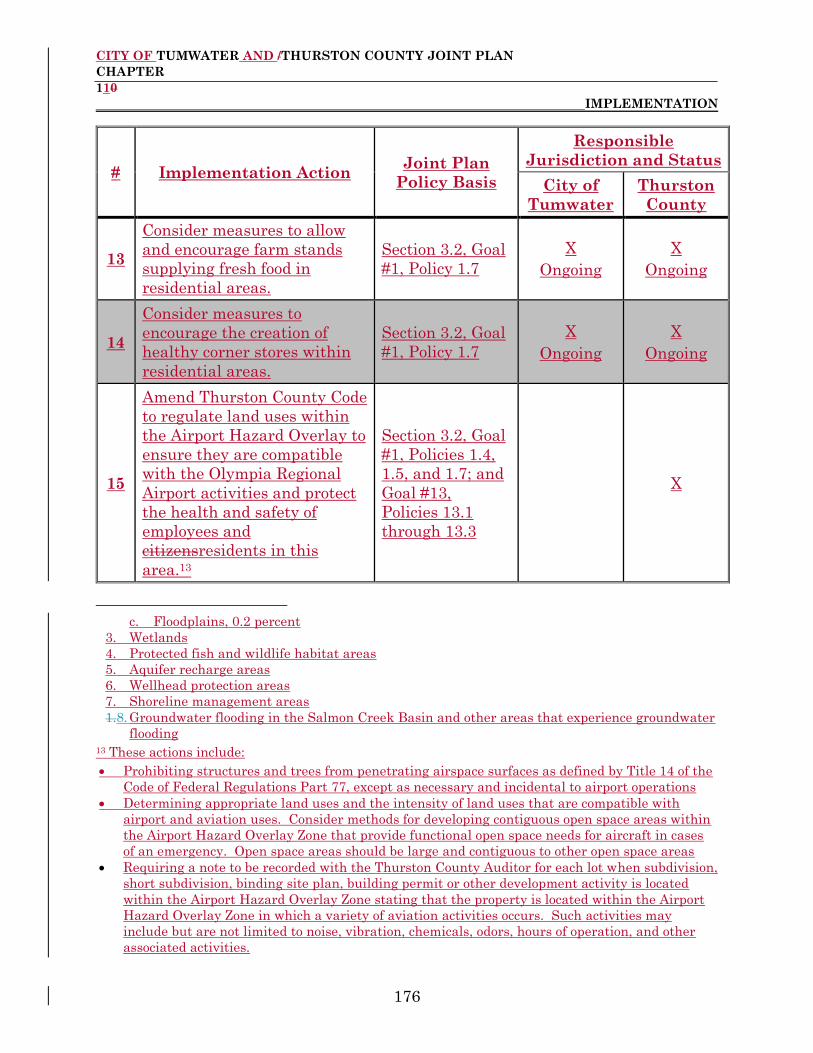
CITY OF TUMWATER AND /THURSTON COUNTY JOINT PLAN
CHAPTER
110
IMPLEMENTATION
176
# Implementation Action Joint Plan
Policy Basis
Responsible
Jurisdiction and Status
City of
Tumwater
Thurston
County
13
Consider measures to allow
and encourage farm stands
supplying fresh food in
residential areas.
Section 3.2, Goal
#1, Policy 1.7
X
Ongoing
X
Ongoing
14
Consider measures to
encourage the creation of
healthy corner stores within
residential areas.
Section 3.2, Goal
#1, Policy 1.7
X
Ongoing
X
Ongoing
15
Amend Thurston County Code
to regulate land uses within
the Airport Hazard Overlay to
ensure they are compatible
with the Olympia Regional
Airport activities and protect
the health and safety of
employees and
citizensresidents in this
area.13
Section 3.2, Goal
#1, Policies 1.4,
1.5, and 1.7; and
Goal #13,
Policies 13.1
through 13.3
X
c. Floodplains, 0.2 percent
3. Wetlands
4. Protected fish and wildlife habitat areas
5. Aquifer recharge areas
6. Wellhead protection areas
7. Shoreline management areas
1.8. Groundwater flooding in the Salmon Creek Basin and other areas that experience groundwater
flooding 13 These actions include:
Prohibiting structures and trees from penetrating airspace surfaces as defined by Title 14 of the
Code of Federal Regulations Part 77, except as necessary and incidental to airport operations
Determining appropriate land uses and the intensity of land uses that are compatible with
airport and aviation uses. Consider methods for developing contiguous open space areas within
the Airport Hazard Overlay Zone that provide functional open space needs for aircraft in cases
of an emergency. Open space areas should be large and contiguous to other open space areas
Requiring a note to be recorded with the Thurston County Auditor for each lot when subdivision,
short subdivision, binding site plan, building permit or other development activity is located
within the Airport Hazard Overlay Zone stating that the property is located within the Airport
Hazard Overlay Zone in which a variety of aviation activities occurs. Such activities may
include but are not limited to noise, vibration, chemicals, odors, hours of operation, and other
associated activities.
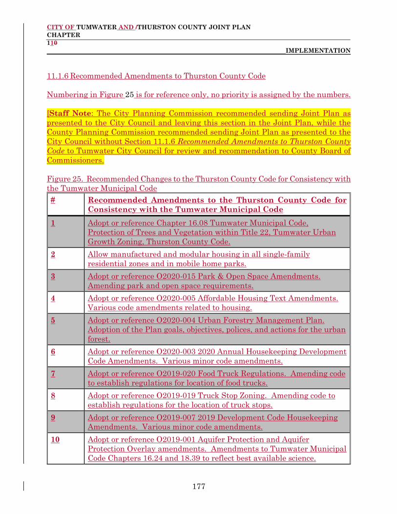
CITY OF TUMWATER AND /THURSTON COUNTY JOINT PLAN
CHAPTER
110
IMPLEMENTATION
177
11.1.6 Recommended Amendments to Thurston County Code
Numbering in Figure 25 is for reference only, no priority is assigned by the numbers.
[Staff Note: The City Planning Commission recommended sending Joint Plan as
presented to the City Council and leaving this section in the Joint Plan, while the
County Planning Commission recommended sending Joint Plan as presented to the
City Council without Section 11.1.6 Recommended Amendments to Thurston County
Code to Tumwater City Council for review and recommendation to County Board of
Commissioners.
Figure 25. Recommended Changes to the Thurston County Code for Consistency with
the Tumwater Municipal Code
# Recommended Amendments to the Thurston County Code for
Consistency with the Tumwater Municipal Code
1 Adopt or reference Chapter 16.08 Tumwater Municipal Code,
Protection of Trees and Vegetation within Title 22, Tumwater Urban
Growth Zoning, Thurston County Code.
2 Allow manufactured and modular housing in all single-family
residential zones and in mobile home parks.
3 Adopt or reference O2020-015 Park & Open Space Amendments.
Amending park and open space requirements.
4 Adopt or reference O2020-005 Affordable Housing Text Amendments.
Various code amendments related to housing.
5 Adopt or reference O2020-004 Urban Forestry Management Plan.
Adoption of the Plan goals, objectives, polices, and actions for the urban
forest.
6 Adopt or reference O2020-003 2020 Annual Housekeeping Development
Code Amendments. Various minor code amendments.
7 Adopt or reference O2019-020 Food Truck Regulations. Amending code
to establish regulations for location of food trucks.
8 Adopt or reference O2019-019 Truck Stop Zoning. Amending code to
establish regulations for the location of truck stops.
9 Adopt or reference O2019-007 2019 Development Code Housekeeping
Amendments. Various minor code amendments.
10 Adopt or reference O2019-001 Aquifer Protection and Aquifer
Protection Overlay amendments. Amendments to Tumwater Municipal
Code Chapters 16.24 and 18.39 to reflect best available science.

CITY OF TUMWATER AND /THURSTON COUNTY JOINT PLAN
CHAPTER
110
IMPLEMENTATION
178
# Recommended Amendments to the Thurston County Code for
Consistency with the Tumwater Municipal Code
11 Adopt or reference O2018-029 2018 Neighborhood Commercial Zoning
Code Amendments. Amendments to update regulations within the
Neighborhood Commercial Zone District.
12 Adopt or reference O2018-010 Wellhead Protection Update.
Amendments to Tumwater Municipal Code to Chapter 18.26 o reflect
best available science.
13 Adopt or reference O2018-007 2018 Annual Housekeeping Development
Code Amendments. Various minor code amendments.
14 Adopt or reference O2017-023 Warehouse Standards, Amendments to
Tumwater Municipal Code Title 18 governing the location and
development standards for warehouse uses.
15 Adopt or reference O2017-022 2017 Annual Housekeeping Development
Code Amendments. Various minor code amendments.
16 Adopt or reference O2017-021 Light Industrial Zone District Setbacks.
Amendments to Tumwater Municipal Code Chapter 16.24 to update
setbacks within the Light Industrial zone district.
17 Adopt or reference O2017-019 Drive Through Standards. Amendments
to Title 18 Zoning to update the standards for drive through uses.
18 Adopt or reference O2017-018 Wetland Ratings Update. Amendments
to Tumwater Municipal Code Chapter 16.28 to reflect best available
science.
19 Adopt or reference O2017-017 Business Park Zone District Repeal.
Amendments to remove the Business Park zone district from the
municipal code.
20 Adopt or reference O2017-014 Beekeeping. Amendments to the
municipal code regarding beekeeping.
21 Adopt or reference O2017-007 Sign Code Amendments. Amendments
to Tumwater Municipal Code Chapter 18.44.
22 Adopt or reference O2017-003 RSR Residential/Sensitive Resource Zone
District Amendments. [Tumwater Municipal Code 18.08.050] Support
agricultural uses on large lots in the RSR Residential/Sensitive
Resource Zone District.
23 Adopt or reference O2017-002 Cottage Housing. Title 18, Zoning,
Tumwater Municipal Code, and creating a new chapter entitled
"Chapter 18.51 Cottage Housing" in the Tumwater Municipal Code.

CITY OF TUMWATER AND /THURSTON COUNTY JOINT PLAN
CHAPTER
110
IMPLEMENTATION
179
# Recommended Amendments to the Thurston County Code for
Consistency with the Tumwater Municipal Code
24 Adopt or reference O2016-024 Amendments to Title 16, Environment,
and Chapter 17.04, Definitions, Tumwater Municipal Code, Critical
Area Regulations Update. Amend Title 16, Environment, Chapter
17.04, Definitions, and Chapter 18.39, AQP Aquifer Protection Overlay,
Tumwater Municipal Code to be consistent with State law as required
by the Growth Management Act.
25 Adopt or reference O2016-023 Airport Related Industry, Amendments
to Chapter 18.34, Airport Related Industry, Tumwater Municipal Code.
Replaced the Port of Olympia Airdustrial Park Land Use Plan with the
2011 Port of Olympia Development Guidelines and adopted the City of
Tumwater Citywide Design Guidelines.
26 Adopt or reference O2016-022. Preliminary land division approval time
periods adjusted to be consistent with changes in state law.
27 Adopt or reference O2016-021. Impact fee expenditure time limits
moved from six years to ten years to be consistent with changes in state
law.
28 Adopt or reference O2016-010 Plat extensions for Habitat Conservation
Plan affected properties.
29 Adopt or reference O2016-013. Apply the City of Tumwater Citywide
Design Guidelines and Development Standards for all types of
development in the Joint Plan area.
30 Adopt or reference O2014-008 Off-Street Parking.
31 Adopt or reference O2013-013 Marijuana – locations and definitions,
etc.
32 Adopt or reference O2012-007 Liquor sales.
33 Adopt or reference O2011-006 Drive through use standards. Tumwater
Municipal Code 18.43.075 has been changed to Tumwater Municipal
Code 18.43.020. Queuing area requirements were modified as well.
34 Adopt or reference O2011-014 Homeless Encampments. Extend time
in one place from 90 to 180 days.
35 Adopt or reference O2010-029 Urban Agriculture (chickens, bees, goats,
fences, etc.)
36 Adopt or reference O2010-015. Electric Vehicle Infrastructure added to
most zones as a permitted or accessory use. Definition added also.
RCW 35A.63.
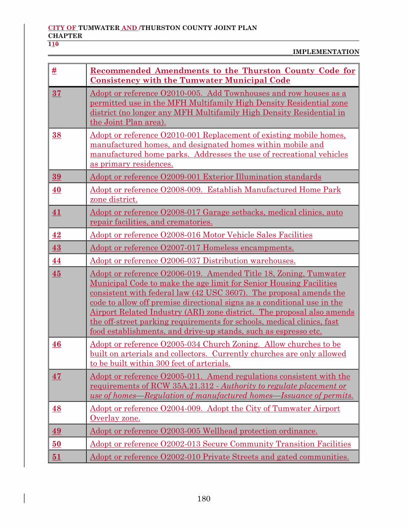
CITY OF TUMWATER AND /THURSTON COUNTY JOINT PLAN
CHAPTER
110
IMPLEMENTATION
180
# Recommended Amendments to the Thurston County Code for
Consistency with the Tumwater Municipal Code
37 Adopt or reference O2010-005. Add Townhouses and row houses as a
permitted use in the MFH Multifamily High Density Residential zone
district (no longer any MFH Multifamily High Density Residential in
the Joint Plan area).
38 Adopt or reference O2010-001 Replacement of existing mobile homes,
manufactured homes, and designated homes within mobile and
manufactured home parks. Addresses the use of recreational vehicles
as primary residences.
39 Adopt or reference O2009-001 Exterior Illumination standards
40 Adopt or reference O2008-009. Establish Manufactured Home Park
zone district.
41 Adopt or reference O2008-017 Garage setbacks, medical clinics, auto
repair facilities, and crematories.
42 Adopt or reference O2008-016 Motor Vehicle Sales Facilities
43 Adopt or reference O2007-017 Homeless encampments.
44 Adopt or reference O2006-037 Distribution warehouses.
45 Adopt or reference O2006-019. Amended Title 18, Zoning, Tumwater
Municipal Code to make the age limit for Senior Housing Facilities
consistent with federal law (42 USC 3607). The proposal amends the
code to allow off premise directional signs as a conditional use in the
Airport Related Industry (ARI) zone district. The proposal also amends
the off-street parking requirements for schools, medical clinics, fast
food establishments, and drive-up stands, such as espresso etc.
46 Adopt or reference O2005-034 Church Zoning. Allow churches to be
built on arterials and collectors. Currently churches are only allowed
to be built within 300 feet of arterials.
47 Adopt or reference O2005-011. Amend regulations consistent with the
requirements of RCW 35A.21.312 - Authority to regulate placement or
use of homes—Regulation of manufactured homes—Issuance of permits.
48 Adopt or reference O2004-009. Adopt the City of Tumwater Airport
Overlay zone.
49 Adopt or reference O2003-005 Wellhead protection ordinance.
50 Adopt or reference O2002-013 Secure Community Transition Facilities
51 Adopt or reference O2002-010 Private Streets and gated communities.

CITY OF TUMWATER AND /THURSTON COUNTY JOINT PLAN
CHAPTER
110
IMPLEMENTATION
181
# Recommended Amendments to the Thurston County Code for
Consistency with the Tumwater Municipal Code
52 Adopt or reference O2001-012. Establishes and amends definitions and
permitted and conditional uses in relation to bed and breakfasts, over
height structures, manufactured homes, building heights, professional
and personal services, and retail sales.
53 Adopt or reference O2000-004 Wellhead Protection Standards.
[Chapter 16.16 Tumwater Municipal Code] Amend Title 16,
Environment, Tumwater Municipal code, Tumwater Urban Growth
Zoning, and Thurston County Code to include wellhead protection
standards for expansions of existing uses.
54 Adopt or reference O2000-004 Residential Density Bonus. [Tumwater
Municipal Code 18.08.050, 18.10.050, and 18.12.050] Amend the
density sections of the single-family residential zone districts by
removing the 25% density bonus for lands that are subject to the
wetland protection standards of Chapter 16.28 Tumwater Municipal
Code.
55 Adopt or reference O2000-004 Residential/Sensitive Resource Zone
District-Accessory Dwelling Units. [Tumwater Municipal Code
18.08.020 and 18.42.010] Amend the Residential/Sensitive Resource
(R/SR) zone district to allow accessory dwelling units as permitted uses.
56 Adopt or reference O2000-004 Plat Phasing and Time Extensions.
[Tumwater Municipal Code 17.14.080 and 17.14.090]. Amend Title 17,
Land Division, Tumwater Municipal Code to allow large developments
to be built in phases. The total time of all the phases is not to exceed
eight (8) years. Also amends Title 17, Land Division, Tumwater
Municipal Code to allow for up to three (3) one-year time extensions for
the standard five (5) year non-phased development, provided certain
criteria are met.
57 Adopt or reference O2000-004 Wrecking and Junk Yards. [Table 18.24
and Chapter 18.56, Conditional Use Permits, Tumwater Municipal
Code and Tumwater Municipal Code 18.25.040 and 18.56.300]. Amend
the zoning code to allow wrecking and junk yards as conditional uses in
the Heavy Industrial zone district. Current code language could be
interpreted as allowing wrecking yards and junk yards as permitted
uses in both the Light Industrial (LI) and Heavy Industrial (HI) zone
districts.

CITY OF TUMWATER AND /THURSTON COUNTY JOINT PLAN
CHAPTER
110
IMPLEMENTATION
182
# Recommended Amendments to the Thurston County Code for
Consistency with the Tumwater Municipal Code
58 Adopt or reference O2000-004 Automobile Sales Areas. [Chapter 18.04,
Definitions, and 18.56, Conditional Use Permits, Tumwater Municipal
Code and Tumwater Municipal Code 18.04.034, 18.22.040, 18.24.020,
18.34.020, and 18.56.310]. Establishes a definition for automobile sales
areas and allows them as permitted uses in the Airport Related
Industry (ARI) and Light Industrial (LI) zone districts and as
conditional uses in the General Commercial (GC) zone district.
59 Adopt or reference O2000-004 Recycling Collection Center. [Table
18.24 Tumwater Municipal Code and Tumwater Municipal Code
18.24.020] Add recycling collection centers to the permitted uses
section of the Light Industrial (LI) chapter of the Title 18, Zoning,
Tumwater Municipal Code.
60 Adopt or reference O2000-004 Sign Standards. [Tumwater Municipal
Code 18.44.170]. Add to Tumwater Municipal Code 18.44.170, Exterior
Lighting, the requirement that all illuminated signs within 300 feet of
and visible from residential districts must be turned off at 10 PM or
when the business closes, whichever is later. This amendment is the
result of a number of complaints by citizensresidents living near
commercial areas and businesses.
61 Adopt or reference O2000-004 Fence Heights. [Tumwater Municipal
Code 18.46.030]. Allows a fence up to seventy-eight inches (78”) in one
of the front yards on a “through lot” provided specific requirements are
met. The current zoning code does not allow fences taller than forty-
two inches (42”) in a front yard. This proposed amendment came about
due to a number of recent situations where houses were built on
through lots and the owners wanted a fence taller than 42” in the yard
on the backside of the structure.
62 Adopt or reference O2000-004 Senior Housing Facilities. [Tumwater
Municipal Code 18.14.040, 18.18.040, 18.20.030, and 18.56.125]. Allow
senior housing facilities as conditional uses in the Multi Family
Medium (MFM) and Neighborhood Commercial (NC) zone districts and
as permitted uses in the Mixed Use (MU) zone district. They are
currently allowed in the Multi Family High density (MFH) zone district
as both a permitted and conditional use depending on their density.

CITY OF TUMWATER AND /THURSTON COUNTY JOINT PLAN
CHAPTER
110
IMPLEMENTATION
183
# Recommended Amendments to the Thurston County Code for
Consistency with the Tumwater Municipal Code
63 Adopt or reference O2000-004 Residential Density-Administrative
Flexibility. [Tumwater Municipal Code 18.08.050, 18.10.050,
18.12.050, and 18.14.050, 18.16.050]. Amend the density sections of
the residential zone districts to allow the Development Services
Director to authorize a reduction of the minimum density standards for
small, oddly shaped, or partially developed lots if the site configuration
precludes subdivision at the minimum density. This amendment would
provide additional opportunities for urban infill on lots that would
otherwise remain undeveloped.
64 Adopt or reference O2000-004 Stormwater and Open Space Density.
[Tumwater Municipal Code 18.08.050, 18.10.050, 18.12.050, 18.14.050,
and 18.16.040] Amends the density sections of the residential chapters
of the zoning code to clarify that open space and park areas that also
include stormwater facilities that are designed for active and/or passive
recreational purposes shall not be excluded from density calculations.
65 Adopt or reference O2000-004 Neighborhood Commercial Design
Guidelines. [Tumwater Municipal Code 18.43.020 and 18.43.060]
Amend Chapter 18.43, Design Review Guidelines, Tumwater Municipal
Code to include the Neighborhood Commercial (NC) zone district.
66 Adopt or reference O2000-004 Landscaping Requirements. [Tumwater
Municipal Code 18.47.020]. Broaden the applicability of landscaping
standards to include expansions of existing uses. The Development
Services Department has reviewed several projects where expansions
did not require compliance with the City of Tumwater’s landscaping
standards.
67 Adopt or reference O2000-004 Mini-storage Parking Requirements.
[Figure 18.50.070(A)]. Amends the current parking requirements for
mini-storage facilities to clarify that a minimum of three (3) spaces are
required. Current code language could be interpreted as not requiring
any parking spaces in certain situations.
68 Adopt or reference O2000-004 Residential Care Facilities-Parking
Standards. [Figure 18.50.070(A)]. Amends Figure 18.50.070.A to
include parking standards for Residential Care Facilities. The current
zoning code does not have parking standards for these facilities.

CITY OF TUMWATER AND /THURSTON COUNTY JOINT PLAN
CHAPTER
110
IMPLEMENTATION
184
# Recommended Amendments to the Thurston County Code for
Consistency with the Tumwater Municipal Code
69 Adopt or reference O2000-004 Duplex Definition. [Tumwater
Municipal Code 18.04.180]. Amend the definition of “duplex” to include
only buildings which have two separate dwellings that are completely
separated by an unpierced wall or ceiling. This is to prevent houses
connected by breezeways or carports from being classified as duplexes.
70 Adopt or reference O2000-004 Entertainment Facilities. [Chapter
18.04 Tumwater Municipal Code, Definitions, and Tumwater Municipal
Code 18.04.201]. Amend the code to create a definition for
entertainment facilities. These facilities are currently allowed as
permitted uses in the General Commercial (GC), Mixed Use (MU), and
Community Services (CS) zone districts.
71 Adopt or reference O2000-004 Critical Areas and Density Calculation
in Residential Districts. [Tumwater Municipal Code 18.08.050,
18.10.050, 18.12.050, 18.14.050, and 18.16.050] Amends the density
sections of the residential zoning chapters to clarify that land
prohibited from development by Title 16, Environment, Tumwater
Municipal Code cannot be used in the density calculation
72 Adopt or reference O2000-004 Manufactured Homes. [Table 18.08
Tumwater Municipal Code and Tumwater Municipal Code 18.08.020,
18.10.020, 18.12.020, and 18.14.020]. Clarify that manufactured homes
are allowed in all residential districts except Multi Family High density
districts (MFH) when sited on individual lots. Also, clarify that
designated mobile home parks are only allowed in Multi Family
Medium (MFM) districts.
73 Adopt or reference O2000-004 Setbacks for Multi-Story Structures.
[Tumwater Municipal Code 18.14.050, 18.16.050, 18.18.050, 18.19.010,
18.22.050, 18.24.050, and 18.25.060] Clarify the language regarding
setbacks for structures over one story when located adjacent to
residential zones.
74 Adopt or reference O2000-004 Wireless Communications Facilities.
[Chapter 18.04, Definitions, Tumwater Municipal Code and Tumwater
Municipal Code 18.04.493 and 18.04.642]. The definition of “Wireless
Communications Facilities was placed incorrectly in the zoning code
definitions chapter. This amendment is to move the definition to the
correct place.

CITY OF TUMWATER AND /THURSTON COUNTY JOINT PLAN
APPENDIX A 1988 URBAN GROWTH MANAGEMENT
AGREEMENT SUMMARY OF PROCESS AND CRITERIA USED TO DEVELOP
THE 1988 URBAN GROWTH MANAGEMENT AGREEMENT
185
APPENDIX A. SUMMARY OF PROCESS AND CRITERIA USED TO
DEVELOP THE 1988 URBAN GROWTH MANAGEMENT
AGREEMENT
[Staff Note: Attach Summary of Process and Criteria Used to Develop the 1988
Urban Growth Management Agreement]

CITY OF TUMWATER AND /THURSTON COUNTY JOINT PLAN
APPENDIX B JOINT PLAN URBAN GROWTH BOUNDARY
ANALYSIS ANALYSIS OF CITY OF TUMWATER/THURSTON COUNTY
JOINT PLAN URBAN GROWTH BOUNDARY’S CONSISTENCY
186
APPENDIX B. ANALYSIS OF CITY OF TUMWATER AND THURSTON
COUNTY JOINT PLAN URBAN GROWTH BOUNDARY’S
CONSISTENCY WITH COUNTY-WIDE PLANNING
POLICIES
[Staff Note: Staff suggests that we delete this appendix and replace it with a new
implementation item to adjust the current Joint Plan area boundaries.]
The City of Tumwater and /Thurston County Joint Plan makes several adjustments to
the Tumwater urban growth boundary (UGB) from the long-term UGB that was
established in the 1988 Urban Growth Management Agreement between the Ccities of
Lacey, Olympia, Tumwater, and Thurston County.
Two of the areas in which the Joint Plan adjusts the UGB were the subject of special
notes on the 1988 Urban Growth Management Agreement (UGMA) Map. Those notes
indicated that the UGB as shown on that map in those two locations was illustrative
only and would be resolved through joint planning. The resolution as to the exact
location of the UGB in those areas is included in the Joint Plan's UGB.
Following is a demonstration of the consistency of the Joint Plan's UGB with the criteria
established by the Urban Growth Management (UGM) Committee for inclusion in the
Thurston County County-Wide Planning Policies for considering amendments to urban
growth boundaries. (Note: The UGM Committee's criteria is shown in italics.)
1.2 Amend long-term urban growth boundaries that meet the following criteria:
a. Expansion of the Long-Term Urban Growth boundary must demonstrate
consistency with the following criteria:
(1) (a) For South County growth areas, the expansion area can and
will be served by municipal water and transportation in the
succeeding 20 years. South County jurisdictions must demonstrate
that the expansion area can be served by sewage disposal methods
that provide for the effective treatment of waste water in the
succeeding 20 years; or
(b) For the North County growth area, the expansion area can
and will be served by municipal sewer and water and transportation
in the succeeding 20 years.
Because Tumwater is part of the North County growth area, only
(1)(b) applies to the Joint Plan UGB. The areas that expand the
CITY OF TUMWATER AND /THURSTON COUNTY JOINT PLAN
APPENDIX B JOINT PLAN URBAN GROWTH BOUNDARY
ANALYSIS ANALYSIS OF CITY OF TUMWATER/THURSTON COUNTY
JOINT PLAN URBAN GROWTH BOUNDARY’S CONSISTENCY
187
1988 UGB can be served with municipal sewer and water and
transportation in the succeeding 20 years, as shown in the City's
sanitary sewer, water, and transportation plans. They will be
served by these services as development occurs which requires
these services, as ensured by the City's adopted Capital Facilities
Plan concurrency element.
The City of Tumwater's adopted Comprehensive Sanitary Sewer
Plan (1989) already includes planned service to the areas where the
UGB is expanded. This plan identifies all future sanitary sewer
system components that will be needed to serve these areas.
Likewise, the 1992 Tumwater Water Comprehensive Plan and the
1994 Tumwater Transportation Plan demonstrate the ability to
serve the entire proposed UGB with those services. The specific
capital improvement projects needed to provide all three of these
services to the proposed urban growth area are included in
Chapters 8 and 9 of the Joint Plan.
The adopted Tumwater Capital Facilities Plan includes a
concurrency element which ensures the provision of adequate
public facilities for development which occurs in the Tumwater
urban growth area. That element states, in part:
"Concurrency will be sought for public facilities as identified below.
When concurrency cannot be achieved because of lack of financial
resources, then the specific development upon which the
concurrency test was applied will not be certified for construction
or occupancy...if the City or other parties do not have adequate
funding available to match funds to construct the necessary
infrastructure, the developer may voluntarily finance the
construction with recourse of remuneration through financing
techniques such as a traditional latecomers process of future
development paying back the costs assigned through fair share
growth cost allocation."
Facilities requiring concurrency in the Tumwater Capital Facilities
Plan include: streets, roads, highways, traffic signals, sidewalks,
street and road lighting systems, mass transit, potable water, and
sanitary sewer.
The Capital Facilities Plan also states: "If, in the future, capital
facilities (system improvements) needed to obtain concurrency for
development are not funded by the CFP due to omission or lack of
CITY OF TUMWATER AND /THURSTON COUNTY JOINT PLAN
APPENDIX B JOINT PLAN URBAN GROWTH BOUNDARY
ANALYSIS ANALYSIS OF CITY OF TUMWATER/THURSTON COUNTY
JOINT PLAN URBAN GROWTH BOUNDARY’S CONSISTENCY
188
funds, one or more of five strategies must be employed to obtain
consistency of plan and concurrency of necessary infrastructure:
Strategy 1: Developer pays
Strategy 2: Increase City revenues
Strategy 3: Reprioritize CFP projects
Strategy 4: Reassess land use densities
Strategy 5: Lower level of service standards"
(2) Urbanization of the expansion area is compatible with the use of
designated resource lands and critical areas.
The UGB expansion areas do not include, nor are they adjacent to,
any Thurston County designated resource lands. The proposed
expansion areas may include, or be adjacent to, some critical areas
as defined by either the Thurston County or City of Tumwater
critical areas ordinances. These may include the Deschutes River
and its floodplain, a portion of Black Lake and possible wetlands.
The Joint Plan prohibits any new residential development in the
Deschutes River floodplain and the Black Lake shoreline
jurisdiction. To reflect that fact, these areas are assigned future
land use designations of parks/open space and shoreline
environment, respectively. Development adjacent to these areas,
and any other critical areas that may be within the expansion
areas, will be subject to either the Thurston County or City of
Tumwater critical areas ordinance, both of which provide for
protection of the critical areas from development through the
establishment of undeveloped buffers.
In summary, the expansion of the UGB is compatible with the use
of designated resource areas and critical areas.
(3) The expansion area is contiguous to an existing urban growth
boundary.
The UGB expansion areas are contiguous to the 1988 UGMA long-
term UGB, as shown on Map 2-3 of the Joint Plan.
(4) The expansion is consistent with the County-Wide Planning Policies.
Thurston County County-Wide Planning Policy 1.1 includes
additional criteria that any proposed UGBs must meet:

CITY OF TUMWATER AND /THURSTON COUNTY JOINT PLAN
APPENDIX B JOINT PLAN URBAN GROWTH BOUNDARY
ANALYSIS ANALYSIS OF CITY OF TUMWATER/THURSTON COUNTY
JOINT PLAN URBAN GROWTH BOUNDARY’S CONSISTENCY
189
a. Contain areas characterized by urban growth
The UGB expansion areas contain areas characterized by
urban growth, including residential development along
Fairview Road and 88th Avenue (1 to 2 DU per acre). The
exceptions are an area adjacent to the Deschutes River and
a strip of land south of 93rd Avenue near Old Highway 99
(see Map 2-3 in the Joint Plan). The area along the
Deschutes River is included in the UGB to provide more
logical boundaries for service provision and administration,
and is proposed for a land use designation of parks/open
space. New residential development is proposed to be
prohibited in the Deschutes River floodplain area.
The expansion area south of 93rd Avenue near Old Highway
99 includes primarily the remaining portion of properties
that had been divided by the 1988 UGMA long-term UGB.
The expansion provides a more logical boundary along
property lines, minimizing cases in which properties are
divided by the UGB.
b. Are served by or are planned to be served by municipal
utilities
The UGB expansion areas are planned to be served by
municipal utilities, as demonstrated in 1.2.a(1) above.
c. Contain vacant land near existing urban areas that is
capable of supporting urban development
The UGB includes existing urban development and vacant
land capable of supporting future urban development, with
the exception of potential critical areas as described in
1.2.a(2) above.
d. Are compatible with the use of designated resource lands and
critical areas
The UGB expansion areas are compatible with designated
resource lands and critical areas as demonstrated in 1.2.a(2)
above.
CITY OF TUMWATER AND /THURSTON COUNTY JOINT PLAN
APPENDIX B JOINT PLAN URBAN GROWTH BOUNDARY
ANALYSIS ANALYSIS OF CITY OF TUMWATER/THURSTON COUNTY
JOINT PLAN URBAN GROWTH BOUNDARY’S CONSISTENCY
190
e. Follow logical boundaries
The UGB expansion areas specifically provide for logical
boundaries, including property lines, section or quarter-
section lines, the Deschutes River, and the Black Lake
shoreline. In virtually all cases, the primary reason for the
expansion of the UGB is specifically to provide more logical
boundaries than those in the 1988 UGB.
f. Consider citizen preferences
The UGB expansions are included as the result of ten
months of public meetings of the Tumwater Joint Planning
Committee with citizens of the area to develop the Draft
Joint Plan. Citizen comments were taken at each meeting of
the committee before action was taken by the committee.
Citizen preferences were carefully considered in formulating
the committee's proposed UGB. Further citizen testimony
was taken at public hearings conducted by the Tumwater
and Thurston County Planning Commissions, and the
Tumwater City Council and Thurston County
Commissioners, prior to adoption of the Joint Plan UGB.
g. Are of sufficient area and densities to permit the urban
growth that is projected to occur in the succeeding twenty-
year period.
Chapter 3 of the Joint Plan contains a land supply analysis
which determines that the urban growth area does contain
sufficient area and land use densities to accommodate the
urban growth projections produced in accordance with the
County-Wide Planning Policies.
b. Expansion of the Long-Term Urban Growth Boundary must demonstrate
consistency with one of the two following criteria:
(1) There is insufficient land within the existing Long-Term Urban
Growth Boundary to permit the urban growth that is forecast to
occur in the succeeding 20 years; or
(2) An overriding public interest demonstrating a public benefit beyond
the area proposed for inclusion would be served by moving the Long-
Term Urban Growth Boundary related to protecting the public

CITY OF TUMWATER AND /THURSTON COUNTY JOINT PLAN
APPENDIX B JOINT PLAN URBAN GROWTH BOUNDARY
ANALYSIS ANALYSIS OF CITY OF TUMWATER/THURSTON COUNTY
JOINT PLAN URBAN GROWTH BOUNDARY’S CONSISTENCY
191
health, safety and welfare; enabling more cost-effective, efficient
provision of sewer or water; and enabling the locally adopted
Comprehensive Plans to more effectively meet the goals of the State
Growth Management Act.
The UGB expansion meets the second of these two criteria. As
mentioned several times previously in Appendix H, the UGB
expansion areas are included specifically to provide for more logical
boundaries. These boundaries will enable more cost-effective
provision of sewer or water and enable the locally adopted
comprehensive plans to be more effectively implemented in
accordance with the State Growth Management Act. The following
demonstrates how each of the expansion areas shown on the Joint
Plan Map 2-3 meets this criteriathese criteria.
The expansion area southwest of the 1988 UGB includes all of the
rights-of-way of 88th Avenue and Fairview Road to provide cost-
effective and efficient sewer and water provision as shown in the
Comprehensive Sewer and Water Plans. Inclusion of these areas
also helps meet the first two goals of the State Growth Management
Act: "(1) Encourage development in urban areas where adequate
public facilities and services exist or can be provided in an efficient
manner, and (2) Reduce the inappropriate conversion of
undeveloped land into sprawling, low-density development." These
areas are developing with single-family residential uses at
densities that are not rural in nature (e.g., 1 DU per acre).
Including them in the urban growth area will allow for the eventual
provision of urban facilities to these areas, and will reduce low-
density sprawl by allowing for future in-fill of these areas at more
urban densities.
The expansion areas along the east and southeast sides of the 1988
UGB are included specifically to provide for more efficient service
provision. The northern-most area clarifies the water and sewer
service areas for the Cities of Olympia and Tumwater, as called for
by a note on the 1988 Urban Growth Management Agreement Map.
The area along the west side of the Deschutes River provides for all
areas on that side of the river adjacent to the 1988 UGB to be
included in the Joint Plan UGB. While this area is not proposed in
the Joint Plan for any new development needing water or sewer
service, its inclusion in the UGB will enable more efficient provision
of other urban services such as police, fire and land use
administration. The Deschutes River would provide for a more
CITY OF TUMWATER AND /THURSTON COUNTY JOINT PLAN
APPENDIX B JOINT PLAN URBAN GROWTH BOUNDARY
ANALYSIS ANALYSIS OF CITY OF TUMWATER/THURSTON COUNTY
JOINT PLAN URBAN GROWTH BOUNDARY’S CONSISTENCY
192
easily recognizable boundary than the 1988 UGB (which follows no
discernable boundary) and will not create a situation in which
service personnel must pass through City jurisdiction to reach
County jurisdiction, as the 1988 UGB would.
The area south of 93rd Avenue near Old Highway 99 also will
create a more recognizable boundary by significantly reducing the
number of properties that would be divided by the UGB in
comparison with the 1988 UGB. This would enable more efficient
development services and other administrative services by the City.
c. Reduction of the Long-Term Urban Growth Boundary must demonstrate
consistency with the following criteria:
(1) Sufficient land will remain within the reduced Long-Term Urban
Growth Boundary to permit the urban growth that is forecast to
occur in the succeeding 20 years.
Reducing the 1988 UGB in the areas proposed will still provide for
sufficient land within the urban growth area to accommodate the
forecasted urban growth, as demonstrated in item 1.2.a(4)g above.
(2) The reduced Long-Term Urban Growth Boundary will include cost-
effective sewer and water and transportation service areas.
The specific reductions of the 1988 UGB will not jeopardize the cost-
effective provision of sewer, water and transportation. In fact, the
reduction area east of Interstate 5 is an area which only has
transportation access (and existing rights-of-way) from 101st
Avenue and Case Road outside of the UGB. Retaining this area in
the UGB would make the provision of transportation services more
difficult and less efficient than under the Joint Plan UGB.
(3) Reduction of the Long-Term Urban Growth Boundary is compatible
with the use of the designated resource lands and with critical areas.
The reductions to the 1988 UGB are not likely to affect Thurston
County's designated resource lands because these lands are not
located in the vicinity of the proposed reductions. The reduction
areas do include portions of possible wetland areas, which are
critical areas as defined by the Thurston County and City of
Tumwater critical areas ordinances. These critical areas will be
removed from the 1988 urban growth area under this plan,

CITY OF TUMWATER AND /THURSTON COUNTY JOINT PLAN
APPENDIX B JOINT PLAN URBAN GROWTH BOUNDARY
ANALYSIS ANALYSIS OF CITY OF TUMWATER/THURSTON COUNTY
JOINT PLAN URBAN GROWTH BOUNDARY’S CONSISTENCY
193
removing the possibility of adjacent urban development while
retaining the applicability of the Thurston County critical areas
ordinance over any future permitted development in the vicinity.

CITY OF TUMWATER AND /THURSTON COUNTY JOINT PLAN
APPENDIX C THURSTON COUNTY COUNTY-WIDE PLANNING POLICIES
194
APPENDIX C. THURSTON COUNTY COUNTY-WIDE PLANNING
POLICIES
Thurston County
COUNTY-WIDE PLANNING POLICIES November 10, 2015
These policies were adopted by the Board of County Commissioners on September 8,
1992. They were ratified earlier by each of the seven cities and towns within
Thurston County. Those seven cities and towns are Lacey, Olympia, Tumwater,
Bucoda, Rainier, Tenino and Yelm. On August 2, 1993, representatives of Thurston
County and the seven cities and towns met to clarify intent of policies 1.2 and 1.3
and to affirm long and short term Urban Growth boundaries established in 1988
around Olympia, Lacey and Tumwater. In 2002, policies were amended to be
consistent with RCW 36.70A.215 (“Buildable Lands Program”). In 2015, the policies
were amended to incorporate foundational principles and policies from Creating
Places, Preserving Spaces, A Sustainable Development Plan for the Thurston Region,
December 2013.
Background: The Growth Management Act calls for the faster growing counties and
cities within their borders to undertake new planning to prepare for anticipated
growth. New parts are to be added to the Comprehensive Plans of these counties
and cities, and those plans are to be coordinated and consistent. The framework for
this coordination are county-wide planning policies, developed by each county, in
collaboration with its cities and towns. These are Thurston County’s county-wide
planning policies which will be used to frame how the Comprehensive Plans of
Thurston County and the seven cities and towns will be developed and coordinated.

CITY OF TUMWATER AND /THURSTON COUNTY JOINT PLAN
APPENDIX C THURSTON COUNTY COUNTY-WIDE PLANNING POLICIES
195
TABLE OF CONTENTS
I. General Policies .............................................................................................. C-3
II. Urban Growth Areas ...................................................................................... C-5
III. Promotion of Contiguous and Orderly Development, Provision
of Urban Services, and Protection of Rural Areas ...................................... C-7
IV. Joint County and City Planning within Urban Growth Areas ................. C-10
V. Siting County-Wide and State-Wide Public Capital Facilities .................. C-11
VI. Analysis of Fiscal Impact ............................................................................ C-12
VII. Economic Development and Employment .................................................. C-13
VIII. Affordable Housing ....................................................................................... C-15
IX. Transportation .............................................................................................. C-16
X. Environmental Quality ................................................................................ C-18
XI. County-Wide Policies Which Establish a Process to Develop
Future Policies .............................................................................................. C-20

CITY OF TUMWATER AND /THURSTON COUNTY JOINT PLAN
APPENDIX C THURSTON COUNTY COUNTY-WIDE PLANNING POLICIES
196
I. GENERAL POLICIES (Adopted November 10, 2015)
1.1 Balance our needs today with those of future residents, to protect and
enhance quality of life and in recognition that each generation is a
trustee of the environment for succeeding generations.
1.2 Preserve and promote awareness of our historic, cultural, and natural
heritage.
1.3 Develop new ways to cultivate and support respectful civic engagement
and participation by residents, and public, private, and nonprofit
businesses and organizations, encouraging choices and offering
information that contribute to individual, household, and community
health and well-being.
1.4 Break down institutional barriers to communication and cooperation,
fostering open communication and transparent processes that
encourage community-wide participation.
1.5 Think broadly, regionally and globally – act locally. Acknowledge the
interdependence of communities both within and external to our
region, recognizing the impacts of our region upon the world, as well as
the impacts of the world upon our region.
1.6 Translate vision to policy and act on adopted local plans and policies.
Consider the effects of decisions on achieving this vision, while
balancing individual property rights with broader community needs
and goals.
1.7 Monitor progress and shift course when necessary. Use meaningful,
easy-to-understand methods to measure progress on key objectives.
Respond and adapt to future social, economic, and environmental
challenges.
1.8 Partner across topic areas and jurisdictional boundaries. While
supporting local decision-making, encourage regional and cross-
jurisdictional coordination, communication, and cooperation that
increase our capacity to make decisions for the common good across
jurisdiction boundaries.
1.9 Build and maintain distinct communities, preserving and enhancing
the character and unique identities of the existing urban, suburban,
and rural communities in a way that protects what matters most,
while offering additional opportunities to improve on what can be
better.
1.10 Meet basic human needs of clean water and air, healthy food, adequate
housing, quality education, public safety, and equal access, regardless
of socio-economic status.

CITY OF TUMWATER AND /THURSTON COUNTY JOINT PLAN
APPENDIX C THURSTON COUNTY COUNTY-WIDE PLANNING POLICIES
197
1.11 Support education, employment, commercial opportunities, cultural,
social, and recreational opportunities in appropriate places and at a
scale that supports community health and well-being.
1.12 Champion energy efficiency and renewable energy strategies that
contribute to energy independence, economic stability, reduced climate
impacts, and long-term household and community health.
1.13 Protect the natural environment while acknowledging the
interdependence of a healthy environment and a healthy economy.
1.14 Provide for adequate active and passive recreational opportunities.

CITY OF TUMWATER AND /THURSTON COUNTY JOINT PLAN
APPENDIX C THURSTON COUNTY COUNTY-WIDE PLANNING POLICIES
198
II. URBAN GROWTH AREAS (June 5, 1992, Adopted September 8, 1992, Amended November 10, 2015)
2.1 Urban growth within Thurston County is to occur only in designated
urban growth areas.
2.2 The boundaries of designated urban growth areas must meet the
following criteria:
a. Contain areas characterized by urban growth.
b. Be served by or planned to be served by municipal utilities.
c. Contain vacant land, or under-developed land with additional
capacity, near existing urban areas that is capable of supporting
urban development.
d. Be compatible with the use of designated resource lands and
critical areas.
e. Follow logical boundaries.
f. Consider citizen preferences.
g. Be of sufficient area and densities to permit the urban growth
that is projected to occur in the succeeding twenty-year period.
2.3 Amendments to the urban growth boundaries must use the following
process:
a. Cities and towns will confer with the county about boundary
location or amendment.
b. Proposed boundaries are presented to the Urban Growth
Management (UGM) subcommittee of Thurston Regional
Planning Council, which makes a recommendation directly to
the Board of County Commissioners.
c. Following a public hearing, the Board of County Commissioners
designates the boundaries and justifies its decision in writing.
d. Cities and towns not in agreement with the boundary
designation may request mediation through the State
Department of Commerce.
e. At least every 10 years, growth boundaries will be reviewed
based on updated 20 year population projections.
f. Appeals of decisions made through this process are per the State
Growth Management Act, RCW 36.70A.
2.4 Expansion of the Urban Growth Boundary must demonstrate
consistency with:
a. All of the following criteria:
CITY OF TUMWATER AND /THURSTON COUNTY JOINT PLAN
APPENDIX C THURSTON COUNTY COUNTY-WIDE PLANNING POLICIES
199
i. For South County jurisdictions: the expansion area can
and will be served by municipal water and transportation
in the succeeding 20 years. South County jurisdictions
must demonstrate that the expansion can be served by
sewage disposal measures that provide for the effective
treatment of waste water in the succeeding 20 years.
ii. For North County jurisdictions: the expansion area can
and will be served by municipal sewer, water and
transportation in the succeeding 20 years.
iii. Urbanization of the expansion area is compatible with the
use of designated resource lands and with critical areas.
iv. The expansion area is contiguous to an existing urban
growth boundary.
v. The expansion is consistent with these County-Wide
Planning Policies.
b. One of the two following criteria:
i. There is insufficient land within the Urban Growth
Boundary to permit the urban growth that is forecast to
occur in the succeeding 20 years; or
ii. An overriding public interest demonstrating a public
benefit beyond the area proposed for inclusion would be
served by moving the Urban Growth Boundary related to
protecting public health, safety and welfare; enabling
more cost-effective, efficient provision of sewer or water;
and enabling the locally adopted Comprehensive Plans to
more effectively meet the goals of the State Growth
Management Act.
2.5 Reduction of the Urban Growth Boundary must demonstrate
consistency with all of the following criteria:
a. Sufficient land will remain within the reduced Urban Growth
Boundary to permit the urban growth that is forecast to occur in
the succeeding 20 years.
b. The reduced Urban Growth Boundary will include cost-effective
sewer and water and transportation service areas, as applicable
for each urban growth area.
c. Reduction of the Urban Growth Boundary is compatible with the
use of the designated resource lands and with critical areas.

CITY OF TUMWATER AND /THURSTON COUNTY JOINT PLAN
APPENDIX C THURSTON COUNTY COUNTY-WIDE PLANNING POLICIES
200
III. PROMOTION OF CONTIGUOUS AND ORDERLY DEVELOPMENT, PROVISION OF URBAN SERVICES, AND PROTECTION OF RURAL AREAS (August 19, 1992, Adopted September 8, 1992, Amended November 10, 2015)
3.1 Concentrate development in urban growth areas and protect rural
areas by:
a. Accommodating the county’s growth first and foremost in the
urban growth areas and ensuring that development occurring in
rural areas is rural in character.
b. Encouraging infilling first within those parts of the urban
growth areas that are:
already characterized by urban growth that have
adequate existing public facilities and service capacities
to serve such development,
second in areas already characterized by urban growth
that will be served adequately by a combination of both
existing public services and facilities, that are provided by
either public or private sources, and
third in the remaining portions of the urban growth areas.
c. Phasing urban development and facilities outward from core
areas.
d. Establishing mechanisms to ensure average residential
densities sufficient to enable the county as a whole to
accommodate its 20-year population projection.
e. Limiting growth in rural areas to prevent sprawl and the
overburdening of rural services, maintain rural character, and
protect the natural environment.
f. Prohibiting urban net densities in rural areas.
g Designating rural areas for low intensity, non-urban uses that
preserve natural resource lands, protect rural areas from
sprawling, low-density development and assure that rural areas
may be served with lower cost, non-urban public services and
utilities.
h. Where urban services & utilities are not yet available, requiring
development to be configured so urban growth areas may
eventually infill and become urban.
i. Considering innovative development techniques.
3.2 Coordinate Urban Services, Planning, and Development Standards
through:
CITY OF TUMWATER AND /THURSTON COUNTY JOINT PLAN
APPENDIX C THURSTON COUNTY COUNTY-WIDE PLANNING POLICIES
201
a. Maximizing the use of existing infrastructure and assets, and
leveraging the value of these in building vital, healthy, and
economically viable communities.
b. Making public investments that further multiple community
goals, target identified priorities, and leverage additional
investment.
c. Considering both economies of scale and long-term maintenance
cost when investing in infrastructure.
d. Providing and maintaining municipal services (water, sewer,
solid waste, public safety, transportation, and communication
networks) in a sustainable, and cost-effective manner.
e. Coordinating planning and implementation of policies regarding
urban land use, parks, open space corridors, transportation, and
infrastructure within growth areas. Developing compatible
development standards and road/street level of service
standards among adjoining jurisdictions.
f. Developing, and ensuring the enforcement of, agreements
between Thurston County and the cities and towns within its
borders, that ensure development occurring within
unincorporated urban growth areas is consistent with city utility
and storm water planning and conforms to the development
standards and road/street level of service standards of the
associated city or town.
g. Phasing extensions of urban services and facilities concurrent
with development and prohibiting extensions of urban services
and facilities, such as sewer and water, beyond urban growth
boundaries except to serve existing development in rural areas
with public health or water quality problems.
h. Identifying, in advance of development, sites for schools, parks,
fire and police stations, major storm water facilities, greenbelts,
open space, and other public assets. Acquisition of sites for these
facilities shall occur in a timely manner and as early as possible
in the overall development of the area.
3.3 Cooperate on annexations in order to accomplish an orderly transfer of
contiguous lands within growth areas into the adjoining cities and
towns. Cooperate on developing a streamlined and efficient process for
annexation, while maintaining appropriate environmental review.
3.4 Provide capacity to accommodate planned growth by:
a. Assuring that each jurisdiction will have adequate capacity in
transportation, public and private utilities, storm drainage

CITY OF TUMWATER AND /THURSTON COUNTY JOINT PLAN
APPENDIX C THURSTON COUNTY COUNTY-WIDE PLANNING POLICIES
202
systems, municipal services, parks and schools to serve growth
that is planned for in adopted local comprehensive plans; and
b. Protecting ground water supplies from contamination and
maintaining ground water in adequate supply by identifying and
reserving future supplies well in advance of need.

CITY OF TUMWATER AND /THURSTON COUNTY JOINT PLAN
APPENDIX C THURSTON COUNTY COUNTY-WIDE PLANNING POLICIES
203
IV. JOINT COUNTY AND CITY PLANNING WITHIN URBAN GROWTH AREAS (August 19, 1992, Adopted September 8, 1992, Amended November 10, 2015)
4.1 Thurston County and the cities and towns within its borders will
jointly plan the unincorporated portions of urban growth areas.
4.2 Each city and town will assume lead responsibility for preparing the
joint plan for its growth area in consultation with the county and
adjoining jurisdictions.
a. The lead city or town and the county will jointly agree to the
level and role of county involvement at the outset of the project,
including the role of each jurisdiction’s planning commission.
b. A scope of work, schedule and budget will be jointly developed
and individually adopted by each jurisdiction.
c. The process will ensure participation by area residents and
affected entities.
4.3 The jointly adopted plan or zoning will serve as the basis for county
planning decisions and as the pre- annexation comprehensive plan for
the city to use when annexations are proposed.
4.4 Each joint plan or zoning will include an agreement to honor the plan
or zoning for a mutually agreeable period following adoption of the
plan or annexation.
4.5 Nothing in these policies shall be interpreted to change any duties and
roles of local governmental bodies mandated by state law; for example,
statutory requirements that each jurisdiction's planning commission
hold hearings and make recommendations on comprehensive plans and
zoning ordinances.

CITY OF TUMWATER AND /THURSTON COUNTY JOINT PLAN
APPENDIX C THURSTON COUNTY COUNTY-WIDE PLANNING POLICIES
204
V. SITING COUNTY-WIDE AND STATE-WIDE PUBLIC CAPITAL FACILITIES (June 5, 1992, Adopted September 8, 1992, Amended November 10, 2015)
5.1 Cooperatively establish a process for identifying and siting within their
boundaries public capital facilities of a county-wide and state-wide
nature which have a potential for impact beyond jurisdictional
boundaries. The process will include public involvement at early
stages. These are facilities that are typically difficult to site, such as
airports, terminal facilities, state educational facilities, state or
regional transportation facilities, state and local correctional facilities,
solid waste handling facilities, and in-patient facilities including
substance abuse facilities, mental health facilities, and group homes.
5.2 Base decisions on siting county-wide and state-wide public capital
facilities on the jurisdiction’s adopted plans, zoning and environmental
regulations, and the following general criteria:
a. County-wide and state-wide public capital facilities shall not
have any probable significant adverse impact on lands
designated as critical areas or resource lands; and
b. Major public facilities that generate substantial traffic should be
sited near major transportation corridors.
CITY OF TUMWATER AND /THURSTON COUNTY JOINT PLAN
APPENDIX C THURSTON COUNTY COUNTY-WIDE PLANNING POLICIES
205
VI. ANALYSIS OF FISCAL IMPACT (August 19, 1992, Adopted September 8, 1992, Amended November 10, 2015)
6.1 Develop financing methods for infrastructure which minimize the
taxpayer’s overall burden and fairly divide costs between existing and
new development.
6.2 Cooperatively explore a method to mitigate the fiscal impact on county
government of annexation of significant developed commercial and
industrial properties.
6.3 Cooperatively explore methods of coordinating financing of
infrastructure in urban growth areas.
CITY OF TUMWATER AND /THURSTON COUNTY JOINT PLAN
APPENDIX C THURSTON COUNTY COUNTY-WIDE PLANNING POLICIES
206
VII. ECONOMIC DEVELOPMENT AND EMPLOYMENT (June 5, 1992, Adopted September 8, 1992, Amended November 10, 2015)
7.1 Encourage an economy that is diverse, can adapt to changing
conditions, and takes advantage of new opportunities.
7.2 Support the recruitment, retention and expansion of environmentally
sound and economically viable commercial, public sector and industrial
development and resource uses, including the provision of assistance in
obtaining funding and/or technical assistance.
7.3 Provide in comprehensive plans for an adequate amount of
appropriately located land, utilities, and transportation systems to
support desirable economic development. Create and maintain
regulatory certainty, consistency, and efficiency.
7.4 Acknowledge and look for opportunities to engage with regional
economic drivers such as state government, the Port of Olympia, and
Joint Base Lewis-McChord. Coordinate economic development efforts
as well with other jurisdictions, the Economic Development Council,
Chambers of Commerce, and other affected groups.
7.5 Build a vital, diverse and strong local economy, including job
opportunities that support community and household resilience,
health, and well-being, by:
a. Supporting workforce training and offering opportunities for
education and entrepreneurial endeavors.
b. Supporting creativity, arts, and culture.
c. Providing opportunities for a range of business types to succeed.
d. Emphasizing policies that support locally owned businesses
including home-based, entrepreneurial, and nonprofit business
and organizations.
e. Encouraging the development of local services for food, clothing
and other basic human needs.
f. Nurturing urban and rural agricultural and food-oriented
businesses.
g. Protecting resource lands.
h. Encouraging the utilization and development of areas
designated for industrial use, consistent with the environmental
policies in these countywide policies.
i. Connecting economic health with personal health and well-being
and the advancement of environmental health.

CITY OF TUMWATER AND /THURSTON COUNTY JOINT PLAN
APPENDIX C THURSTON COUNTY COUNTY-WIDE PLANNING POLICIES
207
j. Adding incentives for business to demonstrate their
environmental sustainability including reduction in greenhouse
gas emissions.

CITY OF TUMWATER AND /THURSTON COUNTY JOINT PLAN
APPENDIX C THURSTON COUNTY COUNTY-WIDE PLANNING POLICIES
208
VIII. AFFORDABLE HOUSING (August 19, 1992, Adopted September 8, 1992, Amended November 10, 2015)
8.1 Increase housing choices to support all ranges of lifestyles, household
incomes, abilities, and ages. Encourage a range of housing types and
costs that are commensurate with the employment base and income
levels of jurisdictions’ populations, particularly for low, moderate and
fixed income families.
8.2 Accommodate low and moderate income housing throughout each
jurisdiction rather than isolated in certain areas.
8.3 Explore ways to reduce the costs of housing.
8.4 Establish and maintain a process to accomplish a fair share
distribution of affordable housing among the jurisdictions.
8.5 Work with the private sector, Housing Authority, neighborhood groups,
and other affected citizens, to facilitate the development of attractive,
quality, low and moderate income housing that is compatible with the
surrounding neighborhood and located within easy access to public
transportation, commercial areas and employment centers.
8.6 Regularly examine and modify policies that pose barriers to affordable
housing.
8.7 When possible, provide assistance in obtaining funding and/or
technical assistance for the expansion or establishment of low cost
affordable housing for low, moderate and fixed income individuals and
families.

CITY OF TUMWATER AND /THURSTON COUNTY JOINT PLAN
APPENDIX C THURSTON COUNTY COUNTY-WIDE PLANNING POLICIES
209
IX. TRANSPORTATION (April 30, 1992, Adopted September 8, 1992, Amended November 10, 2015)
9.1 Increase transportation choices to support all ranges of lifestyles,
household incomes, abilities, and ages.
9.2 Increase opportunities for riding transit, biking, walking, ridesharing,
allowing and encouraging flexible work schedules, and teleworking.
9.3 Encourage efficient multi-modal transportation systems that are based
on regional priorities and are coordinated with county and city
comprehensive plans.
a. Local comprehensive plans will consider the relationship
between transportation and land use density and development
standards.
b. Local comprehensive plans and development standards should
provide for local and regional pedestrian and bicycle circulation.
c. Improved transit service will be based on Intercity Transit’s
plans, informed by and consistent with the regional
transportation plan and local comprehensive plans.
d. Transportation Demand Management plans and programs
required by State law will be implemented as a key part of the
region’s transportation program.
e. Improvements to the regional road network will be consistent
with local and regional transportation plans.
f. The regional transportation planning process is the primary
forum for setting County-wide transportation policy.
9.4 The transportation element of each jurisdiction’s comprehensive plan
will be consistent with the land use element of that jurisdiction’s
comprehensive plan.
9.5 The transportation element of each jurisdiction’s comprehensive plan
will include level of service standards for all arterials and transit
routes and services. Each jurisdiction will coordinate these level of
service standards with all adjacent jurisdictions. Transit level of
service standards will be consistent with Intercity Transit policies.
9.6 Each jurisdiction’s transportation element will include an assessment
of the impacts of the transportation plan and land use assumptions on
the transportation systems of adjacent jurisdictions.
9.7 The transportation elements of comprehensive plans adopted by
Thurston County and each city and town in the county will be
consistent with the Regional Transportation Plan adopted by Thurston

CITY OF TUMWATER AND /THURSTON COUNTY JOINT PLAN
APPENDIX C THURSTON COUNTY COUNTY-WIDE PLANNING POLICIES
210
Regional Planning Council, in accordance with the provisions of the
Washington State Growth Management Act.
9.8 The Regional Transportation Plan adopted by Thurston Regional
Planning Council will be consistent with the land use elements of
comprehensive plans adopted by Thurston County and the cities and
towns within Thurston County and with state transportation plans.
To ensure this, the Regional Transportation Plan will be reviewed and
updated, if necessary, at least every two years for consistency with
these plans.
9.9 All transportation projects within Thurston County that have an
impact upon facilities or services identified as regional in the Regional
Transportation Plan will be consistent with the Regional
Transportation Plan.
9.10 Local and regional transportation plans will consider maritime,
aviation and rail transportation as an integral link to the area’s
regional transportation needs.
CITY OF TUMWATER AND /THURSTON COUNTY JOINT PLAN
APPENDIX C THURSTON COUNTY COUNTY-WIDE PLANNING POLICIES
211
X. ENVIRONMENTAL QUALITY (August 19, 1992, Adopted September 8, 1992, Amended November 10, 2015)
10.1 Recognize our dependence on natural systems and maintain a balance
between human uses and the natural environment.
10.2 Establish a pattern and intensity of land and resource use that is in
concert with the ability of land and resources to sustain such use,
reduce the effects of the built environment on the natural
environment, conserve natural resources and enable continued
resource use, through:
a. Land-use and transportation plans and actions that encourage
compact development and concentrate development in urban
growth areas.
b. Retrofitting existing infrastructure to reduce impacts of the built
environment on the natural environment.
c. Planning for the amount of population that can be sustained by
our air, land and water resources without degrading livability
and environmental quality.
d. Minimizing high noise levels that degrade residents’ quality of
life.
10.3 Protect the soil, air, surface water, and groundwater quality, including
through:
a. Reducing dependence on the use of chemicals and other products
that pollute and, when their use is necessary, minimizing
releases to the environment.
b. Ensuring adequate clean water is available to support household
and commercial needs while sustaining ecological systems
through conservation, balancing of uses, and reuse.
c. Protecting ground and surface water and the water of the Puget
Sound from further degradation by adopting and participating
in comprehensive, multi-jurisdictional programs to protect and
monitor water resources for all uses.
d. Protecting and enhancing air quality.
10.4 Take action to conserve resources, increase use of renewable resources
and decrease dependence on non-renewable resources by:
a. Reducing energy consumption and reliance on nonrenewable
energy sources.
b. Encouraging the reuse and recycling of materials and products,
and reduction of waste to the maximum extent practicable.

CITY OF TUMWATER AND /THURSTON COUNTY JOINT PLAN
APPENDIX C THURSTON COUNTY COUNTY-WIDE PLANNING POLICIES
212
10.5 Acknowledge that changing weather and climate patterns will impact
the human, natural, and built environments and plan for impacts such
as increased wildfire, flooding and sea-level rise.
10.6 Protect and restore natural ecosystems, such as, forests, prairies,
wetlands, surface and groundwater resources, that provide habitat for
aquatic and terrestrial plants and animals.
10.7 Provide for public access to natural resource lands, while ensuring that
uses and economic activity which are allowed within those lands are
sustainable.
10.8 Provide for parks and open space and maintain significant wildlife
habitat and corridors.
10.9 Where outdoor lighting is necessary, design the lighting to minimize
the light pollution.

CITY OF TUMWATER AND /THURSTON COUNTY JOINT PLAN
APPENDIX C THURSTON COUNTY COUNTY-WIDE PLANNING POLICIES
213
XI. COUNTY-WIDE POLICIES WHICH ESTABLISH A PROCESS TO DEVELOP FUTURE POLICIES (August 10, 1992, Adopted September 8, 1992, Amended July 1, 2002, Amended November 10, 2015)
11.1. Process to determine and assure sufficiency of Urban Growth Areas to
permit projected urban population:
a. The state Office of Financial Management (OFM) growth
management planning population projections for Thurston
County will be used as the range of population to be
accommodated for the coming 20 years.
b. Within the overall framework of the OFM population projections
for the County, Thurston Regional Planning Council will develop
countywide and smaller area population projections, pursuant to
RCW 36.70A.110 and based on current adopted plans, zoning
and environmental regulations and buildout trends.
c. A review and evaluation program pursuant to RCW 36.70A.215
(“Buildable Lands Program”) will be established. The
evaluation and subsequent updates required under the
Buildable Lands Program will follow timelines in the RCWs,
subject to availability of State funding. This evaluation may be
combined with the review and evaluation of county and city
comprehensive land use plans and development regulations
required by RCW 36.70A.130 (1), and the review of urban
growth areas required by RCW 36.70A.130(3).
i. In the event of a dispute among jurisdictions relating to
inconsistencies in collection and analysis of data, the
affected jurisdictions shall meet and discuss methods of
resolving the dispute.
ii. Nothing in this policy shall be construed to alter the land
use power of any Thurston County jurisdiction under
established law.
iii. Because inclusion of this policy is as a result of state
mandated legislation, implementation of this policy shall
be commensurate with state funding.
d. The Thurston Regional Planning Council will review the smaller
area population projections to assure that the 20-year
population is accommodated county-wide, and that urban
growth areas are of sufficient area and densities to permit the
projected urban population.
11.2 These county-wide policies will be reviewed upon the request of four
jurisdictions.

CITY OF TUMWATER AND /THURSTON COUNTY JOINT PLAN
APPENDIX C THURSTON COUNTY COUNTY-WIDE PLANNING POLICIES
214
11.3 Under the State Growth Management Act, authority for making
changes to County-Wide Planning Policies (CWPPs) lies with Counties.
The State Growth Management Act also states that counties are
required to consult with the cities and towns within its borders
regarding changes to the CWPPs. It is the role of the Thurston
Regional Planning Council Urban Growth Management (UGM)
Subcommittee to be the vehicle for this jurisdictional consultation
process in Thurston County. Amendments to the Thurston County
County-Wide Planning Policies must use the following process:
a. Proposed amendments are to be reviewed by the UGM
Subcommittee, which consists of a representative from the City
Council of each of the cities and towns in Thurston County and a
representative from the Board of County Commissioners.
b. Technical assistance will be provided to the UGM Subcommittee
by jurisdictional Planning Directors or their designated
representatives.
c. It is the responsibility of the UGM Subcommittee members to
coordinate with their respective Councils regarding amendments
to the CWPPs and to do so prior to the UGM Subcommittee
making its recommendation on the amendments to the Board of
County Commissioners.
d. The UGM Subcommittee will make a recommendation on the
amendments to the CWPPs directly to the Board of County
Commissioners.
e. The Board of County Commissioners will hold a public hearing
on the amendments to the CWPPs. This public hearing would
allow Cities and Towns within Thurston County an opportunity
to comment directly to the Board of County Commissioners on
the amendments.

CITY OF TUMWATER/THURSTON COUNTYCITY OF TUMWATER AND THURSTON COUNTY
JOINT PLAN
APPENDIX D CITY OF TUMWATER LANDS FOR PUBLIC PURPOSES ELEMENT
215
APPENDIX D. CITY OF TUMWATER LANDS FOR PUBLIC PURPOSES
ELEMENT
Note: The information in this appendix is contained in its entirety as an Element of
the City of Tumwater Comprehensive Plan.
CITY OF TUMWATER AND/ THURSTON COUNTY JOINT PLAN
APPENDIX E CITY OF TUMWATER UTILITIES ELEMENT
216
APPENDIX E. CITY OF TUMWATER UTILITIES ELEMENT
Note: The information in this appendix is contained in its entirety as an Element of
the City of Tumwater Comprehensive Plan.

CITY OF TUMWATER /AND THURSTON COUNTY JOINT PLAN
APPENDIX F CITY OF TUMWATER HOUSING ELEMENT
217
APPENDIX F. CITY OF TUMWATER HOUSING ELEMENT
Note: The information in this appendix is contained in its entirety as an Element of
the City of Tumwater Comprehensive Plan.

CITY OF TUMWATER AND/ THURSTON COUNTY JOINT PLAN
APPENDIX G CITY OF TUMWATER PARKS, RECREATION, AND OPEN SPACE
ELEMENTPLAN
218
APPENDIX G. CITY OF TUMWATER PARKS, RECREATION, AND OPEN
SPACE PLAN
Note: The information in this appendix is contained in its entirety as an Element of
the City of Tumwater Comprehensive Plan.

CITY OF TUMWATER AND/ THURSTON COUNTY JOINT PLAN
APPENDIX H CITY OF TUMWATER TRANSPORTATION ELEMENT
219
APPENDIX H. CITY OF TUMWATER TRANSPORTATION ELEMENT
Note: The information in this appendix is contained in its entirety as an Element of
the City of Tumwater Comprehensive Plan.
CITY OF TUMWATER AND/ THURSTON COUNTY JOINT PLAN
APPENDIX HI CITY OF TUMWATER TRANSPORTATION ECONOMIC DEVELOPMENT
ELEMENTPLAN
220
APPENDIX I. CITY OF TUMWATER ECONOMIC DEVELOPMENT PLAN
Note: The information in this appendix is contained in its entirety as an Element of
the City of Tumwater Comprehensive Plan.

CITY OF TUMWATER AND/ THURSTON COUNTY JOINT PLAN
APPENDIX IJ MEMORANDUM OF UNDERSTANDING1983 M.O.U. ON URBAN GROWTH
MANAGEMENT
(JANUARY 31, 1983)
221
APPENDIX J. MEMORANDUM OF UNDERSTANDING ON URBAN
GROWTH MANAGEMENT (JANUARY 31, 1983)
[Staff Note: Attach Memorandum of Understanding on Urban Growth Management
(January 31, 1983)]

CITY OF TUMWATER AND/ THURSTON COUNTY JOINT PLAN
APPENDIX JK 1988 M.O.U.EMORANDUM OF UNDERSTANDING: ON URBAN GROWTH
MANAGEMENT
(JUNE 1988)
222
APPENDIX K. MEMORANDUM OF UNDERSTANDING ON URBAN
GROWTH MANAGEMENT (JUNE 1988)
[Staff Note: Attach Memorandum of Understanding: An Urban Growth
Management Agreement (June 1988)]

CITY OF TUMWATER AND/ THURSTON COUNTY JOINT PLAN
APPENDIX KL M.O.U. ONMEMORANDUM OF UNDERSTANDING:
ON URBAN GROWTH AREA AND
DEVELOPMENT STANDARDS (DECEMBER 7, 1995)
223
APPENDIX L. MEMORANDUM OF UNDERSTANDING: ON URBAN
GROWTH AREA AND DEVELOPMENT STANDARDS
(DECEMBER 7, 1995)
[Staff Note: Attach Memorandum of Understanding: Urban Growth Area Zoning and
Development Standards (December 7, 1995)]

TUMWATER
BLACK LAKE
49TH AVE SW
BLAC
K LAK
E-BE
LMOR
E RD
SW
Thurston County makes every effort to ensure that this mapis a true and accurate representation of the work of CountyGovernment. However, the county and all related personnelmake no warranty, express or implied, regarding theaccuracy, completeness or convenience of any informationdisclosed on this map. Nor does the County accept liability forany damage or injury caused by the use of this map.
To the fullest extent permissible pursuant to applicable law,Thurston County disclaims all warranties, express or implied,including, but not limited to implied warranties ofmerchantability, data fitness for a particular purpose, andnon-infringements of proprietary rights.Under no circumstances, including, but not limited tonegligence, shall Thurston County be liable for any direct,indirect, incidental, special or consequential damages thatresult from the use of, or the inability to use, Thurston Countymaterials.
OLYMPIA
TUMWATER
0 0.05Miles
Date: 7/26/2021 by EP
Black Lake Belmore and 49th Avenue SWApplicant: City of TumwaterProject: Tumwater Joint Plan Update(Black Lake Neighborhood Commercial)Amendment: From Neighborhood Commercial toSingle Family MediumProject Info: 2.32 acres
ZoningNC Neighborhood CommercialSFL Single-Family Low Density Residential(4-7 Units Per Acre)SFM Single-Family Medium Density Residential(6-9 Acres Per Unit)MFM Multi-Family Medium Density Residential(9-15 Units Per Acre)Cities
Area being considered forland use plan and zoning
amendment from NC to SFM.
Document Path: G:\Users\erp\Projects\CompPlan\2021\01_TumwaterUGA_BlackLake.mxd
²

TUMWATER
83RD AVE SW
CENT
ER ST
SW
PAT KENNEDY WAY SW
PRIN
E VIL
LA LN
SW
Thurston County makes every effort to ensure that this mapis a true and accurate representation of the work of CountyGovernment. However, the county and all related personnelmake no warranty, express or implied, regarding theaccuracy, completeness or convenience of any informationdisclosed on this map. Nor does the County accept liability forany damage or injury caused by the use of this map.
To the fullest extent permissible pursuant to applicable law,Thurston County disclaims all warranties, express or implied,including, but not limited to implied warranties ofmerchantability, data fitness for a particular purpose, andnon-infringements of proprietary rights.Under no circumstances, including, but not limited tonegligence, shall Thurston County be liable for any direct,indirect, incidental, special or consequential damages thatresult from the use of, or the inability to use, Thurston Countymaterials.
OLYMPIA
TUMWATER²
0 0.05Miles
Date: 7/26/2021 by EP
Central Street and 83rd Avenue SWApplicant: City of TumwaterProject: Tumwater Joint Plan Update(Heck Rezone)Amendment: From Neighborhood Commercial toGeneral CommercialProject Info: 29.83 acres
ZoningMFM Multi-Family Medium Density Residential(9-15 Units Per Acre)GC General CommercialLI Light IndustrialCities
Area being considered forland use plan and zoning
amendment from NC to GC.
Document Path: G:\Users\erp\Projects\CompPlan\2021\02_TumwaterUGA_CentralStreet.mxd
²

TUMWATER
I 5
I 5 AC
CESS
LITTLEROCK RD SW
PRIN
E DR
SW
TUMWATER BLVD SW
KIMMI
E ST S
W
73RD AVE SW
MIRA
SETT
ST S
W
76TH AVE SW
BRON
INGT
ON D
R SW
77TH WAY SW
ROTH
ENBE
RG D
R SW
SOUT
HWIC
K CT
SW
LAZY
CT S
W
OSBORN ST SW
SUMMERHILL CT SW
I 5 AC
CESS
I 5
76TH AVE SW
Thurston County makes every effort to ensure that this mapis a true and accurate representation of the work of CountyGovernment. However, the county and all related personnelmake no warranty, express or implied, regarding theaccuracy, completeness or convenience of any informationdisclosed on this map. Nor does the County accept liability forany damage or injury caused by the use of this map.
To the fullest extent permissible pursuant to applicable law,Thurston County disclaims all warranties, express or implied,including, but not limited to implied warranties ofmerchantability, data fitness for a particular purpose, andnon-infringements of proprietary rights.Under no circumstances, including, but not limited tonegligence, shall Thurston County be liable for any direct,indirect, incidental, special or consequential damages thatresult from the use of, or the inability to use, Thurston Countymaterials.
OLYMPIA
TUMWATER
0 0.1Miles
Date: 7/26/2021 by EP
Littlerock Road and 73rd Avenue SWApplicant: City of TumwaterProject: Tumwater Joint Plan Update(Commercial Development Rezone)Amendment: From Commercial Development toMixed UseProject Info: 22.5 acres
ZoningSFM Single-Family Medium Density Residential(6-9 Acres Per Unit)MFM Multi-Family Medium Density Residential(9-15 Units Per Acre)GC General CommercialMU Mixed UseCities
Area being considered forland use plan and zoning
amendment from CD to MU.
Document Path: G:\Users\erp\Projects\CompPlan\2021\04_TumwaterUGA_73rdStreet.mxd
²

TUMWATERI 5
KIMMI
E ST
SW
I 5
I 5
KIMMI
E ST
SW85TH AVE SW
BURN
S DR
SW
83RD AVE SW
FRONTAGE RD SW
80TH AVE SW
86TH CT SW
I 5
83RD AVE SW
Thurston County makes every effort to ensure that this mapis a true and accurate representation of the work of CountyGovernment. However, the county and all related personnelmake no warranty, express or implied, regarding theaccuracy, completeness or convenience of any informationdisclosed on this map. Nor does the County accept liability forany damage or injury caused by the use of this map.
To the fullest extent permissible pursuant to applicable law,Thurston County disclaims all warranties, express or implied,including, but not limited to implied warranties ofmerchantability, data fitness for a particular purpose, andnon-infringements of proprietary rights.Under no circumstances, including, but not limited tonegligence, shall Thurston County be liable for any direct,indirect, incidental, special or consequential damages thatresult from the use of, or the inability to use, Thurston Countymaterials.
OLYMPIA
TUMWATER
²0 0.1
Miles
Date: 7/26/2021 by EP
85th Avenue SW and I-5Applicant: City of TumwaterProject: Tumwater Joint Plan Update(Business Park Rezone)Amendment: From Business Park to GeneralCommercialProject Info: 75.36 acres
ZoningBP Business ParkSFL Single-Family Low Density Residential(4-7 Units Per Acre)MFM Multi-Family Medium Density Residential(9-15 Units Per Acre)GC General CommercialLI Light IndustrialCities
Area being considered forland use plan and zoningamendment from BP to LI.
Document Path: G:\Users\erp\Projects\CompPlan\2021\03_TumwaterUGA_85thStreet.mxd

OLD HWY 99 SE
SILVE
RSPO
T DR
SE
YARROW CT SE
VIOLA ST SE
WILDRYE LN SE
Thurston County makes every effort to ensure that this mapis a true and accurate representation of the work of CountyGovernment. However, the county and all related personnelmake no warranty, express or implied, regarding theaccuracy, completeness or convenience of any informationdisclosed on this map. Nor does the County accept liability forany damage or injury caused by the use of this map.
To the fullest extent permissible pursuant to applicable law,Thurston County disclaims all warranties, express or implied,including, but not limited to implied warranties ofmerchantability, data fitness for a particular purpose, andnon-infringements of proprietary rights.Under no circumstances, including, but not limited tonegligence, shall Thurston County be liable for any direct,indirect, incidental, special or consequential damages thatresult from the use of, or the inability to use, Thurston Countymaterials.0 0.05
Miles
Date: 7/26/2021 by EP
The Enclave at Deschutes RiverApplicant: Evergreen Heights, LLCProject: Tumwater Joint Plan Update(Enclave Rezone)Amendment: Mapping correction from OS to SFLProject Info: 0.72 acres
ZoningSFL: Single-Family Low Density Residential(4-7 Units Per Acre)OS: Open SpaceCitiesUrban Growth Areas
Area being considered forland use plan and zoning
amendment from OS to SFL.
Document Path: G:\Users\erp\Projects\CompPlan\2021\07_TumwaterUGA_Enclave.mxd
²

TUMWATER
LACEY
LACEY
OLYMPIA OLYMPIA
Thurston County makes every effort to ensure that this mapis a true and accurate representation of the work of CountyGovernment. However, the county and all related personnelmake no warranty, express or implied, regarding theaccuracy, completeness or convenience of any informationdisclosed on this map. Nor does the County accept liability forany damage or injury caused by the use of this map.
To the fullest extent permissible pursuant to applicable law,Thurston County disclaims all warranties, express or implied,including, but not limited to implied warranties ofmerchantability, data fitness for a particular purpose, andnon-infringements of proprietary rights.Under no circumstances, including, but not limited tonegligence, shall Thurston County be liable for any direct,indirect, incidental, special or consequential damages thatresult from the use of, or the inability to use, Thurston Countymaterials.0 0.4 0.8
Miles
Date: 4/5/2021 by EP
Tumwater Airport Overlay ZoneProject:Tumwater Joint Plan UpdateProject Info:Existing Overlay Distict: 1096.1 acresProposed Addition: 224.4 acresTotal Overlay District: 1320.5 acres
Airport Overlay Zone DistrictOfficially Adopted Overlay ZoneProposed Additions to Overlay ZoneCitiesUrban Growth Areas
Areas being considered foraddition to Airport OverlayZone, with amendments tothe Official Zoning Mapsfor Thurston County, WA
Document Path: G:\Users\erp\Projects\CompPlan\2021\06_TumwaterUGA_AirportOverlay.mxd
²
This map shows proposed amendments(additions) to the Airport Hazard OverlayZone (Titles 22 and 20).

Thurston County Community Planning and Economic Department
Community Planning Division
THURSTON COUNTY-TUMWATER
PLANNING COMMISSION DRAFT
COMMERCIAL DEVELOPMENT Chapter 22.21
Chapter: 22.21 (Attachment A) – Repeal
Deleted Text: Strikethrough Proposed Changes: Underlined
Staff Comments: Italics Unaffected Omitted Text …
This proposed code amendment is associated with the Tumwater Joint Plan update. Repeal of the existing Commercial Development zone (TCC 22.21) is a recommended implementation action within the Tumwater Joint Plan. Changes will result in Commercial Development zone being replaced with Mixed Use (TCC 22.20).

Attachment A – Tumwater Urban Growth Area Zoning (Title 22)
The proposed repeal of Chapter 22.21 TCC will result in a full repeal of the existing Chapter that was adopted under Ordinance 11274 in 1996.
CHAPTER 22.21 - COMMERCIAL DEVELOPMENT ZONE DISTRICT (CD)
Sections: 22.21.010 - Intent.
The intent of the commercial development (CD) zone is to establish a new commercial center for the city within this zone, and to preserve areas for those commercial facilities which make use of the close proximity to Interstate 5, while minimizing the undesirable impacts of such uses on the neighborhoods which they serve. Special uses identified in this zone are to be approved only when it is shown that the uses will further the goals of the CD zone in aspects of developing a commercial core and/or landscaping or architectural attractiveness.
(Ord. 11274 § 2 (part), 1996)
22.21.020 - Permitted uses.
Uses permitted in the CD district are as follows: A. Professional services; B. General retail sales; C. General offices; D. Appliance equipment repair/sales; E. Support facilities; F. Parks/open space; G. Recreational facilities; H. Restaurants; I. Automobile service stations; J. Post offices; K. Motels, hotels; L. Planned unit development (PUD); M. Medical clinics, where the primary structure has a setback of thirty feet or greater from all property
lines; N. Child day care center; child mini-day care center; O. Adult family homes, residential care facilities; P. Group foster homes; Q. Private clubs and lodges; R. Family child care home;

S. Parking lots as separate, primary uses are permitted. The proposed parking lot shall exclusively serve specifically identified uses in or adjacent to the district to accommodate shared employee or customer parking or off-site employee parking. The uses served by the lot may change over time;
T. Parking structures; U. Park and ride lots; V. Mixed use; multifamily residential/commercial structure.
(Ord. 11500 § 13, 1997: Ord. 11274 § 2 (part), 1996)
22.21.030 - Accessory uses.
Accessory uses in the CD district are as follows: A. Off-street parking and loading areas; B. Storage, if less than fifty percent of gross floor area of the primary structure; C. Energy systems; D. On-site hazardous waste treatment and storage facilities; E. Cocktail lounge as an accessory use to restaurants; F. Living or residential quarters as an accessory use including, but not limited to, security guards'
quarters where such quarters are customarily provided for security and/or insurability of the premises and other residential uses directly related to the operation of the primary permitted use.
(Ord. 11500 § 14, 1997: Ord. 11274 § 2 (part), 1996)
22.21.040 - Special uses.
Special uses in the CD district are as follows: A. Transportation terminals; B. Medical clinics where the primary structure has less than a thirty-foot setback from any property
line; C. Taverns, cocktail lounges; D. Animal clinics; E. Convalescent centers; F. High-rise residential (five stories or more); G. Off-premises signs; H. Public and/or private schools; I. Mini-storage facilities, wholesaling, manufacturing, assembling, warehousing, storing, repairing,
fabricating, or other handling of such products and equipment; J. Auto repair facilities; K. Boat/marine sales; L. The following essential public facilities:
1. State education facilities;

2. Large scale state or regional transportation facilities; 3. Prisons, jails and other correctional facilities;
M. Nurseries; N. Wireless communication facilities and other antenna support structures; O. Temporary uses.
(Ord. 13058 § 25, 2003; Ord. 12032 § 87, 1999; Ord. 11867 § 3 (part), 1998; Ord. 11500 § 15 (part), 1997: Ord. 11274 § 2 (part), 1996)
22.21.050 - Density regulations.
Density regulations in the CD district are as follows: A. Site area: no minimum, except the lot shall be adequate to provide for required parking, yards
and landscaping; B. Lot coverage: no maximum, except adequate space must be provided for required parking, yards
and landscaping; C. Structure height: no maximum; D. Yards:*
1. Front: ten feet minimum setback on all street frontages; 2. Side: no minimum; 3. Rear: no minimum.
Where any structures or portions of structures are adjacent to any residential zoning district, the minimum setback shall be twenty feet. Where structures are constructed over one story, the setback from the adjacent property line or lines shall be increased by ten feet for every story above the ground level story of the proposed new building, and shall be screened from view in accordance with Chapter 22.47.
(Ord. 12761 § 75, 2002; Ord. 11804 § 134, 1998: Ord. 11500 § 15 (part), 1997: Ord. 11274 § 2 (part), 1996)
* See Section 22.04.670.

Thurston County Community Planning and Economic Department
Community Planning Division
THURSTON COUNTY-TUMWATER
PLANNING COMMISSION DRAFT
BUSINESS PARK Chapter 22.28
Chapter: 22.28 (Attachment A) – Repeal
Deleted Text: Strikethrough Proposed Changes: Underlined
Staff Comments: Italics Unaffected Omitted Text …
This proposed code amendment is associated with the Tumwater Joint Plan update. Repeal of the existing Business Park zone (TCC 22.28) is a recommended implementation action within the Tumwater Joint Plan. Changes will result in Business Park zone being replaced with General Commercial (TCC 22.22).

Attachment A – Tumwater Urban Growth Area Zoning (Title 22)
The proposed repeal of Chapter 22.28 TCC will result in a full repeal of the existing Chapter that was adopted under Ordinance 11274 in 1996.
Chapter 22.28 - BUSINESS PARK ZONE DISTRICT (BP)
Sections: 22.28.010 - Intent.
The intent of the business park (BP) zone district is to provide for the establishment of business parks which permit a wider variety of uses than other commercial zones and a greater degree of protection to the surrounding community due to coordinated development of large parcels of land.
(Ord. 11274 § 2 (part), 1996)
22.28.020 - Permitted uses.
Permitted uses in the BP district are as follows: A. Business and professional offices, including financial institutions; B. Wholesale business establishments, including warehousing and storage located entirely within
an enclosed building but not more than fifty percent of any one building; C. Restaurants; D. Manufacturing, assembly, processing and/or fabrication activities conducted entirely within an
enclosed building and ancillary to the primary office use (less than twenty-five percent of the floor area of the building);
E. All public and utility facilities; F. Child day care center; child mini-day care center; G. Planned unit development not including residential uses; H. Park and recreation facilities.
(Ord. 11274 § 2 (part), 1996)
22.28.030 - Accessory uses.
Accessory uses in the BP district are as follows: A. Residential; B. Off-street parking and loading; C. Energy systems; D. On-site hazardous waste treatment and storage facilities.
(Ord. 11274 § 2 (part), 1996)
22.28.035 - Special uses.
Special uses in the BP district are as follows: A. The following essential public facilities:
1. Large scale or regional transportation facilities; 2. Sewage treatment facilities (not including individual or community waste-water treatment
systems); B. Wireless communication facilities and other antenna support structures; C. Temporary uses.
(Ord. 13058 § 30, 2003: Ord. 12032 § 91, 1999; Ord. 11867 § 3 (part), 1998; Ord. 11274 § 2 (part), 1996)
22.28.040 - Prohibited uses.
Prohibited uses in the BP district are as follows: A. Any use not specified in this chapter; B. Outdoor storage areas other than a designed parking area used for short-term parking of vehicles
regularly used by a business; C. Any outdoor storage of materials and/or equipment; D. Extractive industries.
(Ord. 11274 § 2 (part), 1996)
22.28.050 - Development regulations.
Development regulations in the BP district are as follows: A. Site Area.
1. All development shall be consistent with a master plan for the property approved in accordance with Chapter 22.36 pertaining to PUD's.
2. Business park master plans shall cover not less than ten acres. B. Lot Coverage. Buildings shall occupy no more than fifty percent of a lot zoned BP. Buildings,
structures, parking, maneuvering and other surfaced areas shall, in total, occupy no more than seventy-five percent of a tract zoned BP.
C. Building Height Limit. The building height limit is fifty-five feet maximum. D. Yards.
1. Front: fifteen percent of the property depth to a maximum requirement of thirty feet; 2. Side: none; 3. Rear: none;
4. Any yard, front, side or rear, adjoining significant waterways shall be a minimum of one hundred feet from the building line to the top of the bank (if this provision conflicts with TCC Title 24, the more restrictive provision shall apply); 5. No building shall be located closer than one hundred feet from external roads.
E. Access. All access to business within a business park shall be from an internal road network. Direct access to arterial streets shall be through a limited number of public streets designed to

provide adequate traffic flow. No individual business shall access streets external to the business park.
F. Open Space/Park Area. For developments of ten acres or more, the minimum usable open space/park area shall be five percent of the total site. Open space/park area shall at a minimum meet the standards shown in Section 18.47.040 TCC; provided, however, a land division which includes a master plan that provides for an open space/park area meeting the intent of this provision shall be considered to have fulfilled this requirement.
(Ord. 11804 § 137, 1998: Ord. 11500 § 21, 1997: Ord. 11274 § 2 (part), 1996)
(Ord. No. 14773, § 10(Att. I), 7-24-2012)
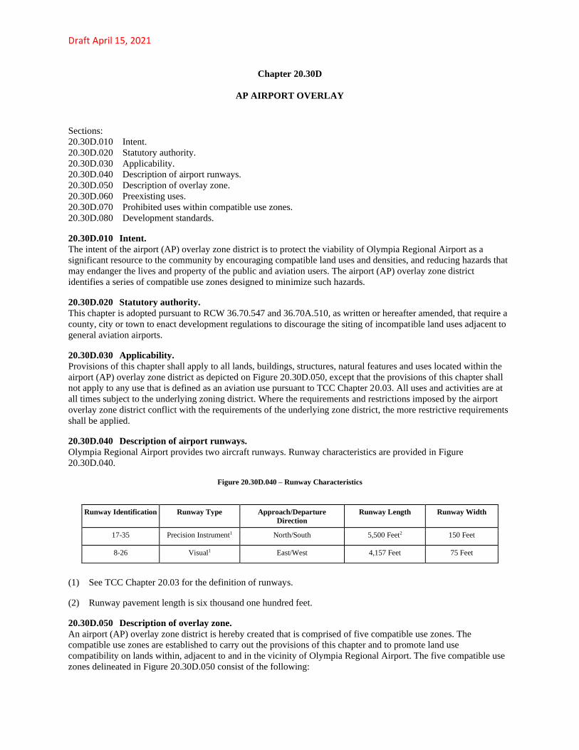
Draft April 15, 2021
Chapter 20.30D
AP AIRPORT OVERLAY
Sections:
20.30D.010 Intent.
20.30D.020 Statutory authority.
20.30D.030 Applicability.
20.30D.040 Description of airport runways.
20.30D.050 Description of overlay zone.
20.30D.060 Preexisting uses.
20.30D.070 Prohibited uses within compatible use zones.
20.30D.080 Development standards.
20.30D.010 Intent.
The intent of the airport (AP) overlay zone district is to protect the viability of Olympia Regional Airport as a
significant resource to the community by encouraging compatible land uses and densities, and reducing hazards that
may endanger the lives and property of the public and aviation users. The airport (AP) overlay zone district
identifies a series of compatible use zones designed to minimize such hazards.
20.30D.020 Statutory authority.
This chapter is adopted pursuant to RCW 36.70.547 and 36.70A.510, as written or hereafter amended, that require a
county, city or town to enact development regulations to discourage the siting of incompatible land uses adjacent to
general aviation airports.
20.30D.030 Applicability.
Provisions of this chapter shall apply to all lands, buildings, structures, natural features and uses located within the
airport (AP) overlay zone district as depicted on Figure 20.30D.050, except that the provisions of this chapter shall
not apply to any use that is defined as an aviation use pursuant to TCC Chapter 20.03. All uses and activities are at
all times subject to the underlying zoning district. Where the requirements and restrictions imposed by the airport
overlay zone district conflict with the requirements of the underlying zone district, the more restrictive requirements
shall be applied.
20.30D.040 Description of airport runways.
Olympia Regional Airport provides two aircraft runways. Runway characteristics are provided in Figure
20.30D.040.
Figure 20.30D.040 – Runway Characteristics
Runway Identification Runway Type Approach/Departure
Direction
Runway Length Runway Width
17-35 Precision Instrument1 North/South 5,500 Feet2 150 Feet
8-26 Visual1 East/West 4,157 Feet 75 Feet
(1) See TCC Chapter 20.03 for the definition of runways.
(2) Runway pavement length is six thousand one hundred feet.
20.30D.050 Description of overlay zone.
An airport (AP) overlay zone district is hereby created that is comprised of five compatible use zones. The
compatible use zones are established to carry out the provisions of this chapter and to promote land use
compatibility on lands within, adjacent to and in the vicinity of Olympia Regional Airport. The five compatible use
zones delineated in Figure 20.30D.050 consist of the following:

Draft April 15, 2021
A. Zone 1: Runway Protection Zone.
B. Zone 2: Inner Approach/Departure Zone.
C. Zone 3: Inner Turning Zone.
D. Zone 4: Outer Approach/Departure Zone.
E. Zone 5: Sideline Zone.
20.30D.060 Preexisting uses.
A. Nothing contained herein shall require any change in the construction or alteration of any structure, if the
construction or alteration of such was vested pursuant to TCC prior to the effective date of this chapter.
B. Destruction. The owner of any preexisting use or structure legally constructed prior to the effective date of this
chapter which, as a result of fire, explosion or other casualty is destroyed, shall be allowed to rebuild, reconstruct or
rehabilitate the same preexisting use of the same size (gross square feet) on the same parcel, provided the use
complies with the following:
1. The use complies with the height standards of the underlying zoning district;
2. The use is permitted in the underlying zoning district.
C. Expansion of Preexisting Uses. Any preexisting use legally constructed prior to the effective date of this
chapter may be expanded, altered or otherwise enlarged if the use meets the following:
1. The use is not listed as a prohibited use by other sections of this chapter;
2. The use complies with the standards set forth in TCC 20.30D.080;
3. The use complies with the height standards of the underlying zoning district;
4. The use is permitted in the underlying zoning district.
20.30D.070 Prohibited uses within compatible use zones.
Uses listed in this section are prohibited, except for those uses permitted pursuant to TCC 20.30D.060. A use or
building is deemed to be within the applicable compatible use zone if any portion of the use or building touches or
extends into the applicable zone. The mere application of the zone on a tract of land upon which such use or
building is located or proposed to be located shall not prohibit otherwise authorized development on the portion of
the tract outside of the zone.
A. Zone 1 – Runway Protection Zone – Prohibited Uses.
1. Residential dwellings;
2. Stormwater wet ponds;
3. Active recreational facilities;
4. Schools, preschool/child care facilities, child day care centers, churches, hospitals, senior housing facilities,
rest homes and group foster homes;
5. Uses that:
a. Create lighting that diminishes the ability of pilots to distinguish between airport lights and nonairport
lights;
b. Create electrical interference with navigational signals or radio communication between the airport
and aircraft;

Draft April 15, 2021
c. Create dust, smoke or other emissions that result in impairment of visibility for pilots.
B. Zone 2 – Inner Approach/Departure Zone – Prohibited Uses.
1. Multifamily dwellings;
2. Active recreational facilities;
3. Schools, preschool/child care facilities, child day care centers, churches, hospitals, senior housing facilities,
rest homes and group foster homes;
4. Uses that:
a. Create lighting that diminishes the ability of pilots to distinguish between airport lights and nonairport
lights;
b. Create electrical interference with navigational signals or radio communication between the airport
and aircraft;
c. Create dust, smoke or other emissions that result in impairment of visibility for pilots.
C. Zone 3 – Inner Turning Zone – Prohibited Uses.
1. Multifamily dwellings;
2. Active recreational facilities;
3. Schools, preschool/child care facilities; child day care centers; churches, hospitals, senior housing
facilities, rest homes and group foster homes;
4. Uses that:
a. Create lighting that diminishes the ability of pilots to distinguish between airport lights and nonairport
lights;
b. Create electrical interference with navigational signals or radio communication between the airport
and aircraft;
c. Create dust, smoke or other emissions that result in impairment of visibility for pilots.
D. Zone 4 – Outer Approach/Departure Zone – Prohibited Uses.
1. Multifamily dwellings;
2. Schools, preschool/child care facilities; child day care centers; churches, hospitals, senior housing
facilities, rest homes and group foster homes;
3. Uses that:
a. Create lighting that diminishes the ability of pilots to distinguish between airport lights and nonairport
lights;
b. Create electrical interference with navigational signals or radio communication between the airport
and aircraft;
c. Create dust, smoke or other emissions that result in impairment of visibility for pilots.
E. Zone 5 – Sideline Zone – Prohibited Uses.

Draft April 15, 2021
1. Multifamily dwellings;
2. Schools, preschool/child care facilities; child day care centers; churches, hospitals, senior housing
facilities, rest homes and group foster homes;
3. Uses that:
a. Create lighting that diminishes the ability of pilots to distinguish between airport lights and nonairport
lights;
b. Create electrical interference with navigational signals or radio communication between the airport
and aircraft;
c. Create dust, smoke or other emissions that result in impairment of visibility for pilots.
20.30D.080 Development standards.
Development standards are necessary to protect the health, safety, welfare and quality of life of the general public,
property owners, airport operators, and aviation community, and also to ensure compatible land uses in the vicinity
of the airport. Development standards imposed within the airport overlay zone district are in addition to the
development standards of the underlying zoning district. Where standards imposed by the airport overlay zone
district conflict with the standards of the underlying zone district, the more restrictive standard shall be applied.
Mixed use development that propose both residential and nonresidential uses must meet applicable standards in both
subsections below.
A. Residential Standards. Residential land divisions of one acre or more located within compatible use zones 3, 4
or 5 shall meet the following standards:
1. The land division is approved as a clustered development with the residential lots located as far away from
the runway centerline as possible;
2. An open space area is provided on the project site. The purpose of this open space area is to provide sites
that are suitable for the emergency landing of aircraft. The required minimum size of this open space area is
one-half acre or ten percent of the gross site area, whichever is greater. This open space area may be used to
fulfill other applicable open space/park requirements for residential developments; provided, that active
recreation facilities and aboveground stormwater ponds and infiltration facilities shall not be located in this
open space area. This open space area should be contiguous to other open space areas within or adjacent to the
project site, and may include wetlands and their buffers and other critical areas.
B. Nonresidential Standards. All nonresidential developments and uses shall meet the following intensity
standards; provided, however, that these standards do not apply to preexisting uses as described in TCC
20.30D.060(B). The building code as adopted by the Thurston County shall be used for determining the building
occupant load factor. For developments proposing two or more uses, the calculation must incorporate the occupant
load factor and acreage for the entire development. For developments involving land or buildings split by a
compatible use zone boundary, only that portion of the land or building(s) located within the compatible use zone
shall be subject to the standards below.
1. Zone 1: twenty people per acre maximum;
2. Zone 2: sixty people per acre maximum;
3. Zone 3: one hundred twenty-five people per acre maximum;
4. Zone 4: one hundred thirty-five people per acre maximum;
5. Zone 5: one hundred fifty people per acre maximum;
Draft April 15, 2021
6. Intensity Bonus. Land development proposals located in compatible use zones 2, 3, 4, or 5 that exceed the
intensity standards set forth in subsections (B)(2) through (5) of this section may be considered for approval
through the apecial use permit process.
People per acre shall be calculated as follows:
Step 1. Building size (gross square feet) divided by occupant load factor (square feet per occupant as set forth in the
building code) equals maximum building occupancy.
Step 2. For retail and office uses only: maximum building occupancy multiplied by 0.50 equals adjusted maximum
building occupancy.
Step 3. Maximum building occupancy divided by gross site acreage equals people per acre.
Note: A parking structure shall be excluded from the calculation unless the structure is the primary use of the site.
Example:
A single-floor furniture store containing twenty-four thousand square feet of floor area is proposed on a two-acre
site. The store consists of fifty percent of floor space dedicated to retail sales and fifty percent for warehousing.
Usage intensities are estimated as follows:
Step 1. Twelve thousand square feet retail sales floor area divided by thirty square feet/occupant equals four hundred
people maximum occupancy in retail sales area.
Twelve thousand square feet warehouse floor area divided by five hundred square feet/occupant equals twenty-four
people maximum occupancy in warehouse area.
Step 2. Assuming typical peak occupancy for retail sales is fifty percent of maximum occupancy for retail sales
equals two hundred people maximum expected at any one time. Maximum occupancy for entire use is therefore two
hundred twenty-four people (two hundred plus twenty-four).
Step 3. Two hundred twenty-four people divided by two acres equals one hundred twelve people per acre average
for the site.
C. Flammable and Combustible Materials. Flammable and combustible liquids and specifications for fuel storage
shall be in accordance with the fire code as adopted by the city of Tumwater.
D. Noise Insulation. Noise insulation for new structures shall be in accordance with the building code as adopted
by the city of Tumwater.
E. Disclosure Statement. A disclosure statement shall be recorded with the Thurston County auditor for
subdivisions, short subdivisions, binding site plans and building permits for any new building or expansion of an
existing building located within the airport overlay zone district. The disclosure statement shall state that the
property is located within the airport overlay zone district in which a variety of aviation activities occur, which may
include but are not limited to: noise, vibration, chemicals, odors, hours of operation and other associated activities.
F. Land Divisions.
1. A new lot proposed to be created by a land division shall not result in an increase in intensity on the newly
created lot when the existing lot contains a nonresidential use that exceeds the intensity standards of subsection
B of this section.
2. A nonresidential use that complies with the intensity standards of subsection B of this section may proceed
with a proposed land division if the new lot to be created contains adequate gross site acreage such that the use
of the new lot also meets the intensity standards of subsection B of this section.
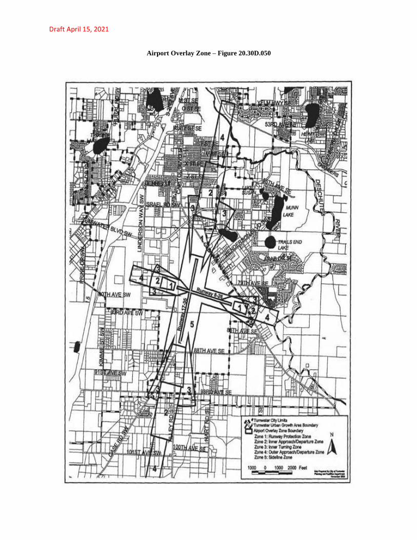
Draft April 15, 2021
Airport Overlay Zone – Figure 20.30D.050
Draft April 15, 2021
20.03.040.7.1 Aviation use.
“Aviation use” means any runway, taxiway, connector, apron or heliport designed for the landing and taking off of
aircraft, transfer of passengers and/or cargo, surface access, and other support facilities typically associated with
airports, including: hangars, control towers, communication and maintenance facilities, operations area, airport
fueling facilities, fixed-based operators (FBO) and passenger and cargo terminals (including retail and eating and
drinking establishments located within a terminal or FBO building).
20.03.040.116.3 Runways.
“Precision instrument runway” means a runway that is designed to provide an approach path for exact alignment and
descent of an aircraft on final approach using vertical and horizontal navigational aid equipment.
“Visual runway” means a runway intended solely for the operation of aircraft using visual approach procedures.
20.03.040.35 "Airport approach areas" means an imaginary surface longitudinally centered on the runway
centerline, extending outward and upward from the end of the runway, and is based upon the type of approach
available or planned for that runway end.