Community Integrated Management Plan - mnre.gov.ws · Solomona Lesā Losi Leiataua Eseta Futi...
118
Community Integrated Management Plan Aiga i le Tai District– Upolu Implementation Guidelines 2018
Transcript of Community Integrated Management Plan - mnre.gov.ws · Solomona Lesā Losi Leiataua Eseta Futi...

Community Integrated Management Plan
Aiga i le Tai District– Upolu
Implementation Guidelines 2018
COMMUNITY INTEGRATED MANAGEMENT PLAN IMPLEMENTATION GUIDELINES
MNRE PAGE 2
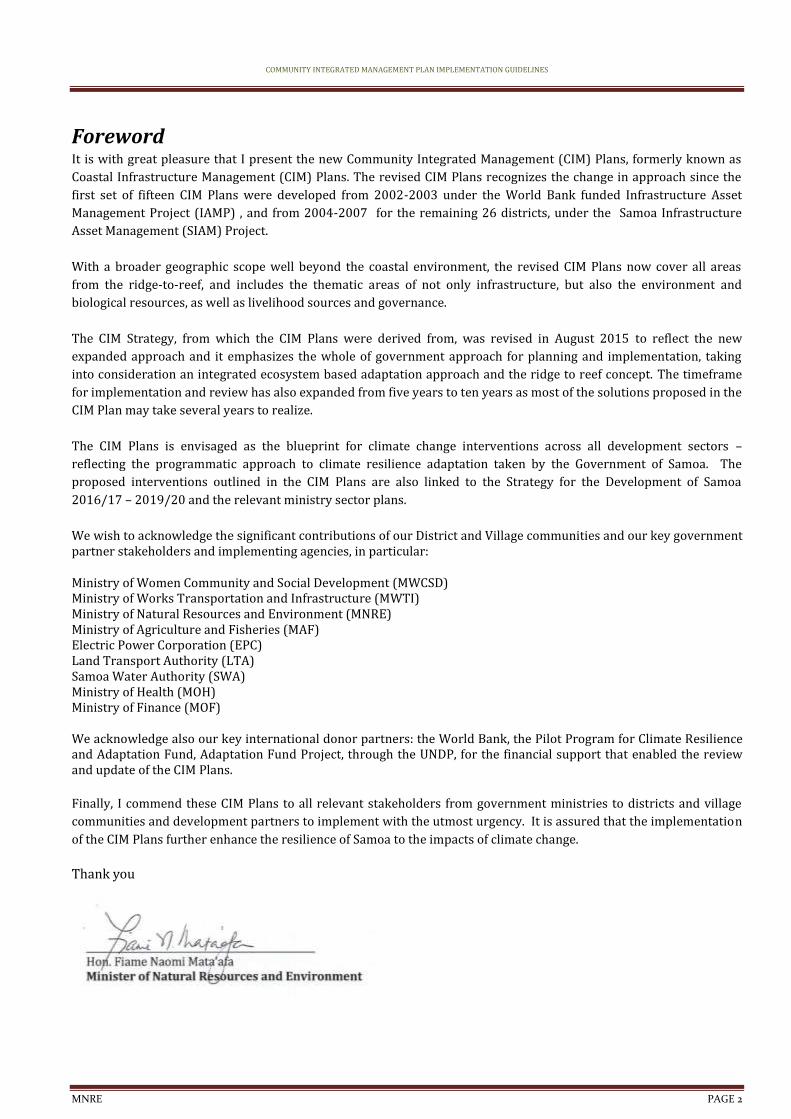
Foreword It is with great pleasure that I present the new Community Integrated Management (CIM) Plans, formerly known as
Coastal Infrastructure Management (CIM) Plans. The revised CIM Plans recognizes the change in approach since the
first set of fifteen CIM Plans were developed from 2002-2003 under the World Bank funded Infrastructure Asset
Management Project (IAMP) , and from 2004-2007 for the remaining 26 districts, under the Samoa Infrastructure
Asset Management (SIAM) Project.
With a broader geographic scope well beyond the coastal environment, the revised CIM Plans now cover all areas
from the ridge-to-reef, and includes the thematic areas of not only infrastructure, but also the environment and
biological resources, as well as livelihood sources and governance.
The CIM Strategy, from which the CIM Plans were derived from, was revised in August 2015 to reflect the new
expanded approach and it emphasizes the whole of government approach for planning and implementation, taking
into consideration an integrated ecosystem based adaptation approach and the ridge to reef concept. The timeframe
for implementation and review has also expanded from five years to ten years as most of the solutions proposed in the
CIM Plan may take several years to realize.
The CIM Plans is envisaged as the blueprint for climate change interventions across all development sectors –
reflecting the programmatic approach to climate resilience adaptation taken by the Government of Samoa. The
proposed interventions outlined in the CIM Plans are also linked to the Strategy for the Development of Samoa
2016/17 – 2019/20 and the relevant ministry sector plans.
We wish to acknowledge the significant contributions of our District and Village communities and our key government partner stakeholders and implementing agencies, in particular:
Ministry of Women Community and Social Development (MWCSD) Ministry of Works Transportation and Infrastructure (MWTI) Ministry of Natural Resources and Environment (MNRE) Ministry of Agriculture and Fisheries (MAF) Electric Power Corporation (EPC) Land Transport Authority (LTA) Samoa Water Authority (SWA) Ministry of Health (MOH) Ministry of Finance (MOF)
We acknowledge also our key international donor partners: the World Bank, the Pilot Program for Climate Resilience and Adaptation Fund, Adaptation Fund Project, through the UNDP, for the financial support that enabled the review and update of the CIM Plans.
Finally, I commend these CIM Plans to all relevant stakeholders from government ministries to districts and village
communities and development partners to implement with the utmost urgency. It is assured that the implementation
of the CIM Plans further enhance the resilience of Samoa to the impacts of climate change.
Thank you
COMMUNITY INTEGRATED MANAGEMENT PLAN IMPLEMENTATION GUIDELINES
MNRE PAGE 3
Participants in the Plan
The CIM Plan is a Partnership between the Government of Samoa and the villages within the Plan area. The Plan area starts from the ridge extending to the reef broadly covering 4 sectors; Infrastructure; Natural Environment and Resources; Livelihood and Food security; and Village Governance. Both partners have responsibilities for issues and solutions and the Plan gives an integrated approach to the provision of services and improvement of resilience now and in the future. This Plan incorporates the Faipule District of Aiga I le Tai and Satuimalufilufi Village (Apai Tai, ApolimaUta, Apolima Tai, Faleu Tai, Lalovi, Lepuia’i Tai, Manono Uta, Mulifanua, Paepaealā, Salua Tai and Satuimalufilufi villages). The village representatives participated in the preparation of this CIM Plan in partnership with the Government of Samoa.
Date of Signing: _22 June 2015
Representative: Signature:
Apai Tai Village, Manono Tai
Feauina Tolovae
Finau – Apai Tavita
Faimafili Finau
Alo Tile
Kaisu Faimalo
Apolima Tai Village
Sa’u Filimaua
Sa’u Shute
Sa’u Faamanuia
Tautaiole Vao Tautala
Taumaiasi Atapana

COMMUNITY INTEGRATED MANAGEMENT PLAN IMPLEMENTATION GUIDELINES
MNRE PAGE 4
Apolima Uta Village
Sa’u Polafaasili Puavase Sa’u
Tina Sa’u
Tolusefulutasi Siliva
Sa’u Iosefa
Anaimalo Sa’u
Faleu Tai Village, Manono Tai
Lesā Tominiko
Solomona Lesā
Losi Leiataua
Eseta Futi
Terisa Leiataua
Lalovi Village
Seulu Iloa
Seuklu Pelela
Togia Tuavela
Gale Togia
Falute Tafia
COMMUNITY INTEGRATED MANAGEMENT PLAN IMPLEMENTATION GUIDELINES
MNRE PAGE 5
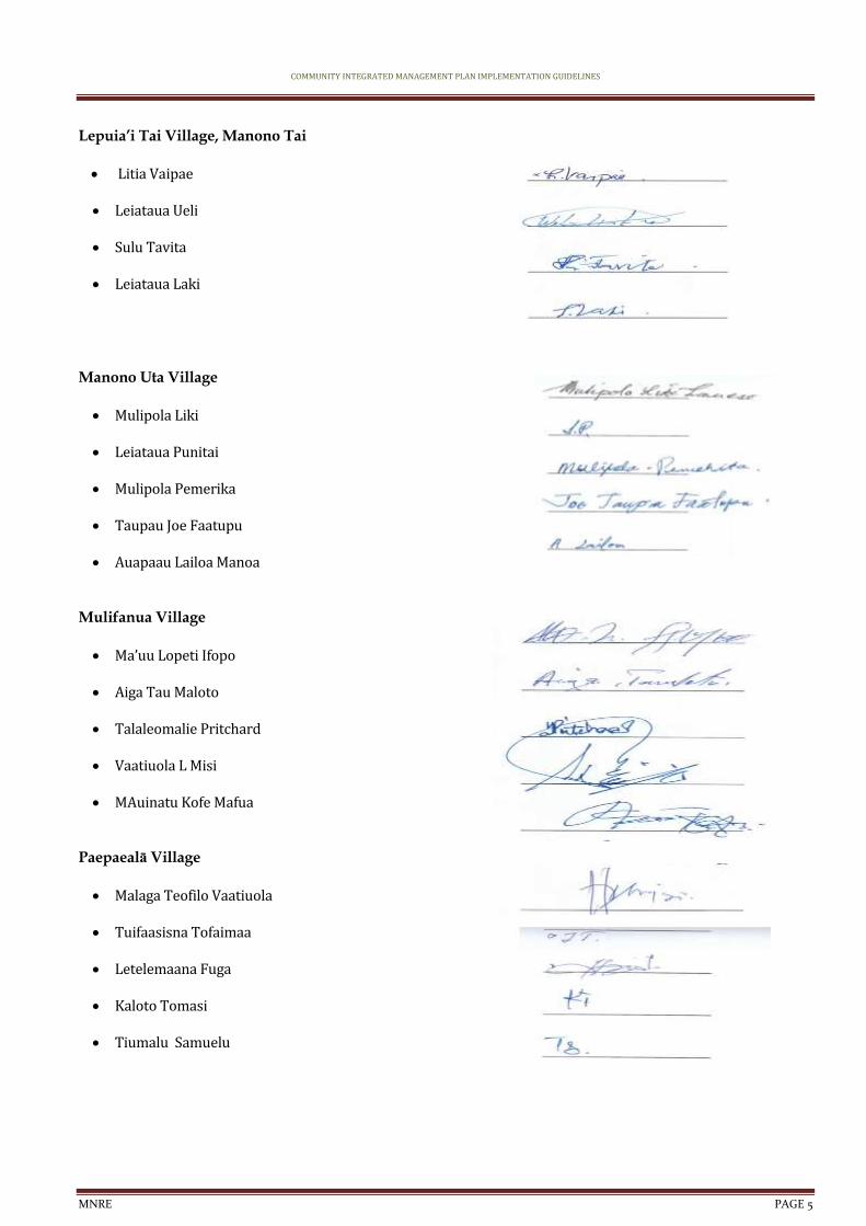
Lepuia’i Tai Village, Manono Tai
Litia Vaipae
Leiataua Ueli
Sulu Tavita
Leiataua Laki
Manono Uta Village
Mulipola Liki
Leiataua Punitai
Mulipola Pemerika
Taupau Joe Faatupu
Auapaau Lailoa Manoa
Mulifanua Village
Ma’uu Lopeti Ifopo
Aiga Tau Maloto
Talaleomalie Pritchard
Vaatiuola L Misi
MAuinatu Kofe Mafua
Paepaealā Village
Malaga Teofilo Vaatiuola
Tuifaasisna Tofaimaa
Letelemaana Fuga
Kaloto Tomasi
Tiumalu Samuelu

COMMUNITY INTEGRATED MANAGEMENT PLAN IMPLEMENTATION GUIDELINES
MNRE PAGE 6
Salua Tai Village, Manono Tai
Aupaau Talilalo
Mulipola Tausala
Eseta Elisala
Talia Auapaau
Malo Taupau
Satuimalufilufi Village
Tiumalu Taua
Malumaauga Pisa
Fuga Manuele
Mavaega Tamati
The Government of Samoa adopts the Community Integrated Management Plan for the Faipule District of Aiga I
le Tai as a Management Plan for the Implementation of the Community Integrated Management Strategy (CIMS).
The Ministry of Natural Resources and Environment, as lead organization of Government, on behalf of the
participating Government Departments and Corporations, confirms the participation of the Government of Samoa
in the preparation of this Community Integrated Management Plan and its adoption as a Management Plan for
the implementation of the Community Integrated Management Strategy.
COMMUNITY INTEGRATED MANAGEMENT PLAN IMPLEMENTATION GUIDELINES
MNRE PAGE 7
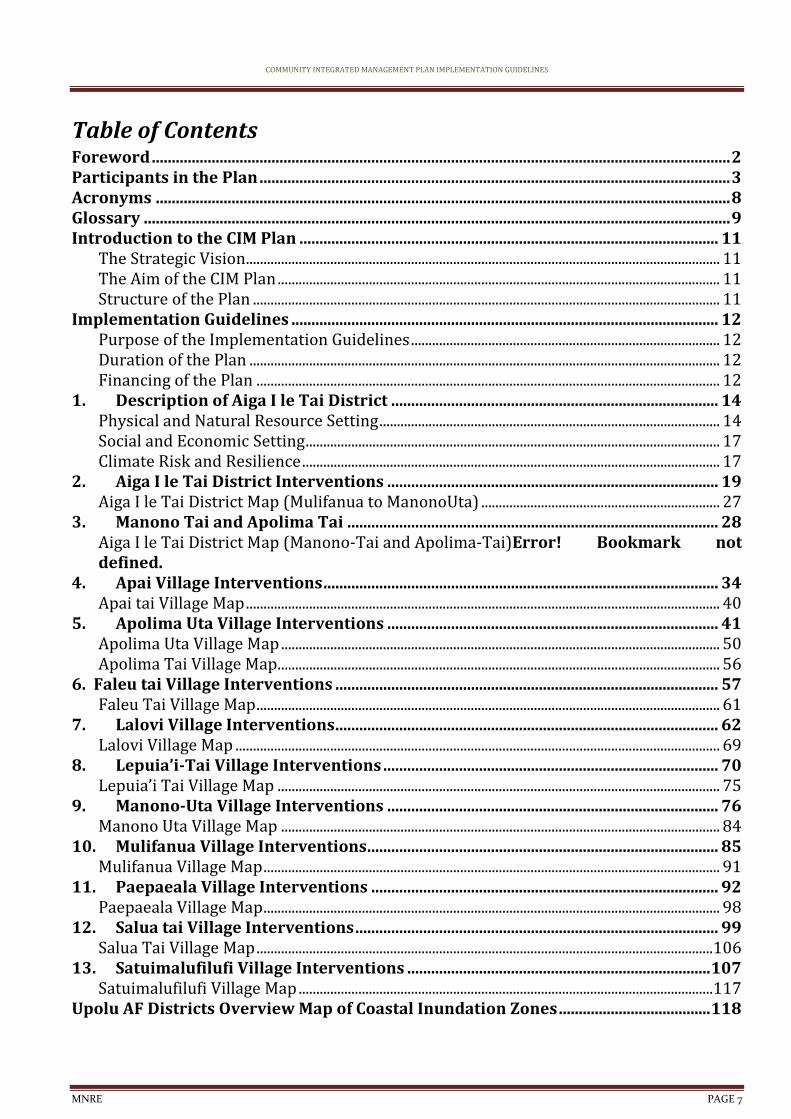
Table of Contents Foreword ................................................................................................................................................. 2 Participants in the Plan ...................................................................................................................... 3 Acronyms ................................................................................................................................................ 8 Glossary ................................................................................................................................................... 9 Introduction to the CIM Plan ......................................................................................................... 11
The Strategic Vision....................................................................................................................................... 11 The Aim of the CIM Plan .............................................................................................................................. 11 Structure of the Plan ..................................................................................................................................... 11
Implementation Guidelines ........................................................................................................... 12 Purpose of the Implementation Guidelines ........................................................................................ 12 Duration of the Plan ...................................................................................................................................... 12 Financing of the Plan .................................................................................................................................... 12
1. Description of Aiga I le Tai District .................................................................................. 14 Physical and Natural Resource Setting ................................................................................................. 14 Social and Economic Setting ...................................................................................................................... 17 Climate Risk and Resilience ....................................................................................................................... 17
2. Aiga I le Tai District Interventions ................................................................................... 19 Aiga I le Tai District Map (Mulifanua to ManonoUta) .................................................................... 27
3. Manono Tai and Apolima Tai ............................................................................................. 28 Aiga I le Tai District Map (Manono-Tai and Apolima-Tai)Error! Bookmark not defined.
4. Apai Village Interventions ................................................................................................... 34 Apai tai Village Map ....................................................................................................................................... 40
5. Apolima Uta Village Interventions ................................................................................... 41 Apolima Uta Village Map ............................................................................................................................. 50 Apolima Tai Village Map.............................................................................................................................. 56
6. Faleu tai Village Interventions ................................................................................................ 57 Faleu Tai Village Map .................................................................................................................................... 61
7. Lalovi Village Interventions ................................................................................................ 62 Lalovi Village Map .......................................................................................................................................... 69
8. Lepuia’i-Tai Village Interventions .................................................................................... 70 Lepuia’i Tai Village Map .............................................................................................................................. 75
9. Manono-Uta Village Interventions ................................................................................... 76 Manono Uta Village Map ............................................................................................................................. 84
10. Mulifanua Village Interventions........................................................................................ 85 Mulifanua Village Map .................................................................................................................................. 91
11. Paepaeala Village Interventions ....................................................................................... 92 Paepaeala Village Map .................................................................................................................................. 98
12. Salua tai Village Interventions ........................................................................................... 99 Salua Tai Village Map ..................................................................................................................................106
13. Satuimalufilufi Village Interventions ............................................................................ 107 Satuimalufilufi Village Map ......................................................................................................................117
Upolu AF Districts Overview Map of Coastal Inundation Zones ...................................... 118
COMMUNITY INTEGRATED MANAGEMENT PLAN IMPLEMENTATION GUIDELINES
MNRE PAGE 8
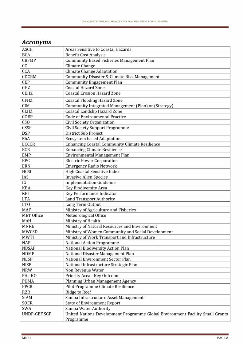
Acronyms ASCH Areas Sensitive to Coastal Hazards BCA Benefit Cost Analysis CBFMP Community Based Fisheries Management Plan CC Climate Change CCA Climate Change Adaptation CDCRM Community Disaster & Climate Risk Management CEP Community Engagement Plan CHZ Coastal Hazard Zone CEHZ Coastal Erosion Hazard Zone
CFHZ Coastal Flooding Hazard Zone CIM Community Integrated Management (Plan) or (Strategy) CLHZ Coastal Landslip Hazard Zone COEP Code of Environmental Practice CSO Civil Society Organization CSSP Civil Society Support Programme DSP District Sub Project EbA Ecosystem based Adaptation ECCCR Enhancing Coastal Community Climate Resilience ECR Enhancing Climate Resilience EMP Environmental Management Plan EPC Electric Power Corporation ERN Emergency Radio Network HCSI High Coastal Sensitive Index IAS Invasive Alien Species IG Implementation Guideline KBA Key Biodiversity Area KPI Key Performance Indicator LTA Land Transport Authority LTO Long Term Output MAF Ministry of Agriculture and Fisheries MET Office Meteorological Office MoH Ministry of Health MNRE Ministry of Natural Resources and Environment MWCSD Ministry of Women Community and Social Development MWTI Ministry of Work Transport and Infrastructure NAP National Action Programme NBSAP National Biodiversity Action Plan NDMP National Disaster Management Plan NESP National Environment Sector Plan NISP National Infrastructure Strategic Plan NRW Non Revenue Water PA - KO Priority Area - Key Outcome PUMA Planning Urban Management Agency PPCR Pilot Programme Climate Resilience R2R Ridge to Reef SIAM Samoa Infrastructure Asset Management SOER State of Environment Report SWA Samoa Water Authority UNDP-GEF SGP United Nations Development Programme Global Environment Facility Small Grants
Programme

COMMUNITY INTEGRATED MANAGEMENT PLAN IMPLEMENTATION GUIDELINES
MNRE PAGE 9
WB World Bank WCR West Coast Road WMP Watershed Management Plan WSSP Water Sanitation Sector Plan
Glossary Coastal Hazard Zones Defined areas landward of the coast which are or are considered likely to be
subject to the effects of hazards over a defined assessment period. In this study, reference is made to four coastal hazard zones: ASCHs (areas sensitive to coastal hazards); CEHZs (coastal erosion hazard zones); CFHZs (coastal flood hazard zones) and CLHZs (coastal landslip hazard zones).
“Do Minimum”option A Management option that involves continuing with the present maintenance and upgrading programme on and when required basis.
Emergency Management To provide communities with skills, facilities and materials so that they may adapt, respond and recover more quickly in the event of emergencies.
Hazard A source of potential harm or a situation with a potential to cause loss.
Infrastructure Built structures and networks which support the national, regional or local community.
Lifeline infrastructure Infrastructure that contributes directly to the survival of the community and its ability to respond and recover at the time of extreme events.
Secondary infrastructure Infrastructure that contributes to the every-day development of the community.
Implementation Guidelines A document to guide land use and resource practices to achieve specified goals, objectives and policies and provide a framework for the implementation of defenses and works.
Issue A specific concern regarding both cause and effect.
Land and Resource Use The use of land and resources by the community for social, economic or other benefit (e.g. land use includes areas used for villages or crops, resource use includes activities such as sand mining, gravel extraction or fishing).
Monitoring Process of measuring the effectiveness or impacts of projects and works against predicted standards, levels or outcomes.
Resilience The ability to be adaptive, responsive and quick to recover.
Community Resilience The ability for the community to be adaptive, responsive and quick to recover from the adverse effects of hazard.
Natural Resilience– The ability of natural systems to be adaptive, responsive and quick to recover from natural processes or hazards.
Risk The chance of something happening that will have an impact on objectives. It is measured in terms of consequence and likelihood. In the Community Integrated Management Plan context it is the likelihood that infrastructure, environment and biological resources and agricultural and marine resources (food security) will be subject to inland and coastal hazards and the potential for loss of property, life or land due to natural processes.
Stakeholders Those people and organizations who may affect, be affected by, or perceive themselves to be affected by, a decision or activity. The term stakeholder may also include interested parties.
Strategy Direction or course of action to achieve a define division.
Susceptibility The degree to which infrastructure at risk is likely to be damaged by coastal hazards and how easy/difficult, expensive/cheap it is to replace. In the context of the CIM Plan the term susceptibility is equivalent to the term vulnerability as the Samoan phrase for both susceptibility and vulnerability is the same.
COMMUNITY INTEGRATED MANAGEMENT PLAN IMPLEMENTATION GUIDELINES
MNRE PAGE 10
Vision A desired destiny.
Livelihood A livelihood is a means of making a living. It encompasses people's capabilities, assets, income and activities required to secure the necessities of life Food availability: The availability of sufficient quantities of food of appropriate quality, supplied through domestic production or imports (including food aid).
Food access Access by individuals to adequate resources (entitlements) for acquiring appropriate foods for a nutritious diet. Entitlements are defined as the set of all commodity bundles over which a person can establish command given the legal, political, economic and social arrangements of the community in which they live (including traditional rights such as access to common resources).
Utilization Utilization of food through adequate diet, clean water, sanitation and health care to reach a state of nutritional well-being where all physiological needs are met. This brings out the importance of non-food inputs in food security.
Stability To be food secure, a population, household or individual must have access to adequate food at all times. They should not risk losing access to food as a consequence of sudden shocks (e.g. an economic or climatic crisis) or cyclical events (e.g. seasonal food insecurity). The concept of stability can therefore refer to both the availability and access dimensions of food security.
COMMUNITY INTEGRATED MANAGEMENT PLAN IMPLEMENTATION GUIDELINES
MNRE PAGE 11
Introduction to the CIM Plan
The Strategic Vision The District Community Integrated Management (CIM) Plan for Aiga I le Tai District and Satuimalufilufi Village
has been prepared as part of the Government of Samoa’s Adaptation Fund - Enhancing Resilience of Coastal
Communities of Samoa to Climate Change Project. The CIM Plan is one of the primary means of implementing the
CIM Strategy, which was formally approved by the Government of Samoa in February, 2001 and updated in 2015
as providing the Strategic direction for enhancing the resilience of community livelihoods, infrastructure,
environment and natural resources using a holistic and integrated ridge-to-reef approach. The Strategy has as
its central vision:
The CIM Plan takes this vision and provides the practical tools with which the communities and the government, in partnership, can implement the Strategy. To be resilient is to be adaptive, responsive and quick to recover so that communities are environmentally, socially and economically sustainable (CIM Strategy, 2015).
The Aim of the CIM Plan The aim of the CIM Plan is to help communities and government improves resilience by identifying actions and solutions considered as best approach to issues identified. Not all the solutions may be actioned immediately but the plan will ensure that issues and options are identified for the long-term improvement in resilience of community livelihoods, infrastructure, and environment and resource systems.
The CIM Plan will:
1. Improve the community’s awareness of all hazard risks from the ridge to the reef; 2. Enable the community as well as providers of services and physical, financial, and technical
support in all climate prone sectors, to reduce inland and coastal hazard risks in villages; 3. Enable the community and government service providers of infrastructure services, livelihoods,
environment and natural resources to better adapt, respond and recover from cyclones.
Structure of the Plan The CIM Plan consists of two parts each serving a separate and distinct purpose.
Plan Development, which describes the process undertaken in preparing the CIM Plan in conjunction with representatives of the Communities involved, the Government and other stakeholders with interests in the Plan area.
Implementation Guidelines, which describes the Plans and Actions recommended as outcomes of the process, together with the partner responsible for implementing these outcomes. The participants of the CIM Plan preparation process are acknowledged in the Implementation Guidelines.
Resilience – Community Livelihoods, Infrastructure, Environment and Natural Resources to Climate Change and Natural Disasters

COMMUNITY INTEGRATED MANAGEMENT PLAN IMPLEMENTATION GUIDELINES
MNRE PAGE 12
Implementation Guidelines
Purpose of the Implementation Guidelines The Implementation Guidelines describe the solutions proposed that will increase the resilience of the villages in
the Plan area and the ways these solutions can be implemented. The solutions are presented for various
livelihoods, infrastructure, environment and natural resources items that have moderate to low resilience.
Where one solution will provide benefits to other items of livelihoods, infrastructure, environment and natural
resources these “Other Benefits” are also noted. Implementation is considered to be the joint responsibility of
both the villages and the government in partnership. The government is responsible for the provision of
national and district “Public”, infrastructure and public goods and benefits derive from environmental services
and natural resources , while villages are responsible for local and community infrastructure and livelihoods
related actions. The responsibility for implementing the proposed actions is also defined. Solutions for both
District and Village level issues related to livelihoods, infrastructure, environment and natural resources
respectively, and the responsibility of both partners, should be considered together as they combine to provide
for the integrated management of all community development initiatives.
The solutions for village level interventions related to livelihoods, infrastructure, environment and natural
resources will usually be the responsibility of the Village Council and Families in the village to implement.
Advice and resources may be available from the Government to assist the village in implementing these
solutions. In most situations these solutions will also provide benefits to both village and district infrastructure
and resources and environmental goods that are shared between villages. These solutions should be considered
an integral part of strengthening community resilience at both levels.
Duration of the Plan The CIM Plan is reviewed every 10 years but during the Plan period, the solutions implemented will be monitored on a five (5) yearly basis to ensure the proposed solutions are effective and are actually improving resilience. The 5 yearly monitoring of the new CIM Plan is aligned with the 5 year review of the key national planning and programming strategy for Samoa: the Strategy for the Development of Samoa (SDS). The new CIM Plan recognizes some solutions are likely to take longer than 5 years, whilst others may take up to 10 years to implement due to the complexity of planning process, funding and budgeting programming required to implement these solutions.
Detailed implementation of the solution will determine the monitoring requirements and Key Performance Indicators.
Financing of the Plan
Implementation of best solutions is the collective effort of all identified responsible agencies, civil society organizations, donor partners and district and village communities themselves. Funding will be sourced through several mechanisms recognizing the Government of Samoa’s programmatic approach to tackling climate change impacts on its development progress. While every effort has been made to identify priority actions needed to build the resilience of Samoa and its communities, the Government also recognizes that not all actions identified can be financed at once. Implementation of best solutions will be undertaken strategically and over time in line with available funding and, if determined a priority CCA activity that will actually build the resilience of communities and Samoa as a whole. Criteria of determining priority CCA best solutions for financing are:
• proposed development is in general accordance with the objectives of the CIM Strategy 2015; • development is specifically recommended in the CIM Plan • number of people that will benefit from the development, i.e. population benefit • development will provide life sustaining support for communities • minimum or neutral environmental effects • development will improve resilience • development will achieve speedy recovery • development will reduce risk • also identified as a priority in other Sector Plans or National Strategies
COMMUNITY INTEGRATED MANAGEMENT PLAN IMPLEMENTATION GUIDELINES
MNRE PAGE 13
During the development of the new CIM Plans, the World Bank funded Pilot Programme for Climate Resilience Enhancing Climate Resilience for Coastal Resources and Communities (PPCR ECR) prepared two (2) key documents:
Community Engagement Plan (CEP)-the guidelines provided in the CEP is an excellent capacity building tool that can be used by CSO's and village communities themselves to aid development of small grant proposals to existing small grant funding mechanisms like CSSP and the UNDP-GEFSGP
District Sub Project (DSP) – the guidelines provided in the DSP targets single districts or multi-district
projects with a large number of beneficiaries.
Noting Samoa’s programmatic approach to CC and CCA, these key documents are fundamental in guiding development partners, implementing agencies and other stakeholders on the most effective way of resourcing and supporting climate change adaptation projects at the village and district levels. These village and district level CCA projects actually achieve the majority of key indicators in various Sector Plans, subsequently achieving key national indicators contained in the Strategy for the Development of Samoa (SDS).

COMMUNITY INTEGRATED MANAGEMENT PLAN IMPLEMENTATION GUIDELINES
MNRE PAGE 14
1. Description of Aiga I le Tai District
Physical and Natural Resource Setting The Faipule District of Aiga I le Tai covers the islands of Manono and Apolima as well as part of Upolu at the western end of Upolu Island. Satuimalufilufi village which is part of the Faipule District of Aana Alofi 3, is covered under the Aiga i le Tai CIM Plan as it is located between the villages of Apolima Uta and Lalovi (refer map of district). The villages in the Aiga I le Tai district include Manono-Uta, Apolima-Uta, Lalovi, Mulifanua and Paepaealā from Upolu while Faleu Tai, Salua Tai, Lepuia’i Tai and Apai Tai are villages of Manono Tai. Apolima Tai covers the whole of Apolima Island which lies north-west of Manono Tai. The physical and natural resource setting has been divided into distinct settings – Mulifanua to Manono Uta, Manono Island and Apolima Island – this setting provides three different environments to be considered in this CIM Plan. Mulifanua Wharf to Manono Uta The Mulifanua Wharf to Manono Uta sector of the Plan area is generally a flat or gently sloping plain characterized by a coastal berm with a wide low-lying area behind. The coast is, in most parts, a sandy shore with intermittent natural headlands including Cape Fatuosofia. The coastline is also highly modified with numerous reclamations jutting out into the lagoon creating smaller pocket beaches and interrupting sediment flow along the shore. There are also a number of poor quality seawalls along the coast in this area. The low-lying area is mainly swamp, in some parts there is standing or tidal water (behind Apolima Uta) and in others it consists of mangroves (between the main road and the Samoan Village Resort) or reeds. Outside of the swamp areas, most vegetation is plantation or garden. Remnant lava flows dissect the low-lying areas at intervals mainly between Lalovi and Satuimalufilufi. The southern end of the District at Manono Uta changes from a typical soft coast to a harder rocky coastline. Satuimalufilufi land is partly covered by the Apolima Uta coastal marshland, and through the years, coastal erosion and sea level rise has resulted in the loss of over 20m of previously coastal areas. A seawall now protects the coastal part of the village as well as the main west coast road that runs along the village. As sea level continue to rise, so will the wetlands behind the village, rendering it uninhabitable being so closely situated to the wetlands. The main district infrastructure in the Mulifanua to Manono Uta area of the CIM Plan include the main road1which is considered a lifeline access as it connects the western side of Upolu to services such as the hospital2, Faleolo International Airport, wharves, ports and other essential services. There are also seawalls with the most recent ones constructed in 2011 as part of the Tsunami Recovery Programme. The Aana West Coast Road is considered an important part of the district’s infrastructure, however is listed as high severity for coastal hazard risk in the Vulnerability Assessment of the Samoa Road Network report3. Government managed seawalls include ones located at Satuimalufilufi, Apolima Uta and Manono Uta. These were constructed in 2004 and 2006 but later reconstructed in 2011 after being damaged by the tsunami of 2009.
The main road provides primary access to and from Apia, to the Faleolo International Airport, the Mulifanua wharf to Savai’i as well as district facilities and services including the district hospital, schools, churches and shops. The Aana West Coast Road connects the district to the southern side villages of Falelatai, Lefaga and Faleaseela but it is located within the flooding and erosion hazard zones and, in some parts, is only metres from the high water mark.
Where the road is close to the coast there is typically an un-designed seawall along the berm edge, which has not stopped erosion. In some places holes as much as a metre wide exist behind the rocks. Many of the drainage culverts under the road are blocked or damaged and are not effective in draining the low-lying area behind the road. This district sits within the LTA Samoa Infrastructure Asset Management Zone 6 and aside from the main Aana West Coast Road, has a total of 9 access roads4 maintained by the government. There are approximately 6 unsealed roads/tracks in the district. Majority of these roads are in poor conditions and in need of maintenance.
1Aana West Coast Road. Source: LTA Samoa Infrastructure Asset Management Register 2Leulumoega and Motootua Hospitals 3LTA 2016 4 Paepaeala Road 1 & 2, Fuailoloo Road 1 & 2, FaleuManono Rd, Salua Access Roads 1 & 2. Lepuiai andSatuimalufilufi Rd not
COMMUNITY INTEGRATED MANAGEMENT PLAN IMPLEMENTATION GUIDELINES
MNRE PAGE 15
Overhead electricity lines are on the inland side of the main west coast road. The water network is currently being upgraded to follow the inland side of the road. Construction works are, in some places, affecting the carriageway and cutting off or blocking the drainage culverts. It is expected that this network will remain in place for 30 – 40 years unless damaged by cyclones. The telephone network to this area is provided by way of a micro-wave station at Apolima Uta and distributed by overhead lines from the central point. The main land and resource use issue affecting the public or “lifeline” infrastructure along the Mulifanua Wharf to Manono Uta coast is the location of the road on the top of the sand berm. This combined with inadequate, blocked or damaged drainage culverts is seen as being the main cause of flooding in the areas behind the road. Rains of two days are reported to leave standing water for up to a week. This is common throughout the rainy season. This also affects the natural environment of the low-lying areas behind the coastal development, restricting flushing and creating unnatural conditions in these areas. The coast is highly modified with many reclamations interrupting sediment flow along the coast and un-designed seawalls ineffective against erosion. Sand mining has occurred on some parts of the coast both for domestic and commercial use. Most villages have management controls in place for domestic use and there is no commercial mining at present. Government is concerned at the on-going demand for sand for commercial use and seeks to identify specific sites for this.The Upolu based communities have limited access to area suitable for cultivation or livestock grazing area. Land available for crops is small in comparison to other districts. Much of the resettled land is logged and supports small household crops. This limits the varieties of crops that can be successfully cultivated. There is limited opportunity for raising livestock as well. The agricultural ecosystem is mixed cropping on a small household scale. The soil type is influenced by ponding and swamp area. Fishery is a temporary operation with the brood stock being sourced from local reefs flats. The soil is rich and supports a number of plantations. The dominant varieties are banana, taro and coconut. Household income source is obtained through plantation and fishing. Development is characteristically "ribbon-like", along the main west coast road, which provides easy access to the main services. The district now relies on mobile phones rather than landlines so underground cabling priority is based on commercial companies funding priorities.
Manono Island Manono Island is a low, cone shaped island approximately 2.4km long and 1.5km wide, 290ha in area. At its highest point it is 95m above sea level. The island lies within the main Upolu reef/lagoon system as described, about 3.5km from Upolu. The reef to the south is about 1km off-shore while to the west and north it is about 800m off-shore. There are no breaks in the reef to the south and west while there is a narrow break to the north which is used for access to Apolima Island. Manono Island has a cluster of communities that are all close to the shoreline. The island is a surrounding fringing coral reef system that creates a lagoon system and natural protection from prevailing storms and trade winds. The coastline is generally rocky with small pocket beaches. The developed parts of the coast have been modified with the extension of private jetties, or rock walls, out from many properties. The only significant sand beach is in front of Apai Tai village. It was reported that this beach was moved inland about 30m by cyclones Ofa (1990) and Val (1991). Behind the beach is a low-lying area which remained flooded for 3 weeks following the cyclones. There are four villages on the island. Faleu Tai is the largest village and is closest to Upolu, located on the southern tip of the island. Faleu was one of those affected by the 2009 tsunami which damaged the jetty currently Utilized by Faleu and neighbouring villages to travel to Manono Uta and Apolima Tai. Salua Tai is located on the northern tip of the island about 2.4km from Faleu Tai. There is continuous residential and some tourism resort developments along the eastern coast (facing Upolu) between the two villages. Lepuia’i Tai and Apai Tai villages are located on the south-west facing the coast. Lepuia’i Tai is adjacent to Faleu Tai and Apai Tai is approximately 2km west of Faleu Tai. There is a distinct break in development between Lepuia’i Tai and Apai Tai. Apai Tai is located on a sandy beach while the other villages are located on rocky shorelines. There is almost no development along the north-west coast or more than 100m from the shore.
on LTA SIAM. Names may differ between LTA and MWTI records
COMMUNITY INTEGRATED MANAGEMENT PLAN IMPLEMENTATION GUIDELINES
MNRE PAGE 16
Manono Island livelihood is quite similar to that of Apolima Island. There are a variety of crops farmed on the island. Most are small scale and associated with household subsistence. Fishing is the main economic activity on the island and there are small provision shops in the village. Development is focused along the eastern coast. There is one main tourist “resort” although other families also provide beach fales. The cash economy of the island is dominated by traditional work. The majority of the residents are largely sustained by plantation work and fishing. There are commercial oyster and giant clam farms on Manono Tai managed by Lepuiai, Apai and Faleu Tai residents and a private company. The island is well planted with plantations and gardens with some open areas apparent from the aerial photograph (Flown 1999). It generally has a constant slope of about 10 degrees to the shore, although there are areas behind Apai Tai and Lepuia’i Tai that are flatter and flooded in extended periods of rain. A single sand track approximately 7.5km long circles the island. The track generally lies within the Coastal Hazard Erosion and Flooding zones. There are no permanent water courses on the island. Water is supplied by SWA through a submarine pipeline and is supplemented by wells and rain water by way of roof tanks. The piped water is intermittent and salination has been reported due to the water mains being located in the coastal erosion and flooding zones. The coast of Manono Island has not only been impacted by the 2009 tsunami, domestic sand mining for construction and development purposes, but also the many private jetties along the coast interrupting the natural movement of sand. The local beaches are the only source of sand for construction on the island as the main wharf and jetties are not large enough to accommodate equipment and vehicles usually required for construction loads and purposes. Private jetties are formed from loose coast rocks often for each family along the shoreline. The effect is to remove some of the natural coast (used as raw material for the jetty), and potentially increasing the rate of localised erosion. Poor maintenance along the road contributes to some erosion from storm water runoff over soft road edges. Over the years, island flooding occurs only during cyclones when waves run up the shore and recede once the storm passes. At Apai Tai and Lepuia’i Tai, flood waters lie for some time in low-lying areas behind a higher coastal area. Residents have responded to the problem by building their homes higher. The electricity supply is limited to the times that the generator is operated (7 – 8 hours per day). Piped water supply is intermittent resulting in reliance on rain water and wells.
Apolima Island Apolima Island is a remnant volcanic cone located outside the main reef and lagoon system that surrounds much of Upolu. It is a small island of about 95 hectares, approximately 9.5km from Upolu. The highest part of the island (about 160m above mean sea level) is along the southern rim of the volcano from where it slopes steeply (approximately 45 degrees) to the southern coast and less steeply to the remnant crater and the northern side of the island. Apolima Tai village is located close to the northern side of the island and is accessed by way of a breach in the crater wall. This has formed a “pocket" beach in a small bay which provides safe harbour for fishing craft. The entrance to the bay is through a narrow gap in the volcanic rocks which limits the size of craft that can be used for access. The entrance faces directly north, which is the direction from which a cyclone is most likely to approach from and the village facing the beach is very exposed to these events. The buildings are at least 60m from the present shoreline. The outer "face" of the island is generally steep cliffs, bare of vegetation and actively eroding into the sea. Inside, the crater is well vegetated with plantations and gardens. The Coastal Hazard Zone maps indicate that the outer face of the island is eroding (Landslip hazard) at an average rate of about 0.5m/yr. The geographic isolation and difficulty of access make provision of services and infrastructure here a special case. Some residents have relocated to the Upolu part of the district but approximately 50 households remain on the island. On the island of Apolima, reef fishing is an important livelihood to the island community as well as supplementing fish to the community of Upolu. Water is provided through a central tank, supplemented by isolated rain catchment areas. Any significant alteration in rain patterns will have direct impact on the agriculture production. Families that have resettled on Upolu faces reduced areas for agricultural and cropping purposes as the soil there is not well drained and mainly swampy.
The beach formation consists of a steep coral/sand berm behind which is a wide low-lying area taking up the area eroded by cyclones Ofa and Val. The area is overgrown with plant material and is a good example of natural
COMMUNITY INTEGRATED MANAGEMENT PLAN IMPLEMENTATION GUIDELINES
MNRE PAGE 17
revegetation. Native forest vegetation of these islands are completely altered by the years of human settlements with a small exception of remaining native ridge forests on Apolima which understandably, has not been affected by developments due to its difficult and inaccessible terrain. Several seabirds were observed nesting the seaward cliffs of Apolima mountain ridges. A small wetland area with an active stream exists in the middle of Apolima but its ecology has not been studied. The fringing coral reefs system around these islands are intact and rich with fish and shell fish species through swath of damaged reefs are recovering from recent cyclones, part destructive fishing and over-fishing practices
Social and Economic Setting The most recent census (2016) shows the population of the following villages in the Aiga I le Tai District at Mulifanua (504), Paepaeala (162), ManonoUta (1394), Apolima Uta (500), Faleu Tai (250), Salua Tai (136), Apai (124), Lepuiai (183), Apolima Tai (96), and Satuimalufilufi (747). There are 6 schools within the district; 2 Pre-schools5 and 4 Primaries6. A total of 22 churches are divided between the villages of Satuimalufilufi, Mulifanua, Apolima Tai, Manono Uta, Apai, Faleu Manono, Lepuiai Tai and Salua Tai. There are 4 tourist accommodations7, 3 are based in the western part of Upolu and 1 is located on the island of Manono. Aiga I le Tai is ranked as the 5th highest district that derive their income sources from remittances. The division of houses in the district showed 15 open Samoan fales, 21 open Samoan fales with extension, 1 closed Samoan fale, 146 open European house, 49 open European houses with extension, 144 closed European houses, 70 closed European houses with extension, 2 houses with 2 floors, 29 faleo’o and 31 faleapalaiti. This sums up to a total of 508 households in the Aiga I le Tai district. About 66 families in the district have no access to water supply; which has ranked the district with the most counted families with no water supply in a survey of 25 districts from Upolu and Savaii8.
Climate Risk and Resilience The use of LiDar mapping data, hydrologist and geomorphologist data and findings for this district has helped determine inland and coastal hazard zones and high risk areas for Aiga I le Tai. The immediate risks for some areas of Aiga I Le Tai District are coastal landslips, coastal erosion and fluvial hazards. Part of the district in the western end of Upolu sits in a very high combined risk area with about 78 buildings in the Tsunami shore exclusive zone, Coastal Flood Hazard Zone (CFHZ), Coastal Erosion Hazard Zone (CEHZ) and Immediate Fluvial Hazard Zone (IFHZ). The island of Manono Tai has 101 buildings in the CFHZ and Tsunami shore exclusive zone. Apolima Tai Island has about 4 buildings in the CEHZ and 7 buildings in the CFHZ. It is of note that most buildings in this high risk coastal zone are schools, health centres and women’s committee houses. Relocation options must be considered. The main Aana West Coast Road is ranked high in severity of impacts from coastal erosion9 but the AF Disaster Risk Management maps clearly show parts of the main road sitting in an area of combined hazard zones10 which puts this crucial infrastructure at a very high risk. These specific high risk areas of the road will need to relocate as it is the only access connecting communities in the western coast11 to essential services (hospital, wharf, and airport). Blocked culverts, damaged or non-existent drainage also increase the risk of the communities and essential infrastructure. Inland flooding from catchment areas and wetland areas are exacerbating storm surges during the rainy season or cyclone season. This district requires an integrated land management strategy that considers both engineering (hard) and soft options such as increasing the wetland coverage; riparian replanting and coastal replanting. When designing the size of culverts, a number of elements should be taken into account, i.e. size of drainage area, surrounding terrain type, rainfall intensity, etc.
5Saleiuatua Pre-School and Lepuiai Pre-school. 6Mulifanua Primary School, ApolimaUta Primary School, FaleuManono Tai Primary School and Salua Tai Primary School. 7Aggie Greys Hotel, Airport Lodge, Levasa Resort and The Sweet Escape 8MNRE. 2017. CDCRM Household survey: final report 9LTA. 2016. Vulnerability Assessment of the Samoa Road Network 10CEHZ, CFHZ, IFHZ and tsunami shore exclusive zones 11Includes Falelatai and Samatau as well as Lefaga and Faleaseela

COMMUNITY INTEGRATED MANAGEMENT PLAN IMPLEMENTATION GUIDELINES
MNRE PAGE 18
Certain coastal areas of Aiga I le Tai is eroding at a much faster rate due to human influence. Sand mining is a major contributor to such cause. There is also evidence of recent reclamations in the coastal area which is affecting the natural flow of the wetland into the sea. The combination of floodplains, sand mining and reclamations puts this part of the district in a potential dangerous situation. Some villages in this district have no lands to relocate to, or have lands but are hemmed in by the coastal and wetland areas. These villages have requested land from the government to relocate to as a long term solution. Rainwater harvesting is evidently a well-accepted, effectively universal practice for the scattered population of Aiga I le Tai District. Since the idea is already well accepted in the district, continuation with this practice would appear to be the most logical recommendation for any rural water supply scheme. Stored rainwater should be regarded as one of the primary resources in the district, which can effectively be Utilized in much of the area as the principal potable source, to be managed in conjunction with other potential sources of lesser reliability or (possibly mixed with) poorer quality. Clearly, the more rainwater harvesting that can be developed in the area, then the less demand needs to be placed on more conventional piped (SWA) water supplies sourced from the locally extremely “sensitive” aquifer (Tokalauvere, 2017).
COMMUNITY INTEGRATED MANAGEMENT PLAN IMPLEMENTATION GUIDELINES
MNRE PAGE 19
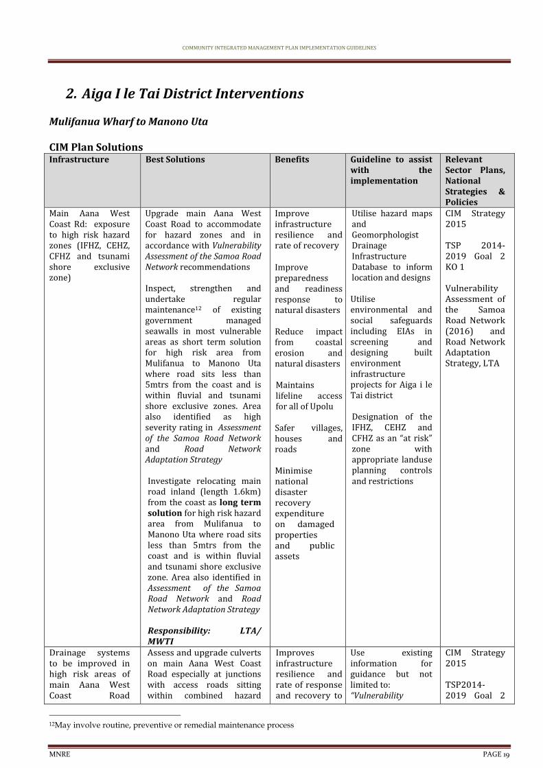
2. Aiga I le Tai District Interventions
Mulifanua Wharf to Manono Uta CIM Plan Solutions Infrastructure Best Solutions Benefits Guideline to assist
with the implementation
Relevant Sector Plans, National Strategies & Policies
Main Aana West Coast Rd: exposure to high risk hazard zones (IFHZ, CEHZ, CFHZ and tsunami shore exclusive zone)
Upgrade main Aana West Coast Road to accommodate for hazard zones and in accordance with Vulnerability Assessment of the Samoa Road Network recommendations Inspect, strengthen and undertake regular maintenance12 of existing government managed seawalls in most vulnerable areas as short term solution for high risk area from Mulifanua to Manono Uta where road sits less than 5mtrs from the coast and is within fluvial and tsunami shore exclusive zones. Area also identified as high severity rating in Assessment of the Samoa Road Network and Road Network Adaptation Strategy Investigate relocating main road inland (length 1.6km) from the coast as long term solution for high risk hazard area from Mulifanua to Manono Uta where road sits less than 5mtrs from the coast and is within fluvial and tsunami shore exclusive zone. Area also identified in Assessment of the Samoa Road Network and Road Network Adaptation Strategy Responsibility: LTA/ MWTI
Improve infrastructure resilience and rate of recovery Improve preparedness and readiness response to natural disasters
Reduce impact from coastal erosion and natural disasters Maintains lifeline access for all of Upolu Safer villages, houses and roads Minimise national disaster recovery expenditure on damaged properties and public assets
Utilise hazard maps and Geomorphologist Drainage Infrastructure Database to inform location and designs Utilise environmental and social safeguards including EIAs in screening and designing built environment infrastructure projects for Aiga i le Tai district Designation of the IFHZ, CEHZ and CFHZ as an “at risk” zone with appropriate landuse planning controls and restrictions
CIM Strategy 2015
TSP 2014-2019 Goal 2 KO 1 Vulnerability Assessment of the Samoa Road Network (2016) and Road Network Adaptation Strategy, LTA
Drainage systems to be improved in high risk areas of main Aana West Coast Road
Assess and upgrade culverts on main Aana West Coast Road especially at junctions with access roads sitting within combined hazard
Improves infrastructure resilience and rate of response and recovery to
Use existing information for guidance but not limited to: “Vulnerability
CIM Strategy 2015
TSP2014-2019 Goal 2
12May involve routine, preventive or remedial maintenance process
COMMUNITY INTEGRATED MANAGEMENT PLAN IMPLEMENTATION GUIDELINES
MNRE PAGE 20
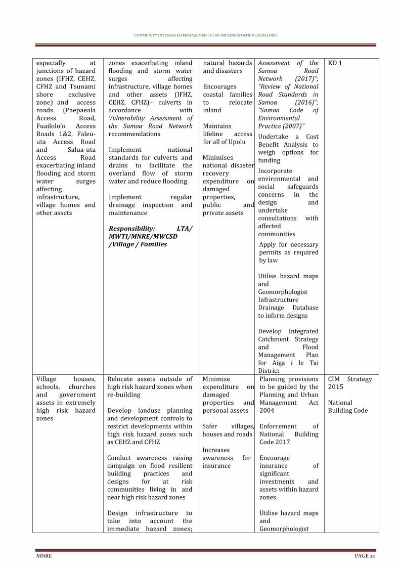
especially at junctions of hazard zones (IFHZ, CEHZ, CFHZ and Tsunami shore exclusive zone) and access roads (Paepaeala Access Road, Fuailolo’o Access Roads 1&2, Faleu-uta Access Road and Salua-uta Access Road exacerbating inland flooding and storm water surges affecting infrastructure, village homes and other assets
zones exacerbating inland flooding and storm water surges affecting infrastructure, village homes and other assets (IFHZ, CEHZ, CFHZ)– culverts in accordance with Vulnerability Assessment of the Samoa Road Network recommendations Implement national standards for culverts and drains to facilitate the overland flow of storm water and reduce flooding Implement regular drainage inspection and maintenance Responsibility: LTA/ MWTI/MNRE/MWCSD /Village / Families
natural hazards and disasters Encourages coastal families to relocate inland Maintains lifeline access for all of Upolu Minimises national disaster recovery expenditure on damaged properties, public and private assets
Assessment of the Samoa Road Network (2017)”; “Review of National Road Standards in Samoa (2016)”; “Samoa Code of Environmental Practice (2007)”
Undertake a Cost Benefit Analysis to weigh options for funding
Incorporate environmental and social safeguards concerns in the design and undertake consultations with affected communities
Apply for necessary permits as required by law Utilise hazard maps and Geomorphologist Infrastructure Drainage Database to inform designs Develop Integrated Catchment Strategy and Flood Management Plan for Aiga i le Tai District
KO 1
Village houses, schools, churches and government assets in extremely high risk hazard zones
Relocate assets outside of high risk hazard zones when re-building Develop landuse planning and development controls to restrict developments within high risk hazard zones such as CEHZ and CFHZ Conduct awareness raising campaign on flood resilient building practices and designs for at risk communities living in and near high risk hazard zones Design infrastructure to take into account the immediate hazard zones;
Minimise expenditure on damaged properties and personal assets
Safer villages, houses and roads Increases awareness for insurance
Planning provisions to be guided by the Planning and Urban Management Act 2004 Enforcement of National Building Code 2017 Encourage insurance of significant investments and assets within hazard zones Utilise hazard maps and Geomorphologist
CIM Strategy 2015
National Building Code

COMMUNITY INTEGRATED MANAGEMENT PLAN IMPLEMENTATION GUIDELINES
MNRE PAGE 21
for example, raise floor levels of houses in flood prone areas Families and village to limit building and developing on natural overland flow paths exacerbating inland flooding and storm water surges
Responsibility: Village / Families /MWTI/ MNRE/ MWCSD
Drainage Infrastructure Database to determine safe areas for relocation purposes Designation of the IFHZ, CEHZ and CFHZ as an “at risk” zone with appropriate landuse planning controls and restrictions
Upgrade access/ work roads to facilitate relocation of houses away from hazard zones and as potential escape routes
Assess and upgrade access/work roads as potential escape routes Construct roadside drainage ditches where needed Implement routine maintenance of the roads and clear any debris obstructing the free flow of surface water runoff Village to regulate developments near and around road shoulders of all access roads Enforce environmental safeguards where reclamations are proposed. Government and district to manage processes by requiring villagers to get the appropriate permits and consent Responsibility: LTA/ MWTI/ MNRE/ Villages/Families
Improve infrastructure resilience and rate of recovery Improve preparedness and readiness response to natural disasters
Safer villages, houses and roads Minimise national disaster recovery expenditure on damaged properties and public assets
Utilise hazard maps and Geomorphologist Drainage Infrastructure Database to inform location and designs Develop an integrated land management plan with the aim of reducing any unnecessary actions that may adversely affect the natural habitats and ecosystems of the area Designation of the IFHZ, CEHZ and CFHZ as an “at risk” zone with appropriate landuse planning controls and restrictions
Utilise environmental and social safeguards including EIAs in screening and designing built environment infrastructure projects for Aiga i le Tai district
National Disaster Management Plan 2017-2021 TSP 2014-2019 Goal 2 KO 1
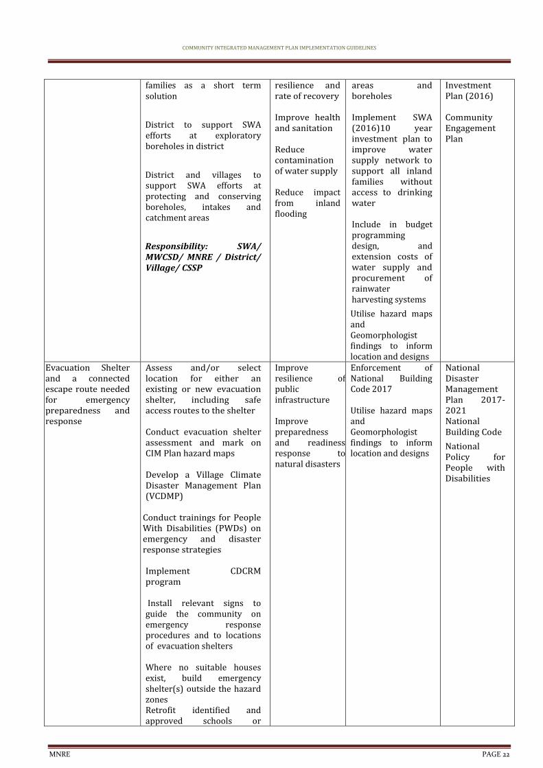
Reticulated water supply, quality and network to be improved
Extend the water supply to families inland with no access to water
Procure rainwater harvesting systems for vulnerable
Increase adaptation during drought periods Improve infrastructure
Develop and register District/Village bylaws to include regulating developments around catchment
CIM Strategy 2015
Water and Sanitation Sector Plan
SWA 10 Year
COMMUNITY INTEGRATED MANAGEMENT PLAN IMPLEMENTATION GUIDELINES
MNRE PAGE 22
families as a short term solution
District to support SWA efforts at exploratory boreholes in district
District and villages to support SWA efforts at protecting and conserving boreholes, intakes and catchment areas
Responsibility: SWA/ MWCSD/ MNRE / District/ Village/ CSSP
resilience and rate of recovery Improve health and sanitation Reduce contamination of water supply Reduce impact from inland flooding
areas and boreholes Implement SWA (2016)10 year investment plan to improve water supply network to support all inland families without access to drinking water Include in budget programming design, and extension costs of water supply and procurement of rainwater harvesting systems
Utilise hazard maps and Geomorphologist findings to inform location and designs
Investment Plan (2016)
Community Engagement Plan
Evacuation Shelter and a connected escape route needed for emergency preparedness and response
Assess and/or select location for either an existing or new evacuation shelter, including safe access routes to the shelter Conduct evacuation shelter assessment and mark on CIM Plan hazard maps Develop a Village Climate Disaster Management Plan (VCDMP)
Conduct trainings for People With Disabilities (PWDs) on emergency and disaster response strategies Implement CDCRM program Install relevant signs to guide the community on emergency response procedures and to locations of evacuation shelters Where no suitable houses exist, build emergency shelter(s) outside the hazard zones Retrofit identified and approved schools or
Improve resilience of public infrastructure Improve preparedness and readiness response to natural disasters
Enforcement of National Building Code 2017 Utilise hazard maps and Geomorphologist findings to inform location and designs
National Disaster Management Plan 2017-2021 National Building Code
National Policy for People with Disabilities
COMMUNITY INTEGRATED MANAGEMENT PLAN IMPLEMENTATION GUIDELINES
MNRE PAGE 23
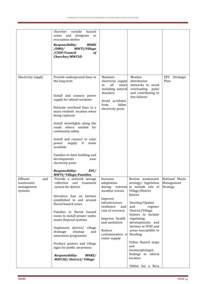
churches outside hazard zones and designate as evacuation shelter
Responsibility: MNRE /DMO/ MWTI/Village /CSSP/Council of Churches/MWCSD
Electricity supply
Provide underground lines in the long term
Install and connect power supply for inland residents Relocate overhead lines to a more resilient location when being replaced Install streetlights along the roads where needed for community safety Install and connect to solar power supply if made available Families to limit building and developments near electricity posts Responsibility: EPC/ MWTI/ Village/Families
Maintain electricity supply at all times including natural disasters Avoid accidents from fallen electricity posts
Monitor distribution networks to avoid overloading poles and contributing to line failures
EPC Strategic Plan
Effluent and wastewater management systems
Provide a network sewage collection and treatment system for district
Introduce ban on latrines established in and around fluvial hazard zones Families in fluvial hazard zones to install proper septic waste disposal systems Implement district/ village drainage cleanup and awareness programme Produce posters and village signs for public awareness Responsibility: MNRE/ MWCSD/ District/ Village
Increase adaptation during extreme weather events Improve infrastructure resilience and rate of recovery Improve health and sanitation Reduce contamination of water supply
Review wastewater strategy/ legislation to include role of Village/District bylaws Develop/Update and register District/Village bylaws to include regulating developments and latrines in IFHZ and areas susceptible to flooding Utilise Hazard maps and Geomorphologist findings to inform location Utilise Sui o Nu’u
National Waste Management Strategy

COMMUNITY INTEGRATED MANAGEMENT PLAN IMPLEMENTATION GUIDELINES
MNRE PAGE 24
monthly meetings to monitor progress of village programmes on waste management
Natural Resources and Environment
Best Solutions Benefits Guideline to assist with the implementation
Relevant Sector Plans, National Strategies & Policies
Soft coastal protection measures needed for most vulnerable areas
Plant native species along coastal areas to strengthen existing seawall and to reduce coastal erosion and landslips; Talie, Fetau, Toa, Togatogo are known to have greater resilience to natural disasters and changing climate conditions
To act as an effective wave barrier, a minimum distance of 200m of vegetation is needed
Responsibility: MNRE/ MAF/Villages
Soft coastal protection measures will support and strengthen existing and new infrastructure along the coast Reduce impact from coastal erosion and natural disasters Implements an Ecosystem Based Approach
Develop an integrated land management plan for Aiga i le Tai district with the aim of reducing any unnecessary actions that may adversely affect the natural habitats and ecosystems of the area MAF to assist in establishment of pilot sites to trial climate ready plant varieties MNRE Forestry, DEC and MAF to collaborate on supply of climate resilient crops
NESP 2018 - 2022 Two Million Tree Planting Strategy 2015-2020 Restoration Operational Plan 2016-2020
Sand mining (commercial) and sand extraction (domestic)
Identify alternative sustainable sources of sand for domestic use Research the impacts of sand mining Village consultation on sand mining policy and regulation Village and government to collaborate closely on designated areas for sand/rock mining
Raise awareness and support of sustainable land use practices
Responsibility: MNRE/ Village/Families
Mitigate potential damage from coastal erosion and flooding accommodating the hazard Safer villages, houses and roads Reduce impact from coastal erosion Economic benefit for village from sustainable sand mining activities
MNRE to continue to identify specific sites for inshore/ inland sustainable sand/rock mining to meet demand without compromising riverbanks
Undertake assessments of identified sites
Undertake consultation with villages affected by proposed sand/rock mining
Develop and register District bylaws to include managing and monitoring domestic sand/rock
Draft Soil Resource Management Bill
COMMUNITY INTEGRATED MANAGEMENT PLAN IMPLEMENTATION GUIDELINES
MNRE PAGE 25
mining of rivers Pest management; invasive plants and animals
Implement an eradication programme to eradicate, contain or exclude invasive species Implement an inventory of invasive species and include information on their past, present and potential future distribution, as well as impacts and possible actions that can be taken Conduct education and awareness programmes on the impacts of invasive species Implement the Integrated Pest Management Programme Implement Sustainable Land Management (SLM) practices Build the capacity of farmers to manage stray animals (pigs, cattle) that are contaminating water sources District to fence domestic animals Responsibility: Villages /District/ MNRE/MAF/ SROS
Maintains natural ecosystem Builds resilience of community livelihood and food security
Develop an integrated land management plan for Aiga i le Tai district with the aim of reducing any unnecessary actions that may adversely affect the natural habitats and ecosystems of the area MAF to raise awareness of farmers on impacts to water flows from poor livestock management MNRE, MAF and SROS to implement aggressive, nationwide invasive species eradication programme based on inventory of invasive species and conduct campaign on public awareness accordingly Training for farmers on pests management particularly affecting fruit trees and crops
Agriculture Sector Plan 2016-2021 Samoa’s National Invasive Species Action Plan (NISAP)
Governance Best Solutions Benefits Guideline to assist with the implementation
Relevant Sector Plans, National Strategies & Policies
Strengthen the governance of natural resources and land use through Bylaws
Update and/or develop bylaws to manage the use of natural resources, and to control land use impacts; such as drainage maintenance, rubbish dumping, sand mining, stray animals and unregulated developments in water catchment areas and near boreholes. Collaborate with Sui o Nuu to monitor the use of and impact on natural resources
Strengthen implementation of all national sector plans Strengthen monitoring of all National Acts, Regulation, Strategies, Plans and Policies Improve ability of communities to adapt,
Develop and register district/village bylaw to protect all district/ village and government assets, environment, livelihood and food security especially activities affecting water catchment areas and coastline Utilise Sui o Nu’u monthly meetings to
Village Fono Act (Amendment Bill 2016) Community Sector Plan Community Development Plan 2016-2021

COMMUNITY INTEGRATED MANAGEMENT PLAN IMPLEMENTATION GUIDELINES
MNRE PAGE 26
Facilitate continuous awareness raising programs with the villages Responsibility: MWCSD /Village
respond and recover quickly in the long term Improve accountability and enabling environment of communities
monitor progress of district/village bylaws
Non-CR issues raised during consultations
Proposed Solution Comments
District lands
Responsibility: Village/ Member of Parliament
District requested land from government for relocation purposes
Related to CR as relocation is one of the recommended solutions to impacts of climate change included in the Aiga I le Tai CIM Plan
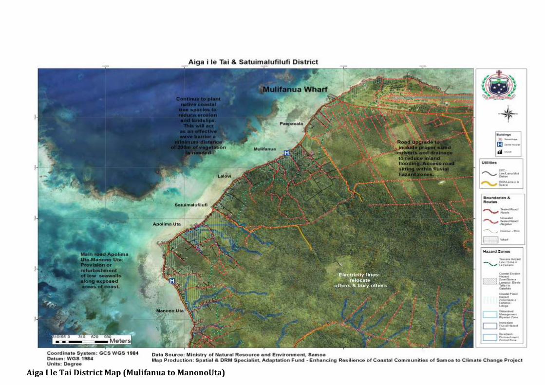
Aiga I le Tai District Map (Mulifanua to ManonoUta)

COMMUNITY INTEGRATED MANAGEMENT PLAN IMPLEMENTATION GUIDELINES
MNRE PAGE 28
3. Manono Tai
CIM Plan Solutions Infrastructure Best Solutions Benefits Guideline to assist with
the implementation Relevant Sector Plans, National Strategies & Policies
Main wharves Assess and upgrade main wharves to accommodate for response and recovery teams and equipments for both islands as only lifeline and connectivity infrastructure between Upolu, Manono-Tai and Apolima-Tai Inspect, strengthen and undertake regular maintenance of existing government managed seawalls in most vulnerable areas where there is no alternative route for relocation, as short term solution for high risk area
Responsibility: S P A / MWTI/ MNRE/ Villages/CSSP/ NGO
Improve infrastructure resilience and rate of recovery Improve preparedness and readiness response to natural disasters Maintain lifeline access for all of Aiga i le Tai Safer villages, houses and roads
Utilise environmental and social safeguards including EIAs in screening and designing infrastructure facilities
Utilise hazard maps and Geomorphologist Drainage Infrastructure Database to inform location and designs Develop an integrated land management plan with the aim of reducing any unnecessary actions that may adversely affect the natural habitats and ecosystems of the area Include in budget programming CBA, design and construction.
Designation of the IFHZ as an “at risk” zone with appropriate landuse planning controls and restrictions
CIM Strategy 2015
TSP 2014-2019 Goal 2 KO 1 Vulnerability Assessment of the Samoa Road Network (2016) and Road Network Adaptation Strategy, LTA
Main roads : exposure to high risk hazard zones (IFHZ, CEHZ, CFHZ and tsunami shore exclusive zone)
Upgrade and maintain13 main road to accommodate for hazard zones and in accordance with Vulnerability Assessment of the Samoa Road Network recommendations Responsibility: LTA/ MWTI/ MNRE/ Villages
Improve infrastructure resilience and rate of recovery Improve preparedness and readiness response to natural disasters
Reduce impact from coastal erosion and natural disasters Maintains lifeline access for all of Aiga i le Tai
Utilise hazard maps and Geomorphologist Drainage Infrastructure Database to inform location and designs Utilise environmental and social safeguards including EIAs in screening and designing built environment infrastructure projects for Aiga i le Tai district Designation of the IFHZ, CEHZ and CFHZ as an “at risk” zone with appropriate landuse planning controls and restrictions
CIM Strategy 2015
NISP 2011 KESO 5 TSP 2014-2019 Goal 2 KO 1
13May involve routine, preventive or remedial maintenance process
COMMUNITY INTEGRATED MANAGEMENT PLAN IMPLEMENTATION GUIDELINES
MNRE PAGE 29
Safer villages, houses and roads Minimise national disaster recovery expenditure on damaged properties and public assets
Village houses, churches, and other government assets located in high risk hazard zones
Relocate assets outside of high risk hazard zones when re-building Develop landuse planning and development controls to restrict developments within high risk hazard zones such as CEHZ and CFHZ Conduct awareness raising campaign on flood resilient building practices and designs for at risk communities living in and near high risk hazard zones Design infrastructure to take into account the immediate hazard zones; for example, raise floor levels of houses in flood prone areas Families and village to limit building and developing on natural overland flow paths exacerbating inland flooding and storm water surges
Responsibility: Village / Families /MWTI/ MNRE/ MWCSD
Minimise expenditure on damaged properties and personal assets
Safer villages, houses and roads Increases awareness for insurance
Planning provisions to be guided by the Planning and Urban Management Act 2004 Enforcement of National Building Code 2017 Encourage insurance of significant investments and assets within hazard zones Utilise hazard maps and Geomorphologist Drainage Infrastructure Database to determine safe areas for relocation purposes Designation of the IFHZ, CEHZ and CFHZ as an “at risk” zone with appropriate landuse planning controls and restrictions
CIM Strategy 2015
National Building Code
Reticulated water supply, quality and network to be improved
Extend the water supply to families inland with no access to water
Procure rainwater harvesting systems for vulnerable families as a short term solution
District and village to
Increase adaptation during drought periods Improve infrastructure resilience and rate of recovery
Develop and register District/Village bylaws to include regulating developments around catchment areas and boreholes Implement SWA (2016)10 year investment plan to
CIM Strategy 2015
Water and Sanitation Sector Plan
SWA 10 Year Investment Plan (2016)

COMMUNITY INTEGRATED MANAGEMENT PLAN IMPLEMENTATION GUIDELINES
MNRE PAGE 30
support SWA water rationing programmes during times of drought
District to support SWA efforts at exploratory boreholes in district
District and villages to support SWA efforts at protecting and conserving boreholes, intakes and catchment areas
Responsibility: SWA/ MWCSD/ MNRE / District/ Village/ CSSP
Improve health and sanitation Reduce contamination of water supply Reduce impact from inland flooding
improve water supply network to support all inland families without access to drinking water Include in budget programming design, and extension costs of water supply and procurement of rainwater harvesting systems
Utilise hazard maps and Geomorphologist findings to inform location and designs
Community Engagement Plan
Electricity supply
Provide underground lines in the long term
Install and connect power supply for inland residents Relocate overhead lines to a more resilient location when being replaced Install streetlights along the roads where needed for community safety Install and connect to solar power supply if made available Families to limit building and developments near electricity posts Responsibility: EPC/ MWTI/ Village/Families
Maintain electricity supply at all times including natural disasters Avoid accidents from fallen electricity posts
Monitor distribution networks to avoid overloading poles and contributing to line failures
EPC Strategic Plan
Effluent and wastewater management systems
Introduce ban on latrines established in and around IFHZ, CEHZ and CFHZs Families in fluvial hazard zones to install proper septic waste disposal systems Implement district/ village drainage cleanup and awareness programme Produce posters and
Increase adaptation during extreme weather events Improve infrastructure resilience and rate of recovery Improve health and sanitation Reduce contamination of water supply
Develop an integrated land management plan for Apolima Tai and Manono Tai Review wastewater strategy/ legislation to include role of Village/District bylaws Develop/Update and register District/Village bylaws to include regulating developments and latrines in IFHZ and areas susceptible to
National Waste Management Strategy
COMMUNITY INTEGRATED MANAGEMENT PLAN IMPLEMENTATION GUIDELINES
MNRE PAGE 31
village signs for public awareness Responsibility: MNRE/ MWCSD/ District/ Village
flooding Utilise Hazard maps and Geomorphologist findings to inform location
Natural Resources and Environment
BestSolutions Benefits Guideline to assist with the implementation
RelevantSector Plans, National Strategies & Policies
Sand mining (commercial) and sand extraction (domestic)
Identify alternative sustainable sources of sand for domestic use Research the impacts of sand mining Village consultation on sand mining policy and regulation Village and government to collaborate closely on designated areas for sand/rock mining
Raise awareness and support of sustainable land use practices
Responsibility: MNRE/ Village/Families
Mitigate potential damage from coastal erosion and flooding accommodating the hazard Safer villages, houses and roads Reduce impact from coastal erosion Economic benefit for village from sustainable sand mining activities
MNRE to continue to identify specific sites for inshore/ inland sustainable sand/rock mining to meet demand without compromising riverbanks
Undertake assessments of identified sites
Undertake consultation with villages affected by proposed sand/rock mining
Develop and register District bylaws to include managing and monitoring domestic sand/rock mining of rivers Utilise Sui o Nu’u monthly meetings to monitor progress of CIM Plan activities
Draft Soil Resource Management Bill
Soft coastal protection measures needed for most vulnerable areas
Plant native species along coastal areas to strengthen existing seawall and to reduce coastal erosion and landslips; Talie, Fetau, Toa, Togatogo are known to have greater resilience to natural disasters and changing climate conditions
To act as an effective wave barrier, a minimum distance of 200m of vegetation is needed
Soft coastal protection measures will support and strengthen existing and new infrastructure along the coast Reduce impact from coastal erosion and natural disasters Implements an
Develop an integrated land management plan for Aiga i le Tai district with the aim of reducing any unnecessary actions that may adversely affect the natural habitats and ecosystems of the area MAF to assist in establishment of pilot sites to trial climate ready plant varieties MNRE Forestry, DEC and MAF to collaborate on supply of climate resilient
NESP 2018 - 2022 Two Million Tree Planting Strategy 2015-2020 Restoration Operational Plan 2016-2020
COMMUNITY INTEGRATED MANAGEMENT PLAN IMPLEMENTATION GUIDELINES
MNRE PAGE 32
Responsibility: MNRE/ MAF/Villages
Ecosystem Based Approach
crops
Pest management; invasive plants and animals
Implement an eradication programme to eradicate, contain or exclude invasive species Implement an inventory of invasive species and include information on their past, present and potential future distribution, as well as impacts and possible actions that can be taken Conduct education and awareness programmes on the impacts of invasive species Implement the Integrated Pest Management Programme Implement Sustainable Land Management (SLM) practices Build the capacity of farmers to manage stray animals (pigs, cattle) that are contaminating water sources Responsibility: Villages /District/ MNRE/MAF/ SROS
Maintains natural ecosystem Builds resilience of community livelihood and food security
Develop an integrated land management plan for Aiga i le Tai district with the aim of reducing any unnecessary actions that may adversely affect the natural habitats and ecosystems of the area MAF to raise awareness of farmers on impacts to water flows from poor livestock management MNRE, MAF and SROS to implement aggressive, nationwide invasive species eradication programme based on inventory of invasive species and conduct campaign on public awareness accordingly Training for farmers on pests management particularly affecting fruit trees and crops
Agriculture Sector Plan 2016-2021 Samoa’s National Invasive Species Action Plan (NISAP)
Governance Best Solutions Benefits Guideline to assist with the implementation
Relevant Sector Plans, National Strategies & Policies
Strengthen the governance of natural resources and land use through Bylaws
Update and/or develop bylaws to manage the use of natural resources, and to control land use impacts; such as drainage maintenance, rubbish dumping, sand mining, stray animals and unregulated developments in water catchment areas and near boreholes. Collaborate with Sui o Nuu to monitor the use of and impact on natural resources Facilitate continuous
Strengthen implementation of all national sector plans Strengthen monitoring of all National Acts, Regulation, Strategies, Plans and Policies Improve ability of communities to adapt, respond and recover quickly
Develop and register district/village bylaw to protect all district/ village and government assets, environment, livelihood and food security especially activities affecting water catchment areas and coastline Utilise Sui o Nu’u monthly meetings to monitor progress of district/village bylaws
Village Fono Act (Amendment Bill 2016) Community Sector Plan Community Development Plan 2016-2021

COMMUNITY INTEGRATED MANAGEMENT PLAN IMPLEMENTATION GUIDELINES
MNRE PAGE 33
awareness raising programs with the villages Responsibility: MWCSD /Village
in the long term Improve accountability and enabling environment of communities
Non-CR issues raised during consultations
Proposed Solution Comments
District lands
Responsibility: Village/ Government/
District requested land from government for relocation purposes
Indirectly related to CR as relocation is one of the recommended solutions to impacts of climate change included in the Aiga I le Tai CIM Plan
Lighthouse maintenance
Responsibility: SPA/DAC
Conduct regular structural and damage surveys and maintenance of lighthouse
Although considered a safety issue, it is indirectly related to CR as it will be required for all travelling public (including government inspection/recovery teams) not just residents of Apolima Tai and Manono Tai

COMMUNITY INTEGRATED MANAGEMENT PLAN IMPLEMENTATION GUIDELINES
MNRE PAGE 34
4. Apai Village Interventions
CIM Plan Solutions Infrastructure
Best Solutions Benefits Guideline to assist with the implementation
Relevant Sector Plans, National Strategies & Policies
Village infrastructure located in high risk hazard zones; such as houses, schools, Churches, Businesses, Committee houses etc
Relocate assets outside of high risk hazard zones when re-building Develop landuse planning and development controls to restrict developments within high risk hazard zones such as CEHZ and CFHZ Conduct awareness raising campaign on flood resilient building practices and designs for at risk communities living in and near high risk hazard zones Design infrastructure to take into account the immediate hazard zones; for example, raise floor levels of houses in flood prone areas Families and village to limit building and developing on natural overland flow paths exacerbating inland flooding and storm water surges
Responsibility: Village / Families /MWTI/ MNRE/ MWCSD
Minimise expenditure on damaged properties and personal assets
Safer villages, houses and roads Increases awareness for insurance
Planning provisions to be guided by the Planning and Urban Management Act 2004 Enforcement of National Building Code 2017 Encourage insurance of significant investments and assets within hazard zones Utilise hazard maps and Geomorphologist Drainage Infrastructure Database to determine safe areas for relocation purposes Designation of the IFHZ, CEHZ and CFHZ as an “at risk” zone with appropriate landuse planning controls and restrictions
CIM Strategy 2015
National Building Code
Evacuation Shelter and a connected escape route needed for emergency preparedness and response
Assess and/or select location for either an existing or new evacuation shelter, including safe access routes to the shelter Conduct evacuation
Improve resilience of public infrastructure Improve preparedness and readiness response to
Enforcement of National Building Code 2017 Utilise hazard maps and Geomorphologist findings to inform location and designs
National Disaster Management Plan 2017-2021 National Building Code
National Policy for People with

COMMUNITY INTEGRATED MANAGEMENT PLAN IMPLEMENTATION GUIDELINES
MNRE PAGE 35
shelter assessment and mark on CIM Plan hazard maps Develop a Village Climate Disaster Management Plan (VCDMP)
Conduct trainings for People With Disabilities (PWDs) on emergency and disaster response strategies Implement CDCRM program Install relevant signs to guide the community on emergency response procedures and to locations of evacuation shelters Where no suitable houses exist, build emergency shelter(s) outside the hazard zones Retrofit identified and approved schools or churches outside hazard zones and designate as evacuation shelter
Responsibility: MNRE /DMO/ MWTI/Village /CSSP/Council of Churches/MWCSD
natural disasters
Disabilities
NISP 2011 KESO 5
Coastal protection
Assess potential of a revetment for badly eroded coastal areas where relocation is not possible as short term solution Encourage relocation of families/houses in badly eroded coastal areas Responsibility: MNRE/ Village /MWTI
Reduce impact from inland flooding on coastal areas
Mitigate potential damage from coastal erosion and flooding accommodating the hazard Safer villages, houses and roads
Planning provisions to be guided by the Planning and Urban Management Act 2004 Utilise hazard maps and Geomorphologist Drainage Infrastructure Database to determine safe areas for relocation purposes Designation of the IFHZ, CEHZ and CFHZ as an “at risk” zone with appropriate landuse planning controls and restrictions
NESP 2018 - 2022

COMMUNITY INTEGRATED MANAGEMENT PLAN IMPLEMENTATION GUIDELINES
MNRE PAGE 36
Electricity supply
Install streetlights along the roads where needed for community safety Relocate overhead lines to a more resilient location when being replaced Provide underground lines in the long term
Install and connect to solar power supply if made available
Responsibility: EPC /MWTI/ Villages
Maintain electricity supply at all times including natural disasters
Avoid accidents from fallen electricity posts
Monitor distribution networks to avoid overloading poles and contributing to line failures
EPC Strategic Plan
Reticulated water supply, quality and network to be improved
Extend the water supply to families inland with no access to water
Procure rainwater harvesting systems for vulnerable families as a short term solution
District and village to support SWA water rationing programmes during times of drought
District to support SWA efforts at exploratory boreholes in district
District and villages to support SWA efforts at protecting and conserving boreholes, intakes and catchment areas
Responsibility: SWA/ MWCSD/ MNRE / District/ Village/ CSSP
Increase adaptation during drought periods Improve infrastructure resilience and rate of recovery Improve health and sanitation Reduce contamination of water supply Reduce impact from inland flooding
Develop and register District/Village bylaws to include regulating developments around catchment areas and boreholes Implement SWA (2016)10 year investment plan to improve water supply network to support all inland families without access to drinking water Include in budget programming design, and extension costs of water supply and procurement of rainwater harvesting systems
Utilise hazard maps and Geomorphologist findings to inform location and designs Utilise Sui o Nu’u monthly meetings to monitor progress of village programmes and responsibilities
CIM Strategy 2015
Water and Sanitation Sector Plan
SWA 10 Year Investment Plan (2016)
Community Engagement Plan
Natural Resources and Environment
Best Solutions Benefits Guideline to assist with the implementation
Relevant Sector Plans, National Strategies & Policies
Marine resources depletion
Assess feasibility of creating a marine reserve for village as backup, alternative food supply
Protects and enhance local species diversity Maintains natural
MAF and MNRE DEC to provide technical assistance and backstopping in the assessment and
NESP 2018 - 2022 Community Engagement Plan
COMMUNITY INTEGRATED MANAGEMENT PLAN IMPLEMENTATION GUIDELINES
MNRE PAGE 37
Village to restock marine reserve with suitable species Continue to ban the use of dynamites, herbal poisons (ava niukini), chemicals and other unsustainable fishing methods including sand mining and extraction Research improved inshore fishery resources that are resilient to climate change Village to provide fencing for domestic animals to prevent waste contaminating marine reserve Responsibility: MNRE /MAF/ Village /CSSP/ UNDP-GEF SGP
ecosystem Builds resilience of community livelihood and food security
establishment of a marine reserve for village
Develop an integrated land management plan with the aim of reducing any unnecessary actions that may adversely affect the natural habitats and ecosystems of the area Village to seek funding to establish marine reserve MAF to raise awareness of farmers on impacts to water flows from poor livestock management
Agriculture Sector Plan 2016-2021
Soft coastal protection measures needed for most vulnerable areas
Plant native species along coastal areas to strengthen existing seawall and to reduce coastal erosion and landslips; Talie, Fetau, Toa, Togatogo are known to have greater resilience to natural disasters and changing climate conditions
To act as an effective wave barrier, a minimum distance of 200m of vegetation is needed
Responsibility: MNRE/ MAF/Villages
Soft coastal protection measures will support and strengthen existing and new infrastructure along the coast Reduce impact from coastal erosion and natural disasters Implements an Ecosystem Based Approach
Develop an integrated land management plan for Aiga i le Tai district with the aim of reducing any unnecessary actions that may adversely affect the natural habitats and ecosystems of the area MAF to assist in establishment of pilot sites to trial climate ready plant varieties MNRE Forestry, DEC and MAF to collaborate on supply of climate resilient crops
NESP 2018 - 2022 Two Million Tree Planting Strategy 2015-2020 Restoration Operational Plan 2016-2020
COMMUNITY INTEGRATED MANAGEMENT PLAN IMPLEMENTATION GUIDELINES
MNRE PAGE 38
Governance Best Solutions Benefits Guideline to assist with the implementation
Relevant Sector Plans, National Strategies & Policies
Strengthen the governance of natural resources and land use through Bylaws
Update and/or develop bylaws to manage the use of natural resources, and to control land use impacts; such as drainage maintenance, rubbish dumping, sand mining, stray animals and unregulated developments in water catchment areas and near boreholes. Collaborate with Sui o Nuu to monitor the use of and impact on natural resources Facilitate continuous awareness raising programs with the villages Responsibility: MWCSD /Village
Strengthen implementation of all national sector plans Strengthen monitoring of all National Acts, Regulation, Strategies, Plans and Policies Improve ability of communities to adapt, respond and recover quickly in the long term Improve accountability and enabling environment of communities
Develop and register district/village bylaw to protect all district/ village and government assets, environment, livelihood and food security especially activities affecting water catchment areas and coastline Utilise Sui o Nu’u monthly meetings to monitor progress of district/village bylaws
Village Fono Act (Amendment Bill 2016) Community Sector Plan Community Development Plan 2016-2021
Non-CR issues raised during consultations
Proposed Solution Comments
Village lands
Responsibility: Village/ Government/
Village requested land from government for relocation purposes
Related to CR as relocation is one of the recommended solutions to impacts of climate change included in the Aiga I le Tai CIM Plan
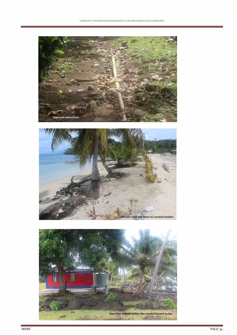
COMMUNITY INTEGRATED MANAGEMENT PLAN IMPLEMENTATION GUIDELINES
MNRE PAGE 39
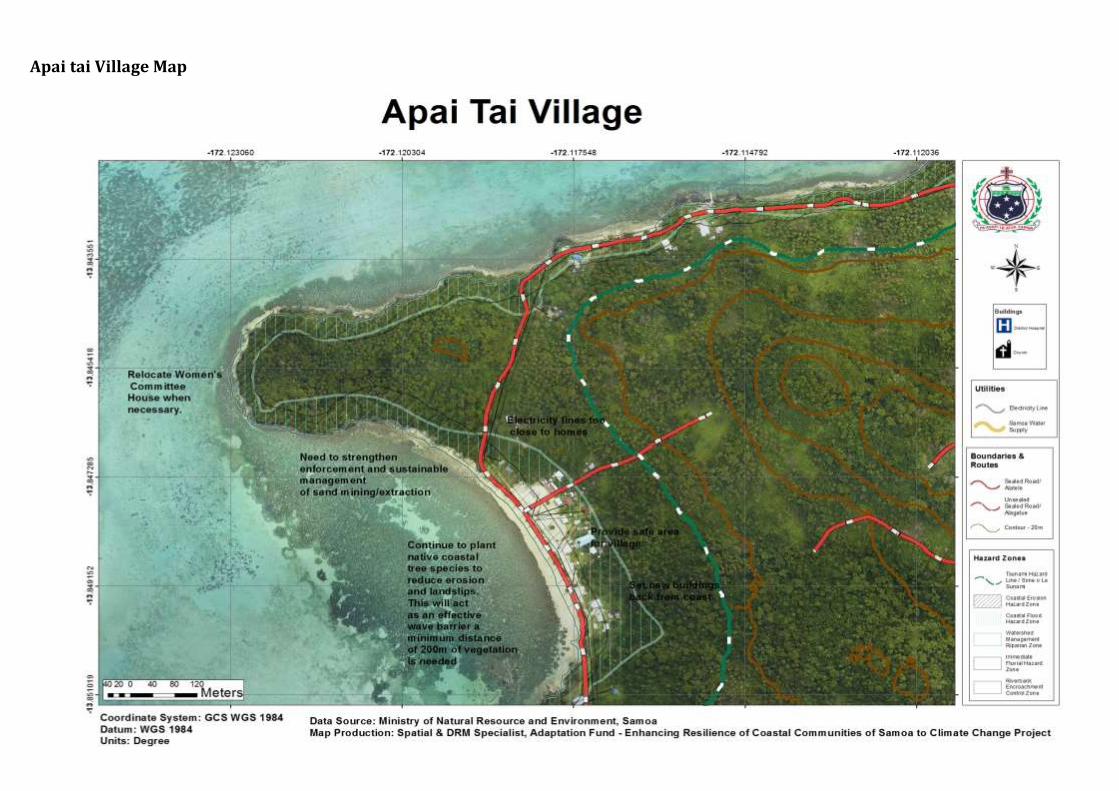
Apai tai Village Map
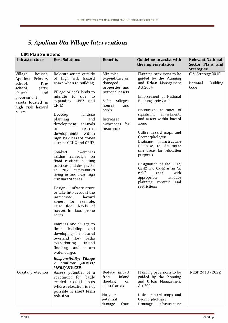
COMMUNITY INTEGRATED MANAGEMENT PLAN IMPLEMENTATION GUIDELINES
MNRE PAGE 41
5. Apolima Uta Village Interventions
CIM Plan Solutions Infrastructure Best Solutions Benefits Guideline to assist with
the implementation Relevant National, Sector Plans and Strategies
Village houses, Apolima Primary school, Pre-school, jetty, church and government assets located in high risk hazard zones
Relocate assets outside of high risk hazard zones when re-building Village to seek lands to migrate to due to expanding CEFZ and CFHZ Develop landuse planning and development controls to restrict developments within high risk hazard zones such as CEHZ and CFHZ Conduct awareness raising campaign on flood resilient building practices and designs for at risk communities living in and near high risk hazard zones Design infrastructure to take into account the immediate hazard zones; for example, raise floor levels of houses in flood prone areas Families and village to limit building and developing on natural overland flow paths exacerbating inland flooding and storm water surges
Responsibility: Village / Families /MWTI/ MNRE/ MWCSD
Minimise expenditure on damaged properties and personal assets
Safer villages, houses and roads Increases awareness for insurance
Planning provisions to be guided by the Planning and Urban Management Act 2004 Enforcement of National Building Code 2017 Encourage insurance of significant investments and assets within hazard zones Utilise hazard maps and Geomorphologist Drainage Infrastructure Database to determine safe areas for relocation purposes Designation of the IFHZ, CEHZ and CFHZ as an “at risk” zone with appropriate landuse planning controls and restrictions
CIM Strategy 2015
National Building Code
Coastal protection Assess potential of a revetment for badly eroded coastal areas where relocation is not possible as short term solution
Reduce impact from inland flooding on coastal areas
Mitigate potential damage from
Planning provisions to be guided by the Planning and Urban Management Act 2004 Utilise hazard maps and Geomorphologist Drainage Infrastructure
NESP 2018 - 2022
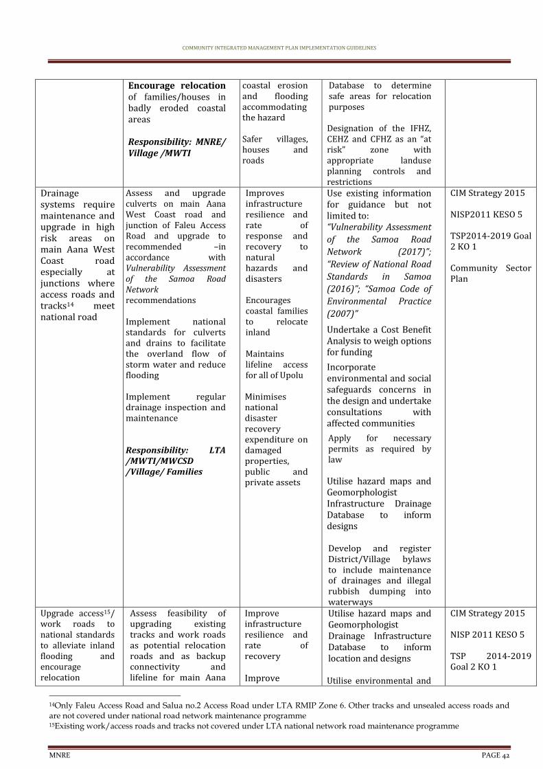
COMMUNITY INTEGRATED MANAGEMENT PLAN IMPLEMENTATION GUIDELINES
MNRE PAGE 42
Encourage relocation of families/houses in badly eroded coastal areas Responsibility: MNRE/ Village /MWTI
coastal erosion and flooding accommodating the hazard Safer villages, houses and roads
Database to determine safe areas for relocation purposes Designation of the IFHZ, CEHZ and CFHZ as an “at risk” zone with appropriate landuse planning controls and restrictions
Drainage systems require maintenance and upgrade in high risk areas on main Aana West Coast road especially at junctions where access roads and tracks14 meet national road
Assess and upgrade culverts on main Aana West Coast road and junction of Faleu Access Road and upgrade to recommended –in accordance with Vulnerability Assessment of the Samoa Road Network recommendations Implement national standards for culverts and drains to facilitate the overland flow of storm water and reduce flooding Implement regular drainage inspection and maintenance Responsibility: LTA /MWTI/MWCSD /Village/ Families
Improves infrastructure resilience and rate of response and recovery to natural hazards and disasters Encourages coastal families to relocate inland Maintains lifeline access for all of Upolu Minimises national disaster recovery expenditure on damaged properties, public and private assets
Use existing information for guidance but not limited to: “Vulnerability Assessment
of the Samoa Road
Network (2017)”;
“Review of National Road
Standards in Samoa
(2016)”; “Samoa Code of
Environmental Practice
(2007)”
Undertake a Cost Benefit Analysis to weigh options for funding
Incorporate environmental and social safeguards concerns in the design and undertake consultations with affected communities
Apply for necessary permits as required by law Utilise hazard maps and Geomorphologist Infrastructure Drainage Database to inform designs Develop and register District/Village bylaws to include maintenance of drainages and illegal rubbish dumping into waterways
CIM Strategy 2015
NISP2011 KESO 5 TSP2014-2019 Goal 2 KO 1 Community Sector Plan
Upgrade access15/ work roads to national standards to alleviate inland flooding and encourage relocation
Assess feasibility of upgrading existing tracks and work roads as potential relocation roads and as backup connectivity and lifeline for main Aana
Improve infrastructure resilience and rate of recovery Improve
Utilise hazard maps and Geomorphologist Drainage Infrastructure Database to inform location and designs Utilise environmental and
CIM Strategy 2015
NISP 2011 KESO 5 TSP 2014-2019 Goal 2 KO 1
14Only Faleu Access Road and Salua no.2 Access Road under LTA RMIP Zone 6. Other tracks and unsealed access roads and are not covered under national road network maintenance programme 15Existing work/access roads and tracks not covered under LTA national network road maintenance programme
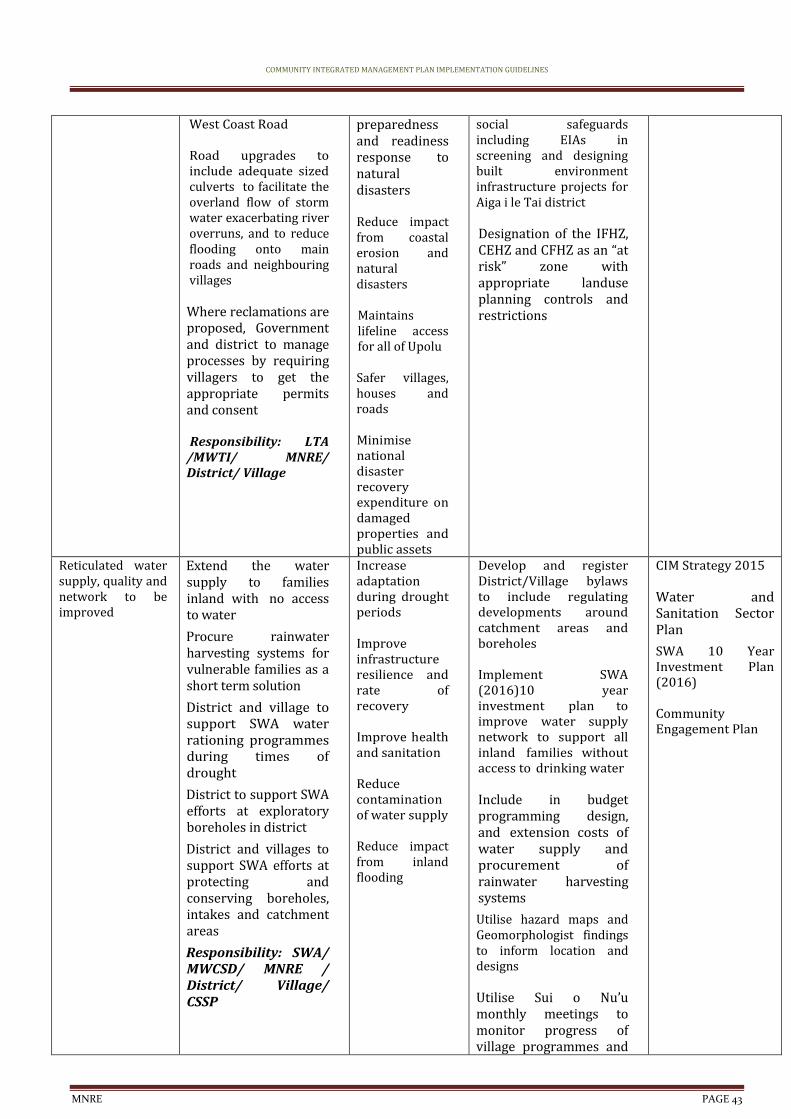
COMMUNITY INTEGRATED MANAGEMENT PLAN IMPLEMENTATION GUIDELINES
MNRE PAGE 43
West Coast Road Road upgrades to include adequate sized culverts to facilitate the overland flow of storm water exacerbating river overruns, and to reduce flooding onto main roads and neighbouring villages
Where reclamations are proposed, Government and district to manage processes by requiring villagers to get the appropriate permits and consent Responsibility: LTA
/MWTI/ MNRE/ District/ Village
preparedness and readiness response to natural disasters
Reduce impact from coastal erosion and natural disasters Maintains lifeline access for all of Upolu Safer villages, houses and roads Minimise national disaster recovery expenditure on damaged properties and public assets
social safeguards including EIAs in screening and designing built environment infrastructure projects for Aiga i le Tai district Designation of the IFHZ, CEHZ and CFHZ as an “at risk” zone with appropriate landuse planning controls and restrictions
Reticulated water supply, quality and network to be improved
Extend the water supply to families inland with no access to water
Procure rainwater harvesting systems for vulnerable families as a short term solution
District and village to support SWA water rationing programmes during times of drought
District to support SWA efforts at exploratory boreholes in district
District and villages to support SWA efforts at protecting and conserving boreholes, intakes and catchment areas
Responsibility: SWA/ MWCSD/ MNRE / District/ Village/ CSSP
Increase adaptation during drought periods Improve infrastructure resilience and rate of recovery Improve health and sanitation Reduce contamination of water supply Reduce impact from inland flooding
Develop and register District/Village bylaws to include regulating developments around catchment areas and boreholes Implement SWA (2016)10 year investment plan to improve water supply network to support all inland families without access to drinking water Include in budget programming design, and extension costs of water supply and procurement of rainwater harvesting systems
Utilise hazard maps and Geomorphologist findings to inform location and designs Utilise Sui o Nu’u monthly meetings to monitor progress of village programmes and
CIM Strategy 2015
Water and Sanitation Sector Plan
SWA 10 Year Investment Plan (2016)
Community Engagement Plan
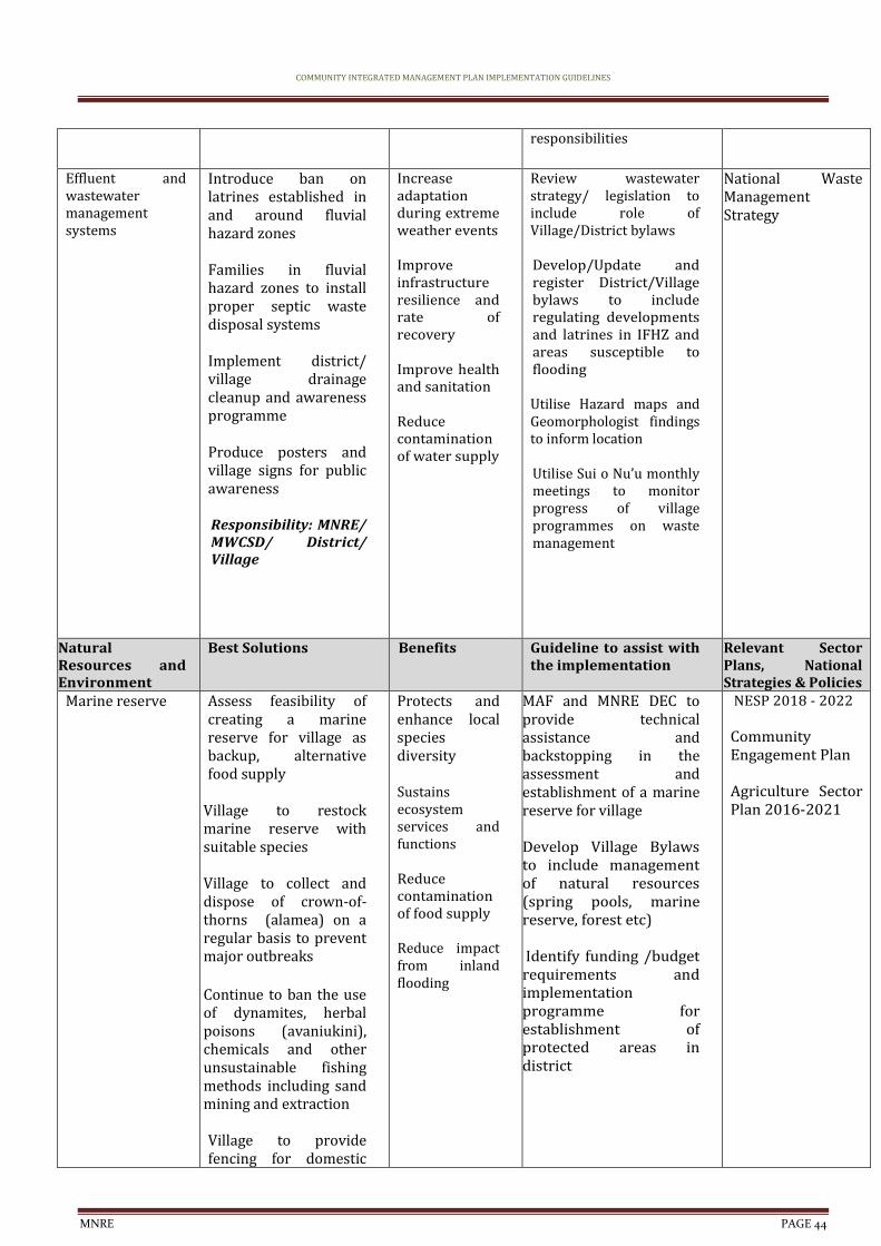
COMMUNITY INTEGRATED MANAGEMENT PLAN IMPLEMENTATION GUIDELINES
MNRE PAGE 44
responsibilities
Effluent and wastewater management systems
Introduce ban on latrines established in and around fluvial hazard zones Families in fluvial hazard zones to install proper septic waste disposal systems Implement district/ village drainage cleanup and awareness programme Produce posters and village signs for public awareness Responsibility: MNRE/ MWCSD/ District/ Village
Increase adaptation during extreme weather events Improve infrastructure resilience and rate of recovery Improve health and sanitation Reduce contamination of water supply
Review wastewater strategy/ legislation to include role of Village/District bylaws Develop/Update and register District/Village bylaws to include regulating developments and latrines in IFHZ and areas susceptible to flooding Utilise Hazard maps and Geomorphologist findings to inform location Utilise Sui o Nu’u monthly meetings to monitor progress of village programmes on waste management
National Waste Management Strategy
Natural Resources and Environment
Best Solutions Benefits Guideline to assist with the implementation
Relevant Sector Plans, National Strategies & Policies
Marine reserve Assess feasibility of creating a marine reserve for village as backup, alternative food supply
Village to restock marine reserve with suitable species Village to collect and dispose of crown-of-thorns (alamea) on a regular basis to prevent major outbreaks
Continue to ban the use of dynamites, herbal poisons (avaniukini), chemicals and other unsustainable fishing methods including sand mining and extraction Village to provide fencing for domestic
Protects and enhance local species diversity Sustains ecosystem services and functions Reduce contamination of food supply Reduce impact from inland flooding
MAF and MNRE DEC to provide technical assistance and backstopping in the assessment and establishment of a marine reserve for village Develop Village Bylaws to include management of natural resources (spring pools, marine reserve, forest etc) Identify funding /budget requirements and implementation programme for establishment of protected areas in district
NESP 2018 - 2022 Community Engagement Plan Agriculture Sector Plan 2016-2021
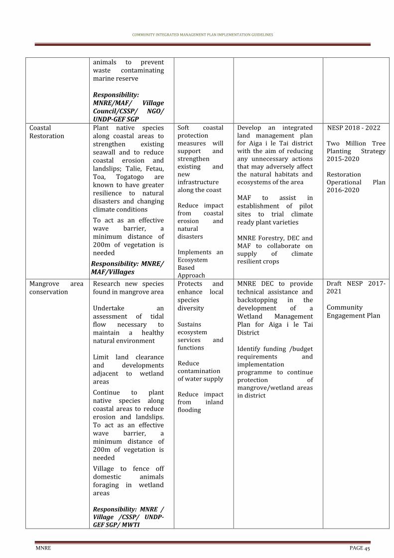
COMMUNITY INTEGRATED MANAGEMENT PLAN IMPLEMENTATION GUIDELINES
MNRE PAGE 45
animals to prevent waste contaminating marine reserve Responsibility: MNRE/MAF/ Village Council/CSSP/ NGO/ UNDP-GEF SGP
Coastal Restoration
Plant native species along coastal areas to strengthen existing seawall and to reduce coastal erosion and landslips; Talie, Fetau, Toa, Togatogo are known to have greater resilience to natural disasters and changing climate conditions
To act as an effective wave barrier, a minimum distance of 200m of vegetation is needed
Responsibility: MNRE/ MAF/Villages
Soft coastal protection measures will support and strengthen existing and new infrastructure along the coast Reduce impact from coastal erosion and natural disasters Implements an Ecosystem Based Approach
Develop an integrated land management plan for Aiga i le Tai district with the aim of reducing any unnecessary actions that may adversely affect the natural habitats and ecosystems of the area MAF to assist in establishment of pilot sites to trial climate ready plant varieties MNRE Forestry, DEC and MAF to collaborate on supply of climate resilient crops
NESP 2018 - 2022 Two Million Tree Planting Strategy 2015-2020 Restoration Operational Plan 2016-2020
Mangrove area conservation
Research new species found in mangrove area Undertake an assessment of tidal flow necessary to maintain a healthy natural environment Limit land clearance and developments adjacent to wetland areas
Continue to plant native species along coastal areas to reduce erosion and landslips. To act as an effective wave barrier, a minimum distance of 200m of vegetation is needed
Village to fence off domestic animals foraging in wetland areas Responsibility: MNRE / Village /CSSP/ UNDP-GEF SGP/ MWTI
Protects and enhance local species diversity Sustains ecosystem services and functions Reduce contamination of water supply Reduce impact from inland flooding
MNRE DEC to provide technical assistance and backstopping in the development of a Wetland Management Plan for Aiga i le Tai District Identify funding /budget requirements and implementation programme to continue protection of mangrove/wetland areas in district
Draft NESP 2017-2021 Community Engagement Plan
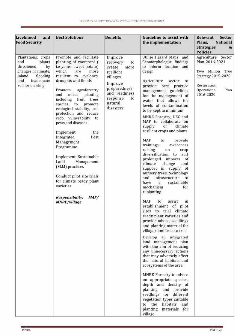
COMMUNITY INTEGRATED MANAGEMENT PLAN IMPLEMENTATION GUIDELINES
MNRE PAGE 46
Livelihood and Food Security
Best Solutions Benefits Guideline to assist with the implementation
Relevant Sector Plans, National Strategies & Policies
Plantations, crops and plants threatened by changes in climate, inland flooding and inadequate soil for planting
Promote and facilitate planting of rootcrops ( i.e yams, sweet potato) which are more resilient to cyclones, droughts and floods Promote agroforestry and mixed planting including fruit trees species to promote ecological stability, soil protection and reduce crop vulnerability to pests and diseases Implement the Integrated Pest Management Programme Implement Sustainable Land Management (SLM) practices Conduct pilot site trials for climate ready plant varieties
Responsibility: MAF/ MNRE/village
Improve recovery to create more resilient villages
Improve preparedness and readiness response to natural disasters
Utilise Hazard Maps and Geomorphologist findings to inform location and design Agriculture sector to provide best practice management guidelines for the management of water that allows for levels of contamination to be kept to minimum
MNRE Forestry, DEC and MAF to collaborate on supply of climate resilient crops and plants MAF to provide trainings, awareness raising on crop diversification to suit prolonged impacts of climate change and support in supply of nursery trees, technology and infrastructure to have a sustainable mechanism for replanting MAF to assist in establishment of pilot sites to trial climate ready plant varieties and provide advice, seedlings and planting material for village/families as a trial
Develop an integrated land management plan with the aim of reducing any unnecessary actions that may adversely affect the natural habitats and ecosystems of the area MNRE Forestry to advice on appropriate species, depth and density of planting and provide seedlings for different vegetation types suitable to the habitats and planting materials for village
Agriculture Sector Plan 2016-2021 Two Million Tree Strategy 2015-2020 Restoration Operational Plan 2016-2020
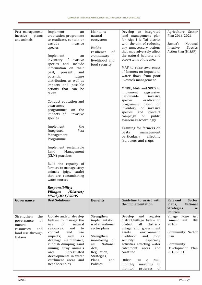
COMMUNITY INTEGRATED MANAGEMENT PLAN IMPLEMENTATION GUIDELINES
MNRE PAGE 47
Pest management; invasive plants and animals
Implement an eradication programme to eradicate, contain or exclude invasive species Implement an inventory of invasive species and include information on their past, present and potential future distribution, as well as impacts and possible actions that can be taken Conduct education and awareness programmes on the impacts of invasive species Implement the Integrated Pest Management Programme Implement Sustainable Land Management (SLM) practices Build the capacity of farmers to manage stray animals (pigs, cattle) that are contaminating water sources Responsibility: Villages /District/ MNRE/MAF/ SROS
Maintains natural ecosystem Builds resilience of community livelihood and food security
Develop an integrated land management plan for Aiga i le Tai district with the aim of reducing any unnecessary actions that may adversely affect the natural habitats and ecosystems of the area MAF to raise awareness of farmers on impacts to water flows from poor livestock management MNRE, MAF and SROS to implement aggressive, nationwide invasive species eradication programme based on inventory of invasive species and conduct campaign on public awareness accordingly Training for farmers on pests management particularly affecting fruit trees and crops
Agriculture Sector Plan 2016-2021 Samoa’s National Invasive Species Action Plan (NISAP)
Governance Best Solutions Benefits Guideline to assist with the implementation
Relevant Sector Plans, National Strategies & Policies
Strengthen the governance of natural resources and land use through Bylaws
Update and/or develop bylaws to manage the use of natural resources, and to control land use impacts; such as drainage maintenance, rubbish dumping, sand mining, stray animals and unregulated developments in water catchment areas and near boreholes.
Strengthen implementation of all national sector plans Strengthen monitoring of all National Acts, Regulation, Strategies, Plans and Policies
Develop and register district/village bylaw to protect all district/ village and government assets, environment, livelihood and food security especially activities affecting water catchment areas and coastline Utilise Sui o Nu’u monthly meetings to monitor progress of
Village Fono Act (Amendment Bill 2016) Community Sector Plan Community Development Plan 2016-2021
COMMUNITY INTEGRATED MANAGEMENT PLAN IMPLEMENTATION GUIDELINES
MNRE PAGE 48
Collaborate with Sui o Nuu to monitor the use of and impact on natural resources Facilitate continuous awareness raising programs with the villages Responsibility: MWCSD /Village
Improve ability of communities to adapt, respond and recover quickly in the long term Improve accountability and enabling environment of communities
district/village bylaws
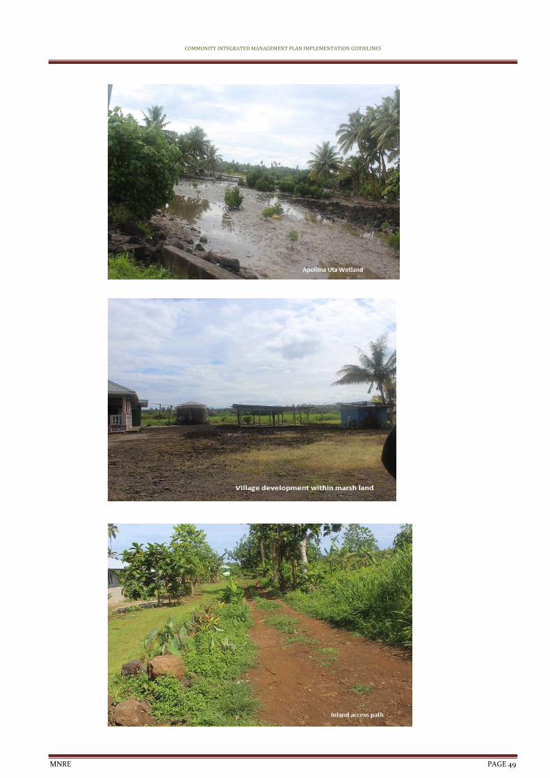
COMMUNITY INTEGRATED MANAGEMENT PLAN IMPLEMENTATION GUIDELINES
MNRE PAGE 49
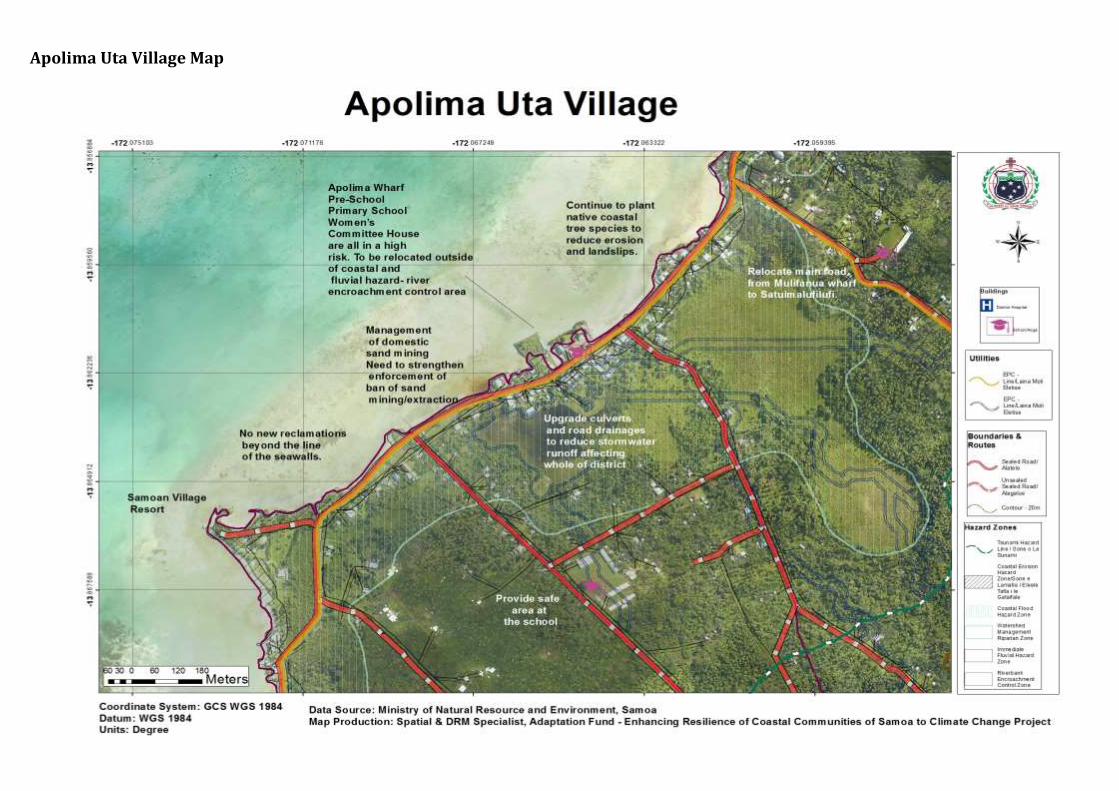
Apolima Uta Village Map
COMMUNITY INTEGRATED MANAGEMENT PLAN IMPLEMENTATION GUIDELINES
MNRE PAGE 51
6. Apolima Tai Village Interventions
CIM Plan Solutions Infrastructure Best Solutions Benefits Guideline to assist
with the implementation
Relevant Sector Plans, National Strategies & Policies
Village houses, church and other government assets located in high risk hazard zones
Relocate assets outside of high risk hazard zones when re-building Village to seek lands to migrate to due to expanding CEFZ and CFHZ Develop landuse planning and development controls to restrict developments within high risk hazard zones such as CEHZ and CFHZ Conduct awareness raising campaign on flood resilient building practices and designs for at risk communities living in and near high risk hazard zones Design infrastructure to take into account the immediate hazard zones; for example, raise floor levels of houses in flood prone areas Families and village to limit building and developing on natural overland flow paths exacerbating inland flooding and storm water surges
Responsibility: Village / Families /MWTI/ MNRE/ MWCSD
Minimise expenditure on damaged properties and personal assets
Safer villages, houses and roads Increases awareness for insurance
Planning provisions to be guided by the Planning and Urban Management Act 2004 Enforcement of National Building Code 2017 Encourage insurance of significant investments and assets within hazard zones Utilise hazard maps and Geomorphologist Drainage Infrastructure Database to determine safe areas for relocation purposes Designation of the IFHZ, CEHZ and CFHZ as an “at risk” zone with appropriate landuse planning controls and restrictions
CIM Strategy 2015
National Building Code
Marine landing ramp: main wharf
Repair and upgrade damaged marine landing ramp Enforce environmental safeguards under the PUMA Act when
Maintain lifeline access and connectivity Improve preparedness and readiness
Identify funding/ budget requirements and implementation programme Designation of the CEHZ, CFHZ and
CIM Strategy 2015
Community Sector Plan Apolima Village Hazard Zone

COMMUNITY INTEGRATED MANAGEMENT PLAN IMPLEMENTATION GUIDELINES
MNRE PAGE 52
upgrading wharves and jetties
response to natural disasters
tsunami shore exlusive zones as an “at risk” zone with appropriate landuse planning controls and restrictions
Resettlement Plan (VHZRP)
Evacuation Shelter and a connected escape route needed for emergency preparedness and response
Assess and/or select location for either an existing or new evacuation shelter, including safe access routes to the shelter Conduct evacuation shelter assessment and mark on CIM Plan hazard maps Develop a Village Climate Disaster Management Plan (VCDMP)
Conduct trainings for People With Disabilities (PWDs) on emergency and disaster response strategies Implement CDCRM program Install relevant signs to guide the community on emergency response procedures and to locations of evacuation shelters Where no suitable houses exist, build emergency shelter(s) outside the hazard zones Retrofit identified and approved schools or churches outside hazard zones and designate as evacuation shelter
Responsibility: MNRE /DMO/ MWTI/Village /CSSP/Council of Churches/MWCSD
Improve resilience of public infrastructure Improve preparedness and readiness response to natural disasters
Enforcement of National Building Code 2017 Utilise hazard maps and Geomorphologist findings to inform location and designs
National Disaster Management Plan 2017-2021 National Building Code
National Policy for People with Disabilities
NISP 2011 KESO 5
Island water supply: tank
Relocate main water tank out of hazard zones Procure rainwater
Improve preparedness and readiness response to natural disasters
Develop and register District/Village bylaws to include regulating developments around
CIM Strategy 2015
Water and Sanitation Sector
COMMUNITY INTEGRATED MANAGEMENT PLAN IMPLEMENTATION GUIDELINES
MNRE PAGE 53
harvesting systems as backup for vulnerable families as a short term solution
Regulate developments and remove latrines around water supply
Village to fence domestic animals away from areas susceptible to flooding
Responsibility: District/Village/ CSSP/ NGO
Increase adaptation during drought periods Improve health and sanitation Reduce contamination of water supply
identified hazard zones Include in budget programming relocation of tanks and procurement of rainfall catchment systems
Utilize Hazard Map Hazard maps and Geomorphologist findings for planning purposes Utilize Sui o Nu’u monthly meetings to monitor progress of village programmes and responsibilities
Plan
Community Engagement Plan
Solar power plant
Replace battery to maintain electricity supply to Apolima island
Responsibility: District /Village/ CSSP/ NGO
Maintain connectivity Improve preparedness and readiness response to natural disasters
Village to seek funding
Utilize Sui o Nu’u monthly meetings to monitor progress of village programmes and responsibilities
CIM Strategy 2015
Community Engagement Plan
Energy Sector Plan
Natural Resources & Environment
Best Solutions Benefits Guideline to assist with the implementation
Relevant Sector Plans, National Strategies & Policies
Village pool located in high risk hazard zones
Village pool is currently in a poor state with an assessment needed for options to either rejuvenate or find a new site depending on the location of springs
Test the quality of the water source before any further investment on the pool is undertaken (eg: fence/repair works)
Responsibility: MoF-CSSP/ MNRE/Villages/ NGOs
Increase adaptation during drought periods Improve health and sanitation Reduce contamination of water supply
Utilise Hazard Maps and Geomorphologist findings to inform location and design MNRE Water & Sanitation to conduct water testing and analysis of village pool prior to any intervention Update Village bylaws to include managing and maintaining village natural resources
CIM Strategy 2015
Community Engagement Plan
Coastal Restoration
Plant native species along coastal areas to strengthen existing seawall and to reduce coastal erosion and landslips; Talie, Fetau, Toa, Togatogo are known to have greater resilience to natural
Soft coastal protection measures will support and strengthen existing and new infrastructure along the coast
Develop an integrated land management plan for Aiga i le Tai district with the aim of reducing any unnecessary actions that may adversely affect the natural habitats and
NESP 2018 - 2022 Two Million Tree Planting Strategy 2015-2020 Restoration Operational Plan 2016-2020
COMMUNITY INTEGRATED MANAGEMENT PLAN IMPLEMENTATION GUIDELINES
MNRE PAGE 54
disasters and changing climate conditions
To act as an effective wave barrier, a minimum distance of 200m of vegetation is needed
Responsibility: MNRE/ MAF/Villages
Reduce impact from coastal erosion and natural disasters Implements an Ecosystem Based Approach
ecosystems of the area MAF to assist in establishment of pilot sites to trial climate ready plant varieties MNRE Forestry, DEC and MAF to collaborate on supply of climate resilient crops
Governance Best Solutions Benefits Guideline to assist with the implementation
Relevant Sector Plans, National Strategies & Policies
Strengthen the governance of natural resources and land use through Bylaws
Update and/or develop bylaws to manage the use of natural resources, and to control land use impacts; such as drainage maintenance, rubbish dumping, sand mining, stray animals and unregulated developments in water catchment areas and near boreholes. Collaborate with Sui o Nuu to monitor the use of and impact on natural resources Facilitate continuous awareness raising programs with the villages Responsibility: MWCSD /Village
Strengthen implementation of all national sector plans Strengthen monitoring of all National Acts, Regulation, Strategies, Plans and Policies Improve ability of communities to adapt, respond and recover quickly in the long term Improve accountability and enabling environment of communities
Develop and register district/village bylaw to protect all district/ village and government assets, environment, livelihood and food security especially activities affecting water catchment areas and coastline Utilise Sui o Nu’u monthly meetings to monitor progress of district/village bylaws
Village Fono Act (Amendment Bill 2016) Community Sector Plan Community Development Plan 2016-2021
Non-CR issues raised during consultations
Proposed Solution Comments
Village lands
Responsibility: Village/ Government/
Village requested land from government for relocation purposes
Related to CR as relocation is one of the recommended solutions to impacts of climate change included in the Aiga I le Tai CIM Plan

COMMUNITY INTEGRATED MANAGEMENT PLAN IMPLEMENTATION GUIDELINES
MNRE PAGE 55
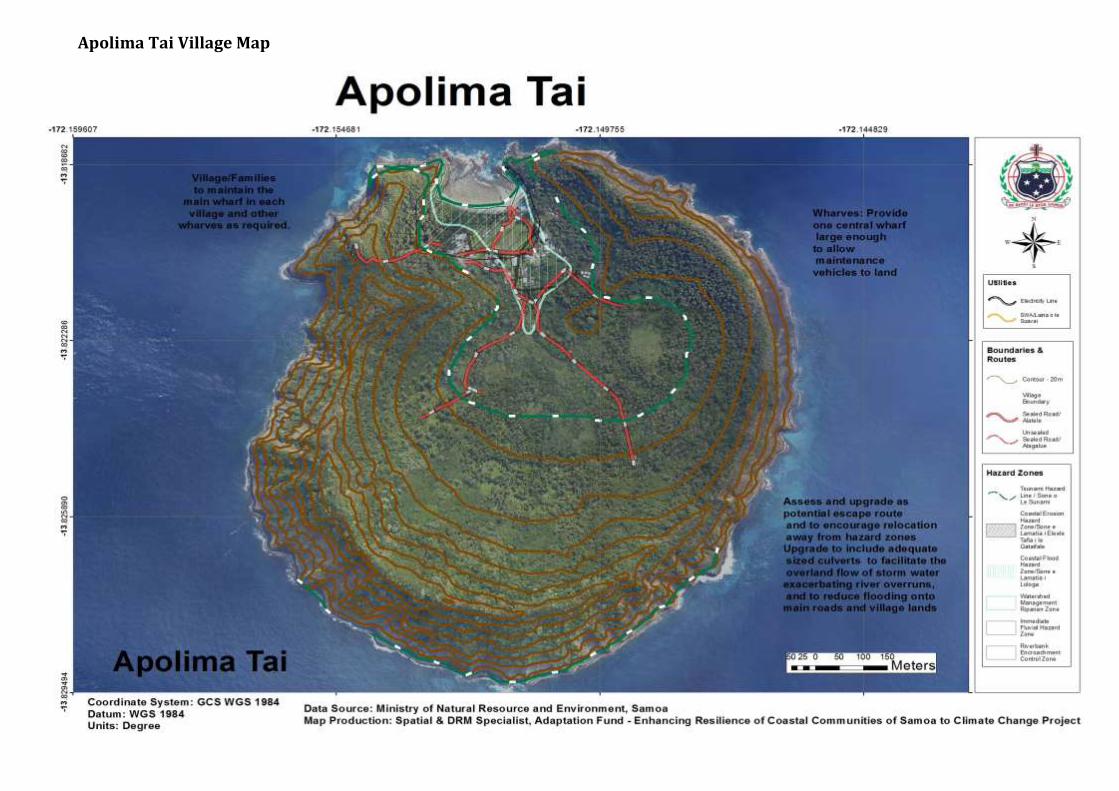
Apolima Tai Village Map

COMMUNITY INTEGRATED MANAGEMENT PLAN IMPLEMENTATION GUIDELINES
MNRE PAGE 57
6. Faleu tai Village Interventions
CIM Plan Solutions Infrastructur
e Best Solutions Benefits Guideline to assist with
the implementation Relevant Sector Plans, National Strategies & Policies
Village houses, church and other government assets located in high risk hazard zones
Relocate assets outside of high risk hazard zones when re-building Develop landuse planning and development controls to restrict developments within high risk hazard zones such as CEHZ and CFHZ Conduct awareness raising campaign on flood resilient building practices and designs for at risk communities living in and near high risk hazard zones Design infrastructure to take into account the immediate hazard zones; for example, raise floor levels of houses in flood prone areas Families and village to limit building and developing on natural overland flow paths exacerbating inland flooding and storm water surges
Responsibility: Village / Families /MWTI/ MNRE/ MWCSD
Minimise expenditure on damaged properties and personal assets
Safer villages, houses and roads Increases awareness for insurance
Planning provisions to be guided by the Planning and Urban Management Act 2004 Enforcement of National Building Code 2017 Encourage insurance of significant investments and assets within hazard zones Utilise hazard maps and Geomorphologist Drainage Infrastructure Database to determine safe areas for relocation purposes Designation of the IFHZ, CEHZ and CFHZ as an “at risk” zone with appropriate landuse planning controls and restrictions
CIM Strategy 2015
National Building Code
Coastline protection: combination of hard and soft solutions
Investigate potential for upgrading seawalls in areas where road sits less than 5mtr from coastline Encourage relocation of families/houses in badly eroded coastal areas
Improve infrastructure resilience and rate of recovery Improve preparedness and readiness response to natural disasters
Reduce impact from coastal erosion and
Utilize environmental and social safeguards including EIAs in screening and designing infrastructure facilities
Utilize Sui o Nu’u monthly meetings to monitor progress of village replanting and cleanup programmes
CIM Strategy 2015 NESP 2018 - 2022 Community Sector Plan
COMMUNITY INTEGRATED MANAGEMENT PLAN IMPLEMENTATION GUIDELINES
MNRE PAGE 58
Responsibility: MWTI/ MNRE/ Village
natural disasters Safer villages, houses and roads
Jetty Repair and upgrade damaged posts Village to maintain and upgrade jetty Village to limit number of private jetties on island Responsibility: SPA/ MNRE/ Village /CSSP/ NGO
Maintain lifeline access and connectivity Improve preparedness and readiness response to natural disasters
Identify funding/ budget requirements and implementation programme Utilize environmental and social safeguards including EIAs in screening and designing infrastructure facilities
Designation of the CEHZ, CFHZ and tsunami shore exlusive zones as an “at risk” zone with appropriate landuse planning controls and restrictions
CIM Strategy 2015
Community Engagement Plan
Natural Resources and Environment
Best Solutions Benefits Guideline to assist with the implementation
Relevant Sector Plans, National Strategies & Policies
Coastal Restoration
Plant native species along coastal areas to strengthen existing seawall and to reduce coastal erosion and landslips; Talie, Fetau, Toa, Togatogo are known to have greater resilience to natural disasters and changing climate conditions
To act as an effective wave barrier, a minimum distance of 200m of vegetation is needed
Responsibility: MNRE/ MAF/Villages
Soft coastal protection measures will support and strengthen existing and new infrastructure along the coast Reduce impact from coastal erosion and natural disasters Implements an Ecosystem Based Approach
Develop an integrated land management plan for Aiga i le Tai district with the aim of reducing any unnecessary actions that may adversely affect the natural habitats and ecosystems of the area MAF to assist in establishment of pilot sites to trial climate ready plant varieties MNRE Forestry, DEC and MAF to collaborate on supply of climate resilient crops
NESP 2018 - 2022 Two Million Tree Planting Strategy 2015-2020 Restoration Operational Plan 2016-2020
Governance Best Solutions Benefits Guideline to assist with the implementation
Relevant Sector Plans, National Strategies & Policies
Strengthen the governance of natural resources and land use through
Update and/or develop bylaws to manage the use of natural resources, and to control land use impacts; such as drainage maintenance,
Strengthen implementation of all national sector plans Strengthen monitoring of all National Acts,
Develop and register district/village bylaw to protect all district/ village and government assets, environment, livelihood and food security especially
Village Fono Act (Amendment Bill 2016) Community Sector Plan

COMMUNITY INTEGRATED MANAGEMENT PLAN IMPLEMENTATION GUIDELINES
MNRE PAGE 59
Bylaws rubbish dumping, sand mining, stray animals and unregulated developments in water catchment areas and near boreholes. Collaborate with Sui o Nuu to monitor the use of and impact on natural resources Facilitate continuous awareness raising programs with the villages Responsibility: MWCSD /Village
Regulation, Strategies, Plans and Policies Improve ability of communities to adapt, respond and recover quickly in the long term Improve accountability and enabling environment of communities
activities affecting water catchment areas and coastline Utilise Sui o Nu’u monthly meetings to monitor progress of district/village bylaws
Community Development Plan 2016-2021
Non-CR issues raised during consultations
Proposed Solution Comments
Village lands
Responsibility: Village/ Government/
Village requested land from government for relocation purposes
Related to CR as relocation is one of the recommended solutions to impacts of climate change included in the Aiga I le Tai CIM Plan

COMMUNITY INTEGRATED MANAGEMENT PLAN IMPLEMENTATION GUIDELINES
MNRE PAGE 60
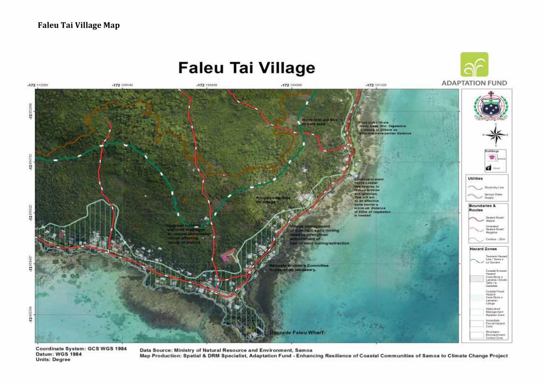
Faleu Tai Village Map

COMMUNITY INTEGRATED MANAGEMENT PLAN IMPLEMENTATION GUIDELINES
MNRE PAGE 62
7. Lalovi Village Interventions
CIM Plan Solutions Infrastructure Best Solutions Benefits Guideline to assist
with the implementation
Relevant Sector Plans, National
Strategies & Policies Village infrastructure located in high risk hazard zones; such as houses, schools, Churches, Businesses, Committee houses etc
Relocate assets outside of high risk hazard zones when re-building Develop landuse planning and development controls to restrict developments within high risk hazard zones such as CEHZ and CFHZ Conduct awareness raising campaign on flood resilient building practices and designs for at risk communities living in and near high risk hazard zones Design infrastructure to take into account the immediate hazard zones; for example, raise floor levels of houses in flood prone areas Families and village to limit building and developing on natural overland flow paths exacerbating inland flooding and storm water surges
Responsibility: Village / Families /MWTI/ MNRE/ MWCSD
Minimise expenditure on damaged properties and personal assets
Safer villages, houses and roads Increases awareness for insurance
Planning provisions to be guided by the Planning and Urban Management Act 2004 Enforcement of National Building Code 2017 Encourage insurance of significant investments and assets within hazard zones Utilise hazard maps and Geomorphologist Drainage Infrastructure Database to determine safe areas for relocation purposes Designation of the IFHZ, CEHZ and CFHZ as an “at risk” zone with appropriate landuse planning controls and restrictions
CIM Strategy 2015
National Building Code
Coastline protection: combination of hard and soft solutions
Investigate potential for upgrading government managed seawalls in areas where road sits less than 5mtr from coastline as short term solution Where reclamations, sand mining, extraction or other major coastal works are proposed, Government and village
Improve infrastructure resilience and rate of recovery Improve preparedness and readiness response to natural disasters
Reduce impact from coastal erosion and
Utilize environmental and social safeguards including EIAs in screening and designing infrastructure facilities
Develop and register Village bylaws to include banning of sand mining, reclamation works in high risk hazard
CIM Strategy 2015 PUMA Act Community Engagement Plan NESP 2018 - 2022 Village Fono Act (Amendment Bill 2016)

COMMUNITY INTEGRATED MANAGEMENT PLAN IMPLEMENTATION GUIDELINES
MNRE PAGE 63
to manage processes by requiring villagers to get the appropriate permits and consent Clear debris from existing culverts near seawalls to enable free outflow of storm water and streams Ban reclamations beyond seawalls Responsibility: MWTI/ MNRE/ Village
natural disasters Safer villages, houses and roads
zones and illegal rubbish dumping in waterways and drains
Utilize Sui o Nu’u monthly meetings to monitor progress of village replanting and cleanup programmes
Main Aana West Coast Road and junctions of main west coast road and access roads/tracks16
Continue investigating relocating main road (2km arterial road) in areas where road sits less than 5mtr from coastline in accordance with Vulnerability Assessment of the Samoa Road Network recommendations Assess and upgrade access roads/tracks to include adequate sized culverts to facilitate the overland flow of storm water and to reduce flooding onto main lifeline and connectivity road Responsibility:LTA/MWTI/ MNRE/ District/ Village
Improve infrastructure resilience and rate of recovery Improve preparedness and readiness response to natural disasters
Reduce impact from coastal erosion and natural disasters Safer villages, houses and roads Minimize national disaster recovery expenditure on damaged properties and public assets
Utilize environmental and social safeguards including EIAs in screening and designing infrastructure facilities
UtilizeHazard Map Hazard maps and Geomorphologist Drainage Infrastructure Database Include in budget programming CBA, design and construction
Designation of the CEHZ and CFHZ as an “at risk” zone with appropriate landuse planning controls and restrictions
CIM Strategy 2015
TSP2014-2019 Goal 2 KO 1 Vulnerability Assessment of the Samoa Road Network (2016) and Road Network Adaptation Strategy, LTA
Evacuation Shelter and a connected escape route needed for emergency preparedness and response
Assess and/or select location for either an existing or new evacuation shelter, including safe access routes to the shelter Conduct evacuation shelter assessment and mark on CIM Plan hazard maps Develop a Village Climate Disaster Management Plan
Improve resilience of public infrastructure Improve preparedness and readiness response to natural disasters
Enforcement of National Building Code 2017 Utilise hazard maps and Geomorphologist findings to inform location and designs
National Disaster Management Plan 2017-2021 National Building Code
National Policy for People with Disabilities
NISP 2011 KESO 5
16Access roads not in national network nor LTA road maintenance programme

COMMUNITY INTEGRATED MANAGEMENT PLAN IMPLEMENTATION GUIDELINES
MNRE PAGE 64
(VCDMP)
Conduct trainings for People With Disabilities (PWDs) on emergency and disaster response strategies Implement CDCRM program Install relevant signs to guide the community on emergency response procedures and to locations of evacuation shelters Where no suitable houses exist, build emergency shelter(s) outside the hazard zones Retrofit identified and approved schools or churches outside hazard zones and designate as evacuation shelter
Responsibility: MNRE /DMO/ MWTI/Village /CSSP/Council of Churches/MWCSD
Reticulated water supply, quality and network to be improved
Extend the water supply to families inland with no access to water
Procure rainwater harvesting systems for vulnerable families as a short term solution
District to support SWA efforts at exploratory boreholes in district
District and villages to support SWA efforts at protecting and conserving boreholes, intakes and catchment areas
Responsibility: SWA/ MWCSD/ MNRE / District/ Village/ CSSP
Increase adaptation during drought periods Improve infrastructure resilience and rate of recovery Improve health and sanitation Reduce contamination of water supply Reduce impact from inland flooding
Develop and register District/Village bylaws to include regulating developments around catchment areas and boreholes Implement SWA (2016)10 year investment plan to improve water supply network to support all inland families without access to drinking water Include in budget programming design, and extension costs of water supply and procurement of rainwater harvesting systems
Utilise hazard maps and Geomorphologist findings to inform
CIM Strategy 2015
Water and Sanitation Sector Plan
SWA 10 Year Investment Plan (2016)
Community Engagement Plan
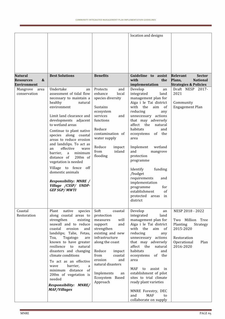
COMMUNITY INTEGRATED MANAGEMENT PLAN IMPLEMENTATION GUIDELINES
MNRE PAGE 65
location and designs
Natural Resources & Environment
Best Solutions Benefits Guideline to assist with the implementation
Relevant Sector Plans, National Strategies & Policies
Mangrove area conservation
Undertake an assessment of tidal flow necessary to maintain a healthy natural environment Limit land clearance and developments adjacent to wetland areas
Continue to plant native species along coastal areas to reduce erosion and landslips. To act as an effective wave barrier, a minimum distance of 200m of vegetation is needed
Village to fence off domestic animals Responsibility: MNRE / Village /CSSP/ UNDP-GEF SGP/ MWTI
Protects and enhance local species diversity Sustains ecosystem services and functions Reduce contamination of water supply Reduce impact from inland flooding
Develop an integrated land management plan for Aiga i le Tai district with the aim of reducing any unnecessary actions that may adversely affect the natural habitats and ecosystems of the area Implement wetland and mangrove protection programme Identify funding /budget requirements and implementation programme for establishment of protected areas in district
Draft NESP 2017-2021 Community Engagement Plan
Coastal Restoration
Plant native species along coastal areas to strengthen existing seawall and to reduce coastal erosion and landslips; Talie, Fetau, Toa, Togatogo are known to have greater resilience to natural disasters and changing climate conditions
To act as an effective wave barrier, a minimum distance of 200m of vegetation is needed
Responsibility: MNRE/ MAF/Villages
Soft coastal protection measures will support and strengthen existing and new infrastructure along the coast Reduce impact from coastal erosion and natural disasters Implements an Ecosystem Based Approach
Develop an integrated land management plan for Aiga i le Tai district with the aim of reducing any unnecessary actions that may adversely affect the natural habitats and ecosystems of the area MAF to assist in establishment of pilot sites to trial climate ready plant varieties MNRE Forestry, DEC and MAF to collaborate on supply
NESP 2018 - 2022 Two Million Tree Planting Strategy 2015-2020 Restoration Operational Plan 2016-2020

COMMUNITY INTEGRATED MANAGEMENT PLAN IMPLEMENTATION GUIDELINES
MNRE PAGE 66
of climate resilient crops
Livelihood and Food Security
Best Solutions Benefits Guideline to assist with the implementation
Relevant Sector Plans, National Strategies & Policies
Plantations, crops and plants threatened by changes in climate, inland flooding and inadequate soil for planting
Promote and facilitate planting of rootcrops ( i.e yams, sweet potato) which are more resilient to cyclones, droughts and floods Promote agroforestry and mixed planting including fruit trees species to promote ecological stability, soil protection and reduce crop vulnerability to pests and diseases Implement the Integrated Pest Management Programme Implement Sustainable Land Management (SLM) practices Conduct pilot site trials for climate ready plant varieties Responsibility: MAF/ MNRE/village
Improve health through access to clean water and waste management
Improve recovery to create more resilient villages
Improve preparedness and readiness response to natural disasters
Agriculture sector to provide best practice management guidelines for the management of water that allows for levels of contamination to be kept to minimum
MNRE Forestry, DEC and MAF to collaborate on supply of climate resilient crops and plants MAF to provide trainings, awareness raising on crop diversification to suit prolonged impacts of climate change and support in supply of nursery trees, technology and infrastructure to have a sustainable mechanism for replanting MAF to assist in establishment of pilot sites to trial climate ready plant varieties and provide advice, seedlings and planting material for village/families as a trial
Develop an integrated land management plan with the aim of reducing any unnecessary actions that may adversely affect the natural habitats and ecosystems of the area MNRE Forestry to advice on appropriate species, depth and density of planting and provide seedlings
Agriculture Sector Plan 2016-2021 Two Million Tree Strategy 2015-2020 Restoration Operational Plan 2016-2020
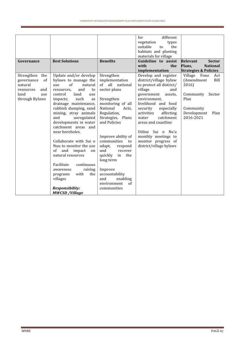
COMMUNITY INTEGRATED MANAGEMENT PLAN IMPLEMENTATION GUIDELINES
MNRE PAGE 67
for different vegetation types suitable to the habitats and planting materials for village
Governance Best Solutions Benefits Guideline to assist with the implementation
Relevant Sector Plans, National Strategies & Policies
Strengthen the governance of natural resources and land use through Bylaws
Update and/or develop bylaws to manage the use of natural resources, and to control land use impacts; such as drainage maintenance, rubbish dumping, sand mining, stray animals and unregulated developments in water catchment areas and near boreholes. Collaborate with Sui o Nuu to monitor the use of and impact on natural resources Facilitate continuous awareness raising programs with the villages Responsibility: MWCSD /Village
Strengthen implementation of all national sector plans Strengthen monitoring of all National Acts, Regulation, Strategies, Plans and Policies Improve ability of communities to adapt, respond and recover quickly in the long term Improve accountability and enabling environment of communities
Develop and register district/village bylaw to protect all district/ village and government assets, environment, livelihood and food security especially activities affecting water catchment areas and coastline Utilise Sui o Nu’u monthly meetings to monitor progress of district/village bylaws
Village Fono Act (Amendment Bill 2016) Community Sector Plan Community Development Plan 2016-2021

COMMUNITY INTEGRATED MANAGEMENT PLAN IMPLEMENTATION GUIDELINES
MNRE PAGE 68
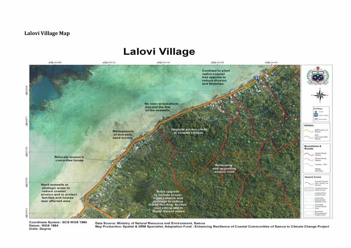
Lalovi Village Map
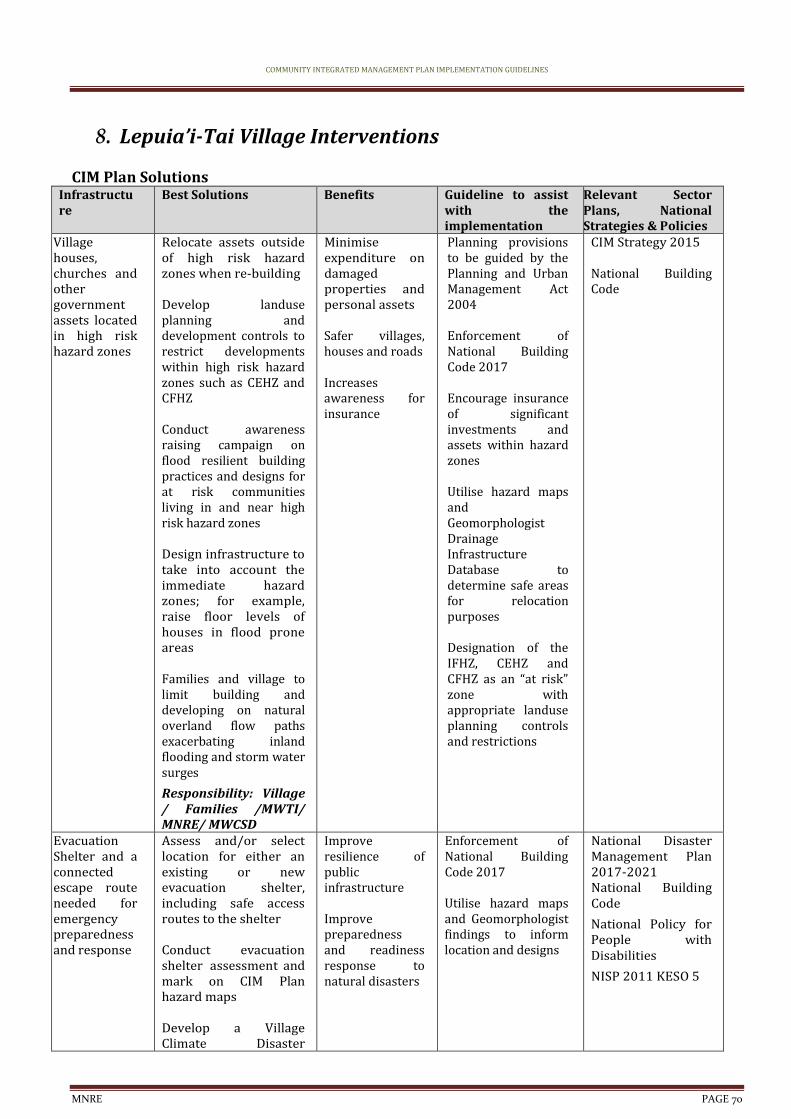
COMMUNITY INTEGRATED MANAGEMENT PLAN IMPLEMENTATION GUIDELINES
MNRE PAGE 70
8. Lepuia’i-Tai Village Interventions
CIM Plan Solutions Infrastructure
Best Solutions Benefits Guideline to assist with the implementation
Relevant Sector Plans, National Strategies & Policies
Village houses, churches and other government assets located in high risk hazard zones
Relocate assets outside of high risk hazard zones when re-building Develop landuse planning and development controls to restrict developments within high risk hazard zones such as CEHZ and CFHZ Conduct awareness raising campaign on flood resilient building practices and designs for at risk communities living in and near high risk hazard zones Design infrastructure to take into account the immediate hazard zones; for example, raise floor levels of houses in flood prone areas Families and village to limit building and developing on natural overland flow paths exacerbating inland flooding and storm water surges
Responsibility: Village / Families /MWTI/ MNRE/ MWCSD
Minimise expenditure on damaged properties and personal assets
Safer villages, houses and roads Increases awareness for insurance
Planning provisions to be guided by the Planning and Urban Management Act 2004 Enforcement of National Building Code 2017 Encourage insurance of significant investments and assets within hazard zones Utilise hazard maps and Geomorphologist Drainage Infrastructure Database to determine safe areas for relocation purposes Designation of the IFHZ, CEHZ and CFHZ as an “at risk” zone with appropriate landuse planning controls and restrictions
CIM Strategy 2015
National Building Code
Evacuation Shelter and a connected escape route needed for emergency preparedness and response
Assess and/or select location for either an existing or new evacuation shelter, including safe access routes to the shelter Conduct evacuation shelter assessment and mark on CIM Plan hazard maps Develop a Village Climate Disaster
Improve resilience of public infrastructure Improve preparedness and readiness response to natural disasters
Enforcement of National Building Code 2017 Utilise hazard maps and Geomorphologist findings to inform location and designs
National Disaster Management Plan 2017-2021 National Building Code
National Policy for People with Disabilities
NISP 2011 KESO 5
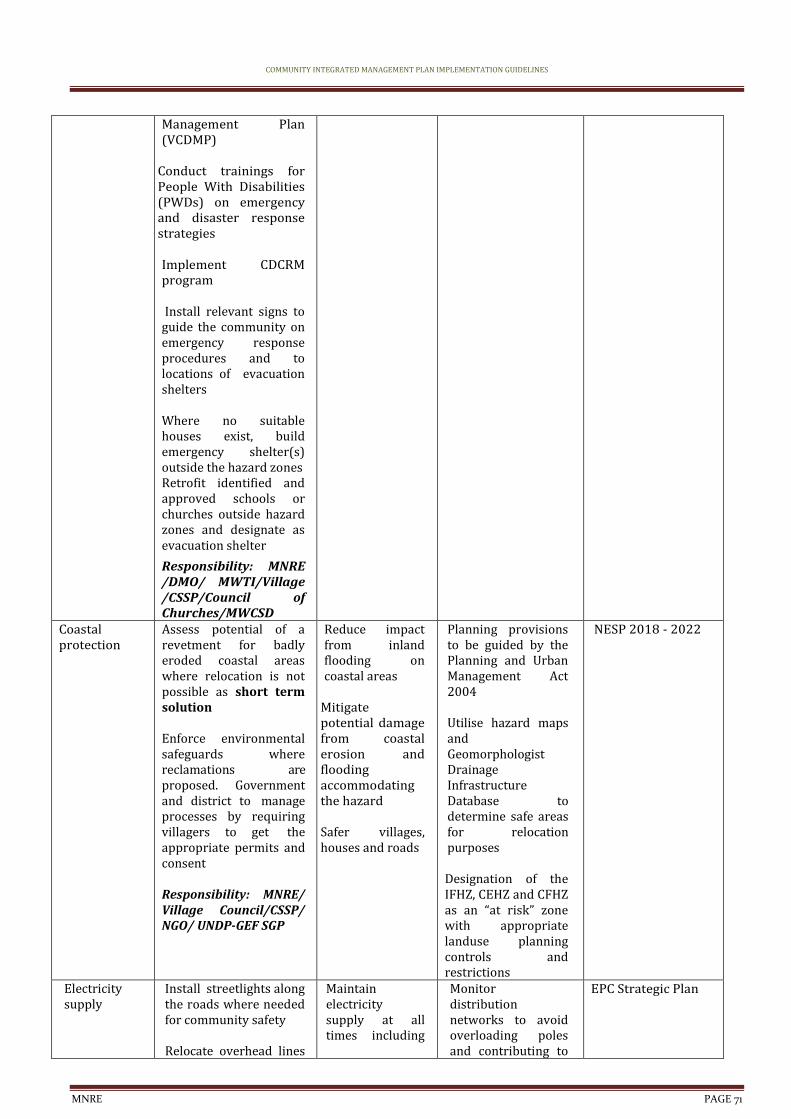
COMMUNITY INTEGRATED MANAGEMENT PLAN IMPLEMENTATION GUIDELINES
MNRE PAGE 71
Management Plan (VCDMP)
Conduct trainings for People With Disabilities (PWDs) on emergency and disaster response strategies Implement CDCRM program Install relevant signs to guide the community on emergency response procedures and to locations of evacuation shelters Where no suitable houses exist, build emergency shelter(s) outside the hazard zones Retrofit identified and approved schools or churches outside hazard zones and designate as evacuation shelter
Responsibility: MNRE /DMO/ MWTI/Village /CSSP/Council of Churches/MWCSD
Coastal protection
Assess potential of a revetment for badly eroded coastal areas where relocation is not possible as short term solution Enforce environmental safeguards where reclamations are proposed. Government and district to manage processes by requiring villagers to get the appropriate permits and consent Responsibility: MNRE/ Village Council/CSSP/ NGO/ UNDP-GEF SGP
Reduce impact from inland flooding on coastal areas
Mitigate potential damage from coastal erosion and flooding accommodating the hazard Safer villages, houses and roads
Planning provisions to be guided by the Planning and Urban Management Act 2004 Utilise hazard maps and Geomorphologist Drainage Infrastructure Database to determine safe areas for relocation purposes Designation of the IFHZ, CEHZ and CFHZ as an “at risk” zone with appropriate landuse planning controls and restrictions
NESP 2018 - 2022
Electricity supply
Install streetlights along the roads where needed for community safety Relocate overhead lines
Maintain electricity supply at all times including
Monitor distribution networks to avoid overloading poles and contributing to
EPC Strategic Plan
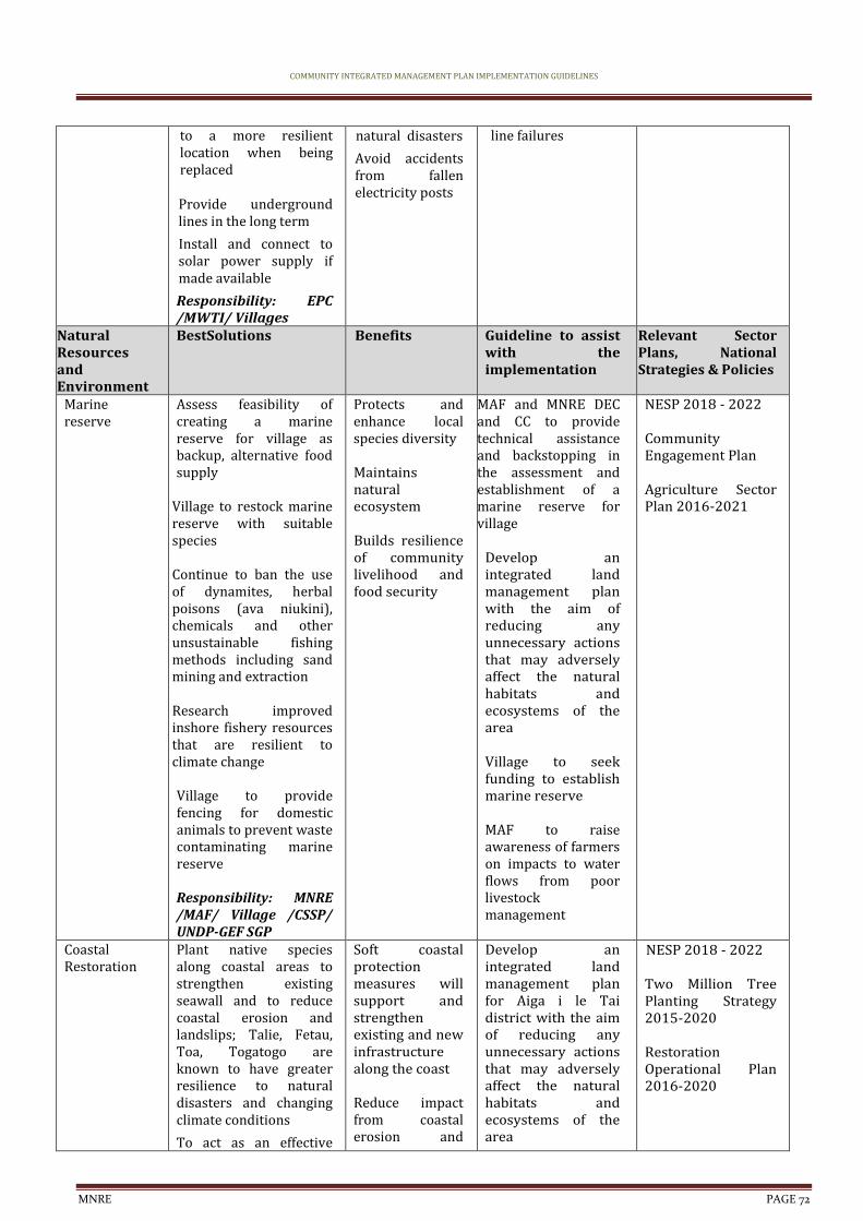
COMMUNITY INTEGRATED MANAGEMENT PLAN IMPLEMENTATION GUIDELINES
MNRE PAGE 72
to a more resilient location when being replaced Provide underground lines in the long term
Install and connect to solar power supply if made available
Responsibility: EPC /MWTI/ Villages
natural disasters
Avoid accidents from fallen electricity posts
line failures
Natural Resources and Environment
BestSolutions Benefits Guideline to assist with the implementation
Relevant Sector Plans, National Strategies & Policies
Marine reserve
Assess feasibility of creating a marine reserve for village as backup, alternative food supply
Village to restock marine reserve with suitable species Continue to ban the use of dynamites, herbal poisons (ava niukini), chemicals and other unsustainable fishing methods including sand mining and extraction Research improved inshore fishery resources that are resilient to climate change Village to provide fencing for domestic animals to prevent waste contaminating marine reserve Responsibility: MNRE /MAF/ Village /CSSP/ UNDP-GEF SGP
Protects and enhance local species diversity Maintains natural ecosystem Builds resilience of community livelihood and food security
MAF and MNRE DEC and CC to provide technical assistance and backstopping in the assessment and establishment of a marine reserve for village
Develop an integrated land management plan with the aim of reducing any unnecessary actions that may adversely affect the natural habitats and ecosystems of the area Village to seek funding to establish marine reserve MAF to raise awareness of farmers on impacts to water flows from poor livestock management
NESP 2018 - 2022 Community Engagement Plan Agriculture Sector Plan 2016-2021
Coastal Restoration
Plant native species along coastal areas to strengthen existing seawall and to reduce coastal erosion and landslips; Talie, Fetau, Toa, Togatogo are known to have greater resilience to natural disasters and changing climate conditions
To act as an effective
Soft coastal protection measures will support and strengthen existing and new infrastructure along the coast Reduce impact from coastal erosion and
Develop an integrated land management plan for Aiga i le Tai district with the aim of reducing any unnecessary actions that may adversely affect the natural habitats and ecosystems of the area
NESP 2018 - 2022 Two Million Tree Planting Strategy 2015-2020 Restoration Operational Plan 2016-2020
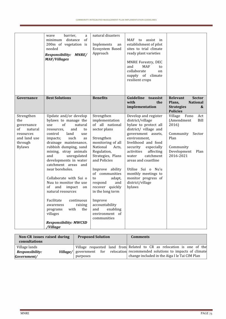
COMMUNITY INTEGRATED MANAGEMENT PLAN IMPLEMENTATION GUIDELINES
MNRE PAGE 73
wave barrier, a minimum distance of 200m of vegetation is needed
Responsibility: MNRE/ MAF/Villages
natural disasters Implements an Ecosystem Based Approach
MAF to assist in establishment of pilot sites to trial climate ready plant varieties MNRE Forestry, DEC and MAF to collaborate on supply of climate resilient crops
Governance Best Solutions Benefits Guideline toassist with the implementation
Relevant Sector Plans, National Strategies & Policies
Strengthen the governance of natural resources and land use through Bylaws
Update and/or develop bylaws to manage the use of natural resources, and to control land use impacts; such as drainage maintenance, rubbish dumping, sand mining, stray animals and unregulated developments in water catchment areas and near boreholes. Collaborate with Sui o Nuu to monitor the use of and impact on natural resources Facilitate continuous awareness raising programs with the villages Responsibility: MWCSD /Village
Strengthen implementation of all national sector plans Strengthen monitoring of all National Acts, Regulation, Strategies, Plans and Policies Improve ability of communities to adapt, respond and recover quickly in the long term Improve accountability and enabling environment of communities
Develop and register district/village bylaw to protect all district/ village and government assets, environment, livelihood and food security especially activities affecting water catchment areas and coastline Utilise Sui o Nu’u monthly meetings to monitor progress of district/village bylaws
Village Fono Act (Amendment Bill 2016) Community Sector Plan Community Development Plan 2016-2021
Non-CR issues raised during consultations
Proposed Solution Comments
Village lands
Responsibility: Village/ Government/
Village requested land from government for relocation purposes
Related to CR as relocation is one of the recommended solutions to impacts of climate change included in the Aiga I le Tai CIM Plan
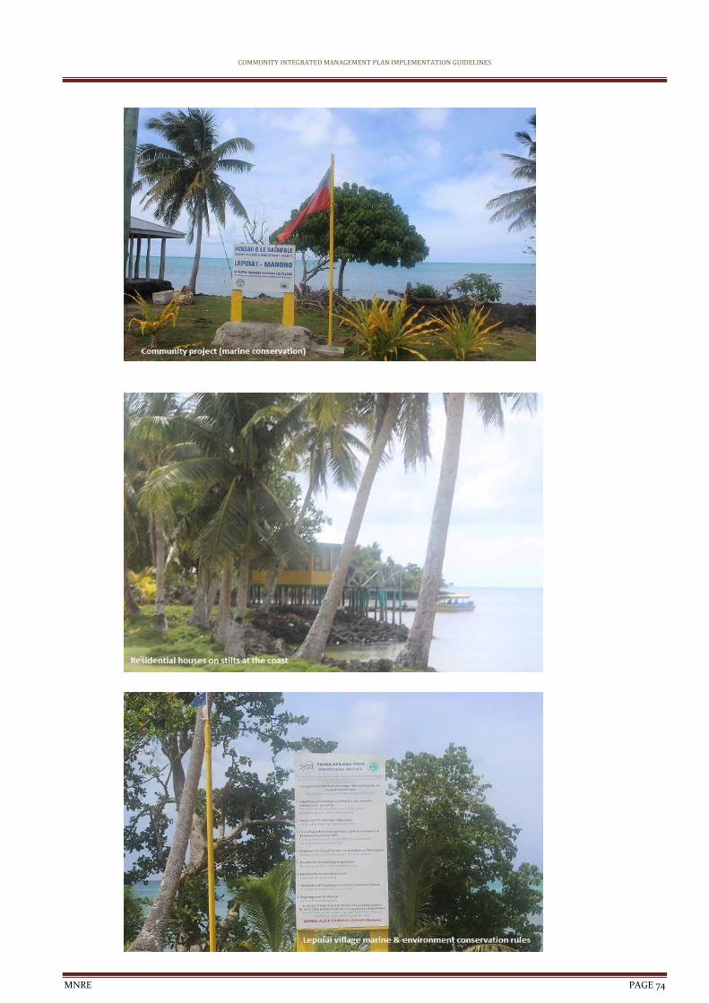
COMMUNITY INTEGRATED MANAGEMENT PLAN IMPLEMENTATION GUIDELINES
MNRE PAGE 74
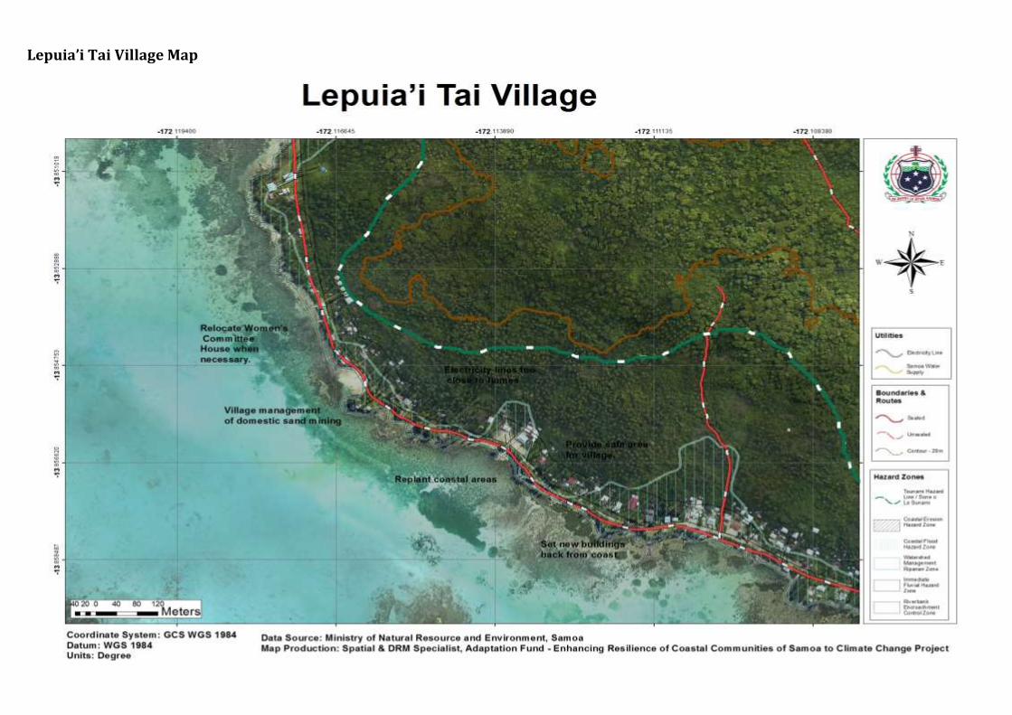
Lepuia’i Tai Village Map
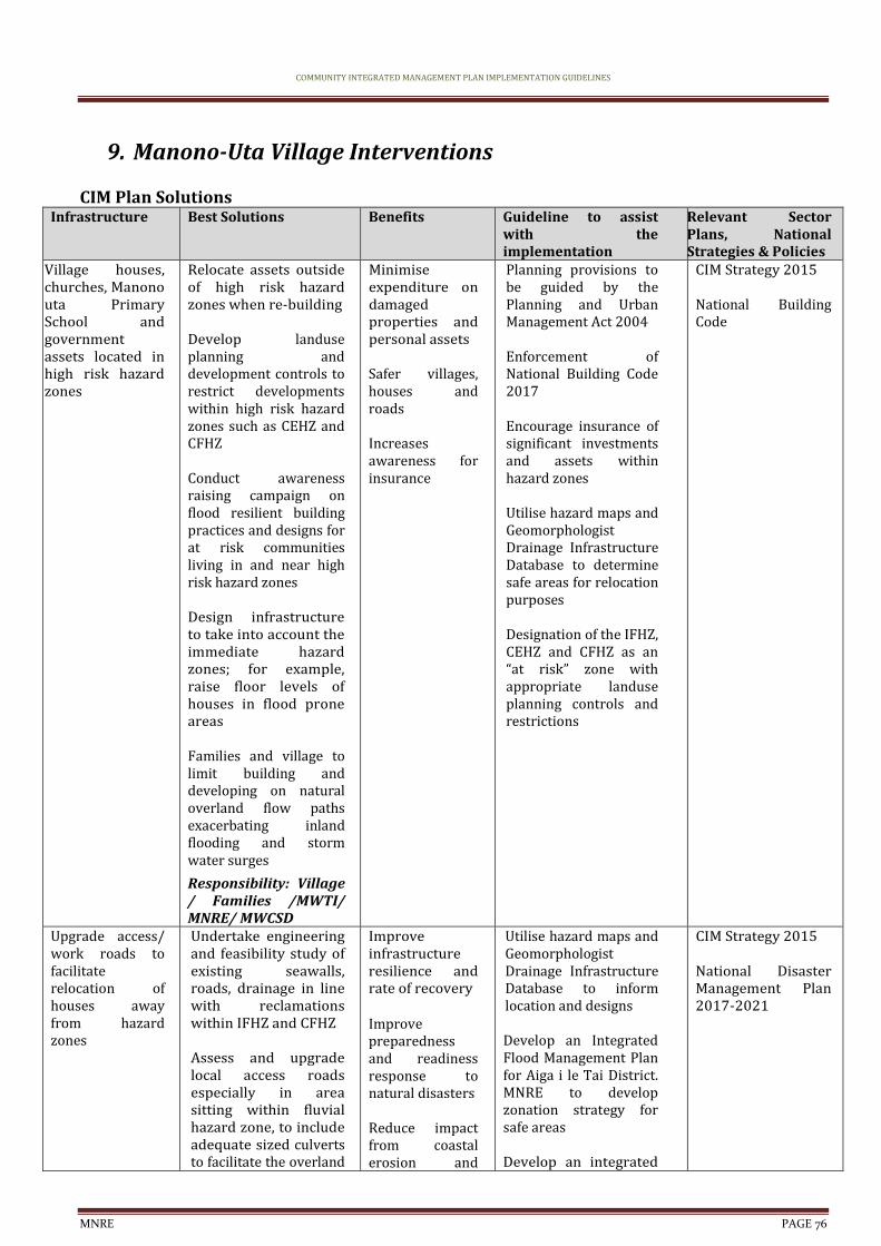
COMMUNITY INTEGRATED MANAGEMENT PLAN IMPLEMENTATION GUIDELINES
MNRE PAGE 76
9. Manono-Uta Village Interventions
CIM Plan Solutions Infrastructure Best Solutions Benefits Guideline to assist
with the implementation
Relevant Sector Plans, National Strategies & Policies
Village houses, churches, Manono uta Primary School and government assets located in high risk hazard zones
Relocate assets outside of high risk hazard zones when re-building Develop landuse planning and development controls to restrict developments within high risk hazard zones such as CEHZ and CFHZ Conduct awareness raising campaign on flood resilient building practices and designs for at risk communities living in and near high risk hazard zones Design infrastructure to take into account the immediate hazard zones; for example, raise floor levels of houses in flood prone areas Families and village to limit building and developing on natural overland flow paths exacerbating inland flooding and storm water surges
Responsibility: Village / Families /MWTI/ MNRE/ MWCSD
Minimise expenditure on damaged properties and personal assets
Safer villages, houses and roads Increases awareness for insurance
Planning provisions to be guided by the Planning and Urban Management Act 2004 Enforcement of National Building Code 2017 Encourage insurance of significant investments and assets within hazard zones Utilise hazard maps and Geomorphologist Drainage Infrastructure Database to determine safe areas for relocation purposes Designation of the IFHZ, CEHZ and CFHZ as an “at risk” zone with appropriate landuse planning controls and restrictions
CIM Strategy 2015
National Building Code
Upgrade access/ work roads to facilitate relocation of houses away from hazard zones
Undertake engineering and feasibility study of existing seawalls, roads, drainage in line with reclamations within IFHZ and CFHZ Assess and upgrade local access roads especially in area sitting within fluvial hazard zone, to include adequate sized culverts to facilitate the overland
Improve infrastructure resilience and rate of recovery Improve preparedness and readiness response to natural disasters
Reduce impact from coastal erosion and
Utilise hazard maps and Geomorphologist Drainage Infrastructure Database to inform location and designs Develop an Integrated Flood Management Plan for Aiga i le Tai District. MNRE to develop zonation strategy for safe areas Develop an integrated
CIM Strategy 2015 National Disaster Management Plan 2017-2021
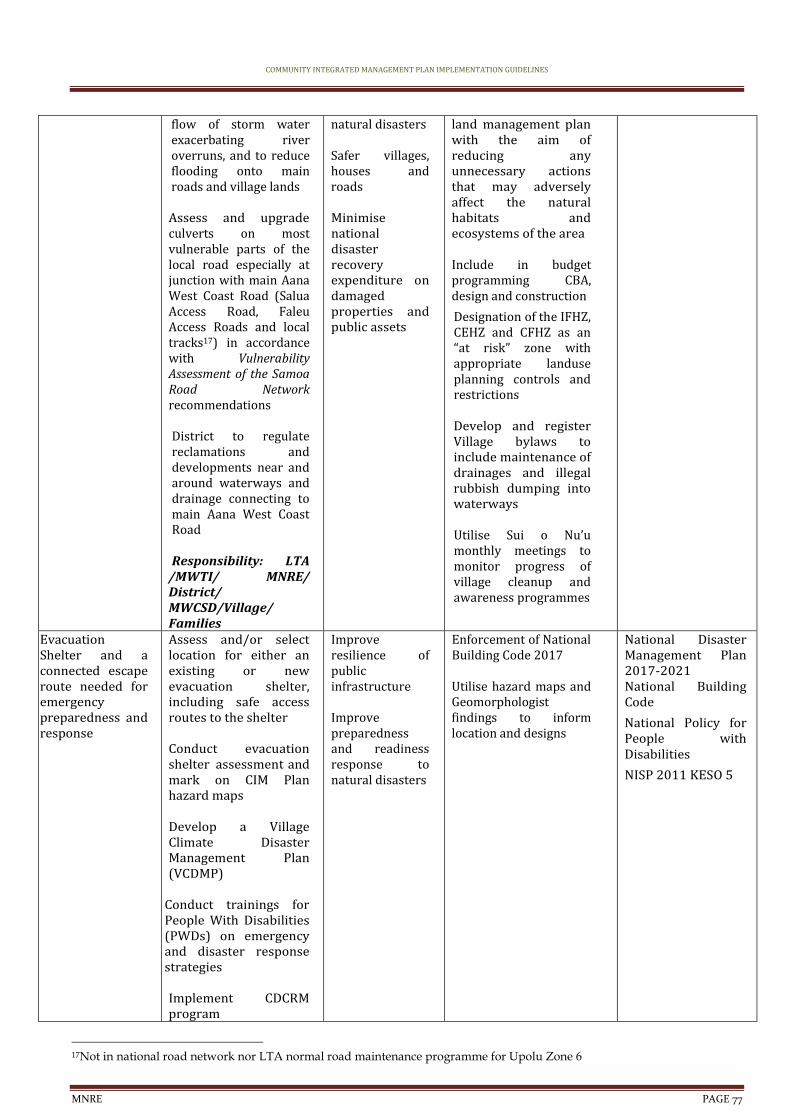
COMMUNITY INTEGRATED MANAGEMENT PLAN IMPLEMENTATION GUIDELINES
MNRE PAGE 77
flow of storm water exacerbating river overruns, and to reduce flooding onto main roads and village lands Assess and upgrade culverts on most vulnerable parts of the local road especially at junction with main Aana West Coast Road (Salua Access Road, Faleu Access Roads and local tracks17) in accordance with Vulnerability Assessment of the Samoa Road Network recommendations District to regulate reclamations and developments near and around waterways and drainage connecting to main Aana West Coast Road Responsibility: LTA
/MWTI/ MNRE/ District/ MWCSD/Village/ Families
natural disasters Safer villages, houses and roads Minimise national disaster recovery expenditure on damaged properties and public assets
land management plan with the aim of reducing any unnecessary actions that may adversely affect the natural habitats and ecosystems of the area Include in budget programming CBA, design and construction
Designation of the IFHZ, CEHZ and CFHZ as an “at risk” zone with appropriate landuse planning controls and restrictions Develop and register Village bylaws to include maintenance of drainages and illegal rubbish dumping into waterways Utilise Sui o Nu’u monthly meetings to monitor progress of village cleanup and awareness programmes
Evacuation Shelter and a connected escape route needed for emergency preparedness and response
Assess and/or select location for either an existing or new evacuation shelter, including safe access routes to the shelter Conduct evacuation shelter assessment and mark on CIM Plan hazard maps Develop a Village Climate Disaster Management Plan (VCDMP)
Conduct trainings for People With Disabilities (PWDs) on emergency and disaster response strategies Implement CDCRM program
Improve resilience of public infrastructure Improve preparedness and readiness response to natural disasters
Enforcement of National Building Code 2017 Utilise hazard maps and Geomorphologist findings to inform location and designs
National Disaster Management Plan 2017-2021 National Building Code
National Policy for People with Disabilities
NISP 2011 KESO 5
17Not in national road network nor LTA normal road maintenance programme for Upolu Zone 6

COMMUNITY INTEGRATED MANAGEMENT PLAN IMPLEMENTATION GUIDELINES
MNRE PAGE 78
Install relevant signs to guide the community on emergency response procedures and to locations of evacuation shelters Where no suitable houses exist, build emergency shelter(s) outside the hazard zones Retrofit identified and approved schools or churches outside hazard zones and designate as evacuation shelter
Responsibility: MNRE /DMO/ MWTI/Village /CSSP/Council of Churches/MWCSD
Coastal protection
Assess potential of a revetment for badly eroded coastal areas where relocation is not possible as short term solution Enforce environmental safeguards where reclamations are proposed. Government and district to manage processes by requiring villagers to get the appropriate permits and consent Responsibility: MNRE/ Village Council/CSSP/ NGO/ UNDP-GEF SGP
Reduce impact from inland flooding on coastal areas
Mitigate potential damage from coastal erosion and flooding accommodating the hazard Safer villages, houses and roads
Planning provisions to be guided by the Planning and Urban Management Act 2004 Utilise hazard maps and Geomorphologist Drainage Infrastructure Database to determine safe areas for relocation purposes Designation of the IFHZ, CEHZ and CFHZ as an “at risk” zone with appropriate landuse planning controls and restrictions
NESP 2018 - 2022
Effluent and wastewater management systems
Introduce ban on latrines established in and around fluvial hazard zones Families in fluvial hazard zones to install proper septic waste disposal systems Implement district/ village drainage cleanup and awareness programme Produce posters and village signs for public awareness
Increase adaptation during extreme weather events Improve infrastructure resilience and rate of recovery Improve health and sanitation Reduce contamination of water supply
Review wastewater strategy/ legislation to include role of Village/District bylaws Develop/Update and register District/Village bylaws to include regulating developments and latrines in IFHZ and areas susceptible to flooding Utilise Hazard maps and Geomorphologist findings to inform location
National Waste Management Strategy
COMMUNITY INTEGRATED MANAGEMENT PLAN IMPLEMENTATION GUIDELINES
MNRE PAGE 79
Responsibility: MNRE/ MWCSD/ District/ Village
Utilise Sui o Nu’u monthly meetings to monitor progress of village programmes on waste management
Electricity supply
Provide underground lines in the long term Install and connect power supply for inland residents Relocate overhead lines to a more resilient location when being replaced Install streetlights along the roads where needed for community safety Install and connect to solar power supply if made available Families to limit building and developments near electricity posts Responsibility: EPC/ MWTI/ Village/Families
Maintain electricity supply at all times including natural disasters Avoid accidents from fallen electricity posts
Monitor distribution networks to avoid overloading poles and contributing to line failures
EPC Strategic Plan
Natural Resources and Environment
Best Solutions Benefits Guideline to assist with the implementation
Relevant Sector Plans, National Strategies & Policies
Coastal Restoration
Plant native species along coastal areas to strengthen existing seawall and to reduce coastal erosion and landslips; Talie, Fetau, Toa, Togatogo are known to have greater resilience to natural disasters and changing climate conditions
To act as an effective wave barrier, a minimum distance of 200m of vegetation is needed
Responsibility: MNRE/ MAF/Villages
Soft coastal protection measures will support and strengthen existing and new infrastructure along the coast Reduce impact from coastal erosion and natural disasters Implements an Ecosystem Based Approach
Develop an integrated land management plan for Aiga i le Tai district with the aim of reducing any unnecessary actions that may adversely affect the natural habitats and ecosystems of the area MAF to assist in establishment of pilot sites to trial climate ready plant varieties MNRE Forestry, DEC and MAF to collaborate on supply of climate resilient crops
NESP 2018 - 2022 Two Million Tree Planting Strategy 2015-2020 Restoration Operational Plan 2016-2020
Mangrove area conservation
Research new species found in mangrove area Undertake an
Protects and enhance local species diversity
MNRE DEC to provide technical assistance and backstopping in the development of a
Draft NESP 2017-2021 Community
COMMUNITY INTEGRATED MANAGEMENT PLAN IMPLEMENTATION GUIDELINES
MNRE PAGE 80
assessment of tidal flow necessary to maintain a healthy natural environment Limit land clearance and developments adjacent to wetland areas
Continue to plant native species along coastal areas to reduce erosion and landslips. To act as an effective wave barrier, a minimum distance of 200m of vegetation is needed
Village to fence off domestic animals foraging in wetland areas Responsibility: MNRE / Village /CSSP/ UNDP-GEF SGP/ MWTI
Sustains ecosystem services and functions Reduce contamination of water supply Reduce impact from inland flooding
Wetland Management Plan for Aiga i le Tai District Identify funding /budget requirements and implementation programme to continue protection of mangrove/wetland areas in district
Engagement Plan
Livelihood & Food Security
Best Solutions Benefits Guideline to assist with the implementation
Relevant Sector Plans, National Strategies & Policies
Plantations, crops and plants threatened by changes in climate, inland flooding and inadequate soil for planting
Promote and facilitate planting of rootcrops ( i.e yams, sweet potato) which are more resilient to cyclones, droughts and floods Promote agroforestry and mixed planting including fruit trees species to promote ecological stability, soil protection and reduce crop vulnerability to pests and diseases Implement the Integrated Pest Management Programme Implement Sustainable Land Management (SLM) practices Conduct pilot site trials for climate ready plant varieties Responsibility: MAF/ MNRE/village
Improve recovery to create more resilient villages
Improve preparedness and readiness response to natural disasters
Utilise Hazard Maps and Geomorphologist findings to inform location and design Agriculture sector to provide best practice management guidelines for the management of water that allows for levels of contamination to be kept to minimum
MNRE Forestry, DEC and MAF to collaborate on supply of climate resilient crops and plants MAF to provide trainings, awareness raising on crop diversification to suit prolonged impacts of climate change and support in supply of nursery trees, technology and infrastructure to have a sustainable mechanism for replanting
Agriculture Sector Plan 2016-2021 Two Million Tree Strategy 2015-2020 Restoration Operational Plan 2016-2020
COMMUNITY INTEGRATED MANAGEMENT PLAN IMPLEMENTATION GUIDELINES
MNRE PAGE 81
MAF to assist in establishment of pilot sites to trial climate ready plant varieties and provide advice, seedlings and planting material for village/families as a trial
Develop an integrated land management plan with the aim of reducing any unnecessary actions that may adversely affect the natural habitats and ecosystems of the area MNRE Forestry to advice on appropriate species, depth and density of planting and provide seedlings for different vegetation types suitable to the habitats and planting materials for village
Pest management; invasive plants and animals
Implement an eradication programme to eradicate, contain or exclude invasive species Implement an inventory of invasive species and include information on their past, present and potential future distribution, as well as impacts and possible actions that can be taken Conduct education and awareness programmes on the impacts of invasive species Implement the Integrated Pest Management Programme and Sustainable Land Management (SLM) practices Build the capacity of farmers to manage stray
Maintains natural ecosystem Builds resilience of community livelihood and food security
Develop an integrated land management plan for Aiga i le Tai district with the aim of reducing any unnecessary actions that may adversely affect the natural habitats and ecosystems of the area MAF to raise awareness of farmers on impacts to water flows from poor livestock management MNRE, MAF and SROS to implement aggressive, nationwide invasive species eradication programme based on inventory of invasive species and conduct campaign on public awareness accordingly Training for farmers on pests management particularly affecting
Agriculture Sector Plan 2016-2021 Samoa’s National Invasive Species Action Plan (NISAP)

COMMUNITY INTEGRATED MANAGEMENT PLAN IMPLEMENTATION GUIDELINES
MNRE PAGE 82
animals (pigs, cattle) that are contaminating water sources Responsibility: Villages /District/ MNRE/MAF/ SROS
fruit trees and crops
Governance Best Solutions Benefits Guideline to assist with the implementation
Relevant Sector Plans, National Strategies & Policies
Strengthen the governance of natural resources and land use through Bylaws
Update and/or develop bylaws to manage the use of natural resources, and to control land use impacts; such as drainage maintenance, rubbish dumping, sand mining, stray animals and unregulated developments in water catchment areas and near boreholes. Collaborate with Sui o Nuu to monitor the use of and impact on natural resources Facilitate continuous awareness raising programs with the villages Responsibility: MWCSD /Village
Strengthen implementation of all national sector plans Strengthen monitoring of all National Acts, Regulation, Strategies, Plans and Policies Improve ability of communities to adapt, respond and recover quickly in the long term Improve accountability and enabling environment of communities
Develop and register district/village bylaw to protect all district/ village and government assets, environment, livelihood and food security especially activities affecting water catchment areas and coastline Utilise Sui o Nu’u monthly meetings to monitor progress of district/village bylaws
Village Fono Act (Amendment Bill 2016) Community Sector Plan Community Development Plan 2016-2021
Non-CR issues raised during consultations
Proposed Solution Comments
Village lands Responsibility: Village/
Government/
Village requested land from government for relocation purposes
Related to CR as relocation is one of the recommended solutions to impacts of climate change included in the Aiga I le Tai CIM Plan

COMMUNITY INTEGRATED MANAGEMENT PLAN IMPLEMENTATION GUIDELINES
MNRE PAGE 83
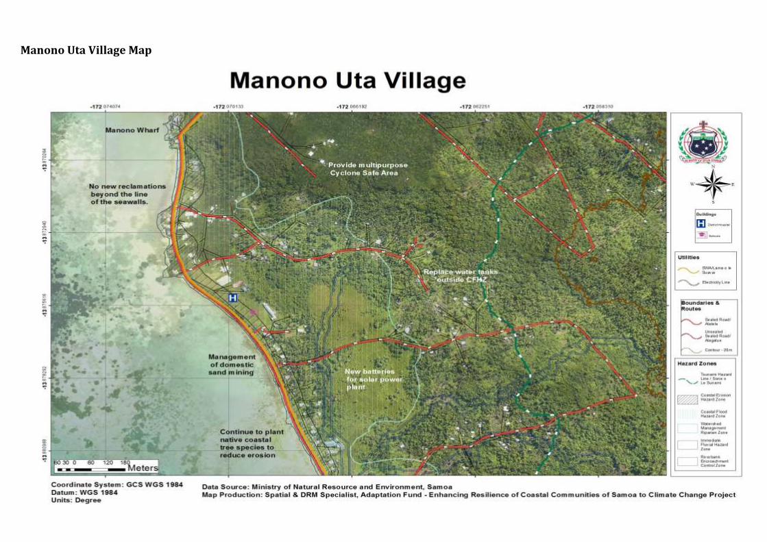
Manono Uta Village Map
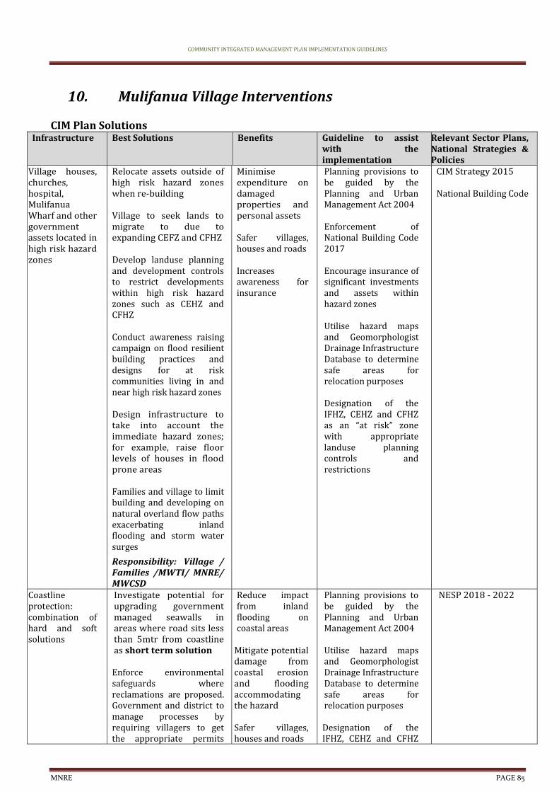
COMMUNITY INTEGRATED MANAGEMENT PLAN IMPLEMENTATION GUIDELINES
MNRE PAGE 85
10. Mulifanua Village Interventions
CIM Plan Solutions Infrastructure Best Solutions Benefits Guideline to assist
with the implementation
Relevant Sector Plans, National Strategies & Policies
Village houses, churches, hospital, Mulifanua Wharf and other government assets located in high risk hazard zones
Relocate assets outside of high risk hazard zones when re-building Village to seek lands to migrate to due to expanding CEFZ and CFHZ Develop landuse planning and development controls to restrict developments within high risk hazard zones such as CEHZ and CFHZ Conduct awareness raising campaign on flood resilient building practices and designs for at risk communities living in and near high risk hazard zones Design infrastructure to take into account the immediate hazard zones; for example, raise floor levels of houses in flood prone areas Families and village to limit building and developing on natural overland flow paths exacerbating inland flooding and storm water surges
Responsibility: Village / Families /MWTI/ MNRE/ MWCSD
Minimise expenditure on damaged properties and personal assets
Safer villages, houses and roads Increases awareness for insurance
Planning provisions to be guided by the Planning and Urban Management Act 2004 Enforcement of National Building Code 2017 Encourage insurance of significant investments and assets within hazard zones Utilise hazard maps and Geomorphologist Drainage Infrastructure Database to determine safe areas for relocation purposes Designation of the IFHZ, CEHZ and CFHZ as an “at risk” zone with appropriate landuse planning controls and restrictions
CIM Strategy 2015
National Building Code
Coastline protection: combination of hard and soft solutions
Investigate potential for upgrading government managed seawalls in areas where road sits less than 5mtr from coastline as short term solution
Enforce environmental safeguards where reclamations are proposed. Government and district to manage processes by requiring villagers to get the appropriate permits
Reduce impact from inland flooding on coastal areas
Mitigate potential damage from coastal erosion and flooding accommodating the hazard Safer villages, houses and roads
Planning provisions to be guided by the Planning and Urban Management Act 2004 Utilise hazard maps and Geomorphologist Drainage Infrastructure Database to determine safe areas for relocation purposes Designation of the IFHZ, CEHZ and CFHZ
NESP 2018 - 2022
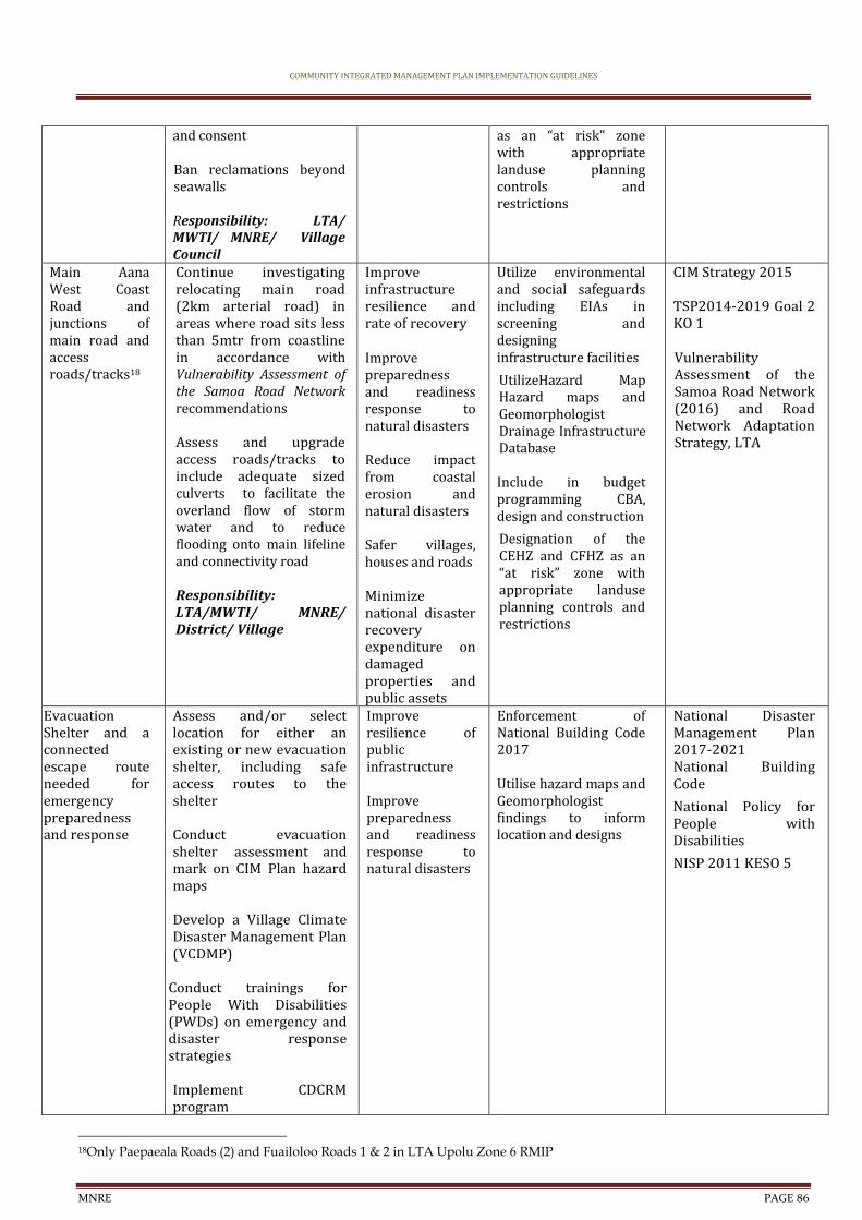
COMMUNITY INTEGRATED MANAGEMENT PLAN IMPLEMENTATION GUIDELINES
MNRE PAGE 86
and consent Ban reclamations beyond seawalls Responsibility: LTA/ MWTI/ MNRE/ Village Council
as an “at risk” zone with appropriate landuse planning controls and restrictions
Main Aana West Coast Road and junctions of main road and access roads/tracks18
Continue investigating relocating main road (2km arterial road) in areas where road sits less than 5mtr from coastline in accordance with Vulnerability Assessment of the Samoa Road Network recommendations Assess and upgrade access roads/tracks to include adequate sized culverts to facilitate the overland flow of storm water and to reduce flooding onto main lifeline and connectivity road Responsibility: LTA/MWTI/ MNRE/ District/ Village
Improve infrastructure resilience and rate of recovery Improve preparedness and readiness response to natural disasters
Reduce impact from coastal erosion and natural disasters Safer villages, houses and roads Minimize national disaster recovery expenditure on damaged properties and public assets
Utilize environmental and social safeguards including EIAs in screening and designing infrastructure facilities
UtilizeHazard Map Hazard maps and Geomorphologist Drainage Infrastructure Database Include in budget programming CBA, design and construction
Designation of the CEHZ and CFHZ as an “at risk” zone with appropriate landuse planning controls and restrictions
CIM Strategy 2015
TSP2014-2019 Goal 2 KO 1 Vulnerability Assessment of the Samoa Road Network (2016) and Road Network Adaptation Strategy, LTA
Evacuation Shelter and a connected escape route needed for emergency preparedness and response
Assess and/or select location for either an existing or new evacuation shelter, including safe access routes to the shelter Conduct evacuation shelter assessment and mark on CIM Plan hazard maps Develop a Village Climate Disaster Management Plan (VCDMP)
Conduct trainings for People With Disabilities (PWDs) on emergency and disaster response strategies Implement CDCRM program
Improve resilience of public infrastructure Improve preparedness and readiness response to natural disasters
Enforcement of National Building Code 2017 Utilise hazard maps and Geomorphologist findings to inform location and designs
National Disaster Management Plan 2017-2021 National Building Code
National Policy for People with Disabilities
NISP 2011 KESO 5
18Only Paepaeala Roads (2) and Fuailoloo Roads 1 & 2 in LTA Upolu Zone 6 RMIP
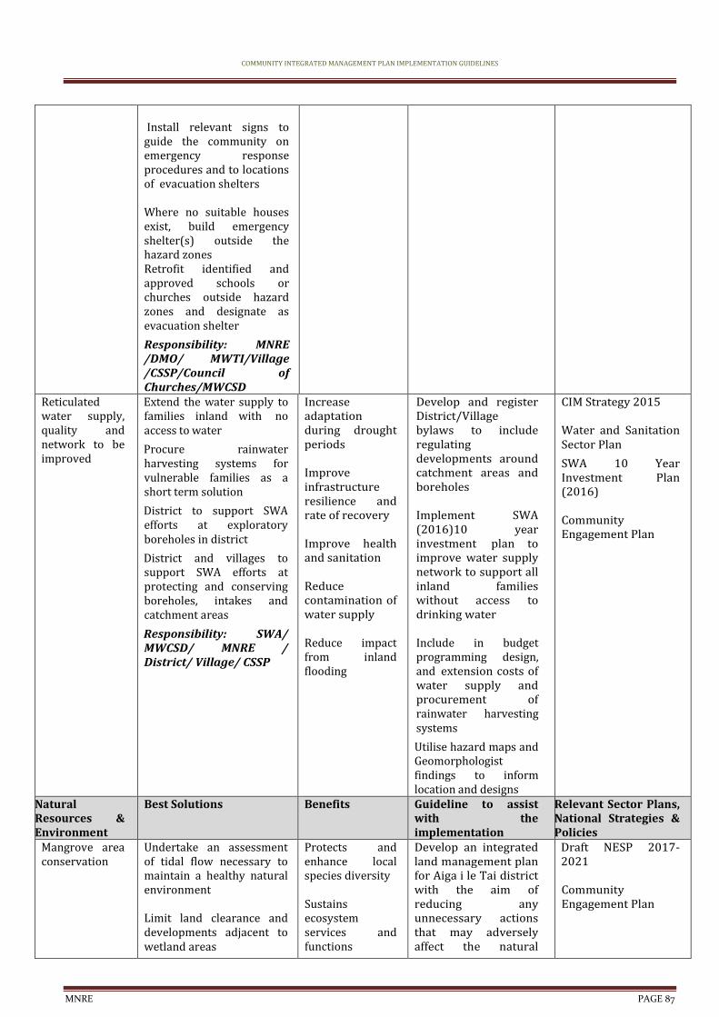
COMMUNITY INTEGRATED MANAGEMENT PLAN IMPLEMENTATION GUIDELINES
MNRE PAGE 87
Install relevant signs to guide the community on emergency response procedures and to locations of evacuation shelters Where no suitable houses exist, build emergency shelter(s) outside the hazard zones Retrofit identified and approved schools or churches outside hazard zones and designate as evacuation shelter
Responsibility: MNRE /DMO/ MWTI/Village /CSSP/Council of Churches/MWCSD
Reticulated water supply, quality and network to be improved
Extend the water supply to families inland with no access to water
Procure rainwater harvesting systems for vulnerable families as a short term solution
District to support SWA efforts at exploratory boreholes in district
District and villages to support SWA efforts at protecting and conserving boreholes, intakes and catchment areas
Responsibility: SWA/ MWCSD/ MNRE / District/ Village/ CSSP
Increase adaptation during drought periods Improve infrastructure resilience and rate of recovery Improve health and sanitation Reduce contamination of water supply Reduce impact from inland flooding
Develop and register District/Village bylaws to include regulating developments around catchment areas and boreholes Implement SWA (2016)10 year investment plan to improve water supply network to support all inland families without access to drinking water Include in budget programming design, and extension costs of water supply and procurement of rainwater harvesting systems
Utilise hazard maps and Geomorphologist findings to inform location and designs
CIM Strategy 2015
Water and Sanitation Sector Plan
SWA 10 Year Investment Plan (2016)
Community Engagement Plan
Natural Resources & Environment
Best Solutions Benefits Guideline to assist with the implementation
Relevant Sector Plans, National Strategies & Policies
Mangrove area conservation
Undertake an assessment of tidal flow necessary to maintain a healthy natural environment Limit land clearance and developments adjacent to wetland areas
Protects and enhance local species diversity Sustains ecosystem services and functions
Develop an integrated land management plan for Aiga i le Tai district with the aim of reducing any unnecessary actions that may adversely affect the natural
Draft NESP 2017-2021 Community Engagement Plan

COMMUNITY INTEGRATED MANAGEMENT PLAN IMPLEMENTATION GUIDELINES
MNRE PAGE 88
Continue to plant native species along coastal areas to reduce erosion and landslips. To act as an effective wave barrier, a minimum distance of 200m of vegetation is needed
Village to fence off domestic animals Responsibility: MNRE / Village /CSSP/ UNDP-GEF SGP/ MWTI
Reduce contamination of water supply Reduce impact from inland flooding
habitats and ecosystems of the area Implement wetland and mangrove protection programme Identify funding /budget requirements and implementation programme for establishment of protected areas in district
Coastal Restoration
Promote and support village and district tree planting on coastal areas around existing seawalls to strengthen seawalls and reduce erosion using native species such as talie, fetau, toa etc that are known to have greater resilience to natural disasters and changing climate conditions Depth and density of planting to be increased and a minimum vegetative distance of 200mm as an effective wave barrier distance
Maintains natural ecosystem Improve infrastructure resilience and rate of recovery Improve preparedness and readiness response to natural disasters Reduce impact from coastal erosion and natural disasters Safer villages, houses and roads
Develop an Integrated Flood Management Plan for Manono-uta. Utilize Sui o Nu’u monthly meetings to monitor progress of village cleanup and awareness programmes MNRE Forestry to provide technical assistance to guide village planting programmes in coastal areas MNRE Forestry to provide suitable climate ready trees suitable for coastal conditions
NESP 2017 – 2021 Two Million Tree Strategy 2015-2020
Forestry Management Act 2011
Livelihood and Food Security
Best Solutions Benefits Guideline to assist with the implementation
Relevant Sector Plans, National Strategies & Policies
Plantations, crops and plants threatened by changes in climate, inland flooding and inadequate soil for planting
Promote and facilitate planting of rootcrops ( i.e yams, sweet potato) which are more resilient to cyclones, droughts and floods Promote agroforestry and mixed planting including fruit trees species to promote ecological stability, soil protection and reduce crop vulnerability to pests and diseases Implement the Integrated Pest Management Programme
Improve health through access to clean water and waste management
Improve recovery to create more resilient villages
Improve preparedness and readiness response to natural disasters
Agriculture sector to provide best practice management guidelines for the management of water that allows for levels of contamination to be kept to minimum
MNRE Forestry, DEC and MAF to collaborate on supply of climate resilient crops and plants MAF to provide trainings, awareness raising on crop diversification to suit prolonged impacts of
Agriculture Sector Plan 2016-2021 Two Million Tree Strategy 2015-2020 Restoration Operational Plan 2016-2020
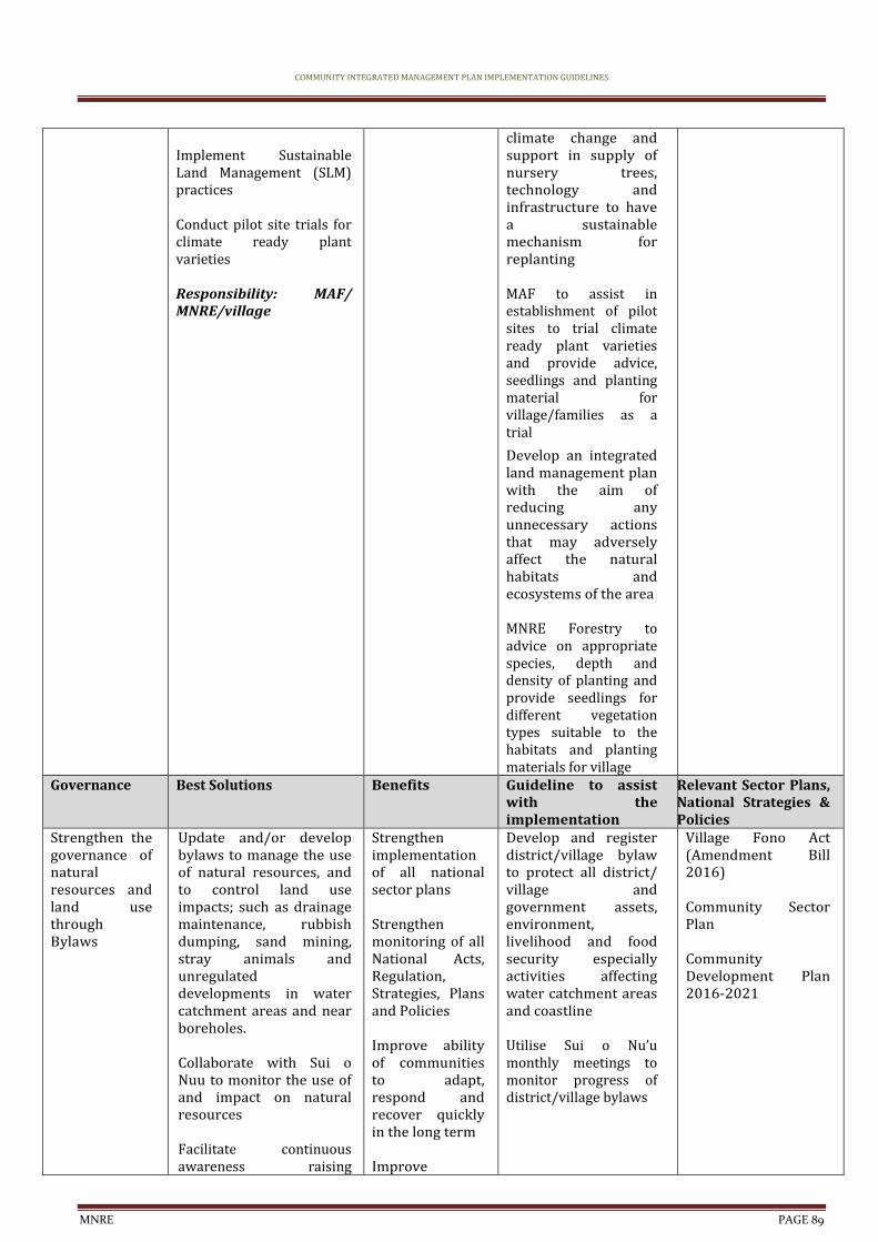
COMMUNITY INTEGRATED MANAGEMENT PLAN IMPLEMENTATION GUIDELINES
MNRE PAGE 89
Implement Sustainable Land Management (SLM) practices Conduct pilot site trials for climate ready plant varieties Responsibility: MAF/ MNRE/village
climate change and support in supply of nursery trees, technology and infrastructure to have a sustainable mechanism for replanting MAF to assist in establishment of pilot sites to trial climate ready plant varieties and provide advice, seedlings and planting material for village/families as a trial
Develop an integrated land management plan with the aim of reducing any unnecessary actions that may adversely affect the natural habitats and ecosystems of the area MNRE Forestry to advice on appropriate species, depth and density of planting and provide seedlings for different vegetation types suitable to the habitats and planting materials for village
Governance Best Solutions Benefits Guideline to assist with the implementation
Relevant Sector Plans, National Strategies & Policies
Strengthen the governance of natural resources and land use through Bylaws
Update and/or develop bylaws to manage the use of natural resources, and to control land use impacts; such as drainage maintenance, rubbish dumping, sand mining, stray animals and unregulated developments in water catchment areas and near boreholes. Collaborate with Sui o Nuu to monitor the use of and impact on natural resources Facilitate continuous awareness raising
Strengthen implementation of all national sector plans Strengthen monitoring of all National Acts, Regulation, Strategies, Plans and Policies Improve ability of communities to adapt, respond and recover quickly in the long term Improve
Develop and register district/village bylaw to protect all district/ village and government assets, environment, livelihood and food security especially activities affecting water catchment areas and coastline Utilise Sui o Nu’u monthly meetings to monitor progress of district/village bylaws
Village Fono Act (Amendment Bill 2016) Community Sector Plan Community Development Plan 2016-2021
COMMUNITY INTEGRATED MANAGEMENT PLAN IMPLEMENTATION GUIDELINES
MNRE PAGE 90
programs with the villages Responsibility: MWCSD /Village
accountability and enabling environment of communities
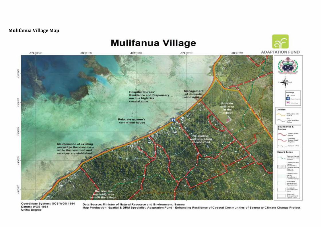
Mulifanua Village Map
COMMUNITY INTEGRATED MANAGEMENT PLAN IMPLEMENTATION GUIDELINES
MNRE PAGE 92
11. Paepaeala Village Interventions
CIM Plan Solutions Infrastructure Best Solutions Benefits Guideline to assist
with the implementation
Relevant Sector Plans, National Strategies & Policies
Village houses, churches hospital, and other government assets located in high risk hazard zones
Relocate assets outside of high risk hazard zones when re-building Develop landuse planning and development controls to restrict developments within high risk hazard zones such as CEHZ and CFHZ Conduct awareness raising campaign on flood resilient building practices and designs for at risk communities living in and near high risk hazard zones Design infrastructure to take into account the immediate hazard zones; for example, raise floor levels of houses in flood prone areas Families and village to limit building and developing on natural overland flow paths exacerbating inland flooding and storm water surges
Responsibility: Village / Families /MWTI/ MNRE/ MWCSD
Minimise expenditure on damaged properties and personal assets
Safer villages, houses and roads Increases awareness for insurance
Planning provisions to be guided by the Planning and Urban Management Act 2004 Enforcement of National Building Code 2017 Encourage insurance of significant investments and assets within hazard zones Utilise hazard maps and Geomorphologist Drainage Infrastructure Database to determine safe areas for relocation purposes Designation of the IFHZ, CEHZ and CFHZ as an “at risk” zone with appropriate landuse planning controls and restrictions
CIM Strategy 2015
National Building Code
Coastline protection: combination of hard and soft solutions
Investigate potential for upgrading government managed seawalls in areas where road sits less than 5mtr from coastline as short term solution
Enforce environmental safeguards where reclamations are proposed. Government and district to manage processes by requiring
Reduce impact from inland flooding on coastal areas
Mitigate potential damage from coastal erosion and flooding accommodating the hazard Safer villages,
Planning provisions to be guided by the Planning and Urban Management Act 2004 Utilise hazard maps and Geomorphologist Drainage Infrastructure Database to determine safe areas for relocation purposes
NESP 2018 - 2022

COMMUNITY INTEGRATED MANAGEMENT PLAN IMPLEMENTATION GUIDELINES
MNRE PAGE 93
villagers to get the appropriate permits and consent Responsibility: LTA/ MWTI/ MNRE/ Village Council
houses and roads Designation of the IFHZ, CEHZ and CFHZ as an “at risk” zone with appropriate landuse planning controls and restrictions
Main Aana West Coast Road and junctions of main road and access roads/tracks19
Continue investigating relocating main road (2km arterial road) in areas where road sits less than 5mtr from coastline in accordance with Vulnerability Assessment of the Samoa Road Network recommendations Assess and upgrade access roads/tracks to include adequate sized culverts to facilitate the overland flow of storm water and to reduce flooding onto main lifeline and connectivity road Responsibility:LTA /MWTI/ MNRE/ District/ Village
Improve infrastructure resilience and rate of recovery Improve preparedness and readiness response to natural disasters
Reduce impact from coastal erosion and natural disasters Safer villages, houses and roads Minimize national disaster recovery expenditure on damaged properties and public assets
Utilize environmental and social safeguards including EIAs in screening and designing infrastructure facilities
Utilize Hazard Map Hazard maps and Geomorphologist Drainage Infrastructure Database Include in budget programming CBA, design and construction
Designation of the CEHZ and CFHZ as an “at risk” zone with appropriate landuse planning controls and restrictions
CIM Strategy 2015
TSP2014-2019 Goal 2 KO 1 Vulnerability Assessment of the Samoa Road Network (2016) and Road Network Adaptation Strategy, LTA
Evacuation Shelter and a connected escape route needed for emergency preparedness and response
Assess and/or select location for either an existing or new evacuation shelter, including safe access routes to the shelter Conduct evacuation shelter assessment and mark on CIM Plan hazard maps Develop a Village Climate Disaster Management Plan (VCDMP)
Conduct trainings for People With Disabilities (PWDs) on emergency and disaster response strategies
Improve resilience of public infrastructure Improve preparedness and readiness response to natural disasters
Enforcement of National Building Code 2017 Utilise hazard maps and Geomorphologist findings to inform location and designs
National Disaster Management Plan 2017-2021 National Building Code
National Policy for People with Disabilities
NISP 2011 KESO 5
19Only Paepaeala Roads (2) and Fuailoloo Roads 1 & 2 in LTA Upolu Zone 6 RMIP
COMMUNITY INTEGRATED MANAGEMENT PLAN IMPLEMENTATION GUIDELINES
MNRE PAGE 94
Implement CDCRM program Install relevant signs to guide the community on emergency response procedures and to locations of evacuation shelters Where no suitable houses exist, build emergency shelter(s) outside the hazard zones Retrofit identified and approved schools or churches outside hazard zones and designate as evacuation shelter
Responsibility: MNRE /DMO/ MWTI/Village /CSSP/Council of Churches/MWCSD
Reticulated water supply, quality and network to be improved
Extend the water supply to families inland with no access to water
Procure rainwater harvesting systems for vulnerable families as a short term solution
District to support SWA efforts at exploratory boreholes in district
District and villages to support SWA efforts at protecting and conserving boreholes, intakes and catchment areas
Responsibility: SWA/ MWCSD/ MNRE / District/ Village/ CSSP
Increase adaptation during drought periods Improve infrastructure resilience and rate of recovery Improve health and sanitation Reduce contamination of water supply Reduce impact from inland flooding
Develop and register District/Village bylaws to include regulating developments around catchment areas and boreholes Implement SWA (2016)10 year investment plan to improve water supply network to support all inland families without access to drinking water Include in budget programming design, and extension costs of water supply and procurement of rainwater harvesting systems
Utilise hazard maps and Geomorphologist findings to inform location and designs
CIM Strategy 2015
Water and Sanitation Sector Plan
SWA 10 Year Investment Plan (2016)
Community Engagement Plan
Natural Resources & Environment
Best Solutions Benefits Guideline to assist with the implementation
Relevant Sector Plans, National Strategies & Policies
Mangrove area conservation
Undertake an assessment of tidal flow necessary to maintain a
Protects and enhance local species diversity
Develop an integrated land management plan for
Draft NESP 2017-2021
COMMUNITY INTEGRATED MANAGEMENT PLAN IMPLEMENTATION GUIDELINES
MNRE PAGE 95
healthy natural environment Limit land clearance and developments adjacent to wetland areas
Continue to plant native species along coastal areas to reduce erosion and landslips. To act as an effective wave barrier, a minimum distance of 200m of vegetation is needed
Village to fence off domestic animals Responsibility: MNRE / Village /CSSP/ UNDP-GEF SGP/ MWTI
Sustains ecosystem services and functions Reduce contamination of water supply Reduce impact from inland flooding
Aiga i le Tai district with the aim of reducing any unnecessary actions that may adversely affect the natural habitats and ecosystems of the area Implement wetland and mangrove protection programme Identify funding /budget requirements and implementation programme for establishment of protected areas in district
Community Engagement Plan
Coastal Restoration
Plant native species along coastal areas to strengthen existing seawall and to reduce coastal erosion and landslips; Talie, Fetau, Toa, Togatogo are known to have greater resilience to natural disasters and changing climate conditions
To act as an effective wave barrier, a minimum distance of 200m of vegetation is needed
Responsibility: MNRE/ MAF/Villages
Soft coastal protection measures will support and strengthen existing and new infrastructure along the coast Reduce impact from coastal erosion and natural disasters Implements an Ecosystem Based Approach
Develop an integrated land management plan for Aiga i le Tai district with the aim of reducing any unnecessary actions that may adversely affect the natural habitats and ecosystems of the area MAF to assist in establishment of pilot sites to trial climate ready plant varieties MNRE Forestry, DEC and MAF to collaborate on supply of climate resilient crops
NESP 2018 - 2022 Two Million Tree Planting Strategy 2015-2020 Restoration Operational Plan 2016-2020
Livelihood and Food Security
Best Solutions Benefits Guideline to assist with the implementation
Relevant Sector Plans, National Strategies & Policies
Plantations, crops and plants threatened by changes in climate, inland flooding and inadequate soil for planting
Promote and facilitate planting of rootcrops ( i.e yams, sweet potato) which are more resilient to cyclones, droughts and floods Promote agroforestry and mixed planting including fruit trees species to promote
Improve health through access to clean water and waste management
Improve recovery to create more resilient villages
Improve
Agriculture sector to provide best practice management guidelines for the management of water that allows for levels of contamination to be kept to minimum
MNRE Forestry, DEC and MAF to
Agriculture Sector Plan 2016-2021 Two Million Tree Strategy 2015-2020 Restoration Operational Plan 2016-2020

COMMUNITY INTEGRATED MANAGEMENT PLAN IMPLEMENTATION GUIDELINES
MNRE PAGE 96
ecological stability, soil protection and reduce crop vulnerability to pests and diseases Implement the Integrated Pest Management Programme Implement Sustainable Land Management (SLM) practices Conduct pilot site trials for climate ready plant varieties
Responsibility: MAF/ MNRE/village
preparedness and readiness response to natural disasters
collaborate on supply of climate resilient crops and plants MAF to provide trainings, awareness raising on crop diversification to suit prolonged impacts of climate change and support in supply of nursery trees, technology and infrastructure to have a sustainable mechanism for replanting MAF to assist in establishment of pilot sites to trial climate ready plant varieties and provide advice, seedlings and planting material for village/families as a trial
Develop an integrated land management plan with the aim of reducing any unnecessary actions that may adversely affect the natural habitats and ecosystems of the area MNRE Forestry to advice on appropriate species, depth and density of planting and provide seedlings for different vegetation types suitable to the habitats and planting materials for village
Governance Best Solutions Benefits Guideline to assist with the implementation
Relevant Sector Plans, National Strategies & Policies
Strengthen the governance of natural resources and land use through Bylaws
Update and/or develop bylaws to manage the use of natural resources, and to control land use impacts; such as drainage maintenance, rubbish dumping, sand
Strengthen implementation of all national sector plans Strengthen monitoring of all National Acts,
Develop and register district/village bylaw to protect all district/ village and government assets, environment, livelihood and food security especially
Village Fono Act (Amendment Bill 2016) Community Sector Plan Community
COMMUNITY INTEGRATED MANAGEMENT PLAN IMPLEMENTATION GUIDELINES
MNRE PAGE 97
mining, stray animals and unregulated developments in water catchment areas and near boreholes. Collaborate with Sui o Nuu to monitor the use of and impact on natural resources Facilitate continuous awareness raising programs with the villages Responsibility: MWCSD /Village
Regulation, Strategies, Plans and Policies Improve ability of communities to adapt, respond and recover quickly in the long term Improve accountability and enabling environment of communities
activities affecting water catchment areas and coastline Utilise Sui o Nu’u monthly meetings to monitor progress of district/village bylaws
Development Plan 2016-2021
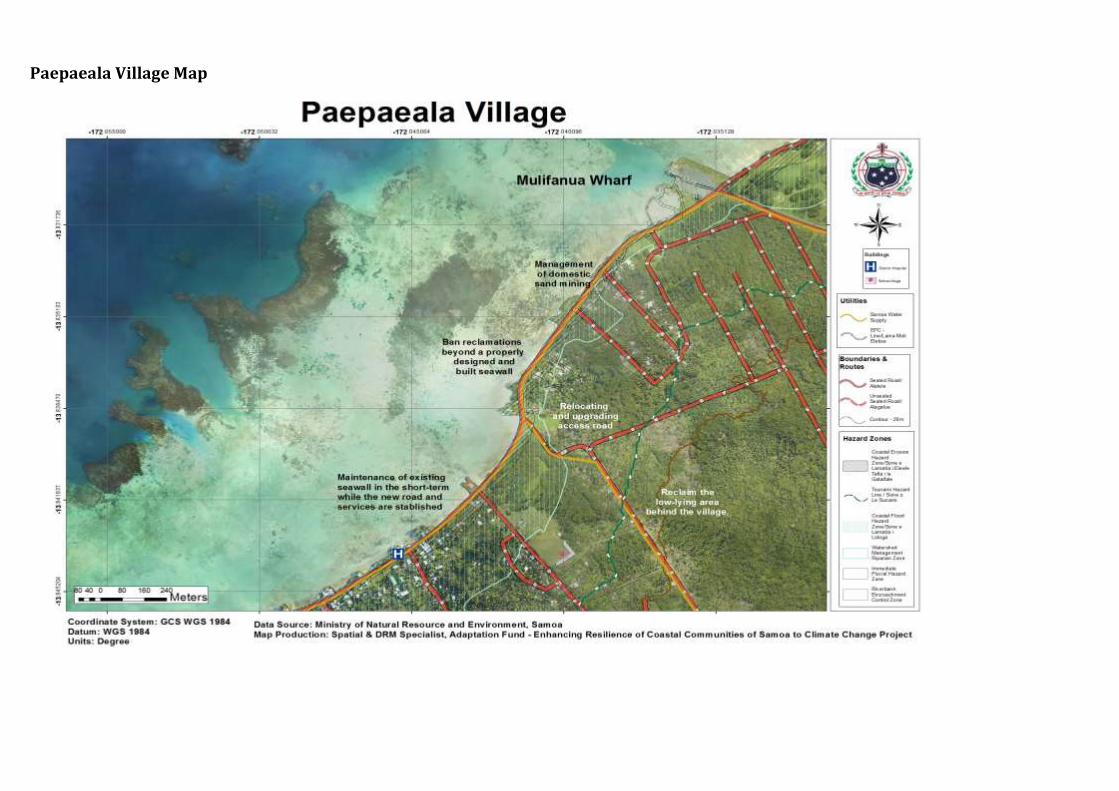
Paepaeala Village Map
COMMUNITY INTEGRATED MANAGEMENT PLAN IMPLEMENTATION GUIDELINES
MNRE PAGE 99
12. Salua tai Village Interventions
CIM Plan Solutions Infrastructure Best Solutions Benefits Guideline to assist
with the implementation
Relevant Sector Plans, National
Strategies & Policies Village houses, churches, pre-school and other government assets located in high risk hazard zones
Relocate assets outside of high risk hazard zones when re-building Develop landuse planning and development controls to restrict developments within high risk hazard zones such as CEHZ and CFHZ Conduct awareness raising campaign on flood resilient building practices and designs for at risk communities living in and near high risk hazard zones Design infrastructure to take into account the immediate hazard zones; for example, raise floor levels of houses in flood prone areas Families and village to limit building and developing on natural overland flow paths exacerbating inland flooding and storm water surges
Responsibility: Village / Families /MWTI/ MNRE/ MWCSD
Minimise expenditure on damaged properties and personal assets
Safer villages, houses and roads Increases awareness for insurance
Planning provisions to be guided by the Planning and Urban Management Act 2004 Enforcement of National Building Code 2017 Encourage insurance of significant investments and assets within hazard zones Utilise hazard maps and Geomorphologist Drainage Infrastructure Database to determine safe areas for relocation purposes Designation of the IFHZ, CEHZ and CFHZ as an “at risk” zone with appropriate landuse planning controls and restrictions
CIM Strategy 2015
National Building Code
Coastline protection: combination of hard and soft solutions
Investigate potential for upgrading seawalls20 in areas where road sits less than 5mtr from coastline
Enforce environmental safeguards where reclamations are proposed. Government and district to manage processes by requiring
Reduce impact from inland flooding on coastal areas
Mitigate potential damage from coastal erosion and flooding accommodating the hazard
Planning provisions to be guided by the Planning and Urban Management Act 2004 Utilise hazard maps and Geomorphologist Drainage Infrastructure Database to determine safe areas
NESP 2018 - 2022
20Constructed in 2011 under Tsunami Recovery Programme
COMMUNITY INTEGRATED MANAGEMENT PLAN IMPLEMENTATION GUIDELINES
MNRE PAGE 100
villagers to get the appropriate permits and consent Responsibility: LTA/ MWTI/ MNRE/ Village Council
Safer villages, houses and roads
for relocation purposes Designation of the IFHZ, CEHZ and CFHZ as an “at risk” zone with appropriate landuse planning controls and restrictions
Evacuation Shelter and a connected escape route needed for emergency preparedness and response
Assess and/or select location for either an existing or new evacuation shelter, including safe access routes to the shelter Conduct evacuation shelter assessment and mark on CIM Plan hazard maps Develop a Village Climate Disaster Management Plan (VCDMP)
Conduct trainings for People With Disabilities (PWDs) on emergency and disaster response strategies Implement CDCRM program Install relevant signs to guide the community on emergency response procedures and to locations of evacuation shelters Where no suitable houses exist, build emergency shelter(s) outside the hazard zones Retrofit identified and approved schools or churches outside hazard zones and designate as evacuation shelter
Responsibility: MNRE /DMO/ MWTI/Village /CSSP/Council of Churches/MWCSD
Improve resilience of public infrastructure Improve preparedness and readiness response to natural disasters
Enforcement of National Building Code 2017 Utilise hazard maps and Geomorphologist findings to inform location and designs
National Disaster Management Plan 2017-2021 National Building Code
National Policy for People with Disabilities

COMMUNITY INTEGRATED MANAGEMENT PLAN IMPLEMENTATION GUIDELINES
MNRE PAGE 101
Jetty Repair and upgrade damaged posts Village to maintain and upgrade jetty Village to limit number of private jetties on island Responsibility: SPA/ MNRE/ Village /CSSP/ NGO
Maintain lifeline access and connectivity Improve preparedness and readiness response to natural disasters
Identify funding/ budget requirements and implementation programme Utilize environmental and social safeguards including EIAs in screening and designing infrastructure facilities
Designation of the CEHZ, CFHZ and tsunami shore exlusive zones as an “at risk” zone with appropriate landuse planning controls and restrictions
CIM Strategy 2015
Community Engagement Plan
Electricity supply
Install streetlights along the roads where needed for community safety Relocate overhead lines to a more resilient location when being replaced Provide underground lines in the long term
Install and connect to solar power supply if made available
Responsibility: EPC /MWTI/ Villages
Maintain electricity supply at all times including natural disasters
Avoid accidents from fallen electricity posts
Monitor distribution networks to avoid overloading poles and contributing to line failures
EPC Strategic Plan
Island water supply: pipelines
Relocate main water pipelines away from CEHZ and CFHZ Procure rainwater harvesting systems as backup for vulnerable families as a short term solution
Regulate developments and remove latrines around water supply
Village to fence domestic animals away from areas susceptible to flooding
Responsibility: District/Village/ CSSP/ NGO
Improve preparedness and readiness response to natural disasters Increase adaptation during drought periods Improve health and sanitation Reduce contamination of water supply
Develop and register District/Village bylaws to include regulating developments around identified hazard zones Include in budget programming relocation of tanks and procurement of rainfall catchment systems
Utilize Hazard Map Hazard maps and Geomorphologist findings for planning purposes Utilize Sui o Nu’u monthly meetings to
CIM Strategy 2015
Water and Sanitation Sector Plan
Community Engagement Plan

COMMUNITY INTEGRATED MANAGEMENT PLAN IMPLEMENTATION GUIDELINES
MNRE PAGE 102
monitor progress of village programmes and responsibilities
Natural Resources & Environment
Best Solutions Benefits Guideline to assist with the implementation
Relevant Sector Plans, National Strategies & Policies
Marine Protected Area and inshore fishery resources
Village to restock marine reserve with suitable species Collect and dispose of crown-of-thorns (alamea) on a regular basis to prevent major outbreaks
Continue to ban the use of dynamites, herbal poisons (avaniukini), chemicals and other unsustainable fishing methods including sand mining and extraction Enforce village bylaws on ban on rubbish dumping in coastal areas Responsibility: Village
fishing households, MAF/
CSSP/ NGO
Protect coral reefs and inshore fisheries
Protect marine biodiversity Protects and enhance local species diversity Sustains ecosystem services and functions
MAF Fisheries to support implementation and provide technical backstopping and monitoring Develop an integrated land management plan with the aim of reducing any unnecessary actions that may adversely affect the natural habitats and ecosystems of the area Develop Village Bylaws to include management of natural resources (spring pools, marine reserve, forest etc)
Agriculture Sector Plan 2016-2021 Community Engagement Plan
Coastal Restoration
Plant native species along coastal areas to strengthen existing seawall and to reduce coastal erosion and landslips; Talie, Fetau, Toa, Togatogo are known to have greater resilience to natural disasters and changing climate conditions
To act as an effective wave barrier, a minimum distance of 200m of vegetation is needed
Responsibility: MNRE/ MAF/Villages
Soft coastal protection measures will support and strengthen existing and new infrastructure along the coast Reduce impact from coastal erosion and natural disasters Implements an Ecosystem Based Approach
Develop an integrated land management plan for Aiga i le Tai district with the aim of reducing any unnecessary actions that may adversely affect the natural habitats and ecosystems of the area MAF to assist in establishment of pilot sites to trial climate ready plant varieties MNRE Forestry, DEC and MAF to collaborate on supply of climate resilient crops
NESP 2018 - 2022 Two Million Tree Planting Strategy 2015-2020 Restoration Operational Plan 2016-2020
COMMUNITY INTEGRATED MANAGEMENT PLAN IMPLEMENTATION GUIDELINES
MNRE PAGE 103
Livelihood and Food Security
Best Solutions Benefits Guideline to assist with the implementation
Relevant Sector Plans, National Strategies & Policies
Pest management; invasive plants and animals
Implement an eradication programme to eradicate, contain or exclude invasive species Implement an inventory of invasive species and include information on their past, present and potential future distribution, as well as impacts and possible actions that can be taken Conduct education and awareness programmes on the impacts of invasive species Implement the Integrated Pest Management Programme Implement Sustainable Land Management (SLM) practices Build the capacity of farmers to manage stray animals (pigs, cattle) that are contaminating water sources Responsibility: Villages/District/ MNRE/MAF/ SROS
Maintains natural ecosystem Builds resilience of community livelihood and food security
Develop an integrated land management plan for Aiga i le Tai district with the aim of reducing any unnecessary actions that may adversely affect the natural habitats and ecosystems of the area MAF to raise awareness of farmers on impacts to water flows from poor livestock management MNRE, MAF and SROS to implement aggressive, nationwide invasive species eradication programme based on inventory of invasive species and conduct campaign on public awareness accordingly Training for farmers on pests management particularly affecting fruit trees and crops
Agriculture Sector Plan 2016-2021 Samoa’s National Invasive Species Action Plan (NISAP)
Plantations, crops and plants threatened by changes in climate, inland flooding and inadequate soil for planting
Promote and facilitate planting of rootcrops ( i.e yams, sweet potato) which are more resilient to cyclones, droughts and floods Promote agroforestry and mixed planting including fruit trees species to promote ecological stability, soil protection and reduce crop vulnerability to pests and diseases Implement the Integrated Pest Management Programme
Improve recovery to create more resilient villages
Improve preparedness and readiness response to natural disasters
Utilise Hazard Maps and Geomorphologist findings to inform location and design Agriculture sector to provide best practice management guidelines for the management of water that allows for levels of contamination to be kept to minimum
MNRE Forestry, DEC and MAF to collaborate on supply of climate resilient crops and plants MAF to provide
Agriculture Sector Plan 2016-2021 Two Million Tree Strategy 2015-2020 Restoration Operational Plan 2016-2020

COMMUNITY INTEGRATED MANAGEMENT PLAN IMPLEMENTATION GUIDELINES
MNRE PAGE 104
Implement Sustainable Land Management (SLM) practices Conduct pilot site trials for climate ready plant varieties Responsibility: MAF/ MNRE/village
trainings, awareness raising on crop diversification to suit prolonged impacts of climate change and support in supply of nursery trees, technology and infrastructure to have a sustainable mechanism for replanting MAF to assist in establishment of pilot sites to trial climate ready plant varieties and provide advice, seedlings and planting material for village/families as a trial
Develop an integrated land management plan with the aim of reducing any unnecessary actions that may adversely affect the natural habitats and ecosystems of the area MNRE Forestry to advice on appropriate species, depth and density of planting and provide seedlings for different vegetation types suitable to the habitats and planting materials for village
Governance Best Solutions Benefits Guideline to assist with the implementation
Relevant Sector Plans, National Strategies & Policies
Strengthen the governance of natural resources and land use through Bylaws
Update and/or develop bylaws to manage the use of natural resources, and to control land use impacts; such as drainage maintenance, rubbish dumping, sand mining, stray animals and unregulated developments in water catchment areas and
Strengthen implementation of all national sector plans Strengthen monitoring of all National Acts, Regulation, Strategies, Plans and Policies
Develop and register district/village bylaw to protect all district/ village and government assets, environment, livelihood and food security especially activities affecting water catchment areas and coastline
Village Fono Act (Amendment Bill 2016) Community Sector Plan Community Development Plan 2016-2021
COMMUNITY INTEGRATED MANAGEMENT PLAN IMPLEMENTATION GUIDELINES
MNRE PAGE 105
near boreholes. Collaborate with Sui o Nuu to monitor the use of and impact on natural resources Facilitate continuous awareness raising programs with the villages Responsibility: MWCSD /Village
Improve ability of communities to adapt, respond and recover quickly in the long term Improve accountability and enabling environment of communities
Utilise Sui o Nu’u monthly meetings to monitor progress of district/village bylaws
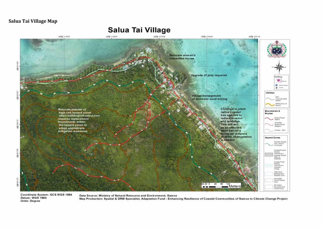
Salua Tai Village Map
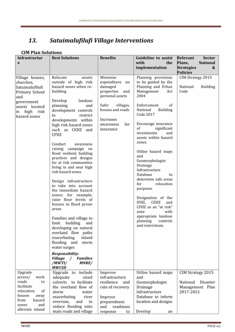
COMMUNITY INTEGRATED MANAGEMENT PLAN IMPLEMENTATION GUIDELINES
MNRE PAGE 107
13. Satuimalufilufi Village Interventions
CIM Plan Solutions Infrastructure
Best Solutions Benefits Guideline to assist with the implementation
Relevant Sector Plans, National Strategies & Policies
Village houses, churches, Satuimalufilufi Primary School and government assets located in high risk hazard zones
Relocate assets outside of high risk hazard zones when re-building Develop landuse planning and development controls to restrict developments within high risk hazard zones such as CEHZ and CFHZ Conduct awareness raising campaign on flood resilient building practices and designs for at risk communities living in and near high risk hazard zones Design infrastructure to take into account the immediate hazard zones; for example, raise floor levels of houses in flood prone areas Families and village to limit building and developing on natural overland flow paths exacerbating inland flooding and storm water surges
Responsibility: Village / Families /MWTI/ MNRE/ MWCSD
Minimise expenditure on damaged properties and personal assets
Safer villages, houses and roads Increases awareness for insurance
Planning provisions to be guided by the Planning and Urban Management Act 2004 Enforcement of National Building Code 2017 Encourage insurance of significant investments and assets within hazard zones Utilise hazard maps and Geomorphologist Drainage Infrastructure Database to determine safe areas for relocation purposes Designation of the IFHZ, CEHZ and CFHZ as an “at risk” zone with appropriate landuse planning controls and restrictions
CIM Strategy 2015
National Building Code
Upgrade access/ work roads to facilitate relocation of houses away from hazard zones and alleviate inland
Upgrade to include adequate sized culverts to facilitate the overland flow of storm water exacerbating river overruns, and to reduce flooding onto main roads and village
Improve infrastructure resilience and rate of recovery Improve preparedness and readiness response to
Utilise hazard maps and Geomorphologist Drainage Infrastructure Database to inform location and designs Develop an
CIM Strategy 2015 National Disaster Management Plan 2017-2021
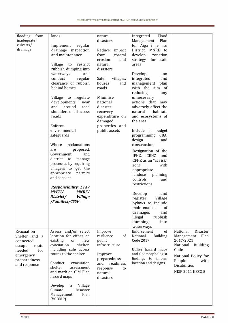
COMMUNITY INTEGRATED MANAGEMENT PLAN IMPLEMENTATION GUIDELINES
MNRE PAGE 108
flooding from inadequate culverts/ drainage
lands Implement regular drainage inspection and maintenance Village to restrict rubbish dumping into waterways and conduct regular clearance of rubbish behind homes Village to regulate developments near and around road shoulders of all access roads
Enforce environmental safeguards Where reclamations are proposed, Government and district to manage processes by requiring villagers to get the appropriate permits and consent Responsibility: LTA/ MWTI/ MNRE/ District/ Village /Families/CSSP
natural disasters
Reduce impact from coastal erosion and natural disasters Safer villages, houses and roads Minimise national disaster recovery expenditure on damaged properties and public assets
Integrated Flood Management Plan for Aiga i le Tai District. MNRE to develop zonation strategy for safe areas Develop an integrated land management plan with the aim of reducing any unnecessary actions that may adversely affect the natural habitats and ecosystems of the area Include in budget programming CBA, design and construction
Designation of the IFHZ, CEHZ and CFHZ as an “at risk” zone with appropriate landuse planning controls and restrictions Develop and register Village bylaws to include maintenance of drainages and illegal rubbish dumping into waterways
Evacuation Shelter and a connected escape route needed for emergency preparedness and response
Assess and/or select location for either an existing or new evacuation shelter, including safe access routes to the shelter Conduct evacuation shelter assessment and mark on CIM Plan hazard maps Develop a Village Climate Disaster Management Plan (VCDMP)
Improve resilience of public infrastructure Improve preparedness and readiness response to natural disasters
Enforcement of National Building Code 2017 Utilise hazard maps and Geomorphologist findings to inform location and designs
National Disaster Management Plan 2017-2021 National Building Code
National Policy for People with Disabilities
NISP 2011 KESO 5
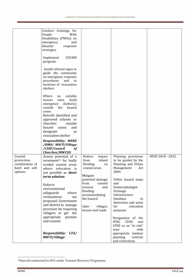
COMMUNITY INTEGRATED MANAGEMENT PLAN IMPLEMENTATION GUIDELINES
MNRE PAGE 109
Conduct trainings for People With Disabilities (PWDs) on emergency and disaster response strategies Implement CDCRM program Install relevant signs to guide the community on emergency response procedures and to locations of evacuation shelters Where no suitable houses exist, build emergency shelter(s) outside the hazard zones Retrofit identified and approved schools or churches outside hazard zones and designate as evacuation shelter
Responsibility: MNRE /DMO/ MWTI/Village /CSSP/Council of Churches/MWCSD
Coastal protection: combination of hard and soft options
Assess potential of a revetment21 for badly eroded coastal areas where relocation is not possible as short term solution Enforce environmental safeguards where reclamations are proposed. Government and district to manage processes by requiring villagers to get the appropriate permits and consent Responsibility: LTA/ MWTI/Village
Reduce impact from inland flooding on coastal areas
Mitigate potential damage from coastal erosion and flooding accommodating the hazard Safer villages, houses and roads
Planning provisions to be guided by the Planning and Urban Management Act 2004 Utilise hazard maps and Geomorphologist Drainage Infrastructure Database to determine safe areas for relocation purposes Designation of the IFHZ, CEHZ and CFHZ as an “at risk” zone with appropriate landuse planning controls and restrictions
NESP 2018 - 2022
21Seawall constructed in 2011 under Tsunami Recovery Programme
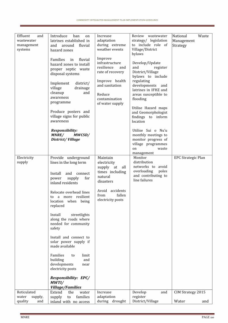
COMMUNITY INTEGRATED MANAGEMENT PLAN IMPLEMENTATION GUIDELINES
MNRE PAGE 110
Effluent and wastewater management systems
Introduce ban on latrines established in and around fluvial hazard zones Families in fluvial hazard zones to install proper septic waste disposal systems Implement district/ village drainage cleanup and awareness programme Produce posters and village signs for public awareness Responsibility: MNRE/ MWCSD/ District/ Village
Increase adaptation during extreme weather events Improve infrastructure resilience and rate of recovery Improve health and sanitation Reduce contamination of water supply
Review wastewater strategy/ legislation to include role of Village/District bylaws Develop/Update and register District/Village bylaws to include regulating developments and latrines in IFHZ and areas susceptible to flooding Utilise Hazard maps and Geomorphologist findings to inform location Utilise Sui o Nu’u monthly meetings to monitor progress of village programmes on waste management
National Waste Management Strategy
Electricity supply
Provide underground lines in the long term
Install and connect power supply for inland residents Relocate overhead lines to a more resilient location when being replaced Install streetlights along the roads where needed for community safety Install and connect to solar power supply if made available Families to limit building and developments near electricity posts Responsibility: EPC/ MWTI/ Village/Families
Maintain electricity supply at all times including natural disasters Avoid accidents from fallen electricity posts
Monitor distribution networks to avoid overloading poles and contributing to line failures
EPC Strategic Plan
Reticulated water supply, quality and
Extend the water supply to families inland with no access
Increase adaptation during drought
Develop and register District/Village
CIM Strategy 2015
Water and
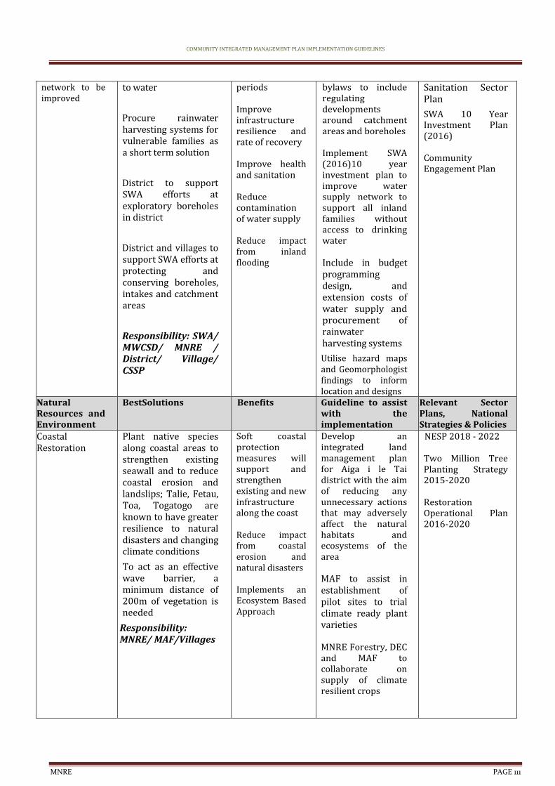
COMMUNITY INTEGRATED MANAGEMENT PLAN IMPLEMENTATION GUIDELINES
MNRE PAGE 111
network to be improved
to water
Procure rainwater harvesting systems for vulnerable families as a short term solution
District to support SWA efforts at exploratory boreholes in district
District and villages to support SWA efforts at protecting and conserving boreholes, intakes and catchment areas
Responsibility: SWA/ MWCSD/ MNRE / District/ Village/ CSSP
periods Improve infrastructure resilience and rate of recovery Improve health and sanitation Reduce contamination of water supply Reduce impact from inland flooding
bylaws to include regulating developments around catchment areas and boreholes Implement SWA (2016)10 year investment plan to improve water supply network to support all inland families without access to drinking water Include in budget programming design, and extension costs of water supply and procurement of rainwater harvesting systems
Utilise hazard maps and Geomorphologist findings to inform location and designs
Sanitation Sector Plan
SWA 10 Year Investment Plan (2016)
Community Engagement Plan
Natural Resources and Environment
BestSolutions Benefits Guideline to assist with the implementation
Relevant Sector Plans, National Strategies & Policies
Coastal Restoration
Plant native species along coastal areas to strengthen existing seawall and to reduce coastal erosion and landslips; Talie, Fetau, Toa, Togatogo are known to have greater resilience to natural disasters and changing climate conditions
To act as an effective wave barrier, a minimum distance of 200m of vegetation is needed
Responsibility: MNRE/ MAF/Villages
Soft coastal protection measures will support and strengthen existing and new infrastructure along the coast Reduce impact from coastal erosion and natural disasters Implements an Ecosystem Based Approach
Develop an integrated land management plan for Aiga i le Tai district with the aim of reducing any unnecessary actions that may adversely affect the natural habitats and ecosystems of the area MAF to assist in establishment of pilot sites to trial climate ready plant varieties MNRE Forestry, DEC and MAF to collaborate on supply of climate resilient crops
NESP 2018 - 2022 Two Million Tree Planting Strategy 2015-2020 Restoration Operational Plan 2016-2020

COMMUNITY INTEGRATED MANAGEMENT PLAN IMPLEMENTATION GUIDELINES
MNRE PAGE 112
Livelihood & Food Security
Best Solutions Benefits Guideline to assist with the implementation
Relevant Sector Plans, National Strategies & Policies
Marine reserve Assess feasibility of creating a marine reserve for village as backup, alternative food supply
Village to restock marine reserve with suitable species Continue to ban the use of dynamites, herbal poisons (ava niukini), chemicals and other unsustainable fishing methods including sand mining and extraction Research improved inshore fishery resources that are resilient to climate change Village to provide fencing for domestic animals to prevent waste contaminating marine reserve Responsibility: MNRE /MAF/ Village /CSSP/ UNDP-GEF SGP
Protects and enhance local species diversity Maintains natural ecosystem Builds resilience of community livelihood and food security
MAF and MNRE DEC and CC to provide technical assistance and backstopping in the assessment and establishment of a marine reserve for village
Develop an integrated land management plan with the aim of reducing any unnecessary actions that may adversely affect the natural habitats and ecosystems of the area Village to seek funding to establish marine reserve MAF to raise awareness of farmers on impacts to water flows from poor livestock management
NESP 2018 - 2022 Community Engagement Plan Agriculture Sector Plan 2016-2021
Plantations, crops and plants threatened by changes in climate, inland flooding and inadequate soil for planting
Promote and facilitate planting of rootcrops ( i.e yams, sweet potato) which are more resilient to cyclones, droughts and floods Promote agroforestry and mixed planting including fruit trees species to promote ecological stability, soil protection and reduce crop vulnerability to pests and diseases Implement the Integrated Pest Management
Improve recovery to create more resilient villages
Improve preparedness and readiness response to natural disasters
Utilise Hazard Maps and Geomorphologist findings to inform location and design Agriculture sector to provide best practice management guidelines for the management of water that allows for levels of contamination to be kept to minimum
MNRE Forestry, DEC and MAF to collaborate on supply of climate
Agriculture Sector Plan 2016-2021 Two Million Tree Strategy 2015-2020 Restoration Operational Plan 2016-2020
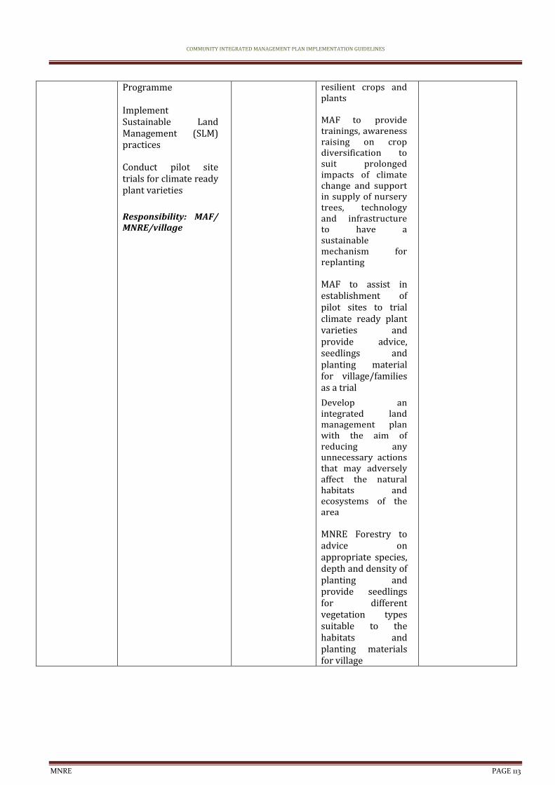
COMMUNITY INTEGRATED MANAGEMENT PLAN IMPLEMENTATION GUIDELINES
MNRE PAGE 113
Programme Implement Sustainable Land Management (SLM) practices Conduct pilot site trials for climate ready plant varieties
Responsibility: MAF/ MNRE/village
resilient crops and plants MAF to provide trainings, awareness raising on crop diversification to suit prolonged impacts of climate change and support in supply of nursery trees, technology and infrastructure to have a sustainable mechanism for replanting MAF to assist in establishment of pilot sites to trial climate ready plant varieties and provide advice, seedlings and planting material for village/families as a trial
Develop an integrated land management plan with the aim of reducing any unnecessary actions that may adversely affect the natural habitats and ecosystems of the area MNRE Forestry to advice on appropriate species, depth and density of planting and provide seedlings for different vegetation types suitable to the habitats and planting materials for village
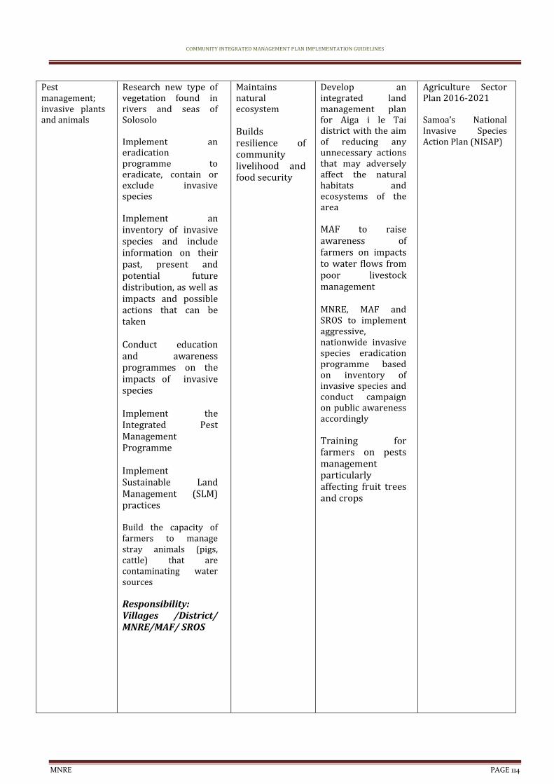
COMMUNITY INTEGRATED MANAGEMENT PLAN IMPLEMENTATION GUIDELINES
MNRE PAGE 114
Pest management; invasive plants and animals
Research new type of vegetation found in rivers and seas of Solosolo Implement an eradication programme to eradicate, contain or exclude invasive species Implement an inventory of invasive species and include information on their past, present and potential future distribution, as well as impacts and possible actions that can be taken Conduct education and awareness programmes on the impacts of invasive species Implement the Integrated Pest Management Programme Implement Sustainable Land Management (SLM) practices Build the capacity of farmers to manage stray animals (pigs, cattle) that are contaminating water sources Responsibility: Villages /District/ MNRE/MAF/ SROS
Maintains natural ecosystem Builds resilience of community livelihood and food security
Develop an integrated land management plan for Aiga i le Tai district with the aim of reducing any unnecessary actions that may adversely affect the natural habitats and ecosystems of the area MAF to raise awareness of farmers on impacts to water flows from poor livestock management MNRE, MAF and SROS to implement aggressive, nationwide invasive species eradication programme based on inventory of invasive species and conduct campaign on public awareness accordingly Training for farmers on pests management particularly affecting fruit trees and crops
Agriculture Sector Plan 2016-2021 Samoa’s National Invasive Species Action Plan (NISAP)
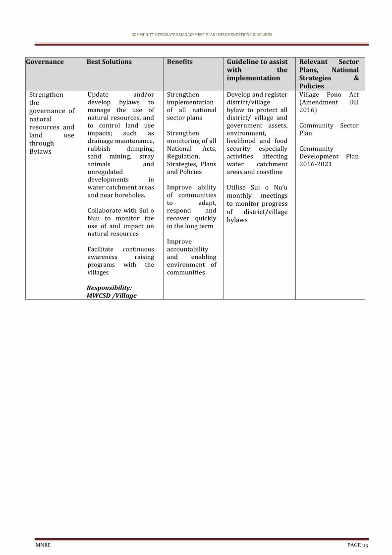
COMMUNITY INTEGRATED MANAGEMENT PLAN IMPLEMENTATION GUIDELINES
MNRE PAGE 115
Governance Best Solutions Benefits Guideline to assist with the implementation
Relevant Sector Plans, National Strategies & Policies
Strengthen the governance of natural resources and land use through Bylaws
Update and/or develop bylaws to manage the use of natural resources, and to control land use impacts; such as drainage maintenance, rubbish dumping, sand mining, stray animals and unregulated developments in water catchment areas and near boreholes. Collaborate with Sui o Nuu to monitor the use of and impact on natural resources Facilitate continuous awareness raising programs with the villages Responsibility: MWCSD /Village
Strengthen implementation of all national sector plans Strengthen monitoring of all National Acts, Regulation, Strategies, Plans and Policies Improve ability of communities to adapt, respond and recover quickly in the long term Improve accountability and enabling environment of communities
Develop and register district/village bylaw to protect all district/ village and government assets, environment, livelihood and food security especially activities affecting water catchment areas and coastline Utilise Sui o Nu’u monthly meetings to monitor progress of district/village bylaws
Village Fono Act (Amendment Bill 2016) Community Sector Plan Community Development Plan 2016-2021
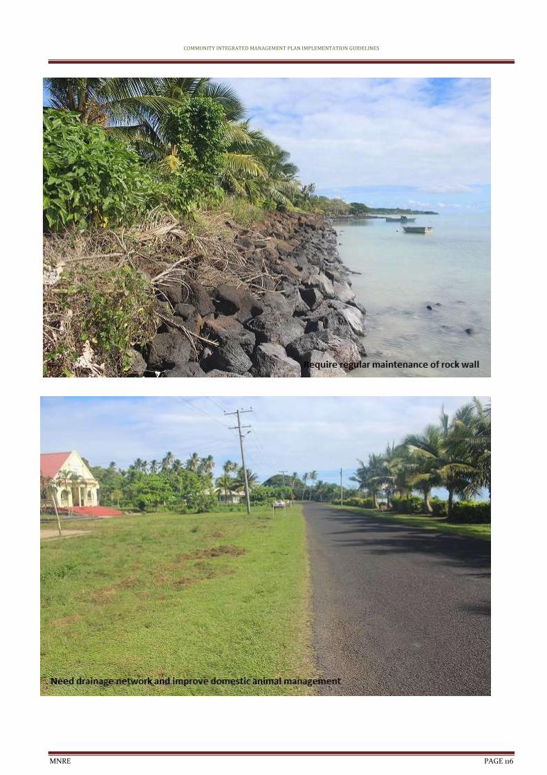
COMMUNITY INTEGRATED MANAGEMENT PLAN IMPLEMENTATION GUIDELINES
MNRE PAGE 116
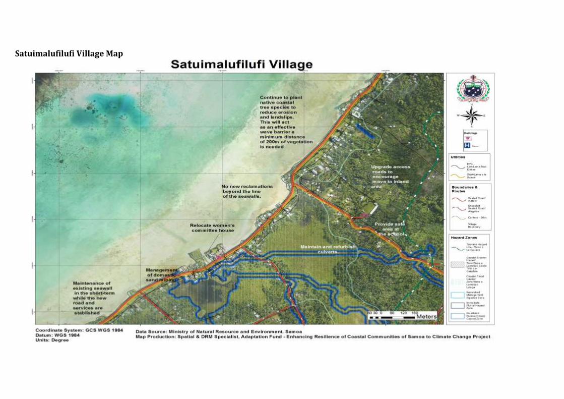
Satuimalufilufi Village Map
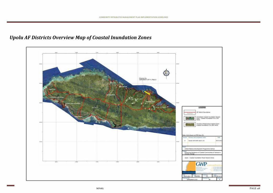
COMMUNITY INTEGRATED MANAGEMENT PLAN IMPLEMENTATION GUIDELINES
MNRE PAGE 118
Upolu AF Districts Overview Map of Coastal Inundation Zones