
COMMUNITY ENGAGEMENT IN THE FLOODPLAIN … · The community engagement plan should include both the...
36
https://molinostewart.com.au https://molinostewart.com.au WORKSHOP ACTIVITY BOOK COMMUNITY ENGAGEMENT IN THE FLOODPLAIN MANAGEMENT PROCESS Neil Dufty Molino Stewart Pty Ltd
Transcript of COMMUNITY ENGAGEMENT IN THE FLOODPLAIN … · The community engagement plan should include both the...

https://molinostewart.com.au
https://molinostewart.com.au
WORKSHOP ACTIVITY BOOK
COMMUNITY ENGAGEMENT IN THE FLOODPLAIN MANAGEMENT
PROCESS
Neil Dufty
Molino Stewart Pty Ltd

https://molinostewart.com.au
https://molinostewart.com.au
HOW CAN WE IMPROVE COMMUNITY ENGAGEMENT FOR FLOODPLAIN MANAGEMENT?
N Dufty1 1Molino Stewart Pty Ltd, Parramatta, NSW
Abstract
Managing the floodplain: a guide to best practice in flood risk management in Australia (Attorney-General’s Department, 2013, p.145), states that “community engagement is vital to the successful development of the flood management study and plan. The community should be consulted to allow their concerns, suggestions and comments about management and options to be considered”. Community engagement is also strongly suggested in the preparation of flood studies, and the implementation and evaluation of floodplain management options.
However, much of this community engagement is conducted by engineers and planners with little or no technical understanding in the field. In some cases, this results in community engagement not being effective as it could be.
This paper draws on research and practice in the field to provide guidance for floodplain managers to improve community engagement.
The psychologies underpinning community interest in floodplain management are identified and discussed. Interest factors include risk awareness, risk perception, flood experience, self-efficacy and protection motivation.
An initial step in the design of an effective community engagement plan should be a community profile to understand demographics including vulnerable groups. A high- level social network analysis is also recommended to harness social capital.
The community engagement plan should include both the engagement methodology and content, along with responsibilities, timeframes and evaluation techniques.
The paper concludes with helpful hints including:
• Importance of ongoing and regular dialogue with communities • Gaining advice from local community engagement specialists including from
councils • Using the floodplain management committee to provide advice on community
engagement • Using a multi-source approach including both traditional and non-traditional
methods. Introduction
‘Managing the floodplain: a guide to best practice in flood risk management in Australia’ (the Guide) (Australian Emergency Management Institute, 2013) provides a framework to understand and manage flood risk and its consequences to the community.
2017 Floodplain Management Australia Conference 1

2017 Floodplain Management Australia Conference https://molinostewart.com.au
2
https://molinostewart.com.au
The Guide defines flood mitigation as “permanent or temporary measures taken in advance of a flood aimed at reducing its impacts” (p. 167). Flood mitigation is viewed as an important step in the goal of increased resilience to floods (p. xiii).
The Guide acknowledges that communities have an important role in providing advice and local knowledge about managing flood risk including mitigation measures. It encourages consultation with potentially-affected communities throughout the steps in its flood risk management framework including through reference committees, flood studies and floodplain management studies and plans.
“Community engagement is vital to the successful development of the flood management study and plan. The community should be consulted to allow their concerns, suggestions and comments about management and options to be considered.” (Australian Emergency Management Institute, 2013, p. 145)
In Australia, much of this community engagement relating to flood mitigation planning is conducted by engineers and planners (usually flood consultants and local council staff) with little or no technical understanding in the fields of community engagement or education. This may result in community engagement not being effective as it could be.
Whilst the Guide provides extensive details of understanding and treating flood risk, conducting a flood study, developing a floodplain management study and plan etc., it gives minimal advice on how to carry out community engagement that it strongly advocates.
This paper attempts to fill this gap. Firstly, it examines the academic literature related to the psychological and sociological predispositions of people to engage in floodplain risk management planning. From this and relevant past experiences and practices, some guidance in good practice community engagement for floodplain risk management planning is provided.
Why do people engage in floodplain risk management?
An initial determinant of the willingness to engage in pre-planning for an emergency or disaster is risk awareness. If people do not envisage they are at risk in any way, they will be oblivious and not be involved.
It is common to find a relatively high percentage of people residing in floodplains that are unaware of their flood risk. For example, as shown in Figure 1, approximately 18% of those living in high risk flood-prone parts of Fairfield City (Sydney) did not know that they were at risk of above-floor flooding (Molino Stewart, 2012).
Studies across Europe (Bradford et al., 2012) support this observation, finding on average 20% of those living in flood-prone areas unaware of their risk of flooding. “Awareness was subsequently found to be strongly correlated to previous flood experience.”
Another factor influencing flood risk awareness is the mobility of the at-risk population. If the population is transient or a receiver of migrants (such as Fairfield City), the result is that knowledge of a localised flood risk may not readily be passed on between generations (Blyth et al., 2001); a problem that increases as the duration between floods becomes greater.

2017 Floodplain Management Australia Conference https://molinostewart.com.au
3
https://molinostewart.com.au
45 40 35 30 25 20 15 10
5 0
No risk Low risk Moderate Risk
High risk
Property flooding House flooding
Figure 1: Awareness of flood risk from those living in high-risk Fairfield City floodplains (source: Molino Stewart, 2012)
Once people are aware of the existence of flood risk, then a major factor in determining their propensity for engagement in mitigation and preparedness activities appears to be risk perception. There is a plethora of psychological theories, models and research into why people conduct emergency pre-planning activities. Most of these identify the level of perception of risk as an important determinant.
In general terms, risk perception can be considered as an individual’s interpretation or impression based on an understanding of a particular threat that may potentially cause loss of life or property. Eiser et al. (2012) prefer to use the phrase ‘risk interpretation’ to refer to “how we anticipate the outcomes of choices made either by ourselves, or by other decision-makers. Simply stated, interpretation of risk is a special case of the interpretation of uncertain information, and ‘risk-taking, ‘preparing’ and ‘avoidance’ are special kinds of actions chosen under conditions of uncertainty”.
To simplify matters, it would be useful to assume a linear relationship starting with risk awareness leading to risk perception and then to actions such as involvement in mitigation and preparedness activities. However, theoretical and research studies demonstrate much more complex interrelationships at play.
One model showing variables impacting on risk perception and then on hazard mitigation measures is the Protective Action Decision Model (Lindell and Hwang, 2008). As for risk awareness, it shows (Figure 2) that hazard experience has a strong influence on risk perception. Gender, ethnicity and income are also determinants. Thus there are inequities across a flood-prone community in risk perception.
Prior flood experience can trap people into expecting the same again, the so-called ‘prison of experience’ (Kates, 1962), where people expect the future to be like the past. Thus, if a previous event resulted in minor disruption and impact then they are unlikely to be involved in planning for anything more significant.
Studies of people’s low risk perception of flooding have identified some other factors including:
• Low risk perception in structurally protected areas e.g. behind levees, dams (Ludy and Kondolf, 2012): the ‘levee syndrome’.

2017 Floodplain Management Australia Conference https://molinostewart.com.au
4
https://molinostewart.com.au
• Low levels of understanding of the probabilistic terminologies that describe flood magnitudes (Bradford et al., 2011)
• Disconnect between the language used by the engineering community and that understood by the public at large (Bradford et al., 2011)
• Unrealistic optimism, psychological attachment to the home or economic interests in not wishing to devalue the home by accepting and acknowledging risk (Burningham et al., 2008).
The latter issue can work in the opposite way when risk perception relating to property is heightened by flood information and instigates worry. As a result people become involved in floodplain risk management studies and planning to protest or complain over perceived risks to their property values e.g. by changes to flood extents such as due to sea level rise projections (Molino Stewart, 2011).
Figure 2: Refined Protective Action Decision Model (Lindell and Hwang, 2008)
It should be noted that there may be a discrepancy between the floodplain manager’s and citizen’s perception of flood risk (Paton, McClure and Burgelt, 2006). As stated previously, people can overestimate the capacity of flood mitigation strategies to eliminate a threat. Also they are not always privy to the data and objective analysis of flood risk available to floodplain managers. The likelihood that expert and citizen estimates of risk will coincide depends on the degree to which citizens are actively involved in decision making about acceptable levels of risk and the strategies used to mitigate this risk.
To add to the complexity of this psychological background, some researchers have found a direct relationship between risk perception and flood preparedness (e.g. Miceli et al. 2008; Grothmann and Reusswig 2006), while others found no such relationship (Siegrist and Gutscher 2008; Steinfuhrer and Kuhlicke 2007). Other factors identified that can impact on people’s pre-flood actions include self-efficacy (one's belief in one's ability to succeed in specific situations or accomplish a task), trust in the information source, fatalism (the belief that the destructive effects of a hazard are inevitable) and perception of time until the next flood.

2017 Floodplain Management Australia Conference https://molinostewart.com.au
5
https://molinostewart.com.au
Arguably it is more difficult for people to become engaged in mitigation activities than preparedness activities, as mitigation involves ‘passive’ activities when a flood threat is not imminent (Sutton and Tierney, 2006). In an extensive literature review of those involved in public mitigation (Shreve et al., 2014), previous flood experience and emotion (e.g. worry) were found to be the main factors for engagement.
Studies of community involvement in flood mitigation activities provide further evidence for community engagement planning. For example, an international sample showed a general trend of limited interest in flood hazards, reluctance towards evacuation and lack of consensus between the general public and authorities (Krasovskaia et al., 2001). Flegentreff (2003) found that people supported non-structural mitigation measures (e.g. landuse planning) prior to a flood event, but then reverted to confidence in the existing structural defences after a flood.
Community connectedness
The previous discussion provides an insight into why people might engage in floodplain risk management. However, people are social beings and live in communities, and therefore there are also broader social influences that explain their involvement (or lack of) in floodplain risk management.
People are bound together in communities through social capital. Social capital has been defined as the “networks, norms, and social trust that facilitate coordination and cooperation for mutual benefit” (Putnam, 1995). It consists of those bonds created by belonging to a group that instils trust, solidarity, and cooperation among members.
There are three types of social capital as shown in Figure 3: bonding, bridging and linking.
Figure 3: Bonding, bridging, and linking social capital (from Aldrich, 2012, p. 34)
2017 Floodplain Management Australia Conference https://molinostewart.com.au
6
https://molinostewart.com.au
Social capital plays a considerable role in all phases of the disaster risk management cycle (Koh and Cadigan, 2008; Kuhlicke et al., 2011; Aida et al., 2013). In the mitigation phase, social trust can streamline decision-making in public flood protection projects, which are more likely to be accepted when backed by the wider community in a participative process. Public knowledge can complement expert knowledge and increase efficiency, particularly when decisions are made in conflicting and uncertain situations (Gamper and Turcanu, 2009). Citizen participation, therefore, creates opportunities to fast-track decision-making in floodplain risk management.
Kanakis and McShane (2016) in a study of flood- and cyclone-impacted communities in North Queensland found that ‘social connectedness’ was one of the main psychosocial determinants in the residents’ desire to carry out and be involved in pre-disaster risk minimisation activities.
Though social capital is generally considered a resource that encourages community involvement in flood mitigation planning, certain negative effects need to be acknowledged. For example, Babcicky and Seebauer (2016) found that expected social support might downplay risk, making it less likely that households engage in pre- flood action. They showed that “greater stocks of social capital are associated with lower levels of risk perception and higher levels of self-efficacy. This combination undermines the intention to take flood mitigation measures, making the adoption of non-protective responses such as wishful thinking, denial or fatalism more likely”.
The media (including social media) have been shown to influence people’s intention to be involved and carry out mitigation actions. For example, media coverage that emphasises devastation reinforces people’s belief that disasters are too catastrophic for personal action to be effective (Keinen, Sadeh and Rosen, 2003). On the other hand, media coverage that shows distinctive damage and the value of mitigation options (e.g. levees) can help enhance people’s outcome expectancy beliefs and propensity to be involved in mitigation and preparedness actions (Paton, McClure and Burgelt, 2006).
Political juntas and power factions can be highly influential in people’s involvement in flood mitigation planning. For example, political parties and politicians may attempt to strongly sway their constituents to become involved in floodplain risk management for a particular outcome. Developers may wish to ‘stack’ engagement activities with pro- development community members. There are several lobby groups wishing to engage in flood risk management planning for a range of reasons e.g. the National Flood Forum in the United Kingdom.
Studies into community engagement and risk management planning
There are a few studies of community engagement for hazard risk management planning that provide an insight into the more effective practices.
From research in the USA, Godschalk, Brody and Burby (2003) observed that “citizen interest in participating in the formulation of hazard mitigation policies in comprehensive plans is low, despite mounting evidence of perils to life and property from floods, hurricanes and earthquakes”. To overcome this they recommended “co- ordinating hazard mitigation plans with comprehensive plan elements, connecting mitigation policies and quality of life concerns and preparing small area plans for locations with high hazard vulnerability. It is necessary to devise creative participation programmes in communities facing high hazard risks”.

2017 Floodplain Management Australia Conference https://molinostewart.com.au
7
https://molinostewart.com.au
In a study of community engagement in wildfire mitigation in Canada, the USA and Australia, McGee (2011) conceded that “actively engaging members of the public in hazard mitigation can be challenging”. A key engagement strategy identified was ongoing communication between neighbours, and between neighbours and government agencies. “Interactive approaches involving two-way communication and partnerships are increasingly being advocated as a way to more actively engage citizens in wildfire mitigation and management”.
Fordham (1999) observed that flood professionals generally use top-down engagement activities that largely leave them in control of floodplain risk management planning.
“Professionals involved in flood planning and management employ a range of techniques but typically favour a limited number, such as public meetings with slide and video displays, and written information or newsletters. These clearly favour one-way communication - from the expert to the public - and leave the professionals largely in control (although public meetings can, of course, be highly adversarial and threatening to those ‘at the front’).” (Fordham, 1999, p. 32)
Instead, Fordham promotes “the participation of people in the analysis of problems and the development of proposals (which) is a vital characteristic of community based mitigation. The starting point is always the specific problems a community faces and people’s perceptions of how to solve them”.
Paton and McClure (2013) from community engagement theory identified several key community engagement implications for risk management planning. These included:
• Embedding discussions in existing social contexts (e.g. community meetings) • Engaging with communities over time • Allowing community members to define and resolve their own risk
management problems • Engaging with diverse communities to develop collaborative approaches to
confront the threat • Inviting representatives of community and business groups to review hazard
scenarios • Working with community leaders and training them to provide information and
advice pertinent to the needs of their communities • Agency and council staff to act as facilitators, mentors, change agents and
coordinators as required, rather than directing in a top-down process. What does this mean in practice?
The previous discussion highlights complex reasons for why (or why not) people would engage in floodplain risk management planning. It also provides some guidance on general engagement approaches that have worked or could work well. These learnings can be transferred into the following suggested practices.
1. An initial step should be a community profile of the at-risk area to understand demographics including vulnerable groups. This can be obtained using census data and any relevant social research (e.g. local council community surveys). A high-level social network analysis is also recommended to help understand social capital. This can include the analysis of the Community Directory available on the websites of many local councils. It will provide details of community groups and linkages in the community being studied.
2. As shown in the psychological context provided previously, it is important early to advise all residences, businesses and other landuses (e.g. caravan parks) in

2017 Floodplain Management Australia Conference https://molinostewart.com.au
8
https://molinostewart.com.au
the flood-prone area that they are at risk of flooding. This will help ensure risk awareness across the flood study area. This could be done via a letter, of if the flood study or plan is in a small area, by doorknocking. It is not sufficient to assume that landowner notifications of flooding will suffice as many Australian flood-prone communities can over 25% renters, especially in metropolitan areas.
3. It is critical to communicate early (e.g. by media releases, face-to-face discussions, world cafes) in the flood risk management process about the local flood risk to enable accurate risk perception by local community members. This could build on existing community flood education and engagement. Content of the communication should be tailored locally to aspects of risk perception such as flood probability, the ‘levee syndrome’, the ‘prison of experience’ and impacts on property values. The communication should use non-technical language to introduce the flood investigation and explain flood probabilities and possible mitigation options. It should also encourage community participation in the process and advise how this could be done.
4. There are numerous psychological impediments for people to be engaged in floodplain risk management. For these reasons, the timing and venues used in community engagement are critical. People do not usually want to travel far and therefore informal interactions at local shopping centres and online appear to be more successful than in a community hall or council office. The timing should be when people are most available e.g. evenings, at weekends.
5. The process should utilise existing community engagement networks such as community groups, schools, chambers of commerce, Culturally and Linguistically Diverse (CALD) communities, religious groups and progress associations. Community representatives on the floodplain management committee may also be a conduit to people in the at-risk study area. These techniques will enable the engagement to ‘lock into’ social capital in the community.
6. Ongoing dialogue between flood professionals and citizens is critical to build up trust throughout the flood study and planning. Community members should be helped in relation to their risk perception – one way to do this is through the use of maps and flood photos. Their local flood knowledge and insight should be harnessed and appreciated. Participatory mapping and problem solving activities should be part of the engagement process to enable both flood professionals and community members to work together, rather than a top- down approach. Another useful participatory engagement technique is ‘crowdsourcing’ (a form of citizen science) where numerous community members provide information that is useful to the risk management planning process. For example, some local councils encourage community members to provide there photographs of previous flooding in the area to help build flood scenario data.
7. One of the tenets of community engagement is to ‘close’ each phase of the engagement by providing feedback to the community on input it has provided. This builds trust by demonstrating that community input has been heard and considered. An effective technique for phase closure is the use of a project bulletin providing details of community feedback and advertising the next phase in the risk management planning process.
8. For a true participatory engagement process, local communities should be involved in the planning of the engagement. Use of the floodplain management committee (assuming it has community representatives) is recommended to assist flood consultants and local council staff in the engagement development.
9. Local councils usually have community engagement and/or communications specialists than can advise what local social networks should be tapped into and the most effective engagement techniques. These specialists should be

2017 Floodplain Management Australia Conference https://molinostewart.com.au
9
https://molinostewart.com.au
‘sounding boards’ for the review of the community engagement plan and its roll- out.
10. An engagement approach using multiple techniques (traditional and non- traditional) is recommended as different people engage in different ways. If possible, a sample of the community should be surveyed to find out their preferred methods of engagement e.g. drop-in sessions, Listening Posts, public meetings, online engagement tools such as Bang the Table, social media, emails, websites.
11. The community engagement plan for the flood study or floodplain risk management planning should include both the engagement methodology and content, along with responsibilities, timeframes and evaluation techniques. A valuable guide to developing an effective community engagement plan is provided by the Victorian Government
Conclusion
Even after a range of community engagement techniques have been used, community interest and engagement in the floodplain risk management process may be low.
The apparent lack of community interest should not be viewed as a failure or futile. It may be that those community members attending will ‘spread the message’ to others, and even become a ‘champion’ or supporter of the process.
There are complex psychological and sociological interactions that influence community engagement in local floodplain risk management. These should be understood and addressed in the development and implementation of community engagement plans. From the research, a participatory approach is encouraged to maximise community trust, input and benefit.
References
Aida, J., Kawachi, I., Subramanian, S. V., & Kondo, K., 2013, Disaster, Social Capital, and Health. In I. Kawachi, S. Takao & S. V. Subramanian (eds.) Global Perspectives on Social Capital and Health, New York, Springer.
Aldrich, D.P., 2012, Building resilience: social capital in post-disaster recovery, Chicago, University of Chicago Press.
Australian Emergency Management Institute, 2013, Managing the floodplain: a guide to best practice in flood risk management in Australia, Australian Emergency Management Handbook Series, Commonwealth of Australia.
Babcicky, P., & Seebauer, S., 2016, The two faces of social capital in private flood mitigation: opposing effects on risk perception, self-efficacy and coping capacity, Journal of Risk Research, DOI: 10.1080/13669877.2016.1147489
Blyth, K., Baltas, E., Benedini, M., & Givone, P., 2012, Risk of inundation - planning and response interactive user system, Telematics Application Programme, 2001.
2017 Floodplain Management Australia Conference https://molinostewart.com.au
10
https://molinostewart.com.au
Bradford, R. A., O’Sullivan, J. J., Langan, S. J., Rotko, P., Bonaiuto, M., Twigger-Ross, C., Waylen, K., Aaltonen, J., Watson, R. D., & Carrus, G., 2011, Improving flood communications in Europe: Results from vulnerable and impacted communities, Proceedings of the International Symposium on Urban Flood Risk Management, Graz, Austria, 553–558.
Bradford, R.A., O’Sullivan, J. J., van der Craats, I.M, Krywkow, J., Rotco, P., Aaltonen, J., Bonaiuto, M., De Dominicis, S., Waylen, K., & Schelfaut, K., 2012, Risk perception – issues for flood management in Europe. Natural Hazards and Earth System Sciences, Vol. 12, pp. 2299-2309.
Burningham, K., Fielding, J., & Thrush, D., 2008, “It’ll never happen to me”: Understanding public awareness of local flood risk, Disasters, Vol. 32, pp. 216–238.
Eiser, J.R., Bostrom, A., Burton, I., Johnston, D.M., McClure, J., Paton, D., van der Pligt, J., & White, M.P., 2012, Risk interpretation and action: A conceptual framework for responses to natural hazards. International Journal of Disaster Risk Reduction, Vol. 1, pp. 5–16.
Flegentreff, C., 2003, Post-Disaster Situations as “Windows of Opportunity”? Post- Flood Perceptions and Changes in the German Odra River Region after the 1997 Flood. ERDE-BERLIN-, Vol. 134, No. 2, pp. 163.180.
Fordham, M., 1999, Participatory planning for flood mitigation: models and approaches. Australian Journal of Emergency Management, Summer 1998/1998, pp. 27-34.
Gamper, C. D., & Turcanu, C., 2009, Can Public Participation Help Managing Risks from Natural Hazards? Safety Science, Vol. 47, No. 4, pp. 522–528.
Godschalk, D.R., Brody, S., & Burby, R., 2003, Public Participation in Natural Hazard Mitigation Policy Formation: Challenges for Comprehensive Planning. Journal of Environmental Planning and Management, Vol. 46, No. 5, pp. 733–754.
Grothmann, T., & Reusswig, F., 2006, People at risk of flooding. Why some residents take precautionary action while others do not. Natural Hazards, Vol 38, pp.101–120.
Kanakis, K., & McShane, C. J., 2016, Preparing for disaster: preparedness in a flood and cyclone prone community. Australian Journal of Emergency Management, Vol. 31, No. 2, pp. 18-24.
Kates, R. W., 1962, Hazard and choice perception in flood plain management, Chicago, Illinois, University of Chicago.
Keinen, G., Sadeh, A., & Rosen, S., 2003, Attitudes and reactions to media coverage of terrorist acts. Journal of Community Psychology, Vol. 31, pp. 149-165.
Koh, H. K., & Cadigan, R. O., 2008, Disaster Preparedness and Social Capital. In I. Kawachi, S. V. Subramanian, & D. Kim (eds.), Social Capital and Health, 273–285. New York: Springer.
Krasovskaia, I., Gottschalk. L., Saelthun, N.R., & Berg, H., 2001, Perceptions of the risk of flooding: the case study of the 1995 flood in Norway. Hydrological Sciences Journal, Vol. 46, No. 6, pp. 855-868.
Kuhlicke, C., Steinführer, A., Begg, C., Bianchizza, C., Bründl, M., Buchecker, M., & De Marchi, B., 2011, Perspectives on Social Capacity Building for Natural Hazards:

https://molinostewart.com.au
Outlining an Emerging Field of Research and Practice in Europe. Environmental Science & Policy, Vol. 14, No. 7, pp. 804–814.
Lindell, M., & Hwang, S.N., 2008, Households’ Perceived Personal Risk and Responses in a Multihazard Environment. Risk Analysis, Vol. 28, No. 2, pp. 539-556.
Ludy, J. & Kondolf, G., 2012, Flood risk perception in lands “protected” by 100-year levees, Natural Hazards, Vol. 61, pp. 829–842.
McGee, T. K., 2011, Public engagement in neighbourhood level wildfire mitigation and preparedness: Case studies from Canada, the US and Australia. Journal of Environmental Management, Vol. 92, pp. 2524-2532.
Miceli, R., Sotigiu, I., Settanni, M., 2008, Disaster preparedness and perception of flood risk: a study in an alpine valley in Italy. Journal of Environmental Psychology, Vol. 28, pp. 164- 173.
Molino Stewart, 2011, Community and stakeholder consultation for the Lake Macquarie Waterway Flood Management Plan. Report for Lake Macquarie City Council.
Molino Stewart, 2012, Community flood education and awareness in Fairfield City. report prepared for Fairfield City Council
Paton, D., McClure, J., & Burgelt, P.T., 2006, Natural hazard resilience: the role of individual and household preparedness. In D. Paton, & D. Johnston, Disaster Resilience: An Integrated Approach, Springfield, Illinois, Charles C Thomas.
Paton, D., & McClure, J., 2013, Preparing for disaster: building household and community capacity, Springfield, Illinois, Charles C Thomas.
Putnam, R., 1995, Bowling Alone: The Collapse and Revival of American Community, Journal of Democracy, Vol. 6, pp. 65-78.
Shreve, C., Fordham, M., Anson, S., Watson, H., Hagen, K., Wadhwa, K., Begg, C, Muller, A, Kuhlicke, C., & Karanci, N., 2014, Report on risk perception and preparedness. Report for the TACTIC Consortium.
Siegrist, M., & Gutscher, H., 2008, Natural hazards and motivation for mitigation behavior: people cannot predict the affect evoked by a severe flood. Risk Analysis, Vol. 28, pp. 771–778.
Steinfuhrer, A., & Kuhlicke, C., 2007, Social vulnerability and the 2002 flood. Country report Germany (Mulde River). Report T11-07-08 of FLOODsite Integrated Project.
Sutton, J., & Tierney, K., 2006, Disaster preparedness: concepts, guidance, and research. University of Colorado Natural Hazards Center, Institute of Behavioural Science.

https://molinostewart.com.au
USING CENSUS DATA
Data item Use in Community Engagement Use in Floodplain Management
Process Age Age in Five Year Groups Age in Ten Year Groups Ancestry Multi Response Ancestry 1st Response Ancestry 2nd Response Core Activity Need for Assistance Number of Bedrooms in Private Dwelling
Number of Bedrooms in Private Dwelling (ranges)
Country of Birth of Mother Country of Birth of Person Country of Birth of Father Country of Birth of Parents Count of All Children in Family Count of Dependent Children Under 15 Temporarily Absent
Count of Dependent Children in Family
Community Development Programme Participation
Count of Dependent Students (15- 24 years) Temporarily Absent
Unpaid Child Care Australian Citizenship Count of Non-Dependent Children Temporarily Absent
Count of Non-Dependent Children in Family
Count of Persons Temporarily Absent from Household
Count of Persons Temporarily Absent from Family
Count of Persons in Family Child Type (including grandchildren)
Child Type Dwelling Location Unpaid Domestic Work: Number of Hours
Dwelling Type
Engagement in Employment, Education and Training
Number of Employees Proficiency in Spoken English/Language
Proficiency in Spoken English Family Blending Family Income Derivation Indicator
https://molinostewart.com.au
Total Family Income as Stated (weekly)
Total Family Income (weekly) Family Composition Grandparent Families Family Number Relationship Between Families Public/Private Sector Family Household Composition (Dwelling)
Family Household Composition (Family)
Level of Highest Educational Attainment
Household Composition Household Income Derivation Indicator
Equivalised Total Household Income (weekly)
Total Household Income as Stated (weekly)
Total Household Income (weekly) Housing Suitability Hours Worked Hours Worked (ranges) Highest Year of School Completed Imputation Flag for Age Imputation Flag for Registered Marital Status
Imputation Flag for Number of Males and Females in Dwelling
Imputation Flag for Place of Place of Work
Imputation Flag for Place of Usual Residence
Imputation Flag for Sex Total Personal Income (weekly) Industry of Employment Indigenous Household Indicator Indigenous Status Language Spoken at Home Labour Force Status and Hours Worked Not Stated
Labour Force Status of Parents/Partners in Families
Labour Force Status Landlord Type Social Marital Status Mortgage Repayments (monthly) Dollar Values
Mortgage Repayments (monthly) Ranges
Registered Marital Status Method of Travel to Work Household One Year Mobility

https://molinostewart.com.au
Indicator Household Five Year Mobility Indicator
Dwelling Internet Connection Type of Non-Private Dwelling Number of Persons Usually Resident in Dwelling
Occupation Place of Work Place of Usual Residence Place of Usual Residence One Year Ago
Place of Usual Residence Five Years Ago
Non-School Qualification: Field of Study
Non-School Qualification: Level of Education
Religious Affiliation Relationship as Reported for Couples
Relationship in Household (including grandchildren)
Relationship in Household Residential Status in a Non-Private Dwelling
Rent (weekly) Dollar Values Rent (weekly) Ranges Family/Household Reference Person Indicator
Supported Accommodation Flag Sex Status in Employment Sex of Lone Parent Location of Spouse Same-Sex Couple Indicator Dwelling Structure Full-Time/Part-Time Student Status Tenure Type Tenure and Landlord Type Number of Children Ever Born Number of Children Ever Born (ranges)
Type of Educational Institution Attending
Educational Institution: Attendee Status
Usual Address Indicator Census Night
Usual Address One Year Ago Indicator
Usual Address Five Years Ago Indicator
Unpaid Assistance to a Person with a Disability

https://molinostewart.com.au
Number of Motor Vehicles Number of Motor Vehicles (ranges) Voluntary Work for an Organisation or Group
Year of Arrival in Australia Year of Arrival in Australia (ranges)

https://molinostewart.com.au
PARTICIPATORY MAPPING
Imagine you are a community member with non-technical flood knowledge. In the space below or on A3 paper, draw a ‘mud map’ of a local catchment. Identify and locate flood risk issues and possible flood risk management options. Explain your map to others.

https://molinostewart.com.au
ORAL HISTORIES
In pairs, use smartphones or acting to record brief recounts of flood experience (fictitious or real). Think of other ways to use oral histories in the floodplain management process.
You might like to make notes below to guide your recount.
https://molinostewart.com.au
doi: 10.7558/bhs.2012.ns34
Flood histories, flood memories and informal flood knowledge in the development of community resilience to future flood risk
Lindsey McEwen1*, Franz Krause2, Joanne Garde Hansen3, and Owain Jones4
1Department of Geography and Environmental Management, University of the West of England; 2Countryside and Community Research Institute, University of Gloucestershire; 3Centre for Media, Memory and Community;
4University of Gloucestershire, and Countryside and Community Research Institute, University of the West of England
Abstract This research emphasises the importance of informal/local/lay flood knowledges, flood memories and shared flood histories/heritage in developing community resilience to flooding. How do these knowledges relate to communities’ capacities to prepare for, and recover from, extreme floods? This question requires urgent response, given recent extreme floods in the Severn catchment (2007), Morpeth (2008), and Cumbria (2009). We present a novel framework for flood research with integrated stakeholder engagement, and outline initial research outcomes from an interdisciplinary UK Economic and Social Research Council-funded research project. The project proposes the concept of ‘sustainable flood memory’ for effective flood risk management. ‘Sustainable flood memory’ is conceived as community focused, archival, integrating individual and collective experiences of local flood histories, involving inter- (vertical) and intra- generational (horizontal) communication, and strategies for its future. It thereby fathoms the creative tension between memories of past events and their role in a changing socioeconomic and hydrological environment. The project aims to increase understanding of how flood memories of these local flood histories provide a platform, creating social learning opportunities that can increase communities’ adaptive capacities and flood resilience. Working closely with a stakeholder competency group, the project explores: how communities remember and archive flood experiences; how local flood knowledge is materialised, assimilated and protected; the role of catastrophic floods (e.g. July 2007, River Severn, UK) in building ‘community’ memory and flood risk knowledge; and whether informal knowledge can be transmitted, developed, revitalised and returned in settings where it is lost or lacking.
Background
There is growing evidence as to the importance of informal/ local/lay/indigenous knowledges in science more generally (Whatmore, 2009) and in flood risk management (McEwen and Jones, in press). This occurs for instance for flood modelling and prediction (see Parkin, 2010 re Morpeth 2008 floods) and flood risk management (e.g. Lane et al., 2012; Whatmore, 2009). In parallel, flood memories and associated informal knowledges and heritage have potential for social learning for public/community resilience to flooding. This poses questions as to how such flood memories and informal knowledges impact on communities’ capacities to prepare for, and recover from, floods. This paper outlines initial outcomes of a project researching and promoting community-lead adaptation planning.
The project The Economic and Social Research Council (ESRC) project ‘Sustainable Flood Memories’ aims to increase understanding of how memories of local flood histories provide a platform for developing the character and role of informal knowledges for personal/community resilience. Further detail on initial research results can be found in McEwen et al. (2012).
Our research explores: (a) how communities remember and archive flood experiences; (b) how local flood
knowledge is materialised, assimilated and protected; (c) the
role of floods in building community, community identity, and community knowledge of flood risk; (d) how informal knowledge is acquired in a social learning process; and (e) how informal knowledge can be transmitted, developed, revitalised and returned in settings where it is lost or lacking. The research is critically evaluating the extent to which, and in what ways, flood memories contribute to local flood knowledge, building community resilience in the face of changing flood risk and during actual events. To achieve this, the research is comparing three communities in the lower Severn valley, UK, which have different histories, forms and levels of past flood experience, and different degrees of community development. Sustainable Memories, Watery senses of place and flood heritage The project proposes the concept of ‘sustainable flood memory’ for effective flood risk management. ‘Sustainable flood memory’ is conceived as community focused, archival, integrating individual/personal and collective/community experiences, involving inter- and intra- generational communication and strategies for its future. It thereby fathoms the creative tension between memories of past flood events and their role in changing hydrological and socioeconomic environments. The research explores how the concept of memory can help understand processes of community and informal social learning that might be supported/enhanced in flood risk management, and how this
BHS Eleventh National Symposium, Hydrology for a changing world, Dundee 2012. ISBN: 1903741181 © British Hydrological Society

https://molinostewart.com.au
may strengthen community resilience to future floods. The evidence base for sustainable flood memory
is taken to be the narratives, histories and folk memories of previous flood events and their impacts that are embedded in local communities and culture. This in turn, we suspect, can lead to what is a ‘watery sense of place’ — that is living with water and the risks it brings become part of collective understandings of place characteristics, distinctiveness and identity.
Environmental Setting The Severn catchment, UK, has a long history of flooding (McEwen, submitted), including extreme floods in March 1947 and July 2007, and a flood-rich period in the 1990s but also a period of relative flood quiescence in the 1970s/ 1980s. The July 2007 floods were characterised by a complex interaction of fluvial, pluvial and groundwater flooding (Marsh and Hannaford, 2007). Many people had properties affected by pluvial/ surface water flooding, which were not indicated as at risk on Environment Agency fluvial flood risk maps. Prediction of where surface water flooding might occur has been a major focus of expert science since the Pitt Review (Cabinet Office, 2008), with County Councils working to produce surface water risk maps.
Stakeholders at the heart of research process One of the worst affected areas in the July 2007 floods was the lower Severn valley where research team members already had extensive knowledge, previous research experience and contacts. Several flood action groups have formed there after extreme floods, including the Alney Island Group (Gloucester), and the Severn and Avon Valley Combined Floods Group (Tewkesbury). The three floodplain locations studied for this project comprise: (a) a village with a significant history of episodic extreme floods, (Setting 1); (b) a town, large parts of which were built after the 1947 floods, but flooded badly in 2007 (Setting 2); and (c) a floodplain city ward with a past history of extreme flooding including recent experience in 2007, but with significant transient or intermittent residential patterns (Setting 3). Twenty residents are being interviewed in depth in each case-study area, using a snowballing technique and a quota approach to sampling on the basis of gender and age to identify interviewees. The semi-structured interviews cover recording, communicating and maintaining or discarding flood memories, and their perceived relationship to community resilience.
The project is developing a type of ‘stakeholder competency group’ model (cf. Langström et al.) that iteratively involves stakeholders/ research-end users throughout the research process, including its design, methodology, results, outputs and dissemination phases to optimise research value and impact. The group comprises representatives from a community flood action group, the environmental regulator, emergency services, local government, Parish and Community Councils (lowest tier UK government), rural community development council, National Flood Forum (national self-help group for those affected by flooding), insurance industry and local archives/museums. The operation of the stakeholder competency group facilitates iterative feedback loops between the empirical research and the outlook of FRM organisations. The recorded six-monthly meetings plus interim virtual exchanges form key parts of the research evidence base.
Initial results
Here we capture emerging themes through local voices around flood knowledges. They include the importance of
memory as processses, and the need for rehearsal and practice of memories to ensure/maintain links to local knowledge, preparedness and action. Memories can be rehearsed and practised during floods but also in times between floods. Other themes include the diverse ways used to materialise floods, the importance of childhood memories of ‘learning to live with floods’ in instilling a ‘watery sense of place’, memory as a catalyst for action/campaigning, suggestions about strategies for developing flood memory, and relationships with other stakeholders in FRM (see McEwen et al., 2012). In the synthesis below, the main focus is on flood memory for local learning and knowledge exchange/ co-generation in the context of understandings of physical process, flood risk and local impacts. Flood memory as local learning Local knowledge includes observations of the physical characteristics of local flooding, and how floods play out over local topography. This includes knowledge of flood extents and timings, depths, velocities and the extent of personal risk, often gained through repeated flood experience. “We didn’t even used to go down Sandhurst Lane, it was too fierce because the water used to cut across the road at about 45°.” (male, 74 years, Setting 3)
Accounts capture the complexity of flooding and its causes, including changing interactions of fluvial/pluvial and surface water flooding contributions over time, and the impact of artificial interventions (e.g. ditches and blocked culverts). “We didn’t flood from the river. We stopped it. But what we flooded from was from behind us. From down here, down this area here, and in ditches up through here (points at aerial photograph). ……But if it would have been the 2000 flood, with the experience we had at that time and with this wall working, we could have held the water. Nobody would have flooded. Or flooded very little. The damage wouldn’t be as great as it was.” (male, 64 years, setting 3)
One focus for flood memory and local knowledge is the hydrological impact of artificial obstructions, for example, water table changes due to increasing volumes of local landfill as evidenced by timing/rates of water filling cellars, and monitoring the length of time for water to recede before and after human interventions. Repeated observation of physical processes combines with detailed local knowledge of the past chronology/legacy of floodplain obstructions, and their hydraulic impacts during past floods. “He seemed to know the paths that the water can and cannot take during floods very well, and was annoyed at all obstructions that hindered the water to flow across the island.” “….and then parts of the island with various obstructions (mostly road embankments, some of them, like that of the former railway trunk line to the Docks, or that around the former bridge over the western arm of the Severn, partly dismantled/levelled; …and flood banks that he said were built during the war to safeguard food production, i.e. make sure no crops are lost to high water, and that he thinks are a thing of the past and need to be dismantled).” (notes concerning male, 74 years, Setting 3)
Some local observation during floods involves experimentation, e.g. a video capturing an experiment by one resident putting a brick next to the water edge in front of his house just before the tide is due, and then documenting

https://molinostewart.com.au
how the water rises to disprove the thesis that tides have no effects on the flood. Other areas include the impacts of urban drainage systems in floodplain development, and their relationship to existing drainage pathways.
“the new housing estate… But the drainage that they have to do… They did loads of it! I mean, it’s all the latest thing, but it stops short just before the garage, which means it’s just going to funnel straight down there (pointing to the alleyway across the road from the pub) as fast as possible this time. Yeah, it will all be rushing down here so we might flood next time when before we would never have flooded.” (male, 34 years, Setting 2)
Local knowledge also offers predictions and concern
about the character and impact of future floods, based on previous observations of river processes.
“And once you come to the next time for a massive flood, because of what’s gone on on the northern bypass to the north of us, the water is going to back up the Severn Valley. That road is gonna give way, and all that water is gonna be released as a tsunami, if you like, down through here.” (male, 74 years, Setting 3)
Furthermore, remembering past flood patterns
can instil understandings of changing residual risk and a perception of environmental change, as this comment on continual upgrading of flood defences implies:
“My thought is that this is the third flood bank put, and year after year it seems to want making higher, so obviously the flooding situation is over the years getting worse and I think experiences from the previous floods is quite a benefit for the next generation to understand.” (male, 75 years, Setting 1)
Flood materialisation and sharing Methods of recording, materialising, memorialising and sharing flood knowledge varied widely. The marking of 2007 flood levels against local points of reference has occurred at several locations, for example, on churches, public houses, garages and teashops. Local flood recording also occurs in photography/film making; oral history/storytelling; and social networking sites. Already some flood marks from the 2007 floods have been removed both by local government and individuals.
“in the Globe [Inn] in Sandhurst they had all the previous floods marked on the wall. When they redeveloped it, I think they took all the flood marks away. Which was a shame because that’s a bit of history gone. But I think on the outside wall of the Longford Inn it’s still got the flood marks of 47.” (male, 74 years, Setting 3)
Photographs play a crucial role in remembering the
physical character, processes and impacts of floods in Gloucestershire. Particularly during the 2007 floods, with widespread digital photography, popular photo-sharing websites (e.g. Flikr) and affordable photo printing, flood memories have been saturated with flood photos. In addition, other residents have captured the spatial and temporal character of the floods on film. For example, one floodplain resident has been filming the water in his neighbourhood for over a decade since the December 2000 floods. In his extensive collection, there are nineteen videos of floods and bore tides, which he annotates with local knowledge . Such materialisation of flood character also allows validation of flood memory with time.
Flood memory, knowledge ‘transfer’ and conflict One example of the potential conflict between local and expert knowledge involves the flood warnings delivered by the Environment Agency. “Somebody from the EA, phoned me up personally, ‘You are gonna flood tonight’. And I looked out the window and I said, ‘No, I’m not’. He said, ‘Oh, I am very sorry, you are, because our computers say this, that or the other’. And I said, ‘My two sticks say, we’re fine’. And we didn’t. We know. We see it every day. We know. I don’t know, you just get to read it. And all they’ve got is computers.”(female, 63 years, Setting 3)
Flood memories are also invoked in the contested definitions of floodplain, and the modelled flood outlines on Environment Agency mapping, in the context of development and flood risk. “And it was actually in a floodplain and now apparently they are gonna build on it. So yeah, somebody took a picture of it in the floods and then took a picture of it afterwards, with a thing saying ‘apparently this doesn’t flood…’ And there’s the tree underwater… Yeah, I don’t know what that was… [name of local newspaper] or something” (male, 34 years, Setting 2)
This local knowledge of processes can also feed into campaigning for the removal of rural embankments to allow the land to be used for natural flood storage, so protecting urban areas. “I was up on Over Bridge filming the floods flowing over the flood bank and out across the floodplain. And I said on that tape that these banks should be removed so that the flood could spread out across the floodplain as nature intended.” (male, 74 years, Setting 3) From local knowledge to social learning and knowledge exchange Flood memory and knowledges can be developed within communities — through discussions in which various ‘expert’ and ‘local’ voices may participate. Some respondents suggest bringing up flooding as an issue regularly, independently of actual flood events. Other proposals included integrating floods in the school curriculum of flood prone areas, or running an annual “Flood Week” with pupils. This opens up potential for inter-generational learning with families or school-aged children. Furthermore, festivals linked to water heritage, like a recently discontinued “Water Festival” could take up flooding issues alongside residents’ presentations of their images and stories, and exhibitions in people’s houses, local museums/heritage centres, and public spaces. Knowledge exchange and co-generation can also take place through multi-stakeholder events, open fora and conferences that link ‘local’ with ‘expert’, rehearse flood memory and share local knowledges as part of ‘community’ flood education strategies. Hydrological knowledge for a changing world? How can local flood knowledge be explicitly recognised and valued? Often, local knowledge does not appear in mitigation strategies and processes until late in planning processes, if at all. FRM practitioners could encourage those experiencing local floods systematically to capture flood events using photography and other media, indicating that these data will form part of the valuable evidence base for ground truthing flood modelling and informing future local resilience

https://molinostewart.com.au
planning. Similarly, media like digital stories (oral accounts with images selected by the author) capture oral history accounts and learning around flood processes. This has been trialled through the Lower Severn Flood Education network
With climate change scenarios projecting potential ‘flood rich’ periods and episodic high magnitude events interspersed with droughts during which flooding may shift off the public radar, there is high value in promoting flood memories and local knowledge of changing flood character passed down through generations — both in families and communities. Post-flood learning about flood processes and risk, so important in community flood education (cf. Dufty, 2008; McEwen, 2011), needs to be shared within and between generations in flood risk groups. This involves creating social learning opportunities in communities that allow engagement between the local and the expert.
The need to integrate local and expert knowledge around flood processes and flood risk emphasises the importance of building longitudinal relationships between FRM professionals and flood risk groups. This necessitates knowledge exchange and co-generation in communities, and between the different stakeholders in flood risk management, as opposed to more traditional knowledge transfer from expert to resident. Langstrom et al. (2011) have likewise argued for a reconceptualisation involving co-production of flood knowledge. This is critical in understanding the complexity of physical flood processes, and in making informed comparisons between flood modelling and the flood as experienced on the ground.
Conclusions
This project has identified three ways in which local flood knowledges can be usefully integrated with expert knowledge and formal FRM in the context of a socially and environmentally changing world. It is trialling the stakeholder competency group as a mode of integrating expert and local knowledge; the importance of memory as remembering (setting up fora where various ‘expert’ and ‘local’ voices may participate), and the potential for linking Environment Agency flood risk information to public/community engagement and ‘folk’ archives/local flood information.
A focus on memory, which transforms along with the context of remembering (Grosz 1999; Legg 2007), can stipulate a more dynamic outlook on the relationship between past and future floods. This applies both to remembering sequences and thereby detecting pattern changes, and to gaining some general insights about flood dynamics, rather than only learning very specific and fixed ‘facts’. This type of dynamic and adaptive knowledge seems crucial for dealing with a hydrologically and socio-economically changing world (cf. Scones 1999).
Acknowledgements
This research was funded by Economic and Social Research Council (ESRC). We are indebted to research participants and stakeholders for sharing their memories, knowledge and concerns.
References Cabinet Office The Pitt Review: Lessons learned from the
2007 floods. Dufty, N. 2008. A new approach to flood education. Austral.
J. Emergency Manage., 23, 4–8. ESRC Sustainable flood memories.
Grosz, E. (editor) 1999. Becomings: explorations in time, memory, and futures. Ithaca: Cornell University Press.
Lane, S.N., Odoni, N., Landström, Whatmore, S.J., Ward, N. and Bradley, S. 2011. Doing flood risk science differently: an experiment in radical scientific method. Trans. Inst. of Brit. Geogr., 36, 15–36.
Langström, C., Whatmore, S. J., Lane, S. N., Odoni, N. A., Ward, N. and Bradley, S. 2011. Co-producing flood risk knowledge: redistributing expertise in critical ‘participatory modelling’. Environment and Planning A 43, 1617–1633.
Legg, S. 2007. Reviewing geographies of memory/forgetting. Environment and Planning A 39, 356–466.
Marsh, T.J. and Hannaford, J. The summer 2007 floods in England and Wales – a hydrological appraisal. Centre for Ecology and Hydrology, Wallingford, UK, 2007.
McEwen, L.J. 2011 Approaches to Community Flood Science Engagement: the Lower River Severn catchment, UK as Case-study. Int. J. Science in Society 2, 159–179.
McEwen, L.J. and Jones, O. (in press). Building local/lay flood knowledges into community flood resilience planning after the July 2007 floods, Gloucestershire, UK. Hydrol. Res., Special Issue.
McEwen, L.J. (submitted) Flood seasonality and generating conditions in the Severn catchment, UK from 1200 to present.
McEwen, L.J., Krause, K., Jones, O. and Garde-Hansen, J. 2012. Sustainable flood memories, informal knowledges and the development of community resilience to future flood risk. In: Flood Recovery, Innovation and Response III, D. Proverbs, S. Mambretti, C.A. Brebbia and D. de Wrachien (eds.). WIT Press, Ashurst, UK. 253–264.
Parkin, G. 2010. The September 2008 Morpeth flood: information gathering for dynamic flood reconstruction. Summary Report for NERC, 31 May 2010.
Scones, I. 1999. New ecology and the social sciences: what prospects for a fruitful engagement? Ann. Review Anthropol., 28, 479–507.
Whatmore, S.J. 2009. Mapping knowledge controversies: science, democracy and the redistribution of expertise. Prog. Human Geogr., 33, 587–598.

https://molinostewart.com.au
COMMUNITY SURVEY In small groups, in the space below and on the back prepare a community survey for the start of the FRMS&P on:
• Flood issues and concerns • Flood experiences • Possible flood risk management options No more than 10 questions (open and closed questions). Then ask another group to complete and evaluate.
https://molinostewart.com.au
LISTENING POSTS
Imagine you are a local community member visiting a Listening Post on the FRMS&P at a local shopping centre. Prepare a question in the space below.
Practise answering questions as a flood specialist and asking questions as a community member to others (‘speed dating’ facilitation to provide three minutes of asking/answering then move on)

https://molinostewart.com.au
CROWDSOURCING
In pairs or small groups, use smartphone or writing below to record nine different pieces of information that might be useful in assessing risk at the conference location.
Consider ways in which crowdsourcing can be used in the floodplain management process.
1.
2.
3.
4.
5.
6.
7.
8.
9.

https://molinostewart.com.au
CROWDSOURCING CASE STUDY – FLOOD MAPPING IN JAKARTA In 2014 Jakarta launched its smart city plan. But rather than focus on the Internet of Things and big data, the organisers decided that it would focus on citizen engagement. To do this, the Jakarta provincial government developed the Smart City Platform which consists of an issue–reporting app, a crowdsourced flood map and a crowdsourced traffic management tool.
Crowdsourced flood mapping with Petajakarta Floods are a major issue in the city, with thousands of people forced to abandon their homes every year. The Regional Disaster Management Agency (BPBD) has developed an online map to give citizens and city staff information about flooding, based on reports that it receives from officers in the field. While the map is very accurate it takes a long time to update. Another option that Jakarta has started to experiment with is crowdsourcing flood reports. It is a surprising fact that Jakarta Tweets more than any other city in the world. This produces a huge amount of data for researchers and city officials to analyse.
PetaJakarta, a joint project between researchers at the University of Wollongong in Australia and the Jakarta provincial government, was set up to take advantage of this. The software uses Tweets about floods to create a real time, crowdsourced map is its partnership with Twitter: if a resident of Jakarta Tweet’s the word flood, Twitter will send them a message asking for verification. If the person confirms they were trying to report a flood, the message will go on to the crowdsourced map. BPBD is now trying to integrate the system into its existing workflow.

https://molinostewart.com.au
World Cafe - Step by step
World Café can be modified to meet a wide variety of needs. Specifics of context, numbers, purpose, location, and other circumstances are factored into each event's unique invitation, design, and question choice, but the following five components comprise the basic model:
1) Setting: Create a "special" environment, most often modelled after a café, where people feel invited to contribute i.e. small round tables covered with a tablecloth, plenty of paper or a flipchart paper tablecloth, coloured pens. There should be 3-6 chairs at each table. Small group sizes are essential.
2) Welcome and Introduction: The host begins with a word of welcome and an introduction to the World Café process, setting the context, explaining the etiquette of the cafe (see visual on the next page), and putting participants at ease.
3) Small Group Rounds: The process begins with the first of three twenty minute rounds of conversation for the small group seated around a table. At the end of the twenty minutes, each member of the group moves to a different new table. Only the table host stays to welcome the next group and briefly fills them in on what happened in the previous round, using the flipchart tablecloths as a visual reminder of the previous conversation.
4) Questions: each round is prefaced with a question designed for the specific context and desired purpose of the session. The same questions can be used for more than one round, or they can be built upon each other to focus the conversation or guide its direction. The question is at the heart of the conversation so make sure it matters for all participants.
5) Harvest: After the small groups (and/or in between rounds, as desired) individuals are invited to share insights or other results from their conversations with the rest of the large group. These results are reflected visually in a variety of ways, most often using graphic recorders in the front of the room.
When bringing together the discoveries and insights of the small groups, the group gets an opportunity to see and link all the harvested information from a broader perspective. Patterns can be identified and the collective wisdom becomes visible. Also possibilities for action might emerge.

https://molinostewart.com.au
CHOOSING THE MOST APPROPRIATE ENGAGEMENT METHODS
METHOD Linear overland flow, flash flood catchment in large city
Isolated township in rural area receiving riverine flooding
Peri-urban large study area with major water supply dam
Small study area in regional centre including retirement village
Newspaper media release Display in library Webpage Crowdsourcing Community event Social media World café Public meeting Participatory mapping Meet the Street Doorknocking Community survey Drop-in session Online Have Your Say Oral histories Listening Post Radio talkback Focus groups Problem solving workshop Interviews Fact sheet Written submission Floodplain Man. C’tee Other:
https://molinostewart.com.au
PRELIMINARY COMMUNITY AND STAKEHOLDER ENGAGEMENT PLAN PROJECT: Smithfield West Floodplain Risk Management Study and Draft Plan Preparation
BACKGROUND
The study area for this project occupies 152 hectares and is located in the northern part of the Fairfield Local Government Area (LGA). It is impacted by overland flow flooding related to a stormwater system that conveys stormwater runoff in a north-easterly direction into Prospect Creek.
The Fairfield City Overland Flood Study identified the Smithfield West catchment as one of the highest priority overland flow catchments in terms of the number of properties at high risk from flooding.
The study area consists mainly of low density residential properties, with some commercial properties. Council’s records indicate that properties within the study area have previously been impacted by overland flooding including in 1990 and more recently in 2012.
Council has taken a number of actions to address the flooding problems in this catchment including house-raising, open fencing, flood-proofing of houses, construction of pits and pipes, and regular cleaning of stormwater pits.
However, there is considerable residual risk transferred in a 1% AEP flood to an estimated 251 properties in the study area. Twenty-two of these properties are predicted to be flooded above floor. It is estimated that 750 people live in the residential part of the study area.
It is a culturally diverse area with 87% of people having one or both parents born overseas (2011 census). Seventy-five percent of households speak two or more languages at home. Many residents of Fairfield City come from overseas communities where flooding is commonplace and where flood emergency response is not coordinated as it is in Australia. Their attitudes and beliefs towards flooding can be markedly different than those assumed in Australian floodplain and emergency management.
Fairfield LGA is also one of the most disadvantaged areas in Sydney based on socio-economic indicators. It has a relatively large population of people with disabilities.
OBJECTIVES
The objectives for community engagement are:
1. To identify community attitudes to floodplain management
2. To identify the level of flood awareness in the community, how the community responds to floods
3. To identify community attitudes to various floodplain management measures
4. To identify whether there are any preferred options and whether there are any specific issues of concern to the community
5. To consult with the community regarding the preparation of the Draft Floodplain Risk Management
Plan through the Floodplain Risk Management Committee
6. To publically exhibit the draft Plan and obtain comments from the community regarding it.
TARGET AUDIENCES AND STAKEHOLDERS

https://molinostewart.com.au
Key community target audiences for this program are the residential properties impacted by flooding. The businesses (owners, employees) in the Smithfield Industrial Estate should also be targeted. The non-flood affected residents in the study area form a secondary audience as they are still indirectly impacted by flooding.
As a part of the consultation process, the consultant is required to review and provide a comprehensive list of other stakeholders who will need to be engaged throughout this project. The list of stakeholders will need to be presented to Council for approval before contact is made.
Stakeholders will include, but not be limited to:
• Council officers (including planners and engineers)
• Council’s Floodplain Management Committee (FMC)
• Appropriate government agencies (e.g. NSW SES, OEH, Office of Water, BoM, LLS, RMS, DoP)
POSSIBLE RISKS
• Community apathy towards flooding including personal understanding of flood risk
• Language and culturally conceptual barriers to understanding flooding
• Lack of appreciation of the impact of flood damages to business continuity
• Developers or others with future development plans contesting mitigation options or development controls
• Opposition based on perceived effects on property values and future development potential.
PROCESSES
To effectively obtain community input to the development of the Smith West Floodplain Risk Management Study and Plan, four phases of engagement are recommended:
1. Inform the residents, businesses about the project 2. Consult with residents and business about flooding issues, their concerns and possible
mitigation options 3. Consult with residents and businesses regarding preferred mitigation options 4. Consult with residents and businesses regarding the draft floodplain risk management study
and plan.
An outline of the proposed consultation program is provided in the table below

https://molinostewart.com.au
OUTLINE – PRELIMINARY COMMUNITY AND STAKEHOLDER CONSULTATION PROGRAM
PROJECT: Smithfield West Floodplain Risk Management Study and Draft Plan Preparation OBJECTIVES
1. To identify community attitudes to floodplain management
2. To identify the level of flood awareness in the community, how the community responds to floods
3. To identify community attitudes to various floodplain management measures
4. To identify whether there are any preferred options and whether there are any specific issues of concern to the community
5. To consult with the community regarding the preparation of the Draft Floodplain Risk Management Plan through the Floodplain Risk Management Committee
6. To publically exhibit the draft Plan and obtain comments from the community regarding it.
Audience/ Stakeholders (who)
Link with objectives (why)
Communication or consultation activity (what)
Medium (how) Timing/frequency (when)
RESPONSIBILITY
EVALUATION

https://molinostewart.com.au
AUDIENCE/ STAKEHOLDERS (Who)
LINK WITH OBJECTIVES (Why)
COMMUNICATION OR CONSULTATION ACTIVITY (What)
MEDIUM (How) TIMING/FREQUENCY (When)
RESPONSIBILITY EVALUATION

https://molinostewart.com.au
AUDIENCE/ STAKEHOLDERS (Who)
LINK WITH OBJECTIVES (Why)
COMMUNICATION OR CONSULTATION ACTIVITY (What)
MEDIUM (How) TIMING/FREQUENCY (When)
RESPONSIBILITY EVALUATION

https://molinostewart.com.au
NON-TECHNICAL COMMUNICATION
Read the following text and then write it in a non-technical fact sheet for the community.
EXECUTIVE SUMMARY
The town of Woop Woop is situated approximately 38 km north-west of Bullamakanka. Woop Woop Creek enters the town from the south and is joined by Sandy Creek, which enters the town from the west. Muddy Creek flows into Woop Woop Creek from the north, joining it just downstream of the town. The total catchment area upstream of Muddy and Woop Woop Creek is approximately 96 km².
The Way Out West Council (Council) commissioned Superior Flood Modellers (SFM) to prepare the Woop Woop Floodplain Risk Management Plan (FRMP). The major components of the Woop Woop FRMP were:
I. Flood Study – development of hydrologic and hydraulic models to define flood behaviour and characteristics of the floodplain.
II. Floodplain Risk Management Study – analysis of the flood risks to the community and infrastructure, and investigation of possible floodplain risk management measures to mitigate the risk, using the models developed in the Flood Study.
III. Floodplain Risk Management Plan – development of a plan which outlines the preferred floodplain risk management measures from the options investigated in the Floodplain Risk Management Study.
I. Flood Study
For the township of Woop Woop, no hydrologic modelling had previously been undertaken.
A hydrologic XP-RAFTS model was developed as part of this study. A TUFLOW hydraulic model was built based on an existing uncalibrated MIKE FLOOD hydraulic model. A joint calibration approach was used to calibrate both models to the January 2011 flood event.
The calibrated TUFLOW hydraulic model was used to simulate design flows derived from the XP- RAFTS hydrologic model.
Simulations were undertaken for the 20%, 5%, 2%, 1% and 0.2% Annual Exceedance Probability (AEP) and Probable Maximum Flood (PMF) events. The number of buildings found to be potentially flooded above floor level is summarised in Table ES-1-1.
Table ES-1-1 Buildings (both residential and commercial/industrial) potentially flooded above floor level
20% AEP 5% AEP 2% AEP 1% AEP 0.2% AEP PMF
Number of Buildings
2 4 10 9 16 93
II. Floodplain Risk Management Study
Based upon the Flood Study results, the Floodplain Risk Management Study assessed the impacts of flooding including flood behaviour, impacts on property, social impacts, heritage impacts and environmental impacts. From this, it was found that:
• The majority of road crossings in Woop Woop have a flood immunity of less than a 20% AEP event, with the hazard classified as ‘high’ or ‘extreme’.
• Impacts on property were calculated as Average Annual Damage (AAD) totalling $0.122m.
• Approximately 19 people at risk of above-floor flooding in the 1% AEP event.
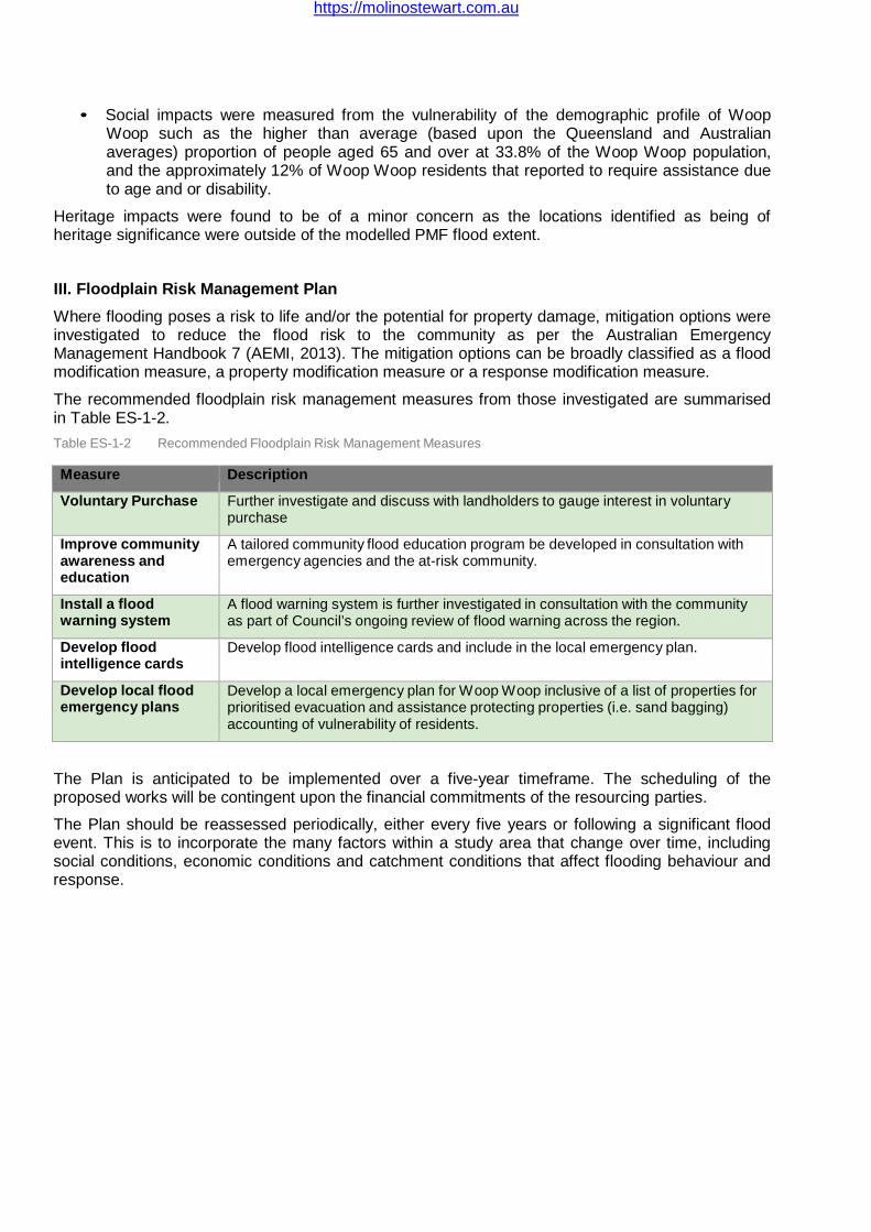
https://molinostewart.com.au
• Social impacts were measured from the vulnerability of the demographic profile of Woop Woop such as the higher than average (based upon the Queensland and Australian averages) proportion of people aged 65 and over at 33.8% of the Woop Woop population, and the approximately 12% of Woop Woop residents that reported to require assistance due to age and or disability.
Heritage impacts were found to be of a minor concern as the locations identified as being of heritage significance were outside of the modelled PMF flood extent.
III. Floodplain Risk Management Plan
Where flooding poses a risk to life and/or the potential for property damage, mitigation options were investigated to reduce the flood risk to the community as per the Australian Emergency Management Handbook 7 (AEMI, 2013). The mitigation options can be broadly classified as a flood modification measure, a property modification measure or a response modification measure.
The recommended floodplain risk management measures from those investigated are summarised in Table ES-1-2.
Table ES-1-2 Recommended Floodplain Risk Management Measures
Measure Description
Voluntary Purchase Further investigate and discuss with landholders to gauge interest in voluntary purchase
Improve community awareness and education
A tailored community flood education program be developed in consultation with emergency agencies and the at-risk community.
Install a flood warning system
A flood warning system is further investigated in consultation with the community as part of Council’s ongoing review of flood warning across the region.
Develop flood intelligence cards
Develop flood intelligence cards and include in the local emergency plan.
Develop local flood emergency plans
Develop a local emergency plan for Woop Woop inclusive of a list of properties for prioritised evacuation and assistance protecting properties (i.e. sand bagging) accounting of vulnerability of residents.
The Plan is anticipated to be implemented over a five-year timeframe. The scheduling of the proposed works will be contingent upon the financial commitments of the resourcing parties.
The Plan should be reassessed periodically, either every five years or following a significant flood event. This is to incorporate the many factors within a study area that change over time, including social conditions, economic conditions and catchment conditions that affect flooding behaviour and response.