COMMITTEE OF INQUIRY - VT-JEKdgca.nic.in/accident/reports/incident/VT-JEK.pdf · Final...
42
Final Investigation Report on Serious Incident to M/s Jet Airways aircraft VT-JEK at London Heathrow Airport on 30.08.2016 COMMITTEE OF INQUIRY - VT-JEK (Raje Bhatnagar) Assistant Director, AAIB Member, CoI -VT-JEK (Dr. Jitender Loura) Assistant Director, AAIB Chairman, CoI-VT-JEK
Transcript of COMMITTEE OF INQUIRY - VT-JEKdgca.nic.in/accident/reports/incident/VT-JEK.pdf · Final...

Final Investigation Report on Serious Incident to M/s Jet Airways
aircraft VT-JEK at London Heathrow Airport on 30.08.2016
COMMITTEE OF INQUIRY - VT-JEK
(Raje Bhatnagar)
Assistant Director, AAIB
Member, CoI -VT-JEK
(Dr. Jitender Loura)
Assistant Director, AAIB
Chairman, CoI-VT-JEK

Foreword
In accordance with Annex 13 to the Convention on International Civil
Aviation Organization (ICAO) and Rule 3 of Aircraft (Investigation of
Accidents and Incidents), Rules 2012, the sole objective of the investigation
of an incident or accident shall be the prevention of incidents and accidents
and not apportion blame or liability.
This document has been prepared based upon the evidences collected during
the investigation, opinion obtained from the experts and laboratory
examination of various components. Consequently, the use of this report for
any purpose other than for the prevention of future incidents /accidents
could lead to erroneous interpretations.

Glossary
AAIB,UK Air Accidents Investigation Branch ,U.K
AAIB Aircraft Accident Investigation Bureau, India
ADS-B Automatic Dependence Surveillance-Broadcast
AGL Above Ground Level
AIP Aeronautical Information Publication
ANOMS Heathrow Noise and Track Keeping System
AOP Air Operator Permit
ASDA Accelerate-Stop Distance Available
ASMGCS Advanced Surface Movement Guidance and Control System
ATCO Air Traffic Control Officer
ATD Actual Time of Departure
ATM Assumed Temperature Method
ATIS Automatic Terminal Information Service
ATSI Air Traffic Services Investigations
AUW All Up Weight
CDU Control and Display Unit
C of A Certificate of Airworthiness
C of R Certificate of Registration
CLD Clearance Delivery Unit
COI Committee of Inquiry
CPL Commercial Pilot License
DFDR Digital Flight Data Recorder
EFB Electronic Flight Bag
FMC Flight Management Computer
ICAO International Civil Aviation Organization
IATA International Air Transport Association
IFR Instrument Flight Rule
LVP Low Visibility Procedure
MDS Multistatic Dependence Surveillance System
MHz Mega Hertz
MTOW Maximum Take Off Weight
NATS National Air Traffic Services, UK
NLR Netherlands Aerospace Centre
NOTAM Notice to Airmen
OPT On-board Performance Tool
PIC Pilot In Command
Pax. Passenger
QFE Query: Field Elevation
QNH Query: Nautical Height
R/T Radio Telephony
SMC Surface Movement Control
TODA Take off Distance Available
TODR Take Off Distance Required
TO/GA Take Off/ Go Around
TORA Take off Run Available
VR Rotate Speed
VHF Very High Frequency
UTC Co-ordinated Universal Time

INDEX
CONTENTS PAGE No.
SYNOPSIS 02
1 FACTUAL INFORMATION 02
1.1 HISTORY OF THE FLIGHT 02
1.1.1 INFORMATION FROM NATS, HEATHROW 04
1.1.2 INFORMATION FROM THE CREW 09
1.1.3 TAKEOFF PERFORMANCE-ONBOARD CALCULATION 11
1.1.3.1 THRUST MANAGEMENT 11
1.1.3.2 TAKEOFF PERFORMANCE CALCULATION 11
1.1.3.3 TAKEOFF PERFORMANCE-REGULATORY REQUIREMENT 12
1.1.4 THE OPERATOR’S SOP 13
1.2 INJURIES TO PERSONS 13
1.3 DAMAGE TO AIRCRAFT 13
1.4 OTHER DAMAGE 13
1.5 PERSONNEL INFORMATION 14
1.6 AIRCRAFT INFORMATION 15
1.7 METEOROLOGICAL INFORMATION 16
1.8 AIDS TO NAVIGATION 17
1.9 COMMUNICATIONS 17
1.10 AERODROME INFORMATION 17
1.11 FLIGHT RECORDERS 18
1.12 WRECKAGE AND IMPACT INFORMATION 18
1.13 MEDICAL AND PATHOLOGICAL INFORMATION 18
1.14 FIRE 18
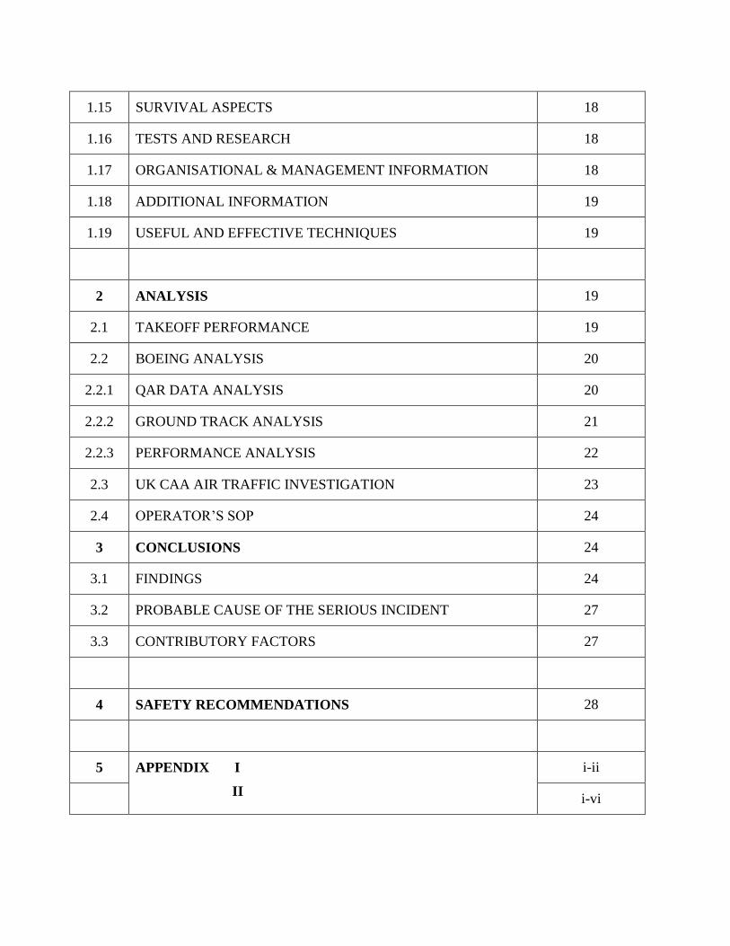
1.15 SURVIVAL ASPECTS 18
1.16 TESTS AND RESEARCH 18
1.17 ORGANISATIONAL & MANAGEMENT INFORMATION 18
1.18 ADDITIONAL INFORMATION 19
1.19 USEFUL AND EFFECTIVE TECHNIQUES 19
2 ANALYSIS 19
2.1 TAKEOFF PERFORMANCE 19
2.2 BOEING ANALYSIS 20
2.2.1 QAR DATA ANALYSIS 20
2.2.2 GROUND TRACK ANALYSIS 21
2.2.3 PERFORMANCE ANALYSIS 22
2.3 UK CAA AIR TRAFFIC INVESTIGATION 23
2.4 OPERATOR’S SOP 24
3 CONCLUSIONS 24
3.1 FINDINGS 24
3.2 PROBABLE CAUSE OF THE SERIOUS INCIDENT 27
3.3 CONTRIBUTORY FACTORS 27
4 SAFETY RECOMMENDATIONS 28
5 APPENDIX I
II
i-ii
i-vi

1 | P a g e
Final Report on Serious Incident to M/s Jet Airways Ltd. B777-300, VT-JEK
at London Heathrow Airport on 30.08.2016
1. Aircraft
Type : B777-300 Nationality : Indian
Registration : VT-JEK
2. Owner/ Operator : M/s Jet Airways
3. Pilot – in –Command : ATPL Holder
Extent of injuries : Nil
4. First Officer : CPL Holder
Extent of injuries : Nil
5. Place of Incident : London Heathrow Airport
6. Date & Time of Incident : 30th August 2016, 20:30 UTC
7. Last point of Departure : London Heathrow Airport
8. Point of intended landing : CSI Airport, Mumbai
9. Type of operation : Schedule Operation
`
10. Crew on Board : 02+13
Extent of injuries : Nil
11. Passengers on Board : 231
Extent of injuries : Nil
12. Phase of operation : Take- off
13. Type of Occurrence : Serious Incident (Late take-off)
(ALL TIMINGS IN THE REPORT ARE IN UTC)

2 | P a g e
SYNOPSIS:
On 30th August 2016, M/s Jet Airways aircraft B777-300 registration VT-JEK departed from
runway 27L of London Heathrow airport at 20:30 UTC. The aircraft departed from an
intersection departure S4E and did not use the full length for take-off which could have been
used from the north of the aerodrome after crossing the runway 27L. As per the initial report
received from Air Accidents Investigation Branch (AAIB), U.K, the aircraft crossed the airfield
boundary at approximately 13 feet AGL and an adjacent road at 30 feet AGL. This event has
been treated as Serious Incident by AAIB, UK and handed over to AAIB, India for further
investigations.
Ministry of Civil Aviation constituted a committee of inquiry vide Notification No. Av-
15013/16/2016-DG to investigate the cause of the Serious Incident under Rule 11 (1) of Aircraft
(Investigation of Accidents and Incidents), Rules 2012 comprising of Dr. Jitender Loura Assistant
Director of Operations (AAIB) as Chairman and Shri Raje Bhatnagar, Assistant Director of
Airworthiness (AAIB) as member.
1. FACTUAL INFORMATION
1.1 History of the flight
Jet Airways aircraft B777-300 was operating a Commercial Air Transport flight from London
Heathrow Airport to Chhatrapati Shivaji Airport in Mumbai, India with 231 passengers and 15
crew on board. The aircraft departed from stand 407 and the runway in use was Runway 27L
(Figure 1).
Figure 1: London Heathrow Airport south of Runway 27L

3 | P a g e
There were two NOTAMs relevant to the departure of the flight, both due to work in progress:
Taxiway S east of Taxiway V was unavailable (including Link 41 and holding point S1), as was
the entry to Runway 27L via holding points S3/SB3. Consequently, the flight was required to
enter the runway and takeoff via entry point S4 (E or W), or to cross Runway 27L and enter the
runway via one of the taxiway intersections on the north side (NB1, N2E, N2W, or N3). The
Heathrow ATC tape transcript reveals that:
I. At 2010:00 JAI117 contacted Heathrow Delivery for their clearance, advising they were on
Stand 407 and in receipt of ATIS “Information November”. ATIS N stated that SB3 was
closed but S4 was available for departure. The pilot was issued with their departure route
and transponder code.
II. Then at 2010:20 the pilot was asked if they required the full length for departure, to which
the pilot replied “Negative, S4 acceptable”. They were then advised to expect an “S4E
intersection departure” which was acknowledged by the pilot.
III. At 2011:30 the pilot reported ready (for push), was again advised by Heathrow Delivery to
“Expect S4E intersection departure”, and instructed to hold position, and was then
transferred to Heathrow Ground.
IV. The pilot contacted Heathrow Ground at 2012:00 requesting push and start, which was
approved and the pilot was instructed to face north.
V. At 2018:40 the pilot requested taxi and was instructed to “follow greens and hold S4E”
which was correctly read back by the pilot.
VI. At 2022:20 the pilot was instructed to “continue round the corner to S4E and then contact
Tower 118.5” which again was read back correctly by the pilot.

4 | P a g e
VII. At 2023:05 the pilot called Heathrow Tower and was instructed to “hold at S4E and I will
call you back. It’ll be around ten minutes at the moment”, which was correctly read back by
the pilot.
VIII. At 2033:48 the tower controller instructed the pilot “behind departing Indonesia Garuda
777 from the full length, via S4W line up Runway 27 Left behind”.
IX. The pilot read back the clearance but advised the controller that they were “holding short 27
Left at S4E”, to which the controller did not correct themselves but added “Thank you, I’ll
give you the green lights very shortly”.
X. At 2034:40 the controller cleared the aircraft for take-off: “(c/s) from S4E, Runway 27 Left
clear takeoff. Wind 180°/ 5 kts”. The pilot repeated the clearance “from S4E cleared for
take-off Runway 27 Left (c/s)”.
XI. The aircraft was transferred to London Control at 2037:25.
1.1.1 Information from NATS, ATC Heathrow
I. Since 18th
February 2016 a project has been underway at Heathrow Airport to refurbish and
enable Link 41 and Taxiway Sierra, east of Taxiway Victor for larger aircraft operations.
This removed access to the runway from Hold S1 during the whole of the works period. To
allow the installation of new stop bars on the taxiway between Tango and Victor, the green
centre line lighting had been removed, and therefore, and due to the removal of taxiway
guidance lighting, Holds S3/SB3 were not available during those periods when there was a
requirement to use airfield ground lighting (i.e. night and LVPs).
II. Unless there were any short-notice changes to the operational status of the aerodrome from
the published data in the UK Aeronautical Information Publication (AIP) and the variations
issued by NOTAM by the Aerodrome Operator at Heathrow, the ATCOs were not required
to remind pilots of aircraft wishing to access Runway 27 Left from the south-side areas, as to
the non-availability of the holding points east of S4 during this period. However, for tactical

5 | P a g e
purposes, pilots were being asked if they required full length departure. Full length
departures were available and required the aircraft to cross the runway onto the north-side of
Runway 27L. Heathrow Delivery was responsible for determining the pilot’s requirements,
to allow for the planning of taxi-routes and facilitating runway crossing.
III. The pilot of the B773 had clearly stated that they were able to accept a departure from the
intersection S4E. IV. ATSI obtained a printout from the Heathrow Noise and Track Keeping System (ANOMS)
which showed the B773 having just passed a height of 30ft approaching the western
perimeter road. A review of the Aerodrome Chart and the AIP entries for Heathrow shows
assessed aerodrome obstacles (trees) as high as 31ft. [The ANMOS height data is not as
accurate as the information supplied by Boeing. That is why the Boeing data was used in
the AAIB final report and not the ANMOS data when showing the height at which the
aircraft crossed the end of the runway.]
Figure 2 : ANMOS Plot of JAI 117
V. When considering the reported heights of the aircraft, the following information has been
obtained from both Heathrow and NATS engineers, together with a report from the
Netherlands Aerospace Centre (NLR), which was commissioned earlier this year to complete
a verification of the Heathrow Noise and Track Keeping System. NLR compared the raw

6 | P a g e
data received and displayed from the NATS source with separate ADS-B data in the same
period.
Figure 3(a) Noise Monitor Figure 3(b) Aerodrome Obstacles
VI. Accuracy of the data supplied by this system is subject to the following:
Aircraft Mode-S transponders report pressure altitude, against a standard QNH of
1013. The accuracy of such systems could not be determined although they must be
capable of reporting in 25ft intervals.
Accuracy of the receiving radar/processor - the ANOMS is supplied with data via an
Asterix Cat-62 NATS radar feed, accurate to +/-25ft in this instance.
Accuracy of the display system – in this case ANOMS – verified by NLR to be
accurate to an average per flight of -55 to +40ft, with a maximum difference of -35
to 120ft.
VII. ATSI reviewed the ASMGCS radar for the period 1945 – 2045 UTC, noting which of those
aircraft which were based on the south side of Runway 27L, elected to take an S4
intersection departure, and those which crossed to the north side to take full length. Also,
snapshots were taken of the first point an altitude was recorded by the ASMGCS for a
departing aircraft, (all of whom took full-length departures.) This gave a broad picture of the
point of rotation of each aircraft. Only those results which show a similar type (Boeing 777)
are included in this report.

7 | P a g e
Figure 4(a): Departing BAW 77 (B772)
Figure 4(b): JAI 117 (B77W) Lined up
Figure 4(c): JAI 117 (B77W) approaching threshold

8 | P a g e
Figure 4(d): JAI 117 (B77W) airborne
Figure 4(e): JAI 121 (B77W) - another aircraft airborne
Figure 4(f): AAR 552 (B772) airborne
VIII. During the period of observation, only one other aircraft was observed to take the S4
intersection (an A320). Three other aircraft elected to cross to the north side for a full length
departure, an A346, an A332 and another B77W belonging to the same operator as the
subject aircraft. IX. Using an ADS-B Multistatic Dependence Surveillance System (MDS) as its source,
ASMGCS data is believed to be accurate to within 7.5m laterally however, height is reported
9 | P a g e
as pressure altitude and although reported by the system in 25ft intervals, accuracy could not
be determined.
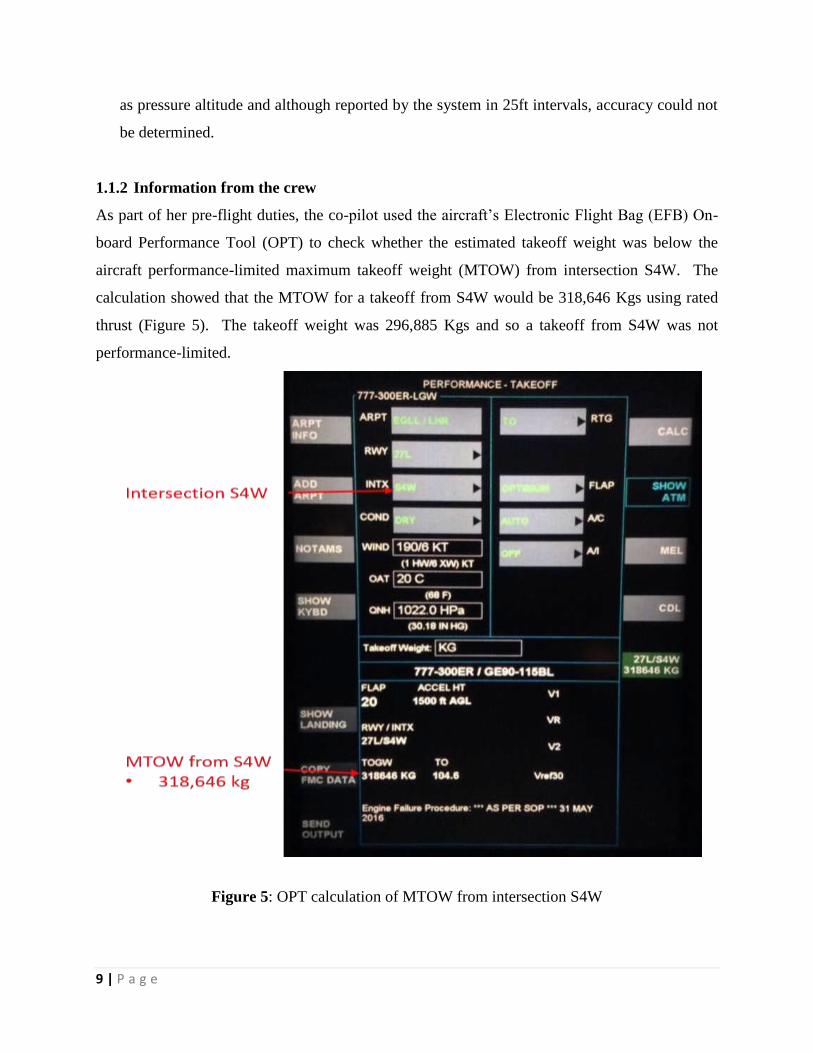
1.1.2 Information from the crew
As part of her pre-flight duties, the co-pilot used the aircraft’s Electronic Flight Bag (EFB) On-
board Performance Tool (OPT) to check whether the estimated takeoff weight was below the
aircraft performance-limited maximum takeoff weight (MTOW) from intersection S4W. The
calculation showed that the MTOW for a takeoff from S4W would be 318,646 Kgs using rated
thrust (Figure 5). The takeoff weight was 296,885 Kgs and so a takeoff from S4W was not
performance-limited.
Figure 5: OPT calculation of MTOW from intersection S4W

10 | P a g e
When the load sheet arrived, each pilot ran the performance calculation again using the actual
TOW to establish takeoff speeds and the thrust setting for the takeoff. When the crew cross-
checked the output from their respective OPTs, however, it became apparent that the commander
had calculated aircraft performance from the first four intersections on the north side of Runway
27L (NB1, NB2E, NB2W, and NB3 in Figure 1) whereas the co-pilot had used S4W. The
commander had done this by selecting the “FIRST 4” option from the OPT intersection drop-
down menu rather than using the “S4W” option (Figure 6). The Co-Pilot changed the option
in her OPT to match the commander’s option and did not select S4W again.
Figure 6: OPT drop-down menu for Runway 27L intersection

11 | P a g e
During the takeoff, as the aircraft approached Vr, the commander noticed the runway centreline
lighting change from all-white to alternating red-and-white lights. This occurs with 900 m of
runway remaining. The co-pilot commented that the commander’s rate of rotation “was a bit
faster than normal”.
1.1.3 Takeoff performance – on-board calculation
1.1.3.1 Thrust management
Rated thrust is the maximum thrust that an aircraft’s thrust management system will allow the
engines to produce. Airliners regularly takeoff using thrust settings below rated thrust because
doing so reduces engine servicing costs, increases engine life and improves engine reliability.
Thrust management systems commonly use two methods to calculate and set reduced thrust:
a. De-rated thrust using fixed de-rate settings which, on the Boeing 777, are referred to as
TO 1 or TO 2 (10% and 20% reduction from rated thrust respectively).
b. Assumed temperature method (ATM) whereby thrust is limited by assuming a
temperature for the performance calculation which is higher than the actual outside air
temperature. This temperature is shown as SEL TEMP on the OPT performance
calculation output (Figure 7).
The EFB OPT calculates takeoff performance for a given set of aircraft and environmental
conditions. The OPT may be used to calculate the maximum takeoff weight (MTOW) possible
from a given runway/taxiway intersection (Figure 1). It may also be used to calculate optimum
settings for thrust and flaps when the actual takeoff weight is known. In this case, it also
calculates takeoff speeds V1, VR and V2. Performance information is entered into the Flight
Management Computer (FMC) through the keypad on the Control and Display Unit (CDU). The
FMC commands the selected takeoff thrust when the TO/GA switch is pushed.
1.1.3.2 Takeoff performance calculation
The commander selected FIRST 4 on the EFB OPT and, although four performance calculations
were performed by the OPT, the default output showed the result for a takeoff using the full
length of the runway (Figure 7). The takeoff weight used for the calculation, obtained from the
load sheet, was 296,886 kg and the weather used by the crew to calculate aircraft performance,
obtained from ATIS N, was: wind from 190° at 6 kts, a temperature of 20°C and a QNH of 1022
hPa.

12 | P a g e
Figure 7: OPT output used for the takeoff
The calculation showed that, for a takeoff from the full length of Runway 27L, the takeoff power
setting to be entered into the FMC was ‘D-TO 1 SEL TEMP 45° C’. This corresponded to a
reduction from rated power of 10% plus a further reduction entered into the FMC using an
assumed temperature of 45°C.
The takeoff speeds were: V1 = 163 kts, VR = 167 kts and V2 = 171 kts.
1.1.3.3 Takeoff performance – regulatory requirements
The takeoff distance required (TODR) on a dry runway is the longest of the following distances:
a. 115% of the distance with all engines operating from the start of the takeoff to the point
at which the aeroplane is 35 ft above the runway (also known as the screen height).

13 | P a g e
b. The distance from the start of the takeoff point at which the aeroplane is 35 ft above the
runway assuming failure of the critical engine occurs at a point corresponding to the
decision speed (V1).
1.1.4 The operator’s SOPs
The operator’s SOPs required a departure briefing to be given by the Pilot Flying (PF) as soon as
practicable ‘so as not to interfere with the final takeoff preparation’ (Annexure I ). During the
briefing the PF would review the ATIS and read aloud unspecified ‘Takeoff Data inputs’ and the
PM would verify that the same data was input on his/her OPT.
On receipt of the Load and Trim sheet (load sheet) the SOPs required crews to check that the
TOW entered in the Control and Display Unit (CDU) was the same as the TOW on the load
sheet, enter the TOW into the OPT, and select CALC to perform the performance calculation.
There was no explicit requirement before selecting CALC to check whether any of the data
entered at the time of the departure briefing had changed, such as the intersection being used for
takeoff.
Once the OPT performance calculation was complete, the SOPs required the commander to read
aloud the assumed temperature thrust setting (SEL TEMP), the flap setting and the takeoff
speeds. The co-pilot was required to crosscheck the results, read out any discrepancies and
enters the information into the CDU. There was no requirement for the commander to read
aloud from the OPT the runway and intersection used for the performance calculation or the
fixed de-rate setting e.g. D-TO 1 (Figure 7).
1.2 Injuries to persons
INJURIES CREW PASSENGERS OTHERS
FATAL Nil Nil Nil
SERIOUS Nil Nil Nil
MINOR/NONE (02+13)
(02+05) Silk Air
231 Nil
1.3 Damage to aircraft: Nil
1.4 Other damage: Nil

14 | P a g e
1.5 Personnel information
1.5.1 Pilot in command
Age 45 Yrs
License ATPL
Date of License Issue and Valid up to 25/08/2009 & 24/08/2020
Category Aero plane
Class Multi Engine Land
Endorsements as PIC B737-700/-800/-900, B777-300 ER
Date of FRTOL issue & validity 30/07/1992 to 09/09/2021
Date of Med. Exam & validity 11/04/2016 to 13/10/2016
Date of last Refresher/Simulator 14/03/2016
Simulator Training for Critical Emergencies Last IR on 15/02/2016 & PPC on 10/08/2016.
Total flying experience 13436:57 Hrs
Total Experience on type 943:19 Hrs
Total Experience as PIC on type 943:19 Hrs
Total flying experience during last 01 Year 430:33 Hrs
Total flying experience during last 180 days 209:26 Hrs
Total flying experience during last 30 days 32:29 Hrs
Total flying experience during last 07 Days 21:39 Hrs
Total flying experience during last 24 Hours 09:19 Hrs
Rest period before the flight 23.58 Hrs
1.5.2 Co-pilot
Age 32Yrs
License CPL
Date of License Issue and Valid up to 20/12/2007 & 19/12/2017
Category Aero plane
Class Multi Engine Land
Endorsements as PIC B737-700/-800/-900, B777-300 ER
Date of Endorsement as PIC on type N/A
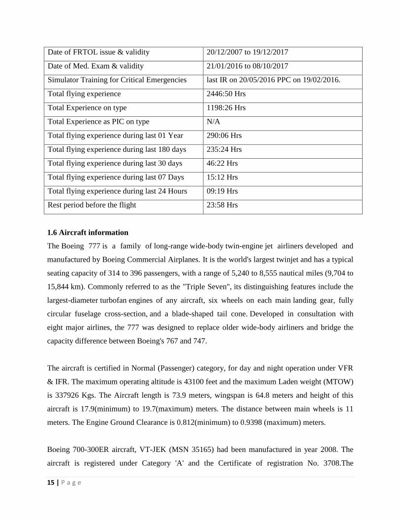
15 | P a g e
Date of FRTOL issue & validity 20/12/2007 to 19/12/2017
Date of Med. Exam & validity 21/01/2016 to 08/10/2017
Simulator Training for Critical Emergencies last IR on 20/05/2016 PPC on 19/02/2016.
Total flying experience 2446:50 Hrs
Total Experience on type 1198:26 Hrs
Total Experience as PIC on type N/A
Total flying experience during last 01 Year 290:06 Hrs
Total flying experience during last 180 days 235:24 Hrs
Total flying experience during last 30 days 46:22 Hrs
Total flying experience during last 07 Days 15:12 Hrs
Total flying experience during last 24 Hours 09:19 Hrs
Rest period before the flight 23:58 Hrs
1.6 Aircraft information
The Boeing 777 is a family of long-range wide-body twin-engine jet airliners developed and
manufactured by Boeing Commercial Airplanes. It is the world's largest twinjet and has a typical
seating capacity of 314 to 396 passengers, with a range of 5,240 to 8,555 nautical miles (9,704 to
15,844 km). Commonly referred to as the "Triple Seven", its distinguishing features include the
largest-diameter turbofan engines of any aircraft, six wheels on each main landing gear, fully
circular fuselage cross-section, and a blade-shaped tail cone. Developed in consultation with
eight major airlines, the 777 was designed to replace older wide-body airliners and bridge the
capacity difference between Boeing's 767 and 747.
The aircraft is certified in Normal (Passenger) category, for day and night operation under VFR
& IFR. The maximum operating altitude is 43100 feet and the maximum Laden weight (MTOW)
is 337926 Kgs. The Aircraft length is 73.9 meters, wingspan is 64.8 meters and height of this
aircraft is 17.9(minimum) to 19.7(maximum) meters. The distance between main wheels is 11
meters. The Engine Ground Clearance is 0.812(minimum) to 0.9398 (maximum) meters.
Boeing 700-300ER aircraft, VT-JEK (MSN 35165) had been manufactured in year 2008. The
aircraft is registered under Category 'A' and the Certificate of registration No. 3708.The
16 | P a g e
Certificate of Airworthiness Number 4017/6790 under "NORMAL category" subdivision
Passenger / Mail / Goods was issued by DGCA. The specified minimum operating crew is two
and at the time of incident the Certificate of Airworthiness was current.
The Aircraft was holding a valid Aero Mobile License No. A-006/WRLO-08 at the time of
serious incident. This aircraft was operated under Scheduled Operator's Permit No S-6A which
was valid up to 12.02.2018. As on 30.08.2016, i.e. the day of serious incident, the aircraft’s left
and right engine’s serial Number and hours/cycles logged are:
1. Right Hand (RH) Engine: ESN 906359 TSN/CSN 37863 hours / 4683 cycles
2. Left Hand (LH) Engine : ESN 906494 TSN/CSN 30300 hours / 3796 cycles
The B777-300ER aircraft and its engines are being maintained as per the maintenance
programme consisting of calendar period/ flying hours or cycles based maintenance as per
maintenance programme approved by Regional Airworthiness office.
Accordingly, the last major inspection C1 Check was done on 16/05/2016 and A24 Check was
done on 17/08/2016. The aircraft was last weighed on 03/12/2012 and the weight schedule was
prepared and duly approved by the office of Director of Airworthiness, DGCA. Prior to the
incident flight the weight and balance of the aircraft was well within the operating limits. All the
concerned Airworthiness Directive, mandatory Service Bulletins, DGCA Mandatory
Modifications on this aircraft and its engine has been complied with as on date of serious
incident.
1.7 Meteorological information:
An Aviation Routine Weather Report (METAR) was posted at 09:20 PM local time. The
airplane lifted off at approximately time 09:36 PM local time (20:36 Greenwich Mean Time
[GMT]). The METAR stated the following:
METAR EGLL 302020Z AUTO 20009KT 150V230 9999 NCD 19/12 Q1022 NOSIG

17 | P a g e
The METAR report indicated that the winds were on average from 200 degrees at 9 knots,
varying between 150 to 230 degrees, with an unlimited ceiling. The wind data resolved into
components when referenced to the runway heading (true heading = 270 degrees) would result in
a 3-knot headwind and an 8-knot left crosswind. The temperature was reported as 19 degrees
Celsius and the air pressure was 30.18 inches of Mercury (in Hg).
1.8 Aids to navigation
All the aids to navigation including Heathrow Delivery frequency (121.975 MHz), Heathrow
Ground Frequency (121.700 MHz), Heathrow Aerodrome Control frequency (118.500 MHz) and
SMGCS were reported working normal
1.9 Communications
During the period of occurrence, the aircraft JAI 117 (B77W) was in contact with Heathrow
ATC on Aerodrome Control Tower frequency 118.500 MHz. There was always two way
communications between the ATC and the aircraft.
1.10 Aerodrome information
Heathrow Airport (also known as London Heathrow Airport) (IATA: LHR, ICAO: EGLL) is a
major international airport in London, United Kingdom. Heathrow is the second busiest airport
in the world by international passenger traffic (surpassed by Dubai International in 2014), as well
as the busiest airport in Europe by passenger traffic, and the seventh busiest airport in the
world by total passenger traffic. In 2016, it handled a record 75.7 million passengers, a 1.0%
increase from 2015. In the 1950s, Heathrow had six runways, arranged in three pairs at different
angles in the shape of a hexagram with the permanent passenger terminal in the middle and the
older terminal along the north edge of the field; two of its runways would always be within 30°
of the wind direction. As the required length for runways has grown, Heathrow now has only two
parallel runways running east–west. These are extended versions of the two east–west runways
from the original hexagram.
The UK AIP lists the following declared distances for Runway 27L, which was the Runway in
use on the day of serious incident as below:

18 | P a g e
Runway TORA TODA ASDA Remarks
27L 3658 m 3658 m 3658 m 3658 m
27L 2589 m 2589 m 2589 m Take-off from intersection with S4E
1.11 Flight recorders
The Heathrow Advanced Surface Movement Guidance and Control System’s (ASMGCS) radar
recordings, the R/T transcripts of Heathrow Delivery, Ground and Tower controllers and
DFDR/QAR data of the subject aircraft was analyzed for investigation purpose.
1.12 Wreckage and impact information
There was no damage to either of the aircraft or to any ground facilities.
1.13 Medical and pathological Information
The cockpit crew of M/s Jet Airways had undergone pre-flight medical check prior to the flight
and the same was found to be negative.
1.14 Fire
There was no fire.
1.15 Survival aspects
The incident may or may not be survivable, had there been a rejected take off for any reason(s).
1.16 Tests and research Nil
1.17 Organizational and management information
M/s Jet Airways is an Indian registered Schedule airline. It operates scheduled flights to both
domestic and international sectors. The Flight Safety Department is headed by Chief of Flight
Safety approved by DGCA. M/s Jet Airways has a fully established Operations training facility
for the pilots.

19 | P a g e
1.18 Additional information
Figure 8: Heathrow ASMGCS Radar Display showing JAI 117
1.19 Useful and Effective Techniques Nil
2. ANALYSIS
2.1 Takeoff performance
M/s Jet Airway’s aircraft took off from intersection S4E on Runway 27L using performance
information (power setting, flap setting and takeoff speeds) appropriate for a takeoff from
intersection N1 (full length). The manufacturer found that, for the aircraft to meet all
regulatory performance requirements, the takeoff distance required was 3,349 m whereas the
takeoff distance available from intersection S4E was 2,589 m. The aircraft lifted off within the
takeoff distance available but:
a. Did not meet regulatory requirements for the all-engine, continued takeoff case.
b. Would not have been able to reject the takeoff and stop in the runway remaining
following an engine failure just below V1.
c. Would not have been able to continue the takeoff while meeting regulatory requirements
following an engine failure just above V1.

20 | P a g e
2.2 Boeing’s Analysis:
2.2.1 QAR Data Analysis
The provided QAR data are non-time-aligned, which means that each parameter has lost its
original timestamp. These data are buffered and output in “clusters” of data, corresponding to
common sample rates. Then, post-processing tools evenly distribute the data samples throughout
each sample interval (one second in this dataset) based on sample rate, without knowledge of
when that event actually occurred on the airplane. For example, a parameter that is recorded at 4
samples per second (sps) will have the recorded data points evenly distributed at 0.0, 0.25, 0.5,
and 0.75 seconds within a given second. As a result, there may be an error in time when
comparing recorded data points to GMT and to other parameters. Thus, caution should be
exercised when interpreting these data.
Time history plots of the pertinent longitudinal and lateral-directional parameters are attached in
Annexure II [page i to vi]. The QAR data show the airplane configured for a flaps 15 takeoff, at
a takeoff gross weight of 654,080 pounds (LB) [Annexure II ], and center of gravity of 31%.
The stabilizer was positioned at -2 degrees which was within the takeoff green band. The
certified maximum takeoff weight is 745,000 LB. The takeoff runway was Runway 27L (RWY
27L) at LHR based on the recorded latitude/longitude coordinates (not shown) and magnetic
heading (Annexure II). The throttles were advanced from the forward idle position at time 1230
seconds and the engines began to spool up. The airplane turned to the left and was aligned with
the runway heading by time 1231 seconds (Annexure II). Around the time of auto throttle
engagement at time 1237 seconds, the engines stabilized at approximately 55% N1 before
spooling up to the takeoff N1 of 92.2% by time 1243 seconds (Annexure II). The takeoff thrust
was de-rated as indicated by a DERATE_1_TM discrete (not shown). Rotation was initiated at
approximately time 1273.5 seconds with a slight pull of the column at a computed airspeed of
165 knots (Annexure II). The rotation speed (VR) was recorded at 167 knots. At time 1274.5
seconds, while still on ground, a more aggressive pull of the column occurred and the airplane
pitch attitude started to increase. The airplane lifted off at approximately time 1278.5 seconds,
as indicated by the main gear tilt discrete parameters transition to TILT, at a pitch attitude of
approximately 8 degrees and computed airspeed of 180 knots (Annexure II). The airplane
reached a climb rate of approximately 2500 feet/minute at time 1287.5 seconds and maintained a

21 | P a g e
pitch attitude of 14 degrees. Just after liftoff, the bank angle was maintained at near wings level
(Annexure II) until a left turn was initiated at time 1302 seconds (Annexure II).
2.2.2 Ground Track Analysis
A ground track was generated to show the airplane’s path during the takeoff roll and initial climb
out (Annexure II). RWY 27L has a length of 12,001 feet and a width of 164 feet. Longitudinal
and lateral distances were calculated using the recorded inertial data: ground speed, drift angle,
and heading. The distances were then referenced to the runway based on the airplane’s turn onto
the runway from Taxiway S4E. The airplane was estimated to have aligned with the runway
centerline at 4000 feet beyond the runway threshold (8001 feet of runway remaining).
The ground track shows the airplane entering RWY 27L from Taxiway S4E. The analysis
indicates that the takeoff was initiated at a distance of approximately 4286 feet beyond the
runway threshold (7715 feet of runway remaining) at auto throttle engagement and the engines
spooled up to the takeoff N1 of 92.2% at 4600 feet beyond the runway threshold. Rotation
initiation occurred just prior to VR at 10,185 feet beyond the threshold and liftoff occurred at
approximately 11,690 feet beyond the threshold. As the airplane climbed over the end of the
runway, at 12,001 feet beyond the runway threshold, the center radio altitude parameter (shown
on plot) was at 16.4 feet. The other two radio altimeter parameters, left and right (not shown),
had values of approximately 16.6 feet and 17 feet, respectively. At the perimeter road, which
was approximately 13,215 feet beyond the runway threshold, the center radio altitude parameter
and left radio altitude were both at a value of approximately 112 feet and the right radio altitude
value was 118 feet.
Figure: 9 showing Radio Altimeter Parameter
22 | P a g e
Annexure II shows the QAR recorded latitude and longitude data (in yellow) on a Google Earth
image of LHR starting at push back from the terminal through the takeoff roll and liftoff. The
data confirmed that the airplane taxied onto RWY 27L using Taxiway S4E.
2.2.3 Performance Analysis
The outside air temperature (OAT) at the time of the event was reported by the METAR as 19
degrees Celsius (66 degrees Fahrenheit) with a pressure of 30.18 in Hg. The pressure altitude
recorded by the QAR was -140 feet just prior to the takeoff. The reported OAT used by the crew
from the load sheet was 20 degrees Celsius with a pressure of 30.18 in Hg. A performance
analysis of the required field length was produced using the following parameters for the takeoff
conditions of the event: METAR reported winds, OAT of 19 degrees Celsius, and a runway
pressure altitude of -140 feet. The analysis indicated that the climb limited takeoff weight was
653,640 LB, which is approximately 400 LB lower than the recorded takeoff weight. The climb
limited weight was close enough to the recorded takeoff weight and can be accounted for by
adjusting the conditions (temperature, runway pressure altitude, etc.) slightly. The analysis
resulted in a required field length for dispatch of approximately 11,000 feet and is based on a
balanced decision speed (V1). The actual (non-factored) all-engine go takeoff distance would be
8472 feet with a calculated distance to liftoff of 7393 feet. The actual takeoff distance for an
engine-out case would be 9828 feet with a calculated distance to liftoff of 8094 feet.
The ground track analysis (Annexure II) shows that the takeoff was initiated at approximately
4286 feet beyond the runway threshold, which left 7715 feet of runway available (RWY 27L =
12,001 feet). Liftoff occurred approximately 7404 feet from takeoff initiation (11,690 feet
from the runway threshold), just 311 feet from the end of the runway. To meet the required
runway field length for dispatch, the takeoff run should have started no farther than
approximately 1001 feet from the runway threshold. The airplane did not meet the 35 feet
screen height requirement when crossing the end of the runway and would not have had
enough runway distance available to perform a rejected takeoff (RTO).
Boeing concluded that the very low takeoff was the result of using Taxiway S4E onto RWY 27L
which did not allow for enough runway distance available for the takeoff to meet the takeoff
performance requirements at the takeoff thrust setting. The center radio altimeter showed the
23 | P a g e
airplane at an altitude of 16 feet at the end of the runway and at 112 feet radio altitude at the
airport perimeter road which was 13,215 feet from the threshold of RWY 27L.
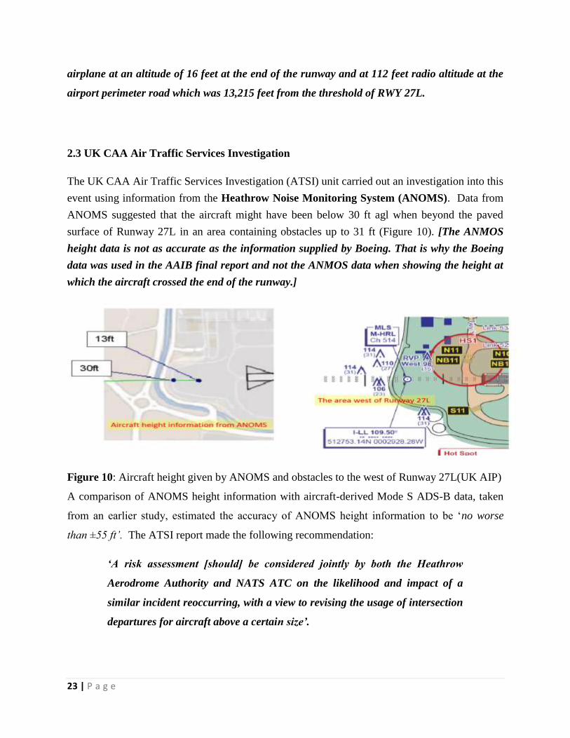
2.3 UK CAA Air Traffic Services Investigation
The UK CAA Air Traffic Services Investigation (ATSI) unit carried out an investigation into this
event using information from the Heathrow Noise Monitoring System (ANOMS). Data from
ANOMS suggested that the aircraft might have been below 30 ft agl when beyond the paved
surface of Runway 27L in an area containing obstacles up to 31 ft (Figure 10). [The ANMOS
height data is not as accurate as the information supplied by Boeing. That is why the Boeing
data was used in the AAIB final report and not the ANMOS data when showing the height at
which the aircraft crossed the end of the runway.]
Figure 10: Aircraft height given by ANOMS and obstacles to the west of Runway 27L(UK AIP)
A comparison of ANOMS height information with aircraft-derived Mode S ADS-B data, taken
from an earlier study, estimated the accuracy of ANOMS height information to be ‘no worse
than ±55 ft’. The ATSI report made the following recommendation:
‘A risk assessment [should] be considered jointly by both the Heathrow
Aerodrome Authority and NATS ATC on the likelihood and impact of a
similar incident reoccurring, with a view to revising the usage of intersection
departures for aircraft above a certain size’.

24 | P a g e
2.4 The operator’s SOPs
The operator’s SOPs required a departure briefing to be given by the Pilot Flying (PF) as soon as
practicable ‘so as not to interfere with the final takeoff preparation’. During the briefing the PF
would review the ATIS and read aloud the ‘takeoff data inputs’, and the PM would verify that
the same data was input on his/her OPT.
On receipt of the Load and Trim sheet (load sheet) the SOPs required crews to carry out the
procedure shown in Annexure I. A crew would ensure that the TOW entered in the Control and
Display Unit (CDU) was the same as the TOW on the load sheet, enter the TOW into the OPT,
and select CALC to perform the performance calculation. There was no explicit requirement
before selecting CALC to check whether any of the data entered at the time of the departure
briefing had changed, such as the intersection being used for takeoff. There was, however, a
requirement to ‘Individually check EFB calculation’ and call out any discrepancies.
After the pilots checked their own OPT calculation, the captain would read aloud the OPT output
while the First Officer entered the information into the CDU.
Company SOPs separated the calculation of aircraft takeoff performance into two discrete
procedures without an explicit check that data entered during the first procedure (the departure
briefing) was still valid and appropriate during the second (after receipt of the load sheet).The
operator confirmed that, after the crew selected FIRST 4 on the OPT, although four performance
solutions were available corresponding to the first four intersections, the default output was used
to programme the CDU for departure. The default output provided performance information for
a departure from N1 (Runway 27L full length).The operator reviewed its SOPs and concluded
that they did not trap data input errors e.g. using the incorrect runway intersection or
environmental conditions, or selecting the incorrect thrust de-rate. It issued SOP Revision 1 on
1st September 2016 to address these deficiencies.
3. CONCLUSIONS
3.1 Findings
1. The medical of both the cockpit crew members of Jet Airways, JAI117 was valid. The
crew of Jet Airways JAI117 has undergone pre-flight medical checks including BA test
which was negative.
2. At 2010 hrs the co-pilot contacted Heathrow Delivery stating that she had ATIS
Information N. ATIS N stated that SB3 was closed but S4 was available for departure.
25 | P a g e
After receiving the flight’s departure clearance, she was asked “DO YOU REQUIRE THE
FULL LENGTH OF THE RUNWAY FOR DEPARTURE?” The co-pilot replied “NEGATIVE,
SIERRA FOUR ACCEPTABLE” and was told to expect a “SIERRA FOUR ECHO INTERSECTION
DEPARTURE”. At 2012 hrs, VT-JEK was cleared to push back from stand 407 and start
engines after which it taxied to holding point S4E. VT-JEK was cleared to takeoff from
S4E at 2034 hrs.
3. VT-JEK took off from runway intersection S4, as briefed by the crew, but used
performance figures calculated for intersection N1 (Runway 27L full length).
Consequently, regulatory takeoff performance requirements were compromised.
4. Heathrow ATC correctly verified that the pilot of subject aircraft could accept an
intersection departure, and that position was mentioned a total of 7 times by ATC and
correctly read back by the pilot on each occasion.
5. Sufficient information had been published by the Aerodrome Authority on the non-
availability of full-length departures from the southern holding points for Runway 27L.
6. For an all-engine go takeoff, at the event conditions, the estimated required field length
would be 9387 feet with distance to liftoff at 8222 feet. The Airplane Flight Manual
(AFM) distance to V1 was 6578 feet. If a RTO was initiated at V1, there would be 2809
feet of runway available for stopping.
7. For a balanced V1, one engine inoperable (OEI), the required field length would be
10,989 feet at the event conditions. The AFM distances to V1 was 6634 feet and to
liftoff was 9020 feet. The climb performance with an engine inoperative is 2.4%.
8. After reviewing the ATIS, the Departure Briefing SOP required the crew to read out
‘Takeoff Data inputs’ before entering those data into the OPT, but the procedure did not
specify which ‘Takeoff Data inputs’ were required and there was no requirement to
nominate the runway or intersection to be used. The SOP following receipt of the load
sheet ensured that the OPT based its takeoff performance calculation on the actual, rather
than estimated, TOW but there was no explicit step to check that data input as part of the
departure briefing was still valid or appropriate to the current circumstances. From a
procedural perspective, there appeared to be no assurance that an incorrect or invalid
entry into the OPT made at the departure briefing would be corrected before the
performance calculation was made.

26 | P a g e
9. The commander calculated aircraft takeoff performance from the first four intersections
of Runway 27L (using the default OPT output corresponding to the full length),
whereas the co-pilot calculated performance (correctly) for a takeoff from intersection
S4W. Even though there was no requirement to read aloud the runway and intersection
used by the OPT for the performance calculation, the discrepancy was nevertheless
identified during the post-calculation crosscheck of OPT output. This provided an
opportunity for the crew to agree the correct intersection but the co-pilot changed her
OPT entry to match that of the commander and the opportunity was lost probably due to
the fact that Commander was much senior to the Co-pilot.
10. It is the responsibility of the pilot to determine the suitability of an intersection departure
for their aircraft and none of the subject Pilots have ever departed from SW4 intersection
departure before the day of the serious incident.
11. The available evidence suggests that the departing aircraft completed a late rotation
which, in comparison with previous departures of similar aircraft types, placed it at a
significantly lower height as it left the airfield.
12. The aircraft manufacturer carried out an analysis of the takeoff using data from the
aircraft’s Quick Access Recorder (QAR) and the environmental conditions used by the
crew for the performance calculation.
13. After the TO/GA switch was pressed, the auto throttles increased engine rpm to the
reference value of 92.2% N1 (this value is shown in Figure 7 beneath ‘D-TO 1’). The
pilot began to rotate the aircraft at 165 kt with a slight pull of the control column
followed by a ‘more aggressive’ pull one second later. The aircraft lifted off the runway
at 180 kts.
14. The manufacturer calculated that rotation was initiated with 556 m of runway remaining
and lift off occurred with 97 m remaining. As the aircraft passed the end of the runway,
the three radio altimeters recorded heights above the surface of 16.4 ft, 16.6 ft and 17 ft
respectively.
15. The manufacturer’s performance analysis indicated that, for the actual takeoff weight and
environmental conditions of the day:

27 | P a g e
a. The Takeoff Distance Required (TODR) was 3,349 m. The Takeoff Distance Available
(TODA) was 2,589 m for a departure from S4E (3,658 m for a takeoff using the full
length of the runway). (i.e.760 meters of runway was short for the departure)
Note: TODR includes the distance it takes for the aircraft to climb to 35 ft agl.
b. The aircraft did not meet the 35 ft screen height requirement at the end of the runway.
c. The aircraft would not have enough runway distance available to perform a rejected
takeoff manoeuvre (RTO) from close to V1.
16. The manufacturer concluded that the use of a power setting appropriate for a takeoff
using the full length of Runway 27L, while actually taking off from intersection S4E, ‘did
not allow for enough runway distance available for the takeoff to meet the takeoff
performance requirements’.
17. M/s Boeing also concluded that the center radio altimeter showed the airplane at an
altitude of 16 feet at the end of the runway and at 112 feet radio altitude at the airport
perimeter road which was 13,215 feet from the threshold of RWY 27L.
18. The SOPs required a crosscheck of OPT output, which revealed that different
performance calculations had been carried out. However, the crew did not resolve why
they had selected different intersections for the calculation, thereby preventing the error
from being trapped. Data validation immediately before the performance calculation
might have prevented the two pilots from calculating takeoff performance from different
intersections.
19. Following the serious incident, the operator amended its SOPs to make it more likely that
data-entry errors would be noticed.
3.2 Probable cause of the Serious Incident
Wrong selection of aircraft take- off performance by the Commander despite the Co-pilot
selecting the right take-off performance initially but the commander overruled her take-off
performance selection.
3.3 Contributory Factors
The first time initiation of SW4 intersection departure by the crew (both Commander and
Co-pilot).


i
Annexure- 1
Operator’s SOP for the Departure Briefing

ii
Operator’s SOP after receipt of the Load and Trim sheet

Annexure –II
Page i - vi

������������������������������������������������������������������������������������������������������������������������������������������������������������������������������������������������������������������������������������������������������������������������������������������������������������������������������������������������������������������������������������������������������������������������������������������������������������������������������������������������������������������������������������������������������������������������������������������������������������������������������������������������������������������������������������������������������������������������������������������������������������������������������������������������������������������������������������������������������������������������������������������������������������������������������������������������
1 2 2 0 . 1 2 3 0 . 1 2 4 0 . 1 2 5 0 . 1 2 6 0 . 1 2 7 0 . 1 2 8 0 . 1 2 9 0 . 1 3 0 0 . 1 3 1 0 . 1 3 2 0 .
0
1 0 0 .
2 0 0 .
2 5 .
7 5 .
2 5 .
7 5 .
0
1 0 0 0 .
2 0 0 0 .
0
1 .
0
1 .
0
. 2
0
1 0 0 0 .
2 0 0 0 .
0
1 0 .
2 0 .
0
1 0 .
0
5 .
1 0 .
0
- 1 0 .--
0
- 2 .--
- . 2--
0
. 2
0
5 0 .
2 0 .
0
1 = ENGAGED
1 = ENGAGED
POS I T I VE COL UMN = PUL L
NEGAT I VE E L E VATOR = T E UP
NEGAT I VE S TAB TRAVE L = A I RP L ANE NOSE - UP--
THROT T L ERE SOL VERANGL E( DEGREE S )
AUTOP I LOT
AUTOTHROT T L E
LONG I TUD I NALACCE L ERAT I ON( g ’ s )
P I TCHAT T I TUDE( DEGREE S )
ANGL E OFAT TACK( DEGREE S )
COL UMNDE F L ECT I ON( DEGREE S )
E L E VATORDE F L ECT I ON( DEGREE S )
L E F TR I GHT
S TAB I L I Z ERPOS I T I ON( DEGREE S )
VER T I CALACCE L ERAT I ON( g ’ s )
SPEEDBRAKEHANDL E( DEGREE S )
F L APHANDL EDE T ENT
T I ME ( SECONDS )
L E F T VANER I GHT VANEBODY
PRE SSUREAL T I TUDE( F EE T )
PRE SSURE AL T I TUDERAD I O AL T I TUDE
A I RP L ANESPEED( KNOT S )
COMPUT ED A I RSPEEDGROUND SPEEDROTAT I ON SPEED = 1 6 7 KNOT S
ENG I NE N 1( % ) L E F T
R I GHT
TAKEOF F GROSS WE I GHT = 6 5 4 , 0 8 0 L B
ENG I NE PARAME T ERS :
VER T I CALSPEED( F T / M I N )
MA I N L AND I NGGEAR T I L T
L E F TR I GHT
S I GN CONVENT I ONS MAY NOT BE S TANDARDP L EASE USE AX I S D I RECT I ONAL NOT E S
NOT T I L T ED
T I L T ED
AP
PD
AP
PD
CH
EC
K
CA
LC
RE
VIS
ED
DA
TE
FIG
UR
E
TH
E B
OE
ING
CO
MP
AN
Y
EX
PO
RT
CO
NT
RO
LL
ED
EC
CN
: 9E
99
1
JPL
777-300
ER VER
Y LOW
TAKEO
FF30
AUG20
16 --
NON
-TIM
E-A
LIG
NED
QAR
DA
TALO
NGITUD
INA
L P
ARAM
ETER
S
AEROD
YNAM
ICS
28AUG17
WD770/VT-JEK
1P
AG
E
BO
EIN
G P
RO
PR
IET
AR
Y

������������������������������������������������������������������������������������������������������������������������������������������������������������������������������������������������������������������������������������������������������������������������������������������������������������������������������������������������������������������������������������������������������������������������������������������������������������������������������������������������������������������������������������������������������������������������������������������������������������������������������������������������������������������������������������������������������������������������������������������������������������������������������������������������������������������������������������������������������������������������������������������������������������������������������������������������
1 2 2 0 . 1 2 3 0 . 1 2 4 0 . 1 2 5 0 . 1 2 6 0 . 1 2 7 0 . 1 2 8 0 . 1 2 9 0 . 1 3 0 0 . 1 3 1 0 . 1 3 2 0 .
0
1 0 0 .
2 0 0 .
2 5 .
7 5 .
0
1 0 0 0 .
2 0 0 0 .
0
1 .
2 0 .
0
- 2 0 .--
2 0 .
0
- 2 0 .--
2 0 .
0
- 2 0 .--
. 2
0
- . 2--
2 8 0 .
2 7 0 .
2 6 0 .
5 .
0
- 5 .--
0
5 .
- 1 0 .--
0
1 0 .
2 0 0 .
1 0 0 .
0
2 0 .
1 = ENGAGED
NEGAT I VE BANK = L E F T WI NG DOWN
NEGAT I VE WHEE L = L E F T
NEGAT I VE A I L ERON / F L APERON = T E UP
NEGAT I VE ACCE L = L E F T
POS I T I VE =GROUND TRACK R I GHT OF A I RP L ANE HEAD I NG
POS I T I VE PEDAL = L E F T
POS I T I VE RUDDER = T E L E F T
RE F ERENCED TO TRUE NOR THTRUE + 0 . 7 6 DEGREE S = MAGNE T I C
PRE SSUREAL T I TUDE( F EE T )
PRE SSURE AL T I TUDERAD I O AL T I TUDE
A I RP L ANESPEED( KNOT S )
COMPUT ED A I RSPEEDGROUND SPEEDROTAT I ON SPEED = 1 6 7 KNOT S
ENG I NE N 1( % )
L E F TR I GHT
AUTOP I LOT
BANKANGL E( DEGREE S )
CTRL WHEE LDE F L ECT I ON( DEGREE S )
A I L ERON /F L APERONDE F L ECT I ON( DEGREE S )
L E F T A I L ERONL E F T F L APERONR I GHT F L APERONR I GHT A I L ERON
L AT ERALACCE L ERAT I ON( g ’ s )
MAGNE T I CHEAD I NG( DEGREE S )
DR I F TANGL E( DEGREE S )
RUDDER P EDALDE F L ECT I ON( I NCHE S )
RUDDERDE F L ECT I ON( DEGREE S )
WI NDD I RECT I ON( DEGREE S )
WI NDSPEED( KNOT S )
T I ME ( SECONDS )
RUNWAY HEAD I NG = 2 7 1 DEGREE S
DATA CL I PPED FORP LOT CL AR I T Y
WI ND DATA I NVAL I D ON GROUND
MA I N L AND I NGGEAR T I L T
L E F TR I GHT
S I GN CONVENT I ONS MAY NOT BE S TANDARDP L EASE USE AX I S D I RECT I ONAL NOT E S
NOT T I L T ED
T I L T ED
TAKEOF F GROSS WE I GHT = 6 5 4 , 0 8 0 L B
AP
PD
AP
PD
CH
EC
K
CA
LC
RE
VIS
ED
DA
TE
FIG
UR
E
TH
E B
OE
ING
CO
MP
AN
Y
EX
PO
RT
CO
NT
RO
LL
ED
EC
CN
: 9E
99
1
JPL
777-300
ER VER
Y LOW
TAKEO
FF30
AUG20
16 --
NON
-TIM
E-A
LIG
NED
QAR
DA
TALA
TERA
L-D
IREC
TIO
NA
L P
ARAM
ETER
S
AEROD
YNAM
ICS
28AUG17
WD770/VT-JEK
2P
AG
E
BO
EIN
G P
RO
PR
IET
AR
Y

������������������������������������������������������������������������������������������������������������������������������������������������������������������������������������������������������������������������������������������������������������������������������������������������������������������������������������������������������������������������������������������������������������������������������������������������������������������������������������������������������������������������������������������������������������������������������������������������������������������������������������������������������������������������������������������������������������������������������������������������������������������������������������������������������������������������������������������������������������������������������������������������������������������������������������������������
1 2 7 0 . 1 2 7 2 . 1 2 7 4 . 1 2 7 6 . 1 2 7 8 . 1 2 8 0 . 1 2 8 2 . 1 2 8 4 . 1 2 8 6 . 1 2 8 8 . 1 2 9 0 .
0
2 0 0 .
4 0 0 .
1 5 0 .
1 7 0 .
1 9 0 .
9 0 .
1 0 0 .
6 5 .
7 5 .
- 1 0 0 .--
1 0 0 .
3 0 0 .
0
1 .
0
1 .
0
. 2
0
1 0 0 0 .
2 0 0 0 .
0
1 0 .
2 0 .
0
1 0 .
0
5 .
1 0 .
0
- 1 0 .--
0
- 2 .--
- . 2--
0
. 2
0
5 0 .
2 0 .
0
1 = ENGAGED
1 = ENGAGED
POS I T I VE COL UMN = PUL L
NEGAT I VE E L E VATOR = T E UP
NEGAT I VE S TAB TRAVE L = A I RP L ANE NOSE - UP--
THROT T L ERE SOL VERANGL E( DEGREE S )
MA I N L AND I NGGEAR T I L T
L E F TR I GHT
AUTOP I LOT
AUTOTHROT T L E
LONG I TUD I NALACCE L ERAT I ON( g ’ s )
P I TCHAT T I TUDE( DEGREE S )
ANGL E OFAT TACK( DEGREE S )
COL UMNDE F L ECT I ON( DEGREE S )
E L E VATORDE F L ECT I ON( DEGREE S )
L E F TR I GHT
S TAB I L I Z ERPOS I T I ON( DEGREE S )
VER T I CALACCE L ERAT I ON( g ’ s )
SPEEDBRAKEHANDL E( DEGREE S )
F L APHANDL EDE T ENT
T I ME ( SECONDS )
L E F T VANER I GHT VANEBODY
L E F TR I GHT
VER T I CALSPEED( F T / M I N )
PRE SSUREAL T I TUDE( F EE T ) RAD I O
AL T I TUDE( F EE T )
PRE SSURE AL T I TUDERAD I O AL T I TUDE
A I RP L ANESPEED( KNOT S )
COMPUT ED A I RSPEEDGROUND SPEEDROTAT I ON SPEED = 1 6 7 KNOT S
ENG I NE N 1( % )
ENG I NE PARAME T ERS :
S I GN CONVENT I ONS MAY NOT BE S TANDARDP L EASE USE AX I S D I RECT I ONAL NOT E S
NOT T I L T EDT I L T ED
TAKEOF F GROSS WE I GHT = 6 5 4 , 0 8 0 L B
AP
PD
AP
PD
CH
EC
K
CA
LC
RE
VIS
ED
DA
TE
FIG
UR
E
TH
E B
OE
ING
CO
MP
AN
Y
EX
PO
RT
CO
NT
RO
LL
ED
EC
CN
: 9E
99
1
JPL
777-300
ER VER
Y LOW
TAKEO
FF30
AUG20
16 --
NON
-TIM
E-A
LIG
NED
QAR
DA
TALO
NGITUD
INA
L P
ARAM
ETER
S -
ZOOM-
IN
AEROD
YNAM
ICS
28AUG17
WD770/VT-JEK
3P
AG
E
BO
EIN
G P
RO
PR
IET
AR
Y

������������������������������������������������������������������������������������������������������������������������������������������������������������������������������������������������������������������������������������������������������������������������������������������������������������������������������������������������������������������������������������������������������������������������������������������������������������������������������������������������������������������������������������������������������������������������������������������������������������������������������������������������������������������������������������������������������������������������������������������������������������������������������������������������������������������������������������������������������������������������������������������������������������������������������������������������
1 2 7 0 . 1 2 7 2 . 1 2 7 4 . 1 2 7 6 . 1 2 7 8 . 1 2 8 0 . 1 2 8 2 . 1 2 8 4 . 1 2 8 6 . 1 2 8 8 . 1 2 9 0 .
1 5 0 .
1 7 0 .
1 9 0 .
9 0 .
1 0 0 .
- 1 0 0 .--
1 0 0 .
3 0 0 .
0
1 .
5 .
0
- 5 .--
2 0 .
0
- 2 0 .--
2 0 .
0
- 2 0 .--
. 2
0
- . 2--
2 8 0 .
2 7 0 .
2 6 0 .
5 .
0
- 1 .--
0
1 .
- 5 .--
0
5 .
0
2 0 0 .
4 0 0 .
1 5 0 .
1 0 0 .
0
1 0 .
1 = ENGAGED
NEGAT I VE BANK = L E F T WI NG DOWN
NEGAT I VE WHEE L = L E F T
NEGAT I VE A I L ERON / F L APERON = T E UP
NEGAT I VE ACCE L = L E F T
POS I T I VE =GROUND TRACK R I GHT OF A I RP L ANE HEAD I NG
POS I T I VE PEDAL = L E F T
POS I T I VE RUDDER = T E L E F T
RE F ERENCED TO TRUE NOR THTRUE + 0 . 7 6 DEGREE S = MAGNE T I C
L E F TR I GHT
AUTOP I LOT
BANKANGL E( DEGREE S )
CTRL WHEE LDE F L ECT I ON( DEGREE S )
A I L ERON /F L APERONDE F L ECT I ON( DEGREE S )
L E F T A I L ERONL E F T F L APERONR I GHT F L APERONR I GHT A I L ERON
L AT ERALACCE L ERAT I ON( g ’ s )
MAGNE T I CHEAD I NG( DEGREE S )
DR I F TANGL E( DEGREE S )
RUDDER P EDALDE F L ECT I ON( I NCHE S )
RUDDERDE F L ECT I ON( DEGREE S )
WI NDD I RECT I ON( DEGREE S )
WI NDSPEED( KNOT S )
T I ME ( SECONDS )
RUNWAY HEAD I NG = 2 7 1 DEGREE S
WI ND DATA I NVAL I D ON GROUND
PRE SSUREAL T I TUDE( F EE T ) RAD I O
AL T I TUDE( F EE T )
PRE SSURE AL T I TUDERAD I O AL T I TUDE
A I RP L ANESPEED( KNOT S )
COMPUT ED A I RSPEEDGROUND SPEEDROTAT I ON SPEED = 1 6 7 KNOT S
ENG I NE N 1( % )
MA I N L AND I NGGEAR T I L T
L E F TR I GHT
S I GN CONVENT I ONS MAY NOT BE S TANDARDP L EASE USE AX I S D I RECT I ONAL NOT E S
NOT T I L T ED
T I L T ED
TAKEOF F GROSS WE I GHT = 6 5 4 , 0 8 0 L B
AP
PD
AP
PD
CH
EC
K
CA
LC
RE
VIS
ED
DA
TE
FIG
UR
E
TH
E B
OE
ING
CO
MP
AN
Y
EX
PO
RT
CO
NT
RO
LL
ED
EC
CN
: 9E
99
1
JPL
777-300
ER VER
Y LOW
TAKEO
FF30
AUG20
16 --
NON
-TIM
E-A
LIG
NED
QAR
DA
TALA
TERA
L-D
IREC
TIO
NA
L P
ARAM
ETER
S -
ZOOM-
IN
AEROD
YNAM
ICS
28AUG17
WD770/VT-JEK
4P
AG
E
BO
EIN
G P
RO
PR
IET
AR
Y

������������������������������������������������������������������������������������������������������������������������������������������������������������������������������������������������������������������������������������������������������������������������������������������������������������������������������������������������������������������������������������������������������������������������������������������������������������������������������������������������������������������������������������������������������������������������������������������������������������������������������������������������������������������������������������������������������������������������������������������������������������������������������������������������������������������������������������������������������������������������������������������������������������������������������������������������
- 1 0 0 0 .-- 0 1 0 0 0 . 2 0 0 0 . 3 0 0 0 . 4 0 0 0 . 5 0 0 0 . 6 0 0 0 . 7 0 0 0 . 8 0 0 0 . 9 0 0 0 . 1 0 0 0 0 . 1 1 0 0 0 . 1 2 0 0 0 . 1 3 0 0 0 . 1 4 0 0 0 . 1 5 0 0 0 .
0
5 0 .
1 0 0 .
1 5 0 .
2 0 0 .
0
1 0 0 .
2 0 0 .
2 5 .
7 5 .
3 0 .
4 0 .
5 0 .
6 0 .
7 0 .
0
1 0 .
0
5 .
0
- 1 0 .--
0
2 0 0 0 .
1 0 0 .
0
- 1 0 0 .--
- 2 0 0 .--
RAD I OAL T I TUDE( F EE T )
CAL CUL AT EDL AT ERALDE V I AT I ONF ROM RWYCENT ERL I NE( F EE T )
CAL CUL AT ED LONG I TUD I NAL D I S TANCE F ROM RWY 2 7 L THRE SHOLD ( F EE T )
A I RSPEED( KNOT S )
ENG I NEN 1 ( % )
THROT T L ERE SOL VERANGL E( DEGREE S )
COL UMNDE F L ECT I ON( DEGREE S )
P I TCHAT T I TUDE( DEGREE S )
E L E VATORDE F L ECT I ON( DEGREE S )
COMPUT ED A I RSPEEDGROUND SPEEDROTAT I ON SPEED = 1 6 7 KNOT S
L E F TR I GHT
ENG I NE PARAME T ERS :
L E F TR I GHT
VER T I CALSPEED( F EE T / M I N )
MA I N L AND I NGGEAR T I L T
L E F TR I GHT
NEGAT I VE E L E VATOR = T E UP
POS I T I VE COL UMN = PUL L
S I GN CONVENT I ONS MAY NOT BE S TANDARDP L EASE USE AX I S D I RECT I ONAL NOT E S
TAKEOF F GROSS WE I GHT = 6 5 4 , 0 8 0 L B
ENGAGED
A / T
NOT T I L T ED
T I L T ED
APPD
APPD
CHECK
CALC REVISED DATE
FIGURE
THE BOEING COMPANY
EXPORT CONTROLLED ECCN: 9E991
J P L 7 7 7 - 3 0 0 ER VERY L OW T AK EOF F3 0 AUG2 0 1 6 - - NON - T I ME - A L I GNED QAR DA T A
GROUND TRACK ANA L YS I S
AERODYNAM I CS 1 1AUG 1 7WD 7 7 0 / V T - J EK
5PAGE REV
BOEING PROPRIETARY
fj203a
Line
fj203a
Text Box
16 FEET
fj203a
Line
fj203a
Text Box
112 FEET
fj203a
Text Box
END OF RUNWAY
fj203a
Text Box
AIRPORT PERIMETER ROAD
fj203a
Text Box
S4E
fj203a
Text Box
S4W
fj203a
Text Box
S3
fj203a
Text Box
S1
fj203a
Text Box
S5E
fj203a
Text Box
S5W
fj203a
Text Box
S6
fj203a
Text Box
S7
fj203a
Text Box
S11
fj203a
Text Box
TAXIWAYS

APPD
APPD
CHECK
CALC REVISED DATE
FIGURE
THE BOEING COMPANY
EXPORT CONTROLLED ECCN: 9E991
J P L 7 7 7 - 3 0 0 ER VERY L OW T AK EOF F3 0 AUG2 0 1 6 - - NON - T I ME - A L I GNED QAR DA T AGOOGL E E AR TH MAP - L A T I TUDE / L ONG I TUDE
AERODYNAM I CS 1 1AUG 1 7WD 7 7 0 / V T - J EK
6PAGE REV
BOEING PROPRIETARY
fj203a
Text Box
S6
fj203a
Text Box
S7
fj203a
Text Box
S5W
fj203a
Text Box
S5E
fj203a
Text Box
S4W
fj203a
Text Box
S4E
fj203a
Text Box
S3
fj203a
Text Box
S1
fj203a
Text Box
TAXIWAYS
fj203a
Text Box
S11
fj203a
Line
fj203a
Text Box
N
fj203a
Polygonal Line