
Comments on Gowanus Canal Superfund Proposed Remedial Action Plan, 2013
33
2011 July 17 Gowanus Canal oxygenation aerator “life support” flotation buoy covered in sewage scum. photo by by backgroundgeo_Flickr Comments on the Gowanus Canal Superfund Site Proposed Remedial Action Plan by Eymund Diegel, Gowanus Canal Community Advisory Group at large member and local resident 439 Sackett Street, Brooklyn, New York, 11231 telephone: 1 718 596 1464 e-mail: [email protected]
-
Upload
eymund-diegel -
Category
Documents
-
view
217 -
download
1
description
These are comments on various aspects of the US Environmental Protection Agency's Proposed Remedial Action Plan for the cleanup of the Gowanus Canal Superfund Site in Brooklyn, NY. They were submitted by Eymund Diegel, a Gowanus Canal Superfund Community Advisory Group at large member and local Canal resident.
Transcript of Comments on Gowanus Canal Superfund Proposed Remedial Action Plan, 2013

2011 July 17 Gowanus Canal oxygenation aerator “life support” flotation buoy covered in sewage scum. photo by by backgroundgeo_Flickr
Comments on the Gowanus Canal Superfund Site Proposed Remedial Action Plan by Eymund Diegel, Gowanus Canal Community Advisory Group at large member and local resident 439 Sackett Street, Brooklyn, New York, 11231 telephone: 1 718 596 1464 e-mail: [email protected]

Eymund Diegel 22 April 2013 439 Sackett Street Brooklyn, NY 11231 Tel. 1 718 596 1464 e-mail: [email protected] RE: GENERAL LETTER OF SUPPORT FOR THE GOWANUS CANAL SUPERFUND PLAN, RED HOOK LANDFILL OPTION, AS WELL AS CONCERNS & SUGGESTIONS FOR ADDITIONAL ACTIONS (5TH STREET BASIN, CANAL WIDENING, UPLAND SITE ACQUISITION & FLOOD MANAGEMENT PLANNING) Dear Superfund Team, I would like to compliment the community groups, USEPA, NYSDEC and New York City on working together to cleanup our neighborhood waterway and to create a world class waterfront asset for New York City. Overall, I think this is a good well thought out plan, prepared in an impressively short time with meaningful and constructive community input. The inclusion of the community concerns about combined sewer overflows and long term water quality improvements will be an investment appreciated for generations to come. I strongly support the Superfund Team’s philosophy of “What happens in Vegas, stays in Vegas” and feel that the on site management of dredge spoils at the proposed Red Hook Landfill Facility or some other locally selected site is the most sustainable and cost effective solution.
I would like to comment in greater detail on a number of aspects of the Plan:
1- Landfilling & Sludge Management Proposals 2- Canal Edge Treatment & Wetland Reconstruction 3- Soil Remediation & Water Quality Standards Targets
& Use Attainability Analysis 4- Integration of Watershed wide planning into the
water quality remediation plan 5- Upland opportunity sites for the Plan 6- Archeological commemoration projects
Thank you for the hard work you have all put into this plan.

Landfilling & Sludge Management Proposals Remediation of contaminated dredge spoils should happen locally. This includes the more contaminated coal tar sludges from the upper part of the Canal. I support the proposal to have a remediation facility built on the Gowanus Bay Terminal site in Red Hook. It will provide an opportunity to rebuild the Red Hook waterfront on a more sustainable, community friendly partnership model. Because it is uniquely sited at the mouth of the Gowanus Canal it can help advance the goals of the City’s Coastal Resiliency Plan to create storm surge breakers that can help reduce flooding levels in Red Hook and Gowanus.
General Gowanus Canal floodwater entry points in the Watershed
The Gowanus Bay Terminal waterfront redevelopment plan supports the City’s commitment to improving air quality by reducing freight truck traffic on local highways and increasing facilities for low emissions waterborne transport. Air pollution from the Brooklyn Queens Expressway is currently the primary environmental health hazard for local residents, far greater than any risks from buried Gowanus industrial pollutants. Supporting the lowest carbon footprint solution by looking at local water borne based scenarios and maintaining a sustainable industrial waterfront will help reduce air pollution while finding a common ground for the sometimes competing land uses that will revitalize the Gowanus Canal and its watershed.
2012 Red Hook proposed oyster reefs wave breakers, Scape_Landscape Architecture, Rising Currents MOMA Exhibit

Primary Public Hazard in Red Hook and Gowanus is Air Pollution, not Soil or Water Pollution
Local Superfund sludge processing and new docks can help with this Air Quality problem: Darker brown on map shows major truck generated PM 2.5 dust pollutants from Brooklyn Queens Expressway, closer to housing than the Gowanus Bay Terminal (GBX) site. A revitalized harbor transport system will help move bulk transport from trucks to cleaner barges. Map from 2009 NYC Community Air Quality Survey.
Diesel truck yard parking lot at 2nd Street and Gowanus Canal with asthma causing fume traces on wall
By designing the Superfund plan to use waterborne transport, and restructuring the Canal to make it easier to use for sustainable water based transport, the Superfund Team will be improving not just water and soil pollution reduction targets, but air quality goals ones as well. Respect Red Hook Residents’ Concerns about “No Toxics” in our backyard. Even at a distance of 2000 feet from the closest home, the concerns by some local residents that a temporary state of the art Red Hook waste management facility is an undesirable neighbor is appreciated and should be addressed. More education and outreach focused on Red Hook is needed for dialogue as the Plan moves forward. The measure of community support or opposition for the landfill site should be based on an objective survey or referendum of local residents, not just a vocal minority. Should the Red Hook site be rejected, the Superfund Team should make every effort to find another local processing alternative. All sites should be subject to the SEQRA environmental review process. Other potential Gowanus Canal sludge processing site candidates could include the following: Public Place (459 Smith Street) Bayside Fuel Depot (510 Sackett Street) for which redevelopment and remediation plans have been considered Thomas Greene Park waterfront site (226 Nevins, corner of Nevins and Butler Street)
GBX Site

Oil saturated soils at the Fulton MGP / Thomas Greene Park, 226 Nevins waterfront lot truck yard 31 July 2011
Abandoned Bayside Fuel Depot site on Sackett Street, affected by Fulton MGP plume and oil runoff. 8 July 2112
Public Place / Citizens Manufacturing Gas Plant site / Gowanus Green Redevelopment Site, Huntington St. 15 December 2012
All pictures courtesy of the Gowanus Canal Conservancy Grassroots Mapping Balloon Photography Program All the above Gowanus waterfront sites are already heavily contaminated and should be looked at as potential staging areas for the sludge processing as the cleanup proceeds from north to south, and from the side basins to the main Canal. Eminent domain measures have been used unsuccessfully by the City to revitalize Gowanus Canal sites such as Public Place. Instead of eminent domain, the City and EPA should work cooperatively with the current owners through the Mayor’s Office for Environmental Remediation to integrate these upland sites into the current Superfund Plan. The current property owners would all benefit from increased property values as a result of both on site cleanup and Canal remediation. As a local resident, I would personally welcome a temporary cleanup facility at the end of my Sackett Street block given the promises of a cleaned up waterfront and street end water access.

To support waterfront industrial redevelopment, the Superfund team should strategically pursue landfilling opportunities that can help better engineer the Gowanus flood plain for climate change, for example at the mouth of the Canal. It also needs to address the haphazard water encroachments that have occurred over the decades. The Plan should be reviewed by qualified flood plain specialists from the US Army Corps of Engineers.
The Plan should remove the landfilling that is contributing to higher flood plain levels for local residents. The Community Advisory Group unanimously passed a resolution calling for the Superfund Plan to aim at maintaining historical bulkhead heights (+/- 4 feet above mean sea level) and maintaining the historical canal width (100 feet) where this was practicable. There is concern that the current Remedial Design bulkhead proposal will further worsen the already congested Canal by adding a third generation of bulkheads. Local barge operators have pointed out that to meet the City’s transportation goals of a Sustainable Waterfront that obstructions in the Gowanus Canal would have to be removed to make larger barge navigation possible. This means widening the Canal in strategic spots.

“These houses are built on low ground, and the kindness of the contractor in making a public dump of the vacant lot in front of them has so arranged matters that the rain water from the lot in question and also from the property between there and Third avenue flood into them. When it rains, they are flooded, and the surface drains become a nuisance instead of a help, the drains are so elevated that the ends of the perimeter are actually lower than the ends of the street. Connection with the canal which is only sixty or a hundred feet away would remove all the trouble.” A TOUR THROUGH THE THIRD DISTRICT; Some Objectionable Italian
Tenements and Pestilential Dumping Grounds THE CONDITION OF BROOKLYN'S STREETS AND HOUSES. Brooklyn Daily Eagle, 9 May 1885
Great grandpa’s old fashioned common sense flood engineering advice should be integrated into the Superfund Plan. The Plan’s proposal to remove contaminated landfill in the First Street Basin is an excellent one. A second candidate for similar treatment is 5th Street Basin. The strategic location of the landfilled 5th Street Basin will help alleviate the recurring flooding problem centered near 4th Avenue and Third Street. By including the 5th Street Basin in the final cleanup plan local property owners who have endured a century of contaminated flooding will be able to say: “Superfund made a real difference”. Reducing runoff flooding has been identified as goal of the PlaNYC Climate Resiliency Plan. A Superfund plan that does not strategically address measures to control future contamination dispersal from almost certain future flooding is not a pla n.

Soft Edges should be a key part of the new shoreline design Brooklyn Bridge Park wetlands image from Valkenburgh Associates, ASLA, 2013
Former Denton’s Pond / 4th Street Basin - freshwater wetlands reemerging from remediation excavations; Whole Foods shopping center site Photo by by K. Lapp, November 2008
Canal Soft Edge Treatment & Wetland Reconstruction; “I bend, therefore I survive” The marsh reed in Aesop’s Fables THE REMEDIATION DESIGN MUST SUPPORT THE US ARMY CORPS HARBOR ESTUARY PROGRAM’S ECOLOGICAL RESTORATION GOALS.
The Superfund Plan needs to detail the issues of wetlands mitigation banking as it applies to the proposed remedy. The Red Hook disposal facility is projected to landfill 10 acres of what are currently legally protected “Open Waters of the US”. In addition, another 3 acres of the Gowanus Canal have been filled over the last decades, and are legally outstanding violations of the Clean Water Act. The Plan needs to clarify legal status of Gowanus Canal infilling and what needs to be removed under existing waterfront / wetland management laws, and what falls under CERCLA jurisdiction / obligations. There is concern that the Canal bulkhead prototypes being developed by NYSDEC and National Grid will further shrink already limited water area of Canal by building out additional bulkheads into water. It should instead be expanding them, and integrating the proposed 70 foot rezoned Public Access canal edge setback into the engineering design of the new bulkheads. It should consider the possibility of a curvilinear wetland enhanced Canal edge at strategic sites where major excavation will be necessary, such as at Thomas Greene Park and at Public Place.

The Plan should restore the Canal to its 100 foot minimum width as a navigable waterway. Where new bulkheads have to encroach into water for pollution control and logistics reasons (e.g. the Bond Lorraine Sewer restriction on Public Place) then the opposite site of the Canal has to be expanded and owners compensated where there is a property taking (versus an encroachment removal). Under the Army Corps “No Net Loss of Wetlands” policy, this will provide opportunities to implement habitat restoration goals of the Harbor Estuary Program and the Comprehensive Restoration Plan. SUPERFUND & FLOOD MANAGEMENT Superfund managers have clearly stated that the “Environmental Protection Agency is not in the business of flood management”. By dredging the Canal from its current average 8 foot depth to a new depth of 19 feet, they will defacto be increasing the Canal’s capacity for receiving flood waters by 100%. Whether they like it or not, the Superfund program is in the business of flood management. Some candidate sites for flood plain reconstruction and wetland mitigation banking: First Street Gowanus Canal Basin (currently landfilled)
5th Street Gowanus Canal Basin / 4th Street Basin (currently landfilled) 7th Street Basin (currently very shallow open water) Marmurstein Bus Lot / Salt Lot waterfront edge, opposite Public Place 73 foot wide "bottleneck" section (see earlier map).
Brooklyn Rapid Transit / Powerhouse Environmental Arts Center Canal waterfront edge site (70 feet right of way would need to be purchased by City from the current owner) Former City Waterworks Site; the upland portion of the truck maintenance lot between Thomas Greene Park and Gowanus Canal is heavily contaminated. It will need to be excavated and purchased by the City, potentially for a CSO or storm tank and the doubling of the Park’s size.
Water Sensitive Urban Design; “Flood Park” in Rotterdam Holland, designed to absorb flood surges. Thomas Greene Park (the Fulton Gas Works Site) should have its “brownfield cap” removed, the coal tar plume should be excavated, and the flood management functions of historic Brouwer’s Pond (which the Gas Works was built on) should be restored and integrated with the Canal. The doubling of the Park’s size would compensate the community for the time the Park and pool is unusable during the necessary coal tar removal and remediation.

The concept of Potentially Responsible Parties / City Tax Payers purchasing land as part of the Remedy must be discussed to meet stated goals and obligations (e.g. CSO reduction / storm tanks) and the City’s CEQR guidelines to provide upgraded Gowanus open space requirements under the rezoning plan. Given the trend towards future planned recreational waterfront uses for the Canal, industrial stakeholders should also be consulted for barge access priorities and integration planning with community "soft edges" and recreational goals for the Canal. FLOOD MANAGEMENT PLANNING SUMMARY The Superfund Plan engineering solutions should support the City’s Coastal Resiliency Plan and the USACE Harbor Estuary Program. A watershed wide model for water runoff should quantify Canal sewer, runoff impacts and pollution dispersal during severe flood scenarios and dredging and bulkhead designs matched accordingly. Specific opportunities for a flood management include the remediation of Thomas Greene Park (The Fulton MGP site). The Park’s expanded Canal waterfront should be regraded to a 4 ft grade above mean sea level, down 8 feet from its current 12 ft elevation. This would allow the now expanded Park to act as an emergency flood water basin. For Public Place (the Citizens MGP site), Canal side public access along waterway portions of site of should be regraded to the lower 4ft grade to better manage storm surges and waterfront enjoyment issues. The grade can go higher once past the proposed setback to address water table and residential construction concerns. Keeping the lower historical bulkhead height has the benefit of allowing the new 50 feet steel bulkheads to be driven 8 feet deeper, providing that much more sub surface barrier control for the coal tar plume.
First Street Basin Fresh Water Restoration Site - 2012 December 15 Denton’s Spring fresh water inflow diluting Post Hurricane Sandy Gowanus Canal raw sewage overflows, captured by a camera mounted on a balloon sponsored by Liberty Industrial Gases and pulled by Gowanus Dredgers Canoe Club / Conservancy Grassroots Mappers

1766 Ratzer Map with Denton’s Pond with current street overlay and approximate location of Darby’s Patch landfill – The 5th Street Basin is a potential wetland restoration site. “AM” stands for Al Madinah School, the largest number of students (600) directly on a Superfund site in America.
THERE IS HOPE - WHAT CLEAN WATER MAKES POSSIBLE… Reappearance of Denton’s Pond when toxic soils dug were out of Whole Foods site. Photo by Robert Gusskind, 2007, July 10
If ducks tried to cross Denton’s Pond today … How can Superfund help reestablish a more natural infrastructure ?
PHASING OF REMEDIATION - The Superfund Plan should prioritize those sections of the site where the most human activity is expected. This highlights the 4th Street Basin, / 5th Street Basin restoration, and the Al Madinah School area and Whole Foods Area open space reconstruction. Prioritizing high density use areas in the side basins could run concurrently with the current North South dredging and cleanup proposal. By prioritizing high human use areas of the Canal, immediate high profile impacts can be achieved from what will be a very long term process. A key priority area is the Fifth Street Basin / Whole Foods Site, expected to attract thousands of people to the Canal waterfront, with public waterfront access currently under construction.

CONTROLLING OUTFLOWS & NOT THROWING OUT THE BABY WITH THE BATHWATER. The Superfund Plan has stated that all outflows that have been identified will be blocked. But… some outflows are beneficial. Fresh water should not be treated as a negative piped outflow to be blocked. Where possible, Superfund Plan should integrate stream daylighting goals and natural habitat restoration plans into the City owned abandoned Canal street ends, in particular on Second Street and First Street. This will earn the Team some appreciative quacks. Bergen Stream, currently a flowing stream being permanently pumped out of local basements needs to be disconnected from its suspected sewer connection to the Bond Lorraine Sewer Main and the RH 35 CSO and reconnected to the Canal. The Superfund Team needs to work with NYCDEP to systematically map historic streams that have been diverted into the now overwhelmed sewer system. This can be done by reviewing the existing NYCDEP video footage of the Bond Lorraine sewer shot by Gannett Fleming / Dvirka and Bartilucci and looking for unmapped side inflows. Dye tracing and wet weather underwater tunnel photography is also needed. Where such fresh water loads can be identified they should be redirected to street end waterfront “Sponge Park” connections to the Canal to reduce combined sewer overflows.
Inflows of Seabring’s Brook into the Gowanus Flushing Tunnel, February 2013 An example of technical challenges faced by the City’s engineers. The new sewer force main is being used temporarily as a pump pipe for natural stream inflows during tunnel construction.
Denton’s Pond creek, hidden behind bulwarks at 2nd Street and flowing into Canal, March 2011 An example of a natural watercourse that could be restored by “Green Infrastructure” connections for the Third Avenue High Level Storm Sewer - currently planned to be discharged at Carroll Street Bridge with possible scouring impacts.

INTEGRATE CRITICAL UPLAND SITES INTO THE RECORD OF DECISION LONG TERM PLANNING GOALS
The Plan is still missing an integrated mapping of overall polluted upland sites and their impacts on the water. The overall brownfield “plume” area is estimated to be 178 acres, based on a 2007 Columbia University study. The extents and depth of three major MGP coal tar plumes should be clearly shown on a single map using the latest EPA and NYSDEC findings.
The Remedial Investigation has sidestepped this issue of an integrated flood plain wide pollution assessment. The Plan could benefit from a better structural overview of contaminated landfilled soil area, the depth and nature of landfilling, location of pollution plumes, and dispersion estimates on streams and tidal forces that disperse those pollutant hot spots. Some notes on landfilling history around 4th Ave are given later in my comments. This would give people interested in investing in the Canal’s future a clearer spatial sense beyond the otherwise very well researched waterfront lots. The EPA has stated that remediation standards and actions will be informed by long term plans for the Canal and its adjacent uplands. SUPERFUND IS NOT “JUST A CLEANUP” – IT IS A HALF A BILLION DOLLAR INVESTMENT PLAN INTO OUR INDUSTRIAL, RESIDENTIAL AND RECREATIONAL WATERFRONT FUTURE. The Superfund Design Plan and the Final Record of Decision (ROD) need to integrate upland linkages from various community plans into the structural design of the new bulkheads and dredging. Existing community plans (Gowanus Community Development Corporation Plan, City Planning Rezoning Plan, Friends of CB6 Brownfields Opportunity Area Plan) all need to be part of the cleanup decision making PLANNING process. This includes plans for new residential developments at both the Carroll Street Bridge (Lightstone) and Public Place (Gowanus Green), both including canoe dock and waterfront access proposals. Both of these proposals will require custom bulkhead designs ( e.g. steps to water access) and the proposed Remedy must be flexible enough to accommodate these proposals.

Another example is the City’s Green Infrastructure Plan for the Canal, as demonstrated by Sponge Park Plan prototype for 2nd Street. New bulkheads should be inset and stepped at street ends to allow for street end bio filter designs. I would like to further highlight and discuss some of the sites around the Canal that can contribute to better integration between the federal dredging program and the State and City upland site remediation plans. It is important that strategic sites that provide opportunity for the surrounding community be included in Superfund’s Record of Decision. They need to be identified, thoroughly discussed and integrated into a coherent plan that meshes with Superfund’s remediation and engineering goals. Several sites around the Canal are “Keystone” sites that will connect our rapidly growing neighborhoods with the remediated waterfront.
Local Gowanus Canal Citizens using Grassroots Mapping tools to highlight sites and local knowledge that are important to them. As follows are some details on particular strategic Superfund relevant sites.

The Gowanus Canal Sponge Park Plan (Gowanus Canal Conservancy / dland studio) with historic overlay notes from the CAG Archeology Committee discussions highlighting sites of special interest. These areas have been the focus of more detailed research by the Conservancy’s Grassroots Mapping team, with help from the Gowanus Dredgers and Proteus Gowanus.

Thomas Greene Park / Fulton Manufacturing Gas Plant Site Remediation and Expansion
Side of Canal next to Thomas Greene Park should be used for storm holding tanks, cleaned sludge disposal and an expanded park and new community recreation center.
Photos: Google Aerials Circa 2010 Park redesign courtesy of Joseph Barrick, Gowanus by Design Water_Works competition.
The 2011 Superfund Tourism Map, showing generalized outline of Fulton MGP Coal Tar Plume that needs to be excavated down to 30 feet (or as deemed necessary)
The City would acquire the parcels between Thomas Greene Park and the Gowanus Canal as part of its Combined Sewer Overflow (CSO) elimination requirement. The first 100 feet from Canal would be reconstructed as a tidal wetlands to create filter habitats, with stormwater holding tanks under the reconstructed Park and pools.

1766 Ratzer Map of Thomas Green Park Area with 2011 Kite Aerial showing how sinking tarmac matches streams. Coal Tar leaches from Park to Canal via spring system Potential spring outflow at end of Degraw Street from Park
Sinking at Thomas Greene Park from historic stream beds 2011 May 31 photo by Eymund Diegel
What can we do better ? The City, instead of properly cleaning up the Fulton Manufacturing Gas Plant site simply covered it with tarmac and called it Thomas Greene Park. Over the years, streams and tidal marshes on which the gas plant was built have caused parts of Park to subside, while carrying coal tar contamination into the Gowanus Canal waters. Currently the “remediation” plan calls for building a wall along the Canal to block the contamination. That is not good enough. The New York City Park’s Department needs to work with the EPA, National Grid and NYSDEC to properly excavate the coal tar contaminated soils under the pools.
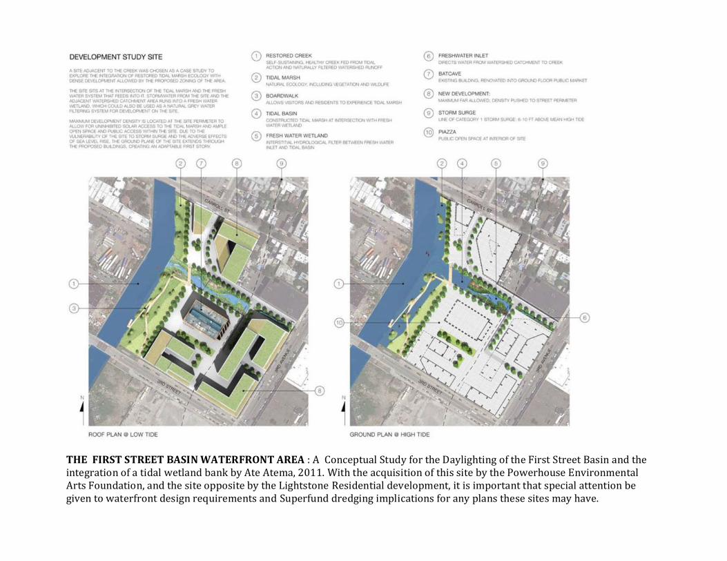
THE FIRST STREET BASIN WATERFRONT AREA : A Conceptual Study for the Daylighting of the First Street Basin and the integration of a tidal wetland bank by Ate Atema, 2011. With the acquisition of this site by the Powerhouse Environmental Arts Foundation, and the site opposite by the Lightstone Residential development, it is important that special attention be given to waterfront design requirements and Superfund dredging implications for any plans these sites may have.

Overlay of a 1766 Map of the Denton Tide Mill on top of a 2012 balloon aerial of the First Street Basin
Gowanus Dredger at the First St. Basin landfill. The Basin contains historic Denton’s Spring: Check out the stream video of a restoration opportunity.
LOCAL KNOWLEDGE COMMUNITY PARTICIPATION FEEDBACK / “GRASSROOTS” MAPPING OF DENTON’S SPRING. An example of how weed patterns growing through concrete cracks led to the discovery of substantial fresh water flows coming out from underneath the Figliolia Building’s foundations. This outflow was missed by the Superfund Pipe Survey, and with a second one hidden behind the bulwarks at 2nd Street, they have the highest flows of any pipes going into the Canal.

Underwater Bridge idea from Brabant Holland
2011 Marking High Tide, David Lam Park, Vancouver, photo by Don Vaughan
Timeless Tides Marker installed on side of Gowanus Canal to mark Brouwer’s Tidal Dam, 7 April 2013
REMEMBERING AMERICA – MOVING FROM SUPERFUND TO CELEBRATING THE CANAL’S UNIQUE HISTORY
UNION STREET BRIDGE / BROUWER’S MILL DAM ARCHEOLOGICALLY SIGNIFICANT AREA This is the main area of the Superfund Site with historical commemorative significance. Once dredged this strategic site of America’s First Battle for Independence should be commemorated by an appropriate waterfront feature, whether an underwater bridge, tidal steps, or some other design the community feels appropriate.

KEEPING THE WHEELS OF PROGRESS TURNING.. The comprehensive and well researched Archeological Study of the Gowanus Canal Superfund Site and its surrounding areas by Hunter Research noted the significance of the First Street Basin Site in American history. The site was the backdrop for an 1858 painting by Alonzo Chappel depicting the Battle of Long Island. With the growing interest in Battle of Brooklyn events, the report’s recommendation to study the site for a commemorative structure is an important one. For example, a reconstructed tidal mill could serve as water science education center for local schools. The Canal is currently a field trip destination for several local schools. It is suggested that as the dredging program moves forward that the Superfund Team consider the Figliolia Building
property, (currently for rent) and the adjoining First Street Basin (City owned) as a construction site management office. The First Street Basin lot would be the perfect place for a community information trailer on Superfund progress as the plan moves forwards.
Vanderveer Tide Mill in Canarsie, Brooklyn, showing water wheel and sluiceway Photograph by Daniel Berry Austin, circa 1899, Brooklyn Museum AN EXAMPLE OF A HISTORIC TIDAL MILL THAT COULD BE RECONSTRUCTED AS AN ENVIRONMENTAL SCIENCE CENTER IN THE FIRST STREET BASIN

COMMUNITY OUTREACH & ENVIRONMENTAL EDUCATION 2012, 5 March – “How Bridges Work”, an educational program on the Gowanus Canal sponsored by the Gowanus Dredgers Canoe Club, here with International School of Brooklyn students. The Gowanus Canal has become a major educational destination for local schools, used as a workshop site by local universities and toured by many overseas delegations. As part of the Community Advisory Groups and the Superfund Team’s Public Information campaign it is proposed that construction management facilities for the Superfund cleanup include a physical public information center. It can be as humble as a weather protected information board with progress maps and key facts. As funding and community organizations evolve, it could become a permanent Environmental Education Center located on one of the currently landfilled Canal basins.

INCLUSION OF THE 5TH STREET BASIN (4th STREET BASIN EXTENSION) INTO THE FINAL SUPERFUND PLAN The Superfund Team made the decision to include First Street Basin in the Cleanup Plan but not the Fifth Street Basin. The Community Advisory Group unanimously supported the 5th Street Basin’s inclusion in the Cleanup Plan. Below is more detailed discussion as to why the 5th Street Basin should be included: POLLUTION: It is polluted enough to qualify as an integral part of Superfund Site. Many other parts of current Gowanus Canal Superfund Site are less polluted than the Fifth Street Basin. FLOOD MANAGEMENT: The Basin is strategically located to reduce contaminated flooding for local businesses COMBINED SEWER OVERFLOW (CSO) REDUCTION: The 5th Street Basin provides a better strategic location for stormwater or CSO tanks. Both of the current CSO tank proposals (Salt Lot and Greene Park) are located in the worst section of the Gowanus flood zone, while the 5th Street Basin is located at edge of the flood zone. OPEN SPACE REQUIREMENTS: The City needs to expand open space for the growing population of the watershed’s neighborhoods. 600 students are directly adjacent to the Canal Superfund site, without recreational open space. EPA HAS LEGAL MANDATE: Cleanup to open space standards can best be achieved by Federal EPA standards, not City or State ones, which have failed the community, both in allowing illegal dumping in the Canals and Park construction on coal tar plumes.
SUSTAINABLE: The 5th Street Basin was the historic outflow for Vechte’s Creek, the natural outflow point for Park Slope rain waters. These waters are currently mechanically pumped and sent all the way to the Brooklyn Navy Yard through a failing overwhelmed sewer system. The 5th Street Basin provides a sustainable gravity fed solution to stormwater management. CONNECTION CORRIDOR: The Basin is a key identified greenway linkage in the Gowanus Canal Conservancy’s Sponge Park Plan, currently being used by the City as part of its Green Infrastructure Strategy. Thousands of shoppers and recreational users are expected to converge on the redeveloped 4th Street Basin / Whole Foods Park, and the currently landfilled basin is the missing link to Brooklyn’s Greenway and open space network. The 5th Street Basin provides a connection opportunity for Park Slope to the watershed’s largest open space: the Gowanus Canal – it brings people to Superfund’s results.
2011, 31 July – Balloon aerial of 5th Street Basin / 4th Street Basin Connection, Al Madinah School, American Can Factory, Whole Foods Site and Third Ave. Grassroots Balloon photo courtesy of Gowanus Canal Conservancy

4th Street / 5th Street Basin Remediation. The 4th Street Basin is mapped as one of the highest coal tar contaminant zones in the Canal. It is slated for contaminated sludge removal and in-situ stabilization. Currently, the immediately connecting landfilled (confusingly named) 5th Street Basin is only proposed for remediation under the States Brownfield program. The Superfund Team’s reason for this is that it is not contaminated enough to qualify for inclusion in the Superfund Remediation.
There has been concern expressed by artists at the American Can Factory that the “triage” approach being used by the EPA, of only remediating the “worst offenders” is still letting substantially contaminated areas slip through the cracks.
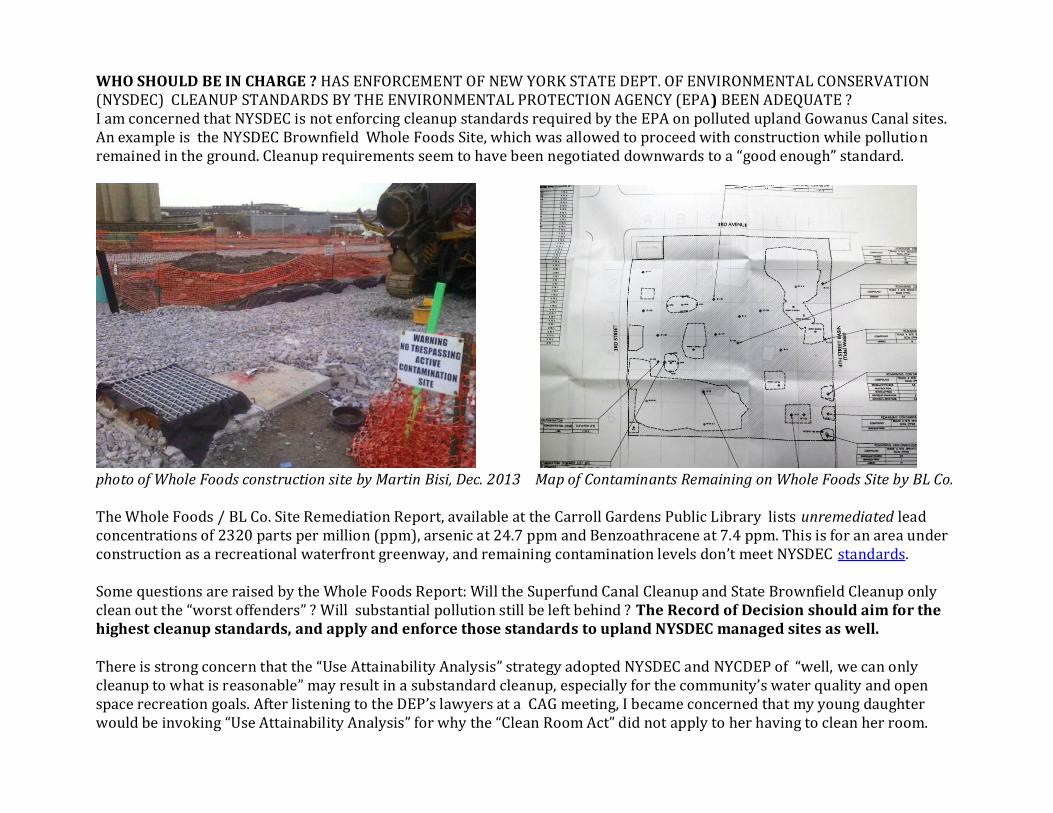
WHO SHOULD BE IN CHARGE ? HAS ENFORCEMENT OF NEW YORK STATE DEPT. OF ENVIRONMENTAL CONSERVATION (NYSDEC) CLEANUP STANDARDS BY THE ENVIRONMENTAL PROTECTION AGENCY (EPA) BEEN ADEQUATE ? I am concerned that NYSDEC is not enforcing cleanup standards required by the EPA on polluted upland Gowanus Canal sites. An example is the NYSDEC Brownfield Whole Foods Site, which was allowed to proceed with construction while pollution remained in the ground. Cleanup requirements seem to have been negotiated downwards to a “good enough” standard.
photo of Whole Foods construction site by Martin Bisi, Dec. 2013 Map of Contaminants Remaining on Whole Foods Site by BL Co. The Whole Foods / BL Co. Site Remediation Report, available at the Carroll Gardens Public Library lists unremediated lead concentrations of 2320 parts per million (ppm), arsenic at 24.7 ppm and Benzoathracene at 7.4 ppm. This is for an area under construction as a recreational waterfront greenway, and remaining contamination levels don’t meet NYSDEC standards. Some questions are raised by the Whole Foods Report: Will the Superfund Canal Cleanup and State Brownfield Cleanup only clean out the “worst offenders” ? Will substantial pollution still be left behind ? The Record of Decision should aim for the highest cleanup standards, and apply and enforce those standards to upland NYSDEC managed sites as well. There is strong concern that the “Use Attainability Analysis” strategy adopted NYSDEC and NYCDEP of “well, we can only cleanup to what is reasonable” may result in a substandard cleanup, especially for the community’s water quality and open space recreation goals. After listening to the DEP’s lawyers at a CAG meeting, I became concerned that my young daughter would be invoking “Use Attainability Analysis” for why the “Clean Room Act” did not apply to her having to clean her room.

It is important that the various cleanup agencies clearly explain what cleanup standards have been met and not met and avoid using legal tactics to evade publically mandated responsibilities to ensure clean and safe environments. The Superfund Team must enforce the law, both for CERCLA and the directly related Clean Water Act, and reject legal attempts to dilute cleanup standards.
List of Contaminants remaining on Local library kids on top of site plan of their future Whole Foods play ground Whole Foods Site by BL Co. Engineers What is “clean enough ?”
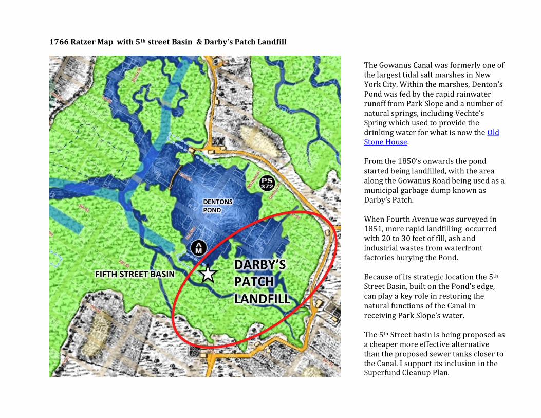
1766 Ratzer Map with 5th street Basin & Darby’s Patch Landfill
The Gowanus Canal was formerly one of the largest tidal salt marshes in New York City. Within the marshes, Denton’s Pond was fed by the rapid rainwater runoff from Park Slope and a number of natural springs, including Vechte’s Spring which used to provide the drinking water for what is now the Old Stone House. From the 1850’s onwards the pond started being landfilled, with the area along the Gowanus Road being used as a municipal garbage dump known as Darby’s Patch. When Fourth Avenue was surveyed in 1851, more rapid landfilling occurred with 20 to 30 feet of fill, ash and industrial wastes from waterfront factories burying the Pond. Because of its strategic location the 5th Street Basin, built on the Pond’s edge, can play a key role in restoring the natural functions of the Canal in receiving Park Slope’s water. The 5th Street basin is being proposed as a cheaper more effective alternative than the proposed sewer tanks closer to the Canal. I support its inclusion in the Superfund Cleanup Plan.

A HISTORY OF LANDFILLING OF THE GOWANUS CANAL SUPERFUND SITE UPLAND AREA The Remedial Investigation had some data gaps with regards to the nature of landfilling around the Gowanus Canal Superfund site. Some background material is submitted here to suggest that the 5th Street Basin, currently excluded from the Cleanup Plan, be given a second look and included in the remediation proposals. There is concern that the eastern end of the 5th street landfill, closest to 4th avenue was used as a municipal landfill by the City, and would contain contaminants typical of 1850’s industrial Brooklyn. Additional soil borings should be taken there in light of community efforts to get the 5th Street Basin become the solution to 4th Avenues flooding and sewer overflow problems. Brooklyn Landfill Dump, circa 1872, typical of those that filled the Gowanus tidal marshes, and a garbage dump rag picker photo by George Bradford Brainerd, courtesy of Brooklyn Museum
A HISTORIC DESCRIPTION OF DARBY’S PATCH LANDFILL The sunken lots, which two years ago were twenty feet below the street surface, are being filled in fast nominally with ashes, but really with lobster and fruit cans, waste paper, rags, old boots and in some instances, garbage and street refuse. Fifty or sixty teams and wagons are now filling in the great sunken lot on the corner of Carroll and Fourth avenue .…Darby's Patch was a densely populous shanty town containing over a thousand squatters who paid no rent and acknowledged no rivals except the grim and dignified goat, the phlegmatic hog and the independent flocks of geese and ducks which went sailing down the filthy ponds between the great heaps of ashes and refuse which the city was kind enough to throw there.… The sunken block upon which the shanties stood is now the property of a gentleman named LYNCH. He is selling city lots in it. They would not have brought $500 each a year ago, when there were thirty feet below street level in some places. The surface of these lots is clean earth, but the substratum is ashes and refuse. A TOUR THROUGH THE THIRD DISTRICT Some Objectionable Italian Tenements and Pestilential Dumping Grounds THE CONDITION OF BROOKLYN'S STREETS AND HOUSES. Brooklyn Daily Eagle, 9 May 1885

4th Avenue Landfilling Concerns on 5th Street Basin Component of Gowanus Canal Superfund Site Study Area
1851 Road Grading Survey Section of 4th Avenue showing average 25 feet of Darby’s Patch landfill on top of Denton’s Pond in blue and oldest shallow section of 5th Street section that would have received oldest most varied industrial and urban wastes
5th ST 1ST ST
Fourth Street Basin frozen with remnant outflows of Vechtes Brook melting the ice photo by K_Lapp, January 18 2009
Runoff Model showing convergence of surface runoff to the 5th Street Basin. This rapid runoff is the major cause of 4th Avenue property flooding. Blue squares indicate rain holding cisterns that could be built in City owned playgrounds to retain runoff for later discharge via the 5th street Basin. Yellow shows the historic Gowanus Marsh and blue the general direction of runoff and groundwater infiltration today. Red shows the extent of the Sandy Flood Area and lavender various storm and sewer holding tank options. (modeled by Eymund Diegel using a 2004 Digital Elevation Model and ArcHydro software)
5th St Basin

The Gowanus Canal Conservancy Grassroots 2012 Mapping program noted melted ice at this location (similar to the 2009 photo) indicative of salt runoff , However, the Third Ave roadbed is bermed here, making salt runoff unlikely. There is a need to cross check the source of melting chemical or warmer water. The current plan calls for some form of barrier at the end of the 4th Street Basin to prevent any form of contamination that may leach from the upland area. This is a problem, as hydrologically, this particular point is the primary runoff flow connection from Park Slope. Any blocking off of the 4th Street Basin / 5th Street basin will exacerbate flooding and water table problems for 4th Avenue residents, and the American Can Factory in particular. It is proposed that the Superfund Plan include the currently landfilled segment of the 5 th Street Basin to become an integral part of the Gowanus Canal, with open water and a reconstructed wetland park connected to the Whole Foods Greenway. The 5th Street Basin should be added to the list of sites submitted by EPA to NYCDEP for study as to its suitability for Combined Sewer Overflow tanks (currently limited to the 2nd Avenue Salt Lot and Thomas Greene Park). Better still, as part of the NYC Green Infrastructure Plan it is proposed that the site be studied for a stormwater diversion area (not sewer overflow tank) that would be a cheaper and more sustainable alternative to the CSO holding tank proposal. I think that combined sewer tanks are bad idea. They are only treating the symptom, not the cause of the problem. A better solution are smaller more strategically located rain water holding tanks in upslope sites that would make the more expensive (tax payer funded) sewer tanks unnecessary by diverting overflow causing rainwater from the sewer pipes. Rainwater, even when polluted by street runoff is much easier to treat than toilet and industrial sewage. The 5th Street Basin would be restored to its natural function as a stream and public park incorporating pollution runoff best management practices tested in the Staten Island Bluebelt Plan. The 5th Street Basin would be part of a comprehensive watershed stormwater management plan incorporating street creeks, holding tank and infiltration swale technologies as appropriate that would be linked to Green Infrastructure in the adjacent JJ Byrne Park , Old Stone House gardens and Junior High School 51 playgrounds and proposed 4th Street Park. THE 5TH STREET BASIN MAKES A BETTER ALTERNATIVE FOR STORMWATER AND SEWER OVERFLOW MANAGEMENT THAN THE CURRENTLY PROPOSED CSO RETENTION TANK AT 2ND AVENUE & 5TH STREET 9 (THE “ SALT LOT”) AND AT THOMAS GREENE PARK.

THE PLAY PUMP PLAN – a rough study on the feasibility of identifying school owned playgrounds suitable for the construction of large rain holding tanks. Kids playing on merry go rounds would pump rainwater back to street and trees after the storm has passed. This is an example of Watershed wide planning supported by the Conservancy.

CONCLUSION
Watershed Wide Superfund Solution: A rebuilt tree pit area next to PS 58 could help reduce Gowanus Canal RH 35 toxic sewer overflows
Rainwater Tanks for a gravity fed playground and street runoff management system that reconstructs natural hydrology 2011 photo from “Street Creeks” proposal by Ate Atema
No More Sludge Increases: Dolphin dying in coal tar contaminated sewer sludge in what could be reconstructed wetland and waterfront park Photo by Reuters, January 2011
Support a swimmable Gowanus Canal water quality standard. Gogo the Gowanus muskrat looking forward to a Superfund cleanup related water quality reclassification from Class SD (horrible) to Class SC (sort of ok for swimming) Photo by Adam Katzman, May 2011

Sludgie the Superfund whale graphic by Anne Martin, 2009 Community groups have worked hard to develop cleaner sustainable neighborhoods around the Gowanus Canal, and to support the City and Government to meet their environmental mandates. The Superfund Cleanup Plan is a unique opportunity for City, State and Federal agencies to find a common ground that can help improve New York City as a whole. Superfund and the Clean Water Act need to work together to ensure that cleanup goals for the Gowanus Canal are not just hypothetical percentages of “modeled” sewer volumes but real reductions aiming to bring sewer volumes and toxic contaminants to Zero. The primary goal of the Clean Up Plan remains the removal of centuries of contaminated sludge and preventing recontamination. However, for the person walking across a Canal bridge, it is the visible component of the cleanup that will define its success - the removal of the floating sewage and oil slicks. With the well thought strategies that the Environmental Protection Agency has come up with, and the great Team they have assembled, I look forward to the Plan’s implementation and a cleaner Canal.


