Columbia Business Center Initial Study Mitigated Negative ... 0959, 0960... · Columbia Business...
130
Columbia Business Center Initial Study Mitigated Negative Declaration Prepared for: City of Riverside Community Development Department 3900 Main Street, 3 rd Floor Riverside, California 92522 Project Proponent: Operating Engineers Pension Trust C/O Washington Capital Management, Inc. 1301 Fifth Avenue, Suite 3100 Seattle, Washington 98101 Prepared by: MIG|Hogle-Ireland, Inc. 1500 Iowa Avenue, Suite 110 Riverside, California 92507 March 2015
Transcript of Columbia Business Center Initial Study Mitigated Negative ... 0959, 0960... · Columbia Business...
Columbia Business Center Initial Study
Mitigated Negative Declaration
Prepared for:
City of Riverside
Community Development Department
3900 Main Street, 3rd Floor
Riverside, California 92522
Project Proponent:
Operating Engineers Pension Trust
C/O Washington Capital Management, Inc.
1301 Fifth Avenue, Suite 3100
Seattle, Washington 98101
Prepared by:
MIG|Hogle-Ireland, Inc.
1500 Iowa Avenue, Suite 110
Riverside, California 92507
March 2015

- This document is designed for double-sided printing -

Columbia Business Center i
Table of Contents
1 Introduction ................................................................................................................ 1 1.1 – Purpose of CEQA .............................................................................................. 1 1.2 – Tiering ............................................................................................................ 2 1.3 – Public Comments .............................................................................................. 4 1.4 – Availability of Materials ..................................................................................... 4
2 Project Description ...................................................................................................... 5 2.1 – Project Title ..................................................................................................... 5 2.2 – Lead Agency Name and Address ......................................................................... 5 2.3 – Contact Person and Phone Number ..................................................................... 5 2.4 – Project Location................................................................................................ 5 2.5 – Project Sponsor’s Name and Address .................................................................. 5 2.6 – General Plan Land Use Designation ..................................................................... 5 2.7 – Zone ............................................................................................................... 5 2.8 – Project Description............................................................................................ 5 2.9 – Surrounding Land Uses ..................................................................................... 7 2.10 – Environmental Setting ....................................................................................... 7 2.11 – Required Approvals ........................................................................................... 7 2.12 – Other Public Agencies Whose Approval is Required ............................................... 8
3 Determination ........................................................................................................... 35 3.1 – Environmental Factors Potentially Affected ......................................................... 35 3.2 – Determination ................................................................................................ 35
4 Evaluation of Environmental Impacts ........................................................................ 37 4.1 – Aesthetics ...................................................................................................... 37 4.2 – Agriculture and Forest Resources ...................................................................... 40 4.3 – Air Quality ..................................................................................................... 42 4.4 – Biological Resources ....................................................................................... 52 4.5 – Cultural Resources .......................................................................................... 56 4.6 – Geology and Soils ........................................................................................... 59 4.7 – Greenhouse Gas Emissions .............................................................................. 62 4.8 – Hazards and Hazardous Materials ..................................................................... 67 4.9 – Hydrology and Water Quality ........................................................................... 71 4.10 – Land Use and Planning .................................................................................... 76 4.11 – Mineral Resources........................................................................................... 77 4.12 – Noise ............................................................................................................ 78 4.13 – Population and Housing ................................................................................... 83 4.14 – Public Services ............................................................................................... 84 4.15 – Recreation ..................................................................................................... 86 4.16 – Transportation and Traffic ................................................................................ 87 4.17 – Utilities and Service Systems .......................................................................... 101 4.18 – Mandatory Findings of Significance .................................................................. 106
5 References 111 5.1 – List of Preparers ............................................................................................ 111 5.2 – Persons and Organizations Consulted ............................................................... 112
6 Summary of Mitigation Measures ............................................................................ 113
7 Appendix Materials .................................................................................................. 125 Appendix A Air Quality/GHG Assessment
Appendix B Health Risk Assessment

Table of Contents
ii Initial Study
Appendix C Biological Assessment
Appendix D Historical/Archaeological Resources Survey
Appendix E Geotechnical Investigation/Geotechnical Infiltration Report
Appendix F Preliminary Environmental Site Assessment
Appendix G Water Quality Management Plan
Appendix H Construction Noise Output
Appendix I Traffic Impact Analysis
List of Tables Table 1 Surrounding Land Uses ............................................................................................ 7 Table 2 South Coast Air Basin Attainment Status.................................................................. 44 Table 3 Building A Maximum Daily Construction Emissions (lbs/day) ....................................... 45 Table 4 Building B Maximum Daily Construction Emissions (lbs/day) ....................................... 45 Table 5 Building C Maximum Daily Construction Emissions (lbs/day) ....................................... 45 Table 6 Long-Term Unmitigated Daily Emissions (lbs/day) ..................................................... 47 Table 7 Cancer and Non-Cancer Risk .................................................................................. 50 Table 8 Total Project Construction Greenhouse Gas Emissions ............................................... 63 Table 9 Long-Term Greenhouse Gas Emissions .................................................................... 64 Table 10 Carbon Sequestration .......................................................................................... 64 Table 11 Greenhouse Gas Emissions Inventory .................................................................... 65 Table 12 Mitigated Greenhouse Gas Emissions Inventory ...................................................... 66 Table 13 Proposed Trip Generation ..................................................................................... 89 Table 14 Existing Intersection Delay and Level of Service ...................................................... 90 Table 15 Opening Year (2015) With Project Building A Traffic Contribution .............................. 93 Table 16 Opening Year (2016) With Project Buildings A and B Traffic Contribution .................... 94 Table 17 Opening Year (2017) With Project Buildings A, B, and C Traffic Contribution ............... 95 Table 18 Year 2035 With Project Buildings A, B, and C Traffic Contribution .............................. 96 Table 19 Summary of Intersection Improvements ................................................................ 97 Table 20 Year 2035 With Project Buildings A, B, and C Fair Share Traffic Calculations ............... 98
List of Figures Figure 1 Construction Equipment Noise ............................................................................... 81
List of Exhibits Exhibit 1 Regional Context and Vicinity Map........................................................................... 9 Exhibit 2 Site Plan ............................................................................................................ 11 Exhibit 3 Photographic Survey ........................................................................................... 13

Columbia Business Center 1
1 Introduction The City of Riverside (Lead Agency) received applications for a General Plan Amendment, Specific
Plan Amendment, Variance, Tentative Parcel Map, and Conditional Use Permit for three
speculative warehouse buildings totaling 1,461,449 square feet at the southeast corner of
Michigan Avenue and Palmyrita Avenue. The approval of these applications constitutes a project
that is subject to review under the California Environmental Quality Act (CEQA) 1970 (Public
Resources Code, Section 21000 et seq.), and the State CEQA Guidelines (California Code of
Regulations, Section 15000 et. seq.).
This Initial Study has been prepared to assess the short-term, long-term, and cumulative
environmental impacts that could result from the proposed warehouse development.
This report has been prepared to comply with Section 15063 of the State CEQA Guidelines, which
sets forth the required contents of an Initial Study. These include:
A description of the project, including the location of the project (See Section 2);
Identification of the environmental setting (See Section 2.11);
Identification of environmental effects by use of a checklist, matrix, or other methods,
provided that entries on the checklist or other form are briefly explained to indicate that
there is some evidence to support the entries (See Section 4.);
Discussion of ways to mitigate significant effects identified, if any (See Section 4);
Examination of whether the project is compatible with existing zoning, plans, and other
applicable land use controls (See Sections 4.10); and
The name(s) of the person(s) who prepared or participated in the preparation of the Initial
Study (See Section 5).
1.1 – Purpose of CEQA
The body of state law known as CEQA was originally enacted in 1970 and has been amended a
number of times since then. The legislative intent of these regulations is established in Section
21000 of the California Public Resources Code, as follows:
The Legislature finds and declares as follows:
a) The maintenance of a quality environment for the people of this state now and in the future is
a matter of statewide concern.
b) It is necessary to provide a high-quality environment that at all times is healthful and pleasing
to the senses and intellect of man.
c) There is a need to understand the relationship between the maintenance of high-quality
ecological systems and the general welfare of the people of the state, including their
enjoyment of the natural resources of the state.
d) The capacity of the environment is limited, and it is the intent of the Legislature that the
government of the state take immediate steps to identify any critical thresholds for the health
and safety of the people of the state and take all coordinated actions necessary to prevent
such thresholds being reached.
e) Every citizen has a responsibility to contribute to the preservation and enhancement of the
environment.
f) The interrelationship of policies and practices in the management of natural resources and
waste disposal requires systematic and concerted efforts by public and private interests to
enhance environmental quality and to control environmental pollution.
g) It is the intent of the Legislature that all agencies of the state government which regulate
activities of private individuals, corporations, and public agencies which are found to affect the

Introduction
2 Initial Study
quality of the environment, shall regulate such activities so that major consideration is given
to preventing environmental damage, while providing a decent home and satisfying living
environment for every Californian.
The Legislature further finds and declares that it is the policy of the State to:
h) Develop and maintain a high-quality environment now and in the future, and take all action
necessary to protect, rehabilitate, and enhance the environmental quality of the state.
i) Take all action necessary to provide the people of this state with clean air and water,
enjoyment of aesthetic, natural, scenic, and historic environmental qualities, and freedom
from excessive noise.
j) Prevent the elimination of fish or wildlife species due to man's activities, insure that fish and
wildlife populations do not drop below self-perpetuating levels, and preserve for future
generations representations of all plant and animal communities and examples of the major
periods of California history.
k) Ensure that the long-term protection of the environment, consistent with the provision of a
decent home and suitable living environment for every Californian, shall be the guiding
criterion in public decisions.
l) Create and maintain conditions under which man and nature can exist in productive harmony
to fulfill the social and economic requirements of present and future generations.
m) Require governmental agencies at all levels to develop standards and procedures necessary to
protect environmental quality.
n) Require governmental agencies at all levels to consider qualitative factors as well as economic
and technical factors and long-term benefits and costs, in addition to short-term benefits and
costs and to consider alternatives to proposed actions affecting the environment.
A concise statement of legislative policy, with respect to public agency consideration of projects
for some form of approval, is found in Section 21002 of the Public Resources Code, quoted below:
The Legislature finds and declares that it is the policy of the state that public agencies should
not approve projects as proposed if there are feasible alternatives or feasible mitigation
measures available which would substantially lessen the significant environmental effects of
such projects, and that the procedures required by this division are intended to assist public
agencies in systematically identifying both the significant effects of proposed projects and the
feasible alternatives or feasible mitigation measures which will avoid or substantially lessen such
significant effects. The Legislature further finds and declares that in the event specific economic,
social, or other conditions make infeasible such project alternatives or such mitigation
measures, individual projects may be approved in spite of one or more significant effects
thereof.
1.2 – Tiering
This Initial Study tiers from the City’s General Plan EIR. Section 15152 et seq of the CEQA
Guidelines describes tiering as a streamlining tool as follows:
(a) Tiering refers to using the analysis of general matters contained in a broader EIR (such as
one prepared for a general plan or policy statement) with later EIRs and negative
declarations on narrower projects; incorporating by reference the general discussions from
the broader EIR; and concentrating the later EIR or negative declaration solely on the
issues specific to the later project.

Introduction
Columbia Business Center 3
(b) Agencies are encouraged to tier the environmental analyses which they prepare for
separate but related projects including general plans, zoning changes, and development
projects. This approach can eliminate repetitive discussions of the same issues and focus
the later EIR or negative declaration on the actual issues ripe for decision at each level of
environmental review. Tiering is appropriate when the sequence of analysis is from an EIR
prepared for a general plan, policy, or program to an EIR or negative declaration for
another plan, policy, or program of lesser scope, or to a site-specific EIR or negative
declaration. Tiering does not excuse the lead agency from adequately analyzing reasonably
foreseeable significant environmental effects of the project and does not justify deferring
such analysis to a later tier EIR or negative declaration. However, the level of detail
contained in a first tier EIR need not be greater than that of the program, plan, policy, or
ordinance being analyzed.
(c) Where a lead agency is using the tiering process in connection with an EIR for a large-
scale planning approval, such as a general plan or component thereof (e.g., an area plan
or community plan), the development of detailed, site-specific information may not be
feasible but can be deferred, in many instances, until such time as the lead agency
prepares a future environmental document in connection with a project of a more limited
geographical scale, as long as deferral does not prevent adequate identification of
significant effects of the planning approval at hand.
(d) Where an EIR has been prepared and certified for a program, plan, policy, or ordinance
consistent with the requirements of this section, any lead agency for a later project
pursuant to or consistent with the program, plan, policy, or ordinance should limit the EIR
or negative declaration on the later project to affects which:
(1) Were not examined as significant effects on the environment in the prior EIR; or
(2) Are susceptible to substantial reduction or avoidance by the choice of specific
revisions in the project, by the imposition of conditions, or other means.
(e) Tiering under this section shall be limited to situations where the project is consistent with
the general plan and zoning of the city or county in which the project is located, except
that a project requiring a rezone to achieve or maintain conformity with a general plan
may be subject to tiering.
(f) A later EIR shall be required when the initial study or other analysis finds that the later
project may cause significant effects on the environment that were not adequately
addressed in the prior EIR. A negative declaration shall be required when the provisions of
Section 15070 are met.
(1) Where a lead agency determines that a cumulative effect has been adequately
addressed in the prior EIR that effect is not treated as significant for purposes of
the later EIR or negative declaration, and need not be discussed in detail.
(2) When assessing whether there is a new significant cumulative effect, the lead
agency shall consider whether the incremental effects of the project would be
considerable when viewed in the context of past, present, and probable future
projects. At this point, the question is not whether there is a significant cumulative
impact, but whether the effects of the project are cumulatively considerable. For a
discussion on how to assess whether project impacts are cumulatively considerable,
see Section 15064(i).
Introduction
4 Initial Study
(3) Significant environmental effects have been adequately addressed if the lead
agency determines that:
(A) they have been mitigated or avoided as a result of the prior
environmental impact report and findings adopted in connection with
that prior environmental report; or
(B) they have been examined at a sufficient level of detail in the prior
environmental impact report to enable those effects to be mitigated or
avoided by site specific revisions, the imposition of conditions, or by
other means in connection with the approval of the later project.
(g) When tiering is used, the later EIRs or negative declarations shall refer to the prior EIR
and state where a copy of the prior EIR may be examined. The later EIR or negative
declaration should state that the lead agency is using the tiering concept and that it is
being tiered with the earlier EIR.
1.3 – Public Comments
Comments from all agencies and individuals are invited regarding the information contained in
this Initial Study. Such comments should explain any perceived deficiencies in the assessment of
impacts, identify the information that is purportedly lacking in the Initial Study or indicate where
the information may be found. All comments on the Initial Study are to be submitted to:
Kyle Smith, AICP, Senior Planner
City of Riverside
Community Development Department
3900 Main Street, 3rd Floor
Riverside, California 92522
951-826-5220
Following a 20-day period of circulation and review of the Initial Study, all comments will be
considered by the City of Riverside prior to adoption.
1.4 – Availability of Materials
All materials related to the preparation of this Initial Study are available for public review. To
request an appointment to review these materials, please contact:
Kyle Smith, AICP, Senior Planner
City of Riverside
Community Development Department
3900 Main Street, 3rd Floor
Riverside, California 92522
951-526-5220
Columbia Business Center 5
2 Project Description
2.1 – Project Title
Columbia Business Center
2.2 – Lead Agency Name and Address
City of Riverside
Community Development Department
3900 Main Street, 3rd Floor
Riverside, California 92522
2.3 – Contact Person and Phone Number
Kyle Smith, AICP, Senior Planner
951-826-5220
2.4 – Project Location
Southeast corner of Palmyrita Avenue and Michigan Avenue
Riverside, California 92507
(See Exhibit 1, Regional Context and Vicinity Map)
2.5 – Project Sponsor’s Name and Address
Columbia Business Center, LLC
C/O Invesco Real Estate
Three Galleria Tower, Suite 500
13155 Noel Road
Dallas, Texas 75240
2.6 – General Plan Land Use Designation
B/OP - Business/Office Park
2.7 – Zone
BMP-SP – Business and Manufacturing Park, and Specific Plan (Hunter Business Park) Overlay
Zones
2.8 – Project Description
The project includes construction of three speculative warehouse buildings: Building A includes
985,620 SF warehouse and 15,000 SF office space, Building B includes 361,842 SF warehouse
and 8,000 SF office space, and Building C includes 82,987 SF warehouse and 8,000 SF office (see
Exhibit 2, Site Plan) on a 72.5-acre property located at the southeast corner of Palmyrita Avenue
and Michigan Avenue (APNs 257-040-015, -018, 019, -020, -021, -022 and 257-050-021, -022, -

Project Description
6 Initial Study
023). The buildings are intended to be used as warehouse/distribution facilities; however, end
users have not been identified at this time, as such, specific details about the future operation of
the facility are not currently available. The proposed design will be concrete tilt-up buildings. The
project includes 585 standard and handicap parking spaces, 272 trailer spaces, and 221 dock
doors. The project applications include a General Plan Amendment, Specific Plan Amendment,
Variance, Tentative Parcel Map, and Conditional Use Permit.
The existing project site was historically used as citrus groves, but is currently vacant. There is
evidence of soil removal along the northern boundary and in the southwestern corner that is
related to the previously planned industrial storage project that was halted around 2007-2008.
The project will have access to Palmyrita Avenue via four 40-foot wide driveways located along
the frontage. One driveway will provide access to Building A, two will provide access to Building B,
and one will provide access to Building C. In addition, a 60-foot wide driveway located near the
southwestern corner of the site will provide truck access to Building A from Michigan Avenue.
Interior drive aisles have a minimum width of 30 feet to provide adequate emergency access as
required by the Fire Department. Existing street improvements include street pavement, painted
medians, curbs, gutters, sidewalks, and parkway landscape improvements. All existing street and
parkway improvements are to remain in place. All required right-of-way dedication has been
provided; therefore, additional right-of-way dedication is not required or proposed. An unpaved
road extends east from the end of Columbia Avenue and curves north to intersect Palmyrita
Avenue. This is a planned Columbia Avenue extension that was not completed. The easement for
this road will be vacated with this project.
Project Phasing and Construction Scheduling
The three buildings will not be built concurrently, but consecutively. Construction of Building A is
modeled herein with a start date of January 2015.
Grading and Drainage
The project site has been previously graded and will not require the import or export of soils.
Currently, the northern half of the site drains northwest to an existing 30-inch to 42-inch storm
drain in Palmyrita and the southern half of the project site flows southwest to an existing 66-inch
storm drain in Columbia Avenue. The project will remove existing storm drains and catch basins
in the planned Columbia Avenue extension that will be vacated. Proposed on-site drainage
improvements for this project include the creation of two detention basins, which will outflow into
the existing drainage system. One basin will be located centrally at the southern portion of the
site, south of Building B and another will be at the northern boundary of the project site north of
Building C (see Exhibit 2).
Landscaping and Lighting
The proposed landscape coverage for the site is 657,464 square feet, or 21 percent of the project
site. The landscaping will be designed to significantly reduce the required water consumption of
the site as compared to traditional landscape designs. The design includes a variety of trees and
shrubs that are described in more detail in the Landscape Plan included in the project submittal.
Landscaped areas are to be located around the perimeter of the site and along parking areas
separating the three buildings and the proposed detention basins.
Utilities
The proposed project will connect to existing facilities within existing right-of-ways. Water service
is provided by the City of Riverside Public Works Department via an existing 20-inch water main
in Palmyrita Avenue and a 12-inch water main in Michigan Avenue. The proposed project will
connect to existing sewer laterals that are currently stubbed to the site from the ten-inch main in
Palmyrita Avenue. The proposed project will connect to existing storm drains in Columbia Avenue

Project Description
Columbia Business Center 7
and Palmyrita Avenue. Runoff from landscaped areas to the north and west of Building A will drain
into existing catch basins in Palmyrita Avenue and Michigan Avenue. Natural gas will be provided
by the Southern California Gas Company via a six-inch main in Palmyrita Avenue and a six-inch
main in Michigan Avenue. The City of Riverside maintains a conduit system in both Palmyrita
Avenue and Michigan Avenue that will provide electrical services. Utility undergrounding will be
required.
2.9 – Surrounding Land Uses
Existing development surrounds the project site to the west, north, and east. The Box Springs
Mountains and associated regional park land are located to the south of the project site. Table 1
(Surrounding Land Uses) lists the existing land use, General Plan Designations, and Zoning
districts surrounding the project site.
Table 1
Surrounding Land Uses Direction General Plan Designation Zoning District Existing Land Use
Project Site B/OP - Business/Office Park
BMP-SP – Business and Manufacturing Park, and
Specific Plan (Hunter Business Park) Overlay Zones
Vacant
North B/OP - Business/Office Park
BMP-SP – Business and Manufacturing Park, and
Specific Plan (Hunter Business Park) Overlay Zones
Warehouse
South* Open Space – Conservation
(OS-C)
Residential Agricultural
(R-A-10) Vacant
East B/OP - Business/Office Park
BMP-SP – Business and Manufacturing Park, and
Specific Plan (Hunter Business Park) Overlay Zones
Warehouse
West B/OP - Business/Office Park
BMP-SP – Business and Manufacturing Park, and
Specific Plan (Hunter Business Park) Overlay Zones
Warehouse
* Riverside County designation.
2.10 – Environmental Setting
The project site is currently vacant and is located within a predominantly industrial area. The Box
Springs Mountains are located south of the project site. Access to the site is provided via
Palmyrita Avenue and Michigan Avenue. The site has been previously disturbed and graded.
2.11 – Required Approvals
The City of Riverside is the only land use authority for this project and this project will require the
following City approvals:
General Plan Amendment
Specific Plan Amendment
Street Vacation
Tentative Parcel Map
Design Review

Project Description
8 Initial Study
Minor Conditional Use Permit
Variance
2.12 – Other Public Agencies Whose Approval is Required
None
2.13 – Project Specific Technical Studies
Air Quality/GHG Assessment
Health Risk Assessment
Biological Assessment
Historical/Archaeological Resources Survey
Geotechnical Investigation
Geotechnical Infiltration Report
Preliminary Environmental Site Assessment
Water Quality Management Plan
Traffic Impact Analysis

Project Description
Columbia Business Center 9
Exhibit 1
Regional Context and Vicinity Map

Project Description
10 Initial Study

Columbia Business Center 11
Exhibit 2
Site Plan

Project Description
12 Initial Study
Columbia Business Center 13
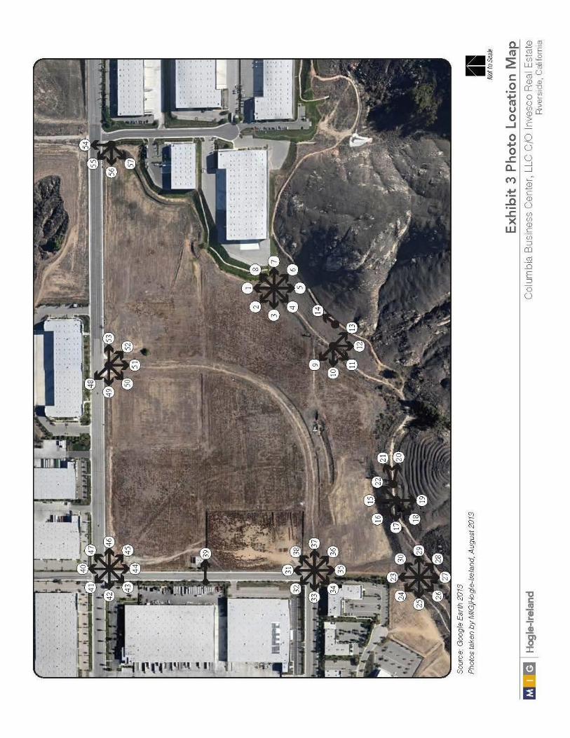
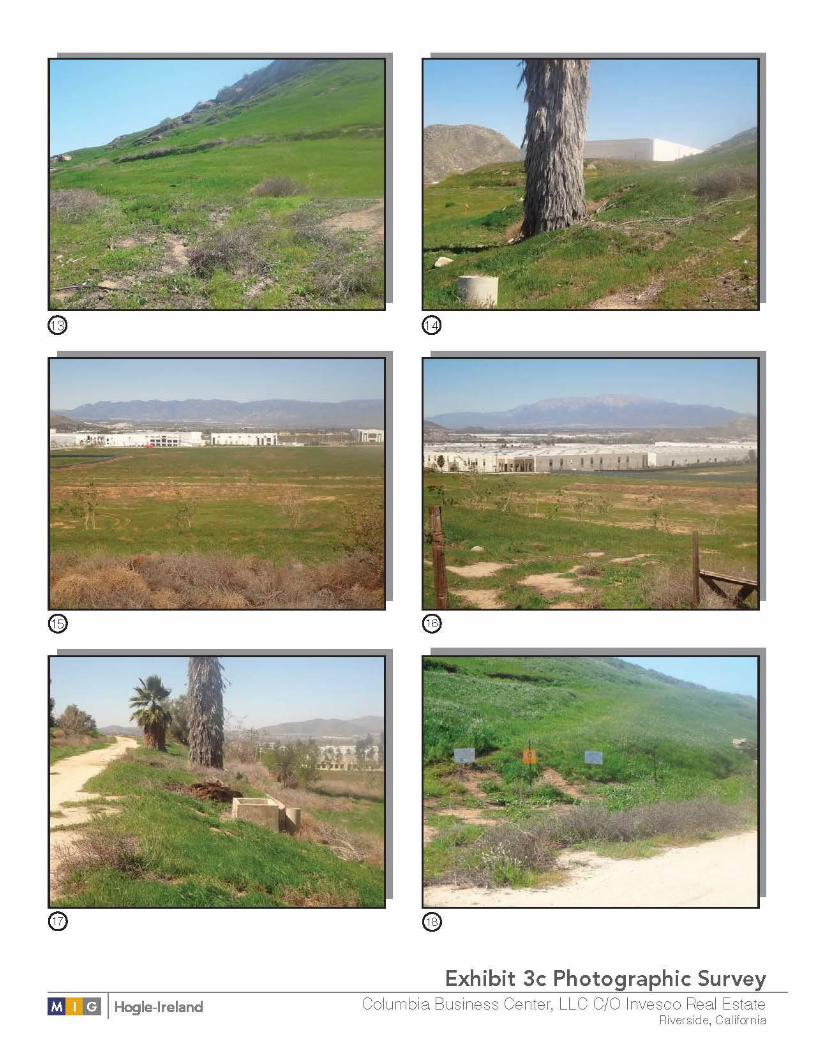
Exhibit 3
Photographic Survey

14 Initial Study

Columbia Business Center 15

16 Initial Study

Columbia Business Center 17

18 Initial Study
Columbia Business Center 19

20 Initial Study

Columbia Business Center 21

22 Initial Study

Columbia Business Center 23

24 Initial Study

Columbia Business Center 25

26 Initial Study

Columbia Business Center 27

28 Initial Study

Columbia Business Center 29

30 Initial Study

Columbia Business Center 31

32 Initial Study

Columbia Business Center 33

34 Initial Study

Columbia Business Center 35
3 Determination
3.1 – Environmental Factors Potentially Affected
The environmental factors checked below would be potentially affected by this project, involving
at least one impact that is a ‘Potentially Significant Impact’ as indicated by the checklist on the
following pages.
□ Aesthetics □ Agriculture Resources □ Air Quality
□ Biological Resources □ Cultural Resources □ Geology /Soils
□ Greenhouse Gas
Emissions □ Hazards & Hazardous
Materials □ Hydrology / Water
Quality
□ Land Use / Planning □ Mineral Resources □ Noise
□ Population / Housing □ Public Services □ Recreation
□ Transportation/Traffic □ Utilities / Service
Systems □ Mandatory Findings
of Significance
3.2 – Determination
□
The City of Riverside finds that the proposed project COULD NOT have a significant
effect on the environment, and a NEGATIVE DECLARATION will be prepared.
The City of Riverside finds that although the proposed project could have a significant
effect on the environment, there will not be a significant effect in this case because
revisions in the project have been made by or agreed to by the project proponent. A
MITIGATED NEGATIVE DECLARATION will be prepared.
□
The City of Riverside findsthat the proposed project MAY have a significant effect on
the environment, and an ENVIRONMENTAL IMPACT REPORT is required.
□
The City of Riverside finds that the proposed project MAY have a ‘potentially significant
impact’ or ‘potentially significant unless mitigated’ impact on the environment, but at
least one effect 1) has been adequately analyzed in an earlier document pursuant to
applicable legal standards, and 2) has been addressed by mitigation measures based
on the earlier analysis as described on attached sheets. An ENVIRONMENTAL IMPACT
REPORT is required, but it must analyze only the effects that remain to be addressed.
□
The City of Riverside finds that although the proposed project could have a significant
effect on the environment, because all potentially significant effects (a) have been
analyzed adequately in an earlier EIR or NEGATIVE DECLARATION pursuant to
applicable standards, and (b) have been avoided or mitigated pursuant to that earlier
EIR or NEGATIVE DECLARATION, including revisions or mitigation measures that are
imposed upon the proposed project, nothing further is required.
Signature
Date
City of Riverside
Printed Name & Title

36 Initial Study

Columbia Business Center 37
4 Evaluation of Environmental Impacts
4.1 – Aesthetics
Would the project:
Potentially
Significant Impact
Less Than Significant with
Mitigation
Incorporation
Less Than Significant
Impact
No Impact
a) Have a substantial adverse
effect on a scenic vista? □ □ □
b) Substantially damage scenic
resources, including, but not
limited to, trees, rock
outcroppings, and historic
buildings within view from a
state scenic highway?
□ □ □
c) Substantially degrade the
existing visual character or
quality of the site and its
surroundings?
□ □ □
d) Create a new source of
substantial light or glare which
would adversely affect day or
nighttime views in the area?
□ □ □
a) Less Than Significant Impact. Scenic vistas can be impacted by development in two
ways. First, a structure may be constructed that blocks the view of a vista. Second, the vista itself
may be altered (i.e., development on a scenic hillside). The project site is currently vacant and
surrounded by industrial uses to the north, west, and east. The Box Springs Mountains are
located to the south of the project site. No state scenic highways are located within or adjacent to
the City limits, according to the State of California Department of Transportation (Caltrans)
California Scenic Highway Mapping System Web Site.1 Palmyrita Avenue is designated as a
Special Boulevard by the City of Riverside that meets local criteria for designation as a scenic
route, but is not a State Designated or Eligible Scenic Highway. Views of the Box Springs
Mountain from Palmyrita Avenue may be blocked as the southern boundary of the project site is
adjacent to the Box Springs Mountain Regional Park boundaries. However, the project is proposed
within an area designated for industrial uses and the surrounding land along Palmyrita Avenue is
developed with similar industrial uses. Riverside Municipal Code Chapter 19.130 requires that all
development in the Business Manufacturing Park (BMP) zone have a maximum building height of
45 feet with no special restrictions for development along Special Boulevards. An eleven-foot
variance has been requested to allow Building A to reach a height of 56 feet at its highest point.
The proposed Building A will have a maximum height of 56 feet, Building B will have a maximum
height of 44 feet, and Building C will have a maximum height of 42 feet.
1 California Department of Transportation. California Scenic Highway Mapping System.
http://www.dot.ca.gov/hq/LandArch/scenic_highways/ [July 2013]

Evaluation of Environmental Impacts
38 Initial Study
b) Less Than Significant Impact. The project is not adjacent to a designated state scenic
highway as identified on the California Scenic Highway Mapping System.2 The project site is
currently vacant and contains no scenic resources. The proposed project includes the construction
of three warehouse buildings that are consistent in type and scale with the existing and planned
development in the vicinity. The Box Springs Mountains are located immediately south of the
project site. Palmyrita Avenue is currently fully developed with industrial use with the exception of
the proposed project site. Buildings B and C will be in compliance with height limits as required by
the Riverside Municipal Code, and a variance has been requested for Building A, which has a
proposed height of 56 feet . The project will result in less than significant impacts.
c) Less Than Significant Impact. Degradation of visual character or quality is defined by
substantial changes to the existing site appearance through construction of structures such that
they are poorly designed or conflict with the site’s existing surroundings.
Construction of the proposed buildings on the existing vacant site would alter the existing visual
character of the site. However, the project site is located in an area designated for industrial use.
Palmyrita Avenue is developed with similar uses with industrial/warehouse buildings to the west,
north, and east of the project site. The project will comply with all pertinent design requirements
of the Zoning Code, specifically those related to industrial warehouse land uses, to assure quality
site design and building architecture that is well constructed and is consistent with the character
of the area. The City of Riverside General Plan EIR states that Citywide design guidelines prevent
the use of highly reflective surfaces and metal siding. The buildings will be of concrete tilt up
panel style construction with architecturally enhanced main entrance and blue window glazing.
Perimeter and interior landscaping is also proposed. With design features included, the project
will have less than significant impacts on the visual character of the site and the surroundings.
d) Less Than Significant Impact with Mitigation Incorporation. Excessive or
inappropriately directed lighting can adversely impact night-time views by reducing the ability to
see the night sky and stars. Glare can be caused from unshielded or misdirected lighting sources.
Reflective surfaces (i.e., polished metal) can also cause glare. Impacts associated with glare
range from simple nuisance to potentially dangerous situations (i.e., if glare is directed into the
eyes of motorists).
Development of the proposed project will require installation of outdoor lighting necessary for
public safety and maintenance, as well as to accommodate nighttime business operations. All
lighting will comply with the development standards contained in the City’s Zoning Code.
Municipal Code Chapter 19.590 (Performance Standards) requires that on-site lighting be
arranged as to reflect away from adjoining property or any public streets. Light shall not be
directed skyward or in a manner that interferes with aircraft operation.
The proposed project could involve nighttime industrial activities that would result in additional
sources of light in the night. However, the project site is surrounded by industrial uses to the
north, west, and east and there is currently substantial nighttime lighting in the surrounding
areas of the project site due to the surrounding developments. Addition of new sources of
permanent light and glare as a result of implementation of the proposed project would not
significantly increase ambient lighting in the project vicinity. Moreover, due to the built nature of
the project area, there is a significant existing amount of ambient light both in the project area
and in the immediately surrounding vicinity.
2 California Department of Transportation. California Scenic Highway Mapping System.
http://www.dot.ca.gov/hq/LandArch/scenic_highways/ [July 2013]
Evaluation of Environmental Impacts
Columbia Business Center 39
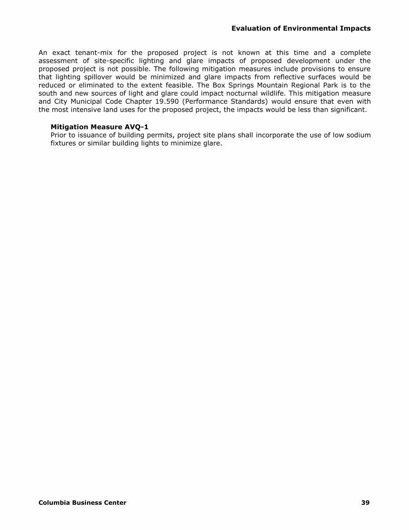
An exact tenant-mix for the proposed project is not known at this time and a complete
assessment of site-specific lighting and glare impacts of proposed development under the
proposed project is not possible. The following mitigation measures include provisions to ensure
that lighting spillover would be minimized and glare impacts from reflective surfaces would be
reduced or eliminated to the extent feasible. The Box Springs Mountain Regional Park is to the
south and new sources of light and glare could impact nocturnal wildlife. This mitigation measure
and City Municipal Code Chapter 19.590 (Performance Standards) would ensure that even with
the most intensive land uses for the proposed project, the impacts would be less than significant.
Mitigation Measure AVQ-1
Prior to issuance of building permits, project site plans shall incorporate the use of low sodium
fixtures or similar building lights to minimize glare.

Evaluation of Environmental Impacts
40 Initial Study
4.2 – Agriculture and Forest Resources
Would the project:
Potentially Significant
Impact
Less Than Significant
with Mitigation
Incorporation
Less Than Significant
Impact
No Impact
a) Convert Prime Farmland, Unique
Farmland, or Farmland of Statewide
Importance (Farmland), as shown on
the maps prepared pursuant to the
Farmland Mapping and Monitoring
Program of the California Resources
Agency, to non-agricultural use?
□ □ □
b) Conflict with existing zoning for
agricultural use, or a Williamson Act
contract? □ □ □
c) Conflict with existing zoning for, or
cause rezoning of, forest land (as
defined in Public Resources Code
section 12220(g)), timberland (as
defined by Public Resources Code
section 4526), or timberland zoned
Timberland Production (as defined by
Government Code section 51104 (g))?
□ □ □
d) Result in loss of forest land or
conversion of forest land to non-forest
use? □ □ □
e) Involve other changes in the existing
environment which, due to their
location or nature, could result in
conversion of Farmland to non-
agricultural use or conversion of forest
land to non-forest use?
□ □ □
a) Less Than Significant Impact. As indicated in the California Department of Conservation
Division of Land Resource Protection and the City of Riverside General Plan EIR, the project site is
identified as being farmland of local importance.34 The project site was historically used as citrus
groves, but is no longer in cultivation today. There is evidence of soil removal as part of a
previous planned industrial storage project that was halted around 2007-2008. The project site is
no longer used as farmland and is surrounded to the west, north, and east by industrial
development. In addition, the project site is not designated or zoned for agricultural use
3 California Department of Conservation. Division of Land Resource Protection. Farmland Mapping and
Monitoring Program. [July 2013] 4 Albert A. Webb Associates. City of Riverside General Plan 2025 Program Environmental Impact Report.
July 2007.

Evaluation of Environmental Impacts
Columbia Business Center 41
according to the General Plan and Zoning Map. Therefore, the proposed project will not result in
the conversion of Prime Farmland, Unique Farmland, or Farmland of Statewide Importance.
Impacts will be less than significant.
b) No Impact. As indicated by the 2007 Riverside General Plan EIR, the project site was
identified as being on Williamson Act enrolled land.5 However, since preparation of the Riverside
General Plan EIR, the status of the Williamson Act has changed. According to the Department of
Conservation Division of Land Resource Protection, the project site is not located on Williamson
Act enrolled land.6 In addition the project is currently zoned as Business Manufacturing Park and
is within the Hunter Business Park Specific Plan Industrial Park District which designates the site
for industrial use. Therefore, there will be no conflict with existing zoning for agricultural use or a
Williamson Act contract and impacts will be no impacts.
c) No Impact. Public Resources Code Section 12220(g) identifies forest land as ‘land that
can support 10-percent native tree cover of any species, including hardwoods, under natural
conditions, and that allows for management of one or more forest resources, including timber,
aesthetics, fish and wildlife, biodiversity, water quality, recreation, and other public benefits.’ The
project site and surrounding properties are not currently being managed or used for forest land as
identified in Public Resources Code Section 12220(g). The project site has been cleared of all
vegetation and is zoned for industrial uses, with no vegetation onsite. Therefore, development of
this project will have no impact to any timberland zoning.
d) No Impact. The project site is vacant and cleared with no substantial vegetation; thus,
there will be no loss of forest land or conversion of forest land to non-forest use as a result of this
project.
e) No Impact. The project site is currently vacant and cleared with no substantial
vegetation. The project is surrounded by other developed industrial properties to the west, north,
and east with little to no trees. None of the surrounding sites contain existing forest uses.
Development of this project will not change the existing environment in a manner that will result
in the conversion of forest land to a non-forest use.
5 Albert A. Webb Associates. City of Riverside General Plan 2025 Program Environmental Impact Report.
July 2007. 6 California Department of Conservation. Division of Land Resource Protection.
ftp://ftp.consrv.ca.gov/pub/dlrp/wa/ [February 2014]

Evaluation of Environmental Impacts
42 Initial Study
4.3 – Air Quality
Where available, the significance criteria established by the applicable air quality
management or air pollution control district may be relied upon to make the following
determinations. Would the project:
Potentially Significant
Impact
Less Than Significant
with Mitigation Incorporation
Less Than Significant
Impact
No Impact
a) Conflict with or obstruct
implementation of the applicable
air quality plan? □ □ □
b) Violate any air quality standard or
contribute substantially to an
existing or projected air quality
violation?
□ □ □
c) Result in a cumulatively
considerable net increase of any
criteria pollutant for which the
project region is non-attainment
under an applicable federal or
state ambient air quality standard
(including releasing emissions
which exceed quantitative
thresholds for ozone precursors)?
□ □ □
d) Expose sensitive receptors to
substantial pollutant
concentrations? □ □ □
e) Create objectionable odors
affecting a substantial number of
people? □ □ □
a) Less Than Significant Impact. A significant impact could occur if the proposed project
conflicts with or obstructs implementation of the South Coast Air Basin 2012 Air Quality
Management Plan (AQMP). Conflicts and obstructions that hinder implementation of the AQMP can
delay efforts to meet attainment deadlines for criteria pollutants and maintaining existing
compliance with applicable air quality standards. Pursuant to the methodology provided in
Chapter 12 of the 1993 South Coast Air Quality Management District (SCAQMD) CEQA Air Quality
Handbook, consistency with the South Coast Air Basin 2012 AQMP is affirmed when a project (1)
does not increase the frequency or severity of an air quality standards violation or cause a new
violation and (2) is consistent with the growth assumptions in the AQMP.7 A consistency review is
presented below:
7 South Coast Air Quality Management District. CEQA Air Quality Handbook. 1993

Evaluation of Environmental Impacts
Columbia Business Center 43
1. The project would result in short-term construction and long-term pollutant emissions that are
less than the CEQA significance emissions thresholds established by the SCAQMD, with
mitigation incorporated, as demonstrated in Section 6.3 et seq of this report; therefore, the
project could not result in an increase in the frequency or severity of any air quality standards
violation and will not cause a new air quality standard violation.
2. The CEQA Air Quality Handbook indicates that consistency with AQMP growth assumptions
must be analyzed for new or amended General Plan elements, Specific Plans, and significant
projects. Significant projects include airports, electrical generating facilities, petroleum and
gas refineries, designation of oil drilling districts, water ports, solid waste disposal sites, and
off-shore drilling facilities; therefore, the proposed project is not defined as significant. This
project includes a General Plan and Specific Plan Amendment to vacate the Columbia Avenue
Loop. Elimination of the Columbia Avenue Loop affects the Mobility Element alone. The Land
Use Element and any assumptions used to estimate employee generation for the RTP will not
be affected. Therefore consistency analysis with the AQMP will not be required.
Based on the consistency analysis presented above, the proposed project will not conflict with the
AQMP.
b) Less Than Significant Impact With Mitigation Incorporated. A project may have a
significant impact if project related emissions would exceed federal, state, or regional standards
or thresholds, or if project-related emissions would substantially contribute to existing or project
air quality violations. The proposed project is located within the South Coast Air Basin, where
efforts to attain state and federal air quality standards are governed by the SCAQMD. Both the
State of California (State) and the Federal government have established health-based ambient air
quality standards (AAQS) for seven air pollutants (known as ‘criteria pollutants’). These pollutants
include ozone (O3), carbon monoxide (CO), nitrogen dioxide (NO2), sulfur dioxide (SO2), inhalable
particulate matter with a diameter of 10 microns or less (PM10), fine particulate matter with a
diameter of 2.5 microns or less (PM2.5), and lead (Pb). The state has also established AAQS for
additional pollutants. The AAQS are designed to protect the health and welfare of the populace
within a reasonable margin of safety. Where the state and federal standards differ, California
AAQS are more stringent than the national AAQS.
Air pollution levels are measured at monitoring stations located throughout the air basin. Areas
that are in nonattainment with respect to federal or state AAQS are required to prepare plans and
implement measures that will bring the region into attainment. Table 2 (South Coast Air Basin
Attainment Status) summarizes the attainment status in the Basin for the criteria pollutants.
Discussion of potential impacts related to short-term construction impacts and long-term area
source and operational impacts are presented below.

Evaluation of Environmental Impacts
44 Initial Study
Table 2
South Coast Air Basin Attainment Status
Pollutant Federal State
O3 (1-hr) -- Nonattainment
O3 (8-hr) Nonattainment Nonattainment
PM10 Nonattainment Nonattainment
PM2.5 Nonattainment Nonattainment
CO Attainment Attainment
NO2 Attainment Nonattainment
SO2 Attainment Attainment
Pb Nonattainment Nonattainment
VRP -- Unclassified
SO4 -- Attainment
H2S -- Unclassified
Sources: ARB 2013
Construction Emissions The California Emissions Estimator Model (CalEEMod) version 2013.2.2 was utilized to estimate
emissions from the proposed construction activities (see Appendix A, Air Quality/GHG
Assessment).8 Considering the site is relatively flat, no import or export of soil is anticipated. The
three buildings will not be built concurrently, but consecutively. Construction of Building A was
modeled with a beginning construction date of January 2015. Default CalEEMod construction
phases were utilized. If construction should start at a later date, emissions will be slightly reduced
due to higher efficiency in construction equipment.
Based on the results of the model, maximum daily emissions from the construction of all three
buildings will result in excessive emissions of volatile organic chemicals (identified as reactive
organic gases) associated with interior and exterior coating activities. Using the default
assumption of 250 grams per liter (g/l) VOC content for interior and exterior coatings, daily VOC
emissions would reach 623.95 lbs/day during summer and winter months in 2018 for Building A,
570.6 lbs/day during summer and winter months in 2020 for Building B, and 223.5 lbs/day for
summer and winter months in 2021 for Building C.
To compensate for excessive VOC emissions from coating activities for Building A, the model
includes use of a maximum zero g/l VOC content for interior coatings and 100 g/l VOC content for
exterior surfaces. Use of low-VOC coatings during construction activities will reduce VOC
emissions to 63.2 lbs/day during summer and winter months, less than the threshold established
by SCAQMD. The use of a maximum of zero g/l VOC content for interior coatings and 125 g/l
VOC content for exterior surfaces for Building B will reduce VOC emissions to 71.7 g/l during
summer and winter months, less than the SCAQMD threshold. The use of a maximum of 50 g/l
VOC content for interior coatings and 150 g/l VOC content for exterior surfaces for Building C will
reduce VOC emissions to 67.3 g/l during summer and winter months, less than the SCAQMD
threshold. The requirement for use of low-VOC coatings has been included as Mitigation Measure
AQ-1 in Section 8 of this report. The results of the CalEEMod outputs with mitigation incorporated
are summarized in Table 3 (Building A Maximum Daily Construction Emissions), Table 4 (Building
8 MIG|Hogle-Ireland, Inc. Columbia Business Center Air Quality and Climate Change Assessment.
November 2013.

Evaluation of Environmental Impacts
Columbia Business Center 45
B Maximum Daily Construction Emissions), and Table 5 (Building C Maximum Daily Construction
Emissions).
Table 3
Building A Maximum Daily Construction Emissions (lbs/day)
Source ROG NOX CO SO2 PM10 PM2.5
Summer 63.22 79.16 115.37 0.22 21.36 12.83
Winter 63.23 79.17 117.49 0.21 21.36 12.83
Threshold 75 100 550 150 150 55
Substantial? No No No No No No
Table 4
Building B Maximum Daily Construction Emissions (lbs/day)
Source ROG NOX CO SO2 PM10 PM2.5
Summer 71.71 59.62 47.86 0.11 20.63 12.16
Winter 71.71 59.63 48.93 0.10 20.63 12.16
Threshold 75 100 550 150 150 55
Substantial? No No No No No No
Table 5
Building C Maximum Daily Construction Emissions (lbs/day)
Source ROG NOX CO SO2 PM10 PM2.5
Summer 67.27 38.93 33.75 0.06 20.20 11.76
Winter 67.27 38.94 33.68 0.06 20.20 11.76
Threshold 75 100 550 150 150 55
Substantial? No No No No No No
Mitigation Measure AQ-1
Prior to issuance of building permits, the project proponent shall submit, to the satisfaction of
the Community Development Director, a Coating Restriction Plan (CRP), consistent with South
Coast Air Quality Management District (SCAQMD) guidelines and a letter agreeing to include in
any construction contracts and/or subcontracts a requirement that the contractors adhere to
the requirements of the CRP. The CRP measures shall be implemented to the satisfaction of
the Building and Safety Division. These shall include the following:
Building A
• The volatile organic compounds (VOC) of proposed architectural coatings shall not exceed
zero for interior applications.
• The volatile organic compounds (VOC) of proposed architectural coatings shall not exceed
100 g/l for exterior applications.
Building B
• The volatile organic compounds (VOC) of proposed architectural coatings shall not exceed
zero for interior applications.
• The volatile organic compounds (VOC) of proposed architectural coatings shall not exceed
125 g/l for exterior applications.
Building C
• The volatile organic compounds (VOC) of proposed architectural coatings shall not exceed
50 g/l for interior applications.
• The volatile organic compounds (VOC) of proposed architectural coatings shall not exceed
150 g/l for exterior applications.

Evaluation of Environmental Impacts
46 Initial Study
This measure shall conform to the performance standard that emissions of volatile organic
compounds from application of interior or exterior coatings shall not exceed the daily
emissions thresholds established by the SCAQMD. The CRP shall specify use of High-Volume,
Low Pressure (HVLP) spray guns for application of coatings.
The following lists existing regulatory requirements and standards that are required to be
implemented as part of the proposed project. While the following measures are not considered
mitigation pursuant to the CEQA, the Lead Agency may choose to include the following as
conditions of approval to ensure that they are appropriately implemented.
S1 To reduce diesel emissions associated with construction, construction contractors shall
provide temporary electricity to eliminate the need for diesel powered generators, or
provide evidence that electrical hook ups at construction sites are not cost effective or
feasible.
S2 To reduce construction related particulate matter air quality impacts of City projects, the
following measures shall be required:
The generation of dust shall be controlled as required by the AQMD;
Grading activities shall cease during period of high winds (greater than 25 mph);
Trucks hauling soil, dirt or other emissive materials shall have their loads covered with
a tarp or other protective cover as determined by the City Engineer; and
The contractor shall prepare and maintain a traffic control plan, prepared, stamped and
signed by either a licensed Traffic Engineer or a Civil Engineer. The preparation of the
plan shall be in accordance with Chapter 5 of the latest edition of the Caltrans Traffic
Manual and the State Standard Specifications. The plan shall be submitted for
approval, by the engineer, at the preconstruction meeting. Work shall not commence
without an approved traffic control plan.
Operational Emissions Long-term criteria air pollutant emissions will result from the operation of the proposed business
park. Long-term emissions are categorized as area source emissions, energy demand emissions,
and operational emissions. Operational emissions will result from automobile, truck, and other
vehicle sources associated with daily trips to and from the warehouse. The California Emissions
Estimator Model (CalEEMod) was utilized to estimate mobile source emissions. Buildings A and B
were modeled as unrefrigerated warehouses without rail spurs. The smaller Building C was input
as Industrial Park but the program values were adjusted to reflect the proposed warehouse use.
Building C was input as a different use to account for the differences in trip generation.
Trip generation and fleet mix (1.68 daily trips per 1,000 SF for high-cube warehouse Buildings A
and B and 3.56 daily trips per 1,000 square feet for warehouse Building C) are based on trip
generation rates and fleet mix used in the Traffic Study prepared by Kunzman Associates. The
heavy duty fleet mix is comprised of approximately 12.3 percent heavy-heavy-duty (HHD), 4.6
percent medium-heavy-duty (MHD), and 3.5 percent light-heavy-duty (LHD1). The remaining
79.6 percent of the fleet mix is allocated to passenger vehicles (LDA). It should be noted that
emissions modeled in CalEEMod do not account for the five-minute idling restrictions required by
State law. Idling emissions factors were reduced to account for these regulations. Trip lengths
have been adjusted based on a study of metropolitan commercial and freight travel conducted by
the National Cooperative Highway Research Program. According to observed data collected in the
field for the Southern California Association of Governments (SCAG) region, trip lengths for
warehouse uses are estimated at 5.92 miles for light-duty trucks, 13.06 for medium-duty trucks,
and 22.40 for heavy-duty trucks. Total vehicle miles were calculated using the average daily trips

Evaluation of Environmental Impacts
Columbia Business Center 47
for each vehicle class and divided by total daily truck trips to get to an average truck distance of
17.41 miles. Assuming an opening year of 2020 with the building occupied and operational, the
total results of the CalEEMod model for summer and winter conditions are summarized in Table 6
(Long-Term Unmitigated Daily Emissions).
Area source emissions are the combination of many small emissions sources that include use of
outdoor landscape maintenance equipment, use of consumer products such as cleaning products,
and periodic repainting of the proposed buildings. Energy demand emissions result from use of
electricity and natural gas. Emissions from area and energy sources were estimated using
CalEEMod defaults, except for consumer product emissions. Due to an error in CalEEMod that
calculates emissions from non-building square-footages (such as the project landscaping), the
ROG emissions factor for consumer products was adjusted to 0.0000116 pounds per square foot
per day to account for the error. Area and energy source emissions are included in Table 6. Based
on the results of the model, maximum daily operational emissions associated with the proposed
project will exceed the thresholds established by SCAQMD for NOX.
Table 6
Long-Term Unmitigated Daily Emissions (lbs/day)
Source ROG NOX CO SO2 PM10 PM2.5
Summer
Area Sources 50.40 0.003 0.32 0.00 0.001 0.001
Energy Demand 0.09 0.84 0.71 0.005 0.06 0.06
Mobile Sources 8.58 58.10 124.29 0.52 33.41 9.79
Summer Total 59.07 58.94 125.32 0.53 33.47 9.86
Winter
Area Sources 50.40 0.003 0.32 0.00 0.001 0.001
Energy Demand 0.09 0.84 0.71 0.005 0.06 0.06
Mobile Sources 8.83 60.37 128.32 0.50 33.41 9.80
Winter Total 59.31 61.21 129.35 0.51 33.48 9.86
Threshold 55 55 550 150 150 55
Substantial? No Yes No No No No
In order to meet the SCAQMD daily threshold, NOX emissions must be reduced by a minimum of
11.3 percent. It should be noted that individual operation of each building will not in and of itself
cause the threshold to be exceeded, thus the required reduction applies to operation of all three
buildings as a whole. To mitigate operational emissions of NOX, pursuant to the on-road engines
mitigation guidance provided by SCAQMD, NOX emissions were analyzed with application of a NOX
filter.9 Emissions reduction technology has the capability to remove a minimum of 25 percent NOX
emissions from on-road diesel vehicles and would thus reduce NOX emissions to below the
SCAQMD threshold.10 Other strategies for reducing NOX emissions include the use of trucks with
engine years of 1990 or newer, limiting the number of trucks operating on a daily basis, or
demonstrating that truck trip length is less than that used in CalEEMod (17.41 miles). With
emissions reduction technology in effect or similar emissions reduction strategies, NOX emissions
will not exceed the daily threshold established by SCAQMD. The requirement for incorporation of
filter technology or implementation of other strategies is incorporated as Mitigation Measure AQ-
2.
Mitigation Measure AQ-2
9 South Coast Air Quality Management District. Mitigation Measures and Control Efficiencies, On-Road
Engines. Table IV – Mitigation Measures, Level 1,2, and 3 Retrofits for On-Road Engines. http://www.aqmd.gov/ceqa/handbook/mitigation/onroad/MM_onroad.html [December 2013]
10 California Air Resources Board. Executive Order DE-08-007. December 2008

Evaluation of Environmental Impacts
48 Initial Study
Prior to issuance of occupancy permits or business licenses, future tenants of the proposed
project shall submit a report to the Community Development Director identifying all diesel
engine powered trucks within the occupant’s fleet and verification that oxides of nitrogen
emissions will be reduced by a minimum of 11.3 percent below typical operating conditions.
Emissions may be reduced through installation of oxide of nitrogen filters as verified by the
California Air Resources Board through executive order, limiting of truck engine years to 1990
or newer, limiting operational truck trips and/or trip length, or any combination of methods
that will otherwise not cause the South Coast Air Quality Management District (SCAQMD) daily
threshold for oxides of nitrogen to be exceeded. This report shall be updated upon occupancy
by a new tenant.
c) Less Than Significant Impact. Cumulative short-term, construction-related emissions
from the project will not contribute considerably to any potential cumulative air quality impact
because short-term project emissions will be less than significant and other concurrent
construction projects in the region will be required to implement standard air quality regulations
and mitigation pursuant to State CEQA requirements, just as this project has. Short-term
construction-related cumulative impacts would thus be less than significant.
The SCAQMD CEQA Air Quality Handbook identifies methodologies for analyzing long-term
cumulative air quality impacts for criteria pollutants for which the Basin is nonattainment. These
methodologies identify three performance standards that can be used to determine if long-term
emissions will result in cumulative impacts. Essentially, these methodologies assess growth
associated with a land use project and are evaluated for consistency with regional projections.
These methodologies are outdated, and are no longer recommended by SCAQMD.
As discussed above, the proposed project is consistent with current land use designations and is
consistent with the growth assumptions in the AQMP. Therefore, the proposed project will not
contribute to any potential cumulative air quality impacts.
d) Less Than Significant Impact. Sensitive receptors are those segments of the population
that are most susceptible to poor air quality such as children, the elderly, the sick, and athletes
who perform outdoors. Land uses associated with sensitive receptors include residences, schools,
playgrounds, childcare centers, athletic facilities, long-term health care facilities, rehabilitation
centers, convalescent centers, and retirement homes. There are no sensitive receptors in
proximity to the project site.
SCAQMD has established thresholds for emissions of toxic air contaminants. Toxic air emissions
from a project are considered potentially significant if maximum incremental cancer risk is greater
than 10 persons in 1,000,000 (1E-05). Cancer risk is determined by calculating the annual
average toxic concentration (µg/m3) and multiplying it by the unit risk factor (URF) for the toxic
and the lifetime exposure adjustment (LEA) of the receptor. URF represents the estimated
probability that a person will contract cancer as a result of inhalation of a toxic of 1 µg/m3
continuously over 70 years. Because some receptors are exposed to toxics for less than 70 years
(i.e. off-site workers), the LEA adjusts the receptors exposure to represent actual exposure time.
The LEA for residential uses and other sensitive receptors is 1, representing an assumed exposure
of 70 continuous years. When a facility and its equipment operate continuously (i.e., 24 hrs/day
and 365 days/yr), the LEA for an off-site worker is 0.14. For all other facility operating schedules,
the LEA for an off-site worker is 0.66. In this report, industrial uses are assumed to operate
continuously and commercial uses are assumed to operate during regular business hours (i.e.
8:00AM to 5:00PM). Cancer risk is estimated using the following equation:
CRDPM = CDPM * URFDPM * LEA

Evaluation of Environmental Impacts
Columbia Business Center 49
where,
CRDPM Cancer risk from diesel particulate matter; the probability of
an individual developing cancer as a result of exposure to DPM
CDPM Annual average DPM concentration in μg/m3
URFDPM Unit risk factor for DPM; estimated probability that a person
will contract cancer as a result of inhalation of a DPM concentration
of 1 μg/m3 continuously over a period pf 70 years
LEA Lifetime exposure adjustment; values range from 0.14 to 1.0; see
the discussion below
Acute and chronic non-cancer risks are considered significant if the project toxic air contaminant
emissions result in a hazard index greater than or equal to 1. The hazard index is determined by
calculating the average annual toxic concentration (µg/m3) divided by the reference exposure
level (REL) for a particular toxic. The REL is the concentration at which no adverse health impacts
are anticipated and is established by OEHHA. The chronic REL for DPM was established by OEHHA
as 5 μg/m3. Non-cancer risk is estimated using the following equation:
HIDPM = CDPM/RELDPM
where,
HIDPM Hazard Index; an expression of the potential for non-cancer
health effects.
CDPM Annual average DPM concentration (μg/m3)
RELDPM Reference exposure level (REL) for DPM; the DPM concentration at
which no adverse health effects are anticipated.
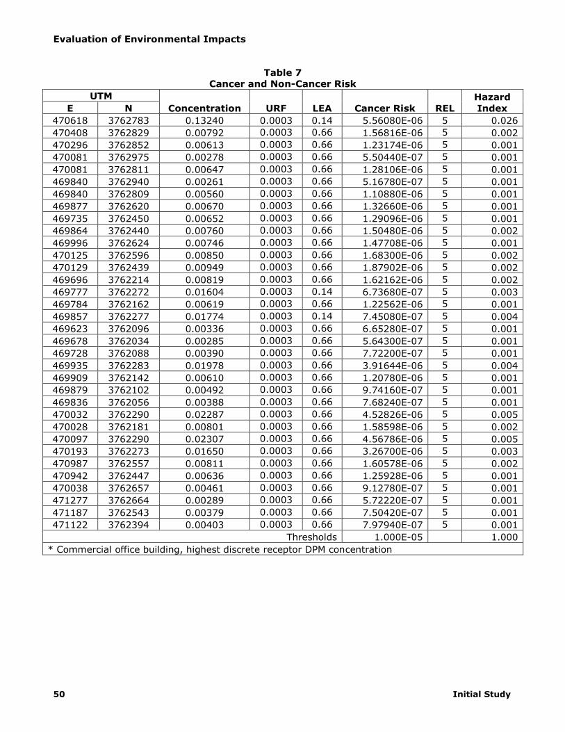
Discrete and grid receptor concentrations are detailed in the Health Risk Assessment prepared for
the project. The highest concentration of DPM will occur at a commercial office building, located at
555 Technology Court, east of Research Park Drive (UTM 470097 Easting, 3762290 Northing) and
west of the project site (See Appendix B, Health Risk Assessment). As summarized in Table 7
(Cancer and Non-Cancer Risk), incremental increases at this facility are less than the threshold of
10 in one million established by SCAQMD. The non-cancer hazard index at this facility is 0.005.
This hazard index value is less than the threshold of 1.0 established by SCAQMD. The calculations
in Table 7 show that no receptor will be exposed to an increase in cancer or non-cancer health
risks in excess of SCAQMD thresholds.
Evaluation of Environmental Impacts
50 Initial Study
Table 7
Cancer and Non-Cancer Risk
UTM
Concentration URF LEA Cancer Risk REL
Hazard
Index E N
470618 3762783 0.13240 0.0003 0.14 5.56080E-06 5 0.026
470408 3762829 0.00792 0.0003 0.66 1.56816E-06 5 0.002
470296 3762852 0.00613 0.0003 0.66 1.23174E-06 5 0.001
470081 3762975 0.00278 0.0003 0.66 5.50440E-07 5 0.001
470081 3762811 0.00647 0.0003 0.66 1.28106E-06 5 0.001
469840 3762940 0.00261 0.0003 0.66 5.16780E-07 5 0.001
469840 3762809 0.00560 0.0003 0.66 1.10880E-06 5 0.001
469877 3762620 0.00670 0.0003 0.66 1.32660E-06 5 0.001
469735 3762450 0.00652 0.0003 0.66 1.29096E-06 5 0.001
469864 3762440 0.00760 0.0003 0.66 1.50480E-06 5 0.002
469996 3762624 0.00746 0.0003 0.66 1.47708E-06 5 0.001
470125 3762596 0.00850 0.0003 0.66 1.68300E-06 5 0.002
470129 3762439 0.00949 0.0003 0.66 1.87902E-06 5 0.002
469696 3762214 0.00819 0.0003 0.66 1.62162E-06 5 0.002
469777 3762272 0.01604 0.0003 0.14 6.73680E-07 5 0.003
469784 3762162 0.00619 0.0003 0.66 1.22562E-06 5 0.001
469857 3762277 0.01774 0.0003 0.14 7.45080E-07 5 0.004
469623 3762096 0.00336 0.0003 0.66 6.65280E-07 5 0.001
469678 3762034 0.00285 0.0003 0.66 5.64300E-07 5 0.001
469728 3762088 0.00390 0.0003 0.66 7.72200E-07 5 0.001
469935 3762283 0.01978 0.0003 0.66 3.91644E-06 5 0.004
469909 3762142 0.00610 0.0003 0.66 1.20780E-06 5 0.001
469879 3762102 0.00492 0.0003 0.66 9.74160E-07 5 0.001
469836 3762056 0.00388 0.0003 0.66 7.68240E-07 5 0.001
470032 3762290 0.02287 0.0003 0.66 4.52826E-06 5 0.005
470028 3762181 0.00801 0.0003 0.66 1.58598E-06 5 0.002
470097 3762290 0.02307 0.0003 0.66 4.56786E-06 5 0.005
470193 3762273 0.01650 0.0003 0.66 3.26700E-06 5 0.003
470987 3762557 0.00811 0.0003 0.66 1.60578E-06 5 0.002
470942 3762447 0.00636 0.0003 0.66 1.25928E-06 5 0.001
470038 3762657 0.00461 0.0003 0.66 9.12780E-07 5 0.001
471277 3762664 0.00289 0.0003 0.66 5.72220E-07 5 0.001
471187 3762543 0.00379 0.0003 0.66 7.50420E-07 5 0.001
471122 3762394 0.00403 0.0003 0.66 7.97940E-07 5 0.001
Thresholds 1.000E-05 1.000
* Commercial office building, highest discrete receptor DPM concentration

Evaluation of Environmental Impacts
Columbia Business Center 51
A carbon monoxide (CO) hotspot is an area of localized CO pollution that is caused by severe
vehicle congestion on major roadways, typically near intersections. CO hotspots have the
potential to violate state and federal CO standards at intersections, even if the broader Basin is in
attainment for federal and state levels. In general, SCAQMD and the California Department of
Transportation Project-Level Carbon Monoxide Protocol (CO Protocol) recommend analysis of CO
hotspots when a project increases traffic volumes at an intersection by more than two percent
that is operating at LOS D or worse.11 12 According to Section 3.1.3 of the Protocol, the project is
not regionally significant and therefore is only required to examine local impacts. A regionally
significant project is a transportation project on a facility that serves regional transportation
needs.
Localized impacts are analyzed in Protocol Section 4. The local analysis procedures in Section
4.7.1 indicate that the project has the potential to worsen air quality (as defined for Protocol
purposes only) because it will result in an increase in the number of vehicles operating in cold
start mode by more than two percent. Cold Start mode refers to a vehicle started after an hour or
more being turned off. Outbound passenger vehicle trips during the afternoon peak hour will
increase by approximately 21 percent at the intersection of Palmyrita Avenue at Michigan Avenue
(105 project-related peak hour trips to 495 existing intersection peak hour trips). The project will
also increase average daily trip (ADT) by approximately 42 percent (2,090 project-related ADT to
4,950 existing intersection ADT) and will likely result in some decrease in average speeds due to
the increased traffic at the project site ingresses and egresses. The local analysis procedures then
direct to Protocol Sections 4.7.3 and 4.7.4. These sections indicate that if the project involves
signalized intersections performing at Level of Service (LOS) E or worse then the project will be
subject to a screening analysis. The proposed project will involve signalized intersections
operating at LOS E or worse as identified in the project traffic study and thus requires a screening
analysis.
Section 4.4 references Appendix A of the Protocol for screening purposes; however, because of
the age of the assumptions used in the screening procedures, they are no longer acceptable. The
Sacramento Metropolitan Air Quality Management District (SAQMD) developed a screening
threshold that states that any project involving an intersection experiencing 31,600 vehicles per
hour or more will require detailed analysis.13 The project will not involve an intersection
experiencing this level of traffic; therefore, the project passes the screening analysis and impacts
are deemed acceptable. Based on the local analysis procedures, the project is satisfactory
pursuant to the Protocol and will not result in a CO hotspot.
e) No Impact. According to the CEQA Air Quality Handbook, land uses associated with odor
complaints include agricultural operations, wastewater treatment plants, landfills, and certain
industrial operations (such as manufacturing uses that produce chemicals, paper, etc.). The
proposed project is sited within an existing industrial area. The proposed warehouses are not
considered sensitive receptors and therefore would not be substantially affected by potential
odors from existing industrial operations. The proposed warehouses, in turn, do not produce
odors that would affect a substantial number of people considering that the proposed warehouses
will not result in the manufacturing of any products and that there are no sensitive receptors in
the project vicinity; no impact will occur.
11 California Department of Transportation. Transportation Project-Level Carbon Monoxide Protocol. 1997 12 South Coast Air Quality Management District. Initial Study (IS) and Draft Mitigated Negative Declaration
(Draft MND) for the Proposed Project No. P200500723 The Alabama Business Center – Industrial Warehouse Facility. September 2006
13 Sacramento Metropolitan Air Quality Management District. CEQA Guide. May 2011

Evaluation of Environmental Impacts
52 Initial Study
4.4 – Biological Resources
Would the project:
Potentially Significant
Impact
Less Than Significant
with Mitigation
Incorporation
Less Than Significant
Impact
No Impact
a) Have a substantial adverse effect,
either directly or through habitat
modifications, on any species
identified as a candidate,
sensitive, or special status species
in local or regional plans, policies,
or regulations, or by the California
Department of Fish and Game or
U.S. Fish and Wildlife Service?
□ □ □
b) Have a substantial adverse effect
on any riparian habitat or other
sensitive natural community
identified in local or regional
plans, policies, regulations, or by
the California Department of Fish
and Game or US Fish and Wildlife
Service?
□ □ □
c) Have a substantial adverse effect
on federally protected wetlands as
defined by Section 404 of the
Clean Water Act (including, but
not limited to, marsh, vernal pool,
coastal, etc.) through direct
removal, filling, hydrological
interruption, or other means?
□ □ □
d) Interfere substantially with the
movement of any native resident
or migratory fish or wildlife
species or with established native
resident or migratory wildlife
corridors, or impede the use of
native wildlife nursery sites?
□ □ □
e) Conflict with any local policies or
ordinances protecting biological
resources, such as a tree
preservation policy or ordinance?
□ □ □

Evaluation of Environmental Impacts
Columbia Business Center 53
f) Conflict with the provisions of an
adopted Habitat Conservation
Plan, Natural Community
Conservation Plan, or other
approved local, regional, or state
habitat conservation plan?
□ □ □
a) Less Than Significant Impact With Mitigation Incorporation. The project site has
been cleared in preparation of a previous development plan and currently lacks any substantial
vegetation. The biological assessment prepared for the project observed isolated buckwheat
scrub along the southern border of the project site (see Appendix C, Biological Assessment).
Adjacent to the project boundary to the south is a small stand of red willow, mulefat and tree
tobacco within the drainage. Because these are isolated, fragmented occurrences, the impact
will be less than significant. The site survey noted suitable burrowing owl habitat on the site,
but no owls were observed during the time of the survey, and no burrowing owls are expected
to occupy the site as long as the site is maintained regularly for weed control.14 Although the
biological site assessment determined that impacts would be less than significant, the following
mitigation measure is required to ensure that impacts would remain less than significant.
Mitigation Measure BIO-1
A focused survey for burrowing owl shall be conducted 30 days prior to any project
construction-related ground disturbance. The survey should be conducted according to the
recommended guidelines of The Burrowing Owl Consortium (1993) as adopted under the
WRCMSHCP. If animals are present, the following shall be required:
As compensation for the direct loss of burrowing owl nesting and foraging habitat, the
project proponent shall mitigate by acquiring and permanently protecting known burrowing
owl nesting and foraging habitat at the following ratios (per The Burrowing Owl Consortium
1993 and the WRCMSHCP):
1. Replacement of occupied habitat with occupied habitat at 1.5 times 6.5 acres per pair or
single bird;
2. Replacement of occupied habitat with habitat contiguous with occupied habitat at 2
times 6.5 acres per pair or single bird; and/or
3. Replacement of occupied habitat with suitable unoccupied habitat at 3 times 6.5 acres
per pair or single bird.
All owls associated with occupied burrows, that will be directly impacted (temporarily or
permanently) by the project, shall be relocated and the following measures shall be
implemented to avoid take of owls:
1. Occupied burrows shall not be disturbed during the nesting season of February 1
through August 31, unless a qualified biologist can verify through non-invasive methods
that either the owls have not begun egg laying and incubation or that juveniles from the
occupied burrows are foraging independently and are capable of independent flight.
14 Natural Resources Assessment, Inc. Burrowing Owl Habitat Assessment, Assessor’s Parcel Numbers 257-
040-15, 18, 19, 20, 21, 22, 257-050-21, 22, 23, Columbia Business Center, Riverside, California. May
16, 2013.

Evaluation of Environmental Impacts
54 Initial Study
2. Owls must be relocated by a qualified biologist from any occupied burrows that will be
impacted by project activities. Suitable habitat must be available adjacent to or near the
disturbance site or artificial burrows will need to be provided nearby. Once the biologist
has confirmed that the owls have left the burrow, burrows should be excavated using
hand tools and refilled to prevent reoccupation.
3. All relocation shall be approved by the California Department of Fish and Wildlife
(Department). A qualified biologist shall monitor the relocated owls a minimum of three
days per week for a minimum of three weeks. A report summarizing the results of the
relocation and monitoring shall be submitted to the Department within 30 days
following completion of the relocation and monitoring of the owls.
4. A Burrowing Owl Mitigation and Monitoring Plan shall be submitted to the Department
for review and approval prior to relocation of owls. The Burrowing Owl Mitigation and
Monitoring Plan shall describe proposed relocation and monitoring actions. The Plan
shall include the number and location of occupied burrow site and details on adjacent or
nearby suitable habitat available to owls for relocation. If no suitable habitat is available
nearby for relocation, details regarding the creation of artificial burrows (numbers,
location, and type of burrows) shall also be included in the plan. The Plan shall also
describe proposed off-site areas that are preserved to compensate for impacts to
burrowing owls/occupied burrows at the project site as required under Condition 1.
b) No Impact. The project site has been cleared and does not contain any riparian features or
habitat. No impact will occur.
c) No Impact. According to the federal National Wetlands Inventory, there are no data for
the project site. The project site does not contain any wetlands and the proposed project will
not disturb any offsite wetlands (see Section 4.9 for discussion of project drainage
features).15 In addition, the project biological assessment indicated that no wetlands occur
on the project site. No impact will occur.
d) No Impact. The project site is surrounded by development on three sides, the site
assessment determined that the fragmentation of habitat is preventing the use of the project
site and surrounding area as a wildlife corridor. No impact will occur.
e) No Impact. The City of Riverside Municipal Code Section 15.08.020 prohibits the
removal of trees or shrubs planted or growing in the public streets except pursuant to the
policy established by the Park and Recreation Commission. The project site does not have
any trees or shrubs growing in the street, therefore no street trees or shrubs will be
removed. Therefore, no impact will occur.
ff) No Impact. The proposed project is part of the Western Riverside County Multiple
Species Habitat Conservation Plan (MSHCP). The MSHCP is a multi-jurisdictional habitat-
planning effort with the goal of maintaining biological and ecological diversity within a
rapidly urbanizing region.16 The MSHCP complies with Section 10(a)(2)(A) of the 1973
federal Endangered Species Act (FESA) and allows the “incidental take” of a listed species
with an Incidental Take Permit. Continued participation with the MSHCP is desired by the
15 United States Fish and Wildlife Service. National Wetlands Inventory.
http://107.20.228.18/Wetlands/WetlandsMapper.html# [August 28, 2012] 16 Western Riverside County Multiple Species Habitat Conservation Plan.
http://www.rctlma.org/mshcp/volume1/sec1.html#1.1 [July 2013]

Evaluation of Environmental Impacts
Columbia Business Center 55
City and any new proposed project is required to comply with applicable provisions of the
plan. No impact will result.

Evaluation of Environmental Impacts
56 Initial Study
4.5 – Cultural Resources
Would the project:
Potentially Significant
Impact
Less Than Significant
with Mitigation Incorporation
Less Than Significant
Impact
No Impact
a) Cause a substantial adverse change
in the significance of a historical
resource as defined in '15064.5? □ □ □
b) Cause a substantial adverse change
in the significance of an
archaeological resource pursuant to
'15064.5?
□ □ □
c) Directly or indirectly destroy a
unique paleontological resource or
site or unique geologic feature? □ □ □
d) Disturb any human remains,
including those interred outside of
formal cemeteries? □ □ □
a) Less Than Significant Impact. The project site was historically used for citrus groves
and is currently cleared and vacant. The Historical/Archaeological Resources Survey conducted by
CRM Tech suggests that the project remained unsettled throughout the historic period, and was
probably used only for agricultural purposes (see Appendix D, Historical/Archaeological Resources
Survey). In the mid-1850s, when the U.S. government conducted the earliest systematic land
surveys in the Riverside area, the only built features found in the project vicinity were several
roads passing nearby. No other evidence of human activities was reported in or near the project
area at the time.
In the 1930s, a winding dirt road was observed along the southeastern edge of the project area,
skirting around the base of the Sugarloaf/Box Springs Mountain. Other sources indicated that the
course of the road was roughly identical to that of the irrigation line operated by the Riverside
Highland Water Company, suggesting that it was almost certainly a maintenance road for the
irrigation works. Originally built as a wooden flume in the 1890s, the irrigation line was replaced a
short time later with a concrete flume at grade. Around 1939, a concrete pipeline was placed
inside the concrete flume and then covered with topsoil. The Riverside Highland Water Company
evidently diverted from Warm Creek, and the buried pipeline reportedly extended from the
northern side of the Riverside-San Bernardino county line to Marlboro Avenue, just to the south of
the project location.
During the 1950’s-1960’s, the entire project area was occupied by orchards, presumably citrus
groves. Citrus cultivation continued on the property through a least the 1970s, and partially into
the current century. Other than the citrus groves and the roads along the perimeters, including
the maintenance road along the Riverside Highland Water Company pipeline, no notable features
of the built environment were reported within or immediately adjacent to the project area in the
1950s-1970s.

Evaluation of Environmental Impacts
Columbia Business Center 57
During the field survey, irrigation features were noted along the southern project boundary. They
were recorded into the California Historical Resources Inventory during this survey, and
subsequently designated Site 33-022126/CA-RIV-11333 by the EIC. Among the features recorded
at the site were a segment of mostly buried concrete pipeline and remnants of the irrigation
system for the citrus groves that once occupied the property, including eleven concrete
standpipes and four concrete weir boxes.
The pipeline is exposed at some spots, demonstrating a diameter of 1.5 feet, and apparently
remains functional. The length of the entire pipeline is unknown, but the length within the project
area is approximately 1,800 feet. Judging by its location and course along the base of the
Sugarloaf/Box Springs Mountain, this is the pipeline built by the Riverside Highland Water
Company around 1939. The pipeline is no longer in use and will be demolished and removed prior
to project construction.
The other features at Site 33-022126, once parts of the water delivery system for the citrus
groves covering the property, are typical of the fragmented remnants of historic-period
agricultural infrastructure that are commonly found on former farmlands throughout southern
California. Features like these generally do not bear a close association with the productive lives
of important historic figures or significant events even if their historical background can be better
documented from available sources. There is no evidence that these features embody the
distinctive characteristics of any type, period, region, or method of construction. Based on these
considerations, Site 33-022126 does not appear eligible for listing in the National Register of
Historic Places or the California Register for Historical Resources, or for local designation by the
City of Riverside. Impacts will be less than significant.
b) Less Than Significant Impact with Mitigation Incorporation. The project site has
been previously graded and will not involve import or export of soil. Any buried archaeological
resources would have already been uncovered or destroyed at the time of initial grading of the
project site. In addition, in a letter dated April 19, 2013 (see Appendix D), the Native American
Heritage Commission stated that the there is no indication of Native American cultural resources
in the project area. However, such resources have been reported in close proximity of the project
site. In the unlikely event that archeological materials are uncovered, Mitigation Measure C-1 is
incorporated to ensure that uncovered resources are evaluated, left in place if possible, or curated
as recommended by a qualified anthropologist. Native American monitoring is included to provide
assistance in identifying potential resources, as requested through tribal consultation. Impacts to
buried archaeological resources will be less than significant with mitigation incorporation.
Mitigation Measure
C-1 If potential archaeological materials are uncovered during grading or other earth moving
activities, the contractor shall be required to halt work in the immediate area of the find
and to retain a professional archaeologist to examine the materials to determine whether
it is a unique archaeological resource as defined in Section 21083.2(g) of the State CEQA
Statutes. If this determination is positive, the resource shall be left in place, if determined
feasible by the project archaeologist. Otherwise, the scientifically consequential
information shall be fully recovered by the archaeologist. Work may continue outside of
the area of the find; however, no further work shall occur in the immediate location of the
find until all information recovery has been completed and a report concerning it filed with
the City Community Development Director. A tribal monitor shall be retained to oversee
earthmoving activities and assist in the identification of potential archaeological resources.
The applicant shall bear the cost of implementing this mitigation.
c) Less Than Significant Impact. The project site has been previously graded and will not
involve import or export of soil. Any buried paleontological resources would have already been
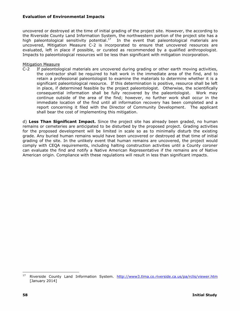
Evaluation of Environmental Impacts
58 Initial Study
uncovered or destroyed at the time of initial grading of the project site. However, the according to
the Riverside County Land Information System, the northwestern portion of the project site has a
high paleontological sensitivity potential.17 In the event that paleontological materials are
uncovered, Mitigation Measure C-2 is incorporated to ensure that uncovered resources are
evaluated, left in place if possible, or curated as recommended by a qualified anthropologist.
Impacts to paleontological resources will be less than significant with mitigation incorporation.
Mitigation Measure
C-2 If paleontological materials are uncovered during grading or other earth moving activities,
the contractor shall be required to halt work in the immediate area of the find, and to
retain a professional paleontologist to examine the materials to determine whether it is a
significant paleontological resource. If this determination is positive, resource shall be left
in place, if determined feasible by the project paleontologist. Otherwise, the scientifically
consequential information shall be fully recovered by the paleontologist. Work may
continue outside of the area of the find; however, no further work shall occur in the
immediate location of the find until all information recovery has been completed and a
report concerning it filed with the Director of Community Development. The applicant
shall bear the cost of implementing this mitigation.
d) Less Than Significant Impact. Since the project site has already been graded, no human
remains or cemeteries are anticipated to be disturbed by the proposed project. Grading activities
for the proposed development will be limited in scale so as to minimally disturb the existing
grade. Any buried human remains would have been uncovered or destroyed at that time of initial
grading of the site. In the unlikely event that human remains are uncovered, the project would
comply with CEQA requirements, including halting construction activities until a County coroner
can evaluate the find and notify a Native American Representative if the remains are of Native
American origin. Compliance with these regulations will result in less than significant impacts.
17 Riverside County Land Information System. http://www3.tlma.co.riverside.ca.us/pa/rclis/viewer.htm
[January 2014]
Evaluation of Environmental Impacts
Columbia Business Center 59
4.6 – Geology and Soils
Would the project:
Potentially Significant
Impact
Less Than Significant
with Mitigation Incorporation
Less Than Significant
Impact
No Impact
a) Expose people or structures to
potential substantial adverse
effects, including the risk of loss,
injury, or death involving:
i) Rupture of a known earthquake
fault, as delineated on the most
recent Alquist-Priolo Earthquake
Fault Zoning Map issued by the
State Geologist for the area or
based on other substantial evidence
of a known fault? Refer to Division
of Mines and Geology Special
Publication 42.
□ □ □
ii) Strong seismic ground shaking? □ □ □
iii) Seismic-related ground failure,
including liquefaction? □ □ □
iv) Landslides? □ □ □
b) Result in substantial soil erosion or
the loss of topsoil? □ □ □
c) Be located on a geologic unit or soil
that is unstable, or that would
become unstable as a result of the
project, and potentially result in on-
or off-site landslide, lateral
spreading, subsidence, liquefaction
or collapse?
□ □ □
d) Be located on expansive soil, as
defined in Table 18-1-B of the
Uniform Building Code (1997),
creating substantial risks to life or
property?
□ □ □

Evaluation of Environmental Impacts
60 Initial Study
e) Have soils incapable of adequately
supporting the use of septic tanks
or alternative waste water disposal
systems where sewers are not
available for the disposal of waste
water?
□ □ □
a.i) No Impact. The proposed project is not located on a known fault as delineated on the
Alquist-Priolo Earthquake Fault Zoning Map.18 No impact will occur.
a.ii) Less Than Significant Impact. The proposed project will be subject to ground shaking
impacts should a major earthquake occur in the future. Potential impacts include injury or loss of
life and property damage.
The proposed project is subject to the seismic design criteria of the California Building Code (CBC)
and the project-specific design requirements of the project geotechnical report. Adherence to
these requirements will reduce the potential of the buildings from collapse during an earthquake,
thereby minimizing injury and loss of life. Although structures may be damaged during
earthquakes, adherence to seismic design requirements will minimize damage to property within
the structure because the structure is designed not to collapse. The CBC is intended to provide
minimum requirements to prevent major structural failure and loss of life. Adherence to existing
regulations will reduce the risk of loss, injury, and death; impacts due to strong ground shaking
will be less than significant.
a.iii) Less Than Significant Impact. The Riverside General Plan EIR indicates that the project
is located within an area with low liquefaction potential.19 In addition, the geotechnical report
determined that subsurface conditions on site are not susceptible to liquefaction (see Appendix E,
Geotechnical Investigation/Geotechnical Infiltration Report).20 The proposed project would be
subject to standard CBC measures to provide for sound structural design that include
considerations for on-site soil conditions, occupancy, and the configuration of the structure
including the structural system and height. Therefore, based on the determination of the
geotechnical report that on-site conditions are not susceptible to liquefaction and with adherence
to CBC requirements, project impacts will be less than significant.
a.iv) Less Than Significant Impact. Structures built below or on slopes subject to failure or
landslides may expose people and structures to harm. The project site is relatively flat. However,
the Box Springs Mountain is located to the south of the site and contains slopes up to 30 percent
or more.21 General Plan Public Safety Policy PS-9.8 requires feasible mitigation of geologic
impacts to reduce risk to the community from hazards related to geologic conditions, seismic
activity, flooding and structural and wildland fires. Impacts will be reduced to less than significant
levels.
b) Less Than Significant Impact. Erosion and loss of topsoil could result in damage to on-
site structures and landscaping or to neighboring properties. Erosion can also impact downstream
18 California Department of Conservation. Special Study Zones. San Bernardino South Quadrangle. 1977. 19 Albert A. Webb Associates. City of Riverside General Plan 2025 Program Environmental Impact Report.
July 2007. 20 Southern California Geotechnical. Geotechnical Investigation Proposed Commercial/Industrial Buildings.
SEC Michigan Avenue and Palmyrita Avenue, Riverside, California for Columbia Business Center, LLC.
August 29, 2013. 21 Albert A. Webb Associates. City of Riverside General Plan 2025 Program Environmental Impact Report.
July 2007.

Evaluation of Environmental Impacts
Columbia Business Center 61
water bodies while loss of nutrient-rich topsoil impacts the ability for vegetation to grow. The
proposed project is subject to SCAQMD Rule 403 and the erosion control requirements of the CBC
to prevent wind-blown and stormwater-related erosion. Rule 403 will minimize wind-blown
erosion by requiring stabilization of disturbed soils during construction activities through
measures such as daily watering. Required erosion control plans will ensure that measures are
implemented at project sites to prevent or minimize erosion due to rain, ensuring that
downstream water bodies are protected from sedimentation. With implementation of existing
regulations, impacts due to erosion and loss of topsoil will be less than significant.
c) Less Than Significant Impact. As stated in the Section 4.a.iii), the soils on the project
site contain low potential for liquefaction. Based on the project site’s slope conditions being
relatively flat, potential for lateral spreading and landslide would be minimal. In addition,
groundwater is expected to be at a depth greater than 40.5 feet.22 The geotechnical report
prepared for the project site determined that near surface soils have the potential for collapse
when exposed to moisture infiltration and have potential for consolidation when exposed to load
increases in the range of those that would be exerted by the foundations of new structures. In
addition, minor shrinkage and ground subsidence has the potential to occur in the soils below the
zone of removal due to settlement and machinery. Standard CBC and recommendations from the
required preliminary soils report (Municipal Code Section 18.090.050) will be implemented during
grading. Impacts related to on- or off-site landslide, lateral spreading, subsidence, liquefaction or
collapse will be less than significant with implementation of the proposed recommendations
included in the geotechnical report.
d) No Impact. Expansive soils shrink and swell in response to moisture due to high
percentages of clay. Expansive soils can result in damage to structures when clay within the soil
swells due to moisture. The project site is not located on soil with high shrink-swell potential
according to the Riverside General Plan EIR.23 In addition, the geotechnical report prepared for
the project site found that the expansion potential of on-site soils is very low.24 No impact will
occur.
e) No Impact. The project site is served by a fully functional sewer system. The project will
connect to this system and will not require use of septic tanks. No impact will occur.
22 Southern California Geotechnical. Geotechnical Investigation Proposed Commercial/Industrial Buildings.
SEC Michigan Avenue and Palmyrita Avenue, Riverside, California for Columbia Business Center, LLC. August 29, 2013.
23 Albert A. Webb Associates. City of Riverside General Plan 2025 Program Environmental Impact Report. July 2007.
24 Southern California Geotechnical. Geotechnical Investigation Proposed Commercial/Industrial Buildings. SEC Michigan Avenue and Palmyrita Avenue, Riverside, California for Columbia Business Center, LLC.
August 29, 2013.
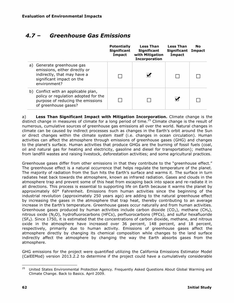
Evaluation of Environmental Impacts
62 Initial Study
4.7 – Greenhouse Gas Emissions
Potentially
Significant Impact
Less Than
Significant with Mitigation Incorporation
Less Than
Significant Impact
No
Impact
a) Generate greenhouse gas
emissions, either directly or
indirectly, that may have a
significant impact on the
environment?
□ □ □
b) Conflict with an applicable plan,
policy or regulation adopted for the
purpose of reducing the emissions
of greenhouse gases? □ □ □
a) Less Than Significant Impact with Mitigation Incorporation. Climate change is the
distinct change in measures of climate for a long period of time.25 Climate change is the result of
numerous, cumulative sources of greenhouse gas emissions all over the world. Natural changes in
climate can be caused by indirect processes such as changes in the Earth’s orbit around the Sun
or direct changes within the climate system itself (i.e. changes in ocean circulation). Human
activities can affect the atmosphere through emissions of greenhouse gases (GHG) and changes
to the planet’s surface. Human activities that produce GHGs are the burning of fossil fuels (coal,
oil and natural gas for heating and electricity, gasoline and diesel for transportation); methane
from landfill wastes and raising livestock, deforestation activities; and some agricultural practices.
Greenhouse gases differ from other emissions in that they contribute to the “greenhouse effect.”
The greenhouse effect is a natural occurrence that helps regulate the temperature of the planet.
The majority of radiation from the Sun hits the Earth’s surface and warms it. The surface in turn
radiates heat back towards the atmosphere, known as infrared radiation. Gases and clouds in the
atmosphere trap and prevent some of this heat from escaping back into space and re-radiate it in
all directions. This process is essential to supporting life on Earth because it warms the planet by
approximately 60° Fahrenheit. Emissions from human activities since the beginning of the
industrial revolution (approximately 250 years ago) are adding to the natural greenhouse effect
by increasing the gases in the atmosphere that trap heat, thereby contributing to an average
increase in the Earth’s temperature. Greenhouse gases occur naturally and from human activities.
Greenhouse gases produced by human activities include carbon dioxide (CO2), methane (CH4),
nitrous oxide (N2O), hydrofluorocarbons (HFCs), perfluorocarbons (PFCs), and sulfur hexafluoride
(SF6). Since 1750, it is estimated that the concentrations of carbon dioxide, methane, and nitrous
oxide in the atmosphere have increased over 36 percent, 148 percent, and 18 percent,
respectively, primarily due to human activity. Emissions of greenhouse gases affect the
atmosphere directly by changing its chemical composition while changes to the land surface
indirectly affect the atmosphere by changing the way the Earth absorbs gases from the
atmosphere.
GHG emissions for the project were quantified utilizing the California Emissions Estimator Model
(CalEEMod) version 2013.2.2 to determine if the project could have a cumulatively considerable
25 United States Environmental Protection Agency. Frequently Asked Questions About Global Warming and
Climate Change. Back to Basics. April 2009.

Evaluation of Environmental Impacts
Columbia Business Center 63
impact related to greenhouse gas emissions (see Appendix A, Air Quality/GHG Assessment).26 The
emissions inventory accounts for GHG emissions from construction activities and operational
activities.
Operation emissions associated with the proposed project would include GHG emissions from
mobile sources (transportation), energy, water use and treatment, waste disposal, and area
sources. GHG emissions from electricity use are indirect GHG emissions from the energy
(purchased energy) that is produced offsite. Area sources are owned or controlled by the project
(e.g., natural gas combustion, boilers, and furnaces) and produced onsite. Construction activities
are short term and cease to emit greenhouse gases upon completion, unlike operational
emissions that are continuous year after year until operation of the use ceases. Because of this
difference, SCAQMD recommends amortizing construction emissions over a 30-year operational
lifetime. This normalizes construction emissions so that they can be grouped with operational
emissions in order to generate a precise project-based GHG inventory. Total construction
emissions are summarized in Table 8 (Total Project Construction Greenhouse Gas Emissions).
Table 8
Total Project Construction Greenhouse Gas Emissions
GHG Emissions (MT/YR)
CO2 CH4 N2O TOTAL*
Building A 6,877.63 0.51 0.00 6,888.39
Building B 1,339.97 0.15 0.00 1,343.13
Building C 583.96 0.09 0.00 585.91
SUB-TOTAL 8,801.56 0.75 0.00 8,817.43
AMORTIZED TOTAL^ 293.39 0.025 0.00 293.91
* MTCO2E
Note: Slight variations may occur due to rounding and variations in
modeling software
^ Amortized over 30-years
A summary of the project’s long-term greenhouse gas emissions inventory is included in Table 9
(Long-Term Greenhouse Gas Emissions). The emissions inventory is presented as metric tons of
carbon dioxide equivalent (MTCO2E) meaning that all emissions have been weighted based on
their Global Warming Potential (GWP) (a metric ton is equal to 1.102 US short tons). Mobile
sources are based on annual vehicle miles traveled (VMT) based on daily trip generation identified
in the project traffic study.27 Trip lengths have been adjusted based on a study of metropolitan
commercial and freight travel conducted by the National Cooperative Highway Research Program.
According to observed data collected in the field for the Southern California Association of
Governments (SCAG) region, trip lengths for warehouse uses are estimated at 5.92 miles for
light-duty trucks, 13.06 for medium-duty trucks, and 22.40 for heavy-duty trucks. Total vehicle
miles were calculated using the average daily trips for each vehicle class and divided by total daily
truck trips to get to an average truck distance of 17.41 miles. Natural gas usage, electricity
usage, water/wastewater demand, and solid waste disposal are based on default demand figures
utilized in CalEEMod.
Landscape irrigation requirements were calculated using the California Department of Water
Resources (DWR) Water Budget Workbook that calculates the Maximum Applied Water Allowance
(MAWA) for landscaping based on the requirements of the state water conservation in landscaping
26 MIG|Hogle-Ireland, Inc. Columbia Business Center Air Quality & Climate Change Assessment. November
2013. 27 Kunzman Associates, Inc. Invesco Columbia Center Traffic Impact Analysis. May 30, 2014.
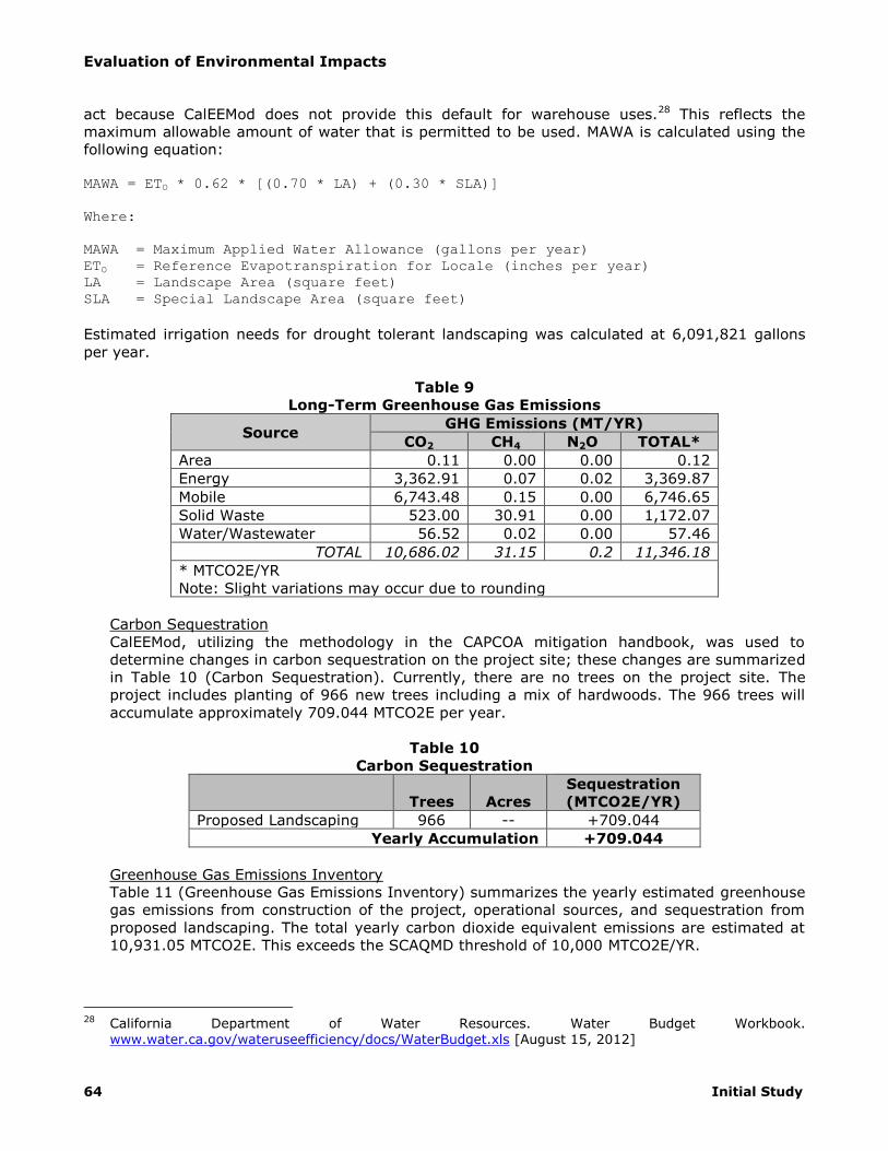
Evaluation of Environmental Impacts
64 Initial Study
act because CalEEMod does not provide this default for warehouse uses.28 This reflects the
maximum allowable amount of water that is permitted to be used. MAWA is calculated using the
following equation:
MAWA = ETO * 0.62 * [(0.70 * LA) + (0.30 * SLA)]
Where:
MAWA = Maximum Applied Water Allowance (gallons per year)
ETO = Reference Evapotranspiration for Locale (inches per year)
LA = Landscape Area (square feet)
SLA = Special Landscape Area (square feet)
Estimated irrigation needs for drought tolerant landscaping was calculated at 6,091,821 gallons
per year.
Table 9
Long-Term Greenhouse Gas Emissions
Source GHG Emissions (MT/YR)
CO2 CH4 N2O TOTAL*
Area 0.11 0.00 0.00 0.12
Energy 3,362.91 0.07 0.02 3,369.87
Mobile 6,743.48 0.15 0.00 6,746.65
Solid Waste 523.00 30.91 0.00 1,172.07
Water/Wastewater 56.52 0.02 0.00 57.46
TOTAL 10,686.02 31.15 0.2 11,346.18
* MTCO2E/YR
Note: Slight variations may occur due to rounding
Carbon Sequestration
CalEEMod, utilizing the methodology in the CAPCOA mitigation handbook, was used to
determine changes in carbon sequestration on the project site; these changes are summarized
in Table 10 (Carbon Sequestration). Currently, there are no trees on the project site. The
project includes planting of 966 new trees including a mix of hardwoods. The 966 trees will
accumulate approximately 709.044 MTCO2E per year.
Table 10
Carbon Sequestration
Trees Acres
Sequestration
(MTCO2E/YR)
Proposed Landscaping 966 -- +709.044
Yearly Accumulation +709.044
Greenhouse Gas Emissions Inventory
Table 11 (Greenhouse Gas Emissions Inventory) summarizes the yearly estimated greenhouse
gas emissions from construction of the project, operational sources, and sequestration from
proposed landscaping. The total yearly carbon dioxide equivalent emissions are estimated at
10,931.05 MTCO2E. This exceeds the SCAQMD threshold of 10,000 MTCO2E/YR.
28 California Department of Water Resources. Water Budget Workbook.
www.water.ca.gov/wateruseefficiency/docs/WaterBudget.xls [August 15, 2012]

Evaluation of Environmental Impacts
Columbia Business Center 65
Table 11
Greenhouse Gas Emissions Inventory
Source GHG Emissions (MT/YR)
CO2 CH4 N2O TOTAL*
Construction^ 293.39 0.025 0.00 293.91
Operational 10,686.02 31.15 0.02 11,346.18
SUB-TOTAL 10,979.41 31.18 0.02 11,640.09
Trees (Credit) -709.04 0.00 0.00 -709.04
Grand Total 10,270.37 31.18 0.02 10,931.05
* MTCO2E/YR
Note: Slight variations may occur due to rounding
^ Construction impacts amortized over 30-years
Greenhouse gas emissions from the project were evaluated in light of project design features
and existing regulations to determine if emissions could be reduced below the 10,000 MTCO2E
threshold without the need for incorporation of mitigation measures. Project design features
include energy efficiency building design and water efficient landscaping. Project design
features and regulatory requirements are listed below.
Emissions Reductions
High Efficiency Lighting (LE-1)
The project proponent will install high-efficiency lighting. High-efficiency for purposes of this
study is defined as a minimum 25 percent reduction in energy demand over typical lighting.
The requirement for use of high-efficiency lighting is incorporated as Mitigation Measure GHG-
1.
Water Efficient Landscaping (WUW-3)
Proposed landscaping has been designed to be water efficient in accordance with State and
City water efficient landscape requirements. Based on the proposed landscape design,
maximum allowable water use was calculated at 15,137,254 gallons. The estimated total
water use was calculated at 6,091,821 gallons, an approximate 59.8 percent reduction in
outdoor water demand.
Recycling Services (SW-1)
Pursuant to the mandatory commercial recycling requirements of AB341, a minimum of 50
percent of all solid waste will be recycled at each of the proposed warehouses.
With incorporation of Mitigation Measure GHG-1 and consideration of project design features and
existing regulatory requirements, the proposed warehouses will emit approximately 9,798.65
MTCO2E per year accounting for construction and operational sources as summarized in Table 12
(Mitigated Greenhouse Gas Emissions Inventory). This does not exceed the 10,000 MTCO2E/YR
thresholds established by SCAQMD.

Evaluation of Environmental Impacts
66 Initial Study
Table 12
Mitigated Greenhouse Gas Emissions Inventory
Source GHG Emissions (MT/YR)
CO2 CH4 N2O TOTAL*
Construction^ 293.39 0.025 0.00 293.91
Operational 9,879.22 15.68 0.02 10,213.78
SUB-TOTAL 10,172.61 15.71 0.02 10,507.69
Forest (Credit) -709.04 0.00 0.00 -709.04
Grand Total 9,464.57 15.71 0.02 9,798.65
* MTCO2E/YR
Note: Slight variations may occur due to rounding
^ Construction impacts amortized over 30-years
Mitigation Measure GHG-1
Prior to issuance of occupancy permits or business licenses, buildings shall have installed
high-efficiency lighting with a minimum reduction in energy demand of 25 percent below
typical lighting. Installation of high-efficiency lighting shall be verified by the Building and
Safety Division.
b) Less Than Significant Impact.. The SCAQMD supports State, Federal and international
policies to reduce levels of ozone depleting gases through its Global Warming Policy and rules and
has established an interim Greenhouse Gas (GHG) threshold. As indicated in Question A, above,
the project would comply with the City’s General Plan policies, Municipal Code Chapter 16.07
(Green Code), and State Building Code provisions designed to reduce GHG emissions. In
addition, the project would comply with all SCAQMD applicable rules and regulations during
construction of the project and, as demonstrated in the Climate Change Analysis, will not interfere
with the State’s goals of reducing GHG emission to 1990 levels by the year 2020 as stated in AB
32 and an 80 percent reduction in GHG emissions below 1990 levels by 2050 as stated in
Executive Order S-3-05. Based upon the prepared Climate Change Analysis for this project and
the discussion above, the project will not conflict with any applicable plan, policy or regulation
related to the reduction in the emissions of GHG and thus a less than significant impact will occur
directly, indirectly and cumulatively in this regard.

Evaluation of Environmental Impacts
Columbia Business Center 67
4.8 – Hazards and Hazardous Materials
Potentially Significant
Impact
Less Than Significant
with Mitigation Incorporation
Less Than Significant
Impact
No Impact
a) Create a significant hazard to the
public or the environment through
the routine transport, use, or
disposal of hazardous materials?
□ □ □
b) Create a significant hazard to the
public or the environment through
reasonably foreseeable upset and
accident conditions involving the
release of hazardous materials into
the environment?
□ □ □
c) Emit hazardous emissions or handle
hazardous or acutely hazardous
materials, substances, or waste
within one-quarter mile of an
existing or proposed school?
□ □ □
d) Be located on a site which is
included on a list of hazardous
materials sites compiled pursuant
to Government Code Section
65962.5 and, as a result, would it
create a significant hazard to the
public or the environment?
□ □ □
e) For a project located within an
airport land use plan or, where
such a plan has not been adopted,
within two miles of a public airport
or public use airport, would the
project result in a safety hazard for
people residing or working in the
project area?
□ □ □
f) For a project within the vicinity of a
private airstrip, would the project
result in a safety hazard for people
residing or working in the project
area?
□ □ □
g) Impair implementation of or
physically interfere with an adopted
emergency response plan or
emergency evacuation plan?
□ □ □
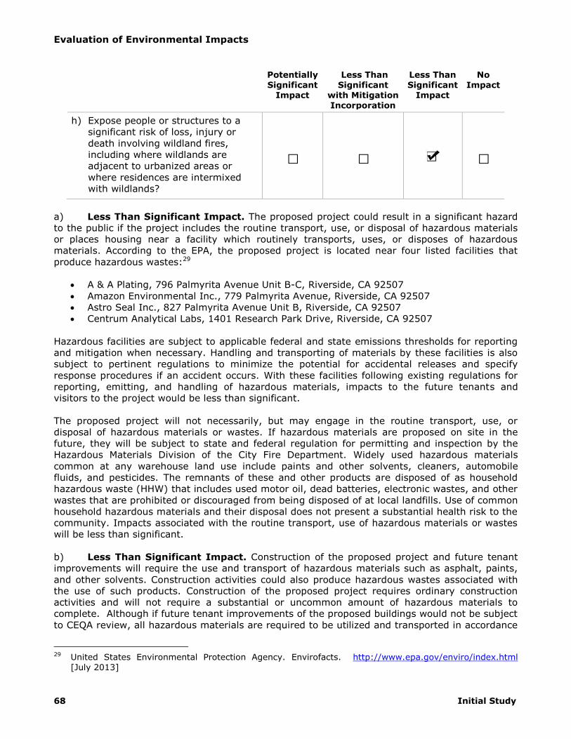
Evaluation of Environmental Impacts
68 Initial Study
Potentially Significant
Impact
Less Than Significant
with Mitigation Incorporation
Less Than Significant
Impact
No Impact
h) Expose people or structures to a
significant risk of loss, injury or
death involving wildland fires,
including where wildlands are
adjacent to urbanized areas or
where residences are intermixed
with wildlands?
□ □ □
a) Less Than Significant Impact. The proposed project could result in a significant hazard
to the public if the project includes the routine transport, use, or disposal of hazardous materials
or places housing near a facility which routinely transports, uses, or disposes of hazardous
materials. According to the EPA, the proposed project is located near four listed facilities that
produce hazardous wastes:29
A & A Plating, 796 Palmyrita Avenue Unit B-C, Riverside, CA 92507
Amazon Environmental Inc., 779 Palmyrita Avenue, Riverside, CA 92507
Astro Seal Inc., 827 Palmyrita Avenue Unit B, Riverside, CA 92507
Centrum Analytical Labs, 1401 Research Park Drive, Riverside, CA 92507
Hazardous facilities are subject to applicable federal and state emissions thresholds for reporting
and mitigation when necessary. Handling and transporting of materials by these facilities is also
subject to pertinent regulations to minimize the potential for accidental releases and specify
response procedures if an accident occurs. With these facilities following existing regulations for
reporting, emitting, and handling of hazardous materials, impacts to the future tenants and
visitors to the project would be less than significant.
The proposed project will not necessarily, but may engage in the routine transport, use, or
disposal of hazardous materials or wastes. If hazardous materials are proposed on site in the
future, they will be subject to state and federal regulation for permitting and inspection by the
Hazardous Materials Division of the City Fire Department. Widely used hazardous materials
common at any warehouse land use include paints and other solvents, cleaners, automobile
fluids, and pesticides. The remnants of these and other products are disposed of as household
hazardous waste (HHW) that includes used motor oil, dead batteries, electronic wastes, and other
wastes that are prohibited or discouraged from being disposed of at local landfills. Use of common
household hazardous materials and their disposal does not present a substantial health risk to the
community. Impacts associated with the routine transport, use of hazardous materials or wastes
will be less than significant.
b) Less Than Significant Impact. Construction of the proposed project and future tenant
improvements will require the use and transport of hazardous materials such as asphalt, paints,
and other solvents. Construction activities could also produce hazardous wastes associated with
the use of such products. Construction of the proposed project requires ordinary construction
activities and will not require a substantial or uncommon amount of hazardous materials to
complete. Although if future tenant improvements of the proposed buildings would not be subject
to CEQA review, all hazardous materials are required to be utilized and transported in accordance
29 United States Environmental Protection Agency. Envirofacts. http://www.epa.gov/enviro/index.html
[July 2013]

Evaluation of Environmental Impacts
Columbia Business Center 69
with their labeling pursuant to federal and state law. Because of these existing regulations,
construction activities do not pose a substantial risk to the public or the environment due to the
use of hazardous materials; impacts will be less than significant.
c) No Impact. No schools are located within one-quarter mile of the project site. Therefore,
no impact will occur.
d) No Impact. The proposed project is not located on a site listed on the State ‘Cortese List’,
a compilation of various sites throughout the state that have been compromised due to soil or
groundwater contamination from past uses. Therefore, no impact will occur.
Based upon review of the Cortese list, the project site is not:
listed as a hazardous waste and substance site by the Department of Toxic Substances
Control (DTSC),30
listed as a leaking underground storage tank (LUFT) site by the State Water Resources
Control Board (SWRCB),31
listed as a hazardous solid waste disposal site by the SWRCB,32
currently subject to a Cease and Desist Order (CDO) or a Cleanup and Abatement Order
(CAO) as issued by the SWRCB,33 or
developed with a hazardous waste facility subject to corrective action by the DTSC.34
In addition, a preliminary environmental site assessment was prepared for the northern portion of
the project site (see Appendix F, Preliminary Environmental Site Assessment). The proposed
project site was previously used for agricultural purposes. To ensure that contamination from
pesticide storage and use has not occurred, soil samples were collected at five locations. The
preliminary environmental site assessment concluded that there were no unusually high
concentrations of pesticides, herbicides, or heavy metals on site. There will be no impact.
e-f) No Impact. The proposed project is not located within two miles of a public or private
airstrip or within an airport land use plan. No Impact will occur.
g) Less Than Significant Impact. The proposed project site is currently vacant. The project
will therefore increase trips in the area. Per state Fire and Building codes, sufficient space will
have to be provided around the buildings for emergency personnel and equipment access and
emergency evacuation. All project elements, including landscaping, would be sited with sufficient
clearance from existing and proposed structures so as not to interfere with emergency access to
and evacuation from the site. The project is required to comply with the California Fire Code (Title
24, California Code of Regulations, Section 9). The site plan includes five ingress/egress access
points: four driveways on Palmyrita Avenue and one driveway on Michigan Avenue. One driveway
on Palmyrita Avenue and the driveway on Michigan Avenue will provide access to Building A, two
driveways on Palmyrita Avenue will provide access to Building B, and one driveway on Palmyrita
Avenue will provide access to Building C.
30 California Department of Toxic Substances Control. EnviroStor.
www.envirostor.dtsc.ca.gov/public/search.asp [July 2013] 31 California State Water Resources Control Board. GeoTracker. geotracker.waterboards.ca.gov [July 2013] 32 California State Water Resources Control Board. Sites Identified with Waste Constituents Above
Hazardous Waste Levels Outside the Waste Management Unit. www.calepa.ca.gov/SiteCleanup/CorteseList/CurrentList.pdf [July 2013]
33 California State Water Resources Control Board. List of Active CDO and CAO.
http://www.calepa.ca.gov/sitecleanup/corteselist/ [July 2013] 34 California Department of Toxic Substances Control. Hazardous Facilities Subject to Corrective Action.
www.calepa.ca.gov/SiteCleanup/CorteseList/SectionA.htm#Facilities [July 2013]

Evaluation of Environmental Impacts
70 Initial Study
The project driveways will allow emergency access and evacuation from the site, and would be
constructed to California Fire Code specifications. The project would not impair implementation of
or physically interfere with an adopted emergency response plan or evacuation plan because no
permanent public street or lane closures are proposed. Construction work in the street associated
with the buildings would be limited to lateral utility connections that would be limited to nominal
potential traffic diversion. Traffic control will be provided for any lane closures. Project impacts
would be less than significant.
h) Less Than Significant Impact. The project site has been graded and is surrounded to
the west, north, and east by other primarily developed parcels consisting of industrial land uses.
According to the Riverside General Plan EIR, the project site is not located in a high fire hazard
area.35 However, the Box Springs Mountain is located to the south of the project site, which is a
very high fire hazard area.
The entire project will be required to comply with the City Ordinances and State requirements
identified above through the Building and Safety plan check process. The proposed project will not
increase the risk from wildland fires beyond the risk that is currently surrounding the existing
project site, and will be required to comply with all regulations relating to fire hazards. Therefore,
based upon the project’s compliance with regulations to reduce risk from wildland fires, the
project will have a less than significant impact to exposing people or structures to wildfire.
35 Albert A. Webb Associates. City of Riverside General Plan 2025 Program Environmental Impact Report.
July 2007.

Evaluation of Environmental Impacts
Columbia Business Center 71
4.9 – Hydrology and Water Quality
Potentially Significant
Impact
Less Than Significant
with Mitigation Incorporation
Less Than Significant
Impact
No Impact
a) Violate any water quality standards
or waste discharge requirements? □ □ □
b) Substantially deplete groundwater
supplies or interfere substantially
with groundwater recharge such
that there would be a net deficit in
aquifer volume or a lowering of the
local groundwater table level (e.g.,
the production rate of pre-existing
nearby wells would drop to a level
which would not support existing
land uses or planned uses for which
permits have been granted)?
□ □ □
c) Substantially alter the existing
drainage pattern of the site or area,
including through the alteration of
the course of a stream or river, in a
manner which would result in
substantial erosion or siltation on-
or off-site?
□ □ □
d) Substantially alter the existing
drainage pattern of the site or area,
including through the alteration of
the course of a stream or river, or
substantially increase the rate or
amount of surface runoff in a
manner which would result in
flooding on- or off-site?
□ □ □
e) Create or contribute runoff water
which would exceed the capacity of
existing or planned stormwater
drainage systems or provide
substantial additional sources of
polluted runoff?
□ □ □
f) Otherwise substantially degrade
water quality? □ □ □

Evaluation of Environmental Impacts
72 Initial Study
Potentially Significant
Impact
Less Than Significant
with Mitigation Incorporation
Less Than Significant
Impact
No Impact
g) Place housing within a 100-year
flood hazard area as mapped on a
federal Flood Hazard Boundary or
Flood Insurance Rate Map or other
flood hazard delineation map?
□ □ □
h) Place within a 100-year flood
hazard area structures which would
impede or redirect flood flows? □ □ □
i) Expose people or structures to a
significant risk of loss, injury or
death involving flooding, including
flooding as a result of the failure of
a levee or dam?
□ □ □
j) Inundation by seiche, tsunami, or
mudflow? □ □ □
a) Less Than Significant Impact. Violations of water quality standards or waste discharge
requirements, or degradation of water quality can result in potentially significant impacts to water
quality and result in environmental damage or sickness in people. The project would result in a
significant impact to water quality if water quality standards, waste discharge requirements, or
degradation of water quality occurred.
Point-source pollutants can be traced to their original source. Point-source pollutants are
discharged directly from pipes or spills. Raw sewage draining from a pipe directly into a stream is
an example of a point-source water pollutant. The project consists of the development of three
warehouse buildings totaling 1,461,449 square feet and does not propose any uses that would
generate point source pollutants. Therefore, water quality impacts due to point sources would be
less than significant.
Non-point-source pollutants (NPS) cannot be traced to a specific original source. NPS pollution is
caused by rainfall or snowmelt moving over and through surface areas. As the runoff moves, it
picks up and carries away natural and human-made pollutants, finally depositing them into lakes,
rivers, wetlands, coastal waters, and even underground sources of drinking water. These
pollutants include:
Excess fertilizers, herbicides and insecticides from agricultural lands and residential areas
Oil, grease, and toxic chemicals from urban runoff and energy production
Sediment from improperly managed construction sites, crop and forest lands, and eroding
streambanks
Salt from irrigation practices and acid drainage from abandoned mines
Bacteria and nutrients from livestock, pet wastes, and faulty septic systems
Atmospheric deposition and hydromodification
Impacts associated with water pollution include ecological disruption and injury or death to flora
and fauna, increased need and cost for water purification, sickness or injury to people, and
degradation or elimination of water bodies as recreational opportunities. Accidents, poor site

Evaluation of Environmental Impacts
Columbia Business Center 73
management or negligence by property owners and tenants can result in accumulation of
pollutant substances on parking lots, loading and storage areas, or result in contaminated
discharges directly into the storm drain system.
The Santa Ana Regional Water Quality Control Board (RWQCB) administers the National Pollutant
Discharge Elimination System (NPDES) permit in the region. The City is required to implement all
pertinent regulations of the program to control pollution discharges from new development. These
regulations reduce NPS pollutant loading through the implementation of Best Management
Practices (BMPs) and other control measures that minimize or eliminate pollutants from urban
runoff, thereby protecting downstream water resources. BMPs implemented to address
commercial pollutant sources generally involve maintenance of storm drain facilities, parking lots,
vegetated areas, and educational programs. Violations of water quality standards due to urban
runoff can be prevented through the continued implementation of existing regional water quality
regulations. The proposed project would not interfere with the implementation of NPDES water
quality regulations and standards.
The proposed project would disturb approximately 72.5 acres of land and therefore will be subject
to National Pollutant Discharge Elimination System (NPDES) permit requirements during
construction activities in addition to standard NPDES operational requirements. The proposed
project will require submittal to the local reviewing agency, the Santa Ana RWQCB, a Storm
Water Pollution Prevention Plan (SWPPP) that will include BMPs protects water quality during
construction activities. The City will require BMPs as listed in the California Stormwater Quality
Association’s California Storm Water Best Management Practice Handbooks. These measures,
which include resident/owner education, activity restrictions, parking lot sweeping, basin
inspection, landscaping, roof runoff controls, efficient irrigation, slope and channel protection,
storm drain signage, trash racks, and trash storage areas, will reduce pollutants in storm water
runoff and reduce non-storm water discharges to the City's storm water drainage through
controlling the discharge of pollutants. Operational BMPs will be identified in a Stormwater Runoff
Management Plan that will be submitted to the City for review and approval. Impacts related to
violation of water quality standards will be less than significant with implementation of these
existing regulations.
b) Less Than Significant Impact. If the project removed an existing groundwater recharge
area or substantially reduced runoff that results in groundwater recharge, a potentially significant
impact could occur.
The site is currently vacant. The proposed project will construct impervious pavement with areas
of landscaping as well as two detention basins that could provide for similar levels of,
groundwater recharge compared to the existing conditions. The site does not accommodate any
substantial natural drainage or managed recharge areas. The project site is surrounded by
development to the west, north, and east. To the south is the Box Springs Mountain and regional
parkland. The City of Riverside is served by City of Riverside Public Utilities (RPU). Domestic
water is provided via groundwater basins. According to the General Plan EIR, recharge areas for
the primary groundwater aquifer utilized by RPU is located in other jurisdictions. Therefore,
development within the City of Riverside will not affect groundwater recharge. The project site is
not the location of an existing groundwater spreading basin and will not significantly change the
runoff from the project that may otherwise recharge groundwater basins; therefore, impacts to
groundwater recharge will be less than significant.
c) Less Than Significant Impact. Potentially significant impacts to the existing drainage
pattern of the site or area could occur if development of the project results in substantial on- or
off-site erosion or siltation. As was previously detailed in Section 3.9.b, the site is vacant but
surrounded by development to the west, north, and east. The project site is a currently vacant,

Evaluation of Environmental Impacts
74 Initial Study
dirt lot. The site generally surface drains north-westerly to Palmyrita Avenue and Michigan
Avenue.
Proposed on-site low impact development (LID) principles include the implementation of BMPs
including landscaping, bioretention areas, and ponding areas. A Project Specific Preliminary
Water Quality Management Plan (WQMP) has been prepared for the proposed project and is
included in Appendix G. The WQMP indentifies proposed drainage management areas and the
effectiveness of proposed BMPs. Implementation of bioretention and ponding BMPs will capture a
volume of approximately 149,360 cubic feet. According to the WQMP, proposed LID BMPs fully
address all drainage management areas and no alternative compliance measures are required for
the proposed project.
The design of the proposed project will not substantially alter drainage patterns in the area to the
extent that substantial on- or off-site erosion or siltation will occur; therefore, impacts will be less
than significant.
d) Less Than Significant Impact. As was previously detailed in Section 3.9.c herein, the
project would not result in an alteration of the drainage pattern or increase in flows that would
result in flooding on- or off-site because all on- and off-site drainage will be controlled by storm
drain and flood control facilities. The proposed project’s detention basins have been designed to
accommodate enough runoff to reduce proposed runoff to amounts that can be accommodated
with existing infrastructure. Impacts to flooding on- or off-site as a result of a change in the
drainage pattern or increase in runoff will thus be less than significant.
e) Less Than Significant Impact. A potentially significant impact could occur if the project
creates or contributes runoff that would exceed the capacity of existing or planned stormwater
drainage systems or provide substantial additional sources of runoff. As was previously detailed in
Section 3.9.c, project-related stormwater flows will be directed to the proposed water
quality/detention basins prior to outlet to existing storm drain facilities. The proposed water
quality function of the basins would reduce the amount of polluted runoff that would be conveyed
into the storm drain system. Impacts will be less than significant.
f) No Impact. The project does not propose any uses that will have the potential to
otherwise degrade water quality beyond those issues discussed in Section 3.9 herein.
g) No Impact. The project does not include housing, therefore no impact will occur.
h) Less Than Significant Impact. The proposed project is not located within a designated
100-year flood hazard area or zone.36 Therefore, the project will not impede or redirect flood
flows. The project will have a less than significant impact.
i) Less Than Significant Impact. The project site is not located within a dam inundation
area.37 Impacts due to levee failure will be less than significant.
j) Less Than Significant Impact. The project site is not located near any lakes or other
bodies of water that would be subject to potential seiche. The project site is located
approximately forty-eight miles from the Pacific Ocean. Due to the distance, no impact from
tsunami will occur.
36 Albert A. Webb Associates. City of Riverside General Plan 2025 Program Environmental Impact Report.
July 2007. 37 Albert A. Webb Associates. City of Riverside General Plan 2025 Program Environmental Impact Report.
July 2007.

Evaluation of Environmental Impacts
Columbia Business Center 75
There is potential for mudflow near the project site associated with erosion and fire damage that
may occur at the Box Springs Mountain. The area surrounding the Mountain is designated for
open space and recreation. If mudflow were to occur at the Box Springs Mountain, limited
nuisance mudflows may occur. The City requires standard construction BMPs to control erosion
and protect areas with steep slopes for all new developments. Impacts will be less than
significant.
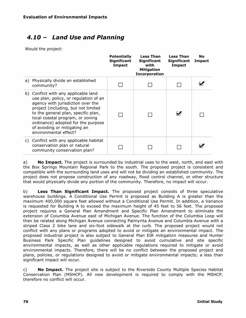
Evaluation of Environmental Impacts
76 Initial Study
4.10 – Land Use and Planning
Would the project:
Potentially Significant
Impact
Less Than Significant
with Mitigation
Incorporation
Less Than Significant
Impact
No Impact
a) Physically divide an established
community? □ □ □
b) Conflict with any applicable land
use plan, policy, or regulation of an
agency with jurisdiction over the
project (including, but not limited
to the general plan, specific plan,
local coastal program, or zoning
ordinance) adopted for the purpose
of avoiding or mitigating an
environmental effect?
□ □ □
c) Conflict with any applicable habitat
conservation plan or natural
community conservation plan? □ □ □
a) No Impact. The project is surrounded by industrial uses to the west, north, and east with
the Box Springs Mountain Regional Park to the south. The proposed project is consistent and
compatible with the surrounding land uses and will not be dividing an established community. The
project does not propose construction of any roadway, flood control channel, or other structure
that would physically divide any portion of the community. Therefore, no impact will occur.
b) Less Than Significant Impact. The proposed project consists of three speculative
warehouse buildings. A Conditional Use Permit is proposed as Building A is greater than the
maximum 400,000 square feet allowed without a Conditional Use Permit. In addition, a Variance
is requested for Building A to exceed the maximum height of 45 feet to 56 feet. The proposed
project requires a General Plan Amendment and Specific Plan Amendment to eliminate the
extension of Columbia Avenue east of Michigan Avenue. The function of the Columbia Loop will
then be related along Michigan Avenue connecting Palmyrita Avenue and Columbia Avenue with a
striped Class 2 bike lane and six-foot sidewalk at the curb. The proposed project would not
conflict with any plans or programs adopted to avoid or mitigate an environmental impact. The
proposed industrial project is also subject to General Plan EIR mitigation measures and Hunter
Business Park Specific Plan guidelines designed to avoid cumulative and site specific
environmental impacts, as well as other applicable regulations required to mitigate or avoid
environmental impacts. Therefore, there will be no conflict between the proposed project and
plans, policies, or regulations designed to avoid or mitigate environmental impacts; a less than
significant impact will occur.
c) No Impact. The project site is subject to the Riverside County Multiple Species Habitat
Conservation Plan (MSHCP). All new development is required to comply with the MSHCP,
therefore no conflict will occur.

Evaluation of Environmental Impacts
Columbia Business Center 77
4.11 – Mineral Resources
Would the project:
Potentially Significant
Impact
Less Than Significant
with Mitigation Incorporation
Less Than Significant
Impact
No Impact
a) Result in the loss of availability of a
known mineral resource that would
be of value to the region and the
residents of the state?
□ □ □
b) Result in the loss of availability of a
locally-important mineral resource
recovery site delineated on a local
general plan, specific plan or other
land use plan?
□ □ □
a) Less than Significant Impact. The project site is located within a MRZ-4 area, which
indicates that there is insufficient data to assign any other MRZ designation.38 Mining operations
in the City have not been active for decades. According to the Riverside General Plan EIR, the
maximum potential for mineral extraction has occurred; therefore the proposed project would not
result in any loss of availability of any known or unknown mineral resource than currently already
occurs. There are no known mining operations within the vicinity of the project site and
surrounding land uses would preclude mining from occurring. Industrial uses are defined as
incompatible land uses to mining operations.39 Less than significant impact will occur.
b) No Impact. The City’s General Plan does not identify any locally important mineral
resources, other than those associated with past mining activities. Maximum potential for those
deposits have been reached. The project site is currently vacant and is not used for mineral
extraction or mining, therefore the proposed project would not result in any loss of availability of
any known or unknown locally important mineral resource than currently already occurs. There
are no known mining operations within the vicinity of the project site and zoning and surrounding
land uses would preclude mining from occurring. No impact will occur.
38 Albert A. Webb Associates. City of Riverside General Plan 2025 Program Environmental Impact Report.
July 2007. 39 California Department of Conservation, State Mining and Geology Board. Guidelines for Classification and
Designation of Mineral Lands. 2000.

Evaluation of Environmental Impacts
78 Initial Study
4.12 – Noise
Would the project result in:
Potentially Significant
Impact
Less Than Significant
with Mitigation Incorporation
Less Than Significant
Impact
No Impact
a) Exposure of persons to or
generation of noise levels in excess
of standards established in the local
general plan or noise ordinance, or
applicable standards of other
agencies?
□ □ □
b) Exposure of persons to or
generation of excessive
groundborne vibration or
groundborne noise levels?
□ □ □
c) A substantial permanent increase in
ambient noise levels in the project
vicinity above levels existing
without the project? □ □ □
d) A substantial temporary or periodic
increase in ambient noise levels in
the project vicinity above levels
existing without the project? □ □ □
e) For a project located within an
airport land use plan or, where
such a plan has not been adopted,
within two miles of a public airport
or public use airport, would the
project expose people residing or
working in the project area to
excessive noise levels?
□ □ □
f) For a project within the vicinity of a
private airstrip, would the project
expose people residing or working
in the project area to excessive
noise levels?
□ □ □
Noise can be defined as unwanted sound. Sound (and therefore noise) consists of energy waves
that people receive and interpret. Sound pressure levels are described in logarithmic units of
ratios of sound pressures to a reference pressure, squared. These units are called bels. In order
to provide a finer description of sound, a bel is subdivided into ten decibels, abbreviated dB. To
account for the range of sound that human hearing perceives, a modified scale is utilized known
as the A-weighted decibel (dBA). Since decibels are logarithmic units, sound pressure levels
cannot be added or subtracted by ordinary arithmetic means. For example, if one automobile
produces a sound pressure level of 70 dBA when it passes an observer, two 2 cars passing

Evaluation of Environmental Impacts
Columbia Business Center 79
simultaneously would not produce 140 dBA. In fact, they would combine to produce 73 dBA. This
same principle can be applied to other traffic quantities as well. In other words, doubling the
traffic volume on a street or the speed of the traffic will increase the traffic noise level by 3 dBA.
Conversely, halving the traffic volume or speed will reduce the traffic noise level by 3 dBA. A 3
dBA change in sound is the beginning at which humans generally notice a barely perceptible
change in sound and a 5 dBA change is generally readily perceptible.40
Noise consists of pitch, loudness, and duration; therefore, a variety of methods for measuring
noise has been developed. According to the California General Plan Guidelines for Noise Elements,
the following are common metrics for measuring noise:41
LEQ (Equivalent Energy Noise Level): The sound level corresponding to a steady-state sound
level containing the same total energy as a time-varying signal over given sample periods. LEQ is
typically computed over 1-, 8-, and 24-hour sample periods.
CNEL (Community Noise Equivalent Level): The average equivalent A-weighted sound level
during a 24-hour day, obtained after addition of five decibels to sound levels in the evening from
7:00pm to 10:00pm and after addition of ten decibels to sound levels in the night from 10:00pm
to 7:00am.
LDN (Day-Night Average Level): The average equivalent A-weighted sound level during a 24-
hour day, obtained after the addition of ten decibels to sound levels in the night after 10:00pm
and before 7:00am.
CNEL and LDN are utilized for describing ambient noise levels because they account for all noise
sources over an extended period of time and account for the heightened sensitivity of people to
noise during the night. LEQ is better utilized for describing specific and consistent sources because
of the shorter reference period.
a) Less Than Significant Impact. The City of Riverside General Plan has established noise
compatibility standards for land uses throughout the city. 42 Interior noise levels for sensitive
receptors, such as residential uses, are considered acceptable up to 45 dBA CNEL. Exterior noise
levels for office/commercial land uses are considered acceptable up to 65 dBA CNEL. Exterior
noise levels for industrial land uses are considered acceptable up to 70 dBA CNEL. Existing land
uses surrounding the project site and within the project vicinity generally consist of office and
industrial facilities. These uses will generate typical urban noises that will not substantially impact
the development. The project site is not within the existing 60, 65 or 70 dBA CNEL contours for
roadways, freeways, and railroads; therefore, the proposed project will not be exposed to traffic
generated noise levels in excess of acceptable levels.43 Noise contours for 2025 built out General
Plan conditions are included in the General Plan EIR. The proposed project is not located within
the 70 CNEL, 65 CNEL, or 60 CNEL noise contours at build out.44 Impacts related to exposure of
the proposed project to noise levels in excess of General Plan standards will be less than
significant.
40 California Department of Transportation. Basics of Highway Noise: Technical Noise Supplement.
November 2009. 41 California Governor’s Office of Planning and Research. General Plan Guidelines. 2003 42 City of Riverside General Plan Noise Element. 43 Albert A. Webb Associates. City of Riverside General Plan 2025 Program Environmental Impact Report.
July 2007. 44 Albert A. Webb Associates. City of Riverside General Plan 2025 Program Environmental Impact Report.
July 2007.

Evaluation of Environmental Impacts
80 Initial Study
b) Less Than Significant Impact. Vibration is the movement of mass over time. It is described
in terms of frequency and amplitude and unlike sound; there is no standard way of measuring
and reporting amplitude. Vibration can be described in units of velocity (inches per second) or
discussed in decibel (dB) units in order to compress the range of numbers required to describe
vibration. Vibration impacts to buildings are generally discussed in terms of peak particle velocity
(PPV) that describes particle movement over time (in terms of physical displacement of mass).
For purposes of this analysis, PPV will be used to describe all vibration for ease of reading and
comparison. Vibration can impact people, structures, and sensitive equipment. The primary
concern related to vibration and people is the potential to annoy those working and residing in the
area. Vibration with high enough amplitudes can damage structures (such as crack plaster or
destroy windows). Groundborne vibration can also disrupt the use of sensitive medical and
scientific instruments such as electron microscopes. Common sources of vibration within
communities include construction activities and railroads. Operation of the proposed facility does
not include uses that cause vibration and the nearest railroad is located west of Northgate Street,
approximately 0.5 miles west of the project site.
Groundborne vibration generated by construction projects is usually highest during pile driving,
rock blasting, soil compacting, jack hammering, and demolition-related activities. Next to pile
driving, grading activity has the greatest potential for vibration impacts if large bulldozers, large
trucks, or other heavy equipment are used. Construction of the project does not require rock
blasting or pile driving. The remaining construction phases do not require equipment that could
result in appreciable levels of vibration. There are no sensitive noise and vibration receptors in the
project area. Construction-related vibration impacts will be less than significant.
c) Less Than Significant Impact. The proposed project would increase ambient noise levels if it
increased traffic generation in the project vicinity. The project is anticipated to generate
approximately 2,626 daily trips.45 As discussed previously, increases in traffic-generated noise will
only be perceptible to the community if traffic levels double on any roadway. Roadways in the
project vicinity and the number of vehicles they carry per day in the study area are detailed in the
Traffic Impact Study prepared by Kunzman Associates as follows:
Primer Street – up to 15,100 per day
West La Cadena Drive – up to 9,600 vehicles per day
East La Cadena Drive – up to 8,000 vehicles per day
Chicago Avenue – up to 13,400 vehicles per day
Iowa Avenue – up to 23,200 vehicles per day
Michigan Avenue – up to 3,100 vehicles per day
Palmyrita Avenue – up to 8,300 vehicles per day
Interchange Street – up to 15,500 vehicles per day
Columbia Avenue- up to 27,200 vehicles per day
Marlborough Avenue – up to 3,000 vehicles per day
Spruce Street – up to 12,400 vehicles per day
Massachusetts Avenue – up to 3,900 vehicles per day
3rd Street/Blaine Street – up to 26,400 vehicles per day
The project would not double traffic on any of the surrounding roadways listed above and,
therefore, will not result in perceptible increase in traffic-related noise of 3 dBA. Impacts will be
less than significant.
d) Less Than Significant Impact. Operationally, the project will result in periodic landscaping
and other occasional noise generating activities. These activities are common in industrial uses
45 Kunzman Associates, Inc. Invesco Columbia Center Traffic Impact Analysis. May 30, 2014.

Evaluation of Environmental Impacts
Columbia Business Center 81
and do not represent a substantial increase in periodic noise in consideration that the project
vicinity is characterized primarily by industrial uses. Furthermore, the project is subject to Zoning
Code Section 7.25.010 that limits noise levels to 70 dBA for industrial land uses. With compliance
with this existing regulation, periodic operational noise increases will be less than significant.
The project will result in temporary construction-related noise increases related to on-site ground
disturbing and construction activities. Construction noise levels vary, depending on the type and
intensity of construction activity, equipment type and duration of use, and the distance between
the noise sources and the receiver. Typical sound emission characteristics of construction
equipment are provided in Figure 1 (Construction Equipment Noise).
Figure 1
Construction Equipment Noise
Temporary noise increases will be greatest during removal grading activities where tractors,
backhoes, loaders, and graders can produce noise levels between 75 dBA and 95 dBA at 50 feet
from the equipment source. Equipment utilized during building construction, paving, and
architectural coating activities can produce noise levels up to 85 dBA at 50 feet from the
equipment source. This can potentially result in impacts to nearby residential land use. However,
there are no residential uses in the project vicinity. Therefore there will be no impact to

Evaluation of Environmental Impacts
82 Initial Study
residential use as a result of construction of this project. Temporary construction noise has been
estimated using the Federal Highway Administration’s Roadway Construction Noise Model Version
1.1 (see Appendix H, Construction Noise Output). Because the three proposed buildings will be
constructed consecutively, construction noise has been estimated for the construction of each
individual building. During the construction of proposed Building A, the maximum noise levels
from construction equipment are not expected to exceed 63.9 dBA as measured at nearby
buildings. Noise levels are the highest at an industrial building located approximately 565 feet to
the west of Building A, located at the northwest corner of Columbia Avenue and Michigan Avenue.
During the construction of Building B, noise levels from construction equipment are not expected
to exceed 64.1 dBA. Noise levels are the highest at an industrial building located approximately
556 feet to the east of Building B on Mt. Vernon. During the construction of Building C, noise
levels from construction equipment are not expected to exceed 66.8 dBA. Noise levels are the
highest at an industrial building located approximately 408 feet to the east of Building C, adjacent
to the project site. The City of Riverside allows exterior noise levels to reach 70 dBA for industrial
uses. The highest estimated construction noise levels for each of the three proposed buildings will
not exceed the 70 dBA threshold. Therefore, temporary construction-related noise impacts will be
less than significant.
e,f) No Impact. The proposed project is not located within two miles of a public or private
airstrip or within an airport land use plan. No impacts will occur.

Evaluation of Environmental Impacts
Columbia Business Center 83
4.13 – Population and Housing
Would the project:
Potentially Significant
Impact
Less Than Significant
with Mitigation
Incorporation
Less Than Significant
Impact
No Impact
a) Induce substantial population
growth in an area, either directly
(for example, by proposing new
homes and businesses) or indirectly
(for example, through extension of
roads or other infrastructure)?
□ □ □
b) Displace substantial numbers of
existing housing, necessitating the
construction of replacement
housing elsewhere?
□ □ □
c) Displace substantial numbers of
people, necessitating the
construction of replacement
housing elsewhere? □ □ □
a) Less Than Significant Impact. The 2012 Regional Transportation Plan (RTP) growth
projections are developed utilizing a comprehensive analysis of fertility, mortality, migration,
labor force, housing units, and local policies such as land use plans. Growth projections for the
2012 RTP predicted a citywide employment growth between 2008 and 2020 of approximately
45,800 and 66,300 by 2035. This project’s estimated 3,172 employees represent approximately
6.9 percent and 4.8 percent of that citywide projection for 2020 and 2035 respectively. This
project would accommodate additional local employment that is well within the growth forecasts
developed for the RTP. Furthermore, the project does not include any infrastructure extension or
expansion and therefore will not result in any indirect population growth. Impacts will be less than
significant.
b) No Impact. The project site is vacant without any housing and does not require removal
of any residential units, thus no impact will occur.
c) No Impact. Displacement, in the context of housing, can generally be defined as persons
or groups of persons who have been forced or obliged to flee or to leave their homes or places of
habitual residence.46 There is no housing located onsite. As such, there is no forced or obliged
removal of persons, and therefore no displacement. No impact will occur.
46 The Brookings Institute. Handbook for Applying the Guiding Principles on Internal Displacement. 1999.

Evaluation of Environmental Impacts
84 Initial Study
4.14 – Public Services
Would the project result in substantial adverse physical impacts associated with the
provision of new or physically altered governmental facilities, need for new or physically
altered governmental facilities, the construction of which could cause significant
environmental impacts, in order to maintain acceptable service ratios, response times or
other performance objectives for any of the public services:
Potentially Significant
Impact
Less Than Significant
with Mitigation Incorporation
Less Than Significant
Impact
No Impact
a) Fire protection? □ □ □
b) Police protection? □ □ □
c) Schools? □ □ □
d) Parks? □ □ □
e) Other public facilities? □ □ □
a) Less Than Significant Impact. The City of Riverside Fire Department provides fire protection
and emergency medical response services in the City of Riverside. The project site is primarily
serviced by Station No. 6, located at 1077 Orange Street, approximately 2.4 miles west of the
project site.
The project is a proposed development of a vacant site in a primarily industrial area. The project
is located within the service area of the Riverside Fire Department, which has 14 stations.
Therefore, the project would not have a significant impact on fire response times and would not
otherwise create a substantially greater need for fire protection services than already exists that
would necessitate construction of new facilities. No new or expanded fire protection facilities
would be required as a result of this project. Furthermore, the proposed project does not propose
to use substantially hazardous materials or engage in hazardous activities that will require new or
modified fire protection equipment to meet potential emergency demand. Any incremental
impacts on level of service will be offset by the payment of development impact fees and property
taxes. Impacts related to expansion of fire protection services will be less than significant.
b) Less Than Significant Impact. The City of Riverside Police Department provides police
protection services in the City of Riverside. The project site is served by the Orange Station
located at 4102 Orange Street, approximately 4.5 miles southwest of the project site.
The proposed project will not result in any unique or more extensive crime problems that cannot
be handled with the existing level of police resources. The proposed project is located within the
Riverside Police Department service area. No new or expanded police facilities would need to be
constructed as a result of this project. Any incremental impacts on level of service will be offset
by the payment of development impact fees and property taxes. Impacts related to expansion of
police protection services will be less than significant.

Evaluation of Environmental Impacts
Columbia Business Center 85
c) Less Than Significant Impact. The proposed industrial project will result in indirect
incremental population growth and potential associated growth in students, within the Riverside
Unified School District. In accordance with California Government Code and the Riverside Unified
School District, a standard school facility impact fee will be paid to offset any incremental impacts
of the proposed project. Impacts to the school facilities will be less than significant.
d) No Impact. The proposed industrial project will not result in direct population growth that
would incrementally impact recreation facilities. Impacts to recreation facilities are further
discussed in section 4.15. Any expansion or new construction of recreation facilities resulting from
the proposed project would be subject to its own environmental review pursuant to CEQA. No
impact will occur.
e) Less Than Significant Impact. The proposed industrial project will result in employment
growth and indirectly in population growth that would incrementally impact other public services
such as libraries or hospitals. Any incremental impact would be addressed through payment of
property taxes that go to serve City and County public services. With the payment of
development impact fees and property taxes, a less than significant impact will occur.

Evaluation of Environmental Impacts
86 Initial Study
4.15 – Recreation
Potentially
Significant Impact
Less Than
Significant with Mitigation Incorporation
Less Than
Significant Impact
No
Impact
a) Would the project increase the use
of existing neighborhood and
regional parks or other recreational
facilities such that substantial
physical deterioration of the facility
would occur or be accelerated?
□ □ □
b) Does the project include
recreational facilities or require the
construction or expansion of
recreational facilities which might
have an adverse physical effect on
the environment?
□ □ □
a) No Impact. The proposed industrial project will not directly result in population growth
that would impact recreation facilities. However, the addition of employees to the project vicinity
would result in increased use of local park facilities. Pursuant to Riverside Municipal Code
Chapters 16.60 (Local Park Development Fees) and 16.44 (Regional Parks and Reserve Parks
Development Fee), a Local Park Development Fee and a Regional Park and Reserve Park
Development Fee is imposed on the construction or placement of all nonresidential units and new
dwelling units. Dedication of park land in lieu of payment of all or a portion of the Local Park
Development Fee may be accepted by the City Council. Credits for Regional Park Fees can be
requested with the donation of land adjoining a regional park or land that is situated in a planned
regional park or reserve park as shown in the City’s General Plan. With payment of the required
Park Development Fees, dedication of land in lieu of payment, or donation of land to the regional
park system, no impact will occur.
b) Less Than Significant Impact. The proposed project includes the completion of a
segment of an adjacent public trail located to the east of the site. The previously graded trail will
be re-graded and completed with fencing and landscaping. Upon completion of this segment, the
trail will connect to the city and county trail network. The area of the trail and improvements is
minimal and will not cause an adverse physical effect on the environment. Impacts will be less
than significant.

Evaluation of Environmental Impacts
Columbia Business Center 87
4.16 – Transportation and Traffic
Would the project:
Potentially Significant
Impact
Less Than Significant
with Mitigation
Incorporation
Less Than Significant
Impact
No Impact
a) Conflict with an applicable plan,
ordinance or policy establishing
measures of effectiveness for the
performance of the circulation
system, taking into account all
modes of transportation including
mass transit and non-motorized
travel and relevant components of
the circulation system, including
but not limited to intersections,
streets, highways and freeways,
pedestrian and bicycle paths, and
mass transit?
□ □ □
b) Conflict with an applicable
congestion management program,
including, but not limited to level of
service standards and travel
demand measures, or other
standards established by the county
congestion management agency for
designated roads or highways?
□ □ □
c) Result in a change in air traffic
patterns, including either an
increase in traffic levels or a change
in location that results in
substantial safety risks?
□ □ □
d) Substantially increase hazards due
to a design feature (e.g., sharp
curves or dangerous intersections)
or incompatible uses (e.g., farm
equipment)?
□ □ □
e) Result in inadequate emergency
access? □ □ □
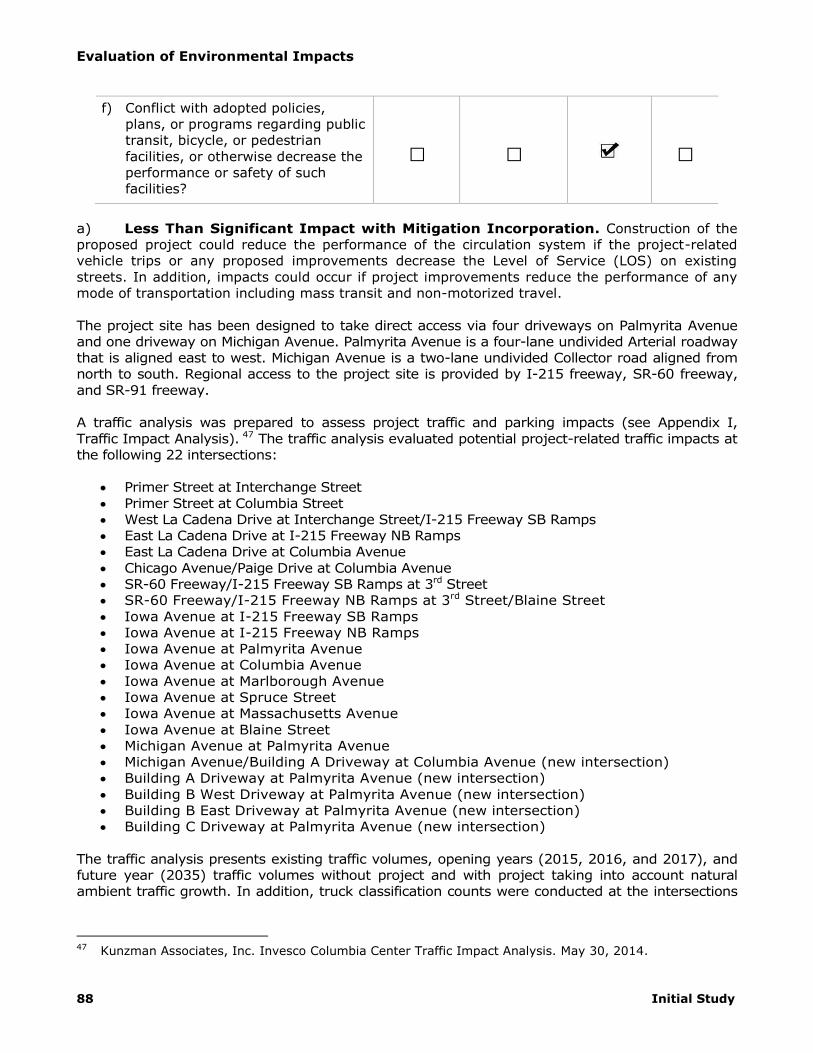
Evaluation of Environmental Impacts
88 Initial Study
f) Conflict with adopted policies,
plans, or programs regarding public
transit, bicycle, or pedestrian
facilities, or otherwise decrease the
performance or safety of such
facilities?
□ □ □
a) Less Than Significant Impact with Mitigation Incorporation. Construction of the
proposed project could reduce the performance of the circulation system if the project-related
vehicle trips or any proposed improvements decrease the Level of Service (LOS) on existing
streets. In addition, impacts could occur if project improvements reduce the performance of any
mode of transportation including mass transit and non-motorized travel.
The project site has been designed to take direct access via four driveways on Palmyrita Avenue
and one driveway on Michigan Avenue. Palmyrita Avenue is a four-lane undivided Arterial roadway
that is aligned east to west. Michigan Avenue is a two-lane undivided Collector road aligned from
north to south. Regional access to the project site is provided by I-215 freeway, SR-60 freeway,
and SR-91 freeway.
A traffic analysis was prepared to assess project traffic and parking impacts (see Appendix I,
Traffic Impact Analysis). 47 The traffic analysis evaluated potential project-related traffic impacts at
the following 22 intersections:
Primer Street at Interchange Street
Primer Street at Columbia Street
West La Cadena Drive at Interchange Street/I-215 Freeway SB Ramps
East La Cadena Drive at I-215 Freeway NB Ramps
East La Cadena Drive at Columbia Avenue
Chicago Avenue/Paige Drive at Columbia Avenue
SR-60 Freeway/I-215 Freeway SB Ramps at 3rd Street
SR-60 Freeway/I-215 Freeway NB Ramps at 3rd Street/Blaine Street
Iowa Avenue at I-215 Freeway SB Ramps
Iowa Avenue at I-215 Freeway NB Ramps
Iowa Avenue at Palmyrita Avenue
Iowa Avenue at Columbia Avenue
Iowa Avenue at Marlborough Avenue
Iowa Avenue at Spruce Street
Iowa Avenue at Massachusetts Avenue
Iowa Avenue at Blaine Street
Michigan Avenue at Palmyrita Avenue
Michigan Avenue/Building A Driveway at Columbia Avenue (new intersection)
Building A Driveway at Palmyrita Avenue (new intersection)
Building B West Driveway at Palmyrita Avenue (new intersection)
Building B East Driveway at Palmyrita Avenue (new intersection)
Building C Driveway at Palmyrita Avenue (new intersection)
The traffic analysis presents existing traffic volumes, opening years (2015, 2016, and 2017), and
future year (2035) traffic volumes without project and with project taking into account natural
ambient traffic growth. In addition, truck classification counts were conducted at the intersections
47 Kunzman Associates, Inc. Invesco Columbia Center Traffic Impact Analysis. May 30, 2014.

Evaluation of Environmental Impacts
Columbia Business Center 89
and the existing percent of trucks were used in the conversion to Passenger Car Equivalent’s
(PCE’s).
Table 13 (Project Trip Generation) below details the trip generation for each building of the
proposed development. The proposed project is anticipated to generate a total of 4,542 ADT, 239
AM peak hour trips, and 261 PM peak hour trips in passenger car equivalents.
Table 13
Proposed Trip Generation
Land Use ADT AM Peak PM Peak
Building A 2,202 147 160
Building B 815 54 62
Building C 425 38 39
Total 3,442 239 261 Source: Kunzman Associates, Inc. Columbia Business Center Traffic Impact Analysis. November 18, 2014
Traffic volumes and delay presented in the traffic study utilize Delay and Level of Service (LOS).
Delay is measured utilizing the Intersection Delay Method based on the 2000 Highway Capacity
Manual. This method calculates delay by comparing the volume of traffic using a given
intersection to the capacity of a given intersection where when an intersections volume exceeds
capacity resulting in a ratio equal to or exceeding 1.0 and a LOS of F. The traffic analysis also
presents delay in terms of time (seconds) of delay experienced at a given intersection. LOS is
defined on a scale of A through F, with LOS A representing the best operating conditions and LOS
F representing the worst operating conditions. LOS A is characterized as having free-flowing traffic
conditions with no restrictions on maneuvering or operation speeds, where traffic volumes are low
and travel speeds are high. LOS F is characterized as having forced flow with many stoppages and
low operating speeds.
The City of Riverside allows peak hour intersection operations of LOS D to be used as a maximum
acceptable threshold for study area intersections. A significant impact could occur when the
addition of project generated trips causes either peak hour LOS to degrade from acceptable LOS
(A through D) to unacceptable LOS (E or F) or peak hour delay to increase as follows:
Level of Service A/B = By 10.0 seconds
Level of Service C = By 8.0 seconds
Level of Service D = By 5.0 seconds
Level of Service E = By 2.0 seconds
Level of Service F = By 1.0 seconds
Table 14 (Existing Intersection Delay and Level of Service) identifies the existing intersection
delays utilizing Delay and LOS for the 17 existing intersections.

Evaluation of Environmental Impacts
90 Initial Study
Table 14
Existing Intersection Delay and Level of Service
Study Intersection
AM Peak Hour PM Peak Hour
Delay LOS Delay LOS
Primer Street at Interchange Street 56.8 F 99.9 F
Primer Street at Columbia Street 15.8 B 16.5 B
West La Cadena Drive at Interchange Street/I-215 Freeway SB Ramps
23.8 C 99.9 F
East La Cadena Drive at I-215 Freeway NB Ramps 99.9 F 99.9 F
East La Cadena Drive at Columbia Avenue 39.2 D 33.8 C
Chicago Avenue/Paige Drive at Columbia Avenue 23.6 C 22.7 C
SR-60 Freeway/I-215 Freeway SB Ramp at 3rd Street 28.0 C 27.4 C
SR-60 Freeway/I-215 Freeway NB Ramp at 3rd Street/Blaine Street 25.7 C 20.5 C
Iowa Avenue at I-215 Freeway SB Ramps 19.4 C 20.0 C
Iowa Avenue at I-215 Freeway NB Ramps 15.8 C 14.2 B
Iowa Avenue at Palmyrita Avenue 27.0 C 25.8 C
Iowa Avenue at Columbia Avenue 19.5 C 20.3 C
Iowa Avenue at Marlborough Avenue 16.6 B 21.3 C
Iowa Avenue at Spruce Street 26.3 C 26.1 C
Iowa Avenue at Massachusetts Avenue 26.1 C 13.5 B
Iowa Avenue at Blaine Street 28.8 C 29.5 C
Michigan Avenue at Palmyrita Avenue 9.7 A 12.6 B Source: Kunzman Associates, Inc. Columbia Business Center Traffic Impact Analysis. November 18, 2014. Notes: - Delay and level of service has been calculated using the following analysis software Traffic, Version 7.9.0215 (2008).
Per the Highway Capacity Manual, overall average intersection delay and level of service are shown for intersections with traffic signal or all way stop control. For intersections with cross street stop control, the delay and level of service for the worse approach are shown.
- 99.9 – F = Delay high, intersection unstable, Level of Service F
Opening Year 2015 Intersection Delay
Table 15 (Opening Year (2015) With Project Building A Traffic Conditions) shows intersection
delays and LOS under without Project and with Project Building A conditions. Under 2015 without
project conditions, the study area intersections are projected to operate at acceptable LOS during
peak hours, except for the following study area intersections without improvements:
Primer Street at Interchange Street
West La Cadena Drive at Interchange Street/I-215 Freeway SB Ramps
East La Cadena Drive at I-215 Freeway NB Ramps
East La Cadena Drive at Columbia Avenue
The delay and LOS for year 2015 with Project Building A conditions is shown on Table 15. As
shown, the following study area intersections would operate at unacceptable LOS under Opening
Year 2015 conditions without improvements.
Primer Street at Interchange Street
West La Cadena Drive at Interchange Street/I-215 Freeway SB Ramps
East La Cadena Drive at I-215 Freeway NB Ramps
East La Cadena Drive at Columbia Avenue

Evaluation of Environmental Impacts
Columbia Business Center 91
Opening Year 2016 Intersection Delay
Table 16 (Opening Year (2016) With Project Buildings A and B Traffic Conditions) shows
intersection delays and LOS under without Project and with Project Buildings A and B conditions.
Under 2016 without project conditions, the study area intersections are projected to operate at
acceptable LOS during peak hours, except for the following study area intersections without
improvements:
Primer Street at Interchange Street
West La Cadena Drive at Interchange Street/I-215 Freeway SB Ramps
East La Cadena Drive at I-215 Freeway NB Ramps
East La Cadena Drive at Columbia Avenue
The delay and LOS for year 2016 with Project Buildings A and B conditions is shown on Table 16.
As shown, the following study area intersections would operate at unacceptable LOS under
Opening Year 2016 conditions without improvements.
Primer Street at Interchange Street
West La Cadena Drive at Interchange Street/I-215 Freeway SB Ramps
East La Cadena Drive at I-215 Freeway NB Ramps
East La Cadena Drive at Columbia Avenue
Opening Year 2017 Intersection Delay
Table 17 (Opening Year (2017) With Project Buildings A, B, and C Traffic Conditions) shows
intersection delays and LOS under without Project and with Project Buildings A, B, and C
conditions. Under 2017 without project conditions, the study area intersections are projected to
operate at acceptable LOS during peak hours, except for the following study area intersections
without improvements:
Primer Street at Interchange Street
West La Cadena Drive at Interchange Street/I-215 Freeway SB Ramps
East La Cadena Drive at I-215 Freeway NB Ramps
East La Cadena Drive at Columbia Avenue
The delay and LOS for year 2017 with Project Buildings A, B, and C conditions is shown on Table
17. As shown, the following study area intersections would operate at unacceptable LOS under
Opening Year 2017 conditions without improvements.
Primer Street at Interchange Street
West La Cadena Drive at Interchange Street/I-215 Freeway SB Ramps
East La Cadena Drive at I-215 Freeway NB Ramps
East La Cadena Drive at Columbia Avenue
SR-60 Freeway/I-215 Freeway NB Ramp at 3rd Street/Blaine Street
Year 2035 Intersection Delay
For year 2035 Without Project traffic conditions, the study area intersections are projected to
operate at acceptable LOS during the peak hours, except for the following study area
intersections that are projected to operate at unacceptable LOS during the peak hours, without
improvements.
Primer Street at Interchange Street
I-215 Freeway SB Ramps at Columbia Avenue
East La Cadena Drive at Columbia Avenue
Chicago Avenue/Paige Drive at Columbia Avenue

Evaluation of Environmental Impacts
92 Initial Study
SR-60 Freeway/I-215 Freeway NB Ramp at 3rd Street/Blaine Street
Iowa Avenue at I-215 Freeway SB Ramps
Iowa Avenue at I-215 Freeway NB Ramps
Iowa Avenue at Palmyrita Avenue
Iowa Avenue at Spruce Street
Iowa Avenue at Blaine Street
Table 18 (Year 2035 With Project Buildings A, B, and C Traffic Contributions) shows Year 2035
with and without Project Buildings A, B, and C delay and LOS. As shown, the following study area
intersections would operate at unacceptable LOS under Year 2035 conditions without
improvements.
Primer Street at Interchange Street
I-215 Freeway SB Ramps at Columbia Avenue
East La Cadena Drive at Columbia Avenue
Chicago Avenue/Paige Drive at Columbia Avenue
SR-60 Freeway/I-215 Freeway NB Ramps at 3rd Street/Blaine Street
Iowa Avenue at I-215 Freeway SB Ramps
Iowa Avenue at I-215 Freeway NB Ramps
Iowa Avenue at Palmyrita Avenue
Iowa Avenue at Spruce Street
Iowa Avenue at Blaine Street
Michigan Avenue at Palmyrita Avenue
A summary of intersection improvements and costs are shown on Table 19 (Summary of
Intersection Improvements). Year 2035 With Project Buildings A, B, and C fair share calculations
are provided in Table 20 (Year 2035 With Project Buildings A, B, and C Fair Share Traffic
Calculations). As shown in Table 20, the project’s fair share of identified intersection costs is
$60,120. Implementation of Traffic Study recommendations as Mitigation Measures will reduce
Project impacts to less than significant levels.

Evaluation of Environmental Impacts
Columbia Business Center 93
Table 15
Opening Year (2015) With Project Building A Traffic Contribution
Intersection Peak Hour
Opening Year (2015)
Without Project
Opening Year (2015) With Project Building A
Without Mitigation With Mitigation
Delay LOS Delay LOS Project Impact
Significant Impact Delay LOS
Project Impact
Significant Impact
Primer Street at Interchange Street AM PM
69.8 138.8
F F
83.3 158.8
F F
13.5 20.0
Yes Yes
10.5 12.1
B B
-59.3 -126.7
No No
Primer Street at Columbia Street AM PM
16.2 17.0
B B
16.4 17.1
B B
0.2 0.1
No No
W La Cadena Drive at Interchange Street/I-215 SB Ramps
AM PM
27.9 164.8
D F
31.9 179.5
D F
4.0 14.7
No Yes
9.5 15.9
A B
-18.4 -148.9
No No
E La Cadena Drive at I-215 NB Ramps AM PM
823.7 815.1
F F
867.6 928.8
F F
43.9 113.7
Yes Yes
17.1 21.4
B C
-806.6 -793.7
No No
E La Cadena Drive at Columbia Avenue AM PM
42.9 36.6
D D
46.1 39.0
D D
3.2 2.4
No No
29.0 27.5
C C
-13.9 -9.1
No No
Chicago Avenue/Paige Drive at Columbia Avenue
AM PM
24.3 23.1
C C
24.6 23.3
C C
0.3 0.2
No No
SR-60/I-215 SB Ramp at 3rd Street AM PM
30.6 30.2
C C
31.2 31.5
C C
0.6 1.3
No No
SR-60/I-215 NB Ramp at 3rd Street/Blaine Street
AM PM
28.8 22.0
C C
30.3 22.9
C C
1.5 0.9
No No
Iowa Avenue at I-215 SB Ramps AM PM
21.1 22.1
C C
21.5 22.1
C C
0.4 0.0
No No
Iowa Avenue at I-215 NB Ramps AM PM
16.6 14.7
C B
16.7 14.8
C B
0.1 0.1
No No
Iowa Avenue at Palmyrita Avenue AM PM
27.8 26.4
C C
27.9 26.5
C C
0.1 0.1
No No
Iowa Avenue at Columbia Avenue AM
PM
19.8
20.8
B
C
20.7
21.6
C
C
0.9
0.8
No
No
Iowa Avenue at Marlborough Avenue AM PM
19.8 21.7
B C
19.9 21.8
B C
0.1 0.1
No No
Iowa Avenue at Spruce Street AM
PM
27.7
27.2
C
C
27.7
27.5
C
C
0.0
0.3
No
No
Iowa Avenue at Massachusetts Avenue AM PM
28.7 13.7
C B
29.7 13.7
C B
0.7 0.0
No No
Iowa Avenue at Blaine Street AM PM
30.2 31.1
C C
31.5 32.9
C C
1.3 1.8
No No
Michigan Avenue at Palmyrita Avenue AM PM
9.8 12.9
A B
10.0 14.5
B C
0.2 1.6
No No
Source: Kunzman Associates, Inc. Columbia Business Center Traffic Impact Analysis. November 18, 2014.
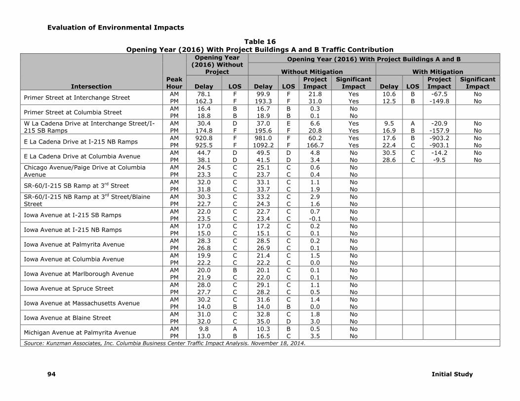
Evaluation of Environmental Impacts
94 Initial Study
Table 16
Opening Year (2016) With Project Buildings A and B Traffic Contribution
Intersection Peak Hour
Opening Year (2016) Without
Project
Opening Year (2016) With Project Buildings A and B
Without Mitigation With Mitigation
Delay LOS Delay LOS Project Impact
Significant Impact Delay LOS
Project Impact
Significant Impact
Primer Street at Interchange Street AM PM
78.1 162.3
F F
99.9 193.3
F F
21.8 31.0
Yes Yes
10.6 12.5
B B
-67.5 -149.8
No No
Primer Street at Columbia Street AM PM
16.4 18.8
B B
16.7 18.9
B B
0.3 0.1
No No
W La Cadena Drive at Interchange Street/I-215 SB Ramps
AM PM
30.4 174.8
D F
37.0 195.6
E F
6.6 20.8
Yes Yes
9.5 16.9
A B
-20.9 -157.9
No No
E La Cadena Drive at I-215 NB Ramps AM PM
920.8 925.5
F F
981.0 1092.2
F F
60.2 166.7
Yes Yes
17.6 22.4
B C
-903.2 -903.1
No No
E La Cadena Drive at Columbia Avenue AM PM
44.7 38.1
D D
49.5 41.5
D D
4.8 3.4
No No
30.5 28.6
C C
-14.2 -9.5
No No
Chicago Avenue/Paige Drive at Columbia Avenue
AM PM
24.5 23.3
C C
25.1 23.7
C C
0.6 0.4
No No
SR-60/I-215 SB Ramp at 3rd Street AM PM
32.0 31.8
C C
33.1 33.7
C C
1.1 1.9
No No
SR-60/I-215 NB Ramp at 3rd Street/Blaine
Street
AM
PM
30.3
22.7
C
C
33.2
24.3
C
C
2.9
1.6
No
No
Iowa Avenue at I-215 SB Ramps AM PM
22.0 23.5
C C
22.7 23.4
C C
0.7 -0.1
No No
Iowa Avenue at I-215 NB Ramps AM PM
17.0 15.0
C C
17.2 15.1
C C
0.2 0.1
No No
Iowa Avenue at Palmyrita Avenue AM
PM
28.3
26.8
C
C
28.5
26.9
C
C
0.2
0.1
No
No
Iowa Avenue at Columbia Avenue AM PM
19.9 22.2
C C
21.4 22.2
C C
1.5 0.0
No No
Iowa Avenue at Marlborough Avenue AM
PM
20.0
21.9
B
C
20.1
22.0
C
C
0.1
0.1
No
No
Iowa Avenue at Spruce Street AM PM
28.0 27.7
C C
29.1 28.2
C C
1.1 0.5
No No
Iowa Avenue at Massachusetts Avenue AM PM
30.2 14.0
C B
31.6 14.0
C B
1.4 0.0
No No
Iowa Avenue at Blaine Street AM PM
31.0 32.0
C C
32.8 35.0
C D
1.8 3.0
No No
Michigan Avenue at Palmyrita Avenue AM PM
9.8 13.0
A B
10.3 16.5
B C
0.5 3.5
No No
Source: Kunzman Associates, Inc. Columbia Business Center Traffic Impact Analysis. November 18, 2014.

Evaluation of Environmental Impacts
Columbia Business Center 95
Table 17
Opening Year (2017) With Project Buildings A, B, and C Traffic Contribution
Intersection Peak Hour
Opening Year (2017) Without
Project
Opening Year (2017) With Project Buildings A, B, and C
Without Mitigation With Mitigation
Delay LOS Delay LOS Project Impact
Significant Impact Delay LOS
Project Impact
Significant Impact
Primer Street at Interchange Street AM PM
88.0 189.8
F F
118.7 228.5
F F
30.7 38.7
Yes Yes
10.7 12.8
B B
-77.3 -177.0
No No
Primer Street at Columbia Street AM PM
16.6 19.0
B B
17.0 19.2
B B
0.4 0.2
No No
W La Cadena Drive at Interchange Street/I-215 SB Ramps
AM PM
33.4 184.9
D F
42.4 209.4
E F
9.0 24.5
Yes Yes
9.6 17.9
A B
-23.8 -167.0
No No
E La Cadena Drive at I-215 NB Ramps AM PM
1026.1 1047.5
F F
1098.2 1263.1
F F
72.1 215.6
Yes Yes
18.2 23.4
B C
-1007.9 -1024.1
No No
E La Cadena Drive at Columbia Avenue AM PM
46.8 39.8
D D
52.6 43.8
D D
5.8 4.0
Yes No
31.9 29.7
C C
-14.9 -10.1
No No
Chicago Avenue/Paige Drive at Columbia Avenue
AM PM
24.7 23.6
C C
25.5 24.0
C C
0.8 0.4
No No
SR-60/I-215 SB Ramp at 3rd Street AM PM
33.6 33.5
C C
35.2 35.8
D B
1.6 2.3
No No
SR-60/I-215 NB Ramp at 3rd Street/Blaine
Street
AM
PM
32.2
23.6
C
C
35.8
25.6
D
B
3.6
2.0
No
No
22.2
18.0
C
B
-10.0
-5.6
No
No
Iowa Avenue at I-215 SB Ramps AM PM
23.1 25.0
C D
24.1 24.9
C C
1.0 -0.1
No No
Iowa Avenue at I-215 NB Ramps AM PM
17.5 15.3
C C
17.8 15.4
C C
0.3 0.1
No No
Iowa Avenue at Palmyrita Avenue AM
PM
28.8
27.2
C
C
29.1
27.3
C
C
0.3
0.1
No
No
Iowa Avenue at Columbia Avenue AM PM
20.1 22.3
C C
21.2 22.8
C C
1.1 0.5
No No
Iowa Avenue at Marlborough Avenue AM
PM
20.2
22.1
C
C
20.2
22.3
C
C
0.0
0.2
No
No
Iowa Avenue at Spruce Street AM PM
28.7 28.3
C C
29.3 29.0
C C
0.6 0.7
No No
Iowa Avenue at Massachusetts Avenue AM PM
32.0 14.1
C B
34.0 14.2
C B
2.0 0.1
No No
Iowa Avenue at Blaine Street AM PM
31.9 33.1
C C
34.2 36.8
C D
2.3 3.7
No No
Michigan Avenue at Palmyrita Avenue AM PM
9.8 13.2
A B
10.5 18.3
B C
0.7 5.1
No No
Source: Kunzman Associates, Inc. Columbia Business Center Traffic Impact Analysis. November 18, 2014.

Evaluation of Environmental Impacts
96 Initial Study
Table 18
Year 2035 With Project Buildings A, B, and C Traffic Contribution
Intersection Peak Hour
Opening Year (2035) Without
Project
Opening Year (2035) With Project Buildings A, B, and C
Without Mitigation With Mitigation
Delay LOS Delay LOS Project Impact
Significant Impact Delay LOS
Project Impact
Significant Impact
Primer Street at Interchange Street AM PM
51.4 46.6
F E
51.4 46.6
F E
0.0 0.0
No No
10.7 10.6
B B
-40.7 -36.0
No No
Primer Street at Columbia Street AM PM
16.9 36.9
B C
16.9 36.9
B D
0.0 0.0
No No
I-215 Freeway SB Ramps at Columbia Avenue
AM PM
24.8 47.6
C D
16.6 19.8
B B
-8.2 -27.8
No No
I-215 Freeway NB Ramps at Columbia Avenue
AM PM
14.2 19.1
B B
15.2 20.3
B C
1.0 1.2
No No
E La Cadena Drive at Columbia Avenue AM PM
34.8 55.8
C E
35.0 58.6
C E
0.2 2.8
No Yes
29.3 38.4
C D
-5.5 -17.4
No No
Chicago Avenue/Paige Drive at Columbia Avenue
AM PM
91.0 137.8
F F
103.5 141.4
F F
12.5 3.6
Yes Yes
44.0 54.4
D D
-47.0 -83.4
No No
SR-60/I-215 SB Ramp at 3rd Street AM PM
40.0 42.0
D D
38.2 45.2
D D
-1.8 3.2
No No
SR-60/I-215 NB Ramp at 3rd Street/Blaine
Street
AM
PM
58.1
71.7
E
E
63.3
79.1
E
E
5.2
7.4
Yes
Yes
35.0
37.8
C
D
-23.1
-33.9
No
No
Iowa Avenue at I-215 SB Ramps AM PM
154.7 365.4
F F
154.1 360.5
F F
-0.6 -4.9
No No
14.9 14.6
B B
-139.8 -350.8
No No
Iowa Avenue at I-215 NB Ramps AM PM
36.9 259.7
E F
38.1 264.5
E F
1.2 4.8
No Yes
13.2 33.8
B C
-23.7 -225.9
No No
Iowa Avenue at Palmyrita Avenue AM
PM
120.7
126.5
F
F
125.7
130.9
F
F
5.0
4.4
Yes
Yes
54.4
53.4
D
D
-70.3
-73.1
No
No
Iowa Avenue at Columbia Avenue AM PM
41.0 45.6
D D
36.4 49.9
D D
-4.6 4.3
No No
Iowa Avenue at Marlborough Avenue AM
PM
35.0
38.9
C
D
35.0
39.7
C
D
0.0
0.8
No
No
Iowa Avenue at Spruce Street AM PM
62.7 101.3
E F
63.6 102.8
E F
0.9 1.5
No Yes
37.9 48.4
D D
-24.8 -52.9
No No
Iowa Avenue at Massachusetts Avenue AM PM
31.7 32.7
C C
27.8 34.0
C C
-3.9 1.3
No No
Iowa Avenue at Blaine Street AM PM
53.9 65.9
D E
579 73.6
E E
4.0 7.7
No Yes
32.1 35.6
C D
-21.8 -30.3
No No
Michigan Avenue at Palmyrita Avenue AM PM
14.0 33.8
B D
15.3 58.2
C F
1.3 24.4
No Yes
19.6 19.0
B B
5.6 -14.8
No No
Source: Kunzman Associates, Inc. Columbia Business Center Traffic Impact Analysis. November 18, 2014.

Evaluation of Environmental Impacts
Columbia Business Center 97
Table 19
Summary of Intersection Improvements Intersection Improvement Note Cost
Primer Street at Interchange Street Install a traffic signal 1, 2, 3 Proposed new interchange TUMF
W La Cadena Drive at Interchange Street/I-215 Freeway SB Ramps
Construct a northbound left turn lane1, 2, 3 Construct a southbound left turn lane 1, 2, 3 Construct a westbound left turn lane1, 2, 3 Construct an additional westbound left turn lane4 Install a traffic signal1, 2, 3
Proposed new interchange Proposed new interchange Proposed new interchange Proposed new interchange Proposed new interchange
TUMF TUMF TUMF TUMF TUMF
E La Cadena Drive at I-215 Freeway NB Ramps Install a traffic signal1, 2, 3 Proposed new interchange TUMF
E La Cadena Drive at Columbia Avenue Install a westbound right turn overlap1, 2, 3, 4 Pay fair share $10,000
Chicago Avenue/Paige Drive at Columbia Avenue
Construct a northbound right turn lane4
Construct an additional southbound left turn lane4 Pay fair share Pay fair share
$50,000 $50,000
SR-60 Freeway/I-215 Freeway NB Ramps at 3rd Street/Blaine Street
Construct a westbound right turn lane4 Pay fair share $50,000
Iowa Avenue at I-215 Freeway SB Ramps Construct an additional northbound through lane4 Construct an additional southbound through lane4 Install a traffic signal4
Proposed new interchange Proposed new interchange Proposed new interchange
TUMF TUMF TUMF
Iowa Avenue at I-215 Freeway NB Ramps
Construct an additional northbound through lane4 Construct a southbound left turn lane4 Construct an additional southbound through lane4 Install a traffic signal4
Proposed new interchange Proposed new interchange Proposed new interchange Proposed new interchange
TUMF TUMF TUMF TUMF
Iowa Avenue at Palmyrita Avenue
Install a northbound right turn overlap4 Construct an additional westbound left turn lane4 Install a westbound right turn overlap4
Pay fair share Pay fair share Pay fair share
$10,000 $50,000 $10,000
Iowa Avenue at Spruce Avenue
Construct an additional northbound left turn lane4 Construct an additional southbound left turn lane4 Construct an eastbound right turn lane4
Construct a westbound right turn lane4
Construct a westbound right turn overlap4
Pay fair share Pay fair share Pay fair share Pay fair share Pay fair share
$50,000 $50,000 $50,000 $50,000 $10,000
Iowa Avenue at Blaine Street Construct an additional northbound left turn lane4
Install a southbound right turn overlap4 Pay fair share Pay fair share
$50,000 $10,000
Michigan Avenue at Palmyrita Avenue Stripe a northbound left turn lane4 Stripe a southbound left turn lane4 Install a traffic signal4
Pay fair share Pay fair share Pay fair share
$10,000 $10,000 $250,000
Total $770,000
Source: Kunzman Associates, Inc. Columbia Business Center Traffic Impact Analysis. November 18, 2014.
1 Improvement required for Opening Year (2015) with Project Building A 2 Improvement required for Opening Year (2016) with Project Buildings A and B 3 Improvement required for Opening Year (2017) with Project Buildings A, B, and C 4 Improvement required for Year 2035 with Project Buildings A, B, and C

Evaluation of Environmental Impacts
98 Initial Study
Table 20
Year 2035 With Project Buildings A, B, and C Fair Share Traffic Calculations
Intersection
Year 2035 Improvement
Costs1
Existing Year 2035 With
Project Project Total New
Traffic Project % of New
Traffic Fair
Share Cost AM PM AM PM AM PM AM PM AM PM AVG
E La Cadena Drive at Columbia Avenue
$10,000 2,672 2,808 4,207 4,745 114 124 1,535 1,937 7.4% 6.4% 6.9% $690
Chicago Ave/Paige Dr at Columbia Ave
$100,000 2,215 2,377 5,047 5,713 114 124 2,832 3,336 4.0% 3.7% 3.9% $3,850
SR-60 Freeway/I-215 Freeway NB Ramp at 3rd St/Blaine St
$50,000 2,727 2,495 3,600 3,536 67 73 873 1,041 7.7% 7.0% 7.4% $3,675
Iowa Ave at Palmyrita Ave $70,000 1,751 2,050 4,118 4,920 43 47 2,367 2,870 1.8% 1.6% 1.7% $1,190
Iowa Ave at Spruce Avenue $210,000 2,495 2,613 4,354 5,318 67 74 1,859 2,705 3.6% 2.7% 3.2% $6,615
Iowa Ave at Blaine St $60,000 3,054 3,363 4,547 5,059 67 74 1,493 1,696 4.5% 4.4% 4.5% $2,670
Michigan Avenue at Palmyrita Avenue
$270,000 304 495 1,363 1,520 155 170 1,059 1,025 14.6% 16.6% 15.6% $42,120
Total $770,000 $60,120
Source: Kunzman Associates, Inc. Columbia Business Center Traffic Impact Analysis. November 18, 2014.
1 This total is for Year 2035 With Project Buildings A, B, and C improvements.
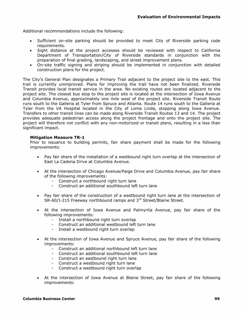
Evaluation of Environmental Impacts
Columbia Business Center 99
Additional recommendations include the following:
Sufficient on-site parking should be provided to meet City of Riverside parking code
requirements.
Sight distance at the project accesses should be reviewed with respect to California
Department of Transportation/City of Riverside standards in conjunction with the
preparation of final grading, landscaping, and street improvement plans.
On-site traffic signing and striping should be implemented in conjunction with detailed
construction plans for the project.
The City’s General Plan designates a Primary Trail adjacent to the project site to the east. This
trail is currently unimproved. Plans for improving the trail have not been finalized. Riverside
Transit provides local transit service in the area. No existing routes are located adjacent to the
project site. The closest bus stop to the project site is located at the intersection of Iowa Avenue
and Columbia Avenue, approximately one mile west of the project site. Riverside Transit Route
runs south to the Galleria at Tyler from Spruce and Atlanta. Route 14 runs south to the Galleria at
Tyler from the VA Hospital located in the City of Loma Linda, stopping along Iowa Avenue.
Transfers to other transit lines can be made along Riverside Transit Routes 13 and 14. The project
provides adequate pedestrian access along the project frontage and onto the project site. The
project will therefore not conflict with any non-motorized or transit plans, resulting in a less than
significant impact.
Mitigation Measure TR-1
Prior to issuance to building permits, fair share payment shall be made for the following
improvements:
Pay fair share of the installation of a westbound right turn overlap at the intersection of
East La Cadena Drive at Columbia Avenue.
At the intersection of Chicago Avenue/Paige Drive and Columbia Avenue, pay fair share
of the following improvements:
- Construct a northbound right turn lane
- Construct an additional southbound left turn lane
Pay fair share of the construction of a westbound right turn lane at the intersection of
SR-60/I-215 Freeway northbound ramps and 3rd Street/Blaine Street.
At the intersection of Iowa Avenue and Palmyrita Avenue, pay fair share of the
following improvements:
- Install a northbound right turn overlap
- Construct an additional westbound left turn lane
- Install a westbound right turn overlap
At the intersection of Iowa Avenue and Spruce Avenue, pay fair share of the following
improvements:
- Construct an additional northbound left turn lane
- Construct an additional southbound left turn lane
- Construct an eastbound right turn lane
- Construct a westbound right turn lane
- Construct a westbound right turn overlap
At the intersection of Iowa Avenue at Blaine Street, pay fair share of the following
improvements:
Evaluation of Environmental Impacts
100 Initial Study
- Construct an additional northbound left turn lane
- Install a southbound right turn overlap
At the intersection of Michigan Avenue at Palmyrita Avenue, pay fair share of the
following improvements:
- Stripe northbound left turn lane
- Stripe southbound left turn lane
- Install a traffic signal
b) Less Than Significant Impact. The proposed project could result in significant impacts
if it conflicts with the Riverside County Congestion Management Program (CMP) through reducing
the Level of Service of a non-exempt segment to fall to “F”. If LOS for a non-exempt segment is
reduced to “F”, a deficiency plan outlining specific mitigation measure and a schedule for
mitigating the deficiency will be required. The nearest affected CMP designated freeways are I-
215, SR-60, and SR-91 and the nearest arterial link is Main Street. The project traffic study
indicated that the project would not reduce the Levels of Service on non-exempt
roadways/highways as defined by the County’s CMP. In addition, as is indicated previously in
section 4.16 a, the project would not result in any intersection operating at LOS E or below with
the proposed improvements; therefore a less than significant impact to the CMP will occur.
c) No Impact. The proposed project is not located within two miles of an airport or private
air strip. The proposed building would not encroach into air traffic space and this project would
have no effects on demand for local air service or volumes of air traffic. The proposed project will
not alter air traffic patterns, therefore no impact will occur.
d) Less Than Significant Impact. If the project will substantially increase hazards due to a
design feature, a significant impact could occur. No existing traffic hazards are known to exist in
the immediate vicinity of the project. Roadways and intersections provide sufficient sight distance
to limit the potential of any hazards and stop signs and traffic signals are placed at intersections
to safely control traffic movements. The project traffic study included in its recommendation that
sight distance at each project access should be reviewed with respect to California Department of
Transportation/City of Riverside standards in conjunction with the preparation of final grading,
landscaping, and street improvement plans. Impacts from the project will be less than significant
to any potentially existing or future traffic hazard.
e) Less Than Significant Impact. The proposed project will be accessible via four 40-
foot wide driveways on Palmyrita Avenue and one 60-foot wide driveway on Michigan Avenue.
The project site plan identifies the 26-foot wide fire department access and turning radii entering
the site and within the site, which are adequate to serve the site in case of an emergency.
Therefore, the project will have less than significant impacts on the provision of adequate
emergency access.
f) Less Than Significant Impact. The project will not result in conflicts with adopted
policies or plans related to alternative modes of travel, such as bus transit, bicycles or walking
paths. The project is not located adjacent to or near an existing bike path or pedestrian facilities it
could conflict with, nor does the City have adopted policies, plans, or programs regarding public
transit, bicycle, or pedestrian facilities that apply to the proposed project site. There is an
unimproved park trail located along the eastern boundary of the project site. Plans to improve the
trail have not been finalized. Therefore, a less than significant impact will occur.

Evaluation of Environmental Impacts
Columbia Business Center 101
4.17 – Utilities and Service Systems
Would the project:
Potentially Significant
Impact
Less Than Significant
with Mitigation
Incorporation
Less Than Significant
Impact
No Impact
a) Exceed wastewater treatment
requirements of the applicable
Regional Water Quality Control
Board? □ □ □
b) Require or result in the construction
of new water or wastewater
treatment facilities or expansion of
existing facilities, the construction
of which could cause significant
environmental effects?
□ □ □
c) Require or result in the construction
of new storm water drainage
facilities or expansion of existing
facilities, the construction of which
could cause significant
environmental effects?
□ □ □
d) Have sufficient water supplies
available to serve the project from
existing entitlements and
resources, or are new or expanded
entitlements needed?
□ □ □
e) Result in a determination by the
wastewater treatment provider
which serves or may serve the
project that it has adequate
capacity to serve the project’s
projected demand in addition to the
provider’s existing commitments?
□ □ □
f) Be served by a landfill with
sufficient permitted capacity to
accommodate the project’s solid
waste disposal needs?
□ □ □
g) Comply with federal, state, and
local statutes and regulations
related to solid waste? □ □ □
a) Less Than Significant Impact. The proposed project could affect Regional Water Quality
Control Board treatment standards by increasing wastewater production, which would require
expansion of existing facilities or construction of new facilities. Exceeding the RWQCB treatment

Evaluation of Environmental Impacts
102 Initial Study
standards could result in contamination of surface or ground waters with pollutants such as
pathogens and nitrates.
The City of Riverside Public Works Department provides sewer service to the project area.48 The
City of Riverside Public Works Department provides for the collection, treatment and disposal of
wastewater at the project site through its Riverside Regional Water Quality Treatment Plant
(RRWQCP) and complies with state and federal requirements governing the treatment and
discharge of wastewater. The wastewater collection system includes over 776 miles of gravity
sewers that range in size from six to 54 inches in diameter and includes 18 wastewater pump
stations. According to the City of Riverside 2010 Urban Water Management Plan, RRWQCP treats
approximately 34 million gallons per day (MGD). The capacity of the plan is 40 MGD. Upgrades to
the plant are being designed to increase the capacity to 46 MGD by 2015. With improved
treatment processes being added, the ultimate plant capacity is anticipated to be 52 MGD.49 Final
plant expansion is anticipated to occur in 2026. Sewer connection fees will be determined as
outlined under Section 14.08.080 of the City’s Municipal Code. Wastewater flows associated with
the proposed Project would consist of the same kinds of substances typically generated by
industrial use and no modifications to any existing wastewater treatment systems or construction
of any new ones would be needed to treat this project’s wastewater. Estimated wastewater
generated by the proposed industrial development is approximately 17,347 gallons per day (gpd)
(wastewater is estimated to be 80 percent of total water use). This volume represents 0.04
percent of the RRWQCP’s current 40 mgd total treatment capacity. This project would thus have a
less-than-significant impact on the ability of the RRWQCP to operate within its established
wastewater treatment requirements, which are enforced via the facility’s NPDES permit
authorized by the Santa Ana Regional Water Quality Control Board (SARWQCB). Therefore, the
project will have a less than significant impact related to wastewater treatment requirements of
the SARWQCB.
b) Less Than Significant Impact. The City of Riverside’s water supply is primarily
groundwater, extracted by production wells from the Bunker Hill Basin, Riverside North, and
Riverside South. Additional sources of water include groundwater from the Rialto-Colton Basin,
recycled water from the City of Riverside’s Regional Water Quality Control Plant (RWQCP), and
imported water from WMWD through a connection at the Metropolitan Water District of Southern
California’s Henry J. Mills Treatment Plant. The Riverside Public Utilities Department provides
water service to the project area, and will provide water service to the proposed project upon
completion of financial arrangements and compliance with the Department’s Rules and
Regulations for the installation of water facilities.50 Sections 10910-10915 of the state Water Code
require the preparation of a water supply assessment (WSA) demonstrating sufficient water
supplies for any subdivision that involves the construction of more than 500 dwelling units, or the
equivalent thereof. As the project is below the established thresholds, no WSA is required.51 The
Riverside Public Utilities Department (RPU) projects adequate water supplies for the project based
upon current water supply and projected growth rates, estimated between 2015 and 2035.52 The
2010 water usage in the RPU service area was approximately 83,300 AFY and is expected to
increase steadily through to 2035. The proposed water use in 2035 is estimated to be 119,800
AFY, an increase of 36,500 AFY. Groundwater supplies will be augmented through three
conjunctive use projects: Seven Oaks Dam Conservation Project, Riverside North Aquifer Storage
48 Correspondence with Robert Van Zanten, Principal Engineer, City of Riverside Public Works Department.
January 30, 2013. 49 City of Riverside Public Utilities. Final 2010 Urban Water Management Plan. July 2011. 50 Correspondence with Toni Redman, Senior Engineering Aide, City of Riverside. March 11, 2013. 51 Correspondence with Michael L. Plinski, P.E., Senior Water Engineer, Riverside Public Utilities.
November 26, 2013. 52 City of Riverside Public Utilities. Final 2010 Urban Water Management Plan. July 2011.

Evaluation of Environmental Impacts
Columbia Business Center 103
and Recovery Project, and Pellisier Ranch Aquifer Storage and Recovery Project, and through
increased use of recycled water. Total available water (including groundwater, conjunctive use
projects, recycled water, and imported water from MWD) to the Riverside Public Utilities service
area is estimated to reach 143,226 AFY by 2035, which is more than sufficient to meet the
estimated 2035 water demand. Based on CalEEMod assumptions, the proposed project’s
estimated water demand is approximately 24.3 AFY, representing 0.07 percent of the remaining
projected use. The proposed project is designed to support typical warehouse and distribution
uses. Should a heavy utility use be proposed as a tenant, further review and approval will be
required through the City.
Regarding wastewater facilities, as discussed in the preceding response, wastewater generated at
the project site is treated at the Riverside Regional Water Quality Treatment Plant (RRWQCP). The
proposed project is estimated to have a wastewater generation of approximately 17,347 gpd. This
generation is well within the existing remaining treatment capacity of the RRWQCP, comprising
0.04 percent of the current 40 million gpd treatment capacity.
Connections to local water and sewer mains would involve temporary and less than significant
construction impacts that would occur in conjunction with other on-site improvements. No
additional improvements are needed to either sewer lines or treatment facilities to serve the
proposed project. Standard connection fees will address any incremental impacts of the proposed
project. Therefore, the project will result in less than significant impacts as a result of new or
expanded wastewater treatment facilities.
c) No Impact. Potentially significant impacts could occur as a result of this project if storm water
runoff was increased to a level that would require construction of new storm drainage facilities. As
discussed in the Hydrology section, the proposed project would not generate any increased runoff
from the site that would require construction of new storm drainage facilities. The City’s NPDES
permit requires most new development projects to incorporate best management practices to
minimize pollutant levels in runoff. Pursuant to Riverside Municipal Code Chapter 14.12
(Discharge of Wastes into Public Sewer and Storm Drain Systems), all construction projects shall
apply Best Management Practices (BMPs) such as sediment barriers, plastic sheeting, detention
ponds, filters and berms to prevent erosion. Implementation of BMPs would reduce pollutants in
stormwater and urban runoff from the project site. The proposed storm drainage system and
BMPs must be designed to the satisfaction of the City’s Public Works Director and in conformance
with all applicable permits and regulations. The project applicant/developer would be required to
provide all necessary on-site infrastructure. The project will have a less than significant impact on
requiring the construction of new facilities or expansion of existing storm drainage facilities.
d) Less Than Significant Impact. The project could result in significant impacts if the
project required additional water supplies than are currently entitled. Water demand is provided
by survey data utilized in the CalEEMod air quality model. Water demand is estimated at
7,914,557 gallons per year or 24.3 acre feet per year. Water demand within the Riverside Public
Utilities service area is projected to be 119,800 AFY by 2035. The proposed project’s estimated
water demand is approximately 24.3 AFY, representing 0.07 percent of the remaining projected
use. Based on the City of Riverside 2010 Urban Water Management Plan (UWMP), the City’s
service area is approximately 80 percent built out with approximately 15 percent vacant land
available for development. The Bunker Hill Basin is managed to maintain adequate future water
supplies through future conjunctive use projects, increased use of recycled water, and water
imported from MWD. The project would not substantially deplete water supplies, and the project
would have a less than significant impact on entitled water supplies.
Evaluation of Environmental Impacts
104 Initial Study
e) Less Than Significant Impact. As detailed in Sections 4.17.a) and 4.17.b), the proposed
project will be adequately served by existing facilities. Therefore a less than significant impact will
occur.
f) Less Than Significant Impact. Significant impacts could occur if the proposed project
will exceed the existing permitted landfill capacity or violates federal, state, and local statutes and
regulations. The City of Riverside Public Works Department collects trash from 70 percent of all
households. The remaining portions of the City’s solid waste are serviced by private collectors.53
Regional landfill capacity fluctuates daily and is regularly monitored by the County Sanitation
Districts of Riverside County to ensure there is sufficient landfill space available to dispose of
municipal solid wastes throughout the region. This project’s additional solid waste stream would
have a less than significant impact on regional landfill capacity. Cities must meet the 50% landfill
diversion mandate required by State law. General Plan Policy PF-5.1 states that waste should be
diverted from landfills and states that the City should achieve 100% recycling citywide for both
residential and non-residential development. In 2012, the per employee disposal rate was 13.7
pounds per day, below the target of no more than 19.5 pounds per day and less than waste in
2011 (13.9 pounds per day).54 According to the California Department of Resources Recycling and
Recovery (CalRecycle), the City disposes of waste at several area landfills, including:
Badlands Sanitary Landfill
El Sobrante Landfill
Puente Hills Landfill (Closed 2013)
Olinda Alpha Sanitary Landfill
San Timoteo Sanitary Landfill
Simi Valley Landfill & Recycling Center
California Street Landfill
Mid-Valley Sanitary Landfill
Azusa Land Reclamation Co. Landfill
Chiquita Canyon Sanitary Landfill
Antelope Valley Public Landfill
American Avenue Disposal Site
McKittrick Waste Treatment Site
The majority of waste in 2012 went to the Badlands Sanitary Landfill and the El Sobrante
Landfill.55 The Badlands Sanitary Landfill, located in Moreno Valley, has a permitted daily capacity
of 4,000 tons, with a permitted total capacity of 33,560,993 cubic yards and a remaining capacity
of 14,730,025 cubic yards. This landfill is projected to close in 2024.56 The El Sobrante Landfill,
located in Corona, has a permitted daily capacity of 16,054 tons per day and a total capacity of
184,930,000 tons, with a remaining capacity of 145,530,000 tons. This landfill is estimated to
close in 2045.57 Although these existing landfills currently used by Riverside are anticipated to
close in 2024 and 2045, other regional landfills have remaining capacity. Also, regional plans are
underway to transport waste by rail to landfill sites in the desert areas to the east.
53 Albert A. Webb Associates. City of Riverside General Plan 2025 Program Environmental Impact Report.
July 2007. 54 CalRecycle. Facility/Site Summary Details, Jurisdiction Diversion/Disposal Rate Summary.
http://www.calrecycle.ca.gov/LGCentral/reports/diversionprogram/JurisdictionDiversionPost2006.aspx [December 2013]
55 CalRecycle. Jurisdiction Disposal by Facility. http://www.calrecycle.ca.gov/LGCentral/Reports/DRS/Destination/JurDspFa.aspx [December 2013]
56 CalRecycle. Facility/Site Summary Details: Badlands Sanitary Landfill (33-AA-0006)
http://www.calrecycle.ca.gov/SWFacilities/Directory/33-AA-0006/Detail/ [December 2013] 57 CalRecycle. Facility/Site Summary Details: El Sobrante Landfill (33-AA-0217)
http://www.calrecycle.ca.gov/SWFacilities/Directory/33-AA-0217/Detail/ [December 2013]
Evaluation of Environmental Impacts
Columbia Business Center 105
Different uses have varying levels of estimated solid waste production. Using the default
calculations in the CalEEMod model, the proposed Project will generate approximately 644 tons of
solid waste per year. There is adequate landfill capacity in the region to accommodate project-
generated waste. Considering the availability of landfill capacity and the relatively nominal
amount of solid waste generation from the proposed project, project solid waste disposal needs
can be adequately met without a significant impact on the capacity of the nearest and optional,
more distant, landfills. Therefore, it is not expected that the proposed project would impact the
City’s compliance with state-mandated (AB 939) waste diversion requirements. Impacts will be
less than significant.
g) No Impact. The proposed project is required to comply with all applicable federal, state,
County, and City statutes and regulations related to solid waste as a standard project condition of
approval. Therefore, no impact will occur.
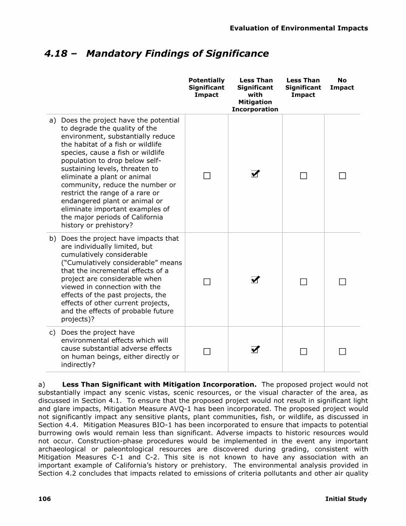
Evaluation of Environmental Impacts
106 Initial Study
4.18 – Mandatory Findings of Significance
Potentially Significant
Impact
Less Than Significant
with Mitigation
Incorporation
Less Than Significant
Impact
No Impact
a) Does the project have the potential
to degrade the quality of the
environment, substantially reduce
the habitat of a fish or wildlife
species, cause a fish or wildlife
population to drop below self-
sustaining levels, threaten to
eliminate a plant or animal
community, reduce the number or
restrict the range of a rare or
endangered plant or animal or
eliminate important examples of
the major periods of California
history or prehistory?
□ □ □
b) Does the project have impacts that
are individually limited, but
cumulatively considerable
(“Cumulatively considerable” means
that the incremental effects of a
project are considerable when
viewed in connection with the
effects of the past projects, the
effects of other current projects,
and the effects of probable future
projects)?
□ □ □
c) Does the project have
environmental effects which will
cause substantial adverse effects
on human beings, either directly or
indirectly?
□ □ □
a) Less Than Significant with Mitigation Incorporation. The proposed project would not
substantially impact any scenic vistas, scenic resources, or the visual character of the area, as
discussed in Section 4.1. To ensure that the proposed project would not result in significant light
and glare impacts, Mitigation Measure AVQ-1 has been incorporated. The proposed project would
not significantly impact any sensitive plants, plant communities, fish, or wildlife, as discussed in
Section 4.4. Mitigation Measures BIO-1 has been incorporated to ensure that impacts to potential
burrowing owls would remain less than significant. Adverse impacts to historic resources would
not occur. Construction-phase procedures would be implemented in the event any important
archaeological or paleontological resources are discovered during grading, consistent with
Mitigation Measures C-1 and C-2. This site is not known to have any association with an
important example of California’s history or prehistory. The environmental analysis provided in
Section 4.2 concludes that impacts related to emissions of criteria pollutants and other air quality

Evaluation of Environmental Impacts
Columbia Business Center 107
impacts will be less than significant. Section 4.7 concludes that impacts related to climate change
would be less then significant with incorporation of Mitigation Measure GHG-1. Sections 4.9
concludes that impacts related to hydrology and water quality will be less than significant. Based
on the preceding analysis of potential impacts in the responses to items 4.1 thru 4.17, no
evidence is presented that this project would degrade the quality of the environment. The City
hereby finds that impacts related to degradation of the environment, biological resources, and
cultural resources will be less than significant with mitigation incorporation.
b) Less Than Significant with Mitigation Incorporation. Cumulative impacts can result
from the interactions of environmental changes resulting from one proposed project with changes
resulting from other past, present, and future projects that affect the same resources, utilities
and infrastructure systems, public services, transportation network elements, air basin,
watershed, or other physical conditions. Such impacts could be short-term and temporary,
usually consisting of overlapping construction impacts, as well as long term, due to the
permanent land use changes involved in the project.
Non-Cumulative Impacts
Impacts related to aesthetics, geology and soils, and airport hazards at the project-level have no
potential for cumulative impacts because impacts are limited to on-site conditions and include no
component that could result in similar impacts over time or space. Therefore, no cumulative
impacts related to these topics will occur.
Local Impacts
Projects can contribute considerably to cumulative impacts in context of the local environment.
Local cumulative impacts are limited to agricultural and forestry resources, air quality, biological
resources, cultural resources, hazardous materials, wildfires, groundwater levels, drainage and
water quality, land use and planning, mineral resources, noise, population and housing, public
services, recreation, transportation and traffic, and utilities and service systems. A general
discussion of potentially significant cumulative impacts in the local context is summarized below.
The analysis provided in Section 4.11 found that no individual impacts would occur; therefore, the
project could not contribute considerably to local mineral resources impacts. The analysis
provided in Section 4 related to agriculture and forest resources, hazards and hazardous
materials, hydrology and water quality, land use and planning, noise, population and housing,
public services, recreation, and utilities and service systems found that impacts would be less
than significant; therefore, while the project will contribute to localized cumulative impacts, the
project contribution will not be considerable.
Impacts related to air quality, biological resources, cultural resources, greenhouse gas emissions,
and transportation and traffic were found to be potentially significant and require mitigation to
reduce to less than significant levels; therefore, the project could contribute considerably to
significant localized cumulative impacts in these topical areas. These topics are discussed in
detail below.
Air Quality. The context for assessing cumulative air quality impacts is the immediate project
vicinity with respects to emissions generated by the construction and operation of the proposed
project. As mentioned in Section 4.3, use of low-VOC coatings during construction activities could
reduce VOC emissions to a maximum of 71.71 pounds per day, which is less than the threshold
established by SCAQMD. The requirement for use of low-VOC coatings has been included as
Mitigation Measure AQ-1. To meet long-term daily thresholds of NOX, emissions use be reduced
by a minimum of 11.3 percent. Mitigation Measure AQ-2 requires future tenants of the proposed
buildings to identify all diesel engine powered trucks within its fleet and verification that NOX will
be reduced by a minimum of 11.3 percent. With implementation of Mitigation Measure AQ-2,

Evaluation of Environmental Impacts
108 Initial Study
emissions would not exceed SCAQMD thresholds, as demonstrated in Section 4.3 of this report;
therefore, the project could not result in an increase in the frequency or severity of any air quality
standards violation and will not cause a new air quality standard violation. Impacts to sensitive
receptors due to localized carbon monoxide emissions were determined to be less than significant
and the proposed project would not subject a substantial number of people to objectionable
odors. Therefore, the project will have no contribution to a cumulative increase in air quality
impacts in the immediate project vicinity.
Biological Resources. The context for assessing cumulative impacts to local biological resources
includes sensitive species and their habitat in the project vicinity. As discussed in Section 4.4,
the project site lacks any substantial vegetation. Suitable burrowing owl habitat is on site but no
owls were observed. Mitigation Measure BIO-1 has been included to ensure that impacts to
potential burrowing owl would remain less than significant. Therefore, the proposed project
would not result in cumulative impacts related to the loss of sensitive species in the project area.
Cultural Resources. The context for assessing cumulative impacts to local archeological
knowledge of our past is the geographical extent of local historic and pre-historic knowledge.
Loss of on-site archaeological resources could reduce or eliminate important information relevant
to the City of Riverside and/or the Inland Empire. Mitigation Measures C-1 and C-2 have been
incorporated requiring evaluation of any discovered potential archaeological resources, the
uniqueness of the archaeological sample, and appropriate steps to preserve or curate the artifact.
This will eliminate any potential loss of important local archaeological information that may be
buried under the project site; therefore, the project will have no contribution to a cumulative loss
of important local archaeological knowledge.
Transportation and Traffic. Cumulative traffic impacts with ambient growth were analyzed in
Section 4.13. Twenty-two intersections were analyzed to determine if project traffic would result
in any intersection deteriorating to insufficient Level of Service (LOS). Based on the analysis, the
proposed project would significantly impact study intersections. Implementation of Mitigation
Measure TR-1, which requires fair share payments be made for specified intersection and roadway
improvements, impacts would be less than significant. Therefore, the proposed project will have
no contribution to cumulative traffic impacts in the project area.
Regional Impacts
Projects can contribute considerably to cumulative impacts in context of the regional
environment. Regional cumulative impacts are limited to air quality, biological resources, cultural
resources, hazardous materials, wildfires, groundwater levels, drainage and water quality,
flooding, land use and planning, mineral resources, transportation and traffic, and utilities and
service systems. A general discussion of potentially significant cumulative impacts in the regional
context is summarized below.
The analysis provided in Section 4.11 found that no individual impacts would occur; therefore, the
project could not contribute considerably to mineral resources impacts. The analysis provided in
Section 4 related to agriculture and forest resources, hazards and hazardous materials, hydrology
and water quality, land use and planning, noise, population and housing, public services,
recreation, and utilities and service systems found that impacts would be less than significant;
therefore, while the project will contribute to localized cumulative impacts, the project
contribution will not be considerable.
Impacts related to air quality, biological resources, cultural resources, greenhouse gas emissions,
and transportation and traffic were found to be potentially significant and require mitigation to
reduce to less than significant levels; therefore, the project could contribute considerably to

Evaluation of Environmental Impacts
Columbia Business Center 109
significant regional cumulative impacts in these topical areas. These topics are discussed in detail
below.
Air Quality. The context for assessing cumulative air quality impacts in the region is the extent to
which project-generated emissions will exceed regional air quality standards. As mentioned in
Section 4.3, the use of low-VOC coatings during construction activities could reduce VOC
emissions to 71.71 pounds per day, which is less than the threshold established by SCAQMD. The
requirement for use of low-VOC coatings has been included as Mitigation Measure AQ-1. To meet
long-term daily thresholds of NOX, emissions use be reduced by a minimum of 11.3 percent.
Mitigation Measure AQ-2 requires future tenants of the proposed buildings to identify all diesel
engine powered trucks within its fleet and verification that NOX will be reduced by a minimum of
11.3 percent. With implementation of Mitigation Measure AQ-2, emissions would not exceed
SCAQMD thresholds, as demonstrated in Section 4.3 of this report; therefore, the project could
not result in an increase in the frequency or severity of any air quality standards violation and will
not cause a new air quality standard violation. Impacts to sensitive receptors due to localized
carbon monoxide emissions were determined to be less than significant and the proposed project
would not subject a substantial number of people to objectionable odors. Therefore, the project
will have no contribution to a cumulative increase in regional air quality impacts.
Biological Resources. The context for assessing cumulative impacts to regional biological
resources includes sensitive species and their habitat in the Inland Empire. As discussed in
Section 4.4, the project site lacks any substantial vegetation. Suitable burrowing owl habitat is
on site but no owls were observed. Mitigation Measure BIO-1 has been included to ensure that
impacts to potential burrowing owl would remain less than significant. Therefore, the proposed
project would not result in cumulative impacts related to the loss of sensitive species in the
region.
Cultural Resources. The context for assessing cumulative impacts to regional archeological
knowledge of our past is the geographical extent of regional historic and pre-historic knowledge.
Loss of on-site archaeological resources could reduce or eliminate important information relevant
to the City of Riverside and/or the Inland Empire. Mitigation Measures C-1 and C-2 have been
incorporated requiring evaluation of any discovered potential archaeological resources, the
uniqueness of the archaeological sample, and appropriate steps to preserve or curate the artifact.
This will eliminate any potential loss of important local archaeological information that may be
buried under the project site; therefore, the project will have no contribution to a cumulative loss
of important regional archaeological knowledge.
Transportation and Traffic. Cumulative traffic impacts with ambient growth were analyzed in
Section 4.13. Twenty-two intersections were analyzed to determine if project traffic would result
in any intersection deteriorating to insufficient Level of Service (LOS). Based on the analysis, the
proposed project would significantly impact study intersections. Implementation of Mitigation
Measure TR-1, which requires fair share payments be made for specified intersection and roadway
improvements, impacts would be less than significant. Therefore, the proposed project will have
no contribution to cumulative traffic impacts in the region.
Global Impacts
One topic of global concern is climate change. As discussed in Section 4.7, climate change is the
result of numerous, cumulative sources of greenhouse gas emissions all over the world.
Mitigation Measure GHG-1 has been included to reduce energy demand by a minimum of 25
percent. The project will not contribute considerably to global climate change with
implementation of existing regulations and Mitigation Measure GHG-1.

Evaluation of Environmental Impacts
110 Initial Study
Based on the above analysis concerning the local, regional, and global impacts of the project in
consideration of past, current, and future projects, the City of Riverside hereby finds that the
contribution of the proposed project to cumulative impacts will be less than significant with
mitigation incorporation.
c) Less Than Significant with Mitigation Incorporation. Based on the analysis of the
project’s impacts in the responses to items 4.1 thru 4.17, there is no indication that this project
could result in substantial adverse effects on human beings. While there would be a variety of
temporary adverse effects during construction related to criteria pollutant emissions, these will be
reduced to less than significant levels through mitigation and incorporation of standard
requirements for air quality protection. Impacts to the local roadway network would be reduced
to less than significant levels through payment of fair share fees to provide for intersection and
roadway improvements. Less than significant long-term effects would include air quality,
population and housing, public services, recreation, and changing the visual character of the site,
with a majority of these impacts affecting the project site itself. The analysis herein concludes
that direct and indirect environmental effects will at worst require mitigation to reduce to less
than significant levels. Generally, environmental effects will result in less than significant
impacts. Based on the analysis in this Initial Study, the City finds that direct and indirect impacts
to human beings will be less than significant with mitigation incorporation.

Columbia Business Center 111
5 References
5.1 – List of Preparers
City of Riverside (Lead Agency) 3900 Main Street
Riverside, California 92501
951-826-5371
Kyle Smith, AICP, Senior Planner
Gabriel Perez, Principal Planner
Teri Delcamp, Historic Preservation Senior Planner
MIG | Hogle-Ireland (Environmental Analysis) 1500 Iowa Avenue, Suite 110
Riverside, California 92507
951-787-9222
Christopher Brown, Director of Environmental Services
Olivia Chan, Project Associate
Heidi Mellor, Project Assistant
Natural Resources Assessment, Inc. (Biological Resources) 3415 Valencia Hill Drive
Riverside, California 92507
951-686-1141
Karen Kirtland
CRM Tech (Cultural Resources) 1016 E. Cooley Drive, Suite A/B
Colton, California 92324
909-824-6400
Bai “Tom” Tang, Principal Investigator
Michael Hogan, Principal Investigator
Deirdre Encarnacion, Archaeologist/Report Writer
Daniel Ballester, Archaeologist/Field Director
Terri Jacquemain, Historian
Southern California Geotechnical (Geology and Soils) 22885 Savi Ranch Parkway, Suite E
Yorba Linda, California 92887
714-685-1115
Daniel W. Nielsen, RCE 77915, Project Engineer
John A. Seminara, CEG 2125, Principal Geologist
CHJ Environmental, Inc. (Hazards and Hazardous Materials) 1355 E. Cooley Drive, Suite F

References
112 Initial Study
Colton, California 92324
714-824-7296
Gerald J. Grimes, Engineering Geologist
Thienes Engineering (Hydrology and Water Quality) 14349 Firestone Boulevard
La Mirada, California 90638
714-521-4811
Reinhard Stenzel, R.C.E. 56155
Brian Weil
Eduardo Toledanes
Kunzman Associates, Inc. (Transportation and Traffic) 1111 Town & Country Road, Suite 34
Orange, California 92868
714-973-8383
Robert Kunzman
Carl Ballard, LEED GA
William Kunzman, P.E., Principal
5.2 – Persons and Organizations Consulted
City of Riverside, Public Works Department
Robert Van Zanten, P.E., Principal Engineer
Toni Redman, Senior Engineering Aide

Columbia Business Center 113
6 Summary of Mitigation Measures
Mitigation Measure AVQ-1
Prior to issuance of building permits, project site plans shall incorporate the use of low sodium
fixtures or similar building lights to minimize glare.
Mitigation Measure AQ-1
Prior to issuance of building permits, the project proponent shall submit, to the satisfaction of
the Community Development Director, a Coating Restriction Plan (CRP), consistent with South
Coast Air Quality Management District (SCAQMD) guidelines and a letter agreeing to include in
any construction contracts and/or subcontracts a requirement that the contractors adhere to
the requirements of the CRP. The CRP measures shall be implemented to the satisfaction of
the Building and Safety Division. These shall include the following:
Building A
• The volatile organic compounds (VOC) of proposed architectural coatings shall not exceed
zero for interior applications.
• The volatile organic compounds (VOC) of proposed architectural coatings shall not exceed
100 g/l for exterior applications.
Building B
• The volatile organic compounds (VOC) of proposed architectural coatings shall not exceed
zero for interior applications.
• The volatile organic compounds (VOC) of proposed architectural coatings shall not exceed
125 g/l for exterior applications.
Building C
• The volatile organic compounds (VOC) of proposed architectural coatings shall not exceed
50 g/l for interior applications.
• The volatile organic compounds (VOC) of proposed architectural coatings shall not exceed
150 g/l for exterior applications.
This measure shall conform to the performance standard that emissions of volatile organic
compounds from application of interior or exterior coatings shall not exceed the daily
emissions thresholds established by the SCAQMD. The CRP shall specify use of High-Volume,
Low Pressure (HVLP) spray guns for application of coatings.
Mitigation Measure AQ-2
Prior to issuance of occupancy permits or business licenses, future tenants of the proposed
project shall submit a report to the Community Development Director identifying all diesel
engine powered trucks within the occupant’s fleet and verification that oxides of nitrogen
emissions will be reduced by a minimum of 11.3 percent below typical operating conditions.
Emissions may be reduced through installation of oxide of nitrogen filters as verified by the
California Air Resources Board through executive order, limiting of truck engine years to 1990
or newer, limiting operational truck trips and/or trip length, or any combination of methods
that will otherwise not cause the South Coast Air Quality Management District (SCAQMD) daily
threshold for oxides of nitrogen to be exceeded. This report shall be updated upon occupancy
by a new tenant.
Mitigation Measure BIO-1
A focused survey for burrowing owl shall be conducted 30 days prior to any project
construction-related ground disturbance. The survey should be conducted according to the

Summary of Mitigation Measures
114 Initial Study
recommended guidelines of The Burrowing Owl Consortium (1993) as adopted under the
WRCMSHCP. If animals are present, the following shall be required:
As compensation for the direct loss of burrowing owl nesting and foraging habitat, the
project proponent shall mitigate by acquiring and permanently protecting known
burrowing owl nesting and foraging habitat at the following ratios (per The Burrowing
Owl Consortium 1993 and the WRCMSHCP):
1. Replacement of occupied habitat with occupied habitat at 1.5 times 6.5 acres per
pair or single bird;
2. Replacement of occupied habitat with habitat contiguous with occupied habitat at 2
times 6.5 acres per pair or single bird; and/or
3. Replacement of occupied habitat with suitable unoccupied habitat at 3 times 6.5
acres per pair or single bird.
All owls associated with occupied burrows, that will be directly impacted (temporarily or
permanently) by the project, shall be relocated and the following measures shall be
implemented to avoid take of owls:
1. Occupied burrows shall not be disturbed during the nesting season of February 1
through August 31, unless a qualified biologist can verify through non-invasive
methods that either the owls have not begun egg laying and incubation or that
juveniles from the occupied burrows are foraging independently and are capable of
independent flight.
2. Owls must be relocated by a qualified biologist from any occupied burrows that will
be impacted by project activities. Suitable habitat must be available adjacent to or
near the disturbance site or artificial burrows will need to be provided nearby. Once
the biologist has confirmed that the owls have left the burrow, burrows should be
excavated using hand tools and refilled to prevent reoccupation.
3. All relocation shall be approved by the California Department of Fish and Wildlife
(Department). A qualified biologist shall monitor the relocated owls a minimum of
three days per week for a minimum of three weeks. A report summarizing the
results of the relocation and monitoring shall be submitted to the Department within
30 days following completion of the relocation and monitoring of the owls.
4. A Burrowing Owl Mitigation and Monitoring Plan shall be submitted to the
Department for review and approval prior to relocation of owls. The Burrowing Owl
Mitigation and Monitoring Plan shall describe proposed relocation and monitoring
actions. The Plan shall include the number and location of occupied burrow site and
details on adjacent or nearby suitable habitat available to owls for relocation. If no
suitable habitat is available nearby for relocation, details regarding the creation of
artificial burrows (numbers, location, and type of burrows) shall also be included in
the plan. The Plan shall also describe proposed off-site areas that are preserved to
compensate for impacts to burrowing owls/occupied burrows at the project site as
required under Condition 1.
Mitigation Measure C-1
If potential archaeological materials are uncovered during grading or other earth moving
activities, the contractor shall be required to halt work in the immediate area of the find and
Summary of Mitigation Measures
Columbia Business Center 115
to retain a professional archaeologist to examine the materials to determine whether it is a
unique archaeological resource as defined in Section 21083.2(g) of the State CEQA Statutes.
If this determination is positive, the resource shall be left in place, if determined feasible by
the project archaeologist. Otherwise, the scientifically consequential information shall be fully
recovered by the archaeologist. Work may continue outside of the area of the find; however,
no further work shall occur in the immediate location of the find until all information recovery
has been completed and a report concerning it filed with the City Community Development
Director. A tribal monitor shall be retained to oversee earthmoving activities and assist in the
identification of potential archaeological resources. The applicant shall bear the cost of
implementing this mitigation.
Mitigation Measure C-2
If paleontological materials are uncovered during grading or other earth moving activities, the
contractor shall be required to halt work in the immediate area of the find, and to retain a
professional paleontologist to examine the materials to determine whether it is a significant
paleontological resource. If this determination is positive, resource shall be left in place, if
determined feasible by the project paleontologist. Otherwise, the scientifically consequential
information shall be fully recovered by the paleontologist. Work may continue outside of the
area of the find; however, no further work shall occur in the immediate location of the find
until all information recovery has been completed and a report concerning it filed with the
Director of Community Development. The applicant shall bear the cost of implementing this
mitigation.
Mitigation Measure GHG-1
Prior to issuance of occupancy permits or business licenses, buildings shall have installed
high-efficiency lighting with a minimum reduction in energy demand of 25 percent below
typical lighting. Installation of high-efficiency lighting shall be verified by the Building and
Safety Division.
Mitigation Measure TR-1
Prior to issuance of building permits, fair share payment shall be made for the following
improvements:
Pay fair share of the installation of a westbound right turn overlap at the intersection of
East La Cadena Drive at Columbia Avenue.
At the intersection of Chicago Avenue/Paige Drive and Columbia Avenue, pay fair share
of the following improvements:
- Construct a northbound right turn lane
- Construct an additional southbound left turn lane
Pay fair share of the construction of a westbound right turn lane at the intersection of
SR-60/I-215 Freeway northbound ramps and 3rd Street/Blaine Street.
At the intersection of Iowa Avenue and Palmyrita Avenue, pay fair share of the
following improvements:
- Install a northbound right turn overlap
- Construct an additional westbound left turn lane
- Install a westbound right turn overlap
At the intersection of Iowa Avenue and Spruce Avenue, pay fair share of the following
improvements:
- Construct an additional northbound left turn lane

Summary of Mitigation Measures
116 Initial Study
- Construct an additional southbound left turn lane
- Construct an eastbound right turn lane
- Construct a westbound right turn lane
- Construct a westbound right turn overlap
At the intersection of Iowa Avenue at Blaine Street, pay fair share of the following
improvements:
- Construct an additional northbound left turn lane
- Install a southbound right turn overlap
At the intersection of Michigan Avenue at Palmyrita Avenue, pay fair share of the
following improvements:
- Stripe northbound left turn lane
- Stripe southbound left turn lane
- Install a traffic signal

Summary of Mitigation Measures
Columbia Business Center 117
This Page Intentionally Left Blank

Mitigation Monitoring Reporting Program
Columbia Business Center 118
COLUMBIA BUSINESS CENTER
Mitigated Negative Declaration: Mitigation Monitoring Reporting Program
Mitigation Measures
Monitoring Timing/
Frequency
Action Indicating
Compliance
Monitoring Agency
Verification of Compliance
Initials Date Remarks
Aesthetics Mitigation Measure
AVQ-1 Prior to issuance of building permits, project site plans shall incorporate the use of low sodium fixtures or similar building lights to minimize glare.
Prior to Issuance of Building
Permits
Incorporation of low sodium fixtures of
similar on site plans
Community Development Department
Air Quality Mitigation Measures
AQ-1
Prior to issuance of building permits, the project proponent shall submit, to the satisfaction of the Community Development Director, a Coating Restriction Plan (CRP), consistent with South Coast Air Quality Management District (SCAQMD) guidelines and a letter agreeing to include in any construction contracts and/or subcontracts a requirement that the contractors adhere to the requirements of the CRP. The CRP measures shall be implemented to the satisfaction of the Building and Safety Division. These shall include the following:
Building A
• The volatile organic compounds (VOC) of proposed architectural coatings shall not exceed zero for interior applications.
• The volatile organic compounds (VOC) of proposed architectural coatings shall not exceed 100 g/l for exterior applications.
Building B
• The volatile organic compounds (VOC) of proposed architectural coatings shall not exceed zero for interior applications.
• The volatile organic compounds (VOC) of proposed architectural coatings shall not exceed 125 g/l for exterior applications.
Building C
• The volatile organic compounds (VOC) of proposed architectural coatings shall not exceed 50 g/l for interior applications.
The volatile organic compounds (VOC) of proposed architectural coatings shall not exceed 150 g/l for exterior applications.
Prior to Issuance
of Building Permits
Submittal of a
Coating Restriction Plan
Community
Development Department

Mitigation Monitoring Reporting Program
Columbia Business Center 119
COLUMBIA BUSINESS CENTER
Mitigated Negative Declaration: Mitigation Monitoring Reporting Program
Mitigation Measures
Monitoring Timing/
Frequency
Action
Indicating Compliance
Monitoring Agency
Verification of Compliance
Initials Date Remarks
This measure shall conform to the performance standard that emissions of volatile organic compounds from application of interior or exterior coatings shall not exceed the daily emissions thresholds established by the SCAQMD. The CRP shall specify use of High-Volume, Low Pressure (HVLP) spray guns for application of coatings.
AQ-2
Prior to issuance of occupancy permits or business
licenses, future tenants of the proposed project shall submit a report to the Community Development Director identifying all diesel engine powered trucks within the occupant’s fleet and verification that oxides of nitrogen emissions will be reduced by a minimum of 11.3 percent below typical operating conditions. Emissions may be reduced through installation of oxide of nitrogen filters as verified by the California Air Resources Board through executive order, limiting of truck engine years to 1990 or newer, limiting operational truck trips and/or trip length, or any combination of methods that will otherwise not cause the South Coast Air Quality Management District (SCAQMD) daily threshold for oxides of nitrogen to be exceeded. This report shall be updated upon occupancy by a new tenant.
Prior to Issuance
of Occupancy Permits or Business Licenses
Submit report
verifying that oxides of nitrogen
emissions will be reduced by 11.3 percent below typical
operating emissions.
Community
Development Department
Biological Resources Mitigation Measure
BIO-1
A focused survey for burrowing owl shall be conducted
30 days prior to any project construction-related ground disturbance. The survey should be conducted according to the recommended guidelines of The Burrowing Owl Consortium (1993) as adopted under the WRCMSHCP. If animals are present, the following shall be required:
• As compensation for the direct loss of burrowing owl nesting and foraging habitat, the project proponent shall mitigate by acquiring and permanently protecting known burrowing own nesting and forafing habitat at the following ratios (per The Burrowing Owl Consortium 1993 and the WRCMSHCP):
1. Replacement of occupied habitat with occupied habitat at 1.5 times 6.5 acres per pair or single bird;
2. Replacement of occupied habitat with habitat
30 Days prior to
Construction-Related Ground
Disturbance
Submit focused survey for
burrowing owl
Community Development Department

Mitigation Monitoring Reporting Program
120 Initial Study
COLUMBIA BUSINESS CENTER
Mitigated Negative Declaration: Mitigation Monitoring Reporting Program
Mitigation Measures
Monitoring Timing/
Frequency
Action
Indicating Compliance
Monitoring Agency
Verification of Compliance
Initials Date Remarks
contiguous with occupied habitat at 2 times 6.5 acres per pair or single bird; and/or
3. Replacement of occupied habitat with suitable unoccupied habitat at 3 times 6.5 acres per pair or single bird.
• All owls associated with occupied burrows, that will be directly impacted (temporarily or permanently) by the project, shall be relocated and the following measures shall be implemented to avoid take of owls:
1. Occupied burrows shall not be disturbed during the nesting season of February 1 through August 31, unless a qualified biologist can verify through non-
invasive methods that either the owls have not begun egg laying and incubation or that juveniles from the occupied burrows are foraging independently and are capable of independent flight.
2. Owls must be relocated by a qualified biologist from any occupied burrows that will be impacted by project activities. Suitable habitat must be available adjacent to or near the disturbance site or artificial burrows will need to be provided nearby. Once the biologist has confirmed that the owls have left the burrow, burrows should be excavated using hand tools and refilled to prevent reoccupation.
3. All relocation shall be approved by the California Department of Fish and Wildlife (Department). A qualified biologist shall monitor the relocated owls a minimum of three days per week for a minimum of three weeks. A report summarizing the results of the relocation and monitoring shall be submitted to the Department within 30 days following completion of the relocation and monitoring of the owls.
4. A Burrowing Owl Mitigation and Monitoring Plan shall be submitted to the Department for review and approval prior to relocation of owls. The Burrowing Owl Mitigation and Monitoring Plan shall describe proposed relocation and monitoring actions. The Plan shall include the number and location of occupied burrow site and details on adjacent or nearby suitable habitat available to

Mitigation Monitoring Reporting Program
Columbia Business Center 121
COLUMBIA BUSINESS CENTER
Mitigated Negative Declaration: Mitigation Monitoring Reporting Program
Mitigation Measures
Monitoring Timing/
Frequency
Action
Indicating Compliance
Monitoring Agency
Verification of Compliance
Initials Date Remarks
owls for relocation. If no suitable habitat is available nearby for relocation, details regarding the creation of artificial burrows (numbers, location, and type of burrows) shall also be included in the plan. The Plan shall also describe proposed off-site areas that are preserved to compensate for impacts to burrowing owls/occupied burrows at the project site as required under Condition 1.
Cultural Resources Mitigation Measures
C-1
If potential archaeological materials are uncovered during grading or other earth moving activities, the contractor shall be required to halt work in the immediate area of the find and to retain a professional archaeologist to examine the materials to determine whether it is a unique archaeological resource as defined in Section 21083.2(g) of the State CEQA Statutes. If this determination is positive, the resource shall be left in place, if determined feasible by the project archaeologist. Otherwise, the scientifically consequential information shall be fully recovered by the archaeologist. Work may continue outside of the area of the find; however, no further work shall occur in the immediate location of the find until all information recovery has been completed and a report concerning it
filed with the City Community Development Director. A tribal monitor shall be retained to oversee earthmoving activities and assist in the identification of potential archaeological resources. The applicant shall bear the cost of implementing this mitigation.
During Grading
or Earth Moving Activities
Halt work and retain a
professional archaeologist
Community
Development Department
C-2
If paleontological materials are uncovered during
grading or other earth moving activities, the contractor shall be required to halt work in the immediate area of the find, and to retain a professional paleontologist to examine the materials to determine whether it is a significant paleontological resource. If this determination is positive, resource shall be left in place, if determined feasible by the project paleontologist. Otherwise, the scientifically consequential information shall be fully recovered by the paleontologist. Work may continue outside of the area of the find; however, no further work shall occur in the immediate location of the find until all information recovery has been
During Grading
or Earth Moving Activities
Halt work and retain a
professional paleontologist
Community
Development Department

Mitigation Monitoring Reporting Program
122 Initial Study
COLUMBIA BUSINESS CENTER
Mitigated Negative Declaration: Mitigation Monitoring Reporting Program
Mitigation Measures
Monitoring Timing/
Frequency
Action
Indicating Compliance
Monitoring Agency
Verification of Compliance
Initials Date Remarks
completed and a report concerning it filed with the Director of Community Development. The applicant shall bear the cost of implementing this mitigation.
Greenhouse Gas Emissions Mitigation Measure
GHG-1
Prior to issuance of occupancy permits or business
licenses, buildings shall have installed high-efficiency lighting with a minimum reduction in energy demand of 25 percent below typical lighting. Installation of high-efficiency lighting shall be verified by the Building and Safety Division.
Prior to Issuance
of Occupancy Permits or Business Licenses
Install high-
efficiency lighting
Building Division
Transportation and Traffic Mitigation Measure
TR-1
Prior to the issuance of building permits, fair share payment shall be made for the following improvements:
Pay fair share of the installation of a westbound rught turn overlap at the intersection of East La Cadena Drive at Columbia Avenue.
At the intersection of Chicago Avenue/Paige Drive and Columbia Avenue, pay fair share of the following improvements:
- Construct a northbound right turn lane
- Construct an additional southbound left turn lane
Pay fair share of the construction of a westbound right turn lane at the intersection of SR-60/I-215 Freeway northbound ramps and 3rd Street/Blaine Street.
At the intersection of Iowa Avenue and Palmyrita Avenue, pay fair share of the following improvements:
- Install a northbound right turn overlap
- Construct an additional westbound left turn lane
- Install a westbound right turn overlap
At the intersection of Iowa Avenue and Spruce Avenue, pay fair share of the following improvements:
- Construct an additional northbound left turn lane
- Construct an additional southbound left turn lane
- Construct an eastbound right turn lane
- Construct a westbound right turn lane
Prior to Issuance
of Building Permits
Pay fair share
of improvements
Public Works Department

Mitigation Monitoring Reporting Program
Columbia Business Center 123
COLUMBIA BUSINESS CENTER
Mitigated Negative Declaration: Mitigation Monitoring Reporting Program
Mitigation Measures
Monitoring Timing/
Frequency
Action
Indicating Compliance
Monitoring Agency
Verification of Compliance
Initials Date Remarks
- Construct a westbound right turn overlap
At the intersection of Iowa Avenue at Blaine Street, pay fair share of the following improvements:
- Construct an additional northbound left turn lane
- Install a southbound right turn overlap
At the intersection of Michigan Avenue at Palmyrita Avenue, pay fair share of the following improvements:
- Stripe northbound left turn lane
- Stripe southbound left turn lane
- Install a traffic signal

Mitigation Monitoring Reporting Program
124 Initial Study

Columbia Business Center 125
7 Appendix Materials

Appendix Materials
126 Initial Study