Colorado River Basin - Map - California
109
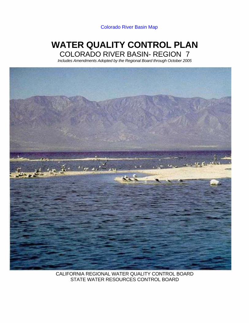
WATER QUALITY CONTROL PLAN COLORADO RIVER BASIN- REGION 7 Includes Amendments Adopted by the Regional Board through October 2005 CALIFORNIA REGIONAL WATER QUALITY CONTROL BOARD STATE WATER RESOURCES CONTROL BOARD Colorado River Basin Map
Transcript of Colorado River Basin - Map - California
FOREWORD On November 17, 1993 the Regional Board adopted Resolution No. 93-145 which approved this 1993 Basin Plan. This Basin Plan was subsequently approved by the State Water Resources Control Board on February 17, 1994 (Resolution No. 94-18). The California Office of Administrative Law approved the adoption of the 1993 Basin Plan on August 3, 1994. This Basin Plan now supersedes the previous (1991) Basin Plan. This Basin Plan was prepared by the California Regional Water Quality Control Board, Colorado River Basin Region, in accordance with criteria contained in the California Porter-Cologne Water Quality Control Act, the Federal Clean Water Act, and other pertinent state and federal rules and regulations. The intent of this plan is to provide definitive guidelines, and give direction to the full scope of Regional Board activities that serve to optimize the beneficial uses of state waters within the Colorado River Basin Region of California by preserving and protecting the quality of these waters. This plan is also subject to review by the United States Environmental Protection Agency (EPA). The plan is in itself not a final statement on regional water quality planning, but is subject to continuous review, and update as necessary. Updated sections of the plan may appear as periodic Basin Plan amendments, which are also subject to approval by the State Water Resources Control Board and the Office of Administrative Law. This Basin Plan includes amendments adopted by the Regional Board through November 2002. COVER: PHOTO OF THE SALTON SEA
TABLE OF CONTENTS
CHAPTER 1 - INTRODUCTION.......................................................................................................................................1 I. THE REGIONAL BOARD..............................................................................................................................1 II. FUNCTION OF THE BASIN PLAN...............................................................................................................1 III. LEGAL BASIS AND AUTHORITY ................................................................................................................2
A. FEDERAL REQUIREMENTS...............................................................................................................2 B. CALIFORNIA STATUTORY AND ADMINISTRATIVE LAWS.............................................................3 C. OTHER PLANNING AGENCIES..........................................................................................................5
IV. THE PLANNING PROCESS.........................................................................................................................5 A. BASIN PLAN AMENDMENT PROCESS .............................................................................................5 B. TRIENNIAL REVIEW PROCESS.........................................................................................................6
V. THE COLORADO RIVER BASIN REGION..................................................................................................6 A. GEOGRAPHICAL SETTING ................................................................................................................6 B. GEOLOGY .............................................................................................................................................7 C. MAJOR HYDROLOGIC FEATURES....................................................................................................7 D. CLIMATE................................................................................................................................................8 E. FISH AND WILDLIFE RESOURCES ....................................................................................................8
VI. PLANNING AREAS .......................................................................................................................................9 A. LUCERNE VALLEY PLANNING AREA ...............................................................................................9 B. HAYFIELD PLANNING AREA............................................................................................................10 C. COACHELLA VALLEY PLANNING AREA .........................................................................................12 D. ANZA-BORREGO PLANNING AREA.................................................................................................13 E. IMPERIAL VALLEY PLANNING AREA..............................................................................................13 F. SALTON SEA PLANNING AREA.......................................................................................................14 G. EAST COLORADO RIVER BASIN PLANNING AREA .....................................................................14
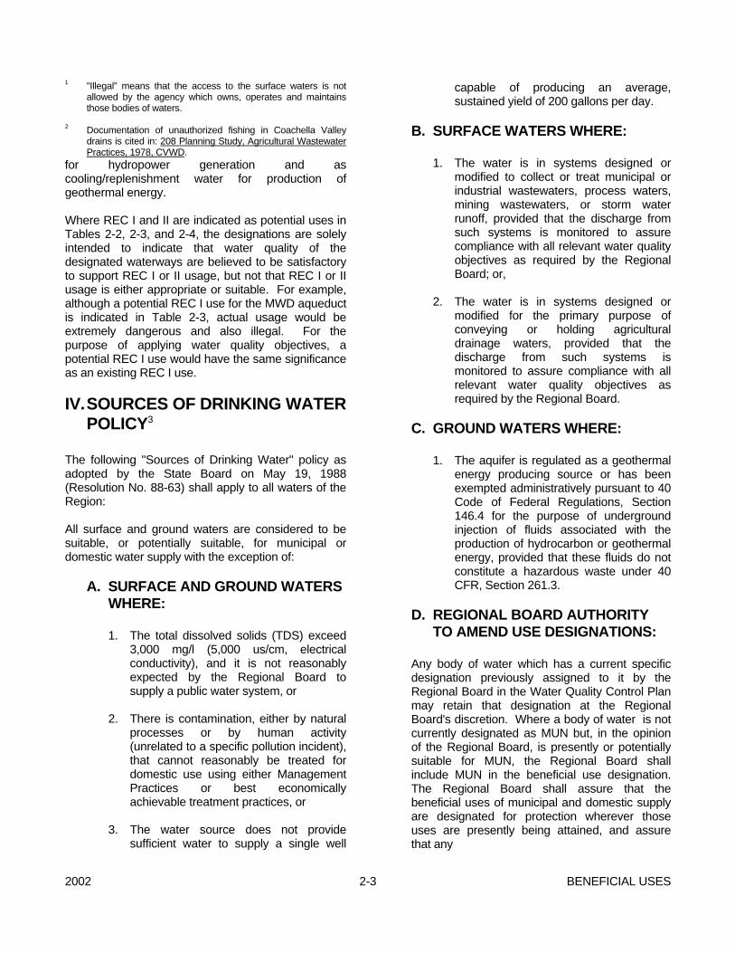
CHAPTER 2 - BENEFICIAL USES ...................................................................................................................................1 I. PAST OR HISTORICAL BENEFICIAL USES ..............................................................................................1 II. PRESENT BENEFICIAL USES ....................................................................................................................2 III. POTENTIAL BENEFICIAL USES .................................................................................................................2 IV. SOURCES OF DRINKING WATER POLICY3 .............................................................................................3
A. SURFACE AND GROUND WATERS WHERE: ..................................................................................3 B. SURFACE WATERS WHERE:.............................................................................................................3 C. GROUND WATERS WHERE:..............................................................................................................3 D. REGIONAL BOARD AUTHORITY TO AMEND USE DESIGNATIONS:............................................3
TABLE 2-1: DEFINITIONS OF THE BENEFICIAL USES OF WATER ..............................................5 TABLE 2-2: BENEFICIAL USES OF SURFACE WATERS IN THE EAST
COLORADO RIVER BASIN...............................................................................................7 TABLE 2-3: BENEFICIAL USES OF SURFACE WATERS IN THE WEST
COLORADO RIVER BASIN...............................................................................................9 TABLE 2-4: BENEFICIAL USES OF WATERS FROM SPRINGS IN THE
COLORADO RIVER BASIN.............................................................................................13 TABLE 2-5: BENEFICIAL USES OF GROUND WATERS IN THE COLORADO
RIVER BASIN1..................................................................................................................18
CHAPTER 3 - WATER QUALITY OBJECTIVES..............................................................................................................1 I. GENERAL OBJECTIVES..............................................................................................................................1
II. GENERAL SURFACE WATER OBJECTIVES.............................................................................................1 A. AESTHETIC QUALITIES......................................................................................................................1 B. TAINTING SUBSTANCES....................................................................................................................2 C. TOXICITY 1 ............................................................................................................................................2 D. TEMPERATURE ...................................................................................................................................2 E. pH .............................................................................................................................................2 F. DISSOLVED OXYGEN.........................................................................................................................2 G. SUSPENDED SOLIDS AND SETTLEABLE SOLIDS .........................................................................2 H. TOTAL DISSOLVED SOLIDS ..............................................................................................................2 I. BACTERIA .............................................................................................................................................3 J. BIOSTIMULATORY SUBSTANCES ....................................................................................................4 K. SEDIMENT............................................................................................................................................4 L. TURBIDITY............................................................................................................................................4 M. RADIOACTIVITY...................................................................................................................................4 N. CHEMICAL CONSTITUENTS..............................................................................................................4 O. PESTICIDE WASTES...........................................................................................................................5
III. SPECIFIC SURFACE WATER OBJECTIVES .............................................................................................5 A. COLORADO RIVER..............................................................................................................................5 B. NEW RIVER ..........................................................................................................................................6 C. SALTON SEA........................................................................................................................................8 D. IRRIGATION SUPPLY CANALS..........................................................................................................8
IV. GROUND WATER OBJECTIVES.................................................................................................................8 A. TASTE AND ODORS............................................................................................................................9 B. BACTERIOLOGICAL QUALITY ...........................................................................................................9 C. CHEMICAL AND PHYSICAL QUALITY...............................................................................................9 D. BRINES .............................................................................................................................................9 E. RADIOACTIVITY...................................................................................................................................9 F. GROUND WATER OVERDRAFT ........................................................................................................9
CHAPTER 4 - IMPLEMENTATION...................................................................................................................................1 I. INTRODUCTION ...........................................................................................................................................1
A. REGIONAL BOARD GOALS AND MANAGEMENT PRINCIPALS ....................................................1 B. GENERAL IMPLEMENTATION ...........................................................................................................1
II. POINT SOURCE CONTROLS......................................................................................................................2 A. GEOTHERMAL DISCHARGES............................................................................................................3 B. SLUDGE APPLICATION ......................................................................................................................3 C. MUNICIPAL WASTEWATER TREATMENT PLANTS........................................................................3 D. WASTEWATER RECLAMATION AND REUSE..................................................................................3 F. STORMWATER ....................................................................................................................................4 G. BRINE DISCHARGES ..........................................................................................................................4 H. SEPTIC SYSTEMS...............................................................................................................................5
Cathedral City Cove...............................................................................................................................5 Cathedral City Cove - Reports...............................................................................................................5 Mission Creek or Desert Hot Springs Aquifers .....................................................................................5
III. NONPOINT SOURCE CONTROLS .............................................................................................................6 A. AGRICULTURE.....................................................................................................................................7
B. STATE WATER QUALITY CERTIFICATION...............................................................................................8 IV. SPECIFIC IMPLEMENTATION ACTIONS...................................................................................................8
A. NEW RIVER POLLUTION BY MEXICO ..............................................................................................9 B. SALTON SEA......................................................................................................................................12
C. TOXICITY OBJECTIVE COMPLIANCE.............................................................................................14 D. DISPOSAL OF WASTE TO INDIAN LAND........................................................................................14
V. TOTAL MAXIMUM DAILY LOADS (TMDLS) AND IMPLEMENTATION PLANS.......................................14 A. NEW RIVER PATHOGEN TMDL ..........................................................................................................14
TABLE A-1: NEW RIVER PATHOGEN TMDL ELEMENTS ..............................................................15 B. ALAMO RIVER SEDIMENTATION/SILTATION TMDL........................................................................18
TABLE B-1: ALAMO RIVER SEDIMENTATION/SILTATION TMDL ELEMENTS1...........................19 TABLE B-1A1 : WASTE LOAD ALLOCATIONS FOR POINT SOURCES IN THE ALAMO RIVER WATERSHED....................................................................................23 TABLE B-2: INTERIM NUMERIC TARGETS FOR ATTAINMENT OF THE TMDL1 ........................24
C. NEW RIVER SEDIMENTATION/SILTATION TMDL............................................................................24 TABLE C-1: NEW RIVER SEDIMENTATION/SILTATION TMDL ELEMENTS ................................24 TABLE C-2: INTERIM NUMERIC TARGETS FOR ATTAINMENT OF THE TMDL .........................29
D. IMPERIAL VALLEY DRAINS SEDIMENTATION/SILTATION TMDL..................................................29 TABLE D-1: IMPERIAL VALLEY DRAINS (NILAND 2, P, AND PUMICE) SEDIMENTATION/SILTATION TMDL ELEMENTS (CONTINUED)...........................31
E. FURTHER IMPLEMENTATION ACTIONS AND REGULATIONS FOR ALL IMPERIAL VALLEY SEDIMENTATION/SILTATION TMDLs................................................................34
VI. ACTIONS OF OTHER AUTHORITIES.......................................................................................................41 VII. PROHIBITIONS ..........................................................................................................................................41
A. IMPERIAL VALLEY SEDIMENTATION/SILTATION ............................................................................41
CHAPTER 5 - PLANS, POLICIES AND ISSUES ...........................................................................................................42 I. STATE BOARD PLANS AND POLICIES ...................................................................................................42
A. RESOLUTION NO. 68-16...................................................................................................................42 B. WATER QUALITY CONTROL............................................................................................................42 C. THERMAL PLAN.................................................................................................................................42 D. POWERPLANT COOLING.................................................................................................................42 E. WATER RECLAMATION....................................................................................................................42 F. SHREDDER WASTE..........................................................................................................................42 G. NONPOINT SOURCE MANAGEMENT PLAN ..................................................................................42 H. SOURCES OF DRINKING WATER POLICY ....................................................................................42
II. REGIONAL BOARD POLICIES ..................................................................................................................42 A. SEWERAGE SYSTEMS.....................................................................................................................42 B. SEWAGE DISPOSAL FROM LAND DEVELOPMENTS...................................................................42 C. MOU WITH THE BUREAU OF LAND MANAGEMENT ....................................................................42 D. WATER QUALITY LIMITED SEGMENTS .........................................................................................43 E. MOA'S ...........................................................................................................................................43 F. WATER QUALITY ASSESSMENT ....................................................................................................43 G. AGRICULTURAL DRAINAGE............................................................................................................43 H. WAIVER FOR WASTE DISCHARGES..............................................................................................43
III. REGIONAL BOARD ISSUES......................................................................................................................43 A. SEPTIC SYSTEM IMPACTS TO GROUND WATER BASINS .........................................................43 B. BENEFICIAL USE DESIGNATIONS OF AQUIFERS........................................................................43 C. GEOTHERMAL FLUIDS.....................................................................................................................43
CHAPTER 6 - SURVEILLANCE, MONITORING AND WATER QUALITY ASSESSMENT...........................................1 I. STATEWIDE MONITORING.........................................................................................................................1 II. REGIONAL BOARD MONITORING.............................................................................................................2
A. SURFACE WATER MONITORING......................................................................................................2 TABLE 6-1: PRIMARY NETWORK STATIONS .................................................................................2
B. COMPLIANCE MONITORING .............................................................................................................3 C. COMPLAINT INVESTIGATION............................................................................................................4 D. INTENSIVE SURVEYS.........................................................................................................................4
TABLE 6-2: PRELIMINARY BIOMONITORING SCREENING LOCATIONS ....................................5 E. TOXIC SUBSTANCES MONITORING ................................................................................................6
TABLE 6-3:TSM PROGRAM – STATION SAMPLING HISTORIES ...................................................6 F. TOTAL MAXIMUM DAILY LOADS COMPLIANCE ASSURANCE AND
ENFORCEMENT ....................................................................................................................................7 III. WATER QUALITY ASSESSMENT ACTIVITIES........................................................................................10 IV. QUALITY ASSURANCE AND QUALITY CONTROL.................................................................................10
APPENDIX A - Regional Ground Water Basin (Hydrologic Unit) Map and Index MAP A - Foldout Regional Ground Water Basin (Hydrologic Unit) Map MAP B - Foldout Regional Aquifer Map
2002 1-1 INTRODUCTION
CHAPTER 1 - INTRODUCTION I. THE REGIONAL BOARD The Regional Board consists of nine members appointed by the Governor for staggered four-year terms. Members must reside or maintain a place of business within the Region and must be associated with or have special knowledge of specific activities related to the control of water quality. Members of the Board conduct their business at regular meetings and public hearings at which public participation is encouraged. All duties and responsibilities of the Regional Board are directed at providing reasonable protection and enhancement of the quality of all waters of the Region, both surface and underground. The programs by which these duties and responsibilities are carried out include: - Preparing new or revised policies addressing
region-wide quality concerns; - Adopting, monitoring compliance with, and
enforcing waste discharge requirements and National Pollutant Discharge Elimination System permits;
- Providing recommendations to the State Board on
financial assistance programs, proposals for water diversion, budget development, and other statewide programs and policies;
- Coordinating with other public agencies which are
concerned with water quality control; and - Informing and involving the public on water quality
issues. Administration of these duties is accomplished by a permanent staff of State Employees, directed by an Executive Officer who is selected by and serves at the pleasure of the Regional Board. II. FUNCTION OF THE BASIN PLAN This Water Quality Control Plan (herein referred to as the Basin Plan) for the Colorado River Basin Region was prepared by the California Regional Water Quality Control Board, Colorado River Basin Region,
in accordance with criteria contained in the California Porter-Cologne Water Quality Control Act, the Federal Clean Water Act, and other pertinent state and federal rules and regulations. The intent of the Basin Plan is to provide definitive guidelines, and give direction to the full scope of Regional Board activities that serve to optimize the beneficial uses of the state waters within the Colorado River Basin Region of California by preserving and protecting the quality of these waters. Water uses and water benefits vary. Water quality is an important factor in determining use and benefit. For example, drinking water has to be of higher quality than the water used to irrigate pastures. Both of these are beneficial water uses, but the quality requirements for irrigation water are different from those for drinking water. The Basin Plan recognizes the variations of water quality and water uses. This Basin Plan lists and defines the various beneficial water uses (Chapter 2). It describes the water quality which must be maintained to support such uses (Water Quality Objectives, Chapter 3). The section on implementation (Chapter 4) describes the programs, projects and other actions which are necessary to achieve the standards established in this Plan. Plans, Policies and Issues (Chapter 5), summarizes the various plans and policies which protect water quality. This chapter also describes water quality issues which require special attention. Surveillance and Monitoring (Chapter 6), describes activities within the Colorado River Basin Region which are related to surveillance, monitoring, assessment, lab support, quality assurance and quality control. The Regional Board implements the Basin Plan by issuing and enforcing waste discharge requirements to persons; which can include individuals, communities, or businesses whose waste discharges may affect water quality. These requirements can be either state Waste Discharge Requirements for discharge to land, or federally delegated National Pollutant Discharge Elimination System permits for discharges to surface water. Dischargers are required to meet water quality objectives and thus protect beneficial uses.
INTRODUCTION 1-2 2002
This Basin Plan also encourages water users to improve the quality of their water supplies, particularly where the wastewater they discharge is likely to be reused. Public works and other projects, which can affect water quality, are reviewed and their impacts are identified. Proposals, which implement or help achieve the goals of the Basin Plan, are supported. This Basin Plan is subject to review by the State Water Resources Control Board (State Board) and the United States Environmental Protection Agency (USEPA). The Basin Plan is, in itself, not a final statement on regional water quality planning, but is subject to continuous review and update as necessary. Updated sections of the plan may appear as periodic amendments, which are also subject to approval by the State Board and USEPA. III. LEGAL BASIS AND AUTHORITY The Porter-Cologne Water Quality Control Act which is contained in Division 7 of the California Water Code, establishes the responsibilities and authorities of the nine Regional Water Quality Control Boards (Regional Board) and the State Water Resources Control Board (State Board). The Porter-Cologne Act names these Boards "...the principal state agencies with primary responsibility for the coordination and control of water quality" (Section 13001). Each Regional Board is directed to "...formulate and adopt water quality control plans for all areas within the region." A water quality control plan for the waters of an area is defined as having these three components: beneficial uses which are to be protected, water quality objectives which protect those uses, and an implementation plan which accomplishes those objectives (Section 13050). Further, "such plans shall be periodically reviewed and may be revised" (Section 13240). The Federal Clean Water Act (Public Law 92-500, as amended) provides for the delegation of certain responsibilities of water quality control and water quality planning to the states. Where the USEPA and the State Board have agreed to such delegation, the Regional Boards implement portions of the Clean Water Act, such as the NPDES program and toxic substance control programs. The Porter-Cologne and Clean Water Acts also describe how enforcement of waste discharge requirements is to be carried out. Enforcement tools available to the Regional Board range from simple letters to the discharger, through formal Board Orders and administrative civil liabilities, to judicial abatement for civil and/or criminal penalties. Legally noticed
public hearings are required for Cease and Desist Orders, but Cleanup and Abatement Orders may be issued by the Executive Officer to allow for a quicker response than regularly scheduled board meetings can provide. This Water Quality Control Plan was prepared to comply with all applicable Federal and State laws, regulations, plans, policies, and guidelines. The laws, regulations, and guidelines are summarized below. The plans and policies are summarized in Chapter 5. Also, future amendments thereto, are hereby included in this plan by reference. A. FEDERAL REQUIREMENTS One Federal law specifically and directly
addresses the matter of water pollution control. This law is known as the Federal Clean Water Act. Several other Federal laws, classifiable as "environmental" laws, may also apply to water pollution control activities. These laws include the National Environmental Policy Act, the Clean Air Act, and the Resource Conservation and Recovery Act.
1. Federal Clean Water Act The objective of the Act is to restore and
maintain the chemical, physical, and biological integrity of the Nation's waters. The Act further states that it is the policy of Congress to recognize, preserve, and protect the primary responsibilities, and rights of the States to prevent, reduce, and eliminate pollution, to plan the development and use (including restoration, preservation, and enhancement) of land and water resources, and that full public participation in the development and/or revision of regulations, plans and programs be provided for, encouraged, and assisted. The responsibility to administer the Act is placed with the Administrator of the U.S. Environmental Protection Agency.
2. National Environmental Policy Act
(NEPA) In general, this Act proposes to
satisfactorily preserve the environment and to restore that which has been

2002 1-3 INTRODUCTION
degraded. The method devised to accomplish this is to require evaluation of the effect of each action proposed upon the environment, and to consider the results in making decisions regarding such action. NEPA applies to the actions of the Federal Government.
NEPA declares a continuing policy for all
levels of government and concerned public and private organizations to create and maintain conditions under which people and nature can exist in productive harmony and fulfill the social, economic, and other needs of present and future generations. The Act directs an interdisciplinary approach to integrated use of all talents in planning and decision-making that impact on the environment (Sec. 102). Each report or recommendation must be accompanied by a detailed statement prepared by the responsible official on:
- The environmental impact of the
proposed action; - Any adverse environmental effects
which cannot be avoided if the action is taken;
- Alternatives to the action; - Relationship between local short-
term uses of the environment, and maintenance and enhancement of long-term productivity; and
- Any irreversible and irretrievable
commitments of resources if the proposed action is taken.
Appropriate alternatives to proposed
actions must be studied and developed when conflicts in use of available resources are encountered.
B. CALIFORNIA STATUTORY AND
ADMINISTRATIVE LAWS The laws in California are organized into the
Constitution, Statutes, and Administrative Codes encompassing all facets of the State's governmental controls. Laws that directly affect water resources planning are contained
principally in the California Water Code, with additional specificity in those Administrative Codes which are titled Water Resources, Health and Safety, Public Resources, and Fish and Game.
1. California Water Code One Division of statutory law is directed
primarily towards the control of water quality. This is Division 7 of the California Water Code, also referred to as the "Porter-Cologne Water Quality Control Act". Those portions of said Division 7 which relate to or govern the preparation of basin plans are summarized below.
This Act establishes that the waters of
the State shall be protected for use and enjoyment by the people of the State; that the activities and factors which may affect the quality of the waters of the State shall be regulated to attain the highest water quality which is reasonable, considering all demands being made or to be made and the total values involved, beneficial and detrimental, economic and social, tangible and intangible; that the health, safety, and welfare of the people require that there be a statewide program for control of the quality of all waters of the State; that quality and quantity of water shall be administered conjunctively; and that the statewide program for water quality can most effectively be administered regionally within a framework of statewide coordination and policy. The State Water Resources Control Board, hereinafter referred to as "State Board", and the nine Regional Water Quality Control Boards, hereinafter referred to as "Regional Board(s)", are established under the Act as the principal state agencies with primary responsibility for control of water quality.
The State Board is responsible for the
formulation and adoption of state policy for water quality control. State policy consists of:
- Water quality principles and
guidelines for long-range planning for ground waters and surface waters, and the use of reclaimed water;
INTRODUCTION 1-4 2002
- Water quality objectives at key locations; and
- Other principles and guidelines
deemed essential for water quality control.
The State Board may adopt water quality
control plans for waters for which water quality standards are required by the Federal Clean Water Act. The Regional Water Quality Control Plans are prepared to conform with policies of the State Water Resources Control Board.
Each Regional Board must formulate and
adopt, for its region, water quality control plan(s) which establish such water quality objectives as in its judgement will ensure reasonable protection of beneficial uses.
Article 4 of Chapter 4 of Division 7 of the
Water Code establishes basic procedures for prescription of waste discharge requirements upon dischargers of waste. Any person who is discharging, or proposes to discharge waste other than into a community sewer, that could affect the quality of water, shall file a report with the Regional Board containing information required by the Board. After any necessary hearing, the Board may impose waste discharge requirements based on the nature of the proposed discharge relative to conditions existing in the disposal area or receiving waters. Discharge requirements may be reviewed and revised as appropriate, upon application by any affected person or by the Regional Board on its own motion. The discharge of wastes does not create any vested right to continue such discharge.
Section 2100 of the Water Code provides
for adjudication to protect ground water quality. The State Board, upon a finding of existing or threatened irreparable damage, may file an action in the Superior Court to restrict pumping or to impose physical solutions, or both, to the extent necessary to prevent destruction of or irreparable injury to the quality of ground water. The State Board may take such action only if an affected local
agency charged with this responsibility fails to take appropriate action.
The Water Code contains provisions
which control almost every consideration of water and its use. Division 2 of the Water Code provides that the State Board shall consider and act upon all applications for permits to appropriate waters. The State Board's authority includes water quality considerations in granting a water right; Division 3 deals with dams and reservoirs; Division 5 pertains to flood control; Division 6 controls conservation, development and utilization of the state water resources; Division 7, as described above, covers water quality; and Divisions 11 through 21 provide for the organization, operation, and financing of various types of local water-oriented agencies.
2. California Environmental Quality Act
(CEQA) CEQA is contained in Sections 21000 to
21176 of the Public Resources Code. CEQA, which is the State-level equivalent of the Federal NEPA, requires all State agencies, boards, and commissions to include, in any report on any project having a significant effect on the environment, an environmental impact report (EIR). CEQA also requires, in addition to the five items set forth in Section 102 of NEPA, that the EIR include a discussion of mitigation measures proposed to minimize the impact. The responsibility for development of objectives, criteria, and procedures to assure proper preparation and evaluation of the EIR is placed with the State Office of Planning and Research.
3. California Code of Regulations The administrative procedures of the
State Board are contained in Title 23, Chapter 3, of the California Code of Regulations. Regulations relating to the many facets of water rights and water quality are contained in the several subchapters of said Chapter 3. Title 17 (Public Health) of the California Code of
2002 1-5 INTRODUCTION
Regulations contains requirements for quality of water for domestic uses. Restrictions on the uses of waters reclaimed from wastewater are contained in Title 22 (Environmental Health).
4. Other State Statutes Portions of various other codes, such as
the Health and Safety Code, Fish and Game Code, Public Resources Code, and Revenue and Taxation Code, impose various regulations that are to be considered in the basin planning process. The Health and Safety Code contains regulations relating to the formation and operation of county sanitation and sewer maintenance districts, sewer revenue bonds, the use by the public of reservoirs, and ocean water-contact sports. The Fish and Game Code provides for the preservation, protection, and enhancement of birds, mammals, fish, amphibians, and reptiles, and their habitats.
C. OTHER PLANNING AGENCIES There are various other regional and local
governmental agencies whose policies are considered during any Water Quality Control Plan update. These include but are not limited to the following:
- Southern California Association of
Governments - Coachella Valley Association of Governments - Imperial Valley Association of Governments - San Bernardino Association of Governments - Agencies, districts, and other public bodies
responsible for collection, treatment, and disposal of wastewaters and for water conservation and production.
IV. THE PLANNING PROCESS A. BASIN PLAN AMENDMENT
PROCESS
Both Federal and State laws require public participation in the development of Water Quality Control Plans and amendments thereto. The principal laws governing public participation with respect to development of water quality control plans are listed below:
- Federal Clean Water Act - Division 7 of the California Water Code - California Environmental Quality Act (CEQA) In addition to these laws, both Federal and State
regulations and guidelines have been developed to ensure compliance with the intent of the laws.
This Regional Board uses the following
procedures for adoption of Water Quality Control Plans:
- Proposed Plans are prepared by Regional
Board staff, under the direction of the Regional Board's Executive Officer.
- An Environmental Checklist Form for the
proposed Plan is prepared. - Staff prepares a summary report containing: A brief description of the proposed Plan; Reasonable alternatives to the proposed
Plan; and Mitigation measures to minimize any
significant adverse environmental impacts.
- A Notice of Filing and Notice of Public
Hearing is mailed to all interested agencies (Federal, State, and local), organizations, and individuals at least 45 days prior to the scheduled Regional Board hearing on the proposed Plan. Those agencies, organizations, and individuals who are presumed to have special interest in the proposed Plan are forwarded copies of the proposed plan, the Environmental Checklist Form, and the summary report.
- At least 45 days prior to the scheduled
Regional Board Public Hearing, a copy of the Notice of Filing and Notice of Public Hearing is published in newspapers for major circulation in areas affected by the proposed Plan.
INTRODUCTION 1-6 2002
- Copies of the proposed Plan, environmental checklist, and summary report are provided upon request to other agencies and persons.
- The Regional Board staff prepares written
responses to comments concerning significant issues raised during the public review period. If a comment is received less than 15 days prior to the date of the Regional Board hearing on the proposed Plan, an oral response is presented at the hearing. The oral response, as well as comments and responses at the Board meeting, are included in the meeting minutes.
- Following Regional Board adoption of the
Plan, the Regional Board's Executive Officer will forward the Plan for consideration of approval to the State Water Resources Control Board.
- Following State Board approval of the Plan, a
Notice of Decision will be filed by the Regional Board with the Secretary of the Resources Agency for public posting for a period of at least 30 days.
In addition to the above procedure, other
provisions are made to allow for public involvement. All Regional Board files containing information regarding the proposed plan are open to public inspection at the office of the California Regional Water Quality Control Board, Colorado River Basin Region, 73-720 Fred Waring Drive, Suite 100, Palm Desert, California, 92260, during the hours of 9 a.m. to 4 p.m. of each business day. Also, appointments can be made with Regional Board staff to discuss the proposed plan and answer any questions.
B. TRIENNIAL REVIEW PROCESS The Federal Clean Water Act (Section 303(c))
requires states to hold public hearings for review of water quality standards at least once every three years. Water quality standards consist of beneficial use designations and water quality objectives necessary to protect those uses. The Porter-Cologne Water Quality Control Act requires the Basin Plan to be reviewed periodically. While a major part of the review process consists of identifying potential problems, an important part of the review is the reaffirmation
of those portions of the plan where no potential problems exist.
At the conclusion of the triennial review public
hearing, Regional Board staff prepares a priority list of potential problems with the Basin Plan that may result in amendments. Placing a potential problem on the priority list will only require Regional Board staff investigation of the need for an amendment. It does not necessarily mean a revision of the water quality control plan will be made.
Other items completed after the public hearing
include: - Detailed Workplans of each issue; - Regional Board identification of issues that
can be completed within existing resource allocations over a three-year period; and
- List of projects requiring additional resources
to complete. Once the triennial review process is complete,
Regional Board staff begins investigating the issues in order of rank. After each investigation, staff determines the need for a Basin Plan amendment.
Basin Plan amendments can also be prepared for
issues not identified during the triennial review. Amendments can be prepared for urgent issues or to reflect new legislation.
V. THE COLORADO RIVER BASIN
REGION A. GEOGRAPHICAL SETTING The Colorado River Basin Region covers
approximately 13 million acres (20,000 square miles) in the southeastern portion of California (Plate 1-1, Page 1-10). It includes all of Imperial County and portions of San Bernardino, Riverside, and San Diego Counties. It is bounded for forty miles on the northeast by the State of Nevada, on the north by the New York, Providence, Granite, Old Dad, Bristol, Rodman, and Ord Mountain ranges, on the west by the San Bernardino, San Jacinto, and Laguna Mountain ranges, on the south by the Republic of Mexico,

2002 1-7 INTRODUCTION
and on the east by the Colorado River and State of Arizona. Geographically the region represents only a small portion of the total Colorado River drainage area which includes portions of Arizona, Nevada, Utah, Wyoming, Colorado, New Mexico, and Mexico.
A significant geographical feature of the Region is
the Salton Trough, which contains the Salton Sea and the Coachella and Imperial Valleys. The two valleys are separated by the Salton Sea, which covers the lowest area of the depression. The trough is a structural extension of the Gulf of California. In prehistoric times it contained the ancient Lake Cahuilla (not to be confused with the present Lake Cahuilla which is located at the terminus of the Coachella Branch of the All-American Canal). Much of the agricultural economy and industry of the Region is located in the Salton Trough. There are also industries associated with agriculture, such as sugar refining. During the past several years there has been increasing development of geothermal industries. In the future, agriculture is expected to experience little growth in the Salton Trough, but there will likely be increased development of other industries (e.g. construction, manufacturing, and services).
The present Salton Sea, located on the site of a
prehistoric lake, was formed between 1905 and 1907 by overflow of the Colorado River. Today, it serves as a drainage reservoir for irrigation return water and stormwater from the Coachella Valley, Imperial Valley, and Borrego Valley, and also receives drainage water from the Mexicali Valley in Mexico. The Sea is California's largest inland body of water and it provides a very important wildlife habitat and sportfishery.
Developments along California's 230 mile reach
of the Colorado River, which flows along the eastern boundary of the Region, include agricultural areas in Palo Verde Valley and Bard Valley, urban centers at Needles, Blythe, and Winterhaven, several transcontinental gas compressor stations, and numerous small recreational communities. Some mining operations are located in the surrounding mountains. Also the Fort Mojave, Chemehuevi, Colorado River, and Yuma Indian Reservations are located along the River.
B. GEOLOGY
The mountains of the Region consist mainly of metamorphic and igneous rocks of pre-Cambrian to Tertiary age, and the sediments in the intervening valleys are generally weakly consolidated to unconsolidated sediments of late Cenozoic age. Northwest-trending faults are extensive and are a major factor in determining the configuration of the land. The well known San Andreas Fault Zone cuts diagonally across the southwesterly portion of the Region and borders the highlands on the northeast side of the Salton Trough. Borrego Valley is a typical valley formed by the San Jacinto Fault. The valleys, mountains, and dry lakes generally trend toward the northwest as oriented by the major fault systems.
The Coachella and Imperial Valleys were created
when the Colorado River formed a delta that isolated the Salton Trough from the Gulf of California. Subsequently, under desert conditions, the inland sea dried up. Later, the trough was occupied by lakes for various periods, and deposition into these lakes gives the valleys their characteristic flat lands and fertile soils.
The Anza-Borrego planning area is made up of
the Old California batholith that has been weathered and eroded. Today only low dissected hills remain.
The East Colorado River Basin planning area
consists of a sediment-filled structural trough. Deep alluvial deposits composed of silt, clay, and sand were laid down by ancestral streams of the present Colorado River system.
C. MAJOR HYDROLOGIC FEATURES The Colorado River is the most important
waterway in the Region. The River supplies water for use within the Region and elsewhere. Regional drainage to the River is from a strip about 200 miles long, with a watershed which (in California) ranges from 7 to 40 miles in width. This watershed strip is referred to as the East Colorado River Basin.
Near Parker Dam, water is diverted by the
Metropolitan Water District for export through the Colorado River Aqueduct to coastal counties. The dam forms Lake Havasu, a major recreational development. At Palo Verde Diversion Dam, water is diverted for irrigation in Palo Verde Valley. At Imperial Dam, water is diverted to the All-American Canal, which
INTRODUCTION 1-8 2002
conveys water in California to the Bard Valley, and to the agricultural areas of the Imperial and Coachella Valleys.
Apportionment of water available for diversion
from the River is made in accordance with a number of documents collectively referred to as the Law of the River. These include interstate compacts, federal legislation, water delivery contracts, state legislation, a treaty with Mexico, United States Supreme Court decrees, and federal administrative actions. Presently, California is receiving waters unused by other states. When Arizona is diverting its full apportionment, it is anticipated that there will be only infrequent periods of surplus, and California's diversions will be limited to its basic apportionment of 4.4 million acre-feet per year.
Regional drainage waters resulting from Colorado
River diversions and use, and which do not return to the Colorado River, drain into the Salton Sea. That portion of the Region that does not drain into the Colorado River is referred to as the Colorado River Basin (West) or West Basin.
Much of the northern portion of the West Basin
drains to several individual internal sinks or playas, while the southern portion generally drains to the Salton Sea. The Imperial and Coachella Valleys contain numerous drains that transport irrigation return flows and stormwater, as well as canals for importation and distribution of Colorado River water.
The Salton Sea, which is replenished principally
by irrigation drainage and stormwater, is the largest body of water in the West Basin. The Sea serves as a reservoir to receive and store agricultural drainage and seepage waters, but also provides important wildlife habitat and is used for recreational purposes which include boating and fishing. Several smaller constructed recreational lakes are located in the Imperial Valley. In addition, Lake Cahuilla in Coachella Valley is used to store Colorado River water for irrigation and recreational purposes.
D.CLIMATE The Region has the driest climate in California.
The winters are mild and summers are hot. Temperatures range from below freezing to over 120oF. In the Colorado River valleys and the
Salton Trough frost is a rare occurrence, and crops are grown all year round.
Snow falls in the Region's higher elevations, with
mean seasonal precipitation in the upper San Jacinto and San Bernardino Mountains ranging from 30 to 40 inches. The lower elevations receive relatively little rainfall. An average of about four inches of precipitation occurs along the Colorado River, with much of this coming from late summer thunderstorms moving north from Mexico.
Typical mean seasonal precipitation in the desert
valleys is 3.6 inches at Indio and 3.2 inches at El Centro. Precipitation over the entire area occurs mostly from November through April, and August through September, but its distribution and intensity are often sporadic. Local thunderstorms may contribute all the average seasonal precipitation at one time, or only a trace of precipitation may be recorded at any locale for the entire season.
E. FISH AND WILDLIFE RESOURCES The Region provides habitat for a variety of native
and introduced species of wildlife. Increasing human population and its associated development have adversely affected the habitat for some species, while enhancing it for others.
Large areas within the Region are inhabited by
animals tolerant of arid conditions, including small rodents, coyotes, foxes, birds, and a variety of reptiles. Along the Colorado River and in the higher elevations of the San Bernardino and San Jacinto Mountains, where water is more abundant, deer, bighorn sheep, and a diversity of small animals exist.
Practically all of the fishes inhabiting the Region
are introduced species. The most abundant species in the Colorado River and irrigation canals include largemouth bass, smallmouth bass, flathead and channel catfish, yellow bullhead, bluegill, redear sunfish, black crappie, carp, striped bass, threadfin shad, red shiner, and in the colder water above Lake Havasu, rainbow trout. Grass carp have recently been introduced into sections of the All American Canal system for aquatic weed control. Fishes inhabiting agricultural drains in the Region generally include mosquito fish, mollies, red shiners, carp, and
2002 1-9 INTRODUCTION
tilapia, although locally significant populations of catfish, bass, and sunfish occur in some drains. A considerable sportfishery exists in the Salton Sea, with orangemouth corvina, gulf croaker, sargo, and tilapia predominating.
The Salton Sea National Wildlife Refuge and
state waterfowl management areas are located in or near the Salton Sea. The refuge supports large numbers of waterfowl in addition to other types of birds. Located along the Colorado River are the Havasu, Cibola and Imperial National Wildlife Refuges.
The Region provides habitat for certain
endangered/threatened species of wildlife including desert pupfish, razorback sucker, Yuma clapper rail, black rail, least Bell's vireo, yellow billed cuckoo, desert tortoise, and peninsular bighorn sheep.
VI. PLANNING AREAS For planning and reporting purposes, the Region has been divided into the following seven major planning areas on the basis of different economic and hydrologic characteristics (Plate 1-1): - Lucerne Valley - Hayfield - Coachella Valley - Anza-Borrego - Imperial Valley - Salton Sea - East Colorado River Basin A. LUCERNE VALLEY PLANNING
AREA The Lucerne Valley planning area comprises
many small internal drainage basins which cover 6,500 square miles, approximately the northern third of the West Basin. In the upper desert, which contains Lucerne Valley, Yucca Valley, Joshua Tree, and Twentynine Palms, precipitation is higher, and frost often occurs. The San Bernardino Mountains on the northwest have the highest peaks in the planning area, with elevations exceeding 7,000 feet.
1.Surface Water Hydrology Precipitation occurs mostly as rainfall,
with some snowfall in the San
Bernardino Mountains. Rainfall is sporadic, and amounts vary widely with location. Mean annual precipitation ranges from 16 inches in the San Bernardino Mountains to less than three inches in the Bristol Lake (dry) area. The average annual rainfall over the entire planning area is five inches. Little of the rainwater percolates into the ground water table and most is lost by evaporation and by evapotranspiration. Arrastre and Crystal Creeks are the most significant streams in the planning area.
2.Ground Water Hydrology Ground water is stored principally in the
unconsolidated alluvium. Except for areas near some of the dry lakes, ground water is unconfined. The depth of the water bearing deposits is not known, but the basins have accumulated hundreds of feet of sediments (e.g. 1,200 feet of sediments have been measured in the Dale Hydrologic Subunit).
Wells yield from a few gallons-per-minute
(gpm) to 3,000 gpm. In 1970, depth to ground water ranged from flow at the surface to 445 feet in the Copper Mountain hydrologic unit.
There may be some flow (less than an
average 100 acre-feet per year) from the Lucerne Hydrologic unit into the Upper Mojave River Hydrologic Subunit in the South Lahontan Basin. There is also an undetermined amount of outflow from the Cadiz Hydrologic Unit into the Palen Hydrologic Subunit of the Hayfield Planning Area.
Ground water flow follows the general
gradient of the land surface except in areas of heavy extraction and where subsurface flow may be affected by faults. The Baseline Fault along the south side of Twentynine Palms Valley causes a long linear zone of rising water covered by dense vegetation, which includes the Twentynine Palms Oasis. Another fault, the Mesquite Dry Lake Fault, intersects the Baseline Fault four miles east of Twentynine Palms and impedes ground water movement locally, causing a higher water table on the
INTRODUCTION 1-10 2002
southwest side of the fault. Other faults have less effect on the hydrology, but may be responsible for high fluoride in the water and for high water temperatures. Wells in the Dale hydrologic unit yield water with temperatures ranging from 70o to 118oF.
B. HAYFIELD PLANNING AREA
The Hayfield Planning Area lies primarily in Riverside County and covers approximately 1,860 square miles. The Hayfield Planning Area is a desert, with barren mountains and valleys and with dry lake beds at the lower elevations.
PLATE 1-1. Colorado River Basin Planning Areas.
2002 1-11 INTRODUCTION

INTRODUCTION 1-12 2002
The area is bounded on the south by the Chuckwalla Mountains, and on the east by the McCoy Mountains. The highest elevation in the Planning Area is close to 5,000 feet, but most of the mountain tops are at lower elevations. 1. Surface Water Hydrology Average annual precipitation ranges from
less than three inches in the lower valley to eight inches in the higher elevations of the Little San Bernardino Mountains. The average annual runoff for the area, which occurs principally during thunderstorms, is 5,000 acre-feet. No perennial streams flow in the planning area. Almost all the moisture from rain is lost through evaporation and evapotranspiration.
2. Ground Water Hydrology Runoff from the higher elevations is the
main source of recharge of the ground water basins. Small amounts might percolate to the ground water table from direct precipitation. Water in storage is generally unconfined in the sediments that fill the valleys.
Water levels range from ground surface
down to 400 feet. Wells in the planning area yield from a few gpm to over 5,000 gpm. The water-bearing sediments have been penetrated to a depth of 1,200 feet. Most of the pumping in the area has been done by the Kaiser Steel Corporation for industrial use.
Ground water flow generally follows the
gradient of the land surface but may be affected by pumping depressions and by the local geology of the non-water-bearing rocks. An example is the subsurface basalt dike that impedes ground water movement at the east end of the Pinto hydrologic subunit and prevents flow into the adjoining Palen Hydrologic Subunit.
C. COACHELLA VALLEY PLANNING
AREA This planning area contains the Whitewater
Hydrologic Unit and the East Salton Sea
Hydrologic Unit. It lies almost entirely in Riverside County and covers 1,920 square miles in the west central portion of the Region. The San Bernardino Mountains and the Little San Bernardino Mountains form the northern boundary.
The San Jacinto and Santa Rosa Mountains and
the Salton Sea shoreline form the western and southern boundaries. Elevations range from over 10,000 feet in the San Jacinto Mountains to 230 feet below sea level at the Salton Sea shoreline.
The higher elevations of the San Bernardino and
San Jacinto Mountains have evergreen forests with perennial streams. A contrasting scene is presented on the Coachella Valley floor where the land contains desert vegetation, except where the land has been irrigated with pumped ground water or with imported Colorado River water.
1. Surface Water Hydrology Average annual precipitation ranges from
less than three inches in the valleys to 40 inches in the San Bernardino Mountains. Seasonal snows fall on the higher elevations in the San Bernardino and San Jacinto Mountains. In the valleys, precipitation from summer thunderstorms often exceeds that of winter.
Runoff resulting from rains and snowmelt
at the higher elevations is the major source of ground water replenishment. Perennial streams include the upper reaches of the San Gorgonio and Whitewater Rivers, and Palm Canyon, Tahquitz, Snow, Deep Canyon, Chino, and Andreas Creeks.
The Whitewater River is the major
drainage course in the Planning Area. There is perennial flow in the mountains, but because of diversions and percolation into the basin, the River becomes dry further downstream. The constructed downstream extension of the River channel known as the Coachella Valley Storm Water Channel, serves as a drainage way for irrigation return flows, treated community wastewater, and storm runoff.
2002 1-13 INTRODUCTION
There is one relatively large surface water impoundment. Lake Cahuilla, at the terminus of the Coachella Canal, serves as a storage reservoir to regulate irrigation water demands, and is also used for recreational purposes.
2. Ground Water Hydrology Ground water is stored principally in the
unconsolidated Pleistocene sediments. Wells yield up to 4,000 gpm. Maximum thickness of the water-bearing sediments is not known; however, it exceeds 1,000 feet in Coachella Valley.
Ground water is generally unconfined
except in the lower areas of the Coachella Valley. A clay aquitard, a result of past sedimentation in the old lake bed, extends from the Salton Sea to some distance west of Indio, overlying the domestic-use aquifers. The clay layer underlies lenses of permeable sediments and perched ground waters which are replenished by percolating irrigation water.
The planning area is faulted extensively,
altering ground water movement. The Mission Creek, Banning, and San Andreas Faults form effective barriers to ground water movement. The Indio Hills, Garnet Hills, and Mecca Faults form partial barriers.
The Indio and Mecca Hills have been
uplifted along the northwest-trending San Andreas Fault system. The alignment of oases on the flanks of those hills results from faults that impede the movement of ground water. The most prominent of these oases is the Thousand Palms Oasis on the Mission Creek Fault.
D.ANZA-BORREGO PLANNING AREA This Planning Area includes the Clark, West
Salton Sea, and Anza-Borrego Hydrologic Units. It comprises 1,000 square miles in the southwest corner of the Region, mostly in San Diego and Imperial Counties, with a small segment in Riverside County.
Elevations range from 230 feet below sea level at the Salton Sea to over 6,000 feet along the western boundary. The principal communities in the planning area are Salton City and Borrego Springs.
1. Surface Water Hydrology
Drainage flows to the Salton Sea except
for two small areas of internal drainage in Clark and Borrego Valleys in the northwest corner of the planning area.
Average annual precipitation ranges from
less than three inches along the eastern boundary, near Imperial Valley, to 25 inches in the mountain divide between the Salton Sea and Pacific Ocean drainages. Runoff occurs from winter precipitation especially in the higher elevations and from summer thunderstorms. Perennial flow includes reaches of Coyote and San Felipe Creeks.
2. Ground Water Hydrology Ground water is pumped principally from
the unconsolidated Pleistocene sediments, but some is pumped from low-yield wells that extend to weathered and fractured bedrock.
Ground water flows in the same general
direction as surface water to Clark Lake, Borrego Sink, and the Salton Sea. However, this subsurface flow is affected by pumping and may be impeded by faults. About 10,000 acre-feet of subsurface flow reaches the Salton Sea annually. A safe yield of 22,000 acre-feet/year is estimated for the Planning Area. Storage capacity of the ground water basin is estimated at seven million acre-feet.
E. IMPERIAL VALLEY PLANNING
AREA This Planning Area comprises 2,500 square miles
in the southern portion of the Region, almost all of it in Imperial County. The easterly and westerly boundaries are contiguous with the westerly and easterly boundaries of the East Colorado River Basin and the Anza-Borrego Planning Area,

INTRODUCTION 1-14 2002
respectively. Its northerly boundary is along Salton Sea and the Coachella Valley Planning Area and its southerly boundary follows the International Boundary with Mexico. The Planning Area's central feature is the flat, fertile Imperial Valley. The principal communities are El Centro, Brawley, and Calexico.
1. Surface Water Hydrology Surface waters mostly drain toward the
Salton Sea. The New and Alamo Rivers convey agricultural irrigation drainage water from farmlands in the Imperial Valley, surface runoff, and lesser amounts of treated municipal and industrial waste waters from the Imperial Valley. The flow in the New River also contains agricultural drainage, treated and untreated sewage, and industrial waste discharges from Mexicali, Mexico.
Average annual precipitation ranges from
less than three inches over most of the planning area to about eight inches in the Coyote Mountains on the western border.
Colorado River water, imported via the All
American Canal, is the predominant water supply and is used for irrigation, industrial, and domestic purposes.
2.Ground Water Hydrology Ground water is stored in the Pleistocene
sediments of the valley floor, the mesas on the west, and the East Mesa and sand hills on the east. However, the fine-grained lake sediments in the central portion of Imperial Valley inhibit ground water movement, and tile-drain systems are utilized to dewater the sediments to a depth below the root zone of crops and to prevent the accumulation of saline water on the surface.
Few wells have been drilled in these lake
sediments because the yield is poor and the water is generally saline. The few wells in the Valley are for domestic use only. In the Coyote Wells Hydrologic Subunit and Davies Hydrologic Unit, which are at higher elevations, the water yield from wells is higher, and the waters are of lower salt concentration. Ground
water is the main water supply in those areas.
Factors that diminish ground water
reserves are consumptive use, evapotranspiration, evaporation from soils where ground water is near the surface, and losses through outflow and export.
F. SALTON SEA PLANNING AREA This planning area consists entirely of the Salton
Sea, which is a saline body of water in a natural sink between the Imperial and Coachella Valleys, in Riverside and Imperial Counties. The sea is 30 miles long, about 10 to 15 miles wide, with an average depth of 30 feet. It has an area of approximately 360 square miles, and its surface elevation, although variable, is approximately 227 feet below mean sea level. The climate is arid, and average annual precipitation is about 2.6 inches.
Replenishment of the Salton Sea is
predominantly from farm drainage and seepage, and occasional and sometimes significant storm runoff, from the Coachella Valley, Imperial Valley, and Anza-Borrego area in this Region, and from the Mexicali Valley in Mexico. The gross contributing watershed comprises about 7,500 square miles.
G. EAST COLORADO RIVER BASIN
PLANNING AREA The East Colorado River Basin Planning Area,
encompasses the eastern portion of San Bernardino, Riverside, and Imperial Counties. It is bounded on the north by Nevada, on the east by the Colorado River, which generally forms the Arizona-California state line, on the south by Mexico, and on the west by the drainage division of the California streams and washes directly tributary to the Colorado River. The planning area is 200 miles long, with a maximum east-west width of 40 miles. The area is characterized by desert valleys and low mountains that are generally less than 4,000 feet above sea level. The Palo Verde and Bard Valleys are within this planning area.
1. Surface Water Hydrology

2002 1-15 INTRODUCTION
Precipitation is 3-4 inches annually with about half of this occurring from summer thunderstorms, and the other half from generally weak winter storms.
All drainage flows to the Colorado River
except for a minor amount which flows into the Colorado River aqueduct via Gene Wash and Copper Basin Reservoirs.
Perennial flow is limited to the Colorado
River, and associated drains, canals, and aqueducts. Piute Creek, a small stream northwest of Needles flows perennially for about a mile before infiltrating into the ground.
2. Ground Water Hydrology Ground water is generally unconfined in
all four hydrologic units of the Planning Area. However, some confined zones probably exist in the more than 700 feet of alluvial sediments that form the aquifers in three of the units.
Some subsurface water probably enters
the Planning Area from other than the Colorado River. However, no data is available upon which to base an estimate. The subsurface inflow from Nevada into the Piute Hydrologic Subunit and from the Chuckwalla and Rice Hydrologic Units into the Palo Verde and Vidal Hydrologic Subunits, respectively, may be significant in terms of the limited capacity of these subunits.
About 10,000 acre-feet of precipitation
deep-percolates annually. The combined total storage capacity of all hydrologic units is about 35 million acre-feet within a selected 200-foot zone that lies above the base of the deepest well in each hydrologic unit. In three hydrologic units, wells are 300 feet or more deep.

2002 2-1 BENEFICIAL USES
CHAPTER 2 - BENEFICIAL USES Division 7 of the California Water Code (also known as the Porter-Cologne Water Quality Control Act) requires the Regional Board to consider past as well as present and probable future beneficial uses when establishing water quality objectives. Section 13050 (f) of said Division 7 describes "beneficial uses" as follows: "Beneficial uses of the waters of the State that
may be protected against quality degradation include, but are not necessarily limited to, domestic, municipal, agricultural, and industrial supply; power generation; recreation; aesthetic enjoyment; navigation; and preservation and enhancement of fish, wildlife, and other aquatic resources or preserves."
Beneficial water uses are of two types - consumptive and nonconsumptive. Consumptive uses are those normally associated with people's activities, primarily municipal, industrial and irrigation uses that consume water and cause corresponding reduction and/or depletion of water supply. Nonconsumptive uses include swimming, boating, waterskiing, fishing, hydropower generation, and other uses that do not significantly deplete water supplies. Maintenance of fish and wildlife may be either a consumptive or a nonconsumptive use. Because each use may be best served by a specific set of water quality conditions, beneficial uses are a controlling factor in establishing water quality objectives for a particular body of water. I. PAST OR HISTORICAL
BENEFICIAL USES Historical beneficial uses of water within the Colorado River Basin Region have largely been associated with irrigated agriculture and mining. With the discovery of gold in the East Colorado River Basin about 1860, mining activities began at Picacho, California. Crops were also grown along the Colorado River to graze livestock. In 1877, the first request was filed for use of the Colorado River water in Palo Verde Valley, California, for agricultural, mining, manufacturing, domestic, and commercial purposes.
In 1901, water was first delivered to Imperial Valley through the Canal del Alamo and was used to irrigate land. With the completion of Hoover Dam in 1935 and the All-American Canal in 1940, most of the land in the Imperial Valley was developed for agriculture. In 1949, the Coachella branch of the All-American Canal was completed which delivers water for irrigation and other beneficial uses in Coachella Valley. Today approximately 500,000 acres in Imperial Valley and about 70,000 acres in Coachella Valley are under cultivation. Executive Order of Withdrawal (Public Water Reserve No. 114, California No. 26), signed by the President of the United States on February 26, 1928, withdrew from all forms of entry all public lands of the United States in the Salton Sea area lying below the elevation of 220 feet below sea level for the purpose of creating a reservoir in Salton Sea for storage of wastes and seepage water from irrigated land in the Imperial Valley. By the 1920's, large acreages of land in Palo Verde Valley were being irrigated with Colorado River water. A few years later, canals were constructed to irrigate land within the Bard Valley. At present, about 92,000 acres in Palo Verde Valley and about 14,000 acres in Bard Valley are under cultivation. Availability of good quality ground water has been very important in the development of many areas including Coachella Valley, Borrego Springs, Morongo Valley, Twentynine Palms, Joshua Tree, Yucca Valley, Lucerne Valley, and Desert Center. Industrial use of water has become increasingly important in the Region, particularly in the agricultural areas. Recreational use (both contact and non-contact uses) of the Colorado River and Salton Sea is a very important use of these waters; and this use supports millions of dollars worth of recreational oriented businesses. The surface waters in the Region provide habitat for the support of a variety of fish and wildlife. Definitions and abbreviations of beneficial use categories are listed in Table 2-1.
BENEFICIAL USES 2-2 2002
II. PRESENT BENEFICIAL USES From a quantity standpoint, agricultural use is the predominant beneficial use of water in the Colorado River Basin Region, with the major irrigated acreage being located in the Coachella, Imperial and Palo Verde Valleys. The use of water for municipal and industrial purposes, which is second in quantity of usage, is also located largely in these valleys and in the Joshua Tree and Dale Hydrologic Units of the Lucerne Valley Planning Area. The third major category of beneficial use, recreational use of surface waters, represents another important segment of the Region's economy. The beneficial uses found in many areas/hydrologic units today are the result of not only naturally occurring resources but also of improved technology and the importation of water into the Region. The importation of Colorado River water, via the Canal del Alamo, which began shortly after the turn of the century, and subsequently via the All-American Canal, has resulted in numerous supply canals, drainage channels, and water bodies where previously surface waters were non-existent, intermittent, or limited in nature. The development of deep well drilling and pumping technology allowed development in areas of the Region where water supplies were previously not available. Since the mid-1970's, a portion of the Colorado River water which is imported via the California Aqueduct by the Metropolitan Water District of Southern California is used for ground water recharge in the upper portions of Coachella Valley. The primary purpose of the Salton Sea and the agricultural drains in the Imperial, Palo Verde, Coachella, and Bard Valleys is for collection, transport, and/or storage of drainage (including subsurface) waters from irrigated cropland in order to maintain adequate soil salinity balance for agriculture in the Region. Although this is clearly the primary purpose of these waters, this cannot be recognized as a beneficial use in Tables 2-2 and 2-3 since federal regulations specify that waste transport or assimilation cannot be designated as a beneficial use for any waters of the United States (as per Clean Water Act, 40 CFR Section 131.10 (a)). Most of the data contained in Tables 2-2, 2-3, and 2-4 uses is based on information compiled in the following reports:
- Surface Water Survey, March 1984 (revised September 1988);
- Survey of Springs, 1984; and - Survey of Springs, 1986. In Tables 2-2, 2-3, and 2-4 present beneficial uses are designated by X, potential beneficial uses are designated by P, and intermittent uses by I. Intermittent uses include those uses which occur only seasonally because of limiting environmental conditions (e.g. provide habitat for trout during colder months of the year), and uses which are dependent on and occur only when sufficient flow exists. Identification of beneficial uses of surface waters is based strictly on documentation of the existence of those uses and should not in any way be construed to indicate Regional Board authorization or approval of the uses. In some instances water quality may not be adequate to support beneficial uses indicated, or beneficial uses may be occurring illegally1 or without authorization (for example: fishing in Coachella Valley drains2). The beneficial uses for ground water which are contained in Table 2-5 are for each hydrologic unit as an entirety, unless otherwise specified. Some hydrologic units contain multiple aquifers which may each support different beneficial uses. III. POTENTIAL BENEFICIAL USES Beneficial uses of surface water and ground water in the Region are expected to change little, if at all, between now and the year 2000. Tables 2-2, 2-3 and 2-4 are also valid for potential beneficial uses. However, the relative amount of water resource used for each category of beneficial use may change during the above period. The existing quality of water in the New and Alamo Rivers limits the present beneficial uses of these waters. Existing beneficial uses for these Rivers are indicated in Table 2-3. When Mexico corrects its present discharges of raw and inadequately treated sewage and other wastes into the New River, beneficial uses of New River water are expected to increase, particularly fish and wildlife, and non-contact water recreational use. The Rivers also have potential
2002 2-3 BENEFICIAL USES
1 "Illegal” means that the access to the surface waters is not allowed by the agency which owns, operates and maintains those bodies of waters.
2 Documentation of unauthorized fishing in Coachella Valley
drains is cited in: 208 Planning Study, Agricultural Wastewater Practices, 1978, CVWD.
for hydropower generation and as cooling/replenishment water for production of geothermal energy. Where REC I and II are indicated as potential uses in Tables 2-2, 2-3, and 2-4, the designations are solely intended to indicate that water quality of the designated waterways are believed to be satisfactory to support REC I or II usage, but not that REC I or II usage is either appropriate or suitable. For example, although a potential REC I use for the MWD aqueduct is indicated in Table 2-3, actual usage would be extremely dangerous and also illegal. For the purpose of applying water quality objectives, a potential REC I use would have the same significance as an existing REC I use. IV. SOURCES OF DRINKING WATER
POLICY3 The following "Sources of Drinking Water" policy as adopted by the State Board on May 19, 1988 (Resolution No. 88-63) shall apply to all waters of the Region: All surface and ground waters are considered to be suitable, or potentially suitable, for municipal or domestic water supply with the exception of: A. SURFACE AND GROUND WATERS
WHERE: 1. The total dissolved solids (TDS) exceed
3,000 mg/l (5,000 us/cm, electrical conductivity), and it is not reasonably expected by the Regional Board to supply a public water system, or
2. There is contamination, either by natural
processes or by human activity (unrelated to a specific pollution incident), that cannot reasonably be treated for domestic use using either Management Practices or best economically achievable treatment practices, or
3. The water source does not provide
sufficient water to supply a single well
capable of producing an average, sustained yield of 200 gallons per day.
B. SURFACE WATERS WHERE: 1. The water is in systems designed or
modified to collect or treat municipal or industrial wastewaters, process waters, mining wastewaters, or storm water runoff, provided that the discharge from such systems is monitored to assure compliance with all relevant water quality objectives as required by the Regional Board; or,
2. The water is in systems designed or
modified for the primary purpose of conveying or holding agricultural drainage waters, provided that the discharge from such systems is monitored to assure compliance with all relevant water quality objectives as required by the Regional Board.
C. GROUND WATERS WHERE: 1. The aquifer is regulated as a geothermal
energy producing source or has been exempted administratively pursuant to 40 Code of Federal Regulations, Section 146.4 for the purpose of underground injection of fluids associated with the production of hydrocarbon or geothermal energy, provided that these fluids do not constitute a hazardous waste under 40 CFR, Section 261.3.
D. REGIONAL BOARD AUTHORITY
TO AMEND USE DESIGNATIONS: Any body of water which has a current specific
designation previously assigned to it by the Regional Board in the Water Quality Control Plan may retain that designation at the Regional Board's discretion. Where a body of water is not currently designated as MUN but, in the opinion of the Regional Board, is presently or potentially suitable for MUN, the Regional Board shall include MUN in the beneficial use designation. The Regional Board shall assure that the beneficial uses of municipal and domestic supply are designated for protection wherever those uses are presently being attained, and assure that any
BENEFICIAL USES 2-4 2002
3 This policy does not affect any determination of what is a
potential source of drinking water for the limited purposes of maintaining a surface water impoundment after June 30, 1988, pursuant to Section 25208.4 of the Health and Safety Code.
changes in beneficial use designations for waters of the State are consistent with all applicable regulations adopted by the U.S. Environmental Protection Agency. Tables 2-4 and 2-5 have not yet been modified to reflect this policy, but may be modified in future updates of this Plan after sufficient information has been collected to make determinations based on this policy.
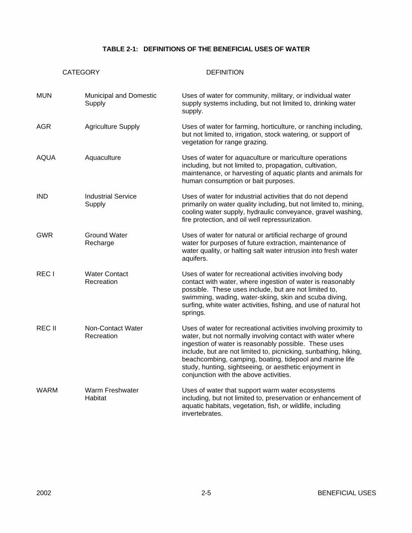
2002 2-5 BENEFICIAL USES
TABLE 2-1: DEFINITIONS OF THE BENEFICIAL USES OF WATER CATEGORY DEFINITION MUN Municipal and Domestic
Supply Uses of water for community, military, or individual water supply systems including, but not limited to, drinking water supply.
AGR Agriculture Supply Uses of water for farming, horticulture, or ranching including,
but not limited to, irrigation, stock watering, or support of vegetation for range grazing.
AQUA Aquaculture Uses of water for aquaculture or mariculture operations
including, but not limited to, propagation, cultivation, maintenance, or harvesting of aquatic plants and animals for human consumption or bait purposes.
IND Industrial Service
Supply Uses of water for industrial activities that do not depend primarily on water quality including, but not limited to, mining, cooling water supply, hydraulic conveyance, gravel washing, fire protection, and oil well repressurization.
GWR Ground Water
Recharge Uses of water for natural or artificial recharge of ground water for purposes of future extraction, maintenance of water quality, or halting salt water intrusion into fresh water aquifers.
REC I Water Contact
Recreation Uses of water for recreational activities involving body contact with water, where ingestion of water is reasonably possible. These uses include, but are not limited to, swimming, wading, water-skiing, skin and scuba diving, surfing, white water activities, fishing, and use of natural hot springs.
REC II Non-Contact Water
Recreation Uses of water for recreational activities involving proximity to water, but not normally involving contact with water where ingestion of water is reasonably possible. These uses include, but are not limited to, picnicking, sunbathing, hiking, beachcombing, camping, boating, tidepool and marine life study, hunting, sightseeing, or aesthetic enjoyment in conjunction with the above activities.
WARM Warm Freshwater
Habitat Uses of water that support warm water ecosystems including, but not limited to, preservation or enhancement of aquatic habitats, vegetation, fish, or wildlife, including invertebrates.
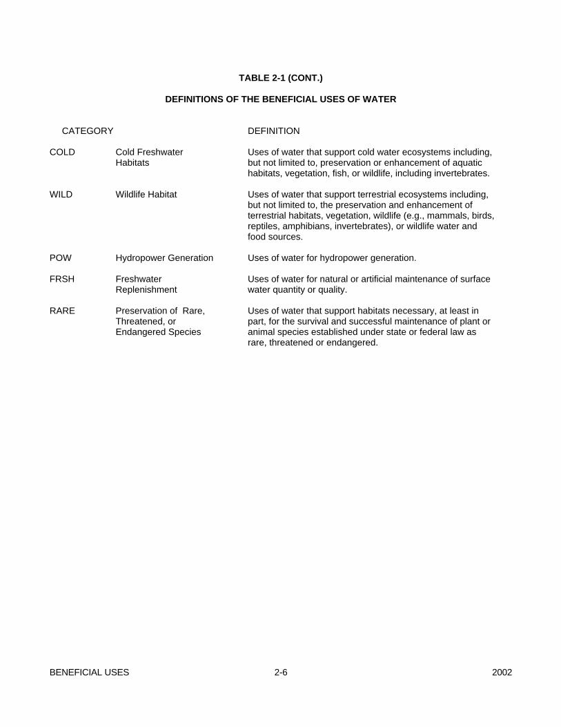
BENEFICIAL USES 2-6 2002
TABLE 2-1 (CONT.) DEFINITIONS OF THE BENEFICIAL USES OF WATER
CATEGORY DEFINITION COLD Cold Freshwater
Habitats Uses of water that support cold water ecosystems including, but not limited to, preservation or enhancement of aquatic habitats, vegetation, fish, or wildlife, including invertebrates.
WILD Wildlife Habitat Uses of water that support terrestrial ecosystems including,
but not limited to, the preservation and enhancement of terrestrial habitats, vegetation, wildlife (e.g., mammals, birds, reptiles, amphibians, invertebrates), or wildlife water and food sources.
POW Hydropower Generation Uses of water for hydropower generation.
FRSH RARE
Freshwater Replenishment Preservation of Rare, Threatened, or Endangered Species
Uses of water for natural or artificial maintenance of surface water quantity or quality. Uses of water that support habitats necessary, at least in part, for the survival and successful maintenance of plant or animal species established under state or federal law as rare, threatened or endangered.
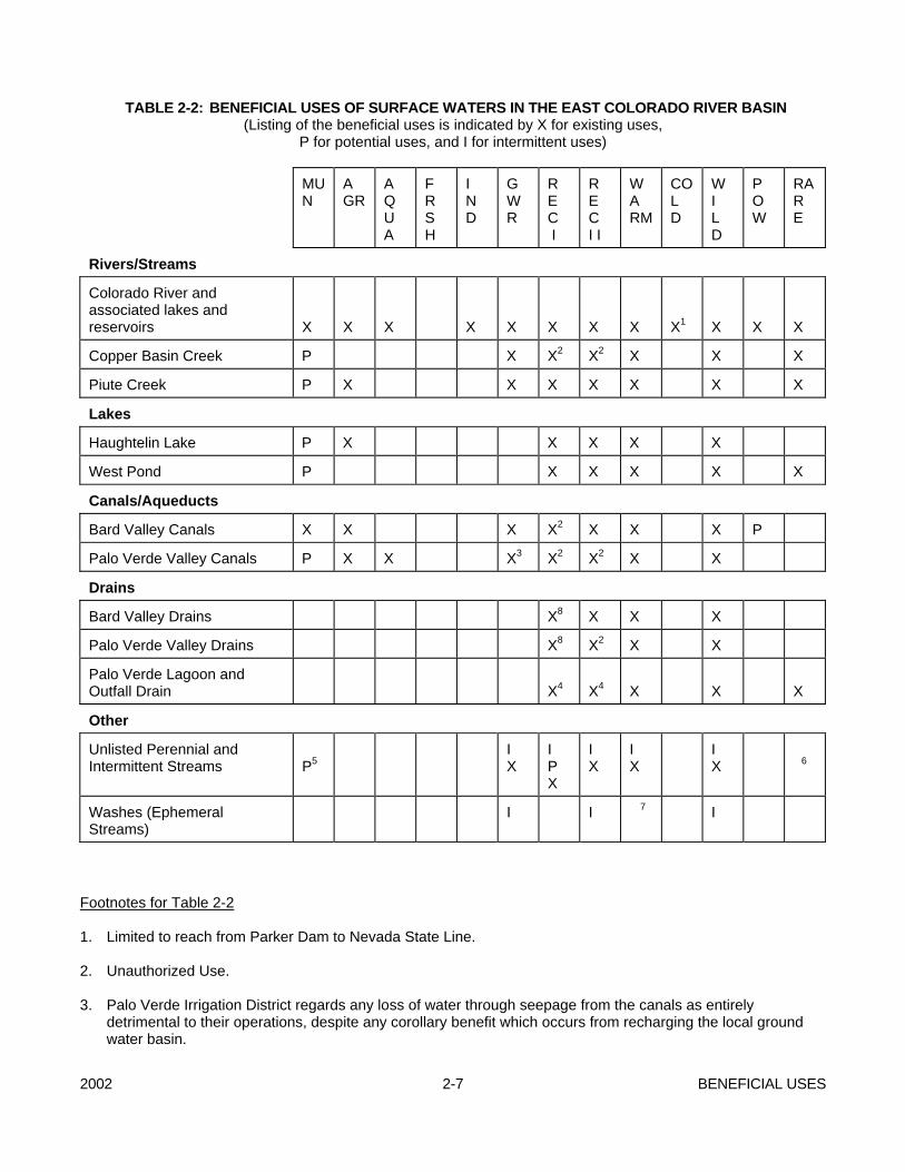
2002 2-7 BENEFICIAL USES
TABLE 2-2: BENEFICIAL USES OF SURFACE WATERS IN THE EAST COLORADO RIVER BASIN (Listing of the beneficial uses is indicated by X for existing uses, P for potential uses, and I for intermittent uses)
MU N
A GR
A Q U A
F R S H
I N D
GWR
R E C I
R E C I I
WA RM
CO L D
W I L D
P OW
RAR E
Rivers/Streams
Colorado River and associated lakes and reservoirs
X
X
X
X
X
X
X
X
X1
X
X
X
Copper Basin Creek P X X2 X2 X X X
Piute Creek P X X X X X X X
Lakes
Haughtelin Lake P X X X X X
West Pond P X X X X X
Canals/Aqueducts
Bard Valley Canals X X X X2 X X X P
Palo Verde Valley Canals P X X X3 X2 X2 X X
Drains
Bard Valley Drains X8 X X X
Palo Verde Valley Drains X8 X2 X X
Palo Verde Lagoon and Outfall Drain
X4
X4
X
X
X
Other
Unlisted Perennial and Intermittent Streams
P5
I X
I P X
I X
I X
I X
6
Washes (Ephemeral Streams)
I I 7 I
Footnotes for Table 2-2 1. Limited to reach from Parker Dam to Nevada State Line. 2. Unauthorized Use. 3. Palo Verde Irrigation District regards any loss of water through seepage from the canals as entirely
detrimental to their operations, despite any corollary benefit which occurs from recharging the local ground water basin.
BENEFICIAL USES 2-8 2002
4. Unauthorized use within Riverside County portion of flow. 5. Potential use designation will be determined on a case-by-case basis as necessary in accordance with the
"Sources of Drinking Water Policy" in this chapter. 6. Rare, endangered, or threatened wildlife may exist in or utilize some of these waterways. If the RARE
beneficial use may be affected by a water quality control decision, responsibility for substantiation of the existence of rare, endangered, or threatened species on a case-by-case basis is upon the California Department of Fish and Game on its own initiative and/or at the request of the Regional Board; and such substantiation must be provided within a reasonable time frame as approved by the Regional Board.
7. Use, if any, to be determined on a case-by-case basis. 8. The only REC I usage known to occur is from fishing activity.
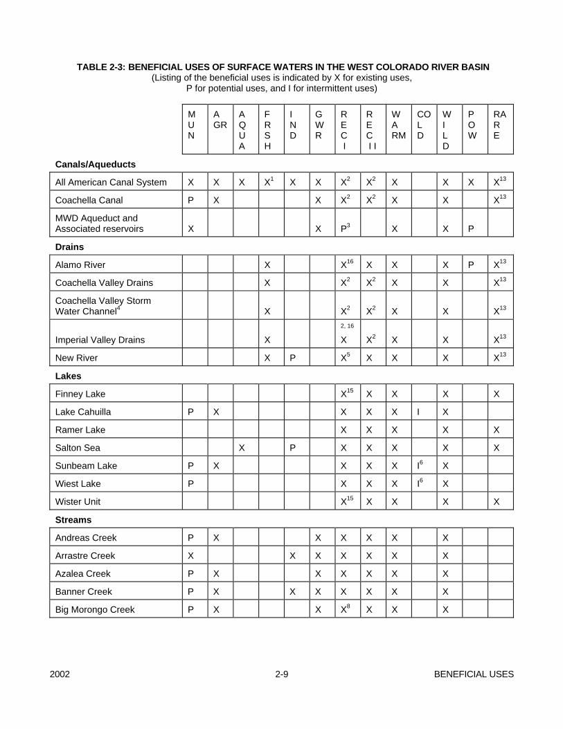
2002 2-9 BENEFICIAL USES
TABLE 2-3: BENEFICIAL USES OF SURFACE WATERS IN THE WEST COLORADO RIVER BASIN (Listing of the beneficial uses is indicated by X for existing uses, P for potential uses, and I for intermittent uses)
M U N
A GR
A Q U A
F R S H
I N D
G W R
R E C I
R E C I I
WA RM
CO L D
W I L D
P OW
RAR E
Canals/Aqueducts
All American Canal System X X X X1 X X X2 X2 X X X X13
Coachella Canal P X X X2 X2 X X X13
MWD Aqueduct and Associated reservoirs
X
X
P3
X
X
P
Drains
Alamo River X X16 X X X P X13
Coachella Valley Drains X X2 X2 X X X13
Coachella Valley Storm Water Channel4
X
X2
X2
X
X
X13
Imperial Valley Drains
X
2, 16
X X2
X
X
X13
New River X P X5 X X X X13
Lakes
Finney Lake X15 X X X X
Lake Cahuilla P X X X X I X
Ramer Lake X X X X X
Salton Sea X P X X X X X
Sunbeam Lake P X X X X I6 X
Wiest Lake P X X X I6 X
Wister Unit X15 X X X X
Streams
Andreas Creek P X X X X X X
Arrastre Creek X X X X X X X
Azalea Creek P X X X X X X
Banner Creek P X X X X X X X
Big Morongo Creek P X X X8 X X X
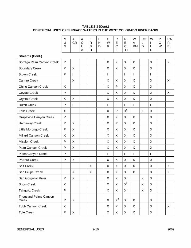
BENEFICIAL USES 2-10 2002
TABLE 2-3 (Cont.) BENEFICIAL USES OF SURFACE WATERS IN THE WEST COLORADO RIVER BASIN
M
U N
A GR
A Q U A
F R S H
I N D
G W R
R E C I
R E C I I
WA RM
CO L D
W I L D
P OW
RAR E
Streams (Cont.)
Borrego Palm Canyon Creek P X X X X X X
Boundary Creek P X X X X X X
Brown Creek P I I I I I I
Carrizo Creek X X X X X X X
Chino Canyon Creek X X P X X X
Coyote Creek P X X X X X X
Crystal Creek X X X X X X X
Dutch Creek P I I I I I I
Falls Creek X X P X9 X X
Grapevine Canyon Creek P X X X X X
Hathaway Creek P X X P X X X
Little Morongo Creek P X X X X X X
Millard Canyon Creek X X X X X X X
Mission Creek P X X X X X X
Palm Canyon Creek P X X X X X X
Pipes Canyon Creek P I I I I I
Potrero Creek P X X X X X X
Salt Creek X X X X X X X
San Felipe Creek X X X X X X X X
San Gorgonio River P X X X X X X
Snow Creek X X X X9 X X
Tahquitz Creek P X X X X X
Thousand Palms Canyon Creek
P
X
X
X2
X
X
X
Tubb Canyon Creek X X P X X X X
Tule Creek P X X X X X X

2002 2-11 BENEFICIAL USES
TABLE 2-3 (Cont.) BENEFICIAL USES OF SURFACE WATERS IN THE WEST COLORADO RIVER BASIN
M U N
A GR
A Q U A
F R S H
I N D
G W R
R E C I
R E C I I
WA RM
CO L D
W I L D
P OW
RAR E
Streams (Cont.)
Twin Pines Creek X X X X X X X
Vallecito Creek P I I I I I I
Walker Creek P X X X X X X
Whitewater River10 X X X X X I X X X
Willow Creek P X X X X X
Other
Unlisted Perennial and Intermittent Streams
P11
I X12
I X
I P X
I X
I X
I X
I X13
Washes14 (Ephemeral Streams)
I12
I
I
7
I
Footnotes for Table 2-3 1. Some very limited spillage of canal water occurs providing freshwater replenishment to Salton Sea. 2. Unauthorized use. 3. The water quality is satisfactory to support REC I use, although such use is strictly prohibited and would be
extremely dangerous. 4. Section of perennial flow from approximately Indio to the Salton Sea. 5. Although some fishing occurs in the downstream reaches, the presently contaminated water in the river
makes it unfit for any recreational use. An advisory has been issued by the Imperial County Health Department warning against the consumption of any fish caught from the river and the river has been posted with advisories against any body contact with the water.
6. The lake was experimentally stocked with trout during the winter of 1987/88. The results from this stocking
will be evaluated to see if future stocking will be recommended. 7. Use, if any, to be determined on a case-by-case basis. 8. Although it is not encouraged, children play in the water infrequently on the wildlife reserve.
BENEFICIAL USES 2-12 2002
9. Most of the creek is on National Forest Service land except one section which is owned by Desert Water Agency. This section provides the only reasonable access to the area. To enter Falls or Snow Creek through Desert Water Agency's land, a permit is required. The permit stipulates that persons entering through DWA's land must agree not to swim, fish, or wade in any portion of the creek.
10. Includes the section of flow from the headwaters in the San Gorgonio Mountains to (and including) the
Whitewater Recharge Basins near Indian Avenue crossing in Palm Springs. 11. Potential use designations will be determined on a case-by-case basis as necessary in accordance with the
"Sources of Drinking Water Policy" in this chapter. 12. Applies only to tributaries to Salton Sea. 13. Rare, endangered, or threatened wildlife exists in or utilizes some of these waterway(s). If the RARE
beneficial use may be affected by a water quality control decision, responsibility for substantiation of the existence of rare, endangered, or threatened species on a case-by-case basis is upon the California Department of Fish and Game on its own initiative and/or at the request of the Regional Board; and such substantiation must be provided within a reasonable time frame as approved by the Regional Board.
14. Including the section of ephemeral flow in the Whitewater River Storm Water Channel and Coachella Valley
Storm Water Channel from Indian Avenue to approximately 1/4 mile west of Monroe Street crossing. 15. The California Department of Fish and Game manages these lakes and does not permit swimming in them. 16. The only REC I usage that is known to occur is from infrequent fishing activity.
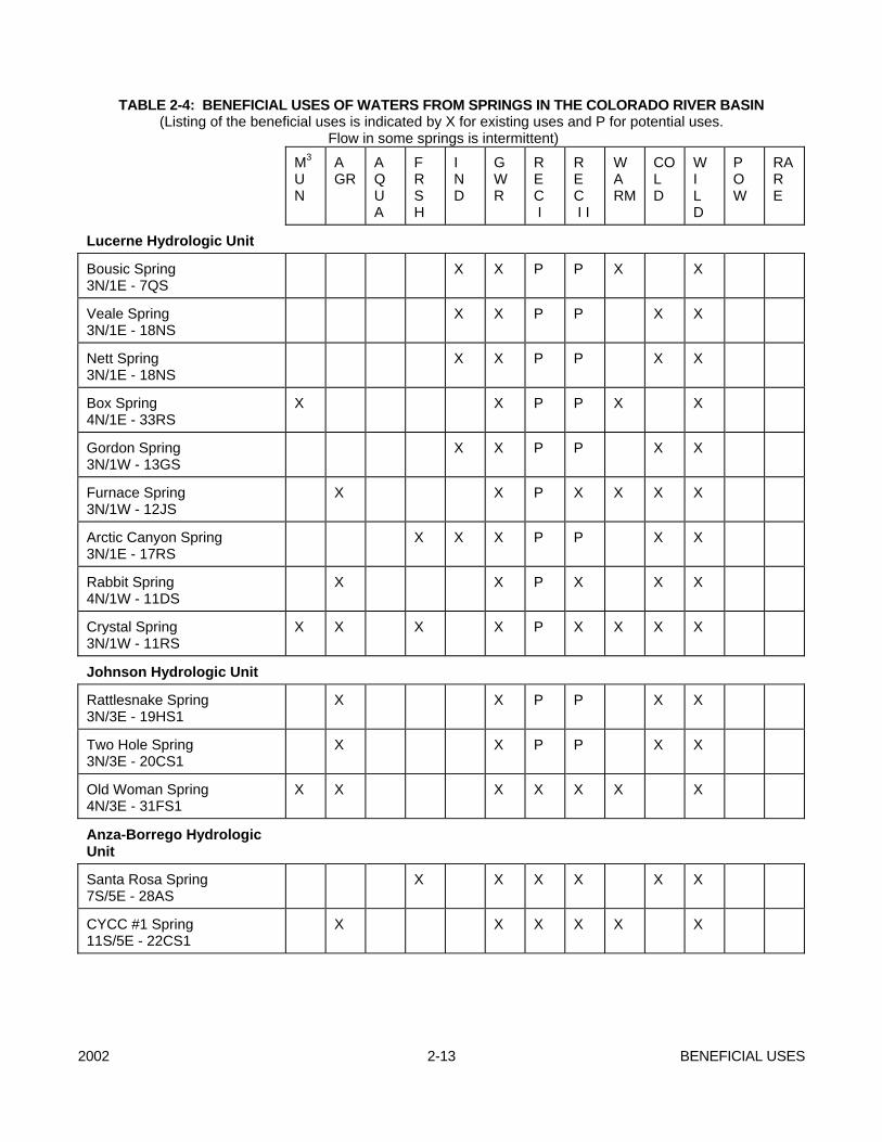
2002 2-13 BENEFICIAL USES
TABLE 2-4: BENEFICIAL USES OF WATERS FROM SPRINGS IN THE COLORADO RIVER BASIN (Listing of the beneficial uses is indicated by X for existing uses and P for potential uses. Flow in some springs is intermittent)
M3 U N
A GR
A Q U A
F R S H
I N D
G W R
R E C I
R E C I I
WA RM
CO L D
W I L D
P OW
RAR E
Lucerne Hydrologic Unit
Bousic Spring 3N/1E - 7QS
X X P P X X
Veale Spring 3N/1E - 18NS
X X P P X X
Nett Spring 3N/1E - 18NS
X X P P X X
Box Spring 4N/1E - 33RS
X X P P X X
Gordon Spring 3N/1W - 13GS
X X P P X X
Furnace Spring 3N/1W - 12JS
X X P X X X X
Arctic Canyon Spring 3N/1E - 17RS
X X X P P X X
Rabbit Spring 4N/1W - 11DS
X X P X X X
Crystal Spring 3N/1W - 11RS
X X X X P X X X X
Johnson Hydrologic Unit
Rattlesnake Spring 3N/3E - 19HS1
X X P P X X
Two Hole Spring 3N/3E - 20CS1
X X P P X X
Old Woman Spring 4N/3E - 31FS1
X X X X X X X
Anza-Borrego Hydrologic Unit
Santa Rosa Spring 7S/5E - 28AS
X X X X X X
CYCC #1 Spring 11S/5E - 22CS1
X X X X X X
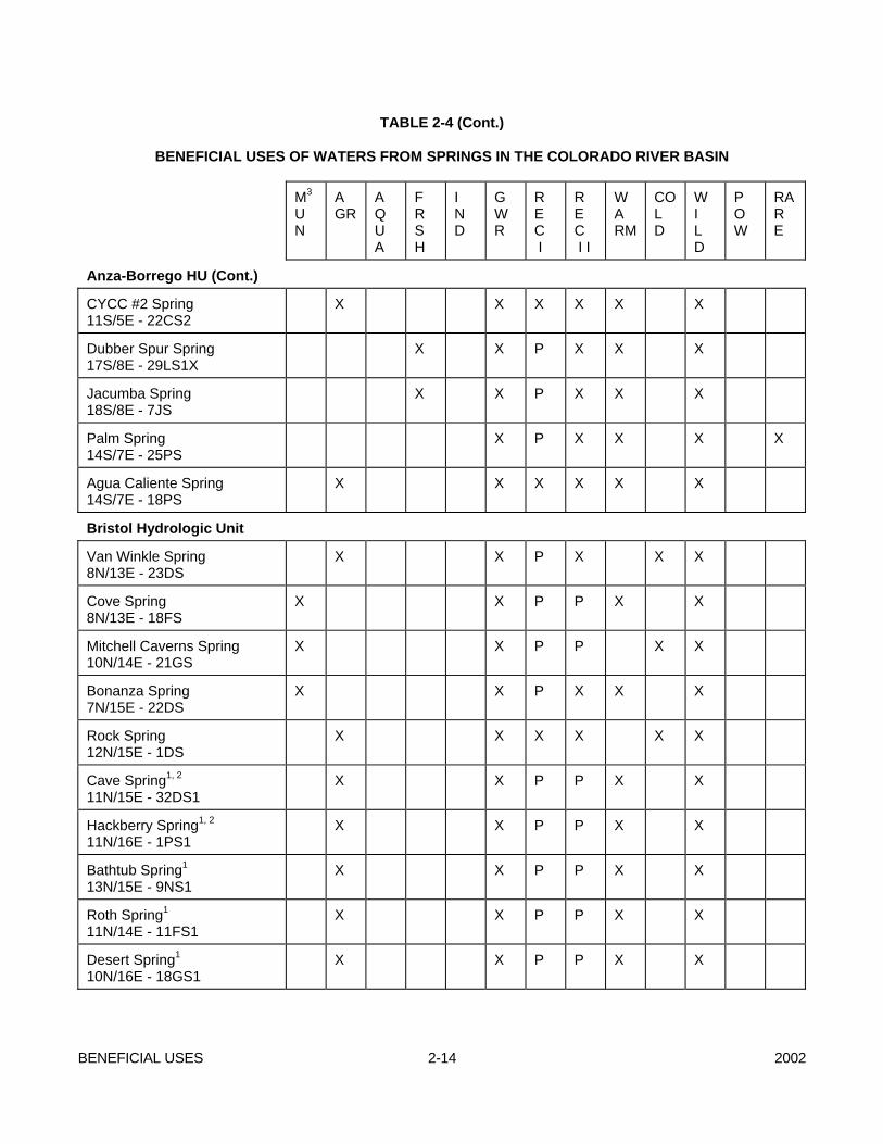
BENEFICIAL USES 2-14 2002
TABLE 2-4 (Cont.) BENEFICIAL USES OF WATERS FROM SPRINGS IN THE COLORADO RIVER BASIN
M3 U N
A GR
A Q U A
F R S H
I N D
G W R
R E C I
R E C I I
WA RM
CO L D
W I L D
P OW
RAR E
Anza-Borrego HU (Cont.)
CYCC #2 Spring 11S/5E - 22CS2
X X X X X X
Dubber Spur Spring 17S/8E - 29LS1X
X X P X X X
Jacumba Spring 18S/8E - 7JS
X X P X X X
Palm Spring 14S/7E - 25PS
X P X X X X
Agua Caliente Spring 14S/7E - 18PS
X X X X X X
Bristol Hydrologic Unit
Van Winkle Spring 8N/13E - 23DS
X X P X X X
Cove Spring 8N/13E - 18FS
X X P P X X
Mitchell Caverns Spring 10N/14E - 21GS
X X P P X X
Bonanza Spring 7N/15E - 22DS
X X P X X X
Rock Spring 12N/15E - 1DS
X X X X X X
Cave Spring1, 2 11N/15E - 32DS1
X X P P X X
Hackberry Spring1, 2
11N/16E - 1PS1 X X P P X X
Bathtub Spring1 13N/15E - 9NS1
X X P P X X
Roth Spring1 11N/14E - 11FS1
X X P P X X
Desert Spring1 10N/16E - 18GS1
X X P P X X
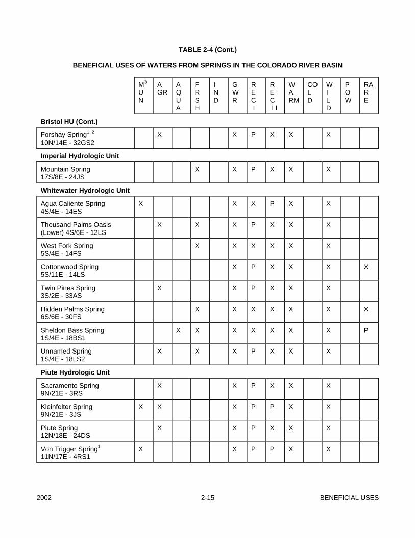
2002 2-15 BENEFICIAL USES
TABLE 2-4 (Cont.) BENEFICIAL USES OF WATERS FROM SPRINGS IN THE COLORADO RIVER BASIN
M3 U N
A GR
A Q U A
F R S H
I N D
G W R
R E C I
R E C I I
WA RM
CO L D
W I L D
P OW
RAR E
Bristol HU (Cont.)
Forshay Spring1, 2 10N/14E - 32GS2
X X P X X X
Imperial Hydrologic Unit
Mountain Spring 17S/8E - 24JS
X X P X X X
Whitewater Hydrologic Unit
Agua Caliente Spring 4S/4E - 14ES
X X X P X X
Thousand Palms Oasis (Lower) 4S/6E - 12LS
X X X P X X X
West Fork Spring 5S/4E - 14FS
X X X X X X
Cottonwood Spring 5S/11E - 14LS
X P X X X X
Twin Pines Spring 3S/2E - 33AS
X X P X X X
Hidden Palms Spring 6S/6E - 30FS
X X X X X X X
Sheldon Bass Spring 1S/4E - 18BS1
X X X X X X X P
Unnamed Spring 1S/4E - 18LS2
X X X P X X X
Piute Hydrologic Unit
Sacramento Spring 9N/21E - 3RS
X X P X X X
Kleinfelter Spring 9N/21E - 3JS
X X X P P X X
Piute Spring 12N/18E - 24DS
X X P X X X
Von Trigger Spring1 11N/17E - 4RS1
X X P P X X
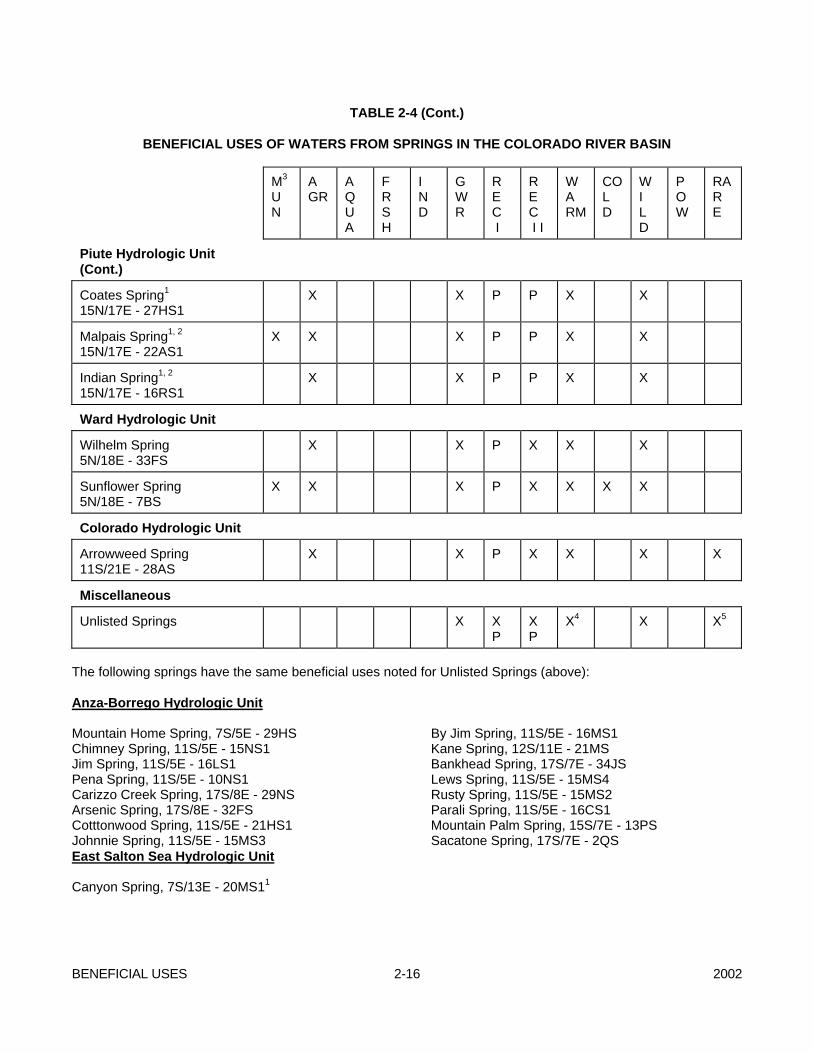
BENEFICIAL USES 2-16 2002
TABLE 2-4 (Cont.) BENEFICIAL USES OF WATERS FROM SPRINGS IN THE COLORADO RIVER BASIN
M3 U N
A GR
A Q U A
F R S H
I N D
G W R
R E C I
R E C I I
WA RM
CO L D
W I L D
P OW
RAR E
Piute Hydrologic Unit (Cont.)
Coates Spring1 15N/17E - 27HS1
X X P P X X
Malpais Spring1, 2
15N/17E - 22AS1 X X X P P X X
Indian Spring1, 2 15N/17E - 16RS1
X X P P X X
Ward Hydrologic Unit
Wilhelm Spring 5N/18E - 33FS
X X P X X X
Sunflower Spring 5N/18E - 7BS
X X X P X X X X
Colorado Hydrologic Unit
Arrowweed Spring 11S/21E - 28AS
X X P X X X X
Miscellaneous
Unlisted Springs X X P
X P
X4 X X5
The following springs have the same beneficial uses noted for Unlisted Springs (above): Anza-Borrego Hydrologic Unit Mountain Home Spring, 7S/5E - 29HS Chimney Spring, 11S/5E - 15NS1 Jim Spring, 11S/5E - 16LS1 Pena Spring, 11S/5E - 10NS1 Carizzo Creek Spring, 17S/8E - 29NS Arsenic Spring, 17S/8E - 32FS Cotttonwood Spring, 11S/5E - 21HS1 Johnnie Spring, 11S/5E - 15MS3
By Jim Spring, 11S/5E - 16MS1 Kane Spring, 12S/11E - 21MS Bankhead Spring, 17S/7E - 34JS Lews Spring, 11S/5E - 15MS4 Rusty Spring, 11S/5E - 15MS2 Parali Spring, 11S/5E - 16CS1 Mountain Palm Spring, 15S/7E - 13PS Sacatone Spring, 17S/7E - 2QS
East Salton Sea Hydrologic Unit Canyon Spring, 7S/13E - 20MS11
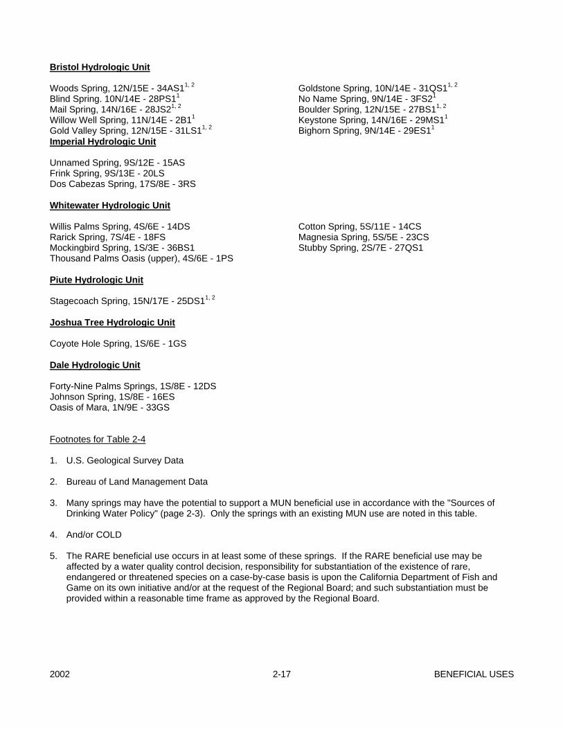
2002 2-17 BENEFICIAL USES
Bristol Hydrologic Unit Woods Spring, 12N/15E - 34AS11, 2 Blind Spring. 10N/14E - 28PS11 Mail Spring, 14N/16E - 28JS21, 2 Willow Well Spring, 11N/14E - 2B11 Gold Valley Spring, 12N/15E - 31LS11, 2
Goldstone Spring, 10N/14E - 31QS11, 2 No Name Spring, 9N/14E - 3FS21 Boulder Spring, 12N/15E - 27BS11, 2 Keystone Spring, 14N/16E - 29MS11 Bighorn Spring, 9N/14E - 29ES11
Imperial Hydrologic Unit Unnamed Spring, 9S/12E - 15AS Frink Spring, 9S/13E - 20LS Dos Cabezas Spring, 17S/8E - 3RS Whitewater Hydrologic Unit Willis Palms Spring, 4S/6E - 14DS Rarick Spring, 7S/4E - 18FS Mockingbird Spring, 1S/3E - 36BS1 Thousand Palms Oasis (upper), 4S/6E - 1PS
Cotton Spring, 5S/11E - 14CS Magnesia Spring, 5S/5E - 23CS Stubby Spring, 2S/7E - 27QS1
Piute Hydrologic Unit Stagecoach Spring, 15N/17E - 25DS11, 2 Joshua Tree Hydrologic Unit Coyote Hole Spring, 1S/6E - 1GS Dale Hydrologic Unit Forty-Nine Palms Springs, 1S/8E - 12DS Johnson Spring, 1S/8E - 16ES Oasis of Mara, 1N/9E - 33GS Footnotes for Table 2-4 1. U.S. Geological Survey Data 2. Bureau of Land Management Data 3. Many springs may have the potential to support a MUN beneficial use in accordance with the "Sources of
Drinking Water Policy" (page 2-3). Only the springs with an existing MUN use are noted in this table. 4. And/or COLD 5. The RARE beneficial use occurs in at least some of these springs. If the RARE beneficial use may be
affected by a water quality control decision, responsibility for substantiation of the existence of rare, endangered or threatened species on a case-by-case basis is upon the California Department of Fish and Game on its own initiative and/or at the request of the Regional Board; and such substantiation must be provided within a reasonable time frame as approved by the Regional Board.
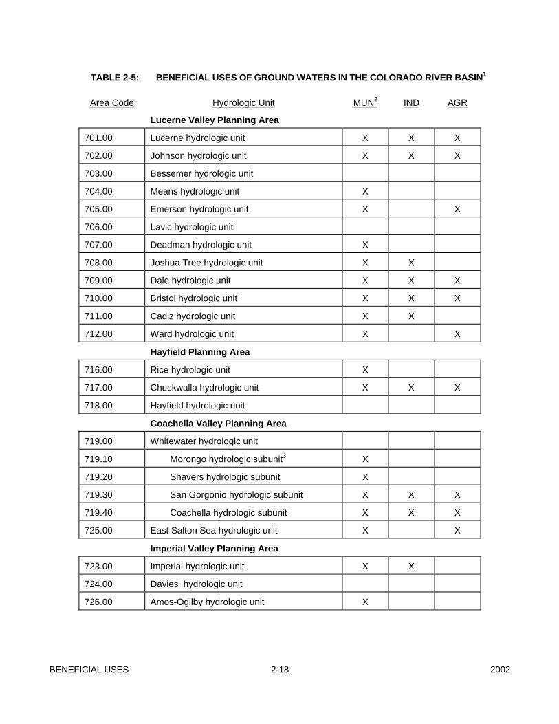
BENEFICIAL USES 2-18 2002
TABLE 2-5: BENEFICIAL USES OF GROUND WATERS IN THE COLORADO RIVER BASIN1
Area Code Hydrologic Unit MUN2 IND AGR
Lucerne Valley Planning Area
701.00 Lucerne hydrologic unit X X X
702.00 Johnson hydrologic unit X X X
703.00 Bessemer hydrologic unit
704.00 Means hydrologic unit X
705.00 Emerson hydrologic unit X X
706.00 Lavic hydrologic unit
707.00 Deadman hydrologic unit X
708.00 Joshua Tree hydrologic unit X X
709.00 Dale hydrologic unit X X X
710.00 Bristol hydrologic unit X X X
711.00 Cadiz hydrologic unit X X
712.00 Ward hydrologic unit X X
Hayfield Planning Area
716.00 Rice hydrologic unit X
717.00 Chuckwalla hydrologic unit X X X
718.00 Hayfield hydrologic unit
Coachella Valley Planning Area
719.00 Whitewater hydrologic unit
719.10 Morongo hydrologic subunit3 X
719.20 Shavers hydrologic subunit X
719.30 San Gorgonio hydrologic subunit X X X
719.40 Coachella hydrologic subunit X X X
725.00 East Salton Sea hydrologic unit X X
Imperial Valley Planning Area
723.00 Imperial hydrologic unit X X
724.00 Davies hydrologic unit
726.00 Amos-Ogilby hydrologic unit X
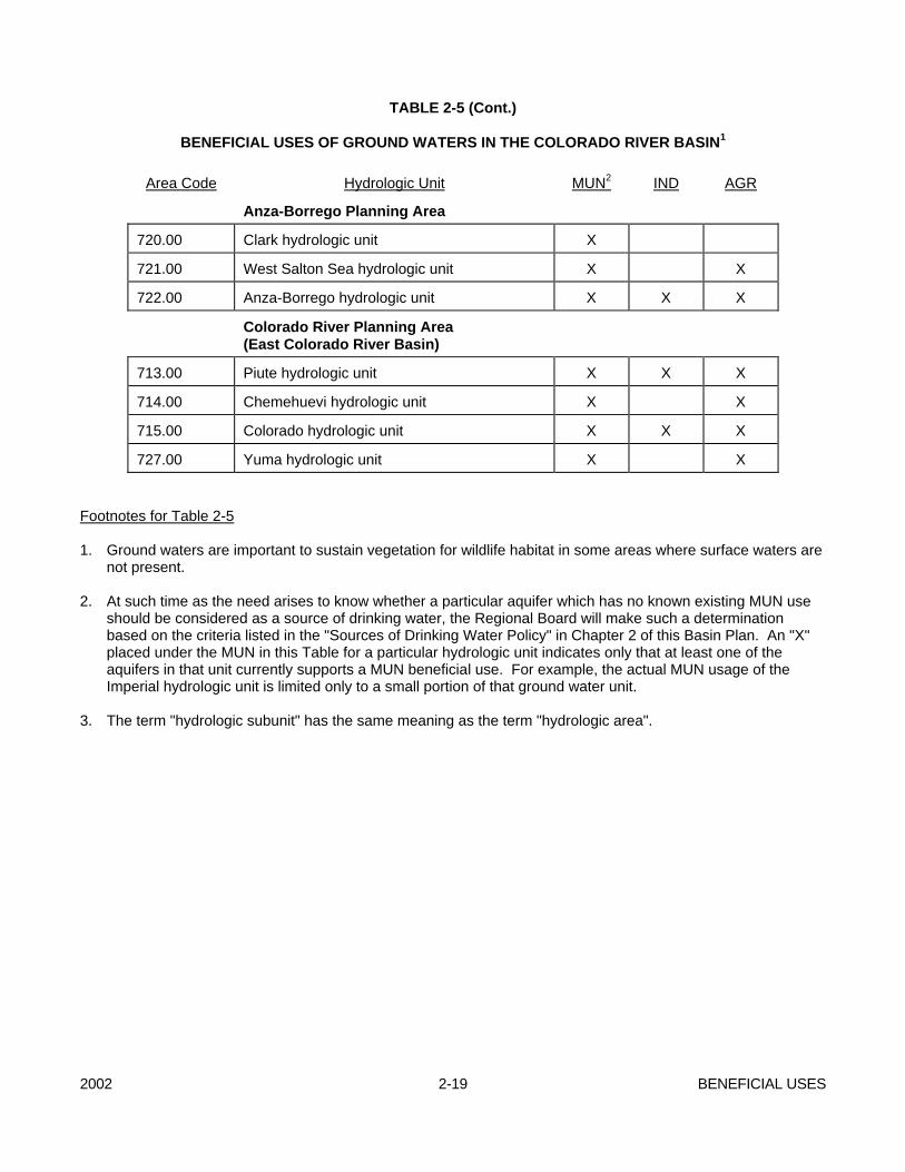
2002 2-19 BENEFICIAL USES
TABLE 2-5 (Cont.) BENEFICIAL USES OF GROUND WATERS IN THE COLORADO RIVER BASIN1
Area Code Hydrologic Unit MUN2 IND AGR
Anza-Borrego Planning Area
720.00 Clark hydrologic unit X
721.00 West Salton Sea hydrologic unit X X
722.00 Anza-Borrego hydrologic unit X X X
Colorado River Planning Area (East Colorado River Basin)
713.00 Piute hydrologic unit X X X
714.00 Chemehuevi hydrologic unit X X
715.00 Colorado hydrologic unit X X X
727.00 Yuma hydrologic unit X X Footnotes for Table 2-5 1. Ground waters are important to sustain vegetation for wildlife habitat in some areas where surface waters are
not present. 2. At such time as the need arises to know whether a particular aquifer which has no known existing MUN use
should be considered as a source of drinking water, the Regional Board will make such a determination based on the criteria listed in the "Sources of Drinking Water Policy" in Chapter 2 of this Basin Plan. An "X" placed under the MUN in this Table for a particular hydrologic unit indicates only that at least one of the aquifers in that unit currently supports a MUN beneficial use. For example, the actual MUN usage of the Imperial hydrologic unit is limited only to a small portion of that ground water unit.
3. The term "hydrologic subunit" has the same meaning as the term "hydrologic area".

2002 3-1 WATER QUALITY OBJECTIVES
CHAPTER 3 - WATER QUALITY OBJECTIVES Section 13241, Division 7 of the California Water Code, specifies as follows: "Each regional board shall establish such water
quality objectives in water quality control plans as in its judgement will ensure the reasonable protection of beneficial uses and the prevention of nuisance; however, it is recognized that it may be possible for the quality of water to be changed to some degree without unreasonably affecting beneficial uses..."
"Water quality objectives", as defined in said Division 7 are "limits or levels of water quality constituents or characteristics which are established for the reasonable protection of beneficial uses of water or the prevention of nuisance within a specific area". Water quality objectives contained herein are designed to be in accordance with all pertinent State and Federal requirements. Existing Statewide Plans and Policies of the State Water Resources Control Board that must be considered in establishing and implementing water quality objectives in the Colorado River Basin Region are listed in Chapter 5. Some of these statewide plans contain water quality objectives that apply to waters in this Region. However, most statewide objectives are not listed in this chapter but can be obtained by referring to the text of the statewide plans. In the event that statewide and regionwide objectives conflict the most stringent objective will apply. The water quality objectives contained in this Plan supersede and replace those contained in the Water Quality Control Plan, dated May 1991, and any amendments thereto. Controllable water quality factors shall conform to the water quality objectives contained herein. When other factors result in the degradation of water quality beyond the levels or limits established herein as water quality objectives, the controllable factors shall not cause further degradation of water quality. Controllable water quality factors are those actions, conditions, or circumstances resulting from people's
activities which may influence the quality of the waters of the State and which may feasibly be controlled. Actions to be taken by the Regional Board to achieve compliance with water quality objectives are described in the Implementation section of this Plan (see Chapter 4). Implementation actions directed toward nonpoint source discharges will be in conformance with the State Board's Nonpoint Source Management Plan, will be reasonable, and will consider economic and technical feasibility. I. GENERAL OBJECTIVES The following objective shall apply to all waters of the Region: Wherever the existing quality of water is better
than the quality established herein as objectives, such existing quality shall be maintained unless otherwise provided for by the provisions of the State Water Resources Control Board Resolution No. 68-16, "Statement of Policy with Respect to Maintaining High Quality of Waters in California".
II. GENERAL SURFACE WATER
OBJECTIVES Regarding controllable sources of discharge, in the absence of site specific objectives established herein, the following objectives apply to all surface waters of the Colorado River Basin Region: A. AESTHETIC QUALITIES All waters shall be free from substances attributable to wastewater of domestic or industrial origin or other discharges which adversely affect beneficial uses not limited to: - Settling to form objectionable deposits; - Floating as debris, scum, grease, oil, wax, or
other matter that may cause nuisances; and
WATER QUALITY OBJECTIVES 3-2 2002
- Producing objectionable color, odor, taste, or turbidity.
B. TAINTING SUBSTANCES Water shall be free of unnatural materials which
individually or in combination produce undesirable flavors in the edible portions of aquatic organisms.
C. TOXICITY 1 All waters shall be maintained free of toxic
substances in concentrations which are toxic to, or which produce detrimental physiological responses in human, plant, animal, or indigenous aquatic life. Compliance with this objective will be determined by use of indicator organisms, analyses of species diversity, population density, growth anomalies, 96-hour bioassay or bioassays of appropriate duration or other appropriate methods as specified by the Regional Board. Effluent limits based upon bioassays of effluent will be prescribed where appropriate, additional numerical receiving water objectives for specific toxicants will be established as sufficient data become available, and source control of toxic substances will be encouraged.
The survival of aquatic life in surface waters
subjected to a waste discharge or other controllable water quality factors, shall not be less than that for the same water body in areas unaffected by the waste discharge, or other control water which is consistent with the requirements for "experimental water" as described in Standards Methods for the Examination of Water and Wastewater, 18th Edition. As a minimum, compliance with this objective as stated in the previous sentence shall be evaluated with a 96-hour bioassay.
As described in Chapter 6, the Regional Board
will conduct toxic monitoring of the appropriate surface waters to gather baseline data as time and resources allow.
D. TEMPERATURE The natural receiving water temperature of
surface waters shall not be altered by discharges of wastewater unless it can be demonstrated to the satisfaction of the Regional Board that such
alteration in temperature does not adversely affect beneficial uses.
E. pH Since the regional waters are somewhat alkaline,
pH shall range from 6.0-9.0. Discharges shall not cause any changes in pH detrimental to beneficial water uses.
F. DISSOLVED OXYGEN The dissolved oxygen concentration shall not be
reduced below the following minimum levels at any time:
Waters designated: WARM ..........................................5.0 mg/l COLD........................................... 8.0 mg/l WARM and COLD........................8.0 mg/l G. SUSPENDED SOLIDS AND
SETTLEABLE SOLIDS Discharges of wastes or wastewater shall not
contain suspended or settleable solids in concentrations which increase the turbidity of receiving waters, unless it can be demonstrated to the satisfaction of the Regional Board that such alteration in turbidity does not adversely affect beneficial uses.
H. TOTAL DISSOLVED SOLIDS Discharges of wastes or wastewater shall not
increase the total dissolved solids content of receiving waters, unless it can be demonstrated to the satisfaction of the Regional Board that such an increase in total dissolved solids does not adversely affect beneficial uses of receiving waters.
Additionally, any discharge, excepting discharges
from agricultural sources, shall not cause concentration of total dissolved solids (TDS) in surface waters to exceed the following limits:
2002 3-3 WATER QUALITY OBJECTIVES
1 Certain exceptions for herbicides apply to irrigation supply
canals which are discussed under the heading "Irrigation Supply Canals" in this Chapter.
TDS (mg/L) Annual Ave. Maximum New River 4000 4500 Alamo River 4000 4500 Imperial Valley Drains 4000 4500 Coachella Valley Drains 2000 2500 Palo Verde Valley Drains 2000 2500
I. BACTERIA In waters designated for water contact recreation
(REC I) or noncontact water recreation (REC II), the following bacterial objectives apply. Although the objectives are expressed as fecal coliforms, E. coli, and enterococci bacteria, they address pathogenic microorganisms in general1 (e.g., bacteria, viruses, and fungi).
Based on a statistically sufficient number of
samples (generally not less than five samples equally spaced over a 30-day period), the geometric mean of the indicated bacterial densities should not exceed one or the other of the following:
REC I REC II E. coli 126 per 100 ml 630 per 100 ml enterococci 33 per 100 ml 165 per 100 ml nor shall any sample exceed the following
maximum allowables: REC I REC II E. coli 400 per 100 ml 2000 per 100 ml enterococci 100 per 100 ml 500 per 100 ml except that for the Colorado River, the following
maximum allowables shall apply: REC I REC II E. coli 235 per 100 ml 1175 per 100ml enterococci 61 per 100 ml 305 per 100 ml In addition to the objectives above, in waters
designated for water contact recreation (REC I), the fecal coliform concentration based on a minimum of not less than five samples for any 30-day period, shall not exceed a log mean of 200 MPN per 100 ml, nor shall more than ten percent of total samples during any 30-day period exceed 400 MPN per 100 ml.
1 Fecal coliforms and E. coli bacteria are being used as the indicator microorganisms in the Region until better and similarly practical tests become readily available in the region to more specifically target pathogens.
WATER QUALITY OBJECTIVES 3-4 2002
J. BIOSTIMULATORY SUBSTANCES Waters shall not contain biostimulatory
substances in concentrations that promote aquatic growths to the extent that such growths cause nuisance or adversely affect beneficial uses. Nitrate and phosphate limitations will be placed on industrial discharges to New and Alamo Rivers and irrigation basins on a case-by-case basis, taking into consideration the beneficial uses of these streams.
K. SEDIMENT The suspended sediment load and suspended
sediment discharge rate to surface waters shall not be altered in such a manner as to cause nuisance or adversely affect beneficial uses.
L. TURBIDITY Waters shall be free of changes in turbidity that
cause nuisance or adversely affect beneficial uses.
M. RADIOACTIVITY Radionuclides shall not be present in waters in
concentrations which are deleterious to human, plant, animal or aquatic life or that result in the accumulation of radionuclides in the food web to an extent which presents a hazard to human, plant, animal or aquatic life.
Waters designated for use as domestic or
municipal supply (MUN) shall not contain concentrations of radionuclides in excess of the limits specified in the California Code of Regulations, Title 22, Chapter 15, Article 5, Section 64443, as listed below:
Maximum Contaminant Constituent Level, pc/L Combined Radium-226 and Radium-228.............5 Gross Alpha particle activity (including Radium-226 but excluding Radon and Uranium) .................. 15 Tritium.......................................................... 20,000 Strontium-90 ..........................................................8
Gross Beta particle activity .................................50 Uranium...............................................................20 N. CHEMICAL CONSTITUENTS No individual chemical or combination of
chemicals shall be present in concentrations that adversely affect beneficial uses. There shall be no increase in hazardous chemical concentrations found in bottom sediments or aquatic life. Waters designated for use as domestic or municipal supply (MUN) shall not contain concentrations of chemical constituents in excess of the limits specified below:
Maximum Contaminant Levels for Organic and Inorganic Chemicals Maximum Contaminant Inorganic Chemical Constituents: Level, mg/L Arsenic ................................................0.05 Barium...................................................1.0 Cadmium ..........................................0.010 Chromium ...........................................0.05 Lead ....................................................0.05 Mercury.............................................0.002 Nitrate (as Nitrogen) ...........................10.0 Selenium.............................................0.01 Silver ...................................................0.05 Organic Chemical Constituents MCL mg/L (a) Chlorinated Hydrocarbons Endrin ..................................0.002 Lindane ...............................0.004 Methoxychlor...........................0.1 Toxaphene ..........................0.005 (b) Chlorophenoxys 2,4-D........................................0.1 2,4,5-TP Silvex......................0.01 Limiting Concentrations of Fluoride Annual Average of Maximum Daily Air Temperature Fluoride Concentrations mg/l Maximum
2002 3-5 WATER QUALITY OBJECTIVES
Degrees Degrees Contaminant Fahrenheit Celsius Lower Optimum Upper Level below 53.8 below 12.1 0.9 1.2 1.7 2.4 53.8 to 58.3 12.1 to 14.6 0.8 1.1 1.5 2.2 58.4 to 63.8 14.7 to 17.6 0.8 1.0 1.3 2.0 63.9 to 70.6 17.7 to 21.4 0.7 0.9 1.2 1.8 70.7 to 79.2 21.5 to 26.2 0.7 0.8 1.0 1.6 79.3 to 90.5 26.3 to 32.5 0.6 0.7 0.8 1.4
O. PESTICIDE WASTES The discharge of pesticidal wastes from pesticide
manufacturing processing or cleaning operations to any surface water is prohibited.
III. SPECIFIC SURFACE WATER
OBJECTIVES A. COLORADO RIVER 1. Colorado River (Above Imperial Dam) In response to requirements in Section
303 of the Federal Water Pollution Control Act Amendments of 1972 (P.L. 92-500), the Seven States Colorado River Salinity Control Forum developed water quality standards in 1975 for salinity consisting of numeric criteria and a basinwide plan of implementation for salinity control. The Forum recommended that each of the Basin States adopt the proposed standards. California along with the other Basin States adopted the Forum's recommended standards which were subsequently approved by the U.S. Environmental Protection Agency. The standards were reviewed in 1978, 1981, 1984, 1987, and 1990. While the numeric criteria have not changed, the plan of implementation was updated in those years to reflect changes in the salinity control program since 1975.
The flow-weighted average annual
numeric criteria for salinity (total dissolved solids) were established at three locations on the lower Colorado River:
Salinity in mg/l Below Hoover Dam, AZ-NV......... 723
Below Parker Dam, AZ-CA ..........747 Imperial Dam, AZ-CA ...................879 The plan of implementation consists of a
number of federal and non-federal measures throughout the Colorado River system to maintain the adopted numeric criteria while the Basin states continue to develop their compact apportioned waters. There are four areas of the implementation plan which have direct applicability to California. The first is the control of the discharge of total dissolved solids from point sources through the NPDES Permit program on industrial and municipal discharges. The plan's policy has as its primary objective no-salt return from industrial sources wherever practicable. Reasonable incremental increases of salinity from municipal sources shall be permitted so long as they do not exceed 400 mg/l above the flow-weighted average salinity of the supply water. The second recommends that each state encourage and promote the use of brackish and/or saline waters for industrial purposes. The third deals with an improved water delivery system and on-farm water management system. Finally, the plan encompasses those portions of the 208 Water Quality Management plans dealing with salinity control once adopted by the State and approved by USEPA.
2. Colorado River (Below Imperial Dam) Below Imperial Dam, the River's salinity
will be controlled to meet the terms of the agreement with Mexico on salinity in Minute No. 242 of the International Boundary and Water Commission, entitled "Permanent and Definitive Solution to the International Problem of the Salinity of the Colorado River". This agreement states that measures will be taken to assure that the waters delivered to Mexico upstream from Morelos Dam will have annual average salinity concentration of no more than 115 ppm (+ 30 ppm) total dissolved solids greater than the annual average salinity concentration of Colorado River water arriving at Imperial Dam. Title I of Public
WATER QUALITY OBJECTIVES 3-6 2002
Law 93-320 is the legislation which implements the provisions of Minute No. 242. Minute No. 242 and Title I constitute a federal numeric criterion and plan of implementation for the River below Imperial Dam.
B. NEW RIVER Minute No. 264 of the Mexican-American Water
Treaty titled "Recommendations for Solution of the New River Border Sanitation Problem at Calexico, California - Mexicali, Baja California Norte" was approved by the Governments of the United States and Mexico effective on December 4, 1980. Minute No. 264 specifies qualitative and quantitative standards for the New River at the International Boundary and upstream of the International Boundary in Mexico.
The quantitative standards of Minute No. 264 are
contained in Table 3-1. Following are the qualitative standards of Minute No. 264 for the New River at the locations specified below (interim solution).
1. The waters of the River shall be free of
untreated domestic and industrial waste waters.
2. The waters shall be free from substances
that may be discharged into the River as a result of human activity in concentrations which are toxic or harmful to human, animal or aquatic life or which may significantly impair the beneficial uses of such waters.
3. The waters of the River shall be
essentially free from trash, oil, scum, or other floating materials resulting from human activity in amounts sufficient to be injurious, unsightly, or to cause adverse effects on human life, fish, and wildlife. Persistent foaming shall be avoided.
4. The waters of the River shall be free of
pesticides in concentrations which could cause harmful effects to human life, fish, and wildlife.
5. The channel of the River shall be free of
residual sludge deposits from domestic or industrial wastes.
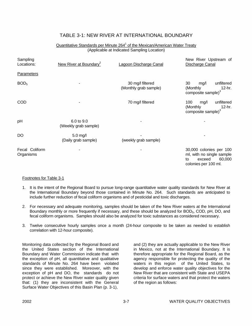
2002 3-7 WATER QUALITY OBJECTIVES
TABLE 3-1: NEW RIVER AT INTERNATIONAL BOUNDARY Quantitative Standards per Minute 2641 of the Mexican/American Water Treaty (Applicable at Indicated Sampling Location)
Sampling Locations: Parameters BOD5 COD pH DO Fecal Coliform Organisms
New River at Boundary2 - - 6.0 to 9.0 (Weekly grab sample) 5.0 mg/l (Daily grab sample) -
Lagoon Discharge Canal 30 mg/l filtered (Monthly grab sample) 70 mg/l filtered - - (weekly grab sample) -
New River Upstream of Discharge Canal 30 mg/l unfiltered (Monthly 12-hr. composite sample)3 100 mg/l unfiltered (Monthly 12-hr. composite sample)3 - - 30,000 colonies per 100 ml, with no single sample to exceed 60,000 colonies per 100 ml.
Footnotes for Table 3-1 1. It is the intent of the Regional Board to pursue long-range quantitative water quality standards for New River at
the International Boundary beyond those contained in Minute No. 264. Such standards are anticipated to include further reduction of fecal coliform organisms and of pesticidal and toxic discharges.
2. For necessary and adequate monitoring, samples should be taken of the New River waters at the International
Boundary monthly or more frequently if necessary, and these should be analyzed for BOD5, COD, pH, DO, and fecal coliform organisms. Samples should also be analyzed for toxic substances as considered necessary.
3. Twelve consecutive hourly samples once a month (24-hour composite to be taken as needed to establish
correlation with 12-hour composite). Monitoring data collected by the Regional Board and the United States section of the International Boundary and Water Commission indicate that with the exception of pH, all quantitative and qualitative standards of Minute No. 264 have been violated since they were established. Moreover, with the exception of pH and DO, the standards do not protect or achieve the New River water quality given that: (1) they are inconsistent with the General Surface Water Objectives of this Basin Plan (p. 3-1),
and (2) they are actually applicable to the New River in Mexico, not at the International Boundary. It is therefore appropriate for the Regional Board, as the agency responsible for protecting the quality of the waters in this region of the United States, to develop and enforce water quality objectives for the New River that are consistent with State and USEPA criteria for surface waters and that protect the waters of the region as follows:
WATER QUALITY OBJECTIVES 3-8 2002
1. Bacteria Water Quality Objectives The bacterial standards identified in the General Surface Water Objectives section of this Basin Plan (p. 3-3) are applicable to the entire stretch of the New River in the United States. The Pathogen Total Maximum Daily Load (TMDL) and associated implementation actions are described in Chapter 4, Section V(A). Compliance Monitoring activities for the TMDL are described in Chapter 6, Section II(B). C. SALTON SEA 1. Total Dissolved Solids (Salinity) The total dissolved solids concentration
of Salton Sea in 1992 was approximately 44,000 mg/l.
The water quality objective for Salton Sea
is to reduce the present level of salinity, and stabilize it at 35,000 mg/l unless it can be demonstrated that a different level of salinity is optimal for the sustenance of the Sea's wild and aquatic life (California Department of Fish and Game is attempting to make this determination). However, the achievement of this water quality objective shall be accomplished without adversely affecting the primary purpose of the Sea which is to receive and store agricultural drainage, seepage, and storm waters. Also, because of economic considerations, 35,000 mg/l may not be realistically achievable. In such case, any reduction in salinity which still allows for survival of the sea's aquatic life shall be deemed an acceptable alternative or interim objective. Because of the difficulty and predicted costliness of achieving salinity stabilization of Salton Sea, it is unreasonable for the Regional Board to assume responsibility for implementation of this objective. That responsibility must be shared jointly by all of the agencies which have direct influence on the Sea's fate. Additionally, there must be considerable public support for achieving this objective, without which it is unlikely that the necessary funding for Salton Sea salinity control will ever be realized.
2. Selenium The beneficial use of the Salton Sea for
recreation has been impaired due to elevated levels of selenium in tissues of resident wildlife and aquatic life (See page 4-10 for a more detailed discussion of this). The following objectives apply to all surface waters that are tributaries to the Salton Sea:
1. A four day average value of
selenium shall not exceed .005 mg/L;
2. A one hour average value of
selenium shall not exceed .02 mg/L.
These numerical limits are based on the
United States Environmental Protection Agency's National Ambient Water Quality Criteria.
D. IRRIGATION SUPPLY CANALS Herbicide spraying in irrigation canals must be
conducted in coordination with the County Agricultural Commissioner, California Department of Fish and Game (DFG), and California Department of Health Services. In canals used for domestic supply, no herbicides shall be applied in concentrations which are toxic or otherwise harmful to humans; also no herbicides shall be applied in concentrations which are toxic or otherwise harmful to aquatic life, except that herbicides may be used in cases where the herbicide only impacts the targeted species, is a legally registered product, and is used in accordance with label requirements and in accordance with all applicable laws and regulations.
IV. GROUND WATER OBJECTIVES Establishment of numerical objectives for ground water involves complex considerations since the quality of ground water varies significantly with depth of well perforations, existing water levels, geology, hydrology and several other factors. Unavailability of adequate historical data compounds this problem. The Regional Board believes that detailed investigation of the ground water basins should be
2002 3-9 WATER QUALITY OBJECTIVES
conducted before establishing specific ground water quality objectives. Ideally the Regional Board's goal is to maintain the existing water quality of all nondegraded ground water basins. However, in most cases ground water that is pumped generally returns to the basin after use with an increase in mineral concentrations such as total dissolved solids (TDS), nitrate etc., that are picked up by water during its use. Under these circumstances, the Regional Board's objective is to minimize the quantities of contaminants reaching any ground water basin. This could be achieved by establishing management practices for major discharges to land. Until the Regional Board can complete investigations for the establishment of management practices, the objective will be to maintain the existing water quality where feasible. A. TASTE AND ODORS Ground waters for use as domestic or municipal
supply shall not contain taste or odor-producing substances in concentrations that adversely affect beneficial uses as a result of human activity.
B. BACTERIOLOGICAL QUALITY In ground waters designated for use as domestic
or municipal supply (MUN), the concentration of coliform organisms shall not exceed the limits specified in California Code of Regulations, Title 22, Chapter 15, Article 3.
C. CHEMICAL AND PHYSICAL
QUALITY Ground waters designated for use as domestic or
municipal supply (MUN) shall not contain concentrations of chemical constituents in excess of the limits specified in California Code of Regulations, Title 22, Chapter 15, Article 4, Section 64435, Tables 2, 3, and 4 as a result of human activity.
D. BRINES Discharges of water softener regeneration brines,
other mineralized wastes, and toxic wastes to disposal facilities which ultimately discharge in areas where such wastes can percolate to ground waters usable for domestic and municipal purposes are prohibited.
E. RADIOACTIVITY Ground waters designated for use as domestic or
municipal supply (MUN) shall not contain radioactive material in excess of the limits specified in California Code of Regulations, Title 22, Chapter 15, Article 5, Sections 64441 and 64443. The limits contained in Section 64443 are included under item "II.M. Radioactivity", in this Chapter.
F. GROUND WATER OVERDRAFT A number of ground water basins in the Region
are in overdraft, and in some areas there have been indications of possible increase of mineral content of the ground water. Investigative studies will be conducted to develop ground water objectives and implementation plans for the following ground water basins:
- Indio Subarea of the Whitewater Hydrologic
Unit - Warren Subunit of the Joshua Tree
Hydrologic Unit - Twentynine Palms Subunit of the Dale
Hydrologic Unit - Borrego Subarea of the Anza-Borrego
Hydrologic Unit - Lucerne Hydrologic Unit - Terwilliger Subarea of the Anza-Borrego
Hydrologic Unit - Ocotillo Subunit of the Anza-Borrego
Hydrologic Unit

2002 4-1 IMPLEMENTATION
CHAPTER 4 - IMPLEMENTATION I. INTRODUCTION The Porter-Cologne Water Quality Control Act states that basin plans consist of Beneficial Uses, Water Quality Objectives and an Implementation Program for achieving the water quality objectives. The Implementation Program is required to include, but is not limited to: - A description of the nature of actions which are
necessary to achieve the water quality objectives, including any recommendations for appropriate action by any entity, public or private;
- A time schedule for actions to be taken; - A description of surveillance to be undertaken to
determine compliance with the objectives. A. REGIONAL BOARD GOALS AND
MANAGEMENT PRINCIPALS The regulatory activities of the Regional Boards
are the primary mechanism for water quality control. In view of this, and in view of the limited water resources in the Colorado River Basin Region and their increasing use, the Regional Board directs its actions toward the following goals and management principles:
- Preserve and enhance the quality of waters,
both ground and surface, fresh and saline, for present and anticipated beneficial uses, taking social and economic factors into consideration.
- Encourage reclamation of wastewaters,
wherever feasible, in order to preserve freshwater supplies and to protect water quality to the maximum extent possible.
- Preserve the integrity of ground water basins,
so that the basins remain capable of storing water for beneficial uses.
- Seek improvement in the quality of
international and interstate waters entering the Region.
- Waste collection, treatment, and discharge
systems in addition to their primary function, shall also be oriented towards optimization of the quality of state waters and the reclamation of wastewaters for beneficial use.
- The optimization of water quality, where
feasible, will be considered in relation to environmental goals.
- Controllable water quality factors will be
regulated to ensure preservation of the integrity of usable ground water basins.
- Source control and pretreatment of wastes
will be required wherever necessary to minimize degradation of water quality.
- The transport of hazardous materials should
be controlled to prevent spillage and leakage. - Wastes which have a long-term capability of
polluting water will be disposed of at approved sites, and in such a manner as to not enter usable waters of the State.
- The administration of grants and loans to
public entities shall be in accordance with applicable rules and regulations, including determination of implementation of adequate source control and industrial waste control ordinances.
- Ground water recharge with water of
adequate quality is encouraged, wherever feasible.
- Evaporative loss of reclaimable wastewater is
to be minimized. B. GENERAL IMPLEMENTATION The Regional Board will implement this Water
Quality Control Plan by taking the following actions:
- Encourage water conservation and reuse of
reclaimable water in situations where water
IMPLEMENTATION 4-2 2002
quality and beneficial uses are not adversely impacted. The Regional Board considers that by proper management of reclaimable wastewater, possible adverse impacts on ground water quality as well as potential ground water overdraft could be minimized. The Regional Board encourages local agencies responsible for water supply and/or wastewater treatment and disposal to investigate conservation measures, and to maximize utilization of reclaimed water for greenbelt irrigation where socially and economically feasible.
- Protect ground waters against land
operations, particularly discharges of soluble minerals, toxicants, and taste-producing materials on permeable soils, so that beneficial uses will not be impaired. This is normally accomplished by prescription and enforcement of Waste Discharge Requirements.
- Review local ordinances relating to individual
waste treatment and disposal systems and request that local agencies adopt ordinances which are compatible with State Board and Regional Board policies and guidelines for those systems.
- Eliminate discharges of wastes that threaten
water quality or create nuisance conditions. This includes elimination of discharges from individual subsurface sewage disposal facilities, unless Regional Board policies and/or guidelines are followed.
II. POINT SOURCE CONTROLS Section 13263 of the California Code of Regulations (Porter-Cologne Act) requires that Waste Discharge Requirements be prescribed for any discharge or proposed discharge that could affect the quality of the waters of the state, other than into a community sewer system. All industrial discharges that meet this definition are regulated with Waste Discharge Requirements. In addition to Waste Discharge Requirements (WDRs), a National Pollutant Discharge Elimination System (NPDES) permit may be required for the discharge. Section 122 of Title 40 of the Code of Federal Regulations (40 CFR) requires that NPDES permits be obtained for all point source discharges to
"waters of the United States". Waters of the United States is defined in Section 122.2 and is generally interpreted to mean any surface water in the State, including lakes, rivers, streams, wetlands, mudflats, sandflats, sloughs, or playa lakes. The NPDES program objective is to regulate the discharge of wastewaters and storm waters to surface waters of the State so that the beneficial uses of these waters are protected and enhanced. NPDES permits are federal permits, but California has been delegated authority by the USEPA to administer NPDES permits. In order to implement the above stated objective, individual and general NPDES permits are developed and adopted by the Regional Board. The Regional Board has adopted a general NPDES permit to regulate the discharge of extracted and treated ground water resulting from the cleanup of ground water polluted by fuel and other related waste leaks. Also, the discharge of hydrostatic test water to surface waters is regulated through a general NPDES permit. The State Board adopted general NPDES permits to regulate the discharge of stormwater resulting from industrial and construction sites to surface waters. The issuance of general permits provide for more efficient and economical regulation of discharges of wastewaters that require the same type of control and monitoring, as opposed to issuing individual permits for each discharger. In addition to regulating discharges of wastewater to surface waters, NPDES permits also require municipal sewage treatment systems to conduct pretreatment programs if their design capacity is greater than 5 million gallons-per-day. Smaller municipal treatment systems may be required to conduct pretreatment programs if there are significant industrial users of their systems. The pretreatment programs must comply with the federal regulations in 40 CFR 403. The NPDES program involves the issuance of new permits, reissuance of expired permits, conducting compliance inspections, review of monitoring reports, and taking enforcement actions against dischargers who fail to comply with the conditions of their permit. Potential enforcement actions include letters of noncompliance, notices of violation, cleanup and abatement orders, cease and desist orders, imposition of administrative civil liabilities, and referral to the State Attorney General.
2002 4-3 IMPLEMENTATION
A. GEOTHERMAL DISCHARGES
The Regional Board closely monitors the activities of those companies that are developing geothermal resources. The Regional Board issues waste discharge requirements that regulate the drilling of geothermal wells, the operations at the power plants, and the disposal of geothermal wastes produced during these operations. The Regional Board works closely with the California Division of Oil and Gas to regulate these facilities in accordance with the Memorandum of Agreement between the State Water Resources Control Board and the Department of Conservation, Division of Oil and Gas, as amended by State Board Resolution No. 88-61. This agreement generally requires the Division of Oil and Gas to issue permits to regulate subsurface discharges and requires the Regional Board to issue waste discharge requirements to regulate surface discharges.
B. SLUDGE APPLICATION The U.S. Environmental Protection Agency
recently promulgated new regulations for sludge use and disposal. These regulations are applicable to land application, surface disposal, and incineration of municipal sludge. These regulations are contained in 40 CFR, Section 503.
There is increasing interest in the beneficial use
of municipal wastewater treatment plant sludges as an agricultural soil amendment. State and Federal regulations establish heavy metals application rates for sludge used in the growing of crops. The new federal regulations establish heavy metals and pathogen limitations for "clean" sludge.
The Regional Board's primary concerns related to
sludge are contamination of groundwater by sludge composting facilities and potential contamination of surface waters from tailwater discharges off fields where sludge has been applied. Sludge composting facilities are attracted to this Region because of the sunny climate, low cost of land, relatively low population density, and close proximity to major Southern California population centers.
Regional Board measures for regulating sludge
use are as follows:
- Permits issued to domestic wastewater treatment facilities will be modified to incorporate the requirements of 40 CFR 503.
- Sludge composting facilities will be regulated
through the prescription and enforcement of WDRs.
- Waste Discharge Requirements or waivers
will be issued to land appliers of sludge on a case by case basis, although properly composted sludge may be exempted.
C. MUNICIPAL WASTEWATER
TREATMENT PLANTS Regulating discharges from municipal wastewater
treatment plants is done through either the issuance of National Pollutant Discharge Elimination System (NPDES) permits where the discharge is to surface water or through Waste Discharge Requirements (WDRs) where the discharge is to land. The discharge of wastewater effluent to surface water will meet the effluent limitations prescribed by the U.S. Environmental Protection Agency. The current USEPA effluent limitations for secondary treatment are as follows:
30-Day 7-Day Arithmetic Mean ArithmeticMean Constituent Discharge Rate Discharge Rate 20oC BOD5 30 mg/L 45 mg/L Suspended 30 mg/L 45 mg/L Solids pH - The effluent values for pH shall remain within the limits of
6.0 to 9.0 The arithmetic mean of the values for effluent
samples collected for 200C BOD5 and Suspended Solids (SS) in a period of 30 consecutive days shall not exceed 15 percent of the arithmetic mean of the values for influent samples collected at approximately the same times during the same period (85 percent removal).
D. WASTEWATER RECLAMATION
AND REUSE Wastewater reclamation and reuse is encouraged
by this Regional Board. However, for wastewater reclamation and reuse facilities it is necessary to meet the water quality standards set by the
IMPLEMENTATION 4-4 2002
Regional Board. Also, all state, federal, and local standards must be adhered to when reclaimed wastewater is used in this Region. Waste Discharge Requirements would be necessary where potential public and worker contact is high and where reclaimed water is used in large amounts. Currently, the primary use of reclaimed wastewater is golf course irrigation.
E. CONFINED ANIMAL FACILITIES The State and Regional Boards have adequate
authority under federal regulations and under the California Water Code (in general), and regulations contained in Title 23, Chapter 15, Article 6 (in particular), to fully regulate waste disposal activities at confined animal facilities. Additional and/or more stringent measures may be required in those areas overlying threatened or impaired sources of drinking water.
There are three types of confined animal facilities
operating in this Region: fish farms, dairies, and feedlots. City and county offices have been notified to provide information to the Regional Board about the location of facilities in this Region. All these facilities are required to submit a Report of Waste Discharge to the Regional Board. Facilities may request a waiver from Waste Discharge Requirements which may be granted as long as the discharge does not create pollution, contamination, or nuisance as described by Section 13050 of the California Water Code. Periodic inspections are conducted to observe the performance of the facilities under the program.
F. STORMWATER Federal regulations require National Pollutant
Discharge Elimination System (NPDES) permits for discharges of stormwater associated with:
- municipalities with populations of 100,000
persons or more; - construction activities that disturb five or more
acres of land; and - certain specified industrial activities. California is a delegated NPDES state, and has
authority to administer the NPDES program within its borders. Two general NPDES stormwater
permits have been adopted by the State Water Resources Control Board to administer two parts of the stormwater program; one for industrial activity discharges and one for construction activity discharges. Discharges of stormwater from municipalities are regulated with individual NPDES permits.
Enforcement of the two general NPDES
stormwater permits is the responsibility of the Regional Board. The number of facilities and projects applicable to these permits is expected to be large. The first priority of the Regional Board is to assure that all applicable industrial facilities and construction projects have filed for their respective general NPDES permits. The next priority is to assist the dischargers in achieving and maintaining compliance with the general NPDES permits. Emphasis will be placed on maintaining a cooperative approach with the dischargers.
Municipalities with over 100,000 persons who
own and operate stormwater sewer systems are required to obtain municipal NPDES stormwater permits. Although there are currently no individual municipalities that exceed this population in this region, the Coachella Valley area contains approximately 250,000 persons. Therefore, the cities and other authorities in the Coachella Valley who own and operate storm drainage systems have been designated by the Regional Board as municipalities required to have a municipal NPDES stormwater permit. The cities located in the Coachella Valley, along with the County of Riverside, Riverside County Flood Control and Water Conservation District, and the Coachella Valley Water District, have formed a group to apply as co-applicants for a single areawide municipal NPDES stormwater permit. Part 1 of their application was submitted in May 1992. Part 2 is due in May 1994. The permit should be issued by January 1995. Other municipalities may be required to have a permit as their populations grow or as smaller municipalities are phased into the regulations.
Caltrans has filed an application to discharge
stormwater from their highways in the Region. This permit is expected to be issued by January 1994.
G. BRINE DISCHARGES
2002 4-5 IMPLEMENTATION
Discharges of water softener regeneration brine are prohibited to facilities which ultimately discharge in areas where such wastes can percolate to ground water usable for domestic and municipal purposes. The Regional Board requests that local agencies adopt ordinances to prohibit discharges of these brines to ground waters, surface waters, or into community sewers.
H. SEPTIC SYSTEMS Pursuant to Section 13224, Article 2, Chapter 4 of
the California Water Code, the Colorado River Basin Region may issue policy statements relating to any water quality matter within its jurisdiction. Septic systems (all on-site wastewater treatment systems) have the potential to degrade the water within the Region's jurisdiction if improperly used. For this reason, the Regional Board has established guidelines and a general permit for such systems.
The 1979 "Guidelines for Sewage Disposal From
Land Developments" (herein referred to as the guidelines) describe the appropriate use of septic tank systems. Also discussed is the role which the county governments have in the placement and allowance of these systems. The guidelines describe what types of discharges need Waste Discharge Requirements and what types of discharges qualify for a waiver under Water Code Sections 13260 and 13269, respectively. To eliminate confusion, systems which should adhere to the guidelines are also described. However, the bulk of the guidelines describe minimum design criteria where septic systems can be placed to protect groundwater quality.
The guidelines are reviewed and revised as
necessary. At this time some local governments in the Region have prohibitions on septic systems.
Since January 1993, the Regional Board has
required all new vehicle maintenance facilities which use septic systems as a wastewater disposal method to file for a general discharge permit. It has been shown that some septic systems for auto maintenance facilities have been contaminated with petroleum hydrocarbons. The general permit describes appropriate designs for septic systems used at vehicle maintenance shops and requires analysis, monitoring and
reporting. By requiring these items, it is anticipated that pollution from these systems can be identified and stopped prior to extensive contamination.
Cathedral City Cove On and after January 1, 2012, the discharge of wastewater into the ground through the use of individual subsurface disposal systems in the Cove area of Cathedral City in Riverside County is prohibited. Cathedral City Cove is that area of the city bound to the south by Cathedral City city limits as of January 1, 2012, to the east by the East Cathedral Canyon Channel, to the west by the West Cathedral Canyon Channel, and to the north east by the extension of the West Cathedral Canyon Channel, as depicted in the USGS Cathedral City Quad Map photorevised in 1981.
Cathedral City Cove - Reports
On October 17, 2002, the State Water Resources
Control Board approved a $2,809,000.00 grant to the city of Cathedral City for Cove area septic system elimination. Pursuant to Section 13225 of the Water Code, by May 21, 2004 the City of Cathedral City shall submit to the Regional Board a report describing an implementation plan to comply with the January 1, 2012 prohibition date. Thereafter, the city shall submit annual reports to the Regional Board regarding any actions taken by the city of Cathedral City or any other person or entity in order to achieve compliance by January 1, 2012.
Mission Creek or Desert Hot Springs Aquifers The following language implements Porter-Cologne Water Quality Control Act Section 13281. Effective January 21, 2005:
(1) The discharge of waste from new or existing individual disposal systems on parcels of less than one-half acre that overlie the Mission Creek Aquifer or the Desert Hot Springs Aquifer in Riverside County is prohibited, if a sewer system is available.
(2) For parcels of one-half acre or greater that overlie the Mission Creek Aquifer or the Desert Hot Springs Aquifer in Riverside County, the maximum number of equivalent dwelling units
IMPLEMENTATION 4-6 2002
with individual disposal systems shall be two per acre, if a sewer system is available. The discharge of waste from additional new or existing individual disposal systems is prohibited, if a sewer system is available. The term “equivalent dwelling unit” means a building designed to be used as a home by the owner of such building, which shall be the only dwelling located on a parcel of ground with the usual accessory buildings. This definition is from Section 221.0 of the 1997 edition of the Uniform Plumbing Code of the International Association of Plumbing and Mechanical Officials, and any authority interpreting that section shall be relevant in interpreting this prohibition.
If a sewer system becomes available after January 21, 2005, Prohibitions (1) and (2) in the preceding paragraph shall apply to discharges of waste from all new or existing individual disposal systems on all parcels to which the sewer system becomes available. A sewer system is “available” if a sewer system, or a building connected to a sewer system, is within 200 feet of the existing or proposed dwelling unit, in accordance with Section 713.4 of the 1997 edition of the Uniform Plumbing Code of the International Association of Plumbing and Mechanical Officials. State Water Resources Control Board awarded two grants to Mission Springs Water District for a total of $2,800,000 for the elimination of disposal systems (septic tanks) on parcels less than one-half acre overlying the Desert Hot Springs and Mission Creek Aquifers if sewer is available. Pursuant to Section 13225 of the Water Code, by November 18, 2005, the Mission Springs Water District shall submit to the Regional Board a report describing actions taken to implement the subject prohibition.
III. NONPOINT SOURCE CONTROLS Despite California's significant achievements in controlling point source discharges, such as wastewater from municipal treatment plants and industrial facilities, many of the State's valuable water resources continue to be polluted by nonpoint sources (NPS). NPS water pollution is generally caused by poor land use practices and the collective effects of individual behavior. It is distinguished from point sources which discharge wastewater of predictable
concentrations and volumes. NPS pollution is diffuse throughout a watershed, variable in nature, and most significant in its cumulative effects. Management of NPS water pollution is also distinguished from point source management because it requires an array of control techniques customized to local watershed conditions, rather than relying exclusively on waste discharge requirements as with individual point source facilities. Land uses associated with NPS water pollution include agriculture, forestry, urban development, grazing, water development, inactive mines, and boating and marinas. Impacts from land uses to California's water resources continue. Unless these uses are managed in a way which will minimize NPS impacts, the resource values will diminish, lowering land values and discouraging future use. The challenge of nonpoint source pollution management is to implement economically achievable protections which will preserve the resources upon which California's quality of life and economic vitality depend. The Federal Clean Water Act, as amended in 1987, includes Section 319 titled "Nonpoint Source Management Programs". Section 319 requires the States to develop assessment reports and management programs describing the States' nonpoint source problems and setting forth a program to address the problems. The State Water Resources Control Board (State Board) adopted its "Nonpoint Source Management Plan" in November 1988. The Plan was updated in December 1999 with adoption of the "Plan For California’s Nonpoint Source Pollution Control Program," (hereafter referred to as "State NPS Program"), including "Volume I: Nonpoint Source Program Strategy and Implementation Plan for 1998-2013 (PROSIP)" and "Volume II: California Management Measures for Polluted Runoff (CAMMPR)" (adopted December 14, 1999, SWRCB Resolution No. 99-114). This Plan has an approach to NPS water quality control whereby the following are implemented as needed: 1. Self-determined implementation of
Management Practices (MPs); 2. Regulatory-based encouragement of
Management Practices; and 3. Effluent requirements. Depending on water quality impacts and severity of NPS problem, the Regional Board may move directly to full regulatory and complementary

2002 4-7 IMPLEMENTATION
enforcement actions. It is the preference of the Regional Board to regulate nonpoint sources of pollution using the least stringent methods possible, while attaining water quality standards. The Porter-Cologne Water Quality Control Act is also used by the State Board and Regional Boards to direct nonpoint source pollution control activities. The Porter-Cologne Act is California's comprehensive water quality control program and applies to both ground waters and surface waters. Its principal means of implementing water quality controls is through issuance of waste discharge requirements which can be applied to both point source and nonpoint source discharges. There is close cooperation between the State Board's Nonpoint Source Program and this Region's Nonpoint Source Program. Much of the funding for these programs comes from federal grants which are designed to assist in implementation of the federal Clean Water Act provisions on nonpoint source pollution control. Some of the important activities of these nonpoint source programs include development of water quality assessments, development and oversight of NPS pollution control demonstration projects, active cooperation with other affected state, local and federal agencies, identification, development and implementation of MPs, program development activities, public participation, and educational outreach activities. The Regional Board adopted an updated Clean Water Act Section 303(d) list, which, in part, identifies the quality of the waters of the Salton Sea, Alamo River, New River, and Imperial Valley agricultural drains as being impaired by discharges of wastes from nonpoint sources, primarily of agricultural origin.. The Alamo River and New River are the two largest drains in this Region that are significantly impaired by agricultural pollution. Nonpoint source pollution in this Region also originates from sources other than agriculture including abandoned mines, stormwater runoff, boating activities, alterations to land (e.g. urban development), and animal production activities. Storm water discharges have been discussed earlier in this chapter. Alterations to land are discussed below under "State Water Quality Certification". The other sources of nonpoint source pollution will be investigated and appropriate actions taken pending the availability of funding. Consistent with the 1999 State NPS Program, the Regional NPS Management Program includes:
• Implementation of the “Plan for California’s Nonpoint Source Pollution Control Program”
• Implementation of this Basin Plan • Implementation of other applicable
statewide plans and policies • Development and implementation of Total
Maximum Daily loads for impaired and threatened surface waters
• Implementation of Regional planning and prioritization through the California Watershed Management Initiative
• Completion of annual workplans • Public participation and coordination with
stakeholders and cooperating agencies • Coordination with local governments in the
development of General Plans • Formal agreements (Memoranda of
Understanding and Management Agency Agreements)
• Implementation of the NPS Regulation • Financial and technical assistance • Water Quality Monitoring and Assessment
and Regular Reporting • Assessment of Management Measure
Effectiveness
A. AGRICULTURE Agricultural discharges, primarily irrigation return
flows, constitute the largest volume of pollution entering surface waters in this Region. The agricultural drains/drain systems in this Region support significant beneficial uses as identified in Chapter 2 of this Plan. In an effort to protect and enhance these uses, the Regional Board adopted the "Agricultural Drainage Management (ADM) Report for the Colorado River Basin Region" in March 1992. This report established priorities for dealing with the drain systems based on a watershed approach. Drainage entities (e.g. water districts), including Imperial Irrigation District, Coachella Valley Water District, and Palo Verde Irrigation District, were identified in each of four watersheds, and the Regional Board will work closely with these entities to implement agricultural pollution controls.
The preferred approach toward addressing
nonpoint source pollution is to deal with the problem on a watershed basis. The Salton Sea Transboundary Watershed has been identified as this Region's highest priority for control of agricultural pollution, based mainly on its

IMPLEMENTATION 4-8 2002
relatively large size, the beneficial uses of waters in the watershed, the volume of discharge, and the severity of water quality degradation. California's 1998 Unified Watershed Assessment identified the Salton Sea Transboundary Watershed as a Category 1 (impaired) watershed.
The effectiveness over time of agricultural
pollution controls is much more likely if all involved parties (e.g. farmers, local officials, the public) are informed of these activities and play a role in their development and implementation. In recognition of this, the state and federal nonpoint source programs contain significant outreach and educational components. In addition to working with the identified drainage entities, the Regional Board will continue to work with local Resource Conservation Districts, the U.S. Natural Resource Conservation Service, the State Department of Pesticide Regulation, the State Department of Food and Agriculture, County Agricultural Commissioners, college and university agricultural extension services, local Farm Bureaus, and stakeholder groups. The Regional Board also has the responsibility of coordinating and overseeing implementation of federal and state grants and loans programs that provide resources to local entities for control of nonpoint source pollution. The Regional Board will provide technical and educational assistance on pollution control as requested by local groups and will collect and make available information on successful pollution control activities in other regions and other states.
B. STATE WATER QUALITY
CERTIFICATION The Water Quality Certification program is
authorized by Clean Water Act Section 401. Certification, or waiver of Certification is required for any activity which requires a federal permit or license and which may result in a discharge to waters of the United States. Issuance or waiver of Certification is based on a determination that state water quality standards will not be violated. Federal regulations define water quality standards as including a state's water quality objectives, designated beneficial uses, and anti-degradation policy, which requires that "existing instream water uses and the level of water quality necessary to protect the existing uses shall be maintained and protected" (40 CFR 131).
Section 13160 of the Porter-Cologne Water Quality Control Act designates the State Board as the state's water pollution control agency for all purposes stated in the Federal Clean Water Act (CWA) and any other federal act, including issuance of Certification. Section 13160.1 authorizes the state to establish a reasonable fee schedule to cover the cost of processing Certification requests.
Except for discharges associated with
hydroelectric activities, the State Board has delegated to the Regional Board the authority to evaluate projects for Certification. The Regional Boards have been delegated the authority to determine whether or not to waive Certification, or to recommend that the State Board issue Certification, a denial of Certification, or a conditional Certification for the project. This delegated authority covers U.S. Army Corps of Engineers (ACOE) CWA 404 Permits which consist of Individual and General Permits covering dredge and fill operations to waters of the United States.
Implementation of the 401 Water Quality
Certification Program in this Region starts with a review of the following documentation for each activity for which Certification is required:
- A formal request for CWA 401 Water Quality
Certification for the project submitted by the applicant.
- A copy of the final environmental document
prepared in compliance with the California Environmental Quality Act (CEQA).
- A full description of the project. - A complete copy of the application for the
federal permit or license. - A copy of the California Department of Fish
and Game Streambed Alteration permit. - The filing fee specified in the California Code
of Regulations. IV. SPECIFIC IMPLEMENTATION
ACTIONS
2002 4-9 IMPLEMENTATION
A. NEW RIVER POLLUTION BY MEXICO
The New River rises in Mexico, flows northward
across the International Boundary and through California's Imperial Valley before ultimately discharging into the Salton Sea. The River conveys agricultural drainage from the Imperial and Mexicali Valleys to the Salton Sea. The River also conveys community and industrial wastewaters. In Imperial Valley, waste discharge requirements are prescribed and enforced by this Regional Board for discharges of treated community and industrial wastewater. However, Mexico discharges raw and inadequately treated sewage, toxic industrial wastes, garbage and other solid wastes, animal wastes, and occasionally geothermal wastewaters from the Mexicali area into the United States via the New River. These discharges of raw and inadequately treated sewage and industrial wastes have continued for over 40 years. The resulting pollution of the New River at the International Boundary is such that sewage solids continue to be plainly visible in the River at the International Boundary. Also, toxic chemicals have been detected in the River water. Responsibility within the United States for dealing with Mexico on the New River pollution problem is with the United States Section of the International Boundary and Water Commission (IBWC) and the USEPA
The IBWC is a US-Mexican federal agency with roots in the "Treaty of Guadalupe Hidalgo of Peace, Limits and Settlement," which was signed by both Countries in February 1848. IBWC was established as the "International Boundary Commission" (IBC) in 1889 to deal with boundary issues. In 1944, the US and Mexico signed the Treaty entitled "Utilization of Waters of the Colorado and Tijuana Rivers and of the Rio Grande" (a.k.a. the "Mexican-American Water Treaty"), which was ratified by the US Congress in 1945. The Mexican-American Water Treaty changed the name of IBC to IBWC, and expanded their jurisdiction and responsibilities. The IBWC's jurisdiction extends along the boundary and into both countries where international projects have been constructed. The agencies responsibilities include the implementation of boundary and water treaties and mediating disputes that arise in their application. The treaty specifically
charged the IBWC with solving border sanitation and water quality problems. In August 1983, the Presidents of Mexico and the United States signed the La Paz Agreement to protect and improve the environment in the border area. The La Paz Agreement designates the USEPA as the US coordinator for pursuing practical, legal, institutional and technical measures necessary to protect the environment. The agreement originally named Mexican Secretaría de Desarrollo Urbano y Ecologia (SEDUE) as the coordinator for Mexico. In 1992, Mexico transferred responsibility for border problems to the Secretaría de Desarrollo Social (SEDESOL). Currently, the Comision Nacional del Agua (CNA) has primary responsibility for water quality problems along the border for Mexico..
For over 30 years, this Regional Board has been
encouraging the United States Commissioner on the IBWC to obtain corrections of this gross problem. Since 1975, the Regional Board has monitored water pollution in the New River in an effort to identify the pollutants coming from Mexico. This information has been forwarded to the United States Commissioner and to others to aid and encourage Mexico in implementing corrective actions.
For sewage service purposes, the Mexicali
metropolitan area is divided into the Mexicali I and Mexicali II areas. Mexicali I includes most of the old, well established neighborhoods to the west, the existing municipal sewage collection and treatment system,(excluding the Gonzalez-Ortega lagoon system) and the Zaragoza lagoons. The Mexicali II service area includes the new residential and industrial development to the east of the Gonzalez-Ortega lagoons, and the proposed new 20-mgd WWTF. The City of Mexicali is undergoing unprecedented growth. In the year 2000, the “Instituto Nacional de Estadisticas Geografia e Informatica” (INEGI) estimated the population within the Municipality of Mexicali to be 765,000 people, and projected a 2.6% annual growth rate. Based on this, the production of domestic and industrial wastewater is projected to increase to 58-67 mgd over the next 20 years. However, Mexicali lacks an adequate sewage collection, conveyance, and treatment system for current and projected flows. It is currently served by
IMPLEMENTATION 4-10 2002
two stabilization lagoon systems, which lack disinfection facilities. The systems have a combined design capacity of about 20-25 mgd, however sewage flows calculated by CH2M Hill in 1997 ranged from 35 to 40 mgd.
The Regional Board staff has conducted
investigations of the New River watershed in Mexico to determine the type(s) and extent of waste discharges into the New River and its tributaries so that possible corrective measures could be considered. The investigations have been successful in identifying the problems that must be addressed to obtain adequate corrections. These problems include the following:
- Breakdowns in Mexicali's sewer system from
either occasional pump failure or line incapacity/collapse resulting in the discharge of raw sewage to the River;
- Discharge of untreated industrial wastes to
the River including highly toxic chemical wastes, many of which are on EPA's list of 129 priority pollutants and some of which are carcinogens;
- Inadequate treatment of sewage and
industrial wastes by the Mexicali lagoon systems;
- Discharge of solid waste in or near the River
and its tributaries; - Discharge of raw sewage to the River from
adjacent unsewered residences; - Occasional discharge of wastes to the River
by septic tank pumpers; - Periodic direct discharges of untreated
wastes from a slaughterhouse, dairy, and hog farms;
- Discharges from residential hog and cattle
pens located adjacent to the River and its tributaries; and
- Occasional discharges of geothermal wastes
to the River. Described below is a summary of actions taken
by various agencies (Federal and State) to
correct the international pollution problems in the New River watershed.
In August 1980, Minute No. 264 to the Mexican-
American Water Treaty was signed which specified time schedules for completing works that were to result in a full cleanup of the river. In addition, minimal water quality standards were specified for New River water quality at the International Boundary. Unfortunately, the specified schedules and standards of Minute No. 264 were not met and the need for further improvements to Mexicali's sewage work became evident.
In 1987, Montgomery Engineers Inc., was contracted by the Regional Board to investigate pollution abatement measures within the United States for the New and Alamo Rivers. A final report entitled New River Pollution Abatement Report - Recommended Projects, December 1987, recommended that a screening device and chlorination/aeration facility be constructed near the International Boundary. A proposed appropriation of $1,525,000 for follow-up work including actual engineering designs was rejected by the Governor of California on July 8, 1988. The Administration's position was that pollution emanating from Mexico is a complex international problem which demands an international solution and that the Federal Government must address this issue rather than the State. On April 15, 1987, Minute No. 274 to the Mexican-American Water Treaty was approved by the governments of Mexico and the United States. The Minute provided for a $1,200,000 United States/Mexico jointly funded project to construct certain works in Mexico to reduce pollution in the New River. The project included construction of a major new pumping plant and sewer line, placement of standby pumps and rehabilitation of existing pumps at Pumping Plants No. 1 and 2, and purchase of sewer line cleaning equipment. Although efforts were made by the Government of Mexico to rehabilitate and expand the sewage system in Mexicali, the accelerated urban growth surpassed the capacity of these works and discharges of untreated industrial and domestic wastewaters into the New River continued. Minute No. 288 was signed by the Commissioners in October of 1992 titled "Conceptual Plan for the Long Term Solution to the Border Sanitation Problem of the New River at Calexico, CA - Mexicali, Baja California". It was the result of a recommendation by the United States and Mexico at the IXth US/Mexico Binational
2002 4-11 IMPLEMENTATION
Commission that priority attention should be given to the cleanup of the New River. Minute No. 288 established short and long-term solutions for the sanitation of the New River at the International Boundary. These short-term measures, known as "Quick Fixes," were designed to be compatible with the long-term solution, and were funded through a cost sharing agreement between both countries. The U.S. and Mexico funded 55% and 45% respectively, of the total $7.5 million required for the Quick Fixes. The Binational Technical Advisory Committee (BTAC) implemented the quick fix and is comprised of representatives from IBWC, Mexican Section(CILA), State Public Services Commission of Mexicali (CESPM) , National Water Commission (CAN) (, Secretary of Human Settlements and Public Works (SAHOPE) , the Municipality of Mexicali for Mexico, the United States IBWC Section, US EPA, California State Water Resources Control Board, Regional Board, Imperial County, and the Imperial Irrigation District. The BTAC improved communication and technology transfer between the two countries. The Quick Fixes are summarized below: • Improvements to the sewage collection system,
either by lining or replacing existing sewer pipes and acquiring modern sewer line cleaning equipment;
• Rehabilitation and upgrading of pumping facilities that lift and deliver wastewater to treatment facilities; and
• Improvements to the existing lagoons at the
Ignacio Zaragoza (Mexicali I) and Gonzalez-Ortega wastewater treatment facilities in Mexicali to increase their reliability and capacity.
As of May 2000, nearly 100% of the Quick Fixes were completed and operating successfully The long-term strategy consists of a series of sewage infrastructure projects for Mexicali I and Mexicali II service areas to address New River pollution. The Mexicali I projects consist of the replacement/rehabilitation of about 44,000 feet of sewage pipes, rehabilitation of sewage pump stations, and expansion of the Mexicali I wastewater treatment plant to 30 mgd. The Mexicali II projects entail the construction of a new 20-mgd wastewater treatment plant (a.k.a. Mexicali II WWTP), the sewage Pumping Plant No. 4 for the new WWTP, installation of telemetry equipment for the WWTP
and pumping plants, construction of 31,170 feet of discharge forcemain2 for Pumping Plant No. 4, construction/rehabilitation of about 96,000 feet of sewer lines, and rehabilitation of two sewage lift stations. The proposed projects have an estimated cost of $50 million dollars. The USEPA will fund 55% and the Mexican government the remaining 45% of the total cost. The projects received conditional certification by the Border Environment Cooperation Commission on December 5, 1997, and final certification as of January 7, 1998. In November 1999, the NADBank developed and submitted a financing plan for the projects to USEPA and the Mexican Government for approval. The plan was approved by both entities and includes Federal, State, and local funds to pay for project costs. Construction of the projects is underway, and should improve the overall quality of the New River, when properly operated and maintained. The construction of the WWTP has been delayed due to a law suit in Mexico and construction is now expected to be completed in 2004. However, the existing lagoon systems and the proposed 20-mgd facility do not include disinfection . The Regional Board will continue to work with State and Federal authorities in an effort to bring about a solution to this longstanding problem. However, the cooperation of Mexico is crucial in solving this problem. The Regional Board presently supports correction of the problem in Mexico as the most viable solution. The successful implementation of Minutes No. 264 and 288 to the Mexican American Water Treaty would represent an important step in progressing toward this goal. Water quality sampling and analyses of the New River at the International Boundary by the Regional Board will continue as funding permits. However, the conditions and characteristics of the river at the International Boundary are a federal responsibility. Since the data is forwarded to all the agencies in Mexico and the United States that share responsibility for corrective action, it serves as a constant reminder that there is concern to keep the river clean, and that pressure will continue to be administered by the Regional Board. Monitoring results will be utilized as follows:
2 CNA is responsible for this project. As of December 1997, a CNA contractor had already installed approximately 1.5 miles of the force main, a 54-inch steel pipe. However, as of January 1998, the project has been on hold reportedly due to problems between CNA and its contractor.
IMPLEMENTATION 4-12 2002
- Informing the United States Environmental
Protection Agency and other appropriate agencies of pollution problems in the New River at the International Boundary requiring attention;
- Gauging the effectiveness of cleanup
measures in Mexico;
- Evaluating Mexico's compliance with the standards set forth in Minute No. 264;
- Formulating plans for construction and operation of facilities needed to assure permanent correction of this New River pollution problem;
- Providing information on the appropriateness
of New River water for specific beneficial uses;
- Alerting the State and local health authorities
of health hazards associated with New River water; and
- Identifying new pollutants - Determining compliance with the waste load
and load allocation. B. SALTON SEA At present the primary water quality problem
facing Salton Sea is increasing salinity. Salinity and total dissolved solids are considered equivalent for this discussion. The salinity of the sea was approximately 44,000 mg/l in 1992. Most of the recreationally important species of fish inhabiting the sea were originally transplanted from the Gulf of California where the salinity level is approximately 35,000 mg/l. Previous tests have indicated that spawning of these transplanted fishes is adversely affected at salinity levels above 40,000 mg/l. When salinity increases above 45,000 mg/l it is very questionable if a viable fishery will continue to exist.
Because the Salton Sea is in a closed basin and
is replenished primarily by agricultural drainage water containing approximately 3,000 mg/l total dissolved solids, the salinity will continue to rise at about 1-2% per year unless a means of salinity
control is devised and implemented. Any reduction in inflows to the sea will cause the salinity to rise more rapidly. The volumes of flow contributed from Mexico and from stormwater runoff will also have a bearing on the rate of salinity increase in Salton Sea.
Another water quality issue facing Salton Sea is
the significant input of selenium from agriculture return flows. Relatively elevated levels were first analyzed for and detected in Salton Sea fish during 1984, and have continued to be detected in similar concentrations through 1991 (the last year for which data is available). On May 6, 1986, the California Department of Health Services issued the following advisory on selenium:
"1. Total consumption by adults of croaker,
orangemouth corvina, sargo and tilapia from the Salton Sea should be limited to one 4-ounce portion per two weeks, or one 8-ounce portion per month.
2. Consumption of croaker, orangemouth
corvina, sargo and tilapia from the Salton Sea should be avoided altogether by women of child-bearing age and by children under the age of 15 years."
These recommendations were issued to guard
against the effects of excessive selenium ingestion by humans which could include growth and developmental effects in children, and reproductive, neurologic, gastrointestinal, and dermatologic effects in adults. Selenium bioaccumulates in fish and wildlife and poses threats to many species including migratory birds, endangered species, and resident waterfowl and is a significant concern to the Salton Sea Wildlife Refuge and other adjacent parks and refuges.
Most of the selenium entering the Salton Sea
comes originally from the Colorado River water which flows into the Salton Sea watershed via the All American Canal and via Mexican canals. The majority of this selenium becomes concentrated by agricultural usage and is discharged from subsurface tile drains in the Imperial Valley into surface drains which eventually flow into Salton Sea.
1. Salinity Control
2002 4-13 IMPLEMENTATION
Many studies have been conducted over the last 25 years in an effort to identify methods to maintain the salinity of Salton Sea at a level that would sustain the Sea's fishery. The Regional Board has been involved with many of these studies and has been an active member of the Salton Sea Task Force. The Task Force was created to bring together local, state, and federal agencies that had an interest in maintaining and improving the environment of the Salton Sea. The Task Force was formed and operated with the assistance of the California Department of Fish and Game. A variety of strategies to control salinity levels in the Sea were reviewed by the Task Force. Three strategies received the most attention and are summarized as follows:
a. Pumpout Options Since approximately 4 million tons
per year of salt are added to the Sea by its tributaries, removing an equal amount of salt from the Sea would be necessary to stabilize the salinity level of the Sea. This could be done by removing about 120,000 acre feet of salty water from the Sea per year. Removing additional salt would begin to lower the salinity to a desired level. One option for salt removal is to pump this salty water to the Gulf of California (or alternately Laguna Salada). Preliminary technical and cost estimates for this option have been developed by the U.S. Bureau of Reclamation. However, the Gulf of California is in Mexico and such a project would require an agreement with that country. Alternate locations for disposal of the salty water include the Pacific Ocean, underground injection, and pumping to other enclosed desert basins, although the technical difficulties and costs would be significantly higher.
Another option would pump Sea
water into constructed ponds where an enhanced evaporation system would be utilized to concentrate salt. Theoretically these ponds could
generate electricity through solar heat trapping. To stabilize the salinity levels in the Sea, at least 4-5 square miles would be needed for such ponds, in addition to disposal of up to 5 million tons of salt per year.
b. In-Sea Impoundments This option would divide the Sea into
basins separated by dikes. Parts of the Sea would then be allowed to get very salty while other areas would receive most of the freshwater inflows and could maintain a favorable salinity. It would be very costly to construct and maintain the dikes. As with the solar pond option, salt disposal would have to be dealt with at some point.
The last meeting of the Salton Sea
Task Force was in 1992. A recommendation was made at that time that in order to proceed with any large scale salinity control project, it would be necessary for appropriate local agencies to establish a single operating entity with the authority to manage such a project. In June of 1993 the Salton Sea Authority was formed for this purpose. The four member agencies of the Authority are Riverside County, Imperial County, Imperial Irrigation District, and Coachella Valley Water District. The Regional Board will support the Authority in its efforts to improve water quality in the Salton Sea.
2. Pollution Control Investigations by the Regional Board,
U.S. Geological Survey, U.S. Fish and Wildlife Service, California Department of Fish and Game, and others have identified pollutants from upstream sources which threaten the beneficial uses of the Sea. These pollutants include selenium, nutrients, pesticides, bacteria, and silt. Most of these pollutants are from agricultural runoff from farmlands in the Salton Sea Watershed. The largest contribution is from the Imperial Valley with smaller
IMPLEMENTATION 4-14 2002
amounts coming from the Coachella and Mexicali Valleys. Controls on these pollutants are most effectively implemented at their source. The major control activity will be implementation of Management Practices (MPs) on farmlands which will be conducted in accordance with the State's Nonpoint Source Program as discussed in Chapter 4. The Regional Board will also work with the USEPA, U.S. Bureau of Reclamation, Colorado River Basin Salinity Control Forum, and upstream states to identify sources of pollutants, especially selenium, entering the Colorado River from locations upstream of California. Pending the availability of funding, the Regional Board will continue to monitor water quality at the Salton Sea and its tributaries as described in Chapter 6.
C. TOXICITY OBJECTIVE
COMPLIANCE Compliance with the Regional Board's toxicity
objective (see Chapter 3) will be determined through the use of bioassays utilizing standard/approved methodology. A three part biomonitoring program to determine compliance is described in Chapter 6 (Section II.B.). Compliance may also be determined by reviewing data generated by the Toxic Substances Monitoring Program (see Chapter 6, Section II.E.) and other water quality monitoring programs. Implementation measures to address violations of the toxicity objective will be conducted in compliance with applicable state and federal policies and regulations.
D. DISPOSAL OF WASTE TO INDIAN
LAND In an effort to protect the Region's water quality it
is proposed that resources be requested to undertake the following tasks:
- Identification of Indian Reservation land within
the Region where disposal of wastes could threaten Regional surface and ground waters off the Reservation.
- Creation of a Regional Board liaison to communicate with the Bureau of Indian Affairs, USEPA, and appropriate tribal representatives pertaining to disposal of wastes on Indian land.
- In conjunction with the California
Environmental Protection Agency cooperative agreements could be made with tribes to address water quality protection from construction and operation of hazardous waste and solid waste facilities on the Reservation. The agreements would provide for the regulation of the facility at a level that is functionally equivalent to that provided under State Law.
- Address other non-hazardous waste
discharges on tribal land which may threaten the waters of the State, but for which State law presently does not apply for the purposes of entering into cooperative agreements.
V. TOTAL MAXIMUM DAILY LOADS
(TMDLs) AND IMPLEMENTATION PLANS
A. NEW RIVER PATHOGEN TMDL 1. TMDL ELEMENTS
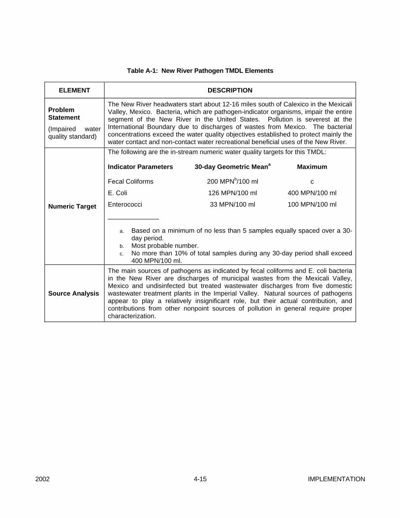
2002 4-15 IMPLEMENTATION
Table A-1: New River Pathogen TMDL Elements
ELEMENT DESCRIPTION
Problem Statement
(Impaired water quality standard)
The New River headwaters start about 12-16 miles south of Calexico in the Mexicali Valley, Mexico. Bacteria, which are pathogen-indicator organisms, impair the entire segment of the New River in the United States. Pollution is severest at the International Boundary due to discharges of wastes from Mexico. The bacterial concentrations exceed the water quality objectives established to protect mainly the water contact and non-contact water recreational beneficial uses of the New River.
Numeric Target
The following are the in-stream numeric water quality targets for this TMDL:
Indicator Parameters 30-day Geometric Meana Maximum
Fecal Coliforms 200 MPNb/100 ml c
E. Coli 126 MPN/100 ml 400 MPN/100 ml
Enterococci 33 MPN/100 ml 100 MPN/100 ml
______________
a. Based on a minimum of no less than 5 samples equally spaced over a 30-day period.
b. Most probable number. c. No more than 10% of total samples during any 30-day period shall exceed
400 MPN/100 ml.
Source Analysis
The main sources of pathogens as indicated by fecal coliforms and E. coli bacteria in the New River are discharges of municipal wastes from the Mexicali Valley, Mexico and undisinfected but treated wastewater discharges from five domestic wastewater treatment plants in the Imperial Valley. Natural sources of pathogens appear to play a relatively insignificant role, but their actual contribution, and contributions from other nonpoint sources of pollution in general require proper characterization.

IMPLEMENTATION 4-16 2002
ELEMENT DESCRIPTION
Allocations and Margin of Safety
Discharges from point sources and nonpoint sources of pollution shall not exceed the following waste load allocations (WLAs) and load allocations (LAs), respectively:
WLAs and LAs
Indicator Parameters 30-Day Geometric Meana Maximum
Fecal Coliforms 200 MPNb/100ml C
E. coli 126 MPN/100 ml 400 MPN/100 ml
Enterococci 33 MPN/100 ml 100 MPN/100 ml
_______________
a. Based on a minimum of no less than 5 samples equally spaced over a 30-day period.
b. Most probable number. c. No more than 10% of total samples during any 30-day period shall exceed
400 MPN/100 ml.
The allocations are applicable throughout the entire stretch of the New River in the U.S. The numeric target concentrations are based on extensive epidemiological studies conducted by the USEPA and others. By setting the TMDL and each of the load and waste load allocations equal to the standards, the proposed TMDL approach results in very limited uncertainty about whether attainment of the TMDL and the individual allocations will result in attainment of the applicable numeric standards. Moreover, the TMDL analysis takes a conservative approach of providing load and wasteload allocations even for relatively minor loading sources, which helps to ensure that the selected source control approach will result in attainment of the numeric objectives. Finally, to help address uncertainty concerning the bacterial die-off and regrowth dynamics in the River, the TMDL provides implicit margin of safety by including a relatively aggressive monitoring and review plan which will help ensure that needed data are collected and that, if necessary, the TMDL will be revised in the relatively near future.

2002 4-17 IMPLEMENTATION
2. Implementation Actions for Attainment of TMDL The pathogen load allocations, waste load allocations, and water quality objectives shall be applicable to the New River for the protection of the REC-l and REC-II beneficial uses and shall be achieved within three years of USEPA approval of the TMDL. To this end, the following actions shall be implemented. 2.1 Wastewater Treatment Plants All point source dischargers discharging, potentially discharging, or proposing to discharge waste with bacteria into the New River and/or surface waters tributary to the New River, at concentrations that violate or threaten to violate waste load allocations (WLAs), shall provide adequate disinfection to meet the WLAs specified in Table A-1. Currently, there are five (5) NPDES permitted facilities discharging undisinfected municipal wastewater into the New River: the City of Brawley WWTP, Seeley County Water District (SCWD) WWTP; Date Gardens Mobile Home Park (DGMHP) WWTP; City of Westmorland WWTP, and McCabe Union School District (MCUSD) WWTP. Both the City of Westmorland and City of Brawley have been issued Time Schedule Orders (TSOs) requiring them to upgrade their WWTPs by January 2002 and March 2002, respectively. The City of Westmorland is already upgrading its WWTP and expects to complete the upgrade by 2002. The City of Brawley is securing financing from the North America Development Bank to upgrade its WWTP. The NPDES permit for the City of Brawley already prescribes effluent disinfection limits consistent with this TMDL. However, neither the TSO nor the NPDES permits for the City of Westmorland contains requirements for disinfection. It is essential that the referenced facilities that are not disinfecting provide adequate effluent disinfection at the earliest possible date. Towards this end, the Executive Officer shall direct staff to draft revised NPDES permits for these facilities incorporating the WLAs prescribed in Table A-1 and monitoring requirements for the WLAs. Draft revised permits shall be ready for Regional Board consideration in accordance with the following schedule or sooner as resources allow.
Facility Name NPDES Permit No. Expiration Date
Revision Date
City of Westmorland WWTP CA0105007 1/28/03 {Year 1}* Seeley County Water District WWTP CA0105023 6/25/02 {Year 1}* Date Gardens Mobile Home Park WWTP
CAO104841 9/24/02 {Year 1}*
McCabe Union High School District WWTP
CA0104281 11/29/00 {Year 1}*
*Year 1 refers to the effective date to revise the permits for these plants, which shall be 30 days after USEPA approval of the TMDL. (USEPA approval date August 14, 2002)
Additionally, SCWD, DGMHP, and MCUSD shall each: a. By November 14, 2002 and pursuant to Section
13267 of the California Water Code, submit a technical report in the form of plans, specifications, and proposed measures to be taken to secure funds to comply with their WLAs by no later than May 14, 2005.
b. Submit quarterly reports to the Executive Officer describing their progress towards meeting their WLAs. Quarterly reports shall be due on the 15th day of the month following the reporting calendar quarter, and begin the first calendar quarter immediately following USEPA approval.
2.2 United States Government
IMPLEMENTATION 4-18 2002
Neither the existing lagoon systems nor the proposed wastewater treatment facilities for the Mexicali metropolitan area include disinfection. Also, there are a significant number of unregulated point and nonpoint sources of bacteria which discharge directly into the New River watershed in Mexicali, and an unknown number of raw sewage bypasses, which are not addressed by the certified projects. Therefore, the projects by themselves will not result in attainment of the bacterial load allocations downstream of the International Boundary. Consequently, it is necessary for the U.S. Government to pursue additional steps to ensure this TMDL complies with the requirements of Section 303(d) of the Clean Water Act and ensure discharges of wastes from Mexico will not cause or contribute to a violation of this TMDL. Therefore, pursuant to Section 13225 of the California Water Code, the U.S. Section of the International Boundary and Water Commission and USEPA shall: a. By February 14, 2003, submit a technical report
to the Regional Board with proposed measures (e.g., plans and specifications for disinfection facilities) to ensure that discharges of wastes from Mexico do not cause or contribute to a violation of this TMDL. The report shall specify the parties responsible for implementation of the measures and include a time schedule for implementation and completion of the measures within three years of USEPA approval of this TMDL.
b. By May 14, 2003, submit a report identifying financial options for implementation of the measures discussed in Task No. "a,” above.
c. Submit semi-annual progress reports to the
Regional Board regarding progress towards completion of the measures. The semi-annual reports shall be due by the 15th day of the month, and shall begin in the 6th month following submission of the technical report required in 2.2, a.
B. ALAMO RIVER
SEDIMENTATION/SILTATION TMDL
1. TMDL ELEMENTS SUMMARY
This TMDL was adopted by: The California Regional Water Quality Control Board, Colorado River Basin Region on June 27, 2001. The California State Water Resources Control Board on February 19, 2002. The Office of Administrative Law on May 3, 2002. The U.S. Environmental Protection Agency on June 28, 2002.
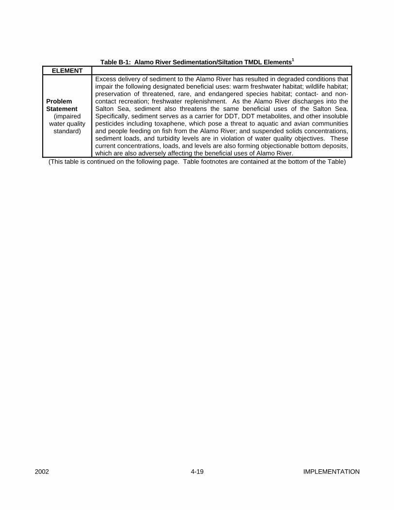
2002 4-19 IMPLEMENTATION
Table B-1: Alamo River Sedimentation/Siltation TMDL Elements1
ELEMENT
Problem Statement
(impaired water quality
standard)
Excess delivery of sediment to the Alamo River has resulted in degraded conditions that impair the following designated beneficial uses: warm freshwater habitat; wildlife habitat; preservation of threatened, rare, and endangered species habitat; contact- and non-contact recreation; freshwater replenishment. As the Alamo River discharges into the Salton Sea, sediment also threatens the same beneficial uses of the Salton Sea. Specifically, sediment serves as a carrier for DDT, DDT metabolites, and other insoluble pesticides including toxaphene, which pose a threat to aquatic and avian communities and people feeding on fish from the Alamo River; and suspended solids concentrations, sediment loads, and turbidity levels are in violation of water quality objectives. These current concentrations, loads, and levels are also forming objectionable bottom deposits, which are also adversely affecting the beneficial uses of Alamo River.
(This table is continued on the following page. Table footnotes are contained at the bottom of the Table)
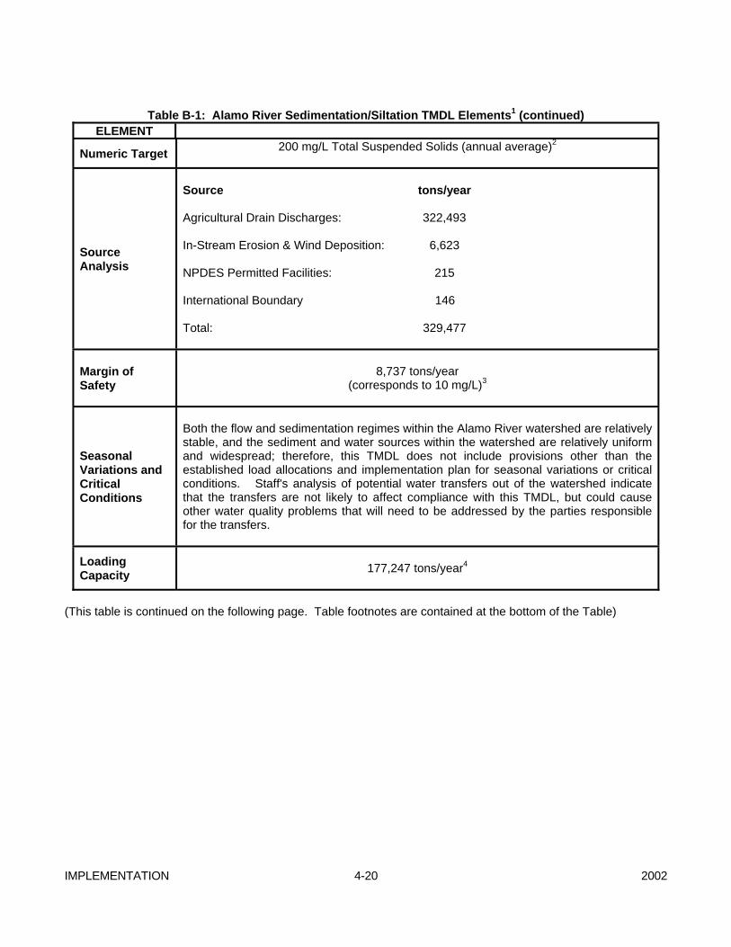
IMPLEMENTATION 4-20 2002
Table B-1: Alamo River Sedimentation/Siltation TMDL Elements1 (continued)
ELEMENT
Numeric Target 200 mg/L Total Suspended Solids (annual average)2
Source Analysis
Source tons/year Agricultural Drain Discharges: 322,493 In-Stream Erosion & Wind Deposition: 6,623 NPDES Permitted Facilities: 215 International Boundary 146 Total: 329,477
Margin of Safety
8,737 tons/year
(corresponds to 10 mg/L)3
Seasonal Variations and Critical Conditions
Both the flow and sedimentation regimes within the Alamo River watershed are relatively stable, and the sediment and water sources within the watershed are relatively uniform and widespread; therefore, this TMDL does not include provisions other than the established load allocations and implementation plan for seasonal variations or critical conditions. Staff's analysis of potential water transfers out of the watershed indicate that the transfers are not likely to affect compliance with this TMDL, but could cause other water quality problems that will need to be addressed by the parties responsible for the transfers.
Loading Capacity
177,247 tons/year4
(This table is continued on the following page. Table footnotes are contained at the bottom of the Table)
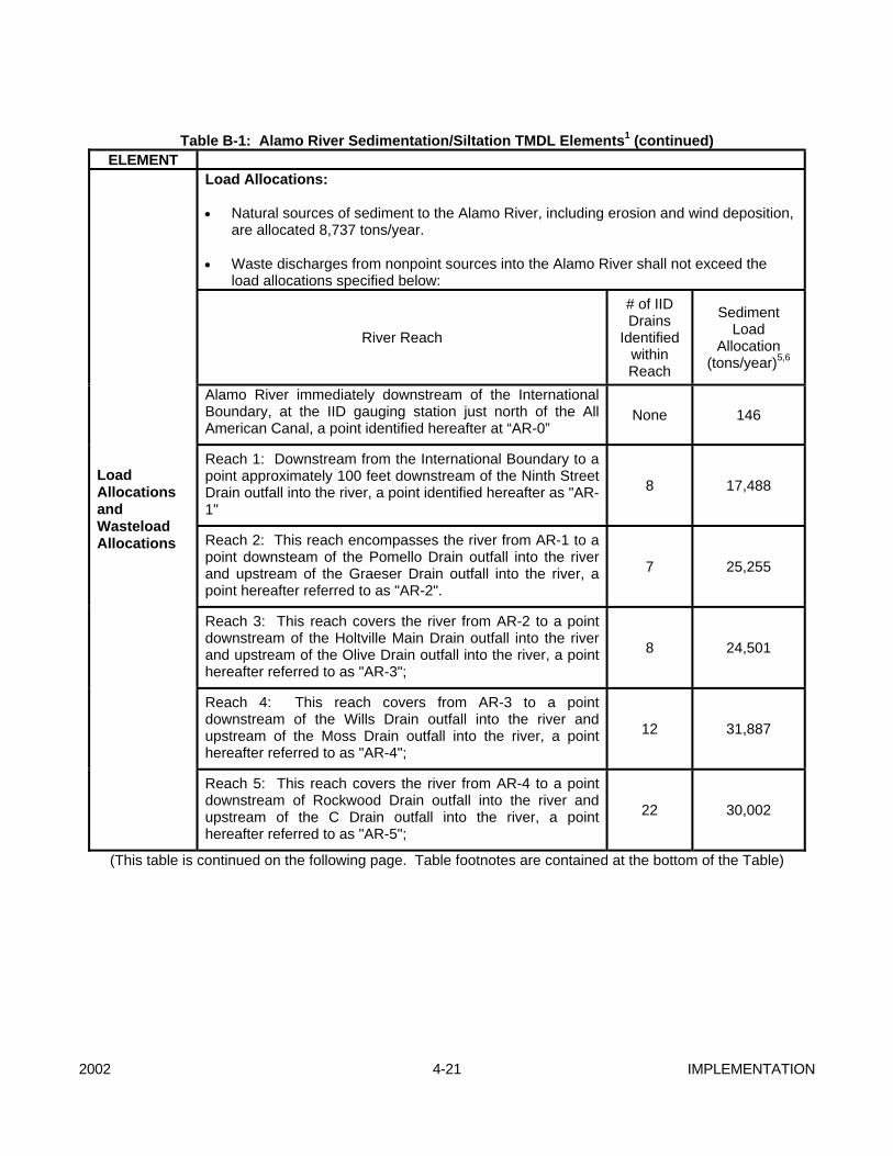
2002 4-21 IMPLEMENTATION
Table B-1: Alamo River Sedimentation/Siltation TMDL Elements1 (continued)
ELEMENT Load Allocations: • Natural sources of sediment to the Alamo River, including erosion and wind deposition,
are allocated 8,737 tons/year. • Waste discharges from nonpoint sources into the Alamo River shall not exceed the
load allocations specified below:
River Reach
# of IID Drains
Identified within Reach
Sediment Load
Allocation (tons/year)5,6
Alamo River immediately downstream of the International Boundary, at the IID gauging station just north of the All American Canal, a point identified hereafter at “AR-0”
None 146
Reach 1: Downstream from the International Boundary to a point approximately 100 feet downstream of the Ninth Street Drain outfall into the river, a point identified hereafter as "AR-1"
8 17,488
Reach 2: This reach encompasses the river from AR-1 to a point downsteam of the Pomello Drain outfall into the river and upstream of the Graeser Drain outfall into the river, a point hereafter referred to as "AR-2".
7 25,255
Reach 3: This reach covers the river from AR-2 to a point downstream of the Holtville Main Drain outfall into the river and upstream of the Olive Drain outfall into the river, a point hereafter referred to as "AR-3";
8 24,501
Reach 4: This reach covers from AR-3 to a point downstream of the Wills Drain outfall into the river and upstream of the Moss Drain outfall into the river, a point hereafter referred to as "AR-4";
12 31,887
Load Allocations and Wasteload Allocations
Reach 5: This reach covers the river from AR-4 to a point downstream of Rockwood Drain outfall into the river and upstream of the C Drain outfall into the river, a point hereafter referred to as "AR-5";
22 30,002
(This table is continued on the following page. Table footnotes are contained at the bottom of the Table)

IMPLEMENTATION 4-22 2002
Table B-1: Alamo River Sedimentation/Siltation TMDL Elements1 (continued)
ELEMENT
River Reach
# of IID Drains
Identified within Reach
Sediment Load Allocation
(tons/year) 5,6
Reach 6: This reach covers the river from AR-5 to the point where it intersects the Garst Road, a point hereafter referred to as "AR-Outlet.”
12 19,469
Tailwater outfalls discharging directly to the Alamo River. a 7,830 Natural Sources 8,737
Load Allocations
and Wasteload Allocations
Waste Load Allocations: The discharge from point sources shall not exceed the total suspended limits specified under 40 CFR 122 et seq., and the corresponding mass loading rates.
N/A
3,196
Footnotes for Table No. B-1: 1 For purposes of measuring compliance, all samples will be analyzed for volatile suspended solids at locations
where organic loading represents a significant proportion of the total suspended solids or turbidity. The volatile suspended solids component will be subtracted for determining compliance.
2 The numeric target is a goal that translates current silt/sediment-related Basin Plan narrative objectives and
shall not be used for enforcement purposes.
3 The margin of safety is roughly equal to the estimated load from natural sources to the Alamo River. This margin of safety allows for the loading of sediment from natural sources to the river to be double the natural source loading estimated in the Source Analysis without exceeding the Numeric Target.
4 Previously reported as 174,747 due to typographical error. 5 The sediment load allocation for any particular reach shall be distributed proportionately amongst the
agricultural drains within that particular reach based on the relative flow contribution of each drain to the total flow contribution to the reach from the drains within the reach. The sediment load allocation will be reviewed every three years following TMDL implementation. The sediment load allocation will vary depending on drain flow.
6 The sediment load allocations herein have been calculated based on the estimated individual average drain flows within the reach for the 1994-1999 period. At lower or higher drain flows, the average annual load allocation for a particular reach shall not exceed the load given by:
7 LAR = (180)*(QR)*(0.0013597), where: 8 LAR = Load Allocation for any of the Alamo River reaches identified above (tons/yr). 9 QR = Reach Flow (ac-ft) = Total flow contribution to the reach from the drains within the reach (ac-ft). a The number of outfalls has not been determined.
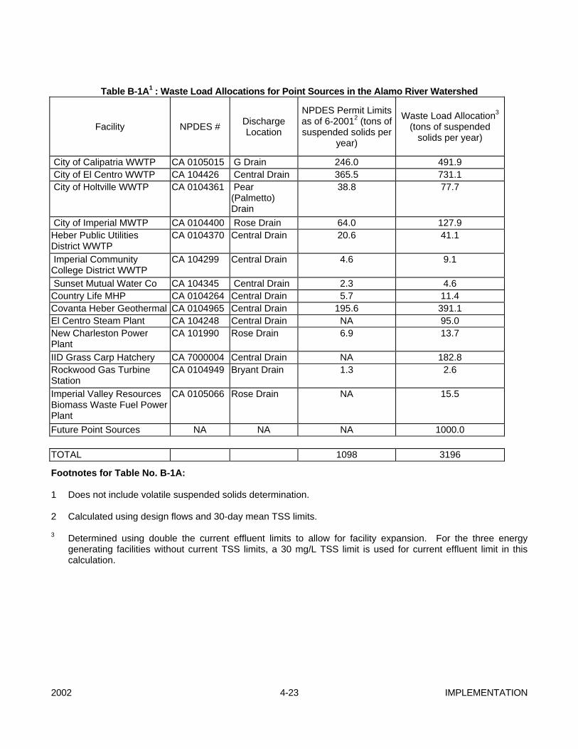
2002 4-23 IMPLEMENTATION
Table B-1A1 : Waste Load Allocations for Point Sources in the Alamo River Watershed
Facility NPDES # Discharge Location
NPDES Permit Limits as of 6-20012 (tons of suspended solids per
year)
Waste Load Allocation3 (tons of suspended
solids per year)
City of Calipatria WWTP CA 0105015 G Drain 246.0 491.9 City of El Centro WWTP CA 104426 Central Drain 365.5 731.1 City of Holtville WWTP CA 0104361 Pear
(Palmetto) Drain
38.8 77.7
City of Imperial MWTP CA 0104400 Rose Drain 64.0 127.9 Heber Public Utilities District WWTP
CA 0104370 Central Drain 20.6 41.1
Imperial Community College District WWTP
CA 104299 Central Drain 4.6 9.1
Sunset Mutual Water Co CA 104345 Central Drain 2.3 4.6 Country Life MHP CA 0104264 Central Drain 5.7 11.4 Covanta Heber Geothermal CA 0104965 Central Drain 195.6 391.1 El Centro Steam Plant CA 104248 Central Drain NA 95.0 New Charleston Power Plant
CA 101990 Rose Drain 6.9 13.7
IID Grass Carp Hatchery CA 7000004 Central Drain NA 182.8 Rockwood Gas Turbine Station
CA 0104949 Bryant Drain 1.3 2.6
Imperial Valley Resources Biomass Waste Fuel Power Plant
CA 0105066 Rose Drain NA 15.5
Future Point Sources NA NA NA 1000.0 TOTAL 1098 3196
Footnotes for Table No. B-1A: 1 Does not include volatile suspended solids determination. 2 Calculated using design flows and 30-day mean TSS limits.
3 Determined using double the current effluent limits to allow for facility expansion. For the three energy generating facilities without current TSS limits, a 30 mg/L TSS limit is used for current effluent limit in this calculation.
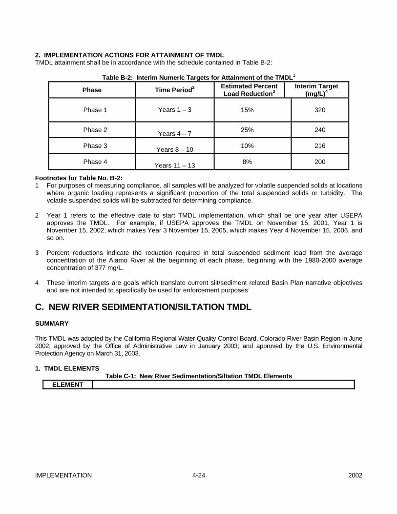
IMPLEMENTATION 4-24 2002
2. IMPLEMENTATION ACTIONS FOR ATTAINMENT OF TMDL TMDL attainment shall be in accordance with the schedule contained in Table B-2:
Table B-2: Interim Numeric Targets for Attainment of the TMDL1
Phase Time Period2 Estimated Percent Load Reduction3
Interim Target (mg/L)4
Phase 1
Years 1 – 3 15% 320
Phase 2 Years 4 – 7 25% 240
Phase 3 Years 8 – 10 10% 216
Phase 4 Years 11 – 13 8% 200
Footnotes for Table No. B-2: 1 For purposes of measuring compliance, all samples will be analyzed for volatile suspended solids at locations
where organic loading represents a significant proportion of the total suspended solids or turbidity. The volatile suspended solids will be subtracted for determining compliance.
2 Year 1 refers to the effective date to start TMDL implementation, which shall be one year after USEPA
approves the TMDL. For example, if USEPA approves the TMDL on November 15, 2001, Year 1 is November 15, 2002, which makes Year 3 November 15, 2005, which makes Year 4 November 15, 2006, and so on.
3 Percent reductions indicate the reduction required in total suspended sediment load from the average
concentration of the Alamo River at the beginning of each phase, beginning with the 1980-2000 average concentration of 377 mg/L.
4 These interim targets are goals which translate current silt/sediment related Basin Plan narrative objectives
and are not intended to specifically be used for enforcement purposes. C. NEW RIVER SEDIMENTATION/SILTATION TMDL SUMMARY This TMDL was adopted by the California Regional Water Quality Control Board, Colorado River Basin Region in June 2002; approved by the Office of Administrative Law in January 2003; and approved by the U.S. Environmental Protection Agency on March 31, 2003. 1. TMDL ELEMENTS
Table C-1: New River Sedimentation/Siltation TMDL Elements ELEMENT
2002 4-25 IMPLEMENTATION
Problem Statement
(impaired water quality
standard)
Excess delivery of sediment to the New River has resulted in degraded conditions that impairs designated beneficial uses: warm freshwater habitat; wildlife habitat; preservation of threatened, rare, and endangered species habitat; contact- and non-contact recreation; freshwater replenishment. As the New River discharges into the Salton Sea, sediment also threatens the same beneficial uses of the Salton Sea. Sediment serves as a carrier for DDT, DDT metabolites, and other insoluble pesticides including toxaphene, which pose a threat to aquatic and avian communities and people feeding on fish from the New River; and suspended solids concentrations, sediment loads, and turbidity levels are in violation of water quality objectives. These current concentrations, loads, and levels are also forming objectionable bottom deposits, which are also adversely affecting the beneficial uses of New River.
(This table is continued on the following page.)
IMPLEMENTATION 4-26 2002
Table C-1: New River Sedimentation/Siltation TMDL Elements (continued)
ELEMENT CURRENT CONDITIONS
Numeric Target 200 mg/L Total Suspended Solids (annual average)3
Source Analysis
Source tons/year Agricultural Drain Discharges: 137,715 In-Stream Erosion & Wind Deposition: 6,409 NPDES Permitted Facilities: 356 International Boundary 11,265 Total: 155,745
ELEMENT LOAD ALLOCATIONS
Margin of Safety
6,409 tons/year
(corresponds to 10 mg/L)
Seasonal Variations and Critical Conditions
Both the flow and sedimentation regimes within the New River watershed are relatively stable, and the sediment and water sources within the watershed are relatively uniform and widespread; therefore, this TMDL does not include provisions other than the established load allocations and implementation plan for seasonal variations or critical conditions. Staff's analysis of potential water transfers out of the watershed indicate that the transfers are not likely to affect compliance with this TMDL, but could cause other water quality problems that will need to be addressed by the parties responsible for the transfers.
Loading Capacity
127,881 tons/year
(This table is continued on the following page.)
3 The numeric target is a goal that translates current silt/sediment-related Basin Plan narrative objectives and shall not be used for enforcement purposes.
2002 4-27 IMPLEMENTATION
Table C-1: New River Sedimentation/Siltation TMDL Elements (continued)
ELEMENT Load Allocations: • Natural sources of sediment to the New River, including erosion and wind deposition,
are allocated 6,409 tons/year. • Waste discharges from nonpoint sources into the New River shall not exceed the load
allocations specified below:
River Reach
# of IID Drains
Identified within Reach
Sediment Load
Allocation (tons/year)1,2
New River immediately downstream of the International Boundary, at the USGS gauging station, a point identified hereafter at “NR-0”
None 11,265
Reach 1: Downstream from the International Boundary to the intersection of the Evan Hewes Road Bridge and the New River Channel, a point identified hereafter as "NR-1"
14 20,730
Load Allocations and Wasteload Allocations
Reach 2: This reach encompasses the river from NR-1 to Drop Structure 2, a point upstream of the Rutheford Road Bridge hereafter referred to as "NR-2".
17 32,350
(This table is continued on the following page.)
IMPLEMENTATION 4-28 2002
Table C-1: New River Sedimentation/Siltation TMDL Elements (continued)
ELEMENT Reach 3: This reach covers the river from NR-2 to the point where it intersects the Lack Road Bridge, a point hereafter referred to as "NR-Outlet.”
23 35,835
Direct Outfalls to River # of IID Drains
Identified
Sediment Load
Allocation (tons/year)1,2
Tailwater outfalls discharging directly to the New River. a 14,884 Natural Sources
Natural Sources 6,409
Load Allocations
and Wasteload Allocations
Waste Load Allocations: • The discharge from point sources (NPDES permits) shall not exceed the total
suspended solids limits specified under 40 CFR 122 et seq., and the corresponding mass loading rates.
Footnotes for Table No. C-1:
1 The sediment load allocation for any particular applicable reach shall be distributed proportionately amongst the agricultural drains within that particular reach based on the relative flow contribution of each drain to the total flow contribution to the reach from the drains within the reach. The sediment load allocation will be reviewed every three years following TMDL implementation. The sediment load allocation will vary depending on drain flow.
2 The sediment load allocations have been calculated based on the estimated individual average drain flows within the reach for the 1995-2000 period. At lower or higher drain flows, the average annual load allocation for a particular reach shall not exceed the load given by:
3 LAR = (180)*(QR)*(0.0013597), where: 4 LAR = Load Allocation for any of the New River reaches identified above (tons/yr). 5 QR = Reach Flow (ac-ft) = Total flow contribution to the reach from the drains within the reach (ac-ft). The
sediment load allocation will be reviewed by the Executive Officer every three years following TMDL implementation.
a. The number of outfalls has not been determined.
2. Implementation Actions for Attainment of TMDL TMDL attainment shall be in accordance with the schedule contained in Table C-2A:
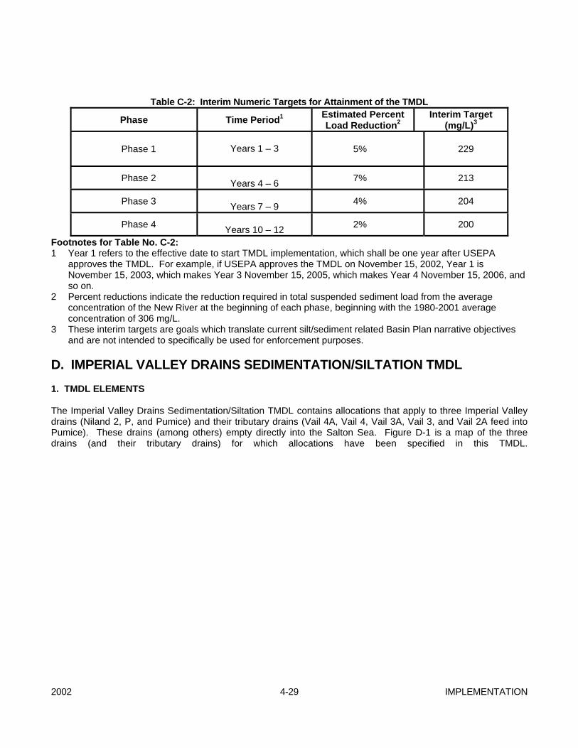
2002 4-29 IMPLEMENTATION
Table C-2: Interim Numeric Targets for Attainment of the TMDL
Phase Time Period1 Estimated Percent Load Reduction2
Interim Target (mg/L)3
Phase 1
Years 1 – 3 5% 229
Phase 2 Years 4 – 6 7% 213
Phase 3 Years 7 – 9 4% 204
Phase 4 Years 10 – 12 2% 200
Footnotes for Table No. C-2: 1 Year 1 refers to the effective date to start TMDL implementation, which shall be one year after USEPA
approves the TMDL. For example, if USEPA approves the TMDL on November 15, 2002, Year 1 is November 15, 2003, which makes Year 3 November 15, 2005, which makes Year 4 November 15, 2006, and so on.
2 Percent reductions indicate the reduction required in total suspended sediment load from the average concentration of the New River at the beginning of each phase, beginning with the 1980-2001 average concentration of 306 mg/L.
3 These interim targets are goals which translate current silt/sediment related Basin Plan narrative objectives and are not intended to specifically be used for enforcement purposes.
D. IMPERIAL VALLEY DRAINS SEDIMENTATION/SILTATION TMDL 1. TMDL ELEMENTS The Imperial Valley Drains Sedimentation/Siltation TMDL contains allocations that apply to three Imperial Valley drains (Niland 2, P, and Pumice) and their tributary drains (Vail 4A, Vail 4, Vail 3A, Vail 3, and Vail 2A feed into Pumice). These drains (among others) empty directly into the Salton Sea. Figure D-1 is a map of the three drains (and their tributary drains) for which allocations have been specified in this TMDL.

IMPLEMENTATION 4-30 2002
Figure D-1: Drains (Niland 2, P, and Pumice and Their Tributary Drains) for Which Allocations Have Been Specified in this TMDL
Table D-1: Imperial Valley Drains (Niland 2, P, and Pumice) Sedimentation/Siltation TMDL Elements ELEMENT
Problem Statement (impaired water quality standard)
Excess delivery of sediment to Niland 2, P, and Pumice Imperial Valley drains has resulted in degraded conditions that impairs designated beneficial uses: warm freshwater habitat; wildlife habitat; preservation of threatened, rare, or endangered species; water contact and non-contact water recreation; and freshwater replenishment. As the drains discharge into the Salton Sea, sediment also threatens the same beneficial uses of the Salton Sea. Sediment serves as a carrier for DDT, DDT metabolites, and other insoluble pesticides including toxaphene, which pose a threat to aquatic and avian communities and people feeding on fish from the drains. Suspended solids concentrations, sediment loads, and turbidity levels are in violation of water quality objectives. These current concentrations, loads, and levels also are forming objectionable bottom deposits, which are adversely affecting the beneficial uses .
(This table is continued on the following page.)
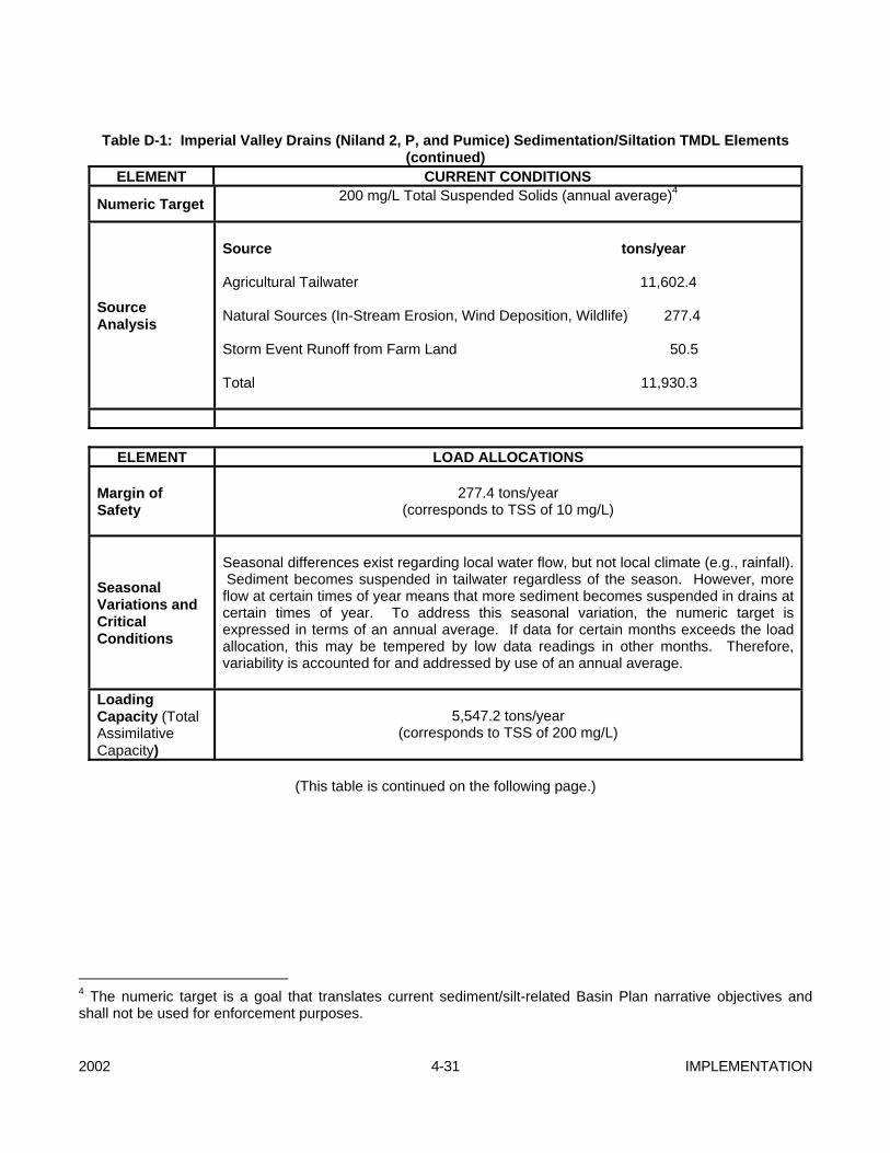
2002 4-31 IMPLEMENTATION
Table D-1: Imperial Valley Drains (Niland 2, P, and Pumice) Sedimentation/Siltation TMDL Elements
(continued) ELEMENT CURRENT CONDITIONS
Numeric Target 200 mg/L Total Suspended Solids (annual average)4
Source Analysis
Source tons/year Agricultural Tailwater 11,602.4 Natural Sources (In-Stream Erosion, Wind Deposition, Wildlife) 277.4 Storm Event Runoff from Farm Land 50.5 Total 11,930.3
ELEMENT LOAD ALLOCATIONS
Margin of Safety
277.4 tons/year
(corresponds to TSS of 10 mg/L)
Seasonal Variations and Critical Conditions
Seasonal differences exist regarding local water flow, but not local climate (e.g., rainfall). Sediment becomes suspended in tailwater regardless of the season. However, more flow at certain times of year means that more sediment becomes suspended in drains at certain times of year. To address this seasonal variation, the numeric target is expressed in terms of an annual average. If data for certain months exceeds the load allocation, this may be tempered by low data readings in other months. Therefore, variability is accounted for and addressed by use of an annual average.
Loading Capacity (Total Assimilative Capacity)
5,547.2 tons/year
(corresponds to TSS of 200 mg/L)
(This table is continued on the following page.)
4 The numeric target is a goal that translates current sediment/silt-related Basin Plan narrative objectives and shall not be used for enforcement purposes.
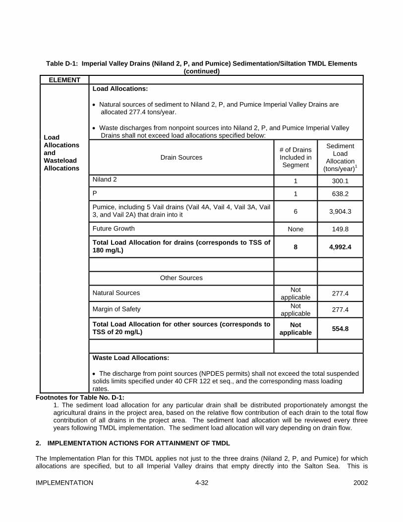
IMPLEMENTATION 4-32 2002
Table D-1: Imperial Valley Drains (Niland 2, P, and Pumice) Sedimentation/Siltation TMDL Elements
(continued) ELEMENT
Load Allocations: • Natural sources of sediment to Niland 2, P, and Pumice Imperial Valley Drains are
allocated 277.4 tons/year. • Waste discharges from nonpoint sources into Niland 2, P, and Pumice Imperial Valley
Drains shall not exceed load allocations specified below:
Drain Sources # of Drains Included in Segment
Sediment Load
Allocation (tons/year)1
Niland 2 1 300.1
P 1 638.2
Load Allocations and Wasteload Allocations
Pumice, including 5 Vail drains (Vail 4A, Vail 4, Vail 3A, Vail 3, and Vail 2A) that drain into it 6 3,904.3
Future Growth None 149.8
Total Load Allocation for drains (corresponds to TSS of 180 mg/L) 8 4,992.4
Other Sources
Natural Sources Not applicable 277.4
Margin of Safety Not applicable 277.4
Total Load Allocation for other sources (corresponds to TSS of 20 mg/L)
Not applicable 554.8
Waste Load Allocations:
• The discharge from point sources (NPDES permits) shall not exceed the total suspended solids limits specified under 40 CFR 122 et seq., and the corresponding mass loading rates.
Footnotes for Table No. D-1: 1. The sediment load allocation for any particular drain shall be distributed proportionately amongst the agricultural drains in the project area, based on the relative flow contribution of each drain to the total flow contribution of all drains in the project area. The sediment load allocation will be reviewed every three years following TMDL implementation. The sediment load allocation will vary depending on drain flow.
2. IMPLEMENTATION ACTIONS FOR ATTAINMENT OF TMDL The Implementation Plan for this TMDL applies not just to the three drains (Niland 2, P, and Pumice) for which allocations are specified, but to all Imperial Valley drains that empty directly into the Salton Sea. This is
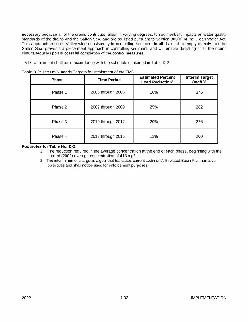
2002 4-33 IMPLEMENTATION
necessary because all of the drains contribute, albeit in varying degrees, to sediment/silt impacts on water quality standards of the drains and the Salton Sea, and are so listed pursuant to Section 303(d) of the Clean Water Act. This approach ensures Valley-wide consistency in controlling sediment in all drains that empty directly into the Salton Sea, prevents a piece-meal approach in controlling sediment, and will enable de-listing of all the drains simultaneously upon successful completion of the control measures. TMDL attainment shall be in accordance with the schedule contained in Table D-2: Table D-2: Interim Numeric Targets for Attainment of the TMDL
Phase Time Period Estimated Percent Load Reduction1
Interim Target (mg/L)2
Phase 1
2005 through 2006
10% 376
Phase 2
2007 through 2009
25% 282
Phase 3
2010 through 2012
20% 226
Phase 4
2013 through 2015
12% 200
Footnotes for Table No. D-2: 1. The reduction required in the average concentration at the end of each phase, beginning with the
current (2002) average concentration of 418 mg/L. 2. The interim numeric target is a goal that translates current sediment/silt-related Basin Plan narrative
objectives and shall not be used for enforcement purposes.
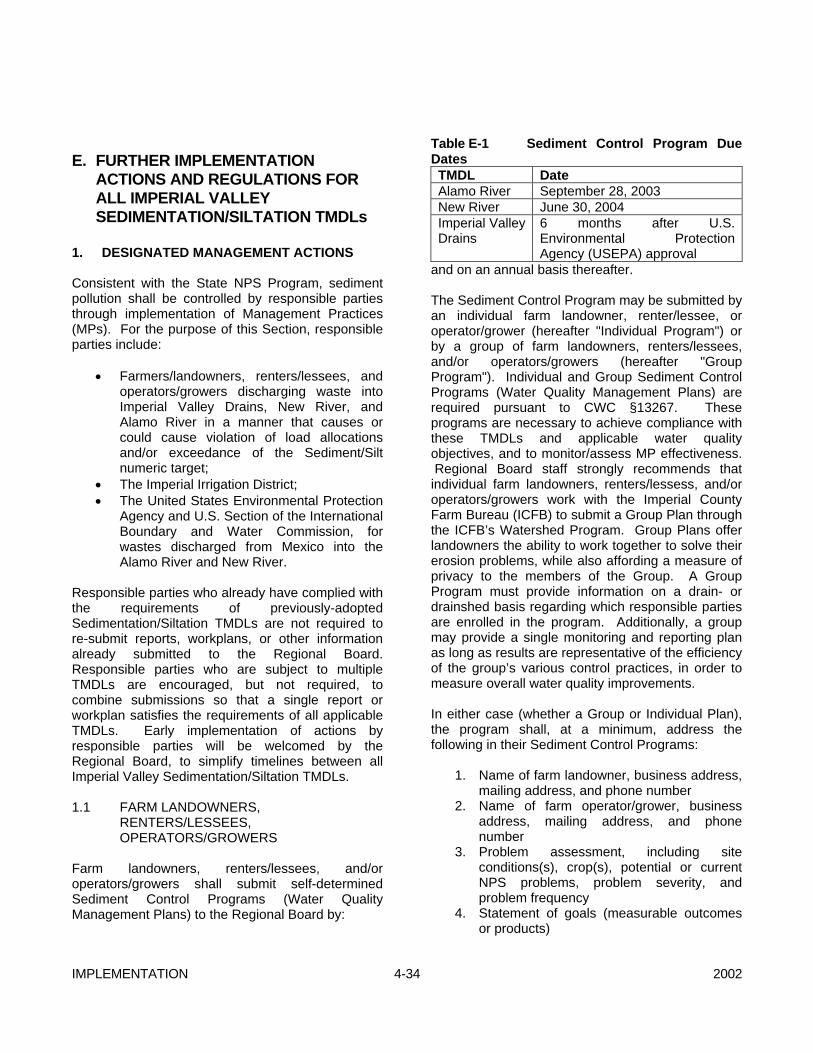
IMPLEMENTATION 4-34 2002
E. FURTHER IMPLEMENTATION
ACTIONS AND REGULATIONS FOR ALL IMPERIAL VALLEY SEDIMENTATION/SILTATION TMDLs
1. DESIGNATED MANAGEMENT ACTIONS Consistent with the State NPS Program, sediment pollution shall be controlled by responsible parties through implementation of Management Practices (MPs). For the purpose of this Section, responsible parties include:
• Farmers/landowners, renters/lessees, and operators/growers discharging waste into Imperial Valley Drains, New River, and Alamo River in a manner that causes or could cause violation of load allocations and/or exceedance of the Sediment/Silt numeric target;
• The Imperial Irrigation District; • The United States Environmental Protection
Agency and U.S. Section of the International Boundary and Water Commission, for wastes discharged from Mexico into the Alamo River and New River.
Responsible parties who already have complied with the requirements of previously-adopted Sedimentation/Siltation TMDLs are not required to re-submit reports, workplans, or other information already submitted to the Regional Board. Responsible parties who are subject to multiple TMDLs are encouraged, but not required, to combine submissions so that a single report or workplan satisfies the requirements of all applicable TMDLs. Early implementation of actions by responsible parties will be welcomed by the Regional Board, to simplify timelines between all Imperial Valley Sedimentation/Siltation TMDLs. 1.1 FARM LANDOWNERS,
RENTERS/LESSEES, OPERATORS/GROWERS
Farm landowners, renters/lessees, and/or operators/growers shall submit self-determined Sediment Control Programs (Water Quality Management Plans) to the Regional Board by:
Table E-1 Sediment Control Program Due Dates TMDL Date Alamo River September 28, 2003 New River June 30, 2004 Imperial Valley Drains
6 months after U.S. Environmental Protection Agency (USEPA) approval
and on an annual basis thereafter. The Sediment Control Program may be submitted by an individual farm landowner, renter/lessee, or operator/grower (hereafter "Individual Program") or by a group of farm landowners, renters/lessees, and/or operators/growers (hereafter "Group Program"). Individual and Group Sediment Control Programs (Water Quality Management Plans) are required pursuant to CWC §13267. These programs are necessary to achieve compliance with these TMDLs and applicable water quality objectives, and to monitor/assess MP effectiveness. Regional Board staff strongly recommends that individual farm landowners, renters/lessess, and/or operators/growers work with the Imperial County Farm Bureau (ICFB) to submit a Group Plan through the ICFB’s Watershed Program. Group Plans offer landowners the ability to work together to solve their erosion problems, while also affording a measure of privacy to the members of the Group. A Group Program must provide information on a drain- or drainshed basis regarding which responsible parties are enrolled in the program. Additionally, a group may provide a single monitoring and reporting plan as long as results are representative of the efficiency of the group’s various control practices, in order to measure overall water quality improvements. In either case (whether a Group or Individual Plan), the program shall, at a minimum, address the following in their Sediment Control Programs:
1. Name of farm landowner, business address, mailing address, and phone number
2. Name of farm operator/grower, business address, mailing address, and phone number
3. Problem assessment, including site conditions(s), crop(s), potential or current NPS problems, problem severity, and problem frequency
4. Statement of goals (measurable outcomes or products)
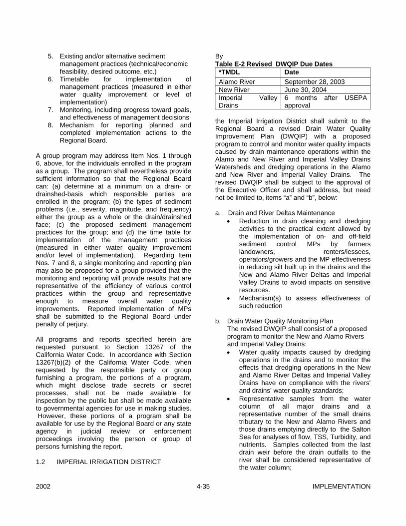
2002 4-35 IMPLEMENTATION
5. Existing and/or alternative sediment management practices (technical/economic feasibility, desired outcome, etc.)
6. Timetable for implementation of management practices (measured in either water quality improvement or level of implementation)
7. Monitoring, including progress toward goals, and effectiveness of management decisions
8. Mechanism for reporting planned and completed implementation actions to the Regional Board.
A group program may address Item Nos. 1 through 6, above, for the individuals enrolled in the program as a group. The program shall nevertheless provide sufficient information so that the Regional Board can: (a) determine at a minimum on a drain- or drainshed-basis which responsible parties are enrolled in the program; (b) the types of sediment problems (i.e., severity, magnitude, and frequency) either the group as a whole or the drain/drainshed face; (c) the proposed sediment management practices for the group; and (d) the time table for implementation of the management practices (measured in either water quality improvement and/or level of implementation). Regarding Item Nos. 7 and 8, a single monitoring and reporting plan may also be proposed for a group provided that the monitoring and reporting will provide results that are representative of the efficiency of various control practices within the group and representative enough to measure overall water quality improvements. Reported implementation of MPs shall be submitted to the Regional Board under penalty of perjury. All programs and reports specified herein are requested pursuant to Section 13267 of the California Water Code. In accordance with Section 13267(b)(2) of the California Water Code, when requested by the responsible party or group furnishing a program, the portions of a program, which might disclose trade secrets or secret processes, shall not be made available for inspection by the public but shall be made available to governmental agencies for use in making studies. However, these portions of a program shall be available for use by the Regional Board or any state agency in judicial review or enforcement proceedings involving the person or group of persons furnishing the report. 1.2 IMPERIAL IRRIGATION DISTRICT
By Table E-2 Revised DWQIP Due Dates *TMDL Date Alamo River September 28, 2003 New River June 30, 2004 Imperial Valley Drains
6 months after USEPA approval
the Imperial Irrigation District shall submit to the Regional Board a revised Drain Water Quality Improvement Plan (DWQIP) with a proposed program to control and monitor water quality impacts caused by drain maintenance operations within the Alamo and New River and Imperial Valley Drains Watersheds and dredging operations in the Alamo and New River and Imperial Valley Drains. The revised DWQIP shall be subject to the approval of the Executive Officer and shall address, but need not be limited to, items “a” and “b”, below: a. Drain and River Deltas Maintenance
• Reduction in drain cleaning and dredging activities to the practical extent allowed by the implementation of on- and off-field sediment control MPs by farmers landowners, renters/lessees, operators/growers and the MP effectiveness in reducing silt built up in the drains and the New and Alamo River Deltas and Imperial Valley Drains to avoid impacts on sensitive resources.
• Mechanism(s) to assess effectiveness of such reduction
b. Drain Water Quality Monitoring Plan
The revised DWQIP shall consist of a proposed program to monitor the New and Alamo Rivers and Imperial Valley Drains: • Water quality impacts caused by dredging
operations in the drains and to monitor the effects that dredging operations in the New and Alamo River Deltas and Imperial Valley Drains have on compliance with the rivers' and drains’ water quality standards;
• Representative samples from the water column of all major drains and a representative number of the small drains tributary to the New and Alamo Rivers and those drains emptying directly to the Salton Sea for analyses of flow, TSS, Turbidity, and nutrients. Samples collected from the last drain weir before the drain outfalls to the river shall be considered representative of the water column;

IMPLEMENTATION 4-36 2002
• A representative number of source water locations for TSS;
• A representative number of drains at a location sufficiently upstream of the outfalls to the river so as to provide an idea of how much of the silt is being reduced by field MPs;
• Sediment impacts from storm events;
c. Information on Agricultural Dischargers Table E-3 IID Submission of Data on Agricultural Dischargers Due Dates TMDL Date Alamo River October 28, 2003 New River July 31, 2004 Imperial Valley Drains
6 months after USEPA approval
and on a semi-annual basis thereafter, the IID shall submit the following information to the Regional Board on the agricultural dischargers within the District: The names and mailing addresses for all the owners of properties within the IID service area that are being used for irrigated agriculture, as well as the location of their properties. The names and mailing addresses for all water account holders within the IID service area, and the location of all fields that they irrigate. For each parcel within the IID service area, the location of the parcel, the irrigation canal and gates serving the parcel, the drop boxes draining the parcel, the drains that these drop boxes empty into, and the fields located within each parcel. For each field within the IID service area, the parcel within which each field is located, the area and location of each field within the parcel, the irrigation canal and gates serving each field, the drop boxes draining each field and the drains to which these drop boxes drain. The above information should be submitted in an electronic, tabular, and easily geo-referenced format. No later than 60 days following the Executive Officer’s approval of the revised DWQIP, the IID shall submit to the Executive Officer a Quality Assurance Project Plan (QAPP) prepared in accordance with Requirements for Quality Assurance Project Plans for Environmental Data Operations, EPA QA/R-5, 1994 for the revised DWQIP. The QAPP is subject to the approval of the Executive Officer. No later than 30 days following the Executive Officer’s approval of the QAPP, the IID shall implement the QAPP and submit quarterly
and annual monitoring reports to the Executive Officer. The quarterly reports shall be due on the month following the calendar's quarter and shall transmit a quarterly summary of the results for the previous three months. The annual reports shall be due on February 15 and summarize the year’s data, quality control reports, and any trends in the data. The DWQIP and QAPP are required pursuant to CWC §13225 and 13267. These are necessary to achieve compliance with this TMDL and the applicable water quality objectives and to monitor/assess effectiveness of MPs in a cost-effective manner. IID is required to provide this information because it operates and maintains the subject drains and because it is the only entity with access to some of the information required in the DWQIP. All plans and reports requested herein are requested pursuant to Section 13267 of the California Water Code and shall be prepared under the direct supervision of a California registered civil engineer and/or agricultural engineer, with experience in the preparation of this type of program. 1.3 UNITED STATES ENVIRONMENTAL
PROTECTION AGENCY (USEPA) AND U.S. SECTION OF THE INTERNATIONAL BOUNDARY AND WATER COMMISSION (USIBWC)
The USEPA and USIBWC are not responsible parties for the Imperial Valley Drains Sedimentation/Siltation TMDL. The USEPA and USIBWC are responsible parties for the Alamo River and New River Sedimentation/Siltation TMDLs. By Table E-4 Technical Report Due Dates TMDL Date Alamo River September 28, 2003 New River June 30, 2004
the USEPA and/or the U.S. Section of the IBWC shall submit to the Regional Board a technical report pursuant to Section 13225 of the California Water Code describing the proposed control measures, monitoring plan and reporting procedures, and quality assurance procedures the U.S. Government proposes to take to ensure that discharges of wastes from Mexico do not violate or contribute to a violation of these TMDLs, particularly a violation of the Load Allocation immediately downstream of the
2002 4-37 IMPLEMENTATION
International Boundary, at the points identified as “AR-0.” and "NR-0". The report shall be prepared under the direct supervision of a California registered civil engineer, with experience in the preparation of these types of reports and shall include a time schedule for implementation. 2. RECOMMENDED MANAGEMENT
PRACTICES (MPs) Implementation of MPs should normally include: (1) consideration of specific site conditions; (2) monitoring to assure that practices are properly applied and are effective; (3) improvement of a MP or implementation of additional MPs or other management practices when needed to resolve a deficiency and; (4) mitigation of a problem where practices are not effective. The practices listed herein are a compilation of MPs recommended by the Imperial Valley Sedimentation/Siltation TMDL Technical Advisory Committee (Silt TMDL TAC), Natural Resources Conservation Services Field Office Technical Guide (NRCS FOTG), IID, and University of California Cooperative Extension (Holtville Field Station). Inclusion of practices herein is not meant to imply or establish a prescriptive list of 'one size fits all' preferred practices for the Imperial Valley Drains, Salton Sea, and Alamo and New River Basins. These recommendations do not preclude dischargers from implementing other proven sediment management practices. Identification of the most appropriate controls to achieve the TMDL for site- and crop-specific conditions is best made by the dischargers relying on technical resource agencies and organizations. The listed practices are recommended because they have been documented to be effective under a variety of circumstances. Under many circumstances, implementation of a combination of MPs may be necessary to ensure that discharges do not adversely impact water quality. In addition, the effectiveness of many MPs can be greatly increased when used in conjunction with other MPs. 2.1 ON-FIELD SEDIMENT CONTROL MPs The following practices have been recommended for implementation as on-field sediment-control MPs (references are in brackets): • Tailwater Drop Box with Raised Grade Board
(Imperial Irrigation District Regulation No. 39) This practice involves maintenance of the grade
board at an elevation high enough to minimize
erosion. In many situations the grade board elevation can be set higher than required by IID Regulations, especially when anticipated tailwater flows will not reach an elevation that will cause crop damage.
Imperial Irrigation District’s Regulation 39 (required by IID) calls for maintenance of field drainage structures, and states in part, “It is the responsibility of each water user to maintain a tailwater structure and approach channel in acceptable condition, in order to qualify for delivery of water. An acceptable structure shall have vertical walls and a permanent, level grade board set a maximum of 12 inches below the natural surface. If the situation warrants, and at the discretion of the district, 18 inches maximum may be allowed”. See also: Imperial Irrigation District Regulation No. 39, NRCS FOTG Conservation Practice “Structure for Water Control” (Code 587).
• Improved Drop Box with Widened Weir and
Raised Grade Board This practice involves widening the drop box
overpour weir and maintaining the grade board at an elevation high enough to minimize erosion. Widening the drop box overpour weir enables the weir elevation to be set higher without raising the surface elevation of the water above the acceptable level. Higher weir elevations allow for an increased tailwater ditch cross section, and reduced erosion when water leaving the field enters the tailwater ditch. See also: NRCS FOTG Conservation Practice “Structure for Water Control” (Code 587).
• Pan Ditch (Enlarged Tailwater Ditch Cross
Section) This practice involves widening the tailwater
ditch and making it very shallow, which will result in decreased tailwater velocity and depth. The water must be checked downstream of the oversized area to make the cross section of the water as large as practical. The slower the velocity, the more sediment will settle out of the water and stay in the field, and the less will be picked up by the moving water. Effectiveness can be further improved by planting grass filter strips in the tailwater ditch and/or installing tailwater ditch checks.
• Tailwater Ditch Checks or Check Dams
IMPLEMENTATION 4-38 2002
Tailwater Ditch Checks are temporary or permanent dams that hold the water level well above the ground. They can be placed at intervals in tailwater ditches, especially those with steeper slopes. They increase the cross section of the stream of water, decrease the water velocity and reduce erosion, and may cause sediment already in the water to settle out. Tailwater Ditch Checks can be constructed of plastic, concrete, fiber, metal or other suitable material. If plastic sheets are used, care must be taken not to allow pieces of the plastic to be carried downstream with the water. In order to be effective, this practice must be utilized in condition where water velocities will not wash out the check dams or the sides of the tailwater ditch around the dams. Tailwater ditch checks or check dams are expected to work best in wide “pan ditches” where the width of tailwater stream can be effectively increased.
• Field to Tailditch Transition This practice involves use of spillways or pipes
where water moves from fields into tailwater ditches, allowing the tailwater to fall down into the tailwater ditch from the field without washing across and eroding the soil. Spillways might be constructed of plastic, concrete, metal, or other suitable material. If plastic sheets are used, care must be taken not to allow deterioration to cause pieces of the plastic to be carried downstream with the water. This procedure may be useful on fields irrigated in bordered-strips and furrows. Care must be taken to address erosion that may be caused in the tailditch at the location where the spillway discharges to the tailditch.
• Irrigation Land Leveling
This practice involves maintaining or adjusting field slope so as to avoid excessive slopes or low spots at the tail end of a field. In some cases it might be advantageous to maintain a reduced main or cross slope, which facilitates more uniform distribution of irrigation water and can result in reduced salt build-up in the soil, increased production, reduced tailwater, and decreased erosion. See also: NRCS FOTG Conservation Practice “Irrigation Land Leveling” (Code 464).
• Filter Strips
This practice involves elimination of borders on the last 20 to 200 feet of the field. Planted crop is maintained to the end of the field and tailwater
from upper lands is used to irrigate the crop at the ends of the adjacent lower lands. It is important that the main slope on the lower end of the field is no greater than on the balance of the field. A reduced slope might be better. With no tailwater ditch, there should be very little erosion as the water slowly moves across a wide area of the field to the tailwater box. Some sediment might settle out as the crop slows the water while it moves across the field. This could be used with water tolerant crops or special soil conditions. See also: NRCS FOTG Conservation Practice “Filter Strip” (Code 393).
• Irrigation Water Management Irrigation Water Management is defined as
determining and controlling the rate, amount, and timing of irrigation water in a planned manner. Effective implementation of this practice can result in minimizing on-farm soil erosion and the subsequent transport of sediments into receiving waters. S Specific methods of Irrigation Water Management include: Surge Irrigation, Cut-Back Irrigation, Irrigation Scheduling, and the Runoff Reduction Method. In some cases, irrigation water management could include the employment of an additional irrigator to assist in better monitoring and managing irrigation water and addressing potential erosion problems. Irrigator Water Quality Training could provide irrigators with the knowledge necessarily to implement IWM and other sediment control practices. See also: NRCS FOTG Conservation Practice “Improved Water Application” (Code 197, CA Interim) and NRCS FOTG Conservation Practice “Irrigation Water Management” (Code 449).
• Sprinkler Irrigation Sprinkler irrigation involves water distribution by means of sprinklers or spray nozzles. The purpose of this practice is to efficiently and uniformly apply irrigation water to maintain adequate soils moisture for optimum plant growth without causing excessive water loss, erosion, or reduced water quality. See also: NRCS FOTG Conservation Practice “Irrigation System, Sprinkler” (Code 442).
• Drip Irrigation Drip irrigation consists of a network of pipes and emitters that apply water to the surface or
2002 4-39 IMPLEMENTATION
subsurface of the soil in the form of spray or a small stream.
• Reduced Tillage
This practice involves limiting the use of heavy farm machinery to only the operations required for crop growing and harvesting. The goal is to eliminate at least one cultivation per crop. Reduced tillage practices include working seed beds only enough to properly plant, avoiding work in wet soil, varying tillage depth from year to year, cultivating only to control weeds, and chiseling when dry to break up plow plan. Such practices minimize erosion and sedimentation that may occur in furrows.
• Furrow Dikes (also known as “C-Taps”)
Furrow dikes are small dikes created in furrows to manage the velocity of the water in the furrow. They can be either constructed of earth and built with an attachment to tillage equipment, pre-manufactured “C-Taps,” or other material, including rolled fiber mat, plastic, etc.
2.2 OFF-FIELD SEDIMENT CONTROL MPs The following practices have been recommended as off-field sediment-control BMPs (references are in brackets):
• Channel Vegetation/Grassed Waterway
This practice involves establishing and maintaining adequate plants on channel banks and associated areas to stabilize channel banks and adjacent areas and reduce erosion and sedimentation, and establishing maximum side slopes. This practice serves to stabilize the channel bank, reducing the potential for bank failure. See also: NRCS FOTG Conservation Practice “Channel Vegetation” (Code 322) and NRCS FOTG Conservation Practice “Grassed Waterway” (Code 412).
• Irrigation Canal or Lateral
This practice applies to irrigation drainage channels. One objective of the practice is to prevent erosion or degradation of water quality. Drainage channels should be designed to develop velocities that are non-erosive for the soil materials of which the channel is constructed. .See also: NRCS FOTG Conservation Practice “Irrigation Canal or Lateral” (Code 320).
• Sediment Basins Sediment basins are constructed to collect and store debris or sediment. The capacity of the sediment basin should be sufficient to store irrigation tailwater flows for long enough to allow most of the sediments within the water to settle out. The sediment basins also must be cleaned regularly to maintain their capacity and effectiveness.
2.3 ESTIMATED COST OF IMPLEMENTATION AND SOURCES OF FINANCING FOR IMPERIAL VALLEY DRAINS, AND NEW AND ALAMO RIVERS
The estimated total cost of implementing MPs range from just over $2.00 to $52.50 per acre per year, which is estimated to be less than or about 2% of production cost. The development of Farm Water Quality Management Plans are estimated to be less than $200.00 per field. Monitoring costs are estimated to range from $100.00 to $500.00 depending on the monitoring program. The preparation of the IID monitoring plan is estimated to be $25,000. Implementation of the IID monitoring plan is estimated to be $70,000 per year, and the characterization of dredging impacts is estimated to be $20,000. Potential sources of financing are: Private financing by individual sources; Bond indebtedness or loans from government institutions; Surcharge on water deliveries to lands contributing to the sediment pollution problem; Taxes and fees levied by the Irrigation District that provides drainage management; State and/or Federal grants and low-interest loans, including State Proposition 13 (Costa-Machado Act of 2000) grant funds and Federal Clean Water Act Section 319(h) grant funds; and, Single purpose appropriations from Federal and/or state legislative bodies.
2.4 RECOMMENDED ACTIONS FOR
COOPERATING AGENCIES
2.4.1 IMPERIAL COUNTY FARM BUREAU WATERSHED PROGRAM
The Imperial County Farm Bureau (ICFB) initiated a “Watershed Program” in 1999, in which it committed to development of program elements, including “outreach programs and mechanisms to encourage and foster an effective self-determined approach to attainment of TMDL load applications.” To implement the program, the ICFB has committed to make contact with every farm landowner,
IMPLEMENTATION 4-40 2002
renter/lessee, and operator/grower, and to supply material related to the TMDL process, its ramifications, and implementation alternatives. The specific goals of the Watershed Program include: (1) coordination of grass roots educational program to make farmers aware of the TMDL process, and educate farmers on how to reduce sediment/silt leaving their fields, (2) maintenance of informational and data website, (3) coordination of workshops with local technical assistance agencies, and (4) cooperation with Regional Board staff to track and report MP effectiveness. The ICFB has designated the geographical areas for ten (10) subwatershed groups, each covering approximately 50,000 acres of irrigated land. These geographical designations are to be utilized in the ICFB Watershed Program’s approach to education and implementation. Although the Imperial County Farm Bureau is not a regulatory agency, it has committed to develop and implement a “Watershed Program” that can play a vital role in achieving TMDL waste load allocations. Therefore, it is appropriate to recommend that the ICFB prepare, submit, and implement the following:
a. ICFB WATERSHED PROGRAM PLAN The Imperial County Farm Bureau should: • By
Table E-5 Letter Issue Due Dates TMDL Date Alamo River July 28, 2003 New River April 30, 2004 Imperial Valley Drains
3 months after USEPA approval
issue letters to all potential program participants within the project area that are enrolled in the ICFB Watershed Program, informing them that the TMDL is being implemented and stating what is required of them.
• By Table E-6 List of Program Participants Due Dates TMDL Date Alamo River September 28, 2003 New River June 30, 2004 Imperial Valley Drains
5 months after USEPA approval
provide the Regional Board with a list of program participants, organized by subwatershed (“drainshed”).
• By Table E-7 ICFB Watershed Program Plan Due Dates TMDL Date Alamo River September 28, 2003
New River June 30, 2004 Imperial Valley Drains
6 months after USEPA approval
submit the ICFB Watershed Program Plan to the Regional Board. The Plan should (1) identify measurable environmental and programmatic goals; (2) describe aggressive, reasonable milestones and timelines for development and implementation of TMDL outreach plans; (3) describe aggressive, reasonable milestones and timelines for development of sub-watershed (“drainshed”) plans; (4) describe a commitment to develop and implement a tracking and reporting program.
• Submit semi-annual reports to the Regional Board’s Executive Officer that describe the progress of each subwatershed group, any technical assistance workshops that are planned or were conducted, and any other pertinent information.
b. ICFB TRACKING AND REPORTING PROCEDURES
The Imperial County Farm Bureau should also: • By
Table E-8 Tracking Implementation Plan Due Dates TMDL Date Alamo River October 28, 2003 New River July 31, 2004 Imperial Valley Drains
7 months after USEPA approval
submit a plan to the Regional Board’s Executive Officer describing tracking and reporting process for (1) implementation of MPs (and other proven management practices) and (2) MP performance.
• Implement the tracking and reporting procedures in accordance with the Implementation Plan.
• Submit a yearly summary report to the Regional Board’s Executive Officer by 15th of February of each year.
2.4.2 UNIVERSITY OF CALIFORNIA
COOPERATIVE EXTENSION The Regional Board supports efforts of the University of California Cooperative Extension to provide interested growers information on sediment control MPs, implement projects qualitatively assessing MP performance, and develop farm water quality planning programs. 2.4.3 NRCS
2002 4-41 IMPLEMENTATION
The Regional Board recommends that the NRCS require control of irrigation-induced erosion as part of the Farm Plans developed under the Environmental Quality Incentives Program (EQIP) or other federal grant programs.VI. ACTIONS OF OTHER AUTHORITIES Within the Colorado River Basin Region, there are several water quality issues requiring actions that fall either wholly or in large part outside the direct authority of the State and Regional Boards. One particular issue involves recharge of the Coachella Valley ground water basin with imported water. The Coachella Valley Water District (CVWD) and the Desert Water Agency (DWA) exchange their entitlements to State Water Project water for equal volumes of the Metropolitan Water District of Southern California's (MWD) water entitlement from the Colorado River. This water is delivered via the MWD's Colorado River Aqueduct for recharge purposes in the upper portion of the Coachella Valley. The recharge lessens the Valley's overdraft problem, although the total dissolved solids (TDS) concentration of Colorado River water is significantly higher than that of the native ground water in the greater portion of Coachella Valley. In addition to importing water to augment available local supplies as required to lessen overdraft of ground water supplies within the Coachella Valley and to meet existing and future growth therein, the Regional Board encourages the CVWD and DWA to implement water conservation and reclamation practices within their respective jurisdictional areas of the Coachella Valley. The water resources of the Coachella Valley are limited, and the demands on those resources have increased considerably. Every effort must be made to optimize the use of available water resources. The quantity of treated wastewaters produced by community sewerage systems is appreciable, and the TDS concentrations of the treated wastewaters is less than that of the Colorado River water which is purchased and spread for recharge in the upper valley areas. In recognition of this, the Regional Board supports the reuse of community wastewaters, wherever economically and socially feasible (See page 4-2). VII. PROHIBITIONS
A. IMPERIAL VALLEY
SEDIMENTATION/SILTATION A prohibition of sediment/silt discharge is hereby established for the Imperial Valley, including the Alamo River, New River, all Imperial Valley Drains, and their tributaries. Specifically, beginning three months after USEPA approval, the direct or indirect discharge of sediment into the Imperial Valley is prohibited, unless:
1. The Discharger is: a. In compliance with applicable Sedimentation/Siltation TMDL(s), including implementation provisions (e.g., Discharger is in good standing with the ICFB Watershed Program or has a Drain Water Quality Monitoring Plan (DWQMP) approved by the Executive Officer); or b. Has a monitoring and surveillance program approved by the Executive Officer that demonstrates that discharges of sediment/silt into the aforementioned waters do not violate or contribute to a violation of the TMDL(s), the anti-degradation policy (State Board Resolution No. 68-16), or water quality objectives; or c. Is covered by Waste Discharge Requirements (WDRs) or a Waiver of WDRs that applies to the discharge. TMDL compliance groups have formed to address issues regarding wastewater discharge from irrigated lands to waters of the state. Individual Dischargers are not required by the Regional Board to join in TMDL compliance groups. Individual Dischargers who choose not to participate in TMDL compliance groups must file a Report of Waste Discharge for general or individual Waste Discharge Requirements. Compliance with the prohibition will be determined with respect to each individual Discharger, whether or not the Discharger is a member of a compliance group. The intent of this prohibition is to control to the degree practicable sediment/silt discharges from irrigated lands in amounts that violate or contribute to a violation of state water quality standards.
PLANS, POLICIES AND ISSUES 5-42 1994
CHAPTER 5 - PLANS, POLICIES AND ISSUES In addition to the Basin Plan, many other plans and policies are applicable to Regional Board actions or clarify the Regional Boards intent. This Chapter contains a list of applicable State Board and Regional Board plans and policies for water quality control. This chapter also contains discussions of important water quality issues that the Regional Board will be addressing in the future. I. STATE BOARD PLANS AND
POLICIES The applicable State Water Resources Control Board (State Board) Plans and Policy statements include: A. Resolution No. 68-16 "Statement of Policy with Respect to Maintaining
High Quality of Waters in California" (adopted October 28, 1968).
B. Water Quality Control "State Policy for Water Quality Control" (adopted
July 6, 1972, by motion). C. Thermal Plan "Water Quality Control Plan for Control of
Temperature in the Coastal and Interstate Waters and Enclosed Bays and Estuaries of California" (adopted on September 18, 1975; Resolution No. 75-89).
D. Powerplant Cooling "Water Quality Control Policy on the Use and
Disposal of Inland Waters Used for Powerplant Cooling" (adopted June 19, 1975; Resolution No. 75-58).
E. Water Reclamation
"Policy with Respect to Water Reclamation in California" (adopted January 6, 1977; Resolution No. 77-1).
F. Shredder Waste "Policy on the Disposal of Shredder Waste"
(adopted March 19, 1987; Resolution No. 87-22). G. Nonpoint Source Management Plan "Nonpoint Source Management Plan" (adopted
November 15, 1988; Resolution No. 88-123). H. Sources of Drinking Water Policy "Sources of Drinking Water" (adopted May 19,
1988; Resolution No. 88-63). II. REGIONAL BOARD POLICIES Adopted Regional Board Policies include the following: A. Sewerage Systems "Guidelines Regarding Grouped or Community
Sewerage Systems" (adopted January 28, 1981; Resolution No. 81-35).
B. Sewage Disposal from Land
Developments "Guidelines for Sewage Disposal from Land
Developments" (adopted March 14, 1979; Resolution No. 79-42).
C. MOU with the Bureau of Land
Management "Memorandum of Understanding between
California Desert District U.S. Bureau of Land Management and California Regional Water
1994 5-43 PLANS, POLICIES AND ISSUES
Quality Control Board Colorado River Basin Region" (adopted January 25, 1985; Resolution No. 85-24).
D. Water Quality Limited Segments "Designating Water Quality Limited Segments in
the Colorado River Basin Region" (adopted January 27, 1988; Resolution No. 88-37).
E. MOA's "A Memorandum of Agreement between the
California Regional Water Quality Control Board Colorado River Basin Region and the Department of Health Services for the Regulation of Low-Level Radioactive Waste" (adopted June 28, 1989; Resolution No. 89-060).
"A Memorandum of Agreement between the
California Regional Water Quality Control Board Colorado River Basin Region's Executive Officer and Ibanez Farms and Chino Corona Farms" (adopted November 29, 1989; Resolution No. 89-078).
F. Water Quality Assessment "Water Quality Assessment for the Colorado
River Basin Region of California" (adopted November 20, 1991; Resolution No. 91-057).
G. Agricultural Drainage "Agricultural Drainage Management Report for
the Colorado River Basin Region" (adopted March 11, 1992; Resolution No. 92-023).
H. Waiver for Waste Discharges "Waiving Waste Discharge Requirements for
Specific Types of Discharges" (adopted March 31, 1993; Resolution No. 93-004).
III. REGIONAL BOARD ISSUES The following issues will be considered by the Regional Board: A. SEPTIC SYSTEM IMPACTS TO
GROUND WATER BASINS
There are a number of unsewered communities in
this Region which have the potential to have a negative impact on the groundwater. The Regional Board has identified some communities with high densities of septic systems. As staffing and finances permit, the Regional Board will conduct investigations to determine the relative priority for sewering the following communities:
- Communities in the Indio Hydrologic
Subarea - Yucca Valley - Twentynine Palms - Palo Verde - Morongo Valley - Lucerne Valley - Borrego Springs - Landers - Joshua Tree B. BENEFICIAL USE DESIGNATIONS
OF AQUIFERS The ground water Beneficial Use Designations for
this Region are currently based on hydrologic units. In the next three years, Regional Board staff intend to review the appropriate groundwater data and propose changes to the Beneficial Use Designations so that they will correspond to individual groundwater aquifers within the various hydrologic units. The proposed changes in designations will also be based on the review of the "Sources of Drinking Water Policy" in Chapter 2. These changes would result in an updated version of Table 2-5 (Chapter 2) and a more detailed map of the groundwater aquifers in this Region.
C. GEOTHERMAL FLUIDS Due to the extensive development of the
geothermal industry in Imperial Valley, the Regional Board is assessing the potential of surface water and ground water contamination from geothermal brines. A Regional Board policy on geothermal development along with updated water quality objectives may be promulgated as necessary based on the findings obtained.

2002 6-1 SURVEILLANCE, MONITORING AND W.Q.A
CHAPTER 6 - SURVEILLANCE, MONITORING AND WATER QUALITY ASSESSMENT The effectiveness of a water quality control program cannot be judged without information supplied by a comprehensive surveillance and monitoring program. To protect California's water resources, the State Board and the Regional Boards closely monitor water quality throughout the state. Historically, a wide variety of interested state, federal and local agencies have sampled, analyzed, and tracked water quality. Local agencies include county health departments, water districts, and irrigation districts. The State Board and Regional Board monitoring programs evaluate existing information, supplementing it where necessary to meet data needs. I. STATEWIDE MONITORING The Porter-Cologne Water Quality Control Act delegates primary responsibility for coordination and control of water quality in California to the State Board. Section 13163 of the Act states that in conducting this mission, the State Board shall coordi-nate water quality investigations, recognizing that other State agencies have primary statutory responsibility for such investigations, and shall consult with the concerned Regional Boards in implementing this section. Pursuant to these mandates, the State Board in 1976 established a coordinated Primary Water Quality Monitoring Network for California. Participants in the Primary Network included the California Departments of Health, Water Resources, and Fish and Game; and the U.S. Bureau of Reclamation, the U.S. Geological Survey and the U.S. Environmental Protection Agency. The goal of the Primary Network has been to provide an overall, continuing assessment of water quality in the State. This goal is to be achieved by statewide monitoring of water quality parameters that can affect beneficial uses of State waters. Among such parameters, toxic substances have received increasing attention in federal and state water pollution control activities, and accordingly, the Toxic
Substances Monitoring Program is included in the Primary Network. The State's surveillance and monitoring program is designed to assure the collection of data necessary to: establish and review water quality standards, goals and objectives; determine maximum daily loadings, wasteload allocations, and effluent limitations; perform segment classifications and rankings; and establish the relationship between water quality and individual point and nonpoint sources of pollutants. These data must be verified and properly interpreted to evaluate water quality trends in order to make the necessary changes in the enforcement and planning programs as needed to carry out program objectives. Output based upon data obtained from this program is used to prepare reports satisfying the requirements of the Federal Clean Water Act and the applicable portions of the Porter-Cologne Water Quality Control Act. The overall objectives of the State's surveillance and monitoring program are: - To measure the achievement of water quality
goals and objectives specified in Water Quality Control Plans.
- To measure specific effects of water quality
changes on beneficial uses. - To measure background conditions of water
quality and determine long-term trends in water quality.
- To locate and identify sources of water pollution
that pose a threat to the environment. - To provide information needed to relate receiving
water quality to mass emissions of pollutants by waste dischargers.
- To provide data for determining waste
discharger's compliance with permit conditions.

SURVEILLANCE, MONITORING AND W.Q.A. 6-2 2002
- To provide the documentation necessary to support the enforcement of permit conditions and waste discharge requirements.
- To provide data needed to carry on the continuing
planning process. - To measure the effects of water rights decisions
on water quality and to guide the State Board in its responsibility to regulate unappropriated water for the control of quality.
- To prepare reports on water quality conditions as
required by federal and state regulations or requested by others.
The surveillance and monitoring program is designed to meet the objectives set forth above. An optimum surveillance and monitoring program requires flexibility and must be able to respond to needs specified in the Basin Plan as it is implemented and revised. Statewide water quality assessments performed every two years provide a timely cycle to evaluate the program's effectiveness and make appropriate changes. The surveillance and monitoring program provides for collection and analysis of samples and the reporting of water quality data. It includes laboratory support and quality assurance, storage of data for rapid and systematic retrieval, and preparation of reports and data summaries. Most importantly, it includes interpretation and evaluation of data leading to recommendations for action. II. REGIONAL BOARD
MONITORING The Regional Board participates in the implementation of the statewide surveillance and monitoring program by conducting the following tasks: A. Surface Water Monitoring B. Compliance Monitoring C. Complaint Investigation D. Intensive Surveys E. Toxic Substances Monitoring A. SURFACE WATER MONITORING The Regional Board's Surface Water Monitoring
Program was developed in 1980 as an outgrowth of the State's Primary Monitoring Network. Its
goal has been to characterize the water quality of the Region's surface water bodies. Quarterly sampling was conducted on major water bodies and annual sampling was conducted on other surface waters. Samples were collected by Regional Board staff as grab samples and were analyzed by either the Regional Board's in-house laboratory or the State Department of Health Services laboratory in Los Angeles. The samples were analyzed for several general water quality parameters but not for toxic substances. Analyses were conducted for pH, turbidity, total dissolved solids, suspended solids, volatile suspended solids, settleable solids, phosphate, nitrate, nitrite, ammonia, MBAS, BOD, COD, and fecal coliform. Field measurements were made for dissolved oxygen, temperature, pH, flow rate, and conductivity. Data from this program has been entered into the statewide database system (SWQIS) from which it is periodically entered into the federal water quality data system (STORET). A summary of historic sample collections at the surface water monitoring stations is included in Table 6-1. Continued sampling of these water bodies by the Regional Board is dependent on the availability of funding. Sampling of the New River at the International Boundary has been conducted as a separate investigation and is described in Section D. Intensive Surveys.
TABLE 6-1: PRIMARY NETWORK STATIONS
Station Name Period of Record Annual Stations Piute Creek 12/81-4/91 Millard Canyon Creek 11/81-4/91 Crystal Creek 12/81-4/91 Copper Basin 12/81-4/91 Azalea Creek 11/81-4/91 Antelope Creek 05/85-4/91 Boundary Creek 12/81-6/93 Walker Creek 12/81-6/93 Tule Creek 03/83-6/93 Carrizo Creek 12/81-6/93 Banner Creek 12/81-6/93 San Felipe Creek 12/81-6/93 Borrego Palm Canyon Creek 12/81-6/93 Coyote Creek 12/81-6/93 Salt Creek 12/81-6/93 Tahquitz Creek 11/93-6/93 Twin Pines Creek 11/81-6/93 Mission Creek 12/81-6/93 Big Morongo Creek 12/81-6/93 Little Morongo Creek 12/81-6/93
2002 6-3 SURVEILLANCE, MONITORING AND W.Q.A.
Arrastre Creek 12/81-6/93 TABLE 6-1 (Cont.) Quarterly Stations Colorado River above Morelos Dam 2/80-6/93 Colorado River at Nevada State Line 2/80-5/93 Colorado River at Imperial Dam 2/80-5/93 Salton Sea at County Line 2/80-5/93 Central Drain Outlet 2/80-5/93 Alamo River Outlet 2/80-5/93 New River Outlet 2/80-5/93 Whitewater River above MWD outfall 2/80-5/93 Palo Verde Outfall Drain 2/80-5/93 Reservation Main Drain 4 2/80-5/93 Holtville Main Drain 9/88-5/93 Coachella Valley Stormwater Channel 2/80-5/93 Alamo River at International Boundary 2/80-5/93 Rose Drain at Outlet 2/80-8/89 B. COMPLIANCE MONITORING 1. Regulated Facilities
Data from facilities with waste discharge requirements including NPDES permits are collected and used to determine compliance with requirements and receiving water standards and to support enforcement actions. Data is retrieved from self monitoring reports generated by waste dischargers and from compliance monitoring reports prepared by Regional Board staff. These reports are reviewed and if violations are noted, appropriate action is taken, ranging from administrative enforcement to judicial abatement depending on the circumstances. Self monitoring report data have also been used to calculate pollutant loadings and to indicate the general improvement noted in the receiving water.
2. Recommended Biomonitoring (Toxicity Monitoring)
Programs
Compliance with the Regional Board's toxicity objective (see Chapter 3) will be determined through the use of bioassays utilizing standard/approved methodology. For an initial two-year period, biomonitoring will be conducted primarily for informational purposes. The resulting data will be utilized to determine a specific compliance protocol, including methodology and enforcement procedures. Dischargers whose NPDES permits do not
include biomonitoring requirements will be encouraged to voluntarily conduct bioassays during this initial two-year period to assist in developing said protocol. Dischargers who wish to experiment with other methods of determining toxicity compliance are welcome to do so and may submit such data to the Regional Board for review and consideration.
Although this initial two-year period would be
utilized primarily to collect information, it would not preclude the possibility of enforcement action in cases where significant toxicity is exhibited. Such enforcement would be considered by the Regional Board on a case by case basis.
Pending appropriations of adequate resources,
the following three biomonitoring programs are recommended for implementation:
Program A Bioassay Type: Chronic Frequency: Quarterly Sampling Locations: 1. Colorado River near California/Nevada State
Line 2. Palo Verde Outfall Drain near South Highway
78 Crossing 3. Colorado River at Imperial Dam 4. Reservation Main Drain near Outlet 5. Colorado River above Morelos Dam 6. Alamo River near International Boundary 7. New River near International Boundary 8. Central Drain near Outlet 9. Holtville Main Drain 10. Alamo River near Outlet 11. New River near Outlet 12. Whitewater River above MWD Outfall 13. Coachella Valley Storm Water Channel at
Lincoln Street Crossing The above-listed sites represent the more
important waterways in the Region in regard to flow. Where chronic toxicity is exhibited at any of the above monitoring locations, an investigation would follow to determine the source of the toxicity.
Program B Bioassay Type: Chronic
SURVEILLANCE, MONITORING AND W.Q.A. 6-4 2002
Frequency: Annually Sampling Locations: 1. Tahquitz Creek 2. Twin Pines Creek 3. Boundary Creek 4. Walker Creek 5. Tule Creek 6. Mission Creek 7. Carrizo Creek 8. Big Morongo Creek 9. Banner Creek 10. Little Morongo Creek 11. San Felipe Creek 12. Arrastre Creek 13. Borrego Palm Canyon Creek 14. Coyote Creek 15. Salt Creek Where chronic toxicity is exhibited at any of the above monitoring locations, an investigation would follow to determine the source of the toxicity. Program C Bioassay Type: Acute and/or Chronic Frequency: To be determined by Regional Board staff on a case-by-case basis, but shall in no case be less frequent then annually. It is recommended that at a minimum appropriate acute/chronic toxicity bioassays be required in all new or updated NPDES permits. For future permit holders, assignment of such testing will be determined on a case-by-case basis. C. COMPLAINT INVESTIGATION This task involves investigation of complaints of citizens and public or governmental agencies on the discharge of pollutants or creation of nuisance conditions. It is a Regional Board responsibility which may include preparation of reports, letters, and taking other necessary follow up actions to document observed conditions and to institute appropriate corrective actions. D. INTENSIVE SURVEYS Intensive monitoring surveys provide detailed water quality data which is used to locate and evaluate
violations of receiving water standards and to develop waste load allocations. They usually involve localized, intermittent sampling at a higher than normal frequency. Intensive surveys should be repeated at appropriate intervals depending on the parameters involved, the variability of conditions, and changes in hydrologic or effluent regimes. The two main Regional Board studies are described below. 1. Imperial Valley Agricultural Drain Study The agricultural drain study uses bioassays to
monitor and assess toxicity in agricultural return flows and in receiving waters. The first samples were collected in September 1991. After the preliminary sampling results from various drains and rivers were reviewed (see Table 6-2), the study was primarily limited to the South Central Drain area in the Imperial Valley. This area was chosen because discharges to the drains in this area were primarily agricultural in nature and the potential for toxicity due to non-agricultural discharges would be reduced. Samples were collected from tailwaters and from the surface drains which received the tailwaters. Field measurements were made for temperature, pH, dissolved oxygen, and specific conductivity. Samples were analyzed at the Regional Board laboratory for TDS, alkalinity, hardness, and ammonia. Samples were shipped to the University of California, Davis for toxicity testing. Acute toxicity tests (48 hour) were conducted using Daphnia magna and Ceriodaphnia dubia. Samples identified as toxic by the acute testing were also analyzed for Organophosphate and Carbamate pesticides. Sample splits were collected on June 15 and 29, 1992 and analyzed by the U.S. Geological Survey laboratory for Organochlorine, Organophosphate, Carbamate, and Triazine pesticides.
During the second year of the study, the toxicity in
Imperial Valley waterbodies will be assessed from a broader perspective. The Alamo River was selected for intensive surveying because it contains mainly agricultural runoff from Imperial Valley.
Presently, the upper and lower portions of the
Alamo River are sampled once a month. The River is sampled at locations downstream of the major drains and other pertinent locations. Field measurements and analyses by the Regional Board laboratory remain the same as the previous year's study. Samples shipped to U.C.
2002 6-5 SURVEILLANCE, MONITORING AND W.Q.A.
Davis have acute toxicity tests performed on them using Ceriodaphnia dubia and Neomysis. The State Department of Pesticide Regulation analyzes samples (upper or lower Alamo River) for Organophosphate and Carbamate pesticides.
TABLE 6-2: PRELIMINARY BIOMONITORING
SCREENING LOCATIONS Sample Sites 1. New River at outlet 2. Alamo River at outlet 3. Trifolium Drain No. 9 4. Vail 2A Drain at Sinclair Road 5. New River at Worthington Road 6. Alamo River at Worthington Road 7. Palo Verde Intake Canal 8. Palo Verde Outfall Drain 9. Lincoln Street Drain between Ave. 70
& 71 10. Coachella Valley Storm Water
Channel (CVSWC) between Ave. 66 & 68
11. Avenue 66/68 Drain above CVSWC 12. Rose Drain 13. Newside Drain 14. South Central Drain #4 15. Barbara Worth Drain at Outlet 2. New River Monitoring
The New River is monitored at the International Boundary to evaluate discharges of untreated and partially treated wastewater from the City of Mexicali, Mexico. Other type of wastes discharged to the River include toxic industrial wastes from industries in the City of Mexicali, garbage from dumpsites within the City, runoff from agricultural land in the Mexicali Valley, and occasionally geothermal wastewater and slaughterhouse wastes.
The New River has been monitored on a quarterly basis since 1989. Prior to 1989, monitoring was done on a monthly basis for several years. Future monitoring will be conducted if funding is available.
Data is collected in the field on an hourly basis for temperature, pH, dissolved oxygen, specific conductance, and settleable solids. Additional samples for turbidity analysis are taken hourly. Samples for Fecal Coliform are taken on the hour during the last 4 hours of sampling.
The following additional analyses are performed
on a composite sample comprised of grab samples taken at 60 minute intervals throughout the sampling period:
TDS TSS VSS Total Phosphate Ammonia Nitrate Nitrite MBAS BOD COD Total Cyanide Phenol Arsenic Boron Cadmium Chromium Copper Lead Zinc The composites presently consist of samples
taken over an 8-hour period. In the past, composites were generally taken over a 10-hour period and annually, a 24-hour composite was taken.
Additionally, 1 or 2 grab samples are taken
during each sampling event for analysis by EPA Method 524.2 for Volatile Organic Analyses.
All samples are sent to the state Department
of Health Services Southern California Laboratory for analyses except the following analysis which are performed at the Regional Board Laboratory:
Turbidity VSS Fecal Coliform BOD TDS COD TSS In January of 1992 the USEPA provided
laboratory services for analysis of the following parameters:
Metals Organophosphorus Pesticides Volatile Organics Semi-volatile Organics

SURVEILLANCE, MONITORING AND W.Q.A. 6-6 2002
Pesticides/PCPs Chlorinated Herbicides Triazine Herbicides These analyses were performed on a grab
sample taken during a regularly scheduled quarterly sampling run.
Additional sampling events have also been
conducted at this location in the past for the parameters listed above or for additional parameters. These unscheduled sampling events will be conducted in response to unusual events noted at the New River, when funds or laboratory services are available for additional sampling or in response to specific needs for data.
E. TOXIC SUBSTANCES
MONITORING One method of monitoring for toxic substances is
to collect and analyze water samples. A major problem with this approach is that toxic discharges are likely to occur in an intermittent fashion and are thus likely to be missed with "grab" sampling of the water. Another limitation to analyzing water samples is that, generally, harmful toxicants are present in low concentra-tions in the water. The process of bioaccumulation acts to concentrate toxicants through the aquatic food web. Therefore, in the Toxic Substances Monitoring Program the tissues of fish and other aquatic organisms are analyzed for toxic metals and synthetic organic compounds.
The Toxic Substances Monitoring (TSM) portion
of the Primary Network has been integrated with other Primary Network monitoring. The toxic substances monitoring of resident organisms has been performed by the State Department of Fish and Game under a contract managed by the State Board with the assistance and oversight of the Regional Board. Continuation of this monitoring is dependent upon continued funding of this program.
The objectives of the Toxic Substance Monitoring
Program are: - To develop statewide baseline data and to
demonstrate trends in the occurrence of toxic
elements and organic substances in the aquatic biota.
- To assess impacts of accumulated toxicants
upon the usability of State waters by man. - To assess impacts of accumulated toxicants
upon the aquatic biota. - Where problem concentrations of toxicants
are detected, to attempt to identify sources of toxicants and to relate concentrations found in the biota to concentrations found in the water.
The samples collected in the TSM program
include benthic invertebrates and fish. Species collected in this Region include (by common name): bardiella, carp, channel catfish, flathead catfish, grass carp, mosquitofish, mozambique mouthbrooder, largemouth bass, orangemouth corvina, tilapia, red shiner, red swamp crayfish, sailfin molly, sargo, spiny soft shelled turtle, yellow bullhead, and zill's cichlid. The history of the TSM Program sampling in this Region through 1990 is summarized in Table 6-3.
TABLE 6-3:TSM PROGRAM – STATION
SAMPLING HISTORIES Station Name Sample Years Alamo River/Calipatria 1978-1985, 1987-1990 Alamo River/International Boundary 1985, 1987-88 Central Drain 1988 Coachella Canal 1987 Coachella Valley Stormwater Channel 1986-87 Colorado River/Cibola 1978-1981 Colorado River/International Boundary 1985, 1988 Colorado River/Needles 1987-88 Colorado River/Picacho 1984 Colorado River/u/s Imperial Dam 1987, 1989 Dixie Drain No. 1 1986 Dixie Drain No. 3 1986 Dixie Drain No. 5 1986 Fig Drain 1989-90 Fig Lake 1985, 1989-90 Fig Lake Outlet 1990 Forgetmenot Drain 1986 Greeson Drain 1985 Holtville Main Drain 1989-90 Lake Cahuilla 1987 Lake Havasu 1987 New River/Internat. Bound 1984-85, 87, 1989-90 New River/Westmorland 1978-1990 Palo Verde Outfall Drain 1986-87

2002 6-7 SURVEILLANCE, MONITORING AND W.Q.A.
Pumice Drain 1990 Reservation Main Drain 1986 Rice Drain 1985-86 Rose Drain 1988 Salt Creek Slough 1985-86 Salt Creek/Mouth 1987 Salton Sea/North 1981 Salton Sea/South 1980-81, 1985, 1987, 1989 Salton Sea/West Shore 1984, 1986 San Felipe Creek/d/s Highway 86 Bridge 1987 San Felipe Creek/San Sebastion Marsh 1986 South Central Drain 1990 Trifolium Drain 7 1985 Verde Drain 1989 Warren Drain 1989-90 West Side Drain 1986 Wiest Lake 1989 F. TOTAL MAXIMUM DAILY LOADS
COMPLIANCE ASSURANCE AND ENFORCEMENT
The Executive Officer shall use, as the circumstances of the case may warrant, any combination of the following actions to ensure that the water pollution threats identified in TMDLs are promptly and effectively corrected:
• Implementation and enforcement of Section 13225, 13267, and 13268 of the California Water Code to ensure that all responsible parties submit in a prompt and complete manner, the Water Quality Management Plan defined in Chapter 4, Section V(E)(1.1).
• Require submission of reports of waste discharge pursuant to CWC §13260.
• Adoption of waste discharge requirements, pursuant to Section 13263 of the California Water Code, as appropriate (i.e., for any responsible party who fails to implement voluntary or regulatory-encouraged sediment controls).
• Adoption of enforcement orders pursuant to Section 13304 of the California Water Code against any responsible party who violates Regional Board waste discharge requirements and/or fails to implement voluntary or regulatory-encouraged sediment control measures to prevent and mitigate sediment pollution or threatened pollution of surface waters.
• Adoption of enforcement orders pursuant to Section 13301 of the California Water Code against those who violate Regional Board waste discharge requirements and/or prohibitions.
• Issuance of Administrative Civil Liability Complaints, pursuant to Section 13261, 13264, or 13268 of the California Water Code, against any responsible party who fails to comply with Regional Board orders, prohibitions, and requests.
• Adoption of referrals of recalcitrant violators of Regional Board orders and prohibitions to the District Attorney or Attorney General for criminal prosecution or civil enforcement.
1. PATHOGEN/BACTERIAL INDICATORS A. New River 1.A.1. Additional Compliance Assurance and
Enforcement Implement and enforce Section 13267 of the California Water Code to ensure that all dischargers subject to Regional Water Quality Control Board, Colorado River Basin Region, Order No. 01-800, NPDES No. CA0017001, General National Pollutant Discharge Elimination System Permit and General Waste Discharge Requirements for Confined Animal feeding Operations (Order No. 01-800), submit, in a prompt and complete manner, the Engineered Waste Management Plan required by Order No. 01-800. 1.A.2. Water Quality Monitoring Monitoring activities are contingent upon adequate programmatic funding. Monitoring activities for the New River Pathogen TMDL will be conducted by the Regional Board pursuant to a Regional Board Quality Assurance Project Plan for the New River (QAPP-NR). The QAPP-NR shall be developed by Regional Board staff and be ready for implementation within 180 days following USEPA approval of the TMDL. The objectives of the monitoring program shall include collection of water quality data for: - assessment of water quality standards
attainment, - verification of pollution source allocations, - calibration or modification of selected
models (if any), - evaluation of point and nonpoint source
control implementation and effectiveness, - evaluation of in-stream water quality,
SURVEILLANCE, MONITORING AND W.Q.A. 6-8 2002
- evaluation of temporal and spatial trends in water quality, and
- modification of the TMDL as necessary.
The monitoring program shall include a sufficient number of sampling locations and sampling points per location along the New River and major drain tributaries to the river. Monthly grab samples from the above-mentioned surface waters shall be collected and analyzed for the following parameters: - Flow (to be obtained from IID or USGS) - Dissolved Oxygen - pH - Temperature - Fecal coliform organisms - E. Coli - Fecal streptococci - Enterococci Activities implemented by dischargers and responsible parties and surveillance conducted for the New River Pathogen TMDL will be tracked pursuant to a Regional Board implementation tracking plan (ITP). Regional Board staff will develop the ITP within 180 days following USEPA approval of the TMDL. The objectives of Regional Board surveillance and implementation tracking are: - Assess/track/account for practices already
in place; - Measure the attainment of Milestones; - Determine compliance with NPDES permits,
WLAs, and LAs; and - Report progress toward implementation of
NPS water quality control, in accordance with the SWRCB NPS Program Plan (PROSIP).
2. SEDIMENTATION/SILTATION A. Imperial Valley 2.A.1. Additional Compliance Assurance and
Enforcement As provided in the State Board's Water Quality Enforcement Policy, prompt, consistent, predictable, and fair enforcement are necessary to deter and correct violations of water quality standards, violations of the California Water Code, and to ensure that responsible parties carry out their responsibilities for meeting TMDL allocations. This is particularly necessary to adequately deal with those responsible parties who fail to implement self-determined or regulatory-encouraged sediment control measures, which are the cornerstone of the State's NPS Program.
From the standpoint of measuring progress, any cropland discharge with a concentration of suspended solids, measuring more than 375 mg/L (or about 270 NTU for turbidity) and absent reasonable implementation of MPs would be considered unsatisfactory. Samples will be analyzed for volatile suspended solids at locations where organic loading represents a significant proportion of the total suspended solids or turbidity. The volatile suspended solids component will be subtracted. Further, in assessing the status of compliance with Load Allocations of any responsible party, the Regional Board shall consider, in addition to water quality results, the degree to which the responsible party has implemented, or is implementing, sediment control measures. In the absence of true progress, the Regional Board directs the Executive Officer to draft requirements that will fulfill sediment control measures. The numeric target is a goal that translates current sediment/silt-related Basin Plan narrative objectives and shall not be used for enforcement purposes. 2.A.2. Monitoring and Tracking Tracking TMDL and monitoring water quality progress, and modifying TMDLs and implementation plans as necessary to ensure attainment of water quality standards, are important to address uncertainty that may exist in aspects of TMDL development, oversee TMDL implementation to ensure that implementation is being carried out, and to ensure that the TMDL remains effective, given changes that may occur in the watershed after the TMDL is developed. (All monitoring activities are contingent on funding through fund-source specific work plans.) 2.A.3. Water Quality Monitoring and Assessment Monitoring activities are contingent upon adequate programmatic funding. Regional Board staff will conduct monitoring activities for the Alamo River, New River, and Imperial Valley Drains Sedimentation/Siltation TMDLs pursuant to a Regional Board Quality Assurance Project Plan for the Alamo River (QAPP-AR), New River (QAPP-NR), and Imperial Valley Drains (QAPP-IV Sed) Sediment TMDLs. The QAPPs shall be developed by Regional Board staff. The QAPP-AR and QAPP-NR shall be ready for implementation within 180 days following USEPA approval of these TMDLs. The QAPP-IV Sed shall be ready for implementation by one month following USEPA approval of this TMDL. The Regional Board’s Executive Officer shall approve the QAPPs and monitoring plans after

2002 6-9 SURVEILLANCE, MONITORING AND W.Q.A.
determining that they satisfy the objectives and requirements of this Section. The objectives of the monitoring program shall include collection of water quality data for: - Assessment of water quality standards
attainment, - Verification of pollution sources, - Calibration or modification of selected models (if
any), - Evaluation of point and nonpoint source control
implementation and effectiveness, - Evaluation of in-stream water quality, - Evaluation of temporal and spatial trends in
water quality, and - Modification of the TMDLs as necessary. The monitoring program shall include a sufficient number of sampling locations and sampling points per location along the Alamo River, New River, Imperial Valley Drains, and major drain tributaries to the rivers and Salton Sea. The following parameters will be sampled and analyzed from the above-mentioned surface waters, contingent on funding. Data sources may be outside of the Regional Board. Frequency is in brackets. • Flow [Quarterly] • Field turbidity [Monthly] • Laboratory turbidity (EPA Method No. 180.1)
[Monthly] • Total Suspended Solids (EPA Method No.
160.2) [Monthly] • Total DDT and DDT metabolites [Quarterly] The Regional Board will track activities implemented by dischargers and responsible parties and surveillance conducted for the Alamo River, New River, and Imperial Valley Drains Sedimentation/Siltation TMDLs pursuant to an implementation tracking plan (ITP). Regional Board staff will develop and implement the ITP within 180 days following USEPA approval of the Alamo River and New River TMDLs. Regional Board staff will develop and implement the ITP by one month following USEPA approval of the Imperial Valley Drains TMDL. The Regional Board’s Executive Officer shall approve the ITP after determining that the ITP satisfies the objectives and requirements of this Section. The objectives of Regional Board Surveillance and implementation tracking are: - Assess/track/account for practices already in
place; - Measure the attainment of Milestones;
- Report progress toward implementation of NPS water quality control, in accordance with the SWRCB NPS Program Plan (PROSIP).
2.A.4. TMDL Implementation Tracking Implementation of sediment control activities shall be tracked by Regional Board staff and shall be reported to the Regional Board at least yearly. 2.A.5. TMDL Assessment and Reporting On a yearly basis, Regional Board staff will prepare a report assessing compliance with the TMDL Goals and Milestones. In the report, staff will assess:
- Water quality improvement (in terms of total suspended sediments, total sediment loads, Total DDT, and DDT metabolites).
- Trends in MP implementation. - MP effectiveness. - Whether milestones were met on time or at
all. If milestones were not met, provide a discussion of the reasons, and make recommendations.
- Level of compliance with measures and timelines agreed to in Program Plans and Drainshed Plans.
2.A.6. Regular Review The Regional Board shall hold public hearings at least every three years to review the level of MP implementation, effectiveness of MPs, and overall progress of sediment control practices. At these hearings, the following shall be considered: - Monitoring results - Progress toward attainment of milestones - Trends in implementation of MPs - Modification/addition of management practices
for the control of sediment discharges - Revision of TMDL components and/or
development of site-specific water quality objectives
Review of subcategories of water quality standards related to these TMDLs and/or attainability of the TMDLs also may be appropriate after the parties responsible for TMDL implementation submit appropriate documentation that sediment control practices (e.g., MPs) are being implemented on a widespread-basis in the watersheds, that the control practices are being properly implemented and maintained, and that additional controls would result in substantial and widespread economic and social impact. The Regional Board 303(d) listing of the sediment/silt impairment for the Alamo River, New River, Imperial Valley Drains and/or tributary drains shall also be re-evaluated.

SURVEILLANCE, MONITORING AND W.Q.A. 6-10 2002
III. WATER QUALITY ASSESSMENT
ACTIVITIES Section 305(b) of the federal Clean Water Act requires States to prepare and submit biennially to the USEPA a Water Quality Inventory. This Inventory report includes: (a) a description of the water quality of major navigable waters in the State during the preceding years; (b) an analysis of the extent to which significant navigable waters provide for the protection and propagation of a balanced population of shellfish, fish and wildlife, and allow recreational activities in and on the water; (c) an analysis of the extent to which elimination of the discharge of pollutants is being achieved or will be needed; and (d) an estimate of the environmental impact, the economic and social costs necessary to achieve the "no discharge" objective of the Clean Water Act, the economic and social benefits of such achievement, and estimates of the date of such achievement. Data collection and analyses already being carried out by the State in the permitting, planning, monitoring, and enforcement programs is utilized in preparing the reports on the quality of the waters of California. The first report was published in 1975. IV. QUALITY ASSURANCE AND
QUALITY CONTROL The purpose of the statewide Quality Assurance (QA) Program is to ensure that data generated from environmental studies are technically sound, scientifically valid, and legally defensible. A federal regulation (EPA order 5360.1))requiring the State to develop and implement a Quality Assurance Program Plan (QAPP) was adopted in April 1993. The program mandate is identified in 40 CFR 30.503 (July 01, 1987). The State Board has appointed a QA Program Manager to direct, coordinate and administer the State QAPP. Independently, each Regional Board has appointed a QA Officer to administer its Regional responsibilities. The State Board and the Regional Boards jointly administer the program but the State Board has lead responsibility for managing the overall program and for reporting to the USEPA. The duties of the Regional Board QA Officer include overseeing
and implementing QA procedures conducted in the Regional Board laboratory, interacting with project managers on the required preparation of QA Project Plans, and evaluating compliance inspection data on all major dischargers. The Regional Board Laboratory was started in June 1976. Its purpose is to perform water and wastewater analysis for the monitoring and surveillance, enforcement, and planning programs. In order for the laboratory to produce data that can be confidently used by this and other agencies in their programs, a QA Program Plan has been written and is being used by the laboratory. The QA Program Plan is designed to maintain Quality Assurance on the samples from the time of collection until the data is reported. This Plan will be reviewed annually and updated if necessary.