Colonel Light Gardens Conservation Management Plan … · The stylised “Colonel Light Gardens”...
150
Conservation Management Plan
-
Upload
nguyenkiet -
Category
Documents
-
view
230 -
download
2
Transcript of Colonel Light Gardens Conservation Management Plan … · The stylised “Colonel Light Gardens”...

Conservation Management
Plan

The photograph on the front cover was taken in 1999 by Philip Knight, and is used with permission.

for the
City of Mitcham
prepared by
Conservation Management
Plan
Weidenhofer Architects
March 2005

ii Weidenhofer architects
Conservation Management Plan
The stylised “Colonel Light Gardens” used in this Plan was first used for the cover of the 1921 Sales Brochure.
The authors of this Conservation Management Plan, Robyn Taylor and Simon Weidenhofer, wish to thank the administration of the City of Mitcham, the Colonel Light Gardens Historical Society and the Colonel Light Gardens Residents Association for their kind assistance in the preparation of this document.

iii Weidenhofer architects

iv Weidenhofer architects
Conservation Management Plan
Explanatory note:
The Colonel Light Gardens Conservation Management Plan (The Plan) is not a statutory document. The Plan is a guide for the management and development of public land within Colonel Light Gardens and complements the State Heritage Area (Colonel Light Gardens) Zone which guides “development” as defined by the Development Act.
The Plan provides a framework for the Council in undertaking and guiding maintenance work and new projects within Colonel Light Gardens. The Plan does not in itself set any priorities in terms of the allocation of resources. Neither does it prioritise works to be undertaken as described in the Plan, nor does it infer any particular priorities in the context of the Council budget as a whole. In the absence of any decision of Council to the contrary, or any additional source of funding being made available, the budget will not allocate additional funds to the implementation of the Plan, above the level of funds normally set aside for expenditure in Colonel Light Gardens.
v
Conservation Management Plan
Weidenhofer architects
Contents1 INTRODUCTION 1
1.1 Reasons for the Commissioning of this Report 11.2 Heritage Listings 11.3 Burra Charter 1
2 HISTORY OF COLONEL LIGHT GARDENS 22.1 A History of Mitcham 22.2 Early History of Colonel Light Gardens 22.3 History of the Creation of the Garden Suburb 22.4 Implementation of The Mitcham Garden Suburb 42.5 The Thousand Homes Scheme 42.6 The Impact of the Thousand Homes Scheme on Reade’s Design 52.7 Sources 6
3 STATEMENT OF HERITAGE VALUE 7
4 SECTIONS AND STREET CLASSIFICATION SYSTEM 94.1 Sections 9
4.1.1 East Section 94.1.2 West Section 9
4.2 Street Classifications 94.2.1 Main Roads 94.2.2 Category 1 Streets 104.2.3 Category 2 Streets 104.2.4 Category 3 Streets 114.2.5 Category 4 Streets 114.2.6 Application of Street Categories or Policy Development Related to Street Categories 11
5 POLICIES 125.1 Stormwater Tables 12
5.1.1 Description 125.1.2 History 125.1.3 Objectives 125.1.4 Stormwater Table Policy 12
5.2 Kerbs 145.2.1 Description 145.2.2 History 145.2.3 Objectives 155.2.4 Kerbs Policy 15
5.3 Verges 175.3.1 Description 175.3.2 Objectives 175.3.3 Verges Policy 17
5.4 Verge Surfaces 185.4.1 Description 185.4.2 History 185.4.3 Objectives 185.4.4 Verge Surfaces Policy 18

vi Weidenhofer architects
Conservation Management Plan
5.5 Street Trees 205.5.1 Description 205.5.2 History 215.5.3 Objectives 225.5.4 Street Trees General Policy 23
5.6 Footpaths and Driveways 285.6.1 Description 285.6.2 History 285.6.3 Objectives 295.6.4 Footpaths and Driveways Policy 29
5.7 Street and Footpath Lights 305.7.1 Description 305.7.2 History 305.7.3 Objectives 325.7.4 Street and Footpath Lights Policy 33
5.8 Street Name Plates 365.8.1 Description 365.8.2 History 365.8.3 Objectives 375.8.4 Policy 37
5.9 Signs 385.9.1 Description 385.9.2 History 385.9.3 Objectives 385.9.4 Policy 38
5.10 Street Furniture 405.10.1 Description 405.10.2 History 405.10.3 Objectives 415.10.4 Policy 42
5.11 Utility Ways / Laneways 455.11.1 Description 455.11.2 History 455.11.3 Objectives 465.11.4 Policy 46
5.12 Services – Electricity, Gas and Telecommunications, Water and Sewerage 475.12.1 Description 475.12.2 History 475.12.3 Objectives 485.12.4 Policy 48
5.13 Street Garden Reserves, Ornamental Plots, Street Islands and Roundabouts 495.13.1 Description 495.13.2 History 545.13.3 Landscaping Objectives 545.13.4 Policy 54

vii
Conservation Management Plan
Weidenhofer architects
5.14 Internal Reserves and Internal Playgrounds 805.14.1 Description 805.14.2 History 805.14.3 Objectives 815.14.4 Policy 81
5.15 Public Parks 865.15.1 Mortlock Park 865.15.2 Reade Park 905.15.3 Hill View Reserve 935.15.4 Light Place 955.15.5 Kent Reserve 975.15.6 Portland Place 995.15.7 Ludgate Circus 1015.15.8 Oxford Circus 1035.15.9 Piccadilly Circus 1055.15.10 Doncaster Reserve 1065.15.11 The Strand Reserve 108
6 TRAFFIC MANAGEMENT 1106.1 Previous Studies 1106.2 Street Pattern 110
7 REFERENCES 111
APPENDIX 1 - Fieldwork Data 113
APPENDIX 2 - The Burra Charter 130

viii Weidenhofer architects
Conservation Management Plan
Colonel Light Gardens State Heritage Area 8Original Kerb & Crossover Details 16Street Tree Planting Along Goodwood Road 27Ornamental Pillar Lights 34Street Signs 37Bus Shelter 43Seat 44Bollards 44East Parkway 56East Parkway & Lincoln Avenue 57East Parkway & Salisbury Crescent 58East Parkway & The Grove 59East Parkway & Prince George Parade 60Eton Street Reserve 61Eton Street & Lancaster Avenue 62Freeling Crescent & Windsor Avenue 63Goodwood Road & Chester Street 64Lancaster Avenue & Bedford Square 65Lincoln Avenue 66Lincoln Avenue & Wattlebury Road 67Martlesham Crescent 68Prince George Parade & Broadway 69Rochester Avenue & Kandahar Crescent 70Salisbury Crescent & Lincoln Avenue 71Tidworth Crescent & Flinders Avenue 72Tidworth Crescent & Kandahar Crescent 73View Street 74West Parkway & Salisbury Crescent 75West Parkway & Doncaster Avenue 76West Parkway & Lancaster Avenue 77West Parkway & The Strand 78West Parkway & Winchester Avenue 79Pembroke Place Internal Reserve 82Lancaster & Rochester Avenues Internal Reserve 83Internal Reserve 53 84Internal Reserve 54 85Mortlock Park Existing Layout 88Reade Park 91Hill View Reserve 94Light Place 96Kent Road Reserve 98Portland Place Reserve 100Ludgate Circus 102Oxford Circus 104Doncaster Reserve 107The Strand Reserve 109
MAJoR ILLUstRAtIons

�
Conservation Management Plan
Weidenhofer architects
1 IntRoDUCtIon
1.1 ReAsons foR the CoMMIssIonIng of thIs RePoRtThis Conservation Management Plan has been commissioned by the City of Mitcham to assist and guide the management of the public spaces and infrastructure within the State Heritage Area of Colonel Light Gardens.
The intent of this Plan is to provide a “how to” guide to the broad range of management issues that arise for both local government and public instrumentalities.
1.2 heRItAge LIstIngsThe State Heritage Area of Colonel Light Gardens was created when the Development Plan was authorised in May 2000.
The suburb is entered upon the State Heritage Register (SHR), Register No: 11597. The suburb was also entered upon the Register of the National Estate (RNE) on 26th October 1999, Register No: 019429, File No: 3/03/005/0001.
1.3 BURRA ChARteRReferences within this Conservation Management Plan to the heritage value of the place, as defined under the Heritage Act 1993, relate to and can be read as meaning the cultural significance of the place as defined under the Burra Charter. The Burra Charter is included as Appendix 2 of this report for the benefit of the reader.
� Weidenhofer architects
Conservation Management Plan
2 hIstoRY of CoLoneL LIght gARDens
2.1 A hIstoRY of MItChAMThe land that became the suburb of Colonel Light Gardens, in the heart of what is now the City of Mitcham, lay largely undeveloped until the early twentieth century. Development in Mitcham followed a typical pattern of the establishment of settlement in Adelaide. Initially, from the 1840s, large estates were established with the beginnings of grand houses built at the core of the estates. A number of small villages were also established at this time including Mitcham and St Marys as well as agricultural settlements in the surrounding hinterland. During the 1850s to the 1880s, the intensification of the agricultural or horticultural use of the area increased. This was aided by an improved road network. Improved roads and transport methods motivated a suburban expansion which occurred in Mitcham in the period from 1884 to 1914. During this time, many of the inner ring suburbs of Adelaide were developed and houses built upon the allotments. The period that followed, from 1914 to 1927, marked the explosion in suburban development, a time when the appearance of the Adelaide Plains was changed forever. During this period some of the large estates that had remained intact to this time, were acquired by private or government developers, schools and other institutions. The creation of the suburb of Colonel Light Gardens occurred during this period.
2.2 eARLY hIstoRY of CoLoneL LIght gARDensThe section of the suburb of Colonel Light Gardens east of Goodwood Road was originally ‘Grange Farm’, a 300 acre farm owned by W T Mortlock. Mortlock’s property was delineated by Springbank, Goodwood and Grange Roads with another boundary running from east of the intersection of Sussex Terrace and Grange Road south to Springbank Road. The South Australian Government acquired the farm on 3 June 1915 from the trustees of the estate of W T Mortlock who died in 1913. Although the land was bought with the intention of constructing a garden suburb, World War 1 interrupted plans and it was initially used as a military training camp and embarkation depot.
After the War, the Garden Suburb Act was passed (in 1919), to allow for the creation of such a suburb. Work began and was aided by increasing pressure for the construction of more houses and the provision of housing loans to low-income earners through the State Bank of South Australia.
South Australians had been introduced to garden city ideals, which had emerged in England at the start of the 20th century. This was principally through the efforts of a town planning advocate and garden city enthusiast, New Zealander Charles Reade, in a series of lectures given during an official tour during World War 1.
Colonel Light Gardens developed from the mid-1920s and by the late-1920s was virtually complete. In 1920, a separate Municipality of Colonel Light Gardens was formed which existed until 1975 when the City of Mitcham resumed control.
2.3 hIstoRY of the CReAtIon of the gARDen sUBURBColonel Light Gardens was an unusual animal at the time of its development; a State Government sponsored garden city development when most developments

�
Conservation Management Plan
Weidenhofer architects
were usually private ventures. The suburb came into being for a specific reason, “to lay out a model suburb on the latest and most approved methods of subdivision.”1 Charles Reade, an enthusiastic supporter of the garden city idea was employed by the South Australian Government to design the State’s first model garden suburb. He commenced work in South Australia as the Government’s Town Planning Adviser in April 1916 and continued in that position until 1918 when he was appointed Government Town Planner.
In 1917 Reade began preparing schematic designs for what was becoming known as the Mitcham Garden Suburb. The suburb was planned to have a radically different appearance to a typical suburb of the time with buildings set in a planned environment; planned locations for public buildings; and an abundance of parks, gardens and wide verges set beside curved roads, rather than the usual grid.
In keeping with garden city principles, Reade designed the Mitcham Garden Suburb as a low-density, self-contained residential environment that catered for many residents’ needs within its boundaries. Using the topography and extant natural features of the 300 acre site, a 10 acre recreation park created a focus and also served as the site for an ornamental lake and formal gardens utilizing the natural drainage of the site. Existing roads determined the entry points to the suburb.
Within the suburb, distinct areas were set aside for commercial, administrative, education, religious, recreational and residential land uses. No industrial area was created. Two shopping precincts (one with town hall, theatre and fire station nearby) were allowed for, as well as sites for schools, accommodation for the aged, a convalescent home, a returned soldiers’ facility comprising a medical institute and a technical institute, and churches.
Reade allowed for a mix of recreation places including several large parks, a park which included tennis, lawn bowls and croquet, a children’s playground adjacent to the oval and school, internal reserves placed behind groups of houses on smaller allotments and small parks dotted throughout the suburb.
Reade applied the garden city principle of road classification to his design rather than the usual road width, which was a standard 66 feet, or one surveyor’s chain. The suburb’s roads varied in width, their width determined by the amount of traffic they would carry and their importance in the design scheme. Road widths varied in the suburb from 42 feet to 66 feet in residential areas, from between 66 and 80 feet for roads with shopping zones and other public facilities. The thoroughfare to the major aesthetic feature, the central square, was 99 feet wide.
The line of the roads was varied with curves and crescents where practical and long straight stretches avoided. Buildings were set back from the streets to ensure that adequate garden plots could be developed in front of houses. At corners, buildings were placed to avoid blank walls and ensure visibility for drivers. Rear lanes, in which the services were located, were provided behind the residential allotments.
Reade allowed for housing all social groups, and in line with garden city principles, aimed to design a site-specific Australian garden suburb, reflecting the desire for single storey houses on one allotment for one family. The building density was planned to be low (eventually three houses per acre) with each
� Weidenhofer architects
Conservation Management Plan
house available for freehold purchase. Larger allotments were planned, dotted throughout the suburb for the more affluent and a complex for elderly residents, facilities for returned servicemen and a hostel for single men were also proposed. Smaller house blocks, which were intended to be purchased by people of “small means”, were provided with access to internal reserves at the rear of a cluster of these allotments. The internal reserves were intended to be additional available land for recreational or horticultural use.
Reade’s plan for the Mitcham Garden Suburb was released in 1917 and by September 1919, the suburb came into being as result of an Act of Parliament, the Garden Suburb Act (1919). From 1921, the suburb became a reality.
2.4 IMPLeMentAtIon of the MItChAM gARDen sUBURBBeginning in the north, 118 building allotments were created by late April 1921. Initially only 32 sold when the land was released, but by 30 June 1922, seven houses had been built. At that time, essential services were only partially completed and public transport was not close. By 30 June 1923 however, 11 houses had been constructed and land sales had increased. Development picked up and by 1924 the suburb was connected to reticulated water, sewerage lines were being installed and gas was promised soon. Links with existing public transport systems were improved at this time.
2.5 the thoUsAnD hoMes sCheMeIn June 1924 the South Australian Government announced the creation of the Thousand Homes Scheme in an attempt to address the acute housing shortage being experienced in the State. In part, this was an extension to Reade’s original plan as additional land was bought on the western side of Goodwood Road, and the suburb was extended. However, the incorporation of the Thousand Homes Scheme into the suburb changed the clarity of Reade’s original intent.
The Government intended the Thousand Homes Scheme to provide housing for returned soldiers and their families and working class civilians. Construction and land costs were to be kept to a maximum of £700. The State Bank of South Australia was assigned the task of administering the scheme under the Advances for Homes Act (1910). Under the Thousand Home Scheme, the Government expected to build 700 houses in Colonel Light Gardens, some of which would be constructed in the suburb as designed by Reade. Additional land was required to accommodate such a large number of houses, hence the acquisition of land on the western side of Goodwood Road.
Some 363 houses encouraged by the Thousand Homes Scheme were built on the redesigned southern section of the former ‘Grange Farm’ site and another 332 in the western extension. The design for the extension was laid out by Walter Scott Griffiths, the Government’s then Town Planner. Tenders were called for building all 1000 homes as one project or houses in multiples of 10. A contractor by the name of Timms, who tendered for all 1000 homes was successful. Timms’ business unfortunately failed in early 1925 and the contract was terminated in March 1925. A second contractor, Mr H C Freburg finished the task in 18 months.
Specific by-laws controlled many aspects of the housing constructed in both the private and thousand homes sections of the suburb including set backs from

�
Conservation Management Plan
Weidenhofer architects
boundaries, verandah widths and bathroom sizes. Buildings were required to stand alone but also be visually compatible with their neighbours. Most of the houses built in the suburb were builder-designed bungalows, an adapted version of the American Californian bungalow, but informed by Australian trends. Some Tudor style houses were also constructed from about 1927. These had steeper roof pitches but a very similar plan to the bungalow. All of the Thousand Homes were one of 14 facade designs on very similar plans prepared for the contractor by State Bank architects. These houses featured only brick front walls, not the use of stone, which is often found in the northern section of the suburb.
2.6 the IMPACt of the thoUsAnD hoMes sCheMe on ReADe’s DesIgn
The incorporation of the Thousand Homes Scheme forced changes to be made to Reade’s designed garden suburb. In essence, the southern end of Reade’s design, an area then unbuilt, was remodelled to standardise the allotment sizes. The formal gardens and ornamental lake in the recreation park planned for the south-western corner of the suburb was eliminated from the design, as were the open air swimming baths, the facilities for returned soldiers and this section’s internal reserves.
The revised plan of Reade’s design respected most of the principles on which Reade’s design was based, but two were significantly changed; the number, variety and distribution of recreation areas and the proximity of open space at the southern end of the suburb. Secondly, the socio-economic mix as intended by Reade was abandoned. The Thousand Homes Scheme created a zone of houses constructed for a very similar price, resulting in a uniform environment, although the architectural design of the houses varied slightly. The motivations and economic climate behind the creation of this part of the suburb were very different from those that accompanied Reade’s design.
In 1924 Colonel Light Gardens was foundering through a lack of private investment. The Thousand Homes Scheme with Government intervention brought finance, people and confidence to the garden suburb.
In the western extension, the suburb planning had very few references to garden city principles. In this area, the suburb was laid out in a standard grid plan to maximize allotment numbers. Token references to garden city principles were included in the design, notably the semi-circular reserve on Light Place, another reserve and one crescent-shaped street, Martlesham Crescent. The character of this western part of the suburb is quite different from the northern section of Colonel Light Gardens and is characterised by uniform street widths, a grid layout, limited sites for community facilities and few laneways.
By 1927, nearly all the available blocks in the suburb had been purchased and were occupied.
Today Colonel Light Gardens presents as a suburb with three distinct character areas. The north of the suburb embodies Reade’s original plan and intention and is the purest example of garden city principles applied to a suburb found in South Australia. The southern end of the suburb contains a slightly diluted version of the original plan. Colonel Light Gardens west of Goodwood Road appears as a standard suburban layout that emerged in the 1920s; a subdivision
� Weidenhofer architects
Conservation Management Plan
pattern dominated by the grid and laid out with financial imperatives in mind. Nevertheless, the suburb is a fascinating example of the design and application of garden city principles of this period in Australia.
In a short time, the suburb became better known as a mass housing scheme than as a garden suburb, however residents were aware of the special nature of the suburb and advocated for its protection and enhancement.
2.7 soURCesMost of the information contained in the history is closely derived from the following source:
Christine Garnaut, Colonel Light Gardens; model garden suburb, Crossing Press, Australia, October 1999.
Other sources used include:Annual Reports of the Garden Suburb Commissioner for the period June 1921 to 1928-9 with highlights from later years. Available from the Colonel Light Gardens Historical Society Inc.
Colonel Light Gardens Historical Society Inc, Colonel Light Gardens Reference Notes, Notes relating to the streetscape elements of Colonel Light Gardens. Available from the Society.
Colonel Light Gardens Historical Society Inc. Copies of archival documents from various sources.
Archival Photographs, Mitcham Local History Collection.
Australian Town Planning Conference and Exhibition, Volume of Proceedings of the Second Australian Town Planning Conference and Exhibition, held in Brisbane (Queensland) 30 July to 6 August 1918.
Colonel Light Gardens; A Model Garden Suburb. Marketing brochure, commonly known as the Red Book, available as facsimile edition from the Colonel Light Gardens Historical Society Inc.
Bechervaise and Associates Pty Ltd in association with McDougall and Vines, Colonel Light Gardens Conservation Study, July 1989. Report commissioned by the Colonel Light Gardens Residents Association using National Estate Grants Programme Funding.
Robert Freestone, Model Communities; the Garden City Movement in Australia, Thomas Nelson Australia, Melbourne, 1989.
Alan Hutchings and Raymond Bunker (eds.), With Conscious Purpose; A History of Town Planning in South Australia, Wakefield Press in association with Royal Planning Institute (South Australian Division), Wakefield Press, Adelaide.
City of Mitcham Development Plan.

�
Conservation Management Plan
Weidenhofer architects
3 stAteMent of heRItAge VALUe
This Statement of Heritage Value is taken from the City of Mitcham Development Plan.
The suburb of Colonel Light Gardens is significant for the following reasons:• It exemplifies the theories of town planning of the early 20th century based
on the Garden City concept, and is considered the most complete and representative example of a Garden Suburb in Australia, combining both town planning, aesthetic and social elements into a coherent plan. The public and private spaces of the suburb meld to create a distinctive three-dimensional suburban design.
• It represents the best work of Charles C Reade, who was the first appointed Town Planner in Australia and South Australian Government Planner from 1916-1920. Reade was the leading exponent of the Garden City Movement to practice in Australia.
• It is the repository of the majority of houses built under the mass housing programme of the Labour [sic] Government of 1920s known as the Thousand Homes Scheme and became the area identified with the Scheme. International visitors were taken to view the housing developments at Colonel Light Gardens during the 1920s.
• It contains a homogenous style of residential architecture representing the particular workingman’s house idiom of the mid-1920s, developed from the Californian Bungalow design.
• It is the embodiment of other, more ephemeral social concepts of the 1920s such as ‘post war reconstruction’, ‘home for returned soldiers’ and ‘community spirit and self help’ which lead to the creation and development of a community.
Colonel Light Gardens is therefore recognised as part of the environmental, social and cultural heritage of the State which is of significant aesthetic, architectural, historical and cultural interest; and qualifies for declaration as a State Heritage Area under the terms of the South Australian Heritage Act of 1993.

� Weidenhofer architects
Conservation Management Plan
COLONEL LIGHT GARDENS STATE HERITAGE AREA

�
Conservation Management Plan
Weidenhofer architects
4 seCtIons AnD stReet CLAssIfICAtIon sYsteM
4.1 seCtIonsThe sections and street classification system used in this Conservation Management Plan provide a hierarchical framework within which the heritage value of the suburb can be managed.
4.1.1 East sEctionThe east section is defined as the area of Colonel Light Gardens to the east of Goodwood Road. It is bounded by Grange Road, Goodwood Road, Springbank Road and in a line that continues both south and north of View Street.
This east section incorporates the sections of the suburb of Colonel Light Gardens as designed and partly implemented under Reade’s plan (1917) and Scott Griffiths’ later, modified plan of 1924 that incorporated the Thousand Homes Scheme. As described in the History, generally the northern sections of the suburb were implemented as per Reade’s plan and the southern sections of the suburb occurred as implemented by the 1924 plan.
Both phases of the construction of the suburb are considered as one within this assessment because much of Reade’s road layout of 1917 survived and remained largely intact in the 1924 plan. The modified plan incorporated the creation of some additional roads or the extension of Reade designed roads. The main changes that occurred in the 1924 plan concern the reduction of open space and its use for housing and the creation of standardised allotments.
4.1.2 WEst sEctionThe west section covers the area of the suburb west of Goodwood Road that is also sometimes referred to as Colonel Light Gardens West. The shape of this section is irregular. It is bounded by Goodwood Road to the east and Winston Avenue to the west. Richmond Avenue and Corunna Avenue form the north and south boundaries, see map for boundaries.
This section is differentiated from the rest of the suburb because of the grid-like pattern and lack of laneways. The consequence of the lack of laneways is that the electricity supply occurs via wires suspended from Stobie poles that are located on the verges of the streets. Other services are also located in the street rather than in the laneways. In the remainder of the suburb, wires are found unobtrusively in the laneways that exist behind the houses. There are fewer Stobie poles and other fixtures cluttering the visual amenity of the streets within the suburb.
4.2 stReet CLAssIfICAtIons
4.2.1 Main Roads Goodwood, Springbank and Grange Roads and Winston Avenue are defined as main roads for the purposes of this Conservation Management Plan.

�0 Weidenhofer architects
Conservation Management Plan
4.2.2 catEgoRy 1 stREEtsAs described in the History, Reade’s design for the suburb created a hierarchy of roads, in line with garden city principles and practice. Those roads in the suburb that were intended to carry the majority of traffic were generally wider and incorporated wider verges. Several formed an internal highway comprising East and West Parkway, Sturt Avenue and Salisbury Crescent. The internal highway had wide verges to facilitate the notion that drivers were passing through a park-like environment. Many of the allotments that fronted the internal highway were designed under Reade’s plan to be larger sites for the houses of the wealthy. The suburb’s principal public facilities such as bowling clubs, churches, community halls and shopping related functions are located on main thoroughfares. This category of streets is referred to in this Conservation Management Plan as Category 1 streets.
Category 1 streets are:East sEctionSalisbury CrescentEast ParkwayBroadwayWest ParkwaySturt AvenueThe StrandBedford SquareKent Road (between Sturt Avenue and Springbank Road)
WEst sEctionLight Place
4.2.3 catEgoRy 2 stREEtsA second category of roads exists in the suburb. These roads tend to have verges that range from 2-3 metres wide. Some intersect with the first category of roads. The second category allows access to residences but also provides the connection to a third category of roads. This category of streets is referred to in this report as secondary or Category 2 streets.
Category 2 streets include:East sEctionFlinders AvenueKandahar CrescentRochester AvenueLancaster AvenueDoncaster AvenueWinchester AvenueFreeling CrescentDorset AvenueHastings RoadLudgate CircusPiccadilly CircusOxford CircusPrince George ParadeWindsor Avenue (east of Freeling Crescent)The GroveWattlebury RoadYork Place

��
Conservation Management Plan
Weidenhofer architects
4.2.4 catEgoRy 3 stREEtsThe third category of roads are those designed to primarily allow access to residences only and tend not to contain any public facilities. This category of streets is referred to in this Conservation Management Plan as tertiary or Category 3 streets.
Category 3 streets include:East sEctionTidworth CrescentLincoln AvenueHereford PlacePortland PlaceChester StreetRosemont StreetView StreetManchester RoadPembroke PlaceEton StreetWindsor Avenue (west of West Parkway)Suffolk PlaceKent Road
4.2.5 catEgoRy 4 stREEtsAll Category 4 streets are found in the west section, ie Colonel Light Gardens west of Goodwood Road.
WEst sEctionRichmond AvenueMartlesham CrescentPenang AvenueRozells AvenueCorunna AvenueClyde AvenueRapid Avenue
4.2.6 application of stREEt catEgoRiEs oR policy dEvElopMEnt RElatEd to stREEt catEgoRiEs
In order to maintain the integrity of the design of Colonel Light Gardens, it is necessary to develop separate policies for each of these categories of streets and in some cases individual streets. For more standard elements, general policies applicable to larger areas have been developed.

�� Weidenhofer architects
Conservation Management Plan
5 PoLICIes
5.1 stoRMwAteR tABLes
5.1.1 dEscRiptionCurrently, a variety of stormwater management solutions are found within Colonel Light Gardens east and west sections. Some of Colonel Light Gardens’ streets do not possess any stormwater or kerbing system, namely Kent Road (near Reserve) and Doncaster Avenue. In some of the streets without stormwater tables, the asphalt at the road edge is slightly thickened, eg Doncaster Avenue. For other streets, the asphalt road surface continues and butts into the kerb with no concrete water table. This is found in streets such as Hereford Place.
Most commonly, however, the stormwater table is fabricated from concrete. In some cases, the stormwater table was laid as a distinctly separate component from the kerbing, with the upright kerbs added after.
The current practice is to fabricate the stormwater table and kerb as one unit. This relatively modern form of stormwater table treatment is found in much of the suburb. The stormwater table component of this unit is usually 280 – 300mm wide and is laid in lengths of approximately 3 metres. In some streets the stormwater table can be up to 400mm wide.
With the modern stormwater table kerb units, entrances to driveways have been flattened out to form the crossover. These crossovers have a shallow valley and are generally up to about 700mm wide.
5.1.2 HistoRyThe construction of “channelling” or “watertabling” was reported to be incomplete in the Annual Reports of 1928 and 1929. We can only assume that as it was considered as an integral part of the kerb structure, the water channelling was intended to be completed throughout the suburb, but never was.
By 1929, Dorset Avenue, Penang Avenue and part of Kandahar Crescent had been “kerbed” and presumably the watertable had been constructed as well.
5.1.3 objEctivEsThe objectives for the conservation of the heritage value of this element within the suburb are:• To retain the historic fabric (original) where this exists.• To reinforce the historic character.
5.1.4 stoRMWatER tablE policyMain RoaDsThe watertable treatment for main roads should be consistent with the remainder of the road, rather than making an exception for that section which is part of Colonel Light Gardens.
��
Conservation Management Plan
Weidenhofer architects
East sEction: catEGoRiEs 1, 2 & 3• Where the bitumen road surface abuts the kerb (ie no concrete watertable is
present) retain this treatment.• Where the kerbing and stormwater were fabricated as two distinct elements
and assembled on site, retain this treatment.• Where integral kerb and watertable exist, these may remain until they are due
for replacement at which time, the kerb and watertable unit should be replaced with a concrete upright kerb with the bitumen road surface abutting the kerb to form the water table.
• Rollover kerbing with integral watertable should not be used within Colonel Light Gardens. Rollover kerbing should be removed where it currently exists and replaced with upright concrete kerbing.
WEst sEction: catEGoRiEs 1 & 4• Where the bitumen road surface abuts the kerb, (ie no formal watertable is
present) retain this treatment.• Where the kerbing and stormwater were fabricated as two distinct elements
and assembled on site, retain this treatment.• Where integral kerb and watertable exist, these may remain until due for
replacement at which time, the kerb and watertable unit should be replaced with a concrete upright kerb with the bitumen road surface abutting the kerb to form the water table.
• Rollover kerbing with integral watertable should not be used within Colonel Light Gardens. Rollover kerbing should be removed where it currently exists and replaced with upright concrete kerbing.
�� Weidenhofer architects
Conservation Management Plan
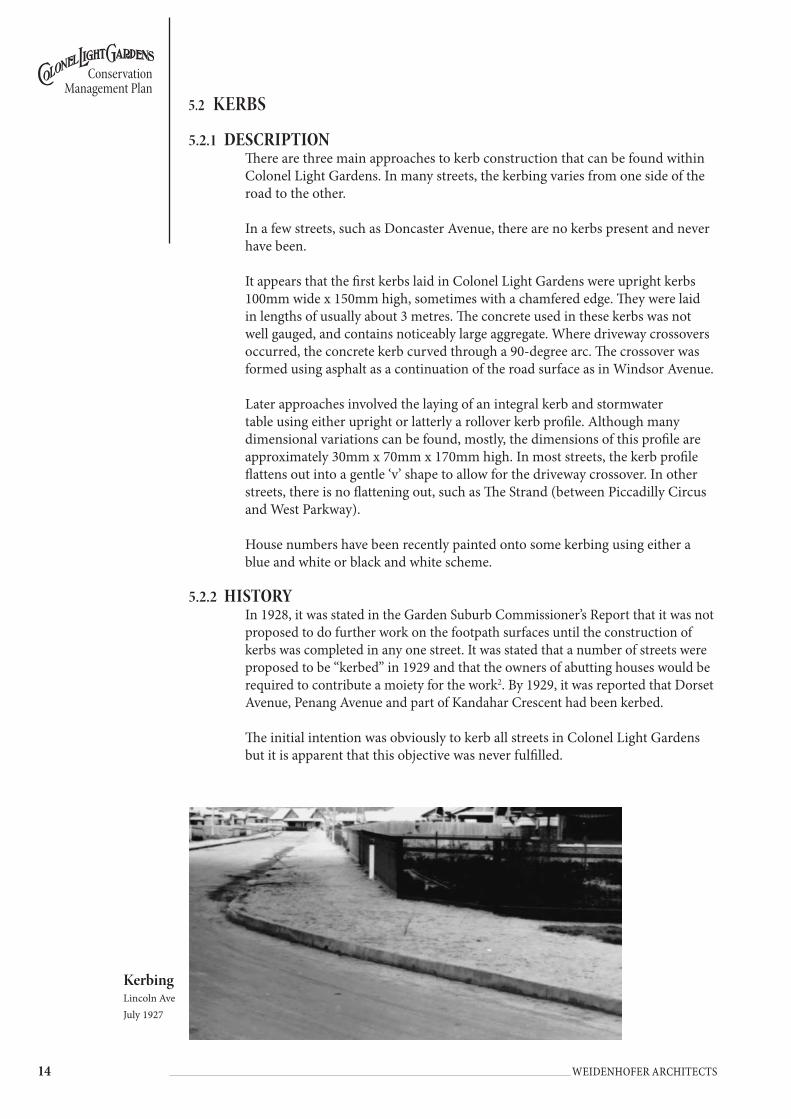
KerbingLincoln AveJuly 1927
5.2 KeRBs
5.2.1 dEscRiptionThere are three main approaches to kerb construction that can be found within Colonel Light Gardens. In many streets, the kerbing varies from one side of the road to the other.
In a few streets, such as Doncaster Avenue, there are no kerbs present and never have been.
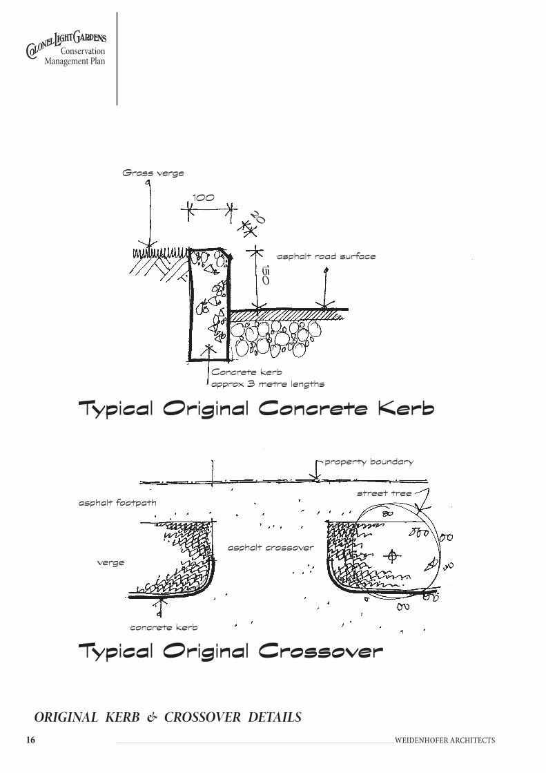
It appears that the first kerbs laid in Colonel Light Gardens were upright kerbs 100mm wide x 150mm high, sometimes with a chamfered edge. They were laid in lengths of usually about 3 metres. The concrete used in these kerbs was not well gauged, and contains noticeably large aggregate. Where driveway crossovers occurred, the concrete kerb curved through a 90-degree arc. The crossover was formed using asphalt as a continuation of the road surface as in Windsor Avenue.
Later approaches involved the laying of an integral kerb and stormwater table using either upright or latterly a rollover kerb profile. Although many dimensional variations can be found, mostly, the dimensions of this profile are approximately 30mm x 70mm x 170mm high. In most streets, the kerb profile flattens out into a gentle ‘v’ shape to allow for the driveway crossover. In other streets, there is no flattening out, such as The Strand (between Piccadilly Circus and West Parkway).
House numbers have been recently painted onto some kerbing using either a blue and white or black and white scheme.
5.2.2 HistoRyIn 1928, it was stated in the Garden Suburb Commissioner’s Report that it was not proposed to do further work on the footpath surfaces until the construction of kerbs was completed in any one street. It was stated that a number of streets were proposed to be “kerbed” in 1929 and that the owners of abutting houses would be required to contribute a moiety for the work2. By 1929, it was reported that Dorset Avenue, Penang Avenue and part of Kandahar Crescent had been kerbed.
The initial intention was obviously to kerb all streets in Colonel Light Gardens but it is apparent that this objective was never fulfilled.

��
Conservation Management Plan
Weidenhofer architects
5.2.3 objEctivEsThe objectives for the conservation of the heritage value of this element within the suburb are:• To retain the historic fabric (original) where this exists.• To reinforce the historic character.• Programme the replacement of inappropriate kerbing with standard
(traditional) design.
5.2.4 KERbs policyMain RoaDsThe kerb treatment should be consistent with the remainder of the road, rather than making an exception for that section which is part of Colonel Light Gardens.
East sEction: catEGoRiEs 1, 2 & 3• Where the kerbing and stormwater were fabricated as two distinct elements
and assembled on site, retain this treatment.• Where an integral kerb and watertable exist, these may remain until due for
replacement at which time, the kerb and watertable unit should be replaced with a concrete upright kerb with the bitumen road surface abutting the kerb to form the water table.
• Retain existing crossovers but when replacement is required, remove concrete crossovers and replace with standard design.
• Domestic stormwater disposal to the road watertable may be undertaken provided the pipe is concealed below the footpath surface and verge surface. Checkerplate or other evidence of the stormwater pipe is inappropriate. Galvanised metal pipes of 75mm - 100mm diameter should discharge through the concrete kerb.
• Where residents opt to install house numbers on kerbing, these numbers should be black and white only and placed on the vertical surface of the kerb. No reflective material should be used.
• Rollover kerbing with integral watertable should not be used within Colonel Light Gardens.
WEst sEction: catEGoRiEs 1 & 4• Where the kerbing and stormwater were fabricated as two distinct elements
and assembled on site, retain this treatment.• Where an integral kerb and watertable exist, these may remain until due for
replacement at which time, the kerb and watertable unit should be replaced with a concrete upright kerb with the bitumen road surface abutting the kerb to form the water table.
• Retain existing crossovers but when replacement is required, remove concrete crossovers and replace with standard design.
• Domestic stormwater disposal to the road watertable may be undertaken provided the pipe is concealed below the footpath surface and verge surface. Checkerplate or other evidence of the stormwater pipe is inappropriate. Galvanised metal pipes of 75mm - 100mm diameter should discharge through the concrete kerb.
• Where residents opt to install house numbers on kerbing, these numbers should be black and white only and placed on the vertical surface of the kerb. No reflective material should be used.
• Rollover kerbing with integral watertable should not be used within Colonel Light Gardens.
�� Weidenhofer architects
Conservation Management Plan
ORIGINAL KERB & CROSSOVER DETAILS
street tree
Grass verge
20
asphalt road surface
Concrete kerbapprox 3 metre lengths
asphalt footpath
property boundary
asphalt crossover
concrete kerb
verge
Typical Original Concrete Kerb
Typical Original Crossover
100
150

��
Conservation Management Plan
Weidenhofer architects
5.3 VeRges
5.3.1 dEscRiptionThe suburb of Colonel Light Gardens features many variations in its verge widths. The verge width is measured between the carriageway of a road and the boundary with private properties. Broadly they fall into four categories. As discussed in the History and this section, Reade’s design for the suburb created a hierarchy of roads, in line with garden city principles and practice. They were:• Major thoroughfares (Category 1) catered for the majority of traffic. The roads
were wider and incorporated wider verges. Some of these roads have central island verges that are also quite wide.
• Secondary roads (Category 2), intersect with internal highways and in the main have verges that range from 2-3 metres wide.
• Tertiary roads (Category 3), intersect with secondary roads and were designed to allow access to and from the residences. These streets tend to have very narrow verges, often less than 1 metre.
• Other roads (Category 4) found in the western section of Colonel Light Gardens have verges generally about 2.5 metres wide.
5.3.2 objEctivEsThe objectives for the conservation of the heritage value of this element within the suburb are:• Retain the existing verge widths to preserve the historic street and verge
pattern within the suburb.
5.3.3 vERgEs policyMain RoaDsVerges along both sides of Goodwood Road, Springbank Road and Winston Ave should be retained, however the treatment of these may be considered within the broader context of these roads, rather than specifically identifying Colonel Light Gardens. Grange Road should be treated as for Eastern Section: Category 1 road.
East sEction: catEGoRiEs 1, 2 & 3• All original verges should remain in their current configuration.• No further alienation of the verges should occur.• Where alienation has occurred, the original verge alignment should be
reinstated, ie in the vicinity of the Institute, the former cinema (where possible) and Kent Road between Springbank Road and Sturt Avenue, and Windsor Avenue west of West Parkway.
• No kerb re-alignment should take place to accommodate car parking bays or street widening.
• Creation of traffic calming measures may be appropriate provided these occur within the carriageway and do not encroach into the verge.
• Road surfaces should remain as bitumen.
WEst sEction: catEGoRiEs 1 & 4• All verges should remain in their current configuration.• No re-alignment should take place.• Creation of traffic calming measures may be appropriate provided these occur
within the carriageway and do not encroach into the verge.

�� Weidenhofer architects
Conservation Management Plan
5.4 VeRge sURfACes
5.4.1 dEscRiptionBy far the majority of the streets in the eastern section of Colonel Light Gardens have grassed verges. The quality of the lawn grown varies considerably from scrubby and patchy grass, such as found in Kandahar Crescent, through to the manicured lawns of parts of East Parkway. The quality and consistency of the grassed surface makes an important contribution to the visual amenity of the locality. The verges also often contain a variety of shrubs planted in an idiosyncratic and inconsistent fashion.
In the eastern section of Colonel Light Gardens, there are several streets that have bare earth or bitumen/dolomite verges, some only on one side of the street. Mostly these bare verges can be found in the smaller streets at the boundaries of the suburb or in the Circuses. These streets are well-used entrances to the suburb, ie Windsor Avenue, Chester Street, Ludgate Circus and Oxford Circus and the visual amenity of these streets is important for the first impression they create.
In the western section of Colonel Light Gardens, there is a very patchy approach and one that seems to be determined by the residents’ personal planting and maintenance program. Many of the verges have an earth surface only. Some have gravel and or nuts dropped from the street trees. Others have lawn and shrubs planted by the residents. It is also apparent that a much greater proportion of the verges in this part of the suburb, as opposed to the eastern part of the suburb do not have consistently grassed verges. The lack of consistency has a profound effect on the overall visual amenity of this part of the suburb.
5.4.2 HistoRyGrassed verges planted with trees were intended to create a park-like atmosphere. In some streets it was intended that the trees planted in the verge would, when fully grown, form a leafy canopy that arched and met over the street. Driving through these streets was intended to resemble a pleasure drive where the verges as well as private and public gardens would merge3.
In 1936-37, mention is made that a contractor was engaged in that year to mow the grassed nature strips, confirming that some were planted with grass4.
5.4.3 objEctivEsThe objective for the conservation of the heritage value of this element within the suburb is:• To preserve and reinforce the park-like nature of Colonel Light Gardens’
streets.
5.4.4 vERgE suRfacEs policyMain RoaDsVerge Surfaces along both sides of Goodwood Road, Springbank Road and Winston Ave may be considered within the broader context of these roads, rather than specifically identifying Colonel Light Gardens. Grange Road should be treated as for Eastern Section: Category 1 road.

��
Conservation Management Plan
Weidenhofer architects
East sEction: catEGoRiEs 1, 2 & 3• Grassed verges should remain planted with grass.• No alternative planting (or paving) should be introduced. Introduced planting
should be removed and the verge planted with suitable grasses.• Grassed verges should be regularly maintained (but not irrigated).• Parking of vehicles should not be allowed to occur on the verges.• Verges, which are not grassed, should be prepared and planted with grass. Only
in circumstances where this cannot be achieved for reasons of a dense street tree canopy should pea gravel of a light beige colour be laid as the verge surface.
• Doncaster Avenue should remain without gravel.
WEst sEction: catEGoRiEs 1 & 4• Grassed verges should remain planted with grass.• No alternative planting (or paving) should be introduced. Introduced planting
should be removed.• Parking of vehicles should not be allowed to occur on the verges.• Verges, which are not grassed, should be prepared and planted with grass.
Only in circumstances where this cannot be achieved for reasons of a dense street tree canopy should pea gravel of a light beige colour be laid as the verge surface.

�0 Weidenhofer architects
Conservation Management Plan
5.5 stReet tRees
5.5.1 dEscRiptionAs a general rule, the street trees planted in the verges of both the east and west sections of Colonel Light Gardens are planted about half way between the kerb edge and the edge of the footpath. Exceptions to this rule do occur, for example when remnant vegetation is involved, ie Freeling Crescent outside the school. In Doncaster Avenue the road surface abuts the bases of the large eucalypts.
Notable exceptions to this halfway rule are also found in the Category 1 streets. In these very wide verges, the trees are often, but not always, planted further away from the kerb and closer to the footpath. This results in a shaded footpath rather than road. The south section of Broadway is a good example of this planting approach. Here the trees are planted 6.75 metres in from the kerb edge in a verge that is 9.6 metres wide. In some streets, the trees are planted closer to the kerb edge. Sturt Avenue is a good example where the trees are planted 400mm from the kerb in a verge that is 3.1 metres wide.
Generally there is only one line of street trees, even in the widest of verges. Exceptions to this rule are the east side of Kent Road between Sturt Avenue and Springbank Road where there is a double row of recently planted trees.
Street trees within Colonel Light Gardens are generally regularly spaced, however many issues can act to interrupt this regular spacing, eg the presence of driveways, entrances and exits to lanes and the requirements of the individual species of tree. Distances between tree centres often vary from one side of the street to the other even where the same species is used.
As a general rule however, the distance between tree centres found in the most visually pleasing and effective avenues of trees within the suburb, are formed when the tree centres are planted about 7 paces apart. Streets that feature this planting distance are Light Place, Windsor Avenue, Sturt Avenue, West Parkway, East Parkway, Portland Place, The Strand, Lincoln Avenue and Bedford Square. Most of these streets have been identified as Category 1 streets within this Conservation Management Plan.
Some streets with trees planted at a distance of more than 10 paces can also be very visually effective, for example, Prince George Parade. Generally however, the further apart the street trees are planted, and where interrupted with new plantings of a different species, the less visually cohesive the street looks. In some streets, the distance between trees is simply too varied to provide consistency. These streets have limited charm.
Many of the principal streets of Colonel Light Gardens were created and planted with street trees some 80 years ago and consequently, a number of trees have reached the end of their lives and have been removed and replaced. In several streets, such as West Parkway, some new planting with saplings has occurred, in this case between original but senescent mature trees. The approach to planting new trees is not consistent and gives some streets a patchy feel.

��
Conservation Management Plan
Weidenhofer architects
5.5.2 HistoRyFrom the earliest days of the creation of the suburb, a variety of mainly exotic trees were planted on the street verges and in central islands between the carriageways. Vegetation comprised only trees and grasses in the verges. Trees were to be planted only on the wider, higher category streets, with no plantings in the narrower, lower category streets that served residences only.
One species of tree per street was favoured. It is also clear that a mix of deciduous and evergreen, ornamental and attractive shade trees were preferred, in order to create the feeling of a leafy canopy overhead.
Remnant clumps of Eucalyptus were retained when the Garden Suburb was developed. These trees can be found east of the Primary School in Freeling Crescent, along Flinders Avenue next to the entrance to Reade Park and along Doncaster Avenue.
The street tree-planting programme began in 1921-22 and continued energetically during the 1920s. By 1924, 1077 trees had been planted and were being cared for to ensure straight upright growth. By 1925, 1800 trees had been planted in the suburb. In 1932 it was reported that 2500 trees had been planted since the suburb was established.
The long avenues of mature shade trees were an integral part of the planning of the Garden Suburb and form one of the most significant landscape features of Colonel Light Gardens. A complete list of which species were planted where is not to be found in the sources, but the most complete list dates from c.1924 (see table 1).
street treesEast Parkway.1930
River red gumsDoncaster Avecirca 1927

�� Weidenhofer architects
Conservation Management Plan
5.5.3 objEctivEsThe objectives for the conservation of the heritage value of this element within the suburb are:• To retain the existing remnant street and reserve tree planting pattern.• To reinforce this original pattern by removing inappropriate plantings.• To actively reinstate the original planting pattern and density of trees as
existed in Colonel Light Gardens and as identified by the planting notes of Table 1.
TABLE 1Street by Street Tree Planting List c.1924
Street: Street Category
Original Species Planted (where
known)
Existing Tree Species as at
2004
Number Planted
Comment:
Bedford Square 1 American Ash American Ash 75
Bond Street (now Salisbury Crescent) Robinia sp. Robinia 37
Broadway 1 Jacaranda Jacaranda 55
Chester Street 3
Clyde Avenue 4
Corunna Avenue 4
Doncaster Avenue 2
Dorset Avenue 2
East Parkway (Springbank Road to Prince George Parade) 1 White Cedar Cedar 85
East Parkway (Prince George Parade to The Grove) 1 Plane Tree Plane 57
East Parkway (Salisbury Crescent to The Grove) 1 Scotch Elm Scotch Elm 74
Eton Street 3
Flinders Avenue (Lancaster Avenue to Salisbury Crescent) 2 Plane Tree Plane 77
Flinders Avenue (Salisbury Crescent to Grange Road) 2 Scotch Elm Scotch Elm 29
Freeling Crescent 2
Grange Road 1 White Cedar Cedar 80
Goodwood Road White Cedar and Robinia sp.
CedarRobinia
7246
Hastings Road 2 Tamarisk Tamarisk 82
Hereford Place 3
Kandahar Crescent 2
Kent Road 3 Robinia Robinia 22
Kent Road (between Sturt Avenue and Springbank Road) 1
Lancaster Avenue 2 Herculia Herculia 53
Light Place 1 Plane Tree Plane 24
Lincoln Avenue (set backs corner Wattlebury Road) 3 Poplar 12 Removed in the 1990s
Ludgate Circus 2
Manchester Road 3
Martlesham Crescent 4
Mortlock Park Plane 90
Oxford Circus 2 Robinia sp. Robinia 33
Oxford Circus 2 Scotch Elm Scotch Elm 12
Pembroke Place 3
Penang Avenue 4
Piccadilly Circus 2
Portland Place 3
Prince George Parade 2 Flowering Gums Flowering Gums
50
Rapid Avenue 4

��
Conservation Management Plan
Weidenhofer architects
5.5.4 stREEt tREEs gEnERal policy• Street trees should be maintained to reinforce the formal and uniform patterns
of avenue planting prevalent through the suburb.• Street trees should be planted to form formal avenues.• Trees should be regularly spaced and replacements should be planted in the
same location as inter-planting dramatically affects the visual rhythm. • When replacement tree planting is necessary, the section or whole of a street
should be replanted so that in the future, the trees are of a consistent size.• New street tree planting should reflect the original species, wherever possible.• Each street or section of a street should have a nominated tree species
consistent with the early planting.• Where existing trees are not of the nominated species, these trees should be
removed progressively and replaced with a tree of the nominated species.• Advanced replacement trees (ie greater than 3 metres tall) should be used in
high profile locations.• The old large River Red Gums in Freeling Crescent, Doncaster Avenue and
Flinders Avenue should be retained and protected from any damage or threat to their health and survival.
• Street trees are to be set back from street garden reserves (refer individual diagrams). Feature trees which are to be planted on street garden reserves are to planted in accordance with the positions marked on the individual diagrams and are not to be aligned with the street trees.
Street: Street Category
Original Species Planted (where
known)
Existing Tree Species as at
2004
Number Planted
Comment:
Reade Park Reserve Jacaranda {x}
Richmond Avenue 4
Rochester Avenue 2
Rosemont Street 3
Rozells Avenue 4
Salisbury Crescent 1 Scotch Elm Scotch Elm 78
Sturt Avenue 1 Scotch Elm Scotch Elm 100
Suffolk Place 3
The Grove 2 Scotch Elm Scotch Elm 30
The Strand 1 Plane 26
The Strand (reserve) Poplar 6
Tidworth Crescent 3 Council is to plant Jacaranda
mimosifolia
View Street 3 Poplar Poplar 26
Wattlebury Road 2 Scotch Elm 28
West Parkway 1 Robinia sp. Robinia 100
West Parkway 1 Scotch Elm Scotch Elm 59
West Parkway 1 White Cedar Cedar 58
Winchester Avenue 2
Windsor Avenue (east of Freeling Crescent) 2 Scotch Elm Scotch Elm 47
Windsor Avenue (west of West Parkway) 3 Robinia sp. Robinia 69
York Place 2
Source: Handwritten note from T C Stephens, Garden Suburb Engineer. Reproduced in C. Garnaut Colonel Light Gardens; model garden suburb

�� Weidenhofer architects
Conservation Management Plan
Main RoaDs East sEction: catEGoRY 1 & 2 stREEts
Issues• The rhythm of the street planting is being altered by inter-planting young
saplings between existing trees.• Existing English and Scotch Elms are being gradually replaced due to their
age and condition and replaced with a species that is resistant to Dutch Elm Disease.
• Using Chinese Elm to replace the existing Elms will not produce the same character that currently exists along the streets due to the different characteristics and growth habit of the Chinese Elm.
• Inter-planting young saplings between existing trees creates both overcrowding and gaps in the street tree canopy when existing trees still remain in the optimum positions for planting.
• Inter-planting over an extended period of time can result in an uneven canopy.
Policy• Retain all original street trees where individual specimens remain healthy.
Major pruning or removal of these trees should occur only as a last resort.• Specimens, which have been introduced after 1945, should be removed where
they are inconsistent with the original planting intent.• Retain alignment of tree plantings parallel to the street in a single row. Do not
introduce a secondary row of trees.• Inter-planting resulting from tree replacement should preserve the species and
extant spacing of trees within the street or section of the street as applicable. Preferably, semi-mature trees should be planted instead of small saplings.
• Identify moribund trees.• Stage the removal and replacement of ailing or dying trees with same species
or selected equivalent.• Planting of new species to occur in a regular pattern to maintain the formality
and density of planting.
East sEction: catEGoRY 3 stREEts
Issues• Many streets are planted with various Eucalyptus sp. and other species
resulting in an inconsistent canopy along the street and a character not in keeping with the original planting scheme for the suburb.
• The rhythm of the street planting is being altered by inter-planting young saplings between existing trees.
• Inter-planting between existing trees creates both overcrowding and gaps in the street tree canopy when existing trees still remain in the optimum positions for planting.
• Inter-planting over an extended period of time can result in an uneven canopy.

��
Conservation Management Plan
Weidenhofer architects
Policy• Retain all original street trees where individual specimens remain healthy.
Major pruning or removal of these trees should occur only as a last resort.• Specimens, which have been introduced after 1945, should be removed where
they are inconsistent with the original planting intent.• Retain alignment of tree plantings parallel to the street in a single row. Do not
introduce a secondary row of trees.• Planting resulting from tree replacement should preserve the species and
extant spacing of trees within the street or section of the street as applicable. Preferably, semi-mature trees should be planted instead of small saplings
• Identify moribund trees. • Stage the removal and replacement of trees with same species or selected
equivalent.• Planting of new species to occur in the same position as existing trees to
maintain the existing formality and density of planting.• Select species of smaller varieties of trees used throughout Colonel Light
Gardens to maintain the existing character of the suburb and reinforce the hierarchy of the streets through the size and structure of the tree planting.
• In streets where there is a less cohesive structure of street trees, or an existing species is being replaced, the new trees should be planted in the optimum location to achieve a consistent canopy with an even spacing of trees.
WEst sEction: catEGoRY 1 stREEts
Issues• Inter-planting between existing trees in Light Place creates both overcrowding
and gaps in the street tree canopy when existing trees still remain in the optimum positions for planting.
• Inter-planting over an extended period of time can result in an uneven canopy.• Random plantings of various Eucalyptus sp. in Light Place detract from the
formality and character desired for Colonel Light Gardens.
Policy• Retain all original street trees where individual specimens remain healthy.
Major pruning or removal of these trees should occur only as a last resort.• Specimens, which have been introduced after 1945, should be removed where
they are inconsistent with the original planting intent.• Retain alignment of tree plantings parallel to the street in a single row. Do not
introduce a secondary row of trees.• Interplanting resulting from tree replacement should preserve the species and
extant spacing of trees within the street or section of the street as applicable. Preferably, semi-mature trees should be planted instead of small saplings.
• Identify moribund trees.• Staged removal and replacement of ailing or dying trees with same species or
selected equivalent.• Planting of new species to occur in the same position as existing trees to
maintain the existing formality and density of planting.• New species to replace Eucalyptus sp. in Light Place to include further
planting of the existing species – Plane Trees and White Cedars.
�� Weidenhofer architects
Conservation Management Plan
WEst sEction: catEGoRY 4 stREEts
Issues• Inter-planting young saplings between existing trees are altering rhythm of the
street planting.• Inter-planting between existing trees creates both overcrowding and gaps
in the street tree canopy when existing trees still remain in the optimum positions for planting.
• Inter-planting over an extended period of time can result in an uneven canopy.
Policy• Retain all original street trees where individual specimens remain healthy.
Major pruning or removal of these trees should occur only as a last resort.• Specimens, which have been introduced after 1945, should be removed where
they are inconsistent with the original planting intent.• Retain alignment of tree plantings parallel to the street in a single row. Do not
introduce a secondary row of trees.• Planting resulting from tree replacement should preserve the species and
extant spacing of trees within the street or section of the street as applicable.• Preferably, semi-mature trees should be planted instead of small saplings.• Identify moribund trees.• Stage the removal and replacement with same species or selected equivalent.• Planting of new species to occur in the same position as existing trees to
maintain the existing formality and density of planting.• Streets where there is a less cohesive structure of street trees, or an existing
species is being replaced, the new trees should be placed in the optimum location to achieve a consistent canopy with an even spacing of trees.
GooDWooD RoaD
Issues• The existing structure of median planting along Goodwood Road is a
confusing mixture of tall, mature Eucalyptus sp. under-planted with a variety of large and small shrubs that have been pruned into informal hedges.
• Goodwood Road is not maintained by Council, therefore any recommended changes must be negotiated with Transport SA.
Policy
Subject to Transport SA approval:• Use a median planting of Plane Trees (Platanus sp.) to provide a visual
connection between the east and west sections of Colonel Light Gardens.• Use a contrasting tree of a consistent species (eg tall Eucalypts) in the
Goodwood Road median where it does not directly separate the east and west sections of Colonel Light Gardens.

��
Conservation Management Plan
Weidenhofer architects
OVERALL STREET TREE PLANTINGThe replacement of existing street trees is occurring where the species is either dying, in poor condition or is a species that is inappropriate within the context of the garden suburb.
An overall Tree Management Plan for Colonel Light Gardens is required to ensure the original intention of a hierarchy of street tree planting is maintained. (refer attached Colonel Light Gardens Tree Management Plan).
While still maintaining the same species in single streets, or sections of streets as in East Parkway, it is important to ensure that there is not an over abundance of a single species in groups of neighbouring streets as this would detract from the existing variety of character throughout Colonel Light Gardens.
STREET TREE PLANTING ALONG GOODWOOD ROAD
Ludgate Circus
Contrasting trees of a consistent species (eg tall Eucalyptus) in grass to stop before Ludgate Circus
GR
AN
GE
R
D.
Contrasting trees of a consistent species (eg tall Eucalyptus) in grass to stop before Oxford Circus
Plane trees used to link the two sections of Colonel Light Gardens
Jacarandas to stop before Ludgate Circus
Jacarandas to stop before Oxford Circus
Oxford Circus
New planting of plane trees in Piccadilly Circus
SP
RI
NG
BA
NK
R
D.
Plane Plane
CLG (eastern section)
CLG (western section)
�� Weidenhofer architects
Conservation Management Plan
5.6 footPAths AnD DRIVewAYs
5.6.1 dEscRiptionCurrently Colonel Light Gardens’ footpaths are surfaced in three different ways; some are dirt, others are bitumen and some are grey (and in one instance pink) concrete interlocking paving bricks. Commonly, the footpath of one side of any street may be surfaced using one medium while another is used on the opposite side of the street.
Dirt or remnant gravel footpaths are generally found on streets where a reserve abuts the footpath, eg the south side of Oxford Circus, Freeling Crescent and West Parkway, near Mortlock Park.
By far the most common footpath surface is bitumen, which is used extensively throughout the suburb. Generally these bitumen footpaths are in the order of 1.6-1.7 metres wide. They begin at the fence line of the residence and consequently no gap exists between the beginning of the footpath and the fence line. Where footpaths are bitumen, the driveway surface is usually bitumen too.
More recently, some of the bitumen footpaths have been replaced with a system of interlocking concrete pavers. Footpaths constructed of pavers are in the order of 1.5 metres wide. Generally, a gap exists between the fence line and the beginning of the paved surface. This gap is generally about 200mm to 300mm wide but can be as much as 450mm (Hastings Road). Occasionally, the concrete pavers are continued through and used as the surface for the driveway but bitumen is usual.
5.6.2 HistoRyBy 1926, it was reported that approximately 26 miles of footway had been constructed5. By 1927, it was reported that a light footpath power roller had been acquired with a view to placing the 26 miles of footways in order as early as possible. This statement was made in the context of tar dressing the road surfaces and suggests that the first footpath surface was later covered with a bitumen dressing6. In 1929 it was reported that it was not proposed to do more than grade and screen the footpaths where urgently required (with a footpath roller) until the work of kerbing and water-tabling in any one street was completed. It was not practical to lay down a permanent footway until this work had been done7.
Archival photographs make clear that the gravel used for footpaths was a light colour. The paths appear not to be edged in a formal way, except when kerbing is present on the roadside. They terminate against the fences and in some photographs seem to continue to form driveway or path surfaces on the adjoining house allotment.
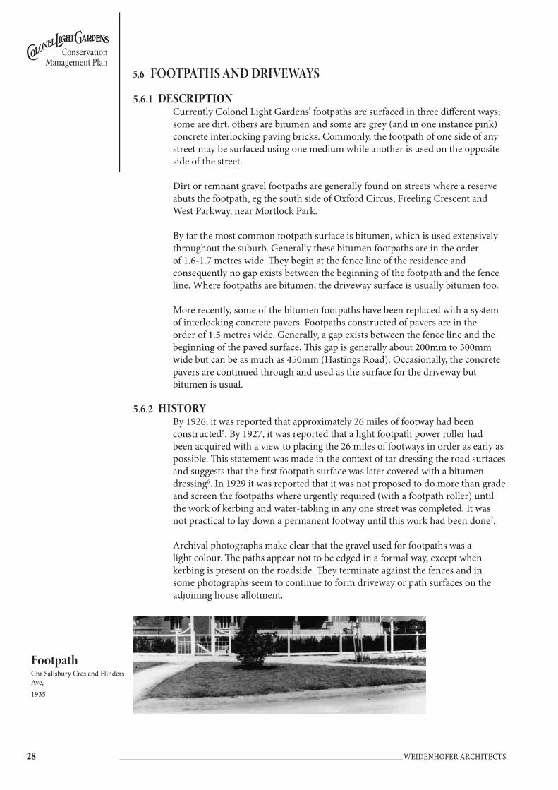
footpathCnr Salisbury Cres and Flinders Ave, 1935
��
Conservation Management Plan
Weidenhofer architects
It is clear that initially the footpaths on both sides of the road were constructed from screened gravel or aggregate that was then rolled to achieve a compact, hard and slightly impervious surface. Clearly, the intention was to lay bitumen on the footpaths of Colonel Light Gardens, but to do so only when the kerb and water-table were constructed. In some places this never occurred.
5.6.3 objEctivEsThe objective for the conservation of the heritage value of this element within the suburb is:• Retain bitumen as one of the early paving treatments throughout the suburb.• Reinforce bitumen paving throughout the suburb in lieu of alternative paving
types.
5.6.4 footpatHs and dRivEWays policyMain RoaDsFootpaths and driveways along both sides of Goodwood Road, Springbank Road and Winston Ave may be considered within the broader context of these roads, rather than specifically identifying Colonel Light Gardens. Grange Road should be treated as for Eastern Section: Category 1 road.
East sEction: catEGoRiEs 1, 2 & 3WEst sEction: catEGoRiEs 1 & 4• All footpath and driveway paving within Colonel Light Gardens should be
bitumen.• Staged removal of concrete unit pavers and any other surfaces other than
bitumen.• Replacement of existing bitumen pathways in poor condition and concrete
unit pavers with a two coat seal of bitumen. • Use of compacted quarry rubble with quartzite/sandstone gravel in high
profile locations around pillar lights.• The footpaths should be approximately 1.7 metres wide and extend from the
fence line. No gap should remain between the paved surface and the fence.• There should be one driveway of standard width for each residential allotment.
�0 Weidenhofer architects
Conservation Management Plan
street LightCnr Salisbury Cres and West Parkway.1936
5.7 stReet AnD footPAth LIghts
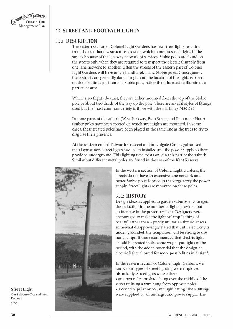
5.7.1 dEscRiptionThe eastern section of Colonel Light Gardens has few street lights resulting from the fact that few structures exist on which to mount street lights in the streets because of the laneway network of services. Stobie poles are found on the streets only when they are required to transport the electrical supply from one lane network to another. Often the streets of the eastern part of Colonel Light Gardens will have only a handful of, if any, Stobie poles. Consequently these streets are generally dark at night and the location of the lights is based on the fortuitous position of a Stobie pole, rather than the need to illuminate a particular area.
Where streetlights do exist, they are either mounted from the top of the Stobie pole or about two thirds of the way up the pole. There are several styles of fittings used but the most common variety is those with the markings M80D97.
In some parts of the suburb (West Parkway, Eton Street, and Pembroke Place) timber poles have been erected on which streetlights are mounted. In some cases, these treated poles have been placed in the same line as the trees to try to disguise their presence.
At the western end of Tidworth Crescent and in Ludgate Circus, galvanised metal goose neck street lights have been installed and the power supply to them provided underground. This lighting type exists only in this part of the suburb. Similar but different metal poles are found in the area of the Kent Reserve.
In the western section of Colonel Light Gardens, the streets do not have an extensive lane network and hence Stobie poles located in the verge carry the power supply. Street lights are mounted on these poles.
5.7.2 HistoRyDesign ideas as applied to garden suburbs encouraged the reduction in the number of lights provided but an increase in the power per light. Designers were encouraged to make the light or lamp “a thing of beauty” rather than a purely utilitarian fixture. It was somewhat disapprovingly stated that until electricity is under-grounded, the temptation will be strong to use hung lamps. It was recommended that electric lights should be treated in the same way as gas lights of the period, with the added potential that the design of electric lights allowed for more possibilities in design8.
In the eastern section of Colonel Light Gardens, we know four types of street lighting were employed historically. Streetlights were either:• an open reflector shade hung over the middle of the street utilising a wire hung from opposite poles. • a concrete pillar or column light fitting. These fittings were supplied by an underground power supply. The

��
Conservation Management Plan
Weidenhofer architects
light took the form of a reinforced concrete column, with a base, shaft and capital seated on a stepped pedestal. Above the capital was a post top fitting comprising a half sphere from which the globe emerged. An opaque glass sphere shaded the light globe at the top of the column’s capital. These pillars were placed at visually important locations in the suburb.
• a metal pipe (resembling an upside down and lying on its side ‘L’ shape). It was hung from a pole and stabilized by metal brackets with curved ends. The open reflector light shade was a flat dish shape.
• a ‘Wembly’ fitting
By 1925, the Commissioner reported that an agreement had been reached with the electricity suppliers regarding street lighting in Colonel Light Gardens. Initially two systems of lighting were adopted; the usual suspended lights (adopted as the most efficient) and a second style, an ornamental pillar light located in specific positions. By 1925 several streets had been illuminated and it was expected that the whole area would be illuminated in the course of a few weeks9.
Correspondence occurring between the parties makes clear that the cost of providing the ornamental pillar lights was prohibitive, particularly given that the alternative, wooden poles were provided at the cost of the electric supply company. The Commissioner intended to place a few ornamental pillar lights in the suburb, but only at visually significant locations. No pillar lights remain today. Where overhead lights (ie located midway across a street, and strung from poles on either side) were used, the poles were to be placed on the alignment of the allotments as it was thought that this would not make them too obtrusive. It was added that additional lamps could be installed at any time10. None of these remain either.
By 1926, it was reported that all roads in the suburb had been illuminated by electric lights. Given that the Thousand Homes Scheme was in operation by that time, it is presumed that the western section of Colonel Light Gardens had been lit as well11.
Clearly the amount of illumination provided was not sufficient. In 1927, it was reported that additional high-powered lights had been installed. There were now 82 well placed lights at street intersections and other important positions, the whole giving a satisfactory result equal to the lighting of most of the metropolitan residential area12.
Pillar street Light, Salisbury Cres and Flinders Avelate 1930s
wembley Light fitting http://www.cooksonr.freeserve.co.uk/Pics/wemb.JPG

�� Weidenhofer architects
Conservation Management Plan
In 1928, an additional 8 lamps were installed, making a total of 11413. In 1929, another street light or lamp was installed at the junction of West Parkway and Suffolk Place, making a total of 115 lamps14.
Further records reveal that it was initially proposed to install 26 lights of 50 cp, 5 of 100 cp and 6 ornamental pillar lights of 100 cp. The ornamental pillar lights were supplied by the Garden Suburb Commissioner and connected via underground wires. We know that they were placed at the following locations because of a reference to cabling requirements.• West Parkway to Stafford Place (32 y)• Broadway to Prince George (40 y)• West Parkway to Lancaster (32 y)• Bond Street (26 y)• Salisbury Crescent (56 y)• The ornamental pillar originally proposed for The Grove was re-allocated by
TC Stephens to the corner of Salisbury Crescent and Flinders Avenue15.Later correspondence in the period 1926-29 records the following installations:• Ludgate Circus 2 100 bracket• Rochester 1 100 suspended• Manchester/Pembroke 1 ns ns (not specified)• ns 6 100 ns• Bedford Sq/Lincoln 1 100 sus• Garden plot Salisbury/ West Parkway 1 100 ns• Nth side Light Place/Martlesham 1 100 ns• South side Light Place/Corunna 1 100 ns• Windsor opposite Primary School 1 100 ns• replace existing 50 cp Flinders/Portland 1 100 ns• replace existing 50 cp Flinders/Rochester 1 100 ns• junction of utility way south side Stafford Place 1 100 bracket• West Parkway/Salisbury Cres 1 100 ornamental pillar• Doncaster/ Goodwood Road 1 100 ‘Wembly’ fitting• Piccadilly/ Doncaster 1 100 ‘Wembly’ fitting• Winchester/Piccadilly 1 100 bracket• Suffolk Place/West Parkway 1 100 bracket.
5.7.3 objEctivEsThe objectives for the conservation of the heritage value of this element within the suburb are:• To retain the current unobtrusive nature of the street lighting in the eastern
section of Colonel Light Gardens.• To reinstate lost feature street lights.• To retain the current street lighting approach in the western section of Colonel
Light Gardens.

��
Conservation Management Plan
Weidenhofer architects
5.7.4 stREEt and footpatH ligHts policyEast sEction: catEGoRY 1, 2 & 3 stREEtsThese consultants do not support the installation of footpath lighting in the eastern section of Colonel Light Gardens. Increased lighting levels provided by an increased number of, or increased illumination of, streetlights will profoundly change the character of the suburb at night and during the day. The addition of large numbers of light posts will be visually intrusive.
• Reinstate ornamental pillar lights. (Refer to Pillar Light Policy below).• Any further augmenting of street lighting or park lighting must be supplied by
an underground power supply. Ensure that trenching does not impact upon street trees.
• Place new lights to minimise impact upon and clearance from street trees.• Street lighting to Goodwood, Springbank and Grange Roads should be
consistent with the lighting for the rest of those roads.
Stobie Poles Policy• Remove Stobie poles in high profile locations such as reserves where they
clearly diminish visual amenity.
Pillar Lights Policy• Install ornamental pillar lights with underground power supply to specified
locations.• New pillar lights are to be placed in high profile locations throughout Colonel
Light Gardens where there is the termination of a vista. The locations for the lights include:
• Ludgate Circus• Corner of East Parkway and Salisbury Crescent• Corner of Salisbury Crescent and Lincoln Avenue• Doncaster Reserve• Termination of vista along East Parkway and The Grove• The Strand Reserve• Termination of vista along East Parkway at the intersection with Prince
George Parade• Oxford Circus• Termination of vista along Kent Road at Kent Reserve.
Manufacture of Pillar LightsThe columns for the pillar lights should be constructed from Glass Reinforced Concrete with a tapered form based on the original ornamental light design. The light fitting will be a catalogue item from one of the major light manufacturers to ensure easy replacement of components as required.
General Lights PolicyIf street lighting requires augmenting, the following options are appropriate:• Where laneways cross over a street, install light suspended from cable above
centre line of road. Cables to be supported from Stobie poles set within opposite lanes
• Where no laneways exist, install new pole and fitting of an appropriate and sympathetic style located within the line of the street trees with power supplied via underground cabling. Ensure that trenching does not impact upon street trees.
• Place new lights to minimise impact upon and clearance from street trees.• Rationalise all existing cantilevered arms supported from Stobie poles.
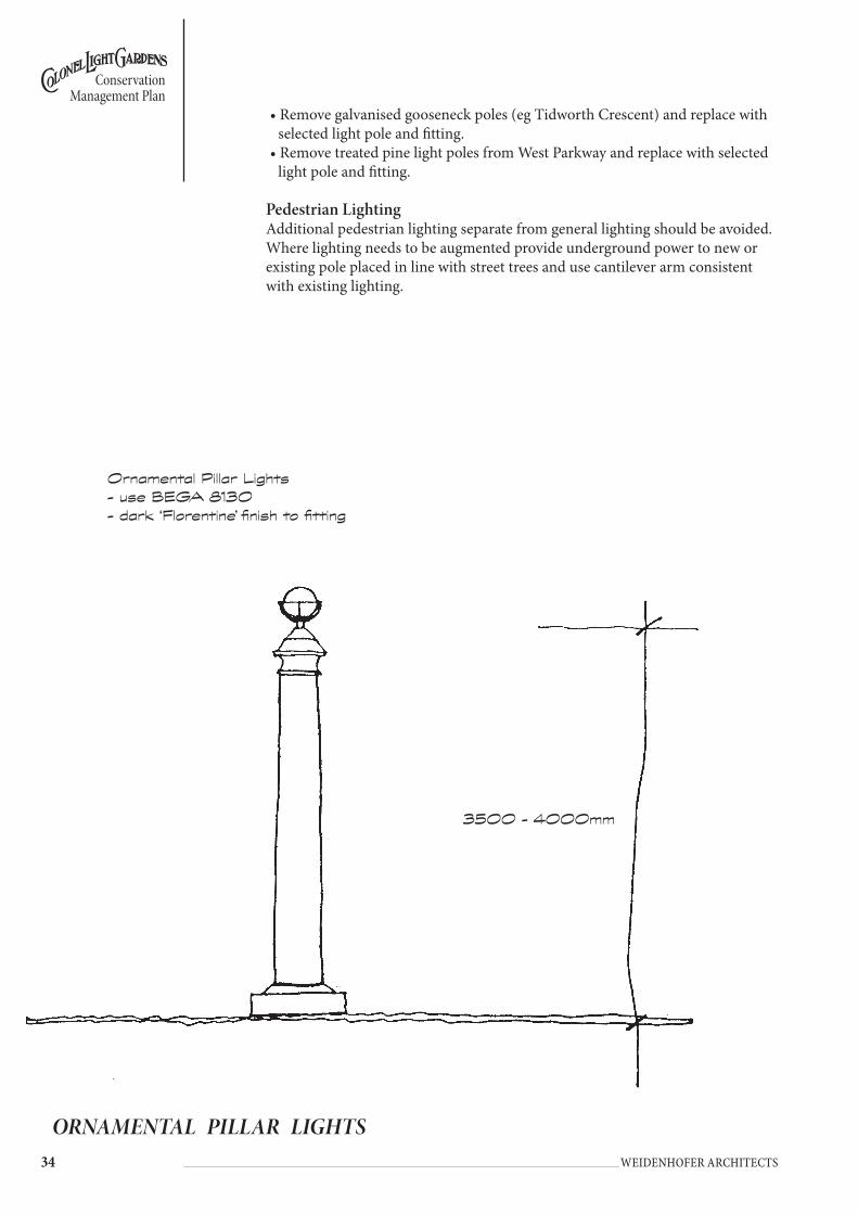
�� Weidenhofer architects
Conservation Management Plan
ORNAMENTAL PILLAR LIGHTS
Ornamental Pillar Lights- use BEGA 8130- dark ‘Florentine’ finish to fitting
3500 - 4000mm
• Remove galvanised gooseneck poles (eg Tidworth Crescent) and replace with selected light pole and fitting.
• Remove treated pine light poles from West Parkway and replace with selected light pole and fitting.
Pedestrian LightingAdditional pedestrian lighting separate from general lighting should be avoided. Where lighting needs to be augmented provide underground power to new or existing pole placed in line with street trees and use cantilever arm consistent with existing lighting.
��
Conservation Management Plan
Weidenhofer architects
WEst sEction: catEGoRY 1Install two ornamental pillar lights with underground power supply to Light Place to frame the termination of the vista from Goodwood Road.
Street lighting to Goodwood Road and Winston Avenue should be consistent with the lighting for the rest of those roads.
Stobie Poles Policy• Remove Stobie poles in high profile locations such as reserves where they
clearly diminish visual amenity.
Pedestrian Lighting PolicyAdditional pedestrian lighting separate from general lighting should be avoided. Where lighting needs to be augmented provide underground power to new or existing pole placed in line with street trees and use cantilever arm consistent with existing lighting.
WEst sEction: catEGoRY 4
Street Lighting Policy• Any further augmenting of street lighting or park lighting must be supplied by
an underground power supply. Ensure that trenching does not impact upon street trees.
• Place new lights to minimise impact upon and clearance from street trees.
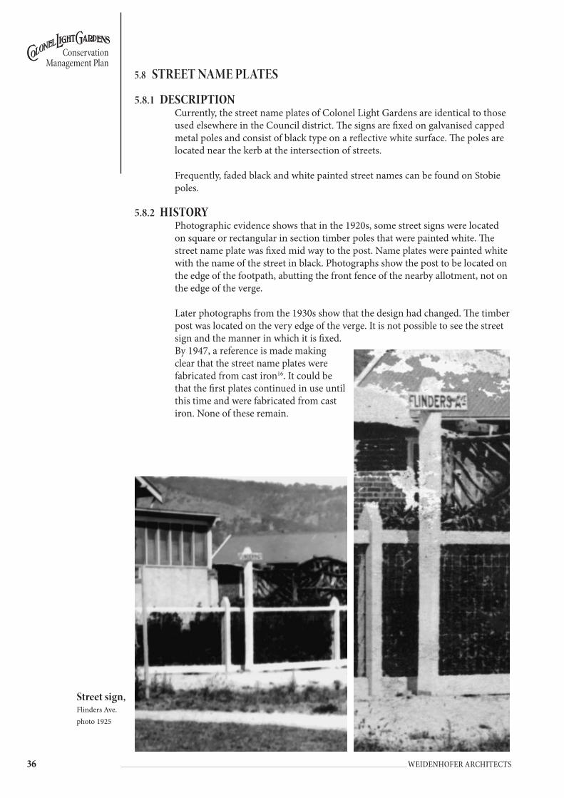
�� Weidenhofer architects
Conservation Management Plan
street sign, Flinders Ave.photo 1925
5.8 stReet nAMe PLAtes
5.8.1 dEscRiptionCurrently, the street name plates of Colonel Light Gardens are identical to those used elsewhere in the Council district. The signs are fixed on galvanised capped metal poles and consist of black type on a reflective white surface. The poles are located near the kerb at the intersection of streets.
Frequently, faded black and white painted street names can be found on Stobie poles.
5.8.2 HistoRyPhotographic evidence shows that in the 1920s, some street signs were located on square or rectangular in section timber poles that were painted white. The street name plate was fixed mid way to the post. Name plates were painted white with the name of the street in black. Photographs show the post to be located on the edge of the footpath, abutting the front fence of the nearby allotment, not on the edge of the verge.
Later photographs from the 1930s show that the design had changed. The timber post was located on the very edge of the verge. It is not possible to see the street sign and the manner in which it is fixed. By 1947, a reference is made making clear that the street name plates were fabricated from cast iron16. It could be that the first plates continued in use until this time and were fabricated from cast iron. None of these remain.
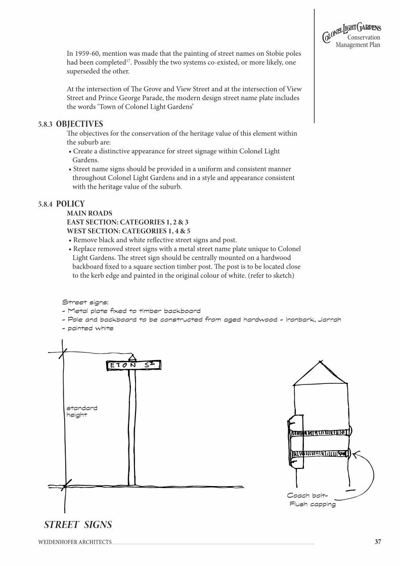
��
Conservation Management Plan
Weidenhofer architects
In 1959-60, mention was made that the painting of street names on Stobie poles had been completed17. Possibly the two systems co-existed, or more likely, one superseded the other.
At the intersection of The Grove and View Street and at the intersection of View Street and Prince George Parade, the modern design street name plate includes the words ‘Town of Colonel Light Gardens’
5.8.3 objEctivEsThe objectives for the conservation of the heritage value of this element within the suburb are:• Create a distinctive appearance for street signage within Colonel Light
Gardens.• Street name signs should be provided in a uniform and consistent manner
throughout Colonel Light Gardens and in a style and appearance consistent with the heritage value of the suburb.
5.8.4 policyMain RoaDs East sEction: catEGoRiEs 1, 2 & 3WEst sEction: catEGoRiEs 1, 4 & 5• Remove black and white reflective street signs and post.• Replace removed street signs with a metal street name plate unique to Colonel
Light Gardens. The street sign should be centrally mounted on a hardwood backboard fixed to a square section timber post. The post is to be located close to the kerb edge and painted in the original colour of white. (refer to sketch)
STREET SIGNS
standard height
Coach bolt- Flush capping
Street signs:- Metal plate fixed to timber backboard- Pole and backboard to be constructed from aged hardwood - Ironbark, Jarrah- painted white

�� Weidenhofer architects
Conservation Management Plan
5.9 sIgns
5.9.1 dEscRiptionThe public realm signage of Colonel Light Gardens consists of Road Traffic Act signage and Council signs that relate to parking issues, etc. Many of the streets have few if any Council signs yet in others there are many signs mostly regulating parking (where and when) and ‘Clean Up After Your Dog’. These signs are consistent in their graphics and similar in form to the smaller of the Road Traffic Act signs such as ‘One Way’. Most Council signs are small, use reflective material as a sub-surface and have black and/or red typeface. They are mounted on galvanised metal poles and generally located close to the kerb edge. Some signs display a City of Mitcham logo.
On the major roads, near the boundary of the suburb, other seemingly older signs can be found which announce the suburb name.
The appearance and size of the Road Traffic Act signage cannot be altered.
5.9.2 HistoRyOriginally, the suburb would appear to have had few signs other than street nameplates.
However, metal sign at the intersection of West Parkway and Doncaster Avenue with the words ‘To Institute’ remains.
5.9.3 objEctivEsThe objectives for the conservation of the heritage value of this element within the suburb are:• Create a distinctive appearance to signage within Colonel Light Gardens and
identify the suburb as a special area at major gateways.• Identify Colonel Light Gardens’ reserves with appropriate signage.• Signs should be provided in a uniform and consistent manner throughout the
suburb and in a style and appearance consistent with the heritage value of the State Heritage Area.
• Reduce the number of signs and poles in Colonel Light Gardens.• Ensure that existing and any new signs are located discreetly and sensitively to
minimize visual impact.
5.9.4 policyMain RoaDs East sEction: catEGoRiEs 1, 2 & 3WEst sEction: catEGoRiEs 1 & 4• Install or maintain and enhance existing suburb signs on the major roads.• Provide signage and entry statements to identify Colonel Light Gardens at the
southern and northern entry points of Ludgate Circus and Oxford Circus. The entry statements should include signage, entry pillars, hedging, ornamental planting, pathways, fencing and new tree planting. (Refer to perspective sketch of the entry statement and concept sketch for Ludgate Circus and Oxford Circus.)
• As vehicle parking on anything other than designated parking bays, carriageways or private property is contrary to the Road Traffic Act, the ‘No Parking on Verges’ signs are superfluous. Remove ‘No Parking on Verges’ signs. Council to rigorously police illegal parking.
• Paint sign poles in the recommended ‘Charcoal’ colour throughout the suburb.

��
Conservation Management Plan
Weidenhofer architects
• Remove all non-essential signs.• Remove as many sign poles as possible by clustering signs that are as small as
practicable onto one post. Mount signage on existing Stobie poles if possible.• Locate parking regulatory signs a uniform distance from the kerb edge (eg
600mm). Parking signs should not be located on the corners of intersections.• To prevent the proliferation of signage close to kerbs, locate ‘Clean Up After
Your Dog’ signs well within the boundaries of reserves, rather than adjacent to kerb lines.
• Retain the sign ‘To Institute’ at the intersection of West Parkway and Doncaster Avenue
• Where used, interpretative signs to be of a consistent design and be sympathetic and appropriate to Colonel Light Gardens.
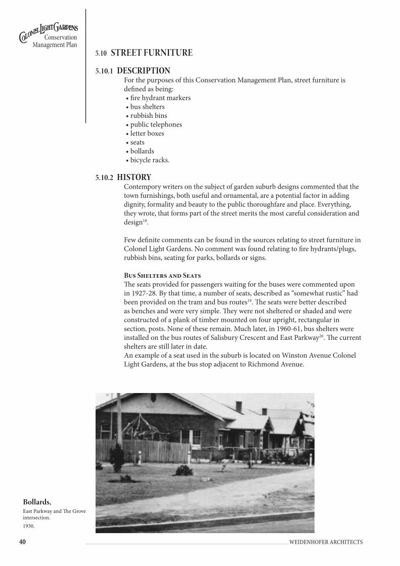
�0 Weidenhofer architects
Conservation Management Plan
5.10 stReet fURnItURe
5.10.1 dEscRiptionFor the purposes of this Conservation Management Plan, street furniture is defined as being:• fire hydrant markers• bus shelters• rubbish bins• public telephones• letter boxes• seats• bollards• bicycle racks.
5.10.2 HistoRyContempory writers on the subject of garden suburb designs commented that the town furnishings, both useful and ornamental, are a potential factor in adding dignity, formality and beauty to the public thoroughfare and place. Everything, they wrote, that forms part of the street merits the most careful consideration and design18.
Few definite comments can be found in the sources relating to street furniture in Colonel Light Gardens. No comment was found relating to fire hydrants/plugs, rubbish bins, seating for parks, bollards or signs.
Bus shelters and seatsThe seats provided for passengers waiting for the buses were commented upon in 1927-28. By that time, a number of seats, described as “somewhat rustic” had been provided on the tram and bus routes19. The seats were better described as benches and were very simple. They were not sheltered or shaded and were constructed of a plank of timber mounted on four upright, rectangular in section, posts. None of these remain. Much later, in 1960-61, bus shelters were installed on the bus routes of Salisbury Crescent and East Parkway20. The current shelters are still later in date. An example of a seat used in the suburb is located on Winston Avenue Colonel Light Gardens, at the bus stop adjacent to Richmond Avenue.
Bollards, East Parkway and The Grove intersection. 1930.
��
Conservation Management Plan
Weidenhofer architects
BollardsArchival photographs record the appearance of some early bollards. They were square in section timber posts of a square section that were painted white.
Public telephones and Letter BoxesBy June 1925, pillar boxes and public telephones had been installed in convenient positions in the suburb (by then including the Thousand Homes Scheme)21. In 1927-28, it was noted that an additional telephone cabinet would be installed at the north-eastern corner of the junction of West Parkway and Doncaster Avenue22. None of these remain.
Fire Hydrant Markers/PlugsArchival photographs show that the first generation of fire hydrant markers (timber) is still present in the suburb.
5.10.3 objEctivEsAll street furniture (as defined above) should be uniform and consistent throughout the area and in a style and appearance appropriate to the heritage value of the suburb.
All street furniture should be located so as to be discreet and reinforce the heritage value of the suburb.
Fire Hydrant MarkersThere are two styles of fire hydrant markers found in Colonel Light Gardens; timber posts and later, metal posts. The older style fire hydrants are timber with the dimensions 100mm x 100mm by 1050mm high. The posts are painted white, have chamfered corners and are topped with red metal caps. The newer style of hydrants are constructed from circular metal pipes with a diameter of 80mm that are 1060mm high, topped with a red plastic cap. Both are located in the verge close to the kerb edge, although some of the older ones are located in the tree line.
Bus sheltersColonel Light Gardens has only one bus route that runs through the suburb, along East Parkway. The associated bus shelters are found on some but not all of the stops on that route and they are of a standard but not modern design. The shelters are fabricated from metal and reinforced concrete, with a raked roof, and are painted a dark carriage green. At bus stops, the yellow ‘Hail Bus Here’ signs as well as bus timetable information on yellow painted metal poles can be found.
Rubbish BinsThere are few public rubbish bins in the suburb that lie outside of the parks and reserves. Those few found, tend to be mounted on a single galvanised metal post, and fabricated from green corrugated metal with a white metal lid. The bins are of a standard, if somewhat aged design.
Public telephonesThere appear to be no public telephone booths located within the suburb.
Letter BoxesLetter boxes of the standard design produced for Australia Post exist only in the suburb in The Strand and in East Parkway.

�� Weidenhofer architects
Conservation Management Plan
BollardsVehicles are prevented from entering many lanes in the suburb by means of a series of bollards. These bollards take many forms, from galvanised pipe, with or without chains, to timber posts of many different timbers, dimensions, heights, capping profile, reflectors and finished surfaces. Throughout the suburb, any one bollard design is seldom repeated. Residents clearly use a number of the lanes for vehicle access and some bollards have been removed or fixed in such a way that they are very easily removed. Some residents have devised means of gaining vehicular access from their properties to the laneways.
5.10.4 policy
Overall Street Furniture PolicyUnless colours are specifically nominated street furniture should be a Charcoal colour.
East sEction: catEGoRiEs 1, 2 & 3WEst sEction: catEGoRiEs 1, 4 & 5Fire Hydrant Markers• Fire hydrant marker posts should be ‘the old style’, ie timber with cast metal
cap.• Retain the existing older style timber posts for identification of fire hydrant
locations.• Replace all other forms of posts used for identification of fire hydrant locations
with timber posts made out of hardwood timber and painted white.Bus shelters and seating• Remove current bus shelters and seat units and replace with bus shelters as per
recommended design. (refer to sketch)• At bus stops that have bench seats only, remove existing seating and replace
with Colonel Light Gardens seat. (refer to photo and details)Public telephones• Any new public telephones that are installed should be contained within a
traditional phone box. Contemporary metal boxes are not appropriate.Post Boxes• No change to current Australia Post policy.
seats• When seating within the streets is proposed, these should be the Colonel Light
Gardens seat. Rubbish Bins• Remove all rubbish bins within the suburb and replace with Colonel Light
Gardens standard rubbish bin design. Bins should either be the City of Mitcham standard secured to a fixed pole, or some other standard design which is appropriate to the character of Colonel Light Gardens
Bollards• Remove all bollards that are not consistent with the new standard 125 x
125mm timber bollard. (refer to sketch)• Paint timber bollards ‘Charcoal’ to match other street furniture throughout
Colonel Light Gardens.• Use a hardwood timber bollard to standard dimensions with a clear finish in
high profile locations such as reserves and around areas with pillar lights.Bicycle Racks• Install where required Colonel Light Gardens standard bicycle bollard design.
The design should incorporate at the ends, bollards that are based on the Colonel Light Gardens standard bollard design.

��
Conservation Management Plan
Weidenhofer architects
BUS SHELTER
400
‘Charcoal’ timber posts and rails ‘Tongue and groove’ panel to rear for protection from weather
Galvanised corrugated iron roofing
BUS STOP:reference awnings on Bungalows
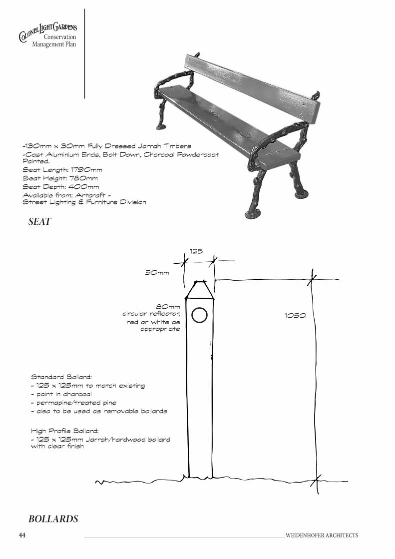
�� Weidenhofer architects
Conservation Management Plan
BOLLARDS
Standard Bollard:- 125 x 125mm to match existing- paint in charcoal- permapine/treated pine- also to be used as removable bollards
125
1050
50mm
80mm circular reflector,red or white as
appropriate
High Profile Bollard:- 125 x 125mm Jarrah/hardwood bollard with clear finish
SEAT
-130mm x 30mm Fully Dressed Jarrah Timbers-Cast Aluminium Ends, Bolt Down, Charcoal Powdercoat Painted.Seat Length: 1790mmSeat Height: 780mmSeat Depth: 400mmAvailable from: Artcraft - Street Lighting & Furniture Division
��
Conservation Management Plan
Weidenhofer architects
5.11 UtILItY wAYs / LAnewAYs
5.11.1 dEscRiptionAn extensive and comprehensive network of lanes is found in the eastern part of Colonel Light Gardens. This network runs behind the houses and contains underground and above ground services, namely electrical supply carried on Stobie poles above ground and water, gas and sewer contained in underground pipes.
The appearance of the laneways varies considerably. Generally they are between 4m to 6m wide. The majority are in the order of 4.9m or 16 feet wide, as originally designed. Some are wider and often contain very large Stobie poles, ie off Wattlebury Road. Frequently, the surface of the lanes is a mixture of dirt and remnant gravel. A few lanes have a dolomite surface and many lanes are used to dump vegetation.
A few laneways have been planted with grass and shrubs and residents have set up garden furniture, eg West Parkway. Presumably, these lanes are used as a quasi-extension of private gardens or a community space.
Some lanes have been utilised for vehicle access purposes (Masonic Homes on the Strand is an example and off West Parkway, for use by Colonel Light Gardens Primary School) and these lanes have a hard surface, generally bitumen.
In the western section of Colonel Light Gardens, there are only four lanes, one of which links Penang Avenue with Richmond Avenue. Two lanes link Corunna Avenue with Rozells Avenue. A fourth lane exists between Rozells and Penang Avenues. Lanes in this section of the suburb were for pedestrian use only.
In parts of the suburb, most commonly in the northern sections of the eastern part of the suburb, a stormwater drain system runs through the lanes. This takes the form of channels along which stormwater runs before emptying into concrete drainpipes that carry the water under the roads and then empty in the continuation of the laneway. This approach to stormwater is found in West Parkway (between Salisbury Crescent and Portland Place), Flinders Avenue, Lincoln Avenue and Broadway. Some of these lanes have part hard surfaces (for the drain at least), but for others the drains are causing erosion. Some of these lanes become impassable quagmires after heavy rain.
5.11.2 HistoRyThe rear utility ways (laneways) featured as part of Reade’s original design. Their purpose was to take services so as to ensure that public streets were not visually cluttered with poles and wires and to ensure that the trees and gardens were not disturbed when work was required to be done to the existing services. Reade envisaged that all other services would be connected from the utility ways.
The lanes were designed to be 16 feet wide, a width suggested as appropriate by the Hydraulic Engineer. In order to ease the task of laying pipes, the laneways did not follow the curves of the streets. Rather they were laid out as a series of connected straight lines.
�� Weidenhofer architects
Conservation Management Plan
Laneways were closed to vehicles but open to pedestrians, intentionally providing a direct, straight route to the shops and park areas. To ensure vehicles did not use them, bollards were placed at the entrances.
In later years, some changes were made. In 1964-65, it was reported that four pieces of road, including two unused utility ways, were sold to adjoining property owners23. This was followed in 1965-66 with the Freemasons purchasing part of the laneway at the Strand and West Parkway24.
In recent times, problems have been encountered with the utility ways including weed growth, the surface condition of the laneways and rubbish dumping. Service vehicles are increasingly finding the lanes difficult to use due to the increase in vehicle size. This has lead in some cases to Stobie poles and timber poles being erected in streets25.
Photographs from the 1930s show the laneway bollards to be rather like the fire plugs, ie short, square section timber posts, painted white. Down from the top of the post, a dark coloured band exists.
5.11.3 objEctivEs• Retain the lanes for service infrastructure.• Preserve the lanes as a network for pedestrians and cyclists.• Exclude non-service vehicular traffic from regular use.• Keep the laneway network free and clear.• Laneways should remain in public, rather than private ownership. No further
subdivision or alienation of this public land should occur.
5.11.4 policy• Connect all stormwater sumps via underground pipes to the main stormwater
system. Where that cannot be done, open sealed spoon drains should be formed which channel surface water towards sumps feeding via underground pipes into the stormwater drainage system.
• Provide uniform surfacing to non-sealed laneways using compacted quartzite/sandstone quarry rubble (PM 21) topped with a sandstone/quartzite gravel.
• Sealed laneways may remain, but further sealing of lanes should be avoided. Where sealed laneways are in poor condition they should be resurfaced.
• Existing grassed lanes may remain. Residents should be discouraged from annexing the lanes as additional garden space as this narrows the lane and prevents access by service vehicles.
• Planting in the laneways should not occur.• Dumping of waste prunings etc in the laneways by the residents should be
actively discouraged. Council should regularly check and clear the lanes of plantings, dumped and overhanging vegetation which obstructs free and reasonable access and remind residents of the green waste collection system currently operating in Colonel Light Gardens.
• Development involving new vehicular access points onto a laneway should not be undertaken except under the following circumstances:
1. The site immediately abuts one of the utility laneways (comprising lots 52, 654 and 655 which provide access behind the commercial properties of Salisbury Crescent and The Strand.)
2. The access point will be to a utility laneway that already has a sealed surface (ie allotments 284-293, 303 to 312 and 538-545.)
3. Vehicular access to a public road cannot be provided for the on site parking area due to the positions of existing buildings on the allotment on which the development is proposed.

��
Conservation Management Plan
Weidenhofer architects
5.12 seRVICes – eLeCtRICItY, gAs AnD teLeCoMMUnICAtIons, wAteR AnD seweRAge
5.12.1 dEscRiptionIn the eastern section of Colonel Light Gardens, the presence of the lanes allows the services in the main thoroughfares to be minimised. In the streets, there is no tangle of overhead wires. Although some Stobie and timber poles in Pembroke Place, Eton Street, Lincoln Avenue and Wattlebury Road are found in the public realm, most of the poles required to carry the electrical supply are located in the laneways. Stobie poles are only generally found in the streets when carrying wires from one network of lanes to another.
When not in laneways, the poles have often been deliberately placed in line with street tree trunks in an effort to disguise them. For example, on the Broadway, where a central island runs down the street, the Stobie poles are placed in line with the trees in the middle of the island. Where this has not occurred, the location of the Stobie poles varies tremendously. They can be found from 200mm to 1200mm from the kerb edge.
The inspection/access points for the other services, ie gas, water and sewer, are found in the lanes and also in footpaths or verges. Some of the other structures associated with services, such as the telephone distribution pillars and cabinets are located in the verges.
In the western section of Colonel Light Gardens, the lack of laneways required that the services were provided in the street, either underground or above ground. For electrical and telephone supply, this required a network of Stobie poles and a web of wires overhead. The poles are located in the verges about 25 to 30 metres apart, usually on both sides of the street, and generally about 2 metres from the kerb. Stobie poles are located either parallel or at 90 degrees to the kerb. In Penang Avenue timber poles are also found.
Gas, water and sewer pipes are underground with inspection points located in the footpath and/or verge.
5.12.2 HistoRySupplied electricity and reticulated water were the first services provided to the residents of Colonel Light Gardens and they existed and were operational in the part of the suburb that had been subdivided by 192326. By 1923-24, the entire area was reported to be supplied with water mains27.
Sewerage was first installed in 1923-2428. By 1924-25, it was reported that deep drainage now extended over the whole of Colonel Light Gardens as it had then developed29. By 1929, it was reported that the reticulation of the sewers had been completed in Rozells Ave, Penang Ave, Corunna Ave, Richmond Ave, Martlesham Cres, Rapid Ave and Light Place. The whole area of Colonel Light Gardens was now provided with sewers30.
By 1925, gas mains had been constructed in the suburb (now with the Thousand Homes Scheme.) Presumably the electricity supply was extended as required with the additional release of land.31 The majority of these services were provided in the lanes in line with Reade’s intentions.
�� Weidenhofer architects
Conservation Management Plan
5.12.3 objEctivEsThe objectives for the conservation of the heritage value of this element within the suburb are:• Services infrastructure should be located so as to complement the heritage
value of the suburb.• Services should be preferably underground and located in the utility ways.• Services infrastructure should be visually unobtrusive and where above
ground, designed and located to retain the heritage value of the area.
5.12.4 policy• New electrical, telecommunications or other services cabling infrastructure
should be, where it is not replacement infrastructure, located underground in the laneways. Where underground services run parallel to the property frontage, they should be located within the road carriageway or below footpaths.
• No additional overhead cabling is to be undertaken by any service provider outside of existing laneways and future road crossings between adjacent laneways are to be placed underground, except where street lighting is to be augmented.
• All new replacement “lead-in” cabling to customer premises is to be located underground.
• Inspection points and access pits should be located in the laneways. Where underground services occur within the street network, they should be located within the roadway or footpath. Location of pits within the landscaped section of the verges should be avoided

��
Conservation Management Plan
Weidenhofer architects
5.13 stReet gARDen ReseRVes, oRnAMentAL PLots, stReet IsLAnDs AnD RoUnDABoUts
5.13.1 dEscRiption
STREET GARDEN RESERVESThe street garden reserves in Colonel Light Gardens are usually grassed with exotic shrubs and ground covers, both small and large trees, and more recently planted with flowering native trees. Raised red brick garden beds were created in the 1990s at the corner of Lincoln Avenue and Salisbury Crescent and in Martlesham Crescent.
Colonel Light Gardens eastern section:intersection of Rochester avenue and Kandahar crescentA star shaped intersection with four triangular areas of grass and tree planting. Street trees consist of Ash (Fraxinus sp.) and Silky Oak along Kandahar. Trees along Rochester are predominantly Ash (Fraxinus sp.) with some small Eucalyptus sp. Within the grassed areas there are random plantings of Eucalyptus sp. and young Chinese Elm (Ulmus parvifolia).
intersection of Rochester avenue and Goodwood RoadAlthough part of the original layout for the suburb, the northern rectangular garden reserve has been used for carparking as part of the adjacent commercial developments.
intersection of West Parkway and the strandThe reserve at this intersection is on West Parkway north of The Strand. Trees along The Strand consist of young and mature Plane Trees (Platanus sp.) with some Brush Box (Lophostemon conferta). West Parkway has street tree plantings of White Cedar (Melia azedarach) on the eastern side and a young Plane on the western side. Just outside the reserve is a large Eucalyptus camaldulensis. The grassed areas have planting of Eucalyptus sp.
intersection of West Parkway and Lancaster avenueThe pathways through this intersection are in the process of being upgraded and there are new pram ramps installed that do not follow the existing path structure. A Stobie pole with a street light dominates the intersection and there are driveways of bitumen and gravel that cut through the grassed area on the NW quadrant.
The reserve has four triangular quadrants in a star shape that are each different sizes due to Lancaster Avenue being offset from West Parkway. Street trees along Lancaster are Kurrajongs (Brachychiton sp.) with False Acacia (Robinia sp.) along
garden reserve, Ludgate Circus1930

�0 Weidenhofer architects
Conservation Management Plan
West Parkway and some Brush Box (Lophostemon conferta). The dominant planting in the intersection are the 2 Norfolk Island Pines in the larger of the 2 quadrants. Shrub planting throughout the intersection consists of Oleander, Tecoma and Viburnum.
intersection of Lincoln avenue and East Parkway This reserve consists of two grassed areas on the eastern side of East Parkway. The northern section has a young planting of Chinese Elm (Ulmus parvifolia) with the southern section having a mature Silky Oak (Grevillea robusta) in the reserve and a young Ash (Fraxinus sp.) on the street edge.
intersection of Lancaster avenue and Bedford squareKurrajongs (Brachychiton sp.) extend along Lancaster and into the reserve on both corners where Lancaster intersects with Bedford Square with one of the Kurrajongs in poor condition. The street trees around Bedford Square are Plane Trees (Platanus sp.) with some gaps in the planting.
Junction of salisbury crescent and Lincoln avenue This intersection is a major focal point for traffic entering Colonel Light Gardens from Grange Road and Sussex Terrace. The intersection is dominated by a Stobie pole with street lighting attached in two directions.
The reserve is predominantly grass with three curving, raised garden beds on the southern side of Lincoln edged with red bricks and two crescent shaped beds on the northern side. The planting in the beds consists of Agapanthus, Diosma, Lavender and Roses with two of the beds being framed by large Tecoma that possibly date back to the original planting. The other dominant planting feature at the intersection is the large Blue Cedar Tree in the property that faces the intersection.
intersection of East Parkway and salisbury crescent This corner reserve is predominantly grass with a mature Purple Leafed Plum (Prunus cerasifera ‘Nigra’) in the corner and a dying Eucalyptus sp. There is also an Agave sp. adjacent to one of the boundary fences. It is an open area with a number of service pit covers set in the road verge.
intersection of Wattlebury Road and Lincoln avenueThe reserve contains four rectangular sections which were originally planted with poplars, some of which have new plantings of Chinese Elm (Ulmus parvifolia) and Ash (Fraxinus sp.). Street trees on the western edge of Wattlebury are established Elms (Ulmus sp.) with new plantings of Ash (Fraxinus sp.) on the Lincoln to the north of Wattlebury.
garden reserve Salisbury Cres
photo 1935
��
Conservation Management Plan
Weidenhofer architects
intersection of tidworth crescent and Flinders avenueStreet tree planting along Flinders are established Elms (Ulmus sp.) with planting on Tidworth being a combination of various Eucalyptus sp. and new plantings of Jacaranda mimosifolia. This reserve is octagonal in shape with Eucalyptus sp., Brush Box (Lophostemon conferta) and Purple Leafed Plum (Prunus cerasifera ‘Nigra’) planted both formally and at random. Paving surfaces include bitumen, gravel and unit concrete pavers.
intersection of East Parkway and Prince George ParadeThe abutment on Prince George Parade has groundcover planting of Cotoneaster sp. and Rosmarinus sp. Street tree planting on East Parkway is set back from the intersection. There are old plantings of both False Acacia (Robinia sp.) and Flowering Gum (Eucalyptus ficifolia) on Prince George with interplanting of new False Acacia.
intersection of Prince George Parade and BroadwayThe road width at the corner of this intersection has been reduced with a line of rumble bars fixed to the road surface. The kerb is still set in its original position and the reserve is a small grassed area with no planting.
intersection of chester street and Goodwood RoadThis reserve consists of two square areas of grass with tree planting and diagonal pathways. The trees are planted formally with 2 established White Cedars (Melia azedarach) and 2 Silky Oaks (Grevillea robusta) on either side of the paths. Other planting of Eucalyptus sp. and Bottlebrush (Callistemon sp.) are in semi-formal positions but overall the reserve looks cluttered.
intersection of Winchester avenue, Windsor avenue and West ParkwayThree roads converge at the western entrance to Colonel Light Gardens Primary School with the reserve set amongst this intersection. It consists of a central island with a large established White Cedar (Melia azedarach) and the adjacent section of reserve to the north with pathways and a single planting of Irish Strawberry Tree (Arbutus unedo). Street trees in adjacent streets are White Cedar (Melia azedarach) and Elm (Ulmus sp.).
Lincoln avenueThis reserve has four equal rectangular sections parallel to Lincoln Avenue set back from the existing road verge with the front boundary of adjacent properties set back accordingly. One of the sections has been planted up by the property owner with shrubs in keeping with the rest of their front garden. The other three sections have established plantings of Kurrajong (Brachychiton sp.) and Purple Leafed Plum (Prunus cerasifera ‘Nigra’) with lawn underneath and Eucalyptus sp. with under-planting of Diosma.
East ParkwayThis reserve runs parallel to East Parkway and is set back from the existing road verge with the front boundary of adjacent properties set back to suit. It is crossed at several places by driveways and 2 laneways also enter the reserve from east and west. It is predominantly trees planted in grass with one of the sections having shrub planting extending from the adjacent property.
Trees in the reserve include Golden Elm (Ulmus glabra ‘Lutescens’), Golden Rain Tree (Koelreutaria paniculata), Brush Box (Lophostemon conferta),

�� Weidenhofer architects
Conservation Management Plan
Willow Myrtle (Agonis flexuosa), Silky oak (Grevillea robusta), Prunus sp. and Eucalyptus sp. The street tree plantings has the original Elms (Ulmus sp.) with gaps in the canopy due to the removal of some trees.
East Parkway and the GroveAn access road runs parallel to East Parkway and forms one edge to this reserve with formal street tree planting of Plane Trees (Platanus sp.). The eastern boundary is the road verge and street tree planting of Elms (Ulmus sp.) that have been inter-planted with young Chinese Elm (Ulmus parvifolia).
Planting in the reserve consists of a mature Honey Locust (Gleditsia triacanthos sp.) and several established shrubs including Privet, Oleander and Viburnum sp. in grass. There are timber bollards to prevent vehicle access on to the reserve at the northern end.
Eton street and Lancaster avenueThis reserve has the shape of an arrowhead with street tree planting of mature Kurrajong (Brachychiton sp.) along Lancaster and young Plane Trees (Platanus sp.) along Eton. In the centre of the reserve there is a mature Norfolk Island Pine (Araucaria heterophylla).
Freeling crescent and Windsor avenueThis site has mature River Red Gums (Eucalyptus camaldulensis) that have been left from the original farm. The trees are set in grass and located in two groups at either end of the reserve.
It is a memorial site with a stone cairn that has a commemorative plaque and small paved area and has a very different character from all other street garden reserves.
Colonel Light Gardens western section:Martlesham crescent The north and south reserves on Martlesham are both triangular shaped islands, each with a mature Ash (Fraxinus sp.) at their western corners, and predominantly grass underneath trees.
The south reserve was altered in the 1990s and has an ornamental planting bed with roses and border planting of daisy and lobelia set within a red brick edge. It also has two benches and a frame for climbing roses. Other trees in the reserve include new planting of White Cedar (Melia azedarach) and Eucalyptus sp. with the adjacent street trees being Kurrajongs (Brachychiton sp.)
The north reserve has random planting of new and mature Eucalyptus sp. with Brush Box (Lophostemon conferta) along the northern edge. There is a bench beneath the Ash (Fraxinus sp.) but no ornamental planting bed.
STREET ISLAND RESERVESThese island reserves are characterised by grass and established formally planted exotic trees or more recently planted, random groups of flowering natives.
BroadwayThe reserve along Broadway consists of a formal planting of mature Jacaranda mimosifolia with grass growing underneath.

��
Conservation Management Plan
Weidenhofer architects
Eton streetThis small reserve is set in the middle of a cul-de-sac with established Eucalyptus sp. Hakea sp. and a new planting of Jacaranda mimosifolia. Adjacent street tree planting includes Bottlebrush (Callistemon sp.) and Golden Rain Tree (Koelreutaria paniculata).
salisbury crescentWhite Cedar (Melia azedarach) and False Acacia (Robinia sp.) are planted in the central median with grass underneath. Some of the trees have been removed and are being replaced with young saplings.
The section of median adjacent to the roundabout has Red Ironbark (Eucalyptus sideroxylon) planted together with shrubs that include Duranta sp. and Viburnum sp.
West Parkway Mature False Acacia (Robinia sp.) are being inter-planted with young saplings of False Acacia into the grass median.
intersection of the strand and Freeling crescent (see the strand Reserve)
intersection of Kandahar crescent and tidworth crescent A mature Norfolk Island Pine (Araucaria heterophylla) is planted in the middle of this triangular shaped reserve with grass planted beneath.
View streetFor much of the suburb’s history, until the 1980s there was a large open drain along the middle of View Street, between The Grove and Prince George Parade. The original intent was not to plant trees on the View Street boundary but to have a planting of trees in the laneways on the remaining eastern boundary of the suburb. This is clearly indicated in the Bird’s Eye perspective. The central median of View Street is planted with a variety of trees and large shrubs that includes Acacia sp., Callistemon sp., Eucalyptus sp., Melaleuca sp., and Cupressus sp. The large shrubs have been clipped to form a hedge with the large trees growing out of the hedge.
There are paved pedestrian crossovers in the middle and at each end of the median with treated pine timber post and rail fences. Adjacent street tree planting includes a variety of Eucalyptus sp.
ROUNDABOUTS WITH GARDENSintersection of West Parkway and salisbury crescentThis island reserve has four, mature Red Ironbark (Eucalyptus sideroxylon) planted at equal spacings around the edge of the roundabout and set in grass.
intersection of West Parkway and DoncasterThis roundabout has four ‘Keep Left’ signs set into a brick-patterned concrete edge. Behind this there is a raised planting bed with a red brick edge and planted with Bluebell Creeper (Sollya heterophylla) and Seaside Daisy (Erigeron karvinskianus).

�� Weidenhofer architects
Conservation Management Plan
5.13.2 HistoRyGarden Suburb design theorists recommended that garden plots be located at the termination of a vista to improve the appearance of the suburb. Simple rectangular beds were considered desirable although the need for rounded corners (to aid visibility for traffic) was frequently commented upon. The plants chosen for such beds were most often hardy flowering shrubs planted “en masse” Annuals and flowers did not serve so well32.
By 1922, the Annual Reports mention that a nursery, stocked with shrubs had been established. The shrubs were intended to be planted in the ornamental plots as soon as the ground had been prepared33. By 1923, the nursery was well established and several plots had been planted with what was described as “ornamental shrubs”34. By 1925, further shrubberies and lawns had been planted in the spaces set aside for them35.
By 1928, it was reported that “Progress had been made in planting the small garden plots at road junctions and elsewhere, as laid down in the original plan”. It was reported that grassing the plot and growing hardy shrubs had proved most successful36.
5.13.3 landscaping objEctivEsThe objectives for the conservation of the heritage value of this element within the suburb are:• The existing street garden reserves should be retained and regularly
maintained.• Future landscape treatment for these reserves should be consistent throughout
the suburb and should reflect the original/early landscape philosophy of formality and simplicity.
• Existing landscape treatment, which does not comply with the above objective, should be replaced.
• When the use of the former cinema at 501 Goodwood Road changes, or when the opportunity arises, Council should consider seeking the resumption for public use the adjacent garden reserve at the intersection of Rochester Avenue and Goodwood Road.
5.13.4 policy• Ornamental plots, street islands and roundabouts should be planted with grass
or suitable vegetation which provides a formal garden effect as a ground cover.• Roundabouts and abutments should be grassed with no additional planting.
The roundabout at the intersection of Doncaster Avenue and West Parkway should have the raised bed removed and be planted with suitable low formal plants.
• Street island reserves such as Broadway and View Street should be planted with exotic trees formally planted in straight rows in the centre of the islands.
• Where the original planting selection for an ornamental plot is not known, the plot should be planted with hardy trees and shrubs. Plant types selected should be those that have characteristics in common with the plants used by the Garden Suburb Commissioner in the 1920s.
• Where the original plant species are known but no longer remain, remove existing vegetation and replant with original species.
• The plantings of River Red Gums in Flinders Avenue, Freeling Crescent and Doncaster Avenue are to be reinforced with additional plantings as necessary.

��
Conservation Management Plan
Weidenhofer architects
• Plantings should be symmetrical and formal in design and easy to maintain whilst preserving an adequate line of sight for motorists.
• Reserves should be maintained by Council. • Where the original planting in a reserve, street island or ornamental plot is
recorded (see Table in Street Trees), replacement planting should use the same species (preferably advanced specimens), planted to reinforce the original planting pattern.
• When the use of the former cinema at 501 Goodwood Road changes, or where the opportunity arises, Council should consider the reinstatement of the adjacent garden reserve at the intersection of Rochester Avenue and Goodwood Road. Consideration should be made having regard to the legal context and the potential impact on the former cinema building. If the street garden is achieved, provide street tree planting as a continuation of the Rochester Avenue plantings.
General Notes on Garden Plots in Colonel Light GardensThe following individual plans for garden plots in Colonel Light Gardens set out the trees to be used at each location. The selection of each species has had regard to the climate, soil type, sightlines (where appropriate) and a plan to unify spaces within the suburb.

�� Weidenhofer architects
Conservation Management Plan
EAST PARKWAY
E
AS
T
PA
RK
wA
y
Staged removal of existing planting in reserve. Replace with a contrasting tree to street planting - Cupressus glabra
POST BOX
DRIVE
when new street tree planting, stop street tree planting at edge of reserve
DRIVE
D R I V E
D R I V E
D R I V E
D R I V E
LANE L A N E
maintain grass beneath trees
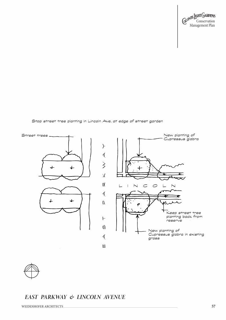
��
Conservation Management Plan
Weidenhofer architects
EAST PARKWAY & LINCOLN AVENUE
L I N C O L N
Stop street tree planting in Lincoln Ave. at edge of street garden
Street trees
EA
ST
P
AR
Kw
Ay
New planting of Cupressus glabra
New planting of Cupressus glabra in existing grass
Keep street tree planting back from reserve
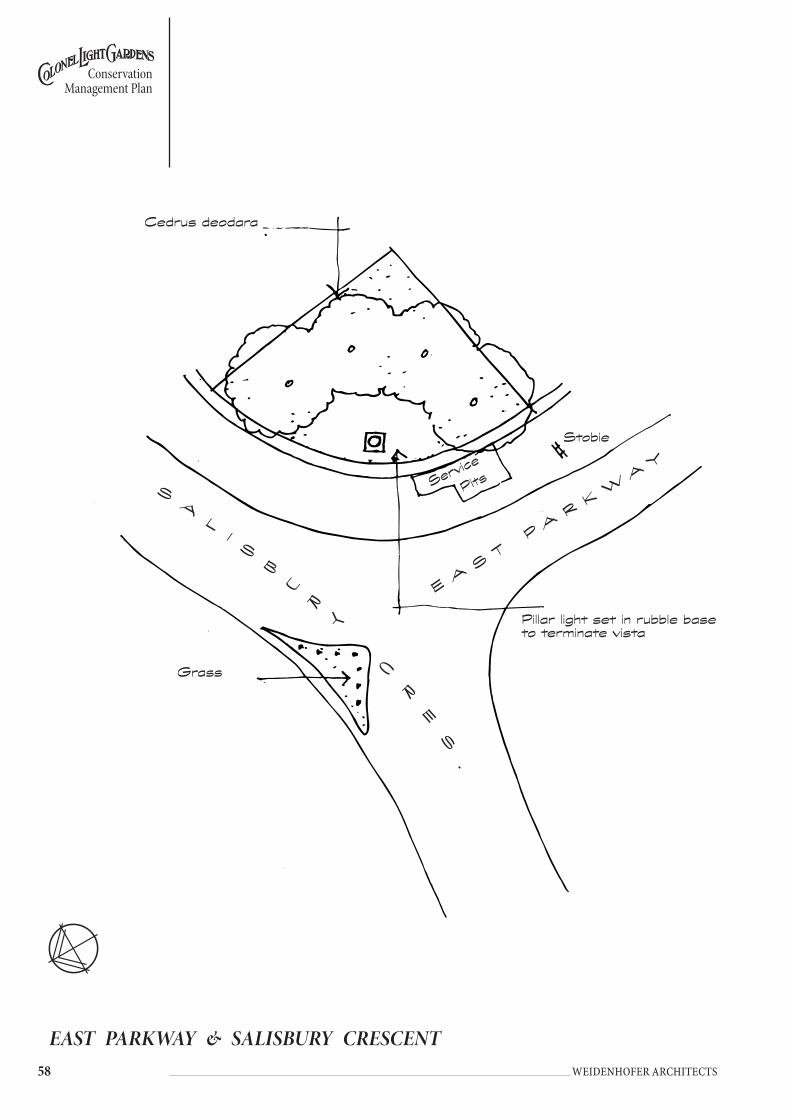
�� Weidenhofer architects
Conservation Management Plan
EAST PARKWAY & SALISBURY CRESCENT
EA
ST
PA
RK
wA
y
Pillar light set in rubble base to terminate vista
SA
LI
SB
UR
y
C
R
ES
.
Grass
Cedrus deodara
Stobie
Service
Pits

��
Conservation Management Plan
Weidenhofer architects
T H E G R O V E
Pillar light set in rubble base to terminate vista
Cedrus deodara
EA
ST
PA
RK
wA
y
L A N E
EAST PARKWAY & THE GROVE
Cedrus deodara
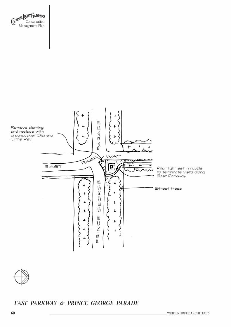
�0 Weidenhofer architects
Conservation Management Plan
EAST PARKWAY & PRINCE GEORGE PARADE
PR
I NC
E G
EO
RG
E P
AR
AD
E
EAST PARK wAy
Remove planting and replace with groundcover Dianella ‘Little Rev’
Pillar light set in rubble to terminate vista along East Parkway
Street trees

��
Conservation Management Plan
Weidenhofer architects
ETON STREET RESERVE
ET
ON
S
T.
Street trees
Plant 2 No new Jacaranda mimosifolia to reinforce 1 No new planting of Jacaranda
Street trees

�� Weidenhofer architects
Conservation Management Plan
Underplant with local grass species
Retain as open grassland
Timber bollard
Memorial stone and Plaque
Underplant with local grass speciesCOLONEL LIGHT GARDENS
PRIMARy SCHOOL
ETON STREET & LANCASTER AVENUE
Recent planting of 2 No
Sophora japonica
Existing Brachychiton sp.
Existing Norfolk Island PineL
AN
CA
ST
ER
A
VE
NU
E
ET
ON
S
TR
EE
T

��
Conservation Management Plan
Weidenhofer architects
FREELING CRESCENT & WINDSOR AVENUE
Underplant with local grass species
Retain as open grassland
Timber bollard
Memorial stone and Plaque
Underplant with local grass speciesCOLONEL LIGHT GARDENS
PRIMARy SCHOOL

�� Weidenhofer architects
Conservation Management Plan
GOODWOOD ROAD & CHESTER STREET
G O O D w O O D R O A D
New plantings of Cupressus glabra
Keep new street tree planting out of intersection
Existing MeliaExisting Melia
CH
ES
TE
R
ST.
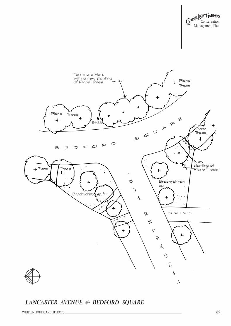
��
Conservation Management Plan
Weidenhofer architects
LANCASTER AVENUE & BEDFORD SQUARE
DR
IV
E
LA
NC
AS
TE
R
AV
E.
Trees
B E D F O R D Sq
UA
RE
Trees
New planting of Plane Trees
Trees
Terminate vista with a new planting of Plane Trees
Plane
TreesPlane
Stobie
Plane
Plane
Brachychiton sp.
Brachychiton sp.
D R I V E
DR I V
E
DR
I VE
DR
IV
E

�� Weidenhofer architects
Conservation Management Plan
LINCOLN AVENUE
L A N E
Staged removal of existing trees and reclaim section combined into residents, front gardens
L A N E
LI
NC
OL
N
AV
E.
Plant Cupressus glabra at equal spacings in grass to contrast with street trees
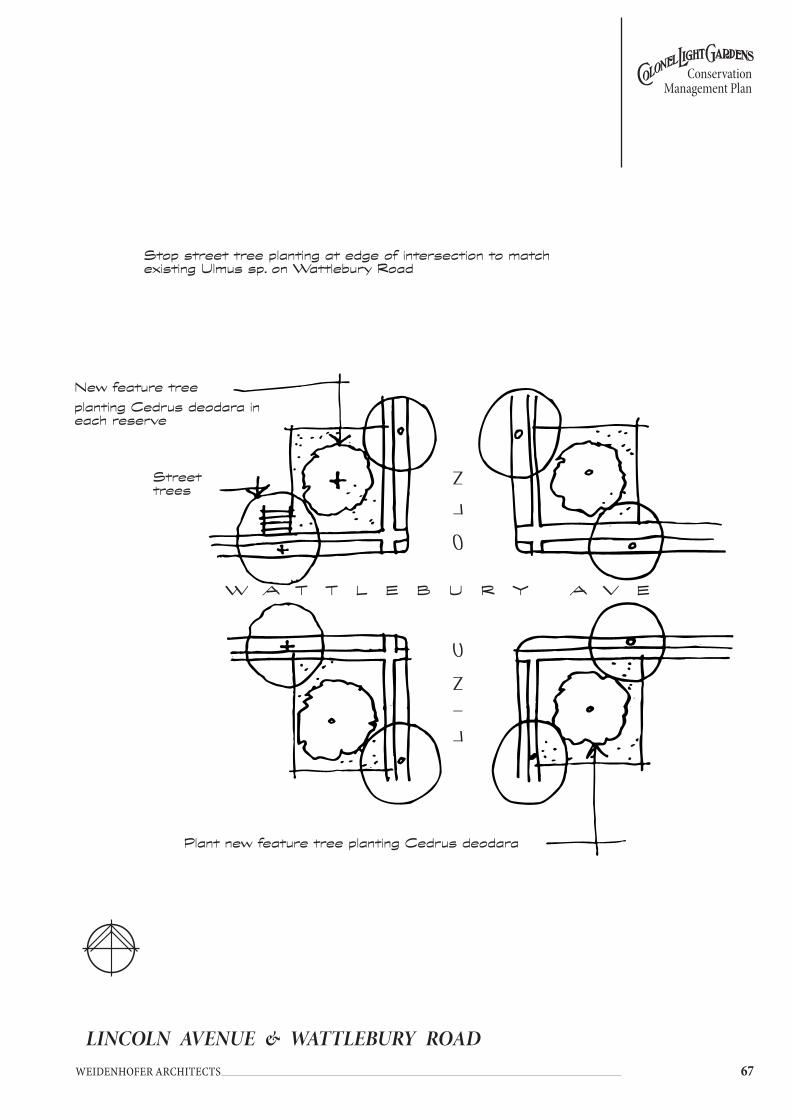
��
Conservation Management Plan
Weidenhofer architects
LINCOLN AVENUE & WATTLEBURY ROAD
Stop street tree planting at edge of intersection to match existing Ulmus sp. on wattlebury Road
LI
NC
O
LN
w A T T L E B U R y A V E
Street trees
Plant new feature tree planting Cedrus deodara
New feature tree planting Cedrus deodara in each reserve

�� Weidenhofer architects
Conservation Management Plan
MARTLESHAM CRESCENT
Existing Ash
Bench set in planting bed
New planting of street trees
Existing Ash
Bench set in planting bed
M
A
R
TL
ES
HA
M
CR
ES
C
E
N
T
New planting of street trees
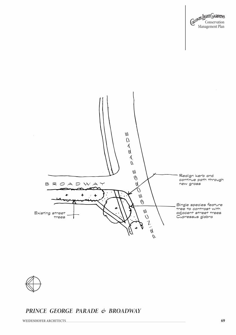
��
Conservation Management Plan
Weidenhofer architects
Existing street trees
Single species feature tree to contrast with adjacent street trees Cupressus glabra
B R O A D w A y
PR
IN
CE
G
EO
RG
E P
AR
AD
E
Realign kerb and continue path through new grass
PRINCE GEORGE PARADE & BROADWAY
M
A
R
TL
ES
HA
M
CR
ES
C
E
N
T

�0 Weidenhofer architects
Conservation Management Plan
ROCHESTER AVENUE & KANDAHAR CRESCENT
Keep new street trees back from intersection
New feature tree planting X 4 Cedrus deodara
R O C H E S T E R A V E N U E
KA
ND
AH
AR
CR
ES
CE
NT

��
Conservation Management Plan
Weidenhofer architects
SALISBURY CRESCENT & LINCOLN AVENUE
S
AL
IS
BU
Ry
C
RE
SC
EN
T
LI
NC
O
LN
A
V
E.
existing 1.0m high ornamental planting
Prune existing Tecoma to reduce size
Prune existing Tecoma to reduce size
New tree to be Cedrus deodara
H O U S E
Remove stobie pole from corner and replace with pillar light to terminate vista.
G R A S S
existing 1.0m high ornamental planting

�� Weidenhofer architects
Conservation Management Plan
TIDWORTH CRESCENT & FLINDERS AVENUE
Existing Street trees
New street tree planting to be kept back from intersection
New street tree planting to be kept back from intersection
Feature planting in each quadrant of Cedrus deodara
TI
Dw
OR
TH
CR
ES
.
F L I N D E R S A V E .

��
Conservation Management Plan
Weidenhofer architects
TIDWORTH CRESCENT & KANDAHAR CRESCENT
T I D w O R T H
Existing Norfolk Island Pine
Edge island with low timber bollards, if required for safety
KA
ND
AH
AR
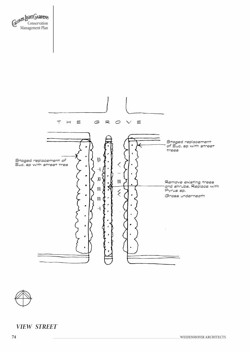
�� Weidenhofer architects
Conservation Management Plan
VIEW STREET
T H E G R O V E
Remove existing trees and shrubs. Replace with Pyrus sp.Grass underneath
Staged replacement of Euc. sp with street tree
Staged replacement of Euc. sp with street trees
VI
Ew
ST
RE
ET

��
Conservation Management Plan
Weidenhofer architects
WEST PARKWAY & SALISBURY CRESCENT
Provide X 3. Cedrus deodara trees as a feature planting.
New planting of Robinia sp.
Low groundcovers or grass beneath tree with 400mm hardwood bollards to restrict entry
S
A
LI
SB
UR
y
CR
ES
.
w E S T PA R K wAy
Staged replacement of Robinia sp.

�� Weidenhofer architects
Conservation Management Plan
WEST PARKWAY & DONCASTER AVENUE
Plant Dianella ‘Little Rev’ to maintain vista
along street
w E S T
DO
NC
AS
TE
R
P A R K w A y
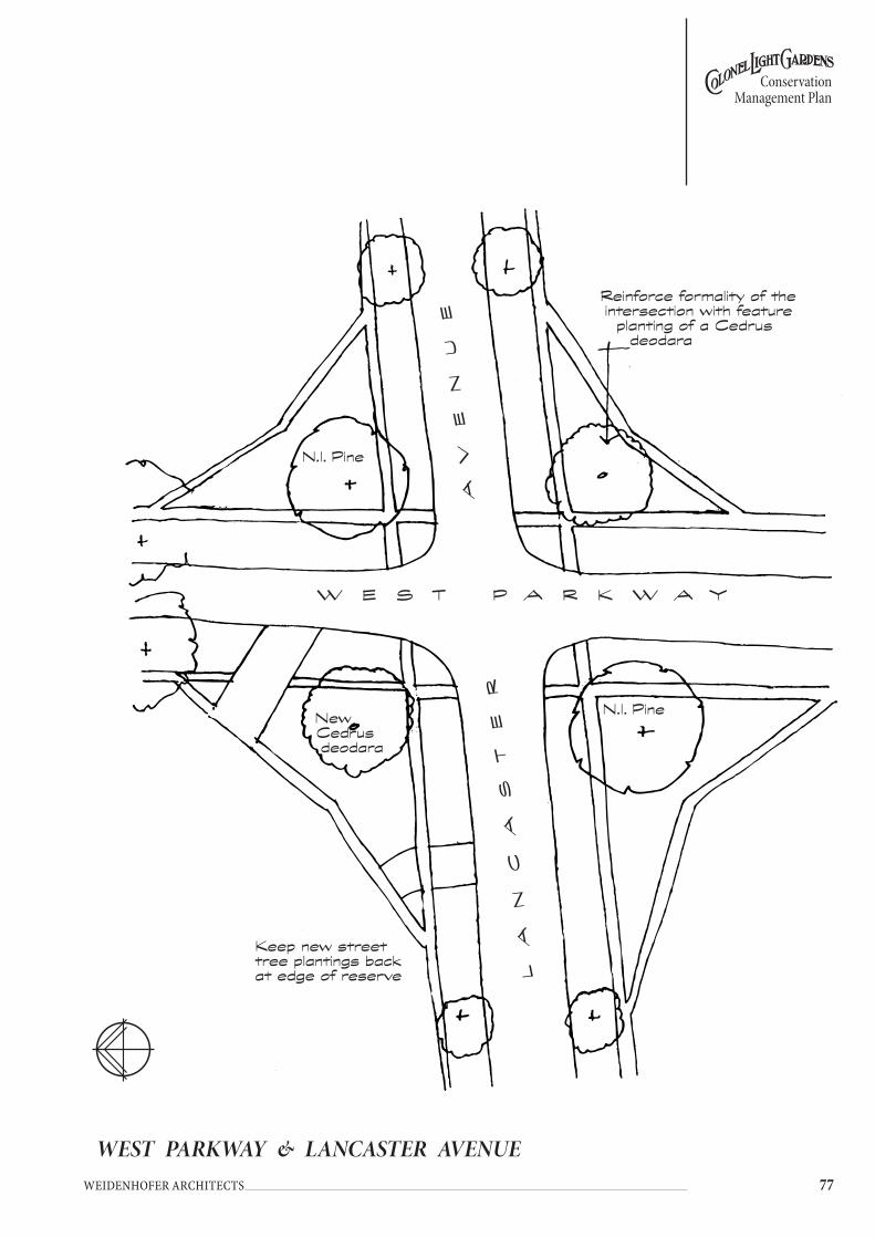
��
Conservation Management Plan
Weidenhofer architects
WEST PARKWAY & LANCASTER AVENUE
LA
NC
AS
TE
R
A
VE
NU
EN.I. Pine
N.I. Pine
Reinforce formality of the intersection with feature
planting of a Cedrus deodara
w E S T P A R K w A y
Keep new street tree plantings back at edge of reserve
New Cedrus deodara

�� Weidenhofer architects
Conservation Management Plan
WEST PARKWAY & THE STRAND
Existing Plane trees
Continue planting of Plane Trees
Existing Eucalyptus camaldulensis
SH
OP
w E S T P A R K w A yT
HE
S
TR
AN
D
Keep new street tree plantings back at edge of reserve
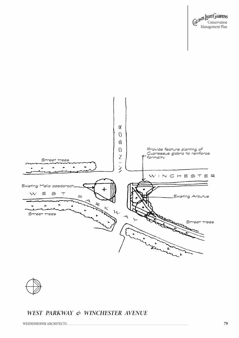
��
Conservation Management Plan
Weidenhofer architects
WEST PARKWAY & WINCHESTER AVENUE
Existing Melia azedarach
Street trees
Provide feature planting of Cupressus glabra to reinforce formality
Existing Arbutus
w I N C H E S T E R
wIN
DS
OR
w E S T PA
RK
wA
yStreet trees
Street trees
w E S T P A R K w A y
TH
E
ST
RA
ND
�0 Weidenhofer architects
Conservation Management Plan
5.14 InteRnAL ReseRVes AnD InteRnAL PLAYgRoUnDs
5.14.1 dEscRiptionCurrently, there are eight internal reserves in Colonel Light Gardens. One is found off Pembroke Place, two exist between Salisbury Crescent and Tidworth Crescent, a further two are found between Tidworth Crescent and Grange Road and one is found between Lancaster and Rochester Avenues. A small reserve lies near the north eastern boundary of the suburb. For the purposes of the Conservation Management Plan, the eighth internal reserve, found at Portland Place, is treated as a Public Park and is dealt with in Section 5.15.6
The internal reserves are currently used in the following way:• Pembroke Place – tennis courts.• Lancaster and Rochester Avenues – tennis courts.• Eastern reserve between Salisbury Crescent and Tidworth Crescent – vacant.• Eastern reserve between Tidworth Crescent and Grange Road – community
garden.• Western reserve between Salisbury Crescent and Tidworth Crescent
– currently used, at the pleasure of Council, as private open space by abutting landowners.
• Western reserve between Tidworth Crescent and Grange Road – currently used, at the pleasure of Council, as private open space by abutting landowners
• reserve at north eastern boundary of the suburb - informal use
5.14.2 HistoRyReade’s original design for Colonel Light Gardens incorporated a series of internal reserves. Originally envisaged as a common space for residents of small means, (ie smaller landholdings) and as a safe playing space for children, these reserves were small allotments of vacant land located at the rear of a cluster of properties. The reserves generally had no street access and could only be accessed via lanes or through the back fence of adjoining properties. Reade envisaged that the controlling authority would retain the freehold of these small allotments but would allow the use of the land, at small rentals, for recreational or productive uses by the residents.
The eastern section of Colonel Light Gardens was laid out incorporating these reserves. However in 1924, the original plan of the southern portion of the suburb was revised to accommodate the Thousand Homes Scheme. The re-design of the suburb caused the deletion of the internal reserves located in the southern part of Colonel Light Gardens. No internal reserves were created in the later, western section of Colonel Light Gardens.
In the Annual Report of 1928, it was stated that 10 internal reserves had been created. Even by that time, it was reported that most of these reserves had been neglected as residents concentrated their efforts on their houses. By 1928, one reserve had been graded by its nearby residents and was used as two tennis courts. Two other reserves had been planted with shrubs and trees, children’s playground equipment had been established and tennis courts created37. By 1929, no additional internal reserves had been developed38.
During the following years, the fortunes of the internal reserves waxed and waned. By 1931, five blocks had been leased to tennis clubs and to the Scouts but by 1938, the blocks were in a neglected condition. A special Act of Parliament enabled the disposal of the internal reserves to adjoining property owners but

��
Conservation Management Plan
Weidenhofer architects
this was only taken up to a limited extent- the reserve on allotment 251 was sold and the reserve on allotment 203 developed as aged housing.
5.14.3 objEctivEsThe objectives for the conservation of the heritage value of this element within the suburb are:• Retain the remaining internal reserves in public ownership for use by the
Colonel Light Gardens community.• No further subdivision or alienation of this public land should occur.• Reclaim annexed land for public use.
5.14.4 policy• The internal reserves should be used and developed as informal recreation and
open space areas for the use and enjoyment of residents, provided the use does not create any appreciable disturbance to nearby residents.
• Tree planting in the internal reserves should reflect the character and use of the reserve, being a mixture of formal and informal spaces.
• Laneways that connect to internal reserves should be clear and easily trafficable for pedestrians and/or vehicles depending on their use.

�� Weidenhofer architects
Conservation Management Plan
PEMBROKE PLACE INTERNAL RESERVE
LA
NE
PE
MB
RO
KE
P
LA
CE
Small flowering deciduous trees - Crepe Myrtle
Retain planting bed
Provide new planting of med-sized deciduous trees
2 No HARDCOURT
TENNIS COURTS
Retain existing trees and replace as required
Remove existing Eucalyptus sp. and Callistemon sp. and replace with Small flowering deciduous trees - Crepe Myrtle
Maintain laneways with gravel
L A N E
C L U B

��
Conservation Management Plan
Weidenhofer architects
LANCASTER & ROCHESTER AVENUES INTERNAL RESERVE
Maintain laneway
R O C H E S T E R A V E .
LA
NE
L A N E
wE
ST
P
AR
Kw
Ay
LA
NE
Existing Melia azedarach
Existing Fraxinus sp.
New planting small trees
Maintain laneway
Remove Eucalypts
2 No Tennis Courts
or
2 No Netball Courts
grass

�� Weidenhofer architects
Conservation Management Plan
INTERNAL RESERVE 53
GR
AN
GE
RO
AD
L A N E
Retain selected existing trees
Remove planting beds and provide various deciduous trees
Interpretative signage
Continue a theme of random planting with various tree species, more a community tree garden rather than high maintenance flowers and shrubs.
Interpretative signage to provide information about reserve and characteristics of various trees
L A N E
LA
NE
L A N E
Retain existing trees

��
Conservation Management Plan
Weidenhofer architects
INTERNAL RESERVE 54
y O R K P L A C E
Retain kikuyu grass
New seat
LA
NE
LA
NE
L A N E
TID
wO
RT
H
CR
ES
.
L A N E
Maintain planting of Melia
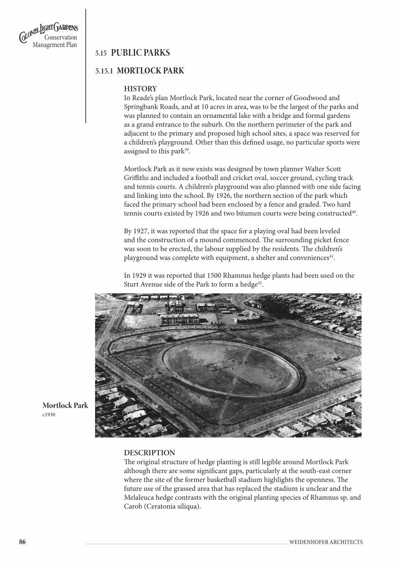
�� Weidenhofer architects
Conservation Management Plan
5.15 PUBLIC PARKs
5.15.1 MoRtlocK paRK
HISTORYIn Reade’s plan Mortlock Park, located near the corner of Goodwood and Springbank Roads, and at 10 acres in area, was to be the largest of the parks and was planned to contain an ornamental lake with a bridge and formal gardens as a grand entrance to the suburb. On the northern perimeter of the park and adjacent to the primary and proposed high school sites, a space was reserved for a children’s playground. Other than this defined usage, no particular sports were assigned to this park39.
Mortlock Park as it now exists was designed by town planner Walter Scott Griffiths and included a football and cricket oval, soccer ground, cycling track and tennis courts. A children’s playground was also planned with one side facing and linking into the school. By 1926, the northern section of the park which faced the primary school had been enclosed by a fence and graded. Two hard tennis courts existed by 1926 and two bitumen courts were being constructed40.
By 1927, it was reported that the space for a playing oval had been leveled and the construction of a mound commenced. The surrounding picket fence was soon to be erected, the labour supplied by the residents. The children’s playground was complete with equipment, a shelter and conveniences41.
In 1929 it was reported that 1500 Rhamnus hedge plants had been used on the Sturt Avenue side of the Park to form a hedge42.
DESCRIPTIONThe original structure of hedge planting is still legible around Mortlock Park although there are some significant gaps, particularly at the south-east corner where the site of the former basketball stadium highlights the openness. The future use of the grassed area that has replaced the stadium is unclear and the Melaleuca hedge contrasts with the original planting species of Rhamnus sp. and Carob (Ceratonia siliqua).
Mortlock Park c1930

��
Conservation Management Plan
Weidenhofer architects
The community building is the most visually dominant structure in the park together with the adjacent chain wire fencing used by the baseball club. The baseball club also has chain wire practice nets to the south of their playing field.
Car parks are yet to be softened by young tree planting and stretch along most of the southern edge of the park.
The arbour and paved area at the south-west corner of the park provides a formal pedestrian entrance to the reserve from Oxford Circus. Planting of new Plane Trees has begun throughout the reserve and adjacent to the arbour.
Play equipment in the northern section of Mortlock Park fits well amongst the deciduous trees with the original structure of the Windsor Avenue street trees still clearly evident.
Car parking and student drop-off areas are provided at either end of Windsor Avenue where the street has been closed to allow safer play for school children.
Mortlock Park is a predominantly open site with a variety of original tree and hedge planting together with newer plantings of Plane Trees (Platanus sp.), River Red Gums (Eucalyptus camaldulensis) and Red Ironbark (Eucalyptus sideroxylon).
OBJECTIVESThe objectives for the conservation of the heritage value of this element within the suburb are:• Mortlock Park should be maintained as the main recreation area within the
suburb of Colonel Light Gardens with a mix and range of formal and informal recreation uses.
• New major sporting clubrooms or other facilities requiring additional large areas of car parking for spectators and participants are not appropriate for Mortlock Park.
• Recreation use and development should provide both formal and informal activities to meet a range of needs and should not generate undue disturbance to nearby residents.
• New buildings and structures should be designed in scale and appearance to complement the predominantly single storey, residential character of development in the locality.
POLICY• Continue to implement the Mortlock Park Master Concept Plan as this
provides for the future use of the park by local sporting clubs and informal local community use.
• Refine the approved 1992 Mortlock Park Master Concept Plan and develop more detailed direction for the future of the Park
• Contain the use of the Gil Langley Building to ensure a level of usage that does not disturb nearby residents.
• In the medium to long term, Council should seek to ensure that over the whole of any year, a balance of informal and formal uses of the Park is achieved. This policy sits in the context that Mortlock Park in 2005 is at saturation point in terms of formal sporting use, and that as a guide, when existing clubs vacate Mortlock Park, new leases or licences will be entered into in order to strike a better balance.

�� Weidenhofer architects
Conservation Management Plan
MORTLOCK PARK EXISTING LAYOUT
CLG
PR
IMA
Ry
S
CH
OO
L
GIL
LA
NG
LE
y
BU
ILD
ING
Hedge o
f M
ela
leuc
a
sp.
Original h
edge p
lant
ingF
enc
ing t
o
cont
ain b
aseba
ll gro
undO
VA
L
Pla
ne t
rees
BM
X T
RA
CK
BO
RE
SC
OU
T
HA
LL
GUIDES
Original s
treet
tree p
lant
ing
Reinfo
rce
rece
nt
plant
ings
of R
iver
Red
gum
s
BA
SE
BA
LL
CA
RPA
RK
GRA
SS
C
RE
TE
C
AR
PA
RK
Original
hedge
plant
ing
GRA
SS
CA
RPA
RK
PLA
y
Eq
UIP
ME
NT
FR
EE
LI
NG
C
RE
S.
STURT AVE.
Original h
edge p
lant
ing
Original h
edge p
lant
ing
wE
ST
P
AR
Kw
Ay
.
��
Conservation Management Plan
Weidenhofer architects
• New buildings or facilities should be in scale with the surrounding residential development and school buildings and should be designed to complement the 1920s architecture of this section of the suburb.
• The scout and guide halls may be retained and may be extended whilst a local community need exists.
• Any new fencing associated with any individual sporting activities and associations should be removable and of a temporary nature for the duration of the sporting activity/season.
• New fencing used throughout the park shall be consistent with the pallette of materials used for fencing throughout Colonel Light Gardens.
• Access to recreation areas of Mortlock Park should be through established (hedge) openings on West Parkway, Sturt Avenue and Freeling Crescent and from Windsor Avenue to the north. Current street patterns should be utilised.
• The boundary hedges to Mortlock Park should be retained and reinforced with additional planting where gaps exist.
• No further alienation of public land for car parking purposes should occur.• Remove the existing Melaleuca sp. hedge opposite the Gil Langley Building
and replace with one of the original species.• Lighting throughout the park shall be consistent with the street and pedestrian
lighting used throughout Colonel Light Gardens. Floodlights for the ovals should be sited so as to cause minimal impact on the visual quality of the park.
• Consult with users of the park to determine the need for public toilets.
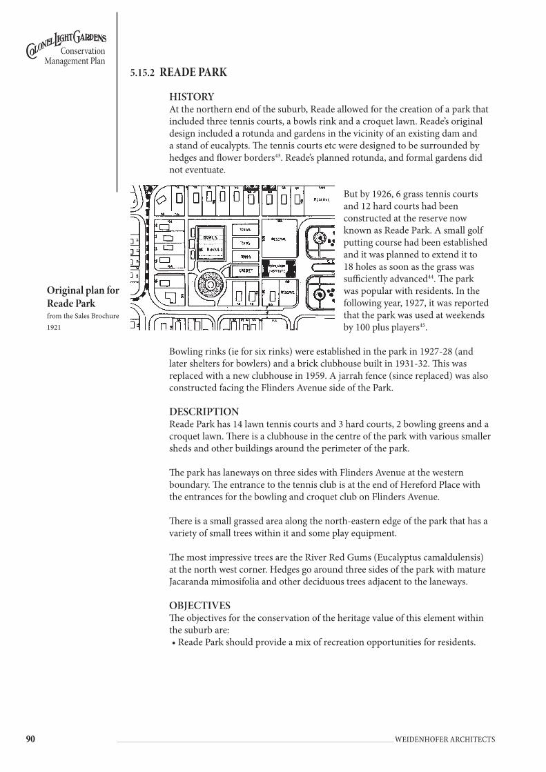
�0 Weidenhofer architects
Conservation Management Plan
5.15.2 REadE paRK
HISTORYAt the northern end of the suburb, Reade allowed for the creation of a park that included three tennis courts, a bowls rink and a croquet lawn. Reade’s original design included a rotunda and gardens in the vicinity of an existing dam and a stand of eucalypts. The tennis courts etc were designed to be surrounded by hedges and flower borders43. Reade’s planned rotunda, and formal gardens did not eventuate.
But by 1926, 6 grass tennis courts and 12 hard courts had been constructed at the reserve now known as Reade Park. A small golf putting course had been established and it was planned to extend it to 18 holes as soon as the grass was sufficiently advanced44. The park was popular with residents. In the following year, 1927, it was reported that the park was used at weekends by 100 plus players45.
Bowling rinks (ie for six rinks) were established in the park in 1927-28 (and later shelters for bowlers) and a brick clubhouse built in 1931-32. This was replaced with a new clubhouse in 1959. A jarrah fence (since replaced) was also constructed facing the Flinders Avenue side of the Park.
DESCRIPTIONReade Park has 14 lawn tennis courts and 3 hard courts, 2 bowling greens and a croquet lawn. There is a clubhouse in the centre of the park with various smaller sheds and other buildings around the perimeter of the park.
The park has laneways on three sides with Flinders Avenue at the western boundary. The entrance to the tennis club is at the end of Hereford Place with the entrances for the bowling and croquet club on Flinders Avenue.
There is a small grassed area along the north-eastern edge of the park that has a variety of small trees within it and some play equipment.
The most impressive trees are the River Red Gums (Eucalyptus camaldulensis) at the north west corner. Hedges go around three sides of the park with mature Jacaranda mimosifolia and other deciduous trees adjacent to the laneways.
OBJECTIVESThe objectives for the conservation of the heritage value of this element within the suburb are:• Reade Park should provide a mix of recreation opportunities for residents.
original plan for Reade Parkfrom the Sales Brochure1921
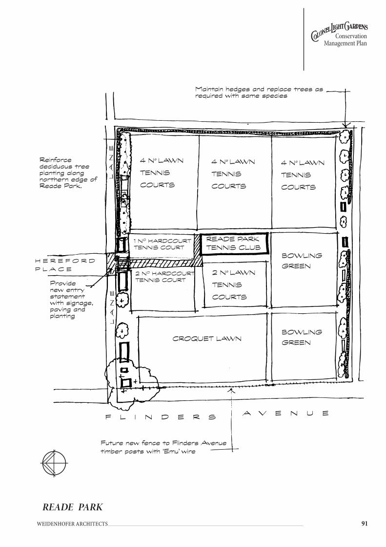
��
Conservation Management Plan
Weidenhofer architects
READE PARK
F L I N D E R S
Maintain hedges and replace trees as required with same species
4 No LAwN
TENNIS
COURTS
4 No LAwN
TENNIS
COURTS
4 No LAwN
TENNIS
COURTS
BOwLING
GREEN
2 No LAwN
TENNIS
COURTS
CROqUET LAwN
BOwLING
GREEN
READE PARK TENNIS CLUB
1 NO HARDCOURT TENNIS COURT
2 NO HARDCOURT TENNIS COURT
Reinforce deciduous tree planting along northern edge of Reade Park.
Future new fence to Flinders Avenuetimber posts with ‘Emu’ wire
A V E N U E
LA
NE
H E R E F O R D
P L A C E
LA
NE
Provide new entry statement with signage, paving and planting
�� Weidenhofer architects
Conservation Management Plan
• Given the close proximity of residences and the absence of off-street and restricted on-street car parking, future use levels should not exceed current levels.
• Maintain and develop Reade Park as a principal recreation and open space area providing formal and informal recreational activities for use and enjoyment by all residents.
• Recreation use and development should provide both formal and informal activities to meet a range of needs and should not generate undue disturbance to nearby residents.
• New buildings and structures should be designed in a scale and appearance to complement the predominantly single storey residential character of development in the locality.
POLICY• In order to realise the objective of a balance between formal and informal use
of Reade Park, Council will seek to reduce (as of 2005) over time the amount of space dedicated to formal use. As a guide, roughly no more than half of Reade Park should be dedicated to formal club use. This policy should be used as a guide by Council to decide the future of land when an existing club ceases to use land in Reade Park.
• Levels of use by clubs should not increase from present levels of use in weekly hours and months of use and in any case should not impact adversely on the amenity of nearby residents.
• Replace fence facing Flinders Avenue with a more traditional material fence ie crimped or ‘emu’ woven wire.
• Maintain the existing stand of Eucalypts in Flinders Avenue, which abuts the Reade Park fence.
• Provide an entry statement for Reade Park at the end of Hereford Place.• Maintain and replace existing hedges and tree planting along the boundaries.• Resurface the north-west laneway that is in poor condition.

��
Conservation Management Plan
Weidenhofer architects
5.15.3 Hill viEW REsERvE
HISTORYHill View Reserve or Playground, as it was then called, was planned by Walter Scott Griffiths when the western section was designed in 1926. By 1928, four tennis courts as well as playground equipment and a bandstand had been constructed amidst lawns46.
In the Annual Report of 1930-31, it was reported that the bandstand that had been located on Hill View Reserve had been relocated to Light Place47. Following the removal of the bandstand, a small hall was constructed on the reserve in c1930. It is surrounded by plantings of white cedars.
DESCRIPTIONHill View Reserve is predominantly used by the Colonel Light Gardens West Tennis Club which has its club rooms in the reserve with tennis courts facing both Penang and Rozells Avenue. There is a gazebo that is available for public use and an old toilet block.
Other facilities include seats and play equipment.
At the front of the reserve there is a small hall. Planting throughout the reserve consists of mature White Cedar (Melia azedarach) growing in grass.
OBJECTIVESThe objectives for the conservation of the heritage value of this element within the suburb are:• Hill View Reserve should continue to provide recreation opportunities for
residents.• Given the close proximity of residences and the absence of off-street and
restricted on-street car parking, future use levels should generally not increase above current levels and in any case should not adversely impact on the amenity of the locality.
• Provide safe playing space for the neighbourhood’s children.• Maintain and develop Hill View Reserve as a principal recreation and open
space area providing formal and informal recreational activities for use and enjoyment by all residents.
• Recreation development should provide both formal and informal activities to meet a range of needs and should not generate undue disturbance to nearby residents.
• New buildings and structures should be designed in a scale and appearance to complement the predominantly single storey residential character of development in the locality.
POLICY• Maintain existing uses and ambience of the reserve.• Provide a new entry statement and signage, arbour and planting with a new
fence to Penang Avenue.• Formalise entry and access with a path system that links the activities within
the reserve.• Provide further tree planting to reinforce the existing structure within the
reserve.

�� Weidenhofer architects
Conservation Management Plan
• New tree planting should be selected and located in order that recreation space is maximised, views are maintained to tennis courts from the clubrooms, and damage does not occur to court surfaces.
• Demolish the existing toilet block and provide new facilities.• Upgrade existing lighting where required with new Colonel Light Gardens
standard fittings and poles.
HILL VIEW RESERVE
PE
NA
NG
A
VE
Tennis Courts
New plantings of deciduous trees
Existing Melia azedarach
New plantings of deciduous trees
Maintain play equipment Existing Melia
azedarach
Small, flowering deciduous trees
New entry statement with signage, arbour and pathway
Maintain pathway and gazebo
Tennis Courts
CLUB
Play
Seat
Hall
New plantings of deciduous trees

��
Conservation Management Plan
Weidenhofer architects
5.15.4 ligHt placE
HISTORYLight Place was planned by Walter Scott Griffiths as part of the Thousand Homes Scheme and forms a major element of the entrance to the extension of Colonel Light Gardens. The reserve was developed as a public square for Colonel Light Gardens residents in the 1930s-40s.
In the Annual Report of 1930-31, it was reported that the bandstand that had been located on Hill View Reserve had been relocated to Light Place48.
DESCRIPTIONLight Place is a formal park with a recently constructed bandstand located at the centre of the open, rectangular site. The design of the bandstand was based on the one reconstructed on the site (see above). There is a sundial set at the front of the bandstand.
Original tree planting is still evident along the western edge of the park with a row of White Cedars (Melia azedarach). Other planting throughout the park includes a variety of Eucalyptus sp. planted randomly.
There are 2 pathways that provide pedestrian access from east to west and they each have pedestrian lighting.
OBJECTIVESThe objectives for the conservation of the heritage value of this element within the suburb are:• Light Place should be maintained as a formal community meeting place and
passive recreation area. Light Place should be formally landscaped as the entrance to the western section of Colonel Light Gardens.
• Light Place Reserve should continue to provide low level recreation opportunities for residents.
• Recreation development should not result in undue disturbance to nearby residents.
POLICY• Maintain grass cover to reserve.• Establish formal tree planting of Plane trees in the original crescent shape
intended for the park.• Frame the vista from Goodwood Road with two pillar lights.• Upgrade the existing pedestrian lighting with the new Colonel Light Gardens
standard.• Standardise furniture and urban design elements to maintain consistency with
the remainder of Colonel Light Gardens.• Retain and maintain the bandstand. Consider lighting of the bandstand in
order to improve visibility and reduce vandalism.• Reinforce the existing rows of Plane trees between Light Place and Goodwood
Road with a further planting of Plane trees in the park, in the median of Goodwood Road and through to Piccadilly Circus to provide a tangible link between the eastern and western sections of Colonel Light Gardens.
• Maintain open, unrestricted access to Light Place.• No further built structures should be established.
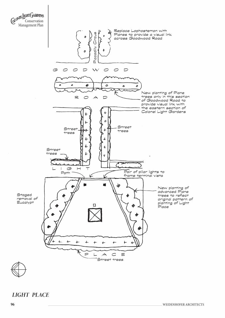
�� Weidenhofer architects
Conservation Management Plan
LIGHT PLACE
P L A C EStreet trees
Replace Lophostemon with Planes to provide a visual link across Goodwood Road
G O O D w O O D
R O A DNew planting of Plane trees only in this section of Goodwood Road to provide visual link with the eastern section of Colonel Light Gardens
Street trees
Street trees
Street trees
Picca
dilly
Circu
s
New planting of advanced Plane trees to reflect original pattern of planting of Light Place
L I G H T
Staged removal of Eucalypt
Pair of pillar lights to frame terminal vista
Path

��
Conservation Management Plan
Weidenhofer architects
5.15.5 KEnt REsERvE
HISTORYThe three allotments that form the basis of Kent Reserve were set aside for public use after the Thousand Homes scheme was created.
DESCRIPTIONKent Reserve has a different character from most other public open space within Colonel Light Gardens due to the topography and planting which is predominantly varieties of tall Eucalyptus sp., plantings of this type were popular in the 1980s. There is also a range of play equipment, picnic benches and seats set on the grass underneath the trees.
Kent Road has been closed and extends along the north-west boundary of the reserve. There is very little street tree planting on this section of the road and a Stobie pole is the dominant element at the corner where the road is closed. A concrete unit paver path weaves along the reserve edge of the street and through tall Eucalyptus sp.
There is a low fence around the south-east edge of the reserve adjacent to the play equipment with a row of new pedestrian lights along Hastings Road.
OBJECTIVESThe objectives for the conservation of the heritage value of this element within the suburb are:• Kent Reserve should continue to provide recreation opportunities for residents.• Given the close proximity of residences and the absence of off-street and
restricted on-street car parking, future use levels should not exceed current levels.
• Provide a safe playing space for the neighbourhood’s children.• Maintain and develop Kent Reserve as a principal recreation and open space
area providing informal recreational activities for use and enjoyment by all residents.
• Recreation development should meet a range of needs and should not generate undue disturbance to nearby residents.
• Kent Reserve should be maintained as a low key informal recreation area and developed to enhance the open space character and appearance of the reserve.
POLICY• Maintain grass cover to reserve.• Establish formal tree planting on the reserve side of Sturt Avenue, Kent Road
and Hastings Road.• Replace existing pedestrian lights with the new standard to maintain
consistency throughout Colonel Light Gardens.• Retain the existing character of tall Eucalyptus sp. in grass.• Install a new Pillar light in the centre of the road closure to terminate the
vista along Kent Road and announce the park with ornamental planting and signage.
• Standardise furniture and urban design elements to maintain consistency with the remainder of Colonel Light Gardens.
• Refit the existing fence with detailing consistent with the pallet of fence materials used throughout Colonel Light Gardens.
• Upgrade lighting to improve safety where necessary using selected fittings.• No further built structures should be established.

�� Weidenhofer architects
Conservation Management Plan
KENT ROAD RESERVE
S T U R TRemove existing planting and replace with Dianella ‘Little Rev’ to maintain vista
KE
NT
EA
ST
P
AR
Kw
Ay
HA
ST
ING
S
Street trees
Staged removal of Ash
Removal of Euc. and replace with Street trees
Install new pillar light set in rubble to terminate vista
New planting of street trees
• Retain character of native reserve.
Street trees
Existing interplanting of Melia and Ash
��
Conservation Management Plan
Weidenhofer architects
5.15.6 poRtland placE
HISTORYThis was designated in Reade’s plan and, like the internal reserves, was intended for community recreational use. In the 1940s when some residents attempted to purchase portions adjacent to their properties they claimed that it was used mainly for the dumping of rubbish and that tall summer grasses were a fire hazard. In 1945 the Garden Suburb Commissioner approved the erection of a new Scout hall on the reserve. Neighbours complained about the noise and towards the end of 1946 the hall was moved to its current location at Mortlock Park. The reserve was used by a local nurseryman for the raising of citrus stock in 1966-68, possibly into the 1970s49.
DESCRIPTIONPortland Place Reserve is a small reserve with a new entry statement and front fence. There are various pieces of play equipment including a seesaw, swing and backhoe set in both soft fall and sand.
There is a young Plane Tree at the front of the reserve with a variety of large and small Eucalyptus sp. planted randomly throughout. On the eastern fence there is a raised planting bed that is retained by moss rocks. Plants in the bed include Diosma, Erigeron, Lavender and Rosemary.
Laneways enter at the rear of the reserve. They have wide gates, presumably to allow maintenance vehicles to enter.
OBJECTIVESThe objectives for the conservation of the heritage value of this element within the suburb are:• Portland Place Reserve should continue to provide recreation opportunities
for residents.• Given the close proximity of residences and the absence of off-street and
restricted on-street car parking, future use levels should not exceed current levels.
• Provide safe playing space for the neighbourhood’s children.• Maintain and develop Portland Place Reserve as a principal recreation and
open space area providing informal recreational activities for the use and enjoyment by all residents.
• Recreation development should provide for informal activities to meet a range of needs and should not generate undue disturbance to nearby residents.
• Structures should be designed in scale and appearance to complement the single storey residential character of the locality.
POLICY• Maintain grass cover to reserve.• Establish formal tree planting along the street edge.• Consolidate play equipment into sandpit and soft fall areas.• Maintain random planting of Eucalyptus sp. in the reserve.• Standardise furniture and urban design elements to maintain consistency with
the remainder of Colonel Light Gardens.

�00 Weidenhofer architects
Conservation Management Plan
PORTLAND PLACE RESERVE
Maintain play equipment
Moss rock planting bed
Retain existing entry structure and paving.Move benches into paving
Plant extra Plane tree to reinforce formality at street edge
SAND
P L Ay
L A N E
L A N E
P O R T L A N D P L A C E
Continue planting tall Eucalyptus in reserve. Remove Eucalyptus that are in poor condition and any large shrubs
Maintain sandpit
young Plane tree
�0�
Conservation Management Plan
Weidenhofer architects
5.15.7 ludgatE ciRcus
HISTORYLudgate Circus (and Oxford Circus) were originally planned as secondary formal entrances (to Piccadilly Circus) to the suburb. They were planned by Reade to be crescent shaped and bisected by a road and planted with gardens on either side. Ludgate Circus was developed by 1925.
In 1966-67, the diagonal roads that ran through both Ludgate Circus and Oxford Circus were closed for safety reasons.
DESCRIPTIONEucalyptus sp. are planted around the perimeter of Ludgate Circus with 2 large Poplars (Populus alba) located on either side of the reserve. In the north-western corner there is a large Olive Tree (Olea europaea). All of the trees are planted in grass.
There is a bus stop on Grange Road and a sign frame at the north-west corner of the reserve that has removable signs temporarily fixed to it.
OBJECTIVESThe objectives for the conservation of the heritage value of this element within the suburb are:• Establish Ludgate Circus as the northern formal entrance to Colonel Light
Gardens.• Reinstate the original form of the entry road through Ludgate Circus.• Open up the entrance to Colonel Light Gardens.
POLICY• Delineate former alignment of bisecting road with formal tree planting and
pathway.• Maintain grass cover to reserve.• Establish formal tree planting to perimeter.• Provide an entry statement for Colonel Light Gardens with entry pillars,
signage, hedging and ornamental planting beds• Install a Pillar light to terminate the vista from the Goodwood and Grange
intersection into Colonel Light Gardens.• Standardise furniture and urban design elements to maintain consistency with
the remainder of Colonel Light Gardens.• Install seating along the central path and beneath the feature trees.

�0� Weidenhofer architects
Conservation Management Plan
LUDGATE CIRCUS
Street trees
Street trees
New planting of street trees
Future planting of feature tree after Populus are removed- Norfolk Island Pine.
Major entry statement with pillars and timber signs as per sketch.Hedging and ornamental planting behind.
Open up views into the suburb - by opening up Ludgate Circus Reserve.Entry statement (Badging) to reflect character of the built form and gardens within the suburb.
wide pathway
Street trees
New Pillar light to terminate vista
Retain existing Populus alba
Retain existing Populus alba
G O O D w O O D R O A D
GR
AN
GE
R
OA
D
LU
DG
AT
E
CI
RC
US
Street trees
Street trees

�0�
Conservation Management Plan
Weidenhofer architects
5.15.8 oxfoRd ciRcus
HISTORYOxford Circus, (like Ludgate Circus) was originally planned as a secondary formal entrance to the suburb. It was similarly crescent-shaped and bisected by a road, planted with gardens on either side. Oxford Circus had been planted with trees and shrubs by 1930.
DESCRIPTIONOxford Circus is at the south-west corner of Colonel Light Gardens and has street tree planting of Elm (Ulmus sp.). There are 2 large Poplars (Populus alba) in the northern half of the reserve and a variety of Eucalyptus sp. planted at random throughout. Recent plantings of Chinese Elm (Ulmus parvifolia) are planted in a formal row along the axis of the old access road and at other locations. Other species include Ash (Fraxinus sp.), Hakea sp. and Bracelet Honey Myrtle (Melaleuca armillaris).
The area is used by the adjacent St. Therese School for general play and has a cricket net on the eastern edge of the reserve. There is a 1.2 metre ARC fence around the majority of the site to prevent easy access on to the adjacent roads. Other features include a gravel pathway through the centre of the site, seats and a drinking fountain.
OBJECTIVESThe objectives for the conservation of the heritage value of this element within the suburb are:• Maintain and reinforce Oxford Circus as a visual entrance to the suburb, but
of secondary importance to Ludgate Circus. • Establish Oxford Circus as the southern formal entrance to Colonel Light
Gardens.• Reinstate the original form of the entry road through Oxford Circus.• Open up the entrance to Colonel Light Gardens.
POLICY• Delineate former alignment of bisecting road with formal tree planting and
pathway.• Maintain grass cover to reserve.• Establish formal tree planting to perimeter.• Provide an entry statement for Colonel Light Gardens with entry pillars,
signage, hedging and ornamental planting beds.• Install a pillar light to terminate the vista from the Goodwood Road and
Springbank Road intersection into Colonel Light Gardens.• Standardise furniture and urban design elements to maintain consistency with
the remainder of Colonel Light Gardens.• Install seating along the central path and beneath the feature trees.• Replace existing fencing with standard design. Any fencing along Goodwood
and Springbank Roads is to meet the standard required by Transport SA.• Remove cricket practice nets.
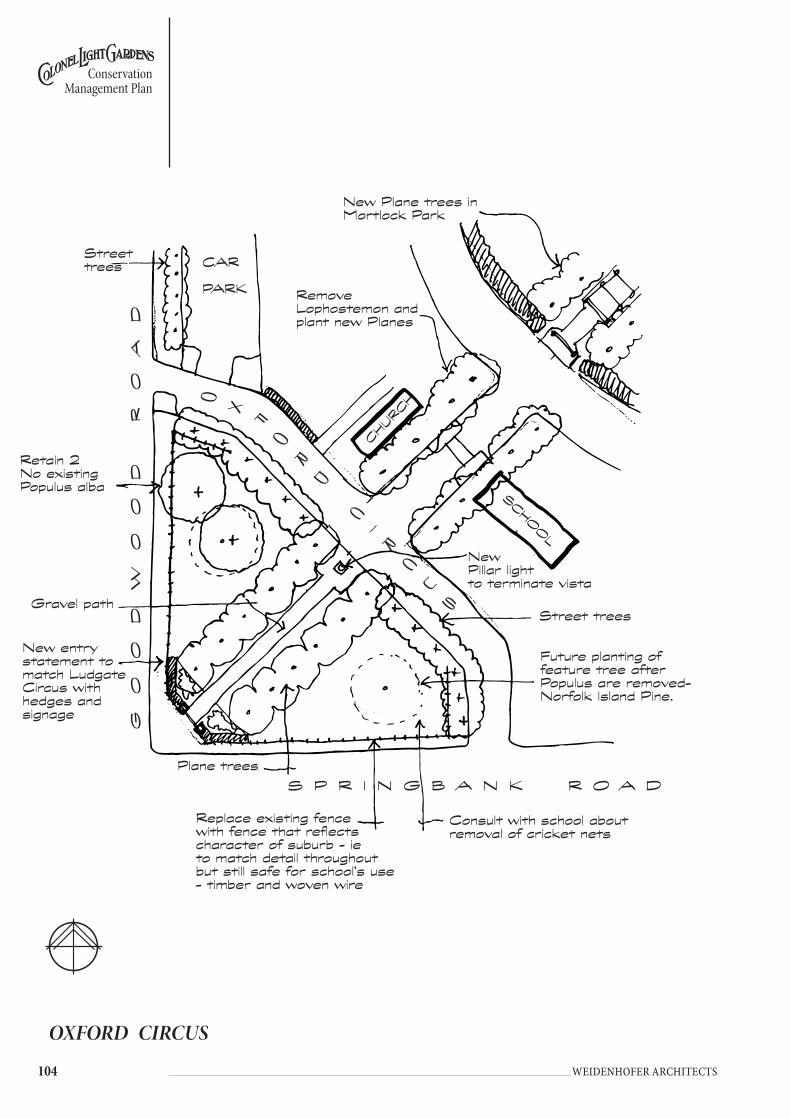
�0� Weidenhofer architects
Conservation Management Plan
OXFORD CIRCUS
Retain 2 No existing Populus alba
Gravel path
New entry statement to match Ludgate Circus with hedges and signage
Plane trees
New Pillar light to terminate vista
Street trees
Street trees
GO
OD
wO
OD
R
OA
D
New Plane trees in Mortlock Park
Consult with school about removal of cricket nets
CAR PARK
CHURC
H
SCHOOL
Remove Lophostemon and plant new Planes
Replace existing fence with fence that reflects character of suburb - ie to match detail throughout but still safe for school’s use - timber and woven wire
S P R I N G B A N K R O A D
OX
FO
RD
C
IR
C
US
Future planting of feature tree after Populus are removed- Norfolk Island Pine.

�0�
Conservation Management Plan
Weidenhofer architects
Render
Interpretative signage
Brick edge
Ludgate Circus/Oxford Circus
5.15.9 piccadilly ciRcus
HISTORYPiccadilly Circus was intended to be the main entrance to the suburb. It was planned that the streets would radiate from the Circus into the suburb and that the garden spaces of the Circus would be planted with formal gardens. It was proposed to locate public toilets and a tram passenger shelter in the Circus.
In the year of 1938-39, the Annual Report commented that Piccadilly Circus had been subdivided and prepared for the sale of an additional 20 blocks for housing50.
The visual impact of this formal entrance into Colonel Light Gardens as intended by Reade and its expression of the objectives of Reade’s design were lost when this land was subdivided and developed for housing. For this reason, emphasis should be directed towards the secondary entrances, most importantly Ludgate and then Oxford Circus.

�0� Weidenhofer architects
Conservation Management Plan
5.15.10 doncastER REsERvE
HISTORYThis triangle of land was included in Reade’s plan but set aside by the Garden Suburb Commissioner as the ‘Mitcham Camp Memorial Site’. A flagpole was erected after World War 1 but the site was not developed. The RSL conducts its annual Anzac Day and Remembrance Day services there. In 1962 the Commissioner approved a site lease to the Mothers and Babies Health Association and an infant health clinic was constructed at a sufficient distance from the flagpole to allow services to continue. At the RSL’s request the building was called a ‘War Memorial’ centre.51. It was made ‘surplus to needs’ in 1996 and following community consultation was demolished in 1998. The present war memorial was constructed in 1986.
DESCRIPTIONDoncaster Reserve terminates the vista when looking east from Goodwood Road along the mature gum tree-lined Doncaster Avenue. A Stobie pole and street light are situated centrally at the western edge of the reserve.
The reserve contains an RSL memorial to the original Mitcham Camp during WW1. There are flagpoles, with a concrete path connecting the memorial and the flagpoles together. The path was used for access to the recently demolished building. There is a timber post and galvanised pipe rail fence around three sides of the reserve with timber bollards on the other side.
Planting in the reserve consists of 2 mature Poplar Trees (Populus sp.), new plantings of Jacaranda mimosifolia, Melia azedarach and a single planting of Pine (Pinus sp.) originating from the Lone Pine from Gallipoli. These trees are all growing in grass with benches underneath the Poplars.
OBJECTIVESThe objectives for the conservation of the heritage value of this element within the suburb are:• Maintain and reinforce Doncaster Reserve as a focal point at the end of
Doncaster Avenue.• Doncaster Reserve should continue to provide low level recreation
opportunities for residents.• Given the close proximity of residences and the absence of off-street and
restricted on-street car parking, future use levels should not exceed current levels.
• Reinforce the formal axis through the reserve and the location of the memorial.
POLICY• Remove the existing Stobie pole and light and replace with a Pillar light to
terminate the vista.• Remove the existing paving and provide a new path and paving system
that reinforces the formality of the site and provides new opportunities for ornamental planting.
• Remove the Poplars and add further planting of Jacaranda mimosifolia.• Retain seating below shade trees.• Reinforce boundary definition eg post and wire fencing

�0�
Conservation Management Plan
Weidenhofer architects
DONCASTER RESERVE
New planting of Jacarandas
Paved area around flag poles and monument with planting to enclose space
New Pillar light to terminate vista set in rubbleRemove stobie pole
New boundary definition e.g. post and wire
Ex. Pinus sp.
B R O A D w A y
DO
NC
AS
TE
R
Further planting of Jacarandas

�0� Weidenhofer architects
Conservation Management Plan
5.15.11 tHE stRand REsERvE
HISTORYThe Strand Reserve was originally a triangular island reserve with formal rows of street trees on each edge. In the centre of the reserve there was a formal ring of Poplar Trees that gave the reserve a distinct character. It also had trimmed hedge and shrub planting throughout.
Traffic safety requirements led to The Strand itself being closed at the eastern end. The planting also changed over time with very little of the original formality remaining.
DESCRIPTIONThis reserve has 2 mature Ash (Fraxinus sp.) placed at either end with semi-formal planting of Eucalyptus sp. throughout and Brush Box (Lophostemon conferta) as street trees on Freeling Crescent. New planting of Chinese Elm (Ulmus parvifolia) have been planted on the southern side of The Strand.
It has benches and rubbish bins with a path extending along the northern edge that connects to Prince George Parade.
OBJECTIVESThe objective for the conservation of the heritage value of this element within the suburb is:• Formalise planting within the Strand Reserve and maintain as a low-level
recreation space for residents.
POLICY• Maintain grass cover to reserve.• Establish formal tree plantings of deciduous trees on Freeling Crescent.• Provide a Pillar light at the north east corner with paving, and ornamental
planting/element to terminate the vista along Prince George Parade.• Retain the Ash (Fraxinus sp.) trees and plant a ring of fastigiate trees that
reflect the original planting intention of Poplar Trees.• Standardise furniture and urban design elements to maintain consistency with
the remainder of Colonel Light Gardens.• Provide seating underneath the 2 Ash trees with the new standard Colonel
Light Gardens seat.

�0�
Conservation Management Plan
Weidenhofer architects
THE STRAND RESERVE
New planting of Cedrus deodara
Street trees
Continue street tree planting along edge of reserve to match other side
Street trees
New pillar light set in rubble to terminate vista
T H E S T R A N D
T H E S T R A N D
FR
EE
LI
NG
C
RE
S.
ex. tree
ex. tree
SH
OP
LA
NE
��0 Weidenhofer architects
Conservation Management Plan
6 tRAffIC MAnAgeMent
6.1 PReVIoUs stUDIesThe City of Mitcham commissioned a traffic study in 1996 (Murray F Young & Associates Pty Ltd: Traffic Study, Colonel Light Gardens, August 1996), which followed on from a preliminary study by the same consultants in September 1994.
A limited number of minor traffic controls were recommended in the study, which addressed specific concerns raised by the residents. It is worth noting however that the study quotes the residents of Colonel Light Gardens as not wishing to impose “vast traffic control schemes”52.
From 1 March 2003 a lower maximum speed limit (50km/hr) took effect on non-arterial roads across the State. This reduction in speed applies to Colonel Light Gardens. Whilst some of the recommendations within the 1996 Study will remain valid, it is suggested that, prior to installing any physical traffic control devices, the impact of the lower maximum speed limit be fully assessed and that the recommendations be reassessed accordingly.
6.2 stReet PAtteRn
OBJECTIVESThe objective for the conservation of the traditional street pattern within the suburb is:• Retain the original street pattern and avoid the introduction of inappropriate
traffic management devices.
POLICY• Assess the existing introduced traffic management devices as a result of the
lower maximum speed limit within the suburb.• Remove superfluous traffic safety devices, protuberances, islands, signage etc.• Avoid the introduction of additional devices that diminish the integrity of the
original street layout and detail.

���
Conservation Management Plan
Weidenhofer architects
7 RefeRenCes1 Garnaut, Christine Colonel Light Gardens; model garden suburb, Crossing Press, 1999, p. 12 Garden Suburb Commissioner, Annual Report, November 19283 Garnaut, p. 48-9 and Colonel Light Gardens Historical Society Inc, Colonel Light Gardens Reference Notes - Notes relating to the streetscape elements of Colonel Light Gardens, p. 64 Annual Report,1936-75 Annual Report, November 19266 Annual Report, 30 November 19277 Annual Report, 30 November 19298 Colonel Light Gardens HSI in Colonel Light Gardens Reference Notes - Notes relating to the streetscape elements of the suburb, p. 99 Annual Report, 30 June 192510 Letter from Garden Suburb Commissioner to Colonel Light Gardens Progress Association, 22 May 1925.11 Annual Report, 30 November 192612 Annual Report, 30 November 192713 Annual Report, 30 November 192814 Annual Report, 30 November 192915 State Records, GRG 13/15 for the years 1924-916 Colonel Light Gardens HSI in Colonel Light Gardens Reference Notes - Notes relating to the streetscape elements of Colonel Light Gardens, p. 19, Minutes of Advisory Committee of 27 June 194717 Annual Report of 1959-60.18 Colonel Light Gardens HIS in Colonel Light Gardens Reference Notes - Notes relating to the streetscape elements of Colonel Light Gardens, p. 1719 Annual Report, 30 November 192820 Annual Report for the year 1960-6121 Annual Report, 30 June 192522 Annual Report, 30 November 192823 Annual Report for the year 1964-6524 Annual Report for the year 1965-6625 Bechervaise and Associates Pty Ltd in association with McDougall and Vines, 198926 Annual Report, 30 June 192327 Annual Report 30 June 192428 Annual Report, 30 June 192429 Annual Report, 30 June 192530 Annual Report, 30 November 192931 Annual Report 30 June 192532 Colonel Light Gardens Reference Notes - Notes relating to the streetscape elements of Colonel Light Gardens, p. 733 Annual Report, 30 June 192234 Annual Report, 30 June 192335 Annual Report, 30 June 192536 Annual Report, 30 November 192837 Annual Report, 30 November 192838 Annual Report, 30 November 192939 Garnaut, 1999, p. 45

��� Weidenhofer architects
Conservation Management Plan
40 Annual Report, 30 November 192641 Annual Report, 30 November 192742 Annual Report, 30 November 192943 Garnaut, 1999, p. 4544 Annual Report, 30 November 192645 Annual Report, 30 November 192746 Annual Report, 30 November 192847 Annual Report, 1930-3148 Annual Report, 1930-3149 R. Miller, “A History of the Colonel Light Gardens Communities”, unpublished typescript, 1993.Colonel Light Gardens Garden Suburb Commissioner Annual Reports.50 Annual Report, 1938-3951 Records of the CAFHS building, Broadway in the possession of the Colonel Light Gardens Historical Society.
Colonel Light Gardens Garden Suburb Commissioner Annual Reports.52 Murray F Young & Associates Pty Ltd: Traffic Study, Colonel Light Gardens, August 1996, summary

���
Conservation Management Plan
Weidenhofer architects
APPenDIX 1 -Fieldwork Data

Cons
erva
tion
Man
agem
ent P
lan
��� Weidenhofer architects
Road
Nam
eSt
reet
W
idth
Stor
mw
ater
Kerb
and
Dri
vew
ay
Edgi
ng
Natu
re
Stri
p W
idth
Natu
re S
trip
Pl
antin
g/
Surf
ace
Dist
ance
to
Tre
e Ce
ntre
s
Dist
ance
be
twee
n Tr
ees
Foot
path
W
idth
Foot
path
Su
rfac
eLa
nes
Stob
ie P
oles
Fire
H
ydra
nts
Serv
ices
Sign
sO
ther
Colo
nel L
ight
Ga
rden
s - W
este
rn
Sect
ion
Rich
mon
d Av
enue
- No
rth
Side
6660
mm
270
mm
, con
tinuo
us
conc
rete
120
mm
x 12
0 m
m,
driv
eway
is 6
00
mm
conc
rete
apro
n
1560
mm
grav
el, w
ith so
me l
ow
shru
bs o
r law
n76
0 m
m13
-16
pace
s17
00bi
tum
en6m
wid
e, di
rt an
d gr
avel
surfa
ce, v
ehicl
e acc
ess
prev
ente
d by
3 m
etal
pi
pe b
olla
rds,
70 m
m
diam
by 1
000m
m, w
hite
pa
inte
d w
ith 5
0 m
m re
d ba
nds a
t top
Both
side
s of s
treet
, 32
pac
es ap
art
Stre
et li
ghts
mou
nted
at
top
of st
obie
pol
eRo
ad si
gns
Rich
mon
d Av
enue
- So
uth
Side
300
mm
Roun
ded
kerb
co
ntin
ues
2810
mm
grav
el w
ith so
me
plan
ting
760m
m20
-10
pace
s17
00bi
tum
en
Pena
ng A
venu
e - S
outh
Si
de58
50m
m30
0mm
cont
inuo
us
conc
rete
150
x100
mm
, dr
ivew
ays c
oncr
ete
apro
n 67
0mm
2600
mm
som
e gra
ssed
, oth
ers
lawne
d13
00m
m15
-14
pace
s15
30m
m w
ith
360m
m ga
pgr
ey co
ncre
te
inte
rlock
ing
pavi
ng b
ricks
Both
side
s of s
treet
, 29
pac
es ap
art,
plac
ed
abou
t 200
0 fro
m
kerb
edge
, som
etim
es
para
llel t
o str
eet,
som
etim
es at
90
degr
ees
Serv
ice ac
cess
poi
nt
cove
rs in
foot
path
and
verg
e. St
reet
ligh
ts m
ount
ed ab
out t
wo
third
s up
poles
Blue
and
white
and
blac
k an
d wh
ite
num
bers
pai
nted
on
ker
b
Pena
ng A
venu
e - N
orth
Si
de30
0mm
cont
inuo
us
conc
rete
in 3
m le
ngth
s10
0 x 1
50m
m,
driv
eway
s are
co
ncre
te ap
ron,
66
0mm
wid
e
2560
mm
som
e gra
ss, s
ome d
irt96
0mm
1650
mm
bitu
men
Roze
lls A
venu
e - S
outh
Si
de63
40m
m30
0mm
, con
tinuo
us
conc
rete
in 3
m le
ngth
s10
0 x 1
50m
m,
driv
eway
is
conc
rete
apro
n 67
0mm
wid
e
2500
mm
som
e bar
e, so
me
gras
sed
with
shru
bs19
50m
m16
pac
es17
30m
mbi
tum
enBo
th si
des o
f stre
et,
2m fr
om k
erb
edge
, lo
cate
d pa
ralle
l and
so
me 9
0 de
gree
s
Roze
lls A
venu
e - N
orth
Si
de30
0mm
, con
tinuo
us
conc
rete
in 3
m le
ngth
s10
0 x 1
50m
m,
driv
eway
is
conc
rete
apro
n 67
0mm
side
2200
mm
dirt
1300
mm
1650
mm
bitu
men
Thre
e size
s of s
tobi
es
poles
can
be fo
und,
no
rmal
, larg
e and
tim
ber p
oles
Both
type
s fou
nd
- Old
(ie1
00 x
100
x 105
0mm
, w
ith ch
amfe
red
corn
ers,
topp
ed
with
red
met
al
cap)
and
new
(ie
1060
x 80
mm
di
am m
etal
pip
es
with
red
plas
tic
cap
Telst
ra cy
clind
ers,
ETSA
bo
x in
verg
eBl
ue an
d wh
ite an
d bl
ack
and
white
nu
mbe
rs o
n ke
rbs
Ligh
t Pla
ce -
Wes
t Sid
e25
0mm
80 x
50 1
40m
m
with
curv
ed
conc
rete
edge
s to
driv
eway
s, co
ncre
te ap
ron
for
driv
eway
s
2660
mm
lawns
1200
mm
1530
mm
with
20
0mm
gap
grey
pav
ers
2050
mm
from
ker
bOl
d

Cons
erva
tion
Man
agem
ent P
lan
��� Weidenhofer architects
Road
Nam
eSt
reet
W
idth
Stor
mw
ater
Kerb
and
Dri
vew
ay
Edgi
ng
Natu
re
Stri
p W
idth
Natu
re S
trip
Pl
antin
g/
Surf
ace
Dist
ance
to
Tre
e Ce
ntre
s
Dist
ance
be
twee
n Tr
ees
Foot
path
W
idth
Foot
path
Su
rfac
eLa
nes
Stob
ie P
oles
Fire
H
ydra
nts
Serv
ices
Sign
sO
ther
Ligh
t Pla
ce -
Sout
h Si
de30
0mm
150
x 100
mm
, dr
ivew
ays a
re
conc
rete
apro
ns,
680m
m w
ide
2680
mm
grav
el10
00m
m17
30m
mbi
tum
en18
00m
m fr
om k
erb
Stre
et li
ghts
from
2/3
up
stobi
e pol
e
Ligh
t Pla
ce -
Nort
h Si
dero
ad su
rface
mee
ts ke
rb,
or 2
60m
m co
nt co
nc10
0 x 1
50m
m24
00m
mlaw
n, gr
avel
1100
mm
16-1
9 pa
ces
1700
mm
bitu
men
Ligh
t Pla
ce -
East
Side
260m
m
100
x 130
mm
2530
mm
lawn,
grav
el12
00m
m17
00m
mbi
tum
en18
20m
m fr
om k
erb
Ligh
t Pla
ce -
Proj
ectin
g we
st fa
cing w
ings
on
East
Side
260m
m10
0 x 1
30m
m16
00m
mgr
avel
1700
mm
bitu
men
Ligh
t Pla
ce -
Entra
nce
from
Goo
dwoo
d Ro
ad
- Sou
th Si
de
100
x 150
mm
8600
mm
lawn
3400
mm
7 pa
ces
1600
mm
none
Ligh
t Pla
ce -
Entra
nce
from
Goo
dwoo
d Ro
ad
- Nor
th Si
de
100
x 150
mm
8600
mm
lawn
3800
mm
7 pa
ces
1600
mm
yes
old
stree
t lig
hts m
ount
ed
on st
obie
pol
es, T
elstra
cy
linde
rs, a
nd gr
een
boxe
s on
thre
e leg
s
Coru
nna A
venu
e - S
outh
Si
de6
pace
s30
0mm
, con
t con
c in
3, len
gths
100
x 150
mm
2700
mm
grav
el, so
me l
awns
an
d sh
rubs
1800
mm
16 p
aces
1700
mm
bitu
men
Both
side
s, ab
out 2
m
from
ker
b, al
l loc
ated
90
deg
rees
to st
reet
Coru
nna A
venu
e30
0mm
100
x 150
mm
, co
nt co
nc in
3m
len
gths
with
apro
n dr
ivew
ay, 6
70m
m
1900
mm
, 20
30m
m at
ea
st on
nth
sid
e
lawns
, shr
ubs
1100
mm
, 10
30m
m at
east
on n
th si
de
16 p
aces
, in
terp
lant
ed
spec
ies n
ot at
re
gula
r int
erva
ls
1700
mm
, 154
0mm
at
east
on n
th si
de
bitu
men
6m, d
olom
ite su
rface
, w
ith b
olla
rds (
6 x 1
m x
50m
m m
etal
pip
es w
ith
caps
. Lan
eway
bet
ween
no
.s 6
and
8- 3
530m
m
wid
e, ro
ad m
etal
surfa
ce
with
bol
lard
s
circu
lar
serv
ice ac
cess
in
foot
path
, man
y ov
erhe
ad w
ires
Blue
and
white
and
blac
k an
d wh
ite k
erb
num
bers
Clyd
e Ave
nue -
Eas
t Sid
e6
pace
s30
0mm
100
x 150
mm
2250
mm
dirt
, shr
ubs
1100
mm
1600
mm
bitu
men
East
side,
para
llel a
nd
90 d
egre
es to
stre
etTe
lstra
cycli
nder
Clyd
e Ave
nue -
Wes
t Sid
e30
0mm
100
x 150
mm
, co
ncre
te ap
ron
driv
eway
s
2150
mm
dirt
1150
mm
1740
mm
bitu
men
Wes
t sid
eNo
stre
et li
ghts
Fade
d str
eet s
ign
pain
ted
on st
obie
pol
e
Rapi
d Av
enue
Eas
t Sid
ebi
tum
en to
ker
b ed
ge60
x 50
x 10
0mm
2580
mm
lawn
1300
mm
1600
mm
grey
pav
ers
old
Rapi
d Av
enue
- W
est S
ide
bitu
men
to k
erb
edge
60 x
50 x
100m
m,
curv
ed d
rivew
ay
edgi
ng
2640
mm
lawn
1300
mm
1600
mm
grey
pav
ers
Both
side
s170
0mm
fro
m k
erb
edge
old
Fade
d str
eet s
ign
pain
ted
on st
obie
pol
e

Cons
erva
tion
Man
agem
ent P
lan
��� Weidenhofer architects
Road
Nam
eSt
reet
W
idth
Stor
mw
ater
Kerb
and
Dri
vew
ay
Edgi
ng
Natu
re
Stri
p W
idth
Natu
re S
trip
Pl
antin
g/
Surf
ace
Dist
ance
to
Tre
e Ce
ntre
s
Dist
ance
be
twee
n Tr
ees
Foot
path
W
idth
Foot
path
Su
rfac
eLa
nes
Stob
ie P
oles
Fire
H
ydra
nts
Serv
ices
Sign
sO
ther
Colo
nel L
ight
Ga
rden
s - E
aste
rn
Sect
ion
Oxfo
rd C
ircus
- So
uth
side
9 pa
ces
380m
m10
0 x 1
50m
m,
conc
rete
apro
n fo
r dr
ivew
ays
2800
mm
, bu
t par
t of
rese
rve
grav
el, d
olom
ite13
00m
m8-
9 pa
ces
2800
- 30
80m
mdi
rt, g
rave
lNo
ne
Oxfo
rd C
ircus
- No
rth
Side
380m
m, c
ont c
onc o
f 4
pace
s10
0 x 1
50m
m, c
onc
apro
n dr
ivew
ayno
verg
e, 25
60m
mbi
tum
enno
tree
sno
foot
path
as su
chLo
cate
d 24
0mm
fro
m k
erb,
90 d
egre
es
to st
reet
old
acce
ss p
lates
in fo
otpa
thPo
ol fe
ncin
g bou
nds
rese
rve,
grey
pav
ers
used
on
driv
eway
en
tranc
e to
scho
ol
Suffo
lk P
lace
- So
uth
7 pa
ces
bitu
men
to k
erb
100
x 30
x 80m
m,
roun
ded
kerb
for
driv
eway
s, co
ncre
te
apro
n
2500
mm
gras
s14
00m
m9-
10 p
aces
1850
mm
bitu
men
4 pa
ces,
dirt
, gra
vel
Loca
ted
in la
nes
Suffo
lk P
lace
- No
rth
bitu
men
to k
erb
80 x
140m
m, c
onc
cont
leng
ths
2650
mm
gras
s13
00m
m6
pace
s15
40m
mgr
ey p
aver
s49
00m
m w
ide,
grav
el su
rface
2 in
stre
et, lo
cate
d 11
00m
m fr
om k
erb,
mos
t loc
ated
on
edge
of
lane
Win
dsor
Ave
nue -
Nor
th11
pac
es37
0mm
, con
t con
c10
0 x 1
50m
m,
conc
rete
apro
n fo
r dr
ivew
ays
2100
mm
grav
el, d
irt13
00m
m7
pace
s15
30m
mgr
ey p
aver
s48
00m
m, g
rave
l sur
face
Loca
ted
in la
nes
noSt
reet
ligh
t (1)
on ‘
T’ o
n to
p of
stob
ieNo
hou
ses f
ace S
uffol
k, on
ly si
de fe
nces
Win
dsor
Ave
nue -
Eas
t37
0mm
, con
t con
c17
0 x 1
00m
m21
00m
mdi
rt, s
ome s
hrub
s13
00m
m7
pace
s17
00m
mbi
tum
enas
abov
eLo
cate
d in
lane
Stur
t Ave
nue -
Nor
th7
pace
s30
0mm
70 x
170
x 30m
m,
cont
conc
, in 4
pa
ce le
ngth
s, ap
ron
driv
eway
s
6600
mm
gras
s33
00m
m7
pace
s16
00m
mbi
tum
enFe
w on
bot
h sid
es
Stur
t Ave
nue -
Wes
t28
0mm
70 x
170
x 30m
m,
cont
conc
, in 4
pa
ce le
ngth
s, ap
ron
driv
eway
s
6250
mm
gras
s36
50m
m7-
9 pa
ces
1700
mm
bitu
men
Loca
ted
3600
mm
fro
m k
erb
acce
ss p
lates
in ve
rge
Fade
d str
eet n
ame o
n sto
bie p
oles
Lane
- bo
rder
bet
ween
CL
G an
d Cl
apha
mdi
rt, g
rave
lLo
cate
d in
lane
, som
e hu
ge st
obie
pol
es
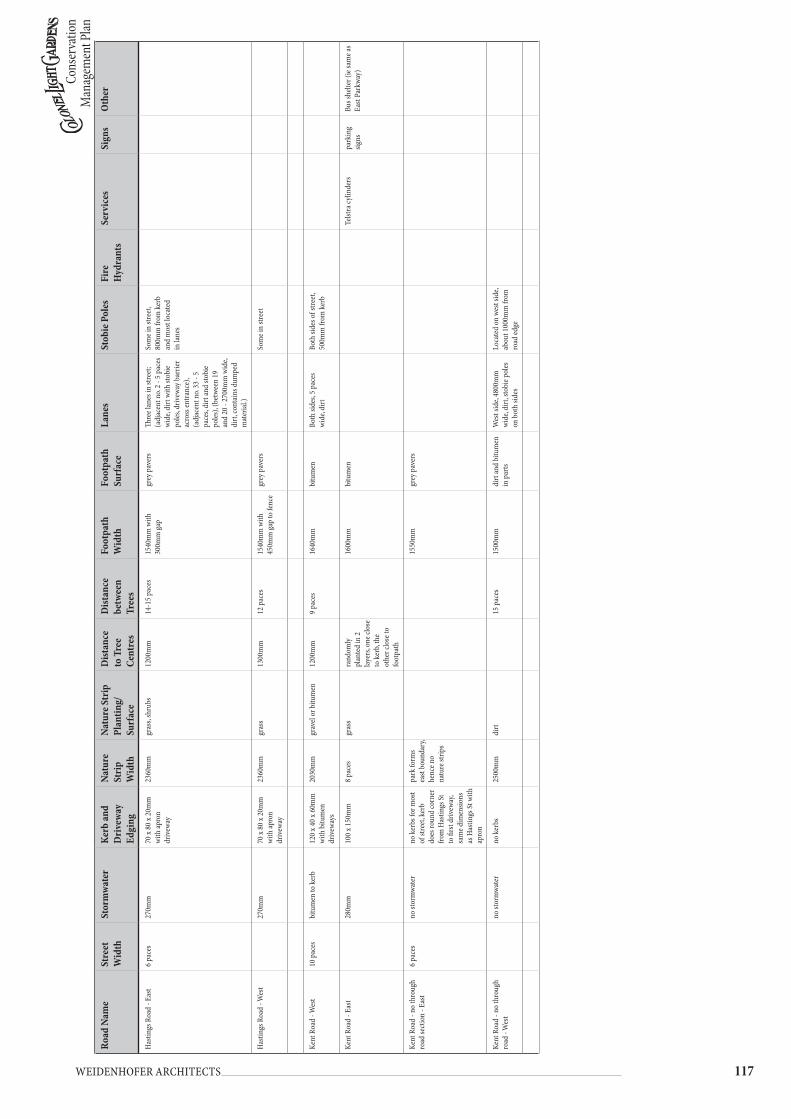
Cons
erva
tion
Man
agem
ent P
lan
��� Weidenhofer architects
Road
Nam
eSt
reet
W
idth
Stor
mw
ater
Kerb
and
Dri
vew
ay
Edgi
ng
Natu
re
Stri
p W
idth
Natu
re S
trip
Pl
antin
g/
Surf
ace
Dist
ance
to
Tre
e Ce
ntre
s
Dist
ance
be
twee
n Tr
ees
Foot
path
W
idth
Foot
path
Su
rfac
eLa
nes
Stob
ie P
oles
Fire
H
ydra
nts
Serv
ices
Sign
sO
ther
Has
tings
Roa
d - E
ast
6 pa
ces
270m
m70
x 80
x 20
mm
w
ith ap
ron
driv
eway
2360
mm
gras
s, sh
rubs
1200
mm
14-1
5 pa
ces
1540
mm
with
30
0mm
gap
grey
pav
ers
Thre
e lan
es in
stre
et;
(adj
acen
t no.
2 - 5
pac
es
wid
e, di
rt w
ith st
obie
po
les, d
rivew
ay b
arrie
r ac
ross
entra
nce)
, (a
djac
ent n
o. 33
- 5
pace
s, di
rt an
d sto
bie
poles
), (b
etwe
en 1
9 an
d 20
- 27
00m
m w
ide,
dirt
, con
tain
s dum
ped
mat
eria
l.)
Som
e in
stree
t, 80
0mm
from
ker
b an
d m
ost l
ocat
ed
in la
nes
Has
tings
Roa
d - W
est
270m
m
70 x
80 x
20m
m
with
apro
n dr
ivew
ay
2360
mm
gras
s13
00m
m12
pac
es15
40m
m w
ith
450m
m ga
p to
fenc
egr
ey p
aver
sSo
me i
n str
eet
Kent
Roa
d - W
est
10 p
aces
bitu
men
to k
erb
120
x 40
x 60m
m
with
bitu
men
dr
ivew
ays
2030
mm
grav
el or
bitu
men
1200
mm
9 pa
ces
1640
mm
bitu
men
Both
side
s, 5
pace
s w
ide,
dirt
Both
side
s of s
treet
, 50
0mm
from
ker
b
Kent
Roa
d - E
ast
280m
m10
0 x 1
50m
m8
pace
sgr
ass
rand
omly
pl
ante
d in
2
layer
s, on
e clo
se
to k
erb,
the
othe
r clo
se to
fo
otpa
th
1600
mm
bitu
men
Telst
ra cy
linde
rspa
rkin
g sig
nsBu
s she
lter (
ie sa
me a
s Ea
st Pa
rkwa
y)
Kent
Roa
d - n
o th
roug
h ro
ad se
ctio
n - E
ast
6 pa
ces
no st
orm
wate
rno
ker
bs fo
r mos
t of
stre
et, k
erb
does
roun
d co
rner
fro
m H
astin
gs St
to
firs
t driv
eway
, sa
me d
imen
sions
as
Has
tings
St w
ith
apro
n
park
form
s ea
st bo
unda
ry,
henc
e no
natu
re st
rips
1550
mm
grey
pav
ers
Kent
Roa
d - n
o th
roug
h ro
ad -
Wes
tno
stor
mwa
ter
no k
erbs
2500
mm
dirt
15 p
aces
1500
mm
dirt
and
bitu
men
in
par
tsW
est s
ide,
4800
mm
w
ide,
dirt
, sto
bie p
oles
on
bot
h sid
es
Loca
ted
on w
est s
ide,
abou
t 100
0mm
from
ro
ad ed
ge
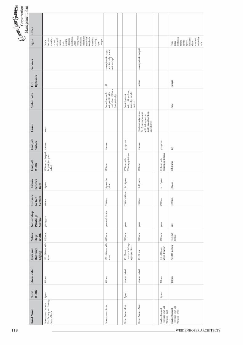
Cons
erva
tion
Man
agem
ent P
lan
��� Weidenhofer architects
Road
Nam
eSt
reet
W
idth
Stor
mw
ater
Kerb
and
Dri
vew
ay
Edgi
ng
Natu
re
Stri
p W
idth
Natu
re S
trip
Pl
antin
g/
Surf
ace
Dist
ance
to
Tre
e Ce
ntre
s
Dist
ance
be
twee
n Tr
ees
Foot
path
W
idth
Foot
path
Su
rfac
eLa
nes
Stob
ie P
oles
Fire
H
ydra
nts
Serv
ices
Sign
sO
ther
Stur
t Ave
nue -
bet
ween
Ea
st Pa
rkwa
y and
Has
tings
St
reet
- No
rth
6 pa
ces
300m
m15
0 x 1
00m
m w
ith
apro
n31
00m
mpa
tchy
gras
s40
0mm
20 p
aces
1700
mm
, no
foot
path
fo
r par
k, ju
st gr
ass
to k
erb
bitu
men
none
On st
h ea
st pa
rk
boun
dary
, cy
clone
w
ire w
ith
timbe
r po
sts
form
ing
1200
mm
hi
gh fe
nce.
So
me
stobi
e pol
es
have
fade
d str
eet n
ame
pain
ted
on.
At su
burb
bo
unda
ry,
plan
ting
layou
t ch
ange
s.
Stur
t Ave
nue -
Sou
th30
0mm
150
x 100
mm
with
ap
ron
4350
mm
gras
s with
shru
bs22
00m
m14
pac
es, b
ut
varie
s17
00m
mbi
tum
enLo
cate
d on
sout
h sid
e, pa
ralle
l with
ro
ad, a
bout
120
0mm
fro
m k
erb
edge
old
acce
ss p
lates
in ve
rge,
near
ker
b ed
ge, b
oxes
on
thre
e leg
s?
Dors
et A
venu
e - E
ast
7 pa
ces
bitu
men
to k
erb
80 x
60m
m,
conc
rete
with
larg
e ag
greg
ate p
iece
s
2500
mm
gras
s13
00 -
1400
mm
15 -
16 p
aces
1530
mm
with
25
0mm
gap
to fe
nce
grey
pav
ers
Loca
ted
on ea
st sid
e, 11
40m
m fr
om
kerb
edge
, par
allel
to
stre
et
Dors
et A
venu
e - W
est
bitu
men
to k
erb
80 x
60 m
m25
00m
mgr
ass
1300
mm
14 -1
6 pa
ces
1700
mm
bitu
men
Two
lane
s; ad
jace
nt n
o. 34
- 5
pace
s wid
e, di
rt
with
stob
ie p
oles
on
nort
h sid
e, at
nor
ther
n en
d of
stre
et
mod
ern
acce
ss p
lates
in fo
otpa
th
Free
ling C
resc
ent
- bet
ween
Stur
t and
W
inds
or -
East
6 pa
ces
300m
m15
0 x 1
00m
m,
apro
n dr
ivew
ay49
00m
mgr
ass
2900
mm
15 -
17 p
aces
1530
mm
with
30
0mm
gap
to fe
nce
grey
pav
ers
Free
ling C
resc
ent
- bet
ween
Stur
t and
W
inds
or -
Wes
t
280m
m70
x 18
0 x 2
0mm
verg
e not
de
fined
dirt
1700
mm
10 p
aces
not d
efine
ddi
rtno
nem
oder
nFr
om
hedg
e bo
rder
ing
park
to
kerb
is
4 pa
ces.
Blac
k an
d wh
ite
num
bers
pa
inte
d on
ke
rb

Cons
erva
tion
Man
agem
ent P
lan
��� Weidenhofer architects
Road
Nam
eSt
reet
W
idth
Stor
mw
ater
Kerb
and
Dri
vew
ay
Edgi
ng
Natu
re
Stri
p W
idth
Natu
re S
trip
Pl
antin
g/
Surf
ace
Dist
ance
to
Tre
e Ce
ntre
s
Dist
ance
be
twee
n Tr
ees
Foot
path
W
idth
Foot
path
Su
rfac
eLa
nes
Stob
ie P
oles
Fire
H
ydra
nts
Serv
ices
Sign
sO
ther
Free
ling C
resc
ent -
Stur
t Ro
ad to
Sprin
gban
k Ro
ad
- Eas
t
8 pa
ces
280m
m70
x 18
0 x 2
0mm
w
ith ap
ron
4 pa
ces
gras
s19
00m
m9
pace
s15
00m
m w
ith
1000
mm
gap
to fe
nce
bitu
men
One
Loca
ted
on ea
st sid
eTe
lstra
cylin
ders
, stre
et
light
s
Free
ling C
resc
ent -
Stur
t Ro
ad to
Sprin
gban
k Ro
ad
- Wes
t
280m
m70
x 18
0 x 2
0mm
w
ith ap
ron
4 pa
ces
gras
s16
00m
m8
pace
s15
00m
m w
ith
500m
m ga
pgr
ey p
aver
s, us
ed
for d
rivew
ays t
oo
Free
ling C
resc
ent
- bet
ween
Win
dsor
and
Prin
ce G
eorg
e Par
ade
- nor
th en
d of
Eas
t sid
e
300m
m15
0 x 1
00m
m48
00m
mgr
ass
2000
mm
16 p
aces
1600
mm
bitu
men
Free
ling C
resc
ent
- bet
ween
Win
dsor
and
Prin
ce G
eorg
e Par
ade
- sou
th en
d of
Eas
t sid
e
300m
m15
0 x 1
00m
m w
ith
curv
ed k
erb
at
driv
eway
s
4000
mm
gras
s20
00m
m16
00m
mbi
tum
enLa
ne o
ff Fr
eelin
g, di
rt,
perm
apin
e bol
lard
s 11
0mm
x 90
0mm
Scho
ol
signs
Foot
path
is lo
cate
d ad
jace
nt to
ker
b, no
t aft
er ve
rge.
Are
a co
ntai
ns m
any
bolla
rds/
anti-
park
ing
devi
ces.
Stob
ie p
oles
w
ith p
aint
ed b
&w
nam
es.
Free
ling C
resc
ent
- bet
ween
Win
dsor
and
Prin
ce G
eorg
e Par
ade
- Wes
t
300m
m15
0 x 1
00m
m52
00m
mgr
ass
2400
mm
11 -1
6 pa
ces
1700
mm
bitu
men
Both
side
s
Free
ling C
resc
ent
- bet
ween
Win
dsor
and
Prin
ce G
eorg
e Par
ade
- Wes
t whe
re R
eser
ve is
300m
m15
0 x 1
00m
mve
rge
broa
dens
to
smal
l Res
erve
gras
ssta
nd o
f old
gu
ms
no co
nsist
ant
plan
ting
1700
mm
bitu
men
Bolla
rds v
ary f
rom
50
x 130
0mm
galv.
pos
ts to
90
x 110
0mm
circ
tim
ber a
nd 7
5 x 1
25 x
1030
mm
tim
ber.
Som
e wh
ite p
aint
ed.
Win
dsor
Ave
nue -
Nor
th7
pace
sbi
tum
en to
ker
b15
0 x 1
00m
m w
ith
coar
se ag
greg
ate
and
curv
ed
driv
eway
edge
4700
mm
gras
s21
00m
m16
pac
es15
00m
mbi
tum
enM
ainl
y on
nort
h sid
e, po
sitio
ned
to b
e lin
ed
up w
ith tr
ees
Win
dsor
Ave
nue -
Sou
th
bitu
men
to k
erb
150
x 100
mm
with
co
arse
aggr
egat
e an
d cu
rved
dr
ivew
ay ed
ge
4600
mm
gras
s22
00m
m8
pace
s16
00 -
1700
mm
bitu
men
Both
side
s, 5
pace
s wid
e, di
rt, s
tobi
e pol
esAft
er E
ast P
arkw
ay,
kerb
s cha
nge t
o be
com
e 70
x 18
0 x 2
0mm
with
30
0mm
stor
mwa
ter
Win
ches
ter A
venu
e - E
ast
7 pa
ces
bitu
men
to k
erb
150
x 100
mm
with
co
arse
aggr
egat
e29
00m
mgr
ass
1200
mm
10 p
aces
, but
va
ries
1600
mm
bitu
men
Both
side
s, 5
pace
s w
ide,
dirt
In la
nes
mod
ern
Acce
ss p
lates
in la
nes
Bolla
rds a
t lan
e en
tranc
es, 9
0mm
un
pain
ted
perm
apin
e
Win
ches
ter A
venu
e - W
est
bitu
men
to k
erb
150
x 100
mm
with
co
arse
aggr
egat
e25
00m
mpa
tchy
gras
sra
ndom
ly
plac
edra
ndom
ly p
lace
d16
00m
mbi
tum
enno
ne in
stre
et

Cons
erva
tion
Man
agem
ent P
lan
��0 Weidenhofer architects
Road
Nam
eSt
reet
W
idth
Stor
mw
ater
Kerb
and
Dri
vew
ay
Edgi
ng
Natu
re
Stri
p W
idth
Natu
re S
trip
Pl
antin
g/
Surf
ace
Dist
ance
to
Tre
e Ce
ntre
s
Dist
ance
be
twee
n Tr
ees
Foot
path
W
idth
Foot
path
Su
rfac
eLa
nes
Stob
ie P
oles
Fire
H
ydra
nts
Serv
ices
Sign
sO
ther
The S
trand
- Pi
ccad
illy t
o W
est P
arkw
ay) -
Nor
th7
pace
s29
0mm
30 x
180
x 70m
m
kerb
cont
inuo
us,
no sc
oops
for
driv
eway
s
6600
mm
gras
s, tre
es an
d so
me
inte
rpla
ntin
g with
sh
rubs
3600
mm
14 -1
6 pa
ces
1600
mm
bitu
men
Both
side
s, 2
allo
tmen
ts ba
ck, 5
pac
es w
ide,
dirt
, ser
vice
plat
es an
d sto
bie p
oles
. Bol
lard
s ar
e whi
te p
aint
ed ga
lv
pipe
s, 90
0mm
hig
h x
70m
m d
iam
.
In la
nes
Stan
dard
lette
r box
The S
trand
- Pi
ccad
illy t
o W
est P
arkw
ay) -
Sou
th29
0mm
30 x
180
x 70m
m
kerb
cont
inuo
us,
no sc
oops
for
driv
eway
s
6600
mm
gras
s30
00m
m8
pace
s18
00m
mbi
tum
enSo
uth
lane
has
bee
n bi
tum
enise
d an
d in
corp
orat
ed in
Mas
onic
Hom
es d
rivew
ay
Eton
Stre
et -
East
6 pa
ces
290m
m20
x 17
0 x 8
0mm
1950
mm
gras
s11
00m
m12
- 20
pac
es15
00m
m w
ith
200m
m ga
pgr
ey p
aver
sSt
obie
pol
es an
d pe
rmap
ine t
elegr
aph
poles
in st
reet
Sout
h en
d of
Eto
n ha
s ov
al sh
aped
isla
nd
plan
ted
with
gras
s and
gu
ms.
Its e
dged
in o
ld
kerb
ing.
Eton
Stre
et -
Wes
t29
0mm
with
scoo
ped
apro
n fo
r driv
eway
20 x
170
x 80m
m16
00m
mgr
ass a
nd sh
rubs
1000
mm
varie
s16
00m
mbi
tum
enBo
th si
des,
5 pa
ces w
ide,
dirt
with
stob
ie p
oles
Som
e pla
ntin
g of y
oung
tre
es h
as o
ccur
red
Donc
aste
r Ave
une -
Sou
th
8 pa
ces
no st
orm
wate
r or k
erb,
just
a rol
l of b
itum
en
at ro
ad ed
ge, d
rivew
ay
bitu
men
3200
mm
gras
s15
00m
m11
pac
es, m
ix o
f co
nsist
ent t
ree
and
rem
nant
hug
e gu
ms
1700
mm
bitu
men
Both
side
s, 49
00m
m
wid
e, di
rt w
ith st
obie
po
les
Stob
ie p
oles
on
both
sid
e, 13
00m
m fr
om
road
edge
Few
stree
tligh
tsRo
unda
bout
at ju
nctio
n of
Wes
t Par
kway
and
Donc
aste
r. B
rick
edge
d,
shru
bs an
d ro
ad si
gns
Donc
aste
r Ave
nue -
Nor
thno
stor
mwa
ter o
r ker
b, ju
st a r
oll o
f bitu
men
at
road
edge
, driv
eway
bi
tum
en
5500
mm
gras
s with
5 h
uge
gum
s, irr
egul
arly
pl
ante
d on
road
edge
Tree
s on
road
ed
ge (r
oad
crea
ted
arou
nd
them
)
15 -
20 p
aces
1700
mm
bitu
men
Both
side
s, 1
allo
tmen
t ba
ck, 4
900m
m d
irt w
ith
stobi
e pol
es
Donc
aste
r Ave
nue -
bot
h sid
es ar
ound
Res
erve
no st
orm
wate
r10
0 x 3
5 x 5
0mm
, len
gths
of 9
00m
m,
thick
ened
curv
es at
dr
ivew
ay ed
ge
1000
mm
gras
s, no
tree
s 13
00m
m
bitu
men
Lane
s on
both
side
sNo
stob
ie p
oles
old
No st
reet
light
sBo
llard
s at l
anew
ays,
circ a
nd ti
mbe
r??
Donc
aste
r Ave
nue
- Res
erve
none
none
2500
mm
, m
arke
d by
line
of
perm
apin
e po
sts (7
0 x 8
0 x 1
100m
m)
with
galv
pi
pe
Rese
rve i
s gra
ss an
d tre
esno
neM
emor
ial t
o M
itcha
m
WW
1 Arm
y Cam
p, co
ntai
ns cr
oss m
ount
ed
on p
yram
id w
ith 2
fla
gpol
es o
n eit
her s
ide.
2 pa
rk b
ench
es.
Pem
brok
e Pla
ce -
East
6 pa
ces
280m
m, c
ontin
uous
co
nc in
3 p
ace l
engt
hs30
x 16
5 x 7
5mm
, ke
rb co
ntin
uous
, ie
no sc
oope
d ap
ron
for d
rivew
ays
1300
mm
gras
s65
0mm
11 p
aces
but
varie
s17
00m
mbi
tum
enBo
th si
des,4
900m
m, d
irt
with
stob
ie p
oles
None
on
east
side
mod
ern
Inte
rnal
rese
rve
acce
ssed
off
nort
h en
d of
stre
et. N
orth
en
d is
dead
end
with
m
oder
n ho
uses
arou
nd
a cul
-de-
sac

Cons
erva
tion
Man
agem
ent P
lan
��� Weidenhofer architects
Road
Nam
eSt
reet
W
idth
Stor
mw
ater
Kerb
and
Dri
vew
ay
Edgi
ng
Natu
re
Stri
p W
idth
Natu
re S
trip
Pl
antin
g/
Surf
ace
Dist
ance
to
Tre
e Ce
ntre
s
Dist
ance
be
twee
n Tr
ees
Foot
path
W
idth
Foot
path
Su
rfac
eLa
nes
Stob
ie P
oles
Fire
H
ydra
nts
Serv
ices
Sign
sO
ther
Pem
brok
e Pla
ce -
Wes
t28
0mm
, con
tinuo
us
conc
in 3
pac
e len
gths
30 x
165
x 75m
m,
kerb
cont
inuo
us, ie
no
scoo
ped
apro
n fo
r driv
eway
s
1300
mm
gras
s65
0mm
12 -
20 p
aces
1700
mm
bitu
men
On w
est s
ide,
perm
apin
e tele
grap
h po
les, 1
50m
m o
ut
from
ker
b
None
or v
ery f
ew
stree
tligh
ts
Prin
ce G
eorg
e Par
ade
- Nor
th9
pace
sbi
tum
en to
ker
b10
0 x 1
00m
m, in
2
pace
leng
ths,
conc
with
larg
e ag
greg
ate
9300
mm
gras
s36
00m
m17
pac
es b
ut va
ries
1500
mm
bitu
men
On co
rner
of
Pem
brok
e Pla
ceol
dBl
ack
and
white
stre
et
signs
pai
nted
on
stobi
e po
les
Prin
ce G
eorg
e Par
ade
- Sou
thbi
tum
en to
ker
b10
0 x 1
00m
m, in
2
pace
leng
ths,
conc
with
larg
e ag
greg
ate
9000
mm
gras
s33
00m
m11
pac
es16
00m
mbi
tum
enNo
neNo
ne
View
Stre
et -
Wes
t38
0mm
, con
tinuo
us
conc
rete
, 3 p
aces
long
, sc
oope
d ap
ron
for g
rey
pave
r driv
eway
s
90 x
150m
m90
0mm
dirt
40
0mm
5 pa
ces
1500
mm
with
15
0mm
gap
pink
inte
rlock
ing
conc
rete
pav
ers
Both
side
s,490
0mm
, dirt
w
ith st
obie
pol
es. L
ane
behi
nd 1
allo
tmen
t in
View
Stre
et is
470
0mm
w
ide,
dirt
with
stob
ie
poles
and
serv
ices
None
Blac
k an
d wh
ite n
o.s
on k
erb
View
Stre
et -
East
Islan
d pl
anta
tion
abou
t 5 p
aces
w
ide
Man
ches
ter R
oad
- Nor
th6
pace
s29
0mm
30 x
165
x 70m
m,
cont
inuo
us
conc
rete
in 4
pa
ce le
ngth
s, no
sc
oope
d ap
rons
for
driv
eway
s
2800
mm
gras
s14
00m
m8-
9 pa
ces
1700
mm
bitu
men
Both
side
s, 47
00m
m d
irt,
stobi
e pol
es an
d se
rvice
pl
ates
. Som
e hav
e whi
te
pain
ted
perm
apin
e ba
rrie
r. 1
00m
m d
iam
lo
g on
2x95
0mm
hig
h po
sts.
None
B&W
stre
et n
ames
pa
inte
d on
stob
ie p
oles
Man
ches
ter R
oad
- Sou
th
290m
m30
x 16
5 x 7
0mm
, co
ntin
uous
co
ncre
te in
4
pace
leng
ths,
no
scoo
ped
apro
ns
for d
rivew
ays,
kerb
co
ntin
ues
2500
mm
gras
s13
00m
m10
pac
es b
ut va
ries
1500
mm
bitu
men
Sout
h sid
e, 65
0mm
ou
t, str
eetli
ghts
mou
nted
on
corn
er
pole
Tree
s hav
e 850
mm
di
am co
ncre
te ci
rcle
in w
hich
they
are
plan
ted
in.
Wes
t Par
kway
- So
uth
End
- Eas
t sid
e13
pac
es,
bum
ps d
own
mid
dle,
wid
e m
arke
d pa
rkin
g lan
es
370m
m10
0 x 1
50m
m, c
ont
conc
in le
ngth
s of
4 pa
ces
3000
mm
bitu
men
, but
30
00x3
400m
m b
are
eart
h at
bas
e of t
rees
1300
- 14
00m
m17
pac
es, v
arie
s18
00m
mbi
tum
enUs
ed as
driv
eway
to re
ar
of ch
urch
None
None
Acce
ss p
lates
in
foot
path
Scho
ol cr
ossin
g - gr
ey
pave
rs p
roje
ctin
g int
o ro
ad o
n bo
th si
des w
ith
red
and
white
pol
es

Cons
erva
tion
Man
agem
ent P
lan
��� Weidenhofer architects
Road
Nam
eSt
reet
W
idth
Stor
mw
ater
Kerb
and
Dri
vew
ay
Edgi
ng
Natu
re
Stri
p W
idth
Natu
re S
trip
Pl
antin
g/
Surf
ace
Dist
ance
to
Tre
e Ce
ntre
s
Dist
ance
be
twee
n Tr
ees
Foot
path
W
idth
Foot
path
Su
rfac
eLa
nes
Stob
ie P
oles
Fire
H
ydra
nts
Serv
ices
Sign
sO
ther
Wes
t Par
kway
- So
uth
End
- Wes
t sid
e 39
0mm
150
x 100
mm
no n
atur
e str
ipbi
tum
en, b
are
eart
h sq
uare
s of
1200
x100
0mm
at
base
of t
rees
1300
mm
7 pa
ces
1800
mm
bitu
men
used
as d
rivew
ay to
sc
hool
On ea
st sid
e, 23
0mm
fro
m ed
ge, p
aral
lel
to st
reet
Wes
t Par
kway
- Ce
ntre
se
ctio
n - E
ast
8 pa
ces
300m
m20
x 18
0 x 7
0mm
, co
nt co
nc in
3 p
ace
lengt
hs
4330
mm
, no
t defi
ned
as ru
ns in
to
foot
path
dirt
and
grav
el26
00m
m7
pace
s, so
me
inte
rpla
ntin
g30
00m
mgr
avel
None
None
old
Acce
ss p
lates
Nort
h en
d of
east
side,
old
trees
inte
rpla
nted
w
ith n
ew o
nes
Wes
t Par
kway
- Ce
ntre
se
ctio
n - W
est
280m
m20
x 18
0 x 7
5mm
6300
mm
gras
s36
00m
m7
pace
s16
00m
mbi
tum
enNo
neOn
e on
east
side
No st
reet
light
s
East
Park
way -
from
Ge
orge
Par
ade t
o St
urt
Aven
ue -
East
7 pa
ces
300m
m10
0 x 1
50m
m, c
ont
conc
with
scoo
ped
apro
n
6700
mm
gras
s35
00m
m8
pace
s16
00m
mbi
tum
enBo
th si
des
Both
side
s, po
sitio
ned
in li
ne w
ith tr
ees
trun
ks
old
Bus s
helte
r, bu
s sto
psB&
W n
o.s o
n ke
rb
East
Park
way -
from
Ge
orge
Par
ade t
o St
urt
Aven
ue -
Wes
t
300m
m10
0 x 1
50m
m64
00m
mgr
ass
3600
mm
8 pa
ces
1700
mm
bitu
men
If no
t in
line w
ith tr
ee
trun
ks, t
hen
1540
mm
ou
t fro
m k
erb
Ches
ter S
treet
- No
rth
9 pa
ces
380m
m15
0 x 1
00m
m, c
ont
conc
of 3
pac
es,
scoo
ped
apro
ns fo
r dr
ivew
ays
900m
mdi
rt, s
hrub
s45
0mm
9 pa
ces
1700
mm
bitu
men
Both
side
s, ov
er 4
pac
es,
stobi
e pol
esSt
obie
pol
es in
lane
sNo
ne
Ches
ter S
treet
- So
uth
380m
m15
0 x 1
00m
m, c
ont
conc
of 3
pac
es,
scoo
ped
apro
ns fo
r dr
ivew
ays
940m
mdi
rt,lo
ts of
in
terp
lant
ing
500m
mto
o va
ried
1500
mm
grey
pav
ers
Kand
ahar
Cre
scen
t - E
ast
6 pa
ces
300m
m15
0 x 1
00m
m,
cont
conc
with
sc
oope
d ap
rons
for
driv
eway
s
2600
mm
gras
s, sh
rubs
1100
mm
9 - 1
0 pa
ces
1600
mm
bitu
men
Both
side
s, ov
er 4
pac
es,
dirt
, sto
bies
. Bol
lard
s ar
e whi
te p
aint
ed ti
mbe
r po
sts 1
200
high
x 12
5 x
75m
m w
ith re
flect
ors.
An
othe
r typ
e of b
olla
rd
is vi
sible
half
way d
own
the l
ane.
Lane
s con
tain
sto
rmwa
ter d
rain
s, ex
its
and
erod
ed ch
anne
l
Kand
ahar
Cre
scen
t - W
est
300m
m15
0 x 1
00m
m,
cont
conc
with
sc
oope
d ap
rons
for
driv
eway
s
3100
mm
gras
s15
00m
mto
o va
ried
1700
mm
bitu
men
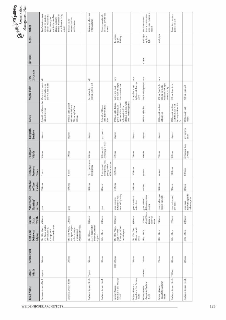
Cons
erva
tion
Man
agem
ent P
lan
��� Weidenhofer architects
Road
Nam
eSt
reet
W
idth
Stor
mw
ater
Kerb
and
Dri
vew
ay
Edgi
ng
Natu
re
Stri
p W
idth
Natu
re S
trip
Pl
antin
g/
Surf
ace
Dist
ance
to
Tre
e Ce
ntre
s
Dist
ance
be
twee
n Tr
ees
Foot
path
W
idth
Foot
path
Su
rfac
eLa
nes
Stob
ie P
oles
Fire
H
ydra
nts
Serv
ices
Sign
sO
ther
Lanc
aste
r Ave
nue -
Nor
th6
pace
s28
0mm
20 x
150
x 90m
m,
over
3 p
ace l
engt
hs,
kerb
cont
inuo
us,
ie n
o ap
rons
at
bitu
men
driv
eway
s.
6200
mm
gras
s35
00m
m9
pace
s18
30m
mbi
tum
enBo
th si
des,
4900
mm
, dirt
w
ith st
obie
pol
esW
hen
stobi
es p
lace
d on
stre
et, p
lace
d in
lin
e with
tree
trun
ks
old
B&W
stre
et n
ames
on
stobi
es. A
t jun
ctio
n of
Wes
t Par
kway
and
Eton
Stre
ets g
rass
an
d sh
rubs
hav
e bee
n pl
ante
d in
squa
re
form
ed b
y cor
ners
of
each
allo
tmen
t bei
ng
cut o
ff.
Lanc
aste
r Ave
nue -
Sou
th28
0mm
20 x
150
x 90m
m,
over
3 p
ace l
engt
hs,
kerb
cont
inuo
us,
ie n
o ap
rons
at
bitu
men
driv
eway
s.
7200
mm
gras
s45
00m
m9
pace
s17
00m
mbi
tum
en47
00m
m w
ide,
gras
sed
with
tim
ber b
olla
rds,
750m
m h
igh
x 70
x 11
5mm
.
Bolla
rds c
an b
e re
mov
ed to
allo
w ve
hicle
acce
ss
Roch
este
r Ave
nue -
Nor
th7
pace
s 30
0mm
90 x
140m
m,
scoo
ped
apro
ns fo
r dr
ivew
ays,
bitu
men
or
pav
ers
2000
mm
gras
s10
00m
m10
-11
pace
s, so
me
inte
rpla
ntin
g18
00m
mbi
tum
enOn
nor
th si
de,
550m
m in
from
ker
bol
dCo
rner
cut o
ffs cr
eate
d w
ith K
anda
har.
Roch
este
r Ave
nue -
Sou
th30
0mm
150
x 100
mm
2100
mm
gras
s80
0mm
8 pa
ces,
som
e in
terp
lant
ing w
ith
youn
g tre
es o
f di
ffere
nt sp
ecie
s
1800
mm
with
25
0mm
gap
to fe
nce
grey
pav
ers
Both
side
s, 48
00m
m
wid
e, di
rt w
ith st
obie
po
les
Stob
ies o
n no
rth
side
set t
o lin
e up
with
tree
tr
unks
.
Salis
bury
Cre
sent
- Ka
ndah
ar to
Eas
t Par
kway
- N
orth
9000
280m
m20
x 18
0 x 7
0mm
, sli
ght s
coop
to
driv
eway
s, 53
0mm
co
ncre
te ap
ron
5550
mm
gras
s, co
nsist
ent
mat
ure t
rees
with
so
me i
nfill
plan
ting
3450
mm
1030
0mm
1600
mm
bitu
men
4700
mm
wid
e, di
rt an
d gr
avel:
3 b
olla
rds,
1 x
130m
mm
dia
m. 8
80m
m
high
unp
aint
ed, 2
x 12
00m
m h
igh
rem
ovab
le 13
0 x 1
30 b
row
n pa
inte
d
in tr
ee li
ne, b
lack
an
d wh
ite w
ritin
g of
stree
t nam
e on
side
new
Road
sign
s eg
. No
Park
ing
Salis
bury
Cre
sent
- Ka
ndah
ar to
Eas
t Par
kway
- S
outh
280m
m20
x 17
0 x 7
0mm
, 53
0mm
conc
rete
ap
ron
6000
mm
gras
s, co
nsist
ent
mat
ure t
rees
3400
mm
1070
0mm
1700
mm
bitu
men
in tr
ee li
ne, s
treet
lig
ht m
ount
ed o
n to
p (M
80)
new
Salis
bury
Cre
sent
- L
udga
te to
Kan
daha
r - N
orth
6100
mm
280m
m15
0 x 1
00m
m14
50m
m,
also
460
0mm
isl
and
in
cent
re o
f str
eet
gras
s, tre
es o
ff di
ffere
nt ty
pes a
nd
spac
ing
rand
omra
ndom
1600
mm
bitu
men
4900
mm
wid
e, di
rt1
on st
reet
alig
nmen
tne
win
lane
sro
ad si
gns
eg K
eep
Left
Cons
isten
t mat
ure
trees
in ce
ntre
nat
ure
strip
, som
e var
iatio
n of
sp
ecie
s
Salis
bury
Cre
sent
- L
udga
te to
Kan
daha
r - S
outh
370m
m15
0 x 1
00m
m13
00m
mgr
ass,
rand
om tr
ees
(mos
tly E
ucal
ypts)
1000
mm
rand
om17
00m
mbi
tum
en46
00m
m, d
irt, s
tobi
es
and
serv
ices
400m
m fr
om k
erb,
com
ing o
ut in
line
w
ith la
ne, M
80 li
ght
mou
nted
on
top
new
road
sign
s
Roch
este
r Ave
nue -
Nor
th74
00m
m28
0mm
150
x 100
mm
1950
mm
gras
s, m
atur
e and
ne
w tre
es90
0mm
1000
0mm
1800
mm
bitu
men
4800
mm
, dirt
, sto
bies
, lo
cate
d be
twee
n W
est
Park
way a
nd K
anda
har
Cr
500m
m f
rom
ker
bFa
ded
stree
t num
bers
pa
inte
d on
ker
b
Roch
este
r Ave
nue -
Sou
th28
0mm
150
x 100
mm
2100
mm
gras
s, tre
es,
inte
rpla
ntin
g of o
ld
and
new
spec
ies
800m
m81
00m
m26
0mm
gap
then
15
50m
mgr
ey co
ncre
te
pave
rs48
50m
m, d
irt an
d sto
bies
700m
m fr
om k
erb

Cons
erva
tion
Man
agem
ent P
lan
��� Weidenhofer architects
Road
Nam
eSt
reet
W
idth
Stor
mw
ater
Kerb
and
Dri
vew
ay
Edgi
ng
Natu
re
Stri
p W
idth
Natu
re S
trip
Pl
antin
g/
Surf
ace
Dist
ance
to
Tre
e Ce
ntre
s
Dist
ance
be
twee
n Tr
ees
Foot
path
W
idth
Foot
path
Su
rfac
eLa
nes
Stob
ie P
oles
Fire
H
ydra
nts
Serv
ices
Sign
sO
ther
Wes
t Par
kway
- Do
ncas
ter
to Th
e Stra
nd -E
ast
7100
mm
280m
m15
0 x 1
00m
m37
50m
mgr
ass,
cons
isten
t wh
ite ce
dars
850m
m77
00m
m20
0mm
gap
then
15
30m
mgr
ey co
ncre
te
pave
rs23
00m
m sc
oop
for
park
ing o
n ea
st sid
e of
stre
et
Wes
t Par
kway
- Do
ncas
ter
to Th
e Stra
nd -
Wes
t73
0mm
dra
in 1
750m
m
from
ker
b (p
arki
ng la
ne
betw
een)
150
x 100
mm
5000
mm
gras
s, co
nsist
ent
white
ceda
rs21
00m
m78
00m
m15
00m
mbi
tum
en50
00m
m w
ide,
3 ga
lv.
Pipe
bol
lard
s 65m
m
diam
. 830
mm
hig
h,
2 pa
inte
d wh
ite &
1
unpa
inte
d
in li
ne w
ith tr
ees
old
serv
ice p
lates
in ea
st fo
otpa
th an
d in
verg
e ne
ar w
est f
ootp
ath
road
sign
s, co
uncil
sig
ns
(clea
n up
aft
er yo
ur
dog e
tc)
yello
w bu
mps
in ce
ntre
of
road
; par
king
bay
s eit
her s
ide o
f roa
dway
. Co
rner
cut-o
ff at
The
Stra
nd in
ters
ectio
n
Wes
t Par
kway
bet
ween
Th
e Stra
nd an
d W
inds
or
Ave -
Eas
t
6900
mm
290m
m20
x 17
0 x 7
0mm
6500
mm
gras
s, co
nsist
ent
white
ceda
rs40
00m
m78
00m
m24
0mm
gap
then
15
30m
mgr
ey co
ncre
te
pave
rs6
pace
s, bi
tum
en (l
eads
to
scho
ol)
in li
ne w
ith tr
ees,
pain
ted
telec
om p
ole b
etwe
en
trees
and
foot
path
bitu
men
driv
eway
to
scho
ol
Wes
t Par
kway
bet
ween
Th
e Stra
nd an
d W
inds
or
Ave -
Wes
t
280m
m20
x 18
0 x 7
0mm
66
00m
mgr
ass,
trees
3800
mm
7500
mm
1600
mm
bitu
men
, all
but
one d
rivew
ay
bitu
men
(oth
er is
gr
avel)
6 pa
ces,
dolo
mite
, se
rvice
s run
ning
th
roug
h
in tr
ee li
ne, p
aint
ed; 1
59
00m
m fr
om k
erb
old
Wes
t Par
kway
- Po
rtla
nd
Plac
e to
The S
trand
- Ea
st65
00m
m28
0mm
20 x
175
x 75m
m,
500m
m co
ncre
te
apro
n
6600
mm
gras
s, m
atur
e tre
es o
f di
ffere
nt sp
ecie
s40
00m
m15
200m
m20
0mm
gap
then
15
30m
mgr
ey co
ncre
te
pave
rs47
00m
m, d
irt, s
ervi
ce
plat
es, d
rain
sin
lane
way
old,
in tr
ee li
nete
lecom
pol
e in
tre
e lin
eso
me i
nter
plan
ting o
f ne
w tre
es
Wes
t Par
kway
- Po
rtla
nd
Plac
e to
The S
trand
- W
est
280m
m20
x 17
0 x 7
5mm
, 50
0mm
conc
rete
ap
ron
6700
mm
gras
s, m
atur
e tre
es o
f di
ffere
nt sp
ecie
s40
00m
m76
00m
m16
00m
mbi
tum
en47
00m
m w
ide,
dirt
, 2 x
timbe
r bol
lard
s 120
0mm
hi
gh x
70 x
105m
m,
serv
ices
4400
mm
from
ker
b an
d in
lane
old
telec
om p
ole i
n la
newa
yLa
nes b
etwe
en
Lanc
aste
r and
Do
ncas
ter,
and
Lanc
aste
r and
Ro
ches
ter,
4800
mm
w
ide,
dirt
and
stobi
es an
d bo
llard
s.
Corn
er cu
toff
at W
est
Park
way/
Lanc
aste
r in
ters
ectio
n.
Wes
t Par
kway
- Sa
lisbu
ry
Cr to
Por
tland
Pl -
Eas
t56
50m
m29
0mm
20 x
150
x 90m
m,
500m
m co
ncre
te
apro
n to
driv
eway
s
1600
mm
gras
s, co
nsist
ent t
rees
650m
m10
400m
m15
0mm
gap
then
15
30m
mgr
ey co
ncre
te
pave
rs48
00m
m w
ide,
dirt
, 3
galv.
Pip
e bol
lard
s 75m
m
diam
. 950
mm
hig
h, la
rge
drai
n in
cent
re
400m
m fr
om k
erb,
also
in la
nePM
G’ p
lates
in ve
rge,
telec
om p
lates
in
foot
path
road
sign
sIsl
and
in ce
ntre
of
road
, 455
0mm
wid
e, 78
00m
m b
etwe
en tr
ees,
cent
ral s
tobi
e pol
e with
M
80 li
ght a
nd b
lack
an
d wh
ite st
reet
nam
e pa
inte
d on
Wes
t Par
kway
- Sa
lisbu
ry
Cr to
Por
tland
Pl -
Wes
t29
0mm
20 x
150
x 90m
m,
500m
m co
ncre
te
apro
n to
driv
eway
s
1870
mm
gras
s and
cons
isten
t tre
es b
ut d
iffer
ent
spec
ies f
rom
Eas
t sid
e
700m
m63
00m
m17
00m
mbi
tum
en50
00m
m w
ide,
serv
ices
run
thro
ugh,
serv
ice
plat
es in
foot
path
. Cy
clone
wire
gate
to
inte
rnal
rese
rve a
t end
in la
newa
yne
w, 2
50m
m
from
ker
bIn
tern
al re
serv
e ac
cess
ed b
y lan
e in
Wes
t sid
e of s
treet
, sto
bie p
oles
arou
nd
edge
of r
eser
ve. G
ate
to re
serv
e cyc
lone
wire
an
d ga
lv. P
ipe 1
000m
m
high
, 110
x 11
0mm
po
sts w
ith ar
ched
top
Port
land
Pla
ce -N
orth
6300
mm
290m
m14
0 x 9
0, la
rge
scoo
p to
driv
eway
s, 67
0mm
conc
rete
ap
ron
1300
mm
gras
s, yo
ung t
rees
, va
ried
spec
ies
620m
m68
00m
m15
40m
mgr
ey co
ncre
te
pave
rs to
Wes
t Pa
rkwa
y, th
e 16
60m
m b
itum
en
old
road
sign
sPa
rk en
try (
Port
land
Pl
ace R
eser
ve) w
ith
cyclo
ne w
ire fe
nce
900m
m h
igh,
curv
ed
top
posts
110
0mm
hi
gh.
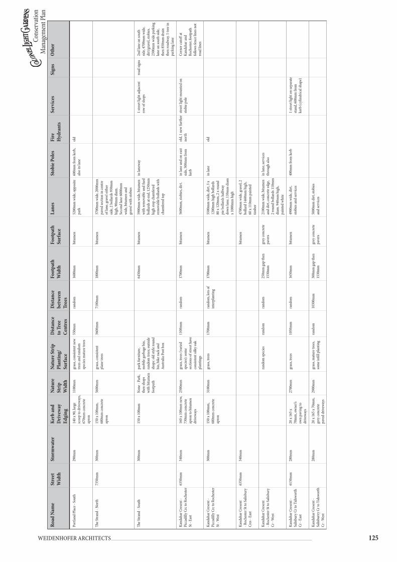
Cons
erva
tion
Man
agem
ent P
lan
��� Weidenhofer architects
Road
Nam
eSt
reet
W
idth
Stor
mw
ater
Kerb
and
Dri
vew
ay
Edgi
ng
Natu
re
Stri
p W
idth
Natu
re S
trip
Pl
antin
g/
Surf
ace
Dist
ance
to
Tre
e Ce
ntre
s
Dist
ance
be
twee
n Tr
ees
Foot
path
W
idth
Foot
path
Su
rfac
eLa
nes
Stob
ie P
oles
Fire
H
ydra
nts
Serv
ices
Sign
sO
ther
Port
land
Pla
ce -
Sout
h29
0mm
140
x 90,
larg
e sc
oop
to d
rivew
ays,
670m
m co
ncre
te
apro
n
1100
mm
gras
s, co
nsist
ent n
ew
trees
and
rand
om
spec
ies m
atur
e tre
es
550m
mra
ndom
1600
mm
bitu
men
5200
mm
wid
e, op
posit
e pa
rk60
0mm
from
ker
b, al
so in
lane
old
The S
trand
- No
rth
7350
mm
300m
m15
0 x 1
00m
m,
680m
m co
ncre
te
apro
n
5600
mm
gras
s, co
nsist
ent
plan
e tre
es36
00m
m71
00m
m18
00m
mbi
tum
en37
00m
m w
ide,
2000
mm
pa
ved
sect
ion
in ce
ntre
of
lane
, gra
vel e
ither
sid
e, 2
bolla
rds 9
30m
m
high
, 90m
m d
iam
. Se
cond
lane
600
0mm
w
ide,
bitu
men
and
grav
el w
ith st
obie
s
The S
trand
- So
uth
300m
m15
0 x 1
00m
mNo
ne -
Park
, th
en sh
ops
with
bitu
men
fo
otpa
th
park
furn
iture
, m
obile
garb
age b
in,
rand
om tr
ees;
outsi
de
shop
s: ol
d sty
le ro
und
bin,
bik
e rac
k an
d Au
stral
ia P
ost b
ox
6450
mm
bitu
men
5900
mm
wid
e, bi
tum
en
with
rem
ovab
le an
d fx
ed
bolla
rds a
t end
, 125
0mm
hi
gh st
op ch
amfe
red
rem
ovab
le bo
llard
s with
ch
amfe
red
top
in la
newa
y1
stree
t lig
ht ad
jace
nt
row
of sh
ops
road
sign
s2n
d la
ne o
n so
uth
side,
4700
mm
wid
e, di
rt/g
rave
l, sto
bies
. 23
00m
m w
ide p
arki
ng
lane
on
sout
h sid
e, th
en 8
50m
m d
rain
th
en ro
adwa
y. 1
tree i
n pa
rkin
g lan
e
Kand
ahar
Cre
sent
- Pi
ccad
illy C
rc to
Roc
heste
r St
- Ea
st
6350
mm
340m
m16
0 x 1
00m
m n
ew,
730m
m co
ncre
te
apro
n to
bitu
men
dr
ivew
ays
2500
mm
gras
s, tre
es (v
arie
d sp
ecie
s): s
ome
sect
ions
of s
treet
hav
e co
nsist
ent s
ilky o
ak
plan
tings
1100
mm
rand
om17
00m
mbi
tum
en56
00m
m, s
tobi
es, d
irt.
in la
ne an
d on
east
side,
500m
m fr
om
kerb
old,
1 n
ew fu
rthe
r no
rth
stree
t lig
ht m
ount
ed o
n sto
bie p
ole
Corn
er cu
toff
at
Kand
ahar
and
Roch
este
r, fo
otpa
th
follo
ws fe
nce l
ines
not
ro
ad li
nes
Kand
ahar
Cre
sent
- Pi
ccad
illy C
rc to
Roc
heste
r St
- W
est
300m
m15
0 x 1
00m
m,
680m
m co
ncre
te
apro
n
3100
mm
gras
s, tre
es17
00m
mra
ndom
, lots
of
inte
rpla
ntin
g17
00m
mbi
tum
en55
00m
m w
ide,
dirt
, 3 x
1200
mm
hig
h bo
llard
s 80
x 12
0mm
, 2 x
roun
d pi
e bol
lard
s hal
fway
do
wn
lane
, 110
mm
dia
m
x 100
0mm
hig
h
in la
neol
d
Kand
ahar
Cre
sent
- R
oche
ster S
t to
Salis
bury
Cr
es -
East
6350
mm
340m
mbi
tum
en47
00m
m w
ide,
grav
el, 2
bo
llard
146
0mm
hig
h,
60 x
110m
m p
aint
ed
timbe
r
Kand
ahar
Cre
sent
- R
oche
ster S
t to
Salis
bury
Cr
- W
est
rand
om sp
ecie
sra
ndom
rand
om25
0mm
gap
then
15
30m
m
grey
conc
rete
pa
vers
2100
mm
wid
e, bi
tum
en
and
dirt
, con
cret
e edg
e, 2
roun
d bo
llard
s 110
mm
di
am. 9
40m
m h
igh,
pa
inte
d wh
ite
in la
ne, s
ervi
ces
thro
ugh
also
Kand
ahar
Cre
sent
- Sa
lisbu
ry C
r to
Tids
wort
h Cr
- Ea
st
6150
mm
280m
m20
x 16
5 x
70m
m, o
wne
r’s
own
pavi
ng to
dr
ivew
ays
2700
mm
gras
s, tre
es10
50m
mra
ndom
1650
mm
bitu
men
4900
mm
wid
e, di
rt,
stobi
es an
d se
rvice
s40
0mm
from
ker
b1
stree
t lig
ht o
n se
para
te
stand
, 600
mm
from
ke
rb (c
ylin
drica
l sha
pe)
Kand
ahar
Cre
sent
- Sa
lisbu
rry C
r to
Tids
wort
h Cr
- W
est
280m
m20
x 16
5 x 7
0mm
, gr
ey co
ncre
te
pave
d dr
ivew
ays
2900
mm
gras
s, m
atur
e tre
es,
som
e infi
ll pl
antin
gra
ndom
1030
0mm
300m
m ga
p th
en
1530
mm
grey
conc
rete
pa
vers
5000
mm
dirt
, sto
bies
an
d se
rvice
s
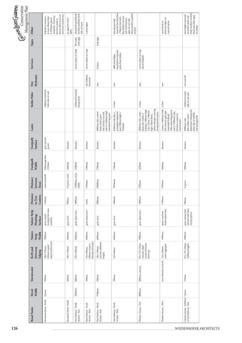
Cons
erva
tion
Man
agem
ent P
lan
��� Weidenhofer architects
Road
Nam
eSt
reet
W
idth
Stor
mw
ater
Kerb
and
Dri
vew
ay
Edgi
ng
Natu
re
Stri
p W
idth
Natu
re S
trip
Pl
antin
g/
Surf
ace
Dist
ance
to
Tre
e Ce
ntre
s
Dist
ance
be
twee
n Tr
ees
Foot
path
W
idth
Foot
path
Su
rfac
eLa
nes
Stob
ie P
oles
Fire
H
ydra
nts
Serv
ices
Sign
sO
ther
Rose
mon
t Stre
et -
Nort
h6
pace
s30
0mm
100
x 150
mm
, 63
0mm
scop
ed
apro
n to
driv
eway
s
1900
mm
gras
s, m
ostly
eu
caly
pts b
ut so
me
varia
tion
1100
mm
varie
s mar
kedl
y25
0mm
gap
then
15
30m
m
grey
conc
rete
pa
vers
1600
mm
from
ker
b, bo
th si
des o
f roa
dbo
llard
s at e
ntra
nce
to la
ne, 6
0mm
dia
m
X 10
30m
m, p
lace
d ra
ndom
ly. D
rivew
ay
has b
een
mad
e to
lane
to al
low
acce
ss to
ele
ctric
ity tr
ansfo
rmer
Rose
mon
t Stre
et -S
outh
300m
m10
0 x 1
50m
m
2800
mm
gras
s, tre
es70
0mm
4-9
pace
s, va
ries
1600
mm
bitu
men
no ap
pare
nt st
reet
lig
hts
East
Park
way -
Sou
th
Sect
ion
- Eas
t76
00m
m28
0mm
150
x 100
mm
6200
mm
gras
s, pl
ane t
rees
3400
mm
1190
0mm
, var
ies
a litt
le17
00m
mbi
tum
en32
50m
m fr
om k
erb,
facin
g stre
etse
rvice
plat
es o
n ve
rge
bus s
tops
, ro
ad si
gns
cham
fere
d to
p bo
llard
s lo
cate
d ra
ndom
ly, b
oth
sides
of s
treet
East
Park
way -
Sou
th
Sect
ion
- Wes
t30
0mm
150
x 90m
m,
580m
m sc
oop
to
bitu
men
driv
eway
s
6400
mm
gras
s, pl
ane t
rees
varie
s77
00m
m17
00m
mbi
tum
enol
d, 3
500m
m
from
ker
bse
rvice
plat
es o
n ve
rge
2 str
eet l
ight
s
East
Park
way -
Nor
th
Sect
ion
- Eas
t75
00m
m30
0mm
140
x 100
mm
co
ncre
te, 2
900m
m
lengt
hs
6300
mm
gras
s, tre
es36
00m
m10
600m
m17
00m
mbi
tum
en49
00m
m, d
irt, c
entra
l dr
ain,
stob
ies,
post
and
rail
fenc
e at r
oad
end.
4 x
1020
mm
hig
h ch
amfe
red
top
posts
new
in la
nes
road
sign
s
East
Park
way -
Nor
th
Sect
ion
- Wes
t29
0mm
150
x 90m
m
6300
mm
gras
s, tre
es35
00m
m10
700m
m17
60m
mbi
tum
en47
00m
m w
ide,
dirt
, 1
perm
apin
e unp
aint
ed
post
1200
mm
hig
h x
110d
iam
in la
nene
wM
80 st
reet
ligh
ts m
ount
ed o
n se
para
te
poles
from
stob
ies
telec
om p
ost a
nd
Austr
alia
Pos
t let
terb
ox
, 730
mm
from
ker
b.
Bus s
helte
rs o
n we
st sid
e, ‘h
ail b
us h
ere’
signs
on
east
side:
stree
t num
bers
pai
nted
on
ker
b
Flin
ders
Ave
nue -
Eas
t80
00m
m28
0mm
, con
cret
e20
x 17
0 x 7
0mm
co
ncre
te, s
light
sc
oop
to b
itum
en
driv
eway
s
3900
mm
gras
s, pl
ane t
rees
1000
mm
7700
mm
1650
mm
bitu
men
4800
mm
wid
e, ce
ntre
dr
ain,
dirt
, sto
bies
, 2
bolla
rds,
1 90
0mm
hig
h 12
0 x 7
5mm
, 1 9
00m
m
high
110
mm
dia
m.,
chai
n w
ith p
ipe c
over
ing
strun
g bet
ween
pos
ts
in la
nene
wse
rvice
plat
es in
verg
e an
d in
foot
path
Flin
ders
Ave
nue -
Wes
tno
ne (b
itum
en to
ker
b)11
0 x 1
00m
m
coar
se ag
greg
ate
4300
mm
gras
s, co
nsist
ent
mat
ure p
lane
tree
s17
00m
m77
00m
m16
00m
mbi
tum
en2
lane
s, 1
4900
mm
wid
e, di
rt, s
ervi
ces,
galv
pip
e re
mov
able
bolla
rds
with
conn
ectin
g pip
e at
end,
2: 4
700m
m w
ide,
bitu
men
scoo
ped
to
cent
ral d
rain
in la
nene
wcu
rved
ker
b to
dr
ivew
ay ed
ges,
no
conc
rete
apro
n
Linc
oln
Aven
ue -
Salis
bury
to
Eas
t Par
kway
- Ea
st5
pace
s27
0mm
20 x
170
x 20m
m,
3200
mm
leng
ths
1600
mm
gras
s, yo
ung c
lare
t as
h tre
es an
d ot
her
vario
us sp
ecie
s
700m
m11
pac
es16
00m
mbi
tum
en49
00m
m w
ide,
dirt
, sto
bies
, cen
tre
depr
essio
n ru
nnin
g int
o dr
ain,
lots
of ru
bbish
an
d un
derg
rowt
h
1450
mm
fro
kerb
, on
ly o
n ea
st sid
ene
w an
d ol
dstr
eet l
light
s mou
nted
on
stob
ies,
blac
k an
d wh
ite n
umbe
rs o
n ke
rb,
blac
k an
d wh
ite si
gns
on st
obie
s

Cons
erva
tion
Man
agem
ent P
lan
��� Weidenhofer architects
Road
Nam
eSt
reet
W
idth
Stor
mw
ater
Kerb
and
Dri
vew
ay
Edgi
ng
Natu
re
Stri
p W
idth
Natu
re S
trip
Pl
antin
g/
Surf
ace
Dist
ance
to
Tre
e Ce
ntre
s
Dist
ance
be
twee
n Tr
ees
Foot
path
W
idth
Foot
path
Su
rfac
eLa
nes
Stob
ie P
oles
Fire
H
ydra
nts
Serv
ices
Sign
sO
ther
Linc
oln
Aven
ue -
Salis
bury
to
Eas
t Par
kway
- W
est
270m
m20
x 18
0 x7
0mm
, gr
ey co
ncre
te
driv
eway
s with
50
0mm
apro
n
1200
mm
gras
s, yo
ung c
lare
t as
h w
ith p
erm
apin
e po
sts su
ppor
ting
600m
m17
pac
es, b
ut
varie
s 15
30gr
ey co
ncre
te
pave
rs48
00m
m, d
irt, s
tobi
es,
serv
ices
new
and
old
teleg
raph
pol
es an
d se
rvice
s in
ffot
path
on
west
side
#afte
r W
attle
bury
St
teleg
rph
poles
co
ntin
ue
on b
oth
sides
of
stree
t
Corn
er cu
toff
at
Linc
oln
Ave/
Eas
t Pa
rkwa
y int
erse
ctio
n,
7100
mm
verg
e and
co
nsist
ent a
sh tr
ees,
bitu
men
foot
path
Linc
oln
Aven
ue -
East
Park
way t
o Be
dfor
d Sq
uare
- No
rth
5 pa
ces
270m
m20
x 19
0 x 7
0mm
, 37
00m
m le
nght
s of
conc
rete
, no
driv
eway
s
6500
mm
gras
s, co
nsist
ent
ash
trees
4100
mm
7700
mm
420m
m ga
p th
en
1530
mm
grey
conc
rete
pa
vers
road
sign
sye
llow
bum
ps in
cent
re
of ro
ad
Linc
oln
Aven
ue -
East
Park
way t
o Be
dfor
d Sq
uare
- So
uth
280m
m20
x 17
0 x 7
5mm
, gr
avel
driv
eway
s71
00m
mgr
ass,
cons
isten
t as
h tre
es43
00m
m77
00m
m16
00m
mbi
tum
en
Bedf
ord
Squa
re -
Nort
h Se
ctio
n - N
orth
6700
mm
280m
m30
x 17
0 x 7
0mm
, sc
oope
d to
grey
co
ncre
te b
lock
dr
ivew
ays
4200
mm
gras
s, as
h tre
es16
00m
m77
00m
m30
0mm
gap
then
15
40m
mgr
ey co
ncre
te
pave
rson
corn
er o
f stre
et,
no st
reet
light
sne
wte
lecom
plat
es in
verg
epa
rkin
g/
road
sign
sin
terp
lant
ing o
f new
tre
es am
ongs
t mat
ure
trees
Bedf
ord
Squa
re -N
orth
Se
ctio
n - S
outh
290m
m20
x 19
0 x 7
0mm
74
00m
mgr
ass,
ash
trees
1800
mm
7600
mm
no fo
otpa
thne
wpa
rkin
g/
road
sign
s
Bedf
ord
Squa
re -
East
Sect
ion
- Eas
t61
50m
m29
0mm
20 x
180
x 70m
m,
conc
rete
apro
n to
dr
ivew
ays
3400
mm
gras
s, tre
es19
00m
m76
00m
m11
00m
m ga
p th
en
1560
mm
grey
conc
rete
pa
vers
alig
ned
with
fenc
esne
wro
ad si
gns
Bedf
ord
Squa
re -
East
Sect
ion
- Wes
t28
0mm
20 x
180
x 70m
m,
3200
mm
leng
ths
ofr c
oncr
ete,
larg
e sc
oop
to b
itum
en
driv
eway
s
8100
mm
gras
s, di
rt, c
onsis
tent
tre
es25
00m
m77
00m
mno
foot
path
dirt
4650
mm
wid
e, di
rt an
d sto
bies
new
road
sign
s
Bedf
ord
Squa
re -
Sout
h Ea
st Se
ctio
n - E
ast
6100
mm
280m
m20
x 18
0 x 7
0mm
, 50
0mm
conc
rete
ap
ron
to b
itum
en
driv
eway
s
4200
mm
gras
s, tre
es26
00m
m75
00m
m20
00m
mbi
tum
enno
nero
ad si
gns
Bedf
ord
Squa
re -
Sout
h Ea
st Se
ctio
n - W
est
280m
m20
x 18
0 x 7
0mm
, gr
avel
driv
eway
s, sh
allo
w sc
oop
to
driv
eway
5600
mm
gras
s, tre
es21
50m
m74
00m
mno
foot
path
gras
s
Bedf
ord
Squa
re -
Sout
h W
est S
ectio
n - E
ast
6100
mm
280m
m20
x 17
0 x 7
0mm
, 31
50m
m le
ngth
s64
50m
mgr
ass,
plan
e tre
es29
00m
m77
00m
mno
foot
path
gras
s18
00m
m fr
om k
erb
blac
k an
d wh
ite h
ouse
nu
mbe
rs o
n ke
rb
Bedf
ord
Squa
re -
Sout
h W
est S
ectio
n - W
est
300m
m20
x 18
0 x 6
0mm
, 31
50m
m le
ngth
s, 50
0mm
apro
n to
bi
tum
en d
rivew
ays
5500
mm
gras
s, pl
ane t
rees
2400
mm
7800
mm
1600
mm
bitu
men
none
road
sign
sco
rner
cuto
ff to
La
ncas
ter S
treet
/ Be
dfor
d Sq
uare
in
ters
ectio
n, 1
4000
mm
fro
m k
erb
to fe
nce
Bedf
ord
Squa
re -
Wes
t Se
ctio
n - E
ast
7300
mm
300m
m20
x 17
0 x 7
0mm
, 30
00m
m le
ngth
s83
50m
mgr
ass,
plan
e tre
es14
00m
m74
50m
mno
foot
path
in tr
ee li
ne, 1
300m
m
from
ker
b, w
ith b
lack
an
d wh
ite p
aint
ed
signs
new
road
sign
s

Cons
erva
tion
Man
agem
ent P
lan
��� Weidenhofer architects
Road
Nam
eSt
reet
W
idth
Stor
mw
ater
Kerb
and
Dri
vew
ay
Edgi
ng
Natu
re
Stri
p W
idth
Natu
re S
trip
Pl
antin
g/
Surf
ace
Dist
ance
to
Tre
e Ce
ntre
s
Dist
ance
be
twee
n Tr
ees
Foot
path
W
idth
Foot
path
Su
rfac
eLa
nes
Stob
ie P
oles
Fire
H
ydra
nts
Serv
ices
Sign
sO
ther
Bedf
ord
Squa
re -
Wes
t Se
ctio
n - W
est
270m
m20
x 17
0 x 8
0mm
co
ncre
te43
00m
mgr
ass,
trees
1700
mm
7700
mm
1700
mm
bitu
men
new
road
sign
s
Ludg
ate C
ircus
- Ea
st9
pace
s36
0mm
varie
s, 10
0 x
100m
m to
100
x 15
0mm
, sco
op
to d
rivew
ay 7
80
- 800
mm
conc
rete
ap
ron
sout
h en
d - n
one,
nort
h en
d - 1
000m
m
sout
h en
d - b
itum
en
with
soft
squa
re
arou
nd tr
ees,
nort
h en
d - g
rass
, you
ng
plan
e tre
es
Sout
h -
1050
mm
, nor
th
- 500
mm
varie
s dep
endi
ng
on d
rivew
ay
loca
tion
vario
us, 1
800m
m at
so
uth
end,
300
0mm
in
sect
ions
, 155
0mm
at
nor
th en
d
bitu
men
none
road
sign
s
Ludg
ate C
ircus
- W
est
100
x 150
mm
, sc
oop
to d
rivew
ays
on re
serv
e sid
e on
ly
no n
atur
e str
ipal
l res
erve
rand
omly
pl
ante
d tre
esno
foot
path
stree
tligh
ts (M
80 ty
pe)
mou
nted
on
met
al
poles
, no
stobi
e pol
es
Tidw
orth
Cre
sent
- No
rth
5 pa
ces
280m
m25
x 18
5 x 6
0mm
, sli
ght s
coop
to
driv
eway
s with
52
0mm
conc
rete
ap
ron
2700
mm
gras
s, va
riety
of
trees
- Eu
caly
pts,
jaca
rand
as -
very
pa
tchy
1300
mm
10 p
aces
but
ch
ange
s with
new
an
d ol
d pl
antin
gs
1530
mm
grey
conc
rete
pa
vers
no la
nes e
vide
ntol
d an
d ne
wro
ad si
gns
Tidw
orth
Cre
sent
- So
uth
280m
m20
x 19
0 x 7
0mm
, 52
0mm
apro
n to
dr
ivew
ays
2700
mm
gras
s, m
ix o
f new
/ ol
d, n
ativ
e/ n
on
nativ
e tre
es
1500
mm
rand
om17
30m
mbi
tum
enno
lane
s evi
dent
1 sto
bie o
n so
uth
side
old
and
new
road
sign
slig
ht fi
tting
s on
met
al
polie
s (no
t sto
bies
) at
weste
rn en
d of
stre
et
The G
rove
- No
rth
8 pa
ces
280m
m co
ntin
uous
co
ncre
te90
x 15
0mm
with
66
0mm
scoo
p an
d co
ncre
te ap
ron
to
driv
eway
3700
mm
gras
s, co
nsist
ent
mat
ure t
rees
with
se
rrat
ed ed
ges(
??),
som
e int
erpl
antin
g
1100
mm
10 p
aces
16
50m
mbi
tum
enno
lane
s evi
dent
1 in
line
with
tree
s, on
corn
er o
f stre
etol
dro
ad si
gns
end
of su
burb
occ
urs
half
way a
long
the
stree
t
The G
rove
- So
uth
300m
m10
0 x 1
50m
m
with
680
mm
wid
e sc
oop
and
conc
rete
ap
ron
3800
mm
gras
s, m
atur
e tre
es;
som
e res
iden
ts ha
ve
plan
ted
diffe
rent
sp
ecie
s out
side t
heir
hous
es
700m
m6
pace
s bet
ween
ne
w sa
plin
gs,
som
e old
er tr
ees
miss
ing
1700
mm
bitu
men
no la
nes e
vide
nton
corn
er o
f Eas
t Pa
rkwa
yol
dte
legra
ph p
ole m
odel
M80
D97
road
sign
s
Salis
bury
Cre
sent
- Ea
st Pa
rkwa
y to
Gran
ge R
d - E
ast
8 pa
ces
290m
m co
ntin
uous
co
ncre
te20
x 17
0 x 7
0mm
, ve
ry sl
ight
scoo
p to
dr
ivew
ay
5500
mm
gras
s, co
nsist
ent
big t
rees
3600
mm
11 p
aces
1700
mm
bitu
men
loca
ted
on ea
st sid
e of
road
, mid
way i
n tre
e lin
e, pa
inte
d sig
ns o
n th
em
stree
tligh
ts on
stob
ie
poles
, Tels
tra p
lates
in
verg
e
road
sign
sCo
rner
cuto
ff at
Li
ncol
n Av
e/ S
alisb
ury
Cr, h
as re
d br
ick ed
ged
curv
ed fl
ower
bed
s on
both
side
s of r
oad.
Also
co
rner
cuto
ff at
Eas
t Pa
rkwa
y/ S
alisb
ury
Cr in
ters
ectio
n (3
way
in
ters
ectio
n)
Salis
bury
Cre
sent
- Ea
st Pa
rkwa
y to
Gran
ge R
d - W
est
280m
m30
x 18
0 x 7
5mm
co
ntin
uous
co
ncre
te, s
light
sc
oop
to d
rivew
ays
5700
mm
gras
s, co
nsist
ent
mat
ure t
rees
but
with
so
me i
nter
plan
ting
3230
mm
10 p
aces
170m
m ga
p th
en
1530
mm
grey
conc
rete
pa
vers
4400
mm
wid
e, di
rt an
d gr
avel,
stob
ie p
oles
to
rear
of l
ane;
serv
ices
runn
ing t
hrou
gh
none
on
weste
rn si
deIn
som
e int
erse
ctio
ns
betw
een
Salis
bury
and
othe
r stre
ets,
bum
ps in
ce
ntre
of r
oad
Wat
tlebu
ry R
oad
- Nor
th8
pace
s30
0mm
cont
inuo
us
conc
rete
100
x 150
mm
co
ncre
te w
ith
680m
m co
ncre
te
apro
n an
d pr
onou
nced
scoo
p to
driv
eway
s
3900
mm
gras
s, co
nsist
ent
mat
ure t
rees
1500
mm
10 p
aces
1800
mm
bitu
men
lane
mar
king
end
of
subu
rb n
orth
side
on
road
, 9 p
aces
wid
e and
ha
s lar
ger t
han
norm
al
stobi
es
none
on
nort
h sid
e of
road
road
sign
sco
rner
cuto
ff at
W
attle
bury
and
Linc
oln

Cons
erva
tion
Man
agem
ent P
lan
��� Weidenhofer architects
Road
Nam
eSt
reet
W
idth
Stor
mw
ater
Kerb
and
Dri
vew
ay
Edgi
ng
Natu
re
Stri
p W
idth
Natu
re S
trip
Pl
antin
g/
Surf
ace
Dist
ance
to
Tre
e Ce
ntre
s
Dist
ance
be
twee
n Tr
ees
Foot
path
W
idth
Foot
path
Su
rfac
eLa
nes
Stob
ie P
oles
Fire
H
ydra
nts
Serv
ices
Sign
sO
ther
Wat
tlebu
ry R
oad
- Sou
th30
0mm
100
x 150
mm
co
ncre
te w
ith
680m
m co
ncre
te
apro
n an
d pr
onou
nced
scoo
p to
driv
eway
s
3400
mm
gras
s, co
nsist
ent
mat
ure t
rees
1000
mm
10 p
aces
1800
mm
bitu
men
at re
ar o
f blo
ck25
00m
m fr
om k
erb
York
Pla
ce -
East
5 pa
ces
300m
m co
ntin
uous
co
ncre
te20
x 18
0 x 6
5mm
w
ith sl
ight
scoo
p to
bi
tum
en d
rivew
ays
2900
mm
dirt
, ver
y lar
ge ca
rob
trees
13 p
aces
1300
mm
bitu
men
5 pa
ces w
ide,
dirt
only
on
east
side
of st
reet
road
sign
s
York
Pla
ce -
Wes
t28
0mm
20 x
170
x 70m
m
2950
mm
leng
ths o
f co
ncre
te
2900
mm
gras
s, co
nsist
ent
larg
e tre
es11
00m
m15
pac
es16
00m
mbi
tum
enlea
ds to
inte
rnal
rese
rve,
gras
s and
youn
g tre
esno
ne o
n we
st sid
e of
stre
etro
ad si
gns
Her
efor
d Pl
ace -
Eas
t7
pace
s no
ne (b
itum
en to
ker
b)80
x 12
0mm
old
co
ncre
te w
ith
aggr
egat
e pie
ces,
roun
ded
to
driv
eway
edge
s
800m
mdi
rt
no tr
ees o
n ea
st sid
e14
30m
mbi
tum
en5
pace
s wid
e, di
rt20
0mm
from
ker
bro
ad si
gns
sout
hern
end
of th
e str
eet i
s ent
ranc
e to
Read
e Par
k La
wn
Tenn
is Cl
ub
Her
efor
d Pl
ace
- Wes
tno
ne (b
itum
en to
ker
b)11
0 x 1
30m
m
conc
rete
aggr
egat
e, no
driv
eway
s but
cu
rved
sect
ion
to
lane
way e
ntra
nce
300m
mdi
rtno
ne16
70m
mbi
tum
enwe
stern
end
is bi
tum
en
with
cent
ral d
rain
none
on
weste
rn si
dero
ad si
gns
Broa
dway
- No
rth
Sect
ion-
Eas
t41
00m
mgr
ass
none
no fo
otpa
th2
stobi
es at
nor
ther
n en
d of
stre
etce
ntra
l isla
nd 8
300m
m
wid
e, no
ker
bing
, sto
bie
poles
and
road
sign
s in
isla
nd
Broa
dway
- No
rth
Sect
ion
- Wes
t53
50m
m27
5mm
20 x
90 x
70m
m,
3000
mm
leng
ths,
no sc
oop
to
driv
eway
s
4200
mm
gras
sno
tree
s at
nort
hern
end
varie
s, 90
00
- 120
00m
mno
foot
path
4900
mm
, dirt
, pile
s of
dum
ped
vege
tatio
nin
lane
cent
ral i
sland
830
0mm
w
ide,
no k
erbi
ng, s
tobi
e po
les an
d ro
ad si
gns
in is
land
Broa
dway
- Ce
ntra
l Se
ctio
n - E
ast
6500
mm
290m
m20
x 19
0 x 7
0mm
, 26
50m
m le
ngth
s, sli
ght s
coop
to
bitu
me d
rivew
ays
2400
mm
gras
s, tre
es95
0mm
1740
0mm
, no
driv
eway
s16
00m
mbi
tum
en49
00m
m, b
itum
en w
ith
drai
n ru
nnin
g thr
ough
ce
ntre
(dra
in 9
00m
m
wid
e)
in la
ne
Broa
dway
- Ce
ntra
l Se
ctio
n - W
est
1400
mm
bitu
men
4900
mm
dirt
and
stobi
esne
w
Broa
dway
- So
uth
Sect
ion
- Eas
t70
00m
m30
0mm
100
x 180
mm
co
arse
aggr
egat
e, cu
rved
to d
rivew
ay
edge
s
9600
mm
gras
s, tre
es67
50m
m93
00m
m13
00m
mbi
tum
enro
ad si
gns
Broa
dway
- So
uth
Sect
ion
- Wes
t29
0mm
20 x
190
x 70m
m,
chan
ges t
o 80
x 15
0mm
coar
se
aggr
egat
e str
ip
for l
ast (
mos
t so
uthe
rly) s
ectio
n
9500
mm
gras
s, tre
es90
00m
m17
00m
mbi
tum
enro
ad si
gns
cent
ral s
ectio
n of
ro
ad o
n we
stern
side
fro
nts s
mal
l res
erve
: no
storm
wate
r or k
erb,
Picc
adill
y Circ
us
- Goo
dwoo
d to
Do
ncas
ter -

��0 Weidenhofer architects
Conservation Management Plan
APPenDIX 2 - the BURRA ChARteR

���
Conservation Management Plan
Weidenhofer architects

��� Weidenhofer architects
Conservation Management Plan

���
Conservation Management Plan
Weidenhofer architects

��� Weidenhofer architects
Conservation Management Plan
���
Conservation Management Plan
Weidenhofer architects

��� Weidenhofer architects
Conservation Management Plan

���
Conservation Management Plan
Weidenhofer architects

��� Weidenhofer architects
Conservation Management Plan

���
Conservation Management Plan
Weidenhofer architects

��0 Weidenhofer architects
Conservation Management Plan