COLLABORATIVE NEGOTIATION AS A GEODESIGN … · x DESIGN PROFESSIONS GEOGRAPHIC SCIENCES o o Carl...
89
The generic problem---- How do we organize and conduct the very beginning and strategic stages of designing for longer-term change in a large, multi-system, multi-client and contentious context .….and one which should not become a zero-sum game? This is very frequently the normal situation for important projects and studies. This is what geodesign should be doing ! COLLABORATIVE NEGOTIATION AS A GEODESIGN METHOD Carl Steinitz
Transcript of COLLABORATIVE NEGOTIATION AS A GEODESIGN … · x DESIGN PROFESSIONS GEOGRAPHIC SCIENCES o o Carl...

The generic problem----
How do we organize and conduct the very beginning and strategic stages of designing for longer-term change in a large, multi-system, multi-client and contentious context .….and one which should not become a zero-sum game?
This is very frequently the normal situation for important projects and studies.
This is what geodesign should be doing !
O
COLLABORATIVE NEGOTIATION AS A GEODESIGN METHOD
Carl Steinitz

.
o o
o
o
o
0
O O
COLLABORATIVE NEGOTIATION AS A GEODESIGN METHOD

.
o o
o
o
o
0
O O
COLLABORATIVE NEGOTIATION AS A GEODESIGN METHOD
Norbert Weiner 1894 - 1964

.
o o
o
o
o
0
“Geodesign applies systems thinking to the creation of
proposals for change and their impact simulations,
informed their geographic contexts, and usually supported
by digital technology.”
Tess Canfield after Carl Steinitz after Stephen Ervin after Michael Flaxman
"Geodesign changes geography by design“
Carl Steinitz
adapted from C.Steinitz, 2012, A Framework for Geodesign , preface
o
O
COLLABORATIVE NEGOTIATION AS A GEODESIGN METHOD

.
o o
“Geodesign” is an invented word, and a very useful
term to describe a collaborative activity that is not the
exclusive territory of any design profession,
geographic science or information technology.
Each participant must know and be able to contribute
something that the others cannot or do not. …….
yet during the process, no one need lose his or her
professional, scientific or personal identity.
0
adapted from C.Steinitz, 2012, A Framework for Geodesign , preface
o
O
COLLABORATIVE NEGOTIATION AS A GEODESIGN METHOD

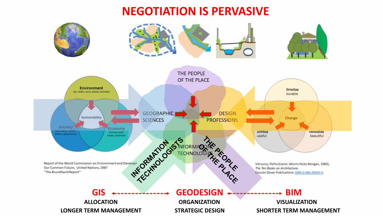
Development
0
O GEOGRAPHIC SCIENCES DESIGN PROFESSIONS GEODESIGN IS COLLABORATION AND NEGOTIATION
O
0
GIS GEODESIGN BIM ALLOCATION ORGANIZATION VISUALIZATION
LONGER TERM MANAGEMENT STRATEGIC DESIGN SHORTER TERM MANAGEMENT
O O
COLLABORATIVE NEGOTIATION AS A GEODESIGN METHOD
SUPPLY-BASED DEMAND-BASED “DEFENSIVE” STRATEGIES “OFFENSIVE” STRATEGIES

COLLABORATIVE NEGOTIATION AS A GEODESIGN METHOD
ESRI Press 2012

COLLABORATIVE NEGOTIATION AS A GEODESIGN METHOD
ESRI Press 2012

COLLABORATIVE NEGOTIATION AS A GEODESIGN METHOD
ESRI Press 2012
THE FRAMEWORK IS NEVER LINEAR IN APPLICATION

O
COLLABORATIVE NEGOTIATION AS A GEODESIGN METHOD
ESRI Press 2012

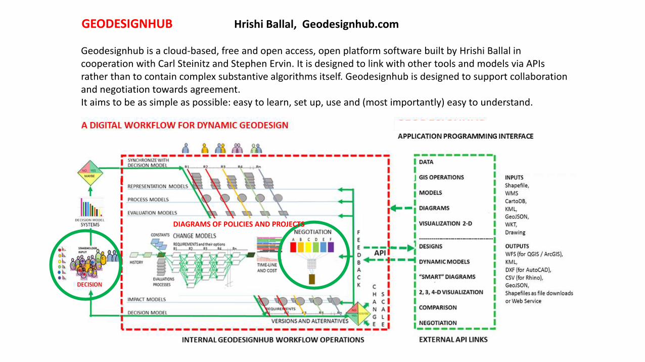
GEODESIGNHUB Hrishi Ballal, Geodesignhub.com
Geodesignhub is a cloud-based, free and open access, open platform software built by Hrishi Ballal in cooperation with Carl Steinitz and Stephen Ervin. It is designed to link with other tools and models via APIs rather than to contain complex substantive algorithms itself. Geodesignhub is designed to support collaboration and negotiation towards agreement. It aims to be as simple as possible: easy to learn, set up, use and (most importantly) easy to understand.
0
DIAGRAMS OF POLICIES AND PROJECTS
GEODESIGNHUB Hrishi Ballal, Geodesignhub.com
Geodesignhub is a cloud-based, free and open access, open platform software built by Hrishi Ballal in cooperation with Carl Steinitz and Stephen Ervin. It is designed to link with other tools and models via APIs rather than to contain complex substantive algorithms itself. Geodesignhub is designed to support collaboration and negotiation towards agreement. It aims to be as simple as possible: easy to learn, set up, use and (most importantly) easy to understand.
0 0
DIAGRAMS OF POLICIES AND PROJECTS

0
PROJECTS AND STUDIES ON THE GEODESIGNHUB PLATFORM
GEODESIGNHUB Hrishi Ballal, Geodesignhub.com
0

TRANSFORMING THE “CITTA DEL SALUTE TORINO” Stefano Pensa et al, Turin Polytechnical University
TRANSFORMING THE “CITTA DEL SALUTE TORINO” Stefano Pensa et al, Turin Polytechnical University
o
"Molinette“: TRANSFORMING THE CITTA DEL SALUTE TORINO Stefano Pensa et al, Turin Polytechnical University
o o

. . x
.
GEOGRAPHIC SCIENCES DESIGN PROFESSIONS
o
o
Carl Steinitz, Notes on Geodesign Dynamics, October 2015
.O.
There are IMPORTANT PROBLEMS and—frequently—
there is LITTLE TIME FOR DECISION AND ACTION.
PEOPLE/GROUPS HAVE DIFFERENT INTERESTS AND PRIORITIES.
EACH seeks/NEEDS LEGITIMACY in/via design.
GEODESIGN does NOT normally produce A FINAL PRODUCT.
IT IS LIKELY TO MOST USEFUL AT THE BEGINNING
of thinking about and deciding on
THE STRATEGY of what to do….
GEODESIGN IS SERIOUS
o

. . x
.
GEOGRAPHIC SCIENCES DESIGN PROFESSIONS
o
o
Carl Steinitz, Notes on Geodesign Dynamics, October 2015
.O.
o 0
THERE ARE UNCERTAINTIES:
Multiple GEOGRAPHIC SCOPES: political boundaries, watersheds, etc.
Complex CONTENT: SYSTEMS which vary by size, location, threat, etc.
CHANGE REQUIREMENTS are many.
GEODESIGN METHODS do not scale and do not exactly-repeat.
THEY SHOULD FIT THE CONTEXT.
Therefore GEODESIGN and its technical support must be
FLEXIBLE, ITERATIVE, TRANSPARENT AND RAPID.
GEODESIGN IS COMPLEX
O
.O. GEODESIGN IS COMPLEX

. . x
.
GEOGRAPHIC SCIENCES DESIGN PROFESSIONS
o
o
Carl Steinitz, Notes on Geodesign Dynamics, October 2015
.O. GEODESIGN IS DYNAMIC
o
O O
CHANGE in a design is a RELATIONAL SYNTHESIS in SPACE and TIME
of SETS of system-based POLICIES AND PROJECTS
….AND THE SEQUENCE MATTERS.
DESIGN(S) SHOULD BE ASSESSED AND ITERATIVELY IMPROVED,
KNOWING THAT ANY CHANGE CHANGES ALL THE SYSTEMS.
Therefore, a primary aim of GEODESIGN is to RAPIDLY MOVE from infinite
possible designs towards an socially, environmentally and economically
FEASIBLE DECISION.
THE GEODESIGN ENDGAME MUST SUPPORT INFORMED NEGOTIATION.
.O. GEODESIGN IS DYNAMIC

. . x
.
GEOGRAPHIC SCIENCES DESIGN PROFESSIONS
o
o
Carl Steinitz, Notes on Geodesign Dynamics, October 2015
.O. GEODESIGN IS COMMUNICATION
o
O
GEODESIGN is likely to be COLLABORATIVE.
Therefore--
ALL ASPECTS OF GEODESIGN SUPPORT MUST BE EASILY LEARNED,
EASILY USED AND EASILY COMMUNICATED --and most importantly--
THE “LANGUAGE” of GEODESIGN MUST BE EASILY UNDERSTOOD BY ALL.
GEODESIGN IS A COLLABORATIVE,
SOCIAL- POLITICAL PROCESS OF DESIGN.
.O. GEODESIGN IS COLLABORATIVE

NEGOTIATION IS PERVASIVE
0
O
O
O O O 0
GIS GEODESIGN BIM ALLOCATION ORGANIZATION VISUALIZATION
LONGER TERM MANAGEMENT STRATEGIC DESIGN SHORTER TERM MANAGEMENT

Development
NEGOTIATION IS PERVASIVE
0
O GEOGRAPHIC SCIENCES DESIGN PROFESSIONS
SUPPLY-BASED DEMAND-BASED “DEFENSIVE” STRATEGIES “OFFENSIVE” STRATEGIES
GEODESIGN IS COLLABORATION AND NEGOTIATION
O O
0
GIS GEODESIGN BIM ALLOCATION ORGANIZATION VISUALIZATION
LONGER TERM MANAGEMENT STRATEGIC DESIGN SHORTER TERM MANAGEMENT

Change
NEGOTIATION IS PERVASIVE
0
O O
0
GIS GEODESIGN BIM ALLOCATION ORGANIZATION VISUALIZATION
LONGER TERM MANAGEMENT STRATEGIC DESIGN SHORTER TERM MANAGEMENT

Change
NEGOTIATION IS PERVASIVE
0
O O
0
GIS GEODESIGN BIM ALLOCATION ORGANIZATION VISUALIZATION
LONGER TERM MANAGEMENT STRATEGIC DESIGN SHORTER TERM MANAGEMENT
Change
NEGOTIATION IS PERVASIVE
0
O O
0
GIS GEODESIGN BIM ALLOCATION ORGANIZATION VISUALIZATION
LONGER TERM MANAGEMENT STRATEGIC DESIGN SHORTER TERM MANAGEMENT

Change
NEGOTIATION IS PERVASIVE
0
O O
0
GIS GEODESIGN BIM ALLOCATION ORGANIZATION VISUALIZATION
LONGER TERM MANAGEMENT STRATEGIC DESIGN SHORTER TERM MANAGEMENT

Change
NEGOTIATION IS PERVASIVE
0
O O
0
GIS GEODESIGN BIM ALLOCATION ORGANIZATION VISUALIZATION
LONGER TERM MANAGEMENT STRATEGIC DESIGN SHORTER TERM MANAGEMENT

WHY APPLY GEODESIGN IN A COLLABORATIVE WORKSHOP FORMAT ?
0
O O O
• WHEN WORKING THROUGH A FRAMEWORK IN ORDER TO UNDERSTAND IT
• WHEN APPLYING GEODESIGN AND THERE IS LITTLE TIME AND SMALL DATA
• WHEN STARTING FAST TO IDENTIFY CENTRAL ISSUES AND OPTIONS
• WHEN IT TAKES A DESIGN TO KNOW WHAT THE QUESTIONS REALLY ARE
• WHEN IT TAKES A DESIGN TO KNOW WHAT IS REALLY WANTED
O
GIS GEODESIGN BIM ALLOCATION ORGANIZATION VISUALIZATION
LONGER TERM MANAGEMENT STRATEGIC DESIGN SHORTER TERM MANAGEMENT

O
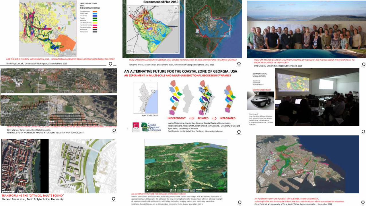
The Eastern Suburbs, Iron Mining in Minas Gerais, The Georgia Coastal Zone, Sydney, Australia Brazil U S A Chris Pettit et al Ana Clara Moura et al Rosanna Rivero, Brian Orland et al
NO YES
WAYS TO ORGANIZE GEODESIGN TOWARDS A NEGOTIATED AGREEMENT
0
O
2017 GEODESIGN SUMMIT, REDLANDS, CA, USA https://youtu.be/QERJbL9J1Xw

AN ALTERNATIVE FUTURE FOR EASTERN SUBURBS, SYDNEY, AUSTRALIA, Chris Pettit et. al., University of New South Wales, Sydney, Australia November 2016
o


Approximate land area of study site: 5553 ha (ABS 2014)
Assumptions •Sydney’s population is set to grow from 4.7 million (as of 2012) to 7.9 million by 2050 based on the largest population projection scenario for NSW (ABS 2013)
•Projected changes within the study area: •180,000 additional dwellings needed between 2016 and 2050 in the Eastern Suburbs to serve an added 360,000 population. •Increase in younger population and cultural diversity is expected due to overseas migration
•25% of the population would be people of 65 years and over, while children of 0-14 years of age could make up 16-18%. •While the Eastern part of the study area may be relatively unaffected by rise in sea level due to its topography, low-lying areas in the Western part of the study area may experience more nuisance flooding. •Kingsford Smith Airport will become domestic, with international commercial flights and most air freights moved to Western Sydney Airport •Growth of High Value Industry drives demand for a new university/expansion of UNSW. •The hospital will also expand. •There is a need to remake the region’s “Green Infrastructure” and “Blue infrastructure”.
ASSUMPTIONS AND THE PROBLEM STATEMENT THE SYDNEY REGIONAL POLICIES PERSPECTIVE
O
o
References ABS data Greater Sydney Plan and District Plans 30 minute city – Federal Government Eastern Suburbs Economic Profile - SGS Economics and Planning

HOW?
O
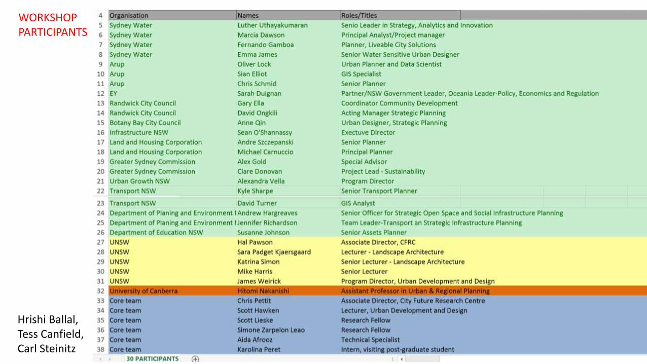
WORKSHOP PARTICIPANTS
O
Hrishi Ballal, Tess Canfield, Carl Steinitz

EVALUATION MODELS
O
O
PRE-WORKSHOP PREPARATION

System Description Additional provision needed (ha)
MDH – Medium Density
Housing
New medium density housing
of 4-7 storeys accommodating
200 persons/ha
900 ha
HDH – High Density Housing New high density housing of 8-
25 storeys accommodating 800
persons/ha
300 ha
PTRANS – Public transport Train and light rail
development
15 ha (15km length x 10m width)
ATRANS – Active Transport Cycling infrastructure 50 ha (100km length x 5m width)
GINFRA – Green Infrastructure Installing elements of urban
greenery; e.g. rain gardens,
green roofs
700 ha
COMIND – Commerce and
Industry
Commercial/industrial
development
200 ha
BINFRA – Blue Infrastructure Swales, green space for
promoting water sensitive
urban design
400 ha
EDU – Education Development/expansion of
Primary/secondary/tertiary
education facilities
200 ha
TOUR – Tourism Developing new points of
interest for recreation and
entertainment, and/or
expanding tourist areas
200 ha
Year 2016a Year 2050b
Population 407250 770000
Number of households 184850 360000
SYSTEM REQUIREMENTS BY YEAR 2050
O O
PRE-WORKSHOP PREPARATION

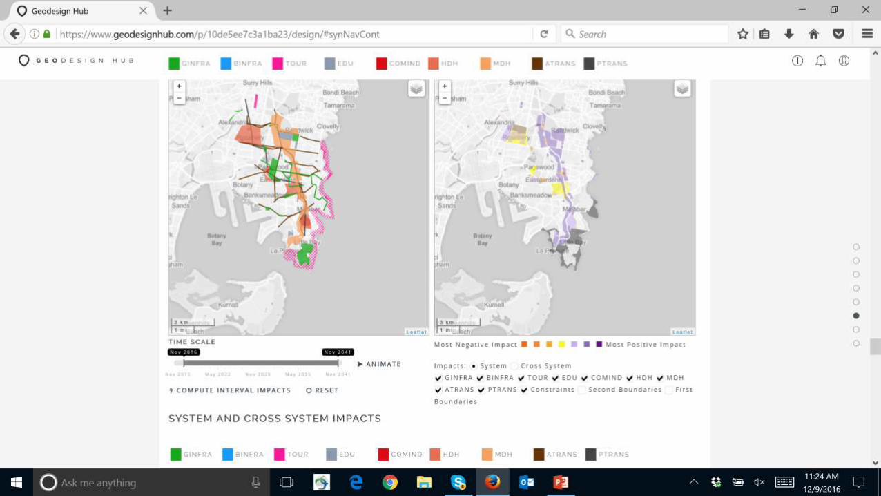
SYSTEM IMPACTS MODEL FORMAT
O
O
PRE-WORKSHOP PREPARATION

CROSS-SYSTEMS IMPACT MODEL
O
O
PRE-WORKSHOP PREPARATION

http://yoursay.infrastructurevictoria.com.au/30-year-strategy/application/files/1714/7546/2887/SGS_
Economics_and_Planning_-_Comparative_costs_of_infrastructure_across_different_development_settings.PDF
SYSTEM UNIT COSTS SYSTEM UNIT COSTS
Seattle $US Sydney $US
w/refs Greenfield CP, CS Urban Redevelopment
1 CRITICAL AREAS 3000/ac 1 GREEN INFRA 1,000,000/mile, 10,000/ac
2 SURFACE WATER 3000/ac 2 BLUE INFRA 1,000,000/mile, 50,000/ac, 10,000,000/fac
3 GROUNDWATER 30,000/ac 3 TOURISM 1,000,000/ac
4 FORESTRY 10,000/ac 4 EDUCATION 25,000,000/fac
5 AGRICULTURE 10/000/ac 5 COM, IND 16,000,000/fac, 4,000,000/ac
6 LOW DENS HOUSING 600,000/ac 6 HIGH DENS HSG 22,,000,000/ac
7 HIGH DENS HSG 6,000,000/ac 7 MED DENS HSG 12,000,000/ac
8 COM, IND, INST 9,000,000/ac 8 AUTO TRANS 1,500,000/lane mile
9 UTILITY INFRASTR 130,000/ac 9 PED TRANS 300,000, lane mile
10 TRANSPORT 2,000,000/lane mile
add 50% of value of prior use if taken
http://yoursay.infrastructurevictoria.com.au/30-year-strategy/application/files/1714/7546/2887/SGS_
Economics_and_Planning_-_Comparative_costs_of_infrastructure_across_different_development_settings.PDF
SYSTEM UNIT COSTS SYSTEM UNIT COSTS
Seattle $US Sydney $ US from $ AUS
w/refs Greenfield CP, CS Urban Redevelopment
1 CRITICAL AREAS 3000/ac 1 GREEN INFRA 1,000,000/mile, 10,000/ac
2 SURFACE WATER 3000/ac 2 BLUE INFRA 1,000,000/mile, 50,000/ac, 10,000,000/fac
3 GROUNDWATER 30,000/ac 3 TOURISM 1,000,000/ac
4 FORESTRY 10,000/ac 4 EDUCATION 25,000,000/fac
5 AGRICULTURE 10/000/ac 5 COM, IND 16,000,000/fac, 4,000,000/ac
6 LOW DENS HOUSING 600,000/ac 6 HIGH DENS HSG 22,,000,000/ac
7 HIGH DENS HSG 6,000,000/ac 7 MED DENS HSG 12,000,000/ac
8 COM, IND, INST 9,000,000/ac 8 AUTO TRANS 1,500,000/lane mile
9 UTILITY INFRASTR 130,000/ac 9 PED TRANS 300,000, lane mile
10 TRANSPORT 2,000,000/lane mile
add 50% of value of prior use if taken
COSTS MODEL (based on Seattle, WA, USA)
PRE-WORKSHOP PREPARATION

30 November 2016: Pre-workshop Geodesign team Tour of Study Area 17:30 – 19:30 Public Lecture by Carl Steinitz 1 December 2016: Workshop Day One 08:30 – 09:00 Set up and connect to Geodesignhub 09:00 – 09:45 Personal Introductions and Description of Study Area and Organization of Workshop 09:45 – 09:50 Pre-workshop Survey 10:00 – 10:30 Geodesignhub tutorial 10:30 – 12:15 System teams make at least 10 diagrams of policies and projects 12:15 – 12:30 Form Change-design teams 12:30 – 13:30 Lunch 13:30 – 13 50 Geodesignhub tutorial 13:50 – 15:00 Create Decision model and Change design Version 1, assess Impacts, independently 15:00 – 16:30 Create Change design Version 2, assess Impacts, Independently 16:30 – 17:30 Timeline, cost and 3-D 2 December 2016: Workshop Day Two 09:00 -- 10:00 Presentations of Change designs Version 2 10:00 – 12:30 Create Change design Version 3, with negotiation as needed, assess Impacts and cost, and make Timeline 12:00 -- 13:00 Lunch 13:00 – 13:30 Presentations 13:30 – 14:00 Comparision and Negotiation tools 14:00 – 14:30 Sociogram and Negotiation strategy 14:30 – 15:30 First Negotiation round , create Versions 4, assess Impacts and costs, staging and 3-D 15:30 – 17:00 Final Negotiation round, create Verion 5 in public, assess Impacts and costs, staging and 3-D 17:00 – 17:30 Discussion and END 17:30 – 18:00 Post-workshop survey and debrief participants
o
O
PRE-WORKSHOP PREPARATION
WORKSHOP SCHEDULE

WHAT? WHERE? WHEN?
O

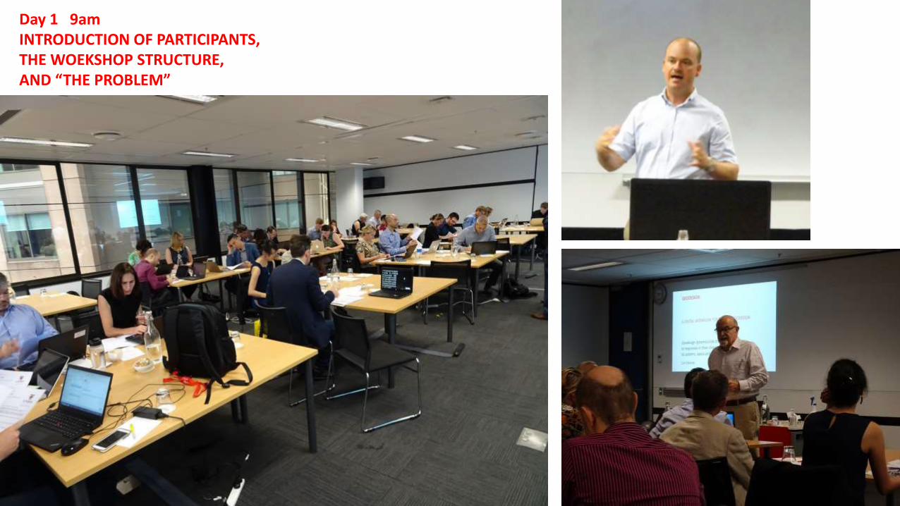
Day 1 9am INTRODUCTION OF PARTICIPANTS, THE WOEKSHOP STRUCTURE, AND “THE PROBLEM”

Day 1 10am TUTORIAL: EVALUATION MODELS AND DIAGRAMS OF POLICIES AND PROJECTS


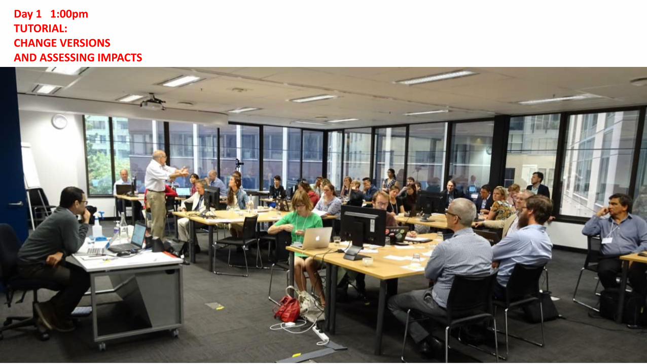
Day 1 1:00pm TUTORIAL: CHANGE VERSIONS AND ASSESSING IMPACTS
O

Environmental Sustainabilty and Resilience: Economic and population growth will continue to put pressure on resources, and climate change would lead to sea level rise and extreme weather. The study area may see increased rain fall, and the Botany Bay side of the map could be subject to increased nuisance flooding due to its low-lying topography. Keeping this in mind, how would you address increased demand on housing and services within the study area, and how would you mitigate the potential effects of climate change mentioned?
Housing Development: It is forecast that 1-2-person households will be an increasing trend in the study area towards 2050. But while the study area is also projected to have an increase in younger working population, it will also be faced with an ageing population. How would you plan for housing that would cater to such demographic changes?
University + Hospital employment cluster: UNSW and Prince of Wales Hospital are major employers in the study area. How would you incorporate the expansion of UNSW and the hospital as major knowledge and health economy precincts in your design? Keeping in mind that such an expansion will increase flow of human capital and global job opportunities in the study area. Efficient Public service: How would you design a ‘Just City’ with services aligned to support a multi-cultural diverse society and high quality amenity, with policy mechanism for ‘value sharing’ in the investment of supporting initiatives as affordable housing? A driver for this scenario is about improving the liveability and quality of life for residents and visitors to the area. Tourism and Recreation: The beaches and coastal walk are the main draw for tourism within the study area. Tourism flows will continue to increase, putting pressure on existing infrastructure. How will you design the study area that responds to this increase and also caters to potentially diversified cultural interests to accommodate international tourism and activities from China, India and other Asia markets. Compact City
Accessibility driven scenario based on the concept of the 30 minute city; and minimising travel and commute times. This will lead to healthy city outcomes with people spending less time in cars and more time using public and active transport modes.
O
CHANGE TEAMS, SCENARIOS AND TARGETS

Day 1 1:20pm CHANGE VERSION 1 AND IMPACTS, INDEPENDENTLY BY TEAM
O
Add compact or green infra design and iimpacts


Day 1 2:30pm TUTORIALS TIMELINE AND COST, AND 3-D
O

Day 1 3:00pm CHANGE VERSION 2+ AND IMPACTS, TIMELINE AND COST AND 3-D, INDEPENDENTLY BY TEAM
O

VERSION 1 MAJOR SAVED
O

VERSION 2 MAJOR SAVED
O

O
Day 2 9:00am REVIEW AND PRESENTATIONS (6)
O

O
Day 2 10am CHANGE VERSION 3+ WITH NEGOTIATION AMONG TEAMS AS NEEDED

O
Day 2 1:15pm TUTORIAL: COMPARISON TOOLS NEGOTIATION TOOLS
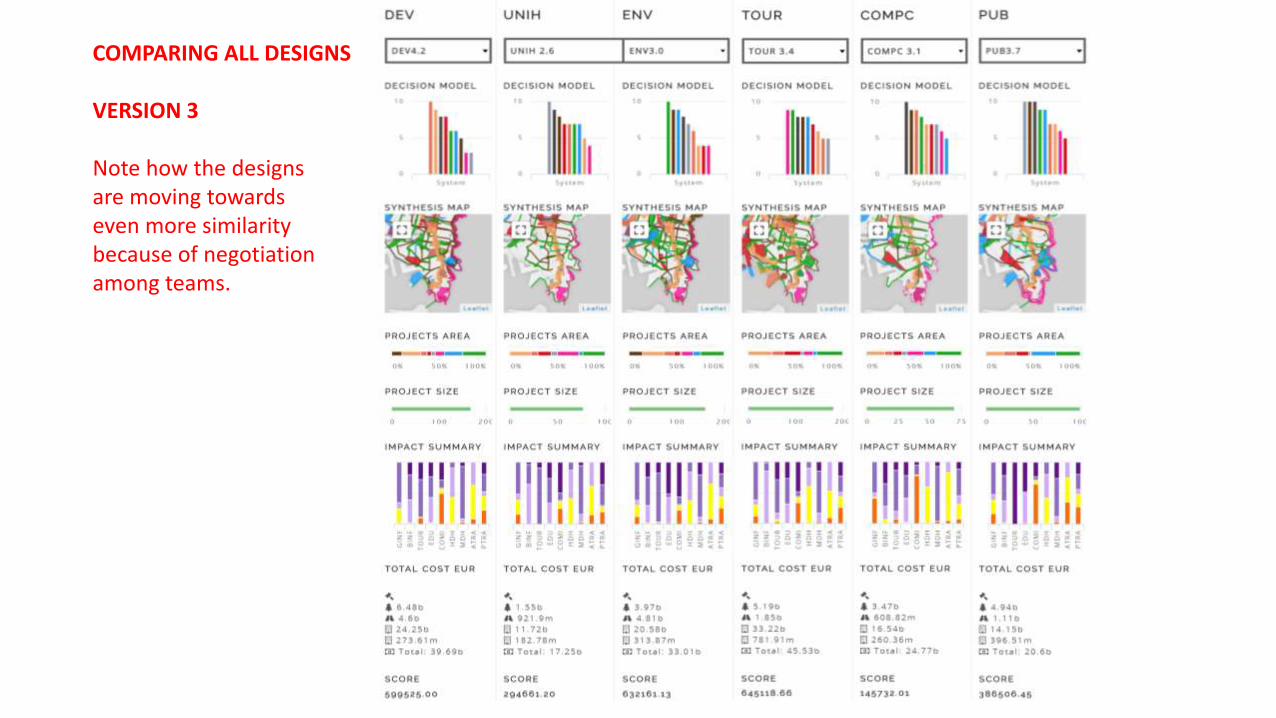
COMPARING ALL DESIGNS VERSION 3 Note how the designs are moving towards even more similarity because of negotiation among teams.
0

COMPARING ALL DESIGNS VERSION 3 “BEST” (C S)
0


O
Day 2 2:00pm SOCIOGRAM TO ORGANIZE NEGOTIATION


NEGOTIATION 1 NEGOTIATION 2 PUBLIC NEGOTIATION 3

O
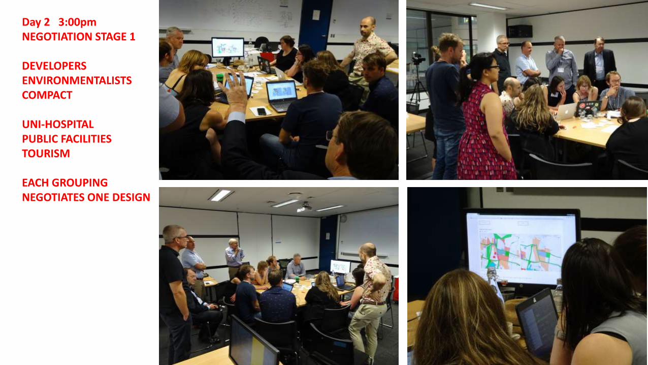
Day 2 3:00pm NEGOTIATION STAGE 1 DEVELOPERS ENVIRONMENTALISTS COMPACT UNI-HOSPITAL PUBLIC FACILITIES TOURISM EACH GROUPING NEGOTIATES ONE DESIGN


THE AGREED POLICIES AND PROJECTS BEFORE THE FINAL NEGOTIATED DESIGN
O

O
Day 2 3:30pm DEVELOPING THE FINAL NEGOTIATION STRATEGY DEV-ENV-COMP UNIH-PUB-TOUR

O
Day 2 3:30pm THE FINAL NEGOTIATION IN PUBLIC
O
Day 2 3:30pm DEV-ENV-COMP UNIH-PUB-TOUR

O
Day 2 3:30pm THE FINAL NEGOTIATION IN PUBLIC DEV-ENV-COMP and UNIH-PUB-TOUR

THE LAST BIG DECISION… THE ALIGNMENT AND MAJOR STOP OF THE METRO
O


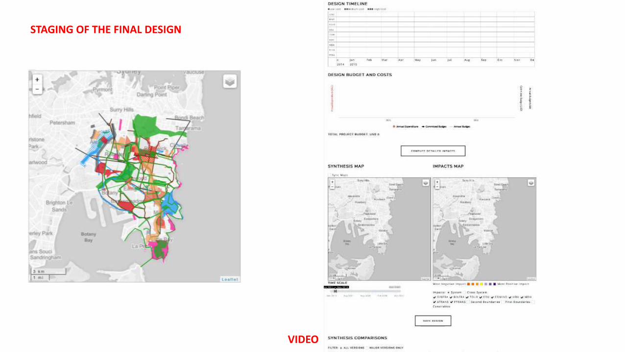
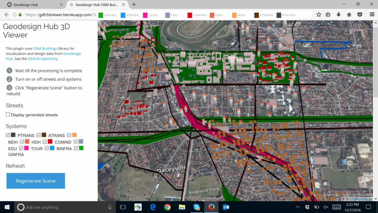
STAGING OF THE FINAL DESIGN
VIDEO


O
Day 2 5:00pm REVIEW AND DISCUSSION END

TEAM’S………………………………………………………………………………………………………………………NEGOTIATION………………………………………………………………….. INITIAL VERSION 1 VERSION 2 VERSION 3 VERSION 4 VERSION 5 FINAL DESIGN
HISTORY OF THE DEVELOPMENT TEAM’S DESIGN DEVELOPMENT AND NEGOTIATION

Which workshop tools/resources did you find most helpful and/or influential?
• Negotiation process • Geodesignhub’s tools for comparing different team designs
o

Roderick Simpson Environment Commissioner, Greater Sydney Commission Professor, University of Sydney “The Geodesign approach is most effective in dealing with complexity and emergence of the city in the context of the the city as a mosaic of places- this is an approach that is gaining currency at the Greater Sydney Commission. Place-based planning allows a wide range of factors to be considered concurrently by reducing the scale not the scope. It also allows a contextually specific response which Geodesign supports”. “The selection process and negotiation in the geodesign process could be considered a form of emergence, particularly if emergence is seen to be a pattern or an idea that gains prominence. This is through the negotiation process and consensus - which is where the geodesign process adds significant value.”